Presentation type:
ERE – Energy, Resources and the Environment

EGU26-13423 | ECS | Orals | ERE5.1 | ERE Division Outstanding ECS Award Lecture

Understanding fluid injection-induced earthquakes: From causal mechanisms to fault frictional slip 

Wenzhuo Cao

The global energy transition increasingly relies on the sustainable use of the subsurface, which commonly involves fluid injection. Such injection can induce earthquakes, posing significant challenges to the safety and operability of geo-energy applications. Addressing these challenges requires a geomechanical understanding of induced seismicity and the coupled subsurface processes that govern it. This Award Lecture introduces recent research on fluid injection-induced earthquakes, spanning the evaluation of causal mechanisms to an in-depth understanding of the fault-slip processes that control earthquake magnitude and frequency.

The first part of the presentation focuses on identifying and evaluating the causal mechanisms for injection-induced earthquakes. The problem is formulated as assessing the susceptibility of fracture and fault slip driven by coupled thermo-hydro-mechanical (THM) processes in fractured porous media. Through several geo-energy case studies, it is demonstrated that induced seismicity commonly results from fracture and fault reactivation through multiple, co-occurring mechanisms. The relative contribution of these mechanisms largely depends on regional geology, fracture and fault properties, ambient stress conditions, and operational parameters. Fluid overpressure typically develops rapidly following injection and may influence a large area, depending on hydraulic connectivity and fault permeability. Poroelastic stressing accompanies fluid pressurisation, with its contributions controlled by the distance to susceptible faults and fault orientation relative to the ambient stress field. Thermal stressing is generally more spatially localised around injection wells but can become dominant over longer timescales. In addition, fault slip-induced stress transfer can explain seismicity beyond the region affected by fluid pressure and poroelastic stress changes. Understanding these mechanisms enables the development of physics-based approaches for induced seismicity hazard assessment that explicitly account for both geological conditions and operational strategies.

The second part of the presentation addresses fault frictional slip processes that ultimately control the earthquake magnitude and frequency. Three key governing processes are identified for injection-induced fault slip: fluid pressurisation, hydraulic diffusion, and frictional nucleation, each characterised by a distinct timescale. Their interactions give rise to a wide range of induced earthquake behaviours. To disentangle their combined effects, a coupled hydro-mechanical-frictional modelling framework was developed that integrates frictional contact models for faults with poroelastic models for surrounding rocks. The results have shown that frictional properties exert first-order control on fault slip regimes and the maximum earthquake magnitude, whilst fluid pressurisation primarily governs earthquake frequency and also influences the maximum magnitude through poroelastic stressing. These effects are further modulated by hydraulic diffusion, highlighting the role of reservoir hydraulic conductivity in controlling how injected fluids interact with distant faults. Building upon this understanding, this contribution illustrates how fluid pressurisation rate influences induced earthquake magnitude and frequency, and discusses the implications for designing injection strategies that minimise seismic risk while maintaining operational efficiency.

Acknowledgement: I gratefully acknowledge the support and nomination by Prof. Sevket Durucan, Dr. Suzanne Hangx, Prof. Chris Spiers, Prof. Paul Glover, and Prof. Keita Yoshioka, and the many collaborators who contributed to the research presented.

How to cite: Cao, W.: Understanding fluid injection-induced earthquakes: From causal mechanisms to fault frictional slip, EGU General Assembly 2026, Vienna, Austria, 3–8 May 2026, EGU26-13423, https://doi.org/10.5194/egusphere-egu26-13423, 2026.

The increasing global demand for nickel, driven by its critical role in stainless steel production and emerging battery minerals technologies, has intensified exploration efforts in geologically diverse terrains. This study focuses on the Cuddapah Basin, a Proterozoic sedimentary basin in southern India, which presents a complex geological framework with promising yet underexplored potential for nickel mineralization. Through an integrated approach combining lithological mapping, geophysical surveys, and geochemical analysis, this paper present fingerprints of geochemical and geophysical signatures to target Nickel Exploration. The preliminary findings indicate the presence of ultramafic intrusions and favourable host rocks such as picritic sills which are typically associated with nickel sulfide deposits. The western margin of the Proterozoic-aged Cuddapah Basin contains gabbro and plagioclase bearing sills within the Tadapathri formations These sills have 4-28% MgO and 30-1050ppm Ni and they are characterized by elevated Th/Nb which is indicative of contamination by upper crustal material. The low MgO mafic magmas have one to two orders of magnitude viscosity higher than the picritic sill they are emplaced all along the Cuddapah basin margin. No Ni-Sulphide mineralization is known in this belt, but trace interstitial sulphide is present. The following features of the Pulivendla-Vemula sill complex indicate that the rocks are prospective for magmatic sulfide exploration:1. Tholeiitic lavas and sills were emplaced during extensional intra-cratonic rifting at a time of major Ni ore formation at ~1.9 Ga metallogenic epoch i.e late Proterozoic-Archaean in age.2. Un-deformed fresh differentiated ultramafic sills have a range in Ni concentration over a narrow interval of forsterite content with primary olivine 3. These sills and other sills in the footprint of regional magnetic and gravity anomalies possibly contain feeders where immiscible magmatic sulfides may have formed. correlating between Werner depth estimations and seismic data, particularly in pinpointing fault zones. These zones act as critical conduits for fluid migration from the mantle to the surface, playing a vital role in both tectonic interpretation and mineralexploration4. Despite the absence of magmatic sulfide mineralization and magmatic breccias, there is untested potential within the basin stratigraphy for the development of intrusions which have a magnetic and density signal, possibly in association with a structural break as well as a diagnostic electromagnetic signal from highly conductive sulfide mineralization. However, the geological complexity, including structural deformation and metamorphic overprints, poses significant challenges in locating economically viable deposits. The study underscores the importance of advanced exploration techniques and multidisciplinary data integration to improve discovery success rates. Ultimately, this work contributes valuable insights into the Ni-mineral prospectivity of the P-V Picritic Sill in western margin of Cuddapah Basin and highlights its potential as a frontier region to relook for nickel exploration in India.

How to cite: Sunder Raju, P. V.: Fingerprints of Nickel Exploration in the Pulivendla-Vemula (P-V) sill in Cuddapah Basin:Geological Complexity and Discovery Potential, EGU General Assembly 2026, Vienna, Austria, 3–8 May 2026, EGU26-1384, https://doi.org/10.5194/egusphere-egu26-1384, 2026.

EGU26-3742 | ECS | Posters virtual | VPS19

Designing cost-effective storage portfolios in decarbonizing power systems: a deficit stretch approach 

Anasuya Gangopadhyay and Ashwin K Seshadri

High wind and solar penetrations would make bulk energy storage increasingly important for electricity system reliability. We introduce a deficit stretch framework that relates the temporal structure of generation shortfalls to optimal storage configurations in a decarbonizing grid and links the intensity, duration, and frequency of deficits to storage needs and cost–reliability trade-offs. Using Karnataka (India) as a case study, we simulate wind–solar–demand scenarios to examine (i) drivers of deficit-stretch emergence, (ii) which wind–solar–storage portfolios align with available storage technologies, and (iii) how these choices map onto Pareto frontiers of cost versus reliability. We cluster deficit stretches to identify characteristic storage durations (across hours to seasons) enabling a direct mapping from variability patterns to feasible technology options. Results indicate that solar share largely controls the deficit stretch duration spectrum. The proposed framework offers an empirical approach leading from analysis of renewables variability to consideration of bulk energy storage portfolios amidst cost–reliability tradeoffs and is extendable to other regions as well.

How to cite: Gangopadhyay, A. and K Seshadri, A.: Designing cost-effective storage portfolios in decarbonizing power systems: a deficit stretch approach, EGU General Assembly 2026, Vienna, Austria, 3–8 May 2026, EGU26-3742, https://doi.org/10.5194/egusphere-egu26-3742, 2026.

EGU26-4291 | Posters virtual | VPS19

Coal fire & Mine water: two major post-mining issues 

Qiang Zeng

Coal is an important major source of energy for sustainable development and growth of economy around the world. Coal fire and mine water issues are two aspects of mining-induced safety and eco-environmental issues which occurred during and after mining. In the present presentation, the author illustrates the understanding of these two issues by employing the theoretic analysis, the experimental simulation, the numerical simulation, and the field investigation, etc. Results from this research show that the rational scientific mining methods and technologies can be used to reduce the occurrence and influence of these two phenomena which leads to the possible sustainable exploitation of coal resource.

How to cite: Zeng, Q.: Coal fire & Mine water: two major post-mining issues, EGU General Assembly 2026, Vienna, Austria, 3–8 May 2026, EGU26-4291, https://doi.org/10.5194/egusphere-egu26-4291, 2026.

Investment decisions for offshore wind-to-hydrogen (W2H) projects are often framed as “better forecasts reduce uncertainty,” but it is less clear when higher-fidelity scenario modelling meaningfully changes a financing decision versus merely narrowing outcome ranges. We address this question using a decision-coupled evaluation that scores forecast skill on propagated economic distributions and links it directly to financeability metrics.

Using 61 years of ERA5 wind data at 150 m hub height, we generate 1000 synthetic 23-year hourly wind scenarios per method and propagate them through a techno-economic model of a 375 MW offshore W2H project (development in 2024, operation in 2026-2050, base hydrogen price €8/kg, discount rate 7%). We compare three probabilistic scenario generators: historical bootstrapping, parametric Weibull fitting, and a calibrated probabilistic long short-term memory (LSTM) sequence model (used as a benchmark rather than architectural novelty).

We evaluate (a) continuous ranked probability score (CRPS) of levelized cost of hydrogen (LCOH), net present value (NPV), and internal rate of return (IRR), (b) decision bandwidths W(Y) = P95(Y) – P5(Y), (c) threshold-crossing probabilities Pr(NPV>0) and Pr(IRR>10%), and (d) a local elasticity E(Y) = dW(Y)/dCRPS that maps marginal forecast skill to risk-band compression. Finally, we run a financing price sweep to identify the minimum hydrogen offtake price that achieves a 90% probability target for NPV > 0 and the joint target NPV > 0, IRR > 10%.

Results show that improved scenario modelling can substantially reduce economic distribution error and compress risk bands: the LSTM lowers CRPS by 30% for LCOH and NPV and by 25% for IRR versus the best bootstrap/Weibull configurations. However, under base assumptions the financeability thresholds are nearly invariant across methods: the 90%-target required hydrogen price is €7.76-7.78/kg for Pr(NPV>0) and €9.16-9.18/kg for Pr(NPV>0 and IRR>10%), with cross-method spread below €0.02/kg indicates a threshold-saturated regime where better modelling mainly narrows uncertainty rather than shifting the decision boundary. Sensitivity analysis indicates decision value is highest in moderate-margin regimes (roughly €5.5-8/kg) and diminishes at high profitability where models converge.

This work reframes “better scenarios” into an investment-relevant diagnostic: use elasticity and threshold behaviour to identify when modelling improvements will shift financeability versus only compress risk bands, supporting more defensible screening and policy design.

How to cite: Aditama, P. and Zia, A. W.: When Does Better Scenario Modelling Improve Financeability? A Decision-Coupled Evaluation for Offshore Wind-to-Hydrogen, EGU General Assembly 2026, Vienna, Austria, 3–8 May 2026, EGU26-5058, https://doi.org/10.5194/egusphere-egu26-5058, 2026.

EGU26-6552 | ECS | Posters virtual | VPS19

Assessing future wind energy resources in the Iberian Peninsula under climate change scenarios 

Alonso García-Miguel, Carlos Calvo Sancho, Javier Díaz Fernández, Juan Jesús González Alemán, Mauricio López Reyes, Pedro Bolgiani, María Luisa Martín Pérez, and María Yolanda Luna

This study evaluates annual changes in wind power density (WPD) in a domain covering the Iberian Peninsula and adjacent areas using several CMIP6 global climate models and the ensemble mean under historical (1961-1990) and SSP5-8.5 scenarios for two-time horizons—near future (2041–2070) and far future (2071–2100).

Results from the ensemble indicate a robust and generalized decrease in WPD throughout the 21st century. The most pronounced declines occur in windows starting mid-century (2050–2055), with reductions of about -90 W m-2 century-1 persisting for up to 40-year periods. Short-lived positive trends (≈ 50 W m-2 century-1) appear around 2030 and 2045, suggesting temporary peaks before a marked decline (≈ -100 W m-2 century-1) in later decades. Comparisons between future and historical periods reveal strong WPD decreases (-70 W m-2), mainly offshore, particularly in far-future scenarios.

Inland areas may experience annual mean WPD values falling below the cut-in threshold (3 m/s, ≈ 15.5 W m-2), rendering some older wind farms economically and technically unviable. Offshore regions, despite current technological priorities, face substantial WPD reductions (up to -60 W m-2), while inland declines are significant in northeastern Spain, where major wind farms are located. These projected reductions—especially offshore (10–20%)—could challenge the financial viability of future wind energy projects.

How to cite: García-Miguel, A., Calvo Sancho, C., Díaz Fernández, J., González Alemán, J. J., López Reyes, M., Bolgiani, P., Martín Pérez, M. L., and Luna, M. Y.: Assessing future wind energy resources in the Iberian Peninsula under climate change scenarios, EGU General Assembly 2026, Vienna, Austria, 3–8 May 2026, EGU26-6552, https://doi.org/10.5194/egusphere-egu26-6552, 2026.

The contribution proposes a feasibility study for a pumped‑storage hydropower (PSH) scheme in the wider Ptolemaida lignite basin in Western Macedonia, Greece, aiming to repurpose post‑mining landscapes as multi‑functional water and energy infrastructures that support the rapid penetration of renewables into the national power system. The work is particularly relevant to the EGU community as it lies at the interface of fluvial and hydraulic engineering, energy transition, and post‑mining land and water management in a coal‑dependent region undergoing accelerated decarbonisation.
 
The study will develop and assess alternative PSH configurations using existing and planned mine pits and overburden areas as upper and lower reservoirs, constrained by local hydro‑geomorphological, geotechnical and hydrogeological conditions. A coupled hydrological–hydraulic framework will be applied to (i) quantify available storage volumes and head differences, (ii) evaluate seepage, slope stability and embankment safety under cyclic operation, and (iii) explore interactions with surface and groundwater systems at seasonal to multi‑annual time scales.
 
On the energy‑system side, the project will simulate PSH operation under different scenarios of wind and solar deployment in Western Macedonia and the wider Greek interconnected system, using high‑resolution time series of load and variable renewable generation. Key performance indicators will include round‑trip efficiency, contribution to peak‑shaving and intra‑day balancing, provision of frequency and reserve services, and impacts on curtailment of renewables during high‑production, low‑demand periods.
 
The economic feasibility assessment will combine capital and operational expenditure estimates for mine‑based PSH schemes with projected revenue streams from energy arbitrage and ancillary services, within evolving Greek and EU regulatory frameworks for storage and just transition financing. Special emphasis will be placed on uncertainty analysis with respect to future market prices, policy instruments, and potential support mechanisms for storage in former lignite regions, in line with ongoing decarbonisation and regional development strategies.
 
From an environmental and socio‑hydrological perspective, the study will investigate how PSH reservoirs can be integrated into long‑term mine‑closure and landscape‑rehabilitation plans, including water‑quality evolution, sediment management, and the creation of new aquatic and riparian habitats. The results are expected to demonstrate pathways by which PSH in Ptolemaida can simultaneously deliver grid‑scale flexibility, reduce environmental legacies of lignite mining, and support regional socio‑economic resilience, offering a transferable case study for coal regions in transition across Europe.

How to cite: Touloumenidou, L.: Pumped‑Storage Hydropower in a Post‑Mining Landscapes: A Feasibility Study for Repurposing the Ptolemaida Lignite Basin in Western Macedonia, Greece, EGU General Assembly 2026, Vienna, Austria, 3–8 May 2026, EGU26-6952, https://doi.org/10.5194/egusphere-egu26-6952, 2026.

EGU26-7454 | Posters virtual | VPS19

Spatiotemporal Patterns of Ecological Vulnerability in Malta: An Empirical Analysis Using the PVOR Model 

Lin Wang, Jichang Chi, and Xiao Xiao

Accurate assessment of ecological vulnerability in island systems under natural and anthropogenic pressures is crucial for ecosystem stability and sustainable development. Constructing an adaptive and scientific framework for evaluating ecological vulnerability in island regions remains a key challenge. This study introduces a novel Pressure–Vigor–Organization–Resilience (PVOR) model for assessing ecological vulnerability, applied to the main island of Malta. A combined weighting approach using game theory was used to determine composite indicator weights, while multi-source data (e.g., remote sensing and geospatial data) were integrated to investigate the long-term spatiotemporal evolution of ecological vulnerability from 2000 to 2020 and its driving factors.

The results show that: (1) Over 20 years, the ecological vulnerability index (EVI) of Malta fluctuated but declined from 0.65 to 0.58. From 2000 to 2015, vulnerable areas were mainly located in the eastern built-up zones. By 2020, the area of highly vulnerable zones decreased by 86% due to ecological protection policies and the COVID-19 pandemic, with minor increases in vulnerability (less than 5 km²) along the southwestern coastline. (2) Ecological vulnerability exhibited significant spatial clustering (global Moran’s I > 0.80, p < 0.01), with high-value clusters in the east and low-value clusters in the west and north. (3) Key driving factors include habitat quality, landscape fragmentation, population density, and development intensity, with interaction effects being stronger than individual factors. (4) Based on both static and dynamic vulnerability assessments, ecological zoning was defined, and targeted management strategies were proposed.

This study provides a scientific foundation for ecological restoration and sustainable development in Malta, offering a transferable framework for other island systems.

How to cite: Wang, L., Chi, J., and Xiao, X.: Spatiotemporal Patterns of Ecological Vulnerability in Malta: An Empirical Analysis Using the PVOR Model, EGU General Assembly 2026, Vienna, Austria, 3–8 May 2026, EGU26-7454, https://doi.org/10.5194/egusphere-egu26-7454, 2026.

EGU26-8851 | ECS | Posters virtual | VPS19

Unfolding the rise in cooling demand from residential buildings sector in India 

Divya Davis and Nandita Saraf

India’s buildings sector contributed to about 36% of total electricity consumption, with residential buildings comprising nearly 79% of this demand in 2025 [1]. Within residential electricity use, cooling alone accounted for about 31% of the consumption and has seen a rise by 50% over the past decade [1]. India has one of the highest cooling gaps in the world primarily driven by population growth and affordability constraints [2]. India energy security scenario (IESS) 2047 suggests that, with rising per capita income, the residential air conditioner ownership expected to increase by 1.3 folds in the next decade [3]. India Cooling Action Plan has projected that cooling electricity consumption will be doubled by 2038, however passive design strategies on building envelop can reduce the consumption by 15% [4]. V. Chaturvedi et al., (2020) and R. Khosla et al., (2021) suggested that along with passive design interventions, promoting consumer awareness also plays a crucial role in reducing the cooling energy demand [5, 6]. Despite rising cooling demand, the combined quantitative influence of consumer behaviour, climate, technology, and building characteristics on cooling electricity demand in India remains insufficiently explored. 

To address this research gap, the authors have developed a bottom-up generic model to estimate the residential cooling energy demand based on variation in ambient temperature, appliance ownership, and relative humidity. The model is applied to India as a case study and with parameters calibrated using context-specific empirical data. Cooling degree days (CDD) serve as a metric to quantify ambient temperature rise relative to a base temperature of 24ºC. The analysis estimates the sensitivity of cooling demand to ambient temperature variations, expressed as a percentage increase in electricity consumption per degree rise. By varying the base temperature from 18ºC to 26ºC, model also captures the influence of consumer behaviour on cooling energy demand. The developed model is soft linked to SAFARI, a system dynamics model, developed by Centre for Science, Technology, and Policy (CSTEP) to design low carbon pathways for India. SAFARI explores the interlinkages between demand sectors such as buildings, transport, agriculture, forest and other land use (AFOLU), industry and supply sector, i.e., power. Soft-linking will enable to generate scenarios of different combinations of climatic conditions, behavioural aspects, varying appliance penetration rate, low carbon interventions in residential building sector such as, cool roof, wall insulation, alternate construction materials etcThese scenarios will allow understand the potential possibilities of reducing the energy demand for the country and can inform policy making on demand side management measures. 

 References: 

1. CSTEP. https://safari.cstep.in/safari/ 

2. Debnath, B. K. https://doi.org/10.3390/buildings10040078 

3. NITI Aayog. https://iess.gov.in 

4. Government of India. India-Cooling-Action-Plan.pdf  

5. Chaturvedi, V. https://doi.org/10.1016/j.heliyon.2020.e05749 

6. Khosla, R. https://doi.org/10.1088/1748-9326/abecbc 

How to cite: Davis, D. and Saraf, N.: Unfolding the rise in cooling demand from residential buildings sector in India, EGU General Assembly 2026, Vienna, Austria, 3–8 May 2026, EGU26-8851, https://doi.org/10.5194/egusphere-egu26-8851, 2026.

EGU26-9067 | ECS | Posters virtual | VPS19

Safety and Sustainability in Artisanal and Small-Scale Mining Operations in Mozambique 

Luana Victorina Sá dos Santos, Maurício Ernesto Guiliche, and João Alberto Mugabe

Artisanal and small-scale mining (ASM) is an important source of livelihood in Mozambique, directly involving over 100,000 people, largely through informal and poorly regulated operations (Delve, 2020). ASM activities are concentrated in provinces with high mineral potential, including Manica, Tete, Zambézia, Niassa, Nampula and Cabo Delgado (Mapurango, 2014), and primarily involve the extraction of gold, precious and semi-precious stones, as well as construction materials. Despite its socio-economic relevance, the sector is characterised by weak technical organisation, limited regulatory integration and widespread informality.

This study examines the main safety and sustainability challenges associated with ASM in Mozambique, with particular emphasis on occupational health and safety and environmental management. The methodological approach is based on a review of secondary literature and documentary analysis of existing legal and policy frameworks. The analysis indicates that high levels of informality contribute to unsafe working conditions, inadequate use of personal protective equipment, frequent occupational accidents and significant environmental degradation, including soil and water contamination.

Recent regulatory interventions, such as the suspension of mining licences in Manica Province in October 2025 due to uncontrolled discharge of mining effluents, highlight the urgency of strengthening environmental governance and enforcement mechanisms. The results suggest that the adoption of sustainable mining principles—focused on risk management, environmental protection, decent working conditions and long-term economic viability—can substantially improve the performance of ASM operations. Practical measures include basic technical training, increased awareness campaigns on occupational health and safety, gradual adoption of appropriate technologies and progressive formalization supported by effective monitoring.

In conclusion, enhancing safety and sustainability in ASM is essential not only to reduce occupational and environmental risks but also to ensure that small-scale mining continues to positively contribute to local communities and the national economy.

How to cite: dos Santos, L. V. S., Guiliche, M. E., and Mugabe, J. A.: Safety and Sustainability in Artisanal and Small-Scale Mining Operations in Mozambique, EGU General Assembly 2026, Vienna, Austria, 3–8 May 2026, EGU26-9067, https://doi.org/10.5194/egusphere-egu26-9067, 2026.

EGU26-9664 | Posters virtual | VPS19

CO2 storage potential of contourite channels – Laboratory studies on geochemical reactions 

Edgar Berrezueta, Timea Kovács, Berta Ordóñez-Casado, Estefanía LLave, Beatriz Benjumea, Paula Canteli, Jose Mediato, Javier Hernández-Molina, and Wouter de Weger

Contourite sandstones exhibit high lateral continuity, moderate to high porosity (depending on diagenetic overprint), and are typically overlain by fine-grained marls, making them promising candidates for subsurface CO₂ storage. This study investigates contourite channel deposits of late Miocene age that outcrop in the Rifian Corridor (northern Morocco). A fine-grained, bioclastic–siliciclastic sandstone and a medium- to coarse-grained sand representing potential reservoir materials were selected for controlled CO₂–rock interaction experiments.

CO₂ exposure tests were conducted in a batch reactor at 8 MPa and 40 °C for 30 days. Textural and pore-space changes were assessed through comparative SEM imaging, and bulk-rock and brine chemical compositions were analysed before and after exposure. The first reservoir sample experienced only minor dissolution features and limited particle detachment. In contrast, the fine-grained reservoir candidate underwent pronounced physical disintegration during CO₂ exposure. Chemical alteration was modest in both lithologies, expressed mainly as slight increases in dissolved ion concentrations in the brines.

These results highlight contrasting mechanical responses of contourite channel facies to CO₂ exposure and underscore the importance of lithological variability when evaluating contourite systems for CO₂ storage applications.

This research was conducted within the ALGEMAR Project (Ref. PID2021-123825OB-I00), funded by the Plan Nacional of Spanish Ministry of Science and Innovation

How to cite: Berrezueta, E., Kovács, T., Ordóñez-Casado, B., LLave, E., Benjumea, B., Canteli, P., Mediato, J., Hernández-Molina, J., and de Weger, W.: CO2 storage potential of contourite channels – Laboratory studies on geochemical reactions, EGU General Assembly 2026, Vienna, Austria, 3–8 May 2026, EGU26-9664, https://doi.org/10.5194/egusphere-egu26-9664, 2026.

EGU26-10232 | Posters virtual | VPS19

Carbonate-rich Sandstone Reactivity to Supercritical CO₂ and Brine: A Case Study from the Guadalquivir Basin, Spain 

Berta Ordóñez-Casado, Santiago Ledesma, José Mediato, Timea Kóvacs, Darío Chinchilla, Luis González-Menéndez, and Edgar Berrezueta

This study investigates mineralogical and geochemical alterations at the matrix scale in carbonate-rich sandstone exposed to supercritical CO₂ (SC-CO₂) and formation brine. Batch experiments were conducted under reservoir conditions (≈8 MPa, 333ºK) to simulate the early stages of CO₂ injection in a deep sedimentary formation of the Guadalquivir Basin (southern Spain).

Rock samples were analysed before and after exposure using scanning electron microscopy (SEM) with microanalysis, X-ray fluorescence (XRF), and X-ray diffraction (XRD). Complementarily, chemical analyses of the brine before and after the experiments were performed. The interaction with CO₂-rich brine caused a marked pH decrease, leading to carbonate dissolution and minor alteration of clay minerals. The Ca concentration in the brine increased by about 300%, confirms active carbonate dissolution driven by CO₂-induced acidification. These reactions, together with particle detachment and micro-scale pore modification, indicate dynamic fluid-rock interactions within the calcarenite matrix.

The results show up that the studied reservoir rocks maintain overall structural integrity under CO₂-rich conditions while undergoing measurable geochemical alteration. This experimental framework provides a reproducible approach to evaluate mineral reactivity and textural evolution in carbonate-rich sandstone reservoirs, offering relevant insights to the design and assessment of CO₂ sequestration projects in comparable geological settings.

This research was conducted within the UNDERGY Project (Ref. MIG-20211018), funded by the Programa Misiones CDTI 2021 of the Spanish Ministry of Science and Innovation and the Next Generation EU Fund.

How to cite: Ordóñez-Casado, B., Ledesma, S., Mediato, J., Kóvacs, T., Chinchilla, D., González-Menéndez, L., and Berrezueta, E.: Carbonate-rich Sandstone Reactivity to Supercritical CO₂ and Brine: A Case Study from the Guadalquivir Basin, Spain, EGU General Assembly 2026, Vienna, Austria, 3–8 May 2026, EGU26-10232, https://doi.org/10.5194/egusphere-egu26-10232, 2026.

EGU26-14485 | ECS | Posters virtual | VPS19

Integrating Micro-Scale Urban Geometry with Macro-Scale Climate Projections to Improve Rooftop Photovoltaic Potential Assessment: An Application to Selected Urban Areas in the Southeastern Mediterranean 

Natalia Agazarian, Constantinos Cartalis, Konstantinos Philippopoulos, and Ilias Agathangelidis

This study presents a comprehensive methodological framework that integrates micro-scale urban geometry with macro-scale climate projections to improve the assessment of rooftop photovoltaic (PV) potential in urban environments. High-precision solar resource estimation is achieved through the use of very high–resolution Digital Surface Models (DSMs; 0.8 m) within the Solar Energy on Building Envelopes (SEBE) model, enabling detailed simulation of shading effects in dense urban fabrics.

Historical and present-day atmospheric inputs—including surface solar radiation, cloud cover, and aerosol optical depth—are obtained from the Copernicus Atmosphere Monitoring Service (CAMS) and combined with meteorological variables from ERA5-Land. Future rooftop PV potential is projected using a multi-model ensemble of CMIP6 climate simulations under the SSP2–4.5 and SSP5–8.5 emission scenarios. Statistical downscaling techniques are applied to translate large-scale climate projections to local urban conditions.

In addition, the study evaluates PV system performance during specific atmospheric episodes, quantifying the effects of dust intrusions and compound events—defined as the co-occurrence of high temperatures and elevated dust concentrations—on energy yield. Finally, cluster analysis is performed on the urban building stock of selected southeastern Mediterranean cities using key performance indicators, including received solar radiation, total energy yield, rooftop area, and building height.

The results demonstrate that integrating micro-scale urban morphology with macro-scale climate projections is critical for accurately estimating rooftop PV potential, particularly in regions characterized by complex urban structures and climate-sensitive atmospheric processes.

How to cite: Agazarian, N., Cartalis, C., Philippopoulos, K., and Agathangelidis, I.: Integrating Micro-Scale Urban Geometry with Macro-Scale Climate Projections to Improve Rooftop Photovoltaic Potential Assessment: An Application to Selected Urban Areas in the Southeastern Mediterranean, EGU General Assembly 2026, Vienna, Austria, 3–8 May 2026, EGU26-14485, https://doi.org/10.5194/egusphere-egu26-14485, 2026.

EGU26-16152 | ECS | Posters virtual | VPS19

 4D Multi-Physics Forward Modelling for CO2 Storage Monitoring in the Hewett Field 

Jing Yang and Mads Huuse

Long-term geological CO2 sequestration relies on quantitative time-lapse geophysical monitoring to assess storage integrity. In this study, we present a multi-physics forward modelling framework for 4D monitoring of CO2 storage and demonstrate its application through a case study in the Hewett Field, a depleted gas field in the Southern North Sea. The case study focuses on a 30-year CO2 injection scenario into the Bunter sandstone. Seismic, controlled-source electromagnetic (CSEM) and gravity methods are combined within this multi-physics framework to provide complementary information.

The modelling workflow includes geological modelling, CO2 injection modelling, rock-physics modelling, and 4D geophysical forward simulations. The modelling starts from a static geological model describing the structural framework of the reservoir. This model is used in the dynamic CO2 injection simulations, which predict the CO2 saturation and pressure evolution during CO2 injection and post-injection migration. The resulting dynamic properties are converted into velocity, resistivity and density changes through rock-physics modelling. Based on these physical properties, 4D geophysical forward modelling is performed for seismic, CSEM and gravity methods to simulate time-lapse geophysical responses associated with CO2 plume development.

By comparing the simulated time-lapse responses of seismic, CSEM and gravity data, the integrated 4D modelling framework uses the Hewett Field as a case study to develop and test a site-specific monitoring strategy.

How to cite: Yang, J. and Huuse, M.:  4D Multi-Physics Forward Modelling for CO2 Storage Monitoring in the Hewett Field, EGU General Assembly 2026, Vienna, Austria, 3–8 May 2026, EGU26-16152, https://doi.org/10.5194/egusphere-egu26-16152, 2026.

Groundwater-induced subsurface collapse presents a critical geotechnical hazard in karst terrains, which poses heavy risks to global public safety and infrastructure. Despite the substantial economic impact, predicting these failures remains challenging due to sparse subsurface monitoring and the difficulty of integrating indirect, multi-modal satellite data into traditional models. To address the challenge of low observability, we present a physics-informed neural network (PINN)-based digital twin for simulating coupled hydro-mechanical processes. The framework integrates NASA GPM (IMERG) precipitation data and Sentinel-1 InSAR surface deformation measurements to constrain subsurface dynamics. Implemented in the West-Central Florida Karst Belt, the model represents a three-dimensional domain of unconsolidated overburden overlying a weathered limestone aquifer. Subsurface dynamics are governed by transient Darcy flow and an effective stress relationship, while progressive material weakening is captured through a continuous damage variable, d, which evolves via stress redistribution and pore-pressure diffusion. Through minimizing the residuals of these governing equations, the PINN identifies the start of collapse, defined as the point where localized damage exceeds a critical threshold. Our results indicate that the digital twin produces physically consistent fields with 25–30% lower error in pore pressure and damage predictions compared to simulations that are uncoupled. Predicted collapse initiation times, Tc, remained within 18–23% of benchmark solutions, capturing time-accelerated failure during intense recharge events. Sensitivity analysis reveals that hydraulic conductivity, K, accounts for over 63% of damage variance, highlighting the model's physical interpretability. This framework provides a scalable approach for real-time hazard assessment in data-poor karst regions globally.

How to cite: Korada, S. and Liu, W.: PINN-Based Digital Twins for Modeling Groundwater-Induced Subsurface Collapse under Low-Observability Hydro-Mechanical Conditions, EGU General Assembly 2026, Vienna, Austria, 3–8 May 2026, EGU26-16204, https://doi.org/10.5194/egusphere-egu26-16204, 2026.

EGU26-18202 | ECS | Posters virtual | VPS19

Material Selection for Vortex-Induced Vibration Energy Harvesting in Water Systems: Environmental and Performance Insights from the Verona Case Study in Italy 

Monica Siviero, Bjarnhéðinn Guðlaugsson, Francesco Nascimben, David Christian Finger, Alberto Benato, and Giovanna Cavazzini

Wastewater treatment plants are essential environmental infrastructures that operate continuously and require considerable electrical energy, while simultaneously conveying persistent flows that dissipate low-grade hydraulic energy. Recovering even a fraction of this overlooked resource could support decarbonisation targets and provide autonomous power for environmental monitoring and digital water services, without additional land take or large hydropower installations. Within the Horizon Europe project H-HOPE – Hidden Hydro Oscillating Power for Europe – this study investigates how the selection of structural materials affects the performance of vortex-induced vibration energy harvesters (VIV-EH) deployed in controlled water environments. Rather than optimising device geometry or control strategies, the analysis focuses on how broad material classes influence feasibility, energy potential, and environmental suitability when integrating harvesters into existing wastewater infrastructure. Operational records from a municipal wastewater treatment plant in northern Italy were analysed. A validated one-dimensional modelling framework was used as a comparative tool to estimate annual energy production for harvesters manufactured from widely available metallic and composite materials under realistic operating conditions.

Results show a consistent trend: lighter materials with favourable stiffness-to-mass ratios generate larger oscillation amplitudes and substantially higher harvested energy. Fibre-reinforced composites achieve the highest performance, with an estimated annual production of approximately 800–875 kWh/year for the specific case study. Aluminium alloys produce slightly lower yields (≈800 kWh/year) while retaining advantages in recyclability and manufacturability. In contrast, high-density metals such as structural and stainless steel, typically yield 450–480 kWh/year, highlighting how increased mass suppresses the vortex-induced response. These differences arise solely from material choice, without modifying hydraulic conditions, device geometry, or plant operation.

From a renewable-energy perspective, these results indicate that material-driven design is a practical lever for scaling small, autonomous generators across water networks, providing reliable power for sensors, process control and digital water management. Because devices exploit existing hydraulic infrastructure, they can be replicated modularly and integrated alongside other renewables as part of distributed energy portfolios, supporting resilience and local self-sufficiency. However, performance advantages must be considered alongside environmental trade-offs. Composites show limited recyclability and higher embodied energy compared with metals such as aluminium and stainless steel, which favour circularity but offer lower energy conversion. The study relies on a simplified modelling framework and a single representative site, broader validation under different hydraulic regimes and long-term material ageing will require pilot-scale deployment. Despite this, the comparative trends provide robust guidance for design and prioritisation.

Overall, the study demonstrates that targeted material selection can unlock “hidden hydropower” within wastewater systems, delivering incremental yet scalable renewable generation aligned with European decarbonisation goals while enhancing the sustainability and reliability of essential water services.

How to cite: Siviero, M., Guðlaugsson, B., Nascimben, F., Finger, D. C., Benato, A., and Cavazzini, G.: Material Selection for Vortex-Induced Vibration Energy Harvesting in Water Systems: Environmental and Performance Insights from the Verona Case Study in Italy, EGU General Assembly 2026, Vienna, Austria, 3–8 May 2026, EGU26-18202, https://doi.org/10.5194/egusphere-egu26-18202, 2026.

EGU26-19216 | ECS | Posters virtual | VPS19

Selective recovery of copper from mine tailings using a green leaching agent 

Gabriele Baldassarre, Vittorio Zasa Courtial, Rossana Bellopede, and Paola Marini

The growing demand for Critical and Strategic Raw Materials (CRMs, SRMs) and the limited availability of primary resources in Europe have renewed regulatory and scientific interest in mine waste and tailings as secondary raw material sources (European Critical Raw Materials Act 2023; Hool et al. 2024). Accordingly, efficient and environmentally sustainable extraction technologies are necessary to minimize both environmental impact and processing costs (Whitworth et al. 2022). Among emerging solutions to conventional acidic leaching, glycine has been attracting attention as a non-toxic and biodegradable amino acid capable of forming stable complexes with calcophile elements under alkaline conditions and low temperatures, enabling low-cost, possible industrial applications for recovering precious and critical metals from mine waste and tailings (O’Connor et al. 2018; Barragán-Mantilla et al. 2024; Eksteen et al. 2018). This study investigated the application of glycine leaching as a green chemical approach for the recovery of copper from fine-grained historical tailings samples from the Fenice–Capanne mine, Tuscany, Italy.

Historical tailings samples were preliminarily characterised in terms of granulometry, geochemical and mineralogical composition using multiple methodologies, such as ICP-MS, HH-XRF, SEM-EDS and SEM-MLA for the definition of metal grades and the identification of metal-bearing minerals. Batch leaching tests were conducted using a glycine solution under controlled conditions, including alkaline pH, a constant liquid-to-solid ratio, and progressively increasing leaching times. The performance of glycine as a lixiviant was evaluated in terms of metal extraction efficiency and selectivity using HH-XRF on solid residues and ICP-OES on leaching liquors. Particular focus was addressed on Cu and associated Zn extraction. As a term of comparison, the same samples were leached using sulphuric acid leaching.

Preliminary results indicated that glycine leaching enabled the selective extraction of Cu and minor Zn while limiting the dissolution of Fe, and competitive recovery rates when compared to traditional sulphuric acid leaching. It highlighted its potential as an environmentally friendly leaching agent. The outcomes of this study could contribute to the assessment of sustainable options for the recovery of CRMs and SRMs from mine tailings within a sustainable and circular economy approach.

How to cite: Baldassarre, G., Zasa Courtial, V., Bellopede, R., and Marini, P.: Selective recovery of copper from mine tailings using a green leaching agent, EGU General Assembly 2026, Vienna, Austria, 3–8 May 2026, EGU26-19216, https://doi.org/10.5194/egusphere-egu26-19216, 2026.

EGU26-19295 | Posters virtual | VPS19

Assessing and Designing a Pilot Aquathermal System on the TU Delft Campus 

Michiel Fremouw, Alexis Koulidis, and Martin Bloemendal

An aquathermal energy system is a sustainable heating and cooling technology for buildings by utilizing low-grade thermal energy from water sources. This contribution presents a full scale pilot at the TU Delft campus that investigates and show-cases the potential of a campus pond to supply thermal energy to the Firma van Buiten (FvB) building, which is a restaurant/meeting location.

The contribution focuses on sensor integration and data acquisition, heat balance modeling, and design considerations for an aquathermal system. Initially, a field campaign was conducted to assess the pond's dimensions, collect bathymetric data, and install temperature sensors at various locations and depths.

The heat balance model uses data from the pond and a nearby weather station to quantify temperature effects on the surface water system. By performing a heat balance of the water body, considering various factors, including solar radiation, wind speed, air temperature, and heat fluxes, the study evaluates the extractable thermal energy from the pond and assesses its suitability for low-temperature heating and cooling applications.

Finally, a design analysis of the pilot aquathermal system is presented, considering technical feasibility, integration with existing building energy systems, and potential scalability across the campus. The contribution also provides recommendations for implementing a more sophisticated data acquisition and monitoring system.

The findings provide practical insights for advancing sustainable energy solutions in dense urban environments and support the broader implementation of aquathermal technologies in the Netherlands.

How to cite: Fremouw, M., Koulidis, A., and Bloemendal, M.: Assessing and Designing a Pilot Aquathermal System on the TU Delft Campus, EGU General Assembly 2026, Vienna, Austria, 3–8 May 2026, EGU26-19295, https://doi.org/10.5194/egusphere-egu26-19295, 2026.

Underground coal gasification (UCG) offers a viable approach for extracting deep-seated coal deposits with minimal surface disruption. The thermomechanical behavior of adjacent rock formations, particularly shale, which typically acts as a ceiling or floor rock, has a significant impact on the success of UCG operations. This study examines the pore structure evolution of shale samples at increased temperatures from room temperature to 800 °C, approximating the thermal range experienced during UCG procedures. The primary goal is to understand how high-temperature exposure changes the porosity and microstructure of shale, altering gas movement, confinement, and overall system stability.

Shale samples were collected from Jharia Basin, India, and were heated in a muffle furnace at gradually increasing temperatures. The pore properties were assessed by Low-Pressure Gas Adsorption (LPGA), Helium Pycnometry, and Scanning Electron Microscopy (SEM). SEM imaging showed considerable microcrack formation and intergranular pore growth at temperatures above 300 °C. LPGA data showed a shift from microporous to meso- and macroporous materials as temperature increased, implying gradual pore coalescence. The Helium Pycnometer results verified a temperature-dependent increase in apparent porosity, which corresponded well to the observed physical degradation. The findings show a non-linear rise in total porosity and considerable microstructural disintegration of shale at high temperatures, which can improve gas flow paths but may expose the confining layers' stability. These thermal changes are critical to UCG operations because they affect both gas recovery efficiency and subsurface safety. The work sheds light on the thermal behavior of shale under UCG-relevant conditions, emphasizing the importance of complete thermomechanical studies in site selection and operational planning for UCG projects.

Keywords: Underground Coal Gasification, LPGA, Permeability, temperature, Porosity.

How to cite: Sahoo, S. S.: Temperature-Induced Pore Structure Evolution in Shale: Implications for Underground Coal Gasification Applications , EGU General Assembly 2026, Vienna, Austria, 3–8 May 2026, EGU26-19786, https://doi.org/10.5194/egusphere-egu26-19786, 2026.

Accurate forecasting of surface solar irradiance is needed, as it helps in PV power system planning, particularly under extreme weather conditions. Deterministic and persistence-based forecasting methods generally fail under extreme weather conditions. The present study develops a hierarchical Bayesian spatio-temporal model to forecast solar radiation in the Tucson Electric Power (TEP) region, Arizona, United States. Satellite-derived (CERES SYN1deg) and reanalysis (MERRA-2) solar radiation data have been used in the present study to identify variability across the four TEP stations. The hierarchical Bayesian spatio-temporal model outperformed the persistent model. The findings also highlight that, instead of focusing on point forecasts, we should focus on uncertainty-aware forecasts.


How to cite: Singh, J.: Hierarchical Bayesian Modeling of Solar Irradiance under Extreme Weather in the Tucson Electric Power Region, EGU General Assembly 2026, Vienna, Austria, 3–8 May 2026, EGU26-22088, https://doi.org/10.5194/egusphere-egu26-22088, 2026.

ERE1 – Integrated studies

Pyrophyllite is a mineral known for its chemical inertness, thermal stability and low thermal conductivity. Such properties are making it a suitable material for modern and advanced insulation technologies. The study evaluates the potential of pyrophyllite-rich natural resources for industrial usage in heat-resistant, eco-friendly and sustainable geocomposite insulation panels when combined with plant-based fabrics such as cotton, jute and linen.

The samples obtained from the Pütürge district of Malatya, where the majority of pyrophyllite deposits in Türkiye are located, were characterized mineralogically and geochemically in order to evaluate their suitability for industrial purposes and geocomposite production. Pyrophyllite-rich sample powders were micronized to improve bonding between mineral particles and fabric fibers, while plant-based fabrics were mercerized with sodium hydroxide for better surface reactivity. Mercerized fabrics were impregnated with a binder solution which includes the micronized powder and sodium silicate and later subjected to heat treatment to provide stability. Thermogravimetric (TGA) and Differential Scanning Calorimetry (DSC) analyses on both untreated and impregnated fabrics revealed their mass-loss characteristics, thermal decomposition behavior and their flame-retardant potential.

The results indicate that impregnating the plant-based fabrics with pyrophyllite significantly increases the thermal performance. Among these fabrics, the best improvement in thermal mass retention is observed in cotton, followed by jute and linen. Jute fabrics exhibit the highest degree of thermal endurance, maintaining structural stability up to approximately 600 °C. The positive change in heat resistance for cotton and linen is relatively weaker, but all mineral-impregnated fabrics develop a char layer after combustion, with residual masses of 33-43% for jute, 17-20% for cotton, and 15-18% for linen. This mineral-based barrier is essential for sustainable thermal insulation, as it reduces heat transfer and supports the long-term integrity of the resulting geocomposites. In conclusion, the results demonstrate that pyrophyllite-impregnated plant-based fabrics, especially jute, are highly suitable for production of environmentally friendly, sustainable, thermally resistant and flame-retardant geocomposites for insulation purposes.

How to cite: Aykasım, D., Toksoy Köksal, F., and Kılıç, A.: Thermal performance improvement of plant-based fabrics via pyrophyllite impregnation: an environmentally friendly approach to geocomposite insulation materials, EGU General Assembly 2026, Vienna, Austria, 3–8 May 2026, EGU26-383, https://doi.org/10.5194/egusphere-egu26-383, 2026.

Electrification of residential heating via heat pumps is a key aspect of the global strategy to reach Net Zero. This is because heat pumps which can convert electricity directly to heat will almost directly reflect the carbon intensity of the electricity they use. The reduction in greenhouse gas emissions is dependent on the raw materials used, the source and quantity of electricity consumed for operation and end of life management of heat pumps. Therefore, it is necessary to evaluate the climate change impact and other sustainability aspects of heat pumps on a life cycle basis. 

However, heat pumps may be installed for individual buildings or as part of a heat network that supplies multiple properties, with significant differences between them in impacts from material usage, installation and operation. This review aims to synthesise and analyse the latest research to compare the environmental impacts of domestic heat pumps at these different scales, for new-build and retrofit cases. Following PRISMA protocols, a systematic search of peer-reviewed literature from 2017–2025 was conducted using the Web of Science and Scopus databases. The keywords used are as follows: 'Heat pump', 'Life Cycle Assessment', 'Environmental impact assessment', 'District heating', 'Domestic heating'. The number of studies found on the Web of Science database was 1256, with 1605 found on Scopus. 1006 studies were removed as duplicates, and the amount studies after removing duplicates were 1857. The review focused on studies quantifying impacts beyond operational energy use, specifically targeting embodied carbon, ozone depletion potential (ODP), resource depletion and the coefficient of performance (COP). 

We found that the life cycle impacts are interlinked with many factors, such as the characteristics of the electricity grid, the temperature lift, and the type of heat pump. We also note that there are differences in the methodological approaches, including choice of functional units and system boundaries, which limit the ability to cross-compare studies by non-experts. Despite this, the conclusions drawn suggest that geothermal heat pumps perform better than air source heat pumps. Moreover, future life cycle assessment studies on heat pumps will benefit by integrating temporal and spatial variations, such as heat pump performance with respect to the ambient temperature, and electricity grid greenhouse gas emission factors. This can help prioritise the deployment at scale of heat pumps on a wider scale based on the sustainability benefits when compared to conventional heating systems. 

The synthesis reveals that while domestic heat pumps generally exhibit lower upfront embodied carbon, they are frequently associated with higher cumulative refrigerant leakage and lower real-world efficiencies due to suboptimal installation. Conversely, district heat pumps consistently show lower environmental impact per kWh of heat delivered in high-density urban zones (>50 dwellings/hectare), primarily driven by the integration of waste heat sources and professionalized maintenance which prevents performance drift.

How to cite: Fadden, L., Radcliffe, J., and Mehta, N.: Decarbonising Residential Heating: A Systematic Review of Life Cycle Impacts for Residential and District Heat Pump Systems, EGU General Assembly 2026, Vienna, Austria, 3–8 May 2026, EGU26-1219, https://doi.org/10.5194/egusphere-egu26-1219, 2026.

Solar-driven interfacial evaporation (SDIE) offers a sustainable route for treating high-salinity wastewater; however, reconciling ultra-high evaporation rates with long-term salt resistance remains a critical bottleneck. Herein, a structurally robust, sponge-templated composite aerogel (PCPG) is developed by confining a polyvinyl alcohol (PVA)-based semi-interpenetrating network (semi-IPN) within a polyurethane (PU) sponge skeleton. In this architecture, Carbon Black (CB) and PEDOT:PSS are synergistically integrated to ensure broadband solar absorption (>90%) and reinforce the gel matrix.  The abundant hydrophilic groups within the polymer chains regulate the water state, effectively reducing the evaporation enthalpy to 831.5 J g⁻¹. Crucially, the composite features a hierarchical porous structure: the gel's micropores facilitate rapid capillary water supply, while the sponge's macropores enable efficient back-diffusion of salt ions. Leveraging these synergistic effects, PCPG achieves an exceptional pure water evaporation rate of 6.13 kg m⁻² h⁻¹ with 123.08% efficiency under 1 sun irradiation. Remarkably, it sustains a stable rate of 5.21 kg m⁻² h⁻¹ in 20 wt% NaCl brine without salt accumulation.Validated by both experiments and numerical simulations, this work presents a scalable, salt-resistant solution for zero-liquid discharge (ZLD) desalination and industrial brine management.

How to cite: Li, F.: Composite Aerogel with Hierarchical Hydrophilic Networks for Solar Evaporation and Salt-Resistant Brine Concentration, EGU General Assembly 2026, Vienna, Austria, 3–8 May 2026, EGU26-1909, https://doi.org/10.5194/egusphere-egu26-1909, 2026.

EGU26-2354 | ECS | PICO | ERE1.1

A Geologically Inspired Low-Energy Construction Material Based on Vernacular Geomaterials for Hot and Dry Environments 

Omar Radwan, Mohamed Hussein, Rida Assaggaf, John Humphrey, Murtada Al-Hashem, Ahmed Mahmoud, and Ahmed Abdelaal

Inspired by sand roses and the geological process of pressure-solution creep, this study presents a geomimetic, low-energy approach for producing sustainable bricks from vernacular geomaterials. By adapting the cold sintering technique, sand - uncalcined gypsum mixtures are densified at room temperature using minimal water and moderate pressure, thereby circumventing the high energy demands, chemical use, and substantial carbon emissions associated with conventional fired-clay or cement-based brick production. The research was conducted in two sequential experimental phases to bridge the gap between fundamental mechanism and practical manufacturability.

The first phase, conducted on small laboratory-scale samples, established the fundamental controls on mechanical performance. It demonstrated that gypsum acts as an effective binder at room temperature via a dissolution–precipitation mechanism. Critical processing parameters were identified, including gypsum content, gypsum particle size, pressure magnitude and loading mode. Notably, cyclic loading significantly enhanced the unconfined compressive strength (UCS) without requiring increases in gypsum content or applied pressure, enabling mixtures to achieve strengths comparable to or exceeding those of equidimensional concrete bricks.

The second phase focused on upscaling the process to brick-relevant dimensions. By optimizing critical parameters such as pressure duration, drying time, and ambient humidity, the study successfully produced 50 mm cubes that meet ASTM standards for load-bearing masonry (13.8 MPa). The optimized process—applying only 50 MPa of uniaxial pressure for 5 minutes, followed by one day of drying (50 °C) at controlled humidity (40 %)—yielded sand–gypsum compacts with a UCS of approximately 18 MPa. This result confirms that reduced processing times are feasible for manufacturing, provided the drying environment is carefully regulated.

Overall, this geomimetic fabrication strategy leverages locally abundant resources, drastically reduces embodied energy and water consumption, and supports circular economy principles through material recyclability. It offers a viable, sustainable alternative for construction in hot, arid climates, directly contributing to global sustainability goals.


How to cite: Radwan, O., Hussein, M., Assaggaf, R., Humphrey, J., Al-Hashem, M., Mahmoud, A., and Abdelaal, A.: A Geologically Inspired Low-Energy Construction Material Based on Vernacular Geomaterials for Hot and Dry Environments, EGU General Assembly 2026, Vienna, Austria, 3–8 May 2026, EGU26-2354, https://doi.org/10.5194/egusphere-egu26-2354, 2026.

  Global industrialization and population growth have increased the demand for energy and food, leading to a rise in food-processing by-products. Okara (soybean residue) is one of the most abundant by-products, with an annual production exceeding 14 million tons worldwide. Despite its high organic content, okara is often discarded due to its high moisture content and limited processing options. Converting okara into energy or high-value materials has become a significant challenge in light of resource scarcity and circular economy principles. This study proposes an efficient conversion pathway that combines hydrothermal treatment (HT-carbonization/liquefaction) with anaerobic digestion (AD) to transform okara into usable resources without energy-intensive drying.

  The hydrothermal process converts okara into bio-crude oil, hydrochar, and nutrient-rich aqueous phase, while simultaneously breaking down its high cellulose and protein content under high temperature and pressure. This process facilitates the conversion of large molecules into smaller molecules, which enhances methane production during subsequent anaerobic digestion and improves energy recovery efficiency.

  Experiments were conducted in a 500 cm³ high-temperature, high-pressure stainless-steel reactor equipped with a mechanical stirrer. Okara and deionized water were added at solid-to-liquid ratios of 1:10 and 1:5. After nitrogen purging, the reactor was pressurized to 2 MPa. The reaction temperature ranged from 200 to 300°C, with reaction times between 60 and 360 minutes. Results showed that the highest yields of hydrochar (38%) and bio-crude oil (31%) were achieved at 200°C and 120 minutes. Yields decreased when temperatures exceeded 230–250°C or reaction times were prolonged, as more carbon shifted to the aqueous and gaseous phases. At 300°C with short reaction times, moderate yields of hydrochar (20–23%) and bio-crude oil (25–26%) were obtained, indicating that high temperatures with limited exposure promote oil formation without excessive degradation.

  The remaining nutrient-rich liquid phase was subjected to co-digestion with sludge, maintaining a 1:1 liquid-to-sludge ratio based on volatile solids content. Gas was collected daily, and the bottles were opened weekly for gas, solid, and liquid analysis, as well as biodegradability assessments. Anaerobic co-digestion further enhanced methane production, significantly improving energy recovery. The liquid phase provided biodegradable organic matter, which was broken down by anaerobic microorganisms, resulting in increased methane yield and improved overall energy recovery efficiency.

  Additionally, a life cycle assessment (LCA) was conducted to evaluate the environmental impacts of the hydrothermal treatment combined with anaerobic digestion. From number of LCA paper results, it was shown that this integrated process had a lower environmental impact and higher resource efficiency compared to traditional waste management methods, such as landfilling, incineration, or direct AD.

  In conclusion, this integrated system presents a viable waste-to-resource pathway. The hydrochar produced can be used as a soil conditioner, and the bio-crude oil as a fuel. Methane can be utilized for power generation, while the remaining digestate can be applied as liquid fertilizer. The combination of hydrothermal treatment with anaerobic digestion, alongside the incorporation of life cycle assessment, highlights a promising circular economy strategy that reduces carbon emissions, fosters energy production, enhances resource recovery, and supports the sustainable use of agricultural by-products.

How to cite: Lin, C. J., Huang, Y.-Z., and Fan, C.: Valorization of Okara using Hydrothermal Treatment in combination with Anaerobic Digestion for Resource Recovery, EGU General Assembly 2026, Vienna, Austria, 3–8 May 2026, EGU26-2926, https://doi.org/10.5194/egusphere-egu26-2926, 2026.

In Taiwan, over 400,000 tonnes of fish are consumed annually through commercial fish markets, with approximately 45% converted into low-value fish waste (FW), including viscera, bones, and scales, resulting in more than 200,000 tonnes of fish waste each year. These fish wastes are characterized by high moisture content and high biodegradability, particularly proteins and lipids. They are predominantly managed through low-efficiency practices such as landfilling, composting, or feed conversion, which often attract environmental concerns.

Anaerobic digestion (AD) is a conventional technology for converting organic waste into renewable energy. Previous studies have shown that AD of fish waste is frequently inhibited by long-chain fatty acids and high nitrogen content, leading to limited energy recovery and the generation of large volumes of digestate that require further treatment. Meanwhile, hydrothermal liquefaction (HTL) can effectively convert high-moisture and heterogeneous biomass materials into bio-crude oil without the need for energy-intensive drying, making it particularly suitable for anaerobic digestates.

This study investigates the integration of anaerobic digestion as a pre-treatment step with HTL to explore the resource recovery potential of liquid and solid digestate derived from fish waste. Fish waste was subjected to anaerobic digestion under five different substrate-to-inoculum (S/I) ratios, and HTL subsequently treated the resulting digestate under subcritical water conditions at temperatures ranging from 275 to 325 °C with a residence time of 30-60 min. The distribution and characteristics of the main HTL products, including bio-crude oil, solid residue, and aqueous phase, were analyzed.

The anaerobic digestion results showed variable biomethane production across different S/I ratios (1.84 ± 0.27-93.45 ± 8.84 mL CH4 g-1 VS). Notably, the AD process was utilized to partially degrade macromolecules while preserving sufficient organic carbon for subsequent HTL. Under HTL conditions at 325 °C for 60 min, bio-crude oil yields reached over 50 wt%. Gas chromatography–mass spectrometry (GC–MS) analysis indicated that the bio-crude oil was dominated by lipid-derived aliphatic amides, alongside protein-derived nitrogen-containing heterocyclic compounds, including lactams and fatty acid pyrrolidides. This suggests that the organic constituents of fish waste were effectively transformed into the oil phase with promising potential for further upgrading and valorization, while partially incorporating nitrogen into stable oil-phase compounds.

Furthermore, a life cycle assessment (LCA) framework was applied to compare this integrated AD–HTL pathway with traditional fish waste management practices to evaluate its potential environmental benefits in terms of resource recovery and pollution mitigation. Environmental benefits (such as carbon negativity and resource circularity) can be expected compared with conventional treatments for fish waste. Overall, the findings demonstrated that integrating biological and thermochemical processes could contribute to more sustainable approaches for managing biomass wastes, enabling the recovery of high-value secondary energy carriers and material resources.

How to cite: Hsu, T. Y., Huang, Y.-Z., and Fan, C.: Integration of Anaerobic Digestion and Hydrothermal Liquefaction for Resource Recovery from Fish Waste Digestate, EGU General Assembly 2026, Vienna, Austria, 3–8 May 2026, EGU26-2934, https://doi.org/10.5194/egusphere-egu26-2934, 2026.

Volatile fatty acids (VFAs) are key intermediates produced during anaerobic processing of organic wastes and represent a recyclable carbon stream for resource recovery. Converting mixed VFA streams into microbial lipids offers a potential route to generate lipid feedstocks that can serve as precursors for sustainable aviation fuel (SAF) production. Here, we evaluated stepwise metabolic engineering strategies in the oleaginous yeast Yarrowia lipolytica to improve lipid accumulation from a mixed VFA substrate designed to mimic waste-derived streams (acetic, butyric, and hexanoic acids). While Y. lipolytica efficiently converts acetate into lipids, utilization of mixed-VFA substrates can impose physiological constraints that limit conversion performance. To address this challenge, we first overexpressed DGA1, a key enzyme for triacylglycerol (TAG) synthesis, resulting in lipid production of 0.54 g/L (1.83-fold increase). In contrast, deletion of PEX10 (peroxisomal biogenesis factor 10), a commonly applied strategy to enhance lipid accumulation in Y. lipolytica, led to reduced lipid production due to impaired utilization of butyric and hexanoic acids as substrates, as the ΔPEX10 strain showed significantly lower consumption rates of butyric and hexanoic acids compared to the control, accompanied by reduced lipid accumulation, suggesting that disruption of peroxisomal biogenesis and β-oxidation impairs the utilization of C4–C6 fatty acids as carbon sources under VFA-based cultivation. To further improve lipid biosynthesis, a heterologous acetyl-CoA synthetase from Salmonella enterica(seACS) was overexpressed to enhance acetyl-CoA supply, achieving lipid titer of 0.82 g/L. Overall, these stepwise engineering efforts resulted in a 2.77-fold increase in lipid production from mixed VFAs relative to the parental strain, demonstrating that targeted metabolic engineering can significantly improve the VFA-to-lipid bioconversion. Taken together, our findings highlight the feasibility of upgrading complex, waste-derived VFAs mixtures into microbial lipid feedstocks, providing a foundation for future waste-to-SAF and circular bioresource platforms.

How to cite: Choi, S. and Lee, S.-M.: Waste-to-SAF Precursors from Mixed Volatile Fatty Acids: Stepwise Metabolic Engineering of Yarrowia lipolytica, EGU General Assembly 2026, Vienna, Austria, 3–8 May 2026, EGU26-6276, https://doi.org/10.5194/egusphere-egu26-6276, 2026.

The efficient development of shale gas in mountainous regions is critical for supporting China's energy security and transition towards carbon neutrality. However, the economic viability of such projects is heavily constrained by complex surface conditions, which introduce significant cost uncertainties that are difficult to quantify using conventional assessment methods. To address this, we develop a quantitative techno-economic model for mountain shale gas that integrates multi-source geospatial data. Framed within a real options analysis, the model expands the standard net present value calculation by incorporating not only traditional costs (e.g., fixed operations, exploration, royalties, surface engineering) but also spatially-variable costs derived from geospatial analysis. These include hazard mitigation, water access, ecological restoration, and community compensation.

Key spatial parameters are derived from open-access data, including high-resolution DEMs, multispectral imagery, land cover maps, infrastructure networks, and geohazard products. These datasets inform a comprehensive surface suitability assessment based on terrain ruggedness, slope, vegetation indices, and proximity to infrastructure, enabling the identification of viable wellpad locations and the estimation of maximum drillable wells. This process quantitatively translates spatial constraints into economic inputs. Monte Carlo simulation is then employed to analyze the sensitivity of project economics to key variables, particularly the number of wells and natural gas price volatility.

An application in the mountainous region of Western Hubei demonstrates the model's effectiveness in differentiating the economic potential of various blocks. The results quantify the substantial negative impact of surface complexity on both net present value and real option value, confirming well count and commodity price as the primary drivers of financial risk. This study presents a novel decision-support tool that systematically embeds geospatial data into the economic evaluation of shale gas resources in complex terrain. The developed "geospatial-data-to-economic-parameter" framework provides a transferable methodology for the techno-economic assessment of natural resource projects subject to strong spatial constraints.

How to cite: Yuan, K., Xu, X., Liu, K., and Qiu, J.: A Quantitative Techno-Economic Assessment Model for Mountain Shale Gas Development Driven by Multi-Source Geospatial Data, EGU General Assembly 2026, Vienna, Austria, 3–8 May 2026, EGU26-8749, https://doi.org/10.5194/egusphere-egu26-8749, 2026.

Driven by the goals of sustainable development, resource development demands drilling technologies with high efficiency and low energy consumption. Scientific drilling, as a key tool for accessing subsurface resources and geoscientific information, relies on energy-efficient drilling systems to achieve sustainable resource exploitation. In response, this study presents a self-balancing drilling rig hoisting system that surpasses conventional rigs in both drilling efficiency and operational stability while significantly reducing energy consumption. To characterize the dynamic performance of this rig’s hoisting system, a mathematical model was developed through theoretical analysis and validated via numerical simulation. The results demonstrate that using the proposed system for tripping operations can increase efficiency by more than 40%, and the rig operates more stably than traditional systems. Moreover, the self-balancing rig hoisting system employs two coordinated traveling-block systems to achieve self-balance against the reaction torque generated by the winch, while effectively recovering and utilizing the gravitational potential energy released during drill stem lowering. These findings provide a novel approach to improving drilling efficiency and reducing energy consumption, with significant engineering implications and theoretical value for the development of high-efficiency, energy-saving drilling operations.

How to cite: Song, W.: Dynamic Modeling and Performance Analysis of a Self-Balancing Drill Hoisting System for Efficient Resource Development, EGU General Assembly 2026, Vienna, Austria, 3–8 May 2026, EGU26-12110, https://doi.org/10.5194/egusphere-egu26-12110, 2026.

In the context of sustainable development, high-efficiency drilling operations have become a key objective in advancing scientific drilling technology. Given the frequent coring and tripping operations involved in ultra-deep scientific drilling, automating and streamlining the make-up/breakout and handling/transfer of drill pipe wellhead tools is a critical technological pathway for improving overall drilling efficiency. To meet the demand for faster tripping operations, this study designed a high-efficiency transfer system for ultra-long drill pipe and determined its optimal operating strategy by combining experiments with finite element analysis. All experiments were conducted on a dedicated intelligent drilling platform. For three drill pipe sizes (3.5 in, 4.5 in, and 5 in), a series of tests were performed, including four-stand lifting tests, asynchronous up/down transfer tests, and inclined lean-against tests. The results indicate that the maximum bending deformation occurs within 16–21 m above the wellhead, with a peak deflection of 549 mm. Based on these findings, four-stand drill pipe are best transferred using an integrated “lower support + upper clamp” mode, whereas drill collars are better handled using a push-and-support mode. Subsequently, aiming to achieve 25 stands per hour during tripping operations, a corresponding tripping workflow and an offline operational scheme were developed. Finally, an integrated control strategy for the transfer system was proposed, considering the overall rig layout and tubular-handling process requirements. Through systematic design, experimental validation, and process optimization, this study has developed an efficient handling method and integrated control scheme for ultra-long drill pipe during drilling and tripping operations in ultra-deep scientific drilling. The findings provide technical and equipment support for the sustainable development and efficient utilization of resources.

How to cite: Gao, K.: Design and Experimental Study of an Ultra-Long Drill Pipe Transfer System for Efficient Continuous Operations in Resource Development, EGU General Assembly 2026, Vienna, Austria, 3–8 May 2026, EGU26-12238, https://doi.org/10.5194/egusphere-egu26-12238, 2026.

EGU26-13588 | ECS | PICO | ERE1.1

Energy, natural capital and economic growth 

Georgios Karakatsanis

This work utilizes the universal concepts of energy and Carnot Heat Engine to explain the formation of natural capital types as products of evolutionary processes, activated and driven by planetary heat engines. On this foundation, it further argues on the need for a fundamental redesign of the global economic and financial architecture with consistency to thermodynamic principles. The Laws of Thermodynamics dictate that the generation of physical work in a system with well-defined boundaries requires the existence of a heat gradient. Beginning from a typology of planetary natural capital species -ranging from fossil and nuclear fuels to minerals, biomass and genetic information- it is argued that the global stock of natural capital essentially constitutes and accumulated surplus of useful work or exergy, as the fundamental potential of economic growth. The exergy embodied in each natural capital type establishes three major economic functions: (1) for inorganic natural capital (such as fossil fuels, nuclear materials and minerals) it sets a reference state above thermodynamic equilibrium that contains intrinsic economic value and (2) for organic natural capital (such as chemically structured biomass, ecosystem functions and genetic information) it sets an optimal ecological state, sustained by daily planetary exergy flows. These two functions derive the third, (3) on the global economy’s ecological constraints to generate heat and material wastes -from the thermodynamic transformation of natural capital into economic goods- that distort the optimal ecological state. On these grounds, this work develops a quantitative economic framework with consistency to the laws of thermodynamics, introducing innovative key metrics on humanity’s evolutionary course by its energy paradigm, the thermodynamic conditions for a steady-state economy, the Jevons’ Effect as an inevitable evolutionary pressure towards energy paradigm shifts, the re-postulation of the Hartwick’s Rule of intergenerational equity on thermodynamic foundations, as well as the Scarcity Rent as a financial investment instrument for energy technology transitions.

Keywords: energy, Carnot Heat Engine, natural capital, Laws of Thermodynamics, useful work, exergy, economic growth, energy paradigm, Jevons’ Effect, Hartwick’s Rule, intergenerational equity, Scarcity Rent

References

  • Kümmel Reiner. The Second Law of Economics. New York: Springer-Verlag; 2011
  • Ayres Robert U, Warr Benjamin. The Economic Growth Engine. Cheltenham: Edward Elgar Publishing Ltd; 2009.
  • Roegen Nicolas Georgescu. The Entropy Law and the Economic Process. Cambridge MA: Harvard University Press; 1971.

How to cite: Karakatsanis, G.: Energy, natural capital and economic growth, EGU General Assembly 2026, Vienna, Austria, 3–8 May 2026, EGU26-13588, https://doi.org/10.5194/egusphere-egu26-13588, 2026.

EGU26-13892 | ECS | PICO | ERE1.1

Participation Builds Trust, Not Framing: Insights from a National Energy-Transition Experiment  

Kevin Goes, Louison Thépaut, Niek Mouter, Emile Chappin, and Sjoerd Kluiving

Public trust is widely recognized as a key condition for public cooperation in the energy transition, yet surprisingly little is known about whether and how government communication can actively shape that trust. In particular, value-based framing strategies are often assumed to be a low-risk way to strengthen credibility, but empirical evidence on their effects remains scarce. This study examines how the value content and institutional source of government communication influence trust in practice, using a large-scale national experiment (N ≈ 3,000) embedded in an online Participatory Value Evaluation (PVE) on sustainable heat policy in the Netherlands.


Participants were randomly assigned to one of six experimental conditions or a value-neutral control group. The treatments varied along two dimensions: value-based framing (environmental, financial, or stability-related) and governance level (local versus national government). Trust in government was measured immediately before and after exposure, enabling a Difference-in-Differences design that isolates trust changes attributable to the communication treatments. To examine heterogeneity, the analysis combines DiD estimation with Latent Profile Analysis of baseline trust orientations and Honest Causal Forests to detect non-linear treatment-effect variation.


Across all specifications, value-based framing does not increase institutional trust and, in several cases, reduces it. The most consistent negative effect appears for stability framing delivered by local government. Importantly, these average null effects mask strong heterogeneity: trust responses differ substantially across latent trust profiles but not across socio-demographic groups. Individuals with higher baseline trust tend to react more negatively to value-laden messages, whereas lower-trust respondents show weakly positive or neutral responses. This indicates that communication sensitivity is driven primarily by pre-existing trust dispositions rather than demographic characteristics.


By contrast, participation in the PVE itself generates a modest but robust increase in trust across both treated and control groups, independent of framing. This pattern suggests that being invited to engage with policy trade-offs and provide input may strengthen perceptions of procedural fairness and benevolence more effectively than persuasive messaging. Overall, the findings challenge common assumptions in the nudging and public communication literatures. The findings suggest that participatory decision tools may strengthen trust, whereas value-laden communication risks unintended negative effects.

How to cite: Goes, K., Thépaut, L., Mouter, N., Chappin, E., and Kluiving, S.: Participation Builds Trust, Not Framing: Insights from a National Energy-Transition Experiment , EGU General Assembly 2026, Vienna, Austria, 3–8 May 2026, EGU26-13892, https://doi.org/10.5194/egusphere-egu26-13892, 2026.

Tetracyclines (TCLs) are prevalent in environmental matrices and can bypass conventional wastewater treatment systems, thereby posing risks to human health and aquatic organisms. A 2D/3D Z-scheme Bi12O15Cl6/Fe2O3@C (BFC) (specifically BFC-II, consisting 10% Fe2O3@C) heterojunction photocatalyst was utilized for the degradation of TCL, under visible light. At reaction conditions (initial TCL concentration: 5 mg/L; photocatalyst dosage: 0.5 g/L; solution pH: 7; temperature: 27 ± 2 oC), the photocatalyst demonstrated a degradation efficiency of approximately 95% after a reaction time of 90 min, with the pseudo-first order degradation rate constant (k) of 0.0329 min-1. This could be associated with the reduced recombination rate of photoinduced charge carriers and their improved separation efficiency. Furthermore, hydroxyl radicals were identified as the primary reactive species facilitating the photocatalytic degradation of TCL. Overall, the BFC-II offers novel aspects related to the development of bismuth oxyhalide-based photocatalysts and their modification using Fe-MOF-derived materials.

How to cite: Singh, A. and Gupta, A. K.: Fe-MOF derived Fe2O3@C modified Bi12O15Cl6 for the visible light driven photocatalytic degradation of tetracycline, EGU General Assembly 2026, Vienna, Austria, 3–8 May 2026, EGU26-16022, https://doi.org/10.5194/egusphere-egu26-16022, 2026.

EGU26-16043 | ECS | PICO | ERE1.1

Vis-LED responsive floating Hematite/Bi4O5I2 decorated polyurethane foam for synergistic adsorption-photocatalysis of phenols 

Akash Rawat, Suneel Kumar Srivastava, Chandra Sekhar Tiwary, and Ashok Kumar Gupta

Slurry-based photocatalyst reactors often suffer from secondary pollution due to catalyst leaching and low reusability, resulting from inefficient catalyst recovery. In this context, a visible light-driven Hematite/Bi4O5I2 (HBI) nanocomposite was decorated on porous polyurethane foam (PU). The HBI nanocomposite was prepared by facile room temperature chemical precipitation, subsequently immobilized on PU via an eloquent chemical deposition technique. The inherent floating property of PU supported the mass transfer within the reactor, which could be attributed to the heat-induced convection across the HBI@PU  bed depth and stirring-induced convection throughout the phenolic solution. Thus, facilitating the transportation of pollutants and reactive species to the catalyst surface. As a result, the adsorption and photocatalysis were enhanced simultaneously. Moreover, the as-synthesized HBI and HBI@PU materials were characterized thoroughly using various techniques, including XRD, SEM, TEM, UV-DRS, and XPS. Furthermore, the photocatalysis of phenolics using HBI@PU was evaluated under optimal conditions: initial concentration of phenolics, 10 ppm; weight of catalyst material used, 0.25 g; pH, 6.2; and photocatalysis time, 80 min. The open-pore structure of the PU foam significantly enhanced the adsorption of phenolics, indicating that the foam provides additional porosity and adsorption sites. Consequently, the overall recorded removal of BPA, m-cresol, and phenol was 92.07 ± 1.53%, 84.25 ± 2.59%, and 59.41 ± 2.14%, respectively. Notably, only a marginal drop in removal efficiency was observed after subsequent recycles of photocatalysis. Hence, the as-synthesised visible light-driven floating HBI@PU photocatalyst holds potential applications in green and sustainable environmental remediation.

How to cite: Rawat, A., Srivastava, S. K., Tiwary, C. S., and Gupta, A. K.: Vis-LED responsive floating Hematite/Bi4O5I2 decorated polyurethane foam for synergistic adsorption-photocatalysis of phenols, EGU General Assembly 2026, Vienna, Austria, 3–8 May 2026, EGU26-16043, https://doi.org/10.5194/egusphere-egu26-16043, 2026.

EGU26-18267 | ECS | PICO | ERE1.1

Mechanistic insights into antibiotic degradation using multicomponent 2D quasicrystals as robust photocatalysts via in situ TEM 

Zahoor Manzoor, Shamik Chowdhury, and Chandra Sekhar Tiwary

The widespread presence of antibiotics such as sulfamethoxazole (SMX) and tetracycline (TC) in aquatic environments poses a significant threat to ecological safety. In this study, aluminum-based multicomponent alloys engineered into two-dimensional quasicrystals (2D QCs) are presented as a robust and reusable photocatalyst for visible-light-driven degradation of SMX and TC. The catalyst achieved degradation efficiencies of approximately 94% for SMX and 89% for TC within 2 hours. The photocatalytic activity was thoroughly examined under various conditions, including pH variations, catalyst dosage, pollutant concentration, and the influence of common inorganic ions. The 2D QCs demonstrated excellent reusability with negligible metal leaching across successive cycles. Notably, substantial degradation was also achieved in real water matrices such as tap water, pond water, and municipal wastewater, highlighting their environmental practicality. Furthermore, in situ liquid-phase transmission electron microscopy captured the real-time degradation of SMX antibiotic molecules on QC surfaces. Phytotoxicity assays with Vigna radiata confirmed that the treated effluents were non-toxic, as seed germination and root growth were comparable to those of the controls. This work identifies 2D QCs as a highly effective photocatalyst for antibiotic removal in complex water systems, addressing an urgent global challenge.

How to cite: Manzoor, Z., Chowdhury, S., and Tiwary, C. S.: Mechanistic insights into antibiotic degradation using multicomponent 2D quasicrystals as robust photocatalysts via in situ TEM, EGU General Assembly 2026, Vienna, Austria, 3–8 May 2026, EGU26-18267, https://doi.org/10.5194/egusphere-egu26-18267, 2026.

Water distribution networks (WDNs) are a critical component of modern society, responsible for delivering water to local communities and industries while maintaining continuous, stable flow within the system, which carries low-grade hydropower potential. These systems are vulnerable to disruptive events, such as pipeline failures and water contamination. To mitigate the risk of disruption events, recent EU policies have focused on the digitalisation of critical infrastructure, including WDNs and wastewater treatment plants (WWTPs), through the integration of Internet of Things (IoT) technologies. Digitalisation enables system operators to collect real-time data and perform predictive maintenance, thereby improving resilience and operational efficiency. Thus, system electricity requirements will increase to support IoT and digitalisation retrofitting.

This creates an opportunity to deploy energy-harvesting (EH) devices within WDNs and WWTP infrastructure that harness and utilise the resonant and kinetic energy inherent in water flow. Although the benefits of EH devices are often considered minimal and their energy outputs are low, EH devices are considered a viable power source for low-power sensors, such as pressure, contamination, and temperature sensors.

This study proposes and applies a feasibility assessment framework to evaluate EH devices as an alternative, decentralised power source for IoT-enabled monitoring in WDNs. The framework includes technical performance analysis, economic viability, and environmental impact assessments, combined with probability-based resilience modelling. It uses case-specific hydraulic, operational, design, and economic data to quantify EH power outputs, assess the costs of design and deployment, evaluate the environmental footprint of the devices, determine sensor energy requirements, and assess system resilience across different deployment scenarios.

Results demonstrate that the EH device has a mechanical power-generation capacity potential ranging from 0.049 to 36 watts, depending on the study location, flow conditions, and design characteristics. This EH generation capacity is sufficient to power pressure, contamination, and temperature sensors. The resilience modelling indicates that the detection probability of WDNs exhibits the most significant gains from adding sensors at low deployment levels. Thus, most of the improvement in detection levels occurs between deploying the first five to ten sensors; beyond this threshold, adding more sensors exhibits diminishing marginal returns to detection probability and system resilience. In addition, adding more sensors can significantly reduce system resilience by increasing power requirements, thereby placing excessive load on the power supply of the EH devices. Thus, it increases the risk of failure rather than enhancing resilience.

Overall, the results underscore the importance of strategic sensor allocation over high-density deployment and of balancing monitoring coverage with energy availability. Furthermore, the results show that EH devices are suitable power-generation technologies for supporting the digitalisation of WDNs and informing the design of new monitoring systems and sensor placement to enhance system reliability, enable cost-effective monitoring, and maximise mitigation benefits. In addition, the proposed framework provides decision-makers with a structured approach to assessing EH integration applications for digitalised WDNs, focusing on enhancing resilience through monitoring, conducting technical performance and cost-benefit analyses, assessing environmental trade-offs, and designing monitoring strategies aligned with sustainability and resilience objectives.


How to cite: Guðlaugsson, B., Stepanovic, I., Marguerite Bronkema, B., and Christian Finger, D.: Enhancing water system resilience and reliability: Application of Multidimensional Feasibility Assessment framework to assess if the deployment of energy harvesting devices in urban water systems enables a higher degree of system resilience., EGU General Assembly 2026, Vienna, Austria, 3–8 May 2026, EGU26-19267, https://doi.org/10.5194/egusphere-egu26-19267, 2026.

Agent-based models (ABMs) are increasingly used to study climate action, yet models remain fragmented and highly case-specific, preventing the field from rigorously advancing shared modeling principles, comparing models across cases, and cumulating knowledge over different applications. Our paper proposes a transferable two-tier ABM framework serving as a conceptual and practical guide for researchers tackling climate-action research questions with ABMs, offering an abstract architecture to replace the ad hoc design of case-specific models for climate action. Tier 1 introduces a functional architecture in which social, economic–financial, governance, and biophysical subsystems generate policies, information, physical impacts, and market interactions that feed the agent decision-making mechanism. Agents process these inputs, select and implement climate actions, and thereby generate feedback that updates all subsystems over time. Between Tier 1 and an implementable model, our pathway introduces a classification step that links the generic architecture to specific decision-making. We classify climate actions by action locus (individual, collective, autonomous) and adaptation timing (reactive, concurrent, proactive), indicating how decision-making and information flows from Tier 1 should be represented for each class. In our study, we instantiate one cell of the design space—proactive, individual household action—by extending the Protective Action Decision Model (Lindell & Perry, 2012) to longer decision horizons and embedding economic–financial drivers, social cues, and environmental signals into a multi-stage decision pathway. Our Tier 2 module describes how households process cues, appraise risk, screen feasible actions, and implement measures under evolving conditions. Our framework provides a structured pathway for developing transparent, comparable, and empirically grounded ABMs for climate action and for accumulating evidence across applications.

How to cite: Brahim, W. and Heinz, B.: From Ad Hoc to Transferable: A Two-Tier Architecture for Agent-Based Climate Action Models, EGU General Assembly 2026, Vienna, Austria, 3–8 May 2026, EGU26-20849, https://doi.org/10.5194/egusphere-egu26-20849, 2026.

EGU26-708 | ECS | Posters on site | ERE1.2

Exploring the Potential of Organic-Rich Shales for In Situ Hydrogen Production through Thermal Stimulation and Fracturing. 

Adamu Kimayim, Bassam Tawabini, Israa Abu-Mahfouz, and Ahmed Yaseri

The global pursuit of clean and sustainable energy has increased interest in hydrogen as a key energy carrier for achieving carbon neutrality. Consequently, global demand for hydrogen is anticipated to grow significantly in both the near and long term, necessitating the development of hydrogen production methods. While several researches have examined hydrogen generation through inorganic processes such as serpentinization, the potential of organic-rich sedimentary formations remains underexplored. This study investigates hydrogen-rich gas generating potential and fracture evolution of organic-rich rocks, with a particular focus on immature shales under controlled thermal treatment, aiming to enhance the yield of clean hydrogen gas. Pyrolysis experiments were conducted to simulate subsurface geological conditions, supported by comprehensive characterization using X-ray diffraction (XRD), X-ray fluorescence (XRF), thermogravimetric analysis (TGA). Gas Chromatography (GC) was used to analyze the gases generated at various heating temperatures and micro-CT imaging was used to examine the samples subjected to varying temperatures. The results show that hydrogen generation increases with temperature, with yields rising from 0.31% at 100°C to 36.02% at 450°C. High-resolution micro-CT imaging shows that thermally induced fractures developed predominantly parallel to bedding planes, enhancing permeability and facilitating gas migration. The progressive decomposition of organic matter, coupled with fracture development, significantly improved hydrogen release efficiency. These findings highlight the potential of organic-rich rocks, as viable and cost-effective targets for natural hydrogen exploration and in situ hydrogen gas generation and offering a pathway toward sustainable subsurface hydrogen exploitation strategies.

How to cite: Kimayim, A., Tawabini, B., Abu-Mahfouz, I., and Yaseri, A.: Exploring the Potential of Organic-Rich Shales for In Situ Hydrogen Production through Thermal Stimulation and Fracturing., EGU General Assembly 2026, Vienna, Austria, 3–8 May 2026, EGU26-708, https://doi.org/10.5194/egusphere-egu26-708, 2026.

EGU26-756 | ECS | Posters on site | ERE1.2

Experimental Investigation of Geochemical Interactions between Supercritical CO₂ and Shale 

Saheli Ghosh Dastidar, Kripamoy Sarkar, Debanjan Chandra, Vikram Vishal, and Bodhisatwa Hazra

The geochemical interactions between shale, supercritical carbon dioxied (SC-CO₂ ), and brine play a significant role in determining both the possibility of carbon storage and the long-term stability of shale gas reservoirs. The shale samples were exposed to CO₂-brine-rich environments for a period of 30 days to simulate the in-situ conditions of the shale reservoirs. The pre- and post-analysis were conducted to identify changes in mineralogy, chemical bonding, pore structure, surface texture and morphology. Several analytical techniques, including X-ray diffraction (XRD), thermogravimetric analysis (TGA), Fourier transform infrared spectrometry (FTIR), scanning electron microscopy (SEM), and low-pressure gas adsorption (LPGA), were used for characterisation. The results show that significant mineralogical changes occurred to clay minerals and carbonate, accompanied by modification in hydrocarbon functional groups and fluctuation in micropore and mesopore parameters. The consistent variations in pore characteristics are attributed to continuous processes of dissolution- precipitation and development of increased surface roughness due to reaction. The formation of microfractures and the etching effect of the samples were studied using high-resolution SEM images. TGA study confirmed the systematic mass loss caused due to prolonged reactions. These findings indicate that the reservoir integrity and the storage capacity can be affected due to pore structure evolution during geological CO₂ sequestration. Additionally, the changes documented in this study can provide the pathway to improve shale gas recovery, signifying the crucial role of shale formation in global decarbonization efforts

How to cite: Ghosh Dastidar, S., Sarkar, K., Chandra, D., Vishal, V., and Hazra, B.: Experimental Investigation of Geochemical Interactions between Supercritical CO₂ and Shale, EGU General Assembly 2026, Vienna, Austria, 3–8 May 2026, EGU26-756, https://doi.org/10.5194/egusphere-egu26-756, 2026.

EGU26-1481 | ECS | Posters on site | ERE1.2

Dynamic Optimization Control of Injection-Production Parameters for Oil Shale Self-Heating In-Situ Conversion 

Chaofan Zhu, Qiang Li, Sunhua Deng, Fengtian Bai, and Wei Guo

Oil shale self-heating in-situ conversion technology has emerged as a significant development direction due to its environmental friendliness and cost advantages. However, conventional constant injection-production parameters often lead to inefficient compression energy input and formation oxidation losses, limiting further improvement in energy return ratio (ERR) and oil yield. This study establishes a dynamic optimization model for injection-production parameters in oil shale self-heating in-situ extraction and develops a method for dynamically regulating gas injection rate and oxygen content to enhance process economy and feasibility.Results indicate that under the optimal gas injection parameters (adjustment duration: 120 days, decay rate: 1200, final flow rate: 40 m³/day), the steady-state phase in late production reduces compression energy consumption by 90% and CO₂ production by 48%, significantly decreasing cumulative compression energy input and suppressing hydrocarbon oxidation losses. Consequently, the peak ERR reaches 13.87, representing a 132.33% improvement over constant-rate injection, while oil production increases to 47 m³/m, a 66.9% enhancement. Furthermore, synergistic regulation of oxygen content and injection rate reduces compression energy by an additional 16%, elevating the peak ERR to 14.80—a 6.71% further increase—demonstrating technical feasibility for industrial application. These findings and key parameters provide theoretical and technical support for the large-scale implementation of oil shale self-heating in-situ conversion technology.

How to cite: Zhu, C., Li, Q., Deng, S., Bai, F., and Guo, W.: Dynamic Optimization Control of Injection-Production Parameters for Oil Shale Self-Heating In-Situ Conversion, EGU General Assembly 2026, Vienna, Austria, 3–8 May 2026, EGU26-1481, https://doi.org/10.5194/egusphere-egu26-1481, 2026.

The mobility and producible volume of shale oil are key factors controlling the effectiveness of shale oil exploration and development and are fundamentally governed by the occurrence state of hydrocarbons within shale pore systems. Consequently, accurate identification and quantitative characterization of oil–water occurrence in shales represent a core scientific challenge in shale oil research. Current investigations rely heavily on fresh or pressure-preserved cores. However, during routine coring, handling, and storage, substantial fluid loss is inevitable, rendering most conventionally cored shale samples unsuitable for in situ fluid-occurrence analysis. Although pressure-preserved coring can effectively maintain original fluid states, its high operational cost severely restricts large-scale application. Therefore, restoring the original pore-fluid occurrence in conventionally cored shales has become a critical technical bottleneck.To overcome this limitation, we develop a novel workflow integrating alternating oil–water spontaneous imbibition with nuclear magnetic resonance (NMR) measurements to recover the original fluid-occurrence state in conventionally cored shales. Pressure-preserved shale cores were first exposed to laboratory conditions to simulate fluid loss during conventional coring. Subsequently, a multistage alternating spontaneous imbibition procedure was implemented using n-dodecane and 15 wt% KCl brine as imbibing fluids to progressively restore the original oil and water contents. Throughout the entire fluid-loss and restoration processes, NMR T₁–T₂ maps were continuously acquired to dynamically monitor variations in oil and water contents and their pore-scale migration behaviour.

The results indicate that shale cores experience rapid oil–water loss during the initial 0–80 h, followed by a markedly reduced loss rate between 80 and 500 h, and reach a quasi-steady state after approximately 500 h, with a cumulative fluid loss of ~45%. During the alternating imbibition procedure, the samples undergo four successive stages, namely primary oil imbibition, water imbibition, secondary oil imbibition, and secondary water imbibition, each approaching a new dynamic equilibrium. After restoration, the oil and water saturations of the conventionally cored shales show strong agreement with those of the corresponding pressure-preserved samples.These findings demonstrate that the proposed method can effectively recover the original pore-fluid occurrence state in conventionally cored shales, enabling reliable characterization of shale oil and water distribution. The workflow is expected to significantly improve the accuracy of shale oil sweet-spot evaluation and provide new technical support for shale reservoir exploration and development.

How to cite: Chen, J. and Wang, M.: Restoring Original Pore-Fluid Occurrence in Conventionally Cored Shales: Insights from Alternating Oil–Water Spontaneous Imbibition and Nuclear Magnetic Resonance, EGU General Assembly 2026, Vienna, Austria, 3–8 May 2026, EGU26-2169, https://doi.org/10.5194/egusphere-egu26-2169, 2026.

Oil and gas reserves are crucial resources for human survival, directly affecting the sustainable development and utilization of future energy. In order to protect the Earth we live on, it is crucial to enhance our understanding and judgment of the trends in oil and gas reserves and to use these resources wisely. To explore new methods for predicting oil and gas reserves, promote sustainable energy development, and provide a theoretical basis for oil and gas exploration and development, this study takes the Neuquén Basin in South America as an example. By combining oil and gas reserve growth data with various geological characteristics and other comprehensive information, a Monte Carlo search + ARIMA algorithm-based method for predicting oil and gas reserves is proposed and applied to the Neuquén Basin for predictive validation. This method analyzes the structural background and divides the basin into structural units to decompose the basin’s reserves into reserves within each structural unit. The reserve growth data from each unit are input into the model, and the parameters required by the model are obtained through Monte Carlo search to produce predictive results. This approach successfully captures the inherent trends of reserve changes and the dynamic features of reserve growth. The method shows significant effectiveness in predicting reserves in the Neuquén Basin, with the predictive model demonstrating high accuracy in fitting.

How to cite: Li, H. and Zhang, L.: oil and gas reserve prediction method based on Monte Carlo Search + ARIMA algorithm: A case study of the Neuquén basin in South America, EGU General Assembly 2026, Vienna, Austria, 3–8 May 2026, EGU26-2263, https://doi.org/10.5194/egusphere-egu26-2263, 2026.

EGU26-2286 | ECS | Posters on site | ERE1.2

Pore Genesis and Organic–Inorganic Synergistic Evolution of Lacustrine Organic-Rich Shales 

Shangde Dong and Min Wang

Lacustrine shale reservoirs exhibit complex pore structures and strong heterogeneity, which exert a critical control on hydrocarbon storage and fluid flow. Although numerous studies have independently investigated organic matter–hosted pores and inorganic mineral pores, the coupled evolution of organic matter and inorganic minerals—and its influence on pore development across different thermal maturity stages—remains insufficiently understood. In this study, shale samples from the Qingshankou Formation in the Gulong Sag, spanning a range of thermal maturities, were analyzed using field-emission scanning electron microscopy (FE-SEM) combined with quantitative pore characterization techniques. The results indicate that pore formation and evolution in lacustrine shale are fundamentally governed by the coupled evolution of organic matter and inorganic minerals. Organic matter–clay composite pores are closely associated with organic matter thermal cracking and clay mineral transformation processes, and their development is primarily controlled by thermal maturity and clay mineral content. Organic matter–hosted pores are mainly influenced by organic matter type, abundance, and maturity, while inorganic minerals—particularly pyrite and clay minerals—can significantly promote organic matter cracking. Interparticle pores are closely related to the abundance of felsic minerals and thermal maturity; however, organic acid dissolution and ion precipitation during clay mineral transformation may partially or completely occlude these pores. In addition, organic acid dissolution capacity (controlled by total organic carbon content, soluble mineral content, and vitrinite reflectance Ro) and clay mineral transformation processes (controlled by clay content and Ro) further regulate intraparticle pore development by influencing dissolution pores and clay intercrystalline pores, respectively. These findings provide important insights into the genesis and evolutionary mechanisms of pores in lacustrine shale reservoirs.

How to cite: Dong, S. and Wang, M.: Pore Genesis and Organic–Inorganic Synergistic Evolution of Lacustrine Organic-Rich Shales, EGU General Assembly 2026, Vienna, Austria, 3–8 May 2026, EGU26-2286, https://doi.org/10.5194/egusphere-egu26-2286, 2026.

EGU26-3007 | ECS | Posters on site | ERE1.2

Study on fracture distribution law of buried hill in deep metamorphic rock : A case study of Bozhong L oilfield in Bohai Bay Basin, China 

Ruitong Guo, Wenya Lv, Lianbo Zeng, Xiaoyu Du, Hao Li, and Jiacheng Yin

Abstract

The buried depth of Archean metamorphic buried hill in Bozhong L Oilfield of Bohai Bay Basin is more than 4000 meters, and the matrix porosity and permeability are extremely low. As an effective reservoir space and seepage channel, natural fractures are the core controlling factors for oil and gas enrichment and high yield in buried hills of tight metamorphic rocks. Due to the influence of multi-stage tectonic movement and weathering, the development of buried hill fractures is complex. At the same time, due to the lack of core and imaging logging data, the study of fracture regularity is not systematic. In this study, the data of core, thin section, scanning electron microscope, imaging logging, conventional logging and production performance were comprehensively used to carry out conventional logging fracture identification, and the vertical and plane distribution of fractures and their influence on productivity were clarified. The conventional logging is calibrated by core and imaging logging, and four logging curves sensitive to fractures, such as resistivity difference, density, acoustic time difference and natural gamma, are optimized. The correlation degree between each parameter and fracture is calculated and weighted, and the fracture indication parameter curve is constructed. Compared with the results of fracture identification such as core and imaging logging in the study area and the dynamic data such as leakage, the accuracy of fracture identification based on conventional logging is more than 85 %. In the longitudinal direction, the strong weathered zone is dominated by weathering fractures, with high degree of fracture filling and strong reservoir heterogeneity. The sub-weathered zone develops structures and weathering fractures, which are transformed by dissolution and have high porosity and high permeability. The tight zone only develops regional structural fractures with low porosity and low permeability. The inner fracture zone is dominated by fault-related structural fractures, with low porosity and high permeability. The degree of fracture development is sub-weathered zone > strong weathered zone > inner fracture zone > tight zone. On the plane, fracture development is mainly controlled by faults. With the increase of distance from faults, the degree of fracture development decreases exponentially. The degree of fracture development is significantly positively correlated with productivity. The more developed the fracture is, the higher the productivity is. The research results can provide reference for the characterization of natural fractures in deep metamorphic buried hill reservoirs, and provide geological basis for the efficient development of deep metamorphic buried hill reservoirs in this area.

Key words

Metamorphic buried hills; Conventional logging; Fracture identification; Distribution law; Capacity; Bohai Sea

How to cite: Guo, R., Lv, W., Zeng, L., Du, X., Li, H., and Yin, J.: Study on fracture distribution law of buried hill in deep metamorphic rock : A case study of Bozhong L oilfield in Bohai Bay Basin, China, EGU General Assembly 2026, Vienna, Austria, 3–8 May 2026, EGU26-3007, https://doi.org/10.5194/egusphere-egu26-3007, 2026.

EGU26-4140 | ECS | Posters on site | ERE1.2

Intelligent fracture identification and its geological significance in tight sandstone reservoirs. 

Baoyu Liang, Lianbo Zeng, and Shaoqun Dong

Abstract: Natural fractures in tight sandstone reservoirs play an important role in hydrocarbon migration and accumulation. Fracture identification remains challenging due to the scarcity of labeled data and the complex logging responses of fractures. To address these problems, we propose a novel hybrid deep learning framework (CNN-Attention-BiLSTM). First, labeled fracture classification based on Full waveform sonic logs characteristics is employed to screen unlabeled data, replacing sampling algorithms for data balancing. This approach provides more fracture labels that align with authentic geological information. Subsequently, one-dimensional convolution is applied to construct multi-dimensional fracture logging response patterns that characterize fracture development. A Channel Self-Attention is introduced to assign optimal weights to response patterns across different dimensions, achieving an optimized pattern combination. A double-layer BiLSTM is then utilized to mitigate the impact of sedimentary cycles on logging identification, while capturing both short- and long-term dependencies of fracture responses across different network layers. The identification method is applied to the H1 member of the Lower Shihezi Formation in the Hangjinqi area, China. The test set accuracy is higher than 90%, and blind wells verification demonstrates an improvement of over 8% in accuracy compared to conventional methods. The identification results reveal that fractures are the most developed in H1-2, followed by H1-1 and H1-3, while H1-4 is the least developed layer. The fracture distribution pattern is evidently controlled by sedimentary rhythms, with fracture density decreasing in the order: interbedded sandstone and mudstone layers, thick sandstone and thick mudstone, thick mudstone and poorly developed sandstones. This trend is primarily attributed to the thickness of mechanical stratigraphy. Under equivalent tectonic stress conditions, thin sandstone layers are more prone to fracturing due to stress concentration, resulting in higher fracture density. Additionally, the proposed method deepens the correlation between the log response types of fractures and their development degree. It clarifies that fractures occur in varied patterns across different regions. In sandy conglomerates and gravel coarse sandstone intervals with high porosity and permeability, fractures tend to occur as single or multiple parallel fractures and are relatively less developed. fractures are more prevalent in the overlying and underlying intervals. Conversely, in tight sandstone intervals with poor porosity and permeability, the rock is more brittle, leading to the development of dense, interconnected fracture networks. And gas distribution shows correlate strongly with fracture-developed intervals. Therefore, it can be inferred that in intervals with high-quality sandstone reservoirs in the study area, fractures likely serve as vertical conduits connecting upper and lower gas-bearing zones, acting as preferential migration pathways. In contrast, within tight sandstone intervals, fractures primarily enhance matrix reservoir quality, thereby facilitating gas migration and accumulation. The intelligent fracture identification method proposed in this study can provide guidance for the migration, accumulation and efficient development of tight sandstone gas, Further, it can also offer a basis for the later carbon dioxide storage and the construction of underground gas storage of tight sandstone.

Keywords: Fracture identification; Tight reservoirs; Full waveform sonic logs; Conventional logs; Deep learning 

How to cite: Liang, B., Zeng, L., and Dong, S.: Intelligent fracture identification and its geological significance in tight sandstone reservoirs., EGU General Assembly 2026, Vienna, Austria, 3–8 May 2026, EGU26-4140, https://doi.org/10.5194/egusphere-egu26-4140, 2026.

Free hydrocarbon content (S1) is a key parameter for source rock evaluation and sweet spot identification in organic-rich shale reservoirs. Accurate determination of S1 is essential for petroleum exploration; however, traditional measurements rely on expensive core acquisition and Rock-Eval pyrolysis, limiting spatial coverage and operational efficiency. Empirical and log-based models often fail to capture complex non-linear relationships between S1, petrophysical logs, and geochemical properties. This study presents an integrated, physics-informed machine learning workflow for predicting S1 from well logs, mineralogical, and geomechanical data in the upper Shahejie Formation. The dataset comprises 357 S1 core measurements matched to high-resolution well logs (gamma ray, acoustic travel time, density, neutron porosity, and resistivity) over a 799 m stratigraphic interval. To address the inherent depth mismatch between irregularly spaced cores and regularly sampled logs, a constrained nearest-neighbor depth-matching strategy was implemented and validated.  Quality control confirmed minimal bias and high precision, ensuring that observed log S1 correlations represent true petrophysical trends rather than alignment-related biases. Physics-informed feature engineering was applied to capture geological ratios, porosity interactions, and depth trends. Interaction terms, including resistivity-TOC combinations, were incorporated to reflect hydrocarbon saturation and organic matter effects. Six ML algorithms were evaluated, including tree-based ensembles, kernel-based methods, and neural networks. The gradient boosting model achieved the best performance, with a correlation coefficient of 0.92 on independent test data and an RMSE of 0.58, representing a 33% improvement over a logs-only baseline. Cross-validation based on unique S1 measurements was used to prevent data leakage and demonstrated stable generalization across the dataset. Feature importance analysis highlights the dominant contribution of physics-informed terms, confirming that physically constrained predictors outperform individual logging or geochemical parameters. The proposed workflow enables continuous S1 profiling with minimal core measurements, supporting reservoir characterization and sweet-spot identification while reducing reliance on expensive geochemical analyses. This study demonstrates how combining rigorous depth alignment, physics-guided feature engineering, and machine learning can deliver reliable continuous S1 prediction for shale energy resources.

How to cite: Bennani, R. and Wang, M.: Physics-Informed Machine Learning Workflow for Free Hydrocarbon Content (S1) Prediction in Organic-Rich Shale Formation, EGU General Assembly 2026, Vienna, Austria, 3–8 May 2026, EGU26-5306, https://doi.org/10.5194/egusphere-egu26-5306, 2026.

With the continuous advancement of oil and gas exploration technologies and associated theoretical frameworks, deep to ultra-deep oil and gas exploration has emerged as a pivotal component of contemporary petroleum geology research and currently seems as a focal area of interest. But, overpressure is prevalent in deep to ultra-deep formations, and there are substantial discrepancies in studies regarding the impact of overpressure on the maturity of hydrocarbon source rocks and hydrocarbon generation. These discrepancies have hindered a comprehensive understanding of hydrocarbon formation and phase states in ultra-deep settings, thereby constraining deep oil and gas exploration endeavors.

The Shawan Sag in the Junggar Basin is characterized by widespread and high-intensity overpressure development, coupled with huge hydrocarbon resources in the lower stratigraphic assemblage. Among these, The Fengcheng Formation, serving as the primary hydrocarbon source rock, is the main source of oil and gas for the reservoirs within the sag. Consequently, this study focuses on the Permian hydrocarbon source rocks in the Shawan Sag of the Junggar Basin as the primary research target. After ascertaining the overpressure development in the Permian strata, typical low-maturity samples were selected to conduct hydrocarbon generation physical simulation experiments under varying pressure conditions. Based on these experiments, maturity evolution and hydrocarbon generation kinetic models that account for pressure were established, and thermal-maturity-hydrocarbon generation evolutionary history simulations were performed for typical wells and a 2D cross-section.

The results reveal the following: (1) There is a negative correlation between vitrinite reflectance and pressure in the vertical direction, with Ro evolution being lower than the normal trend in overpressure zones. (2) Thermal simulation experiments confirm that, under identical temperature conditions, higher pressure leads to a lower equivalent Ro and a greater proportion of medium-to-heavy components in the generated hydrocarbon products, demonstrating the inhibitory effect of pressure on hydrocarbon source rock maturity and hydrocarbon generation products. (3) Based on the results of physical simulation experiments and measured geological data, a 2D thermal-maturity-hydrocarbon generation evolutionary history for the Shawan Sag was simulated. It is concluded that the hydrocarbon source rocks in the Fengcheng Formation of the Shawan Sag are predominantly Type II highly mature hydrocarbon source rocks. The hydrocarbon generation threshold is suppressed until the end of the Triassic, with significant oil generation commencing in the late Jurassic and entering the highly mature stage by the end of the Cretaceous. Regarding hydrocarbon generation products, the cracking of heavy hydrocarbons to generate gas in the Fengcheng Formation is inhibited by overpressure. This study contributes to enhancing the theoretical understanding of overpressure-inhibited hydrocarbon generation and holds practical significance for hydrocarbon exploration in ultra-deep formations within the Shawan Sag.

How to cite: He, B. and Liu, J.: Maturity Evolution History and Hydrocarbon Generation Evolution History of Hydrocarbon Source Rocks in the Fengcheng Formation, Shawan Sag, Under the Influence of Overpressure, EGU General Assembly 2026, Vienna, Austria, 3–8 May 2026, EGU26-6097, https://doi.org/10.5194/egusphere-egu26-6097, 2026.

Shale reservoirs exhibit complex wettability. Under in-situ formation conditions, oil and water coexist as two phases, and interfacial interactions are pronounced, thereby influencing fluid occurrence state and mobility. Therefore, developing methods to evaluate wettability and mobility under oil–water coexistence conditions, and elucidating the controlling mechanism of wettability on mobility, is crucial for assessing petroleum reserves, production performance, and economic benefits. To this end, this study selected representative terrestrial medium- to high-maturity shale samples from the Lianggaoshan Formation in the Sichuan Basin and conducted alternating oil–water imbibition–NMR–centrifugation experiments. The results indicate strong heterogeneity in pore wettability: water-wet pores are mainly associated with quartz–feldspar minerals, attributable to their intrinsically hydrophilic surfaces; oil-wet pores are related to clay minerals and organic matter rich in polar functional groups, where adherent oil films readily form; mixed-wet pores are associated with carbonate minerals, for which a more balanced interfacial energy state is conducive to oil–water coexistence. Mobility analysis further shows that better reservoir properties, favorable pore–throat configuration, higher proportions of NMR-identified large pores plus microfractures, and higher TOC content all promote shale-oil mobility. Moreover, wettability serves as an even more critical factor influencing mobility: the mobile fraction is positively correlated with the proportion of mixed-wet pores and negatively correlated with the proportion of oil-wet pores. Wettability differences can enhance fluid connectivity by regulating capillary effects and interfacial tension, thereby increasing the mobile fraction. This study highlights the necessity of investigating the controlling mechanism of wettability on mobility, providing an important theoretical basis for understanding pore-scale fluid behavior in shale and for optimizing unconventional oil and gas recovery.

How to cite: Li, T. and Wang, M.: Evaluation of Shale Pore Wettability under Oil–Water Coexistence Conditions and Its Control on Fluid Mobility, EGU General Assembly 2026, Vienna, Austria, 3–8 May 2026, EGU26-7418, https://doi.org/10.5194/egusphere-egu26-7418, 2026.

The high-temperature conditions of deep mining significantly affect the mechanical stability of tar-rich coal. The mechanical properties and energy evolution characteristics of heat-treated tar-rich coal are discussed in this study through experiments and corresponding analyses. The research object is tar-rich coal from the Shaanxi coalfield in China. Microstructural and static/dynamic mechanical tests were conducted on specimens heat-treated at different temperatures (25℃, 200℃, 400℃, and 600℃) to study their structural changes and mechanical behavior. The study shows that tar-rich coal undergoes rapid pyrolysis after 418℃. Therefore, the surface cracks of the coal sample treated at 600℃ deepen, leading to an eight-fold increase in porosity and a permeability as high as 87.1%. The size distribution range of pores and cracks expands, and multifractal characteristics become more pronounced. The carbon composition of the heat-treated tar-rich coal gradually changes from being predominantly aliphatic carbon to being predominantly aromatic carbon. Its surface structure undergoes an evolution from “dense” to “cellular” and then to “fracture-connected”. After static pressure, the failure mode shifts from brittle failure dominated by tension to ductile failure dominated by shear slip and plastic rheology. The energy evolution under different confining pressures exhibits an inherent consistency, with approximately 29% of the input energy dissipated irreversibly. The energy dissipation mechanism under dynamic compressive loading tends towards volumetric fragmentation and shear slip, while the energy in dynamic splitting tests is more concentrated in the generation of through-tensile cracks. This results in the energy absorbed during dynamic compressive failure being 2-3 times that absorbed during dynamic splitting under the same conditions. Overall, temperature significantly affects parameters directly reflecting mechanical properties, while impact pressure influences strength indicators by increasing energy absorption.

How to cite: Meng, F. and Xie, Q.: Study on the structural evolution and mechanical deterioration characteristics of heat-treated tar-rich coal, EGU General Assembly 2026, Vienna, Austria, 3–8 May 2026, EGU26-7522, https://doi.org/10.5194/egusphere-egu26-7522, 2026.

Understanding shale oil occurrence differences and their controlling factors is essential for evaluating shale oil resource potential and predicting favorable oil-bearing lithofacies. The Lianggaoshan Formation shales in the Sichuan Basin, China, are characterized by diverse lithologies and strong reservoir heterogeneity, resulting in significant variations in shale oil occurrence modes, distribution, and content. Previous studies have mainly focused on oil-bearing differences among lithofacies, whereas fine-scale characterization of shale oil occurrence and its controlling mechanisms at the lamina-to-layer scale remains limited. In this study, shale oil occurrence characteristics of the Lianggaoshan Formation were systematically investigated using X-ray diffraction (XRD), X-ray fluorescence (XRF), rock pyrolysis, nitrogen adsorption before and after extraction, nuclear magnetic resonance (NMR), laser scanning confocal microscopy, scanning electron microscopy (SEM), and multiple temperature step rock pyrolysis, combined with light hydrocarbon recovery and micro-drilling sampling. Results show that the Lianggaoshan Formation shales exhibit good oil-bearing capacity from the nanometer to centimeter scale. Shale oil mainly occurs as oil films, with no nearly spherical oil droplets observed. Light oil is preferentially enriched in interparticle pores and bedding fractures, whereas heavier components are mainly retained within interparticle pores. Five shale lithofacies are identified: moderately organic laminar siliceous-rich shale (MLSS); moderately organic laminar clay-rich shale (MLCS); highly organic laminar clay-rich shale (HLCS); moderately organic laminar mixed-composition shale (MLMS); and moderately organic beded clay-rich shale (MBCS). Among them, HLCS exhibits the highest contents of both free and adsorbed oil, with oil occurring across the entire pore-size spectrum and the oil-bearing volume peaking at a pore diameter of approximately 100 nm. In contrast, the other lithofacies contain oil mainly within the 3–100 nm pore-size range, with the lower limit for free oil occurrence at 3 nm.At the millimeter scale, different lithofacies are composed of various combinations of pure clay layers, clay–siliceous/calcareous interbeds, pure siliceous layers, and calcareous laminae or Beded structures. Clay-dominated layers and clay–siliceous/calcareous assemblages contain significantly higher free oil contents than pure siliceous or calcareous laminar/Beded structures. HLCS consists of interbedded clay layers and clay–siliceous/calcareous units, in which siliceous and calcareous laminae provide higher-quality reservoir space, accounting for its elevated free oil content. Free oil abundance is mainly controlled by total organic carbon (TOC), porosity, and pore volume, and shows weak correlation with siliceous mineral content. These results provide a scientific basis for screening favorable shale oil lithofacies in the Lianggaoshan Formation.

How to cite: zhang, Y., wang, M., and wang, X.: Mechanisms and Main Controlling Factors of Shale Oil Occurrence Differences: A Case Study of the Lianggaoshan Formation, Sichuan Basin, EGU General Assembly 2026, Vienna, Austria, 3–8 May 2026, EGU26-10378, https://doi.org/10.5194/egusphere-egu26-10378, 2026.

EGU26-12538 | ECS | Posters on site | ERE1.2

Semi-automated porosity mapping in carbonate reservoirs using borehole images 

Bob Bamberg, Ganesh Reddy Gajjala, and Kai Zosseder

Reservoir quality in carbonate systems is commonly controlled by secondary porosity associated with fractures and karst. Accurate characterisation of these features is critical for predicting fluid storage and permeability distribution, yet remains challenging using conventional downhole geophysical logging techniques. Interpretation is typically performed manually using resistivity borehole images (BHIs), which resolve rock texture at millimetre scale. However, this approach is time-consuming and yields only a limited and largely qualitative representation of the true porosity distribution, as only a small number of features can be mapped.

To obtain a more comprehensive picture of the macroscopic porosity distribution, we developed a semi-automated workflow for high-resolution pore space mapping and classification in BHIs. We focus on greyscale-converted images rather than raw resistivity data because they are more commonly available for legacy wells. Our workflow applies simple thresholding to generate binary porosity maps from both static (linear conversion of resistivity to brightness) and dynamic images (with histogram equalisation). The dynamic map is grafted onto the static map in areas identified as dark or bright in the blurred static image, resulting in a millimetre-scale porosity map of the borehole wall. Following interpolation between the imager pads and/or flaps, geometric properties are extracted for each connected cluster of mapped pixels, allowing classification of pore types as fractures, vugs, or karst features. The workflow performs well in limestone and dolostone sequences with high resistivity contrast between matrix and pore space, but is less reliable in marly intervals and in sections affected by poor borehole or data quality. We are currently developing an updated, fully automated workflow leveraging machine learning algorithms for pore space segmentation and classification.

As a first application, we analysed BHIs from the North Alpine Foreland Basin in Bavaria, where the Upper Jurassic hosts a hydrothermal reservoir. Of the 16 good-quality BHIs analysed, visual inspection indicates that 13 produced reliable results. By combining the derived macroscopic porosity with available matrix porosity measurements, total porosity can be estimated along the well path. Integration with additional well data enables us to define porosity–permeability trends for active flow zones, elucidate controls on pore space distribution, and derive realistic porosity ranges for reservoir model parameterisation.

How to cite: Bamberg, B., Gajjala, G. R., and Zosseder, K.: Semi-automated porosity mapping in carbonate reservoirs using borehole images, EGU General Assembly 2026, Vienna, Austria, 3–8 May 2026, EGU26-12538, https://doi.org/10.5194/egusphere-egu26-12538, 2026.

Targeting the extreme downhole environments of oil-rich coal in-situ pyrolysis—characterized by high pressure up to 21MPa, severe corrosion with 3% H₂S content, substantial temperature fluctuations from 120℃ to 650℃, and inherent difficulties in data acquisition—traditional heater control systems suffer from inadequate precision, weak anti-interference capability, poor adaptability, and lack of effective life prediction methodologies for unoperated scenarios. To address these issues, this study conducts in-depth research on an intelligent control system centered on the full-link closed-loop control logic of "perception-decision-execution-feedback".

A novel three-model collaborative decision-making architecture integrating "physical benchmark-condition adaptation-time series supplement" is established. The Weibull model serves as the physical life baseline to ensure compliance with equipment aging laws, reflecting the late-stage accelerated aging characteristic of downhole heaters with a shape parameter greater than 1, a scale parameter representing the characteristic life corresponding to a 63.2% failure probability, and a position parameter defining the minimum safe life threshold. The XGBoost model quantifies the impact of operating conditions such as pressure and corrosion rate through an additive integration mechanism, enabling accurate life correction without relying on the target equipment’s own operating data. The LSTM network captures time-series dynamic anomalies via its gate control unit structure, and its weight is adaptively reduced in unoperated scenarios while the weights of the preceding two models are enhanced through a dynamic weighted fusion approach, addressing the limitation of single-model dependence on operational data.

A hierarchically collaborative control architecture is designed. The perception layer deploys a high-temperature and high-pressure resistant sensor array, achieving 10ms-cycle data transmission through the PROFINET industrial bus and MQTT/OPC UA dual protocols to mitigate environmental interference. The decision layer integrates adaptive fuzzy control with PID regulation, interfaces with a digital twin system for real-time state mapping and fault pre-diagnosis, and embeds a predictive maintenance model based on resistance drift rate and thermal response time. The execution layer takes Siemens PLC as the core, complemented by a thyristor regulator with a response time of less than 10ms and an independent hard-wired safety loop that terminates power supply within 0.5s under extreme conditions. The feedback layer calibrates PID parameters every 10 days and optimizes model weights for full-cycle iterative optimization.

Hardware optimization involves integrating PLC with high-temperature resistant sensors and developing reliable packaging processes including wellhead sealing and cable crossing sealing. Validated by 1200-hour continuous operation on a 205m-deep in-situ test platform, the system achieves life prediction accuracy with a coefficient of determination of no less than 0.9 and a mean absolute percentage error of no more than 10%, controls outlet temperature fluctuation within ±3℃, maintains a control response time of no more than 10ms, an insulation resistance of no less than 100MΩ, and a thermal efficiency of 89.7%. Stable performance is retained even with 30% data loss, providing a systematic theoretical and engineering framework for the safe and efficient operation of oil-rich coal in-situ pyrolysis equipment.

How to cite: Li, Q. and Guo, W.: Multi-field Coupling Precision Control Technology of Downhole Heater for Oil-Rich Coal In-Situ Pyrolysis, EGU General Assembly 2026, Vienna, Austria, 3–8 May 2026, EGU26-15511, https://doi.org/10.5194/egusphere-egu26-15511, 2026.

The pore structure of tight reservoirs exhibits significant heterogeneity. Understanding the microscopic distribution and occurrence characteristics of tight oil is crucial for optimizing tight oil resource development. This paper focuses on the Copper Bowl Temple Formation gravel reservoir in the Uersun Sag of the Hailar Basin. Through the use of ultra-thin sections and laser scanning confocal microscopy, the distribution and occurrence characteristics of tight oil components in the reservoir were revealed. By integrating thin-section analysis, SEM, and micro-CT, we systematically analyzed how pore networks influence tight oil occurrence. The results show that the gravel reservoir can be classified into two types: grain-supported and matrix-supported frameworks. The occurrence of tight oil in the reservoir is diverse, mainly manifesting as bound-state star-shaped, particle-adsorbed, semi-bound-state fissure-shaped, and free-state cluster-shaped forms. The pore network in the grain-supported framework reservoir is relatively uniform, with good pore connectivity. Intergranular pores are the primary space for oil and gas accumulation, where tight oil primarily occurs in the free-state cluster-shaped and particle-adsorbed forms. In contrast, the matrix-supported framework reservoir has uneven pore distribution, with numerous isolated pores and poor connectivity. In this type of reservoir, tight oil primarily occurs in the bound-state star-shaped and particle-adsorbed forms, with a small amount occurring in the semi-bound-state fissure-shaped form, restricting the development of tight oil.Cluster-shaped oil in intergranular pores exhibits the highest mobility, spanning the broadest pore size distribution (0.33–7.29 μm), followed by the fissure-shaped and particle-adsorbed forms. Star-shaped oil predominantly occurs in isolated pores with the narrowest pore size range (0.28–4.37 μm).

How to cite: Huang, Y.: Research on the Microscopic Occurrence State Characterization and Influencing Factors of Tight Oil: A Case Study of the Sand and Gravel Reservoir in the Hailar Basin, EGU General Assembly 2026, Vienna, Austria, 3–8 May 2026, EGU26-15592, https://doi.org/10.5194/egusphere-egu26-15592, 2026.

Understanding the mechanisms of hydrocarbon migration, accumulation, and alteration, particularly how evolution controls these processes, is critical for exploring lithologic hydrocarbons in reservoirs. In the complex tectonic settings of the continental margin of the stable North China Craton, there is a significant presence of small yet highly prolific hydrocarbon reservoirs. The processes of hydrocarbon migration and accumulation are complex and thus represent an important research focus in geology. This study, based on core, logging, and seismic data and integrating fluid inclusion analysis, quantitative fluorescence techniques, and geochemical experiments, combines the shale smear factor and paleotectonic reconstructions to clarify the hydrocarbon accumulation episodes, migration pathways, and factors controlling reservoir adjustments in the Yanwu area of the Tianhuan Depression in the Ordos Basin, China. The results reveal three types of NE-trending left-lateral strike-slip faults: linear, left-stepping, and right-stepping. Shale Smear Factor (SSF) analysis confirms that these faults exhibit segmented opening behaviors, with SSF > 1.7 identified as the threshold for fault openness. Multiparameter geochemical tracing based on terpanes and steranes shows that lateral migration along fault zones dominates the preferential migration pathways for hydrocarbons. Fluid inclusion thermometry revealed homogenization temperatures within the 100–110°C and 80–90°C intervals, while the oil inclusions exhibit blue or blue-and-white fluorescence, reflecting early hydrocarbon charging and late-stage secondary migration. Integrated analysis indicates that during the late Early Cretaceous (105–90 Ma), hydrocarbons were charged upward through open segments of linear strike-slip fault zones in the northern study area, experiencing lateral migration and accumulation along high-permeability sand bodies and unconformities in the shallow strata. Since the Late Cretaceous (65 Ma–present), the regional tectonic framework has evolved from a west-high, east-low to a west-low, east-high configuration, inducing secondary hydrocarbon migration and leading to the remigration or even destruction of early-formed oil reservoirs. This study systematically demonstrates that fault activity and tectonic evolution control the accumulation and distribution of hydrocarbons in the region. These findings provide theoretical insights for hydrocarbon exploration in regions with complex tectonic evolution within stable cratonic basins.

How to cite: Yang, Z.: Influencing factors of hydrocarbon migration and adjustment at the edge of a stable cratonic basin: Implications from fluid inclusions, quantitative fluorescence techniques, and geochemical tracing, EGU General Assembly 2026, Vienna, Austria, 3–8 May 2026, EGU26-15641, https://doi.org/10.5194/egusphere-egu26-15641, 2026.

The reservoir of Qinhuangdao 32-6 oilfield is a complex fluvial sedimentation, with large lateral variations in sand bodies, complex oil-water relationships, and diverse reservoir types. According to its sedimentary characteristics, the sedimentary facies of the oilfield can be further divided into two types: braided river and meandering river. The level of channel sand body configuration interface, configuration units, and their combinations are not yet clear; There is still a lack of understanding on how configuration units and their combinations under different levels of configuration interface control can control reservoir heterogeneity, which makes it difficult to predict the gas content inside individual sand bodies in the study area.

In response to the above issues, under the constraint of the configuration interface level, combined with the lithology and lithofacies of sedimentary microfacies units and their combination types, the configuration interface of the study area is divided. Based on the vertical sequence sedimentary characteristics of the configuration unit combination, the configuration unit combination is further divided, and the control effect of configuration on reservoir heterogeneity under different levels of interface control is clarified. Among them, the 5-level configuration interface controls the reservoir plane heterogeneity, which is controlled by the rise of the reference plane and structural subsidence; The level 4 configuration interface controls the heterogeneity between reservoir layers, which is controlled by terrain slope and erosion; The 3-level configuration interface controls the heterogeneity within the reservoir layer, which is controlled by hydrodynamic conditions, channel curvature, channel migration degree, sedimentary load, flow rate, and diagenesis. Finally, a control mode for reservoir heterogeneity under 3-5 level interface constraints was established.

How to cite: li, S.: Heterogeneous characterization of reservoirs at different levels and types of rivers---Taking the Neogene Reservoir of Qinhuangdao 32-6 Oilfield as an Example, EGU General Assembly 2026, Vienna, Austria, 3–8 May 2026, EGU26-16087, https://doi.org/10.5194/egusphere-egu26-16087, 2026.

EGU26-21757 | ECS | Posters on site | ERE1.2

Uncertainty Analysis Method for Petroleum System Modeling Based on SurrogateModel to Improve Thermal Maturity Evaluation 

Bingbing Xu, Yuhong Lei, Likuan Zhang, and Naigui Liu

Quantitative evaluation of source rock thermal maturity is a core component of petroleum system analysis. Traditional deterministic modeling methods are affected by geological parameter uncertainties, making it difficult to meet the demands of shale oil and gas sweet spot prediction. Taking the Permian source rocks of the Junggar Basin as the research object, this paper constructs a thermal evolution surrogate model integrating 3D convolution and spatial attention mechanism, and adopts the Unscented Kalman Inversion method to realize key parameter inversion and uncertainty quantification. Thermal history uncertainty propagation is accomplished via Monte Carlo sampling. Simulation results show that this method can efficiently improve the accuracy of source rock thermal maturity evaluation. The Permian source rocks have generally entered the oil generation stage, with the sag centers reaching the high-maturity gas generation stage, which is consistent with drilling measured data. This method provides a new paradigm for uncertainty modeling of petroliferous basins and has important guiding significance for hydrocarbon exploration.

How to cite: Xu, B., Lei, Y., Zhang, L., and Liu, N.: Uncertainty Analysis Method for Petroleum System Modeling Based on SurrogateModel to Improve Thermal Maturity Evaluation, EGU General Assembly 2026, Vienna, Austria, 3–8 May 2026, EGU26-21757, https://doi.org/10.5194/egusphere-egu26-21757, 2026.

Efficient and accurate estimations of submarine gas reservoir porosity and gas saturation are essential for successful reservoir characterization. However, most classical rock-physics inversion methods for gas saturation (e.g., [1-2]) require pre-existing data, such as porosity, the mineral constituent ratio of the rock, or assumed empirical equations. These methods have limited applicability due to incomplete data and the unclear physical significance of the empirical equations, often yielding inversion results that deviate significantly from well log data and cannot be applied to non-well regions. Although an effective multi-parameter inversion method [3] exists that can estimate critical parameters from elastic impedance data, elastic impedance inversion requires high-resolution raw seismic gathers and complex procedures [4], making it more expensive for 2D/3D reservoir characterization.

To address this, a new method (US appl. 19/432,887) based on rock-physics theory for submarine gas reservoirs is proposed now. In this approach, gas saturation, porosity, the mineral composition of the rock matrix, and fluid-mixture properties are treated as independent variables, while density and P-wave velocity are treated as dependent variables. These four parameters are simultaneously inverted from density and P-wave velocity data.

Testing this method at Site 1245E on Hydrate Ridge along the Cascadia Margin [5] produced acceptable root-mean-square errors for gas saturation (0.0598) and porosity (0.0151), and the estimated mineral constituent proportions closely matched smear-slide analyses. Inversion tests at three additional gas-bearing sites [6-8] demonstrated that the proposed method outperforms previous approaches in accurately estimating porosity and gas saturation, with further validation using 2D density and P-wave velocity profiles from post-stack seismic inversion, which yielded porosity and gas-saturation profiles below the bottom-simulating reflector that align well with logging data.

[1] M., Collett, T.: Gas hydrate and free gas saturations estimated from velocity logs on Hydrate Ridge, offshore Oregon, USA. In: Proc Ocean Drill Prog Sci Results 204:1–25, 2006.

[2] Tinivella, U.: A method for estimating gas hydrate and free gas concentration in marine sediments, Boll Geofis Teor Appl, 40, 19–30, 1999.

[3] Yan, Y., Li, H., Hao, G., et al.: Simultaneous inversion of five physical parameters of submarine gas reservoir from synthetic elastic impedance for high-efficiency reserve evaluation, J Petrol Explor Prod Technol, 15, 68, 2025.

[4] Maurya, S. P.: Estimating elastic impedance from seismic inversion method: A case study from Nova Scotia field, Canada, Current Science, 116, 628–635, 2018.

[5] Tréhu, A. M., Bohrmann, G., Rack, F. R., Torres, M. E., et al., Proc ODP Init Repts, 204, 1–75, 2003.

[6] Riedel, M., Collett, T., Malone, M., Expedition 311 scientists: Site U1329, Proc IODP, 311, 107–2006, 2006.

[7] Collett, T., Riedel, M., Cochran, J., Boswell, R., Presley, J., Kumar, P., Sathe, A., Sethi, A., Lall, M., NGHP Expedition Scientists: National Gas Hydrate Program Expedition 01 Initial Report, Directorate General of Hydrocarbons, Ministry of Petroleum and Natural Gas: New Delhi, 2008.

[8] Paull C, Matsumoto R, Wallace P, et al. Proceedings of the Ocean Drilling Program, Initial Reports, 164, 1996.

How to cite: Yan, Y., Zhao, Z., and Hao, G.: Effective estimation of critical parameters in submarine gas reservoirs using P-wave velocity and density data for 2D/3D reservoir characterization, EGU General Assembly 2026, Vienna, Austria, 3–8 May 2026, EGU26-2255, https://doi.org/10.5194/egusphere-egu26-2255, 2026.

EGU26-4796 | ECS | Posters on site | ERE1.4

Electromagnetic induction characterization of soil contamination from the São Domingos Mine (Portugal) 

Rui Jorge Oliveira, Pedro Teixeira, Gonçalo Rodrigues, Miguel Potes, Mariana Custódio, Adriana Catarino, Nadine Semedo, José Fernando Borges, Maria João Costa, Patrícia Palma, and Bento Caldeira

The São Domingos Mine (Mértola, Portugal) is an abandoned sulfide mine. Heavy metal (HMs) contamination of the soil extends for approximately 20 km along a watercourse connected to a reservoir and two international rivers. Assessing the contamination is a slow process involving the collection of soil samples for HMs analysis.

The INCOME (Inputs for a more sustainable region – Instruments for managing metal-contaminated areas) project is an interdisciplinary study that aims to determine faster ways to obtain contamination maps using Artificial Intelligence techniques combining data from Geophysics, Chemistry Analysis, and Remote Sensing.

This approach allows to improve the sustainability of management of contaminants, which will drive optimization and reduce resources spent on sampling and analysis phases. Furthermore, the model aims to provide important real-time information for decision-making related to pollution monitoring and management. It also has high potential for replication in other contaminated environments, such as landfills, industries, or even intensive agriculture.

This work presents the results of electromagnetic induction surveys conducted in several sectors of the São Domingos Mine. The results are analyzed graphically, through shape analysis and compared with patterns observed in visible satellite imagery. Furthermore, the values ​​obtained for these shapes are also analyzed to attempt to establish correspondence with standard values ​​of the physical parameters of the contaminating materials present in the mine.

Acknowledgments: The work is supported by the Promove Program of the “la Caixa” Foundation, in partnership with BPI and the Foundation for Science and Technology (FCT), in the scope of the project INCOME – Inputs para uma região mais sustentável: Instrumentos para a gestão de zonas contaminadas por metais (Inputs for a more sustainable region: Instruments for managing metal-contaminated areas), PD23-00013, and by national funds through FCT, in the framework of the UID/06107/2025 – Centro de Investigação em Ciência e Tecnologia para o Sistema Terra e Energia (CREATE – University of Évora), and in the frame of UID/00073/2025 and UID/PRR/00073/2025 projects of the R&D unit of Geosciences Center (University of Coimbra, Portugal).

How to cite: Oliveira, R. J., Teixeira, P., Rodrigues, G., Potes, M., Custódio, M., Catarino, A., Semedo, N., Borges, J. F., Costa, M. J., Palma, P., and Caldeira, B.: Electromagnetic induction characterization of soil contamination from the São Domingos Mine (Portugal), EGU General Assembly 2026, Vienna, Austria, 3–8 May 2026, EGU26-4796, https://doi.org/10.5194/egusphere-egu26-4796, 2026.

EGU26-7015 | ECS | Posters on site | ERE1.4

Predicting CEC concentration in soil using machine learning algorithms 

Mirjana Radulović, Branislav Živaljević, Maria Kireeva, and Gordan Mimić

Contaminants of emerging concern (CECs) have received increasing attention due to their persistence and potential ecological risks in freshwater environments. However, their spatial patterns, source contributions, and transfer from aquatic systems to surrounding soils remain insufficiently understood. Moreover, CECs are often poorly regulated, partly because interactions between individual contaminants and groups of contaminants are complex, making it hard to assess the risks they may cause. Given their adverse effects on ecosystems and human health through direct and indirect exposure, this study presents a first attempt to predict the occurrence of CECs in soil in a highly agricultural area in Serbia using machine learning techniques.

The investigation was conducted along the Veliki Bački Canal in Vojvodina (Serbia), which presents one of the main water supplies for irrigation. Initially, concentrations of CECs in canal water were measured and their spatial distribution mapped for the most frequently detected substances, including 4-acetamidoantipyrine, acesulfame calcium, estradiol, venlafaxine, and carbamazepine. Based on these results, representative locations for soil sampling on agricultural land were selected, and two soil sampling campaigns were carried out, where 96 samples were collected.

The analysis revealed that the dominant soil contaminants were primarily of industrial origin, such as tributyl phosphate, dodecyl sulfate, 2,5-di-tert-butylhydroquinone, and triethylene glycol bis (2-ethylhexanoate). Using soil and terrain characteristics as predictor variables, three machine learning algorithms were trained and evaluated - Multiple Linear Regression, Support Vector Machine, and Random Forest. Random Forest models showed strong predictive capability, particularly for industrial contaminants, such as tributyl phosphate, with a coefficient of determination (R²) of 0.65 and a mean squared error of 38.45 ng/g. Only in one case, for the prediction of 2,5-di-tert-butylhydroquinone, the Multiple Linear Regression model outperformed Random Forest. Feature importance analysis indicated that soil sand content and flow accumulation were the most influential factors controlling contaminant distribution in soil.

Although model performance is constrained by limited soil sampling data, the proposed framework provides a robust foundation for predicting soil contamination patterns and supports improved risk assessment and monitoring strategies in freshwater-influenced agricultural landscapes.

How to cite: Radulović, M., Živaljević, B., Kireeva, M., and Mimić, G.: Predicting CEC concentration in soil using machine learning algorithms, EGU General Assembly 2026, Vienna, Austria, 3–8 May 2026, EGU26-7015, https://doi.org/10.5194/egusphere-egu26-7015, 2026.

EGU26-8035 | ECS | Posters on site | ERE1.4

Mapping the 3D subsurface structure of a legacy landfill using a multi-geophysical approach 

Abhiroop Binod, Carl-George Bank, Edward Ebie, and Stephane Ngueleu Kamangou

Legacy landfill sites often contain buried trenches that are not well delineated, not documented to modern standards, with subsurface voids that can act as preferential pathways for water, sediment and contaminants. To evaluate whether geophysical methods can help identify these features in a landfill, we conducted integrated electrical resistivity tomography (ERT) and ground-penetrating radar (GPR) survey along three collocated transects; at a closed 1950’s landfill site in Ontario, Canada. The survey used a multi-electrode ERT array and a 250 MHz GPR to image shallow structures associated with historical waste trenches and potential soil-pipe development.

The survey results reveal a consistent pattern: high-resistivity anomalies in ERT between 1-2 m depth align with wide, crossing hyperbolas in the respective GPR profiles. The high-resistivity anomalies are interpreted as waste trenches. Located between the identified trenches, elongated resistive zones corresponding to GPR troughs and dipping reflectors, are tentatively interpreted as sedimentary layers with possible soil-pipe-like connections. These results, overlaid with site monitoring data, will improve the overall clarity and allow a better understanding of these subsurface structures. Three trench-like structures with two connecting anomalies are imaged along each transect, demonstrating a repeating subsurface pattern. Deeper ERT anomalies (4-9 m) lack GPR counterparts due to the limited penetration of the 250 MHz antenna Further surveys will use different antenna types to achieve deeper resolutions.

The study results show that combining ERT resistivity contrasts with GPR hyperbola geometry, provides a reliable means of mapping buried trenches and potential erosion pathways at legacy landfill sites. Next steps include expanding the survey grid, forward modeling, integrating other geophysical methods that complements ERT and GPR, and developing 3D interpretations to support long-term environmental monitoring and risk assessment.

How to cite: Binod, A., Bank, C.-G., Ebie, E., and Ngueleu Kamangou, S.: Mapping the 3D subsurface structure of a legacy landfill using a multi-geophysical approach, EGU General Assembly 2026, Vienna, Austria, 3–8 May 2026, EGU26-8035, https://doi.org/10.5194/egusphere-egu26-8035, 2026.

EGU26-10532 | ECS | Posters on site | ERE1.4

Structural delineation of the South Caspian Basin using edge enhancement techniques: Application of the Improved Logistic filter to gravity data 

Murad Gahramanov, Rafig Safarov, Nafiz Maden, and Fakhraddin Gadirov (Kadirov)

The South Caspian Basin, positioned within the dynamic Alpine-Himalayan orogenic belt, is distinguished by its intricate geological architecture, featuring a sedimentary cover exceeding 20 km and substantial lateral fluctuations in Moho depth. Due to the presence of these deep, massive geological bodies, standard potential field maps frequently fail to resolve fine tectonic nuances. However, the gravitational signals from deep structures often mask subtle features, creating ambiguities in interpreting the regional deformation. For the first time, we utilize the Improved Logistic (IL) filter on Bouguer gravity anomalies to clarify these structural uncertainties and accentuate density contrasts that are otherwise obscured in conventional datasets. The results of our analysis uncovered a complex network of lineaments, predominantly trending NE-SW and WNW-ESE, which provide a multi-scale perspective on the basin's tectonic framework. We successfully highlighted critical tectonic boundaries, such as the Turkmenbashi-Makhachkala fault, and corroborated the segmentation of major uplift zones like Godin and Safidrud. We believe that the Improved Logistic filter acts as a powerful mechanism for revealing subsurface architecture in basins blanketed by thick sedimentation, offering a refined structural model for hydrocarbon exploration and seismotectonic assessment in this complex region. Compared to standard gradient methods, this technique effectively equalizes the gravitational response from varying depths to better interpret deformation mechanisms driven by ongoing plate convergence.

How to cite: Gahramanov, M., Safarov, R., Maden, N., and Gadirov (Kadirov), F.: Structural delineation of the South Caspian Basin using edge enhancement techniques: Application of the Improved Logistic filter to gravity data, EGU General Assembly 2026, Vienna, Austria, 3–8 May 2026, EGU26-10532, https://doi.org/10.5194/egusphere-egu26-10532, 2026.

EGU26-13845 | ECS | Posters on site | ERE1.4

Spatial distribution and assessment of potentially toxic elements in an Iberian Pyrite Belt Mine: the case-study of São Domingos (Southern Portugal) 

Mariana Custódio, Nadine Semedo, Adriana Catarino, Gonçalo Rodrigues, Pedro Teixeira, Miguel Potes, Bento Caldeira, Maria João Costa, Rui Jorge Oliveira, and Patrícia Palma

Mining activities generate significant soil contamination, leaving behind a persistent legacy of potentially toxic elements (PTEs) in the environment. At the inactive São Domingos mine in southern Portugal, the legacy of mining is marked by acid mine drainage (AMD), which facilitates the release and dispersion of PTEs, creating ongoing risks to ecosystem integrity and public health. In this context, the present study aims to characterize and evaluate the risks of soil contamination by PTEs in a selected area of São Domingos, where 11 topsoil samples (0-20 cm; A2 to A12) were collected. The PTE analyzed were cadmium (Cd), chromium (Cr), copper (Cu), lead (Pb), nickel (Ni), zinc (Zn), and arsenic (As). Quantification was performed by inductively coupled plasma mass spectrometry (ICP-MS) after microwave-assisted digestion, according to the USEPA (2007) method. PTE concentrations were compared with Portuguese reference values for agricultural and industrial soils, respectively (Cd: 1.0/1.9 mg/kg; Cr: 160 mg/kg; Ni: 130/340 mg/kg; Pb: 45/120 mg/kg; Cu: 180/300 mg/kg; Zn: 340 mg/kg; As: 18 mg/kg; APA, 2019) and Canadian soil quality guidelines for agricultural and industrial soils, respectively (Cd: 1.4/22 mg/kg; Cr: 64/87 mg/kg; Ni: 45/200 mg/kg; Pb: 70/600 mg/kg; Cu: 63/91 mg/kg; Zn: 250/410 mg/kg; As: 12 mg/kg; CCME, 2018). Cadmium (0.29–0.43 mg/kg) and chromium (25.31–67.27 mg/kg) showed low concentrations, remaining below guideline values for agricultural and industrial soils. The Ni concentrations (Ni; 36.34–163.29 mg/kg) exceeded agricultural thresholds but remained below limits established for industrial land use at some sampled locations. In contrast, As (324.72–2612.97 mg/kg), Pb (153.51–5321.22 mg/kg), Cu (197.50–1307.09 mg/kg) and Zn (61.17–2743.12 mg/kg), exhibited the highest concentrations, largely exceeding both national and international guideline values for agricultural and industrial soils. The results revealed high spatial variability in PTE concentrations across the study area, a characteristic feature of mining-impacted environments, with the identification of located hotspots representing critical zones of environmental risk.  The results highlighted distinct contamination patterns, identifying As, Pb, Cu, and Zn, as the primary contaminants. These contaminants are primarily associated with historical mining activities and acid mine drainage processes. These elements are characterized by high toxicity and persistence in soils and therefore constitute the main contributors to the environmental risk identified in the study area. These findings support the INCOME project’s environmental management framework and inform the development of integrated and sustainable strategies for the remediation of abandoned mining areas.

Funding: The work is supported by the Promove Program of the “la Caixa” Foundation, in partnership with BPI and the Foundation for Science and Technology (FCT), in the scope of the project INCOME – Inputs para uma região mais sustentável: Instrumentos para a gestão de zonas contaminadas por metais (Inputs for a more sustainable region: Instruments for managing metal-contaminated areas), PD23-00013, and by national funds through FCT, in the framework of the UID/06107/2025 – Centro de Investigação em Ciência e Tecnologia para o Sistema Terra e Energia (CREATE – University of Évora), and in the frame of UID/00073/2025.

How to cite: Custódio, M., Semedo, N., Catarino, A., Rodrigues, G., Teixeira, P., Potes, M., Caldeira, B., Costa, M. J., Oliveira, R. J., and Palma, P.: Spatial distribution and assessment of potentially toxic elements in an Iberian Pyrite Belt Mine: the case-study of São Domingos (Southern Portugal), EGU General Assembly 2026, Vienna, Austria, 3–8 May 2026, EGU26-13845, https://doi.org/10.5194/egusphere-egu26-13845, 2026.

EGU26-14968 | ECS | Posters on site | ERE1.4 | Highlight

Integrated multispectral and hyperspectral remote sensing for mapping metal contamination in the São Domingos mining area (southern Portugal) 

Gonçalo Rodrigues, Pedro Teixeira, Mariana Custódio, Rui Oliveira, Adriana Catarino, Nadine Semedo, Miguel Potes, Maria João Costa, Teresa Gonçalves, Patrícia Palma, Pedro Salgueiro, Luis Rato, and Bento Caldeira

The São Domingos Mine (southern Portugal) is an abandoned sulphide mining area where metal contamination extends over approximately 20 km along a watercourse connected to a reservoir and two international rivers. Conventional soil contamination assessment relies on extensive field sampling and laboratory analysis, both of which are time-consuming and spatially limited.

Within the INCOME project (Inputs for a more sustainable region – Instruments for managing metal-contaminated areas), satellite-based remote sensing is explored as a means to parametrise the study area at a spatial resolution of approximately 30 m, helping to overcome the spatial limitations inherent to point-based laboratory measurements.
Multispectral and hyperspectral satellite data, including Sentinel-2 MSI, EnMAP and PRISMA observations, are used to characterise metal-contaminated surfaces. This combines the high spatial and temporal coverage of the MSI with the enhanced spectral resolution of the hyperspectral sensors, which is essential for identifying the absorption features associated with metals. Atmospheric correction based on radiative transfer modelling (6SV) ensures consistent surface reflectance products, and machine learning techniques are employed to correlate satellite-derived information with laboratory measurements of specific metals. Overall, this work presents the potential of integrated remote sensing approaches in supporting the more efficient monitoring and management of metal-contaminated areas.


Acknowledgments: The work is supported by the Promove Program of the “la Caixa” Foundation, in partnership with BPI and the Foundation for Science and Technology (FCT), in the scope of the project INCOME – Inputs para uma região mais sustentável: Instrumentos para a gestão de zonas contaminadas por metais (Inputs for a more sustainable region: Instruments for managing metal-contaminated areas), PD23-00013, and by national funds through FCT, in the framework of the UID/06107/2025 – Centro de Investigação em Ciência e Tecnologia para o Sistema Terra e Energia (CREATE – University of Évora), and in the frame of UID/00073/2025 and UID/PRR/00073/2025 projects of the R&D unit of Geosciences Center (University of Coimbra, Portugal).

How to cite: Rodrigues, G., Teixeira, P., Custódio, M., Oliveira, R., Catarino, A., Semedo, N., Potes, M., João Costa, M., Gonçalves, T., Palma, P., Salgueiro, P., Rato, L., and Caldeira, B.: Integrated multispectral and hyperspectral remote sensing for mapping metal contamination in the São Domingos mining area (southern Portugal), EGU General Assembly 2026, Vienna, Austria, 3–8 May 2026, EGU26-14968, https://doi.org/10.5194/egusphere-egu26-14968, 2026.

The pore structure, which serves as a conduit for gas and leachate migration during municipal solid waste (MSW) landfilling, undergoes continuous changes in pore size and connectivity with waste degradation. In this study, we established two types of landfill simulation containers filled with either formless or fixed-shaped MSW particles. Computer tomography (CT) scanning technology was used to monitor the pore structures regularly in situ during degradation, and Avizo image processing software was used to extract the characteristic parameters of the pore structure. The results showed that the pore structures all had unimodal distributions. The pore structures of the formless synthetic MSW particles continued to shrink, the sizes of the nodal pores decreased, and the pore channels narrowed and shortened with degradation. In contrast, the pore structures of the fixed-shaped MSW particles continued to grow during degradation, the nodal pores enlarged, and the pore channels expanded. Specifically, the pore channel length increased by nearly 1000 μm. This finding indicated that changes in the pore structures of wastes could be determined by the supporting factors of waste particles and by the biodegradation of microorganisms. The pore structures grew when the supporting factors were predominant and shrank when microorganism biodegradation was predominant.

How to cite: Liu, X.: Changes in the pore structures of municipal solid waste samples with different abilities to provide support to the landfill structure during degradation: Analysis of synthetic waste using X-ray computed microtomography, EGU General Assembly 2026, Vienna, Austria, 3–8 May 2026, EGU26-15520, https://doi.org/10.5194/egusphere-egu26-15520, 2026.

Mining environments exhibit geochemically dynamic landscapes driven by geogenic and anthropogenic processes, resulting in the deterioration of groundwater and surface water quality. The hydrogeological alterations in such settings further facilitate contaminant mobility, thereby increasing the vulnerability of (sub)-surface water resources to contaminant transport. This study presents an integrated hydrogeological and hydrochemical framework to delineate contaminant pathways and understand (sub)-surface hydrochemical processes in a semi-arid mining region. To operationalize this framework, a series of electrical resistivity tomography (ERT) surveys were conducted to characterize subsurface heterogeneity and identify potential pathways for contaminant movement. The ERT survey was followed by (sub)-surface water quality analysis to understand the hydrochemical process governing water contamination. The resistivity variations in ERT profiling revealed distinct subsurface geological formations. The low resistivity values varying from 2.99 to 10 Ωm reflected aquifers saturated with a possible contaminated plume from either surface runoff or anthropogenic mining activities. The high resistivity values (>100 Ωm) corresponded to weathered formations, which serve as active sites for geogenic rock-water interactions. The entropy water quality index revealed distinct spatial variations in contaminant levels, whereas principal component analysis distinguished between anthropogenic and geogenic factors influencing water quality in the mining-impacted region. The isotopic composition of groundwater (δ²H = 3.67·δ¹⁸O – 17.09) indicated recharge from an evaporatively modified, surface-influenced source, suggesting increased susceptibility to surface-derived contamination, whereas the surface-water samples (δ²H = 5.70·δ¹⁸O – 13.94) primarily reflected evaporative enrichment. Overall, the integrated hydrogeological and hydrochemical framework is found to be effective for understanding the key subsurface processes that drive contaminant mobility and deterioration of water quality in mining regions.

Keywords: Hydrogeological alterations, Contaminant mobility, ERT profiling, Electrical resistivity tomography, Rock-water interactions

How to cite: Singh, B. and Yadav, B. K.: Unraveling (Sub)-surface Water Dynamics in a Mining Environment: Hydrogeological and Hydrochemical Insights, EGU General Assembly 2026, Vienna, Austria, 3–8 May 2026, EGU26-472, https://doi.org/10.5194/egusphere-egu26-472, 2026.

Placing reclamation covers is an effective method to reduce NO3- release from coal gangue. This study considered the impacts of different reclamation covers on the contributions and release of NO3- from explosive and exchangeable NH4+ (NH4+-ex) sources in coal gangue using column experiments. The δ18O-NO3- values were measured to identify the sources of NO3- in coal gangue, and the calibrated and validated hydraulic and solute parameters were used to simulate the release of NO3- for all treatments (without cover, CK; 30 cm sandy loess, T1; 30 cm Pisha sandstone, T2; 30 cm mixed soil, T3; 15 cm Pisha sandstone overlying 15 cm sandy loess, T4; and 15 cm sandy loess overlying 15 cm Pisha sandstone, T5). The results indicated SEEP/W and CTRAN/W with optimized parameters could accurately simulate water movement and NO3- transport. The contribution of the explosive source was 80, 81, 86, 82, 84, and 84% and of the NH4+-ex source was 20, 19, 14, 18, 16, and 16% for CK, T1, T2, T3, T4, and T5, respectively. The five covered treatments respectively decreased the total cumulative water volume by 5.80, 11.11, 7.73, 9.18, and 10.63% and the total NO3- cumulative mass released from the coal gangue by 5.59, 20.95, 7.41, 14.61, and 14.36% compared to CK. Our results suggest the reclamation covers significantly reduced the release of NO3- from coal gangue primarily by decreasing the release of NO3- derived from the NH4+-ex source, with the most significant effect noted for the 30 cm Pisha sandstone cover (T2).

How to cite: Huang, M. and Liu, X.: The impact of different reclamation covers on the release of nitrate from various sources in coal gangue, EGU General Assembly 2026, Vienna, Austria, 3–8 May 2026, EGU26-2016, https://doi.org/10.5194/egusphere-egu26-2016, 2026.

Mining activities are a major driver of long-term geo-environmental and eco-environmental degradation, particularly during the post-mining stage when residual contamination and ecological risks often persist or intensify. The rapid expansion of lithium mining and processing linked to the battery and energy-transition industries has increased Li accumulation in soils and waters around mine sites, posing emerging risks to terrestrial ecosystems and land reclamation. Owing to its high mobility and weak natural attenuation, lithium presents particular challenges for post-mining soil remediation, highlighting the need for effective, low-cost, and ecologically compatible remediation strategies.

Here we evaluate perennial ryegrass (Lolium perenne L.) for lithium phytoremediation using a 42-day hydroponic experiment with six LiCl treatments (0, 7, 140, 280, 560, and 700 mg L-1). Plant performance was assessed through seed germination, growth traits, photosynthetic pigment contents, oxidative stress indicators, and antioxidant enzyme activities. Lithium removal and accumulation were evaluated to assess plant tolerance and remediation efficiency. Lithium exposure induced clear dose-dependent inhibitory effects on germination and seedling development, with pronounced suppression occurring at concentrations ≥280 mg L-1. Under high Li stress (560–700 mg L-1), ryegrass exhibited significantly reduced growth and photosynthetic pigment contents, accompanied by enhanced oxidative damage, indicating that prolonged and intense Li stress can disrupt physiological homeostasis. Correlation analysis further demonstrated a stress-threshold–dependent physiological shift, whereby Li accumulation was positively associated with oxidative stress indicators (MDA) and antioxidant enzyme activities (SOD, POD, and CAT) under moderate Li stress, but became negatively correlated with growth and photosynthetic parameters at higher Li levels, reflecting a transition from adaptive defense responses to toxicity-dominated inhibition. Despite these adverse effects, ryegrass maintained substantial remediation capacity across a wide concentration range. Lithium removal increased consistently with exposure time, and after 42 days, removal efficiencies exceeded 60% for all moderate-to-high treatments (280–700 mg L-1). At the highest Li concentration, maximum Li accumulation reached 38.26 mg g-1, which is significantly higher than Li accumulation levels reported for maize and sunflower under comparable conditions. Tissue partitioning indicated root-dominated Li retention, limiting translocation to shoots.

To elucidate the microscale mechanisms of Li stabilization, time-of-flight secondary ion mass spectrometry (TOF-SIMS) imaging was conducted on root cross-sections, and an ion–ion spatial correlation matrix was constructed. Lithium signals were concentrated in organic-rich microdomains near the cortex and endodermis, showing strong co-localization with oxygen-rich fragments derived from polysaccharides and phenolic structures (indicative of carboxyl and hydroxyl functional groups), as well as phosphate-related fragments. In contrast, negative spatial associations with Si-rich mineralized regions were observed, highlighting the dominance of biochemical domains rather than silicified structures in Li sequestration.

Overall, effective Li removal by perennial ryegrass is supported by root-dominated uptake and coordinated physiological regulation, with Li primarily associated with oxygen-rich organic functional groups and phosphate domains in roots, and a remediation threshold around 280 mg L-1. These findings provide both quantitative performance metrics and mechanistic evidence supporting the application of ryegrass-based phytoremediation for Li-mining and Li-industrial soil pollution, and they offer practical guidance for developing scalable remediation strategies at post-mining sites.

How to cite: Zhang, Y. and Chen, N.: Lithium Uptake, Physiological Responses, and Root-Scale Stabilization Mechanisms in Perennial Ryegrass, EGU General Assembly 2026, Vienna, Austria, 3–8 May 2026, EGU26-2495, https://doi.org/10.5194/egusphere-egu26-2495, 2026.

The backfilling method stands as a widely employed extraction technique in contemporary mining practices, with the performance of cemented tailings backfill (CTB) being pivotal in determining the overall quality of backfilling. Nevertheless, traditional CTB exhibits suboptimal mechanical properties, particularly crack resistance, under complex stress environments. Presently, one of the extensively explored backfill types is the fiber-reinforced cemented tailings backfill (FRCTB), with a particular emphasis on those reinforced with polypropylene fibers. In order to scrutinize the mechanical characteristics of FRCTB under intricate stress states, this study, employing a triaxial Hopkinson pressure bar experimental apparatus, investigates the dynamic mechanical behaviors, fracture damage patterns, and energy dissipation features of FRCTB under five different confining pressures (0, 1, 2, 3, 4 MPa) and various strain rates. Key findings include:

(1) Under dynamic loading, FRCTB exhibits a pronounced strain rate strengthening effect along with a notable confining pressure strengthening effect. The presence of confining pressure significantly alters the stress-strain curve of FRCTB. The peak stress and dynamic increase factor (DIF) of FRCTB linearly increase with the augmentation of both confining pressure and strain rate. The peak strain linearly increases with the strain rate, with confining pressure exerting minimal influence on the peak strain. Confining pressure substantially enhances the elastic modulus of FRCTB, while the impact of strain rate is comparatively marginal.

(2) In the absence of confining pressure, FRCTB specimens, with increasing strain rates, exhibit an outward-expanding conical failure shape. The crack volume and surface area increase in a stepwise fashion, and the hollow cylindrical polypropylene fibers undergo flattened failure. At this juncture, the polypropylene fibers endure a limit strain rate ranging from 206.5 s-1 to 232.3 s-1. As confining pressure gradually increases, the outward expansion tendency is progressively restrained until no discernible internal damage occurs. At this point, the polypropylene fibers manifest phenomena such as splitting, bending, and extraction. Under low (no) confining pressure conditions, the fractal dimension and porosity of FRCTB increase with the rising strain rate. In high confining pressure conditions, the fractal dimension and porosity of FRCTB are relatively similar across different strain rates.

(3) At lower confining pressures, the strain rate strengthening effect is evident in both fracture morphology and energy dissipation but diminishes as confining pressure increases. Dissipated energy density exhibits an increasing trend with the rise in confining pressure, while the energy dissipation rate shows a quadratic function decrease with increasing strain rate. The stress-strain curves of FRCTB under no confining pressure and with confining pressure can be categorized into four and five segments, respectively: elastic growth, plastic yield, post-peak energy accumulation, and post-peak failure for the former, and elastic growth, plastic damage incubation, plastic damage development, plastic damage accumulation, and post-peak failure for the latter. Under low confining pressure conditions, the fractal dimension linearly increases with the growth of dissipated energy. This trend gradually transforms into a cubic function change as confining pressure increases. There exists a notable similarity between fractal dimension and energy dissipation rate, as well as between strain rate and confining pressure.

How to cite: Zou, S., Gao, Y., and Zhou, Y.: Study on Dynamic Mechanical Behavior and Damage Evolution Mechanism of Fiber Reinforced Cemented Tailings Backfill, EGU General Assembly 2026, Vienna, Austria, 3–8 May 2026, EGU26-3329, https://doi.org/10.5194/egusphere-egu26-3329, 2026.

EGU26-4895 | Orals | ERE1.7

Mechanically activated glauconitic sandstone: potential for alternative potassium fertilizer 

Richard Pihel, Kaarel Lumiste, Kalle Kirsimäe, and Peeter Paaver

Potassium (K) is an essential nutrient for all living organisms. Its high mobility in soils often limits its availability to plants, constraining growth. To meet the increasing demand for food, K-based fertilizers are routinely applied to enhance the yields of agricultural crops. However, the use of conventional KCl fertilizers can lead to soil salinization, their supply is vulnerable to geopolitical and economic fluctuations, and the production of soluble KCl is energy- and environmentally intensive. Therefore, potassium-rich aluminosilicate minerals, such as micas, glauconite, and K-feldspar, have been considered as alternative potassium fertilizers. This study investigates the usability of mining waste composed of glauconitic sandstone as a raw material for potassium fertilizer, with a focus on mechanical activation as a method to enhance potassium leachability. Bulk sandstone and enriched glauconite samples were subjected to mechanical activation to evaluate changes in particle size, morphology, specific surface area, and potassium solubility. Mechanical activation significantly enhanced the release of plant-available K, with up to 80% of total K released into solution in 240 minutes, with 55% of K extracted in  first 30 minutes, indicating high process efficiency. Glauconite sandstone enrichment improved the K content by 14% but also led to a nearly seven-fold increase in bulk Cr concentrations reaching 291 ppm, approaching regulatory limits for fertilizers agricultural use. While mechanical activation offers a scalable, energy-efficient alternative to conventional K-fertilizers, the relatively low bulk K₂O content (<5%) and elevated Cr levels limit the practical application of the Estonian glauconitic sandstone as a K-fertilizer. These findings highlight both the potential and constraints of mechanical activation for sustainable potassium fertilizer production.

How to cite: Pihel, R., Lumiste, K., Kirsimäe, K., and Paaver, P.: Mechanically activated glauconitic sandstone: potential for alternative potassium fertilizer, EGU General Assembly 2026, Vienna, Austria, 3–8 May 2026, EGU26-4895, https://doi.org/10.5194/egusphere-egu26-4895, 2026.

EGU26-5418 | Orals | ERE1.7

Beyond Numerical Modeling: An Integrated Remote Sensing and AI Methodology for Rapid Slope Stability Analysis in Mining Regions 

Siddhartha Agarwal, Pankaj Kumar, Maitreya Mohan Sahoo, and Gianluca Reale

This research presents an integrated methodology for enhanced slope stability analysis in mining areas by merging remote sensing, artificial intelligence, and temporal deep learning. It advances beyond traditional numerical models by utilizing multi-source satellite data (Sentinel-1, Sentinel-2, DEM) to extract critical stability parameters—including slope angle, deformation, and rainfall intensity, among others within a multimodal geographic information system (GIS) environment. Current research focuses on generating a pixel-level risk-susceptibility map of the stability of mining slopes and classifying them into different risk zones — high, medium, and low by integrating fuzzy logic and multi-criteria decision-making (MCDM) techniques. Subsequently, the identified high-risk zones are processed to analyze temporal patterns and mine expansion/deformation in land from time-series imagery using a ConvoLSTM/U-Net deep learning model, thereby improving predictive capability for evolving slope geometries. The methodology has been validated through field surveys using drone imagery and laboratory tests of physico-mechanical properties on rock and dump samples. These support the interpretation of remote sensing–derived slope deformation and stability patterns. Ultimately, this research offers a cost-effective, scalable solution for predicting and monitoring OB dump slope stability by integrating remote sensing and AI, filling gaps left by traditional methods.

How to cite: Agarwal, S., Kumar, P., Sahoo, M. M., and Reale, G.: Beyond Numerical Modeling: An Integrated Remote Sensing and AI Methodology for Rapid Slope Stability Analysis in Mining Regions, EGU General Assembly 2026, Vienna, Austria, 3–8 May 2026, EGU26-5418, https://doi.org/10.5194/egusphere-egu26-5418, 2026.

EGU26-6954 | ECS | Orals | ERE1.7

Monitoring of surface water quality in the San Quintín mining area during its restoration 

Feliciano Bakale, Judith Liliana Jaeger Collantes, Marco Tiberio Nsue Eneme, Domingo melchor Obama Ntutumu, Jherson Antonio Morales Laurente, José Ignacio Barquero Peralbo, and Pablo Leon Higueras Higueras

San Quintín was a former galena (PbS) mine rich in Ag, and sphalerite (ZnS), whose extractive activity generated a set of mining wastes with high contents of heavy metals and metalloids, mainly present as primary sulfides and secondary sulfates, accompanied by significant amounts of pyrite (FeS₂). These wastes pose an environmental risk due to their dispersion into the surrounding natural environment. The presence of sulfides, such as pyrite, promotes the formation of acid mine drainage (AMD), generating waters with low pH and high electrical conductivity (EC).

The objective of this study was to assess the quality of water in streams and ponds in the San Quintín area through physicochemical parameters (pH and EC) during the restoration stage, comparing them with values obtained prior to the remediation actions. To this end, a network of sampling points was established along the stream system and in rain-formed ponds, prioritizing areas close to former waste rock dumps and tailings. Measurements were carried out both in situ and in the laboratory using calibrated equipment, allowing detailed monitoring of the physicochemical variability of temporary surface waters.

The results indicate that under drought conditions, which represent the critical load of acidity and ion concentration, partial recovery of pH and EC is observed in sectors associated with old ponds and waste rock dumps. During the rainy season, pH increases markedly due to dilution, while EC decreases near the deposits but increases at the confluence points of the stream system, where ions transported by runoff become concentrated.

As a provisional conclusion, considering the factors affecting the variability of physicochemical parameters, a partial recovery of pH and EC is observed in the temporary surface water system of the mining area, largely attributable to the neutralizing action of carbonate materials deposited during restoration. Nevertheless, continued monitoring of these parameters is still necessary to verify that conditions of near neutrality are ultimately achieved in the waters throughout the area.

How to cite: Bakale, F., Jaeger Collantes, J. L., Nsue Eneme, M. T., Obama Ntutumu, D. M., Morales Laurente, J. A., Barquero Peralbo, J. I., and Higueras Higueras, P. L.: Monitoring of surface water quality in the San Quintín mining area during its restoration, EGU General Assembly 2026, Vienna, Austria, 3–8 May 2026, EGU26-6954, https://doi.org/10.5194/egusphere-egu26-6954, 2026.

Open-pit coal mining exerts long-lasting and cumulative disturbances on terrestrial ecosystems during the post-mining stage, and the associated environmental impacts and recovery processes exhibit pronounced temporal persistence and spatial heterogeneity. Long-term remote sensing monitoring is therefore essential for understanding post-mining ecosystem dynamics and evaluating restoration outcomes. In this study, we constructed a Mining Landscape Disturbance Index (MLDI) and a Mining Landscape Recovery Index (MLRI) based on the Enhanced Vegetation Index (EVI) and Land Surface Temperature (LST). Combined with the LandTrendr algorithm, post-mining disturbance-recovery trajectories of 46 open-pit coal mines in northern China were systematically monitored and analyzed over the period 1984-2025. Using disturbance and recovery trajectory information extracted by LandTrendr, ecosystem resilience was comprehensively assessed from three dimensions: resistance, recovery capacity, and stability. Based on disturbance magnitude and recovery magnitude, the 46 mining areas were classified into four types: high disturbance-high recovery (HH), high disturbance-low recovery (HL), low disturbance-high recovery (LH), and low disturbance-low recovery (LL). The results indicate that the median MLRI values of all four types show an overall increasing trend at the interannual scale, suggesting a general post-mining recovery tendency of ecosystems during the study period, although significant differences exist in recovery levels and recovery rates among different types. Meanwhile, the median MLDI values also exhibit a continuous upward trend, reflecting persistent cumulative degradation pressure on mining ecosystems under long-term mining activities. Distinct multidimensional differentiation patterns were observed among the four disturbance-recovery types in terms of resistance, recovery capacity, and stability. This study provides an effective remote sensing-based framework for monitoring long-term post-mining ecological dynamics and offers scientific support for differentiated environmental management and ecological restoration strategies in post-mining areas.

How to cite: Liu, Y. and Xie, M.: Post-mining Ecological Disturbance-Recovery Trajectories and Resilience Assessment of Open-pit Coal Mines Based on Long-term Remote Sensing Indices, EGU General Assembly 2026, Vienna, Austria, 3–8 May 2026, EGU26-7127, https://doi.org/10.5194/egusphere-egu26-7127, 2026.

EGU26-7788 | ECS | Orals | ERE1.7

Characterizing Residual Hydrocarbons and Microbial Dynamics in Froth Treatment Tailings for Reclamation Planning 

Amy-lynne Balaberda, Dennis Escolástico-Ortiz, Christine Martineau, Nicole Heshka, Matthew Lindsay, and Dani Degenhardt

Froth treatment tailings (FTT) are a byproduct of bitumen extraction in Alberta’s oil sands and, while the smallest tailings stream by volume, they present disproportionate challenges for closure and reclamation. Produced during froth treatment, where diluent such as naphtha is added to separate bitumen from water and solids, FTT contain residual hydrocarbons and sulfide minerals like pyrite. These constituents can influence redox conditions, microbial activity, and hydrocarbon degradation processes, ultimately affecting long-term deposit behavior. Despite their importance, FTT remain understudied compared with other tailings types, especially in the context of terrestrial beach deposits targeted for reclamation.

This study investigated the spatial and vertical distribution of hydrocarbons and microbial communities across a 1.4 km transect of a naphtha-based FTT beach deposit at Syncrude’s Mildred Lake Settling Basin. Samples were collected from six locations spanning the pond edge to a reclamation dyke, with depths ranging from 0.15 to 46 m. Chemical analysis revealed that petroleum hydrocarbon (PHC) and residual naphtha concentrations reflected deposition history, with higher concentrations found in deeper, older FTT near the dyke and at shallower depths adjacent to the pond. Naphtha concentrations were most strongly correlated with heavier PHC fractions (F2–F4), while toluene and ethylbenzene emerged as key indicators of microbial variation.

Distinct microbial communities were observed in FTT relative to the underlying coarse tailings, with reduced diversity at depths greater than ~30 m. FTT were enriched in hydrocarbon degraders (e.g., Pseudomonas), sulfur-cycling taxa (Thiobacillus, Desulfovibrio, Desulfotomaculales), and methanogens (Methanosaeta). Community composition varied with depth, distance from the pond, and presence of FTT, with the strongest drivers being PHC concentrations and pyrite content. These findings suggest that residual hydrocarbons act both as substrates and stressors, shaping microbial ecology while interacting with geochemical processes such as sulfur reduction and oxidation as well as methanogenesis.

Together, this work provides one of the first spatially resolved assessments of FTT deposits illustrating how residual diluent, hydrocarbons, and microbial processes interact to influence subsurface conditions. Accurate characterization of FTT is essential for predicting long-term behavior, guiding the design of closure landforms, and informing reclamation monitoring programs.

How to cite: Balaberda, A., Escolástico-Ortiz, D., Martineau, C., Heshka, N., Lindsay, M., and Degenhardt, D.: Characterizing Residual Hydrocarbons and Microbial Dynamics in Froth Treatment Tailings for Reclamation Planning, EGU General Assembly 2026, Vienna, Austria, 3–8 May 2026, EGU26-7788, https://doi.org/10.5194/egusphere-egu26-7788, 2026.

EGU26-8067 | ECS | Posters on site | ERE1.7

Preventing dust emission in non-active quarries by filling enriched waste material 

Avital Esther, Meni Ben-Hur, and Katra Itzhak

Quarrying activities have significant impacts on the human and the natural environments. Following a quarry's closure, exposed surfaces remain vulnerable to wind erosion and dust emission until full long-term reclamation is achieved. The objective of this research is to examine the efficacy of using quarry by-product material (Nivrar) to fill such surfaces in inactive quarries to prevent erosion until full rehabilitation takes place. This pilot research is conducted in a calcareous quarry. The fill sample consists of Nivrar supplemented with a local topsoil from the edge of the quarry to enrich it with seeds of native vegetation. Additionally, a biopolymer is used to stabilize the upper layer for immediate-term protection. Samples of the Nivrar and the topsoil were analyzed at various ratios to determine the optimal composition related to erosion and soil fertility, including aggregation, organic matter, dust fraction, electrical conductivity. A controlled experiment was performed to test seed germination and growth within the Nivrar. Experiments in a boundary-layer wind tunnel allowed for testing the samples' resistance to soil erosion and dust emission (PM). The results indicate that the Nivrar material is not a limiting factor for plant development, and its wind erosion coefficients are relatively low compared to the quarry's surfaces despite the relatively high amount of dust fraction. The addition of the topsoil increased the percentage of organic matter and essential elements (potassium). The polymer application significantly reduces dust emissions. The research results to date demonstrate the potential for implementing this method in the field as a sustainable ecological-environmental solution for the rehabilitation of inactive quarries until full reclamation is achieved.

How to cite: Esther, A., Ben-Hur, M., and Itzhak, K.: Preventing dust emission in non-active quarries by filling enriched waste material, EGU General Assembly 2026, Vienna, Austria, 3–8 May 2026, EGU26-8067, https://doi.org/10.5194/egusphere-egu26-8067, 2026.

Opencast coal mining lastingly alters the landscape and hydrology of impacted regions, such as the Lusatian lignite mining district in Eastern Germany. As mining operations are being phased out, groundwater recharge leads to an increased exfiltration of iron- and sulphate-containing compounds into surface waters where they precipitate as iron hydroxide sludge (IHS). These processes occur either under natural conditions or induced through specific technical water treatment interventions. Thus, approximately 60,000 tons of IHS accumulate in Lusatia annually, which currently must be disposed of at great expense to the local authorities, due the absence of viable recycling solutions. Depending on the specific location and precipitation context, IHS can vary greatly in terms of their chemical and mineralogical composition. Initial applied research suggests that there is great potential for using iron-rich, fine-textured and, in some cases, organic-rich IHS in soil amelioration, aiming to stabilise soil carbon, improve water retention capacity and nutrient storage. Respective positive effects are particularly relevant for the restoration/improvement of sandy post-mining soils, prevalent in Lusatia. However, since some IHS are associated with potentially toxic elements, a detailed characterisation of these mineral residues is necessary to determine their suitability for potential uses. As part of the European Centre of Just Transition Research and Impact-Driven Transfer (Project: CO₂-Sequestration and Soil Recultivation Through Recycling of Mineral Residues), we are presenting a comprehensive geochemical and mineralogical systematisation of Lusatian IHS, relying on data derived from RFA, XRD, XPS, 57Fe Mössbauer spectroscopy, wet chemical extractions, and BET surface area measurements. The high geochemical and mineralogical diversity of IHS, even across short geographical distances, is highlighted by the range of exemplary key parameters such as pH (2.1–7.7), total S content (0.1–3.0 %), Dithionite-Citrate-Bicarbonate-extractable iron Fed (124.1–388.4 mg/g), Oxalate-extractable iron Feo (63.0–322.6 mg/g), and Feo/Fed ratio describing the degree of crystallinity of the iron phase (0.16–1.0). This data from Lusatia is contextualized with published (inter)national case studies, and perspectives for the use of specific IHS types in soil amelioration are critically discussed.

How to cite: Herrmann, J., Harlow, E., Pohl, L., Mikutta, R., and Stein, M.: Iron hydroxide sludges from the post-mining landscape of Lusatia, Germany: Prospects for their application as soil ameliorant based on geochemical and mineralogical characteristics, EGU General Assembly 2026, Vienna, Austria, 3–8 May 2026, EGU26-9925, https://doi.org/10.5194/egusphere-egu26-9925, 2026.

In deep hard-rock rotary–percussive drilling, energy efficiency is often constrained because only a fraction of the input energy is converted into effective volumetric fragmentation. The combined action of high-frequency impacts and bottom-hole rotational loading promotes localized crushing, excessive fines generation, and non-directional crack growth, so the crack network fails to evolve into a dominant fracture system capable of effectively detaching rock fragments; instead, substantial energy is dissipated through secondary crushing and high-frequency vibration, yielding only marginal gains in fragmentation while increasing the risk of borehole-wall damage. To address this limitation, the present study relates drilling efficiency to bottom-hole fracture modes by clarifying how crack connectivity and propagation mechanisms govern effective breakage work. A coupled tooth–rock stress-field and fracture-evolution framework is developed to systematically evaluate how tooth geometry, cutter layout, and operational parameters steer crack-network development, and an energy-based metric is formulated to interpret trends in specific energy. The framework is validated against laboratory experiments and dynamic numerical simulations using cuttings size distribution, energy consumption, and borehole-wall damage as verification targets; based on the validated model, practical design and operating windows are identified to increase the fraction of effective breakage work and provide actionable guidance for high-efficiency drilling.

How to cite: Zhang, Y.: Crack Propagation and High Efficiency Rock Fragmentation Mechanisms in Rotary Percussive Drilling, EGU General Assembly 2026, Vienna, Austria, 3–8 May 2026, EGU26-11908, https://doi.org/10.5194/egusphere-egu26-11908, 2026.

EGU26-14587 | ECS | Orals | ERE1.7

Trace elements in soils from reclaimed lands and their bioavailability in wild berries  

Fiorella Barraza, Ella Nelson, Quincy Ybañez, Sambhavi Thirupurasanthiran, Kayla Moffett, Taylor Bujaczek, and William Shotyk

Open-pit mining severely disturbs land by removing vegetation, altering soils, degrading soil structure, and promoting soil erosion and nutrient loss. Waste rock and tailings can release toxic trace elements (TEs), which may be taken up by plants and transferred through the food chain, thereby exposing humans and wildlife to contamination. These long-lasting ecological and health risks highlight the need for soil rehabilitation, vegetation recovery, and ongoing environmental monitoring.

Within this context, reclaimed sites located in a bitumen mining and upgrading area in Alberta, Canada, were selected to: (i) assess the potential bioavailability and transfer of TEs from cover soils to wild berries growing on them; (ii) evaluate the extent to which TEs are enriched in berries from reclaimed lands compared to natural background levels; and (iii) compare TE concentrations in berries with existing thresholds intended for human consumption.

Following metal-free, ultra-clean laboratory procedures, soils and eight species of unwashed berries collected in 2024 were dried and milled, digested in HNO₃, and analyzed using ICP-MS. Phytoavailable TEs in soils were determined following extraction with DTPA. Micronutrients (Cu, Mn, Ni, and Zn), bitumen-enriched elements (Mo, Re, Se, and V), and chalcophile elements (As, Ag, Cd, Pb, Sb, and Tl) were below the remediation guidelines for natural areas in Alberta. Average TE concentrations in these soils were also lower than those reported for soils worldwide and were either lower than or comparable to concentrations in regional parent materials. Based on DTPA soil extracts, it was estimated that 0.1–23% of bitumen-enriched elements, 0.1–75% of chalcophile elements, and 0.1–25% of micronutrients are potentially available for plant uptake.

To distinguish between TE deposition on berry surfaces and root uptake, linear regressions were performed between TE concentrations and conservative lithophile elements (Al, Th, and Y), and Y-normalized TE concentrations in berries were compared with those in soils. These analyses indicate that As, Sb, Pb, Tl, and V are predominantly deposited on berry surfaces (R² > 0.6), whereas Ag, Cd, Cu, Mn, Mo, Ni, and Zn (R² < 0.6) are primarily taken up from the soil. Iron, an essential and abundant element in soils, occurs both internally and on the surface of berries. With the exception of Mn and Mo, TE concentrations in unwashed berries from reclaimed sites were 2-fold (Cd, Cu, Zn) to 38-fold (Y) higher than those measured at remote locations. These differences are attributed to berry species as well as greater dust deposition at reclaimed sites compared to remote areas.

After accounting for the average berry water content (80%), TE concentrations were 7–17 times lower than EU guidelines for safe consumption (30–40 µg/kg for Cd and 100 µg/kg for Pb). However, these results should be interpreted cautiously, as population-related factors such as age, dietary habits, and risk perception must also be considered.

How to cite: Barraza, F., Nelson, E., Ybañez, Q., Thirupurasanthiran, S., Moffett, K., Bujaczek, T., and Shotyk, W.: Trace elements in soils from reclaimed lands and their bioavailability in wild berries , EGU General Assembly 2026, Vienna, Austria, 3–8 May 2026, EGU26-14587, https://doi.org/10.5194/egusphere-egu26-14587, 2026.

A long history of mining has resulted in hundreds of tailings cells in Canada that are orphaned or abandoned. Often the only feasible restoration strategies for such tailings, due to financial constraints, are facilitation of natural revegetation or surface amendment followed by direct planting into tailings. Small changes in substrate conditions, therefore, can have large impacts on revegetation success. This research focuses on a 2.6 km2 gold mine tailings impoundment in northern Ontario, Canada. Over three years, samples were collected from multiple locations and depths across the tailings cell and directly from the processing plant. Elements of interest include S, Cu, and Cr. Metal concentrations were measured using ICP-MS and changes in elemental speciation were measured using synchrotron x-ray absorption spectroscopy. Cr is unchanged along sampling gradients, while S and Cu exhibit great variation in their chemical state along sampling gradients. Results surprisingly show that trace organic carbon from gold processing has a strong effect on Cu speciation, and we further discuss the efficacy of correlating proxy measures of chemical states (e.g. S redox state, pH, conductivity, and carbon content) to Cu and Cr speciation. The results from this research provide insights into how chemical characteristics, including elemental speciation, can vary across time and spatial scales in mine tailings impoundments and what processes may be driving these changes. Future work should consider the described processes when designing sampling methodologies and restoration strategies of similar tailings impoundments.

How to cite: Lundell, L., Peak, D., and Stewart, K.: Investigating processes driving copper, chromium, and sulphur chemistry changes across space and time in a boreal Canadian gold mine tailings impoundment , EGU General Assembly 2026, Vienna, Austria, 3–8 May 2026, EGU26-15907, https://doi.org/10.5194/egusphere-egu26-15907, 2026.

EGU26-16014 | ECS | Orals | ERE1.7 | Highlight

Evolution of tailings and reclamation research in Western Canada: 1970 - 2026 

Abigail Paul, David Barsi, Pablo Dos Santos Cardoso Coelho, Ossama Waseem, Caroline Whitehead, and Tony Zheng

The diverse geology and geomorphology of Western Canada have facilitated the development of a mature mining industry. A variety of commodities such as metals, bitumen, and coal are mined across mountainous, Arctic, and boreal forest regions. In parallel with industrial development, significant research on mine waste and reclamation has occurred in the Western Canadian provinces and territories. In this presentation, the timeline of mine waste research at a Western Canadian university (the University of Alberta) is used to illustrate how perceptions of the geotechnical challenges of mine waste materials and reclamation priorities have evolved over the past 5 decades.

Academic research on oil sands tailings, a fine-grained waste product produced by bitumen mining, began in the 1970s with early work focused on characterizing geotechnical behaviour. The goal of much of this work, from its early stages until the present day, has been to understand consolidation behaviour, which contributes to the challenges of dewatering oil sands tailings. This included a 30-year long standpipe experiment beginning in 1982, and continued interest in consolidation contributed to the construction of Western Canada’s only geotechnical beam centrifuge in 2012 to simulate the effects of long term vertical stress. Starting in the 1990s, different methods of dewatering tailings to speed reclamation progress have been studied, ranging from physical processes such as freezing and thawing to more recent studies on polymer chemical amendments.

Similar to other jurisdictions, acid rock drainage (ARD) is a significant concern for many hard rock mines in Western Canada. Due to the cold climate of the region, a number of studies have investigated the effect of freezing temperatures on ARD. Computer modelling of temperature and water flow in mine waste to predict ARD has been a research focus since the 2010s. This has led to recent research on soil covers and novel mine waste disposal methods such as filtering and commingling.

​The importance of tailings and reclamation research to the mining industry in Western Canada is exemplified by longstanding collaborations with major mining operations and government regulators. This has enabled the application of continuously-evolving geotechnical best practices to academic research. As more rigorous methods of soil mechanics analysis, such as unsaturated and critical state soil mechanics, have been developed, they have been increasingly applied to mine waste. More recently, developing risk-based design approaches for reclamation strategies has been an area of research focus.

Over the past 5 decades, research on tailings and reclamation in Western Canada and beyond has evolved from early geotechnical characterization of mine waste to the development of novel management strategies. While this represents a remarkable technical achievement, the development of resilient reclamation ecosystems remains a challenge. It is suggested that future geotechnical research on tailings and reclamation should prioritize interdisciplinary collaboration to support the development of safe, sustainable, and resilient post-mining landscapes.

How to cite: Paul, A., Barsi, D., Dos Santos Cardoso Coelho, P., Waseem, O., Whitehead, C., and Zheng, T.: Evolution of tailings and reclamation research in Western Canada: 1970 - 2026, EGU General Assembly 2026, Vienna, Austria, 3–8 May 2026, EGU26-16014, https://doi.org/10.5194/egusphere-egu26-16014, 2026.

EGU26-17007 | Posters on site | ERE1.7

Assessment of factors influencing the composition and yield of gases emitted during the self-heating of coal waste based on laboratory simulations 

Dariusz Więcław, Elżbieta Bilkiewicz, Krzysztof Jurek, Monika Fabiańska, Justyna Ciesielczuk, and Magdalena Misz-Kennan

Coal wastes deposited in heaps may undergo self-heating and spontaneous combustion processes. Under oxygen-limited conditions in the dump, besides burning, pyrolysis processes occur. Both processes (pyrolysis and oxidation) result in emissions of volatile pollutants and have been developed in several heaps in the Upper Silesian Coal Basin (USCB), where coal exploitation has lasted for over a century.

         To examine the molecular composition and yields of volatile compounds produced during self-heating, in relation to organic matter (OM) content and its maturity, mineral matter composition, temperature, water presence and oxidation conditions, four coal waste samples were collected from the Polish part of the USCB: two from the Janina Mine (JAN-1, JAN-2) (Rr ca. 0.5%) and two from the Marcel Mine (MAC-1, MAC-2) (Rr ca. 0.9%). JAN-1 and MAC-1 are siltstones containing more quartz and less OM than JAN-2 and MAC-2 claystones. Results of the Rock-Eval analysis evidenced 1.8, 27.3, 1.9, and 21.4 wt. % TOC, respectively and the presence of the Type-III kerogen in all samples. Simulations of the self-heating were conducted in 1-L closed reactors in conditions: dry pyrolysis (DP), hydrous pyrolysis (HP) in 250, 360, and 400oC for 72 h, and oxidation with air (OXI) in 250 and 400oC for 72 h.

The molecular composition of generated gases (i.e., HCs (C1-C8), CO, CO2, H2, H2S, organic S-compounds) was determined and then re-calculated as yields, taking into account the amount of gas generated (pVT) and the mass and TOC of the rock used for each experiment.

The concentration of HCs in HP and DP runs increases with temperature increase up to 58.4 mol %. The concentrations of other generated gases in these experiments strongly relate to the temperature increase of the process as well: the concentration of CO decreased, and the concentration of CO2, H2, H2S and organic S-compounds increased. The presence of water and elevated TOC amounts boost the generation of S-compounds (dominated by H2S). During all OXI experiments, only traces of HCs, H2 and S-compounds were produced; the concentration of CO2 increased and CO decreased with experiment temperature increase. Gases generated from TOC-rich rocks are richer in HCs, and organic S-compounds, resulting in yields of these gases, up to 4.3 kg/Mg rock and 1.4 g/Mg rock, respectively. The highest CO2 and CO yields were recorded in OXI experiments, reaching approximately 390 and 20 kg/Mg rock, respectively; in pyrolytic experiments, these yields did not exceed 8.4 and 0.15 kg/Mg rock, respectively. After recalculating the gas yields per TOC mass in waste, it appeared that the highest HCs yields, exceeding 20 kg/Mg TOC, were recorded during HP and DP pyrolysis at 400°C of samples poor in organic carbon. CO2 and CO yields are highest in OXI experiments of the above-mentioned samples, reaching 850-2000 and 10-50 kg/Mg TOC, respectively. The yields of these gases in pyrolysis experiments for these samples reach 24-310 kg/Mg TOC and 0.0-1.3 kg/Mg TOC, respectively. 

This study was financed from the AGH University of Krakow research subsidy (16.16.140.315) and the National Science Centre, Poland, grant No 2017/27/B/ST10/00680.

How to cite: Więcław, D., Bilkiewicz, E., Jurek, K., Fabiańska, M., Ciesielczuk, J., and Misz-Kennan, M.: Assessment of factors influencing the composition and yield of gases emitted during the self-heating of coal waste based on laboratory simulations, EGU General Assembly 2026, Vienna, Austria, 3–8 May 2026, EGU26-17007, https://doi.org/10.5194/egusphere-egu26-17007, 2026.

EGU26-19082 | Orals | ERE1.7

Monitoring ground uplift in an abandoned mountainous coal mine converted to geothermal facilities using Synthetic Aperture Radar Interferometry (InSAR) 

Roberto Tomás Jover, Inmaculada Álvarez-Fernández, Celestino González Nicieza, and Leandro R. Alejano

Mining activity is essential for providing the raw materials necessary for societal development. The life of an underground mine depends on multiple factors, such as geological characteristics (e.g., mineral quantity and quality), economic drivers (costs, market prices, technology), technical constraints (e.g., extractive efficiency), and environmental/social considerations (e.g. regulations, impact). Following closure, multiple processes can occur, such as subsidence, slope instability, uplift, and the flooding of galleries. Therefore, continuous monitoring of abandoned mines is essential to mitigate risks to human safety and infrastructures. Some abandoned mines are repurposed for uses such as underground tourism, gas storage, fungi cultivation or geothermal resources, among others. The Candín-Fondón underground coal mine is located in the Nalón River valley in Langreo (NW Spain). Coal extraction in the region began in 1840 at the La Nalona mountain mine, later transitioning to the deep-shaft mining complexes of Fondón and Candín. The Fondón shaft reached a depth of 667 m and remained operational until 1995, while the Candín complex reached depths of up to 717 m. During the exploitation of the mines, groundwater levels dropped by more than 600 m in some areas. Today, these sites have been repurposed for industrial heritage and geothermal energy production (up to 3.488 MWh) using mine groundwater. Consequently, the groundwater level in the galleries has gradually recovered. However, the recovery of groundwater levels to the design level for geothermal exploitation has led to an increase in pore pressure within the rock mass joints, causing rock mass expansion and subsequent ground surface uplift. This uplift was detected using European Ground Motion Service (EGMS) Synthetic Aperture Radar Interferometry (InSAR) datasets for the period 2015–2021. Positive uplift rates exceeding 10 mm/year and accumulated uplift of over 4 cm were measured. These displacements are concentrated mainly over the mining works of Candín and Fondón, with maximum displacements located near the Fondón mine shaft. The InSAR time series shows a clear sigmoidal evolution of positive displacements starting in 2016, increasing until 2019, and then stabilizing. EGMS datasets from 2019–2023 show stabilization with residual uplift rates below 2 mm/year. Therefore, this work presents an example of how high-resolution InSAR datasets, such as the EGMS, can be used to accurately characterize the non-linear surface response to groundwater rebound in abandoned mines repurposed for geothermal energy.

How to cite: Tomás Jover, R., Álvarez-Fernández, I., González Nicieza, C., and Alejano, L. R.: Monitoring ground uplift in an abandoned mountainous coal mine converted to geothermal facilities using Synthetic Aperture Radar Interferometry (InSAR), EGU General Assembly 2026, Vienna, Austria, 3–8 May 2026, EGU26-19082, https://doi.org/10.5194/egusphere-egu26-19082, 2026.

EGU26-21213 | ECS | Orals | ERE1.7

New perspectives in post-mining soil restoration: Use of iron hydroxide sludge from acid mine drainage as soil ameliorant 

Mathias Stein, Jakob Herrmann, Emma Harlow, Pauline Winkler, and Robert Mikutta

Lignite open-pit mining causes long-term disturbances of natural soils with losses of their environmental functions. Oxidation of sulfide minerals in the dumped overburden of coal mines and subsequent leaching increase iron and sulfate concentrations in groundwater. If these waters reach the surface and become exposed to oxygen or elevated pH conditions, iron precipitates as iron hydroxide sludge (IHS). The large volumes of IHS generated annually pose a significant environmental challenge due to their complex and costly disposal. Soils developing on post-mining dump substrates in Lusatia are often characterized by high sand contents, poor structure, low water-holding capacity, and a limited ability to retain nutrients and, in particular, organic matter. In contrast, iron hydroxides provide highly reactive surfaces that can effectively bind soil organic matter (SOM), thereby improving soil structure as well as water and nutrient retention. The potential use of IHS in post-mining soil reclamation therefore warrants systematic scientific investigation. The proposed approach offers opportunities and challenges. While IHS may enhance carbon storage and other soil functions, there is a risk of releasing associated potentially toxic elements (PTEs) or immobilizing nutrients on iron oxide surfaces. Here we report results from the first year of a three-year lysimeter experiment evaluating IHS application under field conditions. We quantified potential PTE release as well as water balance, nutrient availability, and effects on SOM contents. Overall, our study provides first evidence on whether the use of acid mine drainage-derived IHS can contribute to the improvement of previously unproductive and low SOM post-mining soils.

How to cite: Stein, M., Herrmann, J., Harlow, E., Winkler, P., and Mikutta, R.: New perspectives in post-mining soil restoration: Use of iron hydroxide sludge from acid mine drainage as soil ameliorant, EGU General Assembly 2026, Vienna, Austria, 3–8 May 2026, EGU26-21213, https://doi.org/10.5194/egusphere-egu26-21213, 2026.

EGU26-21801 | ECS | Orals | ERE1.7

Probabilistic TSF stability assessment using a NorSand-based random-field framework 

Fangzhou Liu and Ekansh Agarwal

Tailings materials are inherently heterogeneous systems where deposition processes produce layering, segregation, and spatial variability in density and structure. Conventional analyses often neglect this spatial variability and instead rely on a single deterministic representation of in-situ state. This study presents a practical framework to assess tailings storage facility (TSF) stability by integrating random field theory with the NorSand model, which explicitly links strength, dilatancy, and static liquefaction susceptibility to the state parameter (ψ). Unlike prior works that approximate state dependence indirectly by randomizing shear strength, the present work models the initial state parameter (ψ_0) itself as a spatially correlated random field with a depth-dependent mean profile, reflecting depositional variability while keeping the NorSand constitutive parameters fixed. Random-field correlation lengths and anisotropy are adopted from CPTu-based spatial variability studies on tailings deposits while the NorSand parameters are calibrated against published experimental response data using an element-level implementation developed in MATLAB. The ψ_0 field is generated through Karhunen-Loève expansion and propagated through Monte Carlo effective-stress TSF stability analyses in PLAXIS 2D. Results show that ψ_0 heterogeneity creates zones with different degrees of contractive response, which leads to localized pore-pressure build-up and deformation. As a result, excess pore-pressure response and the predicted failure mechanism vary across realizations, rather than remaining confined to a single deterministic prediction. The probabilistic workflow provides a robust, data-driven pathway toward performance-based TSF assessment and strengthens mine-closure decisions for long-term stability under depositional uncertainty.

How to cite: Liu, F. and Agarwal, E.: Probabilistic TSF stability assessment using a NorSand-based random-field framework, EGU General Assembly 2026, Vienna, Austria, 3–8 May 2026, EGU26-21801, https://doi.org/10.5194/egusphere-egu26-21801, 2026.

Ophiolitic succession of the Eastern Mediterranean region includes one of the most famous natural H2 leakage spot, globally known as “Chimera Gas Seepage”, noted since ancient times. Geochemical analysis on the seepage revealed that the origin of the gas is abiotic and along CH4, %10-12 of H2 is associated with the seepage due to the serpentinisation process which is widely accepted as one of the main mechanisms for the natural H2 generation.

Radiolysis, considered as another natural H2 generation process, is defined as the decomposition of H2O by decay of 232Th-238U-40K causing an increase in radioactivity levels. Therefore, increasing radioactivity levels can be detected to identify potential natural H2 generating zones by calculating the radiogenic heat generation. This study aims to test this hypothesis by implementing the usually neglected or overlooked 232Th-238U-40K concentration measurements, also known as SGR logs. A-1 well drilled in the onshore portion of the Antalya Bay, SW Turkey, includes 232Th-238U-40K concentration measurements covering an allochthonous ophiolitic section. Penetration into the ophiolites by a well, proximity of well location to the Cirali gas seepage (60 km NE of the seepage) and 2D seismic sections acquired in the region make the study area a perfect spot to test the applicability of integrated methods for natural H2 exploration.

The most significant finding along the ophiolitic section of the A-1 well is the presence of a peak in radiogenic heat generation that might indicate a potential natural H2 generation zone. On the other hand, thermal models derived from the interval velocities of 2D seismic survey nearby indicate that vast majority of generated H2 by serpentinisation process must have migrated from the deepest sections of the ophiolites as temperatures are generally quite low in the area. Apart from that, thermal models also demonstrate the presence of temperature anomalies exhibiting themselves as rapid lateral increases in temperatures that can be associated with the fluids in the sedimentary succession.

As a conclusion, this study provides a unique workflow to reveal potential natural H2 generating zones that can be applied all along the wells if 232Th-238U-40K concentration measurements cover zone of interest not only in the Eastern Mediterranean but for any region. In terms of play fairway, 2 play types have been identified. Naturally generated H2 can accumulate both in the serpentinites as it is already proven by Chimera gas seepage, or it can migrate into Plio-Miocene aged reservoirs in the area. In terms of expulsion mechanism, heavy deformation and compressional tectonic phase controlled by ongoing convergence of African and Anatolian plates create faults and fracture zones that might allow migration of natural H2 from the deeper sections into the shallower structures. However, detailed geomechanical analysis should be performed to understand and prevent potential seal breach risks. The methodologies provided by this study might unlock the path to a potential natural H2 discovery that can turn the Eastern Mediterranean region into a unique natural H2 exploration theatre.

How to cite: Uyanik, A.: Highlighting Natural H2 Generation Potential of the Eastern Mediterranean Ophiolites by Implementing 232Th-238U-40K Concentration Measurements and Thermal Modeling, EGU General Assembly 2026, Vienna, Austria, 3–8 May 2026, EGU26-758, https://doi.org/10.5194/egusphere-egu26-758, 2026.

EGU26-2992 | ECS | Orals | ERE1.8

Exploring Helium in European Rifts: New Insights from the Upper Rhine Graben 

Anna Wallentin, Jesica Murray, Laurent Truche, and Damien Lemarchand

Helium is a critical raw material for medical, industrial, and scientific applications, yet its global supply is largely dependent on hydrocarbon production, linking helium availability to CO₂ emissions and geopolitical constraints. This dependency has driven growing interest in alternative, low-carbon helium sources, particularly radiogenic helium systems associated with N₂-rich and CO₂-poor geological fluids. However, the geological controls on helium generation, migration, and accumulation in such non-hydrocarbon systems remain poorly constrained.

Radiogenic helium systems require the combination of a U–Th-enriched crystalline basement generating helium through alpha decay, sufficient heat to liberate helium from mineral hosts, and fault- and fracture-controlled pathways enabling upward migration while limiting diffusive loss. Where suitable reservoir and seal configurations exist, migrating helium may locally accumulate. Continental rift and geothermal provinces seem especially favourable for these conditions due to elevated heat flow, crustal thinning, and dense fault networks.

In this study, we first compile helium data from the literature to produce a Europe-wide map linking helium occurrence to rifts, sedimentary basins, and Variscan basement exposures, providing a european framework for helium exploration. New helium concentration data from thermal fluids in the Upper Rhine Graben are used to assess the spatial distribution of helium fluxes and their relationship with fault architecture. While near-surface degassing limits shallow accumulation, major fault systems emerge as first-order controls on helium transport. Their deeper continuations beneath sedimentary basins represent promising exploration targets where appropriate reservoir–seal configurations may allow helium retention. This study provides a preliminary framework to guide exploration of helium in European rift and geothermal settings.

How to cite: Wallentin, A., Murray, J., Truche, L., and Lemarchand, D.: Exploring Helium in European Rifts: New Insights from the Upper Rhine Graben, EGU General Assembly 2026, Vienna, Austria, 3–8 May 2026, EGU26-2992, https://doi.org/10.5194/egusphere-egu26-2992, 2026.

EGU26-6527 | ECS | Posters on site | ERE1.8

Understanding natural hydrogen systems: From generation to surface emissions 

Antonio Cremonesi, Lorenzo Borghini, Amerigo Corradetti, Anna Del Ben, Marco Franceschi, and Lorenzo Bonini

Natural hydrogen (H₂), often referred to as white hydrogen, is attracting increasing attention as a potential subsurface energy resource. Its occurrence, migration, and preservation are strongly controlled by faults and fracture networks, which regulate fluid flow, fluid–rock interactions, and overall reservoir integrity. This contribution provides a state-of-the-art review of current research on natural hydrogen systems, with particular focus on the role of fault and fracture zones and on recent advances from Italy as an emerging natural laboratory.

At the global scale, natural hydrogen has been reported in a wide range of structurally complex geological settings, including rift zones, ophiolitic complexes, mid-ocean ridges, sedimentary basins, and fractured crystalline basement (e.g., Zgonnik, 2020; Wang et al., 2023; Sequeira et al., 2025; Gorain, 2025). Hydrogen can be generated through multiple processes—such as serpentinization, radiolysis, organic matter pyrolysis, and mantle degassing—that commonly operate in tectonically active and faulted environments. Owing to its small molecular size and high diffusion coefficient, hydrogen migration is particularly sensitive to fracture connectivity, fault permeability, and fault (re-) activation, making structural architecture a primary control on both accumulation and leakage.

Field observations, well data, and monitoring studies indicate that hydrogen frequently migrates along fault and fracture networks, may accumulate transiently within structurally controlled traps, or is released at the surface through focused seepage (Prinzhofer et al., 2019; Baciu and Etiope, 2024). Recent studies emphasize that circulation of hydrogen-rich fluids within fault zones can significantly modify the mechanical and transport properties of host rocks through fluid–rock interactions, potentially leading to either enhanced or reduced permeability and sealing capacity (Sequeira et al., 2025; Gorain, 2025). These coupled processes have important implications for fault stability, leakage risk, and the long-term viability of subsurface energy systems.

In this context, Italy is a particularly favourable setting for research on natural hydrogen. The country hosts a broad spectrum of geological environments conducive to hydrogen generation and migration, including ophiolites, such as those exposed in the Tuscan–Emilian Apennines, active fault systems, geothermal areas, and sedimentary basins sealed by evaporites. Recent structural, geochemical, and geophysical studies suggest that the occurrence of hydrogen in Italy is closely linked to fault architecture, deformation processes, and multiscale fluid circulation (Azor de Freitas et al., 2025).

By integrating global observations with insights from Italian case studies, this review outlines current research trends, identifies key knowledge gaps, and highlights the need for multidisciplinary approaches combining field investigations, monitoring of potential gas emissions from active fault systems, interpretation of subsurface data and conceptual modelling of potential reservoirs and hydrogen emission areas. These insights are directly relevant to low-carbon energy exploration and to the assessment of fault-controlled leakage, reservoir performance, and system stability in subsurface energy applications.

How to cite: Cremonesi, A., Borghini, L., Corradetti, A., Del Ben, A., Franceschi, M., and Bonini, L.: Understanding natural hydrogen systems: From generation to surface emissions, EGU General Assembly 2026, Vienna, Austria, 3–8 May 2026, EGU26-6527, https://doi.org/10.5194/egusphere-egu26-6527, 2026.

EGU26-7111 | ECS | Posters on site | ERE1.8

Imaging and quantifying ophiolite-hosted natural hydrogen potential in the northern UAE Semail Ophiolite using petrophysically guided joint inversion of geophysical data  

Mohamed Sobh, Mohammed Y. Ali, Hakim Saibi, Ahmed Abdelmaksoud, and Islam Fadel

Natural hydrogen (H₂) emissions in the northern United Arab Emirates (UAE) occur within the northern continuation of the Semail Ophiolite, where serpentinized peridotites, fault permeability, and groundwater circulation jointly control H₂ generation and migration. Recent soil-gas surveys in Ras Al Khaimah (RAK) and the Masafi structural window report systematic H₂ anomalies above a regional background, including locally elevated concentrations along fault corridors and lithological contacts. In parallel, regional geophysical studies in the UAE–Oman mountain belt provide independent constraints on the ophiolite’s three-dimensional architecture, indicating kilometre-scale thickness variations and structural segmentation, while broadband magnetotelluric (MT) models resolve resistivity contrasts and conductive zones consistent with fluid-focused deformation along major fault systems.

Here we develop an integrated, exploration-oriented workflow that constrains depth-resolved ultramafic/serpentinized source geometry and evaluates its spatial consistency with mapped surface H₂ anomalies. We combine available gravity and magnetic datasets with petrophysical constraints and geological priors to perform petrophysically guided joint inversion, targeting (i) the depth extent and volume of ultramafic bodies, (ii) the distribution of serpentinization-related physical property changes, and (iii) structurally controlled corridors that may promote water ingress and gas migration. Where available, MT-derived constraints on conductive pathways and seismic interpretations of basin/foreland structure are used to reduce non-uniqueness and to test competing structural models.

We then translate the recovered 3D ultramafic geometry into bounded H₂ generation estimates by coupling volume-based metrics with physically realistic limits, including temperature constraints informed by regional geothermal/Curie-depth patterns and process caps imposed by hydrogen solubility and water supply. Spatial comparisons between predicted subsurface H₂-favourable domains and mapped soil-gas anomalies provide a quantitative test of whether surface signals preferentially occur above specific ophiolite blocks and fault systems. The results establish a reproducible template for assessing hydrogen in ophiolite-hosted environments under realistic data availability, supporting evidence-based prioritization of targets in the UAE and across the wider Arabian ophiolite belt.

How to cite: Sobh, M., Ali, M. Y., Saibi, H., Abdelmaksoud, A., and Fadel, I.: Imaging and quantifying ophiolite-hosted natural hydrogen potential in the northern UAE Semail Ophiolite using petrophysically guided joint inversion of geophysical data , EGU General Assembly 2026, Vienna, Austria, 3–8 May 2026, EGU26-7111, https://doi.org/10.5194/egusphere-egu26-7111, 2026.

EGU26-8255 | Orals | ERE1.8

The impact of erosion processes on natural H2 resource potential in Alpine-style orogens 

Frank Zwaan, Anne C. Glerum, Sascha Brune, Dylan A. Vasey, John B. Naliboff, Gianreto Manatschal, and Eric C. Gaucher

Natural hydrogen gas (H2) generated through the serpentinization of mantle rocks is a promising source of clean energy. For large-scale serpentinization and natural H2 generation to occur, the mantle rocks need to be brought into a optimal temperature range (the serpentinization window) and into contact with water. Alpine-style rift-inversion orogens, formed during the closure of rift basins, provide excellent environments for serpentinization-related natural H2 generation, while also harbouring extensive volumes of sediments in which natural H2 accumulation could form. In such orogens, erosion is known to have an important impact on exhumation processes and sediment distribution, but to what degree erosion efficiency influences natural H2 resource potential remains poorly understood. We use numerical geodynamic models of rift-inversion to explore and, importantly, quantify the relative roles of erosion and tectonic processes by applying different erosion efficiencies and initial rift phase durations.

Our modelling shows that, regardless of erosion efficiency, initial rift duration is a dominant factor during both the extension and inversion phase. Prolonged rifting causes increased mantle exhumation and thus higher natural H2 generation potential. Erosion efficiency exerts only a secondary effect, in that more efficient erosion modestly reduces H2 generation potential by narrowing the serpentinization window. Inversion of advanced rift basins results in asymmetric orogens in which mantle material is incorporated into the overriding wedge, a configuration that is critical for generating high natural H2 generation potential in these systems. Nevertheless, efficient erosion of otherwise symmetric orogens formed after limited rifting allows for a shift to an asymmetric style, with significant mantle exhumation and natural H2 generation potential.

However, efficient erosion and associated fast exhumation of relatively hot material in orogens can also decrease the vertical extent of the serpentinization window, reducing natural H2 generation potential. Moreover, rapid erosion can remove the otherwise abundant potential reservoir rocks and seals needed for exploitable natural H2 accumulations to form. Still, these negative effects of erosion on “conventional” natural H2 resources (involving H2 accumulation in reservoir rocks), may be favourable for “unconventional” natural H2 resources. Systems with relatively hot mantle material close to the surface may in fact be suitable for stimulated natural H2 exploitation efforts, involving direct drilling of the mantle source rock itself.

Thus, although erosion efficiency is not the dominant factor, it can still have a considerable impact on natural H2 potential in rift-inversion orogens. Therefore, a thorough understanding of the evolution of those orogens targeted for exploration, will be of great importance. This challenge can be aided by numerical geodynamic models such as those presented here, with which we perform a first-order analysis of natural examples from the Pyrenees, Alps, and Betics.

How to cite: Zwaan, F., Glerum, A. C., Brune, S., Vasey, D. A., Naliboff, J. B., Manatschal, G., and Gaucher, E. C.: The impact of erosion processes on natural H2 resource potential in Alpine-style orogens, EGU General Assembly 2026, Vienna, Austria, 3–8 May 2026, EGU26-8255, https://doi.org/10.5194/egusphere-egu26-8255, 2026.

EGU26-9629 | Posters on site | ERE1.8

Deciphering Intermittently Bubbling Degassing Mechanisms of He‐Rich N2 ‐Bubbles at theSedimentary Basin‐Basement Interface by Surface Geophysics and Gas Geochemistry 

Emmanuel Léger, Philippe Sarda, Cédric Bailly, Hermann Zeyen, Marc Pessel, Eric Portier, Gregoire Dupuy, Rémi Lambert, Alexandra Courtin, Damien Guinoiseau, Damien Calmels, Véronique Durand, Gael Monvoisin, Anne Battani, Manuel Moreira, Jocelyn Barbarand, and Benjamin Brigaud

With the growing emphasis on reducing the carbon footprint of transport, there is increasing interest in identifying local sources of hydrogen (H₂) and helium (He) closer to consumers. In this context, we present an integrated approach combining near-surface geophysical imaging, soil gas sampling, and bubbling well gas sampling to investigate fluid and gas pathways near a fault system in the Morvan massif, located in the southeastern Paris Basin. Using electrical resistivity and seismic refraction tomography, we mapped a fault network in the area. Soil gas sampling along these faults revealed a helium hotspot, strongly linked to a specific fault segment, indicating a preferential pathway likely driven by water advection. Additionally, exceptionally high helium concentrations were detected in nitrogen (N₂)-dominated free gas from two nearby bubbling wells, closely associated with the soil helium hotspot. Our geophysical data further suggest the presence of a shallow water reservoir at the basement-sediment interface, containing N₂-He gas bubbles. In contrast, hydrogen (H₂) exhibits a broader spatial distribution, likely due to biological production and consumption processes, as well as soil aeration. A potential geological seep, with diffusion controlled by clay and marls, may also contribute to H₂ dispersion. The distinct spatial patterns observed for He and H₂ reflect their differing transport mechanisms. We propose a simple geochemical model to explain the N₂- and He-rich signature of the bubble gas, attributing it to the exsolution of dissolved atmospheric N₂ during recharge, while radiogenic He originates from the underlying granitic basement.

How to cite: Léger, E., Sarda, P., Bailly, C., Zeyen, H., Pessel, M., Portier, E., Dupuy, G., Lambert, R., Courtin, A., Guinoiseau, D., Calmels, D., Durand, V., Monvoisin, G., Battani, A., Moreira, M., Barbarand, J., and Brigaud, B.: Deciphering Intermittently Bubbling Degassing Mechanisms of He‐Rich N2 ‐Bubbles at theSedimentary Basin‐Basement Interface by Surface Geophysics and Gas Geochemistry, EGU General Assembly 2026, Vienna, Austria, 3–8 May 2026, EGU26-9629, https://doi.org/10.5194/egusphere-egu26-9629, 2026.

EGU26-10130 | Orals | ERE1.8

Assessing potential ‘copper in place’ in subvolcanic brines 

Michele Paulatto, Matthew Jackson, Haiyang Hu, Andrew Berry, Laura Crisp, Roger Beckie, and Adam Pacey

Global copper demand is projected to increase from 22.8 Mt in 2024 to 35 Mt by 2040, driven largely by the transition to green energy technologies. Existing and announced Cu mining projects are forecast to meet only 70% of this demand by 2035, creating a significant supply deficit. Mining of subvolcanic magmatic brines - hypersaline and potentially supercritical fluids enriched in metals – has been proposed as an alternative source (Blundy et al., 2021). Here, we assess the potential mass of Copper Initially in Place (CIIP) in such reservoirs.

Based on published resistivity models from 46 active magmatic-hydrothermal systems, we estimate the typical volume of brine reservoirs to range from 10 to 200 km3 and the average top reservoir depth to be 1.7 km, well within reach of modern drilling technology. Typical reservoir porosity in the shallow sub-critical zone is 8±6% and decreases to 3±3% in the deeper supercritical zone. Copper concentration in the brines is the most uncertain property.  Data from fluid inclusions and Cu solubility modelling suggest that most brine reservoirs will host modest Cu concentration (ca. 10’s to 100’s ppm), but values could exceed 10,000 ppm in the most Cu enriched systems.

We combine these estimates of reservoir volume, porosity and copper concentration using a probabilistic Monte Carlo framework to provide estimates of CIIP. Our analysis indicates a lognormal CIIP distribution with a median (P50) of 8.6 Mt and a P90 of 55 Mt, suggesting that individual magmatic brine resources may be comparable in size to conventional copper porphyry deposits. Moreover, a single high-flow-rate well tapping into a supercritical reservoir could produce approximately 2.4 kt of copper per year. A large-scale operation comprising multiple wells could yield 0.24 Mt/year, equivalent to roughly 1% of current global demand.

A Cu brine mine could extract geothermal energy from the produced fluids. We envisage a self-powered Cu brine mine, with net positive energy per kg of Cu and a minimal environmental footprint. While significant challenges remain regarding exploration for copper-rich brine reservoirs and production of very hot and possibly supercritical brines, brine mining offers a potentially significant source of Cu that could be produced with much lower energy demand and negative environmental impact than conventional mining.

Blundy, J., et al. "The economic potential of metalliferous sub-volcanic brines." Royal Society Open Science 8.6 (2021): 202192.

How to cite: Paulatto, M., Jackson, M., Hu, H., Berry, A., Crisp, L., Beckie, R., and Pacey, A.: Assessing potential ‘copper in place’ in subvolcanic brines, EGU General Assembly 2026, Vienna, Austria, 3–8 May 2026, EGU26-10130, https://doi.org/10.5194/egusphere-egu26-10130, 2026.

EGU26-10381 | ECS | Orals | ERE1.8

The link between deep groundwater flow and serpentinization-sourced H2 production in rift inversion orogens: the example of the Engadine valley (SE Switzerland) 

Quentin Gasser, Gianreto Manatschal, Peter Alt-Epping, Eric C. Gaucher, Samuel Pierre, Francesca Dimasi, and Marc Ulrich

The Engadine valley, located in the Grischun area in SE Switzerland, presents multiple mineralized springs distributed along the Engadine fault. Hydrogen (H2) concentration measured along the Engadine fault can reach up to 1900 ppm, indicating the presence of both, a deep groundwater flow system and a deep-seated 'kitchen'. These observations suggest that the Engadine fault may control the regional hydrodynamics and likely also the hydrogen production along the Engadine valley. A key factor to identify and understand the location of the H2 kitchen, fluid pathways and related water in- and H2 out-flow is the understanding of the nappe stack in the Grischun area and its relation to the Engadine fault. The latter, represents a major SW-NE striking >100km long structure that resulted from post-collisional oblique strike-slip movements during Oligocene-Miocene time. It transects the Late Cretaceous Austroalpine nappe stack, floored by the Pennine, ultramafic rocks bearing ophiolites, inherited from the closure of the Alpine Tethys proto-oceanic domain. Thus, a key question is whether there is a hydrodynamic link between the ultramafic source rocks flooring the rift-inversion nappe stack, the Engadine fault, acting as a possible conduit for deep water circulation, and the occurrence of springs and H2 anomalies in the soil gas. To answer to this question, we constructed a numerical hydrodynamic model of the Engadine and surrounding area, including the Engadine fault. This model allows us to carry out regional-scale simulations to investigate the interplay between topography and a deep, permeable conduit (e.g. Engadine fault) and its control on hydrothermal circulation. The model couples groundwater flow, heat transport and solute transport, and will be calibrated with surface observations (location of springs and chemical anomalies in water and soil gas). First results suggest that fluid upwelling occurs SW of St.Moritz and NE of Scuol along the Engadine valley, whereas the fault-segment between St.Moritz and Scuol corresponds to a region of meteoric recharge. This SW-NE distribution of deep upwelling correlates well with first geochemical field measurements. Future work will include chemical fluid-rock interaction to fully understand the hydro-chemical conditions of H2 formation and H2 pathways to the surface along the Engadine valley. Ultimately, this well-constrained, regional scale model, will serve as an exploration tool, allowing us to quantitatively evaluate the potential for energy-related exploitation (H2 and/or geothermal).

How to cite: Gasser, Q., Manatschal, G., Alt-Epping, P., Gaucher, E. C., Pierre, S., Dimasi, F., and Ulrich, M.: The link between deep groundwater flow and serpentinization-sourced H2 production in rift inversion orogens: the example of the Engadine valley (SE Switzerland), EGU General Assembly 2026, Vienna, Austria, 3–8 May 2026, EGU26-10381, https://doi.org/10.5194/egusphere-egu26-10381, 2026.

EGU26-11903 | Posters on site | ERE1.8

Numerical Modeling of Geothermal Heat and Lithium Co-Production in Fault-Hosted Reservoirs 

Benoit Lamy-Chappuis, Edoardo Pezzulli, and Thomas Driesner

The dual production of geothermal energy and lithium from fault-controlled reservoirs, such as the Rittershoffen doublet in the Upper Rhine Graben (URG), presents a significant opportunity for the energy transition. However, long-term feasibility depends heavily on the complex interplay of fluid flow and chemical transport. We developed a numerical model using a control volume finite element method with embedded discontinuities, calibrated against comprehensive field data (pressure transients, tracers, and thermal profiles).

Our results reveal a highly heterogeneous flow field: a rapid primary path through the major fault/damage zone creates hydraulic "short-circuits," while slower secondary paths sweep the surrounding fractured reservoir. While thermal energy production remains remarkably stable over a 50-year forecast, lithium concentrations are more sensitive to these flow dynamics.

We show that in the absence of active lithium leaching, concentrations decline as lithium-depleted brine recirculates. However, we demonstrate that even modest leaching rates (0.3 g/m3/yr) can sustain concentrations above 100 ppm. These findings highlight that constraining in-situ leaching rates and hydraulic connectivity is not just a geological challenge, but a critical requirement for de-risking the "lithium-from-brine" industry in the URG.

How to cite: Lamy-Chappuis, B., Pezzulli, E., and Driesner, T.: Numerical Modeling of Geothermal Heat and Lithium Co-Production in Fault-Hosted Reservoirs, EGU General Assembly 2026, Vienna, Austria, 3–8 May 2026, EGU26-11903, https://doi.org/10.5194/egusphere-egu26-11903, 2026.

Reliable subsurface temperature models are a key prerequisite for geothermal exploration, reservoir assessment, and broader subsurface energy applications. Within the GeoChaNce research project, we present an integrated geological and thermal characterization of the Bavarian part of the North Alpine Foreland Basin (NAFB), combining petrophysical analyses of a large heterogeneous well dataset with advanced geostatistical modelling approaches.

The thermal analysis focuses on developing a fully volumetric 3D temperature model that covers depths ranging from 300 m to 5000 m true vertical depth. The temperature dataset comprises 196 bottom-hole temperature (BHT) values, which were corrected using Monte Carlo methods to account for uncertainty, and 19 high-quality continuous temperature logs, including wireline and fiber-optic measurements. To robustly account for data heterogeneity and measurement uncertainty, particularly in the error-prone BHT correction methods, Empirical Bayesian Kriging (EBK) was applied within a 3D framework. The model was computed on a 100 × 100 × 100 m voxel grid and provides probabilistic temperature distributions for P10, P50, and P90 scenarios. Cross-validation using a leave-one-out approach yields a mean standard error of 5.6 K, with more than 87% of predictions falling within the modelled 90% confidence interval.

The resulting temperature model reproduces well-known regional thermal anomalies of the Molasse Basin, including positive anomalies in the Munich and Landshut areas and a pronounced negative anomaly associated with the Wasserburg Trough. In addition, a 3D Empirical Bayesian Indicator Kriging approach was used to derive probability maps for reaching specific temperature thresholds (e.g., 80 °C and 100 °C), providing a robust probabilistic framework for geothermal assessment.

Ongoing work focuses on coupling the solely statistical EBK temperature model with lithology-specific thermal conductivity data derived from laboratory measurements, mixing-law models, and petrophysical interpretations of logging data. This will allow calibration of the temperature field, derivation of regional heat-flow densities, and calculation of horizon-based temperature gradients. The GeoChaNce results provide an improved, uncertainty-aware thermal framework for the Bavarian Molasse Basin, contributing to more reliable geothermal resource assessments and forming a key component for a future geothermal decision-support system for the reservoir.

How to cite: Schölderle, F. and Zosseder, K.: From Heterogeneous Well Data to Probabilistic 3D Temperature Modelling of the Bavarian Molasse Basin for Geothermal Exploration, EGU General Assembly 2026, Vienna, Austria, 3–8 May 2026, EGU26-13093, https://doi.org/10.5194/egusphere-egu26-13093, 2026.

EGU26-13177 | Posters on site | ERE1.8

Architecture and controlling factors of intra-salt deformation in diapiric structures: A numerical modelling approach 

Manel Ramos, Ritske Huismans, Leonardo Muniz Pichel, Thomas Theunissen, Jean-Paul Callot, Alexandre Pichat, Naim Célini, Sabine Delahaye, and Claude Gout

Salt tectonics is often simplified with a homogeneous halite rheology, but natural evaporite sequences are heterogeneous, including frictional-plastic anhydrite and low-viscosity K-Mg salts, that can alter the architecture and controlling factors of intra-salt deformations in diapiric structures. We use 2D high-resolution finite-element simulations (FANTOM) to investigate how the vertical position of intra-salt layers controls the formation, geometry, and internal architecture of salt diapirs. The models simulate diapirism driven by sedimentary loading (with varying sedimentation rates and no basal tectonics) and explore different intra-salt stratigraphies. Our results shows that layer position have a first-order control on diapir evolution. When an anhydrite layer is placed at the top of the salt sequence, it acts as a stiff caprock that limits salt flow, resulting in a broad, low-relief salt structure with minimal surface deformation. In contrast, a mid-level anhydrite induces flow partitioning and a bimodal deformation pattern: it decouples movements above and below anhydrite, producing sharp diapir margins and localized folding and disruption of the internal layers. This leads to contrasted intra-diapir complexity. If the strong layer is located near the base of the salt, it initially shows high diapirism from the upper salt but eventually forces the lower salt to flow inside this first diapirs. These tall diapirs are associated with intense rotation of the minibasins and the development of welds where the intra-salt layer breaks and salt flows upward. The presence of low-viscosity K-Mg salt layers further amplifies internal deformation: these weak units flow fast and undergo drastic thinning, creating additional shear zones and irregular internal geometries without significantly impeding diapir growth. Our high-resolution models demonstrate that even thin intra-salt layers significantly influence the localization of deformation, thereby shaping both the external form and internal structure of diapirs. These results are applicable to layered evaporite sequences (LES, e.g. Zechstein Basin) and offer a new way for interpreting complex intra-salt features observed at the seismic scale. These insights have important implications for structural interpretation, resource exploration, and the development of salt formations as effective caprock for CO₂ and for hydrogen storage in salt caverns.

How to cite: Ramos, M., Huismans, R., Pichel, L. M., Theunissen, T., Callot, J.-P., Pichat, A., Célini, N., Delahaye, S., and Gout, C.: Architecture and controlling factors of intra-salt deformation in diapiric structures: A numerical modelling approach, EGU General Assembly 2026, Vienna, Austria, 3–8 May 2026, EGU26-13177, https://doi.org/10.5194/egusphere-egu26-13177, 2026.

EGU26-13651 | ECS | Posters on site | ERE1.8

Building a Picture of the Geological Hydrogen and Helium System in West Texas, USA 

James Thompson, C. Nur Schuba, Gabriel Pasquet, Saad Salah, Edna Rodriguez Calzado, Elizabeth Horne, Rama Arasada, Vincent Mow, Dane Kasperczyk, Jelena Markov, Shuvajit Bhattacharya, Lorena Moscardelli, and Mark Shuster

Geological hydrogen and helium exploration have increased substantially in recent years, driven by requirements for the energy transition and high-tech industries. These efforts have highlighted the need for fundamental understanding of the underlying geologic systems influencing the generation, migration, and storage of these gases. Since hydrogen (H2) and helium (He) are naturally produced in the subsurface via chemical and nuclear reactions involving major igneous rock types that are common in crystalline basements (e.g., mafic/ultramafic for hydrogen and felsic for helium), predicting and mapping basement terranes and lithologies has become a key focus in these new exploration efforts. Further, historical data from oil and gas wells have suggested the presence He and H2 at depth. While these findings offer promising leads, many of these measurements are outdated and require modern verification to assess their current relevance and potential for commercial accumulation.

Our research aims to generate regional-scale interpretations of the He and H2 system across the state of Texas. To this end, we explore field and well data to complement and refine existing basement lithology interpretations previously derived from core and geophysical data. The main contribution of our work is the application of Bayesian analysis as the basis for joint inversion of gravity and aeromagnetic data to produce probabilistic estimates of basement lithologies throughout the state. Secondly, the extensive analysis of soil and well gas samples for determining He and H2 generation and storage. Thirdly, improve well log analysis of basin scale lithological interpretations to increase the accuracy of the hydrogen and helium migration and storage potential across the system. These methods ultimately aim to significantly improve the predictive capability of He and H2 plays based on a suite of geochemical and geophysical data.

The research is currently focusing on the Permian Basin and Ouachita Thrust Belt region in West Texas (USA) that have traditionally been targeted for oil and gas exploration. The Mesoproterozoic basement of the Permian Basin forms an intractonic sag and consists of a complex assemblage of igneous and metamorphic rocks, which are rock types known to generate He and H2. Interestingly, the basin comprises a 300-1200 m thick Permian evaporite sequence, which may act as an effective seal for basement-sourced He and H2. A soil gas survey was conducted to identify potential emission zones and to evaluate the sealing potential of the evaporite sequence. This survey was complemented by well data to investigate gas presence below any overburden. In the most favorable areas, long-term H₂ monitoring was implemented to assess possible cyclicity (e.g., diurnal, seasonal) in gas emissions. Basement rock sampling and well gas analyses provide insights into both past and potentially ongoing reactions beneath the overburden, helping to constrain the He and H2 system and the geological controls.

In this presentation, we demonstrate this approach to generate Texas-wide basement lithology maps. We focus on specific compositions relevant to geologic He and H2 exploration, and highlight the utility of these maps to help focus future exploration and development efforts for this rapidly growing field of study.

How to cite: Thompson, J., Schuba, C. N., Pasquet, G., Salah, S., Rodriguez Calzado, E., Horne, E., Arasada, R., Mow, V., Kasperczyk, D., Markov, J., Bhattacharya, S., Moscardelli, L., and Shuster, M.: Building a Picture of the Geological Hydrogen and Helium System in West Texas, USA, EGU General Assembly 2026, Vienna, Austria, 3–8 May 2026, EGU26-13651, https://doi.org/10.5194/egusphere-egu26-13651, 2026.

EGU26-15257 | Posters on site | ERE1.8

Autothermic Pyrolysis in-situ Conversion Technology and Pilot Test Project 

Wei Guo, Chaofan Zhu, Qiang Li, Sunhua Deng, and Fengtian Bai

Energy consumption and heating efficiency are key bottlenecks constraining the large-scale application of in-situ conversion technology. Autothermic pyrolysis in-situ conversion technology (ATS) proposes an innovative solution: by injecting oxidants such as ambient-temperature air into preheated shale formations, the exothermic oxidation reaction of residual carbon after the thermal cracking of kerogen is utilized to continuously generate substantial heat. This sustains the self-propagating thermal cracking process within the reservoir, significantly reducing the need for external energy supply. Laboratory experiments and numerical simulations show that, through precise control of process dynamics, the technology can achieve an energy efficiency of up to 14.80. With the auxiliary injection of a small amount of hydrocarbon gas, its applicability in shale formations with oil content below 5.0% can also be greatly enhanced.

To advance the engineering application of this technology, our team has developed a series of supporting key technologies, including efficient heating technology, shale complex fracture network construction technology, cross-scale multi-field coupling numerical simulation technology for thermal, fluid, solid, and chemical processes, underground space sealing technology, in-situ catalytic enhancement technology, and an integrated development system combining in-situ conversion, waste heat recovery, and CO₂ sequestration. This has established a comprehensive technological support system. Based on these technologies, our team has conducted two pilot tests in the Qingshankou Formation and Nenjiang Formation of the Songliao Basin in China, at formation depths of 80 meters and 480 meters, respectively. Both tests successfully extracted crude oil and natural gas, verifying the feasibility of this technological approach.

With the growing global demand for cleaner extraction of fossil energy resources, this technology can be widely applied in areas such as in-situ development of oil shale and low-to-moderate maturity shale oil, in-situ coal-to-oil and gasification, in-situ hydrogen production from crude oil, and high-temperature upgrading of heavy oil, demonstrating broad prospects for engineering applications.

How to cite: Guo, W., Zhu, C., Li, Q., Deng, S., and Bai, F.: Autothermic Pyrolysis in-situ Conversion Technology and Pilot Test Project, EGU General Assembly 2026, Vienna, Austria, 3–8 May 2026, EGU26-15257, https://doi.org/10.5194/egusphere-egu26-15257, 2026.

Abstract

Against the backdrop of the global energy transition, hydrogen is gaining prominence as a clean energy carrier due to its zero emissions and high energy density. In-situ gasification of crude oil reservoirs for hydrogen production has thus emerged as a promising technology. However, conventional process of H2 production from crude oil suffer from high operating temperatures and energy consumption. Developing effective catalysts to lower the required reaction temperature is therefore crucial.

In this study, a series of Fe-based catalysts, including Fe-Zn, Fe-Co and Fe-Ni composite catalysts, were developed. Their properties were comprehensively characterized, and their catalytic performance was evaluated through hydrous pyrolysis experiments. The results indicate that all catalysts significantly reduced the initial hydrogen production temperature. The Fe‑Ni catalyst exhibited the best performance, followed by Fe‑Co and Fe‑Zn. The abundant micropores in these catalysts facilitated the cracking of short‑chain hydrocarbon intermediates, thereby enhancing hydrogen yield. Furthermore, the presence of Fe improved the catalysts' resistance to coking. The reaction mechanism during in‑situ catalytic gasification of crude oil was also explored. This work provides theoretical insights and technical guidance for the future engineering application of in‑situ hydrogen production from crude oil gasification.

Keywords: Hydrogen production; Crude oil; In-situ gasification; Fe-based catalyst

How to cite: Deng, S., Liu, H., and Guo, W.: In-situ catalytic hydrogen production from crude oil gasification using Fe-based composite catalyst: An experimental investigation, EGU General Assembly 2026, Vienna, Austria, 3–8 May 2026, EGU26-16296, https://doi.org/10.5194/egusphere-egu26-16296, 2026.

The evidence base for geological hydrogen sources is expanding rapidly, moving from anecdotal reports to systematic surveys, exploration, and focused research that address fundamental knowledge gaps. These efforts will determine whether geological hydrogen remains a small-scale, local energy source or can evolve into a large-scale resource capable of contributing meaningfully to the global energy transition. In this interactive presentation, we aim to present and discuss effective ways of applying thermo-hydro-mechano-chemical (THMC) modelling approaches to geological hydrogen research. The objective is to reduce interdisciplinary barriers and to enable effective discussion that optimizes the use of THMC modelling for constraining fundamental research questions. These questions primarily relate to assessments of geological hydrogen resource potential and to informing exploration strategies and detection methods.

Much of the scientific and technical progress in deep-seated applications in recent decades has benefited from the development of THMC numerical and theoretical models. Such applications range from fossil fuel exploration and recovery to geothermal energy utilization, ore-forming systems, and the assessment and mitigation of induced seismicity. These advances were facilitated by improvements in computational capability and algorithmic development, enabling effective integration of experimental results and field observations into models. This has often enabled the development of a mechanistic understanding of nonlinear and tightly coupled THMC processes operating at depth across wide spatial and temporal scales.

Geological hydrogen systems are similarly governed by crustal processes, which can be described as interconnected components encompassing the generation, migration, accumulation, and preservation of hydrogen. Leveraging established multiphysics modelling approaches to investigate these components can provide valuable insights. Key examples include constraining migration mechanisms of dissolved or free-phase hydrogen from deep source regions toward potentially exploitable reservoirs, and assessing fluxes into and out of hydrogen reservoirs. Assessing the relative timescales  can enable first-order evaluation of losses due to biotic and abiotic reactions, as well as accumulation potential.

How to cite: Aharonov, E., Roded, R., and Toussaint, R.: A cross-disciplinary exchange between modelling, field studies, and industry: How can multiphysics modeling advance geological hydrogen resource development?, EGU General Assembly 2026, Vienna, Austria, 3–8 May 2026, EGU26-16404, https://doi.org/10.5194/egusphere-egu26-16404, 2026.

EGU26-18056 | Orals | ERE1.8

Establishing meaningful soil gas measurements for geological hydrogen research and exploration 

Jelena Markov, Vincent Mow, Dane Kasperczyk, Michael Breedon, Martin Moran, David Down, Michael Camilleri, Julian Strand, and Jiabin Liang

Unlike traditional hydrocarbon and mineral exploration, where decades of empirical data informed threshold values, natural hydrogen exploration requires establishing new baselines for what constitutes an economically significant anomaly. To use soil gas measurements as an effective tool in the geological hydrogen research and exploration we must understand the limitations of the existing instruments, what are background hydrogen values in soil and what other data are required for the reliable interpretation of the soil gas measurements and monitoring data sets.
 Current technology constraints remain a significant challenge in natural hydrogen soil gas sensing. Field-appropriate commercially available sensors exhibit combinations of limited operating ranges, cross-sensitivity to humidity and other gases, baseline drift over time and exposure, and hysteretic dynamics. CSIRO has developed Seeptracker multi-gas (hydrogen, methane, carbon monoxide and carbon dioxide) monitoring device. In this presentation we want to share findings regarding the commercially available hydrogen sensing components comprising Seeptracker and results of deploying this instrument around the world to collect soil gas data in various geological settings. Seeptracker utilises multiple commercially available sensors to measure hydrogen and other gases and the output is enhanced by an extensive calibration routine to improve gas measurement accuracy. Developing Seeptracker revealed the challenge of balancing sensing quality, deployment compatibility, and cost/effort scaling. To achieve suitable long-term large-scale autonomous field deployment requires a clearly and concisely defined study scope, together with a well-characterised sensor package and robust calibration routine to address the multi-variate challenge. 
 Interpreting multi-gas measurements introduces both opportunities and risks for false positives. Effective interpretation of soil gas data for geological hydrogen research requires integration with multiple complementary datasets. Geological mapping identifying serpentinisation fronts, radiolytic source rocks, or fault systems provides essential structural context. Geophysical surveys, particularly magnetotellurics and gravity, can delineate subsurface fluid pathways and potential trap geometries. Geochemical analysis of associated gases, including methane, helium, nitrogen, carbon and noble gas isotopes, potentially enables source discrimination and migration pathway delineation. 
Our work with Seeptracker deployments across diverse geological settings around the world suggests that sustained hydrogen concentrations in soil gas can be used as an effective tool for natural hydrogen exploration, but it cannot be used in isolation. The detailed follow-up investigation is required, particularly when accompanied by spatial coherence and temporal stability and crucially ensuring that measured natural hydrogen is geological. Our studies demonstrate that continuous monitoring data capturing temporal variability, rather than single-point measurements, enhances interpretation confidence. In this presentation we show the performance of the current hydrogen sensors within the CSIRO multi-gas monitoring system Seeptracker, including limitations, and present soil gas monitoring results from various sites around the world. We also show in greater detail soil gas studies from Australia, and the interpretation of the soil gas monitoring results is constrained by geochemical, geophysical and isotope data sets.

How to cite: Markov, J., Mow, V., Kasperczyk, D., Breedon, M., Moran, M., Down, D., Camilleri, M., Strand, J., and Liang, J.: Establishing meaningful soil gas measurements for geological hydrogen research and exploration, EGU General Assembly 2026, Vienna, Austria, 3–8 May 2026, EGU26-18056, https://doi.org/10.5194/egusphere-egu26-18056, 2026.

EGU26-18135 | ECS | Orals | ERE1.8

Sequence-stratigraphic control on facies and karst in Europe’s largest geothermal carbonate reservoir: The Malm Reservoir of the South German Molasse Basin (greater Munich area) 

Aurélia Crinière, Valerie Ernst, Kilian Beichel, Daniel Bendias, Bob Bamberg, Felix Schölderle, Mohamed Nasralla, Daniela Pfrang, Ishani Banerjee, and Kai Zosseder

The Upper Jurassic to Lower Cretaceous (Purbeck) sedimentary succession of the South German Molasse Basin, here referred as the Malm Reservoir, hosts one of the largest hydrothermal resources in continental Europe. It exhibits strong heterogeneity driven by depositional facies variability within a sequence stratigraphic framework, diagenetic overprint including karst horizon development, and structural elements typical for foreland sedimentary basins. The GIGA-M project aims to study the deep geothermal reservoir of the greater Munich area through integrated well data and large-scale 3D seismic interpretation, providing the geological basis for a reservoir management model enabling synergetic geothermal utilisation. Hydraulically active zones in the most productive geothermal wells are commonly observed within karstified intervals (Hörbrand et al., 2025, Schölderle et al., 2023) and are therefore commonly described as one of the main reasons for the exceptional productivity of the reservoir. Facies architecture and Mesozoic to Cenozoic faults further influence reservoir heterogeneity and fluid flow. Karst horizons are unevenly distributed throughout the reservoir, indicating a complex interplay of syn-depositional and diagenetic controls that is common in many karstified carbonate reservoirs worldwide.

This study evaluates how sequence stratigraphy, facies architecture, and karst development control flow zones and matrix porosity in the Malm Reservoir. The analysis focuses on stratigraphic and facies organisation and karst characterisation. Available well data and recent studies indicate that fault systems and fractures play only a minor role in the hydraulic behaviour of the Malm Reservoir; consequently, they are not a primary focus of this study. Our workflow integrates geophysical well logs, mud-log descriptions, and borehole image logs to identify and classify karst features in wells and, where flow data are available, to correlate karst categories with observed flow zones. This approach enables the recognition of karst horizons associated with enhanced porosity and permeability, directly relevant to reservoir quality and well-interference assessment.

A regional sequence stratigraphic framework (Wolpert et al, 2022; Wolpert, 2020) is used to link relative sea-level changes to facies distribution within the carbonate ramp system. Facies associations primarily control matrix porosity and storage properties, whereas sequence boundaries mark exposure surfaces and sedimentary gaps where karst can develop. While early diagenetic karst may initiate at sequence boundaries, the most extensive karst development is interpreted to result from prolonged subaerial exposure of the reservoir during the Cretaceous, highlighting the critical importance of identifying and differentiating sequence boundaries according to their timing and duration of exposure. This Cretaceous karst generation is considered the main candidate for the laterally extensive karst systems that cross-cut facies boundaries and form the main geothermal flow zones, as confirmed by flow observations in wells. These karst horizons exert a first-order control on transmissivity and hydraulic connectivity. Within the GIGA-M project, this stratigraphic and karst framework provides the geological basis for developing facies- and karst-probability maps calibrated with existing and future GIGA-M 3D seismic data, enabling the assessment of flow connectivity and well interference and supporting geothermal reservoir management at the greater Munich area scale.

How to cite: Crinière, A., Ernst, V., Beichel, K., Bendias, D., Bamberg, B., Schölderle, F., Nasralla, M., Pfrang, D., Banerjee, I., and Zosseder, K.: Sequence-stratigraphic control on facies and karst in Europe’s largest geothermal carbonate reservoir: The Malm Reservoir of the South German Molasse Basin (greater Munich area), EGU General Assembly 2026, Vienna, Austria, 3–8 May 2026, EGU26-18135, https://doi.org/10.5194/egusphere-egu26-18135, 2026.

Young igneous geothermal systems recharge by magmatic activity. Due to Iceland’s location on the mid-ocean ridge, repeated dyking compensates here for the spreading. This study examines the impact of intrusive and eruptive events on the thermal evolution of the Krafla geothermal system. The so-called “Krafla fires” in 1975-84 were a volcanic episode comprising 20 intrusive and eruptive events, during which seven of them intersected the geothermal system.

The effects of repeated dyking on temperature, pressure, and enthalpy, as well as steam content, are modelled in simple 2D profiles with HYDROTHERM (USGS). Calculating a heat budget can help to exploit geothermal energy sustainably: How much energy is inputted by the dykes into the geothermal system? How much of this heat is lost to the atmosphere by advection and conduction? How fast is heat transferred in the subsurface?

The total heat input of the dyke into the geothermal system is 0.5-1 x 10¹⁸ J. During, and shortly after the eruptive episode, the dyke nearly cools down to the ambient temperatures of the system. Models and previous analyses of steam clouds in air photos indicate that around 10 % of the heat is lost from the surface to the atmosphere, mostly in the first weeks/months after the dyking event, while 90 % of the dyke’s energy is dissipated into the geothermal reservoir. As the system is already close to the boiling point, the additional heat input by the dyke, leads to steam generation, which rises in the high-permeable lava-hyaloclastite layer. It collects below the clay cap and rises through fissures and fractures. In the lower permeable layer of basement intrusions, the steam is less mobile and stays in the vicinity of the dyke. The main changes in temperature and pressure can be observed in the two-phase and superheated steam regions, where enthalpy increases strongly compared to the initial setting. Long-term simulations indicate that the heat input by the dykes formed in the Krafla fires remains in the reservoir for at least several decades and plays a critical role in maintaining the geothermal system.

How to cite: Fehrentz, P., Gudmundsson, M. T., and Reynolds, H. I.: Thermal effects of intrusive events on geothermal systems: Heat transfer modelling during (and after) the Krafla volcano-tectonic episode 1975-84, NE-Iceland, EGU General Assembly 2026, Vienna, Austria, 3–8 May 2026, EGU26-18250, https://doi.org/10.5194/egusphere-egu26-18250, 2026.

EGU26-18410 | ECS | Orals | ERE1.8 | Highlight

Exploring natural hydrogen in the NW Pyrenees (France) 

Aurore Laurent, Molly Boka-Mene, Thomas De Boisgrollier, Laurent Fontanelli, Sébastien Potel, and Benoît Hauville

Natural hydrogen (H2) is emerging as a promising carbon-free energy source, aligning with France’s ambition for carbon neutrality and energy sovereignty by 2050. Yet, its occurrence, distribution and long-term sustainability remain largely unexplored. In this context, the H2 and helium exploration company 45-8 Energy was granted the “Grand Rieu” exploration license in the northwestern Pyrenees (SW France), to further investigate its natural H2 system prospectivity, with the objective of drilling an exploration well in the near future.

The license covers part of the Mauleon Basin (North-Pyrenean Zone), a Cretaceous hyperextended rift basin inverted during the Tertiary Pyrenean orogeny (e.g. Saspiturry et al., 2020). This region and the adjacent Pyrenean foreland (Arzacq basin) to the north benefit from extensive historical datasets acquired since the 1950s by major academic research programs (e.g. Orogen project) and the Oil & Gas industry (e.g. historical Lacq and Meillon gas fields), including deep exploration wells, 2D/3D seismic reflection surveys and gravimetric and magnetic data.

Our current work aims to integrate and interpret these datasets to characterize each element of the H2 system and perform volumetric and risking evaluations of H2 prospectivity within the Grand Rieu license. Geophysical studies (e.g. Wang et al., 2016; Wehr et al., 2018; Lehujeur et al., 2021; Saspiturry et al., 2024) highlighted gravimetric, magnetic and velocity anomalies suggesting the existence of a large mantle body at depth (8-10 km) under ideal P-T conditions for serpentinization and H2 generation. Numerous active H2 seepages measured at the surface along the North Pyrenean Frontal Thrust system (Lefeuvre et al., 2022) suggest active serpentinization at depth and preferential migration pathways along regional faults. Proven Upper Jurassic and Lower Cretaceous carbonate reservoirs with overlying effective seals are well-known northward in the Pyrenean foreland (Lacq and Meillon gas plays). However, their presence and properties in the Mauleon Basin remain historically poorly studied and therefore needed to be further characterized to improve their predictability. Ongoing seismic interpretation, aiming to identify potential traps and H2 migration pathways at regional scale, reveals a complex structural framework directly linked to Cretaceous hyperextension and following Cenozoic Pyrenean compression. Preliminary results suggest the existence of deep-seated structures suitable for H2 accumulation.

Overall, the Mauleon Basin appears to offer a unique geological setting favorable for natural H2 generation, migration and accumulation. Further characterization of these processes through dynamic numerical modelling is necessary to better constrain the natural H2 system. In addition, volumetric and risking evaluations will guide the selection of a drilling target within the Grand Rieu license, marking a critical step toward assessing the viability of natural hydrogen as a sustainable energy resource in France’s energy transition.

How to cite: Laurent, A., Boka-Mene, M., De Boisgrollier, T., Fontanelli, L., Potel, S., and Hauville, B.: Exploring natural hydrogen in the NW Pyrenees (France), EGU General Assembly 2026, Vienna, Austria, 3–8 May 2026, EGU26-18410, https://doi.org/10.5194/egusphere-egu26-18410, 2026.

EGU26-19864 | ECS | Posters on site | ERE1.8

Coupled chemical and nanostructural evolution of solid bitumen derived from oils with heterogeneous composition 

Qizhang Fan, Peng Cheng, Xianming Xiao, and David Misch

Solid bitumen is an important organic matter (OM) component in shale systems, and its chemical and resulting nanopore structure exert a strong control on unconventional reservoir properties. Solid bitumen is commonly regarded as a product of thermal evolution of primary kerogen or secondary transformation products such as retained oil. The nanoporous structure of post-oil solid bitumen is strongly influenced by the molecular composition of its organic precursors.

In this study, pyrolysis experiments on heterogeneous precursor oil samples were conducted to systematically investigate the coupled chemical and nanostructural evolution of solid bitumen under proceeding thermal maturation. A combination of Fourier-transform infrared spectroscopy (FTIR), X-ray photoelectron spectroscopy (XPS), Raman spectroscopy, optical reflectance measurements, pore structural characterization, and scanning electron microscopy (SEM) was applied.

The results show that the size and arrangement of aromatic structural units and the abundance of functional groups vary for solid bitumen derived from different oil types at comparable thermal maturity level. These nanostructural variations control nanopore development, leading to systematic differences in pore types and pore size distributions among samples. Micropores and small mesopores are closely linked to the growth, stacking, and structural reorganization of aromatic clusters, whereas stress-related processes mainly control larger mesopores and therefore exhibit a weaker coupling with molecular-scale aromatic evolution.

This study suggests that nanopore development in post-oil solid bitumen is not solely governed by thermal maturity but is also strongly influenced by the composition of precursor oils. These findings are important for assessing the fluid storage and transport behavior of fine-grained OM-rich sedimentary rocks. 

How to cite: Fan, Q., Cheng, P., Xiao, X., and Misch, D.: Coupled chemical and nanostructural evolution of solid bitumen derived from oils with heterogeneous composition, EGU General Assembly 2026, Vienna, Austria, 3–8 May 2026, EGU26-19864, https://doi.org/10.5194/egusphere-egu26-19864, 2026.

EGU26-20209 | ECS | Posters on site | ERE1.8

Characterising the Heterogeneity of Transmissibility and Hydraulically Active Zones in the Deep Geothermal Reservoir in Bavaria  

Valerie Ernst, Schölderle Felix, Aurélia Crinière, and Kai Zosseder

The Upper Jurassic-Lower Cretaceous (Malm-Purbeck) reservoir of the North Alpine Foreland Basin (NAFB) in Bavaria represents one of Europe’s most important deep hydrothermal reservoirs for sustainable heat supply. Reservoir transmissibility shows strong spatial variability and remains insufficiently characterized. In particular, the linkage between basin-scale transmissibility, vertically resolved hydraulically active zones, and their sequence stratigraphic context has not yet been systematically investigated. This gap is addressed by integrating transmissibility, hydraulically active zones, and a sequence-stratigraphic framework to provide a comprehensive characterisation of the reservoir.

Transmissibility values were derived from pressure transient analyses of geothermal and research well tests, resulting in a harmonised dataset of 57 high-quality measurements across the NAFB. These data were used to generate a basin-wide probabilistic transmissibility map using Empirical Bayesian Indicator Kriging (EBIK), a geostatistical approach that explicitly accounts for spatial uncertainty and is well-suited for sparse datasets. The resulting map confirms a general decrease in transmissibility with increasing burial depth from north to south, while also revealing regional deviations from this trend.

To resolve reservoir heterogeneity at the vertical scale, flowmeter measurements from 14 wells were analysed to identify hydraulically active zones and quantify their relative contribution to total flow. By distributing total well transmissibility according to flow contribution and zone thickness, transmissibility values were converted into permeability for individual hydraulically active zones. This approach reveals a systematic decrease in permeability with depth, characterized by distinct regional reservoir types previously identified by multivariate statistical analyses.

Hydraulically active zones were further positioned within a sequence-stratigraphic framework, enabling basin-scale correlation. The results demonstrate that hydraulically active zones occur predominantly within specific sequence-stratigraphic intervals, while deeper units contribute progressively less to flow. Although sequence-stratigraphy does not directly control permeability magnitude, it provides a consistent framework for understanding the vertical distribution of flow zones. Overall, this study provides the first integrated basin-scale assessment linking transmissibility, hydraulically active zones, and sequence stratigraphy in the NAFB. The results significantly improve reservoir characterisation, form a robust basis for static and dynamic modelling, and will be a key component of a decision support model for deep geothermal energy in the future.


How to cite: Ernst, V., Felix, S., Crinière, A., and Zosseder, K.: Characterising the Heterogeneity of Transmissibility and Hydraulically Active Zones in the Deep Geothermal Reservoir in Bavaria , EGU General Assembly 2026, Vienna, Austria, 3–8 May 2026, EGU26-20209, https://doi.org/10.5194/egusphere-egu26-20209, 2026.

EGU26-622 | ECS | Posters on site | ERE1.9

Removal of Organic Impurity in Enzyme for Enhanced Efficacy of Enzyme-Induced Calcite Precipitation in Dust Mitigation Practices 

Thapasimuthu Rajakumar Nikitha and Dali Naidu Arnepalli

Legacy fly ash, stored in ash ponds and landfills, poses a significant environmental concern due to the dust nuisance caused by its fine particle size, non-cohesive nature, and high susceptibility to atmospheric dispersion. Apart from being ineffective, conventional dust suppression methods, such as water spraying, airborne particle capture, and chemical binders, provide short-lived solutions that are resource- and energy-intensive, lacking long-term sustainability. Enzyme-Induced Calcite Precipitation (EICP) is emerging as a green, durable, and long-term sustainable alternative, which relies on the enzymatic hydrolysis of urea to precipitate calcite minerals. These minerals bind loose, non-cohesive particles together, thereby increasing surface strength while significantly reducing airborne dust particles. However, limited studies have examined the effect of centrifugal purification on plant- derived urease, which influences calcite precipitation and the resulting cementation strength. Urease extracted from plants contains fibers, fatty acids, and other organic impurities that compromise the bonding between the particles of a treated sample. Experimental results indicate that although the cementation solution with unpurified urease yields more calcite precipitation, the associated organic impurities significantly reduce surface strength. In the case of centrifuged-treated urease, the treated samples achieved nearly double the penetration resistance, attributed to enhanced purity. The microstructural attributes confirmed the presence of fibers in samples treated with unpurified urease and illustrated enhanced particle bonding in purified treatments. The pore size distribution characteristics highlight the distinct qualities in terms of pore structure and particle agglomeration between the samples treated with purified and unpurified urease. Overall, the purification process of plant-derived urease was found to be crucial for enhancing EICP performance, thereby improving both the strength and long-term stability of treated fly ash surfaces, thereby mitigating their dust nuisance ability.

How to cite: Nikitha, T. R. and Arnepalli, D. N.: Removal of Organic Impurity in Enzyme for Enhanced Efficacy of Enzyme-Induced Calcite Precipitation in Dust Mitigation Practices, EGU General Assembly 2026, Vienna, Austria, 3–8 May 2026, EGU26-622, https://doi.org/10.5194/egusphere-egu26-622, 2026.

EGU26-1149 | ECS | Posters on site | ERE1.9

Integrated System Dynamics Modelling of the Community Solar PV Mini-grid Operations 

Omkar Buwa, Anand B. Rao, and Jayendran Venkateswaran

Community mini-grids are small, decentralised power systems that supply electricity to groups of households, local businesses, and community facilities within a village or neighbourhood. They serve as a promising solution to achieve SDG 7 goals in the regions where central grid extension remains uncertain or faces reliability challenges. The real performance of the mini-grids, however, cannot be understood through the physical systems (hardware) alone. These systems evolve within the communities (people), depend on the local institutions (structure), and are shaped by the environmental conditions. This study presents an integrated modelling approach that brings these layers together to understand how the community Solar PV mini-grids, as a 'socio-technical system', behave over time and what supports their long-term operational sustainability.

The approach brings together system dynamics with a probabilistic modelling of uncertainty. System dynamics helps make sense of how everyday elements such as the condition of the physical system, the routine maintenance, the growing demand, the revenue flow, the community satisfaction, and the local institutional practices gradually influence one another. Many of these relationships may be overlooked when seen separately, but they become clearer once the feedbacks over time are mapped together. The probabilistic component adds a way to deal with the uncertainty that surrounds the community engagement, the payment behaviour, the institutional reliability, and the chances of key operational events. This allows the model to explore a range of possible scenarios instead of relying on a single prediction.

The modelling efforts begin with the development of the causal loop diagrams (CLDs) based on the existing literature on mini-grid operations and insights obtained through interactions with the stakeholders. CLDs reflect the ground realities that influence the operations, such as informal load expansion, changes in expectations of service quality, and delays in billing recovery or maintenance. The CLDs are then translated into a stock-flow model that simulates how the system evolves. This holistic approach helps identify which interactions strengthen the system's performance and which ones push it toward unsustainable operations.

Real-world case studies from the mini-grids across India and a few international ones are used to test the approach. This allows the model to explore how different local contexts shape the operational behaviour. The findings show that sustainable operations emerge by balancing many interconnected elements. The scenarios also identify safe operating spaces where operational sustainability can be maintained even under uncertainty. The work offers a structured way to integrate the social and the technical dimensions into one modelling framework. It provides a practical tool for planning, decision-making, and long-term management of the community mini-grids. It also supports a deeper understanding of why some systems sustain the operations while others face dysfunctionality.

The work can be extended in future through a multi-level perspective (MLP) in order to connect the daily operational dynamics with the wider patterns of the socio-technical transition. This will explore how niche-level practices within the community mini-grids interact with the broader regime forces and the landscape pressures, e.g. main grid arrival, and how these interactions shape the long-term energy transitions.

How to cite: Buwa, O., Rao, A. B., and Venkateswaran, J.: Integrated System Dynamics Modelling of the Community Solar PV Mini-grid Operations, EGU General Assembly 2026, Vienna, Austria, 3–8 May 2026, EGU26-1149, https://doi.org/10.5194/egusphere-egu26-1149, 2026.

 Offshore energy islands, serving as integrated marine carbon neutrality platforms that consolidate diverse ocean-based energy sources, are emerging as strategic pivots for safeguarding national energy security and propelling the green, low-carbon transition. Their development follows an evolutionary pathway from "platform-based" to "hub-type" to "network-type", providing a blueprint for the systematic exploitation and deep decarbonization of marine energy resources. This paper employs a case study methodology, conducting in-depth analyses of internationally representative projects such as Norway's Hywind Tampen and Denmark's Bornholm Island, to reveal the inherent logic of offshore energy islands as an effective carbon reduction pathway. We find that their core driver lies in addressing specific energy pain points such as high carbon emissions, while the key to success hinges on the synergy between technological feasibility and business model innovation, jointly constructing an economically sustainable carbon reduction closed-loop. Based on this, the study proposes that energy enterprises should systematically advance from four dimensions: strategic planning, differentiated layout, core technology breakthroughs, and industrial ecosystem development. This aims to accelerate the large-scale development of offshore energy islands in China and contribute a practical and forward-looking Chinese solution to global carbon neutrality efforts.

How to cite: Yukihara, T. and Sun, Q.: Promoting Marine Carbon Neutrality through Offshore Energy Islands               , EGU General Assembly 2026, Vienna, Austria, 3–8 May 2026, EGU26-2448, https://doi.org/10.5194/egusphere-egu26-2448, 2026.

EGU26-3708 | ECS | Orals | ERE1.9

Constraining Geothermal Reservoir Geometry and Development Potential Using Integrated Well-Logging Data: A Case Study from the Chulai Area, Taitung, Taiwan 

Ping yi Chuang, Hung Yu Wu, Hsi Hung Lin, Tsung Cheng Chen, Tsung Cheng Su, and Ching An Lee

The Chulai area is situated within the tectonically active longitudinal valley zone, located between the Central Mountain Range and the Coastal Mountain Range in eastern Taiwan. The terrain is steep and undulating, with frequent geological structures and seismic activity. Influenced by multiple active faults and long-term orogenic processes, the subsurface geologic structure is dominated by metamorphic rocks, with widespread development of schist, slate, and related metamorphic rocks, indicating intense tectonic compression and metamorphism. To better constrain the geometry and characteristics of the geothermal reservoir system in this structurally complex setting, this study integrates comprehensive well-logging datasets acquired by Schlumberger from a geothermal exploration well drilled to a depth of 1850 m. The logging program includes gamma ray, spontaneous potential, multi-array resistivity, caliper, deviation, FMI resistivity imaging, dipole sonic, temperature, pressure, and fast-shear azimuth measurements. The well-logging results are synthesized with existing geological, stratigraphic, and active-fault surveys conducted by the Geological Survey and Mining Management Agency (GSMMA) to delineate lithologic boundaries, fracture zones, and potential fluid-flow pathways. This information, integrated with geophysical logging data, is then incorporated into a three-dimensional geothermal reservoir model developed using PetraSim, allowing for the simulation of subsurface temperature distribution under geological conditions characteristic of the Chulai region. Model outputs accurately reproduce the observed downhole temperature gradient, demonstrating the reliability of well–logging–constrained reservoir geometry and supporting the inference that the region exhibits a high geothermal gradient and favorable reservoir properties. These findings confirm that integrated well-logging data provide essential information for accurately characterizing subsurface structures, evaluating geothermal reservoir potential, and guiding future development strategies in one of Taiwan’s most promising geothermal prospects.

How to cite: Chuang, P. Y., Wu, H. Y., Lin, H. H., Chen, T. C., Su, T. C., and Lee, C. A.: Constraining Geothermal Reservoir Geometry and Development Potential Using Integrated Well-Logging Data: A Case Study from the Chulai Area, Taitung, Taiwan, EGU General Assembly 2026, Vienna, Austria, 3–8 May 2026, EGU26-3708, https://doi.org/10.5194/egusphere-egu26-3708, 2026.

EGU26-4092 | ECS | Posters on site | ERE1.9

Decarbonizing Indian Iron and Steel Industry: An optimization based framework for India 

Deepika Swami and Biswajit Tikadar

India’s iron and steel industry (IISI) contributes nearly 10% of national GHG emissions, making it one of the most carbon-intensive sector. India being an agrarian economy, makes decarbonization using biochar (charcoal derived from biomass) is a viable option. However, its adoption by steel plants is quite limited due to lack of available studies on the optimal number, placement and capacity of biochar facilities in the near-by regions. Moreover, techno-economic viability of biochar utilization has also not been studied so far. This study bridges these gaps by first developing an integrated GIS-MINLP model that optimizes the location, capacity and logistics of biochar production facilities for a case study of steel plant located in Southern India, IISI-A. Further, it assesses the techno-economic and environmental viability of the proposed supply chain and identifies whether adoption of biochar would be economically beneficial for the plant or not.

Results demonstrate that 48 optimal biochar production plants with a combined capacity of 19.62 MTPA can meet ISI-A’s annual biochar requirement of 5.29 MT. Lifecycle CO2 emissions revealed that when used as a reductant and fuel substitute in steelmaking, biochar achieves up to 53% overall emission reduction, lowering specific emission intensity from 2.55 to 1.19 tCO2/tcs. The levelized cost of biochar is estimated at USD 298 per tonne, while the marginal abatement cost varies from -39 to 33 USD/tCO2 depending on market and policy conditions. Policy interventions such as carbon-linked pricing, PLI incentives for decentralized pyrolysis units, concessional loans, and carbon revenue contracts can promote large-scale biochar adoption and strengthen India’s low-carbon steel competitiveness.

How to cite: Swami, D. and Tikadar, B.: Decarbonizing Indian Iron and Steel Industry: An optimization based framework for India, EGU General Assembly 2026, Vienna, Austria, 3–8 May 2026, EGU26-4092, https://doi.org/10.5194/egusphere-egu26-4092, 2026.

EGU26-4323 | ECS | Posters on site | ERE1.9

Regionally Differentiated Methane Mitigation Pathways toward the 1.5 °C Target using Large-Scale Socio-Ecological Observations 

Xiaoxiao Yan, Jingying Fu, Gang Lin, and Dong Jiang

Observation-based constraints on methane mitigation pathways are essential to meet the global 1.5 °C target, especially in large fossil-fuel-dependent economies undergoing rapid structural transition. China is a particularly informative case given its scale, sectoral heterogeneity, and recent emission inflection. While fossil-fuel-related methane emissions in China have declined in recent years, a systematic long-term analysis of national emission trajectories, spatial heterogeneity, and targeted mitigation strategies remains lacking. Here, we develop a transferable Emission–Economy–Ecology–Well-being (E3W) coupled system framework to characterize heterogeneous methane emission trajectories across fossil-fuel and urban systems. China serves as a large-scale testbed to demonstrate the framework under complex, multi-sectoral conditions. Integrating top-down and bottom-up approaches, the framework combines 38 years of methane inventories (1986–2023), satellite-derived ecological indicators, and socio-economic datasets, providing a systematic basis for regionally tailored and phased mitigation strategies. Results show that total methane emissions exhibit a downward inflection after 2022, whereas extreme events declined around 2010, revealing asynchronous turning points between mean and extreme emissions. Urban emissions follow a logistic (S-shaped) trajectory, while mining emissions display a skewed near-normal distribution with rapid peaks and prolonged gradual declines. Nighttime light intensity accounts for ~45.7% of urban methane fluxes, while ecological factors, temperature, and precipitation exert spatially heterogeneous regulation. Some gas-rich mining areas reduce emissions below pre-extraction levels within 3–5 years. These findings highlight that regionally tailored mitigation strategies, prioritizing urban systems and accelerating ecological restoration in mining areas, are essential to avoid climate tipping points and support the 1.5 °C target. These findings offer transferable insights for designing real-zero methane pathways in other fossil-fuel-dependent economies, supporting both climate mitigation and sustainable land-use planning.

How to cite: Yan, X., Fu, J., Lin, G., and Jiang, D.: Regionally Differentiated Methane Mitigation Pathways toward the 1.5 °C Target using Large-Scale Socio-Ecological Observations, EGU General Assembly 2026, Vienna, Austria, 3–8 May 2026, EGU26-4323, https://doi.org/10.5194/egusphere-egu26-4323, 2026.

As the introduction of Locational Marginal Pricing (LMP) gains momentum to address regional imbalances in power supply, the role of Small Modular Reactors (SMRs) as decentralized energy sources is increasingly emphasized. This study evaluates the social acceptance of SMRs in comparison with traditional distributed energy resources, such as solar and wind power, to identify the relative standing of SMRs in the evolving energy landscape. Utilizing a Discrete Choice Experiment (DCE), we quantify the preference gap between different energy sources and analyze how providing information on electricity bill benefits under the LMP system serves as a nudge to shift public perception. Furthermore, the study employs the Contingent Valuation Method (CVM) to estimate the willingness to accept (WTA) for SMR hosting and identifies the specific policy attributes—such as safety enhancement, economic incentives, and regional development—that are most effective in improving acceptance. The findings provide critical insights into the strategic policy interventions required to enhance the viability of SMRs. By identifying which attributes most significantly influence public choice, this research offers a practical framework for policymakers to design effective communication and incentive strategies, ultimately facilitating the integration of SMRs into the future distributed energy grid.

Keywords: Locational Marginal Pricing (LMP), Small Modular Reactor (SMR), Distributed Energy Resources, Social Acceptance, Discrete Choice Experiment, Policy Attributes

How to cite: Son, W. and Woo, J.: Analysis of Social Acceptance of SMRs as Distributed Energy Resources under the Prospective Locational Marginal Pricing in Korea, EGU General Assembly 2026, Vienna, Austria, 3–8 May 2026, EGU26-4620, https://doi.org/10.5194/egusphere-egu26-4620, 2026.

As countries pursue net-zero emissions targets, data centers present a paradox: they are essential for digital transformation yet pose significant challenges to decarbonization due to their intensive energy consumption and carbon footprint. In South Korea, where aggressive climate commitments coincide with rapid digitalization, understanding public acceptance of data center infrastructure is critical for sustainable energy transitions.
This study examines social acceptance of data center construction through a nationwide survey (n≈1,000), employing contingent valuation methods (CVM) with discrete choice experiments to estimate residents' willingness-to-accept (WTA) compensation. We focus on risk perception related to environmental and health impacts, particularly invisible risks such as electromagnetic fields, thermal emissions, and their implications for local climate and wellbeing.
Critically, we investigate how waste heat recovery and community benefit-sharing—including district heating systems, public libraries, and recreational facilities—can transform data centers from energy burdens into integrated components of circular energy systems. This aligns with net-zero strategies that emphasize energy efficiency, waste heat utilization, and co-location with urban heating infrastructure.
By analyzing trade-offs between perceived environmental risks and tangible decarbonization benefits, this research provides empirical evidence for designing socially acceptable pathways to integrate digital infrastructure within net-zero energy systems, contributing to both climate mitigation goals and just energy transitions.

How to cite: Yang, Y. and Woo, J.: Public acceptance of data centers in South Korea: Balancing digital Infrastructure expansion with Net-Zero transitions, EGU General Assembly 2026, Vienna, Austria, 3–8 May 2026, EGU26-4629, https://doi.org/10.5194/egusphere-egu26-4629, 2026.

Rapid growth in energy demand driven by population increase, urbanisation, and economic development, combined with continued dependence on fossil fuels, poses a major challenge for Egypt’s long-term sustainable energy transition. Addressing this challenge requires integrated modelling approaches that jointly assess renewable energy deployment, demand-side transformation, and system-wide decarbonisation strategies. This study develops a national, bottom-up, integrated energy system model for Egypt using the LEAP (Long-range Energy Alternatives Planning) framework, soft-linked with the NEMO optimisation module, to analyse long-term transition pathways over the period 2017–2070. The model is calibrated to a detailed 2017 base year using national energy balances, sectoral activity drivers, and technology-specific techno-economic parameters. A structured scenario framework is implemented to assess the roles of alternative transition strategies in a transparent and comparable manner. Six scenarios are examined: (1) a Business-as-Usual reference (BAU/REF), (2) a Policy-Aligned Transition reflecting Egypt Vision 2030, Egypt's Integrated Sustainable Energy Strategy (ISES) 2035, Egypt's National Climate Change Strategy 2050 (NCCS 2050) and updated NDC commitments (PET), (3) a Renewable Power Transition focusing on large-scale integration of renewable electricity (RPT), (4) an Efficiency-Driven Transition emphasising demand-ide efficiency and demand moderation (EDT), (5) a Combined Carbon-Neutrality Strategy integrating high renewable penetration with demand-side measures under a long-term emissions constraint (CNS), and (6) a least-cost Net-Zero benchmark derived using NEMO (NZ-OPT). The integrated assessment indicates that neither renewable electricity expansion nor efficiency improvements alone are sufficient to deliver carbon neutrality. Deep system-wide decarbonisation requires their coordinated deployment, supported by accelerated electrification of end-use sectors, enhanced system flexibility, and appropriate investment sequencing. The study provides a consistent modelling framework for assessing sustainable energy transitions in Egypt and offers transferable insights for other rapidly growing emerging economies such as developing countries.

How to cite: Elhaddad, A. and Park, C.: Long-term Energy Demand and Carbon-Neutrality Pathways for Egypt: A LEAP-Based Scenario Analysis (2017–2070), EGU General Assembly 2026, Vienna, Austria, 3–8 May 2026, EGU26-6927, https://doi.org/10.5194/egusphere-egu26-6927, 2026.

EGU26-7243 | Orals | ERE1.9

Innovative Carbon Utilization Pathways for Supporting Europe’s Just Transition: Insights from the LIFE CO2toCH4 Project 

Apostolos Antoniadis, Eleni Partheniou, Styliani Konstantinidi, Aikaterini Servou, and Christos Roumpos

The Just Transition of coal-dependent regions represents one of the most demanding challenges within Europe’s ongoing energy transformation. The progressive phase-out of coal-fired power plants is associated with socio-economic implications, particularly in regions historically reliant on fossil-based energy production. At the same time, the transition must ensure energy security, industrial continuity, and the reduction of greenhouse gas emissions in a rapidly changing energy landscape. Within this context, carbon mitigation strategies that go beyond simple emission reduction are gaining increasing attention. Carbon Capture and Utilization (CCU) technologies offer a promising pathway by transforming carbon dioxide emissions into valuable products. The LIFE CO2toCH4 project (https://co2toch4.eu/) addresses these challenges by developing and demonstrating an integrated CCU and hybrid energy storage system based on biological methanation, converting captured carbon dioxide and renewable hydrogen into biomethane on-site through a mobile, autonomous unit. This approach contributes to emissions mitigation while enhancing energy system resilience and supporting a more circular use of carbon.

Beyond pilot-scale demonstration, the long-term impact of such technologies critically depends on their replicability and transferability across diverse geographical and industrial contexts. This work presents a structured replication and transferability framework supporting the large-scale deployment of CCU technologies across Europe. Replicability is addressed through the development of a replication roadmap, focusing on the identification of suitable power plant sites across Europe for the deployment of the CO2toCH4 technology. This assessment is based on a structured set of criteria, including the intensity of carbon dioxide emissions, geographical representativeness, and the commitment of installations to future sustainability pathways. The analysis is supported by comprehensive databases and corresponding maps of European non-renewable power plants, as well as a refined spatial representation of the selected priority sites identified as the most suitable candidates for replication. The transferability assessment highlights that the biogas sector emerges as particularly well-suited, as the carbon dioxide fraction of biogas can be further upgraded to methane, increasing biomethane yields and improving overall plant efficiency. Given the widespread deployment of biogas installations across the European Union, this application highlights the significant replication potential of the technology. Techno-economic assessments indicate that, despite relatively high upfront investment costs and uncertainties linked to early-stage deployment, the technology shows economic viability at large scales. Successful implementation, however, depends on supportive policy frameworks, access to targeted funding mechanisms, and regulatory recognition of CCU-derived fuels. Overall, LIFE CO2toCH4 illustrates the potential role of innovative CCU solutions in supporting the Just Transition, by exploring pathways for the utilization of carbon dioxide within emerging circular energy systems.

Acknowledgements

The project “LIFECO2toCH4 - Demonstration of a mobile unit for hybrid energy storage based on carbon dioxide capture and renewable energy sources” (LIFE20 CCM/GR/001642) is co-funded by LIFE, the EU’s financial instrument supporting environmental, nature conservation and climate action projects throughout the EU.

How to cite: Antoniadis, A., Partheniou, E., Konstantinidi, S., Servou, A., and Roumpos, C.: Innovative Carbon Utilization Pathways for Supporting Europe’s Just Transition: Insights from the LIFE CO2toCH4 Project, EGU General Assembly 2026, Vienna, Austria, 3–8 May 2026, EGU26-7243, https://doi.org/10.5194/egusphere-egu26-7243, 2026.

EGU26-8246 | ECS | Posters on site | ERE1.9

Re-made in Ontario: Greenhouse gas (GHG) emissions impact from cold-spray additive remanufacturing in the auto industry in Ontario 

Savannah Bindas, Rebecca K. Saari, Hamid Jahed Motlagh, Sibel Alumur Alev, Sheila Afros, Bahareh Marzbanrad, and Alan Woo

Automotive manufacturing is a multi-trillion-dollar industry that demands significant energy, materials, innovation, and safety, making it challenging to reach “real zero” in this sector. Remanufacturing can cut energy and material needs, but little is known about its potential greenhouse gas (GHG) reductions. Here, we compare GHG emissions from aluminum automotive control arms produced via conventional manufacturing and cold spray additive remanufacturing (CSARM). We quantify per-part GHG emissions (kgCO2e/part) in collaboration with lab-scale and industrial CSARM and automotive manufacturers. Canada is a top global producer of aluminum, using Quebec’s predominantly hydro-powered grid. We focus on Ontario, Canada’s auto manufacturing hub. We test key system parameters, like grid intensity, deposition efficiency, powder production processes, facility energy use, and transportation.

Results indicate that choice of manufacturing pathway (conventional vs. CSARM) substantially impacts per-part GHG emissions. CSARM reduces GHG emissions by up to 95% relative to conventional manufacturing. However, the magnitude of this difference depends heavily on process parameters such as grid intensity, deposition efficiency, and aluminum powder production route. Emissions from remanufacturing one control arm range from 0.18-2.3 kg CO2e, as opposed to 3.1-7.9 kg CO2e for conventional manufacturing. We find that component-level remanufacturing can support meaningful real zero oriented industrial decarbonization; however, this relies on low-carbon energy, energy efficient facilities, and improvements in upstream material production.

In this presentation, we present these part-level findings and sensitivity analysis. We further apply it to assess the potential for CSARM of aluminum automotive parts to decarbonize automotive manufacturing in Ontario, using optimized reverse logistics to identify used parts and site remanufacturing facilities.

How to cite: Bindas, S., Saari, R. K., Jahed Motlagh, H., Alumur Alev, S., Afros, S., Marzbanrad, B., and Woo, A.: Re-made in Ontario: Greenhouse gas (GHG) emissions impact from cold-spray additive remanufacturing in the auto industry in Ontario, EGU General Assembly 2026, Vienna, Austria, 3–8 May 2026, EGU26-8246, https://doi.org/10.5194/egusphere-egu26-8246, 2026.

EGU26-9388 | Posters on site | ERE1.9

Techno-economic assessment of hydrogen production from refuse-derived fuel using legacy mining infrastructure 

Priscilla Ernst, Thomas Kempka, Krzysztof Kapusta, Paweł Lejwoda, Giuseppe Barbieri, Adele Brunetti, Łukasz Tekeli, Bartosz Gogol, Fabrizio Maseri, Thomas Godfroid, Paul Boutsen, and Guy De Weireld and the HydroMine Partners

The EU HydroMine project investigates waste valorisation, carbon capture, and the reuse of legacy mine infrastructure to produce hydrogen (targeting 90–99.99% purity) from refuse-derived fuel (RDF). RDF is non-recyclable municipal waste in the sense of circular economy, but currently applied in, i.e., thermal recycling in cement plants or deposited on landfills. Hence, reduction of overall RDF volumes is central to address the main challenges of urban waste management and decarbonisation of energy systems. In this course, HydroMine supports circular economy developments in mining regions in transition and advances sustainable hydrogen production strategies by repurposing existing mining infrastructure for RDF beneficiation. Techno-economic modelling was carried out in the project to quantify the economics of this technology by means of a dedicated, dynamic and modular simulation framework. It employs surrogate models using response functions and tables as well as empirical data correlations developed within the project, and was validated for regional operational scenarios at a Polish study area. For that purpose, the complete process chain from RDF pre-processing through gasification for synthesis gas production and cleaning, hydrogen as well as carbon monoxide and dioxide separation by membrane systems [1] and pressure-swing adsorption (PSA) is taken into account. Further unit stages comprise treatment of tail gases by plasma technologies and final product gas compression. All simulations integrate mass and energy balances with cost calculations at unit scale. Sensitivity analyses were embedded into the workflow to establish a comprehensive assessment of influential parameters. The established models are supporting the project in developing commercially viable waste-to-hydrogen strategies for stakeholders, investors, policymakers, and operators to accelerate the adoption of sustainable hydrogen production in the decarbonising energy transition landscape.


[1] Avruscio, E., Marsico, L., Brunetti, A., Theodorakopoulos, G. V., Karousos, D. S., Kempka, T., ... & Barbieri, G. (2026). Syngas hydrogen upgrading using green-based ultra-microporous carbon hollow fibre membranes. International Journal of Hydrogen Energy, 198, 152598. https://doi.org/10.1016/j.ijhydene.2025.152598.


The present study has received funding from the EU RFCS - 2022, under grant agreement No. 101112629 (HydroMine).

How to cite: Ernst, P., Kempka, T., Kapusta, K., Lejwoda, P., Barbieri, G., Brunetti, A., Tekeli, Ł., Gogol, B., Maseri, F., Godfroid, T., Boutsen, P., and De Weireld, G. and the HydroMine Partners: Techno-economic assessment of hydrogen production from refuse-derived fuel using legacy mining infrastructure, EGU General Assembly 2026, Vienna, Austria, 3–8 May 2026, EGU26-9388, https://doi.org/10.5194/egusphere-egu26-9388, 2026.

EGU26-9547 | ECS | Orals | ERE1.9

SAFARI: Modelling Sustainable Alternative Futures for India's Net-Zero Transition 

Aparna Sundaresan, Ramya Natarajan, Kaveri Ashok, Anasuya Gangopadhyay, Divya Davis, Krithika Ravishankar, and Indu Murthy

India faces a formidable challenge in balancing its development goals and climate targets. Addressing this requires a holistic understanding of the system, including the interconnections and trade-offs involved in achieving these objectives. While Integrated assessment models (IAMs) aid in such analysis, they under-represent the Global South, lack transparency in model structures and input parameters, over-rely in futuristic technologies such as carbon dioxide removal (CDR) technologies and miss the non-linear feedbacks yielding least-cost optimal pathways which can be misaligned with the regional reality. In this context we developed Sustainable Alternative Futures for India (SAFARI), a transparent integrated system dynamics simulation model encompassing all economic sectors, the only global south model tailored specifically for these challenges in the Indian context.  SAFARI prioritizes Desired Quality of Life (DQoL) goals such as food and water security, housing, healthcare, and universal access to education while explicitly modelling resource feedbacks such availability of land, water and materials. This framework enables the development of sector-by-sector mitigation or “real-zero” scenarios without compromising energy requirements or carbon space necessary for development. Unlike some global IAM scenarios, SAFARI ensures no DQoL goals like food security are compromised in low-carbon futures. SAFARI’s unique approach yields results that complement global integrated assessment models, which are least-cost and GDP-driven and primarily inform IPCC scenarios. This study details SAFARI’s sectoral modeling approach and presents indicative scenarios towards India’s Net zero 2070 target. In Business-as-usual (BAU) scenario emissions continue to rise and peak in 2070. The Long-Term Strategy (LTS) scenario simulates moderate interventions across multiple demand-side sectors and the supply sector including behavioural shifts, increased efficiency and fuel changes. The emissions in LTS scenario peak in 2041 with a post-peak decline. Land use sector offset residuals for the net zero by 2070. Demand-side interventions have the potential to reduce primary energy demand to a large extent alleviating pressure from the power sector to decarbonize, enhancing the feasibility of achieving net zero emissions without heavy reliance on CDR technology. These scenarios highlight SAFARI as a decision-support tool for creating multiple what-if scenarios that aid in better understanding of overall system and the trade-offs and synergies among various sectors.

How to cite: Sundaresan, A., Natarajan, R., Ashok, K., Gangopadhyay, A., Davis, D., Ravishankar, K., and Murthy, I.: SAFARI: Modelling Sustainable Alternative Futures for India's Net-Zero Transition, EGU General Assembly 2026, Vienna, Austria, 3–8 May 2026, EGU26-9547, https://doi.org/10.5194/egusphere-egu26-9547, 2026.

EGU26-9680 | Posters on site | ERE1.9

Validation of refuse-derived fuel gasification for hydrogen-optimised synthesis gas production by numerical modelling 

Christopher Otto, Krzysztof Kapusta, Marian Wiatowski, Paweł Lejwoda, Marcin Szyja, Jerzy Korol, Artur Wodołażski, Wioleta Basa, Magdalena Pankiewicz-Sperka, Aleksandra Koteras, Kamil Stańczyk, Krzysztof Stańczyk, and Thomas Kempka

The HydroMine project investigates the development of a hydrogen-oriented municipal waste refinery that repurposes legacy mining infrastructure through an integrated gasification and gas separation concept. This contribution presents the results of a 3D thermo-hydraulic-chemical numerical model developed to simulate the gasification of Refuse-Derived Fuel (RDF) - produced from municipal solid waste - into a hydrogen-rich synthesis gas under laboratory-scale conditions, and thereby supporting the transition toward scalable reactor designs.

The fully coupled numerical model was developed to simulate fluid flow, heat transfer and chemical reactions within a packed RDF bed. Model calibration and validation were performed using experimental datasets from 3-m and 7-m laboratory reactor tests, covering the temporally dynamic oxidant and steam injection.

The simulations successfully reproduce the key synthesis gas components (CO2, CO, and H2), showing a good calibration results for the 3-m reactor data used for model calibration as well as the validation based on the 7-m reactor data across all injection regimes applied. This confirms that the applied reaction kinetics and thermo-hydraulic-chemical model formulation effectively represent the governing processes of RDF gasification in a packed bed.

The validated numerical model provides a physics-based foundation for further process optimisation and scale-up analyses to guide investigations in the HydroMine project, including commercial-scale reactor configurations, alternative operational strategies and varying compositions of the RDF feedstock. The findings support techno-economic and environmental feasibility as well as life-cycle assessments within the HydroMine project.

The present study has received funding from the EU RFCS-2022 programme under grant agreement No. 101112629 (HydroMine).

How to cite: Otto, C., Kapusta, K., Wiatowski, M., Lejwoda, P., Szyja, M., Korol, J., Wodołażski, A., Basa, W., Pankiewicz-Sperka, M., Koteras, A., Stańczyk, K., Stańczyk, K., and Kempka, T.: Validation of refuse-derived fuel gasification for hydrogen-optimised synthesis gas production by numerical modelling, EGU General Assembly 2026, Vienna, Austria, 3–8 May 2026, EGU26-9680, https://doi.org/10.5194/egusphere-egu26-9680, 2026.

Agrivoltaic systems have been implemented internationally and have demonstrated significant potential to balance agricultural production and renewable energy development under appropriate regulatory and design. In Taiwan, however, agrivoltaic applications are currently limited to aquaculture–photovoltaic (PV) systems, and ground-mounted agrivoltaics have not yet been permitted, partly due to potential unknown consequences of agrivoltaic systems. In this study, we aimed to assess the influence of agrivoltaics on crop yields, considering the variability in crops’ light requirements and the seasonal crop rotations in Changhua County, Taiwan. Shading factors (SFs), representing the ratio of shaded area to total area, were monthly simulated for an agrivoltaic system designed for planting fruit vegetables, leafy vegetables, and C3 cereals outside the vertical projection area of PV modules to reduce the impact of shading. On the other hand, logistic and hormesis response models were employed to construct the relationships between crop yield and SF, enabling predictions of crop yield variation under a specific PV array configuration. Results of effect analysis indicated that the thresholds of SFs enabling 80% of attainable yields were 61.28% for fruit vegetables, 17.59% for leafy vegetables, and 32.60% for C3 cereals. When the PV array spacing was set to 5 m, SFs ranged from 0.39% to 11.50% over one year, with an average value of 4.27%. Results indicated that, under the crop rotation scenario involving fruit vegetables, leafy vegetables, and C3 cereals, crop yields could still reach 80% of attainable yields. These findings could provide practical insights for the design and planning of agrivoltaic systems in Taiwan and offer a quantitative framework for future policy development and implementation.

How to cite: Lu, T.-H. and Huang, W.-Y.: Integrating the Simulations of Shading Factors and Effect Analysis to Assess the Suitability of Agrivoltaics under a Crop Rotation Scenario in Changhua, Taiwan, EGU General Assembly 2026, Vienna, Austria, 3–8 May 2026, EGU26-10196, https://doi.org/10.5194/egusphere-egu26-10196, 2026.

EGU26-10526 | Posters on site | ERE1.9

Beyond Decarbonization: A Comparative Life Cycle Assessment of the Water-Energy Nexus in Green Hydrogen Production 

Yi-Shin Wang, Nae-Wen Kuo, and Hsin Ju Yeh

Green hydrogen is pivotal for the global energy transition; however, its environmental footprint extends beyond carbon emissions, particularly concerning water consumption in water-scarce regions. This study presents a cradle-to-gate Life Cycle Assessment (LCA) of green hydrogen production via Polymer Electrolyte Membrane (PEM) electrolysis, focusing on the trade-offs between Global Warming Potential (GWP) and Water Scarcity Footprint (WSF).

We modeled three scenarios based on different renewable energy sources (solar PV, wind, and hybrid systems) and water supply methods (freshwater vs. seawater desalination) in Taiwan. The inventory data were analyzed using SimaPro method.

Our results indicate that while solar-driven electrolysis achieves the lowest GWP, it significantly exacerbates regional water stress due to high cooling requirements and panel cleaning, unless coupled with desalination.  The study highlights that ignoring the water footprint in hydrogen roadmaps may lead to burden shifting—solving the carbon problem while creating a water crisis. We conclude by proposing site-specific environmental management strategies to optimize the location of hydrogen hubs.

How to cite: Wang, Y.-S., Kuo, N.-W., and Yeh, H. J.: Beyond Decarbonization: A Comparative Life Cycle Assessment of the Water-Energy Nexus in Green Hydrogen Production, EGU General Assembly 2026, Vienna, Austria, 3–8 May 2026, EGU26-10526, https://doi.org/10.5194/egusphere-egu26-10526, 2026.

EGU26-11032 | ECS | Orals | ERE1.9

Synergies and trade-offs between biodiversity and social acceptance in the spatial allocation of wind power 

Saara Luukkonen, Aleksi Räsänen, Matti Koivula, and Anne Tolvanen

The need to phase out fossil energy has promoted a rapid development of wind power, yet this development may negatively affect biodiversity and encounter resistance among local citizens. To study whether optimal locations for wind power differ when considering biodiversity impacts or social acceptance (in terms of distance to settlements), we used spatial suitability analysis for allocating wind power in Pirkanmaa region in southern Finland. First, we identified areas completely restricted from wind power using constraints based on legislative and authority guidelines. Second, we implemented two suitability analyses based on criteria weighted using analytic hierarchy process (AHP). For biodiversity-based suitability, we used multiple spatial datasets such as bird migration routes, biodiversity value of forests and distance to conservation areas, while acceptance-based suitability was based on distances to residential buildings and second homes. We clustered high-suitability areas using Anselin Local Moran’s I cluster analysis to find spatially contiguous areas for wind power. We compared the results of biodiversity-based and acceptance-based allocation in three scenarios for electricity production for the year 2035: scenario 1 corresponded the current production-consumption ratio in the region, scenario 2 electricity self-sufficiency, and scenario 3 the maximum production capacity. The most suitable areas for wind power were forested areas in the sparsely populated parts of the region. Optimal areas for biodiversity-based and acceptance-based suitability showed only partial overlap, suggesting trade-offs in wind power allocation. The overlap area increased from 0% in scenario 1 to 41% in scenario 3. Highly suitable areas based on both biodiversity and acceptance were not sufficient to cover the production capacity in scenario 2, indicating that reaching electricity self-sufficiency may not be possible without compromising biodiversity or citizen acceptance. The results highlight the importance of consideration of both biodiversity values and citizen acceptance in wind power development, as potential for land use conflicts is likely to increase with growing electricity demand in the future. The proposed method offers a framework to identify areas for wind power development where conflicts between biodiversity values and social acceptance can be minimized.

How to cite: Luukkonen, S., Räsänen, A., Koivula, M., and Tolvanen, A.: Synergies and trade-offs between biodiversity and social acceptance in the spatial allocation of wind power, EGU General Assembly 2026, Vienna, Austria, 3–8 May 2026, EGU26-11032, https://doi.org/10.5194/egusphere-egu26-11032, 2026.

EGU26-11113 | Orals | ERE1.9

No room for backsliding: Assessing the ambition floor of the COP28 agreement 

Alaa Al Khourdajie, Yiyi Ju, Measrainsey Meng, Gaurav Ganti, Shotaro Mori, Oliver Fricko, Shinichiro Fujimori, Matthew Gidden, Siddharth Joshi, Volker Krey, Keywan Riahi, Joeri Rogelj, and Carl Schleussner

The 2023 UAE Consensus (COP28) marked a watershed in global climate governance, committing parties for the first time to “transition away from fossil fuels in energy systems.” Yet the text’s constructive ambiguity leaves the operational content of this commitment uncertain. Four categories of ambiguity emerge: whether transitioning away applies uniformly globally or presupposes differentiated regional responsibilities; whether “net zero energy systems” encompasses industrial processes or only energy supply and demand; whether “mid-century” net zero must be achieved exactly by 2050 or permits some delay; and whether net zero refers to CO2 alone or all GHG. Here we assess whether any plausible interpretation permits policy retrenchment. We benchmark COP28 commitments against IPCC AR6 1.5°C-consistent pathways and develop bespoke scenarios using the MESSAGEix-GLOBIOM integrated assessment model to stress-test each ambiguity dimension. We find that targets for tripling renewable capacity and doubling energy efficiency exceed the median of cost-optimal pathways assessed by the IPCC. Across all tested configurations, reduced fossil fuel output dominates emission reductions (>90%), with carbon capture and storage serving a strictly secondary role (<10%). System boundary definitions prove analytically inconsequential; pollutant and temporal scope affect transition pace but not mechanism. Imposing phaseout constraints on Annex I regions alone dramatically expands feasibility compared with globally uniform mandates, quantifying the enabling effect of differentiated leadership consistent with common but differentiated responsibilities. Even the most lenient interpretations of Article 28 permit no room for backsliding.

How to cite: Al Khourdajie, A., Ju, Y., Meng, M., Ganti, G., Mori, S., Fricko, O., Fujimori, S., Gidden, M., Joshi, S., Krey, V., Riahi, K., Rogelj, J., and Schleussner, C.: No room for backsliding: Assessing the ambition floor of the COP28 agreement, EGU General Assembly 2026, Vienna, Austria, 3–8 May 2026, EGU26-11113, https://doi.org/10.5194/egusphere-egu26-11113, 2026.

EGU26-11789 | ECS | Orals | ERE1.9

Chemical Emissions from Offshore Wind in the North Sea, or, Needles in a Needlestack 

Alexa Zonderman, Anna Ebeling, Dominik Wippermann, Tristan Zimmermann, and Daniel Pröfrock

The marine environment is and will continue to be subject to major changes as an area of interest in the transition to renewable sources of energy. Offshore wind farms are springing up throughout Europe and the world, with EU targets projecting 60 GW by 2030 and 300 GW by 2050. Further commercial and regulatory interests target the addition of additional marine renewables strategies to existing offshore wind energy construction goals, further increasing the variety of structures and technologies introduced to the oceans. Not only structures or industrial activities themselves lead to emissions, but also forms of protection (particularly galvanic anodes, meant to protect large steel structures from corrosion). Lacking is exact knowledge of how emissions from offshore renewable structures interact with and accumulate in their environment. Furthermore, existing uses and historical pollution of coastal areas in combination with a naturally variable, dynamic environment.

This investigation makes use of nearly a decade of data from offshore wind farms and nearby sites in the North Sea, primarily conducting an analysis of metal mass fractions in the fine fraction (< 20 µm) of sampled sediments. Related analyses on seawater and biota are or will become available for reference. Established ICP-MS/MS methods have been used, with focus on technologically critical elements and elements considered by previous publications to have potential as tracers for offshore emissions. These include the galvanic anode components Zn, Ga, In, and Pb. Additionally, the method allows for analysis of over 50 elements. Statistical analyses of the data are complicated by environmental considerations: high natural variability of many elements, historical sources of pollution such as the element Pb, and active simultaneous inputs of contaminants such as Zn from other sources mask signals from the offshore structures under investigation.

These new data and their analysis are of value to understand effects on the marine environment in the context of planned acceleration of renewable energy generation strategies. As installations of offshore wind farms and other offshore renewables infrastructure intensify across Europe and the world, the potential to cause unintended environmental impacts grows along with them. Supported by national and internationally funded projects, the investigation presented here aims to explore the magnitude and ecological consequences of chemical emissions from offshore structures with the goal of informing policy and industry decision-making.

How to cite: Zonderman, A., Ebeling, A., Wippermann, D., Zimmermann, T., and Pröfrock, D.: Chemical Emissions from Offshore Wind in the North Sea, or, Needles in a Needlestack, EGU General Assembly 2026, Vienna, Austria, 3–8 May 2026, EGU26-11789, https://doi.org/10.5194/egusphere-egu26-11789, 2026.

EGU26-12682 | ECS | Posters on site | ERE1.9

A Spatially Explicit Planning of Pumped Hydro Energy Storage in Kenya’s Long-Term Decarbonisation Pathways 

Derya Sadak, Pierre Karamountzos, Patricia Mares-Nasarre, Nick van de Giesen, and Edo Abraham

This study addresses the potential role of Pumped Hydro Energy Storage (PHES) within the Kenyan electricity system pathways by combining high-resolution geospatial analysis for the site suitability and spatially explicit energy system optimisation model (ESOM) to evaluate optimal power system expansions to 2050. The modelling framework further incorporates a Gaussian copula-based Bayesian network to represent uncertainties related to demand and market pricing for net-zero target scenarios.
The study brings together three elements of PHES technologies by quantifying site-specific capital costs based on topology, implementing and optimising their scale and spatial patterns in future power systems, and addressing known uncertainties. Initially, techno-economically viable PHES sites are explored in Kenya by applying geospatial operations and redeveloping existing water bodies. Considering the country’s distinctive geography, climate, land use, and water supply, the potential sites have been assessed within the nexus framework. The results indicate that Kenya offers considerable potential for PHES, with unit capital expenditures ranging from $750/kW to $6000/kW, with many options being comparable to the lower end of global cost ranges. This spatial heterogeneity of PHES potential motivates a spatially explicit dispatch and expansion analysis to identify which sites are cost-effective, where, and at what scale in future electrification pathways.
For this purpose, the study introduces a spatially explicit ESOM, termed PyPSA-KE, based on the open-source PyPSA-Earth framework. The model is calibrated using Kenya-specific data and applied to investigate optimal power system expansion pathways to 2050 under carbon tax-based net-zero scenarios. Closed-loop PHES sites identified in the Global Atlas of PHES (Stocks et al., 2021) are represented explicitly, with site-specific capital costs and grid-connection distances derived from local topography. Results indicate a substantial potential for PHES deployment across Kenya for both daily and multi-day storage, complemented by battery storage to ensure peak demand is met. The absolute amounts of storage required in 2050 are highly sensitive to uncertain exogenous socio-techno-economic factors, most notably future electricity demand, battery cost trajectories, and the stringency of carbon taxation. Although the ESOM is deterministic, explicitly accounting for such uncertainty is essential, in line with a growing shift towards global sensitivity analysis in the literature (Yue et al., 2018). To this end, the study proposes a Bayesian framework enabling probabilistic characterisation and rapid exploration of long-term scenarios. A Gaussian-copula-based Bayesian network is constructed using Monte Carlo samples of PyPSA-KE outputs, generated by imposing probability distributions on key uncertain inputs. Despite limitations associated with network structure and the use of bivariate Gaussian copulas, the approach demonstrates strong potential to extract robust insights and inform policy discussions on long-term power system planning under deep epistemic uncertainty.

Stocks, M., Stocks, R., Lu, B., Cheng, C., & Blakers, A. (2021). Global Atlas of Closed-Loop Pumped Hydro Energy Storage. Joule, 5(1), 270–284. https://doi.org/10.1016/j.joule.2020.11.015
Yue, X., Pye, S., DeCarolis, J., Li, F. G. N., Rogan, F., & Gallachóir, B. Ó. (2018). A review of approaches to uncertainty assessment in energy system optimization models. Energy Strategy Reviews, 21, 204–217. https://doi.org/10.1016/j.esr.2018.06.003

How to cite: Sadak, D., Karamountzos, P., Mares-Nasarre, P., van de Giesen, N., and Abraham, E.: A Spatially Explicit Planning of Pumped Hydro Energy Storage in Kenya’s Long-Term Decarbonisation Pathways, EGU General Assembly 2026, Vienna, Austria, 3–8 May 2026, EGU26-12682, https://doi.org/10.5194/egusphere-egu26-12682, 2026.

Repurposing post-mining shafts for adiabatic compressed air energy storage (ACAES) requires gas-tight lining of shaft collar. Even where macroscopic cracking is absent, the connected pore network of concrete can sustain pressure driven gas transport, leading to standby losses and reduced round-trip efficiency during long idle periods. This contribution presents an experimental investigation and measurements of candidate lining systems for shaft sealing for the A- CAES concept.

Two representative concrete samples were tested (C20/25 and C40/45), reflecting older and modern shaft linings. Two film forming surface protection systems were evaluated: (i) a thin-layer, waterborne epoxy coating WallCoat T; typical dry film thickness ~0.25 mm), and (ii) a thicker Xolutec membrane (Sikagard M 790; typical dry film thickness ~0.7–0.8 mm) that provides crack bridging capability and broader application tolerance. Specimens (Ø25 mm × 30 mm) were prepared and cured per EN 206 and EN 12390-2, with coating application and quality control aligned to EN 1504-10.

Gas permeability was determined using a steady-state flow method with helium as the measurement medium and Klinkenberg-corrected extrapolation to intrinsic permeability. Uncoated concretes exhibited mean permeabilities of ~4.6×10⁻⁴ mD (C20/25) and ~1.4×10⁻⁴ mD (C40/45). Coatings reduced permeability by 3–4 orders of magnitude: WallCoat T achieved ~3.7×10⁻⁸ mD, while Sikagard M 790 yielded ~5.0×10⁻⁷ mD with higher variability attributable to local coating heterogeneities.

How to cite: Lutyński, M. and Kołodziej, K.: Experimental Investigation of Gas Permeability of Concrete Lining and Membrane for CAES in Repurposed Mine Shafts, EGU General Assembly 2026, Vienna, Austria, 3–8 May 2026, EGU26-14000, https://doi.org/10.5194/egusphere-egu26-14000, 2026.

EGU26-14118 | ECS | Posters on site | ERE1.9

Drivers and spatio-temporal characteristics of land movements associated with sinkhole formation in flooded, abandoned mines 

Artur Guzy, Magdalena Łucka, Sebastian Walczak, Xingyu Zhang, and Wojciech T. Witkowski

Flooding of underground mines after closure often leads to groundwater rebound, land uplift, and sinkhole formation. Such land surface changes create direct risks for infrastructure and for people living in affected areas. In recent years, the number of underground mines being closed has increased, particularly in Europe, which raises the need for efficient techniques that can monitor land surface deformation, improve process understanding in post-mining areas, and support the planning of mitigation and land-management measures.
This study focuses on the Olkusz-Pomorzany zinc-lead underground mining district (southern Poland), closed in 2020, where groundwater pumping stopped in 2021, and since then numerous sinkholes have been reported, together with uplift and local subsidence zones affecting forests, fields, and infrastructure. The area is a challenging case because mining has been conducted since the 13th century using different methods, including shallow and partly undocumented workings, and because the geological setting includes fractured and locally karstified carbonate rocks covered by Quaternary unconsolidated deposits of highly variable thickness.
We present land surface deformation results based on satellite radar interferometry and time-series analysis. We use Sentinel-1 Persistent Scatterer InSAR (PS InSAR) for 2021-2024 to map long-term motion patterns, and short-period SBAS results from Sentinel-1 and SAOCOM (2023) to better capture faster, non-linear changes associated with sinkhole formation in areas where C-band coherence is limited. The displacement time series are analysed in two ways. First, Independent Component Analysis (ICA) is applied to separate the main signals present in the whole dataset, including long- and short-term deformation patterns and acquisition-geometry effects; ICA is then used to map spatial differences in component amplitudes and to highlight zones with changing deformation dynamics. Second, each time series is classified into stable, linear, non-linear (quadratic), bilinear, and discontinuous behaviours, including sensitivity tests of the classification thresholds to provide reliable separation between stable and moving points.
Results are compared with a sinkhole inventory (2021-2024) and with mining layers, including the extent of historical workings, areas of shallow mining, and local geological conditions such as overburden type and thickness. Sinkholes are most often located within zones of strong uplift, associated with groundwater rebound, but they do not occur across all uplifting land surface. Instead, they cluster where the time series show the largest change in deformation rate (acceleration/deceleration or breaks) and where shallow, old mining is reported. These patterns suggest that rebound-driven uplift sets the regional background signal, while local weakening and structural complexity related to legacy workings control where sinkholes occur. The combined ICA and trend-classification approach helps to separate regional-scale rebound from local instabilities and supports targeted hazard management in post-mining landscapes.

How to cite: Guzy, A., Łucka, M., Walczak, S., Zhang, X., and Witkowski, W. T.: Drivers and spatio-temporal characteristics of land movements associated with sinkhole formation in flooded, abandoned mines, EGU General Assembly 2026, Vienna, Austria, 3–8 May 2026, EGU26-14118, https://doi.org/10.5194/egusphere-egu26-14118, 2026.

EGU26-14977 | Orals | ERE1.9

Climate Impacts on Photovoltaic Performance and Implications for the Global Solar Energy Transition 

Rui Song, Feng Yin, Jan-Peter Muller, Adam C. Povey, Basudev Swain, Chenchen Huang, and Roy G. Grainger

Limiting global warming to 1.5 °C above pre-industrial levels requires a rapid and sustained transition to renewable energy systems, with photovoltaic (PV) solar energy playing a central role due to its scalability and declining costs. However, PV power generation is inherently sensitive to atmospheric conditions such as aerosols, cloud cover, and temperature, which vary spatially and are expected to evolve under climate change. While global PV capacity has expanded rapidly, climate-related impacts on PV energy generation, particularly at the facility level, remain insufficiently quantified. Many existing assessments rely on generalized assumptions, overlooking the heterogeneity of PV deployment and local environmental conditions, which limits their relevance for integrated energy system modelling and planning.

This study combines machine learning and satellite-based observations to improve the representation of PV systems and climate-related performance losses in global-scale assessments. A machine learning model is trained on diverse geospatial datasets to identify PV installations across a range of geographic and land-use contexts, including complex terrains. Facility-level PV data are then integrated with satellite and reanalysis products to quantify the influence of aerosols, cloud variability, and temperature on solar energy generation over the past decade.

Results reveal pronounced regional variability in PV energy losses, driven by differences in atmospheric composition, cloud dynamics, and thermal stress. Elevated aerosol loads are associated with significant reductions in surface solar irradiance, while cloud variability affects both average generation and short-term reliability. Extreme temperatures further reduce PV efficiency in certain regions. These findings highlight the importance of incorporating site-specific climate sensitivities into energy system models to better assess performance, resilience, and trade-offs in renewable energy deployment.

By shifting the focus from installed capacity to climate-related energy losses, this work contributes to integrated assessments of sustainable energy transitions. The approach provides actionable insights for system planning, model improvement, and policy development, supporting more robust and environmentally informed strategies for scaling solar energy within diversified and resilient energy systems.

How to cite: Song, R., Yin, F., Muller, J.-P., Povey, A. C., Swain, B., Huang, C., and Grainger, R. G.: Climate Impacts on Photovoltaic Performance and Implications for the Global Solar Energy Transition, EGU General Assembly 2026, Vienna, Austria, 3–8 May 2026, EGU26-14977, https://doi.org/10.5194/egusphere-egu26-14977, 2026.

EGU26-16344 | Orals | ERE1.9

Managing Overshoot Through Collective Carbon Debt Drawdown 

Setu Pelz, Oliver Fricko, Keywan Riahi, Shonali Pachauri, Elina Brutschin, Joeri Rogelj, Volker Krey, Injy Johnstone, Adriano Vinca, Carl Schleussner, Jarmo Kikstra, and Matthew Gidden

Managing Overshoot Through Collective Carbon Debt Drawdown

Setu Pelz, Oliver Fricko, Keywan Riahi, Shonali Pachauri, Elina Brutschin, Joeri Rogelj, Volker Krey, Injy Johnstone, Adriano Vinca, Carl F. Schleussner, Jarmo Kikstra, Matthew J. Gidden

The impending breach of the 1.5C limit requires urgent collective action to minimize overshoot magnitude. To date, most Integrated Assessment Model (IAM) experiments treat the principles and norms informing collective action as distinct and typically ex-post considerations, separating, for example, assessments of fairness from the scenario modelling process. Here, we propose and demonstrate a modular framework that endogenizes fairness considerations directly into standard IAM scenario generation processes. We use ‘carbon debt’ to track and minimise regional responsibilities for overshoot corresponding to varied considerations of fairness, and thereby identify a broader solution space for collective high-ambition than previously recognized. We demonstrate that high-responsibility regions can manage this carbon debt through varying combinations of interregional financial transfers and intensified near-term domestic gross emissions reductions. Pathways prioritizing domestic gross reductions lower interregional financial transfer obligations and reduce the reliance on novel carbon dioxide removal in lower-responsibility regions. Conversely, delaying the onset of cooperation increases global energy system investment costs. Ultimately, our results indicate that considerations of fairness are wholly consistent with collective global 1.5°C pathways and can provide a wider solution space informing multilateral deliberations.

How to cite: Pelz, S., Fricko, O., Riahi, K., Pachauri, S., Brutschin, E., Rogelj, J., Krey, V., Johnstone, I., Vinca, A., Schleussner, C., Kikstra, J., and Gidden, M.: Managing Overshoot Through Collective Carbon Debt Drawdown, EGU General Assembly 2026, Vienna, Austria, 3–8 May 2026, EGU26-16344, https://doi.org/10.5194/egusphere-egu26-16344, 2026.

Post underground mining activities can trigger sinkholes that pose long-term risks to infrastructure, public safety, and the sustainable redevelopment of former coal and mining regions. Robust, scalable tools for estimating sinkhole geometry are therefore essential for post-mining risk management, land-use planning, and evidence-based remediation strategies. This study investigates the use of supervised machine learning methods to predict key sinkhole size parameters associated with abandoned underground workings. A multi-country European database was compiled, integrating sinkhole inventories with geological and mining attributes, including characteristics of underground excavations and overburden conditions. Several regression algorithms were trained and compared to estimate sinkhole geometry from available predictors, and model performance was evaluated using standard statistical metrics. To support interpretability and practical adoption, feature-importance analyses were performed to identify the most influential factors controlling predicted sinkhole dimensions. The results demonstrate the potential of data-driven modelling to enhance post-mining hazard assessment and to inform prioritization of monitoring, remediation, and safe land reuse, contributing to risk-aware, sustainable transition pathways in regions affected by underground mining.

How to cite: Szmigiel, A.: Machine Learning for post-mining ground stability: predicting sinkhole geometry to support risk management and land reuse, EGU General Assembly 2026, Vienna, Austria, 3–8 May 2026, EGU26-17362, https://doi.org/10.5194/egusphere-egu26-17362, 2026.

Decommissioning lignite mines aligns with the EU’s climate goals of reducing greenhouse gas emissions by 55% by 2030 and achieving climate neutrality by 2050. A key strategy involves expanding renewable energy, which demands flexible and scalable storage to manage intermittency. Repurposing decommissioned open-pit lignite mines into Pumped Hydropower Storage (PHS) facilities offers a promising solution, enhancing energy security while supporting regional economic transformation. Over the next two decades, numerous EU lignite mines are scheduled for closure between 2038 and 2045, presenting a unique opportunity for sustainable redevelopment.

While prior research has largely focused on conventional reservoirs, the potential of repurposing abandoned mines for PHS remains underexplored. This study fills that gap by evaluating over 140 closed or soon-to-be-closed open-pit lignite mines across the EU. It identifies 50 sites as technically feasible for PHS development, based on topography, hydrology, and grid connectivity. Two operational scenarios were analyzed: short-term load balancing and long-term seasonal storage.

In the load-balancing scenario - optimised for grid stability and peak demand response - the 50 sites could deliver up to 9.6 GW of power capacity and 117 GWh of energy storage. This represents 21% of the EU’s current PHS capacity and would increase total capacity by 45%, significantly boosting grid flexibility. In contrast, the seasonal storage scenario prioritizes long-duration energy storage, yielding 5.4 GW of power (12% of current EU PHS capacity) but a substantial 13 TWh of storage - 4,860% more than existing levels. This vast storage potential could help overcome seasonal mismatches between renewable supply and demand, particularly in solar- and wind-rich regions.

These findings underscore the transformative potential of repurposing lignite mines into PHS facilities. By leveraging existing geological features and infrastructure, such projects can reduce development costs and environmental impact compared to greenfield constructions. Moreover, they support just transition initiatives by revitalizing post-mining regions through clean energy investment, job creation, and industrial diversification. The integration of PHS into the energy system enhances renewable energy utilization, reduces reliance on fossil fuels, and strengthens energy independence - key pillars of the EU Green Deal. As the bloc accelerates its clean energy transition, closed lignite mines emerge as strategic assets for utility-scale storage. With careful planning and policy support, these sites can play a pivotal role in building a resilient, low-carbon energy future, directly contributing to climate targets and long-term energy security across Europe.

References
Ernst, P., Kempka, T. Pumped hydropower storage in closed open-pit lignite mines can provide substantial contributions to the European energy transition. Journal of Sustainable Energy and Assessments, in review.

How to cite: Kempka, T. and Ernst, P.: Repurposing decommissioned lignite mines for pumped hydropower storage: a key enabler of EU renewable integration and climate goals, EGU General Assembly 2026, Vienna, Austria, 3–8 May 2026, EGU26-17423, https://doi.org/10.5194/egusphere-egu26-17423, 2026.

EGU26-18372 | ECS | Posters on site | ERE1.9

Experimental comparative analysis of thermal energy storage beds using sigmoid function approximation 

Wiktor Korpak, Oskar Snarski, Marcin Lutyński, and Konrad Kołodziej

The transition from fossil fuels to renewable energy sources has created an urgent demand for large-scale energy storage. Repurposing unused mining infrastructure for Adiabatic Compressed Air Energy Storage (A-CAES) presents a promising solution. However, a critical research gap remains in optimizing the Thermal Energy Storage (TES) component: specifically, the lack of experimental data comparing the thermal efficiency of low-cost, circular economy materials against traditional natural rocks used specifically to store heat.

The primary aim of this study was to design a physical TES model to experimentally evaluate and compare the heat transfer dynamics of two distinct storage media: irregular  rocks of pure basalt and regular spherical beds made of a cement-waste mixture.

The research methodology involved the construction of a small scale physical model featuring dual vertical chambers powered by active fan heating systems. One chamber contained the randomly packed basalt, while the other contained arranged in an ordered manner, cement-waste spheres. This setup allowed for a precise, comparative analysis of heat distribution, airflow resistance, and thermal saturation speeds. Data was acquired in real-time using a custom Arduino-based sensor array.

To rigorously analyze the thermal charging cycles, a novel analytical methodology was developed using Matlab. Unlike standard linear approximations, this study implemented an algorithm based on the sigmoid function to model the temperature increment. This approach provided a superior fit to the non-linear thermal saturation data, allowing for more accurate characterization of the bed's performance.

The results provide critical insights into the viability of using mining waste for thermal energy storage by demonstrating the aerodynamic and thermal advantages of ordered bed geometries.

Keywords: A-CAES, Thermal Energy Storage, mining waste, heat transfer sigmoid function

How to cite: Korpak, W., Snarski, O., Lutyński, M., and Kołodziej, K.: Experimental comparative analysis of thermal energy storage beds using sigmoid function approximation, EGU General Assembly 2026, Vienna, Austria, 3–8 May 2026, EGU26-18372, https://doi.org/10.5194/egusphere-egu26-18372, 2026.

EGU26-18509 | ECS | Posters on site | ERE1.9

Innovative, wireless system for autonomous monitoring of concentration of gases emitted from decommissioned mine shafts 

Oskar Snarski, Wiktor Korpak, Konrad Kołodziej, and Marcin Lutyński

The reclaiming and rehabilitation of post-mining areas require a comprehensive review of environmental hazards, specifically the residual emission of methane (CH4) and carbon dioxide (CO2) from inactive mine shafts. This paper addresses the significant research gap regarding the long-term supervision of these emissions. While the potential for reusing post-mining land is high, the lack of continuous monitoring data of abandoned shafts poses unpredictable risks to both the environment and human safety. 

In response to the challenges identified in this overview, a concept of an innovative, autonomous, and wireless measurement system has been developed to verify and monitor gas concentrations at the surface of decommissioned shafts. The system, built on a Raspberry Pi platform, utilizes barometric CH4, and CO2 sensors to collect data. This data is transmitted every 5 minutes via a GSM/GPRS network and stored locally in a data cloud. Subsequent analysis is performed using MATLAB to visualize and evaluate changes in gas concentrations. The entire device is protected from adverse weather conditions with a custom-designed 3D-printed enclosure and silicone insulation. It is also equipped with an emergency power supply. 

The system's functionality was successfully confirmed in laboratory tests, where it accurately detected an increased concentration of CO2, validating the feasibility of autonomous detection. 

This study bridges the gap between theoretical risk assessment and practical application. It demonstrates that the introduction of continuous, autonomous monitoring systems is not merely a technical upgrade, but a necessary methodological shift crucial for enhancing the safety and success of post-mining reclamation areas. 

Keywords: Reclamation, post-mining, methane, carbon dioxide, monitoring, gas emissions

How to cite: Snarski, O., Korpak, W., Kołodziej, K., and Lutyński, M.: Innovative, wireless system for autonomous monitoring of concentration of gases emitted from decommissioned mine shafts, EGU General Assembly 2026, Vienna, Austria, 3–8 May 2026, EGU26-18509, https://doi.org/10.5194/egusphere-egu26-18509, 2026.

Pumped Hydropower Storages (PHS) in former open-pit lignite mines offer significant potential for large-scale energy storage, supporting Europe’s energy transition. The reuse concept draws on proven, efficient technology that synergises economically with the subsequent use of former mines and transport infrastructure, local energy storage needs, and favourable ecological site conditions. While such projects must demonstrate economic and technical feasibility, their environmental compatibility is equally critical. This study presents conclusions of the first comprehensive modelling assessment of the hydrochemical implications associated with PHS operations in these settings. By combining a newly developed generic reaction path modelling framework with geochemical and hydrochemical data from two European lignite mines, we derive general insights into the evolution of pH, sulfate, and iron concentrations over a potential PHS operational period. Heterogeneities in internal mine dump sediments are analysed via reactive transport simulations since these emerge as important source for potential water contamination.

Results show that the direct hydrochemical impact of PHS operation is generally negligible compared to the influence of local geochemical and hydrological conditions. As in conventional mine flooding, the key drivers of hydrochemistry are the extent of pyrite oxidation in mine dump sediments and the availability of acid-neutralising minerals, such as calcite. The degree of acidification and sulfate release depends primarily on oxygen availability in the sediments and the amount of oxidised pyrite. The importance of site-specific analysis is underlined by field data since the water balance of surface run-off and groundwater dominated systems fundamentally differ, affecting the responsiveness of the hydrochemical system. If the flooded open-pit mine includes an internal mine dump, the dump’s internal structure is important for quantifying the timing and quantity of solute outflux as the sediments are the main source of pyrite oxidation products in the system.

In conclusion, a detailed, site-specific analysis of geochemical and hydrochemical conditions is essential for planning PHS projects in former open-pit lignite mines. While the PHS infrastructure itself is unlikely to substantially alter water chemistry in most scenarios, pre-existing site conditions may lead to environmental or economic challenges during operation.

Literature

Schnepper, T., Kühn, M. and Kempka, T. (2025a): Reaction Path Modeling of Water Pollution Implications of Pumped Hydropower Storage in Closed Open-pit Lignite Mines. Mine Water and the Environment, 44, 107-121. DOI: 10.1007/s10230-025-01039-y

Schnepper, T., Kapusta, K., Strugała-Wilczek, A., Roumpos, C., Louloudis, G., Mertiri, E., Pyrgaki, K., Darmosz, J., Orkisz, D., Najgebauer, D., Kowalczyk, D. and Kempka, T. (2025b): Potential hydrochemical impacts of pumped hydropower storage operation in two European coal regions in transition: the Szczerców-Bełchatów mining complex, Poland, and the Kardia Mine, Greece. Environmental Earth Sciences, 84, 9, 247. DOI: 10.1007/s12665-025-12198-0

Schnepper, T., Kühn, M. and Kempka, T. (2025c): Effects of Permeability and Pyrite Distribution Heterogeneity on Pyrite Oxidation in Flooded Lignite Mine Dumps. Water, 17, 21, 3157. DOI: 10.3390/w17213157

How to cite: Schnepper, T., Kühn, M., and Kempka, T.: Hydrogeochemical implications of pumped hydropower storage in former open-pit lignite mines: conclusions of comprehensive modelling studies, EGU General Assembly 2026, Vienna, Austria, 3–8 May 2026, EGU26-18832, https://doi.org/10.5194/egusphere-egu26-18832, 2026.

EGU26-19212 | ECS | Orals | ERE1.9

Energy Crops and Carbon Farming on Reclaimed Lignite Mining Sites: A Multi-Criteria Suitability Assessment for Climate-Positive Land Use as part of COFA Project 

Marcin Maksymowicz, Makary Musałek, Beata Merenda, Łukasz Pierzchała, and Lucie Tichá

Former lignite mining regions across Europe present not only significant environmental challenges but also unique opportunities for climate-positive land use. These areas are often degraded due to soil compaction, contamination, altered hydrology, and landscape disruption. However, they also offer lands suitable for agricultural reclamation in terms of carbon farming and biomass production. The COFA project (From Coal to Farm) aims to promote evidence-based land management decisions, contributing to the just transition of former lignite-dependent regions. It promotes climate mitigation, renewable energy generation (biomass), and sustainable development.

Our study develops a multi-criteria framework to assess the suitability of reclaimed lignite mining sites for energy crops and carbon farming, integrating multiple environmental factors. Key factors considered include terrain morphology, area, soil quality and degradation type, hydrological conditions, neighbouring land-uses, proximity to biomass power plants and the potential for alternative land uses such as food production, PV installations, or natural succession. The framework aims to identify sites where energy crops and carbon farming can be environmentally viable and socio-economically beneficial. Our research demonstrates how multi-criteria assessments can support the transformation of post mining regions into productive, climate-positive areas. It aligns with the objectives of the European Green Deal and broader sustainable redevelopment goals.

How to cite: Maksymowicz, M., Musałek, M., Merenda, B., Pierzchała, Ł., and Tichá, L.: Energy Crops and Carbon Farming on Reclaimed Lignite Mining Sites: A Multi-Criteria Suitability Assessment for Climate-Positive Land Use as part of COFA Project, EGU General Assembly 2026, Vienna, Austria, 3–8 May 2026, EGU26-19212, https://doi.org/10.5194/egusphere-egu26-19212, 2026.

EGU26-19644 | ECS | Orals | ERE1.9

Real Zero: Assessing the feasibility of a fossil free energy system by mid-century 

Neil Grant, Zarrar Khan, Dimitris Tsekeris, Corbin Cerny, Michael Petroni, Hanna Getachew, and Abhinav Bhaskar

Achieving net zero greenhouse gas emissions has become a dominant framework for climate action, with regions, countries and corporations all pledging to reach net zero by around mid-century. However, some net zero pledges rely heavily on carbon capture and storage (CCS) and carbon dioxide removal (CDR) to compensate for continued fossil fuel combustion, rather than eliminating fossil fuels entirely. This approach presents significant risks, as CCS faces fundamental technological and geophysical limitations, while available CDR capacity must be prioritized for temperature reduction rather than enabling continued fossil fuel emissions.

This study introduces the concept of "real zero"—the complete elimination of fossil fuels through replacement with zero-carbon alternatives—and assesses its technical feasibility across five critical sectors: road freight, steel production, international shipping, power generation, and light-duty vehicles. We analyse two complementary lines of evidence: (1) deep decarbonization pathways from global integrated assessment models, and (2) sector-specific bottom-up modelling and industry roadmaps.

Our analysis demonstrates that real zero is achievable in leading regions during the 2040s in many key sectors. The power sector shows the earliest dates of real zero, with multiple IAM frameworks achieving real zero by the late 2030s to early 2040s through solar and wind deployment. For trucking, real zero could be reached as early as 2040 in Europe, driven primarily by battery electric vehicles which offer superior economics and efficiency compared to alternatives. Light-duty vehicles follow a similar trajectory, with electrification enabling real zero by the early 2040s.

Steel production presents greater divergence between our lines of evidence, with the earliest IAM scenarios reaching real zero by 2040 in some regions, though broader literature suggests the 2050s as a more conservative target. A real-zero pathway here relies on expanding secondary steel production via electric arc furnaces and deploying hydrogen-based direct reduction for primary production. International shipping can achieve real zero by 2050, with ammonia emerging as the most viable zero-carbon fuel, complemented by direct electrification for shorter routes.

Beyond these findings, we will outline key parameters for an expanded research agenda on real zero, to help facilitate a community discussion on the analysis required to further interrogate the assumptions behind net zero targets.


How to cite: Grant, N., Khan, Z., Tsekeris, D., Cerny, C., Petroni, M., Getachew, H., and Bhaskar, A.: Real Zero: Assessing the feasibility of a fossil free energy system by mid-century, EGU General Assembly 2026, Vienna, Austria, 3–8 May 2026, EGU26-19644, https://doi.org/10.5194/egusphere-egu26-19644, 2026.

EGU26-20394 | Orals | ERE1.9

Exploring Real Zero definitions 

Piers M. Forster, Setu Pelz, and Shanta Barley

In many countries the support for “Net Zero” as a political goal is waning. Yet net zero emission targets remain essential in a geophysical sense to slow and ultimately halt future temperature increases.  Future emission pathways that are aligned with the Paris Agreement objectives typically reach net-zero carbon dioxide emissions by the middle of this century. They often go further and reach net-zero or net-negative greenhouse gas emissions later this century. Such scenarios comprise global gross emission reductions and carbon dioxide removals, via nature-based and or technological options. 

This work examines the changing political context around net zero and the need for a refreshed framing.  From a literature review, we have developed a set of principals for generating and evaluating future emission pathways based on their ability to limit the risks from future global warming  and limiting the risks of delivering successful emission mitigation. We discuss the necessity to preserve natural carbon sinks, and the need to consider intergenerational, regional and in-country equity and the perception of fairness.

Rapid phaseout of fossil fuel production and use emerges as a robust characteristic of the least risky Paris-Agreement aligned scenarios. We term these Real Zero scenarios and show that in such scenarios global progress can be accelerated with a greater focus on policy, technology and efficiency innovation to drive near term action.


How to cite: Forster, P. M., Pelz, S., and Barley, S.: Exploring Real Zero definitions, EGU General Assembly 2026, Vienna, Austria, 3–8 May 2026, EGU26-20394, https://doi.org/10.5194/egusphere-egu26-20394, 2026.

Repurposing decommissioned mine shafts into energy storage systems (e.g., Compressed Air Energy Storage or pumped-storage hydroelectric plants) requires verifying their integrity under reversed stress state conditions. Given the lack of analytical solutions in the literature dedicated to assessing rigid linings subjected to high internal pressure, this study addresses this research gap .

The objective was to construct a mathematical model based on the Kirsch solution for elastic media and the modified Coulomb-Mohr criterion, incorporating thermal loads. The model was implemented in the proprietary computational tool PRESS-SHAFT.

Verification of the model on a real-case scenario led to conclusions that are counter-intuitive in light of classical mining geomechanics. It was demonstrated that the critical weak link of the structure subjected to pressures up to 8 MPa (the maximum expected value for such facilities) is not the deepest section, but the near-surface zone (0–80 m) . In this area, due to low lithostatic stresses, there is a risk of stability loss via hydraulic fracturing .

Regarding the deep sections of the shaft, the model confirmed general stability at maximum pressure but identified a potential risk of shear failure under unfavorable conditions during the storage discharge cycle (internal pressure drop). Ultimately, it was shown that with the application of reinforcements in the shallow zone, the shaft adaptation is technically safe.

How to cite: Kołodziej, K., Lutyński, M., and Smolnik, G.: Development of an Analytical Model and Computational Tool for Geomechanical Stability Assessment of Mine Shafts Adapted as Energy Storage Reservoirs, EGU General Assembly 2026, Vienna, Austria, 3–8 May 2026, EGU26-20643, https://doi.org/10.5194/egusphere-egu26-20643, 2026.

EGU26-21045 | ECS | Orals | ERE1.9

An Endogenous Behaviour-Driven Approach for Sectorized Energy Demand in an Integrated Assessment Model 

Francisco Mahú, William Schoenberg, Jefferson K. Rajah, Benjamin Blanz, Christopher Wells, and Alexandre C. Köberle

Integrated Assessment Models (IAMs) are critical for mapping mitigation strategies. However, their energy demand projections are often constrained by reliance on deterministic, exogenous methods that often overlook the complexity of demand-side responses to fluctuations in the economy, climate, or the energy system itself.  While some process-based IAMs have replaced GDP-linked projections with endogenous cost-optimization or discrete-choice frameworks, they fail to fully couple these demand-side variables with wider system feedbacks, such as human behaviour related dynamics.

This study uses the FRIDA model, an IAM that introduces a comprehensive internal framework for behavioural change, replacing exogenous parameters or assumptions with a structure that simulates decision-making dynamics in the demand for resources and/or end services, leveraging the existing structure for livestock products demand in FRIDA.

The primary contribution of this work is the shift to a fully closed integration of behaviour-driven sectoral energy demand, specifically for transportation demand, reducing reliance on locked-in demand projections, and significantly improving the interconnectedness between economic, climate and energy sections of the model itself.

This implementation expands the existing behavioural change modelling framework in FRIDA, and internalizes energy demand by linking behavioural responses to sector-specific dynamics and systemic feedbacks. The model internalises climate-driven factors, such as the health risks posed by particulate emissions, the composition of the energy mix in production, and the energy carriers in demand, which dynamically drive or constrain energy demand. This structure, demonstrated with the transport sector, can then be replicated across other energy sectors in FRIDA to capture the fundamental dynamics that drive the behaviour determinants of demand.

This work is supported by FCT, I.P./MCTES through national funds (PIDDAC): LA/P/0068/2020 - https://doi.org/10.54499/LA/P/0068/2020 , UID/50019/2025, https://doi.org/10.54499/UID/PRR/50019/2025, UID/PRR2/50019/2025. This work has also received funding from the European Union’s Horizon 2.5 – Climate Energy and Mobility programme under grant agreement No. 101081661 through the 'WorldTrans – TRANSPARENT ASSESSMENTS FOR REAL PEOPLE' project.

How to cite: Mahú, F., Schoenberg, W., K. Rajah, J., Blanz, B., Wells, C., and C. Köberle, A.: An Endogenous Behaviour-Driven Approach for Sectorized Energy Demand in an Integrated Assessment Model, EGU General Assembly 2026, Vienna, Austria, 3–8 May 2026, EGU26-21045, https://doi.org/10.5194/egusphere-egu26-21045, 2026.

Extreme weather events are growing more severe due to climate change. These events impact energy supplies from both renewable and fossil fuel sources. They also affect pathways to carbon neutrality by altering carbon emissions. This study examines how extreme weather shapes China’s energy system and carbon emissions. Using daily carbon emission data from China spanning 1990–2025, combined with multiple future climate scenarios (SSP pathways). A data-driven machine learning approach quantifies the role of extreme temperatures in raising the carbon intensity of the energy system and increasing its dependence on fossil fuels. Our results show that extreme high- and low-temperature events disrupt the energy system. They increase the carbon intensity of energy production, heighten reliance on fossil fuels, and reduce the actual efficiency of renewable energy generation. Simultaneously, we also find that provinces with a larger share of renewable energy tend to have energy systems that are more sensitive to extreme temperatures. Climate simulations indicate that under the SSP1-2.6 pathway, China is projected to achieve carbon neutrality around 2062 with a regional average warming of approximately 2°C, most pronounced in the northwest. Compared to higher-emission scenarios (SSP2-4.5 and SSP5-8.5), achieving carbon neutrality helps mitigate climate change and slows the intensification of extreme warming across most of China. The study concludes that while China's “dual carbon” goals are essential for long-term climate risk reduction, the ongoing energy transition must seriously address the immediate impacts of extreme weather on renewable energy systems. These findings offer a scientific basis for planning a reliable energy system that supports China’s carbon neutrality objectives.

How to cite: Yu, Y.: Assessment of China's Energy-Carbon Emission System Under Extreme Climate Conditions in the Context of Carbon Neutrality, EGU General Assembly 2026, Vienna, Austria, 3–8 May 2026, EGU26-21324, https://doi.org/10.5194/egusphere-egu26-21324, 2026.

EGU26-21598 | ECS | Orals | ERE1.9

Balancing Climate Mitigation Goals with Development: Insights from Pakistan 

Arfa Yaseen, Muhammad Awais, and Talha Manzoor

Balancing climate mitigation with development priorities poses a significant challenge for developing economies where climate action must be pursued alongside economic growth, energy access and tackling poverty. In Pakistan, the challenge gets compounded when national climate commitments rely on an optimistic growth trajectory for projecting baseline assumptions. This in result, risks the accurate assessment of mitigation ambition and policy needs. NDC baseline emissions are anchored to GDP growth of ~9%, while realized growth has averaged closer to ~4% over the last decade. Using MESSAGEix-Pakistan, a national integrated assessment model, we estimate business as usual assumptions to be about 50% lesser.  This gap results in inflated projected baseline emissions, making reported mitigation appear larger even when it reflects slower economic activity rather than policy-driven structural change.

To more structurally evaluate different dimensions of economy, we developed three scenario narratives in line with current NDC assumptions and Shared Socio-economic Pathways (SSPs 1,2 & 5). For each, we first develop a current-measures scenario reflecting existing policies and then assess three mitigation benchmarks using fair share principles (ability-to-pay and equal-cumulative-per-capita) and a low-emissions pathway (LE). The range between ability-to-pay (AP) and equal-cumulative-per-capita (ECPC) defines defensible unconditional commitments; the gap between this range and the low-emissions pathway quantifies the case for conditional support.

Across scenarios, the model identifies consistent transition patterns including rapid electrification of buildings sector and phase out of traditional biomass for cooking under all pathways. While transport and industry remain challenging to decarbonize. In industry, coal phases out by 2060 under all emission-reduction scenarios (ECPC, AP, LE) and is replaced by gas and hydrogen. In the power sector, solar becomes the dominant technology by 2060 under AP and LE pathways, with wind as a complementary pillar. More ambitious mitigation pathways require substantially higher investment levels, particularly in the power sector, where achieving a low-emissions pathway entails nearly double the investment compared to equity-based pathways, highlighting the scale of international support needed to enable deeper emissions reductions.

Overall, the analysis demonstrates how integrated assessment modelling can be used to identify credible emissions baselines, quantify the space between feasible, fair, and conditional mitigation pathways, and link climate ambition with development constraints. These insights support the design of climate strategies that balance mitigation goals with development priorities, while anchoring long-term transitions in feasibility, equity, and transparent investment needs.

How to cite: Yaseen, A., Awais, M., and Manzoor, T.: Balancing Climate Mitigation Goals with Development: Insights from Pakistan, EGU General Assembly 2026, Vienna, Austria, 3–8 May 2026, EGU26-21598, https://doi.org/10.5194/egusphere-egu26-21598, 2026.

EGU26-22020 | Orals | ERE1.9

Re-imagining Post-Coal Regions through Digital Energy Communities: Bridging Policy, Interoperability and Just Transition Goals 

Christina Karatrantou, Nikolaos Koukouzas, Pavlos Tyrologou, Gaettano Zizzo, Pio Alessandro Lombardi, Dimitrios Papadaskalopoulos, Tomasz Sikorski, Przemysław Janik, Alexander Micallef, and Marek Kott

The European Green Deal requires coal-dependent regions to undergo a rapid yet socially balanced transition toward climate neutrality. In countries such as Greece, Poland, and Germany, the phase-out of lignite has created pressing challenges related to energy security, economic restructuring, and social cohesion. At the same time, these regions host extensive legacy energy infrastructures and strong institutional experience, offering unique opportunities for sustainable redevelopment through decentralised and digitally enabled energy systems.

This paper explores how digitally supported energy communities can act as a key mechanism for supporting the just transition of former coal regions, bridging policy frameworks with advanced digital solutions. Based on the FlexBIT project, this study combines a comparative regulatory analysis of selected EU Member States with a focus on interoperability, data governance, and cybersecurity requirements for energy communities, alongside the design of digital platforms that enable flexibility services, energy sharing, and local energy market participation.

The analysis highlights that while EU legislation, particularly RED II/III, the Electricity Market Directive, the Data Act, and NIS2, provides a strong enabling framework, national implementation gaps and fragmented digital infrastructures remain critical barriers. In Greece, regulatory complexity, uneven digital readiness, and limited access to interoperable platforms constrain the ability of communities to fully exploit local renewable generation, storage, and flexibility potential.

The paper demonstrates how interoperable digital platforms, combining real-time data exchange, AI-based flexibility optimisation, and secure governance models, can repurpose existing energy infrastructures and empower local actors, including municipalities, SMEs, and citizens. By aligning regulatory compliance with digital innovation, energy communities can contribute to grid resilience, energy affordability, and social inclusion, transforming former lignite regions into hubs of clean energy innovation.

Overall, the study positions digitally enabled energy communities as a scalable and replicable pathway for integrating policy objectives, technological solutions, and social equity within the just transition of coal regions in Greece and across Europe.

How to cite: Karatrantou, C., Koukouzas, N., Tyrologou, P., Zizzo, G., Lombardi, P. A., Papadaskalopoulos, D., Sikorski, T., Janik, P., Micallef, A., and Kott, M.: Re-imagining Post-Coal Regions through Digital Energy Communities: Bridging Policy, Interoperability and Just Transition Goals, EGU General Assembly 2026, Vienna, Austria, 3–8 May 2026, EGU26-22020, https://doi.org/10.5194/egusphere-egu26-22020, 2026.

EGU26-22943 | ECS | Orals | ERE1.9

Assessment of Pan-European Potential for Hidden Micro-Hydropower (MHP) and Energy Harvesting in Water Infrastructure  

Masoud Emamian Verdi, Dogan Gezer, Ulas Karaagac, Bjarnhéðinn  Guðlaugsson, and David Christian Finger

Europe has mainly focused on large-scale wind and solar projects. However, an abundant renewable energy resource remains untapped within the existing water infrastructure. The continuously flowing energy through the drinking-water pipelines, irrigation canals, and wastewater systems has not been noticed. Yet, tapping into this hidden hydropower is crucial for building a decentralized, carbon-neutral future.


This research assessed Europe’s potential for hidden hydropower through comprehensive technical analyses. For open-channel and natural systems, GIS-based modelling combined with custom Python algorithms mapped and measured the available resource. Within pressurized pipelines, we focused on Pump as Turbine (PaT) technology, demonstrating how to retrofit existing infrastructure for energy recovery.


To complement these large-scale recovery approaches, dedicated hydropower models were developed to estimate the potential of piezoelectric energy harvesting. These models investigate how micro- and nano-hydropower can exploit flow-induced vibrations to supply power for distributed sensor networks. The results show that there is a wealth of untapped power across Europe, underscoring the viability of low-impact and cost-effective micro-hydropower (MHP) technologies. By integrating these energy solutions with smart sensors and real-time monitoring, this research contributes to the development of a more efficient, resilient, and interconnected "energy-water networks" in Europe.


Keywords: Hidden Micro-Hydropower (MHP); Energy Harvesting; GIS-Based Modelling; Water Infrastructure; Piezoelectric Energy Harvesting (PEH), Pump as Turbine (PaT).

How to cite: Emamian Verdi, M., Gezer, D., Karaagac, U.,  Guðlaugsson, B., and Christian Finger, D.: Assessment of Pan-European Potential for Hidden Micro-Hydropower (MHP) and Energy Harvesting in Water Infrastructure , EGU General Assembly 2026, Vienna, Austria, 3–8 May 2026, EGU26-22943, https://doi.org/10.5194/egusphere-egu26-22943, 2026.

EGU26-671 | ECS | Orals | AS3.38

High-resolution measurement-based methane quantification from beef cattle feedlots to improve agricultural GHG inventories 

Sushree Sangita Dash, Trevor W. Coates, and Chandra A. Madramootoo

Methane (CH4) emissions from livestock production remain one of the largest and most uncertain components of national greenhouse gas inventories, largely because direct measurements at operational facilities are limited. This measurement gap constrains the accuracy of agricultural CH4 estimates and the development of effective mitigation strategies. Strengthening the empirical basis for these inventories is therefore essential. Emerging close-range tools, such as uncrewed aerial vehicle (UAV) plume-sampling systems, can enhance monitoring, reporting, and verification (MRV) by providing high-resolution, facility-level observations.

To evaluate this approach, this study conducted a five-day field campaign at a commercial cattle feedlot in southern Alberta, Canada, housing approximately 28,000 cattle. UAV plume sampling was deployed alongside continuous CH4 measurements from an open-path laser (OPL) to estimate CH4 emission rate downwind of the facility. For both techniques, emission rates were derived using inverse dispersion modeling, for a direct comparison of performance and assessing the extent to which UAV-based sampling can complement established ground-based flux measurements.

Uncrewed aerial vehicle-derived CH4 emission rates varied from 149 to 392 g head-1 day-1 (mean ± SE: 280 ± 22), in near-perfect agreement with OPL-derived emissions of 152-438 g head-1 day-1 (280 ± 22). Daily mean emissions differed by only 0.08% during overlapping sampling periods, and statistical distributions were highly consistent across methods. Hour-to-hour variability reflected transient atmospheric dynamics and associated changes in plume dispersion, rather than methodological bias. UAV flights also revealed spatial plume gradients not captured by the fixed OPL geometry, and consistent hourly emission estimates were found when UAV flights collected at least four usable plume samples per hour. Performance declined under very low-wind or highly turbulent conditions, clarifying key operational constraints for future deployments.

Overall, these findings demonstrate that UAV-based plume sampling can provide CH4 emission estimates consistent with established ground-based systems, providing a validated pathway for quantifying emissions from commercial feedlots. The approach aligns with the Integrated Global Greenhouse Gas Information System (IG3IS) good-practice principles and provides empirical information that can improve IPCC Tier 2 emission factors for open-lot beef operations.

How to cite: Dash, S. S., Coates, T. W., and Madramootoo, C. A.: High-resolution measurement-based methane quantification from beef cattle feedlots to improve agricultural GHG inventories, EGU General Assembly 2026, Vienna, Austria, 3–8 May 2026, EGU26-671, https://doi.org/10.5194/egusphere-egu26-671, 2026.

EGU26-2527 | ECS | Orals | AS3.38

Investigating Regional Halocarbon Emissions: The Seoul Tracer Release Experiment 

Michelle Jessy Müller, Martin K. Vollmer, Stephan Henne, Jaegeun Yun, Haklim Choi, Sunyoung Park, Lukas Emmenegger, and Stefan Reimann

Hydrofluorocarbons (HFCs) are used as refrigerants, propellants or insulating foams. They don’t deplete the ozone layer like their predecessors, (hydro)chlorofluorocarbons ((H)CFCs). However, HFCs are still potent greenhouse gases and are regulated under the Kyoto Protocol (1997) and, more recently, the Kigali Amendment to the Montreal Protocol. The Kigali amendment targets reductions in HFC production and consumption over the coming decades.1, 2 Observing halogenated substances in the atmosphere provides an independent means to verify compliance with these international treaties. From these observations, regional and global emission estimates can be obtained by combining them with atmospheric modelling or using a reference tracer with known emissions.3, 4 Due to rapid industrialization and high demand for refrigeration and air conditioning, the eastern Asian region contributes significantly to global HFC emissions. Therefore, it is crucial to understand the emission patterns in this region to assess global compliance.

We have conducted a large-scale controlled-release tracer experiment to estimate regional halocarbon emissions of the greater Seoul metropolitan area (South Korea). Ethyl fluoride (HFC-161)5 and hexafluorobutane (HFO-1336mzzE), which are virtually absent in the background atmosphere, were released at one location in the City of Seoul. Release times were selected to align with favorable meteorological conditions that allowed air masses to reach the AGAGE station Gosan (Jeju Island, 490 km south of Seoul). The site is equipped with an instrument for in-situ halocarbon measurements. Intermediately located along the path of air mass transport, sites at the Global Atmosphere Watch (GAW) Observatory Anmyeondo and Mokpo National University (138 km and 320 km from Seoul, respectively) were used for additional flask sampling. The atmospheric transport model FLEXPART6 was used to forecast the tracer plume's trajectory and dispersion, and the release and sampling times were adjusted accordingly.

During two releases in November 2024 and April 2025, both tracers were detected at the flask sampling sites Anmyeondo GAW Observatory and Mokpo National University, as well as at Gosan station. The measurements show a strong correlation of our tracer substances with various HFCs. Preliminary emission estimates for the greater Seoul metropolitan area are derived using the tracer ratio method, and its limitations are discussed. Finally, a comparison to a full regional inversion, based on the continuous observations at Gosan, is conducted.

References

[1] Kyoto Protocol to the United Nations Framework Convention on Climate Change. adopted on December 11th, 1997; Kyoto, 1998, 1-22.

[2] Kigali Amendment to the Montreal Protocol on Substances that Deplete the Ozone Layer. adopted on October 15th, 2016; United Nations, Kigali.

[3] Matt Rigby, Sunyoung Park, Takuya Saito, Luke M. Western, Alison L. Redington, et al., Nature, 2019, 569 (7757), 546-550.

[4] Peter G. Simmonds, Matthew Rigby, Alistair J. Manning, Sunyoung Park, Kieran M. Stanley, et al., Atmospheric Chemistry and Physics 2020, 20 (12), 7271-7290.

[5] Dominique Rust, Martin K. Vollmer, Stephan Henne, Arnoud Frumau, Pim van den Bulk, et al., Nature, 2024, 633, 96-100.

[6] Ignacio Pisso, Espen Sollum, Henrik Grythe, Nina I. Kristiansen, Massimo Cassiani, et al., Geoscientific Model Development, 2019, 12 (12), 4955-4997.

How to cite: Müller, M. J., Vollmer, M. K., Henne, S., Yun, J., Choi, H., Park, S., Emmenegger, L., and Reimann, S.: Investigating Regional Halocarbon Emissions: The Seoul Tracer Release Experiment, EGU General Assembly 2026, Vienna, Austria, 3–8 May 2026, EGU26-2527, https://doi.org/10.5194/egusphere-egu26-2527, 2026.

EGU26-2643 | Orals | AS3.38

Unveiling Carbon Sequestration Dynamics in Bamboo Forests, China: An Observation-Based Approach Using Atmospheric Tracers 

Shuangxi Fang, Oksana Tarasova, Yanxia Li, Jocelyn Turnbull, Yi Lin, Gordon Brailsford, and Sara Mikaloff-Fletcher

Bamboo, a perennial grass species, exhibits rapid growth rates surpassing many native trees, offering substantial potential for atmospheric carbon capture and subsequent sequestration into durable products. Despite this promise, the carbon sequestration capacity of bamboo forests and its variability under different land management practices and environmental conditions remain underexplored. This study examines carbon sequestration in a representative bamboo forest in Anji, eastern China, employing a novel observation-based approach utilizing multiple atmospheric tracers (CO₂, CO, and ¹⁴C-CO₂) measurements to attribute fluxes accurately. The study also includes regular biomass inventory to be able to compare CO2 fluxes between two approaches. Departing from conventional inventory-based estimates of carbon emissions and uptakes, observations-based method yields detailed insights into individual carbon-cycle processes within bamboo ecosystems and identifies the most effective tracers for quantifying regional CO₂ fluxes. Leveraging high-resolution atmospheric CO₂ observations, coupled with advanced modeling systems and analytical tools—including machine learning techniques to reconstruct and correct prior Net Ecosystem Exchange (NEE) fluxes for the bamboo forest—we derive carbon fluxes while accounting for variations in management strategies and environmental factors. These findings enhance our understanding of bamboo's role in global carbon mitigation, informing sustainable forestry practices and climate policy. This work highlights the transformative potential of tracer-based methodologies for precise, scalable carbon flux assessments in managed ecosystems.

The study is supported by the Quadrature Climate Foundation (Grant No. 01-21-000133).

How to cite: Fang, S., Tarasova, O., Li, Y., Turnbull, J., Lin, Y., Brailsford, G., and Mikaloff-Fletcher, S.: Unveiling Carbon Sequestration Dynamics in Bamboo Forests, China: An Observation-Based Approach Using Atmospheric Tracers, EGU General Assembly 2026, Vienna, Austria, 3–8 May 2026, EGU26-2643, https://doi.org/10.5194/egusphere-egu26-2643, 2026.

EGU26-2748 | Orals | AS3.38

Design, operation, and insights from Zurich’s mid- and low-cost ICOS Cities CO2 sensor network 

Lukas Emmenegger, Luce Creman, Andrea Fischer, Stuart K. Grange, Christoph Hüglin, Pascal Rubli, and Dominik Brunner

Zurich aims for net-zero direct greenhouse gas emissions by 2040, a target supported by 75 % of voters. Progress is tracked through a detailed CO2 inventory covering energy, transport, industry, and waste. Under the European ICOS Cities project, a monitoring program was launched using two approaches: (i) a network of mid- and low-cost CO2 sensors combined with atmospheric inverse modeling, and (ii) CO2 flux measurements from an eddy-covariance system on a city-center high-rise building, paired with footprint modeling.

Here, we focus on the mid-cost (ZiCOS-M) and low-cost (ZiCOS-L) NDIR (nondispersive infrared) CO2 networks, which were both operational for at least 3 years since 2022.

ZiCOS-M consists of 26 monitoring sites, 21 in the city and 5 outside the urban area. Daily calibrations using two reference gas cylinders, and corrections of the sensors’ spectroscopic response to water vapour were performed. The hourly mean root mean squared error (RMSE) was 0.98 ppm (0.46 - 1.5 ppm) and the mean bias ranged between 0.72 and 0.66 ppm compared to parallel measurements with a high-precision reference gas analyser for a period of 2 weeks or more. CO2 concentrations in the city were highly variable with site means ranging from 434 to 460 ppm, and Zurich’s mean urban CO2 increment was 15.4 ppm above the regional background.

ZiCOS-L consists of 56 sites with paired sensors. The sensors require in-field training for model calibration before deployment and further post-processing steps to account for drift and outliers. After data processing, the hourly RMSE was 13.6±1.4 ppm, and the mean bias 0.75±1.67 ppm when validated against parallel reference measurements from ZiCOS-M. CO2 concentrations were highly variable with site means in Zurich ranging from 438 to 465 ppm, reflecting mainly the influence of sources in the nearby surroundings. Vegetation (mainly grassland) amplified the morning concentration on average in summer by up to 20 ppm due to ecosystem respiration, while heavy traffic increased the morning rush hour concentration by 15 ppm. Despite its lower measurement accuracy, the ZiCOS-L network enables the study of concentration dynamics at a spatial and temporal scale that is not accessible by any other means.

The ZiCOS-M data was extensively used to derive top-down CO2 emissions. Similar modelling activities are currently ongoing with the ZiCOS-L data, and both are compared to emissions derived from the eddy covariance system and to the city's emission inventory.


Grange SK, … Emmenegger L, The ZiCOS-M CO2 sensor network: measurement performance and CO2 variability across Zurich. https://doi.org/10.5194/acp-25-2781-2025.

Creman L, … Bernet L, The Zurich Low-cost CO2 sensor network (ZiCOS-L): data processing, performance assessment and analysis of spatial and temporal CO2 dynamics. https://doi.org/10.5194/egusphere-2025-3425

Brunner D, … Emmenegger L, Building-resolving simulations of anthropogenic and biospheric CO2 in the city of Zurich with GRAMM/GRAL. https://doi.org/10.5194/acp-25-14279-2025.

Hilland R, … Christen A, Sectoral attribution of greenhouse gas and pollutant emissions using multi-species eddy covariance on a tall tower in Zurich, Switzerland. https://doi.org/10.5194/acp-25-14279-2025.

Ponomarev N, … Brunner D, Estimation of CO2 fluxes in the cities of Zurich and Paris using the ICON-ART CTDAS inverse modelling framework. https://doi.org/10.5194/egusphere-2025-3668.

How to cite: Emmenegger, L., Creman, L., Fischer, A., Grange, S. K., Hüglin, C., Rubli, P., and Brunner, D.: Design, operation, and insights from Zurich’s mid- and low-cost ICOS Cities CO2 sensor network, EGU General Assembly 2026, Vienna, Austria, 3–8 May 2026, EGU26-2748, https://doi.org/10.5194/egusphere-egu26-2748, 2026.

EGU26-2817 | ECS | Orals | AS3.38

Concurrent data assimilation of methane concentrations and fluxes  

Niklas Becker, Niels Heinrich Keil, Valentin Bruch, and Andrea Kaiser-Weiss

We use atmospheric inverse modelling to provide observation-based estimates of methane emissions at the national scale in Europe. We apply the numerical weather prediction model ICON-ART to obtain an ensemble of methane concentrations by varying the meteorology, the lateral boundary conditions and emission fields. By comparing to ground based observations of the ICOS network, we employ a 4D LETKF to assimilate both the concentrations and emissions concurrently. We create an ensemble of emissions in two ways: We can perturb the underlying emission field with a gaussian random field, or we can separate it into regions and economic sectors and scale these. We compare the two approaches and the resulting emission estimates to national greenhouse gas inventories and synthesis inversion results with a focus on Germany. The first results are presented for 2021 and we identify a considerable mismatch with the reported emissions in central Europe.

How to cite: Becker, N., Keil, N. H., Bruch, V., and Kaiser-Weiss, A.: Concurrent data assimilation of methane concentrations and fluxes , EGU General Assembly 2026, Vienna, Austria, 3–8 May 2026, EGU26-2817, https://doi.org/10.5194/egusphere-egu26-2817, 2026.

EGU26-3366 | Posters on site | AS3.38

Characteristics of CO2 and CH4 from different emission sources using mobile measurements and stable carbon isotope analysis 

Hyeongseok Choi, Jongbyeok Jun, Sunran Lee, Sumin Kim, and Yongjoo Choi

Achieving effective greenhouse gases (GHGs) mitigation policy requires accurate quantification of contribution from each emission source based on in-situ measurements. In this study, we investigated the spatial distribution of CO2 and CH4 emitted from different emission sources by conducting mobile measurements using a GLA331-GGA analyzer (ABB–LGR Inc.) mounted on a vehicle. We conducted seven mobile measurements in spring (N = 3), summer (N = 2), and fall (N = 2) over Seoul Metropolitan Area (SMA) in 2025. By comparing the correlation between two GHGs from various emission sources, we selected representative sites including livestock facilities (cattle and swine barns), industrial complexes, urban, wastewater treatment plants, LNG power plants, rural areas. Background GHGs concentrations were defined as the daily 5th percentile for each measurement day, and correlations between enhancements (ΔCO2 and ΔCH4) were assessed. Along with real time measurements, stable carbon isotopes samplings were also conducted to provide complementary constraints on concentration variability and the contributions of end-member of each emission source. For stable isotope measurements, two ambient air samples were collected per site using canisters (Entech, Simi Valley, CA, USA) and analyzed with Picarro G2131-i for δ13C–CO213C) and Picarro G2132-i for δ13C–CH413CH4). Strong co-variability between the two GHGs was observed at several emission sources and seasons, including springtime cattle barns (R = 0.75), LNG power plants (R = 0.83), industrial complexes (R = 0.74), and swine barns (R = 0.64); summertime cattle barns (R = 0.66) and LNG power plants (R = 0.67); and fall industrial complexes (R = 0.70) and cattle barns (R = 0.97). These correlations suggested that CO2 and CH4 were likely emitted concurrently from shared sources or similar emission activities in SMA region. The observed δ13C values ranged from −8.2‰ to −12.5‰, while δ13CH4 ranged from −47.2‰ to −48.6‰. Seasonal mean δ13C values were −11.2‰ in spring, −9.2‰ in summer, and −10.1‰ in fall, consistent with a summertime influence from enhanced biospheric respiration, with the most depleted values occurring in spring. In contrast, δ13CH4 exhibited relatively small seasonal variability, as indicated by the coefficient of variation (sd/mean; 0.004 in spring, 0.013 in summer, and 0.012 in fall), but still provided useful constraints on source attribution. In addition, a Bayesian isotope mixing model (the ‘simmr’ package in R) was applied to quantify relative source contributions indicating that coal combustion contributed most strongly to δ13C, whereas wastewater treatment and natural gas were the dominant contributors to δ13CH4.

How to cite: Choi, H., Jun, J., Lee, S., Kim, S., and Choi, Y.: Characteristics of CO2 and CH4 from different emission sources using mobile measurements and stable carbon isotope analysis, EGU General Assembly 2026, Vienna, Austria, 3–8 May 2026, EGU26-3366, https://doi.org/10.5194/egusphere-egu26-3366, 2026.

EGU26-3437 | ECS | Orals | AS3.38

Development of an Ensemble-Based Data-Assimilation System for CO2 Fluxes Using ICON-ART 

Jakob Böttcher, Niklas Becker, Andrea Kaiser-Weiss, and Maya Harms

Observation based quantification of surface CO2 fluxes relies on the consistent integration of atmospheric observations with numerical transport models. We present the development and demonstration of an ensemble-based data assimilation system that couples atmospheric CO2 observations to the ICON-ART modeling framework using a Local Ensemble Transform Kalman Filter (LETKF).


Starting with a flux estimate provided by CarbonTracker Europe High-Resolution we start with a dynamic model with hourly resolution with a focus on fluxes in Europe for 2021. We then create an ensemble of perturbed prior fluxes within assumed uncertainties using prescribed spatial and temporal correlation structures. We simulate the transport of these ensemble members in ICON-ART in limited area mode, while varying the meteorological conditions to represent meteorological uncertainties. Subsequently, we use the LETKF to update the state vector of concentrations and CO2 fluxes daily, resulting in an posterior estimate of surface CO2 fluxes over Europe. 


This work provides the foundation for an ICON-ART-based CO2 flux assimilation system and establishes a technical basis for future extensions toward longer assimilation periods, refined error modeling, and the assimilation of anthropogenic emission signals.

How to cite: Böttcher, J., Becker, N., Kaiser-Weiss, A., and Harms, M.: Development of an Ensemble-Based Data-Assimilation System for CO2 Fluxes Using ICON-ART, EGU General Assembly 2026, Vienna, Austria, 3–8 May 2026, EGU26-3437, https://doi.org/10.5194/egusphere-egu26-3437, 2026.

In this research, we propose a simple and effective method for gas analysis of semiconductor and display industries. To achieve this, residual gas analyzer (RGA) was adopted and two high-global warming potential (GWP) gases such as CF4 and NF3 commonly used in industrial application were focused. The experiment was conducted in four key steps: identifying gas species using optical emission spectroscopy (OES), calibrating RGA with a quadrupole mass spectrometer (QMS), constructing a five-point calibration graph to correlate RGA and Fourier-transform infrared spectroscopy (FT-IR) data, and estimating the concentration of unknown samples using the calibration graph. The results under plasma-on conditions demonstrated correlation and accuracy, confirming the reliability of our approach. In other words, the method effectively captured the relationship between RGA intensity and gas concentration, providing valuable insights into concentration trends. Thus, our approach serves as a useful tool for estimating gas concentrations and understanding the correlation between RGA intensity and gas composition.


Reference

[1] B. G. Jeong, S. H. Park, D. H. Goh, and B. J. Lee, Metrology 5 (2025) 60

How to cite: Jeong, B. G.: Real-Time Monitoring and Quantification of Fluorinated Greenhouse Gases in Semiconductor/Display Manufacturing, EGU General Assembly 2026, Vienna, Austria, 3–8 May 2026, EGU26-4566, https://doi.org/10.5194/egusphere-egu26-4566, 2026.

The semiconductor and display industries are significant sources of fluorinated greenhouse gas (F-GHG) emissions in the electronics, making accurate emission estimation essential for addressing climate change. The Republic of Korea, a leading country in the semiconductor and display industries, requires precise evaluation of the environmental impact of these industries due to its global competitiveness. Currently, The Republic of Korea relies on default emission factors provided by the 2006 IPCC guidelines for estimating F-GHG emissions. However, this approach does not account for the latest mitigation technologies implemented in Republic of Korea, resulting in a conservative overestimation of actual F-GHG emissions. To address this issue, this study conducted direct measurements of F-GHG emissions from semiconductor manufacturing processes in facilities equipped with advanced mitigation technologies. By employing state-of-the-art measurement methods, the study evaluated the use rate of gas (Ui) and generation rate of by-product gas (Bbyproduct, Bi) and compared the results with the default emission factors provided by IPCC G/L (2006 and 2019). Moreover, based on derived country-specific emission factors (Tier 3b), GHG emissions were estimated and compared with tier-based methodologies using 2006 and 2019 IPCC G/L default factors (Tier 2a, 2b, 2c and 3a). The finding highlights the need for developing country-specific emission factors and contribute to the establishment of precise, data-driven policies for reducing GHG emissions in Republic of Korea’s electronics industry. Furthermore, this research serves as valuable reference for other countries aiming to refine their emission estimates with country-specific data and technological advancements, ultimately contributing to global efforts towards carbon neutrality.

How to cite: Inkwon, J. and Bong-Jae, L.: Comparative Analysis of F-GHGs Emission Estimates between IPCC Default Factors and Measurement-based Korea-specific Emission Factors in Semiconductor Manufacturing, EGU General Assembly 2026, Vienna, Austria, 3–8 May 2026, EGU26-4570, https://doi.org/10.5194/egusphere-egu26-4570, 2026.

EGU26-5198 | ECS | Orals | AS3.38

Monitoring urban atmospheric CO2 plumes from space: sensitivity to urban physics and scale effects over Paris 

Alohotsy Rafalimanana, Thomas Lauvaux, Charbel Abdallah, Mali Chariot, Michel Ramonet, Josselin Doc, Olivier Laurent, Morgan Lopez, Anja Raznjevic, Maarten Krol, Leena Järvi, Leslie David, Olivier Sanchez, Andreas Christen, Dana Looschelders, Laura Bignotti, Benjamin Loubet, Sue Grimmond, and William Morrison

Quantifying urban CO2 emissions from space can be approached using different methodologies, including direct plume-based analyses, but combining satellite observations with atmospheric transport models requires the ability to realistically reproduce fine-scale spatial gradients over cities. Using the Grand Paris area as a testbed, we investigate the sensitivity of simulated near-surface CO2 concentrations to urban physics parameterization and horizontal resolution within the WRF-Chem modeling framework coupled to a high-resolution fossil fuel emission inventory. At mesoscale resolution (900 m), a hierarchy of urban representations ranging from simulations without urban physics to multi-layer urban canopy models is evaluated, showing that the Building Energy Model (BEM) provides the most physically consistent simulation of surface energy fluxes, boundary-layer development, and near-surface CO2 variability. Building on this configuration, we compare mesoscale simulations with Large-Eddy Simulation (LES) runs at 300 m and 100 m resolution. Model results are evaluated against dense urban CO2 observations from the high-precision Picarro network, a complementary mid-cost sensor network from ICOS-Cities, and surface sensible and latent heat flux observations from the ICOS ETC Level-2 fluxes data product. An extensive urban observation network including wind lidars and ceilometers from Urbisphere project provides an exceptional constraint for the evaluation of boundary-layer structure and vertical mixing at fine scales. The LES simulations substantially enhance the representation of spatial heterogeneity and localized CO2 enhancements associated with major emission sources, which are smoothed or underestimated at mesoscale resolution. However, increased resolution also amplifies sensitivity to local wind fields and emission inventory uncertainties. These results highlight that both urban physics and model resolution critically shape the ability of transport models to reproduce observed urban CO2 gradients.

How to cite: Rafalimanana, A., Lauvaux, T., Abdallah, C., Chariot, M., Ramonet, M., Doc, J., Laurent, O., Lopez, M., Raznjevic, A., Krol, M., Järvi, L., David, L., Sanchez, O., Christen, A., Looschelders, D., Bignotti, L., Loubet, B., Grimmond, S., and Morrison, W.: Monitoring urban atmospheric CO2 plumes from space: sensitivity to urban physics and scale effects over Paris, EGU General Assembly 2026, Vienna, Austria, 3–8 May 2026, EGU26-5198, https://doi.org/10.5194/egusphere-egu26-5198, 2026.

EGU26-5426 | ECS | Orals | AS3.38

Quantifying Agricultural Methane Emissions Using Satellite Observations 

Mengyao Liu, Ronald van der A, Michiel van Weele, Elefttherios Ioannidis, Ruoqi Liu, Zichong Chen, and Jieying Ding

Methane (CH₄) is the second most important greenhouse gas after CO₂, and its emissions from the agricultural sector, particularly rice paddies and dairy farms, remain highly uncertain and challenging to quantify. While recent advancements in satellite technology, such as high spatial resolution instruments, have enabled the detection of methane sources from global to facility scales, agricultural emissions still pose challenges. These emissions are typically diffuse and area-like, making them less detectable by targeted satellites like GHGSat and EMIT, which are better suited for isolated point sources such as oil/gas facilities or landfills. Additionally, agricultural emissions exhibit significant spatiotemporal variability driven by climate conditions, water management practices in rice paddies, and differences in farm types.

In the AGATE project of ESA, we apply an improved divergence method to estimate monthly methane emissions using TROPOspheric Monitoring Instrument (TROPOMI) satellite observations at a 0.1° grid resolution. We focus on major agricultural regions, including the Po Valley in Italy, as well as India and Bangladesh, over the period 2019-2022. To better isolate agricultural emissions, we separate area-like sources (e.g., rice paddies) from isolated point sources. The locations of identified big emitters are cross-validated using bottom-up emission inventories and targeted satellite observations (e.g., EMIT, Carbon Mapper) to minimize the influence of non-agricultural sources. Furthermore, to better understand the seasonality of methane emissions, we analyze the correlations between methane emission variations and auxiliary datasets, such as rice paddy maps and ammonia emissions derived from satellites.

How to cite: Liu, M., van der A, R., van Weele, M., Ioannidis, E., Liu, R., Chen, Z., and Ding, J.: Quantifying Agricultural Methane Emissions Using Satellite Observations, EGU General Assembly 2026, Vienna, Austria, 3–8 May 2026, EGU26-5426, https://doi.org/10.5194/egusphere-egu26-5426, 2026.

EGU26-5912 | ECS | Posters on site | AS3.38

Investigating Germany’s progress in decoupling air pollution emissions from economic activity using satellite-based measurements of NO₂. 

Erika Remy, Rosina Engert, Laurenz Werner, and Michael Bittner

In efforts to mitigate the effects of global climate change several prominent policies and guidelines which emphasize the importance of sustainable growth have been introduced in recent years. Examples include the 2019 European Green Deal, and the subsequent Clean Industrial Deal in 2025. A key aspect of these goals is the reduction of air pollutant emissions, particularly from fossil fuel combustion, without sacrificing economic growth. The Green Deal commits to an EU wide emission reduction of at least 55% by 2030, as compared to 1990 levels. Remote sensing offers many advantages for tracking progress towards reduction of pollutant emissions. In particular, the global coverage allows for analysis of regions which do not have sufficient ground-based measurement networks. This study presents a method of using spectral analysis with tropospheric NO2 column density and the gross domestic product (GDP) to track and compare progress of the German federal states towards decoupling emissions from economic growth. Most studies evaluating economic decoupling focus on CO2, or CO2 equivalences. There is a current lack of studies which investigate other key combustion products. This study focuses on NO2 as a proxy for emissions related to economic activity. NO2 originates primarily from anthropogenic combustion sources, andhas a short tropospheric lifetime, making it suitable to represent localized fossil fuel emissions.  Measurements of NO2 used in this study are obtained from the Ozone Monitoring Instrument (OMI) launched aboard the NASA Aura satellite in 2004. The application of spectral analysis techniques, such as the wavelet analysis, gives additional insight into temporal variability of NO2, to better observe the path of decoupling for each region. Decoupling between GDP and NO2 variability is observed for all regions of Germany in the period between the two most recent global economic recessions (the 2008 financial crisis, and the Covid-19 pandemic). Similar decreasing trends are observed for both the yearly average tropospheric column density and the calculated yearly variability. The variability obtained from the wavelet analysis shows greater sensitivity to changes in NO2 emissions than the absolute tropospheric column density. Further regional differences such as the main economic sectors and types of emission regulations in place are discussed to contextualize the differences present in decoupling processes between the federal states. Overall, NO2 variability is found to be a sensitive and effective indicator for tracking and comparing decoupling progress across different administrative regions.

How to cite: Remy, E., Engert, R., Werner, L., and Bittner, M.: Investigating Germany’s progress in decoupling air pollution emissions from economic activity using satellite-based measurements of NO₂., EGU General Assembly 2026, Vienna, Austria, 3–8 May 2026, EGU26-5912, https://doi.org/10.5194/egusphere-egu26-5912, 2026.

EGU26-7798 | ECS | Posters on site | AS3.38

Low latency and high resolution GHG emission estimates to support monitoring and modelling activities in Spain 

Oliver Legarreta, Paula Castesana, Ivan Lombardich, Carles Tena, Carmen Piñero-Megías, Artur Viñas, Johanna Gehlen, Luca Rizza, Carlos Pérez García-Pando, and Marc Guevara Vilardel

Reliable and timely information on greenhouse gas (GHG) emissions is essential for evaluating mitigation policies and supporting data assimilation and verification modelling frameworks. In this contribution, we present the sPanisH EmissioN mOnitoring systeM for grEeNhouse gAses (PHENOMENA), a low-latency GHG modelling framework developed within the RESPIRE-CLIMATE Spanish national project, which received formal endorsement from the WMO-IG3IS initiative.

PHENOMENA provides harmonised daily and high spatial resolution (up to 1 km × 1 km) CO2 and CH4 emissions for the main combustion-related sectors, including electricity generation, manufacturing industry (cement and iron and steel), residential and commercial combustion, road transport, shipping and aviation. The system estimates CO2 and CH4 emissions by combining low latency activity data and fuel- and process-dependent emission factors through bottom-up and downscaling approaches. The data collected and pre-processed includes hourly near-real-time traffic counts from the national road network, hourly electricity production data reported by individual power plants, daily Copernicus ERA5-Land surface temperature, monthly industrial production statistics and AIS (Automatic Identification System) data, among others.

PHENOMENA produces multiple GHG emission products, including high resolution maps of daily emissions per sector, as well as daily summaries of emissions aggregated at different regional levels and for the main Spanish metropolitan regions. The emissions computed with PHENOMENA allows representing the intra-weekly and seasonal variability of GHG emissions as well as changes in their spatial patterns, which can be linked to specific policy, socioeconomic, and weather impacts.

The results produced with PHENOMENA are compared to official GHG emission inventories as well as to other state-of-the-art low latency GHG emission datasets, such as the ones produced by the CAMS Carbon Monitor initiative. Overall, these developments demonstrate the capability of PHENOMENA to deliver consistent, multisector and near-real-time GHG emission estimates, supporting national monitoring, policy evaluation and future verification and data-assimilation efforts.

How to cite: Legarreta, O., Castesana, P., Lombardich, I., Tena, C., Piñero-Megías, C., Viñas, A., Gehlen, J., Rizza, L., Pérez García-Pando, C., and Guevara Vilardel, M.: Low latency and high resolution GHG emission estimates to support monitoring and modelling activities in Spain, EGU General Assembly 2026, Vienna, Austria, 3–8 May 2026, EGU26-7798, https://doi.org/10.5194/egusphere-egu26-7798, 2026.

EGU26-7927 | Orals | AS3.38

Using point source imaging satellite observations to guide landfill methane model improvements at the national and sub-national scale 

Tia Scarpelli, Daniel Cusworth, Jinsol Kim, Kelly O'Neill, Riley Duren, and Katherine Howell

As national and sub-national governments, companies, and communities plan methane mitigation action, there is a need for robust emissions tracking systems, especially for major sectors like waste where countries have made commitments to reduce emissions. Landfills are a major source of methane emissions in many jurisdictions spread across the world, so there is a need in the waste sector for monitoring frameworks that are applicable at scale but also provide facility-level insights to guide decision making. 


Given the complexity of landfill emissions both in terms of variability and underlying causes, models are a common tool used for planning and tracking landfill methane mitigation, but past studies show potential biases in models and inventories compared to observations. In this work, we bring together both process-level insights as provided in bottom-up models and our top-down observations from the Tanager-1 satellite by (1) improving the accuracy and consistency of satellite-derived annual average emission rates and (2) developing methodologies for reconciling the two unique datasets. The goal of this work is to use satellite methane observations to identify improved bottom-up model parameters, focusing on the modeling frameworks used by national and sub-national jurisdictions.


As a point source imaging satellite, Tanager-1 is well suited for tracking emissions at landfills as it provides facility-scale methane emissions data, but existing algorithms and workflows for creating the emissions data have been primarily validated based on controlled release experiments which mimic environments more similar to the oil and gas sector than landfills. We identify methods that are robust and best suited to landfills by performing sensitivity tests for our quantification methods, testing algorithms and parameters, and identifying causes of bias unique to landfill environments (e.g., albedo, topography). The next step is translating our Tanager-1 observations to annual averages. We present a new methodology for temporally averaging satellite observations that accounts for null detects through scene-specific probability of detection limits. Finally, we compare our annual average satellite-based emission estimates to bottom-up models typically used by jurisdictions for official reporting (e.g., IPCC, LandGEM, US GHGRP), focusing on select countries where there is sufficient spatiotemporal coverage with Tanager-1. We use statistical methods to adjust parameters in the bottom-up models to reconcile the model estimates with observed emissions, allowing region-specific model parameter adjustments to account for potential climatic and meteorological factors. Finally, we discuss the implications of our initial results in terms of improvements to official national reporting and compare to inverse modeling results.

How to cite: Scarpelli, T., Cusworth, D., Kim, J., O'Neill, K., Duren, R., and Howell, K.: Using point source imaging satellite observations to guide landfill methane model improvements at the national and sub-national scale, EGU General Assembly 2026, Vienna, Austria, 3–8 May 2026, EGU26-7927, https://doi.org/10.5194/egusphere-egu26-7927, 2026.

EGU26-8459 | Posters on site | AS3.38

Validating environmental reporting of carbon emissions 

Lee Stokes, Aleksandra Przydrozna, and Valerie Livina

ESG (Environmental, Social, Governance) reporting is essential for industry as it helps secure investment for companies’ development. While Scope 1 are direct emissions and Scope 2 are indirect emissions, most of the industrial players report Scope 2 emissions from the use of energy (electricity and gas): these are carbon emissions that are emitted in the power station that uses fossil fuels (oil, coal, gas, biomass, etc.), see [1].

Conventional way to report company’s carbon emissions of Scope 2 is to obtain electrical meter readings and multiply them by the average carbon intensity of the electric grid that supplies electricity. In the UK, such carbon factors were previously published (annually) by the Department for Environment, Food, and Rural Affairs (Defra), then more recently by the Department for Energy Security and Net Zero (DESNZ). These average annual factors are approximate, and actual fuel mix of the electrical grid varies within a few minutes, depending on the operating power generators.

In some cases, the annual carbon intensity may underestimate the actual intensity of the grid. This usually happens in Europe in winter, when a large number of gas-fuelled generators are active to provide sufficient heating, and at the same time wind conditions are placid, providing little of renewable energy. In other cases, when there is lots of wind-generated energy and less gas-generated energy (for example, on a windy summer day), the average carbon factor may overestimate actual carbon intensity of the grid.

In several case studies, we demonstrate that such discrepancies may reach 10-15% of the total carbon emissions, as they are presented in quarterly or annual ESG reports. The results suggest that the current way of reporting carbon emissions should be revised, so that actual state of the dynamical energy grid would be taken into account for improvement of ESG reporting. Subsequently, this will impact their ESG standing and potential investment, which is crucial for European business as well as for the correct accounting of the impact of European carbon emissions [2].

References

[1] Livina et al, International Journal of Metrology and Quality Engineering, in revision.

[2] Livina et al, in preparation.

How to cite: Stokes, L., Przydrozna, A., and Livina, V.: Validating environmental reporting of carbon emissions, EGU General Assembly 2026, Vienna, Austria, 3–8 May 2026, EGU26-8459, https://doi.org/10.5194/egusphere-egu26-8459, 2026.

Reducing methane (CH4​) emissions through environmentally friendly agriculture, such as Alternate Wetting and Drying (AWD), is a critical strategy for climate change mitigation in rice production. To effectively implement and evaluate these mitigation measures, it is essential to monitor agricultural practices and environmental variables at a high spatial resolution. This study develops a standardized data-processing protocol, which leverages Google Earth Engine (GEE) to generate high-resolution remote sensing features necessary for quantifying CH4​ emissions.

The protocol integrates multi-sensor satellite data to capture the spatio-temporal dynamics of sustainable rice farming. Central to this protocol is the use of Sentinel-1 Synthetic Aperture Radar (SAR) data to classify water management regimes, specifically distinguishing between continuous flooding (CF) and AWD at the pixel level. Additionally, Sentinel-2 optical imagery is processed to extract key vegetation indices (e.g., NDVI, GRVI) to monitor crop growth. To address environmental factors, coarse-resolution soil moisture data from SMAP is downscaled to resolution by incorporating Sentinel-2 and Digital Elevation Model (DEM) data.

By synthesizing these multi-sensor inputs, the protocol provides the necessary foundation for mapping methane emission hotspots and assessing the impact of environmentally friendly management practices. This high-resolution approach supports the design of region-specific mitigation strategies and the advancement of climate-smart agriculture.

As for future research plans, we will apply the constructed model with the field-measured validation data to the extensive rice paddies in southern Ibaraki Prefecture in Japan to estimate methane emissions on a pixel-by-pixel basis and create hotspot maps. This enables the upscaling of a single-point observation model to a broader area while reflecting regional characteristics. This methodology is expected to serve as a powerful tool for examining highly effective methane reduction measures (such as utilization under the J-Credit system) based on each region's agricultural practices and environmental conditions.

How to cite: Shoyama, K., Hirai, C., and Den, H.: Monitoring Environmentally Friendly Agriculture for Methane Emission Reduction: A High-Resolution Multi-Sensor Remote Sensing Protocol on Google Earth Engine, EGU General Assembly 2026, Vienna, Austria, 3–8 May 2026, EGU26-8591, https://doi.org/10.5194/egusphere-egu26-8591, 2026.

EGU26-9177 | Posters on site | AS3.38

Transport model error in inverse modelling: Developments within the ITMS project 

Christoph Gerbig, Michal Galkowski, Frank-Thomas Koch, Lena Danyeli, Fabian Maier, Saqr Munassar, Yang Xu, and Christian Rödenbeck

Inverse modelling of CO2 and CH4 using atmospheric in-situ data relies on simulations of atmospheric transport that arederived from models used in numerical weather prediction. The relevant time scales for inversions range from hours to decades, which is far beyond the time scales of a few weeks for which NWP models are designed. The strong diurnal and seasonal variations in surface to atmosphere fluxes of CO2 covary with atmospheric mixing in the boundary layer, as both are solar radiation driven. This way slight seasonal or diurnal biases in the representation of mixing can be amplified. In addition, different atmospheric models show differences in vertical mixing through turbulent mixing and through moist convection, and thus in the representation of vertical gradients in tracers, which results strong differences in flux estimates from inverse modelling. These facts have been known since several decades by now, but progress in addressing these issues has been slow. Within the atmospheric network of ICOS (Integrated Carbon Observation System) additional meteorological observations are available that provide information on atmospheric mixing heights. Also, IAGOS (In-service Aircraft for a Global Observing System) provides information on vertical gradients which can be related to mixing through turbulence and convection.

ITMS, the Integrated Greenhouse gas Monitoring system for Germany, is implemented in multiple development phases: a first phase with the development of a demonstrator system, followed by the second phase, the development of a first-generation system, and a third and last phase, the transfer to operations. With each phase lasting about four years, the project provides a medium-term framework that allows also addressing some of the longer lasting problems such as transport uncertainty. Within ITMS the CarboScope Regional inversion system (CSR) is used as a reference system for CO2 and CH4 inversions, but also as a testbed for model developments. The presentation will provide an overview of recent results obtained within ITMS. This includes evaluating vertical mixing by using additional meteorological profile data or mixing height information, using additional tracers in inversions such as Radon, and confronting vertical profiles from airborne observations with model equivalents. 

How to cite: Gerbig, C., Galkowski, M., Koch, F.-T., Danyeli, L., Maier, F., Munassar, S., Xu, Y., and Rödenbeck, C.: Transport model error in inverse modelling: Developments within the ITMS project, EGU General Assembly 2026, Vienna, Austria, 3–8 May 2026, EGU26-9177, https://doi.org/10.5194/egusphere-egu26-9177, 2026.

EGU26-9574 | ECS | Orals | AS3.38

A global coal mine methane tracker to highlight inventory gaps and target mitigation 

Rebekah Horner, Sabina Assan, and Adomas Liepa

Methane (CH4) is a key short-lived climate forcer, yet robust monitoring of its anthropogenic sources remains limited by inconsistent national reporting and incomplete inventories, especially from coal mining. Global anthropogenic CH4 emissions are about 369 million tonnes per year, of which coal mine methane (CMM) contributes roughly 40 million tonnes per year, which is comparable to emissions from the gas sector. In 2023 only 15% of coal production reported annual CMM emissions in national greenhouse gas inventories and this limits the scientific basis for monitoring and verification of progress towards the Global Methane Pledge and the Paris Climate Agreement.

We present Ember’s Coal Mine Methane Data Tracker as a new open, global, evidence based dataset for understanding CMM emissions, reporting quality and methane targets. The Data Tracker compiles and harmonises national greenhouse gas inventory submissions to the United Nations Framework Convention on Climate Change (UNFCCC). It integrates these data with historic coal production statistics from the US Energy Information Administration (EIA), International Energy Agency (IEA) coal production forecasts and independent emission estimates (IEA Methane Tracker, Global Energy Monitor (GEM) Global Coal Mine Tracker).

To reconstruct national emissions from 1990 onwards, we calculate country and year specific CH4 emission intensities wherever both reported emissions and coal production exist. Emission intensity is defined as CH4 emissions (in kilotonnes) per million tonnes of coal produced. This approach also enables consistent comparison of reported emissions across countries and over time.

We fill gaps in the intensity time series using values from neighbouring years so that each country has a continuous record. We then multiply these completed intensity series by observed production to estimate unreported emissions. Ember’s gap filled series indicates that global active CMM emissions exceeded 34 million tonnes in 2023, whereas official UNFCCC inventories reported only 4.62 million tonnes, less than 14% of the inferred total. For 2024, the latest compilation of submissions implies 34.5 million tonnes of reported CMM, with underreporting of up to 21.2 million tonnes when compared with independent datasets.

We introduce a quantitative confidence score from 0 to 6 for each country’s reported CMM emissions, combining recency of UNFCCC reporting, consistency with independent estimates from both top down and bottom up approaches, and methodological robustness. Applied to major producers, this score shows that most large coal producing countries fall in the low-to-moderate confidence range, with only a small number, such as Poland (score 5), achieving higher confidence in their reported CMM inventories. 

By providing a transparent, harmonised framework for CMM monitoring, we demonstrate that systematic underreporting pervades national inventories. This gap is driven by widespread reliance on low tier IPCC methods, with 86% of reported CMM emissions relying on emission factors rather than direct measurement. Our quantitative confidence score (ranging from 0 to 6) highlights this reliance, showing that low scoring countries correlate directly with significant underestimation. This evidence necessitates the need for transparent, measurement based Monitoring, Reporting and Verification (MRV) frameworks to establish the rigorous CH4 accounting required by global climate commitments.

How to cite: Horner, R., Assan, S., and Liepa, A.: A global coal mine methane tracker to highlight inventory gaps and target mitigation, EGU General Assembly 2026, Vienna, Austria, 3–8 May 2026, EGU26-9574, https://doi.org/10.5194/egusphere-egu26-9574, 2026.

EGU26-10112 | ECS | Posters on site | AS3.38

Urban greenhouse gas monitoring across the Barcelona Metropolitan Area 

Vanessa Monteiro, Gara Villalba Mendez, Qing Luo, and Roger Curcoll Masanes

An urban greenhouse gas (GHG) monitoring network has been established in the Barcelona Metropolitan Area to support the evaluation of GHG mitigation strategies. The network currently consists of five measurement sites equipped with high-precision Picarro analysers providing continuous observations of carbon dioxide (CO2) and methane (CH4). These measurements, in combination with atmospheric modelling will be used to investigate spatial and temporal variability in urban GHG concentrations.

The five sites (Fabra, ICM, ICTA, IDAEA, and UPC-Agropolis) were strategically selected to represent a range of urban and peri-urban environments, including a natural forest, an urban coastal site, a traffic-influenced highway location on the outskirts of the city, an urban park embedded within a densely built area, and a peri-urban agricultural region. This configuration enables the assessment of how different landuse types and emission sources influence observed GHG mole fractions across the metropolitan area.

Hourly averaged CO2 mole fractions show pronounced differences between sites. Lower values are observed at the forested Fabra site, while the ICTA site, located near a major highway, exhibits the highest mole fractions and the largest variability. These spatial contrasts are consistent with results from previous multi-site measurement campaigns in Barcelona, which indicated that densely urbanized, impermeable landscapes are associated with enhanced CO2 concentrations compared to greener areas, particularly during morning hours dominated by traffic emissions.

Maintaining a continuous urban monitoring network is essential for capturing both spatial and temporal variability in GHG concentrations and for improving our understanding of urban atmospheric processes. Such observations are also critical for constraining and validating atmospheric models and for quantifying changes in emissions over time. Here, we present recent observations from the Barcelona Metropolitan Area GHG network and illustrate their application to the study of greenhouse gas variability in complex urban environments.

How to cite: Monteiro, V., Villalba Mendez, G., Luo, Q., and Curcoll Masanes, R.: Urban greenhouse gas monitoring across the Barcelona Metropolitan Area, EGU General Assembly 2026, Vienna, Austria, 3–8 May 2026, EGU26-10112, https://doi.org/10.5194/egusphere-egu26-10112, 2026.

EGU26-10768 | ECS | Posters on site | AS3.38

Forward modelling of SF6 with ICON-ART 

Maya Harms, Katharina Meixner, Tanja Schuck, Thomas Wagenhäuser, Sascha Alber, Kieran Stanley, Andreas Engel, Valentin Bruch, Thomas Rösch, Martin Steil, and Andrea Kaiser-Weiss

Sulfur hexafluoride (SF6) is a highly potent greenhouse gas (GHG). Despite its high global warming potential (GWP), it continues to be produced and used in Germany. The reported emission estimates can be used to calculate expected concentrations at measurements sites. Within the PARIS (Process Attribution of Regional Emissions) project we used the operational numerical weather prediction model ICON (ICOsahedral Nonhydrostatic) and its extension module for aerosol and trace gases (ART) as an Eulerian forward model to calculate the expected mixing concentrations response of Germany's largest point source of SF6. We compared the modelled concentration peaks that occur when the modelled plume crosses the measurement site of the Taunus observatory (TOB) with the respective observed signals (requiring background subtraction). The 4-year period of 2020-2023 was covered, and the uncertainty of the meteorological transport was estimated using a 20-member ensemble in our limited area model for Europe, which was run with a horizontal grid resolution of 6.5 km and 74 vertical levels.The model predicts well when peaks are measured but weWe found that most observed peaks at TOB are considerably higher than in the model, suggesting that prior emissions estimates were too low. 
This indicates that the independent, observation-based emission estimate of our ICON-ART based system is in the range of double-digit tons, which is considerably higher than the self-reported SF6 emission estimate for this point source, also if the model uncertainties are taken into account. 

How to cite: Harms, M., Meixner, K., Schuck, T., Wagenhäuser, T., Alber, S., Stanley, K., Engel, A., Bruch, V., Rösch, T., Steil, M., and Kaiser-Weiss, A.: Forward modelling of SF6 with ICON-ART, EGU General Assembly 2026, Vienna, Austria, 3–8 May 2026, EGU26-10768, https://doi.org/10.5194/egusphere-egu26-10768, 2026.

EGU26-11447 | ECS | Posters on site | AS3.38

Satellite-Based Estimation of Nitrous Oxide Concentration and Emission in a Large Estuary 

Wenjie Fan and Zhihao Xu

Estuaries are nitrous oxide (N2O) emission hotspots and play an important role in the global N2O budget. However, the large spatiotemporal variability of emission in complex estuary environments is challenging for large-scale monitoring and budget quantification. This study retrieved water environmental variables associated with N2O cycling based on satellite imagery and developed a machine learning model for N2O concentration estimations. The model was adopted in China’s Pearl River Estuary to assess spatiotemporal N2O dynamics as well as annual total diffusive emissions between 2003 and 2022. Results showed significant variability in spatiotemporal N2O concentrations and emissions. The annual total diffusive emission ranged from 0.76 to 1.09 Gg (0.95 Gg average) over the past two decades. Additionally, results showed significant seasonal variability with the highest contribution during spring (31 ± 3%) and lowest contribution during autumn (21 ± 1%). Meanwhile, emissions peaked at river outlets and decreased in an outward direction. Spatial hotspots contributed 43% of the total emission while covering 20% of the total area. Finally, SHapley Additive exPlanations (SHAP) was adopted, which showed that temperature and salinity, followed by dissolved inorganic nitrogen, were key input features influencing estuarine N2O estimations. This study demonstrates the potential of remote sensing for the estimation of estuarine emission estimations.

How to cite: Fan, W. and Xu, Z.: Satellite-Based Estimation of Nitrous Oxide Concentration and Emission in a Large Estuary, EGU General Assembly 2026, Vienna, Austria, 3–8 May 2026, EGU26-11447, https://doi.org/10.5194/egusphere-egu26-11447, 2026.

EGU26-11719 | ECS | Posters on site | AS3.38

Using atmospheric observations to identify point sources of halogenated trace gases 

Katharina Meixner, Dominique Rust, Tanja J. Schuck, Thomas Wagenhäuser, Fides Gad, Cedric Couret, Armin Jordan, Martin Vojta, Andreas Stohl, and Andreas Engel and the PARIS project

Measurement-based emission estimates derived from atmospheric observations provide an independent and important approach for identifying emission sources, quantifying emissions and verifying reported inventories. This is particularly relevant for halogenated gases, which due to their role as ozone depleting substances and potent greenhouse gases are regulated under various international and national frameworks. Here, we present two studies highlighting the urgency and the challenges of the measurement-based emission estimates of sulfur hexafluoride (SF6) and fluoroform (HFC-23) with a particular focus on the influence of point sources.

SF6 and HFC-23 are two of the most potent greenhouse gases with a GWP100 of approximately 24,000 and 14,700, respectively. Previous studies consistently showed a dominant emission source in southern Germany contributing to a large share of European SF6 emissions. Meixner et al., 2025 analysed emission estimates based on 22 European measurement sites revealing an underestimated SF6 emission point source in southern Germany in contrast to the national inventory reports.

Recent studies highlighted major challenges in quantifying HFC-23 emissions (Adam et al., 2024; Rust et al., 2024). We investigate the effects of intermittency in emissions and explore different possibilities based on a priori assumptions about specific emission sources. Forward calculations from these potential emission sources are used to derive expected time series at observational sites. These are compared to observations from different European stations situated in the regions influenced by the potential point sources. We present different approaches based on European atmospheric measurements combined with multiple model approaches, including ICON-ART, FLEXPART and NAME.

Adam, B., Western, L.M., Mühle, J., Choi, H., Krummel, P.B., O’Doherty, S., Young, D., Stanley, K.M., Fraser, P.J., Harth, C.M., Salameh, P.K., Weiss, R.F., Prinn, R.G., Kim, J., Park, H., Park, S., Rigby, M., 2024. Emissions of HFC-23 do not reflect commitments made under the Kigali Amendment. Commun. Earth Environ. 5, 783. https://doi.org/10.1038/s43247-024-01946-y

Meixner, K., Wagenhäuser, T., Schuck, T.J., Alber, S., Manning, A.J., Redington, A.L., Stanley, K.M., O’Doherty, S., Young, D., Pitt, J., Wenger, A., Frumau, A., Stavert, A.R., Rennick, C., Vollmer, M.K., Maione, M., Arduini, J., Lunder, C.R., Couret, C., Jordan, A., Gutiérrez, X.G., Kubistin, D., Müller-Williams, J., Lindauer, M., Vojta, M., Stohl, A., Engel, A., 2025. Characterization of German SF6 Emissions. ACS EST Air 2, 2889–2899. https://doi.org/10.1021/acsestair.5c00234

Rust, D., Vollmer, M.K., Henne, S., Frumau, A., van den Bulk, P., Hensen, A., Stanley, K.M., Zenobi, R., Emmenegger, L., Reimann, S., 2024. Effective realization of abatement measures can reduce HFC-23 emissions. Nature 633, 96–100. https://doi.org/10.1038/s41586-024-07833-y

How to cite: Meixner, K., Rust, D., Schuck, T. J., Wagenhäuser, T., Gad, F., Couret, C., Jordan, A., Vojta, M., Stohl, A., and Engel, A. and the PARIS project: Using atmospheric observations to identify point sources of halogenated trace gases, EGU General Assembly 2026, Vienna, Austria, 3–8 May 2026, EGU26-11719, https://doi.org/10.5194/egusphere-egu26-11719, 2026.

EGU26-11963 | Posters on site | AS3.38

 Bridging Science and National GHG Inventories: Insights from the PARIS Project – Process Attribution of Regional Emissions 

Sylvia Walter, Alistair Manning, Thomas Röckmann, and Anita Ganesan and the PARIS Team

Strengthening the link between scientific research and official greenhouse gas (GHG) reporting is an important step under the Paris Agreement’s Enhanced Transparency Framework. The PARIS Project, funded by Horizon Europe, is working with eight European countries to develop practical tools for this purpose.

A central innovation of PARIS is the development of draft annexes to National Inventory Documents (NIDs). These annexes provide a structured and transparent interface between official bottom-up inventories and top-down atmospheric estimates. They do not alter formal reporting rules; instead, they document how independent scientific assessments compare with inventory estimates, identify consistencies and discrepancies, and highlight where further investigation or methodological development is warranted. In this way, the annexes enable inventory compilers, policymakers, and scientists to interpret atmospheric results within the legal and institutional framework of national reporting.

The annexes are underpinned by major advances in PARIS observation and modelling capacity. Expanded and harmonised networks for CH₄, N₂O, F-gases, and aerosols, together with multi-model inverse systems and common data standards publicly available on the ICOS Carbon Portal, provide robust, traceable estimates of regional emissions and their sectoral drivers. These scientific outputs are synthesised in the annexes in a form that is directly usable by inventory agencies.

Through close engagement with national inventory teams in the UK, Switzerland, Germany, Ireland and other focus countries, PARIS has co-developed annex templates and begun populating them with results from multiple inversion systems. This process reduces barriers between the research and inventory communities and supports routine, transparent comparison of bottom-up and top-down estimates.

The poster will present the main outcomes of the PARIS project, demonstrating how the outcomes advance and embed atmospheric science in national GHG reporting to strengthen confidence in emission estimates, improve process attribution of regional emissions, and ultimately support more effective climate policy under the Paris Agreement.

How to cite: Walter, S., Manning, A., Röckmann, T., and Ganesan, A. and the PARIS Team:  Bridging Science and National GHG Inventories: Insights from the PARIS Project – Process Attribution of Regional Emissions, EGU General Assembly 2026, Vienna, Austria, 3–8 May 2026, EGU26-11963, https://doi.org/10.5194/egusphere-egu26-11963, 2026.

EGU26-12319 | ECS | Orals | AS3.38

The use of CLMS products for improving the spatialization of greenhouse gases emissions from LULUCF and agriculture sectors  

Giulia Cecili, Paolo De Fioravante, Guido Pellis, Marina Vitullo, and Angela Fiore

The Land Use, Land-Use Change, and Forestry (LULUCF) and agriculture sectors are increasingly central to global climate policy. They play a crucial role in climate mitigation strategies, as land acts as a carbon sink that needs to be enhanced and as a source of greenhouse gas (GHG) emissions that must be reduced. In the European context, the LULUCF Regulation (EU 2018/841), revised in 2023, aims for 310 Mt CO2eq net removals by 2030 and requires spatially explicit land-use representations to monitor land dynamics and assess policy impacts.

Within the Horizon project AVENGERS (Attributing and Verifying European and National Greenhouse Gas and Aerosol Emissions and Reconciliation with Statistical Bottom-up Estimates), a methodology was developed to generate an IPCC-compliant land-use map by integrating multiple Copernicus Land Monitoring Service (CLMS) products. In national GHG inventories, the operational use of spatial explicit data is often limited due to restricted temporal coverage, inconsistencies with national statistics, and challenges in interpreting mixed classes and land-use/land cover definitions. This methodology provides a transparent approach to reconcile inventory data with high-resolution spatial datasets.

The approach combines the CLC Plus Backbone geometry with CORINE Land Cover (CLC) and ancillary CLMS datasets, including the High-Resolution Layer Crop Types and Priority Areas monitoring products (e.g., Coastal Zones, Riparian Zones, and Protected areas). Multiple layers were integrated using overlay techniques and priority rules, resulting in an harmonized map at 10-m spatial resolution. CLC attributes were aggregated to IPCC land use categories, allowing direct comparison between mapped areas and inventory surfaces.

Preliminary validation involved cross-checks with national land-use activity data to ensure reliability of mapped areas across LULUCF categories. The resulting maps enable the spatialization of inventory-based LULUCF and agriculture emissions, producing gridded emission datasets based on improved spatially explicit land-use information. These datasets are suitable for use as input (priors) in atmospheric inversion modelling, a top-down emissions estimation method supporting policy evaluation.

The methodology is designed to be replicable across all European countries covered by CLMS data and to be updated approximately every 2–3 years, in line with the regular update cycle of CLMS products. The methodological framework is modular and flexible, based on a spatial data storage and management scheme developed by ISPRA, which allows the integration of additional datasets and adaptation to different territorial contexts. The approach was applied and tested in three national case studies for the year 2018—Italy, Sweden, and the Netherlands—with specific adaptations introduced to account for distinct territorial characteristics. This first implementation represents a promising step and provides a solid foundation for further refinements and future developments, supporting the production of high-resolution land-use maps helpful for national inventory agencies and inversion modelling experts.

How to cite: Cecili, G., De Fioravante, P., Pellis, G., Vitullo, M., and Fiore, A.: The use of CLMS products for improving the spatialization of greenhouse gases emissions from LULUCF and agriculture sectors , EGU General Assembly 2026, Vienna, Austria, 3–8 May 2026, EGU26-12319, https://doi.org/10.5194/egusphere-egu26-12319, 2026.

EGU26-12745 | ECS | Posters on site | AS3.38

Impact of Local-Scale Effects in Methane (CH₄) Inversions on Model-Observation Discrepancies 

Elena Zwerschke, Frank-Thomas Koch, Christoph Gerbig, Jennifer Mueller-Williams, Matthias Lindauer, Frank Keppler, and Dagmar Kubistin

Accurate estimates of greenhouse gas emissions are critical for determining the effectiveness of mitigation strategies under the Paris Agreement. These estimates are commonly derived by atmospheric inversion frameworks, which combine atmospheric transport models with in situ observations to obtain greenhouse gas fluxes. However, regional inversions are often challenged by local-scale signals in atmospheric measurements, that are insufficiently represented by the models. If not properly accounted for, these can introduce biases in inverse flux estimates undermining the reliability of emission estimates.

To address this limitation, observational data has typically been filtered for local influences before being used in inversion simulations, based on assumptions such as stable boundary conditions or wind speed. To make full use of the available dataset, we implemented an observation-dependent model-data uncertainty in the inversion optimisation process, allowing local signals to be explicitly considered. This approach has been applied to CH4 inversions over Europe using the mesoscale Jena CarboScope-Regional (CSR) system at 0.25° × 0.25° resolution.

To determine the time varying model-data uncertainty based on the local influence signal, a leave-one-out cross validation was performed for ground based in situ data of 47 atmospheric stations, excluding one station per inversion simulation. By determining the difference between modelled and observed concentrations, a model-data mismatch was estimated across station categories defined by surrounding land type. These estimates were then combined with local signal features, resulting from low wind speeds, atmospheric stability, and concentration spikes using a multivariate regression. The derived model-data mismatch function was applied to adjust the data weighting in the inversion enabling the inclusion of the observational dataset without discarding any measurements.

In this presentation, we demonstrate the potential of this novel approach to improve the robustness of regional CH4 inversions and to reduce the bias from local-scale signals.

How to cite: Zwerschke, E., Koch, F.-T., Gerbig, C., Mueller-Williams, J., Lindauer, M., Keppler, F., and Kubistin, D.: Impact of Local-Scale Effects in Methane (CH₄) Inversions on Model-Observation Discrepancies, EGU General Assembly 2026, Vienna, Austria, 3–8 May 2026, EGU26-12745, https://doi.org/10.5194/egusphere-egu26-12745, 2026.

EGU26-12776 | ECS | Posters on site | AS3.38

Quantifying European SF6 emissions (2005-2021) using a large ensemble of atmospheric inversions 

Martin Vojta, Andreas Plach, Rona L. Thompson, Pallav Purohit, Kieran Stanley, Simon O'Doherty, Dickon Young, Joe Pitt, Jgor Arduini, Xin Lan, and Andreas Stohl

Sulfur hexafluoride (SF₆) is an extremely potent (GWP100 = 24,300) and long-lived greenhouse gas whose atmospheric concentrations continue to rise due to anthropogenic emissions. Europe represents a particularly relevant test case for investigating SF₆ emissions, as successive EU F-gas regulations over the past two decades have aimed to substantially reduce emissions. A key question is whether these regulatory measures are reflected in observed emission trends and whether reported national inventories are consistent with observation-based estimates.

 In this study, we quantify European SF₆ emissions for the period 2005–2021 using a large ensemble of atmospheric inversions with a strong focus on uncertainty characterization. Uncertainties are assessed using an extensive set of sensitivity tests in which key inversion parameters are systematically varied, while final uncertainties are quantified via a Monte Carlo ensemble that randomly samples combinations of these parameters. This allows us to identify the main sources of uncertainty and to evaluate the robustness of inferred emission trends.

Our analysis focuses on countries with relatively dense observational coverage - the United Kingdom, Germany, France, and Italy - while also examining aggregated emissions for the EU-27.  The inversion results reveal declining SF₆ emissions in all studied regions except Italy, broadly consistent with the timing of EU F-gas regulations (842/2006, 517/2014). In several countries, inferred emissions exceed reported national inventories, although the agreement generally improves in more recent years. At the EU-27 scale, emissions exhibit a pronounced decline between 2017 and 2018, coinciding with a marked reduction in emissions from southwestern Germany, suggesting regional actions were taken as the 2014 regulation took effect.

Our sensitivity tests highlight the crucial role of dense and sustained atmospheric monitoring networks for robust inversion-based emission estimates. In particular, expansions of the UK observing system in 2012 and 2014 lead to significant reductions in emission uncertainties, demonstrating the importance of comprehensive observational networks in refining emission estimates.

How to cite: Vojta, M., Plach, A., Thompson, R. L., Purohit, P., Stanley, K., O'Doherty, S., Young, D., Pitt, J., Arduini, J., Lan, X., and Stohl, A.: Quantifying European SF6 emissions (2005-2021) using a large ensemble of atmospheric inversions, EGU General Assembly 2026, Vienna, Austria, 3–8 May 2026, EGU26-12776, https://doi.org/10.5194/egusphere-egu26-12776, 2026.

EGU26-14303 | ECS | Orals | AS3.38

Urban Atmospheric Monitoring and Modeling System (Urban-AMMS): A Top-Down Approach to Investigate Sources and Variability of an Inert Tracer in the Washington, DC, and Baltimore, MD, Metropolitan Area 

Miguel Cahuich-Lopez, Christopher Loughner, Fong Ngan, Anna Karion, Lei Hu, Israel Lopez-Coto, Kimberly Mueller, Julia Marrs, John Miller, Brian McDonald, Colin Harkins, Congmeng Lyu, Meng Li, Kevin Gurney, Sonny Zinn, Xinrong Ren, Mark Cohen, Howard Diamond, Ariel Stein, and James Whetstone

Accurate quantification of the sources and sinks of long-lived air pollutants is fundamental for effective emissions management, particularly in urban areas where emissions are generally more intense. Stakeholders commonly use so-called bottom-up methods to estimate emissions for urban areas. This type of emission accounting is typically carried out for annual totals, often with a latency of one or more years. Alternative methods that provide estimates with higher temporal resolution and lower latency could be helpful for stakeholders seeking targeted strategies to reduce emissions. A top-down urban emissions estimation system for the Washington, DC, and Baltimore, MD, metropolitan area, called the Urban Atmospheric Monitoring and Modeling System (Urban-AMMS), is being developed to provide accurate, up-to-date urban emissions data. Urban-AMMS has several components, including tower-based, aircraft, and mobile van measurements platforms, whose data are assimilated by the CarbonTracker-Lagrange analytical inverse model; an ensemble of HYSPLIT backward dispersion simulations driven by in-house high-resolution WRF simulations (spatial resolution of 1 km) enhanced with urban meteorological observations; biospheric models; and bottom-up inventories used for a prior estimate of emissions in the domain. The inversion system is tailored to account for the underlying variability in urban fluxes of an inert tracer (CO2) by solving for hourly fluxes and incorporating explicit spatiotemporal covariance of prior errors, as well as high-resolution source-receptor sensitivities estimated by WRF-HYSPLIT. Here, we present an overview of Urban-AMMS, including initial results and sensitivity analyses to investigate the effects of prior spatial aggregation, background handling, and the temporal covariance of prior errors. Numerical experiments show improvements in estimates of urban surface fluxes at both the city and grid cell scales. Still, the reliability of inverse fluxes depends on prior uncertainty, as observed in previous studies. These findings provide critical insights for the inverse estimation of long-lived air pollutants in complex urban environments.

How to cite: Cahuich-Lopez, M., Loughner, C., Ngan, F., Karion, A., Hu, L., Lopez-Coto, I., Mueller, K., Marrs, J., Miller, J., McDonald, B., Harkins, C., Lyu, C., Li, M., Gurney, K., Zinn, S., Ren, X., Cohen, M., Diamond, H., Stein, A., and Whetstone, J.: Urban Atmospheric Monitoring and Modeling System (Urban-AMMS): A Top-Down Approach to Investigate Sources and Variability of an Inert Tracer in the Washington, DC, and Baltimore, MD, Metropolitan Area, EGU General Assembly 2026, Vienna, Austria, 3–8 May 2026, EGU26-14303, https://doi.org/10.5194/egusphere-egu26-14303, 2026.

EGU26-14957 | Orals | AS3.38

Quantifying N₂O Flux over the EU27+3 Region Using CIF-CHIMERE Model for 2005–2023 

Tianqi Shi, Antoine Berchet, and Philippe Ciais

Nitrous oxide (N₂O) is the third most important long-lived greenhouse gas after CO₂ and CH₄, yet large uncertainties remain in its regional emission estimates. In this study, we apply the regional inverse modeling system CIF-CHIMERE to quantify N₂O surface fluxes over the EU27+3 region (European Union, United Kingdom, Norway, and Switzerland) for the period 2005–2023, providing a long-term and high spatiotemporal resolution assessment of N2O fluxes. The inversion is primarily constrained by in situ atmospheric N₂O measurements from the ICOS (Integrated Carbon Observation System) ground-based station network across Europe, and uses the CIF-CHIMERE transport model coupled with a four-dimensional variational (4D-Var) data assimilation framework to estimate posterior N2O fluxes. For 2005–2023, inversions are conducted at a spatial resolution of 0.5° × 0.5°, while for 2018–2023 the resolution is refined to 0.2° × 0.2°. In both configurations, hourly surface fluxes are estimated, enabling analysis of diurnal, seasonal, and interannual variability. The inversions significantly improve the representation of localized emission patterns and short-term flux dynamics. Overall, the results provide a top-down dataset for evaluating bottom-up inventories and for improving the understanding of regional and temporal variability in N₂O emissions across EU27+3.

How to cite: Shi, T., Berchet, A., and Ciais, P.: Quantifying N₂O Flux over the EU27+3 Region Using CIF-CHIMERE Model for 2005–2023, EGU General Assembly 2026, Vienna, Austria, 3–8 May 2026, EGU26-14957, https://doi.org/10.5194/egusphere-egu26-14957, 2026.

EGU26-15692 | ECS | Posters on site | AS3.38

CH4 emissions in Vietnamese Rice Agriculture: Benchmarking process-based model approaches (Tier 3) against Tier 1/2 Estimates 

Chien Nguyen, David Kraus, Tanh Nguyen, Reiner Wassmann, Klaus Butterbach-Bahl, Thi Bach Thuong Vo, Van Trinh Mai, Thi Phuong Loan Bui, and Ralf Kiese

Rice cultivation is the largest source of methane (CH4) emissions in Vietnam’s agricultural sector, making accurate quantification of these emissions critical for national GHG inventories and the design of mitigation policies. Currently, for UNFCCC GHG reporting, Vietnam primarily employs IPCC Tier 2 approaches using national emission factors combined with Tier 1 scaling factors. With the implementation of large-scale mitigation projects and Vietnam’s ambition to achieve Net Zero by 2050, Methane Global Pledge commitment by 2030, and joining international carbon markets, there is an urgent need to transition towards higher-tier methodologies. However, also process-based model (Tier 3) outputs are associated with uncertainty, which needs to be benchmarked first with established Tier 1 and 2 emission estimates.

In this study, CH4 emission data from 13 Vietnamese field experiments are split into two groups—one with comprehensive management information (sufficient data) and one with sparse information (limited data)—to test IPCC Tier methods under different activity data conditions. Furthermore, for Tier 3, an inter-comparison is conducted between two biogeochemical models, DNDC and LandscapeDNDC. The evaluation focuses on the performance in estimating rice yields, seasonal CH4 emissions, and daily flux dynamics, while also analyzing the impact of different model parameterization and simulation setups.

Our evaluation shows that Tier 1 significantly underestimates CH4 emissions, whereas Tier 2 provides a substantial improvement and remains robust across varying soil and management conditions. In contrast, Tier 3 outperforms Tier 2 only when comprehensive management data is available, reflecting its distinctive capacity to represent daily emission dynamics and management-driven peaks.  Consequently, while Tier 2 remains a practical choice for national inventories, Tier 3 is essential for high-resolution mitigation assessments, particularly for large-scale emission reduction evaluations where detailed management data are comprehensively collected and systematically organized. The process-based model comparison reveals that while DNDC and LandscapeDNDC show similar performance under continuous flooding, they diverge significantly under Alternate Wetting and Drying (AWD) regimes. These discrepancies are primarily attributed to the models' different concepts of representing water table fluctuations.

Building on these results, the Tier 3 approach of LandscapeDNDC was integrated into the web‑based LUI‑RICE platform (https://ldndc.online/rice/). This makes GHG quantification for Vietnamese rice cultivation directly accessible to local stakeholders and policymakers, translating the scientific findings of this study into a practical decision-support application.

How to cite: Nguyen, C., Kraus, D., Nguyen, T., Wassmann, R., Butterbach-Bahl, K., Vo, T. B. T., Mai, V. T., Bui, T. P. L., and Kiese, R.: CH4 emissions in Vietnamese Rice Agriculture: Benchmarking process-based model approaches (Tier 3) against Tier 1/2 Estimates, EGU General Assembly 2026, Vienna, Austria, 3–8 May 2026, EGU26-15692, https://doi.org/10.5194/egusphere-egu26-15692, 2026.

EGU26-15734 | Orals | AS3.38

ΔXCO/ΔXCO2 characteristics over coal-fire areas in Xinjiang, China using a portable EM27/SUN FTIR spectrometer 

Qiansi Tu, Jiaxin Fang, Frank Hase, André Butz, África Barreto, Omaira García, and Kai Qin

Long-term coal spontaneous combustion (CSC) represents a severe and persistent threat, resulting in substantial waste of energy resources, significant environmental degradation, and serious risks to human health and safety. To better understand the emission characteristics of CSC, we conducted ground-based measurements of XCO₂, XCH₄, XCO and aerosol optical depth (AOD) using a Fourier-transform infrared spectrometer (EM27/SUN) within the COCCON network, in the Wugonggou coal-fire region near Fukang, Xinjiang.

Our results indicate that TROPOMI satellite data systematically underestimated XCO, with a mean bias of 4.53 ± 5.53 ppb (4.54%). For distinct enhancement events observed by COCCON, ΔXCO₂ and ΔXCO exhibit a strong correlation (R² = 0.6082), with a slope of 9.782 ppb/ppm (9.782 × 10⁻³ ppm/ppm). This value is lower than the CAMS inventory ratio of 13.52 × 10⁻³. This discrepancy arises primarily from their distinct spatial representativeness. The COCCON instrument, located within the coal fire region, captures intense local combustion emission. In contrast, the CAMS product represents a daily average over a much larger model grid cell, which dilutes strong local point sources like coal fires within a broader regional background. Additionally, correlation analysis shows that ΔXCO is more closely linked to AOD (R² = 0.2283) than either ΔXCO₂ or ΔXCH₄, underscoring the distinct behavior of CO in coal-fire plumes.

How to cite: Tu, Q., Fang, J., Hase, F., Butz, A., Barreto, Á., García, O., and Qin, K.: ΔXCO/ΔXCO2 characteristics over coal-fire areas in Xinjiang, China using a portable EM27/SUN FTIR spectrometer, EGU General Assembly 2026, Vienna, Austria, 3–8 May 2026, EGU26-15734, https://doi.org/10.5194/egusphere-egu26-15734, 2026.

EGU26-16089 | Orals | AS3.38

National-scale methane emissions in South Korea (2010–2021): insights from multiple inversion systems  

Samuel Takele Kenea, Daegeun Shin, Wonick Seo, Sunran Lee, Fenjuan Wang, Shamil Maksyutov, Rajesh Janardanan, Soojeong Lee, Dmitry A. Belikov, Prabir K. Patra, Nicole Montenegro, Antoine Berchet, Marielle Saunois, Adrien Martinez, Ruosi Liang, Yuzhong Zhang, Ge Ren, Hong Lin, Sara Hyvärinen, and Aki Tsuruta and the Sangwon Joo, Sumin Kim

Accurate estimation of methane (CH₄) emissions is essential for assessing mitigation progress, 
yet substantial uncertainties persist at the national scale. In South Korea, CH₄ emissions are 
predominantly anthropogenic, with the waste and agricultural sectors contributing 
approximately 82% of total national emissions. This study analyzes national-scale CH₄ 
emission estimates for South Korea during 2010–2021 using multiple atmospheric inversion 
systems participating in the Methane Inversion Inter-Comparison for Asia (MICA) project. 
Results from inversions using only in situ observations indicate that prior emissions over South 
Korea were likely overestimated. Prior estimates range from 1.5 to 1.7 Tg yr⁻¹ for most years, 
whereas posterior emissions are, on average, about 15% lower than the prior estimates. A 
notable exception is the LMDZ inversion model, which yields posterior estimates that are 40
67% lower than prior values. This substantial reduction is primarily associated with the waste 
sector. Sectoral attribution reveals substantial inter-model differences. LMDZ shows a 
decreasing waste-sector emission trend in Exp. 1 but an increasing trend when only satellite 
observations are assimilated (Exp. 2), whereas the STILT-based inversion consistently 
indicates increasing waste-sector emissions. Given that the waste sector dominates national 
CH₄ emissions, these discrepancies strongly influence total emission estimates. The prior 
waste-sector emissions, derived from EDGAR v7, exceed those reported in South Korea’s 
national greenhouse gas inventory (GIR), contributing to the observed overestimation. 
Additionally, the inversion-derived posterior estimates consistently indicate an overestimation 
of prior agricultural emissions during the summer months. Model performance evaluation over 
the region of interest indicates varying levels of agreement between simulated and observed 
CH₄ mole fractions, with correlation coefficients ranging from 0.24 to 0.85 and posterior biases 
ranging from −65.6 to 0.34 ppb, highlighting the choice of transport model is important. Overall, 
this study highlights the value of multi-model inversion inter-comparisons for constraining 
national-scale CH₄ emissions, diagnosing sector-specific uncertainties, and identifying 
structural differences among inversion frameworks that can guide future improvements. 

How to cite: Takele Kenea, S., Shin, D., Seo, W., Lee, S., Wang, F., Maksyutov, S., Janardanan, R., Lee, S., Belikov, D. A., Patra, P. K., Montenegro, N., Berchet, A., Saunois, M., Martinez, A., Liang, R., Zhang, Y., Ren, G., Lin, H., Hyvärinen, S., and Tsuruta, A. and the Sangwon Joo, Sumin Kim: National-scale methane emissions in South Korea (2010–2021): insights from multiple inversion systems , EGU General Assembly 2026, Vienna, Austria, 3–8 May 2026, EGU26-16089, https://doi.org/10.5194/egusphere-egu26-16089, 2026.

EGU26-16769 | Posters on site | AS3.38

Improving the Accuracy of CO₂ Emission Estimates over South Korea Using a Top-down Inversion Framework 

Ho Yeon Shin, Daegeun Shin, Samuel Takele Kenea, Sunran Lee, Sumin Kim, and Yun Gon Lee

The international community has continuously monitored carbon emissions by publishing National Inventory Reports (NIRs) under the Paris Agreement adopted in 2015 to address the climate crisis. However, current emission estimation methods predominantly rely on bottom-up approaches based on statistical information, which are subject to limitations, including the potential omission of emission sources and the long time required for emission compilation. To overcome these limitations, top-down approaches that estimate emissions using meteorological models and observed atmospheric greenhouse gas concentrations have recently gained increasing attention. This approach has been adopted as a scientific methodology of the Integrated Global Greenhouse Gas Information System (IG3IS), developed under the auspices of the World Meteorological Organization (WMO), and is regarded as a complementary alternative to conventional emission inventories. In this study, carbon dioxide (CO₂) emissions over South Korea were estimated using a top-down approach based on the Stochastic Time-Inverted Lagrangian Transport Model (STILT) and observations from WMO/Global Atmosphere Watch (GAW) stations, and their accuracy was evaluated. The STILT-based inversion results indicate that anthropogenic CO₂ emissions in South Korea for 2019 amount to 589.7 Mt yr⁻¹, which is 83.6 Mt yr⁻¹ lower than the estimate reported in the existing NIR. The downward correction is primarily concentrated in Seoul and the surrounding metropolitan region. Furthermore, to account for the spatial characteristics of CO₂ emission distributions, high-resolution and realistic emission estimates were derived for regions with dense point-source emissions using the Weather Research and Forecasting (WRF) model. The application of top-down approaches for greenhouse gas emission estimation in East Asian countries, together with continuous technological advancement, is expected to provide a scientific foundation for improving the reliability of emission estimates and supporting future climate crisis response strategies.

How to cite: Shin, H. Y., Shin, D., Kenea, S. T., Lee, S., Kim, S., and Lee, Y. G.: Improving the Accuracy of CO₂ Emission Estimates over South Korea Using a Top-down Inversion Framework, EGU General Assembly 2026, Vienna, Austria, 3–8 May 2026, EGU26-16769, https://doi.org/10.5194/egusphere-egu26-16769, 2026.

EGU26-17209 | Posters on site | AS3.38

Development and Application of a Cryogenic Preconcentration System for Halogenated Greenhouse Gas Measurements in Korea 

Joo-Ae Kim, Sunggu Kang, Dohyun Kwon, Sunyoung Park, Soojeong Lee, and Sumin Kim

East Asia represents a major source region of greenhouse gas emissions associated with rapid industrialization and increasing energy demand. Among these emissions, halogenated synthetic greenhouse gases such as HFCs and PFCs, which have been widely used as substitutes following international regulations for ozone layer protection, are characterized by high global warming potentials (GWPs).

In South Korea, halogenated greenhouse gases have been monitored at the Gosan station on Jeju Island using the MEDUSA system of the AGAGE network.  However, the expansion of observational coverage and the establishment of measurement capabilities remain essential to better characterize regional emission signals.  In this study, a cryogenic preconcentration and analysis capability for halogenated greenhouse gases (NIMS-preconcentrator) was developed and and evaluate its capability for monitoring halogenated greenhouse gases.

The analytical setup includes a cryogenic thermal desorption (TD) unit and a pre-concentration trap capable of reaching temperatures down to −170 °C, integrated with an automated valve control module and gas chromatography–mass spectrometry (GC–MS). Measurements were conducted using an offline canister-based sampling approach. Analysis of ambient air samples collected at Anmyeondo (GAW station) resolved about ten halogenated greenhouse gas species, including HFC-134a, HFC-125, and legacy chlorofluorocarbons such as CFC-11 and CFC-12. Concentrations were evaluated using calibration standards, and ongoing performance assessment is conducted using laboratory working standards employed at the Gosan AGAGE station.

This study aims to establish a new measurement capability for halogenated greenhouse gases and to assess its consistency with international observation. Continued operation of this system will support the accumulation of long-term observational datasets and facilitate regional-scale analysis and inter-comparison of high-GWP halogenated greenhouse gases in Northeast Asia.

How to cite: Kim, J.-A., Kang, S., Kwon, D., Park, S., Lee, S., and Kim, S.: Development and Application of a Cryogenic Preconcentration System for Halogenated Greenhouse Gas Measurements in Korea, EGU General Assembly 2026, Vienna, Austria, 3–8 May 2026, EGU26-17209, https://doi.org/10.5194/egusphere-egu26-17209, 2026.

EGU26-17591 | Posters on site | AS3.38

High-resolution direct GHG emission estimation and simulation from residential space heating using open data  

Kirsten v. Elverfeldt, Gefei Kong, Veit Urlich, Maria Martin, Moritz Schott, and Sebastian Block

Residential space heating remains a major source of greenhouse gas emissions in the building sector. In Germany, space heating accounts for the largest share of residential energy consumption, and accurate quantification of associated emissions is essential to meet national climate mitigation targets.

Most research on residential heating emissions focuses on the regional or national levels, while estimates at finer spatial scales remain limited. Data availability further constrains the transferability and usability of current models. Consequently, approaches that deliver spatially and temporally detailed emission estimates and interactive tools to support analysis and decision-making by stakeholders are urgently needed.

We introduce the Climate Action Navigator (CAN), a dashboard for the analysis and visualization of climate mitigation and adaptation spatial data, based entirely on open science principles. One of the tools available in the CAN estimates carbon dioxide emissions from residential heating at fine spatial at temporal scales. The tool applies a bottom-up accounting methodology at 100 m spatial resolution based on publicly available census and building characteristics data in Germany, including building age and dominant energy carriers. The resulting emission estimates are consistent with official city- and national-level inventories, confirming methodological reliability. Germany-wide analyses reveal strong spatial heterogeneity in energy consumption and emissions that correlate with urban morphological characteristics.

Temporal dynamics are captured through an hourly simulation using the Demand Ninja model based on local weather data. The resulting temporal emission patterns can support inverse emission modelling applications as well as aid energy management by, for example, revealing peak heating demand times and locations.

Results are delivered via the CAN interface as intuitive, interactive maps and charts that allow users to compare across neighborhoods, explore temporal emission dynamics, and assess potential mitigation actions. By integrating open-source data with high-resolution modeling and visualization, the Climate Action Navigator bridges the gap between scientific emission quantification and practical decision making. The approach supports transparent attribution and tracking of residential space-heating emissions, thereby advancing evidence-based climate mitigation planning.

How to cite: v. Elverfeldt, K., Kong, G., Urlich, V., Martin, M., Schott, M., and Block, S.: High-resolution direct GHG emission estimation and simulation from residential space heating using open data , EGU General Assembly 2026, Vienna, Austria, 3–8 May 2026, EGU26-17591, https://doi.org/10.5194/egusphere-egu26-17591, 2026.

EGU26-19274 | ECS | Posters on site | AS3.38

Carbon dioxide and methane emissions from a network of thirty eddy-covariance sites in the Netherlands 

Ignacio Andueza Kovacevic, Laurent Bataille, Isabel Cabezas, Freek Engel, Wietse Franssen, Corine van Huissteden, Ronald Hutjes, Ruchita Ingle, Wilma Jans, Tan JR Lippmann, Jeferson Zerrudo, Hong Zhao, Reinder Nouta, and Bart Kruijt

Understanding the temporal dynamics and controls on greenhouse gas exchange between terrestrial ecosystems and the atmosphere is critical for advancing process-level understanding and informing national greenhouse gas budgets and inventories. A large portion of soils in the Netherlands are either drained or restored peatlands, where the high carbon/organic matter content is accompanied by large risk of carbon loss to the atmosphere through enhanced soil respiration (drained sites) and/or enhanced methane emissions (rewetted sites). For this reason, increasing attention is being paid to understanding and quantifying the greenhouse gas budgets of both drained and restored peatland sites across the Netherlands. 
 
To both inform national GHG inventories and improve our understanding of site scale process, we present a multi-site analysis of a network of more than thirty eddy-covariance sites in the Netherlands. We discuss the daily, seasonal, and annual variability of carbon dioxide (CO₂) and methane (CH₄) fluxes measured at these sites. These sites include intensively managed grasslands, arable fields, semi-natural pastures, forested peatlands, wetlands and marshes. These sites encompass a wide range of vegetation types, soil characteristics, and water-management practices, with continuous or semi-continuous high-frequency flux datasets extending across multiple years within the last decade.
 
We quantify daily, seasonal, and annual CO₂ and CH₄ fluxes and discuss key biophysical drivers, including soil composition and moisture, vegetation dynamics, groundwater levels, and the impacts of climate anomalies such as temperature and precipitation extremes across varying timescales. We discuss differences between sites and potential impacts of soil characteristics, vegetation, land management, and recent climate anomalies.
 
Our analysis indicates substantial variability in both CO₂ and CH₄ fluxes across sites and seasons. These results highlight the invaluable contributions of both high-resolution flux observations and rigorous data processing methods when disentangling ecosystem controls on gas exchange. These flux observations provide much needed empirical constraints for model evaluation and can facilitate improved representation of peatland and wetland systems in greenhouse gas inventories and process-based models.

How to cite: Andueza Kovacevic, I., Bataille, L., Cabezas, I., Engel, F., Franssen, W., van Huissteden, C., Hutjes, R., Ingle, R., Jans, W., Lippmann, T. J., Zerrudo, J., Zhao, H., Nouta, R., and Kruijt, B.: Carbon dioxide and methane emissions from a network of thirty eddy-covariance sites in the Netherlands, EGU General Assembly 2026, Vienna, Austria, 3–8 May 2026, EGU26-19274, https://doi.org/10.5194/egusphere-egu26-19274, 2026.

EGU26-19514 | Orals | AS3.38

Towards accurate quantification of New Zealand’s methane emissions from waste and agriculture 

Peter Sperlich, Christian Stiegler, Alex Geddes, Hamish Sutton, Brendon Smith, Molly Leitch, Sally Gray, Gordon Brailsford, Rowena Moss, Beata Bukosa, Sara Mikaloff-Fletcher, Amir Pirooz, Richard Turner, Jocelyn Turnbull, Johannes Laubach, Suzanne Rowe, Lorna McNaughton, Olivia Spaans, Kevan Brian, and Ellen Wymei

Methane emissions from waste and agriculture account for 46.6 % of Aotearoa New Zealand’s (ANZ) gross greenhouse gas emissions in 2023. Despite the significance of methane emissions, the only way to estimate their magnitude is based on emission factor methods, which include large uncertainties.  We present newly developed tools to directly measure methane emissions from wastewater treatment facilities, animal effluent storage systems and herds of dairy cows. We deploy in situ analysers on mobile observation platforms (vehicle and drone) and quantify methane emission fluxes using the tracer gas technique.  The accuracy of this method is estimated in multiple ways: i) a controlled release experiment, ii) through comparison to a mass-balance modelling approach, iii) through comparison to co-located chamber measurements for methane emissions from effluent ponds, iv) through comparison to co-located measurements of animal emissions using the “GreenFeed” technique. The comparisons show excellent agreement, providing much needed assurance of analytical performance to our mobile techniques. Our tools support ANZ’s farmers and waste managers to better understand current emissions, as well as to assess the efficacy of investments into emission mitigation. Additional tests explore new isotope techniques with the goal to quantify methane fluxes from different components within a plant, for example methane derived from digestors versus methane derived from biosolids in wastewater treatment systems, or methane from the open face of a landfill versus emissions from an area that is covered.

How to cite: Sperlich, P., Stiegler, C., Geddes, A., Sutton, H., Smith, B., Leitch, M., Gray, S., Brailsford, G., Moss, R., Bukosa, B., Mikaloff-Fletcher, S., Pirooz, A., Turner, R., Turnbull, J., Laubach, J., Rowe, S., McNaughton, L., Spaans, O., Brian, K., and Wymei, E.: Towards accurate quantification of New Zealand’s methane emissions from waste and agriculture, EGU General Assembly 2026, Vienna, Austria, 3–8 May 2026, EGU26-19514, https://doi.org/10.5194/egusphere-egu26-19514, 2026.

EGU26-19832 | ECS | Orals | AS3.38

Can observation-based atmospheric mixing state reduce filtering sensitivity in GHG inversions? Lessons from the UK GEMMA programme 

Dafina Kikaj, Peter Andrews, Alexandre Danjou, Alistair Manning, Matt Rigby, Ed Chung, Grant Forster, Angelina Wenger, Chris Rennick, Emmal Safi, Simon O’Doherty, Kieran Stanley, Joe Pitt, and Tom Gardiner

Uncertainty in atmospheric transport models, especially boundary-layer mixing and turbulence, still limits confidence in top-down GHG emission estimates. In inversion workflows, observation selection is commonly supported by empirically tuned filters based on modelled meteorological variables (e.g., boundary-layer height, wind speed). The selection prioritises periods when transport is expected to be well represented. This motivates continued work to characterise atmospheric mixing and its associated uncertainties using observations.

In the UK GEMMA programme, we investigate whether observation-based atmospheric mixing state can provide complementary information to support uncertainty characterisation in UK CH₄ inversions. We demonstrate the framework at UK sites with radon measurements and at a newly instrumented site in Scotland where only meteorological measurements are available. Where radon is measured, we use it as an independent tracer of near-surface mixing and compare observed radon with radon simulated using the Met Office NAME dispersion model and a radon flux map. This comparison is used to define transport-performance classes (periods of relatively better vs poorer agreement) and associated atmospheric mixing state. At the Scotland site, we derive atmospheric mixing regimes from in situ meteorological measurements alone, using a vertical profile sampled every 10 m to characterise stratification and mixing.

We show how the resulting atmospheric mixing state and transport-performance classes can be used in two operational ways: (i) as additional information to support observation selection alongside existing practice, and (ii) to define regime-dependent uncertainty characterisation within inversion frameworks rather than assuming a single fixed error model. We illustrate the approach using two UK CH₄ inverse methods (InTEM and RHIME) and discuss how observation-based mixing information can improve transparency and reproducibility in hybrid (inventory + atmospheric) emissions estimation for IG3IS-aligned information services.

How to cite: Kikaj, D., Andrews, P., Danjou, A., Manning, A., Rigby, M., Chung, E., Forster, G., Wenger, A., Rennick, C., Safi, E., O’Doherty, S., Stanley, K., Pitt, J., and Gardiner, T.: Can observation-based atmospheric mixing state reduce filtering sensitivity in GHG inversions? Lessons from the UK GEMMA programme, EGU General Assembly 2026, Vienna, Austria, 3–8 May 2026, EGU26-19832, https://doi.org/10.5194/egusphere-egu26-19832, 2026.

EGU26-20089 | Posters on site | AS3.38

From GHG Observations to Actionable Climate Information Services 

Daphne Kitsou, Parakevi Chantzi, Dimitrios Gkoutzikostas, Vasileios Rousonikolos, Georgios Galanis, Argiro Papastergiou, and Georgios Zalidis

Effective climate mitigation requires obtaining greenhouse gas (GHG) information and accounting that is scientifically robust and actionable for decision-making. The CARBONICA project has developed and implemented a robust climate-positive action plan for carbon farming implementation across the widening countries of Greece, Cyprus and North Macedonia, generating climate information services that operate at regional, national, and international scales. An extended management practices inventory has been developed and implemented in pilot sites across 15 crops between the 3 countries, fully aligned with the IPCC, the Natural Climate Solutions World Atlas, the GHG Protocol, and climate related EU laws and initiatives. GHG accounting is supported by a robust MRV system combining soil sampling, field inputs following IPCC Scope guidance, and management practices, covering direct, indirect, and upstream emissions across the farm system, with all procedures are fully compliant with ISO 14064-2. Farm-level data are also collected using the validated Field Diagnostic Toolbox, which includes soil CO₂ flux monitoring using spectroscopy to support accurate assessment of emissions and carbon removals.

This enables explicit attribution of emissions and carbon removals to farms, regions, and in general, the agrifood sector, supporting monitoring, reporting and validating of mitigation measures for positive climate action. LCA modelling on a pilot site (1ha peach orchard) has shown significant results in emissions reductions and carbon removals. The model was used once on the baseline (business-as-usual scenario) in 2024, and once after the management practices no- till and residues incorporation were implemented in the orchard, for the year 2025. The total greenhouse gas emissions from the pilot peach orchard decreased from 2,660 kg CO₂e in 2024 to 1,280 kg CO₂e in 2025, with emissions per ton of produced fruit dropping from 147.63 kg CO₂e to 71.04 kg CO₂e. Beyond the reduction of the emission sources, the demonstrated change in the soil carbon stock was also significant. While the 2024 cultivation season showed a net-zero change compared to the baseline scenario, the implementation of no-till and crop residue incorporation during the 2025 season created an active carbon sink, resulting in a net removal of 597.76 kg of CO₂e from the atmosphere into the soil. Thus, the project successfully demonstrated a twofold climate benefit: a major reduction in operation emissions and a significant sequestration of atmospheric carbon into the soil.

The results presented above are part of a third-party validated carbon farming project, facilitated through CARBONICA. This work also contributes to IG3IS-aligned applications demonstrating the operational use of multi-source GHG observations for real-world solutions in carbon farming.

How to cite: Kitsou, D., Chantzi, P., Gkoutzikostas, D., Rousonikolos, V., Galanis, G., Papastergiou, A., and Zalidis, G.: From GHG Observations to Actionable Climate Information Services, EGU General Assembly 2026, Vienna, Austria, 3–8 May 2026, EGU26-20089, https://doi.org/10.5194/egusphere-egu26-20089, 2026.

EGU26-20826 | ECS | Orals | AS3.38

Daily and 1/16 degree maps of CO2 fossil fuel emissions based on satellite retrievals of pollutant atmospheric data 

Alexandre Héraud, Frédéric Chevallier, Grégoire Broquet, Philippe Ciais, Adrien Martinez, and Anthony Rey-Pommier

In the context of the Paris Agreement on climate change and of a global effort to reduce greenhouse gas emissions, the monitoring of anthropogenic carbon dioxide (CO2) emissions is needed to assist policy makers but represents a major challenge. While current inventories provide rather robust annual emission totals at country scale, they lag behind real time by many months and they lack spatial and sub-annual details. Here we map the daily surface fossil fuel CO2 emissions at a 1/16 degree resolution over Europe, with the year 2021 as an example, based on spaceborne atmospheric composition observations.

As the high-resolution satellite monitoring of atmospheric CO2 remains challenging, especially at a local spatial scale and a daily time scale, we take advantage of the co-emission of CO2 and nitrogen oxides (NOX) during fossil fuel combustion: we exploit images of nitrogen dioxide (NO2) concentrations retrieved from the measurements of the Tropospheric Monitoring Instrument (TROPOMI) onboard the Sentinel-5P satellite.

From the TROPOMI NO2 concentrations, we retrieve daily maps of NOX emissions based on the divergence of the mass fluxes within the NO2 images. We combine the changes of these maps from one year to the next with low latency national CO2 emissions from Carbon Monitor (https://carbonmonitor.org/), and with a baseline of monthly spatially-distributed CO2 emissions for a previous year (here 2020) from GridFED (https://mattwjones.co.uk/co2-emissions-gridded/) from which we removed aviation and shipping emissions beforehand.

The resulting maps of emission increments from 2020 to 2021 capture changes in highly emitting areas: major urban or industrial areas, and main transport corridors. The emissions for the year 2021 show good consistency with existing inventories. The dataset also produces realistic seasonal variability at a local scale and captures daily variability, although temporally smoothed due to a 5-day rolling average of Carbon Monitor data.

This method is both temporally and spatially scalable and can therefore be extended to the entire world and to additional years, which provides encouraging prospects for the continuation of this work.

How to cite: Héraud, A., Chevallier, F., Broquet, G., Ciais, P., Martinez, A., and Rey-Pommier, A.: Daily and 1/16 degree maps of CO2 fossil fuel emissions based on satellite retrievals of pollutant atmospheric data, EGU General Assembly 2026, Vienna, Austria, 3–8 May 2026, EGU26-20826, https://doi.org/10.5194/egusphere-egu26-20826, 2026.

Quantitative evidence is increasingly required to assess the mitigation potential of cities in achieving global carbon neutrality. However, although urban green spaces contribute simultaneously through biophysical carbon sequestration and reductions in energy demand driven by urban heat island mitigation, few studies have systematically compared and evaluated these two effects within a unified framework at the global scale.This study quantifies the total contribution of urban green spaces to carbon neutrality across global cities and decomposes this contribution into carbon sequestration and cooling driven energy savings, assessing their relative importance and spatial patterns.The urban heat island effect is estimated using remote sensing derived land surface temperature differences between urban and non urban areas, while carbon sequestration by urban green spaces is simultaneously quantified based on satellite based observations.These two contributions are then integrated and compared. Furthermore, this study examines how the relative importance of the two effects varies across major climate zones and how heterogeneity manifests in distinct spatial patterns. Finally, this study investigates how vegetation related indicators, socio economic variables, and urban structural characteristics influence the two effects across climate zones with AI based approaches and identify contextual conditions under which the mitigation benefits of urban green spaces are amplified or attenuated even under similar urban green space availability.This study provides a global assessment of the contribution of urban green spaces to carbon neutrality and offers empirical evidence to support the design of climate and context specific nature based mitigation strategies in cities.

How to cite: Kim, S. and Choi, Y.: The dual role of urban green spaces in carbon neutrality: carbon sequestration and cooling driven energy savings at the global scale, EGU General Assembly 2026, Vienna, Austria, 3–8 May 2026, EGU26-20959, https://doi.org/10.5194/egusphere-egu26-20959, 2026.

EGU26-22515 | Orals | AS3.38 | Highlight

Assessing the accuracy of the Climate Trace global vehicular and power plant CO2 emissions 

Kevin Gurney, Bilal Aslam, Pawlok Dass, Lech Gawuc, Toby Hocking, Jarrett Barber, and Anna Kato

Accurate estimation of greenhouse gas (GHG) emissions at the infrastructure scale remains essential to climate science and policy applications. Powerplant and vehicle emissions often form the majority of fossil fuel CO2 (FFCO2) emissions in much of the world at multiple scales. Climate Trace, co-founded by former U.S. Vice President Al Gore, is a new AI-based effort to estimate pointwise and roadway-scale GHG emissions, among other sectors. However, limited independent peer-reviewed assessment has been made of this dataset. Here, we update a previous analysis of Climate Trace powerplant FFCO2 emissions in the U.S. and present a new analysis of Climate Trace urban on-road CO2 emissions in U.S. urban areas. This is done through comparison to an atmospherically calibrated, multi-constraint estimates of powerplant and on-road CO2 emissions from the Vulcan Project (version 4.0).

Across 260 urban areas in 2021, we find a mean relative difference (MRD) of 69.9% in urban inroad FFCO2 emissions. Furthermore, differing versions of the Climate Trace on-road emissions releases shift from over to under-estimation in almost equal magnitudes. These large differences are driven by biases in Climate Trace’s machine learning model, fuel economy values, and fleet distribution values. An update to the powerplant FFCO2 emissions analysis (from a 2024 paper) show both improved and degraded convergence of emissions. We continue to recommend that sub-national policy guidance or climate science applications using the GHG emissions estimates in these sectors made by Climate Trace should be done so with caution.

How to cite: Gurney, K., Aslam, B., Dass, P., Gawuc, L., Hocking, T., Barber, J., and Kato, A.: Assessing the accuracy of the Climate Trace global vehicular and power plant CO2 emissions, EGU General Assembly 2026, Vienna, Austria, 3–8 May 2026, EGU26-22515, https://doi.org/10.5194/egusphere-egu26-22515, 2026.

  The conventional hydrocarbon accumulation model in the Xihu Depression is predominantly characterized by “late-stage accumulation.” However, with advancing exploration, the potential occurrence of commercially significant early hydrocarbon charging events in the Paleogene Pinghu Formation has become a subject of considerable debate. This study examines the accumulation mechanisms of natural gas in the Pinghu Formation through an integrated approach incorporating scanning electron microscopy (SEM), systematic fluid inclusion analysis, and natural gas carbon isotope geochemistry, with a particular focus on the evolutionary patterns of authigenic illite within the reservoir.

  SEM observations reveal three distinct morphological types of authigenic illite in the Pinghu Formation reservoirs: honeycomb, bridge-like, and fibrous. The crystallization of these illite types is primarily governed by diagenetic temperature and pore fluid pH: honeycomb illite forms at low temperatures (60 to 110°C) via smectite transformation; bridge-like illite develops at 120 to 140°C in association with acidic dissolution of K-feldspar; and fibrous illite requires temperatures above 140°C and alkaline conditions for the illitization of kaolinite. A key anomaly contradicting conventional diagenetic sequences was identified: in the shallower and cooler Huagang Formation reservoirs, fibrous illite constitutes up to 76% of the illite assemblage, whereas in the deeper and presumably hotter Pinghu Formation reservoirs, honeycomb and bridge-like types dominate (collectively 65%), with markedly reduced overall abundance. This inverse distribution with depth is interpreted as evidence of early hydrocarbon charging during deep burial of the Pinghu Formation. The introduction of acidic hydrocarbons inhibited the transformation of kaolinite to fibrous illite, thereby preserving the earlier illite morphologies and providing direct mineralogical evidence for an early accumulation event during the Huagang Movement.

  Geological analysis further supports the coupling of key elements conducive to early accumulation: during the Huagang Movement, source rocks had reached burial depths sufficient for hydrocarbon generation (Ro ≥ 0.5%), providing a material basis for large-scale expulsion. Concurrently, the superposition of the Yuquan and Huagang movements facilitated the development of structural–lithologic traps. At this stage, the average porosity of the Pinghu Formation reservoirs was approximately 21%, not yet entering the tightening phase, providing high-quality reservoir space for early hydrocarbon filling and accumulation.

  Fluid geochemical data provide additional robust evidence: hydrocarbon inclusions exhibiting yellow fluorescence with homogenization temperatures peaking between 105 and 135°C record an early hydrocarbon charging event. Furthermore, the methane δ¹³C values of Pinghu Formation natural gas (–38‰ to -34‰) are significantly lighter than those of the overlying Huagang Formation (–34‰ to 29‰), consistent with an early-generated, low-maturity gas source, effectively distinguishing fluid origins between early and late accumulation phases.

  Based on the above research, an early accumulation model governed by the combined effects of “paleo-highs and high-quality reservoirs” is established for the Pinghu Formation. This provides a key predictive model for early-stage reservoir exploration in basins with similar geological conditions worldwide, thereby further expanding new exploration frontiers.

How to cite: Li, L. and chen, Z.: Evidence from Illite Crystal Evolution: Exposing the Early Phases and Patterns of Hydrocarbon Accumulation in the Pinghu Formation of the Xihu Depression in the East China Sea., EGU General Assembly 2026, Vienna, Austria, 3–8 May 2026, EGU26-58, https://doi.org/10.5194/egusphere-egu26-58, 2026.

Rare-earth elements (REE) form indispensable components of daily life, as they are essential constituents of the modern high-technology applications, including clean energy, high-tech electronics, and ultimately to achieve the sustainable development goals of the United Nations. With a growth rate of approximately 10–15% per year, the demand for REE has been increased significantly. However, production and supply chains of REEs are very limited, especially due to the rare occurrences and/or discoveries of REE-enriched deposits. It also invokes an alarming situation, since the REE industry is largely controlled by a small number of countries across the globe, with one holding the dominant position in both mining and processing. Consequently, there is an increasing interest in the REE exploration studies across the globe for finding out new potential sources.

Granitic pegmatites are considered as important sources of rare metals, such as REEs, and other high-field strength elements (HSFE) such as U, Th, Y, Zr, Hf, Nb, Ta and large-ion lithophile element (LILE) such as Li, Rb, and Cs. Here, we report the occurrence of rare-metal granitic pegmatites associated with alkaline granite complex of Munnar in the southern Indian shield. The mineralized pegmatites are intruded along and across the shear planes of granites. The pegmatites are composed of quartz, K-feldspar, plagioclase, biotite and muscovite. Several veins also contain magnetite, pyrite and pyrrhotite. They are characterized by high ΣREEs contents ranging from 1318 ppm to 7682 (avge. 3992 ppm). The chondrite-normalized REE patterns of the pegmatites are characterized by a strong enrichment of LREE over HREE, with a (La/Yb)N ratio between 42 and 1000, with characteristic negative Eu anomalies. The ΣREE of host granites ranges between118 and 6502 ppm. The REE patterns of the pegmatites suggest that the pegmatites are formed from LREE enriched melt, generated possibly during the shearing of host granitic rock. During this process the incompatible REEs are concentrated in the melt causing LREE enrichment, which eventually intruded into the lower curst as granitic pegmatites. This indicates enhanced mobility of REE during alteration of host granites. Thus, the study imposes important insights into the sources and enrichment mechanisms of REEs in the parent rocks as well as their remobilization during alteration processes forming ion-adsorption REE deposits in their weathered crusts.

How to cite: Chettootty, S., Sivankutty, R., and Vasundharan, K.: Rare earth element (REE) enriched granitic pegmatites associated with alkaline granite complex of southern India: Source characteristics, enrichment mechanisms, and insights into potential ion-adsorption REE deposits, EGU General Assembly 2026, Vienna, Austria, 3–8 May 2026, EGU26-790, https://doi.org/10.5194/egusphere-egu26-790, 2026.

EGU26-3352 | Orals | GD4.2

Numerical geodynamic modelling for natural H2 resource exploration 

Frank Zwaan, Anne C. Glerum, Sascha Brune, Dylan A. Vasey, John B. Naliboff, Gianreto Manatschal, and Eric C. Gaucher

A key challenge in the 21st century is the successful implementation of the energy transition, which hinges on the development of sustainable (energy) resources. In this context, hydrogen gas (H2) generated by natural processes is a promising source of clean energy. However, we urgently need to develop the concepts and exploration strategies for this promise of natural H2 energy to become a reality.

The most likely mechanism of large-scale natural H2 generation in nature is the serpentinization of ultramafic mantle rocks during their chemical reaction with water. In order to predict the bulk serpentinization and natural H2 generation that may lead to the development of exploitable H2 deposits, we consider the following “recipe” for efficient serpentinization, which involves three main ingredients: (1) (fresh) mantle rocks that need to be at (2) optimal temperatures between ca. 200-350˚C (the serpentinization window), and (3) in contact with ample water for the reaction to take place. The serpentinization window can be expected at 8-12 kilometers below the Earth’s surface. However, mantle rocks are normally found at much greater depth; thus these rocks must be brought closer to the surface (exhumed) through geodynamic processes. Moreover, water needs to reach such depths along large faults or other structures that cut into the exhumed mantle. The challenge we are faced with is to understand where (and when) these ingredients may come together in nature, and how much natural H2 may be generated.

Numerical geodynamic modelling is an ideal means to tackle this issue since it allows us not only to test how mantle rocks can be exhumed, but also to trace the temperature conditions and potential water availabilitiy (Zwaan et al. 2025). By combining this information, we assess favorable settings and timing of bulk natural H2 generation in different geodynamic systems. Subsequently, we consider where the natural H2 could be exploited. The serpentinizing mantle source rocks at 8-12 km depth cannot be directly targeted. Ideally, the natural H2 would instead migrate and accumulate in sedimentary reservoir rocks at depths of only a couple of kilometers that are connected with the mantle source rocks via migration pathways (e.g., faults). Importantly, all key elements need to be in place for the system to work.

Our first-order modelling work and the development of natural H2 system concepts greatly helps to direct natural H2 resource exploration efforts, for example in the Alps and Pyrenees. Moreover, substantial opportunity lies in refining both the geodynamic modelling and natural H2 system analysis, in field- and laboratory testing of our H2 system concepts, and in extending such a “mineral system” modelling approach to other types of natural resources that are crucial to the energy transition. 

Reference:

Zwaan, F., Brune, S., Glerum, A.C., Vasey, D.A., Naliboff, J.B., Manatschal, G., & Gaucher, E.C. 2025: Rift-inversion orogens are potential hot spots for natural H2 generation, Science Advances, 11, eadr3418. https://doi.org/10.1126/sciadv.adr3418

How to cite: Zwaan, F., Glerum, A. C., Brune, S., Vasey, D. A., Naliboff, J. B., Manatschal, G., and Gaucher, E. C.: Numerical geodynamic modelling for natural H2 resource exploration, EGU General Assembly 2026, Vienna, Austria, 3–8 May 2026, EGU26-3352, https://doi.org/10.5194/egusphere-egu26-3352, 2026.

EGU26-5509 | ECS | Orals | GD4.2

Numerical modeling of magma migration in lithospheric rocks 

Nima Hosseinian, Juan Carlos Afonso, Alberto García-González, and Sergio Zlotnik

Magma migration is a complex natural process that controls volcanism, the formation of many types of ore deposits, the development of geothermal reservoirs and the thermal structure, and long-term evolution of the lithosphere [1-3]. Because the dynamics of magma migration are difficult to observe directly, numerical simulations provide a powerful tool to investigate magmatic systems, the coupled physiochemical processes involved, and the range of spatial and temporal scales over which these processes operate.

In this study, we present a new multi-phase numerical framework to study magma migration within the Earth, with a particular emphasis on the mechanical interactions between melt and solid. The framework is based on multiphase flow in porous media and it incorporates realistic rheological descriptions of lithospheric rocks, including visco-elasto-viscoplastic behavior, damage, strain weakening and the generation of porosity due to plastic deformation. Interaction between the fluid (magma) and solid (host rock) phases are described via a set of equations derived from a formal phase-averaging framework. An arbitrary Eulerian-Lagrangian solver is used to discretize the equations and solve the fully-coupled system. The validity of the model, and its potential to study multi-scale magmatic systems, are demonstrated using well-known benchmark tests and targeted numerical experiments.

Keywords: Dynamics of lithosphere and mantle, Mechanics, Numerical modeling, Physics of magma, Plasticity

REFERENCES

  • [1] Keller, D. A. May, and B. J. Kaus, “Numerical modelling of magma dynamics coupled to tectonic deformation of lithosphere and crust,” Geophys. J. Int., Vol. 195, pp. 1406-1442, (2013).
  • [2] Li, A. E. Pusok, T. Davis, D. A. May, and R. F. Katz, “Continuum approximation of dyking with a theory for poro-viscoelastic-viscoplastic deformation,” Geophys. J. Int., Vol. 234, pp. 2007-2031, (2023).
  • [3] Oliveira, J. C. Afonso, S. Zlotnik, and P. Diez, “Numerical modelling of multiphase multicomponent reactive transport in the Earth’s interior,” Geophys. J. Int., Vol. 212, pp. 345-388, (2018).


Acknowledgment

EarthSafe Doctoral Network has received funding from the European Union’s Horizon Europe research and innovation programme under the Marie Skłodowska-Curie grant agreement No. 101120556.

How to cite: Hosseinian, N., Afonso, J. C., García-González, A., and Zlotnik, S.: Numerical modeling of magma migration in lithospheric rocks, EGU General Assembly 2026, Vienna, Austria, 3–8 May 2026, EGU26-5509, https://doi.org/10.5194/egusphere-egu26-5509, 2026.

Eduardo Monsalvea, Claudia Pavez-Orregob, Ángela Floresa, Nicolás Barbosab, Eckner Chaljuba, Rodrigo Palma-Behnkea, Nikolai H. Gaukåsd, Didrik R. Småbråtend, Diana Comtec*.

  • a) Department of Electrical Engineering / Energy Center, Faculty of Mathematical and Physical Sciences, University of Chile, Santiago, Chile
  • b) Department of Applied Geosciences, Geophysics, SINTEF Industry, Trondheim, Norway
  • c) Advanced Mining Technology Center, Faculty of Mathematical and Physical Sciences, University of Chile, Santiago, Chile
  • d) Department of Sustainable Energy Technology, SINTEF Industry, Oslo, Norway

In a global context marked by increasing energy demand and growing constraints on the large-scale deployment of conventional renewable sources, the exploration of alternative energy pathways has become increasingly relevant. Within this framework, vibrational energy harvesting (VEH) has garnered attention due to its potential to exploit ambient energy sources that are typically overlooked, such as mechanical vibrations. In particular, seismic vibrations, both natural and anthropogenic, represent a persistent and spatially distributed energy resource in regions characterized by intense industrial activity and significant seismicity.

This study presents a systematic and replicable methodology for assessing the energy harvesting potential from real seismic vibrations, with a specific focus on high-vibration environments, such as mining areas and urban settings. The proposed framework aims to quantify both the theoretical potential of the vibrational resource, understood as the maximum energy available in the environment, and the technical potential, defined by the current capability of electromagnetic energy harvesters (EMEHs) to capture and convert this energy into usable electrical power.

The developed methodology consists of six main stages: (i) seismic data acquisition, (ii) signal preprocessing, (iii) event identification, (iv) event characterization and classification, (v) device selection, and (vi) dynamic simulation for harvested power estimation. Continuous seismic records are analyzed to detect and isolate energetically relevant events of both natural and anthropogenic origin, including earthquakes, microseisms, blasting activities, and vehicular traffic. These events are characterized in terms of amplitude, frequency content, and duration, providing objective criteria to evaluate their relevance for energy harvesting applications. Representative seismic excitations are subsequently used as non-stationary inputs to a dynamic model of an EMH, enabling the estimation of the harvested power associated with each event type without parameter optimization. This approach allows for a direct comparison between different vibrational sources under realistic operating conditions and highlights the influence of site-specific factors such as local geology, proximity to vibration sources, and spectral characteristics of ground motion.

The application of the proposed framework to a mining environment in northern Chile reveals distinct, yet partially overlapping, ranges of harvestable power across different classes of seismic events. The results demonstrate a strong spatial dependence on the vibrational energy resource and emphasize the necessity of localized assessments when evaluating the feasibility and robustness of vibrational energy harvesting systems. This work contributes a methodological foundation for resource-oriented evaluation, providing quantitative insight into whether seismic vibrations can realistically support low-power applications such as autonomous sensors and monitoring systems.

How to cite: Monsalve, E.: Evaluating Seismic Vibrations as an Energy Resource in Mining and Urban Environments, EGU General Assembly 2026, Vienna, Austria, 3–8 May 2026, EGU26-5931, https://doi.org/10.5194/egusphere-egu26-5931, 2026.

EGU26-6024 | ECS | Orals | GD4.2

Toward Efficient Stokes Flow Simulations in Multi-Observable Thermo-Chemical Tomography Using Model Order Reduction 

Mustafa Ramadan, Federico Pichi, and Gianluigi Rozza

The prevalence of viscous-dominated regimes within the Earth’s interior gives rise to Stokes-like flow systems in numerous geodynamical applications. A prominent example is sublithospheric mantle convection, which constitutes the primary driving mechanism behind the evolution of dynamic topography. In this context, numerical simulations provide more physically consistent estimates of the Lithosphere–Asthenosphere Boundary (LAB) depth than those derived from first-order isostatic approximations [1].

However, the associated computational overburden is exceptionally high, particularly when accounting for material nonlinearities. The challenge is further complicated when attempting to incorporate them within a Markov Chain Monte Carlo (MCMC) framework that requires an exceptionally large number of evaluations [2], limiting their applicability to large-scale studies and underscores the need for novel and computationally efficient Reduced-Order Modeling (ROM) methodologies [3].

Results from linear Model Order Reduction (MOR) techniques indicate that the complexity of the problem surpasses the capabilities of projection-based ROMs designed to produce globally accurate solutions. This work introduces a localized, goal-oriented criterion to enhance linear reducibility and employs Neural Network (NN) surrogates to replace high-fidelity solver evaluations. These methodological advances jointly underpin the development of a hybrid offline–online reduction framework that efficiently reduces computational complexity while preserving the required levels of accuracy, enabling seamless model updates during parameter-space exploration.


REFERENCES

[1] Afonso, J. C., Rawlinson, N., Yang, Y., Schutt, D. L., Jones, A. G., Fullea, J., & Griffin, W. L. (2016). 3-D multiobservable probabilistic inversion for the compositional and thermal structure of the lithosphere and upper mantle: III. Thermochemical tomography in the Western-Central U.S. Journal of Geophysical Research: Solid Earth, 121(10), 7337–7370. https://doi.org/10. 1002/2016jb013049

[2] Ortega-Gelabert, O., Zlotnik, S., Afonso, J. C., & Diez, P. (2020). Fast Stokes Flow Simulations for Geophysical-Geodynamic Inverse Problems and Sensitivity Analyses Based on Reduced Order Modeling. Journal of Geophysical Research: Solid Earth, 125(3). https://doi.org/10.1029/ 2019jb018314

[3] Hesthaven, J.S., Rozza, G., Stamm, B. (2015). Certified Reduced Basis Methods for Parametrized Partial Differential Equations. SpringerBriefs in Mathematics. Springer International Publishing AG, Cham. https://doi.org/10.1007/978-3-319-22470-1

How to cite: Ramadan, M., Pichi, F., and Rozza, G.: Toward Efficient Stokes Flow Simulations in Multi-Observable Thermo-Chemical Tomography Using Model Order Reduction, EGU General Assembly 2026, Vienna, Austria, 3–8 May 2026, EGU26-6024, https://doi.org/10.5194/egusphere-egu26-6024, 2026.

EGU26-8341 | ECS | Orals | GD4.2

Coupling Bayesian Inversion and Reduced-Order Modeling: Application to Lithosphere–Asthenosphere Boundary Estimation 

Mir Shahzaib, Pedro Díez, Sergio Zlotnik, Alba Muixí, and Macarena Amaya

Geophysical inverse problems are inherently ill-posed due to sparse, noisy, and indirect observations, making Uncertainty Quantification (UQ) a fundamental requirement for reliable subsurface characterization. Bayesian inversion provides a comprehensive probabilistic framework for inferring subsurface parameters by coherently combining prior knowledge with observational data through the likelihood function. However, the practical deployment of Bayesian methods in large-scale geophysical settings is often hampered by the prohibitive computational cost of repeated forward model evaluations. In this context, uncertainty is often not solely driven by observational noise; a substantial and sometimes dominant contribution arises from model error, resulting from simplified physical descriptions, numerical discretization, and uncertain boundary conditions. When these sources of uncertainty are neglected or inadequately represented, Bayesian inversions may yield biased posterior estimates and unrealistically narrow uncertainty bounds. These limitations are particularly acute in deep Earth applications, where complex rheologies, poorly constrained geometries, and computationally intensive forward models coexist.

A key challenge is the accurate delineation of the Lithosphere–Asthenosphere Boundary (LAB), which plays a central role in controlling mantle dynamics, lithospheric deformation, and deep geothermal processes. Despite the necessity of relying on Bayesian approaches to estimate the LAB and its associated uncertainties, the high computational cost of repeated evaluations of the forward solver makes this unfeasible within realistic time frames [1]. To address these limitations, this work investigates Reduced-Order Modeling (ROM) techniques to enable efficient Bayesian inversion of LAB geometry in geodynamical Stokes flow models. ROMs construct low-dimensional surrogates of high-fidelity solvers, allowing rapid forward simulations while preserving the dominant physical behavior of mantle flow. By integrating ROMs with Bayesian inference, the proposed framework enables effective and reliable UQ for LAB characterization.
Keywords: Geophysical inverse problems; Bayesian inversion; Uncertainty Quantification; Reduced-Order Modeling; Lithosphere–Asthenosphere Boundary

Acknowledgement This research was conducted within the EarthSafe Doctoral Network and has received funding from the European Union’s Horizon Europe research and innovation programme under the Marie Sklodowska-Curie grant agreement No. 101120556.

References [1] Olga Ortega-Gelabert, Sergio Zlotnik, Juan Carlos Afonso, and Pedro D´ıez. Fast stokes flow simulations for geophysical-geodynamic inverse problems and sensitivity analyses based on reduced order modeling. Journal of Geophysical Research: Solid Earth, 125(3):e2019JB018314, 2020.

How to cite: Shahzaib, M., Díez, P., Zlotnik, S., Muixí, A., and Amaya, M.: Coupling Bayesian Inversion and Reduced-Order Modeling: Application to Lithosphere–Asthenosphere Boundary Estimation, EGU General Assembly 2026, Vienna, Austria, 3–8 May 2026, EGU26-8341, https://doi.org/10.5194/egusphere-egu26-8341, 2026.

EGU26-9853 | ECS | Posters on site | GD4.2

Toward integrated geodynamic-petrological modelling: coupling ASPECT with thermodynamic calculations  

Arijit Chakraborty, Jeroen van Hunen, Andrew Valentine, Sergio Zlotnik, and Alberto García González

The concentration of critical minerals and metals occurs within 200 km of the transition between thick and thin lithosphere(Hoggard et al., 2020). Understanding the mechanisms behind this distribution requires characterizing a variety of deep Earth processes of different scales and nature. Among these processes, mantle melting is a critical initial step, controlling compositions of early melts and to the stability of cratonic lithosphere. These melting processes are governed by complex phase equilibria which determines proportions and compositions of mineral assemblages, depending on pressure, temperature and bulk composition. 

 We investigate computational strategies for coupling mantle convection codes such as ASPECT with thermodynamic equilibrium calculations tools like MAGEMin. While a direct coupling would provide accurate phase equilibria predictions, it comes at a significant computational cost for large-scale geodynamic models. Our research explores developing surrogate models using machine learning and neural network techniques to approximate these thermodynamic calculations more efficiently. 

We present our preliminary research involving methodological approaches and discuss the computational trade-offs involved in different coupling strategies. A simplified geodynamic model demonstrates potential workflows for this approach. This research is a step towards a more integrated computational framework for a thermo-chemical geodynamic model, which will have important implications for modelling critical mineral formation in complex geodynamic settings. 

References:

  • Hoggard, Mark J., Karol Czarnota, Fred D. Richards, David L. Huston, A. Lynton Jaques, and Sia Ghelichkhan. “Global Distribution of Sediment-Hosted Metals Controlled by Craton Edge Stability.” Nature Geoscience 13, no. 7 (July 2020):504–10.https://doi.org/10.1038/s41561-020-0593-2 

How to cite: Chakraborty, A., van Hunen, J., Valentine, A., Zlotnik, S., and García González, A.: Toward integrated geodynamic-petrological modelling: coupling ASPECT with thermodynamic calculations , EGU General Assembly 2026, Vienna, Austria, 3–8 May 2026, EGU26-9853, https://doi.org/10.5194/egusphere-egu26-9853, 2026.

EGU26-10570 | ECS | Orals | GD4.2

Reducing Computational Costs in 3D Magnetotelluric Simulations via Domain Decomposition and Reduced-Order Modeling 

Luis Tao, Sergio Zlotnik, Alba Muixí, Fabio Ivan Zyserman, Juan Carlos Afonso, and Pedro Diez

Three-dimensional (3D) Magnetotelluric (MT) probabilistic inversion remains rare in real-world applications because it requires solving the forward problem thousands to millions of times, often making the computational cost prohibitive. Since the total duration of an inversion is directly controlled by the performance of the forward solver, the high computational overhead of 3D MT modeling remains a significant challenge, particularly for large-scale problems requiring high mesh resolutions. To address the poor scaling of existing strategies, we introduce DD–POD, a hybrid framework that integrates Domain Decomposition (DD) with Proper Orthogonal Decomposition (POD). The DD formulation partitions the global problem into subdomains, bypassing the memory limitations of traditional direct solvers and enabling simulations with substantially finer discretizations. Implementing this distributed architecture alone yields simulations that are at least 50% faster than global full-order approaches. Building on this foundation, the integration of POD eliminates the need for repeated large-scale linear system solves within the iterative DD process, delivering total forward-solver speed-ups exceeding 90%. Benchmark experiments and a real-world case study demonstrate that DD–POD consistently outperforms standard global POD strategies in computational efficiency with an acceptable trade-off in numerical accuracy.

(This work was supported by the Marie Sklodowska-Curie Actions (Doctoral Network with Grant agreement No. 101120556))

How to cite: Tao, L., Zlotnik, S., Muixí, A., Zyserman, F. I., Afonso, J. C., and Diez, P.: Reducing Computational Costs in 3D Magnetotelluric Simulations via Domain Decomposition and Reduced-Order Modeling, EGU General Assembly 2026, Vienna, Austria, 3–8 May 2026, EGU26-10570, https://doi.org/10.5194/egusphere-egu26-10570, 2026.

EGU26-12436 | ECS | Orals | GD4.2

Adaptive parameterization in Bayesian inversions using transdimensional methods 

Arnau Dols, Macarena Amaya, Sergio Zlotnik, and Pedro Díez

Geothermal energy is a crucial component of the global transition to sustainable and green energy systems due to its renewable and long-term availability. In order to study potential resources, we need to describe the subsurface by solving inverse problems. The complexity and uncertainty of these problems require the use of probabilistic inversion approaches that repeatedly solve partial differential equations over a grid of parameters describing the subsurface domain. Frequently, the high dimensionality of the parameter space to be inferred implies prohibitive computational times and reduces the sensitivity of each parameter as the grid is refined. In this work, we implement and discuss adaptive parametrization strategies in Bayesian inversions. We model the thermal conductivity structure of 2D sections of the Earth's upper mantle and perform Markov chain Monte Carlo (MCMC) inversions to recover the thermal conductivity as a probability distribution based on the likelihood of the temperature measurements. To verify the solution, we first parametrize the physical properties of the subsurface domain equal to the high-dimensional finite element grid. In order to determine the optimal metaparameters on the run we rely on adaptive MCMC techniques that accelerate the convergence and reduce the risk of getting trapped in local minima. We then use a new parametrization based on the physical structure of the geological faults of the mantle that reduces the dimensionality of the problem. By relying on transdimensional sampling through reversible-jump MCMC, we consider the number of parameters as an unknown of the inversion. In these methods, the algorithm is allowed to increase the number of parameters to invert when the solutions found are not accurate enough and to decrease it when the accuracy of the solution is not significantly affected. Our results show that we recover the thermal conductivity structure both with and without adaptive parametrization, and the performance is improved when using transdimensionality. Moreover, the proposed transdimensional inversion decreases or increases the number of parameters locally, thereby providing an efficient and robust method for addressing the often challenging lack of information on subsurface heterogeneity.

Keywords: geothermal energy; Markov chain Monte Carlo; reversible jump MCMC; transdimensional inversion; adaptive parametrization; finite elements; Poisson equation.

How to cite: Dols, A., Amaya, M., Zlotnik, S., and Díez, P.: Adaptive parameterization in Bayesian inversions using transdimensional methods, EGU General Assembly 2026, Vienna, Austria, 3–8 May 2026, EGU26-12436, https://doi.org/10.5194/egusphere-egu26-12436, 2026.

EGU26-13256 | Orals | GD4.2

Non-Intrusive POD–RBF Reduced OrderModeling for Parametric and Transient MantleConvection 

Qusain Haider, Niccolò Tonicello, Michele Girfoglio, and Gianluigi Rozza

Mantle convection plays a fundamental role in governing the thermal and dynamical
evolution of terrestrial planets, yet its numerical simulation remains computationally ex-
pensive due to strong nonlinearities, high Rayleigh numbers, and the presence of thin
thermal boundary layers. In this work, we present a non-intrusive reduced-order modeling
(ROM) framework for two-dimensional mantle convection based on Proper Orthogonal
Decomposition combined with Radial Basis Function interpolation (POD–RBF).
High-fidelity full-order model (FOM) simulations are first performed using a finite-
volume discretization of the incompressible Boussinesq equations under the infinite-Prandtl-
number approximation. The FOM is carefully validated across a wide range of Rayleigh
numbers. Particular attention is devoted to high-Rayleigh-number regimes, where mesh
refinement studies are conducted to improve accuracy and ensure reliable reference solu-
tions.
The ROM is constructed from snapshot data of velocity and temperature fields. POD
analysis reveals a rapid decay of singular values, indicating a low-dimensional structure
of the solution manifold. The parametric dependence of the reduced coefficients is recon-
structed using RBF interpolation, yielding a fully data-driven and non-intrusive ROM.
To rigorously assess predictive capability, the ROM is validated using test points ex-
cluded from the training dataset. Leave-One-Out cross-validation demonstrates that the
ROM accurately predicts unseen solutions across the parameter space, with low relative
L2 errors for both velocity and temperature fields. Field-level comparisons confirm that
the dominant flow structures and thermal patterns are faithfully reproduced.
The framework is further extended to transient simulations, where both time and
Rayleigh number are treated as parameters. This two-dimensional parametric unsteady
ROM successfully captures time-dependent dynamics while providing significant compu-
tational speed-up. The proposed approach offers a robust and efficient tool for parametric
mantle convection modeling and provides a solid basis for future extensions toward three-
dimensional configurations and uncertainty quantification.

How to cite: Haider, Q., Tonicello, N., Girfoglio, M., and Rozza, G.: Non-Intrusive POD–RBF Reduced OrderModeling for Parametric and Transient MantleConvection, EGU General Assembly 2026, Vienna, Austria, 3–8 May 2026, EGU26-13256, https://doi.org/10.5194/egusphere-egu26-13256, 2026.

EGU26-13298 | ECS | Orals | GD4.2

Enabling Probabilistic Full Waveform Inversion in Multi-Observable Thermochemical Tomography through Reduced-Order Spectral Element Modeling 

Ali Jamasb, Juan-Carlos Afonso, Alberto Garcia Gonzalez, Gianluigi Rozza, Federico Pichi, Sergio Zlotnik, Mark van der Meijde, and Islam Fadel

Multi-Observable Thermochemical Tomography (MTT) is a simulation-driven, joint probabilistic inversion framework designed to estimate the thermochemical state of the Earth’s lithosphere by integrating geophysical datasets with complementary sensitivities. By jointly inverting observables such as gravity and geoid anomalies, surface heat flow, seismic dispersion, body-wave data, and magnetotelluric responses, MTT directly estimates primary thermodynamic variables, including temperature, pressure, and bulk composition, from which all secondary physical properties are derived through internally consistent thermodynamic models. This bottom-up approach provides physically-consistent constraints on lithospheric structure across regional to prospect scales.

Within this framework, MTT offers a powerful basis for characterizing lithospheric architecture and compositional domains that are commonly examined in mineral systems studies. In particular, MTT can help delineate major crustal- and lithospheric-scale structures, identify metasomatized/altered domains, and map thermochemical contrasts that serve as lithospheric-scale proxies commonly associated with specific classes of magmatic and hydrothermal mineral systems.

Despite recent advances incorporating ray-based seismic tomography solvers (Fomin, I., Afonso, J. C., Gorbatov, A., Salajegheh, F., Dave, R., Darbyshire, F. A., et al. (2026). Multi-observable thermochemical tomography: New advances and applications to the superior and North Australian cratons. Journal of Geophysical Research: Solid Earth, 131, e2025JB031939. https://doi.org/10.1029/2025JB031939 ), the integration of full-waveform seismic solvers within the MTT framework has not yet been achieved. Full-waveform inversion (FWI) offers enhanced sensitivity to both seismic velocity and density and the potential for improved spatial resolution relative to traditional tomography approaches. However, the computational cost of FWI remains prohibitive, particularly in probabilistic or ensemble-based inversion settings required for uncertainty quantification.

This contribution presents a computational strategy aimed at reducing the cost of full wavefield simulations to enable probabilistic seismic FWI within the MTT framework. We extend reduced-order modeling (ROM) techniques to the spectral element method (SEM), which is widely used for accurate time-domain seismic wave propagation in complex geological settings. Specifically, we consider projection (Galerkin)–based ROMs in which the SEM wavefield is approximated in a low-dimensional reduced basis constructed from representative high-fidelity solutions. While ROM approaches are well established for simpler formulations, their application to SEM-based elastic wave simulations remains challenging due to the method’s high dimensionality and complex operator structure. Beyond MTT, such reductions are also relevant to SEM-based workflows that require large numbers of forward simulations, including ground motion studies and FWI with many sources at regional-to-global scales.

We develop and test a reduced-order SEM formulation using synthetic benchmark models relevant to lithospheric-scale imaging. Results demonstrate computational speed-ups of up to two orders of magnitude relative to full SEM simulations, while retaining sufficient accuracy in simulated wavefields for inversion purposes. These results represent a first proof of concept toward incorporating probabilistic FWI into multi-observable thermochemical tomography and reducing a key computational barrier to uncertainty-aware, physics-based lithospheric imaging.

How to cite: Jamasb, A., Afonso, J.-C., Garcia Gonzalez, A., Rozza, G., Pichi, F., Zlotnik, S., Meijde, M. V. D., and Fadel, I.: Enabling Probabilistic Full Waveform Inversion in Multi-Observable Thermochemical Tomography through Reduced-Order Spectral Element Modeling, EGU General Assembly 2026, Vienna, Austria, 3–8 May 2026, EGU26-13298, https://doi.org/10.5194/egusphere-egu26-13298, 2026.

EGU26-13600 | Posters on site | GD4.2

 Hydro-mechanical parameter estimation in earthfill dams using reduced-order models 

Sergio Zlotnik, Jan Schrader, Jarin Beatrice, Alberto García González, and Alba Muixí

The identification of hydro-mechanical parameters governing earthfill dam behaviour under transient loading conditions is essential for reliable interpretation of monitoring data and predictive analysis. Although coupled flow–deformation models can represent these processes in detail, their direct use in inverse analyses is often prohibitive due to the large number of forward simulations required. This work addresses the efficient estimation of material parameters in earthfill dams by integrating a reduced-order formulation of the problem into an inverse strategy.

A transient, nonlinear hydro-mechanical model for unsaturated soils is considered in the context of a sensor-driven inverse problem, where piezometric measurements are used to constrain model parameters. Reduced-order models based on proper orthogonal decomposition (POD) are introduced to enable repeated model evaluations within the inversion procedure while retaining the key features of the hydro-mechanical response. The framework targets the estimation of relevant soil properties, such as hydraulic conductivity, water retention characteristics, and mechanical stiffness, and is illustrated using both synthetic observations and field piezometer data from the Glen Shira dam during rapid drawdown events.

REFERENCES

[1]  Pinyol, N. M., Alonso, E. E., Olivella, S. (2008). Rapid drawdown in slopes and embankments. Water Resources Resarch, 44(5). doi: 10.1029/2007WR006525

[2]   Nasika, C., Díez, P., Gerard, P., Massart, T.J., Zlotnik, S. (2022). Towards real time assessment of earthfill dams via Model Order Reduction. Finite Elements in Analysis & Design, 199: 103666. doi: 10.1016/j.finel.2021.103666

How to cite: Zlotnik, S., Schrader, J., Beatrice, J., García González, A., and Muixí, A.:  Hydro-mechanical parameter estimation in earthfill dams using reduced-order models, EGU General Assembly 2026, Vienna, Austria, 3–8 May 2026, EGU26-13600, https://doi.org/10.5194/egusphere-egu26-13600, 2026.

EGU26-13610 | ECS | Posters on site | GD4.2

Hyper-reduced POD formulation for the hydro-mechanical assessment of tailings dams 

Alba Muixí, Lluís Monforte, Alberto García-González, and Sergio Zlotnik

The reliable assessment of tailings dam response under transient hydro-mechanical loading is a key challenge for mining infrastructure safety and risk management. High-fidelity numerical models capable of representing coupled groundwater flow and deformation in partially saturated soils provide valuable insight into internal states of the dam, but their computational demands often limit their use in operational settings, such as scenario analysis or near–real-time monitoring.

We consider a transient, nonlinear hydro-mechanical finite element model describing groundwater flow in unsaturated soils and apply a proper orthogonal decomposition (POD)–based reduced-basis formulation to accelerate simulations. While POD effectively reduces the number of unknowns, the computational cost of assembling nonlinear operators remains tied to the full-order mesh dimension, limiting efficiency gains. To address this bottleneck, hyper-reduction techniques are investigated that construct reduced approximation spaces for the nonlinear terms themselves, with the goal of alleviating computational cost relative to standard full-order finite element simulations.

How to cite: Muixí, A., Monforte, L., García-González, A., and Zlotnik, S.: Hyper-reduced POD formulation for the hydro-mechanical assessment of tailings dams, EGU General Assembly 2026, Vienna, Austria, 3–8 May 2026, EGU26-13610, https://doi.org/10.5194/egusphere-egu26-13610, 2026.

EGU26-15494 | ECS | Posters on site | GD4.2

Seismic Super-resolution Leveraging Machine Learning Techniques  

Mukthar Opeyemi Mahmud, Andrew P. Valentine, Anne K. Reinarz, and Jeroen van Hunen

Earth imaging is central to our ability to understand our planet and is important for exploration of critical minerals, geothermal energy resources detection, and mitigation of natural hazards such as earthquakes and the study of plate tectonics. As a result, there is a need for more precise images of the earth’s interior. However, as this imaging process is ill-posed and lossy, the images obtained are inevitably a blurry version of the truth. This makes it challenging to robustly interpret results and draw inferences about geophysical systems.  


The full waveform inversion (FWI) has been the state-of -the-art for high-fidelity and physically consistent subsurface imaging, however, its computational expense has driven exploration into machine learning (ML) techniques. These data-driven ML techniques can perform seismic inversion, directly mapping seismic data to subsurface properties without executing the iterative physics modelling loop of FWI. While their success is highly dependent on the availability of comprehensive, high-quality training data, they have proven capable of delivering subsurface predictions orders of magnitude faster than traditional methods.


In our attempt to obtain physically consistent subsurface images while ensuring cheap inferences, we will explore opportunities for ‘seismic super-resolution’: generation of higher-resolution images by combining observed data with prior knowledge about likely structures and the physics of wave propagation. Our approach involves the combination of machine learning techniques for numerical upscaling and physics – informed neural networks ensuring that the underlying laws of physics are embedded within results.  


In this presentation, we will highlight some of the challenges and opportunities in this approach  

and present some early results from numerical experiments.

How to cite: Mahmud, M. O., Valentine, A. P., Reinarz, A. K., and Hunen, J. V.: Seismic Super-resolution Leveraging Machine Learning Techniques , EGU General Assembly 2026, Vienna, Austria, 3–8 May 2026, EGU26-15494, https://doi.org/10.5194/egusphere-egu26-15494, 2026.

In mineral exploration, on-site analytical techniques provide tools for real-time data acquisition, supporting informed decision-making. Portable instruments such as handheld X-ray fluorescence (pXRF) and short-wave infrared (SWIR) hyperspectral spectrometers enable rapid, non-destructive collection of geochemical and mineralogical information directly from drill cores. When effectively integrated and interpreted, these datasets offer powerful tools for advancing geological understanding and refining 3D models, ultimately improving vectoring toward mineralization and supporting more efficient, sustainable exploration

Where traditional interpretation methods are often subjective and time-consuming, data-driven approaches, particularly machine learning, can identify patterns and correlations within large datasets, accelerating analysis. In this study, we propose a machine learning framework for fusing drill-core hyperspectral and geochemical point data to enhance geological modeling.

Methodologies were applied and tested in two gold target sites hosted by an Archean Ilomantsi Greenstone Belt in eastern Finland. The geology at the selected sites is dominated by visually homogeneous schistose metasediments exhibiting intense sericite–chlorite alteration. Hence, these target areas provide an ideal natural environment for evaluating machine-learning approaches aimed at refining lithological and lithogeochemical discrimination and alteration mineralogy interpretations. The data-fusion and predictive modeling approach has the potential to significantly extend the data-driven geological models in 3D to enhance geological understanding and controls of the Au mineralization.

Lithogeochemical data were first partitioned into distinct compositional groups using the K-means clustering algorithm. The resulting cluster assignments served as training labels for a supervised learning framework aimed at linking geochemical classes to hyperspectral signatures. Selected SWIR spectral parameters corresponding to geochemical sampling points, together with their assigned labels, were used to train a Random Forest (RT) classifier. The trained model was applied to unclassified spectral data to infer lithogeochemical classes to produce a predictive model.

Despite the generally noisy nature of both pXRF and spectral point data and overall, rather poor probability measures of the RT model (< 50% for most classes), in 3D, a clear and spatially reasonable model is produced. Along-strike continuation of lithogeochemical stratigraphy provides a validation argument supporting the success of the predictive model beyond areas with both lithogeochemical and hyperspectral data.

This approach leverages existing drill holes in a fast and cost-efficient manner by utilizing portable data-acquisition technologies. Machine-learning-based integration of multi-sourced datasets is demonstrated to improve lithological/lithogeochemical discrimination and predict subsurface geological features. This aids in the delineation of drilling targets more accurately, supporting dynamic, data-driven decision-making in mineral exploration.

How to cite: Luolavirta, K. and Ojala, J.: Machine learning framework for the integration of drill-core hyperspectral and geochemical point data to enhance geological modeling, EGU General Assembly 2026, Vienna, Austria, 3–8 May 2026, EGU26-19052, https://doi.org/10.5194/egusphere-egu26-19052, 2026.

EGU26-1163 | ECS | Posters on site | SM6.3

Characterising vp/vs ratios beneath geothermal systems of the Hengill volcano in Iceland using a global-local approach 

Franck Latallerie, Vala Hjörleifsdóttir, Marius Isken, Ettore Biondi, Anne Obermann, and Shi Peidong
The Hengill volcanic system in Iceland is of exceptional geological interest and energetic potential. Hengill sits on the mid-Atlantic ridge, on a triple junction, and close to the Icelandic hotspot. It also hosts strong geothermal activity, as apparent at the surface through pools of boiling water scattered across the flanks of the mountain (see figure attached). This geothermal activity has been exploited for electricity production and heating. 
 
While Hengill is of great geological and energetic interest, the geological processes occurring beneath the surface remain only partially understood. Recently, the site has been increasingly instrumented, in particular with large deployments of seismic nodes and with distributed fiber-optic sensing. These give us an unprecedented opportunity to understand processes at work beneath this exceptional volcanic system and shed light on new geothermal energy reservoirs. 
 
Due to their sensitivity to fluids, vp/vs ratios are a parameter of choice to characterise geothermal systems. However, for practical reasons, these ratios also prove difficult to estimate. In this study, we use two overlapping and complementary techniques to infer vp/vs ratios beneath the Hengill volcanic system. First, we use a 'local' technique: the method of double-differences to estimate vp/vs ratios within clusters of earthquakes. These estimates have great accuracy, but they are limited to the locations of the clusters, with a resolution the size of the clusters. Second, we use a 'global' technique: a multi-parameter implementation of Eikonal tomography to map the 3D distribution of vp/vs. This technique offers a global view at the scale of the volcanic system but suffers from resolution artefacts and uncertainty inherent to seismic tomography. These 'local' and 'global' approaches overlap, producing results that can be used to validate each other, and are complementary, allowing us to better characterise the Hengill geothermal system.

How to cite: Latallerie, F., Hjörleifsdóttir, V., Isken, M., Biondi, E., Obermann, A., and Peidong, S.: Characterising vp/vs ratios beneath geothermal systems of the Hengill volcano in Iceland using a global-local approach, EGU General Assembly 2026, Vienna, Austria, 3–8 May 2026, EGU26-1163, https://doi.org/10.5194/egusphere-egu26-1163, 2026.

EGU26-5405 | Posters on site | SM6.3

Passive Array for Critical Minerals on the Island of Newfoundland (PACMIN) 

J. Kim Welford, Fiona Darbyshire, and Maureen Long

In the summer of 2025, the Passive Array for Critical Minerals on the Island of Newfoundland (PACMIN) project was launched. The deployed array comprises 22 broadband seismograph stations, which will record local, regional and global earthquakes as well as ambient ground vibrations for a period of two years. This experiment will yield the first ever detailed 3D lithospheric structure models of the entire island of Newfoundland from multiple types of seismic analysis. From these models, we will be able to investigate how the region was shaped by Appalachian mountain-building processes, while also exploring tectonic controls on the distribution of key mineral deposits such as gold and critical minerals. The onshore seismicity of Newfoundland, while low, will also be investigated to better understand and mitigate mining exploration/exploitation hazards. Improved detection and locating of small local earthquakes will also allow fault networks in the shallow crust to be mapped and assessed in terms of their potential as fluid pathways that may carry critical minerals. 

How to cite: Welford, J. K., Darbyshire, F., and Long, M.: Passive Array for Critical Minerals on the Island of Newfoundland (PACMIN), EGU General Assembly 2026, Vienna, Austria, 3–8 May 2026, EGU26-5405, https://doi.org/10.5194/egusphere-egu26-5405, 2026.

EGU26-5919 | ECS | Posters on site | SM6.3

Ambient Noise Beamforming with Joint DAS and Three-Component (3C) Seismic Arrays 

Sargun Kaur, Claudia Finger, and Erik H. Saenger

Seismic ambient noise analysis has become an important tool for subsurface characterization, offering a cost-effective alternative to active sources and enabling continuous monitoring. Array-based techniques such as beamforming are central to ambient noise analysis, allowing the estimation of wavefield properties such as propagation direction and phase velocity. Traditionally, beamforming has been applied either to vertical-component array data, particularly for surface-wave analysis, or to three-component (3C) seismic arrays, which allow for polarization and wave-type discrimination.

More recently, distributed acoustic sensing (DAS) has emerged as a powerful tool for ambient noise studies, providing dense spatial sampling and large apertures at relatively low per-channel cost. However, DAS measurements are primarily sensitive to axial strain and can therefore be interpreted as effectively single-component observations. As a result, DAS arrays deployed along a single line cannot leverage the benefits of 3C beamforming, such as polarization analysis and wave-type identification. Conversely, sparse 3C arrays provide polarization information but are often limited in wavenumber resolution due to restricted aperture and station spacing.

In this study, we develop and test a joint beamforming approach that combines DAS and 3C seismic observations in a unified framework. The joint beamformer is constructed by combining normalized beam power estimates from DAS-only and 3C-only beamforming, enhancing coherent signals that are consistent across both datasets while suppressing incoherent or aliased energy. The performance of the joint approach is evaluated using numerical simulations in layered elastic media. Systematic tests are carried out for different array geometries and station spacings to investigate their effects on aliasing, resolution, and information gain. The results show that the joint beamformer improves the stability of the results, particularly in cases where DAS-only or 3C-only beamforming suffers from aliasing or limited resolution. Finally, the method is applied to a real test dataset to demonstrate its applicability under realistic noise conditions.

Our study suggests that joint DAS–3C beamforming provides a robust framework for ambient noise analysis, offering improved wavefield characterization compared to single-sensor approaches and highlighting the potential of hybrid array designs for future seismic monitoring applications

How to cite: Kaur, S., Finger, C., and Saenger, E. H.: Ambient Noise Beamforming with Joint DAS and Three-Component (3C) Seismic Arrays, EGU General Assembly 2026, Vienna, Austria, 3–8 May 2026, EGU26-5919, https://doi.org/10.5194/egusphere-egu26-5919, 2026.

EGU26-6450 | ECS | Orals | SM6.3

Probabilistic body wave tomography in a geothermal setting in Cornwall 

Sixtine Dromigny, Hao Yang, Paula Koelemeijer, Andrew Curtis, Thomas Hudson, Mike Kendall, and Xin Zhang

Geothermal systems provide a low-carbon, renewable source of heat, whose performance depends on the presence of permeable, fluid-filled rock at depth. Tomographic images of compressional and shear-wave velocities, Vp and Vs, and their ratio, Vp/Vs, are typically used to constrain the lithology, porosity, fluid content and extent of fracturing in such systems: contrasts in seismic velocity delineate lithological boundaries, identify zones of fracture damage or fluid saturation, and thereby indicate areas of elevated permeability.

Passive seismic acquisition is attractive for geothermal exploration, because it is minimally invasive and can exploit microseismicity recorded by dense nodal seismological arrays. Combining data recorded from microseismic events with Bayesian joint inversion of seismic velocity and source location – here implemented with stochastic Stein Variational Gradient Descent (sSVGD) and double difference tomography – yields relocated earthquake events and three-dimensional estimates of Vp, Vs, and Vp/Vs together with their respective uncertainty. sSVGD approximates the statistical description of all possible models that fit the data, referred to as the posterior distribution, using an ensemble of particles or samples. These are initialized from a prior distribution, which encodes the prior information about the domain, and driven toward the posterior by iterative transforms that minimise the Kullback-Leibler divergence between the particle density and the posterior.

We apply this workflow to the Eden Project geothermal site (Cornwall, UK), using microseismic events recorded by an array of 450 STRYDE nodes deployed around the injection site. The objective is to recover mean models of Vp and Vs, and Vp/Vs with their corresponding uncertainty from passive sources alone, enabling probabilistic assessment of the subsurface structure and potential future well-placement targets.

Owing to the nodal geometry and the spatial distribution of microseismic sources, ray-path coverage is highly heterogeneous across the survey volume. Consequently, the posterior uncertainty is large over much of the domain and decreases substantially where ray coverage is dense – mostly around the geothermal well. Within this region, we observe velocity anomalies consistent with fractured and fluid-saturated rock, while regions distant from the well remain poorly constrained. By providing a clearer understanding of uncertainties inherent to tomographic inversions, the probabilistic imaging framework enables more robust and reliable analysis of the results, which is crucial in geothermal exploration.

How to cite: Dromigny, S., Yang, H., Koelemeijer, P., Curtis, A., Hudson, T., Kendall, M., and Zhang, X.: Probabilistic body wave tomography in a geothermal setting in Cornwall, EGU General Assembly 2026, Vienna, Austria, 3–8 May 2026, EGU26-6450, https://doi.org/10.5194/egusphere-egu26-6450, 2026.

EGU26-10793 | ECS | Orals | SM6.3

Matched-Field Processing for Detecting Mofette Activity in the Western Eger Rift, Czechia 

Kurosh Karimi, Tomáš Fischer, Josef Vlček, Martin Mazanec, Jan Vilhelm, and Ali Masihi

Deep-derived carbon dioxide (CO₂) degassing is a globally important process linking crust–mantle fluid transport with atmospheric carbon budgets. Matched Field Processing-Bartlett Beamformer (MFP-BB) method offers a seismic approach for detecting tremor signals generated by these degassing centers (mofette). Its principle relies on comparing recorded wavefields with modeled replicas to identify the most likely source locations.

This study applies the MFP–BB technique to dense-array seismic noise data from three key mofette areas in the Cheb Basin, western Eger Rift—Bublák, Hartoušov, and Soos. We combine field observations with numerical simulations to evaluate the method’s performance. Synthetic tests with interfering noise-embedded sources (SNR = 5 dB) demonstrate that accurate localization is achievable with appropriate frequency selection, and that even 20% perturbations in the velocity model introduce only minor degradation.

Field data were processed through segmentation, noise filtering, and spectral analysis to determine persistent frequency bands used in the algorithm. Across all sites, MFP-BB energy concentrates near the surface, coinciding with known mofette fields and CO₂ discharge zones. These shallow anomalies reflect microtremors generated as ascending CO₂ interacts with groundwater and unconsolidated sediments; additional, weaker anomalies at depths < 200 m may also represent active gas migration.

How to cite: Karimi, K., Fischer, T., Vlček, J., Mazanec, M., Vilhelm, J., and Masihi, A.: Matched-Field Processing for Detecting Mofette Activity in the Western Eger Rift, Czechia, EGU General Assembly 2026, Vienna, Austria, 3–8 May 2026, EGU26-10793, https://doi.org/10.5194/egusphere-egu26-10793, 2026.

EGU26-11305 | Posters on site | SM6.3

Seismic While Drilling as a Passive Source for Imaging Deep Geothermal Systems  

Nadine Maatouk, Florian Cazenave, Laurent Gerbaud, Mark Noble, and Naveen Velmurugan
Deep high-enthalpy geothermal systems are typically developed in geologically complex settings characterized by strong structural heterogeneity and crystalline reservoirs. In such environments, conventional subsurface imaging methods are severely limited. High-resolution geophysical techniques that perform well in sedimentary basins, such as active surface seismic reflection, are often impractical or ineffective and fail to provide reliable images of deep geological structures. In addition, acquisition costs become prohibitive, particularly for three-dimensional surveys. 
These limitations can be partly overcome by passive seismic imaging approaches, including ambient-noise tomography based on surface waves and earthquake-based passive seismic tomography. These methods have demonstrated their operational robustness in complex geological contexts and at depths beyond the reach of conventional active techniques. However, although generally reliable, their spatial resolution remains limited and typically degrades with depth. 
At the drilling stage of deep geothermal projects, improved subsurface characterization is essential to reduce geological uncertainty, support accurate well trajectory planning, and mitigate drilling risks. Enhancing the resolution and relevance of passive seismic imaging in the vicinity of the borehole therefore represents a key methodological challenge for geothermal exploration and development. 
In this contribution, we present results from a passive seismic acquisition conducted during drilling in a deep high-enthalpy geothermal field in southern Tuscany (Italy). The study investigates the potential of exploiting seismic energy generated by the drill bit (Seismic While Drilling, SWD) as an additional method to complement and enhance subsurface imaging. Although SWD is not a new concept, only a limited number of studies have investigated its application at such depths and in geologically complex crystalline environments. 
For this experiment, a total of 65 seismic nodes, including both single-component and three-component sensors, were deployed around the drilling site, with rig–receiver offsets ranging from 150 m to 1700 m. Continuous recordings were acquired over a 10-day period at a sampling interval of 2 ms, during which drilling progressed from 3,200 m to 3,700 m depth. 
Data processing followed workflows commonly used in ambient-noise tomography. However, the drilling operations generated strong surface waves that required specific processing strategies. Several beamforming and wavefield-separation approaches were therefore applied to suppress surface-wave energy and enhance body-wave signals associated with the drill bit. 
Preliminary results show that body waves generated by the drill bit at depths between 3,200 m and 3,700 m are clearly recorded by surface sensors. These observations enable the extraction of detailed P-wave velocity information, providing higher-resolution constraints that complement other passive geophysical surveys such as ambient-noise tomography. 

How to cite: Maatouk, N., Cazenave, F., Gerbaud, L., Noble, M., and Velmurugan, N.: Seismic While Drilling as a Passive Source for Imaging Deep Geothermal Systems , EGU General Assembly 2026, Vienna, Austria, 3–8 May 2026, EGU26-11305, https://doi.org/10.5194/egusphere-egu26-11305, 2026.

EGU26-13211 | Orals | SM6.3

Reflection Matrix Imaging of the Hengill Geothermal Field, Iceland 

Leon Berry-Walshe, Naiara Korta Martiartu, and Anne Obermann

Imaging the Earth’s subsurface is fundamental to a wide range of geophysical applications, including natural hazard assessment and mitigation, geothermal and mineral exploration, and crustal characterization. However, achieving reliable seismic images in strongly heterogeneous media remains a significant challenge. In such environments, conventional seismic imaging approaches, including tomography and migration, often perform poorly due to the prevalence of multiple scattering and high attenuation, which obscures primary reflections and degrades image quality.

While multiple scattering has traditionally been regarded as a major impediment to seismic imaging, recent advances have demonstrated that this scattered energy can instead be exploited to extract valuable information. One such approach is Reflection Matrix Imaging (RMI). RMI involves using seismic interferometry to construct a reflection matrix that contains the full wavefield response between virtual source–receiver pairs, allowing for the analysis of reflected energy generated by subsurface heterogeneities. From this, the distortions undergone by the incident and reflected waves  can be isolated and compensated for even with a rough estimate of the background seismic velocity. RMI has been shown to enhance imaging in complex geological settings, including volcanic environments, and has also been seen to be effective in 3D imaging applications in fields such as optical microscopy and medical ultrasound.

In this study, RMI is adapted to data from a dense seismic array deployed in the Hengill Geothermal Field, Iceland. The subset of the array considered here comprises 267 stations distributed over a rectangular approximately 5X10km2 , with continuous recordings spanning 2.5 months. Reflection matrices are constructed, and the applicability and performance of RMI in this highly heterogeneous geothermal setting are systematically evaluated.

How to cite: Berry-Walshe, L., Korta Martiartu, N., and Obermann, A.: Reflection Matrix Imaging of the Hengill Geothermal Field, Iceland, EGU General Assembly 2026, Vienna, Austria, 3–8 May 2026, EGU26-13211, https://doi.org/10.5194/egusphere-egu26-13211, 2026.

Mapping of fracture networks is critical to the exploration and responsible exploitation of geothermal resources. Fractures provide the permeable pathways required for efficient heat extraction and knowledge of their subsurface distribution is necessary for optimal well placement and reservoir modelling. Additionally, fractures play a significant role in induced seismic hazards both by decreasing rock strength and by providing hydraulic connections between fluid injection/extraction sites and surrounding fault networks that may slip in response to pore pressure perturbations. However, constraining fracture distributions in 3D can be challenging. Geologic mapping provides limited information regarding how these systems evolve with depth and exploratory drilling is expensive and only provides point-wise constraints that may not reflect larger-scale trends. Seismic imaging utilising local earthquakes provides a cost-effective means to overcome these issues and map fractures at the reservoir scale. In this contribution, we constrain the anisotropic P-wave velocity structure of the Hengill Geothermal Field (Iceland) using arrival times from natural and induced seismicity. A Bayesian Monte Carlo sampling approach is used to construct likely velocity models and posterior parameter distributions from which we evaluate hypotheses for fracture properties. The imaged slow P-wave propagation directions constrain the average 3D fracture plane orientations while the degree of alignment and extent of fracturing is inferred from the strength of velocity anisotropy. Our models reveal significant spatial heterogeneity in these fracture properties throughout the Hengill geothermal system. We explore possible mechanisms behind this heterogeneity (e.g. deformation related to topographic loading, tectonic and magmatic stresses, and geothermal energy production) and its relationship to local seismicity patterns.

How to cite: VanderBeek, B., Nowacki, A., and de Ridder, S.: Exploring fracture networks beneath the Hengill Geothermal Field (Iceland) through probabilistic anisotropic P-wave tomography, EGU General Assembly 2026, Vienna, Austria, 3–8 May 2026, EGU26-13292, https://doi.org/10.5194/egusphere-egu26-13292, 2026.

EGU26-14029 | Orals | SM6.3

Optimization of a land-based non-invasive passive seismic approach for the exploration of deep-seated critical raw materials in the North of Spain 

Patricia Cadenas, Javier Olona, Jorge Acevedo, Elena Fernández Martín, Alejandro Mazaira, Pablo Gallardo, Luis Villa, Manuel Cueto, Jose Antonio Marín, Modesto Agüera, Ramón Rodríguez, and Andrés Olivar-Castaño

A sustainable supply of critical and strategic raw materials, like copper, cobalt, lithium, or fluorite, amongst others, is a critical prerequisite for the decarbonisation of the economy and the successful implementation of the green transition. However, Europe currently lacks sufficient knowledge, exploration activity, and domestic supply of these commodities. To overcome these limitations, the DEXPLORE project aims at developing surface to subsurface sustainable cost-effective geological and geophysical techniques for mineral exploration using three pilot zones in Spain and Estonia. Within the framework of this project, we present an innovative non-invasive passive seismic exploration approach and a field test conducted to optimize acquisition and processing parameters. The main objective was to achieve sufficient resolution at prospect depths of 500-1000 m, enabling the identification of ore-associated geological structures in one of the pilot zones, corresponding to the Villabona Fluorite deposit in Asturias (northern Iberian Peninsula, Spain).   

The passive seismic methodology relies on the recording and processing of ambient seismic noise acquired by seismic nodes. We designed a preliminary configuration and workflow based on an extensive review of the passive seismic method to run a five-day small-scale field test in the Minersa Pilot Zone, located in the central part of Asturias (N Spain). In this area, the currently active Villabona Mine produces fluorite hosted by Mesozoic sediments affected by extensional faults on an epigenetic Mississippi-Valley-type ore deposit. The fieldwork encompassed the deployment of 38 seismic nodes along a profile with a total length of 3300 meters, with a sensor spacing of 90 meters. Five days of continuous passive data were acquired. Processing methods included the Extended Spatial Autocorrelation (ESPAC) methodology and the Ambient Noise Interferometry (ANI) procedure. The inversion of 31 dispersion curves enabled the construction of a 2-D S-wave velocity model extending to a maximum depth of 700 m. The model shows two velocity sectors separated by a low velocity corridor and identifies velocity anomalies that correspond with structural variations and major fault systems. These results validate the proposed ambient seismic noise workflow for imaging geological and structural features to depths of approximately 700 meters. Additionally, this study demonstrates that the ESPAC processing method enhances survey efficiency and flexibility, particularly when using irregular array configurations. The ESPAC method provided the most reliable results for developing an S-wave velocity model, with lateral resolution dependent on the number and spacing of seismic nodes. Future works include the development of additional passive seismic profiles in the Villabona Pilot Zone, together with planned tests in two additional pilot areas in Spain and Estonia. The main aim is to further validate and apply the passive seismic methodology across diverse geological settings characterized by variable ore deposit distribution and structural configurations.  

How to cite: Cadenas, P., Olona, J., Acevedo, J., Fernández Martín, E., Mazaira, A., Gallardo, P., Villa, L., Cueto, M., Marín, J. A., Agüera, M., Rodríguez, R., and Olivar-Castaño, A.: Optimization of a land-based non-invasive passive seismic approach for the exploration of deep-seated critical raw materials in the North of Spain, EGU General Assembly 2026, Vienna, Austria, 3–8 May 2026, EGU26-14029, https://doi.org/10.5194/egusphere-egu26-14029, 2026.

EGU26-15245 | Orals | SM6.3

GEOthermal SEISmic AI Platform (GEOSEIS-AI) for Deep and Supercritical Geothermal Exploration 

Hao Kuo-Chen, Wei-Fang Sun, Zhuo-Kang Guan, Sheng-Yan Pan, Chao-Jui Chang, Yao-Hung Liu, and Takeshi Tsuji

In the pursuit of deep geothermal energy (depths exceeding 3 km), the limitations of traditional surface exploration often render the subsurface "invisible." This study presents an integrated seismic exploration framework: the GEOthermal SEISmic AI Platform (GEOSEIS-AI). This platform leverages high-density microseismic monitoring networks and advanced deep-learning (DL) techniques to resolve the "four pillars" essential for geothermal development: heat sources (temperature), stress states (pressure), fracture distributions (pathways), and fluid properties. Building upon the architecture of the Real-Time Microearthquake Monitoring System (RT-MEMS) (Sun et al., 2025), GEOSEIS-AI utilizes DL phase picking and earthquake localization to accelerate the processing of massive datasets. Key seismic observables—including seismicity, focal mechanism, shear-wave splitting, and seismic tomography—are employed to directly characterize these four parameters. We demonstrate the platform's capabilities through two distinct case studies: a metamorphic region in Taiwan focusing on deep geothermal potential (Huang et al., 2023) and a volcanic region in Japan targeting supercritical energy (Tsuji et al., 2025). By mapping the spatial distribution of microearthquakes, we identify the Brittle-Ductile Transition (BDT) interface. Since seismic activity ceases as rocks transition from brittle to plastic states at high temperatures (350-400°C), the "seismic-quiet zone" serves as a proxy for the top of the heat source. Identifying these thermal upwellings is essential for targeting high-enthalpy drilling sites. By analyzing P-wave first motions with DL techniques, we resolve the local stress field and faulting styles. This provides vital data for assessing wellbore stability and distinguishing between dilated, fluid-conductive faults and compressed, sealing structures. Utilizing shear-wave splitting technique, we quantify the density and orientation of subsurface fracture networks. This provides a "pre-drilling ultrasound" that identifies high-permeability zones and informs hydraulic fracturing strategies for Enhanced Geothermal Systems (EGS). Through Vp/Vs ratio analysis derived from seismic tomography, we can differentiate between solid lithology and fluid-filled pores, and more critically, the identification of fluid phases (liquid water, steam, or melt), where low and high Vp/Vs ratios act as indicators of geothermal steam and fluids, respectively. The results show that GEOSEIS-AI significantly enhances the resolution of reservoir imaging and also provides critical insights into induced seismicity monitoring for future geothermal hydrofracturing and CO2 injection of CCS operation.

Keywords: GEOSEIS-AI; Deep Geothermal Energy; Supercritical Energy; CCS; Deep Learning; Microseismic Monitoring; Seismicity; Focal Mechanism; Shear-Wave Splitting; Vp/Vs; Seismic Tomography.

References:

Sun, W.-F., S.-Y. Pan, Y.-H. Liu, H. Kuo-Chen, C.-S. Ku, C.-M. Lin, and C.-C.Fu  (2025). A Deep-Learning-Based Real-Time Microearthquake Monitoring System (RT-MEMS) for Taiwan. Sensors25(11), 3353. https://doi.org/10.3390/s25113353.

Tsuji ,T., R. Andajani, M. Kato, A. Hara, N. Aoki, S. Abe, H. Kuo-Chen, Z.-K. Guan, W.-F. Sun, S.-Y. Pan, Y.-H. Liu, K. Kitamura, J. Nishijima, and H. Inagaki  (2025) Supercritical fluid flow through permeable window and phase transitions at volcanic brittle–ductile transition zone, Commun. Earth Environ. https://doi.org/10.1038/s43247-025-02774-4.

Huang S.-Y., W.-S. Chen, L.-H. Lin, H. Kuo-Chen, C.-W. Lin, W.-H. Hsu, Y.-H. Liou (2023). Geothermal characteristics of the Paolai Hot Spring area, Taiwan. 45th New Zealand Geothermal Workshop, Auckland, New Zealand.


How to cite: Kuo-Chen, H., Sun, W.-F., Guan, Z.-K., Pan, S.-Y., Chang, C.-J., Liu, Y.-H., and Tsuji, T.: GEOthermal SEISmic AI Platform (GEOSEIS-AI) for Deep and Supercritical Geothermal Exploration, EGU General Assembly 2026, Vienna, Austria, 3–8 May 2026, EGU26-15245, https://doi.org/10.5194/egusphere-egu26-15245, 2026.

EGU26-15833 | ECS | Posters on site | SM6.3

GEOthermal SEISmic AI Platform (GEOSEIS-AI): Shear-wave Splitting Analysis Module and A Case Study of Geothermal Site in Miaoli, Taiwan 

Chao-Jui Chang, Wei-Fang Sun, Yao-Hung Liu, Sheng-Yan Pan, and Hao Kuo-Chen

Shear-wave splitting analysis module is part of the GEOSEIS-AI platform, primarily utilized to characterize stress states and subsurface fracture distributions in geothermal sites. However, microseismic data in geothermal sites often face on inherent limitations, including low signal-to-noise ratios (SNR), cycle skipping, fast/slow wave misidentification, and null measurements, all of which compromise the accuracy of automated processing.

To solve these limitations, this study optimizes the pre-processing stage by utilizing adaptive time-window selection to maximize SNR. Furthermore, an automated quality-controlling workflow was developed, based on three diagnostic metrics: (1) peak-picking determination of fast and slow waves; (2) cross-correlation (CC) coefficients; and (3) the energy variation rate between the principal S-wave component and perpendicular component. These tests facilitate the robust identification and remove low-quality seismic events.

This methodology was validated using microseismic monitoring data from the geothermal site in Miaoli, Taiwan. The results reveal two predominant fracture sets oriented NW-SE and N-S. The NW-SE orientations align with the regional focal mechanism solutions, reflecting stress states, while the N-S trends correspond to surface-mapped fault orientations. This workflow was integrated into the GEOSEIS-AI Platform—alongside AI catalogs, focal mechanisms, and seismic tomography—to establish a reliable microseismic monitoring system for geothermal exploration.

Keywords: GEOSEIS-AI; Geothermal Energy; Microseismic Monitoring; Shear-Wave Splitting; fracture distribution.

How to cite: Chang, C.-J., Sun, W.-F., Liu, Y.-H., Pan, S.-Y., and Kuo-Chen, H.: GEOthermal SEISmic AI Platform (GEOSEIS-AI): Shear-wave Splitting Analysis Module and A Case Study of Geothermal Site in Miaoli, Taiwan, EGU General Assembly 2026, Vienna, Austria, 3–8 May 2026, EGU26-15833, https://doi.org/10.5194/egusphere-egu26-15833, 2026.

EGU26-16026 | ECS | Posters on site | SM6.3

GEOthermal SEISmic AI Platform (GEOSEIS-AI): A Deep-Learning-Based Real-Time Microearthquake Monitoring System (RT-MEMS) for Taiwan 

Wei-Fang Sun, Sheng-Yan Pan, Yao-Hung Liu, Hao Kuo-Chen, Chin-Shang Ku, Che-Min Lin, Ching-Chou Fu, Strong Wen, and Yu-Ting Kuo

Establishing a real-time and high-resolution earthquake catalog is crucial for understanding the development process of earthquake sequences and conducting disaster risk assessment. This study developed a real-time microearthquake monitoring system (RT-MEMS) that integrates deep learning technology (Sun et al., 2025). After testing and verification, it was confirmed that the system can quickly and reliably provide earthquake activity information through a fully automated process. The main data processing process of the system includes: (1) using SeedLink to receive continuous waveform data from four broadband seismic networks, maintained by the Institute of Earth Sciences of Academia Sinica, the National Center for Research on Earthquake Engineering, National Chung Cheng University, and National Taiwan University, and store and build a continuous waveform database; (2) using a deep learning model trained with Taiwan earthquake arrival data to identify and select P- and S-wave arrival times and store them in an arrival database; (3) selecting appropriate seismic station combinations according to the monitoring area, extracting corresponding P- and S-wave arrival times to associate and locate earthquake events, and generating a preliminary deep learning earthquake catalog; (4) preparing daily earthquake reports and sending them to relevant personnel via email, LINE, Discord etc. Compared with the existing seismic observation network, this system has shown advantages in microseismic detection and analysis capabilities and processing efficiency. It is particularly suitable for specific areas or fields that require intensive monitoring. Currently, three real-time microseismic monitoring systems have been established: 1. Chihshang real-time microearthquake monitoring system (2022CSN-RT-MEMS), which observes the background microseismic activity of the creeping segment of the Chihshang fault, including the 2022 M6.9 Chihshang earthquake sequence (Sun et al., 2024); 2. Hualien earthquake real-time microseismic monitoring system (2024HL-RT-MEMS), which continuously observes the changes in the aftershock sequence of the 2024 M7.2 Hualien earthquake; 3. the Chia-Nan real-time microseismic monitoring system (2025CN-RT-MEMS), that this system was established in early 2025 to observe the main aftershock sequence of medium and large earthquakes in the area including the 2025 M6.4 Dapu earthquake sequence (Kuo-Chen et al., 2025). RE-MEMS can quickly provide changes in seismic activity and establish a long-term earthquake catalog. After further data processing (such as absolute or relative relocation), the earthquake catalog will help the subsequent interpretation of earthquake tectonic structures and other earthquake parameter studies, such as focal mechanism, earthquake magnitude, and three-dimensional velocity model inversion. In summary, RT-MEMS serves as an effective reinforcement for the current earthquake observation network, significantly improving the timeliness and resolution of earthquake observation.

Keywords: real-time microearthquake monitoring system; deep learning; SeedLink; automated workflow; earthquake catalog

References

Kuo-Chen H., et al. (2025). Real-time earthquake monitoring with deep learning: A case study of the 2025 M6.4 Dapu earthquake and its fault system in southwestern Taiwan. The Seismic Record, 5(3), 320-329, https://doi.org/10.1785/0320250023.

Sun, W. F., et al. (2024). Deep learning-based earthquake catalog reveals the seismogenic structures of the 2022 MW 6.9 Chihshang earthquake sequence. Terr. Atmos. Ocean. Sci., 35, 5, https://doi.org/10.1007/s44195-024-00063-9.

Sun, W. F., et al. (2025). A Deep-Learning-Based Real-Time Microearthquake Monitoring System (RT-MEMS) for Taiwan. Sensors, 25(11), 3353. https://doi.org/10.3390/s25113353.

How to cite: Sun, W.-F., Pan, S.-Y., Liu, Y.-H., Kuo-Chen, H., Ku, C.-S., Lin, C.-M., Fu, C.-C., Wen, S., and Kuo, Y.-T.: GEOthermal SEISmic AI Platform (GEOSEIS-AI): A Deep-Learning-Based Real-Time Microearthquake Monitoring System (RT-MEMS) for Taiwan, EGU General Assembly 2026, Vienna, Austria, 3–8 May 2026, EGU26-16026, https://doi.org/10.5194/egusphere-egu26-16026, 2026.

Deep mineral exploration in high-altitude permafrost regions, such as the Qinghai-Tibet Plateau, faces severe challenges due to complex topography, fragile ecosystems, and intense industrial noise. While passive seismic reflection imaging offers an eco-friendly alternative to active sources, its reliability is often compromised in active mining areas where the ambient noise field is strongly directional and non-stationary, violating the stationary phase assumption required for interferometry.

In this study, we present a successful application of passive seismic reflection imaging at the Huoshaoyun super-large lead-zinc deposit (>5,000 m elevation) in Xinjiang, China. To overcome the artifacts induced by strong directional noise (e.g., heavy mining trucks and machinery), we propose a novel wavefield reconstruction method based on Directional Energy Balancing in the frequency-wavenumber (f−k) domain. Unlike traditional linear stacking, our approach introduces a Directionality Index (DI) to quantify the energy asymmetry of noise slices. We implement a "bucket balancing" weighting strategy that actively screens and balances the noise energy flux, constructing a virtual isotropic illumination environment. This process effectively suppresses spurious artifacts and significantly enhances the signal-to-noise ratio of body-wave reflections.

Utilizing 31 days of continuous waveform data from a dense linear array of 500 short-period seismometers, we retrieved high-resolution reflection profiles reaching 2 km depth. The imaging results clearly reveal the spatial geometry of ore-controlling syncline structures and interlayer fracture zones. These geophysical interpretations were validated by subsequent drilling, demonstrating a high consistency with geological facts. Our findings indicate that the proposed directional balancing strategy can turn "noise into signal" even in strongly heterogeneous noise environments, providing a robust, low-cost, and non-invasive solution for deep resource exploration in extreme environments.

How to cite: Jin, Z. and Wang, Z.: Passive Seismic Reflection Imaging in Active Mining Environments: A Directional Energy Balancing Strategy Applied to the Huoshaoyun Deposit, Tibet Plateau, EGU General Assembly 2026, Vienna, Austria, 3–8 May 2026, EGU26-16335, https://doi.org/10.5194/egusphere-egu26-16335, 2026.

EGU26-17354 | ECS | Posters on site | SM6.3

GEOthermal SEISmic AI Platform (GEOSEIS-AI):AI-assisted Seismic Tomography for Geothermal Exploration in the Western Foothills of Taiwan 

Zhuo-Kang Guan, Hao Kuo-Chen, Wei-Fang Sun, and Sheng-Yan Pan

Geothermal exploration in tectonically active regions requires reliable imaging of subsurface structures, fracture systems, and potential heat sources. Seismic methods play a critical role in providing key constraints on buried fault geometry and geothermal-related structures.

This study applies an AI-assisted seismic workflow to seismic tomography for evaluating geothermal potential in the Western Foothills of Taiwan.Earthquake catalogs generated using AI-based detection and phase-picking algorithms were used as inputs for finite-difference travel-time tomography to construct three-dimensional P- and S-wave velocity models from the surface to 8 km depth, with an approximate spatial resolution of 1 km in the upper 6 km.

Two geothermal areas were investigated: the Tai’an area in central Taiwan and the Baolai area in southwestern Taiwan, both characterized by prominent hot spring outcroppings. A total of 63 and 49 seismic stations, respectively, recorded one month of continuous data in each area. The tomography results reveal shallow seismicity mainly distributed between 3 and 7 km depth, closely associated with mapped active faults from geological investigations. High-velocity anomalies (Vp > 5.2 km/s) observed at depths of 2–5 km are interpreted as uplifted crystalline basement or competent metamorphic rocks related to orogenic processes.

These shallow high-velocity bodies likely act as geothermal heat sources and structural controls for fluid circulation, explaining the development of surface hot springs. Our results demonstrate that AI-assisted seismic tomography provides an efficient and practical framework for geothermal exploration in complex tectonic environments.

How to cite: Guan, Z.-K., Kuo-Chen, H., Sun, W.-F., and Pan, S.-Y.: GEOthermal SEISmic AI Platform (GEOSEIS-AI):AI-assisted Seismic Tomography for Geothermal Exploration in the Western Foothills of Taiwan, EGU General Assembly 2026, Vienna, Austria, 3–8 May 2026, EGU26-17354, https://doi.org/10.5194/egusphere-egu26-17354, 2026.

EGU26-18122 | ECS | Posters on site | SM6.3

Bayesian Inversion of H/V Spectral Ratios for Constraining Shallow Subsurface Structure in Geothermal Exploration 

Jonas Pätzel, Alexander Yates, Mathieu Depoorter, and Corentin Caudron

Accurate subsurface characterization is fundamental to the successful development of geothermal systems. Such comprehensive knowledge allows determining geological structures that govern local fluid circulation and heat transport. As drilling represents one of the largest cost factors in geothermal development, ensuring that wells target zones of high hydraulic conductivity and permeability can substantially reduce exploration risk and overall project costs. Passive seismic techniques, being both inexpensive and non-invasive, have proven to be effective tools for both geothermal exploration and monitoring. Among them, Horizontal-to-Vertical spectral ratios (H/V) are often used to map subsurface topography. Their interpretation and inversion, however, often rely on prior knowledge of local shear-wave velocity or subsurface layering.

In this case study we employ a trans-dimensional Bayesian framework to invert H/V curves from more than 70 survey points across a prospective aquifer thermal energy storage system in rural Belgium, which will supply about 160 housing units. Our approach enables the generation of pseudo-2D shear-wave velocity profiles across the site without requiring additional information to constrain the inversion. Low velocity zones are identified which can be related to karstification and geological layering suggested by geological maps. The results are further validated with direct field measurements. Borehole logs from exploration wells drilled on the basis of our results indicate high hydraulic conductivity and are supported by water table measurement from cone penetration testing. The derived profiles offer valuable information to guide well placement and optimize drilling decisions by reducing uncertainty in subsurface conditions. Our findings demonstrate that passive seismological techniques, combined with probabilistic inversion approaches can serve as a cost-effective tool in support of the energy transition.

How to cite: Pätzel, J., Yates, A., Depoorter, M., and Caudron, C.: Bayesian Inversion of H/V Spectral Ratios for Constraining Shallow Subsurface Structure in Geothermal Exploration, EGU General Assembly 2026, Vienna, Austria, 3–8 May 2026, EGU26-18122, https://doi.org/10.5194/egusphere-egu26-18122, 2026.

EGU26-18228 | ECS | Posters on site | SM6.3

GEOthermal SEISmic AI Platform (GEOSEIS-AI): P-wave First Motion Focal Mechanism Determination Module 

Sheng-Yan Pan, Wei-Fang Sun, Yao-Hung Liu, and Hao Kuo-Chen

Focal mechanism solutions serve as an effective observational tool for fracture detection in geothermal exploration and monitoring induced seismicity, aiding in the understanding of subsurface stress states. In these monitoring tasks, often involving high-density, small-scale networks, there is a critical need to generate real-time focal mechanism solutions for a large volume of microseismic events characterized by low signal-to-noise ratios. In this study, we develop an automated workflow integrating deep learning models to determine focal mechanisms. To resolve smaller seismic events (especially magnitude < 3), the P-wave first motion method is employed. Validation tests demonstrate that the workflow can rapidly provide a reliable catalog of focal mechanism solutions. The workflow includes: (1) performing signal-to-noise ratio threshold on P-waves to exclude phases with ambiguous polarities; (2) utilizing a suitable deep learning model, RPNet, to determine first-motion polarity, ensuring accurate identification even with arrival time offsets (about 0.02s), which is characteristic of deep learning-based seismic catalogs; and (3) calculating focal mechanisms using three distinct methods: HASH, FPFIT, and FOCMEC, to ensure solution stability, with the Kagan angle used to quantify consistency (smaller differences indicate higher stability). This workflow has been implemented at the Miaoli geothermal field in Taiwan. The resulting focal mechanisms are predominantly strike-slip; the P-axes exhibit a NW-SE orientation, while the T-axes show a NE-SW orientation, aligning with shear wave splitting results. This workflow has been integrated into the GEOSEIS-AI Platform, aiming to get focal mechanisms rapidly and reliably, enhancing our understanding to the seismogenic structure.

Keywords: GEOSEIS-AI; Deep Geothermal Energy; focal mechanisms; deep learning; automated workflow

How to cite: Pan, S.-Y., Sun, W.-F., Liu, Y.-H., and Kuo-Chen, H.: GEOthermal SEISmic AI Platform (GEOSEIS-AI): P-wave First Motion Focal Mechanism Determination Module, EGU General Assembly 2026, Vienna, Austria, 3–8 May 2026, EGU26-18228, https://doi.org/10.5194/egusphere-egu26-18228, 2026.

EGU26-18875 | ECS | Posters on site | SM6.3

High-resolution imaging of the Kuusamo Belt, northern Finland, from ambient noise tomography 

Emily Rodriguez, Christian Sippl, Tuija Luhta, Graham Hill, and Jochen Kamm

The Kuusamo Belt of northern Finland formed as an Early Proterozoic rift system within the Archean crust of the Fennoscandian Shield between ~2.5 and 2.0 Ga. Following its formation, it has recorded several major shortening episodes, resulting in a heavily folded medium-grade metamorphic belt. More recently, this region has garnered interest due to the presence of Au and Co deposits within the belt. As a part of the multidisciplinary project UNDERCOVER, we present a preliminary ambient noise tomography model of the region focused on the crustal architecture around these deposits, using 493 nodal seismometers that were deployed over a 35x35 km region from June to August 2025. This dense array was inset within a larger network of 35 broadband stations spanning 150x170 km. Combining these arrays, we extract path‐averaged Rayleigh wave phase‐velocity dispersion measurements for >130,000 interstation paths to constrain the shear wave velocity structure of the upper 40 km. Our preliminary model resolves the large-scale crustal structure with the bulk crust characterized by shear wave velocities >3.0 km/s up to very shallow depths, consistent with wavespeeds sampling Archean greenstones and Paleoproterozoic mafic rocks which outcrop within the study region. To first order, broad-scale velocity perturbations align well with the trend of large-scale folding in the region. Going forward, we hope to take advantage of the dense nodal array and incorporate high-frequency phase velocities in a single model to refine the shallow subsurface structure and better characterize the relationship between velocity anomalies, structural features, and mineralization.

This research has received funding from the European Union through the Horizon Europe project UNDERCOVER (Grant agreement No. 101177528).

How to cite: Rodriguez, E., Sippl, C., Luhta, T., Hill, G., and Kamm, J.: High-resolution imaging of the Kuusamo Belt, northern Finland, from ambient noise tomography, EGU General Assembly 2026, Vienna, Austria, 3–8 May 2026, EGU26-18875, https://doi.org/10.5194/egusphere-egu26-18875, 2026.

EGU26-23038 | ECS | Orals | SM6.3

Travel time tomography of Aluto-Langano Geothermal field in the Main Ethiopian Rift 

Tesfahiwet Yemane, John Michael Kendall, and Petros Bogiatzis

Understanding the structure of the crust and subsurface fluid distribution in volcanic systems is critical for geothermal energy development, volcanic hazard monitoring and mineral exploration. Seismic travel time tomography provides high-resolution images of the subsurface by mapping variations in P- and S-wave velocity structures and their ratio (Vp/Vs), offering insights into the internal structure of the volcano. In this study, we apply local earthquake travel time tomography at Aluto volcano, located in the central Main Ethiopian Rift (MER), and Ethiopia's first pilot site for geothermal energy development. 

We analyse seismic data recorded between January 2012 and January 2014, identifying 2,393 local earthquakes mainly along the central part of the caldera and the Wonji Fault Belt (WFB) using non-linear location methods. We selected events with low spatial errors and a signal-to-noise ratio threshold of three or higher for the 3D travel time tomography. By resolving P- and S-wave velocity variations, as well as Vp/Vs anomalies, we aim to delineate zones of fluid saturation and structural heterogeneity. We compute the complete model resolution matrix using direct sparse methods, enabling us to assess the reliability of the tomographic model. 

The results of this study are compared with previous studies on the attenuation and conductivity structure of Aluto, collectively providing new insights into the magmatic-hydrothermal system of the Aluto volcano. This study will help to refine geothermal exploration strategies and enhance our understanding of subsurface processes beneath the volcano. 

How to cite: Yemane, T., Kendall, J. M., and Bogiatzis, P.: Travel time tomography of Aluto-Langano Geothermal field in the Main Ethiopian Rift, EGU General Assembly 2026, Vienna, Austria, 3–8 May 2026, EGU26-23038, https://doi.org/10.5194/egusphere-egu26-23038, 2026.

Disaster and risk management has been a very necessary field of both debate and action initiatives in today tricky consequences of climate change. While some regions of the earth are affected by heavy drought, other regions are affected by heavy rains that cause damages on infrastructure, economy, ecosystem and human lives. This contribute to vulnerability of cities.

Nowadays, in many cities of DR Congo, there is increasing of flooding risk and hydrological risk associated like erosion, gully erosion. In DR Congo (a tropical context) the months of November and December and between January and April, heavy rains use to occur and cause severe damages to people and theirs goods in vulnerable zones for instance the  major river basin. Before the end of 2023 from December 24 to December 29, 2023 episodes of rains affected Bukavu and DRC cities like Kananga and Kinshasa. The different episodes of flooding raise the question of risk management. In this process a necessity to consider geoethics as interconnection of geosciences with social, philosophy, and politics may allow to reinforce the debate on flood risk management.

Taking account of the precedent issues, it is important to question: in which way geoethical values can help to understand the link between population representation and perception of flooding risk and disaster management in Bukavu, DR Congo? To respond to this, this reflection will scrutinize in one hand, the geoethical principles as the basis of understanding of flood risk perception and representation in Bukavu and on the other hand, it will analyze the implication of different actors in the awareness building on disaster management.

The investigation concerning population representation and perception of flood risk, will better inform on people resilience and adaptive actions and how they cope with their natural risks impacts. In this reflection, we bring into the consideration of geoethical values to better understand population representation and perception of flood risk.

Key words: Disaster and risk management, Geoethics, Flood risk, Geoethical values or Geoethical principles, Bukavu, DR Congo

How to cite: Nshokano Mweze, J.-R.: Geoethical Consideration in the Understanding of Population Representation and Perception of Flooding Risk Management in Bukavu, DR Congo, EGU General Assembly 2026, Vienna, Austria, 3–8 May 2026, EGU26-36, https://doi.org/10.5194/egusphere-egu26-36, 2026.

EGU26-195 | Orals | EOS4.1

Paving the way for geoethics pedagogy in Ghana: what students’ geoethical reasoning reveals 

Samuel Nyarko, Yvonne Loh, Maame Opokua Debrah, and Gwyneth Gebhart

The fragmented way ethics is currently taught in geoscience, often limited to narrow issues such as academic honesty, plagiarism, or research integrity, demonstrates the urgent need for a dedicated pedagogical framework to ensure that students understand the deeper social responsibilities and ethical implications of geoscience research and practice. In Ghana, the lack of empirical research on how students understand and apply geoethical principles necessitates the design of curricula that match students’ conceptual readiness and learning needs to address this gap. Without this evidence, it is also difficult to identify contextual examples that connect geoethics to students lived experiences.  Thus, in this study, we use relational ethics theory to assess how students perceive the relevance of geoethics in geoscience research and practice and how they take responsibility for ethical decisions, which is an essential step for designing deliberate, contextual, participatory, reflective, and proactive curricula. Through a sequential explanatory mixed methods design that used 193 surveys and 11 theoretical interviews, we identified that almost half (45.6%) of Ghanaian students were unaware of the ethics applied to the geosciences. Students also mostly conceptualized geoethics as a set of codified guidelines and principles, emphasizing truthfulness, integrity, and respect. However, over 62% held the belief that ethical behavior preserves reputation, while violations erode respect, reflecting how geoethics is being internalized as reputation management rather than as a framework for navigating complex societal and environmental relationships. Similarly, the majority of students emphasis of geoethics as personal conduct rather than societal and environmental responsibilities indicates a gap in how students conceptualize these relationships. Finally, although 76% of students showed awareness of geoethics in sustainability and geoheritage, their emphasis on economic and cultural preservation benefits suggests that they may view community engagement and stewardship as instrumental goals rather than long-term ethical responsibilities rooted in reciprocity and accountability. We also provide pedagogical approaches that move beyond rule-based compliance and help students appreciate geoethics as a framework for engaging with communities, negotiating values, and making informed and responsible decisions in complex settings.

How to cite: Nyarko, S., Loh, Y., Opokua Debrah, M., and Gebhart, G.: Paving the way for geoethics pedagogy in Ghana: what students’ geoethical reasoning reveals, EGU General Assembly 2026, Vienna, Austria, 3–8 May 2026, EGU26-195, https://doi.org/10.5194/egusphere-egu26-195, 2026.

EGU26-387 | ECS | Posters on site | EOS4.1

From play to principle or not: Geoethical aspects of climate change simulation/games 

Pimnutcha Promduangsri, Nicolas Becu, and David Crookall

Climate change (CC) is a global challenge.  It requires communication to drive societal action (IPCC, 2022).  However, conveying the complexity of climate science and its socio-economic implications remains difficult.  One method that is increasingly being used to communicate and educate about CC is simulation/games, a global activity.  The question that arises is: Are CC games geoethical, and in what ways?

The field of geoethics provides a powerful framework for attempting to answer this question.  Geoethics holds that geoscientists have an ethical responsibility to communicate knowledge accurately and responsibly (Peppoloni & Di Capua, 2022).

This presentation reports the findings of a study analysing CC simulation/games.  Our research has highlighted important deficits in existing resources, deficits that can be qualified as unethical or wanting geoethically.  More specifically, we have identified three areas that raise geoethical concerns in regard to three aspects of CC simulation/games.  These are:

  • Design and implementation of CC simulation/games.  This includes the unethical absence of structured debriefing materials and guidelines essential for geoethical communication.
  • CC content of simulation/games.  This includes the unethical omission of certain CC topics in the simulation/games that we examined, for instance, climate justice and health.
  • Geoethical issues.  This is the total absence of any discussion or treatment of the geoethics of CC.

We also offer recommendations for improving the geoethics of CC simulation/games.

How to cite: Promduangsri, P., Becu, N., and Crookall, D.: From play to principle or not: Geoethical aspects of climate change simulation/games, EGU General Assembly 2026, Vienna, Austria, 3–8 May 2026, EGU26-387, https://doi.org/10.5194/egusphere-egu26-387, 2026.

EGU26-1463 | Posters on site | EOS4.1

Designing Geoethics for Cultural Milieus: The Inverse Problem 

Martin Bohle

Studies in geoethics offer normative frameworks for the responsible conduct of geoscientists and citizens in their interactions with Earth's telluric aspects [1]. While the expression telluric aspects refers to the material attributes of the planetary habitat, e.g., the lithosphere, hydrosphere, atmosphere, and cryosphere, the related expression tellurian aspects refers to Earth & World, including agents, institutions, and norms. Witnessing planetary-scale anthropogenic change, geoethics configure tellurian practices, that is, how people construct human niches within the planetary habitat. Hence, geoethics mediates between Earth-system knowledge and moral–political judgment, i.e., geoethics are epistemic–moral hybrids [2].  

Applying systemism and scientific realism as philosophical guidance, the design principle of geoethics is derived: consistent philosophical insights and geoscientific insights combine to geoethical tenets ({T_j}). Tellurian practices ({A_{j,k,i}}) emerge when a social group (V_k) applies geoethical tenets ({T_j}) to a given telluric attribute of the planetary habitat, i.e., a geoscientific issue (G_i). The regular problem of geoethics is posed: given ({T_j}) and (V_k) tellurian practices ({A_{j,k,i}}) are deduced for handling (G_i). These practices are means–end complexes specified by an axiology underpinning the philosophical insights, for example, human flourishing (knowledge, welfare, liberty, solidarity, justice). However, conflicts arise in plural societies because groups (W_m) may not accept the geoethical framing ({T_j}) and therefore enact practices ({B_{j,m,i}}) for (G_i). Subsequently, the inverse problem of geoethics is posed: given a desired practice ({A_{j,k,i}}) for a specific geoscientific issue (G_i), which geoethical framing would different cultural milieus be willing to embrace?

To operationalise insights into the inverse problem of geoethics, a typology of symbolic cultural universes, i.e. milieus, is used. These milieus differ in how they interpret "what the world is" and "what ought to be done". Subsequently, these milieus also vary in the uptake of geoethics (high, moderate, partial, or low) and the ways they deal with it (rules, trusted brokers, inclusion mechanisms, or defensive closure). How to tackle 'managed retreat' in response to the predicted rise of global mean sea level illustrates how the inverse problem of geoethics becomes practically urgent [3]. Its systemic relevance arises from understanding the planetary habitat as a single, integrated Earth System [4], which establishes that worldviews, cultures, philosophies, and ethics themselves must be treated as endogenous system attributes. Hence, variants of geoethics designed for cultural milieus are urgently needed to drive just and effective tellurian practices.

  • Peppoloni S, Di Capua G (2021) Current Definition and Vision of Geoethics. In: Geo-societal Narratives. Springer International Publishing, Cham, pp 17–28
  • Potthast T (2024) Epistemic-Moral Hybrids as a Heuristic for Normative Epistemology in Practice. In: Flemmer R, Gill B, Kosgei J (eds) Proximity as Method. Routledge India, London, pp 68–77
  • Bohle M, Marone E (2022) Phronesis at the Human-Earth Nexus: Managed Retreat. Front Polit Sci 4:1–13. https://doi.org/10.3389/fpos.2022.819930
  • Nightingale AJ, Eriksen S, Taylor M, et al (2020). Beyond Technical Fixes: climate solutions and the great derangement. Clim Dev 12:343–352. https://doi.org/10.1080/17565529.2019.1624495


How to cite: Bohle, M.: Designing Geoethics for Cultural Milieus: The Inverse Problem, EGU General Assembly 2026, Vienna, Austria, 3–8 May 2026, EGU26-1463, https://doi.org/10.5194/egusphere-egu26-1463, 2026.

Emerging biological approaches to climate intervention raise core geoethical questions as synthetic biology advances toward the release of engineered cyanobacteria and other organisms designed to enhance carbon sequestration. As biogeoengineering moves toward field-scale deployment, geoscientists will increasingly be responsible for modeling, assessing, and monitoring impacts across ocean biogeochemistry, ecological networks, and Earth-system processes. Because living organisms can reproduce, evolve, and spread unpredictably across ecological and political boundaries, biogeoengineering demands a dedicated geoethical framework distinct from those used for conventional, non-living geoengineering interventions.

This contribution offers an anticipatory geoethical framework for living climate interventions, drawing on comparative insights from biotechnology regulation, environmental law, and international maritime law, which provides both jurisdictional complexity and a normative anchor for geoethical oversight of ocean-based interventions. Its novelty lies in integrating governance approaches from biotechnology and geoscience, foregrounding Global South perspectives and Indigenous epistemologies, and specifying concrete geoscientific responsibilities that must accompany biological climate interventions. The framework identifies four interdependent governance mechanisms that can be built upon existing international treaties to create enforceable, rather than voluntary, accountability. These mechanisms include liability rules to address transboundary harm and geo-colonial risks; mandatory impact assessments that integrate ocean biogeochemistry, ecological modeling, and biosafety analysis; conditional authorizations tied to geoscientifically informed thresholds of environmental safety; and shared-governance structures determining who holds authority to release engineered organisms into international waters or manipulate ocean ecosystems.

These mechanisms depend on active engagement by geoscientists, whose professional obligations must extend beyond traditional observational roles. Geoscientists must establish baseline environmental conditions, design monitoring networks capable of detecting unintended ecological cascades or genetic dispersal, model uncertainties across interconnected ocean systems, and communicate risks transparently. Because biological interventions interact with complex marine processes that are only partially understood, these responsibilities also include ethical deliberation and the co-production of monitoring criteria with affected communities. Meaningful inclusion of local and Indigenous knowledge systems is essential to ensure that populations most vulnerable to potential harms exercise real, rather than symbolic, influence over decisions that may affect their environments and livelihoods.

The Cartagena Protocol’s procedures for the transboundary movement of genetically modified organisms provide an important precedent for biosafety oversight. Yet extending these principles to biogeoengineering requires clarifying whether climate-intervention organisms fall within existing definitions or necessitate new regulatory provisions, particularly given their release into maritime spaces governed by complex jurisdictional regimes. Given risks of ecological cascades, genetic contamination, and unequal distributions of harm across regions, binding safeguards are necessary for any intervention that modifies ocean ecosystems through engineered microbes or biologically driven processes.

By articulating a pathway for just and responsible stewardship, this framework advances SDG 13 (Climate Action), SDG 14 (Life Below Water), and SDG 16 (Strong Institutions). It also contributes directly to responsible geoscience practice by offering foundations for future codes of conduct, funding criteria, and international decision-making norms. Ultimately, it shifts the central question from whether to intervene to how to govern such interventions ethically, equitably, and with full recognition of their planetary-scale implications.

How to cite: Greenbaum, D.: Toward a Geoethical Framework for Living Climate Interventions under International Maritime Law, EGU General Assembly 2026, Vienna, Austria, 3–8 May 2026, EGU26-1493, https://doi.org/10.5194/egusphere-egu26-1493, 2026.

EGU26-1584 | ECS | Orals | EOS4.1

Towards Inclusive and Ethical SRM Governance in Pakistan: Bridging Policy Gaps and Global South Representation  

Abdul Waheed, Athar Hussain, Hassaan Sipra, and Kanwal Latif

Solar Radiation Modification (SRM) is a promising yet controversial climate intervention with complex scientific, ethical, legal, and socio-political implications. Effective governance is essential to  address these challenges prior to any experimentation proceeds, particularly for countries in the Global  South, like Pakistan, where SRM could have profound public health and governance impacts. Global governance discussions are largely driven by Global North institutions, which often marginalize the  concerns of the Global South. This study assesses Pakistan's readiness for SRM governance by analyzing  the coherence of its existing climate change and health policies, alongside expert perceptions. Using a mixed-methods approach, including policy content analysis, expert focus group  discussions, and stakeholder engagement workshops to facilitate deliberation among policymakers, scientists, health professionals, legal experts, civil society, and youth. Additionally, the study analyzes 14 climate change and health policies and gathers feedback from 49 experts through workshops and roundtable discussions. Preliminary policy analysis findings highlight critical gaps in Pakistan’s Climate Change and Public Health governance, current policies fail to address SRM, lack cross-sectoral coordination, and do not include adequate risk assessments, stakeholder engagement, or ethical safeguards. Despite the presence of key policy instruments, Pakistan is unprepared for SRM research, reinforcing global power asymmetries between the Global North and Global South.   The feedback from 49 experts highlights key gaps in Pakistan's Climate Change and Public Health governance, with 53% reporting no prior involvement in SRM projects, underscoring a lack of expertise. 51% viewed SRM as having a moderate role in addressing health challenges, yet no experts saw it as a significant solution. 55% and 61% identified government ministries and provincial departments as crucial for SRM integration, while 39% emphasized the importance of NGOs and civil society. Despite 57% rating existing coordination between health and climate sectors as effective, unclear roles, insufficient resources, and limited capacity remain key barriers. The need for clear institutional mandates (35%) and cross-sectoral coordination (37%) was also stressed, highlighting critical gaps in SRM policy governance.  Experts emphasized the need for stronger coordination between government ministries, NGOs, and civil society, alongside clear institutional mandates, capacity-building, and funding for SRM related research. The analysis of policies further reveals the lack of alignment between climate change and public health frameworks, with experts highlighting the need for better integration and local capacity for research and monitoring.In conclusion, our finding emphasizes the importance of inclusive dialogue, ethical oversight, and institutional reform to ensure that Pakistan—and the broader Global South—are not excluded from shaping global SRM governance. The study argues for Global South representation, the integration of health and ethical considerations into SRM policy, and the establishment of participatory decision-making structures to promote fair, scientifically informed, and accountable governance at both national and international levels.

How to cite: Waheed, A., Hussain, A., Sipra, H., and Latif, K.: Towards Inclusive and Ethical SRM Governance in Pakistan: Bridging Policy Gaps and Global South Representation , EGU General Assembly 2026, Vienna, Austria, 3–8 May 2026, EGU26-1584, https://doi.org/10.5194/egusphere-egu26-1584, 2026.

EGU26-1607 | Posters on site | EOS4.1

A Systemist’s and Agathonist’s Take on Geoethics 

Eduardo Marone, Luis Marone, and Martin Bohle

Geoethics is an epistemic-normative practice that dynamically integrates geoscientific knowledge with ethical reasoning to guide tellurian entanglements of people and Earth. It highlights agency, virtue, responsibility, and knowledge as core tenets1. When geoethical thought is extended to public issues, it supports civic participation while maintaining its foundation in Earth System Science2,3.

Analysing geoethics through the prism of systemism, scientific realism, praxeology (means–end analysis), and agathonism (human flourishing), this study explores mutual conceptual alignments of geoethical practice and Mario Bunge’s philosophical program4,5:

  • Systemism holds that every entity is part of a system, composed of components, relations, and mechanisms across levels, including non-mechanical ones such as algorithms or LLMs.
  • Scientific realism & fallibilism: truth is objective but partial; knowledge grows by conjecture, test and error correction.
  • Praxeology (means–end): responsible action pursues value-guided ends using empirically supported means, with consequences assessed—including long-term effects—and endorses equality, liberty, democracy, solidarity, justice, and competence for institutions.
  • Axiology—Agathonism: ethics aims to promote human flourishing (health, knowledge, solidarity, justice, freedom), rejecting radical moral relativism while allowing contextual trade-offs. Bunge, drawing in part on Max Weber, rejected the idea of an absolute moral code and developed a humanist ethics that evaluates actions by their consequences, integrating commitments to truth and human well-being. His central maxim—“Enjoy life and help others live”—unites personal and collective flourishing.

Initially, systemism reframes agency as capabilities embedded in multi-level socio-ecological systems, requiring explicit description of components, relations, and feedback across scales. Realism and praxeology upgrade virtue and responsibility from personal dispositions to rule-governed routines, such as open data, code and access, registration of interests and affiliations, independent replication, reviews, and audits. Finally, agathonism specifies non-relativist ends (knowledge, welfare, liberty, solidarity, justice) and converts universal rights into side-constraints and metrics for practical trade-offs.

A proposed alignment checklist follows:

-System model (Are components, relations, and cross-scale mechanisms explicit?),

Ends–means coherence (Do chosen means have evidence for and safety given uncertainties?),

-Value vector (How are welfare, knowledge, freedom, solidarity, and justice advanced or constrained?),

-Evidence protocol (What are the reproducibility and transparency provisions (data, methods, replication funding)?),

-Participation efficacy (What binding levers do non-expert stakeholders possess, and how is impact measured?),

-Responsibility pathway (Who is answerable for unintended effects, and what are remediation triggers and funds?).

Overall, the proposed conceptual alignment moves geoethical practice from laudable aspirations to evidence-led, publicly justifiable, and purpose-oriented designable mechanisms that support human flourishing within planetary boundaries.

1Di Capua, G., Peppoloni, S., Bobrowsky, P. (2017). The Cape Town Statement on Geoethics. Annals of Geophysics, 60(0), 1–6. https://doi.org/10.4401/ag-7553.

2Bohle, M., & Marone, E. (2022). Phronesis at the Human-Earth Nexus: Managed Retreat. Frontiers in Political Science, 4(February), 1–13. https://doi.org/10.3389/fpos.2022.819930.

3Marone, E. & Marone, L. (2025). Enlightening the Anthropocene through Supradisciplinary Science and Education. In  Dialogues with the Earth Sciences. Bohle M. & Nauen C. eds.  Springer International Publishing 978-3-031-97445-8(ISBN).

4Bunge, M. A. (2001). Philosophy in Crisis: The Need for Reconstruction. Prometheus Books.

5Bunge, M. A. (2006). Chasing Reality (Toronto St). University of Toronto Press. https://doi.org/10.3138/9781442672857.

How to cite: Marone, E., Marone, L., and Bohle, M.: A Systemist’s and Agathonist’s Take on Geoethics, EGU General Assembly 2026, Vienna, Austria, 3–8 May 2026, EGU26-1607, https://doi.org/10.5194/egusphere-egu26-1607, 2026.

EGU26-1745 | Posters on site | EOS4.1

A Geoethics-Informed Flow Process for Applying the Relational Geoscientific Pragmatism (RGP) Framework 

Giuseppe Di Capua and Silvia Peppoloni

Geoethics examines the ethical, cultural, and social dimensions of human interaction with the Earth system, promoting responsible and sustainable stewardship (Peppoloni and Di Capua, 2022, https://doi.org/10.1007/978-3-030-98044-3). To address escalating global socio-ecological crises, the Relational Geoscientific Pragmatism (RGP) framework is proposed (Peppoloni and Di Capua, 2025, https://doi.org/10.1007/978-3-032-03754-1_2). RGP advocates context-sensitive, pragmatic solutions that harmonize scientific understanding with ethical principles and societal values, drawing inspiration from Ecological Humanism, a worldview recognizing human-nature interdependence and promoting progress that respects both human needs and ecosystem limits.

RGP is a structured, values-driven pathway designed to respond responsibly to geoethical challenges. Rather than prescribing rigid methods, it operationalizes universal geoethical principles and shared values in ways sensitive to local contexts. By integrating geosciences with social and environmental responsibility, RGP provides guidance for navigating complex practical challenges while ensuring ecological integrity and the well-being of present and future generations.

The RGP framework can be applied through a five-phase flow process that consistently integrates scientific rigor and ethical considerations into decision-making:

  • Phase I: Foundation & Analysis (Geoscience). This phase establishes essential geoscientific and contextual understanding of the challenge. It involves gathering objective, verifiable, and up-to-date data, applying rigorous analysis, and exercising professional judgment. The goal is informed, evidence-based decision-making on issues such as resource management or disaster risk reduction.
  • Phase II: Integration & Scope (Interdisciplinarity). Environmental challenges are inherently complex, requiring holistic approaches. This phase integrates knowledge from geosciences, social sciences, economics, law, and philosophy. Emphasis is placed on relationality between disciplines, structuring interdisciplinary collaboration to address specific geoethical challenges effectively.
  • Phase III: Values & Stakeholders (Relationality). This phase centers social justice by identifying stakeholders, particularly marginalized communities, and clarifying relevant universal principles (dignity, freedom, responsibility) alongside aspirational principles (awareness, justice, respect). Relationality extends to future generations and non-human realms, promoting intergenerational and environmental responsibility.
  • Phase IV: Deliberation & Scenario (Pragmatism). Action-oriented and solution-focused, this phase critically analyzes ethical dilemmas in human-environment interactions. It develops potential future scenarios, evaluating outcomes through the lenses of sustainability, equity, and environmental integrity.
  • Phase V: Action & Evaluation (Pragmatism). The final phase ensures participatory, transparent implementation. Scientists, policymakers, and communities collaboratively assess solutions for technical feasibility and societal alignment, balancing ecological integrity with social well-being.

In conclusion, the RGP flow process provides decision-makers with a systematic methodology for addressing contemporary geoethical challenges. By integrating scientific rigor, ethical reflection, and stakeholder engagement, it fosters conscious, informed, and responsible planetary citizenship.

How to cite: Di Capua, G. and Peppoloni, S.: A Geoethics-Informed Flow Process for Applying the Relational Geoscientific Pragmatism (RGP) Framework, EGU General Assembly 2026, Vienna, Austria, 3–8 May 2026, EGU26-1745, https://doi.org/10.5194/egusphere-egu26-1745, 2026.

EGU26-1896 * | Orals | EOS4.1 | Highlight

Fostering the ethical use of Artificial Intelligence in the Geosciences 

Paul Cleverley, Mrinalini Kochupillai, Mark Lindsay, and Emma Ruttkamp-Bloem

A set of practical and actionable recommendations for the ethical application of Artificial Intelligence (AI) in the geosciences is presented by the Task Group on AI Ethics in Geosciences under the IUGS Commission on Geoethics. While geoscientists have long used statistical and machine learning methods, the rapid adoption of frontier and generative AI introduces amplified risks alongside opportunities for scientific discovery and productivity. AI holds immense potential to support the UN Sustainable Development Goals (SDGs), for example by predicting natural resource locations, enhancing understanding of deep geological time, and assisting with natural hazard prediction such as earthquakes and landslides.

However, the rapid development and deployment of AI, combined with high-profile ethical concerns, demands clear, actionable guidance. Current high-level ethical frameworks, such as those from UNESCO, lack the practical detail needed for implementation in the geosciences. This report addresses that gap by providing guidance for academic, industry, governmental, and non-governmental geoscientists, society leaders, and policymakers.

The methodology adopted a robust approach informed by Critical Realism—encouraging attention to hidden structures and power dynamics—and Virtue Ethics—focusing on the character of a “good and wise geoscientist.” The investigation combined a literature review, longitudinal analysis of deployed AI systems, and counterfactual future thinking, all triangulated against the UNESCO Recommendations on AI Ethics and the International Science Council (ISC) AI Analytical Framework.

Eight key themes were identified to address current and anticipated ethical challenges in the geosciences. These recommendations aim to foster a responsible, just, and sustainable integration of AI that serves the public good and upholds scientific integrity:

  • Use AI Responsibly: Treat AI as a tool to support, not replace, geoscientist judgment, avoiding fully autonomous decisions that impact people or ecosystems.
  • Promote Transparency and Explainability: Ensure research is open, traceable, and reproducible, with clear disclosure of data sources, limitations, and uncertainties, particularly for “black box” models.
  • Consider Bias and Fairness: Use diverse, representative datasets and actively address biases that could affect marginalized or Indigenous communities.
  • Obtain Informed Consent and Protect Personal Data: Explicit consent is required for AI training data, and a privacy-by-design approach should be applied, especially for sensitive information.
  • Practice Participatory Design and Community Engagement: Engage meaningfully with communities affected by AI outputs, following the principle “Nothing about us without us.”
  • Advocate for Environmental Protection: Weigh the environmental costs of AI (energy, water, e-waste) against its scientific benefits, promoting sustainable practices such as energy-efficient algorithms.
  • Integrity in Science, Publishing, and Education: Disclose AI use in research, verify AI-generated assertions, and ensure AI does not undermine critical thinking or scientific honesty.
  • Consider Geopolitics: International institutions should remain neutral, avoiding endorsement of cloud platforms that centralize data and risk eroding data sovereignty or reinforcing inequities (“algorithmic colonization”).

The report (https://www.geoethics.org/_files/ugd/5195a5_5dcf66f87cca492c958319c3f4cdeffb.pdf) proposes a high-level roadmap for continuous improvement, including practical ethical impact and risk assessments. These recommendations serve as a call to action to safeguard geosciences and ensure responsible stewardship of the Earth.

How to cite: Cleverley, P., Kochupillai, M., Lindsay, M., and Ruttkamp-Bloem, E.: Fostering the ethical use of Artificial Intelligence in the Geosciences, EGU General Assembly 2026, Vienna, Austria, 3–8 May 2026, EGU26-1896, https://doi.org/10.5194/egusphere-egu26-1896, 2026.

The European Union’s transition to a green, digital, and secure economy depends on reliable access to critical raw materials (CRMs), which are essential for technologies such as batteries, semiconductors, renewable energy systems, and defence equipment. Despite their strategic importance, the EU remains highly dependent on imports, sourcing 65–100% of many CRMs from non-EU countries, often from a small number of geopolitically sensitive suppliers. This concentration exposes Europe to significant economic and strategic risks.

Disruptions to CRM supply chains caused by geopolitical tensions, export restrictions, or trade conflicts could have severe consequences. The policy brief estimates potential annual economic losses of €100–200 billion across manufacturing, transport, and energy sectors. Even a 1% reduction in economic growth linked to supply chain instability would amount to approximately €175 billion in lost value per year. These risks threaten industrial competitiveness, employment, price stability, and the EU’s ability to meet climate and digital transition targets.

To address these vulnerabilities, the brief proposes four strategic policy pillars to strengthen the EU’s resilience to CRM supply disruptions.

The first pillar focuses on securing the value of resources at the point of production. It aims to increase domestic extraction, processing, and recycling of CRMs within the EU and trusted partner regions. Key recommendations include establishing a €500 billion European “Value of Resources” fund, accelerating permitting and co-funding of sustainable mining and refining projects under the Critical Raw Materials Act, and strengthening secondary raw materials markets through harmonised recycling standards and urban mining. Strategic stockpiling, circular economy measures, and the development of regional production clusters are also proposed, with the objective of increasing EU self-sufficiency by 20% by 2030.

The second pillar seeks to align the interests of rights-holders and stakeholders across the CRM value chain. It calls for transparent governance frameworks, including due diligence and traceability requirements under EU legislation, fair benefit-sharing with partner countries through Global Gateway investments, and stronger social licence to operate via robust CSR and ESG practices. Public–private coordination mechanisms, such as CRM roundtables, are recommended to align industrial needs with policy objectives.

The third pillar addresses risk management and opportunity capture. It proposes enhanced risk monitoring through the International Raw Materials Observatory, stronger screening of foreign investments in strategic CRM assets, and increased support for innovation, industrial pilots, and recycling technologies. Blended public and private financing is intended to diversify supply sources and build strategic reserves, reducing disruption risks.

The fourth pillar focuses on safeguarding knowledge, digital infrastructure, and communication. Protecting intellectual property, deploying EU-wide digital traceability systems, investing in skills and research networks, and improving public awareness are seen as essential to maintaining Europe’s technological leadership.

Overall, the brief concludes that CRM dependency represents a systemic risk comparable to energy insecurity. Implementing these four pillars would strengthen the EU’s strategic autonomy, economic resilience, and sustainable growth.

How to cite: Hermann, L. and Marijanski, M.: Four-pillar policy recommendation to increase the European Union’s critical raw material resilience, EGU General Assembly 2026, Vienna, Austria, 3–8 May 2026, EGU26-2615, https://doi.org/10.5194/egusphere-egu26-2615, 2026.

EGU26-2863 | Orals | EOS4.1

ClimarisQ: What can we learn by playing a game for climate education? 

Davide Faranda, Lucas Taligrot, Pascal Yiou, and Nada Caud

ClimarisQ is both a web- and mobile-based game developed by the Institut Pierre-Simon Laplace to support climate change communication through interactive decision-making. This paper presents an exploratory evaluation of the game based on a post-release questionnaire completed by 77 users. Respondents rated ClimarisQ positively in terms of usability and scientific credibility. Self-reported outcomes indicate that the game mainly supported reflection on the complexity, trade-offs, and uncertainty of climate-related decision-making, rather than the acquisition of factual knowledge, particularly among users with prior expertise. The respondent group was predominantly composed of highly educated and climate-aware adults, which limits generalization to other audiences. These results suggest that ClimarisQ can function as a complementary tool for climate education and outreach, especially when used in facilitated settings that encourage discussion and interpretation.

How to cite: Faranda, D., Taligrot, L., Yiou, P., and Caud, N.: ClimarisQ: What can we learn by playing a game for climate education?, EGU General Assembly 2026, Vienna, Austria, 3–8 May 2026, EGU26-2863, https://doi.org/10.5194/egusphere-egu26-2863, 2026.

EGU26-4110 | Orals | EOS4.1

Results of the Skeptical Science experiment and impacts on relaunched website 

Bärbel Winkler and John Cook

Skeptical Science is a highly-visited website featuring 250 rebuttals of misinformation about climate change and climate solutions. The rebuttals are written at multiple levels—basic, intermediate, and advanced—in order to reach as wide an audience as possible. Since November 2021, we have collected survey data from visitors, assessing the effectiveness of rebuttals in reducing acceptance in climate myths and increasing acceptance of climate facts. A key goal of misinformation interventions is to increase reader discernment, the difference between belief in facts and belief in myths. While there was overall an increase in discernment, with the decrease in agreement with myths greater than the decrease in agreement with facts, we also found that belief in climate facts decreased for at least some rebuttals - an unwelcome result running counter to Skeptical Science’s goals. Due to the survey design and not collecting any information about why readers selected a specific option, we can only make educated guesses about what may have led to selecting a specific option. In parallel to running the experiment on our website, we have also been working on a website relaunch project which will address some of the shortcomings already identified. One new feature will be the inclusion - where applicable - of logical fallacies used in climate myths, so that rebuttals will include all three elements of a successful debunking: fact, myth and fallacy. In my presentation, I'll also highlight some of the other updated or new features this website relaunch will include.

How to cite: Winkler, B. and Cook, J.: Results of the Skeptical Science experiment and impacts on relaunched website, EGU General Assembly 2026, Vienna, Austria, 3–8 May 2026, EGU26-4110, https://doi.org/10.5194/egusphere-egu26-4110, 2026.

EGU26-4534 | Orals | EOS4.1

Ecological Moral Voluntarism is a Corollary of Ethical Education 

Jeannine G.M. de Caluwe, Guido J.M. Verstraeten, and Willem W. Verstraeten

Why should humans protect biodiversity? Is it only because nature is beautiful, or because every species plays a role in the ecosystem? Some argue that all living beings have inherent moral value, as proposed by Deep Ecology. However, scientific or philosophical arguments alone are often not enough to motivate people to care about nature. As David Hume suggested, morality is based more on feelings than on pure reason. Protecting ecosystems therefore depends on human choice and moral commitment. Since the Earth cannot defend its own inherent value, caring for the planet ultimately relies on human responsibility.

Both secular and religious forms of ethical education can help develop this sense of care for biodiversity. Secular ethics often emphasize considering the interests of all beings, while monotheistic religions such as Judaism, Christianity, and Islam stress responsibility toward creation through a covenant between humans and God.

To support this moral awareness, we have developed “Noah’s Ark” a cross-cultural and interreligious educational project for primary school children in Flanders. The project aims to encourage respect for all living and non-living parts of the environment and to promote dialogue between different cultural and religious backgrounds, using the story of Noah’s Ark as a shared symbol.

In the first step, children aged 7–8 chose which animals should be allowed on the ark. In addition to familiar and popular animals, they included less attractive species such as spiders, snakes, and bees, as well as animals considered unclean in some traditions, such as pigs. This showed an inclusive view of life.

Next, the children expressed their feelings through drawings of the ark during the flood. Although the storm was frightening, they saw the ark as a place of safety for all life. They then imagined daily life on the ark, which helped them feel connected not only to other humans but also to animals and the natural environment.

Finally, the children shared their thoughts and feelings with one another. This exchange helped them develop new attitudes of care and responsibility toward all life on Earth.

How to cite: de Caluwe, J. G. M., Verstraeten, G. J. M., and Verstraeten, W. W.: Ecological Moral Voluntarism is a Corollary of Ethical Education, EGU General Assembly 2026, Vienna, Austria, 3–8 May 2026, EGU26-4534, https://doi.org/10.5194/egusphere-egu26-4534, 2026.

EGU26-5020 | Posters on site | EOS4.1

Transformative Agency in Climate Education (TRACE): A Project Linking Climate Literacy, Individual and Collective Action 

Thomas Schubatzky, Sarah Wildbichler, Matthias Fasching, Johanna Kranz, and Giulia Tasquier

Climate change education has made substantial progress in understanding how to foster students’ scientific understanding and individual pro-environmental engagement (Aeschbach et al., 2025; Wildbichler et al., 2025). At the same time, recent research points to a persistent tendency to frame climate action only as an individual responsibility, while collective, strategic, and political dimensions of agency remain underrepresented in formal education (Kranz et al., 2022). This narrow perspective risks depoliticising climate education and limiting students’ understanding of how individual and collective forms of action interact within democratic societies. The Erasmus+-Project TRACE (Transformative Agency in Climate Education) addresses this challenge by developing and empirically investigating an educational design that explicitly integrates individual and collective as well as strategic and political dimensions of climate action. Rather than positioning these forms of agency as competing or hierarchical, TRACE conceptualises them as complementary and mutually reinforcing components of climate action (Otto et al., 2020).

In the project, we develop a digital self-reflection tool that supports students’ metacognitive reflection on different climate mitigation and adaptation strategies, including individual, collective, strategic, and political actions. The tool is not intended to prescribe “better” forms of action, but to make students’ assumptions, uncertainties, stances, attitudes and knowledge gaps explicit and open to discussion. Building on these reflections, TRACE implements a modular student lab in which learners engage with climate science, emissions pathways, and decision-making processes through specifically designed activities. Particular emphasis is placed on connecting personal engagement with collective processes, such as policy-making, institutional change, and democratic participation. The project further investigates how such learning environments can be transferred into everyday school teaching through teacher professional development and open educational resources. By addressing the de-politicisation of climate education while avoiding simplistic dichotomies between individual and collective responsibility, TRACE aims to contribute to empirically grounded design principles for climate education that support informed, reflective, and democratically embedded climate agency.

The contribution presents the overall design and research logic of TRACE, including its theoretical grounding, methodology, and cross-national implementation. Particular emphasis is placed on the self-reflection tool, which is discussed in detail with regard to its conceptual framework, design features, and role within the broader learning environment.

How to cite: Schubatzky, T., Wildbichler, S., Fasching, M., Kranz, J., and Tasquier, G.: Transformative Agency in Climate Education (TRACE): A Project Linking Climate Literacy, Individual and Collective Action, EGU General Assembly 2026, Vienna, Austria, 3–8 May 2026, EGU26-5020, https://doi.org/10.5194/egusphere-egu26-5020, 2026.

EGU26-5772 | Orals | EOS4.1

An Ethical Framework for Climate Intervention Research: Keeping Pace with Rapidly Evolving Needs  

Billy Williams, Mark Shimamoto, Janice Lachance, Lexi Shultz, and Hisayo Harlan

Climate change requires urgent and coordinated global action. Increasingly, the world is considering technology-based climate intervention approaches, often called geoengineering, for many different potential applications—from terrestrial, to oceans, to stratospheric research areas of interest. Many of these approaches are untested and the consequences are not yet well understood. While climate intervention research has been justified as necessary to expand the range of options available to policy makers in the future, many questions remain on efficacy, risks and potential harm versus potential benefits.

The need for an ethical framework to help guide this area of growing research interest has never been more acute, as both governmental and private sector funding has accelerated in this area over the past 18 months. This presentation will review recent developments in this field of climate geoengineering research and the continued challenges and opportunities for ensuring ethical research governance practices, in addition to the need to address emissions reduction.

We will discuss the foundations for the AGU Ethical Framework Principles for Climate Intervention Research (now available in 10 languages) the key principles, the process by which they were developed, and the ongoing process for global dissemination and engagement.

How to cite: Williams, B., Shimamoto, M., Lachance, J., Shultz, L., and Harlan, H.: An Ethical Framework for Climate Intervention Research: Keeping Pace with Rapidly Evolving Needs , EGU General Assembly 2026, Vienna, Austria, 3–8 May 2026, EGU26-5772, https://doi.org/10.5194/egusphere-egu26-5772, 2026.

Despite the surge in enthusiasm for regenerative agriculture as a guiding concept, there has been very little conceptual or philosophical literature on the criteria for regenerative agriculture or its underlying rationale. Here, I provide a context-setting discussion of collected works on regenerative agriculture, noting their emphasis on specific agricultural practices rather than theoretical specification or defense of the concept. I then propose an approach that blends an ecological account of renewable elements in agricultural systems into a comprehensive ethics for evaluating alternative configurations of production. Conceptualized in this way, regenerative agriculture offers a framework that integrates two different disciplines—agricultural science and environmental ethics—leading us to a deeper understanding of the challenges and solutions towards more sustainable agriculture. This talk builds on two recent publications in npj Sustainable Agriculture (Congreves 2025a, 2025b) and examines the concept, definition, and philosophy. 

How to cite: Congreves, K.: Regenerative agriculture: searching for meaning via definition and philosophy, EGU General Assembly 2026, Vienna, Austria, 3–8 May 2026, EGU26-5948, https://doi.org/10.5194/egusphere-egu26-5948, 2026.

EGU26-7672 | Orals | EOS4.1

Meeting the Moment: Sustaining Climate Science and Engagement in Shifting Policy Environments 

Janice Lachance, Brandon Jones, and Mark Shimamoto

Rapid shifts in U.S. climate policy have introduced uncertainty around the continuity of national assessments and participation in international scientific processes, raising concerns about maintaining the evidence-base for informed decision-making. This presentation examines how scientific societies, research institutions, and individual researchers are coordinating across disciplinary and national boundaries to safeguard the integrity and accessibility of climate science during periods of geopolitical and policy volatility. It will highlight collaborative strategies that reinforce resilience across the climate enterprise. These include a new cross-society journal access initiative led by AGU and the American Meteorological Society, designed to ensure uninterrupted global access to peer-reviewed climate . The presentation also explores coordinated nomination pathways and access agreements that enable U.S. -based scientists to continue contributing to international assessment processes, such as IPCC’s Seventh Assessment Report, despite shifting domestic policy priorities. Beyond these examples, the presentation situates these efforts within a broader framework of institutional coordination and transnational scientific networks. By leveraging partnerships across disciplinary and national boundaries, the research community is developing adaptive mechanisms to sustain engagement, preserve scientific continuity, and uphold the principles of open science. These practical models offer a roadmap for global research communities navigating similar disruptions, underscoring the critical role of scientific societies in bridging gaps between research, policy and international engagement.

How to cite: Lachance, J., Jones, B., and Shimamoto, M.: Meeting the Moment: Sustaining Climate Science and Engagement in Shifting Policy Environments, EGU General Assembly 2026, Vienna, Austria, 3–8 May 2026, EGU26-7672, https://doi.org/10.5194/egusphere-egu26-7672, 2026.

EGU26-7691 | Posters on site | EOS4.1

From Training to Action: Building concrete pathways for Workplace Well-Being 

Agata Sangianantoni, Valeria De Paola, Giuliana Rubbia, and Giovanna Maracchia

Geoscientists contribute every day to advancing the understanding of the Earth and to supporting decisions that deeply affect people, communities, and ecosystems. Their responsibility extends beyond scientific excellence stricto sensu: it also involves ethical awareness, attention to social impacts and care for the human dimension of scientific practice.

In this context, training plays a fundamental role in fostering a healthy, safe and efficient working environment by promoting awareness, mutual respect and shared responsibility within the scientific community.

Organizational well-being is commonly defined as an organization’s ability to promote and maintain the physical, psychological and social well-being of its employees. Studies have shown that the most effective institutions are those characterized by satisfied staff and a welcoming, participatory internal climate. Motivation, collaboration, involvement, effective information flow, flexibility and trust contribute significantly to workers’ mental and physical health and, in a research environment, ultimately enhance the quality and societal impact of research. Achieving genuine well-being requires the combined contribution of multiple actors, policies and institutional frameworks.

At the European level, several initiatives and projects have paved the way for the implementation of concrete policies aimed at preventing gender-based violence, harassment and discrimination in research and higher education environments. In parallel, efforts within the Coalition for Advancing Research Assessment (CoARA) seek to reform research evaluation systems toward a more inclusive direction. These reforms aim to recognize a broader range of research outputs and professional profiles, valuing contributions beyond traditional publications, such as datasets, software, teaching, mentorship, and outreach, while striving for more transparent and bias-aware evaluation processes.

Within this framework, this contribution presents the case study of the Istituto Nazionale di Geofisica e Vulcanologia (INGV), a leading Italian Research Institution that has undertaken targeted training initiatives addressing anti-discrimination, mobbing and workplace distress. These initiatives recognize education and capacity building as key drivers for well-being, inclusion, and organizational effectiveness. As part of this approach, two employees have completed dedicated training programs to serve as Confidential Counsellors and are engaged in continuous professional development to remain effective, responsive to emerging challenges, and aligned with evolving social, ethical and organizational contexts. Training has led to tangible outcomes by translating knowledge into practice and activating a collaborative internal network that supports concrete actions toward a healthier and more effective working environment.

Furthermore, a collaborative framework has been established among research institutions to enable the exchange of Confidential Counsellors, fostering mutual support, shared expertise and cross-institutional learning.

This document highlights the results of this cooperative network, emphasizing how the sharing of best practices and ethical principles can provide a robust support system for individuals experiencing harassment or workplace distress.

Synergies among well-being stakeholders have been further strengthened by organizing thematic information days and workshops, contributing to the development of a shared culture of respect and institutional health.

Ensuring dignity and protection in the workplace is not merely a legal obligation but a strategic investment. A research environment grounded in respect, transparency, and care fosters a more responsible scientific community and delivers long-term benefits to society as a whole.

How to cite: Sangianantoni, A., De Paola, V., Rubbia, G., and Maracchia, G.: From Training to Action: Building concrete pathways for Workplace Well-Being, EGU General Assembly 2026, Vienna, Austria, 3–8 May 2026, EGU26-7691, https://doi.org/10.5194/egusphere-egu26-7691, 2026.

EGU26-8661 | ECS | Orals | EOS4.1

Best practices for geosciences in the time of crises 

Shahzad Gani

Geopolitical crises increasingly determine where geoscientists can work, who may collaborate, and which forms of knowledge are considered appropriate. In response, scientific institutions have refined best practices that enable engagement with war, displacement, and environmental harm while preserving neutrality, excellence, and uninterrupted research activity—without jeopardizing institutional rankings, benchmarking exercises, or global competitiveness indicators.

Three core guidelines are outlined. First, ethical engagement should be articulated through statements, panels, and codes of conduct that acknowledge suffering in general terms while avoiding reference to specific actors, histories, or responsibilities. Second, international collaboration should be promoted in principle, provided it remains compatible with security frameworks, funding rules, visa regimes, journal indices, and ranking-sensitive performance metrics. Third, moral and political tensions are most efficiently managed by delegating responsibility to individual researchers, early-career scientists, and affected communities, thereby allowing institutions to remain impartial while safeguarding reputation, citation aggregates, and position in global league tables.

Taken together, these practices demonstrate how geosciences can continue to produce knowledge during crises while carefully limiting institutional accountability. The framework highlights neutrality not as an ethical position, but as an optimized governance strategy for maintaining visibility, stability, and rank.

This is satire, or is it?

How to cite: Gani, S.: Best practices for geosciences in the time of crises, EGU General Assembly 2026, Vienna, Austria, 3–8 May 2026, EGU26-8661, https://doi.org/10.5194/egusphere-egu26-8661, 2026.

EGU26-8782 | Orals | EOS4.1

Humanising Natural History Collections: Putting CARE principles into practice in the geosciences in Australia 

Simon Haberle, Annika Herbert, Simon Goring, and Jessica Blois

Australia's natural history collections represent irreplaceable scientific infrastructure that underpins our understanding of deep-time biological and geological diversity and environmental change. As we confront accelerating biodiversity loss and climate change, these collections provide essential baselines for understanding ecosystem responses to environmental stress. Combined with deep temporal perspectives offered by palaeoecological data, in this case held within the Indo-Pacific Pollen Database (IPPD - NEOTOMAdb), this information is particularly valuable for predicting future ecosystem dynamics and informing conservation strategies. This presentation will explore: (i) how Australia’s natural history collections serve as critical infrastructure for systematic palaeoecological research, highlighting their role in preserving Australia's environmental heritage while enabling cutting-edge research into past, present, and future ecosystem dynamics; (ii) pathways to adopt explicit CARE (Collective Benefit, Authority to Control, Responsibility, Ethics) principles that preference Indigenous Data Sovereignty in the governance of the collected biological or geological data; and (iii) examples of ongoing co-designed projects with Indigenous community partners that explicitly preference the rights of Indigenous Peoples to determine how data about them and their lands will be collected and used.

How to cite: Haberle, S., Herbert, A., Goring, S., and Blois, J.: Humanising Natural History Collections: Putting CARE principles into practice in the geosciences in Australia, EGU General Assembly 2026, Vienna, Austria, 3–8 May 2026, EGU26-8782, https://doi.org/10.5194/egusphere-egu26-8782, 2026.

EGU26-10555 | ECS | Orals | EOS4.1

Translating causal models into environmental practice 

Vasileios Sitokonstantinou

Many decisions in agriculture and environmental management now rely on digital information including satellite indicators, reanalysis climate datasets, in-situ sensors and analytics from digital farm platforms. These data are used in predictive models to forecast yields, detect crop stress or classify land use. Prediction is useful, but it does not answer a central question in many decision-making contexts: what would have happened if we acted differently?

Causal machine learning has been proposed as a way to address this gap (Sitokonstantinou et al., 2025). Instead of predicting outcomes, causal ML aims to estimate the effects of policies, management practices or climate shocks and to support decisions about interventions. In my own work, ranging from estimating the impact of humanitarian aid on food security to evaluating the heterogeneous effect of crop practices and digital agricultural advisory services on ecosystem services, causal ML offers a structured way to work with these questions.

At the same time, causal ML raises ethical and epistemic issues that are common across environmental data science. The causal questions that can be asked and the actions that appear reasonable, depend strongly on how socio-ecological processes are translated into variables, interventions and mechanisms. This contribution examines this process of translation in causal ML for environmental and agricultural applications and shows how it is shaped by ontological choices, data availability and institutional priorities.

Ontological choices affect how causal entities are defined. For example, in evaluations of digital agricultural advisory services, “adoption of advice” is often treated as a binary variable. This framing reduces complex farmer decision making, interpretation, partial use, experimentation and risk management, into a single model variable. As a result, the causal effect being estimated reflects the model’s definition of adoption rather than farmers’ actual behaviour.

Data availability further limits what can be studied causally. In analyses of crop diversification or rotation effects, Earth observation metrics such as vegetation indices are often used as proxies for management practices because detailed field level data are unavailable. Consequently, estimated treatment effects capture only the practices that leave a detectable signal in the data, while excluding important management choices that cannot be observed from space.

Institutional priorities also shape causal models. Agricultural research programs and policy initiatives often focus on certain crops or regions that are politically or economically prioritized, leaving smallholder farms or minor crops underrepresented. This means that the causal interventions included in the model reflect institutional focus rather than the full range of agronomic or environmental processes that may be important.

These modelling choices are not mistakes; they reflect real constraints in data and governance. However, they influence how causality, responsibility and intervention are understood. I argue for causal modelling practices that make these translation choices explicit and that pay closer attention to context, plurality and responsibility so causal ML can better support environmental decision-making.


Reference

Sitokonstantinou, V. et al. (2025). Causal machine learning for sustainable agriculture. NeurIPS 2025 Workshop: Tackling Climate Change with Machine Learning. https://openreview.net/forum?id=CE5T6BPFBk

How to cite: Sitokonstantinou, V.: Translating causal models into environmental practice, EGU General Assembly 2026, Vienna, Austria, 3–8 May 2026, EGU26-10555, https://doi.org/10.5194/egusphere-egu26-10555, 2026.

EGU26-10832 | Posters on site | EOS4.1

Geoethics across the Geoscience Curriculum 

Carl-Georg Bank

Practicing geoscience professionals, geoscience researchers, and any informed citizen should be aware of the ethical implications of their actions and intentionally counteract possible negative consequences. This mindset should become more prevalant despite current events. I am convinced that we, the geoscience community, can attract more students into geoscience if they see the ethical dimension of our field. I therefore advocate that instructors of geoscience courses discuss ethics with their students and not leave the teaching of ethical thinking just to dedicated courses that are often taught by philosophers. I posit that students need both a theoretical foundation of ethics, as well as role models that show that we care about ethics and how we address ethical questions in our work, to be able to make informed decisions later. Instructors in any geoscience course can encourage students to think through scenarios, including case studies and wicked problems. Examples range from more general (eg, representation of data, lab group dynamics, credits and authorship, possible conflict of interest) over field-work related and Indigenous questions (eg, inclusiveness, property owners' right to know, land rights, Indigenous knowledge) to politial issues with a geoscience component (eg, ethical mining, including in the deep ocean and space, nuclear waste disposal, green energy, disaster mitigation, cross-border water and resource questions) that can be integrated in overview as well as specialised geoscience courses. By making our students aware of the intersection between geoscience and ethics they will be better prepared to launch a fulfilling career.

How to cite: Bank, C.-G.: Geoethics across the Geoscience Curriculum, EGU General Assembly 2026, Vienna, Austria, 3–8 May 2026, EGU26-10832, https://doi.org/10.5194/egusphere-egu26-10832, 2026.

EGU26-10881 | Posters on site | EOS4.1

How can education address the planetary crisis and steer it in a positive direction?  

Sjoerd Kluiving, Anouk Beniest, Karen Verduijn, Mario Torralba, Katinka Quintelier, Jorim Tielbeek, Sarah Foster, Lisa Ausic, Anco Lankreijer, Jaro Pichel, Wouter Buursma, Serxia Lagearias, Anders Schinkel, Ivar Maas, Scott Dalby, and Martin Bohle

“Education is the most powerful weapon which you can use to change the world1”. But how can educational methods and contents motivate and steer society in a positive direction, and how do we accelerate the educational reform process?

Here we present tools, projects, and movements from academic curricula, ranging from storytelling and experiential coursework to grassroots initiatives in green education.

  • For the UN climate conference COP28 in Dubai in 2023, students, employees, scientists, climate activists, writers and Indigenous authors spurred climate action beyond its walls and national borders through creative means. The outcome was a fluid book2 calling on politicians, policymakers and organisations to action.
  • At the Amsterdam University College (Netherlands), teachers (re-)designed, taught and coordinated the second-year bachelor course ‘Big Questions in the Anthropocene’. 250 students critically evaluated their planetary relationships and explored new ways to transform and sustain them. An experiential format asked students to design and guide a city-based excursion while reflecting on and reviewing that of their peers’ and developing an independent research project.
  • At the grassroots level, EDI (Equality, Diversion and Inclusion) Committees within the program Earth and Environmental Sciences organised lectures, workshops and information sessions on geoethical topics3. These committees connect through networking like national events, conferences and social media (e.g. ‘Earth Science for All 2025’), informing and activating peers around inclusive, cross-broder scientific collaboration and the deconstruction of colonial practices.
  • Plato’s Garden is a VU’s grassroots cross-faculty educators’ movement with interdisciplinary expertise spanning six VU faculties and collaborating with the University of Twente. The platform promotes and incorporates nature- and art-based pedagogic methods such as forest bathing, ecopedagogy exercises and nature walks into higher education.
  • In line with this, the Sustainability Education Hub is active in integrating sustainability into all VU programs.

The tools mentioned here showcase inspiration and creativity, providing fertile ground for the germination of new identities, ultimately blossoming into hands- and heart-type of activities that embed curricula and (non-)academic communities in nature. The challenge is that all these programs operate more in isolation than in collaboration, lacking an ecosystem to scale these initiatives.

Educational specialists and students need an infrastructure that supports their endeavours. This includes 1) formal embedding within university structures, 2) financial support from host institutes, 3) teachers and students with time to spend on those initiatives, 4) facilitating networking and 5) promoting active implementation in educational curricula.  

To stimulate meaningful transformation, we build on a collectivist approach rooted in existing (non-)academic settings and communities. Its strength lies in the diversity of geoethical practices and themes – such as climate action, digital transformation, and social justice – and their expression through educational programs and grassroots initiatives. Here, the classroom becomes a space of critical engagement, enabling us to confront the climate crisis as an ethical, social, and political condition that demands a lived, justice-oriented responsibility. This, in turn, supports an adaptive transformation toward a resilient and synergistic ecojust education.

1 quote attributed to Nelson Mandela

2 VU 2023, Fluidbook for COP28, www.vu.nl/cop28

3 https://en.wikipedia.org/wiki/Geoethics

How to cite: Kluiving, S., Beniest, A., Verduijn, K., Torralba, M., Quintelier, K., Tielbeek, J., Foster, S., Ausic, L., Lankreijer, A., Pichel, J., Buursma, W., Lagearias, S., Schinkel, A., Maas, I., Dalby, S., and Bohle, M.: How can education address the planetary crisis and steer it in a positive direction? , EGU General Assembly 2026, Vienna, Austria, 3–8 May 2026, EGU26-10881, https://doi.org/10.5194/egusphere-egu26-10881, 2026.

EGU26-11674 | Posters on site | EOS4.1

Spatial quantification of the impact of the Russo–Ukrainian War on landscape fires and greenhouse gas emissions (2022-2025) 

Sergiy Zibtsev, Roman Vasylyshyn, Rostyslav Bun, Lennard de Klerk, Oleksandr Soshenskyi, Svitlana Krakovska, Linda See, Mykola Shlapak, Volodymyr Blyshchyk, Lidiia Kryshtop, Zoriana Romanchuk, Orysia Yashchun, Eugene Kalchuk, Yuriy Rymarenko, and Iryna Zibtseva

Military conflicts and wars can trigger landscape fires that cover large territories, leading to significant greenhouse gas (GHG) emissions into the atmosphere and reducing the carbon sequestration capacity of the burned forests. Assessing the scale of this negative impact using ground-based methods is impossible due to contamination by Unexploded Ordnance (UXO) and landmines, the constant shelling, damage to monitoring systems, power outages, and a shortage of personnel. To spatially quantify the impact of the ongoing Russo-Ukrainian War on landscape fires, GHG emissions, and reductions in the carbon sequestration capacity of forests, we utilized remotely sensed data from 2022 to 2025 in combination with geoscientific approaches.

First, we identified the fire perimeters using satellite monitoring data and expert estimation. We then classified the burned areas into different land cover types: coniferous forests (Scots pine and spruce) and deciduous forests (common oak, beech, hornbeam, other hardwoods, and softwoods), croplands (wheat, barley, sunflower, and corn), and other landscapes (pastures, shrub vegetation, wetlands, and water vegetation). Using Canadian Fire Weather Index (FWI) for each land cover type summarizing by calendar seasons, we estimated the attribution factor spatially, which identifies the share of landscape fires that were war-related and not caused by natural factors or human activities typical of peacetime. The assumption was that under the no-war scenario, the same weather conditions (FWI) on the same type of land cover and in the same season should cause commensurate areas of fire across Ukraine.

To calculate the biomass losses due to war-related fires, we considered the land cover type, the species and age structure of the forest stands, the distribution of fires according to their intensity based on the differenced normalized burn ratio, their landscape-damaging severity, and the biomass content. On this basis, we estimated the immediate GHG emissions from war-related landscape fires as well as the longer-term biomass losses due to current forest fires and their corresponding GHG emissions.

Finally, we estimated the loss of carbon sequestration capacity in the burned forests and the associated uncertainty in the results achieved. Our study has demonstrated that during the first 3 years (2022–2024) of the Russo–Ukrainian War, the GHG emissions from war-related landscape fires, including forest, cropland, grassland, and wetland fires, have been substantial, and their spatial pattern has been significantly impacted by the location and intensity of the hostilities. The corresponding GHG emissions in the immediate term were estimated to be 14.18 Mt carbon dioxide equivalent (CO2e), and in the future (long-term), the biomass losses due to current forest fires and their corresponding GHG emissions were calculated to be 32.37 Mt CO2e.  

How to cite: Zibtsev, S., Vasylyshyn, R., Bun, R., de Klerk, L., Soshenskyi, O., Krakovska, S., See, L., Shlapak, M., Blyshchyk, V., Kryshtop, L., Romanchuk, Z., Yashchun, O., Kalchuk, E., Rymarenko, Y., and Zibtseva, I.: Spatial quantification of the impact of the Russo–Ukrainian War on landscape fires and greenhouse gas emissions (2022-2025), EGU General Assembly 2026, Vienna, Austria, 3–8 May 2026, EGU26-11674, https://doi.org/10.5194/egusphere-egu26-11674, 2026.

EGU26-11682 | ECS | Posters on site | EOS4.1

Bridging science and education: The Handbook for Climate Change Adaptation Strategies 

Ana Madiedo Camelo, Ana Matias, A. Rita Carrasco, and Óscar Ferreira

Climate change is increasingly affecting nature and people everywhere. Despite the growing scientific evidence on climate effects, a significant gap persists between the produced scientific knowledge and public understanding. High schools act as critical hubs for climate action by increasing environmental literacy and fostering green skills. In the educational frame, it has been perceived that many teachers lack the tools and resources to confidently address and teach about climate change, its impacts, and adaptation. This study introduces a novel guide designed specifically to train teachers of students aged 12 to 18 on the impacts of climate change and effective adaptation strategies. Structured in a progressive sequence, from basic concepts to adaptation actions, the ‘Handbook for Climate Change Adaptation Strategies’ was developed under the CLARKS, ERASMUS+ project, through a co-creation process. Teachers’ feedback was incorporated to identify specific knowledge gaps and align the content with teaching needs, ensuring that it is understandable for teachers with diverse disciplinary backgrounds. During discussions teachers emphasized the need for the identification of climate change effects in everyday life and the distinction between mitigation and adaptation actions. The handbook was created based on the latest IPCC findings, as well as the European Climate Risk Assessment and other international reports. It focuses on the definition of climate change and how climate-related risks arise from the interplay between climate hazards, vulnerability, exposure, and adaptive capacity.

A target area refers to a system that is affected by climate change and is interconnected with other systems. In this handbook five overarching target areas were considered: ecosystems, food and water, human health, infrastructure, and socio-economics. The handbook describes how each system has been affected by climate hazards and presents proposed lines of adaptation for each target area to address ongoing and expected climate change impacts. These lines of adaptation are based on the national adaptation plans from Finland, Spain and Portugal (ERASMUS+ project partners), as well as on the European Union’s international strategies for climate change adaptation. By integrating scientific knowledge with practical educational guidance, this work contributes to strengthening climate change adaptation literacy across generations and supports the implementation of informed adaptation measures.


How to cite: Madiedo Camelo, A., Matias, A., Carrasco, A. R., and Ferreira, Ó.: Bridging science and education: The Handbook for Climate Change Adaptation Strategies, EGU General Assembly 2026, Vienna, Austria, 3–8 May 2026, EGU26-11682, https://doi.org/10.5194/egusphere-egu26-11682, 2026.

EGU26-12580 | ECS | Orals | EOS4.1

Worker Co-operative Research Laboratories; An Alternative Model for Ambitious Science 

Jacqueline Campbell, Barbara Bertozzi, Paul Borne--Pons, Alistair Francis, and Mikolaj Czerkawski

Cutting edge scientific research is typically confined to three primary areas: university research groups, institutional laboratories and for-profit industry, each of which have their pros and cons. We had personally experienced the trade-offs researchers must make between scientific interests, economic needs, and personal stability, and wanted to create a different environment in which to carry out our work. That’s why in 2024, we founded the UK’s first worker-owned co-operative research organisation, Asterisk Labs [1], where we apply the principles of democratic worker control to the best aspects of traditional research environments; the freedom and scientific rigour of a university group, the stability and societal impact of institutional laboratories, and the speed of innovation in industry.   

We have no investors or shareholders, and are not-for-profit; all the money we make is reinvested back into the scientists and the science itself. We decide which contracts, awards and grants we apply for and accept, ensuring we are true to our ethical and scientific principles. We have a completely flat structure, meaning there is no CEO or hierarchy; all members are offered directorship, everyone is paid equally, and we make decisions collectively. We share the responsibility of the administrative, legal and financial management of the lab, reducing the cost of overheads, increasing transparency and allowing all members to gain experience in running a laboratory. We have a 4 day work week, remote and flexible working, 38 days leave and a competitive salary and pension, ensuring excellent work/life balance and working conditions. 

We are not the only worker owned research organisation, there are others such as Datlas [2] in France and NWRA in the USA [3]  but we hope to play a small part in showing it is possible to create an alternative structure in which scientists can thrive.

In this presentation we will talk about why we set up Asterisk Labs as a co-operative, how we did it, what projects we are working on, and our commitment to open science. We believe our model inherently lends itself to ethical, equitable and impactful scientific research and better working conditions for scientists. 


1. www.asterisk.coop

2. www.datlas.fr

3. www.nwra.com

How to cite: Campbell, J., Bertozzi, B., Borne--Pons, P., Francis, A., and Czerkawski, M.: Worker Co-operative Research Laboratories; An Alternative Model for Ambitious Science, EGU General Assembly 2026, Vienna, Austria, 3–8 May 2026, EGU26-12580, https://doi.org/10.5194/egusphere-egu26-12580, 2026.

EGU26-14156 | Posters on site | EOS4.1

Building an Ethical and Responsible Workforce: An AI/ML Training Strategy for Earth System Science 

Rebecca Haacker, Thomas Hauser, Monica Morrison, and Mariana Cains

As Earth system science (ESS) institutions navigate the growth of artificial intelligence (AI) and machine learning (ML) in research and teaching, preparing the current and future workforce for AI/ML adoption has largely focused on developing technical skills for scientific applications. Many students, postdocs, and scientific staff are learning to use AI tools faster than they are learning to reflect on their implications. The ethical, societal, and educational dimensions of AI use remain comparatively underdeveloped, with important consequences for scientific integrity, public trust, and the long-term sustainability of research practices. If AI is to strengthen ESS research, we need to support researchers at all career stages, not only in how to use these tools, but in how to use them responsibly. This includes ethical decision-making, responsible data practices, transparency in publishing, and awareness of the environmental and societal impacts of increasing computing needs. This presentation describes a structured workforce development approach at the U.S. National Science Foundation National Center for Atmospheric Research (NSF NCAR) that aims to embed responsible AI education across the ESS research lifecycle, with specific attention to the needs of students, postdoctoral researchers, and early-career staff. The framework is built around three interconnected priorities. The first emphasizes foundational skill-building in ethical literacy, critical evaluation of AI outputs, bias awareness, and responsible data and publication practices. The second focuses on strengthening scientific reliability through training in reproducibility, uncertainty awareness, interpretability, and sustainable computing practices. The third addresses governance and ethical dissemination, establishing institutional structures that support transparency, accountability, and responsible use. We will share examples from NSF NCAR of how ethics are addressed in our training programs. Together, these efforts show how responsible AI education can be integrated into everyday research practice and support an ESS workforce that applies AI with rigor, responsibility, and societal awareness.

How to cite: Haacker, R., Hauser, T., Morrison, M., and Cains, M.: Building an Ethical and Responsible Workforce: An AI/ML Training Strategy for Earth System Science, EGU General Assembly 2026, Vienna, Austria, 3–8 May 2026, EGU26-14156, https://doi.org/10.5194/egusphere-egu26-14156, 2026.

EGU26-14505 | Posters on site | EOS4.1

Scale matters, but not always by scaling up 

Cornelia E. Nauen

Humans have spread out of Africa into all continents, except Antarctica. Food availability and adaptability to diverse food were drivers for this expansion impacted by geological and climate processes. Humans themselves also shaped landscapes and biodiversity by eradicating many bigger species (Frankopan 2023). The industrial revolution with massive deployment of fossil energy replacing muscle power of humans and domesticated animals increased CO2 and methane emissions. The ‘great acceleration’ after WWII led to the well-known ‘hockey stick’ effect (Steffen et al. 2015). The massive upscaling through industrialisation transformed food production, distribution and consumption. The trend towards standardisation and spatial expansion of industrial agriculture generated increasingly highly processed food. Energy demand per unit output increased on land with reliance on artificial fertilizers, factory farming and intensive pest and disease control. Its pollution of surface, ground and coastal waters, industrial agriculture has contributed to breaching planetary boundaries.

A similar pattern has arisen in marine food production. While the ocean is one huge interconnected ecosystem, local and regional temperature, salinity and habitats create distinct floral and faunal niches. The scaling up of industrial fishing has, similar to earlier trends on land, significantly changed the faunal size distribution. Top predators that maintain marine food webs have declined, e.g. in the North Atlantic to less than 10% of their biomass a century ago (Christensen et al. 2003). Excessive, unselective extractions create waste and shrink global landings serving as nutritious food. Conversely, improved utilisation and management can increase nutritional effects. Here it is argued that phasing out unselective and particularly destructive forms of fishing and replacing them with local, low impact fisheries would climate proof marine harvesting and enhance justice by benefit sharing (Nauen et al. 2025). The appropriate harvesting scale uses basic principles: let juvenile fish grow to maturity; avoid fishing large, old females with the highest reproductive capacity; fish prey less than predators; harvest only what can regrow, shored up by strongly enforced protected areas. Such technical measures should be underpinned by inclusive management practices that are gender aware and value ecological knowledge of small-scale fishers and science. In many coastal areas scaling down or sideways towards local, low-impact, small-scale fisheries offers more cost-effective and environmentally benign, high quality nutrition and other social benefits. Increased ocean literacy combined with attention to social justice are major enabling factors for steering transitions towards viable regenerative food production systems.

References

Christensen, V. et al. (2003). Hundred-year decline of North Atlantic predatory fishes. Fish Fisheries, 4(1), 1-24 https://doi.org/10.1046/j.1467-2979.2003.00103.x

Francopan, P. (2023). The Earth Transformed. An Untold History. London, Oxford, New York, New Delhi, Sydney, Bloomsbury Publishing, 696 p. ISBN 978-1-5266-2255-5

Nauen, C.E. et al. (2025). Voices from the shorelines to navigate the anthropocene. Ch. 9 in M. Bohle and C.E. Nauen (eds.). Cross-Disciplinary Dialogues with the Earth Sciences, https://doi.org/10.1007/978-3-031-97445-8_9

Steffen, W. et al. (2015). The trajectory of the Anthropocene. The great acceleration. The Anthropocene Review, 2, 81-98. https://doi.org/10.1177/2053019614564785

How to cite: Nauen, C. E.: Scale matters, but not always by scaling up, EGU General Assembly 2026, Vienna, Austria, 3–8 May 2026, EGU26-14505, https://doi.org/10.5194/egusphere-egu26-14505, 2026.

EGU26-17509 | Posters on site | EOS4.1

Sedimentologika 3 years after the opening : reflecting on diamond open access and scholarly-led ventures in scientific publishing  

Camille Thomas, Romain Vaucher, Maria-Cristina Arrieta-Martinez, Domenico Chiarella, Rebecca Englert, Jarred Lloyd, Victor Hême de Lacotte, Marta Marchegiano, Aurelia Privat, and Faizan Sabir

Sedimentologika (e-ISSN 2813-415X) is the community-driven, Diamond Open Access scientific journal dedicated to advancing the field of sedimentology. As a Diamond Open Access journal, the content is freely available to read and share, and the journal is free to publish in.

Sedimentologika is an international, broad-scope journal that publishes high-quality scientific research on sedimentology, stratigraphy, and related fields. The journal accepts research with widely applicable advances in sedimentology, as well as regional case studies of interest to the sedimentology community, regardless of spatial and temporal scales, on Earth or any other planetary body. It also encourages interdisciplinary studies that link sedimentology to geochemistry, palaeontology, microbiology, archaeology, geomorphology, meteorology, hydrology, paleoclimate, tectonics (amongst others), and transdisciplinary studies that encompass sedimentology in society, education, and technology. Finally, Sedimentologika also aims to foster an inclusive and diverse environment within sedimentology, stratigraphy, and related fields (Thomas et al., 2023).

Since its opening in fall 2022, it has published 4 issues and is growing slowly in the sedimentary sciences field. Its growth compares with other newly created and scholarly-led Diamond open access journals, reflecting a community that relies on society journals operating under hybrid or gold open access managed by large for profit publishing companies. While the growth is satisfactory in such environments, it relies on the increasing contribution of researchers, in a system where not all country value the inputs of scholarly-led ventures without impact factor, and where scientific publishing is seen more and more as a service, and less as a joint effort to strenghten a scientific field. In this way, reconsidering editorial, reviewing and copyediting contributions as part of an added value for a scholar career is essential and necessary if fairer modes of publications are to be achieved in a near future.


Thomas, C., Privat, A., Vaucher, R., Spychala, Y., Zuchuat, V., Marchegiano, M., Poyatos-Moré, M., Kane, I., & Chiarella, D. 2023: Sedimentologika : A community-driven diamond open access journal in sedimentology. Sedimentologika, 1.

How to cite: Thomas, C., Vaucher, R., Arrieta-Martinez, M.-C., Chiarella, D., Englert, R., Lloyd, J., Hême de Lacotte, V., Marchegiano, M., Privat, A., and Sabir, F.: Sedimentologika 3 years after the opening : reflecting on diamond open access and scholarly-led ventures in scientific publishing , EGU General Assembly 2026, Vienna, Austria, 3–8 May 2026, EGU26-17509, https://doi.org/10.5194/egusphere-egu26-17509, 2026.

EGU26-20027 | ECS | Orals | EOS4.1

Critical Sustainability in Geosciences — A praxis 

Janne J. Salovaara and Katja Anniina Lauri

Our justification to critical sustainability in geosciences comes from years of experience in engaging with various branches of geo- and sustainability sciences, predominantly revolving around issues of climate change and aiming to tackle its problematique at the human end—be it, for example, educational or societal. Based on a typology formed we recognise three main classes of critical to consider when conducting research; that the state of the earth and its system is in a critical condition and appears to continue the uncomfortable trend at an accelerating speed; that the contemporary practices of sustainability have plenty to be critical about as the track record of the endeavour of sustainable development and sustainability science can be viewed as substandard; and that the history of science, research and other utilisable forms of knowledge- and sense-making offer countless critical approaches that when considering the two previous points begin to seem like a necessity. 

Based on this justification we suggest a two-fold focus for the initiation of a more critical approach in geosciences as it aims to address issues of sustainability. Firstly, the epistemic foundation of geosciences, again and especially in the context of sustainability, could reflect the empiric-historic roots to consider the ongoing unprecedented phenomena and understanding of it: the duality of historical and predictive is severely contested and limits of our understanding—grasping the unknown-unknowns—are put to task. While the previous point mostly pertains to the world-views on which our research is unboundedly built upon, the critical turn has significant relevance to the practice and aims of sustainability-orientated research, from our position: the praxis—the problems of practice. It appears that, while practising research, we simultaneously exemplify the ideals of science (and sustainability) in a manner where we fail to live up to them—partly as ideals are easily understood as utopian, but more deviantly so if we fail to be critical towards our own practice-shortcomings.  

To operationalise the suggested topic: elaborating on the active praxis of critical sustainability in geosciences, we observe a case of citizen climate change and sustainability responses and perceptions in Finland. Based on a (representative) national survey,  while almost 90% agree to mostly understand what climate change is about, only approximately 35% agree that they themselves are contributing to the problems or see that the challenges they face in their everyday life are related to climate change and sustainability. Here we suggest, as a hopeful initiation of a conversation, that geosciences could ponder on its roles and vices, but moreover the groundbreaking possibilities, when contributing to a critical, palatable and impactful understanding of the Earth System crisis we face and the methodological choices we make while labouring towards this understanding.

How to cite: Salovaara, J. J. and Lauri, K. A.: Critical Sustainability in Geosciences — A praxis, EGU General Assembly 2026, Vienna, Austria, 3–8 May 2026, EGU26-20027, https://doi.org/10.5194/egusphere-egu26-20027, 2026.

At a time when climate complexities, exposure to concomitant natural hazards, accruing physical vulnerabilities across the natural and built environments, and a whirlwind evolution of energy sources all pierce through layered societal fragilities and fraught global equilibria, identifying shared interests can appear a Herculean exercise. This is underscored by unexpected geopolitical tensions and strategic conundrums, bridging human safety and security and raising major questions about the present and future of the Earth system. Social and political polarisations, wavering international policies, and ageing demographics are not helpful.

Also, not only can the circuitous evolutions across the availability and location of natural resources, for today and tomorrow, appear both too “fast” and too “slow” (to either global citizens and/or involved stakeholders), but they reveal the inherent fragility of equilibria once socially assumed to be long-standing or “reliable”. The reality of the 21st century brings an indisputably more kaleidoscopic palette, concealing rising economic and social costs. As always throughout human history, many of these involve fundamental social commons, including seemingly far away or very near ones, like freshwater or critical minerals, whose search for and exploitation evoke vital resources and hidden hazards, often resulting in socio-economic complexities or tensions.

While acknowledging that novel mindsets are needed – now – to advance societies and protect human life, knowledge and cross-disciplinary insight can and should be strategic means to help design peaceful, fruitful prospects that lead to concrete cooperation, locally and beyond. Helping to build a socially aware approach to address the contrasts that energy, climate, and boundaries strain can be challenging but enriching, puzzling but revealing, and disconcerting but illuminating. Above all, contemporary crises at the nexus between climate and resources are multiple, exposing systemic fragilities and delicate, shifting boundaries across risks and resources.

How to cite: Fracassi, U.: Buy Hard: Climate, Hazards, and Natural Resources across Geopolitical fault lines, EGU General Assembly 2026, Vienna, Austria, 3–8 May 2026, EGU26-20237, https://doi.org/10.5194/egusphere-egu26-20237, 2026.

It is common that research projects related to geoscience require a contribution to social impact. This is often especially true in relation to climate change mitigation and adaptation. From large-scale science-policy projects to participatory citizen workshops, scholars do their best to understand and professionally execute collaboration and outreach strategies. I argue that despite of the benefits, the process of social impact is largely misunderstood, undervalued and poorly resourced in academia. This can lead to negative effects on desired social impacts, on reseachers’ well-being, on stakeholder experiences and on resources aimed at important basic research. To improve the situation, social impact of research should not be diminished but rather rethought in a way that properly meets the standards of professional ethics and ethics related to collaboration between different sectors of society. The term impact washing (c.f. greenwashing) is used here to refer to providing false, ineffective, irrelevant and vague promises, information and actions to promote social impact to improve your own status, get funding and to distract attention away from concrete and sustainable action.

The topic is approached by providing examples of practical work with transdisciplinary projects in the Finnish academia and beyond, especially in the realm of geosciences and climate change. This presentation aims to act as a conversation starter and to focus on practical steps that we could take to improve social impact and move away from tick-the-box impact strategies. Such steps might include shifting the focus of implementing social impact work from researchers to professional facilitators and societal experts, education, and rethinking funding models and career paths in the academia. Coming from an ex-ethics researcher point of view, the presentation also provides simple tools that can help researchers rethink their work in the context of larger societal discussion and ethical questions. We will look into to this via questions such as: What is the resposibility of institutions and researchers in choosing which type of social impact to focus (or not focus) on? What consequences can false promises of social impact or poorly executed social impact initiatives have on climate change, policies and academia? What ethical concerns are related to interactions between disciplinaries, sectors, communities and individuals?  

How to cite: Rantanen, R.: Social impact or impact washing? The case for a deeper ethical understanding and concrete action , EGU General Assembly 2026, Vienna, Austria, 3–8 May 2026, EGU26-20469, https://doi.org/10.5194/egusphere-egu26-20469, 2026.

EGU26-21044 | Orals | EOS4.1

Beyond Scientific Neutrality: Ethical Responsibility and Geopolitical Accountability in Public Research Institutions 

Stefano Corradini, Daniele Andronico, Carlo Alberto Brunori, Gianfilippo De Astis, Raffaele Di Stefano, Claudia D'Oriano, Valentino Lauciani, Tomaso Esposti Ongaro, Chiara Montagna, Rosa Nappi, Rosella Nave, Paolo Perfetti, Monia Procesi, Dario Stelitano, and Manuela Volpe

In the contemporary geopolitical landscape, the view of science as a "neutral" space, detached from political and ethical implications, is increasingly being challenged by members of the scientific community. This contribution analyzes the mobilization within the Italian National Institute of Geophysics and Volcanology (INGV) and other Public Research Institutions (EPRs) following the escalation of violence in Southwest Asia amid rising tensions across Eurasia and beyond.

Starting from an open letter signed by over 400 researchers and staff members, the movement demands a paradigm shift: from a passive "scientific diplomacy" to an active "ethical accountability". The proponents argue that research institutions have a direct responsibility in the construction of a democratic society that respects human rights and international law. The mobilization specifically addresses the contradictions of maintaining cooperation agreements with institutions directly or indirectly involved in documented violations of international humanitarian law, particularly in the context of the Gaza Strip and the West Bank.

Key issues raised include the need for:

Ethical Procurement and Due Diligence: Implementing protocols to prevent complicity with entities involved in conflicts condemned by the UN.

Institutional Accountability: Challenging the disparity in institutional responses to different global conflicts (e.g., Ukraine vs. Palestine).

Individual Conscience: Proposing the inclusion of "conscientious objection" for researchers regarding dual-use projects or collaborations with ethically compromised entities.

Scientific monitoring and long-term analysis: Using scientific expertise to monitor the direct effects of war and analyze its long-term consequences. This includes assessing the environmental legacy of conflict, such as the massive production of debris (estimated at more than 61 million tons in Gaza) and the severe contamination of soil and water resources.

Support and academic cooperation: Actively promoting collaborations, mobility, and specialization programs with academic communities (students, research groups, and faculty) in regions affected by conflict, political instability, or documented severe human rights violations, in line with the principles of international academic solidarity.

Through the lens of this institutional struggle, the presentation explores the tension between the "mission" of research entities (promotion of knowledge) and their ethical obligations as public actors. It concludes by proposing the establishment of independent Ethics Committees that go beyond "research integrity" (avoiding fraud) to ensure "research morality" (avoiding complicity). Scientific practice is never politically neutral and silence in the face of atrocities is a form of institutional connivance.

How to cite: Corradini, S., Andronico, D., Brunori, C. A., De Astis, G., Di Stefano, R., D'Oriano, C., Lauciani, V., Esposti Ongaro, T., Montagna, C., Nappi, R., Nave, R., Perfetti, P., Procesi, M., Stelitano, D., and Volpe, M.: Beyond Scientific Neutrality: Ethical Responsibility and Geopolitical Accountability in Public Research Institutions, EGU General Assembly 2026, Vienna, Austria, 3–8 May 2026, EGU26-21044, https://doi.org/10.5194/egusphere-egu26-21044, 2026.

EGU26-21402 | Posters on site | EOS4.1

Practicing geoethics in Earth system modeling 

Iris Ehlert

Geoethics is commonly discussed as a field concerned with principles, responsibilities, and normative guidance for geoscientists in their engagement with society and the environment. In this contribution, I take a complementary perspective and explore geoethics as it is lived and negotiated in everyday scientific coordination. Drawing on ethnographic insights from my work as process coordinator within the German Earth System Modeling initiative natESM, I approach geoethics as a situated practice that unfolds in concrete decisions, relationships, and institutional processes rather than as a fixed moral framework.

I focus on moments where technical, organizational, political, and ethical considerations intersect in particularly tangible ways. These include decisions about which numerical models can be sustainably supported within a national infrastructure, the deliberate shift of technical responsibility toward Research Software Engineers to ensure long-term maintainability, and the continuous effort to keep scientific communities involved even when specific models cannot be fully integrated. In this context, the sprint process becomes a central ethnographic site. It brings together different professional cultures, expectations, and temporalities, especially those of scientists and RSEs, and turns collaboration itself into a space where responsibility, care, and authority are constantly renegotiated.

Particular attention is given to the emotional and political work involved in communicating limits, such as defined breakpoints in projects, uncertainty about future trajectories, and the need for redirection. These moments are rarely framed as ethical decisions, yet they profoundly affect professional identities and senses of belonging within the Earth system modeling community. They gain further complexity in an international context shaped by instability and asymmetry, where long-standing partners may face institutional uncertainty while their expertise remains crucial for transnational collaboration.

From this perspective, geoethics appears less as a matter of compliance or formal codes of conduct and more as a form of relational and infrastructural work. It involves balancing care for people, responsibility for public resources, and commitments to scientific quality and sustainability in situations where no solution is purely technical.

By foregrounding coordination and sprint-based collaboration as ethnographic sites of ethical practice, I argue for a broadened understanding of geoethics that includes the mundane and often invisible labor of aligning infrastructures, expertise, and expectations in contemporary geoscience. I propose political ethnography as a way to make visible how ethical responsibility in large-scale scientific initiatives is not only articulated in principles, but enacted in processes.

How to cite: Ehlert, I.: Practicing geoethics in Earth system modeling, EGU General Assembly 2026, Vienna, Austria, 3–8 May 2026, EGU26-21402, https://doi.org/10.5194/egusphere-egu26-21402, 2026.

EGU26-21666 | Orals | EOS4.1

From Polar Science to Public Action: 30 Years of the Ukrainian Antarctic Station Akademik Vernadsky in Times of Polycrisis 

Svitlana Krakovska, Anastasiia Chyhareva, Olena Marushevska, Anna Torgonenko, and Evgen Dykyi

This year the Ukrainian Antarctic Station “Akademik Vernadsky” (UASAV) celebrates its 30-year anniversary as a Ukrainian research facility. Formerly the British Antarctic Survey (BAS) station Faraday, it hosts the longest uninterrupted meteorological observations in Antarctica, with records beginning in 1947. Ukraine assumed responsibility for the station in 1996 after signing a Memorandum with BAS committing to the continuation of core observations at least 10 years. Thereby preserving and enhancing one of the most valuable long-term climate datasets in the Southern Hemisphere.

Over three decades, UASAV has developed into a multidisciplinary research platform contributing to global understanding of interactions within climate system components: atmosphere–ocean–cryosphere-biosphere-lithosphere interactions. Particularly, Antarctic ecosystems are in focus of UASAV research.

Ukrainian scientists actively participate in major international initiatives. Engagement in YOPP-SH (Year of Polar Prediction – Southern Hemisphere) contributes to international efforts to improve weather and climate forecasting through coordinated polar observations particularly in winter with radio sounding of atmosphere which UASAV contributed over 10% of all additional launches among all Antarctic stations. Within HORIZON 2020 PolarRES, research focused on improving polar climate predictability and understanding polar feedbacks in the Earth system. The ongoing OCEAN ICE project addresses coupled ocean–sea ice processes and their role in climate regulation; as a Horizon 2020 project, it places strong emphasis on communication to demonstrate to European society the value of polar research for climate knowledge, environmental policy, and sustainability. Participation in ERASMUS+ project OPTIMA supported integrated Antarctic observations and modeling into Open Science standards particularly in displaced Ukrainian universities.

Despite the ongoing russian aggression against Ukraine and the broader context of global polycrisis, the National Antarctic Scientific Center (NASC) of Ukraine continues to ensure uninterrupted station operations, long-term observations, and international scientific cooperation, particularly within the Scientific Committee on Antarctic Research (SCAR). The high level of Ukrainian Antarctic research is further supported by the research vessel Noosfera (formerly the British James Clark Ross), enabling marine expeditions, oceanographic measurements, and logistical independence.

Beyond research, NASC actively develops climate and polar science communication through traditional media and social platforms, organizes educational outreach with schools, and conducts national photo and video competitions. These activities engage younger generations, foster environmental awareness, and promote values of nature conservation and geoethical responsibility. The 30-year history of UASAV illustrates how sustained science, education, and communication can transform crisis into action and reinforce the societal relevance of polar research.

How to cite: Krakovska, S., Chyhareva, A., Marushevska, O., Torgonenko, A., and Dykyi, E.: From Polar Science to Public Action: 30 Years of the Ukrainian Antarctic Station Akademik Vernadsky in Times of Polycrisis, EGU General Assembly 2026, Vienna, Austria, 3–8 May 2026, EGU26-21666, https://doi.org/10.5194/egusphere-egu26-21666, 2026.

EGU26-21981 | ECS | Orals | EOS4.1

Political Education in Science: Two Years of Palestine Space Institute 

Divya M Persaud, Sahba El-Shawa, Aj Link, and Giuliana Rotola

The Palestine Space Institute (PSI) is a pioneering think tank established to challenge and disrupt the prevailing colonial and militaristic narrative in the space industry. An important aspect of this vision is to equip community members with cross-disciplinary tools to understand science in society and disentangle power, hierarchy, and the interplay between geopolitics and science. We propose an urgent reframing of science communication as political education, and offer reflections from PSI’s implementation of this approach since 2023 and the increasing need for such interventions due to current and emerging geopolitical conditions. These activities include seminars and discussion spaces with researchers, community partners, and global stakeholders; the launch of the Space and Military-Industrial Complex Database, a social-scientific resource built for scientists; an in-person community-building event; and research activities centered on material, ethical, and political examination of the dual-use paradigm in the space industry, including in the use of EO satellites and data. We also present how conceptual interventions, such as understanding, documenting, and obstructing “spacewashing,” can disrupt how science is used to manufacture consent for colonial violence.

PSI’s framework equips STEM practitioners, educators, students, and broader audiences with a holistic understanding of the geopolitical role of science, with participatory, action-centered, and community-building outcomes. This approach also applies characteristics of traditional science communication to improve political literacy for the public. We argue that intellectual resistance is a crucial component of resisting colonialism and neocolonialism, both of which are upheld by science and the false narrative of apolitical science and technology.

How to cite: Persaud, D. M., El-Shawa, S., Link, A., and Rotola, G.: Political Education in Science: Two Years of Palestine Space Institute, EGU General Assembly 2026, Vienna, Austria, 3–8 May 2026, EGU26-21981, https://doi.org/10.5194/egusphere-egu26-21981, 2026.

EGU26-22232 | Posters on site | EOS4.1

Community-based propagation: Systems science insights for rapid scaling of climate action and cooperation 

Juliette Rooney-Varga, Lucia Cheney, Thysan Sam, and Sothea Chiemruom

Research shows that community-based propagation is the most effective strategy for scaling innovations in sustainability education in formal settings like universities. It builds a community of “ambassadors” who share the innovation with their social networks, for whom they serve as trusted messengers. A backbone organization facilitates and elevates ambassadors’ work, spurring interest in joining the community and thereby creating a reinforcing feedback loop that spreads the innovation.

Systems analysis shows that community-based propagation can generate exponential scaling of adoption when word-of-mouth diffusion and direct outreach have little impact. Like educational innovations, efforts to scale climate action via word-of-mouth and direct outreach often fail, even if those actions carry economic and health benefits.

Here, we share initial findings from an ongoing community-based propagation effort to accelerate participation in residential decarbonization among an immigrant community in the US. Working in partnership with a local civil society organization (CSO), we built a program that supports community members who learn about energy efficiency and decarbonization incentives, participate in them, and share their experiences with their own social networks in culturally and in the community’s primary language (here, Khmer). Ambassadors’ work is celebrated by their peers and the CSO, creating a reinforcing feedback loop that amplifies their efforts as more community members become interested in the ambassador program and its work.

We are currently assessing how this approach can be replicated and scaled to other communities and contexts. This largely bottom-up strategy builds trust and participation in climate solutions, which is critically important in a democracy. Perhaps equally importantly, it also strengthens social fabric and civic engagement, which, in turn, strengthen democracy.

How to cite: Rooney-Varga, J., Cheney, L., Sam, T., and Chiemruom, S.: Community-based propagation: Systems science insights for rapid scaling of climate action and cooperation, EGU General Assembly 2026, Vienna, Austria, 3–8 May 2026, EGU26-22232, https://doi.org/10.5194/egusphere-egu26-22232, 2026.

EGU26-22677 | Posters on site | EOS4.1

Designing for impact: How interactive climate simulations foster learning, engagement and action 

Florian Kapmeier, Andrew Jones, and John Sterman

Policy design in climate and sustainability is hindered by nonlinear feedbacks, long delays, and uncertainty that limit the effectiveness of traditional information‑centric communication. The manuscript examines how simulation models can be designed and deployed to support learning and decision‑making by integrating analytical rigor, model transparency, and structured stakeholder engagement. Using the C‑ROADS and En‑ROADS climate policy simulators and insights from the MIT Climate Pathways Project (CPP), the paper distills three design principles for impactful simulation‑based learning environments:

  • (1) rigorous, empirically grounded modeling with comprehensive simulator transparency;
  • (2) user‑centered interface design that scaffolds discovery while preserving access to underlying structure and assumptions; and
  • (3) facilitated, interactive engagements that enable participants to test mental models through experimentation and social learning.

First, rigorous modeling emphasizes the necessity of formal testing and documentation to build confidence in policy insights. En‑ROADS and C‑ROADS are developed iteratively, grounded in the scientific literature, are calibrated to historic data, and their future behavior is tested against the climate scenarios in the Network for Greening the Financial System (NGFS) and other widely-used Integrated Assessment Models (IAMs), GCAM, MESSAGE-GLOBIUM, and REMIND-MAgPIE. Multi‑layered documentation—including an online technical reference guide, simulator behavior comparisons, and easily accessible explanations—enables scrutiny of model mechanisms, parameters, and simulator behavior. Users can interrogate and vary assumptions to explore robustness and uncertainty.

Second, user-centered interface design concerns design for “guided discovery.” The simulator’s layered interface presents key outcomes and policy levers in an intuitive top layer while offering advanced controls (≈250 parameters) and extensive visualization (≈180 graphs). Real‑time, browser‑based computation supports rapid scenario exploration across devices and languages, enabling both individual and group use cases. Iterative usability testing ensures that the interface reduces cognitive load while preserving analytical depth.

Third, facilitated, interactive engagements include the design of engagement protocols that combine analytic reasoning with experiential, collaborative learning. We highlight three formats:

  • the World Climate Simulation with C‑ROADS;
  • the Climate Action Simulation with En‑ROADS; and
  • the En‑ROADS Climate Workshop for policy briefings.

These interactive engagements prompt participants to articulate expectations before running scenarios, confront divergences between expectations and simulated outcomes, and engage in structured discussion and reflection. Such practices surface misconceptions about leverage points (e.g., relative effects of pricing emissions, efficiency improvements, carbon dioxide removal, afforestation, or bioenergy), foster systems thinking, and support informed action.

The CPP and the broader community infrastructure amplify reach and consistency. As of December 2025, more than 472,000 participants in 183 countries—including over 23,000 leaders in government, business, and civil society—have engaged with the simulators. A global network of En‑ROADS Climate Ambassadors (over 940 in 90+ countries) has collectively engaged upwards of 354,000 people through a structured training and certification program, extending the implementation of the design principles in diverse contexts.

The paper concludes with a conceptual model for future empirical research that hypothesizes how model rigor and transparency and interface usability affect learning and action via the mediating mechanism of facilitated, interactive simulation‑based experience. This framework supports systematic evaluation of simulator design and engagement quality, informing the development of SD‑based tools and protocols that can strengthen climate literacy, improve policy reasoning, and support evidence‑based action.

How to cite: Kapmeier, F., Jones, A., and Sterman, J.: Designing for impact: How interactive climate simulations foster learning, engagement and action, EGU General Assembly 2026, Vienna, Austria, 3–8 May 2026, EGU26-22677, https://doi.org/10.5194/egusphere-egu26-22677, 2026.

EGU26-22759 | Orals | EOS4.1

Interactive simulation with En-ROADS spurs climate action among decision-makers 

Juliette Rooney-Varga, Lucia Cheney, Rachel Coleman, Andrew Jones, Florian Kapmeier, Peyton Newsome, Krystal Noiseux, Bethany Patten, Kenneth Rath, and John Sterman

Effective climate mitigation requires rapid, evidence‑based decisions across government, business, and civil society. Yet widespread misconceptions, disinformation, and insufficient understanding of high‑impact climate solutions continue to impede meaningful action among leaders. Traditional risk communication approaches often fail to overcome these barriers, particularly where climate change is politically polarized or socially contested. Here, we investigate whether interactive climate policy simulations with the En‑ROADS model can strengthen leaders’ knowledge, affective engagement, and motivation to take climate action.

Using a mixed‑methods design, we engaged 949 participants in 37 En‑ROADS workshops and Climate Action Simulations, an interactive role-play designed around the En-ROADS simulator. Participants in the role-play are assigned to different delegations at a mock UN climate conference, including governments, representatives from conventional energy, clean tech, industry and finance, and forest and agriculture. Pre‑/post‑survey responses (N≈290 matched) and semi‑structured interviews (N=42) were used to evaluate changes in knowledge, affect, and intended actions.

Survey‑based results show that interactive engagements significantly improved participants’ understanding of which climate policies have high versus low mitigation impact. Participants made substantial gains in identifying high‑impact solutions such as carbon pricing, cutting methane and non‑CO₂ greenhouse gases, and improving building energy efficiency. Participants also improved their ability to identify which solutions have little impact, even when those solutions are commonly favored. Such low-impact solutions do little to reduce near-term emissions and include afforestation, soil carbon sequestration, and technological carbon removal.

Engagement with En‑ROADS also increased participants’ affective engagement with climate change. Participants reported statistically significant increases in both the personal importance they attach to the issue and their sense of empowerment to contribute to climate solutions. These effects were similar across virtual and in‑person workshops, indicating a potential to scale across formats.

Interview‑based analyses confirm the survey results. Interviewees described the simulation experience as improving their understanding of the urgency, scale, and systemic nature of the climate challenge. Many emphasized that En‑ROADS’s interactive features made complex dynamics of the climate and energy systems easier to grasp than other modes of learning. The workshops generated strong emotional responses, including a sense of urgency and hope, which, in turn, motivated participants to act. Social interactions during the sessions played a critical role: collaborative scenario development fostered a sense of collective efficacy, reinforcing participants’ willingness to advocate for organizational or policy change.

Most interviewees reported taking or planning climate‑related actions after to the workshop. These actions include reducing their personal emissions, strategic organizational changes (e.g., establishing an internal carbon price or shifting investment strategies), and advocating for governmental or corporate policy change. Participants who were focused on sustainability prior to En-ROADS simulations also made gains, reporting improved clarity on high‑impact solutions and a strengthened sense of collective efficacy for climate action.

Overall, the results demonstrate that interactive En‑ROADS workshops can improve leaders’ understanding of effective climate mitigation strategies, activate emotional engagement, and motivate both individual and institutional climate action. This suggests that simulation‑based approaches can help bridge the persistent gap between climate knowledge and climate action among key societal actors.

How to cite: Rooney-Varga, J., Cheney, L., Coleman, R., Jones, A., Kapmeier, F., Newsome, P., Noiseux, K., Patten, B., Rath, K., and Sterman, J.: Interactive simulation with En-ROADS spurs climate action among decision-makers, EGU General Assembly 2026, Vienna, Austria, 3–8 May 2026, EGU26-22759, https://doi.org/10.5194/egusphere-egu26-22759, 2026.

ERE2 – Renewable energy

EGU26-544 | ECS | Orals | ERE2.1

Modelling the impacts of climate extremes on Africa's future power systems 

Tinne Mast, Sebastian Sterl, Wim Thiery, and Ruchi Gupta

As Africa accelerates to become one of the world’s largest integrated electricity markets and sets the target to increase renewable generation capacity, the continent’s power systems are becoming more vulnerable to extreme weather and climate events. With growing shares of renewable resources in the power mix, events such as heatwaves, periods of low wind and solar availability or prolonged hydrological drought periods —so-called energy droughts— threaten to challenge the continent’s power system resilience. However,  little is known about how these climate extremes interact with Africa’s rapidly evolving power infrastructure. In this study, we identify and characterise the climate extremes that could impact future African power systems. By integrating the power system design from the African Continental Masterplan with decades of weather and climate data, we examine how variability in wind, solar and hydropower generation, coupled with temperature-driven demand peaks, shape periods of power system stress. Power system stress is  measured through load shedding in high resolution dispatch simulations, developed in the PyPSA modelling framework. We will evaluate scenarios of increasing inter- and intra- regional connections between power pools to investigate whether interconnection alleviates power system stress periods by leveraging Africa’s diverse resource potential and complementary spatio-temporal profiles. In this way, this research aims to inform energy planners and policymakers about strategies that enhance the resilience of Africa’s future power systems to climate extremes, ensuring sustainable electricity supply under a changing energy and climate landscape.

How to cite: Mast, T., Sterl, S., Thiery, W., and Gupta, R.: Modelling the impacts of climate extremes on Africa's future power systems, EGU General Assembly 2026, Vienna, Austria, 3–8 May 2026, EGU26-544, https://doi.org/10.5194/egusphere-egu26-544, 2026.

EGU26-1045 | ECS | Posters on site | ERE2.1

Novel approaches for filling gaps in the spatial wind field in the coastal regions of India 

Pragati Prajapati, Sohan Pandit, and Sanjeev kumar Jha

Coastal regions in India possess an exceptional wind energy potential, exceeding 8,000 MW, with wind speeds ranging from 6.8 to 7.1 m/s. However, these areas face critical data gaps in wind monitoring networks due to sparse instrumentation, station failures, and disruptions from tropical cyclones that frequently impact India's eastern coast. Accurate, high-resolution wind field data is essential for renewable energy planning, infrastructure resilience assessment, and identifying optimal sites for wind farm development in cyclone-vulnerable regions. This study presents novel approaches for filling spatial wind field gaps. We used two approaches based on Multiple-Point Statistics (MPS), which reconstructs wind patterns by learning spatial relationships from training images, and Deep Learning (DL) using ConvLSTM2D neural networks. We apply these methods to ERA5 reanalysis data at 25 km resolution spanning the Andhra Pradesh region. Two gap scenarios were tested: (i) systematic contiguous gaps, and (ii) random scattered gaps using MPS and DL methods. Preliminary results indicate that the MPS approach yields a Pearson correlation of 0.40 with a mean absolute error (MAE) of 0.42 m/s for contiguous gaps and a Pearson correlation (r) of 0.97 with an MAE of 0.34 m/s for random gaps. The DL method for both random and contiguous gaps exhibit better performance, with r > 0.998 and MAE < 0.16 m/s. Ground-based validation with operational wind farm data remains necessary to confirm site-specific accuracy for practical wind energy applications. These gap-filled wind datasets enable the identification of optimal wind farm locations and support climate risk assessments for existing renewable infrastructure and enhance resilience planning against tropical cyclone hazards.

Keywords: Wind field, Multiple-point statistics, Deep learning, Renewable energy.

How to cite: Prajapati, P., Pandit, S., and Jha, S. K.: Novel approaches for filling gaps in the spatial wind field in the coastal regions of India, EGU General Assembly 2026, Vienna, Austria, 3–8 May 2026, EGU26-1045, https://doi.org/10.5194/egusphere-egu26-1045, 2026.

EGU26-1605 | ECS | Orals | ERE2.1

The impact of sea breezes on offshore wind energy resources in Australia 

Andrew Brown and Claire Vincent

The amount of offshore wind capacity has been growing rapidly on the global scale. In Australia, there is currently no installed offshore wind capacity, but this is projected to change over the coming decades following government targets. Therefore, it is important to assess how wind energy availability varies in coastal areas, to understand potential opportunities and risks of offshore wind in the context of the broader energy system.

A key mode of local wind variability in coastal areas is the sea breeze, associated with daytime differential surface heating of the land and ocean, and the resulting thermal circulation with onshore flow near the surface. Although the sea breeze has been characterised by previous studies at individual coastal sites, there has yet to be a robust assessment of occurrences across the broader region of Australia, due to a lack of observational data and generalisable identification methods. As a result, several aspects of the sea breeze and associated wind variations have remained unexplored, including in regions relevant for future wind energy generation.

Here, we use a km-scale atmospheric reanalysis to characterise sea breeze occurrences over Australia. We investigate the spatial and temporal variability in their occurrences, as well as potential impacts on offshore wind energy. This includes the development and application of a new method for defining sea breezes as objects from reanalysis output, using a diagnostic of atmospheric fronts.

We find that there is more wind energy available during the afternoon over offshore wind areas on days with a sea breeze identified, compared to other days during the summer. Sea breeze days also tend to have higher average regional energy demand compared with other days, likely due to warmer surface air temperatures over the land that provide sea breeze forcing and lead to enhanced electricity demand from cooling. However, the amount of offshore wind energy also tends to be lower in the morning on sea breeze days relative to other days, likely due to weak prevailing winds that are then opposed by the formation of the sea breeze. Finally, due to the role of the prevailing wind direction in sea breeze formation, there is an anti-correlation in occurrences between opposite-facing coastlines.

These spatial and temporal variations in offshore winds associated with the sea breeze suggests a potentially important source of renewable energy. The sea breeze is shown here to drive local winds during the late afternoon in the summer, when demand is often high, and solar resources are reduced, representing large potentially value in the energy system. In addition, anti-correlation in occurrences between opposite-facing coastlines suggests that a diversity of offshore wind farm locations could be beneficial for energy reliability.

How to cite: Brown, A. and Vincent, C.: The impact of sea breezes on offshore wind energy resources in Australia, EGU General Assembly 2026, Vienna, Austria, 3–8 May 2026, EGU26-1605, https://doi.org/10.5194/egusphere-egu26-1605, 2026.

EGU26-1873 | ECS | Orals | ERE2.1

Selecting representative climate years for national to continental-scale energy system studies 

Bram van Duinen, Karin van der Wiel, and Laurens Stoop

Due to the ongoing energy transition to variable renewable energy sources, climate variability plays a central role in energy system studies. Climate science routinely addresses this variability by simulating large ensembles spanning hundreds to thousands of model years. However, energy system and power-grid models used for industrial applications are computationally intensive and typically cannot process more than a few years to a few decades of climate data. This mismatch necessitates the selection of a small but representative subset of climate years.

A common workaround is the use of composite or “typical” meteorological years constructed from individual months. While computationally efficient, such synthetic time series disrupt temporal coherence, and fail to capture memory effects that are critical for adequacy assessments, such as storage dynamics of hydropower. As a result, many energy system studies instead select a limited number of complete climate years, typically ranging from one to fifty. Selecting such subsets from large climate simulations constitutes a combinatorial optimisation problem: choosing X years from N>>X, for which brute-force optimisation is computationally infeasible due to ‘combinatorial explosion’.

Current practices rely heavily on (pseudo) random sampling or heuristic selection methods, including clustering-based approaches such as k-medoids (or k-means). While useful, these methods provide no guarantee of near-optimal solutions and often struggle to balance representativeness across multiple, interacting climate variables relevant for energy systems.

In this study, we systematically review existing climate-year selection methodologies and introduce simulated annealing as a flexible and computationally efficient optimisation framework for selecting representative subsets of complete climate years. The method targets representativeness of the joint distribution of multiple energy generation and demand variables. We apply the approach to the Pan-European Climate Database, which comprises 85 years of simulations from six CMIP6 climate models under four SSP scenarios, together with associated energy demand and renewable generation time series. Two use cases are considered: the selection of a larger subset of 30 representative years for adequacy-type studies, and a smaller subset of 5 years for investment-type studies. Across both cases and for both national and contintental-scale applications, simulated annealing consistently outperforms existing methods, proving to be the most robust method for climate year selection in large-scale energy system modelling.

How to cite: van Duinen, B., van der Wiel, K., and Stoop, L.: Selecting representative climate years for national to continental-scale energy system studies, EGU General Assembly 2026, Vienna, Austria, 3–8 May 2026, EGU26-1873, https://doi.org/10.5194/egusphere-egu26-1873, 2026.

EGU26-3024 | ECS | Orals | ERE2.1

 How Technology and Modelling Choices Shape European Wind and Solar Energy Droughts and Stress Events 

Lukas Karkossa, Aleksander Grochowicz, and Marta Victoria

In highly renewable power systems, weather-related variability increasingly translates into system stress. Dunkelflauten are multi-day to multi-week periods of unusually low wind and solar that can span multiple countries. These renewable energy droughts significantly shape storage needs, installed capacity, and transmission requirements, far more so than average conditions. Yet, simulated renewable output is highly sensitive to assumptions regarding meteorology, spatial layout, and plant‑level effects, complicating the detection of these extremes.

We address this by quantifying renewable output in a one-at-a-time sensitivity analysis varying bias-correction methods, spatial representation, technology settings, and wake-loss assumptions. Using hourly reanalysis data, we compute country‑aggregated wind and solar generation for 80 historical weather years to evaluate impacts on annual capacity factors, drought frequency and duration for wind and solar separately. These drought metrics are then linked to system outcomes by running PyPSA‑Eur for five critical weather years under a net-zero scenario, assessing changes in optimal capacities and system‑defining stress events. We find that capacity factors are driven mainly by technology specification, with bias correction exerting little influence on solar means and a moderate effect on wind, while spatial capacity layouts appear negligible for solar but more consequential for wind. Quantile‑mapping bias correction modestly improves energy drought detection, and certain technology configurations reduce risk of low‑generation. At the system level, these differences re‑order stressful periods and shift optimal capacity across technologies and regions.

By identifying the modelling choices that have the greatest impact on energy‑drought detection and associated system stress, this study helps strengthen power system resilience to weather extremes and can improve resource‑adequacy planning for a fully renewable European system

How to cite: Karkossa, L., Grochowicz, A., and Victoria, M.:  How Technology and Modelling Choices Shape European Wind and Solar Energy Droughts and Stress Events, EGU General Assembly 2026, Vienna, Austria, 3–8 May 2026, EGU26-3024, https://doi.org/10.5194/egusphere-egu26-3024, 2026.

EGU26-3066 | ECS | Orals | ERE2.1

Advancing Resilient Renewable Energy Deployment in Africa: A Weather-Aware Optimization Framework 

Rajeev Kurup, Hannah Bloomfield, PushpRaj Tiwari, Nachiketa Acharya, and Evelyn Hesse

Ensuring reliable energy supply and infrastructure resilience in Africa requires renewable energy (RE) deployment that takes into account the continent’s pronounced weather variability. Here, we introduce a weather-aware framework that integrates multi-criteria decision analysis with assessments of meteorological variability to optimize renewable site selection. Optimal solar and wind energy deployment locations are identified using an adapted methodology. These sites are chosen not only by their highest average resource potential but also by evaluating weather variability at each location. We provide insights into generation variability from these optimal deployment sites under major climate oscillations, including the Madden–Julian Oscillation (MJO) modulated by the El Niño–Southern Oscillation. In addition, a set of novel Africa-centric synoptic regimes (AORs) are derived through Self-Organizing Map cluster analysis, providing insight into region-specific drivers of variability that are often missed by global modes like the MJO. Detailed country-level renewable yield estimates under these dominant meteorological patterns are provided along with their frequencies of occurrence. Our findings highlight a critical need for sub-seasonal to seasonal (S2S) forecasting of these regimes to enhance system resilience. While AORs linked to large-scale oscillations like the MJO may inherit its known predictive skill, the predictability of more localized African regimes remains a critical challenge. By explicitly linking generation variability from optimized RE deployment locations to underlying climate drivers, this framework offers a robust pathway for optimizing RE expansion across the continent.

How to cite: Kurup, R., Bloomfield, H., Tiwari, P., Acharya, N., and Hesse, E.: Advancing Resilient Renewable Energy Deployment in Africa: A Weather-Aware Optimization Framework, EGU General Assembly 2026, Vienna, Austria, 3–8 May 2026, EGU26-3066, https://doi.org/10.5194/egusphere-egu26-3066, 2026.

EGU26-3213 | ECS | Posters on site | ERE2.1

Changes in diurnal wind generation during heatwave events 

Mehara Salpadoru, Sarah Perkins-Kirkpatrick, Bjorn Sturmberg, and Bin Lu

Australia’s National Electricity Market (NEM) is in a period of transition. Decarbonization pressures, regulatory incentives, and consumer preferences are driving up the share of renewable generation in the NEM. Concurrently, the nation faces pressure to adapt to a changing climate and the extreme weather that entails. As renewable penetration increases variability of electricity supply, climate change reduces the predictability of the weather that fuels renewables. Extreme weather events are changing; heatwaves are getting more severe, more frequent, and lasting longer.  While the physical processes caused by heat on generation technologies are well defined, quantifying and predicting the systemic impacts of extreme events is an ongoing line of inquiry. Modern electricity markets are relatively young and have evolved rapidly. Generally, market datasets are short in duration, poorly standardised, and have limited coverage relative to meteorological data. They are rarely publicly available, as data publication could be considered a risk to the interests of market participants. This presentation utilises Australia’s National Electricity Market’s (NEM) Market Management System Data Model, alongside the BARRA-R2 regional climate reanalysis, to analyse historical changes in the diurnal generation profiles of wind energy during heatwaves. By bootstrapping composite generation profiles of heatwave and baseline summer days, we present how heatwaves impact generation profiles. We then compare how these profiles vary through time and space. Impact curves (bootstrapped difference curves of heatwave and baseline generation) are calculated and used to analyse patterns of heatwave impact across the NEM using principal component analysis and timeseries clustering. Investigating the scales and patterns of heatwave impacts reveal the weather-scale drivers of generation variability. This allows us to identify how large-scale synoptic systems (such as heatwaves) have myriad localised impacts. We then discuss how these localised variations may contribute to larger shifts in generation dispatch and grid stability on heatwave days. This exploratory data analysis leverages a recent, unexplored dataset to develop methods that quantify the impact of heatwaves on wind generation. The primary contribution of this research is methodological; it also offers exploratory empirical findings, highlighting areas for further research.

How to cite: Salpadoru, M., Perkins-Kirkpatrick, S., Sturmberg, B., and Lu, B.: Changes in diurnal wind generation during heatwave events, EGU General Assembly 2026, Vienna, Austria, 3–8 May 2026, EGU26-3213, https://doi.org/10.5194/egusphere-egu26-3213, 2026.

EGU26-3461 | ECS | Posters on site | ERE2.1 | Highlight

Climate2Energy: a framework to consistently include climate change into energy system modeling 

Jan Wohland, Luna Bloin-Wibe, Erich Fischer, Leonhard Göke, Reto Knutti, Francesco De Marco, Urs Beyerle, and Jonas Savelsberg

Climate models become increasingly sophisticated over time, capitalizing on better modeling techniques, process understanding and computational power. Energy systems become more exposed to climatic changes owing to the increased deployment of weather-dependent renewables as well as heating and cooling systems. There is thus an urgent need for improved usage of climate model simulations in the energy sector.

Here, we present dedicated hourly climate model simulations with CESM2 and a new pipeline to translate climate model output to renewable generation timeseries and heating/cooling demand. We showcase the Climate2Energy workflow that combines bias-correction with existing open-source tools for individual energy sector components (GSEE, windpowerlib, demandninja). We include all relevant types of renewable generation, namely onshore wind, offshore wind, PV, hydropower, and heating/cooling demand in a consistent and synchronized manner. In contrast to assessments drawing from published climate datasets such as CMIP and EURO-CORDEX, we can use non-standard climate model outputs, such as model level winds, air densities, and river discharge.

Using the SSP370 scenario and sampling different phases of the North Atlantic Oscillation to account for climate variability, our results reveal strongly altered future heating (up to 50% reductions) and cooling demand (up to 20-fold increases). In line with previous studies, the impacts on renewable generation are substantially smaller in terms of mean capacity factors. For instance, onshore wind potentials drop by a few percent in many countries while PV potentials increase by similar amounts. More pronounced changes manifest, for example, in the seasonal cycle and in inter-technology complementarity. Furthermore, stochastic optimizations with AnyMOD reveal that a future cost optimal power system looks substantially different from a current one.

Overall, our results underline the need for further analysis of the combined effects of climate change on energy systems. We provide the Climate2Energy pipeline and the data with an open license, aiming to contribute to better and more standardized climate change impact assessments in the energy sector.  


REFERENCE

Wohland, J. et al. Climate2Energy: a framework to consistently include climate change into energy system modeling. Environ. Res.: Energy 2, 041001 (2025) https://doi.org/10.1088/2753-3751/ae2870


How to cite: Wohland, J., Bloin-Wibe, L., Fischer, E., Göke, L., Knutti, R., De Marco, F., Beyerle, U., and Savelsberg, J.: Climate2Energy: a framework to consistently include climate change into energy system modeling, EGU General Assembly 2026, Vienna, Austria, 3–8 May 2026, EGU26-3461, https://doi.org/10.5194/egusphere-egu26-3461, 2026.

EGU26-3466 | Posters on site | ERE2.1

Renewable Energy Variability in the Italian Peninsula: A Weather Regime Perspective 

Riccardo Bonanno and Elena Collino

From the perspective of the energy transition in Europe, the Fit for 55 package outlines a comprehensive set of measures aimed at achieving climate neutrality by 2050 and reducing net greenhouse gas (GHG) emissions by 55% by 2030 relative to 1990 levels. In line with these objectives, the latest Italian Integrated National Energy and Climate Plan foresees a rapid expansion of renewable energy by 2030, with solar capacity rising from 37 GW in 2024 to 80 GW, and wind capacity growing from 13 GW to 28 GW.

As renewable generation expands and electricity demand rises due to increasing electrification, the power system becomes progressively more sensitive to meteorological conditions. This growing dependence highlights the need to better understand how the variability of solar and wind resources affects renewable power production throughout the year, as well as whether this variability has changed over recent decades.

In this context, weather regimes provide a valuable framework for energy system analysis, as they describe large-scale, physically consistent, and persistent atmospheric patterns that are inherently more predictable than local grid-point variables. Several studies suggest that weather-regime-based methods are more effective at predicting medium to long-term weather patterns, making them particularly useful for planning energy systems over the subseasonal-to-seasonal timescale.

Against this background, this study aims to characterize the variability of renewable energy production over the Italian peninsula as a function of weather regimes. In fact, while this approach has been widely applied in northern and central Europe—especially to investigate winter energy droughts (Dunkelflauten)—its application to Italy remains limited.

The methodology involves the estimation of solar and wind capacity factors using dedicated datasets. For solar energy, surface solar radiation from the Surface Solar Radiation Data Set – Heliosat, version 3 is combined with near-surface temperature data from the MEteorological Reanalysis Italian DAtaset - MERIDA to assess changes in solar production efficiency under increasing temperatures. Wind resources are characterized using the wind atlas Atlante EOLico ItaliANo - AEOLIAN, which provides wind speed data at multiple heights representative of wind turbine hub levels and has been specifically adapted for the Italian peninsula. Weather regimes are identified from ERA5 sea-level pressure fields using Principal Component Analysis.

The results show that distinct synoptic regimes are associated with markedly different renewable energy production patterns across Italy. For example, wintertime high-pressure regimes are generally linked to reduced energy production, although notable differences emerge depending on the specific high-pressure configuration and between northern and southern regions of the country.

Overall, these findings highlight the added value of a weather-regime perspective for interpreting and anticipating variability in renewable energy production in Italy, providing a robust basis for improving energy system management and resilience in a weather-dependent power system.

How to cite: Bonanno, R. and Collino, E.: Renewable Energy Variability in the Italian Peninsula: A Weather Regime Perspective, EGU General Assembly 2026, Vienna, Austria, 3–8 May 2026, EGU26-3466, https://doi.org/10.5194/egusphere-egu26-3466, 2026.

A renewable energy resource with much potential, yet which is often overlooked in energy roadmaps, is tidal energy (both kinetic energy – tidal stream, and potential energy – tidal range). Tidal energy is particularly attractive in the energy mix due to its predictability. However, it is as yet under-developed globally, particularly the tidal stream resource. Morlais (“voice of the sea” in Welsh) is a 35 km2 grid-connected tidal energy site in the Irish Sea, UK. Although the site has the potential for 240 MW of tidal stream energy, currently developers have agreed 38 MW of electricity at a Strike Price of £261/MWh. To aid development of the site, we have conducted measurement campaigns over the last decade, including complete multibeam coverage of the 35 km2 site and the deployment of eleven acoustic Doppler current profiles (ADCPs), along with additional wave buoy and meteorological measurements.

Peak (spring) undisturbed power density exceeds 10 kW/m2 over much of Morlais, with the most energetic locations closest to the shore — facilitating power export to the grid. There is a large submerged sand bank extending from a major headland (South Stack) which is responsible for some of the most energetic tidal streams. This sand bank has a width of around 300 m, rises around 20 m compared to the surrounding sea bed, and there is evidence that it produces secondary flows that have been observed at many of the ADCP moorings. There is significant interaction of waves and currents across Morlais. However, this mainly influences wave properties, which could affect maintenance of moorings or devices (due to increased wave steepness), rather than directly influencing the tidal energy resource. There are large variations in flood/ebb asymmetry across the site, and this can largely be explained by the phase relationship between the principal lunar semidiurnal constituent M2 and its first harmonic, M4. Although prominent tidal energy test sites (e.g. EMEC in Orkney) also exhibit strong tidal asymmetry, it could be more of an issue for a commercial site like Morlais since it affects the timing of power export to the grid.

How to cite: Neill, S. and Chisholm, J.: Tidal Stream Energy Resource – a case study at grid-connected Morlais, Irish Sea, EGU General Assembly 2026, Vienna, Austria, 3–8 May 2026, EGU26-3569, https://doi.org/10.5194/egusphere-egu26-3569, 2026.

EGU26-3732 | Posters on site | ERE2.1

Hybrid Analysis and Nowcasting of Surface Solar Radiation Components in the INCA Framework 

Jasmina Hadzimustafic, Irene Schicker, Nikta Madjdi, and Günter Wind

Gridded short-wave surface radiation components are essential for meteorology, hydrology, and renewable energy forecasting. In particular, solar power prediction for photovoltaic (PV) and concentrated solar power (CSP) systems depends critically on accurate short-range forecasts of global, direct, and diffuse irradiance. Delivering such high-resolution, site-specific estimates is a core objective of the FFG-funded PV4Community project and the focus of the presented work. 

A hybrid analysis–nowcasting approach has been implemented in the INCA (Integrated Nowcasting through Comprehensive Analysis; Haiden et al. 2011) radiation module. It combines global irradiance and sunshine duration observations from the Austrian monitoring network, MTG satellite retrievals, and high-resolution NWP guidance from AROME and C-LAEF. Strong coupling to INCA’s cloud analysis and cloud-motion nowcasting enables high spatial detail and very short-range accuracy, while accounting for low-sun-angle conditions and the effects of Alpine topography (terrain shading, slope, aspect). 

Radiation fields are produced on a 1 km × 1 km grid at 15-minute frequency with lead times up to 48 h. A key advancement is the derivation of diffuse and direct radiation components using an adapted version of the Gassel (1999) algorithm. The original Gassel method describes a physically consistent partitioning of global horizontal irradiance into its beam and diffuse components based on solar geometry and atmospheric transmissivity. Our adaptation extends this approach for operational nowcasting by: (i) dynamically coupling the algorithm with INCA’s global irradiance output, (ii) incorporating MTG-based cloud physical properties, and (iii) adjusting the clear-sky and turbidity assumptions to the Alpine environment. This yields a robust irradiance decomposition that remains stable across rapidly changing cloud scenes and complex terrain. 

Validation against measurements from the ARAD radiation network (Olefs et al. 2016) demonstrates high correlation and low bias for both diffuse and direct irradiance, confirming the suitability of the new components for operational solar energy applications. Their integration into the INCA framework ensures sustained, near-real-time availability and opens the door for improved PV nowcasting, solar ramp detection, and future energy system applications. 

Funding: This work was supported by the Austrian Research Promotion Agency (FFG; www.ffg.at). 


Haiden, T., Kann, A., Wittmann, C., Pistotnik, G., Bica, B., & Gruber, C. (2011). The Integrated Nowcasting through Comprehensive Analysis (INCA) system and its validation over the Eastern Alpine region. Weather and Forecasting, 26(2), 166-183. 

Gassel, A. (1999). Beiträge zur Berechnung solarthermischer und exergieeffizienter Energiesysteme (Doctoral dissertation, Fraunhofer-IRB-Verlag). 

Olefs, M., Baumgartner, D. J., Obleitner, F., Bichler, C., Foelsche, U., Pietsch, H., ... & Schöner, W. (2016). The Austrian radiation monitoring network ARAD–best practice and added value. Atmospheric Measurement Techniques, 9(4), 1513-1531. 

How to cite: Hadzimustafic, J., Schicker, I., Madjdi, N., and Wind, G.: Hybrid Analysis and Nowcasting of Surface Solar Radiation Components in the INCA Framework, EGU General Assembly 2026, Vienna, Austria, 3–8 May 2026, EGU26-3732, https://doi.org/10.5194/egusphere-egu26-3732, 2026.

EGU26-4000 | ECS | Orals | ERE2.1

Modeling the surface energy balance of a vegetated solar farm 

Shunko Bolsée and Sylvain Dupont

In response to global climate change, photovoltaic (PV) power plants have been rapidly deployed over the past decade in order to reduce greenhouse gas emissions in electricity production. This massive deployment of large-scale solar parks in rural areas raises questions about the modifications in micrometeorology they cause in contrast to conventional rural land surfaces. This calls for physically based land surface models able to represent the specific land-atmosphere interactions induced by solar parks within weather and climate models. In these models, land surface schemes often neglect the alterations in radiative transfer, surface energy balance, and near-surface turbulence caused by solar panels, potentially leading to biases in weather and climate simulations over regions with large-scale PV power plants.

In this contribution, we present PV-LAND, a photovoltaic land surface model developed as an extension of the Interactions between Soil, Biosphere, and Atmosphere (ISBA) scheme, specifically designed to represent the surface energy balance of a coupled soil-vegetation-PV-atmosphere system. The solar park is represented as a periodic array of panel rows over a vegetated surface, and the surface energy balance is resolved using a nodal approach that explicitly describes the front and back surfaces of PV modules, the photovoltaic cell, the underlying vegetated or bare ground, and the air layers within and above the PV canopy. Shortwave and longwave radiative exchanges account for panel shadowing and multiple reflections between panels and the ground, while turbulent exchanges of momentum, heat, and moisture are computed using parameterizations adapted to the specific geometry and aerodynamic properties of PV canopies, as well as to the wind direction relative to the panel rows.

The model has been run in offline mode over an extensive solar park in southwestern France, where flux measurements (radiative, momentum, heat, and water vapor) have been collected for several years. The PV-LAND performances will be presented at the conference, with a focus on the model's ability to represent the surface energy balance and the surface temperatures.

How to cite: Bolsée, S. and Dupont, S.: Modeling the surface energy balance of a vegetated solar farm, EGU General Assembly 2026, Vienna, Austria, 3–8 May 2026, EGU26-4000, https://doi.org/10.5194/egusphere-egu26-4000, 2026.

EGU26-4045 | ECS | Posters on site | ERE2.1

Revealing Global Patterns of Hydropower Plants via Multimodal AI 

Jiahao Li and Xiaomeng Huang

Hydropower stands as the dominant source of renewable electricity worldwide, playing a pivotal role in global transitions to low-carbon energy systems and climate change mitigation. Yet, the planetary distribution of hydropower infrastructure remains poorly quantified at a global scale—a critical gap that hinders accurate assessments of energy security, freshwater resource allocation, and environmental sustainability. Current public inventories, which are largely compiled through fragmented bottom-up reporting schemes reliant on national or regional submissions, are plagued by pervasive incompleteness, inconsistent geospatial referencing, and significant lags in updates, rendering them inadequate for evidence-based global policy and conservation planning. Here, we present a multimodal artificial intelligence (AI) framework that enables the automated identification of hydropower plants from remote sensing imagery via a globally uniform, top-down methodology. Applied to 8,330,487 river segments across the globe, this framework detects 12,640 hydropower installations, 55.7% of which are unrecorded in leading contemporary public inventories. The resultant global dataset uncovers striking regional disparities and transboundary clustering in hydropower development. It further demonstrates that hydropower infrastructure impacts 56.97% of the world’s protected areas, with marked biomass loss occurring during the construction phase. Complementary hydrological analyses reveal that 29.9% of these installations have experienced declining runoff over the past two decades, while 12.0% are exposed to high flood risk. This work establishes a scalable framework for monitoring global hydropower expansion and its associated environmental and climatic risks, providing a critical foundation for evidence-based energy and conservation policy. The study releases a topdown remote sensing-based hydropower monitoring platform https://glohydro.cn. 

How to cite: Li, J. and Huang, X.: Revealing Global Patterns of Hydropower Plants via Multimodal AI, EGU General Assembly 2026, Vienna, Austria, 3–8 May 2026, EGU26-4045, https://doi.org/10.5194/egusphere-egu26-4045, 2026.

EGU26-4858 | ECS | Posters on site | ERE2.1

Can Reanalysis Products Reliably Represent Solar and Wind Energy Resources and Their Complementarity over China 

Xuanhua Song, Yanyi He, Mingyu Zhang, Jingjing Zhou, and Yan Zhou

Global reanalysis products are indispensable for reconstructing historical meteorological conditions and are crucial particularly for estimation of solar and wind energy resources. Although previous studies have evaluated reanalysis performance for individual resources or regional biases, systematic assessments of their capacity to simultaneously simulate solar and wind energy as well as their complementarity remain limited. This study evaluates the performance of ERA5, MERRA-2, and JRA-55 in estimating solar and wind energy resources across China during 1980–2022, with the help of ground-based observations as a reference. Results show that ERA5 displays superior overall performance in reproducing spatiotemporal patterns of solar and wind energy. Reanalysis products generally reproduce interannual variations and declining trends in solar energy, none fully capture the observed “decline-then-recovery” pattern in wind energy. ERA5 also demonstrates a strong spatial consistency with observations in representing solar-wind complementarity at daily to monthly scales. At the annual scale, ERA5 performs best in representing solar-wind complementarity in southern China, while MERRA-2 overperforms in northern China. This study calls for caution in interpreting solar–wind complementarity in existing studies that rely solely on reanalysis products and provides guidance for their applications in supporting solar and wind energy planning and management.

How to cite: Song, X., He, Y., Zhang, M., Zhou, J., and Zhou, Y.: Can Reanalysis Products Reliably Represent Solar and Wind Energy Resources and Their Complementarity over China, EGU General Assembly 2026, Vienna, Austria, 3–8 May 2026, EGU26-4858, https://doi.org/10.5194/egusphere-egu26-4858, 2026.

EGU26-5004 | ECS | Posters on site | ERE2.1

Towards a better understanding of Atmospheric stability for Wind-Energy Applications with the MiRadOr Project 

Jule Schrepfer, Hannes Juchem, Feifei Mu, Justin Shenolikar, Harald Czekala, Julia Gottschall, and Stephanie Fiedler

We present the Microwave Radiometer for the Detection and Assessment of Offshore Wind Resources (MiRadOr) project, a year-long offshore measurement campaign designed to evaluate how microwave radiometer (MWR) technologies can improve the assessment of offshore wind resources. MiRadOr evaluates vertical profiles of temperature and humidity and compares them with traditional radiosonde and meteorological mast observations, as well as output from numerical weather prediction (NWP) and climate models.

The overarching goal of MiRadOr is to better characterize the dynamics of the lowest levels of the atmosphere in the context of wind energy. We will evaluate the quality and reliability of MWR observations for assessing atmospheric stability- a key metric for wind energy applications.

In November 2025, the MiRadOr project completed a week-long measurement campaign with an intensive radiosondes program, LiDAR measurements, and a 200m-tall met mast in Northern Germany. MiRadOr’s one-year measurements with MWRs and LiDARs are carried out in the Netherlands. Our main intensive observation period in the Netherlands will take place in March 2026 and will include data collection with several MWRs, LiDAR, and a radiosonde program.

Moreover, we evaluate simulated atmospheric stability from reanalysis and weather prediction models with measurements. Ground truth is provided by LiDAR, MWR, and meteorological mast observations from the 2025-2026 MiRadOr campaigns, paired with previously existing measurement data, e.g., from the 2021 FESSTVaL campaign and the Tall Tower Dataset. We assess the performance of atmospheric models against the observations concerning metrics relevant to wind energy.

How to cite: Schrepfer, J., Juchem, H., Mu, F., Shenolikar, J., Czekala, H., Gottschall, J., and Fiedler, S.: Towards a better understanding of Atmospheric stability for Wind-Energy Applications with the MiRadOr Project, EGU General Assembly 2026, Vienna, Austria, 3–8 May 2026, EGU26-5004, https://doi.org/10.5194/egusphere-egu26-5004, 2026.

EGU26-5124 | ECS | Posters on site | ERE2.1

Validation of a rooftop photovoltaic module in large-eddy simulations using eddy-covariance observations 

Haoyuan Zhai, Julian Anders, Björn Maronga, and Matthias Mauder

The rapid expansion of rooftop photovoltaic (PV) systems in urban areas provides substantial renewable energy capacity while also modifying surface radiative and turbulent energy exchange in the urban boundary layer.  As a result, PV installations can contribute to phenomena such as the photovoltaic heat island (PVHI), which refers to increased ambient temperatures associated with heat absorbed and emitted by PV panels. Understanding these coupled effects is essential to assess PV impacts on the urban surface energy balance and boundary layer structure. Despite growing observational and mesoscale modeling studies, building-resolving large-eddy simulation (LES) investigations with direct comparison to rooftop measurements remain rare. In this study, we evaluate a newly developed rooftop PV energy balance module implemented in the LES model PALM. The module solves the PV surface energy balance with temperature dependent conversion efficiency, providing a physically consistent link between radiative forcing, PV surface temperature, thermal and turbulent exchanges, and power production. Simulations are conducted for a large industrial rooftop near Dresden, Germany, equipped with approximately 2,700 PV panels, using realistic building geometry and multiple representations of rooftop PV layouts. Three clear-sky days representing summer and winter conditions are simulated and compared against rooftop observations, including eddy-covariance (EC) measurements of sensible heat flux, near-surface air temperature, PV surface temperature, and recorded power output. We analyze the ability of the PV module to capture the observed diurnal evolution across these thermal, turbulent, and electrical variables. Sensitivity experiments investigate the influence of grid resolution and different rooftop PV layout representations on thermal and turbulent exchange processes. This work aims to advance the understanding of interactions between rooftop PV systems and the urban boundary layer and to support future interpretation of PV impacts on the urban boundary layer.

How to cite: Zhai, H., Anders, J., Maronga, B., and Mauder, M.: Validation of a rooftop photovoltaic module in large-eddy simulations using eddy-covariance observations, EGU General Assembly 2026, Vienna, Austria, 3–8 May 2026, EGU26-5124, https://doi.org/10.5194/egusphere-egu26-5124, 2026.

EGU26-5258 | ECS | Posters on site | ERE2.1

Leveraging large ensembles for renewable resource assessments: how to subselect? 

Isabel Cristina Correa-Sánchez and Jan Wohland

How climate impacts energy is widely recognised as a complex research area, given the diversity of phenomena and spatiotemporal scales at which climate and weather patterns influence the energy sector. While climate models have contributed to understanding climate risk in renewable energy implementation, the systematic use of large ensembles in the climate-energy interface still needs further assessment. This study therefore aims to evaluate changes and internal variability of the main resources for solar photovoltaic, wind, and hydropower energy generation based on large ensembles. To this end, we focus on the historical and SSP3-7.0 experiments from four Single Model Large Ensembles (SMILEs) that provide at least 40 realizations: CESM2, MPI-ESM1.2-LR, ACCESS-ESM1.5 and CanESM5. We evaluate solar radiation at surface and near-surface wind speed, and runoff across the globe because they are the primary resources for renewable energy generation. Given the different number of realizations per model, we identify the optimal ensemble size to assess trends and internal variability following the approach of Milinski et al. (2020).  As suggested therein, we use the pi-control simulation and extract 200, 100, and 40 time series of 20-year duration that we consider as different realizations of each model. We report that the optimal number of realizations varies depending on the variable, region, and maximum number of realizations available. For example, starting from a 100-member ensemble, the optimal number of realizations to assess internal variability in solar radiation can reach up to 60 for some models while 40 are sufficient for runoff.  Our findings provide additional insights into renewable energy resource changes around the world by leveraging multiple realizations of GCMs, which can increase our understanding of the impacts of climate variability and change on renewable energy resources. These results highlight the need to carefully consider the number of realizations when assessing large ensembles. 

Reference: Milinski, S., Maher, N., & Olonscheck, D. (2020). How large does a large ensemble need to be?. Earth System Dynamics, 11(4), 885-901. https://doi.org/10.5194/esd-11-885-2020 

How to cite: Correa-Sánchez, I. C. and Wohland, J.: Leveraging large ensembles for renewable resource assessments: how to subselect?, EGU General Assembly 2026, Vienna, Austria, 3–8 May 2026, EGU26-5258, https://doi.org/10.5194/egusphere-egu26-5258, 2026.

EGU26-5419 | ECS | Posters on site | ERE2.1

Towards climate-responsive demand modelling: quantifying the value of temperature and strategies to resolve the true dependency 

Inger Kristin Nesbø Gjøsæter, Asgeir Sorteberg, and Michael Scheuerer

Modelling daily electricity demand is an essential step to ensure grid stability and to meet society’s needs. Temperature is a key driver of demand, as it not only influences the seasonal variability but also the extremes. Day number is commonly used as a proxy for seasonality and is especially efficient at capturing the lower demand of the summer holiday. This is, however, a static feature and therefore not a sufficient choice when modelling demand in a changing climate. It is therefore of great interest to further investigate how to best resolve the true impact of temperature in demand models.

This study quantifies the gain in model performance when utilizing meteorological parameters directly versus using day number only. Furthermore, we evaluate feature engineering strategies to improve the model's ability to leverage the predictive information embedded in temperature. This was done using Generalized Additive Models (GAMs) to model the weather- and calendar-dependent daily electricity demand for nine European countries and assessing different feature combinations.

The results demonstrate an overall improvement in model performance when temperature is included in the modelling across all countries. The most significant improvements are seen in the Nordics and France, with up to 51.5% decrease in mean absolute error (MAE) compared to using day number alone. The significance of temperature is most pronounced when assessing model performance on the upper 5th percentile of daily demand, where the reduction in MAE is up to 69.0%. These findings underscore temperature’s critical role in capturing extreme demand events and highlight the need for climate-responsive modelling strategies.

How to cite: Nesbø Gjøsæter, I. K., Sorteberg, A., and Scheuerer, M.: Towards climate-responsive demand modelling: quantifying the value of temperature and strategies to resolve the true dependency, EGU General Assembly 2026, Vienna, Austria, 3–8 May 2026, EGU26-5419, https://doi.org/10.5194/egusphere-egu26-5419, 2026.

We introduce a novel spatiotemporal framework for intraday photovoltaic (PV) power forecasting and apply it to a systematic comparison of seven PV nowcasting approaches, assessing their accuracy, reliability and sharpness. The benchmarked methods range from satellite-based deep learning and optical-flow techniques to physics-based numerical weather prediction models, and include both deterministic and probabilistic configurations. Model performance is first evaluated at the irradiance level using satellite-derived surface solar irradiance fields as reference data. The irradiance forecasts are subsequently converted into PV power estimates using a station-specific machine-learning-based irradiance-to-power model, which takes local solar irradiance and local solar azimuth and elevation angles as predictors. This approach enables the transformation of solar irradiance forecasts into PV power forecasts. The latter are validated against measured production from 6434 PV installations across Switzerland. To our knowledge, this work represents the first national-scale analysis of spatiotemporal PV power forecasting. In addition, we present novel visualizations illustrating the influence of mesoscale cloud dynamics on national PV generation at hourly and sub-hourly temporal resolutions. The results indicate that satellite-based models consistently outperform the Integrated Forecast System ensemble (IFS-ENS) at short forecast horizons, although their performance degrades more rapidly than that of IFS-ENS as lead time increases. SolarSTEPS and SHADECast yield the highest accuracy in both irradiance and power predictions, with SHADECast exhibiting the most reliable ensemble dispersion. While the deterministic IrradianceNet model achieves the lowest root mean square error, probabilistic forecasts from SolarSTEPS and SHADECast provide superior uncertainty calibration. Forecast skill is found to decline with increasing elevation. Moreover, cloudy and high-variability weather conditions remain the most challenging for PV power forecasting. At the national level, satellite-based models reproduce daily total PV production with relative errors below 10% for 82% of days during 2019–2020, highlighting their robustness and suitability for operational deployment.

How to cite: Lanzilao, L. and Meyer, A.: A spatiotemporal framework for intraday PV power forecasting using satellite-based and numerical weather prediction models, EGU General Assembly 2026, Vienna, Austria, 3–8 May 2026, EGU26-5577, https://doi.org/10.5194/egusphere-egu26-5577, 2026.

Soiling losses are a major source of uncertainty in photovoltaic energy yield, particularly in regions exposed to high aerosol concentrations and intermittent precipitation. These losses are strongly modulated by meteorological conditions making their quantification a key challenge in energy meteorology. Estimating soiling losses is challenging due to complex interactions between deposition processes, cleaning events such as rain, wind-driven dust transport, and proximity to local aerosol sources.

Soiling losses can be derived from irradiance measurements using paired modules subjected to differing cleaning schedules. In this work, one year of measurements from monitoring networks in West Africa and Pacific islands are used. Meteorological drivers are extracted from ECMWF reanalysis products, including precipitation and particulate matter.

We evaluate two widely used semi-physical soiling models as benchmark, HSU and Kimber, and develop a hybrid physical-machine learning framework that integrates a physics-based empirical model with XGBoost trained on meteorological reanalysis data. Model performance is assessed using temporal cross-validation across all stations and a leave-one-out approach to evaluate spatial portability, followed by an application to a real-world photovoltaic case study in Mali.

The hybrid model significantly improves soiling losses estimation compared to semi-physical benchmarks across most sites. However, its performance decreases in environments characterised by persistently low soiling, highlighting the importance of physical constraints for extrapolation beyond the training domain.

These results highlight the potential and limitations of hybrid physical-machine learning approaches for meteorology-driven soiling assessment, supporting maintenance decisions and photovoltaic energy yield optimization.

How to cite: Turpin, M., Dalmard, A., and Schmutz, N.: Hybrid physical-machine learning estimation of photovoltaic soiling losses from meteorological reanalysis data in Africa and Pacific islands, EGU General Assembly 2026, Vienna, Austria, 3–8 May 2026, EGU26-6300, https://doi.org/10.5194/egusphere-egu26-6300, 2026.

EGU26-6521 | Posters on site | ERE2.1

From Climate DT to Hectoscale Forecasts For Renewable Energy Systems   

Marianne Bügelmayer-Blaschek, Katharina Baier, Paolo Gazzaneo, Kristofer Hasel, Annemarie Lexer, and Irene Schicker


Combining Climate Digital Twin (DT) and Extremes DT offers significant benefits for renewable energy planning. Climate DT provides long-term simulations, while Extremes DT focuses on detecting high-impact events. Although Climate DT includes wind energy aspects, it lacks emphasis on extreme events. Integrating both approaches can address uncertainties in renewable energy supply under current and future climate conditions, as PV and wind are highly sensitive to short-term changes. Within the presented study we aim to evaluate the added value of downscaling Climate DT data from ~5 km to hectometric resolution (400–800 m) to better represent local conditions. Further, we analyse the usability of Climate DT output for the renewable energy sector, either directly or as stated above, as input for setting up dynamical climate simulations at the hecto-scale by using regional climate simulation models WRF and ICON. We therefore have the following objectives: (i) to assess the skill of the Global Climate DT scenarios with respect to representativeness of extreme (meteorological) events, synoptic patterns, and their impact on renewables; (ii) estimate the added value of highly resolved climate scenarios dynamically downscaled to hectometric spatial resolution (and higher vertical resolution) with respect to selected renewables extreme events (negatively affecting either the supply or the infrastructure itself).

For assessing the added value of hecto-scale simulations, on the one hand, regional climate simulations using the WRF and ICON model were conducted – initiated by ERA5 data – for 5 km, 1.6 km, 800 m and 400 m. These simulations display that higher regional climate model resolution from 5 km down to 1.6 km, to 400 m increases the model skill to represent local wind patterns.

On the other hand, to evaluate the skill of Climate DT versus hecto-scale simulations initialized by Climate DT, a model year representative of a real year is selected and simulated using ICON and WRF. Consequently, the meteorological parameters (e.g. wind speed, radiation, temperature) as well as the post-processed energy production (e.g. mean annual and mean monthly values) data are validated.

How to cite: Bügelmayer-Blaschek, M., Baier, K., Gazzaneo, P., Hasel, K., Lexer, A., and Schicker, I.: From Climate DT to Hectoscale Forecasts For Renewable Energy Systems  , EGU General Assembly 2026, Vienna, Austria, 3–8 May 2026, EGU26-6521, https://doi.org/10.5194/egusphere-egu26-6521, 2026.

EGU26-7222 | ECS | Orals | ERE2.1

Bias-Corrected High-Resolution Wind Speed Time Series for Renewable Energy System Modelling 

Florian Scheiber, Sebastian Wehrle, Max Nutz, Isabelle Grabner, and Johannes Schmidt

Future energy systems increasingly rely on weather-driven variable renewable energy (VRE) sources. As a result, the accuracy, resolution, and statistical consistency of meteorological inputs have become key considerations in energy system modelling (ESM). In particular, wind power estimates strongly depend on local wind speed characteristics, including both distributional properties and temporal variability. However, existing wind datasets at continental to national scale often lack sufficient spatial detail, exhibit systematic or statistical biases, or are insufficiently validated against observations. As a result, substantial uncertainty is introduced into wind energy assessments and system-level analyses. To address these limitations, we develop a framework for generating high-resolution hourly wind speed time series for Europe by combining distributional information with statistical downscaling techniques. We estimate a two-parameter Weibull distribution for each region using linear regression across multiple gridded products, including the Global Wind Atlas, ERA5 and E-OBS. The distribution is then evaluated using leave-one-out cross-validation against station measurements. In a second step, we use the validated Weibull distributions to bias-correct and downscale existing wind speed time series using several statistical downscaling approaches. Using station data as an observational benchmark, we assess the accuracy of the reconstructed time series and quantify the structural uncertainty associated with wind speed inputs derived from gridded datasets. The resulting high-resolution, bias-corrected wind speed products provide more robust meteorological inputs for renewable energy system modelling, improving estimates of wind power generation potential and supporting more reliable long-term system planning across Europe. 

How to cite: Scheiber, F., Wehrle, S., Nutz, M., Grabner, I., and Schmidt, J.: Bias-Corrected High-Resolution Wind Speed Time Series for Renewable Energy System Modelling, EGU General Assembly 2026, Vienna, Austria, 3–8 May 2026, EGU26-7222, https://doi.org/10.5194/egusphere-egu26-7222, 2026.

EGU26-7339 | ECS | Orals | ERE2.1

Simulating Atmospheric Dust Impact on Photovoltaic Performance: A sensitivity analysis to guide modelling choices in a data scarce region 

Amy Tamunoibinyemiem Banigo, Louise Crochemore, Benoit Hingray, Béatrice Marticorena, and Sandrine Anquetin

As solar photovoltaic (PV) systems are deployed globally to decarbonize energy production systems, atmospheric dust has emerged as a critical challenge due to its potential to drastically reduce production efficiency in many regions. Dust particles both attenuate incoming solar radiation and accumulate on photovoltaic module surfaces thereby reducing light transmission and power output. Soiling losses (defined as power production losses due to dust accumulation on PV panels) vary at daily, monthly and interannual timescales, as dust accumulation and removal processes depend on time-varying factors such as particulate matter concentration, wind, relative humidity, precipitation and cleaning operations. Capturing these dynamics thus requires assessments spanning several years.

Numerous studies have examined dust impacts on solar power generation, most relying on observations from solar farms or experimental sites. However, such observations remain scarce and often cover short time periods, particularly in data-scarce regions thus preventing comprehensive dust impact assessments. Dust simulation models offer an alternative approach: they enable the reconstruction of dust accumulation dynamics and their impacts on power production from meteorological data over extended periods.

This simulation approach was applied by Isaacs et al. (2023) for West Africa with atmospheric reanalysis (MERRA-2) and satellite-derived data. However, the extent to which input data and modelling choices may influence the conclusions of simulated estimates remains unclear. Reanalysis products are subject to substantial uncertainties and errors, especially in regions where ground-based observations used for their development are scarce. Dust models also typically rely on simplified process representations and poorly constrained parametrizations.

In this study, we introduce PVWAT, a simple dust simulation model developed for dust impact assessment as part of the ANR-funded NETWAT project, which examines water-energy nexus challenges in West Africa. Linking different sub-models from literature, it uses meteorological inputs from on-site observations or atmospheric reanalysis to simulate time series of dust deposition fluxes, deposited dust amounts and the resulting soiling losses.

We then use PVWAT to demonstrate how simulated dust impacts depend on input data and modeling choices. For this, we consider West Africa, a hot spot for dust-related PV production losses. The region's high solar potential and unmet energy demand are expected to drive large PV expansion in the coming years (10+ GW of solar capacity by 2030; IRENA, 2023) but the region borders the Sahara and Bodélé depression, the world's most prolific dust source. Our analysis considers three sites along a north-south transect, representing contrasting dust conditions, climates (arid to humid), and land covers (savanna to tropical forest), in order to draw recommendations for diverse solar production contexts.

Through systematic sensitivity analysis, we perturb model parameters up to 8× and meteorological variables up to 2× to quantify their effects on long-term soiling ratios. This reveals the dominant sources of uncertainty and assesses how the model responds to parametric versus variable perturbations across contrasting sites.

References
International Renewable Energy Agency. (2023). Scaling up renewable energy investments in West Africa. https://www.irena.org
Isaacs et al., 2023. Dust soiling effects on decentralized solar in West Africa. Applied Energy, 340, 120993. https://doi.org/10.1016/j.apenergy.2023.120993

How to cite: Banigo, A. T., Crochemore, L., Hingray, B., Marticorena, B., and Anquetin, S.: Simulating Atmospheric Dust Impact on Photovoltaic Performance: A sensitivity analysis to guide modelling choices in a data scarce region, EGU General Assembly 2026, Vienna, Austria, 3–8 May 2026, EGU26-7339, https://doi.org/10.5194/egusphere-egu26-7339, 2026.

EGU26-7748 | ECS | Posters on site | ERE2.1

Analysis of the intermittency of simultaneous wind speed and power output data of two groups of wind turbines from a wind park. 

Audrey Rised, François G. Schmitt, and Rudy Calif

We consider wind speed and power output time series from six turbines of a wind farm located in the Guadeloupe archipelago, in the eastern Caribean Sea. Simultaneous measurements of wind speeds and power outputs were sampled at a 10-minute temporal resolution throughout the year 2024, using an anemometer mounted on the nacelle of each turbine at a height of 48 m above ground level.

We first study their power spectral behavior and scaling statistics in the framework of fully developed turbulence and Kolmogorov’s theory and also in relation with atmospheric boundary-layer effects producing an inertial range with a power-law slope different from 5/3. We obtain an inertial range between scales from 10-7 ≤ f ≤ 10-4 Hz (10 min ≤ T ≤ 56 days), where f is the frequency and T the time scale, for both the velocity data and the power output.

On this inertial range, the Fourier power spectra E(f) follow a scale-invariant relation of the form E(f)=Cf , where C is a constant, f is the frequency, and  ß is the slope of the power law. We determine the values of ßv = 1.24 ± 0.07 for the wind velocity and   ßP= 1.18 ±0.08.  for the power output. We find a one-to-one relationship between both slopes: the steeper  ßv , the steeper  ßP . Furthermore, over the detected inertial range, using structure function analysis, we obtain intermittent and multifractal properties. In the framework of a lognormal model for the intermittency, we extract the different parameters to characterize this intermittency: the Hurst index H and the intermittency parameter µ. Within this intermittency and turbulent framework, our aim is to better understand the multi-scale relationship between the wind speed and the output power of the turbines.

How to cite: Rised, A., Schmitt, F. G., and Calif, R.: Analysis of the intermittency of simultaneous wind speed and power output data of two groups of wind turbines from a wind park., EGU General Assembly 2026, Vienna, Austria, 3–8 May 2026, EGU26-7748, https://doi.org/10.5194/egusphere-egu26-7748, 2026.

EGU26-7808 | ECS | Orals | ERE2.1

Quantifying future wind resources in complex terrain using data-driven predictions from large-scale GCM inputs 

Ruben Borgers, Claude Abiven, Sophia Buckingham, and Nicole van Lipzig

The expected lifetime energy yield of wind turbines and wind farms is to a large extent determined by the wind climate in which they operate. Importantly, the wind climate of the coming 25 years might differ significantly from that of the past 25 years as a consequence of natural climate variability and/or anthropogenically forced climate changes. Research on the uncertainty in future wind resources often relies on bias-corrected surface wind output from General Circulation Model (GCM) projection ensembles. However, for locations in complex terrain, the accuracy of modelled near-surface winds by these GCMs may be severely impacted by their coarse grid resolution and therefore also the associated wind climate change signals. Here, we assess the added value of a statistical GCM downscaling algorithm which employs GCM output from higher atmospheric levels as predictors. More specifically, we compare it to the standard, surface wind-based approach for a Chilean wind farm located in complex terrain. Furthermore, we assess the performance sensitivity to the choice of statistical model, predictor set, training data and temporal resolution. Finally, we apply both approaches to a GCM projection ensemble to illustrate the necessity of more advanced approaches for quantifying the future wind resource uncertainty for sites in complex terrain.

How to cite: Borgers, R., Abiven, C., Buckingham, S., and van Lipzig, N.: Quantifying future wind resources in complex terrain using data-driven predictions from large-scale GCM inputs, EGU General Assembly 2026, Vienna, Austria, 3–8 May 2026, EGU26-7808, https://doi.org/10.5194/egusphere-egu26-7808, 2026.

EGU26-7982 | ECS | Orals | ERE2.1

Integrating Wind Power into Graph-Based Limited-Area Weather Forecasting Models 

Aaron Van Poecke, Michiel Van Ginderachter, Joris Van den Bergh, Geert Smet, Dieter Van den Bleeken, Hossein Tabari, and Peter Hellinckx

Machine learning-based limited-area models (LAMs) have been shown to rival or even outperform conventional numerical weather prediction models at local, high-resolution forecasting tasks. This study investigates how the Encoder-Processor-Decoder architecture, which has been successfully employed in numerous applications, can be adapted for wind power prediction. Leveraging the Anemoi framework developed by the European Centre for Medium-Range Weather Forecasts (ECMWF) and various national weather services, we implement graph-based neural networks over a spatial domain encompassing the North Sea region. Different weather models, including standard graph neural networks and attention-based methods, are trained using high-resolution weather data from the Copernicus Regional Reanalysis for Europe (CERRA). We explore several strategies for incorporating wind power at different stages of the training pipeline, including training weather models jointly with wind power data from scratch, as well as finetuning pretrained weather models specifically for wind power forecasting. Training and verification are performed utilizing the publicly available wind power production data from the European Network of Transmission System Operators for Electricity (ENTSO-E). The impact of input feature selection and architectural design choices on forecast skill is evaluated. In addition, the resulting wind power forecasts are benchmarked against those obtained from conventional physics-based methods and state-of-the-art data-driven approaches. This comparison provides insight into the benefits and limitations of end-to-end learning frameworks for renewable energy forecasting and their operational applicability.

How to cite: Van Poecke, A., Van Ginderachter, M., Van den Bergh, J., Smet, G., Van den Bleeken, D., Tabari, H., and Hellinckx, P.: Integrating Wind Power into Graph-Based Limited-Area Weather Forecasting Models, EGU General Assembly 2026, Vienna, Austria, 3–8 May 2026, EGU26-7982, https://doi.org/10.5194/egusphere-egu26-7982, 2026.

EGU26-8475 | ECS | Orals | ERE2.1

Solar Irradiation Nowcasting with Flow-Guided Cloud Dynamics Prediction by SimVP-Flow 

Dongjin Kim and Jongmin Yeom

Accurate prediction of solar irradiation is important for renewable energy integration, agriculture, and environmental studies. However, solar power output is highly intermittent, with rapid fluctuations driven by cloud advection, formation, and dissipation. This intermittency increases operational uncertainty for grid operators and can raise reserve requirements. We present a deep learning framework for ultra-short-term forecasting of cloud evolution and solar irradiation up to 7.5 hours ahead using a 5-hour morning history ending at 09:00 (30-minute sampling). The model is trained with GK-2A geostationary satellite observations and auxiliary meteorological information. Conventional video prediction models often under-represent early-stage advection signals and tend to produce overly smooth forecasts, which limits their utility for irradiation prediction. To address these issues, we propose SimVP-Flow (Simple Video Prediction) with three components. First, we use the GK-2A water vapour (WV) infrared channel, infrared window channel and solar zenith angle (SZA) as inputs to provide both mid-to-upper-tropospheric flow cues and physically consistent diurnal geometry during pre-dawn and post-sunrise periods. Second, we incorporate optical-flow-derived motion fields as an explicit constraint to encourage sharper and more advective-consistent forecasts. Third, the decoder is modified with hybrid skip connections and PixelShuffle-based upsampling to better retain high-frequency cloud boundaries and reduce blurring artifacts in long-horizon predictions. We evaluate the proposed method on GK-2A case studies and compare it against single-channel baselines and the original SimVP. Performance is assessed using image-based metrics for cloud fields (e.g., MSE and SSIM) and error statistics for irradiation. This work aims to improve physically consistent short-horizon solar forecasting in data-sparse regions using satellite imagery and lightweight auxiliary variables.

This work was supported by the National Research Foundation of Korea(NRF) grant funded by the Korea government(MSIT)(RS-2025-00515357).

How to cite: Kim, D. and Yeom, J.: Solar Irradiation Nowcasting with Flow-Guided Cloud Dynamics Prediction by SimVP-Flow, EGU General Assembly 2026, Vienna, Austria, 3–8 May 2026, EGU26-8475, https://doi.org/10.5194/egusphere-egu26-8475, 2026.

EGU26-8814 | Posters on site | ERE2.1

Variability of Weather Windows in the Taiwan Strait and Their Linkages to Various Climate Drivers 

Wan-Ling Tseng, Yi-Hui Wang, Yi-Chi Wang, and Yueh-Shyuan Wu

Previous studies of offshore operational weather windows have typically relied on relatively short records (often less than a decade), limiting the characterization of low-frequency variability and its climate drivers. Here, we use more than 60 years of ERA5 reanalysis data to examine weather-window variability relevant to Taiwan’s offshore wind development and to identify the dominant climate processes governing this variability across timescales. Summer months provide the greatest number of operational weather windows and exhibit relatively stable year-to-year variability, making them the primary season for offshore operational activities. Interannual variability of June-July0August mean weather-window counts is dominated by a coherent regional wind pattern across the Taiwan Strait, with secondary contributions from modulation by the western North Pacific summer monsoon, ENSO, and episodic tropical cyclone activity. Together, these multiscale processes explain more than 50% of the variance in summer weather-window availability. Notably, during the period corresponding to the onset of Taiwan’s offshore wind development (2018-2024), summers have exhibited near-maximum accessibility relative to other time windows in the 60-year record, indicating that such favorable conditions may not persist and should be considered in long-term planning. Outside of summer, weather-window variability displays pronounced low-frequency behavior, including decadal oscillations and trends, with transitional months (e.g., October) associated with the Pacific Meridional Mode and colder months modulated by ENSO. These results highlight the importance of accounting for low-frequency climate variability when assessing offshore operational risk, with implications for reducing weather-related delays and supporting sustained progress toward offshore wind deployment goals. The framework presented here is transferable to other offshore wind regions with appropriate regional adaptation.

How to cite: Tseng, W.-L., Wang, Y.-H., Wang, Y.-C., and Wu, Y.-S.: Variability of Weather Windows in the Taiwan Strait and Their Linkages to Various Climate Drivers, EGU General Assembly 2026, Vienna, Austria, 3–8 May 2026, EGU26-8814, https://doi.org/10.5194/egusphere-egu26-8814, 2026.

EGU26-9666 | Posters on site | ERE2.1

Turbulence Intensity from ICON: A study of the potential for Wind Energy Applications 

Eileen Päschke and Maike Ahlgrimm

In addition to wind speed, turbulence intensity (TI) is a key atmospheric variable in the wind energy sector, as it affects both mechanical loads on wind turbines and their power production. Enhanced turbulence levels can increase structural fatigue and wear, while also influencing electricity generation. Consequently, reliable measurements and forecasts of wind speed and TI are essential for technical planning, safe operation, and accurate power yield forecasting for grid integration.

The German Meteorological Service (Deutscher Wetterdienst, DWD) runs the ICOsahedral Nonhydrostatic (ICON) model operationally as a numerical weather prediction model with horizontal grid size resolution of 2.1 km. This model provides wind data and subgrid-scale turbulent kinetic energy (TKE) using the TURBDIFF turbulence parameterization scheme. In parallel, Doppler Lidar (DL) systems are deployed at DWD's Lindenberg Meteorological Observatory to measure wind and turbulence profiles, including TKE, within the lowest 600 m of the atmospheric boundary layer. TI can be derived from both model output and observations by combining wind speed and TKE, enabling an evaluation of ICON with respect to wind-energy-relevant parameters.

In the presented study the model results for wind speed and TI from ICON simulations are compared with DL measurements over a five-day period with a typical summertime convective boundary layer evolution during daytime, while low level jets (LLJ) were observed during nighttime. Although the comparisons show reasonable overall agreement, it also becomes clear that uncertainties in both variables vary depending on atmospheric stratification.

In addition, the results of theoretical investigations into the potential benefits of using ICON forecasts of wind speed and ambient TI as inputs for wind energy power forecasts are presented. For this purpose, a performance model with a single turbine was used, which was driven with measured and simulated wind speed and TI in order to estimate the power output. The respective power outputs were compared with each other and the results suggest that incorporating TI information from ICON into wind power modelling can be advantageous, particularly under convective boundary-layer conditions. However, under stable stratification, the impact of simulated TI appears to be less significant, as uncertainties in LLJ forecasts can outweigh the effect of TI on electricity generation.

Although higher-resolution atmospheric models may better resolve ambient turbulence at rotor scales, their operational applicability is often limited by computational costs and data availability. This study therefore focuses on assessing whether freely available, operational ICON turbulence forecasts, which are available continuously and spatially consistently across Germany, can provide added value for wind energy applications under realistic practical constraints. The studies are limited to the investigation of ambient turbulence. Wake effects and turbine-turbine interactions, which will additionally occur in wind farms with more than one turbine, are not taken into account.


How to cite: Päschke, E. and Ahlgrimm, M.: Turbulence Intensity from ICON: A study of the potential for Wind Energy Applications, EGU General Assembly 2026, Vienna, Austria, 3–8 May 2026, EGU26-9666, https://doi.org/10.5194/egusphere-egu26-9666, 2026.

EGU26-10089 | ECS | Posters on site | ERE2.1

Evaluating Reanalysis Reliability under Compound Climate Extremes for Energy Resilience in the Maritime Continent  

Dea Bestari, Hannah Bloomfield, Craig Robson, Hayley Fowler, and Agie Wandala Putra

Future energy systems in the Maritime Continent are expected to be increasingly dominated by solar power as part of the broader decarbonization and energy transition agenda, with substantial growth in solar potential projected across Indonesia. While overall resource availability is likely to remain high due to Indonesia’s equatorial location, climate change may increase spatial and seasonal variability in surface solar radiation through shifts in cloudiness and atmospheric circulation, underscoring the need for climate-informed energy planning. 

However, the robustness of the reanalysis products under intensifying hydro-climatic extremes remains insufficiently assessed. This study evaluates the performance of the ERA5-Land reanalysis in reproducing surface solar irradiance relative to observations from 23 ground-based stations over the period 2019–2025, using the 2020–2022 triple-dip La Niña event as a natural stress test. Results are further contextualized within observed multi-decadal climate trends spanning 1981–2024. 

The evaluation reveals a systematic clear-sky bias in ERA5-Land that is strongly dependent on the atmospheric regime. While the reanalysis captures the phase of the diurnal irradiance cycle reasonably well under moderate conditions, its performance degrades markedly during high-impact weather regimes. During the deep convective phases of the 2021 La Niña, in situ observations show pronounced attenuation of surface solar irradiance associated with persistent cloud cover, whereas ERA5-Land frequently maintains elevated irradiance estimates. This behavior points to limitations in the representation of cloud optical properties, especially for thick stratiform cloud decks characteristic of the Asian Winter Monsoon. As a result, ERA-5 reproduces rainfall occurrence but underestimates the magnitude of associated solar dimming, leading to a systematic overestimation of solar resource availability during periods of heightened system vulnerability, which may translate into biased generation forecasts, inadequate reserve allocation, and increased operational risk for solar-dominated power systems. 

Other characteristics of climate data that are particularly relevant for future energy systems include emerging climate trends, especially those reflected in extreme climate indices. Analysis of ground stations indicates widespread asymmetric warming, with minimum temperatures increasing more rapidly than maximum temperatures, alongside a statistically significant intensification of wet extremes (RX1DAY) and changes in dry spell characteristics. The increasing prevalence of hydro-climatic extremes implies that the atmospheric regimes under which reanalysis performance is weakest are likely to become more frequent. 

Overall, this study identifies a critical resilience gap in renewable energy resource assessment for the Maritime Continent. Reliance on unadjusted reanalysis data may lead to systematic underestimation of solar power drought risk. We argue that future energy planning should move beyond uniform bias correction and adopt regime-aware approaches that explicitly account for limitations in the representation of cloud-radiative processes under extreme monsoonal conditions. 

How to cite: Bestari, D., Bloomfield, H., Robson, C., Fowler, H., and Putra, A. W.: Evaluating Reanalysis Reliability under Compound Climate Extremes for Energy Resilience in the Maritime Continent , EGU General Assembly 2026, Vienna, Austria, 3–8 May 2026, EGU26-10089, https://doi.org/10.5194/egusphere-egu26-10089, 2026.

EGU26-10118 | Orals | ERE2.1

Investigation of Wind Turbine Wakes in Complex Terrain at the WINSENT Test Site Using UAS Measurements 

Lukas Gruchot, Martin Schön, Yann Büchau, Kjell Zum Berge, Andreas Rettenmeier, Jens Bange, and Andreas Platis

Wind energy plays a key role in achieving carbon-neutral power generation, yet its deployment in complex terrain remains challenging. The WINSENT (Wind Science and Engineering Test Site in Complex Terrain) research facility addresses these challenges by operating research wind turbines in complex terrain.
The test site is located on the Swabian Alb near Stuttgart, Germany, in close proximity to a steep, forested escarpment that influences the local flow conditions. It is equipped with two research wind turbines (RWTs) and four meteorological masts with heights of 100 m. Unlike purely commercial turbines, the research turbines are operated under full experimental control, permitting deliberate activation and shutdown of the turbine and enabling wake studies under well-defined operating conditions.
Additional observation is provided by the University of Tübingen through campaign-based in-situ measurements using multicopter uncrewed aircraft systems (UAS). The UAS are simultaneously deployed at strategic locations, including the upstream inflow and multiple horizontal distances downstream of the turbines. They resolve turbulent structures down to sub-metre scales, allowing detailed investigation of flow variability, terrain-induced influences, flux measurements, turbulent kinetic energy (TKE), and mean wind statistics.
An extensive investigation of RWTs’ wake formation and horizontal and vertical structure is presented during multiple simultaneous UAS measurements. Despite the high surface roughness and the strongly heterogeneous flow conditions induced by the present complex terrain, turbine wakes can be clearly identified from the ultra-near-wake region at distances as close as 20 m downstream of the rotor, as well as at downstream locations corresponding to one-, two-, and three-rotor-diameter distances, with maximum observed wind-speed deficits reaching approximately one third of the inflow wind speed. Measurements acquired during turbine operation and under powered-off conditions are compared, revealing pronounced differences in wake structure, turbulence levels, and wake recovery, and confirming that the observed wind-speed deficits are primarily turbine-induced.

How to cite: Gruchot, L., Schön, M., Büchau, Y., Zum Berge, K., Rettenmeier, A., Bange, J., and Platis, A.: Investigation of Wind Turbine Wakes in Complex Terrain at the WINSENT Test Site Using UAS Measurements, EGU General Assembly 2026, Vienna, Austria, 3–8 May 2026, EGU26-10118, https://doi.org/10.5194/egusphere-egu26-10118, 2026.

EGU26-10500 | ECS | Orals | ERE2.1

Assessing the risk of future Dunkelflaute events for Germany using generative deep learning 

Felix Strnad, Jonathan Schmidt, Fabian Mockert, Philipp Hennig, and Nicole Ludwig
The European electricity power grid is transitioning towards renewable energy sources, characterized by an increasing share of off- and onshore wind and solar power. However, the weather dependency of these energy sources poses a challenge to grid stability, with so-called Dunkelflaute events - periods of low wind and solar power generation - being of particular concern due to their potential to cause electricity supply shortages. In this study, we investigate the impact of these events on the German electricity production in the years and decades to come. For this purpose, we adapt a recently developed generative deep learning framework to downscale climate simulations from the CMIP6 ensemble. We first compare their statistics to the historical record taken from ERA5 data. Next, we use these downscaled simulations to assess plausible future occurrences of Dunkelflaute events in Germany under the optimistic low (SSP2-4.5) and high (SSP5-8.5) emission scenarios. Our analysis indicates that both the frequency and duration of Dunkelflaute events in Germany in the ensemble mean are projected to remain largely unchanged compared to the historical period. This suggests that, under the considered climate scenarios, the associated risk is expected to remain stable throughout the century.

How to cite: Strnad, F., Schmidt, J., Mockert, F., Hennig, P., and Ludwig, N.: Assessing the risk of future Dunkelflaute events for Germany using generative deep learning, EGU General Assembly 2026, Vienna, Austria, 3–8 May 2026, EGU26-10500, https://doi.org/10.5194/egusphere-egu26-10500, 2026.

Wind turbine wakes can significantly impact the performance of downstream turbines, reducing power generation and increasing loads. The characteristics of these wakes are heavily influenced by conditions within the atmospheric boundary layer (ABL). We investigate the interaction between wind turbines and the atmosphere with focus on the near wake region, up to 4 rotor diameters downstream. A large dataset of inflow conditions and wake characteristics comprises measurements from a nacelle-mounted Doppler wind lidar, a meteorological mast and turbine operational data. The data are collected at the research wind farm WiValdi in northern Germany. The lidar scans multiple horizontal planes to derive wake characteristics and near wake lengths, which are then analyzed across a range of atmospheric conditions. The results show that wake velocity deficits are reduced in turbulent conditions and enhanced under stable conditions. Wind veering across the rotor layer is found to correlate with increased wake deflection and vertical tilting, while a high shear exponent and potential temperature gradient which are both characteristic of the stable ABL are associated with increased lateral asymmetry of the velocity deficit. The near wake length is observed to extend on average around 2.01 rotor diameters downstream and exhibits greater sensitivity to atmospheric conditions than to turbine operational parameters. In stable conditions with low turbulence, near wake lengths can be particularly long. Further analysis will explore the asymmetry of the near wake and its vertical tilting in more detail, with complementary measurements from a second, ground-based lidar scanning vertically through the wake during a campaign to improve understanding of the three-dimensional wake dynamics.

How to cite: Menken, J. and Wildmann, N.: Wind turbine wake characteristics in various atmospheric conditions investigated with lidar measurements at WiValdi, EGU General Assembly 2026, Vienna, Austria, 3–8 May 2026, EGU26-10801, https://doi.org/10.5194/egusphere-egu26-10801, 2026.

EGU26-11025 | ECS | Orals | ERE2.1

Impact of floating photovoltaic power plant on reservoir evaporation: insights from eddy-covariance measurements 

Baptiste Berlioux, Rémi Le Berre, Martin Ferrand, Ronnie Knikker, and Hervé Pabiou

Aim and Approach

Increasing pressure on water resources, driven by the growing demand for drinking water, irrigation, and industrial uses, calls for improved water management strategies (Unesco, 2024). In this context, floating photovoltaic (FPV) systems have emerged as a promising solution. Initially developed to address land-use constraints, FPV installations also present a substantial potential for reducing evaporation losses from the reservoirs on which they are deployed (Sahu, 2016). By partially covering the water surface, these systems modify air–water interactions, reducing incoming solar radiation and altering convective heat and mass exchanges, thereby potentially limiting evaporative losses (Taboada, 2017).

However, despite this widely assumed benefit (Taboada, 2017; Gonzalez, 2025; Bontempo, 2021), evaporation reduction induced by FPV systems has not yet been robustly demonstrated or quantified at the scale of industrial installations. This lack of large-scale assessment primarily stems from the complexity of the physical processes involved, including the coupled effects of surface shading, altered turbulence, and modified atmospheric boundary-layer dynamics, which cannot be reliably captured by indirect or simplified approaches and require direct, high-resolution measurements (Tanny, 2008).


To address this gap, two eddy-covariance (EC) systems were deployed on a reservoir partially covered by an industrial-scale FPV plant (see Figure 1). This experimental setup enables a direct and simultaneous monitoring of evaporative fluxes over both covered and uncovered water surfaces, providing new insights into the impact of FPV installations on reservoir-scale evaporation dynamics.

Figure 1 - Location of EC measurements on the reservoir partially covered by an FPV power plant.

Results and Perspectives

Figure 2 presents the daily evaporation rates measured for several days in July over the covered area (EC) and the adjacent uncovered area (EUC), and compares them with evaporation from the reservoir assuming free-water conditions (Efree, PM). The results clearly indicate a substantial reduction in evaporation over the partially covered reservoir compared to the free-water reference.


Over the full observation period (2025-05 to 2025-10), an average evaporation reduction of 44% was observed above the FPV-covered area. More unexpectedly, this reduction extends beyond the direct footprint of the FPV installation. Evaporation over the uncovered area is also significantly reduced, with a mean decrease of 35%. This finding is particularly significant, as it challenges the common assumption in the literature that covered and uncovered areas behave as weakly coupled systems. Instead, our results reveal a strong coupling between these zones, indicating that FPV installations induce non-local modifications of the surface–atmosphere exchanges that affect evaporation at the reservoir scale.

Building on these observations, the next objective is to identify the key physical drivers controlling evaporation under FPV deployment and to explain the observed differences. Ultimately, this work aims to develop a simplified, physically based model capable of estimating evaporation losses from reservoirs partially covered by FPV systems.

Figure 2 - Daily mean evaporation from several days of 2025-07 over covered (orange) and uncovered (blue) areas. Gray bars correspond to the estimated free-lake evaporation of the reservoir. 

How to cite: Berlioux, B., Le Berre, R., Ferrand, M., Knikker, R., and Pabiou, H.: Impact of floating photovoltaic power plant on reservoir evaporation: insights from eddy-covariance measurements, EGU General Assembly 2026, Vienna, Austria, 3–8 May 2026, EGU26-11025, https://doi.org/10.5194/egusphere-egu26-11025, 2026.

EGU26-11402 | Posters on site | ERE2.1

Assessing weather windows for the offshore wind development using combined meteorological and oceanographic reanalysis data 

Thomas Möller, Janosch Michaelis, Akio Hansen, Felicitas Hanse, Thomas Spangehl, Sabine Hüttl-Kabus, Maren Brast, Johannes Hahn, Olaf Outzen, Axel Andersson, Mirko Grüter, and Bettina Kühn

Germany aims to substantially expand its offshore wind energy by 2045, increasing the installed capacity from about 10 GW today to almost 70 GW, with offshore wind expected to supply up to 25 % of the national electricity demand. Achieving this target requires the development of offshore wind in increasingly remote areas, where long-term observational reference data are scarce and meteorological and oceanographic conditions are less well understood. However, a key factor for the safe and cost-effective installation, operation, and maintenance of the offshore wind farms is the assessment of “weather windows”, defined as periods during which meteorological and oceanographic conditions like wind and waves are below the operational limits of the vessels used. The frequency and duration of such weather windows directly affect installation schedules, turbine accessibility during operation, as well as the vessel requirements, and thus the financial viability of offshore wind projects. At the same time, this has a major impact on the corresponding bids submitted in tenders of new offshore wind sites.

To achieve Germany’s offshore targets, new offshore wind sites have been tendered annually since 2021 by the Federal Network Agency, in cooperation with the Federal Maritime and Hydrographic Agency (BSH), according to the Offshore Wind Energy Act (WindSeeG). The German Weather Service (DWD) supports the BSH in compiling detailed information on the prevailing meteorological conditions at the tendered sites and in continuously providing new and improved products. The meteorological dataset for each site typically combines one year of site-specific in-situ measurements obtained with floating LiDARs and several long-term reanalysis datasets. Both provide the basis for the comprehensive report on the expected conditions at an offshore wind site. All data and reports are publicly available via the BSH’s PINTA portal – https://pinta.bsh.de.

This study presents a new comprehensive assessment of combined wind and wave conditions for selected offshore wind sites, using multi-decadal atmospheric and oceanographic reanalysis data. For the first time, the new regional reanalysis product ICON-DREAM-EU from DWD is included alongside well-established reanalysis datasets. The resulting weather windows are evaluated in terms of their frequency, duration, and seasonal variability, considering both average and extreme cases. Generic thresholds relevant to the offshore wind industry are used with a focus on near-surface wind speed and sea state.

The results show distinct patterns of favourable conditions and reveal substantial differences between the reanalysis datasets. These differences highlight uncertainties inherent in assessments based solely on reanalyses and underscore the importance for high-quality, site-specific in-situ measurements. The study supports improved planning and risk assessment for the offshore wind development and emphasizes the value of the in-situ and reanalysis data provided year after year via the PINTA portal for the energy transition.

How to cite: Möller, T., Michaelis, J., Hansen, A., Hanse, F., Spangehl, T., Hüttl-Kabus, S., Brast, M., Hahn, J., Outzen, O., Andersson, A., Grüter, M., and Kühn, B.: Assessing weather windows for the offshore wind development using combined meteorological and oceanographic reanalysis data, EGU General Assembly 2026, Vienna, Austria, 3–8 May 2026, EGU26-11402, https://doi.org/10.5194/egusphere-egu26-11402, 2026.

EGU26-11439 | ECS | Orals | ERE2.1

Influence of aerosol input data on WRF-Solar global horizontal irradiance forecasts for solar energy in West Africa 

Amélie Solbès, Emmanuel Cosme, Damien Raynaud, and Sandrine Anquetin

West Africa has significant solar energy resources, and the growing number of photovoltaic power plants is increasing solar production. The establishment of a day-ahead market should make it possible to increase the share of this intermittent energy in the energy mix. However, this type of market requires estimating the production a day in advance, and thus addressing the challenges of weather and solar forecasting.

Dust advection and clouds are the two meteorological phenomena that most influence photovoltaic production in West Africa. They are still poorly represented by numerical weather models in this region, as no operational high-resolution regional forecasting systems exist. Moreover, the available global operational forecasting systems generally use a low-resolution aerosol climatology that does not account for high-frequency spatiotemporal variability of atmospheric dust content.

This study aims to evaluate the potential improvements achieved through a regional model that incorporates aerosol information and offers high resolution (3 km, 15 min) over Burkina Faso. The Weather Research & Forecasting Model (WRF), an atmospheric simulation system from NCAR, is supplemented by an extension for solar application: WRF-Solar. It can be used with different types of aerosol data, calculating the influence of Aerosol Optical Depth (AOD) on Global Horizontal Irradiance (GHI). In this study, WRF-Solar is used with three different configurations: without AOD data, with the monthly aerosol climatology built into WRF, and with the hourly 2D AOD forecast from CAMS (an atmospheric chemistry model produced by ECMWF). The WRF-Solar simulations are forced by ECMWF IFS forecasts. The simulations have a duration of 36 hours to meet the requirements of the day-ahead market. Two study periods were chosen: during the monsoon season, from July 2023 to September 2023 and during the dry season, from January 2024 to march 2024. The forecasts are evaluated against in-situ GHI measurements from a pyranometer located at Zagtouli photovoltaic power plant.

The results show that simulations using the CAMS 2D AOD forecast and those using the built-in monthly aerosol climatology give similar overall results, with their own specific characteristics. Both configurations simulate an overestimated GHI. They both have a clear advantage over the WRF-Solar configuration without AOD data. Slight differences between the configurations are observed in the calculated GHI on cloudy days during the monsoon, which are related to differences in cloud representation.

How to cite: Solbès, A., Cosme, E., Raynaud, D., and Anquetin, S.: Influence of aerosol input data on WRF-Solar global horizontal irradiance forecasts for solar energy in West Africa, EGU General Assembly 2026, Vienna, Austria, 3–8 May 2026, EGU26-11439, https://doi.org/10.5194/egusphere-egu26-11439, 2026.

EGU26-12138 | ECS | Posters on site | ERE2.1

Evaluating Dual-Doppler Radar Wind Speed Performance Under Different Scanning Strategies and Atmospheric Conditions  

Arianna Jordan, Lin-Ya Hung, Gerrit Wolken-Möhlmann, and Julia Gottschall

With the rapid growth of wind farms worldwide, it is increasingly relevant to identify reliable measurement approaches for characterizing wind turbine wakes. Scanning wind lidars are commonly used for this purpose, but they are constrained by limited spatial coverage and can face performance challenges under certain atmospheric conditions (i.e., precipitation). In contrast, a dual-Doppler radar setup, in which two radars sample the same scanning volume, has emerged as a promising approach. It retrieves wind velocities over larger areas and can capture the spatial extent and evolution of turbine wakes, particularly during precipitation when radar returns are strongest. Recent field operations as part of the American WAKE ExperimeNt have demonstrated the value in using this dual-Doppler radar approach over a large domain encompassing several wind farms. However, there still remains uncertainty about its ability to resolve winds in different locations and under various radar configurations and atmospheric regimes. 

The 2025 Krummendeich field experiment in northern Germany provided an ideal testbed to address this gap. This onshore campaign took place at a wind farm consisting of only a few turbines to target finer, turbulence-based measurements. Along with the dual-doppler setup of the radars, the site was equipped with scanning lidars, met masts, laser disdrometers, a commercial vertical profiling lidar, and other instruments. By leveraging observations collected from Krummendeich, dual-Doppler radar wind measurements can be validated against datasets previously used extensively in wind-energy research, and a systematic evaluation of this novel dual-Doppler setup can provide new insights into how its performance responds to different external factors. As part of an ongoing effort, this study examines under what conditions the dual-Doppler radar approach does and does not supply optimal data availability for resolving turbine wakes. Preliminary results suggest that data coverage and quality increases with rainfall intensity, motivating a more in-depth analysis across precipitation regimes, atmospheric conditions, and scan configurations. 

How to cite: Jordan, A., Hung, L.-Y., Wolken-Möhlmann, G., and Gottschall, J.: Evaluating Dual-Doppler Radar Wind Speed Performance Under Different Scanning Strategies and Atmospheric Conditions , EGU General Assembly 2026, Vienna, Austria, 3–8 May 2026, EGU26-12138, https://doi.org/10.5194/egusphere-egu26-12138, 2026.

EGU26-12727 | ECS | Orals | ERE2.1

Evaluating the Operational Skill of Deterministic and Probabilistic Wind Power Ramping Event Predictions for the Belgian Offshore Zone 

Ruoke Meng, Geert Smet, Joris Van den Bergh, Hossein Tabari, Dieter Van den Bleeken, and Piet Termonia

This study proposes methods of wind power predictions from Numerical Weather Prediction (NWP) models and evaluates wind power ramping event predictions in the Belgian Offshore Zone. We verify the operational deterministic model ALARO-4km at the Royal Meteorological Institute of Belgium, its enhanced version incorporating Wind Farm Parameterization (WFP), and the ECMWF ensemble prediction system. To convert meteorological variables into power forecasts, we implement both physical power curves and machine learning methods, including XGBoost and Transformer models. Within the machine learning models, we over-sample rare but high-impact events such as turbine cut-outs during high wind speeds, enabling the models to effectively learn these critical extreme states. While initial validation using traditional metrics suggests that the Transformer model achieves the lowest Mean Absolute Error (MAE) for deterministic and Continuous Ranked Probability Score (CRPS) for probabilistic, we argue that these aggregate scores may mask deficiencies in the capture of rapid power fluctuations, which is vital for stable grid operations.

Since ramping events pose challenges to power system operations, we further verify the capability of these models to predict significant ramps. We highlight the limitations of standard metrics like MAE and CRPS, as they often optimize average timing and magnitude errors in a way that rewards "over-smoothing", even though such smoothing renders the forecast ineffective for detecting ramps. To overcome this, we propose a verification framework that introduces an error buffer for deterministic contingency analysis (hits, misses, and false alarms) and adapts this buffer concept for probabilistic verification within the Brier Score. We apply these proposed verification solutions to our power model outputs and evaluate the models' useful skills. In deterministic forecasting, the XGBoost model achieves higher scores for most ramping events compared to other models, whereas the power curve approach proves more effective for capturing large-scale ramps within the ensemble-based probabilistic predictions. Our results demonstrate that the Transformer’s low CRPS is largely a result of its smoothed output, which is unfavourable for predicting actual ramping events. These findings emphasize the need for operational caution when identifying "optimal" models, suggesting that lower scores in average error metrics do not inherently guarantee reliability for managing critical power ramps. Our proposed verification solutions provide an intuitive framework for understanding and comparing the predictive skill of various models specifically regarding ramping events.

How to cite: Meng, R., Smet, G., Van den Bergh, J., Tabari, H., Van den Bleeken, D., and Termonia, P.: Evaluating the Operational Skill of Deterministic and Probabilistic Wind Power Ramping Event Predictions for the Belgian Offshore Zone, EGU General Assembly 2026, Vienna, Austria, 3–8 May 2026, EGU26-12727, https://doi.org/10.5194/egusphere-egu26-12727, 2026.

Wind direction is critical for wind energy assessment, as it influences turbine yaw alignment, wake effects, and energy production estimates. This is especially relevant in mountainous regions, where complex terrain and atmospheric processes contribute to directional variability. Despite its importance, wind direction from global atmospheric reanalysis has received little attention in wind resource assessments, which mainly focus on wind speed. This study identified clusters of daily-cycle patterns of angular errors in hourly ERA5 wind direction and evaluated a machine-learning calibration using ERA5 surface meteorological variables. The analysis was applied in the complex terrain of the Ecuadorian Andes (3800 m a.s.l.), using one year of data (2021) of ERA5 wind direction (100 m height) and ground-based wind measurements (80 m). K-means clustering was applied to the sine and cosine components of wind direction from both reanalysis and observations. A Random Forest model was trained independently for each cluster using wind speed at 100 m, sine and cosine components of wind direction, 10 m wind gust, near-surface air temperature, dew point temperature, skin temperature, surface pressure, radiation fluxes, and precipitation. Results revealed three clusters related to the daily-cycle and the magnitude of the angular error: Cluster 1- predominantly nocturnal and early morning (8 pm-10 am, minimum at 4 pm); and small angular error (median 16°); Cluster 2 - daytime and predominantly afternoon (10 am - 8 pm, peak at 4 pm), and large angular error (80°); and Cluster 3 - evenly distributed throughout the day, with a slight maximum at 3 pm; and medium angular error (47°). The largest errors coincided with lower wind speed and post-midday decreases in air temperature, skin-surface temperature, and surface pressure. They also coincided with large variability in wind direction since Cluster 1 was dominated by easterly to southeasterly winds, Cluster 3 by westerly, while Cluster 2 showed a large dispersion from easterly to westerly flows. Calibration substantially improved wind direction representation. For the nocturnal cluster, the most informative predictors were 10 m wind gust, skin temperature, and surface pressure, reducing the median angular error to 8° and improving the wind direction distribution (Perkins Skill Score - PSS from 0.50 to 0.69). For the high-error afternoon cluster, wind speed, total precipitation, and surface pressure were the dominant predictors, decreasing the median angular error to 15° and improving PSS from 0.32 to 0.60. Finally, for the evenly-distributed cluster, surface pressure, dew point temperature, and wind speed were most relevant predictors, yielding a median angular error of 8° and PSS increase from 0.36 to 0.68. The findings highlight the strong dependence of the angular error of ERA5 wind direction on the daily-cycle and thermal processes. 

How to cite: Ballari, D. and Contreras, J.: Daily-cycle patterns of angular errors in ERA5 wind direction: clustering and calibration using surface meteorological variables, EGU General Assembly 2026, Vienna, Austria, 3–8 May 2026, EGU26-12857, https://doi.org/10.5194/egusphere-egu26-12857, 2026.

EGU26-12889 | Posters on site | ERE2.1

Potential of regridding of FMCW lidar wind profiles to improve data availability 

Finja Baumer, Piet Markmann, Finn Burgemeister, and Gerhard Peters

Continuous wave lidars have been widely applied in wind site assessment in recent years. The CW technique uses the adjustment of the beam focus for ranging. A known constraint of this technique is the poor definition of the range weighting function, particularly at upper ranges. In case of inhomogeneous reflectivity distribution, for example caused by low hanging clouds, the center of the scattering volume does not necessarily agree with the center of the adjusted focus range leading to a wrong range allocation of the wind measurements.

As a solution to this fundamental issue, a frequency modulation (FM) of a CW lidar provides independent information of the actual measuring height. The beat frequency of the FMCW lidar depends on the real range of the center of the scattering volume, which may differ from the assumed range based on the focus adjustment. Based on this real range information, the wind profile can be regridded to the expected or defined measuring heights. We will showcase the impact of regridding FMCW wind profiles using a Wind Ranger 200 for cases with inhomogeneous reflectivity distributions and compare the results with a reference pulsed wind lidar.

How to cite: Baumer, F., Markmann, P., Burgemeister, F., and Peters, G.: Potential of regridding of FMCW lidar wind profiles to improve data availability, EGU General Assembly 2026, Vienna, Austria, 3–8 May 2026, EGU26-12889, https://doi.org/10.5194/egusphere-egu26-12889, 2026.

EGU26-13162 | Orals | ERE2.1

Incorporating wake effects in Belgian offshore wind and power forecasts 

Geert Smet, Dieter Van den Bleeken, Joris Van den Bergh, Idir Dehmous, Daan Degrauwe, Michiel Van Ginderachter, and Alex Deckmyn

The Royal Meteorological Institute of Belgium (RMI) has been delivering offshore wind and power forecasts to Elia, the Belgian transmission system operator for high-voltage electricity, as part of a dedicated storm forecast tool, in an operational setting since November 2018. With an installed capacity of 2.26 GW fully completed by the end of 2020, the Belgian offshore zone (BOZ) is one of the highest density wind energy zones in the world. Each Belgian wind farm has a relatively high number of turbines and/or installed power per area. Moreover, due to lack of space in the Belgian North Sea, all Belgian wind farms lie close together in a narrow band, with the Dutch Borssele wind farm zone nearby. There is thus a considerable impact of intra-farm and inter-farm wakes on both power production and mesoscale wind. 

In order to improve offshore wind and power forecasts in the Belgian North Sea, the BeFORECAST research project was funded by the Energy Transition Funds of the Belgian federal government, from 01 November 2022 until 31 October 2025. The project was coordinated by the von Karman Institute for Fluid Dynamics (VKI), in a consortium with KU Leuven, the Royal Meteorological Institute of Belgium (RMI), SABCA, 3E and Vrije Universiteit Brussel (VUB).

We give an overview of RMI's main results in the BeFORECAST project over the past 3 years. In particular a wind farm parameterization was implemented in RMI's operational weather model ALARO, and an artificial neural network for power forecasting was trained on power production data and NWP forecasts. Both wind and power forecasts were further compared with VKI's mesoscale WRF model, and against real-world observations from turbine SCADA, lidar and power production data. The influence of the planned second Belgian offshore zone, the future Princess Elisabeth zone (PEZ), on the BOZ production was also studied. Additionally, 3DVar assimilation of Doppler radar radial wind (VRAD) in ALARO was tested, with very promising results on offshore wind speed forecasts, showing a positive impact up to 24 hours in forecast lead time. Finally, two methods for postprocessing wind speed NWP forecasts using historical lidar and SCADA data were investigated. We developed a neural network for postprocessing of deterministic ALARO forecasts, and a modified member-by-member approach with special emphasis on storm events for the ensemble forecasts of ECMWF.

How to cite: Smet, G., Van den Bleeken, D., Van den Bergh, J., Dehmous, I., Degrauwe, D., Van Ginderachter, M., and Deckmyn, A.: Incorporating wake effects in Belgian offshore wind and power forecasts, EGU General Assembly 2026, Vienna, Austria, 3–8 May 2026, EGU26-13162, https://doi.org/10.5194/egusphere-egu26-13162, 2026.

EGU26-13601 | ECS | Posters on site | ERE2.1

The implications of atmospheric gravity waves for wind farm and turbine design 

Timothy Rafferty and Christopher Vogel

Understanding how wind turbines interact with large-scale atmospheric phenomena is an increasingly important issue for wind farm developers. With the latest 15 MW turbines reaching heights of 270 m, several studies have predicted that farms of these turbines will be able to induce Atmospheric Gravity Waves (AGWs). These buoyancy-driven waves are triggered as a result of a farm vertically deflecting thermally stratified flow above the turbine array. In particular, as the temperature inversion above the North Sea is typically located at heights near the top of a 15 MW turbine, farms in this region may be especially susceptible to generating AGWs. Hence, with most European offshore wind farms based in the North Sea, understanding the interactions with, and impact of, these waves is vital for yield prediction.

Recent studies have shown that AGWs cause a redistribution of flow at the farm scale, altering wind farm power production. As a result, AGWs provide a new challenge for wind farm planning and raise questions about whether farm design can influence how the AGW is triggered, and if these AGWs also have impacts at the turbine scale. To address these questions, large eddy simulations using actuator line turbine representations were undertaken. These simulations replicated the typical atmospheric turbulence, Coriolis force and thermal parameters seen in the North Sea.

First, the middle turbine of an infinitely wide row was simulated. The turbine triggered an AGW, and the flow field was compared to a wave-free case. The AGW was found to cause upstream flow deceleration, accelerate bypass flow above the turbine wake, and cause pockets of acceleration within the wake itself at AGW troughs. Overall, this led to faster wake recovery than in a wave-free case.

Following this, simulations were conducted using two turbines aligned in the streamwise direction, each representative of the middle turbine in an infinitely wide row. Introducing a second turbine triggered stronger AGWs, magnifying their effects on the flow. Furthermore, by varying the position of the downstream turbine, it was possible to both amplify and dampen the AGW produced, along with causing a shift in the wave phase. The power of the second turbine was found to vary sinusoidally with the change in turbine position. When in line with an AGW trough, the second turbine even outperformed the first despite sitting in its wake. However, the increased power came at the cost of a higher mean blade loading and an increase in cyclic loading.

This work demonstrates that AGWs can impact intra-farm flows and turbine performance. Additionally, it confirms an interdependence between AGWs and wind farm turbine spacing. Given the variation in the AGW with spacing, it may become an important factor in design which considers both intra-farm and farm-to-farm scale flows.

How to cite: Rafferty, T. and Vogel, C.: The implications of atmospheric gravity waves for wind farm and turbine design, EGU General Assembly 2026, Vienna, Austria, 3–8 May 2026, EGU26-13601, https://doi.org/10.5194/egusphere-egu26-13601, 2026.

EGU26-13902 | ECS | Posters on site | ERE2.1

Physics-Constrained Latent Dynamics for Solar PV Forecasting via Interpretable Deep Learning 

Jun-Wei Ding and I-Yun Lisa Hsieh

As solar photovoltaic (PV) generation becomes increasingly central to global renewable energy systems, cloud-induced intermittency of solar irradiance remains a major challenge for power system stability and economic dispatch. Due to the sparse spatial coverage of ground-based measurements, high-resolution geostationary satellite imagery (e.g., Himawari-8/9) has become essential for real-time solar forecasting. However, satellite observations provide only two-dimensional projections of integrated atmospheric optical effects, lacking explicit information on cloud vertical structure and microphysics, which fundamentally complicates the inference of physically meaningful irradiance dynamics. Despite recent advances, deep learning–based satellite forecasting methods continue to face three key limitations: limited interpretability due to black-box model structures, excessive parameterization that constrains real-time or edge deployment, and strong sensitivity to quasi-static background signals embedded in satellite imagery. To address these challenges, we propose a Physics-Constrained Latent Dynamics Framework that reframes image reconstruction as an auxiliary constraint governing latent dynamical evolution rather than a prediction target. By minimizing reconstruction errors between predicted and observed satellite images, the framework guides neural physical operators to learn physically consistent cloud motion in latent space. Inspired by PhyDNet, the model decomposes prediction into two parallel pathways: a physics-based branch that governs latent state evolution through neural physical operators, and a data-driven residual branch that compensates for non-physical visual components beyond simplified physical representations. The framework comprises three core components: (i) neural physical operators that approximate partial differential equations (PDEs) via architectural constraints in latent space, enforcing conservation and temporal continuity; (ii) a clear-sky background representation to isolate deterministic irradiance patterns; and (iii) a Global Horizontal Irradiance (GHI) prediction head. In parallel, a ConvLSTM-based residual branch captures cloud formation and dissipation, illumination variability, and sensor noise, forming a dual-branch architecture that integrates physics-based structure with data-driven flexibility. To further decouple stochastic cloud variability from quasi-static background signals, a bootstrap-based extreme-quantile method is employed to construct clear-sky deviation maps, enabling more effective separation of dynamic cloud processes. Preliminary experiments using multiple ground stations in Tokyo, Japan, demonstrate that, without direct irradiance inputs, the proposed framework achieves an R2 of 0.801 and a mean absolute error of 0.5 MJ m-2 for one-hour-ahead GHI forecasts. Analysis of the learned higher-order PDE coefficients suggests that the latent dynamics capture nonlinear physical behaviors beyond simple translational motion. Ablation studies further show that, compared with a pure ConvLSTM baseline, the proposed decoupled architecture reduces parameter counts by approximately 30% while improving forecasting performance by about 12%. While autoregressive frame-based prediction remains susceptible to error accumulation at longer horizons, ongoing work explores replacing the autoregressive formulation with Neural Ordinary Differential Equations to model temporal evolution as continuous dynamical flows, aiming to mitigate long-horizon error growth and establish a more robust foundation for physics-informed solar forecasting and dynamical analysis.

How to cite: Ding, J.-W. and Hsieh, I.-Y. L.: Physics-Constrained Latent Dynamics for Solar PV Forecasting via Interpretable Deep Learning, EGU General Assembly 2026, Vienna, Austria, 3–8 May 2026, EGU26-13902, https://doi.org/10.5194/egusphere-egu26-13902, 2026.

EGU26-14164 | Posters on site | ERE2.1

Potential and limitations of efficient machine-learning wind downscaling for energy-relevant applications in mountainous environments 

Nora Helbig, Florian Hammer, Gert-Jan Duine, Leila Carvalho, Sarah Barber, and Charles Jones

Accurately representing complex spatio-temporal wind fields in mountainous terrain requires high-resolution atmospheric models, but these come with substantial computational cost. Although generally less accurate than physics-based models, machine learning-based wind downscaling offers computationally efficient alternatives for many energy-relevant applications; however, its performance depends on training data and local conditions, limiting its broad applicability.

We present an enhanced version of the deep-learning-based near-surface wind downscaling model Devine (Le Toumelin et al., 2023), trained on controlled atmospheric simulations over synthetic topographies covering a wide range of slopes and terrain features. Wind-direction-dependent descriptive features facilitate deployment across different mountainous sites. We evaluate the model using high-resolution atmospheric simulations and ground-based observations in two mountainous regions with contrasting climates and topography, performing a spatio-temporal assessment of its strengths and limitations.

The enhanced Devine model reproduces fine-scale wind patterns for terrain-induced flow as used in the training data, demonstrating transferability across mountainous sites. Its rapid generation of high-resolution wind fields enables applications such as wind resource assessment, atlas generation, climate impact studies, and short-term operational forecasts for wind farm operation. Overall, the evaluation shows how the enhanced Devine model can guide energy-related applications, indicating where it performs reliably and where caution is needed due to unrepresented wind regimes such as large-scale pressure-driven flow.

LeToumelin, L., Gouttevin, I., Helbig, N., Galiez, C., Roux, M., and Karbou, F. (2023). Emulating the adaptation of wind fields to complex terrain with deep-learning. Artificial Intelligence for the Earth Systems, 2(1):1–39.

How to cite: Helbig, N., Hammer, F., Duine, G.-J., Carvalho, L., Barber, S., and Jones, C.: Potential and limitations of efficient machine-learning wind downscaling for energy-relevant applications in mountainous environments, EGU General Assembly 2026, Vienna, Austria, 3–8 May 2026, EGU26-14164, https://doi.org/10.5194/egusphere-egu26-14164, 2026.

EGU26-14460 | ECS | Posters on site | ERE2.1

Improving wind energy estimates in mountainous terrain using optimal ERA5 model level heights 

Juan Contreras, Nicole van Lipzig, Esteban Samaniego, and Daniela Ballari

Mountainous regions worldwide offer substantial yet underutilized wind energy potential. A key challenge limiting the expansion of wind energy in such areas is the difficulty of obtaining accurate wind resource estimates in complex terrain. Traditionally, long-term wind speed series are derived from short-term site observations combined with reanalysis products. Conventional reanalysis products such as the ERA5 single levels at 10 m and 100 m often misrepresent local orography, resulting in biased wind speed predictions and unreliable inputs for Measure-Correlate-Predict (MCP) methods used in wind resource assessment. Our study addresses this challenge by employing high-quality mast observations at high-elevation sites in the tropical Andes and by leveraging ERA5 model level wind fields, which remain largely unexplored in wind energy research and industry. We compared wind speed estimates at different atmospheric heights of ERA5 model level data with hourly wind speed observations at 80 m from four meteorological masts (2829–3796 m a.s.l.) in the tropical Andes of southern Ecuador. We developed site-specific Random Forest (RF) models to calibrate ERA5 wind speeds. Our results indicate that wind speeds extracted from upper ERA5 model levels (approximately 1000–1500 m for most sites) are stronger correlated with mast measurements than those at the hub-heights (near the surface). Relative to single level inputs, RF estimates driven by model level data show mean improvements of 59% in the Perkins Skill Score, 40% in R², and 23% in MAE and RMSE. In addition, the bias in annual energy production is reduced to below 7%, compared to 22% when ERA5 single level data are used. The largest gains are observed at sites located on exposed ridgelines and peaks, typical targets for wind farm development, where upper model levels more effectively represent the local atmospheric flow. Our results demonstrate that selecting optimal ERA5 model level offers a strategy for generating reliable site-specific wind time series in complex terrain providing useful information for wind resource assessment studies accelerating the development of wind energy projects in mountainous regions.

How to cite: Contreras, J., van Lipzig, N., Samaniego, E., and Ballari, D.: Improving wind energy estimates in mountainous terrain using optimal ERA5 model level heights, EGU General Assembly 2026, Vienna, Austria, 3–8 May 2026, EGU26-14460, https://doi.org/10.5194/egusphere-egu26-14460, 2026.

As renewable penetration and demand rise, many transmission corridors operate near conservative static ratings that assume high ambient temperature, full sun, and low wind. Dynamic line rating (DLR) can unlock headroom by adjusting allowable current (ampacity) so conductor temperature remains below its rating. We quantify the relative importance of weather drivers using Sobol variance decomposition of IEEE‑738 ampacity with respect to three input groups: wind (speed and direction), ambient temperature, and solar irradiance, for (i) a single span and (ii) contiguous line segments under summer conditions. Single‑span analysis uses Environment and Climate Change Canada station data; multi‑segment analysis uses HRDPS model fields. For a representative span, wind dominates ampacity variability across conductor temperature ratings, explaining ~60% of the first‑order variance at 49 °C and ~90% at 95 °C, while temperature and solar contributions decline monotonically as the rating increases. A model‑based replication with HRDPS reproduces these patterns, with slightly lower wind and higher temperature indices, consistent with smoothed model variability.
When aggregating contiguous segments by the minimum ampacity across spans, wind’s contribution decreases with line length due to low spatial coherence: beyond ~20 km at low temperature ratings, the contribution of temperature and solar exceed wind's; for >100 km, wind’s share falls below 20%, and both mean ampacity and variance decline with length because of recurring locally calm spans. Operationally, these results support targeted wind sensing on short or high‑temperature corridors, while recognizing that ambient temperature (available without new sensors) becomes the primary driver for long, low‑rating lines.


How to cite: Rousseau-Rizzi, R.: Wind, Temperature, and Solar Contributions to Dynamic Line Rating: A Sobol Analysis from Span to Corridor Scale, EGU General Assembly 2026, Vienna, Austria, 3–8 May 2026, EGU26-14644, https://doi.org/10.5194/egusphere-egu26-14644, 2026.

EGU26-15623 | ECS | Posters on site | ERE2.1

Improving Hub-Height Wind Speed Estimation by Accounting for Height-Dependent Power-Law Exponents 

Zhe Tong, Boming Liu, and Xin Ma

Accurate estimation of wind speed at turbine hub height is a critical prerequisite for reliable wind energy resource assessment and project development. In recent years, the hub heights of modern wind turbines have steadily increased and now commonly exceed 100 m. However, direct wind measurements at these elevations remain scarce due to the high-cost constraints associated with tall meteorological masts. This observational gap introduces substantial uncertainty in pre-construction wind resource assessments, while relying solely on near-surface wind measurements often leads to significant biased estimates.

A widely adopted solution is the power-law extrapolation derived from Monin–Obukhov similarity theory, which assumes a power-law relationship between wind speed and height. Owing to its simplicity and flexibility, the power-law method has become the most extensively used approach in both engineering practice and scientific studies, as the power-law exponent can be readily derived from wind measurements at two different heights. Nevertheless, existing applications typically treat the exponent as height-invariant, overlooking its potential dependence on altitude. In reality, the power-law exponent varies with height, and directly applying the power-law exponent estimated from low-level measurements to increasingly taller hub heights results in great uncertainty.

To address this limitation, five years (2020–2024) of radiosonde observations over China were analyzed to characterize the vertical variations of the power-law exponent. Statistical results indicate a clear increasing trend with height: the mean exponents at 50 m, 100 m, 150 m, 200 m, 250 m, and 300 m are 0.130 ± 0.192, 0.162 ± 0.207, 0.179 ± 0.221, 0.188 ± 0.212, 0.194 ± 0.199, and 0.197 ± 0.194, respectively. And we found that the relationship between power-law exponents at different heights can be significantly represented by a cubic polynomial model. The fitted models between adjacent height levels exhibit high consistency, with coefficients of determination (R²) generally exceeding 0.96. For height separations of 200 m, the fitting performance remains robust (R² > 0.80), whereas larger vertical gaps lead to a noticeable decline in reliability.

Based on these findings, power-law exponents derived at lower heights—such as those obtained from short meteorological masts—can be reliably extrapolated to turbine hub heights using the proposed polynomial framework. Comparative experiments demonstrate that, relative to using a fixed exponent of 0.14 or directly adopting low-level exponents, the cubic polynomial extrapolation approach consistently achieves the highest accuracy across all combinations of height extrapolation. On average, mean absolute error and root mean square error are reduced by 74.6% and 68.0%, and by 27.9% and 25.7%, respectively. These results highlight the importance of explicitly accounting for the height dependence of the power-law exponent and demonstrate that the proposed framework offers a practical and effective solution for improving hub-height wind speed estimation, particularly in regions lacking direct wind observations at turbine hub height.

How to cite: Tong, Z., Liu, B., and Ma, X.: Improving Hub-Height Wind Speed Estimation by Accounting for Height-Dependent Power-Law Exponents, EGU General Assembly 2026, Vienna, Austria, 3–8 May 2026, EGU26-15623, https://doi.org/10.5194/egusphere-egu26-15623, 2026.

EGU26-16324 | ECS | Posters on site | ERE2.1

Harnessing Synoptic-Scale Information in Wind and Photovoltaic Energy Forecasting Using Machine Learning 

Fernando Lezana Duran and Carlos A. Ochoa Moya

A supervised machine-learning regression framework is presented for forecasting wind and photovoltaic (PV) power generation by integrating local and synoptic-scale meteorological information. The approach is evaluated across multiple sites, including 39 wind and 18 PV stations in Mexico, and 3 wind and 8 PV stations in China. For each station, an XGBoost regression model is trained to predict hourly energy production using local meteorological variables, derived from ERA5 reanalysis data for Mexico and on-site measurements for the Chinese stations.

To assess the added value of large-scale atmospheric information, dimensionally reduced synoptic-scale predictors extracted from ERA5 using self-organizing maps and principal component analysis are incorporated. These predictors are designed to represent dominant atmospheric circulation patterns potentially influencing local renewable energy production. Model performance is assessed through station-specific cross-validation, comparing configurations with and without synoptic-scale features across multiple predictor combinations.

Results indicate that the inclusion of synoptic-scale atmospheric patterns can improve short-term power forecasts at several locations, although the overall gains are generally modest. The analysis suggests that improvements in local meteorological inputs are likely to yield larger increases in forecast skill than further refinement of synoptic-scale representations. Nevertheless, the proposed framework demonstrates clear operational relevance: when customized for individual stations, synoptic-scale information can contribute to improved forecasting performance while maintaining the computational efficiency of machine-learning-based methods.

How to cite: Lezana Duran, F. and Ochoa Moya, C. A.: Harnessing Synoptic-Scale Information in Wind and Photovoltaic Energy Forecasting Using Machine Learning, EGU General Assembly 2026, Vienna, Austria, 3–8 May 2026, EGU26-16324, https://doi.org/10.5194/egusphere-egu26-16324, 2026.

EGU26-17332 | ECS | Orals | ERE2.1

Impact of Euro-Atlantic teleconnection phases on satellite-based solar irradiance forecasting errors 

Swati Singh, Sylvain Cros, and Jordi Badosa

Satellite-based solar irradiance forecasting plays a key role in the short-term management of photovoltaic (PV) power generation. It provides intraday Global Horizontal Irradiance (GHI) forecasts more accurate than NWP models, but their performance remains highly sensitive to cloud cover dynamics and synoptic weather situations.

Large-scale circulation over the Euro-Atlantic area can be commonly described by four leading teleconnection patterns: the North Atlantic Oscillation (NAO), East Atlantic (EA), East Atlantic–Western Russia (EAWR), and Scandinavian (SCA) patterns, each characterized by positive and negative phases. While their influence on climate variability and seasonal renewable energy production has been widely studied, their impact on satellite-based solar irradiance forecasting errors has never been quantified. Previous analyses have shown that individual NAO circulation indices can modulate solar irradiance forecast errors, motivating a comprehensive daily assessment of Euro-Atlantic teleconnection phases.

Here, we analyze eight years (2016-2023) of satellite-derived GHI forecasts at the SIRTA observatory near Paris (France). Four-hour-ahead forecasts with a 15-minute temporal resolution are generated using CMV-based extrapolation of geostationary satellite cloud fields and evaluated against pyranometer observations. Daily Euro-Atlantic teleconnection indices (NAO, EA, EAWR, SCA) are computed from ERA5 500 hPa geopotential height anomalies using an EOF-based methodology. Each day is classified according to the dominant teleconnection pattern and its positive or negative phase.

Forecast errors are quantified using the relative root mean square error (RRMSE) up to a lead time of 4 hours, with a particular focus on the 2-hour forecast horizon as a representative forecast skill assessment. The RRMSE across the full period is 30.8%. Distinct error regimes emerge across the eight teleconnection states (NAO±, EA±, EAWR±, SCA±), with generally lower forecast errors during NAO+, EA+, and SCA phases, and higher errors during NAO-, EA-, and EAWR phases.

Pronounced seasonal contrasts are observed, with the highest (37.4%) and lowest (27.9%) RRMSE values occurring in winter and summer, respectively. Variations in forecast errors across teleconnection phases reflect both circulation dominance and phase frequency. For example, EAWR- exhibits elevated errors in winter (+18.5% relative to the seasonal mean), which progressively decrease from spring to autumn, while NAO- shows reduced errors in winter (-12.8%) but increased errors during spring, summer, and autumn. RRMSE were elevated in winter and spring (20.5% and 7.7%) and reduced in summer and autumn (-15.8%, -6.3%) during EA+. Similar but opposite error patterns were observed during EA- phases across consecutive seasons.

These results highlight the importance of considering the full Euro-Atlantic teleconnection framework when interpreting satellite-based solar irradiance forecast performance. By extending teleconnection analysis to intraday forecast errors, this study demonstrates that large-scale circulation phases provide valuable information for understanding and anticipating variability in solar forecasting skill, with direct implications for PV forecasting and energy system management.

How to cite: Singh, S., Cros, S., and Badosa, J.: Impact of Euro-Atlantic teleconnection phases on satellite-based solar irradiance forecasting errors, EGU General Assembly 2026, Vienna, Austria, 3–8 May 2026, EGU26-17332, https://doi.org/10.5194/egusphere-egu26-17332, 2026.

EGU26-17575 | Posters on site | ERE2.1

Impact of Offshore Wind Farm Expansion Scenarios on Wave Climate in the German Bight 

Nikolaus Groll, Naveed Akhtar, and Beate Geyer

The growing demand for renewable energy has accelerated the development of offshore wind farms (OWFs), particularly in the German Bight, where significant expansion is planned. The construction of these installations in the shallow southern North Sea can significantly alter the lower atmosphere by introducing turbulence and modifying wind profiles. Observations and atmospheric simulations suggest that OWFs reduce near-surface wind speeds and affect vertical wind structure, depending on the size and layout of the turbines, as well as the expansion scenario.

In order to evaluate the potential impact on ocean waves, we use atmospheric simulations representing various OWF development scenarios as input for the spectral wave model WAM (v4.6), investigating changes in the regional wave climate over a 10-year period. The results suggest that OWFs affect not only local wave conditions, but also lead to a reduction in significant wave height and wave power downstream over larger areas. These findings emphasise the importance of considering OWF-induced atmospheric changes when modelling waves and assessing the impact on the coast.

How to cite: Groll, N., Akhtar, N., and Geyer, B.: Impact of Offshore Wind Farm Expansion Scenarios on Wave Climate in the German Bight, EGU General Assembly 2026, Vienna, Austria, 3–8 May 2026, EGU26-17575, https://doi.org/10.5194/egusphere-egu26-17575, 2026.

EGU26-17646 | ECS | Posters on site | ERE2.1

Operationalizing Satellite-Based Solar Nowcasting: A Collaborative Partnership between DMI and Energinet for National Grid Planning  

Irene Livia Kruse, Kristian Holten Møller, Kasper Stener Hintz, Henrik Vedel, Ulrik Ankjær Borch, and Julia Sommer

The rapid expansion of solar power capacity necessitates the development of advanced, high-resolution meteorological tools to ensure national grid stability and efficient energy market integration. This poster presents a high-visibility collaboration between the Danish Meteorological Institute (DMI) and Energinet, the Danish Transmission System Operator (TSO), focused on the end-to-end development and operationalization of a satellite-based solar nowcasting system.  

The project is strategically structured into three distinct development tracks designed to modernize grid planning capabilities through improved short-term forecasts. In the first track, we have successfully transitioned a current optical-flow model based on Meteosat Second Generation (MSG) data into a live production environment. This system currently operates at a 15-minute temporal resolution and update frequency. As of early 2026, the first operational version of this system is live within a containerized Kubernetes environment orchestrated by AirFlow, which triggers automated updates every fifteen minutes. This infrastructure utilizes stable S3-storage for data handling and is transitioning from temporary researcher-led server solutions to permanent, integrated data flows. Validation of this system against current state-of-the-art operational numerical weather prediction output will be presented. The second development track involves adapting these models for the newly available Meteosat Third Generation (MTG) data, which provides significantly improved spatial resolution at 10-minute intervals. This transition includes establishing routines for skill comparison to quantify improvement over the first nowcasting system. Finally, the third track explores the development of an AI-based nowcasting model designed to learn realistic cloud development from historical MTG satellite imagery to further reduce nowcast uncertainty. This project serves as a technical blueprint for the integration of meteorological research into operational IT infrastructure to support the ongoing green energy transition. 

How to cite: Kruse, I. L., Holten Møller, K., Stener Hintz, K., Vedel, H., Ankjær Borch, U., and Sommer, J.: Operationalizing Satellite-Based Solar Nowcasting: A Collaborative Partnership between DMI and Energinet for National Grid Planning , EGU General Assembly 2026, Vienna, Austria, 3–8 May 2026, EGU26-17646, https://doi.org/10.5194/egusphere-egu26-17646, 2026.

EGU26-18742 | ECS | Posters on site | ERE2.1

Compound Drought-Heatwave Events: Brazil’s Energy Sector 

Anna Bradley, Andrew Hartley, Rachel James, Lincoln Alves, and Dann Mitchell

Hydropower provides more than half of Brazil’s electricity, making the energy system sensitive to climate variability. Recent droughts have had severe impacts on hydropower generation, including the 2014/15 event that affected production in Southeast Brazil. Heatwaves in densely populated areas of the country can also drive an increase in energy demand for cooling. The co-occurrence of these drought and heatwaves events can be considered a spatially compound event which occur when interconnected locations experience hazards concurrently, amplifying impacts beyond that of the individual hazards. Therefore, these events represent a substantial risk to the energy security of Brazil.

This study investigates how the occurrence of these drought-heatwave compound events has changed since 2004. Impacts metrics, including the Standardised Precipitation Evapotranspiration Index and Cooling Degree Days derived from ERA5, combined with energy demand and energy production data were used to investigate both the univariate and compound nature of the changes observed, and the implications this has for the energy system. The results indicate that the nature of the most extreme compound events vary, and that a compound approach offers a more comprehensive assessment of climate impacts on the energy system than a univariate approach. These findings also have the potential to aid adaptation research by providing a basis to explore how climate-energy stress events may change under future climate projections.  

How to cite: Bradley, A., Hartley, A., James, R., Alves, L., and Mitchell, D.: Compound Drought-Heatwave Events: Brazil’s Energy Sector, EGU General Assembly 2026, Vienna, Austria, 3–8 May 2026, EGU26-18742, https://doi.org/10.5194/egusphere-egu26-18742, 2026.

EGU26-19096 | Orals | ERE2.1

A Comparative Analysis of Mesoscale and Microscale Vertical Wind Profiles for Wind Energy Assessment 

Jēkabs Priedītis, Tija Sīle, Pēteris Bethers, Uldis Bethers, and Rauls Poļs

Accurate characterization of the vertical wind profile is essential for wind energy assessment, particularly in regions with heterogeneous surface conditions that are challenging for mesoscale modelling. In Latvia, extensive forest cover introduces significant surface roughness, increasing uncertainty when extrapolating wind conditions from mesoscale models to local, mast-measured wind profiles.

This study investigates wind speed and direction profiles based on measurements from communication masts at heights between 10 and 85 meters across three sites in Latvia. Two years of 10-minute averaged wind measurements at several height levels are analysed, with additional remote sensing data used where available. The measured wind profiles are compared against mesoscale model products commonly used in wind resource assessment, with a focus on the influence of surface roughness.

The analysis focuses on surface roughness related differences in mean wind speed, wind shear, and directional dependence between mast-based observations and modelled wind fields. The results demonstrate systematic differences between measured and modelled wind profiles over forested terrain, highlighting the limitations of mesoscale models in resolving local surface effects relevant for wind energy applications. The analysis identifies conditions under which these deviations are most pronounced, providing guidance for the interpretation of mesoscale model output at microscale sites.

These findings emphasize the importance of site-specific measurements for wind energy applications in Latvia and provide insight into the sources of uncertainty when applying wind atlases and reanalysis data in regions with complex terrain and surface roughness.

How to cite: Priedītis, J., Sīle, T., Bethers, P., Bethers, U., and Poļs, R.: A Comparative Analysis of Mesoscale and Microscale Vertical Wind Profiles for Wind Energy Assessment, EGU General Assembly 2026, Vienna, Austria, 3–8 May 2026, EGU26-19096, https://doi.org/10.5194/egusphere-egu26-19096, 2026.

This work is a multidisciplinary approach that analyzes the growing vulnerability of renewable energy production systems to climate variability dominated by just a few large-scale atmospheric regimes. In particular, the Portuguese electricity system is  heavily influenced by atmospheric vulnerability, due to its current high dependance on solar and wind energy, which increases the risk of energy shortages as a consequence of poor meteorological conditions, particularly in situations of low production and high demand. These episodes, known as energy compound events (ECEs), compromise the security and stability of the Portuguese energy system.

The main objective is to investigate the relationship between ECEs and large-scale atmospheric patterns, as well as to assess their evolution in the context of climate change. The methodology is structured in three phases: i) defining and characterizing ECEs in the Portuguese electricity system; ii) identifying the meteorological patterns associated with these events; and iii) assessing the impact of climate change on the frequency and intensity of these patterns. To this end, data on national electricity demand and solar energy production for the period 1989-2025 were obtained from the energy dataset of the European Copernicus Climate Change Service (C3S, https://climate.copernicus.eu/). Wind energy production was calculated from the CERRA atmospheric wind speed fields at 10 meters. The meteorological regimes affecting the Portuguese energy system were calculated from the 500 hPa geopotential height of the ERA5 database, based on the decomposition of the daily Z500 into empirical orthogonal functions and their grouping using k-means clustering. Finally, data from 14 global climate models (GCMs) obtained from the CMIP6 ensemble were used to analyze the evolution of the frequency and intensity of the identified regimes, as well as their consistency with the ERA5 observations (during the historical period) and in the future using different climate scenarios.

From the analysis, six meteorological regimes were identified as having an impact on renewable energy production in Portugal. Out of the 234 ECEs detected throughout the period, 144 occurred under the predominance of the positive phase of the North Atlantic Oscillation (NAO+), indicating an important contribution for ECEs occurrence. It is expected that the analysis of future projections will enable a robust assessment of the evolution of ECE risk in a constantly changing climate, contributing to adaptation and mitigation strategies and ensuring the reliability of energy systems.


This work is supported by FCT, I.P./MCTES through national funds (PIDDAC): LA/P/0068/2020- https://doi.org/10.54499/LA/P/0068/2020 , UID/50019/2025,  https://doi.org /10.54499/UID/PRR/50019/2025 ,UID/PRR2/50019/2025

This work has also received funding from the European Union’s Horizon 2.5 – Climate Energy and Mobility programme under grant agreement No. 101081661 through the 'WorldTrans – TRANSPARENT ASSESSMENTS FOR REAL PEOPLE' project

How to cite: Ganhão, C., Molina, M., and Trigo, R.: Analysis of synoptic conditions that lead to Energy Compound Events (ECEs) in the Portuguese electrical system, in current and future climates, EGU General Assembly 2026, Vienna, Austria, 3–8 May 2026, EGU26-19171, https://doi.org/10.5194/egusphere-egu26-19171, 2026.

PV generation is affected strongly by the short-term fluctuations in meteorological conditions - from clear sky to cloudy, which would be considered normal conditions, to more rare events like snow fall, freezing rain or dust that covers the modules. Rare events are hard to forecast reliably, they are usually not well represented in the training data and cause imbalances in training and prediction. However, they can have huge impacts on the energy system as for example snowfall usually covers many PV plants simultaneously over extended areas. Such events, if not foreseen in time, require balancing action of network operators and thereby cause large costs and possibly strain on the energy infrastructure.

State of the art PV forecasting models are overwhelmingly being trained on datasets without accounting for changing conditions and rare situations. To improve the prediction of such events we present a new method in the form of a data labeler and classifier for snow conditions in PV forecasting based only on meteorological and historical PV generation data to allow for a classification of the expected forecasting conditions over a time horizon of the next few hours up to days. With the classification performed, the best suited model trained for the expected condition can be employed to yield the most reliable PV forecast.

The method is site-specifically trained with historical PV generation data of the site, but no other metadata, module specifications, satellite or visual data are required. The data is combined with historical weather measurements (like irradiance, temperature and precipitation) from a close-by meteorological station. By classifying the conditions in the training dataset with the method, rare conditions are identified and labelled. The labels do not require exact validation, a high likelihood is sufficient. Expert models for those conditions can then be trained in a supervised setting. These are exposed to a training dataset that has dense samples of the selected rare condition and can include augmented samples of the condition. Thereby, a range of specialized forecasting models is created and benchmarked against each other to ensure selection of the best performing models for forecasting in case of a forecast rare condition.

Preliminary results from Austrian PV systems indicate a high accuracy of 99.6% and true positive rate of 96% for the labelling method with a false positive rate of only 0.05% on a test dataset. An LSTM neural network-based classifier to forecast conditions 24 hours ahead shows similar performance metrics and an LSTM regressor expert model achieved only 30% of the PV forecasting error of a similar non-expert model. Both classifier and expert regressor were trained on the labelled and condition enriched dataset.

The work was funded by the Austrian Climate and Energy Fund and carried out under the program "Energieforschung 2022".

How to cite: Reisenbauer, S. and Schicker, I.: Forecasting rare but impactful events in renewable energy generation - condition classification for optimal expert model training and model selection in PV forecasting, EGU General Assembly 2026, Vienna, Austria, 3–8 May 2026, EGU26-19429, https://doi.org/10.5194/egusphere-egu26-19429, 2026.

EGU26-19728 | ECS | Posters on site | ERE2.1

Synthetic PV Data for Energy Communities  

Petrina Papazek and Irene Schicker

Accurate and transferable photovoltaic (PV) power forecasting is essential for grid operation and energy system planning, particularly as PV installations continue to expand and energy communities increasingly rely on decentralized, locally managed generation. However, PV production is inherently site-specific, and many community-scale systems lack sufficiently long and continuous observation records to support robust data-driven forecasting approaches.

We present a scalable machine-learning nowcasting framework designed to support PV forecasting for energy communities. The approach integrates (downscaling) spatial radiation nowcasts and combining openly available meteorological data with local information to generate PV power forecasts tailored to individual PV systems or entire communities. It builds on semi-synthetic data generation and post-processing techniques and is specifically designed for data-scarce environments. Local high resolution weather prediction model output such as our in-house post-processing model INCA is used as a primary source of covariates, complemented by available satellite-derived radiation products from CAMS and reanalysis data from ERA5.

The methodology follows a two-fold strategy to address insufficient historical PV data. Where individual PV systems or communities provide a sufficient amount of measured production data for supervised learning, semi-synthetic PV time series are generated using classical approaches based on auxiliary meteorological and radiation data. In this setting, Random Forest models are employed due to their robustness for limited, seasonal datasets and their ability to capture nonlinear feature interactions without excessive overfitting. In cases where observational data are extremely scarce, an alternative strategy is applied using pre-trained foundation models. These models are driven by a set of meteorological and temporal covariates and calibrated using forecast radiation fields converted into site-specific PV power via PVLib and detailed PV meta-data (e.g. system geometry, technical parameters, and location). In both cases, semi-synthetic PV time series are effectively used to augment training data and optimize data driven nowcasting.

Model performance is evaluated across a diverse set of PV sites and compared against persistence and climatological baselines. Results indicate that semi-synthetic data combined with local covariates provide a robust approach for transferable PV power nowcasting and is useful for energy community use cases.

How to cite: Papazek, P. and Schicker, I.: Synthetic PV Data for Energy Communities , EGU General Assembly 2026, Vienna, Austria, 3–8 May 2026, EGU26-19728, https://doi.org/10.5194/egusphere-egu26-19728, 2026.

EGU26-20178 | ECS | Posters on site | ERE2.1

Simulating Climate Responses to Large-Scale Photovoltaic Deployment with PlaSim 

Arya Samanta and Kira Rehfeld

The rapid integration of renewable energy into national and global electricity systems is a cornerstone of climate mitigation strategies consistent with the Paris Agreement. Photovoltaics (PV) are central to this transition, with global installed capacity exceeding 800 GW by 2021 and projections indicating multi-terawatt deployment by mid-century (IRENA, World energy transitions outlook, 2023). While large-scale PV expansion is essential for decarbonization, it also constitutes a substantial land-surface modification that can influence surface energy fluxes, radiation balance, and atmospheric circulation. Quantifying these interactions is therefore important for understanding the broader environmental implications of renewable energy systems at scale.

Here, we investigate the climatic response to spatially extensive PV deployment using the intermediate-complexity climate model PLASIM (Fraedrich et al., 2005). We perform idealized global simulations with varying fractions of land surface covered by PV, across multiple horizontal resolutions (T21, T31, T42) and three model configurations: atmosphere-only, mixed-layer ocean, and a large-scale geostrophic ocean. This framework allows us to contrast short-term atmospheric adjustments with longer-term, ocean-coupled responses, and to assess the sensitivity of results to spatial resolution and coupling timescales.

Our results show that the climate response to PV deployment is strongly dependent on the albedo contrast between PV panels and the underlying surface. Low effective panel efficiency leads to surface warming due to reduced albedo, while intermediate efficiencies yield mixed regional responses. At high efficiencies, cooling emerges relative to the control climate. These non-linear responses highlight the importance of background land properties and surface–radiation interactions in shaping the climatic impacts of renewable energy deployment.

While the simulations represent idealized and prospective scenarios, we discuss pathways for linking such model-based assessments with long-term field measurements and remote-sensing observations of existing solar installations. Although a clear scale mismatch exists between climate-model grid cells and observed PV sites, observational datasets provide valuable constraints on surface temperature, albedo changes, and land-cover effects. Combining retrospective observations with prospective climate-model experiments offers a promising avenue for cross-examining renewable energy impacts across spatial and temporal scales.

This study contributes to the spatial and temporal modelling of renewable energy systems by bridging climate-system modelling, land-surface impacts, and future deployment scenarios, and by outlining how modelling and observations together can inform sustainable pathways for large-scale solar energy expansion.

How to cite: Samanta, A. and Rehfeld, K.: Simulating Climate Responses to Large-Scale Photovoltaic Deployment with PlaSim, EGU General Assembly 2026, Vienna, Austria, 3–8 May 2026, EGU26-20178, https://doi.org/10.5194/egusphere-egu26-20178, 2026.

EGU26-20893 | ECS | Orals | ERE2.1

The Economic Benefit of AI-Driven Day-Ahead Hydropower Production Forecasts 

Kamilla Wergeland, Christoph Ole Wilhelm Wulff, and Asgeir Sorteberg

To reach the goal of net-zero emissions and carbon neutrality, the European power system is changing towards more variable renewable energy production. The increasing share of weather-dependent energy production however, makes it more challenging to maintain a stable grid frequency. This results in larger penalties for energy producers contributing to instability.

Norway is well connected to the European energy system, exposing it to market conditions in neighboring countries. To ensure a stable grid frequency, the national transmission system operator is responsible for balancing production and consumption volumes. To support the balancing operations, all power producers must submit day-ahead production forecasts. Deviations from the predicted volumes are subject to imbalance fees. In addition, power producers need to buy and sell energy in a dedicated market to balance deviations. To avoid large imbalance costs and support grid stability, accurate high-resolution day-ahead production forecasts are essential.

In Norway, the largest variable renewable energy source is run-of-river hydropower. Forecasting run-of-river hydropower production is equivalent to forecasting streamflow. The industry has expanded rapidly lately, resulting in many newly commissioned plants with limited streamflow observations. Thus, there is a need for a forecasting model that can make accurate predictions with limited training data.

In this study, we explore the potential of using a Long Short-Term Memory neural network to forecast hourly streamflow. The model is trained on historical data from 215 Norwegian gauging stations. To improve training efficiency, we adopt a multi-frequency approach in which earlier time steps are processed at a daily resolution, while more recent inputs retain their original hourly resolution. We explore two approaches of improving model performance: including data from 139 run-of-river hydropower plants during training and including streamflow estimated from production data through a data assimilation approach.

The results show that both approaches improve the performance of the model and the final model outperforms both a persistence model and one of the leading providers of run-of-river hydropower production forecasts in Norway. The potential economic value of the improved day-ahead forecast is estimated on the basis of both reduced imbalance fees and reduced exposure to volatile prices in the balancing market. This shows that the model we propose has the potential to improve upon existing models and contribute to overall grid stability.

How to cite: Wergeland, K., Wulff, C. O. W., and Sorteberg, A.: The Economic Benefit of AI-Driven Day-Ahead Hydropower Production Forecasts, EGU General Assembly 2026, Vienna, Austria, 3–8 May 2026, EGU26-20893, https://doi.org/10.5194/egusphere-egu26-20893, 2026.

EGU26-21298 | Posters on site | ERE2.1

Numerical simulation of wind loads on PV systems placed on the ground and a flat roof 

Marten Klein, Marcelin Kabongo, Heiko Schmidt, and Richard Meyer

Wind loads are a major design constraint for photovoltaic (PV) systems, in particular when modules are installed on flat roofs not connected to the building. Such PV system designs must be heavy enough to assure safe and durable operation under varying and peak wind conditions, but should not be much heavier. The additional weight required for a selected configuration cannot be easily deduced from wind engineering standards (codes) without a calibrated aerodynamic model and without knowledge of the local wind environment. Consequently, risk and lifetime analysis, by means of critical loads for PV panel disposition and fracture initiation due to extreme wind events, as well as fracture worsening due to unsteady aerodynamic loads, cannot be addressed.

To overcome the mentioned limitations, case-specific loading rules have to be developed based on design-specific aerodynamics and site-specific wind conditions within the atmospheric surface layer (ASL), potentially in an urban environment. Numerical simulations provide means to develop such case-specific loading rules. For this purpose, the simulations need to offer sufficient fidelity to enable the prediction of lift and drag forces that act on the selected PV system, simulataneously providing further insight into the flow. Nevertheless, the computational approach is limited by numerical approximations and modeling assumptions. The corresponding numerical and modeling errors manifest themselves by a dependence of the simulated wind loads on the mesh, timestep, selected turbulence model, and inflow condition, among others.

In the contribution, large-eddy simulations (LES) of wind loads on PV systems placed on the ground and a flat roof will be presented. First, starting from the case of a single (South-oriented) PV panel placed on the ground, LES results obtained with OpenFOAM and PVade are compared to each other in order to establish a minimal reference set-up. Second, the geometry is extended to a double-panel (East-West) configuration, which is likewise simulated with both solvers. Third, a single building is introduced in the OpenFOAM-based set-up so that LES for a building without and with a roof-placed PV system are conducted. For comparison, the same PV array is simulated placed on the ground. These results demonstrate the significant influence of the local wind environment on panel-based wind loads and the derived case-specific loading rules. Last, an outlook is given to fluid-structure interaction and fracture initiation.

How to cite: Klein, M., Kabongo, M., Schmidt, H., and Meyer, R.: Numerical simulation of wind loads on PV systems placed on the ground and a flat roof, EGU General Assembly 2026, Vienna, Austria, 3–8 May 2026, EGU26-21298, https://doi.org/10.5194/egusphere-egu26-21298, 2026.

EGU26-21392 | Orals | ERE2.1 | Highlight

Unlocking Renewable Energy Insights with Plume: Extensions for Wind Energy and Beyond  

Clara Ducher, Antonino Bonanni, Domokos Sarmany, and Tiago Quintino

Destination Earth (DestinE) is the European Union's flagship initiative to develop Digital Twin (DT) models of the Earth system. It leverages cutting-edge advances in numerical prediction, digital technologies, high-performance computing, and AI to enhance our understanding of climate change and evolving weather extremes. One of its key objectives is to support the European Commission's Green Deal by enabling the large-scale integration of renewable energy into Europe's energy system. This ambition is pursued through several energy-related use cases, such as the ongoing Onshore & Offshore Wind Energy Information project, or closed Energy Systems for making a resilient power system.

European Centre for Medium-Range Weather Forecasts (ECMWF) has developed Plume, co-funded by the European Commission under the DestinE initiative. Plume is a plugin mechanism for Earth system models that extends their processing capabilities through modular add-on functionalities. Plume dynamically loads plugins at runtime and provides read access to in-memory model fields via a well-defined interface (based on the Atlas library (Deconinck, et al., 2017)), enabling application-specific processing alongside the main model without costly I/O operations. This framework has been applied in the EU Horizon project DTWO, which develops a Digital Twin for wind energy applications. In collaboration with DTWO partners, ECMWF created two Plume plugins, introduced at the 2025 European Meteorological Society Annual Meeting, for wind farm modelling and extreme weather event detection, tested in Extremes DT-like experiments.

This presentation focuses on recent extensions to the Plume framework that enhance these plugins' usability and relevance for the wind energy value chain, while enabling broader development of renewable-energy applications through improved configurability. Wind energy applications require high-frequency, high-resolution data at turbine hub heights (50-200m). The Extremes DT, running the Integrated Forecasting System (IFS), computes wind fields on model levels, from which hub-height winds can be interpolated. However, certain heights, e.g., 100m, are only computed at output steps, limiting availability for plugins during model integration, and the typical output heights do not fully capture the required range. To address these limitations, Plume now includes its own data generation capability. Beyond interfacing with original model fields, Plume can manage derived fields and variables, feeding plugins with relevant data while centralising processing costs and methods, e.g., hub-height wind interpolation. This feature is implemented using an observer pattern, propagating updates from source model data to Plume-managed fields and triggering strategy-based recalculations. The design prioritises extensibility and avoids redundancy in plugin code by concentrating derived data generation within Plume. For the wind farm modelling plugin, this enhancement enables direct retrieval of wind data at configured hub heights, supporting more accurate resource assessments while keeping the implementation application-focused. By consolidating these capabilities within Plume, the framework fosters greater collaboration on iterative improvements and plugin development, engaging a broader community of stakeholders in shaping its evolution.

How to cite: Ducher, C., Bonanni, A., Sarmany, D., and Quintino, T.: Unlocking Renewable Energy Insights with Plume: Extensions for Wind Energy and Beyond , EGU General Assembly 2026, Vienna, Austria, 3–8 May 2026, EGU26-21392, https://doi.org/10.5194/egusphere-egu26-21392, 2026.

EGU26-21603 | ECS | Posters on site | ERE2.1

A Comparative Study on Micro-meteorology and Vegetation Effects of Centralized Photovoltaic Power Stations in High-Altitude Desert Regions 

Yingying Cui, Hongyuan Ma, Deli Ye, Jiachen Zhang, Zhongxue Ma, and Feifei Tang

To investigate the differences in microclimatic and eco-environmental effects of centralized photovoltaic (PV) power stations under diverse climatic backgrounds, high-altitude desert PV stations in Qinghai Province representing hyper-arid, arid, and semi-arid climates were selected. Micro-meteorology factors and vegetation evolution characteristics inside and outside the PV arrays were analyzed by employing paired inside-outside observations and long-time-series NDVI retrieval. It is indicated that the micro-meteorology and eco-environmental effects exhibit differential responses along the aridity gradient, with water availability identified as the core regulatory factor. A significant “heat island effect” with no vegetation recovery was observed in the hyper-arid zone; nocturnal warming and slight humidification with a trend of vegetation recovery were exhibited in the arid zone; while positive ecosystem feedback was demonstrated in the semi-arid zone, where the shading and wind-blocking effects of PV modules facilitated soil moisture conservation, leading to rapid vegetation recovery that offset physical warming through transpiration cooling. The evolutionary pattern of PV ecological effects transitioning from physical disturbance to ecological regulation is elucidated, and the feasibility of synergy between PV development and ecological restoration under suitable water conditions is confirmed.

How to cite: Cui, Y., Ma, H., Ye, D., Zhang, J., Ma, Z., and Tang, F.: A Comparative Study on Micro-meteorology and Vegetation Effects of Centralized Photovoltaic Power Stations in High-Altitude Desert Regions, EGU General Assembly 2026, Vienna, Austria, 3–8 May 2026, EGU26-21603, https://doi.org/10.5194/egusphere-egu26-21603, 2026.

EGU26-21675 | Posters on site | ERE2.1

A Generative Approach for Surface Solar Irradiance Nowcasting 

Georg Ertl, Alberto Carpentieri, Simon Albergel, David Benhaiem, Khalid Oublal, Malo Guichard, and Emmanuel Le Borgne

Accurate short-term forecasting of surface solar irradiance (SSI) is essential for renewable energy integration and trading considerations. In operations, it enables flexibility mechanisms, provides a hedge against rapid weather transitions and overall facilitates decision-making for intraday arbitrage. The ability to anticipate rapid ramp events in particular allows for the proactive management of renewable assets, maximizing capture prices and minimizing imbalance settlements. 

To this end, we present a new probabilistic framework for SSI forecasting over the contiguous United States (CONUS), developed within the NVIDIA Earth-2 platform. The framework builds upon Stormscope, NVIDIA's latest generative model for short-term Geostationary Operational Environmental Satellite (GOES) imagery forecasting, which serves as its core component. Stormscope predicts the spatio-temporal evolution of cloud fields, producing probabilistic satellite imagery sequences that capture atmospheric variability at high temporal resolution across eight spectral bands.

On top of this forecasting backbone, we apply a diagnostic diffusion model to estimate surface solar irradiance from GOES imagery using the National Solar Radiation Database (NSRDB) as reference data. This diagnostic model converts predicted satellite imagery into uncertainty-aware irradiance fields. Real-time inference is performed through Earth2Studio, providing continuous processing of live GOES data streams suitable for operational deployment. 

We evaluate the system’s performance against the High-Resolution Rapid Refresh SSI forecasts, demonstrating improved skill in capturing rapid irradiance fluctuations and cloud-driven variability at short lead times. The integration of Stormscope and the diagnostic diffusion model represents a significant expansion of TotalEnergies' global weather forecast capabilities, bridging the gap between real-time and medium-range weather forecast. This work advances the reliability of solar resource prediction and contributes to improving the profitability of renewable asset portfolios in increasingly volatile merchant markets.

How to cite: Ertl, G., Carpentieri, A., Albergel, S., Benhaiem, D., Oublal, K., Guichard, M., and Le Borgne, E.: A Generative Approach for Surface Solar Irradiance Nowcasting, EGU General Assembly 2026, Vienna, Austria, 3–8 May 2026, EGU26-21675, https://doi.org/10.5194/egusphere-egu26-21675, 2026.

EGU26-21748 | ECS | Posters on site | ERE2.1

On the accuracy of X-band Dual-Doppler Radar for wind energy applications: a comparison study. 

Ana Trindade, Andreas Rott, Jörge Schneemann, and Martin Kühn

Wind energy research relies on remote sensing technologies like dual-Doppler (DD) lidar and radar, or space-born SAR data to estimate complex meteorological conditions and the flow field around wind farms. Offshore measurement campaigns over the last decade accentuate the potential of DD wind radar technology for wind energy application. Onshore, promising results were also reported as part of the American WAKE ExperimeNt (AWAKEN).
The main drawback of wind radar technology is that further characterisation of radar measurement accuracy is required for industry implementation. We investigate X-band wind radar measurement accuracy in a comparison study, using meteorological mast data and wind lidars from an onshore measurement campaign.
Despite their cost, meteorological masts provide very accurate point measurements over specific heights, and are the preferred reference for wind validation. Wind lidars are a proven alternative, as demonstrated in several offshore campaigns. Like for lidars, radar's measurement principle is based on the Doppler effect, and both devices allow for wind field estimates. Yet, radars can scan over larger distances at a much higher sampling rate, with increased resolution along the beam due to the use of a compressed pulse. However, unlike pulsed lidars that emit collimated beams, the radar beam expands with distance, which arguably adds uncertainty to the measurements at far ranges.
A dual-Doppler lidar-radar set-up is used with the remote sensing devices collocated in space, but measuring a-synchronously. We conduct the analysis on wind component basis (u, v) and wind speed and direction, focusing on inflow in front of a large wind turbine (OPUS 1) at the onshore Wivaldi Test Site in Northern Germany, as part of the radar Krummendeich Campaign. Lidars and radars are deployed approximately 3 km to 4 km away from the collocated lidar - meteorological mast - radar measurements. Although the influence of increased probe volume averaging, due to beam expansion, in distance is unclear due to campaign set-up, the results presented set a ground base for further use of long range wind lidars as validation for upcoming radar measurement campaigns.

How to cite: Trindade, A., Rott, A., Schneemann, J., and Kühn, M.: On the accuracy of X-band Dual-Doppler Radar for wind energy applications: a comparison study., EGU General Assembly 2026, Vienna, Austria, 3–8 May 2026, EGU26-21748, https://doi.org/10.5194/egusphere-egu26-21748, 2026.

EGU26-21779 | ECS | Orals | ERE2.1

Decadal wave power variability form satellite altimetry in Ireland 

Nahia Martinez Iturricastillo, Alain Ulazia, Sonia Ponce de León Alvarez, and John V. Ringwood

Ireland is the first landmass between the northeast Atlantic Ocean and Europe; its geographical location endows it with high energy potential in the ocean. At present, around 40% of the energy in Ireland is generated by renewable technologies, the majority of which is produced by onshore wind turbines. However, given the marine energy potential, the integration of wave energy converters into the future energy mix is a plausible proposition. This integration would result in a more stable energy mix, which is not reliant upon a single renewable resource. This study aims to analyse the wave power potential in Ireland by employing long-term satellite altimeter and weather buoy observations. Satellite altimeters offer long-term measurements, and cover a broader area compared to weather buoys. Data spanning from 1995 until 2024 is employed, encompassing a total of 30-years. This timeframe is particularly pertinent in the context of the analysis, as it encompasses the projected lifespan of the wave energy converters to be potentially installed. The goal is to assess whether decadal variations on the available wave power would affect the devices’ performance. To this end, wave power variation maps are generated. As satellite altimeters do not measure wave period, a regression following the method proposed by Gommenginger et. al. (2003) is employed to estimate the zero-crossing wave period by relating the significant wave height and the back-scatter coefficient measured by the altimeters, with Irish moored buoy observations. The wave energy period is obtained from wave period ratio maps created from results by Haoyu Jiang et. al. (2022); ultimately wave power is calculated assuming deep water and panchromatic seas. Decadal variations are calculated with via Theil-Sen approach, after removing the lag-1 autocorrelation, and the statistical significance its evaluated by means of the Mann Kendall test. 

How to cite: Martinez Iturricastillo, N., Ulazia, A., Ponce de León Alvarez, S., and Ringwood, J. V.: Decadal wave power variability form satellite altimetry in Ireland, EGU General Assembly 2026, Vienna, Austria, 3–8 May 2026, EGU26-21779, https://doi.org/10.5194/egusphere-egu26-21779, 2026.

Expansion of offshore wind energy in tropical-cyclone-prone regions (Japan, Taiwan, USA) requires robust and defensible estimates of extreme wind hazard to support engineering design, planning, and risk quantification. In current practice, extreme wind speeds for offshore wind projects are typically derived on a site-specific basis using a combination of historical hurricane records, atmospheric reanalysis products, and synthetic storm simulations. However, the limited length of observational datasets together with the spatial undersampling of rare events and methodological differences between hurricane hazard models may introduce substantial uncertainty and inconsistency in estimated design wind speeds.

This study presents a comparative evaluation of three storm track modeling frameworks commonly used in hazard modeling. The analysis focuses on the U.S. East Coast, extending from South Carolina to the Gulf of Maine. Extreme wind speed maps are generated on a 0.25° × 0.25° grid, consistent with the spatial resolution required for large-scale offshore wind energy design studies and portfolio-level risk assessment. 

The evaluated frameworks differ in both their synthetic storm track generation methodologies and their associated hurricane wind field models. Using consistent regional domains and return-period definitions, we quantify differences in modeled extreme wind speeds and assess their spatial variability across sub-regions. The results reveal large discrepancies between hazard intensity maps, particularly in areas characterized by low historical storm frequency. These findings highlight the intrinsic uncertainty associated with hurricane hazard modeling for offshore wind applications and demonstrate the importance of systematic benchmarking across methodologies. By providing reference-scale comparisons of extreme wind hazard estimates, this work aims to support more consistent, transparent, and defensible assessment of design wind conditions for offshore wind energy infrastructure.

How to cite: Deskos, G.: Evaluating Hurricane Wind Hazard Models to guide the development of Offshore Wind Design Maps, EGU General Assembly 2026, Vienna, Austria, 3–8 May 2026, EGU26-22131, https://doi.org/10.5194/egusphere-egu26-22131, 2026.

EGU26-22824 | ECS | Posters on site | ERE2.1

Economic implications of inter-farm wake losses 

Ward Winters, Ruben Borgers, Erik Delarue, and Nicole van Lipzig

To decarbonize its power sector, the European Union plans a major expansion of wind energy in the North Sea. However, closely spaced turbines can cause wake losses, which may aggregate at the wind farm scale and extend tens of kilometres. This study examines the economic impact of inter-farm wake effects, accounting for the correlation between wind speed and electricity prices. As a case study, we assess the planned Princess Elisabeth Zone (PEZ) and its potential impact on the existing Belgian North Sea cluster. Previous work used the meso-scale climate model COSMO-CLM with the Fitch wind farm parameterization to estimate wind farm energy production for both the current and a potential future layout that includes PEZ. The difference in energy production of the existing Belgian cluster between both runs is attributed to the PEZ’s wake effect and parameterized by wind speed and direction. The energy deficit is applied to ERA5 wind velocity time series, enabling synchronous multiplication with historical electricity prices. We find that energy is lost at about the average price at which wind energy is sold. This price is below the average market price due to a negative wind speed – price correlation. Wind farm owners may thus expect about the same relative revenue loss as their energy deficit. However, different locations for the PEZ as well as higher wind penetration in the electricity market lead to different outcomes, nuancing this statement.

How to cite: Winters, W., Borgers, R., Delarue, E., and van Lipzig, N.: Economic implications of inter-farm wake losses, EGU General Assembly 2026, Vienna, Austria, 3–8 May 2026, EGU26-22824, https://doi.org/10.5194/egusphere-egu26-22824, 2026.

Long-distance transmission of wind and solar power often exposes a mismatch between renewable availability at the sending end and demand requirements at the receiving end. This study examines how such spatiotemporal differences influence capacity planning for a large wind-photovoltaic-pumped hydro storage (WP-PV-PHS) energy base connected to an external load center via an ultra-high-voltage direct current (UHVDC) line. A two-layer planning framework is used, combining capacity optimization with an 8,760h operational simulation. Three operating conditions are assessed. In the free-transmission (FT) case, exported power follows the natural variability of WP-PV resources, constrained only by UHVDC limits and PHS operation. When an agreed transmission curve (ATC) case must be followed, the temporal misalignment between supply and demand becomes evident: exported energy drops, curtailment increases, and periods of insufficient supply emerge. Introducing a small gas turbine (GT) in the ATC-GT case mainly supports hours in which PHS alone cannot restore the required output, improving the system’s ability to meet the transmission target. Results indicate that enforcing the ATC reduces annual exported electricity by roughly 15-20% and increases curtailment by more than 10%. Adding 1 GW of gas turbine capacity markedly improves the supply guarantee with limited cost impact. The analysis shows that planning large WP-PV-PHS energy bases requires explicit consideration of both renewable output patterns and receiving-end demand constraints, especially when UHVDC systems impose strict operational limits.

How to cite: Sun, J. and Jurasz, J.: Capacity planning of large-scale wind-photovoltaic-pumped hydro storage energy bases under sending–receiving-end spatiotemporal mismatches, EGU General Assembly 2026, Vienna, Austria, 3–8 May 2026, EGU26-198, https://doi.org/10.5194/egusphere-egu26-198, 2026.

Off-grid hybrid renewable energy systems are critical for decarbonizing remote regions, yet their long-term design is strongly shaped by climate-driven variability and change in wind and solar resources. This study investigates how multi-decadal weather variability shapes the optimal capacity mix and the trade-offs between cost, reliability, and emissions in an off-grid solar–wind–diesel–pumped-hydro system. Using 45 years of hourly meteorological data for an island power system, we perform multi-objective capacity optimisation under different curtailment constraints and storage capacities.

Results show that designs based on a single “typical” year systematically mis-estimate optimal sizing, especially for high-renewable, high-curtailment configurations. Across the 45-year ensemble, mean optimal capacities remain broadly stable but exhibit pronounced inter-annual deviations that intensify as curtailment limits are relaxed, with wind and solar capacities fluctuating much more than diesel backup. Relaxing curtailment simultaneously lowers levelised cost of electricity and carbon intensity by enabling higher variable renewable penetration, but with diminishing marginal benefits beyond moderate curtailment levels and storage sizes.

These findings demonstrate that capacity planning for off-grid hybrid systems cannot be decoupled from long-term climate variability. Robust, cost-effective decarbonisation requires multi-decadal resource assessment, explicit treatment of curtailment and storage design, and integrated techno-economic-environmental evaluation rather than single-year analyses. We explicitly compare single-year and multi-year designs to quantify these impacts and discuss implications for planning resilient low-carbon island and remote microgrids.

How to cite: Cui, Y. and Jurasz, J.: Multi-decadal climate variability and capacity planning of off-grid hybrid renewable energy systems, EGU General Assembly 2026, Vienna, Austria, 3–8 May 2026, EGU26-339, https://doi.org/10.5194/egusphere-egu26-339, 2026.

EGU26-1638 | Orals | ERE2.3

Climate change impacts on net load under technological uncertainty in European power systems 

Luna Bloin-Wibe, Erich Fischer, Leonard Göke, Reto Knutti, Francesco de Marco, and Jan Wohland

Renewable energy sources play a major role in future net-zero energy systems. However, achieving energy system resilience remains challenging, since renewables strongly depend on weather fluctuations, and future energy systems are subject to major design uncertainty. Existing literature mostly treats these types of uncertainty separately. Therefore, the assessment and comparison of uncertainties surrounding climate change and energy system design, and particularly their interactions, is insufficiently understood.

To close this gap, we evaluate net load to assess energy system stress without relying on perfect foresight, while maintaining the temporal and spatial correlations of the climate system. Net load is calculated from hourly historical and future climate model data translated to energy variables. To scope the extent of plausible energy systems, we consider eight different design scenarios inspired by the European Ten-Year Network Development Plan (TYNDP) and different levels of transmission expansion.

We find that climate change impacts on net load are highly sensitive to the energy system design, implying that energy systems can be designed so that they are either hindered or helped by climate change. Furthermore, within an energy system scenario, climate change can change the frequency and seasonality of high net load events and their technological and meteorological composition. Wind-dominated systems with currently electrified heating levels, for instance, feature a 30% increase of high net load events under climate change, mostly in summer and fall, while fully electrified net zero systems are impacted by high net load events in winter and spring, which decrease by 50% with climate change. Our work thus calls for a wider perspective on energy-climate stress that captures the non-linear interactions of climate change and energy system design uncertainty, thereby overcoming the current focus on cold "Dunkelflauten".

How to cite: Bloin-Wibe, L., Fischer, E., Göke, L., Knutti, R., de Marco, F., and Wohland, J.: Climate change impacts on net load under technological uncertainty in European power systems, EGU General Assembly 2026, Vienna, Austria, 3–8 May 2026, EGU26-1638, https://doi.org/10.5194/egusphere-egu26-1638, 2026.

Solar photovoltaic costs have fallen far faster than anticipated since 2010, driving an unforeseen expansion of solar generation; similar cost declines have occurred for wind and are expected to occur for battery storage. Many European planning studies still rely on conservative cost projections that may misrepresent the future role and value of battery storage. This raises a key question for high-renewables power systems: how do faster-than-expected renewable cost reductions and uncertain battery cost trajectories interact to shape the cost-effective deployment and siting of battery storage?

This study addresses this question using the open-source PyPSA-Eur model to represent the European power system with hourly resolution and isolating the arbitrage value under uncertain costs to identify spatially explicit battery capacity. Current battery storage projects often rely on revenue stacking, combining energy arbitrage with frequency services such as fast frequency response and dynamic containment, but these ancillary markets are likely to saturate as the deployment grows, motivating a focus solely on arbitrage value. The analysis draws on recent empirical work that derives national solar and wind cost floors from a comprehensive panel of historical deployment and cost data, showing that global solar costs are likely to continue declining and remain substantially below wind, whose costs approach a moderate floor by mid-century (Baumgärtner & Farmer, 2025). These cost floors are used as boundary conditions for 2030 and 2050 scenarios that explore five discrete cost levels for utility-scale batteries and wind, while treating solar as already very low-cost.

By systematically varying these inputs, the analysis quantifies the spatial patterns of battery capacity location, duration mixes, and use across Europe. The scenario ensemble highlights the temporal complementarity between cheap solar/wind and storage arbitrage, identifying locations where batteries robustly mitigate renewable droughts and where deployment remains highly sensitive to costs. These insights inform resilient spatial planning for high-renewable energy systems under deep technological uncertainty.

How to cite: Schirren, L. and Hawkes, A.: Spatial Battery Siting under Renewable Cost Floors: A PyPSA-Eur Analysis for Europe to 2050, EGU General Assembly 2026, Vienna, Austria, 3–8 May 2026, EGU26-1840, https://doi.org/10.5194/egusphere-egu26-1840, 2026.

EGU26-2353 | ECS | Orals | ERE2.3

The inertia transition of grid-integrated floating and fixed offshore wind energy in the Philippines 

Ruth Anne Gonocruz-Abe, Nathanael Silava, Edward Joseph Maguindayao, Akito Ozawa, and Rodolfo Aguirre

This study investigates the role of grid-integrated offshore wind (OSW) in coastal regions of an archipelagic country, focusing on the implications for system stability and inertia constraints. Conventional energy modeling frameworks often neglect the temporal and spatial complexities that characterize archipelagic nations such as the Philippines, where fragmented grids and limited inter-island connectivity create significant operational constraints. To address these challenges, several scenarios were developed to assess the integration of floating and fixed OSW technologies within the Philippine power grid under varying inertia conditions. The results reveal the growing advantage of floating platforms, with capacities expanding from 430 MW in low-growth conditions to nearly 4,500 MW in high-growth cases when supported by Battery Energy Storage Systems (BESS). The inclusion of decarbonization measures further enhances OSW deployment potential. Findings present an optimization-based approach for supporting national climate objectives and advancing the global transition toward low-carbon, resilient, and sustainable energy systems. The results indicate that floating offshore wind leads in capacity expansion, particularly under high-growth conditions, reaching 1,262 MW. In contrast, fixed offshore wind plays a smaller role due to limitations related to depth and site accessibility. High-growth scenario with and without CO₂ mitigation and BESS shows that both the addition of BESS and CO₂ reduction policies substantially increase offshore wind deployment. In this case, floating offshore wind capacity reaches 11,258 MW, while fixed offshore wind rises to 1,837 MW. This highlights the significance of energy storage and climate policies in enhancing offshore wind energy production. We also compared the levelized cost of electricity (LCOE). Without CO₂ constraints, fixed offshore wind often proves to be unviable. However, when BESS and CO₂ reduction measures are implemented, the LCOE decreases significantly. In the most favorable scenario, the LCOE drops to 0.18 USD/kWh for fixed offshore wind and 0.15 USD/kWh for floating offshore wind.

How to cite: Gonocruz-Abe, R. A., Silava, N., Maguindayao, E. J., Ozawa, A., and Aguirre, R.: The inertia transition of grid-integrated floating and fixed offshore wind energy in the Philippines, EGU General Assembly 2026, Vienna, Austria, 3–8 May 2026, EGU26-2353, https://doi.org/10.5194/egusphere-egu26-2353, 2026.

EGU26-3768 | ECS | Posters on site | ERE2.3

Climate effects of photovoltaic power plant in desert based on the WRF Model 

Sihan Li and Zhentao Cong

The rapid expansion of large-scale photovoltaic (PV) power plants in arid regions is an important strategy for global carbon neutrality. Extensive PV coverage also fundamentally alters land surface properties and induces feedback to the regional climate. However, the climate responses to different deployment scales remain insufficiently quantified for desert environments. This study utilizes the Weather Research and Forecasting (WRF) model coupled with a PV parameterization scheme. We simulate the climate effects of PV deployment in the Kubuqi Desert, China. Four scenarios were simulated including a baseline without PV, the current actual deployment, two future projections based on energy policies. And we assess impacts on temperature, wind speed, atmospheric moisture, and surface energy balance. The results reveal a scale-dependent photovoltaic heat island effect. As the deployment scale expands, a distinct daytime heat island effect intensifies due to reduced albedo and enhanced sensible heat flux, with the 2 m air temperature increasing by up to 0.40°C in the maximum scenario. The nighttime temperature exhibited warming (+0.11°C) in winter, in contrast to slight cooling in summer. Furthermore, the physical structure of PV arrays creates a strong aerodynamic drag. This reduces 10 m wind speed by over 1.0 m·s-1 in PV area. Additionally, the interaction between surface warming and wind reduction generates a heat-moisture coupling pump. This mechanism promotes vertical mixing and increases mid-tropospheric water vapor (600–800 hPa). These findings explain the complex interactions of desert PV plants and regional climate, providing scientific support for the sustainable planning of renewable energy bases in desert regions.

How to cite: Li, S. and Cong, Z.: Climate effects of photovoltaic power plant in desert based on the WRF Model, EGU General Assembly 2026, Vienna, Austria, 3–8 May 2026, EGU26-3768, https://doi.org/10.5194/egusphere-egu26-3768, 2026.

EGU26-4288 | ECS | Orals | ERE2.3

Improving wind power modelling in the UK through spatially resolved bias correction of reanalysis winds 

Yan Wang, Simon C. Warder, Andrew Wynn, Oliver R. H. Buxton, and Matthew D. Piggott

Reanalysis datasets are widely used in wind energy modelling and power system analysis, particularly in regions where long-term observational records are unavailable. However, their application at wind-farm scale remains challenging, as reanalysis wind fields often exhibit systematic biases linked to simplified physical representations, observational uncertainty, and coarse spatial resolution. In particular, limited spatial resolution restricts the ability of reanalysis data to represent local variability that is critical for accurate wind power simulation.

To address this challenge, we investigate a spatially differentiated bias correction strategy that differs from conventional nationally uniform adjustment schemes. The method adopts a cluster-based representation of wind farm locations, allowing bias correction factors to vary across groups of spatially coherent sites. This framework is applied to a large fleet of UK wind farms to assess its performance under realistic modelling conditions.

Using multi-year operational data from UK wind farms, we evaluate monthly wind power simulations driven by corrected and uncorrected reanalysis winds. The spatially differentiated correction yields reductions in simulation error exceeding 30% relative to baseline ERA5-driven results, demonstrating clear improvements over uniform correction approaches. To assess robustness across reanalysis products, the same methodology is applied to MERRA-2, where comparable performance gains are observed.

Beyond aggregate error metrics, the analysis reveals pronounced regional structure in reanalysis wind speed errors across the UK. Underestimation is most evident in areas of complex terrain, including the Scottish Highlands and mountainous regions of Wales, whereas wind farms located on flat inland plains and offshore sites exhibit relatively minor and more spatially consistent biases. These spatial patterns highlight the importance of accounting for geographic variability when correcting reanalysis wind speeds and demonstrate the value of spatially resolved correction strategies for wind energy applications.

How to cite: Wang, Y., C. Warder, S., Wynn, A., R. H. Buxton, O., and D. Piggott, M.: Improving wind power modelling in the UK through spatially resolved bias correction of reanalysis winds, EGU General Assembly 2026, Vienna, Austria, 3–8 May 2026, EGU26-4288, https://doi.org/10.5194/egusphere-egu26-4288, 2026.

EGU26-4472 | ECS | Posters on site | ERE2.3

A WRF-PALM Multiscale Approach to Assessing Renewable Climate Resources in High-Density Urban River Valleys 

Qingyang Li, Lei Li, Fengyi Wang, and Wenjie Dong

High-density river-valley cities face intensifying heat stress and rising electricity demand, making energy conservation and effective use of renewable resources increasingly imperative. However, wind and solar resources are highly heterogeneous within the urban canopy due to complex terrain and dense morphology, which complicates practical deployment. This study applies a WRF–PALM multiscale modeling framework to quantify future renewable climate resources in Chongqing and to deliver planning-ready micro-siting guidance for hybrid wind–solar streetlights. Bias-corrected CMIP6 forcing under SSP2-4.5 drives mesoscale WRF simulations, and the resulting time-evolving fields are used to force meter-scale PALM large-eddy simulations for both winter and summer. We derive street-level wind and irradiance fields, compute wind and PV capacity factors, and evaluate hybrid energy output across three surface–morphology regimes. Model evaluation indicates that the coupled framework improves near-surface wind and temperature simulations relative to WRF alone. Results show strong seasonality in solar resources and systematic contrasts across regimes: compact high-rise areas exhibit weak within-canopy winds and strong shading, whereas open mid-rise and river-adjacent areas achieve higher PV capacity factors and larger hybrid yields. Using an energy-balance criterion for street lighting, 783 candidate sites in the open mid-rise regime can meet net-zero daily consumption in both seasons. The proposed deployment provides substantial co-benefits, with estimated life-cycle electricity cost savings of about 56.2 million CNY and avoided CO₂ emissions of about 28.1 kt. Overall, we demonstrate that the framework is feasible and offers a transferable pathway from future climate scenarios to actionable, street-scale renewable micro-siting in complex urban terrain.

How to cite: Li, Q., Li, L., Wang, F., and Dong, W.: A WRF-PALM Multiscale Approach to Assessing Renewable Climate Resources in High-Density Urban River Valleys, EGU General Assembly 2026, Vienna, Austria, 3–8 May 2026, EGU26-4472, https://doi.org/10.5194/egusphere-egu26-4472, 2026.

EGU26-4610 | ECS | Posters on site | ERE2.3

Enhancing ERA5 wind speed time series variability through ramp events detection and correction 

Elvina Faustina Dhata, Chang Ki Kim, Hyun-Goo Kim, and Andrea N. Hahmann

Wind variability poses challenges for planning and designing reliable power system with high share of renewables. Their representation in reanalysis dataset such as ERA5 remains an active research area, as it can provide reliable long-term mean wind speed estimates but is missing high frequency variability. The aim of this study is to build a machine-learning model that can correct the representation of variability in the ERA5 wind speed time series. The objective is to reduce not only the averaged error (e.g. the root mean squared error or the mean bias), but also the time series variability characteristics (e.g. the autocorrelation error). Our study focuses on five sites in the North and Baltic Seas. Wind speed measurement were collected using floating lidar systems and a meteorological mast at 100-m height, and these were selected at hourly timestamps to be used as the ground truth. From this observed wind speed dataset, our first objective is to find the periods of high variability that must have been presented in the ERA5 wind speed time series, which we refer to as ramp events. The predictors are constructed from physically motivated variables in the ERA5 dataset, and their relevance and redundancy are evaluated through a process of feature selection. This approach provides insight into the atmospheric mechanisms that drive variability in ERA5 wind speed and offers an explainable basis for improving variability representation and, ultimately, long-term mean estimates derived from ERA5 reanalysis data.

How to cite: Dhata, E. F., Kim, C. K., Kim, H.-G., and Hahmann, A. N.: Enhancing ERA5 wind speed time series variability through ramp events detection and correction, EGU General Assembly 2026, Vienna, Austria, 3–8 May 2026, EGU26-4610, https://doi.org/10.5194/egusphere-egu26-4610, 2026.

EGU26-5132 | Posters on site | ERE2.3

Regional modelling of fuel consumption for agricultural machinery and potential substitutes for drive energy – use case Bavaria 

Janine Mallast, Norman Siebrecht, and Daniela Dressler

The decarbonisation of energy use in agriculture remains a substantial challenge for energy system transitions. Mobile machinery in agriculture still largely depends on fossil fuels, such as diesel. To develop effective substitution strategies, it is necessary to take into consideration the geospatial and temporal variability and dependencies of energy demands, as well as the potential for substitution. Identifying distributional patterns, limitations, displacement effects and specific opportunities is of particular importance for practical application and the implementation of renewable energy systems.

The presentation will demonstrate our approach that has been developed for assessing spatial heterogeneity in agricultural structures, energy demand, renewable resource availability and infrastructure shapes. This approach will be used to identify feasible substitution options and evaluate the CO2 emissions and the climate mitigation potentials. We will demonstrate its application using the Bavarian case study “EigenKraftBayern” for a geospatial and temporal analysis of fuel consumptions and options for substituting fossil diesel in agricultural mobile machinery to enhance renewable energy self-sufficiency in agriculture.

We will describe our modelling approach including required data, regionalised consumption modelling, scenario analysis and assessment of GHG (greenhouse gas) emissions to evaluate regional fuel consumption in agricultural mobile machinery. Within this approach we explicitly account for geospatial differences in production systems and heterogeneity of Bavarian agriculture. Based on this assessment, we deduce alternative drive and fuel options, e.g. electrification, vegetable oil fuel, biomethane, biodiesel and hydrotreated vegetable oil. Our structured, multi-step approach links regional fuel consumption with different substitution pathways, estimates self-supply potentials from locally available renewable energy sources, and compares substitution requirements with technical, spatial and resource-related constraints. Scenario analyses have been used to explore how different assumptions regarding renewable energy availability and infrastructure provision influence substitution outcomes and affect the amount of greenhouse gas emissions.

We will show that fuel consumption and substitution potentials vary markedly across Bavaria. For the reference year 2024, total diesel consumption in agricultural mobile machinery is estimated at approximately 399 million liters, with around 75 % attributable to crop production and 25 % to cattle farming. We will demonstrate that a substantial share (58 %) of this consumption can, in principle, be met by regionally produced renewable energy, while the remaining share would rely on fuels that are not regionally producible.

Finally, we will describe the climate protection effects associated with different substitution scenarios. We will show that the replacement of diesel by renewable alternatives could reduce greenhouse gas emissions by up to 78 %, corresponding to savings of around one million tons of CO₂ equivalents compared to continued fossil fuel use. We will conclude by discussing how spatially explicit and temporally resolved modelling can support the development of resilient, regionally adapted renewable energy systems and policies for the agricultural energy transition.

How to cite: Mallast, J., Siebrecht, N., and Dressler, D.: Regional modelling of fuel consumption for agricultural machinery and potential substitutes for drive energy – use case Bavaria, EGU General Assembly 2026, Vienna, Austria, 3–8 May 2026, EGU26-5132, https://doi.org/10.5194/egusphere-egu26-5132, 2026.

EGU26-5363 | ECS | Posters on site | ERE2.3

Integration of a building energy model with a regional planning tool for energy communities analysis  

Somadutta Sahoo, Jay Ravani, Javier Valdes, and Luis Ramirez Camargo

In Europe, buildings are among the biggest producers of greenhouse gas emissions and consumers of useful energy. To tackle this issue, many building energy models were developed with varying levels of complexities analyzing energy demand and supply options. Currently, not many of them fit the purpose of investigating renewable and citizen energy communities (RECs and CECs), which are continually expanding throughout Europe. These communities have their own set of spatial planning and policies measures and regulations to achieve regional and national energy-related goals. This necessitates the use of a regional planning and policy-support tool for analyses of these RECs and CECs from an energy system modeling and regional policy planning perspectives, which is not well-researched in the current literature. We addressed these issues by integrating an existing RECs and CECs-based building model named Building Energy Model, BuEM, with a regional spatial planning and decision-support tool, EnerPlanET. The integration activities between models involve the following: aligning ontological differences, defining a shared data exchange structure and format, creating a common database, and implementing to a systematic workflow. The interaction between models is bidirectional. To illustrate, EnerPlanET provides BuEM building information, such as archetypes, physical characteristics, and transmittance values. This information ranges from highly specific building components-related information towards less detailed-information such as building types, year of construction, communities information, and even country level information. BuEM uses these information as inputs to produce spatially resolved building level energy-related information on annual heat, cooling, and electricity demands with hourly resolution. BuEM additionally provides parameterized information on building-level heat supply options and the impacts of occupants on energy demand and supply. EnerPlanET uses these information to optimize the overall energy system at a community level. BuEM uses internal application programing Interfaces (APIs) to communicate between its own modules and external APIs to communicate with EnerPlanET. The overall modeling platform capabilities is enriched by incorporating user inputs via a graphical user interface on aspects, such as insulation levels, specific supply options, and comfort temperature ranges. Users can also add constraints related to factors such as ventilation, shading, and existing and expected or possible heat supply options. Additionally, users can override input information on aspects such energy consumptions and occupants’ behavior. We validated the overall model with a case study from one of the energy communities- in the Netherlands, Loenen. The overall model provides results on energy balance at individual buildings and community level, technology options’ investment choices, and spatial planning aspects. The overall tool can be applied for regional decision making related to energy use, efficiency, and sharing in multiple RECs and CECs within Europe having differences in geographical scopes, building characteristics, supply options and resources, and regional policies and regulations. The overall method is generic and can be applied for integrating other similar models. 

How to cite: Sahoo, S., Ravani, J., Valdes, J., and Ramirez Camargo, L.: Integration of a building energy model with a regional planning tool for energy communities analysis , EGU General Assembly 2026, Vienna, Austria, 3–8 May 2026, EGU26-5363, https://doi.org/10.5194/egusphere-egu26-5363, 2026.

EGU26-6370 | ECS | Posters on site | ERE2.3

Evaluation of Offshore Wind Power Potential Using Large-Scale Spatiotemporal Data Mining 

Hung-Chi Liao and Yuan-Chien Lin

Offshore wind power plays a vital role in the global energy transition. The escalating demand for green energy has necessitated the development of computationally efficient and accurate wind farm assessment systems. Existing assessment methods, based on numerical simulations or in-situ observations, are often constrained by high costs and limited spatiotemporal resolution when applied to large-scale studies. Thus, by integrating historical meteorological data with machine learning algorithms, this research aims to establish a framework for assessing wind farm potential and develop a corresponding predictive model.

This study utilizes ERA5 global atmospheric reanalysis data and GEBCO bathymetric datasets. First, K-means cluster analysis is employed to identify high-potential development areas in the offshore waters of Taiwan, considering both wind resource potential and bathymetric constraints. Subsequently, this research combines wavelet analysis and principal component analysis for feature extraction to build optimized machine learning models. Furthermore, the predictive performance of various models is evaluated, and the correlations among key variables are examined. 

Results indicate that the proposed assessment framework effectively identifies optimal locations for offshore wind farms and enables precise forecasting of future wind energy potential. Additionally, the analysis reveals a weakening temporal correlation between the Southern Oscillation Index and local wind speeds—a phenomenon that may be attributed to global climate change. These findings offer significant practical value for engineering; not only do they provide decision-making support for offshore wind farm site selection, but they also serve as a scientific basis for optimizing power generation strategies and grid dispatching.

How to cite: Liao, H.-C. and Lin, Y.-C.: Evaluation of Offshore Wind Power Potential Using Large-Scale Spatiotemporal Data Mining, EGU General Assembly 2026, Vienna, Austria, 3–8 May 2026, EGU26-6370, https://doi.org/10.5194/egusphere-egu26-6370, 2026.

EGU26-6510 | ECS | Orals | ERE2.3

Preparing for the worst: Resilience metrics to guide necessary back-up investments during extreme weather 

Aleksander Grochowicz, Hannah Bloomfield, and Marta Victoria

Security of supply is a common and important concern when integrating renewables in net-zero power systems. Extreme weather affects both demand and supply leading to power system stress; in Europe this stress spreads continentally beyond the meteorological root cause. We use an approach based on shadow prices to identify periods of elevated stress called system-defining events and analyse their impact on the power system. By classifying different types of system-defining events, we identify challenges to power system operation and planning. Crucially, we find the need for sufficient resilience back-up (power) capacities whose financial viability is precarious due to weather variability and weather-induced risk. Furthermore, we disentangle short- and long-term resilience challenges (from multi-day to annual scale) with distinct metrics and stress tests to incorporate both into future energy modelling assessments. Our methodology and implementation in the open model PyPSA-Eur can be re-applied to other systems and help researchers and policymakers in building more resilient and adequate energy systems.

How to cite: Grochowicz, A., Bloomfield, H., and Victoria, M.: Preparing for the worst: Resilience metrics to guide necessary back-up investments during extreme weather, EGU General Assembly 2026, Vienna, Austria, 3–8 May 2026, EGU26-6510, https://doi.org/10.5194/egusphere-egu26-6510, 2026.

EGU26-8854 | ECS | Posters on site | ERE2.3

A Foundation-Specialist Diffusion Framework for High-Fidelity Wind and Solar Scenario Generation 

Chenghong Li, Hui Qin, Xiaole Xu, and Licheng Yang

The transition to power systems with high shares of variable renewable energy demands high-fidelity scenario ensembles capable of accurately capturing the spatiotemporal characteristics of wind and photovoltaic (PV) generation, including multi-scale variability, persistence, ramping behavior, and inter-technology complementarity. However, existing data-driven generative models often face a trade-off among realism, controllability, and computational efficiency. To address this, we propose the Foundation-Adapted Diffusion Framework for Renewable Scenarios (FADFRS). FADFRS employs a foundation and specialist diffusion model architecture. A shared foundation model is first trained on multi-year capacity factor time series to learn generic temporal patterns. Then, lightweight technology-specific adapters are fine-tuned for wind and PV to capture domain-specific dynamics, such as diurnal/seasonal cycles for PV and persistence regimes with extreme ramps for wind. The framework supports conditional generation based on calendar variables and spatial metadata, enabling the creation of spatially coherent multi-site scenarios and the targeted sampling of low-probability, high-impact events (e.g., renewable droughts). Model fidelity is rigorously assessed with a comprehensive suite of diagnostics. This includes established power system metrics (e.g., duration curves, ramp distributions, spectral signatures) as well as advanced probabilistic scores such as the Energy Score, Variogram Score, and FID. Case studies demonstrate that FADFRS consistently outperforms conventional generative baselines in preserving key statistical and dynamical features while maintaining scenario diversity. The work provides a powerful and practical tool for both retrospective analysis and prospective planning of high-renewable power systems.

How to cite: Li, C., Qin, H., Xu, X., and Yang, L.: A Foundation-Specialist Diffusion Framework for High-Fidelity Wind and Solar Scenario Generation, EGU General Assembly 2026, Vienna, Austria, 3–8 May 2026, EGU26-8854, https://doi.org/10.5194/egusphere-egu26-8854, 2026.

Accurate spatiotemporal wind fields at wind turbine hub heights (80–200 m) are essential for renewable energy resource assessment and grid integration studies, yet observational constraints typically limit measurements to sparse station networks at ideally 10-meter reference height. In complex Alpine terrain and semi-complex northern and eastern Austrian terrain, both horizontal interpolation and vertical extrapolation pose exceptional challenges due to orographic flow acceleration, valley channelling, and stability-driven wind shear variations.

We present a comprehensive two-stage framework that transforms sparse concise and quality controlled surface observations into high-resolution, multi-level wind fields and wind power potential suitable for wind energy applications over Austria. The framework processes 25 years (1996–2020), 30 possible if considering all available data, of hourly wind observations from approximately 280 stations and produces gridded wind fields at 1 km horizontal resolution across multiple hub heights.

For horizontal interpolation, an Empirical Orthogonal Function (EOF) decomposition reduces computational complexity by factor ~250× while retaining >95% of spatiotemporal variance. We compare six interpolation approaches: Inverse Distance Weighting, Kriging with External Drift (KED), Random Forest, Bayesian Additive Models for Location, Scale and Shape (BAMLSS), and a Deep Neural Network. Eight terrain-aware covariates capture orographic effects, including topographic position indices, wind exposure indices, surface roughness from CORINE land cover, and ERA5 reanalysis as large-scale atmospheric forcing. Terrain covariates prove essential, with largest gains in complex topography.

For the vertical extrapolation, seven complementary methods extrapolate 10-meter wind fields, for every interpolation method separately, to hub heights of 80, 100, 120, 140, 160, 180, 200, 220, and 250 m: enhanced logarithmic and power law profiles with spatially-variable roughness lengths, stability-dependent extrapolation using surface wind speed as atmospheric stability proxy, directional-terrain correction accounting for orographic sheltering and acceleration, roughness-adaptive method selection, a deep learning model, and a multi-method ensemble providing uncertainty quantification through ensemble spread. GPU acceleration enables efficient processing of massive datasets (~200 million grid points per monthly file).

Preliminary validation against the New European Wind Atlas demonstrates that both the ensemble approach and the machine learning approach captures diurnal wind shear variations and reproduces known orographic patterns, with largest improvements over traditional single-method extrapolation in areas of complex topography.

The resulting multi-decadal, hourly wind speed dataset at multiple hub heights provides a novel resource for Austrian wind energy resource assessment, capacity factor estimation, and renewable integration studies. The modular framework design supports both retrospective climate analysis and operational nowcasting applications.

How to cite: Schicker, I., Lexer, A., and Andre, K.: From surface observations to hub-height wind fields: A two-stage framework combining ML-based interpolation and terrain-aware vertical extrapolation for wind energy applications in the Austrian Alps, EGU General Assembly 2026, Vienna, Austria, 3–8 May 2026, EGU26-9984, https://doi.org/10.5194/egusphere-egu26-9984, 2026.

EGU26-11482 | Posters on site | ERE2.3

Multifunctional Agrivoltaics: Spatio-Temporal Modelling of Environmental and Agroecological Dynamics 

Michael Obriejetan, Martin Foelser, Theresa Kern, Maria Koenig, Bernhard Loder, Hubertus Wiberg, and Alexander Bauer

The rapid expansion of solar infrastructure necessitates innovative solutions to mitigate land-use conflicts between renewable energy production and traditional agriculture. The SoLAgri project addresses this challenge by investigating the sustainable design and management of agrivoltaics (APV) as multifunctional landscapes. As extreme weather events increase in frequency, the role of APV extends beyond energy production, serving as a critical tool for agricultural adaptation. Focusing on the practical integration of PV into arable farming, grazing, and fruit production, this research investigates the environmental impact of APV system design. We analyse how specific panel layouts reconfigure precipitation and water distribution, affecting soil moisture dynamics and availability. By prioritizing practicable field management, the project demonstrates how these systems can buffer microclimatic extremes and stabilize agricultural output.

The project employs an advanced monitoring framework combining in-situ sensor networks for real-time soil and climate data with UAV-based multispectral and RGB imaging plus photogrammetry for 3D models. This approach enables high-resolution spatio-temporal modelling of vegetation health, growth patterns, plant species distribution, and key environmental factors such as shadow dynamics and light attenuation. These data support the development of predictive yield models that account for spatial variability in light and water distribution, as well as energy-yield complementarity across various technologies.

The environmental impacts of APV are compared against single-functional landscapes using Life Cycle Assessment (LCA), with the goal of achieving a low ecological footprint. By integrating biodiversity-enhancing habitats directly into system design, SoLAgri demonstrates how optimized APV configurations can harmonize food security, water protection, and nature conservation within the energy transition.


Acknowledgments: This contribution was supported and financed within the framework of the departmental research program via dafne.at with funds from the Austrian Federal Ministry of Agriculture, Forestry, Regions and Water Management (BML). The BML supports applied, problem-oriented and practice-oriented research in the department's area of competence (Project ID 101971).

How to cite: Obriejetan, M., Foelser, M., Kern, T., Koenig, M., Loder, B., Wiberg, H., and Bauer, A.: Multifunctional Agrivoltaics: Spatio-Temporal Modelling of Environmental and Agroecological Dynamics, EGU General Assembly 2026, Vienna, Austria, 3–8 May 2026, EGU26-11482, https://doi.org/10.5194/egusphere-egu26-11482, 2026.

EGU26-12730 | Posters on site | ERE2.3

Assessment of Future Solar Energy Potential in the Baltic States: Spatial Variability and Coastal Effects 

Rauls Poļs, Jēkabs Priedītis, Pēteris Bethers, Uldis Bethers, and Juris Seņņikovs

It is expected for climate change to significantly alter surface solar radiation, air temperature, and cloud regimes across the Baltic States, directly impacting the long-term viability of photovoltaic (PV) energy production. While previous research has mainly focused on historical climatology, only few studies have addressed the combined influence of future radiation shifts and temperature-dependent PV efficiency at a regional scale. This study quantifies projected changes in solar energy yield in the Baltic States using a multi-model ensemble from the CMIP6 framework under various SSP scenarios.


To ensure physical consistency, surface downwelling shortwave radiation is used to estimate plane-of-array irradiance, accounting for optimal panel tilt and orientation. Furthermore, PV module efficiency is adjusted based on projected near-surface air temperature to reflect real-world operational conditions. A key focus of the analysis is the spatial and seasonal contrast between coastal and inland regions. Specifically, the study investigates the moderating role of the Baltic sea in suppressing convective cloud formation and providing thermal cooling, which potentially enhances PV performance in coastal areas compared to the interior areas.


Uncertainty is addressed through the analysis of inter-model spread, identifying regions where projected trends in PV yield are strong. The findings provide regionally specific, climate-resilient insights necessary for strategic solar energy planning and decarbonization efforts in the Baltic States.

How to cite: Poļs, R., Priedītis, J., Bethers, P., Bethers, U., and Seņņikovs, J.: Assessment of Future Solar Energy Potential in the Baltic States: Spatial Variability and Coastal Effects, EGU General Assembly 2026, Vienna, Austria, 3–8 May 2026, EGU26-12730, https://doi.org/10.5194/egusphere-egu26-12730, 2026.

EGU26-13091 | ECS | Orals | ERE2.3

Towards an Open Austrian Sector-Coupled Energy System Model within a European context  

Max Nutz, Isabelle Grabner, Florian Scheiber, Johannes Schmidt, Vartan Awetisjan, Helmut Wernhart, and Philip Worschischek

Austria has committed to achieving Net Zero greenhouse gas emissions by 2040, with an intermediate target of attaining a 100% renewable electricity supply by 2030 in national balance. These goals demand a comprehensive transformation of the Austrian energy sector, calling for tailored energy system models that can effectively support planning and policy decision-making. 

For Austria, existing national energy system models are limited in spatial or temporal resolution or lack consistent integration within the European energy system. Conversely, European sector-coupled models typically do not provide the level of detail required to tackle Austrian-focused questions. These include future energy infrastructure needs (e.g. pipelines and transmission lines), the implementation of national policy frameworks and the realistic representation of transition pathways from today’s energy system towards net zero. 

We propose to close these gaps by developing an Austria-focused energy system model embedded within a broader European context. Building on the PyPSA-EUR framework and methodologies introduced in PyPSA-DE, we develop PyPSA-AT, a model tailored to Austria’s specific requirements. Key features include high spatial and temporal resolution of Austria’s energy system, inter-connection into Europe’s energy system, extensive inclusion of country-specific input data and national policies as well as model calibration on Austria’s energy balance. 

Compared to the pan-European PyPSA-EUR model, first outputs from PyPSA-AT indicate higher domestic infrastructure requirements. Additionally, the Austrian model results in more extensive deployment of wind, and distinct patterns of energy imports and exports. By providing a granular, Austria-centric representation within a European framework, PyPSA-AT supports robust and actionable policy insights on Austria’s pathway towards net zero. 

How to cite: Nutz, M., Grabner, I., Scheiber, F., Schmidt, J., Awetisjan, V., Wernhart, H., and Worschischek, P.: Towards an Open Austrian Sector-Coupled Energy System Model within a European context , EGU General Assembly 2026, Vienna, Austria, 3–8 May 2026, EGU26-13091, https://doi.org/10.5194/egusphere-egu26-13091, 2026.

EGU26-13094 | ECS | Posters on site | ERE2.3

Biomass Sourcing and Cross-Sectoral Utilization Strategies for Achieving Climate Neutrality in Europe 

Isabelle Grabner, Felix Nitsch, Max Nutz, Florian Scheiber, and Johannes Schmidt

Achieving climate neutrality targets requires consideration of biomass sourcing and utilization strategies. As biomass is commonly considered a carbon-neutral feedstock in the energy sector and the chemical industry, it could help both sectors achieve their climate targets.  The projected demand in these areas varies in the literature and cross-sectoral perspectives are rarely considered. Furthermore, the potential for additional supply in Europe is rather limited, which necessitates careful planning of future sourcing and particularly utilization pathways.

This work aims to develop viable scenarios for biomass sourcing under different sectoral demand scenarios with the goal of achieving climate neutrality in Europe by 2050. The scenarios we discuss are based on a review of the relevant literature and extrapolation of demand based on current demand levels. We focus on assessing trade-offs between usage in energy and chemical industry scenarios in terms of carbon emissions, taking into account alternative decarbonization pathways for sub-sectors, in particular for phasing out biomass from heat generation. Additionally, we compile supply scenarios from the literature to establish guidelines for total available biomass quantities.

We aim to base this work on openly available data and we are committed to taking an open source approach regarding any relevant data generated during the research process.  The proposed scenarios provide a foundation for future model based research and inform policy decisions on subsidizing the allocation of biomass resources for attaining climate neutrality.

How to cite: Grabner, I., Nitsch, F., Nutz, M., Scheiber, F., and Schmidt, J.: Biomass Sourcing and Cross-Sectoral Utilization Strategies for Achieving Climate Neutrality in Europe, EGU General Assembly 2026, Vienna, Austria, 3–8 May 2026, EGU26-13094, https://doi.org/10.5194/egusphere-egu26-13094, 2026.

EGU26-13615 | Posters on site | ERE2.3

Towards a global atlas for renewable energy landscape planning strategies based on energy potentials and landscape saturation 

Romanos Ioannidis, Alena Lohrmann, Barbara Glensk, Jann Michael Weinand, Russell McKenna, and Reinhard Madlener

As the global transition towards renewable energy (RE) accelerates, the integration of wind and solar infrastructure into diverse landscapes has become a central theme in multicriteria analyses and spatial planning. This research seeks to contribute to the mitigation of landscape-related pressures and the corresponding societal concerns. To this aim, a data-driven atlas of global "landscape stress" levels will be created, representing the landscape saturation or sensitivity of each country globally. This framework will be then used to propose the right site-selection strategies for different RE technologies and countries, combining their landscape protection requirements with other technical and economic considerations. 

Over the last several decades, a wide variety of planning approaches for RE siting has been developed, ranging from site-specific analyses to macro-scale spatial exclusion zones; however, there remains a lack of a selection procedure for appropriate approaches for each country. The methodological objective of the proposed framework is to facilitate a strategic choice between the diverse planning methodologies available to policymakers. This effort culminates in a global atlas for renewable energy landscape planning strategies, which assigns a specific rating to each country and classifies them into strategic groups based on their combined landscape-energy profile. We argue that planning measures should be commensurate with both a country's RE potential and its level of landscape saturation: nations with lower stress can benefit from "loose," streamlined planning frameworks, whereas those with higher saturation might require more thorough planning with stricter criteria—such as higher-resolution landscape scenicness analyses and stricter thresholds in visibility analyses.

The research undertakes an interdisciplinary approach, combining expertise in landscape planning, energy systems analysis, and energy economics. Thus, a dual set of global indicators is utilized; firstly, covering electricity generation, installed RE capacities, and future technical potentials for wind and solar energy and secondly, societal and landscape-related metrics, such as development indices, income averages and terrain ruggedness and landscape scenicness. We present a first-order utilization of these datasets to categorize countries based on their current "landscape saturation" versus their remaining techno-economic RE potential. This preliminary analysis serves as a proof-of-concept for a global "Landscape Stress Index," mapping how different nations are positioned relative to their energy transition targets and landscape constraints and challenges.

With the renewable energy transition scaling up, the spatial integration of infrastructure becomes increasingly complex as the availability of sites with potential for low or mild landscape impacts is gradually depleted. By identifying the national combined landscape-energy profiles of countries, this research establishes a foundation for the selection of evidence-based tools and policy directions. Moreover, it is recognized that the deployment of new energy conversion technologies leads to both positive and negative environmental externalities. The public's skeptical attitude toward the latter can create discrepancies between private and social costs and benefits, which can justify government intervention or regulation to enhance the energy transition process. Overall, this work contributes to a more socially acceptable and efficient global energy transition that integrates landscape concerns along with the major technical and economic criteria that define RE planning.

How to cite: Ioannidis, R., Lohrmann, A., Glensk, B., Weinand, J. M., McKenna, R., and Madlener, R.: Towards a global atlas for renewable energy landscape planning strategies based on energy potentials and landscape saturation, EGU General Assembly 2026, Vienna, Austria, 3–8 May 2026, EGU26-13615, https://doi.org/10.5194/egusphere-egu26-13615, 2026.

Hydroelectric power, particularly from run-of-river power plants, is one of the oldest forms of electricity generation from renewable energies. In the context of the rapidly increasing share of variable renewables, such as photovoltaics and wind power [1], the continuous supply of electricity from run-of-river power plants will become an important factor for a successful energy transition [2]. In order to study the effects of this renewable energy on power systems, particularly its contribution to grid stability, spatiotemporally resolved electricity generation data from run-of-river power plants are very useful. The lack of publicly accessible hydroelectric power feed-in data for Germany, especially from the many existing small power plants with installed capacities below 0.25 MW, makes it necessary to estimate the electricity generation for a geographical area and time period under investigation with the help of numerical simulations.

This contribution shows how such a simulation model, which also belongs to the Renewable Spatial-Temporal Electricity Production (ReSTEP) model collection [3], can be created using freely available power plant data and so-called plant load factors as input information. The plant load factors, which relate the hydroelectric power feed-in produced in a certain Transmission System Operator (TSO) region to the average installed capacity of run-of-river power plants in that region, consist of hourly resolved values to ensure the numerical simulations have a high temporal resolution. Once such load factors are calculated for the German TSO regions, the electricity generation can be straightforwardly simulated using the installed capacities and operating times of the investigated run-of-river power plants. After successful model validation, this ReSTEP model was applied to an ensemble of 7,687 run-of-river power plants, with a total installed capacity of 4.73 GW, to simulate their electricity generation for the year 2020. Using such disaggregated simulation results, the electricity generation from run-of-river power plants can be studied on various spatiotemporal scales and presented as highly resolved maps for Germany.

References

[1] Lehneis, R., Manske, D., Schinkel, B., Thrän, D. Modeling of the power generation from wind turbines with high spatial and temporal resolution. EGU General Assembly 2020, Online, 4–8 May 2020, EGU2020-19913, 2020. https://doi.org/10.5194/egusphere-egu2020-19913

[2] Harnisch, F., Lehneis, R. The power grids need to be made ready for a circular and bio-based economy. Next Sustainability 2023, 2, 100010. https://doi.org/10.1016/j.nxsust.2023.100010

[3] Lehneis, R. Effects of climate change on wind power generation: A case study for the German Bight. Energies 2025, 18, 3287. https://doi.org/10.3390/en18133287

How to cite: Lehneis, R.: Modeling of the German electricity generation from run-of-river power plants with high spatiotemporal resolution, EGU General Assembly 2026, Vienna, Austria, 3–8 May 2026, EGU26-14144, https://doi.org/10.5194/egusphere-egu26-14144, 2026.

EGU26-14615 | ECS | Orals | ERE2.3

Balancing local values and energy system implications: social and environmental impacts from wind deployment in Europe 

Guillermo Valenzuela-Venegas, James Price, Marianne Zeyringer, Oskar Vågerö, Meixi Zhang, Evangelos Panos, Ruihong Chen, Adrienne Etard, Andrea Hahmann, Luis Ramirez Camargo, Alena Lohrmann, Piero Visconti, Russell McKenna, Christian Mikovits, and Monika Bucha

In recent years, the deployment of wind energy has grown rapidly due to cost reductions and the need to decarbonize energy systems. However, the increase in wind energy projects has exposed significant local obstacles, leading to resistance to the development of new wind capacity, which could in turn affect the European energy transition and the achievement of climate targets at the national and continental levels.

Concerns about social and environmental impacts, such as landscape visual impacts, the vulnerability of birds and bats, and the avoidance of protected conservation areas, have become increasingly relevant to the acceptance of wind energy projects. These considerations have been studied extensively over the past decade to understand their influence on the social acceptance of wind energy projects. Additionally, recent studies have focused on incorporating these aspects into national energy system models to examine the potential implications and trade-offs of future wind capacity. However, few energy system model studies at the continental scale have accounted for different levels of acceptance of wind energy deployment and examined the system design implications and their trade-offs.

In this work, we examine how different levels of acceptance of social and environmental impacts of wind energy can shape the technology’s role in Europe’s net-zero ambitions and what implications this may have for the design of continental electricity systems in 2050. Using a high-spatial and temporal resolution electricity system model for Europe, coupled with a long-term whole-energy system model, we limit land availability for wind energy deployment by defining different levels of acceptance to social (setback distances, noise, shadow flicker, and landscape visual impact) and environmental (protected conservation areas and the vulnerability of birds and bats to wind turbines) considerations, and then determine the cost-optimal electricity system design subject to them.

Our results indicate that as acceptance of social and environmental impacts decreases, land availability and installed onshore wind capacity decline. To compensate for this consequence, solar PV and offshore wind play a more important role across the continental electricity system, supported by increased battery storage. In the more restrictive scenario (high social and high environmental: high-high), some countries, such as the Czech Republic and France, also install nuclear capacity as part of this shift. In terms of total European system costs, all the scenarios show a 2-14% rise compared with the less restrictive scenario (low-low). However, these costs are not distributed evenly across all countries: some, such as the Netherlands, show decreases in costs in some scenarios, whereas expenditure in Germany (by far the costliest electricity system in our modelling) increases by only 7% in the most restrictive case.

Our findings can help the general public understand the potential consequences of different local-scale decisions for the wider European electricity system. Moreover, this study can serve as a basis for decision-makers to develop local-level policies that mitigate and compensate for the impacts of wind energy deployment and, in so doing, increase the social acceptance of future projects.

How to cite: Valenzuela-Venegas, G., Price, J., Zeyringer, M., Vågerö, O., Zhang, M., Panos, E., Chen, R., Etard, A., Hahmann, A., Ramirez Camargo, L., Lohrmann, A., Visconti, P., McKenna, R., Mikovits, C., and Bucha, M.: Balancing local values and energy system implications: social and environmental impacts from wind deployment in Europe, EGU General Assembly 2026, Vienna, Austria, 3–8 May 2026, EGU26-14615, https://doi.org/10.5194/egusphere-egu26-14615, 2026.

EGU26-15308 | ECS | Orals | ERE2.3

Revisiting offshore wind energy economics through risk-adjusted LCOE under extreme winds 

Weihan Zhao, Jianguo Wang, Wenxin Huang, Yifan Li, Mi Zhou, and Yijun Huang

Achieving the temperature control and net-zero targets remains the one of the most urgent global challenges in addressing climate change since Paris Agreement. Offshore wind power is expanding rapidly worldwide, however, the increasing frequency and intensity of extreme high wind events (EHWEs) driven by climate change are exposing growing physical and economic vulnerabilities of offshore wind infrastructure. Current planning and policy frameworks primarily rely on long-term mean wind statistics and socio-economic indicators, and typically assume that turbines operate reliably throughout their design lifetime. This neglects the cumulative impacts of extreme wind events on turbine integrity, lifetime energy production, and project economics, leading to a systematic underestimation of climate-related risks.

Here we propose an integrated meteorological–engineering–economic framework to quantify the impacts of EHWE on offshore wind energy systems. The framework introduces an Extreme-wind-adjusted levelized cost of energy (EW-LCOE) that links extreme wind hazards, turbine vulnerability, and lifecycle economic performance. Historical EHWEs are identified as the primary risk drivers, and probabilistic damage relationships are used to estimate turbine lifetime and energy losses under extreme wind forcing. Applying this framework to China’s coastal exclusive economic zone reveals strong spatial heterogeneity in EHWE-driven offshore wind risk. The frequency and intensity of extreme wind events generally increase from nearshore to offshore regions, leading to marked spatial differences in turbine lifetime and economic performance. In EHWE-prone regions, recurrent extreme wind events substantially shorten the turbine lifetimes and reduce the lifetime energy yields. Accounting for extreme-wind effects reveals that EW-LCOE in the most vulnerable areas is 5–6 times higher than conventional LCOE estimates, indicating a severe overestimation of offshore wind economic viability when extreme-wind risks are ignored.

By explicitly translating extreme climate hazards into turbine failure risk, lifetime energy losses, and economic costs, this study provides a physically and economically consistent basis for offshore wind planning under climate change. Our results demonstrate that average wind resource metrics alone are insufficient for evaluating offshore wind viability in extreme wind–prone regions, and that turbine resilience to extreme events should be integrated into next-generation offshore wind deployment and investment decisions.

How to cite: Zhao, W., Wang, J., Huang, W., Li, Y., Zhou, M., and Huang, Y.: Revisiting offshore wind energy economics through risk-adjusted LCOE under extreme winds, EGU General Assembly 2026, Vienna, Austria, 3–8 May 2026, EGU26-15308, https://doi.org/10.5194/egusphere-egu26-15308, 2026.

The positive interaction between new energy industry development and comprehensive land consolidation is vital for integrating ecologically fragile areas into the national carbon peaking and carbon neutrality goals, while also supporting regional high-quality development. This study analyzes the challenges and opportunities of new energy development in ecologically fragile areas, investigates the mechanism connecting new energy industry growth and land consolidation, and explores integrated pathways for their coordinated development. The results show that: 1) The development of the new energy industry in ecologically fragile areas faces several challenges, including environmental vulnerability, underdeveloped infrastructure, mismatched resource supply and demand, and land use conflicts. However, with the energy transition, technological breakthroughs, and national spatial planning, the value of renewable energy resources such as wind and solar is increasingly prominent, offering strong prospects for the new energy development. 2) The development of new energy industries and comprehensive land consolidation are mutually supportive, with resource endowments, ecological constraints, new-quality productive forces, and financing mechanisms interacting to form differentiated and coordinated development pathways. 3) Based on new energy industry development and restoration priorities, five restoration models are identified: ecological restoration-led, resource development-led, industry collaboration-led, technology innovation-led, and integrated development-led. Each model has its specific focus and applicable scenarios. This study provides actionable guidance for aligning new energy development with land consolidation in ecologically fragile areas, such as deserts, mining subsidence zones, and regions rich in renewable resources, thereby fostering sustainable regional transformation.

How to cite: Liu, Y. and Tang, L.: Research on the mechanism and models of land consolidation for ecologically fragile areas supported coordinated new energy development, EGU General Assembly 2026, Vienna, Austria, 3–8 May 2026, EGU26-16206, https://doi.org/10.5194/egusphere-egu26-16206, 2026.

EGU26-16713 | Posters on site | ERE2.3

EVIBES Energy Harvesting from Natural and Anthropogenic Vibrations: Modelling, Prototype and Community Testing Stages 

Nicolas Barbosa, Claudia Pavez-Orrego, Diana Comte, and Magdalena Kuchler and the EVIBES Consortium

The search for new energy solutions aims to provide reliable, sustainable, and cost-effective energy to communities worldwide. Among emerging green-energy alternatives, the use of low-amplitude mechanical vibrations as a renewable energy source has gained increasing attention. Mechanical vibrations can be converted into electrical energy, offering a clean and potentially continuous power supply. The energy yield from such vibrations depends primarily on the amplitude and frequency of different natural and anthropogenic sources, which vary according to local conditions.

The aim of this presentation is to introduce the E-VIBES project, an ambitious initiative focused on investigating the energy harvesting potential of ground mechanical vibrations. Within the E-VIBES project, we examine several types of natural and anthropogenic ground-motion sources, such as earthquakes, blasts, and microseisms, together with human-made, industry-related sources such as traffic circulation and CO2 injection, assessing their energy potential in terms of amplitude and frequency content. Based on this assessment, we have planned, designed, and constructed two prototypes of energy harvesters using piezoelectric and electromagnetic mechanisms specifically tailored to the characteristics of the selected vibration sources. The main goal of these prototypes is to harvest energy from highly vibrating environments (e.g., areas with high seismicity rates or mining environments) to supply low-consumption lighting or monitoring sensors. In addition, optimization work has been carried out by modeling interconnected harvesting devices, enabling the scaling of generated energy through modular configurations.

The project is currently in the testing and socio-economic assessment phase, during which the resulting device will be deployed under field conditions in Cuya, northern Chile, to evaluate its efficiency and feasibility for electricity generation from mechanical vibrations. In parallel, socio-economic analyses and community educational activities are being planned and will be conducted to assess the broader societal impact and potential benefits of the proposed energy-harvesting solution in low-income territories. A key element of this process will be the identification of strategies to reduce costs and improve accessibility, to enable adoption across a wide range of applications and communities. 

How to cite: Barbosa, N., Pavez-Orrego, C., Comte, D., and Kuchler, M. and the EVIBES Consortium: EVIBES Energy Harvesting from Natural and Anthropogenic Vibrations: Modelling, Prototype and Community Testing Stages, EGU General Assembly 2026, Vienna, Austria, 3–8 May 2026, EGU26-16713, https://doi.org/10.5194/egusphere-egu26-16713, 2026.

EGU26-17198 | Orals | ERE2.3

Spatial distribution of local burdens from onshore wind energy deployment in Germany 

Jaey Vallapurackal and Paul Lehmann

The expansion of onshore wind energy is central to decarbonizing electricity systems, yet it creates localized burdens, such as visual intrusion and noise, that are spatially heterogeneous and unevenly distributed. These patterns raise concerns of spatial distributional justice. Previous analyses of spatial burden distributions face two main limitations. First, local burdens are often approximated using simple infrastructure-based measures. However, experienced impacts also depend on distance to turbines as well as the density and value of affected populations and assets. These dimensions can be captured more directly through changes in residential property values as an impact-based burden measure. Second, spatial assessments typically rely on a single selected approach to distributional justice, although multiple valid approaches exist.

Here, we assess spatial distributive justice by combining two measures of localized burdens, infrastructure-based and impact-based, with multiple approaches to spatial distributional justice. We hypothesize that the diagnosed degree of spatial distributive justice depends critically on both the burden measure and the justice approach applied.

We analyse wind-energy-related burdens in Germany using two complementary measures. The first is an infrastructure-based measure based on installed wind turbines. The second is an impact-based measure derived from spatially modelled property value losses associated with turbine proximity. The impact-based measure uses a multi-arm causal forest to estimate distance-based, heterogeneous price effects at a 1 km² resolution. Treatment is defined for distances of 0–1 km, 1–2 km, and 2–3 km, with locations beyond 3 km serving as the control group. Estimation relies on an unconfoundedness assumption supported by AIPW diagnostics. Effects are extrapolated using GAM smoothing to obtain continuous spatial coverage for aggregation. Both burden measures are related to five variables, the number of inhabitants, electricity demand, land area, energy potential, and gross domestic product. These variables represent different approaches to spatial distributive justice. Spatial distributive patterns are evaluated using Lorenz curves and Gini coefficients at the federal state (NUTS-1) and district (NUTS-3) levels.

Results show that both the chosen burden measure and the distributive justice approach materially affect inferred spatial disparities. Infrastructure-based measures foreground deployment intensity. Impact-based measures emphasize locations where exposure overlaps with dense and high-value housing markets, resulting in larger absolute economic losses. Rural districts tend to appear more burdened under infrastructure-based measures. Urban districts account for a larger share of impact-based burdens. Turbine counts exhibit only a very weak linear correlation with modelled property value losses, with Pearson r close to zero at the NUTS-3 level. This indicates that infrastructure intensity and monetized local impacts capture distinct dimensions of burden. The resulting distributive patterns vary systematically across justice approaches. Relating burdens to the number of inhabitants, electricity demand, or land area yields broadly North–South contrasts. Relating burdens to gross domestic product or energy potential emphasizes West–East differences.

Overall, the results demonstrate that assessments of spatial distributional justice in wind energy deployment are highly sensitive to both the burden measure and the distributive justice approach applied. We provide a transferable workflow for integrating impact-based burden surfaces into spatial planning metrics. This enables more transparent and robust interpretations of regional burden distributions.

How to cite: Vallapurackal, J. and Lehmann, P.: Spatial distribution of local burdens from onshore wind energy deployment in Germany, EGU General Assembly 2026, Vienna, Austria, 3–8 May 2026, EGU26-17198, https://doi.org/10.5194/egusphere-egu26-17198, 2026.

EGU26-17769 | ECS | Orals | ERE2.3

Dual-Use Solar Strategies: Modelling Land-Constrained PV Deployement in Europe 

Thomas Richards, Marianne Zeyringer, James Price, and Richard Randle-Boggis

This paper explores agrivoltaic deployment scenarios in Europe based on land-use constraints, ecological sensitivity, and grid decarbonisation. Land across Europe is increasingly contested, for example between energy infrastructure, food production, and habitat conservation. With solar PV deployment accelerating, the need to identify land-use strategies that enhance renewable electricity generation without compromising agricultural productivity or biodiversity has become critical. Agrivoltaics offer a potential solution to these constraints by integrating PV within farming systems such that farming and energy outputs are produced concurrently.


The paper investigates two novel research questions to inform agrivoltaic site selection and determine potential synergies:
(1) how do land-use constraints and agrivoltaic implementation affect the renewable energy mix in a decarbonised European energy system?
(2) to what extent do agrivoltaics mitigate land competition and reduce reliance on ecologically sensitive sites?


The highRES model of Europe will be used to address these questions. The model is designed to analyse the effects of high shares of variable renewable energy on the energy system. Deployment scenarios will be modelled with varying land protection constraints to assess whether farmland can be leveraged to relieve pressure on contested land. The findings will demonstrate whether integrating dual-use and alternative PV technologies enables stricter land protection policies whilst maintaining energy system performance.

How to cite: Richards, T., Zeyringer, M., Price, J., and Randle-Boggis, R.: Dual-Use Solar Strategies: Modelling Land-Constrained PV Deployement in Europe, EGU General Assembly 2026, Vienna, Austria, 3–8 May 2026, EGU26-17769, https://doi.org/10.5194/egusphere-egu26-17769, 2026.

Detailed characterization of solar energy resources is increasingly needed to guide national and regional energy transition strategies, support grid planning, and reduce uncertainty for investors. Yet in many European countries the spatial and temporal resolution of publicly available solar datasets remains insufficient for detailed planning. In Poland this gap is further amplified by the limited number of actinometric stations, which makes ground-based climatological series spatially incomplete and unsuitable for characterizing finer temporal dynamics relevant for modern power systems.

To address this, we introduce the concept of the Solar Energy Atlas for Poland (Atlas Energetyki Solarnej PL; AES-PL) - a new high-resolution atlas derived from satellite-based LandSAF products. The atlas provides continuous solar resource data for the period 2015–2024, with 15-min temporal resolution and 3 km spatial resolution, covering the entire territory of Poland. From these data we derive core irradiance metrics (GHI, DNI, GTI) and compute usable PV resource indicators including energy yield (kWh/kWp), capacity factor, and characteristic diurnal profiles for the nine tilt–azimuth configurations most relevant to PV deployment in Poland.

Beyond standard resource climatology, AES-PL explicitly addresses temporal variability as a key dimension of the energy transition. This includes: intra-day variability using a satellite-based ramp-rate metric; inter-annual variability from 10-year continuous time series, and local identification of solar energy droughts understood as prolonged periods of below-median solar input affecting PV production and system balance. Identifying such droughts is important for evaluating system adequacy, storage needs, and interactions with other variable renewables such as wind.

The atlas thus responds to several emerging needs: for system operators, to assess variability, forecastability, and operational flexibility requirements, for investors, to reduce resource and revenue uncertainty at the feasibility study stage, for planners and regulators, to support spatial planning, auction design, and grid reinforcement strategies, and for researchers, by providing an openly documented dataset suitable for integration into energy system models.

By bridging the gap between ground-based point measurements and national policy needs, AES-PL aims to provide a transparent, spatially continuous, and reproducible resource that supports evidence-based decision-making in the context of Poland’s accelerating energy transition.


How to cite: Jurasz, J., Bochenek, B., and Wieczorek, J.: Towards a Solar Resource Atlas for Poland (AES-PL): high-resolution assessment of PV potential, variability, and local energy droughts from satellite data, EGU General Assembly 2026, Vienna, Austria, 3–8 May 2026, EGU26-18233, https://doi.org/10.5194/egusphere-egu26-18233, 2026.

EGU26-19532 | ECS | Orals | ERE2.3

The potential of electric vehicle flexibility to reduce resource demand in future net-zero European electricity systems 

Tobias Verheugen Hvidsten, Fred Espen Benth, James Price, and Marianne Zeyringer

With the European Green Deal the EU aims for net-zero greenhouse gas emissions by 2050. Achieving this involves a shift from fossil fuels to renewable sources of energy. This transition places increasing pressure on the resources needed for renewable energy technologies, such as solar cells and wind turbines, and storage technologies, like batteries, used to facilitate high shares of variable renewable energy. Demand side measures present an opportunity to mitigate the resource demand by supporting the integration of renewables. In extension this could contribute to a more sustainable electricity system by alleviating environmental and social impacts of resource extraction.

The electrification of the transport sector presents an opportunity for one such demand side measure. With increasing deployment of electric vehicles, vast amounts of batteries are distributed throughout the energy system. While the main purpose of these batteries is to store and supply the energy needed for driving, there is usually more storage capacity available than what is utilised on a daily basis. This excess capacity could be used to support the integration of large shares of variable renewable energy. The flexibility from electric vehicles, known as vehicle-to-grid or bidirectional charging, has the potential to provide much of the expected future storage needs in the electricity system.

This work investigates the potential of electric vehicle flexibility to reduce the resource demand of European net-zero electricity systems in 2050. We apply the high spatial and temporal resolution electricity system model for Europe, highRES-Europe, optimising capacity expansion and operation for least cost. Three electric vehicle charging modes with increasing degree of flexibility are considered: immediate, flexible, and bidirectional. A post-analysis is performed to assess the resource demand of the system across electric vehicle flexibility scenarios. First results show that flexible and bidirectional charging can support the integration of large shares of variable renewable energy in future European electricity systems, reducing the need for stationary battery storage. This lessens the resource demand of the energy transition, especially related to batteries, contributing to a more sustainable system.

How to cite: Hvidsten, T. V., Benth, F. E., Price, J., and Zeyringer, M.: The potential of electric vehicle flexibility to reduce resource demand in future net-zero European electricity systems, EGU General Assembly 2026, Vienna, Austria, 3–8 May 2026, EGU26-19532, https://doi.org/10.5194/egusphere-egu26-19532, 2026.

EGU26-19893 | ECS | Posters on site | ERE2.3

Sensitivity of Regional PV Production Simulations to System Characteristics and Spatial Distribution Assumptions: A Case Study over France. 

Camila Botello, Boutheina Oueslati, Katy Pol-Tireau, Jordi Badosa, Julien Dupuis, and Philippe Drobinski

Accurate simulation of regional photovoltaic (PV) electricity production is essential for energy system planning, grid operation, and climate-energy assessments. At regional and national scales, PV production is often modeled using simplified representations of PV systems due to the limited availability of system orientation and deployment information. However, system characteristics such as tilt, azimuth, and spatial distribution significantly affect daily generation patterns and seasonal energy output. Simplifying these characteristics can introduce systematic biases, not only in total energy estimates but also in the timing of generation. Despite the common use of such simplifications, the sensitivity of regional PV simulations to individual and combined assumptions remains poorly quantified, making it difficult to determine which modeling choices are acceptable and which may lead to significant errors.

We developed a regional PV modeling framework over France, combining a high-resolution inventory of PV installations with a physics-based production model driven by ERA5 reanalysis data. The framework was validated against transmission system operator (TSO) measurements for medium- and large-scale installations. Using this validated framework, we constructed a reference simulation preserving observed PV system characteristics and compared it to progressively simplified scenarios reflecting common modeling assumptions—uniform orientation, fixed tilt angles, and homogeneous spatial distribution.

The modeling framework reproduces the temporal variability of regional PV production with high correlations (0.95–0.98) relative to TSO measurements, with a moderate positive bias observed in most regions. Seasonal analysis confirms accurate capture of daily production timing (morning ramp-up, peak, evening decline). Remaining magnitude discrepancies are likely attributable to differences in installed capacity coverage between the PV inventory and TSO observations.

The sensitivity analysis demonstrates that the impact of modeling simplifications depends strongly on their combination. Individual assumptions—such as uniform south-facing orientation or fixed tilt angles—produce moderate deviations from the reference simulation and remain acceptable when broadly consistent with the underlying fleet characteristics. However, combining multiple simplifications (uniform orientation, fixed tilt, and homogeneous spatial distribution) yields substantially larger errors, particularly during winter and low-irradiance periods. These compound errors primarily affect the magnitude of the diurnal cycle, especially during morning and evening hours. 

These findings provide practical guidance for modelers who must simulate future PV production without detailed information on system characteristics. By quantifying the sensitivity to common modeling choices, this framework establishes the minimum level of system detail required for reliable scenario modeling. While individual assumptions on system orientation or spatial distribution may be acceptable for large-scale scenario analyses, combining multiple simplifications can substantially reduce reliability. This framework helps interpret the implications of modeling choices and limits uncertainty in climate change projections of regional PV production and energy transition pathways.

How to cite: Botello, C., Oueslati, B., Pol-Tireau, K., Badosa, J., Dupuis, J., and Drobinski, P.: Sensitivity of Regional PV Production Simulations to System Characteristics and Spatial Distribution Assumptions: A Case Study over France., EGU General Assembly 2026, Vienna, Austria, 3–8 May 2026, EGU26-19893, https://doi.org/10.5194/egusphere-egu26-19893, 2026.

The United Kingdom (UK) has ambitious targets to transform its energy system away from fossil fuels towards sustainable alternatives. Today, the predominant share of the primary energy supply is covered by gas and oil, but with the UK government’s Clean Power 2030 Action Plan, the UK aims for a fast acceleration towards renewables: By 2030, clean sources should constitute at least 95% of the UK’s electricity generation. The ambitions were recently substantiated with a record-breaking 8.4 GW offshore wind action, being the biggest ever in Europe. The UK government expects approximately 50 GW offshore wind, 30 GW onshore wind, and 50 GW solar PV installed by 2030. To accommodate such high penetration of renewable electricity generation capacities, energy storage and adequate energy reserves are essential to ensure a stable power supply.  

Using the open energy system model PyPSA-Eur, we optimize the transition pathway for the UK energy system towards a net-zero emissions system in 2050. For this, we use high spatiotemporal resolution, allowing us to derive energy strategies on a regional level. For an integrated energy system, with electricity, heating, industry, shipping, aviation, and land transport sectors coupled, we inspect the aspect of energy reserves from a wider perspective. Replacing fossil fuels with e-fuels at the sectoral end-users also brings additional benefits, since the conversion from electricity also eases storability and enables long-duration energy storage, which can be exploited in the power sector.

Inspired by recent market trends and research studies, our study investigates whether cost-efficient alternative strategies to a future hydrogen infrastructure exist, to link the power sector with industry sectors and for a provision of long-duration energy storage in a highly renewable energy system. In this work, we evaluate a ladder of energy storage solutions. The first step covers technologies seemingly preferred today, e.g., Li-ion batteries, which have seen high learning rates in combination with low energy conversion losses. The second step includes technologies that are cheap due to their low complexity, e.g., electrical boilers in large hot water tanks, but require more centralization of the supply. The further steps represent technologies with increasingly conversion losses and expenses for the conversion links but offering a medium more suitable to store at large volumes. Using a techno-economic optimization approach, we evaluate the cost of distinct systems that rely on either battery, hydrogen, e-methane, or methanol storage, while we assess their operational and practical benefits. To address meteorological uncertainties, the pathway optimization is performed for a range of reanalysis years.

From our study, strategic allocation of storage and energy reserves on a regional level for the UK can be derived, and our results contribute to the planning of a resilient and sustainable national energy system.  

How to cite: Gøtske, E. K. and Hawkes, A.: Beyond hydrogen: The long-duration energy storage potential of emerging renewable fuels in UK , EGU General Assembly 2026, Vienna, Austria, 3–8 May 2026, EGU26-20442, https://doi.org/10.5194/egusphere-egu26-20442, 2026.

EGU26-20904 | ECS | Posters on site | ERE2.3

 The Impact of Shortage Risk Tolerance on a Future European Net-Zero Electricity System – A Multi-Objective Optimisation Approach 

David Fordham, Tobias Verheugen Hvidsten, Guillermo Valenzuela, and Marianne Zeyringer

Energy system models are crucial tools for planning the transition to low-carbon power systems, particularly in the context of increasing renewable energy sources (RES) integration. However, the inherent variability and uncertainty of RES generation pose challenges for ensuring system reliability. As of today, capacity expansion models often enforce strict reliability constraints, leading to conservative investment decisions that may not reflect real-world risk tolerances, ultimately leading to overdimensioned systems. Reframing planning around acceptable risk can therefore have the potential to shift investment decisions from expensive and rarely used capacity to more valuable assets, such as targeted storage or transmission. 

Here, we implement an allowance for shortage tolerance in an electricity system model at NUTS2 resolution, using a multi-objective optimisation approach that minimises both total system cost and energy shortage risk. We explore the trade-offs between cost and reliability by analysing solutions on the Pareto front, and how they could influence the design of a future European power system with high RES penetration. Our findings expose which regions are most vulnerable to shortages, and allow for policy makers to make informed decisions on how to balance decarbonization, affordability, and local robustness. 

How to cite: Fordham, D., Verheugen Hvidsten, T., Valenzuela, G., and Zeyringer, M.:  The Impact of Shortage Risk Tolerance on a Future European Net-Zero Electricity System – A Multi-Objective Optimisation Approach, EGU General Assembly 2026, Vienna, Austria, 3–8 May 2026, EGU26-20904, https://doi.org/10.5194/egusphere-egu26-20904, 2026.

EGU26-21163 | ECS | Orals | ERE2.3

Comparing technical feasibility of transitioning vulnerable neighbourhoods into Positive Energy Districts (PEDs) across Northern Europe 

Mitali Yeshwant Joshi, Britta Ricker, and Luis Ramirez Camargo

Positive Energy Districts (PEDs) are a promoted sustainable pathway for urban energy systems, characterised by low-carbon renewable energy, energy self-sufficiency and improved energy equity. By integrating renewable energy sources, energy storage, and demand-side management, PEDs aim to generate at least as much energy as they consume.  Buildings increasingly integrate solar photovoltaics (PV) to power heat pumps; however, high PV-penetration can result in excess electricity generation during summer periods, whereas electrified heating significantly increases winter peak electricity demand. This creates a pronounced temporal mismatch between local electricity supply and demand in a neighbourhood, which is further exacerbated by poorly insulated buildings in social housing.  Although this temporal mismatch is a recognised challenge in PED implementation, it remains unclear whether the feasibility constraints vary primarily with neighbourhood characteristics, such as housing typologies, or whether similar limitations emerge across neighbourhoods. Here, we examine four social housing communities experiencing energy vulnerability in three Northern European countries. These include neighbourhoods in Texel (Netherlands), Orebro and Grythyttan (Sweden), and Kongsvinger (Norway). We mainly assess and compare the technical feasibility of transitioning them to PEDs.

We analyse electricity and heat demand for the neighbourhoods using a bottom-up approach. We simulate electricity demand profiles for each building in the neighbourhood, combining typical electricity usage and potential electricity demand from heat pumps. Using a 5R1C building thermal model, we simulate the heat demand profiles for residential neighbourhoods, incorporating local weather data, building geometries, and occupancy patterns. We model three levels of insulation: existing, basic and advanced, based on TABULA database.  To evaluate renewable energy potential, we simulate solar PV generation with varying PV-penetration levels. We use the Time Series Initialization for Buildings (tsib) Python package, with local weather inputs from COSMO-REA6 reanalysis data. The overall modelling framework employs the methodology presented in Joshi et al. (2025), enabling a comparison across neighbourhoods. We compute technical indicators, including variability, unfulfilled demand, loss of power supply probability, excess energy, and storage capacity requirements for neighbourhoods.

All neighbourhoods meet the PED definition of meeting annual demand at 100% PV-penetration. Comparing scenarios at various PV-penetrations reveals consistent trends across neighbourhoods. The heating demand is significantly reduced by advanced insulation; however, PED feasibility remains constrained by temporal mismatches between the demand and supply.  Despite meeting annual targets, unfulfilled demand remains high (around 80%), with slightly lower values observed in the denser Swedish neighbourhood. While solar PVs can contribute to local energy generation, achieving temporal alignment would require extremely large storage. Improving insulation, therefore, emerges as a critical step in addressing the energy vulnerability, although grid support remains necessary. Overall, the neighbourhoods face similar constraints, with multi-family housing showing a reduced temporal mismatch. Across all cases, full independence from the electricity grid remains unattainable, while local generation can significantly support summer electricity supply.

Reference:

Joshi, M. Y., Ricker, B., & Camargo, L. R. (2025). Technical challenges in transitioning vulnerable neighbourhoods to solar photovoltaic-driven positive energy districts with integrated heat pumps. In Journal of Physics: Conference Series (Vol. 3140, No. 3, p. 032002). IOP Publishing.

How to cite: Joshi, M. Y., Ricker, B., and Ramirez Camargo, L.: Comparing technical feasibility of transitioning vulnerable neighbourhoods into Positive Energy Districts (PEDs) across Northern Europe, EGU General Assembly 2026, Vienna, Austria, 3–8 May 2026, EGU26-21163, https://doi.org/10.5194/egusphere-egu26-21163, 2026.

EGU26-21491 | ECS | Posters on site | ERE2.3

Post-Processing of ML-Based Weather Prediction for Solar Capacity Factor Forecasting 

Jan-Philip Kraayvanger and Julian Quinting

1. Introduction

Reliable and computationally affordable forecasts of renewable energy production values are necessary for effective grid management and energy market integration and thus for a fast and sustainable transition of the power sector. State-of-the-art Machine Learning based weather prediction (MLWP) models are getting cheaper and better continuously nowadays, making them the perfect option to provide the needed weather forecasts. On the other hand, they lack the variables for solar power generation (solar capacity factor or irradiance or at least cloud cover). This study aims to answer the question of whether MLWP is suitable for deriving solar energy values from weather forecasts and at the same time providing a suitable post-processing pipeline.

2. Methodology

A comprehensive ML-based post-processing technique is developed to predict the solar capacity factor using weather data from forecasts or reanalysis datasets. In addition to basic calculation and data processing steps, the methodology consists of a Convolutional Neural Networks (CNN) trained on ERA5 and the “C3S operational energy dataset”. From ERA5 only the variables wind, humidity, pressure, and temperature were used in the training, making the model suitable for use with MLWP data. From the energy dataset, the solar capacity factor is used as ground truth.

With this architecture, weather forecasts of MLWP models are used to predict the solar capacity factor for up to 10 days lead time.

3. Current (and Upcoming) Results

Compared to a simple persistence baseline, the CNN consistently yields a lower RMSE, with the error reduction ranging from approximately 51% for a one-day lead time to 11% for a lead time of 10 days. Similar results can be achieved by comparing the model against a climatology baseline.

Future work will include comparing the CNN's performance across different MLWP model forecasts to identify the optimal models for energy sector predictions.

4. Conclusions

This research demonstrates the potential of ML-based post-processing for transforming raw MLWP model model outputs into usable, reliable capacity factor forecasts for the energy sector. The developed post-processing pipeline provides a vital tool for energy trading and grid operators to manage risk, optimize renewable energy resource deployment, and support grid stability.

How to cite: Kraayvanger, J.-P. and Quinting, J.: Post-Processing of ML-Based Weather Prediction for Solar Capacity Factor Forecasting, EGU General Assembly 2026, Vienna, Austria, 3–8 May 2026, EGU26-21491, https://doi.org/10.5194/egusphere-egu26-21491, 2026.

EGU26-22085 | ECS | Posters on site | ERE2.3

Solar-Based Hybrid Energy Systems for Continuous Power Supply in Isolated Regions 

Abdelkader Manghassa and kouadri saber

Electricity considered one of the most important forms of energy and is essential for the development of societies and for daily human life, serving as a way of living. In the economic and industrial sectors, it is a fundamental element. However, the lack of electricity in isolated areas where it is unavailable poses a significant challenge and a real obstacle to the development and growth of these regions. In this context, solar energy emerges as an alternative source of electricity and a viable solution to conventional power grids, which are often expensive to install and technically complex, especially in desert regions. Solar energy represents an excellent and reliable option due to its wide availability, low operational costs, and its safe and environmentally friendly nature.

This theoretical study aims to analyze the use of solar energy through a hybrid system and its application in powering telecommunication equipment. The system provides a reliable electricity supply and operates electrical devices, helping to overcome the isolation of remote areas and connecting them to the wider world.

This research adopts and is based on an analytical and theoretical methodology for the use of solar energy through this hybrid system, specifically designed to power telecommunications equipment in remote areas and to ensure the continuity and reliability of electricity supply. The study relies on a conceptual and analytical approach to guarantee the efficiency and long-term operational reliability of this hybrid system.

This hybrid system consists of several integrated components that work together to ensure continuous power supply, including:

-Solar panels, which must have high efficiency (e.g., 300 W / 39 V / 10 A). The number of panels depends on the required energy demand, as they represent the primary and main energy source for operating equipment during daytime.

-Batteries, which ensure energy storage and enable equipment operation during nighttime or in periods of prolonged solar radiation unavailability. These batteries should have high capacity (e.g., 2 V / 650 Ah), and their number depends on the required load consumption.

Electric generator, which guarantees power supply in the event of a system failure. It must have sufficient capacity, for example 35 kVA or higher.

-Power cabinet, considered one of the most critical components, as it manages and controls the entire system and regulates the operation and consumption of all components. It is a smart unit containing electronic equipment, intelligent control interfaces, protection circuit breakers, and power distribution units. The most important component within it is the FSU (Field Supervision Unit), which acts as a communication controller. It includes digital inputs and outputs (DI/DO), communication ports such as RS485, CAN, RS232, USB ports, and 5G/4G antennas.

The FSU collects data, enables monitoring and remote control via an IP address, and connects these isolated systems to the Internet.

This entire system ensures continuous electricity availability in remote areas, reduces fuel consumption and the use of environmentally unfriendly resources, and minimizes harmful greenhouse gas emissions.

This research is of significant importance as it addresses a major problem and provides a solution to economic and social development challenges in remote and isolated regions.

How to cite: Manghassa, A. and saber, K.: Solar-Based Hybrid Energy Systems for Continuous Power Supply in Isolated Regions, EGU General Assembly 2026, Vienna, Austria, 3–8 May 2026, EGU26-22085, https://doi.org/10.5194/egusphere-egu26-22085, 2026.

EGU26-23045 | Orals | ERE2.3 | Highlight

Mapping the future offshore wind potential in Denmark: Assessment of 2050 wind farm scenarios 

Andrea Hahmann, Nicolás G. Alonso-de-Linaje, Marc Imberger, Jana Fischereit, and Jake Badger

Operating large offshore wind farms reduces wind speeds within the farms and in the downwind areas, a phenomenon known as wind farm wake. This can significantly impact annual energy production, especially in regions with densely packed wind turbines. In a project funded by the Danish Energy Agency[1] and the EuroWindWakes Project[2], we analyse this in Danish waters. We use a mesoscale model to simulate atmospheric conditions and apply two wind farm parameterisations (the Fitch and EWP schemes) to evaluate their effects. We model the flow to estimate wind resources for the North Sea, South Baltic Sea, and Kattegatover a typical year, considering several wind farm scenarios: (i) no wind farms, (ii) existing farms as of November 2021, (iii) planned installations in 2030, and (iv) projected setups for 2050. The 2050 scenario includes four wind farm configurations, each with the same total installed capacity. We simulate reductions in wind speed and other climate conditions caused by wind farm operations. We evaluate the mesoscale simulations of the 2021 wind farm scenario using the two schemes with wind measurements from the Northand Baltic Seas. Additionally, we examine how changes in wind speed affect capacity factors, energy yields,and full-load hours for each turbine and for the overall Danish power system.

Our findings show that the wind farms planned for 2025 could reduce average wind speeds within and downwind of clusters, with deficits reaching up to -2.5 m/s in the North Sea Danish EEZ. About half of the Danish sea could experience reductions of at least -0.25 m/s. Wake losses in future scenarios are estimated to be between 13–24% in 2050, slightly higher than the 11–20% expected in 2030 due to larger capacity and clustering, driven by low-capacity density and placement in high-wind areas. Despite these wake effects, projected annual energy production in Denmark shows a significant increase—from around 24 TWh in 2021 to 84–94 TWh in 2030, and 204–232 TWh in 2050—and full load hours rise from roughly 3009 to over 3430. A scenario with many small, dense farms optimises the balance between wake losses and energy output, though infrastructure costs may be higher for small, spread-out farms. The wind speed deficits and capacity factors from the mesoscale model are consistent across two grid resolutions tested, confirming the robustness of the mesoscale wake impact analysis.

1 https://orbit.dtu.dk/en/publications/environmental-mapping-and-screening-of-the-offshore-wind-potentia/

2 https://www.iwes.fraunhofer.de/en/research-projects/current-projects/eurowindwakes.html

How to cite: Hahmann, A., Alonso-de-Linaje, N. G., Imberger, M., Fischereit, J., and Badger, J.: Mapping the future offshore wind potential in Denmark: Assessment of 2050 wind farm scenarios, EGU General Assembly 2026, Vienna, Austria, 3–8 May 2026, EGU26-23045, https://doi.org/10.5194/egusphere-egu26-23045, 2026.

EGU26-23107 | ECS | Orals | ERE2.3

Evaluating the Adequacy of Wind Turbine Setback Distances for Limiting Shadow Flicker Impacts 

Hsing-Hsuan Chen, Monika Bucha, and Luis Ramirez Camargo

Wind energy is a crucial renewable energy source for reducing greenhouse gas emissions. In Europe, there is still significant onshore wind energy potential. At the same time, most countries use setback distance regulations for wind energy planning, and only a few have introduced shadow flicker (SF) rules. This research aims to examine whether the setback distance rule is sufficient to protect citizens affected by SF in reality. Below, for Denmark, we compare setback-distance regulations with the SF guideline.

For the methodology, we chose Denmark as the case study, grouped the existing 4775 turbines into 604 windfarms based on location, height, and commission date, calculated the SF-affected areas for these windfarms, and overlaid them with the population grid map to estimate the SF-affected population. Then we calculated the population covered by the setback-distance regulation-affected area around wind turbines and aggregated them by windfarms. In the end, comparisons are made between the two affected areas and populations. The model being used here to calculate SF impacts is the WIMBY_SF tool, an open-source SF simulation model written in Python that takes into consideration complex terrain and estimated turbine operation times.  The JRC-CENSUS population1 grid 2021 (JRC, 2024) with a 100 m x 100 m resolution is used to estimate the affected populations.

As a result, the total affected population due to physical impacts from>30 hours/year SF exposure is 16,514. At the same time, by regulation, the suggested distance from residences is four times the turbine tip height, resulting in a population of 16,334. The 30 hours/year is chosen because many EU countries have regulations or guidelines that follow the German guideline, which sets a shadow flicker limit of 30 hours per year for the astronomical maximum possible shadow duration (worst-case scenario). Despite similar affected population sizes, the areas affected by the two assessments vary considerably. The overlapping affected population from the two assessments is 8,939 (36.8% of the union-affected population), and the non-overlapping affected population from both methods is 24,278.

The Intersection over Union (IoU= Area(Model∪Reg)/Area(Model∩Reg)) shows spatial agreement from the setback distance and SF assessments. Across the studied 604 wind farms in Denmark, the IoU distribution is intensely concentrated between 0.50 and 0.70 (56.46%), indicating moderate spatial agreement between the modelling-based and regulation-based affected areas. Only 24 wind farms (3.97%) achieved high agreement (IoU ≥ 0.70), while a notable 85 wind farms (14.07%) exhibit near-zero overlap (IoU ≤ 0.05), implying mismatches in affected area alignment for certain farms.

Furthermore, 319 windfarms show that the physical SF affected population is smaller than the population that lives in the area defined by regulation, 258 windfarms with physical SF affected population larger than the regulation concerned, and only 27 windfarms show 0 affected population for both assessments.

In conclusion, the physically affected population and the regulation-affected population are of similar sizes but differ in geography. A similar analysis will be extended for further European countries

How to cite: Chen, H.-H., Bucha, M., and Ramirez Camargo, L.: Evaluating the Adequacy of Wind Turbine Setback Distances for Limiting Shadow Flicker Impacts, EGU General Assembly 2026, Vienna, Austria, 3–8 May 2026, EGU26-23107, https://doi.org/10.5194/egusphere-egu26-23107, 2026.

The usage of renewable energies is essential for achieving climate neutrality, as outlined in the Paris Agreement and the European Green Deal's target of net-zero emissions by 2050. However, the electricity grid faces significant challenges due to the temporal variability and uneven spatial distribution of renewable energy production. Periods of particularly high or low generation present problems for grid operators. So-called “Dunkelflauten”, periods of little sunshine and low wind speeds, result in a low power supply. These fluctuations emphasise the importance of examining how climate change itself may affect renewable energy sources. Understanding such impacts is crucial for developing effective adaptation strategies. This study investigates changes in the frequency and duration of Dunkelflauten in Germany under climate change by utilising the CMIP6-based high-resolution NUKLEUS ensemble. Unlike previous studies, we do not consider specific installations in order to focus on the change across the entire country. We evaluate changes in wind and photovoltaic capacity factors under 2 K and 3 K global warming scenarios, using two representative wind turbines to illustrate sensitivity to technical specifications. The results show a moderate decline in average wind speed, particularly in northern Germany, which results in a lower wind capacity factor. In contrast, only minimal changes in the photovoltaic capacity factor are projected. Consequently, we conclude that the frequency of Dunkelflauten will increase slightly in the context of a stronger climate change signal. This work highlights the value of high-resolution climate model ensembles for assessing the resilience of renewable energies sources under climate change.

How to cite: Heinrich, P. and Geyer, B.: Changes in Simultaneous Low-Wind and Low-Solar Events (Dunkelflauten) under Global Warming: A High-Resolution Simulation Study for Germany, EGU General Assembly 2026, Vienna, Austria, 3–8 May 2026, EGU26-1730, https://doi.org/10.5194/egusphere-egu26-1730, 2026.

EGU26-3327 | ECS | Orals | ERE2.4

Hourly disaggregation of daily wind projections: an analogue-based, spatially coherent approach to support energy applications 

Zainab Benseddik, Hannah Bloomfield, and Charles Rougé

As the global energy transition accelerates, planning for resilient and reliable power systems increasingly depend on the spatiotemporal dynamics of variable renewable energy (VRE) generation. However, climate projections often lack the necessary high temporal resolution required to balance supply and demand, limiting their utility in robust energy system planning and risk assessment.

In this work, we present a novel and computationally inexpensive temporal disaggregation approach to generate plausible hourly time series from coarse daily climate model projections over multiple sites or regions, with a focus on wind power generation. The approach picks an analogue day from a bank of historical observations for the candidate day to disaggregate. The choice of analogue is based on squared Euclidean distance between candidate day and historical observations, taking into account all sites and conditions before and after the candidate day. Hourly values from the analogue day are then employed across sites and rescaled to match the daily data to disaggregate. Wind speed values are then converted into hourly capacity factor time series.

We validate the framework using a 71-year open-source ERA5 reanalysis record for onshore near-surface wind speed and wind power generation across the twelve NUTS1 regions of the United Kingdom, which we split between training and validation data sets (15 years).

Our applications shows that the model is highly efficient, requiring less than one minute to downscale 15 years of daily mean data into hourly series. Our approach successfully captures the full probability distribution of the real hourly data and preserves high autocorrelation – up to 0.95 – at midnight when the analogue day changes, which has previously been a challenge for these downscaling methods. Resulting hourly wind power time series also successfully reproduce key energy-modelling-relevant characteristics. For wind drought analysis, the reconstructed time series closely follow the observed event-duration distribution, particularly for the longer, system-critical events. Similarly, the model accurately reproduces the observed rapid change distribution, confirming its ability to capture both the frequency and magnitude of wind power ramp events across different timescales. These results hold for both uniform and area-proportional spatial weights, and for different values of the algorithm’s hyperparameters. 

The proposed analogue-based approach provides an efficient, reliable, and stochastically consistent tool for generating the high-resolution VRE time series needed to assess energy-climate interactions and inform critical investment and policy decisions for future decarbonized energy systems.

How to cite: Benseddik, Z., Bloomfield, H., and Rougé, C.: Hourly disaggregation of daily wind projections: an analogue-based, spatially coherent approach to support energy applications, EGU General Assembly 2026, Vienna, Austria, 3–8 May 2026, EGU26-3327, https://doi.org/10.5194/egusphere-egu26-3327, 2026.

EGU26-4372 | Posters on site | ERE2.4

Navigating optimal wind-solar trade-offs under climate change 

Jingyun Li and Dan Tong

The optimal wind-solar ratio (WSR) is crucial for ensuring the stability and cost-effectiveness of renewable energy systems, yet climate change may exacerbate WSR mismatches, leading to increased system costs and capacity demands. This study develops a climate-driven WSR optimization framework, integrating global climate models (GCMs) with a dispatch optimization model to assess the impacts of climate change on WSR under different scenarios. Our findings reveal that historical preference pathways often misalign with evolving climate conditions, causing sharp increases in both costs and capacity requirements. Notably, mismatched WSRs inflate electricity supply costs by an average of 23% across low-latitude countries, far exceeding the direct effects of climate change itself. By contrast, optimization WSR can effectively mitigate cost risk and enhance the resilience of power systems to climate change. Our results uncover a distinct latitudinal divergence in WSR, with enhanced solar dominance in low-latitude regions and a systematic shift toward wind reliance at higher latitudes driven by climate-induced resource variability. Our results underscore the necessity of region-specific WSR optimization strategies to ensure an economically viable and climate-resilient energy transition.

How to cite: Li, J. and Tong, D.: Navigating optimal wind-solar trade-offs under climate change, EGU General Assembly 2026, Vienna, Austria, 3–8 May 2026, EGU26-4372, https://doi.org/10.5194/egusphere-egu26-4372, 2026.

EGU26-5462 | Orals | ERE2.4

Designing weather-informed stress tests scenarios for net-zero Energy systems 

Hannah Bloomfield, Lauren Burton, Madeline Tate, Colin Manning, and James Pope

Energy systems across the world are rapidly evolving to meet climate mitigation targets. This requires lower reliance on fossil fuels and more weather-dependent renewable generation (such as wind power, solar power, and hydropower). This increased weather dependence adds a new set of challenges for balancing supply and demand due to the inherent variability of weather, increasing the need for investment in storage and flexible technologies. Both in terms of security of supply risks from system level challenges (e.g., energy shortfall events, where existing generation is insufficient to meet demand) or from smaller-scale infrastructure challenges (e.g., extreme weather impacting the operability of energy system components) there is the need for stress testing of new power system configurations.  

A challenge for this stress testing is existing power system models are often limited to running single-year simulations, and there is therefore a need to be able to subset years of different challenge levels (e.g. different return period levels of weather-driven stress) that may cause weather-driven stress. Existing methodologies to explore weather-driven stress translate large volumes of gridded meteorological data into demand and renewable generation timeseries which are analysed, often in terms of demand-net-renewables. However, this involves significant interdisciplinary training in energy and climate impacts modelling and large volumes of storage space to convert many decades of data into demand-net-renewables for a robust stress test selection.  

In this study we extend previous work where weather-driven risks to the European energy sector in both a present and future climate have been explored, with a particular focus on the timing, duration, and severity of energy shortfall events [1]. We consider three methods of choosing a stressful year based on demand-net-renewables. These are: 

1. A year with a short duration extreme event. 

2. A challenging year. 

3. A year of challenging large-scale weather. 

The first two types of stress test are defined using weather-driven demand, wind power and solar power timeseries, whereas the final type of stressful year involves matching the most commonly occurring weather-patterns [2] from a historically challenging year to those that are occurring in a climate model, therefore bypassing the need to convert all of the climate model data into energy system variables. 

We demonstrate results from recent stress testing exercises using state-of-the-art outputs from the UK climate projections (UKCP18) 2.2km convection permitting model. We show how from an energy-systems perspective the most challenging short duration extremes are often not contained within the most challenging year, and that this distinction between types of stress needs to be driven by user needs.  

We also show that using traditional large-scale weather to subset the stress test event does not lead to the highest impact energy-stress events contained within a large sample of climate data. It does save a significant amount of processing time for users wishing to stress test a system for a ‘reasonably challenging’ event. 


[1] Bloomfield, H. (2025). Reasonable worst-case stress-test scenarios for the UK energy sector in the context of the changing climate. Available at: https://www.theccc.org.uk/publication/reasonable-worst-case-stress-test-scenarios-for-the-uk-energy-sector-in-the-context-of-the-changing-climate/ 

[2] Pope, J. O., Brown, K., Fung, F., Hanlon, H. M., Neal, R., Palin, E. J., & Reid, A. (2022). Investigation of future climate change over the British Isles using weather patterns. Climate Dynamics, 58(9), 2405-2419. 

How to cite: Bloomfield, H., Burton, L., Tate, M., Manning, C., and Pope, J.: Designing weather-informed stress tests scenarios for net-zero Energy systems, EGU General Assembly 2026, Vienna, Austria, 3–8 May 2026, EGU26-5462, https://doi.org/10.5194/egusphere-egu26-5462, 2026.

EGU26-6975 | ECS | Posters on site | ERE2.4

The impacts of climate change on wind and solar PV power generation in India 

Matthew Calladine, David Greenwood, Kieran Hunt, Haider Ali, and Hannah Bloomfield

Climate change is expected to alter both the magnitude and variability of renewable energy resources, with key implications for climate-resilient power system planning across the world, especially in rapidly growing and evolving energy systems such as India’s. This study investigates how projected climate change may affect wind and solar photovoltaic (PV) generation potential across India in terms of changes in the mean and variability of power capacity factors across various spatial and temporal scales, and the occurrence of low-generation events.

In particular, for a subset of CMIP6 (Coupled Model Intercomparison Project Phase 6) global climate models, we derive wind and solar PV capacity factor fields (CFs) for the historical and three future scenario experiments (SSP1-2.6, SSP2-4.5, and SSP5-8.5). Future changes in renewable generation potential at grid-point and regional levels are found by analysing changes in mean CFs, and interannual and seasonal variability. We also identify and characterise “renewable droughts”, that is periods during which wind and/or solar PV CFs fall below given thresholds, and assess their frequency, duration, and severity under various climate scenarios.

To evaluate the robustness of CMIP6-derived projections, we first compare the historical CFs with those derived from the ERA5 reanalysis in order to understand the model biases and spread, and assess their ability to represent present-day renewable resources.

The results then highlight regions, seasons, and climate scenarios that may pose amplified risks to renewable energy supply, and may inform discussions on climate risks and resilience in long-term energy system planning for India. The derived CF timeseries will also support future work on system-level power system modelling.

How to cite: Calladine, M., Greenwood, D., Hunt, K., Ali, H., and Bloomfield, H.: The impacts of climate change on wind and solar PV power generation in India, EGU General Assembly 2026, Vienna, Austria, 3–8 May 2026, EGU26-6975, https://doi.org/10.5194/egusphere-egu26-6975, 2026.

EGU26-8427 | Orals | ERE2.4

Analysing grid stability under increasing penetration of renewables using machine learning techniques 

Valerie N. Livina, Deborah Ritzmann, Paul Wright, and Freddy Wilkins

Modern electricity grids are introducing more converter-connected renewable energy generators, which help combat climate change. These generators have zero carbon emissions of Scope 1 (instant emissions from burning fossil fuels) and have only Scope 3 carbon emissions (life-cycle emissions due to manufacturing, transportation, deployment and decommissioning). They can connect to the grid almost instantly, which is a great benefit for customers. However, most converter-connected generators lack the inherent grid stabilising functions of conventional generators, which have high inertia in their hardware (steam turbines powered by fossil fuels or nuclear power). As a result of this lower inertia, regular grid disturbances can lead to fast-changing grid frequency variations, potentially cascading to blackouts if uncontrolled. The goal of the modern energy systems is to combine the benefits of heterogeneous energy network with large penetration of renewable generators and highest possible stability of the grid at the level of the standard frequency 50Hz.


We analyse frequency data of the UK grid and demonstrate how the machine learning tools help automate anomaly detection. We apply Bayesian change point analysis and tipping point analysis (early warning signals) to identify and align anomalies, which require additional processing for precise timing of the anomaly events [1]. We also apply clustering to more than 300 datasets of the UK frequency anomaly events and identify several types of such anomalies.


Our results provide the initial grounds for automated preventive management of the grid stability under the increasing number of renewable generators in the national grid. The methodology is generic and can be applied to other types of datasets across Europe.

References

[1] Livina et al, Geoscientific Instrumentation, Methods and Data Systems 14, 541-564, 2025

How to cite: Livina, V. N., Ritzmann, D., Wright, P., and Wilkins, F.: Analysing grid stability under increasing penetration of renewables using machine learning techniques, EGU General Assembly 2026, Vienna, Austria, 3–8 May 2026, EGU26-8427, https://doi.org/10.5194/egusphere-egu26-8427, 2026.

Disclosure of physical climate risks is increasingly emphasized by investors, regulators, and energy system stakeholders, but current reporting remains limited in transparency and comparability. This challenge is particularly evident for renewable energy companies with geographically dispersed assets exposed to extreme weather events, as electricity generation is inherently dependent on climatic conditions. Although recent regulatory initiatives such as IFRS S2 require the disclosure of climate-related physical risks, they offer limited guidance on how climate hazards can be translated into standardized, quantitative risk metrics at the asset and portfolio levels.

In this study, we propose a standardized, event-based probabilistic framework to assess physical climate risks for renewable energy infrastructure. The framework integrates synthetic tropical cyclone hazard scenarios with simplified representations of energy assets to quantify direct physical impacts and aggregated portfolio-level risk indicators. To illustrate the applicability of the approach, we construct a representation of offshore wind assets inspired by publicly available information from a global renewable energy operator.

By combining event-based hazard modeling with spatially explicit asset exposure, the framework captures the effects of spatial diversification, correlated hazards, and risk aggregation across energy portfolios. The results show how extreme weather events can affect multiple energy assets, shaping both site-level vulnerability and firm-level risk exposure. Overall, the proposed framework highlights how transparent, standardized, event-based climate risk metrics can support investment decision-making, energy system resilience planning, and the development of climate adaptation strategies and cost–benefit analyses in the renewable energy sector.

In future work, the framework can be extended to jointly consider climate-related losses and revenue from energy generation, as well as the identification of new potential sites, enabling assessments that capture not only physical damage but also impacts on operational performance.

How to cite: Li, C.-H.: Event-based assessment of physical climate risk for energy infrastructure using CLIMADA and synthetic tropical cyclone hazards, EGU General Assembly 2026, Vienna, Austria, 3–8 May 2026, EGU26-8620, https://doi.org/10.5194/egusphere-egu26-8620, 2026.

EGU26-8767 | Posters on site | ERE2.4

Investment Analysis under Uncertainty: Real Options Valuation of Solar Photovoltaic Projects in South Korea 

Dongseong Lee, Changhyup Park, Ilsik Jang, and Kyungbook Lee

This paper presents an investment analysis of a land-based solar photovoltaic power generation project in a coastal region of South Korea by using real options theory (ROT) to address the limitations of traditional discounted cash flow (DCF) analysis under market uncertainty. Because volatility in the system marginal price (SMP) and renewable energy certificate (REC) prices can significantly affect the profitability of renewable energy investments, incorporating managerial flexibility through ROT is essential for reliable economic assessments. We estimate the critical investment price (CIP) using both a traditional DCF approach and a real options model, and further examine how a government’s long-term fixed price contract influences investment outcomes. The CIP by ROT is derived within a Hamilton-Jacobi-Bellman (HJB) framework. Results indicate that the CIP obtained from ROT is generally higher than that from DCF, reflecting option value from managerial flexibility; moreover, this difference increases as price volatility increases. We also find that long-term fixed-price contracts can reduce revenue uncertainty, thereby lowering required rate of return, the investor’s equity share, and the CIP, ultimately improving project attractiveness to investors. Under the long-term fixed-price contract, the project achieves an internal rate of return (IRR) of 5.75%, exceeding the weighted average cost of capital (WACC) of 3.58%, suggesting that the project is economically feasible.

How to cite: Lee, D., Park, C., Jang, I., and Lee, K.: Investment Analysis under Uncertainty: Real Options Valuation of Solar Photovoltaic Projects in South Korea, EGU General Assembly 2026, Vienna, Austria, 3–8 May 2026, EGU26-8767, https://doi.org/10.5194/egusphere-egu26-8767, 2026.

Wind-solar power is a pillar of renewable energy transition and climate mitigation. However, intrinsic volatility threats electricity supply reliability, which could be further jeopardized by projected climate change. Complementarity of wind-solar power has been introduced to suppress this volatility.  However, it has not been translated into a formal mathematical objective in optimization models. Especially, influences of considering complementarity on cost-effectiveness and supply reliability during long-term operation remains unknow. Here, these knowledge gaps are closed through developing a Daily Complementarity Index of wind–solar generation (DCI) and a nuanced analysis. The results of the comparison of our index with existing indices and site validation con-firm the reasonability of the DCI and its improvements in interpretability. Further, although introducing complementarity into the objectives could increase total initial invest, considering gains from declined supply shortage, increase in initial cost could be offset by effectiveness of trans-regional interconnection in enhancing supply reliability. 

How to cite: Wu, C. and Yang, D.: Beyond flexible regulation: building resilient renewable power system through spatiotemporal complementarity of wind-solar power, EGU General Assembly 2026, Vienna, Austria, 3–8 May 2026, EGU26-8893, https://doi.org/10.5194/egusphere-egu26-8893, 2026.

The electricity grid of the Netherlands is nearing its limits, making short-term load forecasts central to active congestion management. At the same time, the rapid rise of variable renewables has increased the grid’s sensitivity to the weather. Weather forecasts inherently carry some degree of uncertainty, which can be incorporated in energy forecasts in multiple ways. We explore how ensemble weather forecasts can improve probabilistic day-ahead and intraday energy predictions by coupling data-driven load forecasting models with physical Numerical Weather Prediction (NWP) ensembles.

Using the open-source OpenSTEF framework, we train asset-specific forecasting models that predict grid load from calendar, weather, historical load, and market price features. Our approach replaces deterministic meteorological inputs with ensemble quantiles during inference. Tests on real grid assets show improved accuracy, calibration, peak detection and forecast stability. We also identify two key operational challenges: managing dependencies between weather variables and combining different types of specialized weather forecasts with ensembles.

Propagating weather uncertainty into energy forecasts improves the efficiency of grid operation during the energy transition. We invite discussion on hybrid modelling strategies, calibration techniques and validation, and practical aspects such as optimal resolution. We look forward to exchanging ideas and experiences that advance robust and open probabilistic forecasting practices.

How to cite: Reeze, M., van Es, D., and Schilders, L.: Incorporating Weather Uncertainty in Energy Forecasts: Using Ensembles for Intraday and Day‑Ahead Congestion Management, EGU General Assembly 2026, Vienna, Austria, 3–8 May 2026, EGU26-9383, https://doi.org/10.5194/egusphere-egu26-9383, 2026.

EGU26-11820 | ECS | Orals | ERE2.4

Under the Magnifying Glass: multi-scale climate impacts on renewable energy supply and demand in Europe 

Yann Yasser Haddad, Luna Bloin-Wibe, Pauline Seubert, Massimiliano Zappa, Petra Sieber, Lukas Gudmundsson, and Sonia I. Seneviratne

The deployment of renewable energy technologies is accelerating globally as part of climate mitigation strategies, with capacities projected to triple by 2030 compared to 2023 levels. To be effective, this rapid expansion should be guided by long-term planning that accounts for a changing and varying climate. Such planning efforts are usually supported by energy system models, but these models often lack integration of future climate information. The SPEED2ZERO project addresses this gap by bridging energy and climate research to develop climate-resilient energy transition pathways for Switzerland. To achieve this, a Swiss electricity systems model with high spatial resolution is bounded by outputs of a coarser European model. This multi-scale approach requires coherent climate-informed inputs that align with both spatial resolutions.

To generate these multi-scale inputs, we develop climate-driven projections for hydropower, solar, and wind power, as well as heating and cooling demand for Switzerland and Europe. This comprehensive dataset covers the Representative Concentration Pathways (RCPs) 2.6 and 8.5. We leverage high-resolution regional climate model simulations from the EURO-CORDEX archive that include transient aerosols and bias-correct the relevant variables using CERRA and CERRA-Land reanalysis data. We additionally perform dedicated hydrological simulations for Switzerland using the PREVAH model and route the climate model runoff for Europe using the mRM model. In total, this study considers 3 climate model chains for RCP2.6 and 9 for RCP8.5. These chains consist of global climate model-regional climate model pairs spanning 1991 to 2100. The modeling pipeline employs open-source tools, such as pvlib and windpowerlib, along with technical specifications provided by energy system modelers, to convert the processed climate data into energy quantities. 

Results from the modelling pipeline indicate a consistent increase in PV potential over time, a trend mainly attributable to declining aerosols concentrations over most of Europe. In contrast, wind power and water availability for hydropower exhibit substantial spatial variability and model disagreement, including opposing wetting and drying trends across different climate model chains. As these climate signals are spatially heterogeneous, high resolution climate simulations are essential to explore the nuances that coarser datasets might overlook. This granularity allows, for example, the analysis of climate impacts at individual hydropower plants or reservoirs. First results for Switzerland indicate a decline in hydropower generation in the second half of the century, with nationwide trends not always coinciding with trends at single sites. These findings highlight the need to consider energy system planning both from a big picture and local perspective lens to ensure the system's resilience.

How to cite: Haddad, Y. Y., Bloin-Wibe, L., Seubert, P., Zappa, M., Sieber, P., Gudmundsson, L., and Seneviratne, S. I.: Under the Magnifying Glass: multi-scale climate impacts on renewable energy supply and demand in Europe, EGU General Assembly 2026, Vienna, Austria, 3–8 May 2026, EGU26-11820, https://doi.org/10.5194/egusphere-egu26-11820, 2026.

EGU26-12258 | ECS | Orals | ERE2.4 | Highlight

Multi-Hazard Impacts and Cascading Risks in Energy Systems  

Tagele M Aschale, Bruce D Malamud, and Daniel N Donoghue

Here we examine the interrelationships between 30 natural hazard types and 13 energy system components. Energy systems are increasingly exposed to natural hazards that are becoming more frequent, intense, and interconnected under climate change. These hazards rarely occur in isolation. Single events and compound events can trigger cascading impacts that spread across energy generation, transmission, distribution, storage, and end-use demand, often resulting in large-scale power outages and long recovery times. However, many existing studies focus on individual hazards or isolated energy components, which limits understanding of system-wide risk. This study presents a structured synthesis of multi-hazard impacts on energy systems using a hazard–energy interrelationship framework. Based on a systematic review of 219 sources, including peer-reviewed literature, technical reports, and documented real-world events, we examine 30 natural hazard types across atmospheric, hydroclimatic, geophysical, environmental, and space-related categories. For each natural hazard type, we examine its potential influence on 13 different key energy system components, including power generation, transmission and distribution networks, storage systems, and energy demand. Each of the 390 (30x13) potential hazard–energy interrelationships is classified with their potential to cause one of the following: direct physical damage, increased probability of failure, both, or neither. We include both interrelationships that are evidenced by those that have occurred and evidenced in the literature, as well as those that theoretically might occur. Of the potential 390 natural hazard-energy system component interrelationships, we find 5 (1.3%) interrelationships as direct impacts, 11 (2.8%) with increased probability of influencing an impact, 181 (46.4%) with both direct and increased probability, and 193 (49.5%) with no interrelationships. We find that all energy system components are exposed to at least three hazard types, except cooling demand, which is exposed to only two hazard types, and that cascading impacts are common across the energy supply chain. We found that, by hazard group, the following percentages of interrelationships were identified (expressed as a proportion of the total possible hazard–energy component interrelationships within each hazard group): geophysical (65%), atmospheric (52%), environmental (50%), hydroclimatic (44%), space (28%). Case studies of catastrophic power outages, such as the February 2021 Texas (USA) cold wave, which included a storm and floods, illustrate how failures in power generation can rapidly propagate through transmission and distribution networks and interact with extreme demand conditions. Beyond single-hazard perspectives, this framework highlights key interdependencies and vulnerabilities in energy systems and supports integrated approaches for early warning, resilience planning, and decision support. The findings are directly relevant to initiatives and broader discussions on multi-hazard risk and energy system resilience.

How to cite: Aschale, T. M., Malamud, B. D., and Donoghue, D. N.: Multi-Hazard Impacts and Cascading Risks in Energy Systems , EGU General Assembly 2026, Vienna, Austria, 3–8 May 2026, EGU26-12258, https://doi.org/10.5194/egusphere-egu26-12258, 2026.

EGU26-13163 | Posters on site | ERE2.4

Renewable Energy Droughts Under Global Warming 

Amirhossein Aminimehr, Peter Hellinckx, and Hossein Tabari

The replacement of fossil fuels with renewable energy is central to mitigating human-induced climate change and achieving climate neutrality. However, this transition depends on the reliability of renewable energy systems that are increasingly exposed to climate-driven variability. Climate change is expected to alter not only mean renewable energy potentials but also their extremes such as renewable energy droughts, defined as periods of simultaneous low wind and solar power generation. These events pose a growing challenge to energy security in highly decarbonized systems with limited flexibility and storage capacity. This study presents a global assessment of projected changes in renewable energy droughts under 1.5 °C, 2 °C, and 3 °C global warming scenarios using CMIP6 multi-model simulations. Wind and solar energy potentials are first estimated from wind speed and solar radiation using physics-based empirical approaches. These potentials are then combined into a Standardized Renewable Energy Index (SREI) constructed with copula functions to capture their joint dependence. Changes in renewable energy drought severity, duration, and frequency are subsequently evaluated across warming levels. The results reveal strong regional heterogeneity alongside an overall intensification of renewable energy drought characteristics with increasing warming. Based on a machine learning–based assessment of the drivers of changes in renewable energy droughts, solar radiation emerges as the dominant factor, with its influence strengthening at higher warming levels. By anticipating compound extremes in renewable energy supply and identifying hotspot regions, this work underscores the need to incorporate these intensifying events under global warming into energy system planning and risk-informed strategies, particularly in highly renewable power systems, to support a resilient low-carbon transition.

How to cite: Aminimehr, A., Hellinckx, P., and Tabari, H.: Renewable Energy Droughts Under Global Warming, EGU General Assembly 2026, Vienna, Austria, 3–8 May 2026, EGU26-13163, https://doi.org/10.5194/egusphere-egu26-13163, 2026.

Power infrastructure, like power plants, power stations, overhead lines, etc., might be strongly altered or destroyed  by the effect of surrounding air temperature. Either affecting the efficiency of power generation, in case of power plants, or its subsequent transport by influencing the thermal rating of power lines. Extreme temperature events, e.g., the annual maximum surface air temperature, are of interest, since they are representative of the maximum thermal stress from the environment that infrastructure should ideally be capable of withstanding. Additionally, they are usually events that coincide with exceptionally high energy demand, too, due to cooling by air conditioning or electric heating in case of annual temperature minima.

As a result of a changing climate towards hotter average air temperatures, knowledge of the statistics of temperature extremes is relevant to ensure reliable operation of existing infrastructure and to asses the operation environment of potential future assets. The methodology followed in this study is purely statistical [1]. It is the best available methodology for predicting the statistics of extremely rare events based on both observation datasets and the best available climate model outputs. It involves the fit of a non-stationary generalized extreme value distribution (GEV) using the software package ANKIALE [2] using a Bayesian setup. The parameters of the GEV distribution are determined as follows in this setup: First, an a priory distribution from data of 28 CMIP6 models is created. Next, using measurement records, namely the E-OBS dataset in version 31.0e [3], this a priori estimate is then constrained by observations to obtain the final a posteriori distribution of the GEV parameters. It is worth noting that the employed Bayesian approach provides uncertainty or error estimates on the obtained parameters, too, allowing to make statements about the reliability of the predictions.

Using this method, a comprehensive dataset for the non-stationary GEV distribution parameters over Europe was created encompassing the period from 1850 to 2099. For future years, data for the climate scenarios SSP1-2.6, SSP2-4.5, SSP3-7.0 and SSP5-8.5 is available. To facilitate an easy evaluation of the data, a complementary data viewer software was developed. The software visualizes spacial maps of Europe for summary statistics of the GEV distribution including their uncertainty. A relevant quantity for power infrastructure of the GEV distribution is for example the upper bound, which can be interpreted as the most extreme temperature that is statistically possible.

[1] Robin, Y. and Ribes, A.: Nonstationary extreme value analysis for event attribution combining climate models and observations, Adv. Stat. Clim. Meteorol. Oceanogr., 6, 205–221
[2] Robin, Y., Vrac, M., Ribes, A., Barbaux, O., and Naveau, P.: A Bayesian statistical method to estimate the climatology of extreme temperature under multiple scenarios: the ANKIALE package, EGUsphere [preprint], https://doi.org/10.5194/egusphere-2025-1121, 2025.
[3] Cornes, R. C., van der Schrier, G., van den Besselaar, E. J. M., & Jones, P. D. (2018). An ensemble version of the E-OBS temperature and precipitation data sets. Journal of Geophysical Research: Atmospheres, 123, 9391–9409.

How to cite: Wener, P., Robin, Y., Dubus, L., and Bouchet, F.: Non-stationary Generalized Extreme Value Distribution Analysis of Temperature Extremes for the Effects on Electrical Power Infrastructure, EGU General Assembly 2026, Vienna, Austria, 3–8 May 2026, EGU26-19503, https://doi.org/10.5194/egusphere-egu26-19503, 2026.

EGU26-22564 | ECS | Orals | ERE2.4

Modeling policies for the EU building stock decarbonization at sub-national resolution 

Enrico Cofler, Francesco Colelli, Giacomo Falchetta, and Massimo Tavoni

Understanding how the energy needs of the different sectors will evolve in the future is key to informing climate policy design. For the buildings sector, this involves considering heterogeneity in technological, socioeconomic and climatic conditions.  In this work, we develop a building energy sectoral model for Europe that is able to consider technology adoption dynamics at the subnational scale, with high (0.5° x 0.5°) resolution. The model focuses on energy efficiency, by considering  building renovation, space heating and space cooling, and the interplay between them. We simulate wide-scale renovation waves in Europe, understanding where we may expect more households renovation efforts, and where policy support will be most needed in the following decades. We develop three scenarios: the Reference one, where no public policy is in place, the Historical Renovation Rate one, where we reproduce the renovation trends observed in the last years in the EU countries, and the Low Energy Demand one, where a high renovation rate is achieved, along with a cap on floorspace and strong electrification of end uses. In these scenarios, although space cooling energy demand is expected to increase, most efforts target reducing space heating energy demand and electrifying end-uses.  This study implies that energy renovation investments in EU27 need to increase by roughly 16%, in respect with historical data, to significantly reduce energy demand and emissions. Spatial clustering of renovation activities, which this  work uncovers with unprecedented detail across the EU both between and within countries, should be anticipated and explicitly accounted for in the design of European-level policy instruments. To increase renovation rates through subsidies, we find that public government support should roughly match private  investments, especially in those regions where the conditions of the building stock, construction costs and energy expenditures might not motivate households to renovate. This is a significant departure from the current situation where  private investments are about 20 times higher than public ones.

How to cite: Cofler, E., Colelli, F., Falchetta, G., and Tavoni, M.: Modeling policies for the EU building stock decarbonization at sub-national resolution, EGU General Assembly 2026, Vienna, Austria, 3–8 May 2026, EGU26-22564, https://doi.org/10.5194/egusphere-egu26-22564, 2026.

EGU26-1429 | Orals | ERE2.5

Numerical Study on Heat Transfer of Multibranch U-shaped Wells for Closed-Loop Geothermal Systems 

Shouding Li, Shupeng Zhang, Tao Xu, Zhaobin Zhang, and Xiao Li

Deep geothermal energy is a renewable energy source with broad distribution, vast resource potential, and promising development prospects. The current main extraction methods include enhanced geothermal systems(EGS), annular heat exchange well systems(AGS), fault zone fluid circulation extraction, and coaxial casing extraction methods. However, challenges such as unstable heat extraction power, high seismic risks, and low heat extraction efficiency persist. Addressing the bottlenecks in current deep geothermal extraction technology, we adheres to the principle of energy exchange without material exchange during the extraction process and aims for large-scale, sustainable, and stable development of deep dry hot rock geothermal resources. We propose the clustered multi-branch U-shaped well heat extraction method(UMW-DGS) and its key technologies. On this basis, an axisymmetric thermal conduction model for the wellbore is established. We calculated the spatiotemporal evolution of the temperature field and heat extraction power around the well under constant wellbore diameter conditions and analyzed the effects of three sensitive factors—temperature difference, thermal conductivity, and wellbore diameter—on heat extraction power. In addition, to address the boundary value problem of the UMW-DGS, a three-dimensional thermo-hydro-mechanical coupling numerical algorithm based on the finite volume method(FVM) was developed. This algorithm was used to study the heat exchange efficiency of a single horizontal well section of the UMW-DGS and the spatiotemporal evolution of the temperature field under different injection flow conditions. By analyzing the effective heat exchange amount, duration, and power at different flow rates, we found that increasing the injection flow rate decreases the effective heat exchange energy and duration while causing the effective heat exchange power to first increase and then decrease. The research results indicate that deep geothermal energy development requires designing injection flow rates under the condition of balancing heat exchange temperature and power to achieve optimal heat exchange efficiency.

How to cite: Li, S., Zhang, S., Xu, T., Zhang, Z., and Li, X.: Numerical Study on Heat Transfer of Multibranch U-shaped Wells for Closed-Loop Geothermal Systems, EGU General Assembly 2026, Vienna, Austria, 3–8 May 2026, EGU26-1429, https://doi.org/10.5194/egusphere-egu26-1429, 2026.

Geothermal systems are frequently used as a source of low-emissions energy. However, reservoirs with high amounts of dissolved CO2 can produce substantial power plant emissions, exceeding 100 kt/yr in some cases. Accurately accounting for the net anthropogenic emissions at geothermal systems is difficult because these systems also naturally flux CO2, sometimes at a magnitude similar to plant emissions, and this natural flux may increase or decrease due to plant operations. Furthermore, recent efforts in Iceland and New Zealand to capture and reinject geothermal emissions can further alter CO2 fluxes and raise the amount of CO2 stored in the subsurface.

In the absence of direct monitoring data, mathematical models can be used to estimate geothermal CO2 emissions. Here, I describe a lumped parameter model of CO2 flux through a liquid geothermal reservoir. The model parameterises CO2 influx due to magmatic degassing, CO2 loss from vertical migration through caprock or lateral outflow, degassing due to pressure or boiling driven solubility changes, CO2 extraction and reinjection through wells, and permanent storage through mineralisation reactions. Under constant mass extraction and suitable simplifying assumptions, the model can be solved exactly yielding exponential approximations of emissions rates (natural and plant), and reservoir CO2 content.

Calibration of this model to ten years of plant emissions and pressure decline data at Rotokawa and Ngā Tamariki geothermal fields (New Zealand), suggest that degassing trends are largely driven by CO2 dilution of the liquid reservoir. Furthermore, both depressurisation and dilution substantially lower the natural CO2 outflow, an effect not presently accounted for in greenhouse gas inventories. This means that measured plant emissions may exceed the true anthropogenic impact on geothermal emissions by up to a factor of three, which has substantial financial implications for geothermal plant operators.

How to cite: Dempsey, D.: Physics-based Accounting for Natural and Anthropogenic CO2 Emissions from Producing Geothermal Systems , EGU General Assembly 2026, Vienna, Austria, 3–8 May 2026, EGU26-1510, https://doi.org/10.5194/egusphere-egu26-1510, 2026.

EGU26-1935 | ECS | Posters on site | ERE2.5

Characterization of a Lignite-rich Subsurface for Shallow Geothermal Applications 

Nele Hastreiter and Thomas Vienken

Knowledge of subsurface thermal properties, particularly thermal conductivity, is essential for the effective design and operation of shallow geothermal energy systems. This study presents the results of a geological and thermal characterization conducted at a borehole heat exchanger field used for shallow geothermal heating and cooling of a non-residential building southwest of Leipzig, Germany. The subsurface is characterized by a pronounced heterogeneity, including lignite-rich layers. The presence of these units leads to a strong vertical variability in thermal conductivity, posing challenges for conventional geothermal site characterization.

To address this, different in situ and laboratory-based measurement techniques with differing spatial resolutions and support volumes were applied to assess the vertical distribution of thermal conductivity and subsurface heat transport properties. The results obtained from the various methods were systematically compared and evaluated. Additionally, laboratory analyses of lignite samples were performed to better quantify the influence of the organic-rich layers on thermal properties at the site.

How to cite: Hastreiter, N. and Vienken, T.: Characterization of a Lignite-rich Subsurface for Shallow Geothermal Applications, EGU General Assembly 2026, Vienna, Austria, 3–8 May 2026, EGU26-1935, https://doi.org/10.5194/egusphere-egu26-1935, 2026.

EGU26-2473 | ECS | Posters on site | ERE2.5

Application of Time-Frequency Electromagnetic Method in Monitoring Hydraulic Fracturing in Hot Dry Rock 

zhengpu cheng, sheng lian, haijiang zhang, and qiang wei

Introduction: As a new type of clean energy strongly supported by the state, the efficient development of hot dry rock (HDR) relies on hydraulic fracturing technology to create an effective reservoir fracture network. However, the dynamic propagation of fractures and fluid migration during the fracturing process are difficult to observe directly. The Time-Frequency Electromagnetic (TFEM) method, as an artificial source electromagnetic technique with high excitation energy, high precision, broad frequency band, and strong anti-interference capability, provides a powerful geophysical means for real-time monitoring of the fracturing process. This is based on the significant resistivity contrast between the fracturing fluid and the HDR rock mass (e.g., granite).

Method: This study applied the TFEM method to monitor HDR fracturing. The monitoring network was deployed along the direction of the principal crustal stress (i.e., the main direction of fracturing stimulation and the most probable direction of fracture development) to maximize the capture of resistivity change signals induced by fluid injection. After field data acquisition, the raw data and corresponding source data were processed through organization and validation, followed by Fourier transform. Subsequent processing steps included current normalization, editing, filtering, etc. Finally, amplitude anomalies were extracted from the frequencies showing the highest anomalous response to characterize the relative changes in subsurface resistivity.

Results: The basement of the study area consists of high-resistivity granite (buried at approximately 1500 m depth, resistivity 2000~100,000 Ω·m), overlain by medium-to-low resistivity sedimentary strata. The target HDR stimulation depth was 3500-4000 m. Through continuous monitoring of the entire fracturing cycle (including multiple stages such as test fracturing, high-pressure stimulation, stable high-pressure stimulation, pressure-maintained sustained stimulation, pressure-maintained flowback, and enhanced stimulation), amplitude anomaly maps for each stage were obtained (Figure 1a-f). The monitoring results indicate that the resistivity decrease caused by fracturing is clearly reflected in the amplitude anomalies of the surface-collected data. The anomaly maps can intuitively display the spatial distribution of fluid migration and accumulation during different fracturing stages and effectively indicate the preferential migration pathways of the fluid.

Figure1 Plan View of Abnormal Amplitude of Fracturing Monitoring in Each Stage

Discussion and Conclusion: This case study demonstrates that the TFEM method can effectively monitor the resistivity changes induced by fluid injection during HDR fracturing, successfully imaging the dynamic development of the fracture network and fluid migration pathways. This method highlights the advantage of utilizing the physical property differences between the rock mass and fluids to address engineering geological problems, providing crucial technical support for the real-time evaluation and optimization of HDR reservoir fracturing stimulation effectiveness.

How to cite: cheng, Z., lian, S., zhang, H., and wei, Q.: Application of Time-Frequency Electromagnetic Method in Monitoring Hydraulic Fracturing in Hot Dry Rock, EGU General Assembly 2026, Vienna, Austria, 3–8 May 2026, EGU26-2473, https://doi.org/10.5194/egusphere-egu26-2473, 2026.

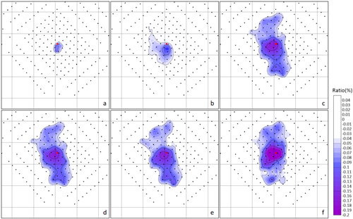
EGU26-3946 | ECS | Posters on site | ERE2.5

Analysis of long-term changes in temperature and heat flow rates caused by the operation of a BHE for a typical suburban setting 

Elisa Löschner, Christof Beyer, Abullqasim Shakeri, and Sebastian Bauer

The utilization of geothermal energy through borehole heat exchangers (BHE) is growing in significance for a sustainable energy and heat supply in urban areas. Therefore, a comprehensive knowledge of the subsurface heat balance and the governing heat transport processes influenced by urban infrastructure is essential when operating multiple BHEs with a high spatial density in city districts.

The aim of this study is to investigate the long-term changes in the subsurface heat balance and subsurface temperatures due to the operation of an individual BHE and to determine the temporal evolution of the heat capture zone of the BHE depending on the presence of streets and buildings in the near surroundings. For this purpose, a numerical model for one plot of land with a standard single-family home from the 2000s and a 3-meter-deep basement next to a street was developed. A BHE is placed in the front yard between the street and the house in accordance to the required minimum distances. Operation of this BHE was simulated for 30 years using a standard load profile based on German guidelines. The model also includes seasonal temperature variations for the street and land surface as well as heat transfer from the building to the ground.

At the beginning of the simulation, the extracted heat originates from the plot subsurface itself. The street as well as the heated basement of the building transfer heat into the subsurface, which is partially extracted by the BHE since it is located in their immediate vicinity. During the 30-year simulation period, the heat capture zone of the BHE increases. After only two years, about 50 % of the extracted heat stem from the subsurface outside the plot. After five years this fraction increases above 65 %, after 30 years above 80 %. In simulations without accounting for heat transfer from the street or the building to the subsurface, this fraction increases to about 90 %. As a consequence, also subsurface temperatures near the BHE as well as BHE return temperatures are reduced by up to 0.87 K and 0.33 K, respectively, compared to the original scenario.

Overall, the results show that the major fraction of the heat extracted by BHEs originates from heat stored in the subsurface, and that after 30 years most of the extracted heat is replaced by heat from neighbouring plots. This indicates, that even if minimum distances to neighbouring BHEs are maintained, these might be significantly affected with consequences for subsurface and BHE return temperatures.

How to cite: Löschner, E., Beyer, C., Shakeri, A., and Bauer, S.: Analysis of long-term changes in temperature and heat flow rates caused by the operation of a BHE for a typical suburban setting, EGU General Assembly 2026, Vienna, Austria, 3–8 May 2026, EGU26-3946, https://doi.org/10.5194/egusphere-egu26-3946, 2026.

EGU26-4674 | ECS | Posters on site | ERE2.5

Subsurface Thermal Impacts of Standing Column Well Operation: Insights from Operational Data 

Hae-Rim Oh, Ji-Young Baek, Philippe Pasquier, Seung-Wook Ha, Kun-Muk An, and Kang-Kun Lee

Ground source heat pump (GSHP) systems are increasingly adopted as renewable energy contributing to global decarbonization efforts. Standing column wells (SCWs) circulate groundwater directly within a single borehole, thereby leveraging the advantages of both closed-loop and open-loop GSHP systems. Owing to their reduced installation area requirements and cost efficiency, SCWs have been widely implemented in urban environments. However, comprehensive studies on SCWs remain limited, particularly with respect to the environmental impact of SCW operation based on actual operational data. This study characterized the thermal behavior of an SCW system installed at a university library in South Korea. System loads were derived from the operational data and correlated with degree-days, an indicator of energy demand, to quantify their relationships. A numerical model was then developed incorporating this relationship to simulate the spatial and temporal distribution of thermal plumes under different operational conditions. Furthermore, thermal plume evolution was evaluated under future climate scenarios by applying projected degree-days that account for global warming effects. Through this approach, the environmental impacts of SCW operation were evaluated in a more realistic manner, providing insights from a representative case of SCW applications in public institutions. Collectively, these findings are expected to contribute to the enhanced efficiency and long-term sustainability of SCW systems.


Key words: Standing column well, Environmental impact, Numerical simulation

Acknowledgement: This work was supported by the National Research Foundation of Korea (NRF) grant funded by the Korea government (MSIP) (No. 2022R1A2C1006696).

How to cite: Oh, H.-R., Baek, J.-Y., Pasquier, P., Ha, S.-W., An, K.-M., and Lee, K.-K.: Subsurface Thermal Impacts of Standing Column Well Operation: Insights from Operational Data, EGU General Assembly 2026, Vienna, Austria, 3–8 May 2026, EGU26-4674, https://doi.org/10.5194/egusphere-egu26-4674, 2026.

EGU26-4987 | ECS | Orals | ERE2.5

An open-data QGIS-workflow for lot-scale shallow geothermal planning 

Abullqasim Shakeri, Christof Beyer, Francesco Witte, Johannes Haller, Elisa Löschner, and Sebastian Bauer

Cities aiming to decarbonize space heating increasingly consider ground source heat pumps, but in densely built-up urban areas permission and practical installation is spatially constrained, e.g., by property boundaries, minimum distances to buildings, exclusion zones, and subsurface conditions. Planners and permitting authorities therefore need transparent tools at the lot-scale for borehole heat exchanger (BHE) array design in accordance with the building’s heat demand, and in compliance with local regulations. We present an open-data workflow implemented in QGIS and python to estimate the technical shallow geothermal potential for cities based on the lot level under relevant regulatory rules. The workflow is designed to rely on public datasets as far as possible, i.e. cadastral lots, building footprints, transport and land use restrictions, tree locations, and subsurface thermal conductivity. Lot-level annual heat demand is estimated based on LOD2 data by assigning standard residential building archetypes to 3D building models, scaling specific demands with floor area. All key distance and BHE array design parameters are considered as user-defined inputs, which facilitates sensitivity and scenario analyses.

The workflow comprises four major steps. First, available installation space is derived for each lot by assigning buffer zones around buildings, lot boundaries, tree locations and other restricting features in order to exclude the placement of BHEs in their direct vicinity. Furthermore, all exclusion zones are subtracted, e.g. drinking water protection zones or natural reserves. Second, within each available space polygon, candidate BHE positions are placed on a rotated and shifted hexagonal grid to approximate the densest location of BHEs for a given minimum separation distance. Third, thermal conductivity along the BHE length is sampled at every BHE position and combined with design tables for vertical BHE systems to estimate specific heat extraction rates and annually extractable geothermal energy. Finally, potentials are aggregated within lots and compared to lot-level heat demand. An energy index is derived to quantify the fraction of demand that can be covered on each lot.

The workflow was exemplarily applied to a city district, containing 1823 lots with a total annual heat demand of about 98 GWh. In a base-case scenario with all distances in compliance to local guidelines, roughly two-thirds of all lots (accounting for 88% of the district’s total heat demand) are suitable for BHE installation. The total technical potential exceeds total demand by about a factor of 1.5, but when limited to the demand per lot, only about half of the district’s heat demand can be met by BHEs on the same lot, and only about one quarter of lots with a non-zero heat demand are self-sufficient. Scenario analyses show that the geothermal potential is most sensitive to borehole depth, spacing between BHEs and distance to neighboring lots, while building and tree distance buffers have smaller effects. A scenario using deeper BHEs and slightly relaxed spacing rules increases district-wide demand coverage to about three quarters and more than doubles the number of self-sufficient lots.

How to cite: Shakeri, A., Beyer, C., Witte, F., Haller, J., Löschner, E., and Bauer, S.: An open-data QGIS-workflow for lot-scale shallow geothermal planning, EGU General Assembly 2026, Vienna, Austria, 3–8 May 2026, EGU26-4987, https://doi.org/10.5194/egusphere-egu26-4987, 2026.

EGU26-5856 | Orals | ERE2.5 | Highlight

Seismic Risk Mitigation for Geothermal Projects in Densely Populated Areas: Lessons from the Haute-Sorne Pilot Project 

Falko Bethmann, Andres Alcolea, Ben Dyer, Dimitrios Karvounis, Peter Meier, Dieter Ollinger, and Olivier Zingg

As the global energy transition accelerates, Geothermal Systems are increasingly recognized for their potential to provide baseload renewable power and heat. However, the deployment of geothermal projects near urban centers faces significant challenges related to induced seismicity, as evidenced by discontinued projects in Basel and St. Gallen. This presentation details the comprehensive seismic risk mitigation strategy developed for the Haute-Sorne EGS pilot project in Switzerland and discusses its critical relevance for future geothermal deployment in densely populated settings.

The Haute-Sorne project employs a multi-faceted approach to risk management that surpasses the current state of the art. Central to this strategy is a shift from single, large-scale stimulations to a multi-stage stimulation concept. By dividing the reservoir into smaller, engineered segments, the project aims to limit the maximum magnitude of induced events, a crucial prerequisite for operating in urban environments where tolerance for felt vibrations is minimal.

To further ensure safety in sensitive locations, the project integrates Adaptive Traffic Light Systems (ATLS). Unlike conventional reactive systems, ATLS utilizes real-time data and earthquake forecasting to predict the evolution of seismicity based on planned injection schedules. This proactive capability allows operators to adjust or halt operations before adverse events occur, providing the high level of operational control necessary for city-based projects.

Finally, addressing social acceptance in populated areas requires transparent risk communication. We present results from a probabilistic risk assessment comparing the geothermal project's risk profile to accepted community risks, such as fire. This comparison demonstrates that with rigorous mitigation, EGS risks can be managed to levels comparable to everyday urban hazards. These lessons from Haute-Sorne provide a vital blueprint for the safe, socially acceptable integration of geothermal energy into the urban landscape.

How to cite: Bethmann, F., Alcolea, A., Dyer, B., Karvounis, D., Meier, P., Ollinger, D., and Zingg, O.: Seismic Risk Mitigation for Geothermal Projects in Densely Populated Areas: Lessons from the Haute-Sorne Pilot Project, EGU General Assembly 2026, Vienna, Austria, 3–8 May 2026, EGU26-5856, https://doi.org/10.5194/egusphere-egu26-5856, 2026.

In need for alternative energy sources, deep borehole heat exchangers (DBHEs) are gaining increasing attention worldwide. Compared to deep open-loop geothermal systems, closed-loop systems generally provide low heat performance, while the advantage of DBHEs lies in their flexible installation (no reservoir needed), safer operation (low impact on the geological environment), and lower maintenance costs. Additionally, DBHEs may be installed in abandoned hydrocarbon wells or unsuccessful geothermal wells, significantly reducing installation costs. In DBHEs, the heat carrier fluid circulates inside the borehole, heated through heat conduction from the surrounding rock. The thermal conductivity and heat capacity of the geological environment therefore control system performance. In DBHE modelling studies, thermal properties of rocks are commonly averaged for lithological groups and the temperature- and pressure dependency of these properties are neglected. Bulk thermal properties are primarily controlled by porosity (i.e. pore fluid content) and the minerals constituting the rock matrix and can significantly change with increasing temperature and pressure conditions. Therefore, realistic estimates on in-situ thermal properties are key input for DBHE performance models. In this study we demonstrate and quantify the effect of depth- temperature- and pressure-dependent thermal properties on the performance of DBHEs in the siliciclastic sediments of the Pannonian Basin. Thermal conductivity and heat capacity profiles of typical lithotypes constituting the Neogene sedimentary succession of the Pannonian Basin, calculated using regional porosity-depth trends and literature-based correction formulas for temperature and pressure, are used as input for the numerical modelling. In addition to general thermal property profiles, we present DBHE models using well-log-based thermal conductivity estimates, showing the effect of local variations in thermal property profiles. DBHE models for an operational period of 1 year highlight significant differences in DBHE performance using constant vs. depth-dependent thermal properties. Models with well-log based thermal property profiles can improve DBHE performance estimates with 10 to 20 %. In general, models adopting temperature- and pressure-dependent thermal properties predict lower DBHE performance, governed by thermal conductivity decrease compared to non-dependent conductivity values. The effect of temperature- and pressure-dependent property variations on DBHE performance is dependent on lithotype and becomes relevant in the case of DBHE depth ~>2 km, further depending on local geothermal conditions. This study demonstrates that the adequate performance evaluation of DBHE projects requires modelling studies adopting carefully selected thermal properties representing the in-situ conditions of the geological environment.

How to cite: Békési, E., Porkoláb, K., and Lenkey, L.: The effect of depth, temperature and pressure dependency of rock thermal properties on the performance of deep borehole heat exchangers: example from the Pannonian Basin, EGU General Assembly 2026, Vienna, Austria, 3–8 May 2026, EGU26-6302, https://doi.org/10.5194/egusphere-egu26-6302, 2026.

EGU26-10256 | ECS | Posters on site | ERE2.5

Numerical Investigation of Non-Darcy Flow Characteristics in Rough Fractures for Geothermal Reservoir Modelling 

Abhishek Kumar Sonkar, Sayantan Ganguly, and Ranjan Das

The rapid increase in greenhouse gas (GHG) emissions due to industrialization, urban
development, and extensive use of cooling and heating devices and appliances such as air
conditioners, refrigerators, and water heaters has become a major environmental concern
worldwide. These systems release harmful GHGs that significantly contribute to global warming
and environmental degradation. To mitigate these impacts, geothermal energy stands out as a
reliable and environmentally friendly source of heat, with the potential to provide long-term
energy security and reduced carbon emissions. Despite its environmental advantages, the
development of geothermal energy projects has been limited due to issues of sporadic
distributions, involvement of high initial investment and operational costs, etc. Therefore,
accurate pre-assessment of reservoir performance is critical to determine whether a geothermal
project can meet the required energy demand and remain economically viable. Numerical
modelling plays a crucial role in this assessment by predicting fluid flow and heat transport
behaviour within geothermal reservoirs. Traditionally, most geothermal reservoir models assume
linear Darcy flow to be valid for both the porous rock matrix and the fracture networks.
However, this assumption may lead to inaccurate predictions when fractures exhibit high
roughness. In such cases, fluid flow within fractures deviates from linear Darcy behaviour and
becomes nonlinear due to inertial effects, which are better described by the Forchheimer flow
regime. Neglecting this nonlinear flow behaviour can result in significant errors in estimating
pressure losses, flow distribution, and ultimately the production temperature over time.
In this study, a numerical model of a fractured geothermal reservoir is developed that
incorporates nonlinear flow behaviour within rough fractures while retaining Darcy flow in the
surrounding porous matrix. The model is applied to a fractured geothermal system, and the
results are systematically compared with those obtained using the conventional Darcy flow
assumption for fractures. The comparison demonstrates that Darcy-based fracture models tend
to overestimate fluid mobility, leading to an underestimation of pressure losses and premature
thermal breakthrough. Consequently, Darcy flow models overestimate the magnitude of the
production temperature decline and underestimate the production temperature. The findings
highlight the importance of considering nonlinear fracture flow in geothermal reservoir
simulations, particularly for systems with highly rough fractures. Incorporating realistic flow
physics improves the reliability of production forecasts and provides a more accurate basis for
decision-making in geothermal project development.

Keywords: Geothermal energy, fractured reservoirs, nonlinear flow, Forchheimer equation, heat
transport.

How to cite: Kumar Sonkar, A., Ganguly, S., and Das, R.: Numerical Investigation of Non-Darcy Flow Characteristics in Rough Fractures for Geothermal Reservoir Modelling, EGU General Assembly 2026, Vienna, Austria, 3–8 May 2026, EGU26-10256, https://doi.org/10.5194/egusphere-egu26-10256, 2026.

EGU26-10284 | ECS | Posters on site | ERE2.5

Thermo-Hydro-Mechanical modelling of a reinjection operation in the North Alpine Foreland Basin 

Moritz Ziegler, Naomi Rettelbach, Michael Drews, Mauro Cacace, Inga Moeck, and Jennifer Ziesch

The use of geothermal energy inevitably causes changes in pore fluid pressure in the subsurface due to the production of fluids at one location and their reinjection at another location. In turn, this local change in pore pressure influences the undisturbed effective stress state. Depending on the stress state and changes in pore pressure, the rock's stability can be compromised. A resulting failure of the rock is perceived as induced seismicity. Since this is undesirable, the thermo-hydro-mechanical response of the rock to operations is often studied with the aim of better understanding the underlying mechanisms that lead to induced seismicity and potentially identifying ways to constrain its impact. However, the availability of direct data on the relevant parameters is usually sparse, if available at all. Thus, it is of interest to understand the magnitude of impact of different parameters on the stability. The ultimate goal is to enhance understanding of the parameters that are most decisive.

Here, we present and quantify the influence of various relevant parameters on the stability of the rock mass. Specifically, we examine the effect of different initial stress states, varying hydraulic and mechanical fault properties, and different rock stiffnesses on the stability of the rock mass. For quantification and comparability, we use the slip tendency as a measure of how close a rock mass is to failure. Differences in slip tendency due to different parameter sets enable us to assess the impact of uncertain information for a specific parameter on the eventual uncertainty of stability prediction.

We illustrate this approach with a case study from the North Alpine Foreland Basin. The geothermal power plant in Unterhaching has operated for almost two decades. Currently, it is used solely for district heating, but it was previously employed for power generation. During its operation, it has experienced several hundred microseismic events around the reinjection well that are attributed to the operation.

We set up a 3D thermo-hydro-mechanical model around the reinjection well to model the response of the stress field to ongoing fluid reinjections. The model geometry is based on a 3D seismic survey that includes six lithological units, each populated with corresponding rock properties. Additionally, pore fluid overpressures, as observed locally in the North Alpine Foreland Basin, are incorporated. Different stress states based on data records and model results are calibrated. Furthermore, the hydraulic properties of the faults are assumed to be either sealing or conducting. Several model scenarios allow us to eventually identify those parameter sets that are in agreement with observations of induced seismicity and reject those that do not align with them. Essentially, this enhances the quality of model predictions and facilitates a more accurate assessment of future operations.

How to cite: Ziegler, M., Rettelbach, N., Drews, M., Cacace, M., Moeck, I., and Ziesch, J.: Thermo-Hydro-Mechanical modelling of a reinjection operation in the North Alpine Foreland Basin, EGU General Assembly 2026, Vienna, Austria, 3–8 May 2026, EGU26-10284, https://doi.org/10.5194/egusphere-egu26-10284, 2026.

EGU26-10847 | Posters on site | ERE2.5

THMC-Coupled Simulation of Diagenetic Processes in Carbonate Geothermal Systems 

Deyan Tian, Guido Blöcher, Sven Maerz, Gerd Winterleitner, Jan Niederau, Nadezda Meier, Christian Siever-Wenzlaff, Alexander Meeder, Samuele Frigo, Mauro Cacace, and David Bruhn

The performance of geothermal reservoirs is fundamentally controlled by the evolution of porosity and permeability, which in turn is governed by diagenetic processes interacting with coupled thermal, hydraulic, mechanical, and chemical (THMC) processes. Diagenetic reactions may either enhance reservoir hydraulic performance - through mineral dissolution, secondary porosity generation, or dolomitization-related volume changes - or degrade it via mineral precipitation, compaction, and cementation, resulting in reduced hydraulic connectivity and geothermal productivity. A process-based understanding of these interactions and feedbacks is therefore essential for reliable geothermal resource assessment.

The Muschelkalk Formation in the Berlin–Brandenburg region of the North German Basin represents a promising geothermal target due to its favorable porosity, permeability due to brittle deformation, and temperature gradients at depth. However, its reservoir properties are strongly modified by diagenetic processes associated with halokinesis and fluid flow, including dolomitization, uplift-related deformation, and fluid-mixing corrosion. These processes generate pronounced spatial heterogeneity and uncertainty in reservoir performance, highlighting the need for a coupled, process-oriented modelling and analysis approach.

We developed a physics-based THMC-coupled modelling framework to investigate diagenetic controls on geothermal reservoir behavior from reservoir to basin scale using integrated geological and petrophysical data from the Muschelkalk Formation. The objectives of our study are (1) the analyses of THMC-coupled diagenetic processes in the Muschelkalk Formation and their effects on porosity–permeability evolution, (2) quantify the interaction between thermal, hydraulic, mechanical, and chemical processes and their influence on reservoir heterogeneity, and (3) assess the impact of these coupled processes on geothermal performance through reservoir- and basin-scale doublet simulations.

The modelling workflow is implemented using the GOLEM application (based on MOOSE framework) for coupled thermal–hydraulic–mechanical (THM) processes, which is coupled with PHREEQC to represent key geochemical reactions, enabling fully THMC-coupled model development and simulations. Despite the high computational demand of large-scale coupled modelling, this approach enables a comprehensive assessment of temperature, fluid flow, stress state, geochemistry, and petrophysical evolution. Overall, the study aims to provide a quantitative and process-based foundation for improving geothermal resource evaluation and long-term reservoir management in sedimentary basins.

How to cite: Tian, D., Blöcher, G., Maerz, S., Winterleitner, G., Niederau, J., Meier, N., Siever-Wenzlaff, C., Meeder, A., Frigo, S., Cacace, M., and Bruhn, D.: THMC-Coupled Simulation of Diagenetic Processes in Carbonate Geothermal Systems, EGU General Assembly 2026, Vienna, Austria, 3–8 May 2026, EGU26-10847, https://doi.org/10.5194/egusphere-egu26-10847, 2026.

EGU26-11172 | ECS | Posters on site | ERE2.5

Hybrid ML assisted Bayesian Optimal Experimental Design for Thermal Field Monitoring 

Cristian Siegel, Denise Degen, and Mauro Cacace

In the context of geothermal energy development, accurate characterization of the subsurface thermal field is critical for successful exploration, resource assessment, and validation of numerical models. The temperature distribution in the subsurface is strongly influenced by the distribution of heterogeneous material properties, which are often poorly constrained, leading to significant uncertainties in model predictions. A key challenge lies in designing or improving sensor networks that effectively capture the spatial and temporal evolution of the thermal field, while considering related sources of uncertainty. Maximizing the expected information that can be acquired with an improved sensor network would enable a reliable calibration and validation of subsurface models during the exploration phase of geothermal projects. We approach this challenge by using a Bayesian optimal experimental design strategy, which allows an optimization of the sensor placement considering uncertainties in, for the case discussed in this contribution, bulk material properties. Bayesian optimal design has the disadvantage of requiring numerous forward solves, which are often prohibitive for high-fidelity numerical simulations. We address this computational burden through the construction of interpretable physics-based machine learning surrogate models. They allow faster evaluations of coupled thermal numerical models, by combining model-order reduction methods with data-driven techniques, enabling rapid and accurate predictions across large parameter spaces, while retaining interpretability grounded in the underlying physical laws. As an application of the method we address the problem of thermal sensor placement to monitor the subsurface response for (sedimentary) basin-wide applications. Our results aim at identifying optimal locations for a regional observation network that maximizes sensitivity to key subsurface characteristics.

How to cite: Siegel, C., Degen, D., and Cacace, M.: Hybrid ML assisted Bayesian Optimal Experimental Design for Thermal Field Monitoring, EGU General Assembly 2026, Vienna, Austria, 3–8 May 2026, EGU26-11172, https://doi.org/10.5194/egusphere-egu26-11172, 2026.

EGU26-11577 | Posters on site | ERE2.5

Minewater Geothermal: Mine-groundwater interactions and the effects on Geothermal Resource feasibility 

Callum Thomas, Jeroen van Hunen, and Julia Knapp

Flooded, abandoned coal mines represent a reliable, low-enthalpy geothermal resource, providing significant subsurface stores of water, which heat can be extracted from or rejected to. Understanding the hydraulic processes not just within the mine, but of the local groundwater regime is key for accurate characterisation and modelling of the heat extraction and storage potential of Minewater Geothermal (MWG) systems. Here, we investigate the interaction between the local groundwater regime and MWG system, their influences on each other, and how ambient flow is diverted, with the mine representing a preferential pathway. Using MODFLOW and Python, we have developed a 3D groundwater model, to assess the rate of groundwater flow through flooded coal mines.   


During active mining, continual pumping of water was necessary to maintain dry working conditions. Once closed, pumps were shut off and the mines were left to flood through groundwater rebound. The UK Mining Remediation Authority are responsible for the monitoring of regional coalfield groundwater resources, investigating the impact on individual MWG sites, however, requires an understanding of the local regime.


Post-mining hydrogeology is very uncertain, with increased fracturing and hydraulic conductivity of surrounding strata producing irregular flow paths into the open mine galleries, the extent of which at individual mine sites is not known. To deal with this level of hydrogeological uncertainty, a broad modelling approach has been taken. We have completed sensitivity analysis of a conceptual model to gain a first-order view of how the distribution of hydraulic conductivity values alters the amount of water flowing through the mines, and the determination of a scaling relationship. We have also carried out transient pumping tests to calibrate the conceptual model.


Here, we present the results of i) conceptual modelling, ii) sensitivity analysis and iii) transient pumping tests, aiming to assess how varying hydrogeology of mined strata influences the rates of groundwater flow through the mine. These initial findings suggest that local groundwater flow has a significant role in the hydraulic conditions of MWG schemes and should be a key consideration when selecting sites for new schemes. Significant flow through the mines could be positive or negative, depending the on the use. For extraction schemes, a regular supply of warm water would be beneficial to the longevity of the scheme. Whereas, for storage purposes, a strong flow through the mine would carry the warm water away from the site leaving it unusable. This becomes a complex issue for seasonal storage/extraction schemes, such as the ICHS project at Durham University. 

How to cite: Thomas, C., van Hunen, J., and Knapp, J.: Minewater Geothermal: Mine-groundwater interactions and the effects on Geothermal Resource feasibility, EGU General Assembly 2026, Vienna, Austria, 3–8 May 2026, EGU26-11577, https://doi.org/10.5194/egusphere-egu26-11577, 2026.

EGU26-13444 | Orals | ERE2.5

Hydrogeological Investigation and Techno-Economic Evaluation of a Geothermal Mine Water System 

Thomas Heinze, Florian Lam, and Thorsten Gökpinar

Abandoned mine infrastructures offer promising potential for subsurface thermal energy extraction and storage in urban environments. However, their integration into energy systems demands a thorough understanding of hydrogeological behavior and economic feasibility. In this study, we present a comprehensive investigation of a geothermal mine water system operating within an abandoned mine in Germany since 9 years. Our approach combines detailed field monitoring, advanced data-driven analysis, and techno-economic evaluation.

High-resolution, high-frequency measurements at the study site reveal dynamic interactions between mine water and surrounding groundwater. These data capture short-term fluctuations driven by recharge events and pressure propagation through interconnected voids and fractured rock. Combined with depth-resolved temperature profiles and in-situ video inspections of mine shafts using cameras and underwater rovers, we aim to gain a detailed understanding of hydraulic processes within the mine workings and their connection to the regional groundwater system.

To translate hydrogeological investigation into system planning and policy decisions, we analyze the sensitivity of the economic performance of the system to carbon pricing, integrating gained insights and operational experience with forward-looking economic modeling. Our results suggest that under the favorable geological and hydraulic conditions at the test site, mine-based geothermal systems can achieve levelized costs that are competitive with air-source heat pumps.

This integrated approach highlights the value of high-frequency field data, data-driven automated analysis, and economic modeling for assessing the viability of repurposing post-mining infrastructure for sustainable energy use.

How to cite: Heinze, T., Lam, F., and Gökpinar, T.: Hydrogeological Investigation and Techno-Economic Evaluation of a Geothermal Mine Water System, EGU General Assembly 2026, Vienna, Austria, 3–8 May 2026, EGU26-13444, https://doi.org/10.5194/egusphere-egu26-13444, 2026.

EGU26-13820 | ECS | Posters on site | ERE2.5

Managing open-loop GWHP operation in urban aquifers to reduce thermal interference and background warming: the THERMAL approach 

Jorge Martínez-León, Enrique Merino-Martínez, Miguel Ángel Marazuela, Carlos Baquedano, Jon Jiménez, Rodrigo Sariago, Samanta Gasco-Cavero, Olga Escayola Calvo, and Alejandro García-Gil

Open-loop groundwater heat pump (GWHP) systems provide low-carbon heating and cooling by exchanging heat with pumped groundwater. In dense urban settings, however, this advantage can become a liability: overlapping thermal plumes and persistent warming may progressively elevate background groundwater temperatures, constrain resource availability, and reduce long-term system reliability. To address this, we introduce THERMAL (Shallow geoTHERmal energy MAnagement through hoListic optimization), a decision-support approach that integrates conventional performance metrics with aquifer-centred sustainability indicators to guide GWHP operation. THERMAL screens operating strategies designed to preserve the ambient thermal baseline while reducing thermal cross-interference between neighbouring installations.
We apply THERMAL to three GWHP systems in Zaragoza’s urban alluvial aquifer, testing 27 alternative operating configurations against the current baseline. The scenario ensemble reveals substantial trade-offs: several configurations perform worse than present operation, whereas multiple options improve both environmental and economic outcomes. The best-ranked strategy achieves an emissions reduction of 14.94 t CO₂-eq yr⁻¹ and €7.53k yr⁻¹ in cost savings. However, the scenarios that maximize cost and CO₂ benefits do not systematically coincide with those that most effectively reduce the spatial footprint of strongly warmed groundwater (areas with ΔT > 4 °C). These results show why single-objective, “performance-only” optimization is insufficient in cities: robust planning requires multi-criteria decisions that explicitly protect the aquifer’s thermal integrity. THERMAL offers a practical route to align GWHP operation with the long-term conservation of urban groundwater thermal conditions.

How to cite: Martínez-León, J., Merino-Martínez, E., Marazuela, M. Á., Baquedano, C., Jiménez, J., Sariago, R., Gasco-Cavero, S., Escayola Calvo, O., and García-Gil, A.: Managing open-loop GWHP operation in urban aquifers to reduce thermal interference and background warming: the THERMAL approach, EGU General Assembly 2026, Vienna, Austria, 3–8 May 2026, EGU26-13820, https://doi.org/10.5194/egusphere-egu26-13820, 2026.

EGU26-15015 | ECS | Orals | ERE2.5

Optimization of deep hydrothermal systems via the adjoint approach 

Ulrich Steindl, Thomas Hamacher, and Smajil Halilovic

The exploitation of Deep Hydrothermal Systems (DHS) offers significant potential for decarbonizing district heating networks by providing renewable baseload energy. However, the sustainable management of these resources requires balancing conflicting physical phenomena. DHS operations extract hot fluid from deep aquifers and reinject heat-depleted water. This process creates a hydraulic head loss near production wells, increasing pumping costs, while simultaneously driving the cold-water plume toward the producer. While placing injection wells nearby mitigates hydraulic pressure drop, it accelerates thermal breakthrough, reducing the system’s thermal capacity.

In this work, we present a computational framework to maximize the net energy extraction of DHS—defined as thermal energy production minus pumping energy consumption—by optimizing well flow rates and positions. We formulate the problem as a PDE-constrained optimization governed by a coupled thermo-hydraulic (TH) model. To solve this efficiently, we utilize the Finite-Element Method (FEM) combined with the adjoint approach to compute gradients, allowing for the use of the Interior Point Optimizer (IPOPT). This is paired with a multi-start strategy to approximate global optimality. Compared to gradient-free algorithms, this gradient-based method offers superior convergence rates, making the optimization of large-scale systems computationally tractable.


We validate the proposed framework by benchmarking against analytical solutions for homogeneous reservoirs, subsequently demonstrating its efficacy through numerical examples in 2D aquifers with heterogeneous hydraulic properties. The results illustrate how optimal well configurations shift based on subsurface permeability structures. Ultimately, this gradient-based framework provides a computationally efficient foundation for optimizing DHS in structurally complex 3D geothermal reservoirs.

How to cite: Steindl, U., Hamacher, T., and Halilovic, S.: Optimization of deep hydrothermal systems via the adjoint approach, EGU General Assembly 2026, Vienna, Austria, 3–8 May 2026, EGU26-15015, https://doi.org/10.5194/egusphere-egu26-15015, 2026.

EGU26-16775 | Orals | ERE2.5

UTES in Berlin: a systems approach to heat storage, usage, and heat pollution mitigation 

Sally Potter-McIntyre and Guido Blöcher

Dense urban areas like Berlin face unique challenges when instituting geothermal energy, especially understanding how subsystems (e.g., transportation, people, legal framework, deep subsurface, drinking water, etc.) are linked and how the larger system is affected by changes to subsystems. The innovative approach to viewing a city as a system composed of subsystems and integrating the subsystems in a holistic energy efficiency framework is required to prevent unforeseen adverse consequences of actions such as heat pollution from thermal energy storage in deep reservoirs. The interaction between U-Bahn tubes, HT-ATES/BTES systems, groundwater flow, and the urban heat island creates a tightly coupled thermomechanical environment in which temperature, pore pressure, strain, and geochemical states evolve simultaneously and govern system efficiency and structural stability. In Berlin-Adlershof, an HT-ATES research well was completed in 2024 and drilling of the injection and production wells are slated for this year. Our new work will demonstrate the efficacy of: 1. HT-ATES in Berlin for thermal heat storage and production, 2. Using the subway system to collect heat and mitigate heat waste from the shallow subsurface heat island and heat pollution produced by HT-ATES wells. The interaction data from monitoring wells and a fiber optic experiment within the subway will provide parameters for thermomechanical models on granular scales (e.g., directly adjacent to wells, subway) and we will scale up models to interconnect ATES, subway, and groundwater, and then to district, city, and national levels. Social science and humanities data will be incorporated into the large-scale models to produce a structure for establishing UTES in other cities with unique settings in terms of geology, legal framework, drinking water sources, presence/ absence of mining, and other differences.

How to cite: Potter-McIntyre, S. and Blöcher, G.: UTES in Berlin: a systems approach to heat storage, usage, and heat pollution mitigation, EGU General Assembly 2026, Vienna, Austria, 3–8 May 2026, EGU26-16775, https://doi.org/10.5194/egusphere-egu26-16775, 2026.

EGU26-16969 | ECS | Orals | ERE2.5

Low-Frequency Distributed Acoustic Sensing reveals transient flow and heat-transfer regimes during geothermal injection 

Johannes Hart, Christopher Wollin, Aurelio Andy, Toni Ledig, Thomas Reinsch, and Charlotte Krawczyk

High-resolution diagnostics of flow and heat transfer in deep geothermal wells are commonly constrained by sparse downhole instrumentation and production-logging tools that require well intervention, interrupting steady-state operations. Here, we demonstrate continuous flow profiling and convection-regime identification (pump-driven forced convection vs. buoyancy-driven natural convection) using fiber-optic sensing methods. We used a combination of the Low-Frequency Distributed Acoustic Sensing (LF-DAS) approach, which measures axial strain-rate changes along a fiber, and Distributed Temperature Sensing (DTS) in a 4.1 km MD (Measured Depth) geothermal injection well within Munich, Germany.

During shut-in, LF-DAS reveals three persistent, depth-localized natural convection cells, characterized by distinct strain-rate patterns and coincident with rapid warming with depth, as observed in the DTS data. In quasi-steady-state injection, operationally occurring temperature changes as small as 10 mK/min in the injected fluid induce thermo-mechanical deformation along the fiber. These downward-propagating thermal fronts initially reflect pump-driven forced convection and enable flow profiling based on advective heat transport. From a depth of 3580 m MD, these fronts are blurred by the onset of buoyancy-driven natural convection. LF-DAS allows estimation of the plume-shedding frequency, plume height, travel distance, and velocity, all related to the temperature gradient measured with DTS. The accuracy of a threshold criterion for the onset of buoyancy-driven flow based on the temperature gradient is currently limited by the precision of the reference DTS measurement. Across all operational states, values range from 39 to 44 °C/km of true vertical depth.

These findings show that fiber-optic sensing can detect fluid-flow pathways, convection behavior, and regime changes without well intervention, thereby improving continuous monitoring and reservoir characterization for sustainable geothermal operation.

How to cite: Hart, J., Wollin, C., Andy, A., Ledig, T., Reinsch, T., and Krawczyk, C.: Low-Frequency Distributed Acoustic Sensing reveals transient flow and heat-transfer regimes during geothermal injection, EGU General Assembly 2026, Vienna, Austria, 3–8 May 2026, EGU26-16969, https://doi.org/10.5194/egusphere-egu26-16969, 2026.

EGU26-17546 | Posters on site | ERE2.5

Groundwater of a former underground slate exploitation in Martelange-Rombach (Luxembourg) and its renewable energy potential  

Natascha Kuhlmann, Robert Colbach, Jean Thein, and Stefan Maas

The role of geothermal energy in the energy transition is rapidly gaining recognition. Its storage technologies provide flexible solutions to address the intermittent nature of other renewable resources. Abandoned mines and other underground caverns have recently attracted particular attention as valuable geothermal reservoirs.

In this context, a pilot project was recently initiated in the flooded abandoned underground slate exploitation area of Martelange (Belgium & Luxembourg). This area,  with its long industrial history, represents a significant opportunity for future geothermal applications. The large volume of water stored within these underground caverns, in combination with heat-pumps, is sufficient to provide heating and cooling for a quite large number of buildings.

Where natural regeneration, depending on groundwater flows and the thermal conductivity of the surrounding soil, proves insufficient and where water temperature changes exceed 5 °C, active regeneration may be implemented. This involves the installation of (un)glazed solar thermal absorbers to collect low-cost solar heat during summer and cold during winter, transforming the system into a form of solar district heating. In such a scenario, the flooded slate caverns would function as a seasonal energy storage body.

The objective of the project is to develop a modern, highly energy-efficient urbanized area with a commercial zone, based on a low-temperature urban heat and cold network fed by heat-pumps. Achieving this requires a detailed assessment of the local geological and hydrogeological conditions, especially the structure and connections of the slate caverns, to ensure optimal and sustainable use of the available water resources. The first results from this study will be presented.


How to cite: Kuhlmann, N., Colbach, R., Thein, J., and Maas, S.: Groundwater of a former underground slate exploitation in Martelange-Rombach (Luxembourg) and its renewable energy potential , EGU General Assembly 2026, Vienna, Austria, 3–8 May 2026, EGU26-17546, https://doi.org/10.5194/egusphere-egu26-17546, 2026.

EGU26-17797 | ECS | Posters on site | ERE2.5

Enhancing Geothermal Performance of Lithuanian Reservoir Using CO2: A Pore-Scale Study 

Parsa Alimohammadiardakani, Anna Horbenko, and Mayur Pal

Renewable energy sources have been recognized over the past years as a key solution for mitigating emissions of CO₂ gas into the atmosphere. Meanwhile, the rapid expansion of the artificial intelligence (AI) industry and the growing demand for large-scale data centers have placed unprecedented pressure on the energy sectors and making a significant contribution to greenhouse gas emissions [1]. Consequently, attention is directed toward geothermal energy due to its ability to operate continuously and efficiently, providing a reliable source of energy for both electricity and heat generation [2].


Western Lithuania has many subsurface reservoirs with temperatures suitable for geothermal applications. Previous studies have analyzed the heat and electricity generation potential of these reservoirs, highlighting promising opportunities for geothermal development in the region [3, 4]. Consequently, the implementation of enhanced geothermal methods could significantly improve the feasibility and efficiency of these geothermal reservoirs.

The Baltic Basin reaches its maximum depths beneath Lithuania, where the subsurface reservoirs in western Lithuania exhibit favorable temperature and pressure conditions and rock properties for CO₂ storage [5]. Several past studies have demonstrated significant storage potential in these subsurface reservoirs of Lithuania [5]. Therefore, opportunity exists to utilize CO₂  , as a fluid for geothermal applications, such as brine displacement for heat extraction. Additionally, CO₂ exhibits advantageous thermophysical properties compared to brine which can enhance heat extraction, electricity generation, and geothermal energy storage efficiency.

This research aims to investigate pore-scale CO₂–brine physical interactions under Lithuanian geothermal reservoir conditions (e.g., temperature, pressure, and salinity). The objective is to evaluate the influence of CO₂ on brine displacement and local temperature distribution. In addition, pore-scale scenarios of CO₂ storage for geothermal energy storage are analytically examined to assess CO₂–brine–rock interactions, identify suitable operating conditions, and estimate viable storage durations. Numerical simulations of flow dynamics and heat transfer are conducted using reservoir simulation tools. A homogeneous and a heterogeneous pore-network models are developed for the simulations.


 References

[1]

R. Jha, R. Jha and M. Islam, "Forecasting US data center CO2 emissions using AI models: emissions reduction strategies and policy recommendations," Frontiers in Sustainability, 2025.

[2]

G. J. N. J. J. P. Ashok A. Kaniyal, "The potential role of data-centres in enabling investment in geothermal energy," Applied Energy, pp. 458-466, 2012.

[3]

M. Pijus, I. Kaminskaite-Baranauskiene, A. Rashid Abdul Nabi Memon and M. Pal, "Assessing Geothermal Energy Production Potential of Cambrian Geothermal Complexes in Lithuania," Energy, 2024.

[4]

A. Rashid Memon, P. Makauskas, I. Kaminskaitė-Baranauskienė and M. Pal, "Repurposing depleted hydrocarbon reservoirs for geothermal energy: A case study of the Vilkyčiai Cambrian sandstone in Lithuania," Energy Reports, pp. 243-253, 2025.

[5]

S. Malik, P. Makauskas, R. Sharma and M. Pal, "Evaluating Petrophysical Properties Using Digital Rock Physics Analysis: A CO2 Storage Feasibility Study of Lithuanian Reservoirs," Applied Sciences, 2024.


How to cite: Alimohammadiardakani, P., Horbenko, A., and Pal, M.: Enhancing Geothermal Performance of Lithuanian Reservoir Using CO2: A Pore-Scale Study, EGU General Assembly 2026, Vienna, Austria, 3–8 May 2026, EGU26-17797, https://doi.org/10.5194/egusphere-egu26-17797, 2026.

EGU26-19874 | Orals | ERE2.5

From Reservoir to District Heating: Success Factors and Challenges of Medium‑Depth Geothermal Energy in North German Municipalities 

Evelin Pechan, Stefanie Krug, Simone Röhling, Simon Richter, Janis Weber, Julika Weiß, Lars Holstenkamp, Johanna Jekel, and Marlena Spieß

This contribution presents results from case studies on medium-depth hydrothermal geothermal projects in the North German Basin (NGB). Despite well-explored locations, these projects have not yet progressed to implementation. All cases were selected based on favourable geohydraulic conditions, and their geology is representative of that of the NGB. The selected sites differ intentionally in terms of their heat-offtake situations, such as the heating network, the size of the municipality, or the presence or absence of commercial heat consumers.

For each case study, technical concepts were developed that integrate geothermal heat for partial or full baseload coverage. A central element of all concepts is the use of one or more high capacity heat pumps to raise the production temperature to the required supply temperature of the district heating network.  

One of the key aspects of this work is to evaluate the operational feasibility of the proposed technical concepts. To this end, the authors performed thermal-hydraulic coupled simulations of the hydrothermal system. These simulations provide insights into long‑term reservoir behaviour under different production and injection scenarios. They form the basis for an energy balance while maintaining reservoir integrity.

The results of the case studies will be generalised. Recommendations will be made to help the stakeholders of the heat transition to integrate medium-depth geothermal energy into the heat supply in a technically robust and economically viable way.

The presented work is part of the research project Warm‑Up, funded by the Federal Ministry for Economic Affairs and Energy (BMWE) and conducted at the Federal Institute for Geosciences and Natural Resources (BGR). Project partners include the Leibniz Institute for Applied Geophysics (LIAG), the ECOLOG Institute for Social‑Ecological Research and Education and the Institute for Ecological Economy Research (IÖW).

How to cite: Pechan, E., Krug, S., Röhling, S., Richter, S., Weber, J., Weiß, J., Holstenkamp, L., Jekel, J., and Spieß, M.: From Reservoir to District Heating: Success Factors and Challenges of Medium‑Depth Geothermal Energy in North German Municipalities, EGU General Assembly 2026, Vienna, Austria, 3–8 May 2026, EGU26-19874, https://doi.org/10.5194/egusphere-egu26-19874, 2026.

EGU26-20547 | Orals | ERE2.5

Multi‑sense monitoring using Distributed Fiber‑Optic Sensing for temperature, groundwater flow and acoustics in Aquifer Thermal Energy Storage Systems 

Roeland Nieboer, Pieter Doornenbal, Edvard Ahlrichs, Henk Kooi, Edwin Obando Hernandez, Manos Pefkos, and Pieter Pauw

Aquifer Thermal Energy Storage (ATES) systems play an increasingly important role in balancing urban heating and cooling demand. Their sustainable operation requires high‑resolution monitoring of subsurface thermal and hydraulic processes, particularly the movement of thermal plumes, groundwater flow dynamics, and operational disturbances during injection and extraction. Traditional monitoring approaches provide only sparse spatial information, limiting the ability to characterize key ATES behaviors. Distributed fiber‑optic sensing (DFOS) offers a step‑change in monitoring capability by enabling continuous measurements along the full depth of wells and monitoring infrastructure.

We present a use case of the ATES system on the Deltares campus in Delft using a multi‑sense DFOS approach that combines Distributed Temperature Sensing (DTS), Active‑Heating DTS (AH‑DTS) and Distributed Acoustic Sensing (DAS). DTS provides the temperature distribution along the well filters and how this evolves over time to get insights into plume migration. AH‑DTS provides estimates of (changes in) groundwater flow velocity by analyzing heating curves measured by the fiber, enabling analysis of preferential flow at specific depth intervals paths. DAS can capture hydrodynamic and operational acoustic signals associated with injection, production, and well hydraulics, offering additional insight into transient system behavior.

Integrating DTS, AH‑DTS and DAS provides low-cost monitoring at aquifer depth that can help reduce uncertainty and provides insights in thermal–hydraulic processes governing ATES performance. This multi‑sense DFOS approach enhances predictive modelling, enables early detection of thermal short‑circuiting or unintended flow pathways, and supports more efficient, reliable and sustainable ATES operation.

How to cite: Nieboer, R., Doornenbal, P., Ahlrichs, E., Kooi, H., Obando Hernandez, E., Pefkos, M., and Pauw, P.: Multi‑sense monitoring using Distributed Fiber‑Optic Sensing for temperature, groundwater flow and acoustics in Aquifer Thermal Energy Storage Systems, EGU General Assembly 2026, Vienna, Austria, 3–8 May 2026, EGU26-20547, https://doi.org/10.5194/egusphere-egu26-20547, 2026.

The global energy transition is accelerating due to the climate crisis, with nations aiming for net-zero emissions as outlined in the “UAE Consensus” from the 28th United Nations Climate Change Conference (COP28). Sub-Saharan Africa must balance climate resilience and economic growth. Geothermal energy, a low-carbon, under-explored alternative to fossil fuels, can help Nigeria meet expanding energy needs. The study which aims to aims to develop an integrated, multi-scale approach for assessing geothermal resource potential employed a multi-criteria decision-making framework combining Fuzzy AHP and TOPSIS to assess geothermal potential across Nigeria’s 37 states. Fuzzy AHP provided weighted criteria, while TOPSIS calculated performance scores based on each state’s proximity to the ideal solution. Initial findings suggest that most of the highest-ranked states for geothermal potential align within regions influenced by the most recent magmatic activities in Nigeria, which occurred during the Tertiary period The analysis showed a wide spread of results, reflecting significant regional variability in geothermal conditions. Nasarawa, Bauchi, and Benue ranked highest, indicating strong geothermal suitability. Lagos, Gombe, and Ogun ranked lowest, while states such as Rivers, Katsina, and Niger showed moderate potential. Meanwhile, we will undertake targeted fieldwork in high-prospect states to map structural features at outcrop scale and conduct geochemical analysis.

How to cite: Yohanna, O.: Integrated Approach for Low-Enthalpy Geothermal Resource Appraisal and Assessment in Nigeria: Implications for Net-Zero Target , EGU General Assembly 2026, Vienna, Austria, 3–8 May 2026, EGU26-20884, https://doi.org/10.5194/egusphere-egu26-20884, 2026.

EGU26-834 | ECS | Posters on site | ERE2.7

Geothermal potential assessment of the Kaplanlı region (Afyon) using the magnetotelluric method 

Eray Mahmutyazıcıoğlu, Elif Nihan Çavdar, and Ümit Avşar

Industry standards for geothermal exploration commonly rely on electromagnetic geophysical techniques. Subsurface and high temperature fluids are responsible for alteration of clays which are observed in locations with geothermal potential. These geological conditions exhibit elevated conductivity values, making EM methods viable for geothermal prospecting. This study presents the results of a magnetotelluric (MT) survey conducted in the Kaplanlı region  in Afyon, Western Anatolia, aimed at identifying geothermal potential within a structurally complex tectonic setting. A total of five MT profiles with 51 stations were acquired and subjected to two-dimensional inversion to resolve the subsurface resistivity structure. The results reveal a prominent medium-resistivity zone with a thickness of 2.5 km and at 3 km’s floor depth, interpreted as a potential geothermal reservoir. Geophysical interpretations, supported by regional tectonic analysis, suggest the presence of deep-seated magmatic intrusions acting as a heat source. The findings indicate that the Kaplanlı area within Afyon holds significant promise for geothermal exploration, and demonstrate the effectiveness of MT methods in delineating favorable reservoir conditions in extensional tectonic settings.

How to cite: Mahmutyazıcıoğlu, E., Çavdar, E. N., and Avşar, Ü.: Geothermal potential assessment of the Kaplanlı region (Afyon) using the magnetotelluric method, EGU General Assembly 2026, Vienna, Austria, 3–8 May 2026, EGU26-834, https://doi.org/10.5194/egusphere-egu26-834, 2026.

EGU26-1369 | ECS | Posters on site | ERE2.7

Geothermal exploration in the Middle East, a case study 

Ramon Asuaje

Known for its world class hydrocarbon plays, the Middle East also offers the opportunity to explore lower carbon emissions energy sources; geothermal.

Understanding the geologic evolution of our basins was key to capitalize and focus the lessons learned from hydrocarbon exploration to the investigation and growth of geothermal resources within the kingdom.

Oil and gas exploration is based on the statistical study of six different elements: trap, reservoir, seal, source, migration, and timing. Whereas the factors that mostly define the success of a geothermal project are flow volume and temperature. Our strategy involved understanding the main elements that define success in geothermal exploration, and follow four main steps to characterize areas of interest: Research, screening, risk, and exploration.  

Research of worldwide successful geothermal developments, with similar geological settings of those found within the kingdom. Screening our geological basin to find analog settings where we could apply the same principles. Risking each factor through a scrutinized statistical analysis similar to the process used in hydrocarbon exploration. Finally, choosing two areas to further investigate their geothermal potential with exploration wells.

The following work further illustrates each step of our exploration process and highlights our lessons learned and future areas of investigation.

How to cite: Asuaje, R.: Geothermal exploration in the Middle East, a case study, EGU General Assembly 2026, Vienna, Austria, 3–8 May 2026, EGU26-1369, https://doi.org/10.5194/egusphere-egu26-1369, 2026.

EGU26-1810 | Posters on site | ERE2.7

Risk-based assessment of geothermal reservoir integrity 

Sabine den Hartog, Nico Hardebol, Frank Janssen, Tamara Morales-Rua, Annemarie Muntendam-Bos, and Resi Veeningen

Several potential hazards are linked to geothermal operations, including hazards arising when reservoir integrity is compromised. This contribution provides a framework for assessing the potential risk of loss of integrity of a geothermal reservoir. Focus is on low enthalpy, matrix permeable sedimentary systems at depths of approximately 1500-3000 m, typical for the Netherlands, but the framework can also be applied to other geothermal plays. Loss of reservoir integrity via a number of leakage pathways is considered, such as newly formed fractures in the caprock induced by thermal cooling or increased fluid pressures, abandoned wells through the caprock, pre-existing faults in the caprock and through the matrix of the caprock. Possible effects of loss of reservoir integrity that are taken into account include groundwater contamination, subsidence/uplift and interference of operations with those in other neighbouring permit areas. With the proposed framework, a qualitative assessment can be made of the risk related to each of these effects, leading to a general evaluation of the risk of loss of reservoir integrity. This framework can be used by geothermal operators in their exploration for suitable locations for geothermal systems and for underpinning the safety of their application for permits for these operations. It can also be used by regulators in their evaluation of geothermal permit applications.

How to cite: den Hartog, S., Hardebol, N., Janssen, F., Morales-Rua, T., Muntendam-Bos, A., and Veeningen, R.: Risk-based assessment of geothermal reservoir integrity, EGU General Assembly 2026, Vienna, Austria, 3–8 May 2026, EGU26-1810, https://doi.org/10.5194/egusphere-egu26-1810, 2026.

EGU26-2196 | ECS | Orals | ERE2.7

Integrated Well-Logging and Numerical Simulation for Geothermal Resource Assessment in Eastern Taiwan 

Chen Wang, Hung-Yu Wu, Ching-An Lee, and Shao-Yu Tseng

Taiwan, situated along the Pacific Ring of Fire, possesses substantial high-enthalpy geothermal resources, particularly within its subduction zone regions. Consequently, the deployment of geothermal energy has become a pivotal component of the national energy-transition policy. Focusing on a tectonically active field in eastern Taiwan, this study evaluates geothermal development potential by integrating advanced well-logging analysis with numerical reservoir simulation. To characterize stratigraphy, structural layers, and fracture networks, we utilize natural gamma ray, resistivity, sonic, and Formation Micro-Resistivity Imager (FMI) logs, integrated with High-resolution Sonic Scanner data. The inclusion of the Far Field Sonic Scanner specifically allows for imaging fracture systems and formation heterogeneities beyond the detection range of conventional acoustic tools. These geophysical datasets support the construction of a three-dimensional geomechanical model that captures in-situ lithological variations and geothermal reservoir properties. Subsequently, thermal–hydraulic behavior is simulated using the TOUGH3 code via the PetraSim interface, allowing for efficient model calibration and post-processing. Model parameters are constrained by in-situ logging measurements to refine estimates of temperature distribution, fracture pathways, and structural orientation. Ultimately, this study aims to deliver a robust conceptual model and a 3D numerical representation of the geothermal system, providing quantitative estimates of recoverable thermal reserves and power generation potential. The proposed workflow enhances the accuracy of geothermal resource evaluation in Taiwan and offers a transferable methodological framework for similar metamorphic tectonic environments.

How to cite: Wang, C., Wu, H.-Y., Lee, C.-A., and Tseng, S.-Y.: Integrated Well-Logging and Numerical Simulation for Geothermal Resource Assessment in Eastern Taiwan, EGU General Assembly 2026, Vienna, Austria, 3–8 May 2026, EGU26-2196, https://doi.org/10.5194/egusphere-egu26-2196, 2026.

EGU26-3840 | Orals | ERE2.7

Beneath the Surface: Bridging Stakeholder Engagement and Modelling in Geothermal Exploration 

Roman Seidl, Anna-Katharina Brüstle, Paula Stocker, Jurre van den Brink, and Stefan Hoyer

Early-stage geothermal exploration depends heavily on geological and numerical modelling to support decision-making under conditions of sparse data, high uncertainty, and significant financial risk. While such models are central to exploration and appraisal workflows, their role, interpretation, and credibility among non-technical stakeholders remain insufficiently understood—particularly during early project phases, when public acceptance, perceived risk, and investment decisions are most sensitive.

This contribution investigates how stakeholders perceive geothermal exploration models and associated uncertainties, with a particular focus on communication challenges at the interface between technical and societal domains. The study accompanies a technically advanced, research-driven modelling framework developed within the GO-Forward project, which can be challenging to interpret even for specialists.

Empirical insights are drawn from two geothermal case areas situated in contrasting national and regulatory contexts: the onshore Gassum Formation (Denmark) and the southern Vienna Basin (Austria). The methodological approach combines expert and stakeholder interviews, a structured stakeholder analysis using a power–interest grid, and two case-specific stakeholder workshops. These workshops address general perceptions of geothermal energy development as well as stakeholder interpretations of modelling outputs, exploration risks, and uncertainties related to assumptions and data limitations.

Preliminary results reveal pronounced procedural differences between the two case areas in terms of stakeholder constellations, institutional roles, and engagement pathways, alongside heterogeneous understandings of modelling and uncertainty. Whereas modelers typically frame uncertainty as an inherent characteristic of subsurface exploration, many stakeholders associate it directly with project risk, credibility, and trust. Practitioners such as energy agencies report relying on geological survey expertise rather than directly using models themselves, for instance when evaluating license applications.

An emerging topic for further investigation is the potential role of advanced modelling approaches in reducing subsurface uncertainty in ways that are relevant for insurance companies, particularly with respect to eligibility and risk assessment criteria. This idea currently stems from discussions with non-insurance stakeholders and will require targeted investigation involving insurance actors.

Despite the limited number of case studies, the findings will provide practical insights into structuring stakeholder interactions during early geothermal exploration and identify uncertainty as a key interface between technical modelling practices and societal expectations. Further results from ongoing stakeholder workshops will be available by May 2026.

How to cite: Seidl, R., Brüstle, A.-K., Stocker, P., van den Brink, J., and Hoyer, S.: Beneath the Surface: Bridging Stakeholder Engagement and Modelling in Geothermal Exploration, EGU General Assembly 2026, Vienna, Austria, 3–8 May 2026, EGU26-3840, https://doi.org/10.5194/egusphere-egu26-3840, 2026.

EGU26-8258 | Posters on site | ERE2.7

Assessment of soil boron, ammonia and elemental mercury for geothermal exploration in the Canary Islands 

Gladys V. Melián, Nemesio M. Pérez, Alba Martín-Lorenzo, Sttefany Cartaya-Arteaga, Oscar Perdomo-Sosa, Eduardo Lodoso, Eleazar Padrón, María Asensio-Ramos, Pedro A. Hernández, and Germán D. Padilla

While the sampling of waters and gases from natural thermal discharges remains the standard approach for geochemical characterization, its application is limited in areas where surface geothermal manifestations are scarce or the reservoir's boundaries are poorly defined. In such cases, soil geochemistry and soil-gas surveys emerge as useful tools for delineating the hidden extent of hydrothermal systems. This type of surveys relies heavily on the identification of surface geochemical anomalies that reflect the presence and characteristics of underlying hydrothermal systems. Among the various chemical species utilized in soil geochemistry, Boron (B), Ammonium (NH4+) and Mercury (Hg) are regarded as "pathfinder" elements of primary importance due to their high volatility and mobility in geothermal fluids. Integrating the analysis of these three species allows exploration teams to differentiate between deep-seated geothermal signals and shallow environmental noise.

This study presents the results of soil B, NH4+ and Hg surveys conducted across two specific areas at Tenerife: (1) Madre del Agua (0.7 km2) located within the Tenerife South Rift Zone (TFSRZ) and (2) Abeque (0.8 km2) situated within the Tenerife Northwest Rift Zone (TFNWRZ). A high-density sampling strategy was implemented, with a spatial resolution of 450–550 sites/km2, to ensure the detection of small-scale anomalies. The investigation aims to characterize the spatial distribution of these key pathfinder elements to delineate potential upflow zones and identify the structural controls governing the underlying hydrothermal activity. Statistical-graphical analysis was performed to identify distinct geochemical populations within the dataset. To assess the spatial distribution of soil B, NH4+ and Hg concentrations, sequential Gaussian simulations (sGs) were implemented.

Statistical analysis identified two distinct geochemical populations (background and peak) within both study areas. The geometric means for the background populations were estimated as: (1) Madre del Agua (176.4 μg/kg for B, 61.9 mg/kg for NH4+, and 25.4 μg/kg for Hg) and (2) Abeque (109.0 μg/kg for B, 36.5 mg/kg for NH4+ and 9.7 μg/kg for Hg). In both areas, the background levels of B and NH4+ for Madre del Agua are relatively higher than those observed in Abeque, suggesting a different baseline for hydrothermal influence or lithological variations between the TFSRZ and the TFNWRZ. Furthermore, the geometric means values for the peak populations were estimated as: (1) Madre del Agua (723.2 μg/kg for B, 229.9 mg/kg for NH4+, and 122.5 μg/kg for Hg) and (2) Abeque (1,358.1 μg/kg for B, 182.4 mg/kg for NH4+, and 105.5 μg/kg for Hg). These relatively high geometric mean peak values, particularly for B at Abeque, indicate localized zones of enhanced permeability and volatile transport, reinforcing the potential for active hydrothermal upflow in this study area, where the highest absolute soil concentrations of B (1,798.0 μg/kg) and Hg (1,474.9 μg/kg) were also detected. Conversely, soil NH4+ surveys showed relatively higher geometric mean peak values at Madre del Agua. This enrichment may suggest distinct boiling conditions within the hydrothermal reservoir or, alternatively, a more pronounced interaction with organic-rich soil horizons during geothermal steam ascent.

How to cite: Melián, G. V., Pérez, N. M., Martín-Lorenzo, A., Cartaya-Arteaga, S., Perdomo-Sosa, O., Lodoso, E., Padrón, E., Asensio-Ramos, M., Hernández, P. A., and Padilla, G. D.: Assessment of soil boron, ammonia and elemental mercury for geothermal exploration in the Canary Islands, EGU General Assembly 2026, Vienna, Austria, 3–8 May 2026, EGU26-8258, https://doi.org/10.5194/egusphere-egu26-8258, 2026.

EGU26-8325 | ECS | Posters on site | ERE2.7

Numerical analysis of pressure increase in injection wells within stochastically heterogeneous reservoirs 

Bence Nagy, Ábel Markó, Attila Galsa, and Bence Molnár

Geothermal conditions in the Pannonian Basin are among the most favorable in continental Europe, thus increasingly more geothermal projects are being launched in Hungary. However, reinjection is often burdened with practical problems, which can seriously decrease its efficiency, and endanger the entire geothermal project.

While most research tends to concentrate on local scale biological-mechanical-chemical problems (e.g. pore-scale clogging), we argue that reservoir (regional) scale heterogeneity of siliciclastic aquifers can pose an equally important risk to reinjection well efficiency. Significant reservoir heterogeneity affects (i) the size of the effective reservoir volume, (ii) the degree of connectivity between zones of high permeability, and (iii) the communication between production and reinjection wells, as a consequence, it can influence the success of reinjection.

Stochastic permeability distributions were generated using Sequential Gaussian (SGS) and Sequential Indicator Simulations (SIS) to represent the heterogeneity of a siliciclastic porous reservoir. The effect of lateral permeability heterogeneity was quantified on head increase in the injection well screened within the reservoir. The propagation of the front of the pressure increase is also monitored in the numerical simulations to make a comparison between the pressure evolution in homogeneous and heterogeneous reservoirs. The effect of the mean, variance and correlation length (i.e. heterogeneity scale) of the permeability distribution was investigated on the pressure increase and calculated using 2D transient numerical flow modelling with COMSOL Multiphysics finite element software package.

Model results show a pressure increase of several bars over the lifetime of the injection well, depending on all three statistical parameters characterizing the permeability heterogeneity. When the well is placed into a high-permeability zone (common operational practice), anomalous pressure rise occurs when the pressure front reaches low-permeability rock. Therefore, the success of the reinjection could also depend on the permeability distribution of areas farther away from the well. The onset time of the head increase observed in the well depends on the actual permeability realization, but, in general, greatly exceeds the time period of a typical pumping test. Insufficient preliminary data and/or disregarding the macroscale hydrogeological variations can lead to relevant overestimations of the injection well capacity. On the other hand, understanding the influence of aquifer heterogeneity on reinjection efficiency can contribute to more proper positioning of reinjection wells and to more successful injection projects.

How to cite: Nagy, B., Markó, Á., Galsa, A., and Molnár, B.: Numerical analysis of pressure increase in injection wells within stochastically heterogeneous reservoirs, EGU General Assembly 2026, Vienna, Austria, 3–8 May 2026, EGU26-8325, https://doi.org/10.5194/egusphere-egu26-8325, 2026.

EGU26-9457 | ECS | Posters on site | ERE2.7

2-D S-velocity and radial anisotropy across the Vienna Basin (Austria) from nodal probabilistic ambient noise tomography 

Clément Estève, Richard Kramer, Jeremy Gosselin, Titouan Muzellec, and Götz Bokelmann

Geothermal energy is becoming an attractive green energy since it is baseload-capable, and highly suitable for the supply of district heating in Europe. Identifying optimal locations for deep geothermal wells is essential, but such exploration typically depends on conventional active seismic surveys, which are logistically complex and costly. Recent development of nodal technology has pushed the method to higher frequencies, enabling high-resolution imaging of local and shallow velocity structure for more applied applications. In eastern Austria, the Vienna Basin is the primary target for deep geothermal production serving the city of Vienna. Meanwhile, the southern Vienna Basin also shows potential for geothermal production for smaller cities like Wiener Neustadt in lower Austria. During summer 2025, we deployed 139 5-Hz geophones along a profile running from the foothills of the eastern Alps to the Vienna basin. Using ambient noise interferometry, we extract Rayleigh- and Love-wave dispersion curves at short periods (0.8-5 s) and develop a high-resolution radially anisotropic shear wave velocity model of the southern Vienna basin. The isotropic shear-wave velocity model reveals the Neogene and Pre-Neogene sedimentary layers as well as the top of the crystalline basement. We also map a normal listric fault controlling the shape of the western edge of the basin. Moreover, we find that the anisotropic structure of the southern Vienna basin is bi-layered, with a slightly negative anisotropy in the upper 1-1.5 km depth and a strong and positive anisotropy at greater depths. We interpret the shallow negative anisotropy to reflect the influence of vertically oriented cracks, while the deeper positive anisotropy corresponds to the horizontal layering of sedimentary rocks. Combined, these findings hold significant implications for early-stage geothermal exploration in the southern Vienna Basin.

How to cite: Estève, C., Kramer, R., Gosselin, J., Muzellec, T., and Bokelmann, G.: 2-D S-velocity and radial anisotropy across the Vienna Basin (Austria) from nodal probabilistic ambient noise tomography, EGU General Assembly 2026, Vienna, Austria, 3–8 May 2026, EGU26-9457, https://doi.org/10.5194/egusphere-egu26-9457, 2026.

EGU26-11148 | Orals | ERE2.7

Geothermal energy in the Canary Islands: a SWOT analysis for sustainable development 

Nemesio M. Pérez, Luca D'Auria, Guacimara Rodríguez Díaz, Narciso Domínguez Hernández, Lionel Torres, Fátima Rodríguez, Ángel Morales González-Moro, and Borja Santiago Aguiar

This study presents a strategic assessment of geothermal energy development in the Canary Islands through the application of a SWOT (Strengths, Weaknesses, Opportunities, and Threats) analysis. Rather than focusing exclusively on geothermal resource characterization, the work aims to evaluate the broader set of conditions that influence the feasibility and sustainability of geothermal deployment in the context of these volcanic islands

The SWOT framework integrates geological, technical, regulatory, socio-economic, and environmental factors relevant to the Canary Islands. Identified strengths include the volcanic nature of the archipelago, evidence of relatively high geothermal gradients, and the inherent advantages of geothermal energy as a stable, low-carbon, and dispatchable renewable source. These characteristics are particularly valuable for isolated island energy systems with limited interconnections and high shares of intermittent renewables. Key weaknesses are associated with high exploration risk, limited subsurface data availability, substantial upfront investment costs, and the lack of a consolidated regulatory and institutional framework specifically designed for geothermal development.

Opportunities are identified within the broader context of the ongoing energy transition. Geothermal energy could contribute to diversifying the renewable energy mix, enhancing energy security, and reducing dependence on imported fossil fuels. Additional opportunities stem from the potential for direct-use applications, sector coupling, and integration with desalination and industrial processes. Moreover, the Canary Islands’ status as a European outermost region provides access to specific funding mechanisms and research programs, which could facilitate pilot projects and demonstration initiatives. Successful development could also position the archipelago as a reference case for geothermal exploitation in other volcanic island regions. Conversely, the analysis highlights several threats that may hinder progress, including public concerns related to geological risk, environmental restrictions in protected areas, competition from rapidly expanding solar and wind technologies, and uncertainty in long-term energy planning. Institutional fragmentation and lengthy permitting procedures are also identified as significant external constraints.

By systematically organizing internal and external factors, the SWOT analysis offers a structured overview of the challenges and prospects for geothermal energy development in the Canary Islands. The results underline the importance of strategic planning, risk mitigation instruments, stakeholder engagement, and targeted policy support to translate geothermal potential into viable and sustainable projects. This study demonstrates the value of SWOT analysis as a decision-support tool for guiding geothermal development in the Canary Islands.

How to cite: Pérez, N. M., D'Auria, L., Rodríguez Díaz, G., Domínguez Hernández, N., Torres, L., Rodríguez, F., Morales González-Moro, Á., and Santiago Aguiar, B.: Geothermal energy in the Canary Islands: a SWOT analysis for sustainable development, EGU General Assembly 2026, Vienna, Austria, 3–8 May 2026, EGU26-11148, https://doi.org/10.5194/egusphere-egu26-11148, 2026.

EGU26-11686 | Orals | ERE2.7

The GeoHEAT project: Georadar-Aided High-Resolution Exploration for Advancing Geothermal Energy Usage 

Linus Villiger, Alexis Shakas, Edoardo Pezzulli, Christin Bobe, Florian Wellmann, and Erik Saenger and the GeoHEAT team

Deep geothermal energy is essential for a sustainable European energy future, yet its growth is hindered by high exploration costs associated with the technical risk of finding suitable sites with water-bearing structures while avoiding seismically susceptible faults in the context of hydrothermal systems, or avoiding seismically susceptible faults entirely in the case of enhanced geothermal systems. We present a novel geothermal exploration approach that integrates innovations at three spatial scales, developed under the GeoHEAT project funded by Horizon Europe and the Swiss State Secretariat for Education, Research and Innovation (SERI). At the regional scale (~100 km), we create Levelized Cost of Electricity (LCOE) heat maps using a techno-economic and metamodel analysis to identify optimal sites while considering social and environmental factors. This allows us to select several potential sites to perform a reservoir scale (~10 km) assessment using low-cost passive seismics and gravity. By integrating these geophysical data with probabilistic geological and geomechanical modeling, we quantify structural uncertainties and propose optimal locations to drill exploration boreholes. Then follows a high-resolution borehole characterization incorporating various analyses, the central one being a novel geothermal-grade georadar probe - currently being designed and built within the project - that allows the illumination of permeable structures up to 100 m away from the borehole wall. This characterization is further enhanced by digital rock physics (DRP) analysis of drill cuttings to link rock properties to geomechanical and hydraulic parameters, alongside the denoising and real-time monitoring of drilling-induced micro-seismicity to integrate seismic risk into high-resolution 3D fracture models. Ultimately, data from all scales are integrated into a coupled Thermo-Hydro-Mechanical (THM) model to optimize reservoir productivity and enhance public acceptance through improved risk communication. We present initial results from these multi-scale efforts.

How to cite: Villiger, L., Shakas, A., Pezzulli, E., Bobe, C., Wellmann, F., and Saenger, E. and the GeoHEAT team: The GeoHEAT project: Georadar-Aided High-Resolution Exploration for Advancing Geothermal Energy Usage, EGU General Assembly 2026, Vienna, Austria, 3–8 May 2026, EGU26-11686, https://doi.org/10.5194/egusphere-egu26-11686, 2026.

EGU26-13640 | ECS | Orals | ERE2.7

Reducing geothermal exploration risks by predicting the properties of potential deep geothermal reservoirs from surface and shallow borehole data 

Sophia Binder, Kurt Decker, Angela Scheidl, Gregor Götzl, and Richard Scholey

The economic viability of deep hydrothermal heat production strongly depends on achievable production rates. For economic operation, flow rates on the order of 60-100 l/s are required. Such rates exceed those of producing hydrocarbon wells by up to two orders of magnitude setting high demands on the hydraulic conductivity. Geothermal exploration of unproven reservoirs from which no production data is available consequently bears a high reservoir risk. Therefore, the overarching goal of this project is the reduction of the discovery risk through a cost-effective characterization of the reservoir properties.

Reservoir properties were investigated in (1) two shallow boreholes and (2) surface outcrops. Well data bridge the mesoscale between lab measurements on small rock volumes and deep-borehole data, and after upscaling serve as representative reservoir parameters for subsequent reservoir modeling. Wells and outcrops are located in geological units that extend beneath the Vienna Basin and are regarded as analogues for the subsurface targets with respect to lithostratigraphy, tectonic position, and deformation history.

(1) The boreholes EVN RO-1 (64.5 m) and EVN RO-2 (25.0 m) penetrate fractured dolomites and dolomite breccias. Geophysical logging (DFEL, Full Wave Sonic, Spectral Gamma, Acoustic Image Log) and permeability measurements (packer-, slug- and pumping tests) were carried out in both boreholes. Logs indicate porosities of ~8 %, while packer tests reveal highly variable permeabilities spanning more than two orders of magnitude (0.13-385 mD), mainly due to variable fracture density and clay content.

(2) Outcrops were investigated through geological profiles, sampling, and petrophysical analyses of parameters relevant to geothermal reservoirs, including porosity (0.9-9.8 % with an average of 4.02 %; measured at 400 psi confining pressure), permeability (plug-derived values 0.002-130 mD with an average of 6.23 mD at 400 psi), thermal conductivity (mean values 4.21 and 5.45 W/mK for dry/water-saturated dolomite), heat capacity (average 2.38 and 2.98 J/m³K dry/water-saturated), and fracture density. Power-law porosity-permeability relationships (K = a·ϕ^b) were derived for datasets representing different sample volumes (plugs, slug tests, and packer tests). All correlations exhibit high scatter, low exponents (b = 0.28-1.36), and weak correlation coefficients (<0.1), likely reflecting a substantial proportion of closed or isolated pores that contribute little to permeability. Porosity/permeability measurements at confining pressures corresponding to those at ca. 3000-3500 m depth show that porosity/permeability in this depth is about 90 % (permeability) and 50 % (porosity) lower than the data measured under atmospheric conditions or low confining pressure. Thermal conductivity and heat capacity are expected to increase at higher confining pressures at depth due to the sensitivity of porosity to pressure.

In sum, borehole and lab data characterize the investigated dolomite formation as a highly inhomogeneous fractured reservoir. Results also show that lab and well data are required to account for the scale dependence of permeability and predict petrophysical reservoir properties that are adequately extrapolated to pressures at reservoir depth. Future work will use the data in conceptual reservoir models for predicting the most likely reservoir performance.

How to cite: Binder, S., Decker, K., Scheidl, A., Götzl, G., and Scholey, R.: Reducing geothermal exploration risks by predicting the properties of potential deep geothermal reservoirs from surface and shallow borehole data, EGU General Assembly 2026, Vienna, Austria, 3–8 May 2026, EGU26-13640, https://doi.org/10.5194/egusphere-egu26-13640, 2026.

EGU26-15151 | Posters on site | ERE2.7

Integrated geophysical, geochemical and modelling constraints on the geothermal system of Pantelleria Island (Italy): results from the PANTA REI project 

Maria Giulia Di Giuseppe, Lucia Nardone, Sergio Bellomo, and Stefano Carlino and the PANTA REI project team

Pantelleria Island represents one of the most promising yet poorly constrained geothermal targets in the Mediterranean volcanic domain, characterized by high geothermal gradients, widespread hydrothermal manifestations, and a complex volcano-tectonic setting. The Pantelleria islAnd geotheRmal ExploratIon (PANTA REI) project, in the framework of the INGV–MUR project Pianeta Dinamico, aimed to provide a comprehensive reassessment of the geothermal system of Pantelleria through an integrated, multidisciplinary approach combining geophysical imaging, structural and seismic analyses, geochemical investigations, and numerical modelling.

The integrated interpretation of magnetotelluric, gravity and magnetic data provided a coherent geophysical model of the shallow crust of Pantelleria, resolving key contrasts in electrical resistivity and density, as well as thermal constraints, and highlighting the main volcano-tectonic structures of the island. Geophysical modelling enabled the identification of two shallow geothermal reservoirs in the central–southern sector of the island, structurally controlled by caldera-related faults and resurgent blocks.

To further constrain this geophysical model, seismic, geodetic and structural investigations were strengthened through the deployment of temporary seismic stations and GNSS receivers. Seismic noise analysis allowed the definition of the first 1D shear-wave velocity model of Pantelleria Island, enabling an improved relocation of the recorded seismicity. The resulting earthquake distribution is characterized by low background activity and shows spatial consistency with the main volcano-tectonic structures, while GNSS measurements confirm a long-term subsidence trend affecting the central sector of the island.

High-resolution geochemical datasets, together with surface temperature measurements, were integrated within a GIS environment to support the spatial interpretation of hydrothermal manifestations and fluid circulation patterns. The distribution of fumarolic and hydrothermal emission areas coupled  with the defined structural pattern show as fluids circulating mainly along faults and fracture systems of the caldera.

The resulting multidisciplinary dataset was integrated into an updated conceptual model of the Pantelleria geothermal system, which provided the basis for steady-state numerical simulations of fluid circulation and heat transport. Numerical modelling, performed using TOUGH2 and constrained by a petrophysical model derived from geophysical results, provides robust quantitative constraints on the geothermal potential of the island and supports the evaluation of small- to medium-scale exploitation scenarios consistent with the natural state of the system.

How to cite: Di Giuseppe, M. G., Nardone, L., Bellomo, S., and Carlino, S. and the PANTA REI project team: Integrated geophysical, geochemical and modelling constraints on the geothermal system of Pantelleria Island (Italy): results from the PANTA REI project, EGU General Assembly 2026, Vienna, Austria, 3–8 May 2026, EGU26-15151, https://doi.org/10.5194/egusphere-egu26-15151, 2026.

EGU26-15747 | ECS | Orals | ERE2.7

Geothermal Gradient Characterization at Aguas de Vichy Hot Spring via Thermophysical Analysis and 2D Conductive Modeling (Santander, Colombia) 

Melissa Salcedo-Rodríguez, Dayana Schonwalder-Angel, and Rocio Bernal-Olaya

The Aguas de Vichy hot spring is located in the Eastern Cordillera of northeastern Colombia, on the eastern flank of the Santander Massif, a crystalline basement complex. This hydrothermal manifestation, together with a few others in the region, occurs in an atypical geological setting for geothermal systems, away from active volcanic arcs or extensional basins. At Aguas de Vichy, the heat source and the spatial variation of the local geothermal gradient remain unknown.

To address this knowledge gap, we present an integrated workflow for early-stage geothermal assessment. Our methodology combines (1) the construction of a detailed two-dimensional geological cross-section, (2) laboratory measurements of key thermophysical properties, including thermal conductivity, density, porosity, and radiogenic heat production from K-U-Th, on representative outcrop samples, and (3) cationic geothermometry applied to the thermal waters to estimate reservoir temperature.

These inputs are incorporated into a steady-state two-dimensional conductive heat-flow model solved using the finite-element method. Model outputs include subsurface temperature fields, heat flow, and derived geothermal gradients, allowing the identification of anomalies related to lithological heterogeneity or potential deep-seated heat sources. This conductive model establishes a thermal baseline for the area. By comparing this baseline with reservoir temperatures inferred from geothermometry, we assess whether the observed heat transfer is dominantly conductive or if additional processes need to be considered.

This study provides the first quantitative estimate of the geothermal gradient for the Aguas de Vichy system. More broadly, the proposed workflow offers a cost-effective and replicable approach to reduce uncertainty in geothermal prospects located in underexplored regions lacking borehole data. As such, it constitutes a transferable methodological framework for early-stage geothermal project development where direct subsurface temperature measurements are unavailable.

How to cite: Salcedo-Rodríguez, M., Schonwalder-Angel, D., and Bernal-Olaya, R.: Geothermal Gradient Characterization at Aguas de Vichy Hot Spring via Thermophysical Analysis and 2D Conductive Modeling (Santander, Colombia), EGU General Assembly 2026, Vienna, Austria, 3–8 May 2026, EGU26-15747, https://doi.org/10.5194/egusphere-egu26-15747, 2026.

EGU26-16388 | ECS | Posters on site | ERE2.7

How important are faults to form geothermal systems? 

Jonas Köpping, Benoit Lamy-Chappuis, and Thomas Driesner

Geothermal systems emerge from the interplay of available heat and sufficient permeability that allows for heat and mass transfer in the Earth’s upper crust. While temperature increases with depth according to the geothermal gradient and may be locally elevated by magmatic intrusions, fluid flow pathways are often structurally controlled. Structures such as faults and fracture networks can locally increase permeability, leading to focused upflow of hot fluids and downflow of cold meteoric fluids. In volcanic provinces as well as amagmatic geothermal systems, complex structural settings including fault relay zones and fault intersections are commonly described as potential favourable locations to form economic geothermal resources. Here, we conduct 3D numerical fluid flow simulations to test the controls of high-permeability structures on intermediate- and high-temperature geothermal system formation in both magmatic and amagmatic settings.

The model domain extends over 40x40x8 km, includes four normal faults, and a relay zone between two overlapping fault terminations. We systematically vary the permeability of the fault zones and the relay zone to explore their effect on geothermal system formation, while the background permeability is depth- and temperature-dependent. In magmatic settings, a magma body with an initial temperature of 900 °C provides additional energy during magma crystallisation and cooling; its location relative to the fault planes is varied to test effects on geothermal resource formation.

Preliminary results suggest that amagmatic settings with a uniform heat source at the bottom boundary rely on high-permeability structures, as they can locally enhance heat and mass transfer, potentially leading to the formation of intermediate-temperature geothermal systems. Structurally complex settings with larger rock volumes of increased permeability (e.g., relay zones) are of particular interest due to the increased potential of enabling and hosting upflow of geothermal fluids. Additional heat from magmatic intrusions, however, can override the structural controls on geothermal reservoir formation. In such magmatic settings, faults may temporarily enhance the upflow of hot fluids if flow pathways from the intrusion are naturally directed into the fault plane, which requires the intrusion to be located underneath the fault. Overall, however, heat and heat source location are the key controlling parameters governing both the formation and spatial location of geothermal reservoirs in magmatic settings.

How to cite: Köpping, J., Lamy-Chappuis, B., and Driesner, T.: How important are faults to form geothermal systems?, EGU General Assembly 2026, Vienna, Austria, 3–8 May 2026, EGU26-16388, https://doi.org/10.5194/egusphere-egu26-16388, 2026.

EGU26-17070 | Orals | ERE2.7

Imaging of an extinct magmatic system to de-risk geothermal exploration: 3-D joint Magnetotelluric and Gravity inversion on Lānaʻi (Hawaiʻi) 

Alexander Grayver, Graham Hill, Amir Haroon, Eric Roots, Erin Wallin, and Nicole Lautze

Reducing exploration risk in geothermal projects requires workflows that can robustly connect subsurface characterization to subsequent decisions on well siting and heat/energy extraction. Here, we present an island-scale, multi-physics imaging workflow that integrates magnetotelluric (MT) and gravity data to constrain the geometry of a volcanic magmatic system and its associated hydrothermal system. We invert MT in 3-D on a locally refined, topography-conforming mesh, and jointly invert gravity using a cross-gradient structural coupling to the resistivity model. The resulting coupled resistivity-density models image a dense, resistive intrusive complex beneath the Palawai Basin interpreted as the remnant upper crust magma reservoir, and radially oriented lineaments consistent with rift-zone dike complexes that terminate around 5 km depth. Above the intrusive core, we resolve a moderately conductive layer that may signify hydrothermal alteration products and/or groundwater, while low resistivities near the coastline delineate extensive seawater/brackish intrusion within the basal aquifer system.

Our models identify a region where the intrusive body -- interpreted as a potential heat source -- is shallow, suggesting an elevated thermal gradient. More broadly, this case study shows how multi-parameter geophysical observations and 3-D imaging can inform conceptual models that support geothermal exploration.

How to cite: Grayver, A., Hill, G., Haroon, A., Roots, E., Wallin, E., and Lautze, N.: Imaging of an extinct magmatic system to de-risk geothermal exploration: 3-D joint Magnetotelluric and Gravity inversion on Lānaʻi (Hawaiʻi), EGU General Assembly 2026, Vienna, Austria, 3–8 May 2026, EGU26-17070, https://doi.org/10.5194/egusphere-egu26-17070, 2026.

EGU26-19405 | Orals | ERE2.7

Sketch-based modelling and flow diagnostics for geothermal exploration 

Carl Jacquemyn, Dmytro Petrovskyy, Mohammad Al Sa'd, Gary J Hampson, Matthew D Jackson, Valeria Nogales Herrera, Hester L Claridge, Alexandros Daniilidis, Pierre-Olivier Bruna, Sebastian Geiger, and Alexander Grayver

Sketch-based geological modelling with flow diagnostics provides an interactive and intuitive prototyping approach to quickly build geomodels and generate quantitative results to evaluate volumetrics and flow behaviour. This approach allows users to rapidly test the sensitivity of model outputs to different geological concepts and uncertain parameters, and informs selection of geological concepts, scales and resolutions to be investigated in more detailed models. Existing applications focussed on production, connectivity and storage of fluids and ignored or oversimplified thermal aspects. Furthermore, geothermal exploration relies on different types of constraining data. As part of the FindHeat project (findheat.eu), we investigate how the sketching and prototyping approaches can be applied to geothermal exploration and integrated with other tools.

Rapid Reservoir Modelling (RRM) is a free open-source sketch-based geological modelling tool with an intuitive interface that allows users to rapidly sketch geological models in 3D (bitbucket.org/rapidreservoirmodelling/rrm). Geological models that capture the essence of the geothermal target and related uncertainty can be created within minutes. Geological operators ensure correct truncation relationships between 3D surfaces by the modelling engine. Flow diagnostics then computes key indicators of predicted flow and storage behaviour within seconds.

Two aspects of sketch-based modelling with flow diagnostics can be adapted for use in geothermal exploration:  
(1) Scenario screening to capture uncertainty in geological concepts cannot be achieved by changing a numerical variable but can be varied easily by sketching the different concepts, such as lateral connectivity, continuity and geometry of geological heterogeneities that act as flow barriers and pathways. Capturing multiple different concepts is time-consuming in conventional modelling approaches, and in practice is rarely carried out in geothermal projects.
(2) Mini-models and hierarchical models can be used to derive effective properties and thereby capture the effects of multiscale geological heterogeneity. This approach has been successfully applied to date to upscale single-phase permeability, relative permeability curves and capillary pressure curves, but can similarly be applied to upscale thermal conductivity and heat capacity. Models with varying complexity of heterogeneity are sketched at the smallest relevant scale, and effective properties are calculated. Calculated effective properties can then be used to populate models sketched at larger scale. Similarly electrical resistivity and seismic velocity can be upscaled to support inversion of seismic and magnetotelluric surveys.

How to cite: Jacquemyn, C., Petrovskyy, D., Al Sa'd, M., Hampson, G. J., Jackson, M. D., Nogales Herrera, V., Claridge, H. L., Daniilidis, A., Bruna, P.-O., Geiger, S., and Grayver, A.: Sketch-based modelling and flow diagnostics for geothermal exploration, EGU General Assembly 2026, Vienna, Austria, 3–8 May 2026, EGU26-19405, https://doi.org/10.5194/egusphere-egu26-19405, 2026.

EGU26-22050 | Orals | ERE2.7

Geothermal energy in France: a snapshot in 2025 

Damien Bonte, Charles Maragna, Virginie Hamm, Camille Maurel, Alexandre Stopin, Chrystel Dezayes, and Bernard Sanjuan

As of the end of 2025, geothermal energy in France is strong of 209 000 shallow geothermal systems (< 200 m) and 73 deep systems that produce heat for a total of 7.1 TWh. In addition, France has two systems that produce electricity using EGS technology in Soultz-sous-Forêt in Alsace and Bouillante on the overseas island of Guadeloupe in the East Caribbean. While shallow geothermal systems can be installed broadly in the whole French territory, deep systems require specific conditions that are mostly found in the two main sedimentary basins, the Paris Basin to the north and the Aquitanian Basin to the west. In these two basins, as well as the basins of the ECRIS system, the development is the most dynamic with 19 permits for the development of heat production. The Rhine Graben, that hosts Soultz-sous-Forêt, sees the development of a combined heat and lithium development with 7 ongoing research permits. In addition, strong developments are happening in French overseas volcanic islands, both in the Caribbean (Guadeloupe and Martinique) and in the Indian Ocean (La Réunion and Mayotte), with 8 research permits delivered.

For its development, the French government has implemented financial support that covers several aspects from risks at the drilling stage to long-term risks. In 2023, the French government has put forward an action plan to accelerate geothermal development with 27 main actions that aim at increasing in 2028 the produced heat and electricity from geothermal. In the French geothermal energy ecosystem, and to contribute to the national action plan, the BRGM is a major contributor for the geothermal energy resources assessment. For deep geothermal, the BRGM is investigating the resources both through existing data at regional scale (GeoScan Hexagone with first application in Paris Basin) and in dedicated geothermal areas with new acquisitions (GeoScan Arc and GeoScan IdF). In addition, favourability maps have been or are being finalised for open and closed loop shallow geothermal systems.
Overall, France is a dynamic territory for a diverse range of geothermal energy, from shallow to deep and high enthalpy systems with a strong aim to develop further in the near future.

How to cite: Bonte, D., Maragna, C., Hamm, V., Maurel, C., Stopin, A., Dezayes, C., and Sanjuan, B.: Geothermal energy in France: a snapshot in 2025, EGU General Assembly 2026, Vienna, Austria, 3–8 May 2026, EGU26-22050, https://doi.org/10.5194/egusphere-egu26-22050, 2026.

EGU26-22980 | Orals | ERE2.7

A Risk Management Toolbox for Minimizing Induced Seismicity and Maximizing Production – HEU URGENT Update 

Kata Kurgyis, Justin pogacnik, Damian Janiga, Pawel Wojnarowski, Virginie Harcouët-Menou, Ilshat Saifullin, and Edgar Hernandez

Traditionally, in faulted/sedimentary systems, geothermal injection wells are drilled away from known faults to reduce the risk of induced seismicity, e.g., in the VITO geothermal project in Mol, Belgium. Unless there is high layer/matrix permeability in the area, this can limit the well capacity and result in prohibitively high injection pressures that can induce high stress changes on smaller potentially unknown faults in the area. Further, in geothermal applications, temperature changes in the subsurface may induce large stress changes that can also result in fault reactivation. As part of the HEU-URGENT project, a risk management toolbox has been developed to allow for more effective placement of geothermal wells in doublet systems to maximize heat production while minimizing the risk of induced seismicity.

An essential part of the risk management toolbox is the geomechanical solution to evaluate effective stress changes on known faults and structures in or near the reservoir. In this work, we evaluate three techniques for stress calculation. The first is a simple, but fast, 1D semi-analytical calculation based on Hooke’s law for elasticity. This approach allows for direct pore pressure and thermal stress effects to be considered but ignores elastic stress transfer and Poisson effects. The second semi-analytical approach utilizes the nucleus of strain concept to account for the elastic stress transfer and Poisson effects but comes at a higher computational cost. The third approach is a numerical finite element approximation of linear elastic material behavior. The pros and cons of each approach will be discussed, and the comparison of the results will be presented.


How to cite: Kurgyis, K., pogacnik, J., Janiga, D., Wojnarowski, P., Harcouët-Menou, V., Saifullin, I., and Hernandez, E.: A Risk Management Toolbox for Minimizing Induced Seismicity and Maximizing Production – HEU URGENT Update, EGU General Assembly 2026, Vienna, Austria, 3–8 May 2026, EGU26-22980, https://doi.org/10.5194/egusphere-egu26-22980, 2026.

EGU26-345 | ECS | PICO | HS5.3.2

Vulnerabilities and opportunities of solar-hydro hybridization under climate change: a case study in the Swiss Alps 

Domenico Micocci, Cristiana Bragalli, Elena Toth, Tobias Wechsler, and Massimiliano Zappa

Many countries are increasing the share of variable renewable energy sources (VRES) in their energy mix, as part of their climate change (CC) mitigation strategy. Coupling solar photovoltaics (PV) with reservoir-based hydropower (HP) is a promising solution to facilitate the introduction of higher amounts of intermittent PV power in the electrical grid, thanks to storage capacity provided by HP. However, these resources are themselves vulnerable to CC: climate-induced modifications of the hydrological cycle may affect HP operations, whereas the projected air temperature increase badly impacts the efficiency of PV converters. Few research works focused on CC impacts on combined HP-PV operation, hence possible consequences for solar-hydro hybrids are still unclear for many regions, such as the Alps.
We evaluate the impacts of CC on a hybrid HP-PV plant in the Swiss pre-Alpine region, consisting of an existing pumped-storage HP plant, complemented by a fictional FPV plant. Simulations are run at hourly temporal resolution according to a top-down approach, involving an impact modelling chain forced by climate variables from a multi-model ensemble of 39 EURO-CORDEX-based GCM-RCM runs covering three emission scenarios; coherent projections for the reservoir inflows are obtained through a hydrological model, developed using the semi-distributed PREVAH modelling system.
We compare a reference setup (with no PV to support HP) to two hybrid setups: in the first one solar energy, if available, contributes to fulfil the demand and excess PV power is possibly stored through pumping; the second setup is similar, but it also includes the possibility to increase the legally prescribed environmental flow using part of the water which is not used for HP generation thanks to PV power contribution.
Simulations indicate an increase of HP production during winter and a decrease in spring and summer, resulting from a climate-induced shift in runoff seasonality. Annual PV energy yield might slightly decrease, mainly as a consequence of air temperature increase; the seasonal pattern of PV power available, instead, is projected not to undergo remarkable changes, the highest potential being concentrated in spring and summer. There exists a complementarity between changes in runoff seasonality in the study area and the seasonal pattern for PV power available, hence a properly designed PV plant might be able to compensate for most of the projected reduction in spring and summer HP generation. We also found that the introduction of PV might have a positive impact on reservoir management and might allow to increase downstream environmental flow without significantly affecting the performance of the power plant.

How to cite: Micocci, D., Bragalli, C., Toth, E., Wechsler, T., and Zappa, M.: Vulnerabilities and opportunities of solar-hydro hybridization under climate change: a case study in the Swiss Alps, EGU General Assembly 2026, Vienna, Austria, 3–8 May 2026, EGU26-345, https://doi.org/10.5194/egusphere-egu26-345, 2026.

Energy resources are necessary for the survival and advancement of human civilization. But since the industrial revolution, using too many fossil fuels has caused greenhouse gas (GHG) levels in the atmosphere to keep rising. Hydropower is a flexible and low-carbon way to make electricity, but climate change is likely to affect hydropower systems by changing hydrologic regimes. This study examines the effects of climate change on hydropower production and electricity consumption in the Beas River Basin, India. To assess the state's current hydropower generation capacity and identify future or upcoming government-supported projects, data was collected from the State Directorate of Energy (DoE). According to data obtained from the Directorate of Energy, the state has identified 983 hydropower projects with a total potential capacity of 22,855 MW. However, as of now, only 181 projects have been commissioned, contributing approximately 11,285 MW power generation. This indicates that a significant portion of the hydropower potential more than 75%, remains untapped. The remaining projects are either under construction, in planning stages or awaiting approval. Future projections of hydropower generation are developed using climate projections from the ensemble mean of eleven GCMs to simultaneously drive a physics based hydrological model (SWAT+) and a statistically based hydropower model for estimating the future power generation of major hydropower plants in the basin, along with an electricity demand model that accounts for various factors. The results indicate that, under climate change, projected hydropower generation in the Beas River Basin is expected to increase substantially exceeding future electricity demand and has the potential to supply surplus energy to other regions. This high supply combined with lower demand is projected to reduce GHG emissions significantly, decreasing MMT CO₂e per year within a few years.


How to cite: Raaj, S., Gupta, V., and Singh, V.: Integrated Assessment of Climate Change Impacts on Hydropower Generation, Energy Demand, and GHG Emissions in the Beas River Basin, EGU General Assembly 2026, Vienna, Austria, 3–8 May 2026, EGU26-1008, https://doi.org/10.5194/egusphere-egu26-1008, 2026.

EGU26-3141 | ECS | PICO | HS5.3.2

Hydropower in Cold Climates Under Climate Change: A Systematic Review 

Raffa Ahmed, Julia Kiehle, Taiwo Bamgboye, Alireza Sharifi Garmdareh, Zeeshan Virk, Noora Veijalainen, Hannu Marttila, and Ali Torabi Haghighi

In cold climate regions, hydropower operations depend on predictable snowmelt and stable ice conditions. However, climate change is disrupting these patterns through earlier snowmelt, shorter ice-influenced period, and rising winter inflows. These shifts challenge existing reservoir rules and complicate efforts to align hydropower production with evolving seasonal energy demand. Despite extensive research, there remains a lack of synthesized data specifically addressing these challenges in cold climate regions. To address this, we conducted a systematic review of 103 peer-reviewed studies and technical reports, complemented by insights from operators, experts, and regulators from regions with snow/glacial-influenced basins. The inclusion criteria focused on studies examining hydropower operations, climate change hydropower adaptation, and cold-climate or Nordic conditions, while the exclusion criteria included studies written in non-English languages, those centered on tropical, arid, or semi-arid hydropower systems, and studies lacking relevance to operational or environmental aspects. The review focused on (i) consequences of climate-driven hydrological and cryosphere changes for hydropower operations, (ii) vulnerability of hydropower intakes, spillways, and dams to changing hydrological and ice conditions, and (iii) adaptation strategies, including flexible rule curves, multi-objective optimization, and ice control methods. The review indicates that climate change is already undermining hydropower resilience in cold-climate regions, altering runoff seasonality, shifting ice regimes, and increasing hydrological variability. Earlier snowmelt, higher winter inflows, and reduced summer runoff commonly lead to seasonal mismatches between water availability, electricity demand, and market conditions.  At the same time, ice-related processes such as frazil ice formation, intake clogging, and ice jams remain major operational risks.  Although some studies suggest potential increases in annual hydropower production, these gains are often offset by increased spill losses, constrained summer generation, and growing conflicts between energy production, flood control, and environmental flow requirements. This work provides a structured basis for enhancing operational resilience by integrating scientific evidence with stakeholder perspectives.

How to cite: Ahmed, R., Kiehle, J., Bamgboye, T., Garmdareh, A. S., Virk, Z., Veijalainen, N., Marttila, H., and Haghighi, A. T.: Hydropower in Cold Climates Under Climate Change: A Systematic Review, EGU General Assembly 2026, Vienna, Austria, 3–8 May 2026, EGU26-3141, https://doi.org/10.5194/egusphere-egu26-3141, 2026.

EGU26-4305 | ECS | PICO | HS5.3.2

Multi-Objective Reservoir Management under Environmental Constraints: Hydropeaking and Thermal Impacts in Alpine Rivers 

Maria Elena Alfano, Marta Zaniolo, Laura Savoldi, and Davide Poggi

Multi-objective reservoir optimization plays a pivotal role in managing water scarcity and growing uncertainty in hydrology under climate change, especially in sensitive mountain environments. While these frameworks are effective in weighing competing uses such as hydropower production and water supply, they often provide a aggregated representation of environmental impacts. In particular, operationally driven alterations of flow regimes (hydropeaking) and downstream water quality, especially water temperature, are seldom incorporated as explicit objectives, despite representing some of the most critical stressors on riverine ecosystems.

Hydropeaking, arising from rapid sub-daily variations in turbine releases, is one of the most severe anthropogenic stressors in regulated Alpine rivers, impacting habitat availability, fish behavior and survival, and benthic communities. In parallel, reservoir operations substantially modify downstream water temperature through flow regulation and withdrawal, directly influencing dissolved oxygen, metabolic processes, and habitat suitability. Although these pressures operate through different mechanisms and timescales, both are directly controlled by reservoir management decisions.

To explicitly incorporate these ecosystem challenges, we develop a sub-daily simulation and optimization framework that integrates both hydropeaking and thermal dynamics directly into operational planning. Thermal dynamics are simulated using a one-dimensional, density-stratified Lagrangian model, which resolves the vertical thermal structure of the reservoir and its impact on release temperature with limited computational burden. Environmental objectives include minimizing (i) hydropeaking metrics that quantify the magnitude and frequency of sub-daily flow fluctuations, and (ii) downstream water temperature exceedance from natural conditions. These are optimized jointly with objectives related to hydropower revenue and irrigation reliability.

The framework is applied to the Ceresole reservoir (North-West Italy) using a closed-loop optimization approach. Policies are optimized using an Evolutionary Multi-Objective Direct Policy Search (EMODPS), permitting adaptive decision-making that responds dynamically to system states rather than prescribing pre-settled release trajectories.

Results show that extensive accounting for both hydropeaking and thermal objectives leads to tangibly different optimal operating strategies compared to traditional formulations, revealing clear trade-offs as well as non-obvious synergies between economic and ecological goals. The proposed framework provides a transparent and transferable approach for integrating operationally relevant environmental constraints into reservoir optimization, supporting more ecosystem-oriented hydropower management in Alpine river systems.

How to cite: Alfano, M. E., Zaniolo, M., Savoldi, L., and Poggi, D.: Multi-Objective Reservoir Management under Environmental Constraints: Hydropeaking and Thermal Impacts in Alpine Rivers, EGU General Assembly 2026, Vienna, Austria, 3–8 May 2026, EGU26-4305, https://doi.org/10.5194/egusphere-egu26-4305, 2026.

EGU26-13039 | ECS | PICO | HS5.3.2

Hydropower generation under anthropogenic disturbances: A global review and case studies in France and Colombia. 

Paul Hazet, Olivier Evrard, Benjamin Quesada, Anthony Foucher, and Alvaro Avila

Hydropower, the global leading renewable energy source (one-sixth of worldwide electricity), is increasingly vulnerable to environmental and anthropogenic pressures. This study assesses their impacts through a systematic review and local scale studies. A systematic review carried out with a PRISMA-based screening of 1,516 Web of Science articles revealed a publication bias towards China and Brazil (24% of studies, 41% of global capacity), with a climate-focused research dominating over land use, sediment dynamics, or policy analysis. Strong correlations between precipitation or inflow variation was found, reflecting this bias. A mapping of climate, hydrology and energy model chains across structural complexity was realized. No cross-study robustness could be established. Almost no studies encompass all environmental factors. Then, to address the identified bias towards climate-focused approaches, we adopted a multi-scale, multi-factor methodology focusing on two case studies: Colombia and France, where hydropower represents approximately 68% and 20% of their total national installed capacity, respectively. In Colombia, we assessed the national-scale impact of ENSO-driven interannual climate variability on hydropower generation. Complementarily, we conducted high-resolution sediment core analyses from lakes supplying the Guatapé/El Peñol (Colombia) and Monts d’Orb (France) dams. Using a combination of fallout radionuclide dating, and multi-proxy analyses (relative density, granulometry, XRF), we reconstructed sediment dynamics to disentagle the combined effects of climate variability, land use change, and policy constrains on hydropower generation. Overall, this work reveals persistent bias and blindspots in hydropower vulnerability assessments, showing the importance of multi-scale, multi-factor approaches that integrate climate, land use, sediment dynamics, and policy constraints.

How to cite: Hazet, P., Evrard, O., Quesada, B., Foucher, A., and Avila, A.: Hydropower generation under anthropogenic disturbances: A global review and case studies in France and Colombia., EGU General Assembly 2026, Vienna, Austria, 3–8 May 2026, EGU26-13039, https://doi.org/10.5194/egusphere-egu26-13039, 2026.

Hydropower is a mature and cost-competitive renewable energy source and plays a central role in the European electricity system by providing flexibility, reserves, and grid stability. However, expanding hydropower generation capacity and operational capabilities is increasingly constrained by environmental regulations, competing water uses, and limited opportunities for new infrastructure development. This study explores the feasibility of deploying hydrokinetic turbines within tailrace channels downstream of hydropower dams as an infrastructure-efficient opportunity to incrementally expand energy production at existing facilities or enable generation at Non-Powered Dams (NPDs), while leveraging regulated flow releases and existing assets. Hydrokinetic turbines harness the kinetic energy of water currents, using the same physical mechanism as wind turbines, and can complement conventional hydropower without requiring additional storage or major civil works.

Tailrace channels offer favourable conditions for hydrokinetic applications due to their fast-moving currents, predictable operating regimes, proximity to grid interconnections, and limited incremental environmental footprint. However, energy extraction introduces additional flow resistance that may induce a backwater effect in subcritical flows, potentially reducing the available hydraulic head at the upstream powerhouse and offsetting net energy gains. To quantify this tradeoff, we propose a simple one-dimensional momentum balance approach to estimate the induced water-level increase as a function of tailrace hydraulics, turbine operating conditions, and channel blockage. The model is non-dimensional and geometry-agnostic, enabling rapid screening across a wide range of sites, and is validated against laboratory and field-scale measurements.

By coupling this formulation with traditional backwater calculations, we show how turbine siting distance can be optimized to maximize net power production while remaining within tailrace boundaries. This approach enables a system-level evaluation of hydrokinetic integration that explicitly balances marginal hydropower losses against hydrokinetic gains. Results suggest that tailrace hydrokinetic deployment can provide incremental generation and operational flexibility using existing assets, supporting grid resilience and renewable integration without requiring major modifications to hydropower plant operation or additional storage infrastructure.

How to cite: Musa, M. and Tseng, C.-Y.: Expanding Hydropower Capabilities Using Hydrokinetic Turbines in Tailrace Channels: Feasibility, Site Optimization, and System Implications , EGU General Assembly 2026, Vienna, Austria, 3–8 May 2026, EGU26-13125, https://doi.org/10.5194/egusphere-egu26-13125, 2026.

EGU26-13849 | ECS | PICO | HS5.3.2

Open River Network and Hydropower Cascade Modelling: A Python Framework for Integrated Hydrological Modelling and Simulation of Regulation Dynamics 

Christine Kaggwa Nakigudde, Epari Ritesh Patro, and Ali Torabi Haghighi

We present Open River Network and Hydropower Cascade Modelling, a Python-based framework implemented in Jupyter Notebooks for integrated analysis and simulation of hydrological dynamics within river networks and hydropower dam cascades. The river network model supports data input from gridded datasets and time series observations for lumped and distributed hydrological modelling to simulate river discharges across subbasins in the river basin. A lake routing routine based on a modified Puls method has been incorporated, allowing integration of lake bathymetry and stage-discharge relationships. River routing employs kinematic wave routing based on 1D Saint-Venant equations to route discharges between river reaches. Calibration routines are embedded within the framework, supporting simple global shuffled optimisation algorithms and evolutionary algorithms. Building on the river network model, the hydropower cascade model includes two submodules: (i) a river network analysis module that computes the dynamic degree of regulation by hydropower dams, resulting downstream inflow alteration, and local degree of regulation introduced by each dam in the cascade; and (ii) an operational cascade module that implements user-defined reservoir regulation rules for long-term scheduling and short-term operational flexibility of both storage and run-of-river hydropower cascades, with a lag function to preserve the hydraulic connection between dams. This modelling framework provides a comprehensive hydrological analysis of heavily regulated river basins with multiple dams. Furthermore, it supports the simulation of operational and regulation dynamics across regulated hydropower cascades within river networks. This work has been conducted as part of the Interreg Aurora’s RE-HYDRO project.

How to cite: Nakigudde, C. K., Patro, E. R., and Haghighi, A. T.: Open River Network and Hydropower Cascade Modelling: A Python Framework for Integrated Hydrological Modelling and Simulation of Regulation Dynamics, EGU General Assembly 2026, Vienna, Austria, 3–8 May 2026, EGU26-13849, https://doi.org/10.5194/egusphere-egu26-13849, 2026.

Under a changing environment, the lack of precise alignment between the multi-driving mechanisms of spatiotemporal runoff evolution and the regulation of reservoir group, coupled with the frequent neglect of uncertainties in attribution analysis, results in a logical disconnect between "driver identification and regulatory response". To address this gap, this study integrates the theories of streamflow change attribution and reservoir group adaptive scheduling, proposing an integrated methodological framework of "uncertainty quantification - precise driver identification - targeted regulation design". The core of this framework comprises two interconnected modules: First, a distributed hydrological model (SWAT) is coupled with the Differential Evolution Adaptive Metropolis (DREAM) algorithm. Through Bayesian inference, the posterior distribution of model parameters is obtained, and combined with multi-route attribution analysis, the nonlinear contributions and uncertainties of climatic factors (precipitation, temperature, humidity, wind speed) and human activities (land use/cover change, LUCC) to streamflow are quantified, clarifying the positive/negative effects and spatial heterogeneity of each driving factor. Second, guided by the attribution results to target key drivers and their uncertainties, a three-dimensional adaptive scheduling system of "supply-demand-linkage" is constructed. Using a multi-objective optimization model solved by the Adaptive Hybrid Particle Swarm Optimization (AHPSO) algorithm, supply-side (cascade joint optimization, rainwater and flood resource utilization), demand-side (water-saving behavior adjustment), and supply-demand linkage regulatory measures are designed to achieve synergistic response to multi-dimensional driving forces. This framework has been applied to the Upper Yangtze River Basin, verifying its effectiveness in bridging attribution analysis and adaptive scheduling. It breaks the traditional disconnect between the two fields, providing scientific and operable methodological support for the dynamic management of water resources systems under changing environments, and can be widely extended to the collaborative optimization of reservoir group systems in complex river basins.

How to cite: Zhang, Y.: From Runoff Change Drivers Identification to Targeted Regulation: An Integrated Framework for Reservoir Group Adaptive Scheduling, EGU General Assembly 2026, Vienna, Austria, 3–8 May 2026, EGU26-15897, https://doi.org/10.5194/egusphere-egu26-15897, 2026.

Hydropower remains one of the most reliable and flexible renewable energy sources and continues to play a vital role in stabilising electricity systems with growing shares of wind and solar power. Yet, in practice, hydropower operation is increasingly shaped by non-power objectives such as environmental flow requirements, water supply security, flood management, and ecosystem protection. These competing demands, combined with climate-driven hydrological variability and evolving electricity market structures, limit the extent to which hydropower can respond to price signals and support renewable integration. Addressing these challenges calls for holistic, policy-relevant approaches that explicitly recognise the interdependencies between water, energy, and ecosystems.

This study explores how hybridising conventional reservoir-based hydropower with downstream hydrokinetic energy recovery can enhance operational flexibility without compromising water-resource or environmental constraints. A nonlinear optimisation framework is developed to co-ordinate hydropower generation, tailrace hydrokinetic extraction, and grid interaction under time-of-use electricity tariffs. The model explicitly represents reservoir dynamics, climatic drivers (inflow, precipitation, evaporation), and mandatory environmental flow releases, while capturing the site-specific relationship between hydropower discharge and tailrace flow velocity. A rolling-horizon formulation is adopted to reflect short-term operational planning and evolving hydrological conditions.

The approach is demonstrated using an existing hydropower plant in southern Poland, where limited hydrokinetic recovery (approximately 3% of main discharge) can be achieved without affecting upstream hydraulic performance or ecological flow regimes. Results show that coordinated operation improves reservoir stability, reduces reliance on peak-period grid imports, and lowers annual operational energy costs by 1.81% compared to conventional operation. Over the plant lifetime, the hybrid configuration yields a 3.95% reduction in total costs with a break-even period of approximately 3.7 years. Sensitivity analyses highlight electricity pricing and financial parameters as stronger drivers of system performance than hydrokinetic capital costs.

Overall, the study demonstrates that hybrid hydropower-hydrokinetic systems offer a practical and policy-compatible pathway to strengthen the water-energy-ecosystem nexus, enhance climate resilience, and unlock additional flexibility from existing hydropower infrastructure in low-carbon electricity transitions.

How to cite: Kusakana, K.: Enhancing hydropower flexibility through tailrace hydrokinetic energy recovery: A Water-Energ-Ecosystem Nexus Perspective, EGU General Assembly 2026, Vienna, Austria, 3–8 May 2026, EGU26-19394, https://doi.org/10.5194/egusphere-egu26-19394, 2026.

EGU26-20631 | PICO | HS5.3.2

Climate change impacts on water availability and hydropower production – a case study from Drammen river basin in Norway  

Kolbjorn Engeland, Emiliano Gelati, Trine Jahr Hegdahl, Shaochun Huang, and Carl Andreas Veie

Close to 90% of the electricity production in Norway originate from hydropower. To match the energy supply with the demand water is stored in reservoirs in summer when reservoir inflow is high and production is high, and released in  winter when the demand is the highest and inflow is small. As the management of hydropower reservoirs aims to maximize income,  the day-to-day decision of power production, and reservoir release, is based on electricity prices and  constrained by minimum and maximum reservoir water levels as well as minimum flow requirements downstream.

As a part of the HorizonEurope project STARS4Water, we aim to assess how climate changes might impact  reservoir inflows, hydropower production, reservoir operations in the Drammen River basin in southern Norway. In particular we have analyzed the climate change impacts on the seasonality and year-to-year variability of energy inflow to the reservoirs, reservoirs water levels and  how much of changes in energy inflow impacts the power production. To assess climate change impacts, downscaled scenarios from several combinations of GCMs, RCMs, and bias correction algorithms from both Coupled Model Intercomparison Project Phase 5 (CMIP5) and CMIP6 are used. We have used two gridded hydrologic models (HBV and LISFLOOD) to simulate runoff for a reference period and two future periods driven by the downscaled climate projections. Thereafter, the energy marked model EOPS (One-area Power-market Simulator) has been used to simulate reservoir operations. EOPS is used for sub-areas or river basins, has a detailed representation of the hydropower system, including environmental restrictions, and requires inflows and energy prices as inputs. Based on the outputs from the hydrological models and EOPS, the changes in water balance, reservoir inflow, water levels, and – outflows, and energy production are analysed and compared.    

How to cite: Engeland, K., Gelati, E., Hegdahl, T. J., Huang, S., and Veie, C. A.: Climate change impacts on water availability and hydropower production – a case study from Drammen river basin in Norway , EGU General Assembly 2026, Vienna, Austria, 3–8 May 2026, EGU26-20631, https://doi.org/10.5194/egusphere-egu26-20631, 2026.

While Hydropower is cost-efficient, reliable, and almost carbon-free, its development in remote Arctic and Alpine regions implies a complex interplay of social, economic, and environmental impacts that extend far beyond technical energy generation. This study employs a comparative case analysis of two major facilities, i) the Kárahnjúkar Plant (690 MW capacity) in Iceland and ii) the Reisseck-Malta hydropower complex (1.1 GW capacity) in Austria, to critically assess the social, economic, and environmental implications of remote mountain hydropower. Both plants generate significant energy, which is supplied to the national grid, but are situated in sparsely populated, ecologically sensitive mountain regions.

Socially, both regions struggle with long-term trends of declining and aging local populations, a dynamic that large-scale infrastructure projects rarely reverse. Economically, the plants operate with high technical and financial efficiency at the national level; however, questions remain regarding the equitable distribution of benefits, as local communities may experience limited direct economic prosperity from the projects. Power plant operators have implemented large-scale projects to minimize, mitigate, and compensate for environmental concerns, including habitat fragmentation, altered river regimes, and landscape modification, with the objective of achieving a net-positive ecological outcome.

Based on this comparative case analysis, a holistic "sustainable energyscape" framework is proposed. The proposed framework conceptualizes the landscape surrounding the power plants as an integrated space where societal needs, energy production, and ecological health are co-managed to achieve synergistic outcomes. By intentionally aligning remote hydropower development with robust local value creation and rigorous environmental stewardship, such a framework can guide the path toward truly sustainable and prosperous societies in energy-intensive futures.

How to cite: Finger, D. C.: The Remote Energy Dilemma: Balancing Hydropower, People, and Nature in the Alps and Arctic, EGU General Assembly 2026, Vienna, Austria, 3–8 May 2026, EGU26-21003, https://doi.org/10.5194/egusphere-egu26-21003, 2026.

EGU26-21011 | ECS | PICO | HS5.3.2

Influence of heatwaves on chlorophyll-a dynamics in a Portuguese large reservoir using Sentinel-2 imagery 

Carla Silva, Ritesh Patro, and Maria Manuela Portela

Global temperatures have increased markedly since the Industrial Revolution, with a clear breakpoint identified during this period. The most recent decade (2011–2020) has recorded progressively higher temperatures compared with the pre-industrial reference period (1850–1900). These increases, driven by anthropogenic climate change, are also reflected in the growing occurrence of extreme events, particularly heatwaves (HWs).

Within this context, Portugal, characterised by a Mediterranean climate, is among the European regions most vulnerable to climate change. These alterations can impact multiple sectors, including water resources dependent on reservoirs, such as hydropower generation. A significant consequence is the intensification of chlorophyll a blooms during heatwave events, which can compromise water quality in reservoirs of national importance.

This study aims to analyse heatwaves over mainland Portugal in 2025, with a focus on the country’s largest reservoir, Alqueva, and assesses the potential implications for chlorophyll-a dynamics. The year 2025 was the third warmest on record, following 2023 and 2024.

The Alqueva Reservoir is located in southern Portugal, has a gross capacity of 4,150 hm³ and a flooded area of 250 km² at full supply level (FSL). Operational since 2002 and situated within the Guadiana River basin, a transboundary catchment of approximately 55,289 km² across Spain and Portugal with mean annual precipitation of 593 mm, the reservoir is a major source of irrigation, drinking water, and hydropower production, with an installed capacity of 520 MW.

Heatwave analyses for 2025 were conducted using the ERA5-Land reanalysis dataset (0.1° × 0.1° resolution). Hourly 2 m air temperature data were used to derive daily maximum (Tmax) and minimum (Tmin) temperatures. Heatwaves were identified using ERA5-Land reanalysis data, with events defined as ≥3 consecutive days with Tmax ≥ 30 °C and Tmin ≥ 22 °C (definition of heatwave frequency). Three heatwaves occurred between June and August 2025 (Figure 1).

Chlorophyll-a concentrations in the Alqueva Reservoir were estimated from Sentinel-2 Level-2A imagery, which provides atmospherically corrected surface reflectance at 10 m resolution. Images were selected from the Copernicus Data Space Browser with less than 10% cloud cover. To evaluate the effects of heatwaves on chlorophyll-a, with events selected based on data availability, concentrations were quantified before and during each event using the Three-Band Method (TBM), calculated from Sentinel-2 bands B4, B5, and B6.

Figure 1. HWs identified in 2025 over the Alqueva Reservoir.

The preliminary results showed a bloom of chlorophyll-a during the heatwaves (Figure 2), highlighting the impact of elevated temperatures on water quality. The methodology could be extended to identify other heatwave events based on pre-established definitions in order to assess whether blooms occur in a similar manner to those detected using the heatwave frequency metric.

Figure 2. Chlorophyll-a in the Alqueva Reservoir before and during the three heatwaves of 2025 (HW1–HW3). Left panels: before each heatwave; right panels: during each heatwave.


Acknowledgments: This research was fully funded by the Fundação para a Ciência e a Tecnologia (FCT) under Grant 2023.04248.BD and the CERIS research unit project UID/6438/2025. Additional support was provided by COST Action CA21104.

How to cite: Silva, C., Patro, R., and Portela, M. M.: Influence of heatwaves on chlorophyll-a dynamics in a Portuguese large reservoir using Sentinel-2 imagery, EGU General Assembly 2026, Vienna, Austria, 3–8 May 2026, EGU26-21011, https://doi.org/10.5194/egusphere-egu26-21011, 2026.

Traditional operational weather prediction systems are driven by physics-based numerical simulations, which demand substantial computational resources. With the advancement of Artificial Intelligence (AI), modern transformer architectures have emerged as powerful alternatives, delivering high accuracy in data-driven weather forecasting. Despite this progress, transformers inherently operate on discrete representations and do not follow the underlying physical laws, thereby limiting their effectiveness in modelling the continuous spatio-temporal evolution of atmospheric processes. To mitigate this issue and inject physical structure, we introduce continuous-depth dynamics within the encoder and attention mechanism of a transformer. We propose the dual attention mechanism that jointly captures spatial and temporal dependencies. The spatial mode is modelled as a simple multi-head attention which is fused with the temporal component. The temporal attention operates on finite-difference derivatives of token embeddings across successive time steps, allowing the network to infer local temporal gradients and represent continuous evolution in feature space. Furthermore, we introduce continuous-depth Neural ODE layers in transformer encoder which models smooth transitions replacing the discrete residual updates. Finally, we propose a customized physics-informed loss function which is applied during training as a soft-constraint. This loss penalizes deviations from established thermodynamic and kinetic energy relationships governing temperature and wind evolution. By constraining the learned dynamics to respect these physical laws, the model produces forecasts that are not only data-accurate but also energetically consistent with the underlying principles of the atmospheric system.

How to cite: Saleem, H., Salim, F., and Purcell, C.: PINN-Cast: Exploring the Role of Continuous-Depth NODE in Transformers and Physics Informed Loss as Soft Physical Constraints in Weather Forecasting, EGU General Assembly 2026, Vienna, Austria, 3–8 May 2026, EGU26-78, https://doi.org/10.5194/egusphere-egu26-78, 2026.

EGU26-526 | ECS | Posters on site | AS1.2

Hima-Net: Deep Learning Enhancement of ECMWF S2S Winter Precipitation Forecasts over Northern India 

Junaid Dar and Subimal Ghosh

Seasonal climate forecasts are critical for disaster management across the fragile Himalayan ecosystem, particularly during winter. However, these forecasts often exhibit strong spatial and temporal biases that reduce their reliability for predicting extremes at longer lead times. Traditional postprocessing methods such as quantile mapping and linear scaling assume stationarity and have limited ability to capture complex spatiotemporal error structures. To address these limitations, this study introduces Hima-Net (Himalayan-Net), a hybrid deep learning model that combines U-Net and Conv-LSTM architectures. Hima-Net is designed to improve the skill of sub-seasonal-to-seasonal (S2S) daily precipitation forecasts from the ECMWF S2S system by learning season-specific spatial and temporal patterns in forecast errors. The model is trained with a loss function that jointly emphasizes magnitude and correlation, enhancing its ability to represent the distribution and evolution of precipitation across lead times. Evaluation using metrics such as root mean square error (RMSE) and anomaly correlation coefficient (ACC) shows that Hima-Net consistently outperforms the raw forecasts across lead times over the Himalayan region. These findings demonstrate the potential of deep learning–based postprocessing to better capture and enhance spatial and temporal forecast patterns, offering a promising pathway for more accurate wintertime precipitation forecasts over the complex terrain of the Himalayas.

How to cite: Dar, J. and Ghosh, S.: Hima-Net: Deep Learning Enhancement of ECMWF S2S Winter Precipitation Forecasts over Northern India, EGU General Assembly 2026, Vienna, Austria, 3–8 May 2026, EGU26-526, https://doi.org/10.5194/egusphere-egu26-526, 2026.

Global Navigation Satellite System Radio Occultation (GNSS RO) observations are increasingly important for improving atmospheric profiling and numerical weather prediction (NWP), especially in cloudy, moisture-rich tropical environments where other satellite observations are often degraded. This study presents two complementary advances: (1) an improved regional quality-control strategy for preserving COSMIC-2 bending-angle data in cloudy regions, and (2) an assessment of the impact of assimilating Tianmu-1 RO observations from a newly deployed 23-satellite commercial constellation on the prediction of Typhoon Gaemi (2024).

First, we show that the widely used latitude-based quality control of COSMIC-2 bending-angle data leads to excessive removal of observations between 6–8 km near the Solomon Islands, where persistent summertime altostratus frequently reach above 6 km. Despite the long-wavelength nature of RO measurements—which makes them less sensitive to clouds—these regions were incorrectly flagged as outliers. By implementing a 2.5° × 2.5° local quality-control approach, the number of discarded observations in cloudy areas is substantially reduced, yielding a more spatially uniform deviation structure relative to the local mean. This regionally adaptive method better preserves high-quality RO data in both mid-tropospheric altostratus and lower-tropospheric Intertropical Convergence Zone environments.

Second, we evaluate the impact of assimilating over 30,000 daily RO profiles from the Tianmu-1 constellation using the GSI–WRF system. Assimilating Tianmu-1 data alone—without other satellite observations—reduces 120-hour track errors of Typhoon Gaemi by 20–40%, with the largest improvements beyond 48 hours. Diagnostics show that enhanced prediction skill arises mainly from improved inner-core temperature structure and better representation of the large-scale steering flow. Remarkably, the track forecasts with Tianmu-1 assimilation are even slightly better than the operational forecasts from the NCEP Global Forecast System (GFS).

Overall, these results highlight the increasing importance of high-density GNSS RO constellations in forecasting tropical cyclone intensity and track, and emphasize the value of cloud-aware, adaptive regional quality-control techniques in preserving cloud-affected observations. Future work will extend these adaptive quality-control strategies globally and examine synergistic assimilation of COSMIC-2, Tianmu-1, and other commercial RO datasets.

How to cite: Yang, S. and Zou, X.: Positive Impacts of Tianmu-1 RO Data Assimilation on Tropical Cyclone Forecasts and the Non-negligible Influence of Altostratus Clouds on RO Data Quality, EGU General Assembly 2026, Vienna, Austria, 3–8 May 2026, EGU26-1396, https://doi.org/10.5194/egusphere-egu26-1396, 2026.

Satellite brightness temperature (BT) observations contain rich information about the horizontal distributions of cloud and rainfall structures; while radiosonde observations provide high-vertical-resolution measurements of temperature, moisture, and wind in the atmosphere. Beyond their traditional use in assimilation and retrieval, this study demonstrates innovative quantitative uses of BT and radiosonde observations for evaluating high-resolution numerical weather prediction (NWP) simulations of tropical cyclones (TCs) and Southwest Vortices (SWVs).

First, we apply BT observations to document  the structural evolution of TCs and SWVs and to directly compare simulated hydrometeor distributions with satellite-observed cloud and precipitation features. These BT-based diagnostics provide objective constraints on model representation of convective initiation and development as well as the impact of diurnal variability.

Second, a BT-based threat-score (BT-TS) framework is introduced to assess the skill of rainfall forecasts with respect to satellite BT observations instead of rainfall observations traditionally used in TS evaluation. Using microwave humidity-sounder channels, the BT-TS metric performs well for assessing rainfall forecast in regions where precipitation observations are sparse or unavailable. The BT-TS forecast results highlight model deficiencies in timing, extent, and intensity of SWV-induced convective rainfall.

Third, radiosonde profiles are used to investigate lower-tropospheric processes critical for vortex evolution, focusing on planetary boundary layer (PBL) height and vertical variability under different vertical-resolution configurations. Verification with high-vertical-resolution (~5–6 m) profiles from 119 Chinese radiosonde stations during the summers of 2021–23 shows that accurately representing PBL height and lower-tropospheric thermodynamic variability requires approximately doubling  the number of ERA5 vertical levels.

Together, these BT- and radiosonde-based diagnostics provide a comprehensive observational framework for evaluating the structural evolution of TCs and mesoscale SWVs. Future work will leverage these insights to refine cloud microphysics schemes, optimize model vertical-resolution design, and enhance the predictability of convection-permitting NWP systems.

How to cite: Zou, X.: Besides Assimilation and Retrieval: Innovative Quantitative Uses of Satellite Brightness Temperatures and Radiosonde Observations, EGU General Assembly 2026, Vienna, Austria, 3–8 May 2026, EGU26-1397, https://doi.org/10.5194/egusphere-egu26-1397, 2026.

EGU26-2677 | ECS | Posters on site | AS1.2

Bias-correction of wind speeds to improve PM2.5 predictability in chemical transport model 

Jaehee Kim, Jinhyeok Yu, Hyun S. Kim, Soon-young Park, Jung-Hun Woo, and Chul H. Song

Wind speed is a critical factor influencing the transport and dispersion of atmospheric pollutants in air quality models. However, numerical weather prediction (NWP) models, such as the weather research and forecasting (WRF) model, typically overestimate surface wind speeds, leading to inaccuracies in air quality predictions. To address this limitation, we developed an Artificial Intelligence (AI)-based Wind Field Correction (WFC) model aimed at improving PM2.5 forecasts over East Asia. The WFC model was constructed using the eXtreme Gradient Boosting (XGBoost) algorithm and trained on eight years of data, incorporating WRF-simulated meteorological variables as input features and in situ, ship-based, buoy, and radiosonde observations as targets. The WFC model effectively reduced the positive bias in WRF-simulated wind speeds, achieving a 90.15% reduction at the surface level and a 94.6% reduction from the surface to 850 hPa. The bias-corrected wind fields, when incorporated into the GIST Multiscale Air Quality model (GMAQ v1.0) developed by the Gwangju Institute of Science and Technology (GIST), resulted in substantial improvements in PM2.5 predictablity. In Central Eastern China (CEC), the wind field correction mitigated the underestimation of PM2.5 by suppressing excessive plume dilution in the model. In South Korea (SK), the correction slowed down accelerated plume advection, leading to a closer agreement between the simulated and observed PM­2.5 plume locations. In addition, the correction enhanced the representation of daily PM­2.5 variability and improved statistical metrics over the capital cities of Seoul and Beijing.

How to cite: Kim, J., Yu, J., Kim, H. S., Park, S., Woo, J.-H., and Song, C. H.: Bias-correction of wind speeds to improve PM2.5 predictability in chemical transport model, EGU General Assembly 2026, Vienna, Austria, 3–8 May 2026, EGU26-2677, https://doi.org/10.5194/egusphere-egu26-2677, 2026.

Minimizing pixel-wise errors in precipitation nowcasting inherently biases models toward smooth predictions, causing failures in resolving extreme convective events. To address this, we propose IMPA-Net, a meteorology-aware framework centered on spectral consistency. The architecture integrates three innovations: a parameter-free Spatial Mixer to encode multi-variate physical interactions (e.g., terrain-wind coupling); an Integrated Multi-scale Predictive Attention (IMPA) module to capture dynamics from Meso-β to Meso-γ scales; and a Meteorology-Aware Dynamic Loss (MAD-Loss) that employs asymmetric penalties to counteract regression-to-the-mean. Experiments demonstrate a 37.3% relative improvement in HSS for severe convection (45 dBZ). Crucially, RAPSD analysis confirms that IMPA-Net maintains spectral energy consistency across high-frequency bands, enabling it to successfully simulate the complex "dissipation-initiation" lifecycle that existing baselines fail to capture. These findings validate that integrating domain knowledge advances the physical plausibility of data-driven forecasting.

How to cite: He, G. and Cui, H.: IMPA-Net: Meteorology-Aware Multi-Scale Fusion and Dynamic Loss for Extreme Radar-Based Precipitation Nowcasting, EGU General Assembly 2026, Vienna, Austria, 3–8 May 2026, EGU26-3224, https://doi.org/10.5194/egusphere-egu26-3224, 2026.

EGU26-8109 | ECS | Posters on site | AS1.2

Deep Learning-Based Precipitation Nowcasting for Operational and Flash-Flood Applications 

Rodrigo Almeida, Jamil Göttlich, Noelia Otero, Marian Jurasek, Ladislav Méri, Zinaw Dingetu Shenga, Aitor Atencia, and Jackie Ma

Accurate short-term precipitation nowcasting is crucial for disaster risk reduction, flash-flood early warning, and water resource management. Conventional nowcasting approaches, such as extrapolation-based radar methods or numerical weather prediction models, often struggle to capture the nonlinear evolution of convective systems and are computationally demanding for rapid updates at high spatial and temporal resolution. The ability to provide reliable high-resolution forecasts at lead times of minutes to hours is particularly important for mitigating the societal and economic impacts of intense rainfall events. Recent developments in deep learning (DL), in combination with high-resolution radar observations, represent a compelling alternative for improving short-term precipitation forecasting. Radar-based precipitation data are particularly well suited for nowcasting applications due to their fine spatio-temporal resolution and ability to capture the dynamic structure and movement of precipitation systems. In this study, we develop and evaluate an operationally oriented DL framework for precipitation nowcasting that integrates multi-source data including high-resolution radar and satellite observations and automatic weather station measurements via the qPrec system over Slovakia. By incorporating satellite-derived forcing, the framework accounts for convection initiation and cloud development stage, providing a physical advantage over both classical extrapolation and radar-only deep learning methods. The framework leverages modern DL architectures, including convolutional encoder-decoder models such as U-Net and spatio-temporal transformer-based models (e.g., Earthformer), to learn the temporal evolution of precipitation fields inputs. The use of transformer-based models allows the network to capture long-range spatial dependencies and complex motion patterns that traditional CNNs may miss.

The proposed models generate precipitation forecasts at a spatial resolution of 1 km and a temporal resolution of 5 minutes, with lead times of up to 60 minutes. In addition to instantaneous precipitation estimates, the framework produces 15-minute accumulated precipitation for horizons up to 120 minutes. Unlike traditional methods where predictability skill remains static across resolutions, our DL approach leverages varied spatial representations to enhance predictability at these coarser temporal scales, optimizing the forecast for different hydrological requirements. These accumulated fields can be directly applied to flash-flood hazard assessment, enabling estimation of flood likelihood as a function of rainfall intensity and duration. Model performance is evaluated using standard verification metrics such as the Fractions Skill Score, and continuous ranked probability score (reducing to MAE on deterministic outputs), showing improvement over conventional radar extrapolation methods. This study demonstrates that modern DL approaches, particularly when combined with high-resolution radar observations, offer a promising path toward next-generation operational nowcasting.

How to cite: Almeida, R., Göttlich, J., Otero, N., Jurasek, M., Méri, L., Shenga, Z. D., Atencia, A., and Ma, J.: Deep Learning-Based Precipitation Nowcasting for Operational and Flash-Flood Applications, EGU General Assembly 2026, Vienna, Austria, 3–8 May 2026, EGU26-8109, https://doi.org/10.5194/egusphere-egu26-8109, 2026.

EGU26-9075 | ECS | Orals | AS1.2

SR-Weather: Super-Resolution Machine Learning Weather Forecast for 1-km Air Temperature Prediction 

Hyebin Park, Seonyoung Park, Daehyun Kang, and Jeong-Hwan Kim

Machine learning-based global weather forecasts often suffer from coarse spatial resolution, limiting their ability to capture fine-scale temperature variability in regions with complex terrain or strong urban–rural gradients. We present SR-Weather, a two-stage deep learning framework that downscales coarse 0.25° forecasts into 1 km air temperature fields. Our model is trained using ERA5 and MODIS-derived temperature data, and leverages high-resolution auxiliary inputs, including elevation, impervious surface fraction, and spatial information–normalized air temperature to enhance spatial fidelity. Applied to 7-day lead forecasts from the FuXi model, SR-Weather consistently outperforms FuXi’s own 1-day lead predictions, indicating strong capabilities in both resolution enhancement and bias correction. The model also exhibits robustness under cloud-contaminated MODIS observations by reconstructing missing temperature values using auxiliary data. While developed and validated over South Korea, SR-Weather is region-agnostic and applicable globally due to the availability of MODIS inputs and minimal reliance on localized data. These results position SR-Weather as a scalable solution for high-resolution, ML-based weather forecasting.

How to cite: Park, H., Park, S., Kang, D., and Kim, J.-H.: SR-Weather: Super-Resolution Machine Learning Weather Forecast for 1-km Air Temperature Prediction, EGU General Assembly 2026, Vienna, Austria, 3–8 May 2026, EGU26-9075, https://doi.org/10.5194/egusphere-egu26-9075, 2026.

EGU26-10225 | ECS | Orals | AS1.2

Bridging AI Large Meteorological Models and Solar Irradiance Forecasting Through Machine Learning Approaches 

Mingyu Yan, Ming Zhang, Kun Yang, Zhifeng Shu, and Changkun Shao

Renewable energy sources have an increasingly pivotal role in global electricity generation, which poses challenges to the accurate and efficient meteorological forecasting (such as solar irradiance and hub-height wind speed). The development of AI large models has significantly shortened the time required for medium-range global weather forecast. However, their outputs typically lack high-temporal-resolution solar irradiance (e.g., provided only at 6-hour intervals or not at all), which cannot be directly applied to renewable energy forecasting.

In this work, we propose a machine learning framework to integrate the output variables from AI large models with high-resolution solar irradiance forecasting. Specifically, we train XGBoost models at 15 sites in eastern China using ERA5 reanalysis variables (2020–2023) as inputs and hourly surface solar irradiance derived from Himawari-8/9 satellite as targets. The trained models are evaluated on a 2024 test set driven by ERA5, achieving an annual mean hourly RMSE of 88.5 W m-2.

To assess the performance of this approach in medium range forecasting, we use hourly forecasts from the GDAS-driven Pangu Weather Model during January and July 2024 as inputs. Over 20 medium-range forecast tests, our approach (Pangu-ML) yields a day-ahead (24-h lead) RMSE of 62.5 (January) /95.4 (July) W m-2 and a 10-day lead RMSE of 92.3 (January) /110.1 (July) W m-2. For comparison, we conduct parallel simulations using the GFS-driven WRF v4.6 model at 9-km resolution over eastern China. The WRF-based irradiance forecasts produce day-ahead and 10-day RMSEs of 78.4 (January) /107.6 (July) W m-2 and 109.8 (January) /130.3 (July) W m-2 across the 15 sites, demonstrating that Pangu-ML achieves comparable or even superior accuracy.

In summary, our approach takes advantage of the computational efficiency of AI large meteorological models. It enables rapid generation of solar irradiance forecasts with minimal computational cost, thereby offering a practical pathway for subsequent operational ensemble irradiance forecasting.

How to cite: Yan, M., Zhang, M., Yang, K., Shu, Z., and Shao, C.: Bridging AI Large Meteorological Models and Solar Irradiance Forecasting Through Machine Learning Approaches, EGU General Assembly 2026, Vienna, Austria, 3–8 May 2026, EGU26-10225, https://doi.org/10.5194/egusphere-egu26-10225, 2026.

EGU26-10396 | ECS | Posters on site | AS1.2

Ensemble Experiments in an AI-NWP Coupled Framework: A Typhoon Case 

Yangjinxi Ge

Artificial intelligence (AI) models have demonstrated advancements in computational efficiency and forecast accuracy relative to the Numerical Weather Prediction (NWP), but they are unable to fully represent high-dimensional atmospheric dynamics. Thus, some AI-NWP coupled frameworks have been proposed, such as integrating AI-driven boundary conditions with numerical models to leverage the strengths of both approaches. However, in this coupled framework, ensemble forecasts and associated error propagation and energy dynamics remain under-explored. In this study, an AI-NWP coupled system that also uses the stochastic kinetic energy backscatter scheme (SKEBS) to generate ensemble forecasts is established. Ensemble simulations of Typhoon Yutu (2018) are carried out with the Weather Research and Forecasting (WRF) model employing Pangu-Weather and FuXi forecast data as boundary forcing. The results show that the ensemble WRF_Pangu (WRF_FuXi) improved Yutu’s track forecast by 67% (50%) compared to the traditional physics-based WRF_GFS (Global Forecast System), and reduced its intensity underestimation by about 67% relative to their AI global counterparts. Nonetheless, WRF_FuXi and WRF_Pangu exhibited limited ensemble spread and linear error growth, reflecting deterministic tendencies. Comparison of global and regional experiments show that Pangu-Weather is more physically constrained and thus better aligned with the WRF model for regional applications, while the adaptation of FuXi to the regional model is less robust. Spectral analysis revealed that AI-derived boundaries introduced excessive small-scale energy and underestimated larger-scale energy. The regional model WRF acted as a “conveyor belt”, propagating additive small-scale energy upscale, ultimately overwhelming the stochastic perturbations for ensemble generation. These findings underscore the need to incorporate more physical features into the AI-derived boundary conditions for ensemble forecasting.

How to cite: Ge, Y.: Ensemble Experiments in an AI-NWP Coupled Framework: A Typhoon Case, EGU General Assembly 2026, Vienna, Austria, 3–8 May 2026, EGU26-10396, https://doi.org/10.5194/egusphere-egu26-10396, 2026.

EGU26-11158 | ECS | Orals | AS1.2

ML-based time interpolation of AIFS Ensemble for renewable energy forecasting 

Hans Brenna Schjønberg, Riccardo Parviero, Marius Koch, and Alberto Carpentieri

Recent advancements in machine learning based weather prediction (MLWP) present novel opportunities for downstream applications like forecasting of renewable energy production from intermittent sources, like wind and solar. MLWP models guarantee shorter simulation run times and lower computational costs, allowing faster updates of downstream models and greater flexibility in the generation of weather scenarios.

Forecasting renewable energy generation critically depends on available weather forecast data at adequate temporal and spatial resolution. Using MLWP weather data in energy system modelling and forecasting has been limited by the coarse temporal resolution of the current generation of models (e.g. ECMWF’s AIFS Ensemble model runs at 6-hour time steps).

In Europe, power market participants are increasingly exposed to weather forecast inaccuracies. This is due to the combined effect of how the power price is calculated for each price area, and the recent increase in intermittent renewable installed capacities. In detail, power prices are set each day for the following day by balancing supply and demand for each Market Time Unit (MTU), which are now 15 minutes long. It is then massively important to benchmark weather forecasts on a time resolution closer to the power market MTU, to properly assess which period will potentially be oversupplied, or undersupplied from intermittent renewable sources. In this context, the 6-hour time resolution of current MLWP models becomes a significant limiting factor for their usefulness.

Using NVIDIA’s Earth2Studio framework, we demonstrate an efficient, integrated MLWP pipeline combining the [open source] AIFS model with the ModAFNO time interpolation model to provide 1-hourly time-resolution MLWP data. This interpolated data is applied to our intermittent renewable energy production models to assess the interpolation quality compared the uninterpolated AIFS data and the best-in-class numerical weather prediction data provided by ECMWF’s IFS Ensemble forecast.

How to cite: Brenna Schjønberg, H., Parviero, R., Koch, M., and Carpentieri, A.: ML-based time interpolation of AIFS Ensemble for renewable energy forecasting, EGU General Assembly 2026, Vienna, Austria, 3–8 May 2026, EGU26-11158, https://doi.org/10.5194/egusphere-egu26-11158, 2026.

EGU26-11583 | ECS | Posters on site | AS1.2

Impacts of subgrid-scale orographic drag on landfalling typhoon precipitation 

Ming Zhang, Mingyu Yan, Yulong Ma, Kun Yang, and Zhifeng Shu

While the effects of subgrid orographic drag on large-scale circulation have been extensively studied, its influence on typhoon precipitation remains less understood. Using the Weather and Research Forecasting model, this study investigates impacts of subgrid orographic drag components (gravity wave drag (GWD), flow-blocking drag (FBD), and turbulent orographic form drag (TOFD)) on landfalling typhoon precipitation and explores their resolution sensitivity through two representative cases: Super Typhoon Lekima (2019) and Severe Typhoon In-Fa (2021). Results reveal distinct distributions of GWD and TOFD over southeastern coastal China, which significantly modulate precipitation during strong landfalls like Lekima: GWD enhances precipitation in southern land areas affected by the typhoon while suppressing it in northern regions, whereas TOFD exerts precisely opposing effects. This is mainly due to enhanced (weakened) lower-tropospheric wind speed and water vapor transport caused by GWD (TOFD). GWD is highly sensitive to horizontal resolution, exhibiting more pronounced effects on the wind, moisture, and precipitation at coarser resolutions, while TOFD remains relatively invariant to horizontal resolution changes. Resolution of subgrid orography dataset driving these parameterizations is essential for accurately simulating drag distributions and impacts. Finally, typhoon intensity modulates these effects: stronger background circulation exacerbates the precipitation impacts of both GWD and TOFD.

How to cite: Zhang, M., Yan, M., Ma, Y., Yang, K., and Shu, Z.: Impacts of subgrid-scale orographic drag on landfalling typhoon precipitation, EGU General Assembly 2026, Vienna, Austria, 3–8 May 2026, EGU26-11583, https://doi.org/10.5194/egusphere-egu26-11583, 2026.

Extreme precipitation poses significant risks to society and infrastructure, highlighting the urgent need for accurate short-term nowcasting. While deep learning models have shown promise in precipitation forecasting, they often lack integration with physical principles, leading to inconsistencies and limited skill in predicting convective evolution. In this study, we introduce RainCast—a novel generative nowcasting framework that synergistically combines deterministic physical modeling with stochastic generative networks to improve the accuracy and physical consistency of extreme rainfall forecasts.

RainCast integrates a deterministic branch based on Neural Ordinary Differential Equations (Neural ODE) to simulate large-scale advective processes and a generative branch built upon a conditional diffusion model to capture fine-scale stochastic variability. The model is guided by key physical features such as flow fields, vorticity, and divergence derived from dual-polarization radar observations, which provide essential dynamical information about convective systems. We train and evaluate the framework using vertically integrated liquid water (VIL) data from dual-polarization radars in China (GD-SPOL) and North America (SEVIR).

Quantitative assessments demonstrate that RainCast significantly outperforms existing nowcasting methods such as SimVP, SwinLSTM, and NowcastNet. On the GD-SPOL dataset, RainCast improves the Critical Success Index (CSI) for intense convection (VIL ≥ 160) by up to 14.1% at 90-minute lead times. Structural similarity metrics also show substantial gains, with reductions in Fréchet Video Distance (FVD) by 25.4% and Learned Perceptual Image Patch Similarity (LPIPS) by 44.6%. Case studies further illustrate RainCast’s ability to realistically simulate the evolution of organized convective systems, including squall lines and multicell storms, while maintaining physical coherence in wind field retrievals.

Our results underscore the value of embedding physical guidance into generative deep learning architectures for convective nowcasting. The RainCast framework represents a meaningful step toward more reliable, interpretable, and physically consistent nowcasting of extreme precipitation, with potential applications in operational meteorology and disaster preparedness.

How to cite: Pan, X. and Zhao, K.: Physics-Guided Generative Nowcasting of Extreme Precipitation with Dual-Polarization Radar and Neural ODE-Diffusion Framework, EGU General Assembly 2026, Vienna, Austria, 3–8 May 2026, EGU26-11714, https://doi.org/10.5194/egusphere-egu26-11714, 2026.

The forecast skill of the Probability Matching Method (PMM) was evaluated based on ensemble precipitation forecasts over New Zealand, with a detailed analysis of the influence of New Zealand's topography. This study used New Zealand ensemble forecast data in 2023 and employed multiple objective verification methods to statistically analyze the difference in performance of PMM over mountainous and plain areas of New Zealand. Results indicate that topographic factors cause significant differences in the skill of the ensemble mean (EM) and PMM between mountainous and plain regions of New Zealand. In the mountainous areas of New Zealand, the performance of the EM is largely comparable to, or slightly better than, PMM. In contrast, PMM outperforms the EM over plain areas. The primary reason for this difference is that the most precipitation affecting New Zealand, moving from west to east, first encounters the western mountainous regions. The unified topography induces uplift motions in all ensemble members, resulting in high spatial consistency in precipitation patterns over the mountains. The smoothing effect caused by inter-member differences is thus weaker. Over plain areas, however, the lack of uniform topographic forcing makes precipitation more sensitive to differences in flow-over-mountain conditions and local thermal-dynamic conditions, leading to greater relative differences among members. Consequently, PMM exhibits higher forecast skill relative to the EM in plains. This also gives PMM a greater advantage over the North Island of New Zealand, as the topographic influence is more dominant in the South Island.

How to cite: Qiao, X. and Cattoën, C.: The Impact of New Zealand's Topography on Quantitative Precipitation Forecasting Based on the Probability Matching Method, EGU General Assembly 2026, Vienna, Austria, 3–8 May 2026, EGU26-13092, https://doi.org/10.5194/egusphere-egu26-13092, 2026.

EGU26-13981 | ECS | Orals | AS1.2

SALAMA 1D: Deep-learning-based identification of thunderstorm occurrence in NWP forecasts without relying on convective indices 

Kianusch Vahid Yousefnia, Christoph Metzl, and Tobias Bölle

Thunderstorms pose significant risks to society and the economy due to hazards such as heavy precipitation, hail, and strong winds, which is why accurate forecasts are required to mitigate their impacts. Convection-permitting numerical weather prediction (NWP) models can explicitly resolve convective processes, but predicting thunderstorms from their output remains challenging since there is no obvious state variable that directly indicates thunderstorm occurrence. Instead, many approaches rely on combining multiple convective indices, such as convective available potential energy (CAPE), which are derived from state variables like temperature, pressure, and specific humidity, and act as surrogates for thunderstorms.

In this study, we present a deep neural network model that bypasses surrogate variables and instead directly processes the vertical profiles of state variables provided by convection-permitting forecasts. Our model, SALAMA 1D, analyzes ten different NWP output fields, such as wind velocity, temperature, and ice particle mixing ratios, across the vertical dimension, to produce the corresponding probability of thunderstorm occurrence. The model’s architecture is motivated by physics-based considerations and symmetry principles, combining sparse and dense layers to produce well-calibrated, pointwise probabilities of thunderstorm occurrence, while remaining lightweight.

We trained our model on two summers of forecast data from ICON-D2-EPS, a convection-permitting ensemble weather model for Central Europe operationally run by the German Meteorological Service (DWD), using the lightning detection network LINET as the ground truth for thunderstorm occurrences. Our results demonstrate that, up to lead times of (at least) 11 hours, SALAMA 1D outperforms a comparable machine learning model that relies solely on thunderstorm surrogate variables. Additionally, a sensitivity analysis using saliency maps indicates that the patterns learnt by our model are to a considerable extent physically interpretable. Finally, we show that spatial coverage can be extended to all of Europe by retraining on ICON-EU reanalysis data. Our work advances NWP-based thunderstorm forecasting by demonstrating the potential of deep learning to extract predictive information from high-dimensional NWP data—without sacrificing model interpretability.

How to cite: Vahid Yousefnia, K., Metzl, C., and Bölle, T.: SALAMA 1D: Deep-learning-based identification of thunderstorm occurrence in NWP forecasts without relying on convective indices, EGU General Assembly 2026, Vienna, Austria, 3–8 May 2026, EGU26-13981, https://doi.org/10.5194/egusphere-egu26-13981, 2026.

EGU26-15394 | Posters on site | AS1.2

Linking the Weather Generator with Weather Forecasts for Use in Forecasting Weather-Dependent Processes  

Martin Dubrovsky, Miroslav Trnka, Lenka Bartosova, Petr Stepanek, Eva Pohankova, and Jan Balek

Weather Generator (WGs) are tools, which produce synthetic weather series which are statistically similar to the weather series used to calibrate the WG. Though the underlying models of the WGs (frequently based on Markov chains and autoregressive models) include a prognostic component, so that the WGs could be hypothetically used to make a weather forecast, the precision of such forecast quickly converge (with increasing lead time) to zero. In our contribution, we do not use our generator for weather forecasting, but we use it to produce an ensemble of synthetic weather series which fit an available weather forecast.  

One of the hot challenges in agrometeorology is a seasonal crop yield forecasting, which is a critical aspect of food production planning. The seasonal crop yield forecasting may be based on crop growth models run with daily time step. In this approach, the meteorological data fed into these models typically consist of observational weather data up to the forecast date, followed by weather forecast data (WF), mean climatic data, or weather generators (WGs).

In our contribution, we propose an improvement of the WG-based methodology. In contrast to approaches described in the literature, where WGs synthesize data independently of any WF, we are developing a methodology in which our single-site parametric M&Rfi WG (run with daily step) synthesizes multiple realisations of weather series which fit available WFs. Two approaches are proposed: (A) For use in operational crop yield forecasting, WG produces synthetic weather series starting with D0 day (which comes after the last day with weather observations and for which WF is available), so that the synthetic series smoothly follows available observations. In our experiments, (a) WF is defined for the upcoming days/weeks/months either in terms of the absolute values of individual weather variables or deviations from their climatological normals, (b) WF may optionally include information on its accuracy (e.g. in terms of standard errors or min-max intervals), (c) Precipitation forecast is assumed to be given in terms of amount and probability of precipitation occurrence, (d) WF may be defined separately for a set of time intervals (e.g. for next three days, next week, next months, etc.). The procedure for linking the generation process with WF is based on a continuous adjusting the stochastically generated series in a way resulting in a series that fits the WF while the internal structure (e.g. relations between variables) of the series remains realistic. (B) the “Research” approach: Unlike A approach, the B approach aims to answer the question: How the use of WF of given accuracy may contribute to the accuracy of seasonal forecast of the crop yields? The process of adjusting the stochastically generated series is similar to A method, but now, we care only about the dispersion of individual realisations, so that the magnitude of the dispersion corresponds to the known accuracy of the weather forecast.

Acknowledgements: The experiments were made within the frame of projects PERUN (supported by TACR, no SS0203004000), OP JAK (supported by MSMT, no. CZ.02.01.01/00/22_008/0004605) and AdAgriF (supported by MSMT, no. CZ.02.01.01/00/22_008/0004635).

How to cite: Dubrovsky, M., Trnka, M., Bartosova, L., Stepanek, P., Pohankova, E., and Balek, J.: Linking the Weather Generator with Weather Forecasts for Use in Forecasting Weather-Dependent Processes , EGU General Assembly 2026, Vienna, Austria, 3–8 May 2026, EGU26-15394, https://doi.org/10.5194/egusphere-egu26-15394, 2026.

EGU26-15508 | Orals | AS1.2

AI nowcasting of localized heavy precipitation from fast-scanning radar with probabilistic and 3D motion guided prediction 

Philippe Baron, Shigenori Otsuka, Adrià Amell, Seiji Kawamura, Shinsuke Satoh, and Tomoo Ushio

Accurate real-time prediction of heavy precipitation is essential for disaster prevention. It remains a challenge for operational meteorology, especially for sudden localized convective storms for which traditional radar and observation extrapolation methods struggle to capture their rapid vertical development, which typically originate at altitudes of 4--8 km before descending to the surface in about 10 minutes.  

In Japan, three Multi-Parameter Phased Array Weather Radars (MP-PAWR) generating 3D data every 30 seconds with high vertical resolution have been deployed. Leveraging these dense 4D observations, an AI-based model produces real-time nowcasts (very short-term forecasts) with high-resolution of 500 m and 10-minute lead time. Updated every 30 seconds, our nowcasts outperform traditional methods for predicting the onset and the dissipation of localized convective precipitation. However, performance is degraded during the mature phase of the storm when its structure becomes more complex (e.g., overlapping  convective cells in different lifecycle states, domination of horizontal motion in radar pattern changes) (Baron et al., 2025a).

Two major improvements are currently being investigated: 1) a Quantile Regression Neural Network (QRNN) technique has been integrated to assess the probability distribution of possible nowcasts and thus provide credible intervals (Baron et al., 2025b), and 2) a better representation of 3D motion is being implemented, as it plays a critical role during the mature phase of storms. The new version of the model will integrate two separate modules: one specialized for capturing 3D-motion vectors, while the second predicts rainfall intensity with motion guidance. Both modules use the current nowcast model architecture which has demonstrated solid performance. The motion module is trained using 3D motion vectors derived directly from the radar observations through a 3D Tracking Radar Echoes by Correlation (TREC) method originally designed for PAWR extrapolation (Otsuka et al., 2016).

This study will present these developments with a special focus on the motion guidance module that is being implemented. The limitations of our approach will also be discussed (e.g., QRNN vs diffusion model, TREC limitation for weak gradient cases, no information on rain precursors and mesoscale scales).

Baron et al., 2025a: “Real-time nowcasting of sudden heavy rainfall using artificial neural network and multi-parameter phased array radar”, SOLA, https://doi.org/10.2151/sola.2025-039

Baron et al., 2025b: “3D Precipitation Nowcasting from Phased Array Radar with Uncertainty Estimation Using a Quantile Regression Neural Network”, IEEE RadarConf25,  10.1109/RadarConf2559087.2025.11204931

Otsuka et al., 2016: Precipitation nowcasting with three-dimensional space–time extrapolation of dense and frequent phased-array weather radar observations. Wea. Forecasting, 31, 329–340.

How to cite: Baron, P., Otsuka, S., Amell, A., Kawamura, S., Satoh, S., and Ushio, T.: AI nowcasting of localized heavy precipitation from fast-scanning radar with probabilistic and 3D motion guided prediction, EGU General Assembly 2026, Vienna, Austria, 3–8 May 2026, EGU26-15508, https://doi.org/10.5194/egusphere-egu26-15508, 2026.

The development of various AI models in recent years has been very promising; the models’ ability to train from reanalysis datasets and evaluate on various metrics opened the door for a variety of new applications. However, the real stress test of any new model is its operational performance - applying predictions to data that weren't available during the model development and assessing the model’s capabilities for predicting real-world scenarios previously unseen. 

In August 2025, we deployed our first high-resolution AI-based model for Iceland and it has been providing us with continuous predictions since then. Here we evaluate forecast skill against surface observations and benchmark against NWP models from the United Weather Centres (UWC) in Denmark and Iceland and our local operational NWP model for Iceland. We analyze the model’s strengths and weaknesses in predicting various weather events and discuss how these characteristics may influence the future model design.

How to cite: Stanisławska, K. and Rögnvaldsson, Ó.: AI model in the real world - analysis of the operational performance of a high-resolution AI weather model for Iceland, EGU General Assembly 2026, Vienna, Austria, 3–8 May 2026, EGU26-18305, https://doi.org/10.5194/egusphere-egu26-18305, 2026.

EGU26-18585 | ECS | Posters on site | AS1.2

Real-Time Solar Irradiance Nowcasting for Renewable Energy Forecasting over Western India 

Sheetal Garg, Subimal Ghosh, Raghu Murtugudde, and Biplab Banerjee

The global transition toward low-carbon energy systems has increased the reliance on renewable energy sources and driven solar power to become a key component of sustainable electricity generation, thereby increasing the importance of accurate irradiance forecasting. As solar penetration grows, power system operations increasingly depend on reliable short-term forecasts to support grid balancing, reserve allocation, and real-time decision-making. Global Horizontal Irradiance (GHI) represents the integrated influence of atmospheric conditions and cloud processes on surface solar radiation and governs short-term variability in photovoltaic power output. However, rapid cloud evolution introduces strong spatiotemporal variability in GHI, making accurate prediction at sub-hourly lead times a persistent challenge for short-term solar forecasting. In this study, we develop a real-time nowcasting system to predict GHI over the western region of India at 15-minute resolution with effective lead times of up to 2 hours. The system is based on a convolutional long short-term memory (ConvLSTM) model that learns spatiotemporal cloud–radiation relationships from high-frequency geostationary satellite observations. We utilize INSAT-3DR and INSAT-3DS products obtained from the MOSDAC archive, which provide continuous monitoring of cloud evolution over the region. The nowcasting framework is implemented using routinely available satellite observations and is evaluated over a large spatial domain covering western India, a region characterized by strong seasonal variability and diverse cloud regimes associated with pre-monsoon, monsoon, and post-monsoon periods. The results demonstrate consistent performance across seasons and show that the system captures the mean diurnal evolution of GHI with stable skill during daytime solar-active periods. Evaluation results indicate mean absolute errors of approximately 60 W m-2 for 1–2 hour lead times and 72 W m-2 for 2–3 hour lead times, corresponding to about 7–12 % of typical daytime GHI under moderate to high irradiance conditions. Overall, this work demonstrates the feasibility of satellite-driven deep learning systems for real-time GHI nowcasting and highlights the potential of integrating geostationary satellite observations and spatiotemporal learning models to support renewable energy forecasting and real-time grid decision-making in regions with high and growing solar power penetration.

How to cite: Garg, S., Ghosh, S., Murtugudde, R., and Banerjee, B.: Real-Time Solar Irradiance Nowcasting for Renewable Energy Forecasting over Western India, EGU General Assembly 2026, Vienna, Austria, 3–8 May 2026, EGU26-18585, https://doi.org/10.5194/egusphere-egu26-18585, 2026.

EGU26-18808 | ECS | Posters on site | AS1.2

Random forest based precipitation nowcasting for Dakar  

Mai-Britt Berghoefer, Jan O. Haerter, and Diana L. Monroy

Approximately 90% of the total precipitation in Senegal is produced by convective storms. The most intense rainfall events are associated with mesoscale convective systems (MCSs), frequently producing high-intensity rainfall that triggers pluvial flooding. Flood vulnerability is particularly high in the Greater Dakar area due to surface sealing and high population exposure. Timely and reliable short-term precipitation forecasts are therefore essential for effective early warning systems and flood risk reduction.

Precipitation nowcasting aims to describe the current atmospheric state and predict weather evolution at short lead times using real-time observations. The quality and availability of input data are key factors determining the nowcasting performance. In this study, three main data sources are employed: (i) in-situ observations from the High-resolution weather observations East of Dakar (DakE) station network, (ii) satellite-based products such as cloud-top temperature (CTT) from EUMETSAT and precipitation estimates from the Integrated Multi-satellitE Retrievals for GPM (IMERG) algorithm provided by NASA, and (iii) modeled data from the Weather Research and Forecasting (WRF) model.

The objective of this project is to identify a suitable nowcasting approach while weighing the strengths and limitations of the available data sources. Extrapolation-based methods, such as optical-flow techniques implemented in the pySTEPS library, estimate future precipitation by extrapolating observed patterns under the assumption of steady system evolution. These approaches perform well for large, long-lived convective systems, but they are unable to predict convective initiation, decay, and growth. Their applicability is further limited by the temporal resolution and detection uncertainties of the available satellite-based precipitation products identified in comparisons with station observations.

To address these limitations, a machine-learning-based nowcasting framework is developed, primarily relying on the high-temporal-resolution DakE station data to accurately capture atmospheric boundary conditions. Given the limited time span of data collection and the high predictor dimensionality, a Random Forest model was chosen as a robust approach. To mitigate challenges like zero inflation and the underestimation of extreme events, a two-step model architecture is developed: in a first step, a classification forest (I) is used to determine precipitation occurrence and the duration of the predicted event in the lead time horizon. If precipitation is expected, the model is coupled to a regression forest (II) that returns the rainfall intensity of the detected event. Future work will assess potential performance improvements from incorporating CTT-satellite and WRF-modeled data using feature importance analysis, which can also inform the placement of hypothetical new automatic weather stations.


How to cite: Berghoefer, M.-B., Haerter, J. O., and Monroy, D. L.: Random forest based precipitation nowcasting for Dakar , EGU General Assembly 2026, Vienna, Austria, 3–8 May 2026, EGU26-18808, https://doi.org/10.5194/egusphere-egu26-18808, 2026.

EGU26-20013 | Orals | AS1.2

Forecast-in-a-Box: AI weather forecasting, easy to run and simple to deploy 

Corentin Carton de Wiart, Harrison Cook, Vojtech Tuma, Jenny Wong, Håvard Alsaker Futsæter, Lene Østvand, Vegard Bønes, Børge Moe, Jørn Kristiansen, James Hawkes, Irina Sandu, and Tiago Quintino

Traditional weather forecasting relies on large scale numerical simulations that run on high-performance computing systems. These methods require substantial computational resources, involve complex workflows, and generate large volumes of data that often exceed individual user needs. Forecast-in-a-Box leverages advances in data-driven modelling to greatly reduce computational and energy costs while delivering tailored forecast products directly to users. Partly funded from the European Commission’s Destination Earth initiative, it packages the entire forecasting chain into a simple and user-friendly application. Built on the open-source Anemoi1 and Earthkit2 projects, it offers a reproducible and modular environment that integrates data access, model execution, and visualisation. This enables accurate forecasts that can be run locally on user desktops, on premise computing infrastructure, or in the cloud.

The approach is being evaluated through a World Meteorological Organization (WMO) Integrated Processing and Prediction System (WIPPS) pilot project led by the Norwegian Meteorological Institute (MET Norway). In this project, a fully packaged forecasting system based on affordable hardware is provided to the Malawi Department of Climate Change and Meteorological Services (DCCMS). The forecasting system is driven by Forecast-in-a-Box and leverages MET Norway’s Bris3 model (Norwegian word for “light wind), a high-resolution data driven weather forecasting model built using the Anemoi framework. The solution is designed to be largely self-contained, with the only external dependency being the retrieval of ECMWF analysis dataset for forecast initialisation.

1https://anemoi.readthedocs.io/en/latest/

2https://earthkit.ecmwf.int

3https://lumi-supercomputer.eu/data-driven-weather-forecasting-model/

How to cite: Carton de Wiart, C., Cook, H., Tuma, V., Wong, J., Futsæter, H. A., Østvand, L., Bønes, V., Moe, B., Kristiansen, J., Hawkes, J., Sandu, I., and Quintino, T.: Forecast-in-a-Box: AI weather forecasting, easy to run and simple to deploy, EGU General Assembly 2026, Vienna, Austria, 3–8 May 2026, EGU26-20013, https://doi.org/10.5194/egusphere-egu26-20013, 2026.

ERE3 – Geo-storage

EGU26-7 | ECS | Posters on site | ERE3.1

Imaging Inclusions within the Hormuz Salt at Jebel Al Dhanna, United Arab Emirates: Insights into Subsurface Storage 

Moamen Ali, Hamda Alshehhi, and Mohammed Ali

Salt domes are increasingly recognized as strategic assets for the energy transition, serving not only in hydrocarbon exploration but also in sustainable applications such as hydrogen storage and CO₂ sequestration. In alignment with the UAE’s sustainability and decarbonization goals, the Infra-Cambrian Hormuz Salt domes represent promising targets for subsurface storage. However, a critical challenge is that the limited knowledge of their internal architecture constrains assessments of cavern feasibility and long-term containment integrity. This study integrates data from three wells and 3D seismic to characterize the Jebel Al Dhanna salt dome—the only emergent salt dome onshore UAE—and its inclusions. Lithological analysis indicates that over half of the drilled interval consists of massive halite, indicating laterally extensive zones suitable for cavern development. Both sedimentary and igneous inclusions are present, with thicknesses ranging from 1 to 193 m. Inclusions thicker than the ~40 m vertical seismic resolution generate strong reflections, allowing the mapping of 52 features up to 40 m thick and laterally continuous for tens of meters to over 1 km. Synthetic seismograms and core photographs confirm excellent well–seismic correlation. Three-dimensional models indicate that inclusions cluster in the upper 1.35 km of the dome, particularly along its eastern, western, and central sectors. Although halite forms the dome framework, non-halite inclusions exhibit strong spatial heterogeneity, reflecting variable source contributions and entrainment histories. These findings document a plug-shaped salt stock with inclusion corridors and large volumes of massive halite, supporting the suitability of Jebel Al Dhanna for future geostorage in the UAE. The integrated workflow and analytical techniques applied in this study provide a practical framework for assessing the internal architecture and storage suitability of other salt domes for hydrogen and CO₂ containment.

How to cite: Ali, M., Alshehhi, H., and Ali, M.: Imaging Inclusions within the Hormuz Salt at Jebel Al Dhanna, United Arab Emirates: Insights into Subsurface Storage, EGU General Assembly 2026, Vienna, Austria, 3–8 May 2026, EGU26-7, https://doi.org/10.5194/egusphere-egu26-7, 2026.

EGU26-342 | ECS | Posters on site | ERE3.1

Assessing basaltic intrusive rocks as caprock candidates for CO₂ geological storage: Insights from the Rio Bonito Formation, Paraná Basin, Brazil 

Gabriel Fontoura, Luana Florisbal, Breno Waichel, Manoela Bállico, Liliana Osako, Monica Manna, Gabriel Maccari, and Carlos Filho

Basaltic rocks have emerged as promising targets for the geological storage of carbon dioxide (CO₂) due to their global distribution and their capacity to promote mineralization reactions that permanently immobilize CO₂ as stable carbonates. The Early Cretaceous Paraná Magmatic Province (PMP), one of the largest continental igneous events on Earth, comprises extensive basaltic flows and intrusive bodies (dikes and sills) known as the Serra Geral Group in Brazil. In addition to lava flows, intrusive rocks emplaced along the sedimentary sequence may act as effective caprocks, playing a crucial role in reactive CO₂ storage systems. In southern Brazil, several studies have identified the Upper Permian Rio Bonito Formation (RBF), in the Paraná Basin, as a suitable siliciclastic saline-aquifer reservoir for CO2 along the Torres Trough (TT). This formation is intruded by multiple basaltic bodies, whose geological and petrological characterization can provide key insights into their suitability as sealing units within a CO₂ storage system. In this context, this study aims to characterize the petrographic and geochemical features of basaltic intrusive bodies hosted in the RBF using analog outcrops from the Criciúma region. These exposures, when integrated with subsurface data from stratigraphic wells in the TT, provide a robust basis for understanding the geometry and extension of such bodies. The integrated analysis of RBF characteristics together with basaltic intrusions is innovative and seeks to build a holistic understanding of the reservoir–seal system for CO₂ storage. The methodology combines detailed geological mapping of the basaltic rocks, petrographic analysis with whole-rock geochemistry. Major and minor oxides were determined by X-ray fluorescence (XRF), whereas trace and rare earth elements were analyzed using inductively coupled plasma optical emission spectrometry (ICP-OES). The geological data points to the occurrence of expressive sills and rare dikes. Petrographic descriptions focused on quantifying mineral and alteration phases, textures, and mineral compositions that influence rock reactivity with injected CO₂. Preliminary results reveal a mineral assemblage dominated by calcic plagioclase, augite, opaque minerals, and apatite, with intergranular and micrographic mesostasis. These mineral phases are known for their high reactivity in mineral carbonation processes, particularly in basaltic systems subjected to pressure-temperature conditions compatible with geological CO₂ storage, such as those in the TT. Moreover, the variable degrees of alteration observed among samples suggest heterogeneities in permeability and porosity, critical parameters for understanding fluid-flow dynamics and carbonate precipitation in the subsurface. The results contribute to identifying key features necessary to evaluate the potential of basaltic sills as sealing units. This study thus represents an initial step in the characterization of basaltic rocks intruding the RBF and highlights the importance of integrating geology, petrography, geochemistry, and experimental approach to support carbon capture, utilization, and storage (CCUS) strategies in the context of climate change mitigation.

How to cite: Fontoura, G., Florisbal, L., Waichel, B., Bállico, M., Osako, L., Manna, M., Maccari, G., and Filho, C.: Assessing basaltic intrusive rocks as caprock candidates for CO₂ geological storage: Insights from the Rio Bonito Formation, Paraná Basin, Brazil, EGU General Assembly 2026, Vienna, Austria, 3–8 May 2026, EGU26-342, https://doi.org/10.5194/egusphere-egu26-342, 2026.

EGU26-770 | ECS | Posters on site | ERE3.1

Feasibility assessment of carbon sequestration in the Grand Banks, offshore Newfoundland, Canada 

Justiina Devries, Alexander Peace, and Adedapo Awolayo

Carbon Capture and Storage (CCS) has become a crucial climate change mitigation strategy aimed at reducing net anthropogenic greenhouse gas emissions through the capture, transport, and permanent subsurface storage of CO2 from industrial sources or directly from the atmosphere. Its expanding role underscores the importance of identifying geologically suitable regions for future carbon storage. The Grand Banks region offshore eastern Canada remains underexplored for CCS despite its proximity to major CO2 sources, favourable geological formations, and existing offshore infrastructure that could be repurposed. However, the region’s tectonic activity, seismic history, and structural complexity necessitate detailed assessments to ensure secure CO2 injection and long-term storage.

In this study, we evaluate CCS feasibility in the offshore Grand Banks region of Newfoundland, Canada using two-dimensional (2D) seismic reflection data, structural analysis, and numerical modeling. The objectives are to: 1) identify prospective CCS sites, 2) build a regional structural and fault framework, 3) investigate structural relationships between fault networks and salt structures, and 4) establish safe CO2 injection thresholds that minimize the risk of induced seismicity. Seismic profiles southwest of Newfoundland were interpreted using Petrel™ Schlumberger software to characterize the stratigraphic sequences, fault networks, and the geometry and distribution of salt structures. These interpretations were then integrated into the Petex™ MOVE suite to conduct fault and stress analyses on the regional structural fabric. The resulting interpretation and structural model, combined with logistical constraints like offshore distance and existing well infrastructure, facilitated the identification of candidate CCS sites and optimal injection locations. Geological parameters derived from seismic interpretation, including fault geometry and salt distribution, and reservoir porosity and permeability, were incorporated to assess storage integrity under multiple injection scenarios and define safe operational thresholds that minimize risks of induced seismicity and CO2 leakage. Numerical simulations were conducted to evaluate CO2 injection and migration behaviour within candidate reservoir-caprock pairs, highlighting leakage pathways and geomechanical responses of faults and caprocks to pressure changes.

Our results reveal two dominant normal fault sets trending N-S and E-W, closely associated with various salt structures that play a crucial role in shaping the region’s subsurface architecture. The spatial correlation between the fault systems and salt distribution indicates their coupled evolution during Mesozoic rifting events and highlights a complex yet strategically favourable setting in which faults may act as either barriers or conduits to fluid flow, while certain salt bodies influence structural trapping efficiency.

By providing foundational geoscientific assessments of the subsurface conditions, these findings advance understanding of CCS integration into the region’s energy infrastructure. This study introduces a multidisciplinary approach that provides a comprehensive framework for evaluating CCS potential in tectonically complex offshore settings and offers transferable insights for CCS deployment in similar geological environments worldwide, supporting climate change mitigation efforts and informed sustainable energy transition planning.

How to cite: Devries, J., Peace, A., and Awolayo, A.: Feasibility assessment of carbon sequestration in the Grand Banks, offshore Newfoundland, Canada, EGU General Assembly 2026, Vienna, Austria, 3–8 May 2026, EGU26-770, https://doi.org/10.5194/egusphere-egu26-770, 2026.

EGU26-1087 | ECS | Orals | ERE3.1

Evolution of Geomechanical and Pore Structure in Thermally Altered Coal and Shale: Significance for Subsurface CO2 Storage 

Megha Chowdhury, Bodhisatwa Hazra, Kripamoy Sarkar, and Vikram Vishal

With increasing global consumption of energy and the urgent need to reduce climate change effects, coal bed methane and shale gas are gaining attention as unconventional energy sources and possible underground CO₂ storage reservoirs. For such sources, the organic matter maturation process is governed by regional geothermal evolution. However, in some cases, thermal metamorphism due to igneous intrusions further alters their chemical and mechanical behaviour; which in turn affects their hydrocarbon generation and storage capacity. Despite the significance, studies on mechanical and petrophysical properties of such thermally altered formations remain understudied, particularly in the Indian context.

This study reduces this gap by comparing chemical, petrophysical, and nano-mechanical properties of both thermally affected and unaffected coals and shales from the Raniganj Basin. Nanoindentation along with Rock-Eval, petrography, XRD, and gas adsorption analyses bring together a constructive overview regarding the impact of intrusive heating on chemical composition, mineralogy, adsorption behaviour and mechanical properties.

These findings, in comparison to unaltered counterparts, reveal significant thermal modification in intrusion-affected samples, as indicated by reduced hydrocarbon index, elevated thermal maturity, quartz enrichment, improved adsorption capacity, and significantly higher Young’s modulus. Enhanced pore volume and mechanical strength of heat-affected samples are attributed to increased aromatic carbon caused by aliphatic chain collapse and hydrocarbon expulsion, forming devolatilization vacuoles and micropores.  

This observation provides important insights into the profound effects of igneous intrusions on coal and shale, highlighting their effects on the CO₂ storage potential and hydrocarbon generation potential of thermally altered basins.

How to cite: Chowdhury, M., Hazra, B., Sarkar, K., and Vishal, V.: Evolution of Geomechanical and Pore Structure in Thermally Altered Coal and Shale: Significance for Subsurface CO2 Storage, EGU General Assembly 2026, Vienna, Austria, 3–8 May 2026, EGU26-1087, https://doi.org/10.5194/egusphere-egu26-1087, 2026.

EGU26-1170 | ECS | Posters on site | ERE3.1

Geochemical Investigation of the Hydrogen Gas – Quartz – Porewater System for Understanding Underground Hydrogen Storage in Siliciclastic Reservoirs  

Laura Horvath, Ákos Kővágó, Dóra Cseresznyés, Csaba Szabó, Orsolya Gelencsér, Dániel Breitner, and György Falus

Underground hydrogen storage (UHS) is a key opportunity in the transition to sustainable energy economy as it addresses the challenge of intermittent renewable energy production. However, a better understanding of the pore scale processes in the rock-porewater-hydrogen system is crucial for secure UHS. To address these geochemistry-related questions, the interaction between quartz and hydrogen gas was investigated in this study. Quartz is a major constituent of siliciclastic rocks, therefore for the batch experiment two types of quartz grains were used: the grains of a natural, inclusion free quartz crystal and quartz grains separated by hand picking from a typical reservoir sandstone of the Carpathian-Pannonian region. Batch experiments combined with geochemical modeling (PHREEQC) were carried out to match the experimental results.

For the batch experiments, 2 g of quartz and 70 ml of deionized water were mixed in a reactor vessel. The experiments were conducted under varying pressures (50–100 bar) and temperatures (80–100 °C), corresponding to the expected conditions for underground hydrogen storage. Throughout the 72-hour experiments, the chemical composition of the solution was monitored through sampling and analyzed by inductively coupled plasma optical emission spectrometry (ICP-OES). Quartz grains were examined before and after the experiments via scanning electron microscope (SEM-BSE) and Fourier-transform infrared spectroscopy (FTIR) to observe any effect of dissolution or surface alteration on the quartz grains. Reference experiments were conducted with helium gas under the same p-T conditions.

Results show that quartz reactivity with hydrogen remained quite low in all experimental runs. The pH displayed considerable increase during some of the experimental runs, which was unforeseen in the geochemical models. Quartz solubility was found to be primarily pH-dependent, as reflected by Si concentrations in solution samples from experiments. Lower solubility (~2 mg/l) was observed in acidic and neutral pH ranges, whereas somewhat higher solubility (~6 mg/l) was observed under alkaline conditions. Silanol groups on the surface of the powdered quartz grains, confirmed by FTIR, may have contributed to the observed increase in pH and enhanced quartz solubility, and should be accounted for the geochemical models.

In the experiment, involving quartz grains from the sandstone reservoir, significantly higher dissolved Si concentrations were measured compared to the experiments with pure quartz under the same conditions. This difference was likely due to the dissolution of other rock forming minerals (e.g., kaolinite) remaining in trace amounts on the surface of the grains despite careful preparation.

In conclusion, quartz is a less reactive mineral under the typical pressure and temperature conditions of subsurface hydrogen storage, therefore quartz dominant rocks seem to be favorable for future hydrogen storage. Further study of silanol behavior and its integration into geochemical modeling may enhance the accuracy of future predictions.

How to cite: Horvath, L., Kővágó, Á., Cseresznyés, D., Szabó, C., Gelencsér, O., Breitner, D., and Falus, G.: Geochemical Investigation of the Hydrogen Gas – Quartz – Porewater System for Understanding Underground Hydrogen Storage in Siliciclastic Reservoirs , EGU General Assembly 2026, Vienna, Austria, 3–8 May 2026, EGU26-1170, https://doi.org/10.5194/egusphere-egu26-1170, 2026.

EGU26-1226 | ECS | Posters on site | ERE3.1

CO₂ Migration and Leakage Risk in Dyke-Dominated Basaltic Reservoirs: A Multiphase Flow Modelling Study 

Dip Das, Tummuri Pavan, and Nimisha Vedanti

CO₂ storage in basalt is considered one of the safest geological sequestration methods, as injected CO₂ reacts with basaltic minerals to form stable carbonates. Flood basalt provinces offer additional advantages, particularly their very low matrix permeability and their three-tier structure, where a vesicular or fractured zone lies between two low permeable massive units. The vesicular zone is often regarded as a suitable storage interval because of its high lateral permeability. These basalt flows are often intersected by dykes, which are commonly dominated with cooling joints. Similar dyke swarms are a characteristic feature of many basaltic terrains around the world, including the Columbia River Basalt Group, the Deccan Traps, and the Spanish Peaks. In India, such fractured dykes frequently serve as pathways for groundwater recharge during the monsoon. As the Deccan basalts in India, are now being examined as a potential large-scale CO₂ storage reservoir, the presence of tens of thousands of dykes presents a serious challenge. These dykes may act as conduits for groundwater contamination or possible leakage routes for injected CO₂. In this study, we numerically examined the effect of a fractured dyke with high vertical permeability intersecting a storage layer at 1.5 km depth using a multiphase flow model. Supercritical CO₂ was injected into a 50 m thick storage interval fully saturated with brine. The permeability of both the dyke and the host layer was derived from discrete fracture network modelling of representative field exposures. The results show that the dyke allows upward migration of CO₂, indicating a clear leakage risk that questions the practical feasibility of large-scale storage in such settings. Because sealing individual dykes is not realistic, and many serve as natural groundwater pathways, the hydrodynamics of dyke systems must be carefully evaluated before any CO₂ injection activity. The results also indicate that sills may offer a more secure storage option.

How to cite: Das, D., Pavan, T., and Vedanti, N.: CO₂ Migration and Leakage Risk in Dyke-Dominated Basaltic Reservoirs: A Multiphase Flow Modelling Study, EGU General Assembly 2026, Vienna, Austria, 3–8 May 2026, EGU26-1226, https://doi.org/10.5194/egusphere-egu26-1226, 2026.

EGU26-1354 | ECS | Posters on site | ERE3.1

Parameter and Grid Sensitivities of Aquifer Models for Underground Hydrogen Storage 

Gergely Schmidt and Insa Neuweiler

The worldwide demand for low-emission hydrogen is expected to rise by ca. 500 % in the time span from 2023 to 2030 due to recent governmental mandates and incentives (IEA Global Hydrogen Review 2024). Aquifers are a widespread and resource-efficient underground hydrogen storage (UHS) possibility, which are - under certain conditions – easier to explore and scale than salt caverns and depleted gas fields. In this study, we quantify the sensitivities of an aquifer UHS model concerning uncertain parameters, the understanding of which is a prerequisite for optimizing operational conditions (e.g. rates and well configurations) and assessing risks for safety and revenue.

A model using Darcy’s law for flow is investigated that describes the motion of two phases (liquid and gas) and three components (water, methane, hydrogen). The model geometry, boundary conditions and parameter distributions are chosen based on real data of a multi-layer sandstone aquifer. The numerical model is implemented in DuMuX and includes real gas behavior and the computation of gas mixture viscosities.

The following tendencies are observed in the simulations: (1) Dirichlet boundary conditions influence dynamic well pressures if the domain size is chosen too small; (2) converged gas plumes require very fine grid resolutions in some places, which constitutes a large computational cost using regular grids; (3) the caprock’s curvature and dip promote vertical and horizontal motion, respectively; (4) the containment of gases is predominantly controlled by entry pressures; (5) higher heterogeneity in porosity and permeability fields increases gas spreading in all directions and reduces hydrogen recovery. The uncertainty of all of these factors and of petrophysical parameters (porosity, permeability, anisotropy) need to be considered in a future global sensitivity analysis. 

How to cite: Schmidt, G. and Neuweiler, I.: Parameter and Grid Sensitivities of Aquifer Models for Underground Hydrogen Storage, EGU General Assembly 2026, Vienna, Austria, 3–8 May 2026, EGU26-1354, https://doi.org/10.5194/egusphere-egu26-1354, 2026.

EGU26-1494 | ECS | Orals | ERE3.1

Assessing the impact of oxygen on rock mineralogy and fluid composition for subsurface biomethane storage in porous reservoirs 

Zaid Jangda, Andreas Busch, Lorraine Boak, Hunter Keil, Robbie Skivington, Ali Daoud, and Martin Maple

Biomethane is an environmentally friendly alternative to natural gas and is regarded as a key energy source for aiding the decarbonization of the energy system. The urgent need to transition to clean energy has driven the demand for large-scale storage of alternative energy carriers, such as biomethane, in subsurface porous reservoirs. Biomethane typically contains oxygen as an impurity (up to 1%), yet the potential impact of oxygen on reservoir rock integrity and subsurface fluid composition during storage remains poorly understood. This study presents a comprehensive geochemical investigation, combining experimental and modelling approaches, to evaluate oxygen’s impact on rock mineralogy and fluid composition at two potential subsurface storage sites with distinct rock properties and mineralogy.

Batch-reaction experiments were conducted under worst-case scenarios, including a high fluid-to-rock ratio and elevated oxygen partial pressures (~3%). Three different experiments were performed for each site: (1) oxygen-brine-rock, to directly evaluate oxygen-brine-rock reactions; (2) nitrogen-brine-rock, to isolate the influence of oxygen; and (3) oxygen-brine, to assess oxygen’s impact on fluid composition alone. Fluid samples were collected regularly during the experiments and analysed alongside pre- and post-experimental fluids to assess changes in ion concentrations. Mineralogical analyses of pre- and post-experimental rock samples were also performed to identify any changes in rock composition.

Fluid analysis shows relatively higher increases in potassium and iron concentrations in the oxygen-brine-rock experiments compared to the nitrogen-brine-rock experiments, suggesting slight dissolution of K+-bearing minerals. However, the changes were marginal considering the amount of these minerals present in the rock. Other ions, including Ca2+, Mg2+, Na+, and SO42− , exhibit minimal changes, primarily attributed to brine-rock interactions rather than reactions involving oxygen.

Mineralogical analysis shows negligible changes in bulk rock composition, with major minerals such as quartz, calcite, and K-feldspar remaining stable. Minor changes in clay minerals, such as slightly increased kaolinite and decreased illite/smectite, were consistent across both gas-brine-rock experiments, indicating that oxygen does not cause significant mineralogical alterations. Geochemical modelling corroborated the experimental findings, showing that oxygen has no long-term negative impact on rock mineralogy.

These results demonstrate that the presence of oxygen in biomethane has a minimal effect on reservoir rock and fluid stability, supporting the geochemical feasibility of subsurface biomethane storage. Moreover, the findings suggest that existing regulatory oxygen limits could be slightly relaxed for subsurface biomethane storage, facilitating a smoother transition to this alternative energy source.

How to cite: Jangda, Z., Busch, A., Boak, L., Keil, H., Skivington, R., Daoud, A., and Maple, M.: Assessing the impact of oxygen on rock mineralogy and fluid composition for subsurface biomethane storage in porous reservoirs, EGU General Assembly 2026, Vienna, Austria, 3–8 May 2026, EGU26-1494, https://doi.org/10.5194/egusphere-egu26-1494, 2026.

EGU26-1512 | ECS | Orals | ERE3.1

Geologically Constrained Underground Hydrogen Storage in Long-term Energy Balancing Models of Isolated Energy Systems 

Jinjiang Liu, David Dempsey, Rebecca Peer, and Karan Titus

For relatively isolated energy systems, such as for island nations like New Zealand, energy balancing is an important consideration for ensuring system reliability. Underground hydrogen storage (UHS) is one possible technology for addressing seasonal fluctuations of solar, wind and hydropower generation on month to year timescales. Although prior power system modelling has considered UHS, it has typically represented subsurface storage with simplified tank models that neglect expected geological complexity and the operational constraints of managing a subsurface reservoir.

Here, we present an energy-balance model of a national power system that incorporates (1) seasonal generation fluctuations derived from New Zealand’s historical records, (2) a UHS facility based on geological characteristics of the Ahuroa gas field (a natural gas storage site in Taranaki, New Zealand), including structure, storage volume, and well configuration, and (3) operational constraints, including reservoir pressure limits, and co-production and treatment of formation water. The model is operated under future multi-year scenarios that incorporate expected growth in renewable generation as well as demand.

Our study finds that under typical meteorological conditions, a single UHS site with capacity of 5.6 PJ can buffer median annual electricity fluctuations of 2.6 PJ. This result is robust under a range of future scenarios including variation in electricity mixes and climatic conditions. However, as wind and solar increase to replace fossil fuels, the seasonal balancing requirement exceeds UHS capacity. Due to round-trip conversion losses – power to hydrogen to power – renewable overbuild that provides an additional 3 PJ annually is required to maintain sufficient hydrogen inventory for stable multi-year operation.

During meteorological dry years, when hydropower generation is well below average, the UHS is called upon to deliver gas at higher than ordinary rates. This causes low-pressure transients in the reservoir that lead to the gas-water interface moving upward, increased water co-production that exceeds treatment capacity, and hence inability of the UHS to meet the energy shortfall.

How to cite: Liu, J., Dempsey, D., Peer, R., and Titus, K.: Geologically Constrained Underground Hydrogen Storage in Long-term Energy Balancing Models of Isolated Energy Systems, EGU General Assembly 2026, Vienna, Austria, 3–8 May 2026, EGU26-1512, https://doi.org/10.5194/egusphere-egu26-1512, 2026.

EGU26-1770 | Posters on site | ERE3.1

A multi-stage SRL-based framework for offshore CO2 storage assessment: Application to the Korean continental shelf 

Kyoungjin Kim, Tea-Woo Kim, Byoungjoon Yoon, and Harya Dwi Nugraha

Identifying reliable and scalable offshore CO2 storage sites requires systematic workflows that connect geological screening with project maturity assessment. In this study, we present a nine-stage evaluation framework that integrates Storage Readiness Levels (SRL), deterministic filtering, Common Risk Segment (CRS) analysis, semi-quantitative scoring, and milestone-based maturity tracking into a unified methodology. The approach is implemented in a modular Excel platform designed to ensure transparency, reproducibility, and applicability across variable data conditions. We applied this framework to major offshore basins surrounding the Korean Peninsula, including the Yellow Sea, South Sea, and East Sea. Initial screening (SRL1–2) identified four basins with adequate depth, sealing systems, and storage potential. CRS-based risk classification (SRL3) narrowed candidates to the Eastern Gunsan Basin (EGB) and the southwestern Ulleung Basin shelf (SWSUB). Quantitative scoring and structure-scale analysis (SRL4) further differentiated prospects within the SWSUB, where six Miocene prospects advanced to SRL5 due to robust seismic–well control and 3D geologic modeling. Among them, one depleted gas field demonstrates conditional SRL6 maturity supported by dynamic simulation results but requires additional geomechanical and monitoring design. The case study reveals significant variability in basin maturity and highlights key data gaps limiting site progression. More broadly, the SRL-based workflow provides a practical path for harmonizing site screening, risk evaluation, and readiness assessment—offering a transferable tool for offshore CCS planning in regions with heterogeneous datasets. This work demonstrates that structured readiness frameworks can accelerate identification of high-potential CO2 storage opportunities and improve communication with regulatory and industrial stakeholders.

How to cite: Kim, K., Kim, T.-W., Yoon, B., and Nugraha, H. D.: A multi-stage SRL-based framework for offshore CO2 storage assessment: Application to the Korean continental shelf, EGU General Assembly 2026, Vienna, Austria, 3–8 May 2026, EGU26-1770, https://doi.org/10.5194/egusphere-egu26-1770, 2026.

EGU26-1876 | Posters on site | ERE3.1

Paleostress study of the Kvartsevoe rare metals deposit, East Kazakhstan 

Christophe Pascal, Mizernaya Marina, Oitseva Tatiana, Salmenbayev Eldar, Tursungaliev Dastan, Kuzmina Oxana, and Dremov Artem

The Kvartsevoe rare metal deposit in East Kazakhstan was discovered in 1967 and is being currently re-evaluated after decades of inactivity. The geology of the area consists mainly of Devonian to Carboniferous metasediments, folded during the latest consolidation phase of the Altai orogen (i.e. Late Carboniferous-Permian) and intruded by series of post-kinematic Permian granites. Metals and elements of economic interest, in particular Lithium, are found in a ~300 m wide and ~700m long pegmatite body, associated with medium-earth biotite granites of phase II of the Kalba complex (i.e. 286±1 Ma). The deposit is represented by a series of pegmatite veins located in one of the projections of the Alypkelsky granite massif, the sedimentary host rocks near the deposit are hornfels of variable metamorphism up to the point of transformation into tourmaline-graphite-quartz-mica hornfels. Numerous quartz veins are found in the close vicinity of the Kvartsevoe deposit. Field observations suggest that the latter veins are genetically linked to the pegmatites. They cross-cut Permian granites and Paleozoic metasediments, show regular trends and typically extend 10s to 100s of metres. We conducted an integrated geochemical-structural study of the veins. Our preliminary results suggest vein emplacement under strike-slip stress regime with NW-SE orientation for the axis of minimum principal stress. The study seems, in addition, to confirm the genetic link between the veins and the pegmatites. Therefore, our findings suggest that the pegmatites were also emplaced under the same stress field. This latter result may be used in the future to predict the orientations of the pegmatites hosting economic metals in the subsurface.

How to cite: Pascal, C., Marina, M., Tatiana, O., Eldar, S., Dastan, T., Oxana, K., and Artem, D.: Paleostress study of the Kvartsevoe rare metals deposit, East Kazakhstan, EGU General Assembly 2026, Vienna, Austria, 3–8 May 2026, EGU26-1876, https://doi.org/10.5194/egusphere-egu26-1876, 2026.

EGU26-3672 | Posters on site | ERE3.1

Impure CO2 storage and potential groundwater leakage indicators 

Julie Pearce, Grant Dawson, Misaki Matsui, Frank Brink, Sue Golding, and Zhongwei Chen

CO2 geological storage generally involves the injection of a captured CO2 stream into a suitable reservoir overlain by a low permeability seal or cap-rock formation.  The risk of significant leakage out of the storage site is expected to be very low in well characterised and managed operations.  However, a stakeholder perceived risk factor is the potential for leakage and contamination to overlying drinking water aquifers via faults, legacy well bores, or leaky seals.  A pilot injection site in Queensland, Australia was planned in a low salinity aquifer.  The CO2 was sourced initially from a coal fired power plant containing SOx, NOx and O2.  Overlying aquifers were part of the Great Artesian Basin in Australia, which is one of the largest artesian aquifer systems in the world. 

Drill core and cuttings from various Great Artesian Basin aquifer formations were characterised from potential CO2 injection and monitoring bores in Queensland, Australia.  The Hutton Sandstone aquifer contains potentially reactive minerals including calcite, siderite, plagioclase and chlorite.  Sandstones and mudstones were reacted at subsurface conditions of 75°C and 15 MPa with synthetic Hutton Sandstone aquifer formation water and either a pure supercritical CO2 stream or an impure CO2 stream composition of CO2-O2.  While dissolved concentrations of elements such as Ca, Ba, Sr, Rb, REE varied with rock type.  Dissolved Fe was affected by the addition of O2 in the gas stream with Fe-oxyhydroxide/Fe-oxide precipitation re-sequestering metals.  Dissolved lead concentrations remained favourably low, with arsenic showing a decreasing trend after CO2 addition, likely through Fe-oxide precipitation and absorption.  Several potential isotope tracers including 87Sr/86Sr, δ13C-DIC, δ13C-CO2, δ18O-H2O and δ2H-H2O were also analysed during CO2-water-rock experiments.                 

How to cite: Pearce, J., Dawson, G., Matsui, M., Brink, F., Golding, S., and Chen, Z.: Impure CO2 storage and potential groundwater leakage indicators, EGU General Assembly 2026, Vienna, Austria, 3–8 May 2026, EGU26-3672, https://doi.org/10.5194/egusphere-egu26-3672, 2026.

EGU26-3898 | ECS | Posters on site | ERE3.1

Salt rock exposure to hydrogen: evolution of mineralogical, pore-system, and elastic properties 

Sara Roces, Timea Kovács, Carolina Díaz, Fabián Suárez-García, Berta Ordoñez-Casado, Sergio Llana-Fúnez, and Edgar Berrezueta

As global decarbonization efforts accelerate, hydrogen (H2) is emerging as a key energy carrier in the transition toward a low-carbon economy. Storing surplus energy is essential to mitigate the intermittency of renewable sources, and underground hydrogen storage (UHS) has therefore attracted growing interest as a cost-effective and scalable solution.

This study investigates the evolution of mineralogical, pore system, and elastic properties (Young’s modulus and Poisson’s ratio) of salt rocks from deep evaporitic deposits in the Ebro Basin (Spain), exposed to hydrogen in an autoclave under controlled batch conditions (4.5 MPa, 30 ºC, 1 cycle of 30 days). Samples were characterized before and after exposure using optical microscopy (OpM), digital image analysis (DIA), scanning electron microscopy (SEM), and P- and S- wave velocity measurements. The combined use of these techniques provides a comprehensive approach to assess the effects of hydrogen on rock properties.

The samples are predominantly composed of white-grey halite (NaCl), with minor impurities of celestine (SrSO4), anhydrite (CaSO4), sylvite (KCl), and silicates. Following hydrogen exposure, the samples were re-evaluated to examine potential microstructural and physical modifications, as well as the behaviour of the impurity phases under the imposed experimental conditions. These preliminary findings provide a basis for discussing hydrogen-rock interactions in evaporitic formations and their relevance for assessing salt deposits as potential reservoirs for underground hydrogen storage (UHS)

The research was conducted within the Project PIEMAX-GEO4TREE and the Format-GEO collaboration network (Ref. LINCGLOBAL 25008).


How to cite: Roces, S., Kovács, T., Díaz, C., Suárez-García, F., Ordoñez-Casado, B., Llana-Fúnez, S., and Berrezueta, E.: Salt rock exposure to hydrogen: evolution of mineralogical, pore-system, and elastic properties, EGU General Assembly 2026, Vienna, Austria, 3–8 May 2026, EGU26-3898, https://doi.org/10.5194/egusphere-egu26-3898, 2026.

The thermal regime of sedimentary basins is jointly shaped by deep lithospheric dynamics and basin-scale tectonic evolution. Investigating these characteristics not only provides critical insights into unraveling tectono-thermal evolutionary trajectories but also plays a pivotal role in regulating hydrocarbon generation, preservation, and phase differentiation. The Permian–Triassic interval in the central Junggar Basin constitutes a key target for hydrocarbon exploration; however, its geothermal attributes remain poorly constrained owing to limited drilling data and significant burial depths. Leveraging borehole temperature logs, rock thermal property measurements, and integrated well log–seismic datasets, this study refines the present-day geothermal characterization of the Permian–Triassic succession and clarifies its regulatory effects on the hydrocarbon system, thereby laying a solid foundation for future exploration endeavors. Key results are as follows: ① Rock thermal conductivity ranges from 1.009 to 3.915 W/(m·K), which is predominantly controlled by lithology and physical properties (conglomerate > sandstone > mudstone) and exhibits a positive correlation with burial depth. Radiogenic heat production varies between 0.312 and 2.238 μW/m³, depending on the abundance of radioactive elements (mudstone > conglomerate > sandstone), and is lower than that in the adjacent Tarim and Qaidam Basins due to differences in provenance. ② Since the Early Permian, the basin has undergone a gradual attenuation of heat flow. The present-day average geothermal gradient and terrestrial heat flow are 20.8 °C/km and 39.6 mW/m², respectively, showing a spatial pattern of being higher in the east-north and lower in the west-south. With the Permian–Triassic burial depth exceeding 5 km, the measured temperatures (125–200 °C) are notably lower than those of extensional basins in eastern China. ③ Predictive modeling reveals a south-to-north thermal attenuation trend. The Fengcheng and Lower Urho Formations (main source rocks) have average bottom temperatures of 173.1 °C and 191.4 °C, respectively, with most intervals entering the high-over mature gas generation stage. The Triassic Karamay and Baikouquan Formations (reservoirs) exhibit lower basal temperatures (145.6 °C and 150.6 °C), remaining within the liquid oil window. The Permian Upper Urho Formation (average basal temperature of 163.2 °C) has experienced extensive oil cracking in the southern part of the basin, which is unfavorable for liquid oil preservation.

How to cite: Su, T. and Liu, H.: Present-Day Geothermal Characteristics of the Permian–Triassic in the Junggar Basin and Implications for Petroleum Geology, EGU General Assembly 2026, Vienna, Austria, 3–8 May 2026, EGU26-4484, https://doi.org/10.5194/egusphere-egu26-4484, 2026.

EGU26-4704 | ECS | Orals | ERE3.1

Machine-learning assisted assessment of CO₂ leakage through adjacent wells in geological carbon storage 

Aitiana Valeria Sanchez Ismodes, Bop Duana Afrireksa, Hyundon Shin, and Honggeun Jo

Geological CO₂ storage in deep saline aquifers represents a central component of long-term climate mitigation strategies. Despite their large storage potential, concerns remain regarding CO₂ leakage, particularly through adjacent wells, which constitute one of the most critical pathways compromising storage integrity and long-term storage effectiveness. Although numerical reservoir simulators are capable of representing complex multiphase flow behavior, their high computational cost limits large-scale uncertainty analysis. This limitation motivates the need for computationally efficient yet physically interpretable approaches for leakage risk assessment.

This study develops an integrated workflow that combines large-scale numerical simulation and machine learning to jointly evaluate CO₂ storage capacity and leakage risk in saline aquifers with existing adjacent wells. A total of approximately 7,000 simulations are computed using CMG-GEM to represent geological and operational conditions, including variations in reservoir and aquifer properties (e.g., permeability and porosity), caprock permeability, distance between the injection well and the adjacent well (either abandoned or monitoring well), and adjacent-well damage severity.

Artificial neural network models are trained to predict total securely stored CO₂ and cumulative leaked CO₂ mass, showing near-perfect agreement with numerical simulation results (R² ≈ 0.99). In parallel, a random forest model is implemented to classify leakage behavior into low, high, and extreme risk regimes based on leakage fraction thresholds commonly adopted in CCS studies. Lastly, model interpretability is assessed using Morris screening and partial dependence plots to identify the dominant controls commanding storage and leakage behavior. The results indicate that reservoir porosity is the primary control on secure CO₂ storage capacity, whereas leakage behavior is mainly influenced by the distance between the injection well and the adjacent well, followed by reservoir permeability and well damage severity. On the other hand, caprock and aquifer properties exhibit a comparatively minor influence. 

The proposed framework enables rapid screening of a large number of potential storage site configurations that would otherwise be computationally impractical to evaluate using conventional numerical simulations. By providing reliable estimates of storage capacity and leakage risk at low computational cost, the framework supports practical, physics-informed decision-making during the early stages of CCS project planning, particularly for site selection and injection strategy design.


Acknowledgement: This work was supported by the National Research Foundation of Korea(NRF) grant funded by the Korea government(MSIT) (RS-2025-25436989, RS-2025-24803244).

How to cite: Sanchez Ismodes, A. V., Duana Afrireksa, B., Shin, H., and Jo, H.: Machine-learning assisted assessment of CO₂ leakage through adjacent wells in geological carbon storage, EGU General Assembly 2026, Vienna, Austria, 3–8 May 2026, EGU26-4704, https://doi.org/10.5194/egusphere-egu26-4704, 2026.

EGU26-5005 | Posters on site | ERE3.1

Reactivity of Natural Rock Salts of Different Genesis under Underground Hydrogen Storage Conditions 

Timea Kovács, José Mediato, Berta Ordóñez, Begoña Del Moral, Sara Roces, and Edgar Berrezueta

Hydrogen energy storage in geological formations is increasingly regarded as a key component of a future low-carbon energy system. Among potential reservoir rocks, salt formations are particularly attractive due to their extremely low permeability, low chemical reactivity, and self-healing behaviour, all of which favour long-term storage integrity. However, natural salt deposits differ in genesis, texture, and impurity content, which may influence their geochemical response to underground hydrogen storage (UHS) conditions.

This study compares the chemical–mineralogical reactivity of rock salt formations of different origins when exposed to hydrogen. Three salt types were studied: the Oligocene Barbastro Formation (Ebro Basin, Spain), the Triassic Atauri Formation (Basque-Cantabrian Basin, Spain), and a commercially available Himalaya salt. Owing to their distinct depositional environments and post-depositional histories, these materials exhibit subtle differences in texture and mineralogical composition. Samples were exposed to hydrogen gas under representative UHS conditions in a high-pressure vessel (p = 10 MPa, T = 60 °C) for 30 days under batch conditions. Pre- and post-exposure characterisation was performed using X-ray diffraction and scanning electron microscopy to assess potential mineralogical and textural changes.

The results indicate that all three salt types undergo only minor alterations under the investigated conditions and timescale, confirming the overall chemical stability of halite in a hydrogen storage context. The only notable differences in reactivity are associated with the presence of gypsum as an accessory phase, which locally influences mineralogical responses. These findings support the suitability of a wide range of natural salt formations for underground hydrogen storage, while highlighting the importance of impurity phases in site-specific assessments.

The research was conducted within the Project UES365, the Project H2Salts and the Format-GEO collaboration network (LINCGLOBAL 25008).

References:

Kovács, T., Mediato, J., Ordóñez, B., Garcia-Mancha, N., Santolaria, P., Calvín, P., Sanchez Guzman, J., Gracia, J., Roces, S., Mata Campos, P., and Berrezueta, E.: Preliminary laboratory studies on hydrogen storage in a salt cavern of the Eocene Barbastro Formation, Southern Pyrenees, Spain, Adv. Geosci., 67, 15–24, https://doi.org/10.5194/adgeo-67-15-2025, 2025.


How to cite: Kovács, T., Mediato, J., Ordóñez, B., Del Moral, B., Roces, S., and Berrezueta, E.: Reactivity of Natural Rock Salts of Different Genesis under Underground Hydrogen Storage Conditions, EGU General Assembly 2026, Vienna, Austria, 3–8 May 2026, EGU26-5005, https://doi.org/10.5194/egusphere-egu26-5005, 2026.

EGU26-5182 | ECS | Orals | ERE3.1

Integrated Geophysical and Mechano-Chemical Approaches to Assess CO2 mineralization in Basalt during Geological Carbon Storage 

Asmita Maitra, Hanif Sutiyoso, Ismael Himar Falcon-Suarez, and Juerg M. Matter

Basaltic formations are increasingly recognized as promising storage for long-term geological CO2 sequestration through in situ mineral carbonation, where the injected CO2 converts into stable carbonate minerals. While field and laboratory studies have demonstrated the feasibility of this process, substantial uncertainties remain regarding the geochemical controls on reaction rates, reaction pathways, and their coupling with evolving transport properties in basalt reservoirs. In particular, the interplay between mineral dissolution, secondary mineral precipitation, and reaction-induced microstructural evolution remains poorly constrained, limiting predictive assessments of storage efficiency and longevity. Our study proposes an integrated geochemical–geophysical framework to investigate CO2–brine–basalt interactions under conditions relevant to geological storage, with a focus on reactive transport processes and associated mechano-chemical feedback phenomena. The primary objective is to determine how basalt mineralogy, pore structure, and fluid composition govern carbonation reactions, and how these reactions response on porosity, permeability, and reactive surface area through time. A central aim is to compare the roles of precipitation-induced pore clogging and reaction-driven cracking, which together control fluid accessibility and mineralization efficiency. The proposed approach integrates detailed mineralogical, hydromechanical, and geochemical characterization of basalt samples with controlled flow-through experiments using CO2-saturated brines in a core flooding rig. These experiments are designed to track the temporal evolution of fluid chemistry and solid–fluid reactions while simultaneously monitoring changes in transport and elastic properties. The geophysical measurements used for monitoring the experiments include ultrasonic (P and S) wave velocities and attenuations and electrical resistivity, which will allow us inferring geochemically induced microstructural changes. We will discuss the geochemical and geophysical results of basalt samples from the pre and post brine-CO2 flow test. Emphasis is placed on identifying dominant reaction pathways, the formation of secondary carbonate and silicate phases, and their spatial distribution within the rock matrix. This integrated framework aims to improve the interpretation of time-lapse geophysical monitoring signals in basaltic CO2 storage reservoirs. By advancing a process-based understanding of mineral carbonation dynamics, this study addresses critical knowledge gaps related to reaction efficiency, transport limitation, seismic response, and monitoring sensitivity, thereby supporting the development of robust strategies for CO2 sequestration in basalt complexes as long term climate mitigation strategy.

How to cite: Maitra, A., Sutiyoso, H., Himar Falcon-Suarez, I., and M. Matter, J.: Integrated Geophysical and Mechano-Chemical Approaches to Assess CO2 mineralization in Basalt during Geological Carbon Storage, EGU General Assembly 2026, Vienna, Austria, 3–8 May 2026, EGU26-5182, https://doi.org/10.5194/egusphere-egu26-5182, 2026.

Depleted hydrocarbon reservoirs represent promising candidates for subsurface heat storage due to their well-organized geological architecture and long production history. However, effective reuse of many mature fields is hindered by incomplete or missing well log data sets, especially in older wells where data only exists in paper-based form. In this study, we present an integrated, data-driven workflow that leverages artificial intelligence (AI) to reconstruct missing petrophysical logs and reassess reservoir properties for geothermal heat storage applications. The approach has been demonstrated in a depleted field in Germany's Upper Rhine Graben – one of the most promising geothermal provinces in Europe.

Older well logs were systematically digitized, standardized, and subjected to rigorous statistical data cleaning to remove collection artefacts while preserving the underlying geological signal. Lithological information was obtained through multi-log cross-plot analysis and coded as an additional input function in the machine learning model. This step proved to be important in limiting petrophysical variability and reducing non-uniqueness in predictions. Several supervised machine learning algorithms were evaluated. Hyperparameter optimization was performed for each algorithm to identify the optimal model configuration and significantly reduce overfitting.

Due to a lack of data availability, only two modern wells with complete log suites were available. One well was used for model training and internal validation, while the other well was reserved exclusively for blind testing. The results show strong predictive performance across key petrophysical logs, with independent testing confirming the robustness and generalizability of the well model. Inclusion of lithological descriptors resulted in significant improvement in prediction accuracy and significant reduction in uncertainty compared to models based only on continuous log input.

The proposed workflow highlights the value of combining revitalization of legacy data with interpretable, well-constrained AI models. It provides a transferable methodology for unlocking the geothermal potential of depleting hydrocarbon reserves and supports data-driven decision-making for sustainable subsurface energy storage.

How to cite: Tolba, A. T., Garipi, X., Schill, E., and Kohl, T.: Artificial Intelligence–Driven Reconstruction of Legacy Well Logs to Unlock Heat Storage Potential in Depleted Hydrocarbon Reservoirs: A Case Study from the Upper Rhine Graben, EGU General Assembly 2026, Vienna, Austria, 3–8 May 2026, EGU26-5223, https://doi.org/10.5194/egusphere-egu26-5223, 2026.

EGU26-5942 | Orals | ERE3.1

 Underground hydrogen storage suitability index: A geological tool forevaluating and ranking storage sites  

Lorenzo Borghini, Amerigo Corradetti, Anna Del Ben, Marco Franceschi, and Lorenzo Bonini

Underground Hydrogen Storage (UHS) is a promising solution to maximize the use of hydrogen as an energy carrier. This study presents a standardized methodology for assessing UHS quality by introducing the Underground Hydrogen Storage Suitability Index (UHSSI), which integrates three sub-indices: the Caprock Potential Index (CPI), the Reservoir Quality Index (RQI), and the Site Potential Index (SPI). Parameters such as porosity, permeability, lithology, caprock thickness, depth, temperature, and salinity are evaluated and ranked from 0 (unsuitable) to 5 (excellent). The methodology was validated using data from six worldwide sites, including salt caverns and aquifers. Sites like Moss Bluff, Clemens Dome, and Spindletop (USA) scored highly, while Teesside (UK), Lobodice (Czech Republic), and Beynes (France) were classified as unsuitable due to shallow depths and microbial activity. A software tool, the UHSSI Calculator, was developed to automate site evaluations. This approach offers a cost-effective tool for preliminary screening and supports the safer development of UHS.

How to cite: Borghini, L., Corradetti, A., Del Ben, A., Franceschi, M., and Bonini, L.:  Underground hydrogen storage suitability index: A geological tool forevaluating and ranking storage sites , EGU General Assembly 2026, Vienna, Austria, 3–8 May 2026, EGU26-5942, https://doi.org/10.5194/egusphere-egu26-5942, 2026.

EGU26-6192 | ECS | Posters on site | ERE3.1

A subduction distance control on craton-margin metallogenesis 

Hojat Shirmard, Ben Mather, Ehsan Farahbakhsh, Craig O'Neill, and R Dietmar Muller

Craton margins represent long-lived lithospheric weak zones that host a disproportionate share of the world’s sediment-hosted Pb–Zn and Cu resources, yet the geodynamic conditions that distinguish fertile from barren margins remain poorly constrained. Here, we test the hypothesis that subduction dynamics exert a first-order control on craton-margin metallogenesis by integrating a 1.8-billion-year global plate motion model, machine learning–derived craton boundary mapping from full-waveform seismic tomography, a global database of age-coded sediment-hosted deposits, and numerical geodynamic simulations.

Spatiotemporal analysis reveals that mineralised craton margins systematically cluster within 2000 km from active subduction trenches at the time of deposit formation—a spatial signal absent from 90,000 randomly generated craton-margin locations propagated through deep time. More than 90% of the total contained metal endowment of the analysed deposits lies within this 2000 km threshold, demonstrating that trench proximity is a robust discriminator between fertile and barren craton edges. This relationship is consistent across three supercontinent cycles and multiple deposit types, including Pb–Zn clastic-dominated, Mississippi Valley–type, and sediment-hosted Cu systems. Kinematic analysis further shows that deposits formed preferentially during episodes of moderate trench retreat, indicating that the overriding plate migrates oceanward and repositions cratons over previously subducted domains.

Numerical geodynamic models reproduce a comparable spatial scale, with subduction-driven mantle return flow generating lithospheric strain-rate maxima at craton margins approximately 2000 km from trenches. These results indicate that subduction transmits stresses thousands of kilometres into the overriding plate, localising deformation at craton edges while preserving craton interiors. There is a slight offset between observed deposit clustering and modelled strain peaks, likely reflecting inherited lithospheric heterogeneity and three-dimensional mantle flow effects not captured by simplified two-dimensional models. Strain localisation enhances permeability, facilitating long-term metasomatic enrichment of the subcontinental lithospheric mantle by slab-derived fluids.

Subduction-derived volatiles and ligands—including halogens, carbon, and reduced sulphur—play a critical role in metallogenic fertility by increasing the capacity of basinal brines to dissolve, transport, and precipitate metals. Episodes of trench retreat position cratons over previously enriched mantle domains, promoting the ascent of metal-bearing fluids and partial melts into sedimentary basins and triggering short-lived mineralisation events. This mechanism provides a physical explanation for the temporal clustering of giant sediment-hosted deposits during supercontinent breakup phases, when rollback-driven extension and back-arc processes were widespread.

Together, the convergence of global reconstructions, statistical analyses, and geodynamic modelling demonstrates that subduction is a fundamental driver of craton-margin metallogenesis. By quantifying a predictive distance window linking subduction, mantle flow, and lithospheric weakening, this study provides a physically grounded framework for mineral exploration and reveals how deep-Earth dynamics regulate the long-term distribution of critical metal resources throughout Earth history.

How to cite: Shirmard, H., Mather, B., Farahbakhsh, E., O'Neill, C., and Muller, R. D.: A subduction distance control on craton-margin metallogenesis, EGU General Assembly 2026, Vienna, Austria, 3–8 May 2026, EGU26-6192, https://doi.org/10.5194/egusphere-egu26-6192, 2026.

EGU26-6270 | ECS | Posters on site | ERE3.1

Assessment of fault activity at offshore carbon storage prospects off northwestern Taiwan 

Kuan-Ting Chen, Ho-Han Hsu, Pin-Rong Wu, Yi-Ping Chen, Yu-Xuan Lin, Arif Mirza, Yi-Jung Lin, and Chin-Hao Yao

The offshore area of northwestern Taiwan is considered a potential site for carbon capture and storage (CCS). However, the containment integrity—particularly the risk of faults breaching the reservoir–seal system—remains insufficiently constrained. Based on stratigraphic and sedimentological investigations, the Late Miocene Nanchuang and Pliocene Kueichulin formations are identified as the primary reservoir units, effectively sealed by the overlying thick Late Pliocene Chingshui Shale. This study aims to analyze the variation trends of fault displacement and reconstruct the temporal evolution of regional faulting, thereby assessing the resultant seal integrity. We integrated 48 multichannel seismic profiles with data from one exploration well. Fault geometries were delineated by identifying high-density contour zones on isopach maps and verifying them against seismic reflection characteristics. A total of 16 normal faults were identified. Quantitative analysis reveals that the maximum vertical displacements observed within the Chingshui Shale, Kueichulin Formation, and Nanchuang Formation are approximately 0.025 s (~40 m), 0.022 s (~35 m), and 0.020 s (~30 m), respectively. Crucially, the maximum displacement within the regional seal (~40 m) is consistently smaller than the shale’s thickness defined at the well location (~81 m). The results indicate that fault activity was episodic and closely linked to the regional tectonic framework. The initial phase of elevated activity occurred during the Late Oligocene to Early Miocene (Mushan, Daliao, and Shihdi stages), associated with rapid subsidence during the post-rift phase. A subsequent phase of reactivation was observed during the Pliocene to Late Pliocene (Kueichulin and Chingshui Shale stages), corresponding to the foreland basin flexure. Consequently, the insufficient fault throws and the long-term decreasing activity trend imply that seal integrity is preserved, supporting the feasibility of the study area for CCS.

Keywords: offshore northwestern Taiwan, fault activity, multichannel seismic (MCS), carbon capture and storage (CCS), seal integrity.

How to cite: Chen, K.-T., Hsu, H.-H., Wu, P.-R., Chen, Y.-P., Lin, Y.-X., Mirza, A., Lin, Y.-J., and Yao, C.-H.: Assessment of fault activity at offshore carbon storage prospects off northwestern Taiwan, EGU General Assembly 2026, Vienna, Austria, 3–8 May 2026, EGU26-6270, https://doi.org/10.5194/egusphere-egu26-6270, 2026.

EGU26-7011 | Orals | ERE3.1

Sulfate-reducing bacteria in a biofilm sediment related to underground hydrogen storage  

Jordi Cama, Elina E. Ceballos, Robert Benaiges-Fernàndez, and Josep M. Soler

Deep saline aquifers are considered feasible geological formations for a large-scale underground hydrogen storage (UHS). Sulfate-reducing bacteria (SRB) contained in the formation groundwater of sedimentary rock formations (e.g. limestone and sandstone) may use aqueous H2 to reduce sulfate to dissolved sulfide. The occurrence of this reaction can change the amount of the stored H2.

Two batch experiments filled with a biofilm-sediment from the La Muerte endorheic lagoon (Spain) were used to elucidate the capacity of SRB communities to oxidize H2 and reduce sulfate. Under H2-free conditions, the SRB contained in La Muerte biofilm-sediment could not reduce sulfate, indicating that the organic matter contained in the sediment could not trigger the reaction. In contrast, as SRB contained in the biofilm-sediment were in contact with aqueous hydrogen (PH2 = 2 bar and 30 °C), sulfate reduced to sulfide.

Numerical reproduction of the temporal variation in pH and concentrations of sulfate and dissolved sulfide in the H2-rich solution by means of geochemical modelling enabled us to calculate the bio-kinetic coefficients used in the implemented Monod kinetics rate laws.

How to cite: Cama, J., Ceballos, E. E., Benaiges-Fernàndez, R., and Soler, J. M.: Sulfate-reducing bacteria in a biofilm sediment related to underground hydrogen storage , EGU General Assembly 2026, Vienna, Austria, 3–8 May 2026, EGU26-7011, https://doi.org/10.5194/egusphere-egu26-7011, 2026.

EGU26-7035 | Posters on site | ERE3.1

Well-connected basalt sequences as potential reservoirs for large-scale carbon sequestration revealed by strontium isotopes 

Ingar Johansen, Craig Smalley, Vani Devegowda, John Millett, Marija P. Rosenquist, Mohamed Mansour Abdelmalak, Sverre Planke, and Stephane Polteau

Well-connected basalt sequences as potential reservoirs for large-scale carbon sequestration revealed by strontium isotopes

Ingar Johansen1, P. Craig Smalley2, Vani N. Devegowda1, John M. Millett3,4,5, Marija P. Rosenqvist4, Mohamed Mansour Abdelmalak4, Sverre Planke3,4, Stéphane Polteau1*,

1 –Institute for Energy Technology, Kjeller, Norway

2 –Imperial College London, London, UK

3 – Volcanic Basin Energy Research, Oslo, Norway

4 - University of Oslo, Oslo, Norway

5 - University of Aberdeen, Aberdeen, UK


Basalt complexes can cover hundreds to thousands of km2 and be several km thick; with an estimated global capacity of 40 Tt for carbon storage, they represent a solution for the large-scale injection of CO2 to reach the 2050 emission targets. However, the hydraulic conductivity of basalt sequences is difficult to predict because it has never been the focus in basalt research. In this contribution, we evaluated for the first time the vertical fluid connectivity of a basalt sequence using the Sr isotope composition of pore waters, sampled using the strontium residual salt analysis (SrRSA) method. Thirty-seven samples were collected in the U1571A borehole (IODP Expedition 396 on the Skoll High, offshore Mid-Norway). Sampling of the well targeted the most representative lithologies in the core and hence included vesicular and tight basalt. The SrRSA method measures the 87Sr/86Sr ratio in the salt residue that precipitated in the pores of core samples after the pore water evaporated, and the value measured in the laboratory should accurately reflect that of the in-situ pore water. However, since the well was drilled using seawater with barite and sepiolite additives, each sample was washed in de-ionized water to reduce potential contamination. The samples were subsequently dried, crushed, the salts were leached, the leachate filtered, and the strontium analyzed using a MC-ICPS-MS. The results show that the Sr concentrations are very low: 1-35 ppb in vesicular basalt samples and up to 2 ppb in tight basalt samples. The 87Sr/86Sr ratio of the vesicular basalt varies little away from the average value of 0.7085, while the values of tight basalts show more variability with an average of 0.7093. The SrRSA pattern vs. depth for the vesicular basalt samples is smooth, indicating limited contamination from drilling fluids, and further suggesting a good vertical connectivity. On the other hand, the pattern of the tight basalts is shifted towards heavier values similar to modern seawater, suggesting the SrRSA for these samples to be contaminated by the drilling fluids. In addition to the residual salts, we are currently analyzing the 87Sr/86Sr in carbonate vesicles and in basalt, which together represent the three main reservoirs of strontium in the samples. These additional results should help us constrain the source of the strontium in the pore system (i.e.:  external, flowing or diffusing through the sequence). These results further show that the fluid connectivity of basalt sequences can be characterized using the SrRSA method by focusing the analyses on vesicular basalt samples. Finaly, this study will provide additional constrains to follow-up numerical models simulating the injectivity and capacity of intra- and inter-basalt reservoir units.

How to cite: Johansen, I., Smalley, C., Devegowda, V., Millett, J., Rosenquist, M. P., Abdelmalak, M. M., Planke, S., and Polteau, S.: Well-connected basalt sequences as potential reservoirs for large-scale carbon sequestration revealed by strontium isotopes, EGU General Assembly 2026, Vienna, Austria, 3–8 May 2026, EGU26-7035, https://doi.org/10.5194/egusphere-egu26-7035, 2026.

Underground hydrogen storage is emerging as a key component of future energy systems, but its deployment in deep geological formations requires a thorough understanding of subsurface structural complexity and fault-controlled reservoir behavior. In tectonically deformed settings, pressure changes associated with cyclic fluid injection and withdrawal may interact with pre-existing structures, potentially affecting reservoir-seal system integrity and fault stability. This study presents first-step results focused on the construction of a static geological model within an integrated geological/fluid-flow/geomechanics modelling workflow developed to assess deep saline aquifers as potential candidates for underground hydrogen storage. The Rivara site was selected as a pilot area based on geological criteria and the availability of extensive datasets, and it is used as a reference case to test the workflow for similar geological settings in Italy and across Europe.

The Rivara area is located in the transition zone between the outer sector of the Northern Apennines (Italy), formed during the Miocene–Lower Pliocene, and the Po Valley. The Rivara Reservoir was previously studied by ERS (Erg Rivara Storage) for a CH₄ storage project, later abandoned. In this work, documentation published by ERS (seismic interpretation, structural maps, petrophysical analyses, etc.) was integrated with public geological databases (ViDEPI) and geological literature. The investigated system consists of a condensed carbonate reservoir (Calcari Grigi Group) overlain by low-permeability marly units (Basinal Formation) acting as a regional seal, within a compressional tectonic framework. Seismic interpretations indicate a structural decoupling between shallow stratigraphic units and deeper levels hosting the reservoir, suggesting that reservoir-scale deformation is governed by a distinct fault system.

Based on available data, we carried out a full modelling workflow. Geological surfaces (associated to the seal and reservoir) were refined through contouring and gridding procedures constrained by explicitly modelled fault traces, preserving fault-related discontinuities. Major compressional structures, including a basal thrust, associated splay and back-thrust elements, and minor faults, were reconstructed in three dimensions and integrated into a comprehensive structural framework. The resulting structural model defines distinct compartments and captures fault offsets and geometries throughout the reservoir volume. The framework was discretized into a three-dimensional geocellular grid through depositional space calculations and structural refinement, and populated with petrophysical properties including interval velocity distributions, porosity, and permeability. A first-pass fracture intensity model was also developed to generate a dual-porosity geological model accounting for tectonic structures and the associated increase in porosity and permeability in their proximity. Finally, formation water salinity was characterized through detailed petrophysical analysis to assess interactions between waters of varying salinity and hydrogen molecules, supporting the evaluation of reservoir suitability for underground hydrogen storage. Overall, the resulting three-dimensional geological model provides a robust basis for investigating subsurface response to hydrogen storage operations in deep saline aquifers.

How to cite: Chiacchieri, D., Vadacca, L., and Lipparini, L.: Understanding Subsurface Deformation Induced by Hydrogen Storage Operations: A Static Geological Model of the Rivara Area (Central Po Plain, Italy), EGU General Assembly 2026, Vienna, Austria, 3–8 May 2026, EGU26-7507, https://doi.org/10.5194/egusphere-egu26-7507, 2026.

A global compilation of UHS facilities in various stages of development from around the world was carried out by searching publicly available data such as government websites and reports, journal papers, conference abstracts, and other reports. Databases currently exist for underground natural gas storage (UGS) and carbon dioxide sequestration (CCUS) at national, regional, or global scales. Several papers and technical reports also list recent projects. Current projects through 2030 are presented in this presentation.

The rationale for creating UHS facilities is perhaps the most critical factor in UHS siting. The use case (i.e., business case) determines the scope of storage. In parallel with this, risk/reward considerations including cost go/no-go decisions by companies and governments are considered necessary. Producers and customers ideally should be near to or co-located with UHS facilities to minimize cost and risk.

In the absence of pilot-scale projects in the USA, the knowledge gap between the USA and the rest of the world continues to widen, especially for porous-rock storage. Sufficient background knowledge and experience in UHS exists, primarily in Europe and in international agencies, to manage the risks of pilot-scale or commercial UHS projects in the USA.

The energy landscape in the USA has undergone rapid and widespread change during the first year of the present administration. It appears to have stabilized in recent months, however, emphasizing oil-and-gas and geothermal energy sources while formally de-emphasizing renewables (solar, wind) at the federal level.

In the USA, public utilities are the direct providers of energy to the consumer. Utility planners, grid operators, and analysts maintain that wind, solar, and batteries are an important part of an evolving power system in which intermittent resources can be reliably scheduled and called upon using sophisticated software and other tools. The levelized cost of renewables is less than that of hydrocarbons, given their lower CAPEX and OPEX. This partly explains why renewables continue to grow as part of the energy mix. Automated markets are consistently choosing renewables whenever possible over other sources on an hourly basis because they are cheaper at the time the grid needs them.

How to cite: Schultz, R.: A Global Inventory of Underground Hydrogen Storage Sites and the Evolving Energy Landscape in the USA  , EGU General Assembly 2026, Vienna, Austria, 3–8 May 2026, EGU26-7820, https://doi.org/10.5194/egusphere-egu26-7820, 2026.

EGU26-9028 | Posters on site | ERE3.1

A multi-criteria screening evaluation of geological CO2 storage potential in Thailand 

Sumet Phantuwongraj, Piyaphong Piyaphong, Sukonmeth Jitmahantakul, Thitiphan Assawincharoenkij, Thotsaphon Thotsaphon, and Dalad Na Nakorn

To attain net-zero aims and mitigate climate change, large-scale carbon capture and geological storage of CO2 are necessary. Thailand's government aims to reduce CO2 emissions by 20% by 2030, compared to current levels. This study uses a national-scale GIS-based multi-criteria decision analysis (MCDA) to screen Thailand's lithology and sedimentary basins for CO2 storage capacity. We ranked geological, hydrogeological, and infrastructure data such as reservoir lithology and thickness, structural stability, formation depth, brine salinity, proximity to CO2 sources, and surface land use using six criteria. An analytical-hierarchy process (AHP) was used to weight these variables and get a composite appropriateness score for each region. The petroleum basin with Permian carbonate reservoir and the Khorat Plateau with Mesozoic sandstones are the two highest priority regions, according to the findings. These regions combine thick, well-sealed reservoirs with surrounding large emitters. The output prioritizes probable storage sites spatially, taking into account geological capacity, infrastructural, and social variables. This thorough screening approach, which uses the original data layers and figures, creates a reproducible framework for CCS site selection in Thailand and other rising nations.

How to cite: Phantuwongraj, S., Piyaphong, P., Jitmahantakul, S., Assawincharoenkij, T., Thotsaphon, T., and Na Nakorn, D.: A multi-criteria screening evaluation of geological CO2 storage potential in Thailand, EGU General Assembly 2026, Vienna, Austria, 3–8 May 2026, EGU26-9028, https://doi.org/10.5194/egusphere-egu26-9028, 2026.

EGU26-9424 | ECS | Posters on site | ERE3.1

Investigating gas shows and migration pathways to mitigate drilling risks of deep geothermal wells in Eastern Bavaria 

Julian Breitsameter, Enzo Aconcha, Nabil Khalifa, Florian Duschl, Indira Shatyrbayeva, Valeria Tveritina, and Michael Drews

This abstract describes one of the work packages of TUM.GTT´s GeoChaNce.Bayern research project, funded by the Bavarian Environmental Agency. A shallow seismic campaign was conducted near the eastern Bavarian town of Simbach am Inn. The poster will provide an overview of the initial results of the shallow seismic campaign and an outlook on the ongoing work on seismic interpretation in the eastern part of the North Alpine Foreland Basin in Germany.

Deep geothermal energy has the potential to replace fossil-fueled heating in Bavaria. However, an increase in geothermal site construction and, thus, drilling activity is necessary to reach the goal of supplying 25% of the building heat used in Bavaria. Drilling efficiency and safety are often compromised by the subsurface's challenging geological and geomechanical conditions. One critical aspect of ensuring a safe drilling process is mitigating the risk of encountering uncontrolled gas influxes, also known as kicks. To do so, potential gas reservoirs in shallow and deep stratigraphic layers should be identified and mapped prior to drilling. An additional step is to reconstruct the migration history of hydrocarbons from source to surface, in order to understand the likelihood of gas occurrence. Here we integrate newly acquired shallow and legacy deep seismic reflection data, well logs and documented drilling incidents in the Altötting-Simbach area, which represents a shallow and deep gas-prone area in the eastern Bavarian part of the North Alpine Foreland. Comprising a large fault-bounded basement high (Landshut-Neuötting High) and basement trough (Giftthal trough) as well as proven shallow and deep natural gas deposits, makes the Altötting-Simbach area an ideal candidate to study gas migration in the North Alpine Foreland Basin. We will introduce the dataset, initial interpretations, and planned workflows to unravel the gas migration history and provide context for drilling risk mitigation in deep geothermal energy production in the North Alpine Foreland Basin.

How to cite: Breitsameter, J., Aconcha, E., Khalifa, N., Duschl, F., Shatyrbayeva, I., Tveritina, V., and Drews, M.: Investigating gas shows and migration pathways to mitigate drilling risks of deep geothermal wells in Eastern Bavaria, EGU General Assembly 2026, Vienna, Austria, 3–8 May 2026, EGU26-9424, https://doi.org/10.5194/egusphere-egu26-9424, 2026.

EGU26-11548 | Posters on site | ERE3.1

A new infrastructure to characterize Underground Hydrogen Storage and White Hydrogen sites 

Erika Barison, Fausto Ferraccioli, Lorenzo Bonini, Alfredo Soldati, Cristian Marchioli, Michele Pipan, Marco De Paoli, Davide Gei, Massimo Giorgi, Dario Civile, Emanuele Forte, Cinzia Bellezza, Andrea Schleifer, Vincenzo Lipari, Stefano Picotti, Marco Franceschi, Amerigo Corradetti, and Anna Del Ben

Green hydrogen is one of the solutions in the European energy transition strategy towards Net Zero, despite the high production costs and associated risks.

Underground hydrogen storage (UHS) can help mitigate energy security issues related to hydrogen production in foreign countries and seasonality of green hydrogen production from renewable wind and solar sources. UHS requires in-depth knowledge of the subsurface and long-term monitoring to minimise the risks associated with hydrogen storage.

Here, we present FUSE (Open Infrastructure on Future Underground Hydrogen Storage), a partnership between OGS, the University of Trieste and the University of Udine, and funded by the Friuli Venezia Giulia Region (NE Italy). The project aims to create an open, integrated and distributed infrastructure designed to link academia and industry for the investigation, characterisation, and de-risking of potential UHS sites and accelerate white hydrogen exploration.

Within the project we will integrate geophysical instrumentation with advanced laboratory facilities and multi-scale numerical modelling to characterize reservoir/caprock systems and assess potential hazards related to hydrogen injection, storage and extraction. The infrastructure includes:

  • The acquisition of high-resolution imaging and monitoring equipment including borehole logging systems, seismic and geoelectric arrays, and optical DAS cable for monitoring purposes. This will enable both the characterisation of potential UHS sites and the continuous observation of pressure-induced changes and fluid migration patterns within the reservoir once hydrogen storage begins.
  • The development of multi-platform remote sensing capabilities through the acquisition of airborne and drone-based magnetic and gravity systems to map subsurface heterogeneities and structural discontinuities.
  • The enhancement of experimental petrophysical and fluid-dynamics laboratories to define hydrogen–rock–fluid interactions and processes. These facilities are essential to quantify the petrophysical properties affecting hydrogen containment and recovery and fluid migration within the reservoir/caprock system.
  • The integration of predictive modelling software suites to derisk site selection and quantify fluid-dynamic processes in the subsurface.

Furthermore, FUSE aims to provide new tools to support the emerging exploration of natural (white) hydrogen. Overall, FUSE will boost opportunities for research and industry realms in the identification of potential UHS sites and help de-risk future efforts aimed at initiating large scale hydrogen storage.

How to cite: Barison, E., Ferraccioli, F., Bonini, L., Soldati, A., Marchioli, C., Pipan, M., De Paoli, M., Gei, D., Giorgi, M., Civile, D., Forte, E., Bellezza, C., Schleifer, A., Lipari, V., Picotti, S., Franceschi, M., Corradetti, A., and Del Ben, A.: A new infrastructure to characterize Underground Hydrogen Storage and White Hydrogen sites, EGU General Assembly 2026, Vienna, Austria, 3–8 May 2026, EGU26-11548, https://doi.org/10.5194/egusphere-egu26-11548, 2026.

EGU26-11734 | ECS | Posters on site | ERE3.1

Subsurface characterization and reservoir selection in Lithuania for underground hydrogen storage 

Apoorv Verma, Shankar Lal Dangi, and Mayur Pal

This study investigates subsurface characterization and reservoir selection for underground hydrogen storage (UHS) in Lithuania, emphasizing geological viability and storage integrity. ​ Lithuania's reservoirs exhibit promising characteristics for UHS, including favorable porosity, permeability, and caprock integrity. ​ A preliminary study of  10-year simulation of hydrogen injection and recovery in the Syderiai saline aquifer demonstrated the feasibility of UHS, though recovery efficiency was reduced by nearly 50% when using a single well for both injection and production. ​ Volumetric analysis estimated a combined storage capacity of approximately 898.5 Gg H2 (~11 TWh) for the Syderiai and Vaskai saline aquifers. ​ After this preliminary study, a systematic approach was utilized to evaluate and rank Lithuanian geological sites for UHS using multi-criteria decision-making (MCDM) methods in details. The study involved identifying and collecting data on essential parameters, which were divided into technical, safety, and environmental aspects. Subsequently, geological options such as salt caverns, brine ponds, and depleted oil reserves were selected. The parameters were validated, converted to numerical values, and organized into a scoring matrix for compatibility with the MCDM method. Challenges such as data gaps and weight assignments were addressed by incorporating expert input and refining the methods to emphasize positively contributing parameters. The study also highlights the importance of collaboration between researchers, industry stakeholders, and policymakers to ensure safe, cost-effective, and sustainable UHS solutions that support Lithuania's transition to a clean energy system.

How to cite: Verma, A., Dangi, S. L., and Pal, M.: Subsurface characterization and reservoir selection in Lithuania for underground hydrogen storage, EGU General Assembly 2026, Vienna, Austria, 3–8 May 2026, EGU26-11734, https://doi.org/10.5194/egusphere-egu26-11734, 2026.

EGU26-12219 | ECS | Orals | ERE3.1

Assessing the performance of gravity monitoring for CAES, UHS, and CCS: A comparative study 

Julien Mouli-Castillo, Abhinav Prasad, and Marc Aftalion

Geological storage is critical for energy systems because it provides large-scale, long-duration storage that stabilises supply and demand through time. It also supports the integration of variable renewables. Technologies such as CAES, UHS, and CO2 storage use subsurface formations to enhance energy security, grid flexibility, and decarbonization, while making efficient use of existing geological resources and infrastructure.

A critical aspect is the ability to monitor the system for leaks. This has significant implications for liability and environmental compliance.

In this work, we developed a comparative numerical leakage model for CAES, UHS, and CO2. This allows for a like for like comparison of the gravity signal from a surface monitoring array. We explore the importance of depth and find important detectability differences between the different gases. These models could be used to benchmark other monitoring methods. 

How to cite: Mouli-Castillo, J., Prasad, A., and Aftalion, M.: Assessing the performance of gravity monitoring for CAES, UHS, and CCS: A comparative study, EGU General Assembly 2026, Vienna, Austria, 3–8 May 2026, EGU26-12219, https://doi.org/10.5194/egusphere-egu26-12219, 2026.

EGU26-13252 | Posters on site | ERE3.1

Optimizing CO2 Injection for Hydrate-Based Solid Sequestration in Deepwater Shallow Sediments Based on a Coupled THMC Model 

Xuyang Guo, Yan Jin, Huiwen Pang, Shijie Shen, and Jizhou Tang

Deepwater shallow sediments can fall within the pressure and temperature stability field of CO2-hydrate. Under these conditions, injected CO2 can be immobilized as a solid phase, which is a potential option for long-term sequestration. However, CO2-hydrate formation can strongly change the coupled hydro-thermo-mechanical response of the near-well region. Hydrate bonding can increase stiffness and strength, while pore filling and connectivity reduction can decrease intrinsic permeability, lower relative permeability to CO2, and reduce injectivity. These competing effects imply that an effective injection strategy should balance maximizing the amount of CO2 stored in the solid hydrate form and maintaining sufficient permeability for injectivity. Excessive pressure buildup and geomechanical instability should also be avoided.

We develop a fully coupled thermo-hydro-mechanical-chemical model to simulate CO2 injection, hydrate kinetics, heat transfer, and sediment deformation. The formulation solves for pore pressure, temperature, displacement, and hydrate saturation. Additional governing equations representing reaction kinetics and mass transfer between gaseous and solid phases are also derived. Hydrate formation and dissociation are described using a kinetic model based on local thermodynamic disequilibrium, and the associated latent heat is included in the energy balance. The geomechanical field is represented by a coupled poromechanical model that accounts for effective stress, fluid pressure, and geomechanical properties. Sediment stiffness, strength, and permeability are modeled as functions of hydrate saturation and stress. Candidate injection schedules including rate, bottom-hole pressure, and temperature are considered in the investigation. The sequestration efficacy is quantified by solid-phase CO2 mass, injectivity, pressure evolution, and shear and tensile failure risks.

Numerical results indicate that hydrate formation localizes near the injection point during early time, leading to rapid permeability reduction and a progressive increase in the injection pressure to sustain the target rate. Injection schedules with step-wise and intermittent operations can delay near-well permeability damage and facilitate outward migration of the hydrate formation front, which helps the spatial distribution of solid CO2 while maintaining injectivity. Results also suggest that hydrate-induced strengthening can increase resistance to deformation, but also change stress concentrations and alter failure patterns depending on the degree of permeability damage and pressure buildup. Analyses indicate that stronger injection leads to greater solid CO2 storage, but can reduce injectivity and geomechanical safety margins. This critical threshold is controlled by sediment physical and geomechanical properties as well as bottom-hole boundary conditions.

This study provides a numerical model for designing CO2 injection strategies in hydrate-stable deepwater sediments. It can be used to provide quantitative predictions and references for injection optimization to achieve robust solid sequestration while avoiding excessive permeability damage and geomechanical instability.

How to cite: Guo, X., Jin, Y., Pang, H., Shen, S., and Tang, J.: Optimizing CO2 Injection for Hydrate-Based Solid Sequestration in Deepwater Shallow Sediments Based on a Coupled THMC Model, EGU General Assembly 2026, Vienna, Austria, 3–8 May 2026, EGU26-13252, https://doi.org/10.5194/egusphere-egu26-13252, 2026.

EGU26-13527 | ECS | Posters on site | ERE3.1

Kinematic Evolution of Layered Aptian Salt in the Northern Santos Basin: Insights from 3D Seismic Data 

Giovana Rebelo Diório, Barbara Trzaskos, Leonardo Muniz Pichel, Vanessa da Silva Reis Assis, and Sérgio Francisco Leon Dias

Salt tectonics is a three-dimensional and time-dependent process strongly influenced by intra-salt heterogeneity and base-salt relief. This study investigates the geometry, internal deformation, and kinematic evolution of layered Aptian salt structures and associated minibasins in the northern Santos Basin, offshore Brazil, using a ca. 3,700 km² post-stack depth-migrated (PSDM) 3D seismic dataset (Franco–Iara survey). Seismostratigraphic analysis enabled the identification of five key seismic surfaces and four chronostratigraphic units within the salt and post-salt succession. Top- and base-salt horizons were mapped across the entire area, while intra-salt reflectors were interpreted in cross-sections to characterize internal deformation, including folds, faults, and shear zones. Salt bodies were classified in terms of their external geometry, maturity, and kinematics based on plan-view and cross-sectional morphology, top-salt concordance, and autochthonous versus allochthonous character. The Aptian layered salt displays strong thickness variations, ranging from ~120 m underneath minibasins to >3.4 km within diapirs. Salt structures include walls, stocks, and anticlines, commonly affected by intra-salt shear-zones and/or faults, and exhibit a basinward decrease in diapir maturity. The Northern Domain of the studied area is dominated by E–W-oriented discordant structures (salt walls and stocks) with E-W upright intra-salt folds and thrusts in their upper most heterogeneous portion that indicate salt transport from north to south. The Northern Domain also displays salt welds, eroded culminations, and features indicative of extensional diapir collapse (e.g., mock-turtle anticlines). In contrast, the Southern Domain is dominated by concordant salt structures, N–S-trending salt anticlines with intra-salt asymmetric fold-and-thrust systems indicating transport from west to east. Base-salt mapping reveals a non-planar surface with dip angles up to ~30°, defining structural highs and lows that exert a first-order control on minibasin localization and salt migration pathways. The spatial correlation between base-salt relief, salt structures, and minibasin architecture supports a conceptual model for the evolution of salt tectonics in the area. Spatiotemporal variations in salt deformation reflect changes in sedimentary loading and transport directions during the Albian–Maastrichtian, followed by waning salt tectonic activity in the Cenozoic. These results highlight the strong coupling between layered salt rheology, base-salt relief, and minibasin evolution, providing new 3D insights into salt tectonic processes in passive margin basins. Understanding salt tectonics in heterogenous settings is critical not only for the oil and gas industry, where salt provides an effective regional seal, but also for emerging energy-transition applications, including subsurface carbon capture and storage.

How to cite: Rebelo Diório, G., Trzaskos, B., Muniz Pichel, L., da Silva Reis Assis, V., and Leon Dias, S. F.: Kinematic Evolution of Layered Aptian Salt in the Northern Santos Basin: Insights from 3D Seismic Data, EGU General Assembly 2026, Vienna, Austria, 3–8 May 2026, EGU26-13527, https://doi.org/10.5194/egusphere-egu26-13527, 2026.

EGU26-15066 | Orals | ERE3.1

Solid Carbon's CO2 removal experiment in the NE Pacific ocean crust 

Martin Scherwath, Laurence Coogan, Dave Goldberg, Sebastian Hölz, Julie Huber, Marion Jegen, Rachel Lauer, Kate Moran, Angela Slagle, Evan Solomon, Devin Todd, and Benjamin Tutolo

The Solid Carbon project aims to utilize the ocean crust for permanent large-scale carbon removal through mineralization to mitigate climate change, and is now funded to conduct an in-situ CO2 injection test before the end of this decade. The test site is the northern Cascadia Basin, offshore Canada’s west coast, where Ocean Networks Canada operates the NEPTUNE cabled observatory with a node near previous scientific ocean drilling holes that have already established structural hydrogeological insights. Water depth is around 2700 m, and a 250-300 m sediment blanket above the ocean crust acts as an impermeable blanket for crustal fluid flow below.

This presentation focuses on the monitoring plan. In preparation for Solid Carbon’s CO2 injection test, over the next three years we will be installing a dedicated monitoring system to establish a baseline before injection. Monitoring will involve active and passive source acoustics, passive seismics, fluid sampling and analysis for chemistry, tracers and microbes, visual observations, borehole pressures, and subsurface electrical conductivity measurements to potentially detect changes after CO2 is injected. Most of the data will be available in real time and critically monitored during and after the injection.

Funded by Canada's New Frontiers in Research Fund - Transformation program, Solid Carbon not only investigates the physical process of CO2 sequestration in the ocean crust but also conducts research on the social, regulatory, and economic aspects as well as large-scale engineering challenges to ultimately enable large-scale open ocean carbon capture and sequestration.

Previous phases in Solid Carbon have focused on feasibility studies and results have been encouraging, suggesting this is a viable method for carbon dioxide removal, is safe and durable, and has clear pathways for scaling up to meet the needs of carbon dioxide removal from the atmosphere by mid-century.

How to cite: Scherwath, M., Coogan, L., Goldberg, D., Hölz, S., Huber, J., Jegen, M., Lauer, R., Moran, K., Slagle, A., Solomon, E., Todd, D., and Tutolo, B.: Solid Carbon's CO2 removal experiment in the NE Pacific ocean crust, EGU General Assembly 2026, Vienna, Austria, 3–8 May 2026, EGU26-15066, https://doi.org/10.5194/egusphere-egu26-15066, 2026.

EGU26-15416 | ECS | Orals | ERE3.1

Regional Screening of Secure CO2 Geological Storage Beyond Oil and Gas Fields: A Criteria-based Assessment of Colombian Sedimentary Basins 

Stephanie San Martín Cañas, Danna Valentina Hernández Giraldo, Boris Lora-Ariza, and Leonardo David Donado

CO2 geological storage, a core component of CCS technologies, is a key pillar of climate change mitigation and the reduction of CO2 emissions within future low-carbon energy systems. Geological suitability constitutes the primary prerequisite for long-term to permanent subsurface CO2 containment. Consequently, the identification of safe storage sites requires robust geological screening to ensure CO2 containment and caprock integrity, while minimizing potential environmental risks associated with CCS operations. In many countries, subsurface data availability ranges from heterogeneous to scarce, particularly with respect to CCS-specific parameters. As a result, numerous sedimentary basins remain underexplored not only for energy resources but, more importantly, for their potential for CO2 geological storage. Hence, regional-scale prospectivity assessments are essential to support to support early-stage planning and strategic decision-making. Importantly, the potential for CO2 geological storage should be assessed independently of existing oil and gas activites, without excluding them, in order to avoid understimating national CCS opportunities. This study presents a systematic regional screening assessment of the CO2 geological storage potential of Colombian sedimentary basins. A total of 23 basins were evaluated using a consolidated set of 21 criteria derived from established CCS site screening, selection, and characterization guidelines. The criteria ordering and assessment strategy were explicitly designed to reflect current limitations in data availability, prioritizing parameters that can be reliably evaluated at the basin scale under a contingent resources scenario and during the early stages of CCS planning. Favorability levels were calculated based on the degree of criteria fulfillment, allowing the classification of basins into high, moderate, and low prospectivity categories for CO2 geological storage. The results identify six sedimentary basins with high prospectivity for secure CO2 geological storage (>80% favorability): Catatumbo, Caguán–Putumayo, Eastern Llanos, Guajira, Guajira Offshore, and Lower Magdalena Valley. These basins exhibit suitable depth ranges, favorable reservoir–seal configurations, relatively stable tectonic settings, and existing infrastructure that may collectively support secure CO2 geological storage operations. Seven additional basins classified as having moderate prospectivity are also identified as relevant candidates, as their limitations are largely associated with data scarcity or low exploration maturity rather than intrinsic geological conditions. This regional-scale assessment demonstrates that Colombia hosts multiple high prospectivity areas beyond oil and gas fields with significant potential for CO2 geological storage that remain underconsidered in current mitigation strategies. The findings indicate that the six prospective basins should be prioritized for further site characterization, risk assessment, and capacity estimations, thereby contributing to the future scalable and effective deployment of secure storage sites. Alongside geological suitability considerations, the results suggest that the principal barriers to CCS deployment in Colombia may not be predominantly technical or economic. Instead, social acceptance, public perception, and the absence of regulatory frameworks emerge as critical challenges, as similarly observed in other Latin American countries. The study underscores that decision-making strategies must recognize CCS as a fundamental component of  future integrated energy systems rather than as isolated technological solutions. Addressing these social and governance dimensions is essential to translate geological storage potential into viable CCS projects in the near term.

How to cite: San Martín Cañas, S., Hernández Giraldo, D. V., Lora-Ariza, B., and Donado, L. D.: Regional Screening of Secure CO2 Geological Storage Beyond Oil and Gas Fields: A Criteria-based Assessment of Colombian Sedimentary Basins, EGU General Assembly 2026, Vienna, Austria, 3–8 May 2026, EGU26-15416, https://doi.org/10.5194/egusphere-egu26-15416, 2026.

EGU26-16391 | Posters on site | ERE3.1

Static underground hydrogen storage capacities of oil and gas fields in the North Alpine Foreland Basin, SE Germany 

Michael Drews, David Misch, Lena-Maria Able, Enzo Aconcha, Parisa Babaie, Joel Bensing, Julian Breitsameter, Florian Duschl, Saeed Mahmoodpour, and Lukas Skerbisch

Underground hydrogen storage (UHS) is a central aspect of Germany's national hydrogen strategy. Hereby, existing salt caverns in Northern Germany are considered for UHS, even though porous formations comprise approximately one third of Germany's in-place capacity for natural gas storage. In addition, first tests in the German and Austrian parts of the North Alpine Foreland Basin showed promising results for UHS in porous formations. The undeformed part of the North Alpine Foreland Basin in SE Germany hosts 58 oil and gas fields, with 5 still actively producing and another 5 converted to natural gas storage sites. The latter currently provide 30% of Germany's in-place natural gas storage capacity in porous formations.

We investigated the static hydrogen storage capacity of all 58 oil and gas fields on the basis of oil and gas production data. We considered ambient densities based on average hydrocarbon compositions and pure hydrogen, and calculated subsurface hydrogen and hydrocarbon densities as a function of temperature and pore pressure gradients, both of which are varying with depth and laterally. Finally, we assumed a range of working-gas-to-cushion-gas ratios which resemble the current natural gas storage sites in the area to estimate static hydrogen storage capacities for each field.

Our results show that the cumulative hydrogen storage capacity in the SE German part of the North Alpine Foreland Basin is close to the capacity of salt caverns in Northern Germany. Hereby, the 5 active natural gas storage sites comprise around 40% of the overall storage capacity, which - by building on the existing infrastructure - would allow for a fast and smooth implementation of additional and spatially diversified UHS capacities in Germany.

How to cite: Drews, M., Misch, D., Able, L.-M., Aconcha, E., Babaie, P., Bensing, J., Breitsameter, J., Duschl, F., Mahmoodpour, S., and Skerbisch, L.: Static underground hydrogen storage capacities of oil and gas fields in the North Alpine Foreland Basin, SE Germany, EGU General Assembly 2026, Vienna, Austria, 3–8 May 2026, EGU26-16391, https://doi.org/10.5194/egusphere-egu26-16391, 2026.

EGU26-16701 | Orals | ERE3.1 | Highlight

DecarbFaroe – pilot project for financially viable CCS in mafic rocks 

Sascha Bussat, Jürg Matter, Óluva Eidesgaard, Daniel Kiss, and Viktoriya Yarushina

The CETP-funded DecarbFaroe project advances CO2 mineralization in volcanic geological formations by moving from academic research to low-cost, commercially viable onshore pilot demonstrations, starting with the first kiloton-scale injections on the Faroe Islands. By leveraging the untapped potential of globally abundant mafic rocks for distributed, permanent onshore CO2 storage, the project addresses a critical gap in Carbon Capture and Storage (CCS). This approach tackles the high costs and limited adoption of large-scale saline aquifer CCS while overcoming acceptance and scalability challenges associated with subsurface mineralization.

Following extensive site characterization, the project will inject up to 1,000 tons of CO2 (dissolved in water) from a local biogas plant into subsurface basalt, demonstrating carbonate mineralization and permanent storage through geochemical and geophysical monitoring. The project also plans dissemination to similar geological settings, including immediate scale-up efforts in India and Brazil.

Beyond technical objectives, DecarbFaroe addresses regulatory, social, and commercial feasibility, aiming for low costs (<100 €/ton CO2) and secure onshore operation. Strong collaboration between academic and industry partners ensures implementation at a well-characterized site with available CO2 and strong local support.

Ultimately, DecarbFaroe will deliver a blueprint for scalable, low-cost CCS in mafic rocks, demonstrating a viable commercial model where revenues exceed costs, enabling global adoption with megaton-scale storage by 2030 and gigaton-scale by 2050.

How to cite: Bussat, S., Matter, J., Eidesgaard, Ó., Kiss, D., and Yarushina, V.: DecarbFaroe – pilot project for financially viable CCS in mafic rocks, EGU General Assembly 2026, Vienna, Austria, 3–8 May 2026, EGU26-16701, https://doi.org/10.5194/egusphere-egu26-16701, 2026.

EGU26-17773 | Orals | ERE3.1

Beyond flux: persistent geophysical-geochemical signatures of methane leakage from a legacy well 

Aaron Cahill, Cooper Pickering, Benjamin Pullen, and Colby Steelman

Legacy wells represent a long-term risk to the integrity of subsurface energy and carbon storage systems, yet leakage detection remains challenging due to the episodic nature of surface gas fluxes and strong modulation by meteorological and near-surface conditions. Here we present an integrated field investigation of methane leakage from a legacy petroleum well, demonstrating that leakage generates a coherent and persistent geophysico-chemical footprint in the shallow subsurface that extends beyond the zone of detectable surface emissions. We combine multi-year surface gas flux measurements with soil gas and soil geochemical indicators and near-surface geophysical imaging (electrical resistivity tomography and electromagnetic induction). Methane fluxes exhibit steep spatial decay and strong temporal variability, reflecting short-term leakage activity. In contrast, geophysical properties define a broader footprint associated with sustained changes in subsurface state, including pore fluid conductivity and moisture structure. Soil geochemical indicators show the most persistent response, recording cumulative alteration driven by repeated gas migration and oxidation, carbonate buffering, and ion exchange processes. These observations reveal three coupled expressions of a single leakage footprint, operating over contrasting timescales: surface flux as a short-term, dynamic signal; geophysical anomalies as an intermediate-memory integrator of subsurface state; and soil geochemistry as a long-memory archive of cumulative leakage impacts. Importantly, the geophysico-chemical footprint remains detectable under conditions where surface flux measurements alone provide weak or ambiguous evidence of leakage. The results demonstrate the value of integrating geophysical and geochemical observations into monitoring strategies for legacy wells and subsurface storage projects, improving confidence in leakage detection, delineation, and long-term storage integrity assessment.

How to cite: Cahill, A., Pickering, C., Pullen, B., and Steelman, C.: Beyond flux: persistent geophysical-geochemical signatures of methane leakage from a legacy well, EGU General Assembly 2026, Vienna, Austria, 3–8 May 2026, EGU26-17773, https://doi.org/10.5194/egusphere-egu26-17773, 2026.

EGU26-18024 | ECS | Posters on site | ERE3.1

Mapping Reservoir Pressure from Surface Deformation: An InSAR and Geomechanical Inversion of the In Salah CO₂ Reservoir for Assessing CO₂ Storage Safety 

Weihang Du, Renaud Toussaint, Fash Marwan, and Kunt Jørgen Måløy

Abstract: The issue of global climate warming is becoming increasingly severe, and geologic CO₂ storage has emerged as a key measure for mitigating climate change, making storage safety particularly critical. In the In Salah region, InSAR technology has been applied to the world’s largest industrial-scale CO₂ storage project to monitor surface deformation induced by CO₂ injection with high precision. In this study, InSAR-observed surface deformation was combined with the surface elastic deformation theory of GEETSMA and Tarantola’s geophysical inversion method to establish a two-dimensional inversion framework linking surface deformation to reservoir pore pressure. Using this framework, we optimized the reservoir’s physical and mechanical parameters, obtained the spatial distribution of pore pressure changes, and evaluated reservoir leakage risk by calculating local mass flux, pressure gradients, and overall mass balance, identifying potential leakage zones and the total possible leaked CO₂, thereby providing a quantitative basis for assessing storage safety. The inverted parameters and pressure distributions can not only support safety assessments but also guide the optimization of injection strategies. Overall, this approach offers a cost-effective method for evaluating the safety of CO₂ sequestration against potential leakage.

Keywords: CO₂ sequestration, InSAR, reservoir pore pressure, geophysical inversion, storage safety

How to cite: Du, W., Toussaint, R., Marwan, F., and Måløy, K. J.: Mapping Reservoir Pressure from Surface Deformation: An InSAR and Geomechanical Inversion of the In Salah CO₂ Reservoir for Assessing CO₂ Storage Safety, EGU General Assembly 2026, Vienna, Austria, 3–8 May 2026, EGU26-18024, https://doi.org/10.5194/egusphere-egu26-18024, 2026.

EGU26-18131 | ECS | Posters on site | ERE3.1

Coupled environmental modulation and source intermittency in gas leakage from a legacy well 

Benjamin Pullen and Aaron Cahill

Legacy wells represent a long-term risk to the integrity of geological CO₂ storage and other subsurface energy systems, yet leakage detection and interpretation remain difficult because surface gas fluxes are highly variable and strongly modulated by environmental conditions. Here we present a field investigation of gas leakage from an integrity-compromised legacy well in northeastern British Columbia, using high-frequency, multi-species flux monitoring to examine how subsurface leakage is expressed at the surface under variable environmental conditions. We combine continuous CH₄ and CO₂ flux measurements, repeated spatial mapping, and co-located soil and meteorological observations over several days, using multivariate statistics and machine-learning approaches to interpret leakage behaviour. We find that leakage expresses through two contrasting but coupled surface signatures. Methane emerges as a compact and persistent hotspot (~1 m²), consistent with focused, advective transport along pathways near the wellbore. In contrast, excess CO₂ forms a broader and mobile footprint (~30 m²) that shifts between surveys, reflecting strong near-surface modulation as migrating CH₄ is partially oxidised and redistributed laterally within the soil. Emissions are modest yet sustained over the observation period, illustrating how small, chronic leaks may accumulate into climate and containment concerns over storage timescales. Baseline CH₄ variability is dominated by environmental state, whereas short-lived high-flux events contribute disproportionately to total emissions and are not explained by measured surface forcing, indicating transient changes in subsurface source behaviour or flow configuration. Together, these results show that surface leakage signatures reflect coupled environmental modulation and subsurface intermittency rather than source behaviour alone.

How to cite: Pullen, B. and Cahill, A.: Coupled environmental modulation and source intermittency in gas leakage from a legacy well, EGU General Assembly 2026, Vienna, Austria, 3–8 May 2026, EGU26-18131, https://doi.org/10.5194/egusphere-egu26-18131, 2026.

EGU26-18262 | Posters on site | ERE3.1

Geochemical monitoring for H2 leakage: Impact of dissolved H2 injection into biogeochemistry of a shallow chalky aquifer 

Julia Guelard, Sonia Noirez, Caroline Patrigeon, Frederic Martin, Yemiha Beibacar, Elodie Muller, Senta Blanquet, Thomas Michel, Anne-Sophie Dallongeville, Arthur Marais, Sanka Rupasinghe, Sylvain Favier, Jeremie Wavrer, Corinne Loisy, and Adrian Cerepi

Ensuring the secure underground storage of hydrogen (H₂) is crucial for future energy systems. Shallow aquifers, as gas retention areas for leaks from deeper reservoirs, are key monitoring zones. The ANR Hystoren project aims to understand the impact of H₂ leakage into the biogeochemistry of a shallow carbonate aquifer. A controlled leakage simulation was conducted at the experimental Saint-Emilion site (France) injecting water in equilibrium with H2 and tracer gases (Krypton and Helium). Direct and indirect parameters such as concentrations of dissolved H2, CO2, CH4, He, Kr, isotopic C and H compositions, water physico-chemical parameters and microbial communities were tracked on monitoring wells over a scale of several meters for a week. Here we will focus on the geochemical results to identify the most sensitive parameters indicative of H2 leakage. On-site H₂ concentrations, measured with Unisens© probes, allowed direct observation of the H2 plume across µM to mM scales. Laboratory analyses confirmed but showed lower concentrations, indicating reduced sensitivity method to monitor dissolved H₂. The evolution of krypton concentrations (ex-situ measurements) correlate closely with H₂ concentrations. The integration of these methodologies highlighted the complementarity of in-situ and ex-situ approaches and their importance in detecting early signs of leakage.

How to cite: Guelard, J., Noirez, S., Patrigeon, C., Martin, F., Beibacar, Y., Muller, E., Blanquet, S., Michel, T., Dallongeville, A.-S., Marais, A., Rupasinghe, S., Favier, S., Wavrer, J., Loisy, C., and Cerepi, A.: Geochemical monitoring for H2 leakage: Impact of dissolved H2 injection into biogeochemistry of a shallow chalky aquifer, EGU General Assembly 2026, Vienna, Austria, 3–8 May 2026, EGU26-18262, https://doi.org/10.5194/egusphere-egu26-18262, 2026.

EGU26-18769 | Posters on site | ERE3.1

Time-lapse  seismic analysis over basaltic rocks at Skoll High (Vøring Basin) to support CO₂ storage monitoring strategies 

Stefan Bünz, Jiaxin Yu, Anders Leiknes Sivertsen, Nina Lebedeva-Ivanova, and Sverre Planke

Basaltic rocks host abundant pore space and reactive mineral phases that make them attractive targets for CO₂ storage via mineral trapping, yet their seismic response presents significant challenges for monitoring due to strong scattering and wavefield complexity. Within the framework of the PERBAS project (Permanent sequestration of gigatons of CO2 in continental margin basalt deposits), we assess the potential for high-resolution time-lapse (4D) seismic methods to detect subsurface changes in a basalt-dominated offshore setting and to inform efficient monitoring strategies applicable to future CO₂ storage operations.

We analyze two P-Cable high-resolution 3D seismic volumes acquired over Skoll High in the Vøring Basin (mid-Norwegian margin), a 2022 baseline and a 2024 repeat survey that reoccupied 17 of 26 original sail lines. Both datasets used consistent acquisition parameters and were processed with a uniform workflow incorporating geometry assignment, noise attenuation, amplitude correction, and high-resolution binning (6.25 × 6.25 m). A key objective was to maximize seismic repeatability as a prerequisite for robust 4D analysis in basaltic terrain.

Time-lapse calibration included cross-correlation for phase and time shifts, shaping filters, cross-correlation statics, and amplitude cross-normalization. Different calibration windows were defined above the top basalt and including the top basalt sequence in order to analyze  the impact of non-repeatable signal variability within the volcanic complex. The normalized root-mean-square (NRMS) metric was used to quantify repeatability across the repeat survey area.

Our initial results indicate that high spatial repeatability is attainable with P-Cable 3D seismic data in a basalt setting when acquisition and processing are carefully controlled, though areas of complex basalt morphology and structural heterogeneity exhibit higher NRMS values. Difference volumes highlight regions of anomalous repeatability that correlate with geological features. These findings underscore both the promise and limitations of time-lapse seismic monitoring in basaltic reservoirs and contribute to establishing realistic detection thresholds and optimized survey designs for CO₂ storage monitoring.

This study expands the understanding of seismic repeatability in volcanic margin environments and provides groundwork for advancing cost-effective monitoring strategies in basalt-hosted storage projects.

How to cite: Bünz, S., Yu, J., Leiknes Sivertsen, A., Lebedeva-Ivanova, N., and Planke, S.: Time-lapse  seismic analysis over basaltic rocks at Skoll High (Vøring Basin) to support CO₂ storage monitoring strategies, EGU General Assembly 2026, Vienna, Austria, 3–8 May 2026, EGU26-18769, https://doi.org/10.5194/egusphere-egu26-18769, 2026.

EGU26-18958 | ECS | Posters on site | ERE3.1

Reducing Uncertainty in CCS Caprock Seal Performance Using NMR: Insights from Offshore Peninsular Malaysia 

W Nur Safawati W Mohd Zainudin, Andreas Busch, Nathaniel Forbes Inskip, Hannes Claes, W M Luqman Sazali, Sahriza Salwani Md Shah, and Chean Lin Lew

Secure subsurface storage is a cornerstone of future low-carbon energy systems, with Carbon Capture and Storage (CCS) playing a central role in long-term greenhouse gas mitigation. The effectiveness of CCS depends on the ability of caprocks to act as durable sealing barriers that prevent buoyant CO₂ migration over geological timescales (>10⁴ years). Despite their importance, significant uncertainty remains in quantifying the sealing capacity of shale and mudstone caprocks, largely due to challenges in characterising their low porosity and nanoDarcy-scale permeability.

Mineralogical analyses show that the studied caprocks are dominated by clay minerals, primarily illite–smectite and kaolinite, with subordinate quartz. This mineralogical composition results in complex pore systems dominated by micro- to nano-scale pores and a high proportion of bound fluids, posing challenges for conventional petrophysical characterisation. Accurate assessment of porosity and permeability is therefore critical for evaluating seal integrity. Conventional laboratory techniques, including Helium Pycnometry, Mercury Intrusion Porosimetry (MIP), and Brunauer–Emmett–Teller (BET) analysis, provide valuable quantitative data and serve as calibration and validation references. However, these methods are often limited by sample preparation effects, incomplete representation of pore connectivity, and measurements conducted under non-representative stress and fluid conditions, highlighting the need for complementary non-destructive approaches.

Nuclear Magnetic Resonance (NMR) has been widely applied in reservoir rock characterisation due to its ability to resolve pore size distribution, porosity, and fluid behaviour. Its application to caprocks, however, remains limited because standard NMR workflows developed for sandstones and carbonates often yield inconsistent results in clay-rich, low-porosity formations. This study evaluates the applicability of NMR for caprock characterisation and develops caprock-specific workflows suitable for CCS seal assessment.

Sample selection focused on primary shale seals overlying reservoirs identified as potential CO₂ storage targets in the Malay Basin, offshore Peninsular Malaysia. The main target intervals comprise Groups B, D, and E from four fields hosting major developed reservoirs. Low-field NMR measurements were conducted using tailored protocols that account for low porosity, complex pore geometry, and clay-related effects. Mineral oil saturation was evaluated as a non-reactive alternative to brine and was found to provide more stable and repeatable porosity measurements by minimising clay swelling and chemical alteration.

NMR-derived porosity shows good agreement with conventional laboratory measurements. Analysis of T₂ relaxation distributions indicates that pore systems are dominated by bound fluid components, consistent with limited pore connectivity and strong capillary sealing behaviour. By integrating NMR with conventional petrophysical data, this work builds a high-resolution database of shale properties, reduces uncertainty in caprock seal performance, and supports safe and reliable CCS storage design. The outcomes are directly relevant to offshore Peninsular Malaysia and contribute to national energy transition and climate objectives.

How to cite: W Mohd Zainudin, W. N. S., Busch, A., Inskip, N. F., Claes, H., Sazali, W. M. L., Md Shah, S. S., and Lew, C. L.: Reducing Uncertainty in CCS Caprock Seal Performance Using NMR: Insights from Offshore Peninsular Malaysia, EGU General Assembly 2026, Vienna, Austria, 3–8 May 2026, EGU26-18958, https://doi.org/10.5194/egusphere-egu26-18958, 2026.

EGU26-18984 | ECS | Posters on site | ERE3.1

How to select potential sites for geologic CO2 sequestration? A CCS screening workflow 

Xiangyun Shi, David Misch, Martin Pischler, Katja Goetschl, Kaiqiang Zhang, and Ziqing Pan

Emission-intensive sectors (e.g., cement, steel, refractories) have a high demand for decarbonization technologies and Carbon Capture and Storage (CCS) is widely regarded as the most important contributor to rapid and large-scale CO2 mitigation. While shared CCS networks serving multiple emitters are favoured for their economies and scalability, dedicated CCS projects targeting individual companies remain critical and currently constitute the majority of operational CCS sites worldwide. The ultimate success of such localized CCS projects is strongly constrained by the geological prerequisites in the vicinity of the emission source. This work presents a regional geological screening for CCS potential tailored to a refractory manufacturing plant in the Anhui Province, China. A workflow was developed integrating both geologic and logistic factors, enabling a first-order assessment of both storage feasibility and associated transport costs. The geological screening covers a wide range of technological readiness levels from early-stage laboratory research to mature industrial applications, including saline aquifers, reservoirs associated with oil and gas operations (e.g., depleted fields or enhanced oil recovery), coalbed formations (e.g., enhanced coal bed methane recovery), as well as in-situ mineralization in basaltic rocks. Based on an extensive review of the literature and available reports, ten sedimentary basins and five abandoned coalfields were identified as promising storage options. A GIS-based database was constructed to visualize and compare all storage scenarios. For each candidate site, the shortest CO2 transport pathway was determined using network-based proximity analysis of existing truck and railway infrastructures. Two sedimentary basins and five coalfields are located within 50 km of the plant, and another two sedimentary basins lie within 100 km. Transportation costs were subsequently estimated using published unit costs for truck and rail transport (EUR/km). Key parameters (e.g., porosity and permeability) of the four closest sedimentary basins were compared with those of international CCS demonstration projects (e.g., Sleipner and Ordos). The results show that for localized, single-emitter CCS projects, geological thresholds such as minimum storage depth and source-sink distance are critical determinants of feasibility, whereas reservoir petrophysical thresholds appear largely project dependent. In particular, while successful CCS projects provide useful benchmarks for porosity and permeability, these parameters alone should not be used as exclusion criteria for CCS deployment in site-specific assessments.

How to cite: Shi, X., Misch, D., Pischler, M., Goetschl, K., Zhang, K., and Pan, Z.: How to select potential sites for geologic CO2 sequestration? A CCS screening workflow, EGU General Assembly 2026, Vienna, Austria, 3–8 May 2026, EGU26-18984, https://doi.org/10.5194/egusphere-egu26-18984, 2026.

EGU26-19131 | Posters on site | ERE3.1

Quantifying Sandstone Permeability Using Multi-Resolution X-ray CT and Statistical Indexes 

Jyh-Jaan Steven Huang, Yao-Ming Liu, Arata Kioka, Szu-Han Chen, Yu-Syuan Jhuo, and Louis Ge

Geological sequestration is widely regarded as an effective strategy for mitigating atmospheric CO₂ emissions, yet its success depends on a robust understanding of subsurface fluid transport. Central to this challenge is the ability to characterize permeability heterogeneity at the core scale. Conventional permeability measurements on core plugs provide only bulk-averaged values and are limited in spatial representativeness, while medical CT combined with core-flooding experiments can image core-scale permeability patterns but lacks sufficient resolution. Conversely, micro-CT enables pore-scale characterization and permeability simulation, but its restricted field of view limits assessment of larger-scale heterogeneity. To bridge these scale gaps, this study integrates multi-resolution X-ray CT imaging to capture both pore-scale features and core-scale variability, thereby improving permeability characterization. Four sandstone core-plug samples were scanned at resolutions of 5.0 μm, 22.3 μm, and 68.9 μm. Binary segmentation and pore network models were constructed at each resolution to quantify porosity, pore and throat size distributions, connectivity, and simulated permeability, which were evaluated against laboratory measurements. Simulated permeability derived from 5.0 μm images agrees well with experimental results, whereas simulations based on coarser resolutions are strongly influenced by partial-volume and point-spread effects. Despite this limitation, throat size exhibits robust correlations with experimental permeability across all resolutions. Building on this observation, we introduce the lower partial standard deviation (LPSD), a grayscale-based statistical index that reduces segmentation uncertainty while capturing pore-scale variability. LPSD shows strong positive correlations with pore size, throat size, and experimental permeability at all resolutions. Cross-resolution validation using a heterogeneous sample further demonstrates consistent permeability distributions estimated from LPSD at 22.3 μm and 68.9 μm. Because 68.9 μm resolution is applicable to whole-core CT scanning with Geotek RXCT, the proposed approach enables core-scale permeability mapping that preserves sub-core heterogeneity, providing a more reliable foundation for CO₂ transport modeling, injection strategy design, and long-term storage performance assessment.

How to cite: Huang, J.-J. S., Liu, Y.-M., Kioka, A., Chen, S.-H., Jhuo, Y.-S., and Ge, L.: Quantifying Sandstone Permeability Using Multi-Resolution X-ray CT and Statistical Indexes, EGU General Assembly 2026, Vienna, Austria, 3–8 May 2026, EGU26-19131, https://doi.org/10.5194/egusphere-egu26-19131, 2026.

EGU26-19438 | Posters on site | ERE3.1

Marine controlled source electromagnetic experiments at potential CCS sites on basalt complexes of the Vøring Plateau offshore Norway  

Tan Jieyu, Hölz Sebastian, Klaucke Ingo, Buck Friedrich, Crüsemann Joshua, Schwarte Jan, Zimmer Hanna, Wollatz Jesse, Wollatz-Vogt Martin, and Bialas Jörg

As part of the PERAS project, basaltic complexes relevant to potential CO₂ storage on the mid-Norwegian margin have been investigated. IODP Sites U1571A and U1572A sample two contrasting volcanic domains: based on seismic interpretations, site U1571A is located on a faulted lava-flow field, whereas site U1572A to the west is located on a younger pitted surface interpreted to reflect the interaction of lava with wet substrate during the original emplacement. These domains also differ in structural deformation, with abundant local NS–oriented normal faults in the eastern flow field, and comparatively minor faulting in the western pitted domain.

We present first results of controlled-source electromagnetic (CSEM) experiments acquired during cruise MSM140 (4.9–9.10.2025) across the Vøring Plateau, offshore Norway. To investigate how emplacement style and deformation influence basalt structure, two CSEM experiments were carried out covering the area around sites U1571A and U1572A. A third experiment was measured along a profile line connecting the two sites. In addition, two experiments were carried out around ODP Site 642E to provide a regional reference and to assess regional lateral homogeneity of the basaltic complex.

For measurements we used the towed transmitter system CAGEM, which allows for measurements with two horizontal transmitter polarizations. For each of the five experiments, 12 seafloor receivers nodes (OBEMs) were deployed onto the seafloor. This allowed us to collect data in both inline and broadside configurations, improving sensitivity to resistivity anisotropy and 3D structural variability.

How to cite: Jieyu, T., Sebastian, H., Ingo, K., Friedrich, B., Joshua, C., Jan, S., Hanna, Z., Jesse, W., Martin, W.-V., and Jörg, B.: Marine controlled source electromagnetic experiments at potential CCS sites on basalt complexes of the Vøring Plateau offshore Norway , EGU General Assembly 2026, Vienna, Austria, 3–8 May 2026, EGU26-19438, https://doi.org/10.5194/egusphere-egu26-19438, 2026.

Carbon storage in basaltic formations is regarded as one of the safest and most stable long-term sequestration strategies, because mineralization immobilizes CO₂ in solid form. The global abundance of basalts also implies substantial storage potential at very large scales, especially in marine settings where potential usage conflicts would be avoided. However, reliable monitoring is required to confirm storage performance and integrity. In the marine environment, controlled-source electromagnetics (CSEM) is sensitive to subsurface resistivity variations and, therefore, offers a potential means to monitor resistivity changes associated with CO₂ injection and subsequent mineralization processes.

In the PERBAS project we investigate the basalt formations of the Vøring Plateau, offshore Norway. There, borehole data show that several hundred-meter-thick target basalt units consist of interchanging layers of basalt and sedimentary layers with individual thicknesses of several meters. While resolving these layers individually is beyond the resolution of CSEM experiments, the strong layering of resistors (basalts) and conductors (sediments) should result in a significant anisotropic effect on CSEM data.

For a modeling study, we consider three different scenarios: (1) the pre-injection stage represented by the background resistivity distribution, (2) the injection stage, where the CO2 is mainly propagating in the sedimentary layers and (3) the post-injection stage, where the CO2 might have migrated into the basalt layers to form stable minerals. Based on resistivity-logs from boreholes, we constructed a simple 1D anisotropic pre-injection model (stage 1). For the injection scenario before mineralization (stage 2), Archie’s law was used to estimate resistivity increases in sediment layers. For the mineralization scenario (stage 3), resistivity changes in the basalt were estimated based on the current literature and in-situ information from drill holes in the working area. We then calculated time-domain CSEM electric field responses for both, inline and broadside source–receiver configurations, analyzed electric fields changes between the different scenarios and configurations, and evaluated how the electrical anisotropy is affected and best resolved in terms of CSEM measurements and measurements configurations.

The modelling indicates that both inline and broadside configurations are sensitive to CO₂ mineralization (stage 3) and yield clear difference between pre- and post-injection. However, only the broadside configuration can clearly distinguish pre- and post-injection states where CO₂ stays unmineralized in the sediments (stage 2). In summary, our results suggest that measuring both inline and broadside components in CSEM measurements can yield insights into monitoring mineralization processes in anisotropic basalt–sediment systems.

How to cite: Hölz, S. and Tan, J.: Monitoring sequestration related mineralization processes in basalts using marine controlled source electromagnetics, EGU General Assembly 2026, Vienna, Austria, 3–8 May 2026, EGU26-19681, https://doi.org/10.5194/egusphere-egu26-19681, 2026.

EGU26-19682 | ECS | Posters on site | ERE3.1

Investigating Seaward-Dipping Reflectors for CO₂ Sequestration on the Vøring Plateau: Preliminary Results from Cruise MSM140 

Elisaveta Sokolkova, Mehrdad Soleimani Monfared, Nina Lebedeva-Ivanova, Ingo Klaucke, Jörg Bialas, Anke Dannowski, Jieyu Tan, and Sebastian Hölz

The long-term storage of gigaton-scale volumes of CO₂ in basaltic formations is widely discussed as a promising strategy for mitigating anthropogenic CO₂ emissions. Offshore basalt deposits are of particular interest as they are distant to urban areas and other resources. In Europe the Vøring Plateau offshore Norway represents a large igneous province called the North Atlantic Igneous Province (NAIP) formed during the breakup of the North Atlantic approximately 56-58 Ma ago. Our research focuses on the lava flows associated with the seaward-dipping reflectors (Planke et al., 2000).

Two sites, previously investigated during ODP and IODP expeditions, on the Vøring Plateau were studied using ocean-bottom seismometers (OBS) and 2D multichannel seismic (MCS) data during cruise MSM140 aboard R/V Maria S. Merian, as part of the multinational PERBAS project. OBS arrays were deployed in a cross-shaped geometry on the seafloor above ODP Site 104–642 and IODP Sites 396–U1571/72. OBS data record both reflected and refracted seismic waves, providing complementary subsurface information to conventional MCS data. In addition, analysis of P-waves and converted S-waves enables detailed velocity modeling and improved characterization of lava flow properties.

Preliminary interpretation of the OBS data and forward modeling allows the identification and narrowing down of a subsurface layer package that appears suitable for potential future CO₂ injection.

How to cite: Sokolkova, E., Soleimani Monfared, M., Lebedeva-Ivanova, N., Klaucke, I., Bialas, J., Dannowski, A., Tan, J., and Hölz, S.: Investigating Seaward-Dipping Reflectors for CO₂ Sequestration on the Vøring Plateau: Preliminary Results from Cruise MSM140, EGU General Assembly 2026, Vienna, Austria, 3–8 May 2026, EGU26-19682, https://doi.org/10.5194/egusphere-egu26-19682, 2026.

To address long-term geological carbon storage under net-zero emission scenarios , this study proposes an innovative accelerated CO2 mineralization and storage technology that uses Penghu basalt as the storage medium, combined with supercritical carbon dioxide and waste desalination brine. Through a laboratory-scale high-pressure automatic injection system, a CO2-brine mixed fluid is injected into basalt cores under simulated temperature and pressure conditions corresponding to a depth of 1,500 meters, promoting reactions between carbonate species and metal ions such as Ca, Mg, and Fe to form stable carbonate minerals, thereby achieving long-term and secure carbon fixation.

To evaluate the storage capacity, this study adopts a volumetric mass-balance approach. Based on the representative chemical composition of Penghu basalt, the best-performing stratigraphic unit indicates a mineralized CO2 storage potential of approximately 7,800 MtCO2. Under Taiwan’s current carbon fee (approximately USD 9-10 per tCO2e, equivalent to about NTD 300), this corresponds to a potential avoided carbon cost on the order of USD 70-80 billion.

This technology simultaneously converts waste brine into a reaction medium, reducing impacts from marine discharge and avoiding competition for freshwater, thus integrating carbon storage with water resource sustainability. The research outcomes are expected to provide a concrete technical basis for the development of mineralization-based CCUS and carbon credit mechanisms in Taiwan’s offshore islands and coastal regions.

How to cite: Chang, C.-W. and Yang, W.-T.: Carbon Sequestration in Penghu Basalt: Integrating CO2 Mineralization with Sustainable Brine Management, EGU General Assembly 2026, Vienna, Austria, 3–8 May 2026, EGU26-19695, https://doi.org/10.5194/egusphere-egu26-19695, 2026.

EGU26-20057 | ECS | Posters on site | ERE3.1

Assessing shale caprock permeability evolution during CO₂ injection and multiphase flow 

Fazil Huseynov, Reinier van Noort, Øyvind Branvoll, Viktoriya Yarushina, and Daniel Kiss

Transitioning to low-emission energy systems increasingly relies on subsurface technologies such as carbon capture and storage (CCS), geological hydrogen storage, and the sealing and abandonment of legacy hydrocarbon wells. All these technologies require reliable long-term containment, which depends strongly on the sealing capacity of caprocks. Shales commonly form the primary barrier above storage reservoirs, benefiting from their very low permeability and relatively ductile deformation behavior. During injection, as the pore pressure in the storage reservoir increases and injected fluids start to invade the shale caprock, pressure-driven changes in pore structure and saturation state may directly impact transport pathways, potentially increasing leakage risk. Given the critical role of shale caprocks in preventing CO₂ migration, laboratory core-scale measurements are essential to assess any such changes in caprock properties.

This study presents a laboratory experimental program designed to quantify how CO₂ and CO₂–water flow alters shale core plug permeability and pressure response. Cylindrical shale core plugs are assembled in an experimental cell with controlled confinement, and permeability is determined from continuous monitoring of inlet and outlet pressures, differential pressure, and flow rate during constant volumetric injection. In the first set of tests, CO₂ is injected CO₂ is injected through shale core plugs under different confining pressures to evaluate how changes in external loading and flow conditions influence measured permeability and pressure transients. These measurements provide insight into stress-sensitive flow behavior and whether permeability changes are reversible or exhibit hysteresis after pressure cycling.

In a second set of experiments, a three-step injection sequence will be performed to mimic saturation-history effects relevant to CO₂ storage. Starting with a water-saturated sample, first CO2 will be injected, followed by water, and then CO2 again. Throughout the sequence, pressure evolution and permeability estimates are tracked to evaluate how switching between injected fluids, and fluid–rock interactions influence transport. The CO₂–water–CO₂ protocol is used to assess whether water introduction modifies flow pathways, and whether the subsequent CO₂ reinjection restores, further reduces, or permanently alters the permeability relative to the initial CO₂ baseline.

The resulting dataset links injection history and confining-pressure changes to permeability evolution in shale caprock analogs, providing experimental constraints for evaluating caprock performance in CCS. In addition, the measurements will be used to calibrate numerical models of flow in low-permeability caprock, strengthening model and improving predictive capability for caprock integrity assessment under realistic injection scenarios.

How to cite: Huseynov, F., van Noort, R., Branvoll, Ø., Yarushina, V., and Kiss, D.: Assessing shale caprock permeability evolution during CO₂ injection and multiphase flow, EGU General Assembly 2026, Vienna, Austria, 3–8 May 2026, EGU26-20057, https://doi.org/10.5194/egusphere-egu26-20057, 2026.

EGU26-20104 | ECS | Posters on site | ERE3.1

Linking Uncertainty and Risk in Underground Hydrogen Storage: An Expert-Elicited Causal Approach 

Merve Aydin, Johannes Miocic, Onur Kilic, Ethemcan Turhan, and Christian Zuidema

Hydrogen has increasingly gained attention in the energy transition due to its potential to store intermittent renewable energy and enhance energy system flexibility. In this context, the Netherlands has advanced policies and strategic roadmaps for underground hydrogen storage in depleted gas fields. Alongside these developments, leakage of hydrogen has emerged as a critical environmental and societal risk. The literature on the causal relations governing such uncertainty-driven risks arising from multiple interacting mechanisms remains limited. This study proposes an uncertainty-driven risk characterisation and prioritisation framework to address this gap for underground hydrogen storage in depleted gas fields. It combines a structured pathway identification, Delphi-based expert elicitation through structured questionnaires, a risk matrix, and a site characterisation tool. Possible causes of hydrogen leakage are categorised into caprock, fault/fracture zones, well system, and overall storage structure, and labelled according to their underlying mechanisms. Experts are selected purposely based on their expertise level, and questionnaires assess the importance of each cause and the degree of certainty associated with this assessment. The most relevant causes are then prioritised using a risk matrix. Site characterisation is considered to contextualise how prioritised causes may manifest across different storage settings. The prioritised risks are subsequently represented using bow-tie and fault tree diagrams. Overall, this study provides a structured investigation of the causal relations underlying uncertainty-driven hydrogen leakage risks in Dutch depleted gas fields. 

Keywords: underground hydrogen storage, uncertainty-driven risks, expert elicitation

How to cite: Aydin, M., Miocic, J., Kilic, O., Turhan, E., and Zuidema, C.: Linking Uncertainty and Risk in Underground Hydrogen Storage: An Expert-Elicited Causal Approach, EGU General Assembly 2026, Vienna, Austria, 3–8 May 2026, EGU26-20104, https://doi.org/10.5194/egusphere-egu26-20104, 2026.

EGU26-20386 | ECS | Posters on site | ERE3.1

Geological and Geochemical Controls on Hydrogen Storage in Zechstein Salt Caverns 

Marianna Skupinska

Underground hydrogen storage in salt caverns is increasingly recognised as a critical component of future low-carbon energy systems, due to the low permeability and favourable mechanical properties of evaporite formations. However, evaporites commonly exhibit significant internal heterogeneity, including sulphate-bearing salts and siliciclastic interlayers, which may influence cavern stability, gas purity, and long-term operational performance. In particular, hydrogen-rock interactions may promote sulphate reduction and H2S generation, posing potential technical and safety risks.

This study investigates the geological and geochemical controls on hydrogen storage in salt caverns, focusing on the Z2 cycle of the Zechstein Formation as a candidate for large-scale hydrogen storage. The approach integrates detailed geological characterisation, laboratory-based batch reaction experiments, petrophysical analysis, and geochemical modelling to assess both storage suitability and key uncertainties. Lithological variability, mineralogical composition, and geochemical reactivity are systematically evaluated, with particular emphasis on sulphate-rich intervals and siliciclastic interbeds.

To address challenges associated with evaporite heterogeneity, the study develops a semi-automated workflow for wireline log analysis, enabling improved identification and characterisation of lithological variability in evaporite formations. Experimental and modelling results are used to constrain potential reaction pathways and assess their implications for cavern integrity and gas quality.

By combining geological, experimental, and geochemical modelling approaches, this work provides new insights into hydrogen-rock salt interactions for both onshore and offshore Zechstein salt caverns. The results contribute to improved risk assessment, site selection, and operational strategies for underground hydrogen storage, supporting both scientific understanding and industrial deployment.

How to cite: Skupinska, M.: Geological and Geochemical Controls on Hydrogen Storage in Zechstein Salt Caverns, EGU General Assembly 2026, Vienna, Austria, 3–8 May 2026, EGU26-20386, https://doi.org/10.5194/egusphere-egu26-20386, 2026.

EGU26-20430 | ECS | Posters on site | ERE3.1

How much CO2 can Hellisheiði reservoir, Iceland store? A multiscale characterisation of porosity and permeability in basaltic rocks. 

Robyn Mottram, Tom Mitchell, Robin Armstrong, Sandra Ósk Snæbjörnsdóttir, and Ashley Stanton-Yonge Sesnic

Carbfix is an Icelandic carbon sequestration company contributing towards global CCS efforts; they have been injecting CO2 and H2S into porous basalt at Hellisheiði, Iceland since 2012. The compounds are dissolved in H2O and injected to depths of 500-800 m where temperatures range from 20-50 °C [1] at a 3:1 ratio of CO2 to H2S [2]. Once injected, the CO2 dissociates into bicarbonate and carbonate ions which react with Ca2+, Mg2+ and Fe2+ ions present in the basalt, causing carbonate minerals to precipitate [3]. 95% of CO2 mineralises within two years [4], and almost all H2S mineralises to pyrite within four months of injection [1]. These short timescales make this process a valuable asset for rapidly reducing atmospheric CO2 levels. The carbonate minerals are locked in solid form for geologically significant timescales, eliminating risk of leakage from the reservoir.

This style of reactive CCS can be considered anthropogenic alteration and analogous to low temperature alteration observed in many mineral deposits. As with mineral deposits, the location of mineral precipitation is governed by fluid chemistry, the reactivity of the rock mass, and crucially the porosity and permeability of the rock mass. Specifically in the case of CCS, we seek to understand not only where these minerals will precipitate, but additionally the potential storage capacity of the reservoir and how this changes over time. Callow et al. [5] concluded that Hellisheiði reservoir has a storage capacity of 0.33 Gt based on analysis of a single core sample. The heterogenous nature of Hellisheiði reservoir indicates that one sample is not representative of the whole reservoir.

This project aims to enhance understanding of the preferential fluid pathways and storage capacity at Hellisheiði reservoir using a range of samples and techniques including X-ray CT scanning and laboratory experiments to understand porosity and permeability, and optical microscopy, XRD and analytical SEM to understand mineralogy. This poster presents current analysis and findings from X-ray CT, optical microscopy and laboratory experiments.

References:

[1] Snæbjörnsdóttir S Ó et al. (2017) Int J of GHG Control 58:87-102

[2] Clark D E et al. (2020) Geochimica et Cosmochimica Acta 279:45-66

[3] Matter J M et al. (2011) Energy Procedia 4:5579-5585

[4] Matter J M et al. (2016) Sci 352:1312-1314

[5] Callow B et al. (2018) Int J of GHG Control 70:146-156

How to cite: Mottram, R., Mitchell, T., Armstrong, R., Snæbjörnsdóttir, S. Ó., and Stanton-Yonge Sesnic, A.: How much CO2 can Hellisheiði reservoir, Iceland store? A multiscale characterisation of porosity and permeability in basaltic rocks., EGU General Assembly 2026, Vienna, Austria, 3–8 May 2026, EGU26-20430, https://doi.org/10.5194/egusphere-egu26-20430, 2026.

Carbon dioxide (CO2) dissolution into brine at deep reservoir conditions is a complex non-linear process that introduces significant challenges for large scale characterization. A comprehensive understanding requires exploring the entire physical parameter space that governs the system dynamics and modelling this behavior with much needed realism. In brief, the dissolution of CO2 into brine creates a density stratification by forming a high-density diffusive layer on top of low-density brine and creates a Rayleigh-Taylor type instability.  This instability results in the diffusive front disintegration and gives rise to dense downwelling fingers that facilitate dissolution.  Over the past few decades, research has investigated fingering dynamics for homogeneous and heterogeneous cases, under the influence of background flow. However, a full-scale study collectively considering the interplay of all the different parameters remains to be done.  Our objective lies in bridging this knowledge gap to understanding the overall system comprehensively.


We use our recently developed particle-based reservoir simulator, PyDDC, to model the entire transport phenomenon subject to a wide range of reservoir input parameters. We model the heterogeneity using multi-Gaussian random fields and use our thermodynamic module, co2br, to compute the intensive parameters. We will first show the system response to heterogeneity in a Peclet-dominated regime and then introduce variations in pressure, temperature and electrolyte compositions to generate a wide range of Rayleigh numbers to model the entire behavior in a mixed regime.  We will investigate how individual physical parameters define the finger morphology and plume deformation in the mixed regime and perform sensitivity analysis to comprehensively understand which factors have the predominant influence. We will also highlight the salting out effect for a wide range of multi-component electrolytes and investigate their influence on regime transitions. We have uncovered trends of CO2 dissolution rate as a function of anionic species in brine and found a dependence of convective onset time and critical finger wavelength on different electrolyte compositions. We identified clusters based on which the electrolytes can be grouped that show similar and antithetic influences on dissolution and mixing. We found temperature and salinity dependence of Sherwood number and global scalar dissipation rate which will help us understand the global mixing behavior. Finally, we will also look at how perturbations develop based on the system response to those physical variables and understand qualitatively how they govern the entire dynamics.

How to cite: Sen, S. and Hansen, S.: High-fidelity field-scale simulation of CO2 dissolution into brine for a fully saturated porous media to capture heterogeneity and thermodynamic response functions on convective dynamics  , EGU General Assembly 2026, Vienna, Austria, 3–8 May 2026, EGU26-20433, https://doi.org/10.5194/egusphere-egu26-20433, 2026.

EGU26-21426 | Posters on site | ERE3.1

Characterization and evaluation of two deep saline aquifers and caprock for carbon dioxide storage offshore Sweden 

Sofie Lindström, Magnus Andersson, Thomas Andolfsson, Peter Dahlqvist, Mikael Erlström, Paula Lindgren, Lena Persson, Daniel Sopher, Per Wahlquist, Linda Wickström, and Lena Yotis

As part of a three-year government assignment to evaluate the potential for geological storage of carbon dioxide in Sweden, the Geological Survey of Sweden has carried out geophysical and geological investigations of deep saline aquifers and caprocks in two areas offshore southern Sweden with very different geological settings: (1) the Lower Palaeozoic succession southeastern Baltic Sea investigations have been focused on offshore the island of Gotland, and (2) the  Upper Mesozoic succession of the southwestern Baltic Sea, offshore Scania – the southernmost part of Sweden. Here we present the results from the two areas are based on two new core drillings in each area combined with onshore and offshore legacy core and seismic data, newly acquired deep seismics from onshore Gotland and Scania as well as offshore Scania. The caprocks in both areas have thicknesses exceeding several hundreds of meters, with low porosities and permeabilities, however, the potential reservoir units present two very different case studies. The Faludden Member consists of homogenous medium-grained quartz arenite with high porosity and permeability, and patchy dolomite cement, while the Arnager Greensand is heterogenous with a lower textural and compositional maturity, consisting of poorly sorted fine- to medium-grained glauconitic sandstones, with varying degrees of consolidation due to intervals of phosphorite concretions and varying content of detrital clay minerals. Despite the difference of the two reservoirs, both are considered suitable candidates for geological storage and further investigations are warranted. Implementation of national CO2-storage sites would contribute to Sweden's goal of net zero greenhouse gas emissions in 2045 and EU's goal to be climate neutral by 2050.

How to cite: Lindström, S., Andersson, M., Andolfsson, T., Dahlqvist, P., Erlström, M., Lindgren, P., Persson, L., Sopher, D., Wahlquist, P., Wickström, L., and Yotis, L.: Characterization and evaluation of two deep saline aquifers and caprock for carbon dioxide storage offshore Sweden, EGU General Assembly 2026, Vienna, Austria, 3–8 May 2026, EGU26-21426, https://doi.org/10.5194/egusphere-egu26-21426, 2026.

EGU26-21776 | Posters on site | ERE3.1

Site screening for lined rock caverns – A UK based case study 

Katriona Edlmann and Ciaran Hemming

The development of a UK hydrogen economy requires storage solutions that are flexible, scalable, and deployable in the near term. While large-scale interseasonal hydrogen storage is expected to rely on salt caverns and depleted hydrocarbon fields, lined rock caverns represent a promising intermediate-scale alternative capable of bridging short-term surface storage and long-term seasonal storage as the hydrogen economy grows. To date, a systematic national assessment of lined rock cavern site suitability has been lacking.

This study presents a geospatial methodology for identifying potential sites for subsurface hydrogen storage within lined rock caverns that can be applicable on a national scale. The methodology integrates geological, geographical, and infrastructural constraints using a multi-criteria screening approach. National datasets describing bedrock lithology, rock competence, structural complexity, land-use constraints, and proximity to existing energy and relevant infrastructure were combined and analysed to identify regions for further exploration for hosting lined rock caverns.

Using the UK as a case study, the results demonstrated that there were substantial areas across the UK that met the fundamental requirements for lined rock cavern-based hydrogen storage, particularly in regions underlain by mechanically competent crystalline rock, critically near regions of high industrial demand and energy infrastructure. Scenario-based assessments indicated that individual lined rock cavern installations could provide hydrogen storage capacities sufficient to supply regional industrial demand for several days to weeks, depending on cavern dimensions and operating conditions.

These findings confirmed that lined rock caverns constitute a technically viable storage option for near-term hydrogen deployment in the UK. The presented methodology provides a transparent and transferable framework that could support the future development of lined rock caverns and support strategic planning and policy decisions regarding hydrogen storage in the UK and beyond.

How to cite: Edlmann, K. and Hemming, C.: Site screening for lined rock caverns – A UK based case study, EGU General Assembly 2026, Vienna, Austria, 3–8 May 2026, EGU26-21776, https://doi.org/10.5194/egusphere-egu26-21776, 2026.

EGU26-21805 | Orals | ERE3.1

Quantifying CO2 Dissolution and Mineralisation Using Inherent Isotope Ratios at the CarbFix2 Project, Iceland 

Stuart Gilfillan, Chris Holdsworth, Biying Chen, Laila Tamraz, Sandra Ósk Snæbjörnsdóttir, Gareth Johnson, Fin Stuart, Adrian Boyce, Martin Voight, Bergur Sigfússon, and Stuart Haszeldine

Injection of CO2 into reactive rocks for permanent fixation into new minerals guarantees storage security1. The leading demonstration of this technology is the CarbFix2 project, in SW Iceland, which captures CO2 and H2S gases emitted from the Hellisheiði geothermal field via dissolution into water and then injects this mix into the subsurface. The captured CO2 and H2S then reacts to form stable minerals within the basaltic rocks2.

Traditional verification of subsurface CO2 sequestration has predominantly relied on artificial or indirect geochemical tracers. Here, we demonstrate the use of inherent isotopic ratios of noble gases and stable isotopes of C, D and O within CO2 and H2O samples obtained from the CarbFix2 project, in order to monitor and quantify surface CO2 capture via dissolution and subsequent subsurface mineralisation.

Initially, shifts in the inlet and outlet CO2/3He and C isotope ratios (δ13C) from the Carbfix2 CO2 capture tower are used to determine that 50% (±4%) of the CO2 was removed from the inlet gas stream via dissolution in the water wash. This estimate of the portion of CO2 captured correlates with independent measurements from existing methods used by CarbFix.

It is then calculated that the dissolved CO2 has a CO2/3He of 9.6 x 10⁹ (± 8.9 x 10⁸) and a δ13CCO2 isotope ratio of -5.0‰ (± 0.2‰) V-PDB. Comparison of these values to those measured in CarbFix2 monitoring wells shows that lower CO2/3He and higher δ13CCO2 than expected are observed in the monitoring wells, compared with a baseline scenario where no mineralisation occurs. This indicates that a significant portion of CO2 has been removed from the injected fluids.

Through integration of these findings with monitoring well data, mineralisation and mixing dynamics at a reservoir temperature of 265°C were explored. A critical role for oxygen isotope ratios of water (δ18O) in distinguishing remaining injectate from background reservoir CO2 was identified, which aids in the interpretation of the CO2/3He and δ13C data.

The results align with previously documented estimates of the proportion of CO2 mineralised obtained from other independent methods2,3. However, further sample collection and analysis is required to affirm these promising initial mineralisation estimates acquired from inherent tracers.

References

1Snæbjörnsdóttir et al., 2020, Nature Reviews Earth & Env. 1, 90–102. DOI:10.1038/s43017-019-0011-8

2Clark et al., 2020, GCA, 279, 45-66, DOI:10.1016/j.gca.2020.03.039

3Ratouis et al., 2022, IJGGC, 114, 103586, DOI:10.1016/j.ijggc.2022.103586

How to cite: Gilfillan, S., Holdsworth, C., Chen, B., Tamraz, L., Snæbjörnsdóttir, S. Ó., Johnson, G., Stuart, F., Boyce, A., Voight, M., Sigfússon, B., and Haszeldine, S.: Quantifying CO2 Dissolution and Mineralisation Using Inherent Isotope Ratios at the CarbFix2 Project, Iceland, EGU General Assembly 2026, Vienna, Austria, 3–8 May 2026, EGU26-21805, https://doi.org/10.5194/egusphere-egu26-21805, 2026.

EGU26-21867 | Orals | ERE3.1

Understanding the fate of subsurface CO2: Modelling noble gas partitioning during CO2 leakage in shallow subsurface environments 

Ian Molnar, Nicholas Ashmore, Magdalena Krol, and Stuart Gilfillan

This study explores the role of numerical modelling in understanding the fate of injected CO2 through the lens of noble gas partitioning. Uncontrolled releases of CO2 can lead to atmospheric re-emission and threaten groundwater, and surface water resources. Furthermore, naturally occurring CO2 can complicate efforts to monitor storage security and identify potential leaks; as such, differentiating anthropogenic and natural CO2 in the shallow subsurface is crucial. Noble gas tracers are ideal for this purpose due to their stability and predictable partitioning behaviour. Our research employs a lab-validated model capable of simulating realistic gas fingering behaviour coupled to groundwater flow via dissolution, exsolution and multicomponent chemical partitioning. We present the results of simulations of shallow CO2 injections with realistic noble gas mixtures under varying conditions of groundwater flow and subsurface heterogeneity. These results reveal how factors such as soil structure and groundwater flow affect the vertical migration of CO2, specifically through the impact on dissolution rates. The study also uncovers how trapped gas influences noble gas ratios to aid interpretation , as less soluble gases like helium gravitate towards the gaseous phase, affecting both noble gas ratios and surface gas flux. These insights underscore the effectiveness of noble gases in monitoring while highlighting the need to account for compositional changes during dissolution.

How to cite: Molnar, I., Ashmore, N., Krol, M., and Gilfillan, S.: Understanding the fate of subsurface CO2: Modelling noble gas partitioning during CO2 leakage in shallow subsurface environments, EGU General Assembly 2026, Vienna, Austria, 3–8 May 2026, EGU26-21867, https://doi.org/10.5194/egusphere-egu26-21867, 2026.

EGU26-21890 | Orals | ERE3.1

Wave-Induced Fluid Flow as an Indicator of Biofilm Growth and Containment of Underground Hydrogen Storage 

Stanislav Glubokovskikh, Seiji Nakagawa, Mingfei Chen, Wenming Dong, and Romy Chakraborty

Underground hydrogen storage (UHS) is central to balancing renewable energy supply and demand, yet its reliability is threatened by biogeochemical reactions driven by hydrogenotrophic microorganisms. These microbes consume hydrogen and stimulate corrosion, mineral precipitation, and biofilm formation - all of which degrade reservoir performance and injectivity.

Seismic monitoring is a standard tool for tracking such processes at reservoir scale. This project studies the sensitivity of seismic methods to such transformations due to wave-induced fluid flow (WIFF) effects. The presence of H2 in the pore space as well as polymeric biofilms modify effective pore-fluid viscosity and compressibility, which may potentially alter seismic velocity and attenuation. We conduct laboratory tests and digital rock physics estimate the impact of two  main WIFF processes: grain-scale squirt flow and mesoscale patchy saturation.

Sandstone core samples are incubated under anaerobic conditions with sulfate-reducing and aerobic bacteria and characterized using SEM, μCT, Raman spectroscopy, and chemical assays to quantify biomass and mineral alteration. Ultrasonic transmission (500 kHz–1 MHz) tracks the evolution of the seismic properties and relates them to the petrophysical and microbial time-lapse measurements. At a much lower frequency range (~1 kHz), Split Hopkinson Resonant Bar measurements capture seismic responses across frequency bands relevant to borehole seismic monitoring at field scale.

Our measurements show a typical Gassmann-type behaviour of the seismic velocities with H2 saturation. Also, we found a very clear dependence of the seismic attenuation on the size of gas bubbles due to acoustic resonances of the gas patches. However, our study confirmed that injection of H2 gas into a reservoir that already contains another gas (either a depleted hydrocarbon play or a cushion gas) produces changes that are below standard seismic methods. At the same time, leakage of H2 to a fully brine-saturated formation can be confidently detected even for very small volumes.

On the other hand, our measurements suggest that viscous polymeric films may be able to detect microbial activity during hydrogen storage. Thus, seismic might be an effective tool to ensure UHS security while addressing fundamental questions of coupled fluid–rock–microbe dynamics.

How to cite: Glubokovskikh, S., Nakagawa, S., Chen, M., Dong, W., and Chakraborty, R.: Wave-Induced Fluid Flow as an Indicator of Biofilm Growth and Containment of Underground Hydrogen Storage, EGU General Assembly 2026, Vienna, Austria, 3–8 May 2026, EGU26-21890, https://doi.org/10.5194/egusphere-egu26-21890, 2026.

EGU26-22649 | Orals | ERE3.1

Growth-limited or pressure-limited? Evaluating CCS scale-up trajectories in the UK 

Iman Rahimzadeh Kivi, Xiaowei Gao, and Samuel Krevor

All pathways provided by integrated assessment models to mitigate climate change suggest large-scale deployment of carbon capture and storage (CCS). The projected storage rates would approach several gigatonnes per year, which entails a massive scale-up of the current industrial practice. Yet these projections are often poorly constrained by both the pace at which CCS infrastructure can expand and geophysical limits on the optimised and safe use of subsurface storage resources. We here present a modelling framework that integrates these constraints into the assessment of CCS scale-up trajectories, with a focus on the offshore UK. We represent CCS deployment pathways consistent with national climate goals using logistic growth models, capturing the characteristic evolution of large-scale resource use systems. We use simplified physics models for screening pressure-limited regional CO2 storage capacity. The combined framework enables allocating storage resources across offshore UK saline aquifers. Our analysis reveals substantial UK offshore storage capacity capable of supporting highly ambitious CCS deployment scenarios without violating geophysical constraints. Across a wide range of geological uncertainties and storage allocation strategies, CCS growth is unlikely to be limited by the reservoir injectivity or storage capacity. However, deployment pathways characterised by more gradual growth and longer injection lifetimes are more consistent with sustainable resource use, reducing the number of high-rate injection hubs and preventing localized pressurisation. Comparison with historical hydrocarbon development in the North Sea suggests that the required storage infrastructure is technically achievable, contingent on supportive economic and regulatory conditions. Overall, our results support the feasibility of rapid, CCS-enabled decarbonization in the UK, provided that policy, investment, and industrial capacity scale in line with climate ambitions. 

How to cite: Rahimzadeh Kivi, I., Gao, X., and Krevor, S.: Growth-limited or pressure-limited? Evaluating CCS scale-up trajectories in the UK, EGU General Assembly 2026, Vienna, Austria, 3–8 May 2026, EGU26-22649, https://doi.org/10.5194/egusphere-egu26-22649, 2026.

EGU26-23128 | Orals | ERE3.1

Coupled Stress–Flow Modelling of CO₂ Injection–Induced Geohazards in Naturally Fractured Carbonate Reservoirs 

Pedro Henrique Silvany Sales, Thiago da Cruz Falcão, Joshua Obradors Prats, and Eugenio Muttio Zavala

Carbon Capture and Storage (CCS) projects are designed to capture CO₂ from high-emission industrial sources and inject it into deep geological formations, including saline aquifers and depleted hydrocarbon reservoirs. A critical barrier is demonstrating the safe, large-scale, and long-term containment of injected CO₂. Injection into deep subsurface formations alters the reservoir’s thermal, hydraulic, chemical, and mechanical conditions, highlighting the importance of modelling the coupled interactions among the injected CO₂, the host rock, and the formation fluids. Despite advances in geomechanical and CO₂ flow modelling aimed at representing these processes, many studies still rely on soft-coupling strategies and simplified assumptions, which limit the reliable assessment of induced hazards and the prediction of CO₂ plume evolution. As a result, such models often fail to capture the inherently 3D redistribution of stress and strain localisation, struggling to reproduce realistic in situ stress-path behaviour and the hysteretic responses documented in depleted fields and laboratory experiments. Capturing reliable stress-dependent behaviour through coupled stress-flow modelling becomes particularly challenging in naturally fractured, heterogeneous-layered carbonate reservoirs, where these limitations are amplified by strong spatial variations in hydromechanical properties arising from facies variability, diagenetic processes, and complex structural settings. Early diagenetic lithification imparts variable mechanical competence and fracture susceptibility during shallow burial, while depositional heterogeneity related to facies fabrics enhances mechanical anisotropy. Moreover, natural fracture networks and fault-rock properties exert a first-order control on fluid circulation and stress transfer, with aperture, stiffness, and permeability evolving dynamically in response to changes in effective stress. In this study, we present fully coupled, critical-state geomechanical–multiphase flow simulations of CO₂ injection in naturally fractured, layered carbonate reservoirs representative of aquifers and depleted carbonate systems found in Brazil. The workflow integrates descriptive and quantitative analyses from a Brazilian subsurface microbial carbonate reservoir and (ii) a Brazilian analogue carbonate outcrop. Our modelling framework couples matrix-controlled poro-elasto-plastic deformation with fracture-dominated flow, enabling assessment of stress-path evolution, pore-pressure build-up, and associated changes in saturation and porosity during CO₂ injection. Critical-state models are constrained using laboratory triaxial test data, while multiscale fracture-network connectivity derived from carbonate outcrop analogues is used to constrain dense embedded-fracture continuum representations.

How to cite: Silvany Sales, P. H., da Cruz Falcão, T., Obradors Prats, J., and Muttio Zavala, E.: Coupled Stress–Flow Modelling of CO₂ Injection–Induced Geohazards in Naturally Fractured Carbonate Reservoirs, EGU General Assembly 2026, Vienna, Austria, 3–8 May 2026, EGU26-23128, https://doi.org/10.5194/egusphere-egu26-23128, 2026.

EGU26-320 | Orals | ERE3.2

Modeling of a dipole matrix diffusion test at the Grimsel Test Site. What explains the different slopes of the tails of the breakthrough curves? 

Josep M. Soler, Marco A. Figueira, Maarten W. Saaltink, G. William Lanyon, and Andrew J. Martin

Within the framework of the LTD project (NUMO - Japan, SURAO - Czech Rep., NAGRA – Switzerland, BASE - Germany), a dipole tracer test was performed in the GAM shear zone at the Grimsel Test Site. The granitic rock at Grimsel is characterized by the presence of ductile shear zones with thicknesses ranging up to meter scales, which in turn include intensely deformed mylonitic bands with thicknesses up to several tens of centimeters. Brittle fractures (mm scale) developed in late stages of deformation, mainly in the mylonite bands, and are partially filled by a highly porous fault gouge.

The experimental setup included two boreholes (injection and extraction) which intersected the shear zone. The distance between the two boreholes along the shear zone was 1.2 m. In the first part of the experiment, Grimsel groundwater containing the tracers was injected at 1 mL/min during 20 hours, followed a long period (> 1 year) of injection of groundwater without tracers. Extraction in the second borehole was continuously performed at the same rate of 1 mL/min together with monitoring of tracer concentrations. The tracers were 3H as HTO (conservative), 22Na (weakly-sorbing) and uranine (only for early on-line monitoring).  In the second part of the experiment, not discussed here, injection was repeated using strongly sorbing 134Cs and 133Ba, together with uranine. Overcoring for rock sampling took place shortly after the end of the second tracer injection.

The breakthrough curves (btc) for HTO and 22Na showed very well defined tails, with different slopes in log-log space for HTO (-2.0) and 22Na (-1.5). While the slope for 22Na is that typical for diffusion from the rock matrix back to the fracture, the one for HTO could in principle be attributed to heterogeneous advection. To check this hypothesis, the tests were modeled accounting for fractures with different apertures within the shear zone. First, an analytical solution for the one-dimensional advection-dispersion equation was used to model the results for HTO. Calculations were performed for twenty different fracture apertures following a truncated Pareto distribution. Flow in the fractures was distributed according to the cubic law, with a fixed total flow rate of 1 mL/min.

Once the results for HTO could be reproduced with the analytical model, it was applied in a numerical 2D model, including flow along the fractures and diffusion in the rock matrix. The slope of the tails of the btc’s could be then explained by the addition of the individual btc’s from the different types of fractures. For HTO, the peaks of the individual btc’s have a much stronger weight than the tails, due to the small rock capacity factors (non-sorbing tracer), resulting in the overall slope of -2.0. For 22Na the tails have much stronger weights (larger concentrations), due to the larger capacity factors, producing the overall slope of -1.5 typical of matrix diffusion.

How to cite: Soler, J. M., Figueira, M. A., Saaltink, M. W., Lanyon, G. W., and Martin, A. J.: Modeling of a dipole matrix diffusion test at the Grimsel Test Site. What explains the different slopes of the tails of the breakthrough curves?, EGU General Assembly 2026, Vienna, Austria, 3–8 May 2026, EGU26-320, https://doi.org/10.5194/egusphere-egu26-320, 2026.

EGU26-1001 | ECS | Posters on site | ERE3.2

Paleohydrogeological Controls on Natural Tracer Profiles in Northern Switzerland 

Tim Schöne and Theresa Hennig

Natural tracers, such as chloride and the stable isotopes of water, are essential for safety assessments of deep geological repositories for high-level radioactive waste, especially in argillaceous formations. Their concentration profiles in the containment-providing rock zone (CRZ) develop through exchange processes between the host rock and adjacent aquifers. Analyzing these profiles provides insights into the paleohydrogeological evolution of a site and allows conclusions about the dominant transport process over geological timescales. Demonstrating diffusion‐dominated conditions as indicator for the long-term stability of the CRZ is a key safety criterion that can be inferred from pore water chemistry.

Numerical transport simulations are used to reproduce measured tracer profiles. These models usually focus on the geologically recent past, which is constrained by direct measurements of present-day groundwaters. Reconstruction of earlier conditions is associated with higher uncertainties because signals of older hydrogeological changes may have been overprinted. Consequently, the entire paleohydrogeological evolution—from deposition to the most recent changes in the aquifers—is often condensed into an assumption about the initial pore water composition. The highest measured chloride or stable water isotope concentration in the central CRZ is commonly used as a first approximation. Therefore, measured profiles are typically required as input for the simulations.

However, the availability and quality of pore water data are limited during the early phase of a site selection process. In many regions under evaluation in Germany, a data-based analysis of tracer profiles is not feasible. Given these constraints and the safety relevance of these profiles, the question arises how such data gaps can be reduced using available information.

In this study, we examine whether present-day natural tracer profiles of chloride and stable water isotopes can be reproduced through numerical simulations of the paleohydrogeological history of the formations under investigation. We apply this approach to the Swiss siting regions as an example. Here, the shape and maximum values of chloride concentration profiles vary significantly between the boreholes in the siting regions. Key events and characteristic differences in the paleohydrogeology of the regions are identified from independent geological, tectonic, geomorphological, hydrogeological, and hydrogeochemical data, parameterized, and translated into model scenarios. Using numerical transport simulations, we assess (1) whether deviations in chloride and stable water isotope profiles can be attributed to paleohydrogeological factors, (2) to what extent present-day tracer profiles can be approximated with this conceptual approach in an internally consistent logic, and (3) under which circumstances this method can support safety assessments during the site selection process for a deep geological repository for high-level radioactive waste in Germany.

How to cite: Schöne, T. and Hennig, T.: Paleohydrogeological Controls on Natural Tracer Profiles in Northern Switzerland, EGU General Assembly 2026, Vienna, Austria, 3–8 May 2026, EGU26-1001, https://doi.org/10.5194/egusphere-egu26-1001, 2026.

The long-term safety assessment of Deep Geological Repositories (DGR) for high-level radioactive waste has traditionally prioritized the Normal Evolution Scenario (NES). However, guaranteeing robust safety over geological timescales requires accounting for "Dynamic Perturbation Factors (DPFs)"—low-probability, high-consequence events that deviate from expected evolutionary paths. This study identifies 18 key DPFs specific to the geo-environmental context of the Korean peninsula and analyzes their cascading impacts on the repository system using the Korean Features, Events, and Processes (K-FEP) framework.

We defined DPFs as active triggers characterized by abruptness and spatial-temporal uncertainty, capable of exerting multiple impacts on Thermal, Hydraulic, Mechanical, Chemical, and Biological (THMCB) behaviors. Through a systematic classification, we identified 11 natural factors, notably fault reactivation driven by Korea’s high horizontal stress fields and climate change-induced erosion, alongside 7 anthropogenic factors such as future human intrusion (deep drilling).

By mapping these factors to the K-FEP structure, the study elucidates cascading failure mechanisms within the multi-barrier system. For instance, the analysis demonstrates how a seismic event (External Factor) can trigger fault reactivation (Geosphere), potentially shearing canisters and creating new hydraulic pathways for radionuclide migration. The results confirm that DPFs act as critical scenario branching points distinct from the NES. This structured approach provides a scientific basis for developing comprehensive safety cases, refining site selection criteria, and establishing robust design margins against geological uncertainties in Korea.

How to cite: Park, E. S., Chae, B. G., and Oh, S. W.: Dynamic Perturbation Factors in Deep Geological Repository Safety Assessment: Identification and Linkage with the K-FEP Framework, EGU General Assembly 2026, Vienna, Austria, 3–8 May 2026, EGU26-2296, https://doi.org/10.5194/egusphere-egu26-2296, 2026.

Establishing a robust geoscientific foundation is essential for the long-term safety of radioactive waste repositories. However, public acceptance remains a significant challenge for the siting of radioactive waste storage and disposal facilities. A strategic approach to mitigate this challenge involves the co-location of diverse management operations within a single site. This study explores this potential by developing a conceptual framework for an offshore island in the Taiwan Strait, targeting the Mesozoic basement as the host rock.

This study develops a 3D geological model using JewelSuite, integrating disparate datasets including geological surveys, seismic reflection profiles, and deep borehole logs to define key stratigraphic interfaces. Based on this structural framework and hydraulic parameters derived from literatures, 3D groundwater flow simulations were implemented using DarcyTools to assess the hydraulic performance of the site. The simulation outputs provide critical insights into the spatial distribution of hydraulic pressure and flow velocity within potential host formations.

These hydrogeological results serve as a primary reference for the conceptual design and spatial configuration of subsurface engineering. By bridging geoscientific characterization with engineering layout, this research proposes a comprehensive conceptual framework for an integrated subsurface complex. This includes a generic Underground Research Laboratory (URL), underground interim storage, and a combined repository for high-level and low-level waste. Distinct from the crystalline rock geological disposal concepts currently prioritized in Taiwan, this study focuses on Mesozoic basement rocks as the geological foundation. The proposed framework demonstrates the technical viability of an offshore co-located solution, providing a critical alternative option for Taiwan's national radioactive waste disposal strategy.

How to cite: Chen, L.-G., Lin, C.-C., Lin, T.-S., and Tseng, H.-H.: Integrated Subsurface Modeling and Co-location Concept for Offshore Radioactive Waste Management: A Case Study of Mesozoic Basement in the Taiwan Strait, EGU General Assembly 2026, Vienna, Austria, 3–8 May 2026, EGU26-2701, https://doi.org/10.5194/egusphere-egu26-2701, 2026.

EGU26-2855 | ECS | Posters on site | ERE3.2

Simulation of iodine migration at Cigar Lake – A natural analog study 

Theresa Hennig, Liange Zheng, and Jens T. Birkholzer

Natural analog studies have long been recognized to support safety cases for the geological disposal of radioactive waste. The uranium ore deposit at the Cigar Lake site in Canada is highly enriched (>55 wt.% U), is located around 450 m below the surface and remained stable since its deposition 1.3 billion years ago. This is related to the presence of a clay‑rich layer, which isolates U and its daughter nuclides from the surface environment. This clay-rich zone mainly consists of illite, a main component of many argillaceous formations considered as suitable host rocks for radioactive waste disposal. Cigar Lake provides a strong and unique natural analog to the multi-barrier system of many disposal concepts.

Iodine, particularly the isotope 129I, is a radionuclide of concern in safety assessments due to its long half-life of 15.7 million years, high mobility, and potential to accumulate in the human body. Naturally, the isotope 129I is produced by neutron‑induced fission of 235U and spontaneous fission of 238U. At Cigar Lake, concentration depth profiles of 129I and U are available over the entire 450 m covering the ore body, clay-rich zone, and surrounding formations. Three zones of U and 129I enrichment were identified. One is located at the depth of the ore body. The other two are at depths of around 270 m and 150 m below the surface. However, measured 129I concentrations do not correspond to the expected theoretical maximum value resulting from the source term calculation for the U isotopes. Compared to the calculated theoretical maximum value, measured 129I concentrations are too low inside (high U concentrations) and too high outside the ore body (low U concentrations). The discrepancy between expected and measured concentrations indicate transport from the ore body through the overburden, via diffusion or through faults. Cigar Lake offers the unique opportunity to investigate 129I migration in an illite‑rich unit on geological spatial and temporal scales giving implications for the near- and far-field of a potential repository.

Quantification of 129I migration processes at Cigar Lake with transport simulations are in the focus of the ANALOG task of DECOVALEX-2027. A step-wise approach is used to identify the underlying processes. First, uncertainties of parameters required for the source term calculation are investigated. This step revealed that the discrepancy between theoretical maximum values and measurements cannot solely be attributed to the source term calculation. Second, migration of 129I from the ore body is therefore modelled with a one‑dimensional diffusion model covering the ore body and the surrounding clay-rich unit. Diffusion and sorption parameters are varied within plausible ranges based on literature values. Results indicate that 129I migration from the ore body must be retarded, either due to very low diffusion or sorption, presumably on minerals other than illite, such as Cu-sulphides. Third, the entire profile of 450 m is modelled including sorption, diffusion, and advection. This integrated approach can help to reduce the uncertainties associated with radionuclide migration and provide a more robust basis for decision-making in the context of radioactive waste disposal.

How to cite: Hennig, T., Zheng, L., and Birkholzer, J. T.: Simulation of iodine migration at Cigar Lake – A natural analog study, EGU General Assembly 2026, Vienna, Austria, 3–8 May 2026, EGU26-2855, https://doi.org/10.5194/egusphere-egu26-2855, 2026.

EGU26-2875 | Orals | ERE3.2

Development of a Coordinate-Based 3D Visualization Tool for Integrated Subsurface Characterization of High-Level Radioactive Waste Repositories 

Minae Guk, Youngdo Park, Seon-Kyoung Kim, Si-Young Choi, and Jung-Hoon Park

The safety assessment of a Deep Geologic Repository (DGR) for high-level radioactive waste in Korea necessitates a precise and integrated understanding of subsurface conditions. Building upon previous research that established a basic 3D site model for intuitive geological understanding, this study focuses on developing an integrated 3D visualization tool. The primary objective is to develop the procedures to manage and visualize diverse investigation datasets by integrating them into a coordinate-based 3D framework, thereby enhancing the reliability of site characterization.

The input data for the proposed tool are categorized into geological features and investigation results. Geological features, including volumes and surfaces (e.g., faults), are constructed by interpolating point clouds from surface maps and joining boundaries within the SKUA-GOCAD environment. Investigation data, comprising geotechnical and geophysical results, are structured into a 4x3 matrix based on their spatial forms (point, line, surface, volume) and physical quantities (scalar, vector, tensor). This systematic classification allows the tool to accommodate all standard investigation formats within a unified spatial environment.

The developed visualization tool provides three core capabilities: 1) Spatial Precision: A coordinate-based system ensures the exact locations of multi-source investigation data. 2) Intuitive Visualization of Physical Quantities: The position and magnitude of physical quantities of scalars, vectors, and tensors can be verified intuitively. The tool utilizes RGB color mapping (blue for low values, red for high values) to represent the magnitude of physical quantities, making data interpretation straightforward. 3) Spatial Interaction and Feedback: The tool enables the analysis of geological attributes along borehole trajectories and geophysical cross-sections. This spatial comparison facilitates a feedback loop, allowing the 3D model to be iteratively refined and updated based on empirical investigation data.

Currently, the tool’s functionality has been verified using geological and investigation data from the research testbed. This integrated approach significantly improves the efficiency of site characterization and provides a robust foundation for DGR safety assessments. Future research will focus on program stabilization, thorough verification and the implementation of advanced analytical features to support long-term site monitoring and management.

How to cite: Guk, M., Park, Y., Kim, S.-K., Choi, S.-Y., and Park, J.-H.: Development of a Coordinate-Based 3D Visualization Tool for Integrated Subsurface Characterization of High-Level Radioactive Waste Repositories, EGU General Assembly 2026, Vienna, Austria, 3–8 May 2026, EGU26-2875, https://doi.org/10.5194/egusphere-egu26-2875, 2026.

EGU26-3963 | Posters on site | ERE3.2

Investigating solubility-limited uranium release from a high-level waste repository in Opalinus Clay: A numerical modeling approach 

Haibing Shao, Kunqing Jiang, Philipp Selzer, and Christoph Lehmann

Safety assessments of deep geological repositories for high-level radioactive waste commonly employ fixed-concentration boundary conditions to represent radionuclide release from the waste form. This approach assumes that the aqueous uranium concentration at the waste-host rock interface equals the thermodynamic solubility of UO2, which is the primary uranium-bearing component in the waste. However, this assumption may overestimate or misrepresent actual uranium release, as it neglects the dynamic interplay between mineral dissolution kinetics and diffusive transport in the surrounding host rock.

In this study, we investigate the coupled processes of UO2 dissolution and uranium diffusion in Opalinus Clay, a clay-rich formation considered as a potential host rock for nuclear waste disposal in Europe. We develop a numerical model using OpenGeoSys (OGS) that explicitly couples a mineral dissolution-precipitation algorithm with diffusive transport. Rather than prescribing a fixed uranium concentration at the source, our approach simulates the dissolution of UO2 as a kinetical or equilibrium-controlled process, allowing the aqueous uranium concentration to evolve dynamically based on local geochemical conditions and transport rates.

Our modeling framework builds upon a dissolution-precipitation algorithm that we have implemented and validated using Python-based equilibrium chemistry solvers. This algorithm is integrated with OGS via a Python-binding library, allowing maximum versatility and enabling reactive transport simulations in realistic geological settings. The primary objective is to quantify the total amount of uranium that can dissolve and diffuse into the host rock over one million years, which is the legal evaluation time required in Germany. We compare our results with those obtained using the conventional fixed-concentration boundary condition to assess whether the commonly adopted simplification leads to conservative or potentially misleading estimates of radionuclide release. Preliminary results and the modeling methodology will be presented, along with a discussion of the implications for repository safety analysis and the potential need for more sophisticated treatment of source-term processes in performance assessments.

How to cite: Shao, H., Jiang, K., Selzer, P., and Lehmann, C.: Investigating solubility-limited uranium release from a high-level waste repository in Opalinus Clay: A numerical modeling approach, EGU General Assembly 2026, Vienna, Austria, 3–8 May 2026, EGU26-3963, https://doi.org/10.5194/egusphere-egu26-3963, 2026.

EGU26-4569 | ECS | Orals | ERE3.2

Integrated Hydraulic Characterization of a Fractured Aquifer at a Natural Analogue Site for Radioactive Waste Repositories in South Korea 

Seung-Wook Ha, Ji-Young Baek, Ye Ji Kim, Seong-Sun Lee, and Kang-Kun Lee

Natural analogue studies provide valuable constraints for long-term assessment of deep geological repositories by examining subsurface environments analogous to repository settings. In South Korea, a natural analogue site in Boeun consists of a black slate with two U-rich coaly slate layers. In this study, we conducted an integrated hydraulic characterization of the fractured aquifer to improve understanding of groundwater flow and solute transport, thereby providing a hydrogeological basis for geochemical interpretation and key constraints for subsequent flow–transport modeling. The characterization was based on one borehole and three wells with depth-discrete open intervals. In specific, we integrated borehole logging (e.g., electrical conductivity (EC) profiling, optical borehole imaging (OBI), and flowmeter logging) with hydraulic tests, including slug, pumping, and solute tracer tests. EC profiling reveals depth-stratified groundwater intervals with distinct chemical signatures. OBI indicates pervasive fracturing throughout the borehole, but the fracture aperture varies with depth. Flowmeter logging identifies hydraulically active intervals that closely match the depth where OBI suggests larger apertures, supporting a depth-dependent hydraulic structure consistent with the EC profile. Consistent with the logging results, slug and pumping tests show modest vertical variability in hydraulic conductivity, supporting depth-dependent differences in hydraulic contributions across the borehole intervals. Tracer tests designed based on the integrated logging and test results suggest reduced vertical hydraulic connectivity across the interval separating the two coaly slate layers, implying compartmentalization and weakened connectivity between the stratified groundwater intervals. Based on these findings, we will develop a discrete fracture network-based conceptual model and incorporate it into coupled groundwater flow and transport simulations to enhance the predictive reliability of radionuclide behavior predictions at the natural analogue site.

This work was supported by the National Research Foundation of Korea (NRF) funded by the Ministry of Education (RS-2025-25414628) and the Korea government (MSIP) (NRF-2021M2E1A1099413).

How to cite: Ha, S.-W., Baek, J.-Y., Kim, Y. J., Lee, S.-S., and Lee, K.-K.: Integrated Hydraulic Characterization of a Fractured Aquifer at a Natural Analogue Site for Radioactive Waste Repositories in South Korea, EGU General Assembly 2026, Vienna, Austria, 3–8 May 2026, EGU26-4569, https://doi.org/10.5194/egusphere-egu26-4569, 2026.

Sorption on mineral surfaces present in (geo-)technical barriers and in host rocks (especially in clay rock and partly in crystalline rock) is a key process constraining the transport of radionuclides from a deep geological nuclear waste repository into the biosphere. The sorption behavior of radionuclides highly depends on the environmental conditions within the deep geological repository system, which may vary spatially and over time. Therefore, a great variety of system parameters involving different sorbing minerals and environmental conditions (e.g. redox condition, ionic strength, pH, presence of complexing ions or microorganisms) need to be considered to assess the mobility of radionuclides.

This study provides a high-level overview of which systems (i.e. combinations of radionuclides, minerals and environmental conditions) have already been investigated extensively and which systems have been addressed in only few studies or not at all. The developed systematic evaluation of the state of knowledge concerning the sorption of iodine, neptunium and technetium (as representatives for safety-relevant elements) in different oxidation states includes a literature survey and a categorization of the references in a literature database with regard to the studied systems. The overarching goal of this evaluation is to identify persisting knowledge gaps and to assess the relevance for the ongoing site selection procedure in Germany and the long-term safety assessment of deep geological nuclear waste repositories in general.

Preliminary results show that iodine, neptunium and technetium sorption has already been extensively studied at neutral and slightly alkaline conditions and at low to moderate ionic strengths. Also, the influence of carbonate and divalent cations (mainly Ca) has received significant attention. However, some environmental conditions constitute knowledge gaps in sorption studies for all three examined elements and all considered solids. These are for example: high ionic strength (> 1 M), high temperatures (> 25°C) and the influence of organic ligands and microorganisms. The outcome of the project will be a sorption literature database with the possibility to search and filter references for the assigned categories.

How to cite: Philipp, T., Weyand, T., and Bracke, G.: Identification of knowledge gaps regarding iodine, neptunium and technetium sorption in the context of deep geological nuclear waste disposal, EGU General Assembly 2026, Vienna, Austria, 3–8 May 2026, EGU26-5127, https://doi.org/10.5194/egusphere-egu26-5127, 2026.

EGU26-7044 | Orals | ERE3.2

Unexpected oxygen calls for rethinking redox conditions in deep geological repositories 

Riikka Kietäväinen, Michelle Kuusiluoma, Imali Hapuhinna, Maija Nuppunen-Puputti, Mari Nyyssönen, and Malin Bomberg

Oxidation-reduction (redox) conditions are among the key factors affecting the long-term safety of nuclear waste disposal. In Finland and Sweden, where high level nuclear waste will be deposited at a depth of 400-450 m in crystalline bedrock, underground repositories are estimated to become anoxic within 200 years after closure (King et al 2010). This scenario follows the general understanding of biological and abiotic consumption of photosynthetic oxygen in the subsurface but does not consider possible in-situ oxygen production. However, non-photosynthetic oxygen is known to be produced by microbiological dismutation reactions and radiolysis of water even under the dark conditions prevailing in the deep subsurface (e.g., Ershov & Gordeev, 2008; Ruff et al. 2023). Such continuous supply of oxygen in deep groundwater environments can greatly influence the long-term safety of nuclear waste disposal, as corrosion reactions, microbial activity, and the mobility of uranium and other redox sensitive elements are strongly affected by the availability of oxygen.

 In our study, we investigated dissolved oxygen concentrations and isotopic composition, microbial communities and their metabolic pathways, as well as reaction thermodynamics to reveal dark oxygen production and potential for oxic niches in deep (> 125 m) bedrock groundwaters in Finland. Our results show that oxygen is commonly found in the deep subsurface, its isotopic composition differs from that of atmospheric air, and deep microbial communities contain genes for protection against oxygen radicals and oxygen-dependent metabolic pathways. Reactions involving oxygen are thermodynamically favored, which would suggest rapid consumption of oxygen. However, their progression is constrained by the availability of other reactants or the accumulation of reaction products, and therefore only a subset of oxygen-driven reactions is energetically feasible in the deep subsurface, potentially allowing the development of oxic niches. Considering these results, redox conditions in the deep subsurface should be reevaluated.

References

Ershov, B. G. & Gordeev, A. V., 2008. A model for radiolysis of water and aqueous solutions of H2, H2O2 and O2. Radiation Physics and Chemistry 77, 928-935.

King, F., Lilja, C., Pedersen, K., Pitkänen, P., Vähänen, M., 2010. An update of the state-of-the-art report on the corrosion of copper under expected conditions in a deep geologic repository. SKB-TR-10-67, Swedish Nuclear Fuel and Waste Management Co., 176 p.

Ruff, S. E., Humez, P., Hrade de Angelis, I., Diao, M., Nightingale, M., Cho, S., Connors, L., Kuloyo, O. O., Seltzer, A., Bowman, S., Wankel, S. D., McClain, C. N., Mayer, B., Strous, M., 2023. Hydrogen and dark oxygen drive microbial productivity in diverse groundwater ecosystems. Nature Communications 14, 3194.


How to cite: Kietäväinen, R., Kuusiluoma, M., Hapuhinna, I., Nuppunen-Puputti, M., Nyyssönen, M., and Bomberg, M.: Unexpected oxygen calls for rethinking redox conditions in deep geological repositories, EGU General Assembly 2026, Vienna, Austria, 3–8 May 2026, EGU26-7044, https://doi.org/10.5194/egusphere-egu26-7044, 2026.

EGU26-7640 | Orals | ERE3.2

Climate Change and its Implications for the repository of HLW in Germany 

Ute Maurer-Rurack, Mario Hellmich, Benno Platte, Christian Strack, and Gernot Thuma

Global warming can cause changes in the frequency and intensity of certain types of external natural hazards. In Germany, this particularly affects hydrological and meteorological hazards and hazards derived from them (such as landslides and forest fires). The research project “Impact of Climate Change on the Safety of Nuclear Facilities” (KlimakA) assesses these external natural hazards and their impact on the safety of nuclear power plants, interim storage facilities and a final repository for HLW radioactive waste (during the operational phase).

In this review study various regulations and databases, e.g., VERA/BEVOR, IRS from the IAEA/NEA, INES, VIBS a.o., were evaluated. The focus on these evaluation lies on statements on very rare events (10,000-year events). It became apparent that climate projections are generally only calculated up to the end of the 21st century. Depending on the nuclear facilities under consideration, different time horizons are relevant: while the focus for European nuclear power plants is on the next 60 to 80 years, longer periods extending wide into the 22nd century are of interest for interim storage facilities and a final repository.

The presentation will present the results of the safety assessment of climate change on nuclear facilities and a final repository in the operational phase for HLW waste. Initial assessments indicate that meteorological and hydrological impacts in Central Europe will not change dramatically in the 21st century, with the exception of temperature. Nevertheless, they should be addressed in safety assessments of nuclear facilities, which is also recommended by recent international guidance on climate hazards events. Since interim storage facilities do not rely on active systems to ensure nuclear safety, they are highly robust against such hazards (including changes in them). A final repository could be more vulnerable to extreme meteorological or hydrological hazards during its operational phase. In this context, infrastructure such as lifting equipment and waste conditioning facilities must be protected against climate change. Forecasts are further complicated by the fact that climate forecasts beyond the year 2100 are rare and based on uncertain assumptions. 

How to cite: Maurer-Rurack, U., Hellmich, M., Platte, B., Strack, C., and Thuma, G.: Climate Change and its Implications for the repository of HLW in Germany, EGU General Assembly 2026, Vienna, Austria, 3–8 May 2026, EGU26-7640, https://doi.org/10.5194/egusphere-egu26-7640, 2026.

EGU26-9796 | Orals | ERE3.2

 Groundwater circulation in deep aquifers in Northern Switzerland: Lessons learned from Nagra’s deep drilling campaign 

Christoph Wanner, Mirjam Kiczka, Emiliano Stopelli, Daniel Traber, Michael Heidinger, H. Niklaus Waber, Jaouhar Kerrou, Wolfgang Schwanghart, Angela Landgraf, and Michael Schnellmann

For the assessment of the long-term safety and geological stability of sites foreseen for deep geological repositories for radioactive waste, it is essential to understand the hydrogeochemical evolution of regional deep aquifers. They represent the boundary conditions for the geological barrier and represent potential exfiltration pathways for radionuclides that may be released from the repository in the far future.

Here we present highlights of hydrogeochemical data and their interpretation collected during Nagra’s recent deep drilling campaign performed in the context of the site selection process for the Swiss deep geological repository. The extended hydrogeochemical investigation included groundwater and porewater hydrochemistry, rock properties, hydrotests, porewater tracer simulations, and groundwater modelling. For groundwaters, essentially all currently available analytical techniques for major ions, trace elements, stable and radiogenic isotopes, as well as common and noble gases were applied. Combining information from all these analyses allows to demonstrate that the aquifers above and below the Opalinus Clay host rock experienced a highly distinct, aquifer-specific evolution and do not hydraulically communicate across the geological barrier. For instance, groundwater in the Malm limestone aquifer located above the host rock contains a 16-20 Ma old marine Na-Cl signature and displays high salinities and 81Kr model ages of up to 15 g/L and 600 ka, respectively. Hence, it behaves almost like a stagnant water body with very low flow rates, which is due to the low permeability and the lack of major open karst features and highly transmissive faults.

In contrast, groundwater in the Muschelkalk dolostone aquifer located beneath the host rock represents a more dynamic flow systems with generally lower salinities and residence times. Nevertheless, two distinct components of different age and hydrochemical signatures can be distinguished. The first one represents a hydrochemically evolved groundwater with elevated concentrations of Na, Cl, and Li, indicative for rock salt dissolution and/or minor interaction with the underlying crystalline basement. The second component is of the Ca-SO4 type and shows a clear glacial water stable isotope signature. Based on the spatial distribution of hydrochemical parameters, we infer that recharge of this glacial component occurred during a short period of time after the last glacial maximum. We link this glacial component to the deflection of the Wutach river towards the recharge area of the aquifer about 18 ka ago. The deflection forced the Wutach to flow directly across the outcrops of the Muschelkalk aquifer for a few thousand years, thus strongly increasing the recharge rate of glacial meltwater into the aquifer.

The two examples emphasize that extended hydrochemical investigations during site characterization may allow to unravel regional scale hydrochemical evolutions of deep aquifers on the time-scale of up to several million years. For the example of the Swiss program, the extended hydrochemical investigation significantly contributed to demonstrate the long-term geological stability of the site.

How to cite: Wanner, C., Kiczka, M., Stopelli, E., Traber, D., Heidinger, M., Waber, H. N., Kerrou, J., Schwanghart, W., Landgraf, A., and Schnellmann, M.:  Groundwater circulation in deep aquifers in Northern Switzerland: Lessons learned from Nagra’s deep drilling campaign, EGU General Assembly 2026, Vienna, Austria, 3–8 May 2026, EGU26-9796, https://doi.org/10.5194/egusphere-egu26-9796, 2026.

EGU26-10080 | Orals | ERE3.2

Enabling Digital Twins for geological radioactive waste disposal – Insights and recommendations from EURAD-2 DITOCO2030 

Réka Szőke, Diederik Jacques, Arto Laikari, Attila Baksay, Pablo Cayón, Alexandros Papafotiou, and Gabriela Roman-Ross

The digital twin (DT) concept has recently attracted attention also in radioactive waste management (RWM). However, its current development and application, particularly in the field of radioactive waste disposal, are at an early stage as compared to other disciplines and industrial branches, such as the nuclear sector, manufacturing and healthcare. Therefore, a dedicated work package within the EJP EURAD-2 project (European partnership on radioactive waste, www.ejp-eurad.eu) was dedicated to DT. The EURAD-2 DITOCO2030 (Digital Twins (DT) to support Optimisation (including communication of safety), Construction and Operation of radioactive waste management facilities) work package aims to develop a roadmap to bridge the existing R&D gap between the currently fragmented DT applications across individual disciplines (e.g., engineering, safety, geology, infrastructure development) as well as data management systems and decision-making platforms. Digital twins can be developed for specific components as well as for the whole geological disposal facility of which the geological environment is an essential part in the safety approach. 

The work began with an overview of current practice, combining insights from the RAW community with relevant experience from other industries and research domains, and translating this knowledge to the context of nuclear waste management. Building on this foundation, gap analyses were performed to identify key gaps and opportunities, informing strategic recommendations for future digital twin (DT) development with a particular focus on end-user requirements. A specific challenge for a geological disposal ensuring the correct representation and setting of the underground engineering structures in a geological environment. This requires a combination of geological, hydrogeological, geochemical and geotechnical concepts, models and data via a geographic information system (GIS) and those related to building information modelling (BIM) as well as the coupling of BIM with numerical solvers for the physical modelling of repository components to facilitate the optimisation of the repository design. Considering geological systems, further difficulties are posed by the complexity of geological structures, strong coupling of THMC processes as well as uncertainties at different spatial and temporal scales. The presentation will - outline strategic pathways for DT development and identify high-value research opportunities, with particular focus on the geological environment and its role in shaping disposal system performance and long-term safety. The proposed directions are grounded in end-users needs, and are intended to deliver actionable recommendations that support practical decision-making.  


How to cite: Szőke, R., Jacques, D., Laikari, A., Baksay, A., Cayón, P., Papafotiou, A., and Roman-Ross, G.: Enabling Digital Twins for geological radioactive waste disposal – Insights and recommendations from EURAD-2 DITOCO2030, EGU General Assembly 2026, Vienna, Austria, 3–8 May 2026, EGU26-10080, https://doi.org/10.5194/egusphere-egu26-10080, 2026.

The assessment of future dissolution rates is an important aspect in the long-term forecast of the evolution of a salt dome, as a potential host rock for a nuclear waste repository. Dissolution or leaching occurs under the influence of undersaturated groundwater on saline rocks. In this way, dissolution reduces the thickness of salt formations and could be significant for the thickness of the host rock. Higher dissolution rates are possible, on the one hand, with continuous salt rise or regional uplift with erosion of the overlying rock. On the other hand, higher dissolution rates can occur with saline solutions flowing away from the area of the salt level due to groundwater flow, for example, through the formation of fractures in the cap rock and overlying rock and the resulting altered permeability. Hydrogeological conditions could change in the future due to altered climatic conditions (higher groundwater recharge rates) and affect dissolution.

This project intends to deepen the understanding of the conditions under which dissolution occurs at the salt interface and to determine dissolution rates depending on the hydrogeological conditions caused by climate. This is done through the simulation of different boundary conditions over time. Different climatic developments for the next 150,000 years are defined. These are meant to cover the two extremes, namely a warm period with no cold period and an early onset of a cold period, as well as certain glacial configurations, such as direct ice coverage or a glacier margin, and variations regarding a tunnel valley and the formation and depth of permafrost. The aim is to investigate how changes in hydrogeological conditions under different climatic settings affect dissolution rates at a salt dome, or whether dissolution occurs at all. An existing generic 2D geological model of a salt dome with overlying rock is adapted to the respective question, meaning, for example, that in the case of considering the impact of a tunnel valley, the existing model is geometrically modified to incorporate a tunnel valley with infill as a structure. Variable fluid viscosities around the salt dome due to variations in salinities and temperature will be considered. Furthermore, the impact of more permeable transition zones in between the salt dome and adjacent units will be analysed. We show here the set up of the 2D geological model and defined scenarios for the simulation.

Resulting dissolution rates can be scaled to the observation period of 1 million years based on assumptions about climatic development to determine maximum dissolution rates.

How to cite: Schütz, F. and Bebiolka, A.: Model Set-Up to Determine Dissolution Rates at a Salt Dome under Changing Climatic Conditions, EGU General Assembly 2026, Vienna, Austria, 3–8 May 2026, EGU26-10152, https://doi.org/10.5194/egusphere-egu26-10152, 2026.

EGU26-12370 | ECS | Orals | ERE3.2

Transient oxygen-driven microbial activity at the bentonite–host rock boundary 

Natalia Jakus, Pranav Vivek Kulkarni, Daniel Grolimund, Stefano Mischler, Nikitas Diomidis, and Rizlan Bernier-Latmani

In many deep geological repository (DGR) concepts for the storage of high-level radioactive waste, bentonite clay is planned to serve as a buffer material between the host rock and the canister. It is expected to serve both a chemical role (immobilization of radionuclides) and a biological one, the inhibition of microbial growth and activity. Sulfate reducing bacteria (SRB) are of particular concern due to the production of sulfide, a strong steel-corroding agent. It is conventionally assumed that microbial sulfate reduction in the bentonite buffer may become active only once oxygen in a DGR is depleted, and that at that stage, compacted bentonite will physically inhibit microbial activity. Here, we challenge this view by showing that a subset of SRB present in the bentonite backfill and in the host rock under repository-relevant conditions are adapted to tolerate, and transiently exploit, oxygen and pore space before the backfill is fully anoxic and saturated. These results are from an in-situ incubation experiment (1.5 and 3 years) conducted in a borehole in Opalinus Clay using modules filled with compacted Wyoming bentonite (1.25 g/cm3) and containing carbon steel coupons. To investigate the role of oxygen, bentonite was pre-equilibrated with an atmosphere containing 0%, 21%, or 100% O₂ prior to deployment. Mineralogical and chemical analyses of the buffer were combined with corrosion studies and microbial assays to assess the response of SRB to oxygen and its consequences. We find that oxygen drives the enrichment of bacteria, including SRB, at the bentonite–host rock interface, most likely during early saturation, when oxygen is still present and the pore space allows for microbial colonization from the borehole. This enrichment leads to sulfide production and reduction of structural Fe(III) in montmorillonite, locally affecting buffer composition, but has a negligible impact on carbon steel corrosion. In the long term (here, 3 years), the oxygen-stimulated effect becomes less important for microbial abundance, which declines; however, sulfate reduction at the boundary remains active. These findings provide a more realistic view of early-stage microbial dynamics at the host rock–backfill boundary and their limited but non-negligible impact on buffer and canister stability in the presence of unavoidable initial oxygen.

How to cite: Jakus, N., Kulkarni, P. V., Grolimund, D., Mischler, S., Diomidis, N., and Bernier-Latmani, R.: Transient oxygen-driven microbial activity at the bentonite–host rock boundary, EGU General Assembly 2026, Vienna, Austria, 3–8 May 2026, EGU26-12370, https://doi.org/10.5194/egusphere-egu26-12370, 2026.

EGU26-14251 | Orals | ERE3.2

Iodate Incorporation into Apatite: An Experimental Study 

Rinat Gabitov, William Laird, Angel Jimenez, Alberto Perez-Huerta, Artas Migdisov, Judith Jernej, Martin Dietzel, Xiaofeng Guo, Hongwu Xu, and Hongjoo Rhee

Radioiodine (129I) poses a long-term environmental and health risk due to its high mobility, solubility, radiotoxicity, and long half-life. Owing to chemical similarities between iodine species and other anions accommodated in apatite, this mineral represents a promising host for radioiodine immobilization. Nevertheless, the mechanisms of iodine incorporation into the apatite structure remain insufficiently understood. In this study, we evaluated the immobilization of iodate by Cl-OH and hydroxyapatite under hydrothermal conditions. Experimental solids were characterized using electron microprobe, scanning electron microscopy, X-ray diffraction, synchrotron X-ray absorption spectroscopy, and atom probe tomography. Experimental solutions were analyzed by ultraviolet–visible spectrophotometry and ion chromatography. The highest iodate concentration measured in apatite was 6.0 wt.% when a 0.1 M NaIO₃ solution was used as the crystal growth medium. However, the ratio of iodate incorporated into the solid relative to its concentration in solution increased with decreasing aqueous iodate concentration, indicating enhanced compatibility of iodate within apatite at ppm-level aqueous concentrations. These results suggest that iodate may substitute for both phosphate and hydroxyl (or chloride) in the apatite structure.

How to cite: Gabitov, R., Laird, W., Jimenez, A., Perez-Huerta, A., Migdisov, A., Jernej, J., Dietzel, M., Guo, X., Xu, H., and Rhee, H.: Iodate Incorporation into Apatite: An Experimental Study, EGU General Assembly 2026, Vienna, Austria, 3–8 May 2026, EGU26-14251, https://doi.org/10.5194/egusphere-egu26-14251, 2026.

With the growing global demand for energy and the transition toward low-carbon sources, nuclear power is expected to play a key role in the foreseeable future. However, nuclear power generation produces high-level radioactive waste (HLW) that requires safe, long-term isolation from the biosphere. Currently, HLW is stored in surface facilities, while several countries (e.g., Finland, USA, Sweden, France, Switzerland) are developing mined geological repositories at depths of 500–1000 m.

This study is related to Ultra Deep Disposal in a borehole at kilometers depth. TNO is investigating a concept for large-diameter borehole disposal of HLW at depths of ~5000 m. Ultra-deep disposal offers several potential advantages over mined repositories: enhanced isolation, reduced migration risk, and lower costs. At these depths, waste is placed at great distance to the biosphere well below fresh groundwater resources, relying on both the thickness of overlying strata and the sealing properties of host rocks as natural barriers,

A robust geological safety case for ultra-deep disposal requires evaluation of multiple criteria, including barrier integrity, mechanical and geological stability, and subsurface usage. A key safety factor is the prevention of degradation of the engineered barriers and radionuclide migration —the primary mechanism for containment failure. At ultra-deep levels, stagnant formations significantly reduce fluid transport potential. Without fluid transport, engineered barriers, canister degradation and radionuclide transport are negligible, ensuring long-term safety.

Faults represent potential migration pathways; however, many faults act as sealed fluid traps due to juxtaposition mechanisms, as extensively studied in hydrocarbon systems. Importantly, fault sealing behavior differs fundamentally between crystalline and sedimentary environments. In crystalline rocks, faults often remain open because deformation is dominated by brittle fracturing, making them potential conduits. In contrast, plastic deformation in sedimentary environments results in sealing of faults through clay smear, shale gouge, and cementation, enabling faults to act as effective barriers.

This research focuses on assessing fault connectivity within the Namurian (Upper Mississippian–Lower Pennsylvanian) as one of the potential host formation for ultra-deep disposal. Preliminary work involves analyzing fault geometry and structural characteristics to identify zones of potential connectivity and sealing capacity. These insights will inform future modeling of fault behavior and its role in long-term containment for Ultra Deep Disposal.

Results indicate that faults in the study area, under the conditions examined, are not necessarily migration pathways. They can function as additional barriers, enhancing the geological containment system for ultra-deep disposal.

How to cite: Altenburg, R. and Heerens, G.-J.: Ultra Deep Disposal: Evaluating Fault Behavior for Long-Term Nuclear Waste Containment at 5000 m depth, EGU General Assembly 2026, Vienna, Austria, 3–8 May 2026, EGU26-17195, https://doi.org/10.5194/egusphere-egu26-17195, 2026.

EGU26-17375 | ECS | Orals | ERE3.2

Unveiling the Hydrogeology of the Mont Terri Anticline – Insights from the DEBORAH Deep Drilling Project 

Felix Kästner, David Jaeggi, Michael Kühn, Stefan Lüth, and Andreas Güntner

Robust geological site selection for deep geological repositories relies on an interrelated understanding of stratigraphy, structure, and hydrogeology, particularly the capacity of low-permeability formations to contain fluids and solutes over geological timescales. Argillaceous formations such as the Opalinus Clay are therefore intensively studied as potential host rocks for radioactive waste disposal. However, their role within the wider hydrogeological framework of entire sedimentary successions remains insufficiently constrained. A key issue concerns the holistic hydrogeochemical characterization of containment zones and their effectiveness in preventing radionuclide migration across formation boundaries.

The Mont Terri Underground Research Laboratory in Switzerland, with over three decades of multidisciplinary research on the Opalinus Clay, provides a unique natural laboratory and infrastructure to investigate these questions. The DEBORAH (Deep Borehole to Resolve the Mont Terri Anticline Hydrogeology) project—the deepest drilling project to date at the Mont Terri site—offers the opportunity to complement previous extensive local studies on the regional scale encompassing the full stratigraphic succession of the Mont Terri anticline.

DEBORAH aims to systematically sample and quantitatively characterize the geological system in and around the Opalinus Clay. The project integrates: (A) an approximately 800 m deep, fully cored underground borehole from the St-Ursanne Formation down to the Schinznach Formation, including dedicated hydrogeochemical porewater sampling, in-situ downhole testing, and geophysical core and downhole logging; (B) seismic reflection and tomography studies combining surface, tunnel, and downhole acquisition geometries to image the geological structure of the Mont Terri anticline; and (C) hydrogravimetric monitoring of natural fluid migration in aquifers above the Opalinus Clay.

The resulting datasets will support 3D geological, hydrogeological, and reactive transport modelling, enabling improved quantification of hydraulic connectivity and containment within and across the system. Beyond Mont Terri, DEBORAH seeks to develop transferable in-situ investigation workflows to support future site selection procedures for radioactive waste disposal in Germany and elsewhere, thereby advancing best practices in scientific continental drilling and subsurface safety assessment. In particular, the realization of a deep borehole in the exceptionally well-characterized geological setting at Mont Terri is likely unique worldwide and will provide critical insights into what can be learned about repository site selection from a single exploration borehole.

How to cite: Kästner, F., Jaeggi, D., Kühn, M., Lüth, S., and Güntner, A.: Unveiling the Hydrogeology of the Mont Terri Anticline – Insights from the DEBORAH Deep Drilling Project, EGU General Assembly 2026, Vienna, Austria, 3–8 May 2026, EGU26-17375, https://doi.org/10.5194/egusphere-egu26-17375, 2026.

EGU26-18361 | ECS | Orals | ERE3.2

Robust seismic-wave transmission of digital data in a deep geological environment 

Christina Akleh, Hervé Chauris, Bruno Figliuzzi, Renaud Fallourd, Paul hardouin, and Paul Jouve

The use of seismic waves is well established in geophysics and geotechnical applications, particularly through surface-wave analysis, seismic reflection, and refraction methods. However, their use as a communication medium for data transmission remains uncommon, especially in deep geological environments where electromagnetic communication is strongly attenuated. However, this wireless communication method represents an interesting opportunity for underground infrastructures such as radioactive waste repositories, particularly for long-term monitoring. In this context seismic waves play an alternative role for long-term wireless underground communication. This study investigates the feasibility of transmitting digital information such as an image through geological layers using seismic waves. Experiments were conducted at the Andra Underground Research Laboratory (URL) to transmit encoded data for the first time from 490 m depth to the surface. The experimental setup consisted of 30 geophones deployed on the surface and two seismic source locations in the URL (borehole and on tunnel floor). The signals were generated from a depth of 490 meters to the surface by using a SeisMovie seismic source which is a low energy piezoelectric vibrator. The experimental setup generated stable and repeatable seismic signals, enabling reliable time-frequency analysis. Several encoding and decoding schemes were tested, including Hamming (7,4) code, frequency modulation, and Morse code. The analysis presented here focuses on the transmission of a 11x17 pixel image encoded using the Hamming (7,4) code. Each pixel was converted into a sequence of frequency activations and transmitted as seismic signals to the surface. The selected frequency band range from 103-124 Hz, corresponding to approximately 20-25 wavelengths for a P-wave velocity of 2500 m/s. Time-frequency analysis of the surface recordings enabled identification of the transmitted frequencies, which were then detected through threshold-based detection. Followed by Hamming decoding, this process successfully reconstructed the transmitted image. For a single transmission, only eight pixels out of 204 were incorrectly decoded, demonstrating the robustness of the encoding and detection workflow under realistic underground conditions. To assess repeatability and signal stability, the same experiment was repeated five times. Stacking the five recordings increased the signal-to-noise ratio by a factor of √5, significantly improving frequency detection. In the stacked case, only one pixel was incorrectly reconstructed, with 90% of the pixels decoded correctly without requiring error correction. The Hamming (7,4) code played an important role in correcting single-bit errors, particularly for individual transmissions with lower signal-to-noise ratios. The main limitation of the current workflow is the use of a fixed detection threshold, which does not fully account for amplitude variability due to noise or source performance. Future work will address these limitations by transmitting larger datasets and by improving detection robustness through an adaptive threshold. Overall, the results are promising but further work is needed before seismic waves can be considered a viable communication channel for transmission of information between deep geological environments and the surface.

Keywords: Seismic data transmission, subsurface monitoring, Hamming code, signal processing, noise reduction, signal detection, innovative technologies.

How to cite: Akleh, C., Chauris, H., Figliuzzi, B., Fallourd, R., hardouin, P., and Jouve, P.: Robust seismic-wave transmission of digital data in a deep geological environment, EGU General Assembly 2026, Vienna, Austria, 3–8 May 2026, EGU26-18361, https://doi.org/10.5194/egusphere-egu26-18361, 2026.

During the siting process the Swiss radioactive waste management organisation Nagra completed nine drillings through the Jura fold-thrust-belt and its evaporitic detachment, mostly down to the underlying basement. A total of around 5.5 km of oriented cores were recovered providing a unique basis for structural analyses. We use this data to review and amend the tectonic history of the wider region of the easternmost Jura which also comprises the site of the future deep geological repository for nuclear waste.

Based on the structural core analysis we characterise the kinematics of four main deformations: (1) a NNW-SSE-extension, which is unequivocally dated to the Jurassic and related to the rifting of the European margin during the opening of the Penninic ocean, (2) a NNW-SSE-extension by the Paleogene-Neogene flexure of the Molasse foreland basin, (3) a local NE-SW extension correlated to the formation of nearby Paleogene-Neogene graben systems, and (4) Neogene (21 Ma) to Quaternary heteroaxial SSE-NNW- and SSW-NNE-directed shortening. Repeated changes of shortening directions probably relate to strain partitioning in a zone of oblique convergence. Convergence at oblique angles with respect to pre-existing basement faults is partitioned into mild sinistral-transpressive shear parallel to the prevailing basement faults and orthogonal shortening perpendicular to these faults.

The outlined tectonics of the last about 21 Ma allows a qualitative extrapolation into the tectonic future of the planned repository considering the past processes as key information for possible future evolutions. Past tectonic history provides sound evidence for pre-dominant concentration of deformation along pre-exisiting faults with aforementioned possible changes in shortening directions. Future tectonic scenarios that can be expected include switches of the deformation regime between orthogonal shortening and sinistral transpression, and changing stress/strain coupling and decoupling between the allochthonous units and the units below the basal evaporitic detachment. However, it should be noted that the site selection process has identified a region that has seen very little deformation in the past. At the site larger faults have been carefully delineated with 3D-seismics and by avoiding these zones the repository is expected to remain intact even in the case of re-activations of regional faults.  

How to cite: Decker, K. and Schneeberger, R.: Forecasting the tectonic evolution of the Swiss Jura fold-and thrust belt: Structural analyses of oriented cores from deep exploration boreholes for the Swiss radioactive waste disposal, EGU General Assembly 2026, Vienna, Austria, 3–8 May 2026, EGU26-18412, https://doi.org/10.5194/egusphere-egu26-18412, 2026.

Radioactive storage is becoming a critical component of industrial waste management. Thorium and Uranium are the primary waste of nuclear power plants and increasingly present in waste from other sectors. While bentonite is often suggested as the primary backfill in repositories, zeolites (e.g. clinoptilolite) are frequently proposed and used as specialized reactive fillers and barrier materials within storage containers and concrete matrices.

In this research we test a novel reactive barrier material for immobilization of Th via coprecipitation with low-solubility lead phosphates (pyromorphite, Pb5(PO4)Cl). The material consists of a mixture of Pb-modified zeolite clinoptiloite and hydroxylapatite. Appropriate methodology of zeolite activation allows us to obtain a Pb-modified clinoptilolite which is safe for the environment (no Pb release in water) but still is reactive enough that in contaminated waters it acts as a Pb source for the precipitation of Pb phosphates [1]. In this system, hydroxylapatite acts as a source of PO43- anions and as a source of Ca ions which can replace Pb on the surface of zeolite through ion exchange. Upon contact with a solution containing radioactive contaminants and Cl, a reaction is expected to produce pyromorphite with incorporated Th as the dominant phase.

To test this model an experiment was conducted in which a mixture of Pb-modified zeolite and hydroxylapatite reacted with solutions containing Th and Cl in pH = 5. Analyses of both the solutions and solid phases were carried out to ascertain the efficiency and mechanisms of the processes.

The reaction with a mixture of Pb-zeolite and hydroxylapatite results in formation of Th-bearing pyromorphite. Powder X-ray diffraction and SEM analyses of the precipitates has shown that a reaction has occurred in all the experiments, with pyromorphite crystals up to 2 μm formed on the surfaces of both zeolite and hydroxylapatite. The reaction is very effective, with Th concentrations lowering from 5 ppm to less than 10 ppb. Precipitation of pyromorphite in the presence of Th (1g/L) results in complete removal of Th from the solution (control experiment).

The proposed mechanism is coprecipitation of Th with Pb-phosphates, principally pyromorphite (potentially accompanied with Th sorption on zeolite). The coprecipitation of Th with pyromorphite occurs according to the following reaction:

Pb-zeolite   +   Ca5(PO4)3OH   +   Th4+   +   Cl-   =>    (Pb,Th)5(PO4)3Cl ↓    +   Ca-zeolite

It is likely that minor amounts of other Pb phosphates precipitate together with pyromorphite and may contribute to the removal of Th from solution. This will be addressed in future studies. The method described might lead to a new technology that allows for selective, permanent and effective way to remove radioactive elements. A mixture of Pb-modified clinoptilolite and hydroxylapatite may serve as a reactive barrier and as a supplementary backfill material in storage containers and underground repositories for radioactive waste. This research was partly funded by NCN research grant no. 2024/55/B/ST10/01958.

[1] Stępień, E., Manecki, M., Bajda, T. 2025. Mimetite precipitation on Pb-clinoptilolite: an effective approach for arsenate removal from water. Mineralogia, vol. 56, 44-51. DOI: 10.2478/mipo-2025-0006

How to cite: Leś, M. and Manecki, M.: A novel approach to Th immobilization via coprecipitation with Pb-apatite on a mixture of Pb-modified clinoptilolite and hydroxylapatite , EGU General Assembly 2026, Vienna, Austria, 3–8 May 2026, EGU26-18940, https://doi.org/10.5194/egusphere-egu26-18940, 2026.

The Radioactive Waste Repository Authority (SÚRAO) is the national organisation responsible for the safe management and disposal of radioactive waste in the Czech Republic. One of the key components of its long‑term mission concerns the development of the country’s deep geological repository (DGR), which is currently advancing via a structured programme of research, design and stakeholder engagement. Aimed at supporting the pre‑implementation phase, SÚRAO is currently conducting an extensive research, development and demonstration (RD&D) programme using a number of generic underground research laboratories, which provide the experimental conditions required to verify the repository concept prior to the selection of the final site (Smutek et al., 2023).

The Bukov Underground Research Facility (URF), including its recent extension - Bukov URF II, fulfils a central role in the RD&D framework. The facility is situated on the 12th level of the former Rožná I uranium mine, approximately 500 metres below the surface. Bukov URF II consists of 6 laboratory corridors and a total of 13 test chambers. The excavation of the Bukov II galleries was completed in April 2024, and the facility entered operation in 2025.

The geological and geotechnical characterisation of Bukov URF II is focusing on forming an understanding of the structural, lithological, hydrogeological and mechanical properties of the Moldanubian crystalline rock basement. Recent investigation research - including detailed structural mapping, core logging, hydrogeological tests, geophysical surveys and in‑situ stress measurements – has provided the data required to make a high‑resolution assessment of the rock mass. The data form the basis for designing and evaluating repository‑relevant experiments, including the testing of the engineered barrier system and the validation of the technical design of the DGR (Hausmannová et al., 2025). The comprehensive results assist in further refining the understanding of deformation structures, fracture network connectivity, geomechanical behaviour and rock mass quality across the newly-excavated spaces of Bukov URF II (Bukovská et al. 2025). Together, these findings significantly strengthen the evidence base for the Czech DGR programme and its continued technical development.

References:

Bukovská Z., Soejono I., Rukavičková L., Chabr T., Morávek R., Levý O., Sosna K., Souček K., Vavro M., Řihošek J., Zelinková T., Pořádek P., Švagera O., Kryl J., Hanák J., Čermák F., Kašpar R., Mareček L., Nedvěd J., Vavro L., Staš L., Georgiou L., Janeček I., Zuna M., Kočan K., Třískalová I., Velímková A. (2025): Geological and geotechnical characterisation of the rock environment – Bukov URF II – English summary. – TZ812/2025/ENG, SÚRAO, Prague.

Hausmannová L, Augusta J. Dohnálková M., Golubko A., Lahodová Z., Matušková E., Mecová M., Smutek J., Valter M., Vencl M. (2025): Technical design of the deep geological repository 2025, SÚRAO TZ 848/2025/ENG REV.1, Prague.

Smutek J., Augusta J., Dohnálková M., Golubko A., Hausmannová L., Mareda L., Matulová M., Mikláš O., Vondrovic L. (2023): The Bukov URF research, development and demonstration activities programme 2023. TZ 683/2023/ENG, SÚRAO, Prague.

How to cite: Klištinec, J., Smutek, J., Soejono, I., Švagera, O., and Golubko, A.: Bukov URF II – the new section of the operated Czech generic underground research laboratory: selected results from construction‑phase characterisation, EGU General Assembly 2026, Vienna, Austria, 3–8 May 2026, EGU26-19658, https://doi.org/10.5194/egusphere-egu26-19658, 2026.

EGU26-20883 | Orals | ERE3.2

Design of concrete lining for drift intersections in deep geological repository in claystone 

Ajmal Monnamitheen, Eric Simo, Philipp Herold, and Mirko Polster

Claystone considered as a potential host rock for high‑level radioactive waste disposal in Germany. It offers favorable long‑term safety characteristics—such as low permeability and significant sorption capacity—yet its geomechanical response is governed by low to moderate strength, pronounced anisotropy, and time‑dependent deformation mechanisms including creep, swelling, and moisture‑induced softening. These properties necessitate continuous support throughout the operational lifetime of repository galleries. Due to the unique thermo‑hydro‑mechanical (THM) boundary conditions of a deep geological repository (DGR), standardized support systems from mining and tunneling cannot be directly transferred, particularly at intersections between long‑living and short‑living drifts where stress concentrations and coupled processes are most pronounced.

This study presents a constitutive rock‑behavior‑driven design methodology for concrete support structures at drift intersections in claystone. The numerical framework incorporates elastic–plastic behavior with strain softening and an exponential creep law based on viscoplastic formulations linked to time evolution. A continuum‑mechanical model developed in FLAC3D simulates excavation sequences, support installation, long‑term mechanical evolution of the claystone, and the interaction between the rock mass and elastic liners. The simulations quantify creep‑dominated stress redistribution, deformation localization, the influence of intersection geometry, and the resulting coupling forces acting on the liners. The coupling forces from numerical simulations are transferred to the other programmes like SOFiSTiK and ATENA for feasible deign and  nonlinear post-peak analyses untill the collapse of support structure. The resulting conceptual design wokrflow integrates mechanically consistent loading envelopes, reinforcement strategies, and installation procedures tailored to repository‑specific operational and long‑term safety requirements.

The findings demonstrate that accurate representation of anisotropy, softening, and time‑dependent behavior is essential for reliable support design in claystone‑hosted DGRs. The methodology provides a reproducible, physics‑based foundation for designing durable support structures in complex underground intersections.

How to cite: Monnamitheen, A., Simo, E., Herold, P., and Polster, M.: Design of concrete lining for drift intersections in deep geological repository in claystone, EGU General Assembly 2026, Vienna, Austria, 3–8 May 2026, EGU26-20883, https://doi.org/10.5194/egusphere-egu26-20883, 2026.

EGU26-21520 | Posters on site | ERE3.2

Metamodels of Chemical System Solvers for Reactive Solute Transport in Engineered Barrier–Steel Canister Interactions in HLW Repositories 

Javier Samper, Alba Mon, Brais Sobral, Luis Montenegro, , , and

Evaluating the long-term behaviour of the engineered barrier system (EBS) in a deep geological repository for high-level radioactive waste (HLW) relies on the application of advanced reactive transport models with a high level of physical and chemical detail. In this context, the EBS comprises the waste canister, the compacted bentonite buffer, and the surrounding concrete liner. In parallel, artificial intelligence and machine learning (ML) techniques are advancing rapidly and are increasingly applied to: (a) speed up numerical computations, (b) handle complex multiscale and multiphysics interactions, and (c) support uncertainty quantification and sensitivity analysis. In this work, we develop metamodels aimed at representing steel canister corrosion processes, the formation of corrosion products, and their interactions with compacted bentonite. These metamodels act as efficient surrogate representations of high-fidelity reactive transport simulations, providing accurate approximations while substantially reducing computational cost.

A metamodel has been developed for a geochemical system with interactions of steel/bentonite and precipitation of corrosion products.  The system includes 3 primary dissolved species (Fe2+, H+ and O2aq), 4 aqueous complexes and two minerals (magnetite and goethite). A set of 500.000 data were sampled with a Latin Hyper Cube (LHC) sequence. Batch simulations were performed with CORE2Dv5 with 3 inputs corresponding to the total concentrations of Fe, H and O2. Outputs include primary and secondary dissolved species, total dissolved and total precipitated concentrations, magnetite, goethite, pH and Eh. The hybrid metamodel is based on Random Forests for group identification and Gaussian Processes for output predicition. A total of 7 groups were defined based on the presence or absence of minerals and some preselected ranges of Eh and pH (pH ≤ 9 and pH > 9). The metamodel provides excellent results for most of the output variables. Working with log-concentrations improves significantly results for some dissolved and precipitated concentrations. When the metamodel is trained by working with concentrations of dissolved Fe, the validation results show some negative concentrations. On the other hand, when the metamodel is trained by working with the logarithm of the concentrations of dissolved Fe, the predicted validation concentrations are always positive, but the metrics of the validation are slightly worse. The accuracy of the metamodel improves significantly by defining 7 groups with Random Forests. The metamodel shows excellent results for predicting mineral and total precipitated concentrations. The CPU for training the Gaussian process increases significantly with the number of training samples.  Work is in progress to implement the metamodel into CORE2Dv5 for testing the improvements in CPU time provided by the metamodel.

Acknowledgements: The research leading to these results was funded by ENRESA through Research Contracts within the Work Package ACED of EURAD (European Joint Programme on Radioactive Waste Management of the European Union), HERMES Work Package of EURAD 2 (Grant Agreement No. 101166718), the Spanish Ministry of Science and Innovation Project HERCULES (PID2023-153202OB-I00)  and the Galician Regional Government (Grant Number ED431C 2025/55).  

How to cite: Samper, J., Mon, A., Sobral, B., Montenegro, L., , , , , and , : Metamodels of Chemical System Solvers for Reactive Solute Transport in Engineered Barrier–Steel Canister Interactions in HLW Repositories, EGU General Assembly 2026, Vienna, Austria, 3–8 May 2026, EGU26-21520, 2026.

EGU26-21761 | Posters on site | ERE3.2 | Highlight

EURAD-2 Work Package CLIMATE: Impact of climate change on nuclear waste management  

Koen Beerten, Jin Park, Alexis Geisler-Roblin, Leonie Petie, Maia Vercelli, and Alvaro Sainz Garcia

Since radioactive waste remains hazardous far beyond conventional planning horizons, climate change is treated as a fundamental external driver that can alter geological, hydrological, geochemical, mechanical, and biospheric processes relevant to containment and isolation over very long time periods, ranging from one hundred years to one million years. This presentation addresses knowledge gaps, constraints and recommendations regarding long-term influence of climate evolution on the safety of radioactive waste disposal systems in Europe, as collected during the EURAD-2 strategic study CLIMATE.  

A regional framework is applied in this study, distinguishing various climate zones, each with characteristic future climate trajectories and dominant safety-relevant processes. Across disposal concepts (surface disposal systems, near-surface or shallow geological facilities, and deep geological repositories), disposal phase (construction, operational, post-closure period) and climate zones in Europe (oceanic-subtropical-continental), this work examines how prolonged warming, renewed glaciations, permafrost development, sea-level change, erosion, and extreme hydroclimatic events are taken into account in climate-impact assessments. It highlights the uneven maturity of current methodologies, the strong dependence of long-term projections on assumptions about future greenhouse gas emissions, and the persistent limitations in regional downscaling and process coupling.  

By identifying common patterns, regional differences, and critical knowledge gaps, the strategic study CLIMATE establishes a coherent basis for improving climate-informed safety assessments and for prioritizing future research needed to support robust, defensible long-term disposal strategies. 

How to cite: Beerten, K., Park, J., Geisler-Roblin, A., Petie, L., Vercelli, M., and Sainz Garcia, A.: EURAD-2 Work Package CLIMATE: Impact of climate change on nuclear waste management , EGU General Assembly 2026, Vienna, Austria, 3–8 May 2026, EGU26-21761, https://doi.org/10.5194/egusphere-egu26-21761, 2026.

EGU26-23080 | Orals | ERE3.2

Competitive sorption effects of Al on the retardation of Eu by quartz and K-feldspar: Experimental and mechanistic modelling insights 

Julian Fricke, Susan Britz, Andrea Kozlowski, Johannes Lützenkirchen, Bahram Hosseinimonjezi, and Jessica Lessing

The adsorption of radionuclides (RNs) onto mineral surfaces is a key retardation mechanism and plays a critical role in the long-term safety assessment of radioactive waste repositories. While numerous studies[1,2,3] have investigated the sorption behavior of trivalent actinides (e.g. Am, Cu) and lanthanides (e.g. Eu, Y) on various minerals, most experiments rely on geochemically simplified systems, typically in binary configurations involving single minerals and single sorbing species. Natural systems, however, are considerably more complex, with competitive sorption, bulk and surface precipitation, incorporation, and co precipitation processes all influencing RN retardation.

In this study, we examine the competitive sorption of Eu (a chemical analogue for trivalent actinides) and Al onto quartz using a combination of batch and column experiments supported by mechanistic surface complexation modeling (SCM). Aluminum, an abundant component in natural groundwater and porewater, may compete with RNs for sorption sites. In addition, due to its low solubility at near neutral pH, Al may undergo surface precipitation, altering mineral surface charge and modifying sorption behavior.

Batch experiments were performed under varying geochemical conditions, including pH, ionic strength, and initial Al and Eu concentrations. The results show that Al sorption onto quartz arises at lower pH compared to Eu, with sorption edges at approximately pH 4.5 for Al and pH 5.5 for Eu (50% sorbed).  In the presence of Al, Eu sorption onto quartz is significantly reduced. Batch sorption data is used for SCM calibration via inverse modeling. These models are then validated using experimental data from column experiments to assess the applicability, advantages, and limitations of derived parameters. In addition, column experiments with K‑feldspar are planned and will be evaluated using SCM to further examine competing sorption effects. Ongoing work focuses on further model development. First modelling outcomes, together with initial assessments of the applicability, strengths and limitations of the emerging parameter set will be presented.

These investigations contribute to improving previous modelling approaches in which competitive Al sorption may have influenced radionuclide behavior. More broadly, the results highlight the importance of understanding geochemical surface reactions to enhance the reliability of long-term safety assessments for radioactive waste repositories.


[1] J. Neumann, J. Colloid Interface Sci. (2020) (https://doi.org/10.1016/j.jcis.2020.11.041)
[2] J. Lessing, Colloids and Surfaces A (2024) (https://doi.org/10.1016/j.colsurfa.2024.133529)
[3] S. Britz, PhD Thesis, 2018 (https://doi.org/10.24355/dbbs.084-201806051207-0)

How to cite: Fricke, J., Britz, S., Kozlowski, A., Lützenkirchen, J., Hosseinimonjezi, B., and Lessing, J.: Competitive sorption effects of Al on the retardation of Eu by quartz and K-feldspar: Experimental and mechanistic modelling insights, EGU General Assembly 2026, Vienna, Austria, 3–8 May 2026, EGU26-23080, https://doi.org/10.5194/egusphere-egu26-23080, 2026.

Understanding the migration of gas within engineered barrier systems remains essential for evaluating the long-term safety of deep geological repositories (DGRs). This study presents a fully coupled hydro-mechanical (HM) modelling framework developed to examine gas transport in saturated bentonite. A modified formulation for intrinsic permeability evolution is introduced to better represent the mechanical response of bentonite during gas-induced fracturing. The approach employs an exponential law to capture the progressive transition of permeability during stress redistribution. The formulation explicitly incorporates the differential stress variable (σ-pg), enabling assessment of the combined influence of total stress variation and gas pressure on fracture initiation. Heterogeneity in dry density is represented through a spatially random distribution concept. Allowing simulation of realistic mechanical variability within compacted bentonite blocks. Model predictions are validated against laboratory experiments conducted under different HM boundary conditions. The numerical results reproduce the observed evolution of total stress, pore pressure, and gas breakthrough behaviour. This demonstrates the model’s capability to capture key coupled processes associated with gas migration in bentonite-based barrier materials.

How to cite: Sunkpal, D. T. and Fall, M.: A Coupled Hydro-Mechanical Framework for Gas Migration in Bentonite Barrier System for Deep Geological Repositories, EGU General Assembly 2026, Vienna, Austria, 3–8 May 2026, EGU26-1440, https://doi.org/10.5194/egusphere-egu26-1440, 2026.

EGU26-2848 | Orals | ERE3.4

Dual-porosity hydromechanical modeling of swelling  processes in Opalinus clay 

Miaomiao Tian, Reza Taherdangkoo, and Christoph Butscher

Opalinus clay exhibits extremely low permeability together with pronounced swelling and self-sealing behavior upon hydration, making it a highly promising host rock for deep geological repositories. This study presents a dual-porosity hydromechanical model to simulate the permeability evolution during swelling. The coupled hydromechanical behavior of clay rocks is described by unsaturated flow using Richards’ equation and by a linear, saturation-dependent swelling deformation. The hydromechanical coupling between swelling and flow is realized via a strain-dependent permeability formulation. The hierarchical pore structure of clay rock is incorporated into the model by distinguishing between macro and micro pore domains, to which different van Genuchten parameters are assigned. The mathematical model is implemented in the open-source software OpenGeoSys. Experimental validation of the model is provided by flow-through multi-load swelling experiments. In these experiments, our samples were flowed through by applying a differential water pressure between the inflow at a central bore of the cylindrical samples, and the outflow at the mantle. At the same time, axial swelling strain was measured during stepwise mechanical unloading. The permeability evolution was determined by the measured outflow rate and pressure difference between the inflow and outflow. The model was calibrated by a dual-objective NSGA-II (Non-dominated Sorting Genetic Algorithm II) optimization, which simultaneously calibrated the strain and permeability evolution. The model effectively reproduces the observed swelling strain development at the different load stages, as well as short-term, unloading-induced permeability changes and a long-term self-sealing trend. These results highlight the capability of the proposed model to predict long-term hydro-mechanical evolution in clay rocks.

How to cite: Tian, M., Taherdangkoo, R., and Butscher, C.: Dual-porosity hydromechanical modeling of swelling  processes in Opalinus clay, EGU General Assembly 2026, Vienna, Austria, 3–8 May 2026, EGU26-2848, https://doi.org/10.5194/egusphere-egu26-2848, 2026.

A systematic understanding of microcracking behavior and fracture properties in granite is essential for rational design and long-term stability assessment in deep underground engineering applications, including high-level radioactive nuclear waste geological disposal and geothermal energy exploitation. Among the three fundamental fracture modes, Mode I fracture is the most prevalent. To investigate the influence of thermal treatment on the Mode I fracture behavior of brittle rocks, notched semi-circular bend (SCB) specimens of Flossenbürger granite are thermally treated at seven target temperatures (25–350 °C) and subjected to two cooling methods (air cooling and water cooling), followed by semi-circular bend tests. Acoustic emission (AE) counts and cumulative energy are adopted to track internal microcrack evolution, while full-field displacement/strain measurements from digital image correlation (DIC) are used to identify fracture initiation, fracture process zone (FPZ) development, and the critical crack opening displacement. The combined AE–DIC approach provides multi-source cross-validation and supports quantitative interpretation of damage evolution and fracture mechanisms. Microscopic observations of granite thin sections are further performed to assess thermally induced microcracks under different scenarios and to relate microscale damage to the macroscopic response.

Keywords: Thermal treatment; Digital image correlation; Acoustic emission; Mode I fracture characteristics.

How to cite: Zhou, Q. and Thuro, K.: Experimental study on mode I fracture characteristics of heated Flossenbürger granite with different cooling methods using DIC and AE , EGU General Assembly 2026, Vienna, Austria, 3–8 May 2026, EGU26-6655, https://doi.org/10.5194/egusphere-egu26-6655, 2026.

The final disposal of high-level radioactive waste in crystalline host rock poses particularly high requirements on the integrity of engineered and geo-engineered barriers, especially on the waste canister. Therefore, it is essential to understand and be able to predict the corrosion behavior of waste canisters and the implications for the release of radionuclides to the host rock.

This work shortly summarizes various approaches to model the corrosion of canisters and highlights a modeling approach on the release of radionuclides. Details are given in (Bracke & Philipp 2025).

Numerous approaches with different complexity exist for the modelling of corrosion mechanisms for potential canister materials. Widely-used models are based on empirical approaches.  Some models include mass balance or mass transport. Beyond that, very complex mechanistic models (such as reactive transport models) exist, which are crucial for the demonstration of process understanding within the safety case, justifying the simplifications made in larger numeric models.

When a potential failure of (geo-)engineered barriers occurs, radionuclides could be released into the host rock. This work considers that parts of the barriers are still present after a failure. These parts may retard or delay the release of radionuclides or contain a fraction. This would imply that an instant and complete release of all radionuclides to the geosphere does not take place after a failure of all barriers. The modeling approach uses hypothetical functions and hypothetical parameter values to quantify this retardation potential. As a first approximation e-functions were used to simulate some underlying processes for retardation of radionuclide in different technical barriers. These functions describe the onset time of failure and the time-dependent extent/size of barrier defects of zircaloy hulls and outer canisters. Sorption and diffusion processes in corrosion products of the inner canister and in bentonite were simulated using the Fick’s law with a realistic but hypothetical apparent diffusion coefficient.

The modeling results show as a proof of principle that the consideration of a retention potential of failed barriers, especially sorption on canister corrosion products and the buffer, can have a significant effect on overall radionuclide release to the host rock. Since the modeling used hypothetical functions and parameter values the real retardation potential of failed technical barriers and the subsequent radionuclide release still needs to be developed and evaluated in detail.

Bracke, G. & Philipp, T. (2025): Konzepte und Testrechnungen zur Vorhersage der Behälterintegrität und des Einschlussvermögens im Kristallingestein. Forschungsbericht 3 von 3 zum Projekt „Langzeitintegrität von Behäl-tern in Kristallingestein“ (LaKris). Forschungskennzahl 4722B10401, Bundesamt für die Sicherheit der nuklearen Entsorgung (BASE). BASE-Forschungsbericht, BASE-008/25: Berlin, August 2025.

How to cite: Bracke, G. and Philipp, T.: Modeling the release of radionuclides to the host rock considering retardation by failed (geo‑)engineered barriers, EGU General Assembly 2026, Vienna, Austria, 3–8 May 2026, EGU26-7073, https://doi.org/10.5194/egusphere-egu26-7073, 2026.

Assessing safety in a deep geological repository for radioactive waste requires a thorough evaluation of coupled thermal, hydraulic and mechanical (THM) processes. This allows the analysis of a possible reduction of the containment capacity of the host rock.  For this purpose, numerical modeling is regarded as a necessary and powerful tool.  Moreover, a distinctive characteristic of crystalline rock is its fractured nature. These fracture networks are expected to influence both the hydraulic and mechanical behavior of the system. Therefore, for a safety concept in crystalline rock, the influence of fractures on the containment of the radionuclides has to be considered. Here, the repository concept in fractured crystalline rock presented in (2), in which multiple smaller containment rock zones are used for the disposal of the nuclear waste.  

This contribution aims to extend the numerical analysis concept for host rock integrity proposed in (2) by including an assessment of the possible risk of fracture reactivation. To this end, the numerical results obtained in (2) are taken as starting point, in particular the temporal evolution of the stress field. The calculated stresses are used to evaluate the deformation behavior at fracture locations (1), specifically for a comparison between dilation and shear. In this context, the evaluation of the German integrity criterion, which focuses on the safety-relevant dilatant behavior of the containment providing rock zone, is extended by the consideration of discrete fractures. Results show that, due to the emplacement of the nuclear waste in the crystalline rock, a change in the potential fault reactivation can be expected. The intensity of this change depends, among others, on fracture orientation and the development of the temperature field and is therefore transient.

References

1. Ferrill, D. A., Smart, K. J. and Morris, A. P. (2020): Resolved stress analysis, failure mode, and fault-controlled fluid conduits. Solid Earth, 11, 899–908, https://doi.org/10.5194/se-11-899-2020.

2. Guevara Morel, C., Thiedau, J. and Maßmann, J. (2025): Numerical assessment of the barrier integrity for a generic nuclear waste repository in crystalline rock. International Journal of Rock Mechanics and Mining Sciences 197, 106326, https://doi.org/10.1016/j.ijrmms.2025.106326.

How to cite: Guevara Morel, C., Thiedau, J., and Jobst Maßmann, J.: Using THM modelling to evaluate the potential reactivation of faults in a generic nuclear waste repository in crystalline rock, EGU General Assembly 2026, Vienna, Austria, 3–8 May 2026, EGU26-7657, https://doi.org/10.5194/egusphere-egu26-7657, 2026.

EGU26-7787 | Orals | ERE3.4

A systematic approach to assess the impact of processes on the safety functions in a repository system for high-level radioactive waste 

Wolfram Rühaak, Yvonne Messerschmidt, Christine Fahrenholz, Bernd Förster, Kim-Marisa Mayer, Florian Panitz, André Rübel, Tobias Wengorsch, Phillip Kreye, Anne Bartetzko, and Jens Wolf

In Germany, the Federal Company for Radioactive Waste Disposal (BGE) is responsible for implementing and performing the Site Selection Procedure, which is regulated by law, for a repository for high-level radioactive waste. The procedure is organized in three phases. At the end of Step 1 of Phase I, ninety sub-areas with favorable geological conditions for safe disposal for one million years were identified. These sub-areas cover approximately 54 % of Germany and include three different host rocks: claystone, rock salt (halite), and crystalline rock.

In Step 2 of Phase I, the ninety sub-areas are currently reduced to a limited number of smaller areas that are suitable for exploration, so-called siting regions. Within this step, representative preliminary safety analyses (rvSU) are applied. Essentially, these evaluate whether the safe containment of radioactive waste can be achieved. As stipulated in the regulatory framework, a maximum limit of a fraction of 10-4 in total and a fraction of 10-9 annually of both the mass and number of atoms over 1 million years is allowed to be released outside the main barrier of the repository system. Quantitative assessment is based on a vertical 1D finite-differences code for modeling the transport of radionuclides in the subsurface. This method, however, is currently suitable for claystones only. Rock salt is considered impermeable, and the models do not apply with the data at hand. For crystalline rocks, the available data in Step 2 of Phase I is not sufficient for reliable transport modeling as well. As an alternative approach, a qualitative evaluation method has been developed. The EVENT method (Evaluation of developments in the rvSU) evaluates whether geogenic processes have an influence on the safety functions of the geological barriers (host rock and overburden) within the assessment period of one million years. Safety functions are defined within the preliminary safety concept. They include the geometry – for example, thickness – or hydraulic properties of the barriers. Geogenic processes include processes such as glacial processes, erosion, or volcanism. FEP (features, events, processes) catalogues are used to structure the interactions and dependencies of processes and components (barriers). To account for climate evolution, the one-million-year assessment period is subdivided into four periods: the container cooling, the remainder of the current interglacial, the first glacial, and the rest of the assessment period. Continuation of the glacial cycles as in the Pleistocene is expected.

For each period, the impact of each process on the safety functions is evaluated. Not all processes will take place during all periods. Processes may have a positive or negative effect on the safety functions. Positive effects are documented but not considered further. Negative impacts are classified as “negligible,” “significant,” or “very significant,” and justified. A very significant negative impact or a considerable number of significant negative impacts indicate safe containment is not ensured for the area.

Assessments are carried out first for each host rock and are specified and adjusted for each area. All assessments are documented and stored in a sophisticated in-house database.

How to cite: Rühaak, W., Messerschmidt, Y., Fahrenholz, C., Förster, B., Mayer, K.-M., Panitz, F., Rübel, A., Wengorsch, T., Kreye, P., Bartetzko, A., and Wolf, J.: A systematic approach to assess the impact of processes on the safety functions in a repository system for high-level radioactive waste, EGU General Assembly 2026, Vienna, Austria, 3–8 May 2026, EGU26-7787, https://doi.org/10.5194/egusphere-egu26-7787, 2026.

This contribution presents an improved explanation for the field data from the the Deep Borehole experiment in Mont Terri underground research laboratory (MTDB) presented by Gonçalvès et al. [1]. The formulation of the THM process with thermo-osmosis (TO) is introduced and discussed. Field data and analytical solution are used to validate the implementation of the thermo-hydro-mechanical (THM) model with TO in multiphysical simulator OpenGeoSys Bilke et al. [2]. Furthermore, the improved explanation of the observed data from the MTDB experiment is presented and discussed. The closer match between field data and numerical and analytical solutions was achieved by inclusion of the spatial variability of the geothermal gradient and intrinsic permeability, and applying SciPy’s Dual Annealing optimizer [3]. With those extensions of the model, the observed data (pressure and temperature) is reproduced more closely and uncertainties has been reduced. The results from the original and this studies are compared in Fig. 1.

Figure 1: Comparison of the results from the original study by Gonçalvès et al. [1] and presented by the authors [4] (paper submitted for publication to a journal).

Acknowledgments
This work has been funded by the German Federal Office for the Safety of Nuclear Waste Management (BASE), ThORN project: “Experimental investigations on thermo-osmotic flow in argillaceous materials relevant to deep geological repositories for radioactive waste” (Grant number: 4723F00104).

References
[1] Julio Gonçalvès, Jean-Michel Matray, and Catherine Ji Yu. Assessing relevant transport processes in Opalinus Clay at the Mont Terri rock laboratory using excess-pressure, concentration and temperature profiles. Applied Clay Science, 242:107016, September 2023. ISSN 0169-1317. doi: 10.1016/j.clay.2023.107016.
[2] Lars Bilke, Dmitri Naumov, Wenqing Wang, Thomas Fischer, Feliks K. Kiszkurno, Christoph Lehmann, Jäschke Max, Florian Zill, Jörg Buchwald, Norbert Grunwald, Kristof Kessler, Ludovic Aubry, Maximilian Dörnbrack, Thomas Nagel, Lion Ahrendt, Sonja Kaiser, and Tobias Meisel. OpenGeoSys. Zenodo, January 2025.
[3] Pauli Virtanen, Ralf Gommers, Travis E. Oliphant, Matt Haberland, Tyler Reddy, David Cournapeau, Evgeni Burovski, Pearu Peterson, Warren Weckesser, Jonathan Bright, Stéfan J. van der Walt, Matthew Brett, Joshua Wilson, K. Jarrod Millman, Nikolay Mayorov, Andrew R. J. Nelson, Eric Jones, Robert Kern, Eric Larson, C J Carey, İlhan Polat, Yu Feng, Eric W. Moore, Jake VanderPlas, Denis Laxalde, Josef Perktold, Robert Cimrman, Ian Henriksen, E. A. Quintero, Charles R. Harris, Anne M. Archibald, Antônio H. Ribeiro, Fabian Pedregosa, Paul van Mulbregt, and SciPy 1.0 Contributors. SciPy 1.0: Fundamental algorithms for scientific computing in python. Nature Methods, 17:261–272, 2020. doi: 10.1038/s41592-019-0686-2.
[4] Feliks Kuba Kiszkurno, Fabien Magri, and Thomas Nagel. Learning from data - validation and improvement of modeling thermo-osmosis effects in THM simulations based on the Mont Terri Deep Borehole experiment, January 2026.


How to cite: Kiszkurno, F., Magri, F., and Nagel, T.: Learning from data - validation and improvement of modeling thermo-osmosis effects in THM simulations based on the Mont Terri DeepBorehole experiment , EGU General Assembly 2026, Vienna, Austria, 3–8 May 2026, EGU26-7821, https://doi.org/10.5194/egusphere-egu26-7821, 2026.

The Mont Terri Project (MTP) is a globally unique underground rock laboratory, run by the Swiss federal administration swisstopo, independent of any implementer or regulator either in the nuclear field or CO2 storage or geothermal communities (https://www.mont-terri.ch/en). For over three decades, researchers, scientists, engineers and technicians from currently 22 European, American and Asian organisations have participated in international cooperation. More than 170 experiments were performed, three quarters completed and published. Currently, 46(47) experiments are running (https://www.mont-terri.ch/en/experiment-portfolio).

All partners – from B/CAN/F/FRG/JAP/NL/Spain/Switz/UK/USA – are responsible for the research programme, and that with the same rights and obligations. An annual programme is prepared and, on the recommendation of an advisory committee (“Commission de suivi”) – particularly on work safety and risk issues –, must be approved by the owner of the underground, the Canton of Jura.

Apart of the generic aim – to investigate the characteristics of argillaceous formations – novel drilling, measurement and evaluation techniques have been developed in MT, e.g. on pore water content, coupled hydraulic-mechanical simulation or micro-seismic methods. Technologies like container storage, backfilling and sealing of storage tunnels are tested. The MT team not only operates the lab but contributes to conceptualise and execute experiments as well as publish them in scientific journals (e.g., latest: Mosler et al. 2026, Bonitz et al. 2025).

This success might come to an end as – within the so-called “relief program 27” to save 300 million Swiss francs (MCHF) in the federal administration – the Swiss government, in April 2025, mandated its ministry in charge that “swisstopo examine the transfer of responsible operation of the Mont Terri rock laboratory to a third party outside the federal administration” (Federal Council 2025, transl. tf). The Swiss investment of 1.5 MCHF (to be saved according to the government’s idea) very well pays off for Switzerland though, as the research share of the Swiss administration is 14 per cent. The partners, on their side, have invested 120 MCHF so far.

The loss of knowledge and collaboration might have negative repercussions on several levels and in several fields, for instance:

  • Research: danger to discontinue experiments on long-term safety or feasibility regarding geological disposal (of nuclear waste) as more than half (25) of the running 47 experiments have the focus on these aspects (MTP 2024, p. 14);
  • Knowledge exchange: partners (or other players) may not be as willing as before to share knowledge;
  • Reputation: internationally and nationally all actors may lose trust if the federal administration cuts the budget for MT; nuclear waste policy (disposal) or climate policy (Carbon Capture and Storage, CCS, net-zero target) are likely to be negatively affected;
  • Acceptance: underground labs considerably contribute to public acceptance in the nuclear waste policy field (Mayer et al. 2023) which should also be investigated in CCS (Federal Council 2022, p. 11).

At any rate, the existing special arrangement of the MPT should be preserved despite any short-sighted austerity measures in the public sector – for scientific, environmental policy and public interest reasons.

References: on slides to be provided

How to cite: Flüeler, T.: The Mont Terri underground lab – edifying on research, regulation, reputation … and shortsightedness, EGU General Assembly 2026, Vienna, Austria, 3–8 May 2026, EGU26-8203, https://doi.org/10.5194/egusphere-egu26-8203, 2026.

The predictive capability of numerical simulations of flow fields, such as those used to assess radionuclide migration, strongly depends on the accuracy of the underlying pore-network geometry. Experimental validation of such simulations is limited by the availability of suitable techniques. In recent years, positron emission tomography (PET) has become a powerful method for investigating transport processes in porous media1. The use of tailored radiotracers enables the analysis of advective transport and diffusive fluxes in complex pore systems, providing time-resolved visualization and statistical evaluation of transport-controlling parameters, offering additional insight into surface reactivity2, 3.

Using complex fractured and mineralized host rock types relevant to underground radioactive waste repositories, we investigate flow-field heterogeneity at the laboratory scale4. We demonstrate that specific structural and compositional features, together with their pore-size distributions and pore-network geometries, control transport behavior. We incorporate these characteristics into generalized pore-network models and transport simulations to determine effective diffusivities through a multiscale upscaling workflow. PET measurements demonstrate the strong influence of parameter variability over multiple spatial scales for complex transport in fractured and mineralized crystalline rocks, with surface structures ranging from nanometers to millimeters governing breakthrough-curve behavior.

1Bollermann, T.; Yuan, T.;  Kulenkampff, J.;  Stumpf, T.; Fischer, C., Pore network and solute flux pattern analysis towards improved predictability of diffusive transport in argillaceous host rocks. Chemical Geology 2022, 606, 120997.

2Schöngart, J.; Lindemann, M.;  Klotzsche, M.;  Franke, K.; Fischer, C., Quantitative tomography of contaminant phytomobilization: β+ emitters 83Sr and 86Y as tracers of fission-product analog mobility. Journal of Hazardous Materials Advances 2026, 21, 100952.

3Schöngart, J.; Kulenkampff, J.; Fischer, C., Positron emission tomography quantifies crystal surface reactivity during sorption reactions. Chemical Geology 2024, 665, 122305.

4Zhou, W.; Kulenkampff, J.;  Zuna, M.;  Jankovský, F.;  Butscher, C.;  Kammel, R.;  Schäfer, T.; Fischer, C., Variability of effective diffusivity in fractured and mineralized metamorphic host rock from Bukov URF, Bohemian Massif (CZ). Applied Geochemistry 2025, 193, 106574.

How to cite: Fischer, C.: Improved migration predictability in host rocks for radioactive waste by a combination of numerical and tomographic analysis, EGU General Assembly 2026, Vienna, Austria, 3–8 May 2026, EGU26-9082, https://doi.org/10.5194/egusphere-egu26-9082, 2026.

EGU26-9222 | ECS | Orals | ERE3.4

Hydrological Model and Numerical Simulation of Freeze-Thaw Processes in Saline Groundwater Flow 

Rebecca Wittum, Arne Nägel, Dmitry Logashenko, and Gabriel Wittum

Evaluating the suitability of geological sites for storage of nuclear waste requires long-term safety assessments in different setups. For these, numerical simulations encompassing groundwater flow and contaminant transport under varying conditions, such as varying salinity, temperatures and pressures are indispensable. As flow patterns are significantly impacted when permafrost soils form or melt, and permafrost conditions could occur at the prospected sites during their usage, the freeze-thaw process should be included in models assessing long-term site safety.

In this work the general approach to modeling water-ice phase transitions for groundwater flow, benchmarked by the Interfrost project [1], was extended to be applicable to saline soils. The model considers the effect of freezing point depression on the phase transition and includes density-driven flow depending on temperature and salinity. The model was implemented and tested based on the ug4 simulation toolbox using a collocated vertex-based finite volume discretization and the adaptive time stepping method LIMEX. For solving the fully coupled system of partial differential equations an efficient linear solver with a geometric multigrid preconditioner was applied.

In numerical experiments, the effect of salinity was studied, and an accelerated melting of ice at lower temperatures due to freezing point depression was observed.


[1] Grenier et. al. "Groundwater flow and heat transport for systems undergoing freeze-thaw: Intercomparison of numerical simulators for 2D test cases." Advances in water resources 114 (2018): 196-218.

How to cite: Wittum, R., Nägel, A., Logashenko, D., and Wittum, G.: Hydrological Model and Numerical Simulation of Freeze-Thaw Processes in Saline Groundwater Flow, EGU General Assembly 2026, Vienna, Austria, 3–8 May 2026, EGU26-9222, https://doi.org/10.5194/egusphere-egu26-9222, 2026.

EGU26-9534 | Orals | ERE3.4

Evaluation of uncertainties related to isolation and containment of a containment-providing rock zone 

Jens Eckel, Torben Weyand, Gerd Frieling, and Martin Navarro

In [1] indicators have been developed to assess confinement and isolation of radionuclides within the essential barriers of a deep geological disposal repository (containment-providing rock zone and geotechnical barriers respectively according to § 23 (4) of the German site selection act). In total, nine indicators have been proposed which are related to different physical reference quantities. Functionality and impact of the indicators were illustrated by means of transport and dispersion calculations for a generic disposal system in clay, based on simplifying assumptions. As a basis for the calculations (using the computer programs MARNIE and TOUGH2-GRS), the inventory of high-level radioactive waste in Germany derived within the VSG (Vorläufige Sicherheitsanalyse Gorleben) [2] and parameter bandwidths of the geoscientific weighting criteria of the site selection act were assumed. The afore mentioned research work [1] was important for the justification of § 4 (5) of the safety requirement ordinance [3].

In the work presented here the prognosed inventory from the VSG in 2011 [2] was updated with the adjusted amount of high-level waste due to the shutdown of all nuclear power plants in Germany and other smaller changes in the nuclear waste management chain. In addition, transparent selection criteria for the radionuclides taken into account within the calculation were proposed. Subsequently, the assumptions of [1] were analysed according to their inherent uncertainties. E.g. the assumption of a linear sorption term for the nuclides overestimates the sorption capacity of the containment-providing rock zone and the assumption of an instant release of the full inventory overestimates the amount of radionuclides being transported. It is one goal of the work to deepen the understanding of the consequences of the inherent uncertainties of such assumptions. With the open-source reactive transport code PFLOTRAN, further developed at BASE, selected calculations from [1] were carried out again to ensure the reproducibility of the results with a different modelling tool. From the analyses of the afore mentioned uncertainties new assumptions had been derived and updated calculations were carried out to demonstrate the applicability of the indicators. Based on the parameter bandwidth of the geoscientific weighting criteria of the site selection act, a systematic sensitivity and uncertainty analyses was carried out. Similar to the findings in [1], the presented results may contribute to a possible review and enhancement of the rules and standards for nuclear waste disposal.

References

[1] Navarro, M., Weyand, T., Eckel, J. & Fischer, H. (2019): Indikatoren zur Bewertung des Einschlusses und der Isolation mit exemplarischer Anwendung auf ein generisches Endlagersystem mit dem Wirtsgestein Tongestein, GRS-A-3985.
[2] Peiffer et al. (2011): Abfallspezifikation und Mengengerüst, GRS-274, GRS-278.
[3] Deutscher Bundestag (2020): Drucksache des deutschen Bundestages, 19/19291.

How to cite: Eckel, J., Weyand, T., Frieling, G., and Navarro, M.: Evaluation of uncertainties related to isolation and containment of a containment-providing rock zone, EGU General Assembly 2026, Vienna, Austria, 3–8 May 2026, EGU26-9534, https://doi.org/10.5194/egusphere-egu26-9534, 2026.

EGU26-9656 | Posters on site | ERE3.4

Time-Dependent Behavior of Opalinus Clay: Insights from six Years of CD-A Experiment at Mont Terri 

Jobst Maßmann, Gesa Ziefle, Tuanny Cajuhi, and Shuang Chen

This contribution addresses the understanding of the observed time-dependent behavior of Opalinus Clay (OPA) due to excavation. During six years of the CD-A experiment at the Mont Terri Rock Laboratory (Switzerland), data from two parallel, unsupported niches (approximately 11 m long and 2.3 m in diameter) was collected. The twins were excavated in 2019, with one is exposed to seasonal climate fluctuations (leading to desaturation of the clay) andthe other sealed to maintain high humidity. Long-term measurements of deformation using extensometer and laser scans show a non-elastic convergence trend, especially in the open niche. This certainly cannot be explained by elastic models, but driven by a mechanical creep mechanism or by hydraulic-mechanically (HM) coupling. Comparisons of the behavior of the two niches provide useful insights here. Further measurements of hydraulic parameters, as well as geophysical surveys and geological characterization, support the investigation. Although many long-term measurements are available today, a clear statement cannot be made yet. One reason for this is the complex behavior of the OPA, especially in the unsaturated zone affected by excavation, where shrinkage effects are pronounced and damage and inhomogeneities occur. Coupled numerical HM modeling is an important tool for gaining further insights.

In addition to the initial outcomes (Ziefle et al., 2022), this contribution provides an update. The 3D HM model has been significantly improved, and now includes a more accurate representation of the equilibrium state prior to excavation, time-dependent excavation processes, and a physics-based description of the swelling behavior. Model validation against extensometer data establishes the model as a robust basis for further investigations, including parameter studies and testing of alternative constitutive models.


Ziefle, G. et al (2022): Multi-disciplinary investigation of the hydraulic-mechanically driven convergence behaviour: CD-A twin niches in the Mont Terri Rock Laboratory during the first year. Geomechanics for Energy and the Environment 31.

How to cite: Maßmann, J., Ziefle, G., Cajuhi, T., and Chen, S.: Time-Dependent Behavior of Opalinus Clay: Insights from six Years of CD-A Experiment at Mont Terri, EGU General Assembly 2026, Vienna, Austria, 3–8 May 2026, EGU26-9656, https://doi.org/10.5194/egusphere-egu26-9656, 2026.

EGU26-9938 | Orals | ERE3.4

Comparative studies of sealing capacity of Wyoming MX-80 and BCV bentonites: the HotBENT in-situ experiment and thermo-hydro-mechanical simulations 

Tymofiy Gerasimov, Eric Simo, Victoria Burlaka, Mirko Polster, Alexandru Tatomir, and Axel Liebscher

A set of useful hydro-mechanical (HM) iso-thermal characteristics of bentonite such as swelling under saturation, low hydraulic conductivity and high sorption may significantly be impaired by the thermal (T) effects. Multiple lab studies demonstrate a sharp drop of the swelling pressure in a confined fully saturated bentonite sample once it is subjected to high temperatures, e.g., [1]. Lab-scale evidence of potential bentonite’s deteriorating “sealing capacity” under thermal loading should be a subject of further investigation, especially when addressing large scale engineered barrier systems for radioactive waste repositories.

In our studies, the HotBENT in-situ experiment – a joint undertaking of multiple international partners at the Grimsel Test Site (Switzerland) operated by NAGRA [2,3] – is a point of departure. Geometry-, material-, and THM-process-wise, the experiment is designed to replicate a potential high level waste repository environment: electric heaters embedded in a bentonite buffer heat the buffers up to 200 °C, and the buffer is subjected to hydration from surrounding fractured granite and artificial hydration pipes. This configuration induces complex interactions between bentonite’s swelling, drying, vapour transport, and re-saturation processes. Two types of granular bentonite – Wyoming MX-80 and Bentonite Cerny Vrch (BCV) – are used in two different sections of the experiment as buffer also with compacted bentonite blocks serving as pedestals for the heaters.

For the HotBENT numerical simulations, the OpenGeoSys [4] computational multi-physics platform is used. The overall modeling campaign is multi-step with increasing dimension- and process-complexity.

Initially, simulations are limited to 2D geometry (cross-section of a heater in radial direction) and TH (non-isothermal two-phase two-component flow) response of buffer [5,6]. The available experimental data on temperature, relative humidity, pore pressure fields/distribution within the buffer enable model calibration of liquid and gas hydraulic conductivities, vapour diffusivity, bentonite’s effective thermal conductivity and water retention behaviour. Efforts have also been made to accurately represent heaters and the related heating modes, as well as to properly describe “buffer – host-rock” hydraulic interaction.

In this talk, we present some results of the extended 3D and fully coupled THM analysis. With accurate parametrization of MX-80 and BCV bentonite models at hand, our focus is shifted to comparison of both short- and long-term performance of these bentonite types. This regards the evolution of saturation and pore pressure fields, as well as buffer deformation response.

References:

[1] Najser, J., Mašín, D., (2024). An experimental study on thermal relaxation of BCV bentonite, Applied Clay Science 254, 107374. https://doi.org/10.1016/j.clay.2024.107374

[2] Grimsel Test Site (GTS). HotBENT – High-temperature effects on bentonite buffers: Introduction. https://grimsel.com/gts-projects/hotbent-high-temperature-effects-on-bentonite-buffers/hotbent-introduction

[3] Kober et al. (2023). HotBENT Experiment: objectives, design, emplacement and early transient evolution, Geoenergy, 1.

[4] OpenGeoSys Community. OpenGeoSys – Open-source finite element software for coupled THMC processes. https://www.opengeosys.org/

[5] Gerasimov et al. (2023-2025). Thermal-hydraulic modeling of the HotBENT experiment using the OpenGeoSys, HotBENT Partner Meetings, internal presentations.

[6] Tatomir et al. (2025). Thermo-Hydraulic Modelling of the In-Situ HotBENT Experiment: Investigating Bentonite Barrier Behaviour at High Temperature and Hydration. EGU General Assembly 2025.

How to cite: Gerasimov, T., Simo, E., Burlaka, V., Polster, M., Tatomir, A., and Liebscher, A.: Comparative studies of sealing capacity of Wyoming MX-80 and BCV bentonites: the HotBENT in-situ experiment and thermo-hydro-mechanical simulations, EGU General Assembly 2026, Vienna, Austria, 3–8 May 2026, EGU26-9938, https://doi.org/10.5194/egusphere-egu26-9938, 2026.

EGU26-10498 | Posters on site | ERE3.4

Interactive Exploration of Thermo-Hydro-Mechanical Near-Field Processes for Repository Site Selection 

Maximilian Bittens and Jan Thiedau

The assessment of potential repository sites for high-level radioactive waste requires a robust understanding of coupled thermo-hydro-mechanical (THM) processes, particularly in the near field of heat-emitting waste. In host rocks, near-field evolution is characterized by an initial desaturation phase caused not only by thermal loading and deformation, but also by repository construction processes such as excavation, ventilation, and the emplacement of initially unsaturated engineered barrier materials (e.g., bentonite). This phase is followed by long-term re-saturation governed by strongly coupled and nonlinear THM processes. These dynamics are critical for integrity-related criteria and are therefore highly relevant for safety assessment and repository design.

High-fidelity numerical simulations (see, e.g., [1]) provide detailed insights into near-field THM processes, but typically produce large datasets that are difficult to analyze systematically, particularly when uncertainties in material properties and process parameters are taken into account. As the number of uncertain inputs increases, the resulting parameter space becomes increasingly challenging to explore using conventional post-processing and sensitivity analysis workflows.

In this contribution, we present first results on interactive parameter-space exploration of near-field simulations under uncertainty. A surrogate model is constructed from a set of deterministic THM simulations, capturing the full temporal and spatial evolution of primary variables without prior data reduction. This surrogate enables rapid evaluation of simulation results for arbitrary combinations of uncertain input parameters within predefined physically plausible ranges [2].

Building on the surrogate model, an interactive dashboard is developed using the plotting ecosystem Makie.jl [3]. The dashboard allows users to explore the influence of thermal, hydraulic, and mechanical parameter uncertainties on near-field evolution in real time. It supports both qualitative and quantitative assessment of desaturation and re-saturation dynamics, as well as their implications for integrity-related criteria, across the full physical and temporal domain.

The presented dashboard emphasizes transparency and comprehensibility. It provides a systematic and reproducible framework for investigating sensitivities, parameter interactions, and plausible ranges of near-field system behavior, thereby supporting safety assessments and the development of robust repository concepts.

[1] Kolditz, O., et al. (2012). OpenGeoSys: an open-source initiative for numerical simulation of thermo-hydro-mechanical/chemical (THM/C) processes in porous media. Environmental Earth Sciences 67 (2012): 589-599.

[2] Bittens, M. (2024). OpenGeoSysUncertaintyQuantification.jl: a Julia library implementing an uncertainty quantification toolbox for OpenGeoSys. Journal of Open Source Software, 9(98), 6725.

[3] Danisch, S., & Krumbiegel, J. (2021). Makie.jl: Flexible high-performance data visualization for Julia. Journal of Open Source Software, 6(65), 3349.

How to cite: Bittens, M. and Thiedau, J.: Interactive Exploration of Thermo-Hydro-Mechanical Near-Field Processes for Repository Site Selection, EGU General Assembly 2026, Vienna, Austria, 3–8 May 2026, EGU26-10498, https://doi.org/10.5194/egusphere-egu26-10498, 2026.

EGU26-10855 | Orals | ERE3.4

Coupled hydro-mechanical-chemical behavior of shale caused by CO2 injection in lab and pilot-scale experiments 

Roman Makhnenko, Hyunbin Kim, and Victor Vilarrasa

This study investigates the coupled hydro-mechanical-chemical (HMC) behavior and multiphase flow properties of Opalinus Clay – a potential caprock candidate for geologic carbon storage. A comprehensive series of laboratory tests is conducted to support the CO2 Long-term Periodic Injection experiment (CO2LPIE) project at the Mont Terri Underground Rock Laboratory in Switzerland, providing essential parameters for caprock characterization. Facies-dependent poroviscoelastic and transport properties are quantified: the sandy facies exhibit higher drained and unjacketed bulk moduli and permeability than the shaly facies, yet both facies display favorable long-term sealing potential with intrinsic permeability on order of ~10-20 m2 and breakthrough pressure of 2-4 MPa. Particular attention is given to the transport properties of the sandy facies under different testing scenarios including the experimental duration, pore pressure difference, fluid types, and saturation history. Long-term tests highlight exponential permeability reduction driven by time-dependent compaction, which is effectively described by a poroviscoelastic model coupled with a power-law porosity-permeability relationship. In contrast, CO2-rich water injection yields relatively stable permeability with only minor irreversible changes likely controlled by fluid-rock interactions, fluid affinity, and electrokinetic effects. A hydro‐mechanical‐chemical coupling framework is employed to evaluate the time‐dependent response of fluid‐saturated rock subjected to CO2 exposure. Carbonate mineral dissolution appears to play a key role in altering poroviscoelastic properties at experimental time scales of 3 to 5 weeks, so the HMC model is calibrated with the experimental data on limestones. The model predicts CO2 injection‐induced porosity changes by accounting for the competing processes of chemical dissolution and time‐dependent compaction. Two-phase flow tests further reveal that CO2 displaces water more effectively in the sandy facies, while CO2 relative permeability is insensitive to lithological differences. Overall, these findings demonstrate that heterogeneous Opalinus Clay retains strong sealing integrity under coupled hydro-mechanical-chemical conditions and provide critical laboratory insights that complement ongoing in-situ monitoring within CO2LPIE.

How to cite: Makhnenko, R., Kim, H., and Vilarrasa, V.: Coupled hydro-mechanical-chemical behavior of shale caused by CO2 injection in lab and pilot-scale experiments, EGU General Assembly 2026, Vienna, Austria, 3–8 May 2026, EGU26-10855, https://doi.org/10.5194/egusphere-egu26-10855, 2026.

EGU26-10945 | ECS | Posters on site | ERE3.4

ThORN – in-situ experiment design for the investigation of the relevance of thermo-osmotic flow in clay for radioactive waste disposal 

Feliks Kiszkurno, Fabien Magri, Remi de La Vaissière, and Carlos Plua

As part of the ThORN project, an in-situ experiment to quantify thermo-osmotic (TO) flow in Callovo-Oxfordian clays will be carried out at the Bure Underground Research Laboratory (URL) in Meuse/Haute-Marne, France.
This project aims to fill an existing gap in the literature regarding the impact, importance and parameterization of TO in the context of nuclear waste storage in clay rocks. An in-situ experiment is being developed in order to address this gap. The design and evaluation of all stages of the experiment will be supported by numerical simulations in the open source-simulator OpenGeoSys [1]. Parallel to OpenGeoSys, COMSOL Multiphysics was used for verification. The results obtained from both were compared and iterated on. This allowed to catch and correct errors and ensure the assumptions and parameterization are consistent between the institutions participating in the ThORN project. The resulting models will be used to analyze near and far field effects in a repository environment.

This contribution delivers an overview of the highlights and conclusions from the experiment design phase. The parameters and assumptions on which the design is based are presented and discussed. Predictive simulations of the design are presented with focus on the pressure development and water flows. We show how the numerical simulations can aid in exploring the potential experiments of the
physical experiments before they are build.

Acknowledgments
This work has been funded by the German Federal Office for the Safety of Nuclear Waste Management
(BASE), ThORN project: “Experimental investigations on thermo-osmotic flow in argillaceous
materials relevant to deep geological repositories for radioactive waste” (Grant number: 4723F00104).

Reference
[1] Lars Bilke, Dmitri Naumov, Wenqing Wang, Thomas Fischer, Feliks K. Kiszkurno, Christoph
Lehmann, Jäschke Max, Florian Zill, Jörg Buchwald, Norbert Grunwald, Kristof Kessler, Ludovic
Aubry, Maximilian Dörnbrack, Thomas Nagel, Lion Ahrendt, Sonja Kaiser, and Tobias
Meisel. OpenGeoSys. Zenodo, January 2025.

How to cite: Kiszkurno, F., Magri, F., de La Vaissière, R., and Plua, C.: ThORN – in-situ experiment design for the investigation of the relevance of thermo-osmotic flow in clay for radioactive waste disposal, EGU General Assembly 2026, Vienna, Austria, 3–8 May 2026, EGU26-10945, https://doi.org/10.5194/egusphere-egu26-10945, 2026.

EGU26-11386 | Posters on site | ERE3.4

Effects of long-term climate variation in numerical thermal models under uncertainties – analyses for the site selection process 

Vera Noack, Maximilian Bittens, Jobst Maßmann, and Britta Frenzel

Computational analysis of host rock integrity is an important tool for assessing the long-term safety of potential final repository sites during site selection process. To ensure the safe operation of a repository and the integrity of the barrier host rock, the temperature increase in the host rock relevant to the containment must be limited. Therefore, knowledge of the current temperature distribution in the subsurface is a prerequisite for designing the final repository.

The focus of this work is on stochastic FE computations for typical geological conditions in sedimentary host rocks in Northern Germany. Using generic models of varying complexity, comparative computational analyses have been carried out to investigate the effect of uncertainties in thermal model parameters and boundary conditions on the transient temperature field. Another focus is set on the thermal effects of permafrost conditions on the temperature field during potential future cold phases, e.g., the penetration depth of permafrost. To evaluate these effects, a temperature-time profile of past climate has been used as the upper boundary condition of the model. This profile was calculated based on a global proxy of a Pliocene–Pleistocene stack of benthic δ18O isotope records. For the lower boundary condition, a heat flow density has been imposed along the base of the model.

The effect of thermal model parameter uncertainty has been quantified and analysed within three applications considerung different host rocks: [1] 1D-vertical model with parameter variations covering different rock types, [2] 2D-vertical model with claystone in the Lower Cretaceous as host rock and [3] 2D-rotationally-symmetric model of a salt diapir with rock salt as host rock. In [2] and [3] the heat power generated by radioactive waste is accounted for in the simulations via a source term.

For the thermal parameters, which reflect a representative state of knowledge for Northern Germany, uniform distributions are assumed. During the numerical analysis of the generic repository systems [2,3], numerous simulation runs are performed to capture all possible manifestations of the uncertain thermal parameters and their combinations. By statistical evaluation, the impacts of uncertainties on the calculated results can be quantified. These results may also help to assess the robustness of a final repository system.

References

Liu, W., Völkner, E., Minkley, W. & T. Popp (2017): Zusammenstellung der Materialparameter für THM-Modellberechnungen (Ergebnisse aus dem Vorhaben KOSINA)  – Ergebnisbericht; Hannover (BGR).

Lisiecki, L.E. & M.E. Raymo (2007). Plio–Pleistocene climate evolution: trends and transitions in glacial cycle dynamics. Quaternary Science Reviews, 26, (1–2): 56-69. https://doi.org/10.1016/j.quascirev.2006.09.005.

Maßmann, J., Thiedau, J., Bittens, M., Kumar, V., Tran, Tuong Vi, Guevara Morel, C.,Kneuker, T. & S. Schumacher (2022): ANSICHT-II – Methode und Berechnungen zur Integritätsanalyse der geologischen Barriere für ein generisches Endlagersystem im Tongestein – Ergebnisbericht; Hannover (BGR). https://download.bgr.de/zsn/201997/201997_01.pdf.


How to cite: Noack, V., Bittens, M., Maßmann, J., and Frenzel, B.: Effects of long-term climate variation in numerical thermal models under uncertainties – analyses for the site selection process, EGU General Assembly 2026, Vienna, Austria, 3–8 May 2026, EGU26-11386, https://doi.org/10.5194/egusphere-egu26-11386, 2026.

EGU26-11800 | ECS | Orals | ERE3.4

Humid air as a driver of compaction creep in granular salt backfill: How a little water makes a big difference 

Bart van Oosterhout, Suzanne Hangx, and Chris Spiers

Understanding how granular salt compacts is essential for estimating the timescales required to seal backfilled galleries and shafts in radioactive waste repositories hosted in rock salt. It is well established that the presence of brine, even as thin liquid films on grain surfaces, strongly accelerates compaction by enabling fluid-assisted grain boundary diffusion, or pressure solution. For this reason, the addition of liquid brine to salt backfill in radioactive waste repositories hosted in rock salt has been considered as a means to accelerate compaction and reduce sealing timescales. However, the presence of liquid brine also enhances corrosion of the waste canister and promotes gas generation, which has therefore been used as an argument against the intentional addition of brine.

Previous studies on salt-moisture interaction show that adsorbed fluid films retain liquid-like properties down to relative humidities of at least 40%, suggesting that pressure solution can operate well below full saturation. However, compaction behavior at relative humidities below the deliquescence point of salt (about 75% RH) remains poorly constrained. 

We present compaction experiments on fine-grained sodium chloride conducted under controlled relative humidities between 53% and 73%. Under these conditions, pressure solution is the dominant compaction mechanism, although compaction rates are 2-4 orders of magnitude lower than when pore spaces are fully saturated with brine. Nevertheless, our results demonstrate that humid air alone significantly accelerates the compaction of granular salt compared to dry conditions, with pressure-solution creep rates increasing systematically with relative humidity. These findings suggest that, in repository backfill, moisture from the surrounding host rock or from ventilation systems may be sufficient to induce pressure-solution-controlled compaction, even in the absence of intentionally added liquid brine or brine inflow from the host rock. Interaction between granular salt backfill and humid air therefore plays a key role in backfill evolution, with important implications for compaction rates, sealing timescales and the long-term containment of radioactive waste.

How to cite: van Oosterhout, B., Hangx, S., and Spiers, C.: Humid air as a driver of compaction creep in granular salt backfill: How a little water makes a big difference, EGU General Assembly 2026, Vienna, Austria, 3–8 May 2026, EGU26-11800, https://doi.org/10.5194/egusphere-egu26-11800, 2026.

EGU26-12021 | Posters on site | ERE3.4

OpenWorkFlow - Reproducible Near-Field Multiphysics Simulations of Radioactive Waste Repositories 

Norbert Grunwald, Wenqing Wang, Dmitri Naumov, Christoph Lehmann, Jörg Buchwald, and Olaf Kolditz

Reliable safety assessments of deep geological repositories require transparent, reproducible exploration of a wide range of processes, design options, and site conditions. To address this need, we developed a fully automated simulation workflow for coupled thermo-hydro-mechanical (and chemical) processes using the open-source code OpenGeoSys (OGS), within the scope of the OpenWorkFlow research project.

The workflow integrates newly developed tools within the OGSTools package and builds on OGS’s transparent modelling framework to support reproducible simulations: automated generation of simulation-ready meshes from CAD geometries with symbolic identifiers for repository components; consistent assignment of thermo-hydro-mechanical-chemical material properties from a dedicated database into OGS input files; and standardized post-processing routines for multiphysics result evaluation. This approach enables script-based model creation and simulation with minimal manual effort.

We focus on near-field analyses of vertical sections through generic repository prototypes, allowing evaluation at arbitrary positions. Multiple process couplings (HM, THM, TH2M, etc.) are supported, and large ensembles of model variants can be generated, facilitating systematic variation of design parameters, material data, or boundary conditions, and enabling both sensitivity and uncertainty analyses.

The workflow has been applied to repository configurations in the Northern Lägern site region. Automated simulations reproduced system behaviour reported in previous studies and showed consistency with results from other modelling groups, demonstrating both the validity of the workflow and its applicability to safety-relevant assessments.

Overall, this study illustrates the potential of open-source, automated multiphysics workflows to enhance transparency, reproducibility, and efficiency in repository performance evaluation, and to provide a versatile platform for comparing design alternatives across host rocks and site conditions.

How to cite: Grunwald, N., Wang, W., Naumov, D., Lehmann, C., Buchwald, J., and Kolditz, O.: OpenWorkFlow - Reproducible Near-Field Multiphysics Simulations of Radioactive Waste Repositories, EGU General Assembly 2026, Vienna, Austria, 3–8 May 2026, EGU26-12021, https://doi.org/10.5194/egusphere-egu26-12021, 2026.

EGU26-12723 | ECS | Posters on site | ERE3.4

How much stress data do we need for a robust geomechanical integrity assessment? 

Louison Laruelle, Moritz O. Ziegler, Karsten Reiter, Oliver Heidbach, Jean Desroches, Silvio B. Giger, and Denise Degen

Geomechanical-numerical modeling aims to provide a continuous description of the stress tensor within rock volumes by leveraging localized stress magnitude data for model calibration. This calibration process involves optimizing displacement boundary conditions to achieve the best possible alignment with in-situ stress measurements obtained from microhydraulic fracturing (MHF) and sleeve reopening (SR) test in boreholes providing magnitudes of the minimum and maximum horizontal stresses. However, the high cost associated with acquiring stress magnitude data often results in sparse and incomplete datasets, which can potentially hinder a robust model calibration.

We investigate the relationship between calibration dataset size and stress field prediction quality by leveraging an exceptionally high-quality set of 45 in-situ stress magnitude data from MHF and SR tests performed in two boreholes in the Zürich Nordost region, a potential deep geological repository location in northern Switzerland. We present a statistical framework that analytically evaluates extensive model ensembles, where each realization uses a distinct subset of the entire stress magnitude dataset for the model calibration. This methodology quantifies the effect of data quantity on modeled stress distributions in lithological units with different elastic properties by efficiently computing stress states for multiple data combinations.

By systematically comparing modeled stress magnitudes derived from incrementally larger calibration datasets, we identify the minimum number of stress magnitude data records needed to achieve a modeled stress range narrower than the predicted stress range resulting from rock stiffness variability. For Zürich Nordost, approximately 15 stress magnitude data records are sufficient to reach this threshold, beyond which additional data provides only minimal improvement to model predictions.

Examination of the dataset revealed one measurement that deviated from the expected model, due to localized variations in the mechanical properties of the rock. Although this observation is geologically valid, it substantially distorts predictions when there are few calibration points available. However, its distorting effect weakens progressively as the size of the calibration dataset increases. Our analytical framework also enables the systematic detection of such anomalous records, which in turn affects the minimum number of data points required for model calibration.

Our findings emphasize the importance of dataset size and composition in reducing uncertainties and help establishing a practical methodology for efficient data acquisition planning. These insights are particularly valuable for subsurface engineering applications that require reliable stress estimates, such as geothermal systems, carbon storage facilities, radioactive waste repositories and underground energy infrastructure.

How to cite: Laruelle, L., Ziegler, M. O., Reiter, K., Heidbach, O., Desroches, J., Giger, S. B., and Degen, D.: How much stress data do we need for a robust geomechanical integrity assessment?, EGU General Assembly 2026, Vienna, Austria, 3–8 May 2026, EGU26-12723, https://doi.org/10.5194/egusphere-egu26-12723, 2026.

EGU26-12947 | ECS | Orals | ERE3.4

Generalizing time domain random walk algorithms to account for transient flow and geochemistry 

Jordi Sanglas Molist, Paolo Trinchero, Scott Painter, Jan-Olof Selroos, and Antti Poteri

In the study of radionuclide transport through sparsely fractured rock, time domain random walk algorithms are often used due to their low numerical dispersion and reduced computational cost. However, a limitation of these algorithms is that steady flow and geochemical conditions are often assumed, or rough approximations are used to simulate transient conditions. In this work, we show how a time domain random walk method that simulates transport through a fracture-matrix system can be extended to account for transient flow magnitude and transient geochemistry. The method is based on approximating those transient conditions using piecewise constant conditions, with sudden stepwise changes. Then, the effect of these stepwise changes can be simulated by interrupting the algorithm at the time of each change and sampling the current location of the particle. The changes in the flow and geochemistry can then be applied, and the algorithm can be resumed. The method has been implemented in the code Migration Analysis of Radionuclides in the Far Field (MARFA) for the case of transport through a fracture system with diffusion into a rock matrix of infinite extent. A few tests are simulated, and the obtained breakthrough curves are compared against a semi-analytical solution that we derive, as well as against equivalent models simulated using the PFLOTRAN code. Results show that the new generalization is a reliable approach to simulate solute transport under a wide range of flow and geochemistry conditions.

How to cite: Sanglas Molist, J., Trinchero, P., Painter, S., Selroos, J.-O., and Poteri, A.: Generalizing time domain random walk algorithms to account for transient flow and geochemistry, EGU General Assembly 2026, Vienna, Austria, 3–8 May 2026, EGU26-12947, https://doi.org/10.5194/egusphere-egu26-12947, 2026.

EGU26-13329 | Orals | ERE3.4

KIMoDA: Opportunities and Limitations of AI-Driven Simulation Methods for Supporting Long-Term Safety Assessment of Deep Geological Disposal 

Albert Nardi, Peter Gailhofer, Nele Kampffmeyer, Marek Pekala, Nikolaos Prasianakis, Aitor Iraola, Karthik Ambikakumari Sanalkumar, Xavier Mosquera, Paolo Trinchero, Ingo Kock, Hendrik Schopmans, and Fabiano Magri

The KIMoDA (Artificial Intelligence for Modelling Diffusive/Advective Flow in Porous Media) project aims to explore the opportunities and limitations of applying AI-driven simulation methods for the methodological development and evaluation of modelling approaches relevant to long-term safety assessments of deep geological disposal of high-level waste in Germany. The project investigates transient advection and diffusion processes in porous and fractured media, across kilometer-scale domains and timeframes of up to 1,000,000 years, where the use of conventional numerical solvers is computationally challenging.

On the technical side, KIMoDA evaluates AI-based surrogates and hybrid models, including deep learning architectures and physics-informed neural networks (PINNs), and, for the same calculation case, compares the results of these models against the results obtained using PFLOTRAN, an open-source solute transport simulation code. To this end, standardised reference cases are developed for the three host rock types considered in the German site selection process: claystone, rock salt and crystalline rock. Performance is assessed using metrics such as RMSE, R², and maximum norm error.

Interwoven with the development and benchmarking of AI surrogates and hybrid models, KIMoDA assesses socio-technical and ethical risks and opportunities that may arise when different AI systems are considered or discussed by experts and officials embedded in organisational, societal, and political contexts. Taking key requirements of the German Site Selection Act (StandAG) as a reference framework—traceability, reproducibility, accountability and participation, and precaution under deep uncertainty – the analysis examines how model properties (e.g., data dependence, opacity, bias, non-determinism) may interact with data governance, validation practices and use-patterns to shape trustworthiness. Explainable AI, sensitivity analyses, and targeted visualisations are applied to strengthen auditability and communicability of results for safety-critical decision-making. By uniquely combining AI modelling with socio-technical and ethical perspectives, KIMoDA aims to contribute to the development of methodological approaches relevant to reproducible, explainable, and publicly credible AI-supported safety cases in nuclear waste management.

How to cite: Nardi, A., Gailhofer, P., Kampffmeyer, N., Pekala, M., Prasianakis, N., Iraola, A., Ambikakumari Sanalkumar, K., Mosquera, X., Trinchero, P., Kock, I., Schopmans, H., and Magri, F.: KIMoDA: Opportunities and Limitations of AI-Driven Simulation Methods for Supporting Long-Term Safety Assessment of Deep Geological Disposal, EGU General Assembly 2026, Vienna, Austria, 3–8 May 2026, EGU26-13329, https://doi.org/10.5194/egusphere-egu26-13329, 2026.

EGU26-13634 | Orals | ERE3.4

Stress state from data and modelling in the site selection process for a deep geological repository for radioactive waste in Germany - The SpannEnD Project 

Karsten Reiter, Steffen Ahlers, Luisa Röckel, Victoria Kuznetsova, Louison Laurelle, Lalit Sai Aditya Reddy Velagala, Oliver Heidbach, Moritz Ziegler, Andreas Henk, Birgit Müller, Tobias Hergert, and Frank Schilling

For a deep geological repository (DGR) for radioactive waste, the stress field is a key parameter for the assessment of potential siting regions, the DGR design, and the evaluation of its long-term safety. Therefore, a 3-D description of the stress state (orientation and magnitudes) is required not only for the repository host rock, but also for the under- and overlying formations that act as additional geological barriers. The main objectives of the project SpannEnD are to predict the spatial variability of the present-day stress state in Germany and to develop the tools that are required to set up and calibrate 3-D geomechanical models. Furthermore, we also developed a statistical framework that uses such models to investigate the number of stress magnitude data that are needed for a robust model calibration, and to test at which depth and in which lithologies microhydraulic fracturing and sleeve re-opening tests should be conducted that is used to derive the magnitudes of the minimum and maximum horizontal stress magnitudes Shmin and SHmax, respectively.

Another objective is to investigate all relevant aspects of the stress state for Germany on a supra-regional scale. To describe the 3-D stress state with geomechanical-numerical models, stress data for the model calibration are required in combination with the knowledge of the geological structures of the subsurface and the rock properties. The orientation of SHmax has been compiled for decades in the World Stress Map database using a wide range of stress indicator. As part of the SpannEnD project, we updated the dataset for Germany and its surroundings to 1573 data records. For the compilation of stress magnitude data we developed for the first time a quality-ranking for the stress magnitude data applied it to the new open access German database with 1330 stress magnitude data records. These datasets are used to calibrate a large-scale 3-D geomechanical model covering the entirety of Germany. The numerical model is based on a comprehensive geological model that integrates all the structural information from the federal geological surveys and other publicly available sources. This model is populated with the rock properties of the individual lithological units and calibrated using the compiled stress data. The resulting geomechanical model for Germany enables an initial assessment of the crustal stress state for the entire country and can be used to investigate the impact of supra-regional structures. Furthermore, the first-order stress predictions are used to define initial conditions for regional-scale models.

In addition to stress data compilation and geomechanical modelling, the project also compiled a fault geometry database for Germany which, in combination with the model results, allows the prediction the slip tendency for these faults and a distribution function for all potential fault orientations. Furthermore, the usage of sub-modelling techniques, the impact of faults on the stress state and uncertainties in the predicted stress state due to the material properties and the calibration data has been investigated. The presentation will provide an overview of the main achievements of the SpannEnD project over the past eight years.

How to cite: Reiter, K., Ahlers, S., Röckel, L., Kuznetsova, V., Laurelle, L., Velagala, L. S. A. R., Heidbach, O., Ziegler, M., Henk, A., Müller, B., Hergert, T., and Schilling, F.: Stress state from data and modelling in the site selection process for a deep geological repository for radioactive waste in Germany - The SpannEnD Project, EGU General Assembly 2026, Vienna, Austria, 3–8 May 2026, EGU26-13634, https://doi.org/10.5194/egusphere-egu26-13634, 2026.

EGU26-14579 | ECS | Posters on site | ERE3.4

Freezing induced deformation and hydraulic response of saturated rock 

Hailong Sheng, Markus Schedel, Hung Pham, Christoph Schüth, Ingo Sass, and Wolfram Rühaak

Safety assessments of deep geological repositories for high level radioactive waste require a robust quantitative and qualitative characterization of the future repository environment over time horizons up to one million years. For instance, in Germany this time-frame spans approximately ten glacial and interglacial cycles, during which ice sheet advance, permafrost formation, and thawing can repeatedly modify the thermal and hydraulic regime of the overburden from near surface to intermediate depths. For assessing radionuclide-transport during glaciation the necessary parameters for process based numerical predictions are required and have to be obtained from laboratory measurements under controlled conditions.

In this study, an improved rock volumetric deformation testing system is used to measure freezing induced deformation and hydraulic response. System and coolant effects were calibrated using an stainless steel standard. Freeze thaw tests were performed on consolidated and unconsolidated materials to obtain temperature dependent deformation behavior, water migration characteristics during freezing, and the evolution of permeability with freeze thaw cycle number.

These experimentally derived relations were then used to constrain a coupled thermos-hydraulic numerical framework implemented via a FEFLOW plug in. The model resolves liquid water and ice phase change in saturated porous media, incorporates nonlinear temperature dependent hydraulic conductivity and effective thermal properties, and represents lateral groundwater flow driven by hydraulic gradients. Permeability levels and their freeze thaw induced evolution were parameterized using the laboratory results, and the simulated stage wise redistribution of water during cooling was evaluated against the measured inlet and outlet flux signatures. The calibrated framework was applied to quantify how advective heat transport associated with lateral flow controls the timing, persistence, and spatial heterogeneity of the freezing front.

How to cite: Sheng, H., Schedel, M., Pham, H., Schüth, C., Sass, I., and Rühaak, W.: Freezing induced deformation and hydraulic response of saturated rock, EGU General Assembly 2026, Vienna, Austria, 3–8 May 2026, EGU26-14579, https://doi.org/10.5194/egusphere-egu26-14579, 2026.

EGU26-14748 | Posters on site | ERE3.4

Radionuclide Transport on the Host-Rock Scale: Coupled Physics and Safety Assessment 

Philipp Selzer, Haibing Shao, Leonard Grabow, Falko Vehling, Peter Bergmann, Fabien Magri, and Olaf Kolditz

The APaRat-project investigates radionuclide transport through geological barriers over the one-million-year timescale, with the goal of supporting long-term safety assessments for deep geological repositories (DGRs). It aims to define conservative yet realistic scenarios in transport of uranium and iodine on the host-rock scale, defining benchmarks to be computed for safety analysis of geological barriers. To this end, specific models are set up for clay-, crystalline- and salt-rock, exhibiting unfavorable geological conditions and evolutions, which reflect possible long-term developments of the repository system and are used to quantify the transport of radionuclides as well as their potential release from the containment-providing rock zone. Focusing on the host rock and on processes induced by the repository itself, relevant physical couplings affecting radionuclide transport as well as the key geochemical parameters affecting radionuclide mobility should be identified. The approach emphasizes the importance of material parameter variations, model sensitivity, conceptual simplifications, dimensionality reduction, and the influence of fractures and disturbance zones. A central aspect is the application of containment indicators according to the German regulation, which are used to assess potential radionuclide release through the geological barrier. Numerical simulations are implemented using OpenGeoSys supported by automated software workflows. Preliminary results from benchmark studies and model setup workflows will be presented.


Acknowledgment

This work has been funded by the German Federal Office for the Safety of Nuclear Waste Management. Project APaRat: „Auswirkungen von Parametervariationen auf den Radionuklidtransport“ (“Effects of Parameter Variations on Radionuclide Transport”) (BASE research contract 4724F10301)

How to cite: Selzer, P., Shao, H., Grabow, L., Vehling, F., Bergmann, P., Magri, F., and Kolditz, O.: Radionuclide Transport on the Host-Rock Scale: Coupled Physics and Safety Assessment, EGU General Assembly 2026, Vienna, Austria, 3–8 May 2026, EGU26-14748, https://doi.org/10.5194/egusphere-egu26-14748, 2026.

EGU26-14931 | Orals | ERE3.4

Model-Hub – Automated and Interactive Benchmarking for Multiphysics Processes 

Olaf Kolditz, Lars Bilke, and Thomas Nagel

The verification and validation of complex models for the numerical simulation of nonlinear, coupled multiphysical processes plays a central role in the preparation of reliable safety analyses, e.g. for the deep geological disposal of radioactive waste, but also for the design of geotechnical facilities, e.g. for the use of geothermal energy systems or energy storage.

The DECOVALEX project (Birkholzer et al. 2025, Kolditz et al. 2025) has been dedicated to the validation of coupled process models for many years, in particular using experimental data from various underground laboratories worldwide. New model developments and the corresponding model validations also play an important role in the European partnership project EURAD (Churakow et al. 2024).

The Model Hub introduces a new concept for benchmarking according to the FAIR principles (Bilke et al. 2025). It is a web platform on which benchmarks are jointly developed, tested and made available using Jupyter Notebooks. The aim is to develop an interactive platform for benchmarking and to be able to test results ‘live’. Pre- and post-processing is supported by the Python library OGSTools. Benchmarking can be performed online via Binder, with quality assurance provided through automation. The Model Hub concept is being developed as part of the DigBen project (BMFTR funding grant 03G0927) in close cooperation between UFZ, TUBAF and Federal Institute for Geosciences and Natural Resources (BGR), and is already being used in the DECOVALEX and EURAD projects.

References

Bilke, L., Fischer, T., Naumov, D. et al. (2025): Reproducible HPC software deployments, simulations, and workflows – a case study for far-field deep geological repository assessment. Environ Earth Sci 84, 502. https://doi.org/10.1007/s12665-025-12501-z

Birkholzer, J.T., Graupner, B.J., Harrington and et al. (2025): DECOVALEX-2023: An international collaboration for advancing the understanding and modeling of coupled thermo-hydro-mechanical-chemical (THMC) processes in geological systems. Geomech. Energy Environ. 42 , art. 100685 10.1016/j.gete.2025.100685

Churakov, S.V., Claret, F., Idiart, A. et al. (2024): Position paper on high fidelity simulations for coupled processes, multi-physics and chemistry in geological disposal of nuclear waste. Environ. Earth Sci. 83 (17), art. 521 10.1007/s12665-024-11832-7

Kolditz, O., McDermott, C., Yoon, J.S. et al. (2025): A systematic model- and experimental approach to hydro-mechanical and thermo-mechanical fracture processes in crystalline rocks Geomech. Energy Environ. 41 , art. 100616 10.1016/j.gete.2024.100616

Model-Hub (mock-up): https://www.opengeosys.org/stable/hub/

OGSTools: https://ogstools.opengeosys.org/stable/

How to cite: Kolditz, O., Bilke, L., and Nagel, T.: Model-Hub – Automated and Interactive Benchmarking for Multiphysics Processes, EGU General Assembly 2026, Vienna, Austria, 3–8 May 2026, EGU26-14931, https://doi.org/10.5194/egusphere-egu26-14931, 2026.

EGU26-15076 | ECS | Posters on site | ERE3.4

Prediction of the present-day stress field of Germany by a new 3D geomechanical-numerical model  

Steffen Ahlers, Andreas Henk, Karsten Reiter, Tobias Hergert, Luisa Röckel, Oliver Heidbach, and Birgit Müller

The present-day crustal stress state is a key parameter for the assessment of a potential siting region for a deep geological repository (DGR) of radioactive waste. It is also crucial for the DGR design and the evaluation of its long-term safety. Therefore, a three-dimensional description of the stress state, including both orientations and magnitudes, is required not only for the repository host rock but also for the underlying and overlying formations that act as additional geological barriers.

For the site selection process in Germany, we present results from an updated large-scale 3D geomechanical-numerical model developed within the SpannEnD project. For the model calibration, we employ a new compilation of data records of the orientation of the maximum horizontal stress SHmax as well as stress magnitude data of SHmax and the minimum horizontal stress Shmin. The model geometry is based on a new geological model of Germany and comprises 50 individually parameterized units. We assume linear elasticity and assume that the stress state is a superposition of gravitational volume forces and surface forces related to plate tectonics. The resulting partial differential equations describing the force equilibrium are solved numerically using the finite element method. The model consists of approximately 107 hexahedral finite elements allowing a vertical resolution of ~50 m within the uppermost 5 km of the model.

To avoid overrepresentation of data clusters, we compare our modeled stress orientations with estimates of the mean SHmax orientation on a regular grid using the data records from the new WSM release 2025. The model results show good agreement with the mean SHmax orientation with a mean of the absolute differences of ~10°. Furthermore, our model results indicate an improved prediction of Shmin in comparison to previous models with a mean of the absolute stress differences with regard to the calibration data records of 2.5 MPa. The modeled SHmax magnitudes exhibit larger deviations from the calibration data with a mean of the absolute differences of 7.5 MPa. These discrepancies are probably attributed to uncertainties associated with the common derivation of SHmax magnitudes from the Shmin data. To further improve the reliability of the model results, additional reliable data records of the SHmax magnitude are required as they currently represent the largest source of uncertainty in the model results.

How to cite: Ahlers, S., Henk, A., Reiter, K., Hergert, T., Röckel, L., Heidbach, O., and Müller, B.: Prediction of the present-day stress field of Germany by a new 3D geomechanical-numerical model , EGU General Assembly 2026, Vienna, Austria, 3–8 May 2026, EGU26-15076, https://doi.org/10.5194/egusphere-egu26-15076, 2026.

Clay rocks are prime candidates for host rocks as stable geological formations with self-sealing properties and can provide a permanent barrier for repositories for radioactive waste [Yardley et al., 2016; Zwingmann et al., 2024]. We here report dry and wet clay deformation experiments using the Silurian Rochester Shale [RS] [Brett 1983, Zwingmann et al., 2019] and the Jurassic Opalinus Clay [OC] [Zwingmann et al. 2017] from the Mt. Terri laboratory, CH, which were selected based on different clay mineralogies. The RS consists mainly of illite (60%) and quartz (23%) whereas OC samples are characterized by higher kaolinite (35%), chlorite (11%), lower illite (30%) and quartz (13%). Our study investigates the generally unknown impact of physical deformation (shearing and grinding) on clay mineral composition and isotopic signatures. Laboratory deformation experiments were conducted to assess how mechanical comminution influences the compositional and isotopic signatures of the RS and OC samples. The study utilized different comminution techniques, applying both ball mill [BM] and McCrone mill [MC] for periods of 5 to 60 minutes between room temperature and 300 ºC. This multi-variable approach provides a comprehensive view on how physical and thermal processes influence isotopic signatures (Ar, ẟD) of RS and OC. In addition to dry experiments, pilot wet deformation experiments (5-30 min) involving both mill types were conducted on RS and OC clays with Bern and Fiji water selected because of their different isotopic hydrogen compositions.

Radiogenic Ar loss in the RS was time- and processing-dependent, ranging between ~ 15–56% in BM and ~ 32–80% in MC mill experiments. For the OC, the impact was reversed: BM induced significant loss (9–48%), whereas MC milling had minimal effect (2–14%).

For the RS, ẟD ‰ values decrease with dry MC milling from -61 (5 min), to -72 ‰ (30 min). Wet experiments using Bern water yield similar values (~-61‰) for all three milling times. The values for RS wet experiments with Fiji water range from -57 to -61 ‰ (5-30 min). Regarding the BM RS experiments, ẟD values vary more significantly from -66 to -81 ‰ (5-30 min).

For the dry OC MC experiments, a similar ẟD trend is observed ranging from -71 to -79 ‰ with increasing dry milling time. OC MC wet milling with Bern water shows relatively homogenous ẟD values ranging from -67 to -65 ‰, when using Fiji water from -67 to -70 ‰. The OC BM wet milling experiments with Bern water yield lower values ranging from -72, -to -87 ‰ (5-30 min).

Milling experiment data suggests that the mechanical interaction between hard framework minerals (quartz and feldspar) and the clay fraction drives the variation in Ar loss and affect hydrogen isotope compositions. Under water saturated conditions, the chemical impact of shearing is dimmed, suggesting that these chemical fingerprints may have the potential to indicate the relevance of a fault zone detected within the emplacement drifts of a DGR.

How to cite: Rahn, M., Zwingmann, H., Todd, A., Mulch, A., and Berger, A.: Impact of fault activity on the chemistry of clay-rich rocks in deep geological repositories: Effects of mechanical comminution on Ar and ẟD isotope composition in clay minerals, EGU General Assembly 2026, Vienna, Austria, 3–8 May 2026, EGU26-16416, https://doi.org/10.5194/egusphere-egu26-16416, 2026.

In a geological disposal facility, the geochemical evolution of a component in the near field (waste form, backfills, structural components and the host rock) is, amongst other factors, influenced by the geochemical properties of the other factors. One approach to assess the evolution of a so-called disposal cell is by coupled reactive transport modeling. Under the assumptions made in the model, this approach allows to evaluate the long-term interactions of the different components of the disposal cell, providing valuable insights into dominating processes across different time-scales, and critical parameters. The present study considers a specific disposal cell configuration with a bituminized waste form, a cementitious engineered barrier system and a clayey host rock. After resaturation of the disposal facility, the hygroscopic salts present in bituminized waste will drive the uptake of water by the waste form. NaNO3 and CaSO4 salts in the waste form will dissolve and diffuse into the cementitious materials. Eventually, these salts may reach the host rock, thereby altering properties such as for example the occupancy on the cation exchange complex. At the same time, there is the alkaline plume effect on the host rock, and the leaching of cement materials. The objectives of this study are (i) to implement a two-dimensional coupled reactive transport model at the disposal cell scale (engineered barriers and near host rock), (ii) to evaluate the geochemical evolution in the cementitious materials and the host rock as a consequence of leaching of soluble salts from the bituminized waste over a time-scale of a few thousands of years, and (iii) to identify the most critical parameters and processes. The results show that NaNO3 will alter the cement by transforming AFm phases into mononitroaluminate, while CaSO4 will first convert to ettringite and later also gypsum. Specifically, the latter will influence porosity and tortuosity of the cement materials. For the assumptions made in the model and considered time scales, the host rock geochemistry is only limitedly perturbed by these salts. In fact, geochemical changes in the host rock close to the interface with the engineered barrier system are mainly caused by cement leaching.

How to cite: Jacques, D., Liu, S., Bleyen, N., and Valcke, E.: Assessment long-term geochemical evolution of disposal cell – NaNO3-CaSO4 interactions with cement and host rock from Eurobitum bituminized waste , EGU General Assembly 2026, Vienna, Austria, 3–8 May 2026, EGU26-16436, https://doi.org/10.5194/egusphere-egu26-16436, 2026.

EGU26-16838 | ECS | Orals | ERE3.4

Predicting the compaction behavior of crushed clay rock-based materials 

Marvin Middelhoff, Stephan Kaufhold, Ben Laurich, and Kyra Jantschik

In the context of the disposal of high‑level nuclear waste (HLW) in clay rock formations, crushed clay‑rock‑based materials can be used to backfill repository drifts and shafts and to construct sealing elements, as their expansive clay content provides favourable properties, such as the development of swelling pressure and the reduction of hydraulic conductivity. The installation of backfill and sealing elements serves to limit the propagation of the excavation damaged zone (EDZ) by stabilizing the surrounding rock formation and by inhibiting fluid transport between the emplacement units and the accessible biosphere. Once installed, these elements complement the host rock and contribute to ensuring the long‑term integrity of the repository.

The behavior of backfill and sealing elements - particularly their volume‑change and fluid transfer behavior - is significantly controlled by the initial (or as‑compacted) dry density. This parameter, in turn, depends on the material’s mineralogy, grain‑size distribution, initial (or as‑compacted) water content, and the applied compaction energy.

This study presents a simplified approach using the compressibility index to derive the initial dry density of crushed clay‑rock‑based materials from the applied axial stress, initial water content, and expansive clay content.

The approach is validated by static compaction experiments in a drained oedometer setup. Prior to compaction, crushed clay rock is mixed with sodium bentonite at three wet‑weight ratios, and each mixture is prepared to six target water contents. The results show that, for low expansive clay contents, the compressibility index exhibits a quadratic dependence on the initial water content, which transitions to a linear dependence as the expansive‑clay content increases. Overall, the findings underline the relevance of this simplified approach for the installation of backfill and sealing elements, particularly with respect to the selection of appropriate installation techniques.

How to cite: Middelhoff, M., Kaufhold, S., Laurich, B., and Jantschik, K.: Predicting the compaction behavior of crushed clay rock-based materials, EGU General Assembly 2026, Vienna, Austria, 3–8 May 2026, EGU26-16838, https://doi.org/10.5194/egusphere-egu26-16838, 2026.

EGU26-17127 | Posters on site | ERE3.4

Automated THMC-Workflows for Safety Assessments of Deep Geological Repositories in the Far-Field 

Florian Zill, Philipp Selzer, Haibing Shao, Tobias Meisel, Linus Walter, Christoph Lehmann, Thomas Nagel, and Olaf Kolditz

The site selection procedure in Germany attempts to find the most suited location for a deep geological repository (DGR) for high-level nuclear waste in either salt-, clay-, or crystalline-rock. For safety assessment, the modeling of coupled thermal-hydraulic-mechanical-chemical (THMC) processes in the far-field of potential repositories plays an important role, e.g. for quantification of potential radionuclide release through the geological barrier or for modeling large scale influences on the engineered repository hypothetically affecting its integrity.

In the BGE-financed project OpenWorkFlow (Lehmann et al., 2024), automated simulation workflows are developed, which shall support the safety assessments in the far-field, among others. These workflows

  • take into account the specifics of the different host rocks,

  • allow for selection of different THMC-process couplings for plausibility checks during development and for troubleshooting in the modeling workflow, and

  • enable the modeling in 2D or 3D with meshes of varying geometric complexity.

Going beyond previous works (Silbermann et al., 2025; Zill et al., 2024), we realized a uni-directional coupling of reactive transport (C) to existing THM-coupled FEM models. For this purpose, we use the Darcy-velocity and other parameters from the THM-simulations to feed them into radionuclide transport simulations. This is valid, as long as there are no significant feedbacks from reactive transport on the THM-formulation via porosity- or fluid-density-alterations, among others, which is often the case.

A uni-directional coupling has the advantage that models for THM-processes and reactive transport can be set up and simulated independently from each other, while meshes are ideally identical or subsets of each other. This allows for separate modeling approaches for THM-processes and reactive transport, which can be optimized numerically for both models independently, which improves the accuracy and robustness of the individual simulations.

The developed workflows are applied to THM far-field models, where the model domain spans from bedrock to the ground surface. Based on this, radionuclide transport is computed on a subset of the model domain which focuses on the host rock to assess, if the potential radionuclide release through the geological barrier stays below the legal limits.


References

Lehmann, C., Bilke, L., Buchwald, J. et al. (2024): OpenWorkFlow—Development of an open-source synthesis-platform for safety investigations in the site selection process. Grundwasser - Zeitschrift der Fachsektion Hydrogeologie 29, 31–47. https://doi.org/10.1007/s00767-024-00566-9

Silbermann, C.B., Zill, F., Meisel, T. et al. (2025). Automated thermo-hydro-mechanical simulations capturing glacial cycle effects on nuclear waste repositories in clay rock. Geomechanics and Geophysics for Geo-Energy and Geo-Resources. 11, 58. https://doi.org/10.1007/s40948-025-00960-4

Zill, Florian, Silbermann, Christian B., Meisel, Tobias, et al. (2024). Far-field modelling of THM processes in rock salt formations. Open Geomechanics, Volume 5, article no. 3, 16 p. https://doi.org/10.5802/ogeo.20

How to cite: Zill, F., Selzer, P., Shao, H., Meisel, T., Walter, L., Lehmann, C., Nagel, T., and Kolditz, O.: Automated THMC-Workflows for Safety Assessments of Deep Geological Repositories in the Far-Field, EGU General Assembly 2026, Vienna, Austria, 3–8 May 2026, EGU26-17127, https://doi.org/10.5194/egusphere-egu26-17127, 2026.

EGU26-17620 | ECS | Posters on site | ERE3.4

Short-term Permeability Evolution Within the Excavation Damage Zone Around a Deep Tunnel in the Rotondo Granite 

Jonas Dickmann, Pooya Hamdi, Michal Kruszewski, Peter Achtziger-Zupančič, Stefan Wiemer, and Florian Amann

Brittle failure phenomena such as spalling occur around deep underground excavations in crystalline rock, leading to the formation of excavation damage zones (EDZ). The EDZ is characterized by stress-induced micro- and macrocracks that significantly increase the permeability of the rock mass surrounding the underground opening. In the context of deep geological repositories, such permeability increases pose a safety concern by creating preferential pathways for radionuclide migration around the underground excavation. The PRECODE project (“Progressive Excavation Disturbance Zone Evolution during and Post Mine-by Tunneling”) at the Bedretto Underground Laboratory in Switzerland investigates the temporal and spatial evolution of the EDZ in the Rotondo Granite at ~1300 m overburden depth. The tunnel section investigated in this study was excavated using a non-explosive mechanical excavation method to avoid blast-induced damage in the surrounding rock. Continuous pore pressure monitoring before, during, and after excavation, combined with repeated hydraulic and pneumatic testing using modular multiple packer systems (MMPS) in dedicated boreholes, contributes to a better understanding of transient hydro-mechanical processes in the near-field rock. Analysis of pressure responses from hydraulic and pneumatic testing reveals the impact of stress redistribution on the adjacent rock mass. The spatial extent of the EDZ varies locally between 0.6 and 1.1 m from the tunnel’s sidewall into the rock mass, and the hydraulic conductivity of the borehole intervals within the EDZ increased progressively by up to five orders of magnitude with time after excavation. The evolving EDZ interacts with pre-existing fractures, developing combined natural and induced fracture-controlled flow paths. These results offer new insights into the short-term evolution and hydraulic behavior of EDZs in crystalline rocks, supporting improved assessment and modeling of repository stability and long-term safety.

How to cite: Dickmann, J., Hamdi, P., Kruszewski, M., Achtziger-Zupančič, P., Wiemer, S., and Amann, F.: Short-term Permeability Evolution Within the Excavation Damage Zone Around a Deep Tunnel in the Rotondo Granite, EGU General Assembly 2026, Vienna, Austria, 3–8 May 2026, EGU26-17620, https://doi.org/10.5194/egusphere-egu26-17620, 2026.

EGU26-17621 | Orals | ERE3.4

Automated Generation of Site‑Specific Discrete Fracture Networks: Mixture‑Model Orientation Clustering and Fracture‑Count Calibration 

Ulrich Kelka, Christian Müller, Ajmal Monnamitheen, and Phlipp Herold

Worldwide, three host rocks are considered for hosting high‑level radioactive waste repositories: salt, clay, and crystalline formations. In crystalline rocks, a reliable, site‑specific representation of the fracture network is critical for safety assessment because fracture characteristics control both mechanical integrity and hydraulic response. In this study we use fracture data from three 10‑m drillholes at the Bedretto Underground Laboratory, Switzerland. The wells are spaced 2m-apart giving access to the local fracture network.

We present an automated workflow to generate discrete fracture networks (DFNs) from field observations. The workflow has two main steps. Step 1: orientation clustering — we fit a mixture model to fracture orientation data to derive orientation sets, then validate the fitted parameters against the field observations using statistical tests. Step 2: abundance calibration — we perform Monte‑Carlo simulations using the best‑fit orientation sets and filter realizations by comparing simulated per‑meter fracture counts to in‑situ observations.

Our results show that mixture models reliably recover orientation parameters, but stochastic simulations are sensitive to the random seed; we therefore recommend ensemble simulations and sensitivity analysis. Combined with the proposed fracture‑count calibration, our approach produces robust, site‑specific DFN realizations suitable for numerical safety assessments and hydraulic or mechanical modelling of fractured rock mass.

How to cite: Kelka, U., Müller, C., Monnamitheen, A., and Herold, P.: Automated Generation of Site‑Specific Discrete Fracture Networks: Mixture‑Model Orientation Clustering and Fracture‑Count Calibration, EGU General Assembly 2026, Vienna, Austria, 3–8 May 2026, EGU26-17621, https://doi.org/10.5194/egusphere-egu26-17621, 2026.

EGU26-18801 | ECS | Posters on site | ERE3.4

Impact of a long-term thermal pulse on bentonite erosion rates in lab scale experiments: Initial results from samples of the LOT/ABM experiments 

Léon Van Overloop, Felix Brandt, Martina Klinkenberg, and Thorsten Schäfer

Due to their advantageous properties (i.e. swelling and sorption), bentonites are used as geotechnical barrier materials in the engineered barrier system (EBS) for radioactive waste disposal in crystalline host rocks [1]. To reduce the spatial footprint of the repository, these systems are being revised for thermal optimization [2]. A key aspect is determining the maximum thermal load at the canister-bentonite and bentonite-host rock interfaces under which bentonite maintains its functionality. Thermal loading affects both swelling [3] and possibly erosion behaviour, potentially compromising long-term integrity of the barrier.


Three samples were analysed to evaluate prolonged elevated thermal load effects on the erosion of bentonite: MX-80 Wyoming-type bentonite (Block 18) from the LOT S2, and MX-80 (Block 8) and FEBEX bentonite (Block 25) from the ABM 45:5 experiment, all conducted at Äspö HRL. Erosion experiments on untreated raw material from the same batches served as references.


 The LOT S2 experiment operated at 500 W over a 20-year period, resulting in a temperature gradient ranging from ~95 °C at the heater-bentonite interface to 60 °C at the bentonite-host rock interface [4]. The ABM 45:5 experiment applied a higher thermal load of 1800 W during the last year of its five-year runtime, producing a temperature gradient from ~250 °C at the heater interface to 170 °C at the interface with the host rock [5].


Plugs (13 mm diameter, 5 mm height) were placed in a 1 mm aperture artificial fracture within a PMMA flow cell to assess erosion [6].  Groundwater from the Grimsel Test Site, representing low-ionic-strength meteoric/glacial meltwater (0.2 mM), was used to simulate future repository scenarios. Swelling pressure, nanoparticle concentration and gel expansion were monitored to calculate mass loss and erosion rates. Erosion rates were determined to be 2.8 ± 1.2 kg/m²/a for raw MX-80 (runtime: 100 d) and 4.6 ± 1.7 kg/m²/a for thermally loaded MX-80 (runtime: 174 d) from the LOT experiment.


The results show increased erosion in thermally loaded bentonites, with higher erosion rates at the heater interface than at the host rock interface. Although erosion rates increase following thermal exposure, all values remain below the threshold of 6.5 kg/m2/a for 1 mm fractures deemed safe by Posiva [6].  Mineralogical analyses reveal no alterations in the 0.2-2 µm size fraction. However, distinct alterations were identified in the < 50 nm fraction via ATR-IR and XRD. These changes might have a high impact on the erosion behavior of the bentonites despite being not the major mass fraction. Based on these results, further mechanistic investigation is required.


[1] Wersin, P. et al. (2007) Phys. Chem. Earth 32:780–788

[2] Kim, J.-S. et al. (2019) J Korean Tunn. Undergr. Space 21(5): 587-609

[3] Kašpar, V. et al. (2021) Minerals 11(9):965

[4] Sandén, T. ; Nilsson, U. (2020) SKB TR-20-11

[5] Svensson, D. et al. (2023) SKB TR-23-25

[6] Schäfer, T., et al. (2024) NTB 23-10

[7] Hedström, M. et al. (2023) Appl. Clay Sci. 239: 106929

How to cite: Van Overloop, L., Brandt, F., Klinkenberg, M., and Schäfer, T.: Impact of a long-term thermal pulse on bentonite erosion rates in lab scale experiments: Initial results from samples of the LOT/ABM experiments, EGU General Assembly 2026, Vienna, Austria, 3–8 May 2026, EGU26-18801, https://doi.org/10.5194/egusphere-egu26-18801, 2026.

EGU26-19238 | ECS | Posters on site | ERE3.4

Exploring the Relationship of Burial History, Mineral Composition, Geomechanics and Petrophysical Properties of Pliensbachian Claystones 

Timo Seemann, Lisa Winhausen, Garri Gaus, Brian Mutuma Mbui, Raphael Burchartz, Mohammadreza Jalali, Ralf Littke, and Florian Amann

Petrophysical properties of claystones, including hydraulic, geomechanical, and pore-network characteristics, and their modification by diagenesis, are critical for the integrity and performance of geological barrier systems and thus relevant to the long-term safety of high-level radioactive waste deposits. Claystones are regarded as suitable rocks for nuclear waste storage due to their low permeability, self-sealing-, and radionuclide sorption capacity. All these properties are strongly dependent on mineral composition and evolve with diagenesis and burial history.

This contribution presents the MATURITY project, which targets the Pliensbachian (Lower Jurassic) Amalthean Clay in the Hils and Sack synclines (Lower Saxony, Germany). Eight 100-m boreholes were drilled at five sites along a SE–NW thermal maturity axis (0.48–1.45% vitrinite reflectance), corresponding to maximum burial depths of roughly 1400–3300 m as derived from basin modeling (Castro-Vera et al., 2024).

The project aims to (i) quantify compositional trends, (ii) characterize the evolution of geomechanical and pore-network properties, and (iii) assess the influence of thermal maturity on repository-relevant properties, with implications for fluid transport under repository conditions.

Compositional data (XRD, XRF, CEC, TOC) combined with multivariate inferential statistics suggest that the Amalthean Clay is compositionally homogeneous irrespective of burial history. Detailed clay mineral analyses show that mixed-layered illite/smectite—with an illite fraction of ~80% independent of burial—dominates and that the clay content is generally high (>0.55 g/g). Pore-network descriptors (e.g., pore-size mode, total pore volume, porosity, water suction), geomechanical (e.g., uniaxial compressive strength, friction angle and cohesion), and hydraulic parameters, such as permeability, display a consistent, method-independent trend: properties follow a trend up to intermediate thermal maturity and exhibit a rebound (>10%) at the highest maturity, a feature previously noted by Gaus et al. (2022) for the Amalthean Clay. Though micropore-controlled parameters (BET area and micropore volume) do not exhibit this rebound.

The results indicate that the Amalthean Clay in the Hils syncline constitutes an ideal natural laboratory for deriving transfer functions between thermal maturity (or maximum burial depth) and repository-relevant rock properties. These findings provide essential insight into the coupling of transport processes, hydro-mechanical behavior, and pore-network characteristics in clay-rich rocks as a function of burial history, forming a foundation for assessing the transferability of key parameters to potential host formations and guiding site evaluation efforts.


References

Castro-Vera, Leidy, Sebastian Amberg, Garri Gaus, Katharina Leu, and Ralf Littke. 3D basin modeling of the Hils Syncline, Germany: reconstruction of burial and thermal history and implications for petrophysical properties of potential Mesozoic shale host rocks for nuclear waste storage. International Journal of Earth Sciences 113, no. 8 (2024): 2131-2162.

Gaus, G., Hoyer, E.M., Seemann, T., Fink, R., Amann, F., Littke, R. (2022). Laboratory investigation of permeability, pore space and unconfined compressive strength of uplifted Jurassic mudstones: The role of burial depth and thermal maturation. Zeitschrift der Deutschen Gesellschaft für Geowissenschaften, 173 (3), 469-489.

How to cite: Seemann, T., Winhausen, L., Gaus, G., Mbui, B. M., Burchartz, R., Jalali, M., Littke, R., and Amann, F.: Exploring the Relationship of Burial History, Mineral Composition, Geomechanics and Petrophysical Properties of Pliensbachian Claystones, EGU General Assembly 2026, Vienna, Austria, 3–8 May 2026, EGU26-19238, https://doi.org/10.5194/egusphere-egu26-19238, 2026.

EGU26-21089 | Orals | ERE3.4

OpenWorkFlow – Automated Simulation Workflows for Safety Assessments of Nuclear Waste Repositories 

Christoph Lehmann, Olaf Kolditz, Thomas Nagel, Christoph Behrens, Phillip Kreye, and Wolfram Rühaak and the OpenWorkFlow-Team

In Germany, the search for a repository for high-level radioactive waste aims to identify the most suitable location for a deep geological repository in one of three types of host rock: salt, clay or crystalline rock. To this end, the Federal Company for Radioactive Waste Disposal (BGE) is conducting a series of increasingly refined safety assessments. In the upcoming Phase II of the site selection process, these assessments will be carried out at the level of several siting regions. Surface exploration will take place alongside the safety assessments.

A key aspect of these safety assessments is the numerical simulation of coupled thermal, hydraulic, mechanical and chemical (THMC) processes within the repository system. In the BGE-funded OpenWorkFlow project (Lehmann et al., 2024), we are developing automated simulation workflows to support this. These workflows will enable the efficient analysis of different siting regions and the easy variation of model parameters and geometries. For example, they will facilitate uncertainty analyses and modelling of different scenarios (features, events and processes, FEPs), as well as the quick adoption of data updates during the site selection process. Furthermore, automation ensures the reproducibility of analyses.

This contribution provides an overview of the current development status of the OpenWorkFlow platform. Among other things, we discuss the modularity of workflows. We demonstrate how various (partial) couplings of the THMC processes and the necessary parameterisations relevant to different scenario simulations and queries are implemented at workflow level. We present our approach to long-term workflow maintenance (Bilke et al., 2025). Finally, we discuss the traceability and verifiability of our workflows.

References

Bilke, L., Fischer, T., Naumov, D. et al. (2025): Reproducible HPC software deployments, simulations, and workflows – a case study for far-field deep geological repository assessment. Environ Earth Sci 84, 502. https://doi.org/10.1007/s12665-025-12501-z

Lehmann, C., Bilke, L., Buchwald, J. et al. (2024): OpenWorkFlow—Development of an open-source synthesis-platform for safety investigations in the site selection process. Grundwasser - Zeitschrift der Fachsektion Hydrogeologie 29, 31–47. https://doi.org/10.1007/s00767-024-00566-9

How to cite: Lehmann, C., Kolditz, O., Nagel, T., Behrens, C., Kreye, P., and Rühaak, W. and the OpenWorkFlow-Team: OpenWorkFlow – Automated Simulation Workflows for Safety Assessments of Nuclear Waste Repositories, EGU General Assembly 2026, Vienna, Austria, 3–8 May 2026, EGU26-21089, https://doi.org/10.5194/egusphere-egu26-21089, 2026.

EGU26-21863 | ECS | Posters on site | ERE3.4

From monitoring to prediction: fiber optic–based detection of damage precursors in radioactive waste packages 

Nataline Simon, Pierre Dick, and Alexandre Dauzères

The long-term safety of deep geological repositories relies on the integrity and performance of engineered and geological barrier systems under coupled thermo–hydro–mechanical–chemical (THMC) processes. Among these barriers, engineered waste packages play a critical role in ensuring the isolation and protection of radioactive waste during the early phases of repository evolution. Reliable experimental methodologies to detect their mechanical behaviour, damage mechanisms, and early-stage degradation processes are therefore essential for safety assessment and performance prediction.

Within the framework of the PALLAS experimental project, this study investigates the use of distributed fiber optic sensing (DFOS) for real-time monitoring of deformation and damage in a full-scale mock-up of a mortar radioactive waste package. Fiber optic sensors were embedded directly within the package to continuously measure strain variations during controlled mechanical loading and chemical degradation experiments, including accelerated sulfate attack representative of aggressive geochemical conditions. The experimental program aimed to reproduce relevant repository-induced stress and chemically driven alteration processes affecting engineered barriers.

The results demonstrate that DFOS enables continuous, high-resolution monitoring of deformation, crack initiation, propagation, and localization within the waste package. During chemical degradation, the technique allows for identification and spatial mapping of fracture development, as well as the estimation of crack width and length. Under mechanical loading, strain evolution not only captures fracture onset and growth but also reveals early strain anomalies that act as precursors to damage, enabling the identification of zones prone to future cracking prior to any visible manifestation. This predictive capability represents a significant step toward anticipating barrier degradation.

Overall, these findings illustrate the interest of distributed fiber optic sensing technologies for the monitoring of engineered barrier systems. The results demonstrate the capability of the approach to measure strain evolution and to identify deformation signatures associated with different coupled processes under controlled experimental conditions. While the experimental configuration relies on non-representative waste packages and requires sensor installation within the structure, the study provides valuable insights into the applicability and limitations of such monitoring techniques for future developments aimed at waste package and concrete structure monitoring.

How to cite: Simon, N., Dick, P., and Dauzères, A.: From monitoring to prediction: fiber optic–based detection of damage precursors in radioactive waste packages, EGU General Assembly 2026, Vienna, Austria, 3–8 May 2026, EGU26-21863, https://doi.org/10.5194/egusphere-egu26-21863, 2026.

Frost damage not only affects the normal functioning of tunnels but also jeopardizes their structural stability, possibly leading to tunnel abandonment.  Passive methods (e.g., insulation layers, thermal insulation doors, and anti-snow sheds) cannot completely eliminate frost damage due to cumulative freezing effects, while active methods (e.g., electric heat tracing, air curtain insulation, and ground source heat pump) suffer from high installation and maintenance costs and significant energy consumption. To effectively eliminate frost damage while reducing costs and energy consumption, a novel technology utilizing underground thermal energy storage technology for cross-seasonal frost protection in tunnels is proposed. This technology converts solar energy into heat energy via solar collectors before the cold season, then the heat energy is induced and stored into the surrounding rock around areas prone to frost damage by heat pipes. The stored heat energy automatically heats the tunnel during the cold season, driven by temperature differentials. To evaluate the feasibility of this technology in various cold regions, a coupled heat transfer model of solar-geothermal exchanger-heat pipe is developed, and a model test is conducted to validate the accuracy of this coupled model. The effects of groundwater seepage, heat storage locations, and tunnel ventilation on the frost protection performance of this technology are investigated through the validated model. Meanwhile, the influence mechanisms of these parameters on underground thermal energy storage and cross-seasonal frost protection in tunnels are determined by analyzing computational results. The optimal thermal storage locations and timing under different groundwater seepage and tunnel ventilation conditions are also identified. Specifically, this underground thermal energy storage technology can raise the average temperature of frozen areas in tunnels above 0 degrees Celsius. When groundwater seepage exists near the tunnel, the heat storage location should be situated upstream of the groundwater, and the distance between the heat storage location and the tunnel should gradually increase as the groundwater seepage velocity increases. The length of the energy storage area gradually increases as the wind speed at the tunnel entrance rises. The appropriate location for heat storage can significantly reduce heat storage time and enhance the antifreeze effectiveness of tunnels. This technology utilizes underground thermal energy storage to precisely eliminate tunnel frost damage while offering the advantages of low energy consumption and low cost, providing a green and sustainable frost prevention solution for tunnels in cold regions.

How to cite: Yu, Z. and Zhang, G.: Application of Underground Thermal Energy Storage in Cross-Seasonal Freeze Prevention of Tunnels in Cold Regions , EGU General Assembly 2026, Vienna, Austria, 3–8 May 2026, EGU26-1914, https://doi.org/10.5194/egusphere-egu26-1914, 2026.

EGU26-3870 | Orals | ERE3.6 | Highlight

Public Perceptions of Underground Thermal Energy Storage in local and national contexts   

Merryn Thomas, Iain Soutar, Melanie Rohse, Magdalini (Madeleine) Kechagia, and Patrick Devine-Wright

Underground Thermal Energy Storage (UTES) offers the potential to manage seasonal demand for heat, thereby reducing reliance on fossil fuels. The Horizon EU project PUSH-IT (Piloting Underground Storage of Heat In geoThermal reservoirs) is testing three ways to store heat up to 90°C, in mines, boreholes and aquifers at six pilot sites. The project also explores governance, policies, business models, and societal engagement.  

Societal engagement is essential to ensure that such technologies are acceptable, fair and legitimate (Soutar et al., 2024). A key to effective engagement lies in strategic listening (Pidgeon and Fischhoff, 2011), which involves understanding existing public perceptions; a critical area that remains underexplored in the context of underground thermal energy storage (Environment Agency, 2025).   

To address this gap, we conducted a 15-minute online questionnaire (N=5,800) with nationally representative samples (n=1,000) across each of four countries (Germany, the Netherlands, the Czech Republic, and the United Kingdom) and locally representative samples (n=300) in each of six communities within 20 km of each site. 

We analyse public perceptions and understandings of UTES, including its perceived advantages and disadvantages, emotional responses to the technology, trust in stakeholders, and overall levels of support nationally and close to each site. We then outline the implications of our findings for designing effective societal engagement strategies for UTES and other underground energy technologies, thereby contributing to sustainable energy goals. 

Acknowledgements: Funded by the European Union under grant agreement 1011096566 (PUSH-IT project). Views and opinions expressed are however those of the author(s) only and do not necessarily reflect those of the European Union or CINEA. Neither the European Union nor CINEA can be held responsible for them. 

How to cite: Thomas, M., Soutar, I., Rohse, M., Kechagia, M. (., and Devine-Wright, P.: Public Perceptions of Underground Thermal Energy Storage in local and national contexts  , EGU General Assembly 2026, Vienna, Austria, 3–8 May 2026, EGU26-3870, https://doi.org/10.5194/egusphere-egu26-3870, 2026.

EGU26-4823 | ECS | Posters on site | ERE3.6

Field-scale analysis of local thermal non-equilibrium in sedimentary aquifers using two-phase heat transport modeling 

Hannah Gebhardt, Alraune Zech, Gabriel C. Rau, and Peter Bayer

Field-scale simulations of heat transport in sedimentary aquifers are commonly based on a single-phase temperature approach that assumes local thermal equilibrium (LTE) between the solid matrix and the pore fluid. However, the validity of this assumption under strong hydraulic heterogeneity and fast flow regimes has been questioned. In such settings, delayed interphase heat exchange may lead to local thermal non-equilibrium (LTNE) effects, resulting in temperature differences between the solid matrix and the fluid phase that cannot be captured by standard modeling approaches.

To investigate the potential influence of pore-scale LTNE effects at the field scale, a two-phase heat transport model was applied, resolving separate temperature fields within the fluid and solid phases and coupling them through an interphase heat transfer coefficient at the scale of a sedimentary aquifer. The model was implemented within the Multiphysics Object-Oriented Simulation Environment (MOOSE) and it numerically solves the coupled groundwater flow and heat transport equations. Simulations focused on the evolution of the thermal plume generated by a borehole heat exchanger. A systematic parameter study was carried out to assess the impact of homogeneous and heterogeneous hydraulic conductivity distributions, grain sizes, mean groundwater flow velocity, porosity, and injection temperature on the transient temperature differences between the fluid and solid phases.

For homogeneously distributed hydraulic conductivities, simulation results indicate that temperature differences between the fluid and solid phases remain below 10−3 K for most of the investigated cases and parameter combinations. Given the typical measurement accuracy of temperature sensors, differences of this magnitude are negligible. Preliminary results for heterogeneous hydraulic conductivity fields show that local temperature differences can exceed those observed in the corresponding homogeneous case. However, when averaged over an ensemble of 100 heterogeneous realizations with identical log-conductivity statistics, the mean temperature difference between the solid and fluid phases remains generally very close to that of the homogeneous case. Upstream of the borehole heat exchanger, ensemble-averaged temperature differences in the heterogeneous case are higher than those in the homogeneous case, whereas downstream the opposite trend is observed. Overall, the study quantifies the magnitude and spatiotemporal variability of LTNE effects under field-scale conditions, providing a basis for assessing the relevance of two-phase LTNE modeling for underground thermal energy storage.

How to cite: Gebhardt, H., Zech, A., Rau, G. C., and Bayer, P.: Field-scale analysis of local thermal non-equilibrium in sedimentary aquifers using two-phase heat transport modeling, EGU General Assembly 2026, Vienna, Austria, 3–8 May 2026, EGU26-4823, https://doi.org/10.5194/egusphere-egu26-4823, 2026.

EGU26-5976 | Orals | ERE3.6

From grains to aquifers: Under what conditions does Local Thermal Non-Equilibrium heat transport matter? 

Gabriel C. Rau, Peter Bayer, Philipp Blum, Haegyeong Lee, Hannah Gabhardt, and Alraune Zech

Accurate prediction of heat transport is fundamental to the design and performance assessment of underground thermal energy storage (UTES) systems. Most groundwater heat-transport models assume local thermal equilibrium (LTE) between the solid matrix and pore water, implying instantaneous interfacial heat exchange and a single temperature field. However, recent experimental and modelling studies show that this assumption can break down under conditions commonly encountered in permeable and heterogeneous aquifers.

Here we present a synthesis of a multi-scale research programme that identifies when and why local thermal non-equilibrium (LTNE) becomes relevant for subsurface heat transport, spanning grain-scale laboratory experiments and field-scale numerical modelling. At the grain scale, laboratory experiments resolving solid and fluid temperatures independently demonstrate that rate-limited interfacial heat exchange results in persistent solid–fluid temperature differences for coarse grains and elevated Darcy velocities representative of UTES operation. These effects are governed primarily by grain size and solid thermal properties and cannot be captured by LTE formulations.

At the aquifer scale, three-dimensional stochastic simulations show that LTNE-like behaviour can emerge even when pore-scale LTE holds, solely due to hydraulic conductivity heterogeneity. Preferential advection along high-permeability pathways accelerates thermal fronts, while delayed heat diffusion into low-permeability domains leads to effective thermal retardation that deviates fundamentally from predictions based on volumetric heat capacity. This field-scale LTNE depends systematically on the variance and correlation length of hydraulic conductivity and the thermal Péclet number.

Together, these results reveal a continuum of LTNE behaviour across scales: grain size controls interfacial heat exchange at the pore scale, while hydraulic conductivity heterogeneity governs delayed heat uptake at the aquifer scale. Ignoring either mechanism can potentially bias predictions of thermal plume migration, retardation, and heat recovery efficiency, with direct implications for UTES modelling, performance assessment, and design reliability.

How to cite: Rau, G. C., Bayer, P., Blum, P., Lee, H., Gabhardt, H., and Zech, A.: From grains to aquifers: Under what conditions does Local Thermal Non-Equilibrium heat transport matter?, EGU General Assembly 2026, Vienna, Austria, 3–8 May 2026, EGU26-5976, https://doi.org/10.5194/egusphere-egu26-5976, 2026.

EGU26-7792 | Orals | ERE3.6

Seasonal Thermal Energy Storage in Abandoned Mines: Transient Numerical Modelling for the ICHS Project 

Jeroen van Hunen, Difu Shi, Alastair Basden, Jon Gluyas, and Callum Thomas

Abandoned, flooded mine workings present a promising opportunity for seasonal underground thermal energy storage (UTES), offering large subsurface water volumes that can hold waste heat from high-performance computing (HPC) systems or other low-grade heat sources and release it during periods of high heat demand. The Immersion Cooling and Heat Storage (ICHS) project at Durham University combines prototype immersion cooling for HPC infrastructure with a feasibility study of using disused mine networks for inter-seasonal heat storage and reuse. ICHS aims to position itself as a living lab that integrates practical technology testing with fundamental research into subsurface thermal storage processes, with the aim of advancing low-carbon heat solutions and facilitating heat reuse within campus systems and beyond.

The potential of flooded mine networks to function as effective thermal stores depends critically on mine water circulation and its interaction with ambient groundwater flow. Advective movement of water between mine workings and surrounding aquifers can lead to significant heat loss or redistribution, thereby influencing storage efficiency, recovery rates, and long-term sustainability of a mine-based UTES system. Accurately quantifying and modelling these coupled flow processes is therefore vital to assess the practical capacity of mine water thermal storage and to develop predictive tools for design and optimisation of real systems.

In seasonal storage schemes, heat is typically introduced into the subsurface during summer months when excess thermal energy is available, and withdrawn in winter to supply space heating via heat pump systems. Such systems can also replenish heat over the summer that was depleted in winter. To model this transient behaviour, we have extended the GEMSToolbox framework (Mouli-Castillo et al., 2024) to support time-dependent injection temperatures and flow rates, enabling simulation of seasonal injection–withdrawal cycles under varying operational conditions.

In this presentation, we (i) introduce the ICHS project, describe (ii) the implementation of transient heat and flow boundary conditions in GEMSToolbox, and (iii) preliminary results that illustrate how mine water–groundwater interactions influence heat dispersion and recovery. These results highlight the importance of capturing coupled flow-heat dynamics in assessments of mine water thermal energy storage (MTES) performance and provide insights into how operational strategies and site characteristics can be tuned to maximise storage efficiency in post-industrial subsurface environments.

How to cite: van Hunen, J., Shi, D., Basden, A., Gluyas, J., and Thomas, C.: Seasonal Thermal Energy Storage in Abandoned Mines: Transient Numerical Modelling for the ICHS Project, EGU General Assembly 2026, Vienna, Austria, 3–8 May 2026, EGU26-7792, https://doi.org/10.5194/egusphere-egu26-7792, 2026.

EGU26-8721 | ECS | Posters on site | ERE3.6

Ultra-High-Temperature Underground Thermal Energy Storage (UHT-UTES) for Large-scale, Inter-seasonal Electricity Storage 

Ruixiao Liu, Matthew D. Jackson, Gary Hampson, Carl Jacquemyn, and Meissam Bahlali

Low-temperature (LT-) and high-temperature underground thermal energy storage (HT-UTES) are used to provide low carbon heating and cooling.  Here, we investigate the potential for ultra-high temperature underground thermal energy storage (UHT-UTES) to balance seasonal fluctuations in electricity supply and demand. During periods of excess supply, groundwater is pumped from naturally porous, permeable underground reservoirs at depths > 500 m, heated to high temperature (>150°C) and pumped back underground where it is stored. When demand exceeds renewable supply, the high temperature water is pumped back to surface and used to generate electricity.

UHT-UTES offers several potential advantages over comparable underground storage technologies such as hydrogen storage: the surface facilities are conventional, comprising boilers and turbines, and expertise can be shared from hydrothermal electricity production.  The technology can utilise deep saline aquifers and end-of-life hydrocarbon reservoirs which are geographically widespread and offer large storage and flow capacity. 

Despite the potential for UHT-UTES, significant uncertainties remain concerning storage efficiency when the stored water temperature is significantly higher than the ambient reservoir temperature.  There are also possible risks to sustainable operation, such as scaling and associated loss of storage and flow capacity, and/or the potential for rock weakening and seismicity. 

This study reports the results of numerical modelling to determine key controls on the storage efficiency of UHT-UTES considering a range of operational storage temperatures, reservoir geological settings and heterogeneities, and real-life patterns of intermittent electricity generation and demand.  Results show that the underground storage efficiency of UHT-UTES for thermal energy is high and losses are due to both thermal conduction and the convection of hot, buoyant groundwater, and varies depending on how heterogeneity impacts on thermal plume migration.

Despite the high underground storage efficiency, the round-trip efficiency for electricity generation from UHT-UTES is constrained by the conversion efficiency of the turbines. Round-trip efficiency can be maximized by choosing a storage temperature that yields maximum turbine efficiency and minimal thermal storage losses in the reservoir. Current work is focused on addressing the potential for chemical reaction to impact sustainable operation.

How to cite: Liu, R., Jackson, M. D., Hampson, G., Jacquemyn, C., and Bahlali, M.: Ultra-High-Temperature Underground Thermal Energy Storage (UHT-UTES) for Large-scale, Inter-seasonal Electricity Storage, EGU General Assembly 2026, Vienna, Austria, 3–8 May 2026, EGU26-8721, https://doi.org/10.5194/egusphere-egu26-8721, 2026.

Ground Source Heating and Cooling (GSHC) and Aquifer Thermal Energy Storage (ATES) systems offer low carbon heating and cooling.  Selecting the best technology or combination of technologies for a given installation requires estimates of system performance early in the design process when detailed, site-specific data are not available.  It is common for early performance estimates to test only a few selected values of key input parameters.  This approach fails to capture the range of potential performance, or the probability of a given performance, and does not allow identification of key uncertain parameters that impact predicted behaviour. 

He we present a simple methodology for rapid, probabilistic assessments of GSHC and ATES system performance from uncertain data using a Monte-Carlo approach.  The method does not require complex numerical simulations; rather, it allows the use of data from analogue systems to guide the range of input parameters that impact performance.  It is assumed that the system under analysis is energy balanced and approximately volume balanced, and that system parameters and predictions can be represented using average values over a given heating or cooling cycle.  The methodology is implemented in an open-source software tool.  The method and software are demonstrated using a case study of Imperial’s South Kensington campus in London.

How to cite: Jackson, M., Yan, Y., and Bahlali, M.: A probabilistic approach for assessing the potential capacity of open-loop Ground Source Heating and Cooling (GSHC) and Aquifer Thermal Energy Storage (ATES) deployments implemented in open-source software, EGU General Assembly 2026, Vienna, Austria, 3–8 May 2026, EGU26-11336, https://doi.org/10.5194/egusphere-egu26-11336, 2026.

Aquifer Thermal Energy Storage (ATES) systems offer a promising way to decarbonise heating and cooling in dense urban environments, but their performance depends on reliable operation within geologically heterogeneous aquifers and under time-varying building demand. Beneath central London, the Chalk aquifer is highly heterogeneous, which leads to complex thermal plume behaviour and potential for significant thermal interference when multiple boreholes are deployed on a confined urban site. This study presents the design of a large ATES system proposed for Imperial College London’s South Kensington campus, a small site (dimensions) with high heating demand. 

The simulated system configuration and operating limits are based on previously developed probabilistic scoping scenarios (Jackson et al., 2026, EGU26).  Monte Carlo sampling of uncertain design and operational parameters was used to define feasible ranges of ATES performance. In the present work, we choose to take forward selected probabilistic scenarios for detailed numerical simulation to investigate their behaviour under realistic geological and operational constraints. 

A bespoke dynamic flow-rate controller is implemented in the simulator through explicit time-dependent borehole boundary conditions. The controller continuously adjusts individual doublet flow rates to meet heating and cooling demand derived from campus load profiles, while also accounting for evolving production temperatures and heat-pump performance. Flow is allocated across a ranked subset of doublets ordered by inter-borehole distance: the most widely spaced doublets are activated first, and progressively closer doublets are only activated as demand increases. Partial loading of marginal boreholes is allowed, and automated temperature-based shut-downs are applied to borehole doublets whenever production temperatures fall below (warm boreholes) or exceed (cool boreholes) the ambient groundwater temperature, to manage thermal breakthrough. 

The base-case simulation represents a P50 probabilistic scenario and includes five active ATES doublets. Lateral plume spreading through high permeability karst intervals in the Chalk aquifer leads to thermal interference and, in some boreholes, thermal breakthrough, which is managed using the borehole flow-rate control system. Despite the complex plume development in the aquifer, the system can deliver the target heating and cooling demand. This would not be possible if the boreholes had been spaced based on multiples of the thermal radius, as is commonly done. Here, allowing thermal interference reduced thermal recovery but supplied higher heating and cooling that could be achieved by a system designed to avoid interference. Thermal breakthrough was managed by monitoring borehole temperature and controlling production in response to this. Our results suggest that high borehole density coupled with active borehole monitoring and control may be preferable in dense urban environments to maximize energy supplied. 

How to cite: Bahlali, M., Jacquemyn, C., and Jackson, M.: Design of an ATES system in a heterogeneous aquifer to supply a small urban site with high demand:  Imperial College London’s South Kensington campus, EGU General Assembly 2026, Vienna, Austria, 3–8 May 2026, EGU26-12378, https://doi.org/10.5194/egusphere-egu26-12378, 2026.

EGU26-12533 | ECS | Orals | ERE3.6

High-temperature heat storage capacity in the depleted hydrocarbon fields in the Upper Rhine Graben  

Xheni Garipi, Florian Bauer, Matthias Hinderer, Christian David, and Eva Schill

Geothermal energy offers a growing opportunity to meet the future energy demand. High-temperature reservoir thermal energy storage (HT-RTES) can decrease seasonal mismatches between heat generation and usage while supporting the stability of the power network. In Upper Rhine Graben, HT-RTES is favored from suitable geological conditions, permeable reservoirs and formation temperatures which makes these reservoirs appropriate for injection temperatures above 100 °C.

The study incorporates data from wells within the Leopoldshafen depleted field as well as two additional wells Eggenstein 1 and Stutensee 1 (EG 1 and ST 1) located approximately 2 and 4 km from the main Leopoldshafen study area. These wells target two Oligocene stratigraphic formations: the Niederrödern formation, deposited in a meandering system, and the Karlsruhe subformation, characterized by marine depositional environments.

Through integration of the existing borehole logging data, we developed an approach to identify potential sandstone reservoir horizons and to evaluate regional heat storage capacity. This methodology relies primarily on the interpretation of self-potential (SP) logs, which enables the identification of sandstone bodies, their internal architecture, and lateral continuity. Based on the newly acquired core- and plug porosity and permeability measurements, the observed reservoir heterogeneity reflects significant variability associated with the distribution of different sedimentary facies.

As a result, a three-dimensional facies-based geological model was constructed to identify the most suitable storage horizons and their associated channel geometries, which also enabled estimation of the potentially storable heat volumes.

How to cite: Garipi, X., Bauer, F., Hinderer, M., David, C., and Schill, E.: High-temperature heat storage capacity in the depleted hydrocarbon fields in the Upper Rhine Graben , EGU General Assembly 2026, Vienna, Austria, 3–8 May 2026, EGU26-12533, https://doi.org/10.5194/egusphere-egu26-12533, 2026.

EGU26-12664 | ECS | Posters on site | ERE3.6

Hydrochemical Evolution during Thermal Cycling in a Mine Thermal Energy Storage System: Insights from the Reiche Zeche MTES site 

Rebekka Wiedener, Alireza Arab, Frank Schenker, Christoph Späker, and Traugott Scheytt

Mine Thermal Energy Storage (MTES) systems represent a promising solution for seasonal heat storage to balance the seasonal regenerative energy supply-demand mismatch in former mining regions. MTES may induce hydrochemical changes due to repeated thermal cycling. This study investigates the hydrochemical evolution of mine water during the operation of a pilot-scale MTES system in the Research and Teaching Mine Reiche Zeche of the TU Bergakademie Freiberg (Germany) and in laboratory experiments in the BMFTR-funded project 'MineATES'.

The MTES pilot system consisted of a 20 m3 mine water filled basin located in the unsaturated zone of the mine. The Mine Water in the basin and the inflows showed typical acid mine drainage characteristics with original pH at 2.7, redox potential at 840 mV and sulphate values around 500 mg/l, up to 30 mg/l zinc and up to 26 mg/l dissolved iron. In total three heating and three cooling cycles were conducted at the test site from original 11.6 °C to water temperatures reaching 26 °C in the first two heating cycles and 39 °C in the last heating cycle. The basin was sampled weekly and the inlets into the storage basin were also monitored.

Results indicate that the mine water chemistry was mostly controlled by temperature, mine water influx, and evaporation. We observed iron precipitation during heating after high inflow periods. After the inflow was significantly reduced iron precipitation did so, too. Iron concentration decreased from 23.7 mg/l to 2.5 mg/l during the first cycle with high inflow conditions. After the inflow was reduced a decrease from 1.5 mg/l to 0.2 mg/l iron was observed in the third heating cycle. The third heating cycle reached 39 °C and induced evaporation through the gaps of the basin cover leading to an enrichment in components by the factor 2 and to gypsum formation above the water line. For future optimisation of MTES systems, results suggest a reduction of new mine water inflow to prevent repeated iron precipitation and full contact with the surrounding rock to minimize evaporation effects.

How to cite: Wiedener, R., Arab, A., Schenker, F., Späker, C., and Scheytt, T.: Hydrochemical Evolution during Thermal Cycling in a Mine Thermal Energy Storage System: Insights from the Reiche Zeche MTES site, EGU General Assembly 2026, Vienna, Austria, 3–8 May 2026, EGU26-12664, https://doi.org/10.5194/egusphere-egu26-12664, 2026.

EGU26-13156 | ECS | Orals | ERE3.6

Effects of temperature variations on aquifer biogeochemistry during high-temperature thermal energy storage operation: flow-through laboratory experiment insights 

Maud Watkinson, Sylvain Stephant, Fabienne Battaglia-Brunet, Martin van der Schans, Simona Regenspurg, and Sétareh Rad

Reducing the carbon footprint of building heating and cooling is essential for reaching climate change mitigation goals. Seasonal High-Temperature Aquifer Thermal Energy Storage (HT-ATES) is a promising method to achieve these goals. However, the injection of high-temperature water may significantly alter aquifer geochemistry and microbiology by influencing redox equilibria and mineral solubility, and by strongly impacting the structure and activity of microbial communities, favouring shifts toward thermophilic microorganisms and changes in metabolisms. Although microbial life is ubiquitous in aquifers, biogeochemical processes occurring under HT-ATES conditions remain poorly understood, raising concerns regarding environmental impacts, system performances and long-term sustainability.

We investigated the effects of heating and cooling cycles on the structure and functions of aquifer microbial communities. HT-ATES conditions were simulated in the laboratory using a pressurised (13 bar) flow-through column with the BRGM’s BioREP platform. Groundwater from a monitoring HT-ATES well in TU Delft campus (Netherlands) was injected through the aquifer sediments while the temperature of the experimental device varied cyclically within a range typical of HT-ATES warm wells (30°C to 50°C), before a last phase returning to the natural aquifer temperature (12°C). Geochemical parameters, such as pH, redox potential, conductivity, redox-sensitive elements were monitored in circulating water at the inlet and outlet points of the column. Changes in microbial community composition of sediments and circulating water were assessed through 16S rRNA genes Illumina sequencing.

Preliminary results indicate that the aquifer sediments are quartz-rich, with presence of carbonates and clay minerals, and that the groundwater is of reduced brackish Na-Cl type. While intermediate and final sediment mineralogy analysis are still ongoing, groundwater analysis show that the chemistry remained stable throughout the experiment. A gradual clogging of the column (increase of the inlet pressure) was observed. Upon opening the experimental setup, precipitates were observed at the outlet of the column. Their origin, whether chemical or biological, are under investigation.

Initial microbial analysis of the groundwater revealed a dominance of bacteria (89%), with major phyla including Firmicutes, Bacteroidota, Proteobacteria, Desulfobacterota, and Spirochaetota along with Halobacterota. Many of these taxa are associated with anaerobic and slightly saline environments and include fermentative microorganisms. Several dominant groups are mesophilic and/or non-spore forming taxa. Higher and fluctuating temperatures may promote alternative, more thermotolerant microbial assemblage. Ongoing metagenomic analyses aim to determine how temperature perturbations under HT-ATES conditions influence microbial communities’ composition and possible functions and assess the implications for associated biogeochemical processes.

Acknowledgements: Funded by the European Union under grant agreement 1011096566 (PUSH-IT project). Views and opinions expressed are however those of the author(s) only and do not necessarily reflect those of the European Union or CINEA. Neither the European Union nor CINEA can be held responsible for them.

How to cite: Watkinson, M., Stephant, S., Battaglia-Brunet, F., van der Schans, M., Regenspurg, S., and Rad, S.: Effects of temperature variations on aquifer biogeochemistry during high-temperature thermal energy storage operation: flow-through laboratory experiment insights, EGU General Assembly 2026, Vienna, Austria, 3–8 May 2026, EGU26-13156, https://doi.org/10.5194/egusphere-egu26-13156, 2026.

EGU26-14202 | ECS | Orals | ERE3.6

Improved Modelling Approach for LT-ATES Systems under Uncertainty in Fractured Reservoirs: A Case Study in Brussels, Belgium 

Luka Tas, Carl Jacquemyn, Meissam L. Bahlali, Matthew D. Jackson, and Thomas Hermans

Most operational low-temperature aquifer thermal energy storage (LT-ATES) systems are implemented in productive sandy aquifers, the traditional storage target. In many regions, such resources are scarce or absent, and we have to resort to more complex subsurface settings. In Belgium, 14 LT-ATES systems already operate in the fractured basement rock. The heterogeneous distribution of fractures leads to uncertainty on preferential flow paths and thereby complicates predictions of thermal recovery efficiency. Although many studies focused on characterizing the fractured basement aquifer, their practical use to build models remains limited because spatial correlation scales are smaller than average ATES well spacing. To enable larger-scale adoption, we propose an improved modelling approach that captures the well connectivity to the surrounding rock and the connectivity between both wells. The IC-FERST simulator is used to model groundwater flow and (heat) transport, as it efficiently handles highly complex models with a (simplified) explicit fracture representation. Fracture zones were conceptualized to only represent distinct connectivity features. Several alternative conceptual models were semi-automatically generated, including uncertainty on the number and size of fracture zones and fracture orientation. As such all concepts have a different degree of connectivity. A short-term fluorescence tracer test was performed and the simulated breakthrough curve for each scenario was compared to field data. Several concepts led to inconsistent tracer behaviour and were quickly falsified, while others captured the first arrival, peak or tail of the breakthrough curve. Recirculation of the tracer showed to be essential to explain the trailing breakthrough behaviour. The concepts that best explained field data were kept for further uncertainty analysis using Monte Carlo simulations. Variability was included on fracture and matrix porous properties, natural groundwater flow, diffusivity and dispersivity. The resulting prior distribution was not falsified by the observed field data. Finally, long-term ATES simulations were performed for the selected concepts. The (simplified) explicit fracture representation produced highly complex storage volume geometries. Concepts that fit field data well, still showed large variability in the prediction of the outflow temperature of the ATES system, highlighting that uncertainty quantification is indispensable for ATES feasibility studies in fractured reservoirs. In conclusion, the well connectivity modelling strategy to simulate an ATES doublet successfully predicts field data, outperforming previous equivalent porous media modelling efforts in the fractured reservoir. This study also highlights that feasibility studies and design standards for ATES in complex subsurface settings should differ from those developed for the traditional setting. In the future, we aim to apply the Bayesian Evidential Learning (BEL) framework to predict the probability of reaching certain ATES recovery efficiency and to optimize ATES design. Since BEL maps a direct relationship between data and prediction without any model calibration, it is well suited to systems with complex heterogeneity.

How to cite: Tas, L., Jacquemyn, C., Bahlali, M. L., Jackson, M. D., and Hermans, T.: Improved Modelling Approach for LT-ATES Systems under Uncertainty in Fractured Reservoirs: A Case Study in Brussels, Belgium, EGU General Assembly 2026, Vienna, Austria, 3–8 May 2026, EGU26-14202, https://doi.org/10.5194/egusphere-egu26-14202, 2026.

EGU26-16009 | ECS | Orals | ERE3.6

Investigating demand-side response with aquifer thermal energy storage (ATES) in the U.K.  

William Nibbs and Gioia Falcone

Understanding sector coupling of thermal and electrical power is increasingly important as the energy sector transitions towards widespread electrification. In scenarios with high-levels of intermittent renewable energy sources in the national energy generation mix, demand-side management offers opportunities to maximise the use of this generation while producing operational cost benefits to time-shifting grid loads. Included within this dynamic response to grid state are energy system components with power-to-heat and thermal energy storage functionality, as in the case of aquifer thermal energy storage (ATES). The control of these integrated energy systems requires simulation through reliable modelling frameworks.

The work herein explores the impact of electricity price signals on an energy system with low-temperature ATES in the United Kingdom. Using a commercial-scale greenhouse simulation as the basis of heating and cooling loads, a fixed-order control approach was applied to the energy system, using price signals as a key variable for operational decision-making. This used a receding horizon approach to energy system scheduling and applied machine learning models to forecast day-ahead wholesale electricity prices. A Python-FEFLOW co-simulation model was developed to investigate the impact of demand-side response on the energy system components, using key indicators of technical and economic performance.

How to cite: Nibbs, W. and Falcone, G.: Investigating demand-side response with aquifer thermal energy storage (ATES) in the U.K. , EGU General Assembly 2026, Vienna, Austria, 3–8 May 2026, EGU26-16009, https://doi.org/10.5194/egusphere-egu26-16009, 2026.

EGU26-16819 | ECS | Posters on site | ERE3.6

Evaluating Darcy Flux Through Enhanced Thermal Response Testing 

Karlo Borko, Fiona Chapman, Jasmin Raymond, Andrej Vidmar, and Nina Rman

The efficiency of underground thermal energy storage (UTES) and ground source heat pump (GSHP) systems depends strongly on subsurface thermal properties and groundwater dynamics. Groundwater flow introduces an advective component to heat transport, which can significantly affect thermal conductivity measurements and system performance. Enhanced Thermal Response Testing (ETRT) provides high-resolution depth profiles of effective thermal conductivity (λeff), enabling detection of geological heterogeneities and zones influenced by groundwater flow.

In this study, ETRT data from boreholes up to 100 m depth were analyzed using the Infinite Line Source (ILS) method, while the Péclet number (Pe) approach was used to estimate Darcy fluxes and assess the relative contribution of advection versus conduction. Calculated Darcy fluxes were compared with regional groundwater flow data for three Slovenian sites representing distinct hydrogeological settings: Ljubljana (a Quaternary aquifer), Veliko Črnelo (fractured dolomites), and Brod v Podbočju (a silty aquitard). Results reveal a clear gradation of regimes: strong advective influence in Ljubljana, mixed conditions with localized advective zones in Veliko Črnelo, and predominantly conductive transport in Brod v Podbočju.

The Péclet-based analysis proved robust for differentiating these regimes, provided that conductive thermal conductivity (λcond) is accurately determined from conductive segments or laboratory measurements. These findings highlight the importance of incorporating advective processes into geothermal system design and modelling, particularly in high-flow areas.

Acknowledgements

The research borehole was drilled within project V1-2213 GeoCOOL FOOD – Cold storage of food using shallow geothermal energy, funded by the Slovenian Research and Innovation Agency and the Ministry of Agriculture, Forestry and Food under the Targeted Research Program "Our Food, Rural Areas and Natural Resources." Research was a combination of work at ARIS projects within the framework of the Young Researcher Program of K. Borko, research core funding No. P1-0020 Groundwater and Geochemistry, CRP GeoCOOL FOOD, DP Geo-OPT and UNESCO IGCP project 636. The study focused on the analysis of Enhanced Thermal Response Test (ETRT) data from boreholes up to 100 m depth, interpreted using the Infinite Line Source (ILS) model.


How to cite: Borko, K., Chapman, F., Raymond, J., Vidmar, A., and Rman, N.: Evaluating Darcy Flux Through Enhanced Thermal Response Testing, EGU General Assembly 2026, Vienna, Austria, 3–8 May 2026, EGU26-16819, https://doi.org/10.5194/egusphere-egu26-16819, 2026.

Seasonal thermal energy storage (sTES) using artificial basins filled with water or water-gravel mixtures and embedded in the ground has been investigated for several decades, primarily in the context of district-scale solar thermal applications. Over time, innovation steps have led to the classification of sTES technologies into distinct generations. Building on this evolution, a fifth sTES generation has been introduced by Bott et al. (2019). It is based on the integration of multiple, interacting storage units forming combined multi-storage systems. This concept responds to the fact that, ideally, heating and cooling systems are not static but evolve over time (Müller et al. 2025). In modern mixed-use districts, storage capacities, system configurations and operational requirements may change, including temperature levels, charging/storage/discharging periods and control strategies for heat and cold. As a result, sTES must be designed for adaptability rather than optimised for a single, fixed operation mode.

Our contribution presents numerical simulation results for water-gravel thermal energy storage (WGTES) configured as multi-cascaded, multi-purpose and multi-functional systems. The analysis focuses on key operational parameters, such as temperature ranges, fluid circulation concepts and cascading versus parallel operation. System performance is evaluated in terms of storage efficiency and thermal losses (to the surrounding ground and to the other units). A set of generalised scenario analyses based on representative cases is used to identify robust storage characteristics and to derive conclusions that are transferable beyond specific case studies.

Bott, C., Dressel, I., & Bayer, P. (2019). State-of-technology review of water-based closed seasonal thermal energy storage systems. Renewable and Sustainable Energy Reviews, 113, 109241.

Müller, S., Bott, C., Schmitt, D., Faigl, M., Göttl, K., Strobel, R., Bayer, P., Schrag, T. (2025). Implementation of an Expanding Thermal Source Network as a Step Towards CO₂-Neutral Industry. Energy, 330, 136766.

How to cite: Bayer, P., Hoffmann, D., and Bott, C.: Model-based comparison of operation modes for water-gravel-filled multi-storage basins operated for seasonal thermal energy storage, EGU General Assembly 2026, Vienna, Austria, 3–8 May 2026, EGU26-18370, https://doi.org/10.5194/egusphere-egu26-18370, 2026.

EGU26-18586 | ECS | Posters on site | ERE3.6

Design, construction, and scientific monitoring of a Reno-sTES 

Christoph Bott, Emre Bas, Abdulrahman Dahash, Fabrizia Giordano, Janik Trauner, Daniel Lager, Markus Faigl, Christian Schneider, David Hoffmann, Jenny Weise, Simon Müller, Shariq Akbar, David Schmitt, Christoph Trinkl, Tobias Schrag, Peter Bayer, and Rainer Strobel

Seasonal thermal energy storage (sTES) is an enabler for matching a temporal imbalance between thermal supply and demand in energy systems. This increases, among others, system efficiency and resilience. By reducing peak loads and fossil supply, sTES further supports decarbonization strategies, making it a cornerstone of long-term, climate-neutral thermal supply strategies. sTES can be realized through artificial systems (i.e., tank (TTES), water-gravel (WGTES), and pit thermal energy storage (PTES)) (Bott et al. 2019). In contrast to geological storage technologies, they store heat or cold in closed volumes separated from the ground. While they can achieve high efficiencies, new installations are often associated with high costs due to excavation, construction, sealing, and insulation. They amount to emissions (Weise et al. 2025), and their performance can be sensitive to thermal losses, groundwater interactions (Bott et al. 2024), and spatial constraints, limiting scalability in dense urban environments.

The Reno-sTES (renovated sTES) concept addresses these challenges by reusing idle/decommissioned infrastructure. By integrating thermal storage into existing basins, Reno-sTES significantly reduces construction effort, material use, and economic risks, while improving environmental performance and accelerating time-to-operation. Further advantages include no further land use, soil sealing, and increased public acceptance: Instead of installing new, visually intrusive infrastructure, desolate installations are brought back to life. Typical candidates for Reno-sTES include basins for former (waste-) water treatment, swimming pools, gravel pits, stormwater retention, industrial cooling, or fire-water reservoirs, and abandoned industrial tanks.

This study presents the first-time R&D-accompanied implementation of a Reno-sTES system at the incampus, Ingolstadt (Müller et al. 2025). Former water treatment basins of a refinery are being repurposed into a combined, multi-unit WGTES. Our contribution focuses on challenges and solutions during the design and construction/renovation phase, including questions related to handling complex geometries, choosing materials that balance thermal performance and durability, and tailored heat-exchanger designs for effective charging and discharging. Environmental constraints and the need for innovative, new planning/design and construction methods are addressed as well (Dahash et al. 2025). The study summarizes the scientific assessment of these aspects before commissioning, expected in Spring 2026, and includes comprehensive monitoring concepts (e.g. via active distributed temperature sensing) within the basins and surrounding ground. Also on this basis, a successful preparation and construction of this Reno-sTES represents an important contribution to the energy transition and forms the basis for further analyses within the Horizon Europe project INTERSTORES (INTERSTORES 2026).

Literature
Bott et al. (2019). State-of-technology review of water-based closed seasonal thermal energy storage systems. Renewable and Sustainable Energy Reviews, 113, 109241.
Bott et al. (2024). Influence of thermal energy storage basins on the subsurface and shallow groundwater. Journal of Energy Storage, 92, 112222.
Dahash et al. (2025). Simulation-based planning for cost-effective and energy-efficient large-scale seasonal thermal energy storage systems. Renewable Energy, 258, 124813.
INTERSTORES 2026. Available online: https://interstores.eu/. 
Müller et al. (2025). Implementation of an Expanding Thermal Source Network as a Step Towards CO₂-Neutral Industry. Energy, 330, 136766.
Weise et al. (2025). Comprehensive life cycle assessment of selected seasonal thermal energy storage systems. Renewable Energy, 124232.

How to cite: Bott, C., Bas, E., Dahash, A., Giordano, F., Trauner, J., Lager, D., Faigl, M., Schneider, C., Hoffmann, D., Weise, J., Müller, S., Akbar, S., Schmitt, D., Trinkl, C., Schrag, T., Bayer, P., and Strobel, R.: Design, construction, and scientific monitoring of a Reno-sTES, EGU General Assembly 2026, Vienna, Austria, 3–8 May 2026, EGU26-18586, https://doi.org/10.5194/egusphere-egu26-18586, 2026.

EGU26-19070 | ECS | Posters on site | ERE3.6

Impacts of Groundwater Decline on Aquifer Thermal Energy Storage Suitability in Spain 

Adela Ramos Escudero and Martin Bloemendal

Aquifer Thermal Energy Storage (ATES) systems are among the technologies needed to decarbonize the heating and cooling of buildings. This study assesses the suitability of ATES systems of Spanish aquifers that are prone to groundwater level decline. The focus of this study is on aquifers that are affected by recurrent droughts and where groundwater availability and stability are critical constraints. These aquifers are identified and selected for detailed analysis within the framework of this study.

Aquifer suitability is evaluated using thermal recovery efficiency as the primary performance indicator for ATES feasibility. The assessment is conducted under both present and future energy demand and groundwater level scenarios, accounting for projected changes in groundwater (phreatic) levels and external temperature conditions associated with climate change. Subsurface conditions are first characterized, including aquifer and aquitard properties and the degree of aquifer saturation.

Future groundwater level scenarios are estimated using an established conceptual relationship between reductions in aquifer recharge and corresponding declines in groundwater levels, applied here using aquifer recharge projections for 2050. In parallel, future thermal demand scenarios for 2050 are derived for residential and tertiary buildings based on projected scenarios with changes in external air temperatures. These projections result in spatially maps of groundwater level change and thermal demand, which are subsequently used as inputs for ATES performance simulations.

Coupled groundwater flow and heat transport modeling is then applied to simulate current and future thermal recovery efficiencies, enabling a direct comparison of ATES performance under evolving hydro-climatic conditions. Preliminary results include national-scale prediction maps of groundwater level decline and future thermal demand, highlighting regions where ATES suitability may decrease or remain viable under future groundwater level decline conditions.

This work represents an extended integrated assessment of ATES suitability in Spain, explicitly linking groundwater availability, climate-driven changes, and thermal recovery efficiency. The proposed framework is expected to provide a decision-support tool that reduces uncertainty, helping private stakeholders and decision-makers to better understand where ATES systems may remain viable or become constrained under declining groundwater level conditions, and why, thereby potentially strengthening confidence in the responsible deployment of ATES in water-stressed regions.

How to cite: Ramos Escudero, A. and Bloemendal, M.: Impacts of Groundwater Decline on Aquifer Thermal Energy Storage Suitability in Spain, EGU General Assembly 2026, Vienna, Austria, 3–8 May 2026, EGU26-19070, https://doi.org/10.5194/egusphere-egu26-19070, 2026.

EGU26-19224 | ECS | Posters on site | ERE3.6

Quantifying Thermal Dispersivity and Darcy Fluxes with Active-DTS thermal tests 

Ji-Young Baek, Olivier Bour, Tanguy le Borgne, and Maria Klepikova

For the successful subsurface thermal energy storage, accurate characterization of a target aquifer is essential. The active-distributed temperature sensing (DTS) thermal test, which often utilizes a fiber-optic cable both to monitor temperature and to serve as a heat source, has emerged as a promising tool for high-resolution estimation of Darcy flux. For the interpretation, most studies have assumed thermal dispersion to be negligible, yet thermal dispersion is expected to become significant under high flow velocity and heterogeneous hydraulic conductivity field. Despite its importance, estimating in-situ dispersivity remains highly challenging. To evaluate the possibility and sensitivity of thermal dispersivity estimates obtained from active-DTS tests, we incorporate thermal dispersion into the moving infinite line source model and validate it through the numerical model. After that, a sensitivity analysis was performed with two-dimensional numerical simulations under various Darcy fluxes (q, 1 – 10 m/d) and thermal longitudinal dispersivity conditions (α, 0 – 0.01 m). Our results demonstrate that increasing thermal dispersivities systematically reduced the magnitude of temperature increase and delayed the time to reach the plateau, both effects intensified as q increased. Based on these results, we jointly estimate Darcy flux and thermal dispersivity from single or multiple active-DTS tests and evaluate their uncertainties quantitatively. We expect that these findings will extend the applicability of active-DTS thermal tests as a versatile tool for aquifer characterizations and provide a chance for in-situ thermal dispersivity estimation.


Keywords: Thermal dispersion; Active-DTS; Aquifer characterization; Moving infinite line source

How to cite: Baek, J.-Y., Bour, O., le Borgne, T., and Klepikova, M.: Quantifying Thermal Dispersivity and Darcy Fluxes with Active-DTS thermal tests, EGU General Assembly 2026, Vienna, Austria, 3–8 May 2026, EGU26-19224, https://doi.org/10.5194/egusphere-egu26-19224, 2026.

EGU26-19331 | Posters on site | ERE3.6

Biogeochemical effects of high temperature storage on groundwater quality – field monitoring and modelling results 

Alwina Hoving, Gilian Schout, Mariëlle Koenen, and Jasper Griffioen

As part of the energy transition, aquifer thermal energy storage (ATES) systems are increasingly used to store thermal energy for heating or cooling purposes in the built environment. In the Netherlands, most ATES systems have a legally defined maximum temperature of 25°C with as justification that this temperature has a limited effect on groundwater. The water quality effects that do occur in this temperature range are mainly caused by the mixing of different types of water (e.g., fresh and brackish or salt water). Currently, there is increasing interest in the application of medium and high-temperature ATES (MT/HT-ATES) with storage temperatures between 25 °C and 90 °C. The advantage of this is that more energy can be stored in the same volume, enabling larger-scale seasonal storage.

While various studies have modeled these effects and investigated them experimentally in laboratories (e.g. Luders et al, 2020; Bonte et al., 2013), the actual impact and potential risk on longer time-scales has not yet been investigated much in practice and needs to be better understood. In the Netherlands, only a few MT-ATES (25-60 °C) systems and one HT-ATES (60-90 °C) system are currently operational. In this study, field monitoring results, including geochemical and microbiological analysis of groundwater at two MT/HT-ATES are discussed. At the HT-ATES location, there is particular focus on the effects to the shallower overlying aquifer, as storing heat in the subsurface will not only increase the temperature of the groundwater at the injection depth, but can also affect shallower groundwater in overlying layers by conduction from the hot wells and the hot reservoir. Results for the shallow aquifer above the HT-ATES sites show that the observed effects are actually not directly temperature induced but result from upwards buoyancy flow caused by heat conduction from the hot well. In the storage aquifer at the MT-ATES site, mixing of water types due to pumping is shown to be the main driver of changes in groundwater composition. 

How to cite: Hoving, A., Schout, G., Koenen, M., and Griffioen, J.: Biogeochemical effects of high temperature storage on groundwater quality – field monitoring and modelling results, EGU General Assembly 2026, Vienna, Austria, 3–8 May 2026, EGU26-19331, https://doi.org/10.5194/egusphere-egu26-19331, 2026.

EGU26-20323 | ECS | Posters on site | ERE3.6

Upscaling experimental data to model the impact of high-temperature underground thermal energy storage 

Matevž Vremec, Florian Kainz, Matthias J. Rebhan, Roman Marte, Christoph Monsberger, Simon Wendl, Simon Seelig, Steffen Birk, and Gerfried Winkler

Integrating high-temperature underground thermal energy storage (HT-UTES) into dense urban areas requires a precise understanding of how heat plumes evolve in groundwater, including potential implications for drinking-water resources and compliance with regulatory temperature criteria. Here, laboratory experiments at mock-up scale are combined with numerical heat-transport modelling using MODFLOW 6–GWE to assess the thermal footprint of HT-UTES on groundwater. The modelling accounts for temperature-dependent density effects to capture buoyancy-driven flow that can influence plume geometry, which is particularly pronounced at high temperatures.

The numerical model is calibrated against a controlled setup using distributed thermal fibre-optic sensing. Observations of transient temperature fields and plume geometry are used to constrain key transport processes and parameters. The laboratory-constrained thermal transport parameters are subsequently applied in an urban-scale model to simulate HT-UTES operation under representative hydrogeological conditions.

We analyse the thermal plume behaviour across a range of hydraulic gradients and compare two operational strategies: (i) cyclic heating/cooling operation and (ii) active plume management using downstream abstraction wells to limit plume migration. The proposed upscaling workflow provides an experimentally constrained basis to evaluate UTES-induced temperature anomalies and thermal interference in groundwater, supporting impact assessment and permitting in urban settings.

How to cite: Vremec, M., Kainz, F., Rebhan, M. J., Marte, R., Monsberger, C., Wendl, S., Seelig, S., Birk, S., and Winkler, G.: Upscaling experimental data to model the impact of high-temperature underground thermal energy storage, EGU General Assembly 2026, Vienna, Austria, 3–8 May 2026, EGU26-20323, https://doi.org/10.5194/egusphere-egu26-20323, 2026.

EGU26-23096 | Orals | ERE3.6

Coupled thermal, hydraulic and geochemical processes in mine thermal energy storage at the Reiche Zeche underground mine (Freiberg, Germany) 

Traugott Scheytt, Alireza Arab, Rebekka Wiedener, Lukas Oppelt, Chaofan Chen, Christoph Späker, Frank Schenker, Tobias Lotter, Thomas Schneider, Timm Wunderlich, Thomas Grab, and Thomas Nagel

Flooded and partially flooded mine workings are a promising but still under-quantified option for Underground Thermal Energy Storage (UTES), offering accessible volumes and well-constrained geometry for field-scale experimentation. We report a long-term Mine Thermal Energy Storage (MTES) demonstration in a fully instrumented test basin (≈20 m³) installed at ~147 m depth in the Reiche Zeche underground Geo-Lab (Freiberg, Germany). Three controlled heating–cooling cycles were operated over 504 days, combining dense thermometry in the surrounding gneiss, NaCl point-dilution tracer testing, hydrochemical monitoring, and in-situ heat exchanger fouling and material-performance assessment.

Across the three cycles, 38.0 MWh of heat was supplied. Basin temperatures reached ~26 °C in Cycles 1–2 and ~39 °C in Cycle 3. Wall-rock sensors recorded a delayed but persistent response, with the gneiss warming by 10.1 K at 1.8 m depth after the hottest cycle, consistent with a conduction-dominated regime and long-lived thermal memory. Energy-balance partitioning indicates that the surrounding rock mass stored ~90% of the injected energy, whereas the basin water primarily acted as a rapid heat carrier and exchanger interface.

Hydraulic exchange was quantified by conservative tracer decay, yielding a steady throughflow of ~79 L h⁻¹ (mean residence time ~10.5 days) and an advective heat-loss coefficient of 0.092 kW K⁻¹. This persistent throughflow represents the dominant loss pathway and explains the strong sensitivity of recoverability to hydraulic boundary control. Exchanger-based recovery metrics show a pair recovery fraction of ~0.53 for the actively discharged Cycle 2, while Cycle 3 exhibits multi-cycle conductive “memory” effects, with incremental recovery fractions reaching ~0.7 and a cumulative storage efficiency of ~0.56 over the full experiment.

Thermal cycling also induced pronounced hydrochemical and operational constraints. Warm phases triggered rapid Fe(II) oxidation and precipitation of Fe(III) oxyhydroxides, driving exchanger fouling; uncoated AISI 316L lost ~45% of initial conductance, whereas a hydrophobic coating limited losses to ~18% and a Fe-resistant alloy provided intermediate mitigation.

Overall, the dataset demonstrates reproducible MTES operation under mine conditions and identifies hydraulic isolation/throughflow reduction and oxygen control as the primary levers for improving MTES performance. The derived field metrics (advective-loss coefficient, conduction-driven storage depth response, and fouling resistance under acidic mine-water conditions) provide transferable guidance for designing and benchmarking MTES in post-mining UTES applications. 

How to cite: Scheytt, T., Arab, A., Wiedener, R., Oppelt, L., Chen, C., Späker, C., Schenker, F., Lotter, T., Schneider, T., Wunderlich, T., Grab, T., and Nagel, T.: Coupled thermal, hydraulic and geochemical processes in mine thermal energy storage at the Reiche Zeche underground mine (Freiberg, Germany), EGU General Assembly 2026, Vienna, Austria, 3–8 May 2026, EGU26-23096, https://doi.org/10.5194/egusphere-egu26-23096, 2026.

Achieving large-scale underground hydrogen storage and carbon-dioxide sequestration is central to the energy transition and climate-neutrality goals. Reliable prediction of multiphase flow in geological formations is essential for the design and safety of such systems and largely relies on accurate estimation of fluid-rock properties. However, conventional coreflooding approaches for determining permeability and relative permeability suffer from some significant drawbacks such as pressure measurement errors, end effects, gravity override and  rock damage, and yield rate-dependent relative permeability curves that are not intrinsic to the rock–fluid system. Furthermore, small-scale sub-core heterogeneity should be considered in the property estimation studies and gravity-capillary driven flow should be a focal point, as it prevails in H2/CO2 storage far from wells or after injection and production has been terminated, leaving the fluids to migrate due to buoyancy and capillary forces.

We present a new buoyancy-based method for estimating three-dimensional permeability (k(x,y,z)) and intrinsic relative-permeability curves (kr) of core samples, without imposing external flow. The approach focuses on gas-water redistribution in a sealed vertical core due to gravity and capillary forces. The method inverts transient and equilibrium saturation fields obtained during the flow using imaging to recover both k(x,y,z) and kr. Synthetic tests on numerical simulations of H2-water flow are conducted and show that the permeability field is reconstructed with an error below 4% for almost all cases. Intrinsic kr curves are also accurately recovered using the new method, with some errors observed for highly nonlinear curves. Parametric analyses shows that the method is generally robust and accurate, providing insight on the unique gravity-capillary driven core-flow. The new approach has numerous advantages over conventional coreflooding and could establish a pathway for more reliable characterization of geological hydrogen and CO2 storage sites.

How to cite: Rabinovich, A. and Wei, Y.: Coreflooding without flooding: Buoyancy-based multiphase-flow core analysis for H2/CO2 storage sites, EGU General Assembly 2026, Vienna, Austria, 3–8 May 2026, EGU26-2637, https://doi.org/10.5194/egusphere-egu26-2637, 2026.

EGU26-2989 | ECS | Posters on site | ERE3.7

Impact of pressure solution creep on the performance of salt caverns for underground hydrogen storage 

Mohammad saeed Amini, Hermínio T. Honório, Cornelis Vuik, and Hadi Hajibeygi

Underground hydrogen storage in salt caverns is a promising option for large-scale energy storage; however, its long-term integrity is governed by the time-dependent creep deformation of rock salt. While dislocation creep is commonly assumed to dominate cavern-scale behavior, increasing experimental evidence indicates that pressure solution creep can play a critical role under low-stress and low-temperature conditions. Nevertheless, its contribution at the field scale and under realistic operational scenarios remains insufficiently quantified. This study presents a three-dimensional numerical investigation of pressure solution creep and its impact on the mechanical behavior of salt caverns used for underground hydrogen storage. A three-dimensional modeling framework incorporating elastic deformation, dislocation creep, and pressure solution creep is implemented in the open-source finite-element simulator SafeInCave using Python. The constitutive model is calibrated against laboratory creep data from the literature over a wide range of stresses and temperatures, ensuring accurate reproduction of both linear (diffusion-controlled) and non-linear (dislocation-controlled) creep regimes. A comprehensive set of numerical experiments is conducted, covering caverns with regular and irregular geometries, varying depths, temperature conditions, and interlayer configurations, under both constant and cyclic gas pressure loading. The results reveal a clear spatial and temporal partitioning of deformation mechanisms. Dislocation creep dominates near cavern walls and in deeper, warmer formations, where deviatoric stresses and temperatures are high. In contrast, pressure solution creep becomes increasingly significant over time in shallow and colder formations, particularly in regions away from the cavern wall where von Mises stresses are low. Neglecting pressure solution creep leads to a systematic underestimation of long-term displacement and cavern convergence, especially under cyclic loading conditions relevant to hydrogen injection and withdrawal. Overall, the study demonstrates that pressure solution creep can govern long-term deformation in shallow or low-temperature salt formations and strongly influences stress redistribution and cavern convergence. Consequently, the explicit inclusion of pressure solution creep is essential for the reliable prediction of cavern performance, integrity assessment, and the safe design of underground hydrogen storage operations.

How to cite: Amini, M. S., T. Honório, H., Vuik, C., and Hajibeygi, H.: Impact of pressure solution creep on the performance of salt caverns for underground hydrogen storage, EGU General Assembly 2026, Vienna, Austria, 3–8 May 2026, EGU26-2989, https://doi.org/10.5194/egusphere-egu26-2989, 2026.

EGU26-5903 | ECS | Posters on site | ERE3.7

From Paleoclimate to Energy Storage: Predictive Stratigraphic and Mobility Modelling and Implications for Underground Hydrogen Storage 

Rafael Cherene, Sabin Zahirovic, Tristan Salles, Phil McManus, Xuesong Ding, Marita Bradshaw, and Michael H Stephenson

Hydrogen plays a major role as a low-carbon energy solution for global energy transition, but its low volumetric energy density makes underground hydrogen storage (UHS) in geological formations the only viable solution for meeting large-scale demand. Passive continental margins host thick Cenozoic successions and are located adjacent to many coastal demand centres, yet their UHS potential is hard to assess where subsurface data are limited. Here, using an open-source landscape evolution code, pyBadlands, we examine how Cenozoic sea-level changes influence passive-margin stratigraphic architecture, focusing on the greenhouse–icehouse transition at around 34 million years ago. Our models of the Hunter margin offshore New South Wales (Australia), an area transitioning from fossil fuel dependence to renewable energy, reveal two main depositional styles. Greenhouse intervals dominated by longer sea-level cycles favour the development of thicker (up to 50 m), laterally progradational packages, aligning with high-capacity reservoirs. In contrast, icehouse intervals marked by higher-frequency oscillations generate more vertically stacked, thinner stratigraphic units, which are more suitable for composite multi-layer sealing systems. The Eocene–Oligocene transition emerges as a potential key boundary separating these different depositional regimes. These contrasting architectures indicate that passive margin successions hosting both greenhouse thick reservoir packages and overlying icehouse multi-layer seal intervals can represent highly prospective configurations for UHS, thus providing storage capacity and containment integrity. However, favourable reservoir–seal architecture alone does not ensure UHS feasibility due to hydrogen’s high mobility, which can lead to vertical migration and leakage. Therefore, we applied a vertical mobility model to a representative offshore exploration well in the same region. Our results reveal a pronounced contrast in vertical velocity between potential reservoir and seal units, with the most favourable configurations observed in the deepest Cenozoic intervals: thick sandstone packages display high hydrogen mobility (~68 m/day), supporting high injection rates, whereas the immediately overlying laminated shale interval exhibits reduced vertical velocity (~0.02 m/day), ensuring effective containment capacity. These results demonstrate how paleoclimate-driven stratigraphic variability controls the distribution and performance of candidate hydrogen storage sites. By combining landscape evolution modelling with vertical mobility analysis, this work offers a predictive framework for assessing subsurface storage potential in data-limited passive margin settings, ultimately supporting more informed site selection and enhanced risk characterisation for UHS deployment along passive margins.

How to cite: Cherene, R., Zahirovic, S., Salles, T., McManus, P., Ding, X., Bradshaw, M., and H Stephenson, M.: From Paleoclimate to Energy Storage: Predictive Stratigraphic and Mobility Modelling and Implications for Underground Hydrogen Storage, EGU General Assembly 2026, Vienna, Austria, 3–8 May 2026, EGU26-5903, https://doi.org/10.5194/egusphere-egu26-5903, 2026.

During injection and production for oil and gas geological storage, the cement sheath is frequently subjected to high-magnitude, high-frequency cyclic compressive loads. These cyclic loads can induce progressive, irreversible damage in the cement sheath in the form of brittle microcracking and plastic deformation, while the casing and surrounding formation typically exhibit predominantly elastic recovery during the unloading phase. However, existing fatigue life prediction models often fail to capture the dynamic stress-strain constitutive behavior of cement sheath under cyclic loading. In this study, intelligent inversion methods (i.e. Artificial Neural Networks) were employed to directly capture highly nonlinear and complex correlations among variables from measured experimental data, offering greater flexibility and adaptability in deriving material constitutive models. Five constitutive prediction models for the complex hysteresis loops of hardened oil-well cement slurries under cyclic loading are developed using deep learning (DL) statistical theory and physics-informed constraint methods. Firstly, to effectively describe the nonlinear morphological evolution of the hysteresis loops in cyclic curves, the experimental dataset is subdivided into 416 sub-datasets according to different cycle periods. Three different hybrid DL architectures—LSTM, CNN-LSTM, and TCN-LSTM—are constructed, and their learning accuracy and effectiveness are evaluated. Then, combined with physics-informed (physics-constrained) supervised approaches, ablation studies are conducted to compare and assess the use of a single-step prediction model with physics-based constraints. Finally, the optimal model is extended to the full-process prediction of the entire cyclic loading paths. The research approach presented in this paper differs from previous methods that input the entire cyclic curve data into an ANN model all at once. Instead, it establishes a novel methodology characterized by single-step rolling learning, enhanced accuracy through physics-informed constraints, and continuous full-process prediction, demonstrating excellent predictive performance (R² > 0.98).

How to cite: Yang, H., He, Z., Yang, Y., and Guo, W.: A Cyclic Constitutive Model for Oil-Well Cement Slurries Based on Hybrid Deep Learning Architectures and Physics-Informed Constraints, EGU General Assembly 2026, Vienna, Austria, 3–8 May 2026, EGU26-6281, https://doi.org/10.5194/egusphere-egu26-6281, 2026.

EGU26-6708 | ECS | Posters on site | ERE3.7

Probabilistic Assessment of Pressure-Constrained Regional Potential for Geological Carbon Storage 

Razieh Sheikhansari and Silvia De Simone

Geological CO2 storage is a key component of climate mitigation strategies, yet its large-scale deployment is hampered by the risks of rock failure and fault reactivation, which may compromise storage integrity. Mitigating these risks requires robust assessment of injection-induced pressure buildup and associated geomechanical risks, particularly in heterogeneous reservoirs and under uncertain geological and operational conditions.

In this work, we propose a fast software tool to estimate the amount of CO2 that can be safely stored without jeopardizing fault stability, using physics-based analytical pressure solutions coupled with geomechanical failure criteria. Pressure buildup is evaluated across a range of injection scenarios and well configurations, allowing assessment of how well spacing, injection rate, and reservoir properties influence regional pressure propagation. Emphasis is placed on computationally efficient approaches that are suitable for screening studies at regional scale.

To account for subsurface uncertainty, a Monte Carlo framework is applied to quantify variability in stress state, fault orientation, and mechanical properties, and to derive critical pressure thresholds and fault-specific probabilities of failure. This probabilistic perspective supports risk-informed evaluation of pressure-constrained storage capacity and highlights parameters that most strongly control fault reactivation potential.

The tool provides scalable decision-oriented workflows for CO2 storage by combining pressure and geomechanical analysis with practical design considerations. It helps define safe injection strategies, assess reservoir geometry and boundary effects, and guide early-stage decision making, site screening, and operational planning, reducing geomechanical risks as projects move toward regional-scale deployment.

How to cite: Sheikhansari, R. and De Simone, S.: Probabilistic Assessment of Pressure-Constrained Regional Potential for Geological Carbon Storage, EGU General Assembly 2026, Vienna, Austria, 3–8 May 2026, EGU26-6708, https://doi.org/10.5194/egusphere-egu26-6708, 2026.

EGU26-7625 | ECS | Posters on site | ERE3.7

Comparative Geomechanical and Flow Behaviour of Bentheimer and Corsehill Sandstones Under Underground Hydrogen Storage (UHS) Conditions 

Ismail Hakki Saricam, Vincent Soustelle, Solmaz Abedi, Saeid Ataei Fath Abad, Aliakbar Hassanpouryouzband, and Katriona Edlmann

UHS represents viable option for enabling large-scale and long-term energy storage in Net Zero energy systems. However, UHS involves several uncertainties, particularly from a geomechanical perspective. To ensure safe operation in porous reservoirs, storage integrity must be maintained under cyclic injection and production. This study investigates the effects of hydrogen exposure and pore pressure cycling on the geomechanical and flow properties of two sandstones: Bentheimer sandstone, which is 99% quartz, and Corsehill sandstone, which is clay rich. Core plugs were exposed to hydrogen at 70 °C and 18 MPa for 50 days, while nitrogen-exposed and unexposed samples were used as controls to isolate hydrogen-specific effects. Triaxial and flow tests were conducted before and after each pore pressure cycle under in-situ stresses and temperatures representative of North Sea reservoir conditions.

Results show a reduction in stiffness, measured as Young’s modulus, of about 6% in Corsehill sandstone after five pore pressure cycles, whereas Bentheimer sandstone showed no significant change. The reduction in Young’s modulus was slightly higher in hydrogen exposed Corsehill samples compared to nitrogen exposed and unexposed control samples. This difference may reflect sample variability, as Corsehill sandstone exhibits a degree of heterogeneity. The reduction in Young’s modulus of Corsehill sandstone may result from several factors, including fracture development, grain grinding, and mineral dissolution facilitated by deionized water. Clay-focused XRD analysis confirmed the absence of swelling clay minerals in Corsehill sandstone. Batch geochemical and core flood experiments revealed mineral dissolution, which likely contributed to the observed mechanical degradation. The finer and more angular grains of Corsehill sandstone increase the reactive surface area in contact with deionized water, enhancing dissolution under cyclic effective stress. Flow tests showed negligible changes in permeability for both sandstones after pore pressure cycling, indicating that the observed mechanical changes did not significantly affect flow properties. This implies that permeability trends alone are not sufficient to assess integrity during cyclic operation, and that rock-specific mechanical criteria are required.

How to cite: Saricam, I. H., Soustelle, V., Abedi, S., Ataei Fath Abad, S., Hassanpouryouzband, A., and Edlmann, K.: Comparative Geomechanical and Flow Behaviour of Bentheimer and Corsehill Sandstones Under Underground Hydrogen Storage (UHS) Conditions, EGU General Assembly 2026, Vienna, Austria, 3–8 May 2026, EGU26-7625, https://doi.org/10.5194/egusphere-egu26-7625, 2026.

EGU26-7750 | ECS | Orals | ERE3.7

Salt Dome Geometry, Caprock Deformation, and Implications for Subsurface Energy Storage 

C. Nur Schuba and Lorena Moscardelli

Salt domes represent one of the most robust geological media for subsurface energy storage, including hydrogen, due to the low permeability, ductile behavior, and self-sealing properties of halite, as well as the extensive legacy infrastructure present along the U.S. Gulf Coast. Regional assessments of energy storage potential in salt basins have demonstrated large aggregate capacity, but these studies commonly rely on simplified geometric representations of salt bodies, most often treating domes as vertically uniform cylinders with minimal internal or external complexity. Such assumptions obscure the influence of salt dome morphology on both workable salt volume and cavern engineering feasibility, and can lead to over- or under-estimation of storage potential at the individual dome scale.

This study advances volumetric assessment methods by explicitly incorporating salt dome geometry and structural complexity into storage evaluations. Using a suite of modeled endmember geometries modify total salt volume, the distribution of salt within depth intervals suitable for cavern development, and the resulting cumulative cavern storage potential. These models are applied to selected salt domes from the East Texas Salt Basin, a region with a long history of salt tectonics research and subsurface storage applications. Results demonstrate that geometric features that promote overhang within the workable depth window, including positive conic taper and primary axis tilt, systematically increase usable salt volume and enable more efficient cavern placement. In contrast, domes characterized by strong ellipticity or negative taper experience disproportionate losses in workable salt, despite large total salt volumes.

In addition to external geometry, we integrate observations of caprock deformation from onshore Gulf Coast domes as indirect evidence for macro-scale intra-salt heterogeneity, including the possible presence of shear zones or salt spines. These features are not typically resolved in regional datasets but may influence solution-mining behavior and long-term cavern performance. By considering both morphological controls and structural indicators, this work provides a more realistic framework for estimating storage capacity and engineering constraints.

Overall, the results highlight the importance of transitioning from basin-scale screening to prospect-scale evaluation when assessing energy storage in salt domes. Incorporating dome-specific geometry and structural context reduces uncertainty in volumetric estimates, improves down-selection of candidate sites, and supports safer and more efficient cavern design. This approach is directly applicable to emerging hydrogen storage projects, as well as to conventional energy resources that include liquid hydrocarbons and natural gas. This study contributes to the development of scalable subsurface energy storage systems that support long-term decarbonization efforts, as well as energy security in general.

How to cite: Schuba, C. N. and Moscardelli, L.: Salt Dome Geometry, Caprock Deformation, and Implications for Subsurface Energy Storage, EGU General Assembly 2026, Vienna, Austria, 3–8 May 2026, EGU26-7750, https://doi.org/10.5194/egusphere-egu26-7750, 2026.

EGU26-8423 | ECS | Orals | ERE3.7

Cement-Rock Bond Integrity under Injection-Production Cycling in Underground Hydrogen Storage (UHS) 

Solmaz Abedi, Vincent Soustelle, Ismail Saricam, Saeid Ataei Fath Abad, Aliakbar Hassanpouryouzband, and Katriona Edlmann

The shift from fossil fuels to renewable energy is essential for mitigating climate change and meeting the Paris Agreement goals. However, the inherent intermittency of solar and wind energy necessitates robust, large-scale storage solutions to balance supply and demand. Converting excess renewable energy into hydrogen for UHS in geological formations offers a high-capacity and long-duration storage option. Despite its potential, the introduction of hydrogen into the geological system presents uncertainties. One of these concerns is the long-term wellbore integrity, particularly at wellbore interfaces, which act as the primary barrier to fluid containment and leakage prevention.

This study investigates how hydrogen exposure and cyclic injection–production affect rock-cement bond integrity under simulated subsurface conditions. Experiments were performed on rock-cement composites prepared with Class G cement and two reservoir sandstone analogues representative of North Sea formations, with the rock-cement interface perpendicular to the plug cross section. Corsehill sandstone, clay rich ~50 mD, and Bentheimer sandstone, quartz rich ~600 mD. A subset of samples was exposed to hydrogen at 70 °C and 18 MPa for 50 days. To represent operational cyclicity relevant to UHS, samples were tested under triaxial loading and subjected to 5 and 20 pore pressure cycles. Nitrogen-exposed and unexposed sister plugs were used as controls to isolate hydrogen-specific effects. A comprehensive suite of measurements, including flow testing, fluid sampling, and acoustic velocity monitoring, was used to quantify interfacial degradation and assess the effects of cycling rate and cycle number. Following the experiments, several samples were analysed using micro-CT to characterise fracture patterns in the rock-cement interfacial transition zone.

Results show that permeability decreases during pore pressure cycling, with the largest reduction occurring during the first cycle, 30% for cement-Corsehill and 12% for cement-Bentheimer samples. Slower cycling rate result in a greater reduction in permeability over successive cycles. At higher cycle numbers, permeability increases at later stages, consistent with enhanced dissolution, as supported by the ICP results. In several samples, fractures observed within the cement and propagated parallel to the cement-rock interface, indicating that cement adjacent to the interface is the mechanically weakest zone, while the interface itself remains intact. These responses also controlled by the reservoir rock properties, and the higher permeability samples show stronger bond integrity.

These findings demonstrate that operational cycling conditions and site-specific geological properties are key controls on wellbore integrity, with direct implications for the safe and long-term deployment of UHS.

How to cite: Abedi, S., Soustelle, V., Saricam, I., Ataei Fath Abad, S., Hassanpouryouzband, A., and Edlmann, K.: Cement-Rock Bond Integrity under Injection-Production Cycling in Underground Hydrogen Storage (UHS), EGU General Assembly 2026, Vienna, Austria, 3–8 May 2026, EGU26-8423, https://doi.org/10.5194/egusphere-egu26-8423, 2026.

EGU26-8512 | ECS | Posters on site | ERE3.7

Machine learning-powered precise quantification of geological CO2 injectivity 

Ziqing Pan, Xiaojiang Li, Chuanjie Ren, and Kaiqiang Zhang

The accelerating rise in global temperature and the growing risk of crossing critical climate thresholds have transformed gigatonne-scale geological CO2 storage from a long-term mitigation option to an immediate necessity. Robust assessment of formation injectivity is central to storage site screening and project design, as it directly constrains injection pressure management, achievable injection rates, and the scalability and security of long-term storage. However, existing injectivity evaluation approaches often face a fundamental trade-off between physical fidelity and computational efficiency, limiting their applicability to large-scale, multi-site deployment. Here, we present a physics-informed, machine learning-based framework for the precise quantification of geological CO2 injectivity. A three-dimensional two-phase multicomponent numerical model was developed to explicitly simulate CO2 injection, plume migration, and in-situ phase behavior in deep saline aquifers. Based on this model, 200 high-fidelity simulations were conducted by systematically varying key geological parameters, including formation area, thickness, porosity, permeability, heterogeneity, pressure, and temperature. The resulting dataset was employed to train an artificial neural network (ANN) surrogate model with Bayesian hyperparameter optimization, enabling rapid prediction of injectivity while preserving the governing trapping mechanisms. Feature importance was quantified using Shapley values derived from cooperative game theory, allowing each geological parameter to be assigned a contribution-based weight within the injectivity evaluation system. The results indicate that permeability, reservoir thickness, and heterogeneity exert dominant controls on injectivity, with normalized weights of 0.444, 0.269, and 0.108, respectively. In contrast, porosity, formation pressure, area, and temperature show comparatively weaker influences, with weights of 0.062, 0.048, 0.036, and 0.033. A weighted scoring framework was subsequently constructed to classify formation injectivity into four levels ranging from poor to good. The proposed methodology was applied to three representative CO2 storage candidates (Site A, B and C) in the Ordos Basin, China. For the site classified as having good injectivity (Site A), the ANN-based surrogate predicts a minimum injectivity index of 95,671 t·yr-1·MPa-1, corresponding to a maximum sustainable injection rate of 589,333 t·yr-1. By integrating physics-based modeling, explainable machine learning, and site-scale decision metrics, this study provides a scalable framework for screening and designing gigatonne-scale geological CO2 storage projects. Beyond CO2 sequestration, the methodology is readily transferable to other subsurface fluid and energy storage systems - such as underground hydrogen storage, nuclear waste disposal and compressed air energy storage - where injectivity and formation performance are critical to operational feasibility and long-term safety.

How to cite: Pan, Z., Li, X., Ren, C., and Zhang, K.: Machine learning-powered precise quantification of geological CO2 injectivity, EGU General Assembly 2026, Vienna, Austria, 3–8 May 2026, EGU26-8512, https://doi.org/10.5194/egusphere-egu26-8512, 2026.

EGU26-9014 | ECS | Posters on site | ERE3.7

CO₂ Injection in Opalinus Clay at the Mont Terri CL-Experiment: Insights from Laboratory Experiments and Hydraulic-Geochemical Coupled Modeling  

Shuang Chen, Jérôme Corvisier, Jin Ma, Gesa Ziefle, Christian Ostertag-Henning, Vinay Kumar, Ümit Koç, Laura Blanco Martin, and Jobst Massmann

Carbon capture and storage (CCS) projects raise fundamental questions beyond technical performance, including how injected CO₂ behaves in the subsurface over long-time scales, how reliable model predictions are, and how experimental observations and simulations can be meaningfully combined. Addressing these questions requires not only process-based physical understanding, but also transparent modeling workflows, experimental validation, and effective collaboration across disciplines and institutions. 

In this contribution, we use the ongoing CO₂ Long-term Periodic Injection Experiment (CL-Experiment) at the Mont Terri Rock Laboratory in Switzerland as a central case study to illustrate how such integrated understanding can be developed. The core of the work is a numerical benchmark modeling study of CO₂ injection into the Opalinus Clay formation, using a two-dimensional axisymmetric representation of the injection system to investigate hydraulic propagation and coupled geochemical processes over a 20-year period. The simulations assume a fully water-saturated domain and single-phase injection at 3 MPa, using artificial porewater containing dissolved CO₂ corresponding to a partial pressure of 2 MPa. As part of a benchmark study, international teams use different numerical codes. Evaluation of the results enables a transparent assessment of model assumptions, sensitivities, and limitations, as well as model verification.

To gain insights into CO₂–water–rock interactions, laboratory experiments were conducted using crushed Opalinus Clay from the in-situ sandy facies field site in an open system under controlled CO₂ conditions. Differences and consistencies between laboratory observations and numerical simulations are explicitly examined, highlighting key parameters and controlling processes that influence both model behavior and experimental responses.

This study integrates numerical benchmarking, laboratory experiments, and interdisciplinary collaboration as a learning process to improve understanding of CO₂ storage in clay formations. Continuum-scale modeling shows that the CO₂ plume remains confined within approximately 1 m of the injection zone over 20 years (based on a cutoff concentration of 10 mmol/L), while CO₂-induced carbonate dissolution causes localized porosity increases within about 5 cm of the injection zone. At the laboratory scale, modeling indicates that carbonate reactions are the dominant factor on the pH evolution. However, strong spatial mineralogical heterogeneity observed in the in-situ samples limits the applicability of homogeneous batch-scale representations. For the international benchmark exercise, effective coordination relied on a hierarchical benchmarking strategy in which model complexity was increased stepwise by progressively introducing key variables and parameters. Together, the results of this study demonstrate the strength of coordinated benchmarking initiatives, and continuous exchange across disciplines, tools, and teams.

How to cite: Chen, S., Corvisier, J., Ma, J., Ziefle, G., Ostertag-Henning, C., Kumar, V., Koç, Ü., Blanco Martin, L., and Massmann, J.: CO₂ Injection in Opalinus Clay at the Mont Terri CL-Experiment: Insights from Laboratory Experiments and Hydraulic-Geochemical Coupled Modeling , EGU General Assembly 2026, Vienna, Austria, 3–8 May 2026, EGU26-9014, https://doi.org/10.5194/egusphere-egu26-9014, 2026.

EGU26-11074 | ECS | Orals | ERE3.7

Laboratory-Scale 4D Seismic Monitoring of CO₂ Storage Under Sparse Acquisition 

Kasper Hunnestad, Martin Landrø, and Philip Ringrose

Reliable monitoring of subsurface CO₂ plumes is essential for ensuring the safety, efficiency, and regulatory compliance of carbon capture and storage (CCS) operations. While time-lapse seismic monitoring and numerical simulations are widely used, both approaches face limitations related to cost and uncertainty. Laboratory-scale experiments provide a valuable complementary pathway by enabling controlled, repeatable studies with real-world physics. Here, we present a new open-access laboratory facility designed to investigate seismic monitoring strategies for CO₂ storage using three-dimensional ultrasonic imaging.

The facility consists of a 1:2000 downscaled physical replica of the upper caprock of the Utsira Formation at the Sleipner CO₂ storage site, submerged in water and monitored by a dense array of ultrasonic transducers. A total of 128 high-frequency (1 MHz) and low-frequency (0.15 MHz) piezoelectric transducers are configured to act as both sources and receivers, enabling highly flexible acquisition geometries. Using air as a safe laboratory proxy for CO₂, controlled injection experiments were conducted to emulate plume migration beneath the caprock. Continuous scanning of the transducer array allows the acquisition of large 3D time-lapse (“4D”) datasets within minutes.

The resulting data demonstrates clear detection of gas accumulation and migration pathways beneath the model caprock, as well as successful imaging of the aquifer topography. Time-lapse amplitude changes correlate well with independently observed plume evolution, particularly when using the low-frequency, wide-beam transducers, which provide improved illumination of complex topography.

We further investigated the impact of data sparsity by systematically decimating the ultrasonic dataset. Both systematic and random receiver reductions were tested to emulate sparse and irregular monitoring geometries. Because the true plume extent is known from direct visual observations, the quality of the resulting seismic monitoring could be quantitatively evaluated as a function of sampling density and decimation strategy. The results demonstrate clear differences in detection performance between the two sparsity patterns. These findings provide important insights for the design of cost-efficient and reliable seismic monitoring programs for CO₂ storage.

The facility provides a versatile and scalable platform for testing seismic imaging techniques, acquisition strategies, and processing workflows under controlled conditions. Future developments will include an enhanced acquisition setup, for even higher flexibility, repeatability and quality, opening up new avenues of research with advanced processing techniques.

How to cite: Hunnestad, K., Landrø, M., and Ringrose, P.: Laboratory-Scale 4D Seismic Monitoring of CO₂ Storage Under Sparse Acquisition, EGU General Assembly 2026, Vienna, Austria, 3–8 May 2026, EGU26-11074, https://doi.org/10.5194/egusphere-egu26-11074, 2026.

Underground hydrogen storage (UHS) for energy supply-demand management is a relatively new topic compared to the natural gas storage. It is gaining increasing interests due to the ‘hope’ that hydrogen may indeed be the missing link of scalable low-carbon energy systems. Successful deployment of UHS depends on reliable performance analyses, which depend on rigorous understanding of the relevant cyclic processes at various scales. Beyond this, geophysical field and lab data sets, collected on different scales, need to be conveniently utilized and integrated in the dynamic simulations in order to construct the multiscale models and calibrate their many parameters. Furthermore, simulations are often performed on highly heterogeneous upscaled reservoir models which raise the question of how reliable our predictions for the uncertain systems can be.

To address this challenge, in this invited talk, a multiscale experimental-numerical framework for rapid site selection and performance analyses of UHS is presented. The framework addresses the thermo-chemical properties at molecular scale, trapping and transport mechanisms at micro-meter scale, and the system performance at continuum reservoir scale. The nonlinear, time-dependent mechanical response of the host rocks is also analysed, with the focus on model construction and parameter calibration, including field validation. Emphasizing the importance of reliable performance assessments under uncertainty, some key gaps in this evolving technology will be also addressed.

How to cite: Hajibeygi, H.: Building confidence in simulation of underground hydrogen storage: recent advancements and remaining gaps, EGU General Assembly 2026, Vienna, Austria, 3–8 May 2026, EGU26-11087, https://doi.org/10.5194/egusphere-egu26-11087, 2026.

EGU26-13282 | ECS | Posters on site | ERE3.7

Exploring the biochemical potential of the subsurface for UHS risk assessments 

Guillermo Climent Gargallo, Katriona Edlmann, and Donato Giovannelli

Subsurface microbial communities constitute a major part of the global biosphere and they play a crucial role in the cycling of several gases related to Underground Hydrogen Storage (UHS), such as carbon dioxide, methane, hydrogen sulfide and, certainly, hydrogen (Beaver & Neufeld, 2024; Cascone et al., 2025; Kieft, 2016; Magnabosco et al., 2018; McMahon & Parnell, 2014). The key reactions in these processes involve the transfer of electrons between chemical species, i.e. the coupling the oxidation of electron donors to the reduction of electron acceptors, and are catalysed by a specialized subgroup of enzymes: oxidoreductases (Hay Mele et al., 2023). Organisms can then capture the free Gibbs energy released in these reactions and use it to sustain themselves (Lane & Martin, 2012). By elucidating which oxidoreductases a given microbial species or community contains, we can infer the potential for these reactions to occur in the environment of interest. Despite recent efforts, there are few comprehensive and comparative studies targeting the presence of oxidoreductases in the subsurface and their implications for UHS, which is critical to understand the risks these operations may face (Dopffel et al., 2021; Escudero & Amils, 2023; Ranchou-Peyruse, 2024; Templeton & Caro, 2023; Thaysen et al., 2023). In this work, we expand on a previous bioinformatics pipeline to predict the presence of oxidoreductases employing publicly available datasets of subsurface microbial communities as a case study with relevance to UHS (Climent Gargallo et al., 2025). Preliminary results point to potential sinks for the stored hydrogen and sources for the corrosive and toxic hydrogen sulfide, as well as methane and other related gases, which could greatly impact the operation conditions of the UHS pipeline.


References

  • Beaver, R. C., & Neufeld, J. D. (2024). Microbial ecology of the deep terrestrial subsurface. The ISME Journal.
  • Cascone, M., et al. (2025). Hydrogenotrophic metabolisms in the subsurface and their implications for underground hydrogen storage and natural hydrogen prospecting. EarthArXiv.
  • Climent Gargallo, et al. (2025). Closing the circuit: Mapping the fate of electrons in the environment. Goldschmidt 2025.
  • Dopffel, N., et al. (2021). Microbial side effects of underground hydrogen storage – Knowledge gaps, risks and opportunities for successful implementation. International Journal of Hydrogen Energy.
  • Escudero, C., & Amils, R. (2023). Dark biosphere: Just at the very tip of the iceberg. Environmental Microbiology.
  • Hay Mele, B., et al. (2023). Oxidoreductases and metal cofactors in the functioning of the earth. Essays in Biochemistry.
  • Kieft, T. L. (2016). Microbiology of the Deep Continental Biosphere. Springer International Publishing.
  • Lane, N., & Martin, W. F. (2012). The Origin of Membrane Bioenergetics. Cell.
  • Magnabosco, C., et al. (2018). The biomass and biodiversity of the continental subsurface. Nature Geoscience.
  • McMahon, S., & Parnell, J. (2014). Weighing the deep continental biosphere. FEMS Microbiology Ecology.
  • Ranchou-Peyruse, A. (2024). Artificial subsurface lithoautotrophic microbial ecosystems and gas storage in deep subsurface. FEMS Microbiology Ecology.
  • Templeton, A. S., & Caro, T. A. (2023). The Rock-Hosted Biosphere. Annual Review of Earth and Planetary Sciences.
  • Thaysen, E. M., et al. (2023). Microbial risk assessment for underground hydrogen storage in porous rocks. Fuel.

How to cite: Climent Gargallo, G., Edlmann, K., and Giovannelli, D.: Exploring the biochemical potential of the subsurface for UHS risk assessments, EGU General Assembly 2026, Vienna, Austria, 3–8 May 2026, EGU26-13282, https://doi.org/10.5194/egusphere-egu26-13282, 2026.

EGU26-13358 | Orals | ERE3.7

Accurate and efficient multiscale simulation of CO2 storage in Giant Saline Aquifers 

Mathias Kreutz Erdtmann, Filipe Lira, Sebastian Geiger, and Hadi Hajibeygi

Giant saline aquifers (defined here as aquifers that cover areas larger than 10.000 km²) are promising candidates to scale up geological CO2 storage. However, they present significant simulation challenges due to their vast extent, heterogeneity, and limited subsurface data. This study introduces a reliable multiscale modeling framework which is designed for these fields. The method is also applied to assess CO2 storage in the Ponta Aguda saline aquifer (Santos Basin, Brazil, 40000 km2 area) to demonstrate its applicability in real field environments.

Our multiscale strategy is formulated such that it delivers reliable quantification of the trapped and mobile mass of CO2, i.e., the plume migration under complex hysteretic transport physics.  Of particular interest is to preserve reliable quantification of the plume dynamics from near wellbore region (in the order of 10m horizontal resolution) all the way to the far field zones (with 1000m horizontal resolution).

Consistency checks are applied to make sure that the results from different scales are representative of the same realization and storage conditions. Our novel multiscale strategy benefits from the local saturation and global pressure physics. More precisely, the best global pressure representation is provided on the largest scale and therefore is used to provide local boundary conditions (using methods such as Fetkovich model) to the higher resolutions (smaller sub-domains). On the other hand, saturation distribution is first resolved from the smallest sub-domains (highest resolution) and upscaled to the large-scale domains. Through these analyses, it is found that classical upscaling approaches systematically overestimate the trapped amount of CO2 on coarser models. This motivates the development of advanced reliable multiscale strategies which are efficient but also accurate while the system is being represented on coarser-resolution grids.

We present three different methods and compare them based on their accuracy of trapped amount of CO2 in the field-scale model. These are namely: Local Grid Refinement (LGR), Effective Values (EV), and Algebraic Dynamic Multilevel (ADM). The results indicate that ADM is the most stable and robust approach among all the approaches considered for real-field applications. Especially, LGR and EV are found limited in their scopes since they depend on a matching procedure (against a reference solution) for their upscaled parameters, before any new simulations. As a result, their tuned parameters cannot be transferred from one model to another. ADM, on the other hand, does not require any upscaling procedure, as the multiscale basis functions allow for consistent mapping across resolutions. The results show the importance of scale-consistent modeling approaches for accurate CO2 storage assessment and highlight the risks of relying on overly simplified coarse models in the design and optimization of carbon storage projects in giant saline aquifers.

How to cite: Kreutz Erdtmann, M., Lira, F., Geiger, S., and Hajibeygi, H.: Accurate and efficient multiscale simulation of CO2 storage in Giant Saline Aquifers, EGU General Assembly 2026, Vienna, Austria, 3–8 May 2026, EGU26-13358, https://doi.org/10.5194/egusphere-egu26-13358, 2026.

EGU26-17382 | ECS | Orals | ERE3.7

Comparative analysis of carbon dioxide, methane, and hydrogen plume migration in aquifers 

Amin Misaghi Bonabi, Ryan Haagenson, Kees Vuik, and Hadi Hajibeygi

The use of geological reservoirs in support of a sustainable energy system has been explored for decades. Geological carbon storage (GCS), underground gas storage (UGS), and underground hydrogen storage (UHS) are prominent examples of such applications. Among the available geological settings, saline aquifers represent a feasible large-scale option for subsurface storage.

To reliably assess reservoir performance and conduct sensitivity analyses, physics-based simulation toolboxes with accurate thermophysical and petrophysical descriptions (density, viscosity, solubility, relative permeability, etc) are essential, in addition to field and laboratory studies. DARSim (Delft Advanced Reservoir Simulator) is an open-source, MATLAB-based simulator capable of fully compositional flow modeling. Combined with the algebraic dynamic multilevel (ADM), it provides an effective framework for multiscale reservoir simulations.

This work begins with a comparative analysis of CO2, CH4, and H2 flow in brine-saturated porous media to examine how differences in gas properties influence reservoir-scale flow behavior, and trapping mechanisms. The study first reproduces the FluidFlower benchmark, a numerical–experimental study originally developed for CO2, for all three gases. Subsequently, an upscaled version of the benchmark is investigated to evaluate model performance using a multiscale strategy. The adaptive multilevel method (ADM) efficiently captures key subsurface processes, including buoyancy-driven migration and phase partitioning. By dynamically refining regions with strong gas mass fraction gradients and coarsening smoother areas, ADM balances computational efficiency with the accuracy required to represent essential flow and transport behavior in heterogeneous reservoirs.

How to cite: Misaghi Bonabi, A., Haagenson, R., Vuik, K., and Hajibeygi, H.: Comparative analysis of carbon dioxide, methane, and hydrogen plume migration in aquifers, EGU General Assembly 2026, Vienna, Austria, 3–8 May 2026, EGU26-17382, https://doi.org/10.5194/egusphere-egu26-17382, 2026.

EGU26-18385 | ECS | Orals | ERE3.7

Potential for fault reactivation during Underground Hydrogen Storage. 

Rebecca Peter, Auregan Boyet, Pablo Pacios, Victor Vilarrasa, and Juan Alcalde

Underground hydrogen storage (UHS) is expected to play a key role in the emerging hydrogen economy by providing large-scale storage capacity with lower leakage risk than above-ground alternatives. While geological storage has been extensively studied for natural gas (CH4) and carbon dioxide (CO2), the physical behaviour of hydrogen (H2) in the subsurface remains less understood. Owing to its lower density and viscosity and higher diffusivity, H2 is expected to induce different coupled hydro-mechanical (HM) responses than these well-studied fluids, with potential implications for fault stability and risks of induced seismicity. This study employs a with linear elasticity and strain-dependent permeability to simulate hydrogen injection in a fractured carbonate reservoir, using the Hontomin CO2 storage pilot site (Spain) as a geological analogue. The reservoir and caprock are represented as homogeneous continua, while major faults are modelled explicitly with varying permeability, controlling pressure diffusion and compartmentalisation. Two contrasting fault systems are considered: one critically stressed and highly sensitive to stress perturbations, and one initially more stable. The associated potential for induced seismicity is first assessed using mobilized friction to evaluate fault stability under evolving stress and pore-pressure conditions. The model is then integrated with a rate-and-state friction model framework to quantify stress-driven changes in terms of seismicity rates. The results show that pore-pressure redistribution, reservoir geometry and frictional properties are key controls on both co-injection and post-injection seismicity. Distant faults may reactivate after injection shut-in due to delayed pore-pressure diffusion and poroelastic stress. Seismicity is more likely to occur on faults with large offsets and low permeability, where pore pressure dissipation is limited. The seismic response is strongly governed by the initial proximity of faults to failure rather than injection behaviour alone. These findings highlight the necessity of detailed site-specific geological and geomechanical characterisation for assessing UHS feasibility and mitigating seismic risk. Ongoing work extends the modelling approach towards seismic waveform simulations to assess the detectability of H2 plume evolution and migration.

How to cite: Peter, R., Boyet, A., Pacios, P., Vilarrasa, V., and Alcalde, J.: Potential for fault reactivation during Underground Hydrogen Storage., EGU General Assembly 2026, Vienna, Austria, 3–8 May 2026, EGU26-18385, https://doi.org/10.5194/egusphere-egu26-18385, 2026.

EGU26-19414 | ECS | Posters on site | ERE3.7

Bridging reservoir physics and energy system operation: A cross-scale numerical framework for high-temperature aquifer heat storage 

Kalliopi Tzoufka, Guido Blöcher, Mauro Cacace, and Kai Zosseder

High-Temperature Aquifer Thermal Energy Storage (HT-ATES) is increasingly considered as a key technology to enhance the flexibility of heat supply systems and to support the decarbonization of District Heating Networks (DHN). In this study, we present a physics-based numerical modeling framework for the consistent assessment of HT-ATES performance across scales, from reservoir physics to energy system modeling.

Coupled thermal-hydraulic numerical models are developed to simulate the storage of high-temperature fluids in a stratified geothermal reservoir. This layered configuration captures key subsurface heterogeneity and enables the systematic evaluation of zone-specific contribution to fluid migration, heat transfer, and associated heat losses. The models consistently account for temperature- and pressure-dependent fluid density and viscosity, allowing density-driven effects and their interaction with forced convection to be resolved.

The numerical analysis captures the spatial and temporal evolution of the thermal perturbation induced by the cyclic HT-ATES operation. Beyond conventional thermal performance metrics, the approach additionally quantifies the hydraulic performance of the HT-ATES system via computing the productivity and injectivity indices, thus enabling the assessment of heat recovery and well performance within a unified framework. The geometry of the thermally influenced rock volume and the developing surface area between the thermal front and undisturbed rock are shown to critically affect heat losses. The hydraulic performance is primarily controlled by the reservoir transmissibility, while variations in fluid properties introduce an additional transient component to the system response.

Building on the reservoir-scale model, the HT-ATES system is exemplarily integrated into a multicomponent energy network, in which a geothermal plant provides the base load and gas boilers supply peak demand. To enhance the energy flexibility in the system, the seasonally operated HT-ATES system is combined with a short-term Thermal Energy Storage (TES) tank. In this hybrid storage configuration, the HT-ATES charges the TES tank, which in turn manages short-term fluctuations in peak heat demand. A coupled simulation framework links the reservoir-scale HT-ATES model with the network-scale thermal-hydraulic models of the DHN and the TES. The dynamic interaction between subsurface storage and heat demand is resolved through the exchange of transient mass fluxes and fluid temperature. Simulation results demonstrate that the integrated HT-ATES/TES storage system can flexibly respond to fluctuating heat demand, covering the greatest portion of the annual peak load and thus significantly reducing reliance on gas boilers.

This integrated approach enables the evaluation of HT-ATES as an active energy system component for seasonal heat shifting, peak-load management, and reduction of fossil-fuel-based heat generation. The presented methodology provides a transferable framework for linking detailed reservoir physics models with energy system models, supporting the design and assessment of multicomponent energy systems and advancing strategies toward flexible, decarbonized heat supply schemes.

How to cite: Tzoufka, K., Blöcher, G., Cacace, M., and Zosseder, K.: Bridging reservoir physics and energy system operation: A cross-scale numerical framework for high-temperature aquifer heat storage, EGU General Assembly 2026, Vienna, Austria, 3–8 May 2026, EGU26-19414, https://doi.org/10.5194/egusphere-egu26-19414, 2026.

EGU26-20286 | ECS | Orals | ERE3.7

Investigation of hydrogen-rock-brine geochemical reactions in depleted gas reservoir: A study from an Italian case.  

Maryam Dzulkefli, Ivan Maffeis, Francesco Marzano, Juan Alcalde, and David Iacopini

Underground hydrogen storage (UHS) in depleted gas reservoirs is increasingly considered as a viable option for large-scale and seasonal energy storage. While such reservoirs benefit from existing infrastructure and extensive subsurface characterisation, uncertainties remain regarding hydrogen–rock–brine interactions and their potential impact on hydrogen retention and reservoir integrity. In particular, the presence of reactive mineral phases may lead to abiotic hydrogen consumption and spatially variable geochemical behaviour that is difficult to assess at the reservoir scale.

This study investigates hydrogen–rock–brine geochemical interactions in a mixed-mineralogy clastic reservoir from an onshore depleted gas field in the Adriatic Basin, Italy. The reservoir is a Pliocene turbiditic sandstone with good petrophysical properties and a heterogeneous mineralogical composition, including a substantial carbonate fraction. Static geochemical modelling was performed using PHREEQC to evaluate mineral stability and potential hydrogen consumption under representative reservoir conditions.

The modelling results indicate that silicate minerals are largely stable in the presence of hydrogen, whereas carbonate minerals (calcite and dolomite) dissolve under equilibrium conditions, suggesting that carbonate-rich intervals may represent zones of enhanced reactivity. To explore how these mineral-scale results may translate to the reservoir scale, reactive facies were defined based on total carbonate content and implemented within a 3D geostatistical reservoir model. This approach allows the spatial distribution of relative geochemical reactivity to be assessed across the field.

The results provide a first-order assessment of potential abiotic geochemical hydrogen loss and its spatial variability. The study highlights the importance of mineralogical heterogeneity when evaluating depleted gas reservoirs for hydrogen storage and demonstrates how geochemical modelling results can be incorporated into reservoir-scale frameworks.

How to cite: Dzulkefli, M., Maffeis, I., Marzano, F., Alcalde, J., and Iacopini, D.: Investigation of hydrogen-rock-brine geochemical reactions in depleted gas reservoir: A study from an Italian case. , EGU General Assembly 2026, Vienna, Austria, 3–8 May 2026, EGU26-20286, https://doi.org/10.5194/egusphere-egu26-20286, 2026.

EGU26-21098 | Posters on site | ERE3.7

Learning Hydrogen Flow Behavior in Heterogeneous Saline Aquifers under Cyclic Operation with Physics-Constrained CNN-RNN Framework 

Zhen Xu, Amin Misaghi Bonabi, Mengjie Zhao, Marc Gerritsma, Hadi Hajibeygi, Juan Alcalde, and Victor Vilarrasa

Geological heterogeneity in subsurface reservoirs, such as spatial variability in permeability and porosity, strongly controls hydrogen plume migration and reservoir pressure evolution during underground hydrogen storage (UHS) operated under cyclic injection and withdrawal. These heterogeneities introduce significant uncertainty in system response, complicating predictability, risk assessment, and site design. In our study, with proper distributed statistical sampling of heterogeneous permeability and porosity map on a synthetic two-dimensional saline aquifer benchmark, two-phase flow numerical simulation results reveal that cyclic hydrogen recovery performance is primarily controlled by mean reservoir permeability rather than porosity, with high-permeability formations consistently achieving the highest recovery factors regardless of porosity, while mean porosity plays a secondary, weakly controlling role.

Additional step was taking for the cyclic performance evaluation under geological uncertainties. A hybrid deep-learning surrogate framework that combines convolutional and recurrent neural network components to efficiently forecast cyclic UHS behavior under geological uncertainty. Spatial heterogeneity is captured using a U-Net-type convolutional architecture, which concisely encodes and decodes static reservoir features while preserving multiscale spatial structure. Temporal dynamics are modeled using a recurrent neural network framework adapted from ConvLSTM network (Zhao et al., 2024), enabling accurate learning of pressure and gas saturation evolution across successive injection–withdrawal cycles. This recurrent structure effectively captures cycle-dependent memory effects and dynamic transitions between operational phases. To enforce physical consistency, mass-conservation constraints are embedded directly into the training loss, preventing physically implausible predictions and improving generalization.

The developed surrogate model accurately reproduces hydrogen plume migration and reservoir pressure fluctuations observed in high-fidelity simulations. Reliable interpolation within the training cycles and extrapolation to future, unseen cycles, was validated by demostrating the performance on the synthetic aquifer benchmark. The result shows the physics-constrained model consistently outperforms a purely data-driven counterpart in predicting cyclic pressure and saturation dynamics. This approach enables the upscaling of multiphysics simulation insights into computationally efficient forecasting tools, supporting near-real-time scenario evaluation and decision-making for large-scale underground hydrogen storage under uncertainty.

How to cite: Xu, Z., Misaghi Bonabi, A., Zhao, M., Gerritsma, M., Hajibeygi, H., Alcalde, J., and Vilarrasa, V.: Learning Hydrogen Flow Behavior in Heterogeneous Saline Aquifers under Cyclic Operation with Physics-Constrained CNN-RNN Framework, EGU General Assembly 2026, Vienna, Austria, 3–8 May 2026, EGU26-21098, https://doi.org/10.5194/egusphere-egu26-21098, 2026.

Carbon geological sequestration is central to China’s energy transition through carbon capture, utilization, and storage (CCUS). While saline aquifers are commonly regarded as primary targets for large-scale CO₂ storage, the storage potential of gas shales remains poorly constrained due to their complex and heterogeneous pore systems. The Upper Silurian Longmaxi Formation in the Sichuan Basin represents one of China’s most significant shale targets. This study integrates pore-scale characterization and basin-scale modelling to explicitly link intrinsic shale properties with regional CO₂ storage estimates, addressing a key limitation in current CCUS assessments that treat shale as a reservoir unit for CO2 storage.

The Pengye-1 well is located in the Pengshui block on the southeastern margin of the Sichuan Basin, a transitional zone between the stable platform and the Wuling fold belt. It targets organic-rich shales of the Lower Silurian Longmaxi Formation deposited in a deep-water shelf environment and, unlike overpressured reservoirs in the basin interior, is currently preserved under normal-pressure conditions due to tectonic uplift and denudation during the Yanshanian and Himalayan orogenies. To bridge the gap between regional tectonic evolution and microscopic storage capacity, a multi-scale characterization approach was adopted. At the pore scale, core samples from the Pengye-1 well were analysed using Brunauer–Emmett–Teller (BET) adsorption, scanning electron microscopy (SEM), and X-ray computed tomography (CT).  Specific surface area (SSA) ranges from approximately 19 to 60 m² /g over a depth interval of 2095–2140 m. Porosity does not show the expected reduction with increasing depth, SSA and pore volume do not exhibit a simple monotonic decrease attributable solely to burial compaction. Instead, imaging reveals a depth-dependent evolution in pore morphology from relatively open and regular pores to predominantly slit-shaped pores, with locally preserved ink-bottle geometries. The substantial variability in SSA and pore volume among samples at comparable depths highlights the importance of mineralogical heterogeneity, particularly variations in clay mineral assemblages and brittle mineral phases which in controlling pore preservation and surface development. In addition, a subset of samples shows a negative correlation between pore volume and total organic carbon (TOC), in contrast to commonly reported trends, suggesting a role of TOC in pore evolution.

At the basin scale, CO₂ storage capacity was evaluated for both saline aquifers of the Xujiahe Formation and organic-rich shales of the Upper Silurian Longmaxi Formation within the Sichuan Basin, which together form an interbedded sandstone–shale system. Storage capacity was estimated using multiple volumetric approaches and further constrained by geological modelling that explicitly represents shale intra-beds within sandstone reservoirs. Reservoir-scale simulations using the Permedia® CO₂ module were conducted for the Xujiahe Formation in the central Sichuan Basin, comparing sandstone–shale interbeds with shale-dominated scenarios. The simulations indicate near-complete storage efficiency (≈99%), reflecting restricted CO₂ migration and enhanced trapping in low-porosity, tortuous shale pore networks. While saline aquifers offer higher injectivity, shale formations contribute substantially to the total basin-scale storage resource due to their extensive areal distribution and adsorption-dominated storage mechanisms.

How to cite: He, Y.: CO2 Geological Storage Potential of Longmaxi Shale: Insights from Geochemistry, Modelling, and Imaging
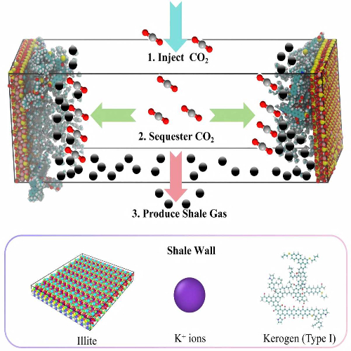
, EGU General Assembly 2026, Vienna, Austria, 3–8 May 2026, EGU26-21345, https://doi.org/10.5194/egusphere-egu26-21345, 2026.

EGU26-85 | ECS | Orals | ERE3.9

Geo–Storage Across Scales: From Nanopore Theory to Reservoir Practice for CO2–Driven Methane Displacement in Ultra–Deep Illite–Kerogen Shales 

Liyuan Zhang, Chengdong Yuan, Xiaoyu Tan, Antonina Stupakova, and Zezhang Song

Ultra–deep shale geo–storage that couples secure CO2 sequestration with enhanced CH4 recovery demands explicit links from nanopore physics to reservoir–scale practice, yet how pore size and hybrid mineral-organic interfaces jointly govern CO2–CH4 competitive adsorption, mobility, and CH4 displacement under the Lower Cambrian Qiongzhusi temperature–pressure window remains insufficiently quantified; here we address this by molecular–dynamics simulations in composite illite–TypeI kerogen slit nanopores spanning 2–10nm and five reservoir state points—330.15K and 30MPa, 360.15K and 45MPa, 390.15K and 60MPa, 420.15K and 75MPa, 450.15K and 90MPa—and by extracting gas-surface interaction energies, cohesive–energy density, a dimensionless competitive–adsorption indicator, self–diffusion coefficients, near–wall density integration, and CH4 displacement efficiency during CO2 injection into CH4–saturated pores as constitutive inputs for dual–porosity⁄dual–permeability upscaling. Confinement amplifies selectivity: CO2 consistently outcompetes CH4 on both illite and kerogen, creating CO2–rich adsorption layers that nearly exclude CH4 from 2 nm surfaces; the competitive–adsorption indicator is ‹1 at 2nm (surface–dominated regime), rises to ≈1.3 at 4nm, and reaches ≈2.4–2.5 at 10nm at the highest temperature and pressure (mixed–fluid regime), while diffusion analysis shows CO2 remaining surface–bound and slower than CH4, which—once dislodged—resides in the central mixed fluid and is more mobile. Displacement metrics reveal a clear pore–width control: CH4 displacement efficiency increases from ≈70–77% (2nm) to ≈85-89% (10nm), peaks near 390.15K and 60MPa, and declines slightly at 450.15K and 90MPa as elevated temperature weakens adsorption; near–wall integration confirms persistent CO2 occupancy with a marked preference for illite across all conditions. Collectively, these pore–scale relations deliver a physically grounded design map for field deployment: (1) prioritize illite–rich, small–pore intervals to maximize durable CO2 trapping and storage security; (2) leverage larger nanopores (≥4–10 nm) as the mobility corridor for liberated CH4 to enhance deliverability; (3) schedule injections around moderate temperature and high pressure to balance displacement and retention; and (4) port the measured selectivity–width trends, cohesive–energy densities, diffusivity contrasts, near–wall occupancy fractions, and displacement curves directly into continuum simulators to forecast CO2–EGR performance and monitoring signatures in Qiongzhusi–type ultra–deep reservoirs by connecting atomistic mechanisms to engineering–relevant operating windows and upscaling parameters.

How to cite: Zhang, L., Yuan, C., Tan, X., Stupakova, A., and Song, Z.: Geo–Storage Across Scales: From Nanopore Theory to Reservoir Practice for CO2–Driven Methane Displacement in Ultra–Deep Illite–Kerogen Shales, EGU General Assembly 2026, Vienna, Austria, 3–8 May 2026, EGU26-85, https://doi.org/10.5194/egusphere-egu26-85, 2026.

EGU26-1490 | ECS | Orals | ERE3.9

Numerical analysis of bio-reactive transport in CO2-H2 underground bio-methanation within depleted reservoirs 

Lin Wu, Junzhang Lin, Yiran Jiang, Dandan Yu, Li Ren, Zhengmeng Hou, Li Fu, Zhifeng Luo, and Xiaochuan Xu

Underground bio-methanation (UBM) of CO2 and H2 in depleted hydrocarbon reservoirs presents a promising strategy that combines carbon recycling, large-scale subsurface energy storage, and renewable CH4 production. Despite its potential, the bio-reactive transport mechanisms underlying UBM remain poorly understood. To fill this knowledge gap, this study develops a numerical modeling framework. A coupled hydro-bio model was developed by integrating multicomponent multiphase flow with microbial growth and conversion processes, and was implemented numerically using the MATLAB Reservoir Simulation Toolbox (MRST). Key microbial kinetic parameters were calibrated using data from high-temperature and high-pressure conversion experiments conducted with formation water containing indigenous methanogenic microorganisms from the Shengli Oilfield, China. Within this this framework, the effects of operational and reservoir parameters, including shut-in duration, injection rate, and reservoir permeability, on gas transport, microbial conversion, and production performance were systematically investigated. Simulation results indicate that extended shut-in periods allow methanogens to continuously consume CO2 and H2, leading to greater pressure depletion and lower residual CO2 in the gas phase. Specifically, increasing the shut-in duration from 180 to 720 days raises the final microbial CO2 conversion from 43.5% to 96%. Higher injection rates extend the gas-front migration distance and stimulate a larger methanogen population, increasing the total CO2 conversion, although the overall conversion efficiency slightly decreases due to higher gas input. In high-permeability reservoirs, enhanced gravity segregation causes gases to accumulate in the upper reservoir, limiting contact with methanogens near the far-well region and thereby reducing conversion efficiency. This study provides new insights into the coupled transport and microbial processes in UBM and offers guidance for the optimization of its design and field-scale implementation.

How to cite: Wu, L., Lin, J., Jiang, Y., Yu, D., Ren, L., Hou, Z., Fu, L., Luo, Z., and Xu, X.: Numerical analysis of bio-reactive transport in CO2-H2 underground bio-methanation within depleted reservoirs, EGU General Assembly 2026, Vienna, Austria, 3–8 May 2026, EGU26-1490, https://doi.org/10.5194/egusphere-egu26-1490, 2026.

Good reservoir injectivity is a fundamental requirement for high-quality CO2 geological storage sites. Salt precipitation near injection wells, induced by brine evaporation and crystallization, is one of the key factors impairing reservoir injectivity. To clarify the differences in salt precipitation and consequent reservoir damage across distinct reservoir types, this study selected sandstone samples with varying micro pore structures and macro reservoir structures, and conducted salt precipitation simulation experiments based on a high-temperature and high-pressure core-flooding system. Employing thin-section analysis, scanning electron microscopy (SEM) with energy-dispersive spectroscopy (EDS), micro-area X-ray fluorescence (μ-XRF) spectroscopy, high-pressure mercury intrusion (HPMI), nuclear magnetic resonance (NMR), and micro-computed tomography (micro-CT) scanning, the salt crystal characteristics, distribution patterns, as well as variations in sandstone pore structures were systematically investigated. High-porosity and high-permeability reservoirs with favorable pore structures are characterized by a small number of salt precipitates, small-sized salt crystals, and dispersed single crystals. With the deterioration of the pore-throat size, sorting and connectivity, the quantity and size of salt crystals and their aggregates increase. With the change of the reservoir pore structures from the homogeneous large pore-throat type to the heterogeneous small pore-throat type, the distribution patterns of salt precipitation vary from weak homogeneous salt precipitation dominated by in-situ brine evaporation, to intensive local salt precipitation dominated by brine capillary backflow, and to intensive homogeneous salt precipitation controlled by brine capillary backflow and salt solute diffusion. Compared with macroscopically homogeneous massive sandstones, heterogeneous sandstones with low- and high-permeability zones generate a greater amount of salt precipitation both in low- and high-permeability segments. This is because the low-permeability zone lack effective brine displacement by injected CO2, thereby retaining more residual brine for salt precipitation. Meanwhile, the salt crystal characteristics and contents indicate the existence of capillary backflow of brine from low-permeability zone to high-permeability zone. Reservoirs with different initial micro- and macro-structures have different characteristics of salt precipitation and thus varied risks of injectivity impairment. Heterogeneous reservoirs, both at the microscale and macroscale, carry a higher risk of salting-out induced reservoir damage, thus requiring the formulation of appropriate salting-out mitigation methods for these reservoirs.

How to cite: Sun, X., Deng, C., and Liu, K.: Effects of micro pore structures and macro reservoir structures on salt precipitation during CO2 geological storage, EGU General Assembly 2026, Vienna, Austria, 3–8 May 2026, EGU26-2112, https://doi.org/10.5194/egusphere-egu26-2112, 2026.

The nanopores in organic matter (OM) in shale are considered to be the main storage space for methane. However, there is still limited understanding of the role of OM in underground hydrogen storage(UHS) in retaining shale gas reservoirs. To investigate the influence of kerogen on hydrogen storage, this study employs multiple spectroscopic techniques (solid-state 13C nuclear magnetic resonance, Fourier transform infrared spectroscopy, and X-ray photoelectron spectroscopy) to establish macromolecular structure models of kerogens of high and over-mature stages. Using molecular simulation techniques (GCMC and MD methods), the adsorption characteristics of hydrogen on kerogen under conditions of 333.15 K-393.15 K and 0-30 MPa are studied. The result shows: Longmaxi kerogen is carbon-dominant (>80%), featuring an extensive aromatic framework in over-mature stages. The high content of protonated and branched aromatic carbon, alongside a well-developed graphite (002) crystal plane, confirms high graphite-like crystallinity in over-mature structures. CH4/H2 competitive adsorption is primarily governed by van der Waals forces. CH4 molecule exhibits stronger surface affinity, preferentially occupying high-energy sites with densities exceeding twice the bulk phase. Conversely, H2 interactions are extremely weak, primarily controlled by pore space confinement and thermodynamic conditions, leading to a bulk-phase distribution. CH4/H2 selectivity decreases with pressure. The limited impact of maturity on selectivity reflects the stability of the dispersion-dominated mechanism. CO2 molecule exhibits strong electrostatic and inductive interactions with polar functional groups. This leads to markedly higher isosteric heats and selectivity compared to the CH4 system. The CO2 molecule exhibits strong electrostatic and inductive interactions with polar groups and aromatic structures, showing significantly higher isosteric heat and selectivity coefficients compared to the CH4/H2 system. The CO2 molecule has the lowest diffusion coefficient due to stable adsorption configurations and long residence times. At high pressures, a pore confinement effect restricts the H2 molecule mean free path, increasing collision resistance and reducing its effective diffusion rate. These findings provide critical theoretical support for assessing the safety and capacity of large-scale UHS in depleted shale gas reservoirs.

How to cite: Liang, Z. and Zhu, G.: Study of the macromolecular structure of kerogen for CO2/H2 and CH4/H2 competitive adsorption capacity: 3D molecular reconstruction, spectroscopic experiments, molecular simulations, EGU General Assembly 2026, Vienna, Austria, 3–8 May 2026, EGU26-2355, https://doi.org/10.5194/egusphere-egu26-2355, 2026.

Geological CO2 storage during CO2-enhanced oil recovery (CO2-EOR) is a promising approach to simultaneously increase hydrocarbon production and mitigate carbon emissions. In this study, the potential of CO2 huff-n-puff for heavy oil cold production and its associated CO2 sequestration efficiency is experimentally evaluated. Five CO2 huff-n-puff cycles were conducted at different injection pressures to determine the heavy oil recovery factor and CO2 storage efficiency, and comparative tests were performed using N2 and CH4 huff-n-puff and viscosity-reducer-assisted CO2 huff-n-puff. The results demonstrate that both heavy oil recovery factor and CO2 storage efficiency increase with injection pressure and cycle number. At an injection pressure of 20 MPa, the cumulative oil recovery factor and CO2 storage efficiency are 39.23% and 28.97%, representing increases of 14.61% and 16.76%, respectively, relative to 8 MPa. CO2 exhibits the highest dissolved gas–oil ratio in heavy oil among the three gases tested at 16 MPa, and the resulting heavy oil recovery factor after CO2 huff-n-puff are 3.59 and 1.86 times those obtained with N2 and CH4, respectively. The cumulative oil recovery factor and total oil exchange ratio are 10.12% and 1.76 t/t for N2, 36.41% and 1.17 t/t for CO2, and 19.57% and 4.96 t/t for CH4. The heavy oil recovery factor is increased by approximately 3.24%–6.45%. These findings provide quantitative guidance for optimizing injection pressure and gas selection in CO2 huff-n-puff schemes, thereby supporting the design and implementation of CCUS-oriented geological storage in heavy oil reservoirs.

How to cite: Du, K. and Li, S.: Experimental investigation of CO2 huff-n-puff for improving heavy oil recovery and CO2 underground storage, EGU General Assembly 2026, Vienna, Austria, 3–8 May 2026, EGU26-2523, https://doi.org/10.5194/egusphere-egu26-2523, 2026.

During hydrogen storage in tight sandstone gas reservoirs, the injection of low-temperature, high-pressure hydrogen induces thermal stress through cold shock, which significantly influences the initiation and propagation of fractures within the reservoir. However, the evolution characteristics of the stress and temperature fields in high-temperature rock matrix, as well as the initiation and propagation patterns of fractures under the coupled effects of low-temperature-induced thermal stress and in-situ stress, remain unclear. Therefore, a thermal-hydraulic-mechanical-damage coupling model was established to analyze the evolution characteristics of the stress and temperature fields in reservoir rocks, along with fracture propagation patterns, under varying stress conditions and injection temperatures. The results indicate that fractures propagate predominantly along the direction of the maximum principal stress. Additionally, larger temperature differences and smaller in-situ stress differentials favor the formation of complex fracture networks. This study holds significant implications for the safety and stability of hydrogen storage in depleted gas reservoirs.

How to cite: Liu, L., Zeng, L., and Li, X.: Numerical Simulation of Fracture Propagation Characteristics Under Thermal-Hydraulic-Mechanical-Damage Coupling Effects During Hydrogen Storage in Tight Sandstone Gas Reservoirs, EGU General Assembly 2026, Vienna, Austria, 3–8 May 2026, EGU26-4436, https://doi.org/10.5194/egusphere-egu26-4436, 2026.

EGU26-5373 | ECS | Orals | ERE3.9

Hydrochemical Stability of Shale Caprocks During Underground Hydrogen Storage (UHS) 

Qizhang Fan, David Misch, Joel Bensing, Lukas Skerbisch, and Xiangyun Shi

The global energy system is transitioning to low-carbon solutions, with an increasing proportion of renewable energy sources. The intermittency of renewable energy generation, e.g. from wind and solar power, however, leads to a rising demand for large-scale and seasonal energy storage. Hydrogen is regarded as a vital energy carrier, and underground hydrogen storage (UHS) in porous geological media is considered a promising option due to its substantial storage capacity, relatively low cost, and potential safety benefits. Nonetheless, hydrogen leakage through caprock formations and hydrogen–rock–brine interactions remain critical uncertainties that require further research.

This study aims to investigate the impact of hydrogen injection on the sealing integrity of shale caprocks. High-pressure, constant-temperature batch reactor tests are employed to simulate gas–brine–rock interactions under reservoir-relevant conditions. Shale samples with three distinct mineralogical compositions (carbonate-, pyrite-, and clay mineral-rich) are selected to represent different types of caprock lithologies. Experiments are conducted using various gas compositions, including hydrogen and potential cushion gases, to evaluate how mineralogical heterogeneity influences geochemical reactions and caprock performance.

The ongoing experiments aim to identify the most suitable (i.e. hydrochemically stable) caprock composition for underground hydrogen storage, as well as gas compositions that are more favorable as cushion gases to enhance storage safety. The results are expected to provide insights into caprock stability and sealing behavior during future hydrogen storage operations.

How to cite: Fan, Q., Misch, D., Bensing, J., Skerbisch, L., and Shi, X.: Hydrochemical Stability of Shale Caprocks During Underground Hydrogen Storage (UHS), EGU General Assembly 2026, Vienna, Austria, 3–8 May 2026, EGU26-5373, https://doi.org/10.5194/egusphere-egu26-5373, 2026.

Accurate numerical simulation of salt cavern performance during underground geo‑energy storage of hydrogen, natural gas, compressed air, and CO2 requires the integration of precise design criteria into a rigorous mechanical constitutive framework. Ideally, this framework should be consistent, describing all mechanical loading (either short-term or long-term) deformations with a single parameter set. Due to methodological disconnects between experimental derivation of design criteria and constitutive laws, only a limited number of consistent constitutive models exist in the literature. The RTL2020 model exemplifies such a mechanical constitutive law by incorporating dilatancy both as a feature in the constitutive model and as a design criterion, enabling accurate prediction of short-term or long-term mechanical deformations, including volumetric strain, with a single parameter set. The novelty of the RTL2020 model lies in the dilatancy-induced volumetric strain, which shifts the focus of design criteria from merely surface deformations to encompass volumetric changes at the cavern wall, critical for precisely assessing salt cavern integrity and performance. This study presents a novel numerical implementation strategy for the RTL2020 model within an open-source numerical simulator, and captures the effectiveness of the dilatancy-based design criteria. The implementation approach employs an iterative stress–strain update algorithm that combines the Newton Raphson method with an adaptation of the classical implicit integration scheme (elastic predictor–inelastic corrector). This formulation ensures unconditional stability, rapid convergence, and high numerical accuracy at low computational cost. Validation against experimental data demonstrates the model’s ability to reproduce key rock salt behaviours, including the negligible influence of mean pressure on axial and deviatoric strain, and the strong dependence of volumetric strain on mean pressure, highlighting the robustness of our implementation. Ongoing application of the model will demonstrate its capability of handling parametric analysis of field-scale hydrogen storage conditions in single and multi cavern systems. Future investigations will integrate the RTL2020 model into fully coupled multiphysics frameworks (thermo-mechanical or hydro-mechanical) to simulate the more complex conditions characteristic of underground hydrogen storage. As an open-source implementation, the model provides the geomechanics community  with a broadly accessible and reliable consistent mechanical constitutive framework for salt cavern design in underground geo‑energy storage applications.

How to cite: Yevugah, I. and Jacquey, A.: Consistent Dilatancy-Based Constitutive Model of Rock Salt for Geo-Energy Storage Applications: An Open-Source Numerical Implementation, EGU General Assembly 2026, Vienna, Austria, 3–8 May 2026, EGU26-6082, https://doi.org/10.5194/egusphere-egu26-6082, 2026.

Since 2017, China has actively promoted the exploration of deep coal seams as unconventional natural gas reservoirs. However, the petrographic composition, pore–fracture structure, and gas occurrence characteristics of deep coal reservoirs remain poorly constrained, particularly under in-situ formation depth conditions. The deep coal seams of the Carboniferous Benxi Formation along the eastern margin of the Ordos Basin exhibit favorable reservoir development conditions and high gas productivity, making them an ideal target for investigating reservoir characteristics and gas-bearing mechanisms of deep coalbed methane (CBM). In this study, the petrographic composition, physical properties, pore–fracture structure, and gas occurrence states of coal reservoirs were systematically investigated through macroscopic observation and classification of coal lithotypes, combined with scanning electron microscopy (SEM), multi-component gas adsorption experiments, overburden pressure porosity–permeability measurements, and variable temperature–pressure adsorption tests. The reservoir characteristics and gas occurrence patterns of deep coal reservoirs were thereby elucidated. The results indicate that the macroscopic coal lithotypes of the Benxi Formation include bright coal (types I、II、III), semi-bright coal (types I、II、III), semi-dull coal (types I–II), and dull coal (types I–II), with bright coal being dominant. The average vitrinite contents of vitrain, clarain, and durain are 94.6%, 85.26%, and 58.8%, respectively, while the corresponding average fixed carbon contents (air-dried basis) are 79.6%, 72.6%, and 34.15%. The average maximum vitrinite reflectance ranges between 1.75% and 2.56%, indicating a high- to over-mature coal rank. Reservoir space is primarily composed of gas pores, cellular pores, and cleat fractures, with micropores and microfractures of 0.5–1.2 nm contributing the dominant pore volume. The average total pore volume of clarain and durain ranges from 0.0299–0.034 cm³/g and 0.014–0.025 cm³/g, respectively, with clarain II exhibiting the largest pore volume. The average permeability and porosity of clarain and durain are 0.623 mD and 5.23%, respectively. Natural fractures significantly enhance permeability under overburden pressure conditions, whereas artificial fractures exert negligible influence. Gas in deep CBM reservoirs occurs in both adsorbed and free states. With increasing burial depth, free gas content increases, adsorbed gas content first increases and then decreases, and total gas content either increases or remains relatively stable. Coal with higher vitrinite and inertinite contents, as well as a higher proportion of clarain, exhibits greater gas content. Under in-situ formation depth conditions, the measured total gas content of the Benxi Formation coal is lower than the theoretical maximum gas adsorption capacity.

Keywords: Ordos Basin; coalbed methane; in-situ formation; Benxi Formation; coal lithotype; reservoir space; pore–fracture structure; gas occurrence characteristics

How to cite: Zeng, Y. and Wang, Y.: Reservoir Characteristics and Gas Occurrence Patterns of Deep Coalbed Methane in the Benxi Formation, Eastern Margin of the Ordos Basin, EGU General Assembly 2026, Vienna, Austria, 3–8 May 2026, EGU26-7058, https://doi.org/10.5194/egusphere-egu26-7058, 2026.

The urgent need to mitigate anthropogenic CO2 emissions necessitates the advancement of large-scale, permanent carbon sequestration technologies. Geothermal systems, with their unique thermo-hydro-chemical conditions, are increasingly recognized as promising environments for CO2 mineralization, with porous carbonate reservoirs serving as ideal storage formations. At the mineral-fluid interface, nanoscale water films act as a critical reactive microenvironment. These films exhibit pronounced size and confinement effects regarding thickness, ionic composition, and pH, which fundamentally dictate mineral dissolution, nucleation, and phase transformation. However, the molecular mechanisms governing cation mobilization and the associated rate-limiting steps within these nanoconfined films remain poorly understood. In this study, we developed a computational framework integrating Density Functional Theory (DFT) and Ab Initio Molecular Dynamics (AIMD), coupled with enhanced sampling techniques to capture rare events, such as proton transfer and ligand exchange, at the electronic level. Using calcite and dolomite as representative carbonate phases, we constructed slab models for the (104) and (110) surfaces. By systematically varying the water film thickness, we simulated the transition from molecular monolayers to continuous thin films. We investigated the heterogeneous reaction mechanisms of CO2 and H2O on these surfaces, elucidating the cation de-coordination pathways, rate-limiting steps, and the characteristics of transient intermediates. Our quantitative evaluation reveals that nanoconfinement introduces a unique free-energy landscape for mineral dissolution. Specifically, the highly structured water layers in ultra-thin films significantly modulate the solvation shells of Ca2+/Mg2+ ions, leading to a thickness-dependent shift in activation barriers. Furthermore, the simulations demonstrate that elevated geothermal temperatures and increased ionic strength synergistically facilitate cation mobilization by lowering the activation enthalpy. We also identified that specific ligand adsorption promotes the formation of inner-sphere complexes, which destabilize surface lattice sites and accelerate dissolution. Notably, the (110) surface exhibits higher kinetic reactivity than the (104) plane due to its lower coordination environment and higher density of reactive sites. These findings provide a robust mechanistic bridge between molecular-scale interfacial processes and macro-scale mineralization kinetics, offering critical theoretical insights for optimizing carbon sequestration efficiency in geothermal reservoirs.

How to cite: Yang, X. and Zhang, K.: Molecular-scale mechanisms of carbonate mineralization in nanoscale water films in geothermal reservoir, EGU General Assembly 2026, Vienna, Austria, 3–8 May 2026, EGU26-8610, https://doi.org/10.5194/egusphere-egu26-8610, 2026.

Utilizing winter natural cold energy for shallow CO2 hydrate sequestration offers a sustainable, energy-efficient pathway for carbon neutrality. However, the upscale application of this technology requires a comprehensive understanding of both microscopic host-sediment interactions and macroscopic reservoir performance. This study integrates laboratory experiments with field-scale numerical simulations to evaluate the feasibility and safety of storing CO2 in zeolite-bearing sediments under seasonally frozen conditions.

In the experimental phase, a visualized high-pressure reactor was employed to investigate CO2 hydrate formation and dissociation characteristics across three sediment types: quartz sand, montmorillonite, and zeolite. Influencing factors including particle size, water saturation, and diverse P-T conditions were systematically analyzed. Results quantified that zeolite sediments significantly outperformed traditional media, shortening the hydration induction time by 17.6% and increasing gas storage capacity by 21.3% compared to quartz sands. This enhancement is attributed to the "molecular sieve" effect and high specific surface area of zeolite. Microscopic characterizations using NMR, XRD, and SEM further revealed that the unique microporous framework of zeolite provides abundant nucleation sites and exerts a strong self-preservation effect, which prolonged the hydrate dissociation window by over 1.20 hours at -5°C, providing a critical safety margin against accidental thermal fluctuations.

Complementing the laboratory findings, a field-scale reservoir model was constructed using the CMG software to simulate the long-term injection and storage process in a pilot area in Northeast China. The simulation coupled thermal-hydraulic-chemical (THC) processes to predict the evolution of the temperature field and the spatial distribution of the hydrate stability zone. Simulation results indicated that utilizing natural cold energy (ambient air temperature of -20°C) could sustain a stable HSZ with a radius of 200 meters around the wellbore. Furthermore, the model validated that the exothermic heat of hydration was effectively dissipated by the continuous cold energy supply, preventing thermal instability. Sensitivity analysis within CMG demonstrated that the leakage risk in zeolite-rich layers was reduced by 15.89% compared to conventional aquifers due to the dual trapping mechanism of solid hydrate formation and adsorptive trapping.

This study elucidates the coupled mechanism of "Cold Energy Drive + Zeolite Enhancement", confirming that zeolite is an ideal functional medium for shallow CO2 sequestration. The findings provide robust theoretical support and quantitative design parameters for implementing low-cost CCS projects in cold regions.

Keywords: CO2 Sequestration; Natural Cold Energy; Zeolite; CMG Simulation; Self-preservation; Multiscale Analysis

How to cite: Wang, X., Guo, W., Zhong, X., and Zhang, X.: Multiscale Study on Shallow CO2 Sequestration via Winter Natural Cold Energy: From Zeolite-Mediated Hydrate Kinetics to Field-Scale Simulation, EGU General Assembly 2026, Vienna, Austria, 3–8 May 2026, EGU26-8992, https://doi.org/10.5194/egusphere-egu26-8992, 2026.

EGU26-9137 | ECS | Posters on site | ERE3.9

Optical 3D micro-scanning for the determination of the envelope volume of rock samples 

Lena-Maria Able, Eric Salomon, Florian Duschl, and Michael Drews

Density and porosity are key parameters in the petrophysical characterization of rock samples. To calculate those properties, the determination of the envelope volume of a rock sample is of central importance. Frequently used methods for unregularly shaped sample pieces are immersion-weighting or mercury porosimetry. For soluble or swellable rock samples an envelope density analyzer is frequently used, which measures the displacement of fluid-like particles to determine the envelope volume. This study investigates a new approach to derive the envelope volume of sample pieces, by directly capturing the surface of a rock, using a 3D micro-scanner. The device uses the triangulation principle to recreate the rock sample, and thus the volume, out of a recorded point cloud in a three dimensional coordinate system. The suitability and reproducibility for different surface properties were evaluated testing various materials (sedimentary rocks, igneous rocks, metamorphic rocks) and by comparing the results to those using an envelope density analyzer. The results show that optical 3D micro-scanning provides a higher reproducibility than the standard envelope density analyzer. Particularly accurate data can be expected for samples with a low surface roughness, regardless of the color and brightness, while recessed angles or shiny surfaces increase inaccuracy, but still with a comparable high reproducibility. Overall, optical 3D micro-scanning provides a fast and robust method to determine the envelope volume of rock samples.

How to cite: Able, L.-M., Salomon, E., Duschl, F., and Drews, M.: Optical 3D micro-scanning for the determination of the envelope volume of rock samples, EGU General Assembly 2026, Vienna, Austria, 3–8 May 2026, EGU26-9137, https://doi.org/10.5194/egusphere-egu26-9137, 2026.

Hydrogen is an expensive and relatively scarce commodity. However, its storage—both to increase renewable energy efficiency by reducing curtailment and to support a zero-carbon energy system that reduces reliance on energy imports—appears inevitable. This raises a key question: how can the high upfront costs and substantial hydrogen volumes required for subsurface storage be reduced? One of the main cost drivers is the need for hydrogen cushion gas, which, depending on the techno-economic analysis, can account for up to 80% of the initial investment costs.

In this talk, we present two approaches to improve the competitiveness of hydrogen storage. First, drawing on lessons learned from the ACT Acorn CO₂ storage project, we explore the potential of a staged investment strategy. The central idea is to initiate storage operations at a small scale, requiring relatively modest volumes of cushion gas, while retaining the option to upscale if early phases prove successful and safe, efficient storage is demonstrated.

Second, we introduce a new conceptual model that allows hydrogen cushion gas to be replaced with cheaper and more readily available alternatives. The primary function of cushion gas is to provide compression during working gas injection and pressure support during production. We propose a strategy in which cushion gas (in this case CO₂) and working gas are spatially separated, preventing mixing or chemical reactions while still delivering the pressure support required for efficient operation.

We use the Long Clawson field in the East Midlands, UK, as a case study to demonstrate the theoretical feasibility of this approach. The field of interest is relatively shallow (approximately 680 m) and comprises several reservoir layers with an average thickness of ~10 m. Using an efficient black-oil simulator, reservoir modelling is employed to test and optimise the feasibility of cyclic hydrogen storage within these layers.

This work forms part of the East Midlands Storage (EMStor) project, a Strategic Innovation Fund–supported feasibility study focused on the development of hydrogen storage in repurposed hydrocarbon fields.

How to cite: Heinemann, N. and Williams, H.: An Innovative Approach to Reducing Upfront Costs in Hydrogen Storage via Cushion–Working Gas Separation, EGU General Assembly 2026, Vienna, Austria, 3–8 May 2026, EGU26-10001, https://doi.org/10.5194/egusphere-egu26-10001, 2026.

EGU26-12322 | ECS | Orals | ERE3.9

Comparative Diffusion Characteristics of Hydrogen, Methane, and Carbon Dioxide in Different Rock Types 

Guangshun Xiao, Qinhong Hu, Fang Hao, Tao Zhang, Qiwei Zong, Qiming Wang, Hongguo Qiao, and Shengyu Yang

Green-hydrogen geological storage, geological sequestration of CO₂, and the generation, accumulation, and potential reservoir formation of natural hydrogen and methane involve a broad spectrum of lithologies, including sandstone, carbonate rock, shallow mudstone, halite (salt rock), serpentinite, basalt, granite, coal, and deep organic-rich shale. Marked contrasts in rock physical properties and pore-structure attributes can strongly regulate macroscopic gas diffusion. Therefore, elucidating gas diffusion behavior across different rock types is essential for evaluating gas storage capacity and geologic trapping potential.

In this work, representative rock samples were crushed to 0.50–0.841 μm particles and tested using a self-developed experimental setup to characterize the diffusion behaviors of H₂, CH₄, and CO₂ at 0.5 MPa. Depending on the observed diffusion features, diffusion coefficients were quantified using both unipore and dual-porosity (bidisperse) diffusion models. Pore-structure characteristics were independently constrained by N₂ physisorption, mercury intrusion porosimetry, and scanning electron microscopy, enabling a systematic assessment of pore-structure controls on gas diffusion. Additional experiments were performed on selected samples to compare diffusion coefficients under varying conditions of temperatures and pressures.

The results demonstrate pronounced inter-gas and inter-lithology differences in diffusion behavior, arising from contrasts in gas properties and rock pore structures. Overall, H₂ diffuses the fastest, followed by CH₄, whereas CO₂ exhibits the slowest diffusion. In micropores-rich rocks, CO₂ shows a distinct “fast initial–slow late-stage” diffusion pattern. Furthermore, diffusion coefficients increase with increasing temperatures but decrease with increasing gas pressures.

These findings reveal lithology-dependent response mechanisms in governing gas diffusion and provide a scientific basis for understanding gas migration in deep geological environments. The results also deliver key experimental constraints for studies of natural hydrogen and methane accumulation and for the assessment and optimization of geological CO₂ sequestration.

Acknowledgement: This work was supported by the Basic Science Center Program of the National Natural Science Foundation of China (NSFC) (Type A; No. 42302145).

How to cite: Xiao, G., Hu, Q., Hao, F., Zhang, T., Zong, Q., Wang, Q., Qiao, H., and Yang, S.: Comparative Diffusion Characteristics of Hydrogen, Methane, and Carbon Dioxide in Different Rock Types, EGU General Assembly 2026, Vienna, Austria, 3–8 May 2026, EGU26-12322, https://doi.org/10.5194/egusphere-egu26-12322, 2026.

EGU26-15844 | ECS | Orals | ERE3.9

Dynamic CO₂ Storage Potential assessment via Reactive Transport  

Boning Li, Ziqiing Pan, and Kaiqiang Zhang

Geological CO2 storage is a pivotal technology for achieving carbon neutrality. However, current assessments of storage potential predominantly rely on static volumetric methods or short-term simulations of dissolution processes. They often fail to adequately quantify the dynamic trapping capacity, particularly the actual contribution of mineral trapping, the dominant mechanism that ensures long-term permanence and enhanced security over centennial to millennial timescales.  This study developed a reactive transport modeling-based assessment framework to quantify the dynamic evolution and contribution of different trapping mechanisms, especially mineral trapping, over centennial timescales following CO₂ injection. A multiphase flow and reactive transport model, coupling CO₂-water-rock interactions, was established to simulate a 1000-year post-injection period for a typical reservoir A in China. The model integrates site-specific hydrogeological parameters and mineral reaction kinetics calibrated against experimental data. The simulation clearly reveals the sequential dominance of trapping mechanisms. Following injection cessation, the proportion of free-phase CO₂ decreases rapidly, while dissolution trapping increases significantly within the first century. Mineral trapping, the precipitation of carbonates such as calcite and dolomite, begins to contribute around 500 years and continues to grow, becoming the dominant mechanism for long-term security. This study proposes "effective mineral trapping capacity" as a time-dependent dynamic metric. In reservoir A, the amount of CO₂ immobilized through mineral reactions over a millennium far exceeds estimates based on short-term reactions, highlighting the necessity of long-term simulations to reveal the true storage potential. Besides, the simulation predicts the spatial evolution of CO₂ plume, trapping mechanism, formation pressure, and the impact of mineral reactions on porosity. This work provides a quantitative assessment of dynamic CO₂ mineralization potential through high spatio-temporal resolution reactive transport modeling. The findings elucidate the time-varying dominance of CO₂ trapping mechanisms for the design and risk management of CCUS project. Furthermore, it provides a transferable methodological framework for capacity evaluation and project optimization in similar or reactive reservoirs. This contributes to advancing the substantive deployment of long-term gigaton-scale, secure geological storage.

How to cite: Li, B., Pan, Z., and Zhang, K.: Dynamic CO₂ Storage Potential assessment via Reactive Transport , EGU General Assembly 2026, Vienna, Austria, 3–8 May 2026, EGU26-15844, https://doi.org/10.5194/egusphere-egu26-15844, 2026.

EGU26-16561 | ECS | Posters on site | ERE3.9

 A three-phase fluid distinguishing method based on dual-parameter from neutron gamma logging technology in CO2 enhanced oil recovery 

Xiaoyang Zhang, Haihua Zhao, Chen Xu, Feng Zhang, Xiaojun He, and Shaogui Deng

Carbon capture, utilization, and storage (CCUS) is widely recognized as a key technological pathway for mitigating greenhouse gas emissions and supporting the global energy transition. Among CCUS applications, carbon dioxide enhanced oil recovery (CO₂-EOR) plays an important role by simultaneously improving hydrocarbon recovery and enabling geological storage of CO₂. During CO₂ flooding, reservoir pores typically contain a three-phase fluid system composed of water, oil, and supercritical CO₂, which poses significant challenges for fluid discrimination and saturation evaluation. In particular, quantitative differentiation between CO₂ and oil remains difficult under three-phase conditions because of weak nuclear-physics contrasts and strong environmental interference, limiting the reliability of current neutron logging interpretations.

Neutron gamma logging tools equipped with multiple detectors provide inelastic and capture gamma responses that are sensitive to elemental composition and fluid properties, offering potential for three-phase fluid evaluation. To establish a physically consistent basis for fluid discrimination, Monte Carlo simulations based on the FLUKA code are performed to systematically investigate the response characteristics of near- and far-detector inelastic gamma spectra, as well as near–long detector capture gamma count ratios, for pure water, oil, and supercritical CO₂ under varying porosity conditions in sandstone formations. Based on the simulation results, quantitative relationships between carbon-to-oxygen (C/O) ratios, capture gamma count ratios, and porosity are established. A dual-parameter fluid evaluation method that combines C/O and capture gamma information is then proposed to effectively distinguish water, oil, and CO₂ over a wide porosity range.

In addition, the influences of borehole fluid, formation water salinity, lithological mineral composition, and clay content on neutron gamma responses are systematically analyzed. The results indicate that the presence of CO₂ in the borehole can significantly distort inelastic gamma measurements and bias the apparent C/O response. To mitigate this effect, a self-compensation correction method based on the near-to-far inelastic gamma count ratio is developed to suppress borehole CO₂ interference.

Finally, multiple formation models with varying porosity, clay content, and fluid combinations are constructed to simulate C/O ratios, capture gamma counts, and related the evaluation based on the combination of two parameters. The simulation results demonstrate the effectiveness of the proposed dual-parameter evaluation method and the borehole CO₂ self-compensation approach. This study provides a physically based framework for improving the interpretation of neutron gamma logging data in CO₂ flooding and CCUS-related reservoir monitoring.

Keywords: neutron gamma logging; carbon–oxygen ratio; capture gamma count ratio; CO₂ flooding; CCUS monitoring

How to cite: Zhang, X., Zhao, H., Xu, C., Zhang, F., He, X., and Deng, S.:  A three-phase fluid distinguishing method based on dual-parameter from neutron gamma logging technology in CO2 enhanced oil recovery, EGU General Assembly 2026, Vienna, Austria, 3–8 May 2026, EGU26-16561, https://doi.org/10.5194/egusphere-egu26-16561, 2026.

EGU26-17169 | ECS | Posters on site | ERE3.9

Carbon dioxide geological storage monitoring based on effective fluid bulk modulus with time-lapse seismic data 

Xiangzhi Zhang, Zhaoyun Zong, Xiaojian Zhu, and Yalong Fan

Carbon dioxide geological storage stands as one of the core technologies for attaining carbon neutrality goals, with time-lapse seismic emerging as the key technique for monitoring. As a robust fluid factor, the effective fluid bulk modulus can delineate the spatial distribution of stored carbon dioxide in geological formations. Elastic inverse scattering theory has been extended to carbon dioxide geological storage monitoring leveraging time-lapse seismic data. Within the framework of elastic scattering theory, the baseline medium is defined as the reference medium, while the monitoring medium corresponds to the perturbed medium. The discrepancy in subsurface physical properties between the baseline and monitoring medium is treated as the property variation between the reference and perturbed medium. The baseline and monitoring seismic data are regarded as the background wavefields and measured full wavefields, respectively, and the differential data is designated as the scattered wavefields. Based on the above hypothesis, we derive a linearized and qualitative approximation of reflectivity variation using perturbation theory, with this variation being explicitly correlated to changes in the effective fluid bulk modulus. By incorporating the seismic wavelet effect into the reflectivity approximation as the forward solver, we further propose a practical pre-stack inversion approach within a Bayesian framework. This approach enables the direct estimations of effective fluid bulk modulus changes from time-lapse seismic data. The efficacy of the proposed approach is validated via examples, which demonstrate that it can yield stable estimations of effective fluid bulk modulus variation, thereby providing a novel technical means for monitoring changes during carbon dioxide geological storage.

How to cite: Zhang, X., Zong, Z., Zhu, X., and Fan, Y.: Carbon dioxide geological storage monitoring based on effective fluid bulk modulus with time-lapse seismic data, EGU General Assembly 2026, Vienna, Austria, 3–8 May 2026, EGU26-17169, https://doi.org/10.5194/egusphere-egu26-17169, 2026.

EGU26-18688 | ECS | Posters on site | ERE3.9

Origins and Evolution Mechanisms of Shale Formation Water in the Sichuan Basin: Insights from Hydrochemistry, Isotope Tracing, and Structural Analysis 

Shitan Ning, Xianglu Tang, Zhenxue Jiang, Shu Jiang, David Misch, and Xinlei Wang

Abstract: High water saturation in shale reservoirs represents a critical challenge for hydraulic fracturing efficiency and gas productivity. Understanding the genesis and evolution of shale formation water is essential for predicting "sweet spots" and managing water production. In this study, we established a systematic theoretical framework for the multigenetic origins of shale water by analyzing the hydrochemical characteristics, Hydrogen-Oxygen-Strontium (H-O-Sr) isotopes, and fluid inclusion data derived from fracturing flowback fluids and associated calcite veins in the Sichuan Basin. Our results classify shale formation water into two distinct genetic categories: Native Water and Exogenous Water. Native water comprises sedimentary residual water, characterized by high salinity and paleo-seawater isotopic signatures, and mineral transformation water released during clay diagenesis and hydrocarbon generation. Conversely, Exogenous water is injected into the reservoir via fracture networks. By integrating structural analysis, we identified three exogenous subtypes: (1) Deep hydrothermal fluids, evidenced by radiogenic Sr isotopes and high-temperature mineral assemblages along strike-slip faults; (2) Meteoric water infiltration facilitated by shallow "open" faults; and (3) Inter-layer formation water migrating through vertical fault conduits. We propose that the actual shale water system is a dynamic product of fluid mixing and fluid-rock interactions controlled by tectonic styles. Structural deformation not only drives the vertical injection of external fluids but also regulates the lateral migration of fluids along bedding planes, resulting in significant heterogeneity in water saturation (e.g., fluid enrichment in structural lows). Case studies in the Weiyuan and Dingshan blocks demonstrate how deep hydrothermal upwelling and atmospheric precipitation alter the primordial connate water, creating complex fluid systems containing magmatic or metamorphic signals. This study elucidates the macro-background of pore-surface fluid-rock interactions and provides a geochemical basis for evaluating the pore water distribution in high water-bearing shale gas plays.

Keywords: Shale Formation Water; Isotopes; Flowback Fluids; Fluid-Rock Interaction; High Water-Bearing Reservoirs

How to cite: Ning, S., Tang, X., Jiang, Z., Jiang, S., Misch, D., and Wang, X.: Origins and Evolution Mechanisms of Shale Formation Water in the Sichuan Basin: Insights from Hydrochemistry, Isotope Tracing, and Structural Analysis, EGU General Assembly 2026, Vienna, Austria, 3–8 May 2026, EGU26-18688, https://doi.org/10.5194/egusphere-egu26-18688, 2026.

   Chlorite pseudomorphs in metaperidotites are not unusual in the Alps and are often in the vicinity of garnet peridotites, for example in the Ulten Zone of northern Italy (Pellegrino et al., 2021). If no garnet survives, then considering the important high-pressure and tectonic implications of garnet peridotite, it is important to demonstrate the former presence of garnet.
    In Washington state, two similar ultramafic bodies inside the ~91-95 Ma Wenatchee Ridge Orthogneiss, a highly deformed tonalite pluton, contain cm-scale chlorite pseudomorphs consisting of Cr (1-6.5 wt%) clinochlore. The host rock typically contains Ol-Srp-Tr±Chl±En±Tlc±Cum±Chr±Mag. One body is typically foliated and contains highly flattened chlorite pseudomorphs with undeformed tremolite and cummingtonite, whereas the other body contains spectacularly deformed, including isoclinally folded, enstatite.
    Chlorite occurs especially as relatively fine-grained randomly oriented flakes within the pseudomorphs. Rarely, chromite grains form s-shaped patterns inside. There is locally a slight core-to-margin variation in Cr content. These pseudomorphs are interpreted as a result of hydrous fluids accessing the rocks during cooling and decompression, resulting in chlorite replacing garnet.
    Minor minerals present include ilmenite (minor geikielite or pyrophanite components), barite, pentlandite grains rimmed by awaruite inside magnetite grains, rare Ni-As grains (probably orcelite), chromite, and heazlewoodite in pentlandite.
    A remarkable aspect of the chlorite pseudomorphs is the presence of late, thin (tens of microns), foliation-parallel calcite veins (no magnesite or dolomite). Normally confined to the pseudomorphs, they increase in thickness from margin to core, indicating a mechanical connection to the chlorite. Assuming countervailing volume expansion from decompression and volume decrease from cooling, a small volume loss, approximately consistent with the volume of the calcite veins, occurs for decreases of approximately 0.4 GPa and 400 °C. Lack of pre-existing carbonate indicates CO2 was introduced via fluid infiltration, whereas Ca may have been liberated from diopside or tremolite breakdown.
    The veins are complex; some are composed purely of calcite, whereas others display fibrous, dilational characteristics and multiple minerals. A Fe-Ca-Si-O mineral (andradite?) is present locally. Small lozenges of probable lime, a rare and unstable mineral, occur. Lime has been reported from limestone xenoliths and pyrometamorphic settings, and is thought to form above 900 °C (Khoury et al., 2016), and readily reacts to portlandite. The veins must be late, forming from local Ca but an external CO2-rich fluid.
     We tentatively propose a P-T path from the Grt-Ol-En field through the Di-Chl-En-Ol field, and into the Tr-Ol field, and finally into the Di-Atg fields of Lakey & Hermann (2022). This is consistent with the near absence of diopside but very late Di+Atg after tremolite, and indicates replacement of garnet by chlorite above about 2 GPa. This could indicate origin of these bodies at >2 GPa and ca. 800 °C, and a decompression and cooling path merging with that of the terrane at 600-650 °C and 1 GPa. Such pressures and the required tectonism would be a new twist on the Cordilleran Orogeny in the U.S. Pacific Northwest.

How to cite: Girot, D. L. and Magloughlin, J. F.: Evidence for retrogression of garnet peridotite in large ultramafic bodies, with late CO2-infiltration, and formation of heazlewoodite, orcelite, awaruite, andradite(?), lime, and pentlandite, and possible UHP metamorphism, Washington, USA, EGU General Assembly 2026, Vienna, Austria, 3–8 May 2026, EGU26-2258, https://doi.org/10.5194/egusphere-egu26-2258, 2026.

EGU26-2334 | Posters on site | GMPV3.1

Fluid inclusion and Mineralogical investigation of garnet and rutile quartz, Kashan, Iran 

Arman Fakheri, Rahim Masoumi, Sina Asadzadeh Tarehbari, Mohammadreza Panahi, and Mohammadreza Rezapour

Abstract:

Quartz crystals containing garnet and rutile inclusions are found in the southwest of Kashan, Iran, adjacent to the Gohrood granitoid intrusive body. This area belongs to the Urmia-Dokhtar magmatic belt, located in the central part of the Iranian plateau with NW-SE trend. The intrusive body related to the garnet and rutile bearing quartzes shows granodiorite-tonalite composition with an age of 17 to 19 million years (Middle Miocene) which has intruded into Jurassic shales, sandstones, limestone, and also cretaceous and Eocene marls which have caused contact metamorphism in surrounding rocks and consequently the formation of typical skarn and hornfels in the area.

The studied quartz crystals show size ranges of 1-12 cm which have been formed inside cracks and fractures. The main alteration zones observed in the area consist of silicification, chlorite, epidote associated with hematite, and jarosite mineralization.

Different varieties of quartz crystals in terms of color and fluid inclusion characteristics are found in the study area: transparent and semi-transparent crystals, yellow crystals (citrine), dark crystals, smoky to reddish brown crystals (garnet inclusion), and rutile quartz.

The carried out fluid inclusion studies indicate that the mean temperature and salinity calculated for the transparent and semi-transparent quartzes are 308 °C and 7.5 wt.% NaCl and 360 °C and 1.6 wt.% NaCl, respectively, and generally, based on the carried out microthermometry studies, the estimated formation temperature ranges between 300-550 °C. The Hydrothermal fluid most likely reached the surface through the faults and joints of Gohrood granitoid with minimal contact with surface fluids, and near the surface mixing with meteoric waters, causing the loss of high temperature and salinity. During rising, these fluids have decomposed the minerals such as biotite, amphibole, and feldspars, which caused the alteration of the wall-rock. The performed microprobe and SEM studies on the inclusions containing garnet in the studied samples show the mineralogical composition of grossular.

How to cite: Fakheri, A., Masoumi, R., Asadzadeh Tarehbari, S., Panahi, M., and Rezapour, M.: Fluid inclusion and Mineralogical investigation of garnet and rutile quartz, Kashan, Iran, EGU General Assembly 2026, Vienna, Austria, 3–8 May 2026, EGU26-2334, https://doi.org/10.5194/egusphere-egu26-2334, 2026.

EGU26-3339 * | ECS | Orals | GMPV3.1 | Highlight

Stimulating Hydrogen Generation in Serpentinised Peridotite: Field-Scale Injection Experiments in Oman 

Joanna Shannon, Eric T. Ellison, Sulaiman Al Mani, Juerg M. Matter, and Alexis S. Templeton

Hydrogen is expected to play a central role in the global energy transition, yet most industrial hydrogen production remains associated with significant CO₂ emissions. Natural hydrogen generated during serpentinisation of ultramafic rocks offers a low-carbon alternative, but its distribution, generation rates, and recoverability remain poorly constrained. To date, most research has focused on identifying naturally occurring hydrogen systems. Here, we explore a complementary approach: testing whether hydrogen-producing reactions in ultramafic rocks can be engineered to achieve economic production through subsurface stimulation. We present results from the Rock Hydrogen Project, a field-scale pilot experiment conducted in serpentinised peridotite in Oman, a globally recognised natural laboratory for ultramafic-hosted fluid–rock interactions. The project investigates the feasibility of enhancing hydrogen generation through controlled water injection into fractured peridotite at almost 1km depth. Downhole geophysical logging was used to characterise fracture distributions, providing a structural framework for interpreting pressure and flow responses. Then, a large-volume water injection, followed by a pump-back phase was completed. During this test, pressure, flow, fluid chemistry, and resulting gas compositions were monitored. Hydrological data outlines injectivity and pressure evolution, while recovered fluids and gases were analysed for major and trace elements, noble gases and major gas compositions using gas chromatography and noble gas mass spectrometry. This integrated dataset captures the coupled hydrological and geochemical evolution of fluids during subsurface circulation and the influence of stress-dependent permeability. Recovered fluids show pronounced chemical modification relative to injected waters, including increased salinity, alkaline pH (up to ~11.5), increased gas concentrations and highly reducing conditions. Measured gas compositions are dominated by hydrogen and small amounts of methane. Together, these observations indicate rapid fluid-rock interaction during injection and recovery. Ongoing work aims to test whether such stimulation can drive the production of hydrogen in fractured peridotite at relatively low temperatures. Next steps include the continued development of fracture network models based on downhole data, continued integration of hydrological and geochemical observations, and the drilling of an additional borehole to establish an injection–production array to test optimal rate of fluid circulation for hydrogen production. These efforts aim to quantify net hydrogen generation rates, evaluate scalability, and improve understanding of the coupled processes governing stimulated hydrogen systems in ultramafic reservoirs.

How to cite: Shannon, J., Ellison, E. T., Al Mani, S., Matter, J. M., and Templeton, A. S.: Stimulating Hydrogen Generation in Serpentinised Peridotite: Field-Scale Injection Experiments in Oman, EGU General Assembly 2026, Vienna, Austria, 3–8 May 2026, EGU26-3339, https://doi.org/10.5194/egusphere-egu26-3339, 2026.

EGU26-3638 | Orals | GMPV3.1

Serpentinization versus carbonation: geochemical and thermodynamic constraints from an ophiolitic reaction profile  

Qing Xiong, Hong-Da Zheng, Xiang Zhou, Biao Chang, Hong-Kun Dai, Hong-Zhu Cai, Ming Chen, and Jian-Ping Zheng

Peridotite carbonation is an efficient process for carbon sequestration in Earth’s carbon cycle. This process is inevitably associated with serpentinization. However, the interplay of the two processes and the fluid-rock reaction details remain elusive. Here we present a ~330-meter-long fluid-peridotite reaction profile with a southward zonation of harzburgite, serpentinite to soapstone-bearing listvenite in the Luobusa ophiolite (Tibet). From harzburgite to listvenite, gradual decreases in whole-rock MgO, SiO2 and FeOT as well as nearly constant Al2O3 and trace-element patterns suggest a continuous reaction from serpentinization to carbonation. The H2O+ contents were rapidly elevated during serpentinization, and then abruptly dropped once the carbonation initiated as evidenced by a jump in CO2 contents. Such contrasting volatile behaviors indicate a competition between serpentinization and carbonation, which caused strong variations in H2 fugacity and redox states in the reaction system and controlled the compositional variations of involved fluids and crystallization of zoned magnesites. Clumped isotopes constrain the carbonation temperatures up to ~192-302 °C. In addition, thermodynamic modelling shows that the mineralogical, chemical and redox variations from serpentinization to carbonation are consistent with those observed in the Luobusa profile. C-O isotopic compositions suggest that the fluids were derived primarily from the mantle and added by those from surface reservoirs. Such CO2-rich fluids migrated along the trans-lithospheric thrust in Himalaya and reacted with the ophiolite, forming the studied profile. This study shows that the serpentinization-versus-carbonation processes may suppress the capacity of carbon sequestration, and calls for a reevaluation of the sequestrated carbon budget in ophiolite-rich orogens.

How to cite: Xiong, Q., Zheng, H.-D., Zhou, X., Chang, B., Dai, H.-K., Cai, H.-Z., Chen, M., and Zheng, J.-P.: Serpentinization versus carbonation: geochemical and thermodynamic constraints from an ophiolitic reaction profile , EGU General Assembly 2026, Vienna, Austria, 3–8 May 2026, EGU26-3638, https://doi.org/10.5194/egusphere-egu26-3638, 2026.

EGU26-4134 | Posters on site | GMPV3.1

Geochemical characteristics of serpentinite types and their implications for tectonic environments 

Huei-Fen Chen, Ju-Lien Pi, Chieh-Ming Liu, Yu-Ho Li, and Tzu-Hsuan Huang

In eastern Taiwan, the metamorphic rocks of the Yuli Belt are mainly derived from subducted oceanic sediments, metabasite, arc-related volcanic rocks, and serpentinite bodies, which were subsequently exhumed from the subduction zone. This study focuses on serpentinites in Taiwan, including those from two distinct tectonostratigraphic units, the Yuli Belt and the Coastal Range, and aims to distinguish different types of serpentinites based on their mineral assemblages and geochemical characteristics. Based on mineralogy, microstructures, and geochemical features, serpentinites can be broadly classified into three major types in Taiwan. The first type, Eastern Taiwan Ophiolite serpentinites (ETO), is predominantly derived from oceanic crust, occurring as blocks within the mudstone of the Lichi Mélange. These serpentinites are mainly composed of mesh-textured fibrous chrysotile, sometimes containing incompletely serpentinized relict olivine. They lack subduction-related fluid signatures such as As and Pb, and display As/Ce ratios lower than 20. The second type located within the subduction zone of Yuli Belt. These serpentinites accompany with the schists, and are dominated by bladed antigorite. The subduction-related fluid metasomatism bring more As, Pb and Sb into serpentinite. Variations in As/Ce ratios reflect the shallower subduction depths in northern Yuli Belt and greater depths in the southern Yuli Belt. The third type comprises high-temperature metamorphic serpentinites. Their antigorite crystal morphology is distinctly different from the bladed form, having transformed into extremely fine-grained antigorite indicative of high-temperature recrystallization. New olivine porphyroblasts formed during high-temperature metamorphism, and magnetite aggregates developed around these olivine grains. They exhibit the lowest As/Ce ratios, and fluid-related elements such as As, Pb, and Sb are significantly depleted. The third type of high-temperature metamorphic serpentinite usually appears as large xenoliths in second type serpentinite in the northern part of the Yuli belt, while the metamorphic temperature of the surrounding schist is only 420-470°C, indicating that the third type of serpentinite was encapsulated and squeezed up in a state of plastic flow. This implies that the rheological behavior of serpentinites within the mantle wedge may be highly complex.

How to cite: Chen, H.-F., Pi, J.-L., Liu, C.-M., Li, Y.-H., and Huang, T.-H.: Geochemical characteristics of serpentinite types and their implications for tectonic environments, EGU General Assembly 2026, Vienna, Austria, 3–8 May 2026, EGU26-4134, https://doi.org/10.5194/egusphere-egu26-4134, 2026.

EGU26-10175 | ECS | Orals | GMPV3.1

The Grischun-Malenco fossil Ocean-Continent-Transition: the fate of the subcontinental mantle in a Wilson cycle and its significance for H2 exploration 

Francesca Dimasi, Gianreto Manatschal, Marc Ulrich, Pauline Chenin, and Quentin Gasser

Serpentinization is a fluid–rock interaction process occurring in specific geodynamic settings, whereby aqueous fluids react with mantle-derived source rocks to produce serpentinite, ± magnetite, and native hydrogen (H₂). Among the key parameters controlling this process, the Fe²⁺ content of primary mantle minerals is directly linked to the capacity for H₂ generation. Because serpentine minerals themselves may incorporate Fe²⁺, serpentinites may retain a degree of “fertility” for continued H2production. In the context of the energy transition, this aspect is of fundamental importance, as zones potentially suitable for H2 extraction are commonly associated with partially to fully serpentinized mantle rocks. Such continental environments are typically suture zones, i.e. rift-inversion orogen that once hosted the subcontinental mantle exhumed along ocean–continent transitions (OCTs).

Several mountain belts worldwide preserve continental-margin ophiolites, consisting of subcontinental lithospheric mantle directly overlain by basaltic lavas and intruded by small gabbroic plutons and rare mafic dikes. However, only a few are sufficiently well constrained in terms of tectonic evolution and petrology. The Grischun–Malenco area (southeastern Swiss and northern Italian Alps) represents the type locality of a fossil OCT, whose history has been precisely reconstructed from pre- to post-rift stages through numerous fundamental studies. The Grishun–Malenco OCT developed along the Jurassic Alpine Tethys and facilitated the subcontinental mantle exhumation to the seafloor. These mantle rocks experienced variable degrees of serpentinization, whereas more proximal domains (present-day Malenco), remaining beneath the continental crust, may undergone only limited serpentinization. During subsequent Eo-Alpine convergence, the Grischun–Malenco area was buried within a potential serpentinization window above the subducting slab, i.e. within a supra-subduction zone located in the hanging wall of the compressional system. Finally, during Meso-Alpine convergence, the area was incorporated into the orogenic lid and tectonically emplaced onto the European plate. Tectonic reconstructions suggest that, structural inheritance, particularly Jurassic rift segmentation, facilitated the emplacement of large mantle bodies into the hanging wall, rather than their dismemberment into thin tectonic slices.

The Grischun–Malenco area therefore constitutes a natural laboratory for investigating serpentinization-driven H2production in continental settings. Integrated investigation of serpentinization processes in continental and supra-subduction environments; combined with constraints on the pressure–temperature conditions of multiple serpentinization events and assessments of source-rock fertility based on Fe²⁺/Fe³⁺ ratios; will provide critical guidance for future hydrogen exploration.

How to cite: Dimasi, F., Manatschal, G., Ulrich, M., Chenin, P., and Gasser, Q.: The Grischun-Malenco fossil Ocean-Continent-Transition: the fate of the subcontinental mantle in a Wilson cycle and its significance for H2 exploration, EGU General Assembly 2026, Vienna, Austria, 3–8 May 2026, EGU26-10175, https://doi.org/10.5194/egusphere-egu26-10175, 2026.

EGU26-10215 | ECS | Posters on site | GMPV3.1

Changing deformation style during natural serpentinite carbonation to talc-magnesite and quartz-magnesite 

Manuel D. Menzel, Vicente López Sánchez-Vizcaíno, Antonio Jabaloy Sánchez, and Carlos J. Garrido

Strategies of underground carbon sequestration by CO2 injection into ultramafic rocks at depth, inducing carbonation of Mg-silicates, face challenges to predict and monitor the evolution of reaction progress, fluid flow, and geo-mechanical responses. The fossil geological rock record of naturally carbonated mantle rocks allows to investigate the involved non-trivial coupling of thermal-hydrological-mechanical-chemical feedback processes across the necessarily large spatial and temporal scales.

To explore the interplay between carbonation reactions and deformation, we investigate the field- to micro-scale structures of a sequence of variably carbonated, serpentinized harzburgites from the Advocate complex of the Baie Verte Ophiolite, Newfoundland. The ultramafic rocks were progressively carbonated at 280 – 350 °C to brucite-magnesite bearing serpentinite, magnesite-talc rock and listvenite due to metamorphic fluid infiltration along a nearby fault zone [1].

Serpentinites show the recrystallization of lizardite to antigorite + brucite. This was related to semi-brittle fracturing and brucite-magnetite veins, together with oriented growth of antigorite. Incipient carbonation proceeded along the brucite veins and replacing remnant lizardite domains. Subsequently, reaction of antigorite with CO2 to magnesite–talc rocks led to talc-rich domains that develop a penetrative foliation. Magnesite shows continued growth of Fe-zoned magnesite, commonly with euhedral facets. In places, talc fringes develop in strain shadows of magnesite grains, indicating that ductile deformation was assisted by dissolution-precipitation.

In contrast, the carbonation reaction talc + CO2 to quartz–magnesite caused common semi-brittle deformation in listvenite. This is manifested by boudinage and sub-parallel sets of quartz extension veins mostly arranged normal to foliation and in oblique echelon arrays, consistent with syn-reaction shearing. At the outcrop scale, these veins cut listvenite layers and boudins, without continuation into talc-magnesite rock. At the microscale, similar quartz veins transect elongated magnesite porphyroblasts in magnesite-talc-quartz rock and foliated listvenite. Their termination at the porphyroblast rims together with co-precipitated magnesite along the vein-walls indicate that they formed synchronous to carbonation reaction. Strongly foliated transitions from talc-rich lithologies to listvenites further show apparent mylonitic fabrics with crystallographic preferred orientations with maxima of [001]Mgs normal and [001]Qtz parallel to foliation. This fabric is inconsistent with low-temperature (< 400°C) dislocation creep, but was likely caused by oriented growth under deviatoric stress. Fuchsite-filled stylolites in quartz-depleted listvenites further attest for prolonged deformation and permeability renewal by pressure solution. Our results indicate that, in line with with experimental evidence [2], carbonation is related to a changing deformation style with increasing reaction extent, from brittle veining in serpentinite, to ductile creep in talc and semi-brittle fracturing in listvenite, although dissolution-precipitation creep mechanisms are relevant during all stages. The studied case example underlines that deformation is a key factor for extensive carbonation. We further show that pressure solution can maintain permeability even in fully carbonated listvenites and may lead to nearly pure magnesite rocks.


Funding: RUSTED project PID2022-136471NB-C21 & C22 funded by MCIN/AEI/10.13039/501100011033 and ERDF – a way of making Europe. M.D.M further acknowledges ERC project OZ (grant: 101088573).


References:

[1] Menzel et al., 2018, Lithos, doi.org/10.1016/j.lithos.2018.06.001

[2] Eberhard et al., in review, Science Advances

How to cite: Menzel, M. D., López Sánchez-Vizcaíno, V., Jabaloy Sánchez, A., and Garrido, C. J.: Changing deformation style during natural serpentinite carbonation to talc-magnesite and quartz-magnesite, EGU General Assembly 2026, Vienna, Austria, 3–8 May 2026, EGU26-10215, https://doi.org/10.5194/egusphere-egu26-10215, 2026.

Natural hydrogen produced by fluid-rock interactions such as serpentinisation has recently been gaining traction as a potential source of carbon-free, green energy, that could go a long way towards mitigating the ongoing climate crisis1. This has led to accelerated efforts globally to identify geological sites at which hydrogen production can be stimulated, and the pressures, temperatures and fluid compositions at which hydrogen production can be optimised. Hydrogen production through serpentinisation involves a coupled redox transformation of Fe2+ to Fe3+ and H2O to H2, owing to which ultramafic lithologies are promising targets for stimulated hydrogen production, owing to their substantial Fe content2.

In this contribution we present the results of modelled fluid-rock interactions between a serpentinised peridotite from the Lizard Ophiolite Complex, United Kingdom and an engineered brine of a composition similar to ones used for CO2 sequestration experiments. Models were constructed by utilising the PHREEQC suite of codes3 using the carbfix.dat database4, at pressures of 50, 100 and 200 bars, temperatures of 100⁰, 200⁰ and 300⁰C and mass of H2O in the solution varying from 0.05-200kg. 1 kg of an almost completely serpentinised peridotite, consisting of chlorite, serpentine and magnetite was chosen as the starting material and fluid injection models were simulated by reacting increasingly dilute solutions with the host rock in successive steps. The models predict hydrogen production to peak at 200 bar and 300⁰C, at which 5.73 mole/kgw hydrogen is produced at low water/rock ratios. The amount of hydrogen produced appears to have a positive correlation with temperature and increases rapidly with increasing temperature. On the other hand, hydrogen production is inversely correlatable with the mass of H2O in the solution and decreases with increasing amounts of H2O as the simulations proceed. The effect of temperature appears to be much more pronounced on the amount of hydrogen produced, compared to the effect of fluid pressure. Only minor increases are observed in the amount of hydrogen produced with increasing fluid pressure (5.68 mole/kgw at 50 bar and 300⁰C increasing to 5.73 mole/kgw at 200 bar and 300⁰C). Our results, although preliminary, highlight the potential of ultramafic lithologies such as the Lizard Ophiolite Complex to play an important role in natural hydrogen stimulation endeavours.

  • Zgonnik, V. The occurrence and geoscience of natural hydrogen: A comprehensive review. Earth Sci Rev 203, 103140 (2020).
  • Osselin, F. et al. Orange hydrogen is the new green. Nat Geosci 15, 765–769 (2022).
  • Parkhurst, D., Appelo, C. A. J. & Survey, U. S. G. Description of Input and Examples for PHREEQC Version 3: A Computer Program for Speciation, Batch-Reaction, One-Dimensional Transport, and Inverse Geochemical Calculations. Techniques and Methods https://pubs.usgs.gov/publication/tm6A43 (2013) doi:10.3133/tm6A43.
  • Voigt, M., Marieni, C., Clark, D. E., Gíslason, S. R. & Oelkers, E. H. Evaluation and refinement of thermodynamic databases for mineral carbonation. Energy Procedia 146, 81–91 (2018).

How to cite: Dobe, R. and Wheeler, J.: Evaluating the feasibility of stimulating natural hydrogen production from the Lizard Ophiolite Complex, UK, EGU General Assembly 2026, Vienna, Austria, 3–8 May 2026, EGU26-10436, https://doi.org/10.5194/egusphere-egu26-10436, 2026.

EGU26-12133 | ECS | Posters on site | GMPV3.1

Mineralogical variation and elemental distribution within a natural carbonation cement sequence (Sverrejfellet, Svalbard): results and implications 

Andrea Pierozzi, Adrienn Szucs, Kerstin Drost, Federica Meloni, Sandor Kele, Laszlo Rinyu, and Juan Diego Rodriguez Blanco

The natural carbonation of basalts has been extensively studied in recent years, as it helps us understand how this process develops and the factors that influence it, particularly in various geological settings and with respect to element mobility. The natural analog of Sverrefjellet in Svalbard remains largely unexplored, yet it presents an intriguing case due to its unique mineralogy. This study aims to correlate petrography, X-ray diffraction (XRD) results, scanning electron microscopy (SEM), cathodoluminescence, and elemental composition in order to gain insights into the mechanisms behind the carbonation sequence of basaltic rocks from the Sverrefjellet volcano in Svalbard.

Sverrefjellet, which erupted about one million years ago, consists of cinder cones, pillow lavas, and dikes formed under subglacial conditions (Treiman 2012). According to Pierozzi et al. (2025), the carbonate cement formed in relation to the alkali basalts of the volcano results from the carbonation process. These findings and new data from the carbonate cement can provide valuable insights into the sample's composition and evolution, the influence of the basaltic host rock, and the environmental conditions during carbonation. The carbonate cement sequence primarily consists of calcite-type carbonates within the magnesite-calcite-siderite compositional range. Various stages of carbonation are evident in the cements, indicating a shift in crystal chemistry from calcian proto-dolomite to Ca-poor magnesite, ultimately leading to a mixture of Fe-rich carbonates (siderite) and non-carbonate cements.

Throughout these stages, distinct behaviors of minor and trace elements are observed, revealing the conditions of the system during cement development. The findings emphasize the significant influence of the host rock's geochemistry on the composition and evolution of carbonate cements.

Treiman, A. H. (2012) ‘Eruption age of the Sverrefjellet volcano, Spitsbergen Island, Norway’, Polar Research. Norwegian Polar Institute, 31

Pierozzi, A., Faulkner, N., Szucs, A. M., Terribili, L., Maddin, M., Meloni, F., Devkota, K., Zubovic, K. P., Guyett, P. C., & Rodriguez-Blanco, J. D. (2025). Natural carbonation in alkali basalts: Geochemical evolution of Ca–Mg–Fe carbonates at Sverrefjellet, Svalbard. Carbon Capture Science & Technology, 17, 100510. https://doi.org/10.1016/j.ccst.2025.100510

How to cite: Pierozzi, A., Szucs, A., Drost, K., Meloni, F., Kele, S., Rinyu, L., and Rodriguez Blanco, J. D.: Mineralogical variation and elemental distribution within a natural carbonation cement sequence (Sverrejfellet, Svalbard): results and implications, EGU General Assembly 2026, Vienna, Austria, 3–8 May 2026, EGU26-12133, https://doi.org/10.5194/egusphere-egu26-12133, 2026.

EGU26-13122 | ECS | Posters on site | GMPV3.1

Water Activity as a Mechanistic Control on CO₂ Mineralization in Basalt 

Mari Chikaarashi

While rapid CO₂ mineralization in basalt has been demonstrated at both laboratory and field scales, the existing studies predominantly treat water as a bulk reaction or a transport medium. Parameters such as injection volume, fluid composition, and water-rock ratio have been investigated, yet the physical state of water at the basalt surface, particularly the level of water activity required to initiate and sustain fast carbonation remains unquantified. Thus, there remains much room for assessment in the water activity conditions required to trigger the fastest and most CO₂ mineralization yield on basaltic rocks. 

This study systematically quantifies water activity as an independent control on CO₂ mineralization kinetics and uptake capacity in basaltic materials. By identifying threshold and optimal water activity regimes, the study aims to understand the mechanism of how the spatial distribution of water and effective surface area jointly influence basalt carbonation. 

Basalt samples will be mechanically powderized with a controlled particle size to vary surface area. Water conditions will be regulated by varying relative humidity and liquid water availability in an environmental chamber. The level of exposure to water ranges from humid air to CO₂-saturated solution infusion, allowing direct comparison between gas–solid carbonation pathways and water-mediated dissolution–precipitation mechanisms. The CO₂ exposure chamber can be used to regulate gas composition and environmental conditions. CO₂ uptake will be quantified in real-time using flux-based measurements. Post-reaction products are analyzed with TGA-MS to determine the reaction efficiency. 

Overall, CO₂ mineralization is expected to show a strong dependence on water activity, with minimal uptake under dry conditions and maximum under high-humidity, non-flooded regimes, consistent with recent observations. Increased effective surface area is expected to enhance both kinetics and total uptake, with water mediating gas–solid reactions most effectively. By constraining the role of surface water films and dissolution–precipitation dynamics in basalt carbonation, this study provides new mechanistic insights relevant to optimizing field-scale CO₂ mineralization strategies in basaltic formations.

How to cite: Chikaarashi, M.: Water Activity as a Mechanistic Control on CO₂ Mineralization in Basalt, EGU General Assembly 2026, Vienna, Austria, 3–8 May 2026, EGU26-13122, https://doi.org/10.5194/egusphere-egu26-13122, 2026.

Natural carbonation of ultramafic rocks is a key process controlling the long-term carbon cycle, as exposed peridotites can directly sequester atmospheric CO2 through carbonation associated with chemical weathering. To constrain the conditions and sources of fluids involved in past natural carbonation processes and magnesite formation, isotopic analyses (δ18O, δ13C and 87Sr/86Sr) were conducted on massive magnesite veins (n = 37) hosted within the exhumed mantle section of the ophiolitic sequence of the Central Sudetic Ophiolite (SW Poland). Samples were collected from three tectonically dismembered ultramafic units: (1) Szklary; (2) Braszowice; (3) Wiry.

Oxygen isotope compositions are most variable in Szklary (δ18O = 22.4 to 31.0‰ SMOW), show a moderately narrower range in Braszowice (22.0 to 29.6‰ SMOW), and are relatively homogeneous in Wiry (27.3 to 28.8‰ SMOW). Carbon isotope values further differentiate the units: Szklary magnesites exhibit the lightest carbon (δ13C = -11.8 to -17.9‰ VPDB), Braszowice samples show consistently heavier values (-10.6 to -13.9‰ VPDB), whereas Wiry displays the widest range toward heavier carbon (-5.5 to -13.8‰ VPDB). Strontium isotopes also vary systematically, with uniformly low 87Sr/86 ratios in Braszowice (~0.7065), more variable values in Szklary (~0.7071 - 0.7117), and the most radiogenic signatures in Wiry (~0.710 - 0.721).

Previous interpretations commonly assumed that magnesite formation was associated with weathering under tropical conditions, in which the oxygen isotopic composition of meteoric water can be approximated as δ18O = 0.0‰ (SMOW). This model is widely invoked for the formation of massive magnesite veins and is supported by evidence for intense weathering of the ultramafic host rocks, including the presence of laterites. Under this assumption, calculated crystallization temperatures range from ~46 °C in Szklary to ~100 °C in Braszowice. Carbon isotope data indicate a dominant contribution of soil-derived CO₂ in Szklary, with increasing influence of additional carbon sources in Braszowice and especially in Wiry.

For samples with low Rb/Sr ratios, variations in 87Sr/86 can be attributed primarily to differences in the isotopic composition of the fluids, indicating multiple Sr sources. The predominance of homogeneous, low 87Sr/86 values at Braszowice is consistent with a crustal fluid source, comparable to ratios reported for Variscan granitoids and nephrites hosted in ultramafic rocks [1]. This suggests that at least some magnesite bodies formed during the Variscan overprint of ophiolitic massifs, contemporaneously with serpentinite-related nephrite formation. This interpretation is supported by elevated ⁸⁷Sr/⁸⁶Sr ratios in samples with higher Rb/Sr from both Szklary and Braszowice, which likely reflect radiogenic ingrowth over hundreds of millions of years. In contrast, the high variability and generally elevated 87Sr/86 values observed in Wiry are more consistent with contemporaneous Sr isotope heterogeneity and may record Sr mobilization during Miocene tropical weathering of older crustal rocks [2].

[1] Gil, G. et al., 2020. Ore Geology Reviews118, 103335.

[2]  Waroszewski, J. et al., 2021. Catena204, 105377.

Acknowledgements: Research financially supported by NCN PRELUDIUM project 2022/45/N/ST10/00879

How to cite: Cieślik, B., Pietranik, A., and Kierczak, J.: Stable and radiogenic isotopes (δ18O, δ13C and 87Sr/86Sr) as tracers of complex carbonation of ultramafic rocks: Evidence from three magnesite deposits, EGU General Assembly 2026, Vienna, Austria, 3–8 May 2026, EGU26-13569, https://doi.org/10.5194/egusphere-egu26-13569, 2026.

EGU26-13709 | ECS | Posters on site | GMPV3.1

In situ oxygen isotope thermometry of carbonate–silicate assemblages in carbonated ultramafic rocks from the Point-Rousse Complex (Newfoundland, Canada) 

Israel David Garduño-Torres, Manuel D. Menzel, José Alberto Padrón-Navarta, Vicente López Sánchez-Vizcaíno, Maria Rosa Scicchitano, Melanie J. Sieber, and Carlos J. Garrido

Carbonated ultramafic rocks such as soapstones and listvenites provide natural evidence of extensive fluid-rock interaction between mantle-derived lithologies and CO2-bearing fluids and serve as natural analogues for carbon sequestration. Oxygen isotope fractionation represents a powerful tool for constraining both temperature conditions and fluid sources during the carbonation process. Here, we present preliminary results from an integrated study combining in situ oxygen-isotope analyses with microscale textural observations in a carbonated ultramafic sequence from the Point-Rousse Complex (Baie Verte Ophiolite, Newfoundland, Canada). In situ oxygen isotope measurements were performed using Secondary Ion Mass Spectrometry (SIMS) targeting five mineral phases: antigorite, talc, magnesite, dolomite, and quartz. Phase-specific reference materials [1,2,3,4] were analyzed during the same analytical session to correct for matrix effects and to monitor instrumental drift.

The studied Point-Rousse Complex sequence comprises ophicarbonates (≤ 5.4 wt% CO₂), antigorite‑bearing soapstones (antigorite–talc–carbonate rocks, 12.8–17.1 wt% CO₂), quartz‑bearing soapstones (quartz–talc–carbonate rocks; 19.5–34.9 wt% CO₂), and listvenites (28.6–46.1 wt% CO₂). Ophicarbonates display non-pseudomorphic textures, with δ¹⁸O values of 4.3–5.2‰ (VSMOW) in antigorite, 7.6–8.6‰ in talc, and 11.1–12.2‰ in magnesite. Antigorite‑bearing soapstones show massive to foliated textures, with recrystallized antigorite overgrowing large magnesite grains, dolomite veins, and talc defining foliated domains. These rocks exhibit similar δ¹⁸O values in antigorite (4.2–5.2‰) and magnesite (9.9–11.7‰), but distinct values in talc (4.3–7‰) and dolomite (10.1–10.7‰). Quartz‑bearing soapstones and listvenites show more complex textures, including Fe‑rich zones in magnesite and talc–quartz coronas around dolomite. Magnesite exhibits a wide range of δ¹⁸O (10.6–17.7‰) with variable values in Mg-rich cores (Fe# = 0.01) and Fe-rich rims (Fe# = 0.16). Talc, dolomite, and quartz show relatively homogeneous δ¹⁸O values (6.1–6.9‰, 10.5–12.8‰, and 11.1–13‰, respectively).

Preliminary oxygen isotope thermometry based on texturally equilibrated serpentine-magnesite and serpentine-talc pairs yields carbonation temperatures of 244 ± 21 °C for ophicarbonates and 309 ± 43 °C for the antigorite‑bearing soapstones. Calculated apparent δ¹⁸O values of the fluid at these temperatures range between 3.7 and 5.4‰, consistent with metamorphic fluids. These results suggest a multi‑stage carbonation at moderate temperatures involving a progressively evolving fluid composition.

Funding: We acknowledge funding for doctoral fellowship FPI2022/PRE2023_IACT_059 (IDG) and Grants PID2022-136471NB-C21 & 22 (RUSTED) by MCIN/AEI/10.13039/501100011033 and FSE+. JAPN, CJG & MDM further acknowledge funding from the ERC project OZ (DOI: 10.3030/101088573).

[1] Scicchitano et al. (2021) DOI: 10.1111/ggr.12359

[2] Scicchitano et al. (2022) DOI: 10.1016/j.gca.2021.11.025

[3] Scicchitano et al. (2025) DOI: 10.1111/ggr.70031

[4] Sliwinski et al. (2018) DOI: 10.1111/ggr.12194

How to cite: Garduño-Torres, I. D., Menzel, M. D., Padrón-Navarta, J. A., Sánchez-Vizcaíno, V. L., Scicchitano, M. R., Sieber, M. J., and Garrido, C. J.: In situ oxygen isotope thermometry of carbonate–silicate assemblages in carbonated ultramafic rocks from the Point-Rousse Complex (Newfoundland, Canada), EGU General Assembly 2026, Vienna, Austria, 3–8 May 2026, EGU26-13709, https://doi.org/10.5194/egusphere-egu26-13709, 2026.

EGU26-14418 | ECS | Orals | GMPV3.1

Bridging Laboratory and Field Scales: A Plug-Flow Reactor to Assess Interactions Between Dissolved CO2 and Mafic/Ultramafic Rock 

Audrey Frappier, Maryam Kariminouroddin, and Kent Novakowski

A plug-flow reactor (PFR) with a 40-60 kg capacity for crushed rock at a targeted particle size range of 4.0-12.5 mm has been constructed to assess CO2-H2O-rock interactions and derive kinetic dissolution rates. By employing particle sizes significantly larger than those used in conventional laboratory dissolution experiments, this system aims to improve the accuracy of laboratory-derived rates relative to field behaviour. Preliminary testing has been conducted using three different mafic/ultramafic site samples from eastern Canada: feldspar-dominant samples from Tamworth, Ontario; forsterite-dominant samples from Thetford Mines, Quebec; and North Mountain Basalt samples from Nova Scotia. Deuterium and potassium chloride are used as conservative tracers to validate flow behaviour within the PFR, providing a baseline for reactive tracer experiments. Reactive tracers are implemented to estimate the effective surface area of the packed sample particles. Tracers with sorptive properties that have been preferentially explored include cesium chloride, strontium chloride, fluorescein, and rhodamine. Batch experiments were performed to characterize sorption kinetics and equilibrium behaviour across particle sizes. These results are compared to the breakthrough curves from flow-through experiments using a retardation factor to estimate the distribution coefficient. CO2-saturated water is prepared in a separate vessel at ambient temperature and a maximum pressure of 25 psi to produce a solution with a pH of ~4.6, comparable to the values during field-scale injections. Preliminary dissolution experiments recycled the CO2-H2O solution through the PFR to create semi-batch conditions and provide insights into the dynamic fluid chemistry as dissolution progresses. Temperature, pressure, pH, and conductivity are recorded at the inlet and outlet, while intermittent fluid sampling determined divalent cation and secondary metal concentrations over time. Steady-state concentrations were used to calculate dissolution rates normalized to the effective surface area. Transport behaviour was analyzed using an independent model based on the advection-dispersion equation accounting for retardation and permanent sorption coupled to mixing equations for the inlet and outlet zones of the PFR.  PHREEQC was employed to predict reactive transport results from dissolution. Comparisons between experimental and modeled dissolution rates provide insight into scaling laboratory results to field conditions and improving predictions of mafic/ultramafic rock reactivity for mineral carbonation.

How to cite: Frappier, A., Kariminouroddin, M., and Novakowski, K.: Bridging Laboratory and Field Scales: A Plug-Flow Reactor to Assess Interactions Between Dissolved CO2 and Mafic/Ultramafic Rock, EGU General Assembly 2026, Vienna, Austria, 3–8 May 2026, EGU26-14418, https://doi.org/10.5194/egusphere-egu26-14418, 2026.

EGU26-15365 | ECS | Orals | GMPV3.1

Experimental assessment of H2 generation from Central Texas alkali basalts under CO2-coupled and high pH conditions 

Orsolya Gelencsér, Estibalitz Ukar, András Fall, Tongwei Zhang, and Toti Larson

Igneous rocks are gaining increasing attention as valuable natural resources in the energy transition. Among them, ultramafic and mafic lithologies are attractive because of their carbon mineralization potential. Another emerging aspect is abiotic hydrogen (H2) generation via the oxidation of reduced iron in the rock-forming minerals, a well-documented process for ultramafic systems known as serpentinization. However, the reaction pathway(s) for hydrogen generation from mafic rocks remain poorly understood. Compared to ultramafic rocks, mafic rocks have a more diverse mineralogy that may include Al- and alkali-bearing silicates, which may drive H₂ production in different reaction pathways. This study evaluates the H2 generation potential of Late Cretaceous silica undersaturated alkali basalt from the Balcones Igneous Province in Central Texas under different pressurized gas conditions (CO2 and Ar).

Static batch experiments were conducted to study rock-water-gas interactions and to assess the H2 generation potential of the basalt. We placed millimeter-sized rock fragments in teflon-lined Hastelloy reactors at elevated pressure (12-17 bar) and temperature (90°C), using both Ar- and CO2-saturated water. The effect of NiCl2, a potential soluble reaction catalyst, was also tested. Mineralogical and chemical changes resulting from rock-water-gas interactions were analyzed using optical microscopy, X-ray powder diffraction, and scanning electron microscopy. Headspace gas composition was measured with gas chromatography, and pH, conductivity, and solution chemistry were monitored throughout the experiment.

After 133 reaction days, the highest H2 yield was observed in the experiment with CO2-rich fluids containing added NiCl2. Comparable H2 production occurred in the Ar experiment, while lower H2 yield was observed in the experiment using CO2 alone. The results indicate that the addition of NiCl2 to CO2-rich fluids enhances the H2 generation. In addition to H2 generation, carbonate mineral precipitation was observed in CO2 experiments, further demonstrating concurrent carbon mineralization. The solution chemistry also reflects differences between settings: the CO2 experiments exhibited lower pH and elevated dissolved elemental concentrations, whereas the Ar experiment maintained higher pH and resulted in less dissolution of the original rock matrix.

Collectively, these findings demonstrate that silica undersaturated mafic rocks, such as the abundant intrusive bodies of the Balcones Igneous Province, have significant potential for both geologic H2 production and carbon sequestration.

How to cite: Gelencsér, O., Ukar, E., Fall, A., Zhang, T., and Larson, T.: Experimental assessment of H2 generation from Central Texas alkali basalts under CO2-coupled and high pH conditions, EGU General Assembly 2026, Vienna, Austria, 3–8 May 2026, EGU26-15365, https://doi.org/10.5194/egusphere-egu26-15365, 2026.

Ocean basin basalt is well recognised as a potentially massive reservoir for CO2 removal via carbon mineralization due to the appropriate mineralogy and the presence of moderate porosity and permeability in these rocks. Similar mafic and ultramafic mineralogy reside terrestrially in exhumed oceanic crust, tectonically active continental margins, and even in stable cratonic settings. As disposal of the necessary volumes of carbon via mineralization requires injecting large volumes of CO2 in either supercritical or dissolved form, having sufficient permeability and porosity in the rock is critical to success. In the few studies that have been conducted on the hydrogeology of terrestrial ultramafics, fluid flow is largely governed by sparsely distributed fractures and faults, with little advection into the surrounding intact rock matrix. The process of carbon mineralization is therefore dependent on advective CO2 transport in the fractures but primarily relies on diffusion-driven transfer into the intact rock matrix. The process of matrix diffusion is well understood from detailed studies of contaminant transport in fractured rock, and robust analytical and numerical models can be used to demonstrate the process, evaluate the timing, and resolve the efficacy for commercial-scale carbon disposal in these settings. To illustrate the impact of fracture and rock properties on the success of carbon mineralization, an analysis is conducted with a radial transport model which can simulate CO2 injection in discrete fractures accounting for matrix diffusion. The analysis is based on a range of bulk permeabilities (1×10-17 m2 to 1×10-12 m2) and matrix porosities (1-4%) obtained from site investigations, and a range of fracture apertures, fracture spacings, and injection pressures.  The cubic law is used to convert permeability to fracture aperture under given fracture spacings. Notwithstanding the geochemical reactions that will be involved, just the process of matrix diffusion illustrates that the matrix pore space can be largely filled with dissolved CO2 given the presence of sufficient fractures and enough time. Considering that the CO2 is also stripped via diffusion from the fractures over time/distance during injection and there is no significant form of CO2 egress from the matrix, there is no need for overlying caprock protection. As has been previously recognised, the largest potential limitation is the limited permeability of these rock types which constrains the volume of fluid that can be injected under acceptable pressure gradients. This is a very similar problem to that experienced in the geothermal industry, whereby hydraulic stimulation (without proppant) of healed fractures is successfully employed. 

How to cite: Novakowski, K.: The importance of fractures and matrix diffusion to the success of carbon mineralization in terrestrial mafic/ultramafic rock bodies, EGU General Assembly 2026, Vienna, Austria, 3–8 May 2026, EGU26-15459, https://doi.org/10.5194/egusphere-egu26-15459, 2026.

EGU26-16029 | ECS | Posters on site | GMPV3.1

Element mobility during serpentinization of the Tulameen Alaskan-type intrusion, British Columbia 

Victoria Windsor and Simon Peacock

The serpentinization of ultramafic rocks occurs under some of the Earth's most extreme geochemical conditions, with strongly reducing fluids, extreme pH, and low silica activity, which contribute to unique element mobility, including the mobilization of aluminum in H2O-rich fluids. This study presents a petrographic and geochemical analysis of partially serpentinized ultramafic rocks from the dunite core of the Tulameen Alaskan-type mafic-ultramafic intrusion in British Columbia, Canada. Mineral composition and textural relationships are used to establish alteration conditions during serpentinization of the intrusion, identify evidence of fluid-mediated element mobility, and reconstruct element transport mechanisms during alteration. Fluid mobile components typically exhibit anisotropic length scales of equilibrium, with fluid-mobile components equilibrating on far greater length scales parallel to permeable pathways than perpendicular to them. Electron microprobe analyses of samples from the Tulameen Intrusion reveal high aluminum content in antigorite and lizardite after olivine (0.14- 2.01 wt% Al2O3). Thermobarometry, mineral composition, and textural analysis indicate that most serpentinization of the Tulameen intrusion occurred at 300-450°C in the antigorite+brucite stability field, and continued as the intrusion cooled. Fluids were H2O-dominated with high pH (>8), low oxygen fugacity (FMQ-4), low silica activity (less than 10−2.5 at the serpentinization front), and low salinity during serpentinization. Correlation between the occurrence of Fe-rich serpentine (2.12-5.45 wt% FeO) and relatively high chlorine levels (0.02-0.05 wt% Cl) implicates salinity in fluid-based iron mobility. Comparative analysis of the alteration conditions identified in the Tulameen and known mechanisms of aluminum mobility suggests that aluminum becomes mobile in H2O-dominated fluids at high pH via the formation of AlO2- anions. These discoveries have implications for ongoing research on serpentinite reactivity in carbon sequestration and on the remobilization of mineral resources during hydrothermal alteration.

How to cite: Windsor, V. and Peacock, S.: Element mobility during serpentinization of the Tulameen Alaskan-type intrusion, British Columbia, EGU General Assembly 2026, Vienna, Austria, 3–8 May 2026, EGU26-16029, https://doi.org/10.5194/egusphere-egu26-16029, 2026.

EGU26-19487 | ECS | Posters on site | GMPV3.1

 Temperature and Water–Rock Ratio Controls on Boron Behavior in Serpentinized Peridotites 

Jianing Zhu, Wolfgang Bach, Christian Hansen, Chuan-Zhou Liu, Chang Zhang, and Tong Liu

Serpentinites formed in abyssal settings show large variations in boron concentration and δ¹¹B, even within similar tectonic environments. To explore the processes controlling boron incorporation and isotopic fractionation during oceanic serpentinization, we developed a stepwise reaction-path model simulating progressive water–rock interaction, using experimentally derived data for B partioning and isotopic fractionation between fluid and rock. The model tracks the coupled evolution of B concentration and δ¹¹B in the solid through multiple reaction loops, characterized by evolving temperature and decreasing water–rock ratios.

Model results indicate that B concentration and δ¹¹B evolve asynchronously during serpentinization. However, at given B contents, serpentinites show a variety of δ¹¹B values, reflecting its strong sensitivity to reaction history rather than equilibrium with a single fluid reservoir. Progressive reaction loops produce divergent isotopic trajectories, in response to the degree of fluid renewal and cumulative fractionation during serpentinization.

Comparison with natural samples shows that B systematics of serpentinites from the Atlantis Massif are best explained by multi-stage serpentinization under relatively restricted fluid conditions, during which progressive fractionation drives δ¹¹B toward lower values despite significant B enrichment. In contrast, serpentinites from the 15°20′N transform fault, Mid-Atlantic Ridge, consistently exhibit seawater-like δ¹¹B, more resembling open-system behaviors involving repeated interactions between fresh fluids and new rock volumes.

These results demonstrate that reaction-path modeling provides a robust framework for interpreting boron isotope systematics in abyssal serpentinites and highlight the critical role of fluid–rock interaction history, along with temperature and bulk composition, in controlling δ¹¹B signatures.


How to cite: Zhu, J., Bach, W., Hansen, C., Liu, C.-Z., Zhang, C., and Liu, T.:  Temperature and Water–Rock Ratio Controls on Boron Behavior in Serpentinized Peridotites, EGU General Assembly 2026, Vienna, Austria, 3–8 May 2026, EGU26-19487, https://doi.org/10.5194/egusphere-egu26-19487, 2026.

EGU26-20378 | Orals | GMPV3.1

Low-Temperature Carbon Mineralisation and Hydrogen Production in Basalt 

Elizabeth Phillips, Martin Voigt, Andre Baldermann, Céline Mandon, Þordís L. Ólafsdóttir, Snædís H. Björnsdóttir, Viggó Tor. Marteinsson, and Sigurdur Reynir Gíslason

Hydrogen generation has been observed under conditions relevant to subsurface carbon mineralization, however, conditions that promote H2 production and its relevance to carbon mineralization remain understudied. In low-temperature (50°C) batch experiments with CO2-charged North-Atlantic-seawater and mid-ocean ridge basalt (MORB) glass, hydrogen and methane were produced and carbonates were formed.  DNA extraction was attempted by 16S rRNA gene amplification was unsuccessful. Accordingly, no evidence was found for microbial presence that could explain formation of the reduced gases. Here, we quantify CO2 mineralization, H2 and CH4 production in experiments under mild conditions (50°C and 1.5 bar pCO2) relevant to subsurface carbon mineralization using the Carbfix method with MORB and seawater. Significant H2 production was not observed in higher temperature (130°C) experiments, conflicting with earlier studies. We provide evidence for H2 and CH4 production via water rock reactions (i.e., low temperature serpentinization) using aqueous cation concentrations, x-ray diffraction data and FTIR data of reaction products. Findings of this work have implications for pilot-scale studies injecting CO2-charged seawater into basalt formations, such as the Seastone project in southwest Iceland by Carbfix. This study highlights key variables to analyze in such studies to assess reduced gas formation, which can be sources of metabolic energy for microbial communities, a potential source of H2 for energy or feedstock use, or an additional reaction pathway for injected CO2. Findings from this work have implications for scaling carbon mineralization projects as they grow in importance in response to global warming.

How to cite: Phillips, E., Voigt, M., Baldermann, A., Mandon, C., Ólafsdóttir, Þ. L., Björnsdóttir, S. H., Marteinsson, V. Tor., and Gíslason, S. R.: Low-Temperature Carbon Mineralisation and Hydrogen Production in Basalt, EGU General Assembly 2026, Vienna, Austria, 3–8 May 2026, EGU26-20378, https://doi.org/10.5194/egusphere-egu26-20378, 2026.

EGU26-20851 | Orals | GMPV3.1

RedOx gradient as the main driver for magnetite formation during serpentinization: implications for natural H2 production 

Benjamin Malvoisin, Paula Dörfler, Anne-Line Auzende, Fabrice Brunet, Mathilde Cannat, Håkon Austrheim, and Mary-Alix Kaczmarek

Serpentinization reaction is known as one of the main sources of natural H2 at the Earth’s surface. Estimates of H2 production during this reaction require an in-depth understanding of the mineralogical processes leading to iron oxidation. The study of serpentinized peridotites collected at 13 localities at mid-ocean ridges, in ophiolites and ultramafic bodies reveals the development of an alteration sequence during reaction.  At the olivine contact, a first reaction zone is composed of a fine-grained mixture of serpentine, Fe-brucite and awaruite (Reaction Zone 1). Thermodynamic modelling with the latest data for the Fe(OH)2 endmember indicates that awaruite formation limits H2 production with H2 concentrations comprised between 10-3 and 10-2 mol/kg. These values are consistent with the maximum values measured in fluids expelled at ultramafic-hosted hydrothermal sites. At the mesh rim, a second alteration zone composed of Ni-bearing magnetite, serpentine and Mg-brucite is found (Reaction Zone 2). Serpentine and Mg-brucite display a porous symplectite microtexture, indicating formation after Reaction Zone 1 by a dissolution-precipitation process. Magnetite formation in Reaction Zone 2 could not be reproduced with thermodynamic modelling by modifying, as previously thought, temperature or water to rock ratio. However, removing H2 from the system was found to reproduce both the mineralogy and the composition of Reaction Zone 2. This indicates that H2 diffusion is the main driver for magnetite formation during serpentinization. The H2, aq concentrations at the equilibrium with Reaction Zone 2 fall in the 10-7 - 10-3 mol/kg range. Based on the mineralogical observations and thermodynamic modelling performed here, two regimes for H2 production during olivine serpentinization can be proposed. If H2 diffusion is limited, the serpentinizing fluid contains between 10-3 and 10-2 mol/kg of H2 but the overall H2 production is one order of magnitude smaller than previous estimates. If H2 diffusion proceeds rapidly, the overall H2 production is comparable to previous estimates but the expected H2 concentration in the serpentinization fluid at the equilibrium with the reaction products is extremely low (10-7 to 10-3 mol/kg).

How to cite: Malvoisin, B., Dörfler, P., Auzende, A.-L., Brunet, F., Cannat, M., Austrheim, H., and Kaczmarek, M.-A.: RedOx gradient as the main driver for magnetite formation during serpentinization: implications for natural H2 production, EGU General Assembly 2026, Vienna, Austria, 3–8 May 2026, EGU26-20851, https://doi.org/10.5194/egusphere-egu26-20851, 2026.

EGU26-22497 | ECS | Posters on site | GMPV3.1

Mineral Carbonation: Processes, Mechanisms, and Its Role in the Carbon–Hydrogen Cycle 

Dingkui Zhou, Shuyun Cao, Xiaowen Li, Xuemei Cheng, Jianhua Liu, Yanlong Dong, and Shu Jiang

Mineral carbonation represents a promising carbon capture and storage (CCS) approach, offering permanent CO2 sequestration via spontaneous reactions, abundant natural feedstocks, and low environmental impact. Mafic and ultramafic rocks, in particular, exhibit high carbonation potential due to their rich magnesium, iron and calcium content. This paper provides a systematically study of the reaction process, intrinsic mechanisms, and role of mineral carbonation in the carbon-hydrogen cycle. (1) Reaction process and mechanisms in mineral carbonation. Mineral carbonation is a dissolution– precipitation process involving Mg2+-, Ca2+-, or Fe2+-rich silicates (e.g., olivine, pyroxene) and CO2-rich fluids. It proceeds through three stages: CO2 dissolves to form carbonic acid, dissociating into HCO3- and CO32- (stage 1); the resulting acidity promotes silicate dissolution, releasing metal ions (e.g., Mg2+, Ca2+) (stage 2); and metal cations react with carbonates ions to precipitate stable carbonate minerals (stage 3). Carbonation in peridotite and pyroxenite is often coupled with serpentinization, leading to the co-formation of carbonates and serpentine minerals. Under certain conditions, abiogenic H2 and organic carbon are also produced, offering implications for astrobiology, early life origins, and clean energy. (2) Role of water in mineral carbonation. Water and H+ ions play a critical role in enhancing silicate dissolution, facilitating the release of Mg2+, Ca2+, and Fe2+. Carbonate ions from hydrated CO2 combine with these cations to form stable minerals. In aqueous supercritical CO2 systems, water content affects carbonation efficiency by influencing pore volume, while nanoscale water films regulate the types of carbonate mineral types formed. Silicate dissolution is typically the rate-limiting step, controlled by mineral structure and composition, and strongly influenced by pH, temperature, and water activity, etc. (3) Long-term reactivity and tectonic integration in carbon-hydrogen system. Effective reactivity is maintained through fluid overpressure, reaction-induced porosity, dissolution channels, and fracturing, which collectively enhance fluid infiltration and promote complete carbonation. Mineral carbonation across diverse tectonic settings and is closely linked to plate activity. It acts as a long-term carbon sink in oceanic and continental lithosphere, while subduction zones facilitate deep carbon and hydrogen transport into the mantle, driving the long-term global carbon-hydrogen cycle.

How to cite: Zhou, D., Cao, S., Li, X., Cheng, X., Liu, J., Dong, Y., and Jiang, S.: Mineral Carbonation: Processes, Mechanisms, and Its Role in the Carbon–Hydrogen Cycle, EGU General Assembly 2026, Vienna, Austria, 3–8 May 2026, EGU26-22497, https://doi.org/10.5194/egusphere-egu26-22497, 2026.

EGU26-2549 | PICO | TS8.2

Novel crustal stress profiling based on the criticality of natural fractures – a KTB example 

Xiaodong Ma, Haonan Wang, and Mark Zoback

Determination of in situ stress magnitude and orientation is fundamental for understanding crustal mechanics and facilitating subsurface exploration and development as well as hazard assessment. At present, in situ stress at depth is mainly estimated from borehole observations. Traditional methods, such as hydraulic fracturing tests, are mature and practical, yielding reliable estimates of the least principal stress but usually at a limited number of depths. Estimates of the maximum horizontal stress (SHmax) and stress orientation rely on observations of compressive or tensile failure of the borehole but can have considerable uncertainty depending on borehole conditions. Therefore, new approaches to estimate in situ stress magnitudes effectively are desired in stress characterization.
In this study, we extend a novel approach for stress determination that utilizes the natural fractures identified in deep boreholes. Critically-stressed natural fractures exhibit distinct thermal anomaly identifiable on temperature logs, whereas non-critically stressed fractures do not. Given an abundant and diverse set of natural fractures, inversion is feasible to estimate the magnitude of the maximum and minimum horizontal stresses utilizing the knowledge of the vertical stress (estimated from density logs).
We illustrate this novel approach with the KTB borehole data set. The classification facilitated a two-stage stress inversion that efficiently inverts the in situ stress orientation and absolute magnitude. The inverted stress matches well with independent borehole observations. The maximum discrepancy between the inversion results and the SHmax derived from wellbore failures is 26.6 MPa at 7 km depth, which is lower than the uncertainty of estimated SHmax magnitude (~47 MPa). The inverted SHmax orientation is N161.3°E, which is quite consistent with the observed SHmax orientation obtained from wellbore failures (~N160°E). To investigate stress heterogeneity over finer scales, the inversion was also applied to selected subsets of fractures along the KTB borehole. We evaluate the limitations and scale-dependence of this approach by considering the fracture distribution and fault perturbations. Our results demonstrate that profiling in situ stress via natural fractures is feasible and complementary to existing approaches, and can offer new insights on the characteristics of crustal stress, its spatial heterogeneity, and its interactions with geological discontinuities.

How to cite: Ma, X., Wang, H., and Zoback, M.: Novel crustal stress profiling based on the criticality of natural fractures – a KTB example, EGU General Assembly 2026, Vienna, Austria, 3–8 May 2026, EGU26-2549, https://doi.org/10.5194/egusphere-egu26-2549, 2026.

Intersecting normal faults that depart from ideal Andersonian orientations in a rapidly extending rift, subject to both orthogonal and rotational opening as well as magmatic activity, generate complex patterns of stress interaction. We investigate these processes in the Wairakei Geothermal Field, the oldest and largest electricity producer within the Taupō Rift, Aotearoa New Zealand. There, boreholes show pervasive fracturing both near faults and in intervening blocks. We developed three-dimensional forward finite element models (FEM) with the Adeli open-source code which accounts for elasto-visco-plastic behaviour (pressure dependent Drucker-Prager plasticity and temperature dependent viscosity). We simulate far-field extension applied on a simplified crustal scale, synthetic fault system consistent with the structural settings. Three steeply dipping (70°) pre-existing faults are set mechanically weaker than the surrounding bedrock. One fault aligns with Andersonian strike, while two intersecting faults are misoriented by –15° and +30°.

Modeled fault displacements and stress rotations broadly agree with paleoseismic slip rates and with the limited but clear stress rotations observed in geothermal boreholes. Preliminary results provide indicators to explain enhanced crustal permeability and the exceptionally productive Wairakei Geothermal Field : zones of strain localisation where fracturing concentrates; stress ratio reflecting how faults behave kinematically with respect to the applied regional stress field; domains undergoing stress rotations and creating conditions where fractures of various orientations become optimally oriented for slip and dilation, most pronounced in domains within 1 km of the pre-existing faults.

Alternating boundary conditions between orthogonal and oblique rift extension (representing rotational rift opening or nearby magma deflation) further enhances the opening of fractures of different orientations at different times. We also tested the influence of the main faults dip and relative strength on resulting slip and dilation tendencies patterns.

This approach provides new insights into stress evolution in magmatic rifts, with implications for seismic and volcanic hazard assessment and for improving the targeting of permeable zones in geothermal reservoirs.

How to cite: Gerbault, M., Massiot, C., Ellis, S., and Villamor, P.: Modeling Stress and Deformation Near Intersecting Misoriented Normal Faults in the Taupō Rift, Aotearoa New Zealand: A New Approach to Target Geothermal Permeability?, EGU General Assembly 2026, Vienna, Austria, 3–8 May 2026, EGU26-2731, https://doi.org/10.5194/egusphere-egu26-2731, 2026.

This study presents a novel iterative method for inverting regional stress fields from focal mechanism data. Building upon key techniques in homogeneous stress inversion, the method enhances the accuracy of stress estimation. The procedure involves clustering seismic events based on spatial distribution to define discrete stress domains, followed by fault plane identification via a fault instability criterion, thereby relaxing the conventional assumption of uniform shear stress across all planes. Stress continuity between adjacent domains is imposed to ensure a smoothly varying stress field. The method is applied to both synthetic tests and earthquake data from the seismically active Sichuan–Yunnan region of China. Results demonstrate that, while principal stress orientations remain consistent with those obtained from conventional approaches, the proposed method provides more reliable estimates of the stress shape ratio, which align more closely with the regional tectonic framework.

How to cite: Guo, X. and Li, Z.: An Improved Method for Inverting the Spatiotemporal Stress Field Using Focal Mechanism Data and Its Application in Sichuan–Yunnan Region, China, EGU General Assembly 2026, Vienna, Austria, 3–8 May 2026, EGU26-4589, https://doi.org/10.5194/egusphere-egu26-4589, 2026.

EGU26-5185 | PICO | TS8.2

Crustal stress state from combined anisotropic seismic imaging and geomechanical modeling 

Manuele Faccenda, Brandon Paul VanderBeek, and Gianmarco Del Piccolo

The Earth’s crust is a mechanically heterogeneous system in which stress, fractures, and geofluids are tightly coupled and jointly control deformation. Quantifying the present-day crustal stress state remains challenging, as it is commonly inferred from indirect and spatially sparse observations and often relies on simplifying assumptions in seismic imaging and mechanical models.

We present a methodological framework that combines probabilisitic anisotropic seismic imaging with geomechanical modeling to constrain the crustal stress state in a physically consistent manner. Seismic anisotropy in the upper crust, expressed through directional variations in elastic properties, is used as a proxy for fracture orientation, fracture density, and fluid-induced compliance, which are intrinsically linked to the ambient stress field. Incorporating anisotropic parameters into seismic imaging reduces inversion artifacts and enables a more robust characterization of stress-aligned fracture networks.

These seismic constraints are integrated into geomechanical models that simulate the stress field under realistic boundary conditions and rheological properties, and calibrated by direct comparison between observed stress indicators (e.g. seismic T-axes, surface faulting patterns, fast shear wave polarisations), anisotropy patterns and model-predicted stress orientations. This combined approach improves stress-state quantification by leveraging seismically-inferred 3D fracture patterns while also providing a framework to assess uncertainties arising from seismic imaging assumptions and mechanical parameter choices.

The proposed methodology is broadly applicable to tectonic and volcanic settings, as well as geothermal and oil fields, and offers a transferable strategy for improving stress-state estimates in regions where direct measurements are limited.

How to cite: Faccenda, M., VanderBeek, B. P., and Del Piccolo, G.: Crustal stress state from combined anisotropic seismic imaging and geomechanical modeling, EGU General Assembly 2026, Vienna, Austria, 3–8 May 2026, EGU26-5185, https://doi.org/10.5194/egusphere-egu26-5185, 2026.

EGU26-7235 | ECS | PICO | TS8.2

Characterization of stress heterogeneity around a fault zone based on inversion of hydraulic fracturing tests  

Barnabás Kövér, Valentin Gischig, Kai Bröker, Jordan Aaron, Men-Andrin Meier, Marian Hertrich, Domenico Giardini, and Stefan Wiemer

Characterization of the in-situ state of stress is critically important in many geoscience applications, including understanding fault mechanics. In-situ stresses can exhibit strong spatial heterogeneities, due to the influence of factors such as surface topography, slip along faults and fractures, as well as lithological contrasts. Our understanding of these factors has been limited by our inability to characterize the full stress tensor and its variability at high spatial resolution. Additionally, studying the relationship between fault mechanics and the heterogeneous stresses has been prevented by the lack of in-situ observations of fault slip in rock volumes well-characterized in terms of stress. The FEAR project provides a unique opportunity to tackle these gaps in our knowledge. As part of this project, a series of hydraulic stimulation experiments are performed in a fractured granitic rock mass intersected by major faults in ETH’s BedrettoLab. The induced seismicity and hydromechanical processes are monitored using a dense sensor network.

To characterize the stress field in the rock mass of interest, a detailed hydraulic fracturing campaign was performed in three vertical and eight inclined boreholes. We developed a new stress inversion method that can infer an arbitrarily inclined primary stress tensor from hydraulic fracturing tests performed in arbitrarily inclined boreholes. The method uses a grid search approach to invert the generalized Kirsch Solution and allows us to quantify the uncertainty of the solution (i.e. its sensitivity to error in the measured input data) both in terms of principal stress magnitudes and orientations. The required input data are fracture orientation from image logs, shut-in pressure, breakdown and fracture reopening pressure.

Applying our inversion technique to the data collected in the BedrettoLab resulted in 32 stress tensor solutions (including uncertainty) corresponding to different locations within the rock volume, as well as 14 additional data points of the S3 magnitude. Our results show that S3 is (sub-)horizontal in the entire rock volume, and its azimuth ranges from N147.8 to 211.4°E. The rock mass can be divided into two domains based on the stress regime: a normal faulting domain in the SSE portion of the rock volume and a strike-slip faulting domain in the NNW portion. Potential causes for the observed abrupt transition from normal to strikes-slip faulting may be compliance contrasts within the rock volume as well as fault slip along different geological structures. The normal faulting domain extends a few meters into the northern side of a major, SSW-ENE oriented fault, and it is unclear whether the transition is related to this fault.

Our high-resolution stress dataset will enable us to investigate the causes of the observed stress heterogeneity using numerical modeling tools, and to determine which faults are likely to slip and open during hydraulic stimulations. Once available, the experimental data of hydraulic stimulations will be compared to our predictions. This will provide an unprecedented opportunity to study the relationship between in-situ stresses and fault dislocation, ultimately resulting in an improved understanding of earthquake physics in general.

How to cite: Kövér, B., Gischig, V., Bröker, K., Aaron, J., Meier, M.-A., Hertrich, M., Giardini, D., and Wiemer, S.: Characterization of stress heterogeneity around a fault zone based on inversion of hydraulic fracturing tests , EGU General Assembly 2026, Vienna, Austria, 3–8 May 2026, EGU26-7235, https://doi.org/10.5194/egusphere-egu26-7235, 2026.

EGU26-7920 | ECS | PICO | TS8.2

3D Geomechanical Model of the Lower Rhine Graben in the Cross-Boarder Region (BE–DE–NL) 

Adam Jones, Michal Kruszewski, Moritz Ziegler, and Florian Amann

Subsurface exploration for geoenergy resources within the seismically-active Lower Rhine Graben (LRG) in the cross-boarder region of Belgium, Germany and the Netherlands (NW Europe) needs to consider the tendency for induced seismic events as well as the effect of subsurface operations to the present-day crustal stresses. Regionally, geomechanical investigations are challenged by inconsistent coverage of reliable geologic and stress data below the Tertiary Rhineish lignite deposits. As deep geothermal exploration is currently focused entirely below these formations within marine sediments from Lower Carboniferous to the Devonian period, a first order 3D regional stress model to seismogenic depths up to 10 km is developed using a newly compiled 3D structural geological model combining data from three national datasets of the cross-boarder region. The structural geological model is distilled to a parameterized FEM mesh and used as input for numerical simulations of crustal stresses based on linear elasticity theory using the open-source MOOSE framework. Calibration of the resulting geomechanical model is completed using focal mechanisms from seismic catalogues, borehole failure observations, and hydraulic fracturing tests in boreholes within the LRG. 3D geomechanical model results of the LRG region provide a quantitative footing to support deep geothermal development through a spatially-continuous characterization of in situ stresses, even in greenfield prospects with little to no stress information, and an improved assessment of the reactivation potential of major faults in the region targeted for future geothermal development. 

How to cite: Jones, A., Kruszewski, M., Ziegler, M., and Amann, F.: 3D Geomechanical Model of the Lower Rhine Graben in the Cross-Boarder Region (BE–DE–NL), EGU General Assembly 2026, Vienna, Austria, 3–8 May 2026, EGU26-7920, https://doi.org/10.5194/egusphere-egu26-7920, 2026.

EGU26-8840 | PICO | TS8.2

A Comparative Study of Conventional and Non-Destructive Methods of In-Situ Stress Measurement 

Zulfiqar Ali, Murat Karakus, and Giang D. Nguyen

Over the past many decades, in-situ stress measurement using overcoring (OC) and hydraulic fracturing (HF) methods has been scientifically accepted and commercially adopted worldwide as the benchmark techniques for quantifying in-situ stress in rock masses. However, with the increase in depth of mining operations, the application of OC and HF has become more cumbersome and costlier, requiring substantial drilling, specialized equipment, and favorable borehole conditions for reliable data collection. This paper investigates the potential of non-destructive techniques (NDTs) for in-situ stress estimation as practical alternatives to conventional methods. A structured comparison of the non-destructive techniques including AE, Deformation Rate Analysis (DRA), Secant Modulus Method (SMM) is presented with the conventional OC and HF methods based on the published literature. To validate these techniques further, non-destructive tests were conducted on oriented rock cores retrieved from a mine site in South Australia where conventional overcoring had been previously applied. The SMM and AE analyses were used to determine the stress tensor and magnitude & direction of principal stresses. The results show a good correlation with the OC data, reinforcing the reliability of NDTs of stress estimation. These findings suggest that integrated non-destructive methods can provide cost-effective alternatives to traditional in-situ stress measurement techniques, offering significant implications for deep mining projects and early-stage stress characterization where borehole access is limited.

How to cite: Ali, Z., Karakus, M., and D. Nguyen, G.: A Comparative Study of Conventional and Non-Destructive Methods of In-Situ Stress Measurement, EGU General Assembly 2026, Vienna, Austria, 3–8 May 2026, EGU26-8840, https://doi.org/10.5194/egusphere-egu26-8840, 2026.

EGU26-12437 | PICO | TS8.2

Lithospheric Driving Forces From Recent Global Density Models 

Nicolai Nijholt, Renato Gutierrez Escobar, Marius Wouters, and Rob Govers

The motion and deformation of the lithosphere result from forces and stresses that are driven by lateral variations in gravitational potential energy (GPE). In turn, GPE variations derive from lateral differences in the thermal or lithological density distribution. The recent development of global lithospheric models allows us to take a step forward towards consistent estimates of Horizontal Gravitational Tractions (HGTs) that arise from lateral gradients in GPE. We find that lithospheric model LithoRef18 [Afonso et al. 2019] yields unrealistic GPE and HGT results. Our preferred HGT field uses lithosphere model WINTERC-G [Fullea et al. 2021] to incorporate horizontal GPE gradients with a laterally variable Lithosphere-Asthenosphere Boundary (LAB). The azimuth of HGTs is most strongly correlated with the azimuth of topographic gradients, while the HGT magnitudes correlates best with topography gradient magnitude for HGTs larger than 10MPa. The most significant HGT magnitudes, exceeding 100 MPa, occur along the edges of the Andes and Tibetan plateaus. Tractions in cratonic regions are generally low, except where surface, Moho, or LAB topology gradients are large. Our attempt to isolate the HGT of the overriding plate yields moderate oceanward HGTs in the forearc along all convergence zones, which may be interpreted as trench suction. We explore the sensitivity of the HGT to classical integration limits of the deepest Moho or 100km depth to find that HGT magnitudes are markedly different and that HGT directions are relatively insensitive to integration depth.


Afonso, J.C., Salajegheh, F., Szwillus, W., Ebbing, J. Gaina, C. (2019), A global reference model of the lithosphere and upper mantle from joint inversion and analysis of multiple data sets, Geophys. J. Int., 217(3), 1602–1628.

Fullea, J., Lebedev, S., Martinec, Z., Celli, N.L. (2021), WINTERC-G: mapping the upper mantle thermochemical heterogeneity from coupled geophysical–petrological inversion of seismic waveforms, heat flow, surface elevation and gravity satellite data, Geophys. J. Int., 226(1), 146–19.

How to cite: Nijholt, N., Gutierrez Escobar, R., Wouters, M., and Govers, R.: Lithospheric Driving Forces From Recent Global Density Models, EGU General Assembly 2026, Vienna, Austria, 3–8 May 2026, EGU26-12437, https://doi.org/10.5194/egusphere-egu26-12437, 2026.

EGU26-12678 | PICO | TS8.2

Application of seismic strain tensor shape analysis to global tectonics 

José A. Alvarez-Gómez, Jorge Alonso-Henar, and José L. Sánchez-Roldán

The analysis of earthquake focal mechanisms is a key tool for studying active tectonic deformation. Various stress inversion methods are frequently used based on this data to obtain stress tensors by making a series of assumptions that can compromise the reliability of the results. On the other hand, obtaining seismic deformation tensors from the summation of seismic moment tensors offers a solid alternative for characterising seismic strain tensors without the uncertainties inherent in stress-based approaches. In this work, we study the global distribution and shape of these combined seismic strain tensors, with special emphasis on their geometric properties and non-double-couple (NDC) components. Our results show systematic patterns in the shape of the tensor in different tectonic contexts. Shallow seismicity, predominantly associated with plate boundaries, shows alternating ellipsoid shapes between prolate and oblate along oceanic ridges, while subduction zones show planar-type strains (near the double-couple) in interface events and departures from this double-couple in back-arc zones. In contrast, deep seismicity within subduction slabs shows greater variability, with some slabs characterised by oblate ellipsoids and others by prolate geometries, indicating diverse deformation modes at depth. Continental collision zones, such as the Himalayan front and the Zagros belt, are dominated by oblate tensor shapes, while adjacent regions, such as the Tibetan plateau, exhibit prolate geometries, reflecting a significant component of uniaxial extension or constriction. Error estimation is addressed through probabilistic weighting of focal mechanisms based on uncertainties in event location and through a Monte Carlo perturbation scheme of the tensor components. This characterisation of aleatory errors ensures a robust evaluation of eigenvalues, eigenvectors, and parameters derived from them. The observed correlation between the tensor shape and the tectonic context highlights the usefulness of strain tensor-based approaches for seismotectonic studies. By characterising instantaneous seismic strain, the methodology proposed in this work complements the study of both brittle and ductile finite strain. These results contribute to improving global models of lithospheric deformation and show the importance of incorporating the geometry of seismic strain tensors into tectonic and geodynamic analysis, as well as their potential application to seismic risk.

How to cite: Alvarez-Gómez, J. A., Alonso-Henar, J., and Sánchez-Roldán, J. L.: Application of seismic strain tensor shape analysis to global tectonics, EGU General Assembly 2026, Vienna, Austria, 3–8 May 2026, EGU26-12678, https://doi.org/10.5194/egusphere-egu26-12678, 2026.

EGU26-12818 | ECS | PICO | TS8.2

Towards a global and quality-ranked pore pressure magnitude database - World Pressure Map 

Indira Shatyrbayeva, Florian Duschl, Julian Breitsameter, Malte J. Ziebarth, Oliver Heidbach, Birgit Müller, and Michael C. Drews

Deformation of the Earth’s crust is fundamentally governed by subsurface stress and pore fluid pressure, which together define effective stress as the difference between total stress and pore pressure. Effective stress controls a wide range of processes, such as fluid migration, sediment compaction, subsidence, fault reactivation and the earthquake cycle. It is also a key parameter for the design of subsurface engineering such as drilling operations, fluid and heat production as well as storage of CO2, radioactive waste, hydrogen and energy. For the safe exploration and operation of georeservoirs and for the development of mitigation strategies of induced hazard such as borehole failure, leakage due to fault reactivation, or induced seismicity a reliable quantification of the effective stress is essential.

Over the past four decades, subsurface horizontal stress orientations and, more recently, stress magnitudes have been systematically compiled and analysed using dedicated quality-ranking schemes. The data are publicly available through the World Stress Map (WSM) database. In contrast, pore pressure data remain fragmented and inconsistently documented. Where available, pore pressure information is typically dispersed across national, regional, commercial or private databases, as well as scientific publications and technical reports. Publicly accessible pore pressure databases are rare and generally lack standardised formats or the application of a common quality assessment. Furthermore, although pore pressure measurements have been collected since the early development of deep drilling primarily by the petroleum industry, most datasets have not been published due to confidentiality concerns. Consequently, pore pressure information is often limited to isolated case studies or regional analyses that neither provide digital data nor precise spatial referencing.

As a result, a global database with quality-ranked pore pressure data complementary to the WSM does not yet exist. This absence represents a major limitation for both fundamental geoscience research and practical application in reservoir management required for a sustainable energy future. To address this gap, this contribution aims to initiate the development of a global database using a quality-ranking scheme for direct pore pressure measurements and indirect pore pressure indicators. The proposed open-access resource referred to as the World Pressure Map is intended to combine data from different methods to make them comparable and to ensure long-term data availability.

How to cite: Shatyrbayeva, I., Duschl, F., Breitsameter, J., Ziebarth, M. J., Heidbach, O., Müller, B., and Drews, M. C.: Towards a global and quality-ranked pore pressure magnitude database - World Pressure Map, EGU General Assembly 2026, Vienna, Austria, 3–8 May 2026, EGU26-12818, https://doi.org/10.5194/egusphere-egu26-12818, 2026.

EGU26-13001 | ECS | PICO | TS8.2

Geomechanical model calibration in the absence of in-situ stress magnitude data 

Louison Laruelle, Moritz O. Ziegler, Oliver Heidbach, Lalit Sai Aditya Reddy Velagala, Karsten Reiter, Silvio Giger, Mojtaba Rajabi, Denise Degen, and Fabrice Cotton

Geomechanical modeling aims to predict the 3D in-situ stress state of the Earth’s crust and to assess the stability of subsurface rock volumes for applications such as radioactive waste disposal, energy storage, or CO₂ geo-sequestration. However, model calibration typically relies on sparse in-situ stress magnitude data which are expensive to acquire, limited in spatial coverage, and may not represent stress conditions over larger rock volumes, away from the measurement sites. Here we present a probabilistic forward-calibration framework that uses the borehole failure interpreted from routinely acquired borehole-image logs as indirect stress data and formation integrity tests (FIT) to calibrate 3D geomechanical models.

Our approach integrates four types of indirect stress observations: the occurrence of borehole breakouts (BO), drilling-induced tensile fractures (DITF), formation integrity tests (FIT), and the documented absence of both BO and DITF at micro-hydraulic fracturing (MHF) stations. Although these indirect data provide only upper and lower limits on the stress state, they offer the critical advantage of scanning the entire borehole trajectory with high resolution, yielding far more extensive spatial coverage than point measurements. The absence of borehole failure provides simultaneous upper and lower bounds on horizontal stress magnitudes, addressing a key limitation in previous approaches that struggled to constrain the maximum horizontal stress magnitude. We developed a forward uncertainty quantification framework that explores hundreds of thousands of model scenarios at each observation point using linear elastic principles and compares the agreement between predicted and observed stress indicators through a probabilistic assessment.

In the Zürich Nordost siting region for a potential deep geological repository for radioactive waste in northern Switzerland, we leverage an exceptional stress magnitude dataset from two deep boreholes. This dataset comprises 30 high-quality microhydraulic fracturing tests and 15 dry sleeve reopening tests, accompanied by comprehensive borehole image logs and detailed laboratory measurements of Young's modulus and rock strength. Using the stress magnitude data alone to calibrate the geomechanical model yields accurate stress predictions with well-constrained uncertainties, providing a rigorous benchmark against which to evaluate models calibrated solely with indirect stress indicators.

Our results demonstrate that stress predictions based solely on indirect observations achieve comparable accuracy to those calibrated with an exceptionally large and robust dataset of in-situ stress magnitude data. For the magnitude of the minimum horizontal stress Shmin, high-agreement scenarios reproduce the reference stress predictions throughout most of the stratigraphic section, with uncertainties dominated by natural rock property variability rather than stress magnitude uncertainty. For the magnitude of the maximum horizontal stress SHmax, the approach successfully delivers constrains within physically realistic ranges, though systematic overestimation of 2–3 MPa in some formations suggests remaining model limitations. This work demonstrates that indirect stress data, readily available during routine drilling operations, can provide reliable, uncertainty-quantified stress predictions without requiring expensive in-situ stress measurement campaigns, opening new possibilities for stress field characterization in subsurface projects worldwide.

How to cite: Laruelle, L., Ziegler, M. O., Heidbach, O., Velagala, L. S. A. R., Reiter, K., Giger, S., Rajabi, M., Degen, D., and Cotton, F.: Geomechanical model calibration in the absence of in-situ stress magnitude data, EGU General Assembly 2026, Vienna, Austria, 3–8 May 2026, EGU26-13001, https://doi.org/10.5194/egusphere-egu26-13001, 2026.

EGU26-17493 | ECS | PICO | TS8.2

New borehole-based techniques for in situ stress measurement and related thermo-hydro-mechanical processes 

Kai Bröker, Benoît Valley, Marian Hertrich, Nathan Dutler, Patrick Steiner, Florian Soom, Paul Cook, and Yves Guglielmi

Accurate in situ stress characterization is essential for predicting the subsurface response to interventions such as underground construction, fluid injection, and fluid extraction. At depths of 2–5 km, which are typical of many such projects, the stress field is often heterogeneous and influenced by complex geological features. This makes reliable stress measurement both operationally critical and technically challenging. Borehole stability is another key concern, as deep boreholes are prone to stress-induced deformations such as breakouts that can damage equipment, impede drilling, and even lead to borehole collapse.

We present results and ongoing developments from two projects focused on novel in situ stress measurement techniques and thermo-hydro-mechanical processes around boreholes. These projects are based on experiments conducted at the Bedretto Underground Laboratory (BedrettoLab) in Switzerland (Ma et al., 2022). The BedrettoLab offers multiple boreholes, up to 400 m in length, located within a fractured granitic rock mass with an overburden of more than 1000 m.

The first project developed an improved technique to estimate the full stress tensor by inverting three-dimensional displacement data obtained during fluid injections in isolated borehole intervals (Bröker et al., 2025). A total of eleven test intervals were investigated, with displacements measured using a SIMFIP (Step-rate Injection Method for Fracture In situ Properties) probe. The results yield a complete stress profile obtained along approximately 60 m of an inclined borehole, revealing significant stress heterogeneity and rotations around an intersected fault zone.

In the second project, we developed a novel borehole probe to investigate the formation of thermally induced breakouts, which are strongly controlled by the in situ stress field. The probe can heat a packed-off borehole section while measuring borehole wall displacement. After extensive calibration in the laboratory, the probe was deployed in the BedrettoLab, and three in situ heating tests were successfully conducted up to 140 °C. Although no borehole breakouts were induced, the experiments provide valuable insight into thermo-hydro-mechanical coupling at borehole walls and its role in breakout initiation and borehole stability.

References:

Bröker, K., Guglielmi, Y., Soom, F., Cook, P., Hertrich, M., & Valley, B. (2025). In situ quantification of fracture slip induced by hydraulic injections in a deep borehole: A comparison of two different borehole techniques. Submitted to IJRMMS. https://doi.org/10.2139/ssrn.5967430

Ma, X., Hertrich, M., Amann, F., Bröker, K., Gholizadeh Doonechaly, N., Gischig, V., Hochreutener, R., Kästli, P., Krietsch, H., Marti, M., Nägeli, B., Nejati, M., Obermann, A., Plenkers, K., Rinaldi, A. P., Shakas, A., Villiger, L., Wenning, Q., Zappone, A., et al. (2022). Multi-disciplinary characterizations of the BedrettoLab – a new underground geoscience research facility. Solid Earth, 13(2), 301–322. https://doi.org/10.5194/se-13-301-2022

How to cite: Bröker, K., Valley, B., Hertrich, M., Dutler, N., Steiner, P., Soom, F., Cook, P., and Guglielmi, Y.: New borehole-based techniques for in situ stress measurement and related thermo-hydro-mechanical processes, EGU General Assembly 2026, Vienna, Austria, 3–8 May 2026, EGU26-17493, https://doi.org/10.5194/egusphere-egu26-17493, 2026.

EGU26-18531 | ECS | PICO | TS8.2

Crustal Stress Field Variations and Fault Reactivation Potential in the Lower Rhine Graben and its Adjacent Regions 

Michal Kruszewski, Adam Jones, Alessandro Verdecchia, Sebastián Carrasco Morales, Thomas Oswald, Rebecca Harrington, and Florian Amann

Characterizing the crustal stress state and its spatial variability is essential for the safe and sustainable development of structurally controlled deep geothermal systems. The seismically active Lower Rhine Graben (LRG), spanning parts of Germany, Belgium, and the Netherlands, is a promising target for geothermal exploitation in fault-controlled, karstified carbonate reservoirs of Lower Carboniferous and Devonian age. However, at drillable depths, the stress field remains poorly constrained, raising concerns regarding fault reactivation and induced seismicity, as highlighted by moderate induced events at recent deep geothermal projects in Belgium and the Netherlands.

We present a quality-rated crustal stress database for the LRG and adjacent regions, integrating legacy and newly acquired stress indicators from earthquakes and recently drilled exploratory boreholes. Stress tensor inversion was performed using recent earthquake focal mechanisms, while borehole-based indicators from hydraulic fracturing tests and borehole deformation analyses provided direct constraints on stress orientations and absolute stress magnitudes at reservoir-relevant depths. These data were combined with publicly available present-day stress indicators from existing databases, and interpolated onto a regular 0.1° grid to generate a gridded stress field capturing regional-scale, long-wavelength variability.

The spatially variable stress field was integrated with mapped major faults to evaluate their reactivation potential by assigning stress orientations to individual fault segments. Our results indicate a clockwise rotation of the maximum horizontal stress from WNW–ESE in the Hohe Venn area west of the graben to NNW–SSE in the Rhenish Massif to the east. At geothermal reservoir depths, NW–SE-striking normal faults show elevated potential for shear reactivation and dilation, whereas NE–SW-striking thrust faults exhibit low potential for both mechanisms.

By integrating more than 135 stress indicators into a spatially resolved fault reactivation analysis, this study substantially increases stress data coverage in the region and provides quantitative constraints on fault stability and seismic hazard relevant for geothermal development, supporting site selection and risk-informed reservoir management in the tectonically active LRG.

How to cite: Kruszewski, M., Jones, A., Verdecchia, A., Carrasco Morales, S., Oswald, T., Harrington, R., and Amann, F.: Crustal Stress Field Variations and Fault Reactivation Potential in the Lower Rhine Graben and its Adjacent Regions, EGU General Assembly 2026, Vienna, Austria, 3–8 May 2026, EGU26-18531, https://doi.org/10.5194/egusphere-egu26-18531, 2026.

EGU26-19338 | PICO | TS8.2

PyFracTend: an Accessible Tool for 3D Stress-State Visualisation and Fault/Fracture Stability Assessment 

Roberto Emanuele Rizzo, Brian Burnham, Gonçalo Benitez Cunha, and David Healy

Accurate quantification of the subsurface stress state, and of its resolved components on faults and fractures, is critical for de-risking applications ranging from geothermal energy and subsurface storage to nuclear waste disposal. While the governing mechanics are well established—reactivation depends on resolved normal and shear stresses, pore-fluid pressure, and frictional resistance—practical barriers remain to accessible, reproducible tools for 3D stress-state visualisation and systematic evaluation of stress–structure interactions.

We present PyFracTend, an open-source Python implementation of the MATLAB-based workflow developed by Stephens et al. (2018), packaged with a cross-platform graphical user interface (GUI) to support reproducible analysis in both research and applied workflows. PyFracTend takes as input principal stress magnitudes and orientations (3D), pore-fluid pressure, and fault/fracture orientation datasets (azimuth and dip), together with user-defined mechanical parameters (e.g., coefficient of friction and cohesion, where applicable). The toolbox computes commonly used stability indicators—including slip tendency, dilation tendency, and related measures—and visualises results on stereonets and Mohr diagrams. All inputs and outputs are exported as analysis-ready tables, enabling straightforward integration with third-party software and downstream modelling.

To ensure consistency with established practice, we benchmark PyFracTend against the original MATLAB implementation, demonstrating agreement across representative stress states and discontinuity datasets. Finally, responding to the growing need for uncertainty-aware stress characterisation, PyFracTend integrates seamlessly with the pfs Python code (Healy & Hicks, 2022) for uncertainty quantification (e.g., Monte Carlo sampling of stress tensor parameters), thereby propagating stress uncertainties into probabilistic fault/fracture stability metrics.

References:

Stephens, T. L., Walker, R. J., Healy, D., Bubeck, A., & England, R. W. (2018). Solid Earth, 9, 847–858.

Healy, D. and Hicks, S. P. (2022). Solid Earth, 13, 15–39.

How to cite: Rizzo, R. E., Burnham, B., Benitez Cunha, G., and Healy, D.: PyFracTend: an Accessible Tool for 3D Stress-State Visualisation and Fault/Fracture Stability Assessment, EGU General Assembly 2026, Vienna, Austria, 3–8 May 2026, EGU26-19338, https://doi.org/10.5194/egusphere-egu26-19338, 2026.

ERE4 – Raw materials and resources

EGU26-273 | ECS | Posters on site | ERE4.1

Sulfur, Carbon, and Oxygen Isotope Constraints on Fluid Sources at the Tamdroust Cu Ore Deposit (Central Anti-Atlas) 

Ismail Bouskri, Said Ilmen, Mustapha Souhassou, Moha Ikenne, Abdel-Ali Kharis, Mohamed Hibti, Abdelaziz Gaouzi, Mohamed Zouhair, Lhou Maacha, Sajjad Maghfouri, Marieme Jabbour, Mohammed Ouchchen, and Mbarek Ghannami

The Tamdroust copper ore deposit, located within the Bou Azzer–El Graara inlier (Central Anti-Atlas, Morocco), exemplifies Lower Cambrian carbonate–siliciclastic–hosted copper mineralization formed through the combined effects of stratigraphic, structural, and hydrothermal processes. The deposit lies within the Lower Cambrian Igoudine and Amouslek formations of the Tata Group. It is controlled by a major fault system trending N110°–N150°, which served as the main pathway for metalliferous fluids during Hercynian tectonic reactivation. Copper mineralization predominantly occurs in reduced green siltstones and dolostones deposited on a shallow, mixed carbonate–siliciclastic marine platform influenced by episodic terrigenous input. Two main styles of mineralization are recognized: (i) disseminated sulfides, including fine-grained bornite, chalcopyrite, and pyrite dispersed within permeable host rocks; and (ii) vein and veinlet stockworks along interconnected fracture corridors associated with the major fault zone. Textural and petrographic studies reveal a multi-stage paragenetic sequence evolution that comprises: (1) early disseminated and veinlet-type bornite–chalcopyrite–pyrite associated with quartz–calcite; (2) hydrothermal enrichment along faults marked by bornite replacement by chalcocite with digenite and covellite; and (3) supergene weathering producing native copper and secondary carbonates. Stable isotope geochemistry offers crucial insights into the origin and development of mineralizing fluids. Sulfur isotope compositions of bornite (δ³⁴S ≈ +10.2‰) suggest a mixed sulfur reservoir primarily formed by thermochemical sulfate reduction (TSR) of evaporitic sulfates, aligning with the presence of Lower Cambrian evaporite-rich formations. Carbon and oxygen isotope values measured in hydrothermal calcite (δ¹³C = –3.6 to –2.6‰ VPDB; δ¹⁸O = –15.8 to –15.2‰ VPDB, equivalent to +14.7 to +15.3‰ VSMOW) indicate moderate-temperature (~150–160°C) hydrothermal fluids originating from mixed meteoric–basinal brines that have isotopically equilibrated with carbonate–evaporite host rocks. The δ¹³C signatures further point to a dominant marine carbonate source with no significant biogenic carbon contribution, while minor meteoric or atmospheric mixing remains possible. These findings support a model of fluid–rock interaction in a mesothermal hydrothermal setting, where brines, partially modified by evaporites, played a key role in copper transport and sulfide formation. The spatial distribution of ores highlights the significance of redox-controlled mineralization, with the most notable mineral deposits forming at the boundary between oxidized hematite-bearing red beds and reduced green siltstones and carbonates. This redox boundary served as a chemical trap, allowing TSR-driven production of reduced sulfur species and subsequent copper sulfide deposition. In summary, geological, structural, and isotopic evidence indicate that the Tamdroust deposit is a carbonate-hosted copper system of epigenetic stratabound type in Cambrian evaporitic settings, formed during the Hercynian reactivation of Cambrian sedimentary basins. The Tamdroust system exhibits strong similarities with other Cambrian Cu ore deposits in the Anti-Atlas, particularly Jbel N’Zourk and Jbel Laassal, supporting a regional metallogenic model involving fault-controlled brine flow, evaporite involvement, and redox-driven sulfide formation. These findings offer a predictive framework for future copper exploration, focusing on structurally controlled brine pathways and redox boundaries as primary targets across the Central Anti-Atlas.

How to cite: Bouskri, I., Ilmen, S., Souhassou, M., Ikenne, M., Kharis, A.-A., Hibti, M., Gaouzi, A., Zouhair, M., Maacha, L., Maghfouri, S., Jabbour, M., Ouchchen, M., and Ghannami, M.: Sulfur, Carbon, and Oxygen Isotope Constraints on Fluid Sources at the Tamdroust Cu Ore Deposit (Central Anti-Atlas), EGU General Assembly 2026, Vienna, Austria, 3–8 May 2026, EGU26-273, https://doi.org/10.5194/egusphere-egu26-273, 2026.

Deep longwall mining in North China-type coalfields is increasingly threatened by water inrush from high-pressure karstic limestone aquifers beneath the coal seam floor. Conventional grouting from underground roadways often has low pressure, short diffusion distances and poor control of hidden faults and collapse columns, so residual water-conducting channels may still trigger serious inflows. This contribution presents an integrated control mode and a quantitative verification framework for deep coal seam floor water hazards. First, a GIS-based multi-criteria assessment of floor failure depth, aquifer pressure and structural complexity is used to delineate high-risk blocks at panel scale. These blocks are treated in advance through coordinated control of water-filled aquifers and water-conducting structures, combining high-capacity directional drilling from the surface with supplementary underground boreholes to grout target limestone aquifers and associated fracture zones ahead of mining. To evaluate the effectiveness of the treatment before face retreat, we establish a sequential verification method that links borehole pressure tests, calculated water-blocking coefficients, repeated mine DC-resistivity surveys, spatial analysis of grouting pressure and volumes, and inspection drilling and inflow monitoring. Application to a >800 m deep longwall panel mining the 11# coal seam shows that inflows from overlying and underlying limestone aquifers were reduced to tens of cubic metres per hour and no floor water inrush occurred during mining. The proposed control–verification scheme provides a transferable engineering model for designing and auditing floor water-hazard management in deep coal mines affected by high-pressure confined aquifers.

How to cite: Hu, Y.: Integrated control and sequential verification of deep coal seam floor water inrush hazards, EGU General Assembly 2026, Vienna, Austria, 3–8 May 2026, EGU26-352, https://doi.org/10.5194/egusphere-egu26-352, 2026.

The Ni-Cu-Co mineralization in the Ringerike Municipality, Norway, is associated with a suite of magmatic intrusions occurring within the Eastern Kongsberg Complex (EKC). The complex formed during the Gothian Orogeny (1.6 - 1.5 Ga), and the most significant local Ni-Cu deposits are predominantly correlated with this magmatism (Orvik et al. 2025). Historically, nickel and copper were produced in this area until operations ceased in 1920 (Mathiesen & NGU, 1977).

In recent years, both industry and academia have shown renewed interest in the region. Current publications have advanced the understanding of the tectonic evolution of the EKC, and its implications for mineral exploration (Orvik et al. 2025). Mansur et al. (2025) discussed the formation and constraints of the most significant past producers, the Ertelien and Langedalen deposits. However, other than several master theses, there has been little to no focus on the other magmatic intrusions hosting the mineralization; the mineralization itself; and the local structural framework and controls on fluid flow. The current license holder, Kuniko Limited, carried out a range of exploration activities and defined a mineral resource estimate (MRE) for the Ni-Cu-Co Ertelien deposit (Kuniko Limited, 2024). The remaining magmatic intrusions received less attention, with large but disparate datasets being produced over the years.

This PhD aims at utilizing the collected data, supported by field and laboratory work, to understand the structural regime across the region and increase the understanding of the controls on mineralization. The integration of the available data will be undergone by application of python-based machine learning to generate mineral prospectivity mapping model. This would allow the identification of exploration targets and the development of hypotheses, which could be then tested by state-of-the-art exploration techniques, significantly enhancing the exploration efforts within the region.

References

Orvik, A. A., Mansur, E. T., Henderson, I., Slagstad, T., Huyskens, M. & Bjerkgård, T., 2025. Isotopic identification of paleo rift zones within the Sveconorwegian Province; implications for nickel sulphide utilisations in the SW Fennoscandian Shield. Precambrian Research 427, 107836.

Mansur, E., Orvik, A. A., Henderson, I., Miranda, A. C., Slagstad, T., Dare, S., Bjerkgard, T., Sandstad, J. S., 2025. Formation of the Ertelien and Langedalen magmatic Ni–Cu sulfide deposits in Norway: investigating the evolution of platinum-group-element-depleted systems at convergent margins. European Journal of Mineralogy 37, 841869

Mathiesen, C. O. & The Geological Survey of Norway, 1977. Vurdering Av Ringerike Nikkelfelter. NGU-RAPPORT, 21.

Kuniko Limited, 2024. ASX Release: Significant Mineral Resource Increase at Ertelien. https://kuniko.eu/asx-announcements/

How to cite: Mroz, R.: Understanding the regional structural framework and controls on Ni-Cu-Co mineralization, in the Ringerike Metallogenic Province, Norway; , EGU General Assembly 2026, Vienna, Austria, 3–8 May 2026, EGU26-1191, https://doi.org/10.5194/egusphere-egu26-1191, 2026.

Introduction: This work deals with the regionalized classification of hydrothermal alteration types from data of continuous features (assays of trace elements and sulfide minerals) in a porphyry copper-gold deposit in Mongolia, using supervised learning algorithms. Traditional machine learning methods ignore the spatial correlations of regionalized data, whereas geostatistics can take advantage of these correlations and enhance classification scores. The novelty of our proposal lies in the deployment of a complementary set of features (‘proxies’) at the sampled data points, calculated ingeniously through geostatistical simulation with nugget effect filtering. 

Methodology: We perform the cleaning and preparation of a vast set of exploratory drill hole samples, including the splitting of this dataset into training and testing subsets in the ratio 70:30. The dataset is used for the geostatistical modeling of the feature variables to simulate (by spectral simulation with filtering) the same feature variables at the training and testing data points. Because of the nugget effect filtering, the simulated values ('proxies') do not coincide with the measured (noisy) values and exhibit a stronger spatial continuity. The proxies are then taken as the input for a supervised classification of the hydrothermal alteration type on the training data, which incorporates misclassification cost matrices that account for geological criteria. The performance of the classifier is finally assessed on the testing data on the basis of standard metrics.

Results and Conclusions: Compared to the traditional approach, where hydrothermal alteration types are predicted directly from the measured features, the classification that uses the geostatistical proxies systematically provides better scores (accuracy rate and Cohen’s kappa statistic increased by 5 to 10 percentual points), showing the importance of incorporating proxy variables obtained by a spatial processing of the input information. Another advantage of using geostatistical proxies in the classification is the handling of missing data, insofar as these proxies provide a ‘clever’ alternative to the imputation of missing values, based on the spatial correlation structure of the feature variables and neighboring information, instead of a simple median value by alteration class. The use of geostatistical proxies can therefore be decisive in the presence of highly heterotopic datasets, for which discarding missing data implies a considerable loss of information. In a nutshell, our study demonstrates two things: the first is how geostatistics enriches machine learning to achieve higher predictive performance and to handle incomplete and noisy datasets in a spatial setting. Secondly, it establishes that better prediction accuracy can be achieved than in previous studies, where alteration types were predicted solely from geochemical data.

The proposed approach has far-reaching consequences for decision-making in mining exploration, geological modeling, and geometallurgical planning. We expect it to be used in supervised classification problems that arise in varied disciplines of natural sciences and engineering and involve regionalized data.


How to cite: Borah, A. and Emery, X.: Integration of Machine Learning and Geostatistics for Hydrothermal Alteration Classification in Smart Mining, EGU General Assembly 2026, Vienna, Austria, 3–8 May 2026, EGU26-2073, https://doi.org/10.5194/egusphere-egu26-2073, 2026.

Accurate and efficient rock mass characterization is crucial for achieving sustainable mineral exploration and resource evaluation, especially in the context of increasing global resource scarcity and the urgent need to reduce environmental and operational costs. The Rock Quality Designation (RQD) is a widely used indicator for assessing rock mass integrity in geological and geotechnical engineering. However, conventional RQD determination relies heavily on manual measurements of drill cores, which suffer from low efficiency, poor scalability, and limited integration into data-driven exploration workflows.

To address these limitations, this study proposes an automated approach for RQD computation of drill cores based on computer vision and deep learning. The method integrates image-based sensing with advanced object detection and image segmentation algorithms to achieve non-destructive and automated characterization of drill cores.

First, perspective correction is applied to field-acquired core images to ensure geometric consistency. The principle of perspective correction is to project the two-dimensional original image into a three-dimensional viewing space and then transform the three-dimensional space to the image processing plane. The formulas are as follows:

The 3D viewing space is then mapped to the image processing plane using:

Subsequently, the Segment Anything Model (SAM) is employed to automatically detect and extract core regions based on the similarity of color and texture features. In SAM, the prompt encoder partitions and encodes the image based on object color, texture, and other features using:

On this basis, a YOLOv8-based image segmentation model is constructed to identify gap features between core pieces, enabling precise segmentation of individual core segments. YOLOv8 selects positive samples using the TaskAlignedAssigner strategy, formulated as:

Furthermore, by establishing a mapping between image pixels and physical dimensions, the lengths of core pieces are automatically quantified, enabling RQD computation as follows:

Studies on practical cases indicate that this approach maintains high computational accuracy while significantly improving processing efficiency, highlighting its potential as an AI-driven tool for automated core characterization. This method provides a scalable, non-destructive, and efficient technique for digital and data-driven mineral exploration workflows, supporting more sustainable and scientifically informed decision-making in mineral exploration and resource evaluation.

How to cite: Jiang, J.: Non-destructive, AI-based Rock Core Characterization for Automated RQD Assessment in Mineral Exploration, EGU General Assembly 2026, Vienna, Austria, 3–8 May 2026, EGU26-3464, https://doi.org/10.5194/egusphere-egu26-3464, 2026.

Electrical Resistivity Tomography (ERT) provides an effective means for probing the internal electrical structure of rock cores and plays an important role in understanding the electrical properties of ore-related geological bodies. Recovering informative structural representations from limited and highly coupled measurement data, however, remains challenging, particularly for drill cores, where complex resistivity distributions are commonly observed. Restricted electrode configurations and scale effects further hinder the ability of conventional inversion schemes and existing convolutional neural network (CNN)–based approaches to preserve structural continuity and spatial correlations in core-scale ERT imaging.

In this study, we investigate a dual-branch CNN–Transformer architecture designed for learning electrical structure representations from core-scale ERT data. The proposed approach adopts an end-to-end image-to-image learning paradigm to explore how complementary data organizations can be leveraged for representation learning. Two dedicated Transformer branches are incorporated: the first branch exploits potential difference data acquired from multiple sets of sequentially excited adjacent electrode pairs with consistent relative spatial configurations, while the second branch utilizes potential difference measurements collected at multiple spatial locations under a single electrode excitation.

By integrating the local feature extraction capability of CNNs with the global dependency modeling strength of Transformers, the proposed architecture aims to construct more expressive representations of complex electrical structures, thereby supporting improved structural coherence and spatial resolution in ERT imaging. Preliminary results, evaluated using quantitative imaging metrics including correlation coefficient and structural similarity index, suggest that the learned representations capture coherent electrical features under varying anomaly geometries, resistivity contrasts, and spatial distributions. These early findings demonstrate the feasibility of combining CNNs and Transformers for electrical structure representation learning in core-scale ERT and provide a methodological foundation for subsequent development of effective deep learning–based inversion strategies oriented toward deep mineral exploration applications.

This work is supported by National Science and Technology Major Project for Deep Earth Probe and Mineral Resources Exploration under Grant 2025ZD1008500.

How to cite: Shen, W., Zou, C., and Peng, C.: Learning Electrical Structure Representations from Ore-Bearing Cores ERT Data Using a Dual Branch CNN Transformer Architecture, EGU General Assembly 2026, Vienna, Austria, 3–8 May 2026, EGU26-7353, https://doi.org/10.5194/egusphere-egu26-7353, 2026.

Surface wave signals between station pairs can be obtained by cross-correlating long-term continuous ambient noise recordings, from which group- and phase-velocity dispersion measurements at different periods are obtained and subsequently inverted for 3-D shear-wave velocity structures from shallow crust to upper mantle. This method does not rely on artificial seismic sources such as explosives, features relatively low exploration costs, and is well suited to complex topographic and environmental conditions. In recent years, it has been widely applied to image 3-D isotropic shear-wave velocity structures of mineral districts at different spatial scales (Hollis et al., 2018; Zheng et al., 2022; Jing et al., 2025). However, due to limitations in imaging resolution and the relatively small density contrast between ore-related rock bodies and surrounding host rocks, isotropic velocity structures alone are often insufficient for the effective identification and detailed characterization of ore-related rock bodies.

To address these limitations, we employed a direct surface wave tomography framework (Fang et al.,2015; Liu et al., 2019) to a selected mineral district using dense array ambient noise data. We first resolved the 3-D isotropic shear-wave velocity structure and subsequently retrieved the azimuthally anisotropic velocity structure in the very shallow crust. The results demonstrate that the isotropic velocity structure clearly delineates the major ore-controlling faults and structural framework of the mineral district, providing insights into its ore-forming tectonic regime. Besides, the azimuthally anisotropic shear-wave velocity structure shows strong spatial consistency with the distribution of known ore-related rock bodies and effectively highlights potential favorable mineralization targets. Overall, our study suggests that the combined interpretation of 3-D isotropic and azimuthally anisotropic velocity structures derived from ambient noise surface wave tomography provides an effective geophysical tool for mineral exploration and evaluation at both shallow and deep levels in mineral districts.

Reference

[1] Hollis D, McBride J, Good D, et al. 2018. Use of ambient-noise surface-wave tomography in mineral resource exploration and evaluation. SEG Technical Program Expanded Abstracts: 1937-1940.

[2] Zheng F, Xu T, Ai Y S, et al. 2022. Metallogenic potential of the Wulong goldfield, Liaodong Peninsula, China revealed by high-resolution ambient noise tomography. Ore Geology Reviews, 142: 104704.

[3] Jing J L, Chen G X, Li P, et al. 2025. Ambient noise seismic tomography of Tonglushan skarn-type Cu-Fe-Au deposit in Eastern China. Ore Geology Reviews, 184: 106718.

[4] Fang H J, Yao H J, Zhang H J, et al. 2015. Direct inversion of surface wave dispersion for three-dimensional shallow crustal structure based on ray tracing: methodology and application. Geophysical Journal International, 201(3): 1251-1263.

[5] Liu C M, Yao H J, Yang H Y, et al. 2019. Direct inversion for three-dimensional shear wave speed azimuthal anisotropy based on surface wave ray tracing: Methodology and application to Yunnan, southwest China. Journal of Geophysical Research: Solid Earth, 124(11): 11394-11413.

How to cite: Fang, J., Li, X., Yao, H., and Luo, X.: Azimuthal Anisotropy of Ambient Noise Rayleigh Waves Revealing Ore-Controlling Structures and Ore-Related Rock Bodies in a Mineral District, EGU General Assembly 2026, Vienna, Austria, 3–8 May 2026, EGU26-7639, https://doi.org/10.5194/egusphere-egu26-7639, 2026.

With a focus on geo-modeling applications for sustainable deep mineral exploration, we propose affordable, but still accurate subsurface modeling technique that can generates realistic 3-D geological models. Conventional geostatistical methods based on two-point statistics, often compromise their performance in deep and structurally complex geological settings mostly due to limitation in modelling complex spatial continuity patterns. On the other hand, deep generative modelling techniques, such as generative adversarial networks (GAN), allow to predict complex spatial patterns but have difficulties to create large-scales models in three-dimensions and be locally conditioned by observations.

We introduce a deep generative framework that adapts conditional GANs with spatially adaptive normalization (cGAN–SPADE) for 3-D geological modeling under sparse and evolving data conditions to predict high resolution subsurface models with real-time data assimilation capabilities. The goal is to generate geo-models based on a priori geological information (i.e., expected geometries and probability maps) with real-time model update as new data are acquired during drilling.

The cGAN-SAPDE is trained with samples based on prior geological knowledge and existing borehole experimental data. Training proceeds through a generator and discriminator scheme in which generator produces new models based on input training data while the discriminator output is the probability of input image being real based on the corresponding conditioning map.

A conditioning map is introduced at each generator’s layer, where it modulates the intermediate activations using SPADE normalization. This mechanism injects spatially varying conditioning information into the network, enabling the generator to preserve structural coherence and fine-grained spatial details in the synthesized outputs.

Experimental results on industry-standard challenging 3-D synthetic data sets show the ability of the network to predict high-resolution 3-D geological models that simultaneously match a priori information and direct measurements acquired in real-time scenario.

This project has received funding from the European Union’s Horizon Europe Research and Innovation Program under the Grant Agreement No.101178775

How to cite: Akram, N. and Azevedo, L.: AI-driven framework to reconstruct real-time 3-D geological models for In-Situ Exploration of Critical Raw Materials, EGU General Assembly 2026, Vienna, Austria, 3–8 May 2026, EGU26-7960, https://doi.org/10.5194/egusphere-egu26-7960, 2026.

The study area is located in the Eastern Taurus Belt, north of the Keban Reservoir Lake, between the districts of Pertek and Çemişgezek in the province of Tunceli. In the Eastern Taurus Belt, mineralizations are widespread associated with the intrusion of magmatic intrusions into carbonate-rich rocks. The studied zone reflects mineral associations that developed primarily due to iron-bearing minerals associated with skarn formations. The skarn formations developed between the Keban Metamorphics (Permo-Triassic) and the Pertek Granitoid (late Cretaceous) are approximately E-W trending and observed in a narrow line in the region. The most common iron-bearing mineral groups in the area are mainly found as magnetite or ilmenite, as alteration minerals are limonite, hematite ± actinolite. Remote sensing methods were tested to support classical methods in tracking the distribution and traces of these mineralizations. In this context, work was carried out to detect iron-rich zones (FeOx) along the Pertek-Çemişgezek (Tunceli) line. The composite images were used for this region, referencing known iron zones, by the ASTER satellite and image enhancement methods. Accordingly, the main target areas in the southern part of Tunceli province were determined as Köçek Village, Çemişgezek Ferry Terminal in the southwest, the area between Kolankaya and Çataksu in the southeast, and the area bounded by Tozkoparan in the northeast. The image from the ASTER satellite (AST_L1T) was cropped according to the study area, and all work was performed on this dataset. The cropped image set has been limited to fit the workspace. All work was performed using the VNIR and SWIR bands of the ASTER images. Radiometric corrections were made on the relevant dataset, and spectral anomalies were minimized. The VNIR spectral bands, which have a 15-meter ground resolution, were downsampled to a 30-meter ground resolution and balanced with the SWIR spectral bands. By comparing with known ground control points, RGB composite images showing the iron-rich zones in the region were created using different band combinations. As a result, it was determined that VNIR Band 2 / VNIR Band 1, SWIR Band 6, and VNIR Band 3 had the best combinations. In the controls performed, a 94% correlation was tested over the observation points and known iron occurrences. Ultimately, known mineralized zones were found to contain both iron-bearing and iron-rich zones. They were observed primarily Ayazpinari iron (Fe) occurrences, Ballıdut FeOx Alterations, and Çemişgezek Elazığ Road Cut FeOx alterations by both satellite observations and field verification studies. 

Note: This study was supported by Fırat University project MF-25.09.

How to cite: Tutlu, R., Ural, M., and Eğri, M.: Detection of Iron-Rich Zones Developed By Skarnification In The Cemisgezek-Pertek (Tunceli) Region Using Remote Sensing Methods, EGU General Assembly 2026, Vienna, Austria, 3–8 May 2026, EGU26-8118, https://doi.org/10.5194/egusphere-egu26-8118, 2026.

EGU26-8405 | Posters on site | ERE4.1

Point cloud segmentation of sedimentary facies in outcrops with convolutional neural networks 

Ítalo Gonçalves, Ezequiel de Souza, Felipe Guadagnin, Eduardo Roemers-Oliveira, Ester Machado, Guilherme Rangel, Ana Clara Freccia, Jean Toledo, Gabriel Schaffer, and Claiton Scherer

3D point clouds of outcrops are digital representations of rock exposures used for geological surveying. These datasets often have high spatial density, up to a thousand points per square meter. By integrating georeferenced data into the 3D point cloud and applying remote sensing interpretation techniques, geoscientists can extract geological features and build 3D models. These models enable the integration of various types of georeferenced datasets, such as compositional, mineralogical, petrographic, structural, multi- and hyperspectral, geophysical, and petrophysical, across 1D, 2D, or 3D formats. However, manual interpretation of 3D point clouds remains labour-intensive, non-reproducible, and prone to human bias. Convolutional neural networks have been applied to segment the images used to build the 3D models, based on a few labelled training and testing subsets, to reduce the amount of human labour. This work used a U-Net encoder-decoder network architecture to segment images of sedimentary facies in reservoir analogue outcrop. The datasets vary in size from 500-1000 images with 40 MP resolution and in number of facies from 2-10. Different data processing pipelines were experimented with, including resizing and slicing due to memory constraints. Approximately 5-10 % of the images in each dataset were labelled by an expert interpreter, with half used for training and half for testing the model, yielding an overall accuracy of 70-85 %. The model was then retrained on the full labelled set and applied to the remaining unlabelled images. The final segmented outputs were processed through a photogrammetry pipeline to generate classified 3D point clouds, capturing the spatial distribution of architectural elements within the outcrop. This workflow allowed a reduction of 90% in manual labour with a high accuracy in the result.

How to cite: Gonçalves, Í., de Souza, E., Guadagnin, F., Roemers-Oliveira, E., Machado, E., Rangel, G., Freccia, A. C., Toledo, J., Schaffer, G., and Scherer, C.: Point cloud segmentation of sedimentary facies in outcrops with convolutional neural networks, EGU General Assembly 2026, Vienna, Austria, 3–8 May 2026, EGU26-8405, https://doi.org/10.5194/egusphere-egu26-8405, 2026.

The transition toward sustainable and resilient supply chains of critical minerals necessitates exploration workflows that are both data-intensive and methodologically transparent. Southeast Asia, which is located at the junction of three main metallogenetic domains, has huge potential for mineral exploration. However, in many ASEAN Member States, mineral exploration remains constrained by heterogeneous data quality, limited interoperability across survey systems, and insufficient integration of multi-scale observation modalities. To address these challenges, the Coordinating Committee for Geoscience Programmes in East and Southeast Asia (CCOP) and the Korea Institute of Geoscience and Mineral Resources (KIGAM) are jointly implementing the ASEAN-Korea Cooperation Fund project (2024-2026), aiming to advance capacity and infrastructure for technology-enabled, database-driven critical mineral exploration.

This contribution presents an integrated framework that couples field-scale acquisition systems with a data platform and a digital-twin-based 3D modeling exploration technology. The proposed workflow assimilates multi-source exploration datasets, including geological mapping, geochemical mapping, geophysical measurements, especially drone-based magnetic surveys, and in-situ terminals, into a unified digital representation of the subsurface. Within this digital twin paradigm, structural elements, geophysical inversion outputs, and associated attribute metadata are harmonized to support iterative model updating, uncertainty reduction, and reproducible interpretation of mineralization processes.

The platform implementation further emphasizes scalable database architecture, secure transmission and governance mechanisms, and interoperable interfaces to facilitate standardized data exchange and analysis. By extending conventional 2D GIS-based repositories toward a 3D exploration database with visualization and model-based analytics, the framework contributes to improved decision support for critical mineral exploration and underpins more robust mineral distribution databases aligned with principles of transparency and materiality commonly required for public reporting.

The CCOP–KIGAM-ASEAN regional collaboration demonstrates how digital-twin-based 3D modeling and integrated exploration data platforms can enhance analytical rigor, operational efficiency, and regional knowledge infrastructure for potential mineral exploration in ASEAN.

Keywords: Critical minerals; Mineral Exploration; Digital Twin; 3D Geological Modeling; Data Platform; ASEAN

How to cite: Wu, S. and Park, G.: Digital-Twin-Based 3D Geological Modeling and Integrated Exploration Data Platforms for Critical Mineral Exploration in ASEAN, EGU General Assembly 2026, Vienna, Austria, 3–8 May 2026, EGU26-8578, https://doi.org/10.5194/egusphere-egu26-8578, 2026.

EGU26-8770 | Posters on site | ERE4.1

Development of a Bionic Self-Cleaning Drill Tool toward Enhanced In-Situ Fidelity in Subsea Sediment Sampling 

Pengyu Zhang, Wei Guo, Yuan Wang, and Rui Jia

Subsea sediment sampling is of great significance for marine geological research, resource exploration, environmental assessment, and geotechnical investigation. However, due to the common characteristics of high clay content, high water content, and under-consolidation of seabed sediments, conventional sampling techniques often cause severe sample disturbance, compression, or even loss. This leads to engineering challenges such as low core recovery and destruction of the original structure, which significantly compromises the in-situ characteristics and representativeness of the samples.Inspired by organisms (such as lotus leaves and earthworm) that maintain clean body surfaces in viscous environments, this study developed a material-structure coupled bionic anti-adhesion and drag-reduction surface by mimicking their micro-nano structure and low interfacial energy characteristics. This surface was constructed using a specific etching process combined with a low interfacial energy material coating technique and applied to the key contact parts of a subsea sediment sampling drill tool. Microstructural characterization and comparative sampling tests in typical clay and silty clay demonstrated that the bionic drill tool significantly reduces soil adhesion and frictional resistance during the sampling process. Consequently, it substantially increases the core recovery rate and effectively preserves the original stratigraphic sequence and moisture condition of the samples, markedly enhancing their in-situ fidelity.The bionic self-cleaning surface technology proposed in this study offers an innovative solution to the technical bottleneck of low-disturbance, high-fidelity sampling of highly viscous subsea sediments. Preliminary tests have verified the chemical stability and corrosion resistance of the surface coating in simulated seawater environments. Its long-term service reliability and large-scale engineering application processes require further research and optimization.

How to cite: Zhang, P., Guo, W., Wang, Y., and Jia, R.: Development of a Bionic Self-Cleaning Drill Tool toward Enhanced In-Situ Fidelity in Subsea Sediment Sampling, EGU General Assembly 2026, Vienna, Austria, 3–8 May 2026, EGU26-8770, https://doi.org/10.5194/egusphere-egu26-8770, 2026.

Three-dimensional mineral prospectivity mapping (3D MPM) plays a key role in predicting deeply concealed mineral deposits; however, integrating heterogeneous datasets within machine learning frameworks remains a major source of uncertainty. In this study, we develop a gradient boosting ensemble method that explicitly adapts to different data representations and apply it to the Haopinggou gold polymetallic deposit in the western Henan metallogenic belt. Guided by mineral system theory and a 3D geological model, model performance and feature contributions are quantitatively evaluated using the SHAP framework. The results demonstrate that the binary-data-based gradient boosting model achieves higher AUC values and prediction accuracy than alternative approaches, and more effectively delineates deep exploration targets. These findings highlight the practical value of representation-aware ensemble learning for deep mineral exploration and target delineation.

How to cite: Fan, M., Xiao, K., Sun, L., and Xu, Y.: Three-Dimensional Mineral Prospectivity Mapping by a Gradient Boosting-Based Integrated Learning Method with Data Representation Adaptability, EGU General Assembly 2026, Vienna, Austria, 3–8 May 2026, EGU26-8798, https://doi.org/10.5194/egusphere-egu26-8798, 2026.

EGU26-9939 | ECS | Orals | ERE4.1

Towards robotic exploration without external infrastructure in underground mining environments: a case study from the PERSEPHONE project 

Christian Burlet, Nikos Stathoulopoulos, Vignesh Kottayam Viswanathan, Sumeet Gajanan Satpute, Giorgia Stasi, and George Nikolakopoulos

The PERSEPHONE Project supports the EU’s strategy to access deeper, previously abandoned or otherwise challenging underground mineral deposits in a more sustainable, safe and digitalised manner. In this context, the field deployment reported here at the Koutzi Mine (Evia, Greece) in September 2025 represents one of the demonstration missions of PERSEPHONE, during which a robotic platform performed mapping, relocalisation and multispectral mineral imaging without reliance on external infrastructure.

Robotic exploration of underground environments can serve not only as a means of new discovery, but also as a valuable tool for the remapping of historic galleries and more broadly for subterranean exploration (including caves and other naturally occurring voids). For instance, the UNEXMIN/UNEXUP projects have employed robotic systems to re-survey Europe’s abandoned flooded mines, as well natural flooded cavities like  the Molnár János cave (Hungary).

The geological setting of the Koutzi Mine is characterised by a narrow-vein magnesite deposit hosted in ophiolitic ultramafic lithologies on the island of Evia. This historic mine was reopened in 2021 and employs sub-level stoping with battery-operated excavators, reflecting a precision extraction philosophy designed to minimise environmental footprint. However, some of the older, smaller galleries remain unsafe for human exploration. The occurrence of magnesite (MgCO₃), frequently resulting from carbonation of ultramafic rocks, together with accessory white minerals such as sepiolite or opal in fault or alteration zones, provides a good target for multispectral imaging: determining vein type, thickness and mineral differentiation in this environment improves both exploration efficiency and robotics mission planning.

The exploration campaign comprised two phases. In the first phase, a agile mobile robot equipped with LiDAR and IMU sensors operated autonomously within the gallery, constructing a detailed volumetric map of several sections of the mine without use of GPS or pre-deployed reference beacons. Zones of interest were identified using the onboard visible-light camera to locate white-mineral zones. In the second phase, a second robot was introduced, successfully relocalized itself within the map created by the first robot and deployed to capture high-quality multispectral imaging of the identified white-mineral vein zones. The multispectral imaging subsystem comprised a near-infrared (NIR) camera and a UV-fluorescence camera mounted on the robot’s sensor suite. The objective was to acquire precise spectral–spatial data on vein geometries and white-mineral occurrences (distinguishing magnesite, sepiolite and opal) and to characterize thickness and orientation of the mineralized zones. By planning reference viewpoints with high overlap (80 %), the system links multispectral data with the 3D map context and supports subsequent data-driven analytics. Together with autonomous mapping and relocalization in absence of external infrastructure, this experiment provides a proof-of-concept of integrated robotic exploration, targeted mineral sensing and operational autonomy in an underground mining environment.

How to cite: Burlet, C., Stathoulopoulos, N., Viswanathan, V. K., Satpute, S. G., Stasi, G., and Nikolakopoulos, G.: Towards robotic exploration without external infrastructure in underground mining environments: a case study from the PERSEPHONE project, EGU General Assembly 2026, Vienna, Austria, 3–8 May 2026, EGU26-9939, https://doi.org/10.5194/egusphere-egu26-9939, 2026.

EGU26-10886 | Posters on site | ERE4.1

Geospatial AI for Continuous Multi-Scale Risk Monitoring of Tailings Storage Facilities 

Feven Desta, Jan Růžička, Robin Bouvier, Louis Andreani, Lukáš Brodský, Martin Landa, Tomáš Bouček, Mike Buxton, Glen Nwaila, Mahsan Mahboob, Mulundumina Shimaponda, Mwansa Chabala, Cuthbert Casey Makondo, Laura Quijano, and Diego Diego Lozano

Tailings Storage Facilities (TSFs) represent one of the most critical and high-risk infrastructures in the mining sector, with failures leading to severe environmental, social, and economic consequences at local and transboundary scales. Increasing climate variability, ageing facilities, rising demand for mined products, and rising regulatory expectations necessitate more advanced TSF monitoring approaches.  Existing TSF monitoring is often fragmented, as Earth observation, in-situ sensing, and risk assessment tools operate independently, limiting their effectiveness for continuous risk assessment. This underscores  the need for integrated, multi-sensor monitoring approaches that can provide continuous, comprehensive, and predictive assessment of TSF stability and associated risks.
The GAIA-TSF (Geospatial Artificial Intelligence Analysis for Tailings Storage Facilities) project, led by an international consortium, aims to design and develop a prototype system. This system integrates satellite Earth Observation (EO) and ground-based sensor data with machine-learning (ML) algorithms to enable continuous, multi-level, and multi-scale characterization and monitoring of TSFs.
As a work in progress, the project has undertaken a comprehensive stakeholder engagement process to identify current gaps, operational needs, and priority monitoring requirements for TSFs. A review of the state of the art in available EO and ground-based monitoring technologies has been conducted, leading to the identification of key technologies and ML techniques. An extensive review of the literature, coupled with stakeholder input, led to the identification of key variables relevant to TSF monitoring. Such parameters include water quality, air quality, and slope stability. In parallel, potential test sites across different continents have been selected to support future calibration and validation of the prototype under diverse geographical and climatic conditions. The functional requirements and system architecture have been defined, identifying the key components of the prototype and how they are connected. The initial development phase of the GAIA-TSF prototype has commenced.
Integrated TSF monitoring supports risk-informed life-cycle management of TSF, enabling loss prevention and effective asset stewardship. It also strengthens decision-making for ESG compliance, the Global Industry Standard on Tailings Management (GISTM), and climate adaptation, ensuring safer and more sustainable mining operations.
The GAIA-TSF prototype offers a transferable and scalable continuous monitoring solution that enhances early anomaly detection and supports risk-informed decision-making. It thereby contributes to more sustainable and resilient TSF management.

How to cite: Desta, F., Růžička, J., Bouvier, R., Andreani, L., Brodský, L., Landa, M., Bouček, T., Buxton, M., Nwaila, G., Mahboob, M., Shimaponda, M., Chabala, M., Makondo, C. C., Quijano, L., and Diego Lozano, D.: Geospatial AI for Continuous Multi-Scale Risk Monitoring of Tailings Storage Facilities, EGU General Assembly 2026, Vienna, Austria, 3–8 May 2026, EGU26-10886, https://doi.org/10.5194/egusphere-egu26-10886, 2026.

EGU26-11149 | ECS | Orals | ERE4.1

A method for estimating the mineral contents from well logs using physics-informed neural networks 

Jiangbo Shu, Changchun Zou, and Cheng Peng

The composition contents of various minerals in the rock are a key concern in geophysical exploration and development. It is essential for lithology classification, the quantitative assessment of mineral resource potential, and reserves prediction. However, accurately calculating these mineral components is often highly challenging for formations with complex lithology, particularly when core samples and formation elemental logging data are scarce. In recent years, with the rapid development of artificial intelligence, utilizing big data and deep learning technologies to improve the accuracy and efficiency of well logging interpretation has become a research hotspot. Nevertheless, traditional data-driven models suffer from a lack of interpretability, which imposes certain limitations on their practical application. As a novel model integrating physical laws, Physics-Informed Neural Networks (PINNs) can constrain prediction results, rendering them more physically meaningful.

In this study, we propose a mineral content prediction model specifically designed for formations with complex mineral types. The model is capable of accurately calculating mineral contents using conventional logging data. First, based on the mineral types present in the formation, forward modeling is used to generate data and construct the training dataset. Subsequently, a CNN (Convolutional Neural Network) model is employed to predict the mineral content. By simultaneously constructing data loss and physical loss functions, the interpretability of the prediction results is ensured. The physical loss is mainly constructed by the volume model. The validity of the model is verified using forward modeling data. Finally, the model is applied to the processing of real logging data. The prediction results demonstrate good consistency with the mineral content obtained from X-ray Diffraction (XRD) analysis of core samples indicating that the model can accurately reflect the variations of complex mineral contents. This study provides a new method for the evaluation of mineral content, which is expected to offer a potential technological pathway for the identification of deep-seated ore bodies and the estimation of resource reserves.

This work is supported by National Science and Technology Major Project for Deep Earth Probe and Mineral Resources Exploration under Grant 2025ZD1008500.

How to cite: Shu, J., Zou, C., and Peng, C.: A method for estimating the mineral contents from well logs using physics-informed neural networks, EGU General Assembly 2026, Vienna, Austria, 3–8 May 2026, EGU26-11149, https://doi.org/10.5194/egusphere-egu26-11149, 2026.

EGU26-12028 | ECS | Orals | ERE4.1

The antimony (Sb) resource in southern Tuscany (Italy): A multi-scale approach from textural and geochemical characterization to 3D geological modeling (Montauto mining area)   

Martina Rosa Galione, Pilario Costagliola, Pierfranco Lattanzi, Guia Morelli, Alessia Nannoni, Valentina Rimondi, Giovanni Ruggieri, Eugenio Trumpy, and Simone Vezzoni

Europe is highly dependent on foreign suppliers for several critical raw materials (CRMs), owing to limited domestic mining production. Antimony (Sb) has been included among Europe’s CRMs since the first list published in 2011, due to its extensive use in strategic industrial sectors. To meet the steadily increasing demand, new Sb orebodies must be identified, explored, and exploited within the European Union to diversify supply chains and reduce geopolitical risks. In parallel, the recovery of Sb from secondary sources, such as historical mining wastes, represents an additional opportunity.  

Within this framework, Italy has adopted the EU Critical Raw Materials Act, promoting the development of a national exploration plan. Antimony was historically mined in two Italian regions, Tuscany and Sardinia, leaving a substantial legacy of geological data (e.g., mining reports and drill logs) as well as significant volumes of mineral wastes. These Sb districts, where stibnite (Sb₂S₃) is the main economic mineral, represent an exceptional case study for assessing the potential Sb resources and associated CRMs in Italy. This study focuses on the Tuscan Sb district (e.g., the Mancianese area, southern Tuscany), where most of the available geological information is outdated and where robust constraints on orebody geometries, volumes, and associated CRM contents are still lacking (e.g., Lattanzi 1999). Here, we present the first results of an ongoing research project aimed at: 

  • Geological, mineralogical and geochimical data of Sb resources in Tuscany unravel ore genesis ;   
  • a 3D geological model of the selected orebodies, and potentially unexploited bodies, with probabilistic functions to conduct uncertainty analysis.  

Field surveys and sample collection were carried out in the Mancianese area and were integrated with textural analyses (reflected-light microscopy and SEM), mineral chemistry investigations (EPMA and LA-ICP-MS), stable and radiogenic isotope analyses and fluid inclusion studies. The collected dataset was used to reconstruct a 3D model of selected orebodies using GemPy, an open-source, Python-based geological modeling software. The results highlight the subsurface extent and continuity of mineralization, allowing a first-order estimate of the potentially available Sb resources. The resulting geological model not only contributes to the evaluation of the Italian Sb mining potential, which remains poorly constrained to date (SCRREEN, 2023), but also provides a robust framework for reconstructing the processes responsible for stibnite mineralization. This represents a valuable basis for future exploration and prospection campaigns in Southern Tuscany, offering essential knowledge for characterizing the mineral resource and developing genetic models that can also be applied to similar geological settings across Europe. 

How to cite: Galione, M. R., Costagliola, P., Lattanzi, P., Morelli, G., Nannoni, A., Rimondi, V., Ruggieri, G., Trumpy, E., and Vezzoni, S.: The antimony (Sb) resource in southern Tuscany (Italy): A multi-scale approach from textural and geochemical characterization to 3D geological modeling (Montauto mining area)  , EGU General Assembly 2026, Vienna, Austria, 3–8 May 2026, EGU26-12028, https://doi.org/10.5194/egusphere-egu26-12028, 2026.

EGU26-12729 | Orals | ERE4.1

Rigorously quantifying observational uncertainty is essential for accelerating and automating geophysical inversions for subsurface mineral exploration 

Tom Hudson, Nick Smith, Martin Gal, Andrej Bona, Jan Hansen, Tim Jones, and Gerrit Olivier

The green energy transition is driving unprecedented demand for critical minerals. To meet this demand, we not only need to discover more mineral deposits, but accelerate the rate of these new discoveries. It is unlikely that many new discoveries will be based on surface observations alone, so geophysics will be valuable in providing the subsurface information required to find new deposits. However, applying geophysics to explore for new mineral deposits is limited by two key factors: uncertainty in subsurface images caused by non-uniqueness and the time taken to get these results from the field to decision makers. Better observational uncertainty quantification can address both these challenges. Here, we first emphasise the theoretical trade-off between subjective inversion choices and observational uncertainty, before practically showing the sensitivity of subsurface models output from geophysical inversions to observational (measurement) uncertainties via real-world examples. We first use an induced polarisation inversion to demonstrate how quantifying observational uncertainties not only results in more plausible subsurface images but also results that are less sensitive to subjective regularisation choices (due to decreased non-uniqueness). We then show a similar result for a seismology example: ambient noise tomography. We also briefly introduce the benefits for performing joint inversions and increasing inversion computational efficiency, as well as recent instrumentation advances that could drive a step-change in observational uncertainty quantification. The theoretical basis of what we show is not novel and the effects of quantifying observational uncertainty on output models are obvious. However, what we wish to emphasise here is instead the impact of quantifying uncertainty and rigorously including it in inversion workflows on reducing subjectivity of geophysical inversions. Reducing subjectivity is essential in the endeavour to automate inversion workflows. The drive to automate workflows is motivated by speed gains and near real-time exploration. If one can speed up inversion workflows then one can unlock near-real-time mineral exploration, allowing the mining industry to explore regions far faster than otherwise possible and meet the increased demand posed by the green energy transition.

How to cite: Hudson, T., Smith, N., Gal, M., Bona, A., Hansen, J., Jones, T., and Olivier, G.: Rigorously quantifying observational uncertainty is essential for accelerating and automating geophysical inversions for subsurface mineral exploration, EGU General Assembly 2026, Vienna, Austria, 3–8 May 2026, EGU26-12729, https://doi.org/10.5194/egusphere-egu26-12729, 2026.

EGU26-13973 | ECS | Posters on site | ERE4.1 | Highlight

EuroMineNet: Continuous Multitemporal Monitoring of Mining Dynamics in the European Union 

Weikang Yu, Vincent Nwazelibe, Xiaokang Zhang, Xiaoxiang Zhu, Richard Gloaguen, and Pedram Ghamisi

Mining activities are essential for the global energy transition, but they remain major drivers of land surface transformation and environmental degradation. Reliable, scalable monitoring of mining-induced land-use change is therefore critical for sustainable resource governance. In our earlier work, MineNetCD (2024) established the first global benchmark for mining change detection, enabling the identification of abrupt mining footprint changes from high-resolution bi-temporal imagery across 100 geographically diverse sites. While this provided a robust foundation for static change detection, sustainable mining oversight requires tracking the continuous and often gradual evolution of mining activities over time.

To address this limitation, we introduce EuroMineNet (2025), the first comprehensive multi-temporal mining benchmark designed for dynamic monitoring across the European Union. Leveraging a decade of Sentinel-2 multispectral imagery (2015–2024), EuroMineNet provides annual observations for 133 mining sites, enabling systematic analysis of both short-term operational dynamics and long-term land-use transformations.

The dataset supports two complementary, sustainability-oriented tasks: (1) Multi-temporal mining footprint mapping, producing temporally consistent annual delineations; and (2) Cross-temporal change detection, capturing gradual expansion, reclamation, and episodic disturbances.

To assess temporal consistency under evolving conditions, we propose a novel Change-Aware Temporal IoU (CA-TIoU) metric. Benchmarking 20 state-of-the-art deep learning models reveals that while current GeoAI methods perform well for long-term changes, they struggle with short-term dynamics crucial for early warning and mitigation. By advancing from global static detection to regional continuous monitoring, this work directly supports the European Green Deal and contributes to the development of transparent and explainable GeoAI tools for environmental resilience.

How to cite: Yu, W., Nwazelibe, V., Zhang, X., Zhu, X., Gloaguen, R., and Ghamisi, P.: EuroMineNet: Continuous Multitemporal Monitoring of Mining Dynamics in the European Union, EGU General Assembly 2026, Vienna, Austria, 3–8 May 2026, EGU26-13973, https://doi.org/10.5194/egusphere-egu26-13973, 2026.

EGU26-16870 | Posters on site | ERE4.1

 Adaptive LIBS analysis for estimating concentrations of alloy elements in heterogeneous metal scrap recycling streams  

Margret Fuchs, Aastha Singh, Rahul Patil, Mody Oury Barry, Gopi Regulan, Yuleika Carolina Madriz Diaz, and Richard Gloaguen

Metal scraps pose an economic and ecologically viable source for secondary resource supply to our industries, which call for more independence from global crises and strategic uncertainties. Well advanced technologies exist for steel and aluminum based on mechanical sorting using basic physical properties in order to split the major Fe- and Al rich fractions. However, many high-tech products require a precise composition specified by narrow acceptable ranges of alloy elements to achieve distint performances of a given alloy type. Here, traditional recycling stream processing bears limitations due to the generation of sorting fractions that contain mixes of variable alloy types, both, in steel as well as aluminum sorting products. Metallurgical processing of such mixed alloys, especially mixed aluminum alloys, leads to lower quality metals with less defined performance specifications and hence, the material is then lost for high-tech industries as a secondary resource. A more detailed, quantitative identification of specific alloy elements provides a solution, which allows for the differentiation between and consequent separation of alloy types. Here, laser-induced breakdown spectroscopy (LIBS) has shown enormous potential for trace (alloy) element detection. The remaining challenge or limitation lies in the strong matrix dependence of LIBS. This means, that a well pre-defined and homogeneous material stream is required for the accurate application of LIBS for element quantification and associated alloy identification.

We propose a hierarchical system to adapt LIBS analysis in a flexible way to the requirements of heterogeneous scrap recycling streams. We developed a clustering method to first identify the metal type, steel or aluminum, in mixed recycling products. The identified metal type provides the information on matrix conditions. Using then the respective calibration model for this matrix condition allows estimating precise alloy element concentrations in order to identify the alloy type. In repetition experiments, we could document high accuracies and precisions for specific diagnostic alloy elements, while few others show medium accuracies and precisions. The complementary information of elemental concentrations provides solid ground for an improved alloy detection and strategically points towards further options for dynamic thresholds in scrap processing procedures.

How to cite: Fuchs, M., Singh, A., Patil, R., Barry, M. O., Regulan, G., Madriz Diaz, Y. C., and Gloaguen, R.:  Adaptive LIBS analysis for estimating concentrations of alloy elements in heterogeneous metal scrap recycling streams , EGU General Assembly 2026, Vienna, Austria, 3–8 May 2026, EGU26-16870, https://doi.org/10.5194/egusphere-egu26-16870, 2026.

EGU26-17036 | Orals | ERE4.1

Advanced Geostatistical Models for Robust Mineral Resources Estimation in Complex Geological Settings 

Emmanouil Varouchakis, Maria Chrysanthi, Maria Koltsidopoulou, and Andrew Pavlides

Modern mineral exploration and production increasingly rely on advanced spatial modeling techniques capable of handling complex geological settings characterized by structural discontinuities, irregular sampling, and physical barriers. Conventional covariance models based on Euclidean distance measures often fail to adequately represent such environments, limiting their effectiveness in resource estimation and uncertainty quantification. The adoption of non-Euclidean distance metrics offers a promising pathway toward more realistic geological modeling and improved decision-making in mining operations.

This contribution presents recent advances in geostatistical covariance modeling based on the Linearly Damped Harmonic Oscillator, implemented through the Harmonic Covariance Estimator (HCE) and the Advanced Harmonic Covariance Estimator (AHCE). Nine case studies are used to demonstrate the applicability and robustness of these models across a broad range of mining-related scenarios, including univariate and multivariate mineral datasets, anisotropic orebody structures, unevenly distributed sampling, conditional simulations for uncertainty assessment and Gaussian anamorphosis models. Comparisons are made against established covariance models commonly used in mining geostatistics under both Euclidean and non-Euclidean distance frameworks.

Model performance is evaluated using leave-one-out cross-validation and eigenvalue-based validity testing. Results show that harmonic covariance models remain mathematically valid and predictive in complex geological environments where traditional approaches often fail. These advances provide a flexible and reliable framework for next-generation mineral resource modeling, supporting more accurate exploration targeting, improved production planning, and sustainable resource management in the mining industry of tomorrow.

The research project is implemented in the framework of H.F.R.I call “Basic research Financing (Horizontal support of all Sciences)” under the National Recovery and Resilience Plan “Greece 2.0” funded by the European Union – NextGenerationEU (H.F.R.I. Project Number: 16537)

M. D. Koltsidopoulou, A. Pavlides, D. T. Hristopulos,  E. Α. Varouchakis, 2025, Enhancing Geostatistical Analysis of Natural Resources Data with Complex Spatial Formations through non-Euclidean Distances, Mathematical Geosciences, in print.

A. Pavlides, M. D. Koltsidopoulou, M. Chrysanthi, E. A. Varouchakis, 2025. A Kernel-Based Nonparametric Approach for Data Gaussian Anamorphosis, Mathematical Geosciences, https://doi.org/10.1007/s11004-025-10251-z

E.A. Varouchakis, M. D. Koltsidopoulou and A. Pavlides, 2025, Designing Robust Covariance Models for Geostatistical Applications, Stochastic Environmental Research and Risk Assessment, https://doi.org/10.1007/s00477-025-02982-6

How to cite: Varouchakis, E., Chrysanthi, M., Koltsidopoulou, M., and Pavlides, A.: Advanced Geostatistical Models for Robust Mineral Resources Estimation in Complex Geological Settings, EGU General Assembly 2026, Vienna, Austria, 3–8 May 2026, EGU26-17036, https://doi.org/10.5194/egusphere-egu26-17036, 2026.

EGU26-19063 | Orals | ERE4.1

Earth Observations and Proximity Sensing Technologies: Safer, More Sustainable, More Efficient Mining 

Jari Joutsenvaara, Ossi Kotavaara, and Marko Paavola

Modern society depends on raw materials for construction and infrastructure, but also increasingly for batteries, renewable energy, electronics, and the broader green transition. At the same time, mining faces tightening environmental expectations, safety requirements, and rising operational costs. The challenge is clear: how can we produce the minerals Europe needs while improving safety, lowering environmental impacts, and strengthening public trust? This book addresses that question by presenting practical, tested solutions based on a new generation of sensing and data technologies spanning Earth observation (EO) satellites, drone-based measurements, GNSS positioning, and proximity (in situ) sensing.
The volume was initiated and is primarily built on results from the EU Horizon 2020 project GoldenEye, which advanced the use of innovative monitoring and characterisation technologies to support safer and more sustainable mineral operations. GoldenEye’s central idea is simple but powerful: mining can be measured, understood, and managed more intelligently when we integrate information across scales from satellites that view entire mining districts, to drones that deliver site-scale detail, to local sensors and positioning systems supporting real-time operations underground and in active pits. Together, these technologies create objective, repeatable evidence of change. They can detect subtle ground movements, monitor tailings stability, map mining activity, characterise rock and ore properties, track vegetation and land-use evolution, and support early warning for environmental risks.
Crucially, the book treats mining as a complete life-cycle system, not only as “exploration and extraction”. The approaches discussed apply from early mineral exploration and resource evaluation, through mine development and active production, and onwards to closure, post-closure monitoring, and even mine reuse. For exploration, EO and hyperspectral methods can improve mineral targeting and reduce the need for costly field campaigns in remote areas. During operations, high-resolution sensing and precise positioning enable more efficient workflows and better safety management. For closure and post-closure, satellite and drone-based monitoring support objective tracking of ground stability and ecosystem recovery, strengthening compliance, transparency, and community confidence.
The volume is grounded in real-world deployment and realistic constraints. It discusses not only what technologies can do, but also their strengths, limitations, and readiness for adoption. The latter includes the skills needed, regulatory integration, and how multi-source data can be translated into reliable decisions. Overall, the book serves as both an accessible introduction and a scientific reference: responsible mining is inseparable from better measurement, and the GoldenEye legacy shows how modern sensing can enable safer, more sustainable, and more transparent mineral production.

How to cite: Joutsenvaara, J., Kotavaara, O., and Paavola, M.: Earth Observations and Proximity Sensing Technologies: Safer, More Sustainable, More Efficient Mining, EGU General Assembly 2026, Vienna, Austria, 3–8 May 2026, EGU26-19063, https://doi.org/10.5194/egusphere-egu26-19063, 2026.

EGU26-19088 | Orals | ERE4.1

Urban Mining in Luxembourg: Integrating Geology and Engineering for Reliable Recycled Aggregate Concrete 

Markus Schäfer, Natascha Kuhlmann, Tom Berna, Michél Bender, Robert Colbach, Jean Thein, Paul Schosseler, and Stefan Maas

Increasing urbanisation and stricter environmental regulations have significantly restricted the exploitation of new gravel quarries as well as the local extraction of natural hard rocks and cement raw materials (lime, marl, clay), posing major challenges for the resource-intensive construction sector. In response, urban mining is gaining importance as a key strategy for circular construction. While natural aggregates from primary quarries provide well-established and consistent quality for concrete production, recycled aggregates (RA) and alternative cement raw materials derived from construction and demolition waste exhibit highly variable performance, strongly governed by source material characteristics and processing routes.

Luxembourg offers a particularly relevant case study due to its pronounced geological diversity and building heritage. The country is divided into the Palaeozoic Eisleck in the north, dominated by schistose rocks affected by Variscan deformation, and the Mesozoic Guttland in the south, characterised by an alternation of sandstones, limestones, dolomites, and marls with limited tectonic overprint. Most of these lithologies were historically used as local building stones, particularly in rubble stone masonry, which was constructed up to the early 20th century. As limestone and marl quarries supplying the cement industry become increasingly depleted or impossible to expand, construction and demolition waste from decommissioned buildings is becoming a significant secondary raw material source.

RA obtained through urban mining originates from highly heterogeneous feedstocks, including demolished concrete, manufactured masonry units, and natural rubble stone masonry. The suitability of rubble stone masonry for structural recycled aggregate concrete (RAC) depends on geological origin, mineralogical composition, the amount and properties of adhering mortar, and potential chemical pre-contamination, particularly by sulphates and chlorides. Porosity and pore-size distribution govern water absorption, workability, and strength development, while mineralogical factors such as alkali–silica reactivity critically affect durability. In addition, the presence of potentially toxic constituents may further limit reuse options.

This contribution presents an integrated geological–engineering approach for the evaluation of locally sourced RA. A material matrix for systematic lithological classification is proposed, linking geological characteristics with processing requirements and concrete performance. Adapted treatment chains - including selective demolition, targeted pre-sorting, and controlled crushing and screening - are identified as essential to ensure consistent RA quality.

Within the regulatory framework of EN 206, EN 206/DNA-LU, and EN 12620, the study demonstrates that properly processed rubble stone masonry can serve as a technically robust and normatively compliant raw material for RAC, supporting sustainable resource management through urban mining.

How to cite: Schäfer, M., Kuhlmann, N., Berna, T., Bender, M., Colbach, R., Thein, J., Schosseler, P., and Maas, S.: Urban Mining in Luxembourg: Integrating Geology and Engineering for Reliable Recycled Aggregate Concrete, EGU General Assembly 2026, Vienna, Austria, 3–8 May 2026, EGU26-19088, https://doi.org/10.5194/egusphere-egu26-19088, 2026.

EGU26-20287 | ECS | Orals | ERE4.1

Critical Raw Material Potential and Mineral System Structure of the Northeastern Estonian Basement: A Geochemical, Geostatistical, and Geophysical Review 

Juan David Solano Acosta, Sophie Graul, Alvar Soesoo, Tarmo All, and Johannes Vind

The northeastern Estonian Precambrian basement, encompassing the Tallinn, Alutaguse, and Jõhvi domains, forms part of the eastern sector of the Fennoscandian Shield. This crustal segment comprises Paleoproterozoic back-arc volcanic–sedimentary successions intruded by Svecofennian granitoids and metamorphosed to amphibolite–granulite facies. Its lithological architecture and metallogenic characteristics show strong affinities with established mineralised provinces of southern Finland and central Sweden, including the Orijärvi and Bergslagen districts.

In this study, more than 500 historical drill cores, together with associated legacy geophysical datasets, were reanalysed to re-evaluate the mineral and critical-metal potential of the NE Estonian basement. Base- and precious-metal anomalies (Cu–Zn–Pb; Au–Ag–As–Sb) are spatially associated with magnetite-bearing and sulphide–graphite gneisses. High-resolution MSCL-XYZ scanning of archived drill cores further reveals a range of multi-element associations indicative of diverse mineral systems, including Ni–Co–Cr, Mo–W–Bi, Sn–Zn–Cd, Cu–Ni, Nb–Y–P, and Au–Ag–As–Sb–Bi–W–Se–Sn. These signatures delineate previously unrecognised prospective intervals across all three basement domains.

A compositional geostatistical workflow was applied to historical whole-rock geochemical data to mitigate biases arising from heterogeneous sampling density and analytical variability. Exploratory analyses conducted on raw datasets were complemented by centred log-ratio (clr) transformation, which enhanced coherence in multivariate patterns. Clr-based spatial maps, principal component analysis, and heat-map visualisations significantly improved the reliability of regional-scale interpretations and reduced artefacts related to mismatched neighbouring datasets.

Lithological descriptions from historical drilling, often incomplete or inconsistent, were reinterpreted using major-element geochemistry, while trace-element data were reassigned within a refined Tallinn–Alutaguse–Jõhvi basement framework. Integration of these geochemical reclassifications with gravity and magnetic data constrains subsurface architecture and strengthens correlations with mineral systems recognised in the southern Svecofennian domain and the Bergslagen province.

Overall, the integrated geochemical, geostatistical, and geophysical approach provides an updated metallogenic framework for the NE Estonian basement and identifies new exploration targets for critical raw materials, supporting ongoing research within the Horizon Europe DEXPLORE programme.

How to cite: Solano Acosta, J. D., Graul, S., Soesoo, A., All, T., and Vind, J.: Critical Raw Material Potential and Mineral System Structure of the Northeastern Estonian Basement: A Geochemical, Geostatistical, and Geophysical Review, EGU General Assembly 2026, Vienna, Austria, 3–8 May 2026, EGU26-20287, https://doi.org/10.5194/egusphere-egu26-20287, 2026.

EGU26-20552 | ECS | Orals | ERE4.1

From Space to Field: Multi-Scale Characterization of Sediment-Hosted Copper Deposits in the Alma Inlier, Western Anti-Atlas, Morocco 

Ilham M'hamdi Alaoui, Ahmed Akhssas, Anas Bahi, Stéphanie Gautier, Hassan Ibouh, Nour Eddine Berkat, Mohammed Boumehdi, Hicham Khebbi, and Younes Abouabila

The Anti-Atlas, one of the oldest mountain chains in Morocco, has undergone multiple orogenic events that shaped its complex geology, making it a major province of sediment-hosted copper deposits, particularly in its western part. This study adopts a multi-scale, interdisciplinary workflow combining high-resolution hyperspectral remote sensing (up to 5 m spatial resolution), field-based spectral validation, geochemical analyses, and airborne geophysical data to achieve a comprehensive characterization of mineralization processes. Regional mapping of structural lineaments and copper-related alteration zones guided field investigations and the sampling of both mineralized and non-mineralized facies, allowing constraints to be placed on the origin of mineralization. These surface observations were subsequently linked to subsurface architecture through airborne geophysical modelling of regional geological cross-sections derived from field data. The integrated interpretation of all datasets enabled the development of a coherent geodynamic model adapted to the Alma Inlier. Overall, the proposed approach enhances exploration efficiency, reduces uncertainty, and supports more sustainable mineral exploration strategies.

Keywords:  Western Anti-Atlas, copper deposits, Hyperspectral remote sensing, Geochemical and geophysical integration, Exploration

How to cite: M'hamdi Alaoui, I., Akhssas, A., Bahi, A., Gautier, S., Ibouh, H., Berkat, N. E., Boumehdi, M., Khebbi, H., and Abouabila, Y.: From Space to Field: Multi-Scale Characterization of Sediment-Hosted Copper Deposits in the Alma Inlier, Western Anti-Atlas, Morocco, EGU General Assembly 2026, Vienna, Austria, 3–8 May 2026, EGU26-20552, https://doi.org/10.5194/egusphere-egu26-20552, 2026.

EGU26-21304 | Orals | ERE4.1

Physics-Informed Annotation for Learning-Based Hyperspectral Mineral Mapping 

Matthias Kahl and Martin Schodlock

The retrieval of drill cores is a costly component of mineral exploration. Improving the spatial overview of mineral abundances within a deposit can substantially reduce the need for drilling. We present an unsupervised, automated annotation strategy for pixel-wise mineral labeling in hyperspectral imagery of simple deposit styles. In this context, a simple deposit style refers to deposits with very low or no mineral transitions and predominantly homogeneous, dominant mineral occurrences.

The automated annotation is based on handcrafted, mineral- and deposit-specific normalized difference indices (NDI). The objective is to extract a large number of representative mineral spectra for each occurring mineral. These spectra are subsequently used as training data for a targeted hyperspectral neural network with positional encoding, which is expected to generalize better to more complex deposit styles.

As a first step, the normalized mineral indices were successfully learned by the network, achieving an F-score of 0.98. This result represents a promising step toward physics-informed, neural-network-based mineral classification in hyperspectral imagery.

How to cite: Kahl, M. and Schodlock, M.: Physics-Informed Annotation for Learning-Based Hyperspectral Mineral Mapping, EGU General Assembly 2026, Vienna, Austria, 3–8 May 2026, EGU26-21304, https://doi.org/10.5194/egusphere-egu26-21304, 2026.

Porphyry Cu deposits host the majority of global Cu resources and high-grade hypogene porphyry Cu deposits are of particular interest to industry because of the reduced waste and energy consumption required in exploitation, leading to favorable economics and reduced environmental impact. Detailed core logging, combined with TESCAN TIMA mineral quantification at two globally significant, high hypogene Cu grade, supergiant porphyry deposits – Resolution, USA and Hugo Dummett North, Mongolia, indicate that the majority of the chalcopyrite±bornite-pyrite are intergrown with muscovite that overprints earlier potassic alteration assemblages containing biotite and/or K-feldspar. Copper grades increase with the intensity of muscovite overprinting on primary potassic assemblages supporting the link between high-grade Cu mineralization and phyllic alteration. Another zone of high-grade Cu mineralization occurs in the upper parts of the phyllic alteration zone and/or within later advanced argillic alteration, associated with high-sulfidation bornite±digenite±covellite±chalcocite-pyrite assemblages, that partly replace earlier chalcopyrite. These two high grade domains have comparable features in many other significant HGHP deposits (Chuquicamata, Rosario, MMH, Onto, Butte) – all strongly telescoped systems that host significant amounts of high-grade Cu mineralization in phyllic and/or advanced argillic alteration that overprint potassic alteration.

We suggest there are at least three reasons for the development of high-grade hypogene ore in telescoped porphyry systems: 1) rapid unroofing and exhumation can generate steep thermal gradients, promoting a rapid decrease in Cu solubility and efficient precipitation of sulfides; 2) the most significant permeability creation in porphyry systems often develops late – during rapid, syn-mineralization exhumation and magma doming stages – when the rock mass behaves in an increasingly brittle fashion; 3) telescoping during syn-mineralization exhumation leads to overprinting of early sulfide assemblages by late-stage acidic and oxidized hydrothermal fluids that remobilize and concentrate early Cu, leading to the precipitation of sulfides with high Cu/S ratios. We conclude that the coincidence of rapid exhumation and long-lived hydrothermal activity exerts a first order control on the formation of high-grade hypogene porphyry Cu mineralization, meanwhile some other factors (such as favorable host rocks, high density of veins and breccias) are potential to form an individual high-grade porphyry Cu deposit.

How to cite: Yang, C. and Wilkinson, J. J.: Formation of giant high-grade hypogene porphyry copper deposits during phyllic to advanced argillic alteration: textural evidence from automated SEM mapping, Resolution and Hugo Dummett North deposits, EGU General Assembly 2026, Vienna, Austria, 3–8 May 2026, EGU26-23164, https://doi.org/10.5194/egusphere-egu26-23164, 2026.

EGU26-960 | Orals | ERE4.2

Multi-scale synchrotron study of critical-metal phases by XRF and XANES spectroscopies 

Georgia Grypaiou Iskenteridou, Alexandra Courtin, Erwan Paineau, Sebastian Schoeder, Laurent Tranchant, Delphine Vantelon, Camille Rivard, Quentin Bollaert, Emmanuel Léger, Julius Nouet, Amélie Plautre, Menel Bereksi, Emmanuel Joussein, and Stéphan Rouzière

Our world is highly dependent on advanced technology, which places a heavy demand on mineral resources, although they produce large volumes of waste. Regarding non-finite mineral resources, mining waste can now be considered a valuable secondary resource. However, they can also be a potential source of pollution. Large heterogeneities in mineralogical compositions and physical and chemical properties make remediation solutions highly complex.

In France, the remediation of mining residues is always challenging due to the aforementioned issues. The age of the mine heaps, dating back to antiquity and extending to the end of the 20th century — and the widespread distribution of the waste, contribute to investigate how a non-remediated site (W district - French Massif Central) evolved over time.

This study primarily examines the formation of new minerals resulting from the weathering of mining waste and their significance in natural attenuation processes. Of particular interest are hardpans - indurated iron layers - due to their recognized ability to effectively sequester metal(loid)s. These hardpans develop from the weathering of sulfide-rich phases in mining waste, especially arsenic-rich pyrite. Beyond W, our analysis includes other trace elements present in the waste, such as As, known for its toxicity, and Bi, whose geochemical behavior and toxicity remain poorly understood. Notably, all three elements are designated as critical raw materials.

This work seeks to elucidate the in-situ formation of hardpans and their capacity to retain critical and/or potentially toxic trace elements over the long term, with a particular focus on the sub-micron scale processes. To achieve this, we employed a multiscale approach integrating synchrotron-based XRF and XANES spectroscopy. By analyzing the As, Bi, Fe, S, and W absorption edges, we aim to characterize the speciation and redistribution of these elements following weathering processes.

The mineralogical composition of the various wastes present on site was determined, with a focus on hardpans, as well as the fractionation of metal(loid) elements within the mining waste. Crystal chemistry, substitutions, and competitive effects between ions were studied within metal-bearing phases, particularly sulfates and iron oxides, using natural and synthetic samples. The results provide an overview of the trace elements' new distribution and give insights into the weathering of mineral phases. It also helps in understanding the elemental mobility toward various environmental compartments in the surrounding area.

How to cite: Grypaiou Iskenteridou, G., Courtin, A., Paineau, E., Schoeder, S., Tranchant, L., Vantelon, D., Rivard, C., Bollaert, Q., Léger, E., Nouet, J., Plautre, A., Bereksi, M., Joussein, E., and Rouzière, S.: Multi-scale synchrotron study of critical-metal phases by XRF and XANES spectroscopies, EGU General Assembly 2026, Vienna, Austria, 3–8 May 2026, EGU26-960, https://doi.org/10.5194/egusphere-egu26-960, 2026.

Iron tailings, with large quantities and low utilization rates, pose significant environmental challenges. The potential for utilizing these tailings is closely linked to their pozzolanic activity. Previous studies have used saturated lime solution method to evaluate the pozzolanic activity of materials. However, the solution preparation is complex and the test time is too long. In this study, a new NaOH solution method was proposed to characterize the pozzolanic activity of iron tailing powders using electrical conductivity. The test parameters, including NaOH concentration, iron tailing powder mass, and reaction temperature, were optimized. A difference between the new proposed NaOH solution method and the traditional saturated lime solution method was compared. The feasibility of the proposed method was further verified through the strength activity index method. The results indicated that under optimal conditions (0.4M NaOH solution, 12g iron tailings powder, and 40°C reaction temperature), the electrical conductivity tends to stable after 900 s. A strong linear relationship was found between electrical conductivity loss at stabilized time and the strength activity index at 90 days, with a coefficient of determination (R2) of 0.93. Additionally, grinding and calcining treatments can significantly enhance the pozzolanic activity of iron tailing powders. Therefore, the new proposed method was a simple and efficient technique for characterizing the pozzolanic activity of iron tailing powders, and provided a solid foundation for the utilization of iron tailings.

How to cite: Zhan, S. and Deng, Y.: A simple and efficient method for characterizing the pozzolanic activity of iron tailing powders using electrical conductivity, EGU General Assembly 2026, Vienna, Austria, 3–8 May 2026, EGU26-1497, https://doi.org/10.5194/egusphere-egu26-1497, 2026.

Shield tunneling generates a large volume of shield tunnel spoil (STS). Conventional disposal practices are associated with high costs, low resource recovery efficiency, and considerable environmental burdens. Meanwhile, synchronous backfill grouting materials used during shield advancement are critical for controlling ground settlement and maintaining lining stability. To address these issues, this study proposes an Alkali-Activated Full-Component Shield Tunnel Spoil Regenerated Solid-Waste Grouting Material (AFS-RSWGM). The material is formulated through the synergistic utilization of cement, fly ash, shield-sieved sand, and spoil soil, and incorporates alkali activation together with the pozzolanic effect of fly ash to enable full-component resource utilization of STS. This approach aims to reduce spoil handling costs, improve recycling efficiency, and enhance the performance of grouting materials. Key findings include:

(1) Based on cement, fly ash, shield-sieved sand, and shield tunnel spoil soil, and coupled with NaOH solution alkali activation and the fly ash pozzolanic effect, AFS-RSWGM was developed. Response Surface Methodology (RSM) was employed to optimize three key factors, namely the water–binder ratio (A), binder–sand ratio (B), and shield tunnel spoil soil (STSS)–water ratio (C). The construction adaptability and mechanical performance were evaluated using macroscopic indices such as compressive strength, fluidity, and bleeding rate. The results indicate that, after mix optimization, the 28-day compressive strength increased by approximately 32% compared with traditional cement-based grouting materials (TCGM), while fluidity increased and bleeding decreased, demonstrating superior overall adaptability and mechanical performance.

(2) The micro-mechanism underlying the performance enhancement of the optimized mix was investigated through multi-scale characterization, including rheological tests, hydration heat analysis, and SEM/XRD/FTIR. The results show that the optimized slurry exhibits a reduced yield stress and pronounced shear-thinning behavior. The hydration heat evolution displays a bimodal exothermic profile, with a significantly intensified second exothermic peak. Microstructural analyses reveal that alkali activation promotes the dissolution of aluminosilicate components in the spoil, producing abundant amorphous C-A-S-H gel and AFt. In addition, fly ash continuously supplies reactive SiO2 and Al2O3, refining the interfacial transition zone (ITZ) and reducing porosity. Accordingly, a coherent evidence chain of "performance enhancement–structural evolution–reaction mechanism" is established.

(3) In the Jinan Metro Line 4 project, the left and right lines adopted TCGM and AFS-RSWGM, respectively, for synchronous grouting. A comparative analysis of settlement monitoring data verified the engineering effectiveness of the proposed material. The results demonstrate that AFS-RSWGM limited the maximum surface settlement to approximately 12.1 mm, representing a 68.6% reduction relative to conventional slurry, and achieved settlement stabilization 65 days earlier. Moreover, no issues such as segment dislocation, cracking, or grout leakage were observed during right-line construction, indicating a marked improvement in lining integrity. Based on the above engineering verification outcomes, construction risk identification and control were carried out, highlighting the transition from material optimization to intelligent construction management and control.

How to cite: Zhou, Y., Yang, Z., and Gao, Y.: Development and Engineering Application Validation of Alkali-Activated Full-Component Shield Tunnel Spoil Regenerated Solid-Waste Grouting Material, EGU General Assembly 2026, Vienna, Austria, 3–8 May 2026, EGU26-4393, https://doi.org/10.5194/egusphere-egu26-4393, 2026.

EGU26-6316 | Posters on site | ERE4.2

Combining MODIS, Sentinel-5P, and CALIOP to monitor dust emissions from mining activities 

Lucia-Timea Deaconu, Anna-Hajnalka Kerekes, Laurentiu-Calin Baciu, and Moritz Kirsch

Atmospheric aerosols are a key component of the Earth system, originating from both natural processes and human activities. Mining is a major industrial source of airborne particulate matter, particularly in open-pit operations where blasting, crushing, hauling, and waste management continuously generate dust. Mine waste facilities, such as tailings storage facilities (TSFs) and waste-rock dumps, are among the dominant anthropogenic sources of mineral dust emissions in many mining districts, due to their large exposed surface areas and limited vegetation cover. Mining aerosols typically consist of mineral particles such as silica and metal oxides, often enriched in toxic trace elements, making them relevant from both public health and environmental perspectives. While coarse particles (PM10) tend to deposit near the source, fine particles (PM2.5 and smaller) can remain suspended and be transported over tens of kilometres, contributing to regional air quality degradation and population exposure.

Monitoring strategies at mining sites primarily rely on in-situ instruments, which provide accurate point measurements but limited spatial context. These observations often do not capture the full extent of dust dispersion or identify preferential transport pathways toward populated areas, particularly in remote or topographically complex regions. Satellite-based aerosol observations offer a valuable complement by providing spatially continuous, long-term, and independent information on aerosol presence, intensity, and transport, yet their application to mining environments remains underexplored.

The MOSMIN project addresses this gap by developing a multi-sensor satellite-based framework to characterise mining-related aerosols across contrasting climatic and surface environments. Satellite products from MODIS MAIAC aerosol optical depth (AOD), Sentinel-5P aerosol index (AI), and CALIOP lidar profiles are combined with meteorological reanalysis to investigate dust emissions, transport, and vertical structure at four pilot sites: Roșia Poieni (Romania), Talabre (Chile), Trident (Zambia), and Aitik (Sweden). Sentinel-5P AI identifies absorbing aerosol hotspots, while MODIS AOD resolves local dust plumes over open pits and TSFs. CALIOP vertical profiles provide complementary information on plume height and vertical structure, improving the interpretation of satellite column measurements.

The combined satellite analysis reveals pronounced site-specific differences driven by meteorology and surface properties. The hyper-arid Talabre site exhibits persistent absorbing aerosol signals and extended plume dispersion, while the Trident mining complex shows strong seasonal contrasts, with enhanced aerosol loading during the dry season and additional contributions from regional biomass burning. At Roșia Poieni, dust emissions show a clear summer maximum linked to increased mechanical activity and boundary-layer mixing, with aerosol accumulation frequently occurring in surrounding valleys rather than directly above the open pit. At the high-latitude Aitik site, mining-related aerosol signals are primarily detectable during the snow-free summer period, when reduced surface brightness allows reliable satellite retrievals of dust transport from exposed mining surfaces.

Overall, the results demonstrate that satellite observations provide essential spatial, temporal, and vertical context for assessing mining-related aerosols, extending monitoring beyond the mine fence and supporting exposure assessment, environmental management, and mitigation planning. In addition, satellite-derived products offer a consistent and accessible basis for communicating dust impact to regulators and other stakeholders, complementing in-situ measurements.

How to cite: Deaconu, L.-T., Kerekes, A.-H., Baciu, L.-C., and Kirsch, M.: Combining MODIS, Sentinel-5P, and CALIOP to monitor dust emissions from mining activities, EGU General Assembly 2026, Vienna, Austria, 3–8 May 2026, EGU26-6316, https://doi.org/10.5194/egusphere-egu26-6316, 2026.

EGU26-7665 | ECS | Orals | ERE4.2

Mineralogical assessment of orpiment-rich tailings from the abandoned Allchar mine, North Macedonia 

Natalie Lammer and Tamara Đorđević

The northern zone of the abandoned Sb–As–Tl–Au Allchar deposit in North Macedonia is characterized by high concentrations of thallium (Tl), iron (Fe) and arsenic (As), which are distributed among mining waste, technosols and soils (Đorđević et al., 2021; Vaňek et al., 2024). The high concentrations of Tl and As in carbonated, buffered environments have led to the formation of secondary minerals that are more widespread than is currently documented, and which can play an important role in reducing the dispersion of Tl and As from sources of contamination. Therefore, a detailed mineralogical assessment of Tl- and As-rich legacy tailings is important to understand the environmental risks and inform future strategies for the valorization or containment of these materials within a circular economy framework.

As part of the current study, we have begun investigating orpiment-rich tailings near Adit 25 in the northern part of the Allchar deposit. Tailings material was collected at four different areas of the tailings and bulk chemical, and mineralogical analyses were performed using powder X-ray diffraction (PXRD), Raman spectroscopy and inductively coupled plasma mass spectrometry (ICP-MS).

The preliminary results indicate the following: (i) Tl is present in amounts ranging from 210 to 3,950 ppm, with an average value of 2,035 ppm; (ii) As is present in amounts ranging from 6,750 to 210,000 ppm, with an average value of 124,550 ppm; (iii) Fe is present in amounts ranging from 6,500 to 50,500 ppm, with an average value of 34,700 ppm. Locally the samples show elevated concentrations of Sb (up to 1,150 ppm) and Hg (up to a maximum of 500 ppm). The main sources of As are orpiment (As2S3), locally realgar (As4S4) and scorodite (FeAsO4·H2O), followed by minor Fe-sulfate arsenates (e.g. bukovskyite, Fe3+2(AsO4)(SO4)(OH)·9H2O) and calcium arsenates. The main sources of Fe are pyrite (FeS2), marcasite (FeS2), goethite (Fe3+O(OH)), scorodite and amorphous Fe-oxides, as well as minor Fe-sulfate arsenates. The major sources of Tl are Tl-bearing sulfosalts, such as vrbaite (Hg3Tl4As8Sb2S20) and simonite (TlHgAs3S6), which also serves as the sources of antimony (Sb) and mercury (Hg). Further dominant phases are gypsum, dolomite, quartz, calcite, muscovite and kaolinite, and barite in the heavy fraction (density >2.9 g/cm3).

While the present study is based on bulk chemical and mineralogical analyses, ongoing and planned micro- and nano-scale electron microscopy will extend these results by investigating metastable surface phases containing Tl and As, thereby improving the assessment of selective re-mining, containment, and valorization options for hazardous but resource-bearing mine waste within risk-aware circular economy frameworks.

Financial support of the Austrian Science Fund (FWF) [P 36828-N] to T. Đorđević is gratefully acknowledged.

Đorđević, T. et al. (2021): J. Appl. Geochem., 135, 105114–105130.

Vaňek, A. et al. (2024): Environ. Pollution, 357, 124413–124421.

How to cite: Lammer, N. and Đorđević, T.: Mineralogical assessment of orpiment-rich tailings from the abandoned Allchar mine, North Macedonia, EGU General Assembly 2026, Vienna, Austria, 3–8 May 2026, EGU26-7665, https://doi.org/10.5194/egusphere-egu26-7665, 2026.

EGU26-8206 | ECS | Orals | ERE4.2

Imaging Legacy Mine Wastes: Geoelectrical Characterisation of Tailings and Waste Rocks in the Philippines and the UK 

Cris Reven Gibaga, Russell Swift, Gawen Jenkin, Jonathan Chambers, Richard Crane, Eva Marquis, Oliver Kuras, Carl Horabin, John Henry Gervasio, Alexandria Tanciongco, Rico Neil Quierrez, Harry Harrison, Jason Ngui, Judith Porter, Edward Bruce, Jessie Samaniego, and Carlo Arcilla

Legacy mine wastes have accumulated over centuries in regions such as Benguet, Philippines, and Cornwall, United Kingdom. Inefficient historical processing left valuable metals in these materials, supporting their potential role in a circular economy through secondary resource recovery. However, elevated concentrations of toxic metals such as arsenic also pose long-term environmental risks. This dual character highlights the need to evaluate legacy mine wastes not only as potential secondary metal resources but also as sources of environmental liability.

Studying legacy mine wastes presents several challenges. These materials are often highly heterogeneous, vary significantly across short spatial scales, and are often poorly documented in terms of their composition, emplacement, and subsequent alteration. Furthermore, intrusive investigations can disturb legacy wastes and mobilise toxic metals, while conventional methods such as drilling are costly, invasive, and limited in coverage. In contrast, geoelectrical techniques provide a non-invasive and cost-effective way to characterise the internal structure and hydrogeological behaviour of mine wastes over larger areas, and are therefore applied in this study to investigate legacy tailings at the Padcal–Philex mine in Benguet, Philippines, and at Wheal Maid (WM), as well as legacy waste rock deposits at Binner Downs (BD) in Cornwall, UK.

At the Padcal–Philex site, several arrays of PRIME electrical resistivity monitoring equipment were installed along and across Benches 4 and 5 of Tailings Storage Facility 1 (TSF1) to characterise the hydrogeological behaviour of the tailings. Daily measurements collected between April 2023 and May 2024 demonstrate that electrical resistivity tomography (ERT) can effectively monitor moisture dynamics within the tailings during both monsoon and dry seasons, a key factor in assessing tailings stability and in planning future secondary resource recovery. Further data processing shows that ERT can distinguish between muddy and sandy tailings units, which have different average copper content, validated by auger sampling.

At Wheal Maid, ERT surveys were conducted along multiple profiles in July 2024, May 2025, and September 2025 to investigate acid mine drainage (AMD) processes in the lower lagoon area. The resistivity models reveal zones of persistently low resistivity, interpreted as areas influenced by AMD within the lagoon. These low-resistivity zones may indicate seepage of AMD-rich water beneath the tailings and tailings dam, suggesting pathways for contaminant transport to the downstream River Carnon. At Binner Downs, ERT imaging successfully delineates the boundary between legacy waste rock and the original ground surface, improving understanding of waste distribution and thickness.

Overall, these results demonstrate the value of geoelectrical techniques for investigating legacy mine wastes. By enhancing understanding of subsurface heterogeneity, moisture behaviour, and contaminant pathways, geoelectrical techniques provide a non-intrusive framework to support environmental risk assessment, remediation planning, and the evaluation of targeted reprocessing opportunities in legacy mining landscapes.


How to cite: Gibaga, C. R., Swift, R., Jenkin, G., Chambers, J., Crane, R., Marquis, E., Kuras, O., Horabin, C., Gervasio, J. H., Tanciongco, A., Quierrez, R. N., Harrison, H., Ngui, J., Porter, J., Bruce, E., Samaniego, J., and Arcilla, C.: Imaging Legacy Mine Wastes: Geoelectrical Characterisation of Tailings and Waste Rocks in the Philippines and the UK, EGU General Assembly 2026, Vienna, Austria, 3–8 May 2026, EGU26-8206, https://doi.org/10.5194/egusphere-egu26-8206, 2026.

EGU26-9747 | Posters on site | ERE4.2

Earth-observation for CO2 sequestration at mine waste sites 

Moritz Kirsch, Sandra Lorenz, Samuel Thiele, Vincent Nwazelibe, Rupsa Chakraborty, and Richard Gloaguen

Mining generates more than 14 billion tonnes of waste each year, which must be safely stored and managed over decades. In circular-economy frameworks, mine waste is increasingly recognised not only as an environmental liability but also as a potential secondary resource, and industrial-scale valorisation initiatives are already being implemented by major mining companies and specialised start-ups. Using mining waste for CO2 sequestration presents a particularly promising valorisation approach, as it promotes both the “zero waste” as well as the “net zero CO2” principles. 

In this contribution, we explore integrated Earth-observation (EO) workflows to support the assessment of CO2 sequestration potential at mine waste sites through two complementary pathways: (i) passive mineral carbonation, where atmospheric CO2 is bound through natural weathering of reactive waste materials, and (ii) carbon sequestration through revegetation and improved stewardship of post-mining landscapes. 

Mafic and ultramafic waste materials rich in Mg-Fe-Ca-bearing silicates, including olivine, serpentine, pyroxenes, amphiboles and smectites, exhibit high carbonation potential and occur widely in waste derived from mining of e.g. asbestos, diamonds, Ni-Cr, PGM, and Pb-Zn ores. Despite their abundance in active and legacy waste facilities, identifying and quantifying these minerals at scale remains challenging, as mine waste is intrinsically heterogeneous and existing mine-waste inventories rarely include spatially explicit mineralogical information. Using resolution-enhanced satellite hyperspectral data, we derive spatially continuous maps of reactive mineral assemblages in mine waste deposits through band-ratio analysis, minimum-wavelength mapping, and spectral unmixing based on dedicated mineral libraries. These products support the screening, targeting, and design of mineral-based CO₂ sequestration strategies such as enhanced weathering or ex-situ carbonation. 

In parallel, we monitor revegetation dynamics on mine waste deposits as a proxy for vegetation-based carbon sequestration. Reclamation commonly involves the addition of topsoil or the construction of technosols from waste materials to enable plant growth and soil development. However, revegetation success is often spatially variable due to hydrology, nutrient limitations, toxicity, and surface instability. We apply decomposition and trend analysis to long-term Sentinel-2 and Landsat vegetation-index time series to quantify revegetation trajectories across multiple closed mine sites. This approach reveals fine-scale patterns in rehabilitation success, identifies erosion-affected or delayed-recovery zones and provides objective indicators for optimising reclamation strategies. Where available, LiDAR and hyperspectral data are integrated to characterise vertical vegetation structure and species composition, providing a basis for above-ground biomass estimation, for carbon accounting and crediting assessments.

The presented EO-based monitoring framework, developed within the EU-funded MOSMIN project, enables consistent comparison, prioritisation, and tracking of CO2 sequestration potential across heterogeneous waste deposits, supporting more sustainable land-use and waste-management strategies.

How to cite: Kirsch, M., Lorenz, S., Thiele, S., Nwazelibe, V., Chakraborty, R., and Gloaguen, R.: Earth-observation for CO2 sequestration at mine waste sites, EGU General Assembly 2026, Vienna, Austria, 3–8 May 2026, EGU26-9747, https://doi.org/10.5194/egusphere-egu26-9747, 2026.

EGU26-9823 | ECS | Posters on site | ERE4.2

Multidimensional Passive Seismic Imaging of Legacy Tailings Storage Facility  

Rahmantara Trichandi, Christian Haberland, Trond Ryberg, Veronica Rodríguez Tribaldos, Moritz Kirsch, and Charlotte Krawczyk

Industrial mining activities have long driven the growth of civilization over the past hundred years. The large-scale mining activities, however, result in large amounts of residual waste in forms of e.g., rock waste and tailings. Engineered embankments or dams are typically used to contain these residual wastes, ensuring their long-term containment and stability. However, these dams can pose a risk of failure, and uncontrolled release of contained materials can bring harm to the environment and nearby communities.  The EU-funded project, MOSMIN (Multiscale observation services for mining related deposits), aims to integrate Earth observation techniques and in-situ geophysical survey for geotechnical and environmental monitoring, as well as the valorisation of mining-related waste. Within this framework, we explore the potential of passive seismic methods as a non-invasive approach for imaging and monitoring such mining waste deposits without the need for high impact seismic sources such as dynamite and vibroseis.

In this work, we present the first results of multidimensional imaging of a legacy Tailings Storage Facility (TSF) using a large-N passive seismic experiment to assess the geotechnical integrity of the legacy TSF, and its potential volume for valorisation. We deployed a total 200 autonomous seismic stations, consisting of 160 1-component and 40 3-components sensors on the surface of a TSF in a closed mining site in Laisvall, Sweden. The seismic stations were deployed as a grid array, with interstation distance of 20 m that covers the whole 500 x 700 m area of the TSF.

We applied the Horizontal-to-Vertical Spectral Ratio method to the 3-components seismic sensors to extract the Rayleigh wave ellipticity curves. The curves obtained were utilized to model the one-dimensional shear wave velocity (Vs) for every station. These values were subsequently interpolated to create a pseudo three-dimensional Vs model of the TSF. Additionally, we also applied Ambient Noise Tomography (ANT) to fully utilize the full coverage of the deployed large-N array. Preliminary results of this research show a robust Vs model that reveals the internal subsurface structure of the deposited tailings, highlighting areas with thicker deposits and lower Vs value. Ultimately, we discuss our results with respect to the implications for storage facilities safety and re-valorisation of the legacy deposits.

How to cite: Trichandi, R., Haberland, C., Ryberg, T., Rodríguez Tribaldos, V., Kirsch, M., and Krawczyk, C.: Multidimensional Passive Seismic Imaging of Legacy Tailings Storage Facility , EGU General Assembly 2026, Vienna, Austria, 3–8 May 2026, EGU26-9823, https://doi.org/10.5194/egusphere-egu26-9823, 2026.

EGU26-12497 | Orals | ERE4.2 | Highlight

Between risk and resource – Mine-Influenced Water (MIW) as challenge and opportunity 

Tim aus der Beek, Katharina Gimbel, Christoff Truter, and Alno Carstens

Mining, particularly gold extraction, represents a significant economic sector but also causes substantial environmental impacts through mine-influenced water (MIW). This contaminated water, especially acid mine drainage (AMD), poses a serious threat to the quality of surface and groundwater and adversely affects both human health and ecosystems. In countries such as South Africa, which are heavily reliant on mining and simultaneously face water scarcity, MIW presents a complex and pressing challenge. The research project MAMDIWAS (Mine Water as a Driver for Change to Enhance Water Security in South Africa), adopts an integrative, technology-based approach to the sustainable utilization of MIW. The project aims to reconceptualize MIW as a resource that can be harnessed for drinking water supply, agriculture, and raw material recovery. At this stage it focuses on integrated water resources management, i.e. (i) assessing water quality within the catchment area of mines, (ii) identifying key pollutants originating from MIW and evaluating their toxicological effects, and (iii) exploring reuse options and analyzing public acceptance, with the goal of deriving informed strategies for water protection and resources management.

Two sampling campaigns were conducted in 2024 and 2025 along two rivers downstream of gold mines west of Johannesburg, as well as on the premises of an active gold mine. The collected samples were analyzed in the laboratory for heavy metals (including Al, Sr, Fe, Mn, Pb, Cd, Co, Cr, Cu, Ni, Zn, Mo, V, Si, Ar, U) and other relevant parameters. The campaigns were carried out under both normal and low-flow conditions. In addition, in-vitro toxicity tests were performed to assess mutagenic and genotoxic effects. The overarching objective is to evaluate ecological and health risks associated with MIW, particularly in regions where such water is used for drinking or irrigation, thereby laying the foundation for sustainable water management. First results indicate that local conditions influence the occurrence and toxicity of MIW pollutants, e.g. geological settings and climate seasonality. Furthermore, samples taking downstream from mining sites show that MIW pollution concentrations are declining due to dilution, sorption, and degradation. However, at the same time toxicity analyses feature an increase further downstream. A working hypothesis that additional pollutants from formal and informal settlements of mostly mine workers influenced this increase was confirmed by additional analysis of organic pollutants. As a next step water re-use options for these different MIW qualities will be derived.

How to cite: aus der Beek, T., Gimbel, K., Truter, C., and Carstens, A.: Between risk and resource – Mine-Influenced Water (MIW) as challenge and opportunity, EGU General Assembly 2026, Vienna, Austria, 3–8 May 2026, EGU26-12497, https://doi.org/10.5194/egusphere-egu26-12497, 2026.

EGU26-14221 | Orals | ERE4.2

A multiscale observational approach for tracking AMD from source to sink: application to Rosia Poieni copper mine, Romania 

Calin Baciu, Moritz Kirsch, Richard Gloaguen, René Booysen, Calin Tamas, Anna-Hajnalka Kerekes, Dan Costin, Andrei Radovici, Dan-Constantin Nita, Camelia Botezan, and Nicolae Pavel

Mining operations are generally accompanied by mobilization of various contaminants that are transferred via water or air to various environmental compartments such as soil, sediments, or biota. Understanding their origins, trajectories, sinks, and spatial distribution is essential for effective risk assessment, site management, recovery planning, and transparent communication with regulators and communities. Rosia Poieni, a porphyry copper deposit that has been excavated as an open-pit mine for the past five decades, has been selected as a test site to integrate remote sensing and ground observation methods for assessing the environmental conditions in the mining and surrounding areas in the EU-funded MOSMIN project. The abundance of pyrite in the host rocks favours the generation of severe acid mine drainage, resulting in pH levels ranging from 2 to 3 and a high load of heavy metals in the streams emerging from the waste rock dumps.

A combination of satellite and UAV multispectral and hyperspectral data, and targeted ground truthing (mineralogical, geochemical, and spectroscopic analyses) has been used to acquire validated and interoperable data products that delineate contaminant sources, transport pathways, and accumulation zones across terrestrial, fluvial, and atmospheric compartments.

Hyperspectral satellite data from PRISMA and EnMAP enabled the discrimination of alteration assemblages and secondary mineral phases that control acid mine drainage (AMD) processes and associated metal release. When supported by site-specific spectral libraries derived from hyperspectral scanning of hand specimens, supervised spectral unmixing approaches produced mineralogical maps with a high degree of consistency relative to field observations and laboratory XRD results. These outputs allow the differentiation of alteration facies with contrasting environmental relevance, such as pyrite-rich phyllic and argillic materials with high acid-generating potential versus propylitic and potassic assemblages characterised by greater buffering capacity.

Multispectral satellite data, particularly from Sentinel-2, were shown to be essential for spatial and temporal scaling of hyperspectral results. Sentinel-2 band ratios and mineral proxy indices, despite their limited spectral resolution, provided robust first-order indicators of iron oxidation state, hydroxyl-bearing alteration, and AMD-impacted materials.

At the local scale, UAV-based multispectral and hyperspectral imaging proved critical for resolving AMD distributions in narrow drainage corridors and near-field impact zones that are not adequately captured by satellite sensors.

The implemented workflows show that we can advance EO-based contaminant assessment from qualitative mapping to quantitative, validated, and reproducible information products. The integration of multiple sensors ensures internal consistency across spatial scales and establishes a robust technical foundation for subsequent data fusion and modelling activities.

Acknowledgement: This work was financially supported by the European Union Agency for the Space Programme under Project 101131740—MOSMIN—HORIZON-EUSPA-2022-SPACE.

How to cite: Baciu, C., Kirsch, M., Gloaguen, R., Booysen, R., Tamas, C., Kerekes, A.-H., Costin, D., Radovici, A., Nita, D.-C., Botezan, C., and Pavel, N.: A multiscale observational approach for tracking AMD from source to sink: application to Rosia Poieni copper mine, Romania, EGU General Assembly 2026, Vienna, Austria, 3–8 May 2026, EGU26-14221, https://doi.org/10.5194/egusphere-egu26-14221, 2026.

The extraction of potassium salts produces large quantities of solid residues, consisting primarily of sodium chloride and, to a lesser extent, magnesium sulfate, magnesium chloride, and insoluble clay minerals. These saline residues have been deposited on the Earth's surface, forming potash tailings piles that can reach heights of up to 200 meters. In Central Germany, numerous potash waste piles characterize the landscape and are particularly noticeable due to their striking appearance and the usually complete absence of vegetation. When rainwater comes into contact with saline residues, sodium chloride in particular can be dissolved and mobilized. This saline seepage can penetrate the subsurface and reach the groundwater. This poses a risk of salinization of the surrounding aquifers and the impairment of surface waters and adjacent ecosystems. Soil coverings with protective vegetation are a potential measure to reduce contact between rainwater and saline residues. The aim of this research is to assess the efficiency of different vegetation types in order to minimize the negative impact of infiltrated rainwater on groundwater. This is investigated using the numerical simulation software Advanced Terrestrial Simulator (ATS), which enables the coupling of surface and subsurface flow as well as the modeling of evapotranspiration. Results indicate that care must be taken in the definition of the free-outflow boundary condition of the drainage layers. Results also show that vegetation types with a deep root zone and a high Leaf Area Index are most suitable as efficient vegetation cover.

How to cite: Graf, T. and Silva Monsalves, F. E.: Efficiency of Vegetation Types on Rainwater Infiltration of a Hypothetical Potash Tailings Pile – Results and Recommendations from a Modelling Study, EGU General Assembly 2026, Vienna, Austria, 3–8 May 2026, EGU26-16900, https://doi.org/10.5194/egusphere-egu26-16900, 2026.

EGU26-18342 | Posters on site | ERE4.2

Fiber-optic monitoring of tailings dams in the MOSMIN project 

Christopher Wollin, Verónica Rodríguez Tribaldos, Christian Haberland, Trond Ryberg, Rahmantara Trichandi, Charlotte Krawczyk, and Moritz Kirsch

Tailings and waste rocks are residuals of industrial mining operations and their collection amounts to the world's largest human-made structures both in spatial extent and mass. The catastrophic consequences of tailings dam failures have been extensively documented, prompting the establishment of stringent regulatory frameworks to mitigate environmental and societal risks. The United Nations Environment Programme (UNEP) introduced the Global Industry Standard on Tailings Management (GISTM) in 2020, which mandates the implementation of monitoring concepts that manage risks throughout the lifecycle of a tailings facility. Addressing this requirement is a key goal of MOSMIN (Multiscale observation services for mining-related deposits), an EU-funded initiative aimed at establishing comprehensive monitoring solutions for mining-related deposits. The project integrates Earth observation technologies with ground-based geophysical measurements to create unified datasets. These datasets are then analysed using advanced computational techniques, including machine learning algorithms, to characterise spatio-temporal dynamics relevant to the safety and sustainability of mining-related deposits.

We contribute to these efforts with in situ high-resolution passive seismic measurements conducted at the tailings storage facilities of two copper mines: the FQM Sentinel mine in Kalumbila, Zambia, and the CODELCO Chuquicamata mine near Calama, Chile. Both experiments aim to seismically characterize the internal structure of the dams and to monitor subsurface processes at different scales, resolutions and depths of investigation through the creation of shear wave velocity models using ambient noise tomography (ANT). Similar array designs were implemented for both sites. Each site was equipped with a kilometers-long, trenched fiber-optic cable interrogated by a commercial Distributed Acoustic Sensing (DAS) system along with 30 conventional geophones. Both types of instrumentation were installed parallel to targeted tailings dam sectors and recorded during regular mining, disposal, and maintenance activities around the tailings facility for several months. However, the highly variable seismic wavefield generated by the active mining environment poses challenges for the ANT procedure. In order to obtain an overview of the wavefield’s spatio-temporal behaviour, we calculate the strain-rate root-mean-square (RMS) in different frequency bands across the entire recording period and fiber array, which encompasses approximately two months across 4 km and 9 months across 1.5 km of optic fiber for the Chile and Zambia sites, respectively. We present results regarding the spatio-temporal variation and stability of cross-correlations, and discuss the feasibility of performing Multi-channel Analysis of Surface Waves (MASW) to obtain high-resolution profiles of the velocity structure of the dam across space and time.

Ultimately, tracking seismic changes in the dam structure could be used as an additional tool for non-invasive, spatially and temporally continuous geotechnical monitoring of the tailings storage facility and, in joint analysis with InSAR-derived surface deformation, reduce false alarms and enable physically meaningful, surface-subsurface interpretation.

How to cite: Wollin, C., Rodríguez Tribaldos, V., Haberland, C., Ryberg, T., Trichandi, R., Krawczyk, C., and Kirsch, M.: Fiber-optic monitoring of tailings dams in the MOSMIN project, EGU General Assembly 2026, Vienna, Austria, 3–8 May 2026, EGU26-18342, https://doi.org/10.5194/egusphere-egu26-18342, 2026.

EGU26-19904 | Orals | ERE4.2

Satellite Monitoring of Thermally Active Coal Waste Dumps in the Lower Silesian Coal Basin – Nowa Ruda mine study 

Kinga Romańczukiewicz, Justyna Górniak-Zimroz, and Jan Blachowski

Ongoing transformations in the European raw materials sector have accelerated the decline of coal mining and the closure of mines across Europe. This process gives rise to post-mining areas, the environmental impact of which does not end with the end of exploitation. In this context, the ability to predict environmental risks at an early stage, based on analyses carried out on similar sites is crucial. Among the various post-mining features, thermally active coal waste dumps represent a persistent environmental legacy of historical and contemporary coal mining. At these sites, spontaneous combustion and self-heating processes can remain active decades after mine closure as a result of exothermic reactions in coal residues and organic matter. These processes generate long-term thermal anomalies, gas emissions, and progressive degradation of soils and ecosystems. Monitoring such sites is therefore essential for understanding associated risks and tracking long-term changes in thermally active areas, with direct relevance for post-mining land use and reclamation process.

This study presents an Earth Observation (EO)-based approach for acquiring and analysing Land Surface Temperature (LST) to monitor thermally active coal waste dumps and evaluate their relationship with surface and vegetation conditions. The methodology is based on multi-temporal open-access satellite imagery, enabling the detection of both persistent and seasonal thermal anomalies at local scales while supporting long-term environmental analysis at the regional level. The analysis uses Landsat 5, 8, 9 imagery acquired between 1999 and 2025 and focuses on a thermally active coal waste heap near Nowa Ruda in the Lower Silesian Coal Basin (SW Poland), a region transformed by decades of underground coal mining.

Thermal anomalies were mapped and analysed across multiple time steps to assess their spatial patterns and temporal variability. The Self-Heating Intensity Index (SHII) was calculated to quantify the intensity and persistence of thermal activity within post-mining waste materials. LST data were analysed in conjunction with vegetation and surface condition indicators derived from satellite imagery, including NDVI, SAVI, NDMI, NBR and BSI. To understand how thermal patterns and surface condition indicators interact under different moisture and geomorphological conditions at waste dumps, a combination of spatial correlation analyses and seasonal comparisons were used.

The results demonstrate spatial associations between elevated LST values and surface characteristics indicative of limited vegetation cover and exposed substrates, whereas areas with lower thermal signatures correspond to more developed surface cover. Temporal analysis reveals differences in the seasonal behaviour of thermal and spectral indicators, allowing for the differentiation of zones with contrasting thermal and surface conditions.

To address the persistent environmental impacts of coal mining in the context of ongoing transformations in the energy and raw materials sector, this study applies thermal and spectral data obtained from satellites to monitor thermally active mine waste sites. The results can serve as a reference point for risk assessment in other areas undergoing mine closure, as well as providing insight into potentially dangerous phenomena based on experience from areas with a longer history of post-mining transformation.

How to cite: Romańczukiewicz, K., Górniak-Zimroz, J., and Blachowski, J.: Satellite Monitoring of Thermally Active Coal Waste Dumps in the Lower Silesian Coal Basin – Nowa Ruda mine study, EGU General Assembly 2026, Vienna, Austria, 3–8 May 2026, EGU26-19904, https://doi.org/10.5194/egusphere-egu26-19904, 2026.

EGU26-19984 | ECS | Posters on site | ERE4.2

CRMsDataSpace: Building a European Data Space for Critical Raw Materials 

Hernan Flores, Tansel Dogan, Alicja Krzemień, Antonio Marquez, and Pedro Riesgo

Coal and lignite mining have produced enormous amounts of mine waste usually collected and left in long term storage facilities such (tailings, waste-rock dumps, and mine-water treatment) across Europe. These deposits may cause long-term environmental and geotechnical risks (instability, acid mine drainage, vegetation and land degradation), while coexisting with opportunities for the recovery of critical raw materials (CRMs). Improving the characterization of these volumes and integrating multiple data inputs is essential to support circular economy approaches to rethink the way mine waste is managed and contribute to regional transition processes in coal regions.

In practice, understanding and giving value to waste facilities is hindered by fragmented information across satellite products (multi and hyper-spectral, thermal, radar interferometry), airborne or UAV digital maps (laser scans, hyper-clouds, geophysical surveys), in-situ sensors, geotechnical observations, geochemical and mineralogical data. As a result, sites cannot be easily compared and Earth-observation data are rarely used directly to support resource assessments and decisions.

In this contribution, we demonstrate the concept of a European data-space framework dedicated to coal waste facilities.  CRMsDataSpace intends to collect scattered data from different sources and formats in a shared digital framework, where the data can be used together and facilitate interpretation. The data is subjected to quality control respecting data ownership and access control. This framework connects Earth observation (EO) data with ground-based references and laboratory analyses at different temporal and spatial scales by using common data structures, shared terminology, and modelling workflows that turn observations into indicators useful for CRM assessment and decision-making.

Demonstration waste facilities in coal and post-mining regions of Germany, Spain, Poland, and Romania will be used as case scenarios. The project combines existing legacy, compositional and EO products with new mineralogical and geochemical analyses, hydrometallurgical recovery tests and exploration drilling to provide comprehensive characterization. This infrastructure is implemented in a Minimum Viable Data Space, allowing sites to be compared in a consistent way and helping to identify and prioritize reprocessing opportunities. While the initial focus is on coal waste streams, the CRMsDataSpace tool is intended to be transferable to other mine-waste origins, supporting circular economy strategies and business opportunity for mining operators or governmental agencies aligned with the European Green Deal and the Critical Raw Materials Act.

The presented digital framework is developed within the EU-CRMsDataSpace project funded by the Research Fund for Coal and Steel (RFCS).

How to cite: Flores, H., Dogan, T., Krzemień, A., Marquez, A., and Riesgo, P.: CRMsDataSpace: Building a European Data Space for Critical Raw Materials, EGU General Assembly 2026, Vienna, Austria, 3–8 May 2026, EGU26-19984, https://doi.org/10.5194/egusphere-egu26-19984, 2026.

EGU26-22557 | Posters on site | ERE4.2

Assessing Mine-Related Surface Water Contamination in the Iron Quadrangle (Brazil): A Risk-Based Spatial Analysis Using Potentially Toxic Elements Indices 

Teresa Valente, Raphael Vicq, Mariangela G. P. Leite, Lucas P. Leão, Hermínio A. Nalini Júnior, Patrícia Gomes, and Rita Fonseca

Water pollution by potentially toxic elements has become a growing global concern, particularly in developing countries, where rapid industrialization and mining activities often outpace environmental regulation. In Brazil, mining stands out as one of the main contributors to surface water contamination, especially in historically exploited regions such as the Iron Quadrangle. This study presents a comprehensive assessment of surface water quality in the Iron Quadrangle, one of Brazil's most important mining regions, with a focus on contamination by potentially toxic elements. A total of 487 water samples were collected from third-order drainage basins across an area of 7,000 km², resulting in a high sampling density (one point per 14.4 km²). Samples were analyzed for major, minor, and trace elements and compared with national and international water quality guidelines. Pollution levels were evaluated using the Heavy Metal Pollution Index (HPI) and the Heavy Metal Evaluation Index (HEI), complemented by high-resolution geochemical mapping. The results revealed elevated concentrations of As, Cd, Pb, Cr, and Zn, with numerous samples exceeding drinking-water standards. The highest concentrations were observed in the Doce, das Velhas, and Paraopeba river basins, particularly within the municipalities of Nova Lima, Mariana, Ouro Preto, and Brumadinho. HPI values ranged from 0.9 to 2871, with 34% of the samples classified as highly polluted. Arsenic, Pb, and Cd were the dominant contributors to HPI, with mean values of 36.8, 35.4, and 26.8, respectively, far exceeding those of other elements (0.001–2.83). Pb and As alone exceeded the pollution threshold (HPI > 100) in 14.3% and 14.1% of the sampling points, respectively.

HEI values ranged from 3.2 to 70.6, with a mean of 8.65. Overall, 22% of samples were classified as moderately polluted and 6.8% as polluted. As, Pb, and Cd again dominated HEI contributions, with average values of 2.95, 2.61, and 1.25, markedly higher than those of other elements (0.016–0.87). The comparison of the indices indicates that HPI exhibits greater variability due to its element-specific weighting, whereas HEI shows a more stable, uniform behavior. The spatial distribution of the indices highlighted severely polluted areas associated with intense mining activity, unplanned urbanization, and natural geogenic sources. The spatial patterns of both indices delineate severely contaminated zones linked to intensive mining, unplanned urbanization, and geogenic inputs. The integrated methodology proved effective in identifying critical contamination hotspots near urban areas, rural communities, and water supply intakes, offering a robust scientific basis for environmental management, monitoring programs, and public policy development in highly impacted regions.

How to cite: Valente, T., Vicq, R., Leite, M. G. P., Leão, L. P., Nalini Júnior, H. A., Gomes, P., and Fonseca, R.: Assessing Mine-Related Surface Water Contamination in the Iron Quadrangle (Brazil): A Risk-Based Spatial Analysis Using Potentially Toxic Elements Indices, EGU General Assembly 2026, Vienna, Austria, 3–8 May 2026, EGU26-22557, https://doi.org/10.5194/egusphere-egu26-22557, 2026.

EGU26-22613 | Posters on site | ERE4.2

Ecological and human health risk assessment of sediments from the São Domingos old mining área 

Patrícia Gomes and Teresa Valente

The legacy of abandoned mining sites poses a major threat to both the environment and human health due to the possible accumulation of potentially toxic elements in soils and sediments. The São Domingos mining area, located in the Iberian Pyrite Belt, represents one such site, where mining activities ceased without the implementation of environmental control or remediation measures. As a consequence, high concentrations of potentially toxic elements have accumulated throughout the surrounding area, leading to severe environmental degradation.

In this context, to improve the understanding of ecological and human health risks in this area, sediment samples were collected from four drills carried out at spaced locations along approximately 5 km of the former mining area. The samples were separated into two grain-size fractions (<2 mm and <2 µm), the latter being particularly relevant due to its enhanced capacity to retain contaminants. Geochemical analyses were performed, and contamination levels were evaluated using several ecological risk indices, including the contamination factor, the geoaccumulation index, and the potential ecological risk index. Human health risks were assessed using the hazard quotient and cancer risk approaches, considering multiple exposure pathways, namely ingestion, inhalation, and dermal contact, for both adults and children.

The results show that potentially toxic element concentrations in most drills largely exceed background values, particularly in the <2 µm fraction. Very high ecological risk levels were identified, well above established thresholds, and the geoaccumulation index classifies several elements as extremely polluted. Human health risk assessment reveals significant non-carcinogenic and carcinogenic risks, with children identified as the most vulnerable population group. Hg, Pb, and As were the elements that contributed most significantly to the observed ecological and human health risks. The most hazardous drills are located close to former ore extraction and processing areas, with a progressive decrease in both environmental and human health risks observed with increasing distance from these zones. These findings are particularly important due to frequent tourist visits throughout the year and the presence of nearby communities, highlighting the potential for widespread human exposure.

Overall, this study demonstrates that the São Domingos mining area represents a serious ecological and public health concern, highlighting the urgent need for remediation measures and continuous environmental monitoring.

How to cite: Gomes, P. and Valente, T.: Ecological and human health risk assessment of sediments from the São Domingos old mining área, EGU General Assembly 2026, Vienna, Austria, 3–8 May 2026, EGU26-22613, https://doi.org/10.5194/egusphere-egu26-22613, 2026.

EGU26-22627 | ECS | Orals | ERE4.2

Overcoming Data Gaps in Abandoned Mining Areas Through High-Resolution UAV Surveys 

Ana Barroso, Renato Henriques, Ângela Cerqueira, Patrícia Gomes, Isabel Margarida Horta Ribeiro, Amélia Paula Marinho Reis, and Teresa Valente

Abandoned mining areas often constitute complex environmental systems, with large volumes of waste materials remaining exposed and poorly documented. In many historical mining districts, the lack of reliable information regarding the amount and spatial distribution of these wastes makes it difficult to properly assess environmental impacts and to define adequate remediation strategies. Recent developments in unmanned aerial vehicle (UAV) technology offer practical solutions to overcome these limitations, particularly in difficult-to-access areas where conventional surveying methods may be limited.

This study presents a UAV-based photogrammetric methodology for the quantitative assessment of mining waste deposits in data-scarce environments, with the primary objective of demonstrating the applicability of high-resolution aerial surveys as a general tool for environmental characterization and decision support. The approach integrates UAV-acquired imagery with photogrammetric processing to generate detailed orthophotos and digital surface models (DSMs), enabling accurate three-dimensional reconstruction and volume estimation of waste materials.

The methodology is applied to an abandoned mining area within the Iberian Pyrite Belt, a region historically affected by intensive sulfide mining and associated environmental impacts, which is used here as a representative case study. High-resolution, georeferenced imagery was acquired using a DJI Phantom 4 RTK UAV and processed to delineate waste accumulation zones, analyze surface morphology, and calculate waste volumes in the absence of detailed archival records.

The results demonstrate that UAV-derived products provide a robust representation of waste deposit geometry, supporting quantitative assessments relevant to environmental risk evaluation and management planning. Beyond volume estimation, the generated datasets provide a valuable spatial baseline for future monitoring of geomorphological changes driven by erosion, instability, or remediation actions.

Overall, the study highlights the potential of UAV-based photogrammetry as a versatile and transferable approach for addressing data limitations in abandoned mining areas and other environmental contexts where legacy waste characterization is required. The proposed framework supports informed decision-making and contributes to more effective environmental management and restoration strategies.

How to cite: Barroso, A., Henriques, R., Cerqueira, Â., Gomes, P., Horta Ribeiro, I. M., Marinho Reis, A. P., and Valente, T.: Overcoming Data Gaps in Abandoned Mining Areas Through High-Resolution UAV Surveys, EGU General Assembly 2026, Vienna, Austria, 3–8 May 2026, EGU26-22627, https://doi.org/10.5194/egusphere-egu26-22627, 2026.

Lithium is central to energy transition as the key element of electric vehicles and grid storage, but its expanding is accompanying with worsen environmental pressures. Existing studies fall short in exploring the full mitigation potential of environmental impacts due to the reliance on a descriptive approach of comparing predefined options. Here we develop an artificial intelligence-driven life cycle assessment methodology to assess 18-dimensional environmental performance for global 121 mining sites, and further optimize global lithium supply portfolios from 2025 to 2050 across four demand scenarios. The optimization model enforces real-world constraints for project commissioning, capacity ramp-up and resource depletion to enable actionable insights. Results indicated that optimized portfolios lower cumulative burdens across 18 environmental dimensions by 53.3–61.8% on average compared to the baseline scenario, with the most reliable gains for climate and health impacts. While water use falls only modestly, and mineral resource scarcity can worsen as other impacts decline. Optimized portfolios suggest a brine-based supply by Chile’s Atacama and Argentina’s Cauchari-Olaroz, Olaroz, and Tres Quebradas, followed around 2035 by accelerated Australian spodumene (Pilgangoora, Mt Holland, Greenbushes) and diversification from other countries. The results point to practical levers for industry and policy stakeholders to prioritize supply sources to align surging lithium demand with multi-dimensional environmental goals.

How to cite: Sun, X.: A prescriptive optimization framework for designing sustainable lithium supply portfolio, EGU General Assembly 2026, Vienna, Austria, 3–8 May 2026, EGU26-2174, https://doi.org/10.5194/egusphere-egu26-2174, 2026.

EGU26-6063 | ECS | Posters on site | ERE4.3

Lifecycle Traceability System for Metal Recovery from Renewable Energy Waste in South Korea 

Junkyo Kim and Hyeong-Dong Park

South Korea depends largely on imports to secure its critical minerals. In the case of lithium, 66% of the demand is imported from China and 31% from Chile, while the price of Lithium continues to rise with the growth of the battery market. By the end of 2025, copper prices are expected to continue rising due to the supply crisis, intensifying the competition for securing resources. To address this international resource-securing crisis, this research focuses on the possibility of recovering metals from waste resources generated by domestic renewable energy facilities.

South Korea operates four Future Waste Resources Base Collection Centers to collect waste batteries from electric vehicles(EV), waste solar panel and wind turbine, conducting performance assessment and resale. However, a detailed analysis of whether waste batteries and panels are reused or recycled is not traceable, thereby limiting the accurate measurement of resource-circulation efficiency.

Although the recovery rates of waste batteries is high(about 14,000 units in 2024), but it is not traceable whether they are reused for energy storage systems(ESS) or recycled for resource recovery. To address this limitation, since 2025, the introduction of the Battery Lifecycle Management System has enabled full lifecycle tracing of EV batteries, whereas batteries from other sources remain outside the tracking system.

Since 2023, the implementation of the Extended Producer Responsibility system for waste solar panels has aimed to enhance resource-circulation efficiency. But the actual quantities recycled, reused, or simply discarded remain unclear, even if the projected amount of waste solar panels in 2025 is 14,596 tons according to the Korea Environment Institute.

While attention is often given to the recycling of wind turbine blades, wind power facilities also possess significant potential for metal resource recovery, as they contain approximately 4.3 tons of copper per MW in onshore installations and 9.6 tons per MW in offshore installations. In particular, a recovery potential of approximately 1,870 tons of copper is estimated from about 483MW of wind power facilities that are expected to reach the end of their life cycle in the early 2030s. Nevertheless, the recycling status of components other than nacelles and blades, such as towers and cables, remains entirely unverified.

Therefore, the introduction of a full-lifecycle tracing system for renewable energy waste resources is proposed. Similar to the Battery Lifecycle Management System, identification numbers are assigned to solar panels and wind power facilities so that the entire process from production to disposal and recycling can be traced, thereby visualizing the domestic circulation path of metal resources and providing a basis for enhancing the actual recycling rate.

How to cite: Kim, J. and Park, H.-D.: Lifecycle Traceability System for Metal Recovery from Renewable Energy Waste in South Korea, EGU General Assembly 2026, Vienna, Austria, 3–8 May 2026, EGU26-6063, https://doi.org/10.5194/egusphere-egu26-6063, 2026.

Global lithium demand is increasing rapidly, with approximately 87% of projected growth driven by Lithium-ion batteries and the expansion of electric vehicles. This trend raises critical questions regarding the availability of lithium resources, the diversity of supply sources, and the economic viability of extraction. This study presents a comprehensive comparative assessment of the main lithium deposit types, including salar brines, granitic pegmatites, and sedimentary deposits. These deposits are classified according to their geological characteristics, typical size and grade ranges, geographic distribution, and global resource and reserve estimates. Beyond the resource base, the study examines the technical and economic aspects of lithium production for each deposit type. The global lithium value chain is mapped, and the principal processing routes leading to lithium carbonate equivalent (LCE) are analyzed. A techno-economic modeling framework is employed to estimate capital expenditure (CAPEX), operating expenditure (OPEX), project development timelines, and life cycle assessment (LCA) indicators, enabling consistent comparison across production pathways. Based on this framework, the contribution of different deposit types and grade classes to future global lithium supply under alternative market and policy scenarios will be assessed. A competitive classification framework will be developed to identify the deposits most likely to enter production, considering technical feasibility, economic competitiveness, and environmental constraints.

How to cite: Mortada, Z.: Techno-Economic Assessment and Supply Forecasting of Lithium from Primary Sources, EGU General Assembly 2026, Vienna, Austria, 3–8 May 2026, EGU26-6490, https://doi.org/10.5194/egusphere-egu26-6490, 2026.

EGU26-6638 | Posters on site | ERE4.3

EU JTF-Project: Development of the Mining Sector in Eastern and Northern Finland - Results Achieved So Far 

Juho Kupila, Hannu Panttila, and Jouni Pihlaja

The transition toward clean energy systems and sustainable industrial development in Europe hinges on secure access to critical raw materials. In response, the project Development of the Mining Sector in Lapland, Northern Ostrobothnia, and Kainuu was launched in September 2024 to strengthen regional competencies, foster research and innovation, and enhance industrial engagement across Finland’s northern regions. Co-funded by the EU Just Transition Fund, the initiative aligns with Finland’s mineral strategy and the EU Critical Raw Materials Act, aiming to advance the mineral and battery value chain, support circular economy principles, and reinforce strategic autonomy.

The project seeks to promote regional collaboration through thematic workshops and joint events with industry development organizations, enhance international engagement by participating in EU-level dialogues and global mining forums, and support innovation and training through seminars, best practice dissemination, and the development of new project initiatives. Since its inception, the project has actively participated in and organized numerous events to build networks and share knowledge. Highlights in Finland include the Oulu Mining Summit in 2024 and 2025, which introduced the project and engaged stakeholders; FinnMateria and Kokkola Material Week in 2024 and 2025, which strengthened networking and collaboration with regional and national actors. Significant contributions include participation in the OECD Conference of Mining Regions and Cities in Rovaniemi, which highlighted regional initiatives in an international context and strengthened dialogue on mineral strategy challenges. Raw Materials Week in Brussels in 2024 and 2025 showcased Finnish expertise at the EU level. The project also fosters scientific exchange through its presentation at the EGU General Assembly in 2025, promoting collaboration across European raw material value chains. Additional activities include Swedish Mining Innovation Days, FEM 2025, the EU Arctic Forum, and targeted workshops with industry and policymakers.

Expected outcomes of the project include strengthened regional innovation ecosystems and improved stakeholder networks across Finland and Europe, policy recommendations that reflect the specific conditions of northern mining regions for integration into EU strategies, and the initiation of new collaborative research projects and training materials supporting the mineral and battery value chain. Furthermore, the project aims to increase the visibility of Finnish expertise in critical raw materials at European and global levels, contributing to a resilient and sustainable supply chain that underpins the green transition.

How to cite: Kupila, J., Panttila, H., and Pihlaja, J.: EU JTF-Project: Development of the Mining Sector in Eastern and Northern Finland - Results Achieved So Far, EGU General Assembly 2026, Vienna, Austria, 3–8 May 2026, EGU26-6638, https://doi.org/10.5194/egusphere-egu26-6638, 2026.

EGU26-7141 | ECS | Orals | ERE4.3

Trace elements distribution and enrichments in lime industry washing muds 

Luca Piepoli and Giovanni Grieco

Processing of carbonatic rocks by lime industry produces scraps, some of which are not yet valorised. An example are the washing muds, separated between extraction of the carbonate material and its processing in the kiln. The subject of this study is the characterisation of trace elements in the washing muds from different quarries, related to various geological settings and different processing, with particular focus on critical raw materials (CRM), and their potential relation with major elements, geological features and age of the exploited rocks. The project, run in collaboration with Unicalce, the major Italian producer of lime, and Carmeuse, one of the primary producers in Europe and partner of Unicalce, led to the collection of samples from six quarries in Italy and two in Belgium. 

Microfacies differences between quarries were determined through petrographic analysis on thin sections of the extracted rocks. The variability observed at microscale in the samples from a single quarry is partially lost due to the bulk blending  during crushing and milling operated to prepare the load for the kiln. As a consequence, the muds resulting from washing of the milled rock, represent a blend of the lithologies extracted in a relatively short lapse of time and sent to the comminution plant.   

Both rock and mud samples were collected for each site and processed into powder pellets for LA-ICP-MS analysis. Major and trace elements were measured, normalised and plotted accordingly. Rare earth elements were normalised to Post Archean Australian Shales (McLennan, 1989) and correlated with Ca, Mg and Al. Other traces were normalised to mean Upper Continental Crust (Rudnick & Gao, 2003), and concentration factors from rock to muds were calculated and plotted. Antimony is enriched in all studied muds, while Li, Cd, Sn and U have notable concentrations, considering the type of rock, with a wide variability range among the quarries. These concentrations are still only traces of few ppm, but the difference in trace element distribution between source rock and muds could serve as an important point of consideration in the future use of these materials and their potential recycling, since they constitute great volumes of unused material all throughout Europe.

McLennan S.M. (1989) Rare earth elements in sedimentary rocks: influence of provenance and sedimentary processes. Reviews in Mineralogy and Geochemistry, 21, 169-200

Rudnick R. L., Gao S. (2003) Composition of the continental crust. Treatise on Geochemistry, Volume 3, pp.659. ISBN 0-08-043751-6 Elsevier

How to cite: Piepoli, L. and Grieco, G.: Trace elements distribution and enrichments in lime industry washing muds, EGU General Assembly 2026, Vienna, Austria, 3–8 May 2026, EGU26-7141, https://doi.org/10.5194/egusphere-egu26-7141, 2026.

The element nickel is included on the critical raw materials (CRM) list as strategic raw materials, in line with the EU Critical Raw Materials Act. It is used for making stainless steel (about two-thirds of production), and in high-performance superalloys for demanding environments like jet engines. It's also critical for electric vehicle (EV) batteries, improving energy density, and for electroplating, magnets, coins, and chemical catalysts. Nickel is mainly extracted from sulphides ores (e.g. pyrrhotite and pentlandite) or from the silicate garnierite (lateritic ore), but in recent times, the mineral awaruite, a native nickel–iron alloy Ni2-3Fe, has gained considerable attention. Awaruite has unique characteristics compared to other nickel minerals: it does not contain sulfur, it has higher magnetic susceptibility than magnetite, and magnetic and gravity separation are feasible methods of awaruite concentration. The presence of this Ni-Fe alloy has been reported in ultramafic rocks (e.g. serpentinites) that underwent specific P-T-X conditions in prograde metamorphism, in strongly reducing conditions. For example, awaruite is an accessory mineral of the Valmalenco serpentinite (central Alps, northern Italy), a stone material used as dimension stone and for roof slabs, with different textures (massive and schistose) and color shades. The extraction and processing of serpentinite generate huge volumes of waste in the form of shapeless blocks, fragments and cutting sludge, with percentages ranging from 35 to 50 per cent of the initial volume. The waste materials were characterized from a chemical, mineralogical and petrographic point of view using ICP-OES, ICP-MS, XRPD, SEM-EDS and WDS, to assess their characteristics and potential reuse in various sectors. The whole-rock Ni content is high, ranging from 1400 to 2400 ppm, and Ni is present in trace amounts in silicates (e.g. olivine, serpentine), in the form of sulphides (pyrrhotite, pentlandite) and awaruite, in grains of approximately 10-30 µm. This Fe-Ni alloy is widespread in all commercial varieties of serpentine and represents the main Ni phase in these rocks. Among the various waste materials, the most promising is processing sludge, which has a fine grain size (less than 50 µm). In this type of waste material, the awaruite grains are already completely freed from the silicate matrix and can therefore be easily separated using magnetic and gravimetric techniques, without further grinding. The actual potential for recovering Ni from mining waste will be assessed through separation tests, combining this with the recovery of other minerals of industrial interest (e.g. olivine, serpentine) to optimize the recovery process.

How to cite: Cavallo, A.: Nickel recovery from serpentinitic waste materials: the potential of awaruite, EGU General Assembly 2026, Vienna, Austria, 3–8 May 2026, EGU26-7211, https://doi.org/10.5194/egusphere-egu26-7211, 2026.

EGU26-7302 | ECS | Orals | ERE4.3

The environmental impacts of the lithium extraction in the European region: a comparative study of conventional and new technologies to produce lithium carbonate 

Paniz Baradaran Kazemian, Vasiliki Alexious, Christos Galanos, Iakovos Yakoumi, and Marcello Baricco

The rapidly growing demand of lithium for batteries, mainly driven by the expansion of electric transportation and large energy storage systems, has increased the need for efficient and environmentally sustainable extraction methods. As Europe works to strengthen its strategic independence regarding critical raw materials, developing sustainable lithium production approaches has become a top priority.

Beyond the successful implementation of the selected technology, the environmental impacts of different extraction routes are of equal importance and must be carefully considered. However, assessing these impacts remains complex, as they are strongly influenced by both process design parameters and the natural characteristics of the lithium-bearing raw material. Traditional direct extraction methods, despite their broad use, require substantial time, water, energy, and chemicals, raising concerns about their overall ecological footprint. In response to this bottleneck, a range of innovative technologies, including nanofiltration, solvent extraction, electrodialysis, and adsorption, have been developed to improve the efficiency on the use of natural resources and to reduce environmental impacts. Despite significant technological progress, detailed and comparable assessments of the environmental impacts of lithium extraction technologies within the European context remain limited. This study seeks to help address this gap by conducting a comprehensive Life Cycle Assessment (LCA) of different lithium extraction routes. Utilizing various inventories to analyze the extraction of lithium with various technologies, LCA utilized the Environmental Footprint 3.1 methodology, the Eco-invent database 3.8, and SimaPro software. The goal is to estimate different environmental impacts of 1 kg lithium carbonate production within the European region.

The study examines not only the innovative technologies introduced to the mining sector, but also compares them with the well-establish benchmark, the conventional direct extraction, methods traditionally employed to extract lithium carbonate.

The comparison of new technologies shows that nanofiltration has the lowest environmental impact, whereas solvent extraction remains the most impactful. When comparing various new technologies with the conventional method, solvent extraction consistently demonstrates the highest environmental impact across most categories. Adsorption also plays a key role in environmental impacts, escalating resource use and climate change.

Overall innovative lithium extraction technologies exhibit varying levels and types of environmental impact. Since solvent extraction remains the most efficient method for extracting the desired purity of lithium from the source  adopting bioleaching and renewable  energy resources can mitigate the corresponding impacts . It has been observed that selecting the appropriate extraction method depends heavily on the source of the raw material resource. Consequently, the adoption of the most efficient and suitable technology should be tailored accordingly.

How to cite: Baradaran Kazemian, P., Alexious, V., Galanos, C., Yakoumi, I., and Baricco, M.: The environmental impacts of the lithium extraction in the European region: a comparative study of conventional and new technologies to produce lithium carbonate, EGU General Assembly 2026, Vienna, Austria, 3–8 May 2026, EGU26-7302, https://doi.org/10.5194/egusphere-egu26-7302, 2026.

EGU26-7337 | ECS | Posters on site | ERE4.3

From waste to resource: multi-technique metal speciation and mineralogical characterisation of incinerator bottom ash for circular economy applications 

Cristiana Passavia, Massimo Colonna, Francesca Parlapiano, Francesco Stoppa, and Gianluigi Rosatelli

In the framework of the European Green Deal and circular economy strategies, the sustainable management of Municipal Solid Waste Incineration (MSWI) residues has emerged as a key challenge. Bottom Ash (BA) represents a significant volume of these residues and is a valuable source of secondary raw materials (SRMs) and Critical Raw Materials (CRMs). Conventional regulatory assessments often focus on bulk chemical composition, which can overestimate environmental risks, such as the HP14-ecotoxic property, by assuming that heavy metals are present in their most reactive and bioavailable oxidised forms.

This study presents an integrated, multi-technique analytical workflow designed to bridge the gap between total elemental concentration and actual environmental risk through speciation-based assessment. By employing a controlled-density separation procedure using LST Fastfloat, distinct density classes were successfully fractionated: a light fraction containing plastics and organic matter; a medium fraction containing glassy blebs and silicates; and a heavy fraction containing metallic alloys and ferrous materials.

To achieve a rigorous scientific characterisation of these fractions, a synergistic multi-technique approach was employed. While SEM-EDX provided high-resolution morphological data and localised chemical speciation – revealing that metals like Zn, Cu and Pb are frequently hosted within metallic alloys rather than oxides – X-Ray Powder Diffraction (XRPD) was crucial for identifying the crystalline mineralogical assemblages. XRPD analysis allowed to confirm the incorporation of heavy metals into stable metallic phases or inert silicate matrices, significantly limiting their mobility and environmental impact under standard conditions.

The quantitative chemical framework was further refined by integrating Inductively Coupled Plasma Optical Emission Spectroscopy (ICP-OES) with Total Reflection X-Ray Fluorescence (T-XRF). The utilisation of ICP-OES was instrumental to ensuring regulatory-grade accuracy in the bulk chemical characterisation; by providing a precise total elemental inventory, it facilitated a direct comparison between the total concentration of heavy metals and their actual mineralogical sequestration as identified by SEM-EDX and XRPD. Simultaneously, T-XRF – characterized by its high sensitivity and minimal sample volume requirements – provided precise quantification of trace elements and a fundamental cross-validation of the wet-chemical results obtained via ICP-OES after microwave-assisted mineralisation. These integrate analyses demonstrates that the heavy metal content is predominantly sequestered in stable, non-reactive phases – such as metal alloys and glassy blebs. These findings have significant implications for the reclassification of BA from hazardous to non-hazardous waste. This research provides a scientifically robust workflow method to characterize BA precisely, thereby reducing their disposal cost and enabling reuse as secondary raw materials.

How to cite: Passavia, C., Colonna, M., Parlapiano, F., Stoppa, F., and Rosatelli, G.: From waste to resource: multi-technique metal speciation and mineralogical characterisation of incinerator bottom ash for circular economy applications, EGU General Assembly 2026, Vienna, Austria, 3–8 May 2026, EGU26-7337, https://doi.org/10.5194/egusphere-egu26-7337, 2026.

EGU26-7460 | Orals | ERE4.3

From granite waste to strategic value: unlocking critical raw  materials through magnetic separation process innovation 

Ivano Menso, Silvia Gioiello, Alberto Cazzaniga, and Niccolò Storni

This study explores the potential recovery of critical raw materials (CRMs) from extractive waste generated during the exploitation of ornamental granite in the Montorfano and Baveno plutons (Verbania, Piedmont, Italy). Current industrial flowsheets are primarily designed to maximise the purity of quartz and feldspar concentrates for ceramic and glass applications. Consequently, separation strategies favour the rejection of middlings, consisting of quartz-feldspar particles partially intergrown with Fe-bearing minerals that would compromise final product specifications, but show enrichments in CRMs. These middlings still contain significant amounts of recoverable non-magnetic silicate minerals and could be valorised through targeted process optimisation. Granite offcuts are reprocessed to extract non-magnetic fractions rich in feldspar and quartz, classified by grain size and chemical purity, while the magnetic fraction - dominated by micas - is typically sold as construction filler. However, this magnetic by-product hosts REE-bearing accessory phases and moderate concentrations of strategic elements - REE, Y, Sc, Li, Ti, Mg, and Mn - representing an underexploited CRM source. Feldspar itself is classified as a CRM under the EU Critical Raw Materials Act (CRMA), further reinforcing the strategic relevance of improving recovery efficiency from granite waste streams. Moreover, the mica-bearing magnetic fraction offers opportunities for market diversification: mica can be further valorised for high-value applications, including cosmetic formulations that exploit its lamellar structure and optical properties. The research addresses mineralogical and processing constraints limiting selective recovery, including low-grade and heterogeneous assemblages, complex mineral intergrowths, and incomplete liberation. A key challenge lies in balancing comminution to achieve sufficient liberation prior to magnetic separation while minimising the generation of ultrafine particles, which  -  despite facilitating physical separation  - negatively affect downstream processing. Additional complexity arises from overlapping magnetic susceptibilities between target phases and Fe-bearing gangue silicates, frequently resulting in mixed products with suboptimal enrichment. Beyond REE minerals such as monazite, allanite, and xenotime - commonly locked within biotite - several elements of interest are plausibly incorporated within the crystal lattice of micas, underscoring the importance of prioritising mica concentration as a pre-treatment step, followed by targeted chemical extraction routes. Process optimisation through refined magnetic separation could simultaneously increase the recovery of non-magnetic material for further processing and alternative quartz and feldspar applications, and improve the grade of the magnetic concentrate, enabling more efficient CRMs recovery. Although CRM concentrations remain modest compared to primary deposits, valorising these materials offers significant advantages, including reduced waste volumes, alignment with EU CRMA objectives, and leveraging existing infrastructure to minimise costs and permitting requirements. From a circular economy perspective, this approach supports near-zero-waste operations while mitigating the environmental impacts associated with primary mining. The study focused on comprehensive mineralogical and geochemical characterisation of feed granites and magnetic separation products using ICP-MS, XRF, XRPD, and SEM-EDS, combined with laboratory-scale processing trials. Both dry permanent magnet and electromagnetic separation techniques were evaluated across different granulometric classes to identify optimal operational parameters. The ultimate goal was to define a scalable processing protocol suitable for pilot-scale validation and integration into the current industrial flowsheet.

How to cite: Menso, I., Gioiello, S., Cazzaniga, A., and Storni, N.: From granite waste to strategic value: unlocking critical raw  materials through magnetic separation process innovation, EGU General Assembly 2026, Vienna, Austria, 3–8 May 2026, EGU26-7460, https://doi.org/10.5194/egusphere-egu26-7460, 2026.

EGU26-7712 | ECS | Posters on site | ERE4.3

Historic mine waste - A potential source for critical metals and environmental contamination? A case study from Styria, Austria 

Frederik Dunkel, Viktor Bertrandsson Erlandsson, Lukas Wolf, Matthias Rittberger, Donata Bandoniene, Stefan Wagner, Johanna Irrgeher, and Phillip Gopon

The European Union has set a target of producing 10 % of its Critical Raw Materials (CRMs) demand by 2030, in order to reduce its dependency on imports (Critical Raw Materials Act, 2024). Achieving this short-term goal is only possible through an increased CRM supply from non-traditional sources, such as historic mine wastes (HMWs). As early mining prioritized high-grade ore and relied on less effective separation techniques, HMWs can still have elevated concentrations of critical and precious metals. Sulfide-rich waste is of particular interest, as it can contain a variety of elements that tend to associate with sulfide minerals (including Ag, As, Au, Cu, Co, Ni, Sb and Te) and can also cause environmental impacts, such as acid mine drainage or metal(loid) contamination of soil and water (Göbel, 2024; Hiller, 2024; Gopon et al., 2025).

To evaluate the residual CRM potential and the associated environmental impacts of HMWs, detailed sampling campaigns have been carried out in a former copper-gold mining district in the Upper Mur Valley (Styria, Austria). In this area, sulfide-rich ore was primarily mined during the 18th and 19th century, resulting in numerous small, generally overgrown waste rock piles. Whole rock geochemical analyses of the sampled waste rock show a strong heterogeneity of the CRMs present in the HMWs, indicating spatial differences in the mined ore. Elevated concentrations of copper, arsenic (both up to 0.6 wt.%), and gold (up to 2.4 g/t) highlight a remaining economic potential for the recovery of both critical and precious metals.

Additionally, a significant environmental impact was revealed by a monthly stream water sampling campaign in combination with metal(loid) analysis by inductively coupled plasma mass spectrometry (ICP-MS). In several streams at the study site, the concentration of arsenic surpasses the WHO drinking water guideline of 10 µg/l (WHO and UNICEF, 2018), with maximum concentrations reaching more than 500 µg/l. The identified sources for the release of arsenic are weathering HMWs and effluent water from open mine adits. Strong spatial heterogeneities of the arsenic concentration and speciation in the stream waters also indicate variations in the waste material and favourable conditions for the release of arsenic.

The results of waste rock and stream water analyses highlight the importance of an interdisciplinary approach on HMWs, which can be both of economic interest and environmental concern at the same time. The work at the study site in the Upper Mur Valley is part of the SCIMIN-CRM project, which is evaluating the CRM potential of mine wastes at four different locations across Europe and is funded by the European Union (Horizon Europe, No. 101177746).


References:

Göbel, E., 2024, Sulfide Geochemistry of the Hohen Tauern Historic Gold Districts (Austria). Montanuniversität Leoben.

Gopon, P., et al., 2025, Revealing Yukon’s hidden treasure (…). Mineralium Deposita, doi:10.1007/s00126-024-01325-9.

Hiller, J., 2024, A green future from a contentious past: Gold and critical metals in a historic arsenic mining district Straßegg (Styria). Montanuniversität Leoben.

WHO and UNICEF, 2018, Arsenic Primer: Guidance on the Investigation & Mitigation of Arsenic Contamination. ISBN: 978-92-806-4980-2.

How to cite: Dunkel, F., Bertrandsson Erlandsson, V., Wolf, L., Rittberger, M., Bandoniene, D., Wagner, S., Irrgeher, J., and Gopon, P.: Historic mine waste - A potential source for critical metals and environmental contamination? A case study from Styria, Austria, EGU General Assembly 2026, Vienna, Austria, 3–8 May 2026, EGU26-7712, https://doi.org/10.5194/egusphere-egu26-7712, 2026.

EGU26-9857 | Orals | ERE4.3

Urban Mine Platform and European historical mining waste database aligned with Critical Raw Materials objectives 

Marc Urvois, Daniel Monfort Climent, Françoise Bodénan, Capucine Albert, Ronald Arvidsson, Špela Kumelj, Špela Bavec, Katarina Hribernik, Gorazd Žibret, Antje Wittenberg, Jeannette Meima, Teemu Karlsson, and Taina Eloranta

Historical and legacy mining waste deposits, such as tailings storage facilities and waste rocks, represent both a potential source of unrecovered critical and non-critical metals as well as a significant environmental challenge in Europe. The EU 2006 Extractive Waste Directive marked the first mandatory step for Member States to monitor mining waste, adopting a risk-based approach following environmental disasters in the 1990s.

In the 2010s, EU-funded projects like ProMine and ProSUM began mapping these deposits and developing a first pan-European database. National, federal and regional initiatives contributed to the multi-actor data collection and dissemination process. More recently, the EU-funded GeoERA programme and particularly the FRAME and MINTELL4EU projects further designed and established the MIN4EU database. This is now the reference pan-European resource, compiling information on mineral deposits and anthropogenic resources, including mining waste. However, until recently, updated datasets were not publicly accessible in a centralised and user-friendly format.

The FutuRaM project (Future Availability of Secondary Raw Materials – futuram.eu), in collaboration with GSEU (Geological Service for Europe – geologicalservice.eu) which associates thirty-seven geological surveys in Europe, aims to map and share data on the potential of critical raw materials in historical mining waste across the continent. Both projects have accelerated the collection and cataloguing of mining waste data. This effort is aligned with the Critical Raw Materials Act (Article 27), which requires EU Member States to establish a database of closed and abandoned extractive waste facilities, excluding sites where recoverable quantities of critical raw materials are unlikely. The database includes: (1) Location, area, and waste volume; (2) Operator information; (3) Quantities and concentrations of raw materials; (4) Additional relevant data for recovery.

The mining waste section of the MIN4EU database is now publicly accessible via the EGDI (European Geological Data Infrastructure – www.europe-geology.eu/) portal and the Urban Mine Platform (www.urbanmineplatform.eu/) developed within FutuRaM. Currently, it covers mining waste data from 20+ European countries. Gaps may exist due to limited historical mining activity or incomplete inventories, but the database remains dynamic, linked to national geological surveys and mining authorities. It is open to new contributions to better appraise the potential source of unrecovered critical and non-critical metals. The communication will present the structure of this database and showcase data access via the Urban Mine Platform.

FutuRaM is funded by the European Union (GA 101058522).

How to cite: Urvois, M., Monfort Climent, D., Bodénan, F., Albert, C., Arvidsson, R., Kumelj, Š., Bavec, Š., Hribernik, K., Žibret, G., Wittenberg, A., Meima, J., Karlsson, T., and Eloranta, T.: Urban Mine Platform and European historical mining waste database aligned with Critical Raw Materials objectives, EGU General Assembly 2026, Vienna, Austria, 3–8 May 2026, EGU26-9857, https://doi.org/10.5194/egusphere-egu26-9857, 2026.

EGU26-10640 | ECS | Orals | ERE4.3

Lithium (Li) geochemistry of oilfield brines: An example from petroliferous basins in southeastern Turkiye 

Zeynep Doner, Alp Ünal, Senel Ozdamar, Mustafa Kumral, Naside Merve Sutcu, Mehmet Zeki Billor, Ming-Kuo Lee, Haibo Zou, Ismail Bahtiyar, Huseyin Eyeci, and Riza Ozgur Temel

Lithium (Li) has become a critical and strategic metal owing to its distinctive physical and chemical properties and its wide range of applications, including batteries, ceramics, glass production, nuclear materials, and lubricating greases. Oilfield brines represent a significant alternative Li resource capable of meeting increasing global demand in the coming decades, and most petroliferous basins are known to contain Li-enriched formation waters. This study investigates the origin of Li in oilfield brines from actively producing fields operated by the Turkish Petroleum Company in southeastern Turkiye. Southeastern Anatolia, which hosts the main oil-producing fields of Turkiye, is located at the northern margin of the Arabian Plate and experienced Paleozoic epirogenic movements associated with the Caledonian and Hercynian orogenies. These tectonic events played a key role in shaping the regional structural framework, controlling basin architecture and long-term fluid pathways that governed the amount and origin of oilfield brines. The Ca, Na, and molar ratios of Cl/Br, Na/Cl, Ca/Mg and Ca/Sr in the brines indicate the influence of multiple diagenetic processes, including halite dissolution, dolomitization, albitization, and calcite or anhydrite cementation. The studied brines contain Li concentrations (up to 10 mg/L) and are characterized by relatively low B, Br, and Sr contents. The salinity of the brines within the sedimentary basins is primarily attributed to evaporation and/or evaporite dissolution. Minor contributions from halite dissolution are indicated by the moderate correlation between the molar Cl/Br and Na/Cl ratios. Furthermore, relatively strong relationships between Li concentration, salinity, and Cl/Br ratios support this interpretation. Trends observed in Ca/Mg and Ca/Sr molar ratios further suggest the occurrence of dolomitization and calcite recrystallization processes. Overall, these results indicate that further integrated studies are required to better constrain modes of occurrences of Li, highlighting the significance of oilfield brines in southeastern Turkiye.

How to cite: Doner, Z., Ünal, A., Ozdamar, S., Kumral, M., Sutcu, N. M., Billor, M. Z., Lee, M.-K., Zou, H., Bahtiyar, I., Eyeci, H., and Temel, R. O.: Lithium (Li) geochemistry of oilfield brines: An example from petroliferous basins in southeastern Turkiye, EGU General Assembly 2026, Vienna, Austria, 3–8 May 2026, EGU26-10640, https://doi.org/10.5194/egusphere-egu26-10640, 2026.

EGU26-11493 | Posters on site | ERE4.3

Critical Raw Materials in Paleocene Karst Bauxites of the Northwestern Himalayas, Pakistan: Grades, Host Minerals, and Economic Implications 

Muhammad Khubab, Michael Wagreich, Shahid Iqbal, Katerina Schopfer, Matee Ullah, and Shuja Ullah

The increasing demand for critical raw materials (CRMs) utilized in green energy systems, batteries, and electronic devices has enhanced the exploration of unconventional ore systems, such as karst-type bauxites, which are host to economically significant Rare Earth Elements (REEs) and associated critical metals (e.g., Li, Ga, Zr, and Sc). Karst bauxite deposits have been documented in Paleocene strata of the northwestern Himalayan foreland basins,  Pakistan. However, the resource potential and beneficiation restrictions have not been adequately assessed yet. The present study measures grade variability, host phases, distribution, and enrichment of REEs and associated CRMs to assess their economic values. Ten bauxite outcrop sections were studied in the northwestern Himalayan fold and thrust belt of Pakistan, including the Hazara–Kashmir Syntax (HKS; n = 2), the Attock–Cherat Ranges (ACR; n = 3), the Trans-Indus Ranges (TIR; n = 2), and the Salt Range (SR; n = 3). The bauxite horizons are overlain by the Paleocene Hangu Formation and underlain by Cretaceous units (HKS, ACR, TIR) and Cambrian to Permian strata (SR). An integrated workflow consisting of fieldwork, XRD, SEM-EDS, XRF, and ICP-MS was used for mineralogical and geochemical characterization. The geochemical data reveal that the ores are primarily bauxitic clays with low to moderate ΣREE concentrations that vary regionally. The average concentrations of ΣREE are 174 ppm (SR), 287 ppm (TIR), 344 ppm (ACR), and 66 ppm (HKS). Compared to the Upper Continental Crust (UCC), Al2O3, Fe2O3, and TiO2 are enriched, while SiO2 is depleted. The CRM-relevant trace elements (Ga, Zr, V, Hf, Nb, Ta, Th, and U) show positive anomalies, indicating widespread but generally low enrichment. The SEM-EDS results reveal that ultrastable accessory minerals, especially zircon, tourmaline, and rutile, are the common carriers of REEs in the studied bauxites.  This implies that the ultrastable detrital phases host many REEs, which may have an impact on extractability. However, cerianite (CeO₂) is an additional important REE-bearing phase that is compatible with a positive Ce anomaly in the Salt Range. In the TIR, fluorapatite contributes to REE hosting (notably Ce, Nd, La, and Y); moreover, minor concentrations of REEs like Yb, La, Eu, and Ce also occur as trace, finely dispersed components within the matrix. The CRM distribution is mostly controlled by the strength of lateritization, which is normally weak to moderate but increases locally in Fe-rich horizons. Unlike other REEs, Ce was probably mobilized during intense ferrilitic weathering of primary REE minerals and then redistributed as cerianite (CeO₂), resulting in a positive Ce anomaly. From an economic perspective, the grade heterogeneity and the predominance of REEs in ultrastable minerals suggest that the prospectivity of CRM relies on identifying enriched layers and determining whether REEs are locked in resistant detrital hosts or occur in processable authigenic phases (cerianite, fluorapatite, monazite, or bastnäsite).

How to cite: Khubab, M., Wagreich, M., Iqbal, S., Schopfer, K., Ullah, M., and Ullah, S.: Critical Raw Materials in Paleocene Karst Bauxites of the Northwestern Himalayas, Pakistan: Grades, Host Minerals, and Economic Implications, EGU General Assembly 2026, Vienna, Austria, 3–8 May 2026, EGU26-11493, https://doi.org/10.5194/egusphere-egu26-11493, 2026.

EGU26-11566 | ECS | Posters on site | ERE4.3

Multispectral Infrared and Machine Learning Methods for Assessing Critical Raw Material Potential in Mining Residuals 

Tianqi Li, Feven Desta, and Mike Buxton

Critical Raw Materials (CRMs) are vital to modern technologies and key sectors such as renewable energy, electronics, and aerospace. Growing geopolitical, environmental, and market risks make supply diversification essential. Mining residuals, including tailings and waste rock, often retain significant CRM concentrations due to past processing inefficiencies, ore grade changes, and advances in extraction technologies. Exploring and recovering CRMs from these residual resources can contribute to resource security and support circular economy objectives. 
This study evaluates an integrated multispectral infrared spectroscopy approach, combined with machine learning, to identify and map CRM-hosting mineral phases in mining residuals. 
Reflectance spectra in the visible–near infrared (VNIR) and shortwave infrared (SWIR) ranges (0.35–2.5 µm) were acquired using an ASD FieldSpec instrument. Mid- to long-wave infrared spectra (2.5–15 µm) were collected using a Fourier Transform Infrared (FTIR) 4300 spectrometer. Together, these data provide complementary mineralogical information across a broad infrared spectral range. Spectral interpretation was conducted to identify the different mineral phases. The spectral datasets were analysed using supervised machine learning techniques, specifically support vector machines (SVM) and partial least squares – discriminant analysis (PLS-DA). These methods were used to classify materials into relatively high- and low-CRM concentration classes, supported by mineralogical and geochemical reference data.
Integrating VNIR–SWIR and FTIR spectral data enhances discrimination of CRM-hosting mineral assemblages and supports spatial mapping in heterogeneous mining residual deposits. When combined with machine learning, infrared spectroscopy offers an efficient tool for rapid assessment of secondary CRM resources. This scalable method can be applied to three-dimensional modelling to quantify CRM distributions within tailings volumes.
Overall, this integrated methodology enhances the mineralogical and geochemical characterization of mining residuals, supporting informed decisions for secondary resource exploration and recovery. 

How to cite: Li, T., Desta, F., and Buxton, M.: Multispectral Infrared and Machine Learning Methods for Assessing Critical Raw Material Potential in Mining Residuals, EGU General Assembly 2026, Vienna, Austria, 3–8 May 2026, EGU26-11566, https://doi.org/10.5194/egusphere-egu26-11566, 2026.

EGU26-11612 | ECS | Orals | ERE4.3

From extractive waste to valuable resources: potential critical raw material recovery and contemporary environmental mitigation in the gold mines of the Western Alps (NW Italy) 

Linda Zaniboni, Alessandro Cavallo, Domenico Antonio De Luca, Manuela Lasagna, Elio Padoan, Maria Martin, and Giovanna Antonella Dino

Extractive waste (EW) represents a significant environmental concern but also a strategic resource opportunity within the framework of the circular economy. This study focuses on the former Crocette and Pestarena gold mines in the Western Alps (NW Italy), which have left behind a significant environmental legacy. The study area is an alpine valley where paragneiss, micaschists and orthogneiss outcrop. At the valley floor, the metamorphic bedrock is covered by alluvial deposits hosting a phreatic aquifer that is hydraulically connected to surface waters.

The research focuses on EW deposits characterisation to assess both their potential for Critical Raw Materials (CRMs) recovery and the level of contamination and potential ecological risk affecting soils and sediments in the mining area.

The study integrates a significant collection of previously unpublished data, mainly focusing on EW and soils, with a 2024 sampling campaign to improve the understanding of EW deposit extension and to investigate their physical, geochemical and mineralogical characteristics.

Results reveal a matrix dominated by quartz, feldspars, and micas, along with secondary minerals (e.g. scorodite and jarosite) indicative of alteration processes. Residual pyrite and arsenopyrite, together with traces of scheelite and Ce-monazite, highlight the presence of associated CRMs. Geochemically, a significant enrichment of CRMs is detected, primarily driven by As, and secondarily by W, Sb, and Bi, with minor enrichment of Light Rare Earth elements (LREEs).

The environmental impact assessment identifies As as the main pollutant, classifying surrounding soils as heavily to extremely contaminated; Pb contamination is moderate. Overall, the potential ecological risk remains moderate. River sediments are uncontaminated; however, sediments from mine drainage tunnels and EW drainage channels also show contamination and potential ecological risk, confirming that environmental impacts are still ongoing more than six decades after mine closure.

The findings suggest that As, which represents the primary source of contamination at the site, is also the element with the greatest recovery potential. The recovery of As would not only ensure an additional supply of CRMs but could also, potentially, contribute to the mitigation of contamination at the site itself. This feasibility is further enhanced when As recovery is considered in conjunction with associated CRMs (Bi, Sb, and W). The estimated volumes of EW and their residual CRMs content indicate a significant potential for concurrent recovery. Overall, these results point toward a more sustainable mitigation strategy, by which part of the remediation costs could be offset by revenues derived from the recovery and commercialization of As and other CRMs, thereby coupling environmental risk mitigation with the valorisation of strategic resources.

How to cite: Zaniboni, L., Cavallo, A., De Luca, D. A., Lasagna, M., Padoan, E., Martin, M., and Dino, G. A.: From extractive waste to valuable resources: potential critical raw material recovery and contemporary environmental mitigation in the gold mines of the Western Alps (NW Italy), EGU General Assembly 2026, Vienna, Austria, 3–8 May 2026, EGU26-11612, https://doi.org/10.5194/egusphere-egu26-11612, 2026.

EGU26-11875 | ECS | Orals | ERE4.3

Environmental risk assessment and antimony recovery potential from flotation tailings of the former Sb-As-Cr mine in Lojane, North Macedonia 

Katharina Vacek, Tamara Đorđević, Goran Tasev, and Todor Serafimovski

Legacy flotation tailings from historical mining operations increasingly attract attention as secondary resources for strategic raw materials while simultaneously posing significant environmental risks. The former Sb–As–Cr mine of Lojane in North Macedonia represents one of the largest arsenic(As)- and antimony(Sb)-rich mine waste sites in the region, originating from the processing of hydrothermal vein-type mineralization hosted within the ophiolitic units of the Vadar Zone (Đorđević et al. 2019). Despite the extensive environmental concerns, the potential of these tailings as a resource has remained largely unexplored.

This study aims to assess the feasibility of sustainable recovery of Sb from the Lojane flotation tailings through a detailed mineralogical and geochemical characterization. This will be achieved by using powder X-ray diffraction (PXRD), inductively coupled plasma-optical emission and -mass spectrometry (ICP-OES/MS), and scanning electron microscopy with energy-dispersive spectroscopy (SEM-EDS), alongside evaluating environmentally relevant processes controlling metal(loid) mobility.

Bulk mineralogical analyses reveal a complex assemblage of primary and secondary Sb- and As-bearing phases, including realgar (AsS), pararealgar (AsS), arsenolite (As2O3), senarmontite (Sb2O3) and cervantite (Sb2O4) accompanied by abundant gangue minerals such as quartz (SiO2) and gypsum (CaSO4·2 H2O). This mineralogical diversity reflects the advanced oxidation and weathering processes that have affected the tailings as wells as indicating multiple mineralogical hosts for Sb and As.

Detailed chemical analyses reveal very high concentrations of As (124–480 g/kg) and Sb (12–87 g/kg), and elevated concentration of Fe (7–30 g/kg) as well as traces of Cr (20–190 mg/kg), Ni (90-2.560 mg/kg), Tl (50-205 mg/kg) and Co (10-130 mg/kg).

Electron microscopy investigations provide detailed insights into the micro-scale distribution of Sb- and As-bearing phases as well as their textural relationships with alteration products. The primary As–Sb sulphide assemblage, including relict realgar and stibnite, is pervasively overprinted by chemically heterogeneous cemented crusts containing shrinkage microcracks that form continuous intergranular matrices.

SEM-EDS reveals the presence of two groups of secondary matrices that commonly occur as pore-filling and grain-coating phases. The first group from the Fe-As-Sb-S-O system consists mostly of oxides (arsenolite, stibioclaudetite, hydroxy iron oxides, roméite group As-bearing Sb-oxides), arsenates (scorodite) and sulphates (gypsum). The second group, which is Si–Al–O dominated, consists predominantly of amorphous to poorly crystalline Si–Al oxides with systematically detectable minor contents of As, Sb, Fe and S.

Together, these observations indicate progressive supergene oxidation, element redistribution and the partial immobilisation of As and Sb within secondary phases. This exerts a key control on their environmental mobility and long-term stability.

By linking mineralogical controls, bulk chemistry and leaching behaviour this study provides a comprehensive framework for evaluating both the environmental risks and resource potential of complex As-Sb flotation tailings.


Tamara Đorđević acknowledges the financial support of the Austrian Science Fund (FWF) [Grant: P 36828-N].


Đorđević, T. et al. (2019): Can. Mineral., 57, 1–21.

How to cite: Vacek, K., Đorđević, T., Tasev, G., and Serafimovski, T.: Environmental risk assessment and antimony recovery potential from flotation tailings of the former Sb-As-Cr mine in Lojane, North Macedonia, EGU General Assembly 2026, Vienna, Austria, 3–8 May 2026, EGU26-11875, https://doi.org/10.5194/egusphere-egu26-11875, 2026.

EGU26-12117 | Posters on site | ERE4.3

A Decision-Support Approach to the Sustainable Management of Extractive Waste: Application of the DST-SRM Tool to the Montorfano Case Study 

Susanna Mancini, Alessandra Faraudello, Marco Casale, Francesca Cacciolo, Piercarlo Rossi, Alberto Cazzaniga, Ivan Mister, Ivano Menso, and Giovanna Antonella Dino

In line with the EU Green Deal and strategic policies on critical raw materials (CRMs), the sustainable management of extractive waste is a major challenge for Europe. To address this, the Decision Support Tool for Sustainable Resource Management (DST-SRM) has been developed as a digital platform enabling the assessment of alternative scenarios for extractive waste (EW) valorisation.

The DST-SRM tool integrates geological, environmental, and economic datasets and applies Multicriteria Decision Analysis (MCDA) to identify potential resources by assessing significant quantities of unexploited minerals and associated by-products. It enables the development of multiple scenarios, the selection of traditional and/or advanced processing techniques for each scenario, and the comparison of scenario outcomes to identify the most sustainable solution. Each scenario is defined through a flowchart that specifies, for each activity, the machinery and equipment used with the relevant technical specifications, the quantities of material processed, and the resulting products or waste. Based on these data and site-specific information, the environmental, economic, and social impacts are assessed using quantitative and semi-quantitative approaches for each scenario.

The Montorfano granite quarry, located in northern Italy, was selected as a case study for DST-SRM validation. This quarry has large deposits of mining waste (covering 200,000 m²), now authorised as a mining site for the exploitation of RM to feed a dedicated treatment plant (approximately 140,000 t/year). Site-specific data included geological and hydrogeological data, chemical and mineralogical composition (55% feldspar, 40% silica, 5% mica), and waste size distribution. Site-specific data also includes characterisation of the area surrounding the extraction site (populated areas, transport routes, distances to facilities, etc.).

Nine scenarios were simulated, ranging from in situ remediation (capping) to advanced secondary recovery techniques, including magnetic separation and dust treatment. The results indicate that the most sustainable option corresponds to the company’s current operating practice, represented by the final scenario evaluated, which achieves the best balance among environmental, economic, and social performance.

Continuous process improvement, together with the recovery and commercialisation of all end products and strategic market diversification, enables the company to maximise economic returns while reducing environmental and social impacts. In this context, the implementation of effective dust extraction systems not only enhances workers’ health and safety but also allows the recovered dust to be valorised as a marketable product.

The Montorfano case study confirms the DST-SRM’s ability to support inclusive, evidence-based decision-making and represents a starting point for operators and stakeholders, promoting extractive waste valorisation within a circular economy by transforming environmental liabilities into strategic secondary resources.

Keywords: Decision Support Tool, Critical Raw Materials, Extractive Waste, Circular Economy, Sustainable mining

How to cite: Mancini, S., Faraudello, A., Casale, M., Cacciolo, F., Rossi, P., Cazzaniga, A., Mister, I., Menso, I., and Dino, G. A.: A Decision-Support Approach to the Sustainable Management of Extractive Waste: Application of the DST-SRM Tool to the Montorfano Case Study, EGU General Assembly 2026, Vienna, Austria, 3–8 May 2026, EGU26-12117, https://doi.org/10.5194/egusphere-egu26-12117, 2026.

The growing demand for critical raw materials (CRMs), such as lithium, nickel, manganese, and cobalt, is increasing the importance of secondary resources derived from lithium-ion battery recycling. At the same time, improper management of end-of-life batteries may pose potential environmental risks. Understanding the processes controlling metal mobilization from battery-derived materials is therefore crucial, both for assessing their environmental impacts and for developing safe and responsible strategies for CRM recovery.

This study investigates metal mobilization from lithium-ion battery black mass under rhizospheric conditions, characterized by variable pH and the presence of organic compounds. Batch leaching experiments were conducted over seven days using two particle size fractions (<250 µm and >1 mm). The material was exposed to artificial root exudates and demineralized water, both at pH 3.5 and 6.7. Concentrations of Mg, Fe, Cu, Zn, Al, Mn, Ni, Co, and Li in leachates were determined using ICP-OES. In addition, SEM-EDS was applied to characterize particle morphology and elemental distribution before and after leaching.

The results demonstrate that acidic conditions combined with organic compounds significantly enhance metal mobilization, particularly for Al and Cu, which reached extraction levels of up to ~75% and ~55% respectively, while Ni, Mn, and Co exhibited lower but still measurable extraction efficiencies up to 4.33%, 5.52%, 4.08% respectively. In artificial root exudates at pH 3.5, the concentrations of several elements were one to several orders of magnitude higher than those obtained in demineralized water. Leaching factors (ARE/H2O) reached 32.5 for Cu and 22.5 for Al in the fine fraction, and increased to 4099 for Al and 2127 for Ni in the coarse fraction. Despite these higher factors in the coarse fraction, a clear particle-size effect was observed, with the fine fraction generally exhibiting higher relative extraction, while coarse particles occasionally released greater absolute metal amounts. In contrast, lithium displayed consistently high mobility across all tested media, pH levels and particle sizes, with comparable extraction of ~15-20%, and leaching factors ranging between ~1.0 and 1.6.

These findings demonstrate that rhizospheric processes strongly affect the release of critical elements from lithium-ion battery black mass. While such mobilization represents an environmental risk in the case of uncontrolled disposal, it also provides insights into chemical processes that may be exploited for the recovery of critical raw materials from secondary resources, contributing to more responsible raw material supply chains.

References

Miśta, G. (2025). Environmental effects of uncontrolled waste disposal: the example of batteries. MSc thesis, University of Wrocław

How to cite: Miśta, G., Pędziwiatr, A., and Potysz, A.: Metal mobilization from lithium-ion battery black mass under rhizospheric conditions: implications for secondary critical raw material recovery , EGU General Assembly 2026, Vienna, Austria, 3–8 May 2026, EGU26-12233, https://doi.org/10.5194/egusphere-egu26-12233, 2026.

EGU26-12761 | ECS | Posters on site | ERE4.3

Mineralogical control and economic barriers for tailings reprocessing 

Manuel Elias, Deborah Panepinto, Rossana Bellopede, and Mariachiara Zanetti

The continuous development of modern technologies and their constant growth in demand have resulted in a surge in the demand for raw materials since the 20th century. However, a significant portion of the supply still originates from primary sources, which result in significant environmental and social impacts. A substantial part of these environmental problems arise from the production of mine tailings. Simultaneously, the continuous increase in production, development of processing technologies, and increased prices often result in a higher amount of tailings produced per output of target material, due to higher volume extracted jointly with a reduction of the cutoff grade.The EU's Critical Raw Materials Act (CRMA) highlights the strategic importance of 34 critical and 17 strategic raw materials (SRMs), with the latter including copper. To mitigate the environmental and supply risks associated with primary extraction, the development of secondary sources is emphasized. Mine tailings represent a significant potential resource, yet systematic frameworks for their valorization require development. This study addresses this gap through a systematic review of 66 articles on copper processing. By synthesizing this data, it seeks to elucidate how deposit geology and beneficiation processes control tailings composition and, in turn, dictate viable pathways for copper recovery.

This study considers that site dependency stems from predictable geological factors. Accordingly, the original mineralogy is defined by the deposit’s genesis and preservation conditions. This assemblage is then overprinted by the extraction process, which modifies its physical state (e.g., liberation, grind) and changes its surface and bulk chemistry through reagent residues, pH modifiers, and induced oxidation. Finally, long-term storage conditions drive the material’s geochemical evolution through oxidation and secondary mineral formation. The culmination of this pathway is a tailings mineralogical signature that pre-selects feasible recovery processes. The goal of our global data collection is to test this hypothesis by mapping these mineralogical signatures against reported processing outcomes, thereby building a predictive framework for route selection for copper reprocessing from mine tailings.

The analysis defends an integrated, site-adjusted framework where the predictive power of deposit geology and tailings mineralogy guides initial process screening but must be tested against four viability criteria: the ability to generate a marketable concentrate, adaptation to local constraints (climate, water, infrastructure), sufficiency of data for design, and a recalibrated economic model that incorporates pollution abatement costs as value drivers, not externalities. To overcome data gaps and extreme site-specificity, success depends on building a global library of mineralogical analogues using advanced characterization (e.g., automated mineralogy, hyperspectral sensing), enabling the extrapolation of proven flowsheets to new sites. This synergetic approach, valuing environmental and social risk reduction alongside metal valorization, is essential to transform tailings from a liability into a strategically viable, circular resource, reducing the pressure on raw material supply chains.

How to cite: Elias, M., Panepinto, D., Bellopede, R., and Zanetti, M.: Mineralogical control and economic barriers for tailings reprocessing, EGU General Assembly 2026, Vienna, Austria, 3–8 May 2026, EGU26-12761, https://doi.org/10.5194/egusphere-egu26-12761, 2026.

EGU26-13813 | ECS | Posters on site | ERE4.3

Electric Arc Furnace Dusts characterization, functionalization and potential applications 

Jakub Czeremuga, Mateusz Skalny, and Tomasz Bajda

Electric Arc Furnace Dust (EAFD) is a byproduct of steel production in electric arc furnaces (EAF). With an annual production of approximately 5-10 million tons, EAFD represents a significant challenge for both the steel industry and the environment. Currently, only ~30% of EAFD is utilized for recovery of metals (mainly Zn), while the remaining 70% is landfilled. The reuse of EAFD is essential for greener and more sustainable steel production. One potential application of EAFD is to be used as an adsorbent for phosphate removal due to its high Fe content.

The focus of this study was the characterization of EAFD magnetic fraction enriched in iron-related phases and depleted in other heavy metals using a range of analytical techniques including X-Ray Diffraction (XRD), Mössbauer spectroscopy, Transmission Electron Microscopy (TEM), Fourier Transformed Infrared Spectroscopy (FTIR) and N2 adsorption/desorption analysis. To validate its usage as an adsorbent, we functionalized EAFD to enhance its reactivity towards phosphates. Functionalization was achieved via a dissolution (1 M HCl) followed by recrystallization through precipitation with either 5M NaOH or Ca(OH)2 until pH reached 7, according to the method described by Fu et al. (2018). Functionalized materials were characterized regarding their physicochemical properties and applied in phosphate adsorption experiments.  

Phase composition analysis using XRD and Mössbauer spectroscopy revealed a mixture of iron minerals, including magnetite, hematite, franklinite, and nano-maghemite with additional quartz and calcite. In both NaOH (Fr-Na) and Ca(OH)2 (Fr-Ca) precipitated materials, ferrihydrite was detected among the iron phases. Its formation was linked with the disappearance of franklinite and a slight decrease in magnetite content. Additionally, Fr-Na material was depleted of calcite. TEM images confirmed the presence of ferrihydrite coating on the functionalized materials. FTIR spectra of all the samples exhibited intensive bands at 637, 570 and 440 cm-1 corresponding to Fe-O and Fe-OH stretching vibrations. EAFD and Fr-Ca showed additional strong bands at 1445 and 875 cm-1, attributed to C-O stretching vibrations of carbonate anions. The absence of these bands in Fr-Na is consistent with the disappearance of calcite observed in the XRD pattern. Functionalization resulted in a sevenfold increase in specific surface area (10 → 70 m2/g), creating many new adsorption sites.

Adsorption studies confirmed the enhanced reactivity of functionalized materials towards phosphates. The Fr-Ca material exhibited the best performance under all tested conditions, with its adsorption capacity increasing fivefold from 2 to 10 mg/g compared to raw EAFD. Moreover, functionalization led to a longer time required to reach adsorption equilibrium (from approximately 20 minutes to over 2 hours), which is attributed to phosphate diffusion within the nanometric pore system of the ferrihydrite coating.

The simplicity of the functionalization process, combined with the substantial increase in adsorption capacity, highlights EAFD as a promising adsorbent for phosphate immobilization. Its wide availability and magnetic properties further support its applicability, especially compared to the current practice of landfilling.

This work was supported by the National Science Centre (Poland) (grant number 2021/41/B/NZ9/01552).

How to cite: Czeremuga, J., Skalny, M., and Bajda, T.: Electric Arc Furnace Dusts characterization, functionalization and potential applications, EGU General Assembly 2026, Vienna, Austria, 3–8 May 2026, EGU26-13813, https://doi.org/10.5194/egusphere-egu26-13813, 2026.

EGU26-13854 | Orals | ERE4.3

Geochemical and mineralogical investigations of waste rock from the historic mines at Håkansboda in Bergslagen, Sweden 

Anna Ladenberger, Ronald Arvidsson, Stefan Sädbom, Christina Nysten, Tero Korhonen, Daniel Buczko, and Patrick Casey

Historic mines at Håkansboda located in western part of the Bergslagen mining district in west-central Sweden were selected as one of the pilot studies within the FUTURAM, a HORIZON EUROPE Research and Innovation project (2022-2026). FUTURAM’s main objectives is to map the supply of Critical Raw Materials (CRM) obtained from recycling of six waste streams: batteries, electrical and electronic equipment, vehicles, mining waste, slag and ash, and construction and demolition waste, and to develop a standard methodology for resource assessment, reporting structure, and guidance to improve the raw materials knowledge base up to 2050. Apart from building a database with Secondary Raw Materials (SRM) in Europe, several case studies were carried out to test different methods and approaches in order to evaluate the mineral potential and economic value of historic and current mining waste volumes. Additionally, UNFC was applied to SRM projects to test, develop, validate and demonstrate the procedures in line with UNFC requirements to enable fact-based decision making for their future exploitation.

In the Håkansboda historic mines, Cu and Co ore was mined since the XV century. Håkansboda deposit is located in the Guldsmedshytte syncline, folded during the Svecofennian orogeny with the stratigraphic sequence of metasedimentary and felsic metavolcanic rocks typical of central Bergslagen mining province. The Håkansboda polymetallic Cu-Co+Ag sulphide deposit is a SVALS-type, a stratabound Cu-Co (Fe, Sb, As, Bi, Ag and Au) mineralisation hosted in the so-called Håkansboda marble. The Håkansboda mineralisation occurs as disseminated sulphides of varying abundance in the marble horizon. It contains massive chalcopyrite-pyrrhotite rich ore bodies with surrounding less massive mineralization zones with various textures and composition. The main mineralogy is represented by chalcopyrite, pyrrhotite with subordinate arsenopyrite, pyrite, tetrahedrite-tennantite, sphalerite, molybdenite, cobaltite and Fe-Co sulphides. Native bismuth and gold can also be found.

Several groups of methods have been tested at Håkansboda: sampling routines, geochemical and mineralogical methods, and waste beneficiation methods. Geochemical methods including geochemical maps gave an overview of the chemical composition of the waste rocks with special emphasis on metals and critical raw materials and their spatial distribution in waste heaps. Mineralogical methods were used to identify the metal-bearing minerals and their parageneses/associations. The preliminary beneficiation tests helped to predict best possible extraction and processing technologies and validate the potential of waste for further extraction, including economic-related factors, such as the grade which can be obtained. At last, UNFC classification was developed upon the basis of quality of the parameters/controlling factors as well as their uncertainties supporting the level of confidence.

How to cite: Ladenberger, A., Arvidsson, R., Sädbom, S., Nysten, C., Korhonen, T., Buczko, D., and Casey, P.: Geochemical and mineralogical investigations of waste rock from the historic mines at Håkansboda in Bergslagen, Sweden, EGU General Assembly 2026, Vienna, Austria, 3–8 May 2026, EGU26-13854, https://doi.org/10.5194/egusphere-egu26-13854, 2026.

EGU26-14815 | ECS | Posters on site | ERE4.3

Zeolites synthesis from Tajogaite eruption ash (La Palma, Canary Islands) and its performance for CO2 capture 

Luis Signorelli, Luis E. Hernández-Gutiérrez, Nemesio M. Pérez, Pedro A. Hernández, Eleazar Padrón, Pedro Esparza, and Helena Hernández-Martín

The 2021 Tajogaite eruption (La Palma, Canary Islands) produced large volumes of volcanic ash that represent an underutilized aluminosilicate resource. Representative ash samples are rich in SiO₂ and Al₂O₃ and show a low Si/Al ratio (~2.5), making them promising precursors for low-silica zeolites with high cation density and strong affinity for polar molecules such as CO₂—properties of interest for direct air capture (DAC).

Here we investigate a conversion route from Tajogaite ash to zeolitic adsorbents and assess their suitability for CO₂ capture. The synthesis follows an alkaline fusion–hydrothermal approach: ash is fused with NaOH at >400 °C for varying times, the fusion product is dissolved to form an aluminosilicate gel, and hydrothermal crystallization is carried out at different temperatures over a range of crystallization times to steer phase selectivity.

X-ray diffraction is used to track zeolite crystallization and phase evolution (e.g., FAU-type zeolite X at shorter times versus sodalite-type phases at longer times), while BET surface area/porosity, thermogravimetric analysis, and CO₂ adsorption isotherms are used to quantify accessible microporosity, thermal/regeneration stability, and CO₂ uptake/affinity in DAC-relevant conditions.

To efficiently optimize performance and resource intensity (e.g., alkali usage, fusion/crystallization conditions), we implement a structured Design of Experiments (DoE) workflow: an initial screening stage using fractional factorial designs to identify the most influential synthesis factors, followed by response surface methodology to locate optimal operating windows for maximizing low-pressure CO₂ adsorption while maintaining robust regenerability.

Overall, this work links volcanic ash valorization with carbon management, advancing locally sourced sorbents for DAC within a circular-economy framework relevant to energy, resources, and environmental sustainability.

How to cite: Signorelli, L., E. Hernández-Gutiérrez, L., M. Pérez, N., A. Hernández, P., Padrón, E., Esparza, P., and Hernández-Martín, H.: Zeolites synthesis from Tajogaite eruption ash (La Palma, Canary Islands) and its performance for CO2 capture, EGU General Assembly 2026, Vienna, Austria, 3–8 May 2026, EGU26-14815, https://doi.org/10.5194/egusphere-egu26-14815, 2026.

With the ongoing green transition and current geopolitical instabilities, the EU has increased focus on domestic sources of critical metals (CM), including secondary resources such as abandoned mine waste. As part of the FutuRaM project (101058522) to establish methodologies to better understand waste streams of secondary raw materials in the EU, several former mine waste repositories studied for secondary raw material potential. The abandoned Bäckegruvan Fe ± Cu mine tailings, in the Bergslagen mining district of southern central Sweden, provide a case study for examination of critical metal potential in mine waste.

As part of a Swedish governmental directive, surficial sampling of abandoned mine waste was conducted throughout Sweden, which demonstrated Bäckegruvan contained high levels of Co and rare earths (REE) withing the tailings. Further investigations, including additional sampling, drilling at depth provided several hundred samples to quantify the potential resources at Bäckegruvan. Bulk geochemical analyses of the collected samples for CM identified average concentrations of 610 ppm Co and 1479 ppm REE within the tailings. Combining these data with advanced geophysical surveys to calculate volume enabled the conservative estimate of 5,700 tonnes of REE and 1200 tonnes of Co in the 5.3 Mt of tailings (Camitz et al., 2024).

The estimates provided in (Camitz et al., 2024) do not consider the importance of mineralogy when considering extractive potential. Investigations of  select samples were conducted using SEM-EDS and XRD. These methods identified numerous host phases for REE, where the most abundant included törnebohmite, and gadolinite-Ce which lack economic recovery methods. Minor bastnäsite, allanite, monazite and xenotime were observed. Only rare, small grains of Co-bearing mineral phases (e.g. cobaltite ) were identified in the samples. SEM-EDS identified pyrrhotite as the predominant host of Co, with concentrations between 0.2 - 2.0 wt%. In pyrrhotite Co likely occurs as lattice substitution, while the higher weight percentages may indicate nano-scale inclusions of Co-minerals in the pyrrhotite. Similar “missing” Co has been observed in pyrrhotite at the Zinkgruvan mine in Bergslagen (Hjorth, 2022). This makes any recovery of Co from this mine waste uneconomic.

This study has demonstrated that, despite apparently promising levels of REE and Co shown by geochemical analysis at Bäckegruvan, at present economic recovery is unlikely. With the focus on EU domestic production of CM resources as laid out in the Critical Raw Materials Act, including re-mining of secondary resources, this study reinforces the need for detailed studies of mine waste for geological feasibility before inclusion in any national resource estimate, or strategic stockpile.

References:
Camitz, J., Rauséus, G., Jönberger, J., Persson, L., Sopher, D., & Bastani, M. (2024). Secondary resources directive: Characterisation of mining waste in central and southern Bergslagen, Sweden (SGU-rapport 2024:03). Sveriges Geologiska Undersökning.

Hjorth, I. (2022). Characterization of the cobalt content in zinc ore from Zinkgruvan, Sweden (Master’s thesis, Luleå University of Technology, Department of Civil, Environmental and Natural Resources Engineering). DiVA – Digitala Vetenskapliga Arkivet.

How to cite: Casey, P., Ladenberger, A., and Arvidsson, R.: The occurrence of critical metals in mine waste: not all that glitters is gold - a case study from the Bäckegruvan Fe-Cu mine tailings, Bergslagen, Sweden, EGU General Assembly 2026, Vienna, Austria, 3–8 May 2026, EGU26-16002, https://doi.org/10.5194/egusphere-egu26-16002, 2026.

EGU26-16715 | ECS | Orals | ERE4.3

Optimization of acid flotation for quartz-feldspar separation from extractive waste 

Silvia Gioiello, Ivano Menso, Carlo Baglietto, Alberto Cazzaniga, Niccolò Storni, Giovanna Antonella Dino, Susanna Mancini, Mery Malandrino, Stefano Bertinetti, Enrica Vesce, and Giulia Lippi

Quartz and feldspar are critical minerals for industries such as glass, ceramics, and photovoltaic cell production. The European Union classifies feldspar as a Critical Raw Material (CRM), while quartz is the main precursor for silicon metal production, also listed as a CRM. Conventionally, their separation relies on flotation with hydrofluoric acid (HF) under strongly acidic conditions (pH 2-3) to enhance the electronegativity and hydrophobicity of feldspar towards the quartz recovery. However, the use of HF poses severe environmental and safety risks and increases operational costs due to its high corrosivity, toxicity, and environmental restrictions posed by EU member states’ legislations. This study aims to improve the efficiency and sustainability of acid flotation for the separation of quartz and feldspar from Minerali Industriali’s extractive waste streams by minimizing or potentially eliminating HF consumption. This is pursued through the fine-tuning of key flotation parameters and the introduction of alternative reagents, such as sodium fluoride (NaF), sulphuric acid (H2SO4), organic acids and innovative chemical compounds, while preserving selectivity and high separation efficiency. In parallel, a sustainable wastewater treatment strategy is being developed to further reduce the environmental footprint of the process, including water recirculation, neutralization, and purification. A preliminary laboratory-scale protocol is currently under development and involves multiple conditioning and flotation stages using water, HF, and cationic collectors (e.g., CustAmine® by Arkema) to recover a high-purity feldspar concentrate from a pre-treated feldspathic sand in the 100-600 µm grain size range. The experimental study is being supported by a Design of Experiments (DoE) integrated with chemical and mineralogical characterization of the feed material and flotation products – both concentrates and tailings - to enable systematic process optimization. Semi-industrial testing through a pilot plant will validate the proposed solutions under real operating conditions. Environmental and economic aspects will be evaluated by Life Cycle Assessment (LCA) and Cost-Benefit Analysis (CBA), comparing conventional and innovative processing routes. Overall, this approach promotes circular economy strategies through by-product reuse, and contributes to safer and more sustainable mineral processing practices supporting the transition towards environmentally responsible industrial operations, while providing deeper insights into the flotation behaviour of quartz and feldspar under both conventional and innovative reagent schemes. The project is partially funded by the Italian Ministry of the Environment MASE (Ministero dell’Ambiente e della Sicurezza Energetica), and involves Minerali Industriali – R&D&I+QCLab Department - as the industrial partner and three different departments of the Università degli Studi di Torino – namely Department of Chemistry, Department of Earth Sciences, and Department of Management "Valter Cantino".

How to cite: Gioiello, S., Menso, I., Baglietto, C., Cazzaniga, A., Storni, N., Dino, G. A., Mancini, S., Malandrino, M., Bertinetti, S., Vesce, E., and Lippi, G.: Optimization of acid flotation for quartz-feldspar separation from extractive waste, EGU General Assembly 2026, Vienna, Austria, 3–8 May 2026, EGU26-16715, https://doi.org/10.5194/egusphere-egu26-16715, 2026.

EGU26-16850 | ECS | Posters on site | ERE4.3

Selective Adsorption of Lithium Ions from Geothermal Water using Crown Ether-Functionalized Magnetic Nanoparticles 

Sophia Kienast, Jana Bayer, Bernhard Gleich, Siegi Ertl, Martin Elsner, and Michael Seidel

The increasing demand for lithium has driven a search for alternative extraction sources. Typically, Li+ is extracted from salar brines and hard-rock ores, but recent projects suggest that oilfield-produced waters and geothermal waters might be viable sources as well.[1] One of the challenges associated with extracting Li+ from these alternative sources is the presence of competing ions in much higher concentrations, such as Na+ and Mg2+.[2] Therefore, extraction techniques must be highly selective. Additionally, to extract meaningful amounts of Li+ from these waters, large volumes must be processed.

One approach to the selective adsorption of Li+ from water is the use of crown ethers (CEs).[2] These cyclic structures can exhibit high selectivity for metal ions based on their size, shape, and electrochemical properties. Subsequent desorption of the metal can be achieved by shifting the pH. To make the process more efficient, it would be advantageous to stabilize the crown ethers in a way that makes them easier to extract from the water following the adsorption. Towards this goal, our group successfully synthesized crown ether-functionalized magnetic nanoparticles (MNPs) for the selective adsorption of Li+ from geothermal water. Crown ethers, activated with N-Hydroxysuccinimide (NHS) and N,N’-Dicyclohexylcarbodiimide (DCC) to form an NHS ester, were reacted with aminosilanized MNPs, which were synthesized in a coprecipitation reaction.[3] A stable amide bond was formed, covering the surface of the MNP with crown ethers. The resulting particles were characterized using Raman spectroscopy, dynamic light scattering (DLS) and electron microscopy techniques. In addition, a reactor has been designed which functions to hold the MNP-CEs in place using external magnets as water flows past. This allows for the continual adsorption of Li+ and subsequently, simple extraction of the magnetic host-guest complex from water. By using a pH shift, the Li+ can be desorbed from the CE, and the MNP-CE compound can be reused for further adsorption of additional Li+. First experiments with the prototype reactor have demonstrated that it is possible to hold MNPs in suspension between two external neodymium magnets, with hardly any MNPs being swept out by the flow of the water.

We are currently working to optimize the parameters of the prototype reactor (e.g., magnet placement, water flow rate), and we will perform experiments to determine the adsorption isotherms of the CE-Li+ reaction. In addition, the selectivity of several different CEs for Li+ versus other metal ions will be tested, and the optimal residence time required for sufficient Li+ adsorption will be determined. Further, the stability and reusability of the MNP-CE compound will be assessed. Inductively coupled plasma mass spectrometry (ICP-MS) will be used to determine the concentrations of Li+ and other metal ions in geothermal water before, during and after adsorption experiments.

If successful, our optimization of both the MNP-CE properties and the reactor setup will result in an efficient, environmentally friendly, and scalable extraction method for Li+.

Citations

[1] S. Yang, Y. et al., Nature 2024, 636, 309–321.

[2] I. Oral, S et al., Sep. Purif. Technol. 2022, 294, 121142.

[3] M. Rieger et al. Anal. Bioanal. Chem. 2012, 403, 2529–2540.

How to cite: Kienast, S., Bayer, J., Gleich, B., Ertl, S., Elsner, M., and Seidel, M.: Selective Adsorption of Lithium Ions from Geothermal Water using Crown Ether-Functionalized Magnetic Nanoparticles, EGU General Assembly 2026, Vienna, Austria, 3–8 May 2026, EGU26-16850, https://doi.org/10.5194/egusphere-egu26-16850, 2026.

EGU26-18435 | ECS | Posters on site | ERE4.3

Estimating Volumes and CRM Recovery Potential from Granite Wastes in the Buddusò–Alà dei Sardi District (Sardinia, Italy) 

Antonello Aquilano, Elena Marrocchino, and Carmela Vaccaro

Starting from May 2024, the Critical Raw Materials Act entered into force in the European Union with the purpose of ensuring access to a secure, resilient, and sustainable supply of Critical Raw Materials (CRMs), including by enhancing efficiency and circularity throughout the entire value chain. Within this regulation, particular emphasis is devoted to the recovery of CRMs from extractive waste. Equal importance is given to the inventory of waste facilities, which must be carried out by Member States in order to obtain a clear framework in geographic, legal, volumetric, and compositional terms.

In Italy, the Sardinia Region is characterized by a remarkably high number of waste deposits originating from ornamental granite extraction. These materials have potential for the recovery of some CRMs such as Rare Earth Elements, due to the presence of allanite, as well as feldspars for the ceramic industry [1–2]. However, the decline of the ornamental granite sector in Italy has resulted in a lack of updated data, making it impossible to estimate either the total amount of granite waste or its potential as a source of CRMs. In this context, the present study aims to estimate the volumes and potential CRMs supply associated with granite waste deposits in the Buddusò–Alà dei Sardi extractive district (Sardinia, Italy).

Using QGIS software and available spatial datasets, extractive areas within the district were identified, and waste dumps were mapped based on satellite imagery. Given the absence of detailed Digital Elevation Models (DEMs) for the study area, these were reconstructed from satellite data, enabling the estimation of dump volumes. The resulting volumes showed a Root Mean Square Error (RMSE) of approximately 27% compared with more accurate DEMs. Subsequently, based on literature data concerning the composition of local granites and potential concentration processes for CRMs described by Aquilano et al. [1] and Vaccaro et al. [2], the potentially recoverable quantities of CRMs were calculated.

Although the results are characterized by relatively high uncertainty, this approach provides a preliminary dataset for extensive areas where significant data gaps currently exist and where achieving high-accuracy estimates in the short term appears unrealistic. Moreover, extending this framework to the entire Region of Sardinia could support the identification of the most promising areas for more detailed investigations, ultimately improving data quality and targeting zones with the highest potential for CRMs recovery.

[1] Aquilano, A.; Marrocchino, E.; Vaccaro, C. Gravity and Magnetic Separation for Concentrating Critical Raw Materials from Granite Quarry Waste: A Case Study from Buddusò (Sardinia, Italy). Resources 2025, 14, 24.
[2] Vaccaro, C.; Aquilano, A.; Marrocchino, E. Alternative Sources of Raw Materials for the Ceramic Industry through Granite Waste Recycling: A Case Study from Buddusò, Sardinia, Italy. Appl. Sci. 2024, 14, 7967.

How to cite: Aquilano, A., Marrocchino, E., and Vaccaro, C.: Estimating Volumes and CRM Recovery Potential from Granite Wastes in the Buddusò–Alà dei Sardi District (Sardinia, Italy), EGU General Assembly 2026, Vienna, Austria, 3–8 May 2026, EGU26-18435, https://doi.org/10.5194/egusphere-egu26-18435, 2026.

EGU26-19153 | ECS | Orals | ERE4.3

CRMs from the LREE-F-rich belt of the Roman Comagmatic Province (Central Italy)  

Leonardo Sciamanna, Maria Grazia Perna, Francesca Parlapiano, Gianluigi Rosatelli, Bruno Casarotto, Matteo Massironi, Francesco Stoppa, Luca Valentini, and Paolo Nimis

Recent advancements in green and sustainable technologies, particularly for decarbonisation and the energy transition, have led to a growing demand for Critical Raw Materials (CRMs). In response, the European Commission is encouraging exploration for economically viable CRMs deposits. The LREE-F-rich belt of the Roman Comagmatic Province (RCP; Washington, 1906) has emerged as a promising target (Mastrangelo, 1976; Stoppa et al., 2016, 2019), hosting key sites: the Pianciano deposit, which features a fluoritite–F-Ca carbonatite orebody, currently the largest underdeveloped fluorite resource in Western Europe, and the Santa Maria di Sala deposit, characterised by F-Ca carbonatite. Both deposits formed from carbothermal fluids derived from carbonatite magmas and exhibit interesting concentrations of LREEs (La, Ce, Pr, Nd) and barite, suggesting their potential for CRMs economically viable recovery.

Here we present the preliminary results of a comprehensive geological and geochemical survey carried out over these study areas, including the first detailed mapping of the Santa Maria di Sala deposit.

The Santa Maria di Sala deposit, which covers an area of approximately 2.5 km², formed in a shallow water basin, with paleosoils intercalations, lignite fragments and travertine beds or layers, suggesting a lacustrine environment. In its northern sector, the deposit is almost continuously exposed, most likely set on a single stratigraphic level, whereas in the southern sector it has a more heteropic character, intercalated with volcanic and fluvial deposits, and developed in at least two distinct series. The deposit is characterised by a very fine grain size, from 200 µm to <1 µm, and displays variable compositions and relative abundances of primary constituent minerals.

XRPD and SEM analyses of samples from Pianciano and Santa Maria di Sala deposits reveal that the dominant mineral phases in both deposits are fluorite (up to 90% in fluoritite and 50% in carbonatite), calcite, and barite, with subordinate apatite, clay minerals, (Pb, Mn)-carbonates, diopside, zeolites, spinel, rare microcline, zircon, garnet, vesuvianite, Fe-horneblende,  and occasional Ce-wakefieldite, vanadinite and titanite.

XRF and ICP-MS dataindicate LREEs concentrations of ~1000–2700 ppm in fluoritites and ~200–800 ppm in carbonatites, hosted principally in apatite and Pb+Mn-carbonates which may contain ~0.5-4% of them.

Preliminary LREEs extraction tests using HCl or citric acid, under variable conditions of time, temperature, concentration and quantity of reagent, showed excellent extraction rates for carbonatites (up to 100%), and lower rates for fluoritites (up to 30%). Although the extraction rate from fluoritites is much lower, the amount of LREEs recovered with citric acid for a given mass of sample is broadly similar due to the higher initial concentration. Optimization of extraction protocols for more efficient LREEs recovery, especially for fluoritites, is ongoing.

How to cite: Sciamanna, L., Perna, M. G., Parlapiano, F., Rosatelli, G., Casarotto, B., Massironi, M., Stoppa, F., Valentini, L., and Nimis, P.: CRMs from the LREE-F-rich belt of the Roman Comagmatic Province (Central Italy) , EGU General Assembly 2026, Vienna, Austria, 3–8 May 2026, EGU26-19153, https://doi.org/10.5194/egusphere-egu26-19153, 2026.

EGU26-19743 | Orals | ERE4.3

Using Natural Language Processing to estimate the grey water footprint of mines 

Julie Faure, Marc Muller, Paolo D'Odorico, and Nadja Kunz

Despite water playing a critical role in nearly every stage of mining activities, substantial uncertainty remains about the extent to which mine operations pollute downstream water bodies. In this study, we develop and parameterize a transferable model to estimate the grey water footprint (GWF) of mine sites. The GWF represents the volume of water required to dilute mine-derived pollutants to safe levels in receiving waters, accounting for both pollutant release rates and natural background concentrations. Applying the GWF concept to systematically evaluate the water quality impact of      large scale mine operations is challenging due to the diversity of pollutants and emission pathways, and because relevant data is scarce, uncertain, and dispersed across numerous text sources. We address this challenge by combining natural language processing and probabilistic estimation. NLP is used to infer from publicly available documents plausible concentration ranges and treatment or immobilization efficiencies across processing steps. We then reduce parameter dimensionality and propagate uncertainties through sensitivity analysis and Monte Carlo simulations. We demonstrate the model’s practical utility by applying it to a representative copper mining site. The strength of our approach lies in its versatility: it adapts to available data at the site level while producing outputs that are readily comparable across sites and linkable to mine typologies, supporting more effective water and pollutant management strategies.

How to cite: Faure, J., Muller, M., D'Odorico, P., and Kunz, N.: Using Natural Language Processing to estimate the grey water footprint of mines, EGU General Assembly 2026, Vienna, Austria, 3–8 May 2026, EGU26-19743, https://doi.org/10.5194/egusphere-egu26-19743, 2026.

EGU26-19788 | Posters on site | ERE4.3

Material fingerprinting of critical raw materials as part of an integrated approach towards due diligence certification: the MaDiTraCe project 

Wolfram Kloppmann, Alban Moradell Casellas, Delphine Losno, Desaulty Anne-Marie, Dehaine Quentin, Robert Arato, Yuan Shang, and Daniel Monfort Climent

The complexity and increasingly intricate nature of global industrial value chains is a challenge to transparency and due diligence. From the US Dodd-Frank Act enacted in 2010 (currently under revision), via the OECD and Chinese Due Diligence Guidances to the 2024 EU Directive on corporate sustainability due diligence, national and supranational legislation has reinforced control on the provenance of critical raw materials and fostered the need for traceability approaches. The EU project MaDiTraCe (2023-2026, https://www.maditrace.eu), develops synergies between digital product traceability solutions, material fingerprinting (MFP), using the intrinsic properties of CRMs and derived intermediate and final products, and artificial tagging. Four commodities, crucial for batteries and magnet value chains, are targeted: cobalt, lithium, natural graphite and rare earths. Here we present an overview on the MFP approach of the project with a special focus on lithium, throughout its value chains, from lithium deposits (hard rocks, salars, geothermal fluids) to batteries. A wide range of on-site and lab-based analytical techniques has been tested on reference samples of ores, concentrates and products and evaluated for their discriminatory power when combined with advanced data analysis. Implementation of this novel, hybrid approach including digital and material technology into the CERA 4in1 mineral raw material certification (https://www.maditrace.eu/cera4in1) system is underway.

How to cite: Kloppmann, W., Moradell Casellas, A., Losno, D., Anne-Marie, D., Quentin, D., Arato, R., Shang, Y., and Monfort Climent, D.: Material fingerprinting of critical raw materials as part of an integrated approach towards due diligence certification: the MaDiTraCe project, EGU General Assembly 2026, Vienna, Austria, 3–8 May 2026, EGU26-19788, https://doi.org/10.5194/egusphere-egu26-19788, 2026.

EGU26-19892 | Orals | ERE4.3

Implementation of hydrogeological and geochemical models in new strategies for Li extraction in salt flat 

Sergio Carrero, Aline Concha-Dimas, Benjamín Crisóstomo, Deby Jurado, Enric Vazquez-Suñé, and Sonia Valdivielso

The climate emergency impacts settlements, infrastructures and ecosystems both through permanent flooding of the lowest‐lying areas and by increasing the frequency and/or severity of storm surges over a much larger region. In response to these challenges, the urgency in green renewable energies transition and vehicle electrifications to reduce the greenhouse gases emissions aligns with the growing need for enhanced electrical storage capacity, predominantly reliant on Li-based batteries. Notably, Li extraction is predominantly sourced from brine pumping and evaporation in salt flats, arid environments necessitating a shift toward Zero-Water consumption in extraction procedures. With this objective, mining companies have proposed a new extraction methodology based on Li recovery without evaporation and later brine reinjection in the aquifer, reducing at the same time cost and environmental impact, aligning with Horizon Europe cluster 5 of agenda 2030. Our research aims to develop a novel hydrogeochemical framework that helps to understand the effect of brine reinjection in salt flat, combining 3 fundamental research plans: 1) the hydrogeological characterization in salt flat focused to fiend the most favorable areas for brine injections, as well as monitoring the evolution of hydrological parameters at the aquifer during injection test for later implementation in 3D models. 2) the hydromechanical analysis of surface deformation associated with brines injection, looking to calculate the storage capacity and identify hydrogeological discontinuities. 3) the geochemical framework around brine mixing and brine-rock interactions affronted by modeling, lab and field samples characterization for later implementation in reactive transport models. A reinjection test carried out at a salt flat has studied by analyzing the generated hydrogeological and geochemical data, combined with historical deformation data. Descents in phreatic level influenced by injection has been characterized and included in a transport model. Geochemical reactions, including brine mixing and brine-rock interactions has ben also characterized by reactive transport models calibrated with field data. Elucidating the whole set of geochemical processes that affect salt flats, as well as their combination with hydrogeologic and interferometric analysis will help to adapt predicting 3D models to new extraction strategies.

How to cite: Carrero, S., Concha-Dimas, A., Crisóstomo, B., Jurado, D., Vazquez-Suñé, E., and Valdivielso, S.: Implementation of hydrogeological and geochemical models in new strategies for Li extraction in salt flat, EGU General Assembly 2026, Vienna, Austria, 3–8 May 2026, EGU26-19892, https://doi.org/10.5194/egusphere-egu26-19892, 2026.

EGU26-20373 | ECS | Posters on site | ERE4.3

Karst bauxites as a non-conventional source of Critical Raw Materials: insights from Mediterranean and Dominican Republic deposits 

Àngel Tisora, Diego Domínguez-Carretero, Cristina Villanova-de-Benavent, Lisard Torró, Telm Bover-Arnal, Lorenzo Tavazzani, Xavier Llovet, Joaquín A. Proenza, and Cyril Chelle-Michou

Karst bauxites are traditionally exploited as the principal source of aluminium, but recent studies have highlighted their growing importance as non-conventional resources for critical raw materials (CRMs), particularly rare earth elements and yttrium (REY), as well as gallium (Ga) and scandium (Sc). This contribution provides a comparative overview of the REY-hyper-enriched karst bauxites of the Sierra de Bahoruco, southwestern Dominican Republic, and Mediterranean karst bauxites, with emphasis on differences in geochemistry and mineralogy.

The REY-hyper-enriched bauxites of the Sierra de Bahoruco display highly variable REY contents, ranging from several hundred ppm to nearly 3 wt%, with median values two to three times higher than those of Mediterranean karst bauxites. In the Bahoruco samples with highest REY contents, the hosting mineralogy is dominated by discrete REY-bearing phosphates and/or carbonates, including monazite, xenotime, rhabdophane, churchite, and bastnäsite-group minerals. By contrast, in bauxites with moderate REY contents, Al-hydroxides, mostly gibbsite, represent the principal REY host, with REY occurring largely as adsorbed species. Mediterranean karst bauxites, mainly of Mesozoic age, typically exhibit only moderate to low REY contents, generally on the order of a few hundred ppm, and are hosted by Al-oxyhydroxides, predominantly boehmite.

Gallium and scandium are consistently present in both Mediterranean and Dominican Republic karst bauxites at levels of potential economic interest. Consequently, Ga and Sc are regarded as promising by-products of bauxite and alumina processing, regardless of geographic setting, whereas REY enrichment and mineralogical controls vary significantly between Mediterranean and Dominican karst bauxite systems.

How to cite: Tisora, À., Domínguez-Carretero, D., Villanova-de-Benavent, C., Torró, L., Bover-Arnal, T., Tavazzani, L., Llovet, X., Proenza, J. A., and Chelle-Michou, C.: Karst bauxites as a non-conventional source of Critical Raw Materials: insights from Mediterranean and Dominican Republic deposits, EGU General Assembly 2026, Vienna, Austria, 3–8 May 2026, EGU26-20373, https://doi.org/10.5194/egusphere-egu26-20373, 2026.

EGU26-21219 | Orals | ERE4.3

Increasing Water Use in Global Copper Production Threatens Freshwater Availability 

Stephan Lutter, Victor Wegner Maus, Sebastian Luckeneder, and Michael Tost

Global demand for the critical raw material copper is projected to increase by approximately 75% by 2050, driven by the growing uptake of advanced technologies and rising material demand for housing and energy infrastructure, particularly in low- and middle-income. While copper recycling is expected to increase, with recycled materials expected to supply about half of total demand by 2050, this rising demand will also require significant expansions in copper mining.

One crucial challenge for the expansion of copper mining is its water use, which is critical at different stages in metal mining and processing. Differences in the processes in place at each site are, therefore, important determinants of water demand and water intensities, which can vary considerably among extraction sites.

Depending on the geographical location of the mine, availability and sources of water as well as the impacts related to their use can vary considerably. As metal mining is often taking place in vulnerable hydrological settings, water use can have considerable impacts on local water scarcity and water quality, leading to or aggravating competition for local water resources which often result in open conflicts. It is hence essential that assessments of mining impacts on water resources consider the local environmental and socio-economic contexts. However, comprehensive assessments of water use in copper mining are limited due to the lack of consistent datasets tracking the actual demand at individual mines worldwide.

This work presents a comprehensive spatially explicit analysis of water use in copper mining, taking into consideration multiple determinants of water input at mine site level. We employ machine learning (ML) to estimate mine-specific water use, which we then integrate with satellite-derived trends in freshwater availability and local water scarcity indicators at each mining site to assess the pressure on water resources. The ML models are trained on available water use data compiled from multiple sources with a predictors space including a wide set of variables: production quantity, primary or by-product classification, mine type, geological setting, process route, ore grade, and potential evapotranspiration. Since data on water is not often reported, the ML models enable to comprehensively estimate global water use across all known copper-producing mines.

The analysis reveals spatial and temporal variations in water use across global copper production in relation to local characteristics such as process types in place, geological setting, and water availability. Results show that global water intensity is two-fold higher than previously known. Between 2015 and 2019 copper mines withdrew 13.6 trillion litres of water, with water use increasing at a rate 50% higher than copper production. In 2019, more than half of global copper output came from sites with decreasing freshwater availability and rising water demand, with notable contribution from Latin America, the largest copper producer and water user.

Our analysis is relevant to public and corporate policy, revealing concerning spatial patterns on water use that can threaten future mine production, cause local conflicts and ultimately put global sustainability strategies at risk.

How to cite: Lutter, S., Wegner Maus, V., Luckeneder, S., and Tost, M.: Increasing Water Use in Global Copper Production Threatens Freshwater Availability, EGU General Assembly 2026, Vienna, Austria, 3–8 May 2026, EGU26-21219, https://doi.org/10.5194/egusphere-egu26-21219, 2026.

The global energy transition has catalyzed an unprecedented demand for Critical Raw Materials (CRMs), driving a rapid expansion of extractive activities. However, the environmental governance of this expansion is currently hindered by a transparency gap: essential geoinformation, including the precise geographical boundaries of mining operations, the volume of extractive waste generated, and the specific minerals extracted, remains fragmented or non-existent at a global scale. This lack of granular data prevents accurate assessments, for instance, of landscape degradation, land-use changes, and on local communities.
The ERC Consolidator Grant MINE-THE-GAP addresses these challenges by developing a scalable, automated methodology to monitor the environmental impacts of the global mining sector. By integrating multi-source satellite imagery (including Sentinel-1 and Sentinel-2) with advanced machine learning workflows, the project seeks to move beyond site-specific studies toward a systemic, planetary-scale evaluation of mining footprints. This approach is particularly relevant for identifying and characterizing extractive waste, which represents both environmental liabilities and potential secondary sources for CRM recovery.
This contribution discusses the research agenda of MINE-THE-GAP to overcome data scarcity by providing high-resolution, mine-level environmental metrics. Such metrics are essential for supporting decision-making across the CRM value chain, from primary extraction to the monitoring of extractive waste deposits. By establishing a robust geospatial baseline, the project provides the empirical foundation needed to enforce international sustainability regulations. Furthermore, it demonstrates how AI-driven remote sensing can foster a more transparent mining sector by enabling independent verification of corporate and state reporting, ultimately ensuring that the surge in CRM production does not come at a hidden environmental cost.

How to cite: Maus, V.: MINE-THE-GAP: Satellite Earth Observation and AI to Map Global Mining Footprints and Support CRM Transparency, EGU General Assembly 2026, Vienna, Austria, 3–8 May 2026, EGU26-21341, https://doi.org/10.5194/egusphere-egu26-21341, 2026.

Strategic Raw Materials (SRMs) are fundamental to the development of energy‑transition technologies, and the European Union promotes domestic exploration through the Critical Raw Materials Act. In this context, the Emilia Romagna region (Northern Apennines) represents a promising area for SRM prospection owing to the presence of ultramafic ophiolitic sequences and volcanogenic massive sulfide (VMS) deposits associated with the External Ligurides Formation [1].

This study investigates SRM enrichment in river sediments influenced by variable mafic detrital contributions, integrating geochemical, mineralogical, and magnetic separation techniques. Bulk sediment characterization was carried out using X‑ray fluorescence (XRF) on glass beads and pressed powders, and inductively coupled plasma mass spectrometry (ICP‑MS) on acid‑digested samples to quantify major and trace elements.

Fine sand fractions were processed using a Frantz isodynamic magnetic separator to isolate magnetic and paramagnetic mineral concentrates. These separates were subsequently examined through scanning electron microscopy (SEM) to characterize ore minerals, identify SRM‑bearing phases, and evaluate their textural and compositional variability.

Trace‑element analyses of magnetic heavy‑mineral fractions were performed via ICP‑MS, with specific attention to elements of strategic relevance in this geological setting—namely chromium, nickel, manganese, zinc, and boron. These elements represent key targets due to their association with ultramafic lithologies, hydrothermal systems, and industrial applications linked to the energy transition.

Dragone Creek, Taro River, Nure River, and Trebbia River were selected to represent different mafic inputs and sediment‑transport dynamics. Preliminary results reveal distinct SRM concentration patterns across the catchments, with higher Cr and Ni contents in basins draining ophiolitic units (bulk concentrations up to 1000 ppm), and variable Mn, Zn, and B enrichments reflecting both lithological sources and sedimentary processes. Magnetic separation proved effective in enhancing the concentration of SRM‑bearing minerals, while SEM analyses provided crucial insights into mineral phases and potential ore associations.

These findings highlight the potential of fluvial sediments as secondary sources of SRMs and demonstrate the value of integrating magnetic separation, SEM mineral characterization, and geochemical proxies in regional exploration frameworks. Finally, this approach provides an effective preliminary exploration tool to delineate sediment provenance domains and identify high‑potential exploration targets at the basin scale.


[1] Kiss G., Molnàr K., Skoda P., Kapui Z., Garuti G., Zaccarini F., Palcsu L. and Czuppon G. 2023. Tracing the Source of Hydrothermal Fluid in Ophiolite-Related Volcanogenic Massive Sulfide Deposits: A Case Study from the Italian Northern Apennines. Minerals, 13 (1).


How to cite: Rotta, D., Bianchini, G., and Bonadiman, C.: Prospecting for Strategic Raw Materials in stream sediments through geochemical and mineralogical analyses: Case studies from Northern Italy, EGU General Assembly 2026, Vienna, Austria, 3–8 May 2026, EGU26-21661, https://doi.org/10.5194/egusphere-egu26-21661, 2026.

EGU26-22292 | Orals | ERE4.3

SARA4UNFC: A holistic approach to assessing mining and extractive waste activities 

Soraya Heuss-Aßbichler, Laddu Bhagya Jayasinghe, Iman Dorri, and Melissa Jimenez Gomez Tagle

The supply security of Critical Raw Materials (CRMs) has led to the adoption of the European Union Critical Raw Materials Act (CRMA), drawing increased attention to the occurrence of CRMs in both primary deposits and secondary sources, including extractive waste. The CRMA explicitly refers to the United Nations Framework Classification for Resources (UNFC) as a reporting and classification system, and strategic projects are expected to apply UNFC principles. However, a key challenge for project developers lies in identifying and applying the technical, environmental, economic, social, and legal criteria required for consistent UNFC-based classification, particularly for anthropogenic and extractive waste resources.

Within the Horizon Europe project FutuRaM, a structured anthropogenic resource assessment tool, SARA4UNFC, was developed to address this challenge and to guide project developers through the UNFC classification process. SARA4UNFC is implemented as a web-based decision-support tool that operationalises the UNFC through a transparent, stepwise procedure covering project definition, recovery process selection, stakeholder identification, evaluation of controlling factors, and final resource classification, with emphasis on influencing environmental-socio-economic viability, technical feasibility, and the level of confidence in the estimated quantities of the products.

The assessment framework integrates two complementary methodological layers. At the early screening stage, a five-step UNFC-compliant screening procedure is applied to support rapid, data-efficient identification of project potential and key barriers using publicly available information and expert judgement. This screening phase enables an initial classification of projects and supports decisions on whether further detailed evaluation is warranted. Projects that pass screening proceed to a structured seven-stage assessment procedure designed for prefeasibility and feasibility levels.

The seven-stage procedure incorporates project development phase–specific requirements. It supports the systematic selection and evaluation of controlling factors in accordance with the chosen context of evaluation in the Realm of Discourse (ROD), including law-based, circular economy–oriented, and sustainability-focused assessments. By systematically linking project-specific information to UNFC categories, SARA4UNFC facilitates traceable documentation of assumptions and results, including data sources, throughout the classification process, based on expert judgements. This approach enables the development of alternative recovery pathways and the identification of key project constraints and risks. The structured workflow improves transparency and comparability across projects while supporting alignment with regulatory and sustainability objectives. Through selected use cases related to extractive waste valorisation, the tool demonstrated its applicability for supporting responsible resource management. SARA4UNFC thus meets the policy-driven classification requirements stipulated in the Critical Raw Materials Act of the EU. In addition, structured data collection and the assessment of relevant factors enable fact-based decision-making at the project level.

Keywords: Resource recovery; Project classification; Secondary raw materials; UNFC; Web tool

How to cite: Heuss-Aßbichler, S., Jayasinghe, L. B., Dorri, I., and Jimenez Gomez Tagle, M.: SARA4UNFC: A holistic approach to assessing mining and extractive waste activities, EGU General Assembly 2026, Vienna, Austria, 3–8 May 2026, EGU26-22292, https://doi.org/10.5194/egusphere-egu26-22292, 2026.

EGU26-2507 | ECS | Posters on site | ERE4.4

Preliminary lithospheric electrical structure of Southern Greater Khingan Range, North China 

Xiaolei Wu, Bo Yang, Xiaoling Meng, Gang Wen, and Li Jiang

The central–southern Greater Khingan Range (GKAR) is a key polymetallic metallogenic region in China, hosting major deposits such as the Baiyinchagan and Weilasituo deposits (Fig. 1). Tectonically, it lies in the eastern Central Asian Orogenic Belt and has been shaped by the closure of the Paleo-Asian Ocean and Paleo-Pacific Ocean and the ongoing subduction of the Pacific Plate. The region is transected by major deep faults, including the northern boundary of the North China Craton, and the Solonker–Xar Moron fault.

In July 2025, a joint team from the Inner Mongolia Geologic Survey and Research Institute and Zhejiang University acquired 77 broadband magnetotelluric (MT) sites, Each site observed for more than 40 hours, yielding high-quality responses with periods up to 5000 s. A 3D inversion using ModEM produced a preliminary lithospheric resistivity model.

The model reveals high-resistivity bodies beneath the GKAR axial fault down to ~60 km, likely reflecting intense east–west compressional metamorphism. Two dominant low-resistivity anomalies are identified: C1 is situated in the southeastern part of the study area and at depths exceeding 80 km, whereas C2 is located in the northwestern part at a shallower depth but exhibits good connectivity with C1 (shown in Figs. 2 and 3). These features are spatially consistent with localized low-velocity upwellings and regions of moderate-to-high heat flow. We infer that mantle-derived melts and fluids, possibly sourced from Pacific Plate subduction, underlie the region’s metallogeny. The spatial linkage between deep fluid migration and shallow ore systems requires further investigation.

This study was supported by the National Science and Technology Major Project for Deep Earth Exploration and Mineral Resources Exploration(2024ZD1000200) and the National Natural Science Foundation of China (42474103).

Figure 1: Overview map of the study area. White inverted triangles denote MT sites, large orange circles represent major mineral deposits, labeled with numbers as follows, 1: Weilasituo Polymetallic Deposit (WLST), 2: Hegerao La (HGL), 3: Hegen Shan (HGS), 4: Baiyinchagan Pb-Zn-Ag Deposit (BYCG), 5: Zhalageamu Cu Deposit (ZLGM), 6: Daolundaba Cu-W-Sn Deposit (DLDB), 7: Shuangjianzi Shan Ag-Pb-Zn Deposit (SJZ), 8: Baiyinnuo Pb-Zn Deposit (BYN), 9: Haobugao Polymetallic Deposit (HBG), 10: Maodeng-Xiaogushan North Sn-Cu-Zn Deposit (MD-XGSN), 11: Baiyinchagan Dongshan Ag-Sn Polymetallic Deposit (BYCG-DS). Small yellow circles indicate minor mineral occurrences. Black dashed lines show the locations of resistivity profiles, with endpoints of profiles P1 to P4 marked accordingly. Red solid lines represent faults. GKAR: Greater Khingan Range, XMF: Xar-Moron Fault.

Figure 2: Resistivity profiles, red inverted triangles denote MT sites near profiles.

Figure 3: 3D Resistivity model, green surface is 70 Ωm isosurface.

How to cite: Wu, X., Yang, B., Meng, X., Wen, G., and Jiang, L.: Preliminary lithospheric electrical structure of Southern Greater Khingan Range, North China, EGU General Assembly 2026, Vienna, Austria, 3–8 May 2026, EGU26-2507, https://doi.org/10.5194/egusphere-egu26-2507, 2026.

EGU26-3275 | Posters on site | ERE4.4

Assessment of Graphite Potential in the Siikalatva Area, Central Finland 

Jukka Konnunaho, Ilkka Lahti, Anssi Rauhala, and Anne Tuomela

Critical and strategic raw materials have emerged as a focal point of global interest and are increasingly embedded in geopolitical competition among major powers. The European Union (EU) has been identified as reliant on external suppliers for these minerals and has undertaken a range of measures to mitigate this dependency.

As part of this initiative, Siikalatva graphite as a raw material for the green transition project has been launched in Central-Finland by the municipality of Siikalatva, the University of Oulu, and the Geological Survey of Finland (GTK). The project is funded by the EU’s Just Transition Fund (JTF) for 2024–2026, with the objective of mitigating the adverse impacts associated with the transition to a low-carbon economy. The project aims to achieve this goal by supporting the regions and employees most affected by the transition and by promoting a balanced socioeconomic transformation.

The main goal of this project is to investigate the flake graphite potential in a small municipality (Siikalatva) in Central Finland. Flake graphite is, after all, a critical raw material e.g., in battery production. Flake graphite occurs in a Paleoproterozoic metasedimentary environment that has undergone high-grade metamorphism, which increases the size of the graphite flakes. Graphite exhibits strong geophysical conductivity and is frequently associated with iron sulfides, including pyrrhotite and pyrite.

In this presentation, we will examine the geophysical research opportunities offered by the GTK’s geophysical and geological data sets for assessing graphite potential in the municipality of Siikalatva. This also serves as a good example of the possibilities and long-term usefulness of geodata for various purposes.

By processing geophysical data from a high-grade metamorphic area, we can delineate graphite-rich zones and further classify them into sulfide-poor and sulfide-rich types. These zones can then be presented as potential areas and integrated with other land-use planning, existing infrastructure, settlements, and tourism. Similarly, integrating this information with, for example, groundwater resource data provides valuable insights for the potential utilization of flake graphite.

This study provides the municipality of Siikalatva an opportunity to assess the perspectives and potential that the graphite in its area may offer. At the same time, it supports land-use planning and decision-making. The results of the project will be published in the final report in 2026.

How to cite: Konnunaho, J., Lahti, I., Rauhala, A., and Tuomela, A.: Assessment of Graphite Potential in the Siikalatva Area, Central Finland, EGU General Assembly 2026, Vienna, Austria, 3–8 May 2026, EGU26-3275, https://doi.org/10.5194/egusphere-egu26-3275, 2026.

The eastern part of the Sofia Basin hosts proven geothermal occurrences documented by borehole data and elevated temperature gradients; however, the geometry, depth extent, and structural controls of the geothermal system remain poorly constrained. Although geological information and drilling provide important local constraints, an integrated understanding of the geothermal system in the eastern Sofia Basin and its relationship to major structural elements is still lacking.

In 2025, a geophysical investigation was carried out in the eastern Sofia Basin within the tasks of the Geotherm Pro project, funded by the Bulgarian National Recovery and Resilience Plan, complementing existing geological and borehole data. These investigations include ground magnetic surveys, seismic (H/V) measurements, electrical resistivity methods, and the first modern magnetotelluric (MT) survey targeting geothermal systems in this part of the basin.

Magnetic and electrical resistivity methods are primarily used to constrain the layered subsurface structure and resistivity contrasts, contributing to the definition of major lithological units. Seismic H/V measurements further constrain sediment thickness and basin geometry. Magnetotellurics is therefore applied as the key method to investigate deep conductivity variations, the spatial extent and geometry of the geothermal system in the eastern Sofia Basin, and the potential role of faults as fluid pathways. MT data acquisition has been completed, and processing and inversion are currently ongoing. Urban electromagnetic noise represents a significant challenge in the study area and is explicitly addressed during data processing and interpretation.

This contribution presents the conceptual framework, survey design, and integration strategy for an exploratory geological and geophysical procedure, aiming to advance the understanding of geothermal systems in the eastern Sofia Basin and to support future geothermal assessment and utilisation.

How to cite: Hristova, D. and Trifonova, P.: Geophysical investigation of geothermal systems in the eastern Sofia Basin, Bulgaria: integrating existing knowledge with new geophysical data, EGU General Assembly 2026, Vienna, Austria, 3–8 May 2026, EGU26-5162, https://doi.org/10.5194/egusphere-egu26-5162, 2026.

EGU26-5714 | Orals | ERE4.4

Investigating geothermal potential with limited direct measurements 

Emma L. Chambers, Javier Fullea, Duygu Kiyan, Bernard Owusu, and Christopher J. Bean

Understanding the whole system from the mantle to the surface is required to produce accurate subsurface models for geothermal resource assessment, resource exploration, hazard assessment and the understanding of tectonic processes. Variations in lithology and the associated thermal parameters will influence the subsurface thermal structure, which is one of the key parameters for geothermal exploration. This information can be difficult to obtain in areas with limited deep boreholes that directly sample subsurface lithology and physical properties (e.g.  temperature). Furthermore, subsurface temperature signals are intertwined with other variables, requiring approaches to separate the individual contributions within overlapping datasets. One way to achieve this is by utilising complementary datasets such as laterally continuous geophysical datasets (primarily passive seismic), thermal conductivity and heat production, and inverting directly for subsurface temperature with a joint geophysical-petrological inversion.

We use Ireland to test the methodology within the crust and lithospheric mantle, both for the full island and local scale. Ireland has 32 deep (>1 km) boreholes, which are unevenly distributed across the island and have variable quality temperature measurements. In contrast, Ireland has abundant indirect geophysical measurements from seismic, magnetotelluric and gravity data. The output from the inversion includes the lithospheric geotherm, lithospheric thickness and Moho depth, as well as crustal structure parameters such as seismic velocity, density and radiogenic heat production. The resulting temperature models agree well with the existing borehole temperature data and provide information for areas with fewer direct measurements. In addition, the inversion outputs offer insights into the lithological and compositional variations within the crust. We further develop the workflow by incrporating lithological boundaries from detailed 3D subsurface models.

How to cite: Chambers, E. L., Fullea, J., Kiyan, D., Owusu, B., and Bean, C. J.: Investigating geothermal potential with limited direct measurements, EGU General Assembly 2026, Vienna, Austria, 3–8 May 2026, EGU26-5714, https://doi.org/10.5194/egusphere-egu26-5714, 2026.

The southeastern margin of the Tibetan Plateau serves as a key pathway for the outward extrusion of plateau material. The deep crust–upper mantle structure and associated material transport processes in this region are therefore crucial for understanding the mechanisms of tectonic deformation of the plateau. The southern part of the Dianzhong secondary block is located at the junction of the Red River Fault Zone and the Xiaojiang Fault Zone, where tectonic activity is particularly intense. However, existing magnetotelluric (MT) studies in the Dianzhong block have mainly focused on its central and northern sectors, while the three-dimensional lithospheric electrical structure of the southern part and its implications for deep material transport remain poorly constrained.

In this study, a three-dimensional MT investigation was carried out in the southern Dianzhong secondary block to image the electrical structure of the crust and upper mantle and to explore its tectonic significance. A total of 105 MT sites were deployed across the study area. Impedance tensor decomposition and phase tensor analysis were first applied to assess the dominant dimensionality and structural strike of the subsurface. The results indicate that the middle to deep crust is characterized by strong three-dimensional features, supporting the application of three-dimensional inversion.

Three-dimensional MT inversion based on a nonlinear conjugate gradient algorithm was subsequently performed, yielding a resistivity model down to a depth of approximately 80 km. The reliability of the major low-resistivity anomalies was further evaluated through sensitivity tests. The inversion results reveal a complex electrical structure in the upper and middle crust, with high- and low-resistivity bodies distributed in an interlaced pattern. Shallow low-resistivity anomalies show a clear spatial correlation with major active faults in the region.

At greater depths, a prominent low-resistivity anomaly extends from the lower crust into the upper mantle and exhibits a noticeable change in geometry near the Moho. Beneath the Xiaojiang Fault Zone, a low-resistivity channel that crosses the Moho is identified. In combination with regional geological and tectonic information, this deep low-resistivity structure is interpreted to represent a pathway for the ascent of thermal material or fluids controlled by deep-seated fault systems. These results provide new electrical constraints on deep material transport processes beneath the southeastern margin of the Tibetan Plateau and the Dianzhong region.


How to cite: Ren, Z., An, Z., and Yun, Z.: Three-Dimensional Electrical Structure of the Southern Dianzhong Secondary Block, Southeastern Tibetan Plateau, EGU General Assembly 2026, Vienna, Austria, 3–8 May 2026, EGU26-6333, https://doi.org/10.5194/egusphere-egu26-6333, 2026.

EGU26-7932 | ECS | Orals | ERE4.4

Regularization-Based Structural Constraints in Two-Dimensional Magnetotelluric Inversion: Implications for Non-Uniqueness and Uncertainty 

Shengqi Tian, Rongwen Guo, JianXin Liu, YongFei Wang, Jian Li, and Thomas Bodin

In geophysical inversion problems, the model–data misfit between the theoretical responses f(m) and observational data d is quantified by a data misfit function:  Φ(m) =Cd1/2(d- f(m))22, and the inverse problems are inherently non-unique.

To reduce the non-unique, regularization is commonly introduced by adding structural constraint terms that favor smooth models consistent with the data and a prescribed error tolerance. This leads to the minimization of an augmented objective function, Φ(m) =Cd-1/2(d- f(m))22+λCm-1/2(m-m0)22. However, such approaches may suppress legitimate model variability and fail to adequately characterize the inherent non-uniqueness of geophysical inverse problems. Bayesian inversion provides a probabilistic framework to address these challenges by characterizing the posterior probability distribution p(md) through the combination of data likelihood p(dm) and prior information p(m) , p(md)∝ p(dm)  p(m), with p(dm) ∝exp[-Φ(m)]. The posterior distribution can be efficiently explored using reversible-jump Markov chain Monte Carlo (rj-MCMC) methods, which allow both model parameters and model dimensionality to be inferred from the data.

This study examines the impact of smoothing-based structural constraints on two-dimensional magnetotelluric (MT) inversion through a comparison of conventional regularized and Bayesian approaches, using a wavelet-domain, tree-based trans-dimensional  MCMC sampling. Two numerical examples are designed to systematically examine the effects of smoothing-based regularization. In the first example, a synthetic model with anomalies of varying sizes and burial depths is used to compare a Bayesian inversion constrained only by model parameterization and weakly informative priors, without smoothness-based regularization, with a conventional nonlinear conjugate gradient (NLCG) inversion that enforces structural constraints through regularization. In the second example, a single high-conductivity anomaly is inverted to directly compare Bayesian inversions without and with regularization-based structural prior information, where the structural prior is explicitly introduced through smoothness constraints. The  structural prior can be expressed as :pstructure(m)=(1/2πλ2)-Mexp[-λ(Cm-1/2(m-m0)22)].

Results from the first example show that the NLCG inversion produces a smooth conductivity model in which the recovered anomalies are larger than the true anomalies, reflecting the strong influence of smoothness regularization. In contrast, the Bayesian inversion recovers the main anomaly locations while yielding rougher boundaries and a background field that is no longer uniformly smooth, indicating that multiple model realizations are consistent with the observed data. While the NLCG solution provides a stable and easily interpretable model, it may underestimate uncertainty, whereas the Bayesian inversion without regularization-based structural priors offers a more complete characterization of model non-uniqueness through marginal probability density distributions. In the second example, introducing smoothness-based structural priors within the rj-MCMC framework produces smoother posterior samples with reduced uncertainty and improved convergence stability, but at the cost of diminishing the relative contribution of the data in constraining the solution.

Overall, our results demonstrate that prior information plays a critical role in Bayesian MT inversion. While structural priors can reduce non-uniqueness and improve convergence in high-dimensional problems, they must be selected with caution to avoid excessive prior-driven bias when interpreting real data.

How to cite: Tian, S., Guo, R., Liu, J., Wang, Y., Li, J., and Bodin, T.: Regularization-Based Structural Constraints in Two-Dimensional Magnetotelluric Inversion: Implications for Non-Uniqueness and Uncertainty, EGU General Assembly 2026, Vienna, Austria, 3–8 May 2026, EGU26-7932, https://doi.org/10.5194/egusphere-egu26-7932, 2026.

The metallogenic belt in the eastern segment of the South China Block (SCB) ranks among the premier metallogenic provinces in China, characterized by a highly complex and heterogeneous tectonic framework and magmatic activity pattern. This region encompasses three major sub-belts, namely the Middle-Lower Yangtze River Metallogenic Belt, the Qinzhou-Hangzhou Metallogenic Belt, and the Wuyi Mountain Metallogenic Belt, which collectively form an integral component of the tectono-magmatic-mineralization system (TMMS) of the South China continental massif.
Beyond its fundamental significance in geological research, this metallogenic province serves as a critical natural laboratory for investigating the crust-mantle deep structure coupling relationships and the intricate interactions between geodynamic processes and mineralization mechanisms. To advance the understanding of the deep tectonic attributes and mineralization genesis within this region, this study systematically integrated aeromagnetic anomaly datasets with three-dimensional magnetotelluric (MT) inversion results, thereby revealing distinct differential characteristics of the deep electrical and magnetic structures across the study area.
Aeromagnetic data interpretations demonstrate that the magnetic anomaly zones within the region exhibit a prominent bimodal trend distribution, dominated by northwest (NW)- and northeast (NE)-oriented belts. These magnetic anomalies show a strong spatial congruence with the major regional fault tectonic systems, and are thus interpreted to delineate the spatial extent of deep-seated tectonic boundaries or the structural framework of metallogenic belts. Electrical structure inversion results indicate that the upper crust of the eastern SCB is predominantly composed of high-resistivity geological bodies, which are inferred to correspond to granitic intrusive complexes or basement metamorphic rock assemblages— a conclusion that is consistent with the well-documented magmatic intrusion history of the region.
Notably, the spatial distribution of localized banded high-conductivity bodies exhibits a significant correlation with aeromagnetic high-anomaly zones. These conductive anomalies are hypothesized to represent shallow concealed orebodies or geologic units with prospective mineralization indicative value. Within the middle and lower crustal levels, conductive bodies are preferentially concentrated at fault intersection zones. This spatial pattern suggests that tectonic activities have facilitated the upward advection of deep hydrothermal fluids along fault networks, thereby establishing deep-seated mineralization conduits. These hydrothermal flow pathways are intimately linked to the migration and precipitation of ore-forming materials, further underscoring the pivotal regulatory role of geodynamic processes in the mineralization cycle.
Through the synergistic analysis of aeromagnetic and magnetotelluric (MT) geophysical datasets, this study validates the controlling mechanism of the deep tectonic-hydrothermal fluid coupling system on the metallogenic process. The resultant findings provide a refined geophysical framework, which enhances the reliability of deep mineralization potential assessment and mineral prospecting prediction within the study region.

How to cite: Yun, Z., An, Z., Di, Q., and Ren, Z.: Study on the Deep Electrical Structure and Metallogenic Coupling Mechanism of the Metallogenic Belt in the Eastern South China Block: Evidence from Aeromagnetic Data and Magnetotelluric Sounding, EGU General Assembly 2026, Vienna, Austria, 3–8 May 2026, EGU26-8589, https://doi.org/10.5194/egusphere-egu26-8589, 2026.

EGU26-8928 | ECS | Orals | ERE4.4

Lithosphere electrical structure and its implications for the metallogenesis of copper and tungsten in northern Jiangxi, China 

Hui Yu, Juzhi Deng, Yindan Wen, Hui Chen, and Dongxu Du

The tungsten and copper deposits in the northern Jiangxi, China are formed in an intraplate environment, with obvious structural mineralization zoning and prominent coexistence and separation enrichment patterns. It is a “natural laboratory” for understanding the intraplate mineralization. However, the understanding of deep crust mantle interactions regulate shallow tectonic-magmatic-mineralization responses in the study area is still insufficient. An array with 144 broad-band magnetotelluric data this important metallogenic region has been completed to find some possible clues to the metallogenesis of copper and tungsten in northern Jiangxi. The inverted resistivity model from 3-D inversion refines that the lithosphere beneath northern Jiangxi is mainly characterized by high-resistivity, but with an approximately, southeast trending high-conductivity zone that occurs beneath the Ganjiang fault. This high-conductivity zone delineates a lithospheric delamination zone, which is localized on a multiply reactivated ancient plate boundary. There is a southeast trending trans-crustal high-conductivity anomaly beneath the Dahutang tungsten deposits, which is connected to the delamination zone. However, the Dexing copper deposits on the east side is mainly characterized by high-resistivity and lacks a high-conductivity channel similar to that connecting the deep mantle. We speculate that this structural difference is likely a deep-seated controlling factor for the zoning of tungsten and copper deposits. This work provides electrical constraints for the deep processes of massive copper and tungsten mineralization in an intraplate environment.

This work was funded by the China Magnetotelluric Array National Science and Technology Major Project (2024ZD1000204), National Natural Science Foundation of China (42130811, 42304090 and 42374097), the Science and Technology Project of Jiangxi Province (DHSQT42023001 and 20242BAB2014) and by Autonomous Deployment Project of the National Key Laboratory of Uranium Resources Exploration-Mining and Nuclear Remote Sensing (2024QZ-TD-15, 2025QZ-YZZ-03).

How to cite: Yu, H., Deng, J., Wen, Y., Chen, H., and Du, D.: Lithosphere electrical structure and its implications for the metallogenesis of copper and tungsten in northern Jiangxi, China, EGU General Assembly 2026, Vienna, Austria, 3–8 May 2026, EGU26-8928, https://doi.org/10.5194/egusphere-egu26-8928, 2026.

The Xiangshan volcanic basin in South China hosts the world’s third-largest volcanic-type uranium deposit. However, the deep structural framework of the caldera-collapse system and its coupling with mineralization remain poorly constrained. We perform resistivity-model–constrained 3D joint inversion of gravity and magnetic data and apply derivative-based edge detection to enhance imaging of shallow structural boundaries. The recovered density and magnetic-susceptibility models reveal two steep, deeply rooted collapse columns that coincide with volcanic conduits, with a dominant eastern column and a smaller western one. Collapse-related low-density zones extend to depths exceeding 2 km, indicating that magma withdrawal caused depressurization and roof instability that drove multi-center, piecemeal subsidence. Segments of the ring-fault belt closely coincide with belt-like granitic-porphyry emplacement, suggesting that the collapse framework remained permeable after collapse and was repeatedly exploited by subvolcanic magma and hydrothermal fluids. In the northern basin, tight conduit–ring-fault coupling aligns with intense alteration and uranium occurrences, implying more efficient ascent and local focusing of mineralizing fluids, whereas weak shallow alteration above large southern intrusions suggests that prospective targets in the south may lie deeper, within granitic-porphyry bodies, along deeper ring-fault continuations, and at intersections with basement faults.

This work was funded by the National Natural Science Foundation of China (42130811, 42304090, and 42374097), the Autonomous Deployment Project of the National Key Laboratory of Uranium Resources Exploration-Mining and Nuclear Remote Sensing (2025QZ-YZZ-03 and 2024QZ-TD-15), and the Science and Technology Project of Jiangxi Province (20242BAB20143).

How to cite: Deng, J., Feng, M., Yu, H., Chen, H., and Yuan, C.: 3D imaging of the caldera-collapse system: implications for uranium mineralization in the Xiangshan volcanic basin, South China, EGU General Assembly 2026, Vienna, Austria, 3–8 May 2026, EGU26-9436, https://doi.org/10.5194/egusphere-egu26-9436, 2026.

EGU26-9602 | Posters on site | ERE4.4

Trans-Scale Magnetotelluric Inversion via Deep Learning Guided by the Principle of Physical Similarity and Application 

Hui Chen, Chongwei Yuan, Juzhi Deng, Hui Yu, Tuanfu Gui, and Min Yin

Deep learning methods are currently being effectively used by several geophysicists to achieve direct data-to-model mapping in magnetotelluric (MT) inversion. This method enables extremely quick inversion speeds in addition to removing the need on initial models. However, the MT method covers a broad frequency band range, and conventional deep learning inversion requires training separate networks for different frequency bands, leading to inefficiency. Here, we present a trans-scale MT inversion framework guided by the principle of physical similarity, which enables a network trained on a single frequency band to be applied across the entire MT spectrum. We first construct practical 2D smooth geoelectric models as network outputs. Using forward modeling, the apparent resistivities for the TE and TM polarization modes are calculated and used as network inputs. In order to improve network robustness, training samples also take data loss scenarios into account and incorporate random noise. A U-Net architecture based on PyTorch is developed to perform high-precision nonlinear mapping from MT data to resistivity models. Crucially, the principle of physical similarity is then applied to extend the trained network to other frequencies without retraining. Furthermore, using the network's predictions as the initial model for deterministic inversion effectively reduces the reliance on initial model selection, decreases the number of iterations, and enhances the final inversion resolution. Ultimately, by means of numerical model tests and the inversion of MT data from the Tamusu region in Inner Mongolia, we verify the efficacy of this inversion technique, offering useful perspectives and pointers for the implementation of intelligent MT inversion.

This work was funded by the National Natural Science Foundation of China (42130811, 42374097 and 42304090), Autonomous deployment project of National Key Laboratory of Uranium Resources Exploration-Mining and Nuclear Remote Sensing (2025QZ-YZZ-03 and 2024QZ-TD-15) of East China University of Technology, and by the Science and Technology Project of Jiangxi Province (DHSQT42023001, 20242BAB20143 and 20204BCJL23058).


How to cite: Chen, H., Yuan, C., Deng, J., Yu, H., Gui, T., and Yin, M.: Trans-Scale Magnetotelluric Inversion via Deep Learning Guided by the Principle of Physical Similarity and Application, EGU General Assembly 2026, Vienna, Austria, 3–8 May 2026, EGU26-9602, https://doi.org/10.5194/egusphere-egu26-9602, 2026.

The Yidun Island Arc, located along the eastern margin of the Tibetan Plateau, represents a Late Triassic active continental margin arc closely associated with the subduction–collision evolution of the Paleo-Tethys Ocean (Fig. 1). Although previous geochemical and geophysical studies have revealed the presence of deep-seated thermal and material anomalies beneath this region, significant controversies remain regarding the geometry of the subducting slab, the pathways of mantle upwelling, and their coupling with mineralization processes. Gravity anomalies are highly sensitive to subsurface density variations and therefore provide direct constraints on deep structures. In this study, we construct a lithospheric density model of the Yidun Island Arc based on three-dimensional gravity inversion, with a focus on resolving the deep structural characteristics of the suture zone and the associated mantle flow patterns.

Fig. 1: Tectonic–geomorphological features and regional setting of the Yidun Island Arc. (a) Topography and distribution of major tectonic units in the Yidun Island Arc. LCJF, Lancangjiang Fault; NJF, Nujiang Fault; JSJFZ, Jinshajiang Fault Zone; JQF, Jinhe–Qinghe Fault; MYF, Mopan Mountain–Yuanmou Fault; ANHF, Anninghe Fault; LTF, Litang Fault; DLSF, Daliangshan Fault. (b) Geographic location of the Yidun Island Arc within the Tibetan Plateau and surrounding tectonic framework.

This study utilizes high-precision gravity data to construct a lithospheric density model for depths of 0–150 km beneath the study area by removing the Moho effect and performing three-dimensional gravity inversion. The results indicate that: (1) pronounced high-density anomalies (Δρ ≈ +0.02–0.03 g/cm³) occur beneath the Jinsha River Suture (~99°E) and the Ganzi–Litang Suture (100–100.5°E), extending to depths of ~120 km. These anomalies are interpreted as remnants of eclogitized slabs formed during westward subduction of the Paleo-Tethys Ocean; (2) a near-vertical low-density channel (Δρ ≈ −0.08–0.12 g/cm³; width ~50–100 km) is developed between the two sutures, extending continuously from the asthenosphere to the lower crust. This channel spatially coincides with low-velocity zones revealed by seismic tomography and high-conductivity anomalies identified by magnetotelluric data (Fig. 2), suggesting a mantle channel flow induced by blockage from the rigid Yangtze Block; (3) the low-density channel shows strong spatial overlap with the porphyry–skarn Cu–Mo polymetallic mineralization belt in the southern Yidun Island Arc, indicating that deep mantle upwelling provided essential thermal input and fluid sources for shallow ore-forming systems.

This study provides the first direct geophysical evidence, from the perspective of three-dimensional density structure, for westward subduction polarity and a mantle channel flow-controlled metallogenic model in the Yidun Island Arc, thereby advancing our understanding of the coupling between deep geodynamic processes and shallow mineralization in the Tethyan collisional belt.

Fig. 2: Vertical slices of three-dimensional density structure derived from gravity inversion. (a) Locations of three vertical profiles in different orientations; (a.1)–(a.3) Density anomaly sections along profiles AA′, BB′, and CC′ obtained from gravity inversion; (b.1)–(b.3) Density anomaly sections along profiles AA′, BB′, and CC′ converted from seismic velocity models.

Finally, we would like to express our special gratitude to the National Natural Science Foundation of China (Grant No. 4223031) for the financial support of this paper.

How to cite: Zhang, Y., Yang, J., Wang, X., Xu, Z., and Jiang, P.: Deep Lithospheric Density Structure and Tectonic Significance of the Yidun Island Arc in the Tethyan Tectonic Domain: Evidence from 3D Gravity Inversion, EGU General Assembly 2026, Vienna, Austria, 3–8 May 2026, EGU26-11291, https://doi.org/10.5194/egusphere-egu26-11291, 2026.

EGU26-11599 | ECS | Orals | ERE4.4 | Highlight

Country-scale airborne electromagnetic and gamma-ray spectrometric data for mapping sustainable resources in Norway 

Marie-Andrée Dumais, Vikas Baranwal, Tom Kristiansen, Frode Ofstad, Alexandros Stampolidis, and Marco Brönner

The Geological Survey of Norway has collected frequency-domain electromagnetic and gamma-ray spectrometric data through airborne mapping since 1972 on the mainland of Norway. These data were acquired and processed using the technologies available at the time of the campaigns. Consequently, the resolution and quality of individual surveys vary across the country.

Over the years, helicopter-borne frequency-domain electromagnetic data were acquired using various instruments with up to five different frequencies. While today, these data are inverted to determine apparent resistivity using a half-space earth model, inversion has not been consistently carried in the past. To build a homogeneous compilation, we are re-processing and inverting all existing data using modern levelling and noise-reduction tools. By limiting instrumental and environmental noise, we create a country-scale map of conductors. For each frequency, apparent resistivity data from all surveys are merged into a single, seamless compilation.

The primary objective of reprocessing and compilation is to recover the maximum amount of legacy airborne data and produce a uniform coverage map. This unique compilation serves as a crucial tool for identifying conductors in evaluating mineral resources and for general bedrock mapping. The location and continuity of conductive structures are interpreted, across survey boundaries, providing critical insights into the deeper sources of mineral systems at a regional scale.

Similarly, gamma-ray spectrometric data were collected using different instruments with varying detector volumes, leading to discrepancies in large-scale resolution. Presently, these data are corrected for live time, cosmic and aircraft background removal, radon removal, Compton stripping, and height attenuation following the International Atomic Energy Agency (IAEA) recommendations. Since 2002, the final products are the ground concentration for potassium, uranium and thorium. Prior to this, window counts of gamma rays for each respective radioelement were reported. A homogeneous compilation is obtained after a careful data re-processing including noise reduction, levelling and calibration. For surveys where original calibration parameters are missing, data from neighbouring overlapping surveys allow to derive the ground concentration. The final compiled ground concentration maps provide geochemical insight about the top half meter of the ground. Combined with electromagnetic data, links between surface lithology and deeper sources can be studied.

Airborne geophysical operations are capital-intensive. A standardized and homogeneous re-processing of frequency-domain electromagnetic and gamma-ray spectrometric data maximizes the value of Norway’s existing geophysical assets. These new regional datasets will contribute to mineral exploration, effective bedrock mapping, and societal safety by identifying natural and anthropogenic radioactivity, quick clay and rock instabilities, and other environmental hazards.

How to cite: Dumais, M.-A., Baranwal, V., Kristiansen, T., Ofstad, F., Stampolidis, A., and Brönner, M.: Country-scale airborne electromagnetic and gamma-ray spectrometric data for mapping sustainable resources in Norway, EGU General Assembly 2026, Vienna, Austria, 3–8 May 2026, EGU26-11599, https://doi.org/10.5194/egusphere-egu26-11599, 2026.

EGU26-13255 | Orals | ERE4.4

Towards a multiscale geophysical approach for the evaluation of the geothermal energy potential of the Eastern Po Plain (Italy) 

Racine Abigail Basant, Valentina Cortassa, Magdala Tesauro, Gianluca Gola, Thomas Nanni, Pawel Michal Slupski, Antonio Galgaro, and Adele Manzella

To contribute to a secure and low energy carbon future, the InGEO project (Innovation in GEOthermal resources and reserves potential assessment for the decarbonization of power/thermal sectors) seeks to develop an innovative exploration workflow for combining muti-parameter datasets that will help reduce the risks associated with geothermal energy exploitation. The chosen area for the application is the Northern Apennine buried - structures belonging to the Romagna and Ferrara Folds (RFF), Eastern Po Plain (Italy). There, a mapped thermal anomaly was interpreted to be the effect of deep fluids circulation within the deep-seated Mesozoic carbonate sequences (e.g., Pasquale et al., 2013). As part of the workflow, we first developed a consistent geological/geophysical model of the RFF region. The model integrated data from over 200 seismic surveys from the VIDEPI database (www.videpi.com), 700 deep (>1500 m) boreholes (CNR database, www.geothopica.igg.cnr.it), 160 sonic and lithological logs (Livani et al. 2023), recent seismic tomography models (e.g., Brazus et al. 2025; Kästle et al., 2025), and new density models, obtained from the inversion of the the first pan-Alpine surface-gravity database (Zahorec et al., 2021). The Kingdom Suite was used to interpret the 2D seismic lines and well log data, while clustering algorithms (K-means and Fuzzy c-means) were chosen to classify the seismic tomography and density dataset. The results consist of a 3D architecture of shallow and deep geological features of the study region. Shallow features (up to a depth of ~15 km) included eight horizons, ranging in age from the Quaternary to the Permian. Deep features (between ~15 and 50 km depth) included the basement, the upper crust and the Moho depths. The geological/geophysical model was further validated by utilizing thermo-physical measurements on rocks, also obtained as part of the InGEO project (Sulpski, 2025), high temperature and pressure laboratory data on rocks, complied from the literature (Burke and Fountain, 1990; Christensen and Mooney, 1995), and sonic log data, obtained from oil and gas wells, drilled in the RFF region (Livani et al. 2023). Furthermore, a comparison with the temperature data on wells provided a preliminary evaluation of the resource potential of the RFF region. The workflow will further entail a more rigorous assessment of the geothermal energy potential of the region, by implementing a numerical simulation, which uses as main input the consistent geological/geophysical model. The workflow of InGEO project will be also used as a decision support system for developing future geothermal projects in Italy.

Acknowledgments

InGEO is a PRIN 2022 PNRR Project and has received funding from the European Union, Next Generation EU.

References

Braszus, et al., 2025. JGR, 130(10), p.e2025JB031877, https://doi.org/10.1029/2025JB031877.

Burke and Fountain, 1990. Tectonophysics, 182(1-2), 119-146, https://doi.org/10.1016/0040-1951(90)90346-A.

Christensen and Mooney, 1995. JGR, 100(B6), 9761-9788, https://doi.org/10.1029/95JB00259.

Kästle et al., 2025. JGR, 130(2), p.e2024JB030101, https://doi.org/10.1029/2024JB030101.

Livani M. et al., 2023. Earth Syst. Sci. Data, 15, 4261–4293, https://doi.org/10.5194/essd-15-4261-2023.

Pasquale et al., 2013. Tectonophysics, 594, 1-12. https://doi.org/10.1016/j.tecto.2013.03.011.

Slupski et al., 2025. 43° National Conference GNGTS, Bologna, 11-14 February 2025.

Zahorec et al., 2021. Earth Syst. Sci. Data, 13, 2165–2209, https://doi.org/10.5194/essd-13-2165-2021.

How to cite: Basant, R. A., Cortassa, V., Tesauro, M., Gola, G., Nanni, T., Slupski, P. M., Galgaro, A., and Manzella, A.: Towards a multiscale geophysical approach for the evaluation of the geothermal energy potential of the Eastern Po Plain (Italy), EGU General Assembly 2026, Vienna, Austria, 3–8 May 2026, EGU26-13255, https://doi.org/10.5194/egusphere-egu26-13255, 2026.

EGU26-14537 | Orals | ERE4.4

Thermo-profiler: Automated Thermal Property Prediction from Routine Wireline Logs in Sedimentary Basins 

Sven Fuchs, Viktoria Dergunova, Eskil Salis Gross, Maximilian Frick, and Ben Norden

Thermal conductivity, heat capacity, and thermal diffusivity control subsurface temperature and heat-flow estimates and are key inputs for geothermal exploration and basin-scale thermal modelling. In practice, these properties are rarely available as continuous depth profiles because laboratory measurements require core material and are typically sparse. We present an extended thermo-profiler workflow that predicts continuous thermal property profiles directly from standard wireline logs and provides uncertainty-aware outputs for downstream geothermal and heat-flow applications. Thermo-profiler uses multivariate statistics or machine-learning models trained on physically modelled synthetic datasets representing realistic mineralogical and porosity variations in common sedimentary lithologies. The workflow learns relationships between thermal properties and routinely available logs (e.g., sonic velocity, density, neutron porosity, gamma ray). Multiple prediction models and log combinations are evaluated, enabling robust predictions even when only a subset of logs is available and allowing automated model choice based on the input data of a given borehole. Validation with independent laboratory core measurements shows that prediction performance improves with log coverage and with formation-scale averaging. For thermal conductivity, uncertainties are commonly within the ~10–30% range at sample scale, while interval means can be constrained substantially better for larger stratigraphic units. Heat capacity is predicted with higher accuracy in the best-performing models, and thermal diffusivity uncertainties follow are derived  from the combined conductivity and heat-capacity predictions. We illustrate application examples where thermo-profiler outputs are used to generate thermal property profiles for wells in sedimentary settings and to provide consistent inputs for conductive 1D temperature and heat-flow modelling, including geothermal screening in data-limited settings. The workflow is implemented as an automated, FOSS  Python package (thermo-profiler) to support reproducible thermal characterization from legacy and modern wireline datasets.

How to cite: Fuchs, S., Dergunova, V., Salis Gross, E., Frick, M., and Norden, B.: Thermo-profiler: Automated Thermal Property Prediction from Routine Wireline Logs in Sedimentary Basins, EGU General Assembly 2026, Vienna, Austria, 3–8 May 2026, EGU26-14537, https://doi.org/10.5194/egusphere-egu26-14537, 2026.

EGU26-18407 | Posters on site | ERE4.4

Investigating serpentinization in the Samail ophiolite using broad-band magnetotelluric survey 

Dmitry Molodtsov, Colin Hogg, Duygu Kiyan, Thomas Belgrano, and Oakley Turner

Serpentinization reactions in ophiolites naturally generate H2 as well as the excess of aqueous cations (e.g. Mg2+, Ca2+) necessary for permanently binding CO2 into carbonate minerals. For either H2 production or CO2 sequestration to be economically viable either these natural reaction rates must be drastically increased or an existing reservoir of accumulated H2 or evolved hyperalkaline fluid must be located. The magnetotelluric (MT) method, being sensitive to zones of increased electrical conductivity, can provide information for modelling the subsurface H2-generating serpentinization system and for locating hyperalkaline fluid reservoirs as well as monitoring the sequestration process. To explore this potential we have conducted a 2D MT survey of part of the Samail ophiolite. MT data is collected at nine sounding locations along an approximately 20 km long east–west oriented profile across the northwestern edge of the ophiolite. We present results of MT inversion constrained by seismic image and surface and subsurface geological data. Interpretation of the resistivity model provides a revised structural model of the Samail thrust and the sub-surface serpentinization system.

How to cite: Molodtsov, D., Hogg, C., Kiyan, D., Belgrano, T., and Turner, O.: Investigating serpentinization in the Samail ophiolite using broad-band magnetotelluric survey, EGU General Assembly 2026, Vienna, Austria, 3–8 May 2026, EGU26-18407, https://doi.org/10.5194/egusphere-egu26-18407, 2026.

India’s energy demand is increasing rapidly due to its urbanization and economic growth, which necessitates a multi-source energy adaptation, as outlined in the first rule of India’s energy governance. At the same time, India has set a target to achieve net-zero emissions by 2070, which has already led to a shift in policy toward renewable energy resources. The recent launch of the National Policy on Geothermal Energy has transitioned India's nascent geothermal market from an exploratory stage to a structured framework ready for tapping its estimated potential. Despite a long-standing exploratory study of Indian geothermal resources, there is less agreement on the definitive estimate of the current reported potential that requires further research. The current study provides an up-to-date assessment of the country's geothermal surface manifestations and subsurface heat flow. The latest data from the Geological Survey of India reports 381 surface manifestations, including hot springs and geysers. The spatial distribution of these surface features has been mapped within 10 geothermal provinces of India to provide the latest map of India’s geothermal provinces. We have generated the latest Heat-Flow map of peninsular India with the latest borehole data available from the International Heat Flow Commission. The results of this study reveal that most surface geothermal manifestations in India are located along the tectonically active zones. Most of the elevated heat flow regions also follow the same pattern. In addition to tectonically active zones with deep extended faults (i.e., Himalayan Province), radiogenic heat sources (i.e., Ladakh Batholits), hot sedimentary basins (i.e., Cambay and Assam basins), and shallow magma chambers (i.e., Andaman Island) are the major sources of India’s geothermal resources. This study further suggests an exploratory investigation into the enhanced geothermal system, which is expected to be more promising, with an approximate potential of 14 terawatt-hours of electricity.

How to cite: Daqiq, M. T. and Sharma, R.: Geothermal resources of India: A country update from surface manifestation to subsurface heat flow, EGU General Assembly 2026, Vienna, Austria, 3–8 May 2026, EGU26-19203, https://doi.org/10.5194/egusphere-egu26-19203, 2026.

EGU26-22622 | ECS | Posters on site | ERE4.4

Rapid imaging of subsurface media with magnetotellurics based on Pix2Pix GAN 

Ya Gao, Qingyun Di, Changmin Fu, and Yilang Zhang

Rapid imaging of subsurface electrical structures is highly challenging, especially for complex geological formations. Conventional inversion algorithms require repeated solutions of large-scale forward problems, which constitute the main computational expense. To address this limitation, we have developed an underground resistivity imaging method based on the Pix2Pix Generative Adversarial Network (GAN) architecture. Our approach integrates impedance phase information with conventional apparent resistivity observations, significantly improving imaging accuracy. For training data generation, we employ Gaussian random fields to synthesize resistivity models. This practice not only enhances the geological representativeness of the data but also introduces meaningful variability that benefits the generalization capability of the GAN. By systematically comparing the prediction accuracy under different loss functions, we determined the optimal form of the loss function.

Detailed qualitative and quantitative evaluations demonstrate that our multi-parameter joint inversion strategy outperforms methods relying on only a single parameter, such as apparent resistivity or impedance phase alone. To improve the method’s robustness in practical applications, we incorporate the objective function from conventional inversion into the GAN’s loss function to handle noisy data. This geophysically constrained loss function greatly enhances the model’s noise resistance. In synthetic data experiments, compared with the Nonlinear Conjugate Gradient (NLCG) inversion method, our approach not only achieves faster prediction but also exhibits superior capability in resolving high-resistivity bodies beneath low-resistivity layers. Validation using real-world data further confirms the practical applicability and generalization potential of the proposed method.

How to cite: Gao, Y., Di, Q., Fu, C., and Zhang, Y.: Rapid imaging of subsurface media with magnetotellurics based on Pix2Pix GAN, EGU General Assembly 2026, Vienna, Austria, 3–8 May 2026, EGU26-22622, https://doi.org/10.5194/egusphere-egu26-22622, 2026.

EGU26-23041 | ECS | Posters on site | ERE4.4

Thermal and Compositional Architecture of the Antarctic Lithosphere Revealed by Integrated Gravity–Seismic Imaging 

Zijun Zuo, Xiaolei Tu, Fei Ji, and Qingyun Di

Understanding the thermal and compositional structure of the Antarctic lithosphere is fundamental for assessing its tectonic stability, geodynamic evolution, and mantle processes beneath East and West Antarctica. However, interpretations based on single geophysical observables remain highly non-unique due to the coupled effects of temperature and composition on seismic velocity and density. Here we present a multi-physics framework that integrates gravity, seismic velocity, heat flow, and thermodynamic modeling to derive high-resolution density, temperature, and compositional models of the Antarctic lithosphere and lithospheric mantle.


We first perform a three-dimensional parallel gravity inversion constrained by seismic shear-wave velocity structure, using a structurally coupled objective function that combines data misfit, model regularization, and Gramian-based structural consistency. Structural similarity between density and velocity is enforced in the mantle, where seismic constraints are strongest, while thermally corrected density relationships are incorporated within the crust. The inversion is accelerated through a matrix-free implementation with CUDA-enabled forward and adjoint modeling and MPI–GPU parallelization, enabling continental-scale imaging at a resolution of 5 km × 5 km.


The resulting absolute density model reproduces observed Bouguer gravity anomalies with low residuals and reveals pronounced lateral heterogeneity across Antarctica. Building on these results, we further decouple temperature (T) and composition (Mg#) in the upper mantle through joint simulation of seismic velocity and density. Forward models are constructed using Gibbs free energy minimization with Perple_X, incorporating phase equilibria, anelastic attenuation, and rheological effects. A probabilistic grid-search approach with Monte Carlo uncertainty analysis enables robust estimation of T and Mg# and identification of regions where standard solid-state physics fails to explain observations.


Our results indicate a cold, thick, and chemically depleted lithospheric root beneath East Antarctica, consistent with a stable cratonic mantle, while West Antarctica is characterized by elevated temperatures, fertile compositions, and widespread regions exceeding solid-state limits, suggesting active asthenospheric upwelling and possible decompression melting beneath the West Antarctic Rift System. This study demonstrates the power of integrated geophysical–thermodynamic approaches for resolving the thermo-compositional state of continental lithosphere.

How to cite: Zuo, Z., Tu, X., Ji, F., and Di, Q.: Thermal and Compositional Architecture of the Antarctic Lithosphere Revealed by Integrated Gravity–Seismic Imaging, EGU General Assembly 2026, Vienna, Austria, 3–8 May 2026, EGU26-23041, https://doi.org/10.5194/egusphere-egu26-23041, 2026.

EGU26-677 | ECS | Orals | ERE4.5

Sulfate-isotope and marker-gene evidence for microbial overprinting of pyrite oxidation in terrestrial environments 

Samyak Pradhan, Anna Somlyay, Negar Haghipour, Lena Bakker, Cara Magnabosco, Indra Sekhar Sen, Stefano Bernasconi, and Jordon D. Hemingway

Pyrite oxidizes aerobically or anaerobically to generate dissolved sulfate (SO42-) and acidity (H+ ions) in rivers – the latter drives the chemical weathering of carbonate rocks. The isotopic composition of sulfate (δ34SSO4 and δ18OSO4) has been utilized to resolve the sources of riverine dissolved SO42- – pyrite oxidation and evaporite weathering. Furthermore, the triple oxygen isotopic composition (Δ’17O) of marine sulfate deposits is used as a proxy for reconstructing past atmospheric conditions (pO2/pCO2) and gross primary productivity—an approach that requires that terrestrial pyrite oxidation consumes atmospheric O2 without subsequent secondary modification. However, sulfate isotopes may not be conservative tracers of pyrite oxidation if microbial sulfate reduction (MSR) in anoxic environments, such as those in soils and aquifers, overprints the pyrite-derived sulfate isotopic composition. Hence, to derive fresh insights into pyrite oxidation and MSR in terrestrial environments, we analyze the δ34SSO4, δ18OSO4, δ18OH2O, major ions, and microbial marker gene abundances of dissimilatory sulfite reductase subunit B (dsrB) and the 16S rRNA gene in a suite of river samples across an elevational and erosional gradient in the headwaters of the Ganga in the Himalayas. We find that dissolved SO42- primarily derived from pyrite oxidation is extensively modified by MSR, which is maximized in low-erosion catchments with moderate mean annual precipitation (MAP) – a combination of factors that promotes longer fluid residence times in aquifers and in the vadose zone. By extending our framework to a global compilation of concomitant δ34SSO4, δ18OSO4, δ18OH2O, and major ions measurements, we find that MSR is as important as lithological variability in setting the isotopic composition of terrestrially derived SO42-. As such, we argue for explicit constraints on terrestrial MSR when inferring relative contributions of pyrite and evaporite weathering to riverine SO42- and when utilizing Δ’17O in marine sulfates to infer past atmospheric conditions.

How to cite: Pradhan, S., Somlyay, A., Haghipour, N., Bakker, L., Magnabosco, C., Sen, I. S., Bernasconi, S., and Hemingway, J. D.: Sulfate-isotope and marker-gene evidence for microbial overprinting of pyrite oxidation in terrestrial environments, EGU General Assembly 2026, Vienna, Austria, 3–8 May 2026, EGU26-677, https://doi.org/10.5194/egusphere-egu26-677, 2026.

EGU26-1913 | Orals | ERE4.5

Geochemical and Biomarker Constraints from High-Pressure Hydrous Pyrolysis: Implications for Monitoring and Optimising In-Situ Conversion of Unconventional Resources 

Fengtian Bai, Clement N. Uguna, Chenggong Sun, Wei Guo, Qiang Li, Sunhua Deng, and Chaofan Zhu

The sustainable exploration and management of unconventional resources, such as oil shale and low-maturity shale oil, require a predictive understanding of fluid-rock interactions under in-situ pressure-temperature conditions. This study integrates high-pressure hydrous pyrolysis with comprehensive geochemical and petrophysical analyses to unravel the coupled effects of thermal maturation, geological pressure, water, and rock composition on hydrocarbon generation, pore evolution, and the development of diagnostic geochemical tracers.

Sequential pyrolysis experiments (350–420 °C, up to ~600 bar) on immature lacustrine shales (Type I and II kerogen) simulated burial depths of 1.8–6.0 km. Results demonstrate that water and pressure are critical, non-passive factors. Water acts catalytically, significantly accelerating hydrocarbon generation, organic matter maturation, and nanopore development—the latter experiencing an additional 1.9–4.5-fold pore volume increase in wet gas stages compared to anhydrous systems. Pressure exerts a dual regulatory role, generally enhancing liquid yield and suppressing gasification, while also impeding expulsion efficiency, leading to viscous bitumen retention.

Crucially, biomarker systems evolve predictably under these simulated geo-conditions. Parameters such as C29 and C30 βα/αβ hopane ratios, C31-C32 22S/(22S+22R) homohopane ratios, and C29 ααα 20S/(20S+20R) sterane ratios show systematic progressions with maturity, providing robust, non-destructive proxies for monitoring thermal evolution. In contrast, Pr/Ph and Ts/(Ts+Tm) ratios are less reliable under these conditions. These geochemical signatures, alongside declining gas dryness indices, form a reliable tracer suite for assessing subsurface conversion progress.

Furthermore, pore network evolution is governed by a synergy of thermal maturity, kerogen type, and mineralogy (e.g., carbonate dissolution, clay stability), all mediated by the presence of water and internal pore pressure. This moves beyond maturity-centric models to a holistic shale-water-pressure framework.

Our findings establish that in-situ conversion (ISC) can be effective at temperatures (350–420 °C) lower than those used in ex-situ retorting, validating prolonged heating as a low-energy strategy. The integrated geochemical and petrophysical framework presented here provides essential constraints for optimizing ISC processes, enabling the use of advanced geo(bio)chemical tracers for real-time monitoring and contributing to the sustainable and efficient exploitation of deep unconventional resources.

How to cite: Bai, F., Uguna, C. N., Sun, C., Guo, W., Li, Q., Deng, S., and Zhu, C.: Geochemical and Biomarker Constraints from High-Pressure Hydrous Pyrolysis: Implications for Monitoring and Optimising In-Situ Conversion of Unconventional Resources, EGU General Assembly 2026, Vienna, Austria, 3–8 May 2026, EGU26-1913, https://doi.org/10.5194/egusphere-egu26-1913, 2026.

EGU26-2957 | ECS | Posters on site | ERE4.5

Unveiling the Geochemical Signature of the Early Permian Orobic Basin (Laghi Gemelli Group; N Italy) 

Simone Reguzzi, Claudio Chesi, Serenella Re, Linda Moschetti, and Massimo Tiepolo

The sedimentary succession of the Laghi Gemelli Group (? Late Carboniferous-Early Permian) outcrops in the northern-central Southern Alpine domain (North Italy, Lombardy) and is composed of volcaniclastic, siliciclastic and subordinate carbonate sediments. The succession was deposited within a fault-bounded basin (Orobic Basin) formed under extensional-transtensional tectonics in the post-Variscan scenario. The stratigraphic succession that build up the Laghi Gemelli Group non-conformably overlies the Variscan Metamorphic Basement and consists of three lithostratigraphic units recording different basin filling phases: 1) alluvial systems dismantling metamorphic uplands (Conglomerato Basale), 2) caldera-centered acidic volcanic systems (Cabianca Volcanite Fm.), and 3) endorheic alluvial systems dismantling metamorphic and volcanic uplands (Pizzo del Diavolo Fm.). A prominent angular unconformity marks the top of the Laghi Gemelli Group, at whose top sits the? Middle-Late Permian Verrucano Lombardo alluvial system.

Excellent outcrop exposures in central Bergamasque Alps (Valgoglio, BG) have progressively fostered a substantial advancement in the understanding of the Lower Permian stratigraphy. However, their geochemical composition and variability – major and trace elements – have largely remained unexplored. Sediment chemistry can contribute to the identification of distinctive geochemical markers that can be employed for basin-scale correlations, a valuable approach in settings characterized by units with pronounced thickness and facies variations.

For the first time, 73 rock samples collected in the central sector of the Orobic Basin from outcrops of the Laghi Gemelli Group and lowermost Verrucano Lombardo have been analyzed at the University of Milan by using the LA-ICP-MS technique. Prior to the analysis, Pressed Powder Pellets (PPPs) were prepared. Although the data analysis didn’t reveal clear significant geochemical trends in both major and trace elements, several local changes are noteworthy. Where preserved below the unconformity with the Verrucano Lombardo, the upper part of the Pizzo del Diavolo Formation, displays an averagely low Na content and substantial increases in K, Li and Cs. No significant geochemical trend or variation has been detected across the unconformity into Verrucano Lombardo sediments. Future investigations may assess whether similar chemofacies occurs in other sectors of the Orobic Basin at a comparable stratigraphic position. Geochemical analysis has also revealed localized anomalies involving a narrow spectrum of elements. Four main patterns were identified: a) high U, Pb, Sb and Cu in altered tuffstones from the top of the Cabianca Volcanite; b) high Zn, Pb and Cd in lacustrine sediments of the lower Pizzo del Diavolo Formation; c) high B in volcaniclastics and mud-heterolithic deposits (Cabianca Volcanite and Pizzo del Diavolo Formation); d) As enrichment accompanied by increased Mo, In and Sb in mudstone facies of the lower Pizzo del Diavolo Formation.

Starting from these new geochemical analyses, future works can peer into the processes that led to such an anomalous concentration in volcano-sedimentary deposits that, except for uranium, have been poorly investigated in the past. Furthermore, broader sampling will reveal how and why some of these anomalies spread into the basin.

How to cite: Reguzzi, S., Chesi, C., Re, S., Moschetti, L., and Tiepolo, M.: Unveiling the Geochemical Signature of the Early Permian Orobic Basin (Laghi Gemelli Group; N Italy), EGU General Assembly 2026, Vienna, Austria, 3–8 May 2026, EGU26-2957, https://doi.org/10.5194/egusphere-egu26-2957, 2026.

Natural hydrogen here refers to H2 produced abiotically by water-rock reactions such as serpentinization and radiolysis at naturally occurring rates. Decades of research have focussed towards understanding the spectrum of hydrogen producing reactions, the role of hydrochemistry, mineralogy and rock types, and recently, mapping the accumulations of such natural hydrogen around the world – particularly in continental systems [1]. The Precambrian continents are of particular interest as they host the largest extent of ultramafic rocks on the planet – including the so-called “greenstone belts”. To date, this research into natural hydrogen has largely been done by geochemists, microbiologists, astrobiologists and planetary scientists focused on the search for life in the Earth’s subsurface biosphere, or on other planets and moons in the solar system. Under this lens, microbial ecosystems have been broadly identified in the subsurface, sustained by hydrogen producing water-rock interactions in the continental crust and at the deep ocean vents and seafloor. Only recently have human populations begun to consider competing with their microbial cousins for this subsurface resource on a global scale. As a result, detailed integration of geo(microbio)chemistry into quantitative evaluation of sources and sinks for natural hydrogen has arguably been neglected by many programs investigating the economic potential for this natural resource.

Based on ground-based and subsurface measurements, Sherwood Lollar et al. (2014) and subsequent papers [1,2] demonstrated that saline fracture waters in the Precambrian continental subsurface are as rich in hydrogen as hydrothermal vents and seafloor spreading centres, and similarly produce hydrogen by a combination of hydration of mafic and ultramafic minerals and by radiolysis [3-5]. Here we provide the long-term (>10 year) monitoring data of hydrogen concentrations, volumes, and discharge rates collected from a site located in a major regional industry hub, with this location representative of many additional potential sites in close proximity in a Precambrian continental setting where natural hydrogen may likewise be available. The analysis demonstrates the hydrogen related to an active mine such as previously described in Albania [6] is not a unique phenomenon and may be more widespread and more volumetrically significant than previously identified. This raises the possibility of readily available natural hydrogen being tapped for local use in regional industry hubs where other extraction activities are already underway, and energy supply remains a critical concern. Co-investigation of microbiological communities and sinks for hydrogen are an important component of this evaluation.

[1] Sherwood Lollar et al., 2014 Nature 516 (7531): 379-382

[2] Warr et al., 2019 Chemical Geology 530:11932

[3] Lin et al., 2005 GCA 69(4):893-903

[4] Li et al., 2016 Nature Communications 7:13252

[5] Sherwood Lollar et al., 2021 GCA 294:295-314

[6] Truche et al., 2024 Science 383:618-621

How to cite: Sherwood Lollar, B. and Warr, O.:  Natural Hydrogen Opportunities: The role of geo(bio)chemistry in controlling source/sink constraints, EGU General Assembly 2026, Vienna, Austria, 3–8 May 2026, EGU26-3182, https://doi.org/10.5194/egusphere-egu26-3182, 2026.

EGU26-7088 | ECS | Orals | ERE4.5

Isotope of Methane and Combined Metagenomic Elucidates Microbial Overprint to Methane Emissions from the Shallow-Water Hydrothermal System of Vulcano Island (Aeolian Archipelago, Italy) 

Francesca Iacuzzo, Martina Cascone, Flavia Migliaccio, Luciano Di Iorio, Rebecca Biagi, Antonio Randazzo, Stefano Amalfitano, Donato Giovannelli, and Franco Tassi

The role of microorganisms in shaping Earth’s dynamics is becoming increasingly evident; therefore, understanding how they influence and control environmental processes is essential for deciphering the functioning of Earth’s systems and for the effective management of natural resources.

Hydrothermal systems offer natural laboratories for investigating the interplay between geological and microbial processes and in this context, Levante Bay on Vulcano Island (Aeolian Archipelago, Italy) represents an ideal setting to explore how these two components interact. This area is a typical hydrothermal system characterized by several CO2-dominated fluid manifestations of varying intensity and temperature. These manifestations exhibit a pronounced H2, CH4 and fluid temperature gradient along a south–north direction, as consistently confirmed by long-term geochemical observations. A distinctive feature of this site is the unusually heavy δ13C values of CH4 (up to -4.8‰ vs. V-PDB), which have led to the hypothesis of an abiotic origin for CH4.

In particular, the geochemical observations indicate that elevated fluid temperatures co-occur with higher H2 concentrations, whereas decreasing temperatures are accompanied by a marked increase in CH4 concentrations. This evidence is consistent with cytofluorimetric detection of F420+ autofluorescent cells, providing direct evidence for methanogenic archaea inhabiting the cooler points of the Bay. Our overarching hypothesis is that the observed CH4 gradient is linked not only to geological dynamics but also to microbial activity, particularly methanogenic metabolism. 

To test this, we designed a microbial incubation experiment to assess whether, and to what extent, the microbial communities inhabiting five distinct points of the aquifer can influence gas and fluid chemistry, with a particular focus on elucidating their contribution to CH4 production. In particular we set three treatments for each hydrothermal fluid sample: (i) BIO_H2, unfiltered fluid incubated under an H2:CO2 (80:20) atmosphere to stimulate hydrogenotrophic methanogenesis; (ii) AB_H2, filtered fluid under H2:CO2 (80:20) conditions serving as abiotic controls; and (iii) BIO_N2, unfiltered fluid incubated under N2:CO2 (80:20) to maintain microbial communities while preventing H2-driven methanogenesis. During the incubation period, we monitored both hydrothermal fluid and headspace gas composition, with particular focus on H2 consumption, CH4 production and stable carbon isotope composition of CH413C-CH4). Microbiological characterization was conducted through 16S rRNA gene sequencing and shotgun metagenomics to detect shifts in taxonomic composition and functional potential, with a particular focus on metabolic pathways underpinning methanogenesis and other hydrogenotrophic processes. 

Preliminary results reveal that BIO_H2 incubations showed increasing alkalinity, pH, and H2S and CH4 production compared to the other treatments. Surprisingly, the AB_H2 condition also produced measurable CH4, occasionally approaching biotic levels, pointing to the need to elucidate this phenomenon. δ13CH4 signatures displayed strong site-specific variability, with high negative values under BIO_H2 treatment and comparatively less negative signatures under BIO_N2 conditions, indicating different CH4 sources or pathways. Overall, these results highlight the complexity of CH4 origin in Levante Bay and indicate that geological and biological controls on methane cycling remain insufficiently resolved.

How to cite: Iacuzzo, F., Cascone, M., Migliaccio, F., Di Iorio, L., Biagi, R., Randazzo, A., Amalfitano, S., Giovannelli, D., and Tassi, F.: Isotope of Methane and Combined Metagenomic Elucidates Microbial Overprint to Methane Emissions from the Shallow-Water Hydrothermal System of Vulcano Island (Aeolian Archipelago, Italy), EGU General Assembly 2026, Vienna, Austria, 3–8 May 2026, EGU26-7088, https://doi.org/10.5194/egusphere-egu26-7088, 2026.

EGU26-7497 | ECS | Orals | ERE4.5

Persistence of pyrite in mountain river sediments sourced by landsliding in southeastern Taiwan 

Enmanuel Cruz Muñoz, Sergio Andò, Eduardo Garzanti, Aaron Bufe, Fabio Gosetti, Davide Ballabio, Alberto Resentini, and Niels Hovius

Although pyrite (FeS₂) is highly reactive in oxygen-rich environments and is expected to be largely consumed through the weathering zone, observations from Taiwan indicate that pyrite grains can survive and be transported by fluvial systems. This rapidly uplifting island exhibits exceptionally high erosion rates driven by frequent earthquakes, typhoons, and pervasive landsliding.In this study, we examine the distribution and preservation of detrital pyrite in river sediments from southeastern Taiwan. Using petrographic, heavy-mineral, Raman spectroscopy and SEM-EDS data, we assessed pyrite abundance, grain morphology, and oxidation state across catchments spanning a range of erosion regimes. The results reveal that pyrite abundance and persistence scale with erosion rates: catchments eroding faster than 1 mm/yr export up to ~30% of the exhumed pyrite, accounting for more than 1% of the total sediment load, primarily as fresh fragments, whereas lower-relief catchments are dominated by oxidized pyrite grains. Fresh pyrite is particularly abundant in sands sourced from the Central Range, where erosion rates are highest and landsliding triggered by typhoons is widespread. These observations indicate that rapid erosion, rather than mineralogical resistance or external geochemical controls, is the primary factor governing pyrite survival in Taiwan’s river systems. Detrital pyrite can therefore bypass oxidative weathering in fast-eroding orogenic settings, with important implications for sulfur and carbon cycling and for the preservation of pyrite in the sedimentary record.

How to cite: Cruz Muñoz, E., Andò, S., Garzanti, E., Bufe, A., Gosetti, F., Ballabio, D., Resentini, A., and Hovius, N.: Persistence of pyrite in mountain river sediments sourced by landsliding in southeastern Taiwan, EGU General Assembly 2026, Vienna, Austria, 3–8 May 2026, EGU26-7497, https://doi.org/10.5194/egusphere-egu26-7497, 2026.

Enrichment of coalbed methane is fundamentally governed by the formation and distribution of coal seams. In continental fault-depression basins, the mechanisms controlling peat accumulation are more complex than those in stable basins, extending beyond traditional sea-level control models. This study examines the synergistic control of provenance, climate, tectonics, and sedimentation on coal accumulation in such settings, focusing on Member 2 of the Lower Cretaceous Nantun Formation (K₁n²) in the Huhehu Depression, Hailar Basin—a typical continental fault-depression basin and its major source rock interval.By integrating multiple analytical techniques, including organic geochemistry (e.g., biomarkers, carbon isotopes), elemental geochemistry (major, trace, and rare earth elements), petrographic analysis, and seismic-log based sedimentary facies interpretation, this research systematically reconstructs the paleoenvironment during peat accumulation, delineates the spatial distribution of coal seams in detail, and quantitatively to semi-quantitatively evaluates the contributions of various controlling factors.
Key findings are as follows:
(1) Paleoenvironmental Reconstruction and Provenance Characteristics: Comprehensive geochemical indicators reveal that during the peat-forming period of K₁n², the study area experienced warm and humid paleoclimatic conditions with a freshwater environment. The provenance was dominated by intermediate-acidic igneous rocks, exhibiting a weakly neutral to acidic geochemical signature. This combination effectively suppressed large-scale terrigenous clastic input, providing a critical geochemical foundation for the development of low-ash, high-organic-content coal.
(2) Sedimentary-Tectonic Synergistic Control Mechanism and 3D Distribution Patterns: This study clearly identifies the littoral-shallow lacustrine facies as the only dominant peat-accumulating facies within this fault-depression lacustrine setting. Its spatial distribution is strictly constrained by the basin’s "eastern faulting, western overlapping" half-graben structural framework. Coal seams mainly developed in the transitional zone from the eastern steep slope belt to the central depression (sag), where the rate of accommodation space creation remained in long-term balance with the rate of peat accumulation. Seismic attribute analysis and isopach mapping clearly demonstrate an asymmetric distribution of cumulative coal seam thickness—thicker in the east and thinner in the west—trending along the fault zone and thickening significantly toward the east (downthrown block), with thicknesses ranging from 30.84 to 151.24 meters. This distribution forms the material basis for coalbed methane enrichment.
Based on these findings, this study innovatively establishes a comprehensive sedimentary model applicable to continental fault-depression basins: "Weakly Neutral-Acidic Provenance Supply – Warm-Humid Freshwater Environment – Littoral-Shallow Lacustrine Facies Dominance – Peat Accumulation in Steep Slope Belt to Depression Zone." This model systematically elucidates the dynamic coupling among provenance characteristics, paleoclimate, syn-sedimentary tectonic activity, and lake-level fluctuations. It represents an important supplement to and advancement of the classical sea-level-controlled coal accumulation paradigm, forming a novel theoretical framework for peat accumulation in continental fault-depression basins.This research deepens the understanding of the intrinsic mechanisms controlling coal measure formation in fault-depression basins.

How to cite: Tang, Y. and Wang, M.: Mechanism of Coal Accumulation in Fault-Depressed Basins and Exploration Insights: A Case Study of Member 2 of the Nantun Formation in the Huhehu Depression, Hailar Basin, EGU General Assembly 2026, Vienna, Austria, 3–8 May 2026, EGU26-8625, https://doi.org/10.5194/egusphere-egu26-8625, 2026.

EGU26-8872 | Posters on site | ERE4.5

Pyrite oxidation enhances nutrient release into freshwater on the Barton Peninsula, Maritime Antarctica 

Nurgul Balci, Egemen Sonmez, Hatice Unal Ercan, and Orkun Demiraran

Pyrite oxidation coupled with rock weathering occurs on the Barton Peninsula and is likely to be accelerated by progressive glacial melting, which exposes more bedrock to weathering. King George Island (KGI), with a surface area of 1250 km², is the largest of the South Shetland Islands (SSI) and is located about 120 km north of the Antarctic Peninsula. The study area, the Barton Peninsula, forms the southwestern part of KGI and is the second-largest ice-free area on the island, with an approximate surface area of 12 km². The Barton Peninsula is predominantly composed of volcanic and plutonic rocks; volcanic rocks make up most of the peninsula and the sampling area, with compositions ranging from basaltic andesite to andesite. In the northern part of the peninsula, strongly weathered paragneiss displays a distinct rusty coloration caused by pyrite oxidation and is enriched within many of the volcanic rocks (Balci and Gunes, 2024). A series of oxidation experiments using pyrite-bearing and non-pyrite-bearing rocks was conducted, and the results were integrated with water geochemistry as well as the mineralogical and elemental compositions of freshwater, sediments, and rocks to evaluate the influence of pyrite oxidation on surface waters of the peninsula. Acid-production potential analyses show that andesitic rocks exposed at the northern tip of the peninsula have the highest values, ranging from 51.25 to 78.1 kg H₂SO₄ per ton of rock. The pH of the experimental media remained acidic even after 240 days of andesite-water interaction. Consistently, the highest releases of Ca (average 1.2 ppm), Mg (1.34 ppm), Mn (0.056 ppm), K (0.074 ppm), and Fe (0.092 ppm) were observed from pyrite-bearing andesitic rocks, whereas the highest releases of P and N were associated with basaltic andesite. Oxidation of andesitic rocks also released elevated concentrations of Zn and Cu. In agreement with the experimental data, freshwaters with low pH (3.7–4.2), high sulfate (46–92 mg/L), and high Fe (0.8–16.5 mg/L) occur at the northern tip of the peninsula. In contrast to neutral waters, these acidic waters exhibit the highest concentrations of cations (e.g., K, Na, Si, and Ca) and anions (e.g., SO₄²⁻). This indicates that pyrite oxidation coupled with enhanced silicate weathering acts as a powerful natural fertilizer on the peninsula and is likely to increasingly regulate microbial and ecosystem productivity in the future as global warming drives progressive glacial melting.

Keywords: Maritime Antarctica, Pyrite, Nutrients, Oxidation,

References:

Balci and Gunes, 2024 Generation and geochemical characteristics of acid rock drainage (ARD) in Barton Peninsula, King George Island (KGI), maritime, Antarctica, Vol.954 Science of The Total Environment.

How to cite: Balci, N., Sonmez, E., Unal Ercan, H., and Demiraran, O.: Pyrite oxidation enhances nutrient release into freshwater on the Barton Peninsula, Maritime Antarctica, EGU General Assembly 2026, Vienna, Austria, 3–8 May 2026, EGU26-8872, https://doi.org/10.5194/egusphere-egu26-8872, 2026.

EGU26-9057 | ECS | Orals | ERE4.5

Pyrite Records of Episodic Venting and Metal Enrichment at the Xunmei Hydrothermal Field, South Mid-Atlantic Ridge  

Lei Fan, Astrid Holzheid, Chuanshun Li, Basem Zoheir, Guozhi Wang, Matthias Frische, and Xuefa Shi

The hydrothermal system serves as a critical conduit for heat transfer, typically evolving from low-temperature diffuse venting to high-temperature focused venting, or vice versa, which governs the enrichment of trace metals and their spatial distribution in pyrite. At the Xunmei hydrothermal field (26°S) on the South Mid-Atlantic Ridge, hosted in N-MORB, morphologically different pyrites provide a continuous record of the complete hydrothermal fluid evolution. This study utilized these varied pyrites to reveal the evolution of ore-forming fluids and the (re)distribution of metals driven by multi-stage episodic hydrothermal activities. Petrographic analysis identifies two mineralization stages, i.e., chimney growth dominated by high-temperature focused venting, and subsequent sulfide mound formation overprinted by late-stage diffuse venting fluids. Coupled in-situ analyses of trace elements and sulfur isotopic compositions of morphologically distinct pyrites indicate that chimney formation involved seawater mixing, magmatic degassing, and ascent of chlorine-rich magmatic fluid, with the magmatic fluid being the predominant ore-forming fluid. Thermodynamic conditions gradually stabilized, and the overgrowth of sulfides by amorphous silica suggests subsequent system cooling. Melt inclusions within plagioclase phenocrysts confirm magmatic degassing, while metallic minerals on inclusion bubble walls and residual metallic minerals in the melt phase demonstrate that ore-forming metals preferentially partition into the gas phase during magmatic immiscibility. Sulfide mound development resulted from chimney collapse, internal fluid recirculation, seawater infiltration, and overprinting by diffuse fluids. Metal enrichment in pyrites correlates with specific mineralization processes. Seawater mixing enriches Tl, V, and Mo. Magmatic degassing is associated with anomalous enrichment of Te, Au, and Cu. High-temperature magmatic influx elevates Se and Co concentrations, further enhanced by internal fluid circulation. Seawater-sulfide interaction induces a galvanic effect, leading to the removal of Zn, Ga, and Cd from the hydrothermal system. This study systematically elucidates the metallogenic mechanisms driven by multi-stage episodic fluid evolution at the Xunmei hydrothermal field, confirms the direct contribution of magmatic fluids to mineralization, and provides theoretical support for prospecting and resource evaluation of hydrothermal systems on slow-spreading mid-ocean ridges.

How to cite: Fan, L., Holzheid, A., Li, C., Zoheir, B., Wang, G., Frische, M., and Shi, X.: Pyrite Records of Episodic Venting and Metal Enrichment at the Xunmei Hydrothermal Field, South Mid-Atlantic Ridge , EGU General Assembly 2026, Vienna, Austria, 3–8 May 2026, EGU26-9057, https://doi.org/10.5194/egusphere-egu26-9057, 2026.

EGU26-9396 | ECS | Orals | ERE4.5

Linking Hydrothermal Processes to Trace Metal Variations in Pyrite from Geothermal Systems in Iceland 

Nico K. Müller, Barbara I. Kleine-Marshall, Martin J. Whitehouse, Heejin Jeon, Edward W. Marshall, Clifford G.C. Patten, Anette K. Mortensen, and Andri Stefánsson

Pyrite is the most widespread sulfide mineral in hydrothermal and geothermal systems. Its geochemistry records changes in fluid and precipitation conditions and therefore provides a valuable tool for investigating hydrothermal processes. Sulfide mineralization and sulfide trace element compositions are controlled by fluid composition, temperature, pressure, pH and redox state. Thus, pyrite compositions can provide constraints on fluid origin and geochemical trends in pyrite help identify geothermal processes such as boiling, mixing, and cooling. However, different processes can produce similar geochemical trends and may overprint one another, making it difficult to attribute specific trends to individual processes. Here, we combine geochemical numerical modelling with natural trace metal datasets of pyrite from hydrothermal systems along the Iceland rift to decipher hydrothermal processes leading to metal enrichment in pyrite. 
Pyrite from boreholes, from seawater-fed and meteoric water-fed high-temperature geothermal systems located along the active Iceland rift, was sampled at regular depth intervals. Trace metal concentrations and δ³⁴S compositions were measured. The δ³⁴S values (+3.4 to +19.7 ‰) of pyrite from seawater-fed geothermal systems were systematically elevated compared to δ³⁴S values of pyrite from meteoric water fed systems (-13.1 to +2.4 ‰). Concentrations of Ni, Co, Te, Se, Ge, and Bi, along with Te/As, Co/Mo, and Se/Tl ratios in pyrite decreased with decreasing depth and temperature. Thallium, Sn, Mo, and In concentrations, along with Sb/Pb, Se/Te, and Tl/Pb ratios, increased toward the surface and cooler conditions.
Geochemical numerical modelling was used to evaluate trace metal behavior during pyrite formation under different hydrothermal processes, including progressive alteration, boiling, fluid mixing, and cooling. To achieve this, the thermodynamic databases implemented in PHREEQC were substantially expanded to include internally consistent thermodynamic data for a wide range of trace metal fluid species as well as numerous sulfide endmembers. The integration of modeling results with the observed trace metal systematics indicates that pyrite formation along the Iceland rift is dominantly associated with boiling of ascending hydrothermal fluids. Furthermore, the modelling suggests that direct magmatic contributions to either sulfur sources or trace metal budgets in pyrite are negligible, with host rock leaching and seawater (in coastal systems) representing the dominant sources of sulfur and metals.

How to cite: Müller, N. K., Kleine-Marshall, B. I., Whitehouse, M. J., Jeon, H., Marshall, E. W., Patten, C. G. C., Mortensen, A. K., and Stefánsson, A.: Linking Hydrothermal Processes to Trace Metal Variations in Pyrite from Geothermal Systems in Iceland, EGU General Assembly 2026, Vienna, Austria, 3–8 May 2026, EGU26-9396, https://doi.org/10.5194/egusphere-egu26-9396, 2026.

EGU26-9746 | Posters on site | ERE4.5

Carlin-like Pyrite in Orogenic Copper-Gold Deposits in the Eastern Alp 

Phillip Gopon, Frederik Dunkel, Eileen Göbel, and Jasmin Hiller

The Carlin-type gold (CTG) mineralization has been known in north-central Nevada since the early 1960s, but was until quite recently assumed to be a Nevadan phenomenon. The model to form the gold containing pyrite in these deposits requires an iron-rich carbonate host rock, which is thought to release its iron during dissolution by an acidic fluid carrying gold, arsenic, and sulfur (Muntean et al., 2011). The subsequent pyrite is thought to grows at the at the expense of the hydrogen-sulfide complex and therefore causes the precipitation of gold.

We will discuss the new model for gold incorporation into pyrite (Gopon et al., 2024), how it links to the occurrence of gold and arsenic containing pyrite from orogenic deposits in the Eastern Alps (Goebel, 2024; Hiller, 2024; Dunkel et al., 2025). These orogenic pyrites appear near identical to pyrite from CTG deposits, despite having none of the required components for gold-arsenic rich pyrite formation from the Muntean model. Do we therefore need to question this model, or are there multiple ways to generate identical pyrite microstructures/geochemistry?

Our works suggest that a more universal model for Au-As rich pyrite is needed, and one that can explain the observed trends in pyrite geochemistry and gold remobilization. In the orogenic deposits in the Alps, we see amble evidence for native gold associated with pyrite, suggesting a secondary remobilization of native gold which was previously hosted in pyrite. In these orogenic deposits, this process appears to lead to an enrichment along the mineralization, which forms the high-grade native gold containing quartz veins for which these districts are famous for.

References:

Dunkel, F. et al., 2025, Precious and critical metal potential of historic Cu-Au-As mine waste in Spielberg, Austria, in Proceesing of the Annual European Geosciences Union Meeting, Vienna.

Goebel, E., 2024, Sulfide Geochemistry of the Hohen Tauern Historic Gold Districts (Austria): Montanuniversitat Leoben.

Gopon, P., Sack, P., Pinet, N., Douglas, J.O., Jenkins, B.M., Johnson, B., Penny, E., Moody, M.P., and Robb, L., 2024, Revealing Yukon’s hidden treasure: an atomic-scale investigation of Carlin-type gold mineralization in the Nadaleen Trend, Canada: Mineralium Deposita, v. 60, p. 937–953

Hiller, J., 2024, A green future from a contentious past: Gold and critical metals in a historic arsenic mining district Straßegg (Styria) [Masters Thesis]: Montanuniversitat Leoben.

Muntean, J.L., Cline, J.S., Simon, A.C., and Longo, A.A., 2011, Magmatic–hydrothermal origin of Nevada’s Carlin-type gold deposits: Nature Geoscience, v. 4, p. 122–127

How to cite: Gopon, P., Dunkel, F., Göbel, E., and Hiller, J.: Carlin-like Pyrite in Orogenic Copper-Gold Deposits in the Eastern Alp, EGU General Assembly 2026, Vienna, Austria, 3–8 May 2026, EGU26-9746, https://doi.org/10.5194/egusphere-egu26-9746, 2026.

EGU26-11853 | ECS | Posters on site | ERE4.5

Electronic controls on transition-metal incorporation in pyrite: insights from ab initio simulations 

Zi-Yue Gao, Kun-Feng Qiu, and Razvan Caracas

Pyrite is one of the most abundant sulfide minerals in the Earth’s crust and can host a wide range of transition metals. However, due to their higher electron counts and atomic sizes different from that of Fe, these substitutions often destabilize the lattice, and the mechanisms controlling their incorporation remain poorly understood. Here we use ab initio simulations to systematically investigate transition-metal substitution in pyrite, using Au-As coupling as a representative example within a broader set of transition-metal systems. We analyze defect formation energies, lattice distortions, and electronic structures for single and double substitutional configurations. Isolated substitutions are generally thermodynamically unfavorable, whereas joint substitutions are more likely to take place. In particular, anion-site dopants with fewer valence electrons than sulfur, such as arsenic, facilitate the incorporation of large-radius transition metals by promoting locally constrained coordination environments and alleviating lattice strain. Electronic structure analyses show that impurity stability is governed by band filling and Fermi-level positioning. Double substitution enables electronic compensation, eliminates mid-gap states, and lowers defect formation energies across multiple transition-metal systems. These results establish electronic compensation as a fundamental control on transition-metal enrichment in pyrite, with implications for pyrite-hosted ore deposits and trace-metal capture across the pyrite life cycle.

How to cite: Gao, Z.-Y., Qiu, K.-F., and Caracas, R.: Electronic controls on transition-metal incorporation in pyrite: insights from ab initio simulations, EGU General Assembly 2026, Vienna, Austria, 3–8 May 2026, EGU26-11853, https://doi.org/10.5194/egusphere-egu26-11853, 2026.

EGU26-12796 | Posters on site | ERE4.5

A Newly Natural Pyrite Reference Material for In Situ S and Fe Isotope Microanalysis 

Liewen Xie, Xiaojun wang, huimin Yu, Jianfeng Gao, Lei Xu, Chao Huang, Yueheng Yang, shitou Wu, and Hao wang

Iron and sulfur isotope geochemistry serves as a powerful tool for probing diverse geological processes, spanning igneous, metamorphic, sedimentary, hydrothermal, and biological systems. Pyrite, a ubiquitous iron and sulfur-bearing mineral in various rock types and the predominant sulfide in hydrothermal ore deposits, is a common product throughout hydrothermal mineralization stages. The coupled Fe-S isotopic system in pyrite offers crucial constraints on fluid sources, fluid–rock interaction, and the physicochemical and redox conditions during mineral precipitation.

In contrast to conventional bulk analytical methods, in situ microanalytical techniques—notably laser ablation multi-collector inductively coupled plasma mass spectrometry (LA-MC-ICP-MS) and secondary ion mass spectrometry (SIMS, mainly for S isotopes)—permit to investigate Fe and S isotopic variations and fine-scale heterogeneity at high spatial resolution, which is essential for deciphering complex, multistage hydrothermal systems. The broader application of these techniques, however, is currently limited by the lack of matrix-matched reference materials with well-characterized Fe and S isotopic compositions.

Here, we assess a natural pyrite sample (IGGPy-1) for its major-element and Fe–S isotopic homogeneity. Bulk analysis by elemental analyzer–isotope ratio mass spectrometry (EA-IRMS) yields a δ34SVCDT value of +17.09 ± 0.30‰. Solution-nebulization MC-ICP-MS (SN-MC-ICP-MS) gives δ56FeIRMM‑014 and δ57FeIRMM‑014 values of –1.31 ± 0.06‰ and –1.94 ± 0.12‰, respectively. These results position IGGPy-1 as a promising candidate reference material for in situ Fe–S isotopic microanalysis of pyrite.

How to cite: Xie, L., wang, X., Yu, H., Gao, J., Xu, L., Huang, C., Yang, Y., Wu, S., and wang, H.: A Newly Natural Pyrite Reference Material for In Situ S and Fe Isotope Microanalysis, EGU General Assembly 2026, Vienna, Austria, 3–8 May 2026, EGU26-12796, https://doi.org/10.5194/egusphere-egu26-12796, 2026.

EGU26-14099 | Posters on site | ERE4.5

West-East transect of fluids geochemistry across the Umbria-Marche Apennine (Italy): from thermal waters to highly saline fluids 

Carlo Cardellini, Mauro Tieri, Marco Taussi, Daniele Cinti, Lorenzo Chemeri, Monia Procesi, Francesco Frondini, Giovanni Chiodini, Stefano Caliro, Rebecca Biagi, Francesca Zorzi, Lorenzo Brusca, and Manfredi Longo

In central Italy, the Apennine fold-and-thrust belt constitutes the boundary between the peri-Tyrrhenian extensional area and the Adriatic compressional-foredeep domain. The different tectonic settings of the two sides of the Apennine promote different geochemical features of the circulating fluids. While the western side  is affected by thermal anomalies, geothermal areas and CO2 degassing sites, in the easternmost side, the presence of foredeep basins promote the presence of hydrocarbon reservoirs, mud volcanoes, and highly salty mineral waters. An extensive database of chemical-isotopic compositions of groundwater across the central Apennine has been recently compiled in the framework of the EMOTION INGV project which was devoted to the geochemical characterisation of geothermal manifestations in central-northern Italy. About 1000 groundwater analyses were retrieved from the available scientific literature and other data sources. Starting from these data, basing on thermal anomalies and other relevant geochemical-isotopic indicators, ~40 thermal/mineral springs and wells were selected and sampled for a wide-spectrum geochemical analyses including major ions, trace elements, dissolved gases and stable isotopes (H2O, C and He). The thermo-mineral waters of the western sector are generally slightly saline (TDS 1-9 g/L), with temperatures from 15 to 30°C, compositions spanning from Ca(Mg)-HCO3-SO4 to Na-Cl and affected by the input of deeply derived CO2. In addition to thermal waters, a slight temperature anomaly of large flow rate springs reveals geothermal heating of the waters corresponding to relevant heat flux. Moving from the “axial” to the easternmost sector, mineral waters show chemical compositions from Ca-SO4 to Na-Cl, the latter of which reaches very high salinities (TDS up to 183 g/L) and Br- and I- relevant contents. In these sectors, mineral waters don’t show significant thermal anomalies and show low to null input of deeply derived CO2, while showing a relative enrichment in dissolved CH4. The only exceptions are Triponzo and Acquasanta Terme systems with temperature of ~30 °C and higher CO2 contents. In this regional trends, local peculiarities are under further investigation. The produced dataset is also valuable for investigating natural resources. For instance, Li occurs at highly variable concentrations (0.01–3 mg/L) but remains of negligible economic significance, with no appreciable differences between the western and eastern sectors. In contrast, other elements of potential interest, such as B, Br, Sr, and Mn, are enriched in the high-salinity waters of the eastern sector, locally attaining potentially useful concentrations.

How to cite: Cardellini, C., Tieri, M., Taussi, M., Cinti, D., Chemeri, L., Procesi, M., Frondini, F., Chiodini, G., Caliro, S., Biagi, R., Zorzi, F., Brusca, L., and Longo, M.: West-East transect of fluids geochemistry across the Umbria-Marche Apennine (Italy): from thermal waters to highly saline fluids, EGU General Assembly 2026, Vienna, Austria, 3–8 May 2026, EGU26-14099, https://doi.org/10.5194/egusphere-egu26-14099, 2026.

The aviation industry is facing increasing pressure to reduce greenhouse gas emissions, accelerating the development of sustainable aviation fuel (SAF) as an alternative to fossil-based jet fuels. Conventional aviation fuels rely on finite fossil resources and are associated with long-term resource depletion and environmental burdens, whereas SAF has attracted growing attention as a viable option for mitigating emissions from a carbon-cycle perspective. Securing sustainable and reliable feedstocks therefore remains a key challenge for large-scale SAF deployment.

Microbial oils have emerged as promising SAF feedstocks due to their high productivity, ability to utilize diverse substrates, and potential for scalable cultivation. In this context, the exploration of novel feedstocks based on microbial biodiversity is gaining increasing importance, particularly for diversifying resource bases and improving feedstock resilience.

In this study, we screened and comparatively evaluated the oil production potential of microbial strains derived from Korean biological resources. A diverse set of microorganisms isolated from various natural environments in Korea was examined, including filamentous fungi (Mortierella sp., Umbelopsis sp., and Mucor sp.) and oleaginous yeasts (Yarrowia lipolytica and Rhodotorula sp.). All strains were cultivated under identical conditions, and their growth characteristics and intracellular lipid accumulation were systematically assessed. Several native strains exhibiting high microbial oil production capacity were successfully identified, underscoring the potential of Korean microbial biodiversity as a sustainable resource for energy applications.

Taken together, these results highlight microbial oils derived from indigenous microbial resources as viable alternative feedstocks for SAF production, with the potential to reduce dependence on fossil fuels and associated greenhouse gas emissions in the aviation sector. Beyond energy applications, the microbial oil production strategies presented here may also be extended to future uses in food and feed systems, providing foundational insights for sustainable energy transitions and the development of a circular bioeconomy.


Following are results of a study on the "Convergence and Open Sharing System "Project, supported by the Ministry of Education and National Research Foundation of Korea

How to cite: Park, S., Lee, D., Kim, Y., and Lee*, S.-M.: Lipid Profiling of Indigenous Korean Microbial Biodiversity for the Discovery of High-Potential Strains for Sustainable Aviation Fuel(SAF) Production, EGU General Assembly 2026, Vienna, Austria, 3–8 May 2026, EGU26-15732, https://doi.org/10.5194/egusphere-egu26-15732, 2026.

EGU26-19159 | ECS | Posters on site | ERE4.5

Pyrite oxidation and its implications for flooding of heterogeneous lignite mine dumps: a reactive transport modelling study  

Tobias Schnepper, Michael Kühn, and Thomas Kempka

Pyrite oxidation in internal lignite mine dumps is the primary source of acidity, sulfate, and iron in flooded open-pit lignite mines. While the associated geochemical reactions have been extensively studied through modeling, field observations, and laboratory experiments, uncertainties remain due to site-specific factors such as the heterogeneous distribution of sediments and pyrite within the dumps. In particular, these heterogeneities complicate predictions of the temporal contaminant release into surrounding aquifers.

This study investigates the development of reaction fronts in an internal mine dump, focusing on how sediment and pyrite distribution, defined by correlation lengths and mineral content, affects reactive transport processes. Geostatistical methods are combined with geochemical modelling to conduct 2D reactive transport simulations that incorporate pyrite oxidation kinetics.

Results show that heterogeneous scenarios reduce tracer breakthrough time by up to 15 % compared to a homogeneous setup. The total tracer outflux varies between 89 % and 139 % of that observed in the homogeneous reference case. Reaction fronts in heterogeneous configurations cover a larger area and extend deeper into the modelling domain than those in the homogeneous scenario. Simulations that exclude reaction kinetics require more computational time, but result in smoother reaction front edges and more detailed redox gradients compared to equilibrium-based approaches.

The findings indicate that preferential flow paths, that arise from structural heterogeneity, can accelerate flow-through times and enhance solute outflux quantities. The effect scales with oxygen availability for pyrite oxidation. However, while higher oxygen concentrations increase peak and average solute concentrations in the dump, the spatial and temporal patterns of outflux are primarily governed by heterogeneity. Accurate prediction of contaminant release from specific mine dumps remains challenging due to the difficulty of characterising internal structures in the field. However, simulating multiple plausible scenarios allows for estimating ranges of outflux timing and magnitude, supporting risk assessment and groundwater management. The impact of 3D heterogeneities on preferential flow path development in similar geochemical systems remains unexplored and should be addressed in future research.

Literature

Schnepper, T., Kühn, M. and Kempka, T. (2025a): Reaction Path Modeling of Water Pollution Implications of Pumped Hydropower Storage in Closed Open-pit Lignite Mines. Mine Water and the Environment, 44, 107-121. DOI: 10.1007/s10230-025-01039-y

Schnepper, T., Kapusta, K., Strugała-Wilczek, A., Roumpos, C., Louloudis, G., Mertiri, E., Pyrgaki, K., Darmosz, J., Orkisz, D., Najgebauer, D., Kowalczyk, D. and Kempka, T. (2025b): Potential hydrochemical impacts of pumped hydropower storage operation in two European coal regions in transition: the Szczerców-Bełchatów mining complex, Poland, and the Kardia Mine, Greece. Environmental Earth Sciences, 84, 9, 247. DOI: 10.1007/s12665-025-12198-0

Schnepper, T., Kühn, M. and Kempka, T. (2025c): Effects of Permeability and Pyrite Distribution Heterogeneity on Pyrite Oxidation in Flooded Lignite Mine Dumps. Water, 17, 21, 3157. DOI: 10.3390/w17213157

How to cite: Schnepper, T., Kühn, M., and Kempka, T.: Pyrite oxidation and its implications for flooding of heterogeneous lignite mine dumps: a reactive transport modelling study , EGU General Assembly 2026, Vienna, Austria, 3–8 May 2026, EGU26-19159, https://doi.org/10.5194/egusphere-egu26-19159, 2026.

Pyrite is ubiquitous in the Earth’s crust, redox-sensitive and prone to oxidation. This applies as well to clay rock formations targeted for the final disposal of radioactive waste. Those rocks are tested in experiments in regard to their suitability for the long-term containment of radionuclides (RN). In the laboratory, samples are often handled under atmospheric conditions, whereas the subsurface provides mainly reducing environments. This means that pyrite can potentially oxidise during experimental procedures, which in turn influences the conditions for the migration of redox-sensitive RN. Different modelling approaches exist to account for pyrite oxidation in geochemical simulations of experiments. The most simple form is the assumption of thermodynamic equilibrium. The application of kinetic rate laws is more complex and computationally intensive.

The electrochemical reaction of pyrite oxidation can be separated into the anodic and cathodic reaction part. They are linked to each other through electron transfer taking place at the interface between mineral surface and pore water. The reductant within the anodic reaction is pyrite itself. Oxidants for the cathodic reaction could be oxygen or ferrous iron. In addition, the direct reaction of other reactants with pyrite, such as oxidised RN, is in some cases thermodynamically feasible for experimental conditions with no or low iron and minor oxygen concentrations in the pore water.

Reactive transport simulations of RN migration in clay rock are compared against experimental data sets. RN occur in different oxidation states, if redox-sensitive. Their mobility and subsequent migration length is governed by the ratio between the most stable oxidised and reduced states under environmental conditions. This is controlled by the inherent redox conditions in the core samples as well as imposed by the introduced pore water chemistry. We test three approaches to model the underlying redox reactions coupled to diffusion and sorption. Firstly, pyrite oxidation in thermodynamic equilibrium. Secondly, different well known kinetic reaction rates for pyrite oxidation. Thirdly, reduction of RN triggered via an iron source associated with the clay minerals. Hence, pyrite oxidation is modelled thermodynamically, kinetically and not at all.

How to cite: Kühn, M. and Hennig, T.: Pyrite oxidation impacts radionuclide migration in clay rock - thermodynamically, kinetically or not at all?, EGU General Assembly 2026, Vienna, Austria, 3–8 May 2026, EGU26-19401, https://doi.org/10.5194/egusphere-egu26-19401, 2026.

EGU26-20250 | Orals | ERE4.5

Origin and fate of methane in the Central American convergent margin 

Matteo Selci, Martina Cascone, Timothy J. Rogers, Rebecca L. Tyne, Antonio V. Brovarone, Carlos Ramirez, Patrick Beaudry, Shuhei Ono, Gerdhard Jessen, Matt O. Schrenk, J. Maarten De Moor, Peter H. Barry, Angelina Cordone, Karen G. Lloyd, and Donato Giovannelli

Convergent margins are gateways through which volatile species such as carbon, water, hydrogen, and sulfur are exchanged between Earth’s surface and its interior. In these subduction zone settings, carbon is fluxed from depth in two main forms: oxidized carbon as carbon dioxide and reduced carbon in the form of methane. While the former is quantitatively more important and its volcanic fluxes have been better constrained, the latter can serve as carbon and energy sources to microbiological communities and may contribute to greenhouse effects and climate stability. Constraining the geological and biological processes that govern the production, transformation, and fate of methane at convergent margins is therefore crucial for understanding the deep carbon cycle and the redox balance. Here, we present data from 47 deeply-sourced geothermal seeps spanning the Costa Rican and Panamanian convergent margins. By integrating the diversity of methane-cycling prokaryotes (5.2 % of the total community) with clumped methane isotope data (Δ13CH3D: -0.59 to 8.32), we provide an unprecedented view of the geobiological processes controlling methane cycling in these systems. Our results indicate that host rock lithology and geological setting strongly influence both the abundance and isotopic signature of the methane cycled to the surface. These findings suggest that different geological settings promote either methane production, methane oxidation, or biological overprinting. We therefore propose the geological setting as the principal control on how secondary geological and biological processes modify deep-sourced methane signals and ultimately affect the fate of methane within convergent margins.

How to cite: Selci, M., Cascone, M., Rogers, T. J., Tyne, R. L., Brovarone, A. V., Ramirez, C., Beaudry, P., Ono, S., Jessen, G., Schrenk, M. O., De Moor, J. M., Barry, P. H., Cordone, A., Lloyd, K. G., and Giovannelli, D.: Origin and fate of methane in the Central American convergent margin, EGU General Assembly 2026, Vienna, Austria, 3–8 May 2026, EGU26-20250, https://doi.org/10.5194/egusphere-egu26-20250, 2026.

Geochemical proxies are routinely interpreted as the outcome of abiotic fluid–rock interactions governed by pressure, temperature, and thermodynamic equilibrium. However, Earth’s subsurface hosts a vast and active biosphere up to several km depth that can alter the chemistry and isotopic composition of fluids and gases across a wide range of geological settings (Magnabosco et al. 2018; Giovannelli et al. 2022). Subsurface microorganisms are able to interact with volatiles such as H2, CH4, CO2, and H2S, and actively cycle key elements including C, S, N, Fe, and trace metals (Hay Mele et al. 2023), often inducing isotopic and compositional shifts that can overprint the signature of purely inorganic processes (Giovannelli et al. 2022; Barry et al. 2019). In this talk, I argue that subsurface microbiology represents a first-order control on many geochemical proxies used in resource exploration and management. I will review current knowledge on subsurface microbial communities and show how microbial metabolisms can reshape redox conditions, regulate gas accumulation and consumption, influence mineral precipitation and dissolution, and generate diagnostic, but frequently overlooked, geo(bio)chemical signatures. Using recent geomicrobiological data collected from diverse geological settings, I will demonstrate how biological activity can decouple classical geochemical tracers from their assumed abiotic origin. Finally, I will discuss emerging strategies to explicitly integrate microbiological processes into models and exploration workflows, to improve predictive frameworks and risk-assessment approaches for subsurface resources such as natural hydrogen, underground hydrogen storage, and carbon storage (Tyne et al., 2022; Cascone et al., 2025). Recognizing and quantifying the role of life in the subsurface is essential to correctly interpret geochemical data, reduce exploration uncertainty, and enable more robust and sustainable geological resource management.


Citations

Barry et al. 2019. Nature, 568: 487-492. 
Cascone et al. 2025. EarthArXiv, 8350: 1-35.
Giovannelli et al. 2022. Front, in Microbiol., 13: 998133.
Hay Mele et al. 2023. Essays in Biochem., 67: 1-18.
Magnabosco et al. 2018. Nature Geosci., 11: 707-717.
Tyne et al. 2023. Environ. Sci. Technol., 57(26): 9459-9473.

How to cite: Giovannelli, D.: The Living Subsurface: Microbial overprinting of subsurface geological processes and implications for natural resource exploration, EGU General Assembly 2026, Vienna, Austria, 3–8 May 2026, EGU26-20886, https://doi.org/10.5194/egusphere-egu26-20886, 2026.

EGU26-21676 | Posters on site | ERE4.5

Microbial masking of deep hydrogen signals in soil-gas measurements  

Guilhem Hoareau, Rumeau Manon, Anthony Ranchou-Peyruse, Marion Guignard, Eric C. Gaucher, Eric Portier, and Christophe Rigollet

Natural hydrogen (H2) produced by deep mantle and/or crustal processes has emerged as a promising source of carbon-free energy. Most current exploration methods rely on soil-gas sampling at one meter depth, where soil biological activity largely interact with H2 through both biological production and, predominantly, biological consumption. Assessing the magnitude of microbial consumption and its drivers is therefore crucial in the context of natural hydrogen exploration.  In this study we developed a novel microcosm assay to discriminate the potential kinetics of aerobic H2 consumption, anaerobic H2 consumption and anaerobic H2 production in soils. In parallel, we characterized soil physical, chemical, and biological properties (granulometry, pH, redox state, soil respiration, and enzymatic activities) to identify the factors controlling biological H2 consumption and production. Experiments were conducted on soil sampled at 1 m depth in three sites exhibiting high soil H2 concentrations near the North Pyrenean Fault Thrust in the southwest of France. We found that net H2 production was consistently negligible confirming that biological H2 and accumulation in soil is unlikely under most conditions. However, we found that H2 consumption can reached up to 0.3 mmol g-1 d-1, indicating that microbial activity has the potential to deplete accumulated H2 soil within seconds under optimal lab conditions. Three main metabolic pathways were identified for H2 consumption: aerobic H2 oxidation, anaerobic acetogenesis and denitrification. H2 consumption rates were correlated with soil H2 concentration within a site, suggesting that H2 consumption directly influences our soil gas measurements. Our results demonstrate that biological consumption may be one of the major drivers of near-surface H2 concentration and call for additional data to constrain true consumption kinetics across depths and sites.

How to cite: Hoareau, G., Manon, R., Ranchou-Peyruse, A., Guignard, M., C. Gaucher, E., Portier, E., and Rigollet, C.: Microbial masking of deep hydrogen signals in soil-gas measurements , EGU General Assembly 2026, Vienna, Austria, 3–8 May 2026, EGU26-21676, https://doi.org/10.5194/egusphere-egu26-21676, 2026.

EGU26-22517 | Orals | ERE4.5

Extreme hydrological events amplify weathering-derived inorganic carbon fluxes in the Arctic permafrost active layer 

Emily Stevenson, Mel J. Murphy, Alexandra V. Turchyn, Phillip A.E. Pogge von Strandmann, and Edward T. Tipper

Chemical weathering plays a key role in regulating long-term atmospheric CO₂, yet the balance between CO₂-consuming and CO₂-releasing weathering pathways in Arctic catchments remains poorly constrained. Here, we present the first high-resolution, multi-decadal (1997–2022) assessment of net carbon fluxes from a heavily monitored small High Arctic river catchment in NE Greenland. Net CO₂ release is dominated by sulfuric acid weathering of carbonates driven by sulfide oxidation from pyrite minerals, as supported by δ34SSO4, δ18OSO4, and δ18OH2O isotopic tracers that together trace sulfide from other sulfur sources in river waters. River pH has increased by >1.5 units over the last 20+ years, consistent with progressive acid neutralisation by carbonate dissolution and coincident with progressive deepening of the active layer. 

Our results reveal intensifying sulfuric acid-carbonate weathering in response to Arctic warming and a strengthening hydrological cycle, highlighting the sensitivity of Arctic carbon fluxes to deepening of active layers, evolving flowpaths, enhanced water-rock interactions, and geomorphic disturbance. Further, we show that extreme erosional events exert contrasting controls on catchment-scale carbon fluxes: glacial lake outburst floods reduce or temporarily reverse net CO₂ release. Erosion therefore does not exert a unidirectional control on weathering-driven carbon fluxes in Arctic systems.

These findings challenge the assumption that enhanced Arctic weathering will necessarily promote long-term CO₂ sequestration and underscore the need to account for lithology-specific and process-driven controls when assessing cryosphere–carbon feedbacks under future climate change.

How to cite: Stevenson, E., Murphy, M. J., Turchyn, A. V., Pogge von Strandmann, P. A. E., and Tipper, E. T.: Extreme hydrological events amplify weathering-derived inorganic carbon fluxes in the Arctic permafrost active layer, EGU General Assembly 2026, Vienna, Austria, 3–8 May 2026, EGU26-22517, https://doi.org/10.5194/egusphere-egu26-22517, 2026.

EGU26-22726 | Posters on site | ERE4.5

Two-step gold mobilization in metamorphic terranes: A refined metamorphic model for Orogenic Gold  

Abdul Latheef Thathrampally, Rajarshi Chakravarti, Crystal Laflamme, Paul Olin, Joseph Magnall, and Sarah A. Gleeson

At the source of an orogenic gold deposit, Au and As are inferred to be mobilized during prograde metamorphic breakdown of diagenetic pyrite into pyrrhotite. However, the exact timing and mechanisms of Au and trace element release from diagenetic pyrite is still elusive. Here we investigate trace element chemistry (LA-ICP-MS) of sulfides (diagenetic pyrite, metamorphic pyrite and pyrrhotite) and bulk Au contents from middle greenschist to lower amphibolite facies metapelites (Neoproterozoic Mandhali Formation from NW Indian Lesser Himalayas). Our results show that more than 80% of Au and 65% of As are released from diagenetic pyrite during early metamorphic recrystallization in the middle greenschist facies. In the lower amphibolite facies, pyrite has been completely metamorphosed and has already lost 93% Au, 75% As and the bulk of Pb, Sb, Cu, Bi and most other trace elements prior to breakdown into pyrrhotite. Despite late and incomplete pyrite to pyrrhotite transition in the amphibolite facies, Au was also mobilized from the bulk rock (from 9.0 ppb to 1.1 ppb mean bulk Au) indicating: (1) even a partial pyrite to pyrrhotite transition can result in regional Au mobilization, and (2) Au mobilization occurs in a two-step process involving release from diagenetic pyrite into the rock matrix during metamorphic recrystallization followed by later mobilization in metamorphic fluids.

How to cite: Thathrampally, A. L., Chakravarti, R., Laflamme, C., Olin, P., Magnall, J., and Gleeson, S. A.: Two-step gold mobilization in metamorphic terranes: A refined metamorphic model for Orogenic Gold , EGU General Assembly 2026, Vienna, Austria, 3–8 May 2026, EGU26-22726, https://doi.org/10.5194/egusphere-egu26-22726, 2026.

EGU26-22735 | Posters on site | ERE4.5

Reduced nitrate degradation in groundwater and its consequences – model-based assessment 

Carsten Hansen and Michael Kühn

In many water catchment areas, degredation processes in aquifers used for water management ensure a reduction in nitrate pollution. The reaction capacity of aquifers is mainly linked to organic carbon compounds and pyrite. The latter is particularly favoured for denitrification. However, pyrite is a finite resource that is depleted by continuous nitrate inputs. In principle, this leads to the advance of reaction fronts in the aquifer and potentially also to increasing concentrations in the managed groundwater. Model calculations are used to illustrate various dispersion mechanisms and the decisive role of pyrite in regard to the amount of nitrate in the groundwater.

How to cite: Hansen, C. and Kühn, M.: Reduced nitrate degradation in groundwater and its consequences – model-based assessment, EGU General Assembly 2026, Vienna, Austria, 3–8 May 2026, EGU26-22735, https://doi.org/10.5194/egusphere-egu26-22735, 2026.

ERE5 – Process coupling and monitoring

EGU26-1317 | ECS | Posters on site | ERE5.1

Cumulative Controls on Intermediate-Field Seismic Migration: Comparative Evidence from Three Geothermal Stimulation Campaigns 

Zhiwei Wang, Kristine Pankow, Antonio Rinaldi, James Verdon, and Ian Main

Injection-induced seismicity in Enhanced Geothermal Systems (EGS) can migrate hundreds of meters from the well and often persists after shut-in, raising operational and hazard concerns. Here we present a cross-site comparative analysis of three stimulation campaigns—Soultz-sous-Forêts (France, 1993), Basel (Switzerland, 2006), and Utah FORGE Stage 3 (USA, 2022)—to identify the dominant controls on intermediate-field seismic migration.

Using a unified dynamic time-windowing framework, we track seismic front evolution via three complementary distance metrics and evaluate their relationships with injection rate, wellhead pressure, cumulative injected volume, hydraulic energy, seismicity rate, and modeled pore pressure at the migration front. Across all sites, cumulative variables—particularly injected volume, hydraulic energy, and injection duration—show the strongest and most consistent correlations with seismic front expansion, whereas instantaneous parameters exhibit weaker or site-specific influence.

Post-injection behaviors distinguish three migration regimes: (i) a pressure-limited regime at Soultz, where the front halts immediately after shut-in; (ii) a diffusion-dominated regime at Basel, with continued post-shut-in propagation; and (iii) a stress-sensitive, limited-diffusion regime at Utah FORGE, characterized by rapid early migration followed by stagnation. Building on these contrasts, we introduce a six-indicator radar classification that quantitatively distinguishes the three regimes.

Our results show that cumulative hydraulic forcing provides transferable, physically interpretable predictors of intermediate-field migration and that distinct post-shut-in signatures reflect underlying connectivity and stress conditions. This comparative framework supports improved seismic hazard assessment and operational planning for geothermal reservoir stimulation.

How to cite: Wang, Z., Pankow, K., Rinaldi, A., Verdon, J., and Main, I.: Cumulative Controls on Intermediate-Field Seismic Migration: Comparative Evidence from Three Geothermal Stimulation Campaigns, EGU General Assembly 2026, Vienna, Austria, 3–8 May 2026, EGU26-1317, https://doi.org/10.5194/egusphere-egu26-1317, 2026.

EGU26-1912 | ECS | Orals | ERE5.1

Assessing induced seismicity risk for the Lower Yarlung Tsangpo hydropower complex 

Haonan Wang, Shemin Ge, and Xiaodong Ma

A large hydropower complex is planned on the Lower Yarlung Tsangpo (YT) with an expected output roughly three times that of the Three Gorges Project. The planned hydropower complex lies in the eastern Himalayan syntaxis, which is characteristic of intricate fault systems, high tectonic strain rates, and strong topographic variations. Reservoir impoundment in such a geologic setting may lead to unintended consequences such as induced seismicity and landslides. A pre-impoundment risk assessment is imperative for the region and the project. With regional faults and stress information, we perform an analysis to identify the fault segments that may be affected by reservoir impoundment and lead to seismicity.
The existing observations from hydraulic fracturing tests indicate that the rotation of SHmax orientation shows similarities with the changes in the YT course. To obtain abundant and diverse stress information, we compiled 145 focal mechanisms for the study area covering the period of 2000 - 2023. Moment magnitudes concentrate around 1.5 - 4, and hypocenter depths are in the upper crust (≤ 15 km). Given the complexity of the fault system and the pronounced heterogeneity in the number and distribution of focal mechanisms, we partitioned the study area into four subregions and performed focal mechanism stress inversions separately for each subregion. The inversion results reveal a strike-slip regime in three subregions and a thrust faulting regime in one subregion. The stress ratios for all subregions lie in the range 0.6 - 0.8. The inverted SHmax orientations differ markedly between subregions, with a maximum discrepancy of ~58.5°.
To quantify fault destabilization risk, we employ a parameter termed ‘fault instability’ (FI). The FI range is from 0 to 1, ‘0’ for the most stable fault, while ‘1’ for the most unstable fault. It is quantified by fault frictional coefficient μf, fault strike and dip, stress field, and pore pressure. To consider the uncertainty in these input parameters, the Monte Carlo sampling is used to constrain the FI. Different fault segments exhibit markedly different FI values. Seismicity over the 23-year period predominantly occur on faults with high FI values, corroborating the qualification of the FI. FI distribution can inform dam siting and tunnel routing. We plan to build a 3D hydro-mechanical model that couples observed and inverted geological data, simulate pore pressure diffusion and water loading effects on Coulomb stress, and assess the resulting changes in FI and induced seismicity risk.

How to cite: Wang, H., Ge, S., and Ma, X.: Assessing induced seismicity risk for the Lower Yarlung Tsangpo hydropower complex, EGU General Assembly 2026, Vienna, Austria, 3–8 May 2026, EGU26-1912, https://doi.org/10.5194/egusphere-egu26-1912, 2026.

EGU26-2227 | ECS | Posters on site | ERE5.1

 The Dual Role of Ductile Barriers: From Stress-Concentrating Seals to Coseismic Valves in Induced Seismicity 

Junhao Tao, Xinxing Chen, Diai Liu, Haichao Chen, Yang Zhao, Fenglin Niu, and Laibin Zhang

Hydraulic fracturing often induces complex seismic sequences that migrate across stratigraphically distinct formations. However, the mechanisms governing delayed triggering and vertical interaction through lithological boundaries remain poorly understood. In this study, we report a novel "coseismic valve" mechanism observed in the Weiyuan shale gas field, southern Sichuan Basin, where the multi-stage evolution of seismicity was strictly governed by pre-existing 3D mechanical stratigraphy.

Using a dense local monitoring array, we constructed a high-resolution catalog by the deep-learning-based LOC-FLOW workflow. This catalog revealed a vertically partitioned fault system, where the deep and shallow seismicity clusters are distinctly separated by a ~400 m thick low-velocity ductile barrier.This barrier mechanically isolated a deep, critically stressed segment (characterized by a low b-value) from a shallower, compliant damage zone. Our analysis reveals a paradox in the role of ductile layers: initially, the barrier acted as a "pressure seal," preventing fluid leak-off and facilitating high differential stress accumulation in the underlying reservoir. This confinement culminated in the nucleation of an Mw 3.6 mainshock with an anomalously high stress drop.

Crucially, finite fault inversion and isochrone back-projection demonstrate that the mainshock rupture propagated upward, dynamically breaching the ductile barrier. This mechanical breach effectively functioned as a valve, establishing a vertical conduit for hydraulic connectivity. Following a distinct 6-day delay, a diffusive seismic swarm erupted in the previously quiescent shallow segment, driven by the upward surge of overpressured fluids through the newly created fracture network.

Our findings challenge the conventional view of ductile layers merely as passive aseismic buffers. We demonstrate that they can play a dual role: serving as stress-concentrating seals that prime the system for nucleation, and as structural valves that, once ruptured, enable cascading seismic hazards. This dynamic interaction highlights the necessity of integrating 3D structural frameworks into seismic risk assessment for geo-energy projects.

How to cite: Tao, J., Chen, X., Liu, D., Chen, H., Zhao, Y., Niu, F., and Zhang, L.:  The Dual Role of Ductile Barriers: From Stress-Concentrating Seals to Coseismic Valves in Induced Seismicity, EGU General Assembly 2026, Vienna, Austria, 3–8 May 2026, EGU26-2227, https://doi.org/10.5194/egusphere-egu26-2227, 2026.

Hydraulic fracturing operations in the Southern Sichuan Basin have generated significant induced seismicity, raising important questions about the underlying rupture processes. We analyze stress drops of 3,369 induced earthquakes (ML > 0.5) using a non-parametric generalized inversion technique with rigorous reference-station corrections. Our analysis reveals two key characteristics of these induced events: first, they exhibit systematically low stress drops (median 0.07 MPa) that show positive scaling with seismic moment, challenging classical self-similarity assumptions; second, we observe pronounced spatial variations in stress release that correlate with depth and fault structure. Notably, fluid diffusion drives rapid activation of fault asperities, resulting in repeated high-stress-drop ruptures (0.3-6.0 MPa) within short timescales of days. This accelerated rupture cycle differs fundamentally from tectonic earthquake recurrence patterns. Our findings demonstrate that induced earthquake rupture dynamics are controlled by the interplay of heterogeneous fault strength and rapid fluid pressurization, providing critical insights for developing targeted hazard assessment strategies in energy-producing regions.

How to cite: Chen, X., Tao, J., Liu, D., and Chen, H.: Stress Drop Variability and Rapid Fault Activation in Hydraulic-Fracturing-Induced Earthquakes: Insights from the Southern Sichuan Basin, EGU General Assembly 2026, Vienna, Austria, 3–8 May 2026, EGU26-2228, https://doi.org/10.5194/egusphere-egu26-2228, 2026.

During the siting of hydraulic-fracturing (HF) wells within industrial activity areas, identifying potential seismogenic faults and effectively avoiding them is critical for mitigating induced seismicity risk. Meanwhile, characterizing the fine-scale structures of seismogenic faults provides the essential foundation for analyses of the mechanisms and rupture processes of induced earthquakes. However, multiple case studies have demonstrated that, even where seismic reflection data are available, it remains difficult to identify small-displacement seismogenic faults, particularly those dominated by strike-slip faults. Consistently, the four representative M5+ induced earthquakes in the Changning and Weiyuan shale gas blocks of the Sichuan Basin also exhibit difficulties in identifying the seismogenic faults from seismic reflection data. Moreover, the scales of faults that can be identified through seismic reflection data and related interpretation methods, and their corresponding seismogenic potential, remain to be systematically defined and quantitatively constrained. This study integrates spatiotemporal data from HF operations, seismicity data, and high-resolution 3D seismic reflection data, together with surface deformation measurements, to address the above questions.

The results show that potential seismogenic faults with moment magnitude (Mw) greater than approximately 3.3 that displace strong reflection horizons can be effectively identified using high-resolution 3D seismic reflection data. In addition, the associated structures of small-displacement strike-slip faults facilitate their recognition in seismic reflection profiles. A common feature of the seismogenic fault systems of the four representative earthquakes is that small-displacement subsidiary faults (including strike-slip faults) intersect the fracturing wells within the reservoir interval, forming downward migration pathways for fracturing fluids and thereby activating the underlying thrust or strike-slip seismogenic faults. More importantly, such small-displacement faults are widely developed within the fractured intervals of the Sichuan Basin shale gas fields, yet their identification remains challenging. As a result, numerous horizontal wells intersect these faults, constituting a key reason for the frequent occurrence of induced seismicity in these areas. The most effective approach to recognizing these faults is to trace multiple strong reflection horizons to construct structural maps. By applying multi-azimuth illumination and vertical stretching, fault traces can be visualized more clearly, in combination with various types of seismic reflection attribute volumes.

Beyond the Sichuan Basin, injection-induced earthquakes in most shale gas fields worldwide are also closely associated with small-displacement faults, particularly strike-slip faults. The failure to avoid such faults during the siting of HF wells is also likely a major reason for the frequent occurrence of induced seismicity in these areas. The small-displacement fault identification techniques presented in this study facilitate a more precise delineation of seismogenic fault system structure. More importantly, during well site selection, from the perspective of fault identification and avoidance based on 3D seismic reflection data, this study provides theoretical support and practical strategies for preventing induced earthquakes with a magnitude (Mw) greater than approximately 3.3. These findings also offer significant implications for the prevention of induced seismicity caused by fluid/gas injection in a broader range of applications.

How to cite: Ye, Y. and Lu, R.: Identification and Impacts of Small-Displacement Faults in Industry-induced earthquake: Insights from the Southern Sichuan Shale Gas Field, EGU General Assembly 2026, Vienna, Austria, 3–8 May 2026, EGU26-2497, https://doi.org/10.5194/egusphere-egu26-2497, 2026.

Identifying and distinguishing induced seismicity from background regional tectonic activity remains a major challenge within tectonically active settings, due to the overlap between natural seismicity and seismicity potentially triggered by human activities. Induced seismicity refers to earthquakes generated or modulated by anthropogenic processes such as reservoir impoundment, fluid injection or extraction, and mining. While mining-induced seismicity has been shown to increase seismicity rates and magnitudes in tectonically stable regions, fundamental uncertainties remain regarding the spatial extent of mining influence and its detectability in areas with high background tectonic activity. The case of study is in the Central Andes (18-36°S), in the Chilean Andean Margin. Here, long-lived subduction has shaped well-defined metallogenic belts hosting major metallic ore deposits, within which Chile has developed a long history of open-pit and underground mining across diverse geological and operational settings. We use regional crustal seismicity from a recently published regional seismic catalog, together with a database of large-scale open-pit and underground mining operations in Chile, to systematically evaluate spatial and statistical relationships between seismicity patterns and mining activity. Specifically, we apply a three-phase framework to identify seismic events with a higher likelihood of mining-induced origin. We first define a 15 km depth threshold to separate shallow seismicity potentially influenced by mining from deeper regional tectonic events, and distinguish near-field from far-field seismicity based on proximity to mining operations. We then apply a nearest-neighbor clustering method to identify stochastically independent events, which are more likely to be induced. Finally, distance to mines and clustering information are combined into a linear weighted metric that quantifies the likelihood of induced seismicity. The results reveal a marked daily temporal anomaly in shallow seismic behavior (depth < 15 km), where an increase in activity is observed in the near field of mines between 16:00 and 22:00, aligning with the mines’ primary operational windows and blasting schedules. Within this time window, the probability of events belonging to a tectonic cluster decreases, thereby increasing the likelihood that they are induced seismicity rather than aftershock sequences. The primary finding highlights a daily six-hour window that concentrates 70% of the total seismic activity in the near field of mines. This represents a concentration 2.8 times higher than normal compared to regional seismicity, which lacks a preferred time frame. These observations indicate that mining activities can impose a measurable temporal signature on seismicity, even within a tectonically active subduction margin, contributing to the broader understanding of how anthropogenic processes interact with natural seismic systems.

How to cite: Ravest, B. and Roquer, T.: Spatial and Temporal Metrics for the Identification of Mining-Induced Seismicity: The Case of the Chilean Andean Margin, EGU General Assembly 2026, Vienna, Austria, 3–8 May 2026, EGU26-4084, https://doi.org/10.5194/egusphere-egu26-4084, 2026.

EGU26-6012 | Orals | ERE5.1

Shear slip and opening of existing faults during fluid injection: insights from tilt measurements 

Saeed Salimzadeh, Aurora Lambiase, Valentin Gischig, Dane Kasperczyk, Men-Andrin Meier, Marian Hertrich, and Antonio Rinaldi

Fluid injection in the subsurface for the purpose of CO2 sequestration, geothermal heat extraction or energy storage has frequently caused faults activation and seismicity, raised the communities’ concerns and ultimately resulted in project shutdown. In order to understand earthquakes, a set of unique experiments are being conducted in Bedretto Underground Laboratory for Geosciences and Geoenergy located at 1,000 m depth under the Swiss Alps. In these suites of experiments, small-scale non-damaging earthquakes are induced via water injection into a well-known and well-characterised fault.

A set of three borehole tiltmeters were deployed in the vicinity of the injection borehole and its data were used for analysing the fault’s behaviour during and after injection. A 3D finite element model (CSMP-HF) was utilised to predict the tilt vectors at specified stations from a set of prescribed input data (geometry, loading, stiffness, etc.), and a residual (cost) function was defined based on Bayesian framework to evaluate the closeness of the model predictions to the field measurements. Finally, a Differential Evolution optimisation technique was used to locate the global minima of the residual (cost) function, corresponding to the best set of input data. The inversion model results confirmed that both shear slip and opening (dilation) deformations occurred not only on the target fault, but also on another transverse fault. The inversion model was capable of accurately finding the location of “unknown” secondary fault which was consistent with log data gathered from another observation wellbore. The shear slippage consisted of both dip-slip (vertical) and strike-slip (horizontal) deformation, consistent with measured in-situ stresses.

How to cite: Salimzadeh, S., Lambiase, A., Gischig, V., Kasperczyk, D., Meier, M.-A., Hertrich, M., and Rinaldi, A.: Shear slip and opening of existing faults during fluid injection: insights from tilt measurements, EGU General Assembly 2026, Vienna, Austria, 3–8 May 2026, EGU26-6012, https://doi.org/10.5194/egusphere-egu26-6012, 2026.

EGU26-7196 | ECS | Orals | ERE5.1

Multi-scale Characterization of Seismic Noise and Signals in an Underground Coal Mine 

Patchamatla V M V Prasada Raju and Paresh Nath Singha Roy

Seismic monitoring in underground coal mining environments is influenced by various anthropogenic and natural noise sources. The background noise, predominantly of mechanical origin, shows strong spatial and temporal variability. Some highly impulsive sources share common characteristics with genuine seismic events. Routine blasting activities within the mine and from surrounding regions also contribute significantly to the recorded data. Mining-triggered sources such as microseismicity, subsidence, roof falls, and occasional sensing of tectonic earthquakes originating from distant locations further contribute to the recorded data. The combined influence of these sources strongly affects the performance of conventional processing workflows, frequently resulting in false detections and event misclassifications.

In this study, continuous seismic data recorded in an underground coal mine using eight short-period seismometers over a six-month duration are analysed to characterise signal and noise properties across temporal, spectral, and spatial domains. Spectral persistence, correlation metrics, and multichannel signal-processing techniques are used to identify dominant noise sources and assess their influence on the recorded waveforms. Persistent mechanical activity is shown to dominate the spectrum, with numerous harmonics and broadband noise, motivating the use of multiscale decomposition methods.

We evaluate the performance of Empirical Mode Decomposition (EMD) and Variational Mode Decomposition (VMD) for multiscale analysis. Our results show that EMD can introduce spurious low-frequency modes that are absent from the original signals and can therefore be misinterpreted. In contrast, VMD’s constrained-bandwidth formulation yields more physically meaningful scale separation. The multivariate extension of VMD (MVMD) has been used for better mode alignment and correlation across channels.

Overall, these results demonstrate the advantages of constrained, multivariate multiscale methods for the characterization of signal and noise with implications for improving seismic monitoring and event classification in complex environments.


How to cite: Prasada Raju, P. V. M. V. and Roy, P. N. S.: Multi-scale Characterization of Seismic Noise and Signals in an Underground Coal Mine, EGU General Assembly 2026, Vienna, Austria, 3–8 May 2026, EGU26-7196, https://doi.org/10.5194/egusphere-egu26-7196, 2026.

EGU26-8098 | ECS | Posters on site | ERE5.1

Characterization of microseismicity at the Húsmúli reinjection area, Hengill Geothermal Field, Southwest Iceland​ 

Sargun Kaur, Tania Toledo, Toni Kraft, and Verena Simon

Induced seismicity remains a major challenge for geothermal projects, with implications for public acceptance and operational risk management. Understanding how fluid injection interacts with fault structures to generate seismicity is therefore essential. The Húsmúli reinjection area in the Hengill geothermal field (SW Iceland) provides an ideal setting to investigate these processes due to its sustained induced seismicity and long operational history. Here, we present an improved seismicity catalog (2018–2021; COSEISMIQ project) and a waveform-based detection workflow that substantially increases catalog completeness and enhances spatiotemporal resolution.

We first improve the initial automatic catalog by re-picking events with unrealistic Vp/Vs ratios (Wadati analysis), high RMS location misfits, or unrealistic depths (e.g., airquakes). Phase picks are then refined using a cross-correlation (CC)-based repicking approach: events are clustered into waveform-similar families, traces are aligned and stacked to increase signal-to-noise, and consistent arrival times are obtained from a single-family reference pick. Missing picks are recovered by inspecting waveforms around the expected arrival time window and estimating phase onsets, accepting only traces with  CC ≥ 0.65 with respect to other family members.

3D spatial clustering of the refined catalog reveals NE–SW oriented seismic lineaments consistent with mapped faults and inferred fluid migration pathways. In contrast, nearby E-W structures show little to no seismicity, suggesting permeability barriers and reservoir compartmentalization. Repeating earthquakes occur along narrow fault segments, indicating repeated rupture of localized slip patches. To further enhance detection, we use QuakeMatch, a single-station template matching workflow using high-SNR events as templates at the station with the best waveform quality and data completeness. This expands the catalog from 3,647 to 12,899 events, lowering the magnitude of completeness and revealing numerous low-magnitude earthquakes previously missed by the automatic STA/LTA processing due to low signal-to-noise or waveform overlap. The resulting catalog shows swarm-like activity typical of fluid-driven seismicity and episodic bursts. A prominent sequence on 15 November 2020 (MLX  = 4.08) is preceded by foreshocks and followed by multiple MLX ≥ 3.0 aftershocks. Gutenberg–Richter analysis indicates a decrease in b-values prior to the mainshock, consistent with stress build-up and suggesting potential precursory behaviour relevant for operational monitoring.

How to cite: Kaur, S., Toledo, T., Kraft, T., and Simon, V.: Characterization of microseismicity at the Húsmúli reinjection area, Hengill Geothermal Field, Southwest Iceland​, EGU General Assembly 2026, Vienna, Austria, 3–8 May 2026, EGU26-8098, https://doi.org/10.5194/egusphere-egu26-8098, 2026.

EGU26-8208 | ECS | Orals | ERE5.1

Nucleation and rupture of induced earthquakes in Groningen confined to the gas reservoir 

Meng Li, Andre R Niemeijer, Femke C Vossepoel, and Ylona van Dinther

To assess seismic hazard in the Groningen gas field, it is crucial to understand earthquake source processes, including the locations of nucleation and possible arrest. These fundamental characteristics, however, remain poorly constrained by seismological observations due to limited resolution. Interpretations of seismological observations are often inconsistent because the focal depth inversion uncertainty (~300 m) is comparable to reservoir thickness (50-300 m). Two fault segments, the velocity-weakening anhydrite layer within the caprock sequence and the velocity-strengthening sandstone reservoir experiencing substantial healing, are suggested to be seismogenic [1]. However, their respective roles in nucleation and rupture remain unclear. Additionally, whether ruptures can propagate into the over- and underburden layers is also debated, yet this is a key constraint for the maximum possible earthquake magnitude (Mmax).


Here, we use physics-based earthquake sequence simulations to investigate how stratigraphic layering, lithology-dependent elastic and frictional properties, and long-term fault healing govern rupture behavior. We find that earthquake nucleation consistently occurs within the sandstone reservoir, even when velocity-weakening friction is assigned to the overlying anhydrite caprock. Rupture propagation is predominantly confined to the reservoir thickness, with only limited penetration into adjacent formations. The anhydrite can only be activated, in rare cases, through rupture propagation. Introducing mechanical heterogeneity exerts a dominant control on rupture behavior by substantially suppressing slip rates and limiting rupture extent, whereas frictional heterogeneity has a comparatively minor effect in the opposite sense. Fully runaway rupture into the underburden is exceedingly rare. It only occurs in one out of 2,000 simulations and requires an extreme and unlikely combination of geometric, mechanical, and frictional conditions. Statistical mapping of simulation outcomes onto the Groningen fault network indicates that most fault segments have 5% or less likelihood of rupture propagating over a distance larger than the reservoir thickness. The likelihood of fully runaway rupture is 0.3%–1% only in a few peripheral regions beyond the locus of recorded earthquake occurrence and below 0.3% elsewhere. Together, these results demonstrate that lithological heterogeneity imposes strong physical constraints on rupture extent, providing robust, physics-based limits on Mmax and improving seismic hazard assessment for Groningen and other energy-producing regions.


[1] Li, M., Niemeijer, A., Van Dinther, Y. (2025, Nat. Comm.) https://doi.org/10.1038/s41467-025-63482-3.

How to cite: Li, M., Niemeijer, A. R., Vossepoel, F. C., and van Dinther, Y.: Nucleation and rupture of induced earthquakes in Groningen confined to the gas reservoir, EGU General Assembly 2026, Vienna, Austria, 3–8 May 2026, EGU26-8208, https://doi.org/10.5194/egusphere-egu26-8208, 2026.

EGU26-8567 | Orals | ERE5.1

Elevated in-situ Vp/Vs preceding M > 3 hydraulic-fracturing induced earthquakes  

Jian Xu, Yajing Liu, Junlun Li, Marco Roth, Rebecca Harrington, and Yicheng He

Hydraulic-fracturing (HF) induced seismicity has attracted growing global attention, with the recorded maximum magnitudes reaching up to M6.0 in the southern Sichuan basin, China. How to mitigate the induced seismic hazard is key for safe energy development. Three mechanisms are proposed to explain earthquake triggering during HF: fluid diffusion, poroelastic stress perturbations, and aseismic slip, which can act individually or in combination. Although fluid diffusion is widely regarded as the primary driver, tracking pore-pressure evolution in near real time and quantifying its role in the nucleation of moderate-to-strong earthquakes remains challenging. Here we apply a non-tomographic Vp/Vs method (Lin and Shearer, 2007) to the southern Sichuan Basin, China and analyze the spatiotemporal variations of near-source Vp/Vs during three moderate M3-M4 HF induced earthquake sequences. Benefiting from abundant clustered induced seismicity and dense seismic arrays, we resolve Vp/Vs changes at a high resolution of ~2 days and ~150 m. We observe a consistent increase in Vp/Vs from ~1.73 to ~1.80 prior to the moderate-sized earthquakes, suggesting progressive pore-pressure buildup that culminates in seismic slip. In addition, the elevated pore pressure precedes eventual seismic slip by ~5–10 days, highlighting a preparatory phase for earthquake nucleation, which could be a valuable time window for making injection parameter adjustments to mitigate seismic hazard. The ability to resolve observable changes that precede moderate seismic events on such time scales suggests that the in-situ Vp/Vs approach offers a promising near-real-time monitoring strategy for seismic hazard assessment in a HF setting.

How to cite: Xu, J., Liu, Y., Li, J., Roth, M., Harrington, R., and He, Y.: Elevated in-situ Vp/Vs preceding M > 3 hydraulic-fracturing induced earthquakes , EGU General Assembly 2026, Vienna, Austria, 3–8 May 2026, EGU26-8567, https://doi.org/10.5194/egusphere-egu26-8567, 2026.

EGU26-8716 | ECS | Posters on site | ERE5.1

HydroMech3D: physics-based earthquake-cycle modeling of fluid-driven fault slip with realistic fault geometry 

Zhenhuan Wang, Luca Dal Zilio, Federico Ciardo, and Antonio Rinaldi

Fluid injection associated with geoenergy applications such as geothermal energy, CO2 sequestration, and hydraulic fracturing can alter fault stability through a combination of coupled hydro-mechanical processes. Laboratory experiments and underground observatories have provided valuable constraints on fault friction and near-fault pressure evolution, yet translating these observations to field-scale behavior requires physics-based numerical models that can resolve fault slip under realistic geometrical and mechanical conditions.

A major limitation of existing modeling approaches is the high computational cost of fully coupled three-dimensional simulations. As a result, many studies rely on one-dimensional fault representations or simplified elastic and hydraulic coupling. While such models have provided important insights into key physical mechanisms, they are not well suited to support the design, interpretation, and long-term forecasting of modern injection experiments equipped with dense monitoring systems. These experimental settings increasingly demand three-dimensional models capable of capturing realistic fault geometry, spatially variable frictional and hydraulic properties, and stress interactions beyond reduced-dimensional assumptions.

Here we present HydroMech3D, a physics-based numerical framework designed to efficiently simulate fluid-driven fault slip over earthquake-cycle timescales in three dimensions. The model employs a quasi-dynamic Boundary Element Method, discretizing only the fault surface embedded in elastic medium, thereby avoiding volumetric meshing. Fault slip is governed by rate-and-state friction and coupled to pore-pressure diffusion along the fault. Computational efficiency is achieved through a C++ implementation accelerated by hierarchical matrix from the Bigwham Library, enabling large-scale simulations with realistic fault geometry.

This framework allows systematic investigation of fault-scale heterogeneity, including asperities with contrasting frictional and hydraulic properties, and provides a platform to explore how three-dimensional fault structure influences aseismic slip, stress transfer, and earthquake nucleation during fluid injection. Benchmarking against established earthquake-cycle test cases validates the mechanical solver and establishes a baseline for ongoing fully coupled simulations. HydroMech3D offers a computationally efficient open-source tool to support experiment design, interpretation of near-fault observations, and assessment of induced seismicity in geoenergy applications.

How to cite: Wang, Z., Dal Zilio, L., Ciardo, F., and Rinaldi, A.: HydroMech3D: physics-based earthquake-cycle modeling of fluid-driven fault slip with realistic fault geometry, EGU General Assembly 2026, Vienna, Austria, 3–8 May 2026, EGU26-8716, https://doi.org/10.5194/egusphere-egu26-8716, 2026.

EGU26-9185 | Posters on site | ERE5.1

Variability of the Seismic Response of the Rittershoffen Geothermal Reservoir to the Series of GRT-1 Stimulations 

Emmanuel Gaucher, Olivier Lengliné, and Jean Schmittbuhl

Between April and June 2013, the GRT-1 well at the Rittershoffen geothermal site in the Upper Rhine Valley (France) underwent three distinct stimulation phases: first a thermal stimulation, then a chemical stimulation, and finally a hydraulic stimulation. These fluid injections significantly enhanced the injectivity index of the well, rendering it suitable for economic exploitation. Throughout these operations, a local surface seismic network continuously monitored the site, recording thousands of unfelt seismic events.

This study builds upon and refines the findings of Lengliné et al. (2017), who focused solely on the hydraulic stimulation of GRT-1, and Maurer et al. (2020), whose interpretations were constrained by uncertain absolute locations of seismic events, particularly in terms of depth. By employing an improved template matching technique and a relative location method, we established a comprehensive seismic event catalog comprising over 3,000 events.

This reliable catalog enables precise tracking of the reservoir’s seismogenic response to the successive yet distinct stimulation types, with high spatial and temporal resolution. Consequently, it allows for an investigation into the potential seismic interplay between these stimulations. Our analysis examines the evolution of key characteristics, including event distribution and clustering, b-value, and seismic injection efficiency across the stimulation phases. The observed differences prompt critical questions regarding the reliability of using responses from prior stimulations to forecast seismogenic behavior during subsequent operations, even for the same site.

How to cite: Gaucher, E., Lengliné, O., and Schmittbuhl, J.: Variability of the Seismic Response of the Rittershoffen Geothermal Reservoir to the Series of GRT-1 Stimulations, EGU General Assembly 2026, Vienna, Austria, 3–8 May 2026, EGU26-9185, https://doi.org/10.5194/egusphere-egu26-9185, 2026.

EGU26-9772 | ECS | Posters on site | ERE5.1

Injection-induced seismicity fronts and stress distribution on rough faults 

Hsiao-Fan Lin, Thibault Candela, and Jean-Paul Ampuero

The increasing occurrence of injection-induced earthquakes has raised public concern and highlighted the importance of understanding subsurface processes to assess induced seismic hazards and risks. A feature of natural faults that has not received sufficient attention in induced seismicity modeling is their geometric roughness. We develop a simple physics-based model to investigate how fault roughness can control induced seismicity during fluid injection.

The first approach to modeling along-fault stresses prior to injection is to project the background stress tensor onto the rough fault. In this case, our models and theoretical analysis show that the apparent diffusivity of seismicity fronts can deviate significantly from the hydraulic diffusivity. Faults with realistic roughness generally display slow seismicity migration, producing apparent diffusivities far below the hydraulic values. Thus, seismicity fronts often lag behind the pressure front, especially at low background stresses and small roughness amplitudes. Only in the rare case of very rough faults stressed very close to failure, apparent diffusivity can exceed the hydraulic diffusivity, leading to seismicity fronts that outpace pressure fronts. 

The second approach to modeling along-fault stresses prior to injection is to simulate stress evolution after multiple tectonic rupture cycles. This ongoing work explores the resulting stress heterogeneity after multiple tectonic rupture cycles and examines whether seismicity migration follows the same trend as in the first approach, i.e., whether seismicity migration is generally slower than the pressure front on rough faults.

Apart from seismicity migration, the magnitude-frequency statistics are also analyzed. Along this single rough fault the frequency-magnitude distribution is bimodal. These results demonstrate how fault roughness and stress conditions control the induced seismicity through their influence on the criticality of the fault and stress transfer, and link long-term fault loading processes with short-term seismicity migration patterns in fluid injection scenarios.

How to cite: Lin, H.-F., Candela, T., and Ampuero, J.-P.: Injection-induced seismicity fronts and stress distribution on rough faults, EGU General Assembly 2026, Vienna, Austria, 3–8 May 2026, EGU26-9772, https://doi.org/10.5194/egusphere-egu26-9772, 2026.

EGU26-11254 | ECS | Orals | ERE5.1

Investigating fracture and stress controls on induced seismicity in geothermal reservoirs with a coupled THM model 

Gaëlle Toussaint, Stephen A. Miller, and Benoît Valley

Enhanced Geothermal Systems (EGS) aim to provide sustainable energy by increasing the permeability of deep, low-productivity reservoirs through hydraulic stimulation. While micro-seismicity is an expected outcome of stimulation, larger induced earthquakes such as those recorded in Basel (2006) and Pohang (2017) remain a major challenge for the safe deployment of deep geothermal projects. This highlights the need for physics-based models capable of resolving the coupled processes and fault behavior that control induced seismicity, and of assessing how reservoir properties and stimulation strategies influence seismicity rates and maximum magnitudes.

We present a numerical framework designed to investigate how coupled thermo-hydro-mechanical (THM) processes govern fault reactivation and induced seismicity in EGS. The model explicitly couples fluid flow, heat transfer, and stress evolution, and incorporates stress-dependent deformation, fault reactivation, and a built-in earthquake detection algorithm based on deviatoric strain rate. This approach enables consistent identification of induced events within simulations and quantification of their magnitudes, providing a process-based framework to explore the spatio-temporal evolution of seismicity. To resolve fault complexity and process coupling at high spatial and temporal resolution, the model is implemented using high-performance computing tools, enabling efficient exploration of a wide range of scenarios.

Preliminary simulations of the 2006 Basel project reproduce key seismic characteristics, including b-values and maximum magnitudes consistent with observations. Early tests on different fracture networks indicate that fracture size strongly influences the resulting seismicity. Ongoing work systematically investigates the roles of fracture size, fracture criticality, and stress ratio in controlling induced seismic behavior. Overall, this modelling framework provides a flexible tool to explore the physical mechanisms driving induced seismicity in EGS and to support the development of safer stimulation strategies.

How to cite: Toussaint, G., Miller, S. A., and Valley, B.: Investigating fracture and stress controls on induced seismicity in geothermal reservoirs with a coupled THM model, EGU General Assembly 2026, Vienna, Austria, 3–8 May 2026, EGU26-11254, https://doi.org/10.5194/egusphere-egu26-11254, 2026.

EGU26-11445 | Orals | ERE5.1

Sedimentary heterogeneity and rock mechanical controls on reservoir compaction in the Groningen gas field 

Johannes Miocic, Sebastian Mulder, and Dmitry Bublik

Induced seismicity associated with gas production in the Groningen gas field, north-eastern Netherlands, underscores the need for improved forecasting of reservoir compaction and stress redistribution during long-term subsurface exploitation. While current geomechanical models typically assume laterally homogeneous reservoir properties, growing evidence suggests that sedimentary heterogeneity exerts a first-order control on sandstone compactional behaviour. This contribution integrates field-scale petrographic analysis with laboratory geomechanical experiments to quantify how inherited geological heterogeneity governs the mechanical response of the Permian Rotliegend reservoir.

A quantitative petrographic dataset of more than 300 samples from fifteen wells demonstrates that porosity loss across the field is overwhelmingly dominated by mechanical compaction associated with rapid Late Permian burial beneath the Zechstein evaporites, accounting for 55–95% of total porosity reduction. However, compaction efficiency varies systematically with depositional texture and early cementation rather than burial depth alone. Grain size, sorting, lamination, and early dolomite and anhydrite cementation controlled initial packing density and grain-contact geometry, leading to strong spatial heterogeneity in preserved intergranular volume and inferred mechanical properties.

To directly test the mechanical implications of this heterogeneity, we conducted triaxial deformation experiments on Rotliegend sandstones with comparable porosity (~12%) but contrasting cementation styles and clay contents. Experiments performed under reservoir-relevant stress and temperature conditions show that approximately 30% of total strain is inelastic, with time-dependent deformation occurring during stress relaxation phases. Samples containing higher clay contents accumulated the largest inelastic strain, while strongly dolomite- and quartz–anhydrite-cemented sandstones exhibited higher stiffness but still significant non-elastic deformation. Microstructural analyses using SEM reveal grain-scale damage patterns consistent with cement- and clay-controlled deformation mechanisms.

Together, these results demonstrate that reservoir compaction in Groningen is strongly conditioned by inherited sedimentary and diagenetic heterogeneity that is not captured in conventional homogeneous models. Incorporating these controls into geomechanical frameworks is essential for more realistic prediction of reservoir deformation and associated induced seismic hazard during subsurface resource exploitation.

How to cite: Miocic, J., Mulder, S., and Bublik, D.: Sedimentary heterogeneity and rock mechanical controls on reservoir compaction in the Groningen gas field, EGU General Assembly 2026, Vienna, Austria, 3–8 May 2026, EGU26-11445, https://doi.org/10.5194/egusphere-egu26-11445, 2026.

EGU26-12093 | ECS | Orals | ERE5.1

Time-Lapse HVSR Analysis for Shallow Subsurface Monitoring at the CaMI.FRS CO2 Sequestration Site  

Tianyang Li, Tao Yu, Nian Yu, Yichun Yang, and Yu Jeffrey Gu

Seismic monitoring is a critical component of Carbon Capture and Storage (CCS) projects, ensuring the containment security of injected fluids and assessing the risks associated with induced seismicity. While fluid injection is known to alter effective stress and pore pressure—potentially inducing velocity changes or fault reactivation—distinguishing these deep subsurface signals from near-surface environmental variations remains a significant challenge. This study utilizes the passive source Horizontal-to-Vertical Spectral Ratio (HVSR) method to investigate the spatiotemporal variations of site response at the CO2 Containment and Monitoring Institute Field Research Station (CaMI.FRS) in Alberta, Canada, providing a robust baseline for long-term integrity monitoring. We analyzed continuous ambient noise data collected between September 2019 and October 2020 from a dense array of short-period seismic stations deployed around the injection well. The injection targets the Basal Belly River Formation at a depth of 300 m. Data processing involved dividing daily records into 150-second windows with 50% overlap, followed by bandpass filtering (0.2–20 Hz) and Konno-Ohmachi smoothing to calculate daily stability-weighted HVSR curves. The results reveal a consistent fundamental resonance frequency (f0) centered at approximately 2 Hz across the study area, corresponding to a soft sediment thickness of 100–150 m overlying the bedrock. While f0 remained relatively stable throughout the monitoring period, the H/V peak amplitude (amplification factor) exhibited significant seasonal time-varying characteristics. Specifically, a strong positive correlation was observed between the amplification factor and environmental variables, including atmospheric temperature, precipitation, and groundwater levels. The amplification factor reached its annual maximum (~2.5–2.6) during the warm, wet summer months (June–August) and dropped to its minimum (~1.5–1.8) during the frozen winter months. These findings suggest that variations in near-surface saturation and soil properties, driven by seasonal climate cycles, significantly modulate seismic site response. Consequently, for effective HVSR-based monitoring of deep CO2 plumes or leakage pathways, it is imperative to decouple these shallow environmental effects from the signals of deep geological alterations. This study demonstrates the efficacy of time-lapse HVSR as a low-cost, non-invasive tool for characterizing site response dynamics and highlights the necessity of multi-physics environmental calibration in CCS monitoring protocols.

How to cite: Li, T., Yu, T., Yu, N., Yang, Y., and Gu, Y. J.: Time-Lapse HVSR Analysis for Shallow Subsurface Monitoring at the CaMI.FRS CO2 Sequestration Site , EGU General Assembly 2026, Vienna, Austria, 3–8 May 2026, EGU26-12093, https://doi.org/10.5194/egusphere-egu26-12093, 2026.

Underground mining induces seismicity and surface displacement. In Poland, in the Legnica Glogow Copper District near Wroclaw, induced earthquakes are particularly frequent with earthquakes of Mw3 and larger occurring many times a year. These earthquakes have shallow hypocentres of often less than 1 km and mostly above the mined copper layer.

The area around the mines also experiences a fast continuous surface subsidence of several millimeters per year caused by rock as well as groundwater extraction. This surface motion is observed through geodetic measurements on the ground and from space. The rate of surface motion is spatially very heterogeneous. Across wide areas above the active mining it even exceeds 10 mm/yr. Also sudden coseismic acceleration of surface motion is observed at the time of the larger earthquakes through space-borne InSAR. In these cases we often observe motion of several centimeters within a few days and with spatial extensions reaching a few kilometers.

Despite safety measures, the occurrence of some, also larger earthquakes is unexpected in space and time, which poses a particular threat to workers in the mines and but also to the subsurface mine structures as well as generally to the people, settlements and infrastructure above ground.


Our study investigates a number of larger events of the recent years by analyzing the locally recorded seismic waveforms jointly with measurements of the surface displacements based on InSAR and partly GNSS measurements. We aim to precisely locate the source processes of larger induced earthquakes and to characterize them as an interplay between shear-failure and collapse using full moment tensor models in a fully Bayesian inference framework. Potentially we can relate collapse and failure to the mining activities or other influences and improve our understanding of these unwanted events for mitigation measures.

The observations are best explained by large negative isotropic components accompanied by apparently significant shear failure mechanisms. Another finding is that our moment estimates systematically exceed the local catalog values. Challenges to be discussed are the impact of our single short-duration source model for possibly an accumulation of multiple events, possibly involving a larger volume and a longer duration, and the potential bias introduced by a simplified velocity model.

How to cite: Sudhaus, H., Witkowski, W., and Moser, S.: Investigating the source processes of underground-mining induced earthquakes based on geodetic and seismic observations, EGU General Assembly 2026, Vienna, Austria, 3–8 May 2026, EGU26-12114, https://doi.org/10.5194/egusphere-egu26-12114, 2026.

EGU26-12236 | ECS | Posters on site | ERE5.1

Fault Network Activation During Controlled Hydraulic Stimulation Experiments in the BedrettoLab 

Martina Rosskopf, Anne Obermann, Antonio Pio Rinaldi, Kai Bröker, Linus Villiger, and Domenico Giardini

Understanding how faults are activated and earthquakes are triggered is still a central challenge in seismology and seismic hazard assessment. Controlled hydraulic stimulation experiments offer a valuable opportunity to study these processes under well-constrained conditions and at spatial and temporal resolutions that are rarely achievable in natural settings. In this study, we present the results of three hydraulic stimulations experiments conducted at the Bedretto Underground Laboratory and monitored by a dense, high-sensitivity seismic network.

These experiments revealed a complex spatio-temporal evolution of induced seismicity, characterized by the activation of a multi-segment fault network. Two dominant seismic clusters were activated early on and show a clear spatial connection to the injection borehole, suggesting that pore pressure is the main driver of seismicity within these clusters. At later stages, a third cluster with a different orientation was activated, despite showing no obvious direct hydraulic connection to the injection interval. Seismicity within this cluster occurred with a temporal delay compared to the other two clusters. This suggests that the fault activation was likely driven by indirect processes such as aseismic deformation, stress transfer, and delayed fluid migration.

The observed fault network activation closely resembles patterns commonly reported in natural earthquake sequences. These findings suggest that the physical mechanisms controlling fault reactivation and earthquake triggering are largely independent of scale, linking controlled field experiments and natural earthquakes. Our results emphasize the importance of fault network geometry and stress interactions in understanding induced and natural seismicity.

How to cite: Rosskopf, M., Obermann, A., Rinaldi, A. P., Bröker, K., Villiger, L., and Giardini, D.: Fault Network Activation During Controlled Hydraulic Stimulation Experiments in the BedrettoLab, EGU General Assembly 2026, Vienna, Austria, 3–8 May 2026, EGU26-12236, https://doi.org/10.5194/egusphere-egu26-12236, 2026.

EGU26-12316 | ECS | Posters on site | ERE5.1

Frictional properties and fluid-induced reactivation of fault rocks from a granitic EGS reservoir 

Sangwoo Woo, Giuseppe Volpe, Luca Coppola, Cristiano Collettini, and Moon Son

In 2017, an MW 5.5 earthquake struck the Pohang region, representing the most damaging seismic event in South Korea, and has been linked in previous studies to hydraulic stimulation at the Pohang Enhanced Geothermal System (EGS) site. However, the relative roles of fluid injection, imposed stress state and fault-zone structure in nucleating this event remain a matter of debate, and the laboratory results presented here are intended to illuminate one mechanically plausible scenario rather than provide a unique causal explanation. Despite the scientific and societal importance of this earthquake, the frictional properties of rocks from the Pohang system are still poorly constrained. Here we experimentally characterize the frictional properties and slip behavior during fluid-induced reactivation of granodiorite wall rock powder and fault gouge recovered from the Pohang PX-2 borehole (~3.8 km depth). We first assessed the mineralogical assemblages of the two fault materials, which consist of mixtures of quartz, K-feldspar, plagioclase and phyllosilicates (mostly chlorite), with phyllosilicate contents varying between 15% and 23% for the wall rock and the fault gouge, respectively. We then measured friction, healing rate and the velocity dependence of friction for both materials under water-saturated conditions at normal stresses of 20–100 MPa using the BRAVA apparatus hosted at the National Institute of Geophysics and Volcanology (INGV). We performed frictional experiments in a double-direct-shear configuration, using a protocol consisting of a run-in at 10 µm/s, slide-hold-slide tests (SHS; hold times ranging between 3 and 3000 s), velocity-stepping tests (VS; velocities ranging between 0.3 and 300 μm/s), and fluid-injection tests (pore-pressure increases of 0.25 MPa every 5 min). Steady-state friction coefficients for both materials fall within the Byerlee range (μ ≈ 0.55–0.62). SHS tests reveal that both fault gouge and wall rock exhibit relatively high healing, with β in the range ≈ 0.0046–0.0092. Conversely, velocity-stepping tests reveal that, over the tested stress and velocity range, the wall rock has a slightly velocity-weakening to neutral behavior (a–b = −0.0007 to 0.0020), while fault gouge is predominantly velocity-neutral to strengthening (a–b = 0.0005 to 0.0028). Additional fluid-injection experiments indicate that, despite these slight differences in frictional properties, both the fault gouge and the wall rock can be reactivated under elevated pore pressure, with slip accelerating from creep to millimetre-per-second rates. Accompanying microstructural observations will examine whether differences in grain-size reduction, shear localization, or porosity evolution account for the similar reactivation behavior despite the slightly contrasting frictional properties. Overall, these measurements will help quantify how lithological heterogeneity, rate-and-state parameters, and pore-pressure evolution govern slip stability and the nucleation potential of injection-induced earthquakes in geothermal settings, with important implications for induced-seismicity hazard assessment in granitic EGS reservoirs.

How to cite: Woo, S., Volpe, G., Coppola, L., Collettini, C., and Son, M.: Frictional properties and fluid-induced reactivation of fault rocks from a granitic EGS reservoir, EGU General Assembly 2026, Vienna, Austria, 3–8 May 2026, EGU26-12316, https://doi.org/10.5194/egusphere-egu26-12316, 2026.

EGU26-12815 | ECS | Posters on site | ERE5.1

Application of Data Science and Machine Learning Techniques for the Prediction of Induced Seismicity 

Leticia Raquel Garay Romero, Licia Faenza, Alex Garcia-Aristizabal, and Anna Maria Lombardi

The prediction of induced seismicity is a critical challenge for geological risk management and the safe operation of industrial facilities, such as geothermal projects. This study focuses on the Cooper Basin in Australia. We applied data science and machine learning techniques to analyze seismic time series, integrating two data sources: discrete seismological events (23,285 events) and continuous operational data sampled every 2 minutes (33,839 records).

The main objective was to develop machine learning models to predict, in future time windows of 10, 30, 60, and 90 minutes, two key variables: the number of seismic events or the maximum magnitude. The XGBoost and Random Forest algorithms were trained and compared. Model performance was evaluated using the , RMSE, and MAE metrics, and their interpretability was analyzed using SHapley Additive exPlanations (SHAP).

The results demonstrate that both models generate predictions consistent with the observations, showing better predictive performance in the longer time windows (60 and 90 minutes). This approach provides a valuable framework for the monitoring and proactive risk assessment of geothermal operations.

How to cite: Garay Romero, L. R., Faenza, L., Garcia-Aristizabal, A., and Lombardi, A. M.: Application of Data Science and Machine Learning Techniques for the Prediction of Induced Seismicity, EGU General Assembly 2026, Vienna, Austria, 3–8 May 2026, EGU26-12815, https://doi.org/10.5194/egusphere-egu26-12815, 2026.

EGU26-13011 | Posters on site | ERE5.1

Enhancing Long-Term Seismic Analysis of Swiss Geothermal Projects through Waveform Similarity 

Tania Toledo, Verena Simon, Toni Kraft, and Tobias Diehl

Induced seismicity remains a significant challenge for the development of deep geothermal energy projects, with continued challenges at both the scientific and operational levels. 

Scientific level: Seismic monitoring at geothermal sites is commonly limited to periods of active operations such as hydraulic stimulation and testing, whereas datasets documenting the seismic response during shut-in and post-operational phases remain scarce. However, larger-magnitude earthquakes have been observed during shut-in phases, and in some cases months later, despite limited information on seismic activity during the active period. As a result, the processes governing delayed, larger-magnitude induced earthquakes remain poorly understood. 

Operational level: During active operations, the spatio-temporal evolution of induced seismicity provides one of the few direct indicators of subsurface processes. Real-time insight into whether seismicity evolves as expected or migrates toward potentially hazardous structures is essential for timely mitigation. Advanced Traffic Light Systems (ATLS) assess seismic hazard and risk based on observed seismic responses and rely on statistical and hydromechanical models to forecast the likelihood of induced events over the following hours to days. The reliability of these forecasts critically depends on the quality of the underlying earthquake catalog. Improved detection and location of small events and more robust magnitude estimates can substantially enhance hazard assessments and operational decision-making. 

To address these challenges, we introduce QuakeMatch (QM), a toolbox that leverages waveform similarity to improve seismic monitoring in both real-time and long-term applications. The workflow employs template matching based on events from a manually revised catalog, followed by refined magnitude estimation, event relocation of assembled events, and statistical analysis. 

We demonstrate the application of QM using the case studies from the Basel and Haute-Sorne deep geothermal projects. The Basel case is currently covered by earthquake catalogs with strongly varying location precision and completeness. A template-matched catalog by Herrmann et al. (2019), covering the period 2006–2019, does not include relocations and has not been updated since its publication. Here, QM is used to build a homogeneous long-term catalog of consistently high-precision earthquake locations that will improve our ability to assess the long-term response of this field over two decades up to the present day. For the Haute-Sorne case, we demonstrate the real-time application of QM, illustrating its potential to better inform advanced induced-seismicity-mitigation procedures (e.g., ATLS) with more reliable, consistent, and sensitive earthquake catalogs. Together, these examples illustrate the potential of combining long-term catalog enhancement with real-time monitoring to support safer and more informed geothermal operations. 

How to cite: Toledo, T., Simon, V., Kraft, T., and Diehl, T.: Enhancing Long-Term Seismic Analysis of Swiss Geothermal Projects through Waveform Similarity, EGU General Assembly 2026, Vienna, Austria, 3–8 May 2026, EGU26-13011, https://doi.org/10.5194/egusphere-egu26-13011, 2026.

EGU26-13423 | ECS | Orals | ERE5.1 | ERE Division Outstanding ECS Award Lecture

Understanding fluid injection-induced earthquakes: From causal mechanisms to fault frictional slip 

Wenzhuo Cao

The global energy transition increasingly relies on the sustainable use of the subsurface, which commonly involves fluid injection. Such injection can induce earthquakes, posing significant challenges to the safety and operability of geo-energy applications. Addressing these challenges requires a geomechanical understanding of induced seismicity and the coupled subsurface processes that govern it. This Award Lecture introduces recent research on fluid injection-induced earthquakes, spanning the evaluation of causal mechanisms to an in-depth understanding of the fault-slip processes that control earthquake magnitude and frequency.

The first part of the presentation focuses on identifying and evaluating the causal mechanisms for injection-induced earthquakes. The problem is formulated as assessing the susceptibility of fracture and fault slip driven by coupled thermo-hydro-mechanical (THM) processes in fractured porous media. Through several geo-energy case studies, it is demonstrated that induced seismicity commonly results from fracture and fault reactivation through multiple, co-occurring mechanisms. The relative contribution of these mechanisms largely depends on regional geology, fracture and fault properties, ambient stress conditions, and operational parameters. Fluid overpressure typically develops rapidly following injection and may influence a large area, depending on hydraulic connectivity and fault permeability. Poroelastic stressing accompanies fluid pressurisation, with its contributions controlled by the distance to susceptible faults and fault orientation relative to the ambient stress field. Thermal stressing is generally more spatially localised around injection wells but can become dominant over longer timescales. In addition, fault slip-induced stress transfer can explain seismicity beyond the region affected by fluid pressure and poroelastic stress changes. Understanding these mechanisms enables the development of physics-based approaches for induced seismicity hazard assessment that explicitly account for both geological conditions and operational strategies.

The second part of the presentation addresses fault frictional slip processes that ultimately control the earthquake magnitude and frequency. Three key governing processes are identified for injection-induced fault slip: fluid pressurisation, hydraulic diffusion, and frictional nucleation, each characterised by a distinct timescale. Their interactions give rise to a wide range of induced earthquake behaviours. To disentangle their combined effects, a coupled hydro-mechanical-frictional modelling framework was developed that integrates frictional contact models for faults with poroelastic models for surrounding rocks. The results have shown that frictional properties exert first-order control on fault slip regimes and the maximum earthquake magnitude, whilst fluid pressurisation primarily governs earthquake frequency and also influences the maximum magnitude through poroelastic stressing. These effects are further modulated by hydraulic diffusion, highlighting the role of reservoir hydraulic conductivity in controlling how injected fluids interact with distant faults. Building upon this understanding, this contribution illustrates how fluid pressurisation rate influences induced earthquake magnitude and frequency, and discusses the implications for designing injection strategies that minimise seismic risk while maintaining operational efficiency.

Acknowledgement: I gratefully acknowledge the support and nomination by Prof. Sevket Durucan, Dr. Suzanne Hangx, Prof. Chris Spiers, Prof. Paul Glover, and Prof. Keita Yoshioka, and the many collaborators who contributed to the research presented.

How to cite: Cao, W.: Understanding fluid injection-induced earthquakes: From causal mechanisms to fault frictional slip, EGU General Assembly 2026, Vienna, Austria, 3–8 May 2026, EGU26-13423, https://doi.org/10.5194/egusphere-egu26-13423, 2026.

EGU26-14235 | ECS | Orals | ERE5.1

Signatures of flow path creation in isotropic components of microseismic moment tensors at Utah FORGE 

Peter Niemz, Gesa Petersen, Jim Rutledge, Katherine Whidden, and Kris Pankow

The Utah Frontier Observatory for Research in Geothermal Energy (FORGE) is a field-scale laboratory for the study of enhanced geothermal systems (EGS) in low-permeable granitic and metamorphic basement rocks. Utah FORGE comprises a highly deviated injection–production well pair reaching a depth of ~2.5km and temperatures above 220°C. The site is monitored by multiple comprehensive microseismic networks with sensors installed at the surface, in shallow boreholes, and in deep boreholes at reservoir level. Following high-pressure hydraulic stimulation campaigns in 2022 and 2024, the wells were successfully connected through at least two principal fracture zones.

We study the induced microseismicity and its relation to flow path creation processes by performing waveform-based full moment tensor (MT) inversions for >180 events (local magnitude ML 0.0–1.9) recorded during the 2024 stimulations. Including non–double–couple (non-DC) or, more specifically, isotropic components helps characterize a complex reservoir development. Locally, most events exhibit highly similar strike-slip mechanisms consistent with the regional stress field, though minor rotations are observed between different fractured zones. We interpret well-resolved positive isotropic components as indicators for tensile opening components in the microseismic events. The maximum isotropic component increases with cumulative injected volume. Interestingly, the tensile components are more pronounced in areas dominated by fault reactivation compared to zones characterized by the opening of new hydraulic fractures and fracture networks. Our analysis highlights the complex interplay between the hydraulic activation of pre-existing fractures and the hydraulic opening of newly formed macrofractures during the stimulations at Utah FORGE. While resolving microseismic non-DC components requires a thorough, challenging analysis of resolution and uncertainties, their inclusion in routine monitoring can help illuminate not only where the reservoir is breaking but also how the hydraulic connection is established.

How to cite: Niemz, P., Petersen, G., Rutledge, J., Whidden, K., and Pankow, K.: Signatures of flow path creation in isotropic components of microseismic moment tensors at Utah FORGE, EGU General Assembly 2026, Vienna, Austria, 3–8 May 2026, EGU26-14235, https://doi.org/10.5194/egusphere-egu26-14235, 2026.

EGU26-14295 | ECS | Posters on site | ERE5.1

Investigating the Correlation Between Post-Injection Trailing Seismicity and Wellhead Pressure Decay in Enhanced Geothermal Systems 

Riccardo Minetto, Zhiwei Wang, Olivier Lengliné, and Jean Schmittbuhl

Injection of fluids during reservoir stimulation aims to enhance reservoir permeability but induces seismic activity that persists for several hours to several months after injection has ceased. Physical and hybrid models have been successfully applied to reproduce and forecast observed seismicity rates during and after injection. However, these models are typically site-dependent, raising the question of whether a general relationship between pressure and seismicity decay can be observed across different sites and operations.

In this study, we investigate the correlation between post-injection pore pressure decay and the decrease in seismicity rate using data from multiple EGS injection operations that share similar properties. First, the performance of several empirical statistical models is evaluated to describe the decrease in seismicity rate. Second, wellhead pressure decay is shown to be best described by a simple exponential model. Lastly, we introduce a time-to-fraction metric to compare the pressure and seismicity evolution after shut-in. We show that the times required to reach a given fraction of the initial rate for both pressure and seismicity are correlated, with pressure evolution being slower than seismicity rate evolution. No correlation is observed between seismicity decay and injection parameters such as injected volume, average injection pressure, or injection duration. These observations suggest that pore pressure has a limited influence on seismicity decay, which has strong implications for reservoir management.

How to cite: Minetto, R., Wang, Z., Lengliné, O., and Schmittbuhl, J.: Investigating the Correlation Between Post-Injection Trailing Seismicity and Wellhead Pressure Decay in Enhanced Geothermal Systems, EGU General Assembly 2026, Vienna, Austria, 3–8 May 2026, EGU26-14295, https://doi.org/10.5194/egusphere-egu26-14295, 2026.

EGU26-14814 | Orals | ERE5.1

Micro-seismicity in the Hverahlíð high-temperature geothermal field, Hengill, SW-Iceland 

Thorbjörg Ágústsdóttir, Ásdís Benediktsdóttir, Egill Árni Gudnason, Rögnvaldur Líndal Magnússon, Sæunn Halldórsdóttir, Gudni Axelsson, Helga Margrét Helgadóttir, and Sveinborg H. Gunnarsdóttir

The Hverahlíð high-temperature geothermal field is located in the southern part of the Hengill volcanic complex in southwest Iceland. Prior to the onset of geothermal production in 2016, seismic activity in the area was limited. Since then, persistent micro-seismicity has been detected, characterised by a diffuse spatial pattern and only minor swarm activity. Despite covering just ~2 km², Hverahlíð hosts some of Iceland’s most productive geothermal wells, with measured temperature exceeding 300°C at around 1.5 km depth.

In this study, we analyse seismicity in Hverahlíð from 2016 to 2025, recorded by a varying number of seismometers (14 to 40) deployed across the wider Hengill area. The core network consists of permanent stations operated by Iceland GeoSurvey (ÍSOR) for ON Power, supplemented by the regional SIL-network of the Icelandic Meteorological Office. Additionally, 30 temporary stations were installed during the COSEISMIQ project (2018–2021), significantly improving the local detection capability and spatial resolution.

Seismicity in Hverahlíð is dominantly micro-seismicity, with ~90% of the activity of ML < 1.0, and a magnitude range of ML -0.3 to 3.5. High-resolution relative relocations show that seismicity is confined to 2-3.5 km depth below sea level, i.e., located slightly below the bottom of the production wells and organised in one main cluster and another significantly smaller cluster, both trending NNE-SSW within the production area.

Although the Hverahlíð area is highly fractured with cross-cutting faults trending from NNE-SSW to ENE-WSW, the observed seismicity does not directly illuminate known surface faults. Instead, the earthquake distribution reflects the geothermal production zone, closely matching the geometry of the geothermal system as inferred from existing resistivity models. The earthquake depth distribution may reflect, at least partially, cooling and thermal contraction of the hot host rock induced by deep fluid convection linked to the heat source of the geothermal system. Comparison with other high-temperature geothermal systems in Iceland suggests that the seismicity may delineate the base of a highly permeable convective geothermal reservoir.

Despite considerable production driven pressure draw-down in Hverahlíð, only around 18% of earthquake source mechanisms show pure normal faulting, whereas 55% show pure strike-slip faulting. As the production area will grow in lateral extent in coming years through planned step-out-wells, a corresponding increase in the lateral extent of seismicity is possible.

How to cite: Ágústsdóttir, T., Benediktsdóttir, Á., Gudnason, E. Á., Magnússon, R. L., Halldórsdóttir, S., Axelsson, G., Helgadóttir, H. M., and Gunnarsdóttir, S. H.: Micro-seismicity in the Hverahlíð high-temperature geothermal field, Hengill, SW-Iceland, EGU General Assembly 2026, Vienna, Austria, 3–8 May 2026, EGU26-14814, https://doi.org/10.5194/egusphere-egu26-14814, 2026.

The injection of produced water back into producing permeable formations is regarded to be of low risk of inducing earthquakes because injection into producing conventional reservoirs generally does not lead to a net increase in reservoir pressure. The rise of production from tight unconventional reservoirs, on the other hand, required injection into non-producing aquifers. While unsurprising in hindsight, the concomitant increase in induced seismicity was unexpected based on the assumption, later shown to be false, that faults in stable cratonic sedimentary basins such as those in Texas and Oklahoma are not critically stressed. Complicating matters more, seismicity preferentially occurred in crystalline basement well below the injection target. Geomechanical models demonstrate that this response can be attributed to poroelastic stresses that are active over a larger distance and greater depth than the direct pore pressure disturbance. Our fully coupled poroelastic finite element simulations also demonstrated that in basins of large-volume injection, stress changes cannot be attributed to a single well or injection operation but reflect the cumulative effect of multiple disposal and production wells on a regional scale, making mitigation significantly more challenging. The difficulty of hindcasting observed seismic events on known and well-instrumented faults also demonstrated that effective forecasting of a seismic response would be difficult. This presentation will discuss viable approaches to mitigating the induced seismicity risk, concluding that active pressure management and avoiding injection in close vicinity to known large faults or close to infrastructure are perhaps the most effective approaches for mitigating earthquake risk associated with large-volume injection of wastewater and CO2 into aquifers.

How to cite: Eichhubl, P., Haddad, M., and Bump, A.: The geomechanics of induced seismicity associated with large-volume fluid injection—implications for risk mitigation , EGU General Assembly 2026, Vienna, Austria, 3–8 May 2026, EGU26-15038, https://doi.org/10.5194/egusphere-egu26-15038, 2026.

EGU26-16611 | ECS | Posters on site | ERE5.1

Stress perturbations and fault reactivation during cold fluid Injection - impact of hydraulic anisotropy  

Tatia Sharia, Birgit Müller, and Andreas Rietbrock

Cold fluid injection into a hot subsurface reservoir alters the in situ temperature, pore pressure, and stress fields through multiple interacting physical mechanisms. Poroelastic stress changes arise from pressure diffusion, whereas thermomechanical stresses are driven by reservoir cooling and associated thermal contraction. In this study, we investigate how hydraulic anisotropy in the reservoir controls the spatio-temporal evolution of these stress perturbations and related failure potential. We present results from fully coupled thermo-hydro-mechanical (THM) simulations using a three-dimensional reservoir-scale generic model, considering different injection scenarios, including single injection wells and doublets, as well as isotropic and anisotropic hydraulic properties. In general, both temperature and pore pressure variations affect the radial and tangential stress components relative to the injection site in distinct ways, even under isotropic material conditions. This distinction is critical for evaluating slip tendency and calculating Coulomb failure stress changes (ΔCFS) for the faults in the vicinity of the injection well. For anisotropic reservoir conditions, we compare the temporal evolution of pore pressure and temperature during single-well injection against isotropic reference cases and assess the implications for ΔCFS. For 20 years of continuous injection and permeability anisotropy factor of 10, the temperature front propagates approximately 20 times faster along the high-permeability direction. While the rate of pressure diffusion scales with the permeability component in the direction of propagation, the resulting pressure magnitude is governed by permeability components in the perpendicular directions. Similarly, thermally induced stresses evolve more rapidly in high-permeability directions and more slowly in low-permeability directions, as well as producing different magnitude changes in radial and tangential stress components. The modeled ΔCFS indicates that although fault orientation influences the calculated stress changes, the dominant control arises from directional fluid flow associated with hydraulic anisotropy. In conclusion, hydraulic anisotropy exerts a first-order control on the spatial and temporal distribution of pressure and temperature perturbations, leading to pronounced directional variations in induced stress fields and the corresponding Coulomb failure stress evolution in the vicinity of geothermal boreholes. These results provide a basis for optimized drill site selection and well orientation strategies aimed at minimizing fault reactivation and reducing the risk of injection-induced seismicity. 


How to cite: Sharia, T., Müller, B., and Rietbrock, A.: Stress perturbations and fault reactivation during cold fluid Injection - impact of hydraulic anisotropy , EGU General Assembly 2026, Vienna, Austria, 3–8 May 2026, EGU26-16611, https://doi.org/10.5194/egusphere-egu26-16611, 2026.

EGU26-17447 | ECS | Posters on site | ERE5.1

Understanding the Non-Stationary Nature of Human-Induced Earthquakes and its Impact on Geothermal Energy Production 

Lada Dvornik, Annemarie Muntendam-Bos, Jan Dirk Jansen, and Loes Buijze

Anthropogenic activity in the subsurface causes stress perturbations which can lead to the onset of seismicity. One of the notorious examples is the Groningen gas field in the northeast part of the Netherlands which is among the largest in Europe. Hydrocarbons have been produced there since 1963 until the field’s ultimate shutdown in October 2023. From December 1991 until January 1st, 2026, total of 1561 events have been recorded in this area, with magnitude ranging from  to . The  events caused extensive damage to buildings and quite a societal unrest as well as scepticism towards subsurface operations in general. Considering, it is crucial to identify an envelope for safe utilization of the subsurface to be able to continue its usage for energy transition while limiting the risk of induced seismicity.

To be able to limit the risk of seismicity from subsurface operations, it is necessary to understand the non-stationary nature of induced seismicity, meaning the underlying physical causes of the observed spatial and temporal variations in event locations and frequency-magnitude distribution. This research is based on the hypothesis that the fault spatial distribution and geometry (dip angle, offset) in conjunction with operational parameters (pressure history, rates, injection temperatures) are the causal processes of the temporal and spatial variations in the Gutenberg-Richter parameters.

I will present the results from modelling production induced seismicity using the Groningen field as a study area. The results include synthetic earthquake catalogues obtained by modelling the event nucleation and magnitudes using a semi-analytical approach of slip weakening faults. For this model, fault geometry and pressure history serve as input. In order to obtain multiple catalogues spanning the full range of uncertainty, a Monte Carlo sensitivity analysis is conducted for different reservoir and fault properties. Subsequently, several statistical comparison tests of the simulated catalogue with the observed seismicity allows us to derive posterior estimates for our properties and provide crucial insight into how we are doing solving the puzzle of what is causing the observed spatiotemporal behaviour of induced earthquakes.

How to cite: Dvornik, L., Muntendam-Bos, A., Jansen, J. D., and Buijze, L.: Understanding the Non-Stationary Nature of Human-Induced Earthquakes and its Impact on Geothermal Energy Production, EGU General Assembly 2026, Vienna, Austria, 3–8 May 2026, EGU26-17447, https://doi.org/10.5194/egusphere-egu26-17447, 2026.

EGU26-17827 | ECS | Posters on site | ERE5.1

3D Modeling of fluid-induced seismicity on fault with heterogeneous frictional asperities 

Jiayi Ye, Zhenhuan Wang, Federico Ciardo, Antonio Pio Rinaldi, Luca Dal Zilio, and Domenico Giardini

A key challenge in induced seismicity is that fluid injection perturbs stress and pore pressure on faults with heterogeneous properties, leading to complex earthquake nucleation, migration and magnitude. The BedrettoLab (Bedretto Underground Laboratory for Geosciences and Geoenergies), located in the Swiss Alps, provides a unique natural testbed to study how these coupled hydro-mechanical processes interact with fault heterogeneity under controlled injection conditions, with direct access to well-characterized and densely instrumented fault zones. Previous characterization of the target MC fault zone at BedrettoLab show that layers of frictional velocity-strengthening (VS) fault gouge are embedded within velocity-weakening (VW) granitic bare rock, forming a strongly heterogeneous frictional architecture. However, how this frictional partitioning controls fault slip behavior and the magnitude of induced seismicity remains unclear. In this study, we use the newly developed 3D hydro-mechanical model HydroMech3D to explore the interplay between frictional heterogeneity and seismicity in fluid injection simulations, governed by rate- and state-dependent friction. We simulate injection scenarios using parameters and conditions derived from the ongoing FEAR (Fault Activation and Earthquake Rupture) experiments at Bedretto. Our simulations investigate how the spatial distribution of VS and VW patches control seismicity magnitude. By systematically changing the partition of VS and VW patches, we explore its influence on event size distributions and maximum magnitudes. Further simulations are conducted under various hydro-mechanical pre-conditioning conditions, by pre-determining the pressurized patch on the fault via the injection protocol prior to the main injection. These simulations allow us to understand whether fault pre-conditioning may influence the maximum magnitude of induced seismicity. Our results emphasize the critical role of frictional heterogeneity and injection strategy in fault dynamics, providing new insights into the hydro-mechanical behavior of complex fault zones during fluid injection and improving seismic risk assessment and mitigation strategies.

How to cite: Ye, J., Wang, Z., Ciardo, F., Rinaldi, A. P., Dal Zilio, L., and Giardini, D.: 3D Modeling of fluid-induced seismicity on fault with heterogeneous frictional asperities, EGU General Assembly 2026, Vienna, Austria, 3–8 May 2026, EGU26-17827, https://doi.org/10.5194/egusphere-egu26-17827, 2026.

EGU26-17977 | Posters on site | ERE5.1

A Hybrid Implicit–Explicit XFEM Framework for Fully Coupled Hydro-Mechanical Dynamic Simulation of Injection-Induced Seismicity 

Mohammad Sabah, Mauro Cacace, Hannes Hofmann, Guido Blöcher, Mohammad Reza Jalali, and Iman R. Kivi

Accurate simulation of injection-induced seismicity requires to solve for strongly coupled hydro-mechanical physics describing processes acting over widely separated spatiotemporal scales, ranging from reservoir scale fluid diffusion to fault nucleation and rapid dynamic rupture. In this study, we present a monolithic hydro-mechanical dynamic framework based on the extended finite element method (XFEM) for modeling fluid-induced fault reactivation governed by rate-and-state friction. Faults are represented as embedded displacement discontinuities within a poroviscoelastic medium, enabling a consistent treatment of fault slip, unilateral contact constraints, stress-dependent permeability evolution, and fluid exchange between the fault and the surrounding porous matrix.

To overcome the computational cost associated with fully implicit time integration, we develop a hybrid implicit–explicit (IMEX) time-integration strategy. The implicit solver is employed during the quasi-static and nucleation phase, while an explicit scheme is activated only during the coseismic stage, once a prescribed slip-velocity threshold is exceeded. This adaptive solver switching allows accurate resolution of the dynamic rupture with substantial reduction of the computational effort. The approach is combined with adaptive time stepping to efficiently capture both slow interseismic evolution and fast seismic transients within a unified framework.

Numerical simulations of fluid injection into a faulted reservoir demonstrate that, despite unconditional stability, fully implicit schemes require minimum time steps comparable to the Courant–Friedrichs–Lewy limit to accurately resolve rupture nucleation and propagation. In contrast, the proposed IMEX formulation can reproduce fault slip evolution, stress redistribution, frictional weakening, seismic moment, and event magnitude with high fidelity, while reducing computational cost by approximately 60–77% relative to fully implicit simulations. Differences between the two approaches are primarily limited to peak slip velocities and rupture speeds, whereas rupture timing, accumulated slip and event-scale seismic metrics remain consistent.

The proposed XFEM-based IMEX framework provides a robust and computationally efficient tool for simulating injection-induced seismicity, offering a practical pathway toward reservoir scale simulations of coupled fault–fluid systems relevant to geo-energy applications and seismic hazard assessment.

How to cite: Sabah, M., Cacace, M., Hofmann, H., Blöcher, G., Reza Jalali, M., and R. Kivi, I.: A Hybrid Implicit–Explicit XFEM Framework for Fully Coupled Hydro-Mechanical Dynamic Simulation of Injection-Induced Seismicity, EGU General Assembly 2026, Vienna, Austria, 3–8 May 2026, EGU26-17977, https://doi.org/10.5194/egusphere-egu26-17977, 2026.

Mining districts in Chile are located within one of the most seismically active tectonic environments on Earth, which makes it challenging to distinguish between natural crustal seismicity and seismicity potentially influenced by mining. A key open question is whether large-scale mining operations produce a measurable and spatially coherent statistical signature in the surrounding shallow crust. In this study, we evaluate this hypothesis using the Gutenberg–Richter b-value as a quantitative proxy for local stress conditions and the degree of rock mass damage and fracturing. We focus on the seismic environment surrounding major mining districts in Chile, restricting the analysis to shallow crustal events with depths shallower than 10 km. This depth filter aims to isolate the seismic response of the upper crust that is most likely to be affected by mining-related stress perturbations, while reducing the contribution of deeper subduction-driven tectonic seismicity. To resolve spatial variations at kilometer scale, we implement a high-resolution concentric-ring analysis centered on each mining district, using 1 km radial bins extending outward from the extraction centers. To ensure statistical robustness and comparability across sites, the magnitude of completeness (Mc) is estimated dynamically using the maximum curvature method, yielding reference values close to ML ≈ 1.87 for the analyzed catalog. The Gutenberg–Richter b-value is then computed using the Aki–Utsu maximum-likelihood estimator, providing a rigorous and stable framework for inter-site comparisons under contrasting geomechanical and operational settings. The analysis reveals clear and systematic differences depending on the mining method. Underground mining environments show a pronounced increase in b-value (b > 1.5) within the first ~5 km, consistent with elevated rates of microseismicity and enhanced brittle damage associated with caving-related processes. In contrast, open-pit operations exhibit a comparatively stable b-value pattern with lower spatial dispersion. In both settings, b-values progressively converge toward the regional tectonic reference level (b ≈ 1.0) with increasing distance from the extraction centers, suggesting a characteristic radius of direct mining influence on the order of ~15–20 km. These preliminary results show that kilometer-scale mapping of the Gutenberg–Richter b-value provides a sensitive and interpretable metric to quantify the spatial footprint of mining-related seismic perturbations in the shallow crust. The observed b-value gradients offer a practical tool for regional-scale geomechanical monitoring, supporting the discrimination between background tectonic seismicity and elastic stress changes induced by excavation and/or large-volume rock mass caving in Chilean mining districts.

How to cite: Roquer, T. and Ravest, B.: Mining-Related b-Value Anomalies in the Upper Crust: A High-Resolution Ring Analysis Across Chilean Mining Districts , EGU General Assembly 2026, Vienna, Austria, 3–8 May 2026, EGU26-20770, https://doi.org/10.5194/egusphere-egu26-20770, 2026.

EGU26-21070 | ECS | Orals | ERE5.1

Network Performance Evaluation workflow and test for seismic monitoring of geothermal projects in Switzerland 

Verónica Antunes, Verena Simon, Tania Toledo, and Toni Kraft
Switzerland is investing in geothermal energy solutions to decrease CO2 emissions by 2050. However, geothermal energy exploration can carry the risk of induced seismicity. Adequately managing seismic risk is key to establishing safe and economically viable geothermal projects. To monitor possible induced seismicity, dedicated seismic networks in the vicinity of the monitored projects have to be in place. These networks must be sensitive enough to follow the evolution of the microseismicity and allow the operators to run traffic-light systems and take actions before larger events occur. Current geothermal guidelines establish the minimum monitoring requirements of such networks, providing specific values for Magnitude of Completeness (Mc) and location accuracies.
To adequately monitor geothermal projects in Switzerland, we developed a workflow that goes from network geometry planning to its final installation (Antunes et al., 2025). This workflow includes network performance and evaluation procedures in order to ensure the minimum monitoring requirements proposed in the Good Practice Guide for managing induced seismicity in Switzerland (Kraft et al., 2025). To evaluate beforehand the detection sensitivity of a seismic network, we estimate the Bayesian Magnitude of Completeness (BMC), optimised for Switzerland. We additionally estimate the theoretical location uncertainties inside the network by generating and locating a synthetic catalogue of events, using the 3D velocity model for Switzerland. Both approaches consider the background noise level at the stations and the specific network geometry.
In December 2017, a seismic network was installed to monitor the geothermal activities of the AGEPP project in Lavey-les-Bains, Switzerland. This seismic network was in operation until mid 2023, acquiring the natural seismicity of this active alpine area. We use the public seismic catalogue as input for a template matching (QuakeMatch, Toledo et al., 2024) scan to increase the sensitivity, reducing the initial Mc by 2 orders of magnitude. We evaluate and test the network performance tools of our workflow by comparing the results of our numerical estimations with the resulting seismic catalogues (Mc and location errors). Our results show good agreement between the theoretical methods' estimations and the catalogue data registered with the network, proving that our numerical tools are a good approach to estimate the performance of a network when no earthquake information is available, e.g., right after a network installation.
 
References:
Antunes, V., Kraft, T., Toledo Zambrano, T. A., Reyes, C. G., Megies, T., & Wiemer, S. (2025). Optimising Seismic Networks for Enhanced Monitoring of Deep Geothermal Projects in Switzerland. In Proceedings of the European Geothermal Congress 2025. European Geothermal Energy Council. https://doi.org/10.3929/ethz-c-000791611
Kraft, T., Roth, P., Ritz, V., Antunes, V., Toledo Zambrano, T. A., & Wiemer, S. (2025). Good-Practice Guide for Managing Induced Seismicity in Deep Geothermal Energy Projects in Switzerland. ETH Zurich. https://doi.org/10.3929/ethz-b-000714220
Toledo, T., Simon, V., Kraft, T., Antunes, V., Herrmann, M., Diehl, T., & Villiger, L. (2024). The QuakeMatch Toolbox: Using waveform similarity to enhance the analysis of microearthquake sequences at Swiss geothermal projects (No. EGU24-13824). Copernicus Meetings. https:.//doi.org/10.5194/egusphere-egu24-13824

How to cite: Antunes, V., Simon, V., Toledo, T., and Kraft, T.: Network Performance Evaluation workflow and test for seismic monitoring of geothermal projects in Switzerland, EGU General Assembly 2026, Vienna, Austria, 3–8 May 2026, EGU26-21070, https://doi.org/10.5194/egusphere-egu26-21070, 2026.

EGU26-124 | Posters on site | ERE5.2

Abrupt structural deformation changes from the boundary to the interior of the Craton Basin 

Lei Huang, Zhao Wang, Yiyong Zhang, Xin Li, and Chiyang Liu

Stable intraplate cratonic blocks usually have less structural deformation and fewer earthquakes than other locations on Earth, but with strong compressional deformation around their periphery. Investigating how and why this different deformation occurred is beneficial for understanding why the cratonic block is so stable and how the intraplate in-plane stress is transmitted. In this work, we first investigated the structural deformation changes from the margin to the interior of the western Ordos Block (OB; one of the most tectonically stable area in China) via seismic data. The results show abrupt structural deformation changes from the margin to the interior of the OB in terms of the deformation strength (from strong to weak), structural orientation (high angle oblique relationships), and kinematics (from compression to wrenching). Our investigation also shows that such phenomena are widespread in cratonic blocks worldwide. The abrupt changes are probably induced by special in-plane stress transfer inside the cratonic block: when far-field stress is transmitted into continental interiors from active plate margins, the weak belt around the cratonic block filters and accommodates the in-plane stress. Consequently, this decreases the stress, changes the stress direction, and transmits the in-plane stress along a shallower layer (probably less than 1500 m). Furthermore, the compression stress from the plate margin is converted into shear stress within the cratonic block. This stress transmission manner makes reactivation of the deep preexisting faults difficult under far-field horizontal plate-boundary stresses in the cratonic block without vertical forces from the mantle, guaranteeing long-term stability and low seismicity. This understanding can provide a new perspective for the interpretation of earthquakes in stable continental regions. It can also be applied to appraise the long-term stability of sites for the storage of CO2.

How to cite: Huang, L., Wang, Z., Zhang, Y., Li, X., and Liu, C.: Abrupt structural deformation changes from the boundary to the interior of the Craton Basin, EGU General Assembly 2026, Vienna, Austria, 3–8 May 2026, EGU26-124, https://doi.org/10.5194/egusphere-egu26-124, 2026.

Abstract: Accurate construction of multi-scale fracture models is essential for optimizing hydraulic fracturing design, predicting sweet-spot distribution, and improving shale gas recovery in deep, structurally complex reservoirs. The Wufeng–Longmaxi shale in the northern Luzhou area is characterized by strong tectonic deformation, lithological heterogeneity, and fracture development across multiple scales. To address these challenges, this study proposes an integrated multi-scale fracture modeling framework that couples reservoir geomechanics, multi-attribute seismic analysis, and microstructural characterization. First, pre-stack seismic inversion was performed to derive elastic parameters, including P-impedance, Vp/Vs ratio, and density, which were further used to construct 3D mechanical property volumes such as brittleness index, Young’s modulus, and Poisson’s ratio. Curvature attributes and ant-tracking analysis were applied to delineate zones of enhanced structural deformation and large-scale fracture corridors. Second, triaxial rock mechanics experiments and CT-based digital core analysis were conducted to calibrate lithology-dependent failure criteria and layer-parallel anisotropic mechanical parameters for siliceous and calcareous shales, forming the basis of a heterogeneous geomechanical model. Finite-element simulations were then used to resolve the present-day in-situ stress field and quantify fracture openness, density, and orientation under mechanical–stratigraphic constraints. Results show that: (1) a NW–SE trending high-curvature anticline dominates the northeastern study area, where brittle siliceous shale (brittleness index > 0.65) accounts for 58%, and the maximum horizontal stress (NW 130°–150°) provides favorable conditions for fracture development; (2) large-scale fractures (>10 m) are controlled by curvature ridges and fault transfer zones, while mesoscale fractures (1–10 m) correlate positively with the product of brittleness index and bedding density, and (3) microscale fractures (<1 mm) exhibit strong coupling with TOC-rich domains (TOC > 3.5%). Integrating curvature volumes, ant-tracking results, geomechanical simulations, and microfracture fractal parameters yields a hierarchical workflow linking macroscopic structural guidance, mesoscale mechanical response, and microscale pore–fracture attributes. Field validation shows that the predicted fracture-rich zones match production performance with an accuracy of 82%. The L202 well, deployed using this workflow, achieved a post-fracturing daily gas rate of 2.3×10⁵ m³, 37% higher than adjacent wells. This integrated methodology overcomes the limitations of single-scale modeling and provides a robust framework for 3D shale gas reservoir evaluation and development in complex structural domains.

Keywords: Multi-scale fracture modeling; reservoir geomechanics; seismic attribute integration; in-situ stress; Luzhou area

How to cite: Ren, Q.: A Multi-Scale Fracture Modeling Framework Driven by Integrated Reservoir Geomechanics and Seismic Attribute Analysis: A Case Study from the Northern Luzhou Shale Gas Play, EGU General Assembly 2026, Vienna, Austria, 3–8 May 2026, EGU26-1485, https://doi.org/10.5194/egusphere-egu26-1485, 2026.

EGU26-2105 | ECS | Posters on site | ERE5.2

Fracture modeling of the hydrocarbon reservoir using geostatistical and neural network methods in the SW Iran Oilfield  

Zahra Tajmir Riahi, Ali Faghih, Bahman Soleimany, Khalil Sarkarinejad, and Gholam Reza Payrovian

Abstract

Fracture characterization and modeling are essential for hydrocarbon exploration and enhanced production. To model the fracture network in the Asmari reservoir of the Rag-e-Sefid Oilfield (SW Iran), this research characterizes fracture intensity using well, fracture driver, and fracture controller data. First, these data are analyzed to estimate fracture intensity. Then, fracture intensity is modeled using geostatistical methods. The geostatistical outputs are compared and calibrated based on the structural setting of the study area and the fracture indicator. Finally, selected fracture intensity data are integrated into a single model using an artificial neural network, resulting in a comprehensive fracture intensity model for the Asmari reservoir of the Rag-e-Sefid Oilfield. The results show that fracture intensity increases near the Rag-e-Sefid and Nourooz-Hendijan-Izeh Faults and in the fold forelimb and crest. The highest fracture intensity in the Asmari reservoir is observed at the intersection of structures with the N-S Arabian trend and the NW-SE Zagros trend, where the fold axis has rotated. Generally, the northwestern part of the Rag-e-Sefid anticline has higher fracture intensity than the southeastern part. The high fracture intensity in the northwest part of the Rag-e-Sefid Oilfield is related to inversion tectonics, multi-stage reactivation along pre-existing basement structures, and an older deformation history in this area compared to its southeastern part. The Asmari reservoir in the NW part of the Rag-e-Sefid anticline contains a greater share of oil and gas in its hydrocarbon traps than the SE part. Moreover, the results of this study indicate that the simultaneous use of different data and the integration of geostatistical and artificial neural network methods can effectively predict fracture distribution in hydrocarbon reservoirs and be used as a suitable technique for fracture modeling in natural oil and gas fields. This research suggests that artificial intelligence and quantum computing techniques provide efficient solutions for characterizing and modeling the entire scale of geological fractures in hydrocarbon reservoirs.

Keywords: Fracture modeling, Geostatistical and neural network methods, Asmari reservoir, Rag-e-Sefid Oilfield, SW Iran

How to cite: Tajmir Riahi, Z., Faghih, A., Soleimany, B., Sarkarinejad, K., and Payrovian, G. R.: Fracture modeling of the hydrocarbon reservoir using geostatistical and neural network methods in the SW Iran Oilfield , EGU General Assembly 2026, Vienna, Austria, 3–8 May 2026, EGU26-2105, https://doi.org/10.5194/egusphere-egu26-2105, 2026.

EGU26-3278 | ECS | Posters on site | ERE5.2

Integrated Characterization of Fracture Orientations and Hydraulic Properties in Crystalline Bedrock 

Hande Okutan, Jon Engström, Daniel Carbajal-Martinez, Mira Markovaara-Koivisto, Rebekka Salmi, Heini Reijonen, and Evgenii Kortunov

Understanding hydraulic properties in fractured crystalline bedrock is essential for predicting groundwater flow and heat transport in deep geological settings. This study focuses on the Kopparnäs Test Site in southern Finland, where the bedrock mainly consists of granites, granodiorites, and, commonly migmatitic mica gneiss.

Fracture orientation and aperture were characterized using acoustic (ABI) and optical borehole imaging (OBI), combined with hydraulic conductivity measurements obtained from zone-based slug tests in a borehole drilled to a depth of 233 m. Seven test zones at depths ranging from 18 m to 132 m were selected for integrated hydraulic conductivity and fracture analysis. The borehole intersects a nearly vertical east–west striking fault zone at approximately 100 m depth, where three core zones were targeted for hydraulic conductivity measurements. Each zone was analysed in terms of fracture frequency, orientation, and infilling to achieve an integrated understanding of hydraulic behaviour.

Structural analysis indicates that most fractures are steeply dipping, with dominant NNE-SSW orientations and dips towards the SSE. Sub-horizontal fractures mainly occur at shallow depths within the upper 100 m, which is typical of Finnish crystalline bedrock due to glacial unloading after the latest glaciation. Between 100-130 m, the borehole intersects a sub-vertical fault zone that significantly increases fracture frequency. Below this zone fracture frequency decreases markedly with only sporadic fractures observed.

Hydraulic conductivity remains within the same order of magnitude (10-9 m/s) but varies between zones reflecting differences in fracture characteristics rather than fracture density alone. Higher hydraulic conductivity is observed at shallow depths where fractures are predominantly sub-horizontal and partially open. In contrast, deeper sections are dominated by steeply dipping, mineral-filled fractures associated with reduced conductivity. Intermediate conductivities reflect mixed orientations and aperture conditions. Overall, fracture orientation and infilling exert a stronger control on hydraulic conductivity than fracture frequency, the role of fracture connectivity, aperture and mineral filling in governing fluid flow.

Core analysis revealed porosity values of about 30% at 140 m depth within heavily altered zones. A similar pattern is observed at the Kivetty site in central Finland, where increased alteration intensity correlates with higher total porosity, improved pore connectivity, and enhanced permeability. Future work will extend hydraulic testing to intervals with high porosity and include fracture aperture and spacing measurements to assess their combined influence. This integrated approach provides a robust framework for distinguishing hydraulically significant fractures from inactive ones, improving site characterization for groundwater resource management, geothermal energy exploration and deep geological repository safety assessments.

How to cite: Okutan, H., Engström, J., Carbajal-Martinez, D., Markovaara-Koivisto, M., Salmi, R., Reijonen, H., and Kortunov, E.: Integrated Characterization of Fracture Orientations and Hydraulic Properties in Crystalline Bedrock, EGU General Assembly 2026, Vienna, Austria, 3–8 May 2026, EGU26-3278, https://doi.org/10.5194/egusphere-egu26-3278, 2026.

EGU26-3471 | Orals | ERE5.2

Heat transport in deforming fractured rocks: the effects of fracture slip and opening 

Silvia De Simone, Sebastián González-Fuentes, Sandro Andrés, and Víctor Vilarrasa

Heat transfer in fractured rocks is a key process for deep geothermal energy exploitation. Fractures represent the main pathways for fluid flow and advective heat transport, while diffusive thermal exchange occurs between the fluid within the fractures and the surrounding host rock. These two processes occur over very different spatial and temporal scales, and their variability is strongly influenced by fracture–rock heterogeneity, which ultimately controls geothermal performance.

In this work, we discuss two transient mechanical processes that can alter the geometry of fractured rocks during fluid circulation, thereby affecting heat transport and, consequently, the efficiency of geothermal plants. The first process involves flow channeling induced by shear slip activation in critically stressed fractures. We analyze this phenomenon at the single-fracture scale. Using analytical solutions and numerical simulations, we investigate the thermal response to the injection of a cold temperature pulse into a rough fracture, considering both synthetic and real heterogeneous aperture fields. The results reveal that fracture roughness has a significant influence on heat transport, with post-peak tailings of the breakthrough curves showing an anomalous transient decay rate in time before evolving toward the asymptotic regime with a -3/2 decay rate, which is characteristic of fracture-matrix diffusive heat exchange. This behavior is sensitive to variations in the fracture aperture field caused by the activation of relative sliding between fracture surfaces, with larger slips leading to earlier temperature peaks and delayed transitions to the asymptotic diffusive regime.

The second process focuses on cooling-induced thermal contraction of the rock surrounding the fractures, which tends to increase fracture aperture and directly affects fluid flow and advective heat transport. We analyze this phenomenon at the scale of the fractured rock mass. By means of a hybrid methodology that combines an analytical model with a particle tracking approach applied to Discrete Fracture Networks (DFNs), we numerically investigate the impact of cold fluid circulation in systems of fractures with different characteristics. Results show that rock contraction accelerates the advective transport resulting in a faster recovery of cold fluid at the outlet.

These analyses allow identifying the characteristics of fractured rocks that are most critical for heat transport under the occurrence of fracture slip and opening. This understanding is crucial to control the performance and lifetime of geothermal exploitations.

How to cite: De Simone, S., González-Fuentes, S., Andrés, S., and Vilarrasa, V.: Heat transport in deforming fractured rocks: the effects of fracture slip and opening, EGU General Assembly 2026, Vienna, Austria, 3–8 May 2026, EGU26-3471, https://doi.org/10.5194/egusphere-egu26-3471, 2026.

EGU26-3852 | Orals | ERE5.2

The importance of structural geology in site characterisation of geoenergy and nuclear waste sites  

Jon Engström, Kati Ahlqvist, Sami Vallin, Nikolas Ovaskainen, and Nicklas Nordbäck

Heating and cooling in both industry and households in Europe has become increasingly important but it is still heavily dependent on fossil fuels. Shifting to low-carbon alternatives cuts emissions, strengthens energy security, and enhances the efficiency for these energy systems in the future. These goals can be achieved with a combination of efficient energy storage and clean energy production. Two example solutions within this field are the Cavern Thermal Energy Storage (CTES) and Deep Geological Repositories (DGR), the first used to store thermal energy and the second to solve the waste issue in climate-neutral nuclear energy production. These two solutions have the common requirement of needing advanced structural geological studies. During the last decade research have focused, for example, on developing CTES, which rely on subsurface caverns in low-permeable rocks that are near surface and remain stable when injected with hot and cold water. Today, there is broad international scientific consensus that high-level nuclear waste should not be stored at the surface in the long term. DGR are considered the best solution as they enclose the radioactive waste in suitable host rock formations located several hundreds of meters below the surface. DGR has also been extensively researched and advanced in several countries, and Finland is a global leader in developing the concept for the storage of nuclear waste within crystalline bedrock.

These storage concepts in crystalline bedrock depend on selecting rock blocks that lack major deformation zones and contain few faults and fractures. Hence, the structural geological modelling is an important tool to mitigate uncertainties and to assess the applicability of the bedrock volume for storage. Several methods exist to assess the bedrock, such as non-intrusive geophysical surveys and intrusive drilling of boreholes into the bedrock. State-of-the-art research shows that best results are achieved by combining multiple research methods within a well-designed research framework to define a 3D geological model of the site.   

Successful implementation of these energy storage projects requires the definition of parameters at early stages of the project to define the constrains for the structural geological 3D model. Detailed structural geological modelling enables evaluation of key aspects and mitigation of uncertainties, such as groundwater conditions, seismic risks, mechanical and thermal properties, as well as environmental factors for the project. This exploration approach can significantly reduce time constrains and costs during every step of these projects. In addition, these geological 3D models serve as an important tool for presenting and communicating projects, including their uncertainties, to policy makers, stakeholders and the public.  

How to cite: Engström, J., Ahlqvist, K., Vallin, S., Ovaskainen, N., and Nordbäck, N.: The importance of structural geology in site characterisation of geoenergy and nuclear waste sites , EGU General Assembly 2026, Vienna, Austria, 3–8 May 2026, EGU26-3852, https://doi.org/10.5194/egusphere-egu26-3852, 2026.

EGU26-4021 | Posters on site | ERE5.2

Capturing natural fracture topology in DFNs for energy and storage applications 

Sarah Weihmann, Christoph Gärtner, James Mullins, Frank Charlier, and Klaus Fischer-Appelt

Many renewable subsurface energy systems rely on understanding fracture networks. In geothermal systems, fractures often provide the primary pathways for fluid flow, while in underground hydrogen storage (UHS) and carbon capture and storage (CCS), fracture networks can strongly influence pressure communication, injectivity or caprock integrity. Similarly, in nuclear waste repositories, fractures can compromise barrier integrity and limit containment. This study investigates the representativity of discrete fracture networks (DFNs) generated from high-resolution photogrammetric outcrop data to support robust models and simulations.

Observed data such as fracture orientations, lengths, intensities, and topological node classifications (X-, Y-, and I-nodes) are used to construct synthetic DFNs via (1) geometric modelling, (2) fracture-growth algorithms, and (3) tracemap extrusion. These DFNs are then meshed and integrated into single-phase flow simulations. Pressure gradients are applied to quantify the influence of fracture intensity and topology on flow behaviour across above fracture generation methods.

Results show systematic topological deviations between natural and synthetic networks. Geometric and growth-based methods overestimate X- and I-nodes while underrepresenting Y-nodes, affecting connectivity and predicted flow paths. Tracemap extrusion reproduces geometry more accurately but requires significantly higher computational resources. Flow simulations reveal that fracture intensity and node topology strongly influence pressure evolution and steady-state attainment. Both parameters are central to injectivity forecasting, (thermal) breakthrough prediction, and storage containment assessment.

Overall, the results demonstrate that current DFN generation methods reproduce fracture geometry reasonably well but struggle to match natural network topology, introducing systematic biases into models and simulations. Improving the representation of Y-node-dominated branching structures is therefore essential for developing more reliable models and simulations of fractured reservoirs and repositories.

How to cite: Weihmann, S., Gärtner, C., Mullins, J., Charlier, F., and Fischer-Appelt, K.: Capturing natural fracture topology in DFNs for energy and storage applications, EGU General Assembly 2026, Vienna, Austria, 3–8 May 2026, EGU26-4021, https://doi.org/10.5194/egusphere-egu26-4021, 2026.

EGU26-4053 | ECS | Posters on site | ERE5.2

Permeability reduction in fractured geothermal field using heat-activated epoxy resin droplets: resolving droplet transport and adhesion dynamics 

Yutong Cui, Rishi Parashar, Yang Ying, Manish Bishwokarma, and Dani Or

The performance of enhanced geothermal systems (EGS) depends critically on effective water–rock heat exchange. This often requires creation of new fractures, however, for certain scenarios, occluding short-circuiting high flow fractures is needed. Here we introduce an approach for reducing the permeability of large fractures using heat-activated epoxy resin foam. The resin is transported as discrete droplets that become thermally activates (foam, expand and cure) in-situ at a prescribed temperature range. We present modelling and experiments for the transport and adhesion characteristics of resin droplets that result in gradual permeability reduction in large aperture fractures (mm-cm scale). The coupled transport and adhesion of resin droplets is represented in a 2-D numerical model enabling quantification of changes in pressure distribution, flow pathways, and effective permeability. Droplet adhesion considers velocity perturbations coupled with Hertz–Mindlin contact mechanics for thermally activated chemical reaction kinetics. Model predictions show good agreement with laboratory-scale fracture experiments, demonstrating the capability of the proposed approach to capture key mechanisms governing resin sticking and permeability alteration in fractured rock.

How to cite: Cui, Y., Parashar, R., Ying, Y., Bishwokarma, M., and Or, D.: Permeability reduction in fractured geothermal field using heat-activated epoxy resin droplets: resolving droplet transport and adhesion dynamics, EGU General Assembly 2026, Vienna, Austria, 3–8 May 2026, EGU26-4053, https://doi.org/10.5194/egusphere-egu26-4053, 2026.

Faults critically control hydrocarbon migration and accumulation, especially in deep to ultra-deep environments where reservoir quality is generally poor. However, current understanding of fault-controlled hydrocarbon accumulation remains largely qualitative, relying on geological interpretation and conceptual models. A quantitative reconstruction of episodic hydrocarbon expulsion, migration, and accumulation during fault activity under in-situ temperature, pressure, and stress conditions remains lacking, thereby constraining a mechanistic understanding of fault-controlled petroleum systems. In western China, thrust-fault-controlled hydrocarbon reservoirs are widely developed in superimposed basins. This study establishes a geological conceptual model based on typical deep reservoirs, incorporating multiple reservoir–seal assemblages and fault systems. Numerical simulations of hydrocarbon migration and accumulation under fully coupled thermo‑hydro‑mechanical (THM) conditions were conducted using COMSOL Multiphysics. The research quantitatively evaluates the effects of fault geometry, reservoir–seal configurations, and fluid properties on accumulation dynamics. The high-resolution simulations of the fully coupled THM processes reveal that during active faulting periods, hydrocarbons preferentially migrate vertically along the high-permeability damage zone on the fault zone, and are blocked by the seal rock, showing a top-down charging into the reservoirs. During transitional periods, diminished vertical conductivity leads to hydrocarbon accumulation preferentially in proximal, bottom reservoirs. Hydrocarbon enrichment is jointly controlled by fault type (reverse faults being more favorable than normal faults), fault activity sequence, and the relationship between strata and fault tendency. Notably, a “seal-before-break” fault activity pattern can lead to instantaneous release of overpressure-driven hydrocarbons, facilitating highly efficient hydrocarbon accumulation. This study provides a quantitative reconstruction method for fault‑controlled hydrocarbon migration and accumulation under realistic subsurface conditions. It advances the mechanistic understanding of fault‑controlled petroleum systems and offers theoretical support for exploring deep fault‑related reservoirs.

How to cite: Jia, K., Liu, J., and Liu, K.: Hydrocarbon migration and accumulation in a thrust fault-controlled deep reservoir: Insight from the THM coupling numerical modeling, EGU General Assembly 2026, Vienna, Austria, 3–8 May 2026, EGU26-4203, https://doi.org/10.5194/egusphere-egu26-4203, 2026.

EGU26-4557 | ECS | Orals | ERE5.2

The fault in our clay: Variation in fault cementation in evaporite-bearing mudrocks and implications for sealing 

Griffin Page, Nathaniel Forbes Inskip, Alexis Cartwright-Taylor, Niko Kampman, and Andreas Busch

Mudrocks are a crucial resource for subsurface storage of gases or radioactive waste, both as host rock and caprock. They are characterised by  low primary permeability and high creep rates, limiting the lifespan of fractures, both decreasing the chance of leakage. Large faults pose a significant risk to this, as they act as coupled hydro-mechanical weak points, with potential for increased flow up-dip and along-strike. Gouge generation is well established as a process which limits this permeability increase, however cementation of void space in faults is less well studied.

We studied faults hosted in the Mercia Mudrock Group in the Bristol Channel (southwest UK). We find that gouge and cementation work cyclically with more than one mineral phase, indicating the hydro-mechanical development of a fault through its lifespan. In the fault core, veins tend to be redirected parallel to the mechanical discontinuity between damage zone and gouge, indicating the location of preferential flow. In the damage zone, veins are not always planar in the soft mudrocks and are often part of an anastomosing network which is influenced by other non-fault related structures, such as older veins, sand dyking, and mechanical stratigraphy. The elongated, fibrous gypsum and calcite crystals observed emphasise the importance of high fluid pressures to open and maintain these fractures.

We interpret episodic overpressures that build up layers of gypsum veining in the gouge core of a number of faults; however, the limited special extent of these veins suggests patch-style dilation and slip that may not pose a significant leakage risk. Gypsum veining appears to destroy most remaining evidence of a damage zone in these instances.

This is in contrast to brittle calcite, associated with rifting and inversion, which shows more fluid movement up-and-down-dip and appears to preserve the damage zone. This results in structures that can be reactivated, both by more calcite-bearing fluid but also overpressure caused by rehydration of anhydrite to. This reactivation causes brecciation of the calcite that is not seen in the gypsum despite the overprinting of stress events.

In summary, tectonic environments which open large fault patches potentially pose a higher risk to leakage through mudrock-hosted faults, than fluid overpressure events. However, cementation of these faults, while providing mechanical discontinuities for later dilation events, do appear to seal voids generated by fault activity.

How to cite: Page, G., Forbes Inskip, N., Cartwright-Taylor, A., Kampman, N., and Busch, A.: The fault in our clay: Variation in fault cementation in evaporite-bearing mudrocks and implications for sealing, EGU General Assembly 2026, Vienna, Austria, 3–8 May 2026, EGU26-4557, https://doi.org/10.5194/egusphere-egu26-4557, 2026.

Heating water using waste heat and excess renewable energy in Cavern Thermal Energy Storage (CTES) systems provides a sustainable solution for large-scale thermal energy storage. In addition to challenging economics of CTES, unexpectedly high thermal losses have been a major concern in many cases in the past. In crystalline bedrock, fractured brittle deformation zones can act as fluid pathways, potentially causing thermal losses and compromising cavern stability. Therefore, detailed modelling of these zones is essential for the safe and efficient operation of CTES facilities.

This study presents a workflow for geological characterization and deformation zone modeling at the planned site of the world’s largest CTES facility, VARANTO, in Vantaa, southern Finland. The dataset includes drill core samples totaling over 4 km, acoustic and optical borehole imaging, outcrop observations, and a photogrammetric model. We delineated deformation zone intersections from core samples and classified them into core and damage zones, defining zone dimensions for altered and fractured bedrock. We clustered orientation data from borehole imaging and core logs to determine mean fracture orientations, which, together with zone dimensions, were integrated into a 3D geological model to construct a volumetric representation of deformation zones. Additionally, we parameterized these zones based on properties such as core fracturing, fracture infill, and alteration to characterize and evaluate their structural significance in terms of stability and potential hydraulic conductivity.

The resulting 3D model improves understanding of potential fracture zones and thus pathways for groundwater flow and their impact for thermal and mechanical behaviour, supporting system simulations, monitoring, and maintenance. Representing deformation zones as volumes rather than surfaces enhances integration with groundwater flow models, reduces uncertainty, and enables more accurate prediction of hydraulic connectivity and thermal losses, thereby optimizing system performance. This workflow also provides a transferable methodology for other underground energy storage projects, facilitating risk assessment and design optimization in crystalline bedrock environments.

How to cite: Ahlqvist, K. M., Engström, J., Vallin, S., and Hagström, M.: Geological 3D modeling in crystalline bedrock for a cavern thermal energy storage site in S Finland - defining properties and parameters for deformation zones, EGU General Assembly 2026, Vienna, Austria, 3–8 May 2026, EGU26-4833, https://doi.org/10.5194/egusphere-egu26-4833, 2026.

EGU26-4886 | ECS | Posters on site | ERE5.2

Preparation of fracture data and delineation of bedrock domains for 3D DFN modeling of a cavern thermal energy storage site in Southern Finland 

Teemu Lindqvist, Kati Ahlqvist, Jon Engström, and Markku Hagström

Cavern thermal energy storage (CTES) is increasingly recognized as a key technology for integrating renewable energy sources and balancing seasonal heat supply and demand. The implementation of CTES in crystalline bedrock settings requires detailed characterization of brittle deformation zones and fracture networks that both control heat transfer and cavern stability. Site-scale zones of localized brittle deformation, ranging from tens of centimetres to several metres in thickness and tens to hundreds of metres in length, can often be identified from drillcore interpretations and represented deterministically in structural geological models. In contrast, fracture networks are commonly constrained by sparse observations of individual fractures with small apertures, necessitating stochastic approaches to account for limited sampling and uncertainty within poorly constrained subsurface volumes. Consequently, detailed fracture mapping and classification, together with the identification of volumes of bedrock constrained by the deformation zones, i.e. bedrock domains, are essential prerequisites for fracture network modelling that utilize, for example, Discrete Fracture Network (DFN) approaches.


In this study, we evaluate the usability of the conventionally acquired and subsequently classified fracture data for generating fracture sets for 3D DFN models in crystalline bedrock deformed by multiple tectonic events and comprising variably altered granites and gneisses. We also evaluate brittle deformation zones as constraints for determining structurally homogeneous bedrock domains. The study focuses on the planned largest CTES site in the world, VARANTO, located in Vantaa, southern Finland, with an approximate storage volume of 1 million m³ and a heat capacity of 90 GWh. The dataset comprises optical or acoustic borehole images (OBI and ABI) from 36 boreholes, fracture observations from oriented drillcores and field observations, and 3D deformation zone models available from earlier work.


The results indicate that classification of discontinuities from the OBI and ABI images based on filling type can present challenges in distinguishing between brittle fractures and other structures such as dikes without a brittle interface. In addition, variations in the OBI and ABI image quality may lead to intervals with limited or less distinct observations. These findings highlight the value of integrating supplemental data sources, such as the fractures mapped from oriented drill cores and field observations, to enhance interpretation and overall representativity of the fracture data. Moreover, using the deformation zone models to constrain the bedrock domains results in a domain pattern that is challenging in terms of drillhole fracture data availability for DFN modeling. Therefore, we briefly discuss filtering of the domains based on available data.

How to cite: Lindqvist, T., Ahlqvist, K., Engström, J., and Hagström, M.: Preparation of fracture data and delineation of bedrock domains for 3D DFN modeling of a cavern thermal energy storage site in Southern Finland, EGU General Assembly 2026, Vienna, Austria, 3–8 May 2026, EGU26-4886, https://doi.org/10.5194/egusphere-egu26-4886, 2026.

EGU26-6253 | Orals | ERE5.2

Why late-stage collisional orogens are favorable for geothermal exploration 

Marco Herwegh, Timothy Schmid, Daniela B. van den Heuvel, Christoph Wanner, Larryn W. Diamond, James Faulds, Alfons Berger, Tobias Diehl, and Herfried Madritsch

In contrast to convergent plate tectonics during subduction, collisional orogens in their late stages (e.g., Alps, Pyrenees, Himalayas) typically exhibit little to no magmatic activity. Consequently, these settings have historically received limited attention in exploration for geothermal energy. Nevertheless, such orogens do host active, amagmatic geothermal systems owing to the co-occurrence of several key features: (1) ongoing crustal-scale deformation within the brittle upper crust, which generates spatially dispersed, permeable fracture networks; (2) major, steep strike-slip and normal faults with permeable dilation zones that cut across the fracture networks; (3) geothermal gradients of 20–35 °C/km, which provide heat to circulating fluids; (4) pronounced topographic relief, which induces strong hydraulic head gradients between high surface elevations and valley floors.

The interaction of these features produces dynamic geothermal circulation systems: meteoric water infiltrates at high elevations into the dispersed fracture networks and is focused into the major faults, allowing the water to descend to depths up to 10 km and become heated to above 200 °C. Subvertical dilation zones within the major faults link the deep flow paths to the surface or relatively shallow depths, generally at lower elevations, allowing the topographically induced hydraulic gradients to drive the hot water up to discharge sites in the valley floors.

Unfortunately, in orogens where valleys are glacially over-deepened, outflow is commonly hidden under thick sequences of unconsolidated sediments. Therefore, the challenge in exploration in such settings is to locate these blind geothermal systems. To address this challenge, we examined the geothermal favorability of the mountainous Valais region in SW Switzerland, which is one of the most well-known areas of geothermal activity in the European Alps. Through collaboration among structural geologists, hydrogeochemists and seismologists, all available geological and hydrochemical data were compiled in a GIS database to conduct a Play Fairway Analysis. Each data layer was evaluated and rated for its ability to directly or indirectly indicate sites of deep thermal upflow. By weighting and combining these layers, we produced favorability maps displaying areas where active upflow of thermal water is most likely. A notable outcome is that most of the known thermal springs in the study area fall within the identified favorable areas. This success demonstrates the usefulness of the favorability maps in guiding more spatially-targeted exploration in the Valais region. Moreover, our methodology provides a transferable framework for exploration in similar geodynamic settings elsewhere.

How to cite: Herwegh, M., Schmid, T., van den Heuvel, D. B., Wanner, C., Diamond, L. W., Faulds, J., Berger, A., Diehl, T., and Madritsch, H.: Why late-stage collisional orogens are favorable for geothermal exploration, EGU General Assembly 2026, Vienna, Austria, 3–8 May 2026, EGU26-6253, https://doi.org/10.5194/egusphere-egu26-6253, 2026.

EGU26-7692 | Orals | ERE5.2

A massive hydraulic tomography experiment for the high-resolution characterization of the excavation induced fracture network using a travel-time based inversion scheme 

Ralf Brauchler, Axayacatl Maqueda, Rémi de La Vaissière, Médéric Piedevache, and Alain Laurent

The Meuse/Haute-Marne Underground Research Laboratory hosts a large-scale hydraulic tomography experiment designed to characterize fracture networks induced around open and sealed galleries. The objective of this study is to reconstruct their hydraulic properties and fracture geometry to validate a conceptual model describing stress redistribution during tunnel excavation. In the first step, cross-hole responses from gas permeability tests conducted by Solexperts SA were analyzed using an equivalent porous media approach consisting of a 3D travel-time-based tomographic inversion. In the second step, a sequential inversion scheme was applied to reconstruct discrete fracture planes in 3D.

Gas injection tests were carried out across 11 boreholes, each equipped with a movable multi-packer system comprising six intervals for injection or observation. This configuration enabled the recording of 1168 pressure interference signals with a signal-to-noise ratio sufficient for inversion.

The applied 3D travel-time-based tomographic approach relies on transforming the transient groundwater flow equation into the eikonal equation using an asymptotic approximation. This inversion method allowed reconstruction of the 3D gas diffusivity distribution, capturing the key features of the conceptual model related to stress redistribution during excavation. The sequential inversion approach integrates the 3D travel-time inversion with multivariate statistics and basic geological constraints. This method enables significant mesh refinement within the model domain while avoiding a strong ill-posed inversion problem. It successfully reconstructed fracture traces of the induced network parallel to the tunnel surface, including both extension and shear fractures.

Combining results from both approaches enhanced understanding of the spatial geometry of the induced fracture network around galleries: the 3D travel-time tomography provided a comprehensive spatial representation of the conceptual model, while the sequential inversion delivered high-resolution 3D images of fracture traces associated with its main properties.

How to cite: Brauchler, R., Maqueda, A., de La Vaissière, R., Piedevache, M., and Laurent, A.: A massive hydraulic tomography experiment for the high-resolution characterization of the excavation induced fracture network using a travel-time based inversion scheme, EGU General Assembly 2026, Vienna, Austria, 3–8 May 2026, EGU26-7692, https://doi.org/10.5194/egusphere-egu26-7692, 2026.

EGU26-8504 | Orals | ERE5.2

Development of Large-scale Rock Friction Apparatuses at NIED, Japan 

Eiichi Fukuyama, Futoshi Yamashita, Shiqing Xu, Kazuo Mizoguchi, Hironori Kawakata, Kurama Okubo, Yoshiyuki Matsumoto, and Sumire Maeda

Development of large-scale rock friction apparatus started around 2010 at National Research Institute for Earth Science and Disaster Resilience (NIED) in Japan (Fukuyama et al., 2014, NIED Rep.). Until now, three generations of the apparatus have already been developed, whose sliding area ranges from 1.5 m to 6.0 m in length. The purpose of this project was to investigate the rock frictional properties and earthquake rupture process at various sliding scales. There are two important characteristics in these apparatuses. One is that the nucleation zone size can be generated within the sliding fault area. The other is that the nucleation process can be spatially monitored by local strain measurement array installed close to the sliding surfaces. When nucleation zone is confined to the experimental fault surfaces, the whole rupture process from initiation to termination could be able to be observed in the experiments (Yamashita et al., 2026, EGU). Using these apparatuses, many kinds of large-scale rock friction experiments have been conducted. Through such experimental research, the following results have been reported. 1) The spatial distribution of strength on the fault surface is heterogeneous, which had not been properly considered by small-scale experiments (Yamashita et al., 2015, Nature). 2) Such spatial heterogeneity of strength on the fault surface could contribute to the fault-size dependence of macroscopic rock friction as well as the rich spectrum of rupture behaviors, which are quite important for the modeling of earthquake generation process (Xu et al., 2023, Nat. Geosci.). Especially, due to high-speed loading (~1 mm/s) and long-distance sliding (~40 cm), ten-decimeter-scale heterogeneity on the fault surface could be generated, which is found to play an important role in large-scale friction experiments (Yamashita et al., 2018, Tectonophys.). In addition to these spatially heterogeneous fault friction experiments, rupture propagation has been investigated in detail to investigate the fracture energy (Okubo et al., 2026, EGU; Matsumoto et al., 2026, EGU). In the near future, we expect that such large-scale rock friction experiments would contribute significantly to seismology, especially, physics of earthquake generation process, by establishing new constitutive law(s) of the rock friction through the usage of dense arrays of near-fault observations.

How to cite: Fukuyama, E., Yamashita, F., Xu, S., Mizoguchi, K., Kawakata, H., Okubo, K., Matsumoto, Y., and Maeda, S.: Development of Large-scale Rock Friction Apparatuses at NIED, Japan, EGU General Assembly 2026, Vienna, Austria, 3–8 May 2026, EGU26-8504, https://doi.org/10.5194/egusphere-egu26-8504, 2026.

Abstract: Early-term inactive faults can be reopened as hydrocarbon migration channels under overpressure. Clarifying their opening mechanism during the hydrocarbon accumulation period is the foundation of hydrocarbon exploration. In view of the problem that early-term inactive faults in the Junggar Basin have the potential for cross-layer migration but the overpressure-driven opening mechanism is unclear, this study constructs a mechanical model coupled with strong and weak layer combinations and pore fluid pressure. Combined with the Mohr-Coulomb fracture criterion, the mechanical response characteristics of the faults under two boundary conditions of lateral confinement and unconfined confinement are analyzed, thereby revealing the opening mechanism of early-term inactive faults. The study shows that: (1) Under lateral confinement conditions, the overpressure evolution is in two stages: "Mohr circle translation - radius enlargement". Due to stress distribution, the Mohr circle is preferentially tangent to the original fracture line, which promotes the local opening of the fault. (2) Under lateral unconfined confinement conditions, the effective stress change is concentrated on the fracture surface, driving the Mohr circle to the left and reducing the critical stress value for opening early-term inactive faults. (3) Both laterally restricted and laterally unrestricted states exhibit the characteristics of "priority of overpressure zone, dominance of lower fault, and initial opening of overpressure segment", and can further extend along the original fault. (4) The study area as a whole shows that the critical opening pressure of the western fault is higher than that of the eastern fault, and this pressure has shown an evolution trend of "increasing-decreasing-increasing" since the end of the Triassic. Areas closer to the overpressure center of the source rock and with a smaller angle between the fault strike and the maximum principal stress have better opening properties. In the late hydrocarbon accumulation stage, some early-decaying faults open due to the overpressure reaching the critical condition, and can serve as effective hydrocarbon migration channels.

How to cite: Zhang, W. and Liu, H.: Research on the Opening Mechanism of Early-Term Inactive Faults: A Case Study of the Junggar Basin, EGU General Assembly 2026, Vienna, Austria, 3–8 May 2026, EGU26-9318, https://doi.org/10.5194/egusphere-egu26-9318, 2026.

EGU26-9512 | ECS | Orals | ERE5.2

Electric Self-Potential Measurements during Fluid Injection at the Bedretto Underground Laboratory 

Nadine Haaf, Jeroma Azzola, Liliana Vargas Meleza, Marian Hertrich, Valentin Gischig, Mathilde Wimez, Antonio Pio Rinaldi, Fridolin Straub, Maren Brehme, Domenico Giardini, Francisco Sorbeto, and Andreas Alcolea

Self-potential (SP) monitoring was implemented at the Bedretto Underground Laboratory as part of the BEACH experiment to complement multi-parameter observations during fluid-injection tests. Continuous SP measurements have been conducted since the end of October 2025, with data acquired so far covering the period until mid-December, and monitoring planned to continue throughout the current year.

The SP setup consists of nine non-polarizable Pb/PbCl₂ electrodes installed along the tunnel wall and within one borehole in the Mesozoic Crystalline Fault Zone. Tunnel-wall electrodes were placed in shallow drill holes and embedded using conductive contact material to ensure stable long-term coupling to the rock. A single electrode was installed in a 50m borehole to provide additional depth sensitivity. All electrodes were connected to a CR6 data logger, recording continuous SP time series with a sampling interval of one value per minute.

The recorded data span different operational phases, including background conditions as well as cold and warm water injection cycles and associated shut-in periods. This contribution presents an initial overview of the acquired SP dataset.


Acknowledgements:

BEACH – Energie Speicherung und Zirkulation von Geothermischer Energie in Bedretto receives funding from the Swiss Federal Office of Energy (SFOE), Project number SI/502817.

"Geo-INQUIRE is funded by the European Commission under project number 101058518 within the HORIZON-INFRA-2021-SERV-01 call."

How to cite: Haaf, N., Azzola, J., Vargas Meleza, L., Hertrich, M., Gischig, V., Wimez, M., Rinaldi, A. P., Straub, F., Brehme, M., Giardini, D., Sorbeto, F., and Alcolea, A.: Electric Self-Potential Measurements during Fluid Injection at the Bedretto Underground Laboratory, EGU General Assembly 2026, Vienna, Austria, 3–8 May 2026, EGU26-9512, https://doi.org/10.5194/egusphere-egu26-9512, 2026.

EGU26-10407 | ECS | Posters on site | ERE5.2

Structural Characteristics and Genesic Mechanism of Antiformal Negative Flower Structures: Insights from the Doseo Basin, Central-West African Rift System 

Yu Yang, Yifan Song, Kunye Xiao, Yebo Du, Xinshun Zhang, Li Wang, Yafei Ou, and Ying Hu

Unlike classical positive and negative flower structures, antiformal negative flower structures represent a unique structural type developed under strike-slip tectonic inversion regimes. Rarely reported in previous studies, the genesic mechanism of such structures remains poorly understood, particularly the mechanical reasons that inhibit the inversion of pre-existing normal faults under compressional conditions. Based on detailed interpretation of high-resolution seismic data, this study systematically investigates the tectonic setting, structural characteristics, and formation mechanism of antiformal negative flower structures in the Doseo Basin of the Central–West African Rift System, and discusses their implications for the structural evolution of strike-slip inversion basins and the development of hydrocarbon traps.

The Doseo Basin is located within the basin-controlling domain of the Central-West African Rift System and experienced two major tectonic episodes: transtension during the Early Cretaceous and intense tectonic inversion during the Eocene. These tectonic events resulted in the development of multiple types of inversion-related structures, including fault-associated, thrust-related, fold-dominated, and antiformal negative flower structures. Antiformal negative flower structures are mainly developed within the central low-relief uplift belt of the basin. In planar view, these structures are arranged in en echelon with a NWW-SEE trend, whereas in cross-section they are characterized by an antiformal uplift controlled by a set of normal faults. During the inversion stage, the pre-existing normal faults were not reactivated to reverse faults; instead, the strata experienced pronounced compressional arching. Notably, the spatial extent of the anticlinal uplift closely coincides with the distribution of the normal faults. Genetic analysis indicates that under the Early Cretaceous transtensional stress field, basement weak zones were reactivated, leading to the formation of normal faults and the initial development of negative flower structures. During this stage, the scale, vertical extent, and activity intensity of the normal faults were established. During the Eocene tectonic inversion, regional transpressional stress was superimposed on the negative flower structure system. However, constrained by two key factors, the relatively high mechanical stability of the early transtensional structures (related to fault cementation and lithological properties of surrounding rocks) and high dipping of the normal faults, the inversion-stage stress failed to reach the critical threshold required for fault polarity reversal. Instead, it was only sufficient to induce compressional arching of the strata, ultimately resulting in antiformal negative flower structures characterized by the preservation of pre-existing normal faults combined with an antiformal uplift.

This study demonstrates that the preservation of normal faults is jointly controlled by insufficient inversion-stage stress and the mechanical stability of pre-existing transtensional fault systems. These findings expand current genetic models of structural styles in strike-slip inversion basins and provide new geological constraints for structural interpretation and hydrocarbon trap prediction in the Doseo Basin and other analogous basins.

How to cite: Yang, Y., Song, Y., Xiao, K., Du, Y., Zhang, X., Wang, L., Ou, Y., and Hu, Y.: Structural Characteristics and Genesic Mechanism of Antiformal Negative Flower Structures: Insights from the Doseo Basin, Central-West African Rift System, EGU General Assembly 2026, Vienna, Austria, 3–8 May 2026, EGU26-10407, https://doi.org/10.5194/egusphere-egu26-10407, 2026.

EGU26-11471 | ECS | Orals | ERE5.2

Fracture network modeling with graph deep learning 

Ana Paula Burgoa Tanaka, Philippe Renard, Xiao Xia Liang, Julien Straubhaar, and Dany Lauzon

Most existing fracture modeling workflows rely on the generation of discrete fracture networks (DFN), which simulate fracture patches based on stochastic distributions of geometric parameters and generally neglect topological constraints. To address the DFN constraints, we propose applying graph theory and deep learning to characterize and generate coherent fracture networks from real-world datasets. Our approach broadens the range of quantitative methods available for fracture modeling; it is non-gridded and accounts for both geometry and topology in the generation of new networks. 

The generation of fracture networks based on a reference and/or analog network interpretation is useful for modeling subsurface uncertainties related to fracture positions and network intersections. This application is useful for sites where fracture interpretation is possible, but where full coverage of the study site is not available. For characterization, we integrate geometry, topology, kinematics, age relationships, and geomechanics to identify the most important connections within a network. For simulations, we combine a graph recurrent neural network (GraphRNN) for generating graph topology and graph denoising diffusion probabilistic models (DDPM) for generating node positions in space. Deep generative models learn distributions from the training fracture network data and generate new networks with a variable number of fracture lineaments, represented as edges, while intersections are represented as nodes.

Our method is applied to a real case study from the Western Helvetic Alps domain in Switzerland. The model is trained on graphs derived from the fracture network interpretation of a Cretaceous limestone aquifer. The generation of new fracture networks as graphs yields coherent topologies with statistical distributions similar to those of the training data for node degree and relative node positions (i.e., edge length and azimuth). Furthermore, the training dataset and the generated networks are compared using node centrality measures (betweenness and percolation), which help describe the network's connectivity and highlight preferential flow paths, thereby emphasizing the role of fracture connectivity in enhancing permeability and controlling flow anisotropy. The method is promising for the generation of fracture networks as an alternative approach that can be used to identify preferential fluid flow paths and to build scenarios for later flow simulation for hydrogeology, reservoir management, geothermal energy, nuclear waste disposal, and geologic sequestration.

How to cite: Burgoa Tanaka, A. P., Renard, P., Liang, X. X., Straubhaar, J., and Lauzon, D.: Fracture network modeling with graph deep learning, EGU General Assembly 2026, Vienna, Austria, 3–8 May 2026, EGU26-11471, https://doi.org/10.5194/egusphere-egu26-11471, 2026.

EGU26-11476 | ECS | Orals | ERE5.2

Hydro-mechanical loading effects on flow through a single natural fracture 

Brandon Stock, Andrew Frampton, and Diego Mas Ivars

Fractured crystalline rocks are widely regarded as suitable host formations for waste isolation applications, including deep geological repositories for spent nuclear fuel. Fluid flow in these systems is predominantly controlled by networks of fractures whose hydraulic properties are governed by internal heterogeneity, contact area distribution, and stress-dependent aperture evolution. These properties are strongly influenced by in situ stress conditions, which may evolve over geological to engineering time scales due to processes such as glacial loading, stress redistribution, and excavation-induced damage. Robust representation of fracture-scale flow behaviour is therefore critical for the development and calibration of large-scale discrete fracture network models.

In this study, we investigate the coupled hydro-mechanical behaviour of a natural single fracture using a laboratory-scale flow experiment under increasing normal load. The fracture aperture field was reconstructed using high-resolution 3D scanning of the opposing fracture surfaces, with vertical alignment refined using pressure-sensitive film measurements. A systematic sensitivity analysis of 27 alignment cases, incorporating translational uncertainties along the x-, y- and z-directions was performed to quantify their influence on flow behaviour. Measured flow rates were compared against predictions from the local cubic law under varying normal stress. Results demonstrate that flow is highly sensitive to fracture surface alignment, with misalignment along the flow direction and normal direction exerting the dominant influence. The local cubic law systematically overestimates flow by at least two orders of magnitude for all loading cases. Furthermore, the application of a constant correction factor to convert mechanical to hydraulic aperture, calibrated under unloaded conditions, fails to reproduce experimental flow rates as normal load increases. We propose a stress-dependent correction factor linked explicitly to the evolution of fracture contact area. Incorporating this relationship yields close agreement with experimental observations across all loading and alignment cases.

How to cite: Stock, B., Frampton, A., and Mas Ivars, D.: Hydro-mechanical loading effects on flow through a single natural fracture, EGU General Assembly 2026, Vienna, Austria, 3–8 May 2026, EGU26-11476, https://doi.org/10.5194/egusphere-egu26-11476, 2026.

Ensuring the safe disposal of high-level radioactive waste in a suitable host rock requires compliance with several legally defined criteria. In Germany, these criteria are established by Repository Site Selection Act (Standortauswahlgesetz – StandAG). One of the key hydrogeological criteria constrains the hydraulic conductivity of the host rock to values below 10-10 m/s. In crystalline rocks, hydraulic conductivity is governed by contributions from both the rock matrix and the fracture network, with transport typically dominated by fractures.

Fractures are characterized by multiple parameters, including orientation (strike and dip angles), fracture size (strike and dip lengths), volumetric fracture density (number of fractures per unit volume), and hydraulic aperture. The main objectives of this study are to (i) evaluate the sensitivity of effective hydraulic conductivity to individual fracture parameters and their correlations, (ii) test a DFN-based workflow for hydraulic upscaling at the representative elementary volume (REV) scale, and (iii) identify parameter combinations that satisfy the hydraulic safety criterion defined by StandAG for nuclear waste repositories.

Parameter correlations represent dependent relationships between fracture properties. Semi-correlated DFN models account for relationships between fracture aperture, strike length, and fracture density while incorporating a stochastic term to capture natural variability, whereas uncorrelated DFN models assume full parameter independence.

Both semi-correlated and uncorrelated DFN models were considered to investigate the influence of correlations between fracture length, aperture, and volumetric fracture density on hydraulic behavior. The proposed workflow integrates DFN generation using the software Frackit, the upscale of fracture-scale properties to an equivalent porous medium (EPM) based on Oda’s method assuming cubic-law fracture-scale flow, and flow simulations performed with FEFLOW 10 to derive effective hydraulic conductivity.

The DFNs were generated within a cubic volume of 50×50×50 m³. Fracture lengths range from a few to several tens of meters, volumetric fracture densities vary between approximately 10-4 and 10-2 m-3, strike and dip angles span 0–180° and 0–90°, respectively, and fracture apertures extend from 10-7 to 10-2 m.

The results show that (1) fracture aperture was consistently found to be the strongest parameter controlling hydraulic conductivity in both semi-correlated and uncorrelated models. In semi-correlated models, volumetric fracture density and fracture dimensions such as strike and dip lengths also significantly affect the effective hydraulic conductivity. Strike and dip angles exhibited low sensitivity. In uncorrelated models, the aperture alone dominates flow, while other parameters show negligible influence. (2) Effective hydraulic conductivity compatible with the StandAG limit is typically found when fracture apertures are small, i.e., smaller than 10-4 m, strike lengths are short, i.e., shorter than 10 m, and fracture density is moderate to high, i.e., higher than 1 × 10⁻³ m-3, in semi-correlated models. In uncorrelated models, hydraulic conductivity below the standard limit is primarily controlled by small apertures, i.e., smaller than 10-4 m, independent of fracture density.

How to cite: Jimenez, V. and Renz, A.: Sensitivity analysis of fracture parameters in discrete fracture network (DFN) models for effective hydraulic conductivity under StandAG, EGU General Assembly 2026, Vienna, Austria, 3–8 May 2026, EGU26-12023, https://doi.org/10.5194/egusphere-egu26-12023, 2026.

EGU26-13002 | ECS | Orals | ERE5.2

Transient permeability in ductile rocks: the competition between deformation and healing 

Gabriel Meyer, Francesco Lazari, and Marie Violay

Fluid circulation in ductile rocks controls the deposition of critical resources such as copper and molybdenum, as well as the potential for deep, supercritical geothermal systems. However, the mechanisms that allow or hinder such circulation under high temperature and pressure conditions remain poorly understood.

In this study, we conducted two sets of healing experiments on thermally cracked Lanhelin granite, both water-saturated and dry, under high confining pressure and temperature. The first set of experiments was carried out under hydrostatic conditions (Peff = 85 MPa) with increasing temperature (21–400 °C). The second set was conducted under triaxial conditions, in which specimens were deformed at Peff = 85 MPa, temperatures ranging from 200 to 600 °C, and a strain rate of 10⁻⁶ s⁻¹. In both cases, permeability was continuously recorded throughout.

Under hydrostatic conditions, permeability remained roughly constant at room temperature and in dry samples, but decreased by up to an order of magnitude over 8 hours at 400 °C. Under triaxial deformation, water-saturated specimens were weaker and exhibited more ductile behavior compared to dry samples. Moreover, the more ductile the sample, the greater the increase in permeability observed leading up to failure.

Microstructural evidence supports chemical crack self-healing as the dominant healing mechanism in the hydrostatic experiments. In the deformed samples, post-mortem analysis revealed that the observed increase in permeability is associated with pervasive cracking throughout the bulk of the rock.

Overall, our study demonstrates the necessity of deformation to generate permeability in ductile rocks, while also highlighting the transient nature of this permeability.

How to cite: Meyer, G., Lazari, F., and Violay, M.: Transient permeability in ductile rocks: the competition between deformation and healing, EGU General Assembly 2026, Vienna, Austria, 3–8 May 2026, EGU26-13002, https://doi.org/10.5194/egusphere-egu26-13002, 2026.

EGU26-13705 | ECS | Orals | ERE5.2

Fault-controlled paleofluid flow in shale caprocks: Structural, geochemical, and mineralogical evidence from the Bristol Channel Basin (UK) 

Tunahan Aykut, Nicolas Beaudoin, Christopher Wibberley, Jade Dutilleul, Laurent Emmanuel, and Jean-Paul Callot

Understanding the development of fault zones in caprock shales and their impact on permeability is critical when considering underground CO2 storage in aquifers and depleted reservoirs. To enhance this knowledge, we characterize the paleofluid system in seismic-scale faults cutting through low-permeability shale formations, assesing whether fluids recorded in the fault core and damage zone record large-scale migration and enhanced effective permeability. The Somerset coast (UK), along the southern margin of the Bristol Channel Basin, exposes shale and marl dominated Mesozoic caprock successions dissected by seismic-scale normal and inverted faults, of which the timing of initial activity is well constrained by radiochronology and which exhibit well-preserved fault cores and damage zones as well. In this study, we present field-based structural analyses, petrographic investigations, stable isotope geochemistry (δ¹³C, δ¹⁸O) and clay mineralogy (XRD) from six selected outcrops. The vein-rich damage zones exhibit calcite and gypsum precipitation, recording transient fluid-flow episodes during reactivation. Stable isotope data, combined with fluid inclusion petrography, indicate that these episodes were dominated by meteoric fluids (δ¹⁸O<-10‰ VPDB) from which synkinematic calcite precipitated in faults at geothermal conditions (<60°C). When considering published radiogenic ages for the extensional development (150-120 Ma) and subsequent inversion (50-20 Ma) of the considered faults, the recharge of meteoric fluids in the fault at depth is consistent with regional paleogeographic reconstructions showing fluctuating emergence of landmasses in the area during the Late Triassic to Cretaceous. Within this framework of episodic fluid circulation, most fault cores are mechanically sealed rather than swelling-sealed, with permeability reduction controlled by grain-size reduction and the development of aligned clay fabric. Nevertheless, mineralized fault cores demonstrate that fault sealing is not static, during episodes of elevated fluid pressure or reactivation, permeability may be locally and temporarily enhanced along discrete slip surfaces. This behavior is strongly controlled by fault-zone architecture, with increasing displacement promoting gouge thickening and fabric development, ultimately leading to more effective long-term sealing. Beyond regional implications, our study reconstructs kilometer-scale downward fluid-flow along faults, supporting the significant impact of the damage zone on the long-term integrity of clay-rich caprocks.

How to cite: Aykut, T., Beaudoin, N., Wibberley, C., Dutilleul, J., Emmanuel, L., and Callot, J.-P.: Fault-controlled paleofluid flow in shale caprocks: Structural, geochemical, and mineralogical evidence from the Bristol Channel Basin (UK), EGU General Assembly 2026, Vienna, Austria, 3–8 May 2026, EGU26-13705, https://doi.org/10.5194/egusphere-egu26-13705, 2026.

EGU26-14875 | Posters on site | ERE5.2

Hydraulic fracturing of the transverse isotropic argillite from Tournemire in a hollow cylinder triaxial cell: experimental study and analytical modelling 

Dragan Grgic, Albert Giraud, Coffi Gbewade, Bastien Walter, and Mohamed Moumni

To study the effect of hydraulically induced damage in a caprock (argillite from Tournemire), hydraulic fracturing tests were conducted in a hollow cylinder triaxial cell on core samples with inner borehole, oriented parallel to the bedding plans. Acoustic Emission (AE) monitoring and strain measurements during hydraulic fracturing tests, as well as post-mortem X-ray CT analysis were carried out. Samples were subjected to stresses representative of the in-situ stress state, and different injection rates of low-viscosity fluid (water) were tested.

Overall, the breakdown pressure is higher and AE activity due to microcracking damage (which increases almost simultaneously with the pressure drop) appears earlier when the injection flow rate increases. During the second injection phase, peak pressures are lower, pressurization rates are higher and stress-strain behaviour is stiffer. The analysis of values of Rise Angle (RA) and Average Frequency (A-FR) indicates that increasing the injection flow rate generates more tensile cracks and increases the severity of damage. The cumulative damage variable, calculated from AE activity, increases significantly just before the first pressure drop and this increase is stiffer when the injection flow rate increases. This confirms that the use of a low-viscosity fluid (water) induces the propagation of unstable cracks, which initiate almost simultaneously with the pressure drop in the borehole, and that this propagation is faster for higher injection rates.

The breakdown pressure and the crack orientation are analysed thanks to the elastic theory for transverse isotropic materials and chemo-hydro-mechanical coupled processes at the borehole wall. The analysis of core samples deformations and X-ray images, and post-mortem visual observation of samples surface indicate that cracks are primarily oriented parallel to the bedding planes and the core sample axis.

How to cite: Grgic, D., Giraud, A., Gbewade, C., Walter, B., and Moumni, M.: Hydraulic fracturing of the transverse isotropic argillite from Tournemire in a hollow cylinder triaxial cell: experimental study and analytical modelling, EGU General Assembly 2026, Vienna, Austria, 3–8 May 2026, EGU26-14875, https://doi.org/10.5194/egusphere-egu26-14875, 2026.

Fluid injection into fractured crystalline rock enhances permeability by opening new fractures and reactivating natural ones, yet the relative roles of fluid pressure and elastic stress transfer remain insufficiently constrained. In this study, we develop a fully coupled hydro-mechanical Particle Flow Code in 3 Dimensions (PFC3D) model calibrated against two mini-frac tests in Rotondo Granite at the Bedretto Underground Laboratory. Applied to intact and naturally fractured intervals, the model reproduces the observed pressure evolution and enables quantitative analysis of fracture slip and stress redistribution, thereby revealing two distinct reactivation mechanisms. The first mechanism arises from effective stress reduction. Elevated pore pressure lowers the effective normal stress and weakens frictional resistance, leading to localized and directionally consistent shear within the high-pressure core. Weaker and more diffuse slip develops outward following the pattern of elastic stress perturbation, and minor shear failure appears at the far edge of the fluid-affected region due to shear stress transfer acting on the compressed faces of the opening fracture. This spatially hierarchical slip structure reflects a transition from deformation dominated by effective stress reduction to deformation dominated by elastic stress transfer. The second mechanism is governed by elastic stress transfer. Deformation of pressurized fractures redistributes surrounding stresses and induces weak, remote shear on neighboring fractures that remain disconnected from the fluid. The resulting stress perturbation resembles that generated by localized volumetric expansion and promotes slip on nearby fractures. An analytical estimate indicates that the radial extent of stress perturbation exceeds the fluid-pressurized region and increases with injected volume while decreasing with rock stiffness. These results establish a unified, field-calibrated framework linking fluid pressure, fracture deformation, and stress redistribution during hydraulic stimulation.

How to cite: Shen, H., Hofmann, H., Zang, A., Zhang, S., Zhou, J., and Yoon, J. S.: Reactivation of Natural Fractures Driven by Fluid Pressure and Stress Transfer During Hydraulic Stimulation: A Three-Dimensional Discrete Element Modeling Study of the Bedretto Underground Laboratory, EGU General Assembly 2026, Vienna, Austria, 3–8 May 2026, EGU26-14876, https://doi.org/10.5194/egusphere-egu26-14876, 2026.

Fractures significantly control subsurface heat and fluid transport and the mechanical properties of rock formations. Natural and stimulated fracture growth processes are thus essential for production of oil and gas in conventional and unconventional reservoirs, caprock integrity, underground storage of carbon dioxide, hydrogen, or wastewater, and for geothermal energy production in systems that require fracture stimulation or that depend on natural fractures for heat extraction. While the formation of fractures is conventionally seen as a purely mechanical process, chemical processes can decrease or increase the propensity for fracture growth as a function of stress conditions, fluid chemical and physical environment, rock composition, and rate of change of fracture driving loading conditions. The influence of chemical reactions on rock fracture processes and their implications for subsurface energy resources is thus increasingly recognized.

In combination with field structural observations of fractures in a variety of natural settings, we conduct double torsion fracture mechanics tests for sandstone, shale, and polycrystalline halite to quantify effects of fluid chemical environment on fracture mechanical properties. Tests are conducted under a range of fluid compositional and environmental conditions that are relevant to subsurface hydrogen and CO2 storage and geothermal energy production. Double torsion fracture mechanics tests measure fracture toughness and subcritical fracture index. Fracture toughness quantifies the loading stress for critical fracture growth, and subcritical fracture index the rate of fracture propagation under subcritical loading conditions. Tests are conducted under ambient room conditions, in dry N2, CO2, or H2 gas environments, and partially or completely saturated aqueous conditions. Some materials are also reacted in an autoclave under elevated temperature and pressure conditions in the presence of H2 and N2 gas prior to fracture testing.

Both fracture toughness and subcritical fracture index are influenced by the chemical environment to varying degree dependent on rock mineral composition, fluid composition, and environmental conditions. For all rock types except polycrystalline halite, samples tested under dry conditions have higher toughness and subcritical index values compared to partially or fully water-saturated samples. This can be beneficial for caprock integrity of CO2 or H2 storage reservoirs where injected gas would dry out the formation reducing the tendency for fracture-controlled leakage of top seals. Aqueous chemical reactions triggered by H2 or CO2 gas injection in porous reservoirs can both impede and enhance mechanical fracture processes depending on the combined effects of mineral dissolution and concurrent precipitation of newly formed minerals. With increasing temperature, the effects of aqueous mineral reactions on fracture properties are generally more pronounced, demonstrating the significance of reactive fracture processes in conventional and enhanced geothermal reservoirs. It is envisioned that chemical effects of fracture growth can be utilized to reduce undesired fracture growth or to optimize stimulated fracture growth to obtain desired fracture geometries that benefit subsurface energy operations.

How to cite: Eichhubl, P. and Gajda, D.: Fracture growth under reactive subsurface conditions: Processes, Mechanisms, and Significance for Geoenergy, EGU General Assembly 2026, Vienna, Austria, 3–8 May 2026, EGU26-15090, https://doi.org/10.5194/egusphere-egu26-15090, 2026.

EGU26-18678 | ECS | Orals | ERE5.2

A Comparative Study of Deterministic and Stochastic DFN Models for Rock Mass Hydraulic Property Estimation 

Marina Facci, Silvia Favaro, Stefano Casiraghi, Federico Agliardi, Silvia Mittempergher, Waqas Hussain, Jeffrey Hyman, Ramil Gainov, Oleksandr Slipeniuk, Massimo Fogazzi, and Andrea Bistacchi

Discrete Fracture Network (DFN) models are widely used for predicting the hydraulic properties of heterogeneous fractured rock masses through the implementation of diverse numerical and semi-analytical methods. However, recent advancements in the parametrization of fracture networks by statistical analyses of field and geophysical data are not yet fully integrated into the capabilities of standard DFN simulators. Available 3D stochastic DFN generators (i) lack the ability to produce realistic topological relationships, and (ii) are limited to random spatial distributions of fracture seeds based on Poisson processes, thereby excluding clustered or regular patterns common in real fracture systems. In the case of heterogeneous rock masses with multiple clustered fracture sets, this leads to an inaccurate representation of connectivity, which significantly impacts the accuracy of hydraulic property estimates and flow modeling results. In addition, the simplified shape of fractures in DFN codes – either rectangular or elliptical, is very different from what observed in our natural sample, where due to mutual abutting relationships the fractures tend to have a triangular or trapezoidal shape, with a strong impact on the evaluation of P32 (i.e. the volumetric fracture intensity), that is a critical parameter in DFN generation. We present a comparative experiment in which a 3D deterministic fracture network was reconstructed from high resolution micro-CT scans of Miocene diatomitic marls (equivalent to the Tripoli Fm., Palena, Central Italy) using a combination of open-source and commercial software, including Move, Petrel, and PZero. This deterministic model was then compared with multiple stochastic DFN realizations sharing the same statistical parameters, generated with DFNWorks, Move and Petrel. Finally, the hydraulic properties of resulting fracture networks and their impacts on flow simulations were assessed using the flow-based model (Petrel), the semi-analytical Oda approach (Petrel and Move) and fully numerical simulations (finite volume in DFNWorks).

Our results indicate that advanced numerical methods, where flow is really simulated along interconnecting fractures, exhibit a greater sensitivity to input data quality than semi-analytical approaches. This discrepancy arises because methods such as the Oda approach rely on idealized assumptions and spatially averaged parameters, disregarding critical parameters such as network topology, connectivity, and fracture aspect ratios. In absence of experiments conducted under controlled lab conditions, we tend to trust the more advanced numerical results (e.g. DFNWorks finite volume) with respect to simplified semi analytical approaches (e.g. Oda).

How to cite: Facci, M., Favaro, S., Casiraghi, S., Agliardi, F., Mittempergher, S., Hussain, W., Hyman, J., Gainov, R., Slipeniuk, O., Fogazzi, M., and Bistacchi, A.: A Comparative Study of Deterministic and Stochastic DFN Models for Rock Mass Hydraulic Property Estimation, EGU General Assembly 2026, Vienna, Austria, 3–8 May 2026, EGU26-18678, https://doi.org/10.5194/egusphere-egu26-18678, 2026.

EGU26-19033 | ECS | Posters on site | ERE5.2

Dating faulting and fluid circulation using the U-Pb carbonate geochronometer reveals Cenozoic reactivation in Gower, Wales 

Nathalie Dawe, Catherine Mottram, Mark Anderson, Billy Andrews, and Matthew Watkinson

With renewed interest in the Bristol Channel and Celtic Sea Basins for geoenergy, South Wales offers the opportunity to study exposed basement rocks at the basin margins. Field relationships show NW-SE and NE-SW trending faults, joints, and fissure fills in South Wales underwent multiple episodes of deformation. Previous studies assume deformation initiated during the Late Variscan, with extensional reactivation during the Mesozoic (e.g. Wright et al., 2009). Recent studies demonstrate the importance of Cenozoic reactivation of Mesozoic structures in the Wessex Basin (Parrish et al., 2018), Bristol Channel Basin (Connolly et al., 2024), and Ireland (Monchal et al., 2023). Due to challenges dating fault rocks associated with low-temperature deformation, the timing of reactivation of Variscan structures is poorly constrained - only one previous study in Gower dates Cretaceous hematite (Ault et al., 2016). New data using the U-Pb carbonate geochronometer at Limeslade Bay, Gower, yields multiple U-Pb ages spanning the Mesozoic to the Cenozoic. A N-S oriented, blocky calcite vein yields a Triassic 206Pb/238U intercept age of 245 ± 11 Ma (MSWD = 2.3, n = 31), and alteration-seam recrystallised host rock yields a Jurassic 206Pb/238U intercept age of 186 ± 19 Ma (MSWD = 2.3, n = 37). Six samples associated with strike-slip deformation yield Eocene-Oligocene (39 - 24 Ma) ages. NW-SE dextral and NE-SW sinistral fault systems displace calcite veins of 27.0 ± 3.4 Ma (MSWD = 1, n = 62) and 24.53 ± 1.28 Ma (MSWD = 1.7, n = 37), respectively. Additionally, an Oligocene (28.6 ± 2.5 Ma, MSWD = 1.2, n = 55) vein is disrupted by Miocene deformation, where a 206Pb/238U intercept age of 13.6 ± 5 Ma (MSWD = 1.4, n = 41) was obtained for recrystallised calcite cross-cutting earlier Oligocene vein fabrics. Cenozoic fault reactivation occurred during N-S compression, resulting from far-field stress during the late Oligocene to Miocene Pyrenean-Alpine orogenies. Fluid circulation is significant in reactivating basin margin structures during basin inversion, which poses a hazard to many geoenergy applications.


References:

AULT, A. K., FRENZEL, M., REINERS, P. W., WOODCOCK, N. H. & THOMSON, S. N. 2016. Record of paleofluid circulation in faults revealed by hematite (U-Th)/He and apatite fission-track dating: An example from Gower Peninsula fault fissures, Wales. Lithosphere, 8, 379-385.

CONNOLLY, J., ANDERSON, M., MOTTRAM, C., PRICE, G. & SANDERSON, D. 2024. Using U-Pb carbonate dating to constrain the timing of structural development and reactivation within the Bristol Channel Basin, SW England. Journal of the Geological Society.

MONCHAL, V., DROST, K. & CHEW, D. 2023. Precise U-Pb dating of incremental calcite slickenfiber growth: Evidence for far-field Eocene fold reactivation in Ireland. Geology, 51, 611-615.

PARRISH, R. R., PARRISH, C. M. & LASALLE, S. 2018. Vein calcite dating reveals Pyrenean orogen as cause of Paleogene deformation in southern England. Journal of the Geological Society, 175, 425-442.

WRIGHT, V., WOODCOCK, N. H. & DICKSON, J. A. D. 2009. Fissure fills along faults: Variscan examples from Gower, South Wales. Geological Magazine, 146, 890-902.

How to cite: Dawe, N., Mottram, C., Anderson, M., Andrews, B., and Watkinson, M.: Dating faulting and fluid circulation using the U-Pb carbonate geochronometer reveals Cenozoic reactivation in Gower, Wales, EGU General Assembly 2026, Vienna, Austria, 3–8 May 2026, EGU26-19033, https://doi.org/10.5194/egusphere-egu26-19033, 2026.

EGU26-20002 | ECS | Posters on site | ERE5.2

Study on mechanism and control of space fracture instability of thick and hard roof under dip angle effect in coal mines 

Xuan Cui, Shengli Yang, and Huiying Zhou

China currently possesses a substantial number of coal seams characterized by thick hard roofs and steep inclinations. With continuous advancements in mining mechanization, increasing mining height and working face length, as well as intensified extraction intensity, the fracture of thick hard roofs induces high-intensity dynamic disturbances and extensive impacts. During weighting periods, intense strata behaviors—such as support crushing, rib spalling, roof collapse, and coal wall spalling—occur frequently. Moreover, the inclination angle of the working face leads to recurrent accidents, including support biting and overturning, severely compromising safe and efficient mining operations. Conventional beam or thin-plate theories are inadequate for analyzing thick hard roofs, as they neglect shear effects induced by roof thickening. The post-fracture structure of thick hard roofs differs significantly from that of thin roofs, resulting in variations in support–surrounding rock interactions and overburden spatial fracture behavior, thereby exacerbating ground control challenges.   To elucidate the disaster mechanisms associated with thick hard roof fracturing and to develop corresponding stability control strategies, this study focuses on the 140502 working face of Kouzidong Coal Mine and the 0448 working face of Chunyi Coal Mine, employing a comprehensive approach that integrates theoretical analysis, numerical modeling, platform development, similar material simulation experiments, rock mechanics testing, and in-situ measurements. The research addresses five key aspects: (1) the law of mine pressure manifestation under thick hard roofs; (2) theoretical analysis of medium-thick plate deformation and failure in roof strata; (3) inclination-thickness coupling effects on roof fracturing; (4) spatial fracture patterns of overburden strata; and (5) support–surrounding rock interactions.

How to cite: Cui, X., Yang, S., and Zhou, H.: Study on mechanism and control of space fracture instability of thick and hard roof under dip angle effect in coal mines, EGU General Assembly 2026, Vienna, Austria, 3–8 May 2026, EGU26-20002, https://doi.org/10.5194/egusphere-egu26-20002, 2026.

EGU26-20086 | ECS | Posters on site | ERE5.2

Stress-controlled fracture closure and anisotropic flow in carbonate reservoirs: implications for CO₂ storage 

Hager Elattar, Paul W.J. Glover, Richard Collier, and Charlotte Botter

Abstract: Natural fractures exert a first-order control on permeability, sealing capacity, and stress sensitivity of carbonate reservoirs, yet quantitative links between measured fracture-surface roughness and evolving transport properties remain poorly constrained across scales. We present a workflow that combines high-resolution optical surface profilometry with numerical closure and flow modelling to evaluate fracture hydraulic behaviour under effective stress, with implications for CO₂ storage efficiency and containment in fractured carbonates. A 4 × 4 cm fractured carbonate sample is split along the fracture plane to expose complementary surfaces, which are imaged using 3D optical microscopy in the metrology laboratory. Surface height grids are processed in Vision64 and exported for analysis. We computed roughness statistics and constructed aperture fields by digitally pairing the two surfaces, thereby enabling progressive mechanical closure to be simulated as either a prescribed displacement (closure) or field-stress-controlled loading.

Using closure-dependent aperture maps, we quantified transport anisotropy by solving pressure-driven flow through the fracture for orthogonal directions. Conductivity/permeability proxies are calculated using both cubic-law scaling and a spatially variable conductivity formulation (k ∝ b³) solved on the aperture grid. In parallel, capillary entry pressure is estimated from aperture distributions to evaluate stress-dependent sealing. Results show a nonlinear reduction in connected aperture with increasing closure, producing rapid declines in fracture conductivity and increases in capillary entry pressures as contact patches expand and percolating pathways collapse. Directional differences in flow and sealing metrics reveal pronounced anisotropy inherited from the surface topography, with dominant flow aligned with the most persistent connected channels.

Finally, stress-path sweeps (injection/depletion and shear ramp scenarios) demonstrate how effective normal stress and shear-related dilation can produce contrasting permeability–capillary responses, highlighting the potential for hysteresis and path dependence during CO₂ injection and pressure cycling. This integrated approach provides a quantitative bridge between laboratory-scale roughness measurements and stress-sensitive fracture transport, supporting improved parameterisation of fractured carbonate reservoirs in CO₂ storage models and risk assessment for leakage versus immobilisation.

Keywords: capillary entry pressure, fracture roughness, CO₂ storage integrity, anisotropy.


How to cite: Elattar, H., Glover, P. W. J., Collier, R., and Botter, C.: Stress-controlled fracture closure and anisotropic flow in carbonate reservoirs: implications for CO₂ storage, EGU General Assembly 2026, Vienna, Austria, 3–8 May 2026, EGU26-20086, https://doi.org/10.5194/egusphere-egu26-20086, 2026.

EGU26-20517 | ECS | Posters on site | ERE5.2

An experimental study of fault growth in a 2D Biaxial apparatus 

Sakshi Yadav, Axelle Amon, Giovanni Camanni, Giacomo Russo, Enza Vitale, and David Iacopini

Placing constraints on the geometry and growth of faults has significant implications for the management of resources in the subsurface; faults are widespread structures and can either compartmentalise subsurface reservoirs or provide favourable fluid migration pathways.

There are two widely accepted models of fault growth: the isolated fault growth model and the constant length fault growth model. These models, largely derived from field, seismic, and analogue modelling data, both describe three stages in fault growth: (1) propagation of fault segments, (2) slip accumulation on fault segments, and (3) segment interaction and linkage. However, they differ in how the initial fault segments interact, whether they are kinematically dependent, and how rapidly their full length is established. The debate is currently still open on which model best describes natural faults, and what geological controls favor one model over the other.

To further address the topic of fault growth, we investigate the different stages of growth through two sets of experiments. First, loading experiments are performed on intact samples of a rock analogue material to track both the propagation of the fracture and the displacement accumulation to test which of the two fault growth models most accurately describes the initial stages of fault propagation. Second, loading experiments are performed on samples with pre-cuts to replicate realistic fault segment geometries, to track fault tip migration and displacement partitioning during the linkage stage of fault growth, to test geometrical controls on the process of fault linkage.

The samples are made of a rock analogue material capable of accommodating displacement gradients through ductile processes, similar to those observed in natural rocks over geological timescales. This material is cohesive and allows the creation of pre-cuts to replicate fault segment geometries. Loading experiments are conducted in a biaxial apparatus at low strain rates, coupled with an interferometric technique using an optical bench to obtain speckle patterns. These speckles are employed to track in high resolution the increase in the length of the fault using Diffusive Wave Spectroscopy (DWS). In addition, we concurrently use the same speckle patterns to track displacement along the fault using Digital Image Correlation.

How to cite: Yadav, S., Amon, A., Camanni, G., Russo, G., Vitale, E., and Iacopini, D.: An experimental study of fault growth in a 2D Biaxial apparatus, EGU General Assembly 2026, Vienna, Austria, 3–8 May 2026, EGU26-20517, https://doi.org/10.5194/egusphere-egu26-20517, 2026.

EGU26-21242 | Posters on site | ERE5.2

Velocity-dependent frictional properties of fault gouges in the Upper Rhine Graben under hydrothermal conditions: Implications for induced seismicity 

Tesfay Kiros Mebrahtu, Michael Rudolf, André Niemeijer, Virginia Toy, Laurence Warr, and Andreas Henk

The Upper Rhine Graben (URG) is a tectonically active area that has been extensively investigated for its geothermal energy potential. However, modification of fluid pressures in subsurface reservoir for geothermal energy production can affect the regional stress field inducing seismicity that causes high public and social concern as well as economic losses, e.g., in Landau, Insheim, Soultz-sous-Fôrets, Rittershofen, Strasbourg, and Basel. The effective frictional strength and stability of faults depend on the nature of stimulation, the reservoir conditions, and subsurface fault rock characteristics. It is crucial that we explore the complex relationships between these factors and the frictional stability of faults for safe geothermal energy operations. In this study, to understand the seismic potential of faults in geothermal reservoir rocks, we investigated how the frictional behaviour of fault gouges from the URG area varies when stimulated with fluids at different temperatures and pressures using hydrothermal rotary shear friction experiments.

Our data are fit by rate-and-state friction laws (RSF) and the mechanical results are supplemented with microstructural observations to identify the active deformation mechanisms. We also analyzed porosity, grain size, shape, and mineralogy of fault gouges employing scanning electron microscopy and energy-dispersive spectroscopy. Simulated fault gouges were prepared from Muschelkalk, Buntsandstein, Rotliegend, and crystalline basement rocks (granite and gneiss), and velocity-stepping tests were conducted at temperatures from 20 to 250 ºC, effective normal stresses of 60 and 75 MPa, pore fluid pressures of 40 and 50 MPa, and slip velocities 0.3 to 100 µm/s, depending on the fault gouge type. Moreover, X-ray diffraction (XRD) was performed on the fault gouge samples to determine their mineralogical composition, which significantly influences the mechanical behavior of the gouges.

We observed differences in gouge sliding strength and frictional character as a function of both sliding velocity and temperature. Preliminary mechanical results show a strong temperature dependent steady-state strength during initial sliding, with friction coefficients in the range of 0.38 – 0.9. All the fault gouges exhibit stable velocity-strengthening (aseismic) behavior, except those derived from Rotliegend and granite, which show a transition from velocity strengthening to velocity weakening with increasing sliding velocity at T>200 ºC. The rate-and-state parameters (a, b, and Dc) for Rotliegend and granite show a transition from a velocity-neutral to velocity- and strain-weakening behavior at temperatures between 200 and 250 ºC. This transition enhances mechanical instability and creates conditions more favorable for earthquake nucleation. In contrast, the Muschelkalk and Buntsandstein samples revealed velocity-strengthening and strain-hardening behavior, favouring aseismic creep over dynamic rupture, which we interpret to be mainly due to the presence of small amounts of weak hydrous minerals and amorphous content. These results indicate that the Rotliegend and crystalline basement rocks (granite) are more prone to induced seismicity than Muschelkalk and Buntsandstein. Our findings provide vital insights into the understanding of fault behavior at regional scales, allowing constraint input for seismic models, and strengthen the connection to numerical models.

How to cite: Mebrahtu, T. K., Rudolf, M., Niemeijer, A., Toy, V., Warr, L., and Henk, A.: Velocity-dependent frictional properties of fault gouges in the Upper Rhine Graben under hydrothermal conditions: Implications for induced seismicity, EGU General Assembly 2026, Vienna, Austria, 3–8 May 2026, EGU26-21242, https://doi.org/10.5194/egusphere-egu26-21242, 2026.

EGU26-1687 | ECS | Orals | ERE5.4

Thermo-hydro-mechanical effects of a well leakage near the Geothermal Power Plant of Landau, Germany 

Rubén Vidal, Silvia De Simone, Maarten W. Saaltink, and Sebastià Olivella

Significant surface vertical displacements, with a maximum of 5 cm, were observed near the Geothermal Power Plant of Landau, Germany, between 2013 and 2014. These vertical movements are associated with a leakage in the casing of the reinjection well at depths between 479 m and 751 m, corresponding to an uncemented section of the well. The leakage resulted from an injection of hot water into the subsurface, inducing coupled thermo-hydro-mechanical (THM) processes and ground surface uplift. While the contribution of hydraulic effects has been investigated in similar cases, the role of the thermal effects has been less explored. We have studied the Landau case by developing a new analytical solution to estimate ground surface vertical displacements that accounts for the effects of both hydraulic head and temperature changes. We have verified this solution with THM numerical models and real data measurements (levelling and PS-INSAR).

This work was financed by the ERANET project HEATSTORE (170153-4401). This project has been subsidized through the ERANET cofund GEOTHERMICA (Project n. 731117), from the European Commission, RVO (the Netherlands), DETEC (Switzerland), FZJ-PTJ (Germany), ADEME (France), EUDP (Denmark), Rannis (Iceland), VEA (Belgium), FRCT (Portugal), and MINECO (Spain). Also, the first author is supported by a grant from the Department of Research and Universities of the Generalitat de Catalunya (2023 FI-3 00208). S.D.S. acknowledges the support of the ‘Ramón y Cajal’ fellowship (reference RYC2021-032780-I) funded by MICIU /AEI /10.13039/501100011033 and by "European Union Next Generation EU/PRTR", and that from the HydroPoreII project (reference PID2022-137652NB-C44) funded by MICIU /AEI/ 10.13039/501100011033 and by “ERDF, EU”.

How to cite: Vidal, R., De Simone, S., Saaltink, M. W., and Olivella, S.: Thermo-hydro-mechanical effects of a well leakage near the Geothermal Power Plant of Landau, Germany, EGU General Assembly 2026, Vienna, Austria, 3–8 May 2026, EGU26-1687, https://doi.org/10.5194/egusphere-egu26-1687, 2026.

Subsurface storage and recovery of gas, carbon, heat, and water, key to the geoenergy transition, are governed by hydromechanical processes in the geologic medium. Despite the importance of hydromechanical storage, the physics of storage has received less attention than the physics of fluid flow. Storage is typically assumed to be a linear, homogeneous function of pore pressure. This approximation may hold for permeable unconsolidated formations under small hydraulic forcings but can break down in stiff or low-permeability media subjected to high-pressure injection and withdrawal.

One reason the physics of hydromechanical behavior in geologic reservoirs remains incomplete is the scarcity of local in-situ measurements of deformation during flow. Commonly available measurements, such as surface deformation (e.g., InSAR) or borehole displacement (e.g., extensiometers), vertically integrate formation strain. The advent of distributed fiber-optic sensing provides a new opportunity to resolve depth-dependent deformation in response to pressure variability.

I describe three experiments in which distributed strain was observed during fluid injection and withdrawal: (1) a sparsely fractured crystalline rock, (2) a semi-consolidated porous sandstone, and (3) a permeable aquifer. In all cases, fiber-optic distributed acoustic sensing (DAS) was used to measure along-wellbore deformation. The nanostrain sensitivity of DAS provided new insight into the physics of hydromechanical deformation associated with subsurface fluid movement. Displacement was vertically heterogeneous in all experiments, and storage parameters derived from displacement measurements were not directly comparable to those inferred from hydraulic responses. These results illustrate the need for coupled hydromechanical frameworks and in-situ measurements that jointly resolve fluid flow and deformation, particularly in the context of subsurface technologies central to the geoenergy transition.

How to cite: Becker, M. W.: Hydromechanical Storage Measured by Fiber Optic Distributed Acoustic Sensing, EGU General Assembly 2026, Vienna, Austria, 3–8 May 2026, EGU26-2221, https://doi.org/10.5194/egusphere-egu26-2221, 2026.

EGU26-2592 | Orals | ERE5.4

Physics-based and probabilistic modelling of induced seismicity: where we stand and where to go next 

Mauro Cacace, Guido Blöcher, Denise Degen, Hannes Hofmann, Magdalena Scheck-Wenderoth, and Jean Schmittbuhl

Induced seismicity, that is, seismicity associated with subsurface operations, has been reported over the last 50 years in different sites world-wide. The knowledge gained from those empirical case studies have helped to pinpoint the main co-factors leading to fault instability, being related to the tectonic stress state of the reservoir, its local geology, induced pore pressure and thermo-chemical changes, local stress redistribution from event-event interactions and feedback from (a)seimic slip on faults. Despite the progress made, forecasting of the induced seismic risk during each stage of a reservoir project remains a challenge. Studies relying on classical earthquake catalogue parameters, which are fed into advanced traffic light system (ATLs) have been partly successful in linking the seismic risk to operational parameters. However, these datasets are generally „biased“ toward more energetic sequences (i.e. few high magnitude events) and are limited by the highly variable quality of operational data available for each particular site. A growing number of field studies (e.g. the Mw5.5 Pohang earthquake, the Mw3.9 Strasbourg earthquake) have been challenging the general validity of usually adopted log-linear frequency-magnitude correlation statistics, thereby calling for a critical revision of our current understanding of the dynamics leading to induced earthquakes.

In this contribution, we will discuss how integrating information derived from physics-based quantitative models into existing stochastic frameworks can help to overcome the shortcomings of purely statistical approaches to induced seismicity.

We will dedicate a first part of this contribution to showcase via diverse field and laboratory examples how physics-based models can be effective to improve our understanding of structure-property relationships under transient loading and across-scale, and to discriminate intrinsic spatio-temporal footprints of the driving dynamics leading to induced earthquakes including expected magnitudes, their spatial and temporal distribution with respect to site-specific conditions and operational parameters. We will then open a second chapter where we will discuss how front ending these software solutions to existing state-of-the-art HPC platforms can enable near real-time model calibration and to additionally explore the sensitivity in terms of either reservoir performance and/or induced seismicity to a wide spectrum of reservoir parameters therefore outperforming classical forecasting models based on field data alone. We will then conclude with an open discussion on how these hybrid approaches can benefit from novel methods from the field of artificial intelligence and machine learning and where existing knowledge gaps remain.

How to cite: Cacace, M., Blöcher, G., Degen, D., Hofmann, H., Scheck-Wenderoth, M., and Schmittbuhl, J.: Physics-based and probabilistic modelling of induced seismicity: where we stand and where to go next, EGU General Assembly 2026, Vienna, Austria, 3–8 May 2026, EGU26-2592, https://doi.org/10.5194/egusphere-egu26-2592, 2026.

Marine clayey silt hydrate sediments are highly susceptible to fines migration during production, which strongly influences reservoir seepage behavior. Hydrate dissociation modifies pore structure and pore water salinity, triggering clay particle detachment, transport, and pore throat clogging. This study investigates pore-water-driven migration behaviors of illite and montmorillonite under hydrate depressurization, focusing on the coupled effects of flow rate, salinity, pore throat evolution, clay content, and production pressure. The results show that illite migrates preferentially ahead of silt particles and is controlled by distinct critical flow rate and salinity. Particle detachment is governed by torque imbalance induced by increasing flow rate. Salinity reduction exhibits a dual control mechanism: above the critical salinity, pore throat expansion associated with hydrate dissociation dominates illite migration, whereas below this value, thickening of the electric double layer and enhanced electrostatic repulsion markedly increase particle concentration, promoting clogging even at low flow rates. Migration mechanisms also depend on production pressure, shifting from flocculation-induced pore clogging at low pressures to bridging-dominated clogging at higher pressures. Montmorillonite exhibits a substantially stronger impact on seepage characteristics due to the combined effects of swelling, dispersion, and migration. Low salinity and high montmorillonite content significantly enhance particle availability, while low Reynolds number conditions favor rolling detachment, re-adsorption, and pore throat clogging. The results provide critical insights for optimizing hydrate production strategies and mitigating permeability damage and associated geohazard risks.

How to cite: Lei, J., Guo, W., and Wang, Y.: Migration characteristics of fine clay particles under the influence of pore water during production in marine clayey silt hydrate reservoirs, EGU General Assembly 2026, Vienna, Austria, 3–8 May 2026, EGU26-2937, https://doi.org/10.5194/egusphere-egu26-2937, 2026.

The implementation of an artificial impermeable overlying boundary has been proven to enhance recovery efficiency and prevent methane leakage during marine natural gas hydrate extraction. However, traditional methods such as lurry, gel, or CO2 hydrate injection can cause irreversible damage to the marine ecosystem, and prevent effective recovery of the materials used. To overcome these drawbacks, this study proposes the construction of a frozen barrier in the overlying layer of marine gas hydrates, to suppress methane leakage, strengthen the overlying sediments, and prevent seawater intrusion. This approach avoids ecological damage, and ensures seabed strata resilience. Experimental results show that the critical temperature for frozen barrier formation is -3 ℃, this effectively prevents the infiltration of pore fluids under actual marine conditions. The effects of the barrier’s freezing temperature and range on the gas production rate are numerically analysed, and simulation results show that the presence of the frozen barrier enhances the depressurization effect, thereby increasing the production rate by 18.67 %. When the frozen barrier range is 60 m, the hydrate dissociation rate increases by 24.67 %, and cumulative gas production rises by 24.41 %.

How to cite: Wang, Y., Lei, J., and Dai, C.: Freeze barrier enhanced depressurization of hydrate exploitation: An improved method for the permeability boundary of marine hydrates, EGU General Assembly 2026, Vienna, Austria, 3–8 May 2026, EGU26-2943, https://doi.org/10.5194/egusphere-egu26-2943, 2026.

EGU26-4916 | ECS | Posters on site | ERE5.4

Multi-Sensor Satellite Processing for the Monitoring of Geo-energies  

Maria Carmelia Ramlie, Paula Olea-Encina, Michele Crosetto, and Oriol Monserrat

Ground deformation related to geo-energy activities is often caused by subsurface fluid injection and extraction, making reliable monitoring essential for understanding reservoir behavior and managing associated risks. Interferometric Synthetic Aperture Radar (InSAR) enables wide-area observation of surface deformation at millimeter scale, but deformation time series derived from a single satellite mission can be affected by coherence loss, atmospheric disturbances, and temporal gaps, particularly in environmentally complex regions.

In this study, we present a multi-sensor InSAR framework that integrates Sentinel-1 and TerraSAR-X data to improve deformation monitoring in geo-energy settings. The approach combines the dense temporal coverage of Sentinel-1 with the higher spatial resolution and phase stability of TerraSAR-X, allowing deformation signals to be captured more robust than with either sensor alone. After aligning the datasets in space and time, interferometric observations from both sensors are jointly analyzed to derive a unified deformation time series.

Deformation is estimated using a least-squares inversion strategy that accommodates uneven temporal sampling and overlapping observations from different sensors. Model-based residual analysis is used to assess data quality and identify potential artefacts, such as atmospheric effects or unwrapping errors, providing additional confidence in the deformation signals derived.

The combined analysis of Sentinel-1 and TerraSAR-X demonstrates the potential of multi-sensor InSAR to enhance temporal sampling and provide complementary information on surface deformation. While the integrated time series reveals improved continuity in certain periods, the results also expose limitations related to sensor differences and processing assumptions. These observations highlight both the opportunities and the challenges of multi-sensor InSAR fusion, and motivate further refinement of processing strategies to support more reliable deformation monitoring in geo-energy applications.

How to cite: Ramlie, M. C., Olea-Encina, P., Crosetto, M., and Monserrat, O.: Multi-Sensor Satellite Processing for the Monitoring of Geo-energies , EGU General Assembly 2026, Vienna, Austria, 3–8 May 2026, EGU26-4916, https://doi.org/10.5194/egusphere-egu26-4916, 2026.

EGU26-6120 | ECS | Orals | ERE5.4

Modelling the Signatures of Supercritical Geothermal Resources under Thermally-Inhibited Permeability Constraints 

Dona Banerjee, David Dempsey, Ben Kennedy, John Cater, James Hewett, and Dale Cusack

Geothermal systems in the Taupō Volcanic Zone (TVZ), New Zealand, are sustained by large-scale convection of groundwater that is mainly confined to the brittle upper crust. The depth and temperature of the brittle–ductile transition (BDT) is hypothesised to demarcate the lower boundary of fracture-hosted permeability and hence fluid circulation. Thus, we expect the thermal structure of the convection cells, both at their base and the geothermal resource at drillable depths, to be influenced by the BDT temperature. As direct observations below 3 km are difficult to obtain, the objective of this study is to test whether temperatures in the upper 2 km of hydrothermal systems are correlated with BDT temperature and could hence serve as a proxy constraint on deep thermal and permeability structure.

This work uses numerical models of hydrothermal circulation that couple Darcy flow and heat transport in a 2D axisymmetric domain. The models assume a deep basal “hotplate” of 800 to 1300°C at 15 km depth and then allows the permeable domain to be dynamically determined as a function of temperature. Following the work of Hayba & Ingebritsen (1997) and Scott et al. (2016), we use a logistic/sigmoid model of rock permeability that decreases smoothly across a prescribed BDT temperature range and whose mid-point temperature was varied between 350 and 650°C. The models reproduce the expected dominance of fluid convection at shallow depths where temperatures are sufficiently low to not inhibit permeability. A convective-conductive boundary forms at a depth that is self-determined by the system balance between shallow convective and deep conductive heat transfer.

Analysis across a range of model parameters and anisotropy conditions confirms a correspondence between the rock’s BDT temperature range and hydrothermal fluid temperatures at 2 km depth. Across a range of BDT temperatures and anisotropy assumptions, we recover a linear relationship between the hydrothermal upflow temperature at 2 km depth and the applied BDT temperature (e.g., 338°C at 2 km depth corresponding to a 400–500°C BDT range). Modelled convection cells range in power outputs from 60 to 285 MW, which is consistent with the range of estimates for TVZ geothermal fields. These findings suggest that shallow temperature observations can be used to infer rock rheology and permeability properties in hydrothermal provinces.

How to cite: Banerjee, D., Dempsey, D., Kennedy, B., Cater, J., Hewett, J., and Cusack, D.: Modelling the Signatures of Supercritical Geothermal Resources under Thermally-Inhibited Permeability Constraints, EGU General Assembly 2026, Vienna, Austria, 3–8 May 2026, EGU26-6120, https://doi.org/10.5194/egusphere-egu26-6120, 2026.

EGU26-8604 | Posters on site | ERE5.4

Study on creep characteristics of clayey silt natural gas hydrate-bearing sediments 

Rui Jia, Wei Guo, Yiming Li, and Gege Tang

The natural gas hydrate reservoirs in the South China Sea are predominantly composed of argillaceous silt sediments, with the trial production area mainly consisting of fine-grained particles and clay minerals, notably montmorillonite and illite. The type and content of clay minerals directly influence the material composition and particle size distribution of the host sediments, thereby significantly affecting their mechanical properties. Furthermore, clay minerals exhibit pronounced plasticity, and their presence markedly alters the creep characteristics of the reservoir, exacerbating reservoir deformation and potentially leading to reservoir failure. Therefore, exploring the mechanism of clay minerals influence on the mechanical properties and creep behavior of hydrate deposits is an important basis for evaluating the stability of clayey silt reservoirs. Based on this background, this study deeply analyzes the influence of clay mineral type and content on the creep characteristics of clayey silt hydrate sediments to provide theoretical support for the safe exploitation of hydrates.

The failure strength of clayey silt hydrate-bearing sediments was obtained through experiments to determine the creep test conditions. Subsequently, the triaxial creep experiment under the stable presence of the hydrate was carried out to study the effects of clay mineral species and clay content on the creep characteristics of the sediments under different stress levels. The research results indicate that hydrate-bearing sediments containing montmorillonite exhibit greater initial and final deformation compared to those containing illite, and the creep rate of montmorillonite-bearing sediments is consistently higher than that of illite-bearing sediments. Clay content is negatively correlated with both sediment deformation and initial creep rate, and hydrate-bearing sediments with lower clay content require greater strain to achieve a constant creep rate. Stress level is positively correlated with sediment deformation and significantly influences the relationship between strain rate and strain. Montmorillonite-bearing hydrate sediments demonstrate stronger sensitivity to loading stress. Additionally, the long-term strength of hydrate-bearing sediments containing illite and montmorillonite at medium and low clay contents was determined.

Triaxial creep experiments were carried out to study the effects of clay mineral species, clay content and stress level on the creep characteristics of the silty silt sediment during hydrate decomposition. The results of the creep experiments during hydrate dissociation reveal that the creep strain and rate of montmorillonite-bearing sediments are generally higher than those of illite-bearing sediments, consistent with the deformation trends observed under stable hydrate conditions. For both illite- and montmorillonite-bearing hydrate sediments, the creep rate increases rapidly at the initial stage of the experiment and then decreases until it stabilizes in the later stage. As the illite content increases, the initial creep strain decreases, while the final creep strain increases. In montmorillonite-bearing sediments, both the initial and final creep strains increase with higher clay content. Additionally, an increase in clay content leads to a higher peak creep rate, particularly evident in montmorillonite-bearing sediments. With increasing stress levels, the initial and final strains of both types of sediments increase, with more pronounced changes in montmorillonite-bearing sediments. Under high stress levels, the peak creep rate increases, and a larger axial strain is required to achieve stability.

How to cite: Jia, R., Guo, W., Li, Y., and Tang, G.: Study on creep characteristics of clayey silt natural gas hydrate-bearing sediments, EGU General Assembly 2026, Vienna, Austria, 3–8 May 2026, EGU26-8604, https://doi.org/10.5194/egusphere-egu26-8604, 2026.

Oil shale is an extremely abundant geo-energy resource worldwide, capable of releasing oil and gas through heating above 350°C. In-situ pyrolysis conversion represents a crucial method for the utilization of oil shale resources; efforts are underway to verify its technical feasibility and economic viability at the reservoir scale. However, commercial development has not yet been realized, fundamentally due to an insufficient understanding of the complex multi-field coupling processes underground and the limitations of current in-situ pyrolysis conversion technologies. Through systematic research on the pyrolysis process of oil shale, the secondary cracking characteristics of pyrolysis oil, and rheological properties, we have established a more comprehensive physicochemical model for in-situ pyrolysis conversion of oil shale. This model can accurately predict phenomena observed in laboratory-scale and reservoir-scale experiments of oil shale pyrolysis, providing theoretical support for enhancing reservoir heating and oil-gas recovery. Accordingly, we propose a method of oil shale in-situ reverse pyrolysis by self-generated heat. This approach not only avoids the reservoir clogging issues faced by current technologies but also improves the stability of in-situ reactions and extraction rates. It increases oil recovery by over 10% and enhances energy efficiency by over 60% compared to existing technologies. The research findings provide critical theoretical and technical support for the efficient development of deep oil shale resources worldwide.

How to cite: Liu, Z.: Advancing Oil Shale In-Situ Pyrolysis: Accurate Multiphysics Prediction and Enhanced Extraction Method, EGU General Assembly 2026, Vienna, Austria, 3–8 May 2026, EGU26-8608, https://doi.org/10.5194/egusphere-egu26-8608, 2026.

EGU26-9104 | ECS | Orals | ERE5.4

Pore pressure at the crack tip: fluid-induced toughening during tensile fracture of fluid-saturated porous solids 

Mathias Lebihain, Antoine Guggisberg, Mehana Allache, Philipp Braun, and Marie Violay

Fracture mechanics has been mostly developed for elastic, brittle, dry materials, yet many subsurface geoenergy applications involve crack growth in porous rocks that are fluid-saturated. While the role of injected fluids in fracture propagation has been studied extensively, the contribution of pore fluids is still commonly treated indirectly. In most cases, pore fluid effects are ignored or absorbed into an apparent fracture resistance.

In fluid-saturated conditions, tensile fracture generates a localized dilation of the pore space ahead of the crack tip, which draws fluid inward from the surrounding pores. This results in a drop of pore pressure in this region, which reduces the effective stress applied to the skeleton, modifies the near-tip failure micromechanisms, and ultimately leads to a change of apparent fracture energy at the macroscopic scale. Up to now, these phenomena have been mostly predicted rather than observed, largely because pore-pressure transients are difficult to resolve at the spatial and temporal scales of crack propagation in the laboratory.

Here, we present a custom experimental platform designed to resolve pore-pressure transients during stable quasi-static crack propagation at prescribed velocity. We use a wedge splitting test (WST) in a water-filled triaxial pressurized cell. A miniature pressure sensor is embedded in the specimen provides real-time internal pore pressure measurements. Combining crack opening displacement, via digital image correlation, and applied force, using a force sensor, we infer the crack velocity and fracture energy throughout the test. We selected a class G oil well cement, with a homogeneous pore structure, low viscosity and well-controlled mechanical and hydraulic properties, as an analog material. In water-saturated conditions, its low permeability and high stiffness bring the characteristic poroelastic length scale ℓpe of pore-pressure variations into the micrometer-millimeter range for laboratory-accessible quasi-static crack speeds, for which spatiotemporal coupling becomes measurable.

Our measurements reveal a transient pressure drop that develops ahead of the crack front, whose magnitude scales with the square root of crack speed, consistent with poroelastic predictions. This underpressure reduces the near-tip effective stress, producing a fluid-induced toughening effect: the apparent fracture energy increases by up to a factor ~2 at the highest tested velocities. This toughening can be attributed to the contraction of the process zone, which leaves a measurable imprint on the fracture surface, revealed by white-light interferometry. Together, these findings identify ℓpe as a governing parameter for tensile rupture in saturated porous materials and motivate rate- and drainage-aware injection strategies for coupled hydro-mechanical processes in geo-energy settings.

How to cite: Lebihain, M., Guggisberg, A., Allache, M., Braun, P., and Violay, M.: Pore pressure at the crack tip: fluid-induced toughening during tensile fracture of fluid-saturated porous solids, EGU General Assembly 2026, Vienna, Austria, 3–8 May 2026, EGU26-9104, https://doi.org/10.5194/egusphere-egu26-9104, 2026.

Injection-induced seismicity is commonly attributed to fluid diffusion, poroelastic stress transfer, and stress loading associated with aseismic creep. In deep geothermal systems, thermal stresses generated by fluid–rock heat exchange constitute an additional mechanism that may significantly influence seismicity. Modeling studies suggest that pore pressure diffusion plays a dominant role in fault reactivation during the early stages of geothermal operations (months to a few years), whereas the contribution of thermal stress may become significant over longer timescales (years to decades). However, the relative contributions of these triggering mechanisms in both aseismic and seismic fault reactivation remain poorly constrained, and the influence of fault properties and operational strategies is still largely unexplored.

In this work, we investigate how thermal stress changes drive aseismic and seismic fault reactivation, as well as their contribution relative to pore pressure and poroelastic stress redistribution. We introduce the effective normal and shear stress changes calculated from a 3D Thermo-Hydro-Mechanical (THM) model into a 3D fault slip sequence model in the rate-and-state frictional framework to simulate fault slip responses to geothermal operation scenarios. We explore two background fault slip scenarios, a seismically active fault undergoing multiple seismic cycles, and a fault that accommodates periodically recurring aseismic deformation.

Overall, our results indicate that the timing of stress perturbation relative to the background slip cycle exerts the primary influence on clock advance of both aseismic and seismic fault slip behaviour during injection operations. All model configurations and variations in the timing of applied stress perturbations lead to an initially aseismic response in both the seismic and aseismic faulting scenarios. However, in the seismic-cycle scenario, aseismic slip accelerates to seismic slip within the injection period when perturbations are introduced late in the background seismic cycle, that is, when the fault is already close to failure. The aseismic-cycle scenario exhibits similar behaviour under conditions where the fault experiences a substantially larger (a factor of 2) stress perturbation. Pore pressure changes preferentially control both the timing and extent of coseismic fault rupture, primarily due to the larger spatial region over which they affect the fault plane. Thermal stress changes are significant in magnitude, yet they exert a comparatively minor influence on the overall aseismic and coseismic slip distribution on the fault because of the limited extent of the fault surface over which they act.

From an operational perspective, we find that cyclic injections generate larger pore-pressure changes compared to a constant injection rate, which may promote earlier seismic reactivation or facilitate a transition from aseismic to seismic slip during the injection period. Finally, our results suggest that a simple doublet configuration could significantly reduce the risk of seismic fault reactivation during injection and production. In such cases, fault architecture (conduit vs. barrier) and relative positioning of injection and production wells play a critical role.

How to cite: Verdecchia, A., Liu, Y., and Harrington, R.: Modeling seismic and aseismic fault reactivation in deep geothermal systems: impacts of pore-pressure, poroelastic, and thermal stresses., EGU General Assembly 2026, Vienna, Austria, 3–8 May 2026, EGU26-9241, https://doi.org/10.5194/egusphere-egu26-9241, 2026.

EGU26-9386 | ECS | Posters on site | ERE5.4

Influence of host-rock plasticity on deformation, stability, and liner detachment in pressurized lined rock caverns  

Yifan Wang, Daniel Kiss, Lawrence Hongliang Wang, Viktoriya M Yarushina, and Lucie Tajčmanová

Lined rock cavern (LRC) offer a promising solution for underground hydrogen storage, which requires high pressure (>200 bar) to ensure economic viability due to hydrogen’s low volumetric density. In LRCs, the liner acts solely as a gas seal, while the rock mass bears the structural load. However, at economically feasible shallow depths (< few hundred meters), the high storage pressure significantly exceeds the low in-situ stress (on the order of 10 bars), creating a critical containment challenge.

Achieving safe containment under such a pressure difference requires accurate assessment of the mechanical strength of the rock mass. A criterion often used is to limit the load below the level when plastic deformation occurs. In many cases, however, this criterion still yields safe gas pressure which are below the desired level. Increasing gas pressure above this level means that some degree of plastic deformation will occur in the rock mass. This can take the forms of continuous deformation, jointing, or cracking.

Our knowledge from rock deformation experiments and LRC pilot sites indicates that there exists a safe level of inelastic deformation before storage integrity is compromised. However, the critical challenge lies in identifying how such inelastic deformation initiates, evolves, and redistributes under high internal pressure, as well as its implications for long-term cavern stability. Consequently, the mechanical response of the surrounding rock under high internal pressure remains a key uncertainty in stability assessment. Simplified elastic rheological models, which are commonly used in engineering design, may mask irreversible deformation processes in the near-field region of the cavern. In this study, a visco-elastic–viscoplastic (VEVP) model is employed to systematically investigate the mechanical behavior of the surrounding rock under cyclic gas pressurization, with particular focus on the role of rock plasticity. Model predictions are quantitatively compared with those obtained from a purely elastic formulation by varying the rock cohesion parameter. Under baseline conditions, the maximum radial displacement predicted by the VEVP model is 53% higher than that predicted by the elastic model, while the maximum circumferential strain increases by 186%. With the development of plasticity, the spatial distributions of strain and displacement evolve significantly. During the elastic stage, maximum circumferential strain is aligned with the principal stress directions, whereas maximum radial displacement occurs along directions oriented at 45° to the axes. As plastic deformation develops, the dominant deformation zone migrates toward the axial directions where plastic flow becomes most pronounced. Furthermore, plasticity-driven stress redistribution leads to stress relaxation and homogenization of deviatoric stress, accompanied by directional migration of pressure-dominated zones. Finally, the VEVP model elucidates a mechanical mechanism for potential lining–rock debonding caused by modulus mismatch. Upon depressurization, the steel lining undergoes nearly complete elastic rebound, while the surrounding rock retains irreversible plastic deformation, leading to asynchronous recovery and possible interface opening. These findings highlight the necessity of accounting for rock plasticity when assessing the mechanical stability and design of lined rock caverns for underground hydrogen storage.

How to cite: Wang, Y., Kiss, D., Wang, L. H., Yarushina, V. M., and Tajčmanová, L.: Influence of host-rock plasticity on deformation, stability, and liner detachment in pressurized lined rock caverns , EGU General Assembly 2026, Vienna, Austria, 3–8 May 2026, EGU26-9386, https://doi.org/10.5194/egusphere-egu26-9386, 2026.

EGU26-9553 | Posters on site | ERE5.4

Coupled thermo-hydro-mechanical processes and induced seismicity in unconventional geothermal systems 

Victor Vilarrasa, Sri Kalyan Tangirala, and Iman R. Kivi

The response of tight rock to harness geothermal energy in unconventional systems involves highly coupled processes. Deep fluid circulation induces thermo-hydro-mechanical coupled processes that may lead to induced seismicity. The traditional concept for harnessing unconventional geothermal systems consists in hydro-shearing pre-existing fractures to enhance permeability thanks to dilatancy. Such concept, known as enhanced geothermal systems (EGS), has been deployed over a few decades, inducing earthquakes on several occasions, giving rise to project cancellation in some instances, like Basel (Switzerland) and Pohang (Korea Republic). Induced seismicity may be controlled by using a favorable stimulation protocol (Tangirala et al., 2024). However, coupled processes acting across the stimulated fracture network may eventually lead to induced earthquakes regardless of the stimulation protocol (Kivi et al., 2024). To minimize the risk of induced seismicity, closed-loop geothermal systems have been proposed because no fluid is injected into fractured rock, reducing the risk of fracture instability. However, since the circulating fluid along the closed loop is heated up just by conduction, a rapid thermal decline occurs along the lateral (in a multilateral setup). Even drilling tens of horizontal multilaterals at depth to decrease the flow rate circulating in each tube cannot effectively limit thermal decline at the outlet, making closed-loop geothermal systems inefficient for scalable electricity generation (Tangirala and Vilarrasa, 2025). Another alternative is multi-stage stimulation of EGS and, in particular, hydraulic fracturing-based EGS. In this concept, rather than hydro-shearing pre-existing fractures, hydraulic fractures connecting a doublet are created, limiting the risk of reactivating a large patch of a pre-existing fracture or fault. Yet, early thermal breakthrough may occur because of positive feedback mechanisms if a fracture starts attracting more water than the others because cooling opens up fractures, enhancing its transmissivity and attracting even more water. We provide a detailed assessment of the coupled processes occurring in these three unconventional geothermal systems and discuss their potential and limitations.


REFERENCES

Kivi, I. R., Vilarrasa, V., Kim, K. I., Yoo, H., and Min, K. B. (2024). On the role of poroelastic stressing and pore pressure diffusion in discrete fracture and fault system in triggering post-injection seismicity in enhanced geothermal systems. International Journal of Rock Mechanics and Mining Sciences, 175, 105673.

Tangirala, S. K., and Vilarrasa, V. (2025). On the limitations of closed-loop geothermal systems for electricity generation outside high-geothermal gradient fields. Communications Engineering, 4(1), 116.

Tangirala, S. K., Parisio, F., Vaezi, I., and Vilarrasa, V. (2024). Effectiveness of injection protocols for hydraulic stimulation in enhanced geothermal systems. Geothermics, 120, 103018.

How to cite: Vilarrasa, V., Tangirala, S. K., and Kivi, I. R.: Coupled thermo-hydro-mechanical processes and induced seismicity in unconventional geothermal systems, EGU General Assembly 2026, Vienna, Austria, 3–8 May 2026, EGU26-9553, https://doi.org/10.5194/egusphere-egu26-9553, 2026.

EGU26-9618 | ECS | Posters on site | ERE5.4

Effects on vegetation due to geo-energy technologies, an Earth Observation approach: Salar de Atacama study case 

Paula Olea-Encina, Oriol Monserrat, Maria Carmelia Ramlie, and Michele Crosetto

New technologies have been developed to accomplish the Sustainable Development Goals, where Geoenergy is key for the transition. In recent years, some studies have suggested that changes in underground conditions could have a secondary impact on the local environment, for example in Carbon Capture and Sequestration leakage of CO2 can impact the health of surrounding vegetation; on Lithium Mining, fluctuations in the water level may affect the health or dynamics of the vegetation.

We propose a scalable Earth-observation-based framework for the spatio-temporal analysis of vegetation dynamics over time. Combining multi-sensor satellite data: Landsat constellation and Sentinel-2 imagery. We complemented these results with meteorological data from ECMWF Reanalysis v5 (ERA5); and in-situ water level datasets.  The proposed approach integrates ecological interpretation with methodological robustness, enabling the systematic assessment of vegetation presence, persistence, and variability over time. We performed a validation analysis using PlanetScope imagery and in-situ meteorological data.

The workflow combines NDVI, and phenological metrics to generate a spatio-temporal vegetation dynamic characterization. The resulting products are designed to be readily integrated with complementary datasets, such as meteorological records and water-level observations, enabling their incorporation into impact assessments and environmental decision-making process.

Salar de Atacama (SdA), one of the world’s largest salt flats used for lithium production, hosts a variety of wetlands that are exposed to both extreme climatic conditions and increasing anthropogenic pressures. Understanding vegetation variability in this context is crucial for establishing robust environmental baselines and supporting long-term monitoring strategies.

Two areas of the salt flat have been selected to perform the analysis: i) surrounding area to Laguna Tebenquiche in the northern area (LTB); and ii) Vegas de Silao and Palolao on the South-East Border (SEB).

Both sites showed the peak NDVI season between late August to early November. Rainfall is concentrated between January and March, with high-magnitude events, confirming the dependence of vegetation on the availability of underground water.

By contrast, temperature exhibits a smooth, symmetric seasonal cycle, suggesting that thermal variability is secondary compared to hydrological pulses, but it should be considered in the snow melting process in the higher part of the basin.

The relative stability of LTB stations suggests shallow groundwater access, stable geomorphological settings, or vegetation assemblages adapted to predictable seasonal forcing. In contrast, the strong interannual variability observed at SEB indicates the vegetation activation is governed by episodic moisture availability.

NDVI peaks lag water-level increases, indicating a delayed vegetation response consistent with subsurface water availability rather than direct rainfall forcing. This lag is visible across sensors and persists across multiple years, reinforcing its ecological significance.

Water-level dynamics in the study area are influenced by multiple interacting processes, including lithium brine extraction rates, aquifer recharge from the upper basin, and direct recharge from rainfall. This study only evaluates the relevance of the methodology for vegetation assessment; it does not estimate the contribution of brine extraction to water levels.

The proposed methodology, when applied to SdA, demonstrates that the methodology effectively captures spatial and temporal patterns of vegetation response in a geoenergy context.

How to cite: Olea-Encina, P., Monserrat, O., Ramlie, M. C., and Crosetto, M.: Effects on vegetation due to geo-energy technologies, an Earth Observation approach: Salar de Atacama study case, EGU General Assembly 2026, Vienna, Austria, 3–8 May 2026, EGU26-9618, https://doi.org/10.5194/egusphere-egu26-9618, 2026.

The in-situ conversion of oil shale has become an inevitable trend for exploitation due to the environmental friendliness and adaptability of deeper reservoirs. In-situ pyrolysis process actually occurred in a semi-closed system, in which kerogen cracking and hydrocarbon migration are inevitably affected by pressure. Additionally, pyrolysis zones far from the injection well remain below 400 °C, leading to prolonged heating stage. The atmospheric pressure rapid pyrolysis of oil shale is dissimilar from in-situ mining conditions. In light of this, this study comprehensively investigated the effects of pressure, temperature, and heating time on the pyrolysis behavior, yield and composition of pyrolysis products. For the effect of pressure, the shale oil yield of 8 MPa at 500 °C declined by 65.7 %, while the gas yield increased by 93.7 % when compared to atmospheric pressure. The pressure promoted the generation of light components and accelerated the conversion of alkenes to alkanes and aromatics in shale oil. The release temperature of gases increased under pressure, encouraging the production of alkane gas while reducing the hydrogen yield. Finally, the pyrolysis mechanism for oil shale coupling of temperature and pressure was proposed. Besides, with the extension of holding time, the maximum shale oil yield reached 65.90 %, 80.81 %, and 83.03 % of the Fischer oil yield at 350 °C, 380 °C, and 400 °C, respectively. Temperature and time exhibited a compensatory effect, with a distinct boundary observed between 350 °C and 380 °C for shale oil production. GC-MS analysis revealed that the proportion of medium- and short-chain alkanes in shale oil exceeded 75 %, while longer time enhanced the release of long-chain alkanes and exacerbated aromatization. Additionally, the accumulation of bitumen could enhance the heat capacity of semi-coke with an appropriate insulation at 350-380 °C, although it did not reverse the deterioration of combustion performance. An alternate pyrolysis pathway of organic matter based on bitumen transformation was proposed during the medium-temperature, long-duration in-situ pyrolysis process.


How to cite: Zhang, X., Guo, W., and Deng, S.: In-situ pyrolysis of oil shale in pressured semi-closed system: Insights into products characteristics and pyrolysis mechanism, EGU General Assembly 2026, Vienna, Austria, 3–8 May 2026, EGU26-9774, https://doi.org/10.5194/egusphere-egu26-9774, 2026.

EGU26-10621 | Orals | ERE5.4

Assessing Conditions for CO2 migration through a fractured shale, inspired by Sleipner 

Tae Kwon Yun, Philip Ringrose, and Carl Fredrik Berg

Carbon capture and sequestration (CCS) is one of the key geo-energy solutions essential to mitigate the acceleration of climate change. Presence of a secure caprock formation that serves as a seal for injected CO2 – such as a low permeability shale – is vital for ensuring safe long-term storage of CO2. The effectiveness of a seal is controlled by its petrophysical properties which can change due to compaction, diagenesis and the in-situ stress field. The geological history and the changing stress field could reduce the caprock’s effectiveness as a flow barrier, by enabling localized migration through the primary seal, leakage along faults and fractures, or diffusive flow through the rock system. However, the relative effect of associated processes on CO2 migration is difficult to investigate individually due to the complexity of the interactions that may require modelling of coupled processes. Faults and fractures are common in geological formations and may act as conduits for flow. Over the course of injection and storage, reactivation or closure of pre-existing discontinuities or injection-induced microfractures may occur.

In this paper, we assess the conditions for CO2 migration through a shale layer by investigating end-member scenarios to improve the accuracy of simulations of the complex physical and chemical interactions involved. A reservoir-caprock system model, based on the 2019 Sleipner Benchmark dataset, was utilized with implementation of regionally determined petrophysical parameters to evaluate the effects of different conditions for CO2 migration. We generated two-phase flow models with inclusion of the effects of capillary pressure and relative permeability appropriate for the Utsira sand and intra-reservoir shales. By using PFLOTRAN, we have simulated a hypothetical fault with high resolution gridding to evaluate the criteria which are likely to control flow through a faulted caprock.

The results demonstrate how a CO2 plume with realistic buoyancy pressure only migrates along fracture zones of relatively high effective permeability (affected by fracture width), while lower permeability fractures (1 mD and below) act as a capillary barrier to two phase flow. Comparison with the latest insights into the actual migration routes at Sleipner, based on Full-Waveform Imaging, allows us to infer the outer bounds for properties of faults that have acted as CO2 migration pathways at Sleipner.

How to cite: Yun, T. K., Ringrose, P., and Berg, C. F.: Assessing Conditions for CO2 migration through a fractured shale, inspired by Sleipner, EGU General Assembly 2026, Vienna, Austria, 3–8 May 2026, EGU26-10621, https://doi.org/10.5194/egusphere-egu26-10621, 2026.

EGU26-10853 | ECS | Posters on site | ERE5.4

Analogue modeling of non-reactive gas transport through porous media utilizing a microfluidic cell, in the context of He/H2 migration 

James Johnson, Daniel Kiss, David Johnson, Reinier van Noort, and Viktoriya Yarushina

Helium, like hydrogen, are critical resources essential to the energy transition. Despite different end uses for helium (e.g., coolant for fission and fusion reactors) and hydrogen (e.g., energy – storage, fuel), the two gases share key similarities, while also having some notable differences. It has been established that they have overlapping source mechanisms (e.g., radioactive decay within basement rocks, radiolysis associated with shales, etc.) resulting in the two gases being co-located in a number of exploration wells globally. Likewise, due to a similarity in the kinetic diameters of the molecules although not the reactive nature of them, physical traps that work for hydrogen, should in principle also work for helium. However, transport and trapping of these molecules are affected by a number of competing factors. Therefore, the transport mechanisms and rates at both a basin and pore-scale remain poorly understood.

Here we explore the nature of helium and hydrogen transport within porous media utilizing a microfluidic cell, representative of typical upper-crustal siliciclastics found in the subsurface, in combination with time-lapsed geometrical image analysis. At the pore scale, concentration of both elements (i.e. He, H2) within the pore space are dependent on a number of factors, including (1) the number of ejection pulses from a given source migrating through the same pore space, (2) the rate of arrival from the source, and (3) the impact of local hydrological currents on the pore space.

The laboratory experiments are combined with numerical modeling of multiphase fluid flow in porous media using a continuum approach. These models allow pore-scale observations from the microfluidic experiments to be upscaled, providing insight into the influence of flow rate, injection cyclicity, and permeability heterogeneity on gas migration and plume stability at the reservoir scale.

How to cite: Johnson, J., Kiss, D., Johnson, D., van Noort, R., and Yarushina, V.: Analogue modeling of non-reactive gas transport through porous media utilizing a microfluidic cell, in the context of He/H2 migration, EGU General Assembly 2026, Vienna, Austria, 3–8 May 2026, EGU26-10853, https://doi.org/10.5194/egusphere-egu26-10853, 2026.

EGU26-11403 | ECS | Orals | ERE5.4

Coupled Hydraulic-Geochemical Processes in a Faulted Clay-Rich Caprock: Reactive Transport Modelling of an In Situ CO2 Injection Experiment 

Ümit Koç, Jérôme Corvisier, Dominique Bruel, and Laura Blanco-Martín

Clay–rich formations are widely regarded as effective caprocks for geological CO2 storage; however, the presence of fractures in fault zone introduces significant uncertainty regarding their hydraulic behaviour during injection. In such settings, fluid migration is expected to be largely governed by fracture networks, while coupled hydraulic and geochemical processes associated with CO2–water–rock interactions may progressively modify hydraulic properties over time. This study presents a reactive transport modelling investigation of the CS–D (Carbon Sequestration – Series D) in situ CO2 injection experiment, with the aim of quantifying fracture hydraulic behaviour within a faulted clay–rich caprock.

A three-dimensional reactive transport model has been fully implemented using HYTEC to simulate coupled fluid flow and CO2–water–rock interactions within a fractured fault zone embedded in a low-permeability clay matrix. The modelling framework accounts for aqueous speciation, mineral dissolution and precipitation, as well as advective–diffusive transport, and is configured to reproduce the experimental conditions of the CS–D test. Structural and hydrogeochemical observations derived from the experiment are used to constrain boundary conditions and initial states, while fracture hydraulic properties are treated as key uncertain parameters.

The numerical framework enables a systematic investigation of the sensitivity of pressure evolution and geochemical responses to variations in fracture permeability and reactive surface area. The current geometric representation captures the principal structural characteristics of the faulted zone and retains sufficient flexibility to explore alternative conceptual configurations as the analysis progresses. The present work addresses coupled hydraulic and geochemical processes and is intended to serve as a basis for future extensions towards a coupled thermo-hydro-mechanical-chemical (THMC) framework relevant to subsurface energy applications.

The resulting simulations are expected to provide quantitative constraints on the range of fracture hydraulic properties compatible with the hydraulic and geochemical signals observed during CO2 injection. Ultimately, this study seeks to improve the process-based understanding of fracture-controlled flow in faulted clay-rich caprocks and to support the interpretation of in situ experiments relevant to the long-term integrity and safety of geological CO2 storage and related geo-energy technologies.

How to cite: Koç, Ü., Corvisier, J., Bruel, D., and Blanco-Martín, L.: Coupled Hydraulic-Geochemical Processes in a Faulted Clay-Rich Caprock: Reactive Transport Modelling of an In Situ CO2 Injection Experiment, EGU General Assembly 2026, Vienna, Austria, 3–8 May 2026, EGU26-11403, https://doi.org/10.5194/egusphere-egu26-11403, 2026.

EGU26-11767 | Orals | ERE5.4

Sharp reaction fronts during diffusion-dominated reactive flow. Experimental and numerical study using cement carbonation as example. 

Reinier van Noort, Viktoriya M. Yarushina, and Yannik F. Schneider

Reactive flow, coupling transport and chemical alteration processes, is a key geological driver, taking place over a wide range of conditions and scales. In addition to natural phenomena (e.g., contact metamorphism; ore formation), many geo-energy technologies are also dependent on, or affected by reactive flow.

One well-studied example of reactive flow is the carbonation, alteration, and potential degradation of a typical wellbore cement exposed to a CO2-bearing fluid under reservoir conditions. As CO2 permeates the cement, it reacts with Ca2+ from portlandite and other cement gel phases to form CaCO3, leading to an increase in solid volume, and therefore a decrease in porosity (and permeability). Different experimental methodologies have been applied to better understand the progression of the carbonation front, including static exposure in batch apparatuses, and exposure to forced flow driven by a pressure gradient along the sample axis. However, progression of the carbonation front typically shows a dependence on the square root of time, suggesting that even under high pressure gradients, transport is still controlled by diffusion through the low-permeability matrix, rather than advective flow.

Interestingly, cement carbonation is often associated with a sharp reaction front, with large changes in mineral assemblage and fluid composition and pH across a relatively short distance. In this presentation, we take a closer look at the carbonation fronts in a set of cement samples exposed to wet supercritical CO2 and CO2-saturated water, using both batch and forced-flow methodologies. We will combine observations based on laboratory experiments with analytical and numerical modelling to address three closely related aspects of reactive transport. First, by explicitly evaluating the Peclet number, we demonstrate that diffusion dominates over advection under the tested conditions, providing a unified interpretation of batch and flow-through experiments. Second, we distinguish between the true diffusion coefficient of CO₂ in the pore fluid and the effective diffusion coefficient inferred from reaction-front propagation, showing that the latter is an emergent quantity controlled by reaction thermodynamics and concentration contrasts rather than a material property. Third, using a reactive transport model that couples fluid transport, solid-fluid reactions, and porosity evolution, we investigate the conditions under which sharp reaction fronts arise and contrast them with regimes that produce smooth transition zones.

How to cite: van Noort, R., Yarushina, V. M., and Schneider, Y. F.: Sharp reaction fronts during diffusion-dominated reactive flow. Experimental and numerical study using cement carbonation as example., EGU General Assembly 2026, Vienna, Austria, 3–8 May 2026, EGU26-11767, https://doi.org/10.5194/egusphere-egu26-11767, 2026.

EGU26-11990 | Posters on site | ERE5.4

Coupled hydromechanical modelling of fault zones in clay-rich rock: towards management of fault-related risks in gigatonne-scale CO2 storage 

Takahiro Shinohara, Florian Doster, Hadi Hajibeygi, and Sebastian Geiger

Achieving climate neutrality by 2050, a target set by the EU, requires significant scale-up of CO2 storage. One economically attractive option is CO2 storage clusters where multiple operators inject COinto the same aquifer that may reach hundreds of kilometers in size. Injecting CO2 from multiple locations in the same aquifer introduces challenges, such as pressure interactions, even in the far-field beyond the storage project. Pressure build-up caused by neighboring fields could result in induced seismicity, potentially opening pathways in the fault damage zone (FDZ) within the caprock through which CO2 could escape. Such risks must be identified early to avoid injecting CO2 into problematic areas within a storage region.

For early-stage screening of high-risk locations, reduced-complexity methods, such as vertical equilibrium models, are suitable since the computational demand of detailed reservoir simulations is prohibitively high. However, currently these models do not account for the effect of pressure change on flow behaviour through the FDZ and the risk of fault reactivation since few constitutive relations exist, limiting their ability to reliably screen risks.

Developing such relations requires a detailed, project-scale understanding of key parameters controlling the risk of fault reactivation and flow behaviour through the FDZ, which includes multiscale fractures, ranging from grains to the thickness of the caprock. Those fractures cause stress perturbations, leading to heterogeneous permeability evolution that needs to be accounted for in models to reliably quantify upscaled flow properties under stress, as well as the risk of fault reactivation, in a realistic yet computationally feasible way. 

We investigate the hydromechanical behaviour of the main fault and surrounding FDZ, using project-scale, sequentially-coupled simulations that include up to thousands of multiscale, planar fractures, following observations of realistic FDZ architectures. Stress, shear- and normal-displacement relationships for single mudrock fractures, derived from experimental data, are used to model intrinsic fracture permeability evolution and resultant upscaled FDZ permeability, while a semi-analytical method is employed to simulate aseismic shear slip on the main, planar fault surrounded by the FDZ, during the nucleation phase, and therefore to assess the risk of fault reactivation. The classical crack tensor theory is used for elastic geomechanical simulations, while the embedded discrete fracture model (EDFM) is employed for single-phase fluid flow simulations.

Preliminary results indicate significant stress perturbations, particularly in regions with higher fracture density (i.e., close to the fault core), which enhanced upscaled FDZ permeability under realistic stress boundary conditions. Initial simulations suggest that stress boundary conditions, and orientation and frictional properties of fractures and the main fault play an important role in controlling the magnitude of pore pressure increase required for fault reactivation and significant increase in upscaled FDZ permeability. Work is ongoing concerning systematic sensitivity analyses, with the aim of identifying key parameters controlling flow behaviour and the risk of fault reactivation. The results are expected to inform the development of constitutive relations required for screening of the risks in reduced-complexity models.

How to cite: Shinohara, T., Doster, F., Hajibeygi, H., and Geiger, S.: Coupled hydromechanical modelling of fault zones in clay-rich rock: towards management of fault-related risks in gigatonne-scale CO2 storage, EGU General Assembly 2026, Vienna, Austria, 3–8 May 2026, EGU26-11990, https://doi.org/10.5194/egusphere-egu26-11990, 2026.

EGU26-12120 | ECS | Orals | ERE5.4

A Three-Dimensional Conceptual Model of the Yangyi Geothermal Reservoir Based on Integrated Data 

Haizhen Zhai, Olaf Kolditz, and Haibing Shao

The Yangyi geothermal field in central Tibet represents a structurally controlled high-temperature geothermal system that has been extensively investigated through geological, geochemical and geophysical exploration, resulting in a substantial body of multi-source datasets. Despite this wealth of information, previous studies have predominantly addressed individual methods or limited spatial scales, and a unified framework for interpreting reservoir architecture, fluid migration pathways, and spatial heterogeneity has remained absent. 

To address this limitation, this study integrates geological mapping, gravity and magnetotelluric surveys, borehole logging and well testing, together with short- and long-term tracer experiments, to construct a three-dimensional geological model of the Yangyi geothermal system within a consistent spatial framework. The model explicitly incorporates the major fault systems, deep and shallow stratifications constrained by the basement andesite layer, and the spatial distribution of low-resistivity zones. Productive geothermal wells, including ZK203, ZK208, and ZK403, are used to constrain the relationships between structural elements and observed hydraulic responses.

The results demonstrate that the spatial zonation of the Yangyi geothermal field is primarily governed by fault-controlled vertical structural differentiation. Shallow fracture networks spatially coincide with low-resistivity zones and constitute hydraulically efficient pathways that facilitate rapid tracer migration between wells. In contrast, the contribution of deep thermal fluids is mainly regulated by major fault structures and is progressively modified along structurally guided flow paths. Integrated geological, geophysical, and tracer evidence indicates that the parent geothermal fluid originates from deeply circulating meteoric water, ascending at depth predominantly along the F5 fault and migrating upward at shallower levels preferentially along the F3 fault. The development of low-resistivity zones reflects fracture enhancement and hydrothermal alteration within the shallow structural domain during this upflow process.

By integrating multi-source datasets within a three-dimensional geological modeling framework, this study provides a coherent structural interpretation for the coexistence of reservoir zonation and inter-well hydraulic connectivity in the Yangyi geothermal field, and offers robust structural constraints for identifying favorable reservoir configurations in fault-controlled geothermal systems.

How to cite: Zhai, H., Kolditz, O., and Shao, H.: A Three-Dimensional Conceptual Model of the Yangyi Geothermal Reservoir Based on Integrated Data, EGU General Assembly 2026, Vienna, Austria, 3–8 May 2026, EGU26-12120, https://doi.org/10.5194/egusphere-egu26-12120, 2026.

EGU26-12803 | ECS | Posters on site | ERE5.4

Integrating EGMS InSAR and GNSS for 3D Surface Deformation Monitoring: Reservoir-Driven Ground Motion in Groningen 

Osmari Aponte, Andrea Gatti, and Eugenio Realini

Three-dimensional ground-motion products help interpret deformation sources and support decisions in deforming regions. GNSS provides high-precision 3D displacement at station locations. InSAR adds dense spatial coverage, but it measures motion mainly along the satellite line of sight (LOS) and has lower temporal resolution and higher latency. We combine GNSS with EGMS InSAR time series to obtain consistent 3D surface deformation over Groningen (the Netherlands), where decades of gas production have produced subsidence.
GNSS PPP daily positions from Nevada Geodetic Laboratory are cleaned for network-wide common-mode signals, corrected for long-period trends, and then expressed in a local reference frame tied to a central station. EGMS “Basic” InSAR time series are updated using smooth calibration behavior derived from the corresponding “Calibrated” products. We align the InSAR and GNSS references by removing the mean LOS deformation near the reference GNSS antenna at matched epochs. For the integration, we pair GNSS stations with nearby persistent scatterers and synchronize the time series. The datasets are fused with an uncertainty-aware least-squares approach to estimate 3D displacement in the East–North–Up (ENU) frame. In this work, we explore spatio-temporal extensions, such as Kalman filtering, and multi-geometry InSAR integration (ascending and descending orbits) to improve continuity and reduce directional bias. Spatially continuous deformation products are generated from the fused 3D estimates using interpolation techniques.
The outcome is a set of 3D deformation time series and maps that merge the spatial coverage of EGMS with the full-component information provided by GNSS. In Groningen, the integration reduces LOS-driven ambiguity, producing 3D deformation products that are easier to interpret across sensors. The workflow is designed as a practical monitoring deliverable and a reproducible basis for site-specific analysis. These outputs can serve as monitoring deliverables and as observational constraints to support site-specific interpretation of coupled reservoir-deformation models used in geo-energy settings.

How to cite: Aponte, O., Gatti, A., and Realini, E.: Integrating EGMS InSAR and GNSS for 3D Surface Deformation Monitoring: Reservoir-Driven Ground Motion in Groningen, EGU General Assembly 2026, Vienna, Austria, 3–8 May 2026, EGU26-12803, https://doi.org/10.5194/egusphere-egu26-12803, 2026.

EGU26-12961 | ECS | Posters on site | ERE5.4

Optimizing stress tensors and friction coefficient from stress inversion of microseismicity at the Decatur CO2 storage site 

Tian Guo, Haiqing Wu, Leo Eisner, Zuzana Jechumtalova, and Víctor Vilarrasa

The Illinois Basin–Decatur Project represents a landmark in Carbon Capture and Storage, with approximately 1 million tonnes of supercritical CO2 being injected into the Mt. Simon Sandstone. Nearly 20,000 microseismic events were recorded during injection, offering a unique opportunity to analyze the reservoir's geomechanical state. In this study, we use two datasets containing high-quality focal mechanisms to characterize the in-situ stress field and evaluate fault reactivation potential. We first apply a full stress inversion algorithm based on the Wallace-Bott hypothesis and stochastic optimization, constrained by vertical stress (Sv) and instantaneous shut-in pressure. The study area is dominated by strike-slip faulting regime (SHmax>Sv>Shmin), initial results assuming a fault friction coefficient of 0.6 and zero cohesion yield minimum activation pressure between 23.3 and 26.0 MPa. These values notably exceed the average downhole injection pressure of ~23.0 MPa, implying that, under the assumptions, the observed seismicity should not have been triggered. However, our refined analyses show that reducing the friction coefficient to 0.4 lowers the activation pressure to values 16.7–21.9 MPa. Alternatively, a comparable consistency can also be achieved by assuming lower values of shut-in pressure. Building on these results, we extend the analysis to systematically identify the optimal combination of SHmax magnitude and fault friction coefficient required to induce slip. We employ slip tendency analysis with nodal plane selection to ensure physical consistency. Using Shmin and Sv estimates derived from published stress gradients and density logs, we analyze the stability of the linked faults. We then perform a sensitivity-based search to identify the optimal range of friction coefficient and SHmax required to trigger fault slip. By varying SHmax and observing corresponding changes in the maximum mobilized friction coefficient, we  narrow the potential stress magnitude range. For example, assuming an initial friction coefficient range of 0.45 to 0.6, the SHmax is constrained to approximately 74–92 MPa. Our results highlight that fault friction, while remaining poorly constrained at the site scale, represents a first-order control on induced seismicity and stress interpretation. Integrating high-quality source mechanisms with sensitivity-based constraints on stress magnitudes and fault properties is essential for the reliable forecasting and long-term risk assessment of large-scale geological CO2 storage.

How to cite: Guo, T., Wu, H., Eisner, L., Jechumtalova, Z., and Vilarrasa, V.: Optimizing stress tensors and friction coefficient from stress inversion of microseismicity at the Decatur CO2 storage site, EGU General Assembly 2026, Vienna, Austria, 3–8 May 2026, EGU26-12961, https://doi.org/10.5194/egusphere-egu26-12961, 2026.

EGU26-13160 | ECS | Orals | ERE5.4

Numerical Investigation of Hydro-Mechanical Processes During Hydraulic Stimulation at BedrettoLab 

Khashayar Khezri, Emad Jahangir, Murad Abuaisha, Dominique Bruel, Victor Clasen Repollés, Antonio Pio Rinaldi, and BedrettoLab team

Hydraulic stimulation is a key technique in Enhanced Geothermal Systems (EGS) to enhance reservoir permeability, but it may also induce fault reactivation and seismicity. Understanding the coupled hydro-mechanical (HM) processes governing fluid pressure diffusion and rock deformation is therefore essential for reservoir optimization and seismic risk mitigation. In this context, validated and well-calibrated numerical models provide a cost-effective alternative to repeated field experiments, enabling the investigation of different stimulation scenarios.

In this study, we develop and validate a three-dimensional HM framework in COMSOL where the fractures and fault zone are described by an elstopaltsic constitutive model using data from the Bedretto Underground Laboratory (BedrettoLab). The model is applied to the hydraulic stimulation experiment conducted during VALTER Phase 1, where a discrete fault is explicitly represented. Model accuracy is evaluated by comparing simulated pressure and strain responses with observations from nearby monitoring wells, allowing us to assess the model’s ability to reproduce hydromechanical behaviour during injection.

To further investigate the experiment, we conduct a sensitivity analysis on key hydraulic and mechanical parameters, injection scenarios, and fault and fracture geometries. This analysis is used to explore the potential role of fracture networks surrounding the main fault and their influence on the system’s hydromechanical response.

How to cite: Khezri, K., Jahangir, E., Abuaisha, M., Bruel, D., Clasen Repollés, V., Pio Rinaldi, A., and team, B.: Numerical Investigation of Hydro-Mechanical Processes During Hydraulic Stimulation at BedrettoLab, EGU General Assembly 2026, Vienna, Austria, 3–8 May 2026, EGU26-13160, https://doi.org/10.5194/egusphere-egu26-13160, 2026.

EGU26-13247 | ECS | Orals | ERE5.4

Experimental Observation of CO2 Breakthrough in Boise Sandstone 

Mateja Macut, Paul Selvadurai, Claudio Madonna, Antonio Pio Rinaldi, Alba Simona Zappone, Philip Ringrose, and Carl Fredrik Berg

The CO2 flow in deep saline reservoirs is controlled by different forces depending on the distance from the well. Far from the well, where capillary forces dominate, it is important to understand at which saturations the CO2 connects through the porous medium in order to better predict its migration within the reservoir.

We investigate CO2 breakthrough behaviour in Boise sandstone, a well-characterized porous reservoir analogue, using controlled laboratory-scale experiments on cylindrical core samples. A low uniaxial load (~5% UCS) was applied to the fully brine-saturated samples to maintain mechanical stability and acoustic sensor coupling. CO2 was injected at flow rates spanning the transition from capillary-controlled to Darcy-dominated flow regimes, ranging from 0.04–0.1 mln/min, and 5–80 mln/min, respectively. The CO2 breakthrough on the top of the setup was detected by using a portable and autonomous mass spectrometric system for on-site environmental gas quantification (“miniRuedi”) together with helium, nitrogen and water as background gases. The use of mass spectrometric detection allows for highly sensitive, real-time identification of CO2 breakthrough at very low concentrations, providing precise constraints on breakthrough timing and flow connectivity that cannot be resolved from pressure data alone. In addition, micro-CT scans before and after the experiments were made, showing the formation of microfractures.

The early experimental results show a clear correlation between the injection rate and breakthrough time, and the intensity of CO2, detected by the miniRuedi (Fig. 1). The observations highlight the role of pore structure in controlling CO2 migration pathways under capillary-dominated conditions, displaying the unsteady-state effects on the inlet pressure. The experimental setup proved to be highly responsive enabling the detection of small deviations within the system. These findings could contribute to improved understanding of pore-scale flow mechanisms relevant for safe and efficient geological CO2 storage and offer experimental constraints for numerical and upscaled flow models.

How to cite: Macut, M., Selvadurai, P., Madonna, C., Rinaldi, A. P., Zappone, A. S., Ringrose, P., and Berg, C. F.: Experimental Observation of CO2 Breakthrough in Boise Sandstone, EGU General Assembly 2026, Vienna, Austria, 3–8 May 2026, EGU26-13247, https://doi.org/10.5194/egusphere-egu26-13247, 2026.

Natural hydrogen produced via serpentinization is emerging as a critical carbon-free energy source, yet the potential for induced seismicity governed by the interplay of mineralogical transformations and thermal anomalies remains poorly understood. To constrain the seismic hazard of natural hydrogen systems, we investigated the frictional stability of simulated fault gouges composed of olivine, lizardite, and their mixtures using a triaxial shear apparatus under hydrothermal conditions relevant to deep reservoirs (125 MPa confining pressure and temperatures of 100–300 °C). Our results reveal a complex competition between mineralogical composition and thermal conditions in controlling fault stability; while the coefficient of friction systematically decreases with increasing serpentinization degree (from ~0.7 for olivine to ~0.4 for lizardite), the velocity dependence parameter (a-b) exhibits a critical transition towards instability at elevated temperatures. Specifically, pure olivine transitions from velocity-strengthening to velocity-weakening behavior as temperature increases, and unexpectedly, lizardite—typically considered a stable sliding mineral—exhibits a distinct window of velocity-weakening behavior at ~250 °C. Furthermore, in mixed gouges (e.g., 50% serpentinization), temperature dominates over mineralogy, shifting the fault from stable sliding at 150 °C to potentially unstable slip at 250 °C. These findings suggest that the exothermic nature of serpentinization could drive fault systems into a velocity-weakening regime before complete serpentinization stabilizes the fault, implying that natural hydrogen exploitation carries a specific, thermally driven seismic risk that necessitates rigorous monitoring.

How to cite: Lv, J. and Zhang, F.: Frictional Stability Transition during Olivine Serpentinization: Implications for Induced Seismicity in Natural Hydrogen Systems, EGU General Assembly 2026, Vienna, Austria, 3–8 May 2026, EGU26-13335, https://doi.org/10.5194/egusphere-egu26-13335, 2026.

EGU26-13753 | ECS | Orals | ERE5.4

Multi-Tracer µCT Characterisation of Basaltic Microporosity, Transport Visualisation, and Carbonation-Related Changes 

Prescelli Annan, Antje van der Net, Eleni Stavropoulou, Claudio Madonna, Antonio Pio Rinaldi, and Alba Zaponne

Geological storage of CO₂ in basaltic formations enables permanent sequestration via in situ mineral carbonation, where CO₂‑rich fluids dissolve silicate minerals (e.g., basaltic glass, olivine), releasing divalent cations that react with dissolved inorganic carbon and precipitate as carbonate minerals such as calcite and magnesite. Basalts display highly heterogeneous pore networks and alteration textures, where fluid accessibility, reactive surface area, and mineralogy govern the location and rate of coupled dissolution–precipitation processes. The role of microstructure and micro-porosity in controlling mineralisation efficiency and rock property evolution remains poorly quantified. A better core-scale understanding of these features is required to optimise CO₂ injection strategies and interpretation of geophysical monitoring at pilot sites.

This work is an experimental investigation into CO₂-mineralisation in Icelandic basalts using X‑ray micro‑computed tomography (μCT) enhanced by contrast‑agents, and laboratory petrophysical measurements. Four Icelandic borehole cores with varying mineralogy, pore structure, and degrees of geothermal alteration were analysed. Sub‑samples from one core were exposed to CO₂‑rich brine for two months at 50 °C and 20–30 bar in a batch reactor, while in situ pH evolution was monitored to track bulk reaction progress. Before and after exposure, effective porosity, permeability, and P‑ and S‑wave velocities were acquired, enabling correlation between reaction progress, flow properties and acoustic response.

A novel multi‑tracer μCT workflow was developed to resolve fluid pathways and quantify sub‑resolution microporosity. Cylindrical core plugs (diameter and height ~6 mm) were scanned at a voxel size of ~2.45 μm.  Using a time-lapse sequence of 3D volumes, we visualised pore network transport using three high-attenuation contrast agents: aqueous CsCl, NaI (1 mol/L), and gaseous Xenon. Difference imaging via the voxel-wise subtraction of baseline scans from contrast-filled states revealed advective and diffusive tracer invasion within vesicles, fractures, and the fine-grained matrix, demonstrating the respective accessibility of each tracer.

Microporosity was quantified using two complementary approaches. First, the discrepancy between μCT‑derived porosity and laboratory‑measured effective porosity was interpreted as accessible pore volume below the imaging resolution. Second, we utilise a partial-volume model where the relative increase in the attenuation of a single voxel, relative to the known attenuation of the pure tracer indicates the portion of the voxel filled, thereby providing an estimation of the sub-resolution microporosity. As a µCT-resolvable analogue for mineralisation-relevant cations (Ca²⁺, Mg²⁺), the CsCl tracer revealed preferential Cs+ uptake within zeolite channels in vesicular basalts. This spatial enrichment corroborates that zeolite-mediated cation exchange may facilitate carbonate precipitation at rates exceeding stoichiometric silicate dissolution (Alqahtani et al., 2025).

Post‑reaction μCT volumes show localised mineral precipitation, remobilisation of palagonite, and spatial correlation of new mineralisation with Fe–Ti oxides, suggesting they may serve as an additional iron source for carbonate growth. Measurable changes to mineralogy, porosity and acoustic velocities demonstrate how CO₂‑induced mineralisation modifies storage‑relevant properties at the core scale. Quantification of basaltic microporosity and improved understanding of transport behaviour can clarify mineralisation controls and help optimise future CO₂ injection strategies.

Alqahtani, A., Addassi, M., Hoteit, H., Oelkers, E., 2025. Rapid CO2 mineralization by zeolite via cation exchange. Sci. Rep. 15, 958. https://doi.org/10.1038/s41598-024-82520-6

How to cite: Annan, P., van der Net, A., Stavropoulou, E., Madonna, C., Rinaldi, A. P., and Zaponne, A.: Multi-Tracer µCT Characterisation of Basaltic Microporosity, Transport Visualisation, and Carbonation-Related Changes, EGU General Assembly 2026, Vienna, Austria, 3–8 May 2026, EGU26-13753, https://doi.org/10.5194/egusphere-egu26-13753, 2026.

EGU26-14056 | Posters on site | ERE5.4

Coupled THM Modeling to Predict Surface Deformation in Legacy Coal Mine Heat Geobatteries 

Anas Sidahmed and Christopher McDermott

Multiple clean energy sources are being adopted to collectively support the energy transition and decarbonization efforts. Legacy coal mines in shallow subsurface layers are potential heat geobatteries that can be repurposed to capture and store waste heat from nearby sources (e.g., supercomputing clusters and large-scale data centres). This stored heat can partially meet the heating needs of local residential and business units during winter months.

Repeated cycles of hot water injection and extraction in the coal mines cause thermo–hydro–mechanical (THM) changes, resulting in subsurface rock strains that are transferred to the ground surface as uplift/subsidence (deformation). Identifying magnitudes, patterns and key variables influencing surface deformation requires building representative coupled THM models.

Galleries to Calories (G2C) is a pilot project testing the geobattery concept in the Scottish legacy mines of the Midlothian Coalfield, southeast of Edinburgh. The subsurface is characterized by thin coal seams hosted within heterogeneous layered strata, posing challenges for reliable coupled THM models to predict deformation.

A fully coupled THM model was initially built using COMSOL Multiphysics and OpenGeoSys for basic model setup assessment and results comparison. The final model was validated using historical ground surface uplift data resulting from water rebound in the coal seams driven by regional groundwater flow. The validated model was then used to quantify and predict surface deformation caused by seasonal heat injection and extraction. The key variables influencing surface deformation were identified and ranked based on sensitivity analyses that accounted for parametric, structural, and regional groundwater flow uncertainties.

The study outcomes provide guidelines for defining technical design and operational constraints that ensure system stability and limit surface deformation, thereby reducing risks to existing buildings and infrastructure above the project area.

How to cite: Sidahmed, A. and McDermott, C.: Coupled THM Modeling to Predict Surface Deformation in Legacy Coal Mine Heat Geobatteries, EGU General Assembly 2026, Vienna, Austria, 3–8 May 2026, EGU26-14056, https://doi.org/10.5194/egusphere-egu26-14056, 2026.

Temperature distribution in the geological subsurface of sedimentary basins is controlled by conductive and advective heat transport processes. The efficiency of these mechanisms is largely governed by the petrophysical properties of the rocks present in a sedimentary basin, with thermal conductivity being of primary importance for conductive heat transfer and permeability for advective heat transport. Sedimentary rocks exhibit a stratification-related anisotropy of both thermal conductivity and permeability, which plays a crucial role in the numerical assessment of thermal conditions in sedimentary basins.

In this study, numerical 3D simulations are carried out using the Thuringian Basin in central Germany as a case study to investigate the influence of anisotropic thermal conductivity and permeability of its Permo-Triassic sedimentary infill on the regional temperature distribution. The modeled results are compared with available temperature measurements in drill holes to evaluate the predictive capability of the simulations. In addition, sensitivity analyses are performed to validate and contextualize the results by quantifying the significance of anisotropic parameters relative to other controlling factors.

The simulation results indicate that accounting for the directional dependence of thermal conductivity and permeability has a significant impact on the regional temperature distribution. In particular, permeability anisotropy exerts a strong control on both the spatial position and the lateral extent of thermal anomalies. Models employing isotropic parameters may significantly underestimate the influence of stratification-induced anisotropy on the subsurface temperature distribution.

How to cite: Schulz, A. and Kukowski, N.: Influence of anisotropic rock properties on the regional temperature distribution in the Thuringian Basin, central Germany: A numerical simulation study, EGU General Assembly 2026, Vienna, Austria, 3–8 May 2026, EGU26-17480, https://doi.org/10.5194/egusphere-egu26-17480, 2026.

Underground gas storage is increasingly considered for renewable-based hydrogen as part of the energy transition. However, hydrogen has a much lower energy density than methane, requiring significantly larger injected volumes to deliver the same stored energy. The geomechanical consequences of this difference remain largely unexplored.

We investigate the impact of replacing methane with hydrogen on subsurface stress conditions and caprock integrity using a coupled two-phase flow and geomechanical model of a dome-shaped aquifer in northern Spain. Five years of seasonal storage cycles are simulated for both gases under equivalent energy storage conditions. Changes in pore pressure and stress are evaluated using the Mohr–Coulomb failure criterion.

Results show that hydrogen storage induces larger pore-pressure increases, leading to a stronger reduction in effective stress and higher mobilized friction coefficients compared to methane. In several areas, hydrogen storage approaches commonly adopted stability thresholds, whereas methane storage remains mechanically stable. These findings emphasize the need for dedicated geomechanical assessments when transitioning from methane to underground hydrogen storage.


Acknowledgments

This research was supported by the ‘‘Ministerio de Ciencia, Innovación y Universidades’’, Spain and ‘‘Agencia Estatal de Investigación’’, Spain (10.13039/501100011033) and by ‘‘ERDF/EU’’, through grant HydroPore II (PID2022-137652NB-C43).

How to cite: Bastias, J., Cueto-Felgueroso, L., and Santillán, D.: Contrasting the Formation Integrity and Geomechanical Response of Underground Methane and Hydrogen Storage at Equivalent Energy Density, EGU General Assembly 2026, Vienna, Austria, 3–8 May 2026, EGU26-17991, https://doi.org/10.5194/egusphere-egu26-17991, 2026.

EGU26-18089 | ECS | Orals | ERE5.4

On the role of poroelasticity in the near-tip region of a hydraulic fracture 

Evgenii Kanin, Andreas Möri, Dmitry Garagash, and Brice Lecampion

Hydraulic fracturing, originally developed to enhance hydrocarbon production, is increasingly applied to geothermal systems, subsurface thermal energy storage, and carbon sequestration. In these applications, reservoir containment is critical: controlling fracture growth through careful management of injection pressure and flow rate is essential to prevent unintended fluid migration and ensure long-term caprock integrity. Hydraulic fracture growth is strongly influenced by near-tip processes, including rock breakage, viscous fluid flow within the fracture, and fluid exchange with the surrounding reservoir. In permeable, fluid-saturated formations, the mechanical response of the rock is coupled to pore pressure diffusion, giving rise to poroelastic phenomena such as additional normal stress acting on the fracture walls (backstress), which increases the fluid pressure required for propagation. This work investigates the near-tip region of a hydraulic fracture propagating in a homogeneous poroelastic medium to identify when poroelastic coupling significantly affects fracture opening and fluid pressure fields.

The near-tip region is modeled as a semi-infinite plane strain crack propagating at constant velocity in a linear isotropic poroelastic medium. Formulated in the moving tip reference frame, the problem is steady. Fracture propagation is governed by linear elastic fracture mechanics. We consider the two-dimensional nature of fluid exchange between the fracture and the surrounding reservoir, assuming the fracturing and pore fluids are identical Newtonian liquids. A fully coupled hydro-mechanical boundary integral formulation is developed. The model accounts for reciprocal poroelastic interactions: backstress generated by pore pressure diffusion in the surrounding rock and pore pressure perturbations induced by deformation of the solid skeleton. The resulting nonlinear system comprises boundary integral equations governing the normal stress along the fracture surfaces and the fluid pressure within the fracture, both dependent on the fracture opening and fluid exchange rate. The system is closed by the fracture propagation criterion and the lubrication equation for flow inside the fracture.

Analytical solutions are obtained for the near- and far-field regions. In the near-field, the fracture opening follows the square-root asymptote with drained elastic moduli, while the fluid pressure within the fracture is uniform. In contrast, the far-field is governed by the storage-viscosity asymptote with undrained elastic moduli. The solution bridging these regions is obtained numerically. Dimensional analysis shows that the problem is governed by four dimensionless coefficients: a dimensionless permeability, a dimensionless effective confining stress, a poroelastic stress coefficient, and a normalized difference between undrained and drained Poisson's ratios. Using parameter ranges representative of sandstone reservoirs, the fully coupled model is compared with reduced formulations that neglect reciprocal poroelastic interactions or retain only the backstress effect. We find that poroelastic effects intensify with increasing permeability and poroelastic stress coefficient, and as reservoir pressure approaches normal conditions, resulting in significant modifications of fracture opening and fluid pressure profiles. While backstress generally dominates deformation-induced pore pressure perturbations, the latter become pronounced in overpressured reservoirs during rapid fracture propagation. The results clarify the conditions under which fully coupled poroelastic interactions must be considered to accurately predict near-tip behavior, providing guidance for reliable modeling of hydraulic fracture propagation in poroelastic media.

How to cite: Kanin, E., Möri, A., Garagash, D., and Lecampion, B.: On the role of poroelasticity in the near-tip region of a hydraulic fracture, EGU General Assembly 2026, Vienna, Austria, 3–8 May 2026, EGU26-18089, https://doi.org/10.5194/egusphere-egu26-18089, 2026.

The island of La Palma, in the Canary Archipelago, hosts one of the most promising geothermal prospects in the Atlantic Ocean, linked to the active volcanic complex of Cumbre Vieja. The western sector of this edifice, encompassing the L1 geothermal anomaly, exhibits a high-enthalpy system previously inferred from the integrated data of geophysical surveys and geothermometry. This study presents a preliminary assessment of the electric power generation potential of the L1 reservoir in pre-exploratory conditions, integrating multidisciplinary data sets including 3D magnetotelluric inversion, ambient noise tomography and attenuation tomography, geodetic modelling, and multicomponent solute geothermometry.

A conceptual model of the L1 geothermal system was established and implemented in a 3D thermo-hydraulic simulation using the TOUGH2 code to evaluate the performance of a single-flash power plant supported by 21 deep wells (14 production and 7 reinjection). The geometry of the geological formations was constructed using GeoModeller, integrating available lithological data, stratigraphic information from water gallery excavations, and structural interpretations based on geophysical surveys. The model simulated multiphase flow and heat transport in porous and fractured volcanic media associated with the L1 anomaly. The simulations were implemented using the EOS1 equation of state, which accounts for water and steam as the only active phases, using variable density to enable convection. The simulations reproduced the natural steady-state conditions, used as input for the exploitation simulations. Uncertain reservoir and operational variables such as physical and hydraulic parameters of the reservoir and surface geological units were accounted and constrained through Monte Carlo stochastic simulations (100 realisations) over a 90-year production period. The simulations yielded expected net electric power outputs ranging from 23 to 45 MWe, with a median value of approximately 36 MWe, a P90 conservative estimate of 31 MWe, and a P10 optimistic scenario of 42 MWe.

The results highlight a stable, convective reservoir with temperatures of 213–231 °C at depths of 2.4–2.7 km, capable of sustaining long-term energy extraction with minimal thermal decline. These findings indicate that the L1 system represents a viable medium-to-high-enthalpy resource comparable to other productive basaltic geothermal fields worldwide. The development of this resource could significantly advance renewable energy transition in La Palma, reducing dependence on fossil fuels and contributing to the pathway toward carbon neutrality.

How to cite: Jiménez Beltrán, J., Baquedano, C., Martínez-León, J., Sariago, R., and García-Gil, A.: Thermo-hydraulic 3D modelling, multicomponent geothermometry and stochastic simulations integrated to assess geothermal potential and uncertainty in volcanic environments: insights from La Palma (Canary Islands), EGU General Assembly 2026, Vienna, Austria, 3–8 May 2026, EGU26-18363, https://doi.org/10.5194/egusphere-egu26-18363, 2026.

EGU26-18451 | ECS | Orals | ERE5.4

Hydrogen Storage Induces Earlier Leakage and Greater Surface Deformation Compared to Compressed Air and Viscous Gases 

Mayukh Talukdar, Muhammad Ismayilov, and Birendra Jha

Underground hydrogen storage (UHS) in porous media reservoirs is increasingly being considered as a means to balance the intermittency of renewable energy systems. However, the geomechanical risks associated with the cyclic injection and production of hydrogen remain underexplored compared to compressed air energy storage (CAES) and the storage of more viscous gases, such as CO₂ and CH₄. This study employs coupled hydro-mechanical numerical simulations of a sandstone reservoir bounded by shale caprock and underburden, intersected by a steeply dipping fault, and overlain by an upper aquifer. We compare deformation, fluid migration, and leakage risks between hydrogen and compressed air under identical cyclic injection scenarios using an integrated workflow that combines a stress-dependent Barton-Bandis caprock fracturing model with a Coulomb friction-based fault permeability evolution model.

Our results reveal that both hydrogen and compressed air follow similar failure sequences: injection-induced pressure buildup triggers caprock failure, followed by gas migration into the caprock and subsequent fault activation. However, critical differences emerge in timing and magnitude. In UHS, leakage into the caprock and overlying aquifer initiates much earlier in the injection cycle compared to CAES. Furthermore, hydrogen consistently results in substantially higher cumulative leakage volumes and generates larger magnitudes of surface uplift and subsidence. This amplified surface deformation is driven by stronger pressure perturbations and a more vertically extensive gas plume, a direct consequence of hydrogen’s high mobility.

These findings suggest that hydrogen compromises reservoir geomechanical integrity faster than compressed air. Since CAES fluids are already less viscous than CH₄ or CO₂, the containment challenges identified here for hydrogen are more severe than other underground gas storage systems. Our findings reveal that site-selection and integrity criteria for CAES, CO₂, or CH₄ storage are inadequate for UHS. UHS requires revised caprock permeability thresholds and enhanced leak detection strategies (such as real-time fault and surface monitoring) to ensure safer operations and infrastructure repurposing from depleted fields.

How to cite: Talukdar, M., Ismayilov, M., and Jha, B.: Hydrogen Storage Induces Earlier Leakage and Greater Surface Deformation Compared to Compressed Air and Viscous Gases, EGU General Assembly 2026, Vienna, Austria, 3–8 May 2026, EGU26-18451, https://doi.org/10.5194/egusphere-egu26-18451, 2026.

EGU26-19496 | ECS | Orals | ERE5.4

Depth Dependence of Signal-to-Noise Ratio in Shallow Seismic Monitoring 

Oleh Kalinichenko and Leo Eisner

The signal-to-noise ratio (SNR) is a key parameter controlling the detectability, particularly for near-surface and shallow borehole seismic monitoring. While shallow borehole arrays are widely used to suppress surface noise and improve SNR, a physically consistent analytical description of SNR variation with depth has remained limited. Existing models typically assume an exponential decay of noise decay with depth and often neglect depth-dependent variations of the seismic signal itself. We developed a new analytical model describing the depth dependence of SNR in a homogeneous elastic half-space, explicitly accounting for the free-surface boundary condition. The signal is modelled as a superposition of upward- and downward-propagating body waves generated by reflection at the free surface. We modified already proposed noise model by Kalinichenko et al. (2025) that consistently links surface and shallow-borehole noise levels. The noise is represented as a superposition of an exponentially decaying surface-wave component and a slowly decaying body-wave component. We model depth dependence of noise as a superposition of exponentially decaying fundamental mode of surface waves and linearly decaying body waves. We show that the up- and down-going wave superposition results in frequency-dependent constructive and destructive interference of signal unsuitable for general microseismic monitoring. We show the depth of signal destructive interference, also known as a ghost, occurs also in a band-limited seismic signal and that its depth depends on the peak frequency of the signal. Furthermore, the complex SNR variations are limited to depths shallower than one-half of the wavelength of the peak frequency of the signal and SNR increases monotonically below this depth.

How to cite: Kalinichenko, O. and Eisner, L.: Depth Dependence of Signal-to-Noise Ratio in Shallow Seismic Monitoring, EGU General Assembly 2026, Vienna, Austria, 3–8 May 2026, EGU26-19496, https://doi.org/10.5194/egusphere-egu26-19496, 2026.

EGU26-939 | ECS | Posters on site | ERE5.6

Thermophysical Characterization of Major Rock Types and Subsurface Thermal Modeling in the Ladakh Himalaya, India: Implications for Geothermal Energy 

Ayan Dutta, Labani Ray, Nishu Chopra, Eswara Rao Sidagam, Sandeep Kumar Prajapati, and Nagaraju Podugu

The growing urgency of global atmospheric decarbonization and reaching net zero carbon emission underscores the importance of shifting our dependency from fossil fuels to relatively cleaner renewable resources. Though India’s average annual CO2 emission growth from fossil fuels decreased from 6.4 % (2005-2014) to 3.6% (2015-2024) in recent times, India still stands as the third largest emitter of carbon at 3.2 billion tonnes per year (2024), reflecting the importance of expanding its renewable energy portfolio. Among the renewable energy resources, geothermal energy, which uses the natural heat stored inside the Earth, holds considerable potential for India, particularly along the Himalayan belt. The Ladakh Himalaya, which forms the northwestern sector of the India-Eurasia collision zone, is the focus of the current study. Ladakh is considered a highly promising geothermal province due to its active tectonics, crustal deformation, and widespread occurrences of numerous hot springs, like Puga, Chumathang, Panamik, Changlung, and Demchok where temperature reaches up to 90 oC. However, despite its strong geothermal potential, the region has limited subsurface thermal characterization, which poses challenges for effective resource assessment and sustainable exploitation.

This study presents an integrated approach that combines field and laboratory based geophysical datasets and geodynamic context to improve understanding of subsurface thermal structure for sustainable geothermal assessment. A comprehensive thermophysical dataset including thermal conductivity, porosity, density, specific heat capacity and radiogenic heat production has been generated in the present study from representative rock types. These include granitoid, sandstone, limestone, ophiolite, phyllite, schist and gneiss belonging to different geological formations such as Higher Himalayan Crystalline, Zanskar Formation, Lamayuru Formation, Indus formation, Ladakh Batholith and Khardung-Shyok Formation. Temperature measurements are carried out in boreholes for determining geothermal gradient, which is essential for calculating surface heat flow. These parameters serve as crucial inputs and boundary conditions, along with the available geological and geophysical information for constructing numerical thermal model and the quantification of crustal heat generation.

The thermal modelling simulates temperature distribution with depth and enhances the understanding of the lithospheric thermal structure of Ladakh, helping to delineate prospective zones for geothermal energy exploration. This work demonstrates the value of multi parameter geomodelling to transform sparse field observations into a robust geothermal assessment. The outcomes significantly contribute to future clean energy strategies, support a promising pathway towards global energy transition to achieve decarbonization goals and provide a framework for regional energy security of a remote mountainous region like Ladakh.   

Keywords: Geothermal energy; Heat flow; Thermal conductivity; Radiogenic heat production; Thermal modelling; Ladakh Himalaya.

How to cite: Dutta, A., Ray, L., Chopra, N., Sidagam, E. R., Prajapati, S. K., and Podugu, N.: Thermophysical Characterization of Major Rock Types and Subsurface Thermal Modeling in the Ladakh Himalaya, India: Implications for Geothermal Energy, EGU General Assembly 2026, Vienna, Austria, 3–8 May 2026, EGU26-939, https://doi.org/10.5194/egusphere-egu26-939, 2026.

This study presents a high-resolution tectono-stratigraphic characterisation of the Palaeocene–Eocene Sylhet–Kopili interval on the Upper Assam Shelf using a 371.5 km² 3D post-stack time-migrated seismic volume integrated with two deep wells. Targeting the 2.5–3.5 s TWT interval, time-slices (3.048–3.200 s) combined with geometric (dip, curvature), discontinuity (similarity), and amplitude-based (reflection magnitude) attributes reveal two distinct structural domains. The north-western sector is dominated by syn-depositional normal faults forming tilted blocks and fault-bend folds, whereas the south-eastern sector is characterized by E–W to ENE–WSW sinistral strike-slip faults, S-shaped bends, relay splays, and NE–SW transfer faults that generate localized transtensional pull-apart structures. Dip and curvature attributes enhance fault-plane continuity and fault-block geometries, while reflection magnitude highlights deformation-controlled variations in reflector strength and stratigraphic contrast within the Kopili and Prang intervals. Similarity and dip-magnitude co-interpretation sharply delineate fault segmentation, linkage zones, and deformation intensity, significantly improving structural resolution compared to conventional seismic interpretation. Synthetic ties to wells W-01 and W-02 (correlation 0.6–0.72) validate key horizons and strengthen structural control. This work provides the first high-resolution 3D multi-attribute imaging of the Sylhet-Kopili interval, resolving deformation styles previously undocumented in the Upper Assam Shelf. The resulting framework delineates multiple trap geometries-tilted blocks, horsts, and fault-bend closures—and demonstrates the value of integrated dip, curvature, similarity, and magnitude attributes for improving tectono-stratigraphic interpretation in foreland basin settings.

How to cite: Kalyani, K. and Kirti Rao Gautam, P.: Tectono-Stratigraphic Characterization of the Paleocene–Eocene Interval in the Upper Assam Shelf Using Integrated 3D Seismic Attribute Analysis, EGU General Assembly 2026, Vienna, Austria, 3–8 May 2026, EGU26-972, https://doi.org/10.5194/egusphere-egu26-972, 2026.

EGU26-1427 | ECS | Posters on site | ERE5.6

3-D Geological Modeling from Legacy Seismic Data with Consideration of Uncertainties 

Daniel Satizabal, Ítalo Gomes Gonçalves, Jan von Harten, Nils Chudalla, David Nathan, and Florian Welmann

Geological modeling is an essential component of reservoir characterization in geothermal exploration. A geological model aims to understand the spatial relation between geological features such as rock unit boundaries, horizons and discontinuities (unconformities, faults) at various scales. However, geological models can contain significant uncertainties – often due to limited information at depth. It is therefore imperative to use all available information, including legacy data. In the KarboEx2-project, legacy seismic data from former coal exploration in the region of North Rhine Westphalia are digitized and reprocessed with modern seismic processing workflows. In our contribution here, we investigate how uncertainties in the interpretation of this legacy data can be considered in subsequent geological modeling workflows.

In the context of model construction, this type of uncertainty relates to the real position of the input points, commonly associated to data uncertainties (seismic processing, picking and interpretation, etc.). Several position points result from the picking of the horizons on legacy seismic data. A simple way to address this type of uncertainty is to perform sampling from the data treating it as fully correlated (i.e., moving all points simultaneously) or fully uncorrelated (i.e., moving all points independently). However, geological errors are commonly correlated with distance. One possibility to consider spatial correlations is to generate a geological surrogate model with a lower-dimensional representation of modelled interface. In addition to accounting for different uncertainties in space, such a low-dimensional representation allows to perform inference, sensitivity analysis, etc. We explore here a workflow based on the application of a variational Gaussian process (VGP) model and universal co-kriging for implicit geological modeling from inducing points using two open-source Python packages (GeoML, GemPy).

Our results show that it is possible to create surrogate models efficiently for a range of geological settings – with a balance between the dimension (input points) of the surrogate model and the level of complexity of the original interface. In addition, due to a variational approach, uncertainties in the input data can also be represented in the surrogate model. In next steps, the generated surrogate models will then be integrated into geothermal exploration workflows, including the uncertainties in the legacy seismic data.

How to cite: Satizabal, D., Gomes Gonçalves, Í., von Harten, J., Chudalla, N., Nathan, D., and Welmann, F.: 3-D Geological Modeling from Legacy Seismic Data with Consideration of Uncertainties, EGU General Assembly 2026, Vienna, Austria, 3–8 May 2026, EGU26-1427, https://doi.org/10.5194/egusphere-egu26-1427, 2026.

EGU26-1660 | ECS | Posters on site | ERE5.6

Three-Dimensional Geological Model of Scoria and Clinker as Major Groundwater Flow Media in Volcanic Aquifers 

YoonHo Choi, Jeong-Wook Kim, Mi-Sol Ham, Jun-Beom Park, Hyuk- Joon Koh, and Soo-Hyoung Moon

The southernmost island of the Republic of Korea, Jeju Island, is composed of multi-layered lava flows formed by repeated volcanic activity and sedimentary layers deposited during quiescent periods between eruptions. Approximately 96% of the island’s total water use is supplied by groundwater, making groundwater the most critical water resource in the region. Therefore, accurate identification of the spatial distribution of aquifers and the major groundwater flow pathways is essential for sustainable groundwater management.

The objective of this study is to establish a 3D geological model for the mid-mountain area of Jeju Island and to quantitatively characterize the spatial distribution of the volcanic aquifer system and the major groundwater flow pathways. This approach enhances the understanding of groundwater recharge and flow mechanisms and provides a scientific basis for future groundwater conservation and management.

The 3D geological modeling results are summarized as follows. The basal Seogwipo Formation occurs below approximately 50 m above mean sea level and has an average thickness of about 50 m. It is overlain by basaltic lava flows with a total thickness of approximately 400 m, emplaced by at least 14 eruptions over the past 500,000 years. Intercalated sedimentary layers mainly consist of mudstone and silty sandstone and are generally less than 5 m thick. These fine-grained, silt–clay–dominated layers act as semi-confining units that retard downward infiltration of rainfall. Scoria and clinker layers occur mainly at the upper and lower boundaries of lava flows and increase in frequency from high-elevation zones to low-lying areas. In contrast to the dense basalt, these porous layers serve as major groundwater flow pathways.

How to cite: Choi, Y., Kim, J.-W., Ham, M.-S., Park, J.-B., Koh, H.-J., and Moon, S.-H.: Three-Dimensional Geological Model of Scoria and Clinker as Major Groundwater Flow Media in Volcanic Aquifers, EGU General Assembly 2026, Vienna, Austria, 3–8 May 2026, EGU26-1660, https://doi.org/10.5194/egusphere-egu26-1660, 2026.

Faults may act either as preferential migration pathways or as effective sealing barriers during hydrocarbon accumulation. Therefore, robust evaluation of fault sealing capacity is critical for assessing trap integrity and reducing exploration risk in fault-controlled reservoirs. Conventional fault-sealing assessments are commonly restricted to two-dimensional cross-sections or single-point analyses, which are insufficient to represent the pronounced spatial heterogeneity and structural complexity of fault systems.To address these limitations, this study proposes a three-dimensional quantitative evaluation method for fault sealing capacity based on displacement pressure difference. Taking the K area gas field in the step-fault zone of the Pinghu Slope, Xihu Depression, as a case study, we integrate three-dimensional structural modeling with geological property modeling. Fault planes are discretized, and key controlling attributes—including in-situ stress, shale content, burial depth, and fault activity timing—are assigned to individual fault elements, allowing calculation of both fault rock displacement pressure and the displacement pressure of juxtaposed reservoirs in three-dimensional space. This framework enables simultaneous evaluation of vertical and lateral sealing capacities.The results indicate that faults within the P5 and P6 members of the Pinghu Formation exhibit relatively strong sealing capacity and constitute the principal sealing intervals in the study area, consistent with existing exploration outcomes. In addition, faults located adjacent to the depocenter generally display enhanced sealing capacity, highlighting favorable zones for future exploration. Compared with traditional fault-sealing evaluation methods, the proposed approach significantly improves spatial resolution and visualization of sealing capacity, enhances evaluation efficiency, and reduces the subjectivity inherent in point-based analyses. This method is therefore well suited for fine-scale characterization of fault-controlled hydrocarbon accumulation in structurally complex basins.

Keywords:Fault sealing capacity; Displacement pressure difference; Three-dimensional fault model; Xihu Depression

How to cite: Yan, J. and Xue, H.: Three-Dimensional Evaluation of Fault Sealing Capacity Based on Fault Attributes and Displacement Pressure Difference: Application to the K Area of the Pinghu Slope, Xihu Depression, East China Sea Shelf Basin, EGU General Assembly 2026, Vienna, Austria, 3–8 May 2026, EGU26-2441, https://doi.org/10.5194/egusphere-egu26-2441, 2026.

EGU26-4835 | Posters on site | ERE5.6

Model-Parameter Sensitivity Analysis on Representative Elementary Volumes for Small-Scale Geological Heterogeneities. 

Jesse Steinvoort, Alex Daniilidis, Hemmo Abels, and Sebastian Geiger

Subsurface reservoir models typically use grid cells of tens to hundreds of meters in the horizontal directions, and several to tens of meters in the vertical direction. The effects of small-scale heterogeneities (below grid cell size) on fluid flow are often ignored or assumed to have an effective ’upscaled’ average in reservoir simulations. The used grid-cell size might not correspond to the scale at which these fluid-rock interactions can be accurately averaged. The smaller scale geological heterogeneities (from pore scale up to meter scale and tens of meters, or outcrop scale) and fluid behavior (e.g., capillary vs gravitationally dominant flow regimes) play an important role in CO2 sequestration and hydrogen storage. Ideally, the grid cell size of a reservoir model is determined by the representative elementary volume (REV) which accurately captures the net effect of smaller scale structures on a certain fluid for a certain (representative) volume. We perform a rigorous analysis on the influence of sub-meter scale heterogeneities on REV scales for single-phase flow. Using generated 3D models of 2x2x2m size we vary the bed thickness, dip angle, azimuth angle, and permeability distribution (values and fining or coarsening upwards), and determining their impact on the REV. To do this a sensitivity analysis is performed on the parameters and the three calculated dimensions of the REV.

How to cite: Steinvoort, J., Daniilidis, A., Abels, H., and Geiger, S.: Model-Parameter Sensitivity Analysis on Representative Elementary Volumes for Small-Scale Geological Heterogeneities., EGU General Assembly 2026, Vienna, Austria, 3–8 May 2026, EGU26-4835, https://doi.org/10.5194/egusphere-egu26-4835, 2026.

EGU26-5316 | ECS | Posters on site | ERE5.6

Global sensitivity analysis of multistage injection in geothermal reservoirs using surrogate models 

Jorge Nicolas Hayek Valencia, Mauro Cacace, and Denise Degen

A characterization regarding the mechanical response of subsurface reservoirs is of increasing interest for energy-related applications, including geothermal energy production and storage of georesources and waste. Modelling the dynamic response of geological formations to fluid injection often relies on fully coupled thermo-hydro-mechanical (THM) models, which provide a high-fidelity representation of the governing physical processes. These models support operational and design decisions under significant geological and parametric uncertainties. However, their high computational cost severely limits their applicability in large-scale statistical analysis and thus limiting the potential to account for these uncertainties.

Still, understanding how uncertainties in reservoir and operational parameters influence application-relevant outcomes is essential for stimulation design and risk mitigation. Global sensitivity analysis offers a quantitative framework to identify the controls on selected quantities of interest (QoIs). The choice of a QoI is inherently problem-dependent and reflects the specific operational objective or risk-related question being addressed, making it a central element in the interpretation of model results.

To overcome the computational demands of full-order THM simulations, we employ non-intrusive reduced-order modeling techniques to efficiently and accurately approximate the transient reservoir response. Projection-based model reduction methods target accurate, physics-based response characterization, resulting in interpretable, physics-consistent, and scalable surrogate models. We train surrogate models using solutions of the coupled THM equations. These surrogates are then used to perform global sensitivity analyses for different choices of QoIs. Finally, we demonstrate the proposed workflow through an application to the Groß Schönebeck geothermal field, featuring a multistage injection scenario, that provides a basis for future analyses targeting induced seismicity. 

How to cite: Hayek Valencia, J. N., Cacace, M., and Degen, D.: Global sensitivity analysis of multistage injection in geothermal reservoirs using surrogate models, EGU General Assembly 2026, Vienna, Austria, 3–8 May 2026, EGU26-5316, https://doi.org/10.5194/egusphere-egu26-5316, 2026.

EGU26-5432 | ECS | Posters on site | ERE5.6

3D Modelling and Retrodeformation of the Western Helvetics: Insights from the swissAlps 3D Project 

Matteo Furlan, Marco Herwegh, Alfons Berger, Fritz Schlunegger, Sofia Brisson, Tobias Diehl, Riccardo Monti, Philippos Garefalakis, Sebastian P. Drvoderic, Stefan Strasky, Eva Kurmann, and Ferdinando Musso Piantelli

3D geological modelling is an essential tool for visualization, interpretation and retrodeformation of orogenic systems. Cross-sections restoration allows improved correlations between present-day structures and their paleogeographic evolution. Despite such advantages, accurately representing polydeformed orogenic belts remains challenging due to their structural complexity, large spatial extent, and multiphase tectonic histories.

To address these challenges, the swisstopo-funded swissAlps 3D (SA3D) project (2024–2030) aims to develop a consistent, large-scale 3D geological model of the major lithostratigraphic and structural boundaries of the Swiss Alpine region. As part of SA3D, the Helvetics 3D (HL3D) project focuses on the 3D reconstruction of the Swiss Helvetic domain. This work focuses specifically on the 3D geometry of the External Crystalline Massifs (ECM), from the Aar Massif to the Aiguilles Rouges–Mont Blanc massifs and the overlaying Helvetic nappe stack.

The Helvetic nappes overlying the ECM – composed of allochthonous Mesozoic marine limestones, marls, shales, and sandstones – experienced multiple deformation phases from ~39 Ma to the present (Burkhard, 1988). These events produced complex structural geometries, including recumbent and isoclinal folds and major thrust systems, making the Helvetic domain a key natural laboratory for verifying and reconstructing 3D geological structures.

The elaborated 3D model is based on 2D geological datasets, interpreted and re-validated cross-sections, borehole data, other published 3D geological models, and geophysical datasets. Except for the Aar Massif (Musso Piantelli et al. 2026), most of the Helvetic realm is characterized by limited subsurface constraints, with sparse borehole information, seismic profiles, and mainly geological cross-sections. To address this limitation, we developed a workflow combining explicit and implicit 3D modelling techniques, preserving the accuracy of detailed geological observations while increasing modelling efficiency.

Here, we present the preliminary results from the HL3D project, illustrating the 3D modelling of the ECMs in the westernmost Swiss Helvetic domain and their progressive retrodeformation from the present-day configuration back to the Miocene Grindelwald deformation phase (Handegg, Oberaar, and Pfaffenchopf phases; Herwegh et al., 2023). The 3D geometry of this area indicates the ECMs as elongated domes, with the long axes of the Aiguilles Rouges/Mont-Blanc and Aar/Gastern massifs respectively, plunging to the ENE and WSW. Their histories characterized by differential uplift, combined with an a-cylindrical and en-echelon arrangement of the basement units, affected the overlaying Helvetic nappe stack, and continues to control large-scale structures such as the Rawil depression.

The retrodeformation of this Miocene uplift shows that the Rawil depression formed in response to the inversion of a complex paleogeographic geometry of the former European passive margin during late-stage collision between the Adriatic and European plates. In this context, the ECMs and the overlying nappe stack experienced an uplift exceeding 8 km (Herwegh et al., 2023; Mercier et al., 2023).

In summary, this first HL3D model and its retrodeformation (i) provides new insights into the geometry and structural evolution of the western ECM, (ii) demonstrates the necessity and strength of 3D modelling in unravelling Alpine complex tectonic evolution, and (iii) reveals the initial extent and paleogeographic configuration of the central part of the European passive continental margin.

How to cite: Furlan, M., Herwegh, M., Berger, A., Schlunegger, F., Brisson, S., Diehl, T., Monti, R., Garefalakis, P., Drvoderic, S. P., Strasky, S., Kurmann, E., and Musso Piantelli, F.: 3D Modelling and Retrodeformation of the Western Helvetics: Insights from the swissAlps 3D Project, EGU General Assembly 2026, Vienna, Austria, 3–8 May 2026, EGU26-5432, https://doi.org/10.5194/egusphere-egu26-5432, 2026.

EGU26-6945 | ECS | Posters on site | ERE5.6

Stepwise and uncertainty-aware 3D structural modelling of the Devonian subsurface in the Eastern Eifel region (Germany) 

Atefeh Rahimi, Jan Von Harten, Nils Chudalla, and Florian Wellmann

Three-dimensional structural geological models are widely used to describe subsurface geometry, but their quality strongly depends on how geological complexity and data uncertainty are handled during model construction. In this study, we present a stepwise workflow for building an uncertainty-aware 3D structural model of the Devonian subsurface in the Eastern Eifel region (Germany) using universal co-kriging implemented in the open-source modelling software GemPy.

The modelling approach follows a gradual and controlled strategy. The model construction starts with a simplified stratigraphic framework based on surface geological data. Major Devonian units are added sequentially, followed by the introduction of a main fault structure. Although the modelling steps are applied sequentially, the model is always fully constructed from the input data and can therefore be completely reproduced on this basis. This enables transparent model building and supports future integration into forward uncertainty quantification and sensitivity analysis workflows. This stepwise procedure allows continuous validation of the model and helps to isolate the effect of individual modelling choices, such as unit simplification, fault geometry, and orientation constraints.

Fault modelling is based on a limited number of geometrically constrained fault points and orientations. This setup reproduces a meaningful displacement across the fault while keeping layer surfaces smooth and geologically plausible on both sides. The focus is not on producing a final deterministic model, but on creating a reproducible baseline model that can be extended towards uncertainty quantification.

The resulting 3D structural framework provides a robust basis for future integration of additional geological or geophysical data and for uncertainty analysis using stochastic or ensemble-based approaches. This work demonstrates how stepwise 3D structural modelling with GemPy supports geological consistency while preparing the model for uncertainty-aware subsurface analysis in structurally complex regions. 

How to cite: Rahimi, A., Von Harten, J., Chudalla, N., and Wellmann, F.: Stepwise and uncertainty-aware 3D structural modelling of the Devonian subsurface in the Eastern Eifel region (Germany), EGU General Assembly 2026, Vienna, Austria, 3–8 May 2026, EGU26-6945, https://doi.org/10.5194/egusphere-egu26-6945, 2026.

The Julong'an deposit is a large volcanic rock type uranium deposit located in the western part of the Xiangshan uranium ore field in Fuzhou City, Jiangxi Province. This study comprehensively utilized topographic maps, geological maps of mineral deposits, 26 exploration line profiles, 5 mid section plans, 65 drill holes etc. Using the “show-hide” interactive 3D geological modeling method, a 3D geological model of the Julong'an uranium deposit was constructed based on GOCAD software (Figure 1). Through 3D modeling, the following deep geological features were revealed:

  • The second memberof the Ehuling Formation is thin in the north and thick in the south, with an exposed elevation of -610 to + Between profile lines 68 and 74, the bottom interface rises sharply from south to north, with a drop of 893m, and the north-south profile is in an "S" shape.
  • The second memberof the Daguding Formation is thick in the north and thin in the south, with an exposed elevation of -700 to + Between lines 68 and 74, the thickness of the rhyolitic dacite increases sharply from an average of 15m to over 764m, and within a range of 240m from north to south, the thickness increases by over 749m. The top interface drops by more than 768m, forming an east-west "lava waterfall distribution".
  • The fault structures mainly include the nearly north-south F7 fault, a hidden fault, and the east-west Niutoushan-Julong'an-Chuankeng volcanic collapse structure. The hidden fault is located on the west side of F7, and the two merge to the north with a gradually widening distance to the south. The cutting depth gradually becomes shallower from north to south. The shallow part of the F7 fault is a steeply dipping main fracture zone, while the deep part gradually transitions into a gently dipping crack dense zone. The fracture appears in an "Open fork" shape on the east-west cross-section and in an inverted "Open fork" shape on the horizontal cross-section (Figure 2). When the fissure zone approaches the intersection of different geological interfaces, mineralization significantly increases, forming a dense vein ore bodies. In the diamond shaped block of Julong'an, other nearly north-south and eastward dipping faults have similar characteristics and mineralization patterns. So, deep mineral exploration should focus on the intersection of the fracture zones of north-south faults and the interfaces between volcanic rock formations, angle unconformities, and intrusion interfaces, especially in the composite areas of east-west volcanic collapse structures on the southern part, which are key target areas for searching for large and rich minerals.

Funding: National Natural Science Foundation of China (42472130), ECUT Research Development Fund (K20240018), and the Natural Science Foundation of Jiangxi Province (20242BAB25183).

How to cite: Wu, Z., Guo, F., Li, B., and Li, G.: 3D geological modeling of the Julong'an uranium deposit in Jiangxi Province and implications for deep geological feature analysis, EGU General Assembly 2026, Vienna, Austria, 3–8 May 2026, EGU26-8900, https://doi.org/10.5194/egusphere-egu26-8900, 2026.

EGU26-9578 | ECS | Orals | ERE5.6

Causes of uncertainties in geomodelling inputs: data review of Paleozoic geology of the Euregion Meuse-Rhine 

Jasper Maars, Jasper Hupkes, Alexander J.P. Houben, Geert-Jan Vis, Allard W. Martinius, Cornelis R. Geel, Marleen de Ceukelaire, and Hemmo Abels

Geological models are needed for subsurface engineering purposes, and it is crucial to identify their uncertainties. However, uncertainties in their input are easily overlooked. Through a data review of Paleozoic geology in the Eurogion Meuse-Rhine, sources of uncertainty were identified in geomodelling input. Causes of uncertainty were classified into four groups: (a) stratigraphic interpretation, (b) fault interpretation, (c) transferring data, and (d) uncertainty in legacy materials. The causes of uncertainty are interlinked, causing the uncertainty chain in geomodelling to be more complex than generally considered. 

The Paleozoic geology in the study region is structurally complex and geomodelling is hampered by limited outcrops and scattered input data. This study compiles geomodelling input and examines data inconsistencies. We collected legacy literature and maps, conducted fieldwork, and compiled a dataset of 738 boreholes. New borehole data are included, and two legacy boreholes (Kastanjelaan-2 and RWTH-1) were re-evaluated. Differences are observed between various stratigraphic profiles for these two boreholes among different sources. Here, we propose updated stratigraphic interpretations for them. Comparing a newly drilled borehole with an existing geological cross-section reveals a >1 km depth mismatch between stratigraphic units. Comparing the stratigraphy of the borehole dataset with different geologic maps shows various degrees of agreement. The identified inconsistencies demonstrate the necessity of validating input data before embarking on any geomodelling exercise.

How to cite: Maars, J., Hupkes, J., Houben, A. J. P., Vis, G.-J., Martinius, A. W., Geel, C. R., de Ceukelaire, M., and Abels, H.: Causes of uncertainties in geomodelling inputs: data review of Paleozoic geology of the Euregion Meuse-Rhine, EGU General Assembly 2026, Vienna, Austria, 3–8 May 2026, EGU26-9578, https://doi.org/10.5194/egusphere-egu26-9578, 2026.

EGU26-9598 | ECS | Orals | ERE5.6

CO2 Injection Simulation in Thalassinoides-bearing rocks: Implications for geological carbon sequestration 

Jose Colmenares, Hassan Eltom, and Korhan Ayranci

Geological carbon sequestration (GCS) is a key technology for mitigating CO₂ emissions from hard-to-abate industrial sources, it has been tested in various subsurface formations including basalts, coal seams, shales, carbonate rocks, sandstones and salt formations.  With carbonates and sandstones being the most widely utilized reservoirs for long-term storage. Although these formations may exhibit favorable porosity and permeability, they are typically heterogenous because of various depositional processes and diagenesis modifications. Such heterogeneity has significant impact on CO₂ injectivity, migration, and storage efficiency.

Bioturbation, the reworking and modification of sediments by organisms represents an additional and often underexplored source of heterogeneity in both carbonate and sandstone reservoirs. Burrow networks can locally enhance or impede fluid flow, thereby influencing CO2 injectivity, migration behavior, and storage performance. This study investigates the role of bioturbation, represented by Thalassinoides networks, in controlling CO2 storage behavior in tight sedimentary strata, with the Upper Jurassic Hanifa Formation of Saudi Arabia serving as a representative case study.

High-resolution X-ray computed tomography scans of Thalassinoides-bearing carbonate rock samples were used to capture the three-dimensional geometry and connectivity of the burrow networks. These data served as training images for multipoint statistics modeling, allowing the construction of a realistic fine-scale rock model that preserve burrow morphology and spatial continuity. To facilitate dynamic flow simulations, the model was upscaled to a coarser grid while maintaining the nature of the burrow network. In this study, three different burrow permeability values (1, 10, and 100 mD) were tested while maintaining the matrix permeability constant (0.1 mD). CO₂ injection simulations were performed using a numerical reservoir simulator, testing the three different scenarios: 1. high burrow permeability (100 mD), 2. medium burrow permeability (10 mD), and 3. low burrow permeability (1 mD).

The results demonstrate that the permeability contrast between the Thalassinoides burrow network and its surrounding matrix has a major control on CO₂ plume diffusion. A high permeability contrasts promote rapid injectivity while leading to a strong channelized flow confined to the burrow networks with poor CO₂ penetration into the matrix. A medium permeability contrast allows for a balanced CO₂ flow and efficient CO2 diffusion into the matrix. A low permeability contrast results in a more homogeneous CO₂ diffusion and an improved storage efficiency due to high penetration into the rock matrix.

These findings highlight the necessity of incorporating bioturbation-induced heterogeneity into GCS assessments. Explicitly accounting for ichnological assemblages can improve simulation accuracy, optimize injection strategies, and support more robust site selection for GCS projects. Similar refinements can be applied in Saudi Arabia and in analogous sedimentary settings worldwide.

How to cite: Colmenares, J., Eltom, H., and Ayranci, K.: CO2 Injection Simulation in Thalassinoides-bearing rocks: Implications for geological carbon sequestration, EGU General Assembly 2026, Vienna, Austria, 3–8 May 2026, EGU26-9598, https://doi.org/10.5194/egusphere-egu26-9598, 2026.

EGU26-10020 | ECS | Posters on site | ERE5.6

Integrating and comparing structural modeling methods within a digital workbench 

Jan von Harten, Alexander Lüpges, Marzieh Baes, Jan Niederau, Florian Wellmann, Bernhard Rumpe, and Mauro Cacace

The creation of reliable structural geological models is often a crucial component of geoscientific workflows. Challenges emerge not only from the availability of data and model construction but also regarding the knowledge and accessibility of software, coding abilities (particularly for open-source tools), and geological expertise. These obstacles hinder the exploration, evaluation, and comparison of diverse modeling methods, often leading to highly customized workflows for specific scenarios that are labor-intensive to create and hard to reuse in other settings.

To mitigate these issues, we present a workbench for digital geosystems that employs a component-and-connector software architecture alongside both textual and graphical domain-specific languages (DSLs) to establish a modular framework. Within this framework, we define fixed interface formats for each workflow step, allowing components responsible for specific tasks to be interchangeable. Structural modeling serves as the initial step in these workflows, which also encompass 3D mesh generation, simulation, and visualization, thereby representing a typical geoscientific workflow.

Within this design, multiple components can be integrated for each workflow step, facilitating straightforward method comparison. Additionally, the DSLs enhance usability for users who may not have extensive coding experience.

We will showcase the software architecture and DSL system through a series of simple models with an emphasis on structural geological modeling and comparisons among multiple implicit modeling methods. A cloud-based version of the graphical DSL will be provided to test the workbench with a curated set of input datasets.

How to cite: von Harten, J., Lüpges, A., Baes, M., Niederau, J., Wellmann, F., Rumpe, B., and Cacace, M.: Integrating and comparing structural modeling methods within a digital workbench, EGU General Assembly 2026, Vienna, Austria, 3–8 May 2026, EGU26-10020, https://doi.org/10.5194/egusphere-egu26-10020, 2026.

EGU26-10312 | Posters on site | ERE5.6

An updated 3D Temperature model of the Netherlands 

Hen Brett, Hans Veldkamp, Jan-Diederik van Wees, Jon Limberger, and Cedric Thieulot

Subsurface temperature is a critical parameter when assessing the geothermal energy potential of a region. Regardless of how favorable an aquifer may be in terms of porosity, permeability, or depth, geothermal exploitation is not economically viable if temperatures are insufficient. As part of the ThermoGIS project, we produce nationwide estimates of geothermal energy potential for the entire Netherlands, which requires a high-resolution statistically robust model of subsurface temperature.

This research adopts a combined physics-based and data-driven approach to estimate the three-dimensional temperature field beneath the Netherlands down to a depth of 10 km. The model is discretized on a regular mesh with a horizontal resolution of 1 × 1 km in longitude and latitude, and a variable vertical resolution that averages between 10 and 30 m in the upper 5 km, and 200 m down to 10 km. This represents a five-fold increase in resolution compared to the most recent published temperature model of the Netherlands (Bekesi et al., 2020).

We first construct a three-dimensional lithological model of the Netherlands comprising 101 distinct litho-stratigraphic layers. Based on expert stratigraphic knowledge, lithological compositions are assigned to each layer. These layers are then populated with thermal conductivity and radiogenic heat production values derived from standard reference data (Hantschel and Kauerauf, 2009), yielding an initial prior model.

Using these prior conductivity and radiogenic heat fields, we solve the three-dimensional steady-state heat diffusion equation using centered finite differences. The model parameters are subsequently updated using Ensemble Smoother Multiple Data Assimilation (Emerick and Reynolds, 2013) to match a high-quality dataset of mostly corrected bottom-hole temperature measurements, and DST and geothermal production temperatures.

A key innovation distinguishing this model from previous temperature models of the Netherlands (Bonte et al., 2012; Bekesi et al., 2020) is the use of efficient numerical solvers combined with a more accurate and detailed lithological model, enabling an order-of-magnitude increase in spatial resolution. Our model was written entirely in python and the code will be made open source upon publication.

How to cite: Brett, H., Veldkamp, H., van Wees, J.-D., Limberger, J., and Thieulot, C.: An updated 3D Temperature model of the Netherlands, EGU General Assembly 2026, Vienna, Austria, 3–8 May 2026, EGU26-10312, https://doi.org/10.5194/egusphere-egu26-10312, 2026.

EGU26-10705 | ECS | Posters on site | ERE5.6

Automatization of Geomechanical Modeling for Complex Geological Structures Using Isogeometric Analysis 

Racha Achour, Denise Degen, Oliver Heidbach, Karsten Reiter, Mauro Cacace, and Florian Wellman

Predictions of the three-dimensional in-situ stress state are crucial for the site selection process for deep geological repositories for nuclear waste and their long-term safety. However, the geological configurations relevant to a potential siting region, such as fault offsets, salt intrusions, and intersecting sedimentary units, create increasing structural complexities. These complexities, especially in the form of intersecting lithological boundaries and interfaces, present significant challenges for the discretization using the Finite Element Method (FEM). In the FEM, lithological boundaries and interfaces are commonly modeled using spline-based representations, which are then geometrically approximated by finite elements. This process introduces an additional layer of geometrical approximations that can lead to discretization errors, mesh distortions, and the need for repeated geometry regeneration when testing different model scenarios.

This study investigates whether the Isogeometric Analysis (IGA) as a discretization method can enhance and facilitate geometric fidelity and contribute to an automated modeling workflow. Unlike FEM, IGA employs the same spline basis functions (e.g., NURBS) for both the geometrical representation and numerical approximation. This direct application of splines eliminates the need for a geometry-to-mesh approximation step, allowing for an exact representation of both lithological boundaries and structural features, such as faults. The workflow for IGA differs from traditional FEM primarily in the preprocessing, solver implementation, and postprocessing stages: geometry is handled directly through control points, spline basis functions replace conventional shape functions, and the numerical solution is stored at these control points before being mapped back to the physical domain. While IGA does not necessitate a separate meshing step, refining the spline representation may still be required.

To evaluate this approach, we begin with a three-layer benchmark model previously used in sensitivity analyses and introduce a fault that offsets the lithological layers. IGA is utilized to compute stress, strain, and displacement fields, with its performance compared to that of the FEM, focusing on the impact of the geometrical approximation. The results aim to illustrate how exact geometrical representation and spline refinement influence stress predictions, particularly in areas where faults or salt contacts create sharp geometrical variations.

This work represents a significant advancement toward a more automated and reliable geomechanical modeling workflow. By reducing the need for manual geometrical regeneration and directly integrating spline-based representations into the analysis, IGA can streamline model scenario exploration and support more consistent gemechanical modeling for repository-scale studies.

How to cite: Achour, R., Degen, D., Heidbach, O., Reiter, K., Cacace, M., and Wellman, F.: Automatization of Geomechanical Modeling for Complex Geological Structures Using Isogeometric Analysis, EGU General Assembly 2026, Vienna, Austria, 3–8 May 2026, EGU26-10705, https://doi.org/10.5194/egusphere-egu26-10705, 2026.

EGU26-10778 | ECS | Posters on site | ERE5.6

Probabilistic Evaluation of Structural Uncertainty in a Synthetic Geological Benchmark Using GeoBUS 

Ezgi Satiroglu, Christin Bobe, Claudia Finger, Francisco Muñoz-Burbano, and Florian Wellmann

Reliable characterization of subsurface geology is a key prerequisite for reducing uncertainty in geoscientific studies and for lowering costs and risks in geothermal drilling. In this study, we apply GeoBUS (Geological modeling by Bayesian Updating of Scalar fields), a probabilistic structural geological modeling workflow, to a synthetic benchmark that represents the characteristic succession of geological units in the canton of Thurgau, Switzerland. As an initial test case, we construct a representative one-dimensional geological model based on available legacy data.

In the first step, a geological prior model is created by introducing epistemic structural uncertainty, perturbing the depths of geological interface points within predefined bounds. For each realization, implicit geological modeling is performed using radial basis function interpolation, resulting in an ensemble of scalar fields from which geological interfaces are represented as isolines of common scalar values.

In a second step, we calculate synthetic surface-wave dispersion curves based on the geological models using representative literature values and considering uncertainties and model variations. The dispersion curves are then inverted for subsurface velocity profiles to estimate biases and resolution limits of inversion schemes compared to the ground truth. We will test an ensemble of plausible subsurface models that is consistent with the dispersion data rather than as a single deterministic solution.

In the third step, literature-based seismic velocities are assigned to the geological units in the prior ensemble of geological model to enable comparison with the seismic data inversion results. An ensemble-based Bayesian update step is then applied to the scalar field ensemble, resulting in a posterior ensemble that is consistent with the assimilated seismic information. By evaluating each scalar field to derive geological interfaces, we obtain a posterior ensemble of geological models that consistently integrates information from both geological modeling and geophysical inversion and allows structural uncertainty to be quantified.

Using a synthetic example, we assess the performance of the GeoBUS workflow with respect to (1) the structural uncertainty in the geological model and (2) the value of information contained in the seismic data, including the influence of measurement sensitivity and prior constraints that may lead to updates in model regions weakly constrained by the assimilated seismic data. Validating the approach in this controlled one-dimensional setting provides an essential benchmark before extending the study to higher-dimensional and more complex geological settings.

This work was funded by the European Union’s Horizon Europe Framework Programme for Research and Innovation under the GeoHEAT project (Grant Agreement No. 101147571)

How to cite: Satiroglu, E., Bobe, C., Finger, C., Muñoz-Burbano, F., and Wellmann, F.: Probabilistic Evaluation of Structural Uncertainty in a Synthetic Geological Benchmark Using GeoBUS, EGU General Assembly 2026, Vienna, Austria, 3–8 May 2026, EGU26-10778, https://doi.org/10.5194/egusphere-egu26-10778, 2026.

EGU26-10942 | ECS | Posters on site | ERE5.6

Effects of deep geothermal injection and extraction well modeling approaches on flow and heat transport in multilayer aquifers 

Kimberley Niehage, Thomas Graf, and Insa Neuweiler

Geothermal reservoir modeling often focuses on fractured or single-layer systems, even though multilayer porous aquifers offer an additional opportunity for geothermal energy extraction. This study examines how specific modeling assumptions influence the flow field and thermal evolution in stratified geothermal systems. It focuses on a representative multilayer aquifer of the Bückeberg Formation in the North German Basin. The targeted interval contains stacked sandstone units separated by claystone between depths of 1200 and 1400 m with reservoir temperatures around 70 °C and injection rates of several tens of litres per second.

A three dimensional numerical model is developed in the open source software OpenGeoSys to evaluate groundwater flow and heat transport in this layered system. As the fluid viscosity is temperature-dependent, the resulting flow field evolves over time. To investigate the associated water distribution around the well, injection and extraction are represented using three numerical approaches. First, a pipe based implementation is used to explicitly model the flow through the wells so that the distribution of injected and produced water between the sandstone layers is not prescribed but governed by the geological and hydraulic properties of the multilayer aquifer. Further, two imposed injection concepts are applied for comparison: a line based source term and a source term defined on a cylindrical borehole surface. Moreover, the approximation of constant viscosity is assessed by comparison with simulations using both constant and temperature-dependent viscosity for the three well implementations. 

Preliminary results show that temperature-dependent viscosity noticeably alters the flow field and affects the evolution of production temperature. These tendencies confirm the relevance of viscosity formulation when analysing thermal behaviour in multilayer geothermal systems. The ongoing comparison of injection and extraction well approaches extends these findings by including the influence of inflow and outflow patterns on the flow field near the wells, where flow paths in multilayer aquifers are inherently more complex. This highlights the importance of choosing appropriate inflow and outflow conditions for modeling the thermo-hydraulic response of stratified reservoirs.

How to cite: Niehage, K., Graf, T., and Neuweiler, I.: Effects of deep geothermal injection and extraction well modeling approaches on flow and heat transport in multilayer aquifers, EGU General Assembly 2026, Vienna, Austria, 3–8 May 2026, EGU26-10942, https://doi.org/10.5194/egusphere-egu26-10942, 2026.

EGU26-11230 | Posters on site | ERE5.6

Comparison of modelling practices for groundwater flow and heat transport in heterogeneous deep geothermal systems 

Ishani Banerjee, Aurélia Crinière, Emilio Sánchez-León, and Kai Zosseder
Coupled flow and heat transport models are essential for understanding subsurface processes and for assessing the long-term sustainability of deep geothermal systems. Due to its favourable geothermal conditions, the South German Molasse Basin, characterised by the fractured and karstic carbonate Upper Jurassic Malm aquifer, is Germany’s most productive geothermal region. Extensive development has made numerical reservoir modelling mandatory for permits and critical for assessing project viability and impacts on nearby plants, supporting informed decisions by both operators and authorities.
 
This study presents an analytical review of geothermal reservoir modelling methodologies applied at 22 existing geothermal plants in the South German Molasse Basin. We examine how key geological features, including stratigraphy, faults, karst horizons, and lateral facies variations, are represented with different conceptual and numerical approaches, from explicit structural integration to effective or homogeneous parametrisation.
 
We systematically evaluate the strengths and limitations of prevailing modelling approaches, benchmark them against state-of-the-art methods, and identify key methodological gaps. We further analyse how subsurface data (e.g., pressure, temperature, porosity, permeability, and inflow zones) are incorporated into models and classify parameters by their level of constraint (measured, derived, calibrated, or assumed), enabling consistent cross-comparison.
 
We identify a wide range of modelling approaches, largely due to geological heterogeneity within the reservoir. Calibration practices also vary significantly, with most studies focused on hydraulic calibration with pressure data, while thermal calibration based on temperature measurements remains rare.
 
We also discuss methodological limitations, including the absence of uncertainty analysis of model outcomes and the limited use of operational data for model validation. These factors influence model predictions and have implications for the long-term sustainable management of geothermal resources. By synthesising reservoir modelling practices and contextualising them within state-of-the-art approaches from other sedimentary reservoirs, this review provides a reference framework to support more consistent, transparent, and robust geothermal reservoir modelling and to facilitate knowledge transfer across sedimentary systems.
 

How to cite: Banerjee, I., Crinière, A., Sánchez-León, E., and Zosseder, K.: Comparison of modelling practices for groundwater flow and heat transport in heterogeneous deep geothermal systems, EGU General Assembly 2026, Vienna, Austria, 3–8 May 2026, EGU26-11230, https://doi.org/10.5194/egusphere-egu26-11230, 2026.

EGU26-11468 | ECS | Posters on site | ERE5.6

A sketch-based REV library for tidal lithofacies 

Annelotte Weert, Sebastian Geiger, and Allard W. Martinius

Tidal reservoirs exhibit complex sedimentary architectures that remain a major challenge to capture in subsurface geological models. In particular, predicting the influence of sedimentary heterogeneities on fluid-flow behavior across multiple spatial scales still remains a major challenge. Simplified or generic modeling approaches often fail to represent the multiscale elements that are characteristic to tidal deposits, resulting in uncertainty in flow predictions and reservoir performance. This limitation is especially critical for geo-energy applications, where reliable forecasts are required to design efficient injection, storage, or drainage strategies.

This study adopts a scale-aware approach based on the concept of the Representative Elementary Volume (REV), defined as the minimum volume over which a heterogeneous property, such as permeability, can be considered effectively homogeneous. Identification of the REV at relevant modelling scales enables consistent upscaling of petrophysical properties and reduces uncertainty in geological models and flow simulations. As such, REV-based approaches are essential for building robust geo-models that capture key geological heterogeneities and support reliable performance forecasting for subsurface energy applications.

The methodology is demonstrated using reservoir rocks from the Viking Graben (Norway), comprising the Middle Jurassic Brent Group, where the reservoir interval represents a highly heterogeneous tidal depositional system. Detailed sedimentological core logging of selected intervals with pronounced heterogeneity is used to identify the principal lithofacies within the reservoir. For each lithofacies, sketch-based geological models are constructed to capture characteristic heterogeneity, such as key architectural elements, facies proportions, and spatial relationships. This sketch-based approach enables transparent and concept-driven representation of the geological complexity for each lithofacies. For each lithofacies model, the REV is systematically calculated for single-phase flow, resulting in a lithofacies-specific REV. Together, these models form a REV library in which each lithofacies is associated with a representative scale that captures its characteristic heterogeneity. This library provides a transferable framework that can be applied to similar reservoirs worldwide, supporting improved upscaling and flow modeling in data-limited subsurface energy applications.

How to cite: Weert, A., Geiger, S., and Martinius, A. W.: A sketch-based REV library for tidal lithofacies, EGU General Assembly 2026, Vienna, Austria, 3–8 May 2026, EGU26-11468, https://doi.org/10.5194/egusphere-egu26-11468, 2026.

EGU26-11917 | Posters on site | ERE5.6

(Auto) Differentiating geophysics: gravity modelling with spatio-temporal neural fields 

Akshay Kamath, Sam Thiele, Lachlan Grose, and Richard Gloaguen

Implicit neural representations (INR) have emerged as a flexible tool for implicit modelling of subsurface structures. Works such as GeoINR (Hillier et al., 2023), and curlew (Kamath et al., 2025) have laid the foundation for building increasingly complex geological models with neural fields. Linking these modelling approaches to geophysical forward models would enable better constraints on the 3D structural geological models (SGM) widely used to predict subsurface geometry for mining, engineering and energy applications.

Specifically, within curlew, geological structures are defined as distinct neural fields. Each field can “learn” arbitrary geometries that fit the available constraints, including geological and petrophysical data. The different fields are then chained together with offsetting and overprinting relationships to derive geological complexity. In this contribution, we combine the spatio-temporal model building capabilities of curlew with a highly optimized FFT-quadrature based gravity forward model (Wang et al., 2023) to generate gravity data from implicit fields. The entire framework is built within PyTorch, which allows us to update SGMs of subsurface geometry populated with property distributions through inversions of gravity datasets. Our preliminary results show that the ability to incorporate several different kinds of losses, as well as constrain both the geometry and property, dramatically improve the inversion results compared to standard inversion techniques.

References:

Hillier, M., Wellmann, F., de Kemp, E. A., Brodaric, B., Schetselaar, E., and Bédard, K.: GeoINR 1.0: an implicit neural network approach to three-dimensional geological modelling, Geosci. Model Dev., 16, 6987–7012, https://doi.org/10.5194/gmd-16-6987-2023, 2023.

Kamath, A., Thiele, S., Moulard, M., Grose, L., Tolosana-Delgado, R., Hillier, M., & Gloaguen, R. (2025). Curlew 1.0: Spatio-temporal implicit geological modelling with neural fields in python. doi:10.31223/x5kx81

Wang, X., Liu, J., Li, J. et al. Fast 3D gravity and magnetic modelling using midpoint quadrature and 2D FFT. Sci Rep 13, 9304 (2023). https://doi.org/10.1038/s41598-023-36525-2.

How to cite: Kamath, A., Thiele, S., Grose, L., and Gloaguen, R.: (Auto) Differentiating geophysics: gravity modelling with spatio-temporal neural fields, EGU General Assembly 2026, Vienna, Austria, 3–8 May 2026, EGU26-11917, https://doi.org/10.5194/egusphere-egu26-11917, 2026.

EGU26-11921 | ECS | Posters on site | ERE5.6

3D geological modelling with curlew and neural fields 

Samuel Thiele, Akshay Kamath, Lachlan Grose, Raimon Tolosana-Delgado, Michael Hillier, and Richard Gloaguen

Implicit structural geological modelling methods can integrate various geological constraints to rapidly constrain subsurface geometries, and are widely used for resource evaluation, geotechnical and hazard assessment, and reservoir characterisation. However, established approaches based on conventional interpolators (e.g., radial basis functions or co-kriging) often suffer from interpolation artefacts (“bubbles”) and can struggle to incorporate common constraints like stratigraphic relationships (inequalities) and geophysics data. 

In this contribution we present an update on progress developing curlew, an open-source python package for structural geological modelling using neural fields (https://github.com/samthiele/curlew/). This flexible modelling framework incorporates various local constraints (value, gradient, orientation and (in)equalities) and tailored global loss functions to ensure data-consistent and geologically realistic predictions. Progressive Random Fourier Feature encodings are adopted as a tool for improving the convergence and reliability of neural fields, and drop-out based approaches to uncertainty assessment are explored. We also present a newly developed method for deriving non-interpolated (analytical) geological prototype models and illustrate how these can be used as useful priors for hyperparameter optimization and the creation of subsequent data-driven (interpolated) models. 

Finally, the applicability of these approaches to real-world data is demonstrated through several case-studies, including the Altenberg-Teplice Caldera (Germany) and Stonepark-Pallas Green region (Ireland). 

How to cite: Thiele, S., Kamath, A., Grose, L., Tolosana-Delgado, R., Hillier, M., and Gloaguen, R.: 3D geological modelling with curlew and neural fields, EGU General Assembly 2026, Vienna, Austria, 3–8 May 2026, EGU26-11921, https://doi.org/10.5194/egusphere-egu26-11921, 2026.

Subsurface reservoirs are used for various applications, driving the energy transition towards zero-carbon energy. Making optimal use of subsurface reservoirs is a great challenge for society these days. Geological CO2 Sequestration (GCS) can play a significant role in reducing anthropogenic CO2 emissions while allowing society to slowly phase out traditional energy sources. An accurate representation of GCS requires computationally expensive modelling of complex physical phenomena at various scales. These models involve many uncertain reservoir parameters and imprecise input information, demanding the generation of representative ensembles of models, thus making the computational cost even higher. In this talk, I will share our experience in the simulation of GCS applications using high-fidelity physics-based computational models. I will present parametrization technology, which allows us to develop a unified modelling framework with multiphase thermal-compositional formulation capable of covering a wide variety of GCS challenges. Several reservoir engineering applications relevant to the CO2 sequestration portfolio will be shown as well.

How to cite: Voskov, D.: Modeling of reservoir applications relevant to the CO2 sequestration portfolio, EGU General Assembly 2026, Vienna, Austria, 3–8 May 2026, EGU26-12605, https://doi.org/10.5194/egusphere-egu26-12605, 2026.

EGU26-12711 | ECS | Orals | ERE5.6

Statistical Assessment of Fracture Areal Intensity (P21) Representative Elementary Area in Digital Outcrop Models 

Stefano Casiraghi, Daniela Bertacchi, Gabriele Benedetti, Silvia Mittempergher, and Andrea Bistacchi

Among the geometrical parameters that can be calculated from an outcrop analogue, fracture areal intensity (P21), defined as the ratio between the total sum of fracture trace length and the sampling area, represents the stopping criterion of 2D marked point process stochastic Discrete Fracture Network models (DFN) or 3D simulations if properly upscaled to its volumetric equivalent (P32). Given the heterogeneous nature of fracture networks, P21 calculation is inherently scale and position dependent, meaning that its value changes depending on the scan area size and its position within the outcrop boundary. For this reason, P21 calculation cannot be separated from the concept of Representative Elementary Volume (REV) or Area (REA), in case of 2D outcrop studies. Depending on the field of application, REV or REA size definition changes, adapting to the different sampling strategies and parameters specific to that research field. We propose a novel approach to define the REA for the P21 parameter as a range bounded by a lower and an upper limit. The upper limit, often overlooked but nonetheless theorized, identifies the largest representative domain, which is crucial for optimizing computational efficiency. To determine the REA range, we evaluate the shape, mean, and variance of P21 value statistical distributions across scan areas of increasing radius. Each statistical parameter is assessed by combining formal statistical tests and diagnostic plots. Within a multi-parametric framework, the method enables a detailed analysis of the statistical behavior of the dataset, facilitating more objective and informed decisions when defining the REA range.

How to cite: Casiraghi, S., Bertacchi, D., Benedetti, G., Mittempergher, S., and Bistacchi, A.: Statistical Assessment of Fracture Areal Intensity (P21) Representative Elementary Area in Digital Outcrop Models, EGU General Assembly 2026, Vienna, Austria, 3–8 May 2026, EGU26-12711, https://doi.org/10.5194/egusphere-egu26-12711, 2026.

EGU26-13931 | ECS | Orals | ERE5.6

The impact of reservoir modelling techniques on CO2 storage 

Filipe Lira, Mathias Erdtmann, Hadi Hajibeygi, Allard Martinius, and Sebastian Geiger

CO2 storage could benefit hard-to-abate industries that face significant challenges in reducing their greenhouse gas emissions. To mitigate global warming without affecting industrial production, there is an urgent need to develop large-scale CO2 storage projects, which, among other factors, depend on reliable forecasts of subsurface CO2 behavior.

Knowledge of the fluid flow in depleted or producing reservoirs provides an important background, but cannot be directly applied to forecast the shape and position of the injected CO2 mass. In deep saline aquifers, one of the main promising storage sites with relatively high storage capacity, injecting CO2 (a lower-viscose fluid) into brine (a higher-viscose fluid) is sensitive to reservoir heterogeneities. Due to this viscosity contrast, CO2 retention is affected by permeability variations of less than one order of magnitude. Consequently, any permeability contrast within the reservoir can favor structural-stratigraphic and residual trapping mechanisms. Moreover, injection affects not only flow behavior near the wellbore but also geomechanical responses over larger areas, requiring a multiscale approach to represent the deep saline aquifer's heterogeneity. Given these particularities and considering that CO2 project forecasts rely primarily on reservoir modeling, questions commonly arise about which technique to use for constructing 3D geological models.

We present a comparative analysis of two stochastic methods for modeling reservoir properties: (1) Sequential Indicator Simulation/Sequential Gaussian Simulation (SIS/SGS) and (2) Multiple-Point Statistics (MPS). Both methods were used to build geological models of the Jureia-Ponta Aguda Formation, a deep saline aquifer in the offshore Santos Basin, Brazil. The formation is a 2,000 m-thick reservoir composed of fluvio-deltaic to shallow marine sediments occurring at depths below 800 m. Based on a dataset of 40 wells and 2D/3D seismic data, an area of 4,000 km2 was modeled at a 1:100,000 mapping scale, with representative geologic elements having a minimum dimension of 1 km. The comparison focuses on the dynamic response of each model under CO2 injection. Key inputs for decision-making in a storage project, including the well injectivity and the area affected by pressure variations and CO2 saturation, are quantified to assess the impact of the reservoir modeling technique on CO2 subsurface behavior.

The SIS/SGS model exhibits a more continuous distribution of reservoir properties, whereas the MPS model better captures the geometry of geological elements, resulting in a more discretized spatial distribution of facies, porosity, and permeability. In a direct comparison, the two models produce different fluid-flow behavior, and the MPS technique appears to be the best choice at first glance because it more accurately represents the inputs. However, the sparse subsurface dataset carries a high level of uncertainty, and different geologic scenarios have a greater impact on the CO2 plume geometry, the pressure front size, and well injectivity than the modeling methodology itself.

As the choice of modeling algorithm becomes less critical in the uncertainty process, addressing CO2 subsurface behavior should focus on the range of possible geologic scenarios. The structural-stratigraphic-sedimentologic framework, along with capillary pressure and drainage/inhibition permeability curves, is the key factor in reservoir models that support decision-making for a storage project.

How to cite: Lira, F., Erdtmann, M., Hajibeygi, H., Martinius, A., and Geiger, S.: The impact of reservoir modelling techniques on CO2 storage, EGU General Assembly 2026, Vienna, Austria, 3–8 May 2026, EGU26-13931, https://doi.org/10.5194/egusphere-egu26-13931, 2026.

EGU26-17661 | ECS | Posters on site | ERE5.6

3D geomodel of the Eastern Tauern Dome (Tauern Window - Eastern Alps) 

Silvia Favaro, Riccardo Monti, Ralf Schuster, and Andrea Bistacchi

The Tauern Window in the Eastern Alps represents an ideal natural laboratory to investigate the three-dimensional architecture due to deformation processes related to continental collision and indentation. It exposes deeply subducted and subsequently exhumed European crust and remnants of the Alpine Tethys ocean beneath nappes derived from the Adriatic upper-plate, which frame the window (Austroalpine units). South of the Tauern Window, the Austroalpine Rieserferner and Drau–Möll blocks acted as indenting wedges during Oligocene-Miocene Adria–Europe convergence, while the Southern Alps form the leading edge of the Adriatic indenter. Lower-plate units exposed in the Tauern Window record a complex tectono-metamorphic evolution from Late Cretaceous to Miocene times, including accretion and subduction (D1-D2), exhumation and isoclinal folding of the Alpine Tethys ophiolites of the Penninic nappes (D3), formation of the crustal-scale Venediger duplex and nappe stacking of the European crust (D4), and overprint of earlier duplex structures by late-stage indentation, doming and lateral escape (D5). The final configuration of the Eastern and Western Tauern domes is then represented by several doubly plunging, upright antiforms deforming the D4 roof thrust of the Venediger duplex and the overlying units. In order to validate these nappe-scale structures, three-dimensional modelling was performed using the open-source software PZero (https://github.com/gecos-lab/PZero).

Geological 3D modelling in such metamorphic belts is hindered by both mathematical and geological complexities, including the interpolation of polydeformed surfaces and the definition of a consistent geological legend. Traditional explicit modelling approaches often generate inconsistencies, while fully time-aware implicit modelling is difficult to apply due to poorly constrained or heterogeneous ages of tectono-metamorphic boundaries. In this project we use the Structural Topology model (STm) approach that integrates conceptual geological interpretation with topological analysis of these units (i.e. volumes) and their boundaries (i.e. surfaces), systematically classifying (i) units as tectono-metamorphic, tectono-stratigraphic, or intrusive, and their boundaries (ii) as being conformal or discordant with the internal foliation of units, and (iii) according to crosscutting relationships that reveal the tectonic evolution. For all these model entities, a polarity is defined that, in addition to constrain stratigraphic and structural relationships, allows constraining the gradient of the scalar field used for implicit interpolation.

We believe that this strategy allows reconstructing topologically and geologically consistent 3D models despite polyphase deformation and reactivation of structures. The resulting 3D geomodel also provides new insights into the architecture and exhumation history of the Eastern Tauern Dome and offers a transferable framework for geological 3D modelling in complex orogenic belts.

How to cite: Favaro, S., Monti, R., Schuster, R., and Bistacchi, A.: 3D geomodel of the Eastern Tauern Dome (Tauern Window - Eastern Alps), EGU General Assembly 2026, Vienna, Austria, 3–8 May 2026, EGU26-17661, https://doi.org/10.5194/egusphere-egu26-17661, 2026.

EGU26-18061 | ECS | Posters on site | ERE5.6

Adaptive Geological Model Parameterization Using Reversible Jump MCMC 

Nils Chudalla, David Nathan, and Florian Wellmann

Uncertainty quantification is a key component of geological modeling for mining, exploration, and civil engineering. While uncertainty estimation workflows for implicit structural modeling and inversion are well established for fixed parameter spaces, they require the number of model parameters to be defined a priori. This assumption is often unjustified and subjected to bias, as the number of geological layers or phases is commonly unknown, leading to models that are either overly complex or overly simplistic. Trans-dimensional Markov chain Monte Carlo methods provide a powerful framework for model selection by favoring parsimonious representations in settings with high uncertainty. In particular, Reversible Jump Markov chain Monte Carlo (RJ-MCMC) has recently gained attention for solving inverse problems with variable dimensionality. In this study, we investigate the applicability of RJ-MCMC to parameters governing geological interpolation functions. By automatically inferring the optimal number of parameters, the method reduces reliance on subjective user choices. We generate synthetic geophysical data from simple structural models to establish ground truth and perform geophysical inversion (gravity) by updating ensembles of prior structural models. This probabilistic framework enables likelihood-based model evaluation and supports further inference as new data become available. Generated candidates can be grouped to identify model archetypes that fit the data, while parsimony is maintained.

How to cite: Chudalla, N., Nathan, D., and Wellmann, F.: Adaptive Geological Model Parameterization Using Reversible Jump MCMC, EGU General Assembly 2026, Vienna, Austria, 3–8 May 2026, EGU26-18061, https://doi.org/10.5194/egusphere-egu26-18061, 2026.

EGU26-18878 | ECS | Orals | ERE5.6

The Structural Topology model: integrating topology and ontology in 3D geological modelling 

Riccardo Monti, Andrea Bistacchi, Waqas Hussain, Silvia Favaro, Marco Herwegh, Sebastian Drvoderić, Matteo Furlan, Ferdinando Musso Piantelli, Giovanni Dal Piaz, and Bruno Monopoli

Three-dimensional geological modelling is increasingly used to analyze and investigate the geological evolution of complex areas, offering advantages over classical 2D maps and cross-sections, to test and validate geometries and structural (topological) relationships against sparse field data.

Within this context, 3D modelling in polymetamorphic belts poses different challenges, first the absence of formally defined stratigraphic surfaces that are transposed and cancelled by multi-stage tectono-metamorphic events. Alternative tectonostratigraphic or tectonometamorphic units are used when mapping in these environments, but the non-formal definition of these units and of their boundaries can lead to topological ambiguities and even inconsistencies in geological legends, that in turn lead to geo-ontological deficiencies in the modelling process – i.e. deficiencies in the explicit and formal shared conceptualization of the geological meaning and role assigned to units and boundaries.

To address these issues, it is essential to explicitly integrate topological and ontological reasoning into the modelling workflow, building a consistent geological legend, in order to generate valid 3D models both in implicit and explicit modelling approaches.

Here, we present the Structural Topology model (STm), a workflow grounded in classical structural geology’s thinking and field mapping knowledge, which systematically analyses scale-dependent topological relationships between surfaces and volumes to reconstruct a geologically valid and internally consistent 3D legend based on the concept of a generalized structural polarity. This is a vector that, depending on the geological environment and modelling purpose, can be defined as the younging direction (when relative or absolute ages are available), but also structural position with respect to some convenient reference, and cross-cutting relationships allowing to constrain a sequence of geological events. In this framework, units are classified as tectonometamorphic (TMU), tectonostratigraphic (TSU), stratigraphic (SU), intrusive (IU), or shear zone (SZ) according to their origin and evolution. Their boundaries may be conformal to the main foliation (in the broadest sense, including bedding) or discordant, e.g. at some tectonic contacts, shear zones and unconformities.

The formal definition of units with internal polarity, conformal vs. discordant boundaries with polarity, and cross-cutting relationships, allow connecting geological ontology with a topological model that can be implemented in a 3D model. In addition, properly defining polarity for each model entity allows using implicit surface methods (that operate by interpolating a scalar field whose gradient is the polarity) at each stage of the modelling workflow.

Here we present an implementation of the STm within the PZero open-source software (https://github.com/gecos-lab/PZero), including a lightweight graphical interface that enables the construction of STm-based geological legends from a Polarigram, where units are plotted against polarity. Examples from complex polymetamorphic areas in the Alps demonstrate that geological topology can be robustly defined even when geological ontology remains ambiguous and scale-dependent, providing a consistent foundation for 3D geological modelling.

How to cite: Monti, R., Bistacchi, A., Hussain, W., Favaro, S., Herwegh, M., Drvoderić, S., Furlan, M., Musso Piantelli, F., Dal Piaz, G., and Monopoli, B.: The Structural Topology model: integrating topology and ontology in 3D geological modelling, EGU General Assembly 2026, Vienna, Austria, 3–8 May 2026, EGU26-18878, https://doi.org/10.5194/egusphere-egu26-18878, 2026.

EGU26-21157 | ECS | Orals | ERE5.6 | Highlight

A multi-scale analysis bridging the gap from centimetres to reservoir simulation cell size for heterogeneous tidal reservoirs 

Iuliia Kapustina, John A Howell, and Sean Kelly

Accurate subsurface characterization is essential for energy transition technologies including geothermal systems, carbon capture and storage (CCS), and hydrogen storage. Reservoir models face a critical challenge: core measurements of petrophysical properties at centimetre scale are used to populate simulation cells which are typically 10-100 m, creating a very large scale gap (1010). Inappropriate upscaling methods lead to systematic errors in flow predictions and fail to preserve the impact of heterogeneity at different levels, particularly in heterolithic depositional environments such as tidal systems where mud drapes create extreme vertical flow barriers. Here, we present a novel approach for multi-scale study that uses virtual outcrop analogues including standard virtual outcrops and high-resolution mini-models collected using smartphone-based lidar. The Sego Sandstone Formation from Sego Canyon (the Book Cliffs, Utah, USA) serves as the case study, representing a tide- and wave-influenced shoreline succession. These deposits serve as analogues to the Garn Formation in the mid-Norwegian Continental Shelf and similar tidal reservoirs.

The workflow comprises three steps. The first step includes small-scale models (1-5 m extent; 1 cm grid resolution) where virtual mini-model data captures centimetre-scale sedimentary heterogeneity. These models were then upscaled to 1 m horizontal and 0.1 m vertical resolution, followed by statistical regression analysis. The second step involves meso-scale models (25×25×15 m model size; 1×1×0.1 m cell size) where these regression relationships are applied, enabling systematic testing of upscaling methods under controlled conditions. These meso-scale models were then upscaled to 25 m horizontal and 1 m vertical resolution, representing typical cell dimensions for reservoir models. Statistical and regression analysis were repeated to derive reservoir-scale upscaling parameters. The final step comprises macro-scale reservoir models with outcrop-scale dimensions and 25×25×1 m cell size, applying validated upscaling parameters from the previous step. Outcomes were compared with original small-scale data to quantify the impact of multi-resolution heterogeneity and identify which geological features have the most influence on upscaled values.

Results demonstrate that depositional architecture fundamentally controls upscaling behaviour, with heterogeneity significantly affecting permeability predictions at all levels. Clean sand facies (tidal bars, shoreface) show predictable behaviour with minimal scale effects on horizontal permeability and moderate vertical anisotropy controlled primarily by cross-bedding dip. Heterolithic facies (inter-bar, offshore transition zones) display moderate horizontal permeability variation but extreme vertical permeability reduction due to continuous mud drapes creating severe vertical flow barriers. Overall, permeability shows complex behaviour at different scales, which cannot be captured by placing data from centimetre-scale core plug measurements directly into simulation cells - a critical limitation for subsurface studies. This methodology is transferable across all depositional environments and directly applicable to energy transition projects requiring accurate multi-resolution flow predictions.

How to cite: Kapustina, I., Howell, J. A., and Kelly, S.: A multi-scale analysis bridging the gap from centimetres to reservoir simulation cell size for heterogeneous tidal reservoirs, EGU General Assembly 2026, Vienna, Austria, 3–8 May 2026, EGU26-21157, https://doi.org/10.5194/egusphere-egu26-21157, 2026.

EGU26-21192 | ECS | Posters on site | ERE5.6

Joint structure-based inversion of electrical resistivity and seismic travel-time data for fault characterization. 

Andrea Balza Morales, Nino Menzel, Hansruedi Maurer, and Florian M. Wagner

Structure-based inversion offers a geologically informed alternative to conventional voxel-based approaches by explicitly representing subsurface interfaces. This enables inversion results to be interpreted in terms of meaningful geological structures rather than smoothed property distributions. Extending this concept to a joint inversion framework further allows multiple geophysical data sets to update a single shared geological model, exploiting complementary sensitivities to better constrain subsurface structure and reduce interpretational ambiguity.

Here, we investigate the effectiveness of structure-based joint inversion for imaging tectonic features in a faulted near-surface environment by jointly inverting electrical resistivity tomography (ERT) and travel-time tomography data. The inversion framework is built around an implicit geomodel in which fault-related interface points are included directly in the model vector (Balza Morales et al., 2025). Both geophysical methods contribute to a single objective function, enabling tectonic interface geometry and associated physical property distributions to evolve consistently during inversion.

The workflow is evaluated using (i) synthetic experiments in a crosshole setting and (ii) field data acquired in the Southern Erft block, a structurally complex tectonic setting in the Lower Rhein Embayment (Menzel et al., 2024). This work provides two contrasting environments: one in which ERT and SRT exhibit strongly complementary sensitivities, leading to improved interface recovery and increased stability of fault geometry updates in joint inversion; and a second in which limited coverage from one method restricts the degree of complementarity, so that while joint inversion can still be performed, it offers only minor improvements over the single-method structure-based inversion. The field case is used to assess how structure-based inversion improves fault interpretation relative to voxel-based inversion through explicit parameterization of geological interfaces derived from an initial conceptual geomodel, and to test whether joint inversion produces more robust and consistent updates to the shared geomodel under realistic acquisition conditions and noise.

By systematically contrasting voxel-based, single-method structure-based, and joint structure-based inversions, the analysis examines how increasing levels of geological coupling influence the stability, interpretability, and geological plausibility of inferred fault architecture while maintaining consistency with an optimized (joint) data misfit. While demonstrated here using ERT and seismic travel-times the proposed evaluation strategy and inversion framework are transferable to other geophysical methods and subsurface applications where structural complexity limits conventional interpretation.

References:

Menzel, N. and Klitzsch, N. and Altenbockum, M. and Müller, L. and Wagner, F.M. (2024): Prospection of faults on the Southern Erftscholle (Germany) with individually and jointly inverted refraction seismics and electrical resistivity tomography. Journal of Applied Geophysics. https://doi.org/10.1016/j.jappgeo.2024.105549

Balza-Morales, A., Förderer, A., Wellmann, F., Maurer, H., & Wagner, F. M. (2025). Structure-based geophysical inversion using implicit geological models. Geophysical Journal International, https://doi.org/10.1093/gji/ggaf445

How to cite: Balza Morales, A., Menzel, N., Maurer, H., and Wagner, F. M.: Joint structure-based inversion of electrical resistivity and seismic travel-time data for fault characterization., EGU General Assembly 2026, Vienna, Austria, 3–8 May 2026, EGU26-21192, https://doi.org/10.5194/egusphere-egu26-21192, 2026.

EGU26-21479 | Posters on site | ERE5.6

Imaging fault-controlled karst systems through integrated Resistivity and IP inversion in the Umbria-Marche Apennines, Piani di Montelago (Sefro, MC) 

Miller Zambrano, Nunzia Lucci, Selenia Ramos, Jose Baena, Humberto Arellano, Jose Eriza, Anakarina Arias, Yoan Mateus, Danica Jablonska, and Dougliemis Torres

Fault-controlled karstic systems hosted in carbonates strongly influence groundwater flow and morphological evolution, including the development of associated basins. Characterizing the geometry of the karst system and related sedimentary basins may contribute to modelling the groundwater system, determining hazards related to collapse, and understanding the relationship with associated geological structures. However, subsurface imaging and geophysical characterization may be challenging due to the depth of the hosting rocks, the presence of saturated layers, and the dimensions of the area affected by the systems. In the case of large and morphologically complex areas, 3D deep full-waveform geo-electrical surveys using wireless devices help to overcome the limitations of conventional small-scale electrical surveys. In particular, the ability to generate integrated Electrical Resistivity Tomography (ERT) and Induced Polarization (IP) models has proven effective in imaging karst features, allowing the detection of cavities and structural complexity.

The Piani di Monte Lago basin, in the Umbria–Marche sector of the Central Apennines, is an intramountain karst–tectonic basin characterized by the development of seasonal lakes and presents a poorly understood karst system with fast water discharge. Its evolution has been shaped by karst processes, with poljes and active ponor drainage developing under the combined influence of tectonic deformation, lithological contrasts, and Pleistocene geomorphological changes.

This work aims to characterize fracture zones and karst features through a combined application of deep ERT and Induced Polarization (IP). The approach integrates acquisition, processing, modelling, and geological interpretation to achieve a more accurate subsurface image in this structurally complex setting.

The survey was conducted using the FullWaver® wireless system (IRIS Instruments), deploying 15 dual-channel receivers and a 5-kW transmitter across an 800 × 800 m area. Flexible quadrupole configurations and dipoles up to 1000 m enabled investigation depths of about 200 m, while GPS synchronization ensured precise time-domain measurements of resistivity, IP, and self-potential, with a timing accuracy of 250 µs.

The generated models, constrained by geological and topographic data, reveal sharp resistivity contrasts between the carbonate substratum and overlying lacustrine deposits. IP variations highlight fracture zones and possible buried structures that control hydraulic connectivity. These results provide new insights into the structural influence on karst development and clarify subsurface drainage patterns. By integrating geophysical inversion with geological constraints, this approach reduces uncertainty and refines 3D models in structurally complex carbonate settings. The findings have direct implications for groundwater resource management, environmental assessment, and land-use planning in tectonically active regions.

How to cite: Zambrano, M., Lucci, N., Ramos, S., Baena, J., Arellano, H., Eriza, J., Arias, A., Mateus, Y., Jablonska, D., and Torres, D.: Imaging fault-controlled karst systems through integrated Resistivity and IP inversion in the Umbria-Marche Apennines, Piani di Montelago (Sefro, MC), EGU General Assembly 2026, Vienna, Austria, 3–8 May 2026, EGU26-21479, https://doi.org/10.5194/egusphere-egu26-21479, 2026.

EGU26-21718 | ECS | Posters on site | ERE5.6

The eastern Lepontine dome nappe stack 3D model (swissAlps3D) 

Matteo De Guglielmi, Filippo Schenker, Stefan Schmalholz, Anindita Samsu, Yves Gouffon, and Ferdinando Musso Piantelli

Over the past few decades, 3D geometrical modelling of the subsurface geological structure has become an essential tool in structural geology, significantly improving the visualization and interpretation of complex geological architectures. However, due to their structural complexity and multi-phase deformation histories, orogenic belts remain a major challenge for 3D modelling. The swissAlps3D project (2024-2030), led by swisstopo, aims to build a consistent, large-scale underground 3D geological model of the main geological and structural boundaries of the Swiss Alps and neighbouring regions. The project is subdivided into eight domain-specific sub-projects, including the Lepontine 3D project (LP3D). Here, we present the datasets, modelling strategy, and preliminary results of a 3D geological model of the eastern Lepontine dome.

The Lepontine dome consists predominantly of amphibolite-facies metamorphic rocks of late Eocene–Oligocene age and covers approximately 4,500 km² at the surface. At depth, it extends from the Simplon Fault Zone to the west and from the Forcola Line to the east. It is further bounded by the Periadriatic Lineament to the south and the Northern Steep Belt to the north. Structurally, it comprises a tectonic window within the Central Alps, which exposes the deepest Alpine nappes in the core of the bell-shaped architecture. It is made up predominantly of polycyclic basement gneisses, intruded by Permo-Carboniferous granitoids and locally bounded by a thin autochthonous or parautochthonous Mesozoic-Cenozoic sedimentary cover. Moreover, ductile isoclinal sheath folding, complex fold interference structures and a strongly debated tectono-stratigraphy (swisstopo 2024) make the Lepontine dome a challenging area for testing and refining its tectonic evolution and 3D modelling techniques capable of representing such units.

The presented 3D geological model, targets the major lithostratigraphic and structural units of the dome and is constructed by combining explicit and implicit 3D modelling approaches that interpolate a heterogeneous input dataset composed of newly acquired and published geological and structural maps, cross-sections, borehole data, existing 3D geological models, and available geophysical constraints from the literature. Preliminary modelling results depict from bottom to top the Leventina-Lucomagno, Simano, Adula, Piz Terri-Lunschania, Vals, Aul, Grava and Tomül nappes. These Lepontic and Lower Penninic units dip eastward at low angle beneath the overlying Pennine and Austroalpine nappe stack. Emphasis is placed on the 3D-architecture of the Lepontic-Penninic boundary, which is dissected by the Forcola extensional shear zone and is interpreted to form an eastward-developing ramp–flat geometry.

How to cite: De Guglielmi, M., Schenker, F., Schmalholz, S., Samsu, A., Gouffon, Y., and Musso Piantelli, F.: The eastern Lepontine dome nappe stack 3D model (swissAlps3D), EGU General Assembly 2026, Vienna, Austria, 3–8 May 2026, EGU26-21718, https://doi.org/10.5194/egusphere-egu26-21718, 2026.

We will never cease to be interested in fluid flow in the subsurface.  Only the fluid changes.

For the energy transition the emphasis of our modelling efforts is changing, however.  Aspects we could accept as ‘reasonable representation’ in oil and gas production projects (especially gas) are less acceptable for storage projects.

This talk will pick out two key elements which differ for ‘transition work’ from a modelling perspective:

  • The need for multi-scale modelling (the REV, sometimes requires for production, always required for storage), and


  • The need for better reservoir-scale structural representation – we’re good at sedimentary heterogeneity but much less so, in practice, for structural heterogeneity.

The expertise with scenario-based workflows, familiar from decades of production projects, applies directly to storage projects.  The principal difference is the lack of calibration data for aquifer-scale storage projects, as these are operating at scales more familiar from regional exploration groups, yet requiring a representation of physics more comparable to km-scale EOR production projects.  With such consequent uncertainty, this means the need for scenarios increases and the requirement for a base case decreases, to the point that ‘base case’ modelling becomes effectively meaningless for storage projects.

For geothermal projects the requirements change again, which even more emphasis on structural modelling.  The challenge here is marginal economics of geothermal projects and hence a different approach to project management (and resulting need for modelling support).  In the extreme case, the argument can be made for ‘no modelling, just fund a pilot project and learn from experience’.  A more nuanced approach would be to take learnings from existing modelling work for other projects (production or storage) and apply selectively and sensibly to the geothermal arena.

The talk will illustrate the above with reference to some example model workflows.

How to cite: Bentley, M.: Modelling Workflows for the Energy Transition - New Tricks, EGU General Assembly 2026, Vienna, Austria, 3–8 May 2026, EGU26-21861, https://doi.org/10.5194/egusphere-egu26-21861, 2026.

EGU26-22110 | ECS | Posters on site | ERE5.6

Geomechanical modelling of tectonic stresses in deep geothermal reservoirs of the Upper Rhine Graben, Germany 

Sornnalad Wittayasettakul, Tesfay Mebrahtu, and Andreas Henk

The demand for energy transition is growing rapidly as climate change accelerates, and concerns about energy security have also increased due to heightened geopolitical tensions. Geothermal energy is a reliable and sustainable solution that produces both heat and electricity with low greenhouse gas emissions and reduces dependence on fossil fuels. The Upper Rhine Graben (URG) is widely recognised as one of Europe’s most promising regions for geothermal development. However, the risk of induced seismicity associated with fluid injection and production processes poses a significant challenge to public acceptance and project viability. Therefore, understanding the crustal stress state is crucial to ensuring a safe and efficient operation of a geothermal plant.

This study employed a three-dimensional (3D) geomechanical-numerical modelling approach to predict the local in situ stress distribution and fracture networks in a faulted reservoir located near Karlsruhe, Baden-Württemberg, Germany. The structural model showing the subsurface geometry was built using a horizon and fault interpretation derived from 3D seismic data provided by an industry partner. This structural model was discretised and parameterised utilizing Visage (Petrel Reservoir Geomechanics software from SLB). Rock mechanical properties, including modulus of elasticity, Poisson’s ratio, bulk density, Biot coefficient, tensile strength, unconfined compressive strength, cohesion, friction angle, and hydraulic properties, were assigned to each formation. These properties were derived from samples taken in outcrops with Muschelkalk, Buntsandstein, Rotliegend, and crystalline basement rocks for laboratory testing.

The boundary conditions of the Finite Element model were calibrated using the minimum horizontal stress magnitudes measured in a nearby well, and the orientation of the maximum horizontal stress obtained from the World Stress Map database. After validation, modelling results provide a prognosis of the complete 3D stress tensor in the entire model domain. Among others, this can be used for well path planning and optimal well placement. To evaluate the probability of reactivation of the faults under the modelled stress conditions, a slip tendency analysis was performed. In particular, faults within the Muschelkalk formation exhibited a higher slip tendency compared to other target units, indicating zones of elevated seismic risk. These findings provide critical insights for geothermal reservoir development and contribute to risk mitigation strategies aimed at minimising induced seismicity.

How to cite: Wittayasettakul, S., Mebrahtu, T., and Henk, A.: Geomechanical modelling of tectonic stresses in deep geothermal reservoirs of the Upper Rhine Graben, Germany, EGU General Assembly 2026, Vienna, Austria, 3–8 May 2026, EGU26-22110, https://doi.org/10.5194/egusphere-egu26-22110, 2026.

Generative super-resolution (SR) reconstruction models are widely applied in digital rock research to balance the 
trade-off between image resolution and the scanning device’s field of view. Existing methods often enhance 
visual details or structural fidelity separately. However, they fail to balance these goals effectively. This failure 
frequently leads to artifacts that distort porosity and permeability measurements. This paper proposes the Sta
tionary and Discrete Wavelet-Enhanced Generative Adversarial Network (SDWGAN). The model is a hybrid SR 
approach that integrates two wavelet decomposition methods. This integration addresses the challenge effec
tively. By integrating multi-scale frequency constraints from wavelet decomposition with adversarial training 
focused on high-frequency components, our method effectively distinguishes rock boundary details from imaging 
artifacts. The proposed model adopts a global-local feature integration architecture to preserve fine-grained 
textures and macroscopic structures. Experimental results on the DeepRock-SR dataset (carbonate, sandstone, 
coal) demonstrate SDWGAN’s enhancements: 0.63–2.12 dB PSNR and 0.01–0.11 SSIM improvements in fidelity, 
alongside 0.001–0.005 LPIPS and 0.62 NIQE gains in perceptual quality over RGB-domain loss-based models. 
Simulated seepage results indicate that SDWGAN estimates porosity and permeability with 98 % similarity to the 
reference images. In conclusion, the proposed model manages the perception-distortion trade-off via frequency 
domain optimization, ensuring petrophysical consistency between SR results and benchmarks. This approach 
offers a novel and reliable method for reservoir characterization in the field of petroleum geology.

How to cite: Ma, G. and Wang, Z.: Multiscale wavelet-adversarial learning eliminates imaging artifacts in digital rock analysis for reliable reservoir evaluation, EGU General Assembly 2026, Vienna, Austria, 3–8 May 2026, EGU26-576, https://doi.org/10.5194/egusphere-egu26-576, 2026.

EGU26-1394 | ECS | Orals | ERE5.7

Physics informed neural networks based on mixed pressure-velocity formulation for flow in heterogeneous aquifers 

Adhish Guli Virupaksha, Marwan Fahs, Thomas Nagel, Francois Lehmann, and Hussein Hotiet

Physics-Informed Neural Networks (PINNs) have emerged as a promising paradigm for solving problems governed by partial differential equations (PDEs) using the flexibility and generalization capability of deep learning. By embedding the governing physical laws directly into the training process, PINNs can approximate complex physical systems even when limited or no observational data are available. However, their performance and convergence can deteriorate significantly in domains characterized by high heterogeneity or discontinuities in material properties. In particular, standard PINN formulations tend to enforce implicit continuity in the hydraulic conductivity field, which can lead to inaccurate representations of physical processes in heterogeneous porous media.

This study introduces a novel and robust PINN framework for modelling transient fluid flow in heterogeneous porous media, with specific emphasis on accurately handling discontinuities in the hydraulic conductivity field. The proposed approach is based on a mixed formulation of the governing flow equations, in which the pressure and velocity fields are represented by independent neural networks. This structural separation eliminates the need to compute spatial derivatives of discontinuous or non-differentiable quantities during the evaluation of the loss function. As a result, the method achieves a more stable and accurate application of automatic differentiation while maintaining strong adherence to the underlying physical principles.

Furthermore, to address the high computational cost typically associated with training PINNs, a discrete-time mixed formulation is developed. By discretizing the temporal domain, this approach reduces the dimensionality of the problem, leading to substantial savings in both memory usage and training time. Despite these efficiency gains, the discrete-time PINN retains a high level of accuracy and fidelity in predicting transient flow dynamics in heterogeneous domains.

Comprehensive testing on various scenarios of unconfined aquifers demonstrate that the proposed implementation outperforms standard PINN approaches when applied to porous media with strong contrasts in hydraulic conductivity. The results obtained from the different PINNs techniques have been compared against the results from finite element software COMSOL to analyze their performance.

Overall, the mixed formulation PINN frameworks are computationally more efficient, and produce results with improved accuracy compared to the standard PINNs technique for simulating fluid flow in complex porous media systems, representing a significant step forward in the application of deep learning to subsurface modelling.

How to cite: Virupaksha, A. G., Fahs, M., Nagel, T., Lehmann, F., and Hotiet, H.: Physics informed neural networks based on mixed pressure-velocity formulation for flow in heterogeneous aquifers, EGU General Assembly 2026, Vienna, Austria, 3–8 May 2026, EGU26-1394, https://doi.org/10.5194/egusphere-egu26-1394, 2026.

EGU26-1788 | ECS | Orals | ERE5.7

Early Warning of Fault Reactivation through Passive Acoustic Emission in Samples Analogous to Carbon Storage Reservoir 

Rafael Mesquita, Nathaniel Forbes Inskip, Milad Naderloo, Auke Barnhoorn, Florian Doster, and Andreas Busch

Climate change drives urgent action in decarbonisation, and carbon capture and storage (CCS) has emerged as a crucial technology in mitigating greenhouse gas emissions. Large-scale subsurface CO2 injection carries the inherent risk of inducing fault reactivation and microseismic events, which could compromise the project. To optimise CCS projects while mitigating these geological hazards, passive acoustic emission (AE) monitoring offers a real-time method to detect initial fracture activity before failure.

In this study, triaxial compression experiments were conducted on reservoir-analogue sandstone sample plugs. Intact samples were axially loaded under an initial confining pressures (Pci) with continuous passive AE recording. A shear fracture was then induced in each sample, which was subsequently re-sheared under different confining pressure regimes (Pc) to mimic fault reactivation. Two porosity groups (~20% and 26%) were tested to evaluate deformation effects on AE response. Acoustic sensors at the sample ends captured the P-wave signals throughout each loading cycle, and the AE events were analysed in conjunction with the mechanical stress-strain data. From these mechanical data, failure envelopes were derived to assess the applicability of failure criteria. The results show that the Mohr–Coulomb criterion provides good agreement with all tests conducted and that fractured specimens may exhibit friction angles different from intact rock while retaining a non-zero cohesion, which should not be neglected when modelling fractured reservoirs for CCS.

The acoustic emission results reveal clear precursor patterns to fracture slip. For intact samples, axial loading triggered intense AE activity from the outset, reflecting micro-cracking and particle rearrangement. In contrast, samples with pre-existing fractures showed an initially low rate of emissions, increasing significantly just before the peak stress. Notably, higher-porosity samples generated roughly an order of magnitude more emissions than lower-porosity samples during both the initial fracturing and the reactivation phases, and consequently a much higher cumulative acoustic energy release.

Crucially, the cumulative AE record revealed a distinct acoustic precursor to failure. During re-shearing, the cumulative event count initially increased steadily, then underwent a sudden acceleration (an identifiable inflection point) shortly before the peak stress. This surge in event rate consistently occurred when the sample was still below its peak strength, signalling imminent failure. Such a signal could serve as an early warning. In a field injection scenario, detection of this acoustic inflection would allow operators to adjust injection rates or pressures before fault reactivation. Incorporating passive AE monitoring in this way could enhance CCS safety by optimising operations and preventing induced seismicity.

How to cite: Mesquita, R., Forbes Inskip, N., Naderloo, M., Barnhoorn, A., Doster, F., and Busch, A.: Early Warning of Fault Reactivation through Passive Acoustic Emission in Samples Analogous to Carbon Storage Reservoir, EGU General Assembly 2026, Vienna, Austria, 3–8 May 2026, EGU26-1788, https://doi.org/10.5194/egusphere-egu26-1788, 2026.

EGU26-2164 | Posters on site | ERE5.7

Research on the Generation Method of an Intrusion Detection Dataset for SCADA Systems in Geothermal Well Scale Inhibitor Injection 

Hongzhou Sun, Yong Zhang, Hanping Wan, Kai Wei, Qianfeng Shui, and Honghui Wang

In the production phase of geothermal resource development and utilization, the SCADA system for geothermal well scale inhibitor injection plays a critical role in scale prevention. A cyberattack on this SCADA system can result in production data anomalies and equipment damage, triggering a cascading failure: the inhibitor injection may be interrupted, leading to wellbore scaling and a reduction in thermal energy supply. As this impact propagates to the geothermal plant, it can reduce power generation, triggering voltage and frequency fluctuations in the grid that ultimately threaten power supply security. Currently, deep learning-based network security protection technologies have become an effective means to address these threats. However, the lack of high-quality, scenario-specific datasets restricts the effectiveness of this approach. Therefore, this paper aims to develop a method for generating a network intrusion detection dataset for the SCADA system of geothermal well scale inhibitor injection. Specifically, first, a geothermal well SCADA network testbed that closely aligns with the real process was constructed. On this testbed, multi-dimensional network attack experiments—covering scanning, denial-of-service (DoS), ARP spoofing, and man-in-the-middle (MitM) attacks—were systematically conducted to simulate threat scenarios with different origins, stealth levels, and scopes. Subsequently, network traffic data under both normal and attacked conditions were collected. The raw traffic was parsed and subjected to feature engineering, and data labeling was completed based on the alignment between attack logs and timestamps. Ultimately, we generated a dataset that contains over 25 million training samples and 2.5 million test samples. Based on this dataset, we conducted benchmark training and evaluation on four mainstream deep learning models: DNN, CNN, LSTM, and Transformer. The experimental results demonstrate that the generated dataset exhibits good learnability and can effectively support the training of different deep learning models. This study not only addresses the scarcity of specialized datasets in this field but also provides a reliable experimental foundation and evaluation benchmark for subsequent cybersecurity research in geothermal energy systems.

How to cite: Sun, H., Zhang, Y., Wan, H., Wei, K., Shui, Q., and Wang, H.: Research on the Generation Method of an Intrusion Detection Dataset for SCADA Systems in Geothermal Well Scale Inhibitor Injection, EGU General Assembly 2026, Vienna, Austria, 3–8 May 2026, EGU26-2164, https://doi.org/10.5194/egusphere-egu26-2164, 2026.

EGU26-2780 | Posters on site | ERE5.7

Source and Evolution of Thermal Fluids in the Lushan Geothermal Field 

Sheng-Rong Song, Yi-Ching Wang, Ting-Jui Song, and Yi-Chia Lu

Geochemically, the oxygen isotope values range from −7.3‰ to −10.7‰, and hydrogen isotope values range from −72.6‰ to −57.2‰. Most data plot along the meteoric water line, indicating a dominant meteoric origin, while a small number of samples deviate slightly from this line, possibly reflecting fluid fractionation associated with boiling. An integrated three-dimensional geothermal geological model was constructed using: (1) surface DEM data, (2) regional geological maps and cross-sections, (3) borehole core descriptions and lithologic logs, (4) 3-D MT data, and (5) well temperature measurements. The Lishan Fault, located on the western margin of the Lushan geothermal area, is a highly active fault that has created a favorable fracture network serving as conduits for meteoric water infiltration and as conditions for geothermal reservoir development. Combined with previously acquired MT profiles across central Taiwan, the data reveal a low-resistivity zone extending upward from depth in the southwestern region along the Lishan Fault and spreading eastward into the Lushan geothermal area. This indicates that the primary heat/fluid source of the Lushan geothermal system is derived from deep circulation originating in the southwestern subsurface of the region.

Veins in the Lushan geothermal area are dominated by quartz veins, with minor occurrences of calcite veins. Based on field occurrences, the veins can be classified into three successive stages: (1) quartz veins parallel to slaty cleavage with homogenization temperatures between 220 and 300 °C, and salinities ranging from 5.7 to 9.1 wt.%, (2) quartz veins cutting across slaty cleavage with temperatures mainly between 220 and 290 °C, with salinities of 4.0–8.0 wt.%, and (3) euhedral to subhedral crystals infilling fractures and pores, yielding homogenization temperatures mostly between 220 and 300 °C, with salinities of 3.1–9.7 wt.%, whereas calcite-hosted fluid inclusions show lower homogenization temperatures of 150–210 °C and salinities of 1.0–5.7 wt.%. Comparison of fluid inclusion temperatures indicates that similarly high homogenization temperatures were attained during all three stages. No clear correlation is observed between temperature and salinity, and the salinity distributions are comparable among different stages. These features suggest the presence of a stable brine source constrained by synclinal structures in the region. The fluids are inferred to originate from a persistent deep heat source beneath Chunyang, where they were heated at different depths before ascending and precipitating mineral veins during successive tectonic episodes.

How to cite: Song, S.-R., Wang, Y.-C., Song, T.-J., and Lu, Y.-C.: Source and Evolution of Thermal Fluids in the Lushan Geothermal Field, EGU General Assembly 2026, Vienna, Austria, 3–8 May 2026, EGU26-2780, https://doi.org/10.5194/egusphere-egu26-2780, 2026.

EGU26-3529 | ECS | Orals | ERE5.7

Mapping the geothermal potential of Italy’s shallow subsoil: a streamlined MILS model approach for extensive datasets 

Gabriela Squarzoni, Francesca Colucci, and Martina Aiello

Shallow geothermal energy represents a significant opportunity to reduce energy waste in the heating and cooling sectors. Geothermal maps are a valuable tool for enhancing the exploitation of geothermal resources on a national scale. In this work, we produced maps of Italian shallow geothermal potential for different saturation and groundwater velocity scenarios. For this purpose, we developed a method for quickly computing geothermal potential, based on lithological data and the simplified application of the Moving Infinite Line Source model for heat dispersion. Our approach follows the G.POT methodology proposed by Casasso and Sethi in 2016, but it also incorporates the contribution of groundwater flow, which was not considered in the original G.POT computation. This method enables the computation of geothermal potential from a large amount of input data, given the geological asset, the thermal and hydrogeological properties of the materials that form the subsoil, the initial underground temperature, and the required thermal load. Using this approach, we estimated the geothermal potential related to more than 28.000 sites for which stratigraphic data are available. We gather the stratigraphic logs of every site and compute the geothermal potential for each lithological layer encountered in each log. The derived values have been averaged to obtain the mean potential of the shallow subsoil at a reference depth of approximately 70 m. The final maps are the result of interpolating the point estimates. The different scenarios explore the variability of the geothermal field as it is intrinsically linked to the geological and hydrogeological context. From completely unsaturated to completely saturated conditions, the geothermal potential can increase by a factor that ranges from 4 to 10, depending on the groundwater flow velocity. The regions showing larger increments related to groundwater action are those characterized by sandy or gravelly subsoils, such as Emilia-Romagna, Piedmont, Lombardy, Friuli-Venezia Giulia, and Veneto. The high permeability of these sediments strongly influences their geothermal potential. On the other hand, areas where consolidated rock prevails are less susceptible to variation due to the presence of water in the underground soils, as observed in some regions of Sardinia, Sicily, and Apulia. Both the final maps and selected intermediate results have been published on open-access data platforms managed by Ricerca sul Sistema Energetico - RSE S.p.A, which also host a wide range of other energy-related information to support territorial energy planning.

How to cite: Squarzoni, G., Colucci, F., and Aiello, M.: Mapping the geothermal potential of Italy’s shallow subsoil: a streamlined MILS model approach for extensive datasets, EGU General Assembly 2026, Vienna, Austria, 3–8 May 2026, EGU26-3529, https://doi.org/10.5194/egusphere-egu26-3529, 2026.

This study evaluates the field applicability of a multi-resolution Convolutional Long Short-Term Memory (ConvLSTM) framework for predicting time-series retaining wall deformations during staged excavation using field measurements from various excavation sites in South Korea. The proposed framework integrates three ConvLSTM models trained with different temporal input resolutions to capture deformation characteristics at multiple time scales. Their multi-step predictions are subsequently refined using a stacking ensemble strategy with a neural network–based meta-learner, which mitigates error accumulation commonly observed in recursive long-horizon forecasting and enhances overall prediction stability and accuracy.

To generate a comprehensive training database, numerical analyses were conducted on a wide range of excavation cross-sections with varying final excavation depths, wall tip restraint conditions, and initial groundwater levels, reflecting diverse geotechnical and structural configurations. The geotechnical and structural properties were defined probabilistically to account for inherent uncertainties in ground conditions and structural stiffness. In total, 4,000 numerical analysis cases were generated and further augmented into 16,000 training datasets through Gaussian noise injection to improve model generalization ability.

For field validation, 34 time-series displacement measurements collected from 11 excavation sites in South Korea were employed to assess the predictive performance of the proposed framework under real construction conditions. When lateral displacement data obtained from earlier excavation stages were provided as inputs, the model predicted retaining wall deformation induced by an additional excavation depth of 5.0 m, achieving an average coefficient of determination (R²) of 0.85 and a mean absolute error (MAE) of 5 mm. Furthermore, the framework demonstrated an average inference time of 0.92 s, confirming its suitability for near–real-time prediction and potential integration with field monitoring systems. These results indicate that the proposed multi-resolution ensemble framework is practically applicable to real-world excavation projects and offers a robust tool for predictive decision-making in excavation safety management.


This work was supported by the National Research Foundation of Korea (NRF) grant funded by the Korea government (MSIT) (No. 2023R1A2C1007635).

How to cite: Kim, J. and Youn, H.: AI-Driven Time-Series Prediction of Retaining Wall Deformation: A Case Study in Korea, EGU General Assembly 2026, Vienna, Austria, 3–8 May 2026, EGU26-3675, https://doi.org/10.5194/egusphere-egu26-3675, 2026.

Understanding and predicting complex environmental and hydrosystem processes is a central challenge in Earth system science. These systems are governed by interacting physical mechanisms across scales, are only partially observed, and are often characterized by limited data and substantial uncertainty. As a result, machine learning (ML) has emerged along two complementary development paths for environmental modeling.

In a first branch, physical process models remain the backbone of simulation, while ML is employed as a surrogate to approximate expensive numerical solvers. Surrogate modeling approaches based on Gaussian process emulators, polynomial chaos expansions, support vector regression, and related probabilistic representations are particularly well suited for data-poor settings. Neural networks are used more selectively in this context, as uncertainty-aware and sample-efficient methods are often preferred. In surrogate modeling, considerable effort is devoted to optimal sampling strategies, including active learning, which adaptively select informative simulations and help preserve scarce computational resources. These surrogate models enable efficient uncertainty quantification, sensitivity analysis, and Bayesian inference, while preserving physical interpretability.

A second, increasingly important branch emerges when physical models are incomplete, unavailable, or deliberately omitted, and ML models replace the governing equations altogether. This branch is most commonly based on neural network representations, but has recently also been explored using Gaussian processes and polynomial chaos–based learning concepts. In this setting, purely data-driven learning is insufficient, as unconstrained models tend to violate physical principles and extrapolate poorly. In this second branch, physical principles such as conservation laws or balance relations are embedded directly into learning architectures. Complementarily, constraint-driven learning strategies enforce physical laws, admissibility conditions, and structural consistency during training. By restricting the hypothesis space, these methods stabilize learning and support robust inference under incomplete physical knowledge.

Taken together, surrogate modeling for physics-based simulations and physics-aware ML for equation-free learning represent two coherent and complementary branches of modern environmental machine learning. We observe a growing convergence between these two branches, as physics-based surrogate modeling and equation-free machine learning increasingly borrow concepts from each other. This convergence is not accidental, but a direct response to fundamental model limitations and the challenge of making reliable predictions under scarce data and knowledge constraints. By integrating physics, probabilistic reasoning and constraints, emerging approaches increasingly focus on robustness and interpretability rather than unconstrained expressive power.

How to cite: Oladyshkin, S.: Physics-Aware Learning for Environmental Systems: Surrogate Modeling and Constraint-Driven Machine Intelligence, EGU General Assembly 2026, Vienna, Austria, 3–8 May 2026, EGU26-3804, https://doi.org/10.5194/egusphere-egu26-3804, 2026.

EGU26-4056 | ECS | Posters on site | ERE5.7

Information-Theoretic Bayesian Active Learning for Surrogate Training and Inverse Modeling in Subsurface Transport Applications 

Maria Fernanda Morales Oreamuno, Tim Brünnette, Stefania Scheurer, Sergey Oladyshkin, and Wolfgang Nowak

Running detailed, physics-based numerical simulations of subsurface transport is often computationally expensive. This becomes a challenge when calibrating models against observed data using methods that require a large number of model runs, such as Bayesian inference. To address this challenge, surrogate models are frequently used to approximate simulation outputs. Surrogates are trained using input-output pairs generated by the physics-based model. Traditional approaches typically rely on space-filling designs that uniformly cover the entire parameter space. However, for high-dimensional problems, this becomes impractical and tends to waste computational resources on parameter regions that are either physically irrelevant or contradict available measurement data.

To overcome these limitations, we utilize a Bayesian Active Learning (BAL) framework that iteratively selects training points most informative for Bayesian inference given available measurements. We employ Gaussian Processes and Bayesian-Polynomial Chaos Expansions as surrogates, which provide probability distributions for their predictions. Our approach takes advantage of these predictive distributions to evaluate candidate training points using information-theoretic criteria. To account for measurement uncertainty and prevent the algorithm from over-sampling local likelihood maxima, we investigate different strategies for representing observations within the selection process. These criteria are integrated into a multi-objective scoring function that balances global exploration (reducing surrogate uncertainty) with targeted exploitation (refining high-likelihood regions). Additionally, we demonstrate how observations from early time steps can iteratively guide the selection of training points to improve predictive accuracy for later, critical periods of the transport process.

We test this method on analytical benchmarks and on subsurface transport models. The framework is evaluated in terms of convergence speed and posterior accuracy relative to existing active learning strategies and reference solutions derived from the full physics-based model. Overall, the proposed goal-oriented strategy aims to reduce the number of expensive model evaluations required for surrogate training, improving the efficiency of subsurface characterization, model calibration and predictive modeling.

How to cite: Morales Oreamuno, M. F., Brünnette, T., Scheurer, S., Oladyshkin, S., and Nowak, W.: Information-Theoretic Bayesian Active Learning for Surrogate Training and Inverse Modeling in Subsurface Transport Applications, EGU General Assembly 2026, Vienna, Austria, 3–8 May 2026, EGU26-4056, https://doi.org/10.5194/egusphere-egu26-4056, 2026.

EGU26-4411 | Posters on site | ERE5.7

From Pore to Core: Multi-Scale Evidence of Underground Hydrogen Storage Stability After Three Months of Hydrogen Exposure Under Reservoir Conditions 

Lin Ma, Heather Braid, Kevin Taylor, Edward Hough, and Chris Rochelle

Underground hydrogen storage (UHS) is a cornerstone technology for net-zero energy systems, offering terawatt-hour capacity to buffer renewable intermittency. Although many experiments have been reported on hydrogen flow in porous rocks, robust evidence for long-duration reactions and impact on transport under combined high temperature and high pressure remains limited, leaving a critical uncertainty around reservoir stability during seasonal storage.

Here we provide firm, multi-scale pre/post experimental constraints on two major onshore UK candidate aquifers—the Triassic Sherwood Sandstone Group and the Cretaceous Lower Greensand Group—after ~3 months exposure to H₂ at simulated in-situ conditions deep underground, 50 °C and 150 bar. We integrate X-ray computed tomography (3D pore–grain architecture and bulk phase fractions), optical petrography (fabric/facies), SEM imaging (micro-textures and fines), and XRD (mineralogy) to resolve hydrogen impacts across scales. We also performed dynamic synchrotron images of hydrogen flows in the porous rocks to investigate the reaction impact on the transport. We performed systematically investigations on the pore networks, grain framework, or mineralogy, porosity and permeability. The results show  the pore network changes varied by <5%, consistent with measurement uncertainty. Only a single localised fines-migration feature (likely pyrite grain displacement) was detected, without associated dissolution/precipitation signatures. Quartz-dominated frameworks (>~65 wt%) appear inert under these conditions, while facies-scale heterogeneity governs pore connectivity and is expected to dominate injectivity and withdrawal behaviour. These results reduce a key uncertainty for UHS in silicate-rich sandstones, support prioritising connected macro-porous facies in site screening and well placement, and provide a transferable workflow for rapid hydrogen–rock interaction assessment and monitoring. Future work should extend to potentially more reactive lithologies, cyclic operation, longer exposure, and bio-active systems, in order to complete risk evaluation for large-scale seasonal storage.

How to cite: Ma, L., Braid, H., Taylor, K., Hough, E., and Rochelle, C.: From Pore to Core: Multi-Scale Evidence of Underground Hydrogen Storage Stability After Three Months of Hydrogen Exposure Under Reservoir Conditions, EGU General Assembly 2026, Vienna, Austria, 3–8 May 2026, EGU26-4411, https://doi.org/10.5194/egusphere-egu26-4411, 2026.

EGU26-5372 | ECS | Orals | ERE5.7

Physics-based and data-driven machine learning modeling of saturated and unsaturated hydraulic conductivity of bentonite 

Muntasir Shehab, Reza Taherdangkoo, and Butscher Christoph

Accurate prediction of the hydraulic conductivity of compacted bentonite is critical for assessing the long-term safety of high-level radioactive waste repositories, where barrier efficiency depends on coupled processes. This study develops a data-driven machine learning model to predict saturated hydraulic conductivity and a physics-based machine learning model to predict unsaturated hydraulic conductivity of compacted bentonite. For the saturated hydraulic conductivity prediction, a dataset of 215 experimental measurements was compiled, incorporating key soil properties such as montmorillonite content, specific gravity, plasticity index, initial water content, dry density, and temperature as input. To predict unsaturated hydraulic conductivity, the study considers experimental data, synthetic data generated using the Van Genuchten model, and outputs from the machine learning model developed for saturated hydraulic conductivity. The input dataset includes specific gravity, montmorillonite content, initial dry density, initial water content, initial void ratio, plasticity index, and suction. The AdaBoost, CatBoost, and XGBoost algorithms were used to train the machine learning models, and the whale optimization algorithm was used for hyperparameter tuning. The trained machine learning models demonstrate good predictive performance for both saturated and unsaturated hydraulic conductivity of compacted bentonite, showing close agreement with experimental measurements.

How to cite: Shehab, M., Taherdangkoo, R., and Christoph, B.: Physics-based and data-driven machine learning modeling of saturated and unsaturated hydraulic conductivity of bentonite, EGU General Assembly 2026, Vienna, Austria, 3–8 May 2026, EGU26-5372, https://doi.org/10.5194/egusphere-egu26-5372, 2026.

EGU26-6206 | ECS | Orals | ERE5.7

CO2 Saturation Prediction from Historical Time-Lapse Seismic Data Using Physics-Constrained VideoMAE 

Man Tang, Zhaoyun Zong, and Diqiong Jiang

Geological carbon storage is a key strategy for mitigating global CO2 emissions, and reliable monitoring of subsurface CO2 migration is critical for storage safety. Time-lapse seismic provides valuable insights into CO2 plume evolution. However, accurately predicting high-resolution CO2 saturation from seismic data remains a major challenge. In this study, we propose a novel physics-constrained deep learning framework that treats time-lapse seismic data as video sequences and leverages the Video Masked Autoencoder (VideoMAE) architecture to capture spatial and temporal dependencies. The approach consists of two stages: self-supervised pretraining on seismic data and supervised fine-tuning for CO2 saturation prediction. During pretraining, masked reconstruction enables the model to extract rich spatiotemporal feature representations from seismic videos. In fine-tuning, the pretrained model is adapted to predict future CO2 saturation from historical time-lapse seismic data without requiring seismic data from the target year. A physical constraint based on Fick’s law of diffusion is incorporated into the loss function to regularize the temporal evolution of CO2 saturation during fine-tuning. Results on the Kimberlina synthetic multiphysics dataset demonstrate that the physics-constrained VideoMAE framework consistently outperforms baseline models in both prediction accuracy and spatial consistency. These findings highlight the effectiveness of combining video-based self-supervised learning with physical constraints for time-lapse seismic monitoring and provide a promising physics-informed approach for CO2 storage surveillance.

How to cite: Tang, M., Zong, Z., and Jiang, D.: CO2 Saturation Prediction from Historical Time-Lapse Seismic Data Using Physics-Constrained VideoMAE, EGU General Assembly 2026, Vienna, Austria, 3–8 May 2026, EGU26-6206, https://doi.org/10.5194/egusphere-egu26-6206, 2026.

EGU26-6239 | Posters on site | ERE5.7

CO2 Exsolution and Nanobubble Evolution in Sandstone under Cyclic Depressurisation 

Andreas Busch, Amirsaman Rezaeyan, Gernot Rother, Zaid Jangda, Hannah P. Menke, and Kamaljit Singh

Understanding the nucleation, growth, and persistence of CO2 gas phases in water-saturated porous media is critical for predicting fluid transport, trapping efficiency, and integrity in geological CO2 storage systems. Gas exsolution under depressurisation remains poorly constrained at the nano- to micro-scale, where capillarity, confinement, and surface chemistry strongly influence phase behaviour. In this study, we investigate CO2 exsolution from water saturating a clay-rich sandstone using small-angle neutron scattering (SANS) under realistic reservoir conditions, providing direct, in situ insights into gas phase evolution within the pore space.

SANS experiments were conducted at the EQ-SANS instrument at Oak Ridge National Laboratory using a pressure cell allowing for exsolution testing at 50 °C under cyclic depressurisation from 12 MPa to 0.7 MPa. The pore fluid consisted of a contrast-matched H2O–D2O mixture (68:32 vol.%), yielding a stable scattering length density of 4.17 × 1010 cm-2, similar to that of the matrix. The H2O:D2O mixture was saturated with CO2 at 12 MPa and room temperature (~22 °C) prior to controlled pressure reduction. Under these conditions, the scattering signal arises from exsolved CO2 nanobubbles. SANS profiles were obtained continuously during pressure decrease.

The scattering data reveal the emergence and evolution of nanoscale heterogeneities consistent with CO2 gas clusters and nanobubbles forming within pores between 5 and 200 nm. Although phase diagrams predict CO2 exsolution at about 8 MPa and 50 °C, this is only observed at ~2.4 MPa. Changes in scattering intensity and slope indicate pressure-dependent growth and coalescence processes, influenced by pore confinement and clay mineral surfaces. Notably, a progressive loss of scattering signatures associated with pores smaller than ~15 nm during pressure reduction suggests the preferential disappearance of CO2 nanobubbles in the smallest pores. This is potentially driven by Ostwald ripening, whereby gas diffuses from high-curvature, unstable nanobubbles toward larger, more stable gas clusters. Repeated pressure cycling highlights the partial reversibility of exsolution and the persistence of gas features, suggesting potential hysteresis effects relevant for cyclic injection and pressure management strategies.

These findings demonstrate the capability of SANS to resolve nanoscale CO2 exsolution processes in complex geomaterials and provide critical constraints for pore-scale and continuum models of multiphase flow and transport. The results have direct implications for assessing CO2 mobility, trapping mechanisms, and leakage risk in clay-rich storage formations and caprocks under dynamic pressure conditions.

How to cite: Busch, A., Rezaeyan, A., Rother, G., Jangda, Z., Menke, H. P., and Singh, K.: CO2 Exsolution and Nanobubble Evolution in Sandstone under Cyclic Depressurisation, EGU General Assembly 2026, Vienna, Austria, 3–8 May 2026, EGU26-6239, https://doi.org/10.5194/egusphere-egu26-6239, 2026.

EGU26-6683 | ECS | Orals | ERE5.7

Influence of texture on anion-accessible porosity fraction explored by µCT, SEM & N2 adsorption data  

Carmen Zwahlen, Thomas Gimmi, Andreas Jenni, and Raphael Wüst

The anion-accessible porosity fraction (fa) is an important parameter controlling solute transport in claystones. A safe disposal of nuclear waste in such rocks relies on a comprehensive understanding of transport in clays. In stratigraphic sequences, established Cl or Br profiles provide insights into the paleo-hydrogeological evolution. Anion concentrations in the accessible porewater can be calculated from measured bulk porewater concentrations and the anion-accessible porosity fraction fa. Since experimental data for fa are scarce, and data extrapolation within a heterogeneous stratigraphy is challenging due to the fa dependency on multiple parameters (e.g., pore/grain shapes and size distributions), detailed understanding of texture and its influence on macroscopic transport parameters is paramount.

In this study, imaging techniques (µCT and SEM) and other methods (e.g., N2 adsorption) were combined to characterise texture and the pore network of rock samples from Opalinus Clay and confining units. The techniques unravel pore characteristics at different scales: N2 adsorption from nanometers to a micrometer, SEM larger than 50 nm, and µCT larger than a few µm. Samples with different mineralogical compositions, lithologies, and experimentally determined fa for Cl (fCl) were analysed.

Two sand/siltstone samples with different fCl but similar clay content show identical ratios of grains to porous clay regions, but different pore sizes in high-resolution SEM images. This can qualitatively explain the different fCl for these samples. However, SEM cannot resolve small pores (<50nm), and a structural model is additionally required to derive quantitative results.

The gained textural insights make clear that fCl does not necessarily correlate with the clay fraction. Moreover, extended correlations of fCl with quantified textural information allow a better prediction of fCl for formations where this parameter was not measured. The outcome of this study encourages further investigations for verifications such as transmission electron microscopy (TEM) imagery to explore the nanometric pore space within and around clay minerals.


[1] C. Zwahlen, T. Gimmi, A. Jenni, M. Kiczka, M. Mazurek, L. R. Van Loon, et al., "Chloride accessible porosity fractions across the Jurassic sedimentary rocks of northern Switzerland," Appl. Geochem., vol. 162, p. 105841, 2024. DOI: 10.1016/j.apgeochem.2023.105841

How to cite: Zwahlen, C., Gimmi, T., Jenni, A., and Wüst, R.: Influence of texture on anion-accessible porosity fraction explored by µCT, SEM & N2 adsorption data , EGU General Assembly 2026, Vienna, Austria, 3–8 May 2026, EGU26-6683, https://doi.org/10.5194/egusphere-egu26-6683, 2026.

EGU26-6919 | Posters on site | ERE5.7

Experimental study on pore variation and meso-damage of saturated sandstone under unloading condition 

Chi Zhang, Jie Wang, Wenchao Chen, Jianxin Fu, and Weidong Song

The degradation of rock mass strength is macroscopically manifested as a reduction in cohesion and an increase in the internal friction angle. Microscopically, it manifests as the propagation of internal fractures, which is also the fundamental cause of rock mass damage and deterioration. The complex mesoscopic fracture structure within the rock mass directly influences its macroscopic mechanical properties and failure characteristics. To more accurately understand the mechanical behavior of rock masses under unloading conditions, it is essential to investigate the internal mesoscopic fracture structure of the rock and its impact on the overall mechanical properties.

To study the crack propagation and meso-damage evolution of saturated sandstone under unloading (unloading confining pressure), triaxial unloading confining pressure tests were designed and conducted on sandstone samples under different initial axial pressures (70%, 80%, and 90% of the triaxial compressive strength, TCS). The results indicate that samples with higher initial axial pressure exhibit larger axial strain and smaller radial strain at unloading failure. As the unloading confining pressure ratio increases, the elastic modulus gradually decreases, while Poisson's ratio and strain gradually increase.

Using 1H Nuclear Magnetic Resonance (NMR) technology, the variations in rock porosity and T2 spectrum curves were analyzed. The T2 spectral peaks show that pore size increases with the unloading confining pressure ratio, and a higher initial axial pressure leads to more significant pore size growth. Porosity increases exponentially with the unloading confining pressure ratio. Within this trend, the number of micropores continuously increases, whereas the numbers of mesopores and macropores first decrease and then increase. The initial axial pressure promotes the development and expansion of pores.

The fractal characteristics of the T2 spectrum were analyzed, and the relationship between the degree of damage and the unloading confining pressure ratio was established. The variation trends of rock pore characteristics, energy, and damage degree are generally consistent. Finally, based on damage mechanics theory, a damage constitutive model for rock under loading and unloading conditions was developed. The overall correspondence between the theoretical model predictions and the experimental curves is satisfactory.

How to cite: Zhang, C., Wang, J., Chen, W., Fu, J., and Song, W.: Experimental study on pore variation and meso-damage of saturated sandstone under unloading condition, EGU General Assembly 2026, Vienna, Austria, 3–8 May 2026, EGU26-6919, https://doi.org/10.5194/egusphere-egu26-6919, 2026.

EGU26-7708 | Orals | ERE5.7

Integrated Geophysical Characterization of Hot Dry Rock Resources in the Gonghe Basin, Qinghai, China 

sheng lian, zhengpu cheng, qiang wei, and linyou zhang

Hot dry rock (HDR) represents a promising form of clean and renewable geothermal energy, with substantial global potential to support the transition to low-carbon energy systems. Among the most prospective regions for HDR development in China is the Gonghe Basin in Qinghai Province. However, the basin's complex subsurface geological conditions present significant challenges for the accurate assessment of HDR resources.

This study proposes a multi-scale integrated geophysical framework for HDR characterization, combining gravity, magnetic, magnetotelluric (MT), ambient noise tomography, and time-frequency electromagnetic methods. Multi-source geophysical datasets were systematically processed, calibrated with available borehole data, and interpreted through inversion modeling to construct a three-dimensional geological-geophysical model of the study area.

The results reveal the spatial distribution, burial depth, and thermal-structural properties of HDR reservoirs, identifying a high-potential zone with reservoir temperatures exceeding 200 °C. The integrated approach effectively addresses the limitations of individual geophysical methods, significantly enhancing the accuracy of HDR reservoir identification and parameter estimation. This study demonstrates the feasibility and effectiveness of integrated geophysical techniques in HDR exploration, offering a robust technical basis for future development in the Gonghe Basin and similar geothermal environments worldwide.

How to cite: lian, S., cheng, Z., wei, Q., and zhang, L.: Integrated Geophysical Characterization of Hot Dry Rock Resources in the Gonghe Basin, Qinghai, China, EGU General Assembly 2026, Vienna, Austria, 3–8 May 2026, EGU26-7708, https://doi.org/10.5194/egusphere-egu26-7708, 2026.

EGU26-7749 | ECS | Orals | ERE5.7

Lithology Segmentation from Well Logs for Geothermal Exploration using Vision Foundation Models 

Ning Qian, Felix Jagert, and Monica Sester

Former oil and gas fields offer a repository of historical geophysical well logs that can help support geothermal exploration across large areas. Lithology classification from logging data is a fundamental task in subsurface geological interpretation. Existing deep learning approaches typically formulate this problem as a point-wise or sequence-wise classification task, where logging curves are treated as one-dimensional depth-dependent signals. Although such methods have demonstrated promising performance, they usually rely on large-scale labelled datasets for training. Moreover, logging datasets commonly exhibit severe class imbalance due to complex geological environments and strong heterogeneity, which further degrades the performance and robustness of data-hungry deep learning models.

To address these challenges, we propose a novel lithology segmentation framework, in which we reformulate lithology classification as a semantic segmentation task, where different lithological units are characterized by continuous intervals separated by distinct boundaries along the depth dimension. Based on this formulation, we develop a lithology segmentation framework that leverages large-scale vision foundation models, enabling effective learning under data-scarce and class-imbalanced conditions. Our core motivation is to transfer the strong image representation and generalization capabilities learned by large pretrained models on massive image data to the geological logging domain.

Specifically, well logging curves are transformed into two-dimensional pseudo-images by a structured multi-scale channel combination along the depth dimension. The repetition factor k controls how many times each logging curve is duplicated in the pseudo-image, enabling Vision Transformer (ViT) with fix-sized patches to encode logging patterns at multiple effective scales. For each scale k, a composite representation X(K)∈ RH×WK  is formed by repeating selected logging curves with scale-dependent repetition factors, where H is the number of depth samples. Accordingly, the width of the pseudo-image at scale k is defined as Wk = k·N, where N is the number of logging curves. The final input representation X is obtained by concatenating all scale-specific representations: X = Concat(X(1), X(2), X(2), ..., X(K)).

Building upon the pretrained Segment Anything Model (SAM), we retain the image encoder to extract high-level visual features, while a task-specific decoder is initialized and trained from scratch for lithology segmentation. The encoder weights are initially frozen and gradually unfrozen during training, and fine-tuned jointly with the decoder to adapt the feature space to the geological patterns of the specific domain. This staged training strategy stabilizes the optimization process, reduces overfitting with limited data, and effectively transfers knowledge from natural images to well logging images. Furthermore, by using a weighted loss function at the segmentation level to address class imbalance, it ensures that a minority of lithological classes contribute sufficiently to model updates.

Overall, the proposed framework demonstrates a new workflow for lithology interpretation by integrating foundation models with geological data analysis. It provides a data-efficient solution for lithology segmentation under realistic constraints of limited and imbalanced well logging datasets.

How to cite: Qian, N., Jagert, F., and Sester, M.: Lithology Segmentation from Well Logs for Geothermal Exploration using Vision Foundation Models, EGU General Assembly 2026, Vienna, Austria, 3–8 May 2026, EGU26-7749, https://doi.org/10.5194/egusphere-egu26-7749, 2026.

  Deep carbonate gas reservoirs represent a crucial frontier in natural gas exploration. However, their strong heterogeneity and complex pore structures often lead to technical challenges and low recovery rates. The Dengying Formation in the Penglai gas area, Sichuan Basin, characterized by typical vuggy, fracture-vuggy, and porous reservoir types, serves as an ideal focus for addressing these issues. Nevertheless, conventional core flooding experiments lack in-situ visualization and real-time monitoring capabilities, making it difficult to characterize dynamic fluid migration at the microscopic scale. Therefore, establishing a new experimental methodology is urgently needed.Moreover,This experiment employed CO2 as the displacement gas. The injection of CO2 into deep carbonate formations enables the underground storage of greenhouse gases, realizing carbon sequestration with substantial environmental benefits.

  In this study, typical carbonate samples from the Dengying Formation were selected to conduct high-temperature and high-pressure (HTHP) physical simulation experiments of SCCO2 displacing methane (CH4) using X-ray Computed Tomography (X-CT). A complete experimental workflow covering "formation water saturation, gas charging, and SCCO2 displacement" was established, along with a quantitative parameter system. Through real-time online monitoring, fluid migration patterns and displacement characteristics were quantitatively analyzed based on CT images and CT number variations.

  The results indicate that: (1) Fracture-vuggy reservoirs exhibit the best displacement performance under high pressure, with the sweep volume of SCCO2 expanding progressively over time. (2) In fracture-dominated reservoirs, SCCO2 tends to migrate along preferential "fracture-vug" pathways under high pressure, leading to gas channeling (fingering) and low sweep efficiency; optimizing the pressure differential (reducing displacement rate) can effectively mitigate channeling and improve matrix mobilization. (3) Vuggy reservoirs have a high mobilization threshold, requiring a higher pressure gradient and longer displacement duration, with the sweep zone expanding gradually. (4) Porous (tight-matrix) reservoirs show the poorest performance; due to narrow throats and poor connectivity, high seepage resistance prevents significant saturation changes or displacement fronts from being observed in CT images.

  This study reveals the microscopic mechanisms of SCCO2 displacing gas under different carbonate pore structures and clarifies the control of heterogeneity on displacement efficiency, providing theoretical support for Enhanced Gas Recovery (EGR) and CO2 sequestration in deep carbonate reservoirs.

Keywords: Deep carbonate reservoir; X-CT scanning; SCCO2-EGR; Physical simulation; Dengying Formation

How to cite: Zhang, Z., Liu, J., and Liu, K.: Microscopic Mechanism of SCCO2 Displacing CH4 in Deep Carbonate Gas Reservoirs Based on X-CT Scanning: A Case Study of the Dengying Formation, Penglai Gas Area, Sichuan Basin, EGU General Assembly 2026, Vienna, Austria, 3–8 May 2026, EGU26-8605, https://doi.org/10.5194/egusphere-egu26-8605, 2026.

EGU26-11018 | ECS | Posters on site | ERE5.7

A Python Multi-Algorithm Optimization Framework for Automated Parameter Calibration in OpenGeoSys 

Reza Mahmoudi Kouhi, Reza Taherdangkoo, Thomas Nagel, and Christoph Butscher

Parameter calibration remains a critical bottleneck in coupled thermo–hydro–mechanical–chemical simulations, particularly when parameters are strongly coupled and non-unique solutions exist. In OpenGeoSys (OGS), calibration is frequently performed by manual trial-and-error, resulting in workflows that are subjective, difficult to reproduce, and unsuitable for systematic comparison of calibration strategies. These limitations become especially pronounced in multiphysics settings, where equifinality can mask parameter sensitivity and bias interpretation.

This study presents a non-intrusive, reusable Python framework for automated parameter calibration in OGS that treats the simulator as a black-box forward model. The framework controls the complete calibration workflow externally, including parameter sampling within defined bounds, automated execution of OGS simulations, extraction of user-defined parameters from output files, and quantitative misfit evaluation using different metrics. A total of twelve optimization algorithms are integrated, spanning local deterministic methods, surrogate optimization, population and swarm based approaches, and hybrid strategies. All algorithms are accessed through a unified configuration interface, enabling direct and fair benchmarking under the same evaluation metrics.

The framework is evaluated using an axisymmetric hydro-mechanical borehole benchmark with prescribed pressure and stress histories. Intrinsic permeability and Young’s modulus are jointly calibrated against a reference mass-flow time series, with each optimization method limited to approximately 100 forward simulations. The results demonstrate that calibration performance is governed primarily by misfit reduction efficiency per simulation rather than algorithmic overhead. Population-based methods robustly identify favorable regions of the parameter space, local search methods exhibit rapid convergence near optimal solutions, and hybrid strategies consistently combine both strengths. The proposed framework provides a reproducible and objective basis for parameter calibration in OpenGeoSys, enabling the development of more reliable models for coupled multiphysics applications.

How to cite: Mahmoudi Kouhi, R., Taherdangkoo, R., Nagel, T., and Butscher, C.: A Python Multi-Algorithm Optimization Framework for Automated Parameter Calibration in OpenGeoSys, EGU General Assembly 2026, Vienna, Austria, 3–8 May 2026, EGU26-11018, https://doi.org/10.5194/egusphere-egu26-11018, 2026.

EGU26-11359 | ECS | Orals | ERE5.7

From Data-Driven to Physics-Informed Surrogate Models for Reactive Nitrate Transport 

Alireza Arab, Traugott Scheytt, Thomas Nagel, and Reza Taherdangkoo

Reactive nitrate transport in groundwater is governed by coupled advection–dispersion–reaction (ADR) dynamics and kinetically limited redox processes, including donor limitation and competition among electron acceptors. We compare two surrogate modeling approaches for reactive nitrate transport. The first is a physics-audited, data-driven approach based on a categorial boosting algorithm, with physical admissibility (e.g., non-negativity and ADR-consistent behavior) assessed via post-hoc diagnostics. The second is a physics-informed neural network (PINN) surrogate that embeds the ADR equation, boundary conditions, non-negativity, and a redox-ordering constraint directly into the training objective to promote mechanistic consistency. Both surrogates are trained and tested on the same one-dimensional PHREEQC benchmark suite spanning increasing hydrogeochemical complexity: linear denitrification, dual-linear nitrate–Fe(III) competition, dual-substrate Monod kinetics, and fully coupled dual-Monod redox systems. Predictive uncertainty is quantified to provide calibrated confidence bounds and identify regions of elevated sensitivity.

Results show that while both surrogates can interpolate reactive nitrate dynamics within the training domain, the PINN surrogate consistently provides superior physical consistency and robustness under increasing kinetic nonlinearity. Uncertainty estimates from the PINN are well calibrated, with prediction-interval widths increasing systematically near migrating reactive fronts where nonlinear redox competition amplifies model sensitivity. The results demonstrate that embedding governing physics directly into the learning process yields a more reliable and interpretable surrogate for uncertainty-aware reactive transport modeling, particularly in regimes dominated by nonlinear kinetics and competing redox pathways.

How to cite: Arab, A., Scheytt, T., Nagel, T., and Taherdangkoo, R.: From Data-Driven to Physics-Informed Surrogate Models for Reactive Nitrate Transport, EGU General Assembly 2026, Vienna, Austria, 3–8 May 2026, EGU26-11359, https://doi.org/10.5194/egusphere-egu26-11359, 2026.

EGU26-11701 | ECS | Posters on site | ERE5.7

Utilising geodata for enhancing success rate of geothermal projects in Finland 

Tuija Luhta, Annu Martinkauppi, Aino Karjalainen, and Viveka Laakso

Shallow geothermal wells for heating individual houses have been utilised successfully in Finland for decades. Recently, deep geothermal wells (down to six kilometres) and medium deep wells (500–3 000 metres) have been piloted for district heating, regional-scale applications in urban areas, and industrial building heating, with varying degrees of success.

Bedrock in Finland consists mostly of Precambrian crystalline rocks. Ancient bedrock is cold and fractured. Several geothermal projects have been delayed, shortened or even cancelled due to challenges in drilling or insufficient heat production. In Geoenergialoikka (Geoenergy Leap) project, the Geological Survey of Finland (GTK) has been developing a workflow to integrate geodata for the site selection of medium deep geothermal wells and consequently for estimating heat production, aiming to improve the success rate of geothermal projects.  

The workflow has been developed while planning and implementing three medium deep geothermal wells (600–800 m) in Kotka, Oulu and Kokkola. Existing geodata has been utilised to determine the locations of the proposed geothermal wells and to assess drilling risks. The datasets include geodata available from GTK’s Hakku service, e.g. geological and aerogeophysical maps, Lidar and lineament data, as well as site specific geophysical survey data.  The cost-effectiveness of different data analyses and survey methods has been evaluated, and best practices for utilizing geodata in medium deep geothermal projects will be proposed.

Geoenergialoikka is co-funded by the European Union’s Just Transition Fund (JTF), the councils of Central Ostrobothnia, North Ostrobothnia, and Kymenlaakso, and the project partners: Geological Survey of Finland GTK (the coordinator), Centria University of Applied Sciences, Oulu University of Applied Sciences OAMK, University of Oulu, and South-Eastern Finland University of Applied Sciences XAMK. The project aims to speed up the comprehensive use of geothermal energy, strengthening national energy self-sufficiency and supply security, and impacting regional employment positively.

How to cite: Luhta, T., Martinkauppi, A., Karjalainen, A., and Laakso, V.: Utilising geodata for enhancing success rate of geothermal projects in Finland, EGU General Assembly 2026, Vienna, Austria, 3–8 May 2026, EGU26-11701, https://doi.org/10.5194/egusphere-egu26-11701, 2026.

EGU26-11715 | Orals | ERE5.7

EGRISE 2.0: the knowledge at the fingertips to power Research and Innovation in Geothermal Energy 

Eugenio Trumpy, Alessia Bardi, and Adele Manzella

The geothermal sector generates a vast amount of knowledge—from research project data to scientific publications, technical reports, patents, and open datasets—produced by scientists, operators, consultants, public authorities, and funding agencies. However, this wealth of information is often scattered across multiple repositories and platforms, which hampers effective access, integration, and utilization. EGRISE 2.0, developed within the EU-funded Geotherm-FORA project, addresses this challenge as the largest thematic repository for geothermal research and innovation in Europe. The platform aggregates information from EU-funded projects, open access publications, scientific journals, and public datasets hosted on repositories such as Zenodo and Pangaea. Each research product is indexed with detailed metadata, enabling users to search, filter, and explore thousands of documents—currently over 11,000—by criteria such as publication type, funder, country, year, language, or resource access.

By consolidating this vast body of knowledge and facilitating its exploration, EGRISE 2.0 allows stakeholders to precisely map the state of R&D in the geothermal industry. Researchers can spot emerging trends, identify gaps, and recognize key contributors, while funding agencies and policymakers can evaluate technological maturity and set priorities for future research and investment. Additionally, the platform facilitates the preparation of innovative project proposals by offering instant access to scientific publications, datasets, and project deliverables.

A set of integrated charts further enhances the platform’s value, offering insights such as publication trends, openness over time, and data FAIRness.

EGRISE is an open tool available at https://egrise.openaire.eu/. It is powered by OpenAIRE CONNECT, a service to build customizable search portals on top of the OpenAIRE Graph, one of the largest open scientific knowledge graph.

In this way, EGRISE 2.0 not only consolidates knowledge but actively empowers innovation, collaboration, and strategic decision-making leveraging on open research information, establishing itself as an indispensable tool for the European geothermal community.

How to cite: Trumpy, E., Bardi, A., and Manzella, A.: EGRISE 2.0: the knowledge at the fingertips to power Research and Innovation in Geothermal Energy, EGU General Assembly 2026, Vienna, Austria, 3–8 May 2026, EGU26-11715, https://doi.org/10.5194/egusphere-egu26-11715, 2026.

EGU26-11794 | Orals | ERE5.7

Predicting Hydraulic Conductivity of Rock Masses using Machine Learning and Hydro-Jacking Tests – A Case Study of Mohmand Dam 

Zargham Zarrar, Zulfiqar Ali, Zohair Vaseer, Sajid Saeed, and Irfan Khan

Hydraulic conductivity of fractured rock masses is a controlling parameter in dam engineering, governing seepage and grouting performance. In practice, hydraulic conductivity is commonly evaluated using in-situ packer (Lugeon) or commonly known hydro-jacking tests. However, these tests are costly, time consuming and cumbersome, requiring skilled technical staff. Therefore, empirical models are often used to estimate the hydraulic conductivity, which generally rely on a limited number of input variables, and therefore inadequately represent the nonlinear permeability behavior of rock masses. To address these limitations, this study proposes a machine-learning based modeling framework for predicting hydraulic conductivity of fractured rock masses using published data comprising packer test results, hydro-jacking reopening pressures, and geological parameters including depth, rock quality designation (RQD), and fracture characteristics. Hydro-jacking tests are performed at the Mohmand dam site, and the model performance is evaluated against the test data. The results indicate that the machine-learning based model is reliable and can accurately capture hydraulic conductivity in fractured rock masses. The proposed approach offers a reliable alternative to traditional empirical methods and has practical implications for seepage assessment, grouting design, and dam foundation permeability evaluation in complex geological settings.

How to cite: Zarrar, Z., Ali, Z., Vaseer, Z., Saeed, S., and Khan, I.: Predicting Hydraulic Conductivity of Rock Masses using Machine Learning and Hydro-Jacking Tests – A Case Study of Mohmand Dam, EGU General Assembly 2026, Vienna, Austria, 3–8 May 2026, EGU26-11794, https://doi.org/10.5194/egusphere-egu26-11794, 2026.

EGU26-15580 | Orals | ERE5.7

Microscopic pore structure and macroscopic fluid flow-chemical transport with the coupled thermal-hydraulic-mechanical-chemical processes 

Qinhong Hu, Fang Hao, Yuefeng Xiao, Keyu Liu, Tao Zhang, Yubin Ke, He Cheng, Xiuhong Li, Qiming Wang, Chen Zhao, and Shengyu Yang

Various types of porous media (both unconsolidated and consolidated geological bodies and engineering materials, etc.) and fluids (water, gas, oil, supercritical carbon dioxide, etc.) are closely intertwined with multiple fields such as the environment, geology, and geotechnical engineering, involving soil contamination and groundwater remediation, high-level nuclear waste disposal, carbon dioxide storage, shale oil and gas extraction, hydrogen energy storage, and geothermal utilization. Nano-petrophysical studies focus on rock properties, fluid properties, and the interaction between rocks and fluids, especially for low-permeability geological and engineering media with a large number of nano-scale pores, as their microscopic pore structure (pore size distribution, pore shape and connectivity) controls the macroscopic fluid-rock interaction and the efficient development or preservation of various energy fluids. Such a subsurface system involves a wide range of nm-μm scale pore sizes, various pore connectivity and wettability, in addition to the coupled thermal-hydraulic-mechanical-chemical (THMC) processes of deep earth environments. This work showcases the development and application of an integrated and complementary suite of nano-petrophysical characterization approaches, including pycnometry (liquid and gas), porosimetry (mercury intrusion, gas physisorption), imaging (Wood’s metal impregnation followed with field emission-scanning electron microscopy), scattering (ultra- and small-angle neutron and X-ray), and the utility of both hydrophilic and hydrophobic fluids as well as fluid invasion tests (imbibition, diffusion, vacuum saturation) followed by laser ablation-inductively coupled plasma-mass spectrometry imaging of different nm-sized tracers in porous materials. These methodologies have been extended into coupled THMC processes under reservoir-relevant setting, such as the small-angle scattering (SAS) method developed and utilized for the direct observation of rock deformation behavior at a spatial resolution of 1 nm with stresses up to 164 MPa using a self-developed high-pressure cell for mechanistic studies of fluid-solid coupling. 

Acknowledgement: This work was supported by the Basic Science Center Program of the National Natural Science Foundation of China (NSFC) (Type A; No. 42302145) and the International Cooperation Project of PetroChina (2023DQ0422).

How to cite: Hu, Q., Hao, F., Xiao, Y., Liu, K., Zhang, T., Ke, Y., Cheng, H., Li, X., Wang, Q., Zhao, C., and Yang, S.: Microscopic pore structure and macroscopic fluid flow-chemical transport with the coupled thermal-hydraulic-mechanical-chemical processes, EGU General Assembly 2026, Vienna, Austria, 3–8 May 2026, EGU26-15580, https://doi.org/10.5194/egusphere-egu26-15580, 2026.

Carbonate terrains in central Saudi Arabia are prone to subsurface hazards due to karstification, fracturing, and differential weathering, posing significant risks for large infrastructure developments. This research presents an integrated geophysical and geotechnical investigation carried out for the proposed construction site at Riyadh, located along the Wadi Hanifah escarpment. The site is underlain by highly to moderately weathered Jurassic limestone of the Shaqra Group, characterized by vugs, fractures, and solution-filled discontinuities.

Multichannel Analysis of Surface Waves (MASW) was employed to map subsurface stiffness variations and identify potential cavities and weak zones. A total of 1400 linear meters of MASW profiles were acquired using a 24-channel system with 2.5 m geophone spacing, achieving an investigation depth of up to approximately 25 m. Shear-wave velocity (Vs) sections were generated through dispersion analysis and inversion of surface-wave data. The interpreted Vs values range from about 200 m/s to 3500 m/s, where higher velocities (>1500 m/s) represent competent limestone, while lower velocities (<1000–1500 m/s) indicate fractured, weathered, or solution-affected zones.

MASW results delineated several localized low-Vs anomalies corresponding to solution-filled vugs and cavities at depths ranging from approximately 1 m to 13.5 m. These geophysical findings were correlated with borehole data from fifteen geotechnical boreholes, including rock coring, RQD measurements, pressuremeter testing, and laboratory strength testing. Borehole logs confirm the presence of highly fractured limestone with variable RQD (0-100%) and unconfined compressive strength values between about 13 and 65 MPa. Zones identified as weak in MASW sections coincide with intervals of low RQD, poor core recovery, and solution-filled fractures observed in the boreholes.

The integrated interpretation demonstrates that MASW is an effective tool for rapid detection and lateral mapping of karst-related weak zones in limestone terrains when calibrated with geotechnical data. The results provided critical input for foundation design, ground improvement planning, and risk mitigation at the site. This study highlights the value of combining surface-wave geophysics with conventional geotechnical investigations for sustainable and safe development in karst-prone regions.

How to cite: Jadoon, M. A. and Jadoon, K. Z.: Integrated Geophysical and Geotechnical Investigation for Detection of Karstic Weak Zones in Limestone Terrain, Riyadh, Saudi Arabia, EGU General Assembly 2026, Vienna, Austria, 3–8 May 2026, EGU26-15860, https://doi.org/10.5194/egusphere-egu26-15860, 2026.

EGU26-17391 | ECS | Posters on site | ERE5.7

Rapid simulation of Aquifer Thermal Energy Storage using transformer-based Machine Learning 

Hadrian Fung, Issac Ju, Carl Jacquemyn, Meissam Bahlali, Matthew Jackson, and Gege Wen

Aquifer Thermal Energy Storage (ATES) offers sustainable, low carbon heating and cooling to the built environment.  Optimising the design and operation of ATES installations requires numerical simulation of groundwater flow and heat transport in heterogeneous aquifers.  These simulations are typically computationally expensive: high spatial resolution is required to accurately resolve pressure, flow and temperature fields; moreover, high temporal resolution may be necessary to control numerical diffusion and/or resolve frequent changes in injection flowrate and temperature. Simulations of (1) systems that utilize multiple well doublets, or (2) capture interactions between neighbouring systems, are particularly challenging.  Multiple simulations may be required to quantify the impact of uncertain aquifer heterogeneity.  Yet the time available for aquifer modelling in many commercial projects is very limited.  Rapid but accurate approaches to simulate subsurface flow and heat transport in ATES and other shallow geothermal deployments are urgently required.

Machine Learning (ML) offers a rapid alternative to conventional numerical simulation of complex subsurface flow and transport processes.  Here we introduce the use of a transformer-based ML approach, on a purely data-driven basis, to significantly increase simulation efficiency whilst retaining its accuracy.   The ML proxy is trained using ATES simulation outputs from the open-source Imperial College Finite Element Reservoir Simulator (IC-FERST), that uses dynamic mesh optimization to provide high solution accuracy at lower computational cost.  The practical consequence here is that the mesh changes across solution snapshots recorded at successive time steps used for training.  Conventional Convolutional Neural Network (CNN)-based models require a fixed mesh.  Here, to provide a fast proxy, we implement atransformer-based model working on adaptive unstructured mesh, enabling a stronger capability in capturing long range changes in predictions. The model can take in the initial state of the reservoir in arbitrary input mesh, perform one-step prediction in non-physical latent space and recover the latent representation of the prediction back to physical space on any given query mesh, allowing the integration of adaptive mesh refinement adjusted to fit the predicted solution on unstructured graphs.
Our results suggest a promising approach to rapid simulation of ATES, in which simulation time can be reduced significantly with a speed-up factor of over 6600 times.

How to cite: Fung, H., Ju, I., Jacquemyn, C., Bahlali, M., Jackson, M., and Wen, G.: Rapid simulation of Aquifer Thermal Energy Storage using transformer-based Machine Learning, EGU General Assembly 2026, Vienna, Austria, 3–8 May 2026, EGU26-17391, https://doi.org/10.5194/egusphere-egu26-17391, 2026.

EGU26-17559 | Posters on site | ERE5.7

heatflow.world: A FAIR, Quality-Controlled Global Platform for Heat-Flow Data and Geothermal Applications 

Ben Norden, Samah Elbarbary, Elif Balkan-Pazvantoğlu, Alexey Petrunin, Marios Karagiorgas, Florian Neumann, Renée Bernhard, Achim Kopf, Kirsten Elger, Sam Jennings, Nikolas Ott, Stephan Mäs, and Sven Fuchs

Heat-flow data are a critical input for geothermal exploration, lithospheric studies, and assessments of the global heat budget. Despite decades of measurements, their reuse has been hampered by heterogeneous or incomplete metadata, inconsistent quality assessment and documentation, and limited interoperability between regional and global compilations. To address these limitations, we present the new European heat-flow compilation as part of the World Heat Flow Database, now served through the www.heatflow.world platform as its new digital home. The European dataset comprises more than 14,000 heat-flow determinations from approximately 8,000 locations, including complementary data (e.g., underlying rock properties, measured temperature gradients, site-specific effects), and covering measurements acquired between 1939 and 2025. The dataset strictly follows a unified metadata schema and quality evaluation framework developed by the International Heat Flow Commission. This framework evaluates heat-flow determinations along three independent dimensions: methodological robustness, numerical uncertainty, and environmental or site-specific perturbations. These dimensions are combined into a transparent, reproducible quality score that supports objective comparison, automated filtering, and informed  reusable data structure.  Our analysis demonstrates that high-quality heat-flow data are available across most European regions, although the spatial density of data remains uneven. Importantly, data quality shows no systematic dependence on the year of measurement, underlining the long-term value of well-documented legacy data when embedded in a modern, quality-controlled framework. By integrating the European compilation into the World Heat Flow Database and publishing it via heatflow.world, regional datasets become interoperable components of a continuously expanding, standardised global resource. The heatflow.world platform is designed to follow the FAIR data principles, providing findable, accessible, interoperable, and reusable heat-flow data, grids, and maps for both academic and applied users. The online interface of the World Heat Flow Portal supports transparent data citation, community-driven updates, and long-term sustainability, thereby establishing a robust foundation for future geothermal exploration and global thermal studies.

How to cite: Norden, B., Elbarbary, S., Balkan-Pazvantoğlu, E., Petrunin, A., Karagiorgas, M., Neumann, F., Bernhard, R., Kopf, A., Elger, K., Jennings, S., Ott, N., Mäs, S., and Fuchs, S.: heatflow.world: A FAIR, Quality-Controlled Global Platform for Heat-Flow Data and Geothermal Applications, EGU General Assembly 2026, Vienna, Austria, 3–8 May 2026, EGU26-17559, https://doi.org/10.5194/egusphere-egu26-17559, 2026.

EGU26-19147 | Orals | ERE5.7

Pore space architecture and water binding state in clay-rich rocks 

Thomas Gimmi, Martin Mazurek, and Katja Emmerich

Clays and clay rocks are relevant materials in many natural or engineered systems. Particles and pores in these materials are very small, which results in very low permeabilities. Accordingly, clays or clay rocks are considered as sealing materials or as host rocks for the safe disposal of hazardous waste in the underground.

The architecture of the pore space, i.e., the pore size distribution and the pore connectivity, are fundamental characteristics that define macroscopic properties of these materials, such as water retention function, hydraulic conductivity, diffusion coefficients, or the mechanical behavior. Unfortunately, the resolution of imaging techniques is often insufficient for a direct visualization of all pores in clays, and mostly indirect methods have to be used. Moreover, porewater close to charged clay surfaces may be partly bound, and this can also affect hydraulic conductivities.

We applied a range of different methods (Hg injection, N2 and H2O ad-/desorption, simultaneous thermal analysis coupled with evolved gas analysis STA-EGA) to characterize the pore space architecture and physical properties of porewater of a set of twelve very different rocks. We addressed the following questions: (1) Is porewater close to solid surfaces more strongly bound compared to porewater far from surfaces? (2) Are physical porewater properties related to basic properties of the clay rocks, such as clay-mineral content, cation exchange capacity, or the pore solution composition?

When comparing pore size distributions derived from the above methods and from NMR cryoporometry (Fleury et al., 2022), we see that mostly similar size ranges are obtained, but specific peaks should not be overinterpreted. Only NMR cryoporometry allows measurements at the original saturation state (except for high salinity solutions), which minimizes potential artefacts from drying. During STA, mainly water was released up to ~200°C (heating rate 10°C/min) in all samples. Vaporization enthalpy distributions derived from the STA data – indicators of water binding states – are unimodal in many cases, meaning that no clearly distinct water populations exist. However, the width of the distributions varied considerably among the samples. Comparably narrow distributions with a main peak in the region of bulk water vaporization enthalpies were seen for samples with relatively large pores, and wider or very wide distributions for samples with small pores, complex pore networks, higher surface charge concentration per volume of pore water, or high salinity pore solutions. The latter demonstrates that the derived vaporization enthalpies do not only reflect surface interactions, but also interactions with solutes. Finally, the partly large differences in the energetic state of the porewater should be considered as a relevant pore-scale feature when trying to derive macroscopic hydraulic parameters.

Fleury, M., T. Gimmi, M. Mazurek (2022). Porewater content, pore structure and water mobility in clays and shales from NMR methods. Clays Clay Miner. 70, 417–437, https://doi.org/10.1007/s42860-022-00195-4

How to cite: Gimmi, T., Mazurek, M., and Emmerich, K.: Pore space architecture and water binding state in clay-rich rocks, EGU General Assembly 2026, Vienna, Austria, 3–8 May 2026, EGU26-19147, https://doi.org/10.5194/egusphere-egu26-19147, 2026.

EGU26-20127 | ECS | Posters on site | ERE5.7

Shallow Geothermal Potential Mapping Incorporating Groundwater Effects Based on a 3D Geological Model: Hsinchu, Taiwan 

Hua-ting Tseng, Sheng-Che Hsu, Wei-Chin Huang, Chia-Lun Wang, and Hwa-Lung Yu

Hsinchu is one of the most densely concentrated high-tech industrial cities in Taiwan and hosts the headquarters of Taiwan Semiconductor Manufacturing Company (TSMC). With the rapid development of artificial intelligence technologies, energy demand has increased sharply, highlighting the need for reliable and sustainable energy resources to mitigate the escalating power consumption. Shallow geothermal energy is a renewable resource that remains underutilized in Taiwan. Hsinchu City is located on Quaternary alluvial deposits characterized by a shallow groundwater table and relatively high groundwater flow velocities, which may provide favorable hydrogeological conditions for the utilization of shallow geothermal energy. This study aims to evaluate the shallow geothermal energy potential of Hsinchu City. The research begins with the construction of a three-dimensional geological model using an advanced geostatistical approach, namely the Bayesian Maximum Entropy (BME) method. The developed model provides spatially distributed information on subsurface thermal properties and groundwater dynamics. Subsequently, an analytical heat-transfer model, the Moving Infinite Line Source (MILS) model, is employed to back-calculate the maximum accessible heat extraction rate under two constraints: environmental impact limits and engineering design limits. The evaluation scenarios consider a 20-year operational period for vertical borehole heat exchanger systems under seasonal variations in groundwater depth and flow velocity. This preliminary assessment provides valuable insights into the feasibility and potential of shallow geothermal energy development and offers a scientific basis for future energy-saving strategies in the Hsinchu Science Park and surrounding industrial areas.

How to cite: Tseng, H., Hsu, S.-C., Huang, W.-C., Wang, C.-L., and Yu, H.-L.: Shallow Geothermal Potential Mapping Incorporating Groundwater Effects Based on a 3D Geological Model: Hsinchu, Taiwan, EGU General Assembly 2026, Vienna, Austria, 3–8 May 2026, EGU26-20127, https://doi.org/10.5194/egusphere-egu26-20127, 2026.

EGU26-21331 | Posters on site | ERE5.7

Towards Sustainable Energy in Svalbard: Geothermal Heat-Flow Insights from Wireline Logs 

Matthijs Nuus, Kim Senger, Sven Fuchs, Aleksandra Smyrak-Sikora, and Tabea Kubutat

Reliable estimates of thermal conductivity and radiogenic heat production are essential for robust heat-flow calculations and geothermal assessments. In the high Arctic archipelago of Svalbard, geothermal energy is increasingly considered as an alternative to the present diesel-based energy supply. However, direct measurements of thermal properties are limited to shallow, fully cored research boreholes, while the deeper subsurface—where temperatures suitable for geothermal district heating (~80 °C) are reached at depths of ~2 km beneath the settlement of Longyearbyen—remains poorly constrained. In this study, we derive thermal properties for the Silurian (?) to Paleogene sedimentary succession of onshore Svalbard using wireline logs from eight petroleum exploration boreholes drilled to depths of up to 3.3 km. In addition, we include data from two fully-cored research boreholes. Lithology logs were digitized and used as the basis for thermal modeling. Two approaches were applied: (1) assigning generalized thermal properties based on lithology classes, and (2) calculating thermal properties directly from wireline logs, incorporating lithological information. The resulting thermal conductivity estimates range from 0.4 to 4.2 W m⁻¹ K⁻¹ and show strong lithological control. In the uppermost kilometer, calculated thermal conductivities were compared with laboratory measurements from two fully cored boreholes, revealing consistent lithology-dependent trends, although calculated values are generally slightly lower than measured ones. The derived thermal properties were subsequently used as input for 1D heat-flow modeling of the ten boreholes and a hypothetical deep geothermal borehole beneath Longyearbyen. Calculated heat-flow values range between 60 and 147 mW m⁻², with the highest values obtained for the Raddedalen borehole on Edgeøya. Our results demonstrate that wireline-log-derived thermal properties provide a valuable basis for improving heat-flow estimates and enable a more spatially resolved assessment of the thermal state and geothermal potential of Svalbard.

How to cite: Nuus, M., Senger, K., Fuchs, S., Smyrak-Sikora, A., and Kubutat, T.: Towards Sustainable Energy in Svalbard: Geothermal Heat-Flow Insights from Wireline Logs, EGU General Assembly 2026, Vienna, Austria, 3–8 May 2026, EGU26-21331, https://doi.org/10.5194/egusphere-egu26-21331, 2026.

EGU26-23124 | Posters on site | ERE5.7

Thermal Response Test (TRT) Database Development and Integration for Shallow Geothermal Applications: The FIS-GP Example 

Mehrdad Sardar Abadi, Sven Rumohr, Holger Jensen, Jens Gramenz, Katharina-Maria Kuper, and Thorsten Agemar

Germany’s transition to renewable energy sources places increasing importance on the efficient use of shallow and medium-depth geothermal systems. The WärmeGut project supporting this energy transition, is funded by the Federal Ministry for Economic Affairs and Energy (Bundesministerium für Wirtschaft und Energie). A central element of this initiative is the development of a comprehensive database to systematically record and evaluate geothermal data obtained from Thermal Response Tests (TRTs) and temperature-depth profile measurements.

These measurements are essential for obtaining thermal properties for subsurface characterization, yet historically, the data have been fragmented, inconsistently stored, and often inaccessible to practitioners and researchers. The creation of a dedicated TRT Database addresses these gaps by enabling standardized data collection, quality control, and long-term storage, thereby supporting more reliable planning and simulation of geothermal systems.

To maximize its impact and usability, a key solution proposed is the integration of this TRT data module into the existing Geophysics Information System (https://www.fis-geophysik.de), a platform managed by the LIAG – Institute for Applied Geophysics. The Geophysics Information System currently provides structured access to a wide range of geophysical measurements and preliminary subsurface evaluations, such as underground temperature profiles. Incorporating TRT data will enhance the system’s value by linking thermal performance insights with broader geological and geophysical contexts.

Ultimately, this effort supports more informed decision-making in geothermal energy development across Germany, fosters research synergies, and contributes to the national goals of energy efficiency and climate resilience.

How to cite: Sardar Abadi, M., Rumohr, S., Jensen, H., Gramenz, J., Kuper, K.-M., and Agemar, T.: Thermal Response Test (TRT) Database Development and Integration for Shallow Geothermal Applications: The FIS-GP Example, EGU General Assembly 2026, Vienna, Austria, 3–8 May 2026, EGU26-23124, https://doi.org/10.5194/egusphere-egu26-23124, 2026.

Continental alkaline lacustrine shale oil reservoirs are typically characterized by extensive fracture networks infilled with alkaline minerals, such as trona and nahcolite. These mineral veins play a crucial role in hydrocarbon storage and migration. However, the diagenetic evolution of these minerals during thermal maturation and their impacts on reservoir storage capacity remain inadequately understood. In this study, thermal simulation (pyrolysis) coupled with integrated mineralogical characterization techniques (including XRD, SEM, TG-DSC, XPS, and FTIR spectroscopy) was systematically employed to investigate the phase transformation and pore structure evolution of alkaline fracture-fillings. Results indicate that a unique synergistic thermal instability exists within the trona-nahcolite assemblage. Specifically, the in-situ dehydration of trona releases structural water, which creates a localized hydrothermal environment and significantly facilitates the decomposition of coexisting nahcolite. Concurrent with these transformations, a substantial solid volume reduction (~38%) is induced. Consequently, the initially dense mineral veins are converted into porous frameworks, leading to a significant expansion of pore space. Thus, we propose that this thermally driven mineral conversion serves as a key diagenetic mechanism for secondary porosity generation. It is concluded that this phenomenon significantly contributes to the formation of effective reservoirs in deep alkaline lacustrine basins, thereby providing novel insights for the evaluation of continental shale oil resources.

How to cite: yang, J. and cheng, F.: Thermally Induced Diagenesis and Pore Space Evolution of Trona-Nahcolite Aggregates in Continental Alkaline Lacustrine Shale Oil Reservoirs , EGU General Assembly 2026, Vienna, Austria, 3–8 May 2026, EGU26-1838, https://doi.org/10.5194/egusphere-egu26-1838, 2026.

EGU26-2244 | ECS | Posters on site | HS8.1.2

NMR T2 Profile Reveals Connectivity-Controlled Permeability Breakthrough during Pore-Scale Carbonate Dissolution 

Bin Wang, Junwen Zhou, Sheng Zhou, Yixing Yang, Bate Bate, and Chi Zhang

Carbonate rock formations constitute common hydrocarbon reservoirs and are often considered as candidates for geological CO2 storage, where acid-driven carbonate dissolution may occur in the near-wellbore region. Calcite dissolution can substantially reconfigure pore networks, altering permeability and influencing storage efficiency and long-term containment integrity. While carbonate dissolution has been extensively studied experimentally and numerically, its detection and characterization using non-invasive monitoring tools remain challenging. Nuclear magnetic resonance (NMR) is a particularly promising tool as it is sensitive to pore geometry and fluid distribution. However, a quantitative framework that links regime-dependent pore-scale dissolution patterns to NMR observables remains underdeveloped. In this work, we establish such structure–signal mapping by coupling pore scale reactive transport simulations of calcite dissolution with forward modeling of low-field NMR responses, generating synthetic observables from dynamically evolving pore geometries due to calcite dissolution. By varying the relative timescales governing advection, diffusion, and surface reaction rates, we analyze the evolution of three representative dissolution patterns: uniform face dissolution, conical channeling dissolution, and wormholing dissolution. To capture the spatial heterogeneity of these features, we segment the pore geometry along the flow axis and derive an NMR T2 relaxation time distribution for each section, constructing flow-direction T2 profiles. In contrast, bulk T2 distributions derived from the entire pore volume tend to average out the spatial heterogeneity of dissolution patterns. Furthermore, to capture the propagation of reaction fronts and characterize the permeability of emerging channels, we formulate specific NMR-based metrics: a pore-enlargement index Ei(t), a heterogeneity index H(t), and a connectivity index C(t). Dissolution breakthrough, defined by k/k0 ≥ 10, occurs at PV10 ≈ 314 for face dissolution, 138 for channeling, and 144 for wormholing. While H(t) consistently evolves non-monotonically, breakthrough is governed by the emergence and strengthening of an inlet-to-outlet pathway. Accordingly, C(t) closely tracks breakthrough during channeling, whereas in wormholing it indicates early connectivity without an immediate permeability increase. Our weighted pore network connectivity by cumulative enlargement yields a single metric that correlates with permeability growth across regimes. This structure–signal framework provides a workflow for using spatially distributed NMR signals to identify pathway formation and provide an early indication of permeability surges. The framework for mapping structures to signals enhances the interpretation of NMR signals in dissolution reactive settings and provides a quantitative foundation for interpreting NMR monitoring signals and informing risk assessment for geological CO2 storage in settings where carbonate dissolution may alter flow pathways.

How to cite: Wang, B., Zhou, J., Zhou, S., Yang, Y., Bate, B., and Zhang, C.: NMR T2 Profile Reveals Connectivity-Controlled Permeability Breakthrough during Pore-Scale Carbonate Dissolution, EGU General Assembly 2026, Vienna, Austria, 3–8 May 2026, EGU26-2244, https://doi.org/10.5194/egusphere-egu26-2244, 2026.

EGU26-3195 | ECS | Posters on site | HS8.1.2

Fracture-Controlled Gas Leakage through the Hydrate Stability Zone under Coupled THMC and Salinity Effects in Subsea Sediments 

Li Zhang, Shubhangi Gupta, and Christian Berndt

Natural gas hydrates are crystalline, ice-like compounds formed by water molecules arranging into cage-like lattices that encapsulate gas molecules under low-temperature and high-pressure conditions typical of continental margins. Within these environments, free gas migrating upwards is generally expected to be trapped upon entering the hydrate stability zone (HSZ) through hydrate formation. Nevertheless, extensive geological and geophysical observations indicate that free gas can traverse the HSZ and escape at the seafloor, suggesting the presence of dynamic leakage mechanisms that are not yet fully understood.

In this study, we develop a fully coupled thermal–hydro–mechanical–chemical (THMC) framework [1] that explicitly incorporates salt transport and hydrate generation and apply it to a three-dimensional subsea geological model. The model is used to investigate gas migration and leakage through the HSZ under realistic pressure–temperature conditions. Simulation results reveal that gas leakage is governed by a transient, fracture-controlled process. Initial hydrate formation locally reduces permeability, acting as a temporary barrier that traps migrating gas and promotes progressive pore pressure build-up beneath HSZ. Continued pressurization compromises sediment mechanical stability, triggering fracture initiation and propagation.

Following fracture development, gas preferentially migrates through these newly formed high-permeability pathways, bypassing the surrounding low-permeability hydrate-bearing sediments. Within the fractured zones, rapid gas invasion promotes local hydrate formation, which is inherently self-limiting. Hydrate growth results in a progressive reduction in local water saturation, while salt is excluded from the hydrate phase and accumulates in the remaining pore fluid. The combined effects of water depletion and salinity increase thermodynamically suppress further hydrate formation, even under favourable pressure–temperature conditions. At the margins of the fractured zones, hydrate saturation becomes locally elevated, forming low-permeability hydrate-rich barrier that effectively restrict lateral water supply and salt diffusion into the fractured zone. This spatial heterogeneity in hydrate distribution reinforces the persistence of gas-conductive pathways within fractures zone. In contrast, the central parts of fractured zone remain characterised by high gas saturation and limited hydrate accumulation, preserving high gas relative permeability and enabling sustained gas flow through the hydrate stability zone.

As gas continues to be supplied, pore pressure progressively increases within and beneath the existing fracture network. This renewed pressurisation promotes further mechanical weakening of the surrounding sediments, leading to the second and more fractured zones. Ultimately, the development of interconnected fracture networks allows free gas to breach the hydrate stability zone and reach the seafloor, resulting in gas leakage into the overlying water column. Once these fractures connect to the seafloor, natural gas is released, causing leakage into the overlying water column.

Therefore, the limited water availability and salinity effects on hydrate formation are fundamental controls on gas leakage through the HSZ, as they restrict further hydrate growth and accelerate more generation of fractures, thereby maintaining highly permeable pathways for gas migration. This highlights the importance of fully coupled THMC processes with considerating salt transport in assessing subsea gas escape and associated geohazards.

[1] L. Zhang, B. Wu, Q. Li, Q. Hao, H. Zhang, Y. Nie, A fully coupled thermal–hydro–mechanical–chemical model for simulating gas hydrate dissociation, Applied Mathematical Modelling, 129 (2024) 88-111.

How to cite: Zhang, L., Gupta, S., and Berndt, C.: Fracture-Controlled Gas Leakage through the Hydrate Stability Zone under Coupled THMC and Salinity Effects in Subsea Sediments, EGU General Assembly 2026, Vienna, Austria, 3–8 May 2026, EGU26-3195, https://doi.org/10.5194/egusphere-egu26-3195, 2026.

EGU26-3207 | ECS | Posters on site | HS8.1.2

Geochemical Controls on Uranium Behavior During Water–Rock Interactions at a Natural Analogue Site in Korea 

Hakyung Cho, Soyeon Lim, Minyoung Choi, and Sung-Wook Jeen

Uranium behavior during water–rock interactions is strongly influenced by geochemical conditions relevant to geological disposal environments. This study investigated how variations in pH, redox conditions, carbonate availability, and temperature regulate uranium behavior through a series of batch experiments. Uranium-bearing coaly slate was collected from a natural analogue site in Boeun-gun within the Okcheon Metamorphic Belt, Korea. The coaly slate contains approximately 99.6 ppm of uranium, primarily hosted in uranium-bearing minerals such as uraninite and ekanite. Five batch experiments were conducted using artificial groundwater designed to represent the groundwater chemistry of the study site. The experimental design isolated the effects of pH, carbonate buffering, temperature, and uranium spiking. Batch 1 and Batch 2 were conducted under initially acidic (pH 5) and alkaline (pH 9) conditions, respectively. Batch 3 involved uranium-spiked artificial groundwater (2 mg L-1), while Batch 4 and Batch 5 were conducted under carbonate-buffered, near-neutral pH conditions at 15 °C and 30 °C, respectively. In Batches 1–3, pH decreased rapidly immediately after the reaction began, resulting in acidic and high Eh conditions driven by pyrite oxidation in the coaly slate. This process promoted the formation of secondary Fe(III) (oxyhydr)oxides and Fe-bearing secondary phases. In Batch 1 and Batch 2, uranium concentrations increased rapidly, reaching approximately 60 and 30 µg L-1 within 72 hours, respectively, and approached near-equilibrium, indicating limited uranium release under acidic conditions. In contrast, despite similarly acidic conditions, Batch 3 exhibited a gradual decrease in aqueous uranium concentration over time, suggesting uranium removal through adsorption or surface complexation onto newly formed Fe(III) (oxyhydr)oxides. In carbonate-buffered systems (Batch 4 and Batch 5), pH remained near neutral throughout the experiments, and uranium concentrations increased continuously with time, reaching levels of up to ~20 µg L⁻¹, which were lower than those observed under acidic conditions. Uranium speciation was dominated by aqueous carbonate complexes, with Ca₂UO₂(CO₃)₃ prevailing at 15 °C and UO₂(CO₃)₂²⁻ dominating at 30 °C. This sustained increase under neutral conditions contrasts with the rapid but limited uranium release observed in acidic systems, highlighting the role of carbonate complexation in regulating uranium mobility in groundwater.

How to cite: Cho, H., Lim, S., Choi, M., and Jeen, S.-W.: Geochemical Controls on Uranium Behavior During Water–Rock Interactions at a Natural Analogue Site in Korea, EGU General Assembly 2026, Vienna, Austria, 3–8 May 2026, EGU26-3207, https://doi.org/10.5194/egusphere-egu26-3207, 2026.

EGU26-3306 | Posters on site | HS8.1.2

Geochemical Modelling for Carbon Dioxide Removal Applications 

Ting Hu, David Dempsey, Zhencheng Zhao, Jie Dong, and Zhenhua Rui

Water-rock and aqueous reactions affect CO2 geological storage in several ways, including through carbonate mineralization, dissolution and reprecipitation, silicate dissolution, and acid-base buffering. However, complex water chemistry compositions and multiple rock mineral types make the quantitative characterization of these reactions difficult. Here, predictive models of geochemical reactions were developed taking place within strong to moderately reactive storage formations where pH-sensitive silicate dissolution and carbonate precipitation dominate. To do this, the TOUGHREACT thermal-hydrological-chemical multiphysics subsurface reactive transport simulator was used to develop well-calibrated models based on field monitoring data.

This study first benchmarked a model against a single-well CO2 push-pull field test conducted in a pH 11.02, shallow peridotite formation in Oman, described in Matter et al. (2025). The simulation included the 13.7-hour carbonated water injection, the subsequent 45-day shut-in, and then 11.2 days of pumping. Calibration of the porosity, permeability and formation mineral assemblage primarily occurs against recorded ion concentrations during the pumping period. The model suggests calcite precipitation dominated at the margins of the 6.4 m radius mineralization zone, with dolomite at intermediate distances and magnesite in the immediate vicinity of the well. Magnesite precipitation is associated with lower pH conditions near the well where there is sufficient available Mg2+ dissolved from the host rock, whereas dolomite and calcite are deposited at higher pH and sufficient available Ca2+. During the storage period, our model underpredicts mineralization (52%) compared to that inferred by Matter et al. (88%), likely due to underprediction of dolomite or magnesite. The precipitated carbonates remain stable upon re-equilibration of the groundwater.

The model was then applied to a hypothetical doublet storage operation in a CO2-rich hydrothermal system at Ohaaki, New Zealand. The goal was to predict CO2 phase evolution subject to long-term geochemical reactions as well as boiling of the fluid phase. Simulations show that ions primarily controlled by a single mineral (Ca2+, Na+, K+, and Fe2+) all reach their peak concentrations within five years, whereas subsequent geochemical evolution is influenced by the dynamic equilibrium of aqueous complexes, such as CaSO4(aq), NaCl, MgHCO3+, and FeCl+. Driven by the injection of aqueous solutions with high carbonic acid concentrations, the mineral volume fraction at the injection well changes at a rate 2–11 times greater than that observed in the rest of the simulation domain. Under high-temperature and low-pressure conditions of the production well, a CO2 boiling zone forms in the reservoir, with the peak gas saturation of CO2 exsolved from the liquid phase reaching 7.6 wt% over the simulation period. This research shows that the geochemical reaction simulation holds significant scientific value for CO2 storage applications in strong to moderately reactive storage formations.

How to cite: Hu, T., Dempsey, D., Zhao, Z., Dong, J., and Rui, Z.: Geochemical Modelling for Carbon Dioxide Removal Applications, EGU General Assembly 2026, Vienna, Austria, 3–8 May 2026, EGU26-3306, https://doi.org/10.5194/egusphere-egu26-3306, 2026.

EGU26-3925 | ECS | Orals | HS8.1.2

In-situ, real-time replacement of calcite under geometrical confinement. 

Joanna Dziadkowiec, Gaute Linga, Kristina G. Dunkel, Markus Valtiner, and François Renard

Mineral replacement by dissolution-precipitation reactions that occur under confinement critically influences subsurface deformation by modifying rock porosity, permeability, and cohesion, and by inducing fracturing. Yet real-time, experimental observations of these phenomena at the nano- to microscale remain insufficient. In this work, we follow the in-situ replacement of confined calcite crystal using a surface force apparatus (SFA) technique. Calcite undergoes dissolution under low pH conditions, followed by replacement into three various Ca-minerals: calcium oxalate, calcium sulfate (gypsum), or calcium phosphate (brushite), depending on the initial composition of the solution. We monitor these reactions in real time, map the spatial distribution of precipitates as a function of confinement gap size, and evaluate how epitaxy between the secondary phases and the parent calcite governs preferred nucleation and growth sites. In addition, we measure forces that act on the confining pore wall during the replacement and estimate the associated crystallization pressures. This work contributes to the understanding of the mineral growth under confinement and its consequences for porous rock integrity, with immediate relevance to subsurface fluid and gas storage operations, where rapid mineralization is common.

How to cite: Dziadkowiec, J., Linga, G., Dunkel, K. G., Valtiner, M., and Renard, F.: In-situ, real-time replacement of calcite under geometrical confinement., EGU General Assembly 2026, Vienna, Austria, 3–8 May 2026, EGU26-3925, https://doi.org/10.5194/egusphere-egu26-3925, 2026.

Bioturbation is the reworking and alteration of sediments, which can significantly impact the petrophysical properties of an aquifer. Numerous studies have shown that bioturbation can alter the porosity and permeability by creating extensive connected networks of burrows, in otherwise low or impermeable porous media. The Upper Cretaceous Aruma Formation in the Arabian Shelf outcropping in central Saudi Arabia contains segments of bioturbated strata with open and large burrows. Although, the common characteristics of these types of bioturbated aquifers are extensively addressed and well documented; however, groundwater flow modelling in such aquifers is limited.

This study aims to address this gap and lack of understanding of flow characteristics in such geological setting by introducing a workflow for modelling groundwater flow in bioturbated strata. The workflow involves integrating high-resolution computed tomography (CT) scans and physics-based numerical modelling, aiming to find a reliable characterization of bioturbated aquifers. First, the bioturbated limestone rock sample was scanned, and the images were used to construct different-scale 3D digital models of the sample. Following this, models for each 3D digital domain were built in COMSOL Multiphysics, using the Darcy’s law module, to simulate the flow.

The CT scan results demonstrated the extensive network of large, connected burrows, which created high permeability zones in the domain. The modelling results showed bioturbation can generate a connected burrow network responsible for high permeabilities, which probably indicates non-Darcian flow. Further, we modelled the groundwater flow at different scales to check the reliability of our workflow. The results for different scale models also verified the high permeability values, confirming the enhancement of permeability by bioturbation.

Results reveal various properties depending on the scale, which highlights the importance of multi-scale modelling in such geological settings.

How to cite: Rehman, A., Fahs, M., and Musa Baalousha, H.: Pore-Scale Groundwater Flow Modeling in a Bioturbated Strata: Insights from the Sedimentary Aquifer in Central Saudi Arabia, EGU General Assembly 2026, Vienna, Austria, 3–8 May 2026, EGU26-4373, https://doi.org/10.5194/egusphere-egu26-4373, 2026.

    Volcanic hydrothermal fluids in sedimentary basins continuously alter sedimentary strata and influence the development of hydrocarbon reservoirs. However, there has been ongoing debate regarding whether volcanic hydrothermal alteration degrades reservoir quality by metamorphism and filling or improves it by dissolution. Taking the Ordovician Yijianfang Formation limestone in the Tarim Basin for example, renowned for ultra-deep burial conditions, the development of strike-slip fault reservoirs and abundant hydrocarbon resources, this study investigated the alteration lithofacies and reservoir characteristics of limestone within the YAB ~YJF series of outcrops featuring diabase intrusions in the Bachu area. The result reveals that alterations in the limestone by volcanic hydrothermal fluids include marbleization, dissolution, silicification, and filling.

    Marbleization is identified as a destructive diagenesis, where the marble formed from limestone exhibits dense lithology, coarse calcite crystals in mutual interlocking contact. Dissolution displays selectivity, strongly dissolving reefal limestone, bioclastic limestone and grain limestone. Features such as moldic pores formed after the dissolution of nautiloids and their fragments, as well as needle-like dissolution pores, are commonly observed. Particularly in fluorite-rich outcrop (YJF-B), strata-bound dissolution caves formed by volcanic hydrothermal fluids are evident, with the largest cave measuring approximately 2.5 m in height, 5 m in width, and 15 m in length. These caves, varying in size, are distributed in a stepped pattern from top to bottom, interconnected by fractures, and contain fluorite, hydrothermal travertine, and gypsum. Caves and pores of various sizes are commonly filled with calcite. Analyses of ⁸⁷Sr/⁸⁶Sr ratios for calcite fillings yield values mostly between 0.710 and 0.711. Reservoirs quality tests of the dissolution layer show a porosity of 4.12% and a permeability of 0.052 × 10⁻³ μm². In some layers with well-developed dissolution pores, porosity and permeability can reach 11.74%, 7.803 × 10⁻³ μm² individually, significantly higher than the average porosity, being lower than 2%, for the unaltered host rocks. This indicates that deep-seated volcanic hydrothermal fluids associated with magma emplacement substantially improved the reservoirs quality of the limestone.

    Based on the types of precipitated hydrothermal minerals, the main fluid components are inferred to include CO₂, Si, F, S. Establishing the spatial relationships among dissolution pores, caves, and hydrothermal mineral reveals that during ascent, volcanic hydrothermal fluids preferentially cause dissolution, forming smaller strata-bound dissolution pores. When fractures are present, the fluids migrate upward along them, leading to continuous dissolution and the formation of large dissolution caves. As the dissolution diminishes, earlier dissolution products precipitate as silicification and filling, forming a sealing layer above the layers with dissolution pores and caves. Although silicification and filling accompany dissolution, with precipitation occurring immediately within newly formed dissolution pores, the two diagenesis is relatively weak where bottom dissolution is strong. However, when dissolution weakens, pore-filling and host silicification becomes the primary destructive diagenesis for reservoir formation.

    The research confirms that within the Ordovician limestone of the Tarim Basin, in areas characterized by ultra-deep burial, strike-slip fault and volcanic activity development such as the Fuman Oilfield, reservoirs formed by volcanic hydrothermal dissolution could do exist.

How to cite: Zhang, T., Qiao, Z., and Chen, J.: Volcanic Hydrothermal Diagenesis and Its Implication for Reservoir Formation in the Ordovician Limestone, Tarim Basin, NW China, EGU General Assembly 2026, Vienna, Austria, 3–8 May 2026, EGU26-5218, https://doi.org/10.5194/egusphere-egu26-5218, 2026.

The Ediacaran dolomites of the Tarim Basin constitute a strategic frontier in global ultra-deep hydrocarbon exploration, yet their complex diagenetic evolution and porosity preservation mechanisms remain pivotal challenges for predicting reservoir "sweet spots." To decipher this history, our study employs an integrated approach—combining detailed petrography with in-situ U-Pb geochronology, trace element analysis, and  in-situ C-O isotopic data-to reconstruct a high-precision, multi-stage diagenetic fluid sequence for the Qigebrak Formation dolomites.

This work not only clarifies the primary origin of the Ediacaran microbial dolomites (Md1) but also delineates six key diagenetic phases: four dolomite cement generations (Cd1-Cd4), one episode of hydrothermal saddle dolomite (Sd), and late-stage calcite veins (Cd5). The evolutionary trajectory is defined as follows: (1) Penecontemporaneous Stage (~583-538 Ma): The microbial matrix (Md1) yields U-Pb ages of 583–559 Ma, consistent with deposition. Its seawater-like REE signatures (high Y/Ho, LREE depletion) and C-O isotopes confirm penecontemporaneous dolomitization in an evaporative setting. Subsequent fibrous/bladed cements (Cd1, Cd2), dated to ~541–538 Ma, display high Mg and inherited seawater chemistry, marking the end of early marine cementation. (2) Shallow-to-Intermediate Burial Stage (~466–409 Ma): Cement Cd3 (~466 Ma) shows negative Ce anomalies and elevated BSI, reflecting mildly reducing modified seawater. A significant fluid shift is recorded by Cd4 (~409 Ma), which exhibits marked MREE enrichment ("bell-shaped" REE patterns) and sharply increased BSI, indicating influence from deep, reducing connate brines during the Late Caledonian to Hercynian. (3) Deep Burial and Tectonic-Hydrothermal Stage (~215 Ma): Saddle dolomite (Sd) is dated to ~215 Ma (Indosinian). Coupled with strong positive Eu anomalies and hydrothermal mineralogy, it unequivocally records tectonically driven, fault-focused hydrothermal fluid influx. Late calcite veins (Cd5) represent final fracture-fill during deep burial.

By establishing an absolute geochronological diagenetic framework, this study precisely pins the timings of fundamental fluid-property shifts. Our results demonstrate that the early rigid framework of penecontemporaneous dolomite (Md1) and marine cements (Cd1/Cd2) was essential for preserving primary porosity against deep burial compaction. In contrast, mid-to-late diagenetic fluids were governed by the basin's tectonic rhythm; the Indosinian hydrothermal event (Sd) underscores the critical role of deep-seated faults in superimposing reservoir modification. These findings deliver a temporally calibrated evolutionary model for ancient cratonic dolomites and provide seminal geological evidence to guide the prediction of ultra-deep hydrocarbon "sweet spots."

How to cite: chen, X., xu, Q., and Hao, F.: From Penecontemporaneous Seawater to Deep Hydrothermal Fluids: Records of Multi-Stage Superimposed Fluid Evolution in Ediacaran Dolomites, Tarim Basin, EGU General Assembly 2026, Vienna, Austria, 3–8 May 2026, EGU26-7825, https://doi.org/10.5194/egusphere-egu26-7825, 2026.

EGU26-8818 | ECS | Orals | HS8.1.2

Karst cave system formation driven by coupled deep-seated processes: modelling and case studies 

Roi Roded, Marco Dentz, and Amos Frumkin

The upper crust evolves through tightly coupled thermal, fluid-flow, mechanical, and geochemical processes, often termed thermo-hydro-mechano-chemical (THMC) interactions. These processes involve multiple nonlinear feedbacks operating across wide spatial and temporal scales, making their interpretation challenging. The integrated outcome of these hidden processes is often recorded in water-rock interactions and alteration patterns, providing valuable clues. In particular, morphologies of hypogene karst and cave systems formed by deep-seated ascending fluids are of great importance. This type of karst is distinct from the shallower, commonly more evident epigenic karst formed by surface infiltration of CO₂-rich meteoric water. Despite being often less visible, it is globally extensive and in many regions dominant, producing voluminous and structurally complex cave systems. As such, hypogene karst offers a unique natural laboratory for investigating coupled upper-crustal dynamics [1–2].

Here, we consolidate field observations of different components into a THMC conceptual scenario for hypogene cave system formation, which is explored using numerical and theoretical modelling. The results reproduce and help clarify hypogene cave morphologies that have been difficult to explain. Several global case studies demonstrate systematic relationships between cave development and structural-tectonic context, supporting the proposed scenario. This work improves understanding of obscured coupled subsurface processes, with relevance to geothermal systems, critical-mineral exploration, and geohazard assessment.

References

[1] Klimchouk, A., in Hypogene karst regions and caves of the world, 1–39, Springer (2017).

[2] Roded, R. et al., Commun. Earth Environ. 4, 465 (2023).

How to cite: Roded, R., Dentz, M., and Frumkin, A.: Karst cave system formation driven by coupled deep-seated processes: modelling and case studies, EGU General Assembly 2026, Vienna, Austria, 3–8 May 2026, EGU26-8818, https://doi.org/10.5194/egusphere-egu26-8818, 2026.

EGU26-9620 | ECS | Orals | HS8.1.2

Experimental studies on reactive transport processes in Enhanced Geothermal Systems (EGS) 

Gina Rüdiger, Juliane Kummerow, Laurenz Schröer, Chandra Widyananda Winardhi, Veerle Cnudde, and Timm John

Reactive transport processes are crucial in various geological settings, driving rock alteration, ore deposit formation, CO2 sequestration and Enhanced Geothermal Systems (EGS). In EGS, these processes, triggered by chemical stimulation, result in dynamic changes in mineral composition and petrophysical properties. Porosity generation and maintenance of permeability are essential for EGS, as they enable efficient fluid flow and hence heat transport. However, the parameters that control the efficiency of chemical stimulation of low-permeable are incompletely understood and experimental studies are still scarce.

To simulate coupled reactive transport processes in low-permeable crystalline reservoirs and to investigate the change of the respective petrophysical properties, we conducted hydrothermal closed-system experiments on the lab-scale, stimulating granite with modified regular mud acid (RMA) under geothermal reservoir conditions.

We characterized and quantified chemical, mineralogical, and microstructural changes of granite samples exposed to reactive fluids, partly in three dimensions, using X-ray powder diffraction (XRD), scanning electron microscopy (SEM), electron microprobe analyses (EMPA), Raman spectroscopy, X-ray micro-computed tomography (µCT) through the EXCITE network at the Centre for X-ray Tomography at Ghent University, and fluid chemical analyses. Furthermore, fluid pathways and distribution of secondary phases, after the fluid-rock interaction, in the granite samples are detected, offering insights into the reaction process and the influence of experimental parameters on the reactions.

Our results show that the experiments effectively stimulate granite and significantly increase interconnected porosity, driven by coupled mineral dissolution and the formation of denser phases replacing the original mineral assemblages. Depending on the fluid composition, secondary phases coat the initial phases or fill the newly-generated pore space. Key findings underscore the potential of reactive transport by laboratory chemical stimulation to affect substantially the petrophysical properties (porosity and permeability) of granites under geothermal reservoir conditions.

How to cite: Rüdiger, G., Kummerow, J., Schröer, L., Winardhi, C. W., Cnudde, V., and John, T.: Experimental studies on reactive transport processes in Enhanced Geothermal Systems (EGS), EGU General Assembly 2026, Vienna, Austria, 3–8 May 2026, EGU26-9620, https://doi.org/10.5194/egusphere-egu26-9620, 2026.

EGU26-9914 | Orals | HS8.1.2

Nanoscale investigation of calcite dissolution processes in Cd-bearing solutions 

Martina Siena, Samantha Ancellotti, Monica Riva, and Alberto Guadagnini

Mineral dissolution is a key process driving the evolution of porous structures in natural environments. Among all minerals, calcite is the most widespread in the Earth crust. Moreover, due to its high affinity for divalent metals, calcite plays a prominent role in the studies of heavy-metal sequestration and groundwater remediation techniques. Cadmium (Cd) is among the most toxic and persistent heavy metals detected in industrial wastewater. Its interaction with carbonate minerals is crucial to understand contaminant mobility and retention in natural systems. A comprehensive understanding of the kinetics of Cd interaction with calcite is essential to unravel the fundamental mechanisms governing these phenomena.

In this work, we rely on in-situ, real time measurements of calcite surface topography acquired via Atomic Force Microscopy (AFM) at nano-scale resolution. The main objectives of this study are: (i) to quantitatively assess the spatial heterogeneity of calcite dissolution; (ii) to evaluate the temporal evolution of the reaction kinetics; (iii) to investigate the effects of dissolved Cd ions on characteristic reaction patterns and on the spatial distribution of rates.

Freshly cleaved calcite crystals are exposed to deionized water and Cd-bearing solutions in a flow-through cell, where AFM acquisition is performed simultaneously with the continuous flow of the liquid phase. This set up allows spatial distributions of dissolution rates to be obtained by comparing topographic maps acquired at successive times.

Stochastic models based on multimodal Gaussian and sub-Gaussian random fields successfully reproduce the statistical behavior of nano-scale dissolution-rate datasets. The temporal evolution of the model parameters provides insights into the key mechanisms controlling mineral surface dynamics and its interaction with Cd.

How to cite: Siena, M., Ancellotti, S., Riva, M., and Guadagnini, A.: Nanoscale investigation of calcite dissolution processes in Cd-bearing solutions, EGU General Assembly 2026, Vienna, Austria, 3–8 May 2026, EGU26-9914, https://doi.org/10.5194/egusphere-egu26-9914, 2026.

Hydrothermal dolomitization is a critical process in carbonate diagenesis, capable of nonlinearly and heterogeneously restructuring pore networks, thereby fundamentally affecting permeability and fluid pathways in carbonate-hosted geothermal systems. Reaction rates and mechanisms in natural rocks remain poorly constrained, as few experimental setups permit direct observation of the process. Here, we present early analyses of operando (4D) µCT data acquired at the PSICHÉ beamline of Synchrotron SOLEIL (France) that document hydrothermal dolomitization in a fractured limestone from the Terwagne Formation of the Lower Carboniferous Kohlenkalk sequence (North Rhine-Westphalia, Germany). Our data provide mechanistic insights that cannot be obtained from conventional experimental approaches.

The fine-grained oosparitic limestone contains microstylolites, which are likely to be diagenetic. A cylindrical core (20.08 × 9.76 mm) was drilled sub-parallel to bedding and axially fractured ex situ (UCS = 98.1 MPa) to promote fluid flow in an otherwise low-porosity (<2%) rock. The initial permeability at experimental conditions was 1.1–2.9 × 10⁻¹⁰ m2. The experiment was conducted using the X-ray transparent Heitt Mjölnir triaxial flow-through rig (Freitas et al., 2024), with continuous injection of a 2.05 M NaCl–MgCl₂–CaCl₂ brine at 1.5 µL min-1, at 260 °C, 20 MPa confining pressure, and 15 MPa pore fluid pressure. Reaction progress was documented in 62 three-dimensional volumes at a 5.8 µm voxel size over 128 h. Each tomography volume is based on 1,400 projections acquired over 180° using a pink beam with a peak energy of ~81 keV. Fluid samples collected after 49, 79, 105, and 128 h were analysed by ICP-OES for Na, Ca, and Mg concentrations, and post-mortem SEM/EDX analyses corroborated the µCT-based interpretations.

Our 4DµCT data resolve the spatiotemporal evolution of reaction products, allowing observation of phase formation sequences, quantification of local reaction rates, and identification of rate-limiting transport mechanisms controlling phase growth within a fractured carbonate rock. Early analyses show that calcite reacts with brine and forms several distinct phases nearly simultaneously, including magnesite, dolomite-type carbonate, and locally brucite where carbonate availability is limited. Post-mortem SEM/EDX reveals that the dolomite-type phase comprises both Ca-dolomite and stoichiometric dolomite, which cannot be distinguished in our 4DµCT data. Magnesite and brucite remain largely confined to the inlet region, whereas dolomite-type carbonate nucleates preferentially along hydraulically active fractures and stylolites with apertures exceeding ~32 µm, reflecting the evolving fluid pathways during reaction. Our observations indicate that magnesite precipitation generates macro-porosity (10–100 µm), facilitating advective fluid transport, whereas dolomite-type carbonate develops sub-micron to micron-scale porosity, likely resulting in transport dominated by grain-boundary diffusion. Brucite locally reduces porosity, but its metastable nature likely limits its impact on bulk fluid flow. Porosity generation associated with dolomite-type replacement enhances fracture and stylolite connectivity, establishing preferential fluid pathways in the process. These spatially and temporally heterogeneous transport regimes reflect local chemical-hydraulic feedbacks, producing differential growth rates among phases and exerting first-order control on the overall rate of dolomitization. ICP-OES data are consistent with bulk mineralogical evolution, while 4DµCT uniquely resolves a spatiotemporal coupling between fluid flow and reaction progress.

How to cite: Ng, A.: Operando 4D synchrotron tomography resolves multiphase hydrothermal dolomitization in a natural carbonate rock, EGU General Assembly 2026, Vienna, Austria, 3–8 May 2026, EGU26-10300, https://doi.org/10.5194/egusphere-egu26-10300, 2026.

Authigenic clay minerals may serve as effective solute carriers, enabling the movement of less mobile pollutants, including pesticides, heavy metals, and polycyclic aromatic hydrocarbons through subsurface environments. When present as colloidal suspensions, clays are highly mobile and can dramatically accelerate the transport of pollutants adsorbed to their surfaces, sometimes increasing mean transport velocities by several orders of magnitude. As a result, delineated groundwater protectionzones and riverbank filtration systems designed solely based on pollutant mobility may be inadequate if the impact of carrier-facilitated transport is ignored. Clay’s ability to mobilize pollutants may be also exploited by using carrier-facilitated (carrier-assisted) transport to release harmful substances from soil or groundwater in in-situ remediation techniques. However, quantitatively evaluating carrier-facilitated transport—especially the parameters governing co-sorption and competitive adsorption between mobile and immobile sorbents—is challenging due to the complex interplay of transport and interaction processes in natural porous media. In this case study, we conducted column experiments demonstrating an enhanced mobilization and transport of poly(ethylene glycol) polymers by montmorillonite in limestone media by a factor of ten. The polymer’s strong affinity for montmorillonite promotes competitive adsorption and enables clays as carriers to mobilize polymers that were previously adsorbed at the immobile phase. Our numerical analysis revealed that high flow rates, e.g. during events like ponding or flooding, further promote carrier-facilitated transport, even when mobile sorbent adsorption is weak. By combining experimental observations with a comprehensive numerical sensitivity analysis, we advanced an experimental protocol to identify and infer the multitude of parameters present in models describing carrier-facilitated transport in an uncorrelated manner, thereby overcoming ambiguity in parameter estimation.

How to cite: Ritschel, T., Kwarkye, N., Pihan, A., and Totsche, K.: Experimental evidence and numerical analysis of competitive sorption and carrier-facilitated transport: How mobile clays shape solute mobility in limestone media, EGU General Assembly 2026, Vienna, Austria, 3–8 May 2026, EGU26-11022, https://doi.org/10.5194/egusphere-egu26-11022, 2026.

EGU26-12091 | ECS | Posters on site | HS8.1.2

Modeling Nitrogen Cycling in Hyporheic Zones: A Comparison of First-Order and Monod-Type Kinetics 

Jingwen Xing, Yi Cai, and Nianqing Zhou

Dynamic interactions between surface water and groundwater induce pronounced temporal and spatial variability in redox conditions and substance concentrations within hyporheic zones, giving rise to highly complex nitrogen transformation dynamics. However, under environmentally heterogeneous and data-limited conditions, the level of kinetic complexity required to adequately represent nitrogen processes remains poorly constrained. In this study, we use soil microcosm experiments representative of hyporheic environments to systematically evaluate the applicability and modeling performance of first-order and Monod-type kinetics for simulating nitrogen transformations. Time-series measurements of ammonia nitrogen (NH4+-N), nitrate nitrogen (NO3--N), nitrite nitrogen (NO2--N) and dissolved organic carbon (DOC) were used to constrain nitrogen transformation rates, while functional gene abundances quantified by quantitative PCR served as indicators of microbial functional potential. Two kinetic frameworks, consisting of parsimonious first-order kinetics and Monod-type kinetics that explicitly incorporate substrate limitation, were independently calibrated to the experimental observations.
Our results indicate that both kinetic frameworks reproduced the overall temporal evolution of nitrogen species, including the general trends of ammonium oxidation and nitrate reduction. However, only the Monod-type kinetics captured substrate-dependent process controls and reactions associated with anoxic microenvironments, even when overall concentration variability was limited. While the first-order kinetics provide an efficient representation of net nitrogen turnover, the Monod-type kinetics offer a more mechanistic description of pathway sensitivity and environmental regulation that is essential for interpreting nitrogen transformation processes in hyporheic zones. The derived kinetic parameters therefore provide scenario-dependent priors for reactive biogeochemical modeling and highlight the importance of explicitly representing substrate limitation and redox regulation using Monod-type kinetics when coupling biogeochemical dynamics with hydrologic variability. 

How to cite: Xing, J., Cai, Y., and Zhou, N.: Modeling Nitrogen Cycling in Hyporheic Zones: A Comparison of First-Order and Monod-Type Kinetics, EGU General Assembly 2026, Vienna, Austria, 3–8 May 2026, EGU26-12091, https://doi.org/10.5194/egusphere-egu26-12091, 2026.

EGU26-12691 | ECS | Posters on site | HS8.1.2

Unraveling dissolution regime transitions in carbonates during CO2-rich water injection 

Atefeh Vafaie, Iman Rahimzadeh Kivi, and Sam Krevor

Carbonate dissolution by CO2-rich brine (carbonic acid) can strongly modify pore structure and flow pathways in subsurface systems relevant to geological CO2 storage. However, predicting the resulting dissolution regimes remains challenging, as widely used transport–reaction scaling approaches based on Péclet and Damköhler numbers often fail to reproduce experimentally observed dissolution patterns. Here, we present a new set of core-scale dissolution experiments designed to directly observe the coupled evolution of pore structure, flow, and reaction-front migration during CO2-rich water injection. Experiments were performed on cylindrical limestone cores with a diameter of 12 mm and a length of 36 mm from two formations exhibiting contrasting pore-scale heterogeneity: (1) Ketton limestone, representing a relatively homogeneous system, and (2) Estaillades limestone, representing a heterogeneous system. Carbonated water with an initial pH of 3 was injected into three samples of each limestone at ambient temperature and a pore pressure of 50 bar under constant flow rates of 0.1, 1, and 10 ml/min. Dissolution processes were monitored using time-lapse X-ray microcomputed tomography at approximately 6 µm spatial resolution. Scans were acquired under initial dry conditions, fully water-saturated conditions, and after successive intervals of 100 injected pore volumes of CO2-rich water, enabling four-dimensional visualization of dissolution pattern development. Across both lithologies, systematic transitions in dissolution behaviour are observed with increasing flow rate: compact or inlet-localized dissolution at low flow rate, dominant wormhole formation at intermediate flow rate, and increasingly distributed, multi-branch, or ramified wormholing (nearly uniform) at the highest flow rate. While pore-scale heterogeneity influences the geometry and symmetry of the resulting dissolution structures, the overall regime transitions remain consistent across both carbonate systems. We observe that dissolution patterns cannot be solely explained by classical Pe-Da scaling based on initial flow and kinetic conditions. Instead, the results demonstrate that the spatial persistence of fluid reactivity governs both the extent and morphology of dissolution across flow rates and lithologies with contrasting heterogeneity. These experiments show that accounting for the evolution of fluid reactivity and reaction-front migration is essential for more accurate prediction of carbonate dissolution during CO2 injection.

How to cite: Vafaie, A., Rahimzadeh Kivi, I., and Krevor, S.: Unraveling dissolution regime transitions in carbonates during CO2-rich water injection, EGU General Assembly 2026, Vienna, Austria, 3–8 May 2026, EGU26-12691, https://doi.org/10.5194/egusphere-egu26-12691, 2026.

EGU26-14201 | Posters on site | HS8.1.2

Reactive Flow Experiments on Granite: Implications for Chemical Stimulation of Enhanced Geothermal Systems 

Juliane Kummerow, Gina Rüdiger, Laurenz Schröer, Chandra Widyananda Winardhi, Veerle Cnudde, and Timm John

Enhanced Geothermal Systems (EGS) rely on heat extraction from deep crystalline rocks, whose inherently low permeability requires reservoir stimulation to establish effective fluid circulation. Current stimulation strategies are largely limited to hydraulic methods, while chemical approaches remain underexplored in crystalline lithologies, even though natural hydrothermal analogues demonstrate that fluid–rock reactions can substantially modify pore structure and flow properties. 

Here, we investigate the reaction-driven evolution of porosity and permeability in low-porosity granite using controlled reactive flow-through experiments conducted under conditions relevant to chemical stimulation of EGS. Reactive fluids with modified regular mud acid (RMA), are continuously circulated through saw-cut granite cores, enabling direct monitoring of hydraulic property evolution during fluid flow. These measurements are complemented by post-experimental mineralogical and microstructural characterisation using electron microprobe analyses (EMPA), scanning electron microscopy (SEM), surface profilometry, and X-ray micro-computed tomography (µCT), conducted via the EXCITE network at the Ghent University Centre for X-ray Tomography. Previous batch experiments, presented separately at this conference (see Rüdiger et al., EGU2026), demonstrate that the used modified RMA fluid reacts preferentially with feldspar and mica, resulting in increased porosity. Building on these findings, the flow-through experiments examine how such mineral reactions progress under dynamic conditions and assess whether the newly formed porosity contributes to connected flow pathways and enhance permeability. In addition, the experiments further address the formation and stability of secondary phases and quantify the advance of reaction fronts into the granite matrix as function of time and flow. Together, these data allow to assess whether the substantial porosity increases observed in batch experiments are sustained under flow-through conditions, and how these changes affect both the magnitude and long-term stability of permeability enhancement.

How to cite: Kummerow, J., Rüdiger, G., Schröer, L., Winardhi, C. W., Cnudde, V., and John, T.: Reactive Flow Experiments on Granite: Implications for Chemical Stimulation of Enhanced Geothermal Systems, EGU General Assembly 2026, Vienna, Austria, 3–8 May 2026, EGU26-14201, https://doi.org/10.5194/egusphere-egu26-14201, 2026.

EGU26-15203 | ECS | Posters on site | HS8.1.2

Evaluation of Potential Carbon Storage of Cement-based Material in Aqueous Media Using PHREEQC  

Yu-Hsuan Tai, Wenxin Wu, Scott Smith, and Philippe Van Cappellen

Cement-based material has great potential to store carbon dioxide (CO2) as carbonate minerals (mainly calcite, CaCO3), through aqueous carbonation, driven by their alkaline nature and high portlandite (Ca(OH)2) content. The carbonation capacity is influenced by many variables, such as cement mass, particle size, and water volume. However, the mechanistic understanding of how these parameters collectively control carbonation kinetics and long-term CO2 uptake under dynamically evolving conditions remains underexplored. In this study, we developed a geochemical model using PHREEQC that integrates thermodynamic descriptions of aqueous speciation and mineral equilibria with kinetic rate laws to simulate simultaneous reactions in dynamically evolving systems. Portlandite dissolution releases Ca2+ into solution, which subsequently reacts with dissolved CO2 to form CaCO3 over time. By tracking phase assemblages involving Ca(OH)2 dissolution, CaCO3 precipitation, and pore-solution evolution, the progression of carbonation can be quantitatively resolved. Model results under experimentally relevant conditions indicate that CO2 dissolution is the rate-limiting step of the overall process. Elevated pH is sustained for a finite duration, which depends on key controlling factors such as cement mass and particle size. This modeling framework provides a mechanistic foundation for upscaling laboratory observations and evaluating the potential performance of cement-based carbonation processes in natural environments, supporting the development and optimization of mineral-based carbon sequestration strategies under environmentally relevant conditions.

How to cite: Tai, Y.-H., Wu, W., Smith, S., and Van Cappellen, P.: Evaluation of Potential Carbon Storage of Cement-based Material in Aqueous Media Using PHREEQC , EGU General Assembly 2026, Vienna, Austria, 3–8 May 2026, EGU26-15203, https://doi.org/10.5194/egusphere-egu26-15203, 2026.

EGU26-15688 | Orals | HS8.1.2

Controls of the Nucleation Rate and Advection Rate on BaritePrecipitation in Fractured Porous Media 

Qiurong Jiang, Ran Hu, Hang Deng, Bowen Ling, Zhibing Yang, and Yi-Feng Chen

Mineral precipitation is ubiquitous in natural and engineered environments, such as carbon mineralization, contaminant remediation, and oil recovery in unconventional reservoirs. The precipitation process continuously alters the medium permeability, thereby influencing fluid transport and subsequent reaction kinetics. The diversity of preferential precipitation zones controls flow and transport efficiency as well as the capacity of mineral sequestration and immobilization. Taking barite precipitation as an example, previous studies have examined this process in porous and/or fractured media, but pore-scale mechanisms under varying flowing and geochemical conditions remain unexplored. In this study, we conducted real-rock microfluidic experiments to investigate the precipitation dynamics within a fractured porous system. Direct observations of the evolution of the porous structure and flow channel and quantifications of barite precipitation dynamics using X-ray diffraction (XRD) and scanning electron microscopy with energydispersive X-ray spectroscopy (SEM-EDS), revealed two distinct precipitation regimes: precipitation on the fracture surface (regime
I) and precipitation in the alteration zone (regime II). Through theoretical analysis of the rate of advection and nucleation, we defined a dimensionless number Da above which regime I occurs and regime II prevails otherwise. At the large Da number, when the precipitation rate is large compared with the flow rate, precipitation on the fracture surface is favored. As the precipitation regimes are expected to impact differently the permeability of the fractured porous media, the mass transfer across matrix and fractures, and the spatial distributions of coprecipitated contaminants, our work sheds light on accurately modeling reactive transport in fractured porous media across diverse applications.

How to cite: Jiang, Q., Hu, R., Deng, H., Ling, B., Yang, Z., and Chen, Y.-F.: Controls of the Nucleation Rate and Advection Rate on BaritePrecipitation in Fractured Porous Media, EGU General Assembly 2026, Vienna, Austria, 3–8 May 2026, EGU26-15688, https://doi.org/10.5194/egusphere-egu26-15688, 2026.

EGU26-17522 | ECS | Posters on site | HS8.1.2

From miscibility development to microbial biomineralization: visualization of pore scale process in microfluidic porous medium.  

Hanbang Zou, Martí Pla-Ferriol, Sophie van Velzen, Dimitri Floudas, and Edith Hammer

Pore-scale processes govern the emergence of macroscopic patterns in porous media. Direct experimental access to these coupled processes at the pore scale, however, remains limited by the opacity and structural heterogeneity of natural geomaterials. Microfluidic porous media offer real-time visualization of flow, interfacial phenomena, and chemical reactions within well-defined pore networks.

Here, we present a microfluidic platform that bridges pore-scale physical chemistry and biologically mediated precipitation process. The device architecture was originally developed to quantify multiple-contact miscibility in CO₂-enhanced oil recovery, providing direct measurements of phase behaviour and interfacial dynamics in a controlled pore network. We now extend this same framework to investigate microbial biomineralization as a precipitation-driven reactive process in porous media.

Using an optically transparent microfluidic porous medium, we resolve microbial transport, attachment, and growth, together with spatially localized mineral precipitation within individual pores and throats. This enables quantitative analysis of nucleation sites, precipitation kinetics, and pore-scale clogging. We apply the platform to study fungal-induced calcium carbonate precipitation, a biologically mediated mineralization pathway relevant to soil stabilization and the development of bio-based construction materials.

Our results demonstrate that a single microfluidic porous medium can be used to transition from physicochemical multiphase flow studies to biologically driven dissolution–precipitation processes. This approach provides a versatile experimental framework for reactive transport research, with implications for biomineralization, subsurface engineering, and biomaterial design based on microbially controlled mineral formation.

How to cite: Zou, H., Pla-Ferriol, M., van Velzen, S., Floudas, D., and Hammer, E.: From miscibility development to microbial biomineralization: visualization of pore scale process in microfluidic porous medium. , EGU General Assembly 2026, Vienna, Austria, 3–8 May 2026, EGU26-17522, https://doi.org/10.5194/egusphere-egu26-17522, 2026.

EGU26-17699 | Orals | HS8.1.2

Linking δ¹³CDIC and microbial respiration to calcium carbonate dissolution in a complex groundwater system: evidence from a large-scale field study 

Elisabetta Preziosi, Stefano Amalfitano, Barbara Casentini, Marco Melita, and Andrea Cisternino

The relationships between groundwater chemistry and the structure and metabolism of microbial communities inhabiting pristine aquifers remain poorly understood, as do the bidirectional interactions between groundwater pollution and microbial activity. In this study, we investigated more than 60 sites within a large groundwater system in central Italy, aiming to integrate geochemical, isotopic, and microbiological information to elucidate key biogeochemical processes.

The relationships between groundwater chemistry and the structure and metabolism of microbial communities inhabiting pristine aquifers remain poorly understood, as do the bidirectional interactions between groundwater pollution and microbial activity. In this study, we investigated more than 60 sites within a large groundwater system in central Italy, aiming to integrate geochemical, isotopic, and microbiological information to elucidate key biogeochemical processes.

The study area is the Sacco River Valley, which hosts multiple hydrogeological complexes, including Quaternary alluvial deposits, Pleistocene volcanic products and travertines, Miocene flysch sequences, and Meso–Cenozoic limestones. Aquifer potential is medium to high, with moderate vulnerability. A regional unconfined aquifer develops along the valley, mainly within volcanic deposits, alluvial sediments, and travertines, and is drained by the river along most of its course. A deeper groundwater system circulates in the Meso-Cenozoic limestones, confined beneath the Neogene-Quaternary formations.

Groundwater samples were collected from wells and springs between November 2024 and December 2025, together with in situ measurements of physical and chemical parameters. Chemical analyses included major ions, trace elements, DOC, and stable isotopes (δ¹³CDIC, δ²H, and δ¹⁸O). Microbial communities were characterized by total cell counts (flow cytometry) and heterotrophic respiration potential (Biolog-MT2™ assay).

Most samples belong to the Ca–HCO₃ facies, and exhibited near-neutral pH. Approximately 30% of the sites showed slightly to strongly reducing conditions. δ¹³CDIC values indicated that groundwater was predominantly influenced by biogenic CO₂ derived from soil respiration (δ¹³CDIC < −10‰). A limited number of samples showed less negative to slightly positive δ¹³CDIC values, associated with elevated iron and manganese concentrations, sub-neutral pH, anoxic conditions and field evidence of dissolved gases, suggesting localized interaction with deep geogenic CO₂ sources.

Preliminary statistical analyses revealed significant correlations between microbial respiration and Ca2+, electrical conductivity, HCO₃⁻, Mg2+, SO₄²⁻, δ¹³CDIC, and iron, while a weaker negative correlation occurred with redox potential. Multivariate analyses discriminated sample groups related to redox conditions and conductivity, the latter being positively associated with heterotrophic microbial respiration. The significant correlation of microbial respiration with calcium concentration suggested a potential role of microbial activity in promoting calcium dissolution in groundwater. Overall, these results highlight the tight coupling between groundwater geochemistry and microbial metabolic activity, providing new insights into biogeochemical controls operating in complex groundwater systems.


How to cite: Preziosi, E., Amalfitano, S., Casentini, B., Melita, M., and Cisternino, A.: Linking δ¹³CDIC and microbial respiration to calcium carbonate dissolution in a complex groundwater system: evidence from a large-scale field study, EGU General Assembly 2026, Vienna, Austria, 3–8 May 2026, EGU26-17699, https://doi.org/10.5194/egusphere-egu26-17699, 2026.

EGU26-17861 | ECS | Posters on site | HS8.1.2

Connecting groundwater age to subsurface weathering reactions at the catchment scale using silicon isotopes and reactive transport modeling 

Nicole Fernandez, Hunter Jamison, Sofía López-Urzúa, Zachary Meyers, Laura Rademacher, Adrian Harpold, and Louis Derry

Fluid-mineral interactions taking place within the natural reactor at the Earth’s surface, the Critical Zone (CZ), are fundamental processes that regulates Earth’s surface conditions and terrestrial weathering fluxes across multiple spatiotemporal scales. Dissolution, precipitation and chemical reaction networks established through fluid-mineral interactions generally take place in the subsurface, and their extent is largely dictated by both the pathways of infiltrating water and the timescales of fluid transport. Deriving a quantitative understanding of how subsurface fluid residence times relate to weathering reaction rates remains a key challenge. This study seeks to better address this unknown by applying advanced geochemical tracers of weathering (silicon stable isotopes, δ30Si) and groundwater ages tracers, along with reactive transport modeling approaches to a well-characterized natural system.

Our work focuses on Sagehen Creek basin, a small (27 km2) montane catchment situated in the Central Sierra Nevada of Northern California, USA. Sagehen Creek hosts robust, multi-decadal hydrologic and geochemical records of groundwater sourced from 12 naturally occurring springs. Over the course of a water year, > 80 spring water samples were collected at a bi-weekly frequency to develop a comprehensive geochemical (δ30Si and dissolved solutes) and groundwater age tracer (CFCs, SF6) dataset. Preliminary results from the field data show spring δ30Si signatures to exhibit a strong correlation with groundwater ages over decadal timescales where the oldest springs have the lowest δ30Si (+0.16 ± 0.08 ‰) and the youngest, the most elevated δ30Si (+1.45 ± 0.07 ‰). This result suggests that weathering reaction progress varies as a function of mean groundwater ages and evolving transit time distributions (TTDs). A series of 1D isotope-enabled reactive transport models (RTMs) were developed to identify the major hydrogeochemical factors underlying the observed relationship between δ30Si and groundwater ages. The leading framework generated from our preliminary RTM efforts centers on secondary mineral precipitation reactions and stable isotope equilibration. Younger groundwaters reflect early reaction progress dominated by active secondary mineral precipitation, which produce elevated δ30Si due to kinetic effects. Older groundwaters on the other hand, reflect late stage, (near)equilibrium conditions for secondary mineral reactions, facilitating continued isotope exchange between minerals and the surrounding fluids, and thereby producing low δ30Si values. Together, these preliminary results provide new constraints on the links between subsurface fluid residence times, weathering reaction progress, and solute generation in catchment-scale CZ systems.

How to cite: Fernandez, N., Jamison, H., López-Urzúa, S., Meyers, Z., Rademacher, L., Harpold, A., and Derry, L.: Connecting groundwater age to subsurface weathering reactions at the catchment scale using silicon isotopes and reactive transport modeling, EGU General Assembly 2026, Vienna, Austria, 3–8 May 2026, EGU26-17861, https://doi.org/10.5194/egusphere-egu26-17861, 2026.

ERE6 – Inter- and Transdisciplinary Sessions (ITS)

In the Lower Bavarian–Upper Austrian Molasse Basin, a regionally extensive and water-resources–relevant thermal groundwater system occurs within the Upper Jurassic carbonate rocks (Malm aquifer), extending from Regensburg to areas west of Linz. This resource has long been utilized on both sides of the national border for balneological purposes as medicinal and bathing water, as well as for geothermal energy production. It therefore represents a significant economic asset for the region and is of particular importance for regional water resource management.

Long-term monitoring and data obtained from pumping tests indicate hydraulic interference among some of these uses. To quantify and assess these interactions, a three-dimensional numerical model was developed and calibrated using observational data collected over several decades. The model will serve as a decision-support tool for future permitting processes, including new applications and modifications of existing uses.

Critical issues comprise the harmonization of heterogeneous datasets and the complex hydrothermal behavior of a steeply dipping aquifer, with localized geothermal gradient anomalies promoting thermally induced convection phenomena.The key innovations of the approach include full transient calibration of the whole reservoir over an analysis period of 100 years; consideration of thermal convection and density effects throuth uni-directional coupling;

Although the current application is restricted to geothermal systems, the modeling approach is methodologically transferable to other forms of subsurface utilization, such as carbon capture and storage (CCS), underground thermal energy storage (UTES), and related technologies as well as their interactions.

The results presented are based on a work under the commission of the Thermal Water Expert Group, acting on behalf of the Permanent Water Commission established under the Regensburg Treaty, and represented by the following institutions:
• Office of the Upper Austrian Provincial Government,
• Bavarian Environment Agency,
• Austrian Federal Ministry of Agriculture and Forestry.

The main publication is available for download (in German language) here: https://www.land-oberoesterreich.gv.at/files/publikationen/w_thermalwasser_bayern_ooe.pdf

How to cite: Hoyer, S., Bottig, M., and Schubert, G. and the ARGE Thermalwasser: Numerical modelling of a carstic aquifer body as decision support tool for deep geothermal applications and their interference. The transboundary upper jurassic carbonates as a case study., EGU General Assembly 2026, Vienna, Austria, 3–8 May 2026, EGU26-5331, https://doi.org/10.5194/egusphere-egu26-5331, 2026.

Carbon capture and sequestration (CCS) is believed to play a critical role in achieving the European Union’s climate neutrality targets, particularly for emissions from hard-to-abate sectors. Recent policy developments in Austria, including renewed discussions on geological CO₂ storage and increased integration into the EU carbon market, have intensified interest in evaluating domestic CCS potential. The Vienna Basin represents Austria’s most promising onshore CCS candidate, owing to its extensive subsurface dataset, long production history, and proven performance as a storage province.

This study assesses the feasibility of CCS in the Vienna Basin with a specific focus on pressure-driven interactions between CO₂ injection and other subsurface operations. A basin-scale reservoir model is developed to represent the key stratigraphic units, structural elements, and hydraulic connections relevant for CO₂ storage. Using this model, multiple injection scenarios are simulated to evaluate pressure evolution, pressure propagation away from the injection site, and the resulting pressure footprints at the basin scale.

Rather than focusing solely on CO₂ plume migration, the analysis emphasizes pressure waves generated by CO₂ injection and their transmission through permeable formations and fault zones. These pressure perturbations may extend well beyond the immediate storage complex and potentially affect neighboring subsurface activities, including underground gas storage, geothermal energy exploitation, and prospective hydrogen storage sites. Scenario results are used to quantify the magnitude and spatial extent of pressure increases and to assess their implications for operational pressure limits, injectivity, and fault stability in adjacent reservoirs.

The results are synthesized into a feasibility framework that links geological suitability, pressure management, and multi-use compatibility. This framework provides guidance on favorable storage domains, critical constraints, and key uncertainties associated with CCS deployment in the Vienna Basin.

How to cite: Abdellatif, M. and Ott, H.: Evaluating Carbon Capture and Storage Feasibility in the Vienna Basin: Pressure Propagation, Formation Integrity, and Multi-Use Subsurface Impacts, EGU General Assembly 2026, Vienna, Austria, 3–8 May 2026, EGU26-6712, https://doi.org/10.5194/egusphere-egu26-6712, 2026.

EGU26-8850 | ECS | Orals | ERE6.2

Pore-scale formation of CO₂ hydrates in sandstone and global assessment of hydrate-based CO₂ storage potential in marine sediments 

Xiuping Zhong, Wei Guo, Praveen Linga, Pengyu Zhang, Chen Chen, and Xiaochu Wang

Hydrate-based geological storage of CO₂ is a solid-state CCUS technology characterized by high thermodynamic stability and long-term safety, and  is therefore regarded as a promising pathway for large-scale CO₂ sequestration. Sandstone formations widely distributed in marine sediments provide substantial pore volume and are considered favorable targets for CO₂ storage. In this study, the pore-scale formation behavior of CO₂ hydrates in sandstone was systematically investigated, and the global CO₂ storage potential in marine sandstones was further assessed.

In the first part of this work, sandstone pore structures were characterized using thin-section petrography, mercury intrusion porosimetry (MIP), and nuclear magnetic resonance (NMR) measurements. The NMR-derived pore size distribution was calibrated against the MIP results, showing excellent agreement (R² = 99.5%) and indicating that the pore sizes of the tested sandstone mainly ranged from 0.005 to 500 μm. Subsequently, in situ CO₂ hydrate formation experiments were conducted using an NMR-based hydrate formation and monitoring system at temperatures of 1–7 °C and pressures of 2–8 MPa, revealing both the kinetic and thermodynamic characteristics of CO₂ hydrate formation in micro- and nanopores. In the second part, global standard datasets were employed to estimate the volume of marine sedimentary sandstones suitable for hydrate-based CO₂ storage, and these results were combined with the water-to-hydrate conversion ratios obtained from laboratory experiments to quantify the total amount of CO₂ that could be stored in marine sediments.

The results indicate that due to the combined effects of pore confinement and the Kelvin effect, the equilibrium pressure of CO₂ hydrates at 7 °C in pores with a pore diameter of approximately 10 nm is elevated from about 2.87 MPa under bulk conditions to 6–8 MPa. When pore sizes exceed 0.1 μm, the influence of pore size on hydrate formation efficiency becomes negligible. Moreover, the large specific surface area provided by rock pores (2.186 m²/g for the samples used in this study) substantially reduces the nucleation energy barrier, leading to rapid hydrate formation kinetics, with all experimental groups reaching approximately 90% of the final conversion within 140 min. Under the investigated pressure–temperature conditions, the water-to-hydrate conversion ratio in pores larger than 0.1 μm ranges from 0.35 to 0.85.

Global-scale estimation suggests that the effective volume of marine sediments suitable for CO₂ hydrate formation within water depths shallower than 4000 m is approximately 3.48 × 10¹⁵ m³. Assuming a sandstone fraction of 1%, the corresponding theoretical CO₂ storage capacity reaches about 1324 Gt, which is close to half of the cumulative anthropogenic CO₂ emissions since the Industrial Revolution. This study provides strong scientific support for large-scale and safe geological sequestration of CO₂ and offers a potential technological pathway toward achieving global carbon neutrality.

How to cite: Zhong, X., Guo, W., Linga, P., Zhang, P., Chen, C., and Wang, X.: Pore-scale formation of CO₂ hydrates in sandstone and global assessment of hydrate-based CO₂ storage potential in marine sediments, EGU General Assembly 2026, Vienna, Austria, 3–8 May 2026, EGU26-8850, https://doi.org/10.5194/egusphere-egu26-8850, 2026.

EGU26-9250 | ECS | Posters on site | ERE6.2

How the “One County, One Product” model reshapes regional ecological vulnerability : Evidence from Shunping county 

Jianwei Li, Hongjun Liu, Wei Wan, Shiwen Liu, and Zhong Liu

Most existing studies on ecological vulnerability assessment focus on large-scale regions, which limits their ability to accurately capture the ecological specificity and underlying driving mechanisms of small-scale areas. Small-scale ecosystems, such as those at the county level, often exhibit pronounced regional characteristics. Their natural endowments, industrial structures, and socio-cultural factors not only shape local ecological conditions but also play an important role in the sustainable development of surrounding areas. Consequently, there is an urgent need for targeted research on such regions and for the formulation of corresponding management strategies.

Taking Shunping County as a case study, this research extends the traditional SRP (Sensitivity–Resilience–Pressure) framework by introducing a “Characteristic” dimension and develops a CSRP (Characteristic–Sensitivity–Resilience–Pressure) model. By integrating the Analytic Hierarchy Process (AHP) and the entropy weight method, the ecological vulnerability of Shunping County was quantitatively evaluated. The spatiotemporal evolution patterns and driving factors were further analyzed, and corresponding management strategies were proposed.

The results indicate that ecological vulnerability in Shunping County exhibited a “deterioration followed by improvement” trend in 2010, 2015, and 2020. These changes were influenced not only by natural factors but also closely associated with the implementation of local policies. Spatially, ecological vulnerability was relatively high in the southeastern plain areas due to intensive human activities and pollution from characteristic industries, whereas the northwestern mountainous and hilly areas showed comparatively lower vulnerability. The driving factor analysis reveals that the interactive effects of socioeconomic development, industrial structure, and population distribution exert a stronger influence on ecological vulnerability than any single natural factor. In addition, pollution control related to industrial activities remains a key issue requiring particular attention in the region.

The findings provide both theoretical and practical implications for ecological management and sustainable development in Shunping County. The proposed CSRP model offers a transferable analytical framework for assessing ecological vulnerability in small-scale regions with distinct local development characteristics. It is particularly useful for understanding socio-ecological interactions in urban areas and their surroundings under environmental pressures and adaptive governance processes, and it can serve as a reference for monitoring, assessment, and sustainable strategy design in the context of urban–rural coordinated transformation.

How to cite: Li, J., Liu, H., Wan, W., Liu, S., and Liu, Z.: How the “One County, One Product” model reshapes regional ecological vulnerability : Evidence from Shunping county, EGU General Assembly 2026, Vienna, Austria, 3–8 May 2026, EGU26-9250, https://doi.org/10.5194/egusphere-egu26-9250, 2026.

EGU26-10035 | Posters on site | ERE6.2

Systemic blue-green-red urban development (URBAN LE) – A Helmholtz Solution Lab 

Jan Friesen, Uwe Hampel, Katharina Schaufler, Daniel Lang, Lucie Moeller, Magdalena Scheck-Wenderoth, Hannes Hofmann, Fabian Brandenburg, and Roland Müller

The URBAN LE project advances climate-resilient urban development by establishing an integrated blue-green-red (BGR) infrastructure framework that reinforces water security and supports sustainable urban transformation. Based in Leipzig and involving five Helmholtz Centers (UFZ, HZDR, HIOH/HZI, GFZ, and KIT), it integrates inter- and transdisciplinary research with co-designed implementation alongside the City of Leipzig and a broad network of municipal, national, and international cities. URBAN LE addresses stormwater management, water-energy coupling, water quality, and governance innovation through real-world pilot implementations at the UFZ campus, and at different sites throughout city. Using functional digital twins and co-designed planning tools, the project evaluates scalable solutions for reducing potable water demand, enhancing water retention and treatment, and integrating aquifer thermal energy storage (ATES). A central focus is the identification of chemical and microbial pollutants mobilized during extreme weather events, including their quantification, accumulation, fate, and transport within BGR systems. Functional digital twins enable comprehensive urban system analysis by combining numerical modeling of hydrological and hydrothermal processes, scenario integration of climatic, demographic, and economic drivers, and infrastructure planning and optimization—such as evaluating interactions between irrigation methods and thermal networks in sponge-city scenarios.

URBAN LE contributes to “Urban Blue-Green-Red Water Systems” and tackles challenges such as decentralized infrastructure planning, digitalization, and institutional governance. Its systemic design positions Leipzig as a model city and facilitates replication in at least ten further German and European cities. By merging rigorous scientific innovation with municipal co-creation, URBAN LE delivers robust tools for climate adaptation, energy transition, and urban water reuse, ensuring long-term impact.

How to cite: Friesen, J., Hampel, U., Schaufler, K., Lang, D., Moeller, L., Scheck-Wenderoth, M., Hofmann, H., Brandenburg, F., and Müller, R.: Systemic blue-green-red urban development (URBAN LE) – A Helmholtz Solution Lab, EGU General Assembly 2026, Vienna, Austria, 3–8 May 2026, EGU26-10035, https://doi.org/10.5194/egusphere-egu26-10035, 2026.

EGU26-10966 | ECS | Orals | ERE6.2

Potential of CO2 storage opportunities and the role of natural CO2 reservoirs in the Pannonian Basin 

Dóra Cseresznyés, Csilla Király, Ágnes Szamosfalvi, Zsuzsanna Szabó-Krausz, Csaba Szabó, and György Falus

One of the key elements to achieve a low-carbon and sustainable future is to utilize the porous media in the subsurface. Carbon dioxide capture, utilization and storage is a promising way to use the subsurface and reduce anthropogenic greenhouse gas emissions, especially carbon dioxide. The Pannonian Basin, shared by Central-Eastern European countries, is one of the most prospective areas of onshore CO2 geological storage in Europe. Late Miocene sedimentary rocks of the Pannonian Basin offer significant potential for storing large gas volumes. Storage potential assessment focused on two major groups of geological structures: depleted hydrocarbon reservoirs and saline aquifers. The CO2 storage capacity of the potential fields was estimated based on volumetric parameters. The total CO2 storage capacity of the depleted hydrocarbon fields is estimated to be ~97 Mt whereas in deep saline reservoirs is estimated to fall ~760 Mt. The reservoir rock with the highest storage potential consists of turbiditic sandstone, which is widespread and has regional extent in the Pannonian Basin.
The mechanisms of storage and the effect of CO2 on porous rock still raises questions. Natural CO2 occurrences have developed in similar geological structures to hydrocarbon reservoirs and represent a unique opportunity to study and understand the long-term fate of CO2 in reservoir structures. Core samples from natural CO2 reservoirs were investigated by detailed modal, textural and geochemical analysis. With isotope geochemistry (stable C, O and H isotopes in carbonates) and geochemical modeling (with PHREEQC) tools, we aim to shed light on which carbonates precipitated as a response to CO2 flooding, and to estimate the mineral interactions on geological time scale (Falus et al., 2025).

How to cite: Cseresznyés, D., Király, C., Szamosfalvi, Á., Szabó-Krausz, Z., Szabó, C., and Falus, G.: Potential of CO2 storage opportunities and the role of natural CO2 reservoirs in the Pannonian Basin, EGU General Assembly 2026, Vienna, Austria, 3–8 May 2026, EGU26-10966, https://doi.org/10.5194/egusphere-egu26-10966, 2026.

EGU26-12313 | Posters on site | ERE6.2

Challenges and opportunities for the multi-use of geothermal resources in urban areas 

Paweł Wojnarowski, Leszek Pająk, Barbara Tomaszewska, Michał Kaczmarczyk, and Damian Janiga

Decarbonising district heating systems poses a significant challenge in Central and Eastern Europe, as high-temperature networks predominantly rely on coal-fired power stations. State policy has expanded the number of sites, facilitating the exploration and development of geothermal energy resources while prioritising subsidies for drilling new wells in regions with intermediate geological exploration. A rise in new activity pertaining to the exploration and development of geothermal resources has been observed. One of such locations is Konin in central Poland. However, exploring geothermal resources in urban environments is hindered by limited data availability, dense infrastructure, and legal constraints. Access may also be restricted and constrained by open spaces and road accessibility. Conventional geothermal evaluations in Polish cases predominantly rely on well-drilling data, geophysical surveys, and thermal-gradient measurements. In addition, most geothermal systems utilise saline geothermal fluids as the energy carrier. Regrettably, most geothermal systems face several technological challenges associated with the disposal of saline geothermal fluids. In the presented work, the limitations of available data are analysed, and the necessity of advanced exploration methods, such as seismic surveys, is highlighted for the Konin site as a case study. To facilitate the development of the geothermal system, seismic surveys tailored to the urban area's specific characteristics have been planned. The surveys are being carried out as part of the URGENT project, which aims to provide sustainable and affordable solutions for urban seismic exploration of geothermal resources. Alternative methods of obtaining geothermal energy are also indicated in this case, thereby limiting problems related to high water mineralisation and enabling closed-loop systems, evaluated as part of the HOCLOOP project. In this configuration, the system can also be used for underground surplus energy storage, enabling wider use of underground structures. The results highlight the essential importance of data integrity and completeness in reducing investment risks and enhancing geothermal resource utilisation. They point to the importance of a comprehensive approach to the use of geothermal resources in urban areas. The application of such a solution enables a rational transition from coal-based heating systems to low-emission systems and multi-use of the subsurface structures.

How to cite: Wojnarowski, P., Pająk, L., Tomaszewska, B., Kaczmarczyk, M., and Janiga, D.: Challenges and opportunities for the multi-use of geothermal resources in urban areas, EGU General Assembly 2026, Vienna, Austria, 3–8 May 2026, EGU26-12313, https://doi.org/10.5194/egusphere-egu26-12313, 2026.

EGU26-13055 | Orals | ERE6.2

Geothermal-lithium co-production from subsurface brines: comparing technological and policy pathways across the Leduc Formation (Canada) and the Buntsandstein (Germany/France) 

Amin Ghanizadeh, Ahmed Elmeligy, Katherine Westerlund, Najmeh Khaleghifar, Nilesh P. Joisar, Adnan Younis, Afshin Ghanizadeh, Hamidreza Hamdi, Christopher R. Clarkson, Katrin Brömme, Timo M. König, Christoph König, David Eaton, Benjamin Tutolo, Per K. Pedersen, Natasha Morris, and Kirsten Pugh

Co-producing geothermal energy and critical elements (notably lithium, Li) from deep subsurface brines is emerging as a “two-for-one” subsurface use[1,2]: renewable heat/power plus domestic supply of battery materials. Yet, the feasibility of geothermal-Li co-development is shaped by coupled constraints spanning reservoir deliverability, fluid chemistry, process integration, and permitting regimes[3,4]. Here we compare technological and policy designs of geothermal-Li co-development using two representative deep saline aquifer systems: (1) the Devonian Leduc Formation in the Western Canadian Sedimentary Basin (Alberta, Canada), and (2) the Triassic Buntsandstein (Bunter Sandstone) reservoirs of the Upper Rhine Graben (Germany/France).

For the Leduc Formation, we expand on our prior feasibility work[1,2] focused on deep (>1.5 km) aquifers and regulatory pathways that already combine geothermal development and brine-hosted mineral considerations within Alberta’s existing energy and injection governance (e.g., Directives 089 and 090). A Python-based, multi-criteria geospatial screening analysis[1] integrated temperature, Li occurrence, geologic constraints, proximity to recorded seismicity, and Indigenous rights-holder considerations to narrow to a preferred candidate locality near Whitecourt/Fox Creek region. This quantitative screening analysis first targeted areas where modeled subsurface temperatures exceed 100 °C and then intersected these “hot spots” with formation-water datasets indicating elevated dissolved Li, through a basin-scale mapping approach[2]. Among the candidate areas, there were regions that fall within multiple Indigenous territories (e.g., Treaty 6 and 8), located within 10s km radius of nearby First Nations reserves (e.g., Alexander 134A), highlighting stakeholder engagement as an operational constraint alongside technical screening.

For the Buntsandstein of the Upper Rhine Graben (Germany/France), we build on existing works, targeting deep (~2.5–5 km) Triassic sandstone reservoirs[5]. Published datasets indicate geothermal brines with Li concentrations in the ~160–200 mg/L range, hosted in settings where the Buntsandstein can form a principal reservoir unit[6,7]. Lithium enrichment is linked to a complex hydrothermal history and interaction with sedimentary and evaporitic components of the rift fill, implying that resource sustainability cannot be inferred from “static” brine grades alone. Recent reservoir-scale modeling based on Upper Rhine Graben stratigraphy indicates that, under plausible reinjection–production connectivity, Li concentrations may decline over multi-decadal operation (order-tens of percent), even while heat production remains comparatively stable, making flow rate, reinjection strategy, and extraction efficiency the dominant levers for long-run performance[5,7]. On the German side, this co-development is governed through state mining authorities by issuing exploration titles explicitly covering “Erdwärme, Sole und Lithium” under the Federal Mining Act (BBergG)[8,9], with project execution governed parallel with water-law permissions for brine handling/reinjection.

Across both regions, we identify a practical policy design lesson: geothermal-li projects would benefit under integrated regulation as “closed-loop” subsurface systems, with adaptive monitoring triggers tied to (a) reservoir pressure, (b) reinjection breakthrough and Li decline trajectories, and (c) scaling/corrosion and waste streams from direct lithium extraction process. By aligning and comparing subsurface governance with coupled thermo-hydro-chemical characteristics of these resources globally, regulators can better capture synergies (energy + minerals) while containing shared risks, accelerating responsible deployment in both mature hydrocarbon basins and geothermal provinces.

How to cite: Ghanizadeh, A., Elmeligy, A., Westerlund, K., Khaleghifar, N., Joisar, N. P., Younis, A., Ghanizadeh, A., Hamdi, H., Clarkson, C. R., Brömme, K., König, T. M., König, C., Eaton, D., Tutolo, B., Pedersen, P. K., Morris, N., and Pugh, K.: Geothermal-lithium co-production from subsurface brines: comparing technological and policy pathways across the Leduc Formation (Canada) and the Buntsandstein (Germany/France), EGU General Assembly 2026, Vienna, Austria, 3–8 May 2026, EGU26-13055, https://doi.org/10.5194/egusphere-egu26-13055, 2026.

EGU26-13739 | Orals | ERE6.2

Venice and its lagoon under sea-level rise: transformative choices for a coastal socio-ecological system 

Piero Lionello, Valeria Di Fant, Ulysse Pasquier, Luigi Tosi, Le Cozannet Goneri, Robert J. Nicholls, Wolfgang Cramer, Roger Cremades Rodeja, Carlo Giupponi, Jochen Hinkel, Adriano Sfriso, Athanasios T. Vafeidis, Georg Umgiesser, and Marjolijn Haasnoot

Venice and its lagoon form a tightly coupled coastal socio-ecological system in which urban fabric, cultural heritage, lagoon ecosystems and regional infrastructures jointly determine vulnerability and resilience to sea-level rise. As relative sea level continues to increase due to climate change and subsidence, adaptation in Venice cannot be limited to incremental risk reduction but requires transitions between fundamentally different strategies.

This contribution applies an adaptation pathways perspective to the Venice–lagoon system to examine how the available solution space decreases under rising sea level. Four adaptation strategies are considered: an open-lagoon configuration based on mobile barriers and accommodation measures, ring-diking that isolates the historic city and other settlements from the lagoon, (closed-lagoon configuration with permanent coastal barriers), and retreat through relocation or abandonment. The  analysis focuses on how physical constraints, ecological impacts, social acceptability and long lead times interact to shape transitions between these strategies as sea level rise continues.

The Venice case illustrates how climate and geo-processes, infrastructures, available technical solutions  and cultural values condition the timing and characteristics of adaptation tipping points, beyond which strategies can no longer meet their intended goals. By explicitly linking alternative strategies to distinct socio-ecological transformations of the city and its surrounding environment, the pathways approach helps clarify trade-offs, irreversibilities and decision time windows for urban transformation under deep uncertainty.

The results highlight the importance of early, anticipatory planning for coastal cities facing long-term sea-level rise, and demonstrate how geoscience-informed adaptation pathways can support governance of transformative change in complex urban regions.


How to cite: Lionello, P., Di Fant, V., Pasquier, U., Tosi, L., Goneri, L. C., Nicholls, R. J., Cramer, W., Cremades Rodeja, R., Giupponi, C., Hinkel, J., Sfriso, A., T. Vafeidis, A., Umgiesser, G., and Haasnoot, M.: Venice and its lagoon under sea-level rise: transformative choices for a coastal socio-ecological system, EGU General Assembly 2026, Vienna, Austria, 3–8 May 2026, EGU26-13739, https://doi.org/10.5194/egusphere-egu26-13739, 2026.

EGU26-13999 | Orals | ERE6.2

Leveraging  Synergies: From Fragmented Development to Integrated Underground Planning 

Katrin Pakizer and Fabienne Sierro

The subsurface represents a critical frontier for achieving sustainability goals, yet current development approaches remain largely uncoordinated and reactive. As societal challenges intensify —from climate change mitigation to urban densification— the underground is increasingly recognized as essential infrastructure space. However, the prevailing "first-come, first-served" or "last-resort" principles governing subsurface allocation result in fragmented management practices that overlook valuable synergistic opportunities between different underground uses. The question therefore arises how subsurface synergies can be strategically integrated into regulation and planning frameworks to promote sustainable, long-term underground development.

We identify three core principles that enable effective subsurface synergies: multifunctionality, circularity, and repurposing. Multifunctionality recognizes that underground spaces can serve multiple purposes simultaneously or sequentially, such as combining geothermal energy extraction with thermal energy storage, or integrating transport infrastructure with utility corridors. Circularity emphasizes cascading energy uses and resource efficiency, exemplified by utilizing waste heat from data centers for district heating networks or repurposing abandoned mines for energy storage. Repurposing extends the lifecycle of underground investments by adapting existing infrastructure to new functions, thereby reducing environmental impacts and optimizing resource utilization.

Through real-world case studies, we demonstrate how these principles can be operationalized within master planning and regulatory frameworks. These cases reveal both the opportunities for synergistic subsurface planning and the governance challenges that emerge from competing uses, jurisdictional fragmentation, and temporal mismatches between planning horizons and underground resource dynamics. Moreover, our analysis highlights critical barriers to achieving subsurface synergies: inadequate legal frameworks that fail to recognize three-dimensional property rights and long-term resource claims; sectoral silos separating energy, water, infrastructure, and environmental governance; insufficient data sharing and transparency about existing and planned underground uses; and lack of coordination mechanisms between stakeholders with different temporal perspectives and priorities. Overcoming these barriers requires moving beyond conflict resolution toward proactive synergy identification and facilitation.

We propose that effective subsurface governance must adopt a holistic, interdisciplinary, and integrated approach combining technical assessment with policy innovation. This includes developing spatial planning tools that visualize underground uses across multiple dimensions; establishing coordination platforms that bring together geoscientists, engineers, policymakers, and affected communities; creating legal mechanisms that recognize and incentivize synergistic developments; and implementing monitoring frameworks that track interactions between subsurface uses over time.

Our presentation contributes to the session's objectives by demonstrating how governance frameworks can either enable or constrain subsurface synergies, and by providing practical insights for researchers, policymakers, and practitioners seeking to leverage underground resources more sustainably. As pressure on subsurface space intensifies, the ability to identify, evaluate, and implement synergistic solutions becomes essential for ensuring that underground development serves both current and future societal needs while respecting environmental limits and intergenerational equity.


How to cite: Pakizer, K. and Sierro, F.: Leveraging  Synergies: From Fragmented Development to Integrated Underground Planning, EGU General Assembly 2026, Vienna, Austria, 3–8 May 2026, EGU26-13999, https://doi.org/10.5194/egusphere-egu26-13999, 2026.

EGU26-14432 | Orals | ERE6.2 | Highlight

Decarbonizing cities from below: deep geothermal energy as a pillar of urban transformation 

Sven Fuchs, Guido Blöcher, Ben Norden, Cornelia Schmidt-Hattenberger, Erik Spangenberg, Simona Regenspurg, Hannes Hofmann, Stefan Kranz, Harald Milsch, and Ingo Sass

Cities are hubs of resource consumption and hotspots of vulnerability, yet they are also places where climate-neutral solutions need be co-designed, tested, and scaled. A central gap in many transformation pathways is that urban energy strategies are still planned largely “from the surface”, while the subsurface and its capacities and constraints remains underexplored in socio-technical and governance-oriented transformation research. This talk positions the subsurface as a core element of integrated urban energy infrastructure within the blue–green–red framing: ensuring groundwater and water quality (blue), and shaping land-use, nature-based solutions (green) interacting with low-carbon heat and power supply (red). We focus on geothermal heat as a practical, scalable option for decarbonizing urban heat supply, while it is reducing exposure to volatile fuel imports and supporting resilient district heating concepts. With a specific subsurface focus using Potsdam as an illustrative case, we outline what it takes to make geothermal a planning-ready solution. The key message is that the subsurface is not only a boundary condition but an indispensable factor and an enabling infrastructure layer for climate-neutral urban transformation. Bringing it systematically into planning and governance is essential for robust mitigation and adaptation strategies that meet cities’ sustainability and resilience targets.

How to cite: Fuchs, S., Blöcher, G., Norden, B., Schmidt-Hattenberger, C., Spangenberg, E., Regenspurg, S., Hofmann, H., Kranz, S., Milsch, H., and Sass, I.: Decarbonizing cities from below: deep geothermal energy as a pillar of urban transformation, EGU General Assembly 2026, Vienna, Austria, 3–8 May 2026, EGU26-14432, https://doi.org/10.5194/egusphere-egu26-14432, 2026.

EGU26-14910 | ECS | Posters on site | ERE6.2

Reverse Engineering for the Chronology of Medieval Aqueducts: A Case Study of the Holy Monastery of Dochiariou, Mount Athos 

Nikolaos Papadodimas, Georgios David Laoutaris, Nikos Mamassis, and G.-Fivos Sargentis

Although extensive information exists on the chronological evolution of the fortified monastic complexes on Mount Athos, data regarding the construction dates of their hydraulic infrastructure remain comparatively limited. Since water constitutes a fundamental prerequisite for sustained settlement and construction, the development of a monastery presupposes access to reliable and sufficient natural resources essential for its establishment and long-term survival. This study applies a quantitative reverse-engineering approach to estimate the water demands associated with the construction of Dochiariou Monastery's principal fortified elements, namely the katholikon, the tower , and the perimeter walls. By approximating the number of monks, draught animals , and construction workforce, as well as the volumes of building materials (brick, stone , and lime mortar), we quantify minimum water requirements for mortar production, brick making, human and animal consumption, and material transport along the steep kalderimi (stone-paved path) from the Αrsanas (dock). Order-of-magnitude calculations indicate that the annual water yield of local springs  provides only a marginal surplus, insufficient to sustain intensive, multi-year construction phases in the absence of engineered storage or supplementary water sources. The central aqueduct—terminating directly into the tower—exhibits a high potential discharge capacity and a strategically integrated layout, suggesting that it may have predated the major building campaigns. This analysis indicates that the aqueduct and associated hydraulic works were likely among the earliest infrastructural interventions, enabling subsequent expansion in an isolated, topographically constrained environment. The findings demonstrate the value of reverse engineering as a methodological tool for inferring the relative chronology and functional role of medieval hydraulic systems, particularly where direct archaeological or archival evidence is scarce. These insights further underscore adaptive water-management strategies that underpin long-term settlement resilience in resource-limited environments.

How to cite: Papadodimas, N., Laoutaris, G. D., Mamassis, N., and Sargentis, G.-F.: Reverse Engineering for the Chronology of Medieval Aqueducts: A Case Study of the Holy Monastery of Dochiariou, Mount Athos, EGU General Assembly 2026, Vienna, Austria, 3–8 May 2026, EGU26-14910, https://doi.org/10.5194/egusphere-egu26-14910, 2026.

To quantitatively assess the increasingly severe light pollution in recent years, approaches capable of estimating night sky brightness with high spatial-temporal precision is crucial. However, Falchi et al. (2016) global model did not adequately represent variations in environmental conditions such as aerosols. Therefore, this study developed a new regional-scale night sky brightness model capable of accounting for local characteristics.

This model inputs aerosol, ground-based artificial light, and surface reflectance, and performs radiative transfer calculations that consider multiple scattering in the atmosphere and multiple reflections at the surface. Furthermore, it considers a point spread function based on the Monte Carlo method and calculates the night sky brightness as a hemispherical mean radiance.

The results enabled a better reproduction of the spatial distribution of brightness in urban areas and provided estimates closer to observed values in Japan compared to Falchi et al. (2016).

Fig. 1 The areas and their distribution of night sky brightness, calculated for seven urban areas in Japan.

Additionally, analysis of long-term variations in seven large cities in Japan using this model suggests that night sky brightness generally correlates with population size while also being influenced by urban structure. Although no significant increasing trend was observed between 2013 and 2023, brightness decreased in many cities during the COVID-19 pandemic period, with contributions from both ground-based artificial light and aerosol changes indicated.

This study provides a new assessment methodology, applicable not only within Japan but also extendable to regions worldwide, for quantitatively understanding the current state and variation factors of light pollution.

How to cite: Sano, M. and Iwabuchi, H.: Reproduction of night sky brightness variations in urban areas of Japan caused by aerosols, artificial ground-based light, and surface reflectance, EGU General Assembly 2026, Vienna, Austria, 3–8 May 2026, EGU26-15384, https://doi.org/10.5194/egusphere-egu26-15384, 2026.

EGU26-15773 | ECS | Orals | ERE6.2

Decoding Socio-Ecological Dynamics for Urban Resilience: A 30-Year Study of Ecosystem Health and Its Drivers in the Guanzhong–Tianshui Economic Zone, China 

Wenjie Xiao, Wen Fan, Ya-ni Wei, Luke Kelleher, Weina Yuan, Shenyuan Zheng, and Zihao Shi

Densely populated urban regions are dual focal points of vulnerability and innovation, where socio-ecological dynamics fundamentally shape regional resilience to global environmental transformation. To decipher this dynamic process, this study adopts ecosystem health (EH) as the core lens to conduct a 30-year (1990–2020) empirical analysis of China's Guanzhong–Tianshui Economic Zone (GTEZ) — a region serving as both a key corridor of the Belt and Road Initiative and a typical area of urban expansion. Its spatial structure, bordered by the ecologically sensitive Loess Plateau to the north, sheltered by the Qinling Mountains ecological barrier to the south, and containing the densely populated Guanzhong Plain in the center, makes it an ideal case for investigating the response mechanisms of human-environment systems. The study period spans three critical transformative phases: rapid industrialization, the gradual establishment of an environmental regulatory framework, and the widespread awakening of ecological conservation awareness.

This research integrates multi-source remote sensing and statistical data within a “Vigor–Organization–Elasticity–Services” assessment framework to systematically characterize the spatiotemporal evolution of EH. It further synthesizes natural drivers (temperature, precipitation, downward longwave radiation) and anthropogenic drivers (PM₂.₅, population density) to reveal the underlying mechanisms. By comparing multiple machine learning models, the CatBoost model with superior performance was selected and combined with the SHAP method for attribution analysis. The main findings are: (1) EH changes followed a clear “deterioration-to-improvement” trajectory. The initial decline was linked to rapid industrialization and a lack of ecological protection, while subsequent improvement benefited from the refinement of environmental regulations and increased public ecological awareness. (2) The dominant drivers shifted significantly from socio-economic factors to natural factors, indicating that after initial containment of anthropogenic pressures, the influence of natural processes like climate change on regional environmental health has become increasingly prominent. (3) EH exhibited significant spatial heterogeneity, with high-value areas consistently distributed in the southern ecological barrier zone, while low-value areas were concentrated in the western and central basin regions, reflecting a spatial gradient of human disturbance intensity.

By employing explainable artificial intelligence methods, this study deepens the understanding of the dynamics within complex urban socio-ecological systems and provides a methodological reference for related monitoring and modeling research. The results not only offer a scientific basis for climate-adaptive spatial planning and ecological risk management in similar urbanizing regions but also help identify key intervention points for resilience building. Ultimately, this research provides empirical insights into how cities and their surrounding areas can proactively adapt to and shape sustainable socio-environmental transformation pathways through collaborative governance and systematic planning. It contributes to translating global sustainable development goals into localized, actionable implementation strategies and offers context-specific guidance for coordinating development and conservation in comparable regions.

How to cite: Xiao, W., Fan, W., Wei, Y., Kelleher, L., Yuan, W., Zheng, S., and Shi, Z.: Decoding Socio-Ecological Dynamics for Urban Resilience: A 30-Year Study of Ecosystem Health and Its Drivers in the Guanzhong–Tianshui Economic Zone, China, EGU General Assembly 2026, Vienna, Austria, 3–8 May 2026, EGU26-15773, https://doi.org/10.5194/egusphere-egu26-15773, 2026.

EGU26-16068 | ECS | Posters on site | ERE6.2

Evaluating Pathways and Feasibility of District-Scale Building Decarbonization: A Municipal Case Study in Seoul 

SangMin Jeong, Yohan Choi, and Chan Park

Achieving national carbon neutrality requires actionable implementation at the municipal level. In Seoul's Dongdaemun-gu, buildings account for 65.2% of greenhouse gas emissions (998 ktCO₂eq, 2018) with ambitious reduction targets of 34% by 2030, 44.3% by 2034, and net-zero by 2050. However, most urban energy studies focus on individual buildings or employ national-level statistics, leaving a critical gap at the district (Gu) scale—where policy authority, infrastructure planning, and technical feasibility converge. This study addresses two key questions: which decarbonization pathway is more viable for district-scale implementation, and can these municipal targets be technically and economically achieved?

We employ City Energy Analyst (CEA) to simulate district-wide building energy systems for all buildings in Dongdaemun-gu. The model encompasses building thermal performance, heating and cooling systems, occupancy patterns, and district energy infrastructure, calibrated against national energy statistics and actual public building consumption data. We compare four scenarios: Current Policy (S0), Heat Pump Electrification Pathway (S1), District Energy & Fuel Cell Pathway (S2), and Integrated Net-Zero Pathway (S3). For each scenario, we quantify final energy consumption, direct building-sector emissions while separating grid decarbonization effects, and economic costs to identify the most feasible route to meeting municipal targets.

By conducting Urban Building Energy Modeling at the district administrative scale, this research bridges the gap between theoretical decarbonization scenarios and implementable municipal climate policies. The findings will quantify the trade-offs between distributed electrification and centralized geoenergy infrastructure, providing evidence-based guidance for how local governments can translate national carbon neutrality commitments into concrete technology deployment strategies. This approach demonstrates the critical role of district-scale analysis in advancing urban energy transformation and climate policy implementation.

This research was supported by Carbon Neutrality Specialized Graduate Program through the Korea Environmental Industry & Technology Institute(KEITI) funded by the Ministry of Climate, Energy and Environment(MCEE).

How to cite: Jeong, S., Choi, Y., and Park, C.: Evaluating Pathways and Feasibility of District-Scale Building Decarbonization: A Municipal Case Study in Seoul, EGU General Assembly 2026, Vienna, Austria, 3–8 May 2026, EGU26-16068, https://doi.org/10.5194/egusphere-egu26-16068, 2026.

Urban rainwater represents a realistic but often simplified exposure pathway for cement-based construction materials used in small-scale urban infrastructure. In this study, we investigated the time-dependent interaction between natural rainwater and cementitious materials, focusing on pH evolution, CO₂-related processes, and elemental mobility in both normative mortars and systems incorporating incinerated sewage sludge ash (ISSA). Rainwater collected in Kraków (southern Poland) exhibits near-neutral pH values that decrease slightly with storage time, reflecting equilibration with atmospheric CO₂ and the absence of strong acidic inputs, consistent with buffering from alkaline, potentially carbonate-bearing, urban aerosols.

Leaching experiments conducted over 1, 3, and 6 months show systematically higher pH values in leachates compared to the original rainwater, reaching approximately 8.1–8.4 after one month and gradually decreasing toward near-neutral values (≈ 7.0–7.3) after six months. These pH variations demonstrate effective alkalinity buffering by the cementitious matrix, dominated at early stages by portlandite dissolution and alkali release. With increasing exposure time, leachate pH shifts toward that of the incoming rainwater. 

Mortars containing ISSA exhibit pH trends comparable to those of conventional systems, with slightly moderated alkalinity release, suggesting the influence of additional aluminosilicate, phosphate, and iron-bearing components on the overall buffering capacity of the composite matrix. The observed pH evolution and associated changes in elemental mobility are linked to early alkalinity buffering, intermediate carbonation, and long-term diffusion-controlled stabilization. Throughout the exposure period, near-neutral to mildly alkaline pH conditions suppress the solubility of trace elements and promote sorption and encapsulation mechanisms, with no evidence of delayed contaminant release.

The results indicated that under realistic urban rainwater conditions, both conventional and ISSA-containing cementitious materials maintain chemical stability and environmental compatibility. Therefore, it is essential to consider natural rainwater chemistry and time-dependent pH evolution when evaluating the long-term durability and environmental safety of small-scale infrastructure. In addition, ISSA, when incorporated into cementitious matrices in appropriate proportions, does not represent a secondary source of contamination and may be valorized as a construction additive rather than disposed of in landfills

Acknowledgment: The research for this publication has been supported by the budget of the Anthropocene Priority Research Area (Earth System Science Core Facility Flagship Project) under the Strategic Programme Excellence Initiative at Jagiellonian University


How to cite: Kasina, M., Wierzbicki, A., and Popów, W.: Rainwater interactions with ISSA-modified mortars: pH evolution, CO₂ buffering and implications for urban infrastructure and waste valorization, EGU General Assembly 2026, Vienna, Austria, 3–8 May 2026, EGU26-16808, https://doi.org/10.5194/egusphere-egu26-16808, 2026.

EGU26-17873 | Orals | ERE6.2

Is there a Gap Between Promise and Practice? A Critical Assessment of Digital Twins for Sustainable and Resilient Smart Cities  

Silke Niehoff, Grischa Beier, Malte Reißig, and Stefanie Kunkel

Urban areas face intensifying socio-ecological and socio-technical challenges – from climate change impacts and resource depletion to increasing polarization – demanding innovative approaches to build societal resilience. Digital twins (DTs) are touted as transformative tools for urban management, promising enhanced monitoring and modelling to ultimately make cities more sustainable and adaptable (Patel et al., 2024; Silva et al., 2018). However, Helbing and Sánchez-Vaquerizo (2023) highlight potential controversies relating to the limitations of DTs in complex dynamical systems and the ethical implications of treating society as something to be managed and optimised (Helbing and Sánchez-Vaquerizo, 2023). Although the concept of DTs is frequently employed to integrate and analyse various data streams, simulate complex urban processes, and facilitate informed decision-making regarding climate change strategies, their actual deployment appears to fall short of this potential (Ferré-Bigorra et al., 2022; Patel et al., 2024; Stufano Melone et al., 2025). Our contribution provides a critical assessment of the application of urban DTs, comparing their theoretical potential for sustainable development with the limitations and tensions affecting sustainability outcomes that have been observed in their practical implementation.

Drawing on a review of recent literature and case studies highlighting successful and problematic implementations, we analyse digital transformation initiatives, with a focus on the co-creation of digital technologies. We identify discrepancies between aspirational goals, such as holistic systems thinking and citizen engagement, and realised functionalities, which are often focused on infrastructure management and operational efficiency. The aim is to raise awareness of unintended social and ecological effects in urban DT initiatives and foster discussions for a more reflective modelling process.

  • Abdeen, F. N., Shirowzhan, S. and Sepasgozar, S. M. (2023). ‘Citizen-centric digital twin development with machine learning and interfaces for maintaining urban infrastructure’. Telematics and Informatics, 84, 102032.
  • Ferré-Bigorra, J., Casals, M. and Gangolells, M. (2022). ‘The adoption of urban digital twins’. Cities, 131, 103905.
  • Helbing, D. and Sánchez-Vaquerizo, J. A. (2023). ‘Digital twins: potentials, ethical issues and limitations’, In Handbook on the Politics and Governance of Big Data and Artificial Intelligence: Edward Elgar Publishing, 64–104.
  • Ibrahim, M., El-Zaart, A. and Adams, C. (2018). ‘Smart sustainable cities roadmap: Readiness for transformation towards urban sustainability’. Sustainable Cities and Society, 37, 530–40.
  • Patel, U. R., Ghaffarianhoseini, A., Ghaffarianhoseini, A. and Burgess, A. (2024). ‘Digital Twin Technology for sustainable urban development: A review of its potential impact on SDG 11 in New Zealand’. Cities, 155, 105484.
  • Shahat, E., Hyun, C. T. and Yeom, C. (2021). ‘City Digital Twin Potentials: A Review and Research Agenda’. Sustainability, 13, 3386.
  • Silva, B. N., Khan, M. and Han, K. (2018). ‘Towards sustainable smart cities: A review of trends, architectures, components, and open challenges in smart cities’. Sustainable Cities and Society, 38, 697–713.
  • Stufano Melone, M. R., Borgo, S. and Camarda, D. (2025). ‘Digital Twins Facing the Complexity of the City: Some Critical Remarks’. Sustainability, 17, 3189.
  • Weil, C., Bibri, S. E., Longchamp, R., Golay, F. and Alahi, A. (2023). ‘Urban Digital Twin Challenges: A Systematic Review and Perspectives for Sustainable Smart Cities’. Sustainable Cities and Society, 99, 104862.

How to cite: Niehoff, S., Beier, G., Reißig, M., and Kunkel, S.: Is there a Gap Between Promise and Practice? A Critical Assessment of Digital Twins for Sustainable and Resilient Smart Cities , EGU General Assembly 2026, Vienna, Austria, 3–8 May 2026, EGU26-17873, https://doi.org/10.5194/egusphere-egu26-17873, 2026.

EGU26-17959 | ECS | Posters on site | ERE6.2

The use of magnetotelluric and gravity studies to identify geothermal conditions – case study from the Polish Lowlands 

Anna Wachowicz-Pyzik, Adam Cygal, and Michał Stefaniuk

Geothermal potential in Poland is mostly associates with low-temperature resources accumulated in four geothermal provinces: Polish Lowlands, Carpathians, Carpathians Foredeep and Sudetes Region. Each provinces is characterized by different geological, and geothermal parameters, determination of which can be supported by magnetotelluric and gravimetric data. Magnetotelluric methods are frequently used as auxiliary under Polish conditions predominant by geothermal resources associated with sedimentary complexes and predominantly in resources connected with crystalline rocks, where seismic method is not effective. Gravimetric methods are used to identify deep and shallow fault zones, which may correspond to geothermal hotspots.

The paper presents examples of hydrogeothermal investigation supported by those two methods in Jurassic sedimentary complexes of Polish Lowlands. The results clearly shows that magnetotelluric and gravimetric methods can effectively support the selection of perspective areas for future low-temperature geothermal investments.

An integrated interpretation of magnetotelluric, gravimetric and seismic results (where available) in the exploration area, supported by existing hydrogeological data, improves the reliability of conceptual models of geothermal systems in the Polish Lowlands by reducing interpretational ambiguity. Comprehensive interpretation helps to distinguish conductive zones related to saline aquifers from structural features controlling fluid circulation, such as fault and fracture zones. This approach reduces exploration risk at the early stage of project development by narrowing the target area for detailed surveys and by constraining the location and expected depth of exploratory wells. In practice, the proposed workflow can be used as a cost-effective screening tool to identify the most promising sites for low-temperature geothermal heat production.

How to cite: Wachowicz-Pyzik, A., Cygal, A., and Stefaniuk, M.: The use of magnetotelluric and gravity studies to identify geothermal conditions – case study from the Polish Lowlands, EGU General Assembly 2026, Vienna, Austria, 3–8 May 2026, EGU26-17959, https://doi.org/10.5194/egusphere-egu26-17959, 2026.

EGU26-18464 | Orals | ERE6.2

A Transdisciplinary Approach to Urban Air Quality Research 

Erika von Schneidemesser, Seán Schmitz, Alexandre Caseiro, Lisa Blyth, and Andreas Kerschbaumer

Urban areas are focal points of resource consumption, innovation, and governance, but they are also hotspots where environmental stressors such as air pollution and climate change impacts disproportionately affect human health and ecosystem resilience. Improving urban air quality is therefore a central challenge for transformations to sustainable and resilient cities. In Berlin, Germany, a series of mobility-related laws enacted over the past five years aim to transform the city’s transport system toward greater environmental sustainability and climate neutrality. However, due to Berlin’s size, historical development, and fragmented governance structures, these measures—such as new bicycle lanes and temporary street closures—are implemented incrementally across diverse urban districts, complicating the assessment of their localized environmental impacts.

Using the transdisciplinary research approach of the Research Institute for Sustainability (RIFS) at GFZ, measurement campaigns to accompany policy implementations were co-designed with local stakeholders from the Berlin Senate Department for the Environment, Urban Mobility, Consumer Protection and Climate Action (SenUMVK). This research contributed to broader evaluations of the policy implementations and the decision-making processes in the city. Building on these experiences, at a larger scale, a similar transdisciplinary approach was implemented as the foundation for Net4Cities, a project with the aim of facilitating the realization of the EU Green Deal’s Zero Pollution Action Plan by advancing air and noise pollution monitoring infrastructure and providing evidence-based support for implementing effective transport policies and thereby improving air quality and mitigating noise pollution. A harmonized transdisciplinary approach was developed and applied during the first year of the project to build on and establish relationships with the 11 partner cities. This approach formed the basis for the project, and in line with the localized Berlin work, was designed to facilitate exchange among the project and partner cities, integrate interests and perspectives from science and policy stakeholders, and increase uptake and the utility of the project outputs. The presentation will discuss the transdisciplinary framework, its application, how this influenced the results and their uptake, as well as reflections on such an approach to influence transformation processes. This contribution highlights how transdisciplinary research can support the monitoring and mitigation of urban environmental stressors, address synergies between air quality improvement and climate action, and facilitate the uptake of scientific evidence into urban policymaking processes.

How to cite: von Schneidemesser, E., Schmitz, S., Caseiro, A., Blyth, L., and Kerschbaumer, A.: A Transdisciplinary Approach to Urban Air Quality Research, EGU General Assembly 2026, Vienna, Austria, 3–8 May 2026, EGU26-18464, https://doi.org/10.5194/egusphere-egu26-18464, 2026.

EGU26-18661 | ECS | Posters on site | ERE6.2

Tools for Compatibility Screening in Shallow Subsurface Uses via Integrated Geophysical Ground Modelling with Uncertainty Assessment 

Adam Cygal, Gabriel Ząbek, Michał Stefaniuk, and Tomasz Maćkowski

Geophysical surveys are widely used to characterize lithological and structural variability in the subsurface. They support the design of shallow, low-temperature geothermal systems, the delineation of freshwater aquifers, and the assessment of investment risk associated with subsurface interventions. Evidence from the authors’ projects and from published case studies shows that a detailed ground model is central to environmental impact assessment, definition of technical boundary conditions, and planning of synergies between operation and its interactions with existing infrastructure, local communities, and the natural environment. In practice, this requires translating interpretation results into project-relevant parameters, including lithology distribution, layer thickness, key boundary geometries, disturbed zones, and hydrogeological conditions, together with risk indicators that describe the likelihood of adverse ground and groundwater conditions at the planned site. Interpretation remains challenging because ambiguity arises from limited resolution and survey coverage and from the inherent heterogeneity of unconsolidated sediments.
This paper presents an integrated workflow for shallow investigations that combines seismic, electrical resistivity and electromagnetic methods to reduce ambiguity through consistent multi-method integration and explicit uncertainty quantification. The workflow assumes that the geological model must both respect method-specific limitations and represent the subsurface architecture realistically enough to support engineering decisions. Spatial geostatistical modelling is used to capture variability and to propagate uncertainty into maps and cross-sections of key boundaries and properties. Geostatistical and Artificial Intelligence tools support data fusion, recognition of structural features and lithological zones, and systematic comparison of alternative geological scenarios. The resulting ground model is delivered as a most-likely realization accompanied by uncertainty products, including probability-based representations of lithology and confidence intervals for boundary positions, so that the outputs can be used directly in technical and environmental risk assessment and in selecting the preferred design variant.
The workflow is demonstrated on experimental field data collected during a seismic project carried out in Poland, in an area with unfavorable geological conditions that generate highly ambiguous seismic responses. Although the survey was not originally intended for shallow geothermal design, it enabled development and testing of the integrated workflow and the formulation of practical guidance for siting shallow installations. The study focuses on ambiguity drivers such as strong attenuation and scattering in unconsolidated deposits, lateral and vertical velocity variability, and locally changing saturation, and on mitigation measures based on survey design, processing choices, and integration with electrical methods. The site is representative of settings with heterogeneous Quaternary cover and thick unconsolidated sediments under variable hydrogeological conditions, which also supports transfer of the methodology to the exploration and characterization of shallow freshwater resources. The final outcome is a coherent methodological description and decision oriented recommendations that support transparent, defensible assumptions during planning and implementation under uncertainty.

How to cite: Cygal, A., Ząbek, G., Stefaniuk, M., and Maćkowski, T.: Tools for Compatibility Screening in Shallow Subsurface Uses via Integrated Geophysical Ground Modelling with Uncertainty Assessment, EGU General Assembly 2026, Vienna, Austria, 3–8 May 2026, EGU26-18661, https://doi.org/10.5194/egusphere-egu26-18661, 2026.

EGU26-19355 | ECS | Orals | ERE6.2

Earth-to-Air Heat Exchangers and Their Role in Energy Efficiency of Large-Scale Buildings 

Marta Czapka and Michał Kaczmarczyk

In this paper, the role of Earth-to-Air Heat Exchangers (EAHEs) in improving the energy efficiency of large-scale buildings is examined. Particular attention is given to its applicability in facilities, where high ventilation rates, large internal volumes, long operating hours, and the frequent need for air quality control create favorable conditions for upstream air tempering. Integration pathways are outlined in relation to typical ventilation architectures and control strategies, emphasizing the potential for demand reduction under design conditions and improved part-load performance during seasonal operation.

Finally, EAHEs are positioned within broader sustainable energy management strategies for logistics buildings, including hybrid configurations with heat recovery ventilation, heat pumps, and renewable energy systems. The potential contribution of EAHEs to operational energy reduction and associated emissions mitigation is discussed, while noting that robust performance assessment requires careful consideration of site-specific constraints and the use of dynamic simulation and monitoring frameworks to support design optimization and verification.

How to cite: Czapka, M. and Kaczmarczyk, M.: Earth-to-Air Heat Exchangers and Their Role in Energy Efficiency of Large-Scale Buildings, EGU General Assembly 2026, Vienna, Austria, 3–8 May 2026, EGU26-19355, https://doi.org/10.5194/egusphere-egu26-19355, 2026.

EGU26-19410 | Posters on site | ERE6.2

Analysis of the Possibility of Recognizing the Deep Geological Structure of the Krakow Region for Advanced Geothermal Systems (Ags) Implementation 

Michał Stefaniuk, Konrad Lukaj, Anna Wachowicz-Pyzik, Adam Cygal, Ryszard Hodiak, and Marcin Nowak

Geothermal energy in Poland is currently used primarily for heating purposes, with an increasing emphasis on recreational and therapeutic applications. These trends are particularly evident in the southern part of the country, in the Małopolska Voivodeship. Geothermal waters occurring in the porous-fissure aquifer of the Podhale Basin are characterized by high flow rates, temperatures close do 90oC  and low mineralization.
Advanced Geothermal Systems (AGS) may prove a significant opportunity for utilizing geothermal resources in the coming years. These systems utilize closed-loop heat systems, in which the medium circulates in a closed system, transferring energy stored in the deep, hot layers of the earth crust to the surface. The implementation of AGS requires reservoirs with temperatures exceeding 100 °C, high thermal conductivity, and very low natural permeability. This creates an opportunity for the deployment of such systems in areas with high energy demand, especially for district heating applications, where natural hydrogeothermal resources with suitable temperature and flow characteristics are absent. A potential recipient in the Małopolska Voivodeship is Kraków, second largest city in Poland with population around 800,000, whose area is geologically poorly explored due to its dense development and lack of hydrocarbon deposits. Consequently, no detailed seismic surveys have been conducted in this region. As a result, significant uncertainties exist regarding the thickness of the overlying sedimentary sequences, the depth of the crystalline basement, its petrophysical properties, and the structural configuration of fault zones. To determine the feasibility of implementing an AGS system, an attempt was made to analyze the possibilities of geological exploration for the Kraków region by designing geophysical surveys along seismic profiles, which would enable the identification of deep geological structures.

How to cite: Stefaniuk, M., Lukaj, K., Wachowicz-Pyzik, A., Cygal, A., Hodiak, R., and Nowak, M.: Analysis of the Possibility of Recognizing the Deep Geological Structure of the Krakow Region for Advanced Geothermal Systems (Ags) Implementation, EGU General Assembly 2026, Vienna, Austria, 3–8 May 2026, EGU26-19410, https://doi.org/10.5194/egusphere-egu26-19410, 2026.

EGU26-19673 | ECS | Orals | ERE6.2

Assessment of Geo-methanation Potential from Biogenic CO2 inAustria under Renewable Electricity Constraints 

Patrick Jasek, Gerald Stiedl, and Ott Holger

Austria’s energy system is characterised by a high share of bioenergy, resulting in substantial biogenic
CO2 emissions from industrial and energy-sector point sources. These emissions represent a potential
carbon feedstock for geo-methanation, enabling the production of renewable methane that is compatible with
existing gas infrastructure. This study presents a national-scale assessment of Austria’s geo-methanation
potential by integrating (i) a spatially resolved inventory of biogenic CO2 point sources, (ii) benchmarked
capture efficiencies by sector, (iii) green hydrogen production constrained by surplus renewable electricity
and electrolyser deployment, and (iv) experimentally observed biological methane yields. Results indicate
that 9–12 Mt CO2 a−1 of biogenic point-source emissions occur nationally, of which 5–8 Mt CO2 a−1 are
technically capturable [1, 2]. Using Austria’s net electricity export balance of 6.8 TWh a−1-derived from
annual import–export statistics, as an upper-bound proxy for surplus electricity, ∼0.7 Mt CO2 a−1 could
currently be methanated [3]. Laboratory geo-methanation experiments achieving approximately 20 % of the
stoichiometric methane yield reduce the methane output potential to 5–8 TWh a−1, corresponding to 7–11 %
of Austria’s current natural gas demand [4, 5]. A phased ramp-up strategy is proposed to reach 10 %, 25 %,
and 50 % utilisation of the biogenic CO2 pool through progressive electrolyser deployment and renewable
electricity expansion. The results demonstrate that Austria’s geo-methanation potential is fundamentally
constrained by the availability of renewable electricity and hydrogen, rather than CO2 supply.

How to cite: Jasek, P., Stiedl, G., and Holger, O.: Assessment of Geo-methanation Potential from Biogenic CO2 inAustria under Renewable Electricity Constraints, EGU General Assembly 2026, Vienna, Austria, 3–8 May 2026, EGU26-19673, https://doi.org/10.5194/egusphere-egu26-19673, 2026.

EGU26-19906 | ECS | Orals | ERE6.2

Pore Structure Development and Mechanical Degradation of Sandstone Under Thermal Loading for Geotechnical Applications 

Arijit Sahoo, Amit Kumar Verma, Ashutosh Tripathy, and Trilok Nath Singh

Understanding the mechanical deformation and pore characteristics of sandstone at high temperatures is crucial for optimizing its application in subsurface energy systems such as Geological carbon sequestration, underground coal gasification (UCG), and geothermal energy extraction. In this research, the impact of mild heat exposure on the mechanical properties and pore structure of sandstone from the Barakar Formation, Jharia Basin, India, was investigated. Low-pressure gas adsorption (LPGA), helium pycnometry, and water immersion porosimetry (WIP) were used to measure porosity and pore evolution quantitatively. Brazilian tensile strength (BTS) and uniaxial compressive strength (UCS) tests were used to assess the mechanical performance of the sandstone with temperatures. 

Low-Pressure Gas Adsorption (LPGA) investigations reveal the presence of silt-shaped pores in the studied samples. Both the specific surface area and pore volume increase with an increase in temperature. Additionally, WIP and He pycnometer data indicate that porosity increases with an increase in temperature, although the change is not significant. BTS and UCS data show a steady decrease in strength characteristics with rising temperatures. This degradation is attributed to the creation of microcracks, the enlargement of pre-existing pores, and thermally driven mineral changes. The study emphasizes the importance of considering thermal effects in subterranean reservoir planning and geotechnical systems, particularly in assessing long-term stability and safety in thermally active environments.

How to cite: Sahoo, A., Verma, A. K., Tripathy, A., and Singh, T. N.: Pore Structure Development and Mechanical Degradation of Sandstone Under Thermal Loading for Geotechnical Applications, EGU General Assembly 2026, Vienna, Austria, 3–8 May 2026, EGU26-19906, https://doi.org/10.5194/egusphere-egu26-19906, 2026.

EGU26-19923 | ECS | Orals | ERE6.2

Beyond Pilots: Urban Digital Platforms as Enduring Research Infrastructures 

Leila Javanmardi and Tim Fraske

Urban digital platforms (UDPs) increasingly mediate how cities are governed, which services are provided, and to what extent citizens engage in urban life. A growing body of research—often discussed under the label of platform urbanism—has explored the development of UDPs in urban studies, however mostly in relation to phenomena such as the gig economy, short-term rentals, and platform-mediated urban services as profit-driven corporate tools.

This article instead focuses on a smaller but increasingly important category of UDPs developed by municipalities, research institutions, and civic actors, aimed at functioning as  supporting elements for decision-making. Designed for planning, participation, and co-design, these platforms, however, often remain temporary pilots rather than evolving into infrastructures for sustained collaboration and reflexive governance. Therefore, our research question is as follows: how can UDPs be technically designed and institutionally embedded so that they evolve from pilots into infrastructures and support long-term, reflexive urban governance?

Here we conceptualize UDPs as research infrastructures for transformation-oriented urban research: socio-technical arrangements that organize how knowledge is generated, validated, and circulated in cities, laying the groundwork for more democratic, just, and sustainable urban co-production. Drawing on German experiences with Real-world Labs (RwLs) as practice-oriented research settings—which have become central inter- and transdisciplinary arenas for addressing sustainability and urban transformation challenges—we identify three recurring dimensions that shape whether UDPs evolve into infrastructures: (1) their capacity to function as a science–policy interface enabling knowledge transfer across academic, political, and civic domains; (2) the risk of quantitative bias over qualitative insights, drawing boundaries on inclusion in decision-making and creating a struggle to accommodate the qualitative and contextual forms of knowledge that are equally vital for reflexive urban transformation; and (3) their role in institutional learning, particularly how organizational routines and governance structures adapt to embed experimentation over time.
These dimensions suggest that the future of UDPs depends not primarily on technical design but on their institutional embedding. As infrastructures of reflexive urban governance, they can support urban resilience and sustainable urban transformation if they balance efficiency with inclusivity and connect short-term experimentation to long-term urban change. Otherwise, digital urban futures risk being shaped predominantly by technocratic or corporate agendas.

How to cite: Javanmardi, L. and Fraske, T.: Beyond Pilots: Urban Digital Platforms as Enduring Research Infrastructures, EGU General Assembly 2026, Vienna, Austria, 3–8 May 2026, EGU26-19923, https://doi.org/10.5194/egusphere-egu26-19923, 2026.

The subsurface (geological space beneath  Earth’s surface) is increasingly treated as a multifunctional resource that must serve multiple purposes in the era of the low-carbon economy. The most important current and near-future energy-related uses may include:
•    conventional and enhanced geothermal systems (EGS) 
•    low- and medium-temperature aquifer thermal energy storage (ATES) 
•    borehole thermal energy storage (BTES) 
•    underground hydrogen storage (porous reservoirs or salt caverns)
•    etc.
Exergy analysis offers a rational way to compare different applications while answering the question: how much useful energy could theoretically be obtained from each cubic meter of subsurface space used in a given way?
Purely volumetric approaches („how many m³ do we have?") can be very misleading – exergy density is usually a much better indicator of real resource value. In this view, priority should be given to high-exergy applications in the most valuable parts of the subsurface.  In the case of energy storage technologies, exergy loss is proportional to the entropy change due to heat dissipation to the environment. This effect will be greater the higher the temperature of the stored heat. The article considers temperature ranges typical for heat storage technologies.

How to cite: Pajak, L., Halaj, E., and Wachowicz-Pyzik, A.: A preliminary comparison of subsurface energy applications from the exergy perspective as a tool for sustainable use of subsurface resources assessment, EGU General Assembly 2026, Vienna, Austria, 3–8 May 2026, EGU26-19988, https://doi.org/10.5194/egusphere-egu26-19988, 2026.

EGU26-20020 | ECS | Orals | ERE6.2

Connecting Urban Transformation Labs to understand, anticipate and leverage resilient and sustainable cities and their surrounding areas 

Franziska Baack, Felix Brennecke, Annika Weiser, and Daniel Lang

Functional urban areas have to adapt to ever evolving challenges from climate change to digitalization to become sustainable and resilient. These complex transformation processes also require an evolution of scientific approaches. Towards this end, we explore the question: How can we better understand, anticipate, and enable transformations towards resilient and sustainable cities through interconnected Urban Transformation Lab research? In this paper we outline a comprehensive conceptual framework to guide the establishment and operation of 3-5 interconnected Urban Transformation Labs that shall be established in a multi-year approach in several cities in Germany run by several Helmholtz Centers. The framework is built on three central pillars: observation, simulation, and experimentation. The overarching goal is to use insights from urban observatories (pillar 1) gathering various environmental and spatial data as a basis for both the digital tools, such as simulation and visualizations (pillar 2), as well as the experimentation together with stakeholders in the real world (pillar 3). Ultimately, the conceptual framework will enable transferability of the approach as well as cross-case comparison between multiple labs in different contexts tackling a variety of challenges and employing a number of solutions.

How to cite: Baack, F., Brennecke, F., Weiser, A., and Lang, D.: Connecting Urban Transformation Labs to understand, anticipate and leverage resilient and sustainable cities and their surrounding areas, EGU General Assembly 2026, Vienna, Austria, 3–8 May 2026, EGU26-20020, https://doi.org/10.5194/egusphere-egu26-20020, 2026.

EGU26-20062 | ECS | Posters on site | ERE6.2

Creative Mapping for Climate Adaptation: Two Case Studies from Jakarta´s Coast 

Teresa Erbach

Urban resilience in the face of climate change and increasing hydrometeorological risks depends not only on technical solutions, but also on social practices, local knowledge, and governance structures that shape how adaptation is understood and enacted. Although the importance of social and cultural dimensions in climate adaptation is widely recognised, there are still few approaches that explicitly address them. One approach that has gained increasing attention in recent years is the use of playful methods, particularly games. These approaches typically aim to foster civic engagement, community resilience, and adaptation literacy. Their playful nature creates space for participants to articulate concerns, desires, and tensions while granting them agency—an experience that can be both empowering and motivating.

Drawing on two case studies from Kampung Akuarium, a flood-prone coastal neighbourhood in Jakarta, we examine memory mapping with children and speculative gameplay involving residents and local government officials. These methods are discussed as experimental interfaces between lived experiences of environmental stressors and formal planning processes. We analyse their methodological affordances and limitations, particularly with regard to their capacity to open spaces for collective reflection on spatial transformation and to elicit social and cultural values, including emotional attachments, that are often excluded from technocratic planning.

Creative mapping enabled residents to document their own spatial narratives and experiences with recently implemented flood protection structures. It also revealed that the disconnection of local residents from their familiar environments reflects a broader shift in the cultural landscape of kampungs, where access to the sea has increasingly been restricted through redevelopment, protective infrastructure, and displacement. Aiming to (re)claim cartography as a means of situated storytelling and collective agency, the workshops sought to create spaces for articulating and negotiating relationships with the environment and for imagining alternative futures of life along the waterfront—an endeavour that proved only partially successful. While challenging technocratic mapping practices, the workshops also demonstrated that playful forms of mapping alone cannot counter the realities of spatial planning. They can document experiences and provoke reflection, but re-establishing access to space requires broader structural change. Without explicit links between workshop outcomes and institutional responsiveness, such mapping approaches risk remaining symbolic rather than transformative.

We argue for a context-sensitive and strategic deployment of creative mapping methods as part of broader socio-technical adaptation efforts. When embedded in sustained research and planning processes, they can contribute to more resilient urban futures by linking local knowledge and lived experiences with governance in rapidly transforming urban environments.

How to cite: Erbach, T.: Creative Mapping for Climate Adaptation: Two Case Studies from Jakarta´s Coast, EGU General Assembly 2026, Vienna, Austria, 3–8 May 2026, EGU26-20062, https://doi.org/10.5194/egusphere-egu26-20062, 2026.

EGU26-20347 | ECS | Orals | ERE6.2

Navigating geothermal development for Singapore 

Jonathan Poh, Alessandro Romagnoli, Jian Wei Mark Lim, Tobias Massier, Anurag Chidire, Wei Wu, and Thomas Hamacher

Singapore relies heavily on energy imports to sustain urban development and ensure energy security, given its absence of extractable natural resources. Currently, natural gas dominates the energy mix. Singapore is considering several clean energy pathways to decarbonise and diversify, including solar photovoltaics, clean energy imports from neighbouring countries, hydrogen-ammonia, and nuclear power. Solar is among the most cost-effective domestic options, yet its extensive land requirements pose challenges for a land-scarce nation. By contrast, geothermal energy warrants investigation as a potential local low-carbon energy source, subject to the confirmation of sufficient subsurface heat resources.

Two deep exploratory slimholes were recently drilled in northern Singapore, reaching depths of 1.12 km and 1.76 km. Their bottom-hole temperatures measured 70°C and 122°C, respectively. From these results, geothermal gradients based on conductive heat transfer evaluated at 40–44°C/km. If such gradients persist to depths of 4–5 km, rock temperatures could exceed 200°C, enabling both electricity generation and direct-use applications. Scenario-based techno-economic and environmental assessments indicate that, if the high geothermal gradients inferred from recent drilling persist to greater depths, geothermal energy could become cost-competitive with existing electricity and cooling supply options under favourable development conditions. Competitiveness is contingent on substantial reductions in well development costs and the successful deployment of advanced subsurface heat-extraction concepts.

Despite these encouraging findings, geothermal remains a nascent technology in Singapore. Research and development are still at an early stage, though the recent drilling campaign marks a revival of efforts first initiated in 2002. Global technological advances in heat extraction and drilling are on the cusp of being demonstrated in the field. Successful deployment could serve as a model for other countries away from tectonic and volcanic settings. However, several challenges must be addressed in Singapore before geothermal can be fully realized. Chief among these are limited data availability and a shortage of local expertise. Building a robust talent pool and expanding the dataset are critical steps to reduce uncertainty and accelerate development. By overcoming these barriers, Singapore can strengthen its position to adopt and assist future geothermal within and in other neighbouring countries, complementing its broader clean energy strategy and enhancing long-term sustainability.

How to cite: Poh, J., Romagnoli, A., Lim, J. W. M., Massier, T., Chidire, A., Wu, W., and Hamacher, T.: Navigating geothermal development for Singapore, EGU General Assembly 2026, Vienna, Austria, 3–8 May 2026, EGU26-20347, https://doi.org/10.5194/egusphere-egu26-20347, 2026.

EGU26-20579 | ECS | Orals | ERE6.2

A Model for sCO2 Storage in Superhot Geothermal Systems 

Christoph Scherounigg and Holger Ott

Superhot geothermal systems, characterized by pressures exceeding 22 MPa and temperatures above 374°C and therefore water being found in its supercritical state, offer a unique opportunity to integrate renewable energy production with carbon capture and storage (CCS). In these systems, supercritical CO2 (sCO2) has a higher density than water, enabling the formation of a sinking CO2 plume that minimizes leakage risks while simultaneously utilizing in-situ geothermal fluids for energy supply. In this presentation, we demonstrate our recent study on the dynamics of CO2 injection and migration in both unfractured, homogeneous, and fractured geothermal reservoirs. Our simulation workflow includes a stochastic fracture network generator that can incorporate various parameters, such as fracture dimensions, strike and dip angles, and fracture network restrictions. Furthermore, the exchange of heat and mass between fracture networks and the surrounding matrix was realized using transfer coefficients rather than a combined grid. This poses numerical challenges that will be discussed during the presentation.

In addition, results from selected simulation runs will be presented, based on different reservoir permeabilities and specific fracture network characteristics, regarding CO2 plume behavior, breakthrough dynamics, and temperature distributions within the reservoir. Overall, high permeability is favorable, while fractured reservoirs exhibit complex migration patterns. Temperature analysis confirmed minimal cooling effects, ensuring long-term operation. In conclusion, our study highlights the conditions necessary for combining CCS and superhot geothermal energy utilization and provides a 3D model for future evaluations.

How to cite: Scherounigg, C. and Ott, H.: A Model for sCO2 Storage in Superhot Geothermal Systems, EGU General Assembly 2026, Vienna, Austria, 3–8 May 2026, EGU26-20579, https://doi.org/10.5194/egusphere-egu26-20579, 2026.

EGU26-23206 | Posters on site | ERE6.2

Integration of Life Cycle Assessment for the Management of the Organic Fraction of Municipal Solid Waste (OFMSW) under a Circular Economy Approach 

Ana Paola Becerra Quiroz, Daniel Gil Ramírez2, María-Elena Rodrigo-Clavero, and Javier Rodrigo-Ilarri

Global municipal solid waste (MSW) generation reached 1.2 billion tonnes in 2022 and is projected to increase to 3.8 billion tonnes by 2050, driven mainly by urbanization and changes in consumption patterns (UNEP & ISWA). In Colombia, MSW generation amounted to 31.31 million tonnes in 2022, of which the organic fraction of MSW (OFMSW) represents between 36% and 58% of the total, depending on the urban context (DANE, 2024). The predominant disposal in sanitary landfills, combined with inadequate technical management, has generated critical environmental impacts, including the emission of nearly 20% of global anthropogenic methane (CH₄) (UNEP, 2021), a gas with a global warming potential approximately 80 times higher than CO₂ (Calvin et al., 2023), as well as the production of highly contaminating leachates and risks to public health (UNEP, 2021).

A paradigm shift has recently been identified, moving from linear collection-and-disposal schemes toward circular-economy-based energy recovery models, in which advanced Mechanical–Biological Treatment (MBT) technologies (Nanda & Berruti, 2021)—including anaerobic digestion (AD), advanced composting, co-digestion, gasification, and pyrolysis—enable the transformation of OFMSW into biogas, bioenergy, and other bioproducts, thereby reducing pressure on final disposal systems and contributing to the achievement of the Sustainable Development Goals (SDGs) (Sharma et al., 2021; Nanda, 2021).

This research is grounded in the formulation of integrated OFMSW management models that consider the physicochemical characterization of waste, which serves as the basis for technology selection and performance assessment (Sondh et al., 2024). Within this framework, Life Cycle Assessment (LCA) is applied to quantify the environmental impacts associated with the implementation of these treatment technologies, and multi-criteria decision-making tools are incorporated to integrate technical, economic, and social variables, enabling comparative scenario evaluations among emerging technologies with the aim of maximizing OFMSW valorization under circular economy principles.

It is estimated that technified OFMSW management could contribute to a potential reduction of 29 to 57 million tonnes of CH₄ emissions globally by 2030 (UNEP, 2021). In Colombia, the implementation of MBT systems for at least 5% of OFMSW, combined with biogas utilization, constitutes a key strategy for the country to achieve its target of a 51% reduction in greenhouse gas emissions by 2030 (Minambiente, 2020). Likewise, the energy recovery of OFMSW provides a strategic contribution to the energy security of Latin American megacities during drought periods, reducing dependence on conventional thermoelectric sources (Sond et al., 2024). Consequently, integrated OFMSW management based on LCA has the potential to reduce environmental impacts and public health risks, transforming waste into assets for resilient urban development.


How to cite: Becerra Quiroz, A. P., Ramírez2, D. G., Rodrigo-Clavero, M.-E., and Rodrigo-Ilarri, J.: Integration of Life Cycle Assessment for the Management of the Organic Fraction of Municipal Solid Waste (OFMSW) under a Circular Economy Approach, EGU General Assembly 2026, Vienna, Austria, 3–8 May 2026, EGU26-23206, https://doi.org/10.5194/egusphere-egu26-23206, 2026.

EGU26-447 | ECS | Posters on site | ITS3.6/ERE6.5

Socioeconomic Development Shapes the Effectiveness and Equity of Loss and Damage Finance 

Jingjing Shi, Yang Ou, Hassan Niazi, and Chaoyi Guo

The establishment of the Loss and Damage Fund at COP27 raised expectations for supporting climate vulnerable countries, yet its implementation has been hindered by several unresolved questions on contribution rules, eligibility, and evidence needed to assess its effectiveness. Addressing these issues requires an analytical framework that links social and economic development conditions with impacts of financial transfers. As an exploration, this study develops a scenario-based approach to examine how socioeconomic pathways shape both the scale and effects of Loss and Damage transfers on energy, water and agricultural systems.

We focus on Shared Socioeconomic Pathways, SSP1, SSP2 and SSP5, to quantify how differences in growth, vulnerability and sectoral structures influence the size and allocation of the Loss and Damage Fund. For simplification, climate damages are imposed on national GDP to derive allocation patterns. Using the Global Change Analysis Model (GCAM), we simulate how fund inflows affect national CO2 emissions, energy use, agricultural production and water withdrawals for both donors and recipients. Across all scenarios, we find that Loss and Damage transfers lead to measurable changes in sectoral activity, but their magnitude is small relative to the variation driven by socioeconomic development. For example, primary energy use in vulnerable recipient regions in 2050 differs by about 70.8 EJ between SSP1 and SSP5, whereas the difference between fund and no fund cases within SSP5 is roughly 7.9 EJ. Sectoral structures also diverge substantially by pathway. In 2050 fossil fuel shares in recipient regions reach 71 percent in SSP5 compared with 61 percent in SSP1, and fund transfers alone do not shift these trajectories. In some cases, fund inflows raise local energy, food and water prices, indicating potential distributional pressures that may increase inequality.

Fig.1 Research framework. E7 and E35 are donor groupings based on historical cumulative CO2 emissions, representing the top 7 (60% of global emissions) and top 35 countries (90%) respectively. G7 refers to the Group of Seven. VH refers to Very High climate-vulnerable countries, and VHH refers to Very High and High climate-vulnerable countries.

Our results show that the performance and equity of the Loss and Damage Fund depend strongly on the socioeconomic context in which transfers are deployed. Therefore, climate finance assessment requires a better consideration of social and economic development pathways and their interactions with the broader system. Our work aims to integrate social science perspectives into modeling by demonstrating how vulnerability, equity and development conditions shape modeled outcomes and influence the design and governance of climate finance mechanisms.

How to cite: Shi, J., Ou, Y., Niazi, H., and Guo, C.: Socioeconomic Development Shapes the Effectiveness and Equity of Loss and Damage Finance, EGU General Assembly 2026, Vienna, Austria, 3–8 May 2026, EGU26-447, https://doi.org/10.5194/egusphere-egu26-447, 2026.

The transition to climate-friendly energy supply is highly contested and increasingly influenced by a rapidly changing geopolitical order. This paper provides an overview of how this energy transition is influencing the distribution of power between major powers, and, conversely, how major powers are seeking to shape the speed and direction of this transition. It takes an analytical perspective that distinguishes broader geopolitical interests from the geoeconomic competition within emerging clean energy supply chains.

It begins by reviewing the relative asset base of China, the US and Europe within the existing fossil-dominated energy system and a potential future one, dominated by renewable energy and characterized by increasing levels of electrification. It then goes on to review the role of new energy supply chains in enabling the economic rise of China and how it is affecting the geoeconomics positions of the US and the EU. It then moves on to the role of these major powers in actively seeking to shape the energy transition. Building on Quitzow and Zabanova (2025), it presents and applies a conceptual framework for analyzing the main channels of influence and how they are being deployed by the three major powers to influence the speed and direction of the energy transition. It discusses how the increasing geopolitical confrontation between the US and China is leading to the development of novel strategies, alliances and institutions. Finally, it also briefly discusses implications and strategic choices of fossil-fuel exporting countries and selected emerging economies.

Reference: Quitzow, R., & Zabanova, Y. (2025). Geoeconomics of the transition to net-zero energy and industrial systems: A framework for analysis. Renewable and sustainable energy reviews, 214: 115492. doi:10.1016/j.rser.2025.115492.

How to cite: Quitzow, R. and Scholten, D.: Great Power Rivalry, Geoeconomic Competition and the Transition to a Net-Zero Energy System, EGU General Assembly 2026, Vienna, Austria, 3–8 May 2026, EGU26-1874, https://doi.org/10.5194/egusphere-egu26-1874, 2026.

Decarbonization is essential to combat climate change, but policies may unintentionally exacerbate inequities between communities. Although energy policy increasingly acknowledges equity concerns, most studies focus narrowly on distributional equity, often overlooking its procedural and contextual dimensions. Further, existing analytical tools used to inform policymaking rarely integrate all three aspects of equity systematically.

This study addresses these limitations by developing a framework for incorporating distributional, procedural, and contextual equity into decision-support models. The framework is applied to inform a strategy for the phaseout of natural gas power plants in California. Key equity-relevant metrics are identified through a structured literature review, and a large language model (LLM) is used with carefully designed prompts and operational definitions to weigh the relative importance of these metrics under different resource allocation (or shapes of justice) principles. This LLM-enabled procedure is used as a scalable, transparent method to rapidly synthesize the literature by systematically surfacing the range of interpretations reported in prior work and representing uncertainty in metric weights (rather than aiming for one optimized value). The resulting metric set is incorporated into a multicriteria decision-making (MCDM) model that assesses how different shapes of justice principles and equity metrics influence phaseout priorities. The framework is designed to accommodate broader stakeholder input and address common critiques of technocratic, top-down approaches. Together, these contributions introduce a novel methodological framework for integrating multiple dimensions of equity into energy transition decision-support models.


How to cite: Chowdhury, S.: Equity Consideration in Analytical Models Used for Decision Making: Conceptual Framework, and Case Study, EGU General Assembly 2026, Vienna, Austria, 3–8 May 2026, EGU26-2694, https://doi.org/10.5194/egusphere-egu26-2694, 2026.

This article examines how green state interventionism and geopolitical rivalry affect the spatio-organizational dynamics of global production networks (GPNs), using solar photovoltaic (PV) as a case. Drawing on the GPN 2.0 approach but incorporating a stronger conceptualization of the role of states, institutions and (geo)politics, our conceptual framework specifies how two policy instruments that are gaining prominence in the current geopolitical conjuncture – tariffs and subsidies – reshape the structural imperatives facing firms and, thus, incentivize a swathe of reconfiguration strategies with direct consequences for the spatial organization of GPNs. Based on interviews with solar PV manufacturers and other stakeholders, policy documents, trade and investment data, a systematic review of the industry press, and corporate financial reports, we present a detailed analysis of the restructuring of the global solar PV industry in response to successive interventions by the United States (US) and the European Union (EU) – particularly targeting Chinese solar PV manufacturers – since 2012. The analysis not only documents a reciprocal, ‘whack-a-mole’-like interplay, in which changing US and EU policies drive a continuous geographical reconfiguration of solar PV GPNs, shifting production from China to Southeast Asia and beyond; it also shows that this restructuring is embedded in a deeper remapping of market, cost-capability and financial imperatives in the solar PV industry, induced by escalating trade and industrial policy interventions. In so doing, the article contributes to narrowing the ‘politics gap’ of GPN research and improving our understanding of GPN dynamics in an era of increasing geopolitical tensions.

How to cite: Hansen, U. E.: Green state interventionism and the reconfiguration of global production networks in the era of geopolitical rivalry, EGU General Assembly 2026, Vienna, Austria, 3–8 May 2026, EGU26-2799, https://doi.org/10.5194/egusphere-egu26-2799, 2026.

As international pressure to achieve carbon neutrality intensifies, electric vehicle (EV) adoption has become a pivotal policy instrument for decarbonizing the transportation sector. While governments have accelerated this transition through subsidies, the shift is causing a structural erosion of fuel tax revenues, threatening the sustainability of transportation infrastructure funding. Furthermore, the concentration of EV adoption among high-expenditure households skews policy benefits toward upper-income groups, while the fuel tax burden remains disproportionately on lower-expenditure households, raising concerns about distributional equity.

This study empirically analyzes the impact of EV expansion on the fiscal sustainability and distributional equity of transportation tax systems. Using survey data from 700 South Korean vehicle-owning households in 2024, we conducted dynamic simulations through 2050, integrating household-level EV adoption intentions and transition timing. We compared two scenarios: maintaining the current fuel tax system versus a full transition to a vehicle miles traveled (VMT) tax.

The analysis reveals that higher-expenditure households adopt EVs earlier and prioritize replacing secondary vehicles, confirming structural heterogeneity in transition behavior. Under the current fuel tax regime, transportation tax revenue is projected to decline by 10% by 2050, with the Kakwani index deteriorating from -0.611 to -0.644, indicating significant intensification of regressivity. While the VMT tax ensures superior revenue stability, it exhibits even stronger initial regressivity (Kakwani index of -0.645) compared to the fuel tax (-0.611) under identical driving patterns.

These findings challenge the conventional wisdom that VMT taxes inherently improve equity. In the Korean context, even technologically neutral instruments can exacerbate inequity due to heterogeneous mobility structures and transition pathways. We conclude that future transportation tax reforms must move beyond merely selecting taxation methods and instead focus on sophisticated institutional designs that account for income-specific mobility patterns and transition speeds.

How to cite: Lee, Y. and Woo, J.: Fiscal Sustainability and Distributional Equity of Transport Taxes under Electric Vehicle Transition: A Micro-Simulation Study of Fuel and VMT Taxes in South Korea, EGU General Assembly 2026, Vienna, Austria, 3–8 May 2026, EGU26-3893, https://doi.org/10.5194/egusphere-egu26-3893, 2026.

EGU26-3980 | ECS | Posters on site | ITS3.6/ERE6.5

Can Solar Radiation Management Reduce Economic Inequality? Insights from a Coupled Climate–Economy Model 

Jenny Bjordal, Evelien Van Dijk, Henri Cornec, Anthony A. Smith, Jr., and Trude Storelvmo

As the world struggles to limit emissions, Solar Radiation Management (SRM) has been proposed as a potential climate intervention. However, its implications for economic inequality and broader socioeconomic outcomes remain uncertain. To explore these questions, we used the coupled climate-economy model NorESM2-DIAM to simulate an idealised SRM experiment. NorESM2 is an Earth system model, while DIAM is a cost-benefit integrated assessment model using perfect foresight. The two models exchange temperature and CO2 emissions annually at a 1x1-degree resolution: temperatures from NorESM2 are passed to DIAM, where they affect economic productivity and the economic agents’ decisions. In DIAM, the agents make decisions about savings and energy use based on temperature, the current economic situation, and their expectations for the future. The resulting CO2 emissions are passed back to NorESM2.

In the experiment, we reduced solar insolation by 1% from 2030 onward, at which point the economic agents adjusted their expectations to account for SRM. The results suggest that SRM reduces economic inequality compared to no intervention. However, this outcome is accompanied by higher CO₂ emissions, which imply additional environmental and societal risks.

While this is an idealised experiment, it demonstrates potential trade-offs between geoengineering and socioeconomic outcomes. The high spatial resolution of the model offers future potential to assess regional inequalities and other distributional outcomes in greater detail. In addition, we plan to explore more realistic SRM scenarios and add additional climate–economy interactions.

How to cite: Bjordal, J., Van Dijk, E., Cornec, H., Smith, Jr., A. A., and Storelvmo, T.: Can Solar Radiation Management Reduce Economic Inequality? Insights from a Coupled Climate–Economy Model, EGU General Assembly 2026, Vienna, Austria, 3–8 May 2026, EGU26-3980, https://doi.org/10.5194/egusphere-egu26-3980, 2026.

EGU26-4123 | Posters on site | ITS3.6/ERE6.5

Mainstreaming Natural Capital for Sustainable Mining in Mongolia 

Tong Wu, Mengye Zhu, Yingjie Li, and Erik Fendorf

The mining industry is a nexus of global climate, nature, and economic challenges. The global energy transition depends on a range of minerals and metals, and on securing vital ecosystem values in the mining process. Failure to do so could disrupt supply chains and undermine confidence and momentum in the transition. Mongolia has one of the world’s richest endowments of minerals and metals and is among the last mining frontiers: less than one-third of its territory has been geologically surveyed and only 1% licensed for mining exploration. Exploiting this potential is crucial to realizing the country’s economic potential. However, to meet sustainability goals, Mongolia also needs to address the social and ecological risks from the expansion of industrial mining.

Our research provides strategies for transitioning Mongolia’s mining sector towards sustainability by incorporating natural capital assessments and valuations into the planning and operation of mining projects. Scalable industry standards for climate and land stewardship in the mining sector could be identified based on these analyses. We deploy the Integrated Valuation of Ecosystem Services and Tradeoffs (InVEST) data and software platform to quantify how mining impacts critical ecosystem services – such as carbon sequestration, flood mitigation, maintenance of water quality, rangeland production, and sandstorm protection – and the resulting social and economic implications.

This is the first deployment of these tools to analyze mining-related impacts on natural capital, as well as the first application of asset-specific footprinting for mining supply chains. Quantifying these impacts and developing policies to mitigate them is crucial for the sustainability of the mining sector in Mongolia and many other countries.

How to cite: Wu, T., Zhu, M., Li, Y., and Fendorf, E.: Mainstreaming Natural Capital for Sustainable Mining in Mongolia, EGU General Assembly 2026, Vienna, Austria, 3–8 May 2026, EGU26-4123, https://doi.org/10.5194/egusphere-egu26-4123, 2026.

Large-scale Energy Storage Systems (ESS) are increasingly recognized as a cornerstone for grid flexibility and the expansion of renewable energy. Consequently, the Levelized Cost of Storage (LCOS) has been widely adopted as a key economic indicator across various electricity markets. While conventional LCOS methodologies effectively serve energy-oriented markets, they exhibit significant limitations in capacity-based contractual environments, where specific operational constraints and rigid capacity maintenance requirements are enforced. This study proposes an advanced LCOS estimation framework that explicitly incorporates two critical constraints: the mandatory maintenance of discharge capacity throughout the contract period and the prohibition of mid-term capacity expansion. To meet these requirements, the model integrates a 'preemptive oversizing strategy' at the initial installation phase to compensate for expected degradation. Furthermore, the framework endogenously reflects the dynamic feedback loop between capacity fading and degradation rates; specifically, it accounts for the gradual increase in the effective Depth of Discharge (DoD) required to maintain constant discharge energy as the system ages, which in turn accelerates cycle-life depletion. Comparative analysis using a simplified grid-scale ESS case demonstrates that traditional LCOS approaches systematically overestimate the economic feasibility of ESS under capacity-based contracts by neglecting the coupled effects of oversizing costs and DoD-induced lifespan reduction. This research clarifies that cost metrics must be tailored to the specific market structure and provides a robust methodological expansion to support consistent design, operation, and investment decision-making for ESS in evolving electricity markets.

How to cite: Choi, J. and Woo, J.: LCOS Methodology for Energy Storage Systems Incorporating Discharge Capacity Maintenance Constraints under Capacity-Based Contracts, EGU General Assembly 2026, Vienna, Austria, 3–8 May 2026, EGU26-4604, https://doi.org/10.5194/egusphere-egu26-4604, 2026.

EGU26-5793 | ECS | Orals | ITS3.6/ERE6.5

Beyond Access Frameworks: Mechanisms of Lived Energy Deprivation in Sub-Saharan Africa 

Oluchukwu Obinegbo, Khalid K. Osman, and Sally M. Benson

Large-scale electrification efforts in Sub-Saharan Africa have prioritized the expansion of formal electricity access, supported by substantial public and donor investment. Yet dominant energy access frameworks often misdiagnose lived energy deprivation in under-electrified contexts characterized by unreliable supply, high costs, and complex institutional arrangements. Indicator-based tools such as the Multi-Tier Framework capture technical service attributes but obscure how energy-related burdens interact and compound in everyday life. This study identifies the mechanisms through which lived energy deprivation is produced, moving beyond isolated indicators to examine how burdens co-occur and reinforce one another. Drawing on focus group discussions across 14 rural and peri-urban communities in Nigeria and South Africa (84 participants), we combine inductive qualitative coding with co-occurrence analysis to identify recurring configurations of energy-related stressors.

The analysis reveals an interactional system of energy precarity operating through three coupled conversion pathways. First, affordability pressure is converted into compound deprivation through reactive coping strategies, whereby forced trade-offs, psychosocial strain, and time loss interact to erode households’ capacity to pursue or sustain modern energy transitions. Second, reliability failures and high operating costs trigger non-linear transition dynamics, as households revert to traditional fuels or informal substitutes, producing cascading physical, temporal, and environmental burdens despite nominal access. Third, institutional and procedural frictions—manifested through administrative burden, opaque billing, and accountability gaps—act as structural amplifiers, intensifying both affordability and reliability stress by imposing additional time, cost, and emotional demands. These pathways emerge as stable clusters in the co-occurrence matrix, indicating patterned, reinforcing dynamics rather than isolated experiences.

We reconceptualize energy poverty as a dynamic, interactional process rather than a set of isolated deficits, explaining why linear transition models and indicator-based assessments systematically overestimate progress and underestimate vulnerability. Integrating lived mechanisms into energy access planning is essential to avoid mistaking nominal system functionality for meaningful energy access, and to prevent underperforming systems from being labeled as transition successes.

How to cite: Obinegbo, O., Osman, K. K., and Benson, S. M.: Beyond Access Frameworks: Mechanisms of Lived Energy Deprivation in Sub-Saharan Africa, EGU General Assembly 2026, Vienna, Austria, 3–8 May 2026, EGU26-5793, https://doi.org/10.5194/egusphere-egu26-5793, 2026.

Ammonia-based synthetic nitrogen fertilizers are indispensable for global food security, yet today’s supply is dominated by fossil-fuel-based, centralized production (largely natural gas and coal) and long-distance transport. This structure creates simultaneous climate, affordability, and resilience challenges: ammonia production is highly energy- and carbon-intensive, while supply disruptions and high delivered prices disproportionately affect import-dependent regions, particularly in the Global South, widening yield gaps between potential and actual crop production.

We present a spatially explicit modelling framework to assess low-carbon, small-scale and decentralized ammonia supply options through the full delivered-cost lens, focusing on electrified pathways based on electrolytic hydrogen as alternatives to conventional fossil routes. Using high-resolution geospatial representations of ammonia supply (including a harmonized dataset of >400 existing plants and major import hubs), nitrogen fertilizer demand, and transport infrastructure and costs, we formulate a mixed-integer linear program that allocates supply to demand and selects least-cost routing to quantify delivered ammonia prices. By explicitly separating production and logistics components, the framework identifies where transport markups and supply-chain fragility create favorable conditions for smaller-scale, decentralized production, even when production costs are higher.

Results show that transportation is a major (and highly uneven) driver of delivered fertilizer prices. Globally, transport adds ~23% to delivered costs, but in many countries in Latin America and Sub-Saharan Africa it exceeds 50%; in remote regions, transportation alone can approximately double end-user prices as ammonia travels thousands of kilometers. In these settings, decentralized electrified production could improve access, reduce exposure to disruptions and price volatility, and support sustainable agricultural intensification, but cost competitiveness hinges on local electricity prices: decentralized electrolytic ammonia becomes viable only below roughly 30–60 USD/MWh, implying the need for targeted financial support, infrastructure upgrades, or policy mechanisms that lower effective power costs.

A U.S. specific case-study illustrates how the same framework can benchmark centralized versus decentralized (grid- and renewables-powered) pathways in a mature market, highlighting the central role of electricity prices and logistics in determining competitiveness. Overall, the approach supports integrated assessment of climate–cost–resilience trade-offs to guide sustainable fertilizer and energy transition planning.

How to cite: Mingolla, S. and Rosa, L.: Mapping Opportunities for Small-Scale Electrified Ammonia to Improve Fertilizer Access and Supply-Chain Resilience, EGU General Assembly 2026, Vienna, Austria, 3–8 May 2026, EGU26-6460, https://doi.org/10.5194/egusphere-egu26-6460, 2026.

EGU26-7666 | ECS | Posters on site | ITS3.6/ERE6.5

Beyond the Text: Visual Framing of Geothermal Energy in News Media 

Sandra Samantela, Heather Handley, Charlotte Bruns, and Anne Dijkstra

The global climate crisis compels nations to pursue clean and sustainable energy sources to meet the demands of both economic and decarbonisation goals. Geothermal energy is a critical component of this transition, yet its utilisation is often hindered by varying public perceptions. News media content plays a pivotal role in shaping risk perceptions of deep geothermal energy exploration and production.  Despite research into how text-based news media influences public perception, there is a notable gap in understanding the extent to which visual framing shapes public perceptions and attitudes towards geothermal energy. This research employs an image cluster approach to analyse how geothermal energy is visually framed in news media in the Philippines, Kenya, Germany, and Australia. We also examine whether visual representations include or marginalize local communities. By categorizing visual motifs ranging from industrial techno-optimism to localized environmental impacts and comparing across various contexts, we explore how visual narratives may shape perceived acceptability of deep geothermal projects. This work advocates the inclusion of social science within transition pathway design, ensuring that modelled scenarios of the energy transition are grounded on social reality, making them not only technically feasible but socially just and inclusive.


How to cite: Samantela, S., Handley, H., Bruns, C., and Dijkstra, A.: Beyond the Text: Visual Framing of Geothermal Energy in News Media, EGU General Assembly 2026, Vienna, Austria, 3–8 May 2026, EGU26-7666, https://doi.org/10.5194/egusphere-egu26-7666, 2026.

EGU26-7693 | ECS | Posters on site | ITS3.6/ERE6.5

The Rise of AI in Weather and Climate Information and Its Impact on Global Inequity 

Amirpasha Mozaffari, Amanda Duarte, Lina Teckentrup, Stefano Materia, Gina E. C. Charnley, Lluís Palma, Eulalia Baulenas Serra, Dragana Bojovic, Paula Checchia, Aude Carreric, and Francisco Doblas-Reyes

The rapid integration of Artificial Intelligence (AI) into Earth system science promises a transformative revolution in predictive speed and fidelity, yet this technological prowess rests on a fragile and unequal foundation. We argue that the current trajectory of AI development risks automating and amplifying the historical North-South divide in the global climate information system. The systemic inequalities are manifested and compounded across the three primary stages of the AI modeling pipeline: input, process, and output.

At the input level, we highlight the risks of relying on global datasets, such as ERA5, which inadvertently inherit and reinforce geographic biases and observational gaps in the Global South; most notably in the Amazon and Sub-Saharan Africa. At the process level, we detail a profound compute sovereignty gap, where the concentration of exascale High Performance Computing infrastructure in the Global North gatekeeps the development of foundation models. Finally, at the output level, we demonstrate that AI-powered forecasting improvements are unevenly distributed, with wealthy regions seeing significantly greater skill gains than the vulnerable populations most in need of accurate early warning systems. 

To steer this revolution toward just outcomes, we call for a move toward Climate Digital Public Infrastructure. By prioritizing data-centric AI, human-cost evaluation metrics, and knowledge co-production, we can ensure that the AI revolution fosters genuine systemic resilience rather than exacerbating global inequity.

How to cite: Mozaffari, A., Duarte, A., Teckentrup, L., Materia, S., Charnley, G. E. C., Palma, L., Baulenas Serra, E., Bojovic, D., Checchia, P., Carreric, A., and Doblas-Reyes, F.: The Rise of AI in Weather and Climate Information and Its Impact on Global Inequity, EGU General Assembly 2026, Vienna, Austria, 3–8 May 2026, EGU26-7693, https://doi.org/10.5194/egusphere-egu26-7693, 2026.

EGU26-10794 | Posters on site | ITS3.6/ERE6.5

Green industrial policy for accelerating innovation in nascent value chains of climate-mitigating technologies  

Kavita Surana, Zachary Thomas, Ellen Williams, and Morgan Edwards

Accelerating climate-tech innovation in the formative phase is crucial to meeting climate goals. However, effective green industrial policies require an understanding of when and where to target policy interventions within the value chain. We conceptualize nascent value chains for climate-tech as product clusters and explore innovation patterns within and across them. We analyze 14 climate-tech sectors using early-stage private investments in over 3,600 North American firms (2006-2021). In terms of product clusters, only 15% of firms develop end products, while 59% provide components, manufacturing, or optimization products, and 26% develop services. Investment evolution reveals three patterns of innovation: maturing innovation (e.g., energy efficiency), ongoing innovation (e.g., energy storage), and emerging innovation (e.g., agriculture). This characterization of nascent value chains offers an analytical basis for green industrial policy, identifying critical structural segments for intervention and illustrating how different value chain positions can create varied opportunities and pathways for regional benefit.

How to cite: Surana, K., Thomas, Z., Williams, E., and Edwards, M.: Green industrial policy for accelerating innovation in nascent value chains of climate-mitigating technologies , EGU General Assembly 2026, Vienna, Austria, 3–8 May 2026, EGU26-10794, https://doi.org/10.5194/egusphere-egu26-10794, 2026.

EGU26-11498 | ECS | Posters on site | ITS3.6/ERE6.5

The role of circular economy in the EU’s strategy for critical raw materials 

Gábor Papp and Dr. Róbert Magda PhD

Since the adoption of the first circular economy action plan in the European Union (EU) in 2015, this subject has become even more important by the years passing on. In 2019 the EU’s Commission implemented the European Green Deal as it’s flagship initiative, as a growth strategy which set the EU on the path to a green transition, with the ultimate goal of reaching climate neutrality by 2050. However, amids of recent geopolitics turmoils besides climate neutrality, green transition has been seen more and more as a tool for energy security by its contribution to energy diversification, a connenction clearly stated out by the EU’s so called REPowerEU Plan published after the break out of the Russian-Ukrainian war. Meanwhile, accelerating green transition means growing demand for some distinguished technologies like solar panels, wind turbines or accumulators, just like for a set of raw materials which are essential building blocks of these technologies. Nevertheless, the overall value chain network of these technologies in the EU tends to be heavily import dependent for example because there is a general lack of availability for many of these raw materials within its territory. The EU itself realised both the economic and geopolitical consequences of this situation and brought up its master plan the so called Critical Raw Materials Act (CRMA) in 2024 to mitigate it by improving capacities all along the supply chains. Taking into account the lack of raw materials just like the occasionally strong but eventually a small global industrial share in the vast majority of cases, recycling as part of the wider circular economy concept could be a key feature to improve availability of these important scarce elements. In this paper the authors' aims are threefold. First, they would like to outline the evolution of the EU’s circular economy policy, focusing on raw materials. Second, besides the general lack of raw materials in the EU, they would present the different devices and their respective raw materials needs as well as their recycling tendencies, changes, prospects, concerning for example their end-of-life recycling rate (EOL-RR) and end-of-life recycling input rate (EOL-RIR). During this process, a special focus will be put onto rare earth elements (REEs) and permanent magnets. The reason behind this choice is the fact that these permanent magnets (PMs) have a wide range of applications including industry, energy and defense sectors. This means that PMs are in the very heart of the most pressing questions of the EU like green transition, competitiveness, reindustrialisation and rearmament. Finally, authors would like to present the current state of the act of recycling which encompasses some future prospects. For all of these, official EU documents will be analysed in depth. Besides, a special attention will put on some implementation of the PMs in depth as well. The first set of so-called Strategic Projects related to strategic raw materials approved by the EU Commission under the CRMA in 2025 will be also discussed from the angle of recycling.

How to cite: Papp, G. and Magda PhD, Dr. R.: The role of circular economy in the EU’s strategy for critical raw materials, EGU General Assembly 2026, Vienna, Austria, 3–8 May 2026, EGU26-11498, https://doi.org/10.5194/egusphere-egu26-11498, 2026.

EGU26-12714 | Orals | ITS3.6/ERE6.5

Translating the Legal Expectation of Highest Possible Ambition in Scenario Study Design   

Julia Schönfeld, Hamish Beath, Setu Pelz, and Joeri Rogelj
 

Under the Paris Agreement, states must communicate Nationally Determined Contributions (NDCs) to the collective achievement of the long-term temperature goal. The International Court of Justice’s (ICJ) Advisory Opinion clarified that the ambition communicated in NDCs is not discretionary to the state. NDCs reflecting highest possible ambition (HPA), as explicitly mandated under Article 4 of the Paris Agreement, must be an adequate contribution to the 1.5° C temperature goal. HPA forms part of states’ due diligence standard to the Paris Agreement, imposing a procedural obligation for the conduct of formulating the NDC targets.  

However, practical translation of how to operationalise states’ respective HPA in NDCs remains unexplored. This contribution bridges the gap between legal obligations and scenario modelling by proposing a framework that establishes a structured understanding of highest possible ambition across six elements, incorporating domestic, international and implementation considerations. These elements are translated into concrete operational terms through conduct and process expectations, including guidance for how scenario studies informing NDCs can be designed to inform the required faithful assessment the mitigation options that serves as a starting point for NDCs of HPA.  

By clarifying how such assessment should be situated within explicit considerations of respective capabilities, equity, and implementation pathways, this framework may shape future NDCs by informing modelling approaches and documentation choices. It supports the systematic and transparent exploration of higher ambition scenarios, strengthening the alignment between legal obligations, scenario modelling, and states’ national climate pledges.  

How to cite: Schönfeld, J., Beath, H., Pelz, S., and Rogelj, J.: Translating the Legal Expectation of Highest Possible Ambition in Scenario Study Design  , EGU General Assembly 2026, Vienna, Austria, 3–8 May 2026, EGU26-12714, https://doi.org/10.5194/egusphere-egu26-12714, 2026.

EGU26-14012 | ECS | Orals | ITS3.6/ERE6.5

Normative Uncertainty Dominates Near-Term Mitigation Policy Decisions in Integrated Assessment Models 

Palok Biswas, Jazmin Zatarain Salazar, and Jan Kwakkel

Climate change is a wicked problem characterized by high uncertainty, ambiguous goals, and diverse normative preferences among actors, which pose significant challenges to just and effective policy design. Cost-Benefit Integrated Assessment Models (CB-IAMs) are widely used to design global mitigation pathways and play a central role in informing and evaluating climate policies within the IPCC Working Group III. However, CB-IAMs reduce the complexity of climate policymaking into a deterministic, unidimensional policy optimization problem. They typically optimize mitigation policy under a single welfare objective, evaluated from the normative perspective of a single representative agent (typically utilitarianism), and consider only a single reference scenario for optimization. This unidimensional framing obscures normative preferences, leaving policymakers without robust or justice-focused information needed in real-world negotiation contexts.

To address these limitations, we introduce JUSTICE, an IAM framework that integrates methods from decision-making under deep and normative uncertainty and welfare economics. JUSTICE implements a general social welfare function (SWF) that explicates normative preferences across regions, time scales, and climate states. This general SWF enables the optimization of policy pathways consistent with multiple distributive justice principles relevant to climate justice discourse. Using JUSTICE, we reformulate the mitigation policy problem into a multi-objective, multi-justice-framing optimization problem. This optimization setup yields Pareto sets of solutions, one for each distributive justice framing. In addition, we conduct a sensitivity analysis of optimal mitigation levels across three types of uncertainty: stochastic, deep, and normative.

Results show that justice framing strongly shapes both the ambition and distribution of global mitigation pathways. The prioritarian framing recommends deeper emission reductions across all SSPs, placing greater normative weight on the temperature objective than the utilitarian framing. The utilitarian framing distributes the mitigation burden more uniformly across regions, whereas the prioritarian framing allocates greater mitigation responsibility to developed regions. Near-term (2050) mitigation ambition is highly sensitive to normative uncertainty, which explains over 50% of the variance in mitigation levels, followed by deep uncertainties arising from socioeconomic dynamics. Stochastic uncertainty originating from the climate's response to emissions has the least influence on the mitigation actions. We find that justice framing determines the spatial distribution of mitigation, while the selection of policy solutions along the Pareto frontier determines the level of ambition. Normative uncertainty is the dominant factor shaping near-term decisions, whereas deep uncertainty becomes increasingly influential towards the end of the century. 

Overall, our results demonstrate the complex interaction of deep and normative uncertainties in mitigation planning. Explicitly disaggregating conflicting objectives and justice perspectives is essential for understanding the distributional consequences of optimal policies. Our methods also expand the range of possible decisions, clarify trade-offs, and ensure the representation of diverse stakeholder values, thereby directly addressing the tenets of procedural justice. When integrated into CB-IAMs, this approach supports the design of fairer climate policies, increases legitimacy, strengthens stakeholder engagement, and facilitates effective climate negotiations.

How to cite: Biswas, P., Zatarain Salazar, J., and Kwakkel, J.: Normative Uncertainty Dominates Near-Term Mitigation Policy Decisions in Integrated Assessment Models, EGU General Assembly 2026, Vienna, Austria, 3–8 May 2026, EGU26-14012, https://doi.org/10.5194/egusphere-egu26-14012, 2026.

EGU26-14453 | ECS | Orals | ITS3.6/ERE6.5

Impact of global low-carbon technology trade on future energy structure transformation 

Peiyu Wang, Xiyan Mao, and Xianjin Huang

Curbing carbon emissions to meet the targets set in the Paris Agreement requires the global deployment of low-carbon technologies (LCTs), including solar photovoltaics, wind turbines, bioenergy systems, electric vehicles, and carbon capture and storage (CCS). The positive impact of global LCT trade on environmental performance has been widely confirmed, but quantifying its influence on national energy structures remains a critical and pressing task. This study quantifies the impact of global LCT trade on greenhouse gas emissions and energy structure transformation under shared socio-economic pathway scenarios (SSPs). The results indicate that: (1) the emission reduction potential of global LCT trade is uneven. Developed regions can achieve effective carbon reduction through LCT trade, while developing regions generate higher greenhouse gas emissions as a result of participation in LCT trade; (2) LCT trade promotes the green transformation of energy structures in developed regions. By 2050, the share of renewable energy in developed countries is projected to increase by nearly 15% under the influence of global LCT trade; (3) trade in LCTs can improve overall social welfare while reducing carbon emissions, but this sustainable development effect is observed primarily in developed regions; and (4) the technological sophistication of traded products leads to heterogeneous carbon reduction effects across regions. This study highlights the need to reduce tariffs, promote the liberalization of LCT trade, and enhance the technological content of traded products to facilitate the global dissemination of green technologies.

How to cite: Wang, P., Mao, X., and Huang, X.: Impact of global low-carbon technology trade on future energy structure transformation, EGU General Assembly 2026, Vienna, Austria, 3–8 May 2026, EGU26-14453, https://doi.org/10.5194/egusphere-egu26-14453, 2026.

EGU26-15530 | ECS | Orals | ITS3.6/ERE6.5

Modelling well-being to aid in social–ecological transitions 

Daniel Horen Greenford, Maxwell Kaye, Abdullah Al Faisal, and Eric Galbraith

Achieving a good life for all within planetary boundaries requires understanding what contributes to human flourishing, yet most macroeconomic models treat GDP as an end goal despite its poor correlation with well-being in high-income societies. Here we investigate key determinants of human well-being that are readily measurable and useful in advancing integrated assessment models (IAMs). We first compile and harmonize global survey data (World Values Survey, Gallup World Poll, Global Flourishing Study) to identify how socioeconomic, biophysical, and cultural markers codetermine human well-being. We then compare survey data to time use data from the Human Chronome Project and an array of material factors using advanced statistical methods (e.g. fixed-effects panel regression) and machine learning (e.g. random forests). We reveal robust patterns that challenge assumptions about relationships between material consumption and life satisfaction. We also interrogate the relationship between self-reported or subjective well-being and more normative understandings of the good life, including societal characteristics like whether wealth is fairly distributed (using inequality metrics e.g. Gini coefficient) or whether citizens have influence over collective decision-making (using e.g. “political voice” metrics from Raworth’s Doughnut). These findings are used to propose new empirically-derived well-being indices for use in macroeconomic models. Models incorporating these metrics provide a powerful tool for policymakers to target well-being outcomes directly, rather than relying on imprecise proxies like GDP. It is our hope that the next generation of IAMs—or environment–society-economy models, more broadly—incorporate these insights to help guide just transitions within and between countries.

How to cite: Horen Greenford, D., Kaye, M., Al Faisal, A., and Galbraith, E.: Modelling well-being to aid in social–ecological transitions, EGU General Assembly 2026, Vienna, Austria, 3–8 May 2026, EGU26-15530, https://doi.org/10.5194/egusphere-egu26-15530, 2026.

EGU26-16575 | ECS | Posters on site | ITS3.6/ERE6.5

Integrating Health Co-benefits into Climate Mitigation Policymaking 

Jianxiang Shen and Wenjia Cai

Climate change mitigation can save lives and improve health through multiple pathways, such as reducing air pollution, promoting active transport, and facilitating healthier diets. These immediate health co-benefits can provide stronger incentives for climate action beyond mitigating health risks associated with global warming and extreme weather events. Thus, a comprehensive stocktake of mitigation costs, health co-benefits, and their consequent cost-effectiveness is critical to better prioritize health gains while achieving Nationally Determined Contribution (NDC) goals. This study first synthesizes findings on mitigation costs, health co-benefits, and cost-effectiveness of climate actions from global and regional health-included Cost-Benefit Analysis (CBA) studies. It then conducts an in-depth analysis of challenges in designing and implementing health-considered climate policies in real-world contexts, and finally proposes strategies for the scientific community to advance health-considered or even health-centered mitigation targets, technology pathways, and implementation strategies.

Global evidence indicates that air pollution-related health co-benefits of climate policies usually outweigh mitigation costs, with Benefit/Cost Ratios (BCRs) ranging from 1.10 to 2.45, meaning each $1 invested in mitigation yields $1.10~2.45 in health co-benefits (Figure 1). Notably, regional BCRs vary by up to 40-fold. Regions with high air pollution and population density (e.g., China and India) have greater health co-benefits, while developed regions (e.g., Europe, USA) with stringent pollution controls show lower co-benefits.

Figure 1 (a) Total carbon reductions (10 Mt), mitigation costs and health benefits (billion 2015 USD) from different original studies (n=332), and (b) regional distribution of annual BCR from different original studies.

Key recommendations include: (1) adopting policy-relevant methods (e.g., the Cost of Illness method, which incorporates tangible region-specific healthcare expenditure data to quantify the reduction of healthcare system burden) to monetize health co-benefits, replacing the Value of a Statistical Life (VSL)-based approaches; (2) fostering interdisciplinary collaboration (involving economists, political scientists, and sociologists alongside climate and health researchers) and strengthening cross-sector policy engagement, particularly engaging high-level decision-makers to establish interdepartmental collaboration frameworks that bridge fragmented governance; (3) conducting more national, subnational (especially in the Global South), or city-level localized studies and enhancing inter-study comparability through unified modeling frameworks and transparent data disclosure protocols (e.g., the Pathfinder Initiative, which integrates health impact data across pathways and regions); and (4) exploring health-optimized mitigation pathways (Figure 2) by addressing three core policy questions (i.e., target allocation across regions/sectors, optimal technology selection, and regionally tailored implementation), and incorporating health co-benefits into model objective functions to shift decision-making from traditional cost minimization to net benefit maximization. This work aims to provide actionable scientific guidance for integrating health co-benefits into climate mitigation modelling and policymaking, ultimately enhancing both climate and public health outcomes.

Figure 2 Conceptual framework for optimizing health-considered mitigation pathways. (a) 3 different research questions mentioned in the text. (b) Additional methods (in color red) to optimize climate policy with health co-benefits compared with current one-way assessment studies. (c) The mechanism of how the differentiated health benefits (in the color red) impact climate policymaking. (Source: Shen et al., Improving cost–benefit analyses for health-considered climate mitigation policymaking, Nature Climate Change, 2025)

How to cite: Shen, J. and Cai, W.: Integrating Health Co-benefits into Climate Mitigation Policymaking, EGU General Assembly 2026, Vienna, Austria, 3–8 May 2026, EGU26-16575, https://doi.org/10.5194/egusphere-egu26-16575, 2026.

EGU26-17455 | Posters on site | ITS3.6/ERE6.5

Stakeholder insights and socio-technical perspectives for analysing sustainable transitions in energy-intensive industrial regions 

Christina Tigka, Konstantinos Koasidis, Miriam Ruß, Lukas Hermwille, Vasileios Rizos, Edoardo Righetti, Luca Nipius, G.M. (Gergő) Sütő, Li Shen, Anna Gorczyca, Patryk Bialas, Agnieszka Ziecina, Iñigo Muñoz Mateos, Diego Garcia Gusano, Izaskun Jimenez Iturriza, Penelope Efthymiades, Maria-Iro Baka, Teresa Domenech Aparisi, and Alexandros Nikas

Incorporating climate action, resource efficiency, and circularity performance within the EU’s industrial transition is a well understood necessity—especially in an environment contested by geopolitical developments and competitiveness concerns. However, the transformations and profound energy and material reconfigurations required towards a coordinated industrial transition are often hampered by divergent regional strategies and potential spatial inequalities. Research in support of these policy processes is often constrained by disciplinary boundaries; notably, energy- and climate-economy models typically used to enable assessments of decarbonisation efforts across multiple industrial value-chains and technologies lack the necessary spatial explicitness and often fail to represent the industrial sector with adequate granularity to address the physical realities and diverse needs of different industrial clusters. Here, we adopt a triangulation approach for informing the industrial low-carbon, circular transition in a transdisciplinary setting that revolves around co-creation and Systems of Innovation perspectives, with the aim to output actionable insights for quantitative systems modelling. Our approach is applied to four representative industrial clusters in Europe. We first establish a stakeholder engagement process with regional and EU actors, to produce key policy- and industry-relevant guiding questions. We then apply socio-technical analysis using integrated frameworks comprising the Multi-Level Perspective and Technological Innovation Systems, to uncover enabling mechanisms for, and hurdles to, the transition. Towards informing place-based scenarios that respond to industrial needs, societal expectations, and climate targets, we highlight aspects that modelling scenarios alone cannot capture without spatiotemporally refined inter- and trans-disciplinary methods, including the role of game-changing disruptions, cross-sectoral cooperation, and industrial symbiosis.

How to cite: Tigka, C., Koasidis, K., Ruß, M., Hermwille, L., Rizos, V., Righetti, E., Nipius, L., Sütő, G. M. (., Shen, L., Gorczyca, A., Bialas, P., Ziecina, A., Muñoz Mateos, I., Garcia Gusano, D., Jimenez Iturriza, I., Efthymiades, P., Baka, M.-I., Domenech Aparisi, T., and Nikas, A.: Stakeholder insights and socio-technical perspectives for analysing sustainable transitions in energy-intensive industrial regions, EGU General Assembly 2026, Vienna, Austria, 3–8 May 2026, EGU26-17455, https://doi.org/10.5194/egusphere-egu26-17455, 2026.

EGU26-17488 | ECS | Posters on site | ITS3.6/ERE6.5

A Data Justice Framework for Evaluating Accessibility, Accuracy and Applicability of High-Resolution Climate Model Data for Climate Impact Analysis in Europe 

Mira Hulkkonen, Saara Leppänen, Anton Laakso, Jessica L. McCarty, Harri Kokkola, and Tero Mielonen

High-resolution climate model products are increasingly embedded in climate impact analyses (CIA) and adaptation planning across diverse societal sectors. While advances in regional climate modelling and statistical downscaling methods have improved the spatial granularity of climate information, recent studies demonstrate that model reliability and bias characteristics vary substantially by region, variable, and modelling framework. These variations raise critical questions not only about scientific robustness and the reliability of impact analyses, but also about the equity and fairness in how climate information is produced, made available, and applied in decision-making.

Responding to growing calls within the climate science community to integrate social science perspectives and justice considerations into climate modelling, this study develops and applies a climate data justice framework to assess the equity and efficacy of downscaled climate data for CIA across Europe. Rather than proposing a normative definition of “just climate data,” we identify sector-specific contexts through which climate data must be generated, evaluated, and stewarded to ensure fair premises for adaptation to changing climate and extreme weather.

We first map sectoral climate data needs by identifying key climate risks, required variables, and temporal resolutions relevant to societally critical sectors. We then compile a comprehensive inventory of publicly available high-resolution climate datasets (including EURO-CORDEX, NEX-GDDP, and Climate Impact Lab products), documenting metadata on spatial and temporal resolution, ensemble composition, scenario coverage, accessibility, and licensing. A crosswalk analysis is used to match sectoral requirements with available datasets.

Building on data justice theory and recent work on defining successful climate services for adaptation, we operationalize the concept of climate data justice across three dimensions: procedural (transparency and accuracy), rights-based (availability and accessibility), and instrumental (applicability and usability for decision-making). A battery of questions with scoring enables quantification and systematic comparison of climate datasets and their availability, accessibility accuracy, and applicability with respect to specific geographic region and industry. The framework is demonstrated through representative sector–region case studies, including agriculture in Ukraine, healthcare in the Nordics, tourism in the Alps, and manufacturing in Portugal.

The results provide a justice-oriented assessment identifying where current climate data infrastructures underserve specific sectors or regions. The study delivers a reproducible framework for evaluating climate data utility, contributes to the integration of justice perspectives in climate modelling, and offers actionable guidance for climate impact analysts, data providers, and funders seeking to strengthen equitable and effective climate adaptation across Europe.

How to cite: Hulkkonen, M., Leppänen, S., Laakso, A., McCarty, J. L., Kokkola, H., and Mielonen, T.: A Data Justice Framework for Evaluating Accessibility, Accuracy and Applicability of High-Resolution Climate Model Data for Climate Impact Analysis in Europe, EGU General Assembly 2026, Vienna, Austria, 3–8 May 2026, EGU26-17488, https://doi.org/10.5194/egusphere-egu26-17488, 2026.

Just transition has emerged as a central concept in international climate discourse and is increasingly framed as a necessary precondition for accelerating climate action. These debates are unfolding alongside a critical evolution in climate and energy modelling: a shift away from an exclusive focus on carbon management towards a broader interrogation of the social, economic, and political dimensions that shape real-world policy choices. This evolution reflects a growing recognition that modelling insights must be easily interpretable and aligned with stakeholder priorities if they are to meaningfully inform decision-making.  

Our work at the research–policy interface highlights a gap between modelling outputs and policy uptake. Scenarios that are perceived by stakeholders as abstract, overly technical, or misaligned with political, institutional and local realities frequently fail to be integrated into policy processes. By contrast, an implementation-focused and participatory approach, grounded in systematic stakeholder engagement, can surface concrete priorities and constraints, which are essential for translating modelling insights into collaborative climate action. 

This paper presents key conclusions from the Just Transition Compass, a co-creative manual for action designed to support the implementation of just transitions. The Compass was developed through an extensive consultation process, including four international events held across three continents, culminating in its launch at COP30. More than 300 stakeholders, including government negotiators, policymakers, practitioners, private sector representatives, and civil society actors, participated in the process. This enabled a structured exploration of how just transition principles are interpreted across regions and governance levels, and how these principles can be transformed in concrete governance frameworks, policy interventions and financing opportunities.  

The key takeaways from the Compass speak directly to urgent political, economic, and social debates that ought to be better reflected in climate and energy modelling. Stakeholders emphasised the importance of recognising the co-benefits and economic opportunities of the transition; ensuring climate action acts as an enabler of the Sustainable Development Goals rather than a competing agenda; addressing cross-border impacts of mitigation measures; reframing industrial policy as a basis for multilateral cooperation; reversing historical injustices by tackling inequalities embedded in global supply chains; and supporting economic diversification and energy security, particularly in transition-dependent economies. 

These diverse insights point to a shared lesson: advancing global climate action requires first understanding people’s vision for a prosperous, just transition. This implies moving beyond modelling frameworks centred solely on emissions trajectories, towards approaches that integrate multiple dimensions of justice, development, and governance. Emerging initiatives, such as the NEWPATHWAYS Horizon Europe project, demonstrate the potential of such co-creative approaches. We argue that, at a time of increasing global fragmentation, participatory modelling can become a critical tool to unblock negotiations and support effective, future-proof climate policies. 

How to cite: Campanelli, G.: Advancing an Implementation- and Stakeholder-Focused Approach to Modelling Just Transitions , EGU General Assembly 2026, Vienna, Austria, 3–8 May 2026, EGU26-18551, https://doi.org/10.5194/egusphere-egu26-18551, 2026.

As the Intergovernmental Panel on Climate Change (IPCC) enters its seventh assessment cycle (AR7), the scientific community faces a pivotal moment of reflection regarding the role of global modelled scenarios in shaping the international climate policy landscape. The Sixth Assessment Report (AR6) highlighted pathways toward the Paris Agreement but also surfaced tensions between cost-optimal global scenarios and heterogeneous levels of national development, mitigation capabilities, and historical responsibilities for climate change. This invited presentation frames the session by interrogating current approaches to justice in climate mitigation research and proposes a research agenda for its transformation.

We first establish a typology of justice-related critiques on the current generation of scenarios. This typology distinguishes between three interrelated dimensions of the modelling process. Structural limitations of the research culture pertain to the geographic and disciplinary concentration of modelling expertise in the Global North, specifically in Europe, North America, and Japan, which has historically privileged certain epistemological contexts while perspectives from Low- and Middle-Income Countries (LMICs) and Small Island Developing States (SIDS) remain underexplored. This lack of diversity shapes narratives constructed and solutions deemed feasible. Next, we discuss methodological biases inherent in model architectures. Standard modelling approaches privilege scenarios that allocate high mitigation burdens to regions with high technical mitigation potential but low institutional and financial capacity, effectively neglecting the principle of common but differentiated responsibilities and respective capabilities. These choices effectively prioritise technoeconomic efficiency over intergenerational and interregional equity. Finally, we discuss epistemological boundaries limiting the breadth of indicators relevant to informing national policy, and the limited contextualisation of scenario outputs within heterogenous policy regimes that face differentiated costs of capital and risks.

Responding to these challenges, we propose a tiered research agenda designed to integrate considerations of justice into scenario design and use. Tier one advocates for incremental refinements within existing frameworks. This includes improving the transparency of model inputs, downscaling global results to policy-relevant national scales and for relevant indicators, and systematically integrating climate impacts and loss-and-damage considerations. Tier two calls for more fundamental advancements in scenario frameworks, including emerging work that replaces blind economic growth narratives with convergent pathways centred on Decent Living Standards (DLS) and multidimensional well-being. This involves reconceptualization of the solution space to prioritize demand-side transformations, sufficiency-based lifestyles, and protection of ecological thresholds that support both human and non-human life. We also emphasize the need for scenarios that explicitly model effort-sharing principles from the outset, incorporating differentiated carbon budgets and international climate finance flows as internal model objectives rather than ex-post calculations. Tier three focuses on procedural justice through participatory co-production. We argue that the legitimacy of future scenarios depends on the sustained engagement of a broader set of stakeholders, including social scientists, humanities scholars, and frontline communities, in the design and interpretation of narratives. This shift requires institutional reforms to support modelling capacity in the Global South and to move beyond tokenistic consultation toward genuine co-production of knowledge.

While models cannot fully capture equity and justice, strengthening them is essential to inform just collective action.

How to cite: Pachauri, S. and the Coauthors: Advancing representations of justice and the social sciences in climate mitigation futures, EGU General Assembly 2026, Vienna, Austria, 3–8 May 2026, EGU26-18819, https://doi.org/10.5194/egusphere-egu26-18819, 2026.

EGU26-19034 | ECS | Orals | ITS3.6/ERE6.5

Material value chains in a fragmented world: modelling reconfigurations and trade strategies 

Xiurong Hu, Philip Horster, Philipp Verpoort, and Falko Ueckerdt

The global basic material industries (e.g., steel, chemicals) are a crucial bottleneck in the transition towards climate neutrality. Renewable electricity and hydrogen can become a key enabler. However, as the renewable resources are distributed heterogeneously across locations, both the global supply chains and trade will likely reshape in the net-zero transition.1,2 The resulting global geography of this future climate-neutral production remains uncertain. This uncertainty is further fuelled by an increasingly complex international trade landscape (e.g., geopolitical developments, trade frictions, carbon tariffs, industrial policy). Global shifts in material production in turn determine regional energy and infrastructure demands and associated regional transition bottlenecks.

To derive long-term transition pathways to climate neutrality for the globe, including for basic material industries, Integrated Assessment Models (IAMs) are the methodological standard. While the representation of international trade in IAMs has historically focused on primary energy carriers, more recently some modelling teams have introduced material trade in stylised “pool-trade” form (i.e., without bilateral routing and corridor constraints).3 However, a detailed representation of bilateral material trade flows is required to capture potential reconfigurations of global material supply chains and trade, while accounting for various trade frictions. Hence, there is no modelling framework that analyses the global energy and industry transformation, while accounting for a potential global reconfiguration of material supply chains and trade.

To address this gap, we present a proof-of-concept study for coupling a trade model for materials to an IAM. More concretely, we couple an Armington-CES structural gravity model to the REMIND material flow analysis (REMIND-MFA)4 of the IAM REMIND framework5. We (i) calibrate the model to historic bilateral trade flows, supply and demand, by adjusting behavioural parameters so that the model reproduces the data, then (ii) take regional supply and demand estimates from the REMIND energy supply system and the REMIND-MFA, respectively, (iii) calculate bilateral trade flows and material prices with the trade model and return them to REMIND. Crucially, transport costs are included as per-unit rates to conserve quantities, as opposed to iceberg costs – the common practice in Comuptable General Equilibrium (CGE modelling. Lastly, (iv) as the trade model enables us to also represent policy changes, geopolitical fragmentation and other modelled shocks, we analyse them and assess their impact on bilateral trade flows in comparison with the previous REMIND-MFA trade. At the conference we present the overall framework and a one-way coupled prototype for steel trade.

Figure: Overview of the linkages between the REMIND-MFA and the trade model

References

1 Verpoort, P. C. Impact of global heterogeneity of renewable energy supply on heavy industrial production and green value chains. Nature Energy9, 491–503 (2024).

2 Eicke, L. & Quitzow, R. Toward a Renewables-Driven Industrial Landscape: Evidence on investment decisions in the Chemical and Steel Sectors. Preprint at https://doi.org/10.21203/rs.3.rs-5519615/v1 (2025).

3 Ünlü, G. et al.MESSAGEix-Materials v1.1.0: representation of material flows and stocks in an integrated assessment model. Geosci. Model Dev.17, 8321–8352 (2024).

4 Dürrwächter, J., Hosak, M., Weiss, B. & Ueckerdt, F. Model documentation: REMIND-MFA framework. https://remind-mfa.readthedocs.io/.

5 Luderer, G. et al.Impact of declining renewable energy costs on electrification in low-emission scenarios. Nat Energy7, 32–42 (2022).

How to cite: Hu, X., Horster, P., Verpoort, P., and Ueckerdt, F.: Material value chains in a fragmented world: modelling reconfigurations and trade strategies, EGU General Assembly 2026, Vienna, Austria, 3–8 May 2026, EGU26-19034, https://doi.org/10.5194/egusphere-egu26-19034, 2026.

EGU26-19392 | ECS | Orals | ITS3.6/ERE6.5

From Capabilities to Scenarios: A Mixed‑Methods Approach to Socially Responsive Energy Systems 

Paola Velasco Herrejon, Guillermo Valenzuela Venegas, Muhammad Shahzad Javed, and Marianne Zeyringer

The Paris Agreement identifies renewable energy technologies (RETs) as essential to avoiding catastrophic climate change. Since 2010, the global electricity mix has evolved rapidly, with renewables as the fastest‑growing source. However, ambitious renewable targets can produce significant social impacts at the local level. To understand these impacts holistically, we need to examine their implications for human development and how well‑being concerns shape local acceptance of RETs.

Norway has some of the best wind resources in Europe, but wind development has been contested: licensing has been revoked following opposition from nature‑conservation groups, recreational users, Sámi reindeer herders, and local communities. This paper operationalises the Capability Approach to integrate well‑being and other socio‑technical considerations into energy‑systems modelling (ESM). It explores the challenges and trade‑offs involved in evaluating well‑being outcomes from RETs, with a particular focus on capturing the voices of people who live near wind infrastructure and using their conceptions of well‑being to define system boundaries, identify priorities and amelioration options, and inform scenario design.

We apply this approach to two Norwegian municipalities: one in Finnmark on Sámi reindeer‑herding land, and one in Østfold near Oslo. Building on capability‑identification methods (Alkire 2002, 2013; Clark 2003; Ibrahim 2008; Uyan‑Semerci 2007), we visualise relationships between well‑being and energy projects and embed those relationships into ESM scenarios.

Our mixed‑methods co‑creation process involved Sámi, Norwegian, and other scholars and consisted of semi‑structured interviews and focus groups (59 participants, July–August 2024) and four participatory workshops (34 participants, October–November 2025) to validate and extend findings. From these engagements, we developed six decarbonisation scenarios that reflect human development and social‑justice priorities: four scenarios directly associated with well‑being dimensions (nature protection; contribution to local industry; protection of traditional economic activities; and Friluftsliv — outdoor life) and two indirectly (reduced energy consumption and technology preferences).

Findings highlight the importance of inclusive energy planning that addresses information asymmetries, acknowledges historical land uses, and creates pathways for restorative justice, local employment, and nature protection. This paper contributes to theory and practice by demonstrating how locally defined capabilities can be operationalised within ESM to better integrate social priorities and justice considerations. We argue that this methodology can help to configure future renewable projects so they prioritise both sustainability and the well‑being of affected communities.

How to cite: Velasco Herrejon, P., Valenzuela Venegas, G., Javed, M. S., and Zeyringer, M.: From Capabilities to Scenarios: A Mixed‑Methods Approach to Socially Responsive Energy Systems, EGU General Assembly 2026, Vienna, Austria, 3–8 May 2026, EGU26-19392, https://doi.org/10.5194/egusphere-egu26-19392, 2026.

EGU26-19663 | Orals | ITS3.6/ERE6.5

Recognizing Mental Health Impacts in Climate Change Assessments 

Muhammad Awais, Hassan Niazi, and Abid Malik

Climate change affects mental health in various ways, now increasingly documented across health, social science, and environmental research, yet these impacts remain largely absent from climate assessments used to inform integrated transformation pathways.  Empirical studies associate climate-related stressors, such as extreme heat, floods, food insecurity, displacement, and environmental degradation, with adverse mental health outcomes, including anxiety, depression, psychological distress, increased psychiatric hospitalizations, and elevated suicide risk. Evidence also suggests that relatively small increases in temperature, on the order of 1 °C, can negatively affect cognitive performance, decision-making, and emotional regulation, with implications for productivity, learning, and social functioning.

These impacts are unevenly distributed and often more pronounced in rural and peri-urban settings, where climate-sensitive livelihoods, environmental stress, and limited access to mental health services intersect. Certain groups face heightened vulnerability, including individuals with pre-existing mental health conditions, whose symptoms may intensify under repeated climate stress, and pregnant individuals, for whom climate-related stress can affect prenatal mental health with potential long-term consequences for child development. In contexts where health systems are already under-resourced, climate stressors can contribute to prolonged mental health crises and strain institutional capacity well beyond the immediate aftermath of climate events.

Despite this growing evidence base, mental health impacts are rarely treated as climate impacts in their own right within climate change assessments, which continue to prioritize physical health outcomes and economic damages. This narrow framing risks underestimating adaptation needs and overlooking important dimensions of non-economic loss and damage, particularly those related to long-term well-being, recovery, and resilience.

This study argues for a more systematic recognition of mental health in climate impact assessments and outlines a pragmatic pathway to do so that is consistent with existing assessment practices. We suggest a staged approach in which mental health impacts are first explicitly identified and characterized within the climate impact space, alongside physical health and economic damages, drawing on established epidemiological and social science evidence. These impacts can then be incorporated into broader assessment processes through several entry points, including scenario narratives that reflect psychosocial vulnerability and recovery, the expansion of impact categories to include mental health–related non-economic losses, and SSH-informed interpretation of assessment results that considers how mental health shapes adaptive capacity, societal readiness, and long-term resilience.  Recognizing mental health as a climate impact in this way can help make climate assessments more comprehensive, realistic, and equity-aware, thereby improving their relevance for adaptation planning and long-term transformation pathways.

How to cite: Awais, M., Niazi, H., and Malik, A.: Recognizing Mental Health Impacts in Climate Change Assessments, EGU General Assembly 2026, Vienna, Austria, 3–8 May 2026, EGU26-19663, https://doi.org/10.5194/egusphere-egu26-19663, 2026.

EGU26-20024 | ECS | Orals | ITS3.6/ERE6.5

Asymmetric Resilience and Trade-offs in Value Chains of Carbon Fiber Composites for Aviation 

Zichen Liu, Fang Wang, and Shaojun Zhang

Carbon fiber reinforced polymer (CFRP) is a critical material for lightweighting strategies in aviation, enabling substantial emission reductions over the aircraft life cycle. However, the manufacturing value chain of CFRP is highly energy-intensive and costly. While its operational fuel-saving potential is well recognized, integrated assessments that systematically weigh upstream value-chain environmental and economic burdens against downstream application benefits remain limited. This gap is particularly critical in the context of China, which now accounts for over 50% of global carbon fiber production capacity. Such concentration raises concerns regarding value chain resilience, systemic risk exposure, and the uneven distribution of environmental and economic burdens across regions.

We develop a comprehensive cradle-to-gate life cycle assessment (LCA) and cost accounting model based on primary data from more than 20 Chinese enterprises, collectively representing approximately 60% of China’s carbon fiber production capacity. The analysis covers the full CFRP supply chain, including acrylonitrile (AN) synthesis, polyacrylonitrile (PAN) polymerization and spinning, precursor stabilization and carbonization, and final CFRP processing. To assess value-chain resilience and trade-offs, we introduce the concept of break-even flight distance, defined as the operational threshold at which fuel-saving benefits offset production-stage environmental and economic burdens.
Results reveal an asymmetry between environmental and economic resilience. The cradle-to-gate carbon footprint of aerospace-grade CFRP reaches 114 kg CO2 per kg, substantially higher than that of aluminum alloys. Environmentally, CFRP substitution is highly resilient: operational fuel savings offset production-related emissions within approximately two years of aircraft operation. Economically, however, the CFRP value chain appears fragile. Ultra-high manufacturing costs and market prices (exceeding 2400 CNY/kg) drive the economic break-even distance into the range of tens of millions of kilometers, comparable to the aircraft’s service lifetime.

These findings highlight a critical mismatch within clean-tech value chains, where environmental benefits coexist with significant upstream economic risks. The results underscore the need for cost-reduction technologies and carefully designed green industrial policies to enhance value chain resilience, rebalance risk distribution, and align economic feasibility with climate mitigation goals.

How to cite: Liu, Z., Wang, F., and Zhang, S.: Asymmetric Resilience and Trade-offs in Value Chains of Carbon Fiber Composites for Aviation, EGU General Assembly 2026, Vienna, Austria, 3–8 May 2026, EGU26-20024, https://doi.org/10.5194/egusphere-egu26-20024, 2026.

EGU26-20028 | ECS | Posters on site | ITS3.6/ERE6.5

Inequality can prevent cooperation in a minimal differential game for climate mitigation 

Eviatar Bach, Alireza G. Tafreshi, and Erol Akçay

In order to mitigate climate change, cooperation is needed among actors with different levels of power and vulnerability to climate harms. We propose a minimal model for climate mitigation, a two-player continuous-time (differential) game. Each player starts with a fossil fuel stock that determines their contribution to a global emissions pool. Both players suffer damage from climate change due to total cumulative emissions. Each player can pay to reduce their individual fossil stock, which in turn prevents future harm for both players; this is thus a public goods game wherein we label fossil stock reductions as cooperation. We compute the optimal strategies of the players under two forms of inequality: inequality in the players' vulnerability to climate harms, and inequality in their starting fossil fuel stock. Both types of inequality lead to reduced cooperation and greater total emissions, and the least cooperation resulting when both types of inequality are present. We provide simple mechanistic explanations for this result within the context of the model. We also analyse a version of the game where players may invest in renewable energy and find qualitatively similar conclusions.

How to cite: Bach, E., Tafreshi, A. G., and Akçay, E.: Inequality can prevent cooperation in a minimal differential game for climate mitigation, EGU General Assembly 2026, Vienna, Austria, 3–8 May 2026, EGU26-20028, https://doi.org/10.5194/egusphere-egu26-20028, 2026.

EGU26-20125 | ECS | Orals | ITS3.6/ERE6.5

Sharing emissions and removals for meeting the Paris Agreement through a distributive and corrective justice lens 

Mingyu Li, Rui Wang, Xinzhu Zheng, Can Wang, and Joeri Rogelj

Carbon dioxide removal (CDR) is critical for achieving net-zero and net-negative CO2 emissions that can halt and potentially reverse global warming, respectively. However, reliable CDR is still costly and comes with considerable technological and ecological uncertainties. Considering global CDR employment from a fairness perspective serves as a starting point to inform national actions and international cooperation, as well as to provide guidance for the formulation and evaluation of nationally determined contributions (NDCs) and long-term low-emission development strategies (LT-LEDS) for which countries need to indicate how they represent a fair and ambitious contribution. Despite the centrality of equity, no integrated framework exists to equitably allocate responsibilities for CDR and residual emissions among countries.

Here, we present a justice-based framework that separates out ethical considerations for equitably allocating gross emissions and gross CDR, addressing how these contributions shift before and after reaching global net-zero CO2 emissions. We distinguish between distributive justice, which refers to ethical principles guiding the fair allocation of scarce resources and rights from a forward-looking perspective, and corrective justice, which applies when losses and damages arising from the excessive use of environmental commons must be addressed. Building on distributive and corrective justice theories, the framework distinguishes between CDR delivered as a common good to reach a collective global climate outcome, and CDR that is used to pay off carbon debts due to emissions overconsumption. We apply the framework to 1.5 °C-consistent scenarios and national projections, covering 176 countries and focusing on durable, engineered CDR options.

Our results reveal substantial divergences between justice-based allocations and technically optimized IAM pathways. High-income regions are systematically assigned larger corrective CDR obligations, while in the Global South, technically modeled pathways generally project fewer residual emissions and larger potential for CDR deployment compared to the justice-based allocation benchmarks, principally in Africa, Southern Asia, and Latin America & the Caribbean. A limited amount of countries provide quantitative information regarding residual emissions and CDR in their LT-LEDS, and even fewer meet their equitable quota. Out of 26 residual emission pledge estimations, only Fiji and Ethiopia stay within their equitable allocation. Out of 38 CDR pledge estimations, 19 countries meet or exceed their equitable CDR allocation, showing a tendency to overly rely on CDR deployment in major countries.

In this work, we offer a new perspective for how nations with substantial historical responsibilities and emerging economies with increasing capacities can collaborate and equitably share the CDR burden, enhancing both international cooperation and national-level climate action.

How to cite: Li, M., Wang, R., Zheng, X., Wang, C., and Rogelj, J.: Sharing emissions and removals for meeting the Paris Agreement through a distributive and corrective justice lens, EGU General Assembly 2026, Vienna, Austria, 3–8 May 2026, EGU26-20125, https://doi.org/10.5194/egusphere-egu26-20125, 2026.

Marine carbon dioxide removal (mCDR) is increasingly included in integrated assessment model (IAM) scenarios, particularly in pathways that allow for temperature overshoot or delayed emissions reductions. While these scenarios explore the technical contribution of mCDR to long-term climate targets, they often leave implicit key assumptions about where deployment occurs, over what time horizons climate benefits are realized, and who bears responsibility for long-term oversight and risk.

This contribution presents ongoing research that applies a justice-informed framework to the interpretation of mitigation scenarios including mCDR, using justice as an internal evaluative dimension rather than an external critique of models. Drawing on recent work in justice-oriented scenario analysis, the framework specifies justice concerns along three axes: spatial scale, temporal scale, and the scope of affected entities.

Spatially, the analysis examines how scenario representations obscure the geographic distribution of mCDR deployment and governance responsibility, with particular attention to transboundary impacts and implications for regions with limited regulatory capacity, many of which are located in the Global South. Temporally, the framework assesses whether assumed climate benefits are aligned with the durability of storage and the long-term monitoring and liability obligations imposed on future generations, highlighting intergenerational justice concerns. Finally, where scenarios imply large-scale or irreversible impacts on marine ecosystems, justice-based assessment is complemented by environmental ethical considerations that extend beyond an exclusively anthropocentric focus.

Using selected overshoot and net-zero pathways as illustrative cases, the paper shows how mitigation scenarios may appear technically coherent while relying on ethically fragile assumptions about governance capacity, permanence, and long-term responsibility. By making these assumptions explicit and comparable across scenarios, the contribution aims to support closer integration of social science and normative insights into climate modeling, improving the transparency and policy relevance of scenario-based assessments of emerging mitigation options such as marine CDR.

How to cite: Sehdev, G.: Justice Dimensions in Climate Mitigation Scenarios: Insights from Marine Carbon Dioxide Removal, EGU General Assembly 2026, Vienna, Austria, 3–8 May 2026, EGU26-20270, https://doi.org/10.5194/egusphere-egu26-20270, 2026.

EGU26-20365 | ECS | Orals | ITS3.6/ERE6.5

Integrating Societal Dynamics into Financial Pathways for Decarbonization 

David Leoncio Hehl, Alexandre C. Koberle, William Schoenberg, Hannah Prawitz, Ryan Yi Wei Tan, and Sibel Eker

Accelerating decarbonization requires significant shifts in financial investments. However, dominant approaches in sustainable finance and climate modeling have primarily emphasized policy, regulation, and risk-based mechanisms. Relatively little attention has been given to how societal dynamics influence financial decision-making processes and how these processes can be incorporated into analytical frameworks used to explore transition pathways. This paper examines the effects of societal dynamics, such as changing social norms, collective action, and climate-related litigation, on financial markets and the resulting feedback loops that can either accelerate or impede low-carbon transitions.

We conduct an exploratory qualitative synthesis of the empirical literature to identify robust evidence on how societal processes influence financial system behavior. Our results reveal links between societal pressures and financial outcomes, including balancing and reinforcing feedback loops. Shifts in social norms and perceptions of legitimacy affect investor preferences and expectations, altering the valuation of carbon-intensive and low-carbon assets. Collective action and climate litigation introduce reputational and legal risks reflected in asset pricing and financing conditions, thereby reinforcing capital reallocation dynamics. Meanwhile, countervailing forces, such as incumbent interests and advocacy, can dampen or delay these processes. Together, these interactions may produce nonlinear dynamics that lead to tipping behavior in investment patterns once critical thresholds are reached.

The framework identifies and links the empirical relationships identified. It highlights that financial markets are shaped not only by formal policy signals, but by societal influences and pressures that affect perceptions of risk, acceptability, and future profitability. The framework clarifies how governance arrangements, institutional legitimacy, and societal acceptance influence the feasibility of transition pathways. It does so by making these mechanisms explicit. We present an initial structured approach to representing society-finance interactions in climate modeling. This has implications for the pace and direction of decarbonization.

This study advances the integration of social science insights by translating scattered empirical evidence into a coherent conceptual framework that can inform future modeling efforts. The results identify leverage points within the society-finance system and provide a structured basis for future empirical research and quantitative modeling that can progressively capture feedback between society and finance in climate transitions.

How to cite: Leoncio Hehl, D., Koberle, A. C., Schoenberg, W., Prawitz, H., Tan, R. Y. W., and Eker, S.: Integrating Societal Dynamics into Financial Pathways for Decarbonization, EGU General Assembly 2026, Vienna, Austria, 3–8 May 2026, EGU26-20365, https://doi.org/10.5194/egusphere-egu26-20365, 2026.

EGU26-20420 | ECS | Posters on site | ITS3.6/ERE6.5

Unlocking cost-competitive synthetic graphite in Saudi Arabia 

Fang Wang
Synthetic graphite (SG), rather than natural graphite, constitutes the predominant proportion of lithium-ion battery anode market, and nearly 96% of the global battery anode capacity is concentrated in China. Western concerns over China’s dominance in SG, alongside China’s growing feedstock shortage over the longer term, is propelling the Kingdom of Saudi Arabia (KSA) to the forefront as an alternative supply source. We briefly assess the future demand–supply landscape and develop a bottom-up SG cost framework for parallel comparison between KSA and China, systematically evaluating cost responses to multiple drivers. China’s SG supply is capped at 3.8 million tons (Mt), leaving a potential 2 Mt gap by the 2030s. Assuming a moderate return rate on capital expenditure, KSA could profitably fill this gap — slightly below China’s profitability but offering a >45% cost advantage over the United States. Considering the superior profitability of high-grade SG compared to needle coke feedstock, a practical approach for KSA would be to focus on high-grade SG production as a start and integrate this with China's value chain, thereby enhancing economic competitiveness relative to SG production in most other global markets.

How to cite: Wang, F.: Unlocking cost-competitive synthetic graphite in Saudi Arabia, EGU General Assembly 2026, Vienna, Austria, 3–8 May 2026, EGU26-20420, https://doi.org/10.5194/egusphere-egu26-20420, 2026.

EGU26-20710 | ECS | Orals | ITS3.6/ERE6.5

From NDC to Pathways: Translating Brazil’s AFOLU Climate Commitments into Scenarios with the FABLE Calculator 

Sara Juliana Galvez Gutierrez, Wanderson Costa, and Alexandre Köberle

The process of transition scenarios design and the construction of policy narratives based on them are often criticized for lacking proper participation of key stakeholders. For the AFOLU sectors, deep transformations face challenges from sociopolitical dynamics which are often underrepresented in scenario design. Further, integrated assessment models lack transparency due to highly complex structures and opaque assumptions that limit their credibility with key stakeholder groups with power to implement the changes needed. The FABLE Calculator was developed to address these criticisms and to enable broad participation of non-technical users. Developed by the FABLE consortium, it is a user-friendly Excel-based tool that links food demand, agricultural production, land-use change, trade, and sustainability indicators to greenhouse gas emissions in five-year steps from 2000 to 2050. It allows for designing and running agriculture and land use scenarios for climate change mitigation such as those exploring outcomes of Nationally Determined Contributions (NDCs) to the Paris Agreement. This study uses the FABLE calculator, applying a Brazil-adapted version with multiple adjustments to reflect national data and policy context, to support Brazil’s alignment of short- and medium-term climate actions with long-term strategies (LTS) and climate-neutrality objectives. The approach translates Brazil’s updated Nationally Determined Contribution (NDC), with a focus on Agriculture, Forestry and Other Land Use (AFOLU), into quantitative pathways using the FABLE Calculator. 

The study combines (i) the development and systematic validation of the model  with Brazilian national datasets to enhance transparency, acceptability and policy relevance; (ii) Brazil-specific spatial downscaling to explore the territorial implications of pathway assumptions and identify potential feasibility constraints, and (iii) a structured translation of the AFOLU NDC components of Brazil’s NDC into explicit scenario levers, such as deforestation limits, restoration trajectories, agricultural productivity, land livestock and demand assumptions to create NDC-consistent pathways. Both the model development and scenario design is informed and validated by stakeholder-oriented processes designed to obtain context-specific evidence, challenge unrealistic parameter choices, and facilitate bi-directional feedback between SSH-informed insights and model structures. The research systematically documents stakeholder responses to modellers’ choices and explores how they align or disagree, and why. Results will inform future studies and provide useful information for the broader modelling community engaged in land use scenario design for Brazil and elsewhere. The study will draw from past workshops already conducted with Brazilian stakeholders and two more scheduled for the first months of 2026.

This research demonstrates how the integration of participatory and empirical inputs into scenario design and validation advances interdisciplinary practice and procedural justice in policy-relevant scenario research. As a result, it enhances the realism, transparency, and acceptability of land-use and climate pathways in decision-making processes for a major Global South agricultural exporter such as Brazil, which is also the most biodiverse country in the world and home to the largest remaining area of primary tropical rainforest .

This work is supported by FCT, I.P./MCTES through national funds (PIDDAC): LA/P/0068/2020 - https://doi.org/10.54499/LA/P/0068/2020 , UID/50019/2025,  https://doi.org/10.54499/UID/PRR/50019/2025, UID/PRR2/50019/2025. This work is also supported by the German Federal Ministry for the Environment, Nature Conservation, Nuclear Safety and Consumer Protection.

How to cite: Galvez Gutierrez, S. J., Costa, W., and Köberle, A.: From NDC to Pathways: Translating Brazil’s AFOLU Climate Commitments into Scenarios with the FABLE Calculator, EGU General Assembly 2026, Vienna, Austria, 3–8 May 2026, EGU26-20710, https://doi.org/10.5194/egusphere-egu26-20710, 2026.

EGU26-21053 | Posters on site | ITS3.6/ERE6.5

Behavioural Dynamics in Agriculture within IAMs: Extending the FRIDA Model with Fertilizer and Livestock Decision Modules 

Wanderson Costa, William Schoenberg, Jefferson Rajah, Benjamin Blanz, Francisco Mahú, and Alexandre Köberle

Integrated Assessment Models (IAMs) have traditionally relied on exogenous assumptions of human behaviour, rather than representing endogenously the social systems dynamics that influence decision-making under climate change. Within this context, the FRIDA model addresses a key limitation of conventional IAMs by introducing a fully endogenous behavioural change modelling framework, allowing behavioural representations to be extended across multiple domains.

This study aims to extend the FRIDA behaviour change module by advancing the endogenous representation of agricultural decision-making. It extends the FRIDA decision-making framework to develop a producers’ behaviour submodule that will extend FRIDA’s endogenous representation of decision-making in agriculture, including crop and the livestock sectors. A fertilizer demand submodule, structured in line with existing behaviour change components, explicitly focuses on perceived accessibility, reflecting economic and systemic constraints that can limit fertilizer use. To represent these dynamics, the submodule is dynamically linked to the Energy module of FRIDA, allowing fertilizer demand to respond endogenously to changes in natural gas prices and availability. For the livestock sector, this study incorporates key drivers of decision-making, including attitudes toward practices, perceived climate change risk, habits and social norms, which have been shown to affect the adoption of sustainable land-use strategies, such as integrated systems (IRs) and sustainable animal housing systems.

Preliminary results show a reduction in fertilizer demand that is endogenously driven, avoiding the need for exogenous caps. Results for the livestock sector are pending additional model development.

This work is supported by FCT, I.P./MCTES through national funds (PIDDAC): LA/P/0068/2020 - https://doi.org/10.54499/LA/P/0068/2020 , UID/50019/2025,  https://doi.org/10.54499/UID/PRR/50019/2025, UID/PRR2/50019/2025. This work has also received funding from the European Union’s Horizon 2.5 – Climate Energy and Mobility programme under grant agreement No. 101081661 through the 'WorldTrans – TRANSPARENT ASSESSMENTS FOR REAL PEOPLE' project.

How to cite: Costa, W., Schoenberg, W., Rajah, J., Blanz, B., Mahú, F., and Köberle, A.: Behavioural Dynamics in Agriculture within IAMs: Extending the FRIDA Model with Fertilizer and Livestock Decision Modules, EGU General Assembly 2026, Vienna, Austria, 3–8 May 2026, EGU26-21053, https://doi.org/10.5194/egusphere-egu26-21053, 2026.

EGU26-21460 | ECS | Posters on site | ITS3.6/ERE6.5

Advancing participatory modelling for climate policy assessments: toward policy-relevant, conversation-driven climate-economy modelling 

Natasha Frilingou, Ugne Keliauskaite, Rutger Broer, Eva Jüngling, Georg Zachmann, Conall Heussaff, Wolfgang Obergassel, Maike Venjakob, Georg Holtz, Willington Ortiz, Yann Briand, Vicente Guazzini, George Xexakis, Konstantinos Koasidis, and Alexandros Nikas

Participatory approaches to integrated assessment modelling seek to bring a more diverse range of views into the modelling process, to build a better understanding of the societal context while supporting more inclusive and fairer decision-making. This need for co-creation reflects a growing trend towards societally engaged and action-oriented research across sustainability science. Efforts to integrate stakeholder inputs in IAM-based research to strengthen legitimacy and transparency of the scientific process and the desirability of its results have remained sparse, with participation often limited to top-down formats in which stakeholders are consulted but rarely able to directly shape choices, outputs, or policy prescriptions. Furthermore, there has been little practical how-to guidance for well-structured participatory IAM processes in a domain that has long acknowledged the added value. Any such process should go beyond well-structured procedures and offer flexibility to quickly adapt to a changing policy landscape and thus to shifting stakeholder priorities.

We designed and implemented a participatory process intended to support acceptable, robust, and durable transition strategies, while strengthening trust between modelling researchers and stakeholders. The process was designed to produce outputs that are intelligible in terms of real-world implications and actionable in terms of concrete policy recommendations. In practice, the process began by scoping and prioritising relevant stakeholder groups and policy questions; it then engaged stakeholders in co-designing the analytical approach used to address these questions; interim results were iteratively refined based on stakeholder feedback; and dedicated discussions supported shared interpretation of findings, which were distilled into policy briefs.

A key lesson from implementing this multi-stage process was the overly thematic structure: framing exchanges around broad “climate and energy transition” topics often diluted sector-specific dynamics and actionable insights. Going forward, engagement could be organised around key drivers and barriers within each sectoral system (e.g., infrastructure and technology constraints, investment and competitiveness, regulatory bottlenecks, distributional impacts, and feasibility). To operationalise this shift, we propose a re-design of the participatory approach into iterative sectoral conversations that enable continuous exchange between the research process and relevant international debates, drawing on prior experience with knowledge co-production and multidisciplinary transition research and aligning with established scholarship on knowledge co-production for sustainability research. The participation proceeds along two integration tracks: (i) interdisciplinary synthesis linking country-level sectoral findings with global-level analysis, and (ii) transdisciplinary exchanges with a small, carefully selected group of international sector experts, complemented by broader expert-facing events.

How to cite: Frilingou, N., Keliauskaite, U., Broer, R., Jüngling, E., Zachmann, G., Heussaff, C., Obergassel, W., Venjakob, M., Holtz, G., Ortiz, W., Briand, Y., Guazzini, V., Xexakis, G., Koasidis, K., and Nikas, A.: Advancing participatory modelling for climate policy assessments: toward policy-relevant, conversation-driven climate-economy modelling, EGU General Assembly 2026, Vienna, Austria, 3–8 May 2026, EGU26-21460, https://doi.org/10.5194/egusphere-egu26-21460, 2026.

EGU26-22813 | Orals | ITS3.6/ERE6.5

Contribution of national analyses to Justice and Social Science Integration  

Saritha Sudharmma Vishwanathan and the Co-authors

Most global pathways generated using Integrated Assessment Models (IAMs) follow a cost-optimized approach, while national scenarios submitted by national models capture the heterogeneity of national circumstances, development priorities, and political realities. National analyses integrated with social sciences and justice insights are essential to close the ‘implementation gap’ between global mitigation pathways and actual mitigation progress. Effort-sharing approaches (also known as burden-sharing) serve as one type of conceptual and ethical bridge between global and national analyses.

Under the Paris Agreement, countries are encouraged to explain how their NDCs are ‘fair and ambitious’. Studies suggest that most parties declare their contributions fair without substantial rigorous metrics. The Enhanced Transparency Framework (ETF) and Global Stocktake (GST) scheduled every five years are designed to collect and analyze data to assess whether collective national efforts are sufficient to meet long term goals in the light of justice and equity. Additionally, the national pathways are developed through co-production of knowledge with stakeholders, strengthening the findings and building national capacity for long term planning.

In this study, we present national analyses from 10 countries (including emission intensive countries and a few African countries) exploring alternative mitigation pathways that captures each of the current policies, NDC, LTS, and Net-Zero using multiple model analysis. The analysis compares socio-economic assumptions, energy supply, energy demand, emission pathways, and subsequent technology change. Additionally, we compare the respective national carbon budgets with each of the effort-sharing carbon budgets of the selected countries from global models to assess the ‘implementation gap’ and estimate the need in the emission reduction of these countries to achieve the global temperature of 2C and well below 2C. Further, we plan to reflect the unique priorities in national plans and present enablers required from a global perspective to accelerate low-carbon transitions towards net-zero in these selected countries.

How to cite: Vishwanathan, S. S. and the Co-authors: Contribution of national analyses to Justice and Social Science Integration , EGU General Assembly 2026, Vienna, Austria, 3–8 May 2026, EGU26-22813, https://doi.org/10.5194/egusphere-egu26-22813, 2026.

EGU26-1009 | ECS | Posters on site | ITS3.8/ERE6.6

Forest Degradation Assessment Framework based on Level-2 Ecosystem Integrity Concept 

Jainet Pallipadan Johny, Athira Pavizham, and Sudheer Kulamulla Parambath

Climate change poses one of the most significant threats to forest ecosystems in the twenty-first century, intensifying the natural processes that drive forest degradation. The Food and Agriculture Organization (FAO) reports that forest degradation is increasing globally and is now outpacing deforestation, underscoring the need for robust methods to quantify degradation and support effective management strategies. The United Nations Strategic Plan for Forests (UNSPF) 2030, urges the need to increase efforts to prevent forest degradation and contribute to the global effort of addressing climate change. Recent advancements in forest degradation research highlight the potential of ecosystem integrity as a more comprehensive framework for assessing degradation. However, current applications of this framework still fall short, as they do not adequately evaluate the resilience of the forested ecosystem in the Anthropocene. Researchers also highlight the importance to go beyond the naturalness in ecosystem integrity concept and adapt a usable concept of level-2 ecological integrity based on the ‘new normals’ or ‘shifting baselines’. The need to address forest degradation both as a ‘process’ and a ‘state’ is also a key requirement to understand the current and critical stages of forest degradation as well as its variation in time. Since the ‘Water Budget’ controls the resilience of any ecosystem restoration, it is also important to analyze the changes in forest hydrological components while assessing its degradation. This study proposes a globally applicable, level-2 ecosystem integrity based framework for forest degradation assessment, incorporating the responses and resilience of forest systems for estimating the ‘process’ and ‘state’ of forest degradation. This will help to identify the pre-degrading, degrading and degraded stages of forests and will help to track the changes at a convenient time step. The framework integrates six forest integrity criteria and multiple associated indicators and evaluators, each representing critical forest characteristics. It also supports the identification of essential forest functions that are undergoing degradation, as well as those that remain intact—information vital for effective forest management. An Analytic Hierarchy Process (AHP) is employed to develop an integrated forest degradation index, which is then validated in a tropical forested river basin of the Western Ghats, India. The study area comprises 152 landscape units within the basin, maintaining approximately 80% forest cover. The assessment results indicate that in 2005, 47% of landscape units were classified as healthy–resilient, 42% as slightly stressed, and 11% as early-degrading. By 2020, these proportions shifted to 18%, 65%, and 17%, respectively. The trend indicates a steady rise in forest degradation, primarily due to the deterioration of ecosystem processes. This emphasizes the need to implement timely monitoring and climate adaptation measures in forest management, and this framework can form a vital part of such decision support systems (DSS).

How to cite: Pallipadan Johny, J., Pavizham, A., and Kulamulla Parambath, S.: Forest Degradation Assessment Framework based on Level-2 Ecosystem Integrity Concept, EGU General Assembly 2026, Vienna, Austria, 3–8 May 2026, EGU26-1009, https://doi.org/10.5194/egusphere-egu26-1009, 2026.

Decision Support Systems (DSS) are increasingly important for modern forest management, offering tools to plan, implement, and evaluate strategies that balance production, conservation, and climate adaptation. Integrative Forest Management (IFM) emphasizes multifunctionality safeguarding biodiversity, mitigating climate risks, and sustaining ecosystem services, yet the extent to which current DSS meet these demands remains unclear.

This study presents findings from Deliverable 5.4 of the TRANSFORMIT Horizon Europe project, which assessed DSS capacity to support IFM principles. We developed a Catalogue of DSS, informed by a survey of 42 DSS managers across Eurasia and North America, to evaluate functionalities against 40 IFM-related variables. These variables span forest production, protection, and conservation, including indicators for ecosystem services, disturbance regimes, and biodiversity.

Results reveal a mixed picture. DSS are robust in traditional forestry domains, like estimating timber yield, stand development metrics, and carbon accounting, yet they exhibit significant gaps in IFM-critical areas. Representation of non-wood forest products, recreational values, hydrological services, and soil carbon remains limited, constraining multifunctional forest planning. Similarly, while some DSS simulate abiotic disturbances (storms, wildfires), few address biotic threats (insects, pathogens), reducing their utility for resilience-based management under climate change. Biodiversity support is weakest: most tools rely on structural proxies (e.g., deadwood) rather than species-level indicators or habitat connectivity, limiting their capacity to inform conservation-oriented decisions. Despite these shortcomings, DSS have advanced considerably, enabling multi-objective analyses and holistic assessments that were unattainable a generation ago. They increasingly integrate ecosystem services and climate-related risks, supporting IFM aspirations at multiple spatial scales. However, usability challenges and a research-practice gap persist, as many tools remain tailored to scientific rather than operational contexts.

To fully realize DSS potential for IFM, enhancements are needed in three areas: (i) ecological complexity, i.e., better modeling of biodiversity and habitat dynamics; (ii) disturbance representation, i.e., improved simulation of climate-driven risks; and (iii) user experience, i.e., intuitive visualization and stakeholder-oriented design. Aligning DSS functionality with policy objectives and practitioner needs will be critical for fostering adaptive, multifunctional forestry.

European initiatives like the TRANSFORMIT Horizon project facilitate progress toward this goal, bridging science and practice to develop DSS that enable balanced, evidence-based decisions. By addressing current limitations, DSS can become key enablers of climate-smart, biodiversity-friendly forest management, supporting resilience and sustainability in an era of rapid environmental change.

How to cite: Mazziotta, A., Kurttila, M., and Vacik, H.: Development of Decision Support Systems for Integrative Forest Management: Insights from a Eurasian and North American survey, EGU General Assembly 2026, Vienna, Austria, 3–8 May 2026, EGU26-1346, https://doi.org/10.5194/egusphere-egu26-1346, 2026.

The quantification of ecosystem service demand value serves as a critical bridge connecting human well-being with ecological management. Addressing the current academic gap in valuation frameworks that precisely couple with supply classification systems and are difficult to integrate into Decision Support Systems (DSS), this study develops an ecosystem service demand analytical model. Based on ecological characteristics and administrative divisions, mainland China was divided into six management zones. Guided by Human Need Theory, a demand classification system was constructed. By integrating socio-economic big data with symbolic regression algorithms, we decoded the quantitative relationships between population scale and various demand values across regions, satisfying the requirements of DSS for rapid computation and real-time simulation. Results show that: (1) Spatial Distribution Characteristics: Within the population interval below 5 million, the demand values for various services in the Yellow River Basin Ecological Restoration Coordination Zone are higher than those in other regions under the same population base. (2) Evolutionary Patterns of Demand: The simulation curves reveal distinct environmental carrying capacity thresholds across all regions. Beyond these critical points, the marginal fulfillment costs of ecosystem services surge, driving a rapid upward trend in demand value. (3) Model Accuracy and Application: With the introduction of a time-factor correction, the average model error is controlled within 10%, and the accuracy is improved by 20%. This study establishes a classification and accounting framework that balances computational simplicity with realistic alignment, achieving multi-scale quantitative assessment of demand value and providing core algorithmic support for ecosystem service decision support systems.

How to cite: Wang, J. and Fu, M.: Research on a Symbolic Regression-Based Model for Valuing China's Population-Ecosystem Service Demand, EGU General Assembly 2026, Vienna, Austria, 3–8 May 2026, EGU26-2420, https://doi.org/10.5194/egusphere-egu26-2420, 2026.

EGU26-2601 | ECS | Posters on site | ITS3.8/ERE6.6

A decision support system for geosystem services 

Hannelore Peeters, Brent Bleys, and Tine Compernolle

Geosystem services (GS) play an important role in the energy and climate transition. Aquifer thermal energy storage, geothermal energy, (seasonal) gas storage and even storage of nuclear waste are all activities derived from GS that can help humanity move towards climate neutrality. As with all ecosystem services, GS need to be used sustainably and fairly. Overuse of GS to speed towards climate neutrality could exhaust these essential services and place a debt on the future.

The interdisciplinary DIAMONDS project: Dynamic Integrated Assessment Methods fOr the sustainable Development of the Subsurface [Compernolle et al., 2023] aims for holistic planning of the subsurface with researchers looking at sustainability from (hydro)geological, engineering, economics, sociological and environmental perspectives. A Principles, Criteria & Indicators (PC&I) framework is developed as a decision support system to incorporate these different views, different tools to deal with uncertainty and the different values at play regarding the sustainable use of GS.

A PC&I is a hierarchical framework consisting of three levels. The first level, the principles, encompasses the universal values that determine sustainability. These are established via a two-round Delphi survey, consulting experts until consensus is reached. The second level consists of criteria which are measurable conditions for the level of applicability of the principle. In this project, the criteria are derived through expert interviews and a focused literature study. Afterwards they are validated and given weight to with an expert survey. To describe the characteristics of the real situation and benchmark against the criteria, indicators are defined at the third level. The information from the involved disciplines is used to create the integrated framework and the framework feeds back into the research by setting some boundaries and specific subjects to measure, model and analyse. The information flows back and forth between the disciplines in the shape of stakeholder workshops, (hydro)geological models, techno-economic assessments, life cycle assessments, real options games and causal loop diagrams.

With this comprehensive decision support system, we hope to guide decision makers towards a sustainable development of the subsurface, helping the energy and climate transition without mortgaging the possibilities for future generations to make use of GS.

Compernolle, T.;  Eswaran, A.;  Welkenhuysen, K.;  Hermans, T,;  Walraevens, K.;  Camp, M.;  Buyle, M.;  Audenaert, A.;  Bleys, B.;  Schoubroeck, S.;  Bergmans, A.;  Goderniaux, P.; Baele, J.;  Kaufmann, O.;  Vardon, P.;  Daniilidis, A.; Orban, P.;  Dassargues, A.;  Serge, B.;  Piessens, K. Geological Society Special Publication (2023) 528, 101-121, DOI: 10.1144/SP528-2022-75

How to cite: Peeters, H., Bleys, B., and Compernolle, T.: A decision support system for geosystem services, EGU General Assembly 2026, Vienna, Austria, 3–8 May 2026, EGU26-2601, https://doi.org/10.5194/egusphere-egu26-2601, 2026.

Natural Resource Managers (NRMs) rely on sectoral modelling approaches that are system specific such as agriculture, forests or rivers. Though the tools provide insights for individual natural systems, they are limited by lack of a holistic evaluation approach, that understands the nexus (trade-offs) between natural ecosystems. As a result, NRMs are limited by lack of integrated evidence on how and why adaptation strategies fail to deliver the intended outcomes.

This study developed an integrated decision support framework, that explicitly links agricultural, forests and rivers systems, to support regional NRMs in Southwest Victoria. This multi-framework foundation ensures that outputs align with real planning processes used by NRMs. The framework evaluates agricultural productivity, habitat distribution and water availability under changing climatic conditions. Using geospatial tools, AI-augmented climate modelling and integrating a multi-framework approach – the tool provides a robust streamlined analysis. The pilot workflow integrates an ensemble of machine learning models to map the impacts. Downscaled climate projections (ACCESS-CM2 SSP585, 2020–2100) were combined with biophysical and land-use data to model land suitability for canola, habitat probability for Kangaroo Grass, and stream yield for the Moorabool River. A rigorous preprocessing pipeline of normalisation, correlation check (IrI>0.7), Variance Inflation Factor (VIF<10), and ML ensemble-based feature selection, improved predictive accuracy. System-specific outputs were combined using an index-based overlay approach using Shapely packages. The analytical workflow progresses from Vulnerability zones for each ecosystem > Trade-offs/Synergies > and arriving at Adaptation Tipping Points. The decision support system (DSS) translates fragmented systems into a comprehensive model to support evidence-based decision making.

The DSS is conceptually anchored in an integrated decision-making framework, that adopts key aspects of decision-making frameworks from Integrated Catchment Management, scenario testing from Resilience Thinking framework, and Adaptation Tipping points from Dynamic Adaptive Policy Pathways, enabling outputs to align with decision processes used by regional authorities. It identifies vulnerable zones, trade-off zones, and possible adaptation tipping points under changing climatic and development pressures.

By translating complex model outputs into accessible spatial layers and scenario-based decision products, the DSS lowers technical barriers for NRMs and strengthens evidence-based planning. The framework is scalable and transferable, providing a replicable pathway for integrating ecosystem service assessments into climate adaptation policy and land-use planning across diverse regions.

How to cite: Gampa, R.: AI-Augmented Decision Support System for Evidence-Based Climate Adaptation in Regional Victoria, EGU General Assembly 2026, Vienna, Austria, 3–8 May 2026, EGU26-4144, https://doi.org/10.5194/egusphere-egu26-4144, 2026.

Forested landscape is a highly complex socio-ecological system, wherein timber production and trade is a very important factor in local economies as well as in the well-being of the region. The management of forested landscapes requires multi-stakeholder interventions and decision support tools that can address ecosystem services, risks, and uncertainties at the landscape scale. This study requires the use of a National level database to support the development of a Decision Support System (DSS) linking forest growth, timber supply, and wood quality with marketing mechanisms across nine Italian regions. Data collected were to evaluate first timber market methods across four dimensions, which comprise the following metrics for economic efficiency: prices, net revenue to forest owners, transaction costs, price variability and payment timing. Market access and demand efficiency are assessed through bidder participation, geographical distribution of buyers, timber volumes, administrative constraints, extent of market access, and the allocation of timber for energy use, industrial, functional use, and premium use according to the cascade use principle.  The indicators of operational efficiency include sale duration, harvesting start and duration, logistics of sale responsibility, quality of information, and sustainability certification. Governance and transparency are assessed through regulatory clarity, e-platforms of sales, traceability and EUTR traceability and compliance, conflict incidence, systems of control and enforcement of timber trades, and limitations of protected zones and land use. These findings are used for developing an integrated DSS that is capable of performing multi-criteria analysis, assessment of disturbance scenarios, and visualizing trade-offs among timber production, timber market and biodiversity. This study emphasizes that institutional support and market development will contribute to increasing the value and sustainability of timber and its carbon sequestration capacity, whereas organizational constraints continue to limit market development for central, southern, and island regions. In conclusion, these observations provide support for further development of DSS on Italian forest landscapes, which focuses on dealing with issues of sustainable timber production efficiency, sales, and market efficiency, as well as ecosystem services provision.


How to cite: Jabre, J. and Carbone, F.: Timber Production and Landscape-Scale Decision Support: Evidence from a Nationwide Assessment of Italian Wood Markets, EGU General Assembly 2026, Vienna, Austria, 3–8 May 2026, EGU26-6691, https://doi.org/10.5194/egusphere-egu26-6691, 2026.

Forests are socio-ecological systems in which management decisions affect multiple ecosystem services simultaneously. This contribution presents an integrated, cross-scale decision support system (DSS) under development and iterative testing in the municipal company “Riga Forests” (managing ~60,000 ha), structured explicitly around a four-level adaptive planning cycle linking strategy, tactics, operations and learning. The central object of the contribution is this cross-scale workflow itself and the tensions that emerge when it is implemented in an organisation with a mature, high-precision timber planning system.
The DSS connects strategic definitions of goals, thresholds and assumptions (based on aggregated ecosystem service indicators), tactical landscape-scale zoning and scenario design, and operational stand-level decisions on specific forestry actions (including clear-cutting, selective harvesting, soil preparation and drainage), with an adaptive layer that compares planned, predicted and realised outcomes and updates models and assumptions accordingly. Conceptual impact models, action–impact matrices and dynamic transition functions link management actions to ecosystem service components including biodiversity, climate regulation, water retention and recreation alongside timber.
The main challenges discussed are structural rather than technical: integrating uncertain and coarse ecosystem service indicators with an already robust and trusted timber accounting system; aligning ecological process scales with planning and operational units; maintaining internal legitimacy when introducing less precise knowledge domains; and avoiding false coherence in integrated outputs. The contribution reflects on these tensions and on what “integration” realistically means in practice when DSS move from conceptual design into operational use.

How to cite: Skudra, A., Vinogradovs, I., and Sisenis, L.: Cross-scale integration of ecosystem services into forest planning: structural tensions in developing an integrated DSS, EGU General Assembly 2026, Vienna, Austria, 3–8 May 2026, EGU26-7233, https://doi.org/10.5194/egusphere-egu26-7233, 2026.

EGU26-7922 | ECS | Orals | ITS3.8/ERE6.6

Tree-Level Decision Support Systems for Forest Management: a Systematic Review 

Nial Perry, Janine Schweier, Leo Gallus Bont, Sunni Kanta Prasad Kushwaha, Heli Peltola, Kyle Eyvindson, Rasmus Astrup, Melissa Chapman, and Clemens Blattert

Societal demands for forest biodiversity and ecosystem services (BES) are growing and diversifying, which necessitates careful decision-making in forest management. Decision support systems (DSS) are a valuable tool to compare different management strategies and model the trade-offs between BES objectives, and they are successfully applied for forest management at the resolution of forest stands and landscapes. However, there is a growing interest in developing DSS at an even finer resolution: the individual-tree level.

We present a systematic review of tree-level decision support systems in forest management, which take individual-tree data as input, apply an optimisation algorithm, and prescribe a management decision for every tree as the output. Tree-level DSS directly include relevant tree attributes in the planning process rather than relying on aggregated proxies at the stand level. This enables a greater flexibility and precision in forest management, which complements the developments in close-to-nature forestry, remote sensing and autonomous forest machines. Our review identified 47 studies that describe a tree-level DSS. These studies use diverse optimisation techniques such as heuristic algorithms, mathematical programming and machine learning to generate the decisions. Several management targets have been addressed in the studies, such as economic value, biodiversity, forest fire risk mitigation and the amenity of the landscape. Thanks to advances in remote sensing, rich information about individual trees can be derived, although the attributes typically gathered during field inventory, like species, tree height and diameter at breast height, are still the most commonly used in decision-making.

Important challenges for the further development of tree-level DSS are to include natural disturbance risk predisposition in the management decisions; to design generalisable approaches that accommodate diverse forest BES, rather than focusing only on specific case studies; to connect tree-level decisions with management plans at larger spatial scales; and to enable the real-world implementation of the optimised decisions. Informed by the findings of our review, we will present our ongoing work on a new tree-level DSS designed to address these challenges.

How to cite: Perry, N., Schweier, J., Bont, L. G., Kushwaha, S. K. P., Peltola, H., Eyvindson, K., Astrup, R., Chapman, M., and Blattert, C.: Tree-Level Decision Support Systems for Forest Management: a Systematic Review, EGU General Assembly 2026, Vienna, Austria, 3–8 May 2026, EGU26-7922, https://doi.org/10.5194/egusphere-egu26-7922, 2026.

Forest decision support systems (DSS) increasingly require growth-modeling solutions that remain robust when forest stands are structurally complex. This abstract describes a machine-learning workflow that models annual increments in height and diameter at breast height (DBH) for stand-forming elements, using dendrometric data and forest site type as predictors.

The main focus is multi-structural representation and ease of deployment inside the DSS. The workflow supports use of separate models for stand elements and combining their predictions into stand-level outputs, covering stands with few elements as well as stands with many elements.

The workflow is suitable for both operational use and research. In a DSS, the prepared model system can be loaded, inputs can be read from a database, and stand-level outputs can be produced for decision support. The component can also be linked to a database and combined with other analytical models. Outputs can then be presented as decision-relevant tables and visualizations.

A Lithuanian forest inventory dataset was used for model development and validation, and an initial performance summary and a brief workflow check are reported. The framework allows accuracy improvements through model updates and provides a simple path for reusing updated models in a DSS.

How to cite: Narmontas, M.: A Stand-Element Increment Modelling Framework for Forest Decision Support Systems, EGU General Assembly 2026, Vienna, Austria, 3–8 May 2026, EGU26-8045, https://doi.org/10.5194/egusphere-egu26-8045, 2026.

The emergence of carbon trading mechanisms is increasing the need for transparent, reproducible, and policy-relevant tools to quantify carbon stock changes in the forest sector. In this context, this study presents an Excel-based carbon calculation tool developed in accordance with IPCC principles for estimating carbon stock changes within the LULUCF sector. The tool supports scenario-based assessments of land-use change and afforestation planning using readily available spatial and statistical inputs and enables evaluation of the potential impacts of legislative initiatives on carbon sequestration from afforestation of non-forest land, serving as an analytical instrument for policy formulation, legislative decision-making, and scientific analysis of forest cover expansion.

To test the applicability of the tool, afforestation scenarios were developed for Jonava municipality (944 km²), Lithuania, using GIS-based identification of suitable areas. Two

contrasting cases were applied: afforestation limited by current land-use regulations and an extended scenario including drainage bund areas. The regulation-aligned case identified 2,862 ha suitable for afforestation, while the extended case increased the afforestable area to 20,189 ha, raising potential forest cover from 41.1% to 62.6%.

When processed with the Excel-based IPCC-consistent tool, the extended scenario demonstrated a substantially higher carbon sequestration potential, with up to 14.1 million tons of additional CO₂ equivalent over a 50-year period – approximately six times the annual sequestration estimated under the regulation-aligned scenario. These results demonstrate the tool’s capacity to quantify long-term carbon stock changes under contrasting land-use assumptions, supporting its use for scenario testing, land-use planning, and carbon accounting.

How to cite: Narmontienė, V.: A Tool to Assess the Impact of Forest Land Expansion on Greenhouse Gas Sequestration and Emissions, EGU General Assembly 2026, Vienna, Austria, 3–8 May 2026, EGU26-8090, https://doi.org/10.5194/egusphere-egu26-8090, 2026.

EGU26-12626 | ECS | Orals | ITS3.8/ERE6.6

Proposing an Ontology for the Innovative Design of Future-Ready Forest Decision Support Systems 

Sina Reuter, Verena C. Griess, Adriano Mazziotta, Christian Rosset, Harald Vacik, Ivo Vinogradovs, and Olalla Díaz-Yáñez

Forest decision-making is becoming increasingly complex due to shifting environmental conditions, rising uncertainty, and evolving societal demands linked to climate change, stakeholder preferences, and forest multifunctionality. To support sustainable forest management effectively, Decision Support Systems (DSS) must integrate diverse information and knowledge sources, objectives, and decision contexts, which poses a number of challenges in their conceptual design.

We developed a shared knowledge base for integrated forest DSS by formalizing a domain ontology, building on a decade-long knowledge repository developed in the context of European network activities (e.g., Community of Practice ForestDSS, COST FORSYS, DSS4ES). Through an expert-driven revision and validation process, we refined concepts and definitions, improved structural coherence, and identified missing elements relevant to both current and future decision contexts.

The resulting ForestDSS ontology highlights central components and design elements of forest DSS, with particular focus on climate sensitivity, natural disturbances, ecosystem services, and landscape-scale interactions. By explicitly representing these components (e.g. data, models, methods, user interface) and their relationships, the ontology provides a structured framework to design, document, compare, and evaluate DSS for multifunctional forest management.

This ontology-based knowledge structuring supports improved characterization of existing DSS and accelerates the development of next-generation tools. It enables transparent concept reuse, more consistent integration of models, data, and stakeholder inputs, and clearer communication across disciplines. The ForestDSS ontology thus serves as a collaborative knowledge resource for research, education, and practice, supporting sustainable forest management at the landscape scale.

How to cite: Reuter, S., Griess, V. C., Mazziotta, A., Rosset, C., Vacik, H., Vinogradovs, I., and Díaz-Yáñez, O.: Proposing an Ontology for the Innovative Design of Future-Ready Forest Decision Support Systems, EGU General Assembly 2026, Vienna, Austria, 3–8 May 2026, EGU26-12626, https://doi.org/10.5194/egusphere-egu26-12626, 2026.

EGU26-12742 | Posters on site | ITS3.8/ERE6.6

A GIS-Based Decision Support System for Environmental Siting Consulting of Onshore Wind Projects 

Young Jae Yi, Taeyun Kim, and Dohyeong Kim

Onshore wind deployment is expanding rapidly, yet project timelines are frequently delayed by environmental conflicts and repeated information requests during environmental impact assessment (EIA). To support early-stage planning and reduce downstream uncertainty, we present a GIS-based Environmental Siting Consulting Decision Support System (DSS) for onshore wind development. The DSS operationalizes the national environmental assessment guidance for onshore wind and is designed to identify key EIA issues in advance while maintaining procedural continuity from pre-screening to formal assessment.

Unlike conventional pre-screening that focuses on simple overlaps with protected areas, our approach implements a stepwise logic that evaluates avoidance, adjustment, and mitigation feasibility. It integrates an expanded pre-siting geodatabase covering ecological value and protected-species indicators (e.g., ecological zoning, vegetation conservation grades), terrain and geohazards (e.g., ridge-core zones, slope, landslide risk, faults), landscape and cultural receptors, noise-sensitive facilities, and water-environment constraints.

Users delineate candidate sites as polygons and linear features, including multi-line layouts that better represent access roads and infrastructure corridors. The system performs dual-scale analysis: a 10 m “core” zone for quantifying land-use composition within the project boundary and a 500 m buffer for screening surrounding sensitive layers and potential indirect impacts. Results are delivered as a standardized, map-rich report that mirrors the structure of the official review/notification document, enabling transparent “why/where” explanations of constraints and priority review items.

This DSS improves predictability and transparency for developers and reviewers, supports iterative design adjustments before formal EIA, and provides a scalable pathway for evidence-based, conflict-aware renewable energy siting.

How to cite: Yi, Y. J., Kim, T., and Kim, D.: A GIS-Based Decision Support System for Environmental Siting Consulting of Onshore Wind Projects, EGU General Assembly 2026, Vienna, Austria, 3–8 May 2026, EGU26-12742, https://doi.org/10.5194/egusphere-egu26-12742, 2026.

EGU26-13424 | ECS | Orals | ITS3.8/ERE6.6

The costs of providing tomorrow’s forest ecosystem services: A framework for assessing harvesting methods and management costs under future forest dynamics 

Simon Mutterer, Janine Schweier, Golo Stadelmann, Jasper M. Fuchs, Roman Flury, Verena C. Griess, Esther Thürig, and Leo G. Bont

Forest management across Europe is confronted with a broad range of uncertainties, including the ecological and economic implications of silvicultural adaptation strategies. Especially in regions with limited forest accessibility, silvicultural constraints, and challenging topographic conditions, the economically viable potential for multifunctional management of forest ecosystem services is determined by its costs. In Swiss mountain forests, for example, costs for timber harvesting and extraction regularly exceed timber revenues; nevertheless, forest management is considered essential to sustain the forests’ protective function against gravitational hazards. Especially under future forest dynamics, it remains unexplored to what extent timber production alone is sufficient to cover forest management costs. Thus, for long-term assessments of management costs across various biogeographic conditions, structured frameworks that integrate both dynamic forest modelling and operational considerations are required to assess potential economic barriers for future forest management.

To close this gap, we present a comprehensive framework to assess socio-economically best suitable timber harvesting methods (BEST) and corresponding harvesting costs in response to long-term forest dynamics. Across the Swiss National Forest Inventory (NFI), we integrated (i) dynamic simulations of alternative management strategies under climate change using the forest model MASSIMO, (ii) technical assessments of state-of-the-art harvesting methods, and (iii) timber harvesting productivity models allowing the estimation of associated harvesting costs.

Our results revealed considerable temporal shifts in BEST portfolios that were mediated by an interplay of varying topographic conditions, differences in forest accessibility, as well as current forest composition and corresponding forest trajectories – for example, with higher shares of air- and cable-based harvesting methods being assigned within the Alpine regions. Further, considerable shifts in harvesting costs in response to long-term forest dynamics were observed. For example, in the Jura, the proportion of managed NFI plots with harvesting costs of < 50 CHF m-3 decreased from approx. 80 % (year 2023) to 50 % (year 2113) under a management strategy aiming for constant growing stocks. Over the simulation period, mean timber harvesting costs remained comparatively stable in the Swiss Prealps and Alps, whereas long-term increases were modelled for both the Jura and Plateau. Notably, harvesting costs under BEST were consistently lower than those estimated under the continuation of currently applied methods (i.e. as documented within the NFI), highlighting the potential for increased cost efficiency through shifts in harvesting methods.

We conclude that climate- and management-induced shifts in forest dynamics may affect the economically viable potential for forest ecosystem service provision. Especially in regions where management costs outweigh timber revenues, economic assessments and decision-support tools need to adopt a supply-cost perspective by accounting for shifts in harvesting methods and associated costs. Further, the development of strategies aiming for forests’ adaptation to climate change needs to consider their long-term economic and technical implications to proactively identify real-world barriers to successful implementation.

How to cite: Mutterer, S., Schweier, J., Stadelmann, G., Fuchs, J. M., Flury, R., Griess, V. C., Thürig, E., and Bont, L. G.: The costs of providing tomorrow’s forest ecosystem services: A framework for assessing harvesting methods and management costs under future forest dynamics, EGU General Assembly 2026, Vienna, Austria, 3–8 May 2026, EGU26-13424, https://doi.org/10.5194/egusphere-egu26-13424, 2026.

EGU26-13666 | Posters on site | ITS3.8/ERE6.6

Role of DSS to support carbon farming at the level of private forest estate 

Ina Bikuvienė and Viktorija Narmontiene

Carbon farming is increasingly promoted as a climate mitigation instrument in agriculture and land use, requiring additional, measurable, and sustainable increases in carbon sequestration. In forestry, meeting these requirements is more challenging due to strict conditions related to additionality, permanence, sustainability, and regulatory compliance. In Lithuania, forest management is strongly governed by legislation, which limits the potential for generating additional carbon benefits without deviating from established management rules. Consequently, additional carbon sequestration in forestry is most commonly associated with afforestation and postponement of final fellings – measure that requires robust justification of additionality.

Demonstrating such additionality requires decision support systems (DSS) capable of modelling carbon stock changes under alternative forest management scenarios and comparing them with baseline management. This study aims to demonstrate the role of DSS in supporting carbon farming at the level of private forest estate by integrating forest inventory data with carbon accounting tools. It shows how enhanced forest inventory data, combined with carbon accounting, can support scenario modelling, improve the transparency of additionality claims, and inform both management decisions and policy design for carbon farming schemes in forestry.

More specifically, the study introduces newly developed DSS tools for predicting future carbon stock changes under conventional and alternative forest management models designed to increase carbon sequestration at the scale of relatively large private forest estates. In addition, it presents new inventory approaches based on the integration of optical remote sensing data with airborne and drone-based laser scanning, aimed at supporting carbon farming–oriented forest management planning.

How to cite: Bikuvienė, I. and Narmontiene, V.: Role of DSS to support carbon farming at the level of private forest estate, EGU General Assembly 2026, Vienna, Austria, 3–8 May 2026, EGU26-13666, https://doi.org/10.5194/egusphere-egu26-13666, 2026.

The expansion of global forest cover is a critical component of preserving biodiversity, promoting climate resilience, and improving community well-being worldwide. Yet, the benefits that forests provide vary significantly depending on factors such as structural complexity, species composition, and geographic context. Forest restoration and tree-planting programs therefore present a unique opportunity to intentionally shape the forest's future conditions to achieve target management objectives and deliver specific ecosystem services. However, implementing such programs at the landscape-scale becomes more complicated, and requires balancing the needs of diverse stakeholders and competing management goals. Urbanizing landscapes introduce additional layers of complexity in the form of high population densities and heterogenous land use mosaics, which intensify trade-offs between ecological and socioeconomic priorities. Furthermore, the inherent variability in each landscape's spatial configuration may present unique challenges or opportunities to balance these trade-offs, which may affect the benefits generated by planted forests. The difficulty in balancing this multitude of context-specific factors emphasizes the need for a systematic, data-driven approach which identifies strategic locations for increasing forest cover.

In this study, we present a spatial decision support system (SDSS) designed to locate optimal planting sites within urbanizing landscapes for strategically increasing tree cover and ecosystem service provisioning. The SDSS analyzes high-resolution geospatial data to identify and rank available planting locations, simulate potential implementation strategies, and integrate external models to quantify potential outcomes. Upon completion, a detailed inventory of identified sites is generated, which provides actionable information including the size and geographic coordinates of each site. The inventory also provides a concrete foundation for quantifying specific ecosystem services, such as carbon sequestration and storage potential or pollution removal. These estimates can then be evaluated alongside stakeholder priorities and management goals to identify areas where forest expansion will yield the greatest benefits. Overall, the SDSS's scalable nature aids decision-making by considering services generated locally by individual trees as well as collectively by entire forests—thus offering comprehensive, actionable insights for sustainable and effective landscape management.

This presentation will highlight a case study from the United States that explores the impacts of different forest expansion scenarios, and the SDSS's capacity to strategically inform forest restoration and expansion efforts and enhance ecosystem service provisioning worldwide.

How to cite: Smolensky, A. and Halsey, S.: Context-Driven Optimization of Ecological and Socioeconomic Benefits through Urban Forest Expansion, EGU General Assembly 2026, Vienna, Austria, 3–8 May 2026, EGU26-14268, https://doi.org/10.5194/egusphere-egu26-14268, 2026.

EGU26-18387 | ECS | Posters on site | ITS3.8/ERE6.6

From point clouds to forest management: Quantifying the sensitivity of a decision support framework to initialization data using close-range remote sensing 

Justus Nögel, Clemens Blattert, Simon Mutterer, Markus Karppinen, Ulrike Hiltner, Julian Frey, Sunni Kanta Prasad Kushwaha, Cédric de Crousaz, Raphael Zürcher, Iga Pepek, Thomas Seifert, and Janine Schweier

Forest management is confronted with deep uncertainties related to trajectories of future forest development, as climate change induces critical transitions in forest ecosystems. Decision support systems (DSSs) that combine climate-sensitive forest modeling with assessments of biodiversity and forest ecosystem services (BES) have the potential to systematically reduce uncertainties regarding the consequences of various climate and management pathways. However, in order to assess the reliability of DSS outputs, systematic analyses of sources of uncertainty across individual DSS components are crucial. This applies in particular to the initialization of DSSs, which remains a key challenge due to constrained data availability from traditional sources such as forest management plans and forest inventories, and thus may constitute a key source of uncertainty within DSSs. In particular, advances in close-range remote sensing, such as high-resolution LiDAR, provide detailed information on the current state and condition of forests and offer new opportunities for DSS initialization. However, the extent to which initialization with high-resolution LiDAR inventory affects DSS outputs and contributes to uncertainty remains unexplored. Therefore, this study aims to quantify the sensitivity of a DSS framework to initialization with LiDAR-based forest inventory data.

Our approach involved (1) terrestrial and airborne laser scanning (TLS/ULS) sampling, (2) initialization of the forest gap model ForClim, (3) simulation under alternative management and climate change trajectories, and (4) evaluation regarding BES. The combined ULS and TLS inventory served as reference data, from which sampling variants with different sample sizes were generated to represent varying levels of forest inventory detail. The DSS sensitivity to initial stand resolution was assessed over a 70-year simulation period under three management intensities, three climate change scenarios, and 15 stand-specific indicators, which were further aggregated into partial utilities for biodiversity and ecosystem services.

Our results revealed that low sample sizes of inventory data resulted in higher deviations from the reference simulation. This effect decreased with progressing simulation time and higher management intensity for most BES indicators. While sample size was the primary source of uncertainty in the early stages of the simulation, climate-related uncertainty increased over time. Our findings establish a 20-40 year tactical window where high-resolution initialization is the primary determinant of DSS reliability, after which climate uncertainty becomes the dominant constraint for strategic planning. Further research should aim to leverage the full potential of high-resolution LiDAR data for DSSs by extracting additional information on forest composition and state. This would enable more informed decision support for long-term forest planning under deep uncertainty and the demand for BES provision. 

How to cite: Nögel, J., Blattert, C., Mutterer, S., Karppinen, M., Hiltner, U., Frey, J., Kushwaha, S. K. P., de Crousaz, C., Zürcher, R., Pepek, I., Seifert, T., and Schweier, J.: From point clouds to forest management: Quantifying the sensitivity of a decision support framework to initialization data using close-range remote sensing, EGU General Assembly 2026, Vienna, Austria, 3–8 May 2026, EGU26-18387, https://doi.org/10.5194/egusphere-egu26-18387, 2026.

EGU26-19890 | Posters on site | ITS3.8/ERE6.6

Decision Support for a low-carbon climate resilient future in Europe 

Harald Vacik, Razvan Purcarea, Florin Crihan, Antonia Lindau, Stefanie Linser, Mathias Neumann, Nicu Constantin, and Sorin Cheval

Decision Support Systems are seen as particularly useful for unstructured, ill-structured and semi-structured problems where human judgement is relevant for problem solving and limitations in human information processing may impede the decision making process. Decision making situations that involve many stakeholders and different natural resources require therefore tools that facilitate the inclusion of stakeholder preferences on different management objectives in the decision making process. On a European scale the reduction in net emissions of greenhouse gases, the sustainable use of forest resources and provision of forest ecosystem services as well as the integration of different economies and societal values are demanded from different stakeholders and policy. The OptFor-EU project “OPTimising FORest management decisions for a low-carbon, climate resilient future in Europe“ designs a Decision Support System that provides forest managers with options for climate resilent forests, decarbonisation and many other forest ecosystem services. The DSS will help stakeholders to select, understand, and undertake appropriate actions to increase forest carbon sinks under changing climate conditions, whilst ensuring other important ecosystem services are maintained or enhanced. The process is decomposed in four basic steps: (1) problem identification and diagnosis, (2) searching and designing for options to overcome the problem, (3) screening and estimation of the effects of different treatment options, (4) evaluation and analysis of various alternative courses of actions. Based on this process, the decision maker can choose an alternative forest management option for a low-carbon, climate resilient future, and analyse the effect of different preferences for the mangagement objectives or climate change projections. The DSS is designed as a “toolbox” by integrating database management systems with analytical and operational research models, graphic display, tabular reporting capabilities to support decision making. A set of climate sensitive forest models were used to predict the effects of different forest management practices (FMP) under various climate change scenarios. The forest stands are characterized based on a European wide classification of European forest types (e.g. beech forest, alpine forest). Users can select from a novel set of Essential Forest Mitigation Indicators (EFMI) and explore their performance for a particular temporal (e.g. 10, 20 years) and spatial (national, regional) scale. For the evaluation of FMPs the preferences for selected EFMIs can be defined and the synergies or trade-offs among the alternatives evaluated. In this contribution the basic components of the DSS (Explorer, Evaluator, Data Client and Database) and their functionality are demonstrated for one of the eight case studies in Europe.

How to cite: Vacik, H., Purcarea, R., Crihan, F., Lindau, A., Linser, S., Neumann, M., Constantin, N., and Cheval, S.: Decision Support for a low-carbon climate resilient future in Europe, EGU General Assembly 2026, Vienna, Austria, 3–8 May 2026, EGU26-19890, https://doi.org/10.5194/egusphere-egu26-19890, 2026.

EGU26-20611 | Orals | ITS3.8/ERE6.6

NEXSOL: A WEFE Nexus Decision Support System for Climate-Resilient Agroforestry Planning in TRANS-SAHARA Living Labs 

Ekaterina Chuprikova, Michele Berlanda, Nikolaus Fröhlich, Eleanor Gardner, Kwadwo Yeboah Asamoah, Roberto Monsorno, Sana Bouguerra, and Daphne Keilmann-Gondhalekar

We present NEXSOL, the TRANS-SAHARA WEFE Nexus Agroforestry Intervention Design Tool for Climate Resilience, developed within TRANS-SAHARA, an EU-funded Horizon project. NEXSOL is a decision support system (DSS) that translates model outputs into actionable guidance for agroforestry planning in Living Labs in Tunisia, Ghana, and Ethiopia. Positioned within the WEFE (Water–Energy–Food–Ecosystems) Nexus, it aims to support researchers, policymakers, and local authorities in exploring intervention options and assessing trade-offs and synergies that affect ecosystem services, water security, and community resilience across the Greater Northern African Region.

This contribution reports work in progress. NEXSOL is being developed to integrate three complementary modelling strands produced in TRANS-SAHARA: (i) a WEFE Nexus framework that computes cross-sectoral KPIs and applies multi-objective optimization to identify “best” solutions across water, energy, food supply, emissions, and economic dimensions; (ii) an optimization-based agroforestry/land-use allocation model that evaluates socio-economic and environmental costs and benefits under plausible future market, productivity, and policy scenarios; and (iii) climate and species-distribution projections that indicate current and future land-use suitability and related ecosystem-service implications.

Specifically, the methodology comprises: (1) the classification of model families, associated data requirements, and remaining gaps; (2) the compilation and harmonization of multi-source datasets and key performance indicators (KPIs); (3) the implementation of a WEFE modelling environment tailored to Living Lab contexts; (4) the development of optimization-based land-use allocation methods for baseline assessment and scenario exploration; (5) the integration of climate projections and species distribution modelling outputs; (6) the establishment of a reproducible data pipeline encompassing ingestion, quality assurance/quality control (QA/QC), metadata management, and version control; (7) the design of a decision-support system (DSS) user interface featuring dashboards, maps, time series, heatmaps, and structured scenario workflows; and (8) calibration and validation using spatially explicit observations. By coupling WEFE modelling with data-driven prediction and visual analytics, the tool may provide climate-robust, actionable guidance on where and how agroforestry interventions are most effective, thereby advancing multi-objective and multi-risk optimization (e.g., profitability, biodiversity, equity) and incorporating carbon-market and payments-for-ecosystem-services mechanisms. The resulting modular system is co-designed with stakeholders and validated against real-world datasets and decision processes.

This research is funded by the framework of the TRANS-SAHARA project, funded by European Union under the Horizon Europe Framework Program Grant Agreement Nº: 101182176.

How to cite: Chuprikova, E., Berlanda, M., Fröhlich, N., Gardner, E., Yeboah Asamoah, K., Monsorno, R., Bouguerra, S., and Keilmann-Gondhalekar, D.: NEXSOL: A WEFE Nexus Decision Support System for Climate-Resilient Agroforestry Planning in TRANS-SAHARA Living Labs, EGU General Assembly 2026, Vienna, Austria, 3–8 May 2026, EGU26-20611, https://doi.org/10.5194/egusphere-egu26-20611, 2026.

Integrated decision support systems are fundamental for addressing complex issues related to forest ecosystems and the land use sector, such as climate, biodiversity or disturbances, and their impact on industry and society. Therefore, it is important to develop and use tools that can better incorporate potential challenges to forest ecosystems, socio-economic trends and political choices, and show their consequences for multiple natural resources. SiTree is a flexible, cross-platform and open-source individual-tree simulator framework written in R. Simulations produced using SiTree are currently and actively being used to inform policy decisions and in research, from carbon uptake under different management options to the provision of different forest ecosystem services, such as timber production and biodiversity. An overview of the current state with practical examples where SiTree simulation tool is being used will be presented. Future possibilities and capabilities for the development of SiTree will be discussed, with a focus, among others, on better linking land use to social trends and policy-making, predicting large-scale disturbances in forests and estimating the provision of forest ecosystem services.  

How to cite: Sevillano, I. and Antón-Fernández, C.: SiTree - A framework to implement single-tree simulators and its potential as a decision support system for ecosystem services, EGU General Assembly 2026, Vienna, Austria, 3–8 May 2026, EGU26-21362, https://doi.org/10.5194/egusphere-egu26-21362, 2026.

EGU26-3781 | ECS | Posters on site | ITS4.16/ERE6.7

Exploring the relationship between frugivorous birds and fruit trees in urban parks using citizen science data 

Xinyi Liu, Xudong Yang, Xinyu Li, and Jun Yang

The occurrence of frugivorous bird species is strongly associated with the occurrence of fruit tree species in natural environments. However, the presence of a similar relationship in urban areas has not been explored. In this study, we used citizen science and field data to test for the existence of this relationship in 24 urban parks in Beijing, China. We compared the species richness and species composition of the two groups after accounting for park area, differences in diet among bird species, and differences in phenology between the two groups. We also constructed an interaction network between frugivorous bird and fruit tree species to evaluate the importance of each fruit tree species. Our results showed a significant positive relationship between the species richness of frugivorous birds and fruit trees. This relationship was significant year-long except during the summer for 133 bird-tree pairs. Park areas did not significantly affect the relationship. However, we found the interaction effect of the park area and the richness of fruit tree species mediated the relationship in certain months. We did not detect significant relationships in species composition between frugivorous birds and fruit trees. Amur honeysuckle (Lonicera maackii), Chinese Juniper (Sabina chinensis), and Oriental persimmon (Diospyros kaki) played a central role in the network of frugivorous bird and fruit tree species. Our results provide evidence for crosstrophic interactions between frugivorous bird species and fruit tree species, justifying planting fruit trees to enhance bird diversity and resilience in urban areas. However, this objective should focus on maximizing fruit production by planting key fruit tree species rather than increasing the total number of fruit tree species.

How to cite: Liu, X., Yang, X., Li, X., and Yang, J.: Exploring the relationship between frugivorous birds and fruit trees in urban parks using citizen science data, EGU General Assembly 2026, Vienna, Austria, 3–8 May 2026, EGU26-3781, https://doi.org/10.5194/egusphere-egu26-3781, 2026.

EGU26-4024 | ECS | Orals | ITS4.16/ERE6.7

Citizens as Sensors! Integrating the Role of People for Surface Water Flood Mapping by Enhancing Open-Sourced DEM 

Purnima Acharya, Louise Bracken, and Melody Sandells

Increasing frequency and severity of surface water floods are driven by disruption of weather patterns due to climate change, and partly due to land use change from increasing urbanisation. Despite their large societal impact, surface water floods have received less attention compared to other forms of flooding, partly due to the complexity of identifying surface water risks.  Flood mapping and modelling tools used to predict surface water inundation require significant data inputs, which are often unavailable both in terms of resolution and density in resource-limited countries. Though the use of citizen science is witnessed in flood modelling, monitoring, and mapping, these efforts have been mostly limited to validation of the prediction models. Thus, the data gap analysis identified on initial phase of this research highlighted the importance of implementing a citizen science approach to address the gaps in topographic data, which is imperative for flood risk mapping and modelling.

This study adopts a mixed-method approach of qualitative and quantitative analysis to explore the feasibility of citizen-driven data to develop an enhanced Digital Elevation Model (DEM) in a resource-limited, low-income country, Nepal.  DEMs were produced using the geo-coordinates recorded by seventeen community volunteers using their Smartphones under different scenarios using smoothing filters like the Low Pass Filter and Kalman Filter in a GIS interface. The most accurate scenario-based DEM was then utilised to develop a 2D HEC-RAS flood model and flood hazard map for a flood event that occurred in July 2018 in the Hanumante River, Bhaktapur, Nepal. The results were then compared to those produced using the freely available SRTM 30m resolution topographic global dataset.

The study indicates that the accuracy of DEMs created using citizen science and the reliability of the resulting flood risk mapping are shaped by several influences, such as the volunteers’ backgrounds, their motivation levels, the precision of the devices and applications they use to record data, and the safety of the conditions in which data are gathered. Among all participants, students proved to be the most engaged and dependable contributors. The research also showed that directing volunteers to map specific locations leads to higher-quality datasets compared to letting them collect points casually as part of their everyday movements. When collected consistently and with the necessary components, community-driven data can significantly enhance flood risk mapping and modelling. This is especially helpful in data-scarce environments where even minor topographical changes might modify surface water behaviour.

Overall, this study shows that citizen-generated data and community involvement can produce current, affordable topographic data that closes important gaps in conventional datasets. This technique improves local knowledge of terrain characteristics and raises community awareness of surface water flood risk. This demonstrates the wider benefits of citizen science for gathering environmental data, especially in areas where traditional data sources are still scarce.

How to cite: Acharya, P., Bracken, L., and Sandells, M.: Citizens as Sensors! Integrating the Role of People for Surface Water Flood Mapping by Enhancing Open-Sourced DEM, EGU General Assembly 2026, Vienna, Austria, 3–8 May 2026, EGU26-4024, https://doi.org/10.5194/egusphere-egu26-4024, 2026.

EGU26-5290 | Orals | ITS4.16/ERE6.7

Citizen Science for Freshwater Monitoring: Linking the Water Framework Directive, the Sustainable Development Goals, and Local Environmental Regulations 

Luisa Galgani, Bruna Gumiero, Leonardo Veronesi, Alessio Corsi, Riccardo Gaetano Cirrone, Andrea Tafi, and Steven A. Loiselle

Citizen science plays an important role in supporting the objectives of the European Union’s Water Framework Directive (WFD) and the United Nations Sustainable Development Goals (SDGs). One of its main strengths lies in addressing data gaps in the monitoring and management of aquatic ecosystems, particularly small rivers that often national and sub-national monitoring programs cannot monitor for resources’ limitations. In a recent work, we examined the opportunities and challenges associated with integrating citizen science data with datasets produced by Environmental Agencies. By analysing publications focused on freshwater citizen science, we particularly highlighted those found to actively employ data generated by citizens. Our study revealed that even though citizen-generated data can achieve high accuracy levels when compared with laboratory measurements, issues of trust in citizen science data and methodologies persist, leading to limited engagement by policymakers and regulatory bodies. This presentation highlights key challenges, opportunities and best practices for collaboration with environmental agencies, with examples of initiatives aimed at supporting the WFD and enhancing the overall impact of freshwater citizen science across Europe and beyond.

How to cite: Galgani, L., Gumiero, B., Veronesi, L., Corsi, A., Cirrone, R. G., Tafi, A., and Loiselle, S. A.: Citizen Science for Freshwater Monitoring: Linking the Water Framework Directive, the Sustainable Development Goals, and Local Environmental Regulations, EGU General Assembly 2026, Vienna, Austria, 3–8 May 2026, EGU26-5290, https://doi.org/10.5194/egusphere-egu26-5290, 2026.

The building sector is essential for integrated global climate action, requiring a balanced approach that simultaneously addresses adaptation to climate risks and mitigation of greenhouse gas emissions. From an adaptation perspective, securing sufficient energy for cooling and heating is critical to reduce temperature-induced climate risks under extreme heat and cold conditions. From a mitigation perspective, substantial reductions are necessary not only in operational energy consumption with low demand strategies but also in the embodied carbon associated with retrofitting existing buildings and constructing new infrastructure. To support these dual climate targets, most integrated assessment studies initiate the projection of future energy and material demands by estimating building floor area, which serves as the fundamental proxy for quantifying service demand and material intensity.

However, existing studies predominantly relying on national-level variables are overly simplistic, as they typically model floor area solely as a function of income and population. This approach fails to capture the spatial heterogeneity within countries. In particular, it neglects the dynamic changes in floor area driven by increasing population density during urban growth. As a result, these models cannot capture how distinct urban forms interact with local climates to drive energy demand, limiting the feasibility of spatially explicit climate strategies

To address these limitations, this study proposes the BADAG (Building-stock Advanced Dynamic Applying Geospatial) framework, a bottom-up approach for estimating future building stock at a 1 km resolution under SSP scenarios. We constructed a comprehensive global spatial database integrating gridded socioeconomic indicators with building attributes from the Global Human Settlement Layer (GHS-OBAT). Our grid-level estimation model analyzes key determinants of floor area demand, simulating the non-linear dynamics linking floor area intensity to changes in population density and household size. Additionally, by leveraging regional correlations between floor area density and urban morphology defined by Local Climate Zone (LCZ) categories, we projected future urban structures. A rigorous calibration process was also implemented to correct potential underestimations in satellite-based datasets.

Applying this framework reveals significant divergences from conventional projections. In the Global South, our model estimates a lower total floor area than previously projected, suggesting that traditional methods overestimated stock by neglecting the limiting effects of increasing population density on per capita space. Conversely, in the Global North, total floor area is projected to increase despite slower growth, driven by shrinking household sizes and lower urban densities. Consequently, these structural shifts lead to a relative increase in cooling and heating energy demand in the Global North and a decrease in the Global South compared to conventional baselines.

These findings suggest that previous assessments may have misallocated climate risks and mitigation burdens due to inaccurate demand baselines. By providing a refined, spatially explicit estimation of building stock, this study demonstrates that advancing floor area projections is a fundamental prerequisite for valid integrated assessment. This enhanced projection enables stakeholders to correctly identify interdependencies between mitigation (operational and embodied emissions) and adaptation (energy requirements), ensuring strategies are based on realistic future urban contexts under SSP scenarios.

How to cite: Choi, Y., Park, C., and Mastrucci, A.: BADAG(Building-stock Advanced Dynamic Applying Geospatial) Framework : High-Resolution Gridded Estimation of Future Building Stock, EGU General Assembly 2026, Vienna, Austria, 3–8 May 2026, EGU26-8871, https://doi.org/10.5194/egusphere-egu26-8871, 2026.

EGU26-13986 | Posters on site | ITS4.16/ERE6.7

Approaches in economic evaluation of climate change adaptation 

Eeva Kuntsi-Reunanen

Besides the accelerating and pressing impacts of climate change on ecosystems and environment, it has wide-ranging impacts across multiple sectors, affecting society and economy. Effective adaptation requires systematic evaluation of its impacts and alternative strategies. Socio-economic parameters provide diverse kinds of impact distributions in the long-term and can guide finding the optimal (e.g. in euros, in losses of lives etc.) adaptation strategy for a specific sector. An integral part of these assessments is evaluating the future socio-economic losses caused by climate change and its extensive societal effects. This paper introduces a preliminary economic frameworks aimed at evaluating the impacts generated by different kind of resilience solutions.

Economic evaluation frameworks, e.g., cost-effectiveness analysis (CEA), cost-benefit analysis (CBA), multi-criteria analysis (MCA) or value-chain analysis (VCA) can be used to assess which resilience solution is the most effective and what the cost is if no action is taken. For example, the objective could be to compare different resilience solutions addressing urban heat island effect in a given location to support selecting the most suitable option. Here cost-benefit analysis (CBA) could be applied, which provides a systematic approach to assess the socio-economic performance of each resilience solution, considering their benefits and costs, including both costs of its production and implementation. Conversely, MCA can be used to link environmental, economic, and social systems under different climate scenarios. Incorporating non-market valuation methods (e.g., contingent valuation, hedonic pricing) ensures that intangible effects such as ecosystem degradation or health impacts are also represented in the analysis in comparable terms. Yet, these methods come with their shortcomings, including the difficulty of capturing non-market benefits quantitatively, that should be stated clearly when presenting the results. Further, assessing the distributional effects of climate impacts – how costs and benefits differ across regions, income groups, or generations – is crucial for equitable adaptation policy. Integrating uncertainty analysis and discounting of future impacts plays a key role in translating long-term climate risks into present economic values.

Use of economic evaluation methods offers a structured way to evaluate different resilience solutions in adaptation-related decision-making. Economic evaluation frameworks allow for including societal impacts (benefits and costs) into economic evaluations which ensures that overall well-being and long-term societal effects are considered in the decision-making process. Moreover, economic evaluation allows for comparing different alternatives in monetary or non-monetary terms, which again enable prioritisation of adaptation strategies and assessment of trade-offs between different impacts. Furthermore, including co-benefits such as improved health, job creation, and ecosystem resilience highlights the broader economic rationale for proactive climate adaptation. While the economic approach provides valuable information for decision-makers on how to allocate resources most efficiently, it is always essential to acknowledge the constraints of economic analysis, especially when evaluating qualitative or intangible impacts. For example, altruistic value generated through implementing resilience solutions that is targeted for the most vulnerable groups cannot be captured in quantified, monetary terms, nor can the value of biodiversity be determined for future generations.

How to cite: Kuntsi-Reunanen, E.: Approaches in economic evaluation of climate change adaptation, EGU General Assembly 2026, Vienna, Austria, 3–8 May 2026, EGU26-13986, https://doi.org/10.5194/egusphere-egu26-13986, 2026.

Approximately one billion people live in informal settlements on marginal land, where climate risks intersect with inadequate infrastructure, insecure tenure, and weak state support. These structural conditions heighten vulnerability and disproportionately burden residents—especially women—with disaster preparedness, risk communication, and everyday adaptation. Yet, they have developed under-recognized forms of collective organization, situated knowledge, and adaptive practices. Addressing these gaps, this study develops and tests a community-based, transferable Climate Risk Assessment (CRA) model tailored to informal settlements.


The CRA unfolds in four phases: (1) mapping local leadership structures and civil society organizations; (2) technical–community mapping of risk and resilience dynamics; (3) integrating the Climate–Gender–Favela Nexus; and (4) adapting and transferring the CRA framework across Global South contexts. The model was implemented in Jardim Colombo, an informal settlement in São Paulo (≈12,000 residents; 814.4 inhabitants/ha), through an iterative process shaped by local priorities, community leadership, and multi-actor engagement.


Phase 1 conceptualized resilience as a multi-scalar, relational process shaped by leaders, NGOs, and residents across social, environmental, educational, and political spheres. Phase 2 integrated open-access geospatial data with gender-disaggregated household interviews (n = 304 adults) to map hazards, exposure, and vulnerability. Phase 3 examined the climate–gender–favela nexus through focus groups with women (n = 64), in-depth interviews with multi-actor (n = 12), a workshop with the Community Leadership Board (n = 7), and a co-designed 3D participatory modelling session with women residents and Civil Defense (n = 26), centering women’s leadership and collective practices in risk assessment and resilience-building.


Findings reveal a densely built, infrastructure-poor environment—marked by narrow alleys, steep stairways, improvised electrics, inadequate drainage, and “buried” dwellings with poor light and ventilation—exposed to multi-hazards, including extreme heat, landslides, and flash floods. Surface temperatures are up to 8 °C higher near favelas than in tree-covered areas; microclimate simulations show a 20 °C mean radiant temperature difference between an open street and a tunnel-like alley, and indoor temperatures of 36 °C in fibre-cement roof dwellings on open street versus 29 °C in similar dwellings on alleys. Slopes of 8–45% intensify runoff, erosion, and flash floods, while precarious drainage heightens sanitary risks and the probability of flooding and landslides.


Socioeconomic vulnerability is driven by widespread insecure tenure (85% without titles), absence of nearby public schools, low educational attainment (30% with incomplete primary), low income (44% earning ≤ R$ 2,000), and precarious access to water, electricity, and sanitation. Gender-disaggregated data show that women have lower incomes and education than men, and that 8 in 10 simultaneously carry productive, reproductive, and community management responsibilities, amplifying both their exposure to climate risks and their socioeconomic vulnerability.


CRA has informed co-produced recommendations for climate adaptation and risk reduction, spanning low- and high-complexity interventions that integrate public policy, infrastructure upgrades, and nature-based solutions. The final phase will synthesise the 12‑month process with community leaders and women residents to refine the model and assess its limitations, before piloting its transferability in an informal settlement in Mozambique to advance South–South learning and more inclusive climate risk governance.


How to cite: Tavares P., C., Damasceno Pereira, R., and Holloway, P.: Transferability of resilience in informal settlements (TRIS): a model for assessing climate risk and empowering women as decision-makers, EGU General Assembly 2026, Vienna, Austria, 3–8 May 2026, EGU26-14146, https://doi.org/10.5194/egusphere-egu26-14146, 2026.

EGU26-14753 | ECS | Posters on site | ITS4.16/ERE6.7

Integrating Technical, Nature-Based, and Social Solutions: A Stakeholder-driven Approach to Climate Adaptation-Mitigation Synergies 

Denyse S. Dookie, Federico Dallo, Hai-Ying Liu, Sebastiaan Wezenberg, Piet Jacobs, Eliane Khoury, Stefania Marcheggiani, Julien Beaumet, Mattia Leone, and Tuan-Vu Cao

As climate change impacts intensify across Europe and globally, societies are confronted with increasingly frequent and severe hazards that challenge public health, urban livability, and environmental sustainability. While adaptation measures are urgently needed to cope with current and near-term climate risks, it is becoming increasingly evident that mitigation efforts are essential to ensure a resilient and sustainable future. Too often, however, adaptation and mitigation strategies are planned and implemented in isolation, within sectoral silos, overlooking their potential interdependencies, synergies, and co-benefits. This contribution draws on the on-going experience and perspectives of the EU-funded healthRiskADAPT project, which addresses climate-related health risks by explicitly linking adaptation and mitigation pathways across multiple hazards.

The project adopts a broad and integrated perspective that combines existing technical solutions, nature-based interventions, and engagement strategies, with a strong emphasis on co-benefits for health and well-being in the face of climate hazards namely heatwaves, air pollution including wildfire emission, and pollen. Central to this framework is the use of cost–benefit and co-benefit analyses to support decision-makers in identifying, prioritizing, and implementing measures that maximize societal resilience while delivering climate resilience solutions, considering natural based solutions (e.g., greening) as well as technical solutions (e.g., smart-buildings, do-it-yourself air purifier devices, evaporative cooling, high efficiency filtering). Beyond technical assessments, the healthRiskADAPT project recognizes that increasing resilience requires engagement beyond institutional actors. Social solutions such as education, awareness-raising, and capacity building at the stakeholder level are considered essential components of effective climate strategies. The contribution therefore also explores participatory formats and stakeholder engagement approaches designed to enhance understanding of climate-related health risks and support the co-design of locally relevant policies and interventions.

By presenting the project’s methodological pathways, tools, and engagement strategies, this contribution illustrates how integrated adaptation–mitigation planning can be operationalized in practice. It highlights the value of moving beyond sector-specific solutions toward systemic approaches that acknowledge complex interdependencies between climate, environment, health, and society. Ultimately, the contribution aims to demonstrate how such integrated frameworks can support cities and regions in developing more coherent, evidence-based, and socially inclusive climate policies, strengthening resilience in the face of a changing climate.

How to cite: Dookie, D. S., Dallo, F., Liu, H.-Y., Wezenberg, S., Jacobs, P., Khoury, E., Marcheggiani, S., Beaumet, J., Leone, M., and Cao, T.-V.: Integrating Technical, Nature-Based, and Social Solutions: A Stakeholder-driven Approach to Climate Adaptation-Mitigation Synergies, EGU General Assembly 2026, Vienna, Austria, 3–8 May 2026, EGU26-14753, https://doi.org/10.5194/egusphere-egu26-14753, 2026.

Marine litter represents a persistent and transboundary pressure on coastal ecosystems, requiring monitoring approaches that are both scientifically robust and socially inclusive. This contribution presents From Trash2Treasure, an innovative citizen science protocol designed to support participatory mapping and monitoring of beach litter while simultaneously fostering environmental awareness and scientific literacy. The campaign is implemented worldwide through coordinated field activities involving students and local participants.
The paper analyses and compares three Mediterranean case studies identified as litter accumulation hotspots: Kavouri Beach (Greece), Amendolara (southern Italy), and Villapiana Scalo (southern Italy). Using a standardized and replicable protocol, participants conducted systematic beach surveys combining litter collection, categorisation, spatial mapping, and qualitative observations on potential sources and drivers of debris accumulation. Data were collected following harmonised procedures to ensure comparability across sites, while maintaining accessibility for non-expert participants.
Results demonstrate that citizen science can generate coherent and spatially explicit datasets capable of capturing site-specific litter patterns, dominant material types, and recurrent accumulation zones. Cross-case comparison highlights both shared trends, such as the prevalence of plastic items, and local specificities linked to coastal morphology, human activities, and hydrodynamic conditions. Beyond data production, the protocol proved effective in engaging participants in critical reflection on marine pollution, strengthening the science–society interface.
Overall, the From Trash2Treasure experience supports citizen science as a valuable and scalable tool for beach litter monitoring, complementing conventional scientific surveys. The approach supports long-term monitoring strategies, contributes to evidence-based coastal management, and promotes active public participation in addressing marine environmental challenges and localization of SDG 14.

How to cite: Vito, D., Fernandez, G., and Mclaughlin, J.: From Trash2Treasure: Turning Citizen Science into an Innovative Protocol for Mapping and Monitoring Beach Litter in Mediterranean Hotspots, EGU General Assembly 2026, Vienna, Austria, 3–8 May 2026, EGU26-16755, https://doi.org/10.5194/egusphere-egu26-16755, 2026.

EGU26-18097 | ECS | Orals | ITS4.16/ERE6.7

Capturing street-level heat: Citizen-based high-frequency observations of urban microclimates  

Martin Hofer, Inian Moorthy, Todd Harwell, Gerid Hager, and Giorgos Tsilimanis

Urban heat stress varies strongly at local scales, shaping everyday exposure to high temperatures and humidity across streets, neighbourhoods, and public spaces. However, official monitoring networks often lack the spatial and temporal detail needed to capture these fine-scale conditions. Citizen science and low-cost sensors offer a promising pathway to complement existing systems with localized, high-frequency observations that reflect how heat is experienced in cities. 

In this study we collaborated with residents and city partners in four European cities (Athens, Cascais, Riga, and Utrecht) to collect geolocated temperature and relative humidity data using more than 300 low-cost sensors. Participants contributed around 160,000 observations, capturing fine-scale variation in urban microclimates and illustrating how Urban ReLeaf, a Horizon Europe initiative, strengthens citizen-powered data ecosystems for urban climate resilience. 

Data collection followed three complementary approaches. Most participants carried sensors during their daily activities and collected data where and when they chose. A second approach equipped municipal street cleaners with sensors during their regular work routes, providing more systematic coverage of public spaces and their working conditions. A third approach deployed sensors for short periods at predefined locations to support targeted comparison and calibration. 

We demonstrate how these citizen-powered observations can be transformed into usable climate information, from filtering reliable spatial records to addressing uneven sampling in time and space. We also explore modelling approaches that leverage the richness of high-frequency, mobile measurements despite their inherent heterogeneity. The results reveal microclimate patterns that remain largely unseen by fixed monitoring networks, particularly at the spatial scales that matter for everyday heat exposure and urban design decisions. We share practical pathways for incorporating citizen science data into urban monitoring efforts and highlight their potential relevance for heat adaptation, greenspace planning, and public health. 

How to cite: Hofer, M., Moorthy, I., Harwell, T., Hager, G., and Tsilimanis, G.: Capturing street-level heat: Citizen-based high-frequency observations of urban microclimates , EGU General Assembly 2026, Vienna, Austria, 3–8 May 2026, EGU26-18097, https://doi.org/10.5194/egusphere-egu26-18097, 2026.

EGU26-18792 | ECS | Posters on site | ITS4.16/ERE6.7

Citizen Science Pathways to Climate-Resilient and Inclusive Cities in Urban ReLeaf 

Todd Harwell, Gerid Hager, Inian Moorthy, Ilia Christantoni, Bárbara Coelho, Johanna Dörre, Nora Gāgane, Johanna Hartley-Zels, Albin Hunia, Sabīne Skudra, Dimitra Tsakanika, and Esther van Leeuwen

European cities face escalating pressures from air pollution, heat stress, biodiversity loss, and unequal access to greenspaces, alongside widening social inequalities. Urban ReLeaf, a Horizon Europe project, positions citizen science as a means of generating inclusive, fine-grained environmental data to support climate-resilient urban planning. Through pilot activities in Athens, Cascais, Dundee, Mannheim, Riga, and Utrecht, the project explores how different models of citizen engagement and data collection can enrich environmental research, address local data gaps, and inform evidence-based decision-making. 

Each city co-designs participatory pilot campaigns aligned with its environmental challenges and policy priorities. Across several pilots, residents contribute high-frequency data using wearable sensors to capture detailed patterns of urban heat exposure, complementing official monitoring systems. Beyond heat-related data, city-specific campaigns focus on a range of environmental themes. In Dundee, families, students, and community groups assess greenspace quality, accessibility, and use, generating insights that inform inclusive park upgrades and long-term greenspace strategies. In Riga, residents collect air quality data to support targeted greening and mobility-related interventions in traffic-intensive neighbourhoods. Athens and Mannheim focus on participatory tree registries, where citizens and municipal staff jointly document street trees, their condition, ecosystem services, and social value. These registries feed into municipal asset management systems, strengthening tree stewardship, transparency, and urban forestry planning. In Cascais, residents document environmental comfort and public use of parks and greenspaces to inform urban design and adaptation measures, while in Utrecht citizen thermal comfort perceptions and measurements are integrated into municipal planning tools to support cross-departmental decision-making. 

Across these diverse contexts, Urban ReLeaf demonstrates how citizen science can generate high-density environmental datasets that add value to official data while strengthening collaboration between communities, researchers, and public authorities. Iterative co-design processes foster trust, shared ownership of data, and pathways for sustained institutional use. At the same time, the pilots show that differences in data applicability, uptake, and institutional integration can vary across domains and urban contexts.  

In this presentation, we introduce the Urban ReLeaf project as a cross-city case study showing how citizen science can connect environmental research with urban planning and decision-making. Drawing on pilot activities in six European cities, we present co-designed approaches that combine participatory methods and digital tools. We highlight selected city campaigns focused on greenspace perceptions, air quality monitoring, and participatory tree registries driving integration of citizen observations into municipal planning tools, illustrating how locally tailored citizen science activities can complement official data and inform concrete urban actions. 

How to cite: Harwell, T., Hager, G., Moorthy, I., Christantoni, I., Coelho, B., Dörre, J., Gāgane, N., Hartley-Zels, J., Hunia, A., Skudra, S., Tsakanika, D., and van Leeuwen, E.: Citizen Science Pathways to Climate-Resilient and Inclusive Cities in Urban ReLeaf, EGU General Assembly 2026, Vienna, Austria, 3–8 May 2026, EGU26-18792, https://doi.org/10.5194/egusphere-egu26-18792, 2026.

EGU26-21672 | Orals | ITS4.16/ERE6.7

Crafting an integrated pathway of adaptation and mitigation for the city of Naples – Experience from the KNOWING project 

Paolo Scussolini, Giovanna Pisacane, Mattia Leone, Joshua Kiesel, Marianne Bügelmayer-Blaschek, Mauro Moreno, Martin Zach, Nicola Addabbo, Demet Suna, Nicolas Pardo-Garcia, Sebastian Stortecky, Basak Falay-Schweiger, Ali Hainoun, Benjamin Kokoll, Andrea Hochebner, Robert Goler, and Christian Rudloff

At a time when reducing emissions is becoming more urgent, and when climate impacts are intensifying, European regions and cities are grappling with the double challenge of planning climate mitigation and adaptation. Project KNOWING investigated how state-of-the-art scientific methods can be leveraged to assist the design of future pathways that integrate mitigation and adaptation interventions in a rational way. We present here the results of this investigation for the city of Naples, focusing on the emerging climate risks: from compound pluvial and coastal flooding, and from heatwaves. Starting from a process of stakeholder consultation and from the local SECAP plans, we defined a set of desirable mitigation and adaptation interventions. This were then simulated through specific domain models, including models of regional and urban climate, marine waves, compound flooding, health impacts, transport, energy supply and energy demand, behaviour. In addition, a model of system dynamics was implemented, to represent the key local processes that are relevant for climate impacts, mitigation and adaptation. Based on the results of both modelling approaches, we designed a local pathway of integrated mitigation and adaptation, which can serve to inform planning in the near and distant future.

How to cite: Scussolini, P., Pisacane, G., Leone, M., Kiesel, J., Bügelmayer-Blaschek, M., Moreno, M., Zach, M., Addabbo, N., Suna, D., Pardo-Garcia, N., Stortecky, S., Falay-Schweiger, B., Hainoun, A., Kokoll, B., Hochebner, A., Goler, R., and Rudloff, C.: Crafting an integrated pathway of adaptation and mitigation for the city of Naples – Experience from the KNOWING project, EGU General Assembly 2026, Vienna, Austria, 3–8 May 2026, EGU26-21672, https://doi.org/10.5194/egusphere-egu26-21672, 2026.

EGU26-21995 | ECS | Posters on site | ITS4.16/ERE6.7

Supporting Participatory Urban Climate Decision-Making Through Hybrid Modelling Tools: Integrating LEGO® models and climate simulation in co-design 

Sara Tedesco, Giovanni Nocerino, Gaetano Manganiello, Maria Teresa Girardi, and Alice Pallotta

The integration of climate adaptation and mitigation in urban transformation requires a synthesis of knowledge from two distinct yet interconnected domains. On the one hand, there is the local experiential knowledge, driven by the specific concerns and priorities of the local community. On the other hand, there is the domain of expert knowledge, which is instrumental in evaluating the effects of climate change using quantitative indicators. Current approaches tend to privilege one over the other: co-design methods often lack feedback on the climatic effectiveness of proposed solutions, while simulation-driven processes struggle to incorporate place-based insights and collective preferences [1].

This work presents a hybrid participatory workflow designed to bridge these two domains. The approach involves the use of physical models built with LEGO® bricks integrated with a 3D digital environment (Rhino/Grasshopper) capable of evaluating urban climate scenarios [2] [3]. Participants work with physical models to explore spatial configurations that incorporate urban climate actions such as vegetation implementation, surface material changes, and shading devices. These configurations are then transferred into the digital model, where they undergo climate performance assessment. Results are communicated back to participants, informing subsequent design iterations. This creates a loop in which local knowledge shapes design hypotheses, while expert knowledge provides evaluative feedback, revealing trade-offs between adaptation priorities (e.g., thermal comfort, shading) and mitigation objectives (e.g., reduced energy demand, carbon sequestration).

The workflow was tested within “Dundrum by Design” [4]: a community-based initiative developed in Dublin as part of the European PROBONO project. Preliminary observations focus on how the feedback loop affects participants' understanding of climate interdependencies and their capacity to negotiate conflicting spatial priorities. The contribution analyses the potential and limitations of this approach for facilitating access to expert knowledge without compromising local agency in decision-making processes.

1. Hudson-Smith, A. (2022). Incoming Metaverses: Digital Mirrors for Urban Planning. Urban Planning, 7(2), 343–354. https://doi.org/10.17645/up.v7i2.5193

2. Nocerino, G., Leone, M.F. (2024). WorkerBEE: A 3D Modelling Tool for Climate Resilient Urban Development. In: Calabrò, F., Madureira, L., Morabito, F.C., Piñeira Mantiñán, M.J. (eds) Networks, Markets & People. NMP 2024. Lecture Notes in Networks and Systems, vol 1189. Springer, Cham. https://doi.org/10.1007/978-3-031-74723-6_2

3. Tewdwr-Jones, M., & Wilson, A. (2022). Co-Designing Urban Planning Engagement and Innovation: Using LEGO® to Facilitate Collaboration, Participation and Ideas. Urban Planning, 7(2). https://www.cogitatiopress.com/urbanplanning/article/view/4960/2587

4. Dundrum by Design (2025). Dundrum by Design [ArcGIS StoryMap]. Esri ArcGIS StoryMaps. Available at: https://storymaps.arcgis.com/stories/54c6fddc4cdf4649875dd9802c8ca899


How to cite: Tedesco, S., Nocerino, G., Manganiello, G., Girardi, M. T., and Pallotta, A.: Supporting Participatory Urban Climate Decision-Making Through Hybrid Modelling Tools: Integrating LEGO® models and climate simulation in co-design, EGU General Assembly 2026, Vienna, Austria, 3–8 May 2026, EGU26-21995, https://doi.org/10.5194/egusphere-egu26-21995, 2026.

EGU26-22049 | Orals | ITS4.16/ERE6.7 | Highlight

From data scarcity to local action: The Kivu Citizen Observer network as an asset for community-led awareness raising 

Caroline Michellier, Théo Mana Ngotuly, Jean Claude Maki Mateso, Joel Ndagana, and François Kervyn

In many low- and middle-income countries, disaster risk reduction and climate adaptation are constrained by data scarcity, limited institutional capacity, and difficulties accessing affected areas. These challenges are particularly acute in eastern Democratic Republic of Congo, where insecurity, remoteness, and scarce resources hinder monitoring of natural hazard disasters. The Kivu Citizen Observer (Kivu CO) network provides a case study of how citizen science can address these challenges while supporting community-led awareness-raising and evidence-informed policymaking.

Established in 2019, the Kivu CO network mobilizes representatives from the Civil Protection, also deeply rooted in their community, who have been trained to collect real-time information on floods, landslides, wind and hail storms, lightning, and earthquakes using smartphone-based reporting tools connected to an online platform. To date, more than 1.200 disasters have been documented across North and South Kivu provinces, generating the first continuous, geo-referenced dataset about natural hazard disasters occurring in the region. These data are compiled into a WebGIS and regular analytical reports disseminated by local scientists to the Civil Protection, local authorities, NGOs, and other research institutions, supporting disaster response, land-use planning, and risk communication.

Beyond filling critical data gaps, the network strengthens awareness-raising capacity. Citizen observers share their knowledge about hazard processes and how to reduce their impacts; they also act as trusted intermediaries between communities, scientists, and institutions, enhancing awareness, preparedness, and local ownership of risk-related information. At the same time, the initiative highlights key challenges for citizen science in resource-constrained settings, including sustaining volunteer engagement, ensuring participant safety, and integrating community-generated data into formal decision-making frameworks. Citizen science in this context is not an exact replica of what is developing in northern countries.

As such, the Kivu CO experience demonstrates that citizen science can function both as a robust data-generation mechanism and as a catalyst for inclusive, locally grounded adaptation and policymaking in fragile contexts.

How to cite: Michellier, C., Mana Ngotuly, T., Maki Mateso, J. C., Ndagana, J., and Kervyn, F.: From data scarcity to local action: The Kivu Citizen Observer network as an asset for community-led awareness raising, EGU General Assembly 2026, Vienna, Austria, 3–8 May 2026, EGU26-22049, https://doi.org/10.5194/egusphere-egu26-22049, 2026.

EGU26-1897 | ECS | Posters on site | EOS4.4

The Unreliable Narrator: LSTM Internal States Fluctuate with Software Environments Despite Robust Predictions 

Ryosuke Nagumo, Ross Woods, and Miguel Rico-Ramirez

Since the robust performance of Long Short-Term Memory (LSTM) networks was established, their physics-awareness and interpretability have become central topics in hydrology. Seminal works (e.g., Lees et al. (2022)) have argued that LSTM internal states spontaneously capture hydrological concepts, and suggested that cell states can represent soil moisture dynamics despite not being explicitly trained on such data. Conversely, more recent studies (e.g., Fuente et al. (2024)) demonstrated that mathematical equifinality causes non-unique LSTM representations with different initialisations.

In this work, we report an arguably more systematic "bug" in the software environment that causes instability in internal states. We initially aimed to investigate how internal states behave differently when trained with or without historical observation data. We encountered this issue while reassembling a computational stack and attempting to replicate the initial results, as the original Docker environment was not preserved. While random seeds have been indicated to lead to different internal state trajectories, we found the computational backend (e.g., changing CUDA versions, PyTorch releases, or dependent libraries) also produces them. These are the findings:

  • In gauged catchments: Discharge predictions remained stable (in one catchment, NSE was 0.88 ± 0.01) across computational environments, yet the internal temporal variations (e.g., silhouette, mean, and std of cell states) fluctuated noticeably.
  • In pseudo-ungauged scenarios: The prediction performance itself became more reliant on the computational environment (in the same catchment, NSE dropped to 0.31 ± 0.15), yet the internal temporal variations of the cell states fluctuated only as much as they did during the gauged scenario.

These findings suggests that instability in the computational environment poses not only a risk of altering interpretability in training (by altering internal states) but also casts doubt on reliability in extrapolation (by altering outputs).

It is worth mentioning that we confirmed this is not a replicability issue; completely identical cell states and predictions are produced when the computational environment, seeds, and training data are held constant. We argue that such stability must be established as a standard benchmark before assigning physical meaning to deep learning internals.

How to cite: Nagumo, R., Woods, R., and Rico-Ramirez, M.: The Unreliable Narrator: LSTM Internal States Fluctuate with Software Environments Despite Robust Predictions, EGU General Assembly 2026, Vienna, Austria, 3–8 May 2026, EGU26-1897, https://doi.org/10.5194/egusphere-egu26-1897, 2026.

EGU26-2771 | Posters on site | EOS4.4

New EGU Manuscript Types: Limitations, Errors, Surprises, and Shortcomings as Opportunities for New Science (LESSONS) 

John Hillier, Ulrike Proske, Stefan Gaillard, Theresa Blume, and Eduardo Queiroz Alves

Moments or periods of struggle not only propel scientists forward, but sharing these experiences can also provide valuable lessons for others. Indeed, the current bias towards only publishing ‘positive’ results arguably impedes scientific progress as mistakes that are not learnt from are simply repeated. Here we present a new article type in EGU journals covering LESSONS learnt to help overcome this publishing bias. LESSONS articles describe the Limitations, Errors, Surprises, Shortcomings, and Opportunities for New Science emerging from the scientific process, including non-confirmatory and null results. Unforeseen complications in investigations, plausible methods that failed, and technical issues are also in scope. LESSONS thus fit the content of the BUGS session and can provide an outlet for articles based on session contributions. Importantly, a LESSONS Report will offer a substantial, valuable insight. LESSONS Reports are typically short (1,000-2,000 words) to help lower the barrier to journal publication, whilst LESSONS Posts (not peer-reviewed, but with a DOI on EGUsphere) can be as short as 500 words to allow early-stage reporting. LESSONS aim to destigmatise limitations, errors, surprises and shortcomings and to add these to the published literature as opportunities for new science – we invite you to share your LESSONS learnt.


Finally, a big thank you from this paper’s ‘core’ writing team to the wider group who have helped shape the LESSONS idea since EGU GA in 2025, including PubCom and in particular its Chair Barbara Ervens.

How to cite: Hillier, J., Proske, U., Gaillard, S., Blume, T., and Queiroz Alves, E.: New EGU Manuscript Types: Limitations, Errors, Surprises, and Shortcomings as Opportunities for New Science (LESSONS), EGU General Assembly 2026, Vienna, Austria, 3–8 May 2026, EGU26-2771, https://doi.org/10.5194/egusphere-egu26-2771, 2026.

EGU26-3077 | ECS | Posters on site | EOS4.4

False Starts and Silver Linings: A Photocatalytic Journey with Layered Double Hydroxides 

Anna Jędras and Jakub Matusik

Photocatalysis is frequently presented in the literature as a straightforward route toward efficient degradation of pollutants, provided that the “right” material is selected. Layered double hydroxides (LDH) are often highlighted as promising photocatalysts due to their tunable composition and reported activity in dye degradation. Motivated by these claims, this study evaluated LDH as mineral analogs for photocatalytic water treatment, ultimately uncovering a series of unexpected limitations, methodological pitfalls, and productive surprises.

In the first stage, Zn/Cr, Co/Cr, Cu/Cr, and Ni/Cr LDHs were synthesized and tested for photocatalytic degradation of methylene blue (0.02 mM) and Acid Blue Dye 129 (0.3 mM). Contrary to expectations,1 photocatalytic performance was consistently low. After one hour of irradiation, concentration losses attributable to photocatalysis did not exceed 15%, while most dye removal resulted from adsorption. Despite extensive efforts to optimize synthesis protocols, catalyst composition, and experimental conditions, this discrepancy with previously published studies could not be resolved.

To overcome limitations related to particle dispersion, surface accessibility, and charge-carrier separation, a second strategy was pursued by incorporating clay minerals as supports.2 Zn/Cr LDH, identified as the most active composition in preliminary tests, was coprecipitated with kaolinite, halloysite, and montmorillonite. Experiments with methylene blue (0.1 mM) and Acid Blue 129 (0.3 mM) demonstrated enhanced adsorption capacities. However, photocatalytic degradation efficiencies remained poor, typically below 10% after one hour, indicating that apparent performance gains were largely adsorption-driven rather than photochemical.

This failure proved to be a turning point. Instead of abandoning LDH entirely, they were combined with graphitic carbon nitride (GCN) to form a heterostructure.3 This approach resulted in a dramatic improvement: after optimization of the synthesis protocol, 99.5% of 1 ppm estrone was degraded within one hour.4 Further modifications were explored by introducing Cu, Fe, and Ag into the LDH/GCN system. While Cu and Fe suppressed photocatalytic activity, silver, at an optimized loading, reduced estrone concentrations below the detection limit within 40 minutes.5

This contribution presents a full experimental arc - from promising hypotheses that failed, through misleading adsorption-driven “successes,” to an ultimately effective but non-intuitive solution - highlighting the value of negative results and surprises as drivers of scientific progress.

This research was funded by the AGH University of Krakow, grant number 16.16.140.315.

Literature:

1            N. Baliarsingh, K. M. Parida and G. C. Pradhan, Ind. Eng. Chem. Res., 2014, 53, 3834–3841.

2            A. Í. S. Morais, W. V. Oliveira, V. V. De Oliveira, L. M. C. Honorio, F. P. Araujo, R. D. S. Bezerra, P. B. A. Fechine, B. C. Viana, M. B. Furtini,
              E. C. Silva-Filho and J. A. Osajima, Journal of Environmental Chemical Engineering, 2019, 7, 103431.

3            B. Song, Z. Zeng, G. Zeng, J. Gong, R. Xiao, S. Ye, M. Chen, C. Lai, P. Xu and X. Tang, Advances in Colloid and Interface Science, 2019, 272, 101999.

4            A. Jędras, J. Matusik, E. Dhanaraman, Y.-P. Fu and G. Cempura, Langmuir, 2024, 40, 18163–18175.

5            A. Jędras, J. Matusik, J. Kuncewicz and K. Sobańska, Catal. Sci. Technol., 2025, 15, 6792–6804.

How to cite: Jędras, A. and Matusik, J.: False Starts and Silver Linings: A Photocatalytic Journey with Layered Double Hydroxides, EGU General Assembly 2026, Vienna, Austria, 3–8 May 2026, EGU26-3077, https://doi.org/10.5194/egusphere-egu26-3077, 2026.

EGU26-4074 | Orals | EOS4.4

Instructive surprises in the hydrological functioning of landscapes 

James Kirchner, Paolo Benettin, and Ilja van Meerveld

BUGS can arise in individual research projects, but also at the level of communities of researchers, leading to shifts in the scientific consensus.  These community-level BUGS typically arise from observations that are surprising to (or previously overlooked by) substantial fractions of the research community.  In this presentation, we summarize several community-level BUGS in our field: specifically, key surprises that have transformed the hydrological community's understanding of hillslope and catchment processes in recent decades.  

Here are some examples.  (1) Students used to learn (and some still do today) that storm runoff is dominated by overland flow.  But stable isotope tracers have convincingly shown instead that even during storm peaks, streamflow is composed mostly of water that has been stored in the landscape for weeks, months, or years.  (2) Maps, and most hydrological theories, have typically depicted streams as fixed features of the landscape.  But field mapping studies have shown that stream networks are surprisingly dynamic, with up to 80% of stream channels going dry sometime during the year.  (3) Textbooks have traditionally represented catchment storage as a well-mixed box.  But tracer time series show fractal scaling that cannot be generated by well-mixed boxes, forcing a re-think of our conceptualization of subsurface storage and mixing.  (4) Waters stored in aquifers, and the waters that drain from them, have traditionally been assumed to share the same age.  But tracers show that waters draining from aquifers are often much younger than the groundwaters that are left behind, and this was subsequently shown to be an inevitable result of aquifer heterogeneity. 

Several examples like these, and their implications, will be briefly discussed, with an eye to the question: how can we maximize the chances for future instructive surprises?

How to cite: Kirchner, J., Benettin, P., and van Meerveld, I.: Instructive surprises in the hydrological functioning of landscapes, EGU General Assembly 2026, Vienna, Austria, 3–8 May 2026, EGU26-4074, https://doi.org/10.5194/egusphere-egu26-4074, 2026.

Coming from geosciences, we hopefully know what we want to do. Coming from numerics, however, we often know quite well what we are able to do and look for a way to sell it to the community. A few years ago, deep-learning techniques brought new life into the glaciology community. These approaches  allowed for simulations of glacier dynamics at an unprecedented computational performance and motivated several researchers to tackle the numerous open questions about past and present glacier dynamics, particularly in alpine regions. From another point of view, however, it was also tempting to demonstrate that the human brain is still more powerful than artificial intelligence by developing a new classical numerical scheme that can compete with deep-learning techniques concerning its efficiency.

Starting point was, of course, the simplest approximation to the full 3-D Stokes equations, the so-called shallow ice approximation (SIA). Progress was fast and the numerical performance was even better than expected. The new numerical scheme enabled simulations with spatial resolutions of 25 m on a desktop PC, while previous schemes did not reach simulations below a few hundred meters.

However, the enthusiasm pushed the known limitations of the SIA a bit out of sight. Physically, the approximation is quite bad on rugged terrain, particularly in narrow valleys. So the previous computational limitations have been replaced by physical limitations since high resolutions are particularly useful for rugged topographies. In other words, a shabby house has a really good roof now.

What are the options in such a situation?

  • Accept that there is no free lunch and avoid contact to the glacialogy community in the future.
  • Continue the endless discussion about the reviewers' opinion that a spatial resolution of 1 km is better than 25 m.
  • Find a real-world data set that matches the results of the model and helps to talk the problems away.
  • Keep the roof and build a new house beneath. Practically, this would be developing a new approximation to the full 3-D Stokes equations that is compatible to the numerical scheme and reaches an accuracy similar to those of the existing approximations.
  • Take the roof and put it on one of the existing solid houses. Practically, this would be an extension of the numerical scheme towards more complicated systems of differential equations. Unfortunately, efficient numerical schemes are typically very specific. So the roof will not fit easily and it might leak.

The story is open-ended, but there will be at least a preliminary answer in the presentation.


How to cite: Hergarten, S.: How useful is a new roof on a shabby house? An example from glacier modeling, EGU General Assembly 2026, Vienna, Austria, 3–8 May 2026, EGU26-4196, https://doi.org/10.5194/egusphere-egu26-4196, 2026.

EGU26-4587 | Posters on site | EOS4.4

The importance of describing simple methods in climate sensitivity literature 

Anna Zehrung, Andrew King, Zebedee Nicholls, Mark Zelinka, and Malte Meinshausen

“Show your working!” – is the universal phrase drilled into science and maths students to show a clear demonstration of the steps and thought processes used to reach a solution (and to be awarded full marks on the exam). 

Beyond the classroom, “show your working” becomes the methods section on every scientific paper, and is critical for the transparency and replicability of the study. However, what happens if parts of the method are considered assumed knowledge, or cut in the interests of a word count? 

An inability to fully replicate the results of a study became the unexpected glitch at the start of my PhD. Eager to familiarise myself with global climate model datasets, I set out to replicate the results of a widely cited paper which calculates the equilibrium climate sensitivity (ECS) across 27 climate models. The ECS is the theoretical global mean temperature response to a doubling of atmospheric CO2 relative to preindustrial levels. A commonly used method to calculate the ECS is to apply an ordinary least squares regression to global annual mean temperature and radiative flux anomalies. 

Despite the simplicity of a linear regression between two variables, we obtained ECS estimates for some climate models that differed from those reported in the original study, even though we followed the described methodology. However, the methodology provided only limited detail on how the raw climate model output – available at regional and monthly scales – was processed to obtain global annual mean anomalies. Differences in these intermediate processing steps can, in turn, lead to differences in ECS estimates.

Limited reporting of data-processing steps is common in the ECS literature. Whether these steps are considered assumed knowledge or deemed too simple to warrant explicit description, we demonstrate that, for some models, they can materially affect the resulting ECS estimate. While the primary aim of our study is to recommend a standardised data-processing pathway for ECS calculations, a secondary aim is to highlight the lack of transparency in key methodological details across the literature. A central takeaway is the importance of clearly documenting all processing steps – effectively, to “show your working” – and to emphasise the critical role of a detailed methods section.

How to cite: Zehrung, A., King, A., Nicholls, Z., Zelinka, M., and Meinshausen, M.: The importance of describing simple methods in climate sensitivity literature, EGU General Assembly 2026, Vienna, Austria, 3–8 May 2026, EGU26-4587, https://doi.org/10.5194/egusphere-egu26-4587, 2026.

Observation of atmospheric constituents and processes is not easy. As atmospheric chemists, we use sensitive equipment, for example mass spectrometers, that we often set up in a (remote) location or on a moving platform for a few-weeks campaign to make in-situ observations. All this with the goal of explaining more and more atmospheric processes, and to verify and improve atmospheric models. However, glitches can happen anywhere in an experiment, be it in the experimental design, setup, or instrumental performance. Thus, complete data coverage during such a campaign is not always a given, resulting in gaps in (published) datasets. And the issue with air is that you can never go back and measure the exact same air again. Here, I would like to share some stories behind such gaps, and what we learned from them. This presentation aims to encourage early career researchers who might be struggling with feelings of failure when bugs, blunders and glitches happen in their experiments - you are not alone! I will share what we learned from these setbacks and how each of them improved our experimental approaches.

How to cite: Pfannerstill, E. Y.: Why are there gaps in your measurements? Sharing the stories behind the missing datapoints, EGU General Assembly 2026, Vienna, Austria, 3–8 May 2026, EGU26-5494, https://doi.org/10.5194/egusphere-egu26-5494, 2026.

Over a 24-year research period, three successive experimental investigations led to three publications, each of which falsified the author’s preceding hypothesis and proposed a revised conceptual framework. Despite an initial confidence in having identified definitive solutions, subsequent experimental evidence consistently demonstrated the limitations and inaccuracies of earlier interpretations. This iterative process ultimately revealed that samples, in particular geological reference materials, sharing identical petrographic or mineralogical descriptions are not necessarily chemically equivalent and can exhibit markedly different behaviors during chemical digestion procedures. These findings underscore the critical importance of continuous hypothesis testing, self-falsification, and experimental verification in scientific research, particularly when working with reference materials assumed to be identical. I will be presenting data on the analysis of platinum group elements (PGE) and osmium isotopes in geological reference materials (chromitites, ultramafic rocks and basalts), which demonstrates the need for challenging matrices for method validation. 

How to cite: Meisel, T. C.: Self-falsification as a driver of scientific progress: Insights from long-term experimental research, EGU General Assembly 2026, Vienna, Austria, 3–8 May 2026, EGU26-5771, https://doi.org/10.5194/egusphere-egu26-5771, 2026.

EGU26-6794 | ECS | Orals | EOS4.4

Back to square one (again and again): Finding a bug in a complex global atmospheric model   

Nadja Omanovic, Sylvaine Ferrachat, and Ulrike Lohmann

In atmospheric sciences, a central tool to test hypotheses are numerical models, which aim to represent (part of) our environment. One such model is the weather and climate model ICON [1], which solves the Navier-Stokes equation for capturing the dynamics and parameterizes subgrid-scale processes, such as radiation, cloud microphysics, and aerosol processes. Specifically, for the latter exists the so-called Hamburg Aerosol Module (HAM [2]), which is coupled to ICON [3] and predicts the evolution of aerosol populations using two moments (mass mixing ratio and number concentration). The high complexity of aerosols is reflected in the number of aerosol species (total of 5), number of modes (total of 4), and their mixing state and solubility. The module calculates aerosol composition and number concentration, their optical properties, their sources and sinks, and their interactions with clouds via microphysical processes. Aerosol emissions are sector-specific and based on global emission inventories or dynamically computed.

Within our work, we stumbled upon an interesting pattern occurrence in our simulations upon changing/turning off single emission sectors. If we, e.g., removed black carbon from aircraft emissions, the strongest changes emerged over the African continent, which is not the region where we were expecting to see the strongest response. Further investigations revealed that this pattern emerges independently of the emission sector as well as species, confirming our suspicion that we are facing a bug within HAM. Here, we want to present how we approached the challenge of identifying and tackling a bug within a complex module with several thousand lines of code.


[1] G. Zängl, D. Reinert, P. Ripodas, and M. Baldauf, “The ICON (ICOsahedral Non-hydrostatic) modelling framework of DWD and MPI-M: Description of the non-hydrostatic dynamical core,” Quarterly Journal of the Royal Meteorological Society, vol. 141, no. 687, pp. 563–579, 2015, ISSN: 1477-870X. DOI: 10.1002/qj.2378

[2] P. Stier, J. Feichter, S. Kinne, S. Kloster, E. Vignati, J. Wilson, L. Ganzeveld, I. Tegen, M. Werner, Y. Balkanski, M. Schulz, O. Boucher, A. Minikin, and A. Petzold, “The aerosol-climate model ECHAM5-HAM,” Atmospheric Chemistry and Physics, 2005. DOI: 10.5194/acp-5-1125-2005

[3] M. Salzmann, S. Ferrachat, C. Tully, S. M¨ unch, D. Watson-Parris, D. Neubauer, C. Siegenthaler-Le Drian, S. Rast, B. Heinold, T. Crueger, R. Brokopf, J. Mülmenstädt, J. Quaas, H. Wan, K. Zhang, U. Lohmann, P. Stier, and I. Tegen, “The Global Atmosphere-aerosol Model ICON-A-HAM2.3–Initial Model Evaluation and Effects of Radiation Balance Tuning on Aerosol Optical Thickness,” Journal of Advances in Modeling Earth Systems, vol. 14, no. 4,e2021MS002699, 2022, ISSN: 1942-2466. DOI: 10.1029/2021MS002699

How to cite: Omanovic, N., Ferrachat, S., and Lohmann, U.: Back to square one (again and again): Finding a bug in a complex global atmospheric model  , EGU General Assembly 2026, Vienna, Austria, 3–8 May 2026, EGU26-6794, https://doi.org/10.5194/egusphere-egu26-6794, 2026.

In situ cloud measurements are essential for understanding atmospheric processes and establishing a reliable ground truth. Obtaining these data is rarely straightforward. Challenges range from accessing clouds in the first place to ensuring that the instrument or environment does not bias the sample. This contribution explores several blunders and unexpected glitches encountered over fifteen years of field campaigns.

I will share stories of mountain top observations where blowing snow was measured instead of cloud ice crystals and the ambitious but failed attempt to use motorized paragliders for sampling. I also reflect on winter campaigns where the primary obstacles were flooding and mud rather than cold and snow. While these experiences were often frustrating, they frequently yielded useful data or led to new insights. One such example is the realization that drone icing is not just a crash risk but can also serve as a method for measuring liquid water content. By highlighting these setbacks and the successful data that emerged despite them, I aim to foster a discussion on the value of trial and error and persistence in atmospheric physics.

How to cite: Henneberger, J.: How Not to Measure a Cloud: Lessons from Fifteen Years of Fieldwork Failures, EGU General Assembly 2026, Vienna, Austria, 3–8 May 2026, EGU26-8228, https://doi.org/10.5194/egusphere-egu26-8228, 2026.

EGU26-8359 | ECS | Posters on site | EOS4.4

Do trees save lives under climate change? It’s complicated  

Nils Hohmuth, Nora L. S. Fahrenbach (presenting), Yibiao Zou (presenting), Josephine Reek, Felix Specker, Tom Crowther, and Constantin M. Zohner

Forests are powerful climate regulators: Their CO2 uptake provides a global biogeochemical cooling effect, and in the tropics, this cooling is further strengthened by evapotranspiration. Given that temperature-related mortality is a relevant global health burden, which is expected to increase under climate change, we set out to test what we thought was a promising hypothesis: Can forests reduce human temperature-related mortality from climate change? 

To test this, we used simulated temperature changes to reforestation from six different Earth System Models (ESMs) under a future high-emission scenario, and paired them with age-specific population data and three methodologically different temperature-mortality frameworks (Cromar et al. 2022, Lee et al. 2019, and Carleton et al. 2022). We expected to find a plausible range of temperature-related mortality outcomes attributable to global future forests conservation efforts.

Instead, our idea ran head-first into a messy reality. Firstly, rather than showing a clear consensus, the ESMs produced a wide range of temperature responses to reforestation, varying both in magnitude and sign. This is likely due to the albedo effect, varying climatological tree cover and land use processes implemented by the models, in addition to internal variability which we could not reduce due to the existence of only one ensemble member per model. Consequently, the models disagreed in many regions on whether global forest conservation and reforestation would increase or decrease temperature by the end of the century.

The uncertainties deepened when we incorporated the mortality data. Mortality estimates varied by up to a factor of 10 depending on the ESM and mortality framework used. Therefore, in the end, the models could not even agree on whether forests increased or decreased temperature-related mortality. We found ourselves with a pipeline that amplified uncertainties of both the ESM and mortality datasets.

For now, the question remains wide open: Do trees save us from temperature-related deaths in a warming world, and if so, by how much?


* The first two authors contributed equally to this work.

How to cite: Hohmuth, N., Fahrenbach (presenting), N. L. S., Zou (presenting), Y., Reek, J., Specker, F., Crowther, T., and Zohner, C. M.: Do trees save lives under climate change? It’s complicated , EGU General Assembly 2026, Vienna, Austria, 3–8 May 2026, EGU26-8359, https://doi.org/10.5194/egusphere-egu26-8359, 2026.

EGU26-10401 | ECS | Orals | EOS4.4

The empty mine: Why better tools do not help you find new diamonds 

Ralf Loritz, Alexander Dolich, and Benedikt Heudorfer

Hydrological modelling has long been shaped by a steady drive toward ever more sophisticated models. In the era of machine learning, this race has turned into a relentless pursuit of complexity: deeper networks and ever more elaborate architectures that often feel outdated by the time the ink on the paper is dry. Motivated by a genuine belief in methodological progress, I, like many others, spent considerable effort exploring this direction, driven by the assumption that finding the “right” architecture or model would inevitably lead to better performance. This talk is a reflection on that journey; you could say my own Leidensweg. Over several years, together with excellent collaborators, I explored a wide range of state-of-the-art deep-learning approaches for rainfall–runoff modelling and other hydrological modelling challenges. Yet, regardless of the architecture or training strategy, I repeatedly encountered the same performance ceiling. In parallel, the literature appeared to tell a different story, with “new” models regularly claiming improvements over established baselines. A closer inspection, however, revealed that rigorous and standardized benchmarking is far from common practice in hydrology, making it difficult to disentangle genuine progress from artefacts of experimental design. What initially felt like a failure to improve my models turned out to be a confrontation with reality. The limiting factor was not the architecture, but the problem itself. We have reached a point where predictive skill is increasingly bounded by the information content of our benchmark datasets and maybe more importantly by the way we frame our modelling challenges, rather than by model design. Like many others, I have come to believe that if we want to move beyond the current performance plateau, the next breakthroughs are unlikely to come from ever more complex models alone. Instead, as a community, we need well-designed model challenges, better benchmarks, and datasets that meaningfully expand the information available to our models to make model comparisons more informative.

How to cite: Loritz, R., Dolich, A., and Heudorfer, B.: The empty mine: Why better tools do not help you find new diamonds, EGU General Assembly 2026, Vienna, Austria, 3–8 May 2026, EGU26-10401, https://doi.org/10.5194/egusphere-egu26-10401, 2026.

EGU26-13630 | ECS | Orals | EOS4.4

How NOT to identify streamflow events? 

Larisa Tarasova and Paul Astagneau

Examining catchment response to precipitation at event scale is useful for understanding how various hydrological systems store and release water. Many of such event scale characteristics, for example event runoff coefficient and event time scale are also important engineering metrics used for design. However, deriving these characteristics requires identification of discrete precipitation-streamflow events from continuous hydrometeorological time series.

Event identification is not at all a trivial task. It becomes even more challenging when working with very large datasets that encompass a wide range of spatial and temporal dynamics. Approaches range from visual expert judgement to baseflow-separation-based methods and objective methods based on the coupled dynamics of precipitation and streamflow. Here, we would like to present our experience in the quest to devise the “ideal” method for large datasets – and trust us, we tried, a lot. We demonstrate that expert-based methods can be seriously flawed simply by changing a few meta parameters, such as the length of displayed periods, baseflow-separation-based methods deliver completely opposite results when different underlying separation methods are selected, and objective methods suddenly fail when dynamics with different temporal scales are simultaneously present.

Ultimately, we realized that finding a one-size-fits-all method was not possible and that compromises had to be made to select sufficiently representative events across large datasets. Therefore, we advocate for pragmatic case-specific evaluation criteria and for transparency in event identification to make study results reproducible and fit for purpose, if not perfect.

How to cite: Tarasova, L. and Astagneau, P.: How NOT to identify streamflow events?, EGU General Assembly 2026, Vienna, Austria, 3–8 May 2026, EGU26-13630, https://doi.org/10.5194/egusphere-egu26-13630, 2026.

EGU26-14148 | Orals | EOS4.4 | Highlight

Buggy benefits of more fundamental climate models 

Bjorn Stevens, Marco Giorgetta, and Hans Segura

A defining attribute of global-storm resolving models is that modelling is replaced by simulation.  In addition to overloading the word “model”  this avails the developer of a much larger variety of tests, and brings about a richer interplay with their intuition.  This has proven helpful in identifying and correcting many mistakes in global-storm resolving models that traditional climate models find difficult to identify, and usually compensate by “tuning.”  It also means that storm-resolving models are built and tested in a fundamentally different way than are traditional climate models. In this talk I will review the development of ICON as a global storm resolving model to illustrate how this feature, of trying to simulate rather than model the climate system, has helped identify a large number of long-standing bugs in code bases inherited from traditional models; how this can support open development; and how sometimes these advantages also prove to be buggy.

How to cite: Stevens, B., Giorgetta, M., and Segura, H.: Buggy benefits of more fundamental climate models, EGU General Assembly 2026, Vienna, Austria, 3–8 May 2026, EGU26-14148, https://doi.org/10.5194/egusphere-egu26-14148, 2026.

EGU26-14374 | Orals | EOS4.4

The dangerous temptation of optimality in hydrological and water resources modelling 

Thorsten Wagener and Francesca Pianosi

Hydrological and water systems modelling has long been driven by the search for better models. We do so by searching for models or at least parameter combinations that provide the best fit to given observations. We ourselves have contributed to this effort by developing new methods and by publishing diverse case studies. However, we repeatedly find that searching for and finding an optimal model is highly fraught in the presence of unclear signal-to-noise ratios in our observations, of incomplete models and of highly imbalanced databases. We present examples of our own work through which we have realized that achieving optimality was possible but futile unless we give equal consideration to issues of consistency, robustness and problem framing. We argue here that the strong focus on optimality continues to be a hindrance for advancing hydrologic science and for transferring research achievements into practice – probably more so than in other areas of the geosciences.

How to cite: Wagener, T. and Pianosi, F.: The dangerous temptation of optimality in hydrological and water resources modelling, EGU General Assembly 2026, Vienna, Austria, 3–8 May 2026, EGU26-14374, https://doi.org/10.5194/egusphere-egu26-14374, 2026.

Among soil physical analyses, determination of the soil particle-size distribution (PSD) is arguably the most fundamental. The standard methodology combines sieve analysis for sand fractions with sedimentation-based techniques for silt and clay. Established sedimentation methods include the pipette and hydrometer techniques. More recently, the Integral Suspension Pressure (ISP) method has become available, which derives PSD by inverse modeling of the temporal evolution of suspension pressure measured at a fixed depth in a sedimentation cylinder. Since ISP is based on the same physical principles as the pipette and hydrometer methods, their results should, in principle, agree.

The ISP methodology has been implemented in the commercial instrument PARIO (METER Group, Munich). While elegant, the method relies on pressure change measurements with a resolution of 0.1 Pa (equivalent to 0.01 mm of water column). Consequently, the PARIO manual strongly advises avoiding any mechanical disturbance such as thumping, bumping, clapping, vibration, or other shock events. This warning is essentially precautionary, because to date no systematic experimental investigation of such disturbances has been reported.

To explore this issue, we prepared a single 30 g soil sample following standard PSD procedures and subjected it to 26 PARIO repeated measurement runs over a period of five months, each run lasting 12 h. Between runs, the suspension was remixed but otherwise not altered. The first ten runs (over ten days) were conducted without intentional disturbance to establish baseline repeatability. This was followed by eight runs with deliberately imposed and timed disturbances that generated single or repeated vibrations (“rocking and shocking”). After approximately two and five months, we conducted additional sets of five and three undisturbed runs, respectively.

We report how these mechanical disturbances, along with temperature variations during measurement and the time elapsed since sample pre-treatment, affected the derived PSD. The results provide a first quantitative assessment of how fragile—or robust—the ISP method and PARIO system really are when reality refuses to sit perfectly still.


How to cite: Nemes, A. and Durner, W.: Rocking and Shocking the PARIOTM: How Sensitive Is ISP-Based Particle-Size Analysis to Mechanical Disturbance?, EGU General Assembly 2026, Vienna, Austria, 3–8 May 2026, EGU26-14763, https://doi.org/10.5194/egusphere-egu26-14763, 2026.

EGU26-14852 | Posters on site | EOS4.4

Some Norwegian soils behave differently: is it an inheritance from marine sedimentation? 

Attila Nemes, Pietro Bazzocchi, Sinja Weiland, and Martine van der Ploeg

Predicting soil hydraulic behavior is necessary for the modeling of catchments and agricultural planning, particularly for a country like Norway where only 3% of land is suitable for farming. Soil texture is an important and easily accessible parameter for the prediction of soil hydraulic behavior. However, some Norwegian farmland soils, which formed as glacio-marine sediments and are characterized by a medium texture, have shown the hydraulic behavior of heavy textured soils. Coined by the theory behind well-established sedimentation-enhancing technology used in waste water treatment, we hypothesized that sedimentation under marine conditions may result in specific particle sorting and as a result specific pore system characteristics. To test this, we designed four custom-built devices to produce artificially re-sedimented columns of soil material to help characterize the influence of sedimentation conditions. We successfully produced column samples of the same homogeneous mixture of fine-sand, silt, and clay particles obtained by physically crushing and sieving (< 200 µm) subsoil material collected at the Skuterud catchment in South-East Norway, differing only in sedimentation conditions (deionized water vs 35 g per liter NaCl solution). Then, the inability of standard laboratory methods to measure the saturated hydraulic conductivity of such fine material, led us to “MacGyver” (design and custom-build) two alternative methodologies to measure that property, i.e. i) by adapting a pressure plate extractor for a constant head measurement and ii) by building a 10 m tall pipe-system in a common open area of the office, in order to increase the hydraulic head on the samples. There was a learning curve with both of those methods, but we have found that the salt-water re-sedimented columns were about five times more permeable than the freshwater ones, which was the complete opposite of our expectations. However, an unexpected blunder in the conservation of our samples suggests that our hypothesis should be further explored rather than dismissed. These contributions hint about the mechanisms that may underlie the anomalous hydraulic behaviour of certain Norwegian soils and raise new questions on the formation of marine clays, improving knowledge available for land managers and modellers.


How to cite: Nemes, A., Bazzocchi, P., Weiland, S., and van der Ploeg, M.: Some Norwegian soils behave differently: is it an inheritance from marine sedimentation?, EGU General Assembly 2026, Vienna, Austria, 3–8 May 2026, EGU26-14852, https://doi.org/10.5194/egusphere-egu26-14852, 2026.

EGU26-16619 | Orals | EOS4.4

The unknown knowns – the inconvenient knowledge in hydrogeology we do not like to use 

Okke Batelaan, Joost Herweijer, Steven Young, and Phil Hayes

“It is in the tentative stage that the affections enter with their blinding influence. Love was long since represented as blind…The moment one has offered an original explanation for a phenomenon which seems satisfactory, that moment affection for his intellectual child springs into existence…To guard against this, the method of multiple working hypotheses is urged. … The effort is to bring up into view every rational explanation of new phenomena, and to develop every tenable hypothesis respecting their cause and history. The investigator thus becomes the parent of a family of hypothesis: and, by his parental relation to all, he is forbidden to fasten his affections unduly upon any one” (Chamberlin, 1890).

The MADE (macro-dispersion) natural-gradient tracer field experiments were conducted more than 35 years ago. It aimed to determine field-scale dispersion parameters based on detailed hydraulic conductivity measurements to support transport simulation. A decade of field experiments produced a 30-year paper trail of modelling studies with no clear resolution of a successful simulation approach for practical use in transport problems.  As a result, accurately simulating contaminant transport in the subsurface remains a formidable challenge in hydrogeology.

What went awry, and why do we often miss the mark?

Herweijer et al. (2026) conducted a ‘back to basics’ review of the original MADE reports and concluded that there are significant inconvenient and unexplored issues that influenced the migration of the tracer plume and or biased observations. These issues include unreliable measurement of hydraulic conductivity, biased tracer concentrations, and underestimation of sedimentological heterogeneity and non-stationarity of the flow field. Many studies simulating the tracer plumes appeared to have ignored, sidestepped, or been unaware of these issues, raising doubts about the validity of the results.

Our analysis shows that there is a persistent drive among researchers to conceptually oversimplify natural complexity to enable testing of single-method modelling, mostly driven by parametric stochastic approaches. Researchers tend to be anchored to a specialised, numerically driven methodology and have difficulty in unearthing highly relevant information from ‘unknown known’ data or applying approaches outside their own specialised scientific sub-discipline. Another important aspect of these ‘unkowns knowns’ is the tendency to accept published data verbatim. Too often, there is no rigorous investigation of the original measurement methods and reporting, and, if need be, additional testing to examine the root cause of data issues.

Following the good old advice of Chamberlin (1890), we used a knowledge framework to systematically assess knowns, unknowns, and associated confidence levels, yielding a set of multi-conceptual models. Based on identified 'unknowns', these multi-models can be tested against reliable 'knowns' such as piezometric data and mass balance calculations.  

Chamberlin, T.C., 1890, The method of multiple working hypotheses. Science 15(366): 92-96. doi:10.1126/science.ns-15.366.92.

Herweijer J.C., S. C Young, P. Hayes, and O. Batelaan, 2026, A multi-conceptual model approach to untangling the MADE experiment, Accepted for Publication in Groundwater.

How to cite: Batelaan, O., Herweijer, J., Young, S., and Hayes, P.: The unknown knowns – the inconvenient knowledge in hydrogeology we do not like to use, EGU General Assembly 2026, Vienna, Austria, 3–8 May 2026, EGU26-16619, https://doi.org/10.5194/egusphere-egu26-16619, 2026.

EGU26-17373 | Posters on site | EOS4.4

The Hidden Propagator: How Free-Slip Boundaries Corrupt 3D Simulations 

Laetitia Le Pourhiet

Free-slip boundary conditions are routinely used in 3D geodynamic modelling because they reduce computational cost, avoid artificial shear zones at domain edges, and simplify the implementation of large-scale kinematic forcing. However, despite their apparent neutrality, our experiments show that free-slip boundaries systematically generate first-order artefacts that propagate deep into the model interior and can severely distort the interpretation of continental rifting simulations.

Here we present a set of 3D visco-plastic models inspired by the South China Sea (SCS) that were originally designed to study the effect of steady-state thermal inheritance and pluton-controlled crustal weakening. Unexpectedly, in all simulations except those with a very particular inverted rheological profile (POLC), the free-slip boundary on the “Vietnam side” of the domain generated a persistent secondary propagator, producing unrealistic amounts of lithospheric thinning in the southwest corner. This artefact appeared irrespective of crustal rheology, seeding strategy, or the presence of thermal heterogeneities.

We identify three systematic behaviours induced by free-slip boundaries in 3D:
(1) forced rift nucleation at boundary-adjacent thermal gradients,
(2) artificial propagator formation that competes with the intended first-order rifting, and
(3) rotation or shearing of micro-blocks not predicted by tectonic reconstructions.

These artefacts originate from the inability of free-slip boundaries to transmit shear traction, which artificially channels deformation parallel to the boundary when lateral thermal or mechanical contrasts exist. In 3D, unlike in 2D, the combination of oblique extension and boundary-parallel velocity freedom leads to emergent pseudo-transform behaviour that is entirely numerical.

Our results highlight a key negative outcome: free-slip boundaries cannot be assumed neutral in 3D rift models, especially when studying localisation, obliquity, multi-propagator dynamics, or the competition between structural and thermal inheritance. We argue that many published 3D rift models may unknowingly include such artefacts.


How to cite: Le Pourhiet, L.: The Hidden Propagator: How Free-Slip Boundaries Corrupt 3D Simulations, EGU General Assembly 2026, Vienna, Austria, 3–8 May 2026, EGU26-17373, https://doi.org/10.5194/egusphere-egu26-17373, 2026.

EGU26-18600 | Posters on site | EOS4.4

Data Disaster to Data Resilience: Lessons from CEDA’s Data Recovery  

Edward Williamson, Matt Pritchard, Alan Iwi, Sam Pepler, and Graham Parton

On 18 November 2025, a small error during internal data migration of between storage systems of the JASMIN data analysis platform in the UK led to a substantial part of the CEDA Archive being made temporarily unavailable online (but not lost!). The unfortunate incident caused serious disruption to a large community of users (and additional workload and stress for the team), it provided important learning points for the team in terms of:  

  • enhancing data security,  
  • importance of mutual support among professional colleagues,  
  • the value of clear and transparent communications with your users 
  • a unique opportunity to showcase the capabilities of a cutting-edge digital research infrastructure in the recovery and return to service with this “unscheduled disaster recovery exercise”. 


We report on the circumstances leading to the incident, the lessons learned, and the technical capabilities employed in the recovery. One example shows, nearly 800 Terabytes of data transferred from a partner institution in the USA in just over 27 hours, at a rate of over 8 Gigabytes per second using Globus. The ability to orchestrate such a transfer is the result of many years of international collaboration to support large-scale environmental science, and highlights the benefits of a federated, replicated data infrastructure built on well-engineered technologies.

How to cite: Williamson, E., Pritchard, M., Iwi, A., Pepler, S., and Parton, G.: Data Disaster to Data Resilience: Lessons from CEDA’s Data Recovery , EGU General Assembly 2026, Vienna, Austria, 3–8 May 2026, EGU26-18600, https://doi.org/10.5194/egusphere-egu26-18600, 2026.

EGU26-19755 | ECS | Posters on site | EOS4.4

Opposite cloud responses to extreme Arctic pollution: sensitivity to cloud microphysics, or a bug? 

Rémy Lapere, Ruth Price, Louis Marelle, Lucas Bastien, and Jennie Thomas

Aerosol-cloud interactions remain one of the largest uncertainties in global climate modelling. This uncertainty arises because of the dependence of aerosol-cloud interactions on many tightly coupled atmospheric processes; the non-linear response of clouds to aerosol perturbations across different regimes; and the challenge of extracting robust signals from noisy meteorological observations. The problem is particularly acute in the Arctic, where sparse observational coverage limits model constraints, pristine conditions can lead to unexpected behaviour, and key processes remain poorly understood.

A common way to tackle the challenge of uncertainties arising from aerosol-cloud interactions in climate simulations is to conduct sensitivity experiments using cloud and aerosol microphysics schemes based on different assumptions and parameterisations. By comparing these experiments, key results can be constrained by sampling the range of unavoidable structural uncertainties in the models. Here, we apply this approach to a case study of an extreme, polluted warm air mass in the Arctic that was measured during the MOSAiC Arctic expedition in 2020. We simulated the event in the WRF-Chem-Polar regional climate model both with and without the anthropogenic aerosols from the strong pollution event to study the response of clouds and surface radiative balance. To understand the sensitivity of our results to the choice of model configuration, we tested two distinct, widely-used cloud microphysics schemes.

Initial results showed that the two schemes simulated opposite cloud responses: one predicted a surface cooling from the pollution that was reasonably in line with our expectations of the event, while the other predicted the opposite behaviour in the cloud response and an associated surface warming. These opposing effects seemed to suggest that structural uncertainties in the two schemes relating to clean, Arctic conditions was so strong that it even obscured our ability to understand the overall sign of the surface radiative response to the pollution.

However, since significant model development was required to couple these two cloud microphysics schemes to the aerosol fields in our model, there was another explanation that we couldn’t rule out: a bug in the scheme that was producing the more unexpected results. In this talk, we will explore the challenges of simulating the Arctic climate with a state-of-the-art chemistry-climate model and highlight how examples like this underscore the value of our recent efforts to align our collaborative model development with software engineering principles and Open Science best practices.

How to cite: Lapere, R., Price, R., Marelle, L., Bastien, L., and Thomas, J.: Opposite cloud responses to extreme Arctic pollution: sensitivity to cloud microphysics, or a bug?, EGU General Assembly 2026, Vienna, Austria, 3–8 May 2026, EGU26-19755, https://doi.org/10.5194/egusphere-egu26-19755, 2026.

All statistical tools come with assumptions. Yet many scientists treat statistics like a collection of black-box methods without learning the assumptions. Here I illustrate this problem using dozens of studies that claim to show that solar variability is a dominant driver of climate. I find that linear regression approaches are widely misused among these studies. In particular, they often violate the assumption of ‘no autocorrelation’ of the time series used, though it is common for studies to violate several or all of the assumptions of linear regression. The misuse of statistical tools has been a common problem across all fields of science for decades. This presentation serves as an important cautionary tale for the Earth Sciences and highlights the need for better statistical education and for statistical software that automatically checks input data for assumptions.

How to cite: Steiger, N.: Pervasive violation of statistical assumptions in studies linking solar variability to climate, EGU General Assembly 2026, Vienna, Austria, 3–8 May 2026, EGU26-19776, https://doi.org/10.5194/egusphere-egu26-19776, 2026.

EGU26-20122 | ECS | Posters on site | EOS4.4

Developing Matrix-Matched Empirical Calibrations for EDXRF Analysis of Peat-Alternative Growth Media 

Thulani De Silva, Carmela Tupaz, Maame Croffie, Karen Daly, Michael Gaffney, Michael Stock, and Eoghan Corbett

A key reason for the widespread use of peat-based growth media in horticulture is their reliable nutrient availability when supplemented with fertilisers. However, due to environmental concerns over continued peat-extraction and use, peat-alternatives (e.g., coir, wood fibre, composted bark, biochar) are increasingly being used commercially. These alternative media often blend multiple materials, making it crucial to understand elemental composition and nutrient interactions between components. This study evaluates whether benchtop Energy Dispersive X-ray Fluorescence (EDXRF) can provide a rapid method for determining the elemental composition of peat-alternative components.

Representative growing media components (peat, coir, wood fibre, composted bark, biochar, horticultural lime, perlite, slow-release fertilisers, and trace-element fertiliser) were blended in different ratios to generate industry-representative mixes. Individual components and prepared mixes were dried and milled to ≤80 μm. An industry-representative mix (QC-50: 50% peat, 30% wood fibre, 10% composted bark, 10% coir, with fertiliser and lime additions) and 100% peat were analysed by EDXRF (Rigaku NEX-CG) for P, K, Mg, Ca, S, Fe, Mn, Zn, Cu and Mo, and compared against ICP-OES reference measurements. The instrument’s fundamental parameters (FP) method using a plant-based organic materials library showed large discrepancies relative to ICP-OES (relative differences: 268–390 084%) for most elements in both QC-50 and peat, with the exception of Ca in QC-50 (11%). These results confirm that the FP approach combined with loose-powder preparation is unsuitable for accurate elemental analysis of organic growing media.

An empirical calibration was subsequently developed using 18 matrix-matched standards (CRMs, in-house growing media and individual component standards). Matrix matching is challenging because mixes are mostly organic by volume, yet variable inorganic amendments (e.g., lime, fertilisers, and sometimes perlite) can strongly influence XRF absorption/enhancement effects. Calibration performance was optimised iteratively using QC-50 as the validation sample, until relative differences were <15% for all elements. When applied to 100% peat, agreement with ICP-OES results improved substantially for some macro-elements (e.g. Mg 10%, Ca 1%, S 19%) but remained poor for most trace elements (28–96%), demonstrating limited transferability of this calibration method across different elements and matrices tested.

Overall, these results demonstrate that loose powder preparation does not provide sufficiently robust accuracy for EDXRF analysis of organic growing media even with meticulous empirical matrix-matched calibration. We are therefore developing a pressed pellet method using a low-cost wax binder to improve sample homogeneity (packing density) and calibration transferability. Twenty unknown mixes will be analysed using both loose powder and pressed-pellet calibrations, and agreement with reference data (ICP-OES) will confirm method validation, supporting the development of EDXRF as a novel approach for growing media analysis.

How to cite: De Silva, T., Tupaz, C., Croffie, M., Daly, K., Gaffney, M., Stock, M., and Corbett, E.: Developing Matrix-Matched Empirical Calibrations for EDXRF Analysis of Peat-Alternative Growth Media, EGU General Assembly 2026, Vienna, Austria, 3–8 May 2026, EGU26-20122, https://doi.org/10.5194/egusphere-egu26-20122, 2026.

EGU26-20375 | ECS | Posters on site | EOS4.4

From Field to File: challenges and recommendations for handling hydrological data 

Karin Bremer, Maria Staudinger, Jan Seibert, and Ilja van Meerveld

In catchment hydrology, long-term data collection often starts as part of a (doctoral) research project. In some cases, the data collection continues on a limited budget, often using the field protocol and data management plan designed for the initial short-term project. Challenges and issues with the continued data collection are likely to arise, especially when there are multiple changes in the people involved. It is especially difficult for researchers who were not directly involved in the fieldwork to understand the data and must therefore rely on field notes and archived data. They then often encounter issues related to inconsistent metadata, such as inconsistent date-time formats and inconsistent or missing units, missing calibration files, and unclear file and processing script organization.

While the specific issues may sound very case-dependent, based on our own and other’s experiences from various research projects, it appears that many issues recur more frequently than one might expect (or be willing to admit). In this presentation, we will share our experiences with bringing spatially distributed groundwater level data collected in Sweden and Switzerland from the field to ready-to-use files. Additionally, we provide recommendations for overcoming the challenges during field data collection, data organization, documentation, and data processing using scripts. These include having a clear, detailed protocol for in the fieldwork and the data processing steps, and ensuring it is followed. Although protocols are often used, they are frequently not detailed enough or are not used as designed. The protocols might also not take into account the further use of the data, such as for hydrological modelling, beyond field collection. 

How to cite: Bremer, K., Staudinger, M., Seibert, J., and van Meerveld, I.: From Field to File: challenges and recommendations for handling hydrological data, EGU General Assembly 2026, Vienna, Austria, 3–8 May 2026, EGU26-20375, https://doi.org/10.5194/egusphere-egu26-20375, 2026.

In 2014 we developed the Wageningen Lowland Runoff Simulator (WALRUS), a conceptual rainfall-runoff model for catchments with shallow groundwater. Water managers and consultants were involved in model development. In addition, they sponsored the steps necessary for application: making an R package, user manual and tutorial, publishing these on GitHub and organising user days. WALRUS is now used operationally by several Dutch water authorities and for scientific studies in the Netherlands and abroad. When developing the model, we made certain design choices. Now, after twelve years of application in water management, science and education, we re-evaluate the consequences of those choices.

The lessons can be divided into things we learned about the model’s functioning and things we learned from how people use the model. Concerning the model’s functioning, we found that keeping the model representation close to reality has advantages and disadvantages. It makes it easy to understand what happens and why, but it also causes unrealistic expectations. Certain physically based relations hampered model performance because they contained thresholds, and deriving parameter values from field observations resulted in uncertainty and discussions about spatial representativeness.

Concerning the practical use, we found that the easy-to-use, open source R package with manual was indispensable for new users. Nearly all users preferred default options over the implemented user-defined functions to allow tailor-made solutions. Parameter calibration was more difficult than expected because the feedbacks necessary to simulate the hydrological processes in lowlands increase the risk of equifinality. In addition, lack of suitable discharge data for calibration prompted the request for default parameter values. Finally, the model was subject to unintended model use, sometimes violating basic assumptions and sometimes showing unique opportunities we had not thought of ourselves.

C.C. Brauer, A.J. Teuling, P.J.J.F. Torfs, R. Uijlenhoet (2014): The Wageningen Lowland Runoff Simulator (WALRUS): a lumped rainfall-runoff model for catchments with shallow groundwater, Geosci. Model Dev., 7, 2313-2332, doi:10.5194/gmd-7-2313-2014

How to cite: Brauer, C.: Re-evaluating the WALRUS rainfall-runoff model design after twelve years of application, EGU General Assembly 2026, Vienna, Austria, 3–8 May 2026, EGU26-21915, https://doi.org/10.5194/egusphere-egu26-21915, 2026.

CC BY 4.0