EGU23-6667 | Orals | CL1
Potential role of methane and other non-CO2 trace gases in past warm climatesEGU23-8969 | Orals | CL1 | Highlight
Pliocene climate and the high latitudes: a data/model perspectiveEGU23-9627 | Orals | CL1 | Highlight
DeepMIP-Eocene: A window to a super-warm world, 50 million years ago, through an model-model-proxy-proxy intercomparison approachEGU23-11669 | Orals | CL1
Effects of CO2 and Ocean Mixing on Miocene and Pliocene Temperature GradientsEGU23-12474 | ECS | Orals | CL3.1.2 | Arne Richter Award for Outstanding Early Career Scientists Lecture
The kids aren’t alright
EGU23-1893 | Orals | MAL14 | Hans Oeschger Medal Lecture
Combining model results and paleodata using data assimilationEGU23-9748 | Orals | CL1.2 | Highlight | Milutin Milankovic Medal Lecture
Milankovitch cycles and the Arctic: insights from past interglacialsCL1 – Past Climates
EGU23-188 | ECS | Orals | CL1.1
Long-term changes in Carbon accumulation in mountain peatbogs in the South-West of NorwayEGU23-1460 | ECS | Posters on site | CL1.1
Warmer and wetter past interglacials in northeast Greenland recorded in speleothemsEGU23-2706 | Posters on site | CL1.1
crestr: An R package to perform probabilistic climate reconstructions from palaeoecological datasetsEGU23-3736 | ECS | Posters on site | CL1.1
The Influence of Temperature on the Fall of the Guge Kingdom in Western Tibet, ChinaEGU23-9362 | Posters on site | CL1.1
Resurrecting lost forests – speleothems inform on environmental changes in northern Scotland during MIS 5eEGU23-9507 | Posters on site | CL1.1
Timescales of volcanic impacts on terrestrial and aquatic ecosystems in the Eastern MediterraneanEGU23-10570 | ECS | Orals | CL1.1
Exploring Pacific Island hydroclimatic extremes using the South Pacific Drought AtlasEGU23-13521 | ECS | Orals | CL1.1
Cloudy with a chance it rained: Progress towards a proxy for palaeocloudEGU23-13661 | Posters on site | CL1.1
Development of new global lake brGDGT-temperature calibrations: advances, applications and challengesEGU23-14517 | ECS | Posters on site | CL1.1
A Miocene (23–12.5 Ma) continental paleotemperature record from the northern Mediterranean region (Digne-Valensole Basin, SE France)EGU23-15079 | ECS | Posters virtual | CL1.1
Peat core sequence in the Northern Carpathians, Romania. Fire and mining activities relationship over the late HoloceneEGU23-16916 | ECS | Posters on site | CL1.1
High-resolution reconstruction of the hydroclimate and palaeoenvironment of the last 5500 years in the Apuseni Mountains (NW Romania)EGU23-1048 | Orals | CL1.2 | Highlight
The relative role of orbital, CO2 and ice sheet forcing on Pleistocene climateEGU23-1311 | ECS | Orals | CL1.2 | Highlight
The role of dispersal limitation in the post-glacial forest expansion of southern and central EuropeEGU23-2372 | ECS | Posters on site | CL1.2
A model-based exploration of mid-Holocene anti-phase climate variations in the Central AndesEGU23-2586 | ECS | Orals | CL1.2
The last glacial cycle transiently simulated with a coupled climate-ice sheet modelEGU23-4683 | ECS | Orals | CL1.2
Reduction in ENSO variability during the mid-Holocene: a multi-model perspectiveEGU23-5982 | ECS | Posters on site | CL1.2
Vegetation Simulation from the Colonization of Land Plants to the PresentEGU23-6376 | ECS | Posters on site | CL1.2
Response of East Asian summer monsoon climate to North Atlantic meltwater during the Younger DryasEGU23-6514 | Orals | CL1.2 | Highlight
Northern Hemispheric extratropical cyclones during glacial times: impact of orbital forcing and ice sheet heightEGU23-6932 | Orals | CL1.2 | Highlight
The Warm Winter Paradox in the mid-Pliocene Warm Period - a focus on model parameterisations.EGU23-7448 | ECS | Orals | CL1.2
A multi-model assessment of the early last deglaciation (PMIP4 LDv1)EGU23-7454 | ECS | Posters on site | CL1.2
An oscillating Atlantic Meridional Overturning Circulation during the last glacial periodEGU23-8172 | ECS | Posters on site | CL1.2
Coupled climate-carbon simulations of the Penultimate Deglaciation and Last Interglacial in the PLASIM-GENIE modelEGU23-8251 | Posters on site | CL1.2
Effects of glacial conditions on the circulation and water vapor sources of Indian monsoon precipitationEGU23-8404 | ECS | Orals | CL1.2 | Highlight
Multimodel comparison of weathering fluxes during the last deglaciationEGU23-8827 | Orals | CL1.2 | Highlight
Are high sensitivity models compatible with the Last Glacial Maximum?EGU23-9705 | ECS | Posters on site | CL1.2
On the global synchronicity of glacial vegetation changesEGU23-9748 | Orals | CL1.2 | Highlight | Milutin Milankovic Medal Lecture
Milankovitch cycles and the Arctic: insights from past interglacialsEGU23-10048 | Posters on site | CL1.2
From the last interglacial to the future – new insights into climate change from the PalMod Earth System modelling frameworkEGU23-11127 | Orals | CL1.2 | Highlight
Rapid expansion of ice sheet area in transient simulations of the last glacial inceptionEGU23-12139 | ECS | Orals | CL1.2
Sensitivity of the glacial marine biological pump to particle sinking and dust deposition in MPI-ESMEGU23-13276 | Orals | CL1.2 | Highlight
A multi-centennial mode of North Atlantic climate variability throughout the Last Glacial Maximum
EGU23-15633 | Posters on site | CL1.2 | Highlight
The impact of CO2 and ice sheet changes on the deglacial AMOC sensitivity to freshwater perturbations in three different Earth System ModelsEGU23-16335 | ECS | Orals | CL1.2
A comparison of the last two glacial inceptions via fully coupled transient ice and climate modelling.EGU23-16871 | ECS | Orals | CL1.2
Species distribution models fail to predict paleozoological occurrences during the Holocene Green Sahara phaseEGU23-157 | ECS | Posters on site | CL1.5
Excess methane, ethane, and propane production in Greenland ice core samples and a first characterization of the δ13C-CH4 and δD-CH4 signatureEGU23-1327 | ECS | Orals | CL1.5
Non-target screening of organic aerosol tracers applied to a high-alpine firn coreEGU23-1684 | Posters on site | CL1.5
The next generation U.S. National Science Foundation Ice Core Facility: supporting state-of-the-art science.EGU23-2398 | ECS | Orals | CL1.5 | Highlight
A Novel Method for Quantifying Terrestrial SOA-Markers in Antarctic IceEGU23-2498 | ECS | Posters on site | CL1.5
239Pu concentrations reconstructed using three Antarctic ice cores during 1940-1980 CEEGU23-4873 | ECS | Orals | CL1.5
Filling N2O data gaps during the last 800,000 years via Artificial Intelligence TechniquesEGU23-8369 | Posters on site | CL1.5
Optimal sampling resolution for water isotope records in ice coresEGU23-9346 | ECS | Posters on site | CL1.5
Analysis of organic aerosol markers and chiral compounds in an ice core from the Siberian Altai using UHPLC-HRMSEGU23-10308 | ECS | Orals | CL1.5 | Highlight
New ice core proxy for reconstructing past wind variability in the Atlantic sector of the Southern Hemisphere Westerly Wind beltEGU23-11819 | ECS | Posters virtual | CL1.5
Greenhouse gas (CO2, CH4) alteration in shallow ice at Larsen blue-ice area, Northern Victoria Land, East AntarcticaEGU23-12385 | Posters on site | CL1.5 | Highlight
Recent heavy metal pollution from the territory of the former Soviet Union (FSU) – ice core records and emission estimatesEGU23-12653 | ECS | Orals | CL1.5
Characterisation of multi-scale deformation in NEGIS from microstructure analysis of the EastGRIP ice coreEGU23-14208 | Posters on site | CL1.5
Optimal coring locations for high resolution climate reconstructions from the East Antarctic PlateauEGU23-14700 | Posters on site | CL1.5
On the importance of atmosphere-snow humidity exchange for the climate signal stored in the snow isotopic compositionEGU23-14910 | ECS | Posters on site | CL1.5
Interlaboratory Calibration for Laser Ablation of Ice CoresEGU23-15249 | ECS | Posters on site | CL1.5
Investigating two possible schemes of Laser Ablation – Cavity Ring Down Spectrometry for water isotope measurements on ice coresEGU23-1312 | ECS | Posters on site | SSP1.5
Analyses of Heatwaves in Observational and Modelled Data for AfricaEGU23-1586 | Orals | SSP1.5 | Highlight
When the desert was a lake: Tectonics, climate, river piracy and hominids in the KalahariEGU23-1589 | ECS | Posters on site | SSP1.5
The influence of tectonic surface faulting on vegetation growth and soil formation of the Mara River Basin, East AfricaEGU23-2109 | ECS | Orals | SSP1.5
Response of benthic foraminiferal assemblages off NW Africa to climate change during the past 27.000 years
EGU23-4141 | ECS | Posters on site | SSP1.5
Future projection of the African easterly waves in a high-resolution AGCMEGU23-5277 | Orals | SSP1.5 | Highlight
Early Warning Signals for the Termination of the African Humid Period(s)EGU23-5707 | Orals | SSP1.5 | Highlight
Paleoecology/paleoclimate of the Levant and its impact on the spread of modern humans from Africa to EuropeEGU23-6585 | ECS | Orals | SSP1.5
Influence of climate and atmospheric circulation changes on water balance of Mount Kenya and surroundingsEGU23-10095 | Orals | SSP1.5 | Highlight
Did the North Atlantic Ocean play a role driving Green Sahara conditions during the Late Pliocene and Early Pleistocene?EGU23-14071 | ECS | Orals | SSP1.5
Variable Hydroclimate in the Suguta-Turkana Valley, Kenya during the Early Middle-Pleistocene TransitionEGU23-14725 | Orals | SSP1.5
Hominin life and evolution across changing African landscapes in the Pleistocene
EGU23-14878 | Posters on site | SSP1.5
Track and trace: how aeolian dust can help to understand East African climateEGU23-15774 | ECS | Posters on site | SSP1.5
Palaeoproteomics of skeletal fossils reveals hominins evolution and behaviours: several case studies from East AsiaEGU23-17267 | Posters on site | SSP1.5
Mid-Pleistocene volcano-tectonic fragmentation of the Turkana-Suguta MegalakeEGU23-2714 | Orals | SSP2.2 | Highlight
Exploring links between the North Atlantic Igneous Province and Paleocene–Eocene climate change using sedimentary mercuryEGU23-5618 | ECS | Posters on site | SSP2.2
A Novel Approach to Constraining Carboniferous Tidal Currents using Bedforms in Tidal RhythmitesEGU23-5657 | ECS | Orals | SSP2.2
Planktonic Foraminiferal δ13Corg as a novel proxy for Carbon CyclingEGU23-6265 | ECS | Posters virtual | SSP2.2
Geochemical and palynological analyses of the Shivee Ovoo coal deposit (Choir-Nyalga basin, Central Mongolia)-palaeoclimatic implicationsEGU23-6929 | Posters on site | SSP2.2
Aspects of the geomorphology of the Late Palaeozoic glaciated landscape of Namibia as revealed by photogrammetryEGU23-7230 | ECS | Posters on site | SSP2.2
Late Paleozoic glaciated landscape in northern Africa as an outstandingly well-preserved analogue to Quaternary deglaciated areasEGU23-7830 | ECS | Posters on site | SSP2.2
Carbon and nitrogen isotope stratigraphy of the Cambrian SPICE record in the UKEGU23-8260 | ECS | Posters on site | SSP2.2
Climatic differences between Estonia and Svalbard during the second half of the HoloceneEGU23-10905 | Posters on site | SSP2.2
Tracking climate changes in the Gulf of California and the Eastern Tropical Pacific Ocean during the past 18,000 yrEGU23-13034 | ECS | Posters on site | SSP2.2
A Siderian Snowball Earth? Multiscale and interdisciplinary Analyses of the Makganyene Formation, South AfricaEGU23-14508 | Posters virtual | SSP2.2
Bathyal bivalve assemblages of the eastern Mediterranean record the Early-Middle Pleistocene transitionEGU23-14596 | ECS | Orals | SSP2.2
Multiproxy constraints on recovery processes during the hyperthermal Toarcian Oceanic Anoxic EventEGU23-15207 | Posters on site | SSP2.2
A climate perturbation at the Middle –Late Jurassic Transition? Evaluating the isotopic evidenceEGU23-17352 | Orals | SSP2.2 | Highlight
Tracing ocean circulation using neodymium isotopes – promises and limitationsEGU23-635 | ECS | Posters virtual | SSP4.2
Deglacial- Holocene carbonate preservation in the Bay of BengalEGU23-2432 | ECS | Posters virtual | SSP4.2
Paleoclimate and paleoenvironment reconstructions from Middle Eocene successions in Egypt: Geochemical and micropaleontological approachesEGU23-4915 | ECS | Posters on site | SSP4.2 | Highlight
A data-model comparison of shallow marine seasonality during the Mid-PlioceneEGU23-9157 | ECS | Posters on site | SSP4.2
Mineralogical, elemental, stable and clumped isotope composition of modern bryozoan skeletons.EGU23-10717 | ECS | Orals | SSP4.2
The fate of Arsenic during early microbialite taphonomy: Implications for chemical biosignature preservationEGU23-12060 | Posters on site | SSP4.2 | Highlight
Tropical Climate Variability and Coral Reefs - A Past to Future Perspective on Current Rates of Change at Ultra-High ResolutionEGU23-12561 | ECS | Posters virtual | SSP4.2 | Highlight
Multi-specific calibration of the B isotope proxy in calcareous red algae for pH reconstructionEGU23-15203 | ECS | Orals | SSP4.2 | Highlight
A new clumped isotope-temperature calibration of cultured coccoliths under different pCO2 and temperature conditionsEGU23-16355 | ECS | Posters on site | SSP4.2
Evaluation of the effect of calcification intensity on the isotopical composition of coccolith calciteEGU23-3795 | Posters on site | GMPV8.5
Characteristics of Latest Eruption in the Tatun Volcano Group, North TaiwanEGU23-7027 | ECS | Posters on site | GMPV8.5
First archive of extensive N-fixation by volcanic lightning and implications for the prebiotic EarthEGU23-7369 | ECS | Orals | GMPV8.5 | Highlight
The evolution and dynamics of the sulfate aerosol plume in the stratosphere after the exceptional Tonga eruption of 15 January 2022EGU23-7516 | ECS | Posters on site | GMPV8.5
Rapid gas measurements in volcanic plumes with UAVs: online and offline measurements of various trace gases with light UAVs
EGU23-8559 | ECS | Orals | GMPV8.5
Laki 1783-84 AD tephra linked mercury enrichment in peat at Brackloon Wood, Mayo, Ireland.EGU23-9128 | Posters on site | GMPV8.5
Ground-based volcanic ash detection with low-cost sensors – a case study at the 2021 Cumbre Vieja eruptionEGU23-12069 | ECS | Orals | GMPV8.5
Explicit simulation of volcanic eruption plumes in atmospheric models: first results and implicationsEGU23-13755 | ECS | Posters on site | GMPV8.5
Inversion techniques on volcanic emissions and the use for quantitative dispersion modeling: The case of Etna eruption on 12 March 2021EGU23-14820 | ECS | Posters on site | GMPV8.5
Pattern of volcanic degassing at open-vent volcanoes using TROPOMI SO2 time-series from COBRA retrievalsEGU23-15716 | Posters on site | GMPV8.5
Tephrochronology and geochemical correlation of Middle Pleistocene distal tephra deposits in ArmeniaCL1.1 – Deep Time
EGU23-1588 | Posters on site | CL1.1.1
Evaluation of the terrestrial sedimentary system response to astronomical forcingEGU23-3597 | ECS | Orals | CL1.1.1
A wavelet-based workflow for cyclostratigraphic studies using the WaverideR R packageEGU23-3965 | Orals | CL1.1.1 | Highlight
Missing Obliquity Signal in Late Paleocene and Early Eocene Climate Records due to Solar System ChaosEGU23-4198 | ECS | Orals | CL1.1.1 | Highlight
Response of the Snowball Earth Climate to Orbital Forcing at High CO2 LevelEGU23-4300 | ECS | Orals | CL1.1.1
Simulated cycles of East Asian temperature and precipitation over the past 425 kaEGU23-5479 | ECS | Orals | CL1.1.1
North African Humid Periods over the past 800000 years – Timing, Amplitude and ForcingEGU23-6175 | ECS | Posters on site | CL1.1.1
Strengthened East Asian winter monsoon associated with insolation and Arctic sea ice since the middle HoloceneEGU23-9202 | ECS | Orals | CL1.1.1 | Highlight
Orbital pacing of Southeast Atlantic carbonate deposition since the Oligocene (30-0 Ma): tracing entwined climate and carbon cycle interactionsEGU23-11747 | ECS | Posters on site | CL1.1.1
Cyclostratigraphic calibration of the Miaolingian Series (Middle Cambrian, Southern Scandinavia, Sweden)EGU23-12603 | ECS | Posters on site | CL1.1.1
Patterns and cyclicity of Quaternary sedimentation above a subducting seamount at Rock Garden (central Hikurangi Margin, New Zealand)EGU23-12664 | ECS | Orals | CL1.1.1
A song of ice and friction: the impact of basal friction and proglacial lakes on Pleistocene glacial cyclesEGU23-12815 | ECS | Posters on site | CL1.1.1
Orbital chronology of Early Eocene hyperthermals from Site RH-323, Northern Negev (Israel)EGU23-13463 | ECS | Orals | CL1.1.1 | Highlight
Phanerozoic Cyclostratigraphy in North Africa: Case studies from TunisiaEGU23-13774 | ECS | Posters on site | CL1.1.1
Numerical simulations of the effects of astronomical forcing on nutrient supply and oxygen levels during the DevonianEGU23-14200 | Orals | CL1.1.1 | Highlight
Past Evolution of the Earth-Moon System. The AstroGeo tools for geological proxies.EGU23-16726 | ECS | Orals | CL1.1.1
Observationally Constrained Cloud Phase Unmasks Orbitally Driven Climate FeedbacksEGU23-17045 | ECS | Orals | CL1.1.1
Obliquity-forced aquifer-eustasy during the late-Cretaceous greenhouse worldEGU23-1631 | ECS | Orals | CL1.1.2
Thermal niche determines marine assemblage change during Early Jurassic warming pulsesEGU23-2127 * | Orals | CL1.1.2 | Highlight
Comparing carbon emission and sequestration during two ancient hyperthermal events: the PETM and the end-Permian mass extinctionEGU23-2375 | Orals | CL1.1.2 | Highlight
Intensification of the terrestrial methane cycle during hyperthermal intervals of the Meso- and CenozoicEGU23-2487 | Orals | CL1.1.2 | Highlight
Mercury evidence global volcanic effects during the Permian-Triassic transitionEGU23-2862 | Orals | CL1.1.2 | Highlight
Early Triassic hothouse conditions limited marine productivityEGU23-3800 | ECS | Orals | CL1.1.2
Astronomical calibration of the Paleocene-Eocene Thermal Maximum on the Atlantic Coastal PlainEGU23-4571 | ECS | Orals | CL1.1.2
Carbonate-platform response to the Toarcian Oceanic Anoxic Event in the Tethys HimalayaEGU23-4645 | ECS | Posters virtual | CL1.1.2
Assessing volcanism during the PETM based on mercury isotope and abundance dataEGU23-4791 | ECS | Posters on site | CL1.1.2
Hydroclimatic change regulated fluvial sediment supply in southern North China during the early Permian deglacial warmingEGU23-4793 | Posters on site | CL1.1.2
Rapid recycling of Gondwana-derived sedimentary rocks in western South China during the Artinskian warmingEGU23-5063 | Posters virtual | CL1.1.2 | Highlight
Pangea is a complete supercontinent: paleomagnetic evidence from North ChinaEGU23-5383 * | Posters on site | CL1.1.2 | Highlight
The coming extinction of land mammals - The next great mass extinctionEGU23-6037 | Orals | CL1.1.2 | Highlight
Extinction cascades, community collapse, and recovery across a Mesozoic hyperthermal eventEGU23-6337 | Orals | CL1.1.2
Carbonate-platform changes response to the Paleocene-Eocene Thermal maximumEGU23-8192 | Orals | CL1.1.2
A biogeographic model of thermal habitat loss during global temperature changeEGU23-9922 | Orals | CL1.1.2 | Highlight
How well do we understand Phanerozoic hyperthermals? Investigations with a climate-biogeochemical modelEGU23-10485 | ECS | Posters virtual | CL1.1.2
Paleocene-Eocene carbon isotope excursion recorded in the western Jianghan Basin, China
EGU23-10503 | ECS | Posters virtual | CL1.1.2
The Carnian Pluvial Episode in the Yanyuan Basin (Southwestern China)EGU23-10979 | ECS | Posters on site | CL1.1.2
Hyperthermal events have a greater effect on body size origination selectivity than extinction
EGU23-12439 | ECS | Posters virtual | CL1.1.2
Storm deposits prior to the Triassic – Jurassic boundary in terrestrial Sichuan Basin, east Tethyan margin, ChinaEGU23-12972 | ECS | Posters on site | CL1.1.2
Novel reef coral communities emerging after deep-time hyperthermal eventsEGU23-13712 | ECS | Orals | CL1.1.2
The sensitivity of the latest Permian climate-carbon state to CO2 emissions in an Earth System ModelEGU23-14328 | ECS | Posters on site | CL1.1.2
Stepwise recovery of vegetation from Permian–Triassic mass extinction in North China and implications for changes of palaeoclimatesEGU23-14942 | Orals | CL1.1.2 | Highlight
Quantifying carbon cycle feedbacks to past hyperthermal eventsEGU23-15404 | Orals | CL1.1.2 | Highlight
Temperature-related stresses as a unifying principle in ancient extinctions (TERSANE)EGU23-15648 | ECS | Orals | CL1.1.2
Cd isotopes in carbonates deposited during ‘OAE 2’: Assessment of a novel palaeo-productivity tracerEGU23-15831 | Posters on site | CL1.1.2 | Highlight
Ephemeral aeolian activity and harsh paleoenvironments in North China related to the late Guadalupian extinction event on landEGU23-16724 | ECS | Posters on site | CL1.1.2
Metabolic rate and the vulnerability of mollusks to hyperthermal-driven extinction eventsEGU23-464 | ECS | Posters on site | CL1.1.3
Effects of the Pacific Antarctic Circumpolar Current on the extant coccolithophore Emiliania huxleyiEGU23-2802 | Orals | CL1.1.3 | Highlight
The Cenozoic sea surface temperature evolution offshore TasmaniaEGU23-5891 | ECS | Posters on site | CL1.1.3
The Leeuwin Current System during the Early Middle Pleistocene Transition (EMPT): foraminiferal assemblage and sea level reconstructionEGU23-7477 | Orals | CL1.1.3 | Highlight
Pliocene-Pleistocene evolution of the Agulhas leakage to the Atlantic OceanEGU23-9653 | Posters on site | CL1.1.3
Using Legacy Data to Explore the Onset and Development of the Southern Hemisphere SupergyreEGU23-10410 | Orals | CL1.1.3 | Highlight
The tropical response to a collapse of the Atlantic Meridional Overturning CirculationEGU23-11804 | ECS | Posters on site | CL1.1.3
Late Cenozoic oxygenation of the Pacific Ocean, a perspective from planktic foraminiferal I/CaEGU23-12026 | Posters on site | CL1.1.3
Microfossil-based reconstruction of latitudinal thermal gradients in the Southern Ocean during MIS11cEGU23-12214 | Posters on site | CL1.1.3
Middle to Late Miocene responses of primary producers to monsoonal upwelling in the western Arabian SeaEGU23-13273 | Posters on site | CL1.1.3
Late Pleistocene-Holocene coccolithophore variations in the Subantarctic South PacificEGU23-17081 | ECS | Posters on site | CL1.1.3
The early to mid-Pliocene latitudinal migration of the Southern Ocean subtropical front (IODP Site U1475, Agulhas Plateau)EGU23-3438 | ECS | Orals | CL1.1.4
High-biased climate sensitivity estimates from mid-Pliocene Warm Period temperaturesEGU23-3808 | Posters on site | CL1.1.4
Abnormal local warming after reducing solar constant under special paleogeography configurationsEGU23-3814 | ECS | Orals | CL1.1.4
South Asian summer monsoon enhanced by the uplift of Iranian Plateau in Middle MioceneEGU23-4102 | ECS | Posters on site | CL1.1.4
Simulation of the climate and ocean circulations in the Middle Miocene Climate Optimum by a coupled model FGOALS-g3EGU23-4227 | ECS | Orals | CL1.1.4
Variations in the amplitude of El Niño–Southern Oscillation in the past 250 million yearsEGU23-6249 | ECS | Orals | CL1.1.4
Bipolar deep-water formation during the climatic warmth of the early-middle EoceneEGU23-6695 | ECS | Orals | CL1.1.4
Steady states and bifurcation diagram for the Permian-Triassic paleogeographyEGU23-6749 | ECS | Orals | CL1.1.4
Meridional Heat Transport in the DeepMIP Eocene ensemble: non-CO2 and CO2 effects
EGU23-8237 | ECS | Orals | CL1.1.4
Investigating the role of temperatures in proxy-based pCO2 estimates: An integrated model-proxy approachEGU23-8997 | ECS | Orals | CL1.1.4
Simulating the terrestrial biosphere in the high CO2 world of the early EoceneEGU23-10673 | ECS | Orals | CL1.1.4
Exploring the role of Mantle and Paleomagnetic Reference Frames with Intermediate Complexity Climate ModelsEGU23-10724 | ECS | Orals | CL1.1.4
The Global Meridional Overturning Circulation of the Paleozoic OceanEGU23-10963 | ECS | Orals | CL1.1.4
Recognizing the Role of Tropical Seaways in Modulating the Pacific CirculationEGU23-12176 | ECS | Orals | CL1.1.4
Eastern Equatorial Atlantic paleoceanographic conditions of the Oligocene and early MioceneEGU23-12549 * | Orals | CL1.1.4 | Highlight
Hominoid dispersal during Neogene, from tectonics to Milankovich forcings as major driving factors to explain the spread of populationEGU23-13112 | ECS | Posters on site | CL1.1.4
A new high resolution stable isotope record from the North Atlantic Ocean: a detailed insight into the mid-Maastrichtian eventEGU23-15801 | ECS | Orals | CL1.1.4
Tropical Atlantic Ocean climate variability during the Miocene Climatic OptimumEGU23-16108 | ECS | Orals | CL1.1.4
Resilience and implications of an Antarctic monsoon during the EoceneEGU23-16165 | ECS | Orals | CL1.1.4
Hydrological upheaval across multiple early Eocene hyperthermal events in the north African arid zoneEGU23-16774 | ECS | Orals | CL1.1.4
Long term Paleogene increase in precipitation intermittency and intensity at mid-latitudes
EGU23-1147 | ECS | Orals | GMPV1.2
A detective duo; an apatite–zircon case study of the Johnston Complex, WalesEGU23-2154 | ECS | Orals | GMPV1.2
Multiple dates in millimetres; diffusion as an explanation for Rb-Sr age discrepancies in biotiteEGU23-6766 | ECS | Posters on site | GMPV1.2
New high-resolution step heating experiments using a coupled Diode laser and thermocouple for thermochronology applicationsEGU23-7367 | ECS | Orals | GMPV1.2
40Ar/39Ar dating of pseudotachylytes: a case study on post-metamorphic brittle fault in the NW AlpsEGU23-7959 | ECS | Posters on site | GMPV1.2
Developing techniques and reference materials for LA-ICP-MS U-Pb geochronology of Sn-W mineralsEGU23-8495 | Posters on site | GMPV1.2
From sedimentation to multiple tectono-thermal events: U/Pb zircon and allanite dating in the Eastern Alps
EGU23-9864 | Orals | GMPV1.2
Luminescence chronology and thermometry studies of plant opal phytolithsEGU23-12637 | Posters on site | GMPV1.2
Erosion patterns in the European Alps from zircon fission-track tracer thermochronologyEGU23-12969 | Posters on site | GMPV1.2
Characterization of zircon megacrysts from an atypical occurrence of carbonatite at Kawisigamuwa, Sri LankaEGU23-13440 | ECS | Orals | GMPV1.2
Partially decoupled magmatic and hydrothermal events in porphyry copper systems?EGU23-14643 | ECS | Orals | GMPV1.2
Out-of-sequence fault activity in the High Himalaya revealed by luminescence thermochronometryCL1.2 – Last ~2.6 Ma
EGU23-871 | ECS | Orals | CL1.2.1
Isotopomers as tools to unravel forest carbon balance over decadesEGU23-1512 | ECS | Posters on site | CL1.2.1
Chemical composition of Fagus Silvatica annual rings affected by local industrial pollution in northern Romania (Baia Mare region)EGU23-1516 | ECS | Posters on site | CL1.2.1
Early warning signals of Norway spruce decline in Eastern EuropeEGU23-3790 | ECS | Posters on site | CL1.2.1
Modelling secondary tree growth of European forests based on high resolution satellite observations and climate dataEGU23-4254 | ECS | Orals | CL1.2.1
Exploring the climatic and non-climatic fingerprints of the hydrogen isotope signals in tree rings.EGU23-4392 | ECS | Orals | CL1.2.1
Large volcanic eruptions elucidate source vs sink limitations to tree growthEGU23-7234 | Posters on site | CL1.2.1
Atmospheric drying across Europe is unprecedented in a pre-industrial contextEGU23-8180 | ECS | Orals | CL1.2.1
Holocene-long climate signals in tree-ring stable isotopes from the European Alps
EGU23-8963 | ECS | Posters on site | CL1.2.1
A ~700 years perspective on the 21st century drying in the eastern part of Europe based on δ18O in tree ring celluloseEGU23-11557 | Posters on site | CL1.2.1
Progress in high-resolution isotope-ratio analysis of tree rings using laser ablationEGU23-13879 | ECS | Orals | CL1.2.1
The History of Fire, Human Influence and Climate in Black Pine Forests, Western AnatoliaEGU23-14680 | ECS | Orals | CL1.2.1
European hydroclimate variability of the past 400 years based on tree-ring isotopesEGU23-152 | ECS | Posters on site | CL1.2.2
Quantifying Holocene relative sea-level changes and paleoclimate using the Scottish speleothem recordEGU23-584 * | Posters on site | CL1.2.2 | Highlight
Extreme rain event during November 1617: from the eastern Iberian Peninsula to Balearic Islands. Speleothem records and historical documents.EGU23-688 | ECS | Posters on site | CL1.2.2
Update to the SISAL speleothem database -- links to monitoring data, additional palaeoenvironmental proxies and enhanced accessibilityEGU23-853 | ECS | Orals | CL1.2.2 | Highlight
A stalagmite-based multiproxy reconstruction of local environmental changes in the 20th century from Normandy, FranceEGU23-1891 | ECS | Posters on site | CL1.2.2 | Highlight
A 13,500 year speleothem record from southeastern AlaskaEGU23-2494 | Orals | CL1.2.2
Abrupt cooling event over Asia due to North Atlantic climate instability ~16 kaEGU23-2667 | ECS | Orals | CL1.2.2
Numerical Modeling of Heat Transfer and Thermal Attenuation Lengths in Ventilated CavesEGU23-2915 | ECS | Posters virtual | CL1.2.2
Stable isotope and fluid-inclusion evidence of hydrothermal speleogenesis (Kryštálová cave, Western Carpathians)EGU23-2947 | Orals | CL1.2.2
Embracing the karst hydrological control on speleothem oxygen isotope variabilityEGU23-3191 | ECS | Orals | CL1.2.2 | Highlight
Paleoclimatic and paleoenvironmental changes in the Pantanal region during the Holocene based on speleothem recordsEGU23-4389 | Posters on site | CL1.2.2
The suddenly occurring Mesoamerican megadrought during the Little Ice Age (1400 to 1600 AD)EGU23-4539 | ECS | Posters on site | CL1.2.2
Coeval stalagmite records from the Rocky Mountains record Holocene climate changeEGU23-4748 | ECS | Posters on site | CL1.2.2
Stalagmite-inferred hydroclimate changes in northern Italy during Allerød/Younger Dryas transitionEGU23-6205 | ECS | Posters on site | CL1.2.2
Determining SISALv2-speleothem growth rates during the HoloceneEGU23-8194 | ECS | Posters on site | CL1.2.2 | Highlight
Speleothem growth and stable carbon isotopes as proxies of last glacial glacier coverage and thermo-dynamical states in the AlpsEGU23-12527 | ECS | Posters on site | CL1.2.2
Tropical cyclone frequency and infiltration changes recorded by speleothem trace metal signaturesEGU23-13007 | Posters on site | CL1.2.2 | Highlight
Towards a high-resolution speleothem fluid inclusion water isotope record for the Holocene from Milandre Cave, SwitzerlandEGU23-15313 | Posters on site | CL1.2.2 | Highlight
Timing and duration of Termination IV using stable isotope records of four stalagmites from Dechencave (western Germany)EGU23-15550 | ECS | Posters on site | CL1.2.2
Exploring a new Central European site of paleoclimate reconstruction: First results from Erdmannshöhle (Southern Germany)EGU23-322 | ECS | Posters on site | CL1.2.4
Assessing North Atlantic climate variability since the early 1800s through historical New England whaling ship logbooks and reanalysesEGU23-574 | Posters on site | CL1.2.4
Hadley Cell Variability during the Last Millenium and response to volcanism in the PMIP4/CMIP6 modelsEGU23-2170 | ECS | Posters on site | CL1.2.4
Northwestward migration of the East Asian monsoonal limit during the Medieval Warm PeriodEGU23-2600 | ECS | Posters on site | CL1.2.4
Reconstructing climate fields with terrestrial climate archives, isotope-enabled GCMs and Data AssimilationEGU23-3587 | ECS | Orals | CL1.2.4 | Highlight
Global changes in the hydroclimate of the Last Millennium: Evidences from reconstructions and simulationsEGU23-3969 | ECS | Orals | CL1.2.4 | Highlight
Agroclimatic relationships in Central Scandinavia, c. 1560–1920EGU23-3976 | Posters on site | CL1.2.4
Drought variability in the Spanish Mediterranean Basin during the Dalton Solar Minimum period (1790-1830)EGU23-4841 | Posters on site | CL1.2.4
DOCU-CLIM: A global documentary climate dataset for climate reconstructionsEGU23-5734 | ECS | Posters on site | CL1.2.4
Analysis of wind direction measurements made by the Rospini family in Graz (Austria), 1822-1850 CEEGU23-6648 | ECS | Posters on site | CL1.2.4
Polar climate variability during the Holocene as archived in ice core water isotopesEGU23-9075 | ECS | Posters on site | CL1.2.4
Climate of the 6th Century based on the Fully Forced Regional Climate Model COSMO-CLM over the Eastern Mediterranean and the Nile BasinEGU23-10323 | Posters on site | CL1.2.4
Reconstruction of solar radiation in Tokyo since 1720 based on historical weather recordsEGU23-12593 | ECS | Orals | CL1.2.4
Atmospheric Analysis in the 1810s by Assimilating Diary-based Weather CategoryEGU23-14248 | Posters on site | CL1.2.4
The first tree-ring reconstruction of streamflow variability over the last ~250 years in the Lower DanubeEGU23-828 | ECS | Posters virtual | SSS3.1
"Paleopedology of Siwalik Paleosols of Kangra Sub-Basin, NW Himalaya: Implication for Weathering and Climate change 11 Ma to 6 Ma"EGU23-2241 | Posters on site | SSS3.1
Post-sedimentary pedogenesis in colluvial soils in the context of the landscape sedimentary history (Czechia)EGU23-2515 | ECS | Posters virtual | SSS3.1
Responses of peatland development and carbon accumulation to climate change over the past 2500 years in the Arxan region, Northeast ChinaEGU23-2822 | Posters on site | SSS3.1 | Highlight
Neolithic Agronomists shaped Chernozem in South-Eastern BavariaEGU23-3857 | ECS | Posters virtual | SSS3.1
A detailed palaeosol record of Middle and Upper Pleistocene from the central part of the Volyn’ Upland (the NW Ukraine)EGU23-5502 | ECS | Posters on site | SSS3.1
Using advanced geophysical data processing to improve low detection data in archaeological sitesEGU23-8737 | ECS | Orals | SSS3.1 | Highlight
Geophysical characterization of the shallow subsoil at a heavily urbanized archaeological site: the Roman Amphitheater and the Scrovegni Chapel in Padua.EGU23-9663 | Posters on site | SSS3.1
Khalat al-Saharij - An Iron Age Small Site and Long Anthropogenic Effect on the SoilEGU23-10838 | ECS | Orals | SSS3.1
Geophysical investigation of kurgans in Uzun Rama steppe, Goranboy region, AzerbaijanEGU23-10982 | Orals | SSS3.1 | Highlight
Construction and Agriculture in Sand at the Early Islamic Plot-and-Berm Groundwater Harvesting Agroecosystem South of Ancient CaesareaEGU23-11168 | ECS | Orals | SSS3.1
Detection of archaeological soil marks using airborne hyperspectral imagesEGU23-12360 | Posters on site | SSS3.1
Intense pedogenic development and large carbon contents in soils above the Pleistocene trimline (NW Italian Alps)EGU23-14576 | ECS | Orals | SSS3.1
Geochemical analysis in the area of a medieval Cistercian manorial farmEGU23-15478 | Posters on site | SSS3.1
Elemental and isotopic composition of silver in selected peat profiles of the Czech RepublicEGU23-16684 | Posters on site | SSS3.1
Using biomarker lipids to reconstruct soil fertility through timeEGU23-17056 | ECS | Posters on site | SSS3.1
Studying the water supply system of the Roman villa of Pisões (Beja, Portugal) using ground-penetrating radar and geospatial methodsEGU23-412 | ECS | Orals | BG1.2
Assessing changes in post-fire vegetation resilience in Mediterranean basin over the past 22 yearsEGU23-1406 | ECS | Orals | BG1.2 | Highlight
Large-scale fire events substantially impact plant-soil water relations across ecosystem typesEGU23-1412 | Posters on site | BG1.2
PyroCbs from Australia Fires and its Impact Study Using Satellite Observations from CrIS and TROPOMI and Reanalysis DataEGU23-1975 | ECS | Orals | BG1.2
Drivers of spatial and temporal variability in savanna fire emission factorsEGU23-2097 | Orals | BG1.2
Linked fire activity and climate whiplash in California during the early HoloceneEGU23-2932 | Posters on site | BG1.2
Hydrological conceptual model for reconstructing fire history from cave stalagmitesEGU23-3238 | ECS | Orals | BG1.2
Feeding the flames: how colonialism led to unprecedented wildfires across SE AustraliaEGU23-3632 | ECS | Posters virtual | BG1.2
BPCA-derived PyC may reflect fire signals over regional scales from the western Amazon Basin fire recordEGU23-5429 | ECS | Posters on site | BG1.2
Smoke self-lofting towards the lower stratosphere: an alternative process to pyroCb-loftingEGU23-5803 | ECS | Orals | BG1.2 | Highlight
Which is the role of post-fire SOC erosion in the C cycle?EGU23-6083 | ECS | Posters on site | BG1.2
Representing Northern High Latitude Peat Fires in the JULES-INFERNO Fire ModelEGU23-6184 | ECS | Orals | BG1.2 | Highlight
A global model for estimating fuel consumption and fire carbon emissions at 500-m spatial resolutionEGU23-6777 | ECS | Posters on site | BG1.2
Characterisation of large-scale urban fire emissions by inverse modellingEGU23-6797 | ECS | Posters on site | BG1.2
Variability of CO and aerosols plumes from wildfires in the Northern Hemisphere in 2008-2022 using satellite observations.EGU23-7379 | Orals | BG1.2 | Highlight
Changes in global fire regimes under idealized overshoot scenariosEGU23-7449 | ECS | Orals | BG1.2
The role of vegetation in UK upland wildfires: Risk, Resilience, and Remote SensingEGU23-7853 | Posters on site | BG1.2
Current Operational Implementation of the Canadian Forest Fire Weather Index System in the Republic of IrelandEGU23-7913 | ECS | Posters on site | BG1.2
Fate of Fire altered Organic Carbon in the arctic river-to-ocean continuum: Resolving Mackenzie River Black Carbon in the Beaufort SeaEGU23-8075 | Posters on site | BG1.2
Impact of socio-economic factors in burnt area for future climate scenariosEGU23-9361 | ECS | Posters on site | BG1.2
Investigating Emergency Room Visits for Cardiorespiratory Diseases in Alberta and Ontario, Canada in Relation to WildfiresEGU23-9575 | Orals | BG1.2
FRYv2.0 : a global fire patch morphology database from FireCCI51 and MCD64A1EGU23-9791 | Orals | BG1.2 | Highlight
Lightning in a changing climate and its impacts on fire area burnedEGU23-10336 | Posters on site | BG1.2
A hybrid deep learning framework for predicting point-level Alaskan firesEGU23-10651 | ECS | Posters on site | BG1.2
An annually resolved stalagmite record of fire frequency for the last 250 years in south west AustraliaEGU23-12559 | ECS | Posters on site | BG1.2
High-latitude wildfires, atmospheric composition, and climateEGU23-12731 | ECS | Posters on site | BG1.2
Quantifying the direct influence of climate change on the rate of spread of wildfires in the Iberian PeninsulaEGU23-14211 | ECS | Posters on site | BG1.2
Impact of biomass burning on the chemical composition of Arctic aerosols using mass spectrometryEGU23-15549 | ECS | Posters on site | BG1.2
Regional precipitation variability modulates Holocene fire history of IcelandEGU23-15670 | ECS | Orals | BG1.2 | Highlight
Identifying tipping points and threshold values for ecosystem functioning in northern peatlands during the climate crisis (PEATFLAMES)EGU23-16152 | Posters on site | BG1.2
Temporal analysis of wildfire emissions in the Northwest of Spain using ESA CCI dataEGU23-16241 | ECS | Posters virtual | BG1.2
Characterizing the fire regime evolution and land-use change in the Dry and Wet Chaco between 2001 and 2019EGU23-16504 | Posters on site | BG1.2
History of fire regime shifts during the last 1000 years in Northeastern MongoliaEGU23-16912 | ECS | Posters on site | BG1.2
Fire, Work with Me: A PAH record from a Southwestern US speleothemEGU23-17450 | ECS | Orals | BG1.2 | Highlight
First results of a field campaign focused on overwintering zombie firesEGU23-1671 | Orals | OS1.7 | Highlight
New perspective on the overturning dynamics in the Indian Ocean
EGU23-2164 * | Posters virtual | OS1.7 | Highlight
Mid-Holocene Monsoon Weakening: A major cause for societal change in the Indian subcontinentEGU23-2165 | ECS | Posters on site | OS1.7
Main drivers of Indian Ocean dipole asymmetry revealed by a simple IOD modelEGU23-2472 | ECS | Posters virtual | OS1.7
Middepth Zonal Velocity in the Southern Tropical Indian Ocean: Striation-Like Structures and Their DynamicsEGU23-2528 | Posters on site | OS1.7 | Highlight
Oceanic Rossby waves induced two types of ocean-atmosphere response and opposite Indian Ocean Dipole phasesEGU23-2532 | Posters on site | OS1.7
Effect of mesoscale eddies on the transport of low-salinity water from the Bay of Bengal into the Arabian Sea during winterEGU23-3426 | ECS | Posters on site | OS1.7
Eddy activity and its role in barrier layer thickness variability in the southeast Indian OceanEGU23-3967 | ECS | Orals | OS1.7 | Highlight
Ecosystem impacts due to thermocline depression by the 2019 extreme Indian Ocean Dipole eventEGU23-5143 | Posters on site | OS1.7 | Highlight
Successive Co-occurring IOD and ENSO Unprecedentedly Intensify Indian Ocean Westward Equatorial Undercurrent During the Summers of 1998 and 2016EGU23-6736 | ECS | Posters on site | OS1.7
How well do CMIP6 models simulate salinity barrier layers in the North Indian Ocean?EGU23-6781 | ECS | Posters on site | OS1.7
On the influence of the Bay of Bengal’s sea surface temperature gradients on rainfall of the South Asian monsoonEGU23-6879 | ECS | Orals | OS1.7
Suitability of ocean reanalyses for monitoring of oceanic exchanges through the Indonesian ThroughflowEGU23-9682 | ECS | Posters on site | OS1.7
Relative contribution of eddies ant atmospheric forcing to the Bay of Bengal non-seasonal Sea Surface Salinity VariabilityEGU23-11289 | ECS | Posters on site | OS1.7 | Highlight
Characteristics and Drivers of Marine Heatwaves in the Western Equatorial Indian OceanEGU23-11965 | ECS | Posters on site | OS1.7
118-year hydroclimate reconstruction from Christmas Island (Indian Ocean); an extended record of variability in the Indonesian ThroughflowEGU23-12048 | ECS | Orals | OS1.7
An asymmetric change in circulation and nitrate transports around the Bay of BengalEGU23-12052 | Posters on site | OS1.7
The occurrence and distribution of microplastics in epipelagic zone of the western Indian OceanEGU23-15102 | ECS | Orals | OS1.7
Indian Ocean mean state biases and IOD behaviour in CMIP6 multimodel ensembleEGU23-15432 | ECS | Orals | OS1.7 | Highlight
Multi-decadal changes in the Indian Ocean heat content from a grand ensemble perspectiveEGU23-49 | ECS | Posters on site | AS1.24
Subseasonal strength reversal of the East Asian winter monsoonEGU23-426 | ECS | Orals | AS1.24
Role of background moisture in dictating the Intraseasonal Rainfall over Bay of BengalEGU23-546 | ECS | Posters on site | AS1.24
Precipitation and temperature variability in Vietnam during Marine Isotope Stage 3 from terrestrial biomarkersEGU23-1193 | ECS | Posters on site | AS1.24
The North-South variation and mechanism of the precipitation over the Tibetan Plateau during the monsoon in the past 60 yearsEGU23-2011 | Posters on site | AS1.24
Increased intra-seasonal variability in Indian summer monsoon precipitation in a warming climateEGU23-2025 | Orals | AS1.24
Processes controlling the South American Monsoon response to Climate ChangeEGU23-2111 | ECS | Orals | AS1.24
Unraveling the association between artic region and Indian summer monsoon – an empirical studyEGU23-2159 | ECS | Posters virtual | AS1.24
Climatic effects of the Indian Ocean tripole on the western United States in boreal summerEGU23-2469 | ECS | Orals | AS1.24
Australian Summer Monsoon Bursts: A Moist Static Energy Budget PerspectiveEGU23-2580 | ECS | Orals | AS1.24
Land evaporation biases link to East Asian rainfall shifts across AMIP simulationsEGU23-3466 | Posters on site | AS1.24
Understanding changes in West African monsoon precipitation in response to increased CO2EGU23-3747 | ECS | Orals | AS1.24
Impact of vegetation on the boreal summer monsoon precipitation over India: an energetics viewpoint.EGU23-4743 | ECS | Posters on site | AS1.24
Impact of the Indo-Pacific Warm Pool on the Tropical Circulations and Changes in Saturation Threshold SSTEGU23-4950 | ECS | Orals | AS1.24
Dynamics and characteristics of monsoonal orographic rainfall variability over Eastern Himalaya
EGU23-7948 | ECS | Posters on site | AS1.24
A thermodynamical study of dry air intrusion activity over India during dry phases of summer monsoon in CMIP6 modelsEGU23-8550 | ECS | Posters on site | AS1.24
Indian Ocean heat transport and its role in developing SST pattern in the post-monsoon season in CMIP6 modelsEGU23-9295 | Posters on site | AS1.24
Mid-Latitude Controls on Monsoon Onset and Progression (the MiLCMOP project)EGU23-9398 | ECS | Orals | AS1.24
Monsoon Planet: Bimodal rainfall distribution due to barrier-structure in pressure fieldEGU23-9428 | ECS | Posters on site | AS1.24
East Asian summer precipitation in AWI-CM3: Comparison with observations and CMIP6 modelsEGU23-11107 | ECS | Posters on site | AS1.24
Regime shift of Jet over East Asian summer Monsoon in the early 2000s: its detection and dynamical driverEGU23-12313 | ECS | Posters on site | AS1.24
Zonal Momentum Balance in South Asian Summer Monsoon: Forces and Changing WindsEGU23-13539 | ECS | Posters on site | AS1.24
Characteristics of spectral energetics during excess and deficient rainfall years in IndiaEGU23-13727 | ECS | Orals | AS1.24
Characteristics of African Sahel Precipitation in global storm-resolving Climate ModelsEGU23-13868 | ECS | Orals | AS1.24
Causal Drivers Behind Enhanced Rainfall Activity OverNorthern IndianEGU23-14204 | ECS | Orals | AS1.24
Modeling the impact of the urban land-use on the Indian Summer Monsoon precipitationEGU23-14372 | ECS | Posters on site | AS1.24
Investigating the Causes of Poleward Shift in Monsoon Low-level JetCL2 – Present Climate – historical and direct observations period


EGU23-1015 | Orals | CL2.1
State Dependence of CO2 Forcing and Its Implications for Climate SensitivityEGU23-1130 | ECS | Posters on site | CL2.1
Analyzing Spatio-temporal variability of clouds over the Arabian Sea using ERA5 reanalysis dataset
EGU23-2563 | Posters on site | CL2.1
Assessing the quality of gridded Climate Data Records of the Surface Irradiance using global Reference Data SetsEGU23-2608 | ECS | Orals | CL2.1
Global ground heat flux from remote sensing data: preliminary results and evaluationEGU23-2962 | Orals | CL2.1 | Highlight
Observational Assessment of Changes in Earth’s Energy Imbalance Since 2000EGU23-4469 | ECS | Orals | CL2.1
Impacts of the Ocean Modes on the Surface Solar Radiation decadal variability over the western PacificEGU23-5155 | ECS | Orals | CL2.1
Low-frequency modes in internal variability of surface solar radiationEGU23-5727 | ECS | Orals | CL2.1
Aerosol Radiative Forcing Over Indian Subcontinent for 2000-2021 using satellite observationsEGU23-6217 | Orals | CL2.1
Concept and validation of a Meteosat based dataset for Surface Radiative BalanceEGU23-6759 | Posters on site | CL2.1
The Global Energy Balance as represented in CMIP6 climate modelsEGU23-7024 | ECS | Posters on site | CL2.1
Assessment of land energy uptake in the industrial period from observation and simulation-based productsEGU23-8365 | Orals | CL2.1 | Highlight
Contributors to multidecadal dimming and brightening of surface solar radiation over Northern Hemisphere continentsEGU23-8463 | ECS | Orals | CL2.1
Global energy budget changes from underestimated land heat uptake in CMIP6 modelsEGU23-8983 | Orals | CL2.1
Aerosol Radiative Forcing time development in the CMIP6 historical experimentEGU23-9084 | ECS | Posters on site | CL2.1
Determining Earth’s outgoing radiative flux from a Moon-Based Wide Field-of-view RadiometerEGU23-10334 | ECS | Posters on site | CL2.1
Using Brutsaert’s Equation to Understand the Spatiotemporal Variations of Downwelling Longwave RadiationEGU23-10455 | ECS | Orals | CL2.1
The spectrally and vertically decomposed outgoing longwave radiation and its climate trends in the far-infraredEGU23-10502 | Posters virtual | CL2.1
From Quantum Mechanics to Climate Change: Global Warming From First PrinciplesEGU23-11494 | Posters on site | CL2.1
Modeling downwelling longwave irradiance at daily resolution under all skies: A cloud-free approachEGU23-11930 | Orals | CL2.1 | Highlight
Fingerprint of CO2 and other gases on the greenhouse effect from direct satellite observationEGU23-12198 | Posters on site | CL2.1
Advances in ISCCP-based Surface Fluxes at Higher Spatial Resolution from the Surface Radiation Budget ProjectEGU23-12792 | ECS | Posters on site | CL2.1
Investigating the role of 3D radiative effects in contrail cirrus and ice clouds.EGU23-13198 | Posters on site | CL2.1
Spectral Aerosol Radiative Forcing and Efficiency of the La Palma Volcanic Plume over the Izaña ObservatoryEGU23-14330 | Orals | CL2.1 | Highlight
Earth’s energy imbalance trend strengthened by recent aerosol emission reductionsEGU23-14718 | ECS | Orals | CL2.1
Low opaque clouds formed over Baffin Sea enhances Greenland's west coast surface cloud warmingEGU23-14872 | Posters on site | CL2.1
Changes in cloudiness cause a changing seasonality in the Baltic Sea regionEGU23-15351 | Orals | CL2.1 | Highlight
Unmasking the Effects of Aerosols on Greenhouse Warming Over EuropeEGU23-15880 | ECS | Posters on site | CL2.1
Investigating the relationship between stratospheric temperature and intermodel CO2 radiative forcing spreadEGU23-408 | ECS | Posters on site | CL2.2
El Niño Southern Oscillation influence over the Orinoco low-level jet variabilityEGU23-1960 | Posters on site | CL2.2
Two regimes of inter-basin interactions between the Atlantic and Pacific Oceans on interannual timescalesEGU23-2136 | ECS | Posters on site | CL2.2
A multi-modal representation of El-Niño Southern Oscillation DiversityEGU23-2477 | Posters on site | CL2.2
ENSO phase space dynamics with an improved estimate of the thermocline depthEGU23-3278 | ECS | Posters on site | CL2.2
Oceanic and Atmospheric Feedbacks Associated with the Spreading of Pacific Coastal Niño EventsEGU23-3440 | ECS | Posters on site | CL2.2
New insight into multi-year La Niña dynamics from the perspective of a near-annual ocean processEGU23-3598 | Orals | CL2.2 | Highlight
Prediction Challenges from Errors in Tropical Pacific Sea Surface Temperature TrendsEGU23-3631 | Posters on site | CL2.2
Multiyear ENSO dynamics as revealed in observations, CMIP6 models, and linear theoryEGU23-3637 | ECS | Posters on site | CL2.2
Is a Preceding Strong El Niño Required to Generate Multi-year La Niña?EGU23-4971 | ECS | Orals | CL2.2
Indo-Pacific teleconnection changes during the Holocene: model-proxy comparisonEGU23-5205 | ECS | Posters on site | CL2.2
Impact of tropical SSTs on the monthly signal over the North Atlantic-European regionEGU23-6401 | ECS | Posters on site | CL2.2
Potential Impact of Spring Thermal Forcing Over the Tibetan Plateau on the Following Winter El Niño–Southern OscillationEGU23-7791 | Posters on site | CL2.2
The multiverse future of ENSO diversity in large ensembles of climate modelsEGU23-8299 | ECS | Orals | CL2.2
Effect of Indian Ocean Dipole on ocean meridional heat transport depends on ENSOEGU23-8733 | ECS | Orals | CL2.2
Stochastic perturbations of El Nino Southern Oscillations (ENSO) : a Wiener chaos approachEGU23-8904 | Orals | CL2.2
Forecasting the El Niño type well before the spring predictability barrierEGU23-13335 | ECS | Posters on site | CL2.2
Using Causal Discovery to Clarify Observed and Simulated Relationships Between ENSO and Other Ocean BasinsEGU23-13812 | ECS | Orals | CL2.2
ENSO–IOD Inter-Basin Connection Is Controlled by the Atlantic Multidecadal OscillationEGU23-15824 | ECS | Orals | CL2.2
Future Changes in the early winter ENSO teleconnections to the North Atlantic European regionEGU23-1433 | Orals | CL2.3 | Highlight
Global warming is increasing the discrepancy between green (actual) and thermal (potential) seasons of temperate treesEGU23-1743 | ECS | Orals | CL2.3
Spatial differences in the response of Ginkgo spring leaf phenology to climate changeEGU23-1924 | ECS | Posters on site | CL2.3 | Highlight
Testing the relative importance of the various environmental triggers of spring leaf-outEGU23-2988 | Posters on site | CL2.3
Four Decades of Trends in Snowmelt and Greenup over High-latitude Terrestrial EcosystemsEGU23-4224 | ECS | Posters on site | CL2.3
Evaluating the capacity of PlanetScope satellites for fine-scale phenology monitoring across temperate forests in eastern North AmericaEGU23-6899 | Posters on site | CL2.3
Genetic analysis of fruit trees and cereals observed in the Phenological Network of Catalonia (Fenocat)EGU23-8536 | ECS | Posters on site | CL2.3
Remote Sensing Vegetation Indices to study migratory insect seasonal movements and population outbreaks.EGU23-11233 | Posters on site | CL2.3
Phenology and competitiveness of three temperate tree species in the juvenile stage under warmer springs and drier summersEGU23-11562 | ECS | Posters on site | CL2.3
Flowering dynamics of nectar and pollen sources in Hungary based on Sentinel-2 satellite dataEGU23-12473 | ECS | Orals | CL2.3
Extended duration of the budburst period under future climate warming: insights from a modelEGU23-13011 | Posters on site | CL2.3 | Highlight
Monitoring phenology as part of university educationEGU23-13150 | Posters on site | CL2.3
Divergent responses of grassland vegetation phenology to climate change at different scalesEGU23-13704 | ECS | Posters on site | CL2.3
Phenological responses of Alpine snowbed communities to advancing snowmeltEGU23-14577 | Orals | CL2.3
Compound effects of extreme spring temperature fluctuations on vegetation phenologyEGU23-14824 | Posters on site | CL2.3
Analysis of changes in the timing of the growing season in the Europe using remote sensing dataEGU23-16286 | Posters on site | CL2.3
Phenology across scales: an intercontinental analysis of budburst in temperate tree populationsEGU23-16892 | ECS | Posters on site | CL2.3
Impact of a damaging spring frost followed by a summer drought on saplings of four temperate speciesEGU23-17353 | ECS | Posters on site | CL2.3
The spatio-temporal dynamics of the peak of the growing season and its responses to climatic driving factors in AfricaEGU23-296 | ECS | Posters on site | CL2.4
Summer winds over the Iberian Peninsula related to thermal low conditions from COSMO-REA6 (1995-2018) high-resolution reanalysisEGU23-615 | ECS | Posters on site | CL2.4
Convection-Permitting Future Climate Simulation Based on SSP3-7.0 Scenario Over the Black Sea BasinEGU23-3516 | Posters on site | CL2.4
Improved bias-adjustment methods for subdaily precipitation extremesEGU23-4462 | ECS | Posters on site | CL2.4
Lagrangian analysis of convective rainfall under different synoptic forcingEGU23-5185 | ECS | Posters on site | CL2.4 | Highlight
Linking future Gulf Stream warming and increased European winter precipitation in an eddy-rich modelEGU23-6121 | Orals | CL2.4
Modeling present-day and future extreme events in the Lake Victoria BasinEGU23-7501 | Orals | CL2.4 | Highlight
The Dutch heat wave of July 2019 in a warmer world: How much hotter could it get?EGU23-8455 | ECS | Posters on site | CL2.4
Dynamical representation of extreme precipitation events in storm resolving global climate models within the NextGEMS projectEGU23-12221 | ECS | Posters on site | CL2.4
Applying a scaling approach for extreme precipitation to disentangle thermodynamic and dynamic contributions to CORDEX-FPS simulationsEGU23-13414 | ECS | Posters on site | CL2.4
Spatial and temporal patterns of tropical forest microclimate in Mount Kenya
EGU23-13843 | ECS | Posters on site | CL2.4
How does the assessment of extreme precipitation profit from convection permitting climate ensembles?EGU23-14134 | ECS | Posters on site | CL2.4
Impact of orography on sub-daily precipitation upper tail from convection-permitting climate model simulations: a multi-model ensemble perspectiveEGU23-16649 | ECS | Posters on site | CL2.4
Mountain climate: one of the multipronged challenges in Ethiopia’s AgricultureEGU23-16986 | ECS | Posters virtual | CL2.4
The impact of climate change on fire danger over the contiguous United StatesEGU23-505 | ECS | Posters virtual | CL2.5
Investigating the Changing Heavy Rainfall Climatology of North East IndiaEGU23-628 | ECS | Orals | CL2.5
Trend analysis of total, seasonal and extreme rainfall data for Ajay River Basin, West Bengal.EGU23-1192 | ECS | Orals | CL2.5
An Isentropic Mass Circulation View on the Extreme Cold Events in the 2020/21 WinterEGU23-1579 | ECS | Orals | CL2.5
Anthropogenic impact on the severity of compound extreme high temperature and drought/rainy events in ChinaEGU23-1580 | ECS | Orals | CL2.5 | Highlight
Future projections of meteorological, agricultural and hydrological droughts in China using the emergent constraintEGU23-1911 | ECS | Posters virtual | CL2.5
Identification of extreme precipitation events in southeastern South America from their associated synoptic environment
EGU23-1945 | ECS | Orals | CL2.5
Explosive increase in convective Extreme El Niño events in the CO2 removal scenarioEGU23-1982 | ECS | Orals | CL2.5
Coupling hotter and drier extremes under elevating air temperature over eastern monsoon ChinaEGU23-2063 | ECS | Orals | CL2.5 | Highlight
Greenhouse gas emissions drive global dryland expansion but not spatial patterns of change in aridificationEGU23-2647 | Posters on site | CL2.5
Precipitation extremes in the Ukraine: dynamical aspects, large-scale circulation and moisture sourcesEGU23-2866 | ECS | Orals | CL2.5 | Highlight
Unravelling the origin of the atmospheric moisture deficit that leads to droughtsEGU23-3037 | Orals | CL2.5 | Highlight
Spatio-temporal variability of rainfall and temperature extremes over Southern AfricaEGU23-4726 | Posters on site | CL2.5
Record-breaking High Temperature in July 2021 over East Sea and Possible MechanismEGU23-5494 | ECS | Posters on site | CL2.5 | Highlight
Understanding the Potential Changes in Causal-Physical Drivers of Extreme Mei-yu Precipitation and Potential ApplicationsEGU23-5554 | Posters on site | CL2.5 | Highlight
Changes in snow accumulation and snow depth in Slovakia in the 1921 – 2021 periodEGU23-5767 | Posters on site | CL2.5
Dynamic and thermodynamic effects driving anomalous precipitation over AmazonEGU23-5908 | ECS | Posters on site | CL2.5
Variations of Summer Extreme and Total Precipitation over Southeast Asia andAssociated Atmospheric and Oceanic FeaturesEGU23-6124 | ECS | Posters on site | CL2.5 | Highlight
Trends in drought across Europe and their links to atmospheric circulationEGU23-6331 | ECS | Orals | CL2.5
Contributions of External Forcing to the Decadal Decline of the South Asian HighEGU23-6335 | ECS | Orals | CL2.5 | Highlight
The Arctic-Siberian Plain warming drives the heat waves in East Asia.EGU23-7631 | ECS | Orals | CL2.5
Mechanisms and prediction of concurrent heatwaves and droughts in July–August over northeastern ChinaEGU23-7643 | ECS | Orals | CL2.5 | Highlight
The Role of Moisture and Heat Transport for Extreme Droughts in the Amazon Basin - a Lagrangian PerspectiveEGU23-8274 | ECS | Orals | CL2.5 | Highlight
Sources, propagation and sinks of Europe’s major heat waves; a complex network analysis of heat extremesEGU23-8502 | ECS | Orals | CL2.5 | Highlight
Trends and Variability in Extreme Precipitation over IndiaEGU23-10470 | ECS | Posters on site | CL2.5
CMIP6 projected response of the East Asian winter climate to the sea ice-free ArcticEGU23-10759 | ECS | Orals | CL2.5
How Do Extreme Summer Precipitation Events Over Eastern China Subregions Change?EGU23-10945 | ECS | Orals | CL2.5
Variations of summer extreme high temperatures in northern Eurasia during the recent decadesEGU23-11002 | ECS | Posters on site | CL2.5
On the atmospheric background for the occurrence of three heat wave types in East ChinaEGU23-11077 | ECS | Posters on site | CL2.5
Characteristics of Large-Scale and Localized Droughts in the Gangetic Plains

EGU23-11276 | ECS | Orals | CL2.5
Variations in Summer Extreme High-temperature Events over Northern Asia and the Possible MechanismsEGU23-11356 | ECS | Posters virtual | CL2.5 | Highlight
The Role of the Ocean for the Development of Heat Waves over EuropeEGU23-11753 | ECS | Orals | CL2.5
Assessing the role of thermodynamic drivers underlying extreme heat in a warming climateEGU23-13740 | ECS | Orals | CL2.5
Detecting Extreme Temperature Events Using Gaussian Mixture ModelsEGU23-14462 | ECS | Posters on site | CL2.5
Analysis of rainfall generation process in east Asia by Summer Cold WaveEGU23-16399 | Posters virtual | CL2.5
Spatial and temporal variability of compound drought heatwave events in the Northern HemisphereEGU23-16634 | Orals | CL2.5 | Highlight
Role of atmospheric moisture sources and pathways in the seasonality of extreme precipitation over the eastern United StatesEGU23-16862 | ECS | Posters on site | CL2.5
High Asia Refined analysis-based Monsoon precipitation characteristics over Indian HimalayasEGU23-17028 | ECS | Posters on site | CL2.5
Diagnosis of Extreme Precipitation Events in the Yucatan Peninsula.EGU23-197 | ECS | Orals | CL2.8
Urban Heat Island and thermo-physiological stress by Local Weather Types in LisbonEGU23-848 | ECS | Orals | CL2.8
Rainwater harvesting potential: the Turin case for an analysis at the urban scaleEGU23-1476 | Orals | CL2.8
Modeling daily urban temperature fields using land use regression approachesEGU23-1872 | Posters on site | CL2.8 | Highlight
Greening the cities – Improving micro-scale thermal conditions and enhancing sustainable urban environmentsEGU23-1976 | Orals | CL2.8 | Highlight
Copernicus for Urban Resilience in Europe: Final results from the CURE projectEGU23-2135 | Posters on site | CL2.8 | Highlight
Greenspace, bluespace, and their interactive influence on urban thermal environmentsEGU23-2638 | ECS | Posters virtual | CL2.8
Bioclimatic characteristics of the county seat cities in the Moldova - Romania region, outlined by ITUEGU23-2898 | ECS | Posters on site | CL2.8
How will the Surface Urban Heat Island respond to changes in climate?EGU23-3458 | ECS | Orals | CL2.8
Comprehensive analysis of high-resolution dispersion simulations in urban area using the GRAMM/GRAL modelEGU23-5192 | ECS | Orals | CL2.8
Urban influences on rainfall interception of different tree speciesEGU23-5207 | ECS | Orals | CL2.8
Impact of land use/land cover changes on the urban heat load - a case study for the city of DubrovnikEGU23-6042 | Orals | CL2.8 | Highlight
Observations and modelling of urban carbon and water fluxes to aid cities in climate mitigation and adaptationEGU23-6744 | Posters on site | CL2.8
The interactions between the summer urban heat islands and heatwaves in Beijing: from past to futureEGU23-6825 | ECS | Posters on site | CL2.8
Identification of hot/cold spots inside the Surface Urban Heat Island of the main cities in North-Eastern Romania using Landsat imageryEGU23-6927 | ECS | Posters on site | CL2.8
Climate and health effects of different urban forest structuresEGU23-6962 | Orals | CL2.8
Towards a satellite based long-term monitoring and prediction of urban heat stressEGU23-7111 | Orals | CL2.8 | Highlight
Modelling spatial variation of thermal comfort indices in urban settings performed within an open source GISEGU23-7133 | Orals | CL2.8
Heat hazard and risk assessment in urban areas. Case study of Bucharest (Romania)EGU23-7691 | ECS | Orals | CL2.8
Validation of a 2D modelling approach for urban microclimatic conditionsEGU23-7886 | ECS | Orals | CL2.8 | Highlight
Hot weather impacts on urban indoor air temperature assessed through citizen science observations in the NetherlandsEGU23-8044 | ECS | Posters on site | CL2.8
Urban tree water demand: Comparison of modeling results to measured sapflow and soil moisture dataEGU23-8092 | Posters on site | CL2.8
Showing the value of green spaces from a climate perspective: a weather sensor network for city spaces in TallinnEGU23-9022 | ECS | Posters on site | CL2.8
On the evaluation of different WRF urban canopy schemes for the study of precipitation related to urban heat island in Kuala LumpurEGU23-9178 | Orals | CL2.8 | Highlight
Climate resilience of the City of Vienna: social impact of Nature-based SolutionsEGU23-9316 | Posters on site | CL2.8 | Highlight
Rethinking green roofs- natural and recycled materials improve their carbon footprintEGU23-9878 | ECS | Posters on site | CL2.8
Comparison of thermal conditions in different intra- and inter-urban structures of different Balkan cities during the summer periodEGU23-9892 | ECS | Posters on site | CL2.8 | Highlight
Assessing the impact of urban heat islands on the risks and costs of temperature-related mortalityEGU23-10461 | ECS | Orals | CL2.8
Understanding within-city interaction between surface and air temperaturesEGU23-10849 | ECS | Orals | CL2.8
Comparison of 300 m and 100 m uSINGV clear-day simulations for SingaporeEGU23-10965 | ECS | Posters on site | CL2.8
Nighttime Urban Heat Island with rainfall impact during monsoon season in South KoreaEGU23-12497 | ECS | Orals | CL2.8
The expected effect of climate change on snowfall amounts and snow depth in the major urban areas of RomaniaEGU23-12500 | Orals | CL2.8 | Highlight
Investigating global warming and future urbanization impacts on heat stress inmegacities- a multi-scalemodeling approachEGU23-12896 | ECS | Orals | CL2.8
Urban heat island under climate change. The case study of Milano, Italy.EGU23-13342 | Posters on site | CL2.8
Estimating the effect of roadside barriers in reducing PMs concentration with PALM - 4UEGU23-13594 | ECS | Posters on site | CL2.8
An innovative method to investigate the altering urban thermal environment by dynamic land cover change: A case study of Suwon, Republic of Korea


EGU23-13816 | ECS | Posters on site | CL2.8
A sensor network for real-time monitoring and modelling of street-level heat exposure in Freiburg, GermanyEGU23-14056 | ECS | Orals | CL2.8
Territorial climate change: understanding, mitigating and adaptingEGU23-14169 | Orals | CL2.8 | Highlight
A modeling approach to address building energy consumption and thermal comfort under urban climate changeEGU23-14239 | ECS | Orals | CL2.8
Influence of urban trees on the climate change adaptation in Boadilla del Monte (Spain)EGU23-14781 | Orals | CL2.8 | Highlight
PANAME – Project synergy of atmospheric research in the Paris region

EGU23-15513 | Orals | CL2.8
A model inter-comparison and sensitivity analysis of three urban canopy modelsEGU23-15799 | ECS | Posters on site | CL2.8 | Highlight
Extreme Climate Change Impacts on Urban Infrastructure and Support SystemsEGU23-16480 | ECS | Orals | CL2.8
Quick calculation of wind field in urban area within a free and open source GIS: evaluation of the URock modelEGU23-16489 | ECS | Orals | CL2.8
Attributes analysis of global urban anthropogenic heat index with multi-sources remote sensing dataEGU23-16915 | Posters virtual | CL2.8
Impact of urban canyons on atmospheric processes in Minsk, Belarus: observational and modelling studyEGU23-17349 | Posters on site | CL2.8 | Highlight
Machine learning-based emulation of land cover effects at sub-hectometric scale using crowd-sourced weather observationsEGU23-2377 | ECS | Orals | CR7.4
Quantifying surface cloud warming increase as Fall Arctic sea ice cover decreasesEGU23-2674 | ECS | Posters on site | CR7.4
Atmosphere and ocean climate model resolution in resolving Weddell Sea polynyas and their ocean-atmosphere interactions.EGU23-3640 | Posters on site | CR7.4
Lagrangian pathways under the Filchner-Ronne ice shelf and in the Weddell SeaEGU23-4860 | ECS | Posters virtual | CR7.4
Sub-daily Antarctic sea-ice variability estimates using swath-based retrieval methodsEGU23-5458 | ECS | Posters virtual | CR7.4
Enhanced winter biogeochemical activity in Antarctic first-year sea iceEGU23-6392 | ECS | Orals | CR7.4
Seeking the origins of Arctic ice nucleating particles with FLEXPART-WRFEGU23-7086 | Posters on site | CR7.4
Interactions between wind waves and frazil ice in the turbulent surface boundary layer of an Antarctic coastal polynyaEGU23-9684 | Posters on site | CR7.4
Modeling influence of sea ice on gas exchanges between atmosphere and ocean in a global Earth System ModelEGU23-12357 | Posters on site | CR7.4
Quantifying the effect of snow and sea ice interactions on SnowModel-LG snow depth and density productEGU23-13035 | Posters on site | CR7.4
Impact of sea-ice melt on DMS(P) inventories associated with algal community dynamics in Antarctic surface waters.EGU23-13518 | ECS | Posters virtual | CR7.4
Association between extreme atmospheric anomalies over Antarctic sea ice, Southern Ocean polar cyclones and atmospheric riversEGU23-14048 | ECS | Orals | CR7.4
Fram Strait Marine Cold Air Outbreaks and associated surface heat fluxes in the ERA5 & CARRA reanalyses
EGU23-15723 | Posters on site | CR7.4
Towards a high-resolution MAR-NEMO coupling to explore atmosphere-ocean-ice interactions in the ArcticEGU23-16638 | ECS | Posters on site | CR7.4
High resolution atmospheric and oceanic modelling over Antarctica: a coupling interface to study sea-ice processesEGU23-987 | ECS | Orals | OS1.5
Tracing Arctic outflow through the Fram Strait and its interaction with North Atlantic watersEGU23-1169 | ECS | Orals | OS1.5
Improved simulation of extratropical North Atlantic atmosphere-ocean variability in HighResMIP modelsEGU23-1359 | ECS | Orals | OS1.5
A Lagrangian study on the structure and pathways of the Irminger CurrentEGU23-1639 | ECS | Posters on site | OS1.5
Impacts of AMOC slowdown on European circulation patternsEGU23-2035 | ECS | Orals | OS1.5
A Lagrangian view of seasonal overturning variability in the eastern North Atlantic subpolar gyre.EGU23-2777 | ECS | Orals | OS1.5
Impacts of Atlantic Multi-decadal Variability on the mid-latitude atmosphereEGU23-2883 | ECS | Orals | OS1.5
The Atlantic meridional overturning circulation at 35N from deep moorings, floats, and satellite altimeterEGU23-3118 | ECS | Posters on site | OS1.5
Climate response to Atlantic meridional energy transport variationsEGU23-3170 | ECS | Orals | OS1.5
Recent Convection Decline in the Greenland Sea - insights from the Mercator Ocean System over 2008-2020EGU23-4077 | ECS | Orals | OS1.5
Interannual variability of the meridional overturning circulation in the subpolar North AtlanticEGU23-5053 | ECS | Orals | OS1.5
Meridional Connectivity of a 25-year Observational AMOC Record at 47°NEGU23-5281 | ECS | Orals | OS1.5
Decadal Variability of Transports through Barents Sea Opening: Changing impact of Large-Scale Wind ForcingEGU23-5422 | ECS | Posters on site | OS1.5
Argo-based anthropogenic carbon concentration and inventory in the Labrador and Irminger Seas over 2011-2021EGU23-5739 | ECS | Orals | OS1.5
A theory for self-sustained multicentennial AMOC oscillation and its evidence in CESM1EGU23-6169 | ECS | Posters on site | OS1.5
Subpolar Atlantic Meridional Overturning in Community Earth System Model (CESM): setting up the further experimentEGU23-6219 | ECS | Posters on site | OS1.5
Does freshwater content of the East Greenland Current show imprints of increasing meltwater runoff?EGU23-7195 | ECS | Posters on site | OS1.5
Quantifying the Contribution of Surface Buoyancy Forcing to Recent Subpolar AMOC VariabilityEGU23-7698 | ECS | Orals | OS1.5
Water mass transformation following instability in the mixed layer of the East Greenland CurrentEGU23-7805 | ECS | Orals | OS1.5
Intra-annual variability of carbon signature and transport in the North Atlantic OceanEGU23-7844 | ECS | Orals | OS1.5
Linkage between overturning and density anomaly over the subpolar gyreEGU23-9765 | ECS | Orals | OS1.5
Cross-shelf exchanges between the East Greenland shelf and interior seasEGU23-9981 | Orals | OS1.5
Cessation of Labrador Sea Convection by Freshening through (Sub)mesoscale FlowsEGU23-11459 | ECS | Posters on site | OS1.5
Tracing Ocean circulation at the AR7W and OVIDE lines using artificial radionuclides
EGU23-12040 | ECS | Posters on site | OS1.5
Common mechanisms of centennial-scale AMOC variability in CMIP6 modelsEGU23-12097 | ECS | Posters on site | OS1.5
Treasure from trash: Using nuclear waste to trace ocean circulation around Iceland
EGU23-14080 | ECS | Orals | OS1.5
Changes in air-sea fluxes over the North Atlantic during 1950-2019 as derived from ERA5 dataEGU23-14285 | ECS | Orals | OS1.5
On the inaccuracy of CMIP6 models in capturing the observed long-term variability of the NAOEGU23-14637 | ECS | Orals | OS1.5
Eight years of continuous Rockall Trough transport observations from moorings and glidersEGU23-15366 | ECS | Posters on site | OS1.5
Optimizing simulated oxygen variability, circulation, and export in the subpolar North Atlantic Ocean using BGC-Argo & ship-based observationsEGU23-15631 | ECS | Orals | OS1.5
Continuity Constraints on the Atlantic Meridional Overturning CirculationCL3 – Future Climate
EGU23-4118 | ECS | Posters on site | CL3.5
Varying contributions of fast and slow responses cause asymmetric tropical rainfall change between CO2 ramp-up and ramp-downEGU23-6636 | ECS | Posters on site | CL3.5 | Highlight
Divergent Response of Ocean Regions to Temporarily Overshooting Paris Agreement Warming LevelsEGU23-7511 | ECS | Posters on site | CL3.5
Future northern peatland responses and its climate feedback under overshoot scenariosEGU23-8310 | ECS | Posters on site | CL3.5
Does the perspective of Global Mean Temperature decreasing after peak warming in an overshoot pathway matter for adaptation?EGU23-8383 | ECS | Posters on site | CL3.5
Regional surface climate irreversibility under temperature overshoot scenariosEGU23-11505 | Posters on site | CL3.5
Potential changes of finfish thermal habitat under negative emissionsEGU23-14436 | ECS | Posters on site | CL3.5
A precautionary approach to carbon dioxide removal needsEGU23-15477 | Posters on site | CL3.5 | Highlight
Global glacier response to temperature goals overshootEGU23-15724 | ECS | Posters on site | CL3.5 | Highlight
Overshoot proofing adaptation policies and plansEGU23-2593 | Posters on site | ITS3.5/CL3.6
Coarse and fine root development of street-tree species in different planting soil substrateEGU23-2682 | ECS | Posters virtual | ITS3.5/CL3.6
Assessing the state of the adoption of Nature-based Solutions for coastal risk management in the Mediterranean basinEGU23-3139 | ECS | Orals | ITS3.5/CL3.6
Future climatic suitability of cocoa agroforestry systems with common fruit trees in CameroonEGU23-4894 | ECS | Posters on site | ITS3.5/CL3.6
Can sand nourishments counteract the consequences of climate change while preserving ecosystems: A case studyEGU23-7009 | ECS | Posters on site | ITS3.5/CL3.6
Estimation of Mangrove Leaf Area Index using Unmanned Aerial Vehicle multispectral imageryEGU23-7179 | Orals | ITS3.5/CL3.6
Effectiveness of climate change adaptation measures in a drought-prone areaEGU23-9250 | Posters on site | ITS3.5/CL3.6
Thermo-hydric assessment of Nature-based adaptation Solutions in urban environmentsEGU23-9635 | ECS | Posters on site | ITS3.5/CL3.6
Seasonal solar radiation input of building surfaces depending on latitude, orientation and urban design- implications for urban greeningEGU23-10916 | ECS | Posters on site | ITS3.5/CL3.6
Leveraging Climate and Governance Variability to Support Future Protected Area Risk AssessmentsEGU23-11799 | ECS | Posters on site | ITS3.5/CL3.6
A systemic framework based on the One Health approach to assess the performance of Nature-based Solutions in urban areasEGU23-13824 | ECS | Posters on site | ITS3.5/CL3.6
Model-based assessment of the effectiveness of Nature-Based Solutions in flood risk reduction: The case of Tamnava River Basin in SerbiaEGU23-14044 | Posters on site | ITS3.5/CL3.6
Towards the intentional, multifunctional design of green infrastructureEGU23-15045 | ECS | Posters on site | ITS3.5/CL3.6
Carbon Management Requiring Index: The Scientific Decision-making Tool for Urban Green ManagementEGU23-15121 | ECS | Posters on site | ITS3.5/CL3.6
A cropland application of Enhanced Weathering in the Mediterranean area to face climate change and preserve natural resourcesEGU23-15256 | ECS | Posters on site | ITS3.5/CL3.6
Stress tests on a modular green wall for greywater treatmentEGU23-15449 | ECS | Orals | ITS3.5/CL3.6
Preliminary results of salt marsh transplants in rewilded coastal wetlandsEGU23-16310 | ECS | Posters on site | ITS3.5/CL3.6
Accretion capacity in Mediterranean coastal ecosystems. Study case: Ebro DeltaEGU23-17125 | Orals | ITS3.5/CL3.6
NBS efficiency-informed urban upscaling methodology: the euPOLIS approachEGU23-351 | ECS | Orals | BG3.17
Assessing the Cooling Potential of Land Restoration in Africa with Google Earth EngineEGU23-1934 | ECS | Posters on site | BG3.17
Deforestation intensifies daily temperature variability in the northern extratropicsEGU23-2749 | ECS | Posters on site | BG3.17
Understanding the Effects of Revegetated Shrubs on Energy, Water and Carbon Fluxes in a Semiarid Steppe Ecosystem Using STEMMUS-SCOPE Model
EGU23-3159 | ECS | Posters on site | BG3.17
Integrating cover crops with no-tillage benefits crop yields, increases soil carbon storage while reducing nitrogen leaching in global croplandsEGU23-3539 | ECS | Posters on site | BG3.17
Land-use following a middle-road socio-economic pathway (SSP2) is not enough to recover mammal populations in Southern-AsiaEGU23-3754 | ECS | Posters on site | BG3.17
The Biophysical Impacts of Idealized Afforestation on Surface Temperature in China: Local and Nonlocal EffectsEGU23-4131 | ECS | Posters on site | BG3.17
Analysis of changes in Local Climate Zone and Urban Heat Island phenomenon of new towns in South Korea according to urban planningEGU23-5354 | Posters on site | BG3.17
The influence of canopy structural traits on the understorey air temperature of tropical forests in BorneoEGU23-5938 | ECS | Orals | BG3.17
Observed and simulated local climate responses to tropical deforestationEGU23-7863 | ECS | Posters on site | BG3.17
Measures of effectiveness to compare the climate mitigation potential of afforestation and BECCSEGU23-10578 | Posters on site | BG3.17
the Paired Land Use Experiments (PLUE) theory in driver identification of regional vegetation changeEGU23-10587 | Posters virtual | BG3.17
Future Land Use Change projection under SSP-RCP scenarios over EthiopiaEGU23-11572 | ECS | Posters on site | BG3.17
Effects of forest management on stand structural variability and microclimate in boreal forestsEGU23-14584 | ECS | Posters on site | BG3.17
Irrigation-expansion-induced impacts model-intercomparison project (IRRMIP)EGU23-15474 | Posters on site | BG3.17
Modeling the effect of land-based mitigation technologies on the carbon cycle and climateEGU23-17287 | Orals | BG3.17
Offsetting climate and land use effects on wetland methane emissions over 1901-2020EGU23-17586 | Posters on site | BG3.17
Detection of land cover changes based on the Sentinel-2 multitemporal data on the GEE platformEGU23-215 | ECS | Posters on site | EOS2.3
Variety and diversity in climate and ocean literacy activitiesEGU23-2367 | Posters virtual | EOS2.3
The Making of Ynyslas: weaving hard scientific evidence into an understandable narrative
EGU23-3261 | Posters virtual | EOS2.3
The Making of Ynyslas: communicating change through the visual impact of a drowned landscape
EGU23-3485 | ECS | Orals | EOS2.3 | Highlight
Fostering the next generation of Arctic scientists, from five to 35EGU23-4157 | Orals | EOS2.3 | Highlight
A journey to a cold seep: a paired teaching video lesson on how scientists study methane in the Arctic OceanEGU23-4214 | Posters virtual | EOS2.3
How marine insurance causes damage with insurers aiding and abetting it!EGU23-15590 | ECS | Posters virtual | EOS2.3 | Highlight
Time to recognize the geoscience disclosure as the tool to face climate change impacts: can we care about something that we do not know?EGU23-15965 | Orals | EOS2.3
Mapping Our Technosphere: what questions make it (and our biosphere) more sustainable?EGU23-16704 | Posters on site | EOS2.3 | Highlight
Education for climate change - Utilizing atmospheric research facilitiesEGU23-17036 | ECS | Posters virtual | EOS2.3
The European Teach-In On Climate And Justice, March 2023EGU23-17490 | Orals | EOS2.3 | Highlight
“Seas & Oceans”: An interactive, immersive science-art exhibition for communicating science and educating the publicEGU23-1422 | Orals | BG3.14 | Highlight
Increasing water limitation of global ecosystems in a changing climateEGU23-2596 | ECS | Orals | BG3.14
Improving stomatal optimization models for accurate prediction of photosynthesis under drought conditions.EGU23-3491 | Posters on site | BG3.14 | Highlight
Discrepant decadal trends in global land-surface and air temperatures controlled by vegetation biophysical feedbacksEGU23-3554 | ECS | Orals | BG3.14
Land-cover and management modulation of ecosystem resistance to drought stressEGU23-3651 | ECS | Orals | BG3.14
Observed Global Photosynthesis Response to Changing Storm Frequency and MagnitudeEGU23-4319 | Posters on site | BG3.14 | Highlight
Compound drought slow down the greening of the EarthEGU23-4622 | ECS | Posters on site | BG3.14
Significant drought legacy effects on gross primary productivity detected in terrestrial ecosystems across the globeEGU23-6416 | ECS | Posters on site | BG3.14
Accelerating the understanding of plant response to drought stressEGU23-6909 | ECS | Posters on site | BG3.14
The role of stream heterogeneity in gas emissions from headwater streams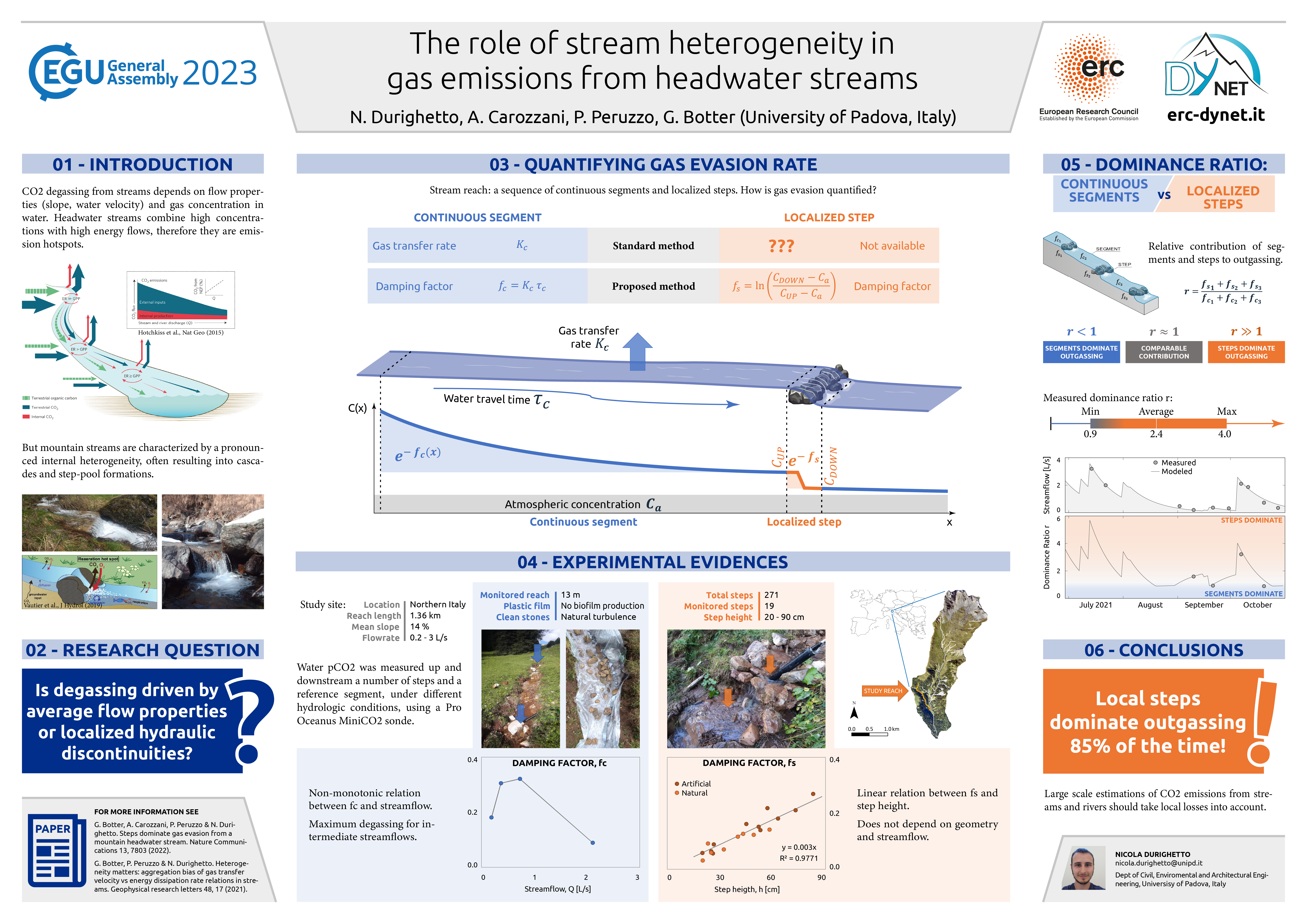
EGU23-7670 | Posters on site | BG3.14
Near-surface vs. sub-surface soil moisture impacts on vegetation functioningEGU23-8013 | ECS | Orals | BG3.14
Contrasting responses of vegetation to intraseasonal rainfall in Earth System ModelsEGU23-8747 | ECS | Orals | BG3.14
Modeling global vegetation processes and hyperspectral canopy radiative transfer using CliMA Land
EGU23-10417 | ECS | Orals | BG3.14
Disentangling the influence of vegetation structure and physiology on land-atmosphere couplingEGU23-10949 | ECS | Orals | BG3.14
Understanding vegetation drought legacy effects on carbon cycling using observations from multiple platformsEGU23-11271 | ECS | Posters on site | BG3.14
Water use efficiency differs for mixed and monospecific boreal forests in SwedenEGU23-11564 | ECS | Orals | BG3.14
Vegetation optical depth reveals changes in ecosystem-level water stress for global forestsEGU23-11630 | Posters on site | BG3.14
Optimal stomatal control in the presence of leaf-atmosphere couplingEGU23-12846 | ECS | Posters on site | BG3.14
The role of water table depth and plant functional type in energy partitioningEGU23-13401 | Posters on site | BG3.14
Drought effect on urban plane tree ecophysiology and its isoprene emissionsEGU23-16495 | ECS | Posters on site | BG3.14
Development of a portable, distance-based paper analytical sensor for carbonate detection.
EGU23-1168 | ECS | Orals | BG8.4 | Highlight
Counting (on) Blue Carbon - Challenges and Ways forward for carbon accounting of ecosystem-based carbon removal in marine environmentsEGU23-4623 | ECS | Orals | BG8.4 | Highlight
Carbon stocks and fluxes of Mangrove Associates(Hibiscus hamabo and Paliurus ramosissimus) in Jeju Island, South KoreaEGU23-5542 | ECS | Orals | BG8.4
Climate Change Mitigation in The Bahamas - The Power of Earth Observation for Blue Carbon Accounting
EGU23-6103 | ECS | Orals | BG8.4 | Highlight
Accumulation rates of salt-marsh blue carbon at Lindisfarne, northern England, and their relationship with sea-level changeEGU23-9877 | ECS | Orals | BG8.4
Marine Biomass Regeneration: Simple Modelling of Large-Scale Ocean Carbon Dioxide RemovalEGU23-10160 | ECS | Posters on site | BG8.4
A Study of Ephemeral Wetland Types According to Water Level Changes in Lava ForestsEGU23-11136 | ECS | Posters virtual | BG8.4
The vegetation characteristics of semi-mangrove Hibiscus hamabo Siebold & Zucc. and Paliurus ramosissimus (Lour.) Poir. in Jeju Island, KoreaEGU23-11142 | ECS | Posters on site | BG8.4
Characteristics of vegetation according to the micro-climatic conditions of a lava pit on Jeju IslandEGU23-11394 | ECS | Posters on site | BG8.4
Prospects of Adaptability and Establishment of Mangroves to Achieve Carbon Capture Expansion in Korean Coastal AreasEGU23-11967 | ECS | Posters on site | BG8.4
Study on Forest Management System Considering Ecosystem Services in Islands in South KoreaEGU23-13673 | ECS | Posters on site | BG8.4
Classification of islands forest types and ecosystem services management in South KoreaEGU23-13684 | ECS | Posters virtual | BG8.4
Assessing impact of land-use changes on carbon stock dynamics in coastal mangrove ecosystem in Bali Island, IndonesiaEGU23-851 | ECS | Orals | EOS4.1
Organisational preparedness for the physical risks of climate change in the UKEGU23-1391 | Posters on site | EOS4.1
Proposal of ethical guidelines for the European Research Infrastructure EPOSEGU23-2805 | Posters on site | EOS4.1
Study on the effective disaster risk management and communication for resilient communityEGU23-3462 | Posters on site | EOS4.1 | Highlight
How to collectively engage in reducing the carbon footprint of a research lab?EGU23-4066 | Posters on site | EOS4.1
Supradisciplinary approach: a (geo)ethical way of producing knowledge and guiding human actions in the XXI Century.EGU23-4384 | ECS | Posters on site | EOS4.1
Social safety in the field – preparing the students, our future colleaguesEGU23-4443 | Posters on site | EOS4.1
Minerals as lenses to illustrate the relationships between Geology and colonialismEGU23-6182 | Orals | EOS4.1 | Highlight
Defining the Anthropocene for the greatest good as an Event-based RenaissanceEGU23-6356 | Posters on site | EOS4.1
Ma Terre en 180 Minutes: a transition support system to build decarbonization scenarios in the academic community.EGU23-7377 | Posters on site | EOS4.1
For a sustainable future: a survey about geoethics and 2030 Agenda among the Italian geosciences communityEGU23-8072 | Orals | EOS4.1 | Highlight
Hydrogeoethical questions related to urban groundwater management: the case of Kabul city, AfghanistanEGU23-8173 | ECS | Posters on site | EOS4.1 | Highlight
The specific responsibility of geoscientists in the midst the climate and ecological crises: a need to address personal and institutional dissonancesEGU23-8683 | Orals | EOS4.1 | Highlight
The Knowledge Hub on Sea Level Rise and the science-based European Seas assessment reportingEGU23-10073 | Posters virtual | EOS4.1
Teaching Geosciences through practical activities to enhance global citizenship education in schools with a high dropout rateEGU23-10946 | Posters on site | EOS4.1
Research in Volcanology: where, when, and by whom? A global bibliometric analysisEGU23-11656 | Orals | EOS4.1
Traveling for academic research : patterns, determinants and mitigation optionsEGU23-12019 | ECS | Posters on site | EOS4.1
Development of a Web Based Decision Support System to Provide Relevant Climate Indicators for Climate Change AdaptionEGU23-13681 | ECS | Orals | EOS4.1
Engaging stakeholders for the co-creation of Climate Services. Beyond ERA4CS INDECIS projectEGU23-13910 | Orals | EOS4.1 | Highlight
Social production of ignorance – the role for geoscientists in addressing “undone science”EGU23-14085 | Posters virtual | EOS4.1
Carbon footprint and reduction initiatives in a French geosciences laboratoryEGU23-14915 | ECS | Posters on site | EOS4.1
Is maximizing spatial resolution worth the computational cost?EGU23-15959 | Posters on site | EOS4.1 | Highlight
Changing the narrative: the hidden histories of British colonial mineral exploitation in AfricaEGU23-16302 | Orals | EOS4.1 | Highlight
An Ethical Framework for Climate Intervention Research and Potential Scaling
EGU23-5949 | ECS | Posters on site | SSS2.3 | Highlight
Sustainable increase of SOC stocks and nutrients in sandy subsoils by ameliorative fractional deep tillage (aFDT)EGU23-6129 | Posters on site | SSS2.3 | Highlight
Development of soil research supporting climate resilience and decision-making in FinlandEGU23-7463 | Posters on site | SSS2.3
Options for reducing agricultural ammonia emissions on different soil typesEGU23-12830 | Posters virtual | SSS2.3
Quantifying the potential of agricultural soils to store carbon. A data-driven approach illustrated for the Netherlands.EGU23-15465 | Posters on site | SSS2.3
Climate change impacts on crop production and soil carbon stock in a continuous wheat cropping system in southeast EnglandEGU23-1525 | ECS | Orals | SSS5.3 | Highlight
Carbon preservation in soils: The role of carbon chemistry in soil aggregate formationEGU23-2255 | ECS | Posters on site | SSS5.3
Molecular characterisation of fire-affected soil organic matter by a 5th generation wildfire in SW-PortugalEGU23-2772 | Posters on site | SSS5.3
Plant lipids as proxies to trace the origin and dynamics of soil organic carbonEGU23-3581 | ECS | Posters on site | SSS5.3
Plastic film mulching combined with manure fertilizer application promotes microbial necromass carbon accumulation within soil macroaggregatesEGU23-3868 | ECS | Posters on site | SSS5.3
Alterations of soil organic matter following 130 years of afforestation assessed by molecular markersEGU23-6849 | ECS | Posters on site | SSS5.3
Complementarity and drivers of thermal and physical soil organic carbon fractions at the scale of mainland France
EGU23-7186 | ECS | Posters on site | SSS5.3
Soil organic matter as a mediator of energy fluxes - a new perspectiveEGU23-7982 | ECS | Posters on site | SSS5.3
Formation of organo-Fe (oxyhydr)oxide interactions during the first stages of Martian regolith simulant terraformingEGU23-8035 | ECS | Posters on site | SSS5.3
13C natural abundance for analysis of steps of organic carbon transformation in soil: application for various ecosystemsEGU23-10362 | ECS | Orals | SSS5.3
Divergent controls on particulate and mineral-associated organic carbon formation and persistenceEGU23-11969 | ECS | Orals | SSS5.3 | Highlight
Taking a closer look: How spectromicroscopic imaging of organo-mineral associations leads to a novel perspective on interrelated soil functionsEGU23-12386 | Posters on site | SSS5.3
Hair-ice, fungal guttation droplets, ice ribbons and needle ice from a chemical perspectiveEGU23-13825 | Posters on site | SSS5.3 | Highlight
How does edaphic context affect soil organic matter persistence?EGU23-13926 | ECS | Orals | SSS5.3
The role of lignin in the saprotrophic degradation of plant biomass in boreal forest soil.EGU23-15659 | ECS | Posters on site | SSS5.3
SOC sequestration affected by fertilization in rice-based cropping systems over the last four decadesEGU23-15729 | ECS | Orals | SSS5.3
Managed pastures enhance soil carbon stocks from degraded pasture in Ferralsol of Brazilian CerradoEGU23-17105 | ECS | Orals | SSS5.3
Evidence for the diagenetic formation of fused aromatic ring structures in an organic soilCL3.1 – Climate change: from regional to global
EGU23-233 | ECS | Orals | CL3.1.2 | Highlight
Simulating extreme cold winters in France with empirical importance samplingEGU23-1722 | ECS | Orals | CL3.1.2
Evaluation of compound dry-hot extremes in summer monsoon in India: Past and FutureEGU23-2684 | ECS | Posters on site | CL3.1.2
On detecting signals of anthropogenic climate change in basin-scale hydrologic variables
EGU23-3679 | Orals | CL3.1.2 | Highlight
From hot air to environmental injustice: end to end event attributionEGU23-3768 | ECS | Posters on site | CL3.1.2
Constrained Emergence of Air Temperature Change Signal in Northern-Central India From Background VariationsEGU23-6020 | ECS | Posters on site | CL3.1.2
The attribution of flash flooding impacts over cities in the United KingdomEGU23-7528 | ECS | Orals | CL3.1.2
Children disproportionally exposed to attributable heatwaves at low-latitude low-income countriesEGU23-7716 | ECS | Orals | CL3.1.2
The evolution of the global population experiencing unprecedented exposure and its age of emergence.EGU23-7932 | Posters on site | CL3.1.2
Evident decrease in future European soil moisture in the Kiel Climate ModelEGU23-8136 | ECS | Orals | CL3.1.2
Anthropogenic influence on precipitation quantile trends over ChinaEGU23-8900 | Posters virtual | CL3.1.2
Observed and projected changes in the diurnal temperature range at European cities with different base climateEGU23-11209 | ECS | Posters on site | CL3.1.2 | Highlight
Significant Role of Internal Climate Variability for the Global Warming Hot-spots in the Northern HemisphereEGU23-11482 | Posters on site | CL3.1.2
Climatic water balance in Poland – intraannual variability and longterm trendsEGU23-11732 | Orals | CL3.1.2 | Highlight
The record-shattering 2021 Pacific Northwest heatwave – challenges and opportunities for attribution and event storylinesEGU23-12474 | ECS | Orals | CL3.1.2 | Arne Richter Award for Outstanding Early Career Scientists Lecture
The kids aren’t alright
EGU23-13745 | Orals | CL3.1.2 | Highlight
Searching for the most extreme temperature events in recent historyEGU23-13786 | ECS | Orals | CL3.1.2
Analysis of precipitation records from climate models in a non-stationary contextEGU23-14095 | ECS | Posters on site | CL3.1.2
Recent changes of tropical night in the South Korea metropolitan areaEGU23-14441 | ECS | Posters on site | CL3.1.2
Collective attribution and future risk assessment of recent high-impact wildfire eventsEGU23-14756 | ECS | Orals | CL3.1.2 | Highlight
The Effect of Climate Change on Global Wildfire ActivityEGU23-15031 | Posters on site | CL3.1.2
Attributing observed trends in heat-related excess mortality to climate changeEGU23-15387 | Posters on site | CL3.1.2
Climate attribution for extreme events. A statistically based approach.EGU23-15502 | ECS | Orals | CL3.1.2
Climate change has increased the intensity of documented Derecho storms in FranceEGU23-15912 | ECS | Posters on site | CL3.1.2
Attribution of seasonally-relevant climate indicators in HungaryEGU23-16087 | Orals | CL3.1.2 | Highlight
On the nature and attribution of the 2022 annual record temperature in the UK and IrelandEGU23-16818 | ECS | Orals | CL3.1.2
Shifting Velocity of Precipitation Extremes over India under Climate ChangeEGU23-2176 | ECS | Orals | CL3.1.3 | Highlight
The 1820s Marks a Shift to Hotter‐Drier Summers in Western Europe Since 1360EGU23-2403 | ECS | Orals | CL3.1.3
Analysis of extreme precipitation in Bangladesh based on reanalysis data and climate modelsEGU23-2892 | ECS | Posters on site | CL3.1.3
Impact of evaporation in Yangtze River Valley on heat stress in North ChinaEGU23-3791 | ECS | Posters on site | CL3.1.3
Storylines for future changes in regional extreme precipitationEGU23-4223 | ECS | Orals | CL3.1.3
Atmospheric Drivers of Rainfall Events in the Republic of DjiboutiEGU23-4268 | Posters on site | CL3.1.3
Variation of global compound heatwaves and their associations with climate variabilityEGU23-4473 | ECS | Orals | CL3.1.3
Temporal scaling properties of extreme rainfall and intensity-duration-frequency curves in the UKEGU23-4651 | ECS | Posters on site | CL3.1.3
Application of an improved snow albedo scheme in the simulation of heavy snow processes over the Tibetan PlateauEGU23-4762 | Orals | CL3.1.3 | Highlight
Detection and attribution of extreme precipitation events over the Asian monsoon regionEGU23-6630 | ECS | Posters on site | CL3.1.3
Projected changes and uncertainty in cold surges over northern China using the CMIP6 weighted multi-model ensembleEGU23-7058 | ECS | Posters on site | CL3.1.3
Effects of Cumulus and Radiation Parameterization on Summer Surface Air Temperature over Eastern ChinaEGU23-7201 | ECS | Posters on site | CL3.1.3
Evaluation on CMIP6 Global Climate Model Simulation of the AnnualMean Daily Maximum and Minimum Air Temperature in ChinaEGU23-8417 | ECS | Orals | CL3.1.3
Analysis of extreme temperature events based on estimated 1-km daily near-surface air temperatureEGU23-10686 | ECS | Orals | CL3.1.3
Anthropogenic Intensification of East Asia Summer Monsoon Frontal Precipitation SystemEGU23-10723 | ECS | Posters on site | CL3.1.3
South China coastline will face more furious storm surges at the end of the 21st centuryEGU23-13678 | ECS | Posters on site | CL3.1.3
Climate projections of frost risk for apple (Malus Domestica) in SloveniaEGU23-14937 | ECS | Posters on site | CL3.1.3
Compound hot and dry extremes might be underestimated in CMIP6 projectionsEGU23-15316 | Posters on site | CL3.1.3
Heat waves and climate change: an application to Sicily (Italy)EGU23-16663 | ECS | Posters on site | CL3.1.3
Characteristics of the Potential Vorticity and its Budget in the Surface Layer over the Tibetan PlateauEGU23-16839 | ECS | Orals | CL3.1.3
How Well do High-resolution Global Climate Models (GCMs) Simulate Tropical Cyclones in the Bay of Bengal?EGU23-181 | ECS | Posters on site | CL3.1.6
Monitoring of agricultural drought using Crop Moisture Stress index and the estimation of resulting maize yield reductionEGU23-762 | ECS | Posters on site | CL3.1.6
The surface runoff response to land use changes in border watersheds of the Central SerbiaEGU23-5430 | ECS | Posters on site | CL3.1.6
The effects of the temperature increase on the rainfall regimes in north-central ItalyEGU23-6044 | Posters virtual | CL3.1.6
On external and internal drivers of extreme discharges in the Danube Lower BasinEGU23-6942 | ECS | Posters on site | CL3.1.6
Trends and characteristics of warm and dry extreme compound event in Southeastern EuropeEGU23-11863 | Posters on site | CL3.1.6
Attribution of extreme rainfall associated with the Balkans floods of May 2014EGU23-14880 | Posters on site | CL3.1.6
Effects of changing atmospheric circulation patterns on waterlogging potential in Southeast EuropeEGU23-1555 | ECS | Posters on site | NP1.2
Drought impact-based forecasting: Trade-offs between indicators and impactsEGU23-2146 | ECS | Posters on site | NP1.2
Contrasting Deep and Shallow Arctic Warming Events on the Intraseasonal Time Scale in Boreal WinterEGU23-2242 | ECS | Posters on site | NP1.2
A Quantile Generalised Additive Approach for Compound Climate Extremes: Pan-Atlantic Extremes as a Case StudyEGU23-2644 | ECS | Posters on site | NP1.2
Investigating the typicality of the dynamics leading to extreme temperatures in the IPSL-CM6A-LR modelEGU23-3300 | Posters on site | NP1.2
Simulating the West Pacific Heatwave of 2021 with Analog Importance SampingEGU23-4216 | ECS | Orals | NP1.2
Large-scale perspective on the extreme near-surface winds in the central North AtlanticEGU23-5515 | ECS | Orals | NP1.2
Estimating non-linear persistence for impact assessment in European forestsEGU23-6507 | ECS | Posters on site | NP1.2
Simulation of future extreme rainfall events over Belgium with a focus on the Vesdre valley using the regional climate model MAR.EGU23-6732 | Posters on site | NP1.2
Deep learning techniques applied to an attribution study for heatwaves in the Iberian PeninsulaEGU23-7087 | Posters on site | NP1.2
A Temperature-Duration-Curve model for the real-time estimation of extreme river water temperatures at ungauged sitesEGU23-7124 | ECS | Orals | NP1.2
Influence of the Atlantic Multidecadal Variability and of Soil Moisture on Extreme Heatwaves in EuropeEGU23-7697 | ECS | Posters on site | NP1.2
Diagnosing atmospheric persistence for heatwaves and in extended range forecastsEGU23-7908 | ECS | Orals | NP1.2
Dynamical pathways for pan-Atlantic compound cold and windy extremesEGU23-7954 | ECS | Orals | NP1.2
On the Response of North Atlantic Extratropical Cyclones to North America Cold Air OutbreaksEGU23-8138 | ECS | Orals | NP1.2
Return levels of extreme European windstorms, their dependency on the NAO, and potential future risksEGU23-8244 | ECS | Posters on site | NP1.2
Predictability of blocking and zonal flow regimes in a reduced-order land atmosphere coupled modelEGU23-9105 | Orals | NP1.2
Effect of anthropogenic climate change on explosive cyclogenesis cases in EuropeEGU23-9123 | ECS | Posters on site | NP1.2
Modeling vegetation response to climate in Africa at fine resolution: EarthNet2023, a deep learning dataset and challenge.EGU23-11943 | Orals | NP1.2 | Highlight
Simulating worst case heatwaves during the Paris 2024 OlympicsEGU23-12059 | ECS | Posters virtual | NP1.2
Present and projected humid heat exposure and precipitation extremes in TurkeyEGU23-12095 | ECS | Posters on site | NP1.2
Weakened impact of the Atlantic equatorial mode of variability on the future Guinea Coast extreme rainfall indicesEGU23-12130 | ECS | Orals | NP1.2 | Highlight
A probabilistic assessment of extreme weather event impacts on crop yield in Germany
EGU23-14838 | Orals | NP1.2
Freva for ClimXtreme: an aid to get the bigger picture in analysis of extremes
EGU23-14879 | ECS | Posters on site | NP1.2 | Highlight
Assessing recent trends in globally co-occurring hot, dry and wet events under climate changeEGU23-15813 | ECS | Posters on site | NP1.2
Delayed Effects of ENSO and Indian Ocean Dipole on the ensuing-summer extreme precipitation over Yangtze River ValleyEGU23-16917 | ECS | Orals | NP1.2
Computing and analyzing persistent merged jet state in climate model using rare event algorithmCL3.2 – Climate and Society
EGU23-1240 | ECS | Orals | CL3.2.1 | Highlight
Does net-zero CO2 stabilize the climate? - On the contributions of the remaining climate forcingEGU23-1664 | ECS | Posters on site | CL3.2.1 | Highlight
Irreversible changes in surface temperature and precipitation to CO2 forcingEGU23-1691 | ECS | Orals | CL3.2.1
Emissions pathways change how abnormal climatic conditions de-emerge beyond net-zeroEGU23-4447 | Orals | CL3.2.1
Adaptive emission reduction approach to reach any global warming targetEGU23-5097 | Orals | CL3.2.1 | Highlight
Investigating the implications of net-zero emissions at different global warming levelsEGU23-5881 | Orals | CL3.2.1 | Highlight
Betting on CDR under uncertain climate sensitivity is bad climate policyEGU23-6073 | ECS | Posters on site | CL3.2.1
Emissions pathways compatible with 1.5ºC and 2ºC stabilized warming in fully-coupled Earth System Models: first results from AERA-MIPEGU23-6566 | Posters on site | CL3.2.1
Levers of climate pledges influencing the Paris Agreement targetEGU23-6584 | ECS | Posters on site | CL3.2.1
Consequences of the spatial configuration of Carbon Dioxide Removal for its potential to withdraw atmospheric CO2EGU23-6823 | Orals | CL3.2.1 | Highlight
Policy implications from aligning IPCC scenarios to national land emissions inventoriesEGU23-9715 | ECS | Posters on site | CL3.2.1
Estimated remaining carbon budgets under terrestrial nutrient limitationEGU23-10823 | Posters on site | CL3.2.1 | Highlight
The full climate impacts of nature-based climate solutions must be considered to achieve climate goalsEGU23-10836 | Posters on site | CL3.2.1
Estimation of renewable power generation and greenhouse gas reduction potential in the building sectorEGU23-11083 | ECS | Orals | CL3.2.1
Transdisciplinary Research Framework on Climate Change Dynamic Decision-making.EGU23-12247 | Posters on site | CL3.2.1
Net greenhouse gas emission pathway for Finland based on fair share of allowed warmingEGU23-14454 | ECS | Orals | CL3.2.1
Regional impacts of climate stabilisation across multiple global warming levelsEGU23-15161 | ECS | Posters on site | CL3.2.1
Defending climate targets under threat of forest carbon impermanenceEGU23-16356 | ECS | Posters on site | CL3.2.1
Towards a net negative world: applying a rapid “Paris Test” to multi-gas national policy scenarios to assess and enable fair share 1.5ºC achievementEGU23-1964 | ECS | Orals | CL3.2.5
Managerial perspectives on climate change and stock price crash riskEGU23-2779 | ECS | Posters on site | CL3.2.5
Implicit cost of carbon emissions: Design the internal carbon price in the decision-making processEGU23-3471 | Posters on site | CL3.2.5
Simple climate emulators - fit for net-zero emission scenarios?EGU23-3680 | ECS | Posters virtual | CL3.2.5
Quantifying Airborne Fraction Trends and the Ultimate Fate of Anthropogenic CO2 by Tracking Carbon Flows in a Simple Climate ModelEGU23-5641 | ECS | Posters on site | CL3.2.5
Model development for climate optimized aircraft designEGU23-6660 | ECS | Orals | CL3.2.5 | Highlight
The carbon dioxide removal gap: current removals and country proposals versus future requirements for limiting warming to 2°C or lowerEGU23-8191 | ECS | Posters on site | CL3.2.5
Climate uncertainty as an integral part of integrated assessment modelsEGU23-9745 | ECS | Orals | CL3.2.5
Understanding the Sources of Climate Uncertainty in Projections of Climate ImpactsEGU23-10393 | ECS | Posters on site | CL3.2.5
Identification and Analysis of Critical Water Futures in the Indus River Basin
EGU23-12124 | ECS | Orals | CL3.2.5
Adaptation constraints in scenarios of socio-economic developmentEGU23-12337 | ECS | Orals | CL3.2.5 | Highlight
Fire Weather Compromises Large Scale Afforestation ScenariosEGU23-13183 | Orals | CL3.2.5 | Highlight
Inequality and the adoption of climate mitigation policiesEGU23-13832 | ECS | Orals | CL3.2.5
What to expect of integrated assessment models: insights from philosophyEGU23-14067 | ECS | Orals | CL3.2.5
Automatic and Open-Source Model with Forecasts for Climate Policy and EconomicsEGU23-14279 | ECS | Orals | CL3.2.5 | Highlight
Closing the loop between integrated assessment and climate risk research – rapid climate risk emulationEGU23-14884 | ECS | Orals | CL3.2.5
Spatially-resolved emulations of droughts and fire weather using MESMER-XEGU23-14996 | ECS | Posters on site | CL3.2.5
Quantifying the different forcing contributions to the climate under the adaptive emission scenarios.EGU23-15660 | ECS | Orals | CL3.2.5
Probabilistic climate emulation with physics-constrained Gaussian processesEGU23-1304 | ECS | Posters on site | CL3.2.6
The impact of Amazon deforestation on rain system using a storm-resolving global climate modelEGU23-3151 | Orals | CL3.2.6 | Highlight
Social tipping points of Anthropocene acceleration dynamics in European history, from Roman times to the Little Ice AgeEGU23-3443 | Orals | CL3.2.6 | Highlight
Regional Climate Expected to Continue to Change Significantly After Net-Zero CO2 Emissions ReachedEGU23-5233 | Posters on site | CL3.2.6
Association for Trans-Eurasia Exchange and Silk-Road Civilization DevelopmentEGU23-5722 | ECS | Orals | CL3.2.6 | Highlight
Recurrent droughts increase risk of cascading tipping events by outpacing adaptive capacities in the Amazon rainforestEGU23-7871 | Posters on site | CL3.2.6 | Highlight
Is the current methane growth event comparable to a glacial/interglacial Termination event?EGU23-9387 | ECS | Posters on site | CL3.2.6
Robustness of critical slowing down indicators to power-law extremes in an Amazon rainforest modelEGU23-9954 | ECS | Posters on site | CL3.2.6
Climate tipping risks under policy-relevant overshoot temperature pathwaysEGU23-10044 | ECS | Orals | CL3.2.6 | Highlight
The Impact of Solar Radiation Modification on Earth System Tipping Points and Threshold Free FeedbacksEGU23-13587 | ECS | Posters virtual | CL3.2.6
Model hierarchies and bifurcations in QE monsoon models
EGU23-14360 | ECS | Posters on site | CL3.2.6
Dam construction as an important anthropogenic modification triggers abrupt shifts in microbial community assembly in freshwater lake sedimentsEGU23-17397 | ECS | Posters virtual | CL3.2.6
Is Arctic Permafrost a Climate Tipping Element? – Potentials for Rapid Permafrost Loss Across Spatial ScalesEGU23-17457 | ECS | Orals | CL3.2.6 | Highlight
Indicators of changing resilience and potential tipping points in the automotive industryEGU23-428 | ECS | Posters on site | CL3.2.8
Is Argentina hotter? Understanding heatwaves temporal and spatial behavior using the ERA5-LAND dataset (1950-2022)EGU23-1212 | Orals | CL3.2.8 | Highlight
Storylines of the impacts in the Netherlands of alternative realizations of the Western Europe July 2021 floodsEGU23-2376 | ECS | Orals | CL3.2.8
Advancing research on compound weather and climate events via large ensemble model simulationsEGU23-3277 | ECS | Posters on site | CL3.2.8
Future socio-ecosystem productivity threatened by compound drought-heatwave eventsEGU23-3832 | ECS | Posters on site | CL3.2.8
Understanding the origins of climate anomalies during low-yield years in Australia’s largest breadbasketEGU23-4309 | ECS | Posters virtual | CL3.2.8
Assessing the impact of climate change scenario for simulating nonstationary rainfall intensity and durationEGU23-4544 | Orals | CL3.2.8 | Highlight
Climate change contributes to the record-shattering 2022 Pakistan rainfallEGU23-4705 | Posters virtual | CL3.2.8
Attribution and projection of the summer 2022 compound dry and hot extreme in the Northern HemisphereEGU23-7134 | ECS | Posters on site | CL3.2.8
Developing storylines for unprecedented extreme events using ensemble boostingEGU23-7329 | ECS | Posters on site | CL3.2.8
Increases in Extreme Precipitation over the Northeast United States using High-resolution Climate Model SimulationsEGU23-9277 | Posters on site | CL3.2.8
Estimating compounding heat waves and rainfall extremes under projected climate change over the island of Sicily, ItalyEGU23-9290 | Orals | CL3.2.8 | Highlight
Quantifying windstorm risks by translating historical extreme events into the futureEGU23-10709 | Orals | CL3.2.8
The Unprecedented Pacific Northwest Heatwave of June 2021: Causes and Impacts
EGU23-14539 | ECS | Orals | CL3.2.8
Increasing probability of extreme records in heavy precipitationEGU23-14556 | ECS | Posters on site | CL3.2.8
A new Max Planck Institute-Grand Ensemble with CMIP6 forcing and high-frequency model outputEGU23-15450 | ECS | Orals | CL3.2.8 | Highlight
A decision-support framework to construct climate impact storylines using downward counterfactualsEGU23-16457 | Posters on site | CL3.2.8
Emulator-enhanced extreme event attribution for data scarce developing countriesEGU23-17463 | ECS | Posters on site | CL3.2.8
Future Extreme Weather: a Data and AI driven approach to Understand Future Coastal FloodingEGU23-1054 | ECS | Posters on site | ERE1.14
Assessing the climate change risk to underwater cultural heritage: the EU-funded WATERISKULT projectEGU23-2440 | ECS | Orals | ERE1.14
Extreme rainfall risk and climate change impact assessment for Edinburgh World Heritage sitesEGU23-3237 | ECS | Orals | ERE1.14
Impact Assessment of Pollution and Climate-Induced Damage on Historic Centre of Rieti (Italy)EGU23-5786 | ECS | Posters on site | ERE1.14
Pore-scale investigation of salt weathering in building heritage materials: combining AFM nano-indentation measurements and multiscale modeling.EGU23-5956 | Posters on site | ERE1.14
Obtaining pore size distribution of porous stone using non-Newtonian fluidsEGU23-11840 | Posters virtual | ERE1.14
Smart IoT sensors as part of a holistic solution for improving resilience and sustainable reconstruction of historic areasEGU23-11948 | ECS | Orals | ERE1.14
Selection of relevant black crusts samples as ancient air pollution archivesEGU23-12449 | ECS | Orals | ERE1.14
The technical relationship between vertical greening and built heritageEGU23-12934 | ECS | Posters on site | ERE1.14
Microclimatic monitoring of the plaster casts of the Trajan’s Column in the Museum of Roman Civilisation (Rome)EGU23-13158 | Posters on site | ERE1.14
The use and vulnerability of medieval masonries in Balaton region, HungaryEGU23-13243 | Orals | ERE1.14
IT support for climate resilient cultural heritage - examples from the KERES projectEGU23-13666 | Orals | ERE1.14
Global warming evidence in long-term temperature monitoring of heritage karstic cavesEGU23-13699 | ECS | Posters on site | ERE1.14
Assessing weathering damage in Arenitic Rock using Non-Destructive Testing: the case study of the stone coats of arms of Palazzo Ricasoli in FlorenceEGU23-15431 | Posters virtual | ERE1.14
The Loggiato dei Cappuccini in Comacchio (Italy): assessment of degradation and state of conservation.EGU23-16553 | ECS | Posters on site | ERE1.14
Porosity evolution of granitic rocks used for the bridge construction
EGU23-593 | ECS | PICO | NH9.9
Variability and the odds of Total and Pathogenic Vibrio abundance in Chesapeake BayEGU23-5923 | ECS | PICO | NH9.9
Impact of global warming and Greenland ice sheet melting on malaria and Rift Valley FeverEGU23-9509 | PICO | NH9.9 | Highlight
The first continental population dynamics model of the Asian tiger mosquito driven by climate and environment
EGU23-13298 | ECS | PICO | NH9.9
Prognostic epidemiological indices and the fate of ongoing infectious disease outbreaksEGU23-14214 | ECS | PICO | NH9.9
A Deep Early Warning System of Mosquito Borne Diseases using Earth Observational DataEGU23-17226 | ECS | PICO | NH9.9 | Highlight
Identification of thresholds on Sea surface temperature and coastal chlorophyll for understanding environmental suitability of V. vulnificus incidenceEGU23-1441 | ECS | Orals | NH9.11
Coastal setback zones can lessen Europe's future exposure to sea level rise.EGU23-2370 | ECS | Orals | NH9.11 | Highlight
A Probabilistic Flood Loss Model for Adaptation Planning in Ho Chi Minh CityEGU23-6022 | Posters on site | NH9.11 | Highlight
Flood Risk in Vietnamese Coastal Cities – Remote Sensing Based Urban Structure Types as a Planning Relevant ToolEGU23-9192 | ECS | Orals | NH9.11 | Highlight
Piloting a physical-metric-based Index bench-marked by a social-economical Index measuring Flood Resilience in Ho Chi Minh CityEGU23-9259 | ECS | Posters on site | NH9.11
Simulation and assessment of compound flooding in coastal cities under climate changeEGU23-9909 | Posters on site | NH9.11
Profiling households with their flood response measures in Ho Chi Minh City, VietnamEGU23-11548 | ECS | Posters on site | NH9.11
Protecting Coastal Communities from Sea Level Rise and Extreme Weather Events: An Analysis of Adaptation and Risk Reduction MeasuresEGU23-13148 | ECS | Orals | NH9.11 | Highlight
Assessing flood situations and technical adaptation measures in the context of climate change in Ho Chi Minh CityEGU23-13799 | ECS | Orals | NH9.11
Assessing perceived probability and damage of flood risk across the globeEGU23-14451 | Orals | NH9.11 | Highlight
Improved Terrain Modelling to aid flood mapping in coastal citiesEGU23-1161 | ECS | Orals | HS2.3.6
Modelling global surface water quality under uncertain climate and socio-economic changeEGU23-1721 | ECS | Posters on site | HS2.3.6
Potential variations in groundwater quality for household and irrigation applications as affected by climate changeEGU23-2336 | ECS | Posters on site | HS2.3.6
Future coastal water pollution under global change: multi-pollutant modelingEGU23-3312 | ECS | Posters on site | HS2.3.6
Attribution of climate change imprint on riverine nutrient export from diffuse pollution sources to African coastal watersEGU23-3700 | ECS | Posters on site | HS2.3.6
Coupling artificial intelligence techniques and remote sensing data for water quality simulation of lakesEGU23-7260 | ECS | Posters on site | HS2.3.6
Modelling the efficacy of catchment remediation measures for reducing sediment & nutrient exports under future climate trajectoriesEGU23-7565 | Posters on site | HS2.3.6
Recent advancement in water quality indicators for eutrophication in global freshwater lakesEGU23-7598 | ECS | Posters on site | HS2.3.6
Joint temporal trends in river discharge and temperature over the past 57 years in a large European basin: implications for diadromous fishEGU23-11247 | ECS | Posters on site | HS2.3.6
Modeling the impacts of climate change on streamflow and nitrate export in a Mediterranean agricultural watershed in SpainEGU23-11416 | ECS | Posters on site | HS2.3.6
How remote sensing can identify land cover and climate change impacts on lake water quality: Lake Nicaragua and Lake Titicaca case studies.EGU23-12024 | Orals | HS2.3.6
Towards realizing the EU 2050 Zero Pollution Vision for Nitrogen ExportEGU23-16167 | ECS | Posters on site | HS2.3.6
Including water quality in the water-energy-food nexus: An Upper White Nile case study
EGU23-1916 | ECS | PICO | HS7.3
Modeling the potential of management options to reduce irrigation demand in Western Switzerland

EGU23-10953 | ECS | PICO | HS7.3
Leveraging Hydroclimate and Earth Observation to Predict Grain Production in Sub-Saharan AfricaEGU23-12693 | ECS | PICO | HS7.3
Photo-driven processes for the removal of biotoxins derived from Harmful Microalgal BloomsEGU23-15429 | ECS | PICO | HS7.3
Effect of distance of crop canopy temperature observations on Crop Water Stress IndexEGU23-16787 | ECS | PICO | HS7.3
An Intelligent Irrigation Decision Support System for Optimizing Cotton Water UseEGU23-469 | ECS | PICO | HS7.9 | Highlight
Revegetation impacts on moisture recycling over Loess Plateau in ChinaEGU23-1887 | ECS | PICO | HS7.9
Updated Understanding of Continental Precipitation Recycling Using Global 3-D Lagrangian TrackingEGU23-2768 | ECS | PICO | HS7.9
Hydrological response to anthropogenic activities and climate change in the southern Caspian Sea, IranEGU23-5016 | PICO | HS7.9 | Highlight
Moisture Recycling in the Amazon: a study using WRF with water vapor tracersEGU23-6508 | PICO | HS7.9 | Highlight
Assessing the impact of large-scale afforestation on the atmospheric water cycle of the Loess Plateau in ChinaEGU23-7687 | ECS | PICO | HS7.9
Towards using multi-dimensional structures in climate variables to detect anthropogenic changesEGU23-7867 | ECS | PICO | HS7.9 | Highlight
The importance of the plant physiological response to rising CO2 in projections of future water availabilityEGU23-7976 | ECS | PICO | HS7.9 | Highlight
Modeling the Impacts of Deforestation: local drying of the atmosphere and potential effect on downwind precipitation.EGU23-8061 | ECS | PICO | HS7.9
Exploring the human influence on surface water availability in the contiguous United StatesEGU23-10652 | ECS | PICO | HS7.9
Atmospheric moisture exchanges between the Magdalena River basin and its surroundings.EGU23-13142 | PICO | HS7.9
An engineering approach to land-surface controlled convective precipitation
EGU23-3046 | ECS | Orals | CR6.1
Hydrological implications of pervasive permafrost thaw across the Tibetan PlateauEGU23-5464 | Posters on site | CR6.1
Detection and localization of ice cavitiy using ambient seismic noiseEGU23-6052 | Orals | CR6.1 | Highlight
Rapid and massive 335 million m3 glacier bed erosion after detachment of the Sedongpu Glacier (Tibet)EGU23-10799 | ECS | Orals | CR6.1
Regional decrease in hazards from ice-dammed lakes in Alaska since the 1960sEGU23-11207 | ECS | Posters virtual | CR6.1
Monitoring GLOFs via deep learning-based remote sensing and transfer learningEGU23-13137 | Orals | CR6.1
Emerging threats: Cryosphere-related hazards in the Trans-Himalaya of LadakhEGU23-13286 | Posters on site | CR6.1
Hazard assessment of the potential outburst flood of the Ikhnach Lakes, UzbekistanEGU23-13819 | ECS | Posters on site | CR6.1
Climate change impacts on large scale avalanche risk in mountainous regionsEGU23-14598 | ECS | Orals | CR6.1
Future proglacial lake evolution and outburst flood hazard in south IcelandEGU23-15227 | ECS | Posters on site | CR6.1
Thermokarst processes as triggers of debris flows: A case study at Hüttekar Rock Glacier (Austrian Alps)EGU23-15703 * | Orals | CR6.1 | Highlight
Mapping Himalayan glacial lake outburst flood hazard through time and spaceEGU23-5623 | ECS | Orals | ERE5.2
The evolution of permeability with pressure and temperature in microfractured graniteEGU23-6830 | ECS | Posters on site | ERE5.2
Comparative analysis of analytical and numerical solutions for hydraulic properties upscaling in fractured mediaEGU23-7330 | ECS | Orals | ERE5.2 | Highlight
Structural patterns and states of stress at the Hengill Triple Junction, SW Iceland: implications for fluid-injection induced seismic hazardEGU23-7596 | ECS | Posters on site | ERE5.2
Seismic monitoring of laboratory fault reactivation by pore fluid injectionEGU23-8016 | Posters on site | ERE5.2
Hydrochemical Stimulation in Fractured Carbonate Rocks - Monitoring and SimulationEGU23-8221 | ECS | Posters on site | ERE5.2
Slip tendency and reactivation pressure prediction of natural fractures at the Bedretto Underground Laboratory, SwitzerlandEGU23-9673 | ECS | Posters on site | ERE5.2
Deformation bands characterization in porous carbonates: a case study from the Matera High (Southern Italy)EGU23-9694 | ECS | Posters on site | ERE5.2
Modelling fluid flow and water-rock interaction in fractured crust using a Discrete Fracture Network approachEGU23-10795 | ECS | Posters on site | ERE5.2
Phase field method to model mixed-mode fracturing in fluid saturated porous reservoirEGU23-13949 | ECS | Posters on site | ERE5.2
Permeability and Compressibility Evolution of Fractured and Intact Reservoir Rocks from the Blue Mountain Geothermal Field, NevadaEGU23-14955 | Posters on site | ERE5.2
Equivalent Biot and Skempton coefficients for fractured rocksEGU23-15424 | ECS | Posters on site | ERE5.2 | Highlight
Structural evolution in the northern Ruhr basin: A case study of urban geothermal exploration in the Münsterland RegionEGU23-717 * | ECS | Posters on site | NH10.1 | Highlight
A continental-scale multi-hazard analysis of economic recovery using nighttime light satellite dataEGU23-892 | ECS | Posters on site | NH10.1
A spatiotemporal indicator-based method to assess the drought and heat risks for urban green infrastructureEGU23-1658 | ECS | Orals | NH10.1
Exploring disaster risk management pathways in complex, multi-risk systems using DAPP-MREGU23-2155 | ECS | Posters on site | NH10.1
EroCA: a new tool for simulating constructed landform erosionEGU23-2413 | Posters on site | NH10.1
An operational tool for geo-hydrological scenario risk assessment and cascading effects evaluationEGU23-2514 | Posters on site | NH10.1
The multi-hazard risk perception of young professionals and students in Geography and Tourism amid the Covid-19 pandemicEGU23-2811 | ECS | Posters virtual | NH10.1
Assessment of flooding impact on water supply systems: a comprehensive approach based on DSSEGU23-4277 | ECS | Orals | NH10.1
Systems-level geohazard risk assessment in southwestern British Columbia, CanadaEGU23-4825 | Posters on site | NH10.1
Compound Vulnerabilities in an Urban Setting: Impact of Floods on the Transportation Network in IstanbulEGU23-5301 | ECS | Posters on site | NH10.1
Multi-risk assessment due to global warming under the SSP climate scenario in the Republic of KoreaEGU23-6275 | Posters on site | NH10.1
Multi-hazard system of a high Alpine valley: construction of an event chronology from different sourcesEGU23-7106 | ECS | Posters on site | NH10.1
Training risk managers in the climate change and energy transition narrative to avoid maladaptation to the emerging 21st century paradigm.EGU23-7499 | Posters on site | NH10.1
SIGALE: An online early warning system for gravitational hazard (Savoie, France)EGU23-7782 | ECS | Posters on site | NH10.1
Multi-hazard risk assessment of extreme weather events in a changing climateEGU23-11160 | ECS | Posters on site | NH10.1
Can we be precautionary with respect to all risks? A natural and health hazards perspectiveEGU23-11291 | ECS | Posters on site | NH10.1
Evaluating Environmental Impacts of Flood-Induced Tank Failures: A Risk Chain Model for Soil and Groundwater Contamination in NaTech contextEGU23-12813 | ECS | Posters on site | NH10.1
Compound events of drought and salt intrusion in the Greater Bay Area and adaptation countermeasuresEGU23-14325 | Posters on site | NH10.1
Operational assessment of landslide risks in the sprawling city of Bukavu (DR Congo)EGU23-16828 | Posters on site | NH10.1
Modelling compound flooding events for multiple hazards mapping: an example from Sweden.CL4 – Climate studies across timescales
EGU23-333 | ECS | Posters virtual | CL4.1
Observation-based assessments of surface flux partitioning regimes in 4 commonly-used land surface modelsEGU23-557 | ECS | Posters on site | CL4.1
Influence patterns of soil moisture change on surface-air temperaturedifference under different climatic backgroundEGU23-799 | ECS | Posters on site | CL4.1
The role of atmospheric humidity in controlling land-atmosphere feedbacks over forest: regional and global-scale analysesEGU23-1067 | Posters on site | CL4.1
The role of land-surface interactions for the surface energy fluxes in the EC-Earth earth system modelEGU23-1689 | ECS | Posters on site | CL4.1
Contrasting influences of biogeophysical and biogeochemical impacts of historical land use on global economic inequalityEGU23-2064 | ECS | Posters virtual | CL4.1
Hot weather amplifies the urban dry island effect, especially in wetter climatesEGU23-2078 | Posters on site | CL4.1
A new satellite-based product for studying land-atmosphere interactionsEGU23-3211 | ECS | Orals | CL4.1
Characterisation and interpretation of local climate evolution in the South-West of FranceEGU23-3549 | ECS | Posters virtual | CL4.1
The incorporation of 250 m soil grid textural layers in the NOAH-MP land surface models and its effects on soil hydrothermal regimesEGU23-3780 | ECS | Orals | CL4.1
Greening vegetation alleviates hot extremes in the semiarid region of ChinaEGU23-4818 | ECS | Posters on site | CL4.1
Simulating regional inter-annual crop yield variability over multiple decades with the Community Land Model (CLM5)EGU23-5624 | ECS | Orals | CL4.1
Abrupt late 1980s surface climate warming effects on drought risk over main french crop production basinsEGU23-5726 | ECS | Posters on site | CL4.1
Ground surface temperature linked to remote sensing land surface temperature in mountain environmentsEGU23-5961 | ECS | Orals | CL4.1 | Highlight
Soil Hot Extremes are Increasing Faster than Air Hot Extremes RegionallyEGU23-6528 | ECS | Posters on site | CL4.1
Improving the temporal and spatial vegetation variability in land surface models based on satellite observationsEGU23-9421 | ECS | Orals | CL4.1
An emergent constraint exposes widespread underestimation of drought impacts by Earth System ModelsEGU23-9767 | ECS | Posters on site | CL4.1
Diagnosing above- and below-canopy temperature impacts of forest in the Netherlands during heatwaves
EGU23-9838 | ECS | Orals | CL4.1
Vegetation-climate coupling and vegetation sensitivity to climate extremes in growing seasonsEGU23-9920 | ECS | Posters on site | CL4.1
Diurnal to interannual variability in Cabauw simulated by the ECLand land surface modelEGU23-10118 | ECS | Orals | CL4.1
Mechanistic patterns of land hydroclimate changes in a changing climateEGU23-11343 | ECS | Posters on site | CL4.1
The relevance of coupled climate model WRF-CTSM for land-atmosphere interactions analysisEGU23-11538 | Orals | CL4.1
Mesoscale Gradients in Soil Moisture over South America Lead to Enhanced ConvectionEGU23-12925 | ECS | Orals | CL4.1
Interannual Variation of Land-Atmosphere Interactions and their Connection with Extremes over EuropeEGU23-13277 | ECS | Posters on site | CL4.1
Earth observation time series for the monitoring of droughts in Cyprus: Patterns and drivers of vegetation dynamicsEGU23-13932 | Posters on site | CL4.1
The Impact of Recent European Droughts and Heatwaves on Trace Gas Surface Fluxes: Insights from Land Surface Data AssimilationEGU23-14104 | ECS | Orals | CL4.1
Transpiration in forest ecosystems based on deep learning and sap flow observationsEGU23-14158 | Posters on site | CL4.1
Continuous observations of CO2 and CH4 exchange from East-African rangelandsEGU23-15299 | Orals | CL4.1 | Highlight
Influence of Soil Moisture on the Evolution of Landfalling Tropical Cyclones during pre and post-monsoon seasonsEGU23-15403 | Orals | CL4.1 | Highlight
Global observations highlight regions where vegetation can enhance S2S predictabilityEGU23-16444 | ECS | Orals | CL4.1
Exploring deep root water uptake, soil moisture, and land surface fluxes in the AmazonEGU23-4628 | ECS | Orals | CL4.2
The key atmospheric drivers linking regional Arctic amplification with East Asian cold extremesEGU23-5682 | ECS | Posters on site | CL4.2
Understanding the Stratospheric Response to Arctic AmplificationEGU23-7373 | ECS | Posters on site | CL4.2
European winter climate response to projected Arctic sea-ice loss strongly shaped by change in the North Atlantic jetEGU23-10037 | ECS | Posters on site | CL4.2
Investigating Uncertainty in the Mid-latitude Response to Sea-Ice Loss with Idealised General Circulation Model ExperimentsEGU23-10544 | ECS | Posters virtual | CL4.2
Combined effects of La Niña events and Arctic tropospheric warming on the winter North Pacific storm trackEGU23-10837 | Posters on site | CL4.2
Earth system model sea-ice loss experiments are wrong. Are they useful?EGU23-13711 | ECS | Posters virtual | CL4.2
Control by the Circulation Adjustment Outside the Arctic on Transient Response of AMOC to Global WarmingEGU23-604 | ECS | Posters on site | CL4.3
Boreal Spring Southern Hemisphere Climate Mode and Global MonsoonEGU23-5325 | ECS | Posters on site | CL4.3
On the Pacific Decadal Oscillation Simulations in CMIP6 Models: A New Test‐Bed from Climate Network AnalysisEGU23-8000 | ECS | Orals | CL4.3
An interpretable neural network approach to identifying sources of predictability in the future climateEGU23-8296 | ECS | Orals | CL4.3 | Highlight
Better late than never: arrival of decadal predictions to the climate services arenaEGU23-8934 | ECS | Posters on site | CL4.3
GCM-based future projections of European weather types obtained by Self‑Organizing-Maps and a novel GCM selection techniqueEGU23-9986 | Posters on site | CL4.3
Probabilistic nonlinear lagged teleconnections of the sea surface temperature fieldEGU23-13736 | ECS | Posters on site | CL4.3
Decadal predictability of European temperature extremes.EGU23-13789 | Posters on site | CL4.3
Do oceanic observations (still) matter in initializing decadal climate predictions over the North Atlantic ocean?EGU23-14755 | ECS | Posters on site | CL4.3
A low-dimensional dynamical systems approach to climate ensemble design and interpretationEGU23-15829 | ECS | Posters on site | CL4.3
Near term climate change in Emilia-Romagna (Italy) using CMIP6 decadal climate predictionsEGU23-16034 | ECS | Posters on site | CL4.3
Seasonal forecast of the Sudden Stratospheric Warming occurrenceEGU23-974 | ECS | Posters on site | CL4.4
A quantitative analysis of the source of inter-model spread in Arctic surface warming response to increased CO2 concentrationEGU23-1762 | ECS | Posters on site | CL4.4
Temporal and spatial variability of Environmental Lapse Rate distribution over Greenland and the central Arctic from 1980 to 2020EGU23-3186 | ECS | Posters on site | CL4.4
Spatial-temporal variations of maximum surface water temperature in Arctic Fennoscandian lakesEGU23-4364 | ECS | Posters on site | CL4.4
Interaction between ice sheet instability and sea surface characteristics in the Labrador Sea during the last 50 kaEGU23-5088 | ECS | Orals | CL4.4
Sedimentation rates across Baffin Bay since the last glacial period (based on radiocarbon age control)EGU23-5643 | Posters on site | CL4.4
Late Quaternary history of glaciations in the northern Kara Sea and Arctic Ocean iceberg drift in marine isotope stage 6EGU23-8351 | ECS | Orals | CL4.4
A high-resolution, operational pan-Arctic meltwater discharge database from 1950 to 2021EGU23-11323 | Posters on site | CL4.4
Freshwater input and water mass interactions in the Uummannaq fjord systemEGU23-14677 | ECS | Posters on site | CL4.4 | Highlight
Increasing Arctic River Discharge and Its Role for the Phytoplankton Responses in the Present-day and Future Climate SimulationsEGU23-1252 | ECS | Orals | CL4.5
Deployment of the global tide and surge model for estimating sea-level trends along the Dutch coastEGU23-4017 | ECS | Posters virtual | CL4.5
Global Sea Level Trend, Acceleration and Its Components over 1993-2016EGU23-4176 | ECS | Posters virtual | CL4.5
Sea level variability across the Northwest Atlantic shelfEGU23-4834 | ECS | Orals | CL4.5 | Highlight
The Timing of Decreasing Coastal Flood Protection Due to Sea-Level RiseEGU23-5341 | ECS | Posters on site | CL4.5
Coherent modes of coastal sea level variability from altimetry and tide gauge observationsEGU23-6990 | ECS | Orals | CL4.5
Removing Internal Variability as a Means of Improving Regional Emulation of Ocean Dynamic Sea-Level ChangeEGU23-7585 | Posters on site | CL4.5
Assessing sea-level change of the last 300 years using tide gauge and proxy recordsEGU23-8047 | ECS | Posters on site | CL4.5
Monthly sea level fingerprints from 1992-2017, utilising ESA CCI Essential Climate Variables in an ensemble modelling frameworkEGU23-9023 | ECS | Posters on site | CL4.5
Enhancing projections of sea-level rise with changing seasonalityEGU23-9181 | ECS | Posters on site | CL4.5
Understanding Regional Sea Level Rise Acceleration Along the North American Eastern SeaboardEGU23-9831 | Orals | CL4.5 | Highlight
Unraveling Regional Patterns of Sea Level Change over the Altimeter EraEGU23-10492 | ECS | Posters on site | CL4.5
Projection of local sea-level rise under CMIP6 scenarios (SSP1-2.6, SSP5-8.5) in the Northwestern Pacific marginal seas using dynamical downscaling.EGU23-10796 | Posters on site | CL4.5 | Highlight
A worst case extreme sea levels along the global coastline by 2100EGU23-11788 | Orals | CL4.5
Constraining ocean dynamic sea level projections along the coast of the Netherlands
EGU23-11825 | ECS | Posters on site | CL4.5
Characterization of changes in extreme storm surges along the North Atlantic coasts, since 1850EGU23-14558 | Posters on site | CL4.5
Observation-Consistent Nonlinear Ice Melt Contribution to Sea Level Rise and its Implications for Sea-Level ProjectionsEGU23-15625 | ECS | Orals | CL4.5
Wind-driven currents and sea-level variability of the northwest European shelfEGU23-15655 | Orals | CL4.5
Towards Physically Consistent Sea Level Rise Storylines for the United KingdomEGU23-16517 | ECS | Posters on site | CL4.5
Forcing Mechanisms of the Interannual Sea Level Variability in the Midlatitude South Pacific during 2004-2020EGU23-17395 | ECS | Posters virtual | CL4.5
Impact of mean sea level rise in the Rias Baixas hydrodynamics (NW Iberian Peninsula)EGU23-502 | ECS | Posters on site | CL4.6
identification of robust predictors of tropical cyclones using causal effect network over the north indian oceanEGU23-595 | ECS | Posters on site | CL4.6
Intra-decadal variability of the Indian Ocean shallow meridional overturning circulation during boreal winterEGU23-864 | ECS | Posters on site | CL4.6
The Teleconnection of Indian Summer Monsoon Clouds with Global Predictors: An Unexplored Measure for Coupled Model developmentEGU23-1944 | ECS | Orals | CL4.6
ENSO-driven abrupt phase shift in North Atlantic Oscillation in early JanuaryEGU23-2004 | ECS | Posters on site | CL4.6
Occurrence and Transition Probabilities for two Weather Classification Systems over GermanyEGU23-5034 | ECS | Orals | CL4.6
Impact of tropical eastern Pacific warming bias on Caribbean climateEGU23-5066 | Posters virtual | CL4.6
Evaluation of CMIP6 models for water and energy fluxes and analysis of source of errors over the Tibetan PlateauEGU23-6017 | ECS | Orals | CL4.6
Possible causes of model biases in simulating Tropical-Arctic teleconnections in CMIP6EGU23-6966 | ECS | Orals | CL4.6
Opposite Impacts of Interannual and Decadal Pacific Variability in the ExtratropicsEGU23-10582 | Orals | CL4.6 | Highlight
Impacts of oceanic warming patterns versus CO2 radiative forcing on the Hadley CirculationEGU23-11826 | ECS | Posters on site | CL4.6
Precipitation weather typing over the South Pacific: application to the TRMM satellite product calibrationEGU23-11931 | ECS | Posters virtual | CL4.6
The Large-Scale Climate of Alaska - The Effects of the Pacific Decadal Oscillation on the Climate of AlaskaEGU23-12678 | ECS | Orals | CL4.6
Classification of Atmospheric Circulation Patterns That Trigger Rainfall Extremes in the Sudan-Sahel RegionEGU23-13294 | ECS | Orals | CL4.6
Regime-oriented causal model evaluation of Atlantic-Pacific teleconnections in CMIP6EGU23-13726 | ECS | Posters on site | CL4.6
Causal drivers of central Amazon precipitation variability during austral summerEGU23-14053 | ECS | Posters virtual | CL4.6
Cyclonic development in the Mediterranean Basin in CMIP6 models using a neural network approachEGU23-15027 | ECS | Orals | CL4.6
Representation of relationship between PDO and global precipitation in CMIP6 modelsEGU23-15646 | ECS | Posters on site | CL4.6
Characterization of Mediterranean large-scale atmospheric circulation based on Jenkinson-Collison Weather Type classification.EGU23-15694 | Posters on site | CL4.6
Heat Waves over Eastern Balkans: A statistical analysis, possible causes and physical drivers.EGU23-16668 | ECS | Orals | CL4.6
Emergence of Low-Frequency Temperature Variability in Instrumental Data and Model SimulationsEGU23-16955 | Posters on site | CL4.6
Tropical to extratropical interactions in the Southern HemisphereEGU23-103 | ECS | Orals | CL4.7
Energetic Constraints on Baroclinic Eddy Heat Transport in a Rotating AnnulusEGU23-273 | ECS | Posters virtual | CL4.7
Understanding the variability and trend of the regional Hadley Cell over Asia-PacificEGU23-972 | ECS | Posters on site | CL4.7
Vanishing the El Niño-induced delay effect on the ice mass loss of West Antarctica under global warmingEGU23-1066 | Posters on site | CL4.7
Jarzynski equality and Crooks relation for local models of air-sea interactionEGU23-1649 | ECS | Posters virtual | CL4.7
Increase in Arctic amplification and high-latitude marine extremes in the 21st century as obtained from high-resolution modellingEGU23-1773 | ECS | Posters on site | CL4.7
Tropical Instability Waves in a High-Resolution Oceanic and Coupled GCMEGU23-1985 | ECS | Posters on site | CL4.7
Sensitivity of ocean heat content to atmospheric forcing in the period of global warming hiatusEGU23-3106 | ECS | Posters on site | CL4.7
Frequency of winter temperature extremes over Eurasia dominated by variabilities over the Atlantic OceanEGU23-3282 | ECS | Posters on site | CL4.7
Physics of the Eddy Memory Kernel of a Baroclinic Midlatitude AtmosphereEGU23-5305 | ECS | Orals | CL4.7
Linking ITCZ migrations to the AMOC and North Atlantic/Pacific SST decadal variabilityEGU23-5962 | Orals | CL4.7
Tropical precipitation biases in nextGEMS storm-resolving Earth System ModelsEGU23-9914 | Posters on site | CL4.7
Changes in river temperature, discharge and heat flux based on new observational data for Yenisei basin and modelingEGU23-11159 | ECS | Orals | CL4.7
Causal model evaluation of Arctic-midlatitude process during the boreal cold season in CMIP6EGU23-12377 | ECS | Posters on site | CL4.7
Thermodynamic assessment of simulations of the last deglaciation with an Earth system model of intermediate complexityEGU23-14470 | Posters on site | CL4.7
A first look at the new PolarRES ensemble of polar regional climate model storylines to 2100EGU23-1417 | ECS | Posters on site | CL4.8
Assembling the climate story: use of storyline approaches in climate-related scienceEGU23-5082 | ECS | Orals | CL4.8
Representing storylines with causal networks to support decision makingEGU23-5133 | Posters on site | CL4.8
Similarity-based storylines of future climate extremes in SwitzerlandEGU23-5164 | ECS | Posters on site | CL4.8
Projected amplification of summer marine heatwave intensity in the Northeast Pacific Ocean in a warming worldEGU23-7354 | ECS | Posters on site | CL4.8
Using pseudo-global-warming storylines and process-based ecosystem models for impact assessment of extreme events on agricultural production.EGU23-7398 | Posters on site | CL4.8
Devising storylines of Arctic climate change from a large ensemble of CMIP6 modelsEGU23-7889 | ECS | Posters on site | CL4.8
Fates of the Beaufort Gyre: Location, Extent and StrengthEGU23-8561 | Posters on site | CL4.8
Dynamical Constraints on regional Projections of Extreme Precipitation EventsEGU23-9368 | ECS | Posters on site | CL4.8
Storyline simulations suggest dampening of 2020 Siberian heatwave analogues in warmer climatesEGU23-11466 | Orals | CL4.8 | Highlight
Probing the Unfathomable: Ensemble Boosting for Physical Climate Storylines of Unseen ExtremesEGU23-12905 | Posters virtual | CL4.8
Downscaling climate change impacts on socio-economic parameters in a storyline-based investigationEGU23-13928 | ECS | Posters on site | CL4.8
Storylines of Southern Hemisphere climate change from CMIP6: Antarctica and the Southern OceanEGU23-15025 | Orals | CL4.8 | Highlight
Drivers of the increased impact of extreme spring frosts on European vineyardsEGU23-17183 | ECS | Orals | CL4.8
Attributing Extreme Weather Events and Mean Climate Change using Dynamical and Event StorylinesEGU23-1235 | Posters on site | CL4.9 | Highlight
Impact of climate change on agro-climatic zones in Europe under different RCPs
EGU23-4158 | ECS | Orals | CL4.9
Precipitation response to climate change in the Mediterranean region – Forcings & DynamicsEGU23-4679 | ECS | Posters on site | CL4.9
Hysteresis of European Summer Mean and Extreme Precipitation in a CO2 Removal ExperimentEGU23-4991 | Posters on site | CL4.9
Extreme Climate Changes in the MENA Region: Their Impacts and Effective Adaptation StrategiesEGU23-5334 | ECS | Posters on site | CL4.9
The distributions of precipitations have been changing across the Mediterranean region in the last 70 years… but not always as we expect !EGU23-6043 | ECS | Orals | CL4.9
Projected changes in the distribution of global Mediterranean climate-type regionsEGU23-7403 | ECS | Posters on site | CL4.9
Analysis of the impact of climate change on grapevines in Turkey using heat unit accumulation–based indicesEGU23-7894 | ECS | Orals | CL4.9
Improving the forecast quality of near-term climate projections in the Mediterranean regionEGU23-11311 | Orals | CL4.9 | Highlight
Persistent anticyclonic conditions and climate change exacerbated the exceptional 2022 European-Mediterranean droughtEGU23-12418 | ECS | Orals | CL4.9
Assessment of agronomic adaptation strategies to climate change in a Mediterranean watershed with SWAT+EGU23-12819 | Posters virtual | CL4.9
Flow reversals and deep-water temperature and salinity trends in a Mediterranean Channel (2003-2019)EGU23-12989 | ECS | Orals | CL4.9
Assessment of the relationship of atmospheric blocking and heatwaves over the Mediterranean regionEGU23-13767 | ECS | Posters on site | CL4.9
Revisiting the Moisture Budget of the Mediterranean Region in the ERA5 ReanalysisEGU23-14381 | Posters virtual | CL4.9
Long-term climatic trends for the Mediterranean region and their association with atmospheric circulationEGU23-14875 | ECS | Posters virtual | CL4.9
Comparison of CMIP5 and CMIP6 mid- and end-century precipitation changes in CaliforniaEGU23-15233 | Posters on site | CL4.9
The new reality of the Mediterranean: accelerating impacts of climate changeEGU23-15428 | Posters virtual | CL4.9 | Highlight
Climate risk assessment for cereal and livestock sectors in Mediterranean areasEGU23-15435 | Posters virtual | CL4.9
Is climate the main driver of Mid-Holocene settlement dynamics on the Varamin plain?EGU23-15806 | ECS | Orals | CL4.9
Evolution of the Drivers of Stratification of the Gulf of Lion in a Changing ClimateEGU23-16437 | Posters virtual | CL4.9
Potential effects of climatic trends on crop yield in the MediterraneanEGU23-17496 | Posters on site | CL4.9
Map viewer of the CLICES project: information analysis tool and educational activityEGU23-1550 | ECS | Posters on site | CL4.10
Contributions of Anthropogenic Forcing and Internal Variability on Global Wave Height Trend during 1961-2020 - CMIP6/DAMIP AnalysisEGU23-7740 | ECS | Posters on site | CL4.10
Variability of atmospheric CO2 in Earth System model large-ensemble simulations with an interactive carbon cycleEGU23-9611 | ECS | Posters on site | CL4.10 | Highlight
Assessing the occurrence of compound hot and dry events from pre-industrial conditions to present-day extremesEGU23-10531 | Posters on site | CL4.10
Constraining temperature variability projections using SMILEs that best represent observed variability
EGU23-12849 | ECS | Posters on site | CL4.10 | Highlight
Interpreting extreme climate impacts from large ensemble simulations — are they unseen or unrealistic?EGU23-14112 | Posters on site | CL4.10
First results from ModE-Sim - A medium size AGCM ensemble to study climate variability during the past 600 yearsEGU23-14461 | Posters on site | CL4.10 | Highlight
Differences in physical drivers of diurnal and nocturnal summer heat wavesEGU23-16537 | ECS | Posters on site | CL4.10
Greater rate of climate zone change in CMIP6 Earth System Models due to stronger warming rates
EGU23-17597 | Posters on site | CL4.10
Analysis of Uncertainty Due to Climate Change Using REA Approach in Different Rivers of Western Ghats, South IndiaEGU23-497 | ECS | Posters virtual | CL4.11
Narrowing uncertainties in projected warming by constraining using the past global warming trend with the pattern effect removedEGU23-3204 | Orals | CL4.11 | Highlight
Dynamical systems approaches to climate response and climate tippingEGU23-4917 | Orals | CL4.11 | Highlight
Theoretical and observational evidence for climate tipping pointsEGU23-7393 | Posters on site | CL4.11
The paradox of the darkening planet and the Earth’s climate sensitivityEGU23-7869 | ECS | Orals | CL4.11
Observations-based machine learning model constrains uncertainty in future regional warming projections.
EGU23-10784 | Orals | CL4.11
North Atlantic carbon uptake modulates warming rate of the future Northern HemisphereEGU23-11010 | ECS | Posters on site | CL4.11
Understanding the impacts of inter-model difference in atmospheric CO2 concentration on terrestrial vegetationEGU23-14962 | ECS | Posters on site | CL4.11
Tipping the Amazon Rainforest: Regional deforestation and land-climate interactionsEGU23-17341 | ECS | Posters virtual | CL4.11
Evidence of localised Amazon rainforest dieback in CMIP6 models
EGU23-17365 | Posters on site | CL4.11 | Highlight
Do Emergent Constraints on Carbon Cycle Feedbacks hold in CMIP6?EGU23-17500 | ECS | Posters on site | CL4.11
Why is climate sensitivity to polar radiative forcings larger than to tropical radiative forcingsEGU23-17519 | Posters virtual | CL4.11
Acceleration of Daily Land Temperature Extremes and Link to Land Forcing
EGU23-3512 | ECS | PICO | ITS2.5/CL4.14
The WInd-blown Sand Experiment (WISE) – UAE: Introduction and first resultsEGU23-3721 | ECS | PICO | ITS2.5/CL4.14
What are coarse dust aerosols, and how do they impact the Earth's climate system?EGU23-6171 | PICO | ITS2.5/CL4.14
Monitoring present-day Saharan dust above and below the ocean surfaceEGU23-13991 | PICO | ITS2.5/CL4.14
Key role of iron oxyhydroxides in dust aerosol from high and low latitudesEGU23-14601 | ECS | PICO | ITS2.5/CL4.14
Paleogene to Neogene aeolian dust provenance in the Chinese Loess Plateau regionEGU23-16284 | ECS | PICO | ITS2.5/CL4.14
Loss of loess in the geological record due to poor preservationEGU23-1329 | ECS | Orals | CR3.2
Characterizing the influence of idealized atmospheric forcings on firn using the SNOWPACK firn modelEGU23-3405 | ECS | Orals | CR3.2
Disentangling the drivers of future Antarctic ice loss with a historically-calibrated ice-sheet modelEGU23-4042 | Posters on site | CR3.2
Experimental design for the the 2nd marine ice sheet and ocean model intercomparison project (MISOMIP2)EGU23-6642 | ECS | Orals | CR3.2
Snow evolution through the Last Interglacial with a multi-layer snow modelEGU23-7020 | ECS | Orals | CR3.2
Uncertainties in Greenland ice sheet evolution and related sea-level projections until 2100EGU23-7385 | ECS | Posters on site | CR3.2
Investigating precession cancellation across the MPT using a zonally averaged energy balance modelEGU23-7422 | ECS | Orals | CR3.2 | Highlight
(Ir)reversibility of future Antarctic mass loss on multi-millennial timescalesEGU23-7507 | ECS | Posters on site | CR3.2
The influence of temperature variability on the Greenland ice sheetEGU23-7553 | ECS | Orals | CR3.2
Examining Possible Retreat Scenarios for the Greenland Ice Sheet during the MIS-11c InterglacialEGU23-7920 | ECS | Orals | CR3.2
The Divergent Futures of Greenland Surface Mass Balance Estimates from Different Regional Climate ModelsEGU23-8853 | ECS | Orals | CR3.2
Sensitivity of Heinrich events to boundary forcing perturbations in a coupled ice sheet-solid Earth modelEGU23-8973 | ECS | Posters on site | CR3.2
How does the Greenland ice sheet respond on a medium-term time scale to various levels of warming?EGU23-9449 | Posters on site | CR3.2
Interactive coupling of the Antarctic Ice Sheet and the global oceanEGU23-9747 | Orals | CR3.2
Climate variability as a major forcing of recent Antarctic ice-mass changeEGU23-10165 | Orals | CR3.2
Competing climate feedbacks of ice sheet freshwater discharge in a warming worldEGU23-10231 | ECS | Orals | CR3.2
The effect of an evolving Greenland ice sheet in NorESM2 projectionsEGU23-11678 | ECS | Posters on site | CR3.2
Antarctic ice sheet response to AMOC shutdowns during the penultimate deglaciationEGU23-12206 | ECS | Orals | CR3.2
The Glacier-climate Interaction over the High-Mountain Asia during the Last Glacial MaximumEGU23-13350 | Orals | CR3.2
Large effects of ocean circulation change on Greenland ice sheet mass lossEGU23-13907 | ECS | Orals | CR3.2
First results of RACMO2.4: A new model version with updated surface and atmospheric processesEGU23-14236 | ECS | Orals | CR3.2
Sensitivity of future projections of ice sheet retreat to initial conditionsEGU23-14412 | ECS | Orals | CR3.2
Self-adaptive Laurentide Ice Sheet evolution towards the Last Glacial MaximumEGU23-14648 | ECS | Orals | CR3.2
On the initialisation of ice sheet models: equilibrium assumptions, thermal memory, and present-day statesEGU23-15230 | Posters on site | CR3.2
Antarctic RINGS to characterize the Antarctic Ice Sheet coastal zone and Antarctic contribution to the global sea-level riseEGU23-15361 | ECS | Posters virtual | CR3.2
Sea ice extent and subsurface temperatures in the Labrador Sea across Heinrich events during MIS 3EGU23-16930 | ECS | Orals | CR3.2 | Highlight
Multistability and transient response of the Greenland ice sheet to anthropogenic CO2 emissions
EGU23-1833 | Posters on site | NP3.1 | Highlight
Coral record from Bicol in the Philippines in 1770-1850 reveals volcanic coolingEGU23-2679 | ECS | Orals | NP3.1
Mechanisms behind ocean variability in transient simulations of the early deglaciationEGU23-4446 | Posters on site | NP3.1
The Fractional Macro Evolution Model: A simple quantitative scaling macroevolution model
EGU23-6870 | ECS | Posters on site | NP3.1
A natural history of networks: Modelling higher-order interactions in geohistorical data
EGU23-7943 | Posters on site | NP3.1 | Highlight
Framing origins and dynamics of biodiversity in the paradigm of space and time scalingEGU23-8513 | ECS | Posters on site | NP3.1 | Highlight
Exploring evolution of feather function in early birds and dinosaursEGU23-9455 | Orals | NP3.1
Was the 4.2 ka event unusual in context of global Holocene climate variability?EGU23-11039 | ECS | Posters on site | NP3.1
New Land- vs. Ocean based Global Mean Temperature Reconstructions reveal high consistency except for early 20th Century Ocean Cold AnomalyEGU23-11519 | ECS | Posters on site | NP3.1
“HespDiv” method allows to quantify the dark matter of biosystemsEGU23-12346 | ECS | Posters on site | NP3.1
Do tree-rings match the low-frequency patterns represented in climate models?EGU23-13323 | Posters on site | NP3.1
Centennial to millennial climate variability across climate states; proxy reconstructions vs. transient model simulations.EGU23-14335 | Orals | NP3.1
Multi-annual variability of a new proxy-constrained modeled AMOC from 1450-1780 CEEGU23-15090 | Orals | NP3.1 | Highlight
Heat extremes in scenario projections: the role of variability
EGU23-15592 | ECS | Orals | NP3.1
Recurrence analysis of large-scale dynamical properties of terrestrial mammal evolutionEGU23-17369 | Posters on site | NP3.1
Spatial and temporal variations of the precipitation regime and trend of the last century in mainland SpainEGU23-17584 | Orals | NP3.1 | Highlight
Climate change detection and attribution using proxy system modelsEGU23-234 | ECS | Posters on site | OS1.4
Future Arctic Ocean atmosphere-ice-ocean momentum transfer and impacts on ocean circulationEGU23-2446 | ECS | Orals | OS1.4
Drivers of Laptev Sea interannual variability in salinity and temperature from satellite dataEGU23-4159 | ECS | Orals | OS1.4
Modes of decadal variability in observed Arctic sea-ice concentrationEGU23-4972 | Posters on site | OS1.4
An 8-year time series of mesozooplankton fluxes in Kongsfjorden, SvalbardEGU23-4988 | ECS | Posters on site | OS1.4
Spatial and temporal distribution of organic matter in central Arctic: Insights from biomarker proxyEGU23-5197 | ECS | Orals | OS1.4
A high-resolution view on mesoscale eddy activity in the Eurasian BasinEGU23-5605 | Posters on site | OS1.4
CMIP6/OMIP simulations of the Arctic Ocean and the impact of resolutionsEGU23-5780 * | ECS | Orals | OS1.4 | Highlight
Marine Heatwaves in the Arctic Ocean: drivers, feedback mechanisms and interactions with sea iceEGU23-6012 | ECS | Posters on site | OS1.4
Winter Atlantic Water intrusions in Kongsfjorden: atmospheric triggering and oceanic preconditioningEGU23-6564 | ECS | Orals | OS1.4
Impact of an isolated summer storm on sea ice and ocean conditions in the Canadian BasinEGU23-6699 | ECS | Orals | OS1.4
Investigating ventilation and saturation dynamics in the Arctic Ocean using noble gas tracer techniquesEGU23-7774 | ECS | Posters on site | OS1.4
Upper Arctic Ocean properties and water mass pathways during the year-round MOSAiC expedition in the context of historical observationsEGU23-9367 | ECS | Posters on site | OS1.4
Wind forcing and tides mediate transport of ocean heat from Storfjordrenna to the Arctic domain of the Barents Sea
EGU23-9887 | ECS | Posters virtual | OS1.4
An updated observational record of Davis Strait ocean transports, 2004-2017EGU23-10572 | ECS | Orals | OS1.4
Sensitivity study of the effects of black carbon on Arctic sea ice using CICE sea-ice modelEGU23-10826 | Posters on site | OS1.4
13-Year Observation of the CH4 across the sea surface in the Western Arctic OceanEGU23-10840 | Posters on site | OS1.4
Upper Arctic Ocean Properties and Relationships with Sea Ice in CMIP6 Historical SimulationsEGU23-10871 | Orals | OS1.4
A First Look at Surface Ocean Measurements during the SASSIE Field Campaign in 2022EGU23-11483 | ECS | Posters on site | OS1.4
The Sea Ice Drift Forecast Experiment (SIDFEx): Introduction and applicationsEGU23-12014 | Posters on site | OS1.4
Summer Net Community Production in the northern Chukchi Sea: Comparison between 2017 and 2020EGU23-12032 | ECS | Orals | OS1.4
Anthropogenic Carbon in the Arctic Ocean: Perspectives from different TTD Approaches and Tracer PairsEGU23-12592 | ECS | Posters on site | OS1.4
Seasonality and regionality of the vertical structure of the water column in the Arctic Ocean.EGU23-13807 | Posters on site | OS1.4
The MOSAiC webODV: Interactive online data exploration, visualization and analysisEGU23-901 | ECS | Orals | AS1.11 | Highlight
Warm Temperature Anomalies Associated with Snowfall in AntarcticaEGU23-5075 | Orals | AS1.11
Measuring snowfall properties with the open-source Video In Situ Snowfall SensorEGU23-5650 | ECS | Orals | AS1.11
Mixed-phase Multilayer Clouds in the Arctic: A Simulation Study using ICONEGU23-5876 | ECS | Orals | AS1.11
Airborne measurements of the cloud impact on the surface radiative energy budget in the Fram StraitEGU23-6007 | ECS | Orals | AS1.11
Impact of Atmospheric Rivers on Poleward Moisture Transport and Arctic Climate on Interannual TimescalesEGU23-7246 | Orals | AS1.11 | Highlight
HALO-(AC)3: Airborne Observations of Arctic Clouds in Airmass TransformationsEGU23-8500 | ECS | Orals | AS1.11
The effects of warm air intrusions in the high arctic on cirrus cloudsEGU23-9323 | Posters on site | AS1.11
Observations of ice optical and microphysical properties in Arctic low-level mixed-phase clouds during ACLOUDEGU23-9784 | ECS | Posters on site | AS1.11
Airborne Closure of Moisture Budget inside Arctic Atmospheric RiversEGU23-10197 | Orals | AS1.11
Atmospheric moisture intrusion into the Arctic: sources, impact, and trendsEGU23-10530 | ECS | Orals | AS1.11 | Highlight
Central tropical Pacific convection drives extreme high temperatures and surface melt on the Larsen C Ice Shelf, Antarctic PeninsulaEGU23-11436 | Orals | AS1.11 | Highlight
Moisture transport into the Arctic in a past and future climateEGU23-11951 | ECS | Posters on site | AS1.11
Influence of atmospheric rivers, cyclones and fronts on precipitation in the Arctic – a climatological perspectiveEGU23-13074 | ECS | Orals | AS1.11
Linking aerosol size distribution and hygroscopicity to cloud droplet formation at an Arctic mountain siteEGU23-13124 | ECS | Posters on site | AS1.11
Assessing Arctic low-level clouds and precipitation from above - a radar perspectiveEGU23-13388 | Posters on site | AS1.11
Occurrence of multilayer clouds and ice-crystal seeding during the Arctic Ocean 2018 and MOSAiC research campaignEGU23-14418 | ECS | Orals | AS1.11
Simulating the effects of Ice-nucleating particles in Antarctica in COSMO-CLM²EGU23-15022 | ECS | Posters on site | AS1.11
Impact of Atmospheric Rivers on the Arctic Surface Energy BudgetEGU23-16007 | ECS | Orals | AS1.11
One year of Aerosol and Cloud measurements in Rothera on the Antarctic PeninsulaEGU23-716 | ECS | Posters on site | AS1.14
Analysis of the Genesis Potential Index in Subtropical Cyclones off the Coast of BrazilEGU23-1812 | ECS | Orals | AS1.14
Extreme rainfall events in Morocco: spatio-temporal characteristics and climate driversEGU23-2195 | ECS | Orals | AS1.14
Origin of low-tropospheric potential vorticity in Mediterranean cyclonesEGU23-5690 | ECS | Posters on site | AS1.14 | Highlight
Investigating the predictability of Mediteranean cyclones and their severityEGU23-6570 | Posters on site | AS1.14
Cloud-radiative heating shapes idealized extratropical cyclones by changing atmospheric stabilityEGU23-6629 | ECS | Posters on site | AS1.14
Effects of climate variability and change on cyclones in the MediterraneanEGU23-7236 | ECS | Posters on site | AS1.14
Objective assessment of storm surge risk in the German Bight – historical events and future climate changeEGU23-8826 | ECS | Orals | AS1.14
Global climatology of cyclone clustering in present and future climatesEGU23-9393 | ECS | Orals | AS1.14
Growing Pacific Linkage with Western North Atlantic Explosive CyclonesEGU23-10041 | ECS | Posters on site | AS1.14
Tropical and extratropical circulation biases and the Southern Hemisphere Hadley cell widthEGU23-10466 | Posters on site | AS1.14
Extratropical storm track activity change in future climate change scenariosEGU23-10857 | ECS | Posters on site | AS1.14
An assessment of extreme precipitation within cyclone composites using ERA5EGU23-12526 | ECS | Posters virtual | AS1.14
Volcanically induced increase in extra-tropical cyclone frequencyEGU23-13180 | ECS | Posters on site | AS1.14
Drivers of large footprints of extreme winds and rainfall and their projected future changesEGU23-13914 | Posters on site | AS1.14
Decadal variability of extreme winds and potential storm losses in Europe using large RCM ensemblesEGU23-13929 | ECS | Posters on site | AS1.14
European windstorm risk at the regional scale under recent and future climate conditionsEGU23-14410 | ECS | Posters on site | AS1.14
Estimating worst-case European windstroms, and worst-case seasons, using seasonal forecasts.EGU23-14446 | ECS | Orals | AS1.14
A framework for understanding the correlation between aggregated losses of compound eventsEGU23-14695 | Posters on site | AS1.14
Assessing the boundaries of seasonal forecast skill for European winter storms from different hindcast suitesCL5 – Tools for Climate studies
EGU23-224 | ECS | Posters on site | CL5.1
On the need for bias-adjusted CORDEX data: present day and future temperature characteristics over the Carpathians at regional and local levelEGU23-727 | ECS | Posters virtual | CL5.1
Projections of continentality and cold season indices in Ukraine based on the ensembles of Euro-CORDEX RCMs
EGU23-1616 | ECS | Orals | CL5.1
Impact of the Ocean-Atmosphere coupling on extratropical cyclones around the Mediterranean basinEGU23-2571 | Posters on site | CL5.1
Long-term impact of urban areas on meteorological conditions: focus on cloud/rain microphysics and convectionEGU23-3713 | Posters on site | CL5.1 | Highlight
A Multi-Index Examination of Future Fire Season Length and Severity Over the United StatesEGU23-3828 | Orals | CL5.1
Comparison of Regional Climate Model Simulations to Observational Data for GeorgiaEGU23-8847 | ECS | Orals | CL5.1
Studying the process of climate change using the continuous form of the Feddema climate classificationEGU23-9292 | ECS | Orals | CL5.1
The representation of large lakes in high-resolution regional climate modelsEGU23-11670 | Orals | CL5.1
Comprehensive dataset assessing extreme winds over Europe in Regional Climate ModelsEGU23-12350 | ECS | Posters virtual | CL5.1
Evaluation of Regional Climate Model IITM-RegCM4 for Kashmir Valley in IndiaEGU23-13648 | Orals | CL5.1
Examination of the effects of extreme weather events on solar power systemsEGU23-14063 | ECS | Orals | CL5.1
Attributing runoff changes to present and future climate projections across EuropeEGU23-14262 | ECS | Orals | CL5.1
A new, high-resolution climatological atmospheric dataset for southern New ZealandEGU23-15005 | Orals | CL5.1
Systematic errors in regional climate simulation of East Asian winter monsoonEGU23-15038 | Orals | CL5.1
The emergence of projected scaled patterns of extreme weather events over EuropeEGU23-15193 | Orals | CL5.1
Hot spots of Global Temperature of Emergence of several CIDs for the European regionEGU23-15548 | ECS | Orals | CL5.1
A storyline approach to select the CMIP6 model ensemble to be downscaled for the South America domainEGU23-16125 | ECS | Posters on site | CL5.1
Effect of an irrigation scheme implemented in a regional climate model over Central AsiaEGU23-16395 | ECS | Orals | CL5.1 | Highlight
Projecting the evolution of the urban climate of metropolitan French cities using a convection-permitting modelEGU23-16645 | Posters virtual | CL5.1
Added value of modeling regional climate over areas characterized by complex terrain: precipitation over the Colombian AndesEGU23-1003 | Posters on site | CL5.2
Ambiguity of luminescence ages from periglacial loess in Poland – “As you like it” or honesty with users?
EGU23-1551 | ECS | Posters on site | CL5.2
Continuous Radiocarbon Records by Laser Ablation – Status ReportEGU23-2934 | ECS | Posters on site | CL5.2
Novel methods for determining the 14C age of microbially assimilated soil carbonEGU23-6028 | Posters on site | CL5.2
Radiocarbon signatures of carbon phases exported by swiss rivers in the Anthropocene
EGU23-6579 | Posters on site | CL5.2
An empirical study on the variability of luminescence ages for coeval loess samplesEGU23-7006 | ECS | Posters on site | CL5.2
A global synthesis of speleothem radiocarbon data – is it a sensitive proxy for past ecosystem processes?EGU23-7936 | ECS | Posters on site | CL5.2
Sources of cave CO2 at Milandre cave, Switzerland constrained through multipool analysis of 14C and δ13C.EGU23-8148 | ECS | Posters on site | CL5.2
Using the radiocarbon bomb spike to constrain the age of soil organic carbon delivered to Lake Constance sediments.EGU23-8323 | ECS | Orals | CL5.2
Using radiocarbon to identify the impact of climate and mineralogy on soil organic matter turnoverEGU23-8974 | Posters on site | CL5.2
New developments in techniques for the sampling and analysis of atmospheric 14CO2 and 14CH4 at ETHZ and UNIBE, SwitzerlandEGU23-10967 | ECS | Posters on site | CL5.2
Initial radiocarbon (14C) results of compound class persistence across a climate gradient in California grassland soilsEGU23-11287 | ECS | Orals | CL5.2
14C-based deconvolution of relationships between carbon pools in Icelandic rivers and streamsEGU23-11860 | Posters on site | CL5.2
A new UV-Oxidation set up for AMS radiocarbon analysis for small dissolved organic carbon in marine and fresh water samplesEGU23-12735 | Orals | CL5.2
14C analysis of atmospheric methane: development of a portable sampling systemEGU23-14183 | ECS | Posters on site | CL5.2
Radiocarbon constraints on lateral export of soil organic carbon in rivers of SwitzerlandEGU23-141 | ECS | Posters on site | CL5.3 | Highlight
Transitioning: the role of disturbances on instigating cross-overs of vegetation zones (a biome perspective)EGU23-3388 | Orals | CL5.3 | Highlight
Multiyear predictability of atmospheric angular momentum and its implications.EGU23-5446 | Orals | CL5.3
Effect of initialisation within a 20yr multi-annual climate prediction systemEGU23-6838 | ECS | Posters on site | CL5.3 | Highlight
Changes in Arctic climate variability and extremes: effects on migratory birdsEGU23-10571 | Posters on site | CL5.3
Simulating hydrology and tracer dynamics in a subglacial environment underneath the Greenland ice sheetEGU23-10719 | Posters virtual | CL5.3 | Highlight
Seasonal prediction and predictability of wind power potential over North AmericaEGU23-12428 | ECS | Orals | CL5.3
Effects of the realistic vegetation cover on predictions at seasonal and decadal time scalesEGU23-14304 | ECS | Posters on site | CL5.3 | Highlight
Decadal prediction along the Western Irish Coast
EGU23-14731 | ECS | Posters on site | CL5.3
Assessing the predictability of droughts through seasonal forecastsEGU23-16200 | Posters virtual | CL5.3
Random Forest approach to forecast onset date and duration of rainy season in TanzaniaEGU23-17225 | Posters virtual | CL5.3
Exploring the Role of Hybrid Energy Systems for Enhancing Green Energy Potential in Urban AreasEGU23-17300 | Orals | CL5.3 | Highlight
Skillful subseasonal prediction of rainfall and extreme events in East China based on deep learningEGU23-17423 | Posters virtual | CL5.3
The role of multi-scale interaction on subseasonal prediction of extreme eventsEGU23-162 | ECS | PICO | CL5.5
Evaluation and projection of global terrestrial near-surface wind speed based on CMIP6 GCMsEGU23-2465 | PICO | CL5.5
Evaluation of daily average OLR retrieved jointly by FY-3 multiple satellitesEGU23-2966 | ECS | PICO | CL5.5
Extending the Air-Sea Essential Climate Variables CDR with AMSR3 and MWI Microwave RadiancesEGU23-3571 | ECS | PICO | CL5.5
Evaluation of Climate Data from ECMWF Reanalyses over Siberia and the Russian Far EastEGU23-4090 | PICO | CL5.5 | Highlight
Changes in global wind patterns since the late 1700s from American whaling ship logbooks and reanalysesEGU23-5860 | ECS | PICO | CL5.5
Development of a daily gridded wind speed observation product using artificial intelligence in SpainEGU23-8119 | ECS | PICO | CL5.5
Estimating exposure biases in early instrumental land surface temperature data
EGU23-9774 | PICO | CL5.5
ERA5-Land: More than 7 decades of land surface consistency with timely updatesEGU23-9977 | ECS | PICO | CL5.5
A NASA GISTEMP Observational Uncertainty Ensemble: Regional and Monthly UncertaintyEGU23-10640 | ECS | PICO | CL5.5
Secure Consistency of COMS/MI and GK-2A/AMI Shortwave Radiation product based on machine learningEGU23-15301 | ECS | PICO | CL5.5
Impact of Cloud Changes on the Radiation Budget Under Global WarmingEGU23-3613 | ECS | PICO | CL5.6 | Highlight
Opening the ‘black-box’ of climate risk assessments for real estate portfolios: lessons from The NetherlandsEGU23-5225 | PICO | CL5.6
Impacts of climate change on temporal fragmentation of energy demand in EuropeEGU23-5880 | PICO | CL5.6 | Highlight
Climate services for finance, lessons learned and feedback for the public sectorEGU23-11152 | ECS | PICO | CL5.6
Co-creating a visualization tool for adaptation to urban heat in Swedish municipalitiesEGU23-11278 | PICO | CL5.6
Seasonal forecasts and heat stress in an eastern Mediterranean environmentEGU23-13802 | ECS | PICO | CL5.6
Evaluation of reference evapotranspiration techniques for seasonal forecasting applications in CroatiaEGU23-14170 | ECS | PICO | CL5.6
Climate Services Ecosystems: an opportunity to increase optimizationEGU23-102 | ECS | Orals | ITS1.14/CL5.8
Inferring Causal Structures to Model and Predict ENSO and Its Effect on Asian Summer MonsoonEGU23-492 | ECS | Posters on site | ITS1.14/CL5.8
Separation of climate models and observations based on daily output using two machine learning classifiersEGU23-753 | ECS | Orals | ITS1.14/CL5.8 | Highlight
Finding regions of similar sea level variability with the help of a Gaussian Mixture ModelEGU23-1135 | ECS | Posters on site | ITS1.14/CL5.8
Curation of High-level Molecular Atmospheric Data for Machine Learning Purposes

EGU23-1244 | Posters on site | ITS1.14/CL5.8
Machine learning for non-orographic gravity waves in a climate modelEGU23-1502 | ECS | Orals | ITS1.14/CL5.8
Adapting Transfer Learning for Multiple Channels in Satellite Data ApplicationsEGU23-2541 | ECS | Posters on site | ITS1.14/CL5.8
Machine learning based automated parameter tuning of ICON-A using satellite dataEGU23-3404 | ECS | Posters on site | ITS1.14/CL5.8 | Highlight
Deep learning-based generation of 3D cloud structures from geostationary satellite dataEGU23-3418 | ECS | Posters on site | ITS1.14/CL5.8
Building a physics-constrained, fast and stable machine learning-based radiation emulatorEGU23-3619 | ECS | Posters on site | ITS1.14/CL5.8
TCDetect: A new method of Detecting the Presence of Tropical Cyclones using Deep LearningEGU23-3875 | ECS | Posters on site | ITS1.14/CL5.8
Explainable AI for oceanic carbon cycle analysis of CMIP6
EGU23-5431 | ECS | Orals | ITS1.14/CL5.8
Towards Robust Parameterizations in Ecosystem-level Photosynthesis ModelsEGU23-5487 * | ECS | Posters on site | ITS1.14/CL5.8 | Highlight
Harvesting historical spy imagery by evaluating deep learning models for state-wide mapping of land cover changes between 1965-1978EGU23-5583 | ECS | Posters on site | ITS1.14/CL5.8
Identifying and Locating Volcanic Eruptions using Convolutional Neural Networks and Interpretability TechniquesEGU23-5967 | ECS | Posters on site | ITS1.14/CL5.8
Potentials and challenges of using Explainable AI for understanding atmospheric circulationEGU23-6061 | ECS | Orals | ITS1.14/CL5.8 | Highlight
Using reduced representations of atmospheric fields to quantify the causal drivers of air pollutionEGU23-6450 | ECS | Orals | ITS1.14/CL5.8
The key role of causal discovery to improve data-driven parameterizations in climate modelsEGU23-7457 | ECS | Posters on site | ITS1.14/CL5.8
Towards the effective autoencoder architecture to detect weather anomaliesEGU23-7465 | ECS | Posters on site | ITS1.14/CL5.8
Invertible neural networks for satellite retrievals of aerosol optical depthEGU23-7862 | Posters on site | ITS1.14/CL5.8
Predicting spatial precipitation extremes with deep learning models. A comparison of existing model architectures.EGU23-8085 | ECS | Posters on site | ITS1.14/CL5.8
Improving the spatial accuracy of extreme tropical cyclone rainfall in ERA5 using deep learningEGU23-8496 | ECS | Posters on site | ITS1.14/CL5.8
Utilizing AI emulators to Model Stratospheric Aerosol Injections and their Effect on ClimateEGU23-8615 | Orals | ITS1.14/CL5.8 | Highlight
Machine learning applications for weather and climate need greater focus on extremesEGU23-8666 | ECS | Posters on site | ITS1.14/CL5.8
Drivers of Natural Gas Use in United States BuildingsEGU23-8921 | ECS | Posters on site | ITS1.14/CL5.8
Identification of sensitive regions to climate change and anticipation of climate events in BrazilEGU23-9337 | ECS | Posters on site | ITS1.14/CL5.8
Modeling landscape-scale vegetation response to climate: Synthesis of the EarthNet challengeEGU23-9434 | ECS | Posters on site | ITS1.14/CL5.8
Enhancing environmental sensor data quality control with graph neural networksEGU23-9810 | ECS | Orals | ITS1.14/CL5.8
Integration of a deep-learning-based fire model into a global land surface modelEGU23-10219 | ECS | Posters on site | ITS1.14/CL5.8
Identifying compound weather prototypes of forest mortality with β-VAEEGU23-10391 | ECS | Posters virtual | ITS1.14/CL5.8
Simulation and reconstruction of global monthly runoff based on hydrological models and machine learning modelsEGU23-10568 | ECS | Orals | ITS1.14/CL5.8
Extended-range predictability of stratospheric extreme events using explainable neural networksEGU23-11238 | ECS | Orals | ITS1.14/CL5.8 | Highlight
Seasonal forecasts of wildfire frequency and burned area in the western United States using a stochastic machine learning fire modelEGU23-11355 | Posters on site | ITS1.14/CL5.8
Estimation of Fine Dust Concentration from BGR Images in Surveillance CamerasEGU23-12137 | ECS | Posters on site | ITS1.14/CL5.8
Identifying mechanisms of low-level jets near coast of Kurzeme using Principal Component Analysis
EGU23-12657 | Orals | ITS1.14/CL5.8 | Highlight
DeepExtremes: Explainable Earth Surface Forecasting Under Extreme Climate ConditionsEGU23-12948 | ECS | Orals | ITS1.14/CL5.8
Identifying drivers of river floods using causal inferenceEGU23-13250 | ECS | Posters on site | ITS1.14/CL5.8
From MODIS cloud properties to cloud types using semi-supervised learningEGU23-14493 | ECS | Orals | ITS1.14/CL5.8
Interpretable probabilistic forecast of extreme heat wavesEGU23-14856 | ECS | Orals | ITS1.14/CL5.8
Classification of Indoor Air Pollution Using Low-cost Sensors by Machine LearningEGU23-15000 | ECS | Orals | ITS1.14/CL5.8 | Highlight
Causal inference to study food insecurity in AfricaEGU23-15185 | ECS | Posters on site | ITS1.14/CL5.8
Deep learning to support ocean data quality controlEGU23-15286 | ECS | Orals | ITS1.14/CL5.8
Spatio-temporal downscaling of precipitation data using a conditional generative adversarial network
EGU23-15540 | ECS | Posters on site | ITS1.14/CL5.8 | Highlight
USCC: A Benchmark Dataset for Crop Yield Prediction under Climate ExtremesEGU23-15817 | ECS | Posters on site | ITS1.14/CL5.8
Evaluating the generalization ability of a deep learning model trained to detect cloud-to-ground lightning on raw ERA5 dataEGU23-16098 | Posters on site | ITS1.14/CL5.8
Identifying Lightning Processes in ERA5 Soundings with Deep LearningEGU23-16163 | ECS | Posters on site | ITS1.14/CL5.8
A comparison of methods for determining the number of classes in unsupervised classification of climate models
EGU23-16186 | ECS | Posters on site | ITS1.14/CL5.8
A review of deep learning for weather predictionEGU23-16443 | ECS | Orals | ITS1.14/CL5.8
Hybrid machine learning model of coupled carbon and water cyclesEGU23-17082 | ECS | Posters on site | ITS1.14/CL5.8
A statistical approach on rapid estimations of climate change indices by monthly instead of daily dataEGU23-17197 | Posters on site | ITS1.14/CL5.8
Machine learning workflow for deriving regional geoclimatic clusters from high-dimensional dataEGU23-17333 | ECS | Posters on site | ITS1.14/CL5.8
Emulating the regional temperature responses (RTPs) of short-lived climate forcersEGU23-92 | ECS | PICO | CR2.2
Improving identification of glacier bed materials using converted-wave seismicsEGU23-2856 | ECS | PICO | CR2.2
New Representation of Synthetic Aperture Radar Images for Enhanced Ice-Sounding Interpretation
EGU23-5545 | ECS | PICO | CR2.2
High resolution maps of the sub-ice platelet layer in Atka Bay from electromagnetic induction soundingEGU23-11787 | ECS | PICO | CR2.2
Validating manual measurements of snow water equivalent against a reference standard
EGU23-13127 | PICO | CR2.2
Snow depth sensitivity to mean temperature and elevation in the European AlpsEGU23-16308 | ECS | PICO | CR2.2
Thwaites Glacier Eastern Shear Margin: Insights from two broadband seismic arraysEGU23-16522 | ECS | PICO | CR2.2
Resolving ice content heterogeneity within permafrost peatlands using high-frequency induced polarisation.EGU23-2068 | Posters on site | GM2.6
Old orogen - young topography: Landscape Rejuvenation in the Bohemian MassifEGU23-2346 | Posters on site | GM2.6
Surface uplift of the Eastern Alps. Much faster than we thought?EGU23-4811 | ECS | Posters virtual | GM2.6
Inferring Long Term Averaged Soil Redistribution Pattern using Meteoric 10BeEGU23-6922 | ECS | Orals | GM2.6
Post-glacial catchment denudation rates from 14C concentrations in Glen Feshie, ScotlandEGU23-7899 | Posters on site | GM2.6
Calculation of cosmogenic radionuclide burial ages: a comparison of two modelsEGU23-8283 | ECS | Posters on site | GM2.6
Englacial transport time of rock debris: new constraints from luminescence rock surface burial datingEGU23-10655 | Posters on site | GM2.6
10Be dating of middle-late Pleistocene uplifted marine terraces in northern Pacific coast of Northeastern JapanEGU23-11243 | ECS | Posters on site | GM2.6
Cenozoic uplift history and topographic rejuvenation of the northern Atlas-Meseta system (Morocco)EGU23-11839 | Posters on site | GM2.6
Will ESR thermochronometry reveal the timing of Rhône valley incision?EGU23-17271 | ECS | Posters on site | GM2.6
Muon Paleotopometry – Measuring crustal thickness variations with muons?EGU23-4478 | Posters on site | ST1.5
The deep space environment simulation vacuum chamber and large radiometry calibration facilities at Shenzhen UniversityEGU23-4590 | Posters on site | ST1.5
Earth Radiation Budget Measurements on Chinese FY-3 Series Polar Orbit SatellitesEGU23-4921 | ECS | Orals | ST1.5
Estimating the Anisotropic Factor of Angular Distribution Models from Radiative FluxesEGU23-5900 | Posters on site | ST1.5
Solar total radiation input and terrestrial temperature in the two millennia of 600-2600EGU23-7190 | ECS | Orals | ST1.5
A new approach to determine the Top of Atmosphere earth Outgoing Radiation using the Geant4 toolkitEGU23-7221 | Posters on site | ST1.5
Total Solar Irradiance and Terrestrial Outgoing Longwave Radiation Measurements obtained with CLARA onboard NorSat-1EGU23-9007 | Posters on site | ST1.5
The DARA/PROBA-3 radiometer: results from the preflight calibration campaignEGU23-9484 | Posters on site | ST1.5
High-resolution solar spectrum obtained from TGO orbiting Mars reveals new solar lines in the 0.7-1.7 µm rangeEGU23-10082 | Orals | ST1.5
GOES EUVS Magnesium II Index: The beginning of a new climate data recordEGU23-10290 | ECS | Posters on site | ST1.5
The TSIS-2 TIM Instrument Pre-Flight Calibration and UncertaintyEGU23-10751 | Orals | ST1.5 | Highlight
On the future of Earth radiation and energy imbalance measurementsEGU23-12178 | ECS | Orals | ST1.5
The Earth Climate Observatory (ECO) space mission concept for themonitoring of the Earth Energy Imbalance (EEI)EGU23-16858 | Posters on site | ST1.5
Exploring New Instrument deGradation Models and Algorithms (ENIGMA)EGU23-17162 | Posters on site | ST1.5
The first light from the joint total solar irradiance measurement experiment onboard the FY3-E meteorological satelliteEGU23-920 | Posters on site | NP1.1 | Highlight
An alternative approach to the ocean eddy parameterization roblemEGU23-1680 | ECS | Posters on site | NP1.1 | Highlight
From Sea Level Rise to COVID-19: Extending a Bayesian Hierarchical Model to unfamiliar problems with the 4D-Modeller frameworkEGU23-3217 | Orals | NP1.1 | Highlight
The velocity of climate change revisited: Smooth velocity field and ecological relevance
EGU23-6887 | ECS | Posters on site | NP1.1
Diagnosing spurious diapycnal mixing and its spatial distribution due to advection in Z-coordinate ocean models using discrete variance decay
EGU23-7813 | ECS | Orals | NP1.1
Drivers and predictability of extreme summer Arctic sea ice reduction with rare event simulation methodsEGU23-8616 | ECS | Orals | NP1.1
A new calibration method for the stochastic rotating shallow water modelEGU23-9799 | Orals | NP1.1 | Highlight
Sample Path Large Deviations for Climate, Ocean, and AtmosphereEGU23-9865 | ECS | Posters on site | NP1.1
Seasonal evolution of the Arctic sea ice thickness distributionEGU23-10911 | ECS | Posters on site | NP1.1
A mathematical investigation of stirring and mixing of passive tracers by an anisotropic flow field characterized by chaotic advectionEGU23-11488 | Posters on site | NP1.1 | Highlight
A Critical Analysis of Optimal Fingerprinting Methods for Climate Change through the Lens of Linear Response TheoryEGU23-15021 | ECS | Orals | NP1.1 | Highlight
Computing precipitations with a vertical radiative-convective model with no adjustable parameters, using the maximum entropy production hypothesis.EGU23-15700 | ECS | Posters on site | NP1.1
On the numerical dependence of balance state in geophysical flowsEGU23-16258 | Orals | NP1.1
Analysis of proxy response and sensitivities in a coupled general circulation modelEGU23-16389 | ECS | Posters on site | NP1.1
Reduced Basis Methods for Optimal Control Problems with Random Inputs in Environmental ScienceEGU23-16458 | ECS | Orals | NP1.1
Limits of large deviation theory in predicting transition paths of climate tipping eventsEGU23-16558 | Posters on site | NP1.1
Analytic solution of the wave equation in complex structures with defects, waveguides, sourcesEGU23-2400 | ECS | Orals | NP4.1
Identifying soil signatures from soil moisture time series via a changepoint-based approachEGU23-3968 | ECS | Posters on site | NP4.1
Influence of Environmental Parameters on Highly Sensitive Instruments at Moxa Geodynamic ObservatoryEGU23-4698 | ECS | Orals | NP4.1
The power low in information geometry: Attempt from the viscoelastic relaxation of rockEGU23-4919 | Posters on site | NP4.1
Long-term sensor drift of pressure gauges characterized by a pressure balanceEGU23-5840 | Orals | NP4.1 | Highlight
Advances in Bayesian time series analysis of palaeoclimate dataEGU23-7450 | ECS | Posters on site | NP4.1
Geodynamic studies in the Pieniny Klippen Belt in 2004-2020
EGU23-9762 | Posters on site | NP4.1
Estimating intermittency significance by means of surrogate data: implications for stationarityEGU23-10009 | Posters virtual | NP4.1
26 August 2018 Geomagnetic Storm: Fractal Analysis of Earth Magnetic FieldEGU23-11060 | Orals | NP4.1
Joint-Multifractal Analysis of High and Low Latitude Magnetospheric Dynamics.EGU23-11304 | Posters virtual | NP4.1
Long term investigations at the Mont Terri rock laboratory of tilt and their near and far field influencesEGU23-11340 | ECS | Posters on site | NP4.1
Observing climate zones boundaries change: Kazakhstan's case studyEGU23-12560 | ECS | Posters on site | NP4.1
Understanding monsoonal rainfall patterns with a complex network approachEGU23-16971 | Posters on site | NP4.1
Ocean Networks Canada: Long-term ocean observing on a Northeast Pacific cabled ocean observatoryEGU23-229 | ECS | Posters virtual | ESSI3.5
A web-based strategy to reuse grids in geographic modelingEGU23-3006 | Posters virtual | ESSI3.5
How AuScope 3D Geomodels Portal integrates relatively metadata poor geological models into its metadata infrastructureEGU23-3711 | Orals | ESSI3.5
Lessons in FAIR software from the Community Surface Dynamics Modeling SystemEGU23-4525 | ECS | Posters on site | ESSI3.5
GCIMS – Integration: Reproducible, robust, and scalable workflows for interoperable human-Earth system modelingEGU23-6375 | Posters on site | ESSI3.5
A machine-actionable workflow for the publication of climate impact data of the ISIMIP projectEGU23-6726 | ECS | Posters on site | ESSI3.5
Data compilations for enriched reuse of sea ice data setsEGU23-7417 | ECS | Posters on site | ESSI3.5 | Highlight
Data-integrated executable publications for reproducible geohazards researchEGU23-7427 | Posters on site | ESSI3.5
Integrating sample management and semantic research-data management in glaciologyEGU23-7532 | Posters on site | ESSI3.5
Virtual Earth Cloud: a multi-cloud framework for improving replicability of scientific modelsEGU23-8321 | Orals | ESSI3.5
Facilitating provenance documentation with a model-driven-engineering approach.EGU23-9852 | Posters on site | ESSI3.5
Proposal of a simple procedure to derive a more FAIR open data archive than a spreadsheet or a set of CSV filesEGU23-12443 | Posters on site | ESSI3.5 | Highlight
Landlab: a modeling platform that promotes the building of FAIR research softwareEGU23-12864 | Orals | ESSI3.5 | Highlight
Who Done It? Reproducibility of Data Products Also Requires Lineage to Determine Impact and Give Credit Where Credit is Due.EGU23-13347 | ECS | Posters on site | ESSI3.5
Transparent and reproducible data analysis workflows in Earth System Modelling combining interactive notebooks and semantic data managementEGU23-15384 | Orals | ESSI3.5 | Highlight
A peer review process for higher reproducibility of publications in GIScience can also work for Earth System SciencesEGU23-15391 | Posters on site | ESSI3.5
Data Management for PalMod-II – data workflow and re-use strategyEGU23-16288 | Orals | ESSI3.5 | Highlight
The UK’s NCAS Data Project: establishing transparent observational data workflows from field to userEGU23-17263 | Posters on site | ESSI3.5
Towards reproducible workflows in simulation based Earth System ScienceEGU23-1846 | Posters on site | NP5.2 | Highlight
Hybrid covariance super-resolution data assimilationEGU23-3011 | Orals | NP5.2 | Highlight
Impacts of Observation Forward Operator on Infrared Radiance Data Assimilation with Fine Model ResolutionsEGU23-3086 | Posters on site | NP5.2
Comparison of optimization methods for the maximum likelihood ensemble filterEGU23-3761 | ECS | Posters on site | NP5.2
Observation space localizations for the maximum likelihood ensemble filterEGU23-4668 | ECS | Posters virtual | NP5.2 | Highlight
A particle filter based target observation method and its application to two types of El Niño eventsEGU23-5421 | ECS | Posters on site | NP5.2
Estimation of Spatially and Temporally Varying Biogeochemical Parameters in a Global Ocean ModelEGU23-5506 | ECS | Posters on site | NP5.2
Empirical optimal vertical localization derived from large ensemblesEGU23-6050 | ECS | Posters on site | NP5.2 | Highlight
Unbalanced emission reductions of different species and sectors in China during COVID-19 lockdown derived by multi-species surface observation assimilationEGU23-7480 | ECS | Orals | NP5.2 | Highlight
Supermodelling: synchronising models to further improve predictionsEGU23-7719 | ECS | Orals | NP5.2
The role of anchor observations in disentangling observation and model bias corrections in 4DVarEGU23-8030 | Posters on site | NP5.2
Assessment of short-range forecast atmosphere-ocean cross-covariances from the Met Office coupled NWP systemEGU23-11889 | ECS | Posters on site | NP5.2
Data Assimilation and Subsurface Flow Modeling: Interactions between Groundwater and the Vadose ZoneEGU23-12304 | ECS | Posters on site | NP5.2
Analysis of airborne-derived sea ice emissivities up to 340 GHz in preparation for future satellite missionsEGU23-14826 | Posters virtual | NP5.2 | Highlight
Inverse modelling for trace gas surface flux estimation, impact of a non-diagonal B-matrixEGU23-14985 | ECS | Orals | NP5.2
Reconstructing North Atlantic Ocean Heat Content Using Convolutional Neural NetworksEGU23-15189 | ECS | Orals | NP5.2
A coupled data assimilation framework with an integrated surface and subsurface hydrological modelEGU23-2725 | ECS | Posters on site | NP6.3
Lagrangian Spatiotemporal Fingerprints of Dissolved Inorganic Carbon in Eighteen Degree Water FormationEGU23-3970 | ECS | Posters on site | NP6.3 | Highlight
Lagrangian trajectories to assess marine plastic pollution distribution in the Canary IslandsEGU23-6537 | ECS | Orals | NP6.3
Forecast of Particle Spreading Using Machine Learning in a Complex Multiple-Inlet Coastal SystemEGU23-7212 | ECS | Orals | NP6.3
Lagrangian tracer spreading in surface ocean turbulence with ageostrophic dynamicsEGU23-7220 | ECS | Orals | NP6.3
Impact of Model Resolution on Mixing and Dispersion in the Gulf of MexicoEGU23-13939 | ECS | Orals | NP6.3
Inertial effects on the transport of an anisotropic particle in surface gravity wavesEGU23-14947 | Posters on site | NP6.3
Small-scale Lagrangian modelling of air bubbles and oil droplets under breaking wavesEGU23-15421 | ECS | Posters on site | NP6.3
Lagrangian dynamics of heavy inertial particles on vortical flowsEGU23-15441 | ECS | Posters on site | NP6.3
Measurements of bubble size distribution underneath breaking wavesEGU23-2843 | ECS | PICO | ESSI1.1
Geography-Aware Masked Autoencoders for Change Detection in Remote SensingEGU23-6818 | ECS | PICO | ESSI1.1
Eddy identification from along-track altimeter data with multi-modal deep learningEGU23-8479 | ECS | PICO | ESSI1.1
Model evaluation strategy impacts the interpretation and performance of machine learning modelsEGU23-11601 | PICO | ESSI1.1
Clustering Geodata Cubes (CGC) and Its Application to Phenological DatasetsEGU23-12773 | PICO | ESSI1.1
Industrial Atmospheric Pollution Estimation Using Gaussian Process RegressionEGU23-12933 | ECS | PICO | ESSI1.1
Estimating vegetation carbon stock components by linking ground databases with Earth observationsEGU23-16768 | PICO | ESSI1.1
Knowledge Representation of Levee Systems - an Environmental Justice PerspectiveEGU23-2579 | Posters on site | ESSI2.8
Using FAIR and Open Science practices to better understand vegetation browning in Troms and Finnmark (Norway)EGU23-6857 | ECS | Posters on site | ESSI2.8
Convergence of HPC, Big Data and Machine Learning for Earth System workflowsEGU23-8756 | Posters on site | ESSI2.8
Pangeo framework for training: experience with FOSS4G, the CLIVAR bootcamp and the eScience courseEGU23-9095 | Posters on site | ESSI2.8
Pangeo@EOSC: deployment of PANGEO ecosystem on the European Open Science CloudEGU23-12851 | Orals | ESSI2.8
From the Copernicus satellite data to an environmentally aware field decisionEGU23-13768 | ECS | Posters on site | ESSI2.8
FAIR Notebooks: opportunities and challenges for the geoscience communityEGU23-14507 | Orals | ESSI2.8
geokube: A Python Package for Data Analysis and Visualization in GeoscienceEGU23-14774 | ECS | Orals | ESSI2.8
meteostations-geopy: a Pythonic interface to access data from meteorological stations

EGU23-9952 | PICO | ESSI4.1 | Highlight
The Earth Data Portal for Finding and Exploring Research Content
EGU23-12762 | ECS | PICO | ESSI4.1
FORESTER – Interactive visualization of tree-based machine learningEGU23-17202 * | ECS | PICO | ESSI4.1 | Highlight
Visualising high-resolution global land use change of six decadesEGU23-1365 | Posters virtual | NP5.1
Improving post-processing of East African precipitation forecasts using a generative machine learning modelEGU23-2592 | ECS | Orals | NP5.1
U-Net based Methods for the Postprocessing of Precipitation Ensemble ForecastingEGU23-2628 | ECS | Posters on site | NP5.1
Seasonal Weather Forecast Biases Dependence on Static and Dynamic Environmental Variables in the Alpine RegionEGU23-2902 | ECS | Posters virtual | NP5.1
D-Vine Copula based Postprocessing of Wind Speed Ensemble ForecastsEGU23-5821 | ECS | Posters on site | NP5.1
A multivariate approach to combine general circulation models using graph cuts
EGU23-8594 | ECS | Posters on site | NP5.1
Joint Generalized Neural Models and Censored Spatial Copulas for Probabilistic Rainfall Forecasting
EGU23-8824 | ECS | Posters on site | NP5.1
Evaluating probabilistic forecasts of extremes using continuous ranked probability score distributionsEGU23-11230 | Posters on site | NP5.1
Mathematical Properties of Continuous Ranked Probability Score ForecastingEGU23-11660 | ECS | Orals | NP5.1
Assessing the calibration of multivariate ensemble forecasts: E-values and the choice of pre-rank functionEGU23-12232 | ECS | Posters on site | NP5.1
Impacts of uni- and multivariate bias adjustment methods on simulations of hydrological signatures in high latitude catchmentsEGU23-12242 | Posters on site | NP5.1
Exploring empirical and statistical approaches for determining an appropriate sample size for aggregate scoresEGU23-13327 | ECS | Posters on site | NP5.1
Towards a machine learning based multimodel for precipitation forecast over the italian peninsulaEGU23-13849 | Orals | NP5.1
Censored Bernstein quantile networks for probabilistic precipitation forecastingEGU23-14425 | ECS | Posters on site | NP5.1
Lead time continuous statistical post-processing of ensemble weather forecastsEGU23-14560 | ECS | Posters on site | NP5.1
Quantile regression forests for post-processing ECWMF ensemble precipitation forecasts: hyperparameter optimization and comparison to EMOSEGU23-14712 | ECS | Orals | NP5.1
NWP model updates and post-processing: a strategy for an EMOS model on ECMWF wind gusts forecastsEGU23-15152 | ECS | Posters on site | NP5.1
Towards sub-kilometer resolution probabilistic analysis of surface wind in complex terrainEGU23-17348 | Orals | NP5.1
Postprocessing of ensemble precipitation forecasts over India using weather typesEGU23-345 | ECS | Posters on site | GI1.3
Wet deposition of heavy metals, reactive nitrogen species and dissolved organic carbonat a residential site in Delhi region, IndiaEGU23-1075 | ECS | Posters on site | GI1.3
What can we learn from nested IoT low-cost sensor networks for air quality? A case study of PM2.5 in Birmingham UK.EGU23-2847 | Posters on site | GI1.3
Atmospheric ammonia in-situ long-term monitoring: review worldwide strategies and recommendations for implementationEGU23-2984 | ECS | Posters virtual | GI1.3
The COllaborative Carbon Column Observing Network COCCON: Showcasing GHG observations at the COCCON Tsukuba siteEGU23-8631 | Posters on site | GI1.3 | Highlight
Ambient conditions and infrared sky brightness in the Chilean Atacama DesertEGU23-9537 | Posters on site | GI1.3
The Global Environmental Measurement and Monitoring Initiative – An International Network for Local ImpactEGU23-11033 | ECS | Posters on site | GI1.3
First HFC-134a retrievals and analysis of long-term trends from FTIR solar spectra above NDACC network stations: the Jungfraujoch caseEGU23-13997 | ECS | Posters on site | GI1.3
Correction, gap filling and homogenization on daily level of the historical DMI station network temperature dataEGU23-14442 | Orals | GI1.3 | Highlight
The WMO Global Atmosphere Watch Programme new implementation plan and strategic objectivesEGU23-14459 | ECS | Orals | GI1.3
Developing and testing a validation procedure to successfully use on-the-move sensors in urban environmentsEGU23-15087 | Posters on site | GI1.3
Applications of an advanced clustering tool for EU AQ monitoring network data analysisEGU23-15609 | ECS | Posters on site | GI1.3
A compact and customisable street-level sensor system for real-time weather monitoring and outreach in Freiburg, Germany
EGU23-16779 | Orals | GI1.3 | Highlight
An integrated meteorological forecasting system for emergency responseEGU23-1387 | ECS | Posters on site | GI4.2
Optical properties of birch pollen using a synergy of three lidar instrumentsEGU23-3042 | Posters on site | GI4.2
Effect of air pollutant concentration according to the height of the Planetary boundary layer in UlsanEGU23-3068 | ECS | Posters on site | GI4.2
Improvement of wind vector retrieval method for increasing data acquisition rate of the wind profiler and the wind lidarEGU23-5753 | Posters on site | GI4.2
Latent flow measurement by Wind Lidar and Raman Lidar during WaLiNeas campaignEGU23-7065 | Orals | GI4.2
Nitrous Oxide, N2O: Spectroscopic Investigations for Future Lidar ApplicationsEGU23-7093 | ECS | Orals | GI4.2
Ceilometer aerosol retrieval and comparison with in-situ tower-measurementsEGU23-7775 | Posters on site | GI4.2
Several months of continuous operation of two thermodynamic Raman lidars in the frame of WaLiNeAsEGU23-8014 | ECS | Posters on site | GI4.2
A compact general-purpose Doppler Lidar for lidar networksEGU23-8149 | ECS | Orals | GI4.2
Water vapor retrieval from mini Raman lidar HORUS in the framework of the WaLiNeAs campaignEGU23-13416 | Orals | GI4.2
Merging clouds retrieved from ALADIN/Aeolus and CALIOP/CALIPSO spaceborne lidarsEGU23-13419 | ECS | Orals | GI4.2
Columnar heating rate and radiative effects of dust aerosols using 20 years of lidar observations.EGU23-15538 | ECS | Posters on site | GI4.2
Atmospheric turbulence and stability in and around long-range-transported Saharan dust layers as observed by airborne lidar and dropsondesEGU23-15605 | Posters on site | GI4.2
How good are temperature and humidity measurements with lidar?EGU23-15942 | ECS | Posters on site | GI4.2
Study of the Atmospheric Boundary Layer and Land-Atmosphere Interaction with LidarsEGU23-16192 | ECS | Posters on site | GI4.2
Investigation of Boundary Layer Aerosol Processes with Turbulence-Resolving LidarEGU23-16695 | ECS | Orals | GI4.2
Preliminary Studies and Performance Simulations in support of the mission “CALIGOLA”EGU23-151 | ECS | Posters on site | GI6.1
Optimal resolution of UAV-based digital elevation models (DEMs) for mapping of selected subtle glacial landformsEGU23-3834 | Posters on site | GI6.1
Modeling outdoor dispersion of CO2 at Puerto Naos (La Palma, Canary Islands)EGU23-5684 | ECS | Posters on site | GI6.1
Random Forest Classification of Proterozoic and Paleozoic rock types of Tsagaan-uul area, MongoliaEGU23-5689 | Posters on site | GI6.1
Post-earthquake geoenvironmental changes in landslide-affected watersheds in Atsuma, Hokkaido (Japan)EGU23-5750 | Posters on site | GI6.1
Aseismic creep and coseismic dislocation at an active fault in volcanic area: the case of Ischia IslandEGU23-8795 | ECS | Orals | GI6.1
Integration of Seismic and Quasi-Static Signals for Improved Volcanic MonitoringEGU23-10069 | ECS | Orals | GI6.1
Vredefort impact site modelling through inhomogeneous depth weighted inversion.EGU23-11065 | ECS | Posters on site | GI6.1
The Dynamics of Climate Change Science and Policy in Panama: A ReviewEGU23-13853 | Posters on site | GI6.1
Analysis and Modelling of 2009-2013 vs. 2019-2022 Unrest Episodes at Campi Flegrei CalderaEGU23-15127 | ECS | Orals | GI6.1
Multiscale magnetic modelling in the ancient abbey of San Pietro in CrapollaEGU23-792 | ECS | PICO | CR2.3
What to watch out for when assimilating ice-cores as regional SMB proxies?EGU23-6900 | ECS | PICO | CR2.3
Determining Basal Mass Balance of Ice Shelves Using Simulation-Based InferenceEGU23-9080 | ECS | PICO | CR2.3
Historical snow and ice temperature compilation documents the recent warming of the Greenland ice sheetEGU23-14292 | ECS | PICO | CR2.3
Bias correction of climate models using observations over Antarctica.EGU23-15374 | ECS | PICO | CR2.3
Reconstructing accumulation rates of the Greenland ice sheet using dated radiostratigraphyEGU23-632 | ECS | Posters on site | G3.1
Deep Learning-aided Temporal Downscaling of Satellite GravimetryTerrestrial Water Storage Anomalies Across the Contiguous United States (CONUS)EGU23-1929 | ECS | Posters on site | G3.1
Hydrospheric mass loading for Europe from GNSS vertical displacement and a hydrological modelEGU23-4048 | ECS | Posters on site | G3.1
Empirical GNSS-derived terrestrial water storage-streamflow relationship in the Sierra Nevada ranges, CaliforniaEGU23-4288 | ECS | Posters on site | G3.1
Quality assessment of the gridded climate indices estimated from GNSS displacements for the European areaEGU23-4554 | ECS | Orals | G3.1 | Highlight
A Detection of the Sea Level Fingerprint of Greenland Ice Sheet MeltEGU23-5486 | ECS | Posters on site | G3.1
How realistic are multi-decadal reconstructions of GRACE-like total water storage anomalies?EGU23-5889 | ECS | Orals | G3.1
Influence of GIA uncertainty on climate applications from satellite gravimetryEGU23-8001 | ECS | Posters virtual | G3.1
Revisiting the global mean ocean mass budget over 2005-2020EGU23-8590 | ECS | Posters on site | G3.1
Multi-decadal Satellite Gravity Mission Simulations Comparing Resolving Capabilities of a Long-term Trend in the Global Ocean Heat Content
EGU23-9933 | Posters on site | G3.1
Water Mass Fluxes and Budgets at Catchment-Scale over Europe in the Collaborative Research Cluster 'DETECT'EGU23-12155 | ECS | Posters on site | G3.1 | Highlight
Mass change of Antarctica from new GRACE/GRACE-FO releases
EGU23-12485 | ECS | Orals | G3.1
Data-Driven and Scaling Factor methods of GRACE leakage correction: Can they be reconciled?EGU23-13048 | ECS | Orals | G3.1
Prospects of Space Geodesy to Monitor Atmospheric Moisture and Atmospheric Net-Water FluxesEGU23-13524 | Posters on site | G3.1
Unravelling watershed fluxes to detect emerging changes of the water balanceEGU23-15762 | Posters on site | G3.1
Reduced order rainfall-discharge model for hydro-climatic data assimilation: a data-driven approachEGU23-16296 | ECS | Orals | G3.1 | Highlight
Sea-level change along the South American Atlantic coastlineEGU23-3351 | ECS | Posters on site | G3.3
Validation of Modelled Uplift Rates with Space Geodetic DataEGU23-4604 | ECS | Posters virtual | G3.3
The importance of underestimated local vertical land motion component in sea-level projections: A case study from the Oka estuary, northern SpainEGU23-7921 | ECS | Orals | G3.3
Emulating the influence of laterally variable Earth structure in a model of glacial isostatic adjustmentEGU23-9697 | ECS | Orals | G3.3
Constraints of Relative Sea Level Change on the Late Pleistocene Deglaciation HistoryEGU23-10493 | Orals | G3.3 | Highlight
New GNSS Observations of Crustal Deformation due to Ice Mass Loss in the Amundsen Sea Region, AntarcticaEGU23-13583 | ECS | Orals | G3.3
A generalised Fourier collocation for fast computation of glacial isostatic adjustmentEGU23-15597 | ECS | Orals | G3.3
Lateral and radial viscosity variations beneath Fennoscandia inferred from seismic and MT observationsEGU23-17255 | Posters virtual | G3.3
Sensitivity of Antarctic GIA correction for GRACE data to viscoelastic Earth structure