Content:
Presentation type:

EOS1 – Science Communication, Engagement & Outreach

EGU23-241 | Orals | EOS1.1

MicrobeX-Science Center to feature soil and its microbes 

Heribert Insam, Carolin Strutzmann, and Judith Ascher-Jenull

The upcoming MicrobeX-Science Center in Zirl, close to Innsbruck (Tyrol, Austria), is focused on microorganisms governing our daily life. The storyline is crossing atmospheric microbiology related to climate change, food microbiology and environmental biotechnology like biomethanisation and wastewater treatment. A most central role, however, will have soil microbiology that is related to the effects of microorganisms on climate, in particular soil greenhouse gas production and uptake, plant-growth promoting rhizobacteria related to environmentally sound alternative agriculture, and also to microbially produced volatiles like geosmin, the scent of soil. Soil biodiversity will also be addressed, in relation to deadwood (until its microbial decomposition into the very first humus form, the so-called lignoform), soil-dwelling myxobacteria and erosion-preventing mycorrhizae. The talk will show how soil microorganisms will be embedded in a storyline that aims at promoting the public interest in microbiology, and microbes in geo- and in particular in soil sciences, with the challenging purpose of generally raising awareness about the central role of (soil) microbes in the past, presence and future.

How to cite: Insam, H., Strutzmann, C., and Ascher-Jenull, J.: MicrobeX-Science Center to feature soil and its microbes, EGU General Assembly 2023, Vienna, Austria, 23–28 Apr 2023, EGU23-241, https://doi.org/10.5194/egusphere-egu23-241, 2023.

EGU23-866 | Posters on site | EOS1.1

Volcanoes in motion: El Hierro and La Palma (Canary Islands) 

Jose-Luis Fernandez-Turiel, Francisco-Jose Perez-Torrado, Alejandro Rodriguez-Gonzalez, Maria del Carmen Cabrera, Juan-Carlos Carracedo, Claudio Moreno-Medina, Constantino Criado, Meritxell Aulinas, and Claudia Prieto-Torrell

Ten informative panels were designed to organize an exhibition of the LAJIAL project results about the recent volcanism of El Hierro Island and the 2021 eruption in La Palma Island. The format was self-rolling panels (roll-ups) 1 m wide by 2 m high, easily transportable, and highly protective. This exhibition was entitled 'Volcanoes in motion: El Hierro and La Palma' and allows us to understand that the volcanic phenomenon is very dynamic and capable of quickly changing the forms of relief, the water network, or the land use. The presentation in all these panels always keeps the same content: an upper strip including the titles of the exhibition, the thematic block, and the panel, as well as its numbering and logos of the promoting entities; a central part with much visual information in the form of maps, figures and photos accompanied by concise and easy-to-read texts; and a lower strip with the credits of the authors and logos of their institutions.

The first block of panels, 'A sea of volcanoes', deals with the generation of intraplate volcanic islands, with the example of the Canary Islands (Panel 1: The Canary Islands, that is how it all began) and the geological evolution of the island of El Hierro (Panel 2: And El Hierro was born). The second block, 'Volcanic landscapes of El Hierro', focuses on geological structures on a large scale (Panel 3: Megastructures) and a small scale (Panel 4: Structures on the ground). The third block, 'Explore your volcanic paradise', pays homage to the geological maps and the last eruption on El Hierro island. Panel 5: Walking among volcanoes shows the Gorona del Lajial eruption, a true paradise of volcanic structures but a geological puzzle solved within the framework of the LAJIAL project. Panel 6: 'The last volcano' is dedicated to the eruption of the Tagoro submarine volcano. The fourth block, 'Living among volcanoes', focuses on the islander's adaptation to the volcanic territory through the rational exploitation of groundwater (Panel 7: Water on El Hierro), volcanic materials as construction elements, or the figure of the UNESCO Geopark of El Hierro (Panel 8: What the land tells us), which brings together the geology of the island with its inhabitants, promoting the sustainable development, its agricultural techniques or knowledge of its archaeological remains. The last block of two panels, 'La Palma: the pretty island' is devoted to the geological evolution of La Palma island (Panel 9: And La Palma was born) and the 2021 eruption of Tajogaite volcano (Panel 10: The eruption of 2021) that represent the last volcanic activity in the archipelago.

Financial support was provided by Project LAJIAL, Grant PGC2018-101027-B-I00 funded by MCIN/AEI/10.13039/ 501100011033 and by "ERDF A way of making Europe", by the "European Union". CPT acknowledges the PhD Grant 2021 FISDU 00347, Departament de Recerca i Universitats, Generalitat de Catalunya. This study was carried out in the framework of the Research Consolidated Groups GEOVOL (Canary Islands Government, ULPGC) and GEOPAM (Generalitat de Catalunya, 2017 SGR 1494).

How to cite: Fernandez-Turiel, J.-L., Perez-Torrado, F.-J., Rodriguez-Gonzalez, A., Cabrera, M. C., Carracedo, J.-C., Moreno-Medina, C., Criado, C., Aulinas, M., and Prieto-Torrell, C.: Volcanoes in motion: El Hierro and La Palma (Canary Islands), EGU General Assembly 2023, Vienna, Austria, 23–28 Apr 2023, EGU23-866, https://doi.org/10.5194/egusphere-egu23-866, 2023.

This research is the result of in-depth work and surprising discoveries on the founding role that the Earth sciences have had on historical events, social dynamics and impacts on culture, far from the usual perception of this discipline. Everyone knows the determining role of this discipline in the understanding of natural phenomena, in the knowledge of dynamics and natural risks and hazards, of environmental protection towards sustainable development. Yet years of teaching students of all ages, of practical activities and laboratory experiences in the various fields of Earth Sciences, to promote knowledge, interest and, when possible, passion for this fascinating discipline, have shown that, if taught and  transmitted without passion it can remain undeniably, inevitably, boring: a discipline that speaks of stones and catastrophes, complex and complicated.

In this research we wanted to highlight a totally different aspect: not so much the richness of themes, of intertwining that the Earth sciences have in various ways with all scientific disciplines, because they are well known to all lovers of the discipline, scientists or enthusiasts, as much as the unpredictable consequences that geological events of all kinds have had on the Earth, on living things, on humankind, our evolution, our history, our culture. Catastrophes then, volcanoes, earthquakes, but also climatic variations, instantaneous or long-lasting events, must therefore be interpreted as causes, unpredictable but indispensable, of events which, at first glance, have nothing to do with earth sciences but which, instead they made the history and culture of humanity.

The Earth sciences become, with this different and somewhat unconventional reading, a founding node of different disciplines, a tool for training and growth of skills, hard and soft, a stimulus of ability and curiosity, and hopefully of passion

How to cite: Occhipinti, S.: Passion Earth sciences: unforeseen connections and new points of view to promote interest and passion for Earth Sciences, EGU General Assembly 2023, Vienna, Austria, 23–28 Apr 2023, EGU23-1659, https://doi.org/10.5194/egusphere-egu23-1659, 2023.

EGU23-1667 | Orals | EOS1.1

Adding plain language summaries to rebuttals on Skeptical Science 

Bärbel Winkler and John Mason

Skeptical Science (SkS) is an international, non-profit science education organization founded by John Cook in 2007. Its main purpose is to debunk misconceptions and misinformation about human-caused climate change based on peer-reviewed literature, featuring a database with more than 200 rebuttals. Many of these rebuttals date back to 2010 or earlier, some have seen updates since then but in a few cases developments in science have rendered these originals out of date. We started an updating programme some years ago, but are now taking a more structured approach.

We decided that rather than fix these rebuttals in an ad-hoc fashion, a full review would be useful as a first step. This review found that most rebuttals lacked an entry-level version, an easy read for people unfamiliar with the terminology and methods of science, identifying a major accessibility issue. Some rebuttals had a “basic” version but no “intermediate” or “advanced” equivalents. In other cases, there was only an intermediate entry. Some basic-level rebuttals were written more accessibly than others. A number of tasks were identified to undertake.

As an initial step, we took a sample of the most frequently-read rebuttals and updated them to include entry-level versions. These “at-a-glance” sections are short (ideally <500 words) and written in a style that hopefully holds the reader via the following three key principles:

ENGAGE

This term refers to engaging with and gently leading the reader into a rebuttal, using things they can relate to: the writer is starting a conversation and needs to do that in an accessible way. Questions can feature here but where appropriate, analogy can be used too. Relating the topic to things in everyday life should always be considered.

HOLD

Avoid all trip-wires. These can be poorly-written or over-lengthy sentences, overly technical terms without proper and full introduction, grammatical issues, repetition: anything that distracts a reader, including links embedded within the text. You want to hold the reader from the start to finish of the rebuttal without distraction.

FINISH

Always try to have an especially memorable short finishing-sentence, a take-home that stays with the reader.

In order to check the effectiveness of these at-a-glance sections, we accompanied the prototyping with a blog post to make our readers aware of these additions and to actively ask for their feedback. By the time the EGU meeting takes place we expect to have received enough feedback to be able to judge how helpful and effective these new plain language additions to our basic rebuttals have turned out to be.

How to cite: Winkler, B. and Mason, J.: Adding plain language summaries to rebuttals on Skeptical Science, EGU General Assembly 2023, Vienna, Austria, 23–28 Apr 2023, EGU23-1667, https://doi.org/10.5194/egusphere-egu23-1667, 2023.

EGU23-2635 | ECS | Posters virtual | EOS1.1

Climate change communication through live theatre and drama workshops 

Roberta Wilkinson, Matthew Kemp, and Helen Johnson

We present the outcomes and lessons from our 2022 Public Engagement with Research (PER) project, ‘Climate Change: Science, Research and Performance’. We combined science, theatre and music to explore climate change with children and young people through a series of workshops and live performances in Oxford, United Kingdom. These shows and workshops were funded by the University of Oxford PER Seed Fund and the EGU Public Engagement grant.

Climate change communication for children often focuses on a limited set of approaches to tackling the climate crisis which emphasise the responsibilities of individuals, such as cycling to school, recycling, or turning off the lights. While these actions are important, they can struggle to match the scale of the problem that children see on the news or in their real lives, and may do little to address the climate anxiety that many young people experience. Additionally, much of the formal climate education in the UK addresses climate change through science or geography, with little opportunity to discuss its wider implications for our lives and mental health.

As both scientists and writers, we aimed to address these gaps with our storytelling musical for ages 8+. We (Roberta Wilkinson and Matthew Kemp) have been writing and performing shows themed around science as Geologise Theatre since 2016. In 2022, we created ‘Chrissie & the Skiddle Witch: A climate change musical’, inspired by interviews with climate researchers at the University of Oxford. Rather than shying away from the realities of climate change, the show aims to be emotionally truthful and scientifically accurate about the nature and scale of the problem and the required solutions, taking the concerns of young people seriously. Through the emotional journeys of the characters, songs and comedic moments, the show allows the audience to explore the possible responses to these issues from the safety of their seats.

For the second strand of the project, we ran drama workshops which connected local young people with climate researchers from a range of disciplines – from oceanography to solar panel physics. In these workshops, the teenagers interviewed the climate researchers about their work and then devised their own dramatic scenes based on their discussions. This allowed the young people to learn about climate research and provided an immediate creative outlet through which they could process the information and its implications, and experiment with their own ideas.

We created bespoke evaluation tools, including feedback forms and interactive activities to suit our young audience. Average enjoyment scores were 4.9/5 (36 responses) for the shows and 4.5/5 (20 responses) for the workshops. The feedback suggested the show was impactful: the word ‘action’ cropped up multiple times in the responses to our evaluation questions on how the show left the audience feeling about climate change. One of the children who attended also told us the show inspired them to write a letter to their local council asking them to put solar panels on the streetlights.

How to cite: Wilkinson, R., Kemp, M., and Johnson, H.: Climate change communication through live theatre and drama workshops, EGU General Assembly 2023, Vienna, Austria, 23–28 Apr 2023, EGU23-2635, https://doi.org/10.5194/egusphere-egu23-2635, 2023.

The widespread deployment of Raspberry Shake seismometers around the world has already been used to document global ‘quieting’ during COVID-19 lockdown (Lecocq et al., 2020). These devices are sensitive to high frequencies (>> 1 Hz) but much less so for lower frequencies (< 0.5 Hz). This instrument response can be put to good use in urban environments to record anthropogenic ‘noise’ from traffic. We are now in a climate emergency (IPCC, 2021). Global greenhouse gas (GHG) concentrations in the atmosphere have risen and are driving global warming. The key component in GHG is carbon dioxide (CO2), generated by the burning of fossil fuels. In Manchester, transport is the largest contributor to atmospheric CO2 (35% of total; BEIS, 2019). The ‘data’ used in the official government calculations are based on national traffic estimates (BEIS, 2019). Calibrated measurements of local traffic volumes could produce better estimates of CO2 emissions. A separate issue is that student enrollments in undergraduate earth science degree programs are falling across the world. Anecdotal evidence suggests that this is due, in part, to the subject being seen as ‘dirty’ – i.e., contributing to environmental damage through polluting extractive industries which traditionally employ graduate geologists.

The Listen to Manchester project has been designed to tackle these issues. Raspberry Shakes have been deployed across Manchester to continuously record traffic ‘noise’. The timeseries data have been analyzed to calibrate them to measured traffic volumes from traffic cameras and ‘in person’ traffic counts, and thereby provide a low cost, continuous alternative to existing methods. Earthquakes and volcanic eruptions are fascinating, but in the UK, we rarely experience events of major significance, and this makes it challenging to connect students with the impact of these processes. But there are many other acoustic signals that can be recorded, such as traffic noise, football crowds and even loading from ocean tides (e.g., Diaz et al., 2020). A key component of the project includes the involvement of local schools to show how skills in maths, physics and coding can be applied to tackle anthropogenic urban ‘noise’ and natural earthquake ‘signal’. Preliminary results show that both the temporal patterns and magnitude of the seismological response correlate well with measured traffic counts. Data from the Manchester Urban Observatory is used to compare traffic counts and air quality indices to the Raspberry Shake response. Work is on-going to define quantitative relationships between the seismological signal and the traffic volumes for different sites through the implementation of the new Clean Air Zone.

For the Energy Transition to succeed we must leverage open citizen science technologies to foster social acceptability and community engagement. Given the centrality of traffic volumes to the actions required to reduce atmospheric CO2, listening to the ‘noise’ transmitted by the Earth is a win-win option: for climate action around Manchester and for re-affirming the links between people and place by learning more about the ground beneath our feet.

How to cite: Healy, D.: Listening to Manchester: using Raspberry Shake seismometers in urban environments to monitor traffic and improve atmospheric CO2 estimates, EGU General Assembly 2023, Vienna, Austria, 23–28 Apr 2023, EGU23-2793, https://doi.org/10.5194/egusphere-egu23-2793, 2023.

EGU23-2842 | ECS | Posters on site | EOS1.1

Urban Sustainability in Action - Multi-disciplinary Approach through Jointly Organised Research Schools (URSA MAJOR) 

Jenny Turton, Igor Ezau, Lasse Pettersson, Vera Kuklina, Alenka Temeljotov-Salaj, and Sobah Abbas Petersen

Smart cities, sustainable and resilient urban centres, are now being designed and implemented all over the world – including in the Arctic. They are a major part of the European Union's Green Deal transformation and the Sustainable Development Goal (SDG) 11 (sustainable cities and communities), but opinions of those living in such cities can be divided. Additionally, most Smart City frameworks have focused on technological advances and have excluded climate change and environmental aspects. The URSA MAJOR project targets education and science communication to future urban stakeholders, such as civil engineers, ecologists, urban architects, city managers and administrators. The holistic educational approach includes digitalising, collecting, storing and analysis of social and environmental information, visualising in different ways through digital technology, and education and training to use the data.

Aspects of the project include eLearning opportunities, urban modelling, citizen science, use of open available data and climate change education. The educational aspects are focused on university students, but the local communities in four cities, as well as Arctic stakeholders are also part of the scope. This presentation will focus on the four main working packages of the project, the needs of an interdisciplinary project team and the results of the science communication efforts, which are now two years in.

How to cite: Turton, J., Ezau, I., Pettersson, L., Kuklina, V., Temeljotov-Salaj, A., and Abbas Petersen, S.: Urban Sustainability in Action - Multi-disciplinary Approach through Jointly Organised Research Schools (URSA MAJOR), EGU General Assembly 2023, Vienna, Austria, 23–28 Apr 2023, EGU23-2842, https://doi.org/10.5194/egusphere-egu23-2842, 2023.

EGU23-3055 | Orals | EOS1.1 | Katia and Maurice Krafft Award Lecture

From Dissemination to Participation – A Creative Approach to Geoscience Communication 

Sam Illingworth

Science communication exists on a spectrum: from dissemination to dialogue. While participation is likely to be the most effective way of helping to truly diversify science, there is still a need for geoscience communication initiatives that exist across this spectrum. In this Katia and Maurice Krafft Award lecture I will present an overview of my research into using poetry and games as facilitatory media to help disseminate knowledge, develop dialogue between scientists and non-scientists, and engender participation amongst diverse publics, including those audiences that have previously been marginalised by the geosciences.

By presenting a series of case studies, published works, and works in progress, I aim to demonstrate how this creative approach can help to address a lack of diversity in the geosciences. This lack of diversity should be paramount to anyone who is involved in either the geosciences or geoscience communication, not only because it is ethically the ‘right thing’ to do, but because ultimately greater diversity results in better science.

In addition to my own research, I will also explore how the work that we are doing with the EGU journal Geoscience Communication is supporting others in developing innovative and effective research and practice in this space, and how this in turn is helping to provide greater recognition for science communication in the geosciences.

How to cite: Illingworth, S.: From Dissemination to Participation – A Creative Approach to Geoscience Communication, EGU General Assembly 2023, Vienna, Austria, 23–28 Apr 2023, EGU23-3055, https://doi.org/10.5194/egusphere-egu23-3055, 2023.

EGU23-4534 | ECS | Orals | EOS1.1

Foresight – Global Change Analytics: Communicating complex science through interactive dashboards 

Zarrar Khan, Chris Vernon, Mengqi Zhao, Taryn Waite, and Hassan Niazi

As scientific models continue to grow in complexity and the level of detail they capture, so too does the size and complexity of the data outputs. Managing the overwhelming amounts of data and curating it into key insights and messages following FAIR (findability, accessibility, interoperability, and reusability) data principles can promote effective communications among scientific teams. This talk presents the ongoing development of “Foresight”, an online platform to visualize and interact with data outputs from the Global Change Intersectoral Modeling System (GCIMS) eco-system of human-Earth system models. The presentation discusses the challenges of managing data storage, selecting and curating key visualizations, as well as the balance between providing simplified digestible results while still ensuring transparency and access to reproducible and detailed results.

How to cite: Khan, Z., Vernon, C., Zhao, M., Waite, T., and Niazi, H.: Foresight – Global Change Analytics: Communicating complex science through interactive dashboards, EGU General Assembly 2023, Vienna, Austria, 23–28 Apr 2023, EGU23-4534, https://doi.org/10.5194/egusphere-egu23-4534, 2023.

EGU23-4553 | Orals | EOS1.1

Journalists, Communication and Volcanic Risk Managment in Spain 

Claudia Rodríguez-Pérez, Nemesio M. Pérez, Fátima Rodríguez, and Carmen Solana

An effective volcanic risk management is a collective responsibility for all individuals and groups who work or live in areas with volcanic activity. This includes scientists, authorities, civil protection specialists, communication professionals, sociologists, psychologists, health specialists, urban and territorial planners, economists, educators, and the general public. While some may have more specific roles and responsibilities in this effort, communication professionals can make a significant contribution to volcanic risk management efforts.

Journalists and the media have the ability to impact the success of volcanic risk management efforts and can potentially save lives by accurately reporting on and informing the public about volcanic hazards. In order to fulfill this role effectively, media professionals should be knowledgeable about the unique characteristics of volcanoes and the methods used to volcanic risk management. However, it is important to note that the media also has a responsibility to critically evaluate and report on the effectiveness of risk management efforts. This dual role of the media can be complex, but it is essential for ensuring transparency and accountability.

This research aims to assess the level of understanding and interest that media professionals have about volcanoes and volcanic risk managment in Spain, and to examine the potential and desired role of the media in enhancing the effectiveness of volcanic risk management efforts.

In order to evaluate the knowledge, attitudes, and practices of journalists regarding volcanoes, volcanic risk management, and communication in Spain, we developed an online questionnaire. The questionnaire consists of approximately 25 questions and can be completed in about 15 minutes. Approximately 24% of the questionnaire consists of general questions such as residence, gender, age, education level, etc. Questions and comments related to volcanoes and volcanic risk management make up approximately 42% of the questionnaire, while the remaining 32% focus on communication and the role of the media in volcanic risk management in Spain. The questionnaire was released on December 26 and by the end of the year 2022, a total of 105 journalists had completed it. Here we present some preliminary results obtained including qualitative data on needs and sentiment towards volcanic risk.  

How to cite: Rodríguez-Pérez, C., Pérez, N. M., Rodríguez, F., and Solana, C.: Journalists, Communication and Volcanic Risk Managment in Spain, EGU General Assembly 2023, Vienna, Austria, 23–28 Apr 2023, EGU23-4553, https://doi.org/10.5194/egusphere-egu23-4553, 2023.

EGU23-5172 | ECS | Orals | EOS1.1

GeoLatinas: bringing down the language barrier to increase Latin American representation and democratize science communication in Earth and Planetary Sciences 

Sofía Barragán-Montilla, Daniela Navarro-Perez, Adriana Guatame-Garcia, Dariana Isamel Avila-Velasquez, Grisel Jimenez Soto, and Rocio Paola Caballero-Gill

GeoLatinas is a member-driven organization that inspires, embraces and empowers Latinas to thrive in Earth and Planetary Sciences (E&PS) by creating initiatives to address and overcome career progression barriers for the representation of the Latin American community. The GeoLatinas’ Voice your needs survey, conducted in English and Spanish, showed in 2020 that many respondents in our community (42%) found language barrier as one of the most pressing issues.

Perceiving English as the main communication language in the science community creates a barrier for non-native English speakers, hindering their inclusion and representation. Bilingual education in Latin American schools is uncommon. The high cost of learning and obtaining proof of English proficiency, results in limited access to higher education. The English barrier is also a challenge when publishing in indexed journals or presenting research at international events. Consequently, education and employment opportunities for aspiring scientists and professionals decrease. 

GeoLatinas transforms the language barrier into an opportunity by communicating in English, Spanish, and Portuguese, thus contributing to a diverse E&PS community. Specifically, we continuously develop strategies to overcome language-related issues like: (1) English as a requirement for inclusion and recognition in the science community; (2) lack of access to opportunities for Non-English speaking experts and non-experts; and (3) limited recognition of Latin American scientists’ work.

Initiatives addressing the first issue include Conversando con GeoLatinas (Chatting with GeoLatinas), a space to improve English and Spanish conversational skills; Dry Runs & Peer Review, a comprehensive database of native English, Spanish and Portuguese-speaking reviewers, allowing members to receive feedback on written and oral pieces; and GeoSeminars, where leaders of GeoLatinas por Mexico host presentations in Spanish and English, with diverse experts sharing their knowledge with a broader community online. Lastly, collaborations with Nature Reviews Earth and Environment help our members publish short scientific articles in English, and Spanish or Portuguese.

Regarding the second issue, the GeoLatinas Blog gives members and invited experts a platform to share their research and thoughts on diverse topics in blogs available in our three languages. In addition, GeoLatinas has fostered partnerships for specific translations to Spanish, such as Eos.org short science articles (with science communication production entity Planeteando); and also to English, like the booklet GEAS: Women who study the Earth (with the ENGIE project).

Confronting the third issue, the GeoLatinas’ social-media based initiative Friday Feature in Geo has broadcasted over 160 profiles highlighting the work and contributions of Latinas in E&PS across all career stages. Together with the GeoLatinas around the world podcast in Spanish and Portuguese, we inspire and inform new generations, sharing funding opportunities and experiences from latinx scholars.

As a multicultural organization, we see strength in our differences and leverage them diversifying the E&PS. Together, we nurture our multilingual communication skills and use them as high-value traits for the scientific community. By embracing our heritage and communicating science in our native languages, GeoLatinas brings down the language barrier, democratizes science communication and increases Latin American representation in science.

How to cite: Barragán-Montilla, S., Navarro-Perez, D., Guatame-Garcia, A., Avila-Velasquez, D. I., Jimenez Soto, G., and Caballero-Gill, R. P.: GeoLatinas: bringing down the language barrier to increase Latin American representation and democratize science communication in Earth and Planetary Sciences, EGU General Assembly 2023, Vienna, Austria, 23–28 Apr 2023, EGU23-5172, https://doi.org/10.5194/egusphere-egu23-5172, 2023.

EGU23-5568 | ECS | Orals | EOS1.1

The shadowlands of science communication in academia — definitions, problems, and possible solutions 

Shahzad Gani, Louise Arnal, Lucy Beattie, John Hillier, Sam Illingworth, Tiziana Lanza, Solmaz Mohadjer, Karoliina Pulkkinen, Heidi Roop, Iain Stewart, Mathew Stiller-Reeve, Kirsten von Elverfeldt, and Stephanie Zihms

Science communication is important for researchers, including those working in the geosciences. However, much of this work takes place in “shadowlands” that are neither fully seen nor understood. With the increasing expectation in academia that all researchers should participate in science communication, there is an urgent need to address some of the major issues that lurk in these “shadowlands”. Here the editorial team of Geoscience Communication seeks to shine a light on the “shadowlands” of geoscience communication and suggest some solutions and examples of effective practice. The issues broadly fall under three categories: 1) unclear or harmful objectives; 2) poor quality and lack of rigor; and 3) exploitation of science communicators working within academia. Ameliorating these will require: 1) clarity in objectives and audiences; 2) adequately training science communicators; and 3) giving science communication equivalent recognition to other professional activities.

How to cite: Gani, S., Arnal, L., Beattie, L., Hillier, J., Illingworth, S., Lanza, T., Mohadjer, S., Pulkkinen, K., Roop, H., Stewart, I., Stiller-Reeve, M., von Elverfeldt, K., and Zihms, S.: The shadowlands of science communication in academia — definitions, problems, and possible solutions, EGU General Assembly 2023, Vienna, Austria, 23–28 Apr 2023, EGU23-5568, https://doi.org/10.5194/egusphere-egu23-5568, 2023.

EGU23-7048 | Orals | EOS1.1

Using the expertise within our communities to advance the IMPACT of scientific ocean drilling 

Carol Cotterill, Sharon Cooper, Lisa White, and Don Haas

The IMPACT workshop series was developed in direct support of the 2050 Framework for Scientific Ocean Drilling and its call to "communicate far-reaching scientific ocean drilling knowledge to the broader community." IMPACT's goal is to build relationships and collect information from an array of different voices. Collectively, the Scientific Ocean Drilling IMPACT workshop series strives to chart the future course of science communication and outreach for scientific ocean drilling.

The summer 2021 virtual workshops explored STEM education and science communication, engaging workshop participants as collaborators, while paying special attention to issues related to diversity and inclusion. The 2022 IMPACT in-person workshop built on and drew from the summer 2021 virtual workshops to move the community forward in its approach to broader impacts for scientific ocean drilling. The findings from the workshop series are helping to create a blueprint for a science communication strategy that is an integral part of implementation of the 2050 Framework for Scientific Ocean Drilling.

In this paper we present a set of strategies with actionable plans for the next 5 years and beyond, through the evolution of 5 “Big Idea” topics and 19 projects that resulted from group brainstorming. Each idea is being led by a community-based group, who have worked to identify possible funding streams, partners and desired outcomes. This grassroots approach gives strength to the proposed ideas, coming from the community and charting the course for the community going forward.

How to cite: Cotterill, C., Cooper, S., White, L., and Haas, D.: Using the expertise within our communities to advance the IMPACT of scientific ocean drilling, EGU General Assembly 2023, Vienna, Austria, 23–28 Apr 2023, EGU23-7048, https://doi.org/10.5194/egusphere-egu23-7048, 2023.

EGU23-7765 | ECS | Orals | EOS1.1 | Highlight

Inception Horizon: a case study in the science communication of groundwater through song 

Fergus McAuliffe, Laurence Gill, and Norah Constance Walsh

Informal science learning has been shown to increase interest in and understanding of geoscience. Creative geoscience communication efforts through collaboration with the arts and cultural performances are an effective tool in reaching new and under-engaged audiences to increase science capital.

Given that groundwater is largely unobservable to the naked eye, people’s conceptions of groundwater and other underground resources are typically naive and in the absence of visible cues, spatial reasoning plays an important role in the development of people’s understanding and conceptions of groundwater when constructing mental models of groundwater environments. Here we present an immersive science communication experience, “Inception Horizon”, as a case study in creative public engagement with groundwater and karst systems through the interlinked medium of song, performance and short film. The science communication project took place over a three year period, involving 30 members of the Mellow Tonics community choir and composer Norah Constance Walsh in the creation of an original musical piece, two performances (one above ground and one in a cave) and the creation of an accompanying short-film of the same name.

“Inception Horizon” follows the path of atmospheric water above karstified terrain, through the soil and into the layers of rock that lie beneath. It seeps, drips and then gains traction, creating and passing through various pathways with its laminar and then increasingly turbulent flow. Over time it carves out a vast cave before finding its way back to the air via a spring. The concept of an inception horizon features strongly in the music of the work - this is the crucial point that facilitates the initial passage of water and then stretches out like a constant ceiling above further descending erosion. Whispers of the corrosive forces at work echo in the space against an overall trajectory of descent, until the final upwards rush when the audience can breathe again.

Evaluation of audience members and choir members was carried out using mixed-methods: Q&A audio recordings on hand-held mic, on-camera interviews, a post-event survey email to all attendees and choir members, and mood boards. Evaluation found that 89% of attendees indicated that the event increased their understanding of karst, and 63% of attendees reported an improvement in confidence about Earth Science issues. Using a logic modelling approach as part of a wider Theory of Change, the evaluation results are taken as an indication of increased empowerment in earth sciences, showing that engagement through the arts can be used as an important medium on the pathway towards informed decision making on water resources. In terms of demographics the Inception Horizon events were successful in attracting attendees from both STEM (42%) and Arts/Music (32%) backgrounds, with the latter being a key audience due to their high cultural capital, but not necessarily high science capital.

How to cite: McAuliffe, F., Gill, L., and Walsh, N. C.: Inception Horizon: a case study in the science communication of groundwater through song, EGU General Assembly 2023, Vienna, Austria, 23–28 Apr 2023, EGU23-7765, https://doi.org/10.5194/egusphere-egu23-7765, 2023.

EGU23-8581 | Orals | EOS1.1

Building confidence in STEM students through breaking (unseen) barriers 

Philip Heron and Jamie Williams

Science, technology, engineering, and math (STEM) subjects have historically struggled to be inclusive and accessible to students from diverse backgrounds. The field of geoscience, in particular, has also had challenges in diversity with respect to staff and student recruitment. The consequence of non-inclusive practices still propagates today, with certain demographics not engaging in STEM activities. As a result, there needs to be conscious efforts to adopt equity, diversity, and inclusive (EDI) initiatives for subjects such as geoscience to grow. In this submission, we outline the steps we have taken to break down known (and unknown) barriers to education in the teaching of a science outreach course to a diverse student body. Our outreach course, Think Like A Scientist, has been running in a number of English prisons since 2019, and starts in Canada in 2023. This course won the EGU Outreach Award in 2019. Although the programme is tailored to the restrictive prison environment, the application of its core principles to education are fundamental EDI practices that could be beneficial to a wide audience. In this submission, we outline our reasoning for specific pedagogical choices in the classroom when working with students that have low confidence in STEM education, and we highlight the need for engagement that is not only relatable, accessible, and inclusive but also offers encouragement. An accompanying publication of this work was published in Geoscience Communication in 2022 (https://doi.org/10.5194/gc-5-355-2022).

How to cite: Heron, P. and Williams, J.: Building confidence in STEM students through breaking (unseen) barriers, EGU General Assembly 2023, Vienna, Austria, 23–28 Apr 2023, EGU23-8581, https://doi.org/10.5194/egusphere-egu23-8581, 2023.

Despite being a very common experience for most people, rainfall essentially remains a mystery for them. They unfortunately remain unaware of the underlying complexity of this geophysical field which exhibits extreme variability over wide ranges of scales in both space and time. 

In order to overcome this lack of knowledge and push people to pay more attention to rainfall and more generally their geophysical environment, we designed and implemented “rainfall snacks”. It basically consists of a snack designed as a small drop of science, in which each item conveys a simple take home message on rainfall. 

In order to fulfil the overall purpose, few basic principles are followed for each item / activity: 1) They have a clear and simple take home message on a given rainfall feature. 2) The studied feature is immediately visible at first sight, for example by systematic comparison between two situations to highlight the targeted feature very easily. 3) The snack somehow mimics or enables to visualise actual data, and a more scientific display of the corresponding data is prepared for discussion (pictures, graphs). When possible, we used data tailored to the target audience, i.e. coming from a place they know. 4) The activity is designed as a whole from an initial game to actively engage the audience to the tasting / savouring and the scientific explanation.

Snacks with four different items were tested:

  • Rainfall Drop Size Distribution variability with cookies (macaron / “baci di dama”) representing drops variability in shape and in the actual size in their fall.
  • Rainfall monthly distribution and its variability, using glass with liquid (champagne, soda, water…) height corresponding to rainfall depth during a month
  • Rainfall intermittency at various time scales using small cakes decorated with two different colours
  • Spatial pattern of convective vs. stratiform event represented by fruits or cream coverage of tarts. 

Each item has been tested in various contexts (family / friends meetings, lab meetings), and improved step by step. Presentation will describe in detail each “rainfall snack item”, and discuss the implementations and improvements.

We found that people prefer a game approach, and this increases their active involvement and curiosity: they have to think more about the topic and to use their own reasoning, and this stimulates asking questions. The tasty food is a good motivation to participate (and to win the game). Although we did not really expect this at the beginning, it also sometimes enabled us to initiate a dialogue on what we did as researchers and as such bring research closer to the general public. In general, rainfall snacks enable us to communicate some science in a rather innovative, tasty and good looking way.

How to cite: Gires, A. and Dallan, E.: Design and implementation of “rainfall snacks”: new opportunity for conveying drops of science, EGU General Assembly 2023, Vienna, Austria, 23–28 Apr 2023, EGU23-9073, https://doi.org/10.5194/egusphere-egu23-9073, 2023.

EGU23-9097 | ECS | Orals | EOS1.1 | Highlight

Co-creating circular futures – developing scenarios with school children's imagination and scientists' biophysical perspectives 

Harald Desing, Maya Ivanova, Michael-Marcel Zingg, Roland Hischier, and Marion Rogalla

Unfolding climate crisis, loss of biodiversity, mounting trash heaps, dwindling resources: our common home is in a deep crisis. Research tells us what we need to do for building a sustainable society: limit the consumption of resources to the carrying capacity of the planet, circulate materials in the technosphere and power sustainable material cycles with renewable energy. However, conditions, pathways and constraints are not very tangible, intuitive or aspirational. Envisioning how we may live, interact, collaborate, move around and work within a sustainable circular economy is important to drive change towards a desirable future. This presentation showcases a co-creation process for such visions, bringing together the imaginative power of school children with the bio-physical perspectives of scientists. The process builds on design thinking approach, divergent-convergent ideation and allows different parts of the future scenarios come together over time. The visions will be created over the course of one term in a gifted program at public schools, preserved in an illustrated children's book and further developed into a curriculum unit for schools. As such it aims at science communication, integration in formal education and may lead to new research directions for investigating and enabling the co-created visions.

How to cite: Desing, H., Ivanova, M., Zingg, M.-M., Hischier, R., and Rogalla, M.: Co-creating circular futures – developing scenarios with school children's imagination and scientists' biophysical perspectives, EGU General Assembly 2023, Vienna, Austria, 23–28 Apr 2023, EGU23-9097, https://doi.org/10.5194/egusphere-egu23-9097, 2023.

EGU23-9377 | ECS | Orals | EOS1.1

OceanSenses 2022: Using Our Primary Senses to Connect with the Arctic Ocean  

Solmaz Mohadjer, Giuliana Panieri, Mathew Stiller-Reeve, Vibeke Aune, Monica Clerici, Villads Dyrved Holm, Katrin Losleben, Filip Maric, Vibeke Os, Margherita Paola Poto, Victor Poddevin, and Heike Jane Zimmermann

Understanding how warming temperatures will alter the Arctic region and how these changes impact other parts of the globe are both scientifically valid and societally relevant. However, many perceive the Arctic Ocean and related environmental issues as remote, disconnected, and irrelevant to their lives. This is partly because scientific research in the Arctic Ocean is often undertaken with little input from or communication with the public. In particular, school communities which act as important gateways to the public, have few opportunities to engage in and contribute to knowledge generation and sharing related to the Arctic Ocean.


To address this issue, the 2022 AKMA2 OceanSenses expedition (11-23 May) bridged researchers with other societal actors including schoolteachers and artists to integrate different kinds of knowledge and co-create educational materials that allow for a closer connection to the Arctic Ocean. Since our five senses (touch, sight, smell, hearing, and taste) are the primary channels through which we experience the world, the educational materials developed during this expedition were based on these senses.


We created a series of lesson plans to engage learners of different ages (from kindergarten to secondary education) to explore different aspects of the Arctic Ocean. Lesson topics range from ocean acidification and seafloor methane seep environments to Arctic ecosystems and food webs. Each lesson takes a unique approach to introduce and explore the lesson topic. For example, the lesson based on “smell” is a boardgame that covers some of the chemicals found in the deep ocean. Players work collaboratively to identify chemical compounds (e.g., methane and sulfur) by smelling already prepared testers. The lesson based on “hearing” encourages students to make sounds of their own to re-create and discuss a selection of sounds recorded on board and in the ocean by the expedition participants. For the lesson based on “touch”, students use modelling clay to sculpt enlarged foraminifera (single cell organisms that live in the ocean), allowing them to feel and learn about these very small organisms that scientists use to learn about past environments. In the “sight” lesson, students learn how water filters out color in the sea and how organisms adapt to live in different light conditions. They do this by searching for marine organisms made from paper cutouts with different colors while wearing blue goggles in a dark room.


In this presentation, we share and discuss examples of our multisensory lesson plans. These lesson plans and accompanying materials will be available on the expedition website (https://akma-project.com/akma2-oceansenses) by April 2023.  


How to cite: Mohadjer, S., Panieri, G., Stiller-Reeve, M., Aune, V., Clerici, M., Holm, V. D., Losleben, K., Maric, F., Os, V., Poto, M. P., Poddevin, V., and Zimmermann, H. J.: OceanSenses 2022: Using Our Primary Senses to Connect with the Arctic Ocean , EGU General Assembly 2023, Vienna, Austria, 23–28 Apr 2023, EGU23-9377, https://doi.org/10.5194/egusphere-egu23-9377, 2023.

Climate change communication has been and remains to be challenging, even when there is no controversy amongst actual climate science experts anymore. However, it is an uphill battle in cases where the science is less clear or where consensus has emerged only very recently. Exemplified for global and regional (or national for that matter) warming levels to date (with reference to the quasi-preindustrial baseline 1850-1900), I will demonstrate what sci-comm problems we face and which ways there are to resolve it. This includes the discussion of strategies to raise awareness within the expert community as well as suggestions for clear, salient and perhaps emotional communication to the public (or media for that matter). The fact that we get ever close to the 1.5°C warming threshold adds considerable urgency to the issue.

I will first introduce the method(s) to estimate the human-induced level of global and regional warming, i.e. how much of the observed warming of the past 150 years is attributable to anthropogenic climate change. I will then highlight the comms failures along the lines of erring on the side of least drama and ask the question when such tendency to 'remain on the safe side' are bordering on actual (unconscious) misinformation. In the second step, I will present results from a questionnaire where we have sampled the climate change knowledge of school students (age 14-19), with particular regard to the attributable warming fraction of global and regional climate. The results will be discussed in light of the unclear messaging from scientists, followed by what I think are the best long-term strategies to improve the situation.

How to cite: Haustein, K.: Are we past the point where it is acceptable to err on the side of least drama?, EGU General Assembly 2023, Vienna, Austria, 23–28 Apr 2023, EGU23-9424, https://doi.org/10.5194/egusphere-egu23-9424, 2023.

One of the challenges to establishing and maintaining momentum for community-driven science communication efforts is engaging participation from the wider scientific community. Launched in early 2022, the s-Ink project (www.s-Ink.org) aims to make high-quality (geo)scientific figures freely available via an accessible online platform. The platform hosts figures that can be searched and downloaded by the entire community, including students, researchers, teachers, the media, and the general public. Hosted content is intentionally broad in nature, and can include data visualisations, animations, artistic impressions, icons, templates, and more. Guidelines for generating accessible, eye-pleasing, modifiable, and scientifically-effective graphics are provided. As such, it is envisaged that the initiative will be of direct use to the entire geo(science) community; somewhat of a holy grail of science communication. Importantly, all content on s-Ink.org has metadata and is available via a Creative Commons licence, so those who create the images (and the sources that they are based on) will receive credit.

s-Ink.org is currently coordinated by three scientists, working on a volunteer-based approach with non-permanent contracts (one a free-lancer, two with the backing of employers). In order to make the community aware of the resource and to increase the number and breadth of content hosted, we have actively pursued several avenues since launch. These include establishing a social media account, running free graphics short-courses and providing graphic-specific feedback, applying for small funding opportunities (to run short-courses and for gift cards to compensate students, where applicable, such as from the Norwegian iEarth consortium), directly inviting creators, presenting dedicated abstracts at conferences (such as at EGU), spreading the word via mailing lists and through colleagues and networks, and mentioning the resource during invited presentations (e.g. by using graphics). We have also written a pre-print that has been posted on the EarthArXiv server (Crameri et al., 2022, https://doi.org/10.31223/X51P78) with more details. To-date, there are nearly 200 individual graphics available from 13 contributing creators. However, this is far fewer than the number of course students (over 50 to-date) and reach that we aimed for and envisaged at launch. In this presentation, we will present some of the lessons learned to-date from our experience, present some of the access statistics (e.g. the latest website traffic and figure downloads). We wish to engage in a discussion about other small-scale science outreach initiatives, and invite feedback about how best to continue our initiative.

How to cite: Shephard, G. E., Crameri, F., and Straume, E. O.: Ongoing experiences in establishing and maintaining a grass-roots science outreach initiative; the s-Ink.org graphics repository, EGU General Assembly 2023, Vienna, Austria, 23–28 Apr 2023, EGU23-10129, https://doi.org/10.5194/egusphere-egu23-10129, 2023.

EGU23-10473 | ECS | Posters virtual | EOS1.1

The Secrets of Rocks: using the geologic heritage of the Pan de Azúcar National Park for earth science communication in the Atacama desert, Chile. 

Javiera Ruz-Ginouves, Antonia Cornejo, Francisca Aguilera, Gerd Sielfeld, and Felipe Aron

Being aware of the geological processes that shape our planet is fundamental for the sustainability of our communities. For example, in active tectonic regions such as the Chilean Andes, where earthquakes, volcanic eruptions and flash floods occur frequently, understanding these processes is vital to act resiliently against them. However, it is frequent that the population outside of the scientific world is not necessarily familiar with these topics, leaving a knowledge gap that must be covered.      

Because of its exceptional characteristics to showcase part of the geological evolution of the Andes, we designed and constructed a didactic and interactive geologic exhibition of the Pan de Azúcar National Park in the Atacama Region of Chile, where visitors can have a memorable experience and learn about geological concepts whilst using the same resources the park has to offer. The Park is a protected area in the coast of the most arid desert in the world, hosting endemic plants, mammals, and birds, such as cacti, guanacos, and Humboldt penguins respectively. These unique species and the desertic coastal landscapes are thus the park’s main attractions, receiving nearly 10.000 visitors every year. However, its most striking, yet unrecognized feature, is the privileged display of rocks that tell a story of 300 million years, representing the most fundamental geological processes in the formation of the Andes. From Palaeozoic metamorphic rocks that tell the story of an ancient subduction zone, Permo-Triassic igneous rocks that represent the roots of an old volcanic arc and its violent eruptions, Mesozoic limestones bursting with Jurassic wildlife fossils, to unconsolidated sedimentary deposits related to flash floods that affected northern Chile in 2015, the park has an immense value for education and research in the Earth Sciences.

The exhibit consists of two main spaces: (a) a geological trail along an outdoor rock garden, where large, up to 3 tons rocks of the main geologic units of the Park are displayed, and (b) an interactive indoor exhibition. The latter is equipped with a lab where visitors can explore the properties of rocks, minerals and fossils, and relate that knowledge to that they can observe in the park. This project, CIENCIA PÚBLICA-1201219 was developed through national public funds, with the active participation of public, private and academic institutions throughout the design, construction and implementation process. The geological content of the exhibition was originally produced throughout 4 semesters of the Capstone Field Geology course at PUC, designed so that the knowledge acquired could be transferred to society. Moreover, early and active incorporation of educators, park rangers, tour guides, tourists and the local community was considered to determine the needs of the target audience and increase the impact of the exhibition in younger generations of the local community. Connection with the audience and the collaboration between the Chilean National Parks Service (CONAF), local authorities and communities, Earth scientists, and the tourism industry , was essential to the success of this project, and is suggested as a requirement for the development of similar projects elsewhere.

How to cite: Ruz-Ginouves, J., Cornejo, A., Aguilera, F., Sielfeld, G., and Aron, F.: The Secrets of Rocks: using the geologic heritage of the Pan de Azúcar National Park for earth science communication in the Atacama desert, Chile., EGU General Assembly 2023, Vienna, Austria, 23–28 Apr 2023, EGU23-10473, https://doi.org/10.5194/egusphere-egu23-10473, 2023.

EGU23-10926 | Orals | EOS1.1 | Highlight

Increasing climate awareness through science/communication collaboration: the CMCC multi-platform approach 

Mauro Buonocore, Selvaggia Santin, Ottavia Carlon, Alessandra Mazzai, Davide Michielin, Arianna Acierno, Agnese Glauda, and Francesco Bassetti

Climate awareness is the starting point for understanding how climate change triggers and contributes to the climate crisis. A public that is aware is made up of citizens who are able to manage the best way to learn about the climate system and its changes and to understand how climate interacts with the individual and collective sphere of each person. Climate awareness provides everything citizens need to play an active role in addressing the negative impacts of climate change on people's lives, seize opportunities and be conscious actors in the present we are living and the future we shape for younger generations. Given the multidisciplinary, cross-cutting and all-comprehensive dimension of the interaction between climate and socio-economic systems (both on a local and global scale), improving Climate awareness requires more than just making reliable information and data available. There is an urgent need for strategic perspectives, critical thinking, and innovative outreach platforms and tools. 

To answer this challenge, the CMCC is implementing an outreach and communication strategy that addresses the complexity of the issue by implementing a multi-platform approach to climate literacy. The target audiences for this approach are as diverse as many social actors are involved in the process of improving their own climate literacy and, thus, contribute to the spread of more advanced climate awareness. These include public opinion as a whole, but specific initiatives and languages should be used to target specific audiences, such as students, journalists, policymakers, and civil society. Thus, the CMCC multi-platform approach addresses the climate crisis in the relationships between target audiences and media in their cultural, social, historical, economic and technological contexts. We present a series of concrete and ongoing initiatives that make up an integrated climate literacy strategy combining storytelling of climate impacts and adaptation solutions, the journalistic vision of a magazine, visual storytelling, podcast, art/science dialogue, science/communication collaboration about IPCC reports and the building of a community/network of climate communication initiatives through a climate communication international award.

How to cite: Buonocore, M., Santin, S., Carlon, O., Mazzai, A., Michielin, D., Acierno, A., Glauda, A., and Bassetti, F.: Increasing climate awareness through science/communication collaboration: the CMCC multi-platform approach, EGU General Assembly 2023, Vienna, Austria, 23–28 Apr 2023, EGU23-10926, https://doi.org/10.5194/egusphere-egu23-10926, 2023.

EGU23-11335 | Posters on site | EOS1.1

Joining efforts to improve Science Communication and Science Education - a new Austrian partnership project 

Eva Feldbacher, Gabriele Weigelhofer, Michaela Panzenböck, Carmen Sippl, and Gregor Jöstl

According to various recent studies, Austrian citizens have a lower interest in science and are less likely to belief in the benefits of science and technology than the average EU citizen. Limited trust and interest in science are closely linked to a lack of knowledge of the research process and scientifically generated data. Projects and networks at the interface of science and education provide an excellent opportunity to develop innovative ways of science communication, raise scientific literacy and influence the attitude towards scientific findings positively. Thus, scientists from several disciplines, educators, and administrative authorities teamed up to form the partnership “Interdisciplinary network for science education Lower Austria (INSE)”, led by WasserCluster Lunz and funded by GFF NÖ. Our partnership aims at (i) raising school students’ and the public’s understanding of science by demonstrating and involving them into the scientific process of different scientific disciplines, (ii) increasing the interest in science by using innovative forms of science communication, and (iii) strengthening the belief in the benefits of science by highlighting the contributions of science to existing and emerging societal and ecological challenges.  We will present our partnership project, show examples of concepts for science education and science communication, and hope to initiate contact with other (inter)national partners (e.g. interested scientists from other disciplines, existing networks for science communication…) to strengthen and expand our partnership network.

How to cite: Feldbacher, E., Weigelhofer, G., Panzenböck, M., Sippl, C., and Jöstl, G.: Joining efforts to improve Science Communication and Science Education - a new Austrian partnership project, EGU General Assembly 2023, Vienna, Austria, 23–28 Apr 2023, EGU23-11335, https://doi.org/10.5194/egusphere-egu23-11335, 2023.

EGU23-11760 | ECS | Orals | EOS1.1

Oranssi Lumi: Learning through Atmospheric Events 

Ana A. Piedehierro, Ines Montalvao, Ina Fiebig, Outi Meinander, and Heidi Kouki

Mineral dust can travel thousands of kilometers up in the atmosphere from the Saharan desert all the way to Finland, landing through snowfall and freezing rain. Inspired by events like the one that occurred in Finland on 23 February 2021 (Meinander et al., 2022), an initiative is being developed to promote knowledge about aerosol science among schoolchildren through activities in the fields of arts and science.

“Learning through atmospheric events: Citizen science and citizen arts educational material”, is the first Finnish Meteorological Institute-led project, funded by the Kone Foundation aiming at bringing science and arts together in the form of educational materials for different educational levels around the topic of desert dust transportation and deposition, connecting to its climate implications.

The project aims are varied and try to respond to scientific and societal questions and needs: 1) to be better prepared for future citizen science campaigns, by disseminating knowledge and clear sample collection guidelines, adapted for different age groups; 2) highlighting the human and artistic aspects of natural processes and events, therefore, connecting with the emotional side of living in a changing world and environment.
By having citizens contribute and helping scientists understand climate change and atmospheric processes, we also aim to engage society in the process of science-making, building trust in scientific institutions, and raising awareness about climate change. 

The focus of this project is on an exploratory approach carried out by a multidisciplinary team from diverse fields and backgrounds. The outcome is Oranssi Lumi (the name deriving from the orange snow phenomenon), an initiative created within the project, in which the core team, in contact with other researchers and educational professionals, ideates and designs informative, inspiring educational materials through a framework of steps. The core team developed the structure, visual identity, and contents of the educational materials in a series of co-creation workshops, with helpful feedback from a group of educators supporting the project. The direct collaboration with education professionals guarantees that the contents and activities are framed within the Finnish educational curriculum for grades 1-9. The materials will contain scientific knowledge and activities connected to artistic and scientific disciplines inspired by the dust transport and deposition phenomenon. The materials will be available in Finnish, Swedish, and English, and suitable to be used in the context of a classroom or other informal learning environments. More information about the initiative can be found through Oranssi Lumi’s communication channels (IG @oranssi_lumi).

This work was supported by the Kone Foundation through the granted project “Learning through atmospheric events: Citizen science and citizen arts educational material”.

References: Meinander, O. et al. Saharan dust transported and deposited in Finland on 23 February 2021, EGU General Assembly 2022, Vienna, Austria, 23–27 May 2022, EGU22-4818, https://doi.org/10.5194/egusphere-egu22-4818, 2022.

How to cite: Piedehierro, A. A., Montalvao, I., Fiebig, I., Meinander, O., and Kouki, H.: Oranssi Lumi: Learning through Atmospheric Events, EGU General Assembly 2023, Vienna, Austria, 23–28 Apr 2023, EGU23-11760, https://doi.org/10.5194/egusphere-egu23-11760, 2023.

EGU23-14298 | ECS | Posters on site | EOS1.1

Outreach Films from the IAGA Social Media Working Group 

Hannah Rogers, Katia Pinheiro, Shivangi Sharan, Barbara Leichter, Anita Di Chiara, and Sarasija Sanaka

The International Association of Geomagnetism and Aeronomy (IAGA) is one of the associations under the International Union of Geodesy and Geophysics (IUGG) and acts as a non-governmental body to serve scientists and decision-makers in research establishments, government agencies, intergovernmental bodies, and private enterprises. IAGA promotes the work of Earth and space scientists studying the magnetic and electrical properties of the Earth, other planets, the Sun and their phenomena, and interplanetary bodies.

Since December 2019, IAGA has had a dedicated social media group (under the Interdivisional Commission on Education and Outreach - ICEO) to promote the work of the organisation and encourage the building of an online community. IAGA social media platforms (including Twitter, Instagram, Facebook, LinkedIn, YouTube, and a blog) started as an alternative version of mailing lists but have expanded into creating original content. We aim to provide an easily accessible platform for news and an online community for IAGA members; to increase awareness of the varied work of IAGA, both within the community and to the general public; and to promote the work of early career researchers (ECRs) and under-represented groups in IAGA. In this talk we present the successes of our most recent undertaking, the filming of outreach materials. These have fallen into two main categories: 1) outreach films, and 2) filmed interviews with IAGA (and wider IUGG) members.

Evidence of success in the first category include the “Magnetic Mosaic” film (directed by Katia Pinhero), which was a finalist film in the “Women in GeoScience” category and finished 5th in the Public Choice at the Earth Futures Film Festival out of 972 initial entries. In this film 10 female scientists take the viewer on a tour as they build a magnetic mosaic from the Earth’s core into the solar system. We have also won a grant to facilitate a children’s outreach project where puppet theatre is used for Bimbim the dog to learn the differences between planets in the solar system with his friends.

Secondly, we have won an outreach Grant from the IUGG where we will produce a documentary and short movies containing interviews with researchers to connect a variety of subjects under the 8 IUGG associations. The documentary will be about the structure and science of IUGG while the short movies will contain interviews of Early Career Researchers. We wish to promote this ongoing work and direct listeners to how to access these materials for their own use.

How to cite: Rogers, H., Pinheiro, K., Sharan, S., Leichter, B., Di Chiara, A., and Sanaka, S.: Outreach Films from the IAGA Social Media Working Group, EGU General Assembly 2023, Vienna, Austria, 23–28 Apr 2023, EGU23-14298, https://doi.org/10.5194/egusphere-egu23-14298, 2023.

Twenty years ago in 2003 the climateprediction.net project was launched. It gave members of the public the opportunity to engage in climate modelling and climate prediction by downloading a comprehensive climate model and running it on their PCs. Participants contributed their results to a large perturbed-parameter ensemble and thus supported an exploration of uncertainty in climate projections. What the project did not do was give the participants much opportunity for participating in the experimental design or data analysis.


Nowadays the questions regarding uncertainty in model-based predictions remain. Unlike twenty years ago, however,  there are many more individuals in our societies who have skills in computing, statistics, physics, geophysics etc. and who have an interest in research but are not part of the research community and don’t want a career in academia. Here I will present a potential project to engage such individuals in exploring and quantifying uncertainty in real-world extrapolatory forecasts of the climate system - that’s to say of climate change. Key to this would be the use of a range of simple, low-dimensional stochastic models founded on the Hasselmann model. Participants would be asked to both code and run ensembles of various versions of the model to explore physical science uncertainties in feedback processes, ocean heat uptake, the scale and type of the stochastic forcing, and even the structure of the model. They would participate in a collection of standardised experiments - common across multiple individuals - to allow for verification of results but they would also be encouraged to run their own experiments and to propose extensions to the main project in collaborative teams.


Such a project would provide a route to enable skilled and interested individuals throughout society to participate in climate research and also to contribute to the wider communication and understanding of the climate prediction and uncertainty quantification problems. This proposal is for a citizen science project that takes scientific engagement to a new level - a project that enables those in society who want to contribute as active researchers to do so but on a voluntary basis without the pressures and demands of a typical academic career.

How to cite: Stainforth, D. A.: A proposal for engaging amateur scientists in climate forecasting, EGU General Assembly 2023, Vienna, Austria, 23–28 Apr 2023, EGU23-14431, https://doi.org/10.5194/egusphere-egu23-14431, 2023.

EGU23-15138 | Posters on site | EOS1.1

Geoscience on television – it’s applied, it’s local, and it shows that scientists are ordinary people. 

Siobhán Power, Koen Verbruggen, Jen Dunbar, and Nuala Cunningham

Recent efforts in Ireland to bring geoscience to primetime and make it a national topic of conversation have proven effective. Successful annual participation by Geological Survey Ireland in a primetime science research series encouraged the development of a three-part series fully dedicated to the geology of Ireland and current work happening to meet the challenges of a rapidly changing climate and the need to manage resources in a sustainable way. The hour-long shows were broadcast at a prime Sunday evening time on autumn 2022 and attracted 20 – 27% of the audience share. They were a production for RTÉ (Ireland’s national broadcaster) and BBC Northern Ireland and being named The Island, the shows covered the whole island of Ireland and featured scientists working in all areas. The Island was led by an internationally known presenter, and this ensured high-profile coverage in advance of the broadcast. The content was a mix of classic geological locations, beautiful photography, input from scientists, well-designed educational graphics, and inspiring music. The audience was guided gently through the science by enthusiastic scientists from the opening tectonic history of Ireland, a story not known by the public, to positive discussions on the future. There was something for everyone and it encouraged ownership and engagement of the science by the audience. The television shows were well-received on social media, both by geoscientists and people with very little previous exposure to the topics on the show.  Since broadcast, the shows have remained on a streaming service and are being used by schools for the teaching of geography – the main subject for geoscience in the national curriculum. Use of national television, with the accompanying use of post-broadcast streaming, and social media, has been an effective way to introduce the science around the critical topics related to climate change and natural resource management. Being presented in a beautiful way by ordinary voices and engaging scientists, and with very little emotive undertones, has allowed the audience to take ownership of the topics as they are local and applicable to their lives and futures.

How to cite: Power, S., Verbruggen, K., Dunbar, J., and Cunningham, N.: Geoscience on television – it’s applied, it’s local, and it shows that scientists are ordinary people., EGU General Assembly 2023, Vienna, Austria, 23–28 Apr 2023, EGU23-15138, https://doi.org/10.5194/egusphere-egu23-15138, 2023.

EGU23-15815 | Posters on site | EOS1.1

Biogeocaching - a scavenger hunt for the treasures of biology around Lake Lunz 

Romana Hödl, Katrin Attermeyer, Laura Coulson, and Astrid Harjung

Climate change and decreasing biodiversity are currently hot topics in the media. Freshwaters in the alpine region are good indicators of climate change and, hence, perfect examples for illustrating these threats. Here, we want to share our idea for a Geocaching path (similar to the popular treasure hunt game) that is used to educate the public about the biology of freshwaters. We want to educate the visitors about the natural environment and the consequences of climate change and decreasing biodiversity for our aquatic ecosystems and livelihoods. In particular, we want to show the approaches of scientists to understand and predict these threats and, furthermore, how our society can find solutions to protect aquatic ecosystems. Lake Lunz is a very popular place for tourists. Visitors enjoy walks around the lake as well as swimming. Close by is also one of the oldest lake research stations (WasserCluster Lunz - Biologische Station), where scientists from all over the world are currently conducting on aquatic ecosystems. The project received funding from the EGU Public Engagement Grant in 2019. The GPS coordinates for the Geocache (a small treasure box in an insect hotel) are hidden in the answers to several questions about freshwater biology that lead the participants around the lake, a search we termed "Biogeocaching". The answers can be found on different informational signs that are set up around the lake and at the experimental sites and research facilities of WasserCluster Lunz. After finishing the path, the participants will have learned about ecology of alpine lakes and the research activities at WasserCluster Lunz. We think that geocaching as a treasure hunt is a playful way for people of all ages to discover nature. The combination of an outdoor recreational activity with information about freshwaters, climate change, and decreasing biodiversity -Biogeocaching - will sensitize the public to and raise awareness of these hot topics in the field of Earth Sciences. We hope to encourage other researchers and research institutes to develop something similar on their topic and research.

How to cite: Hödl, R., Attermeyer, K., Coulson, L., and Harjung, A.: Biogeocaching - a scavenger hunt for the treasures of biology around Lake Lunz, EGU General Assembly 2023, Vienna, Austria, 23–28 Apr 2023, EGU23-15815, https://doi.org/10.5194/egusphere-egu23-15815, 2023.

EGU23-15929 | Orals | EOS1.1 | Highlight

Co-creating curriculum-aligned geoscience resources with teachers, for teachers 

Elspeth Sinclair, Fergus McAuliffe, Siobhán Power, and Amrine Dubois Gafar

Geoscience is vital to our society’s sustainable future. In Ireland, students are introduced to geoscience at Post-Primary level in the non-compulsory subject of geography, yet there are limited resources available to assist geography teachers on their teaching of current  topics and developments in geoscience. To address this, iCRAG (the Science Foundation Ireland Research Centre in Applied Geosciences) and Geological Survey Ireland, part of the Government of Ireland, developed the Geoscience for Leaving Certificate Geography Continuing Professional Development Course. The course was piloted in 2021, continued in 2022, and due to successful outcomes, it is planned to run in the future. In this presentation we will outline the design and delivery of the course, and share our experience, evaluation data and learnings. The CPD course pairs teachers with geoscience practitioners  to co-create a curriculum-aligned geoscience educational resource. The participants are given freedom over the topic and nature of the resource but it should assist in the teaching of  the Irish Leaving Certificate (Key Stage 5, UK or grades 11-12, USA). In the co-creative partnership, teachers contribute their curriculum expertise and pedagogical experience, and geoscientists contribute their subject knowledge and current research. The course runs over six evening sessions every two weeks and it is split into four different phases – learning, design, development, and presenting. So far, the CPD course has resulted in the co-creation of twelve resources: one field guide, one story map, two module plans and eight lesson plans, which are publicly available. Furthermore, selected evaluation data from the 2021 iteration of the course shows that students’ ability to identify geoscience related subjects within the geography curriculum had increased by 33%, and 100% of the teachers that attended felt more confident in teaching geoscience subjects after taking part. We hope to present further evaluation data from the 2022 iteration at EGU 2023.

How to cite: Sinclair, E., McAuliffe, F., Power, S., and Dubois Gafar, A.: Co-creating curriculum-aligned geoscience resources with teachers, for teachers, EGU General Assembly 2023, Vienna, Austria, 23–28 Apr 2023, EGU23-15929, https://doi.org/10.5194/egusphere-egu23-15929, 2023.

EGU23-17032 | Orals | EOS1.1 | Highlight

Communicating the EEA-CATDAT database of past and present European disaster damage to the public 

James Daniell, Jaroslav Mysiak, Wouter Vanneuville, Andreas Schaefer, Judith Claassen, Jens Skapski, Marleen de Ruiter, and Roberth Romero

Over the past 20 years, the CATDAT disaster database has been collected using various research, government and private sector sources in order to examine the social and economic impacts of disasters globally and has been used extensively in the media both in post-disaster comparisons, as well as a standalone.

To aid the understanding of what disaster damages and losses actually entail, as well as to reduce the amount of miscommunication in the media, a new style of outreach is being used where a database for the European part of CATDAT is being improved and released over a number of years (2021-2026).

For Europe, the EEA-CATDAT database (https://www.eea.europa.eu/ims/economic-losses-from-climate-related) is presented which takes into account weather and climate-related extreme events in addition to geophysical events.

Over a 5-year period, a combination of updates to the database have been and will be implemented such as public outreach programs/workshops to understand better what is counted in disasters, how to combine together the socio-economic effects of multiple disasters properly, and where these events were actually located (i.e. including the footprints of historical events).

In addition, the commonly made errors in databases such as wrong event times, transcript errors in socioeconomic losses, faulty economic and social indicators for comparison, inflation and normalisation problems, language errors, and most importantly the different damage and loss definitions used across the EU, will be detailed and simplified for the understanding of the general public such as the differences between insurance, private sector and government estimates.

Using lessons learned from the last 10 years of science communication of CATDAT to the world, it is hoped that by undertaking such a communication effort, that errors in the media and scientific publications will be reduced. In addition, we hope that disaster damages and losses will be understood better including their trends; and that indeed governments, dataviz scientists and journalists as well as researchers will be able to benefit from the knowledge including in the MYRIAD-EU project on multi-hazard risk scenarios for Europe.

How to cite: Daniell, J., Mysiak, J., Vanneuville, W., Schaefer, A., Claassen, J., Skapski, J., de Ruiter, M., and Romero, R.: Communicating the EEA-CATDAT database of past and present European disaster damage to the public, EGU General Assembly 2023, Vienna, Austria, 23–28 Apr 2023, EGU23-17032, https://doi.org/10.5194/egusphere-egu23-17032, 2023.

What kind of ways are there for research and civil society to improve climate safety together? This presentation examines how academics and civil society actors can co-design research-based solutions for supporting a safer climate. The term ‘climate safety’ is used instead of the more commonly used ‘climate security’ to highlight the human security aspects of the matter, as well as to refer to the concept of ‘safer space’ aiming to create a safe environment for a more inclusive climate change discussion and action.

In addition to scientific data, sustainability transformation requires action, political will and cultural change. Therefore it is important to study and create new theoretical and physical spaces at the intersection of science, art and civil society, and to emphasize two-way communication. Civil society plays a key role in strengthening society's crisis resilience in general, which is also important for climate change mitigation and adaptation. Civil society’s versatile role extends from large-scale assistance to authorities in (climate) crisis situations to creative and independent solutions of local communities. By strengthening civil society’s understanding of science and their voice regarding climate change, we are able to strengthen society’s crisis resilience in terms of climate change and related direct, cascading and transition impacts on security.

The presentation is based on and showcases practical examples from the work of the Initiative for a Safer Climate, a new network that brings together researchers, civil society organizations and arts. The network is based in Finland and it is part of the outreach activities of the Atmosphere and Climate Competence Center consisting of University of Helsinki, Tampere University, University of Eastern Finland and the Finnish Meteorological Institute.

How to cite: Rantanen, R.: Research and civil society collaboration - working together for a safer climate, EGU General Assembly 2023, Vienna, Austria, 23–28 Apr 2023, EGU23-17548, https://doi.org/10.5194/egusphere-egu23-17548, 2023.

EGU23-17549 | Posters on site | EOS1.1

Using media to raise awareness on the importance of geoscience in Namibia 

Josephine Uushona, Claudia Mutongolume, Kombada Mhopjeni, Moses Angombe, Giesberta Shaanika, Michelle Hailonga, Victoria Uupindi, Anna Nguno, and Halleluya Naantu Ekandjo

The Ministry of Mines and Energy was constitutionally established (per Article 100 of the Constitution) to take custody of the country’s geological, mineral and energy resources, and ensure that these resources contribute to Namibia’s socio-economic development. The Department of the Geological Survey is responsible for collection, collation and dissemination of geological data and providing basic geological information through outreach programmes.

These outreach programs are conducted in the efforts to increase public awareness on the vital role geosciences play in society's use of resources, interaction with the environment and its contribution to socio-economic development. In addition, the programs provide an opportunity to expose the youth to geoscience career opportunities and positively influence an uptake of geoscience as a potential field of study.

These programs are collaborative efforts between the Geological Survey of Namibia and other organisations such as Young Earth Scientist (YES) Namibian Chapter, Geological Council of Namibia, the Goethe institute and many more. Through the participation in the International Geoscience Program (IGCP) 685 project, the Geological Survey of Namibia, with volunteers from Young Earth Scientist Namibian Chapter (YES) Network developed a 3-minute, motion graphic outreach video and poster focusing on geoscience and sustainable development.  The video and poster are creative ways to engage young people/students, educators, and the community on the importance of geoscience and inspire children’s interest in geosciences, and science in general. Both products are used during outreach programs to schools (high school and primary schools) and communities.

Please follow the link provided to view the video: https://www.youtube.com/watch?v=D-I7nnSiFIg&t=70s 

In addition, GSN embarked on an initiative to engage the Namibian community using radio platform in nine vernaculars.   The main objective of the outreach was to communicate different aspects of geoscience and their application to socio-economic development.


How to cite: Uushona, J., Mutongolume, C., Mhopjeni, K., Angombe, M., Shaanika, G., Hailonga, M., Uupindi, V., Nguno, A., and Naantu Ekandjo, H.: Using media to raise awareness on the importance of geoscience in Namibia, EGU General Assembly 2023, Vienna, Austria, 23–28 Apr 2023, EGU23-17549, https://doi.org/10.5194/egusphere-egu23-17549, 2023.

EGU23-17598 | Orals | EOS1.1 | Angela Croome Award Lecture

From carbon copy paper to AI: 36 years as a reporter for the BBC 

Jonathan Charles David Amos Amos

I joined the British Broadcasting Corporation (BBC) as a 22-year-old radio reporter in the city of Cambridge, in the east of England. At the time, I had the intention of becoming another John Cole, the late, great political editor of the BBC. Politics and social issues were what fascinated me. But a chance meeting one spring afternoon with a scientist at the city’s famous Laboratory of Molecular Biology changed the direction of my career. I was stunned by what this man had achieved (he would later win a Chemistry Nobel) and committed to becoming a journalist specialising in the reporting of science. This was problematic as I’d had no real science education at school. But seven years with the Open University as a mature student put that right, and in 1998 I found myself in the position of leading the science coverage on the fledgling BBC News website. I’ve been a full-time science hack ever since. When I started in journalism my tools were a reel-to-reel recorder, a typewriter and several sheets of carbon copy paper to produce my radio scripts in duplicate. Today, as I approach the end of my career, I operate in a fully digital newsroom with mp3 recorders, cloud computing and AI. My medal lecture will detail the journey from the old to the new. I will pass on some of the lessons learned (which should be of interest to those wanting to interact with journalists) and consider some of the challenges ahead for my profession.

How to cite: Amos, J. C. D. A.: From carbon copy paper to AI: 36 years as a reporter for the BBC, EGU General Assembly 2023, Vienna, Austria, 23–28 Apr 2023, EGU23-17598, https://doi.org/10.5194/egusphere-egu23-17598, 2023.

EGU23-1873 | Orals | EOS1.2

From art to the sustainability of coasts and seas 

Ana Matias, Ana Rita Carrasco, Bruno Pinto, and Jaime Reis

Sustainability is a universal goal by which human development balances social, economic, and environmental dimensions, applicable to both terrestrial and marine environments. Several authors argue that arts are valuable tools to frame and engage with current environmental issues related to sustainability, including pollution, climate change, and biodiversity loss. In this work, we ask - what is the role of art in the sustainability of coasts and seas? To address this question, we conducted a systematic literature review about how artistic practices contribute to sustainability in coastal and marine environments. We searched the two most important scientific databases of articles (Scopus and Web of Science) and retrieved 1352 articles. Several screening tasks were made to narrow the articles to 79 studies that address our research question. For each article, we identified and categorised the art form, target audience, geographical location, expected impact, and method to measure the impact. We found a variety of artworks from the four art categories (Literary, Media, Performing, and Visual) around the world, but more frequently in the US, UK, and Australia. In this review, we deal largely with the use of art in local issues, rather than at a global scale. Visual Art is the most frequent art category (~40%), comprising painting, carving, photography, comics, and architecture, amongst others. Nevertheless, there are mentions of 26 artworks from Performing Arts, 22 from Media Arts, and 16 from Literary Arts. We found that different artists address or are inspired by the same sustainability-related theme, for example, the ocean’s vulnerability is portrayed in a poem and in a theatre play. Only 19 articles measured the impact of artistic activities on their audience. Engagement is a highlighted pursued impact (~40%); however, other authors also intend to promote marine conservation and restoration, management, education, and activism. Art contributions to sustainability are recurrently made through raising awareness, learning, and promoting engagement and enjoyment of artistic project participants. With this systematic review, we set the current state of knowledge on an emerging topic and argue that further research and new strategies of impact measurement are needed to gain a deeper understanding of the role of art on coastal/marine sustainability.

How to cite: Matias, A., Carrasco, A. R., Pinto, B., and Reis, J.: From art to the sustainability of coasts and seas, EGU General Assembly 2023, Vienna, Austria, 23–28 Apr 2023, EGU23-1873, https://doi.org/10.5194/egusphere-egu23-1873, 2023.

Agriculture students, soil science faculty and farmers are familiar with the popular soil zone concept map for the Canadian Prairies. The map, first depicted by Professor AH Joel back in 1928 was based on organic matter contents as affected by climate and parent materials. Newer versions of the soil zone map have been created with colors associated with each soil zone (Brown, Dark Brown, Black, Gray and Dark Gray) that most people would be familiar with today. However, even though we have this mental picture of the color associated with the soil zones, what do the soils really look like if one were to visit sites in each of the different soil zones? Thus, the objective of the project was to collect surface soils samples from N-S transects along three highways in the province of Saskatchewan to convey the soil zones visually through art. Soil samples were collected every 25 km along the three highway transects: one in the east (Highway 9), one in the middle (Highway 2) and the west side of the province (Highway 21). Soil samples were dried, ground and sieved and then the samples used to create soil rubbings on watercolor paper for each of the transects. These transects would then be hung in the College of Agriculture building. A booklet would be developed with QR codes identifying where the samples were collected (GPS, nearest town, land management) and the organic matter content of the soils (measured in the soil science laboratory) that would be used for educational purposes whether in our soil science labs, lectures or summer children camps. This presentation will highlight the development of this project and how the information was used to visually communicate to students and the public the science behind the soil zones of the province.  

How to cite: van Rees, K.: Soil Zones of the Canadian Prairies: Creating Art to Visualize the Concept, EGU General Assembly 2023, Vienna, Austria, 23–28 Apr 2023, EGU23-4635, https://doi.org/10.5194/egusphere-egu23-4635, 2023.

EGU23-5945 | ECS | Posters on site | EOS1.2 | Highlight

TEMPLINK: a project of modeling soil temperature explained using comic strips and fiber-art 

Șerban Raul-David and Șerban Mihaela

TEMPLINK stands for “Modelling ground surface TEMPerature LINKed to remote sensing land surface temperature in mountain environments”, a Marie-Curie Seal of Excellence project (https://www.eurac.edu/en/institutes-centers/institute-for-alpine-environment/projects/templink). The TEMPLINK project aims to develop a model to predict the soil subsurface temperature from satellite thermal images based on numerical modeling. Improving the monitoring of soil subsurface temperature is important for multiple geosciences and agricultural applications, being essential for understanding the climate change impacts on various environments. The model will be generated in the Mazia Valley, North-eastern Italian Alps, part of the International Long-Term Ecological Research (ILTER) network.

For explaining the project main idea and workflow to kids and youth, a cartoon booklet was prepared. The comic strips are available on Academia online: https://www.academia.bz.it/strips/the-story-of-the-ground-surface-temperature. They can also be distributed during science fairs and dedicated activities with schools such as orientation weeks, school visits, GIS (Geographical Information Systems) Days, or Research Open Days. To reach a broader audience was created a fiber-art object representing a 3D model of the Mazia Valley, a typical glaciated alpine valley. Every landcover type of this valley is represented with a different string color and texture. Because the project uses remote sensing data a satellite was made from rope and hang above the 3D model. The fiber-art object is accompanied by a flyer that better explains this blend of science and art. The fiber-art object aims to advertise science through art and can be displayed in art galleries, tourist info centers, or during workshops and conferences. All these outreach materials help to disseminate the TEMPLINK project to a wide audience of different backgrounds, ages, and interests.

How to cite: Raul-David, Ș. and Mihaela, Ș.: TEMPLINK: a project of modeling soil temperature explained using comic strips and fiber-art, EGU General Assembly 2023, Vienna, Austria, 23–28 Apr 2023, EGU23-5945, https://doi.org/10.5194/egusphere-egu23-5945, 2023.

EGU23-6592 | Orals | EOS1.2 | Highlight

“Cambiare il clima”: theatre and academia meet for a new narrative about climate change 

Elisa Vanin, Costantino Manes, Marco Andorno, and Sebastiano Amadio

A collaboration between the Department of Environmental, Land and Infrastructure Engineering of Politecnico di Torino and the theatre group Faber Teater resulted in “Cambiare il clima” (Eng: Change the climate, trailer: https://youtu.be/3LTOE3wIoZM): a theatre play taking inspiration from research on climate change monitoring, adaptation and mitigation solutions carried out at Politecnico di Torino, to stimulate reflection on the phenomenon in a wide audience.

The wide theme of climate-related consequences for humankind urges to enter into mainstream storytelling. For a long while, the narrative around climate change struggled to find its place in literature, cinema and other arts (see A. Gosh, The Great Derangement). This play attempts to create such a space by telling a story about what science can do about climate change and the importance to intertwine technological progress with economic and political decisions.

The main challenge in creating the play was to communicate the exciting world of academic research, without giving up scientific rigor and to highlight the surprising common ground of science and theatre, namely their human, practical and even artisanal dimension. Towards this end, artists had to dive into science and engineering while researchers had to raise their awareness about how their work can stimulate emotions, which are key to deliver important messages to society, such as those related to climate change. The goal was to balance lightness, irony and drama, conveying urgency to the audience, without surrendering to sensationalism.

The play was first performed in November 2020 at Politecnico di Torino during Biennale Tecnologia (an important event about technology, in Italy). Since then, it was repeated several times in festivals, events for science communication, schools, etc. It has also received two awards: (1) it was selected among the works published in the Climate ChanCe 2022 creative communication competition organised by Shylock - University Theatre Centre, Venice; (2) one of the videos composing the play won the "Future Earth" award of the Earth Futures Festival, an initiative promoted by UNESCO - International Geoscience Programme and the International Union of Geological Sciences in 2022.

The presentation will include:

- preferably an oral presentation, summarizing the process that led to the design of the play, the incentives that moved both the researchers and the actors in undertaking this initiative, the challenges they faced and the lessons learnt;

- a short video displaying some excerpts from “Cambiare il clima” (with English subtitles), to show the structure of the play, what the researchers’ role was and how they interacted with the actors.


Note to the Conveners: since some of the researchers involved in the play – besides the authors - will attend EGU2023, it will be possible also to involve them to listen about their experience, during the presentation or next to the display.

How to cite: Vanin, E., Manes, C., Andorno, M., and Amadio, S.: “Cambiare il clima”: theatre and academia meet for a new narrative about climate change, EGU General Assembly 2023, Vienna, Austria, 23–28 Apr 2023, EGU23-6592, https://doi.org/10.5194/egusphere-egu23-6592, 2023.

EGU23-7280 | Posters on site | EOS1.2 | Highlight

From science to stories: different ways to engage new audiences 

Carol Cotterill, Maryalice Yakutchik, Laura Guertin, Marlo Garnsworthy, Expedition 392 scientists, and South Atlantic Transect IODP Expedition 390 and 393 scientists

Through poetry, quilting, illustration and a range of other media, we are reaching out to new audiences, showing scientific ocean drilling research in highly relatable and increasingly visual ways. There is mounting evidence that science-art collaborations provide a more emotional and human lens that allows for both a clearer view and deeper understanding of even the most dense and technical research – one that sidesteps off-putting jargon and ultimately reveals scientific methods and discoveries as inspiration in addition to information.

Through a series of case studies, we aim to show the range of ways that the U.S Science Support Program is using this art-science interface to create outputs from the JOIDES Resolution expeditions, part of the International Ocean Discovery Program (IODP). From 3.9.2. Haiku to storytelling through quilting; watercolor illustrations in books to photo journalism using video and photography, we are exploring how art can help us tell stories. Stories about cores of mud and rocks that engage with audiences in an altogether different way from the typical method of scientific journals and presentations.  In this paper we present some observations from the case studies, and ways we are moving forwards.

How to cite: Cotterill, C., Yakutchik, M., Guertin, L., Garnsworthy, M., 392 scientists, E., and 390 and 393 scientists, S. A. T. I. E.: From science to stories: different ways to engage new audiences, EGU General Assembly 2023, Vienna, Austria, 23–28 Apr 2023, EGU23-7280, 2023.

EGU23-7514 | ECS | Posters on site | EOS1.2 | Highlight

What can we see by illuminating the ambient deep sea? 

Tian Wu, Yu Ren, Sibiao Liu, Chuanzhi Li, Pengfei Yao, and Xin Hu

Geoscientists usually use visuals like graphs and tables to explain their research to their peers or to non-specialists. However, it has been challenging to visualize how our Earth system works hidden behind complex geoscientific data effectively and intuitively to the general public. Art, as a universal language, has seen tremendous growth in the application of scientific data visualization in the last decade. Science-art collaborations become increasingly vital in creating new ways of popularizing geoscience. Here we present our recent immersive science-art interactive work titled 19 HZ, which explores the tectonic evolution and shaping of the deep sea through the visualization of submarine seismic data. The deep oceans were assumed to be quite silent. However, as more and more submarine monitoring experiments have been carried out, a hidden soundtrack under the sea was revealed, composed by marine animals like fish and mammals, and a number of natural phenomenons like submarine earthquakes and volcano activities, as well as human activities like ship-tracks. Our team (Deep Sea Light, DSL) has been working on the auralization and visualization of submarine seismic data, which offers a great opportunity to explore the dynamic world of deep oceans. Using seismic stations, we have successfully detected the activities of earthquakes, volcano eruption, and even fin whale songs. We further use the Audio Spectrum and the Touch Designer to visualize enormous soundtracks under the sea in 3D perspective and present different scenarios physically to the audience through artistic interactive devices. Under the lens of the ocean soundscape, our project will make the ambient deep-sea world more accessible to the public and convey to them how humans should listen to and understand the submarine world reverently.


How to cite: Wu, T., Ren, Y., Liu, S., Li, C., Yao, P., and Hu, X.: What can we see by illuminating the ambient deep sea?, EGU General Assembly 2023, Vienna, Austria, 23–28 Apr 2023, EGU23-7514, https://doi.org/10.5194/egusphere-egu23-7514, 2023.

EGU23-7861 | Orals | EOS1.2

Marine Heatwaves – Ocean Research Through Art 

Svenja Ryan, Caroline Ummenhofer, and Deb Ehrens

Marine heatwaves (MHWs) are extreme events in the ocean when temperatures are well above the long-term average. As global temperatures rise, MHWs are becoming more frequent, more intense, and dramatically impacting marine biodiversity, fisheries, and, ultimately, our coastal communities. The Northeast U.S. continental shelf has become a hotspot for such events in the recent decade. 'Marine Heatwaves' is part of SYNERGY II - a collaboration between Art League Rhode Island and the Woods Hole Oceanographic Institution. Self-selected pairs of scientists and artists collaborate to create a 'common language' using the arts to illustrate and communicate science. Through extensive conversations, we examined the scientific and artistic process and were surprised and delighted at the many similarities in our work. We spoke in-depth about the challenges of communicating big ideas, big data, and multi-scale, complex bio-physical interactions in meaningful ways and how we all had to be compelling storytellers. As our 3D kinetic sculptures spin, they capture the ocean's constantly moving and swirling motions. The printed imagery evokes the thrill of discovery and details the complexity and phases of our research: data acquisition from historical sources, research vessels, and remote sensing to ocean and climate model simulations, coding to visualization, and ultimately conveying a message. This collaboration has not only added a new enriching dimension to our work scientifically and artistically but has also inspired students and engaged adults.

How to cite: Ryan, S., Ummenhofer, C., and Ehrens, D.: Marine Heatwaves – Ocean Research Through Art, EGU General Assembly 2023, Vienna, Austria, 23–28 Apr 2023, EGU23-7861, https://doi.org/10.5194/egusphere-egu23-7861, 2023.

Sonification, making non-verbal sounds from various signals, is being attempted in the field of earth science. A typical motivation is to raise awareness of global warming, resulting in composing musical works from climatic data. The archiving of geoscience data can be an infinite source for composition but basic methodology has not been established. Sound made directly from raw data conversion would not touch human’s emotion greatly. For more musically-meaningful creation we should know how the composer’s personal idea and general music theory can be added to sonificated works to vibrate human emotion. In this study, therefore, an ensemble piece is composed from earth-observational datasets and scientific-and-artistic findings are collected then evaluate effects of artificial editing. 

Temporal records of climatic parameters are collected at four sites in the polar regions. An ice-core drilling site in Greenland (SIGMA-D; [59.1°W, 78.6°N]), satellite-communication facilities in the Svalbard islands (SvalSat; [15.4°E, 78.2°N]), a Japanese Antarctic base (Showa Station; [39.6°E, 69.0°S]), and an ice-core drilling site in the Antarctica (Dome Fuji; [39.7°E, 77.3°S]). These are assigned to two violins, one viola, and one cello.

Temporal records of downward shortwave/longwave radiations, surface temperature, cloud optical thickness and precipitation amount are obtained from ERA5 (1981~) and MODIS products (2000~) via Google Earth Engine. Those exported values are converted to tone pitches in the 12-tone scale and saved as MIDI files. The MIDI files are imported and edited in a DAW software, Logic Pro. The composer performs (1) transpose to available and effective position for string instruments, (2) arrangements on tone length, rhythm, and volume dynamics, (3) orchestration and articulation definitions (e.g. staccato, pizzicato, legato, sul tasto and sul ponticello). The composer's subjective ideas based on classical music theory are less prevalent in the beginning and more dominant in the end. 

A six-minute work namely String Quartet No.1 "Polar Energy Budget" was composed (http://urx.blue/WCIp). Contained tone sequences are categorized into three patterns of (1) seasonal-cycle dominance, (2) that with continuous bottom tones (e.g. winter solar radiation at the poles), and (3) randomness dominance (i.e. precipitation). Actual performance gave an impression of “minimal music with irreproducible swaying” because of small fluctuations along the seasonal cycles. Careful definition of tone range was needed to avoid unplayable tones, whereas 12-tone definition enables straight transpose without considering the harmonic theory. Dynamics of tension and relaxation throughout the piece can only be made by the composer's idea.

This study demonstrated the availability of geoscience sonification and application for string quartet. For scientists, a new way to explain various aspects of the earth system with emotional approaches was given. For artists, expanding availability of music composition was suggested. The impression of “minimal music with irreproducible swaying” implies a new musical style, which was not easily and automatically done in previous ways of contemporary music. Not only scientists but also artists might be regular users of earth observation dataset.

How to cite: Nagai, H.: Composing music for string quartet from earth observation datasets – how does the composer’s intervention enrich sonification works?, EGU General Assembly 2023, Vienna, Austria, 23–28 Apr 2023, EGU23-8540, https://doi.org/10.5194/egusphere-egu23-8540, 2023.

EGU23-8658 | ECS | Orals | EOS1.2

The Virtual Water Gallery: Changing Attitudes through Art 

Louise Arnal, Martyn P. Clark, Stacey Dumanski, Efthimia Kosmas, John W. Pomeroy, and Corinne Schuster-Wallace

Water is life. Water-related challenges, such as droughts, floods, wildfires, water quality degradation, permafrost thaw and glacier melt, exacerbated by climate change, affect everyone. Yet, it is challenging to communicate science on difficult, highly volatile topics such as water and climate change. Conceptualizing water-related environmental and social issues in novel ways, with engagement between diverse audiences may lead to comprehensive solutions to these complex challenges. Art can be a catalyst in the co-creation of new knowledge for the benefit of society.

The Virtual Water Gallery (VWG) is a transdisciplinary science and art project of the Global Water Futures (GWF) program. Launched in 2020, the VWG aims to provide a collaborative space for dialogues between water experts, artists, and the wider public, to explore water challenges. As part of this project, 13 artists representing women’s, men’s and Indigenous voices across Canada were paired with teams of GWF scientists to co-explore specific water challenges in various Canadian ecoregions and communities. These collaborations led to the co-creation of artworks exhibited online on the VWG (www.virtualwatergallery.ca) in 2021.

The VWG recently came to life in 2022 with an in-person exhibition in Canmore, Alberta, Canada. Surveys were developed to capture changes in perspectives regarding climate change and water challenges through this art-science exhibit. Participants of the VWG (artists and scientists), visitors to the online gallery, and visitors to the in-person exhibition in Canmore were all invited to take part in those surveys. The preliminary results from the surveys suggest that participants experienced changes in behaviour regarding water-related climate change mitigation, and that the degree of change depends on factors such as age, income and lived experience (i.e., floods and droughts). The results help elucidate how art viewers engage with art based on science and how science messages can be more effectively communicated through art.

How to cite: Arnal, L., Clark, M. P., Dumanski, S., Kosmas, E., Pomeroy, J. W., and Schuster-Wallace, C.: The Virtual Water Gallery: Changing Attitudes through Art, EGU General Assembly 2023, Vienna, Austria, 23–28 Apr 2023, EGU23-8658, https://doi.org/10.5194/egusphere-egu23-8658, 2023.

EGU23-13195 | Posters on site | EOS1.2

Living with water: Lost or Forgotten Rivers and Waterbodies in Manila and London 

Bruce D. Malamud, Richard L. Ybañez, and Paola Jayme Romaguera

Many urban regions include lost or forgotten rivers, particularly with city growth and rivers becoming buried beneath the streets. Here, as part of the research grant "Multi-hazards & resilience in hyper-expanding cities: Learning from each other how to build more resilient Hanoi and Manila cities" we compile many existing resources, including historical and current artwork (paintings, sculptures, photographs), books, literature, and museum exhibits, that explore these lost or forgotten rivers. We do this for London (31 resources) and Manila (23 resources) and present them in two virtual walls (Padlet). These resources offer glimpses into the past and current ‘lost’ rivers, artist representations of living with the water and floods, and the regeneration of these river and water bodies by community groups.

How to cite: Malamud, B. D., Ybañez, R. L., and Romaguera, P. J.: Living with water: Lost or Forgotten Rivers and Waterbodies in Manila and London, EGU General Assembly 2023, Vienna, Austria, 23–28 Apr 2023, EGU23-13195, https://doi.org/10.5194/egusphere-egu23-13195, 2023.

Foraminifera are tiny, single-celled organisms that live in all of our planet's oceans and seas. They are the most abundant single-celled organisms in the marine environment, and despite their small size, they are essential for understanding the evolution of life and ecosystems on Earth. 

We would like to introduce the world of foraminifera to children and the general public who don't know much about them and their important role in Earth's history in a playful way, where we combine our passion for science and Art.

We have created two illustrated mascots called Nina and Berry, which are based on what we now know about foraminifera thanks to micropalaeontology. Nina Floaty is based on a planktonic species that floats in the sea(Neogloboquadrina pachyderma), and Berry Ground is based on a benthic species that lives on the seabed(Melonis barleeanus).

They will teach us a better understanding and knowledge of our planet through their stories, which will hopefully make us think about why foraminiferal assemblages might be important for more symbiotic ways forward together in this changing world.

How to cite: Panieri, G. and Zimmermann, J.: Nina and Berry: Using science research and art to deepen children’s and public understanding of our oceans and marine organisms, EGU General Assembly 2023, Vienna, Austria, 23–28 Apr 2023, EGU23-13810, https://doi.org/10.5194/egusphere-egu23-13810, 2023.

EGU23-14101 | Posters on site | EOS1.2

Kickstarting scientific engagement with art: An EGU-situ experiment 

Lucia Perez Diaz and Fabio Crameri

Science, at its core, is about making sense of the world around us. So it is somewhat ironic that, more often than not, scientific results are presented in ways that leave specialist audiences baffled, and cause the general public to run in the opposite direction. This is worrying because scientific progress relies on effective scientific communication and knowledge exchange.

In recent years, we’ve seen a proliferation of examples illustrating how art (or at least a more creative approach) can help us, scientists, overcome some of the barriers between our science and the outside world. These range from contributions highlighting the “how and why” of creating scientifically accurate and universally accessible graphics (e.g. Crameri et al., 2022s-ink, colormaps?), to projects where scientific content is simply the inspiration behind abstract illustration (e.g. Wadsworth et al., Nat. Geosci. 15). The first puts the focus on the information being presented, whilst the second is aimed more strongly at catching the audience’s attention, as the first critical step in engaging with potential readers for a science piece. Whilst they are fundamentally different, both of these extremes (and all the possible art-science crossovers in between) show us the huge power of visual storytelling for science communication.

In this contribution, we will experiment withshare a series of interesting geoscientific data visualisations accompanied by short explanations created by a scientist and, illustrateding by an artistinteresting geoscientific facts. Our aim was to create pieces that, through their artistic quality, can originate a spark of curiosity in the viewer strong enough to prompt them to pay closer attention for the length of time required for them to interiorise the scientifically accurates  information being presented. We will collect direct feedback from engaging viewers (in this case EGU GA participants). In doing this, we hope to show, and understand better, the ability of art to kickstart that critical two-step process, where curiosity leads to engagement, which is fundamental for effective communication. And, to generate beautiful office wall decorations in the process.


Crameri, F., G.E. Shephard, and E.O. Straume (2022, Pre-print), Effective high-quality science graphics from s-Ink.org, EarthArXiv, https://doi.org/10.31223/X51P78

Wadsworth, F.B., Vasseur, J., Anagnostopoulos, I. et al. Estimating pi using geoscience. Nat. Geosci. 15, 246–247 (2022). https://doi.org/10.1038/s41561-022-00928-z

How to cite: Perez Diaz, L. and Crameri, F.: Kickstarting scientific engagement with art: An EGU-situ experiment, EGU General Assembly 2023, Vienna, Austria, 23–28 Apr 2023, EGU23-14101, https://doi.org/10.5194/egusphere-egu23-14101, 2023.

EGU23-14193 | ECS | Posters on site | EOS1.2

The Lost Art - Detailed geological outcrop mapping using watercolour sketches 

Phoebe Sleath, Rob Butler, and Clare Bond

Field sketches are a fundamental tool for geoscientists in both research and learning. Field sketches are a helpful tool for expanding understanding and data sharing. When on fieldwork researchers and students find that perspective, weather, and lighting can all distort the view - highlighting features differently, changing colours and shapes to both highlight and conceal features of interest. Before photography was main-stream field sketching and indeed in-field watercolours were the norm for all field researchers. Sketching made observers look more carefully as well as better communicate their findings to others. Geologists in the 1880s were armed not only with hammer and notebook, but a watercolour palette to capture their field observations.      

Here we present a simple interdisciplinary workflow for using sketching and watercolour in addition to digital photography, to capture field observations and to spatially locate data collected. Watercolour paints are made of pigments suspended in a water-based solution, this means they are activated by water and dry quickly allowing fast composition. The paints are widely available as pencils, tubes, and solid pans at a range of different qualities and colours, which can be mixed and matched to mirror the colours of rock types. Watercolours layer well with pencil and pen for note taking and large sketchbooks can be filled easily with washes of colour that capture the essence of outcrops and landscapes. 

This combined methodology of sketching and watercolour with digital photography and ultimately the creation of a virtual outcrop model was used to study fault linkage in a multilayer of sandstones and siltstones at Calafuria, Italy over 5 days. The watercolour sketches produced are clear and legible panoramas of the outcrop with geological data and measurements geospatially annotated onto the outcrop sketch. Simple lines and colours have been used to emphasise important details, and although the sketches are not to scale, they are easily matched with the digital photographs and virtual outcrop away from the field. 

The sketches work to make the complexities of the outcrop more legible, enabling dialogue between researchers and adding to the resource of field data available for interpretation. Field photographs are affected by perspectives and lighting, and the quality of a virtual outcrop created from digital imagery is dependent on these factors as well as their subsequent processing. What we can see easily when we sketch as the light changes can be obscured permanently by a shadow in a digital photograph. Photogrammetry may add precision in measurements, but not necessarily the accuracy of interpretations. Perhaps most importantly when we observe and sketch, we concentrate on capturing details with geological importance and promote interpretation decisions such as the continuity of a fault that a camera does not pay attention to. We find the combined approach outlined illuminates the geology to create a much richer dataset than a photorealistic virtual outcrop alone.      

How to cite: Sleath, P., Butler, R., and Bond, C.: The Lost Art - Detailed geological outcrop mapping using watercolour sketches, EGU General Assembly 2023, Vienna, Austria, 23–28 Apr 2023, EGU23-14193, https://doi.org/10.5194/egusphere-egu23-14193, 2023.

EGU23-15796 | Orals | EOS1.2

The world’s best initiatives raising awareness on climate change: the CMCC Climate Change Communication Award “Rebecca Ballestra” 

Mauro Buonocore, Alessandra Mazzai, Selvaggia Santin, and Ottavia Carlon

Climate change is one of the most prominent challenges of our times. A pervasive topic that actively involves countless actors around the world, conditioning every sector of society. More and more initiatives worldwide are devoted to spreading awareness on climate change and engaging the public to bring the change we need. 

In this context, the CMCC Climate Change Communication Award “Rebecca Ballestra” showcases and promotes innovative projects and initiatives that deliver engaging messages and communicate climate change in education, advocacy, media production and social engagement activities through different forms of communication such as art, theatre, video making, music, photography, journalism, gaming, education, data visualization, and the use of digital channels and tools.

Through this initiative, the CMCC Foundation - Euro-Mediterranean Center on Climate Change is building an innovative and continuously growing global platform (www.cmccaward.eu) that collects and rewards the best climate communication projects worldwide, and connects their authors in a network that fosters collaborations, offers opportunities and opens a space of discussion for climate change communication experts.

Now at its second edition, the CMCC Award honours the memory of the artist Rebecca Ballestra, who was committed to shaping a sustainable future and promoting positive transformation processes in the fields of science, humanities, economy, ecology and art and collaborated with the CMCC in various cultural initiatives.

The CMCC Award focuses on projects that:

  • increase public awareness on climate change and its interactions with society, the economy, the environment, and policy-making processes;
  • disseminate science-based information and data related to climate change through the application of innovative ideas, technologies and methodologies in the field of media, journalism, and communication at large;
  • communicate the threats and opportunities posed by the climate change challenge using multiple languages and innovative mediums, including journalism, art, videos and music;
  • trigger action in the audiences addressed, including students, consumers, businesses and politicians.

The biennial initiative is developed through:

  • a Call for Proposals to collect the best ongoing climate communication projects from all over the world. Over 100 projects were admitted from the 1st call for proposals. The 2nd call for proposals was launched in November 2022 at COP27 in Sharm el-Sheikh, Egypt and will close in June 2023;
  • a series of online and in-person events in which international experts in the field of climate change communication debate with scientists on the best strategies, initiatives and solutions to build a stronger awareness on the climate crisis;
  • the evaluation of the admitted projects by an international Jury of outstanding experts;
  • the final event hosting the Award Ceremony, climax of the initiative, during which the winners and other selected projects have the opportunity to present their work; 

a series of interviews, articles and podcasts on the CMCC magazine climateforesight.eu in collaboration with the authors of the best projects.

How to cite: Buonocore, M., Mazzai, A., Santin, S., and Carlon, O.: The world’s best initiatives raising awareness on climate change: the CMCC Climate Change Communication Award “Rebecca Ballestra”, EGU General Assembly 2023, Vienna, Austria, 23–28 Apr 2023, EGU23-15796, https://doi.org/10.5194/egusphere-egu23-15796, 2023.

Purls of Wisdom is a programme that utilises crafting to raise awareness of Earth’s changing climate. Specifically, the programme frames climate change as a local issue and aims to make this important topic accessible to people of all ages. Purls of Wisdom tackles these issues through fibre crafting as fibre crafting often utilises locally sourced fibres (e.g. wool from local sheep) and can be sustainably dyed (e.g. dyes from local plants). The Purls of Wisdom event took place in August 2022. The event was co-created through a partnership between the Science Foundation Ireland Research Centre in Applied Geosciences (iCRAG) and local community leaders and fibre crafters in a small rural village in County Galway, Ireland. For the event, researchers from institutions across Ireland travelled to rural Galway for a day of crafting and climate conversations. The key aim of the event was to facilitate organic conversations between the participants and the researchers. By creating a safe, non-judgemental space at the crafting tables, participants and researchers were able to have conversations about climate change research and how participants could make a difference in their local environment, and the researchers and participants could work together to co-create crafts that reflected these discussions.  Together, the participants and researchers created hand woven fabric that showed the Irish climate stripes, a series of needle felted squares that depicted everything from Ireland in the past to geothermal energy and a collaborative wall hanging that displayed Galway’s climate change over the past 80 years.

Evaluation data from the event suggests that participants’ knowledge about the science of climate change has increased, and they feel that geoscience has an important role in combatting climate change and in their everyday lives. Selected quotes include: “(Purls of Wisdom) opened my eyes, I’m interested to learn more about geoscience.” “Most definitely geoscience has a huge role to play in climate change going forward.” “Soil is more important than I thought.” and “I believe it is very helpful to incorporate the science and everyday life, including crafts, in presentations re-climate change so as to engage more people in the discussion of this topic.”

The Purls of Wisdom event specifically targeted retirees as retirees have a huge desire to take part in climate initiatives, but initiatives for their age groups are lacking. In creating the event with community leaders (of retirement age), we ensured the event was suitable for them. Furthermore, some participants brought along their children and grandchildren which encouraged cross-generational learning. 22 local people attended the pilot event.

Purls of Wisdom has been funded through the EGU Outreach Grant, 2020 and we hope to showcase some of the climate crafts created at EGU 2023.

How to cite: Sinclair, E. and King, S.: Purls of Wisdom: crafting to raise awareness of the role of geoscience in climate change, EGU General Assembly 2023, Vienna, Austria, 23–28 Apr 2023, EGU23-16109, https://doi.org/10.5194/egusphere-egu23-16109, 2023.

Geoscience data usually is complex and comes at different scales. Effective visualization tools are crucial for efficiently examining properties and correlations when working with the datasets and for telling geoscience stories around them. Virtual Reality (VR) leads users to an immersive experience and allows for true spatial awareness and depth perception. We find that VR enhances knowledge transfer and adds a gamification moment.

In the energy industry and Academia, large amounts of multiscale geo data are compiled but often remain segregated and underutilized. Core data, for example, is sitting in remote core centers and is not readily available to be integrated for improving the quality of 3D geological models and interpretations.

Likewise, numerous supplemental information and geological images are required to improve the quality of any geoscience simulations. Traditionally, most visualization is tied to display on 2D computer screens. Users (geologists, teachers, and students) rely on advanced real-time visualization and interaction methods customized to geospatial data at different scales. It is the user’s objective to improve their observations and interpretations at different dimensions (2D and 3D).

 In this work, we study the effectiveness and usability of Virtual Reality tools for training and collaborative decision purposes. The multiscale data includes sets of cores, logs, sedimentological descriptions, and seismic. All data is presented in a unique virtual data room and immersive presentation.  The geological model and data of different scales are visualized simultaneously and interpreted jointly.

Finally, we highlight the advantages of VR for training students in geoscience and geo data-data interpretation.  This is not limited to but especially true for physical data sets (e.g., core) or models from remote locations (e.g., outcrop) that are difficult to visit. Specific VR tools allow students to navigate in an immersive way through virtual geological multiscale datasets. The interactive environment makes the process of learning fun, removes distractions, and immerses the students in the subject matter at hand. Together with dedicated VR storytelling tools and supplemental documentation, this results in a quicker and deeper understanding of complex geological settings.

How to cite: Jimenez Soto, G., Schulze, K., and Latiff, A. H.: Effectiveness and usability of subsurface geodata visualization for training and storytelling using Virtual Reality: Immersing into a dataset from the EX-carbonate field in Central Luconia Province (Malaysia), EGU General Assembly 2023, Vienna, Austria, 23–28 Apr 2023, EGU23-719, https://doi.org/10.5194/egusphere-egu23-719, 2023.

EGU23-1211 | PICO | EOS1.3 | Highlight

A Round-Table Game for Exploring Extreme Risk Outcomes 

Gordon Woo

Historical events provide a valuable source of information about the risk environment.  Risk analysts recognise a substantial degree of variability in the way in which a hazard event evolves.  Alternatively, a historical event might have evolved to yield a lower or higher societal loss. These better or worse alternatives are referred to as upward and downward counterfactuals. For enhancing risk awareness, it is instructive to explore downward counterfactuals.

Typically, assessments of extreme events are undertaken by hazard domain experts.  However, there is no systematic procedure for spotting missing extreme events.  Furthermore, group meetings may be prone to groupthink, or other forms of human cognitive bias.  For disastrous river floods, Merz et al. (2021)[1] have suggested that biases of wishful thinking may be avoided by purposefully constructing downward counterfactuals.

An innovative systematic procedure for searching for extreme hazard events has been developed by the author[2].  This procedure can take the form of a round-table game, in which each person takes a turn in suggesting a further downward counterfactual; a way in which the loss might have been worse. This game has some similarities with the traditional Victorian parlour game of consequences, in which each player follows on from the preceding player. This type of parlour game is a socially engaging and instructive way for players to explore the range of extreme events.

This round-table game of exploring downward counterfactuals, which could be played for any geohazard, is illustrated by UK flood risk.  One of the most salient near-miss events arose from persistent rain across the Peak District and Yorkshire Dales at the end of July 2019. when half a month’s rain fell. Water poured through the spillway of the Toddbrook Reservoir dam, above the town of Whaley Bridge. The spillway started to erode and concrete ballasts began to rip away. More than 1,500 residents of Whaley Bridge had to leave their homes for six nights after the reservoir dam threatened to breach.

A round-table game would generate a series of notable downward counterfactuals of the 2019 flood risk at Whaley Bridge.  These would be informed by meteorological data, and the independent Toddbrook reservoir review report, which concluded it is unlikely that the spillway would have survived the probable maximum flood, and that if the event had been more intense, or extended for a longer period, catastrophic failure of the dam may have occurred.

Few UK catastrophic dam failures have occurred, and fortunately there has been no loss of life due to dam disasters in the UK since 1925.  Through downward counterfactual games, exploration of near-misses, such as the severe rainfall of July 2019, can provide important insight into the risk of catastrophic dam failure, and the timeliness of risk mitigation measures.


[1] Merz B. et al. (2021) Causes, impacts and patterns of disastrous river floods. Nature Reviews, 2, 592-609.

[2] Woo G. (2019) Downward counterfactual search for extreme events.  Frontiers in Earth Science. https://doi.org/10.3389/feart.2019.00340


How to cite: Woo, G.: A Round-Table Game for Exploring Extreme Risk Outcomes, EGU General Assembly 2023, Vienna, Austria, 23–28 Apr 2023, EGU23-1211, https://doi.org/10.5194/egusphere-egu23-1211, 2023.

EGU23-2743 | PICO | EOS1.3

Immersive virtual reality gaming for geoeducation: proof-of-concept for the prehistoric Wildalpen Rock Avalanche, Austria 

Martin Mergili, Hanna Pfeffer, Johannes Köstner, Lukas Gosch, Andreas Kellerer-Pirklbauer, Julia Eulenstein, and Oliver Gulas

Geoeducation involving people of all ages and societal groups represents an important foundation for building more sustainable societies, including a better awareness of hazardous processes such as landslides and related geomorphic phenomena. In the 21st Century, geoeducation stands in tough competition with a multitude of other pieces of information received by post-modern humans. To ensure that messages are appropriately received and remembered, geoeducational resources have to be funny and impressive. As immersive virtual reality (VR) experiences are supportive to this aim and are becoming more broadly affordable, we apply this technique and develop a set of landslide-related geo-gaming applications, which will be installed at the visitor centres of the three Austrian UNESCO Global Geoparks (UGGps), and freely available to all those who have the necessary VR equipment.

We present a first proof-of-concept study for the prehistoric Wildalpen Rock Avalanche, which occurred sometimes between 5900 to 5700 a BP during the autumn or winter period and displaced a rock mass of approx. 900 million m³. The area affected by the prehistoric rock avalanche is located in the Steirische Eisenwurzen UGGp in the province of Styria. Based on topographic reconstruction of the pre-event terrain and the release mass, we simulate the dynamics of the rock avalanche with the open-source mass flow simulation tool r.avaflow 3. This tool is equipped with

  • a new, highly automatized, work flow for constructing VR-ready meshes in the open-source software Blender 3 and, on this basis, to generate videos that can be watched in VR with simple anaglyph or 3D glasses; and
  • a script to generate animations (sequences) of landslide dynamics in the game development software Unreal Engine 5, based on the meshes produced in Blender 3.

Such sequences can be integrated in immersive VR gaming applications of various levels of complexity. Players can trigger multiple landslides at different pre-defined locations and different times. In our proof-of-concept-study, we present a simple one-player game in which the Wildalpen Rock Avalanche can be triggered by grabbing a magic wand and touching with it the release area of the landslide. After the avalanche has come to rest, a piece of a fir (Abies alba), which was embedded in the rock avalanche sediments, appears at the surface of the deposit. Such  tree logs have been used to date the event. The log can be grabbed by the player and, when touched with the magic wand, will tell how it has experienced the rock avalanche and the time after.

Remaining technical challenges include possible effects of flow-type landslides on the players. Unreal Engine 5 is centred on interactions between discrete objects: whereas it would be straightforward to displace a player hit by a falling rock, dragging away a player by a continuously moving flow represented by a sequence of meshes is much more demanding from a game development perspective.

Acknowledgement: This work is part of the project "Moving mountains - landslides as geosystem services in Austrian geoparks" (ESS22-24 - MOVEMONT) funded through the Earth System Sciences programme of the Austrian Academy of Sciences.

How to cite: Mergili, M., Pfeffer, H., Köstner, J., Gosch, L., Kellerer-Pirklbauer, A., Eulenstein, J., and Gulas, O.: Immersive virtual reality gaming for geoeducation: proof-of-concept for the prehistoric Wildalpen Rock Avalanche, Austria, EGU General Assembly 2023, Vienna, Austria, 23–28 Apr 2023, EGU23-2743, https://doi.org/10.5194/egusphere-egu23-2743, 2023.

To increase the engagement of the students and to explore alternative teaching activities, a didactical experiment was carried out at the University of Firenze (Italy): the teaching course “Basic elements of geomorphology” was reorganized to include relevant elements of gamification. The main one was a competition among the students based on a serial quiz game, which was carried out at the end of each lesson. This activity was called “Who wants to be a geomorphologist?”, clearly paraphrasing a notorious TV show. The students used their mobile device to access a series of quizzes, previously prepared by the teacher to test the reasoning skills of the students, their ability to make connections between distinct topics, and their capability to enter in a “geomorphological state of mind”. Each participant scored some points based on the answers provided and a general ranking was updated after each lesson. The prize (a “bonus” during the final examination for the top three students) was very attractive for the students, which demonstrated a strong engagement and a positive attitude towards the gaming activity. In turn, the activity was an effective didactical tool as allowed the students to better focus on some key concepts delivered by the teacher.

How to cite: Segoni, S.: Gamification of a “geomorphology” bachelor’s degree course, EGU General Assembly 2023, Vienna, Austria, 23–28 Apr 2023, EGU23-3948, https://doi.org/10.5194/egusphere-egu23-3948, 2023.

EGU23-4365 | PICO | EOS1.3

Sources of geo-simulation/game (GSG) resources 

David Crookall and Pimnutcha Promduangsri

Games have existed almost since the dawn of ‘civilization’.  “The history of games dates to the ancient human past.  Games are an integral part of all cultures and are one of the oldest forms of human social interaction.  Games are formalized expressions of play which allow people to go beyond immediate imagination and direct physical activity.  Common features of games include uncertainty of outcome, agreed upon rules, competition, separate place and time, elements of fiction, elements of chance, prescribed goals and personal enjoyment.” (Wikipedia.)  One of the earliest modern works about games was Huizinga’s (1938 & 1998) Homo Ludens.  The founding work of modern academic gaming is unquestionably Dick Duke’s (1974 & 2014) Gaming: The Future’s Language.

Since then, the literature on simulation/gaming (and on crucial debriefing) has exploded.  Dick Duke worked in land planning, and today the gaming literature in areas related to the Earth, the environment, conservation, climate change has exploded.  This is due partly to the increase in massive and wicked problems in those areas, and due partly to the realization that simulation/games are an, and sometimes the only, effective method (or tool) for solving complex problems and for providing guidance in navigating complexity.

The result today is that geo-simulation/games GSGs are spread across far flung places – libraries, depositories, institutes, associations and private collections.  The geo-simulation/gamer (practitioner and researcher) looking for material or a method has a hard time.

This presentation will outline a few pockets where a relatively high concentration of GSG activity and materials may be found.  It will also unveil a simple database destined for GSGs, in the hope that EGU members will contribute and benefit.

How to cite: Crookall, D. and Promduangsri, P.: Sources of geo-simulation/game (GSG) resources, EGU General Assembly 2023, Vienna, Austria, 23–28 Apr 2023, EGU23-4365, https://doi.org/10.5194/egusphere-egu23-4365, 2023.

EGU23-7146 | PICO | EOS1.3

Save the glaciers! An educational escape kit 

Anne Chapuis, Clara Burgard, Etienne Ducasse, Samuel Cook, Léna Gauthier, Cruz Garcia Molina, Amélie Bataille, and Gaël Durand

Save the glaciers! is an educational escape kit designed for teenagers (11-18 years old) to learn what glaciers are, how they move, how they react to climate change and what people can do to slow down their melt.

We made two versions of the game: a physical version and an online version. In both versions players have to sequentially solve 4 enigmas to unlock the next enigma until they reach the end of the game. Each enigma is designed to make the player discover and understand the following processes:

  • Melting of mountains glaciers contributes to sea level rise

  • Anatomy and mass-balance of a mountain glacier: What is it made of? How does it form? How does it grow and shrink?

  • Glacier sliding: glaciers are not static, they slowly slide under their own weight

  • Mountain glaciers are losing mass all around the world due to climate change, which can be observed by looking at their retreating termini.

The physical version is designed to be played by 5 people; the online version can be played alone. Three levels of difficulty have been designed for the physical game: secondary-school pupils, high-school pupils and university students. In total more than 200 people have played the game, across both the physical and online versions.

The game has been developed as a collaboration between the H2020 project PROTECT and a team at the Institute of Environmental Geosciences.

How to cite: Chapuis, A., Burgard, C., Ducasse, E., Cook, S., Gauthier, L., Garcia Molina, C., Bataille, A., and Durand, G.: Save the glaciers! An educational escape kit, EGU General Assembly 2023, Vienna, Austria, 23–28 Apr 2023, EGU23-7146, https://doi.org/10.5194/egusphere-egu23-7146, 2023.

EGU23-7237 | PICO | EOS1.3

Cryosphere and sea level rise : A numerical interactive educational activity 

Clémence Foucher, Anne Chapuis, Gaël Durand, Jean-Baptiste Barré, and Amélie Bataille

Expedition Sea Level - a time travel to unveil the mysteries of sea level rise : becoming an actor of climate change is a numerical interactive activity designed as a game for middle school students (11 - 15 years old) to learn the links between sea level rise, the melt of glaciers and ice sheets, and human activities. This includes various notions to help them understand why sea level changes, how ice sheets and glaciers evolve and are studied, the ideas of uncertain futures, mitigation and adaptation.


This activity is to be discovered in group or alone, in class or in scientific facilities when classes come to visit and encounter the actors and actresses of science. Another of its goal is to create discussions and debates among students on various subjects regarding climate change but also to help them understand the scientific processes behind the different changes happening or incoming, in order to fight increasing eco-anxiety.


To do so, a fictional narrative is decomposed in three chapters with a growing immersion for the audience. The first one is a short animation staging a young Maldivian girl in 2081, going to see her grandparents whom house is partially underwater. The second one is designed as a first person shooter game where the public plays a glaciologist at Dumont d’Urville and on the Astrolabe glacier, answering pedagogical quizzes and learning through mini games. And the last one is shaped as a multiple choices tree game, leading to three IPCC scenario (low, intermediary and high). The choices made by the player.s lead to one out of the three scenario in which the public needs to find the best adaptation plan to protect the grandparents from the first chapter.


Expedition Sea Level is the result of a diploma project conducted alongside the european research project PROTECT. This fully illustrated project answers the communication needs of PROTECT but also the needs of understanding and entertainment expectations of middle school students, based on an anonymous survey conducted among 71 middle school students, mainland France, from December 2021 to February 2022.

How to cite: Foucher, C., Chapuis, A., Durand, G., Barré, J.-B., and Bataille, A.: Cryosphere and sea level rise : A numerical interactive educational activity, EGU General Assembly 2023, Vienna, Austria, 23–28 Apr 2023, EGU23-7237, https://doi.org/10.5194/egusphere-egu23-7237, 2023.

EGU23-8884 | PICO | EOS1.3 | Highlight

Can video game maps be deceptive in their realism? 

Gáspár Albert, Kornél Tóth, and Csaba Szigeti-Pap

One of the main functions of maps is to provide information to the map user, and to pick out from the infinite amount of information that the map maker thinks the reader might find important. It does so in a way that also tries to reflect the character of the area depicted, so that the reader can more quickly recognise the map symbols. Cartography is the science of visual info-communication in the earth sciences: without it, we would not be able to perceive spatiality. Maps also shape perceptions: the content they display can influence the worldview of a generation of readers. So they have a significant role to play, and as virtual worlds become more and more common, the maps that are created for them are playing an increasingly important role in shaping people's perceptions. In this research, we investigated whether users perceive a boundary between virtual and real world maps, and whether they are more attached to one or the other.

Maps in video games are all artworks closely related to the style, world and gameplay of the game. Their aim is to provide a two-dimensional representation that helps the user to navigate through the fictional world of the game. As realism is becoming more and more important in some games, there is also a growing demand - from developers and players - for realism not only in the characters and the environment, but also in the game map. Both the role of realism and the role of maps are particularly important in open-world RPG and FPS games. Therefore, this research has examined these types of recently developed games in relation to four main map representations: city maps, topographic maps, historical maps and realistic terrain representations (based on satellite imagery). The study was carried out with online user tests involving around 300 people, who had to decide which of two randomly displayed map segments was made for a video game. Respondents were assessed by gender, age and education. When responding, they were also asked to indicate what they based their decision on and which map they liked more from an aesthetic point of view. The results show that people typically recognise video game maps for the types of games studied (with the lowest proportion recognising realistic surface renderings), but they find maps for games more appealing.

The present research is a snapshot of how map representations of virtual and real space can or cannot be confused. It also highlights the process whereby the generated reality will sooner or later reach a level that makes it difficult to distinguish from reality, and thus increases the chances that the reader of the map may not be aware that he or she is not seeing reality.

The research was carried out within the project no. TKP2021-NVA-29 and supported by the Ministry of Innovation and Technology of Hungary from the National Research, Development and Innovation Fund, financed under the TKP2021-NVA funding scheme.

How to cite: Albert, G., Tóth, K., and Szigeti-Pap, C.: Can video game maps be deceptive in their realism?, EGU General Assembly 2023, Vienna, Austria, 23–28 Apr 2023, EGU23-8884, https://doi.org/10.5194/egusphere-egu23-8884, 2023.

Misinformation about climate change does damage in multiple ways. It causes people to believe wrong things, polarizes the public, and reduces trust in scientists. Climate misinformation reduces support for climate action, delaying policies to mitigate climate change. One of the most insidious aspects of misinformation is that it can cancel out accurate information. When people are presented with fact and myth but don’t know how to resolve the conflict between the two, they may disengage and believe neither. Consequently, an effective way to counter misinformation is to help people resolve the conflict between facts and myths. This can be achieved through inoculation theory, a branch of psychological research that applies the concept of vaccination to knowledge. Just as exposing people to a weakened form of a virus develops resistance to the real virus, exposing people to a weakened form of misinformation builds immunity to real-world misinformation. In other words, rather than getting lost in details, you explain the misleading rhetorical techniques and logical fallacies used in misinformation. Inoculation has been found to be effective in neutralizing misinformation casting doubt on the scientific consensus on human-caused global warming. However, there are many misinformation techniques and inoculating people against them all is a communication and education challenge. Games offer engaging tools for incentivizing people to repeatedly perform misinformation-spotting tasks in order to build up their critical thinking skills. Games that are fun to engage with while serving a useful educational purpose are known as serious games, and are already being explored as a tool for building resilience against misinformation, using an approach known as active inoculation. Typically, inoculation interventions are passive, with messages received in a one-way direction from communicator to audience. In contrast, active inoculation involves participants in an interactive inoculation process – having them learn the techniques of science denial by ironically learning to use the misleading techniques themselves. The Cranky Uncle game adopts an active inoculation approach, where a “cranky uncle” cartoon character mentors players to learn the techniques of science denial. Cranky Uncle is a free game available on iPhone and Android smartphones as well as web browsers and can already be played in eight languages. The player’s aim is to become a “cranky uncle” who skillfully applies a variety of logically flawed argumentation techniques to reject the conclusions of scientific communities. By adopting the mindset of a cranky uncle, the player develops a deeper understanding of science denial techniques, thus acquiring the knowledge to resist misleading persuasion attempts in the future. The game is available in several languages and creating the translations involved some creative problem solving to come up with suitable alternatives where the English content couldn’t simply be translated directly. For example, some terms were ambiguous in one language but the ambiguity was “lost in translation”, actual people mentioned in quiz questions were not known outside of the US, or a fallacy was named differently in another language, requiring a new icon.

How to cite: Winkler, B. and Cook, J.: Cranky Uncle - a critical thinking game to build resilience against climate misinformation in multiple languages, EGU General Assembly 2023, Vienna, Austria, 23–28 Apr 2023, EGU23-9138, https://doi.org/10.5194/egusphere-egu23-9138, 2023.

EGU23-9153 | ECS | PICO | EOS1.3

QUARTETnary - The card game about the geological time scale 

Iris van Zelst and Lucía Pérez-Díaz

QUARTETnary is an educational card game about the geological time scale. Suitable for ages 7 and up, the game play follows that of the classic card game ‘quartets’, where players aim to collect sets of four cards belonging to a specific group (in this case, a certain geological time period). At the end of the game, the player with the most complete geological time line (i.e., the most quartets) wins the game! 

QUARTETnary consists of 15 different card quartets, each corresponding to a different geological eon, era, or period, starting in the Hadean and ending in the Quaternary. For each quartet, the cards represent key events, animals, or processes. For example, the Hadean consists of 1) the formation of the Moon; 2) Earth’s magma ocean; 3) the layered Earth; and 4) the first occurrence of liquid water on the planet. The cards specifically focus on geodynamic processes (i.e., the presence of supercontinents and the formation of various mountain ranges) and evolutionary developments (i.e., bacteria, land plants, mammals etc.) as well as major global events such as mass extinctions and the Cambrian explosion of life. They are illustrated in accordance with the official colour scheme set by the International Commission on Stratigraphy to ensure easy comparison with the official geological time scale.

Here, we present an update on the development of QUARTETnary (with new cards!) and the projected launch schedule of QUARTETnary’s business plan and Kickstarter campaign, which we will use to produce and distribute the game.

How to cite: van Zelst, I. and Pérez-Díaz, L.: QUARTETnary - The card game about the geological time scale, EGU General Assembly 2023, Vienna, Austria, 23–28 Apr 2023, EGU23-9153, https://doi.org/10.5194/egusphere-egu23-9153, 2023.

The Integrated GroundWater Modeling Center (IGWMC) is a small research center housed within the High Meadows Environmental Institute at Princeton University. The researchers and students of the IGWMC focus on using field observations, hydrological models, and emerging technologies like machine learning to address important water and climate related issues. The scientists, engineers, and students working in this center also support a mission to develop and promote education and outreach in our community. Much of our outreach focuses on providing fun, social, hands-on activities that are gamified for maximum impact.

The IGWMC has an ongoing partnership with the Watershed Institute, an organization in Pennington, New Jersey, that supports a wealth of community focused education, advocacy, and stewardship initiatives. Through the Watershed Institute’s Watershed Academy program for high school students, researchers and students from IGWMC were given the opportunity to host a week-long educational camp, focused on water and climate. During this week, high school students attending engaged with scientists, engineers, graduate students, and undergraduate students to learn about and engage with water and climate topics. We will discuss a collection of gamified activities that have been developed and used for these events along with the impactful experiences had by all.

How to cite: Gallagher, L. and Maxwell, R.: Impactful engagement through games: Examples and experiences from a successful outreach collaboration, EGU General Assembly 2023, Vienna, Austria, 23–28 Apr 2023, EGU23-10548, https://doi.org/10.5194/egusphere-egu23-10548, 2023.

This presentation aims to present the board game " The adventure to knowledge " as a tool to facilitate the teaching-learning process. It was created to help the dissemination and communication of science in the context of an international and interdisciplinary research project that studies the environmental changes that have occurred over the last 7500 years in the southeast coast of Mozambique. In the game, each player is invited to take on the role of a researcher participating in a fieldwork where they will create knowledge to write a book. To do so, he/she will need material and human resources to analyze several paleoenvironmental indicators, and the speed with which he/she will do so will depend on several constraints. This game is available at https://ccvalg.pt/inmoz/inmozEN.html

This study had the support of national funds through Fundação para a Ciência e Tecnologia (FCT), under the project LA/P/0069/2020 granted to the Associate Laboratory ARNET and UID/00350/2020 CIMA, and the project PTDC/HAR-ARQ/28148/2017, granted to the researcher with the following contract CEECINST/00146/2018/CP1493/CT0002.

How to cite: Veiga-Pires, C., Oliveira, S., and Gomes, A.: The adventure to knowledge: A game that teaches how environmental changes that occurred in Mozambique during the Holocene were investigated, EGU General Assembly 2023, Vienna, Austria, 23–28 Apr 2023, EGU23-14449, https://doi.org/10.5194/egusphere-egu23-14449, 2023.

EGU23-17593 | PICO | EOS1.3

Dirty Matters: The Soil Game 

Emma Burak and Christina Christina Van Midden

The presenters would like to showcase a game they have created through funding allocated by the British Society of Soil science. The original brief of the project was to demonstrate the ability of soils to deliver on the UN Sustainable Development Goals, specifically Zero Hunger, Clean Water and Climate Action. We also wanted to capture the interlinking complexity of soil in a simple, fun, and educational format in order to promote how amazingly intricate and fascinating soils are.

The resulting game is called Dirty Matters: The Soil Game and focuses on how soil management practises affect soil, which in turn affect the SDGs. Dirty matters is a fully cooperative game where the players embody soil organisms (including the mole, earthworm, and mycorrhizal fungi) and move around the soil implementing soil management techniques (such as cover crops, no tillage regimes, and adding manure) to counteract the events that negatively impact the soil (such as soil compaction, acid rain, and erosion). This is all done with the overarching aim of keeping the soil healthy enough to meet the yield requirements of a growing population whilst trying to avoid polluting water and excessive carbon loss.

The process of making this boardgame initially involved brainstorming sessions to form a game design and then rigorous research to make sure our concepts were backed by up-to-date science. Once a playable game design was achieved, we started play testing with other soil scientists and a variety of other communities to make sure both the mechanics and science worked, tweaking the game after each session to incorporate feedback. The final stages included making it look appealing by engaging with a graphic designer. As of today, Dirty Matters is free to download and printer friendly educational tool to advance the understanding of soil and how we should take care of it and everything in it.

How to cite: Burak, E. and Christina Van Midden, C.: Dirty Matters: The Soil Game, EGU General Assembly 2023, Vienna, Austria, 23–28 Apr 2023, EGU23-17593, https://doi.org/10.5194/egusphere-egu23-17593, 2023.

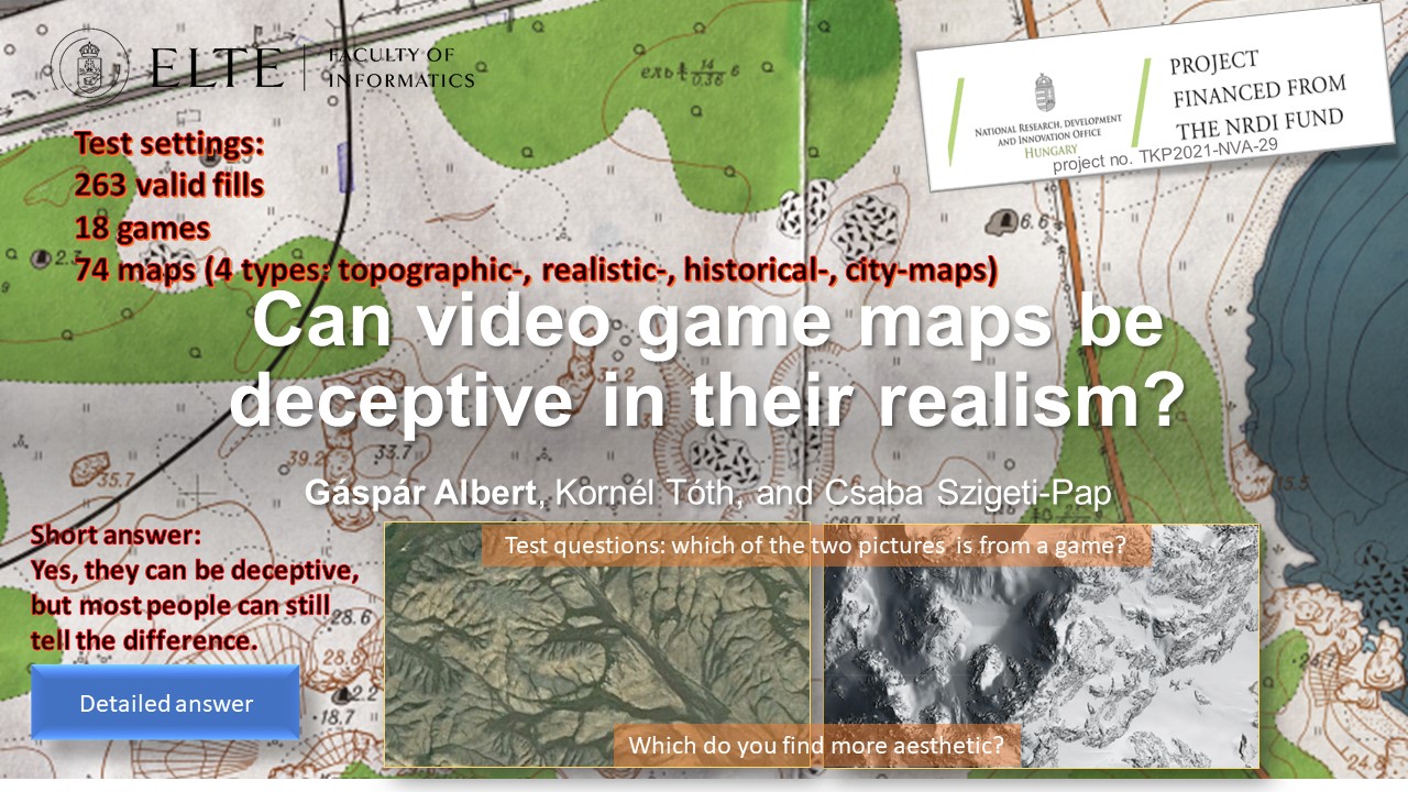
EGU23-1073 | Posters virtual | EOS1.4 | Highlight

AEOLIAN: A new Augmented Reality mobile application to enhance disaster training and response to evolving hazards 

Panagiotis Michalis, Katerina Georgiou, Orestis Sampson, Vasilis Nousis, Marios Palazis, Chrysoula Papathanasiou, Eleftherios Ouzounoglou, and Angelos Amditis

Disaster risk is expected to amplify in the forthcoming years considering the recent climatic projections that highlight that the frequency of shifting weather events is expected to increase posing a significant threat to the resilience of critical assets and societal functions [1]. The increasing trend of extreme weather events and natural hazards highlight the urgency of societies to adapt to current and future evolving hazards. Emerging technologies can play a significant role towards the preparedness and response of societies to disaster risks; however, the vast majority of existing solution are customised to the needs of citizen protection authorities and do not enable interaction with citizens to bridge the risk perception action gap.

This work presents AEOLIAN AR mobile application which focuses on actively engaging both citizens and citizen protection authorities (CPAs) to enhance their risk perception but also response actions during an emerging crisis. AEOLIAN is a new crowdsourcing solution which is following a co-creation design process, through various development iteration phases with main end users [2]. The solution places at the centre both relevant authorities and vulnerable citizens, in an effort to deliver functionalities focused on knowledge generation and exchange among target users. This involves the dissemination of early warnings and real-time bi-directional interaction and exchange of crowdsourcing information between experts and vulnerable communities in case of evolving hazards, allowing for precautionary actions to be employed in areas of concern. It is coupled by Augmented Reality (AR) technology, which seamlessly blends real environments and virtual objects [3], to enrich the knowledge of citizens by providing an immersive storytelling of ‘disaster tales’ to inform users about historical hazardous events that have occurred in their region. Gamified disaster risk training modules also aim to empower participation and learning for climatic and anthropogenic related risks. AEOLIAN has the potential to improve understanding and risk communication between CPAs and citizens towards building disaster resilient societies.

Acknowledgments:

This research has been financed by European Union’s Horizon 2020 research and innovation programme under Grant Agreement No 101019707, project RiskPACC (Integrating Risk Perception and Action to enhance Civil protection-Citizen interaction).

References:

[1] Michalis, P. and Vintzileou, E. (2022). The Growing Infrastructure Crisis: The Challenge of Scour Risk Assessment and the Development of a New Sensing System. Infrastructures. 2022; 7(5):68. https://doi.org/10.3390/infrastructures7050068.

[2] Michalis, P., Anniés, J., Papathanasiou, C., Ouzounoglou, E. and Admitis, A. (2022). Co-creation as an approach to bridge the Risk Perception Action Gap and customise crowdsourcing tools to respond effectively to climatic risks. Proceedings of the 3rd International Conference on Natural Hazards and Infrastructure, 5-7 July 2022, Athens, Greece, ISSN 2623-4513.

[3] Katika, K., Karaseitanidis, I., Tsiakou, D., Makropoulos, C., Amditis, A. (2021) Augmented Reality(AR) Supporting Citizen Engagement in Circular Economy, Circular Economy and Sustainability, https://doi.org/10.1007/s43615-021-00137-7.

How to cite: Michalis, P., Georgiou, K., Sampson, O., Nousis, V., Palazis, M., Papathanasiou, C., Ouzounoglou, E., and Amditis, A.: AEOLIAN: A new Augmented Reality mobile application to enhance disaster training and response to evolving hazards, EGU General Assembly 2023, Vienna, Austria, 23–28 Apr 2023, EGU23-1073, https://doi.org/10.5194/egusphere-egu23-1073, 2023.

EGU23-1381 | Posters virtual | EOS1.4 | Highlight

Enhancement of local community resilience to natural and man-made disasters through the application of co-created novel technological tools 

Chrysoula Papathanasiou, Panagiotis Michalis, Konstantinos Stavrou, Evangelos Tsougiannis, Jeannette Anniés, Sofia Papageorgiou, Eleftherios Ouzounoglou, and Angelos Amditis

Natural and man-made disasters are associated with significant impacts on society, economy and the environment and are considered an issue of national priority at a global level. Further to that, such disasters are exacerbated by climate change (EC DG-ECHO, 2021) and their frequency of occurrence and impact intensity is expected to increase significantly, further affecting the countries’ interlinked economies. The standard practice adopted to mitigate risks includes the undertaking of measures, customized to the needs, particularities and socioeconomic features of the area under threat (Papathanasiou et al., 2015). Informed policy- and decision-making processes need to be outlined from relevant stakeholders. However, this top-down approach, which currently involves policies and measures decided by relevant authorities is not only outdated, but has also been proven to be insufficient. Currently, there is a justified tendency to actively include citizens in disaster management, fostering thus a more citizen-oriented, bottom-up approach. State-of-the art technological tools with advanced functionalities offer extended capabilities towards this direction. RiskPACC project brings together researchers, practitioners and first responders from nine European countries in at least 21 co-creation workshops at 7 case studies, enhancing the communication between local Civil Protection Authorities (CPAs) and citizens and bridging the risk perception-action gap (RPAG) (Michalis et al., 2022).

This work outlines the co-creation approach adopted for the Municipality of Rafina-Pikermi (MRP) use case workshops that focus on wildfires and floods. The functionalities of the AR Aeolian mobile application were defined based on feedback by CPAs and citizens, as provided during workshops, successive iterations and response to appropriate questionnaires posed by the tool providers. User-friendliness was a core design element of the tool to ensure its easy applicability by citizens and control by CPAs, meeting at the same time the need to train the local community how to effectively manage disasters. The process of familiarizing CPAs and citizens with such solutions and encouraging their active participation in relevant training sessions supported them to better understand their particular role in disaster risk reduction, fostering improved situation awareness and risk perception, which is strongly encouraged by immersive technologies. Lessons learnt from citizen empowerment to adopt technical solutions for disaster risk management can be replicated to other use cases with similar population features.


Acknowledgments:

This research has been financed by European Unions Horizon 2020 research and innovation programme under Grant Agreement No 101019707, project RiskPACC (Integrating Risk Perception and Action to enhance Civil protection-Citizen interaction).


References:

EC, Directorate-General ECHO, (2021). Overview of natural and man-made disaster risks the European Union may face: 2020 edition, Publications Office.  

Michalis, P., Anniés, J., Papathanasiou, C., Ouzounoglou, E. and Admitis, A. (2022). Co-creation as an approach to bridge the Risk Perception Action Gap and customise crowdsourcing tools to respond effectively to climatic risks. Proceedings of 3rd International Conference on Natural Hazards and Infrastructure, 5-7 July 2022, Athens, Greece, ISSN 2623-4513.

Papathanasiou, C., Makropoulos, C. and Mimikou, M., (2015). Hydrological modelling for flood forecasting: calibrating the post-fire initial conditions, Journal of Hydrology, Vol. 529, Part 3, pp. 1838-1850, https://doi.org/10.1016/j.jhydrol.2015.07.038

How to cite: Papathanasiou, C., Michalis, P., Stavrou, K., Tsougiannis, E., Anniés, J., Papageorgiou, S., Ouzounoglou, E., and Amditis, A.: Enhancement of local community resilience to natural and man-made disasters through the application of co-created novel technological tools, EGU General Assembly 2023, Vienna, Austria, 23–28 Apr 2023, EGU23-1381, https://doi.org/10.5194/egusphere-egu23-1381, 2023.

EGU23-1615 | Posters on site | EOS1.4

The CEDAS (building CEnsus for seismic Damage Assessment) project: citizen science to increase risk awareness 

Chiara Scaini, Antonella Peresan, and Carla Barnaba

Citizen science has proven very useful to increase awareness and preparedness of societies prone to disaster risk. The active involvement of citizens is also strongly envisaged by strategic documents related to disaster risk reduction (e.g. SENDAI Framework, United Nations Global Assessment Report). Here, we describe the CEDAS (building CEnsus for seismic Damage ASsessment) project, which involved high-school students in citizen science activities related to seismic risk reduction. In particular, students collected data on building characteristics (e.g. height, material) near to their homes using their phone or personal computer. Prior to data collection students were trained on risk-related concepts (hazard, exposure and vulnerability) with specific focus on buildings exposure the area where the activity was carried out (northeastern Italy). CEDAS was implemented in 2021 and 2022 involving approximately 320 students who collected more than 6000 building forms. The CEDAS project is not only data collection: students also analyzed the data and compared the exposure parameters in different areas. Finally, the interpreted the results with the help of teachers and researchers. CEDAS has demonstrated its potential for collecting exposure data in seismic-prone areas and/or include characteristics useful for multi-hazard and multi-risk assessment. However, its generalization requires the adaptation of the training material to the specific context. This presentation will support the discussion on CEDAS based on active involvement of participants. Attendants will have the opportunity to test the CEDAS approach for selected buildings. Pictures of the building front and aerial view, together with a street view, will be displayed on the screen. The active involvement of participants will support the discussion both on technical (e.g. parameters to be prioritized during the collection) and communication (e.g. citizens engagement and training) aspects. The discussion will also cover future developments of CEDAS, in particular in relation to risk awareness and preparedness (e.g. definition of impact assessment metrics).

How to cite: Scaini, C., Peresan, A., and Barnaba, C.: The CEDAS (building CEnsus for seismic Damage Assessment) project: citizen science to increase risk awareness, EGU General Assembly 2023, Vienna, Austria, 23–28 Apr 2023, EGU23-1615, https://doi.org/10.5194/egusphere-egu23-1615, 2023.

In Korea, disaster broadcasting online system and disaster information delivery platform provide disaster information broadcasting and text messages as well as various multimedia services to inform the public. However, it is not possible for Disaster Prevention-Related Organizations and accurately acquire disaster situation information in real time and provide information for preemptive response.

Therefore, in order to quickly deliver weather emergency information to the Disaster Prevention-Related Organizations like fire fighter, we analyse necessary meteorological information for fire fighting and transfer the customized contents that can effectively respond to disaster situations are developed. We propose a system architecture to deliver meteorological information to the person in charge.


How to cite: Lee, B. and Jung, W.-S.: Design of Weather Emergency Information Delivery System to Disaster Prevention-Related Organizations, EGU General Assembly 2023, Vienna, Austria, 23–28 Apr 2023, EGU23-1956, https://doi.org/10.5194/egusphere-egu23-1956, 2023.

EGU23-2951 | Orals | EOS1.4

Communication for emergencies – the need for a new and inclusive ecosystem 

David Wales, Alexandra Olson, and Alexis Gizikis

“The future of emergency communication requires a new ecosystem that enhances capacity and capability by creating an environment that is accessible, equitable, and anticipates change as a constant state.”

This is the key finding of research designed to identify policy recommendations for the EU and which is intended to be of assistance to policymakers at national, regional, and local levels.

It recognises that current models of communication in relation to emergencies are typically oriented towards top-down or single-direction communication, flowing from professionals to lay persons. The impact of this legacy approach extends far beyond the obvious and visible delivery mechanisms. It also frames the underpinning research, discussions, and attitudes. As such, it perpetuates existing limitations and biases of the system, for example, an underappreciation of the needs, role, and contribution of citizens and communities.

It also means that global aspirations- such as enhancing resilience and integration- can at best only ever be partially achieved because they are only seen through a narrow and restrictive lens. This has profound implications and fundamental changes are required to better accommodate multi-directional communication in which the role of authorities and professionals adapts to one of enablement, rather than control.

The primary and overarching recommendation for a new communications ecosystem emerged through considering the wider meaning of specific findings from the research. These are shown below:

  • Bridge the communication gaps between professionals and citizens. For example in relation to language (terminology), content, risk tolerance, stereotypes, desired outcomes/priorities, and assumptions.
  • Recognise that communication is a continuous activity that is reliant on creating the right conditions for it to be effective.
  • Design consistent messaging and communication that is inclusive and adaptable to specific needs.
  • Recognise communication as a learning opportunity and actively design in opportunities to exploit this throughout the cycle.
  • Communication strategies should recognise and positively support the opportunities that emergencies provide for citizens, communities, and formal agencies to enhance integration and resilience.

In proposing this paper to the EGU General Assembly 2023, we hope it may represent a valuable opportunity to consider opportunities to align the work of the climate and crisis sectors in this area. Hopefully, in doing so, we will learn from each other and make the task of those using our work easier and more effective.

Note: The authors were funded by the ENGAGE project to produce the report referenced in this abstract. ENGAGE is an EU-funded project, which started in July 2020 and whose mission is to identify novel knowledge, impactful solutions, and emergency response guidelines for exploiting Europe ́s societal resilience.


How to cite: Wales, D., Olson, A., and Gizikis, A.: Communication for emergencies – the need for a new and inclusive ecosystem, EGU General Assembly 2023, Vienna, Austria, 23–28 Apr 2023, EGU23-2951, https://doi.org/10.5194/egusphere-egu23-2951, 2023.

EGU23-3241 | ECS | Posters on site | EOS1.4

The design of user-centred seismic risk maps – the Swiss case 

Irina Dallo, Laura Noemi Schnegg, and Michèle Marti

Maps are a widely used mean to communicate spatial hazard and risk information to the public, with the aim to increase individual risk awareness. The use of maps is triggered by scientific evidence that maps are the format most preferred by the public. However, past studies have shown that, if not well designed, maps are often misinterpreted and can trigger wrong attitudes. Thereby, the different elements such as the icons on the map, the chosen layers, the legend, or the used color scale influence the comprehension of the information on the map. In the context of natural hazards, and more precisely earthquakes, research has so far mainly focused on the design of hazard maps, and little is known about the effective design of risk maps. We thus assessed how to design understandable, useful, and actionable seismic risk maps for the public.

To this end, we conducted a transdisciplinary project in Switzerland by ensuring an interdisciplinary co-production of the map and testing it with the public. First, we – an interdisciplinary group at the Swiss Seismological Service at ETH Zurich – co-designed different versions of the seismic risk map varying the color scale and legend format. Second, we tested these versions with a public survey (between-subjects experiment); representative for the German- and French-speaking part of Switzerland. We assessed which map version was correctly interpreted, perceived as useful, increased people’s risk perception, and triggered people to take protective actions. Further, we analyzed whether certain social groups (e.g., house owners) had different preferences, risk perception, or intentions to take action.

At the conference, we will present the preliminary results of the survey and provide evidence-based recommendations on how to design user-centred seismic risk maps. This should support institutions responsible for public communication to add seismic risk maps to their products to effectively inform the public about seismic risks and, in turn, increase their risk awareness and intention to take protective actions. 

This project has received funding from the Federal Office for the Environment (FOEN), the Federal Office for Civil Protection (FOCP), and the Swiss Federal institute of Technology Zurich (ETH Zurich).

How to cite: Dallo, I., Schnegg, L. N., and Marti, M.: The design of user-centred seismic risk maps – the Swiss case, EGU General Assembly 2023, Vienna, Austria, 23–28 Apr 2023, EGU23-3241, https://doi.org/10.5194/egusphere-egu23-3241, 2023.

EGU23-4508 | ECS | Orals | EOS1.4

Building a prepared community to volcanic risk: assessment of awareness raising tools for secondary school in Goma, (Eastern DR Congo) 

Blaise Mafuko Nyandwi, Matthieu Kervyn, François Muhashy Habiyaremye, François Kervyn, and Caroline Michellier

Disasters induced by natural hazards are increasing globally and have severe impacts. Some of these hazards, as volcanic eruptions, are related to the earth's interior mechanisms and cannot be prevented. Thereby, risk mitigation is the best strategy for reducing their impacts in densely populated areas, such as the city of Goma in the eastern Democratic Republic of Congo, exposed to volcanic threats from Nyiragongo. This requires the population to be prepared to respond to volcanic risk, by having a high state of awareness, anticipation, and readiness. “Living with a volcano” should be one of the life skills all Goma children acquire during their schooling, regardless of where they attend school. Therefore, this study used a mixed-method approach (questionnaire survey, focus group and written composition) to assess the awareness raising impact of two educational tools recently implemented in Goma for secondary students: the Hazagora serious game and the volcano museum. Several students (402 in total) from 12 schools participated in one of these risk awareness activities, while other students were assessed as controls. Results indicate that the tools have a positive impact on students’ volcanic disaster understanding, their risk perception, and their implication in DRR initiatives. Specifically, the volcano museum increases knowledge of volcanic process more than the Hazagora serious game; the latter increases more the perceived self-capacities and willingness of implementing protective measures. Risk perception raises almost identically with both tools. In general, participants indicate that they receive sufficient scientific information throughout the Hazagora serious game and the volcano museum visit to better understand the physical mechanisms of volcanic hazards and their impacts on human properties and livelihood. In addition, they claim to have received relevant information on protective measures and abilities, and to be willing to search for additional risk information. This study highlights that the two tools are complementary; thus, awareness raising through a diversity of tools can be more effective than a single and isolated activity.

How to cite: Mafuko Nyandwi, B., Kervyn, M., Muhashy Habiyaremye, F., Kervyn, F., and Michellier, C.: Building a prepared community to volcanic risk: assessment of awareness raising tools for secondary school in Goma, (Eastern DR Congo), EGU General Assembly 2023, Vienna, Austria, 23–28 Apr 2023, EGU23-4508, https://doi.org/10.5194/egusphere-egu23-4508, 2023.

In recent years, natural disasters such as typhoons, torrential rains, and wildfires have increased due to climate change. Such a phenomenon is an unpredictable meteorological phenomenon. In this kinds of disasters, warning and alert information rapid transition should be made through disaster prevention-related agencies and regional warning systems. Recently, there has been an increasing demand for such rapid transition information. From the point of view of the current transition system for disaster warning and alert system, the severe weather information from the Meteorological Agency in South Korea is transmitted to broadcasting stations and related media using fax, e-mail, and the like. However, these manual transmission of information is not as much fast as it should be required. To make matters worse, there were cases where it did not delivered. In terms of management and operation of this warning system, related agencies have different independent operation systems depending on the type of disaster. For this reason, when multiple disasters occur at the same time or in stages, it is difficult to respond immediately because the systems are not well coordinated. In addition, for the same meteorological phenomenon, the damage that occurs in the area will differ depending on the disaster prevention capacity of the area, the degree of urbanization and industrialization, and the different shape of watershed of the area. In this study, we analyzed existing severe weather information transmission systems. The new novel system shows a prototype that reflects being rapid, being accurate and being integrated. Then, the study presents a methodology for considering the characteristics of the region. Prototypes planned in this way are evaluated whether functional performance is implemented.  The proposed system lets the urgency of weather events make a decision from a meteorological point of view. This will automatically and quickly categorize the level of need you have to be notified of. Depending on the grade, it will promptly and automatically generated and deliver customized information to the public and the government immediately right after any concerned situation occurs. The system has reflected the construction of a standardized information transmission system. Then, the proposed system will enable operation and management by integrating forecasting systems operated independently by each agency into one system. System integration increases the efficiency of generating and transmitting the necessary information, enabling effective response to the complex disasters. Even in the same weather, if the degree of disaster impact varies by region, the customized information level will be differentiated according to vulnerability, exposure, hazardous, and disaster prevention capacity.  

This study will enable the rapid transmission of necessary information to the public and related organizations for efficient response to unpredictable and complex natural disasters through the improved severe weather information transmission system. Finally, It is expected to contribute to minimizing human and material damage due to natural and social disasters by providing alert and warning with customized information for each region that reflects the degree of disaster impact.

How to cite: Jeun, S. and Kwon, K.: System Development of generation and transmission of customized severe weather information for Emergency responses in South Korea, EGU General Assembly 2023, Vienna, Austria, 23–28 Apr 2023, EGU23-4858, https://doi.org/10.5194/egusphere-egu23-4858, 2023.

In order to successfully set the EU on the path to reach climate neutrality by 2050, it is essential to have communities on board and willing to make changes to act for a sustainable future. However, without courses focused on climate change on the core curriculum of most schools in Europe, many adults are under informed about the effects of climate change, and what can be done on an individual level to reach these goals. The impact of warming oceans are multifold and affect not only communities that directly boarder the sea, but all neighboring nations as well. The Deep Network project addresses the need for adults to become more aware of the problems regarding climate change and the ocean by curating an online ocean-education information hub. To accomplish this, a network will be built working in close partnership with researchers, ocean activists, industries, and professional adult educators to develop high quality, accessible educational material that covers a range of topics related to how human activities impact the ocean. Some of the topics covered in the Deep Network project include ocean pollution, rising sea levels, ocean warming/acidification, habitat destruction, fisheries, and tourism. Additionally, to engage communities to action and to maintain a sustained interest in marine science and conservation, “inspiring practices” will be promoted for each topic. These are examples of realistic actions or lifestyle changes that one can directly implement into one’s own life. Anthropogenic influences on the oceans directly affect us all in varying ways. The goal of The Deep Network project is to create a strong line of accessible communication, trust, and transparency between ocean research and the communities, to ensure that the responsibility of a sustainable future falls not on the scientists, activists, and industry partners alone. A well-informed community has the potential to make a difference in legislation and gives people the opportunity to make educated decisions to act for a sustainable future.

How to cite: Johansen, C.: The Deep Network: curating and co-producing quality ocean-education information for adults., EGU General Assembly 2023, Vienna, Austria, 23–28 Apr 2023, EGU23-5104, https://doi.org/10.5194/egusphere-egu23-5104, 2023.

EGU23-5636 | Orals | EOS1.4

Investigating students' perception of climate change and geo-hydrological risk in Italian public high schools 

Roberto Coscarelli, Loredana Antronico, Stefano Luigi Gariano, and Paola Salvati

Young generation will have to manage, in the not-too-distant future, the increase of climate-change-related hazards. Infact, extreme rainfall events, increases in mean temperatures,  decreases in mean rainfall, tropical cyclones, thunderstorms, droughts are already having a significant impacts on people’s life and to the environment. In light of this, the more young people will be aware of the climate change (CC) and will know how to deal with the risks induced by it, the more they will be able to take measures and adopt behaviors to reduce negative impacts as well as to influence the choices of policy makers. For this reason, knowing the perception, the degree of knowledge and the preparedness of young people to these issues is becoming increasingly important.

By means of a quantitative research method (structured questionnaire), a survey on  a group of Italian high public school students, aged between 13 and 20 and located in central (Umbria region) and southern (Calabria region) Italy, was carried out. This survey focused on young people awareness, perception and preparation concerning natural risks, including landslide and flood risk, and climate change. The survey's results show the following informations: a) the questioned students are aware of the CC issue and they generally believe that human actions and lifestyle affect CC; moreover, young people are more worried than adults about how CC may affect nature and the environment; b) the findings confirm the close relationship between youth and the media in terms of perception, information, and understanding of CC and its impacts; c) besides believing that better risk communication between authorities and citizens is necessary, the students  have low level of trust in local administrations and on the policy regarding geo-hydrological risk; d) young interviewed who participated in a specific educational activity on landslide and flood hazard revealed that they had a good understanding of the triggering processes of these phenomena. Even though the samples is not highly representative of the whole Italian young population, the survey shows that Italian political institutions need to plan responsible, morally sound, and convincing activities in order to win over citizens' credibility and trust, especially younger ones. Additionally, it is crucial that scientists collaborate with politicians, policy makers, and schools to i) promote shared and sustainable actions involving public, particularly the younger generation, and thus increasing people resilience; and ii) develop an integrated and multidisciplinary approach to comprehend a complex phenomenon like climate change and its effects on people and environment.

How to cite: Coscarelli, R., Antronico, L., Gariano, S. L., and Salvati, P.: Investigating students' perception of climate change and geo-hydrological risk in Italian public high schools, EGU General Assembly 2023, Vienna, Austria, 23–28 Apr 2023, EGU23-5636, https://doi.org/10.5194/egusphere-egu23-5636, 2023.

EGU23-6079 | ECS | Posters on site | EOS1.4 | Highlight

Waves…a tool to explore our home! A successful experience in improving risk perception 

Maria Vittoria Gargiulo, Ferdinando Napolitano, and Paolo Capuano

In a geologically interesting land like Italy, and in particular Campania, educating and informing about the concept of risk in general, and specifically seismic risk, is of fundamental importance.

The possibilities of seismic risk mitigation, in fact, depend not only on the scientific community but also on how well prepared and informed society is about the risk itself. It is, therefore, crucial to train the local population to increase disaster risk preparedness and resilience within our region.

The Science Capital framework, developed by Prof. Louise Archer er al. (https://doi.org/10.1002/tea.21227), refers to a person’s science-related resources, such as their science-related understanding, knowledge, attitudes, activities, and social contacts. It also offers a key to defining how everyone's store of scientific knowledge is enriched and influenced by their habits, family, and network of contacts. Understanding this context and its dynamics helps us to enhance the resources available for scientific culture, with a view to building a competent and inclusive educational community. 

With this in minds, we built a didactic protocol dedicated to seismic risk perception taking into consideration the Science Capital framework.

“Waves…a tool to explore our home!” allows students to acquire both specific topics, such as the physical quantities involved in an earthquake, its generation and its dynamics, and general concepts, such as the perception of seismic risk and the impact of man in the prevention, in the possible induction and in the response to an earthquake.

An evaluation phase was carried out to assess the learning experience and the effectiveness of the science communication technique.

This work has been supported by CORE ("sCience and human factor for Resilient sociEty") project, funded from the European Union’s Horizon 2020 - research and innovation program under grant agreement No 101021746 .


How to cite: Gargiulo, M. V., Napolitano, F., and Capuano, P.: Waves…a tool to explore our home! A successful experience in improving risk perception, EGU General Assembly 2023, Vienna, Austria, 23–28 Apr 2023, EGU23-6079, https://doi.org/10.5194/egusphere-egu23-6079, 2023.

EGU23-6102 | ECS | Orals | EOS1.4

Voluntary spring monitoring to make invisible groundwater visible 

Inga Retike, Jaanus Terasmaa, Oliver Koit, Jānis Bikše, Jekaterina Demidko, Marlen Hunt, and Agnese Kukela

Groundwater accounts for nearly 99% of all liquid freshwater on Earth. Not only does groundwater provide almost half of the global drinking water supply and ensures the well-being of humans and sustain dependent ecosystems (rivers, lakes, and wetlands), it is an essential aspect in climate change mitigation too. Despite the exceptional importance of groundwater in social, economic, and environmental processes, it remains poorly understood, mismanaged, and often neglected. In order to increase global awareness of groundwater protection, the theme for World Water Day 2022 was “Groundwater: Making the invisible visible” with the culminating event - the first UN-Water Summit on Groundwater held in Paris on 7-8 December. Data collection and sharing on groundwater were among the key actions highlighted during the Summit because “we cannot manage what we do not measure”.

One of the ways to make groundwater visible is to demystify the underground resources beneath our feet through citizen science. Many volunteer water monitoring programs have generated valuable data sets around the world. Data collection by volunteers is cost- and time effective, supports local communities by raising awareness of groundwater protection, and boosts outdoor tourism. Moreover, such campaigns provide information on water bodies that would otherwise remain unmonitored and, if carefully designed, can be used by national water managers and even support decision-making.

Here we present a joint Estonian-Latvian web-based application for the volunteer monitoring of springs launched in February 2021 (accessible by allikad.info and avoti.info). The web-based map application aims to collect new information on already known springs and locate new ones by providing clear guidelines on how to carry out proper spring monitoring. More than 200 users have already joined the application and approximately 600 new springs have been added to the database. Together, 1132 new observations have been made and 2930 images of springs have been added. This valuable information source has been recently recognized by national water managing authorities and used to improve the transboundary groundwater monitoring network between Estonia and Latvia. We will present how citizen science can improve groundwater management, as well as our success stories and lessons learned. 

The study benefits from Iceland, Liechtenstein and Norway through the EEA and Norway Grants Fund for Regional Cooperation project No.2018-1-0137 “EU-WATERRES: EU-integrated management system of cross-border groundwater resources and anthropogenic hazards”  and Interreg Estonia-Latvia cooperation program project “WaterAct”.

How to cite: Retike, I., Terasmaa, J., Koit, O., Bikše, J., Demidko, J., Hunt, M., and Kukela, A.: Voluntary spring monitoring to make invisible groundwater visible, EGU General Assembly 2023, Vienna, Austria, 23–28 Apr 2023, EGU23-6102, https://doi.org/10.5194/egusphere-egu23-6102, 2023.

EGU23-7342 | Orals | EOS1.4

Risk communication during seismo-volcanic crises: the example of Mayotte, France 

Robin Lacassin, Maud Devès, Hugues Pécout, and Geoffrey Robert

Population information is a fundamental issue for effective disaster risk reduction. As demonstrated by numerous past and present crises, implementing an effective communication strategy is, however, not a trivial matter. Here, and in Devès et al. 2022, we draw lessons from the seismo-volcanic “crisis” that began in the French overseas department of Mayotte in May 2018, and which is related to a submarine eruption off the eastern coast of the island. The seismo-volcanic activity is still ongoing today and large uncertainties remain about its possible future evolution. Mayotte’s case study is interesting for several reasons: (1) although the seismo-volcanic phenomenon itself is associated with moderate impacts, it triggered a social crisis that risk managers themselves qualified as “a communication crisis”, (2) risks are perceived mostly indirectly by the population, which poses specific challenges, in particular to scientists who are placed at the heart of the risk communication process, and (3) no emergency planning or monitoring had ever been done in the department of Mayotte with respect to volcanic issues before May 2018, which means that the framing of monitoring and risk management, as well as the strategies adopted to share information with the public, has evolved significantly over time. Our first contribution is to document the gradual organization of the official response. Then we attempt to understand what may have led to the reported “communication crisis”. To that end, we collect and analyze the written information delivered by the main actors of monitoring and risk management to the public from May 2018 to April 2021. Finally, we compare its volume, timing, and content with what is known of at-risk populations’ information needs. Our results outline the importance of ensuring that communication is not overly technical, that it aims to inform rather than reassure, that it focuses on risk and not only on hazard, and that it provides clues to possible risk scenarios. We issue recommendations for improvement of public information about risks in Mayotte, but also elsewhere in contexts where comparable geo-crises may happen. 

Devès, M., Lacassin, R., Pécout, H., & Robert, G. (2022). Risk communication during seismo-volcanic crises: the example of Mayotte, France. Nat. Hazards Earth Syst. Sci., 22, 2001–2029, https://doi.org/10.5194/nhess-22-2001-202

How to cite: Lacassin, R., Devès, M., Pécout, H., and Robert, G.: Risk communication during seismo-volcanic crises: the example of Mayotte, France, EGU General Assembly 2023, Vienna, Austria, 23–28 Apr 2023, EGU23-7342, https://doi.org/10.5194/egusphere-egu23-7342, 2023.

EGU23-8055 | Posters on site | EOS1.4 | Highlight

Investigating the role of citizens' trust during and after emergencies 

Raffaella Russo, Maria Vittoria Gargiulo, Maria Prosperina Vitale, Serena Quarta, and Paolo Capuano

During and after catastrophes it is important to investigate the role played by key governmental institutions and scientific community in vehiculating correct information to the whole population on how to manage the consequences of disasters in order to minimize losses and avoid other possible cascading effects. Indeed, messages spread out by policy makers and scientific community get positive effects, only if they are trusted by citizens.

The European project entitled “sCience and human factOr for Resilient society” (H2020 CORE) considers trust as a key factor for the individuals’ risk perception, their behavioural response and disaster preparedness. Within this scenario, a survey is promoted by means of an online questionnaire including scales and indicators related to risk perception and trust by controlling for geographical context, socio-demographic and economic backgrounds together with direct and indirect individual experiences. The aim of the survey is twofold: on one hand, it permits to consider the effects on citizens’ behaviors by analysing  different hazards, such as earthquakes, tsunami, wildfire, industrial accident, terrorist attack, flash flood and COVID-19 pandemic; on the other one, it allows to underline best practices adopted by institutions during emergencies in different countries by also investigating the role of fake news.

The final aim is to release guidelines devoted to the policy makers and scientific community experts in order to understand what they can do to be trusted by communities. 

Acknowledgment: The present abstract has been produced for the CORE project that has received funding from the European Union’s Horizon 2020 research and innovation programme under grant agreement No 101021746.

How to cite: Russo, R., Gargiulo, M. V., Vitale, M. P., Quarta, S., and Capuano, P.: Investigating the role of citizens' trust during and after emergencies, EGU General Assembly 2023, Vienna, Austria, 23–28 Apr 2023, EGU23-8055, https://doi.org/10.5194/egusphere-egu23-8055, 2023.

EGU23-9175 | ECS | Orals | EOS1.4

AMALPI trek: a geocultural trail from Maloja to St. Gotthard to increase the awareness of natural hazard in mountain settings 

Francesco Arrigoni, Christian Ambrosi, Tiziana Apuani, Massimo Ceriani, and Cristian Scapozza

The historical evolution of a territory is usually related to its geological features and geomorphological dynamics. Floods and slope instabilities modify the landscape impacting on human life. The perception of the value of natural resources in mountain area and the culture of respect is an essential component in strategies aimed at ensuring the population a future of well-being, social and economic growing.

The AMALPI Trek takes its name from the A.M.AL.PI.18 Project [1], which is the Italian acronymous for “Moving Alps, and Movements in the Alps”, developed in the framework of the European funded Interreg Italy-Switzerland Cooperation Program V-A 2014-2020. The project aims to encourage an innovative strategy for the promotion of natural and cultural heritage in the Alpine area from Maloja to St. Gotthard (through Val Bregaglia, Valchiavenna, Regione Moesa and Alto Ticino), even by the creation of a cross-border geo-cultural trail connecting sites which have experienced important geomorphological and anthropic changes due to the occurrence of landslides of great social impact. The trail is addressed to a scientific-cultural and educational tourism, to raise the perception of landscape components in the framework of the “total history”, composed by the geo(morpho)logical, bioecological and historic-cultural heritages. Placed in a central position, the AMALPI Center (scheduled to open mid-2023 in Chiavenna), will be a study and research hub on large landslides, reference for school activities and promotion events. In addition, an open access hiking guidebook and map will lead the trekker to discover tools and methods that allow the comprehension of past and ongoing processes, with the help of illustrative panels describing the main patrimonial aspects of the territory, which is rich in historical palaces, archaeological sites, and natural monuments.

The AMALPI Trek runs through 10 Alpine valleys and crosses 7 mountain passes, for a total of about 150 km, plus several thematic itineraries that branch out of the main trail. Along the way, 19 large landslides of different age and type are touched. In many segments, the AMALPI trek follows historical trade routes, used in the past for the exchange of silk and soapstone products. There are some links between large landslides and stone resources typical of these mountains. A striking example are the “crotti”, natural caves used as cellars, perfect places for the storage of foods and other goods, and the “trone”, local soapstone caves, both generated by the gravitational accumulation of cyclopean boulders. The petrographic features of soapstone outcropping rock offer then a good workability, but locally they become weakness planes predisposing sliding.

Looking at the causes and effects of landslide events, the trekker accrues the perception of human vulnerability to natural hazard, but it is also invited to discover how to prevent, mitigate, and manage hillslope dynamic to develop a sustainable and fulfilling life in mountain areas.


[1] Interreg V-A Italy-Switzerland 2014-2020 Cooperation Program, Axis II “Cultural and natural enhancement”). Project ID 594274, “A.M.AL.PI. 2018 – Alpi in Movimento, Movimento nelle Alpi. Piuro1618–2018”.

https://progetti.interreg-italiasvizzera.eu/it/b/78/alpiinmovimentomovimentonellealpipiuro

How to cite: Arrigoni, F., Ambrosi, C., Apuani, T., Ceriani, M., and Scapozza, C.: AMALPI trek: a geocultural trail from Maloja to St. Gotthard to increase the awareness of natural hazard in mountain settings, EGU General Assembly 2023, Vienna, Austria, 23–28 Apr 2023, EGU23-9175, https://doi.org/10.5194/egusphere-egu23-9175, 2023.

EGU23-9182 | ECS | Posters on site | EOS1.4

Participatory approach to adapt scientific communication to the socio-cultural context: the case of the seismo-volcanic activity in Mayotte 

Louise Le Vagueresse, Maud Devès, Jocelyn Jacquot, Robin Lacassin, and Raphaël Grandin

Population information is key to disaster risk reduction and scientists have a key role to play in that respect. However, implementing effective scientific communication is not trivial. We draw lessons from our experience of the seismo-volcanic crisis of Mayotte, France. In May 2018, an unprecedented seismic activity started in Mayotte. It was found, a year later, to be linked to volcanic activity, and the birth of a huge submarine volcano ~50km off the east coast of the island. The activity is still ongoing and is being actively studied to understand the phenomena and estimate associated risks. But there are large uncertainties, due to a lack of preexisting knowledge as the area had been poorly studied before 2018, and is challenging to instrument. In this context, informing at-risk populations is difficult. During the first months of the earthquake swarm, the perceived lack of information led to strong anxiety and a feeling of distrust towards scientists and authorities (Fallou et al., 2020; Devès et al., 2022). Experts in charge of monitoring, who are mostly from mainland France, are attempting to develop new ways of disseminating knowledge (e.g., a simplified monthly newsletter, translated into local languages). Nevertheless, they struggle to overcome the socio-cultural gap between mainland France and Mayotte archipelago (multilingualism, levels of literacy, precarious living conditions, see Roinsard, 2014). There is thus a need to explore alternative ways of communicating scientific information so that it can reach the relevant audiences more effectively. We present an approach drawing on the expertise of earth sciences and human and social sciences that reverse the classic top-down approach (the latter does not generally work very well, even less so in Mayotte). We first develop visual and interactive information tools to better represent the uncertainties associated with the knowledge produced by the volcanological and seismological observation network of Mayotte (REVOSIMA). We focus on the link between seismicity and deformation, two phenomena whose consequences are the easiest to perceive for the populations. We then train secondary school students, in collaboration with their teacher, on the basis of these materials. Finally we accompany those students, with the help of their teachers, to develop their own scientific dissemination materials with the objective to transmit this information to their family and friends. This method has the advantage of delegating the tasks of translating and disseminating the acquired knowledge to individuals from different socio-cultural backgrounds on the island who are familiar with the codes and information habits of their respective communities. As this project is still ongoing, we discuss here its conditions of realisation and its contribution to ongoing research on the communication of scientific information in a context of risks and crises.

How to cite: Le Vagueresse, L., Devès, M., Jacquot, J., Lacassin, R., and Grandin, R.: Participatory approach to adapt scientific communication to the socio-cultural context: the case of the seismo-volcanic activity in Mayotte, EGU General Assembly 2023, Vienna, Austria, 23–28 Apr 2023, EGU23-9182, https://doi.org/10.5194/egusphere-egu23-9182, 2023.

EGU23-11949 | ECS | Orals | EOS1.4

Moving from disaster reports to disaster tales to increase flood risk awareness 

Paola Mazzoglio, Stefano Macchia, Enrico Gallo, Julia Winter, and Pierluigi Claps

The lack of basic information about the area where people live and about major hydrometeorological disasters that occurred in the past can lead the population to underestimate the flood risk. The flood risk perception is often related only to past direct experiences and to the memory of floods that took place in the same areas. However, this risk perception is high during the weeks that follow a flood event and then decreases rapidly.

In Italy, the regional agencies in charge of flood management widely use disaster reports (DRs) as the preferred way to collect and standardize information on past flooding events and on the meteorological conditions of that events. However, these DRs are often examined only by technicians, while the general audience is rarely aware about their availability or cannot fully understand what is reported in these documents.

In this work, we performed a systematic survey of the DRs drawn in the past years by the Italian regional agencies in charge of civil protection. We suggest that these DRs could be improved to provide more effective communication to citizens in view of increasing flood risk awareness, reinforcing the communication of civil protection planning and management, and improving the resilience of the population to extreme events. More specifically, we suggest that these disaster reports could be reframed into disaster tales (DTs) without losing the detail level required for the typical technical uses of the DRs. Moreover, these recompiled DTs can be used as tools that offer wider knowledge of the events to improve people’s preparedness and self-protection behavior when a future major flood event will occur.

From a practical point of view, we suggest improving the structure of these reports with the integration of short videos and pictures taken by citizens during the event, maps and interactive tools able to present handier multimedia views of the events. By watching and listening to what has happened, the population can better understand the feelings of the people experiencing an emergency, learning how to act during future floods. We also suggest using a storyline approach to present the whole sequence of events and decisions taken during the flood, putting in chronological order the most significant episodes occurred during the event and the recovery phase.

Application to some case studies of flooding occurred in Italy illustrates how to implement the DRs to create more readily accessible DTs.

How to cite: Mazzoglio, P., Macchia, S., Gallo, E., Winter, J., and Claps, P.: Moving from disaster reports to disaster tales to increase flood risk awareness, EGU General Assembly 2023, Vienna, Austria, 23–28 Apr 2023, EGU23-11949, https://doi.org/10.5194/egusphere-egu23-11949, 2023.

EGU23-12639 | ECS | Orals | EOS1.4 | Highlight

Fighting Climate Misinformation: Fact-Checking of Climate Misinformation in Spanish-speaking podcasts. 

Jon Xavier Olano Pozo, Caterina Cimolai, Andrea Arnal, Mercè Cisneros Bermejo, Anna Boqué Ciurana, Daniel Dermit, Marc Massip, Javier Sigró, and Enric Aguilar

Despite the evidences of the effects of climate change, and the need to adopt adaptation and mitigation measures against its effects,  it still exists a significant current of denialism . Radio podcasts, an evolution of classical radio shows, are an interesting communication and leisure tool for disseminating climate misinformation in today's saturated communication world.

In the framework of the CLIMACAST: UNDERSTANDING AND EXPOSING CLIMATE MISINFORMATION ON PODCASTS project, we monitor, identify, verify and disseminate short notes to fight this climate misinformation. Currently, the project is in the middle of its execution; and we have monitored monitoring more than a thousand hours of podcasts in Spanish-speaking countries from July to December of 2022. The project, funded by META and Poynter’s International Fact-Checking Network is a joint collaboration between C3/IU-RESCAT/URV, VERIFICAT and Kinzen and Chequeados.

The climate misinformation measure unit of this project is a climate claim. A claim is the smallest unit of analysis of verifiable information containing a disputed claim about climate, climate variability and climate change. In addition, to be considered a claim, the information or meaning included in the message should be verifiable content. To track problematic terms, the editors of Verificat monitor podcasts where people post climate disinformation to detect recurring words or phrases in this area to define keywords to find the podcasts. When the podcasts are selected, an artificial intelligence tool transcribes them to a specifically designed dashboard. If it detects problematic content - for example, the word 'calentólogo' (warmist) is typical of negationist slang - the system highlights the keyword for greater detection by analysts. The analyst checks if the keyword refers to some climate and/or meteorological aspect. Then, the analyst determines the content's verifiability based on the message's real climate disinformation. Each claim identified is classified in six main narratives: the main misinformation: climate change does not exist, climate change is not human-caused, climate change is not bad, solutions to face climate change do not work, climate science is not liable and greenwashing.

The results show how the claims are regularly identified in regular podcasts. However, it also shows slight growth in the two weeks of COP27.

How to cite: Olano Pozo, J. X., Cimolai, C., Arnal, A., Cisneros Bermejo, M., Boqué Ciurana, A., Dermit, D., Massip, M., Sigró, J., and Aguilar, E.: Fighting Climate Misinformation: Fact-Checking of Climate Misinformation in Spanish-speaking podcasts., EGU General Assembly 2023, Vienna, Austria, 23–28 Apr 2023, EGU23-12639, https://doi.org/10.5194/egusphere-egu23-12639, 2023.

EGU23-13054 | ECS | Orals | EOS1.4

Using climate stories to bridge the valley of death 

Sophie van der Horst, Felix van Veldhoven, Eva Boon, Jan-Willem Anker, Timo Kelder, Lisette Klok, and Hasse Goosen

Much of the scientific insights and information on climate change and adaptation do not reach decision-makers, companies, and citizens. In literature, this gap between science and society has been referred to as a ‘valley of death’. One of the reasons for the gap is that scientists and societal actors have different understandings and perceptions of what is usable. Climate services should shift from being science-driven, to services that are user-driven and science-informed. In line with this thought, practices such as co-creation and tailoring climate information to user contexts are suggested and described to increase the success of climate services. 

Within the EU funded REACHOUT project, we applied 'storytelling' techniques to create climate stories for six cities across Europe. This is a novel way to transform climate data (hazard maps and datasets) into information that is appealing to local users and citizens. The climate stories combine a narrative structure with visualizations to communicate scientific knowledge to an audience. 

Climate stories are currently being developed within REACHOUT to advance user-oriented climate services to support the implementation of the Green Deal. The initial results are promising as the climate stories are welcomed by the cities as an innovative means to communicate results from the project to the wider audience. For instance, the city of Athens, Milan and Logroño use climate stories about heat to increase awareness and initiate action. 

Climate stories have also been used within the Dutch Climate Impact Atlas to explain climate hazards and impacts to users. In our presentation, we will elaborate on our experiences with the development of climate stories, and discuss the best practices.

How to cite: van der Horst, S., van Veldhoven, F., Boon, E., Anker, J.-W., Kelder, T., Klok, L., and Goosen, H.: Using climate stories to bridge the valley of death, EGU General Assembly 2023, Vienna, Austria, 23–28 Apr 2023, EGU23-13054, https://doi.org/10.5194/egusphere-egu23-13054, 2023.

EGU23-13888 | Posters virtual | EOS1.4

Lend Me Your Ears: Space Weather Citizen Science Through Harnessing Sonification 

Martin Archer, Michael Hartinger, Marek Cottingham, Xueling Shi, Evaldas Vidugiris, Anne Holland, James Harold, Emmanuel Masongsong, Duke Hill, Michael Fox, Shane Coyle, Robert Alexander, Alessandra Pacini, and Robert Candey

The changing conditions in near-Earth space cause space weather. This poses a risk to our everyday lives through the technology we rely upon through impacts on crucial power, communications, navigation, and transport systems. Analogues of sound in the space plasmas around our planet, known as Ultra Low Frequency (ULF) waves, are one means by which energy is circulated from the solar wind to the radiation belt, auroral, and ionospheric regions. Time-series data of ULF waves is often analysed visually, however, such data lends itself more naturally to our sense of sound. Guided by experts in audio, citizen science, and public engagement, we have developed sonification tools that render ULF waves audible. Alongside this, a graphical user interface has been developed, enabling citizen scientists to highlight signals within this audible data that standard methods can struggle to identify. These efforts are part of a NASA-funded pilot project called HARP (Heliophysics Audified Resonances in Plasmas), where high-school students and members of the public contribute to space weather science through listening. We provide an overview of how we carefully developed and tested this citizen science project before launching it publicly.

How to cite: Archer, M., Hartinger, M., Cottingham, M., Shi, X., Vidugiris, E., Holland, A., Harold, J., Masongsong, E., Hill, D., Fox, M., Coyle, S., Alexander, R., Pacini, A., and Candey, R.: Lend Me Your Ears: Space Weather Citizen Science Through Harnessing Sonification, EGU General Assembly 2023, Vienna, Austria, 23–28 Apr 2023, EGU23-13888, https://doi.org/10.5194/egusphere-egu23-13888, 2023.

EGU23-14593 | ECS | Orals | EOS1.4

Using geomojis to communicate geosciences: from development to use 

Claire Shires and Benjamin van Wyk de Vries

Communication across linguistic and cultural borders is vital in our globalised but compartmentalised world, where different people from different origins mix and interact. In the context of geological hazards and the geological environment, we are working towards a clear system that enables specialists in different fields to communicate effectively with each other, and for a common system that allows all types of non-specialists (e.g. general public) to communicate as well. This works using symbols and pictograms to represent geological and environmental phenomena and features, for example geohazards, that can be used to communicate clearly and efficiently. Certain hazard symbols are already in use across the globe, such as those for chemical or environmental hazards, or such as 'rock fall' warning signs that are universal. In this project, we focus on the geological environment and geohazards, and much of the work is done within a UNESCO Geoscience Programme project 'Geoheritage for Resilience', using geoheritage sites as sites for communication and testing, and more recently with a Franco-Mexican ECOS exchange project 'Building Sense in Natural Heritage'. Our geological pictograms, or ‘geomojis’, bridge the gap between simple symbols and words, crossing language borders by representing concepts that we have identified as particularly important for understanding geohazards and risk. Our geomojis are linked to the Global Framework for Geology (see Global and Planetary Change, 2018 - https://digitalcommons.mtu.edu/michigantech-p/427), allowing the context of each geomoji in the Earth system to be understood. We are currently running international workshops to promote discussion and test the geomojis that we have created. These workshops have raised new pictographic needs and the problems associated with them. The goal of these workshops is to consolidate geoscience knowledge from different specialisations and create a basic standardised set of symbols for all geological hazards. This standardisation of geohazard symbols could improve communication not only between specialists and non-specialists, but between geologists themselves. The global framework and geomojis help us to think outside the box of our specialist environment. These geo-pictograms can be used for geoscience communication in all forms, from hazard and risk publications to signage at geological sites and in discussions with local populations. They can be adapted and modified for the local context and needs, while providing a central, and global, base for comparison. We plan to use the set of reference geomojis to accompany a multilingual glossary on geological hazard and risk terminology, a project that we hope will help international geoscience communication.

How to cite: Shires, C. and van Wyk de Vries, B.: Using geomojis to communicate geosciences: from development to use, EGU General Assembly 2023, Vienna, Austria, 23–28 Apr 2023, EGU23-14593, https://doi.org/10.5194/egusphere-egu23-14593, 2023.

EGU23-15345 | ECS | Orals | EOS1.4 | Highlight

Empowering youngsters: Climate high school assemblies to increase risk perception and awareness 

Anna Boqué Ciurana, Jon Xavier Olano Pozo, Gisela Cebrián-Bernat, and Juan Prieto

EMPOCLIM is a project that aims to raise awareness and involve young people in sustainable development through school climate assemblies at five educational centers in Camp de Tarragona, Spain. Thanks to innovative democratic processes designed to learn, deliberate, and decide in an assembly way, the students look for solutions to climate change, proposing actions to promote sustainability at the local and regional levels.

EMPOCLIM emphasizes strengthening environmental awareness and empowering young people through education, recognizing their potential to become ambassadors and agents of change for climate action and sustainable development in their environment, and sharing knowledge and experiences with their families, local communities, and policymakers.

As a result of the climate assemblies, a generation of an action plan and political recommendations by the participating educational communities to achieve the 2 SDGs Climate action and affordable and clean energy at the local and regional levels is obtained.

Parallelly EMPOCLIM project has developed two didactic guides for teachers to work with the knowledge involved with two specific SDGs (the two mentioned before).

Once the EMPOCLIM project was finished, the methodology established continued to be implemented in the high schools on demand, as University Rovira i Virgili offered this Workshop as one that transfers university information to high schools. In the future, EMPOCLIM will probably evolve up-scaled in different national and European proposals and to other educational levels.

We acknowledge  Diputació Provincial de Tarragona for funding the EMPOCLIM project.

How to cite: Boqué Ciurana, A., Olano Pozo, J. X., Cebrián-Bernat, G., and Prieto, J.: Empowering youngsters: Climate high school assemblies to increase risk perception and awareness, EGU General Assembly 2023, Vienna, Austria, 23–28 Apr 2023, EGU23-15345, https://doi.org/10.5194/egusphere-egu23-15345, 2023.

EGU23-15461 | ECS | Posters on site | EOS1.4

Attribution and communication of climate indices in Hungary and Greece 

Péter Szabó, Rita Pongrácz, Elisavet Galanaki, and Vassiliki Kotroni

Although anthropogenic global warming is well-known within the scientific community, the public is still not certain how to associate specific local climate events to this global issue. Therefore, it is essential to raise public awareness by providing sound, graphical, interesting and easily understandable scientific information. Our attribution projects aim for this task both in Hungary and Greece – the former started in September 2021, while the latter a year later. Within the projects, we have slightly different approaches for analysis and dissemination as well. In Hungary, seasonally relevant indices are calculated and published in each season near the time of an event occurrence, and the dissemination is done mainly via a national platform aiming for climate awareness (www.masfelfok.hu), but to reach the public even more, a broad media platform and a large social media network is used as well. In Greece, NOA has also developed a dissemination strategy that mainly focuses on weather and climate extremes and produces layman and explanatory articles that are published on www.meteo.gr, which is visited more than 350.000 times daily.

We found common and relevant indices both for Hungary and Greece that can be shown, thus we selected agriculturally-relevant, spring climate indices for both countries: vegetation start for cold-resistant plants, vegetation start for warm-demanding plants, late frost, and possible frost period. The analyses are performed within the two projects based on several data sources with daily temporal resolution: (1) an ensemble of CMIP6 global climate model simulations of both natural-only forcings and historical runs, (2) an ensemble of regional climate model simulations from Euro-CORDEX, including the RCP4.5 and RCP8.5 scenarios, (3) a fine-resolution, homogenized observation-based gridded data for Hungary.

How to cite: Szabó, P., Pongrácz, R., Galanaki, E., and Kotroni, V.: Attribution and communication of climate indices in Hungary and Greece, EGU General Assembly 2023, Vienna, Austria, 23–28 Apr 2023, EGU23-15461, https://doi.org/10.5194/egusphere-egu23-15461, 2023.

EGU23-15970 | ECS | Posters virtual | EOS1.4 | Highlight

An effectiveness scoring system for risk and uncertainty in serious games for natural hazards 

Shreyasi Choudhury, Bruce D. Malamud, and Amy Donovan

Serious games (SGs) for natural hazards (NHs) can provide an artificial space for players to understand the risk they face through defined rules and quantifiable results. Here, we deduce a scoring system for natural hazard SGs to understand whether these games introduce and communicate the interplay between social/physical vulnerability, exposure, hazard, and uncertainty (called ‘four elements’ here forth) to target players. We first identified 48 natural hazard SGs via a critical review of peer-reviewed and grey- literature. From these 48 SGs, we select 22 that were accessible and scored them on a 12-point scale through a two-stage process: (i) identify the indicators (or evaluation criteria) for three risk elements – vulnerability (6 indicators), hazard (7 indicators), and exposure (7 indicators) – along with uncertainty (8 indicators); and (ii) deduce the scores of the games by employing the evaluation criteria on 22 games. Based on the scores, we found that 70% of the 22 SGs could be applied to more than one hazard type (one of the hazard indicators), whilst 52% of the games included social vulnerability and/or critical loss facilities as exposure. About half of the SGs (48%) fostered player unpredictability which means that the focus of most natural hazard SGs is to indicate how decisions taken by one community member can impact the whole community or another individual in a community. Comparing the game scores, four games ranked highest with a score of 9 out of a possible 12; showing that such games can communicate hazard risks into an appropriate context. Games with high scores (above 10 out of 12) can help the people-at-risk (who are the target players in SGNHs) weigh up in their mind the costs and benefits of different actions, empowering communities to take disaster risk reduction, preparedness, and resilience actions.

How to cite: Choudhury, S., Malamud, B. D., and Donovan, A.: An effectiveness scoring system for risk and uncertainty in serious games for natural hazards, EGU General Assembly 2023, Vienna, Austria, 23–28 Apr 2023, EGU23-15970, https://doi.org/10.5194/egusphere-egu23-15970, 2023.

EGU23-16067 | Posters on site | EOS1.4 | Highlight

Implementing a Citizen Seismology Communication Strategy in a Complex Economic, Political and Security Context: Issues and Feedback from the OSMOSE Project in Haïti 

Laure Fallou, Alice Corbet, Eric Calais, Nixon Calixte, Rémy Bossu, and Patrick Attiè

The OSMOSE project aims to develop citizen seismology in Haiti where seismic risk is high and the scars left by the 2010 earthquake are still very prominent. The project proposes to use low-cost seismic sensors (Raspberry Shake) to (1) complement the national seismic network and (2) improve risk perception, preparedness and scientific knowledge of the population.

This second objective is not self-evident and requires the integration of these volunteers in a wider network, with a real communication strategy towards them but also towards the general population. Originally, the communication strategy was to be established on three levels: the first one for exchanges between the volunteers and the scientists of the project, the second one to support the volunteers in their interactions with their communities so that they become « seismology ambassadors », and the third one to inform the general public. The project planned to support this communication strategy with a series of classic tools (website, social media, partnerships with schools or media), innovative ones (Messaging Apps bots, Virtual Reality...) and already existing tools such as the LastQuake application developped by the EMSC, which allows to collect and give information about felt earthquakes.

During the conception phase some challenges linked to the cultural, economic and hazard context had been considered and taken into account. For instance materials must be translated in French and Creole. Access to technology, whether for practical or literacy reasons, is very unequal.  Moreover, the team had the ambition to study the place of voodoo, religious and scientific culture in the explanation of earth movements in order to adapt the approach and make communication more effective to increase risk awareness and preparedness.

However, we faced many unforeseen difficulties in implementing this communication strategy, mainly related to the security and political context in Haiti. The security context made it nearly impossible to access the field, which would have allowed for in-depth sociological surveys. These surveys had for objectives to better understand risk perception and risk culture, but also educational and cultural barriers (e.g., how can we talk about earthquakes when people do not know that geological faults exist?) or the great differences between the educated people, the urban and impoverished public of the slums and the rural inhabitants. Yet, this knowledge is decisive in the establishment of the communication strategy and difficult to replace by purely quantitative online research. The existing litterature is unsufficient. Beyond these methodological difficulties, the political problems and the disorganization of the State have had repercussions on the academic community, and therefore on the project partners.

Through this presentation of a concrete example of communication in citizen science and the difficulties encountered, the authors wish to share their experience and launch a discussion around the solutions envisaged (an even stronger engagement with volunteers through a WhatsApp group, alternative ways to understand risk culture…).

This, in the expectation and hope for the Haitian people that the political and security situation will improve.

How to cite: Fallou, L., Corbet, A., Calais, E., Calixte, N., Bossu, R., and Attiè, P.: Implementing a Citizen Seismology Communication Strategy in a Complex Economic, Political and Security Context: Issues and Feedback from the OSMOSE Project in Haïti, EGU General Assembly 2023, Vienna, Austria, 23–28 Apr 2023, EGU23-16067, https://doi.org/10.5194/egusphere-egu23-16067, 2023.

EGU23-17394 | ECS | Orals | EOS1.4

The wind is changing – Hurricanes and Climate Change Perceptions 

Yannik Stuka, Valentina Bosetti, and Matthew Ryan Sisco

In the scientific community, there is vast consensus that human activity caused the climate to change significantly with regards to pre-industrial times and actions need to be taken immediately to prevent the worst scenarios from materializing. In the general public, however, such widespread support cannot be observed and is even completely lacking in some parts of the population. To a large part, this great heterogeneity seems to be built on the volatile effects of personal weather experiences on climate change perceptions. Individuals reverting to this source of information to make inferences about the climate are prone to attribution biases and other psychological fallacies, failing to grasp the true magnitude and strength of ongoing climate change.


This paper investigates this mechanism by looking into the effects of the 2020 hurricane season on climate change perceptions. After identifying the strongest hurricanes in the USA, Google Trends data is used to extract the salience as perceived by the population of each of these events. This data is then combined with a rich survey module containing responses on attitudes and behaviors on climate change to uncover the distinct building blocks of how hurricanes can shape climate change beliefs.


It can be observed that during periods of hurricane exposure, people worry more about climate change and display higher motivation to act in favor of climate change mitigation. The effect intensifies with the magnitude of the tropical storm and the length of the entire hurricane season. In a second part of the analysis, the focus is laid on different effect magnitudes for distinct personal characteristics. Political ideology in particular has been identified to heavily distort how people learn from weather events, emphasizing that how climate extremes are evaluated is only a reflection of their previously held core beliefs. This makes it increasingly hard to convince skeptical (e.g. conservative) peer groups of the challenges lying ahead. In this paper however, an ideology gradient can be discovered, showing a stronger effect of hurricane exposure for Conservatives than for Liberals. This can mostly be explained through a higher baseline worry by Liberals about climate change, and thus a lower margin to react to the occurrence of hurricanes. Conservatives, traditionally being more climate change skeptical, have scope to update their climate change beliefs and do so in the face of extreme weather events in this study.


Overall, these findings confirm previous literature on the positive impact of hurricanes on belief in and worry about climate change but open up a whole new ally on the distinct effect on conservative parts of the population. The positive impact on generally climate change skeptical individuals can spark hope and lay the foundation for further research into how to convince those that were thought to be inconvincible, to ultimately win widespread support and consensus for climate change action. This is what is ultimately needed to be able to win support for powerful policies enacted by governments who can draw on majorities in parliaments, and finally achieve large-scale changes in behavior to fight against climate change.

How to cite: Stuka, Y., Bosetti, V., and Sisco, M. R.: The wind is changing – Hurricanes and Climate Change Perceptions, EGU General Assembly 2023, Vienna, Austria, 23–28 Apr 2023, EGU23-17394, https://doi.org/10.5194/egusphere-egu23-17394, 2023.

‘Geoheritage’ refers to important geological heritage having significant scientific, educational, aesthetical, cultural and economic values for human. It helps in understanding the past civilizations and progressive development from ancient times to present. Hence, such heritage sites are need to be preserved, conserved and renovated for present as well as future generations.

The International Commission on Geoheritage (ICG) is a part of International Union of Geological Sciences (IUGS) which aims at recognition of geological heritage sites, geo-collections and heritage stones for their database generation and maintenance, followed by promotional and educational purposes. ICG comprises of three subcommisions among which sub commission on heritage stones deals with identification and characterization of natural stones used in historically significant buildings and monuments, its historical quarries and recognition of stone-built monuments.

From India, several heritage stones such as Makrana Marble, Jaisalmer limestone, Jodhpur sandstone and many more have been reported. These stones have been used in establishment of historically significant monuments such as Mehrangarh fort, Taj Mahal, Umaid bhawan etc. However, no attention has been given to the historically important monuments in northern India. This study is aimed at highlighting monuments in Bangana area of district Una in Himachal Pradesh.

Several historical forts and temples, such as Solasinghi Fort, Solasinghi Temple, Chaumukha Temple, Shiv Temple Jarola, and Baba Balak Nath Temple are present in Bangana area. Among them, Solasinghi fort is an important monument built during the 19th century. It is made up of plastered sandstone bricks. Similar sandstone blocks are used for building other monuments in the area. The sandstone belongs to the middle Shiwalik. It is a grey coloured fine-grained sandstone and is hard and compact. Mica flakes are easily visible.

The sandstone mainly consists of mainly quartz, feldspar, muscovite and rock fragments. Quartz grains are angular to sub-rounded with either irregular or smooth grain boundaries. Silica and microscopic biotite flakes make up the matrix, which makes up around 5–10% of the volume of the rock. Silica cement is present. Even though the stone is not aesthetically appealing but due to its local availability and durability, it was used for the building these monuments.

Currently, these monuments are in a dilapidated state. They have been left abandoned and are adversely affected due to natural and anthropogenic activities. Conservation of these monuments and historical buildings is a matter of serious concern. No attention is given to these monuments and buildings by the authorities for the conservation of these heritage sites.

This work mainly focuses on the evaluation of the present condition and preservation of these heritage monuments. The study will provide some suggestive measures for the protection of these heritage structures using modern techniques and machinery, keeping in mind the building material to maintain the originality.

Keywords: Heritage Monuments, Conservation, Geoheritage

How to cite: Manocha, A. R.: Conservation of Heritage Monuments: A case study of Solasinghi Fort and surrounding monuments in Bangana area, Una, Himachal Pradesh, EGU General Assembly 2023, Vienna, Austria, 23–28 Apr 2023, EGU23-272, https://doi.org/10.5194/egusphere-egu23-272, 2023.

EGU23-3284 | Orals | EOS1.5

The limestone of Ançã Formation: a heritage stone from Portugal 

David Martin Freire-Lista, Lidia Catarino, Fernando Figueiredo, and Maria Helena Henriques

Ançã limestone is one of the most widely used geological formations as building stone throughout history in Portugal, and it can be recognized in many places throughout the country and abroad. The middle Jurassic Ançã Formation was deposited between the Bajocian and the Bathonian at the Lusitanian Basin (central west of Portugal), and it outcrops in Cantanhede municipality, about 25 km northwest of Coimbra. This formation is approximately 250 m thick and it is constituted at the base by layers that reach ≈2 to ≈3 m of greywish micritic limestone, slightly marly, changing to light gray and yellowish to white laterally. It is followed by creamy white to micritic limestones, in layers from ≈0.5 to ≈1 m thick.

Hard limestone types of low porosity and high strength are exploited on three quarry zones located in the Ançã-Portunhos-Outil region, which have many processing and carving workshops. The current annual production of Ançã limestone is ≈8000 m3, which is a distinguishing element of civil construction in the entire area. In addition, the Stone Museum of Cantanhede is a place of learning that promotes activities related to building stones.

The limestone of Ançã Formation is a strong candidate for “Global Heritage Stone”. This stone fits the proposed designation as it has been used since prehistoric times and its greatest use occurs since the 14th century. It has been widely used in important buildings, tombs and monuments of Coimbra. Some historically remarkable examples include the “Porta Especiosa” in the Old Cathedral, the entrance of Santa Cruz Church and the tomb of the first king of Portugal, D. Afonso Henriques.

The University of Coimbra – Alta and Sofia have been granted UNESCO World Heritage status in 2013, and all associated buildings, monuments and pedestrian streets are constructed from heritage stones. Coimbra University is located on a hill overlooking the city. It has colleges that grew and evolved over more than seven centuries within the old town, with the Ançã limestone as the main building stone. Notable buildings include a number of 16th-century colleges, the Royal Palace of Alcáçova, which has housed the University since 1537, the Joanine Library (early 17th century), and the 18th-century Botanical Garden, as well as the large “University City” created during the 1940s.

The importance of Coimbra’s emblematic heritage makes it necessary to protect Ançã limestone and its historical quarries. Given the ongoing transformation of the dimension stone industry, it is important that urban planners and policymakers responsible for cultural heritage work in tandem with needs of the traditional quarry extraction areas.

As may be deduced from the foregoing, Ançã limestone meets all the requisites for a GHS nomination. Its designation would contribute to raising awareness of its essential importance for regional economic growth, while furthering more efficient use of this dimension stone as a restoration material.

Fundação para a Ciência e a Tecnologia I.P. of Portugal supported this study with the CEECIND/03568/2017, UIDB/00073/2020 and UIDP/00073/2020 projects of I & D unit Geosciences Center (CGEO).

How to cite: Freire-Lista, D. M., Catarino, L., Figueiredo, F., and Henriques, M. H.: The limestone of Ançã Formation: a heritage stone from Portugal, EGU General Assembly 2023, Vienna, Austria, 23–28 Apr 2023, EGU23-3284, https://doi.org/10.5194/egusphere-egu23-3284, 2023.

The earth is a complex planet in permanent modification and the set of its changes includes the degradation of its stony constituents. These degradations result from the interactions of these constituents with an environment that presents conditions different from those where they were formed and in two-time scales: the geological and the time of man and his projects. About the degradations that occurred over geological time and inside the Earth's crust, we can learn about them from the exposure of stony materials close to the surface, due to uplifts and exhumations resulting from tectonic movements. From the interaction of these materials with these new conditions and, through human interference, the speed of transformation is further increased, whether using extraction, processing, and application techniques. As a result, there is inevitable degradation, which in turn will mean deterioration involving, from contemporary buildings to cultural heritage elements. Situations involving these interactions and their different forms of degradation, whether in extraction or application, can be observed around the world, both in constructions and sculptural sets, produced in stone, and in their respective quarries of origin. In this direction, and as an example, we are bringing information about geological interactions of ultramafic rocks, which underwent transformations inside the Earth's crust, generating steatite. Then, and already in the time of man and his projects, we bring information about the results of interactions of this steatite with the environment from which they were extracted and where they were applied, as in the case of the architectural complex of Congonhas, Brazil, which is a cultural heritage of humanity. As a mineralogical association, these steatites are essentially constituted by minerals such as: talc, serpentine, chlorite, and amphiboles. Subordinately, the presence of carbonates and opaque minerals is observed, all with variable contents. In the case of Congonhas, the carbonate is dolomite, pyrite was the sulphide and magnetite the oxide, often altered to hematite and goethite/limonite. These alterations present in the extraction fronts are very similar to those observed in the elements of the cultural heritage of Congonhas. Both in the quarries and in the applications, the forms of degradation result from rock interactions in geological time and application. Of this set of degradations, those involving chromatic variations, loss of parts by differential erosion with elimination of soft components, by mechanical actions and by dissolution, which in this case involve minerals such as carbonates and opaques, are most visible. Presents are other forms, such as patinas, fissures and biological colonizations. Due to lack of adequate information, mainly involving the dissemination of geological knowledge, as well as participatory approaches with local communities, Congonhas’ heritage is at risk of permanent damage. With the publicity about these degradations, which are progressive, it is expected a greater awareness and measures on the part of the agencies responsible for the conservation of this cultural heritage.

How to cite: Costa, A.: The soapstone present in elements of the cultural heritage of humanity in Congonhas - Brazil: interactions from the quarry to the monuments, EGU General Assembly 2023, Vienna, Austria, 23–28 Apr 2023, EGU23-3698, https://doi.org/10.5194/egusphere-egu23-3698, 2023.

The “Brecha da Arrábida” consists of an Upper Jurassic intraformational conglomerate breccia, of granular support, with carbonate clasts of different colours, in a carbonate-red clay cement, whose genesis is associated with an immersed karst during the early phases of the North Atlantic opening. It has been exploited both as structural stone since the roman period until the 15th century, the time where it started to be use as an ornamental stone linked to the “Manueline Artistic Style” (a kind of Portuguese specific late gothic style) in the outdoors of the monuments and for the 17th century on, only for interiors purposes.  

The first reference know to the “Brecha da Arrábida”, not with in scientific sense, was made by Duarte Nunes Leão (1530-1608): ”From this stone is built all that great village (the city of Setúbal), with houses, temples, walls and towers, because there is no other stone like this, so in the village and its terminus, as in the mountains, neighboring the Arrábida mountain range, [...]”. And the first reference to Brecha da Arrábida comes from the Baron of Eschwege (1831), when studying the region of Setúbal, designates a type of rock as “Ancient sandstone", also indicating the corresponding formations in Germany, France and England, respectively: “Rothe-todliegende”, “gréshouiller” and “Grésrouge”. He describes the location of the outcrops, stating that: “appears at the foot of Setubal, at the foot of the Serra de S. Luiz and Palmella, on the south coast of Serra da Arrábida” and even though “this ancient sandstone seems to form the base of all the most modern formations near the Serra da Arrabida, which is still need to check”. In 1841, Daniel Sharpe, an English geologist who came to Portugal in 1831, publishes in the Transactions of the Geological Society of London a memoir entitled: “On the geology in the neighbourhood of Lisbon", naming the rock as “Old Red Conglomerate”.

One of the most emblematic monuments is the Jesus Church and Convent (Setúbal), distinguished by the European Commission with the “European Heritage Label” (2011), in 2013 was recognized by the Pan-European Federation of Cultural Heritage Europa Nostra” as one of the seven most endangered monuments in Europe.

In Portugal, from the 88 occurrences listed (on work list), 65 are applications in classified Monuments, 24 of which are National Monuments, and some integrated in UNESCO classifications. Several historical applications can be listed in Monuments in six foreign countries: Austria, Brazil, France, Mozambique, Spain and United Kingdom.

Since this ornamental stone ended the exploitation on the half of the 70´s of the last century, before the first generalized publication of the geotechnical properties of ornamental stones, for constructive reasons, do not exist any publication about this thematic. For the full characterization of the “Brecha da Arrábida” (historical importance, geographic dispersion and physic-mechanic properties) to present as a candidate of “Heritage Stone” classification, all that data was deepened and presented to the Heritage Stone Subcommission, ending successfully its certification on October 2022.

How to cite: Kullberg, J., Prego, A., Lopes, L., and Alves, T.: The “Brecha da Arrábida”: new historical findings, geographic dissemination, and geotechnical contributions for the classification as Heritage Stone, EGU General Assembly 2023, Vienna, Austria, 23–28 Apr 2023, EGU23-8401, https://doi.org/10.5194/egusphere-egu23-8401, 2023.

EGU23-8696 | Orals | EOS1.5

Beige Bahia, the Brazilian travertine-like limestone 

Maria Heloisa Frasca and Nuria Castro

The “Beige Bahia” is a unique light beige limestone visually resembling a travertine. It is an uncommon type of natural stone and a vital mineral resource of Ourolândia (State of Bahia), a municipality in the Northeast region of Brazil, where around 25 quarries and 45 looms in several processing plants are reported (Iza et al. 2022).

Member of the Caatinga Formation, Miocene-Pleistocene age, it is, in fact, a secondary, calcrete type, limestone formed by chemical, physical and biogenic alteration of a marine Neoproterozoic limestone of the Salitre Formation. It resembles a brecciated limestone and is characterized by a heterogeneous arrangement of calcareous fragments in a micritic matrix.

The presence of irregular and centimetric cavities is typical, resulting from the dissolution and recrystallization processes. Most of them seem like geodes due to calcite crystals covering their walls. Another relevant characteristic is the sparse occurrence of whitish areas, composed of microcrystalline calcite and minor clay minerals (illite group).

Beige Bahia had its exploration and processing started in the 1960s, although it had already been “discovered in the backlands of Bahia in the 1950s” when the pioneering producers called it “Marta Rocha marble”, in allusion to the famous Miss Brazil 1956 from Bahia, and the stone had immediate acceptance in the yet incipient Brazilian market of marbles and granites (Ribeiro et al. 2002)

Primarily named “Beige Bahia”, it has been commercialized as a travertine to which it does indeed have some similar characteristics and is even called “National Travertine” or “Brazilian Travertine”. Resembling imported travertines, but at a much lower price, this stone is one of the most commercialized all over the country, and exported mainly to USA, for covering floors and walls, indoors (mainly) and outdoors. It is also commonly used on kitchen, bathroom sink tops and other furniture.

Beige Bahia can be found in countless residential and in façades and columns of modern buildings. It is also covering important Brazilian heritage buildings, such as the Planalto Palace and the Federal Supreme Court, in Brasília (the capital of Brazil) (Frascá et al. 2020). In Rio de Janeiro, the heritage building of the Bank of Brazil Cultural Centre has Beige Bahia flooring in the exposition room. Another example is the Beige Bahia veneers at the Legislative Assembly of Minas Gerais building.

All aspects mentioned here demonstrate the geological, historical, and social importance of this rock, whose occurrence must be known and publicized.

References

Frascá, M.H.B.O., Neves, R., Castro, N.F. 2020. The White Marbles of Brasília, a World Heritage site and capital of Brazil. London, Geological Society Special Publications, 486: 217-227. https://doi.org/10.1144/SP486-2018-31.

Ribeiro, A.F., Pereira, C.P., Braz, E., Magalhães, A.C.F., Chiodi Filho, C. 2002. Mármore Bege Bahia em Ourolândia-Mirangaba-Jacobina, Bahia: geologia, potencialidade e desenvolvimento integrado. Salvador, CBPM. (Série Arquivos Abertos; 17). 56p.

Iza, E.R.H.F (org.). 2022. Rochas ornamentais do estado da Bahia. 2nd ed. Salvador, CPRM. https://rigeo.cprm.gov.br/bitstream/doc/21244/1/irm_rochas_ornamentais_ba.pdf, accessed on 5 Jan. 2023.

How to cite: Frasca, M. H. and Castro, N.: Beige Bahia, the Brazilian travertine-like limestone, EGU General Assembly 2023, Vienna, Austria, 23–28 Apr 2023, EGU23-8696, https://doi.org/10.5194/egusphere-egu23-8696, 2023.

EGU23-10479 | Posters virtual | EOS1.5

Geoheritage of Torres, Southern Brazil: Disseminating its geodiversity and promoting geotourism 

Victória Sander, Marcos Antonio Batista dos Santos Filho, Jaqueline Lopes Diniz, Luiz Filipe Silva e Souza Leite, Mariane Candido, Mauro Daniel Rodrigues Bruno, Priscila dos Santos Ebling, Fernanda Luft-Souza, Bernardo Vázquez-García, Daiane Rodrigues, Gustavo Nunes Aumond, and Maria Elisabeth da Roch

Situated on the northern coast of the Rio Grande do Sul state, in the southern region of Brazil, the Torres municipality contains beautiful landscapes, with a variety of natural sights such as great dunes, lagoons, and its famous volcanic rock natural towers. The main geological processes that sculpted this region are associated with wind activity and the numerous rises and falls of the sea level that occurred between the Pleistocene to the present day. Torres is a highly popular tourist beach, and sees its population grow by nearly 500% during the summer months. Due to it being a tourism hotspot and its incredible geodiversity, Torres is one of the main areas of the “Caminhos dos Cânions do Sul” Geopark (CCSG), a 2,830 km2 area that encompasses seven municipalities situated at the boundary of the Rio Grande do Sul and Santa Catarina states. The geopark has three pillars, education, geoconservation, and tourism, and it aims to boost the economic, sociocultural, and environmental growth of the region in a sustainable manner. The geopark also seeks to help in the preservation of geological sites that most represent its regional diversity, such as the great Juro-Cretaceous volcano-sedimentary rock towers that give the city of Torres its name (which translates from the Portuguese to “Towers”). These structures, which can be seen throughout Torres’ coastline, are composed mostly of the basalts of the Serra Geral Group, which overlay the sandstones of the Botucatu paleodesert. In this municipality, the CCSG has, through lectures, itinerant exhibitions, training courses, and participation in cultural and scientific events, helped increase public consciousness regarding the importance of preserving and valorizing the area's geoheritage. In this work, we present a project developed through a partnership involving the Torres prefecture, the CCSG, and the GeoRoteiros group, which has as its objective the installation of information plaques about the geological evolution of the “Morros Testemunhos” and the state's Coastal Plain. We plan to install 10 plaques throughout the beach, each displaying didactic images and texts in an accessible language for the general public. The information available on these plaques will be summarized; in case the reader wishes to learn more, a QR Code will be available to take them to the websites of the organizing institutions, where they can not only read additional information, but also watch videos discussing the geosites of the geopark. This is a pilot project which will ascertain the viability of developing similar projects for the other municipalities that compose the CCSG.

How to cite: Sander, V., Batista dos Santos Filho, M. A., Lopes Diniz, J., Silva e Souza Leite, L. F., Candido, M., Rodrigues Bruno, M. D., Ebling, P. D. S., Luft-Souza, F., Vázquez-García, B., Rodrigues, D., Nunes Aumond, G., and Elisabeth da Roch, M.: Geoheritage of Torres, Southern Brazil: Disseminating its geodiversity and promoting geotourism, EGU General Assembly 2023, Vienna, Austria, 23–28 Apr 2023, EGU23-10479, https://doi.org/10.5194/egusphere-egu23-10479, 2023.

EGU23-12818 | ECS | Orals | EOS1.5

Enhancement of the Piemonte (NW Italy) stone heritage 

Elena Storta, Luca Barale, Alessandro Borghi, Anna d'Atri, Giovanna Antonella Dino, and Fabrizio Piana

Piemonte region (Northwestern Italy) shows an extraordinary richness of ornamental stones, whose exploitation strongly influenced during the centuries, and still influences the local culture. Indeed, more than 150 lithotypes, mainly exploited in valleys and mountain areas, are used in the rural, urban and architecture heritage of the region.

The great variety of Piemonte stone materials used since ancient times as ornamental stones  is due to the presence of rocks belonging to very different geological units, ranging from the deep lithospheric mantle to both the continental and oceanic crust, together with successions deposited in different sedimentary basins, as well as many types of metamorphic rocks originating in different geodynamic regimes.


This great variety of rocks represents a historical and cultural heritage worthy of study and scientific dissemination not only among experts of Earth Sciences, but also among a wider public.


Starting from the Interactive Geolithological Map of the ornamental stones of Piemonte, performed by CNR-IGG (Institute of Geosciences and Earth Resources-Turin), in collaboration with ARPA Piemonte and the Department of Earth Sciences of the University of Turin, recently published on the Geoportal of Arpa Piemonte, within the webGIS application GeoPiemonte Map 2021

(https://webgis.arpa.piemonte.it/agportal/apps/webappviewer/index.html?id=6ea1e38603d6469298333c2efbc76c72), some important materials from a geological, economic-commercial and cultural point of view were selected for the enhancement of Piemonte ornamental stones.


Hence the idea of trying to bring to light the relevance and value of some of these stones as proposal for the nomination as ‘’IUGS Global Heritage Stone Resource (GHSR)’’ and some quarry districts as ‘’Global Heritage Stone Province (GHSP)’’.

How to cite: Storta, E., Barale, L., Borghi, A., d'Atri, A., Dino, G. A., and Piana, F.: Enhancement of the Piemonte (NW Italy) stone heritage, EGU General Assembly 2023, Vienna, Austria, 23–28 Apr 2023, EGU23-12818, https://doi.org/10.5194/egusphere-egu23-12818, 2023.

EGU23-14744 | ECS | Orals | EOS1.5

Multi-analytical methodology to indagate the Pietraforte sandstone risk assessment 

Teresa Salvatici, Irene Centauro, Eugenio Segabinazzi, Sara Calandra, Emanuele Intrieri, and Carlo Alberto Garzonio

Pietraforte sandstone is one of the most important stone material used during Renaissance in Historic Center of Florence, a UNESCO World Heritage Site. One of its main uses as building material is rusticated block facades, a peculiar masonry technique typical of many historical Florentine palace (ie. Palazzo Pitti, Palazzo Medici Riccardi, Palazzo Strozzi, etc.). The characteristic color of Pietraforte, ranging from grey to yellow-ochreous, is a distinctive feature of the urban landscape of Florence.

Stone rusticated blocks constitute elements with different overhangs which make them subject to decay phenomena due to weathering that, together with their intrinsic characteristics, can lead to detachment and loss of blocks (even of considerable size).

The study of Pietraforte as a geoheritage with its morphological, mechanical, physical, mineralogical, and petrographic characterization is an important starting point to understand the possible evolution of decay processes.

A multi-analytical characterization of this stone in several study cases allow the comparison of Florentine rusticated blocks used in different architectural registers (rough-hewn, smooth-faced and pillow rusticated), highlighting different behaviors of Pietraforte in distint architectural contexts.

For example, convolute laminations and calcite veins (Pecchioni et al. 2007, Pecchioni et al. 2020), typical macroscopic characteristics of Pietraforte, show different behavior depending on the type of rusticated blocks.

A multi-analytical methodology has been developed including sampling for physical, petrographic and mineralogical characterization and Non Destructive Techniques (NTD), using ultrasonic pulse velocity and sclerometric tests for mechanical behaviors (Salvatici et al. 2020, Centauro et al. 2022, Calandra et al. 2023). The main morphological features of Pietraforte from a geological point of view are investigated pondering each rusticated blocks as a rock mass and applied some methods of rock slope stability analysis.

The study performed in this work aims to protect and preserve geoheritage stones finding a new and sustainable restoration and conservation approach for Pietraforte built Cultural Heritage weaknesses. Furthermore this multi analytical approach allow the diagnosis of the vulnerability of the stone material to detachments of scales, fragments and whole blocks that represent a damage to the monuments and a danger for people.

How to cite: Salvatici, T., Centauro, I., Segabinazzi, E., Calandra, S., Intrieri, E., and Garzonio, C. A.: Multi-analytical methodology to indagate the Pietraforte sandstone risk assessment, EGU General Assembly 2023, Vienna, Austria, 23–28 Apr 2023, EGU23-14744, https://doi.org/10.5194/egusphere-egu23-14744, 2023.

EGU23-14920 | ECS | Posters virtual | EOS1.5

Characterization protocol of Florentine historical mortars for absolute dating 

Sara Calandra, Emma Cantisani, Elena Pecchioni, Teresa Salvatici, Irene Centauro, and Carlo Alberto Garzonio

The raw materials used in the realization of a mortar provide information on the supply areas, original recipes and ancient technologies used to realize a building or an artefact. The raw materials utilized may vary over time, so they may be useful to give an indication of its relative dating.

In this field, from the pioneering studies of Labeyrie and Delibrias, (1964) and Stuiver and Smith, (1965), was evaluated the possibilities to radiocarbon dating of historical mortars; this research field still open, since may present many issues in its application. In principle, the carbon fraction datable is represented by calcite (CaCO3) resulting from the hardening of the quicklime (calcium hydroxide, Ca(OH)2) that reacts with CO2 from the atmosphere. The lime binder and lump (un-mixed portion of lime in an aerial mortar) represent the portions that must be isolated from other carbon sources to accurately date mortars. Previous research shows that suitable and proper sampling of mortar samples is of fundamental importance for a conclusive radiocarbon analysis.

In recent years, a complete characterization of the mortar before radiocarbon dating was strongly encouraged (Cantisani et al. 2021). The minero-petrographic characterization is the first step to identify the type of mortar and to develop an efficient analytical approach that allows to select the most suitable component of mortar for absolute dating.

This work is aimed at mortar characterizing of an important architectural Cultural Heritage in Florence (Italy), Palazzo Medici Riccardi, to understand the building technique, the choice of raw materials, the history of its construction and, possibly, the presence of mortar datable fraction. A correct sampling and characterization procedures allow to know the composition of the binder, the nature of the aggregate, the presence of lumps, the carbonate origins etc. Therefore, to reduce the cost and time of dating, it is necessary to utilize always a fully characterized sample, consisting of a calcite binder, to be subjected subsequently to analysis to accelerator mass spectrometry (AMS) for dating.

The research proposes on operative protocol applied on 12 mortar masonry samples of Palazzo Medici Riccardi, composed by: i) a preliminary in-depth characterization of mortar specimens, by means of multi-analytical techniques such as OM, XRPD, TGA, SEM-EDS, OM-CL for a chemical, minero-petrographic and physical characterization fields; ii) non-destructive analyses of datable samples selected, using XRPD, OM-CL and ATR-FTIR (Calandra et al. 2022). The combined use of characterization techniques is the key to obtaining more evidence regarding the composition of the samples to be dated. The selection protocol has made it possible to choose several samples for dating, thanks to which the history of the construction of Palazzo Medici Riccardi will be further explored.


How to cite: Calandra, S., Cantisani, E., Pecchioni, E., Salvatici, T., Centauro, I., and Garzonio, C. A.: Characterization protocol of Florentine historical mortars for absolute dating, EGU General Assembly 2023, Vienna, Austria, 23–28 Apr 2023, EGU23-14920, https://doi.org/10.5194/egusphere-egu23-14920, 2023.

EGU23-15874 | Posters virtual | EOS1.5 | Highlight

The geological story-telling of geopark building stones 

Laura Damas Mollá, Arantxa Bodego, Jesus A. Uriarte, Maialen Sagarna, Iñaki Antiguedad, and Arantza Aranburu

Stones used as building materials provide identity to the landscape of towns and cities, especially those of local origin. They are also a direct reference to the regional geology. In line with the main philosophy that defines the UNESCO Global Geoparks network, protection, education and sustainable development, including both their natural and cultural values (https://en.unesco.org/global-geoparks), ornamental and building stones acquire a significant importance, as they are part of the Geoheritage. The results obtained in the characterisation of these lithologies are used for educational and didactic purposes and serve to valorise Geology. This documentation is significantly important for local development activities, especially in the case of rural areas affected by depopulation.

Las Loras Geopark (North Spain) is a territory with a landscape marked by a strong relief (http://geoparquelasloras.es/index.php/las-loras/). There are numerous small rural towns and villages that contain an important built cultural heritage, especially of the Romanesque period, such as the town of Aguilar de Campoo (Palencia, Spain). In the centre of the Geopark is located the Valdelucio Valley (https://www.valledevaldelucio.es/inicio) with an extension of 96.04 km², and a significant depopulation (330 people census in 2020), it is in this region where the need to implement development activities has been established. The geological discourse centred on building stones requires the development of cultural heritage rooted in society, accessible and, especially, appreciated, such as the existing churches. For this reason, the stones of three of them have been studied, the Church of San Pedro in Paúl (pre-Romanesque, the oldest), the church of Santa Leocadia in Quintanas (municipality that houses the town council of the Valley) and the Sanctuary of the Virgen de la Vega in Pedrosa (with important roots in the Valley).

Stones of Jurassic to the Cretaceous ages, mainly sandstones and limestones, have been identified. As they are rocks from the immediate surroundings, the account of their origin is a synthesis of the geological history of the Valley, of its evolution from wetlands, to rivers, alluvial fans, to the establishment of deltas and carbonate marine platforms. In addition, the Quaternary tuffs used allow to explain the recent geomorphological processes. During the research phase, work was organized in cooperation with the local population in workshops, field trips and conferences. The results have been presented with i) geological mappings of the façades representing the different lithologies present in them, ii) a stratigraphic synthetic column of the geological formations, with indication of equivalent hand samples taken in the field, and iii) microscopy images of the hand samples.

In addition to geological story-telling, the collaboration with the population has allowed prioritisation of content and activity concepts. This methodology has introduced the geology of the Valley to them. What is not known is not valued, and these activities help to value the territory from a wider perspective.

How to cite: Damas Mollá, L., Bodego, A., Uriarte, J. A., Sagarna, M., Antiguedad, I., and Aranburu, A.: The geological story-telling of geopark building stones, EGU General Assembly 2023, Vienna, Austria, 23–28 Apr 2023, EGU23-15874, https://doi.org/10.5194/egusphere-egu23-15874, 2023.

As a climate physicist  - I’m conscious we can use the evidence in the environment around us to help attribute and understand how we adapt to environmental changes. The stones in our vicinities, their use and the geo weathering over long time periods gives us clues to older indigenous societies and the choices made in their cultural epochs.  In this discussion I’ll discuss how society changes over the past 2000 years can be a) assessed using formal methods of signal analysis using paleo and instrumental data record, b) interpreted through the clues provided by stone use/ re-use and weathering evidence and c) known alterations to the climate dynamics in given localities. Examples will be drawn from the localities influenced by long term Pacific and Atlantic climate processes, and the interpretation of how society choices have functioned through their use of stone will be debated.

How to cite: Bruun, J.: A narrative of climate states as represented through cultural use and re-use of stone in local societies, EGU General Assembly 2023, Vienna, Austria, 23–28 Apr 2023, EGU23-15987, https://doi.org/10.5194/egusphere-egu23-15987, 2023.

The city of Rabat, capital of the Moroccan Kingdom, listed as a UNESCO World Heritage Site in 2012 and home to several historical monuments testifying to a cultural wealth and architectural diversity of which the Chellah site is part.

 The monument of Chellah located according to the coordinates: X = -6.8330340 / 6°49'58.9224 "W, Y = 34.0070770 / 34°0'25.4772 "N is special by its history, its architecture, its location within the city of Rabat shared heritage.

This site is 7 ha in area with ramparts of 1030m in length and 4 m to 9.5 m in height, it houses 23 towers and 3 doors.

The historical origin of Sala's (Chellah today) dates back to the VII-VI B.C. During the Phoenician period, this site could play the role of a seaport on the Atlantic route between Lixus and Mogador.

The site of Chellah includes traces of many civilizations, such as the Phoenicians, the Mauritanians, the Almoahades and the Merinids.

The historical site Chellah is at the same time a historical site, a real estate heritage, a universal heritage, an archaeological heritage, a tangible and intangible urban heritage.

The historical site Chellah knows physical and chemical degradations seen its location and the particularity of the building materials as well as the techniques employed mainly for the rehabilitation.

And given the importance of investigation and scientific studies before any restoration operation, we propose in this work a characterization of the stone used in previous restoration made during the protectorate period.

The stone used is the calcarenites of which we propose a characterization under optical microscope and by using the technique of diffraction of the rays X DRX and the fluorescence of the rays X (FX). These analyses made it possible to affirm that this stone is a sandy limestone of a micro-sparitic cement which testifies to a bad conservation of the stone in front of the bad weather, this stone includes comparable fractions of calcium oxide and silica with a loss of fire of 25%, the analyses also made it possible to put in evidence the pathologies which touch them and the minerals of alterations.

Keywords : Alteration, Calarenites, Limestone, Chellah

How to cite: Belhaj, S. and Belhaj, O. E.: Chemical and physical characterization of calcarenites from the protectorate period used in the Chellah site., EGU General Assembly 2023, Vienna, Austria, 23–28 Apr 2023, EGU23-16847, https://doi.org/10.5194/egusphere-egu23-16847, 2023.

EGU23-16959 | Orals | EOS1.5 | Highlight

The historical geological collections of the "Ennio Quirino Visconti" Higher School at the Roman Collegium: a hidden geological jewel in Rome, from the XVII century to nowadays 

Sveva Corrado, Beatrice Adanti, Francesco Grossi, Vitamaria Bosco, Paola Vasconi, Andrea Bollati, and Marina Fabbri

The geological collections, hosted in the Liceo Classico Statale “E. Q. Visconti” in Rome, from the "wonders" of Jesuit Father Athanasius Kircher to the nineteenth-century collections and  the present-day “Wunder Musaeum”, will be presented in this presentation. These collections represent a rich and "hidden" geological jewel preserved in the heart of Rome, made up of thousands of minerals, rocks, fossils and teaching tools, aquired through a long and fascinating story. A historical-scientific heritage that the "Geomuseum" project, developed between the geologists of the University of Roma Tre and teachers of the higher School, has made possible in order to enhance it and make it accessible to the general public and the students, for outreach and teaching purposes.

How to cite: Corrado, S., Adanti, B., Grossi, F., Bosco, V., Vasconi, P., Bollati, A., and Fabbri, M.: The historical geological collections of the "Ennio Quirino Visconti" Higher School at the Roman Collegium: a hidden geological jewel in Rome, from the XVII century to nowadays, EGU General Assembly 2023, Vienna, Austria, 23–28 Apr 2023, EGU23-16959, https://doi.org/10.5194/egusphere-egu23-16959, 2023.

EGU23-2742 | Orals | GMPV8.7 | Highlight

Years of deep magmatic upheaval preceding the 2021 eruption at Fagradalsfjall, Iceland 

Maren Kahl, Euan J.F. Mutch, John Maclennan, Dan Morgan, Fiona Couperthwaite, Enikő Bali, Thor Thordarson, Guðmundur H. Guðfinnsson, Richard Walshaw, Iris Buisman, Stephan Buhre, Quinten H. A. van der Meer, Alberto Caracciolo, Edward W. Marshall, Maja B. Rasmussen, Catherine R. Gallagher, William M. Moreland, Ármann Höskuldsson, and Robert A. Askew

Effective eruption forecasting and volcanic hazard management depend heavily on our ability to detect when a volcanic system switches from a state of unrest into a state of eruption. The 2021 eruption at Fagradalsfjall in SW Iceland, the first deep-sourced eruption on a mid-ocean ridge system monitored with modern instrumentation, presents an ideal opportunity to compare geophysical and petrological datasets to explore processes of deep magma mobilisation and eruption priming. Here we use diffusion chronometry to show that deep magmatic unrest in the roots of volcanic systems can precede apparent geophysical eruption precursors by a few years.  Early phases of magma accumulation and reorganisation in the near-Moho plumbing system, part of the priming for eruption, can occur in the absence of significant increases in shallow seismicity (<7 km depth) or rapid geodetic changes. In contrast, geophysical signals of unrest and crystal records of changing magmatic conditions both show significant increases in intensity in the months and days prior to eruption. This correlation may signal a rapid transition from a state of priming to full scale mobilisation in which magma begins to traverse the upper/ brittle crust. Our findings provide new insights into the dynamics of near-Moho magma storage and mobilisation. 

How to cite: Kahl, M., Mutch, E. J. F., Maclennan, J., Morgan, D., Couperthwaite, F., Bali, E., Thordarson, T., Guðfinnsson, G. H., Walshaw, R., Buisman, I., Buhre, S., van der Meer, Q. H. A., Caracciolo, A., Marshall, E. W., Rasmussen, M. B., Gallagher, C. R., Moreland, W. M., Höskuldsson, Á., and Askew, R. A.: Years of deep magmatic upheaval preceding the 2021 eruption at Fagradalsfjall, Iceland, EGU General Assembly 2023, Vienna, Austria, 23–28 Apr 2023, EGU23-2742, https://doi.org/10.5194/egusphere-egu23-2742, 2023.

EGU23-3542 | ECS | Orals | GMPV8.7

Crustal context of the Fagradalsfjall eruption: shear-wave velocity structure of the Reykjanes Peninsular from receiver function analysis 

Jennifer Jenkins, Tim Greenfield, Nicholas Rawlinson, Thorbjorg Agustdottir, Gylfi Páll Hersir, Egill Árni Gudnason, Josef Horálek, Anne Obermann, Torsten Dahm, and Claus Milkerei

Detailed investigation into local seismicity and geochemical analysis of erupted products from the 2021-22 Fagradalsfjall eruption has already provided new insights into the deep magma plumbing system beneath the Reykjanes Peninsular. Here we focus on producing a detailed regional-scale shear wave velocity model of the Reykjanes to provide wider scale crustal context for these results. Utilising seismic data from 105 stations operated by numerous groups on the peninsular from 2013 to present day, we use recordings of distant teleseismic earthquakes to observe P to s converted phases that provide insight into crustal structure through receiver function (RF) analysis. The total data set of nearly 3000 RFs is computed in several frequency bands. Small subsets of RFs from common backazimuths and epicentral distances displaying high waveform similarity are jointly inverted with surface wave dispersion measurements to produce approximately 300 individual velocity models across the area. These are migrated to depth within a 3D volume to define a single regional velocity model. Major interfaces such as the Moho and base of the upper crust are extracted to produce maps of peninsular wide variation. Computed velocity model inversion results are compared to  RF waveforms combined in multi-phase common conversion point stacks. We compare the velocity structure and interface depths extracted beneath Fagradalsfjall to magma depth estimates from geochemistry and potential structural changes hypothesised from local seismicity linked to the 2021-22 eruption.

How to cite: Jenkins, J., Greenfield, T., Rawlinson, N., Agustdottir, T., Hersir, G. P., Gudnason, E. Á., Horálek, J., Obermann, A., Dahm, T., and Milkerei, C.: Crustal context of the Fagradalsfjall eruption: shear-wave velocity structure of the Reykjanes Peninsular from receiver function analysis, EGU General Assembly 2023, Vienna, Austria, 23–28 Apr 2023, EGU23-3542, https://doi.org/10.5194/egusphere-egu23-3542, 2023.

EGU23-3678 | ECS | Posters on site | GMPV8.7 | Highlight

Eruption Parameters Measured In-flight during the 2022 Icelandic Meradalir Eruption 

Caroline Tisdale, Bruce Houghton, Jóna Sigurlína Pálmadóttir, and Thorvaldur Thordarson

The 2022 Icelandic eruption of Meradalir along the Reykjanes Peninsula, was captured via videography in exceptional detail over much of its 18-day duration. This eruption, like the 2021 Fagradalsfjall eruption, did not pose significant threat to human life or infrastructure. However, many lava-fountaining eruptions elsewhere of similar character (2018 Lower East Rift Zone, Hawaii & 2021 Cumbre Vieja, La Palma, Spain) have caused substantial destruction. Understanding eruption dynamics at these volcanoes is critical for fine-tuning of hazard and risk assessment. With the increasing use of high-speed/resolution cameras in field settings, we are able to quantify in-flight parameters such as particle size and particle exit velocities, rather than having to solely rely on deposit characteristics from samples collected once an eruption has ceased. This is an important development because ground samples can be rapidly buried or reworked and are subject to additional fragmentation during transport and when hitting the ground. The abundance of quantitative information we can obtain from this, coupled with qualitative observations, has allowed us to deepen our understanding of processes of weak explosive eruptions.

How to cite: Tisdale, C., Houghton, B., Sigurlína Pálmadóttir, J., and Thordarson, T.: Eruption Parameters Measured In-flight during the 2022 Icelandic Meradalir Eruption, EGU General Assembly 2023, Vienna, Austria, 23–28 Apr 2023, EGU23-3678, https://doi.org/10.5194/egusphere-egu23-3678, 2023.

EGU23-4209 | ECS | Orals | GMPV8.7

Multi-analytical characterization of a Reykjanes Peninsula (Iceland) basalt 

Daniel Stoicescu, Delia Dumitras, Octavian Duliu, Cristian Panaiotu, Gelu Costin, Inga Zinicovscaia, George Dinca, Cristian Necula, Ioana Porosnicu, and Otilia Culicov

To get more data concerning de geochemistry and volcanology of Reykjanes Peninsula (Iceland) lavas, more high-precision analytical methods such as Instrumental Neutron Activation Analysis (INAA), Electron Microprobe Analysis (EMPA), X-ray Fluorescence (XRF), X-ray Diffraction (XRD), ICP-MS, X-ray microtomography (XRMT) and magnetism, coupled with mineralogical investigations were used. INAA, EPMA, XRF and ICP-MS were used to determine both major and trace element mass fractions. In the case of major elements, despite some differences inherent utilization of different analytical techniques, all analysis suggested a tholeiitic composition. Several discriminating diagrams clearly emphasize the subalkaline and tholeiitic trend, while the tectonic discrimination diagram assigned a “continental affinity”, as well as the existence of a minor crustal contamination. At their turn, the distribution of incompatible trace elements, represented into several discriminating diagrams, in agreement with PetDB database on Reykjanes Peninsula, as well as Hawaii and St Helen volcanic rocks, confirming the previous hypothesis based on major elements distribution on the tholeiitic and evolved character of the Reykjanes Peninsula lava, with an affinity towards ocean island basalts with traces crustal contamination. The results of mineralogical as well as BSE images analysis evidenced an abundance of plagioclase (albite), pyroxene (augite and pigeonite), as well as Fe-Ti oxides, while minerals such as olivine and spinel were less present. XRMT images revealed the presence of a multitude of vesicles showing preferred orientations, most probable due to lava flow, as the XRMT images loaded into stacks and analyzed by appropriate image analyzing software suggested. This particular features could suggest the existence of an important amount of volatiles, which lowering lava viscosity make them visible among larger vesicles. Raman spectroscopy results concerning the phases of each mineral, compared with literature and RRUFFTM database confirmed previuous finding concerning the geochemistry of investigated Reykjaned Peninsula basalt sample. A magnetic analysis, performed by means of FORC diagrams as well as magnetic susceptibility dependence on temperature and the magnetic field, evidenced the presence of titanomagnetite as a main magnetic present in the sample.Therefore, all analyses suggested that the investigated basaltic lava present a tholeiitic composition, with an evolved continental affinity, but not related to rifting. The structural features suggests the presence of an important amount of volatiles existed prior the eruption.

How to cite: Stoicescu, D., Dumitras, D., Duliu, O., Panaiotu, C., Costin, G., Zinicovscaia, I., Dinca, G., Necula, C., Porosnicu, I., and Culicov, O.: Multi-analytical characterization of a Reykjanes Peninsula (Iceland) basalt, EGU General Assembly 2023, Vienna, Austria, 23–28 Apr 2023, EGU23-4209, https://doi.org/10.5194/egusphere-egu23-4209, 2023.

EGU23-5120 | ECS | Orals | GMPV8.7

Primary versus secondary degassing during basaltic eruptions 

Nicolas Levillayer and Olgeir Sigmarsson

Volcanic gases are a major concern, especially when eruptions take place in inhabited or touristic areas. Several studies have revealed that during basaltic eruptions, toxic metals such as Pb, Cd, As and Zn are efficiently outgassed, carried by the major gas species, mainly sulfur and halogens. However, part of the degassing occurs after the eruption, while the lava flow is solidifying, and the composition of this secondary gas is virtually unknown.

After the primary (syn-eruptive) degassing, the lava is depleted in sulfur, leading to relative enrichment in halogens in secondary (post-eruptive) gas emission. This change in major species concentration could impact the volatility of metals and thus the toxicity of the gas emitted.

To investigate this subject, we collected, using filter packs, gas samples of both the primary and the secondary gas phases of the Geldingadalir and Meradalir eruptions. The filters were then leached in diluted acid and the resulting solution analyzed for trace element composition.

Results show syn-eruptive gas samples with very homogeneous trace volatile element composition and distinct from all the post-eruptive gas. Conversely, the secondary gas is more diverse, with distinct composition in samples collected around the main Geldingadalir crater and those collected on the lava flow.

To compare our gas samples (having different air dilution factors), we normalized each element to Cu (well measured and moderately volatile). Overall, the lava flow post-eruptive gas appears enriched in Zn, Sb and Pb with respect to syn-eruptive (10-100 times higher normalized enrichment factor). These elements are known to form chloride species and could thus have an enhanced volatility due to higher Cl concentration in the secondary gas phase. The Sulfur-loving (chalcophile) element Te has, on the other hand, a 10 times lower normalized enrichment factor in the lava flow gas, which is consistent with a sulfur depletion.

It thus seems that volcanic gas emission changes radically between primary and secondary degassing. Increase volatility of some metals such as Lead or Zinc might lead to higher toxicity, with important hazard for the local population and environment.

How to cite: Levillayer, N. and Sigmarsson, O.: Primary versus secondary degassing during basaltic eruptions, EGU General Assembly 2023, Vienna, Austria, 23–28 Apr 2023, EGU23-5120, https://doi.org/10.5194/egusphere-egu23-5120, 2023.

EGU23-6814 | Posters on site | GMPV8.7

Correlation of volcanic activity and S-wave attenuation anomalies in the Reykjanes Peninsula, Iceland 

Jiri Malek and Lucia Fojtikova and the NASPMON WP7

Increased attenuation of seismic S-waves propagating beneath a volcano is one of the most important seismic indicators of magma or partially melted rocks. We studied the attenuation in the Reykjanes peninsula, Southwest Iceland and its local anomalies in relation to the Fagradalsfjall eruption in March 2021.  

The Reykjanes Peninsula (situated on the rift between Eurasian and North American tectonic plates) is characterized by intensive volcanism that forms its unique geological structure and generates seismic swarm activity. Since 2013, it has been monitored by the REYKJANET network. Seismic activity intensified from December 2019 and lasted until the eruption of Fagradalsfjall volcano in March 2021. Seismicity during this period was distributed along the whole peninsula, not only in the vicinity of the eruption site. These data give us a unique opportunity to study the attenuation of seismic S-waves waves and their frequency dependence and to identify anomalies of attenuation.

The formula for mean attenuation is derived by estimating maximum seismic amplitudes as a function of earthquake magnitude accounting for hypocentral distance and station constants that reflect local conditions beneath the stations. It was derived for the vertical and horizontal components of S waves using the ground displacement, velocity and acceleration. Significant frequency dependence of attenuation was found with the attenuation coefficient proportional to the logarithm of the frequency. This explains different attenuation of the maximum amplitudes for stronger and weaker earthquakes, which have different prevailing frequencies. It was also found that the attenuation is not homogeneous in the entire area covered by REYKJANET (approximately 35 km x 15 km). The attenuation showed significant changes in time. Strong S-wave attenuation was detected for rays passing through the Krýsuvík volcanic system during the year 2020. This may indicate the presence of partially melted rocks at shallow depth. The attenuation beneath the eruption site at Fagradalsfjall was not anomalous during the year 2020; the anomalous values were only detected at the time of eruption.

 This study was supported by the NASPMON project.

How to cite: Malek, J. and Fojtikova, L. and the NASPMON WP7: Correlation of volcanic activity and S-wave attenuation anomalies in the Reykjanes Peninsula, Iceland, EGU General Assembly 2023, Vienna, Austria, 23–28 Apr 2023, EGU23-6814, https://doi.org/10.5194/egusphere-egu23-6814, 2023.

Fagradalsfjall eruption showed a remarkable pulsatory magma discharge activity in Jul-Aug 2021, with a characteristic timescale of ~36 hours (with cycles varying from 17 to 76 hours) and a duration of lava outflow from the crater of 10 to 70 hours. Active lava discharge coincides with the presence of both shallow and deep volcanic tremors that stops abruptly as soon as the active phase of the cycle finishes. The initial phase of each eruption cycle is characterized by some shifts of the tremor source between a depth of ~ 5 km and a shallow level, active degassing, and appearance of fresh lava at the top of the crater. Deep tremor source might be continuously active.

We propose that the pulsatory activity is caused by the dynamics of magma flow in a feeding dike. The model assumes purely elastic wall-rocks rheology and Newtonian temperature-dependent magma viscosity. Elastic displacement of host rocks is calculated by means of the analytical solution for an elliptic cavity subject to fluid overpressure. We assume that surrounding rocks temperature is linearly increasing with depth and the heat transfer from the magma following Newton’s law. The influx of the magma at the base of the dike is controlled by the dike overpressure. For reasonable values of governing parameters, the system shows pulsatory activity in accordance with the observed timescales. During low discharge rate magma viscosity in the upper part of the dike increases dramatically, magma flow stops, and the dike starts to inflate at depth storing large amounts of magma. As the pressure increases the flow of the fresh hot magma destroys the plug and discharge episode occurs. The dike deflates and the flow rate decreases leading to consequent cooling of the magma and blockage of the dike.

Parametric study reveals the influence of controlling parameters (magma influx rate, elastic modulus of rocks, heat exchange coefficient end others) on the period of discharge and the presence of pulsatory activity.

How to cite: Melnik, O., Soubestre, J., Shapiro, N., and Caudron, C.: Dynamics of pulsatory magma discharge at Fagradalsfjall volcano during Jul-Aug 2021: insights from observations, tremor locations and numerical models., EGU General Assembly 2023, Vienna, Austria, 23–28 Apr 2023, EGU23-7505, https://doi.org/10.5194/egusphere-egu23-7505, 2023.

EGU23-8196 | ECS | Posters on site | GMPV8.7

Relatively relocated seismicity during the 2021 Fagradalsfjall dyke intrusion, Reykjanes Peninsula, Iceland: Detailed evolution of a lateral dyke, and comparison to Bárðarbunga-Holuhraun 

Esme Glastonbury-Southern, Tom Winder, Tim Greenfield, Thorbjörg Ágústsdóttir, Nick Rawlinson, Robert White, Bryndís Brandsdóttir, Tomas Fischer, Josef Horálek, Jana Doubravová, Conor Bacon, Egill Árni Gudnason, Gylfi Páll Hersir, Pavla Hrubcova, and Eva P. S. Eibl

The 2021 Fagradalsfjall eruption on Iceland’s Reykjanes Peninsula was preceded by more than 12 months of elevated seismic and inflationary activity, beginning around December 2019. On 24th February 2021, an exceptionally intense episode of seismicity covering the length of the Peninsula marked the initiation of a dyke intrusion, which continued to develop until the 19th of March 2021, when melt first erupted at the surface. During the intrusion, more than 80,000 microearthquakes marked the propagation of melt, first northeast towards Mt Keilir, then to the southwest, eventually forming a 10 km-long dyke. These events were recorded by a dense local seismic network and detected and located using QuakeMigrate[1].

We present relative relocations of the seismicity, and tightly constrained focal mechanisms for earthquakes from the dyke intrusion period. The high precision of the relative relocations reveals fine scale structure in the region, which is studied in relation to the orientation of fault planes rupturing in individual earthquakes, thus providing insight into the mechanism of dyke propagation and the controls on faulting in the region. We find that the strikes of the fault planes of individual earthquakes differ from the overall trend of dyke propagation across several propagating seismic swarms.

We compare our findings for the Fagradalsfjall seismicity to the 2014-2015 Bárðarbunga-Holuhraun intrusion and eruption seismicity [2], in the context of the contrasting tectonic settings, and markedly different precursory activity.

1: Tom Winder, Conor Bacon, Jonathan D. Smith, Thomas S. Hudson, Julian Drew, & Robert S. White. (2021). QuakeMigrate v1.0.0 (v1.0.0). Zenodo. https://doi.org/10.5281/zenodo.4442749

2: Woods, J., Winder, T., White, R. S., and Brandsdóttir, B., 2019. Evolution of a lateral dike intrusion revealed by relatively-relocated dike-induced earthquakes: The 2014–15 Bárðarbunga–Holuhraun rifting event, Iceland. https://doi.org/10.1016/j.epsl.2018.10.032

How to cite: Glastonbury-Southern, E., Winder, T., Greenfield, T., Ágústsdóttir, T., Rawlinson, N., White, R., Brandsdóttir, B., Fischer, T., Horálek, J., Doubravová, J., Bacon, C., Gudnason, E. Á., Hersir, G. P., Hrubcova, P., and Eibl, E. P. S.: Relatively relocated seismicity during the 2021 Fagradalsfjall dyke intrusion, Reykjanes Peninsula, Iceland: Detailed evolution of a lateral dyke, and comparison to Bárðarbunga-Holuhraun, EGU General Assembly 2023, Vienna, Austria, 23–28 Apr 2023, EGU23-8196, https://doi.org/10.5194/egusphere-egu23-8196, 2023.

EGU23-9413 | ECS | Orals | GMPV8.7

Seismic Tremor Reveals Changes in Episode Duration throughout the 2021 Geldingadalir Eruption, Iceland 

Eva P. S. Eibl, Oliver Lamb, Thorvaldur Thordarson, Ármann Höskuldsson, Egill Á. Gudnason, Gylfi Páll Hersir, and Thorbjörg Ágústsdóttir

The Geldingadalir eruption on the Reykjanes peninsula, Iceland, lasted from 19 March to 18 September 2021. While it continuously effused lava in March and April, it transitioned to an episodic pattern from 2 May onwards. We based our analysis on seismometer data from stations NUPH and LHR located 5.5 and 2 km SE of the active vent, respectively.

From 2 May to 14 June the eruption featured minute-long episodes that were classified into 6 different periods based on the duration of the tremor, the repose time, and the seismic amplitude (Eibl et al. 2022, Bulletin of Volcanology).

Here we focus on the timespan from 14 June to 18 September and define another three periods with distinct patterns: (i) For most of June the tremor was continuous and transitioned on 6 July to a period with hour long effusion followed by minute-long episodic effusion, (ii) 19 July to 3 September which featured only hour-long lava effusion episodes, and (iii) from 11 September, a 2-day-long effusion was followed by several days of minute-long episodes.

We discuss these changes in the context of acoustic data, video camera data, geomorphological changes of the crater and the shallow subsurface. Overall, we find further indications for an evolving shallow magma compartment in July.

How to cite: Eibl, E. P. S., Lamb, O., Thordarson, T., Höskuldsson, Á., Gudnason, E. Á., Hersir, G. P., and Ágústsdóttir, T.: Seismic Tremor Reveals Changes in Episode Duration throughout the 2021 Geldingadalir Eruption, Iceland, EGU General Assembly 2023, Vienna, Austria, 23–28 Apr 2023, EGU23-9413, https://doi.org/10.5194/egusphere-egu23-9413, 2023.

EGU23-10209 | Posters on site | GMPV8.7

Volcanic degassing during the recent Fagradalsfjall and Merardalir eruptions, Iceland 

Samuel Scott, Melissa Pfeffer, Clive Oppenheimer, and Andri Stefánsson

The recent eruptions of Fagradalsfjall and Meradalir (Iceland) marks the first eruptive episode on the Reykjanes Peninsula in nearly 800 years. Open-path Fourier Transform Infrared (OP-FTIR) measurements of major and minor gas molecular species (including H2O, CO2, SO2, HCl, HF and CO) in the gas emissions have been performed on more than twenty occasions throughout the eruptions in 2021 and 2022. Generally, the gas emissions are water-rich (60-95 mol % H2O) and show CO2/SO2 molar ratios of ~4, consistent with magma generation at >15 km depth. Comparison of measured gas emissions with geochemical models of degassing of the Fagradalsfjall basaltic melt suggest that fractional degassing is necessary to explain the high-water contents of the fountaining gas at Fagradalsfjall, implying that a significant fraction of the CO2 that has exsolved from the magma is lost at depth prior to eruption. The measured vent gas emissions display enigmatic changes as a function of time, with lowest H2O/CO2 and H2O/SO2 ratios measured early in the eruption at Fagradalsfjall in 2021 and higher ratios during later stages and during the Meradalir eruption in 2022. The chemistry of the gas emissions is significantly affected by the style of degassing, with gas emitted by surface lava flows characterized by higher H2O/CO2 and H2O/SO2 and lower SO2/HCl and SO2/HF ratios compared to gas emitted at actively erupting vents. Moreover, the data record significant short-term temporal changes in chemistry on the timescales of minutes associated with intermittent fountaining and cooling/solidification of lava flows. This study highlights the utility of OP-FTIR techniques for tracing basaltic magma degassing in space and time. 

How to cite: Scott, S., Pfeffer, M., Oppenheimer, C., and Stefánsson, A.: Volcanic degassing during the recent Fagradalsfjall and Merardalir eruptions, Iceland, EGU General Assembly 2023, Vienna, Austria, 23–28 Apr 2023, EGU23-10209, https://doi.org/10.5194/egusphere-egu23-10209, 2023.

EGU23-10732 | ECS | Orals | GMPV8.7

Widespread fracture movements during the 2019–2021 volcano-tectonic unrest on the Reykjanes Peninsula from TerraSAR-X interferometry 

Cécile Ducrocq, Thóra Árnadóttir, Páll Einarsson, Sigurjón Jónsson, Vincent Drouin, Halldór Geirsson, and Ásta Rut Hjartardóttir

Fractures and tectonic structures have been related to dyke emplacements, eruption location or dynamics in several volcanic areas around the world. Mapping of active faults is therefore key for assessing the potential tectonic and volcanic hazard within a region. The 2021 eruption in the Fagradalsfjall volcanic area (Reykjanes Peninsula, SW Iceland) was preceded by two years of volcanic unrest, including four non-eruptive unrests in the Svartsengi and Krýsuvík volcanic areas and a dyke intrusion in the Fagradalsfjall volcanic segment. Nine earthquakes of magnitudes M 5–5.6 were recorded during this time period and were widely felt by the surrounding population. Using interferometric synthetic aperture radar (InSAR) applied to TerraSAR-X data collected over 2019–2021, we mapped fracture movements over the Reykjanes Peninsula. We identified ~1250 active structures across 54 interferograms during this time period, complementing previously mapped structures. Our study reveals extensive fracture movements across most of the Peninsula, extending from Reykjanes to NE Krýsuvík volcanic areas. We particularly highlight previously undetected structures beneath the town of Grindavík as well as a N45°E striking structure in the Fagradalsfjall volcanic area, active during summer-autumn 2020, prior to the 2021 dyke intrusion. We propose that this structure influenced the location of the longest lasting vent of the 2021 eruption. The observations presented in this study have important implications for improving our understanding of volcano-tectonic interactions and hazard assessments in Iceland and worldwide.

How to cite: Ducrocq, C., Árnadóttir, T., Einarsson, P., Jónsson, S., Drouin, V., Geirsson, H., and Hjartardóttir, Á. R.: Widespread fracture movements during the 2019–2021 volcano-tectonic unrest on the Reykjanes Peninsula from TerraSAR-X interferometry, EGU General Assembly 2023, Vienna, Austria, 23–28 Apr 2023, EGU23-10732, https://doi.org/10.5194/egusphere-egu23-10732, 2023.

EGU23-13310 | ECS | Orals | GMPV8.7 | Highlight

Relative earthquake relocations and detailed evolution of failed and successful lateral dyke intrusions during the 2021-2022 Fagradalsfjall volcano-tectonic rifting event 

Thorbjörg Ágústsdóttir, Egill Árni Gudnason, Rögnvaldur Líndal Magnússon, Tomáš Fischer, Tom Winder, Eva P. S. Eibl, Esme Glastonbury-Southern, Gylfi Páll Hersir, Josef Horálek, Jana Doubravová, Josef Vlček, Pavla Hrubcová, Jiri Málek, Lucia Fojtíková, and Bryndís Brandsdóttir

The 6-month long fissure eruption that started in Geldingadalir valley within Mt. Fagradalsfjall, Reykjanes Peninsula, SW Iceland, on 19March 2021 was preceded by three weeks of intense seismic activity associated with a ~10 km long NE-SW oriented dyke intrusion, along the Fagradalsfjall volcanic system. This was the first eruption in over 800 years on the Peninsula. A multi-institutional seismic network, installed prior to the dyke intrusion, comprises 27, 3-component instruments (25 broadband and 2 short-period instruments) covering the whole Reykjanes Peninsula. Here we focus on the Fagradalsfjall area (~12x10 km) with 4 instruments located within a 2.5 km radius of the observed dyke seismicity. Accurate automatic earthquake locations using a new detection and location algorithm QuakeMigrate[1] obtain an order of magnitude higher number of earthquakes than conventional location methods. For high precision locations, events are cross-correlated and then relatively relocated using GrowClust[2]. Here we present detailed earthquake location results from 18 September 2021 to 30 September 2022. This period comprises i) the 2021 post-eruptive seismicity along the 10 km long 2021 dyke path; ii) an earthquake swarm about 5 km NE of the eruption site at 5-7 km depth in October; iii) a 5 day-long dyke intrusion in December 2021 that failed to breach the surface; iv) a 5-day-long dyke intrusion that breached the surface on 3 August 2022, and led to a 6 week-long fissure eruption in Meradalir, located about 0.5 km NE of the 2021 eruption site.

We find that the failed dyke in December 2021 and the 2022 dyke that successfully breached the surface share many of the same features. They both propagated at similar depths of 3-6 km, in the pathway of the initial 2021 dyke and both show some sparser seismicity closer to the surface. The time span of their propagation is almost identical; both are propagating for around 5 days, with similar lengths of about 6 km, which is considerably shorter than the 10 km long 3-week 2021 dyke propagation. They differ, however, in their location with respect to the 2021 eruption site. The failed 2021 dyke intrusion propagated mainly SW of the 2021 eruption site, whereas the successful 2022 dyke propagated NE of it. Interestingly, our results suggest that during the initial phases of the 2022 dyke intrusion, two dykelets propagate in opposite directions simultaneously.

How to cite: Ágústsdóttir, T., Gudnason, E. Á., Magnússon, R. L., Fischer, T., Winder, T., Eibl, E. P. S., Glastonbury-Southern, E., Hersir, G. P., Horálek, J., Doubravová, J., Vlček, J., Hrubcová, P., Málek, J., Fojtíková, L., and Brandsdóttir, B.: Relative earthquake relocations and detailed evolution of failed and successful lateral dyke intrusions during the 2021-2022 Fagradalsfjall volcano-tectonic rifting event, EGU General Assembly 2023, Vienna, Austria, 23–28 Apr 2023, EGU23-13310, https://doi.org/10.5194/egusphere-egu23-13310, 2023.

The Reykjanes Peninsula in SW Iceland is a part of the Mid-Atlantic plate boundary. It forms its transtensional segment with several volcanic and faulting systems. We focus on the 2017 seismicity that occurred in the central part of Reykjanes at the place of Fagradalsfjall volcano prior to its eruption on March 19, 2021. We invert well-determined focal mechanisms of the 2017 seismicity and provide mapping of tectonic stress in space and time. Our results disclose heterogeneous stress field manifested by mix of shear, tensile and compressive fracturing.  Although the fracturing was diverse, directions of the principal stress axes were stable and consistent with the processes at the transtensional divergent plate boundary. The prominent stress direction was in the azimuth of 120°±8°, which represents the overall extension related to rifting in the Reykjanes Peninsula. The activity initiated on the transform fault segment with predominantly shear strike-slip events. The non-shear fractures occurred later being associated with normal dip-slips and corresponding to the opening of volcanic fissures trending in the azimuth of 30-35°, perpendicular to the extension. The dip-slips were mainly located above an aseismic dike detected in the centre of the 2017 swarm. This dike represents a zone of crustal weakening during a preparatory phase of future 2021 Fagradalsfjall volcanic eruption located at the same place. Moreover, we detected local variation of stress when the stress axes abruptly interchanged their directions in the individual stress domains. These stress changes are interpreted in a consequence of plate spreading and upcoming fluid flow during a preparatory phase of a rifting episode.

How to cite: Hrubcová, P. and Vavryčuk, V.: Tectonic stress changes related to plate spreading prior to the 2021 Fagradalsfjall eruption in SW Iceland, EGU General Assembly 2023, Vienna, Austria, 23–28 Apr 2023, EGU23-13373, https://doi.org/10.5194/egusphere-egu23-13373, 2023.

EGU23-14037 | ECS | Posters virtual | GMPV8.7

Evolution of temporal seismic velocity changes and earthquake source mechanisms during the 2021 Fagradalsfall dyke intrusion 

Yesim Cubuk Sabuncu, Felix Rodríguez Cardozo, Halldór Geirsson, Kristín Jónsdóttir, Vala Hjörleifsdóttir, Thomas Lecocq, Corentin Caudron, and Aurelien Mordret

Late February 2021, the Reykjanes Peninsula in southwest Iceland experienced severe seismicity associated with the development of a 9 km long dyke. Eight earthquakes of magnitude M≥5  were registered in the vicinity of Fagradalsfjall from February 24 until the onset of the Fagradalsfjall eruption in mid-March, which lasted for six months. Here, we analyze the temporal variations in crustal seismic wave velocities and the source characteristics of earthquakes during the dyke formation phase (February-March 2021).

We apply ambient-noise seismic interferometry and compute seismic noise cross-correlations using the MSNoise software. Cross-wavelet analysis, a powerful technique that allows us to obtain frequency-dependence of velocity change, is used to investigate relative variations in seismic wave velocities (dv/v). Along with our wavelet-based dv/v results, we also present the stretching-based dv/v time-series that were calculated in real-time for volcano monitoring during the unrest. 

The Fagradalsfjall dyke intrusion induced temporal variations in seismic velocities and strong decorrelation that were picked up by the entire network across the peninsula. Beginning abruptly with the increased seismic activity, velocities at nearby seismic stations decreased by 1.5 percent. The amount of dv/v change was noticeably less than 1 percent at distant stations (15-30 km). 

The regional time-domain moment tensor inversion method (TDMT_INVC) was also applied to obtain earthquake mechanism solutions. Source parameters of 50 moderate-sized events with magnitudes Mw≥4.0 revealed predominantly normal and strike-slip faulting. We compare these to the deformation, dv/v and modeled Coulomb stress changes and present a joint interpretation.

We provide a summary of the complex spatial and temporal evolution of crustal seismic velocity changes in the weeks preceding the effusive eruption. The understanding of the pre-eruptive geophysical signatures of the Fagradalsfjall volcano will contribute to better predict future volcanic activity in the area.

How to cite: Cubuk Sabuncu, Y., Rodríguez Cardozo, F., Geirsson, H., Jónsdóttir, K., Hjörleifsdóttir, V., Lecocq, T., Caudron, C., and Mordret, A.: Evolution of temporal seismic velocity changes and earthquake source mechanisms during the 2021 Fagradalsfall dyke intrusion, EGU General Assembly 2023, Vienna, Austria, 23–28 Apr 2023, EGU23-14037, https://doi.org/10.5194/egusphere-egu23-14037, 2023.

EGU23-17131 | ECS | Posters on site | GMPV8.7

Cooling of the 2021 & 2022 Fagradalsfjall lavas: surface deformation and magnetic signatures 

Jóhanna Malen Skúladóttir, Elisa Johanna Piispa, Joaquin Munoz Cobo Belart, Halldór Geirsson, Vincent Drouin, and Kimberley Jean Hutchinson

Lavas are known to cool and contract following their emplacement, resulting in measurable subsidence at their surface. Magnetic surveying of the cooling lava can also provide insight into the causation of such subsidence, whether it be due to for example lava tunnel collapse and/or cooling of the lava. Repeated geodetic, photogrammetric, and magnetic measurements can be used to monitor the subsidence and can help determine the cooling rate of the lava. Here, we present initial results on subsidence and total magnetic field of the Fagradalsfjall lavas (Reykjanes Peninsula, Iceland), which were emplaced in March-September 2021 and August 2022. The post-emplacement deformation of the lavas is measured from comparison of Digital Elevation Models (DEMs) in 2x2 m derived from aerial photogrammetric surveys, in-situ Global Navigation Satellite System (GNSS) surveys of benchmarks in the lava flow, and Interferometric Synthetic Aperture Radar (InSAR). The DEM differences show subsidence of up to 7 m in the first year since the end of the 2021 eruption. Magnetic measurements were performed using drone surveys (MagArrow magnetometer suspended on DJI Matrice 600) and hiking profiles (GEM Systems GSM-19 Overhauser magnetometer). Our preliminary results show quite variable magnetization of the lavas. We suggest that the low magnetic anomalies are either associated with internal structures or show evidence of hot lava still above its Curie temperature and possibly even in liquid form and coincide roughly with the higher subsidence rates. During the August 2022 eruption, when the new lava was partly emplaced on top of the 2021 lava field, some of the older lava squeezed out from the western border of the 2021 flow, demonstrating that the 2021 lavas were still partly in liquid form. We expect the 2021-2022 lavas to continue to subside as the lava cools down and contracts, and plan further studies to provide insight into the cooling processes.

How to cite: Skúladóttir, J. M., Piispa, E. J., Belart, J. M. C., Geirsson, H., Drouin, V., and Hutchinson, K. J.: Cooling of the 2021 & 2022 Fagradalsfjall lavas: surface deformation and magnetic signatures, EGU General Assembly 2023, Vienna, Austria, 23–28 Apr 2023, EGU23-17131, https://doi.org/10.5194/egusphere-egu23-17131, 2023.

EOS2 – Higher Education Teaching & Research

EGU23-989 | Orals | EOS2.1

Higher Education Teaching and Research using NASA’s Solar System Treks 

Emily Law and Brian Day and the Solar System Treks Team

NASA's Solar System Treks Project (SSTP) online portals provide web-based suites of interactive visualization and analysis tools to enable mission planners, planetary scientists, students, and the general public to access mapped data products from past and current missions for a growing number of planetary bodies.

Solar System Treks portals are being used for site selection and analysis by NASA and its international and commercial partners supporting upcoming missions. At the same time, the portals offer great inspirational and educational benefits for science, technology, engineering, art, and math (STEAM) education and public engagement, providing access to data from a wide range of instruments aboard a variety of past and current missions. As a component of NASA's Science Activation Infrastructure, they are available as resources for NASA STEAM programs, and to the greater STEAM community. As new missions are planned to a variety of planetary bodies, these tools facilitate teaching and learning of the missions and engage the public in the process of identifying and selecting where these missions will land.

Today, 11 web portals in the program are available to the public. This list includes portals for the Moon; the planets Mercury, Venus, and Mars; the asteroids Bennu, Ryugu, Vesta, and Ceres; and the outer moons Titan and Europa. The Icy Moons Trek portal features seven of Saturn’s smaller icy moons. All of the portals are unified under a project home site with supporting engagement content. These web-based portals are free resources and publicly available. They are tools that facilitate and benefit teaching and learning within higher education community.

This presentation for EGU will detail and share examples of the project’s STEAM utilization, and preview future developments, enhancements and applications.

How to cite: Law, E. and Day, B. and the Solar System Treks Team: Higher Education Teaching and Research using NASA’s Solar System Treks, EGU General Assembly 2023, Vienna, Austria, 23–28 Apr 2023, EGU23-989, https://doi.org/10.5194/egusphere-egu23-989, 2023.

Teaching geoscience phenomena often involves the use, albeit unconscious, of speech-accompanying gestures (van Boening / Riggs, 2020). Even though speech-accompanying metaphorical gestures are considered to have great potential in teaching situations (Herrera & Riggs, 2013), little attention has been paid to the role of gestures in learning geoscientific processes to date. The presented study addresses the question, whether the teacher's use of metaphorical gestures when explaining the processes at destructive and constructive plate boundaries can help learners to develop adequate scientific conceptions.  In an experimental study, 62 students from eight different classes in two high schools (grades 7-9) watch a movie. In this movie a teacher explains the processes at destructive and constructive plate boundaries, one time (group 1, n= 30) without using metaphorical gestures, one time (group 2, n=32) by using metaphorical gestures. Students are asked about their conceptions of divergent and convergent plate boundaries using semi-structured interviews before as well as after this intervention. The interviews are analyzed using a combination of systematic metaphor analysis (Schmitt, 2010) and gesture analysis (Herrera & Riggs, 2013; Müller, 1998). This was followed by a quantitative analysis with SPSS. The analysis showed highly significant differences between the groups. After the intervention, 33% of the group 1 activated a suitable source domain when explaining divergent plate boundaries, while 78.1 % of the group 2 did so (χ² (1, n = 62) = 12.636, p < .001; φ- = .451). When explaining convergent plate boundaries after the intervention, 10% in group 1 activated an appropriate source domain, and 67.78 % in group 2 did so: χ² (1, n = 61) = 21.300, p < .001; φ- = .59). These results suggest, that the use of metaphorical gestures in teaching geoscience processes should be paid more attention. Further research is needed on different variables, for example, on the type of gestures used, but also on the age of the learners.


References

 van Boening, A. M.  & Riggs, E. M. (2020). Geologic gestures: A new classification for embodied cognition in geology. Journal of Geoscience Education, 68(1), 49-64. https://doi.org/10.1080/10899995.2019.1624250

Herrera, J., & Riggs, E. (2013). Relating Gestures and Speech: An Analysis Of Students' Conceptions About Geological Sedimentary Processes. International Journal of Science Education, 35(12), 1979-2003.

 Müller, C. (1998). Redebegleitende Gesten. Kulturgeschichte – Theorie- Sprachvergleich. Berlin: Berlin Verlag.

Schmitt, R. (2010). Metaphernanalyse. In: Mey,G. & Mruck, K. (Eds.), Handbuch Qualitative Forschung in der Psychologie, (S. 676–691). Springer.

How to cite: Conrad, D.: Understanding processes at plate boundaries with the help of gestures. An experimental study about the role of gestures in teaching geoscience., EGU General Assembly 2023, Vienna, Austria, 23–28 Apr 2023, EGU23-1103, https://doi.org/10.5194/egusphere-egu23-1103, 2023.

EGU23-1106 | Orals | EOS2.1

Researching the use of virtual Field trips as a flexible multipurpose teaching resource 

Jonathan Davidson, Ben Kennedy, Alex Watson, Kamen Engel, Alison Jolley, Tim Stahl, Alex Nichols, and Erik Brogt

Virtual field trips (VFTs) are a means to give learners a genuine experience and feeling of what it
would be like to participate in in-person fieldtrips but can also act as a teaching resource to meet other
learning outcomes that are not necessarily related to fieldwork. These virtual experiences can provide
greater accessibility for people that cannot participate in in-person field trips for reasons such as
logistics, cost, or physical ability. Using internet browsers, we have been able to create online content
that is interactive with mapping activities, communication exercises, animations, 360° videos, virtual
rocks, detailed thin sections of rocks, and questions with automated feedback. These VFTs have been
used as more than just a replica of an in-person field trip, they can be used in a variety of contexts. As
an example, our research group has used them as: 1) flexible knowledge resources to replace lectures
and supplement hands-on laboratory classes and tutorials; 2) fieldwork preparation resources that
teach content and allow students to explore outcrops they will visit in person; and 3) a self-guided
field trip when group field trips are impractical or impossible (e.g., student illness).
We have found that VFTs allow educators to take students to places they would otherwise not be able
to go, to familiarize students with field skills and content before going into the field to maximize
learning on in-person field trips. Our research results from student interviews, focus groups and pre-
post measures of learning show that students enjoy and engage well with the digital content, although
we are still far from an immersive in-person field experience. Looking to the future, we are continuing
to develop new ways for students to genuinely explore and discover on a VFT, making use of mixed
reality, which has the potential to provide students with an even more immersive experience. Such
interactive VFTs can be suitable replacements for lecture content in a flipped classroom or as
preparatory exercises for in-person fieldtrips, but they should only replace in-person fieldtrips after
careful consideration.

How to cite: Davidson, J., Kennedy, B., Watson, A., Engel, K., Jolley, A., Stahl, T., Nichols, A., and Brogt, E.: Researching the use of virtual Field trips as a flexible multipurpose teaching resource, EGU General Assembly 2023, Vienna, Austria, 23–28 Apr 2023, EGU23-1106, https://doi.org/10.5194/egusphere-egu23-1106, 2023.

EGU23-1289 | ECS | Posters on site | EOS2.1

Geomorphica, the new diamond open access journal in the field of geomorphology 

Melanie A. Stammler, Alice Lefebvre, Rachel Bosch, Roberto Fernández, Matthieu Giaime, and Guillaume Goodwin

Today we introduce you to Geomorphica, the new diamond open access journal in geomorphology. Next to Volcanica, Tektonika, Seismica and Sedimentologika, it adds to the growing family of Diamond Open Access Journals in the Geosciences. What exactly is diamond open access publishing? It describes a bottom-up publishing structure that reduces barriers in accessing scientific literature because there are no journal subscription fees and no article processing charges. As such, it allows the reader to access and the author to publish the article for free. Diamond open access publishing promotes inclusivity, equal access to information and provides the newest findings to a large and diverse audience.

Geomorphica has been community-built over the last year. Our structure comprises six commissions – format, website, communications, inclusivity, ethics, and editorial – and a steering committee formed of the chairs of each commission. We determined our name by poll in January and our logo by friendly competition in April. We started cooperating with the International Association of Geomorphology (IAG) in July and signed our hosting agreement with Penn State University in December 2022. At EGU 2023 we are excited to celebrate the achievements of the previous year as well as to exchange ideas on our future together. 

We welcome feedback, comments, ideas and a stimulating discussion from all sectors of the geoscientific community to help us continually improve the initiative. We are always looking for volunteers and we encourage everyone to start brainstorming on potential submissions to Geomorphica, as we plan to open a call for manuscript submissions in spring 2023.

How to cite: Stammler, M. A., Lefebvre, A., Bosch, R., Fernández, R., Giaime, M., and Goodwin, G.: Geomorphica, the new diamond open access journal in the field of geomorphology, EGU General Assembly 2023, Vienna, Austria, 23–28 Apr 2023, EGU23-1289, https://doi.org/10.5194/egusphere-egu23-1289, 2023.

Student mobility, including obtaining degrees abroad, is one of the most effective means of internationalising education and establishing the common dominator of qualification for academics and professionals [1]. Copernicus Master in Digital Earth (CDE), coordinated by Paris-Lodron University Salzburg, has started in October 2019 together with Palacky University Olomouc and University of South Brittany. CDE is an Erasmus Mundus Joint Master Degree programme, fully accredited by the Agency for Quality Assurance and Accreditation Austria1. The Master of Science is a unique role model to obtain a master’s degree in the upcoming field of EO*GI (Earth observation and Geoinformation) with the focus on the European Union’s Earth Observation programme Copernicus, which offers information services based on satellite EO and in-situ data. CDE is an interdisciplinary programme that aims at equipping the students with knowledge and skills from spatial sciences, and concepts from various geospatial disciplines [2], such as geography, surveying, environmental studies, cartography, computer science, applying a “Digital Earth” perspective [3].

Every interested candidate in the MSc is encouraged to apply online, which allows handling ~300 candidates per call; careful, individual attention is given to each candidate and by carrying out a detailed assessment of all completed applications against selection guidelines, including evaluation of the quality and competencies of applicants and online interview of the potential candidates.

The first year provides profound EO*GI application-oriented expertise based on relevant theories and methods. Alternative specialisation tracks are GeoData Science or Geovisualisation. A story map2 and dashboards3 provide further insights into origin of students, gender balance (34f:32m) or domain of previous degree and specialisation track (35:31).

CDE is proud of a well-composed peer group from all over the world who demonstrate a high degree of commitment and motivation, a strong interest and background in the geospatial field. Outstanding and award-winning students4 have initiated start-ups or contributed to exceptional scientific developments in the domains of EO*GI and Digital Earth5. Peer-reviewed publications6 demonstrate the quality of research outcomes of Master theses, with one article to be published in Nature Geoscience. CDE continuity is envisioned from 2024/2025 onwards, to ensure sustainability, and international collaboration by extending the partnership, fostering student and staff mobility and blended learning activities. The consortium will submit a renewal project proposal within the 2023 Erasmus+ call.

The project receives support from the Erasmus+ Programme of the European Union, Erasmus Mundus Joint Master Degree: Copernicus Master in Digital Earth www.master-cde.eu.

1 https://www.master-cde.eu/programme/accreditation/

2 https://arcg.is/0Pev1H

3https://www.master-cde.eu/programme/students/

4https://www.master-cde.eu/programme/awards/

5https://www.master-cde.eu/programme/start-ups-science

6https://www.master-cde.eu/programme/scientific-publications/

Nazarkulova, A., & Strobl, J. (2016) From central Asia to Europe: Erasmus mundus” gsmart” student mobility. International Journal of Geoinformatics, 12(4).

Hofer, B., Castelyn, S., Aguilar-Morena, E., Missoni-Steinbacher, E.-M., Albrecht, F., Lemmens, R., Lang, S., Albrecht, J., Stelmaszczuk-Górska, M., Vancauwenberghe, G. and Monfort-Muriach, A. (2020) Complementing the European earth observation and geographic information body of knowledge with a business-oriented perspective. Transactions in GIS, 24, pp. 587–601.

Lang, S., Tiede, D. and Riedler, B. (2021) Digital Earth observation. European Journal of Remote Sensing, 54(sup1), pp. 1-5.

How to cite: Brunner-Maresch, B., Dabiri, Z., and Lang, S.: “Copernicus Master in Digital Earth” a role model for an interdisciplinary joint master programme in Earth observation and Geoinformation, EGU General Assembly 2023, Vienna, Austria, 23–28 Apr 2023, EGU23-1655, https://doi.org/10.5194/egusphere-egu23-1655, 2023.

EGU23-4945 | Orals | EOS2.1

Developing methodologies and materials for GIS education to university and high school students 

Takashi Oguchi, Hiroyuki Yamauchi, Jiali Song, Takuro Ogura, and Kotaro Iizuka

Although GIS technologies have been utilized in many fields, including geoscience and geography, obtaining skills in GIS operation is still challenging. Effective GIS operation requires geographical and cartographic knowledge such as the principles of map projection, techniques to use computers and related devices, and expertise in graphic, spreadsheet, and database software. In addition, various recent concepts and technologies, such as AR, VR, UAVs, web mapping, and 3D printing, have been combined with today’s GIS. Therefore, comprehensive GIS education is crucial for fostering scientists with GIS skills.

We have been developing methodologies and materials for GIS education to address this issue. They include 1) online open-source materials for learning how to use GIS software for various applications, 2) web-based online GIS to learn applications of GIS for understanding disaster risks, 3) web pages to learn the basics of Python programming relevant to GIS, and 4) materials for learning the utilization of UAVs, 3D printers, AR, and VR in connection with GIS. This presentation outlines our activities and discusses their implications to provide future perspectives.

In 2022, a subject called General Geography with an emphasis on GIS became compulsory in Japanese senior high schools (10 to 12 grades) due to government educational reform. Because students usually select what to major in universities during high school, attracting high-school students' attention to GIS and related geoscientific and geographical issues is essential for the future development of geoscience and geography. Therefore, the targets of our activities are both university and high school students.

How to cite: Oguchi, T., Yamauchi, H., Song, J., Ogura, T., and Iizuka, K.: Developing methodologies and materials for GIS education to university and high school students, EGU General Assembly 2023, Vienna, Austria, 23–28 Apr 2023, EGU23-4945, https://doi.org/10.5194/egusphere-egu23-4945, 2023.

EGU23-6530 | ECS | Orals | EOS2.1

Why are you taking the course? Oh, remote sensing interests me… 

Katja Kuhwald, Kim-Cedric Gröschler, Florian Uhl, and Natascha Oppelt

This is the most common answer to a common question at the beginning of the semester. Teaching remote sensing skills at university often is associated in physical geography but also geoscience studies. Thus, the topics with which we teach remote sensing skills are often related to these subjects. In undergraduate courses, the thematic interests strongly vary among students. In advanced master courses, students with various thematic and technical backgrounds (geo sciences, computing science, economics, ecology, law, politics etc.) may join remote sensing classes. Additionally, the number of students increases. From the teaching perspective, we aim to address the varying student needs and backgrounds and enable them to further develop their technical skills and have to cope with these challenges. In this presentation, we want to present two practical formats of currently taught remote sensing classes.

In all classes, we work with freely available satellite data (Sentinels, Landsat, MERIS, MODIS etc.) and software (SNAP, QGIS, GoogleEarth, Sentinel-Hub and other browser-based tools). The first class is designed for undergraduate students (geography and related subjects, e.g. geosciences) who have a theoretical remote sensing background (lecture). After completing the class, the students should be able to independently conduct and document a remote sensing processing routine and evaluate results. To this end, the class is split in a part with instructions and a second part with independent work. First, the students work in groups through a modular online implemented course for ten weeks. The modules chronologically follow a basic routine to finally classify land use/ land cover in a study area. The modules contain theoretic background, prepared data, short videos on software usage and broad instructions. To assure the learning process, the students conduct self-tests after completed modules and participate in a weekly on-site tutorial. After completing all modules, they have to independently assess a flood event without detailed instructions and write a fictious report for a catastrophe response unit. Students positively evaluate the split structure, free division of work, videos and self-tests with feedback. Otherwise, they wish more time for asking questions and discuss issues of understanding in the on-site tutorials.

The advanced master course “Remote Sensing Applications” is open for students with a basic, practical remote sensing knowledge coming from different master programs. After completing the class, the students should be able to independently process, analyse and discuss remote sensing data and combine them with additional data to work on a geo-/study-related topic (geology, coast, socio-economic, climatic etc.). To this end, we selected New Zealand as study area. Within on-site classes, the students work on the topics geothermics, urban heat islands, droughts, forestry and cloud computing with non-prepared satellite and other data. For the final project, they select a research topic on their own and present their analyses and results in a storymap. Students highly appreciated choosing an own topic for the examination and discussing them in the whole group.  

Here, we aim to reflect the presented classes with the community to further improve our current “solutions” for challenges in teaching remote sensing.

How to cite: Kuhwald, K., Gröschler, K.-C., Uhl, F., and Oppelt, N.: Why are you taking the course? Oh, remote sensing interests me…, EGU General Assembly 2023, Vienna, Austria, 23–28 Apr 2023, EGU23-6530, https://doi.org/10.5194/egusphere-egu23-6530, 2023.

EGU23-6750 | ECS | Orals | EOS2.1 | Highlight

Geobites: 3 Years of Science Communication Training in Practice 

Kristina Vrouwenvelder, Charles Shobe, Margaret Moerchen, and Matthew Giampoala

Science communication skills are more essential than ever to today’s scientists, helping break down barriers such as the widespread use of technical jargon and limited access to journals in order to promote interdisciplinary collaboration with non-geoscientists and public understanding of geoscience research. However, traditional geoscience curricula place limited emphasis on the development of communication skills, particularly for audiences beyond scientific peers. Meanwhile, traditional science news focuses on topics of obvious interest to the public, such as geohazards or climate change. As a result, scientists are often given little scope to practice communicating with a general audience, and the majority of geoscience research lacks a mechanism for generating public interest.

“Bites” sites are blogs dedicated to communicating new developments in science to a broad audience. Each bite is an engaging, short (400-700 word) summary that explains an exciting new scientific paper and discusses its importance in the field. Bites are typically written by graduate students and other early career scientists about recently published articles that have not been picked up by more traditional science news outlets. These sites serve three key purposes: 1) to keep the interested public – especially university students who may consider careers in geoscience – up to date with recent developments in the field, 2) to generate attention for new work that traditional media outlets may miss, and 3) to give early career scientists practice with public-facing writing and editing, which are critical skills both within and beyond academia.

Here we discuss lessons learned in 3 years of running the site Geobites, targeted at communicating new geoscience (broadly-defined) research to the public. We discuss the community of peer science communicators formed by Geobites, diagram the structure of an effective article, present site analytics, and solicit feedback from the geoscience communication community.

How to cite: Vrouwenvelder, K., Shobe, C., Moerchen, M., and Giampoala, M.: Geobites: 3 Years of Science Communication Training in Practice, EGU General Assembly 2023, Vienna, Austria, 23–28 Apr 2023, EGU23-6750, https://doi.org/10.5194/egusphere-egu23-6750, 2023.

EGU23-9303 | Orals | EOS2.1

Development of a Master course module dedicated to Nature-based adaptation Solutions 

Pierre-Antoine Versini, Mario Al-Sayah, and Daniel Schertzer

While the importance of Nature-based Solutions for climate change adaptation (NbaS) is being increasingly acknowledged, this concept should be introduced in higher education. It looks particularly important for master's programs, because they usually lead to management jobs. Future graduates will therefore be required to make decisions in land use planning, urban planning, risk and resource management for example.

Based on a survey questionnaire, several interviews and a text mining analysis of the Master’s contents, a first analysis was conducted to identify, localise and analyse the French Masters that presented links with NbaS related concepts. This analysis revealed that the notion of NbaS is far from being mastered. This might be caused by a conceptual misunderstanding of definitions.

A combined analysis of the findings derived from this study and the results acquired within the framework of the European ARTISAN project (Achieving Resiliency by Triggering Implementation of nature-based Solutions for climate Adaptation at a National scale, www.life-artisan.fr), a training module dedicated to NbaS has been designed. Covering a wide spectrum of topics, it is composed of 8 courses of 3 hours: (i) Introduction to climate change, (ii)  NbS and NbaS: from terminology to reality, (iii) Ecological engineering and multidisciplinary approach, (iv) NbaS and geosciences, (v) Actors: mobilization, consultation and acceptance, (vi) Regulatory and normative framework, (vii) Methods and tools, (viii) Implementation of a NbaS.

Each course contains a general part gathering basic knowledge, and a second more specific part called in-depth.The latter makes it possible to adapt to the environment highlighted by the training in which the module is provided (urban, agricultural, humid, maritime and coastal, mountainous, natural, forest, or all environments).This structuring allows the module to be flexible and adaptable to the level and field of application of the targeted training.

How to cite: Versini, P.-A., Al-Sayah, M., and Schertzer, D.: Development of a Master course module dedicated to Nature-based adaptation Solutions, EGU General Assembly 2023, Vienna, Austria, 23–28 Apr 2023, EGU23-9303, https://doi.org/10.5194/egusphere-egu23-9303, 2023.

EGU23-10567 | ECS | Orals | EOS2.1

A comprehensive Applied Space Weather Research graduate program for professionals to meet academia and commercial needs for space weather expertise 

Gang Kai Poh, Vadim Uritsky, Léa Feuillet, Robert Robinson, and Steve Kraemer

Space weather is the study of the changes in Earth’s space environment with solar activities that impact technical systems, such as communication, navigation, aviation, satellite command and control, and electric power.  With the increasing human presence in space and blossoming of the New Space industry, understanding the physics of the heliosphere and the ability to accurately predict space weather events became essential to government agencies and private industry. The need for “in-house” professional experts on space weather becomes important for agencies/businesses to understand the potential implications of upcoming space weather events and make informed decisions to protect equipment, infrastructure and ensure health and safety. The Catholic University of America Physics department (CUA-Physics) has developed one of the U.S. first M.S. program in Applied Space Weather Research (ASWR), taught by faculty in the Dept. of Physics, researchers from our NASA/PHaSER cooperative agreement, and NASA civil-servant scientists. The CUA Master’s Degree program in Applied Space Weather Research is designed to provide graduate students the knowledge that will be needed in government and industry to confront the increasing impacts of space weather as human presence in space expands. In addition to core courses in thermodynamics, electromagnetism, and statistical mechanics, the program includes three new courses that cover the fundamental physical processes of space weather from the surface of the Sun to Earth’s atmosphere, in addition to courses in plasma physics and numerical methods for space weather. The technical and health impacts of space weather are integrated into these courses and also taught as part of a space weather seminar series. The program is open to students from any of the sciences, mathematics, and engineering disciplines, and is designed to teach students from diverse backgrounds the fundamentals of space weather. The program makes use of models and data streams available through CUA’s on-going partnership with NASA Goddard Space Flight Center. A key goal of the program is to provide our students with ample opportunity to learn both the scientific and practical aspects of space weather that will position them for jobs in academia, government and industry through active mentorship with scientists and researchers at Catholic University, NASA, and university partners. With emphasis on both the applied and research aspects of space weather, the program provides the unique interdisciplinary education needed to address the challenges of understanding, forecasting, and mitigating the threats from space weather. 

How to cite: Poh, G. K., Uritsky, V., Feuillet, L., Robinson, R., and Kraemer, S.: A comprehensive Applied Space Weather Research graduate program for professionals to meet academia and commercial needs for space weather expertise, EGU General Assembly 2023, Vienna, Austria, 23–28 Apr 2023, EGU23-10567, https://doi.org/10.5194/egusphere-egu23-10567, 2023.

EGU23-11388 | Orals | EOS2.1

Training program for PhD students in the field of heliophysics 

Emilia Kilpua and the SWATNet team

Space Weather Awareness Training Network (SWATNet; https://swatnet.eu) is a Marie Skłodowska-Curie Innovative Training Network (INT) in the field of heliosphysics that runs between 2021 - 2025. The project aims scientifically at breakthroughs in our physical understanding of key agents of Space Weather at Earth. The project educates twelve Early Career Researchers (ESRs) with joint or double degrees. The ESRs achieve a versatile scientific and transferrable skills through the ambitious SWATNet training program that comprises of three schools and seven workshops during the project. This presentation summarises the format of these training activities (held both online and face-to-face), their key educational methods and strategies as well as collecting the feedback. One of the key aspects we have strived in our training is to encourage ESRs to critical thinking and asking questions. SWATNet is funded by the European Union’s Horizon 2020 research and innovation programme under the Marie Skłodowska-Curie grant agreement No 955620.

How to cite: Kilpua, E. and the SWATNet team: Training program for PhD students in the field of heliophysics, EGU General Assembly 2023, Vienna, Austria, 23–28 Apr 2023, EGU23-11388, https://doi.org/10.5194/egusphere-egu23-11388, 2023.

EGU23-11437 | Orals | EOS2.1

Soil science skills for the future: a European perspective 

Yves Coquet, Jennifer Veenstra, Romain Melot, and Christian Walter

As part of the European Joint Project (EJP) SOIL on agricultural soil management, we designed and conducted a survey dedicated to the apprehension of the soil science skills required in the future (i.e. 20 years from now). The study adopted an interdisciplinary approach between Soil Science and Social Sciences. Various categories of stakeholders were contacted, including representatives of farmer organizations, farmer advisors, public policy makers, industry and retailers, NGOs, education and research organizations, and certifying and funding agencies. People were asked to provide personal opinions.

The survey comprised five sections. The first section focused on the characterization of the respondents and their relation to soils through their professional activities. The next three sections were designed to collect data about the stakeholders’ assessment of the future importance of soil science skills and identify innovative ideas. In section two, the respondents were asked to provide a list of skills they thought would be important in the future (open questions). Then, in the third section, they were asked to rank a series of proposed skills from 1 (useless) to 8 (essential). Skills were grouped into categories, such as “scientific knowledge on soil and their functioning”, “assessing soil quality” or “knowing how to mobilise agronomic drivers to manage and protect soils”. The survey also included some generic and technical skills, such as oral and written communication or use of databases. In the fourth section, the respondents could provide and rank additional skills that were not included in previous sections. In the fifth and last section, the objective was to identify future soil science related professional profiles. Here, respondents could provide a list of professional profiles and match them with the required skills.

The survey was handled and distributed on line using LimeSurveyTM. The survey was available in English and in the national language of each of the 24 countries taking part in the EJP SOIL. Stakeholders were contacted through the National Hubs set up within the framework of the EJP SOIL. More than a thousand stakeholders were invited to collaborate. Efforts were made to balance participation between countries and stakeholder categories. For that purpose, we set up a target for the number of respondents per country proportional to its NUTS 2 regions. To take into consideration smaller countries representation, a minimum of invitations per country was also set. The response rate and the distribution of the responses between stakeholder categories was satisfactory. The target number was not reached for a few countries.

The analysis of the survey results allowed to identify (i) the skills considered most important according to the categories of stakeholders; (ii) new competences traditionally not included in training curricula but considered necessary by stakeholders; (iii) differences in appreciation according to respondents; (iv) possible evolutions of job profiles related to soil science.  The results of this survey will contribute to EJP’s roadmap on agricultural soil management by providing an objective basis for recommandations on training program evolution within EU.

How to cite: Coquet, Y., Veenstra, J., Melot, R., and Walter, C.: Soil science skills for the future: a European perspective, EGU General Assembly 2023, Vienna, Austria, 23–28 Apr 2023, EGU23-11437, https://doi.org/10.5194/egusphere-egu23-11437, 2023.

EGU23-11484 | ECS | Posters on site | EOS2.1 | Highlight

Web-based fieldwork education system for students 

Yoon Jung Choi, Eunsu Lee, and Jeong Chan Kim

The spread of COVID-19 has cancelled and postponed many geoscience exercise and fieldwork activities worldwide. Various virtual fieldtrips and online courses were offered to the students to overcome this education gap. In this study, we combined virtual fieldwork with self-fieldwork exercise by creating a new fieldwork education system called ‘GeoExplorer’. ‘GeoExplorer’ is a fieldwork instruction webpage (platform), where students can easily access the platform with mobile phones and visit the fieldwork site without an instructor or a teacher. The platform provides detailed fieldwork description and instructs how the student should travel along the site. The system is fairly simple, as the student follow the map of the fieldwork site provided by the platform, the platform will explain the geology and geographic features of each stop points. This fieldwork education platform is created on the geoscience database platform ‘Geo Big Data Open Platform’ of Korea Institute of Geoscience and Mineral Resources (KIGAM). Therefore, the students can easily access detailed geological maps and geoscience information of Korea created by actual geologists and earth scientists of Korea. Currently, three geo-sites are offered for the students to explore (we plan to add more sites in the following years). These geo-sites are not only geologically important but also academically important since they contain the most recent geoscience research outcomes in Korea. We hope this new geoscience fieldwork education approach can encourage students to participate in geoscience fieldwork activities during and after the pandemic.

How to cite: Choi, Y. J., Lee, E., and Kim, J. C.: Web-based fieldwork education system for students, EGU General Assembly 2023, Vienna, Austria, 23–28 Apr 2023, EGU23-11484, https://doi.org/10.5194/egusphere-egu23-11484, 2023.

Planning fieldwork can be overwhelming and time consuming, especially for those who have never done it before, such as early stage PhD or undergraduate students. At the first day of a fieldwork, it is not uncommon to already be exhausted from extensive logistics management, selection and acquisition of adequate equipment and understanding regulations. Not having had the time or assistance to properly learn how to use a field instrument may impact the quality of collected data. Lone, inexperienced fieldworkers in difficult terrain may be confronted with additional safety challenges.

We present ideas for institutional frameworks that support researchers in their fieldwork and share experience from our work as fieldwork technicians at the Institute of Earth Surface Dynamics, University of Lausanne. We suggest that many fieldwork-related resources can be shared across research groups and demonstrate how we provide centralised support to researchers and students in the management of their fieldwork goals, equipment and logistics.

Institute-wide digital libraries managing field and safety equipment can be a useful and sustainable tool to avoid unnecessary double purchases across research groups and to re-use equipment after a project has finished. Streamlining the maintenance, repair, acquisition and improvement of equipment under one shared budget decreases the financial burden on individual research projects and groups. Dedicated technical staff can advise which field equipment best serves its purposes in the framework of the research question and provide innovative support for new instrumentation design. Centralising training on using the field equipment in a safe way not only improves the quality of the field data, but also makes sure that this knowledge is not lost in the short-term turnover of PhD projects.

We further show that safety should always be considered in fieldwork planning and that institutes should provide comprehensive guidelines for this. Safety training and advice on risk assessment adapted to various fieldwork settings should be offered and institute members should be encouraged to regularly refresh their training. Finally, accompanying researchers and students directly to the field does not only avoid risky lone working, but can provide external, more technical expertise that can benefit the quality of the fieldwork outcome.

How to cite: Miesen, F. and Ballu, A.: Sharing knowledge, skills and things: How institutes can benefit from centralised fieldwork management, EGU General Assembly 2023, Vienna, Austria, 23–28 Apr 2023, EGU23-11892, https://doi.org/10.5194/egusphere-egu23-11892, 2023.

EGU23-12309 | Orals | EOS2.1

Report on our hybrid online/on-site field trip: Reconstructing Earth’s past climate from the sedimentary record. 

Virginia Toy, Friedrich Hawemann, Martina Kirilova, Selina Fenske, and Jan Thomann

In August 2022, we organized a hybrid course within the European Universities “FORTHEM” Alliance, which integrated virtual and on-site teaching techniques, testing various didactic concepts that allowed simultaneous, collaborative work by groups of on-line and on-site students.

The field area is located in Molinos, Teruel province of eastern Spain, where a spectacular fossil-rich Jurassic-Cretaceous sedimentary sequence is exposed. The record mainly comprises marine units, which reveal changes in depositional environment that reflect paleoclimate changes. However, the area is extensively folded and faulted, and thus the tectonic deformation needs to be unraveled in order to determine the original depositional sequences.

The two groups of students worked on the same challenges but on different scales. The exchange of field and digital observations between students facilitated a holistic understanding of the local geology. The on-site participants performed traditional geological mapping, focusing on definition of units with different sedimentological characteristics and fossil assemblages, definition of a stratigraphic sequence and characterization of the geological structures that affect its continuity. In the field, these students learned how to use a geologic database (StraboSpot) on their phones or tablets for easy exchange of data, and were given a short introduction in the use of UAVs and photogrammetry.

On-line participants examined 3D models of outcrops and macrofossils, some constructed by the on-site participants, and carried out digital geological mapping with the aid of satellite images. They were able to provide a broader context for the outcrop-scale observations made by the on-site students, and carry out literature review for interpretation of the observed geological unit characteristics.

The two groups met in a hybrid classroom by video conference from 8-10pm daily, to share the outcomes of their days’ work and obtain instructions for the next day. The greatest challenges were logistical, related to establishing and maintaining a classroom environment in a region of poor internet reception. This required large time input from the teaching staff. Nevertheless, in general, the blended learning approach yielded more significant outcomes than would have been possible with only one of the participant groups. 

Acknowledgements: PlaneSight Online: Phillip Seelos, Steffen Abe, Hagen Deckert. V3Geo models: Simon Buckley, Conor Lewis. Molinos geology: Till Sachau, Paul Bons, Carlos Martinez-Perez, Sonia Ros-French, Fabrizio Pepe.


How to cite: Toy, V., Hawemann, F., Kirilova, M., Fenske, S., and Thomann, J.: Report on our hybrid online/on-site field trip: Reconstructing Earth’s past climate from the sedimentary record., EGU General Assembly 2023, Vienna, Austria, 23–28 Apr 2023, EGU23-12309, https://doi.org/10.5194/egusphere-egu23-12309, 2023.

EGU23-13760 | Orals | EOS2.1

Decolonising UK Earth Science pedagogy - from the hidden histories of our geological institutions to inclusive curricula 

Rebecca Williams, Anya Lawrence, Munira Raji, Steven Rogers, Natasha Dowey, Jacqueline Houghton, Keely Mills, Catherine Souch, and George Jameson

The foundations of a discipline shape the way in which knowledge is created, by whom, for what, and dictates who is allowed to generate knowledge. The historical roots of modern Earth Science lie in early colonial principles, when geological exploration for resource extraction was a powerful tool in colonial expansion. The legacy is that dominance of western institutions in Earth Science disciplines reinforces imperial and colonial power relations, where ‘powerful knowledge’ continues to ignore, belittle and erase other systems of knowledge. The founding and growth of these institutions during colonialism dictated who was allowed to practise geology. Those whose class, gender, race, or disability did not fit were excluded. 

There is a documented diversity crisis in UK Higher Education Earth Science. However, Earth scientists of various underrepresented and intersecting identities have always existed; their histories have just been hidden. Marín-Spiotta et al., (2020) argue that any action to “increase diversity, equity, and inclusion needs to start with an examination of the historical roots of contemporary experiences of exclusion”. Dowey et al., (2021) argue that “fundamental lack of acknowledgement that geoscience is deeply rooted in, and built on, colonialism, white power, violence, exploitation and slavery pervades relationships in the present” and is a barrier to participation in the geosciences. However, at present, Earth Science curricula in the UK typically do not confront the subject’s colonial past, and are taught through a Western-centric lens. The UK ‘Fathers of Geology’ feature almost exclusively in historical accounts of the subject while non-western and indigenous scholars and ways of knowing are largely excluded. Geology in Society courses are often framed as how geoscience can help society, without due regard for ethics. Thus, the legacy of colonialism is perpetuated through current UK Earth Science practise and education. 

Decolonising the Curriculum is a philosophical and pedagogical initiative exploring the origin, development and use of knowledge that calls for academics to create “spaces and resources for a dialogue among all members of the university on how to imagine and envision all cultures and knowledge systems in the curriculum, and with respect to what is being taught and how it frames the world” (Keele University’s Decolonising the Curriculum Manifesto, 2018). Rogers et al., (2021) argue that Earth Scientists may lack the academic training, knowledge and interdisciplinary approaches needed to decolonise the Earth Science curriculum. 

In this project we have identified three needs in UK HE Earth Science: (1) to make explicit the exclusionary and unethical practices that were common in geological education and practice and how they manifest today; (2) to reveal the hidden histories of other historically excluded and minoritised Earth Scientists, making their contributions explicitly visible and (3) to train Earth Science professionals and researchers to be more aware of geology’s imperial/colonial past and ongoing extension of colonial practices to halt the perpetuation of this legacy. We present a package of open access pedagogical tools and resources we hope will enable sector-wide recognition, learning, and conversations around the historical legacy of Earth Science and modern inequities. 

How to cite: Williams, R., Lawrence, A., Raji, M., Rogers, S., Dowey, N., Houghton, J., Mills, K., Souch, C., and Jameson, G.: Decolonising UK Earth Science pedagogy - from the hidden histories of our geological institutions to inclusive curricula, EGU General Assembly 2023, Vienna, Austria, 23–28 Apr 2023, EGU23-13760, https://doi.org/10.5194/egusphere-egu23-13760, 2023.

EGU23-13999 | Orals | EOS2.1

The Erasmus+ BridgET project: A European partnership to renew teaching in marine geosciences 

Alessandra Savini, Varvara Antoniou, Fabio Luca Bonali, Clara Drummer, Theynushya Esalingam, Luca Fallati, Susanna Falsaperla, Felix Gross, Hans-Balder Havenith, Juri Klusak, Sebastian Krastel, Iver Martens, Aaron Micallef, Paraskevi Nomikou, Giuliana Panieri, Danilo Reitano, Julian Teege, Alessandro Tibaldi, Andrea Giulia Varzi, and Fabio Vitello and the Erasmus+ BridgET Team

Recent advances in underwater and airborne robotic systems and ocean technologies have opened new perspectives in marine geology and its applications in the context of coastal and marine economic activities, whose sustainable development is increasingly acknowledged as a pillar for the new blue economy. BridgET (Bridging the gap between the land and the sea in a virtual Environment for innovative Teaching and community involvement in the science of climate change-induced marine and coastal geohazard) is an EU ERASMUS+ project designed to develop innovative and inclusive teaching methods to address a growing demand for strategic skills and scientific expertise in the field of 3D geological mapping of coastal environments. Seamless integration of the wide variety of multisource and multiscale onshore, nearshore and offshore geospatial data is indeed one of the main areas for improvement in the implementation of efficient management practices in coastal regions, where climate change, rising sea level, and geohazards are considerable environmental issues.

BridgET involves a partnership consisting of six European universities with outstanding expertise in the study of geological hazards, and climate impacts in marine and coastal areas (i.e., University of Milano-Bicocca, Italy, Arctic University of Tromsø/CAGE - Norway, National and Kapodistrian University of Athens - Greece, Kiel University, Germany, University of Liege – Belgium, and the University of Malta), two Italian research institutes (INGV and INAF) and a German company (Orthodrone GmvH) specialized in UAS-based LiDAR and photogrammetry data acquisition services and analyses. Project implementation relies on delivering learning and teaching activities through dedicated summer schools for MSc students by efficiently combining the partner’s expertise. Schools focus on giving students a hands-on experience with the variety of methods and procedures adopted in geospatial data acquisition and processing, including the use of drones (Uncrewed Aerial System – UAS), acoustic remote sensing techniques and underwater robotic systems, together with      the progress made by computer visions and digital image analysis by using Artificial Intelligence (AI). Students are also introduced to the opportunity to easily examine multiple viewing angles of the seabed and coastal 3D surfaces by using immersive and non-immersive Virtual Reality (VR), to bring them closer to a more straightforward observation of geomorphological data and geological phenomena.

The first Summer School was held in Santorini between the 3rd and 14th of October, 2022. It was attended by 26 students coming from 13 different countries. Teaching and learning activities included several classrooms, fieldwork, laboratory sessions, and seven seminars and cultural visits dealing with transversal topics, allowing students to approach an integrated understanding of human interaction with physical processes from social and economic perspectives. In this presentation, we give examples of course content used to allow students to develop a deeper understanding of theoretical and practical knowledge of climate-induced coastal and marine geohazards. Participants' opinions on the quality of the offered learning/training activities of the Erasmus+ BridgET Santorini Summer School (collected through a dedicated questionnaire) will also be presented.

How to cite: Savini, A., Antoniou, V., Bonali, F. L., Drummer, C., Esalingam, T., Fallati, L., Falsaperla, S., Gross, F., Havenith, H.-B., Klusak, J., Krastel, S., Martens, I., Micallef, A., Nomikou, P., Panieri, G., Reitano, D., Teege, J., Tibaldi, A., Varzi, A. G., and Vitello, F. and the Erasmus+ BridgET Team: The Erasmus+ BridgET project: A European partnership to renew teaching in marine geosciences, EGU General Assembly 2023, Vienna, Austria, 23–28 Apr 2023, EGU23-13999, https://doi.org/10.5194/egusphere-egu23-13999, 2023.

EGU23-14209 | Posters on site | EOS2.1

A Roadmap to Strengthen Geoscience Education for Sustainable Development in Kenya 

Rebecca Williams, Munira Raji, Joel Gill, Lydia Olaka, Christine Omuombo, Cavince Odhiambo, Joseph Oluoch, Samuel Ochola, Dinah Kawino, Natasha Dowey, Hannah Haemmerli, Laura Pozzi, Gareth Hurman, and Honor James

Meeting the targets of the 17 United Nations (UN) Sustainable Development Goals (SDGs) requires contributions from geoscientists. Like most countries, Kenya is faced with the triple dimensional challenge of balancing economic, social and environmental sustainability. Through implementation of its ‘Vision 2030’ strategy, Kenya aims to transform into a high-functioning, industrialised middle-income country, providing a high quality of life to all its citizens by 2030. The country’s constitution harmonises with Vision 2030 and entitles every Kenyan to a clean and secure environment. This background provides an integrated roadmap entrenched in the SDGs. Kenya has also committed to implementing the African Union Agenda 2063 and the East African Community (EAC) Vision 2050, both aiming to build a more prosperous Africa. Eradicating extreme poverty, waste management, disaster preparedness, ensuring affordable, clean and sustainable energy, improving access to clean water, promoting sustainable consumption and production, environmental sustainability, building resilience to climate change impacts and managing Kenya's natural resources are some of the key elements of these policies. 

Here, we highlight the importance of geoscience education in accelerating the critical goals of Kenya’s Vision 2030 and the SDGs. We synthesise key policy documents to explore sustainable development priorities at the national and county level in the context of geoscience in Kenya and explore the relevant geoscience training and skills needed to help address these priorities. We demonstrate that geoscience will continue to be instrumental for achievement of the SDGs and overall performance on socio-economic development in Kenya. Baseline assessments of the geoscience courses available, including training and description of modules offered in Kenya's higher institutions, were compiled and analysed. The extent of the existing geoscience workforce and future workforce required to deliver on Kenya's Vision 2030 and the SDGs was identified through online surveys, focus group discussions, and interviews. We mapped the future needs against the training available and existing current workforce capacity to conduct a skills gap analysis. We identify a number of needs, including (1) to embed sustainability concepts into geoscience curriculum; (2) to expand provision of specialist postgraduate courses (e.g. MSc); (3) to strengthen access to field-based training in both undergraduate and postgraduate degrees; (4) to increase the number of trained geoscientists; (5) improved communication between geoscientists and policymakers. We conclude with a roadmap to address these gaps, embedding good practice from the UN Technology Facilitation Mechanism, and include transferable insights for other national settings.

How to cite: Williams, R., Raji, M., Gill, J., Olaka, L., Omuombo, C., Odhiambo, C., Oluoch, J., Ochola, S., Kawino, D., Dowey, N., Haemmerli, H., Pozzi, L., Hurman, G., and James, H.: A Roadmap to Strengthen Geoscience Education for Sustainable Development in Kenya, EGU General Assembly 2023, Vienna, Austria, 23–28 Apr 2023, EGU23-14209, https://doi.org/10.5194/egusphere-egu23-14209, 2023.

The 'Fieldstone' project is an attempt to first and foremost provide the Utrecht University students with a single source of knowledge/information about the field of computational geodynamics. It consists of a unique blend of multiple syllabuses for the geophysics courses that I teach, more than a hundred of educational python codes covering many topics (finite elements, finite differences, rheology, mass momentum energy equations, plotting, some data processing, etc ...) and a rudimentary attempt at organising more than 4000 references by topic. It is an ongoing open source project that is constantly updated by myself with occasional contributions by our MSc students. It is however not only meant for students as it is also used by colleagues and collaborators of different universities for personal study or to train their own students. 
In my presentation I will explain the philosophy and structure of the project, show examples of some of the key educational codes and reflect on how I see this project mature in the coming years and hopefully find its audience. 

How to cite: Thieulot, C.: FIELDSTONE: a computational geodynamics (self-)teaching tool, EGU General Assembly 2023, Vienna, Austria, 23–28 Apr 2023, EGU23-14212, https://doi.org/10.5194/egusphere-egu23-14212, 2023.

EGU23-14344 | ECS | Posters on site | EOS2.1

OGGM-Edu: an open-source educational platform about glaciers and glacier modelling 

Anouk Vlug, Patrick Schmitt, Lilian Schuster, Erik Holmgren, Marie Schroeder, Lizz Ultee, Nicolas Champollion, Ben Marzeion, and Fabien Maussion

OGGM-Edu (https://edu.oggm.org) is an educational platform about glaciers, with the main goal to provide tools and materials for instructors who want to teach about glaciers at secondary schools, in workshops or at universities. Interactive web applications and open access images provide materials for entry-level classes with no experience in physics or programming. Jupyter notebooks at various levels of complexity offer guidance to run and develop simple modeling experiments in the python programming language. OGGM-Edu follows a decentralized open source model: we encourage our users to mix and remix our templates, and offer technical help to develop new classes, run the notebooks on a dedicated cloud service, or translate our materials to various  languages. With this contribution, we are looking to connect with educators and scientists in all fields of geosciences interested in online teaching resources.

How to cite: Vlug, A., Schmitt, P., Schuster, L., Holmgren, E., Schroeder, M., Ultee, L., Champollion, N., Marzeion, B., and Maussion, F.: OGGM-Edu: an open-source educational platform about glaciers and glacier modelling, EGU General Assembly 2023, Vienna, Austria, 23–28 Apr 2023, EGU23-14344, https://doi.org/10.5194/egusphere-egu23-14344, 2023.

EGU23-14679 | ECS | Orals | EOS2.1

Tektonika: breaking barriers in scientific publishing one manuscript at a time 

Lucia Perez-Diaz, Robin Lacassin, Craig Magee, and Moh Gouiza and the the Tektonika community

Science, without effective dissemination, has a very short life. And yet most scientific research is hidden away behind exclusive and expensive paywalls imposed by traditional publishing models. Tektonika is a community-led diamond open-access journal (DOAJ: free for authors, free for readers) publishing peer reviewed research in geology and tectonics. It is a grass-roots initiative driven by the enthusiasm and devotion of a wide and diverse spectrum of Earth Scientists from around the globe, intended to shape a new landscape for publishing in the geosciences. 

In its first seven months (June-December 2022)year, it received 22 manuscript submissions, covering a range of topics from active tectonic geodesy to microstructures. Two accepted manuscripts are being published online in January 2023, respectively seven and six months after initial submission. At the same time, 6 manuscripts are at the revision stage (either waiting for author’s to submit their revised version, or already attending a second round of reviews). 

A year ago, at EGU22, Tektonika opened its doors to manuscript submissions. One year later, we return to reflect on the journal’s first year of life and discuss what might be next for the growing body of DOAJs established over recent years.

How to cite: Perez-Diaz, L., Lacassin, R., Magee, C., and Gouiza, M. and the the Tektonika community: Tektonika: breaking barriers in scientific publishing one manuscript at a time, EGU General Assembly 2023, Vienna, Austria, 23–28 Apr 2023, EGU23-14679, https://doi.org/10.5194/egusphere-egu23-14679, 2023.

This research explores the experiences of students and staff who have been involved in online courses delivered by the National Centre for Atmospheric Science since March 2020, with a view to developing a pedagogic approach which will help to make online learning more engaging for all students.

I work for the National Centre for Atmospheric Science coordinating the training that we deliver in Atmospheric Science to postgraduate researchers. Over the last two years we have moved much of our training online and I have invested time in working with staff to understand the ways we can best support them to maximise student engagement. When students are attending a course virtually it is challenging to create an environment within which they feel comfortable speaking and sharing their experiences and also for them to feel engaged enough with their learning community to feel that their presence is valued and that they would be missed if absent. When looking to engage students throughout a programme, building a sense of community is a key factor (Boyle et al., 2010; Yates et al., 2014) and builds a sense of dependency amongst the students. Although generally, students are defined as being engaged if they are actively involved in doing something, whether that be activities, discussions or group work (Radloff & Coates, 2010), Kahu et al suggest a broader definition where students feel a connection to their studies (Kahu et al., 2014). As a result of the COVID-19 pandemic many courses have needed to be delivered online, and few teachers have the specific skills needed to develop and deliver high quality online training (OECD, 2020), meaning that delivering teaching that engages students has been challenging. This work unpacks the different approaches used to help students and teachers connect with online delivery, and then applies this to the experiences of those we have worked with in recent times.  I then synthesise our experiences with others taken from literature to propose a best practice approach to creating an inclusive environment within our online teaching spaces and implementing it into future courses.

I define an inclusive pedagogy as an approach to teaching that is intended to engage all students (Florian & Black-Hawkins, 2011). So this is not about access for those with specific additional needs or protected characteristics, but developing a pedagogy which extends what is available for everyone to engage with, rather than providing access for all by differentiating for some. This work focuses on extending what the classroom community offers to all students and making them part of that community, rather identifying some learners as having specific needs which must be met.

How to cite: Whitehouse, L.: How can we develop an inclusive pedagogy for online teaching in atmospheric sciences to maximise student engagement?, EGU General Assembly 2023, Vienna, Austria, 23–28 Apr 2023, EGU23-14923, https://doi.org/10.5194/egusphere-egu23-14923, 2023.

EGU23-15462 | ECS | Orals | EOS2.1

Icelandic Center for Energyscape (ICE) - Creating solutions for a climate-neutral society 

Samaneh Sadat Nickayin and David Christian Finger

The "Icelandic Center for Energyscape (ICE)" is an inter-university teaching and research centre located in Hvanneyri on the campus of the Agricultural University of Iceland and in Reykjavik on the campus of Reykjavik University. The centre focuses on the incorporation of renewable energy into natural landSCAPES, by applying the concept of ENERGYSCAPE. ICE offers undergraduate and graduate courses for students, experts, interested pupils, and research fellows.

Renewable energy production can significantly impact natural resources and landscapes. ICE aims to combine the benefits of renewable energy production with other ecosystem services in order to develop sustainable solutions for a climate-neutral society. This requires a multidisciplinary approach using existing knowledge of landscapes, energy technology, ecology and circular economy solutions to address holistic challenges in energy production. The Agricultural University of Iceland (AUI) has extensive expertise in agriculture, environmental science, and landscape architecture. Reykjavik University (RU) closely cooperates with the Icelandic industries to develop innovative engineering and technology solutions. Therefore, the AUI and RU established a joint research and training Center for Icelandic Energyscape in Hvanneyri. 

The AUI campus in Hvanneyri is located in the protected area of Ramsar - an internationally recognized wetland area for wildlife, vital for the white geese during the summer months. The unique location provides the ideal conditions for innovative and applied research in Energyscape. ICE educate and train a new generation of practitioners to reduce the impact of engineering and agricultural production on sensitive natural resources and ecosystems, to address the challenges of designing and implementing renewable energy infrastructure, with minimal visual and environmental impact in the protected area of Hvanneyri.

Biomass Energyscape:  The organic waste from local farms will be used to develop a biomass energy centre. A small biogas reactor is built to convert biowaste and biomass into climate-friendly biogas.

Hydropower Energyscape: The Andakill hydropower plant is located a few kilometres east of the AUI campus. In order to mitigate and minimize the power plant's environmental impacts, various Nature-based Solutions have been implemented upstream and downstream of the plant. Accordingly, Andakill is the ideal case study to demonstrate and teach sustainable hydropower production.

Tidal Energyscape: Borgarfjörður is an ideal case study to investigate the energy potential of tidal currents, to investigate the tidal currents in the fjord and estimate the power potential of the currents. The impacts on marine flora and fauna will be investigated and demonstrated to students.

Geothermal Energyscape: Being close to Reykholt and Bæjarsveit, two large geothermal sources, geothermal energy pass through the Hvanneyri campus. The evolution of geothermal energy will be monitored with complementary sensors. This will allow students to discuss and analyze the optimal usage of geothermal energy for electricity production, agricultural production, district heating and recreational spas. 

Wind Energyscape: Heggstaðir and Vatnshamrar are two potential locations close to Hvanneyri with suitable weather conditions for wind farms. The energy potential will be assessed using weather monitoring stations. Furthermore, a potential wind farm's visual and environmental impacts can be compared to socio-economic benefits and its impacts on the Ramsar area's fauna.  


How to cite: Nickayin, S. S. and Finger, D. C.: Icelandic Center for Energyscape (ICE) - Creating solutions for a climate-neutral society, EGU General Assembly 2023, Vienna, Austria, 23–28 Apr 2023, EGU23-15462, https://doi.org/10.5194/egusphere-egu23-15462, 2023.

EGU23-15573 | Orals | EOS2.1

Designing and running a student led Climate Change and Sustainability module 

Elizabeth Petrie, Vidya Nanthakumar, Sam Marot, Jaime Toney, Nimaya Lemal, Sydney Antener, and Ben Murphy

We describe the creation and running of ‘Introduction to Climate Change and Sustainability’ a student led interdisciplinary undergraduate module. The course was designed and led by 2 undergraduate students with a passion for climate action, bringing together an interdisciplinary array of academic speakers from different departments. The format has been a mixture of lecture and in-class discussion, with assessment using presentations and group work. It has now been run 3 times. We will discuss some of the experiences and challenges around designing and running a credit bearing module with a joint team of students and staff support, with thoughts from running the course both online and in-person. 

How to cite: Petrie, E., Nanthakumar, V., Marot, S., Toney, J., Lemal, N., Antener, S., and Murphy, B.: Designing and running a student led Climate Change and Sustainability module, EGU General Assembly 2023, Vienna, Austria, 23–28 Apr 2023, EGU23-15573, https://doi.org/10.5194/egusphere-egu23-15573, 2023.

EGU23-15763 | ECS | Orals | EOS2.1

Communicating meteorology: the University Partnership for Atmospheric Sciences (UPAS) 

Insa Thiele-Eich and Annika Uebachs

The recently formed University Partnership for Atmospheric Sciences (UPAS) has been developed by student, academic staff and faculty representatives of the 10 German universities that provide consecutive studies in the field of meteorology through both Bachelor (BSc) and Master (MSc) programmes. UPAS is open to all meteorologists at all levels and is supported by an executive office hosted at the University Bonn. The explicit goal of UPAS is to secure, guide and further develop meteorology as a study and research field at German universities while also synergizing the efforts of the individual partners in the four areas of

  • Attracting suitable students,
  • Excellent education,
  • Synergies for successful science, and
  • Societal and Community outreach.

We will present our efforts of the past months, which included e.g. establishing an international network of early-career scientists in the field of meteorology through virtual monthly meet-ups as well as an annual early-career scientist conference, testing experiments focusing on climate change and developing a handbook for meteorologists to showcase these experiments in a classroom near them, and using tools on our website to interact with the general public. Our upcoming plans include strategically entering the world of online and social media to both communicate to and interact with meteorology students in addition to interested citizens regarding meteorology as a whole, as well as establishing a nation-wide citizen science project. We are also interested in forming international ties to networks with similar objectives.


How to cite: Thiele-Eich, I. and Uebachs, A.: Communicating meteorology: the University Partnership for Atmospheric Sciences (UPAS), EGU General Assembly 2023, Vienna, Austria, 23–28 Apr 2023, EGU23-15763, https://doi.org/10.5194/egusphere-egu23-15763, 2023.

EGU23-16110 | Orals | EOS2.1 | Highlight

Geotopes as a tool for geoscience teaching and outreach 

Anke M Friedrich

Traditional geological field education includes organized trips of large student groups to geological outcrops. Typically, instructors guide students to outcrops and give (mini-) lectures. The students’ notes consist of the provided verbal summaries instead of one’s sketches and descriptions of outcrops, often leading to poor reports. In 2020, the Covid-19 pandemic prevented group travel to geological sites, which halted such forms of teaching. To continue field education despite the contact restrictions, I designed an alternative way of field-based learning through proactive engagement of students in trip planning, site selection, outcrop study, discussion, and report writing. The concept involves (1) geotope sites provided by survey offices (e.g., Geotoprecherche LfU Bayern) because they contain precise outcrop locations and just the right amount of relevant geological information allowing students to visit geotopes of their interest on their own. It also involves (2) a shared project on GOOGLE EARTH WEB to which students post field photos, sketches, and text, which they present in (3) in the weekly zoom-seminars (geotope seminar). Instructors provide feedback and stimulate discussion among participants based on the presented field observations. The resulting sketches and reports are of higher quality because they are exclusively based on the student’s concentrated work at the outcrop (only 2 per day). However, no instructor accompanied any student in the field. The geotope seminar accommodates day trips, multi-day field exercises, and mapping projects for geoscience students of all ages and interests. Geotope courses could be offered to the broader public if safe site access is secured.

How to cite: Friedrich, A. M.: Geotopes as a tool for geoscience teaching and outreach, EGU General Assembly 2023, Vienna, Austria, 23–28 Apr 2023, EGU23-16110, https://doi.org/10.5194/egusphere-egu23-16110, 2023.

EGU23-17227 | Posters on site | EOS2.1

Leveraging digital and research-based teaching methodologies for international geohazards education – experience from the GEOMME partnership with Japan, South Korea, and Norway 

Graham Lewis Gilbert, Kjersti Gleditsch Gisnås, Anders Solheim, Tae-Hyuk Kwon, Satoru Yamaguchi, Yoichi Ito, Joon-Young Park, Ryoko Nishii, Hirofumi Niiya, and Louise Vick

The international partnership GEOMME seeks to develop collaborative activities in research and education on climate-induced geohazards in South Korea, Japan, and Norway. The partnership focuses on excellence in education and research to increase societal resilience against climate-induced geohazards. The objective of the GEOMME partnership is to increase the adaptive capacity of the partner nations to climate change through research-based education, knowledge exchange, and international collaboration. Activities centre on four scientific themes: (1) geohazards in a changing climate, (2) geohazards over large spatial scales, (3) advanced modelling and monitoring techniques, and (4) green solutions for hazard- and risk mitigation – including Nature-Based Solutions.

A novel aspect of the GEOMME partnership is the collective development of four education packages – each focusing on one of the scientific themes. The target audience is graduate students, researchers and practitioners. Education packages consist of two components – an online module and an in-person research- and experience-based course. The online modules are standalone introductions to the scientific themes and are openly accessible. The modules promote rapid accessibility to international perspectives in geohazards education and research, guiding interested parties towards an understanding of these complex topics. The modules will live on beyond the project period, hosted by GEOMME partners. Intensive research- and experience-based courses are implemented as a follow-up to the online modules and allow affiliated partners to further develop in-depth expertise in the topic areas. The content of the education packages reflects the state-of-the-art in research and current state-of-practice in applications within the domains of the three partner countries.

This contribution will present the approach of combining digital and in-person research-based teaching methodologies for geosciences, and experiences and challenges from early-stage implementation.

The GEOMME partnership is financed through INTPART program the Research Council of Norway (project number 322469). The INPART program seeks to promote long-term international partnerships to enhance the quality of higher education and research in Norway. The GEOMME partnership is running between 2021 and 2026.

How to cite: Gilbert, G. L., Gisnås, K. G., Solheim, A., Kwon, T.-H., Yamaguchi, S., Ito, Y., Park, J.-Y., Nishii, R., Niiya, H., and Vick, L.: Leveraging digital and research-based teaching methodologies for international geohazards education – experience from the GEOMME partnership with Japan, South Korea, and Norway, EGU General Assembly 2023, Vienna, Austria, 23–28 Apr 2023, EGU23-17227, https://doi.org/10.5194/egusphere-egu23-17227, 2023.

EGU23-17398 | ECS | Posters on site | EOS2.1

Landscapes Live online seminar series: Promoting and sharing geomorphology research beyond borders and timezones 

Michal Ben-Israel, Rebekah Harries, A. Rita Carrasco, Elizabeth Orr, and Aditi K. Dave

Landscapes Live is a weekly online seminar series freely accessible to the international scientific community interested in various aspects of geomorphology. Established in summer 2020 during the early days of the COVID-19 pandemic, with the goal of better serving the needs of all interested scientists regardless of international mobility and promoting a transition to a greener future.

Landscapes Live is proud to be affiliated with the Geomorphology (GM) division of EGU, as part of EGU’s pioneering CampFire concept to bring together the geoscience community between General Assemblies. Landscapes Live is led by a multinational team of researchers wherein members serve a maximum term of 3 years. The members of the Landscapes Live team reflect the geographical, topical and gender diversity of the Geomorphology division of EGU, which underpins our ethos of equitable science.

Since its foundation, the Landscapes Live seminar has presented over 60 scientific talks free and open to everyone all around the world. Most of the talks are recorded and later uploaded onto our YouTube page which has received upwards of 15 thousand views from 30 different countries across Asia, the Middle East and North Africa, Europe, and North, Central, and South America. Landscapes Live is committed to the promotion of diversity and inclusion in the geosciences and has made it its mission to bring talks from a  variety of speakers from different genders, career stages, and locations. Over the past year, Landscapes Live has expanded its virtual activity bringing a day of talks by and for researchers located in the south Pacific. The success of the Landscapes Live Pacific pilot has opened the door to more collaborations that will bridge physical geographical divides within scientific communities. This year, Landscapes Live will further endeavor to expand its activities to the Asia Pacific region. 

In this session, we will present data analytics from our previous talks as well as past and future extensions for the Landscapes Live seminar series. We are looking forward to hearing suggestions for how LL can best serve the geomorphology community and new ideas about how to move Landscapes Live forward from our fellow geoscience community members attending EGU both on-site and virtually.

How to cite: Ben-Israel, M., Harries, R., Carrasco, A. R., Orr, E., and Dave, A. K.: Landscapes Live online seminar series: Promoting and sharing geomorphology research beyond borders and timezones, EGU General Assembly 2023, Vienna, Austria, 23–28 Apr 2023, EGU23-17398, https://doi.org/10.5194/egusphere-egu23-17398, 2023.

EGU23-215 | ECS | Posters on site | EOS2.3

Variety and diversity in climate and ocean literacy activities 

Pariphat Promduangsri, Pimnutcha Promduangsri, Stacey Alvarez de la Campa, Farhad Bolouri, and Hüseyin Gökçekuş

Climate change (CC) and ocean degradation (OD) affect every living species on the planet.  CC and OD negatively impact marine life, plant life, soils and agriculture, animals and humans.  One way to fight against CC and OD is by learning from climate and ocean programmes and activities, both formal and informal.

Climate and ocean education is crucial as it helps people to better understand how climate is changing and how the ocean is degrading.  Such education will thus provide know-how and ways to act for individuals and for communities to adapt to and mitigate CC and OD.

In this poster, we survey some of the variety and diversity of climate and ocean literacy activities at personal and institutional levels.  At the personal level, we will show experiences that help people to learn about CC and OD, such as work with indigenous communities, attending conferences and studying in MOOCs.  Examples at the institutional level include working in an environmental association, attending workshops (eg, EN-ROADS) and participating in a participatory simulation (eg, IOCS).

We invite you to visit our poster and share your climate and ocean literacy activities.

----------------------------------------------------------------------

References

UNESCO. (n.d.).  Climate change education.  Paris, UNESCO. https://www.unesco.org/en/education/sustainable-development/climate-change

United Nations. (n.d.).  Education is key to addressing climate change.  United Nations. https://www.un.org/en/climatechange/climate-solutions/education-key-addressing-climate-change

How to cite: Promduangsri, P., Promduangsri, P., Alvarez de la Campa, S., Bolouri, F., and Gökçekuş, H.: Variety and diversity in climate and ocean literacy activities, EGU General Assembly 2023, Vienna, Austria, 23–28 Apr 2023, EGU23-215, https://doi.org/10.5194/egusphere-egu23-215, 2023.

EGU23-217 | ECS | Posters on site | EOS2.3

Climate and ocean literacy: Cultural dimensions 

Pimnutcha Promduangsri, Pariphat Promduangsri, Stacey Alvarez de la Campa, Farhad Bolouri, and Hüseyin Gökçekuş

Climate and culture influence each other.  On the one hand, climate change (CC) and ocean degradation (OD) have an impact on culture (with a small c).  According to UNESCO (2021), the negative impacts of CC on culture include loss of cultural heritage, local knowledge and language.  CC also reduces access by communities to their culture.

On the other hand, culture plays an essential role in helping communities to fight against, adapt to and mitigate CC and OD (UNESCO, 2021).  Culture includes knowledge, know-how and local practices in combating climate and OD.  Culture is informally and formally transmitted through society and education.  UNESCO (2021) illustrates the role of culture in fighting against CC:

Culture is a powerful resource for addressing climate change impacts.  …  Intangible cultural heritage practices have proven to be highly effective tools for helping communities prepare for, respond to and recover from climate change-related impacts and emergencies.

CC and ocean literacy methods encourage and embody cultural diversity.  This presentation will provide examples of the cultural dimensions of climate and ocean literacy.  These includes:

  • The views of indigenous communities about climate and ocean literacy (Barbados);
  • EN-ROADS (international and Iran), an online participatory simulation, often includes people from several cultures, especially in online workshops;
  • IOCS (intercultural and France), an online participatory simulation, specifically includes an intercultural dimension and encourages people from different cultures to participate. 

----------------------------------------------------------------------

Reference

UNESCO. (2021).  Culture & climate change, Question & answers.  Paris, UNESCO.  https://en.unesco.org/sites/default/files/info_sheet_climate_change.pdf

How to cite: Promduangsri, P., Promduangsri, P., Alvarez de la Campa, S., Bolouri, F., and Gökçekuş, H.: Climate and ocean literacy: Cultural dimensions, EGU General Assembly 2023, Vienna, Austria, 23–28 Apr 2023, EGU23-217, https://doi.org/10.5194/egusphere-egu23-217, 2023.

Since the beginning of the military aggression of the Russian Federation in Ukraine on 24 February, 2022, military actions and rocket attacks caused a powerful devastating impact on the objects of the residential sector and industry, infrastructure of life support and energy sector as well as on the natural environment, ecosystems, life, and health of people. This factor had a significant impact on the educational process in the Kyiv-Mohyla Academy. On the one hand, aspects of the methodology and practice of assessing the environmental impact of military operations are reflected in the subjects taught to students of the master's program in Ecology. On the other hand, students of master's and PhD programs are involved in real surveys and environmental assessments of the state of deteriorated and polluted territories. The purpose of this study with students’ participation was to analyze the consequences of rocket and artillery shelling of oil depots in the villages of Kalynivka and Kryachky, Kyiv region, and the oil depot of the Aistra Enterprise in the city of Chernihiv. The article presents the results of the analysis of the impact of fires caused by shelling on atmospheric air, terrestrial ecosystems, and climatic characteristics of the Polissia region. The research and learning experience of the students are discussed additionally in terms of the capacity building of young researchers in extraordinary conditions.

How to cite: Karamushka, V., Boychenko, S., and Nazarova, O.: Fossil war impact on atmosphere air, terrestrial ecosystems, and climate: involvement of master’s degree and post-graduate students in Ukrainian Polissia case study, EGU General Assembly 2023, Vienna, Austria, 23–28 Apr 2023, EGU23-600, https://doi.org/10.5194/egusphere-egu23-600, 2023.

For a certain time since the beginning of the aggression of the Russian Federation in Ukraine, education in many Ukrainian universities has been suspended due to security reasons. Ffurther adaptation of the educational process within the Ecology program to the conditions of war included, inter alia, the integration in educational courses the research methodology, and environmental impact assessment of hostilities. The impact of the military actions on the environment in general and the atmosphere, in particular, was in the focus of the discussions during the course Climatology and Meteorology. Researchers and students analyzed powerful direct and indirect effects, namely due to changes in the optical characteristics of the atmosphere, atmospheric pollution as a result of the emission of products of detonation of missiles and shells and increasing emission of greenhouse gases and gas-aerosol impurities. Satellite data were used for this purpose.

Satellite observation of atmospheric concentrations of formaldehyde, aerosol, carbon monoxide, nitrogen oxide, and sulphur dioxide from the Sentinel-5P satellite was an important research method integrated into the educational process. Daily satellite observation data were analyzed using the Google Earth Engine platform for the period 2019-2022. Data were monthly and yearly averaged within the boundaries of rayons (second-level administrative units of Ukraine). In addition, shelling incidents data from the Armed Conflict Location & Event Data Project (ACLED) were analyzed. It helped to register dynamic of the air pollution in the conditions of war.

A full-scale war in Ukraine caused the suspension of many enterprises that were the main sources of gas emissions into the atmosphere, especially in the eastern and southern parts of Ukraine. Therefore, in recent months, the content of pollutants in the atmosphere over these regions is mainly tent to background values and as a result of hostilities. However, massive shelling, the use of military heavy equipment, and fires caused additional emissions of a number of pollutants into the atmosphere. It should be noted that in certain regions and certain months during the active phase of hostilities, these emissions were exceeded by several times compared to the average for the period 2019-2021.


How to cite: Boychenko, S. G., Kuchma, T., and Karamushka, V.: Integrating research in educational process: assessment of gas-aerosol atmospheric pollution over the southern and south-eastern regions of Ukraine due to military actions, EGU General Assembly 2023, Vienna, Austria, 23–28 Apr 2023, EGU23-659, https://doi.org/10.5194/egusphere-egu23-659, 2023.

 In communicating the science behind climate change, there is no single magic bullet. This is because different people process received information in different ways. Some communication-methods have been used far less than others, one in particular being narrative. Opportunities for narrative present themselves worldwide because of the large eustatic rise in sea levels following the Last Glacial Maximum, a well-understood phenomenon in terms of timing and rate. That rise flooded over fertile lowland plains, such as the mostly <30 metres deep modern-day Cardigan Bay, off the western coast of Wales. The advance of the shoreline towards modern-day land created many well-known coastal features. One such is the shingle-spit, dune hinterland and intertidal submerged forest at Ynyslas, Ceredigion, Wales (UK). Ynyslas is a National Nature Reserve with a Visitor Centre and ca. 250,000 visitors a year. A book describing how its landscape came into being has proved popular with almost 2000 copies having been bought since publication in August 2019 (despite closure during the COVID-19 pandemic of 2020-21). Interviews with some of those who read the book indicate that weaving climate science into an interesting narrative, explaining what actually happened, gives people important new insights into the processes involved and the threats now facing modern coastal communities.

How to cite: Mason, J.: The Making of Ynyslas: weaving hard scientific evidence into an understandable narrative, EGU General Assembly 2023, Vienna, Austria, 23–28 Apr 2023, EGU23-2367, https://doi.org/10.5194/egusphere-egu23-2367, 2023.

 Ynyslas National Nature Reserve is a shingle-spit and sand dune complex on the western coast of Wales. In its hinterland are extensive estuarine flats, shifting sandbanks and deep channels. The shingle-spit fronts a wide sandy beach that uncovers at low tide, featuring extensive peat deposits of mid-Holocene and younger ages (6-4.7 KYA). Set in the peat are the stumps of the famous Submerged Forest, consisting of alder, birch, oak and pine that once flourished here before rising water-levels drowned them. Offshore in Cardigan Bay, although extensively reworked Quaternary glaciogenic sediments predominate, similar but either older or undated peatlands have been encountered sporadically in boreholes, one undated example being twenty meters beneath the sea bed in a water depth of 20 m. Clearly these and the Submerged Forest record parts of the post-glacial marine transgression that created the shallow (typically <<50 meters) Cardigan Bay over several thousand years following the onset of the Holocene. The fact that the results of the transgression can be so starkly seen at low tide, coupled with the offshore borehole records, provides a stark reminder of the effects of climate change, of which sea level rise is probably the greatest threat to communities along the Welsh coast. Such straightforward evidence for the effects of climate change provides an excellent opportunity to further explore topics around both its causes and its effects, using a narrative of what actually happened, based on the scientific literature. The Making of Ynyslas (2019) is that narrative and has proved to be an effective method of outreach based around this highly popular (250 K visitors per year) destination. Given that the post-glacial transgression was global in nature, other such science-communication opportunities are likely to present themselves elsewhere.

How to cite: Mason, J.: The Making of Ynyslas: communicating change through the visual impact of a drowned landscape, EGU General Assembly 2023, Vienna, Austria, 23–28 Apr 2023, EGU23-3261, https://doi.org/10.5194/egusphere-egu23-3261, 2023.

EGU23-3485 | ECS | Orals | EOS2.3 | Highlight

Fostering the next generation of Arctic scientists, from five to 35 

Jenny Turton, Naima El bani Altuna, Charlotte Weber, Salve Dahle, Nina Boine Olsen, Elise Fosshaug, Katrine Opheim, and Julia Morales-Aguirre

Inspiring the next generation of scientists and science-policy makers is crucial for continued scientific development and to tackle the largest issues currently facing the Arctic and the globe. Outreach in the Arctic has an added importance by promoting future development of northern and Indigenous communities and inspiring educated individuals to remain living and working in the north, thereby providing value creation in the local areas. But at what age should we focus our outreach efforts? And how can we ensure that the children we inspire go onto careers in science and decision making?

Arctic Frontiers is a non-profit organisation based in Tromsø with the purpose of bringing together scientists, business leaders, policy makers and local communities for knowledge-based discussions. Each year, they organise a series of education and outreach activities for a range of audiences, from 'Science for Kids' and 'Science for Schools' for young children to 'Student Forum' and 'Emerging Leaders' for those up to 35 years old. As well as those in formal education (high school and university), outreach is also vital for those outside of academia and education, including in business, cultural fields and the public sector.

The main focus of the outreach and education is the Arctic: a broad and multidisciplinary topic spanning climate change, biodiversity, cultural preservation, sustainable development, energy transition and science-policy interactions. The science and activities that are planned are tailored to each age group. The youngest children focus on experiments and gaging an interest in science. For those in high school, the program lasts three months, from inspiration days to holding a science conference with findings of their research project. Collaborations and funding are necessary for these events to run, and this can alter the amount of scientific outreach as well as numbers and diversity of students they can reach.

The education and outreach components of Arctic Frontiers have been running now for over 10 years. Testimonials and feedback from attendees are largely positive, but efforts should now be made to increase the circle of impact. In this presentation we will focus on how we tailor the outreach to different groups and discuss how we use science at the heart of bringing together different audiences for holistic Arctic discussions. We also welcome feedback on new methods or activities for outreach, to ensure that we see scientific interest from childhood to career.

How to cite: Turton, J., El bani Altuna, N., Weber, C., Dahle, S., Boine Olsen, N., Fosshaug, E., Opheim, K., and Morales-Aguirre, J.: Fostering the next generation of Arctic scientists, from five to 35, EGU General Assembly 2023, Vienna, Austria, 23–28 Apr 2023, EGU23-3485, https://doi.org/10.5194/egusphere-egu23-3485, 2023.

EGU23-4157 | Orals | EOS2.3 | Highlight

A journey to a cold seep: a paired teaching video lesson on how scientists study methane in the Arctic Ocean 

Vibeke Aune, Giuliana Panieri, and Solmaz Mohadjer

The knowledge generated through scientific research in the Arctic Ocean is often done with little input or communication with the public. In particular, school communities have few opportunities to engage in and contribute to knowledge generation and sharing related to the Arctic Ocean.

To address this issue, the 2022 AKMA OceanSenses expedition (11-23 May) brought together scientists and teachers to co-create educational materials that are scientifically accurate and pedagogically engaging. Here, we present an educational video about methane activity in the Arctic Ocean. The video follows a pedagogical model known as paired teaching. This approach enables scientists and teachers to create and instruct virtual lessons and activities that are carried out under the guidance of in-class teachers in school classrooms. The video is designed to be viewed in short segments. In each segment, the video scientist asks questions that will be explored through hands-on activities and group discussions under the guidance of the classroom teacher in between segments.

The video introduces students to methane and gas hydrates, their geographical distribution, and global significance. These topics are taught through lively discussions and observation-based exercises where students work together to relate scientific datasets to discover processes that produce methane and gas hydrates. The video and supporting materials are freely available on the YouTube channel of the European Geoscience Union (https://youtu.be/k0awmdQQlTA).   

How to cite: Aune, V., Panieri, G., and Mohadjer, S.: A journey to a cold seep: a paired teaching video lesson on how scientists study methane in the Arctic Ocean, EGU General Assembly 2023, Vienna, Austria, 23–28 Apr 2023, EGU23-4157, https://doi.org/10.5194/egusphere-egu23-4157, 2023.

Marine insurers: cargo, shipping (hull and P&I) while insuring their insureds, aid and abet ocean biodiversity damage and climate change. In the process they are also a threat to the related planetary boundaries.

While marine insurance is a direct threat to the well-being of our oceans, insurers of land-based assets - with multiple forms of discharges - also critically and adversely impact the oceans need to be taken into account.

The author will highlight an overview on what these damages are, the possible corrective actions required, seek the insights from the participants and ideally agree upon a plan of action to mitigate this threat.

How to cite: Gupta, P.: How marine insurance causes damage with insurers aiding and abetting it!, EGU General Assembly 2023, Vienna, Austria, 23–28 Apr 2023, EGU23-4214, https://doi.org/10.5194/egusphere-egu23-4214, 2023.

EGU23-7892 | Posters on site | EOS2.3

Activism as a tool for education and societal outreach: making action attractive and accessible for scientists and effective for a greater audience. 

Riccardo Riva, Elodie Duyck, Sylvain Kuppel, Odin Marc, and Marthe Wens

The current state of the climate and environmental crisis calls for science to be able to have a deep impact on society, and to have it quickly. Here we propose to discuss how scientists engaging in climate activism can contribute to educating the general public and press for urgent action, as well as under which conditions such scientific activism can be most effective. The classical way science has been interacting with society has mostly consisted in making scientific results public, without interfering in how politicians, business and the general public would make use of them. Similarly, the role of science educators has been often limited to spreading knowledge to students and broader audiences, independently from how this knowledge affects society. However, such a dynamic is clearly not enough for nowadays climate and environmental science education. Despite an overwhelming scientific consensus about the trajectory of the Earth’s climate and about what is going to happen in the coming decades unless humanity drastically changes its use of natural resources and cuts greenhouse gases emission, too little is still happening. As a result, many scientists, both within and outside academia, have been looking for other ways to communicate the urgency of the climate crisis, including outreach to policy makers and the general public. Notably, communication efforts have been increasingly extending to the public support of environmental action movements and the joining of protests and civil disobedience actions. Since it is good practice to adapt educational methods to both the audience and the message, we argue that activism can be seen as the result of a search for methods that produce viable results and the desired impact on society. 
Using recent examples of civil disobedience by scientists, including actions we joined and/or supported in national or international groups, we discuss how such activism can be complementary to classical approaches to public education about the urgency of the climate and environmental crisis. We also present the reception and reaction from other actors (politicians, companies) and how such actions are received, supported or criticized by the scientific community. We specifically discuss the relation between activism and the broader scientific community, since we believe that scientific activism can only become an efficient way to communicate science and enhance policy-makingif (i) it finds a way to be accepted and respected within the scientific community, and (ii) it follows some rules allowing such communication to maintain (or ideally increase) scientific reputation and position in the broader society. We also stress the important role of universities and research institutes in making possible, especially for early career scientists, to engage in such activism. Scientific institutions need to make clear that climate activism and advocacy is welcome among both researchers and teachers, that their freedom of speech is protected, and that such activities are recognized as valuable.
Finally, we will show some examples of how scientists engaging in climate action can build networks of support, contribute to normalizing such activism in the scientific community, and valorise this form of engagement.

How to cite: Riva, R., Duyck, E., Kuppel, S., Marc, O., and Wens, M.: Activism as a tool for education and societal outreach: making action attractive and accessible for scientists and effective for a greater audience., EGU General Assembly 2023, Vienna, Austria, 23–28 Apr 2023, EGU23-7892, https://doi.org/10.5194/egusphere-egu23-7892, 2023.

EGU23-8324 | Orals | EOS2.3 | Highlight

Activism as a tool for education and societal outreach: legitimacy, efficiency and complementarity with classic science communication 

Sylvain Kuppel, Odin Marc, Riccardo Riva, and Marthe Wens

A classic conception held by many scientists is that their role is to produce and provide new and reliable information for use by the rest of society (public, decision-makers, media, etc). In the case of the ongoing climate and ecological crisis, this has been the dominant stance of many scientific actors, including the IPCC and IPBES. It has resulted in producing and making available syntheses of scientific results both on the “natural” processes and “societal” impacts. The relevance of this conception has been seriously challenged through decades of mismatch between expected and observed translation of scientific communication regarding the ongoing crisis into policy-relevant mitigation measures. At the same time, the urgency of current climate and ecological crisis calls more than ever for actionable science with a deep and immediate impact on society.
Effective communication requires that the recipients of knowledge (i) are able to understand, (ii) want to understand, and (iii) are not distracted by contradictory information (Oreskes, 2022). Most of the effort on science communication has focused on (i), ignoring that conditions (ii) and (iii) are often not met. Other cognitive or psychological issues with important political implications must also be carefully pondered, most notably the fact that popularity or acceptability of a discourse is judged by the public in relation to other discourses, and not in absolute terms, (e.g., Overton window, Simpson et al., 2022) and in relation to the position of the communicator (such as emotional state and personal actions in relation the message, e.g., Attari et al., 2019).
Here we contend that scientists joining environmental activist groups, including engaging in direct actions of civil disobedience, have the potential to enhance effective scientific communication on several levels. Indeed, scientists taking their share of discomfort and even breaking the law, is a strong signal of the emotional involvement of the scientists, of the magnitude of the crisis (e.g., the latter largely dwarfs the risk of receiving judiciary sanctions) and of the need to revise the interactions between science, media and politics. In addition to making more acceptable or even legitimizing more moderate ways of communication, such radical propositions of engagement may also raise media attention and therefore audience and support in the general public (Capstick et al., 2022).
We review recent non-violent actions involving scientists, and then discuss the complementary/synergistic aspects that such disobedience and related direct actions bring to the spectrum of scientific outreach, as a renewed way of communication and dissemination, especially about urgent challenges. Besides, the question of its complementarity with common ways (process of peer review, consolidation of scientific knowledge before dissemination at the University) is also evaluated. The targeted strategy may not replace the "ancient system" with a new one but rather lead to the development of a new system aimed at reinforcing the efficiency of the existing ones.

References

  • Attari, S. Z., et al., Climatic Change, 154, 529–545, https://doi.org/10.1007/s10584-019-02463-0, 2019.
  • Capstick, S., et al., Nat. Clim. Chang., 12, 773–774, https://doi.org/10.1038/s41558-022-01461-y, 2022.
  • Oreskes, N., Proc.Indian Natl. Sci. Acad., 88, 824–828, https://doi.org/10.1007/s43538-022-00121-1, 2022.

How to cite: Kuppel, S., Marc, O., Riva, R., and Wens, M.: Activism as a tool for education and societal outreach: legitimacy, efficiency and complementarity with classic science communication, EGU General Assembly 2023, Vienna, Austria, 23–28 Apr 2023, EGU23-8324, https://doi.org/10.5194/egusphere-egu23-8324, 2023.

Armed conflict and military activity can be highly destructive for the environment. Russia’s invasion of Ukraine has unexpectedly elevated global media attention on the humanitarian, environmental and societal impact of the war, with media reporting on the environmental consequences beyond the scale of other contemporary conflicts.a However, while this attention on the carbon costs of conflict and military actives is welcome, significant data and knowledge gaps remain on the overall contribution that day-to-day military activities make to climate change.b Communicating the issues around military emissions is difficult, given both their complexity and because it is politically sensitive. This is particularly the case around military decarbonisation plans, which some regard as a low priority and a risk to military operational effectiveness or preparedness. This makes geoethics important and communication of the problem especially challenging during a time when military spending is increasing due to Russia’s aggression in Ukraine. 

This perceived political sensitivity has contributed to the exclusion of military emissions from mainstream climate discourse, despite their potential scale. A study - led by Scientists for Global Responsibility - suggests that the world’s militaries are responsible for 5.5% of global emissions.c This is considerable yet many governments do not yet publish or fully understand the contribution that their militaries make to climate change. The significant data gaps mean it is inherently difficult to estimate the emissions of the world’s militaries as a whole. In turn, this makes it challenging to communicate the importance of the topic. 

This presentation will set out some of the initiatives – such as https://militaryemissions.org - which have been developed by civil society to communicate the problem to the broad range of stakeholders, including the public, the military, civil society organisations and policy makers. Given the diverse audience, a spectrum of communication narratives has been used, including a podcast series with the military think-tank Royal United Services Institute,d policy briefs,e webinars,f blogs, papers, and media articles. Effective, ongoing communication and education is vital to increase awareness around the military’s contribution to climate change and seek to ensure that any emerging climate and decarbonisation plans for the military are properly implemented and their effectiveness scrutinised.

a CEOBS, 2022a. Sustainable recovery? First sustain interest in Ukraine’s environment.  https://ceobs.org/sustainable-recovery-first-sustain-interest-in-ukraines-environment/
b Rajaeifar, M. et al, 2022.  Decarbonize the military — mandate emissions reporting. https://doi.org/10.1038/d41586-022-03444-7
c SGR/CEOBS, 2022b. Estimating the Military’s Global Greenhouse Gas Emissions. https://ceobs.org/wp-content/uploads/2022/11/SGRCEOBS-Estimating_Global_MIlitary_GHG_Emissions_Nov22_rev.pdf
d Greening Defence podcast series, available at https://rusi.org/podcast-series/greening-defence-podcasts
e CEOBS, 2022c. Policy brief: Military greenhouse gas emissions – transparency, reporting and action. https://ceobs.org/wp-content/uploads/2022/11/CEOBS_briefing_note_military_GHG_reporting.pdf
f COP27 virtual panel: Military Emissions Gap annual update 2022, available at https://www.youtube.com/watch?v=wRi5Apxht5M&t=3621s


How to cite: Cottrell, L., Parkinson, S., and Kinney, E.: Communicating the need for better understanding of the military’s contribution to climate change and action to be taken, EGU General Assembly 2023, Vienna, Austria, 23–28 Apr 2023, EGU23-8483, https://doi.org/10.5194/egusphere-egu23-8483, 2023.

EGU23-15590 | ECS | Posters virtual | EOS2.3 | Highlight

Time to recognize the geoscience disclosure as the tool to face climate change impacts: can we care about something that we do not know? 

Alan Maria Mancini, Alessandra Negri, Marco Tonon, and Francesca Lozar

Human-induced climate alteration is impacting ecosystem functioning and services. Ocean acidification and deoxygenation, mass extinction, rising sea level and extreme meteorological events are related to the rise of atmospheric CO2 and the consequent increase in temperature. The rate of environmental change is extremely fast, hampering the biota to adapt to the ongoing new conditions, therefore increasing the potential impact on the ecosystem. The geological record is a powerful tool to investigate past trends in order to better understand the current climate change. The ability of geosciences to reconstruct the whole “evolutionary history” of past extreme events, from their onset to their conclusion and the consequent recovery of the ecosystem is something that must be exploited to increase awareness. As an example, the environmental reconstruction of the main events related to abrupt (natural) emissions of CO2 during Earth history underlines that the current climate change is outstanding in terms of rate of environmental change and impact on ecosystems. Understanding and disclosing these findings is crucial in order to increase the population’s awareness of the current ecosystem threat and therefore, contributing to mitigate the impact. This because, trivially, “people cannot care about something that they do not know”. Anthropogenic pressure mostly derives from governance regime; this can be changed if population consciousness boosts governance actions for climate change mitigation. In this perspective, the geoscience, with its potential to explore and constrain past environmental changes, necessitate to be more considered in the educational career both at school and in the mass media worldwide. Clear examples of how, and how much, the awareness of the population regarding the current climate change plays a fundamental role in stimulating sustainable governance actions derive from the “Youth for climate” movement. Here we propose easily performable, inclusive and proactive educational tools for mitigation strategies to face possible future impacts deriving from the climate evolution, as pointed out in the United Nations 2030 Agenda (Sustainable Development Goal 13: Climate Action). We mainly focus our activities on marine sediments, in order to draw the attention to this widely unknown environment and to show how climate change affects the oceans; this also supports the UN Ocean Decade. In order to assess the knowledge and perception on climate change and ocean life evolution, we will present some data collected among the secondary school students reached by a public engagement project devoted to the dissemination of these subjects.

How to cite: Mancini, A. M., Negri, A., Tonon, M., and Lozar, F.: Time to recognize the geoscience disclosure as the tool to face climate change impacts: can we care about something that we do not know?, EGU General Assembly 2023, Vienna, Austria, 23–28 Apr 2023, EGU23-15590, https://doi.org/10.5194/egusphere-egu23-15590, 2023.

EGU23-15886 | Orals | EOS2.3

Innovative tools to narrate the importance of climate literacy 

Selvaggia Santin, Mauro Buonocore, Ottavia Carlon, and Agnese Glauda

Climate literacy means making individuals aware of the daily interactions we all have with the world around us and, consequently, supporting them in making responsible and informed decisions on how to make such interactions sustainable and not harmful to the environment. The idea behind climate literacy is not only to educate people on such principles but also to provide learners with practical applications and equip them with tools they can use to become active change agents in their communities. CMCC is actively taking part in this ambitious challenge through an innovative, interactive platform in which climate change information, tools and data are narrated in a new, multidisciplinary way to help people understand what climate literacy is and what is the meaning of successful adaptation to climate change - and how to practically do it.

Focused on the Adriatic area, the multimedia platform collects a series of nine success stories taking place in the context of the Italy-Croatia Interreg AdriaClim project, which involves local authorities, experts, scientists and citizens in a common effort to adapt to climate change impacts in coastal areas.

The nine stories are presented through the use of new - or different - words, images,  unheard voices and multimedia contents to provide a new narration for innovative solutions. We simplify scientific jargon, giving new life to the words of climate science and sharing information that appeals to facts, and data but also emotions. We dived into the heart of the climate change discourse to extract the most useful keywords to talk about adaptation: we collected and organised them in a simpler, non-canonical dictionary, with practical examples, general context scenarios, differentiated sources and more. Images represent reality but can also be used as access points to knowledge, and impactful visual narratives to explain and illustrate complex concepts and phenomena. Getting in touch with experts and institutional representatives who are at the forefront of the adaptation activities carried out in their areas gives life to a peer-to-peer process that can be an inspiration for different stakeholders. 

Our Climate Literacy platform narrates stories that are born within science but are able to reach non-experts and citizens and help them understand and act about the challenges and solutions of coastal adaptation. Through a multimedia and interdisciplinary dialogue, the platform provides a unique hub for the contamination of knowledge and ideas to act in the face of future impacts.


How to cite: Santin, S., Buonocore, M., Carlon, O., and Glauda, A.: Innovative tools to narrate the importance of climate literacy, EGU General Assembly 2023, Vienna, Austria, 23–28 Apr 2023, EGU23-15886, https://doi.org/10.5194/egusphere-egu23-15886, 2023.

What questions can clarify our thinking so that we understand our technosphere more fully and can actually reduce our ecocidal impacts? Starting by naming our assumptions, say that our biosphere is the world of flora and fauna that can reproduce and biodegrade. Say that our technosphere is anything fabricated—including the Internet, motorized vehicles of all kinds, solar PVs, industrial wind turbines and battery energy storage systems. What are the technosphere’s main energy guzzlers? What kind of water use, extractions, greenhouse gases, electromagnetic radiation, abusive labor practices and toxic waste are involved in manufacturing, operating and discarding the technosphere? What regulations could promote safety and limit ecocidal growth? Katie Singer will sketch what we take from the biosphere to manufacture, operate and discard our technosphere. She’ll propose questions and activities for reducing our digital footprint. For example, could every smartphone user trace the supply chain of one substance in their smartphone or laptop—and share their research?


How to cite: Singer, K.: Mapping Our Technosphere: what questions make it (and our biosphere) more sustainable?, EGU General Assembly 2023, Vienna, Austria, 23–28 Apr 2023, EGU23-15965, https://doi.org/10.5194/egusphere-egu23-15965, 2023.

EGU23-16102 | Orals | EOS2.3

Getting to impact at scale: A dynamic analysis to guide propagation of educational innovations in climate change 

Florian Kapmeier, Juliette N. Rooney-Varga, Charles Henderson, and David N. Ford

In order to successfully address climate change, society needs education that scales rapidly, transmits scientific information about its causes and effects, and motivates sustained commitment to the problem and science-based action to address it. For decades, government agencies in the US and elsewhere have funded the development of innovative, evidence-based pedagogies and curricula to teach STEM fields, including climate change and sustainability. Research shows that many of these innovations deliver strong gains in learners’ knowledge, sense of urgency, and desire to learn more about climate change and sustainability. To build capacity needed to meet the climate and related grand challenges, rapid scaling of educational innovations is needed in higher education. However, current practices of outreach and word-of-mouth propagation mostly fall short. We develop and analyze a simple computational model to understand why and, using the model and conducting sensitivity analyses, test other, more promising strategies. Our dynamic analysis reveals that outreach has limited impact and does little to accelerate word-of-mouth adoption under conditions typical in higher education. Instead, we find that community-based propagation can rapidly accelerate adoption, as is also shown by successful real-world scaling efforts.

How to cite: Kapmeier, F., Rooney-Varga, J. N., Henderson, C., and Ford, D. N.: Getting to impact at scale: A dynamic analysis to guide propagation of educational innovations in climate change, EGU General Assembly 2023, Vienna, Austria, 23–28 Apr 2023, EGU23-16102, https://doi.org/10.5194/egusphere-egu23-16102, 2023.

EGU23-16618 | Posters virtual | EOS2.3

Perfect storm for green economy and fossil fuels alike 

Will Dubitsky

Fuel prices, inflation and war have created the perfect storm for the green economy and fossil fuels alike.  

The presentation is special in its global focus on the perfect storm interconnections of components, much like a huge jigsaw puzzle for which all the pieces fit together, but in a complicated way.

Renewables are expected to represent 90% of newly installed electrical generation capacity between 2022 and 2027, overtaking coal in the process. 

Electric vehicle (EV) sales are growing hastily in China and Europe.  By contrast, North American targets are weak, leaving much room for automakers to continue to favour the more profitable gas-powered vehicles.  Another constraint is the lack of availability of many EV models, with delivery wait times as long as 2 years or more.

The U.S. Inflation Reduction Act (IRA) and the Bipartisan Infrastructure Law (BIL) combined, will catapult U.S. clean energy production plus close American EV and clean tech gaps with China and Europe.  There was a mind-boggling momentum for green economy projects, existing, under construction and planned, prior to the IRA and BIL.  The new legislative initiatives promise to stimulate massive investments green economy research, applications and R & D unparalleled elsewhere, with the possible exception of China.

The IRA and BIL are complex and likely to give the U.S. a North American green advantage at the expense of Canada.

Concurrently, with trillions in profits, the oil and gas sector is headed for gargantuan fossil fuel agenda.  Though the sector was writing off tens of billions of dollars in 2020 and all signs point to peak oil and gas nearby, the short-term sector view has taken precedence. 

This oil and gas industry tunnel vision perspective is propelled by executive bonuses linked to production increases, 41% in the case of ExxonMobil and 20% for Shell.  While the bonus criteria include transition positive elements, many of these elements may actually increase production and/or are greenwashing.  Such is the case with characterizations of natural gas as a bridge fuel, howbeit shale gas methane emissions could render this fuel as bad as coal.  Notwithstanding, greater production trumps all other considerations.

This is what it is like in a transition, the path is bumpy with much tugging in opposite directions.  Not unlike the long history of the struggle for women’s rights.  The green transition shakedown is tramping ahead, but gamechangers are only noticed when tide is omnipresent.

There are reasons that give hope for a green metamorphosis, but the foundation is shaky.

How to cite: Dubitsky, W.: Perfect storm for green economy and fossil fuels alike, EGU General Assembly 2023, Vienna, Austria, 23–28 Apr 2023, EGU23-16618, https://doi.org/10.5194/egusphere-egu23-16618, 2023.

EGU23-16704 | Posters on site | EOS2.3 | Highlight

Education for climate change - Utilizing atmospheric research facilities 

Nikos Kalivitis, Dimitris Stavrou, Mihalis Vrekoussis, Olivia Levrini, Giulia Tasquier, Laura Riuttanen, Athina Ginoudi, Giorgia Bellentani, Georgios Mavromanolakis, and Maria Kanakidou

In order to face the challenges of climate change, coordinated actions and efforts are required on global, regional and local scales. To succeed, they must be conveyed to informed, conscious and active citizens who understand the challenges and are ready to alter their way of living and thinking toward protecting our planet. Therefore, educating young people is one of the most effective tools for combating climate change. However, the increasing interest in climate change education by stakeholders, policymakers and the research community is not yet broadly incorporated into science education activities.

Atmospheric research stations provide valuable information about evolving climate change. Long-term observations of atmospheric parameters provide scientific evidence for the connections between the anthropogenic effect on atmospheric composition and the resulting changes in the planet’s climate.

Here we present educational activities at well-established atmospheric observatories part of international observational networks like ACTRIS, LTER, GAW and ICOS. The stations in those networks provide the necessary data and the links between atmospheric composition changes and climate perturbations. At the same time, these stations host at their premises local hubs where teachers and students have the chance to receive hands-on training on using environmental data in education and, ultimately, in school classrooms. The atmospheric research stations support networking, training and community building by stimulating personal engagement and out-of-school education of trainees.

How to cite: Kalivitis, N., Stavrou, D., Vrekoussis, M., Levrini, O., Tasquier, G., Riuttanen, L., Ginoudi, A., Bellentani, G., Mavromanolakis, G., and Kanakidou, M.: Education for climate change - Utilizing atmospheric research facilities, EGU General Assembly 2023, Vienna, Austria, 23–28 Apr 2023, EGU23-16704, https://doi.org/10.5194/egusphere-egu23-16704, 2023.

EGU23-17036 | ECS | Posters virtual | EOS2.3

The European Teach-In On Climate And Justice, March 2023 

Rossen Petkov and Evelina Van Mensel

Achieving the Sustainable Development Goals is essential to resolving the climate crisis. Higher education is critical in preparing climate-resilient societies and preparing students for careers in sustainable development. But how can universities reach more students in a larger variety of disciplines, outside of the dedicated climate or sustainability studies? The key is to show how their chosen field contributes to just and fair solutions. Since 2019, the Center for Environmental Policy at Bard College in New York has led a global initiative in collaborative climate education, The Worldwide Teach-In on Climate and Justice www.WorldwideTeachIn.org. In March 2022, more than 350 universities, high schools and other organizations held climate education events in 60 countries, directly engaging over 50,000 participants. The theory of change behind the initiative is that, at every school in the world, there are dozens of deeply climate-concerned faculty and staff. How do we empower these faculty to reach students across campus-- beyond the few dozen students who are directly studying climate-- in discussion about climate solutions and justice? The key is creating opportunities for faculty who are not climate experts to teach about climate from their disciplinary perspective—to focus on how artists, economists, chemists, philosophers, or business experts and others, are all working to resolve the climate crisis. For the March 2023 Teach-In, Bard is working with universities worldwide to help their climate-concerned faculty to #MakeClimateAClass. In this presentation, the local coordination team for Europe will provide insights into promoting campus-wide conversation about climate solutions in all disciplines.

How to cite: Petkov, R. and Van Mensel, E.: The European Teach-In On Climate And Justice, March 2023, EGU General Assembly 2023, Vienna, Austria, 23–28 Apr 2023, EGU23-17036, https://doi.org/10.5194/egusphere-egu23-17036, 2023.

Science-inspired art has recently gained momentum as an effective communication tool for educating the public about scientific topics, benefiting from the intrinsic abilities of art to reach a broad audience, convey ideas in novel ways, and inspire on a deep, emotional level.  An upcoming science-art exhibition furthers this concept by offering an immersive, interactive experience to the public. Titled Seas & Oceans, the two-month event seeks to educate and inspire the public about the environment, climate change, sustainability, biodiversity, and related topics through a variety of activities:

  • 1) an art exhibition containing artwork produced by collaborations between scientist and artist pairings,
  • 2) scientific talks given to the public by scientists from a range of disciplines,
  • 3) workshops for local schools and children’s organizations,
  • 4) informal chats between scientists and the public through a “Science Café”, and
  • 5) other interactive performances and activities.

Serving as the scientific coordinator of the event, I will present the strategies used to prepare the event, challenges faced in its organization, feedback from scientists and artists about their collaborations, and methods / performance indicators used to gauge its success in educating the public and energizing interest in the associated scientific topics.

How to cite: Baker, N.: “Seas & Oceans”:  An interactive, immersive science-art exhibition for communicating science and educating the public, EGU General Assembly 2023, Vienna, Austria, 23–28 Apr 2023, EGU23-17490, https://doi.org/10.5194/egusphere-egu23-17490, 2023.

Recent developments in hydrologic science include a strong focus on open-source data sets and modeling tools. These developments can easily be leveraged into hydrologic education in the form of classroom exercises and term projects. Here we present a computational exercise designed to teach the concept of model structure uncertainty to students, using a specific selection of two catchments and two simple conceptual models from open-source data and tools.

The exercise first familiarizes the students with the modeling tool they will use and then has them calibrate and evaluate model performance on each combination of model and catchment. For these specific catchment and models, model structure uncertainty is the dominant source of uncertainty (compared to data, parameter and objective function uncertainties). The exercise includes guiding questions that help the students reach the defined learning goals. Trials at the Technische Universität Dresden show that the exercises are effective in doing so. This introduction to open-source models and data yields the benefit of being easily expanded on during further exercises and term projects.

How to cite: Knoben, W. and Spieler, D.: An example of using open-source data and hydrology models for classroom exercises and term projects, EGU General Assembly 2023, Vienna, Austria, 23–28 Apr 2023, EGU23-2675, https://doi.org/10.5194/egusphere-egu23-2675, 2023.

EGU23-2741 | Posters virtual | EOS2.4

Introducing the use of Open Data into the secondary education: A study on inland water quality 

Chrysanthi Tziortzioti, Elias Dimitriou, and Irene Mavrommati

Public and private organizations and institutions distribute a large volume of Open Data on a continuous basis with aim of increasing efficiency, saving time or reducing costs. Technological advancement offers easy access to open datasets that have potentially added value as educational resources in teaching and learning processes. Open Data provides the educational community with learning experiences related to real world problems and allows students to engage with activities normally undertaken by professionals, without increasing the level of difficulty. In this study, we designed an educational intervention that uses open data from the Institute of Marine Biological Resources and Inland Waters, and we investigated how it can be integrated into the Greek secondary school curriculum. The results suggest that this open data-based practice has increased students’ motivation and has had an impact on selfbeliefs on topics of aquatic environments as well as an impact on students’ perception of the importance of aquatic environmental problems in rivers and lakes. 

How to cite: Tziortzioti, C., Dimitriou, E., and Mavrommati, I.: Introducing the use of Open Data into the secondary education: A study on inland water quality, EGU General Assembly 2023, Vienna, Austria, 23–28 Apr 2023, EGU23-2741, https://doi.org/10.5194/egusphere-egu23-2741, 2023.

EGU23-5020 | ECS | Posters on site | EOS2.4

Design and construction of a rainfall simulator: an interdisciplinary student project towards sustainable development goals achievement 

Mateja Klun, Klaudija Lebar, Katarina Zabret, and Andrej Zdešar

Precipitation is one of the essential parts of the hydrological cycle. Regardless of the important role that precipitation plays for life on Earth, in extreme conditions, such as high intensities and amounts, it can negatively affect various ecosystem services (e.g., flood protection, agriculture). Precipitation is spatially highly variable. Traditionally, precipitation, with rain as the most common type, is measured over very small surface areas (of a few square decimetres) by rain gauges or sensors. However, reliable and representative rainfall data are crucial for understanding the interconnection of different parts of the hydrological cycle (e.g., rainfall interception by vegetation, rainfall erosivity) and quantification of flood, drought, water quality, and other water-related problems. Reducing the negative consequences of the mentioned problems is part of the 2030 Agenda sustainable development goals. Therefore, an interdisciplinary student project on the design and construction of a rainfall simulator was submitted to the University of Ljubljana's call for sustainable development student projects. Rainfall simulators are recognized as important tools for studying the effects of rain on soil. Rainfall simulators can be used in controlled conditions in the laboratory or with additional settings also in the field. The design and construction of the simulator is entirely within the domain of the project team of six students of environmental civil engineering and electrical engineering. This includes the choice of pipe materials, pump capacity, size and type of spray nozzles, development of a control system for monitoring and recording of results, and, last but not least, the determination of rain properties we would like to simulate (e.g., intensity). Three pedagogical mentors and one mentor outside the academia supervise the project. With such a project, group work and co-creation are encouraged among students, theoretical knowledge acquired within the curriculum is transferred into practice and knowledge is exchanged between different disciplines. Skills such as communication, critical thinking, organization of tasks and time management, interdisciplinary problem solving, analytical reasoning, information and technology literacy, are developed in the project. Additionally, such equipment will be used for teaching and research purposes in the future, which is another sustainable feature of this project.

How to cite: Klun, M., Lebar, K., Zabret, K., and Zdešar, A.: Design and construction of a rainfall simulator: an interdisciplinary student project towards sustainable development goals achievement, EGU General Assembly 2023, Vienna, Austria, 23–28 Apr 2023, EGU23-5020, https://doi.org/10.5194/egusphere-egu23-5020, 2023.

EGU23-8427 | Posters on site | EOS2.4

Web-apps as active learning tools in hydrology classrooms 

John Gannon

Active learning strategies such as simulations or problem sets have been shown again and again to be critically useful for helping students understand complex concepts. Students develop a more thorough understanding of processes or problem solving strategies when they are able to practice or explore them with hands-on activities. In hydrology, however, there are several concepts taught, even in introductory classes, where developing suitable activities for this type of learning is difficult. For example, even a simple water balance activity often requires a relatively thorough understanding of spreadsheets or a lot of tedious hand-calculations if students are going to explore relationships between multiple inputs and outputs. Similarly, even the most basic discussion of how a simple box model works is difficult to supplement with an activity that doesn’t involve spreadsheets or writing computer code. Furthermore, it is often beyond the scope of introductory level hydrology classes to teach programming or spreadsheet skills, and hand calculations often take a prohibitive amount of time. Web applications offer a tool to address some of these issues. With the development of tools like Shiny apps for R or Python, instructors with programming experience can relatively easily create interactive learning tools for their classes. Many studies in fields such as statistics and mathematics have shown that these web-apps aid in student learning. Furthermore, hosting and sharing these apps is becoming more accessible, with organizations like CUAHSI running shiny servers. In this presentation, I will show two examples of implementations of a web app to aid in student learning, one on the concept of a water balance, and one on running and parameterizing a basic catchment hydrology model. I will also discuss tools and strategies for building and hosting your own shiny app to address the learning goals for your classes.

How to cite: Gannon, J.: Web-apps as active learning tools in hydrology classrooms, EGU General Assembly 2023, Vienna, Austria, 23–28 Apr 2023, EGU23-8427, https://doi.org/10.5194/egusphere-egu23-8427, 2023.

EGU23-10592 | Posters on site | EOS2.4

Lessons from Adapting Applied Hydrology Instruction to Open Source Software Tools 

Daniel Kovacek and Steven Weijs

Resource use decisions in the extractive resource industry in Canada are supported in various ways by collection and analysis of water resources data.  Data quality assurance and analysis are influenced by the methods taught in academic training, the tools used to teach and practice, and industry standards and culture.  The growth in popularity of computer programming languages such as Matlab, Python, and R, and new web-based collaboration and publishing tools from Project Jupyter (Notebook, Book) have created opportunities for teaching applied hydrology in new ways that can support the evolving nature of data in hydrology practice, namely in treating open-ended problems more typical to industry practice.

The abrupt shift to web-based instruction at the undergraduate level in 2019 spurred development of interactive instructional content in an applied hydrology course at the University of British Columbia, in Vancouver, Canada.  Using the open-source Jupyter Book software framework, we developed open-access course material to complement the hydrology theory curriculum.  The new course content consists of a set of tutorials designed to give students a practical introduction to important components of engineering practice such as data quality assurance, and uncertainty in hydrological models.  The content is provided as an open-access online textbook with an embedded Python code interpreter.   With each successive cohort, the material has adapted to student feedback, namely in treating the types of open problems common in industry, and in the amount of programming experience required. 

How to cite: Kovacek, D. and Weijs, S.: Lessons from Adapting Applied Hydrology Instruction to Open Source Software Tools, EGU General Assembly 2023, Vienna, Austria, 23–28 Apr 2023, EGU23-10592, https://doi.org/10.5194/egusphere-egu23-10592, 2023.

EGU23-12489 | Posters on site | EOS2.4

The benefits of Open Science approaches when teaching hydrology 

Stan Schymanski

Open science is commonly associated with open access publications, and FAIR (findable, accessible, interoperable and reusable) data. Open source code is progressively being considered an essential component of open science, too. However, even if all these ingredients are available and openly accessible, it is often impossible to reproduce the graphs in a paper from the data and code provided. Which script was used on what part of the data to generate a given plot? Which version of a cited database was used, and what query to extract the presented data points? Moreover, even the basic steps of a scientific analysis, i.e. the derivation of mathematical equations, are often not traceable. Ever came across the famous “it follows that”, where, what follows, contains variables that were not present in the preceding equations?

Here I present part of a hydrology course based on a framework designed to address many of the above challenges. It is based on the open-source RENKU platform and deployed in a Jupyterhub instance at https://renkulab.io. RENKU enables the tracking of datasets and their versions, and records executions of code with their respective input and output files, producing a knowledge graph of the entire project and enabling the user to easily re-do all necessary steps to update relevant results whenever a data or code file is updated. RENKULAB uses the docker system to help reproduce the computational environment needed to re-execute the analysis. This greatly facilitates collaborative research and learning, as it removes the need for collaborators and students to recreate the computational environment in their local systems. Integration of GITLAB in RENKULAB facilitates student feedback and collaborative problem solving through issue tracking, where students can gain points by submitting meaningful issues and helping others.

The course also uses an open source package for mathematical derivations (ESSM, https://essm.readthedocs.org), which is based on the Python package Sympy, and facilitates clear definitions of variables including their dimensions and units, and dimensionally consistent fundamental equations. These can then be used to deduce derived equations by automatic solving of systems of equations for unknown variables, derivatives, integrations, and many other mathematical operations contained in Sympy. The package combines graphical depiction of equations, as seen in papers, with computational reproducibility of derivations and transparent re-use of equations in numerical code.

By employing Open Science approaches from the start, students become naturally accustomed to reproducible research and can use the skills they learn in any professional environments, as they are not bound to proprietary software that their future employers and collaborators may or may not have purchased licenses for.

How to cite: Schymanski, S.: The benefits of Open Science approaches when teaching hydrology, EGU General Assembly 2023, Vienna, Austria, 23–28 Apr 2023, EGU23-12489, https://doi.org/10.5194/egusphere-egu23-12489, 2023.

EGU23-12552 | Posters virtual | EOS2.4

The UK Hydrology Skills and Satisfaction Survey 

Christopher Skinner, Annie Ockelford, Andy King, Esther Goodship, and Helen Harfoot

The UK’s 25-year Flood Hydrology Roadmap was published in 2022. The Roadmap was developed by the UK hydrology community to identify the areas of greatest need and to deliver actions across four themes: Ways of Working, Data, Methods, and Scientific Understanding. Ways of Working Action W5 aims to build the ‘skills, esteem and value’ of flood hydrology but this is currently not possible as there is no baseline available. To provide a baseline, a UK-wide survey of hydrologists and the users of hydrology was conducted.

The survey was designed after consultation with hydrologists working in academia, consultancies, and other authoritative bodies in the UK. The objective of the survey was to baseline the current number, skills, satisfaction, backgrounds, and diversity of hydrologists practicing in the UK. A further consideration was to understand how prepared hydrology is as a discipline for anticipated changes in methods and skill requirements. The survey covered both low and high flow hydrology, not just flood hydrology.

In this presentation, we will summarise the key results of the survey and highlight the implications for hydrology training, education, and teaching. Finally, we will share our recommendations, from the perspective of operational users of hydrology, for the future skills needs in hydrology.

How to cite: Skinner, C., Ockelford, A., King, A., Goodship, E., and Harfoot, H.: The UK Hydrology Skills and Satisfaction Survey, EGU General Assembly 2023, Vienna, Austria, 23–28 Apr 2023, EGU23-12552, https://doi.org/10.5194/egusphere-egu23-12552, 2023.

EGU23-13006 | ECS | Posters on site | EOS2.4

Teaching by doing or a field course in our backyard: the first geosensing of the environment course in this geography institute 

Natalie Ceperley, Linus Fässler, Peter Leiser, and Bettina Schaefli

The ubiquitous "field trips in geography" type courses often exclude students on the basis of mobility and flexibility, have a high travel footprint, and rely primarily on passive knowledge.  In the summer of 2022, we taught a master level geography course, Geosensing of the Environment for the first time at the Geography Institute at the University of Bern. The course was team taught by the institute field technician, the assistant and master student, and a researcher in hydrology. This course is unlike anything currently or previously taught at our institute. It put the students in charge of their own scientific trajectories, taking them on a full scientific cycle "journey" from idea and question, to device development and measurement, to analysis and communication. The main goal of the course was for all students to use raspberry pi micro controllers or similar devices and a variety of sensors however they wish to build a scientific measuring device, while maintaining this course's relevance and connection to all physical geography subjects.

The pedagogical framework of the course was innovative in a number of ways, namely bringing together a self-learning module teaching the basics of programming microelectronic boards, a hands-on workshop where they got to build their own sensor device based on their own scientific questions, and a follow-up phase where they got to propose a bigger project using their progress in the workshop as a pilot. Students particularly appreciated the open-ended nature of the course that could be adapted to their interests. Although the students' backgrounds were not technical, by the end of the course, we had one group measuring CO2 over a freeway, one group analyzing temperature variation caused by balcony vegetation, and one group measuring water temperature profiles around Bern. In the end, one device was based on raspberry-pi pico and a second based on the sparkfun thing plus RP2040. In the future, we hope to put more emphasis on energy management and communication of sensor networks.  Improvements to this course must balance the goal to empower each student to "start from scratch" or to provide ready-to-go kits, leaving students to mainly choose which sensors they use.  Our main lessons learned concern teaching technical subjects in non-technical disciplines, focusing on instrumentation to transcend disciplines, transforming field courses to more accessible and lower-impact formats, and empowering students to build sensing devices starting with a blank sheet of paper (and a raspberry pi).

How to cite: Ceperley, N., Fässler, L., Leiser, P., and Schaefli, B.: Teaching by doing or a field course in our backyard: the first geosensing of the environment course in this geography institute, EGU General Assembly 2023, Vienna, Austria, 23–28 Apr 2023, EGU23-13006, https://doi.org/10.5194/egusphere-egu23-13006, 2023.

EGU23-13088 | Posters on site | EOS2.4

Making MacGyvers: lessons from a decade of maker education 

Rolf Hut, Miriam Coenders, and Gijs Vis

Regular visitors of the EGU General Assembly are familiar with the ‘MacGyver’ sessions where hydrologists present measuring solution they have designed, build and tinkered (often ducttaped) themselves. We often get asked how we convey the MacGyver mentality to our students: how to teach them the skills and attitude to tackle their own problems hands on?

We teach this in the undergraduate course ‘measuring water’. In this course the learning goals include teaching hydrology students how to measure the different states and fluxes in the water cycle. We approach this by having teams of students design, make and demonstrate their own sensor. This ‘maker-education’ approach is known for stimulating intrinsic motivation in students to work on their projects, but it also comes with its own challenges: how to make sure that all students learn about all different types of sensors and not only about the one they choose? How to steer students towards choosing a project topic that is both challenging enough and not too challenging, without giving them the idea you are curbing their freedom to choose their own topic?

In this presentation we will reflect on lessons learned from a decade of teaching ‘Measuring Water’ and provide take-aways applicable for all geoscientific teaching.

How to cite: Hut, R., Coenders, M., and Vis, G.: Making MacGyvers: lessons from a decade of maker education, EGU General Assembly 2023, Vienna, Austria, 23–28 Apr 2023, EGU23-13088, https://doi.org/10.5194/egusphere-egu23-13088, 2023.

EGU23-14794 | Posters on site | EOS2.4

Interactive understanding of groundwater hydrology and hydrogeology – the iNUX project 

Thomas Reimann, Roland Barthel, Steffen Birk, Daniel Fernandez-Garcia, and Zhao Chen

Groundwater represents more than 97% of the globally available freshwater resources. Groundwater is situated in geological structures in the subsurface and is therefore not visible, difficult to characterize, and manage. As a consequence, it is often not adequately considered by authorities, the general public – and in education. However, teaching and learning Hydrogeology and Groundwater Management at universities, but also as a part of continuing education training for professionals, is essential to deal with future challenges. For this reason, it is important to use suitable teaching material to improve the understanding of the complex topic of groundwater among these target groups. The recent challenge of the COVID-19 pandemic has increased the demand for digital and remote teaching. An ongoing Erasmus+ cooperation project named iNUX – interactive understanding of groundwater hydrogeology aims to address the need for digital teaching material. The project aims to achieve an interactive and digital learning environment in hydrogeology and groundwater management with a European but also global target of teachers and students.

Existing experience in teaching relevant groundwater subjects from highly reputable European universities will be used to develop interactive and digital teaching material focusing on basic and applied hydrogeology. The teaching material will cover basic theory in combination with field and laboratory applications in different European environments (Northern Europe, Central Europe, and the Mediterranean). The teaching material will comprise (1) various types of videos (e.g., field experiments, lab experiments, screencasts of calculations and software use), (2) interactive Jupyter notebooks that combine explanation with live code (e.g., based on Python), (3) various types of questions and problems that allow different assessments to enhance self-controlled learning of students. All materials are intended as open source and publicly available. The iNUX activities also comprise initiatives to establish interest groups to combine efforts towards larger pools of commonly developed digital teaching material (e.g., question pools) and to link with other activities like the 'Groundwater project' (https://gw-project.org/).

How to cite: Reimann, T., Barthel, R., Birk, S., Fernandez-Garcia, D., and Chen, Z.: Interactive understanding of groundwater hydrology and hydrogeology – the iNUX project, EGU General Assembly 2023, Vienna, Austria, 23–28 Apr 2023, EGU23-14794, https://doi.org/10.5194/egusphere-egu23-14794, 2023.

EGU23-2630 | Posters on site | EOS2.7

An interactive visualisation tool to manage metadata in engaged research projects, track progress, map stakeholders, and evaluate output, outcomes and impacts. 

Roberta Bellini, Paul Coughlan, Aisha Bello-Dambatta, Alex Rigby, Panagiotis Ritsos, and Aonghus Mc Nabola

Increasingly, funded research projects are expected to address critical societal challenges. These challenges require generating and integrating multi-disciplinary and practical knowledge through collaboration among different actors. Correspondingly, many funding agencies demand more insightful planning, reporting and proof of performance, showing how and what the research has achieved against key performance indicators, as well as societal impacts and contributions, such as to the UN Sustainable Development Goals.

Such complex reporting requires accessible data management where researchers and coordinators can manipulate large amounts of data, gathered over time from different sources, and in a broad range of formats. A practical expectation is to inform meaningful and repeated progress reports which list and link deliverables, publications, indicators of performance and social impacts.

This paper presents the research management experience of a multi-disciplinary team and their reflections on how they responded to these challenges and implemented working solutions. As a team from five disciplines, we reflect on this shared experience gained over a 6.5 year-long EU-funded project. Stimulated by the project complexity, we came to recognise that how we managed the data provided us with an opportunity to collaborate meaningfully and to link in novel ways the contributions of research activities to the outcomes and impacts of the project. In brief, we devised a new research data management approach through which we collated and visualised the data so as to facilitate deeper exploration of the interactions among the researchers, tasks and deliverables.

We began by designing an Excel-based matrix to facilitate managing project metadata. Our objective was to demonstrate progress and achievement against key performance indicators, the level of engagement among stakeholders, and the links of tasks to the SDGs. The ideation and design of the original matrix emerged from discussions among task-leaders. Implementation required contributions from all team members. Given the nature of the project, the matrix was extensive and, so, needed to be interrogated using filters.  

Recognising the limitations of data tabulation, we linked the matrix to a powerful visualisation web-based software to create user-friendly visuals, inviting interactive analyses of workflows and stakeholder engagement. The matrix and visualisation tool will be demonstrated during the presentation. This approach enabled visualisation of planned and emergent interactions within the project, underpinned by interconnections among key activities and researchers.

The approach is usable by different stakeholders and useful at different project/programme stages. Research project managers can use it to anticipate and track researcher deployment and work package management at funding application/proposal stage and at project reporting stages. Researchers can use it to manage their workload, share reporting responsibilities, promote discussion with other team members, and reflect on actual and potential collaborations. They can also capture their achievements to support applications for subsequent research or non-academic positions. Finally funding agencies and scientific coordinators can interrogate and visualise project metadata and evaluate them against project aims, objectives and milestones.

How to cite: Bellini, R., Coughlan, P., Bello-Dambatta, A., Rigby, A., Ritsos, P., and Mc Nabola, A.: An interactive visualisation tool to manage metadata in engaged research projects, track progress, map stakeholders, and evaluate output, outcomes and impacts., EGU General Assembly 2023, Vienna, Austria, 23–28 Apr 2023, EGU23-2630, https://doi.org/10.5194/egusphere-egu23-2630, 2023.

EGU23-3605 | Posters on site | EOS2.7

The FAIR “Research Object” paradigm for realizing Open Science with the RELIANCE EOSC project 

Anne Fouilloux, Federica Foglini, and Elisa Trasatti

The field of Open Science has made scientists agree on the idea that data, workflows and services should be findable, accessible, interoperable, and thus optimally reusable (FAIR). These principles apply to Earth Science communities also, dealing with rapidly evolving natural phenomena. However, there is still a weakness regarding research sharing and re-use through the scientific community, due to lack of technological solutions and their long-term implementation. The H2020 Reliance project (https://www.reliance-project.eu) delivers a suite of innovative and interconnected services that extend European Open Science Cloud (EOSC) capabilities to support the management of the research lifecycle within Earth Science communities, Copernicus users, and beyond. The project has delivered three complementary technologies: Research Object, Data Cubes and AI-based Text Mining. ROHub (https://reliance.rohub.org/) is the Research Object management platform that implements these three technologies and enables researchers to collaboratively manage, share and preserve their research work. ROHub implements the full Research Object model and paradigm: resources associated to a particular research work are aggregated into a single FAIR digital object, and metadata relevant for understanding and interpreting the content is represented as semantic metadata that are user and machine readable. 

Research Objects are the innovative and interoperable service, open-by-default, and cross-disciplinary research management environment. Research Objects are virtual aggregations of resources that bring together data, methods, results and people to document scientific investigations, according to Open Science principles. To guide researchers, different types of Research Objects can be created: Basic, that can contain anything; Bibliography-centric, including manuals, and/or other material that support research; Data-centric, focused on datasets which can be indexed, discovered, and manipulated; Executable, including code, data and computational environment. This type of Research Objects can be executed and is often used for scripts and/or Jupyter Notebooks. Research Objects can be public/open/private and can be snapshotted or archived with permanent identifier (DOI). Additional information is associated and displayed in ROHub such as number of downloads, additional discovered metadata (automatically generated from the Reliance Text Mining service), keywords and citation. The toolbox and share tools in ROHub allow end-users to download, snapshot and archive the Research Object and/or share it. Any Research Object in ROHub is a FAIR digital object that is for instance findable in OpenAire, including those without DOI associated.

The development of ROHub is co-designed and validated through multidisciplinary and thematic real life use cases led by three different Earth Science communities: Geohazards, Sea Monitoring and Climate Change communities. In our presentation, we will showcase different types of Research Objects for the three Earth Science communities represented in Reliance to highlight how the scientists in our respective disciplines fostered their work towards Open Science.

The RELIANCE (Research lifecycle management for Earth Science Communities and Copernicus users in EOSC) project has received funding from the European Union’s Horizon 2020 INFRAEOSC programme under grant agreement No 101017501.


How to cite: Fouilloux, A., Foglini, F., and Trasatti, E.: The FAIR “Research Object” paradigm for realizing Open Science with the RELIANCE EOSC project, EGU General Assembly 2023, Vienna, Austria, 23–28 Apr 2023, EGU23-3605, https://doi.org/10.5194/egusphere-egu23-3605, 2023.

EGU23-12995 | Posters on site | EOS2.7

EMSO ERIC support, coordination and management service for the benefit of a distributed consortium 

Gabriella Quaranta, Valentina Tegas, and Juanjo Dañobeitia

In order to achieve a successful research and innovation project, it is increasingly critical to clearly define efficient coordination and management processes. Keeping in mind the limited research funding at the National and European levels and the growing competition in academic areas and more, in general, in the research environment, the proper management of research projects has become essential. Designing and ensuring a realistic project plan in terms of scope, objectives, time and costs is a critical condition to obtain financing and a crucial element to guarantee a successful implementation of a project. This is even more decisive when the project provides for the participation of affiliated entities; this is a common practice in the case of the ERIC- European Research Infrastructure Consortium.  

In the case of EMSO ERIC- The European Multidisciplinary Seafloor and water column Observatory -the project management should normally consider an effective way of coordinating human resource efforts and activities between its central management office and the different affiliated Research Organisations, members of the ERIC  consortium, who could join the same project.

In general, and even more so within a distributed ERIC,  participation in a project means delivering precise impacts and results relevant to the mission of the Consortium and its members, in relation to their strategic roadmap and vision.

For this reason, within EMSO ERIC, an internal service has been created that aims to encourage and promote a permanent and structured collaboration between the EMSO ERIC Central Management office and the research organizations, in the context of activities and strategies planned and implemented since the beginning of the project.

While ensuring a constant and effective cooperative link in the framework of externally funded projects, the EMSO ERIC coordination and management service offers the opportunity to leverage the impact of project activities and results on the growth, strength, outreach and cohesion of EMSO ERIC.

This process covers the whole project life cycle, from its embryonic stage as a proposal, through its implementation and until its completion and conclusion, supporting the development of all the project management steps and monitoring the technical implementation of the activities to fulfil deadlines and targets, trying to be successful in project management as well as in research.

How to cite: Quaranta, G., Tegas, V., and Dañobeitia, J.: EMSO ERIC support, coordination and management service for the benefit of a distributed consortium, EGU General Assembly 2023, Vienna, Austria, 23–28 Apr 2023, EGU23-12995, https://doi.org/10.5194/egusphere-egu23-12995, 2023.

EGU23-16968 | ECS | Posters on site | EOS2.7

Best Practices in  Program Management: A Review of Experiences and Insights from the ITINERIS PROJECT proposal 

Luigi Abruzzese, Massimo Bilotta, and Laura Beranzoli

Best Practices in  Program Management: A Review of Experiences and Insights from the ITINERIS PROJECT proposal

Objective: The objective of this study is to identify and analyze the various experiences and best practices that have been documented in the ITINERIS proposal with a focus on the research and academic aspect

Methodology: To achieve this objective, we will conduct a literature review of multiple sources, including academic journals and industry publications. In addition, we will conduct interviews with research coordinators and project managers to gather insights into their own experiences and best practices during the time of the proposal. The data collected through these methods will be analyzed using a qualitative approach to identify common themes and patterns in the experiences, and best practices reported.

Expected Outcomes: The expected outcomes of this study are as follows:

A comprehensive overview of the experiences and best practices pertaining to the research and academic sector.

Identify key themes and patterns in the experiences, and best practices reported, including the importance of strong leadership, clear communication, and robust project management processes.

Recommendations for researchers and project managers on how to effectively apply these best practices in their own work.

Contribution to the academic literature on how to propose a successful research infrastructure proposal.


How to cite: Abruzzese, L., Bilotta, M., and Beranzoli, L.: Best Practices in  Program Management: A Review of Experiences and Insights from the ITINERIS PROJECT proposal, EGU General Assembly 2023, Vienna, Austria, 23–28 Apr 2023, EGU23-16968, https://doi.org/10.5194/egusphere-egu23-16968, 2023.

EGU23-16982 | ECS | Posters on site | EOS2.7

Keys to risk management in the energy efficiency conversion of government buildings: the INGV NZEB case study 

Luigi Abruzzese, Massimo Bilotta, Robert Migliazza, and Giovanni De Luca
Keys to risk management in the energy efficiency conversion of government buildings
 
1. The importance of risk management in the energy efficiency building conversion
 

The energy sector is an important part of any economy and the risks associated with it can be significant. Risk management is essential to ensure that the transition from conventional buildings to Near Zero Energy Buildings (NZEB) remains viable and sustainable.

There are five key steps to effective risk management in the energy sector. 1. Identifying Risks: The first step in effective risk management is to identify and assess the risks in a NZEB building. This includes identifying potential sources of risk, such as market fluctuations, regulatory changes, and technological advances. It also involves assessing the likelihood of these risks occurring and their potential impact on operations.  2. Developing a Risk Strategy: Once the risks have been identified, it’s essential to develop a strategy for managing them. This involves creating processes and procedures to mitigate the risks and ensuring they are implemented effectively. This strategy should also include contingency plans so that if a risk occurs, it can be managed effectively. 3. Monitoring and Reviewing: Risk management isn’t a one-time process – it needs to be continuously monitored and reviewed to ensure it remains effective in dealing with changing circumstances or emerging risks. Regular reviews should be conducted to evaluate whether existing strategies are still appropriate or whether new ones need to be developed or existing ones modified or replaced. 4. Training & Awareness: Training employees about risk management is essential for ensuring its effectiveness across all departments within an organisation. Employees must be aware of what constitutes a risk and how best to manage it when it arises so that they can take appropriate action when required. 5. Communication: Effective communication between all departments within an organisation is critical for successful risk management, as it ensures everyone is aware of any potential risks and understands how they need to be handled when they arise. This also helps foster collaboration between teams when dealing with any issues related to risk management. In conclusion, effective risk management in NZEB building conversions is essential for ensuring its sustainability over time and avoiding costly mistakes or disruptions caused by unexpected events or circumstances arising from existing or emerging risks. By following these five key steps, organizations can ensure they have an effective strategy in place for managing risk in their operations now, as well as in the future.

How to cite: Abruzzese, L., Bilotta, M., Migliazza, R., and De Luca, G.: Keys to risk management in the energy efficiency conversion of government buildings: the INGV NZEB case study, EGU General Assembly 2023, Vienna, Austria, 23–28 Apr 2023, EGU23-16982, https://doi.org/10.5194/egusphere-egu23-16982, 2023.

EGU23-1098 | PICO | SSS11.3

Playing in the sandbox: An experimental set-up for comparison of soil moisture profile sensors 

Felix Nieberding, Johan Alexander Huisman, Christof Huebner, Ansgar Weuthen, Bernd Schilling, and Heye Reemt Bogena

To enable an efficient and economical use of limited water resources, sensing techniques to determine root zone soil moisture are gaining importance. Because of their easy handling and ability to provide simultaneous measurements in different depths, so-called soil moisture profile sensors (SMPS) exhibit high potential for climate-smart agriculture. However, determining soil moisture with reasonable accuracy is a complex task. Especially clay content and soil temperature influence the soil dielectric permittivity and might thus affect the electromagnetic soil moisture measurement of the SMPS.

To date, an accurate and easy-to-use method for the evaluation of long SMPS is not available. To this end, we designed a laboratory and a field experiment to better discriminate between changes in soil dielectric permittivity and sensor variability due to environmental effects. The tested SMPS are the SoilVUE10 (50 cm) from Campbell Scientific, the Drill&Drop (60 cm) from Sentek, as well as the SMT500 (50 cm), which is an early prototype from TRUEBNER. The following questions were addressed: (1) How high is the measurement variability of the vertical measurement sections of an SMPS? (2) How strong is the sensor response influenced by changes in temperature? (3) What is the SMPS accuracy compared to reference TDR measurements and how high is the sensor-to-sensor variability? We addressed questions 1 and 2 by placing the SMPS into a container filled with well-characterized fine to medium sized sand (type F36, Quarzwerke Frechen). The sand was water saturated and the temperature of the container was stepwise increased from 5 to 40 °C using a water cooling/heating. Question 3 was addressed by setting up a 2 x 2 x 1.5 m sandbox, also filled with F36 sand at a field site. The sandbox is sealed watertight to the sides and to the bottom and provided with a drainage layer of 20 cm gravel. The water level inside the sandbox can be controlled by pumping water in or out using piezometer tubes, which are permeable in the drainage layer. The SMPS were installed into the sandbox and the measurements were compared against reference measurements made using CS610 TDR probes with TDR100 (Campbell Scientific) and against SMT100 (TRUEBNER) TDT measurements.

Preliminary results using factory calibrations indicate that all tested SMPS have their shortcomings regarding the accuracy of soil moisture estimation. The D&D probe shows a high agreement between the measurement depths and a fair temperature stability, but the soil moisture content was underestimated compared to the reference measurements. In comparison, the SoilVUE10 displayed larger variability between different measurement depths, as well as between different sensors. In addition, the soil moisture was overestimated at high soil moisture content and the accuracy declined strongly above a soil temperature of 25°C. The SMT500, albeit a prototype, performed well at low soil moisture but strongly overestimated the soil water content under saturated conditions. Our experimental setup has generally proven useful for the characterization of SMPS. It clearly showed that the accuracy of the soil moisture estimates obtained with the SMPS is quite variable, especially at high soil moisture content.

How to cite: Nieberding, F., Huisman, J. A., Huebner, C., Weuthen, A., Schilling, B., and Bogena, H. R.: Playing in the sandbox: An experimental set-up for comparison of soil moisture profile sensors, EGU General Assembly 2023, Vienna, Austria, 23–28 Apr 2023, EGU23-1098, https://doi.org/10.5194/egusphere-egu23-1098, 2023.

EGU23-5300 | ECS | PICO | SSS11.3

Fast and Reproducible Aggregate Water-Resistance Index Determination Using Laser Diffraction 

Jan-František Kubát, Michal Vrána, David Zumr, and Petr Kavka

Soil aggregate stability is a measure of the resistance of soil aggregates to degradation and breakdown. It is a major factor influencing the soil health and fertility. The aggregates stability also affects soil erosion rates and water retention. Several factors can influence the stability of soil aggregates, including the type and amount of soil organic matter, the presence of soil biota, and the type and intensity of land management practices. Soil management practices that promote the incorporation of organic matter, such as cover cropping and reduced tillage, can increase soil aggregate stability. The aggregate stability is commonly measured using a variety of techniques, such as the water drop penetration test, in which the penetration of a water droplet is used to assess the strength of soil aggregates, and the wetting and drying method, in which the stability of soil aggregates is measured after they have been subjected to alternating wetting and drying cycles. A common method for measuring soil aggregate stability is the wet sieving method. Within this contribution we present a newly developed procedure based on the equation of Kemper & Rosenau that utilizes laser diffraction to estimate the aggregate water resistance index (AWRI). In developing this new method, emphasis was placed on comparability with the standard sieving procedure carried out with the Eijkelkamp wet sieving apparatus. The water resistance of the soil aggregates was tested for five different soil types (Haplic Luvisol, Chernozem, Regosol, Fluvisol, and Cambisol) sampled in the Czech Republic. The AWRI value determined by the laser diffraction procedure is based on an average particle size of the disturbed aggregates recorded for each fictitious sieve size. The results from a limited number of soil samples show promising agreement between the standard wet sieving and the laser diffractometer procedures. The main advantage of the method is the much faster processing of many samples and their replicates with less variability in the results. However, further measurements are needed to validate the procedure.


This study has been supported by Grant of Technology Agency of the Czech Republic QK22020179 and EC H2020 Project 101000224 (TuDi)

How to cite: Kubát, J.-F., Vrána, M., Zumr, D., and Kavka, P.: Fast and Reproducible Aggregate Water-Resistance Index Determination Using Laser Diffraction, EGU General Assembly 2023, Vienna, Austria, 23–28 Apr 2023, EGU23-5300, https://doi.org/10.5194/egusphere-egu23-5300, 2023.

EGU23-5351 | ECS | PICO | SSS11.3

Influence of soil cover on surface runoff, infiltration, and percolation 

Martin Neumann, Petr Kavka, Adam Tejkl, Tomáš Laburda, and Steffen Beck-Broichsitter

The main goal of this study was to determine the effect of surface cover on soil percolation. Many previous papers have focused on reducing soil loss on steep slopes using geotextiles, but not on the intensity of percolation. Reducing surface runoff can help reduce soil loss, but increased infiltration can also increase the risk of slope collapse. For this research, Enkamat 7220 (plastic geotextile) in six different cover variations was used, as well as bare soil for comparison. A laboratory rainfall simulator with variable rainfall intensity and adjustable slope was used for the experiments, which were conducted at rainfall intensities of 60-160 mm/h. The results showed that the lowest soil percolation occurred on the plot with bare soil and on the plot where the entire surface was covered with geotextile and fully backfilled, likely due to soil compaction. The highest percolation was observed on the plot where the geotextile was fixed on top of the surface using ground anchors. The hypothesis that percolation at the foot of the slope is higher than at the top of the slope due to surface and subsurface flow was also confirmed. In future studies on the effectiveness of geotextiles, additional measurements of percolation would be beneficial for a deeper understanding of these processes. This research was supported by the research projects QK22010261, SS05010180 and CTU in Prague, grant No. SGS OHK1-086/23/11143.

How to cite: Neumann, M., Kavka, P., Tejkl, A., Laburda, T., and Beck-Broichsitter, S.: Influence of soil cover on surface runoff, infiltration, and percolation, EGU General Assembly 2023, Vienna, Austria, 23–28 Apr 2023, EGU23-5351, https://doi.org/10.5194/egusphere-egu23-5351, 2023.

EGU23-6524 | ECS | PICO | SSS11.3

Spatio-temporally highly resolved validation of a rill-based soil erosion model with 4D data 

Oliver Grothum, Dave Favis-Mortlock, Petr Kavka, Martin Neumann, Tomáš Laburda, and Anette Eltner

Time-lapse photogrammetry has been proven to be a valuable tool to support the understanding of earth surface processes since it can be used to create 3D models with an unprecedented temporal resolution. Overlapping images are captured simultaneously and structure from motion (SfM) photogrammetry is used to reconstruct 3D point clouds from these images automatically.

We performed one rainfall simulation on an erosion plot in the field covering about 16 square meters and having a slope of 9 degrees and another experiment in the laboratory with a plot of about 4 square meters and a slope of 20 degrees. Rainfall intensities were similar and high in both simulations to ensure rill formation. During the experiment, we measured soil surface changes with a time series of 3D point clouds derived via SfM photogrammetry. We also estimated runoff flow velocities with a tracer and observed the spatial pattern of runoff velocities with particle tracking velocimetry (PTV) applied to videos captured during the field experiment. At the plot outlet, we also measured runoff and sediment yield. These datasets were used as validation data for the soil erosion model.

Soil erosion was simulated with the physically-based model RillGrow and SMODERP, which conceptualizes the formation of erosion rills as a self-organizing dynamic system. We ran several thousand erosion simulations using a Monte Carlo approach. The aim was first to assess the sensitivity of the input parameters of the model, and secondly to automatically find the best fitting set of input parameter values for the given field site conditions and rainfall intensity. We compare the simulation results to global values, such as the sediment yield and runoff, and to local changes, measured by the photogrammetric 4D data.

Our study combines established as well as newly developed data recording and processing methods to create a spatio-temporal high-resolution dataset. This is used to test a soil erosion model with the aim of enhancing understanding of rill erosion processes.

This research was supported by the projects DFG EL926/3-1, SFZP 085320/2022, SS05010180, and SGS OHK1-086/23/11143.

How to cite: Grothum, O., Favis-Mortlock, D., Kavka, P., Neumann, M., Laburda, T., and Eltner, A.: Spatio-temporally highly resolved validation of a rill-based soil erosion model with 4D data, EGU General Assembly 2023, Vienna, Austria, 23–28 Apr 2023, EGU23-6524, https://doi.org/10.5194/egusphere-egu23-6524, 2023.

EGU23-8277 | PICO | SSS11.3

The Influence of Climate Change on Runoff from Headwater Catchments 

Petr Kavka, Martin Neumann, Adam Tejkl, Michal Kuráž, and Martin Hanel

This contribution presented cartographic visualization of project aims.  The goal is to presented the classification the potential utility of irrigation and available water in the Czech Republic territory in the scale of small catchment in square km size. Definition and basic classification of the are presented by Kavka (Kavka, 2021). Classification of the these catchments based on various factors such as terrain morphology, soil characteristics, drought risk, and rainfall variability with final. Main goal of presented are involves the assessing options for retention of the water in the agriculture landscape for the consequence irrigation systems. The research are also focused to the designing and implementing a system for monitoring soil water regimes in irrigated areas as a tool for optimizing irrigation systems and managing water resources.

Water resources are limited by the amount of rainfall and the ways to capture water from extreme precipitation events. To make the most efficient use of these resources, it is important to capture water directly in source catchments and use it for irrigation, rather than relying on technology-intensive infrastructure. Given the changes in climate, which in temperate Central Europe can bring about higher concentrations of extreme precipitation and longer dry periods, it is crucial to adaptation for future changes. From an agricultural perspective, changes in the rapid component of runoff and reduced retention capacity are also key considerations.

In areas that are not near significant watercourses with constant and relative high flow, local sources of water for irrigation may not be relevant. The project includes the identification of areas where it may be possible to store irrigation water at a local scale. The evaluation of the need for hydrological models, local measurements, and balance characteristics of the area. This involves determining the water needs in small catchments, primarily targeted at local irrigation systems, and researching sources of moisture needs. Data on existing and historical small reservoirs and areas with potential water storage for irrigation needs in the source catchments are used for these analyses, considering existing agro-climatic areas and identified historical irrigation systems. The areas with low or zero infiltration (paved road, cities, buildings, etc.) are identified.

 Acknowledgements: This contribution was supported by grant of the The Technology Agency of the Czech Republic – No. SS01020052 - “Utility and risk of irrigation over the Czech Republic in changing climate”. 

How to cite: Kavka, P., Neumann, M., Tejkl, A., Kuráž, M., and Hanel, M.: The Influence of Climate Change on Runoff from Headwater Catchments, EGU General Assembly 2023, Vienna, Austria, 23–28 Apr 2023, EGU23-8277, https://doi.org/10.5194/egusphere-egu23-8277, 2023.

EGU23-12071 | PICO | SSS11.3 | Highlight

Determining the contribution of nitrogen fertilizer and mineralization to volatilized ammonia through the use of nitrogen-15 

Maria Heiling, Rayehe Mirkhani, Christian Resch, Reinhard Pucher, Arsenio Toloza, and Gerd Dercon

Ammonia volatilization (AV) is one of the main pathways of nitrogen fertilizer loss, resulting in reduced crop yields, and a negative impact on the environment. Therefore, reducing AV through proper fertilizer management is essential. We can, however, only provide appropriate management advice when based on accurate measurements, along with understanding the processes involved. For this purpose, the 15N technique has a unique advantage over other methods to precisely identify the sources of ammonia production.

A field experiment was established at the SWMCN laboratory in Seibersdorf on maize with four replications and 120 kg N ha-1 was applied through two equal split applications at 20 DAP (Days After Planting) and 34 DAP. Two 15N microplots inside each main plot were installed. In these microplots, 15N-labeled urea replaced the unlabeled urea according to the time of fertilizer application. Each microplot for 15N-labelled urea was 2.5 m by 2.5 m,and the buffer zone between microplots was 1 m to minimize 15N contamination from adjacent microplot. For these microplots, 15N-labeled urea was used with an enrichment of 5.23 atom% 15N excess. The first microplot received 15N-urea at 20 DAP and unlabeled urea at 34 DAP, the second microplot received 15N-urea at 34 DAP and unlabeled urea at 20 DAP. Ammonia volatilization was measured with semi-static chambers and chambers were installed inside the 15N microplots.

The total cumulative NH3 emissions from urea after the first and second split applications were 13.9 kg N ha-1 and 18.0 kg N ha-1, respectively. This calculation is based on the difference in AV between experimental treatments and control treatment, assuming that AV in control plots indicates the amount of AV from the soil source, whereas AV of the fertilized treatments presents AV from soil and fertilizer sources. It also assumes that all nitrogen transformations, i.e., mineralization, immobilization, and other process in the case of nitrogen, are the same for control and experimental plots. Therefore, the amount of AV in urea treatment was subtracted from the amount of AV in control treatment. The cumulative NH3 emissions from the control treatment (without nitrogen fertilizer) at the same time were 2.7 kg N ha-1 and 3.6 kg N ha-1, respectively. Accordingly, about 20% of the ammonia volatilized from the soil source and the rest could be attributed to the added urea fertilizer.

However, using the 15N labelled fertilizer, it was found that the above assumption shows some flaws. The fraction of nitrogen in the ammonia samples derived from the soil is not constant but changes significantly due to nitrogen fertilizer application. The results show that the nitrogen in the ammonia derived from the fertilizer was 65% and 53% after the first and second split applications, respectively. Therefore, the fraction of nitrogen in the ammonia samples derived from the soil source was 35% and 47% after the first and second split applications. So, the use of the 15N technique shows that adding nitrogen fertilizer likely increased the rate of mineralization by changing the ratio of carbon to nitrogen.

How to cite: Heiling, M., Mirkhani, R., Resch, C., Pucher, R., Toloza, A., and Dercon, G.: Determining the contribution of nitrogen fertilizer and mineralization to volatilized ammonia through the use of nitrogen-15, EGU General Assembly 2023, Vienna, Austria, 23–28 Apr 2023, EGU23-12071, https://doi.org/10.5194/egusphere-egu23-12071, 2023.

EGU23-12154 | ECS | PICO | SSS11.3 | Highlight

Progressing experimental methods for the hydrological characterization of structural soil substrates 

Sebastian Rath, Anna Zeiser, Monika Kumpan, Peter Strauß, and Thomas Weninger

Rising demand for functionality of green infrastructure in urban environments led to the development of combined systems for stormwater retention and infiltration together with urban trees. Frequently, a special type of substrate is used based on coarse gravel or cobbles (ca. 5 – 20 cm) as structure element ensuring load bearing capacity as well as stable pore volume and combine it with a fine growing substrate with a certain storage capacity for water and nutrients. These systems got different names in different parts of the world. They are called structural soils in the US and Singapore, Stockholm systems in Northern and parts of Central Europe, as well as sponge city substrates for urban trees in Austria. Despite progress in technical knowledge about Dos and Don´ts in the installation of structural soils and their stormwater retention functionality, there are no standard lab methods for their hydrological characterization by now.

The main goal was to develop a lab method to determine the retention capacities at different matric potential states and the respective hydraulic conductivity of structural soil substrates. A major challenge therein is to handle the dimensions of the cobbles in lab conditions. For hydrological characterization, the multi-step-outflow method and the evaporation method were combined. The adopted changeable lab setup allows to determine the saturated hydraulic conductivity as well as the total pore volume at the beginning. Afterwards a ceramic pressure plate is used to perform the multistep-outflow method by applying certain negative pressures with a suction pump. In a third step the setup is changed to an evaporation method, which is used to determine the volumetric soil water content at more negative matric potentials.

The first results provide a promising basis for further developments. For example, the available water capacity of structural soil substrates can be narrowed down to around 5 percent by volume, while the air capacity is around 21 percent by volume. This study represents a first step for developing appropriate methodology for a practicable hydrological characterization of structural soils. For the future, the experiment is intended to be extended by observations of wetting front characteristic and to be applied in standard procedures by a wide range of geotechnical or soil science laboratories.

How to cite: Rath, S., Zeiser, A., Kumpan, M., Strauß, P., and Weninger, T.: Progressing experimental methods for the hydrological characterization of structural soil substrates, EGU General Assembly 2023, Vienna, Austria, 23–28 Apr 2023, EGU23-12154, https://doi.org/10.5194/egusphere-egu23-12154, 2023.

Soil is defined in different ways, depending on the scientific discipline and a project’s scope. Understanding these differences is key to facilitate clear communication of subsurface conditions within interdisciplinary project teams and allow a comprehensive presentation of results towards a broader audience. The goal of herein presented research is to find differences and analogies in discipline-dependent definitions of soil, outline resulting challenges and suggest possible solutions.

Definitions of the word soil were reviewed and analyzed in discipline-specific dictionaries of the Oxford reference dictionary series and international standards in regard to soil classifications (i. e. ISO and ASTM). Additionally, a survey was performed among professionals from different disciplines, including, but not limited to pedology, geology, engineering, geomorphology and chemistry. The survey aimed at finding out (i) how the word soil is defined by representatives of different disciplines, (ii) if there are divergent understandings between and within disciplines, (iii) if the various interpretations result in problems in interdisciplinary research and (iv) if and what kind of solutions are needed. The survey was filled out by sixty-two, mostly senior-level professionals from the private sector as well as universities and research institutions.

Together with the results of the analysis of dictionaries and international standards, the answers to the survey showed that there are recognizable differences in the understanding of the word soil and that the majority of the survey participants sees a need to find solutions to how these can be addressed, especially for interdisciplinary projects. It was found that consense among the project team and a clear and comprehensive definition of soil, as it is understood within in a specific project, is required as a minimum from the on-start of a project. Additionally, based on the results of the definitions given in literature as well as in the survey, typical definitions of soil are categorized according to discipline (e. g. soil science, geology, engineering) and a comprehensive summary of terminology and vocabulary is presented in regard to possible synonyms for the word soil. Both approaches aim to assist in defining the word soil by providing a simple terminological framework, in which the project’s detailed definition can be integrated. This framework is flexible enough to be extended to other relevant disciplines (e. g. agricultural science, forestry, law).

How to cite: Kurka, M.: What is Soil? – Addressing challenges due to interdisciplinary differences in the understanding of the word soil, EGU General Assembly 2023, Vienna, Austria, 23–28 Apr 2023, EGU23-12277, https://doi.org/10.5194/egusphere-egu23-12277, 2023.

AbstractThe reservoir-bank collapse has caused soil erosion and bank expansion in the lower Yellow River, which seriously affects the ecological environment and agricultural development. Understanding the processes of mass movement occurred on reservoir-bank is important to predict and control bank expansion. However, little research exists concerning how to accurately quantify the process of bank collapse and trace the source of sediment. In this study, a reservoir-bank model with the gentle slope of 3°, steep slope of 40° and abrupt slope of 70°, was constructed according to geomorphological characteristics of the soil reservoir-bank in Xiaolangdi Reservoir, in which rare earth elements were used to trace the provenance of sediment originated from mass movement on reservoir-bank under different rainfall conditions, and quantify the soil loss from the bank contributed to sediment deposition in reservoir. The results show that the sediment in reservoir mainly comes from steep slope, and the percentage contribution of abrupt slope to the total soil loss increases significantly in rainstorms with the precipitation larger than 60 mm. Under the rainstorms, the contributions of the gentle slope, steep slope and abrupt slope to soil loss were 10%, 55% and 35%, respectively. Without rainstorm, the contributions of the gentle slope, steep slope, and abrupt slope to soil loss were 4%, 72% and 24%, respectively. Meanwhile, sediment deposition in reservoir also mainly derived from steep slope and abrupt slope. The contribution of steep slope and abrupt slope to sediment deposition were 49% and 40% under the rainstorms, and the contribution of steep slope and abrupt slope to sediment deposition without rainfall were 67% and 28%, respectively. In addition, most of the sediment generated from the lower abrupt slope accumulates near the reservoir-bank, while the sediment generated from the steep slope accumulates at a distance from the reservoir-bank. Under the rainstorms, the contribution of upper steep slope to sediment deposition was 54% at 240 cm from the reservoir-bank, while the contribution of lower steep slope to sediment deposition without rainfall was 70% at 180 cm from the reservoir-bank. Whether with or without rainfall, the contribution of lower abrupt slope to sediment deposition was all about 54% at 40 cm from the reservoir-bank. Thus, in the near future, engineering measures such as grid protected slope may be used in the reservoir area to protect the steep slope of reservoir-bank, which can effectively reduce soil erosion and bank expansion in the reservoir area.

Keywords: Bank collapse; Mass movement; Xiaolangdi Reservoir; REEs; Rainstorm

How to cite: Ran, G., Li, T., and Xu, X.: Quantifying provenance of soil originated from mass movement on soil reservoir-bank using rare earth elements, EGU General Assembly 2023, Vienna, Austria, 23–28 Apr 2023, EGU23-16172, https://doi.org/10.5194/egusphere-egu23-16172, 2023.

EGU23-16474 | ECS | PICO | SSS11.3

Development of Geoethics and Sustainable approaches based on Pedological Education 

Hermom Reis Silva, Rosely Aparecida Liguori Imbernon, and Clara Vasconcelos

The rational use of soil has taught in Basic Education in Brazil, in accordance with the National Common Curricular Base (BNCC), from the 2nd year of elementary school. However, for the development of specific skills that involve the interaction between reflective teaching, sustainability, problem solving, among other themes, there are few school projects that promote interdisciplinary strategies for such purposes. In carrying out this pedagogical action, it was necessary to develop methodologies that would integrate the student into the knowledge construction process, from the perspective of environmental education and geoethics.

The project involves directly basic education students, 1st and 5th years of Elementary School level I, and 6th and 9th years of Elementary School level II, and indirectly with participation of high school students, as monitors, in activities in the garden and vegetable garden of School Prof. Francisco de Paula Conceição Junior, a state public school of São Paulo, Brazil.

Based on the Sustainable Development Objective - SDG 15, of the 2030 Agenda, the project developed behavioral changes in students, based on the rational use of land, while developing a teaching methodology in which the student was the protagonist in the learning process. The construction of learning spaces, such as the school's vegetable garden and garden, and the soil laboratory, were strategies in the Interventions adopted in the form of practical, theoretical, and concluding classes.

Built by the students and the teacher in charge, the garden and garden spaces corroborated the development of practical learning within the scope of sustainable development, such as recycling (maintenance of the compost bin for the production of fertilizers from waste produced at school); inclusion of the community in the project (use of sawdust and wood ash donated by traders around the school to correct the soil together with fertilizer); maintenance and planting of garden and garden spaces; implantation/use of the soil laboratory for the application of geoscientific knowledge; holding events at school about soil/planting; conducting thematic theoretical classes, conversation circles for decision-making, among others. In addition to the soil theme, the inclusion of other themes such as water resources, air quality/pollution, types and production of energy were approached, so that the student could discuss geoethics, in the use of resources of the Earth system, and man as a geological agent.

The development of activities allowed the transversality with other curricular components, the inclusion of local environmental problems, since the proposal is based on the construction of knowledge committed to the conservation, preservation, and rational use of resources, regarding geoethics.

The spaces built during the project have become pedagogical instruments for the promotion of environmental, social, cultural, scientific, and intellectual knowledge.

How to cite: Reis Silva, H., Aparecida Liguori Imbernon, R., and Vasconcelos, C.: Development of Geoethics and Sustainable approaches based on Pedological Education, EGU General Assembly 2023, Vienna, Austria, 23–28 Apr 2023, EGU23-16474, https://doi.org/10.5194/egusphere-egu23-16474, 2023.

EGU23-364 | ECS | Orals | TS11.1

Creation of 3D model of the Turkа quarry using terrestrial laser scanning 

Mariia Oliinyk, Ihor Bubniak, Andrij Bubniak, Yevhenii Shylo, Mykola Bihun, and Yuriy Vikhot

Structural studies foresee a detailed three-dimensional model. In this work we present the results of constructing a virtual outcrop at the quarry base in the city of Turka. Such objects are especially valuable for structural geology, sedimentology, mining, etc.

From a geological point of view, it is located in the Outer Ukrainian Carpathians, tectonically it belongs to the Krosno nappe. Here, the rocks are mainly represented with sandstones, siltstones and argillites.

Workflow. The study predicted: 

- Reconnaissance of the object (detailed overview of the object of research, determination of future positions of control and reference points, and standing stations);

- Establishing and determining the coordinates of reference points (placement of six black and white marks);

- Determining the coordinates of control points (fixation on the outcrop body using the electronic total station Leica TCR 405);

- A terrestrial laser scanning process (3/4 scanning points are located approximately on the same line with a step of 25 and 15 meters, the fourth station is located at the top of the right slope of the quarry, the elevation is 29 m; scanning was performed with a Leica ScanStation C10 scanner);

- Photographing the object (in order to improve the quality of the future mesh model, some details and textures. 344 pictures were taken with a Canon Mark 3 5D digital camera);

- Creating a point cloud based on laser scanning data (Processing was performed in the Leica Cyclone Register 360 program. Five reference points were used to orient the cloud of points in the coordinate system);

- Creating a mash model based on point clouds and digital images (This step was done in the Reality Capture program. The accuracy of the mash model was assessed by comparing the coordinates of control points obtained from the mash model and surveying with TPS; the absolute spatial difference does not exceed five centimeters).

The geological field camp was financed by American Association of Petroleum Geologists (AAPG) for the first author.

How to cite: Oliinyk, M., Bubniak, I., Bubniak, A., Shylo, Y., Bihun, M., and Vikhot, Y.: Creation of 3D model of the Turkа quarry using terrestrial laser scanning, EGU General Assembly 2023, Vienna, Austria, 23–28 Apr 2023, EGU23-364, https://doi.org/10.5194/egusphere-egu23-364, 2023.

EGU23-565 | ECS | Orals | TS11.1

From 3D digital outcrops to fluid flow reservoir simulations in a deltaic system: An integrated approach 

Perrine Mas, Raphaël Bourillot, Benjamin Brigaud, Rémy Deschamps, and Bertrand Saint-Bezar

The construction and interpretation of digital outcrop models (DOM) from outcropping reservoir analogues enable to capture and characterize reservoir heterogeneities (in terms of facies, diagenesis, and petrophysical properties) from centimeter to kilometer scales, thus allowing to improve upscaling approaches in 3D reservoir modeling. Digital outcrop models offer a reliable tridimensional representation of sedimentary heterogeneities, which can strongly impact fluid flow and therefore geothermal reservoir exploitation.


The Roda Sandstones (Lower Eocene) are considered as a world-class outcropping example for deltaic sedimentary systems outcropping in the Graus-Tremp Basin (South Pyrenean Basin). Thanks to the quality of its outcrops and to the drilling of 50 to 80-meter-long cores in their vicinity, the Roda Sandstones are commonly used for educational and research purposes (Crumeyrolle et al., 1992; Martinius, 2012).


Over the past 15 years, a few digital outcrop models have been published from the Roda Sandstones (Enge et al., 2007; Leren et al., 2010). These models were only constructed at a small scale (decimeter to hectometer) and did not allow to capture the large-scale architecture of the Roda fluvio-deltaic system. In this study, we built a complete photogrammetric model of one of the prograding sand wedges of the Roda Sandstones (also called Y body) from more than 11000 photos acquired by drone. The model is accurately georeferenced thanks to a dGPS campaign carried out simultaneously with the drone acquisitions. This outcrop model covers a total area of about 4km², and the pixel resolution ranges between 3 mm and 3 cm.


A significant amount of quantitative and qualitative information could be extracted from this digital outcrop model, that helps at constraining the reservoir model. Its interpretation in a software dedicated to the geological interpretation of DOMs enabled to take measurements (e.g., dips, distances, etc.), to identify and to trace the main stratigraphic surfaces, locate the field observations and samples, allowing to precisely assess the architecture and the facies distribution of the Y sandbody.


The results show a multiphase sandbody, made up of different prograding lobes, with variable progradation directions and a diversity of sedimentary structures formed by the competition between fluvial and tidal currents, contributing to the complexity of the sedimentary system. Paleocurrent directions, sediment thicknesses, numerical outcrops painted in facies, digitized sedimentological sections, and boreholes interpreted in facies were used as input data to build a static facies model. The geological static model was then filled with porosity and permeability properties and used as a base for fluid flow simulations in order to assess the impact of sedimentary heterogeneities in deltaic reservoirs for geothermal exploitation purposes.

How to cite: Mas, P., Bourillot, R., Brigaud, B., Deschamps, R., and Saint-Bezar, B.: From 3D digital outcrops to fluid flow reservoir simulations in a deltaic system: An integrated approach, EGU General Assembly 2023, Vienna, Austria, 23–28 Apr 2023, EGU23-565, https://doi.org/10.5194/egusphere-egu23-565, 2023.

EGU23-2729 | ECS | Orals | TS11.1

Fieldwork anytime!——The functions and applications of DDE-Outcrop3D 

Hanting Zhong, Jianhua Chen, Zongqi Lin, Shuaiqi Wang, Mingcai Hou, Yalin Li, and Chengshan Wang

Outcrops are the focus of geological research. Oblique photogrammetric technology with the aid of unmanned aerial vehicles can build 3D digital outcrop models and further help to achieve visualization research of outcrops, which provides new ideas to solve the problems of low efficiency, high risk, and poor data reusability that exist in traditional geological research methods. This paper investigates the key technologies of 3D modeling of oblique images, 3D visualization of digital outcrops, and visualization of panoramic models, and design and implement a Web platform named DDE-Outcrop3D for real-scene 3D digital outcrops based on the Cesium open-source 3D earth engine. The platform achieves the visualization of high-precision 3D models of geological outcrops and combines the outcrop-related information such as text, pictures, videos, panoramas, documents, observation stops, and geological plotting with 3D outcrop models, realizing upload and panoramic roaming of 3D models of outcrops and self-supply, sharing, and visualization of outcrop-related information. As the first choice for the virtual field trips of the 21st International Sedimentological Congress, the platform has been successfully applied to 12 of the 15 field routes. Compared with traditional geological research methods, the visualization of 3D outcrops can help geologists understand the spatial and temporal distribution of geological phenomena and features of outcrops more comprehensively and intuitively. This platform also achieves the co-construction and sharing of resources of outcrops under digital environment, saving the time and economic costs of geological expeditions.

Keywords: Oblique photogrammetry, Real-scene 3D outcrops, Cesium, Visualization platform

How to cite: Zhong, H., Chen, J., Lin, Z., Wang, S., Hou, M., Li, Y., and Wang, C.: Fieldwork anytime!——The functions and applications of DDE-Outcrop3D, EGU General Assembly 2023, Vienna, Austria, 23–28 Apr 2023, EGU23-2729, https://doi.org/10.5194/egusphere-egu23-2729, 2023.

EGU23-5122 | Orals | TS11.1

Going digital in landform fieldwork: fad or opportunity and challenge? 

Simon Hutchinson and Amy Evans

Although the use of digital outcrops may have become a routine way to collect and share geological information, this approach is less well used as a communication tool in geomorphology, whether to support students’ understanding of landform processes or to engage the public in a scientific understanding of landscape features. This study sets out the use of 3D landform and outcrop models in virtual field trips (VFTs); initially developed as a COVID response when fieldwork was curtailed, but subsequently refined to support the Learning Outcomes of in-person fieldwork, as well as to promote Equity, Inclusion, Diversity (EDI) and Access in Environmental Education. On the basis of techniques developed for geoscience in Higher Education, digital visualisation tools (DVTs) have also been applied to reach out and facilitate the (virtual) accessibility of less accessible terrain.

Accessing the efficacy of the use of VFTs to augment the real-world experience of fieldwork in our Geography and Environmental Management degrees indicates that students are positive in engaging with these DVTs to support their learning. Moreover, VFTs can facilitate the inclusion of those unable to participate directly. 3D landform models are particularly useful in providing context and scale for VFTs but can be limited by surface distortion effects when some secondary sources are employed. Bespoke models, made through drone-based photogrammetry in particular, can significantly enhance the fieldwork experience. The additional perspectives they can provide, made available either alongside or directly in the field (i.e., on a mobile device) via interactive features, act effectively as an accessible ‘remote’ guide. Nevertheless, digital tools are seen as augmenting in-person field trips rather than as a replacement.

Given the recent enhanced interest in outdoor activities and the greater familiarity of much of society with digital devices, DVTs also offer a significant opportunity for public outreach with an Environment focus. Tegg’s Nose Country Park (NW England) includes a RIGG (Regionally Important Geological and Geomorphological Site). Working collaboratively with the Park Ranger, the existing geological trail has been enhanced using DVTs to provide a VFT along the route and 3D models of the key outcrop and landform features. We aim to highlight the educational dimension of the Park’s provision and better link the hub of the Park, where there are facilities, with the wider site which is less well used due to its layout and terrain. Engaging virtually provides potential visitors with a greater level of confidence and an enhanced awareness of the site’s features, promoting positive engagement and behaviours.

Challenges in widening the use of DVTs lie in the provision of non-specialist interfaces and access to resources to facilitate their use by the widest range of Educators to promote inclusion and support outreach. Applications also need to remain mindful of the format that viewers will probably employ i.e., hand-held devices which may not have Internet access when really needed e.g., in the ‘real’ field.

How to cite: Hutchinson, S. and Evans, A.: Going digital in landform fieldwork: fad or opportunity and challenge?, EGU General Assembly 2023, Vienna, Austria, 23–28 Apr 2023, EGU23-5122, https://doi.org/10.5194/egusphere-egu23-5122, 2023.

Fieldwork is a pedagogical cornerstone of many geoscience degrees. During the academic year 2020-21, the worldwide COVID-19 pandemic made outdoors fieldwork difficult, resulting in an urgent need to develop virtual alternatives. However, there is still more to learn about the impact of teaching fieldwork virtually on the student learning experience. This study aims to compare the student learning experience during virtual and outdoor fieldwork and establish the value of digital techniques to improve the inclusivity of geosciences degrees. Quantitative and qualitative data were collected to assess students’ attitudes to both outdoor and virtual fieldwork in terms of accessibility, inclusivity and their learning experience. Our results show overall positive student responses to virtual fieldwork, with over half stating it adequately replicated the learning experience of outdoor fieldwork. Students also value outdoor fieldwork for the degree of autonomy it provides, and idea-sharing with peers; yet simultaneously the majority believed outdoor fieldwork is inherently exclusionary. This study concludes that virtual fieldwork, taught using interactive three-dimensional virtual outcrops set within virtual worlds, replicates the outdoor fieldwork learning experience as closely as possible. However, students missed some fundamental and important aspects of outdoor fieldwork, such as being outside in an immersive environment, or the social interactions with peers and staff that are specific to on-location fieldwork. This study recommends the use of virtual fieldtrips in addition to residential on-location fieldwork, as for a significant number of students virtual fieldwork may be a better way of accessing this valued pedagogy of the geosciences. Furthermore, virtual fieldwork has the potential to make geosciences more inclusive and attractive to a wider range of students.

How to cite: Laurent, V., Guillaume, L., and Genge, M.: Geological fieldwork in the time of COVID-19: Comparing the student learning experience during virtual and outdoor fieldwork, EGU General Assembly 2023, Vienna, Austria, 23–28 Apr 2023, EGU23-5926, https://doi.org/10.5194/egusphere-egu23-5926, 2023.

EGU23-7446 | Posters on site | TS11.1

Extraction of 3D structural data from Virtual Outcrop Models: problems and best practices. 

Stefano Tavani, Amerigo Corradetti, and Marco Mercuri

The rapid improvements of computer vision–based photogrammetric image processing pipelines (i.e., Structure from Motion–Multi View Stereophotogrammetry: SfM-MVS), coupled with the availability of various low-cost and portable acquisition tools, such as Digital Single-Lens Reflex (DSLR), mirrorless cameras, Unmanned Aerial Vehicle (UAV) and even smartphones, have revolutionized outcrop studies in structural geology and have brought traditional field geology into the digital age. This has had a transformative impact on Virtual Outcrop Models (VOMs), which have been promoted from mostly visualization media to fully interrogable quantitative objects. Among the several applications of VOMs in structural geology, extraction of near planar features (e.g., fracture and bedding surfaces) is one of the most important. Various procedures aimed at this purpose exist, spanning from fully automated segmentation and best fitting of point clouds to the manual picking of 3D polylines on both point clouds and textured meshes.

Here we illustrate the pros and cons, best practices, and drawbacks of the main procedures for near planar geological data extraction from VOMs. While automated or supervised recognition and subsequent best-fitting of coplanar patches in point clouds has received remarkable attention, its application generally limits to rare case studies. Indeed, most commonly, geological outcrops do not expose patches of near planar surfaces which are large enough to carry out a robust best fitting, and the structural interpretation of the outcrop only permits manual picking procedures. In the latter case, the use of textured meshes must be preferred to point clouds, and during digitization the accuracy of the textured mesh must be considered, as well as the intrinsic roughness of any geological surfaces. The analysis of coplanarity and collinearity of the picked pointsets may help in identifying traces that diverge from idealized (low) collinear and (high) coplanar configurations. However, typically suggested threshold values often produces small datasets. Nonetheless, the goodness of the extraction of data based merely on the visual inspection of the best-fit plane, handling coplanarity and collinearity in real-time through live computation of best-fit planes from picked pointsets, is often acceptable.

How to cite: Tavani, S., Corradetti, A., and Mercuri, M.: Extraction of 3D structural data from Virtual Outcrop Models: problems and best practices., EGU General Assembly 2023, Vienna, Austria, 23–28 Apr 2023, EGU23-7446, https://doi.org/10.5194/egusphere-egu23-7446, 2023.

A major part of Northern Bavaria in Southeast Germany is covered by sedimentary rocks of the Franconian Platform (mainly sandstones, mudstones and limestones). These Permo-Mesozoic continental to shallow marine sediments overlay the Variscan basement and are partially affected by Syn-Variscan structures (Freudenberger and Schwerd, 1996). Further tectonic overprint including Permo-Mesozoic basin extension, Cretaceous inversion and Cenozoic intraplate deformation (e.g., Wiest et al. unpublished) developed a complex fault system. Regionally sparse drill core data as well as large forestry and agricultural cultivation complicate the structural interpretation of the entire area. Drone photogrammetry 3D models from locally selected limestone quarries provide a perfect insight into the structural evolution of Northern Bavaria. Centimetre to several hundreds of metres scale faults, joints and folds are clearly visible and measurable within the models. These local photogrammetry models are implemented into a large scale (Franconian Platform) interpreted 3D model which helps to understand and visualize the major structural features. The photogrammetry models can be used for regional and structural geology teaching purposes. A finished large scale 3D model will be made publicly available through the Bavarian State Office for the Environment LfU (www.lfu.bayern.de).


References:

Freudenberger, W., and Schwerd, K., 1996, Erläuterungen zur Geologischen Karte von Bayern 1:500 000, München, Bayerisches Geologisches Landesamt, 329 p.

Wiest, J.D., Köhn, D., Stollhofen, H., and Dengler, K., The fault network of the Franconian Platform (SE Germany) – workflow, uncertainty, scaling, implications, unpublished.

How to cite: Lang, J. and Koehn, D.: Structural Visualization of Permo-Mesozoic Sediments in Northern Bavaria, Germany – Drone Photogrammetry as a practical Tool for large Areas, EGU General Assembly 2023, Vienna, Austria, 23–28 Apr 2023, EGU23-7755, https://doi.org/10.5194/egusphere-egu23-7755, 2023.

EGU23-8167 | ECS | Posters on site | TS11.1

Determination of geometrical parameters of fractures in Triassic dolomites: the case study of the Daruvar Hydrothermal System (Croatia) 

Ivan Kosović, Marco Pola, Bojan Matoš, Ivica Pavičić, Tihomir Frangen, Mirja Pavić, Morena Mileusnić, and Staša Borović

Carbonates extend on approximately 15% of the ice-free land surface, and approximately 16% of the global population lives in karst areas depending on its groundwater resources. The estimation of the permeability field in carbonate aquifers is crucial for their sustainable management. The presented research was conducted in the Daruvar hydrothermal system (DHS) in the north-eastern part of the Republic of Croatia. It is a typical hydrothermal system hosted in carbonate rocks with water temperatures up to 50 °C. DHS includes both the thermal spring area in the Daruvar area and the western slopes of Mt. Papuk, which are predominantly built of the Mesozoic carbonate rock complexes and represent the recharge area of the thermal system. The objectives of the research are: i) the geometric reconstruction of discontinuities that drive the fluid flow, and ii) the estimation of the hydrogeological parameters of the carbonate thermal aquifer using structural, photogrammetric, and hydrogeological approaches. The regional structural setting was analysed through field investigations evidencing the occurrence of a polyphase deformation. In particular, NNE-SSW compression and ESE-WNW extension were identified, which are consistent with the deformation phases of the Pannonian Basin. Outcrop analogues of the carbonates constituting the thermal aquifer and affected by comparable multi-phase deformation of the rock mass were selected to detail the role of fracture systems on the permeability field. At selected locations, detailed photogrammetric measurements will be carried out and the vectorization of the fractures will be performed for the construction of a virtual outcrop (2D display of fracture traces). The results will be used to evaluate the geometrical parameters of the fractures (e.g., orientation, mean trace length, density, intensity) being the input parameters for discrete fracture network (DFN) modelling. The reconstructed network of discontinuities will be tested through hydrogeological numerical modelling using the DFN approach, thereby enabling the estimation of the hydraulic parameters of the rock mass. The estimated hydraulic parameters will be correlated with the results of pumping tests conducted in the Daruvar area.

Acknowledgments: Presented research has been conducted in the scope of the project “Multidisciplinary approach to hydrothermal system modelling” (HyTheC) funded by the Croatian Science Foundation under grant number UIP-2019-04-1218.

How to cite: Kosović, I., Pola, M., Matoš, B., Pavičić, I., Frangen, T., Pavić, M., Mileusnić, M., and Borović, S.: Determination of geometrical parameters of fractures in Triassic dolomites: the case study of the Daruvar Hydrothermal System (Croatia), EGU General Assembly 2023, Vienna, Austria, 23–28 Apr 2023, EGU23-8167, https://doi.org/10.5194/egusphere-egu23-8167, 2023.

EGU23-8894 | Posters on site | TS11.1

High-resolution Structure from Motion modelling and 3D printing of Scanning Electron Microscopy data 

Bernhard Grasemann, Michel Bestmann, and Michael Kettermann

Structure from Motion photogrammetry calculates 3D point clouds through identification of matching features in an overlapping series of pictures, from which textured 3D surfaces can be derived. This method has become increasingly popular in field geology because with the help of drone pictures, high-resolution digital outcrop models, digital elevation models or orthoimages can be produced at very high quality but low-costs.

Here, we use secondary electron images with micron-scale resolution to reconstruct the 3D geometry of a c. 400 μm quartz mineral fish using photogrammetry. The quartz fish from a marble ultramylonite from Thassos (Greece) has been extracted by an in situ etching technique (Bestmann et al., 2000, JSG, 22, 1789-1807). 57 secondary electron images captured at various stage rotations and stage tilts in a TESCAN Vega II scanning electron microscope were automatically aligned using the Structure from Motion software Agisoft Metashape (version 1.8.4). In order to increase the precision of the algorithm the background information of the images was removed using Adobe Photoshop and 15 marker points were identified in the images, which also helped to define a scaled coordinate system. We calculated a dense point cloud (c. 2.8 million points) from which a 3D model (c. 600000 faces) was derived on which the secondary electron image information was textured.

The tiled 3D model can be used to precisely measure parameters like volume, surface or shapes of the quartz fish either in Agisoft Metashape or from the exported 3D model using more specialized 3D analysis software (e.g. CloudCompare). Furthermore, features at the nanometer-scale like size and orientations of the grain boundaries or crystal faces of the dissolved calcite crystals, which surrounded the quartz fish, can be quantitatively investigated. After cleaning and down-sampling of the exported polygon mesh, the 3D surface can be transformed into a volume and eventually 3D printed. This method offers a great potential for quantitative investigations of the geometry and spatial relationship of microstructures and printed 3D models are a great haptic tool, which can be used in teaching and public outreach.

How to cite: Grasemann, B., Bestmann, M., and Kettermann, M.: High-resolution Structure from Motion modelling and 3D printing of Scanning Electron Microscopy data, EGU General Assembly 2023, Vienna, Austria, 23–28 Apr 2023, EGU23-8894, https://doi.org/10.5194/egusphere-egu23-8894, 2023.

EGU23-9549 | ECS | Posters on site | TS11.1

Point cloud analysis and segmentation procedures in the PZero software 

Gabriele Benedetti, Stefano Casiraghi, Andrea Bistacchi, Gloria Arienti, and Davide Bertolo

With the rapid increase in computing power, 3D modelling and efficient visualization of complex geological features has become more common and accessible. We propose a new point cloud visualization and data analysis module for the open source 3D geomodelling software PZero (https://github.com/andrea-bistacchi/PZero) with the goal to carry out geological, and in particular structural, analysis on Digital Outcrop Models (DOMs). A solid codebase was implemented in PZero to import and analyse DOM data enabling the users to:

  • Import and visualize dense point cloud data sets

  • Calculate normals data if missing

  • Pick plane orientation

  • Segment the point cloud both manually and semi-automatically

The possibility to study and extrapolate properties from dense point clouds directly in a geomodelling software is a big advantage. Bistacchi et al. (2015) demonstrated that carrying out DOM analysis within a geomodelling package improves both the precision and the accuracy of the resulting 3D model, while Martinelli et al. (2020) demonstrated that reservoir-scale characterization could be carried out starting from the analysis of km-scale DOMs.

The open nature of PZero and the readability of its Python code, offers a clear advantage over other closed alternatives in terms of ease of editing and writing new functions. Moreover PZero is robust and efficient in visualizing dense datasets, allowing to easily render on a laptop point clouds reaching hundreds of millions of points. As a result large high-resolution DOMs can be exploited to map complex structures or to carry out dense statistical analysis at the reservoir scale. By including the DOM workflow in a geomodelling package, geologists can approach the modelling problem with new valid tools and techniques and seamlessly include in the final model quantitative and statistically robust properties.

How to cite: Benedetti, G., Casiraghi, S., Bistacchi, A., Arienti, G., and Bertolo, D.: Point cloud analysis and segmentation procedures in the PZero software, EGU General Assembly 2023, Vienna, Austria, 23–28 Apr 2023, EGU23-9549, https://doi.org/10.5194/egusphere-egu23-9549, 2023.

EGU23-9632 | ECS | Orals | TS11.1

Structural interpretation of Digital Outcrop Models on point clouds using a semi-automatic workflow: case studies on fractured metamorphic rocks (Aosta Valley, Italy) 

Stefano Casiraghi, Andrea Bistacchi, Federico Agliardi, Gloria Arienti, Bruno Monopoli, Giovanni Dal Piaz, and Davide Bertolo

The study and characterization of fracture network find applications in a wide range of fields, from the analysis and modelling of mechanical and hydraulic properties of rock masses, to petroleum reservoirs, waste repositories, aquifers and Carbon Capture and Sequestration (CCS). In this context, the use of Digital Outcrop Models (DOMs), overcame the limitations of the classic field survey, such as limited access and logistics, providing a solid framework for the collection of large and quantitative datasets. Here we present a semi-automatic workflow for DOMs structural interpretation, carried out on outcrops of fractured gneiss, prasinites and calcschist of the Dent-Blanche Nappe and Combin Zone, exposed on the Italian side of the Cervino/Matterhorn in Valtournenche. Our methodology is based on a combination of traditional field survey and remote sensing techniques (photogrammetry or laser scanning). The preliminary step is the selection of representative outcrops in terms of structural and lithological properties of a larger rock volume, based on a thorough knowledge of regional structural geology and tectonics; moreover, the outcrop must be representative in terms of morphology and orientation. At this stage it is important to select outcrops that have several faces (e.g. vertical face and a horizontal pavement), so it will be possible to evaluate both the orientation and height distribution on the vertical face and the length distribution on the horizontal “pavement”. The main purpose of the traditional field survey is the analysis of kinematics, relative chronology and mineralization - all parameters needed to characterize fracture sets in terms of their genesis and deformative evolution. At the same time, remote sensing dataset are collected and the output is a point cloud DOM (PC-DOM) colorized with RGB values. After a pre-processing phase where the PC-DOM is cleaned from edge noise (resulting from the photogrammetric processing), vegetation and debris (naturally present in most outcrops), orientation data are collected manually, using suitable software tools (e.g. Compass plugin in CloudCompare or PZero). This step allows, together with the results of the field survey, selecting different fracture sets and characterizing their orientation statistics. The second step consist in a manual segmentation of the PC-DOM based on the previous characterization of fracture sets. In the final step, data are automatically extracted using specific algorithm calibrated based on previous steps (e.g. FACETS plugin in CloudCompare). In the end, this workflow aims at maximizing data collection from DOMs to be used as a basis for the subsequent extraction of statistical parameters such as length and height distribution, orientation statistics, abutting and crosscutting relationship between different sets, connectivity, etc.

How to cite: Casiraghi, S., Bistacchi, A., Agliardi, F., Arienti, G., Monopoli, B., Dal Piaz, G., and Bertolo, D.: Structural interpretation of Digital Outcrop Models on point clouds using a semi-automatic workflow: case studies on fractured metamorphic rocks (Aosta Valley, Italy), EGU General Assembly 2023, Vienna, Austria, 23–28 Apr 2023, EGU23-9632, https://doi.org/10.5194/egusphere-egu23-9632, 2023.

EGU23-9925 | ECS | Posters on site | TS11.1

From digital outcrops to DFN modeling of fractured platform carbonates 

Ian Abdallah, Canio Manniello, Fabrizio Agosta, and Giacomo Prosser

The use of field analogues in fractured reservoir studies is increasingly becoming popular because while large faults are mappable using geological and seismic data and small faults/fractures via well data, they are bound by certain limitations. For faults, it only provides limited information about dimensions, kinematics, and crosscutting relations with both primary and secondary heterogeneities visible at reservoir scales. More so, seismic scale data is unable to provide key information regarding fracture aperture, geometry, and overall degree of connectivity. This uncertainty hence deters working out realistic flow models, for this reason, the field analogues are used to generate digital outcrop models, bridging the gap between well log and core plug data and seismic data. The use of digital outcrop model approach to field analogues (outcrops) offers several advantages for the geoscientists. For instance, solving the inaccessibility challenges posed by some outcrops, allowing the geoscientists to better appreciate the structural architecture of diffuse and fault localised data at different scales of observation.

Our work involves the study of fractured and faulted Jurassic-Cretaceous platform carbonate rocks of the Viggiano Mt., southern Italy, which lie on the NE margin of the High Agri Valley, an intramontane Plio-Quaternary basin. We assess the geometry, distribution, kinematics of the high-angle faults, and the multiscale properties of both diffuse and fault-related fractures. The goal is to compute the transport and storage properties of the platform carbonates at outcrop-to-reservoir scale by building multiple DFN models. The outcrop scale models (50 m-side) are populated with field data and small fault data from structural interpretation of digital outcrop models. The porosity and equivalent permeability results from these models are used as matrix input for a medium size models (500 m-side) model populated with faults documented by digital outcrop analysis. The reservoir scale model (5 km-side) incorporates the latter petrophysical results as matrix input, whereas structural discontinuities are those reported in the 1:10,000 scale geological map of the study area.

Our methodology includes field data collection using linear scanline and circular scanline techniques. Data acquired digitally at late morning hours using a DJi Mavic II zoom drone with its generic camera model FC2204 (fixed focal length of 25mm, ISO -100, diaphragm opening of F/2.8, shutter speed of 1/200s), with a minimum of 280 digital images collected with >75% overlap for the 4 outcrops are processed using the Agisoft Metashape® software running on a computer with a Windows 10 OS equipped with a 64Gb Ram, an Intel core i9 (9th generation) processor and a NVIDIA GeForce RTX 2080 graphics card (32GB dedicated Ram). Structural data were extracted using the Open plot® and Cloud Compare®, are then processed using the FracpaQ®, and statistically computed using Microsoft Excel®. The data obtained on fracture attributes are inserted into Move® to build DFN models. As a result, the values of porosity and equivalent permeability are computed for the different structural configurations/scales. Preliminary results are consistent with small discrepancies existing between results obtained by field and digital structural analyses, and scale-dependant variations of the high-angle fault network.

How to cite: Abdallah, I., Manniello, C., Agosta, F., and Prosser, G.: From digital outcrops to DFN modeling of fractured platform carbonates, EGU General Assembly 2023, Vienna, Austria, 23–28 Apr 2023, EGU23-9925, https://doi.org/10.5194/egusphere-egu23-9925, 2023.

Remote sensing helps to evaluate quantitatively geological processes by increasing the precision of 3D geological maps, especially in areas that are poorly accessible. Here, we investigate the feasibility and the maximum obtainable resolution of digital geological maps of a heterogeneous High-Pressure ultramafic body (length of ca. 300 m) embedded within paragneisses of the Cima Lunga unit (Central Alps, Switzerland). The peridotite contains deformed mafic layers of amphibolite, eclogite, metarodingite or eclogitic metarodingite. Furthermore, calcsilicate layers locally cut the peridotite and are usually interpreted as ophicalcites that formed on the seafloor, prior to Alpine deformation and metamorphism.

Remote sensing data was acquired by an unmanned aircraft system (UAS) and elaborated with the software Aegisoft Photoscan for the image mosaic, Cloud compare for the Digital Elevation Model and QGIS for the visualizations. The model was georeferenced using ground control points, whose exact coordinates were obtained in the field using a GPS (with errors of ± 3 cm). In a first step, we mapped the ultramafic body using the 3D model, the orthoimages and the published geological data. In a second step, we mapped the ultramafic body in the field using our high-precision 3D topographic model (scale 1:1’000). In a last step, we fused the two maps and compared the different approaches in terms of precision of geological boundaries, lithological content and of work efficiency.

The results show that the map interpreted with the digital 3D model yields a high accuracy of the main ultramafic body (<1 m). However, internal small-scale geological features (e.g. mafic dikes <1.5 m) are very hard to distinguish, unless known from prior work. In addition, mapping with UAS images only is not reliable in suboptimal terrain such as loose rocks, grassy ledges, area with large light contrasts, etc.

In comparison, field mapping yielded a much more detailed map with lithological details up to 0.3 m, but the uncertainties of the lithological limits varied from 2.5 to 5 m associated with the precision of the localization in the field. In addition, the field observations helped with the geological interpretation across the partially covered outcrops. However, such an approach was time-consuming.

The fusion of both approaches combined the precision of the 3D model (<1 m) with the resolution of the fieldwork and allowed to resolve features as small as 0.3 m.

Finally, the final 3D map helped to clear up a geological feature: The calcsilicates cannot be considered metamorphosed ophicalcites that formed at the seafloor. Indeed, the map shows that calcsilica-breccias and migmatitic leucogneisses (presumably Alpine in age) together intruded the necking zones of the boudinaged ultramafic body, locally cutting the foliation of the peridotite.

How to cite: Schenker, F. L., Zwahlen, J., and Spataro, A.: Three-dimensional maps of a heterogeneous peridotite of the Cima Lunga unit: resolution of lithological limits and geological implication (Central Alps, Switzerland), EGU General Assembly 2023, Vienna, Austria, 23–28 Apr 2023, EGU23-12094, https://doi.org/10.5194/egusphere-egu23-12094, 2023.

EGU23-12159 | Orals | TS11.1

Introduction of 3D digital outcrops in the teaching of Earth Science studies at the University of Barcelona: The Sallent case study (Ebro Basin) 

Marco De Matteis, Oscar Gratacós, Oriol Ferrer, Eduard Roca, David Garcia-Sellés, Miguel López-Blanco, Patricia Cabello, and Fernando Borràs

One of the elements that have traditionally been used in Earth Sciences and in the social dissemination of geological knowledge is the visit to outcrops. During COVID pandemic, however, the educational community was forced to consider alternatives to field-based learning through the application of outcrop digitization technology and the development of virtual field trips to make them accessible from home. These digital teaching and learning methodologies, instead of disappearing after the removal of mobility restrictions by COVID, have spread and are already considered a complement to field-based learning in Earth Sciences and in other disciplines. In this sense, digital content specifically adapted to educational curricula through information and communication technologies (ICT) has proliferated.


Virtual outcrops, created using drone-based photogrammetry or LiDAR, optimize fieldwork with an educational or informative nature by complementing the “in situ” visits. Also, they allow blended learning of areas that cannot be visited due to lack of time, distance, or accessibility. In any case, the virtual outcrops are a powerful teaching tool since: a) provide points of view that cannot be observed in the field; and b) allow a quick extraction and analysis of geological information (i.e. attitude of bedding, joints and fault planes, geometry of rock bodies, distribution of facies or lithologies, etc.) in the 3D space that can be used to complement or, in some cases, to substitute the collected ones in the field. For these reasons, we consider indispensable to expand and improve the creation of this type of digital content, not only to be able to complement (not replace) fieldwork and increase the training capacity of the students, but also to increase the digital database and cope with possible future situations with mobility restrictions. In this scenario, the number of virtual outcroppings available or ready for teaching are still small and most of them do not include teaching tools.


The objective of this work is to generate educational content by means of disruptive digital technologies applied to geological outcrops in the Sallent area to expand and facilitate the dissemination capabilities, use, and teaching possibilities of these digital contents at BSc. and MSc. studies of Earth Sciences. The target area corresponds to the Southern deformation Front of the Pyrenees within the Ebro foreland basin. At surface, outcrops are made of upper Eocene fluvial-lacustrine fine-grained terrigenous, limestone, and gypsum strata. Deformation is characterized by decametric to hectometric scale thrusts, backthrusts, and folds detached on the Cardona Salt Fm. These structures are clearly visible on the field due to the frequent colour changes in the sedimentary succession. The developed digital teaching tool includes several natural isolated outcrops and a continuous well-exposed railway trench section of hundreds of meters digitized combining drone-based photogrammetry and LiDAR.

How to cite: De Matteis, M., Gratacós, O., Ferrer, O., Roca, E., Garcia-Sellés, D., López-Blanco, M., Cabello, P., and Borràs, F.: Introduction of 3D digital outcrops in the teaching of Earth Science studies at the University of Barcelona: The Sallent case study (Ebro Basin), EGU General Assembly 2023, Vienna, Austria, 23–28 Apr 2023, EGU23-12159, https://doi.org/10.5194/egusphere-egu23-12159, 2023.

A study of the well-bedded carbonates of the Calcari con Selce formation (CCSf), exposed in the Agri valley (Basilicata, Italy), has been focussed on the control of large-scale folds and faults on the geometry of the fracture network. The CCSf is a 300-500 m thick late Triassic succession, consisting of pelagic carbonates, which were deposited within the Mesozoic Lagonegro basin. These carbonates represent excellent aquifers exploited for civil uses both in Basilicata and in the neighbouring regions of Southern Italy, therefore playing a very important role from a structural-geological and hydrogeological perspective. In particular, in the Agri valley a large number of springs are sourced from fractured carbonate rocks belonging to Apennine Platform and the Lagonegro Units. The High Agri Valley is a NW-SE oriented tectonic depression in the central sector of the Southern Apennines. The latter is a thrust and fold belt formed following the tectonic collision between the African and European plates during the since the early Miocene.

The CCSf is a multi-layered succession with carbonate layers containing chert levels and nodules, rare marly layers, and clayey intercalations. The selection of outcrop for the analyses has been performed taking into account distal and proximal basinal environment facies within the CCSf, and the presence of large-scale structures such as folds and faults. In each study area faults are characterized by different orientations and frequency, and folds display different geometry.

The goal was therefore to start from the study of orientation, density and intensity of fractures allowing to derive the specific porosity and permeability parameters. In each area the attributes of each set of faults, stratabound and non-stratabound fractures, veins and pressure solution cleavage were measured. The method used was to acquire data with linear scanline and circular windows using the classic field methods and integrating these measurements with drone-UAV acquisition of images to obtain digital outcrop models. The 3D model allowed the extraction of orthophotos which were digitized with a graphic software to identify the different structures that were processed in FracPaQ, to obtain qualitative and quantitative results for portions of the outcrop.

The geometry of the fracture network in each area has been compared with the geometry and kinematics large-scale structures, indicating a control of the major faults in the study area on the formation of the studied fracture networks. Moreover, we observed the strengths and weaknesses of the adopted measurement methods. The measurement of the data in the field allowed us to increase the accuracy in the measurement and to select the outcrops with the best exposure conditions. On the other hand, detailed fieldwork requires longer acquisition time and difficulty in reaching some outcrops can be encountered. The use of a UAV partly overcomes these problems, making it possible to study larger portions of outcrops in a shorter time. The integration of the different approaches and the advancement of digital techniques could be exploited or improved for future studies.

How to cite: Prosser, G., Olita, F., and Healy, D.: Study of the fractured carbonate aquifers of the Calcari con Selce formation in the Lagonegro Units integrating classical methods with modern digital techniques, EGU General Assembly 2023, Vienna, Austria, 23–28 Apr 2023, EGU23-12738, https://doi.org/10.5194/egusphere-egu23-12738, 2023.

EGU23-13788 | Orals | TS11.1

The effectiveness of using virtual reality materials in preparing students for geological fieldwork 

Jan van Bever Donker, Delia Marshal, Matthew Huber, Rudy Maart, Luyanda Mayekiso, Henok Solomon, and Nompumelelo Mgabisa

Background

During the recent worldwide lockdowns due to the COVID-19 pandemic, several institutions around the world, out of necessity replaced their customary field work with virtual field trips, using existing photographic materials gathered over many years conducting the same fieldtrip, causing the lecturers to conclude that this was a reasonable alternative as the marks scored were similar. 

Several years before the pandemic hit, UWC’s Applied Geology section had already embarked on the development of high-resolution virtual field tours (VFTs)to use as supplementary material in the provision of field education to our geology students, based on the geocognition concept.  This was done as rising costs and increasing health and safety rules effectively forced us to keep fieldwork for students to an absolute minimum, which is unacceptable in geology education. Additionally, in this manner, students could be exposed to classical geology sites from anywhere in the world without having to travel there, as an archive of prime teaching outcrops could be built like this.

Methodology

We created the Virtual Field Tours using High Resolution Photography and constructed the tours using Pano2VR enhanced with videos and drone images. In three different projects we tested for learning gain after exposure to our VFTs by using identical pre and post VFT questionnaires. Pandemic restrictions forced us to replace our first-year introductory field trips by VFTs.

Key Results

In a final assessment testing for understanding of geological principles based on their usage of these VFTs, the assessment results for first year students showed encouraging signs of learning gains. In the second project we exposed second year students, third year students and Honours students as well as graduate geologists to the basic principles of slope stability in engineering geology. In this case we presented a lecture, followed by a questionnaire on the concepts mentioned, followed by the VFT and again the same questionnaire where we demonstrated a distinct learning gain. Finally, we used a lecture on basic characteristics of sedimentary features in turbidite deposits, enhanced by a comprehensive VFT to prepare Honours level students for a weeklong field trip. Comparing their final report with the final report of the previous year’s group of students also demonstrated learning gain.

Conclusion

While we acknowledge that real-life field work can never be replaced, we have demonstrated that properly designed VFTs can be successfully used to enhance learning at real-life field work.

How to cite: van Bever Donker, J., Marshal, D., Huber, M., Maart, R., Mayekiso, L., Solomon, H., and Mgabisa, N.: The effectiveness of using virtual reality materials in preparing students for geological fieldwork, EGU General Assembly 2023, Vienna, Austria, 23–28 Apr 2023, EGU23-13788, https://doi.org/10.5194/egusphere-egu23-13788, 2023.

EGU23-14007 | ECS | Posters on site | TS11.1

LithoNet: A benchmark dataset for machine learning with digital outcrops 

Sam Thiele, Ahmed J. Afifi, Sandra Lorenz, Raimon Tolosana-Delgado, Moritz Kirsch, Pedram Ghamisi, and Richard Gloaguen

Deep learning techniques are increasingly used to automatically derive geological maps from digital outcrop models, lessening interpretation time and (ideally) reducing bias. Such techniques are especially needed when hyperspectral images are back-projected to create data-rich ‘hypercloud’ type digital outcrop models. However, accurate validation of these automated mapping approaches is a significant challenge, due to the subjective nature of geological mapping and difficulty collecting quantitative validation data. This makes validation of different machine learning approaches for geological applications exceedingly difficult. Furthermore, many state-of-the-art deep learning methods are limited to 2-D image data, making application to 3-D digital outcrops (e.g., hyperclouds) an outstanding challenge.


In this contribution we present LithoNet, a benchmark digital outcrop dataset designed to (1) quantitatively compare learning approaches for geological mapping, and (2) facilitate the development of new approaches that are compatible with non-structured 3-D data (i.e., point clouds). LithoNet comprises two halves: a set of real digital outcrop models acquired at Corta Atalaya (Spain), attributed with different spectral and ground-truth data, and a synthetic twin that uses latent features in the original datasets to reconstruct realistic spectral data (including sensor noise and processing artifacts) from the ground-truth. We have used these datasets to explore the abilities of different machine learning approaches for automated geological mapping. By making it public we hope to foster the development and adaptation of new machine learning tools.

How to cite: Thiele, S., Afifi, A. J., Lorenz, S., Tolosana-Delgado, R., Kirsch, M., Ghamisi, P., and Gloaguen, R.: LithoNet: A benchmark dataset for machine learning with digital outcrops, EGU General Assembly 2023, Vienna, Austria, 23–28 Apr 2023, EGU23-14007, https://doi.org/10.5194/egusphere-egu23-14007, 2023.

EGU23-15336 | Orals | TS11.1

Digital Outcrop Acquisition for the Observatory of the Vadose Zone (OZNS) 

Gautier Laurent, Celine Mallet, Thomas Dewez, Louis Lefrançois, Bouamama Abbar, Mohamad Abbas, and Mohamed Azaroual

The Observatory of the Vadose Zone (OZNS) is addressing the role of the unsaturated zone in the transfers of water, heat, and pollutant, between the soil and the aquifer. This project implements a unique observatory within the Beauce Limestone Formation at Villamblain (France). This observatory consists of a large central well (20 m deep and with a diameter of 6.1 m) surrounded by satellite drill holes and surface installations within an area with a radius of a few tens of meters. The overall observatory spans from the surface down to 25 m depth, reaching the aquifer and the barrier layer of the Molasses du Gâtinais. The instrumented surface, central well, and satellite drill holes will produce decade-long records of the vadose zone to evaluate its impact on water and pollutant transfers, while monitoring its long-term evolution in a context of climate change.


The large central well is primarily designed for easily installing, maintaining, and testing geophysical and hydrological sensors over the lifetime of the observatory, but it also provides a unique chance to observe the complex structuration of the vadose zone and its host. In particular, the scale and configurations of the site provide a unique view of these rocks. They are made accessible at a micro-to-decametric scale, which extends drill core observations, and provide a nearly 3D view. This is interesting by comparison with typical outcrops at that scale (e.g., quarries), which are mostly 2D. Preliminary observations, from surrounding drill cores, revealed a particularly complex limestone formation, which consists of a series of terrestrial limestones, with palustrine and lacustrine facies and breccias, affected by a long history of fractures and alterations, silicification, and karstification. A very detailed characterisation of these facies thus requires to provide a high-resolution context for the various measurements and simulations of the transfers in the vadose zone.

This contribution presents the construction of the numerical architecture and the acquisition process implemented for accommodating the very restricted access to direct observations during the construction of the well, which encompasses laser scanning (lidar) and high-resolution photogrammetry. The implications of the different acquisition protocols implemented during the process are discussed in terms of impacts on resolution, coverage, and spatial accuracy. The scanning was performed through 14 distinct stages, where only around 1.5 m height was accessible each time. One of the challenges was thus to stitch the different model rings into a common model. In the end, a complete model of the well surface was recorded with an average resolution of 3 pixels per millimetre.

How to cite: Laurent, G., Mallet, C., Dewez, T., Lefrançois, L., Abbar, B., Abbas, M., and Azaroual, M.: Digital Outcrop Acquisition for the Observatory of the Vadose Zone (OZNS), EGU General Assembly 2023, Vienna, Austria, 23–28 Apr 2023, EGU23-15336, https://doi.org/10.5194/egusphere-egu23-15336, 2023.

The King Fahd University of Petroleum & Minerals (KFUPM) campus features good exposure of the Eocene Rus Formation. This region, which is referred to as the Dammam Dome's apex, is what caused the Rus Formation's primary and secondary deformations. Despite the fact that these structures attracted numerous researchers and produced high-quality documentation and published work, a variety of data covering all the outcrops on the KFUPM campus is still lacking. In this study, 10 outcrops were used, and for each outcrop, high-resolution 3D photographs were captured together with sedimentological and structural data. The outcrops range in height from 5 to 7 meters, in width from 200 to 400 meters, and most of them include at least three distinct sets of fractures. The bed-by-bed sedimentological information includes lithology, grain size, texture, sedimentary structures, and fossils. The structural data also includes the thickness of the beds as well as the strike and dip of a representative number of fractures. To be used in the digital models, the images and all of the obtained data were geo-referenced. A new 3D outcrop model visualization and analysis tool has been created in-house, by the remote sensing team in KFUPM, with a focus on the ability to load and show massive outcrop model datasets in fully georeferenced coordinates (either in colored point cloud or textured TIN-mesh formats). Sedimentological and structural analysis tools have been created to do interactive study & annotation of the outcrop. All of the data from each outcrop were combined to form the results of this study, and the structural measurements were validated with an accuracy of +/- 5 degrees only for the measures of strike and dip. The Rus Formation digital models were also used to teach undergraduate students cutting-edge technologies and to bring the field into their desktops. Future plans and proposals call for integrating digital models with geophysical data such as seismic and GPR to increase value and benefits.

How to cite: Osman, M.: Digital Outcrop Modeling of The Eocene Rus Formation; Implications to Sedimentology and Structural Geology, Saudi Arabia, EGU General Assembly 2023, Vienna, Austria, 23–28 Apr 2023, EGU23-16415, https://doi.org/10.5194/egusphere-egu23-16415, 2023.

EOS3 – Equality, Diversity & Inclusion

EGU23-167 | Posters on site | EOS3.1

The geological period no one talks about: menstruation in the field 

Robyn Pickering and Rivoningo Khosa

A simple Google search for the phrase “period in geosciences” will likely yield reference to geological time. However, ask any woman1 in geosciences, in either academia or industry, and they will have experienced at least one menstrual period in the field, predicted or not. Given the composition of most undergraduate classes, at least half the class are likely to be at risk of experiencing menstruation during field training, and yet, this issue remains unspoken of at best, taboo at worst. This is a global issue, with some Institutions leading the way with innovative policy and practical guidelines2.

To get a sense of the scale of this issue in the South African setting, we ran an informal survey, during the Human Evolution Research Institute’s (HERI) All Womxn Field Camp. This is a three day, two night, women’s only field training camp, which in 2022 had 19 participants from five African countries. Participants ranged from undergarduates, to PhD candidates, post docs and permenant academic staff from the University of Cape Town and Iziko South African Museum. Participants all reported experiencing menstruation at some point during their field training and all expressed issues of discomfort, pain and anxiety affecting their ability to work optimally. Many indicated the inability to openly communicate with lecturers and/or demonstrators about menstruation related issues due to the surrounding stigma.

Following this discussion and referring to best practice guidelines elsewhere2, we propose including sanitary wear in packing lists provided to students. We put together an emergency period kit to accompany every field excursion, containing a range of menstrual products, pain relief, sanitizer etc. We further recommend that bathroom breaks should be planned for and made frequent throughout all field excursion2,3. Finally, we advocate for open communication about this issue and hope that the emergency period kits can help facilitate this. The awkwardness and stigma that surrounds menstruation needs to be tackled head on, and we encourage all lecturers, demonstrators and PIs to actively participate in this endeavor to ensure that all geoscientists have a fair chance to engage optimally in field settings.

References:

1. we refer here to cisgendered women who menstruate; we could also have referred this group as people who menstruate

2. Giles, S., Greene, S., Ashey, K., Dunne, E., Edgar, K., and Hanson, E. Getting the basics right: a field-teaching primer on toilet stops in the field, EGU General Assembly 2020, EGU2020-11723, https://doi.org/10.5194/egusphere-egu2020-11723, 2020

3. Pickering, R., Hasbibi, S., and Tostevin, R. Redesigning field training to provide an informative, safe, and even fun experience for first year students at the University of Cape Town, South Africa., EGU General Assembly 2022, EGU22-522, https://doi.org/10.5194/egusphere-egu22-522, 2022

How to cite: Pickering, R. and Khosa, R.: The geological period no one talks about: menstruation in the field, EGU General Assembly 2023, Vienna, Austria, 23–28 Apr 2023, EGU23-167, https://doi.org/10.5194/egusphere-egu23-167, 2023.

EGU23-1972 | ECS | Orals | EOS3.1

The state of diversity, equity and inclusion in the cloud physics community 

Ulrike Proske, Karin Ardon-Dryer, Zamin A. Kanji, Diana L. Pereira, Zyanya Ramirez-Diaz, Antonia Velicu, and Luis A. Ladino

Diversity in teams improves the quality of scientific research and fosters innovation (Plaut, 2010). In particular, since climate change is a global equity issue, its research demands diverse perspectives. For progress in the understanding of the Earth System, diversity of both scientists and study locations is important. Repeatedly, the geosciences have been shown to be among the least diverse research fields, in which women and other underrepresented groups are exposed to systemic biases (Simarski, 1992; Stokes et al., 2015; Bernard and Cooperdock, 2018). However, assessment of subdisciplines is lacking.

In this project we conduct the first analysis of diversity, equity, and inclusion (DEI) in the cloud physics community. We combine a metadata analysis of 7064 cloud physics papers which were published between 1970 and 2020 with a survey of ~200 participants from the cloud physics community.
The published papers analysis shows that female first author contributions become evident only after 1995. Today, only ca. 17% of studies in the cloud physics field are led by women. However, the relative retention rate for women equals that of men for both entering the field at the same time period. When we asked the participants if they felt included in the cloud physics community, it was encouraging to see that roughly 70% indicated that they felt always or most of the time included, but 30% felt excluded or only included some of the time. This was especially true for young people (<40; 35%), women (37%) and LGBTIQ+ (44%). 33% of those who identified as Asian, Hispanic, Latinx or Black also felt excluded or only included some of the time. Further, of the 200 participants surveyed, 23% identified as part of a minority group. Almost half of those reported that their minority status had a negative impact on their scientific career, particularly in terms of collaborations, promotions, publishing, funding, salary, and citations.
Geographically, authors from the Global North dominate, with less than 5% of studies led by authors with a tropical affiliation. Even where the location of a field study is tropical, the participation of local tropical authors is low, indicating widespread practice of the so-called helicopter or parachute science. However, while there is a consensus among respondents that collaborations with colleagues from tropical latitudes will advance the community, a large fraction of survey respondents are not planning such collaborations .

The data, results, and perspectives from this work can aid the cloud physics community to become aware of its DEI state, as well as to develop new strategies to improve itself and ultimately achieve a better understanding of the climate system.


Bernard, R. E., and E. H. G. Cooperdock. “No Progress on Diversity in 40 Years.” Nature Geoscience (2018), https://doi.org/10.1038/s41561-018-0116-6.

Plaut, V. C. “Diversity Science: Who Needs It?” Psychological Inquiry (2010), https://doi.org/10.1080/1047840X.2010.492753.

Simarski, L. T. “Examining Sexism in the Geosciences.” Eos, Transactions American Geophysical Union (1992), https://doi.org/10.1029/91EO00210.

Stokes, P. J., R. Levine, and K. W. Flessa. “Choosing the Geoscience Major: Important Factors, Race/Ethnicity, and Gender.” Journal of Geoscience Education (2015), https://doi.org/10.5408/14-038.1.

How to cite: Proske, U., Ardon-Dryer, K., Kanji, Z. A., Pereira, D. L., Ramirez-Diaz, Z., Velicu, A., and Ladino, L. A.: The state of diversity, equity and inclusion in the cloud physics community, EGU General Assembly 2023, Vienna, Austria, 23–28 Apr 2023, EGU23-1972, https://doi.org/10.5194/egusphere-egu23-1972, 2023.

EGU23-2595 | Posters on site | EOS3.1 | Highlight

Equality of opportunities in geosciences: The EGU Awards Committee experience 

Thomas Blunier

EGU, the European Geosciences Union, is Europe’s premier geosciences union, dedicated to the pursuit of excellence in the Earth, planetary, and space sciences for the benefit of humanity, worldwide. Every year, the EGU awards and medals programme recognises eminent scientists for their outstanding research contribution in the Earth, planetary and space sciences. In addition, it identifies the awardees as role models for the next generation of early career scientists to foster geoscience research.

Nominations for all the medals and awards are submitted every year online by 15 June by the members of the EGU scientific community. Any person can be nominated except the EGU president, vice-president council members (not including ex- officio members) and chairs of the EGU committees. The EGU Council, the medal and award committees’ members and the Union and division officers are committed to soliciting nominations of deserving individuals by avoiding conflicts of interest. Each EGU medal or award is selected through a rigorous assessment of the candidates and their merits through the respective committee. The procedures for nomination, selection of candidates and the time schedule are described in detail on EGU websites.

It is a strict necessity when recognizing scientific excellence by any scientific association providing equal opportunities and ensuring balance. The processes and procedures that lead to the recognition of excellence has to be transparent and free of gender biases. However, establishment of clear and transparent evaluation criteria and performance metrics in order to provide equal opportunities to researchers across gender, continents and ethnic groups can be challenging since the definition of scientific excellence is often elusive.

This presentation aims to present the experience and the efforts of the European Geosciences Union to ensure equal opportunities. Data and statistics will be presented in the attempt to provide constructive indications to get to the target of giving equal opportunities to researchers across gender, continents and ethnic groups.

How to cite: Blunier, T.: Equality of opportunities in geosciences: The EGU Awards Committee experience, EGU General Assembly 2023, Vienna, Austria, 23–28 Apr 2023, EGU23-2595, https://doi.org/10.5194/egusphere-egu23-2595, 2023.

Scientific evaluation built upon numeric metrics is advantageous: It’s time effective (saving precious research time), fair (directly comparable and less biased by subjective reviewer opinions), and does not require, and cannot be altered by, individual linguistic or other skills (unlike written CVs, for example).

The ruling metric, the h-index, is currently misused widely to rank academics based upon numbers of papers (only papers) published and number of received citations: Who published the most adequately cited papers wins permanent jobs, project funding, and awards. Something that is most easily achieved by an academic, who blends in, and works in, an established research entity and along an established line of research, and does not share methodologies.

I believe that, in stark contrast, a multi-metric profile can end the academic detour past high-quantity low-quality science publication (e.g., “publish or perish”), all-dominant research camps, irreversible scientific views, and inaccessible science. If designed carefully, a numeric multi-metric profile provides a multitude of critical academic incentives. As such it offers a unique opportunity to foster academic diversity, boost disruptive science, and rebuild the bridges with the general public (i.e., academia’s stakeholder); likely the most sensible way forward for science.

Today, the quality of research can – numerically – be valued higher than its quantity; the openness of research, methodologies, and tools can be represented by a single, if also brutally honest number; pivotal academic contributions towards method and tool development, and even to some degree, teaching, and outreach can be recognised in quantified form.

Such a multi-metric professional profile characterises individual academics, instead of purely (and poorly) ranking them. Assembling complementary team or project members becomes easier; more successful research likelier. Individual strengths and weaknesses become clear and allow academics (and supervisors) to make use of them and take steps to improve.

Here, I will introduce, outline, and *make available* the first, ready-to-be-used version of the academic profile, ProAc. It is geared towards making academic evaluation fairer and more time-effective, and science the best it can be: diverse, collaborative, disruptive. ProAc is neither perfect nor complete – it never will be. This is why it is designed for continuous improvements and adjustments. ProAc is crafted with all my heart and your gain in mind, but also with the hope for your feedback and support down along its exciting roadmap.

With love, fury, and a bit of coding. 💫

How to cite: Crameri, F.: Profiling, instead of ranking, academics with the multi-metric academic profile ProAc, EGU General Assembly 2023, Vienna, Austria, 23–28 Apr 2023, EGU23-6465, https://doi.org/10.5194/egusphere-egu23-6465, 2023.

EGU23-7603 | Orals | EOS3.1 | Highlight

How inclusive is the EGU? Editorial boards of EGU journals show a disbalance in European countries of affiliation 

Alida Timar-Gabor, Liviu Matenco, Ivica Vilibić, Johanna Stadmark, Andrea Popp, Ira Didenkulova, Daniel J. Conley, Lisa Wingate, Barbara Ervens, and Claudia Jesus-Rydin

The European Geoscience Union is the largest geoscience society of Europe, representing ~18000 geoscience members from across the world. The EGU engages and serves its community by providing opportunities for members to network, present their research results and exchange ideas at EGU organised conferences, workshops and in their diverse scientific journals. The EGU has also established an EDI Committee to assess the current representation of European countries within the EGU structure and initiatives that reflect and impact the geoscience community. In this context we have conducted a detailed analysis on the geographical representation of European researchers (defined by their country of affiliation) being a member in editorial boards of EGU journals.

Our survey of all 19 EGU journals in 2022, revealed that out of 1176 editors currently 792 editors have an affiliation at a European country, accounting for 67%; scientists with a host institution based in North America were also highly represented (~20%). Most of the editors based in Europe are affiliated to institutions in Germany, UK, France, Switzerland, the Netherlands and Italy. Nordic countries (Denmark, Sweden, and Finland) as well as countries in Southern Europe (Spain, Portugal, and Greece) have a lower representation, with less than 5% of the total number of editors based in each of these European countries.

21 European countries did not have a representative on any of the 19 EGU journal editorial boards. Countries that were not represented include Albania, Andorra, Belarus, Bosnia and Herzegovina, Bulgaria, Estonia, Hungary, Iceland, Ireland, Latvia, Liechtenstein, Lithuania, Malta, Moldova, Monaco, Montenegro, North Macedonia, Romania, San Marino, Serbia, and Slovakia. Other countries with very limited representation included Poland, Czech Republic (3 editors), Slovenia (2 editors) and Croatia and Ukraine with one editor each. Apart from Iceland and Ireland all these severely underrepresented countries are geographically located in Eastern and Central Europe. In total their representation amounts to 1.3% of the total number of EGU journal editors based in Europe. This is extremely low, as the population of these countries represents about 29% of Europe`s population and their scientific productivity based on Scopus indexed articles published currently amounts to 11.6% of Europe`s research output in the field of Earth and Planetary sciences. Collectively, the EGU General Assembly presenters with a host institution based in the above-mentioned severely underrepresented countries represent about 8 % of the European presenters during the last 7 years. We further compared the current data with other performance indicators such as participation in EGU, EGU awards and award nominations. The share of 1.3% in editorial representation was significantly lower than that of award nominations (about 4%) and even lower than the share of EGU awards (1.7%). We will discuss possible reasons for this underrepresentation. We will also show what strategies the Publications Committee has applied so far to increase diversity in their boards and suggest other actions that could be taken to enhance the diversity in editorial boards in EGU and other journals.

How to cite: Timar-Gabor, A., Matenco, L., Vilibić, I., Stadmark, J., Popp, A., Didenkulova, I., Conley, D. J., Wingate, L., Ervens, B., and Jesus-Rydin, C.: How inclusive is the EGU? Editorial boards of EGU journals show a disbalance in European countries of affiliation, EGU General Assembly 2023, Vienna, Austria, 23–28 Apr 2023, EGU23-7603, https://doi.org/10.5194/egusphere-egu23-7603, 2023.

EGU23-7729 | Orals | EOS3.1

Schrodinger’s queers: Are they, or aren’t they? 

Michael Horswell

STEM disciplines have a bad reputation for gender and sexual minority (GSM) inclusion. Both large scale quantitative surveys and more personally focussed qualitative research have shown that most GSM people in STEM disciplines modify, restrict, or manage their self-expression in professional contexts. In educational institutions, relationships are potentially more fraught as the interpersonal complexities of pedagogic interactions make things yet more difficult.

This paper will reflect on a range of contextual literature as a way positioning the personal stories of seven GSM academics at a British university. Undertaken over a period of two years, the reported research involved a series of open discussions with teaching academics across a range of STEM disciplines. Surprisingly, even in the context of a liberal, higher education context, all collaborators adopted impression management strategies in their relationships with colleagues, and noticeably more constrained relationships with students.

The paper concludes with preliminary observations about the impact of institutional equality and diversity policies as a way of promoting an open, and inclusive professional context, and considers the implications of the research for student-facing STEM academics.

How to cite: Horswell, M.: Schrodinger’s queers: Are they, or aren’t they?, EGU General Assembly 2023, Vienna, Austria, 23–28 Apr 2023, EGU23-7729, https://doi.org/10.5194/egusphere-egu23-7729, 2023.

EGU23-8039 | Orals | EOS3.1

Motivations for Engaging in Diversity, Equity, Inclusion and Justice Efforts in the Earth System Science Community 

Rebecca Haacker, Melissa Burt, Patricia Montaño, Marissa Vara, and Valerie Sloan

In the Earth system sciences, the motivations of organizations for pursuing diversity, equity, inclusion and justice (DEIJ) often center on the benefits to the institution or the science enterprise. The argument is known as the “business case for diversity” in which diverse teams are more creative, set high bars for research, and produce ideas that are more innovative than those produced by homogeneous groups. 

While true, as the sole motivation for DEIJ efforts, the business case is insufficient and does not address the harmful workplaces many marginalized scholars encounter. Institutions will make more progress towards diversifying the STEM workforce by understanding and articulating their ethical responsibilities and transitioning to an equity-centered approach. Emphasizing personal motivations to actively engage in DEIJ work resonates with individuals more, rather than engaging with DEIJ to benefit an institution’s goals. 

Two recent studies in the United States support this argument. The first is an alumni study of postdoctoral fellows at the National Center for Atmospheric Research that explored alumni efforts and motivations for engaging in DEIJ work. The second study surveyed attitudes towards DEIJ efforts among STEM graduate students at Colorado State University who took a course on social responsibility in science. Both studies demonstrate the motivations for scientists to support and get involved in these efforts and indicate that the business case is misaligned with the motivations of students and professionals in STEM. Understanding the attitudes and motivations that individuals have for DEIJ in STEM presents an opportunity for how institutions can best learn from and support these motivations for systemic and sustainable change.

How to cite: Haacker, R., Burt, M., Montaño, P., Vara, M., and Sloan, V.: Motivations for Engaging in Diversity, Equity, Inclusion and Justice Efforts in the Earth System Science Community, EGU General Assembly 2023, Vienna, Austria, 23–28 Apr 2023, EGU23-8039, https://doi.org/10.5194/egusphere-egu23-8039, 2023.

EGU23-9648 | Orals | EOS3.1

The Equator Project- how to remove barriers, improve access and enhance experience for ethnic minority students in Geography, Earth and Environmental Science postgraduate research 

Natasha Dowey, Sam Giles, Chris Jackson, Rebecca Williams, Ben Fernando, Anya Lawrence, Munira Raji, Jenni Barclay, Louisa Brotherson, Ethny Childs, Jacqueline Houghton, George Jameson, Anjana Khatwa, Keely Mills, Francisca Rockey, Steven Rogers, and Catherine Souch

Geography, Earth and Environmental Science (GEES) research will play a vital role in addressing the grand challenges of the 21st century, contributing to many of the UN sustainable development goals and the global energy transition. However, geoscience knowledge can only be successfully applied to global problems that impact people from all walks of life if the discipline itself is equitable.

There is a well-documented racial and ethnic diversity crisis in GEES subjects in the Global North1 that leads to inequities in who does environmental research. The Equator project2 set out to increase participation and retention of UK-domiciled Black, Asian and minority ethnic postgraduate research (PGR) students in GEES topics. Our goal was to improve equity and diversity in a research area critical to a more sustainable future; not because of a business case, or for diversity as a resource- but for social justice.

Equator was a six-month project, funded by the Natural Environment Research Council (NERC), that developed three evidence-based interventions targeting different barriers to racial and ethnic diversity in GEES research. To remove barriers to access, a doctoral training working group was formed to share best practices and develop recommendations to make PhD recruitment more equitable. To improve access and participation, a ring-fenced research school for ethnic minority undergraduate, masters and doctoral students was delivered. To increase retention and improve student experience, a targeted mentoring network pairing students with mentors from both industry and academia was created.

Evaluation of interventions took the form of action research with a Theory of Change approach, with surveys used to capture feedback and reflections in each of the three work packages. This occurred alongside collaborative, self-reflective inquiry within the project team and steering committee. The steering committee included grassroots organisations, higher education institutions, professional bodies and an equity, diversity and inclusion (EDI) consultant.

The Equator doctoral training working group developed recommendations to remove barriers to ethnic minority students applying for and being accepted on to PhD programs. These transferable and practical suggestions are designed to be implemented by academics and professional service staff working in doctoral training recruitment, and are broken down into student-facing, procedural and interview/evaluation categories. Themes covered include pre-application support, data collection and reporting, website materials, and standardisation of recruitment materials.

Evaluation of the Equator Research School and Mentoring Network led to the development of recommendations for successful interventions to improve participation and retention in research. Participants in the Equator Research School and Mentoring Network provided very positive feedback both during and following the interventions. The majority of those involved felt a stronger sense of belonging and inclusion in GEES research and were more likely to consider a research career after participating. The evaluation process showed unequivocally that the ring-fenced, discipline-specific, fully-funded nature of the interventions was a critical factor in participants applying to be involved.


1Dowey et al. 2021 Nature Geoscience https://doi.org/10.1038/s41561-021-00737-w

2Dowey et al. 2022 The Equator Project https://doi.org/10.31223/X5793T


How to cite: Dowey, N., Giles, S., Jackson, C., Williams, R., Fernando, B., Lawrence, A., Raji, M., Barclay, J., Brotherson, L., Childs, E., Houghton, J., Jameson, G., Khatwa, A., Mills, K., Rockey, F., Rogers, S., and Souch, C.: The Equator Project- how to remove barriers, improve access and enhance experience for ethnic minority students in Geography, Earth and Environmental Science postgraduate research, EGU General Assembly 2023, Vienna, Austria, 23–28 Apr 2023, EGU23-9648, https://doi.org/10.5194/egusphere-egu23-9648, 2023.

EGU23-9896 | Posters on site | EOS3.1

Analysis of Women Conference Leadership Levels: Convener Impacts on the Science Program Committee 

Andreas Keiling and Beverly Smith-Keiling

Conferences have increasingly come under a spotlight for inclusion and representation of marginalized groups. Here, we retrospectively analyzed perceived binary gender within the internal structure and dynamics of scientific leadership at the Chapman conference series, spanning a period from 2007 to 2019. Chapman conferences are small, focused meetings, under the umbrella of the American Geophysical Union (AGU), in the Earth and space sciences. They follow a centralized, two-leveled scientific leadership model, starting at conference inception by the organizing conveners and their selection of an invited science program committee (SPC). Our main findings were: (1) On average, women in leadership were underrepresented in relation to the total AGU membership number of women. (2) On average, if women were among conveners, the number of women in the SPC increased, reaching equity comparable to AGU membership of women. (3) On average, the women convener ratio was less equitable than the women SPC ratio. In conclusion, targeted efforts for equity–especially at the convener level of the centralized conference model–are needed, as increased representation of women at the convener level improved representation of women at the SPC. Further equity for other marginalized groups such as non-binary gender and other identities can be improved with broader demographic data collection and analysis.

How to cite: Keiling, A. and Smith-Keiling, B.: Analysis of Women Conference Leadership Levels: Convener Impacts on the Science Program Committee, EGU General Assembly 2023, Vienna, Austria, 23–28 Apr 2023, EGU23-9896, https://doi.org/10.5194/egusphere-egu23-9896, 2023.

EGU23-10358 | ECS | Orals | EOS3.1

Using top-down and bottom-up approaches to advance diversity, equity and inclusion 

Lydia O'Halloran and Mažeika Patricio Sulliván

Only when we approach science from multiple perspectives will we accelerate our understanding and protection for the earth we all share. Institutional barriers – such as lack of time, resources, or recognition – can impede academic engagement in diversity, equity, and inclusion (DEI) related activities. To minimize these barriers and effectively promote DEI activities in our institutions, we propose a model across multiple scales of engagement: from the individual/personal scale to working/research groups to administrative units such as departments, schools, and field stations. We provide examples of a combination of both top-down and bottom-up approaches to remove barriers that limit DEI in the geosciences. We highlight ideas for theoretical contemplation as well as concrete action items from the Baruch Institute of Coastal Ecology and Forest Science in South Carolina, USA. Some of these actions include working with local community groups to bridge the gap between scientific needs of the local community and the scientific community at large; grant writing to meaningfully engage with marginalized communities that rely on natural resources; and opening discourse to uncover barriers to more equal representation. The goal is to provide a DEI structure that blends individual contributions and initiative with administrative support and leadership, therein supporting geoscientists across career stages that are diverse in their backgrounds, motivation and intended work arenas to advance science from multiple perspectives for an enriched scientific legacy. 

How to cite: O'Halloran, L. and Patricio Sulliván, M.: Using top-down and bottom-up approaches to advance diversity, equity and inclusion, EGU General Assembly 2023, Vienna, Austria, 23–28 Apr 2023, EGU23-10358, https://doi.org/10.5194/egusphere-egu23-10358, 2023.

EGU23-11524 | Posters on site | EOS3.1

Equitable Letters for Space Physics 

Alexa Halford, Angeline Burrell, McArthur Jones, John Coxon, and Kate Zawdie

 Equitable Letters in Space Physics (ELSP) is an organization that aims to encourage merit-based recommendations and nominations in the space physics community by providing resources and reviews. Recommendation and award nomination letters are a known source of bias that affect education and job opportunities, career progression, and recognition for scientists from underrepresented backgrounds. ELSP was founded to mitigate this bias within the current system by providing a proof-reading service that focuses on identifying phrasing and structure within letters that unintentionally undermines the purpose of the recommendation or nomination. If you are writing a recommendation letter for someone you know professionally, you can send it to us and we will send it out to our reviewers. They will provide recommendations on how you can make your letter more equitable and less biased, using a combination of the techniques and resources described on our site, with the aim to make unbiased recommendation letters more accessible to all. If you are interested in being a reviewer or having your writing reviewed, please reach out to us. We're a relatively young initiative and are keen to engage with and involve many diverse voices. Our website with more information, sample letters, and other resources can be found at https://equitableletterssp.github.io/ELSP/

How to cite: Halford, A., Burrell, A., Jones, M., Coxon, J., and Zawdie, K.: Equitable Letters for Space Physics, EGU General Assembly 2023, Vienna, Austria, 23–28 Apr 2023, EGU23-11524, https://doi.org/10.5194/egusphere-egu23-11524, 2023.

EGU23-11530 | ECS | Orals | EOS3.1

GeoLatinas beyond earth sciences: for an equitable, inclusive, and diverse planetary and space science 

Gabriela Gonzalez Arismendi, Clairet Guerra, Priscilla Nowajewski-Barra, and Humberto Carvajal-Chitty

GeoLatinas in Space is an initiative that fosters scientific literacy in an inclusive environment. For decades access to space-related formation has been precluded to social advantage groups. Minorities have faced low visibility of role models in leadership positions, language barriers, lack of access to resources and information, and ultimately non-inclusive working spaces, resulting in an even more challenging environment. In light of current and historical social challenges that minorities face, GeoLatinas’ visionary purpose offers a platform that aims to empower Latinas in Earth and Planetary sciences. Our community intends to create an inclusive, safe space for scientists from different backgrounds to converge. The new space race is growing exponentially, and occupations in space are becoming more and more relevant. The technology revolution is already here, but it is still centered and constrained by linguistic restrictions. As the new space race gets underway, a need for scientifically competent individuals from other fields will also arise. To promote literacy and communication in planetary sciences, GeoLatinas in Space has established a community that encourages information sharing, makes it approachable, and assures that it is evenly circulated in multiple languages. 

By providing and expanding accessibility to space literacy content and encouraging the creation of professional profiles dedicated to space projects and the cosmos, our goal and efforts are focused on closing knowledge gaps in developing nations, particularly Latin America. By showing that space jobs are feasible today and accessible to those who are interested in pursuing them, we engage a broader audience and work to inspire younger generations.

How to cite: Gonzalez Arismendi, G., Guerra, C., Nowajewski-Barra, P., and Carvajal-Chitty, H.: GeoLatinas beyond earth sciences: for an equitable, inclusive, and diverse planetary and space science, EGU General Assembly 2023, Vienna, Austria, 23–28 Apr 2023, EGU23-11530, https://doi.org/10.5194/egusphere-egu23-11530, 2023.

EGU23-11761 | Posters on site | EOS3.1 | Highlight

Geoscience Access, Inclusion and… Belonging? Making Geoscience Degrees a Place of Belonging for All 

Bethany Fox, Anna Davidson, Rukhsana Din, Manju Patel-Nair, and Vicki Trowler

In the UK, the geosciences are one of the least diverse areas of science at all levels, from school through to senior professionals. This lack of diversity operates on a number of axes, including race, ethnicity, disability, and socioeconomic background. Both universities and learned societies have a range of initiatives to encourage students from under-represented groups to take up geoscience undergraduate degrees. However, merely increasing statistical representation is not sufficient for a truly ethical approach to diversity and inclusion. If we are to progress as a field, we must find ways to make geoscience undergraduate degrees feel like a place of belonging for all.  

We ran a series of workshops for current and recent undergraduates from under-represented groups in geoscience disciplines at UK universities. Groups represented included Black, Asian and minoritised ethnicity students; LGBTQIA+ students; disabled students; students from low-income backgrounds; students who were the first in their family to attend university; students from non-traditional educational backgrounds; international students; and students from a minoritised religious background. Most attendees identified as belonging to more than one of these groups. Geoscience disciplines represented by our attendees included geology, human and physical geography, environmental science and geochemistry.  

During the workshops, we asked participants to tell us about their experiences of geoscience undergraduate degrees and provide practical recommendations for improvements which would increase a sense of belonging. These recommendations covered a range of areas and most can be straightforwardly implemented by individual geoscience lecturers, although some require more institutional buy-in. Here we introduce the findings and recommendations, while full details are available at geoaccess.org.uk. 

How to cite: Fox, B., Davidson, A., Din, R., Patel-Nair, M., and Trowler, V.: Geoscience Access, Inclusion and… Belonging? Making Geoscience Degrees a Place of Belonging for All, EGU General Assembly 2023, Vienna, Austria, 23–28 Apr 2023, EGU23-11761, https://doi.org/10.5194/egusphere-egu23-11761, 2023.

EGU23-12652 | ECS | Posters on site | EOS3.1 | Highlight

Female representation across Copernicus journals 

Andrea Popp, Johanna Stadmark, and Alida Timar-Gabor

In an effort to assess the representation of women across all Copernicus journals, we assigned the apparent gender to each person serving on Copernicus editorial boards (1089 editors in total). Some people are present in more than one journal and can have different roles within one journal, however, we counted them only once per journal in our analysis. We identified the sex of a person by the typical gender association of their first name and by looking at pictures. We are aware that this approach to identifying biological sex can be limited and that gender identity cannot be inferred from this kind of analysis. Our assessment shows that the proportion of apparent female editors across all journals is between 10% and 57% with lower proportions among larger editorial boards. On average, we identified 27% of all editors to be female. We compare these numbers to the average representation of female scientists during EGU General Assemblies (GAs), which serves as a reference for the general gender distribution within the European geosciences community. Based on the self-reported gender of EGU GA participants, senior women constitute about one-third of the EGU participants, while 40% of the ECS participants identify as female. However, commonly more senior scientists are invited to join editorial boards. Thus, our initial assessment indicates that the estimated number of female scientists on editorial boards of Copernic journals nearly reflects the representation of senior female scientists attending EGU GAs. 

How to cite: Popp, A., Stadmark, J., and Timar-Gabor, A.: Female representation across Copernicus journals, EGU General Assembly 2023, Vienna, Austria, 23–28 Apr 2023, EGU23-12652, https://doi.org/10.5194/egusphere-egu23-12652, 2023.

EGU23-13202 | ECS | Posters on site | EOS3.1

The EDIG project: a grassroots initiative working to address systemic inequities in geoscience on a global scale 

Robert A. Watson, Aileen L. Doran, Anna Bidgood, Morgane Desmau, Aaron Hantsche, Amy Benaim, Caroline Tiddy, Evie Burton, Lucy Roberts, Phil Rieger, and William "Iam" Gaieck

In early 2020, a group of geoscientists and other experts came together, within the framework of the Irish Centre for Research in Applied Geoscience (iCRAG), to learn about the challenges experienced by researchers in iCRAG, and to identify ways to work together to create a more inclusive environment. However, it was swiftly realised that these issues were manifest across the geosciences, and that any meaningful changes would need to be structural and widespread. This led to the formation of the Equity, Diversity and Inclusion in Geoscience (EDIG) project: a volunteer-led, virtual initiative, aiming to make geoscience more inclusive, accessible, and equitable. The EDIG project strives to improve awareness of the impact of prejudice, bias, exclusion, discrimination and other experiences within the larger geoscience community and to create strategies and networks to tackle inequities within geoscience.

To help us better understand the challenges faced across the geoscience community, we ran an anonymous survey asking people about their experiences (or lack of) with equality, diversity, and inclusion related topics. The results of the survey helped to structure an online, free conference run over three days in December 2020. This inaugural event aimed to amplify the voices and experiences of underrepresented groups in geoscience in regard to equity, diversity and inclusion, drawing on the knowledge of 17 speakers from geoscience communities around the world.

From the conversations at the 2020 event, we decided to expand outwards, opening our committee up to new volunteers and developing new projects to address barriers and challenges holistically. Many of these projects have involved collaborations with other initiatives and groups, including focused workshops (e.g., early career researcher barriers in Ireland) and are leading to new resources to help reach a wider network. In November 2022, we ran our second virtual conference, which sought to shift the conversation beyond increasing awareness toward strategies for action, and along with our original focus on improving awareness included sessions on data (collection, use, challenges) and how we might influence the future of equity, diversity and inclusion in geoscience.

Going forward, our focus is to grow our network by building greater international links with other like-minded organisations (we’ve discovered that many people want to be involved, which is great!). We want to create a platform for us all to come together to work towards a more equitable and just geoscientific community. We also aim to raise awareness of the vital contributions of minoritized groups to geoscientific knowledge and the damaging consequences of their marginalisation and oppression in the history of our science. Only by creating a global network of supporters and activists can we hope to improve the diversity and inclusivity of our science. Let’s all come together to listen, learn and move forward together.

How to cite: Watson, R. A., Doran, A. L., Bidgood, A., Desmau, M., Hantsche, A., Benaim, A., Tiddy, C., Burton, E., Roberts, L., Rieger, P., and Gaieck, W. ".: The EDIG project: a grassroots initiative working to address systemic inequities in geoscience on a global scale, EGU General Assembly 2023, Vienna, Austria, 23–28 Apr 2023, EGU23-13202, https://doi.org/10.5194/egusphere-egu23-13202, 2023.

EGU23-13710 | Posters on site | EOS3.1 | Highlight

Demographics of presenters and convenors at the EGU General Assemblies 2015-2022 – are there differences between physical, virtual and hybrid meetings? 

Johanna Stadmark, Daniel J. Conley, and Claudia Alves de Jesus-Rydin

The first step for institutions committed to equality, diversity and inclusion is to know their demographics. This presentation includes descriptive statistics for 8 consecutive years (2015–2022) based on presentations and convenorship at the EGU General Assemblies.

In the years 2015-2019, when the meeting was a physical meeting in Vienna, around 90% of the participants gave presentations. In 2020 the meeting was held online at short notice and the registration for participation was free of charge. In 2021 the entire meeting was planned online already at the time of submission of abstracts and the participant fee was lower than for the previous physical meetings. In 2022 the GA was held as a fully hybrid meeting with around 7000 participants in Vienna and 7000 online. This presentation will focus on the gender, career stage, and geographical distribution among presenters and convenors.

The total number of presenters has increased over the time period 2015-2022, and this increase was observed throughout all career stages. The proportion of women presenters has increased from 32% in 2015 to 39% in 2022. A similar trend was observed for the convenors, an increase in total numbers over the years and a higher proportion (40%) of women in 2022 than in 2015 (26%).

In the hybrid meeting in 2022 early career scientists to a higher extent participated physically in the meeting than online. Among more senior researchers a higher proportion attended the meeting virtually. While there were no differences in how women and men participated (online or physically), there are differences connected to the country affiliations. More than half of participants from countries in most of western Europe attended in Vienna, while participants from North America and Asia attended online.

Since EGU General Assembly is the largest geosciences conference in Europe understanding the demographic evolution and their participation to EGU activities, including the GA, of various groups is an important tool for EGU governing body to draw targeted actions to ensure that the current procedures are fair and that all in the community are being and feeling included. We therefore aim to analyse the changes in demographics with regards to gender, career stage as well as to geographical distribution of the presenters and convenors also in coming years to better understand the potential impacts of meetings organized online or physically, or as a combination of both these modes.

How to cite: Stadmark, J., Conley, D. J., and Alves de Jesus-Rydin, C.: Demographics of presenters and convenors at the EGU General Assemblies 2015-2022 – are there differences between physical, virtual and hybrid meetings?, EGU General Assembly 2023, Vienna, Austria, 23–28 Apr 2023, EGU23-13710, https://doi.org/10.5194/egusphere-egu23-13710, 2023.

EGU23-14670 | ECS | Orals | EOS3.1 | Highlight

Unconscious bias in academia: its effects in geoscience and space science research communities and call for actions 

Rungployphan Kieokaew and the IDEEA collaboration

Diversity in the workplace has several benefits including enhancing creativity and collective intelligence – both crucial for problem-solving and unfettered discoveries in scientific collaboration. Geoscience and space science are STEM research fields that attract people from diverse backgrounds across the globe; these research fields have implications far beyond the tackling of climate change issues. Whereas diversity has several benefits, the academic communities, particularly in geoscience and space science, have been demographically skewed. Moreover, discriminations, sexual harassments, and bullying are not unheard of. Unconscious bias deals with stereotyping based on several apparent attributes or more-implicit convictions, such as gender, sexual orientation, race, age, religion, political views, etc. Prejudice against minorities in academia is evidenced in demographic representation at all career stages and gender pay gaps, for instance. By compiling recent studies, I will present the effects of unconscious bias on common academic metrics and practices (e.g., h-index, citation, authorship, and peer-review) and career progression (e.g., progress evaluation and hiring process). As a part of the solution, some action plans by various institutions and local initiatives will be presented. This talk aims to raise awareness of the impacts of unconscious bias in academia, especially in the geoscience and space science communities, and call for collective efforts from local to institutional levels.

How to cite: Kieokaew, R. and the IDEEA collaboration: Unconscious bias in academia: its effects in geoscience and space science research communities and call for actions, EGU General Assembly 2023, Vienna, Austria, 23–28 Apr 2023, EGU23-14670, https://doi.org/10.5194/egusphere-egu23-14670, 2023.

EGU23-15865 | Posters on site | EOS3.1 | Highlight

Is This Really Still Happening?! 

Kirstie Wright, Claire Mallard, Lucia Perez-Diaz, Maëlis Arnould, and Nicolas Coltice

Despite quotas, increased advocacy and movements like Me Too and Time’s Up, sexism in science and the wider world is as prevalent as ever. So why could this be? Is it the expectation that as women and minorities are more common in the workplace, the fight for equality and inclusivity has been “won” or the greater recognition of sexist behaviors and microaggressions? Or is it the rise of “incels” and the encouragement of “masculinity influencers” who subscribe to a brand of extreme misogyny?

Now in its seventh year, the Did This Really Happen?! project provides a safe space for the submission of anonymised testimonies documenting real lived experiences of everyday sexism in scientific environments, including sexist biases and a range of micro and macro aggressions. These are, in turn, converted into comic strips by the DTRH team, as a way to visualize the stories and start a conversation.

Since the project’s inception in 2016, we have received over 150 testimonies which have been turned into about 50 comics, with many more in various stages of preparation. Testimonial topics have ranged from treating women as objects to questioning female competencies and confining males to stereotypical roles (Bocher et al., 2020). 

In this presentation, we will assess if and how the topics of the stories received within our project have evolved since 2016, and we will attempt to reply to the following question, through the lenses of our project: how has the state of sexism evolved in academia since the start of Did this really happen?!. Using a quantitative analysis of all the stories we have received so far, we will prove that (sadly) our project is as relevant today as when it was started. 

How to cite: Wright, K., Mallard, C., Perez-Diaz, L., Arnould, M., and Coltice, N.: Is This Really Still Happening?!, EGU General Assembly 2023, Vienna, Austria, 23–28 Apr 2023, EGU23-15865, https://doi.org/10.5194/egusphere-egu23-15865, 2023.

EGU23-16091 | ECS | Posters on site | EOS3.1

A new EDI Division of the Italian Geological Society 

Chiara Amadori and EDI Division of the Italian Geological Society

The study by Agnini et al. (2020) has described the scenario over the last two decades about the presence of women working in geosciences in the Italian University system. Data show a slightly positive trend in the female percentages of both full (from 9.0% to 18.5%) and associate professors (23.6% to 28.9%). Conversely, the same positive trend is not seen among research fellows/assistant professors, although the PhD population (i.e., the career starting point) shows near gender balance. The under representation of women among permanent researchers is around 35% and 32% for non-permanent researchers. In Italy, the Glass Ceiling Index is alarmingly high, 3.02, and never approached the value of 1 that indicates no difference between women and men in terms of their chances of being promoted. It is clear that more efforts are needed to promote work-life balance policies and a firm discouragement of the prevailing patriarchal mentality would eventually help in reconciling family and work to give equal opportunities to men and women.

On this topic, in 2021, the Italian Geological Society (SGI) created a new Division dedicated to Equity, Diversity and Inclusion, “PanGEA, Geoscienze Senza Frontiere”. This new SGI Division aims to coordinate and promote activities to overcome differences in gender, sexual orientation, ethnic origin, disability, language and age and support inclusiveness in Italian geology. The Division is also conceived as an open environment, intended to create opportunities for communication, mutual support and professional development. To do so, the Division organizes – at least once a year – a national workshop to connect academic geoscientists to professionals from the public and private sectors and teachers. We believe in the need to build supporting and mentoring actions at different levels because geology is a discipline that must evolve to embrace all kinds of diversity. 


Agnini, C., Pamato, M. G., Salviulo, G., Barchi, K. A., and Nestola, F.: Women in geosciences within the Italian University system in the last 20 years, Adv. Geosci., 53, 155–167, https://doi.org/10.5194/adgeo-53-155-2020, 2020.

How to cite: Amadori, C. and of the Italian Geological Society, E. D.: A new EDI Division of the Italian Geological Society, EGU General Assembly 2023, Vienna, Austria, 23–28 Apr 2023, EGU23-16091, https://doi.org/10.5194/egusphere-egu23-16091, 2023.

EGU23-16312 | Orals | EOS3.1

Summary of Actions for a More Diverse Space Physics Research Community 

Michael Liemohn, McArthur Jones Jr, Alexa Halford, John Coxon, Chigomezyo Ngwira, and Xochitl Blanco-Cano

We summarize key perspectives, initiatives, strategies and actions from the papers submitted to the Research Topic special collection, “Driving Towards a More Diverse Space Physics Research Community,” recently closed in Frontiers in Astronomy and Space Sciences. In order to achieve and, more importantly, sustain a diverse environment where all members of the research community can thrive, regardless of race, gender, ethnicity, religious beliefs, or any other discerning factor, we must nurture an inclusive, welcoming and respectful research culture. There are innumerous aspects to the research environment that result in high attrition rates of minority researchers. This is a worldwide problem that is the responsibility of every member of the space physics research community to address. Deep rooted, systemic biases, both implicit and explicit, are present throughout the field of space physics and can result in dramatically different experiences for minority researchers as compared to their majority counterparts. Longstanding systemic biases have led to differences in how groups are treated within a society, such as inequitable service expectations, and therefore tackling the issue of structural equity is necessary to sustain diversity and inclusion within an organization or community. The submissions to this Research Topic range from personal reflections to grassroots efforts to descriptions of formal committee work. It is clear that our community is striving towards a more equitable and inclusive mindset, and yet the community is not diverse nor fully inclusive or equitable. This presentation distills the major elements of insight from these papers as a call to action for the space physics research community.

How to cite: Liemohn, M., Jones Jr, M., Halford, A., Coxon, J., Ngwira, C., and Blanco-Cano, X.: Summary of Actions for a More Diverse Space Physics Research Community, EGU General Assembly 2023, Vienna, Austria, 23–28 Apr 2023, EGU23-16312, https://doi.org/10.5194/egusphere-egu23-16312, 2023.

EGU23-16491 | ECS | Posters on site | EOS3.1 | Highlight

The European Geosciences Community: insights from a survey on workplace diversity and climate 

Anouk Beniest, Andrea Popp, Anita Di Chiara, Derya Gürer, Elenora van Rijsingen, Mengze Li, and Simone Pieber

Although the Geosciences remain one of the least diverse scientific communities, we need more quantitative data to capture how homogeneous or diverse the community actually is. It is also unclear how this non-diverseness translates into workplace safety. Unsafe working conditions are frequently reported in mainstream media, but it remains difficult to develop targeted and effective solutions without knowing who is affected. To obtain data on how different members of the geoscience community experience workplace environments, we released an anonymous survey which can be accessed via:[https://qfreeaccountssjc1.az1.qualtrics.com/jfe/form/SV_6LLqSaXRyLZ3yZg]. The survey interrogates topics affecting workplace safety, such as sexual harassment, discrimination, (un)equal gender treatment. It also includes recommendations and strategies to improve overall workplace safety. Initial findings show that around 40-50% of respondents (n=78) have sometimes experienced a) disrespectful comments or actions, b) people questioning the respondents’ professional expertise, and c) sexist or racist language in their workplace. Such experiences predominantly caused about 40% of total respondents to consider leaving their institutions or changing careers. Our survey also showed that, only around 18% of respondents feel supported by their institutional administrations to report an incident, or trust the reporting system to be fair and unbiased. This preliminary outcome means that there is a major task at hand at the institutional level to transform current working environments into a safe space where geoscientists can thrive. The updated results and insights from this survey will be presented at the EGU General Assembly in 2023.


How to cite: Beniest, A., Popp, A., Di Chiara, A., Gürer, D., van Rijsingen, E., Li, M., and Pieber, S.: The European Geosciences Community: insights from a survey on workplace diversity and climate, EGU General Assembly 2023, Vienna, Austria, 23–28 Apr 2023, EGU23-16491, https://doi.org/10.5194/egusphere-egu23-16491, 2023.

EGU23-16983 | ECS | Posters on site | EOS3.1

Comparing measured and perceived productivity of Earth scientists during COVID-19 work-from-home initiatives 

Sarah Hatherly and Christopher Spencer

Bibliometric and survey-based data are used to evaluate and compare the productivity of Earth scientists. Work-from-home initiatives have led to disproportionate impact among different genders. An individual’s perception of their own productivity is significant in understanding how equity-deserving groups are affected by disruptions to normal routines. Additionally, peer-reviewed publications are a key metric of academic productivity, as they are a vital component of career advancement. Using sex- (female vs. male) and gender-based (women vs. men) methods, this study investigates how both the perceived and measured productivity of women and men was impacted by global COVID-19 work-from-home initiatives. Here we show that in a normal year females publish proportionally to males, and that the proportion of female first authors increased between the 2019-2020 (“pre-pandemic”) and 2020-2021 (“during pandemic”) years. This finding is contrary to the perceived productivity between women and men and indicates that our perceptions may not always match reality. Although women and men are publishing at nearly identical rates based on their proportions within our field, women are harder on themselves. Support structures should be focused on women and early-career researchers as their more negative perception of self-productivity can lead to mental health issues and a lack of confidence.  

How to cite: Hatherly, S. and Spencer, C.: Comparing measured and perceived productivity of Earth scientists during COVID-19 work-from-home initiatives, EGU General Assembly 2023, Vienna, Austria, 23–28 Apr 2023, EGU23-16983, https://doi.org/10.5194/egusphere-egu23-16983, 2023.

EGU23-17006 | Posters on site | EOS3.1

Open Science: Creating a Nurturing, Inclusive Scientific Future 

Cynthia Hall, Yvonne Ivey, and Chelle Gentemann

As life on Earth faces an increasing set of challenges - natural disasters, climate and environmental injustices, and food and water insecurities - it is imperative to have more minds, more hearts, more seats at the table to solve today’s and tomorrow’s challenges. Open science is required to respond to such challenges. For NASA, open science is a collaborative culture within the scientific community and the general public that empowers the open sharing of data, information, and knowledge to accelerate scientific and applications-based research and understanding. Open science creates a more nurturing, diverse, inclusive, and equitable science ecosystem. Open Science accelerates science by promoting a collaborative culture by the open sharing of data, information, and knowledge within the scientific community and the wider public. Open science increases participation of historically underrepresented groups by providing more equitable access to data and information. Open Science empowers communities by making data more accessible, usable, and meaningful for all as a public service

NASA’s Transform to Open Science (TOPS) mission advances the principles of open science, which aims to build trust, understanding, and lead the co-production of knowledge and new discoveries. As we start the Year of Open Science (2023), the TOPS team is developing resources and activities to support and enable user communities as they move towards open science. Join us for an innovative session in which you will: (1) learn more about NASA’s TOPS mission, and (2) mind-map a mosaic in support of a more diverse, inclusive, equitable, and accessible scientific ecosystem. During the session, we want to discuss with attendees their ideas around open science, what role science and accessibility of science data has had on their life and community, and how best to foster a respectful and collaborative environment for future scientists on a global scale.

How to cite: Hall, C., Ivey, Y., and Gentemann, C.: Open Science: Creating a Nurturing, Inclusive Scientific Future, EGU General Assembly 2023, Vienna, Austria, 23–28 Apr 2023, EGU23-17006, https://doi.org/10.5194/egusphere-egu23-17006, 2023.

EGU23-17313 | Posters on site | EOS3.1

Diversity Promotion Activities in the Earth and Planetary Sciences in Japan 

Chiaki Oguchi and Rie Hori

In various fields of science and technology research in Japan, a liaison group of gender-equal academic associations was established by several academic associations around 2000. Since then, the liaison group has become fully active, and the number of participating academic associations has increased, now exceeding 100. JpGU has participated in these activities since their inception. Since the earth sciences encompass many fields, the first step was to recruit people who could cooperate with JpGU through the academic associations that are members of JpGU.  JpGU became a governing committee in charge of the activities of the Liaison Committee at 6th term. The activities of the society include a survey of the current status of female researchers through a large-scale questionnaire once every five years and make proposals and requests based on the results of these survey, and the development of the next generation through the sub-activities (summer school for junior and senior high school girls) for the development of a new generation of female researchers in particulars, etc. JpGU also has done its own activities such as career support counseling during JpGU meeting and made logos representing diversity of session conveners. In this presentation, we will list and briefly introduce the footprints of those who have cooperated in the promotion of diversity, equality, and inclusion through JpGU and liaison groups as a record at this point.

How to cite: Oguchi, C. and Hori, R.: Diversity Promotion Activities in the Earth and Planetary Sciences in Japan, EGU General Assembly 2023, Vienna, Austria, 23–28 Apr 2023, EGU23-17313, https://doi.org/10.5194/egusphere-egu23-17313, 2023.

EOS4 – Geoethics & Policy

The PARADeS project uses participatory approaches to contribute towards enhancing Ghana’s national flood disaster risk reduction and management strategy. The project was initiated by practitioners from Ghana and the problem setting was developed during a definition phase of the project. When the project started, commitment and strong partnership and involvement of partners were already established - a prerequisite for collaborative and non-extractive research.

Multiple workshops and focus group discussions were ‘successfully’ conducted in collaboration with our local partners. Despite the sound basis of the project (e.g. shared goal(s), strong and committed partnership), we experienced challenges before, during and post fieldwork. In this contribution, we particularly reflect and focus on including and managing different types of participants. On the one hand, we engaged with representatives from different governmental institutions and non-governmental organizations with mostly academic background during the workshops. On the other hand, flood-affected urban and rural citizens with strongly differing educational backgrounds and socio-economic assets elaborated on their flood experiences during the focus group discussions. Here, three main themes and challenges arose:

  • Selection of participants: Identifying blind spots of researchers and local partners, e.g. the risk of missing out marginalized voices,
  • Expectations management: Coping with expectations of participants and communicating own room of action, and
  • Feedback processes: Preventing extractive research by feedbacking information relevant to the participants

During the session, these themes are discussed using the guiding principles for fieldwork with participants (see Rangecroft et al. 2020) by highlighting ethics, communication, power dynamics and positionality. For this, we share our experiences and lessons learned e.g. how we deal with the problem of getting a gender balanced participant list or how we manage unexpected structures of focus groups. Furthermore, we would like to share our uneasiness when, for example, a focus group discussion turned into a community talk or unrealistic though understandable expectations were raised. By sharing our successes and pitfalls, we would like to contribute to a broader discussion on how to improve fieldwork, prepare for surprise and, especially, to meet expectations of participants, partners and researchers without compromising each other’s needs and integrity. 


Rangecroft, S., M. Rohse, E. W. Banks, R. Day, G. Di Baldassarre, T. Frommen, Y. Hayashi, B. Höllermann, K. Lebek, E. Mondino, M. Rusca, M. Wens and A. F. Van Loon (2020). "Guiding principles for hydrologists conducting interdisciplinary research and fieldwork with participants." Hydrological Sciences Journal: 1-12.

How to cite: Höllermann, B. and Ntajal, J.: Managing participants, expectations and surprises during fieldwork – Experiences from collaborative flood risk management in Ghana, EGU General Assembly 2023, Vienna, Austria, 23–28 Apr 2023, EGU23-207, https://doi.org/10.5194/egusphere-egu23-207, 2023.

EGU23-851 | ECS | Orals | EOS4.1

Organisational preparedness for the physical risks of climate change in the UK 

Denyse S. Dookie, Declan Conway, and Suraje Dessai

Understanding local perceptions of preparedness, risk and response to climate change is important for effective adaptation-focused actions and policy design. While there have been national surveys of the public’s concern, organisational perspectives are less studied. This research presents findings of a national survey of UK-based organisations’ perceptions about adapting to a changing climate. The survey covers awareness among organisations of climate change, its physical risks and how organisations are taking action to prepare for perceived risks. Administered in spring 2021, our survey summarises the insights of 2,400 respondents in roles related to organisational planning. The majority of respondents (69%) were from the private sector, while others came from public health authorities, local authorities, public educational establishments, and third sector or charitable organisations. 58% of respondents identified the effects of climate change as a concern. While the survey results support a picture of UK organisations taking steps to prepare for similar extreme weather events in the future, action is strongly informed by dealing with the effects of extremes already experienced. There is a much lower proportion of organisations taking measures to deal with the physical risks of future climate change. In terms of future action, organisations perceived a strong role for leadership from government and collective responsibilities for adaptation, signalling a need to recognise this in efforts to promote adaptation. These findings, though UK-centric, provide insight to societal responses, options and pathways, especially at the organisational level for the less widely studied private sector, as noted in IPCC AR6 WGII Chapter 13: Europe. 

How to cite: Dookie, D. S., Conway, D., and Dessai, S.: Organisational preparedness for the physical risks of climate change in the UK, EGU General Assembly 2023, Vienna, Austria, 23–28 Apr 2023, EGU23-851, https://doi.org/10.5194/egusphere-egu23-851, 2023.

Professional experiences led geoscientists initially to put together epistemic-moral hybrids [1], e.g. The Cape Town Statement on Geoethics  [2]. Then, combining geosciences and political philosophies more comprehensively, geo-philosophical assessments of human practices as part of the Earth System emerged [3] [4]. These assessments describe the Human-Earth Nexus amalgamating insights into (i) the dynamics of the Earth System; (ii) socio-historical features of human societies; (iii) philosophical appraisals of socio-political choices.

Scholars of the history of science recently developed a theory of the evolution of knowledge [5] [6] [7]. Applied to societies experiencing anthropogenic global change, they discern the concept of an ergosphere to depict the essence of the Human-Earth Nexus. “With their rapidly evolving culture, humans have introduced an “ergosphere” (a sphere of work, as well as of technological and energetic transformations) as a new global component of the Earth system, in addition to the lithosphere, the hydrosphere, the atmosphere, and the biosphere, thus changing the overall dynamics of the system.“ [6, p. 7].

The historians’ theory of evolution of knowledge offers geoscientists notions (e.g. borderline problem, economy of knowledge, and external representation) for assessing human practices, e.g. (i) a ‘borderline problem’ defined as: “problems that belong to multiple distinct systems of knowledge. Borderline problems put these systems into contact… (and sometimes into direct conflict) with each other, potentially triggering their integration and reorganisation” [7, p427]; (ii) an ‘economy of knowledge’ defined as: “societal processes pertaining to the production, preservation, accumulation, circulation, and appropriation of knowledge mediated by its external representation” [7, p.429]; (iii) an ‘external representation’ defined as: “any aspect of the material culture or environment of a society that may serve as an encoding of knowledge” [7, p. 224].

Concluding: (i) taking a geo-philosophical perspective means, per se, specifying a borderline problem, an economy of knowledge, and an external representation; (ii) the theoretical findings of the history of science offer a standardised methodology for geo-philosophical studies, namely asking: What borderline problem? What economy of knowledge? What external representation? Responses will discern sharper the socio-historical features of geo-philosophical topics, be it geoheritage or the Human-Earth-Nexus.

[1] Potthast T (2015) Toward an Inclusive Geoethics—Commonalities of Ethics in Technology, Science, Business, and Environment. In: Peppoloni MW (ed) Geoethics. Elsevier, pp 49–56

[2] Di Capua G, Peppoloni S, Bobrowsky P (2017) The Cape Town Statement on Geoethics. Ann Geophys 60:1–6. https://doi.org/10.4401/ag-7553

[3] Di Capua G, Bobrowsky PT, Kieffer SW, Palinkas C (2021) Introduction: geoethics goes beyond the geoscience profession. Geol Soc London, Spec Publ SP508-2020–191. https://doi.org/10.1144/SP508-2020-191

[4] Bohle M, Marone E (2022) Phronesis at the Human-Earth Nexus: Managed Retreat. Front Polit Sci 4:1–13. https://doi.org/10.3389/fpos.2022.819930

[5] Rosol C, Nelson S, Renn J (2017) Introduction: In the machine room of the Anthropocene. Anthr Rev 4:2–8. https://doi.org/10.1177/2053019617701165

[6] Renn J (2018) The Evolution of Knowledge: Rethinking Science in the Anthropocene. HoST - J Hist Sci Technol 12:1–22. https://doi.org/10.2478/host-2018-0001

[7] Renn J (2020) The Evolution of Knowledge - Rethinking Science for the Anthropocene. Princeton University Press, Oxford, UK

How to cite: Bohle, M.: Takings from the History of Science for Geo-philosophical Studies, EGU General Assembly 2023, Vienna, Austria, 23–28 Apr 2023, EGU23-1204, https://doi.org/10.5194/egusphere-egu23-1204, 2023.

EGU23-1385 | Posters on site | EOS4.1 | Highlight

An expanded definition of geoethics 

Giuseppe Di Capua and Silvia Peppoloni

Geoethics incorporates instances, categories, concepts, principles, and values already present in the cultural debate, and develops an original theoretical and interdisciplinary framework that merges reflections and considerations that animate philosophical, political, sociological, economic, and (geo)scientific discussions. Geoethics analyses critically and rationally theoretical and practical issues of local and global importance (from climate change, to defense against geohazards and the use of geo-resources), in order to guide social stakeholders towards more inclusive, sustainable, and ecologically-oriented choices.

Geoethics can be qualified as:

  • universal and pluralist (it defines an ethical framework for humanity, in the awareness that the respect of the plurality of visions, approaches, tools is essential to assure dignity to all agents and to guarantee a wide range of opportunities for developing more effective actions to face common threats).
  • wide (its issues and reflections cover an extensive variety of themes);
  • multidisciplinary (its approach favors cooperation and overcoming the sectoral languages of the individual disciplines, to reach the intersection and integration of knowledge);
  • synthetic (it expresses a position of synthesis, definable as ecological humanism, between various existential concepts and different conceptions regarding the nexus between human being and Earth system);
  • local and global (its topics of interest concern both local and regional dimensions, as well as the global one related to the entire Earth system);
  • pedagogical (it proposes a reference model to cultivate one's ethical dimension, to reach a greater awareness of the value of human identity, not in terms of exercisable power over the other by oneself, but of respect of the dignity of what exists);
  • political (it criticizes the materialism, egoism, and consumerism of capitalism, prefiguring a profound cultural change of economic paradigms, and supports the right to knowledge as the foundation of society).

By contributing to change the perception of the nexus between the human being and the Earth system and consequently the social and legal structures of the organization of human communities, geoethics defines educational and political horizons for reaching a global reform of society (Peppoloni and Di Capua 2021: https://doi.org/10.3390/su131810024).

Based on these considerations, the definition of geoethics, as included in the Cape Town Statement on Geoethics (Di Capua et al. 2017: https://doi.org/10.4401/ag-7553) and internationally adopted, can find a new, broader formulation, which also describes better its theoretical structure and operational logic:

Geoethics is a field of theoretical and applied ethics focused on studies related to human-Earth system nexus. Geoethics is the research and reflection on principles and values which underpin appropriate behaviors and practices, wherever human activities interact with the Earth system. Geoethics deals with ways of creating a global ethics framework for guiding individual and social human behaviors, while considering human relational domains, plurality of human needs and visions, planetary boundaries, and geo-ecological tipping points. Geoethics deals with the ethical, social, and cultural implications of geoscience knowledge, education, research, practice, and communication and with the social role and responsibilities of geoscientists.

How to cite: Di Capua, G. and Peppoloni, S.: An expanded definition of geoethics, EGU General Assembly 2023, Vienna, Austria, 23–28 Apr 2023, EGU23-1385, https://doi.org/10.5194/egusphere-egu23-1385, 2023.

EGU23-1391 | Posters on site | EOS4.1

Proposal of ethical guidelines for the European Research Infrastructure EPOS 

Silvia Peppoloni and Giuseppe Di Capua

In the science and technology domain, common methods, procedures, and protocols (rules allowing to make science) guarantee the quality and reliability of scientists’ and technicians’ work. When those rules are adequately followed, there should not arise any problems in deciding what is the best action to take while carrying out research and technological activities. But this is not enough to ensure that activities are conducted ethically.

Ethics influences personal and collective conduct and thereby shapes relationships and resulting outcomes. Research institutions/networks/organizations and their operators have societal responsibilities since their activities may have an impact on stakeholders, partners, and general end users with consequential effects on the economy, society, culture, public policy or services, health, the environment, or quality of life that goes way beyond a purely academic impact. Science, technology, and ethics are closely interconnected and they mutually influence the subject of their analyses and reflections. Thus, research and technological activities have to consider ethics to develop their full potential.

The mission of EPOS is “To establish and underpin a sustainable and long-term access to solid Earth science data and services integrating diverse European Research Infrastructures under a common federated framework.” This mission encapsulates ethical aspects that must be considered by the EPOS community (scientists, technicians, and data providers, who have different roles and therewith responsibilities within the EPOS community) and that are reflected in EPOS’ goals (https://www.epos-eu.org/about-epos).

In the EU H2020 EPOS-SP project, we developed first draft of the ethical guidelines for the EPOS community, that considers the following EPOS key-concepts:

  • multidisciplinary research;
  • integrated use of data, models, and facilities;
  • appropriate legal solutions;
  • common and shared data policy;
  • open access policy;
  • transparent use of data;
  • mutual respect of intellectual property rights.

The ethical guidelines are essential for establishing an informal “contract” between all members of the EPOS community for managing the relationships within the research infrastructure and with partners by defining principles and values to be shared for building a community of purposes, that is a set of individual and institutional subjects who share an organization, a language, a mission, goals to be achieved, a working method and operational tools.

These guidelines shall ensure that the research conducted within EPOS and services operated in this context are done in an ethical way.

The ethical guidelines are an orienting document for the implementation of the EPOS ERIC’s (European Research Infrastructure Consortium) tasks towards its reference community and stakeholders and are preparatory to the drafting of the final version of the EPOS ERIC ethical guidelines on which to develop subsequent ethical codes for managing specific activities or issues concerning EPOS activities.

How to cite: Peppoloni, S. and Di Capua, G.: Proposal of ethical guidelines for the European Research Infrastructure EPOS, EGU General Assembly 2023, Vienna, Austria, 23–28 Apr 2023, EGU23-1391, https://doi.org/10.5194/egusphere-egu23-1391, 2023.

EGU23-2805 | Posters on site | EOS4.1

Study on the effective disaster risk management and communication for resilient community 

Mo-Hsiung Chuang, Kuo-Chen Ma, and Yih-Chi Tan

This 27th United Nations Climate Change Conference clearly pointed out that global warming is progressing. The threat of climate change and extreme disasters will increase rapidly, and the risk of community disasters will increase significantly. Therefore, effective disaster risk management and risk communication can enable community residents in disaster potential areas to understand disaster risks and build disaster prevention organizations, which has become a Practitioner in Disaster Risk Management. This study aims to explore training methods for resilient Communities. These include community environment diagnosis map making, including natural disaster risk and vulnerability discussion and disaster prevention map drawing, and secondly, how to train resilient community to conduct disaster risk control and disaster management measures before or during disaster events and recovery periods. Finally, combine the geographic information of the public sector and volunteers to conduct public-private cooperation to build disaster risk management and practice with resilient communities as the key players.

How to cite: Chuang, M.-H., Ma, K.-C., and Tan, Y.-C.: Study on the effective disaster risk management and communication for resilient community, EGU General Assembly 2023, Vienna, Austria, 23–28 Apr 2023, EGU23-2805, https://doi.org/10.5194/egusphere-egu23-2805, 2023.

EGU23-3462 | Posters on site | EOS4.1 | Highlight

How to collectively engage in reducing the carbon footprint of a research lab? 

Jean-Philippe Vidal, Céline Berni, Marina Coquery, Alexandre Devers, Leslie Gauthier, Claire Lauvernet, Matthieu Masson, Louise Mimeau, and Martin Turlan and the RiverLy Downstream team

This communication aims at testifying how individual commitments of researchers can be combined to engage a whole research lab – in this case INRAE RiverLy – in a carbon transition path. INRAE RiverLy is an interdsciplinary research unit for the management and restoration of river systems and their catchments. In 2020, a group of RiverLy people started questioning the downstream impacts of their research practices. An official internal action called RiverLy Downstream was thus launched to address these issues. A first lab-scale carbon accounting for the year 2019 was performed thanks to the GES 1point5 tool (https://apps.labos1point5.org/ges-1point5). It showed a large contribution of air travel to the total carbon footprint. Further carbon accounting for 2020 and 2021 however highlighted the even larger impact of purchases (equipment, consumables, etc.) thanks to newly implemented features in GES 1point5. An open “climate day” was organized in the lab in September 2022 for (1) raising awareness through a general-public-oriented tool, (2) provide live feedback from other research labs engaged in a carbon transition, and (3) collectively identify propositions of local actions on different themes: purchases, travels, premises, computing, food, and research activities. These propositions fed a lab-wide survey that will help defining a few carbon footprint reduction scenarios based on their social acceptability. These scenarios will then be submitted to the lab board for implementation. The whole process benefited from rich interactions with INRAE national to regional strategy for reducing its environmental footprint (https://www.inrae.fr/en/corporate-social-responsibility-inrae), and with the French national initiative Labos1point5 (https://labos1point5.org/).

How to cite: Vidal, J.-P., Berni, C., Coquery, M., Devers, A., Gauthier, L., Lauvernet, C., Masson, M., Mimeau, L., and Turlan, M. and the RiverLy Downstream team: How to collectively engage in reducing the carbon footprint of a research lab?, EGU General Assembly 2023, Vienna, Austria, 23–28 Apr 2023, EGU23-3462, https://doi.org/10.5194/egusphere-egu23-3462, 2023.

EGU23-4066 | Posters on site | EOS4.1

Supradisciplinary approach: a (geo)ethical way of producing knowledge and guiding human actions in the XXI Century. 

Eduardo Marone, Martin Bohle, and Rika Prieser

Once upon a time, super-specialization and intra-disciplinary approaches were highly rated, although implying divisions of knowledge1. How to challenge such epistemic boundaries? The disciplinary methodology for creating knowledge is important, particularly when subject to solid quality control. However, it is often faulty when handling broad complex systems, such as Natural or Social ones, despite scholars building elaborated methodologies, such as multi-, inter, trans-, and cross-disciplinary practices2. They provided insights and knowledge generation, although showing limitations3,4,5 (epistemic, field domination, egos, etc.).

Geoethics, looking into appropriate behaviours and practices wherever human activities interact with the Earth system6, is an example of the above, which requires overcoming limitations of disciplinary approaches by aiming at supradisciplinary7: engaging with a subject matter across a range of discourses/fields without giving rise to an interdisciplinary hybrid or sui generis discipline.

Exploring what a supradisciplinary practice means, a networkn of scholars proposes a tactic to assemble fellows from the People Sciences and the Natural Sciences: (i) A respectful epistemic trespassing8 allows crossing traditional disciplinary boundaries, and applying proper supradisciplinary collaboration seems more ethical than other methodologies. (ii) Organizing the team under a rhizomatic structure9 does not allow any scientific field hierarchy, avoiding the dilemma of preferring transdisciplinary approaches versus interdisciplinary or multidisciplinary ones and vice versa. Epistemic trespassing is a powerful tool for creating new supradisciplinary knowledge, avoiding the usual hyper-protection (and egos) related to any disciplinary epistemic backyards. It must be considered that supradisciplinary collaboration depends strongly on the quality of the given scientific problem and the proper promotion of the needed epistemic metamorphosis, which seems a more ethical and efficient way of producing knowledge.


1 Klein, J. T., & Miller, R. C. (1983). The Dialectic and Rhetoric of Disciplinary and Interdisciplinary. Issues in Interdisciplinary Studies.

2 Van den Besselaar, P., & Heimeriks, G. (2001). Disciplinary, multidisciplinary, interdisciplinary: Concepts and indicators. In ISSI (pp. 705-716).

3 Okamura, K. Interdisciplinarity revisited: evidence for research impact and dynamism. Palgrave Commun 5, 141 (2019). https://doi.org/10.1057/s41599-019-0352-4

4 Editorial. How to avoid glib interdisciplinarity. Nature 552, 148 (2017). DOI: https://doi.org/10.1038/d41586-017-08465-1

5 Kotter, R., Balsiger, P. W., Bailis, S., & Wentworth, J. (1999). Interdisciplinarity and transdisciplinarity: a constant challenge to the sciences. Issues in Interdisciplinary Studies.

6 Peppoloni, S., Bilham, N., & Di Capua, G. (2019) Contemporary Geoethics Within the Geosciences. In: Exploring Geoethics. Springer International Publishing, Cham, pp 25–70

7 Balsiger, P. W. (2004). Supradisciplinary research practices: history, objectives and rationale. Futures, 36(4), 407-421.

8 Ballantyne, N. (2019). Epistemic trespassing. Mind, 128(510).

9 Deleuze, G., & Guattari, F. (1987) [1980]. A Thousand Plateaus. Translated by Massumi, Brian. University of Minnesota Press. p. 21. ISBN 0-8166-1402-4.

n The Network: Alexandra Aragão, Alessia Rochira, Anamaria Richardson, Antony Milligan, Bruno Costelini, Carlos A.S. Batista, Carlos Murillo, Carsten Herrmann-Pillath, Claire A. Nelson, Cornelia E. Nauen, Eduardo Marone, Francesc Bellaubi, Jas Chambers, Javier Valladares, Luis Marone, Martin Bohle, Nic Bilham, Paul Hubley, Rika Preiser, Sharon Stein, Silvia Peppoloni, Vincent Blok, Will Steffen.

How to cite: Marone, E., Bohle, M., and Prieser, R.: Supradisciplinary approach: a (geo)ethical way of producing knowledge and guiding human actions in the XXI Century., EGU General Assembly 2023, Vienna, Austria, 23–28 Apr 2023, EGU23-4066, https://doi.org/10.5194/egusphere-egu23-4066, 2023.

EGU23-4384 | ECS | Posters on site | EOS4.1

Social safety in the field – preparing the students, our future colleagues 

Kalijn Peters, Steye Verhoeve, and Wiebe Nijland

Watching the documentary ‘The Leadership’ led to a consentient discussion amongst colleagues. In this documentary a group of female scientists set off on a cruise to learn about and experience leadership. Personal experiences, what happens on board and statistics about social safety, show that feeling socially safe and included is still an issue amongst (female) scientists, especially when working in the field. The significantly high numbers of female field scientists in STEM research having experienced discrimination, gender inequality and (sexual) harassment cannot be ignored, so we decided this subject has to be embedded in our bachelor curriculum.

In order to enhance social safety in our earth sciences program, we set up a workshop on this subject for our bachelor students as part of a 15ECTS fieldwork course. In the field, students are physically and mentally challenged, while operating in an often unfamiliar environment, working in bigger and smaller groups, for longer periods of time and integrating all they have learned over the past year(s). With the many challenges this encompasses, they will likely face the boundaries of their comfort zone. This makes them more vulnerable and increases the risk of creating an unsafe working, studying/living environment. However, when treated with care, these experiences can have a significant positive impact on the students personal growth and become beneficial to their professional skills and learning.

The workshop we designed starts with discussing daily practicalities and individual responsibilities, including sanitary hygiene and proper field-equipment, and continues with professional attitude, an exercise on group dynamics, how to function in a team that is not your own choice, and getting to know your teammates in a playful manner. We finish with the discussion of (sexual) harassment, providing tools to become an active bystander, and giving the students case studies of socially (un)safe settings in the field. They present these case studies to each other on how they would react, reflecting on their own capabilities and responsibilities.

After this first year, student evaluations and discussions with field staff point out that this is a valuable part of the fieldwork. For example the staff could more easily refer to some manners discussed in the workshop, and the students could recognize the case studies and use this to tackle unsafe situations at an earlier stage. We now continue with optimizing the existing workshop, and would like to exchange experiences about this subject with colleagues to enhance improvement of social safety and personal growth in the field for both students and teaching staff.

How to cite: Peters, K., Verhoeve, S., and Nijland, W.: Social safety in the field – preparing the students, our future colleagues, EGU General Assembly 2023, Vienna, Austria, 23–28 Apr 2023, EGU23-4384, https://doi.org/10.5194/egusphere-egu23-4384, 2023.

The unprecedented acceleration of human extractions of living and mineral resources particularly after WWII and their wasteful transformation in an expanding technosphere is now estimated to exceed living matter[1]. This fossil fuel driven acceleration has led to exceeding planetary boundaries in several dimensions [2], including the on-going mass extinction of species particularly in the warming and overfished ocean. Catch reconstructions since the beginnings of global statistics in 1950 are revealing the extent of unsustainable extractions from the ocean[3]. Two decisions at global negotiations in 2022, one on harmful fishing subsidies and the landmark target 3 on the protection of 30% of ocean and land by 2030, have potential to slow down the excesses and gradually rebuild fully functional ecosystems. How can scientists enhance their contribution towards shifting the emphasis to implementation? We know from cognitive science, e.g. that excessive car speed and other forms of sensory overload stress humans and reduce quality of life while also harming the environment[4]. Yet even in the face of evidence, it has often been impossible to act decisively on this evidence. Similarly, it has so far been been difficult to overcome widespread cognitive dissonance about climate change and species extinctions in the ocean. Contrary to widely held beliefs, here it is postulated that different attitudes are not impervious to scientific information and learning. Historically these judgemental processes are not fixed, even when reinforced by social norms[5]. However, the accumulation of facts and their presentation in the scientific literature is not enough to bring about what may be considered desirable behavioural change. This is reflected in considerable effort put into policy briefs and other dissemination formats in recent years, including video and social media e.g. by the IPCC. Art of hosting and collective leadership are other proven approaches for building understanding and trust necessary to develop robust solutions through enabling collective action. In their various context-adapted formats they have been successfully deployed for joint learning and action in settings as diverse as largely illiterate small-scale fishing communities and government organisations. They could benefit research and academic institutions in their search for promoting more stakeholder engagement and fostering greater inter- and transdisciplinarity.

[1] Elhacham, E., Ben-Uri, L., Grozovski, J. et al. Global human-made mass exceeds all living biomass. Nature 588, 442–444 (2020). https://doi.org/10.1038/s41586-020-3010-5

[2] Steffen, E., Richardson, K., Rockstroem, J. et al. Planetary boundaries: Guiding human development on a changing planet. Science 347(6223) (2015). DOI: 10.1126/science.1259855

[3] Pauly, D. & Zeller, D. Catch reconstructions reveal that global marine fisheries catches are higher than reported and declining. Nature Commun. 7, 10244 (2016). doi: 10.1038/ncomms10244

[4] Knoflacher, H. Zurück zur Mobilität! Anstöße zum Umdenken. Ueberreuter, Wien (2013)

[5] Sparkman, G., Howe, L., Walton, G. How social norms are often a barrier to addressing climate change but can be part of the solution. Behavioural Public Policy 5(4), 528-555 (2021). DOI: https://doi.org/10.1017/bpp.2020.42

How to cite: Nauen, C. E.: Art of hosting approaches with greater participation of scientists can support robust solutions for increased societal resilience, EGU General Assembly 2023, Vienna, Austria, 23–28 Apr 2023, EGU23-4421, https://doi.org/10.5194/egusphere-egu23-4421, 2023.

EGU23-4443 | Posters on site | EOS4.1

Minerals as lenses to illustrate the relationships between Geology and colonialism 

Selby Hearth and Carrie Robbins

When the core ideas of Geology were being developed in the 19th century, geologists used colonial expeditions for transport, access, data, and -- critically -- specimens. Mineral specimens were sent from colonized and mined localities around the world to centralized collections in Europe and European settler states, forming diverse repositories of minerals, rocks, and fossils that geologists could then draw on without having to leave their home country. The accumulation of these specimens contemporaneously spurred the growth of museums and formed the collections at the heart of object-based pedagogy. As curators of these collections today, how can we use these specimens and their histories to illustrate these connections? This presentation will examine how the Bryn Mawr Mineral Collection is using mineral specimens in cataloging, display, and teaching to provoke reflection on this critical social dimension of our science. One of these strategies has been to recruit student research into mine sites and the provenance and provenience of individual specimens. Activating historical collections in this way helps make them relevant to today’s students. It also helps students recognize that geo-colonialism is not restricted to the past. Lithium, cobalt, and other rare minerals will be central to the production of batteries and anti-carbon technologies for the new “green economy” in the coming decades. It is important that mineral collections begin to use specimens to teach broader social histories of mining, extraction, and Western colonial relationships so that differential distributions of power are taken into account.

How to cite: Hearth, S. and Robbins, C.: Minerals as lenses to illustrate the relationships between Geology and colonialism, EGU General Assembly 2023, Vienna, Austria, 23–28 Apr 2023, EGU23-4443, https://doi.org/10.5194/egusphere-egu23-4443, 2023.

Scientists remain citizens and human beings. As so, they keep their critical mind and have visions for society and opinions on related crucial issues. The climate and ecological crisis makes no exception and has become the subject of more and more discussions among scientific communities. The bond between scientific research and societal issues can be seen in the common practice of national funding agencies asking scientists to explicitly define the societal values of their research activities (the so-called “knowledge utilization”). On such occasions, scientists need to prove that their findings will bring parts of technical, scientific, social, or even political solutions to a range of stakeholders, including decision-makers. Such a peculiar position raises many issues. In democracies, scientists and other experts are usually asked to remain neutral and only provide scientific and technical knowledge to support decision-makers (i.e., governments) who will make the decision.

The question of neutrality has particularly animated scientific communities for decades. May we, as scientists, activate only the rational part of our brains when doing science and activate the emotional one when we return to our daily personal and civic life? Should we remain neutral at all costs? When "business as usual" means making the ecological and social crisis more profound, does the concept of neutrality even exist? Is that ethical if doing nothing means supporting "business as usual"? Or should we admit that this is neither doable nor desirable?

In this paper, we suggest that being neutral and inactive is neither doable nor desirable for the sake of science and society. First of all, scientists are people, and their actions cannot remain completely value-free or independent from societal influences. Instead, the notions of objectivity, scientific rigor, and transparency, which all make part of scientific integrity, may be much more relevant to define good research practices. As long as these practices are followed, many ways of communicating with peers, stakeholders, and the public sphere may be considered, from appeased recommendations to stakeholders all the way down to (illegal) civil disobedience, as those may only differ by their degree of engagement in reporting the same facts. To which the ethics of responsibility should be added: we must say what we know (Resnik and Elliot, 2016).

We collected several testimonies from scientists from the earth and climate sciences engaged in activism and civil disobedience. The description of the several types of intellectual trajectories will help us understand how scientists connect their values to science and how, at their scale, their vision helps them disseminate science to improve societies and reduce their impacts on global changes.

Resnik, D. B. and Elliott, K. C.: The Ethical Challenges of Socially Responsible Science, Accountability in Research, 23, 31–46, https://doi.org/10.1080/08989621.2014.1002608, 2016.

How to cite: Lassabatere, L., Kuppel, S., and Vitón, Í.: Engaged scientists and the question of neutrality and integrity: illustrative intellectual trajectories of geoscientists, EGU General Assembly 2023, Vienna, Austria, 23–28 Apr 2023, EGU23-5456, https://doi.org/10.5194/egusphere-egu23-5456, 2023.

EGU23-5570 | ECS | Orals | EOS4.1

Decarbonising conference travel: testing a multi-hub approach 

Sabrina Zechlau, Stefanie Kremser, Andrew Charlton-Perez, Jadwiga Richter, Jose Santos, Julia Danzer, and Stefanie Hölbling

As the global research enterprise grapples with the challenge of a low carbon future, a key challenge is the future of international conferences. An emerging initiative which combines elements of the traditional in-person and virtual conference is a multi-hub approach. Here we report on one of the first real-world trials of a multi-hub approach, the World Climate Research Programme/Stratosphere-troposphere Processes And their Role in Climate (WCRP/SPARC) General Assembly held in Qingdao-Reading-Boulder during the last week of October 2022. Based on travel surveys of participants, we estimate that the multi-hub approach reduced the carbon footprint from travel of between a factor of 2.3 and 4.1 times the footprint when hosting the conference in a single location. This resulted in a saving of at least 288 tCO2eq and perhaps as much as 683 tCO2eq, compared to having the conference in one location only. Feedback from participants, collected immediately after the conference, showed that the majority (85%) would again attend another conference in a similar format. There are many ways that the format of the SPARC General Assembly could have been improved, but this proof-of-concept provides an inspiration to other groups to give the multi-hub format a try.

How to cite: Zechlau, S., Kremser, S., Charlton-Perez, A., Richter, J., Santos, J., Danzer, J., and Hölbling, S.: Decarbonising conference travel: testing a multi-hub approach, EGU General Assembly 2023, Vienna, Austria, 23–28 Apr 2023, EGU23-5570, https://doi.org/10.5194/egusphere-egu23-5570, 2023.

Paul Crutzen’s concept of the Anthropocene in Nature in 2002 stressed that “a daunting task [lay] ahead for scientists and engineers to guide society towards environmentally sustainable management” and that “this will require appropriate human behaviour at all scales”. The proposal by the Anthropocene Working Group of the International Commission on Stratigraphy’s Subcommission on Quaternary Stratigraphy for an ‘Anthropocene Epoch’ with an isochronous mid-20th century start has been recently challenged by another group of researchers. Mindful of the diachronous impacts of human evolution, they favor a much longer and still ongoing ‘Anthropocene Event’.

In sync with IUGS goals to promote public understanding of the Earth and contribute to international policy decisions, the Anthropocene debate offers an unprecedented opportunity for the geoscience profession to become proactively relevant to the UN’s next-step vision for Planet Earth. Arguably, its 2015-2030 agenda of 17 Sustainable Development Goals each focused on a facet of society and the environment needs a more holistic successor with realistic thinking about sustainability, “one of the most overused and ill-defined words in conversations about the environment” in the view of Andrew Revkin at Columbia University’s Earth Institute. Ideally, the UN’s successor plan would be aligned with the interdependent subsystems of the Earth-Human System and propelled by transdisciplinary involvement of the sciences and humanities.

Echoing an observation by Stanley Finney and Lucy Edwards in GSA Today in 2016 that the terms Anthropocene and Renaissance have similar characteristics as “richly documented, revolutionary human activities”, an ‘Anthropocene Renaissance’ would highlight the need for greater harmony among and between environmental and societal movements. In this vision, the past-framed ‘Anthropocene Event’ underpins the future-framed ‘Anthropocene Renaissance’ as a boldly integrated effort to ‘protect our planet’, one of twelve commitments made by world leaders in 2020 at the UN’s 75th Anniversary Meeting. In a profile of the Anthropocene debate in The New York Times on 18 December 2022, the conclusion featured my interview: “I always saw it not as an internal geological undertaking but rather one that could be greatly beneficial to the world at large”. The UN’s ‘Summit of the Future: Multilateral Solutions for a Better Tomorrow’ will take place in New York City on 22-23 September 2024.


How to cite: Koster, E.: Defining the Anthropocene for the greatest good as an Event-based Renaissance, EGU General Assembly 2023, Vienna, Austria, 23–28 Apr 2023, EGU23-6182, https://doi.org/10.5194/egusphere-egu23-6182, 2023.

EGU23-6356 | Posters on site | EOS4.1

Ma Terre en 180 Minutes: a transition support system to build decarbonization scenarios in the academic community. 

Nicolas Champollion and the Ma Terre en 180 Minutes team

A growing portion of scientists realized the need to not only alert about climate change, but also change their professional practices. A range of tools have emerged to promote more sustainable activities, yet many scientists struggle to go beyond simple awareness-raising to create concrete transition actions. This study proposed the use of a new game-based transition support system called " Ma Terre en 180 Minutes ", which is, to our knowledge, the first tool developed by and for the academic community. It has been designed to build scenarios of greenhouse gases (GHG) emissions reduction in the academic community, and present its deployment during the year 2021, including six hundred participants from 9 countries and 50 cities.


After the phase 1, called awareness, that aims to build a common scientific background about the context (global warming, its causes and consequences, planetary boundaries) and challenge (50% reduction of our carbon budget by 2030), the participants, with the phase 2 called role-playing, immerse themselves into fictional characters, to simulate the behavior of real research groups. Phase 1 and 2 are separated by a few days interphase helping participants to embody their fictional characters and be comfortable with the virtual research group they will simulate, as well as having time to perform their personal carbon footprint. Finally, an important final phase after the game-playing phase 2 take place to discuss, analyze and assess the results of phase 2.


Results show clear pathways for GHG reductions between 25 and 60%, and a median reduction of 46%. The alternatives allowing the greatest reduction are video communication tools (36%), followed by mutualization of professional activities and voluntary cancellation or reduction, thatrepresents 22 and 14% of reduction, respectively. The remaining 28% of reduction is composed by the use of trains as a transport alternative, the relocation of professional activities, the duration extension of some missions, etc… In addition, the analyses pointed out the importance of guided negotiations to bring out some alternatives such as relocation, local partners and computing optimization. An added value of this transition support system is that the information it collects (anonymously) will be used to answer pressing research questions in climate change science and environmental psychology regarding the use of serious games for promoting changes in attitudes and behaviors towards sustainability, and including broader questions on how network structures influence “climate behavior”, knowledge, and the governance of the commons.

How to cite: Champollion, N. and the Ma Terre en 180 Minutes team: Ma Terre en 180 Minutes: a transition support system to build decarbonization scenarios in the academic community., EGU General Assembly 2023, Vienna, Austria, 23–28 Apr 2023, EGU23-6356, https://doi.org/10.5194/egusphere-egu23-6356, 2023.

EGU23-7063 | Posters virtual | EOS4.1

The evolving Code of Conduct at the National Institute of Geophysics and Volcanology of Italy: a participatory process to combine law compliance and geoethics principles 

Giuliana Rubbia, Daniele Bravi, Valeria De Paola, Sergio Gurrieri, Maria Valeria Intini, and Silvia Peppoloni

According to the current legislation of Italy (e.g., Law No. 165/2001) public organizations must have a code of conduct in place, which specifies and complements the General Code of Conduct for public employees, embedding issues that are typical for the specific context. 

The Authority aimed at disseminating a culture of integrity and legality, the Italian National Anti-Corruption Authority (ANAC), provided a set of directives over time that specifies key actors and procedures, drafting methods, and fundamental principles that the Code must contain.

In this framework, public research institutes are no exception. At the National Institute of Geophysics and Volcanology of Italy (INGV) an interdisciplinary working group with diverse experiences and profiles has been created and committed to reviewing the current code of conduct and proposing a new one.

The drafting process progressed through a thorough examination of fundamental principles and compliance with laws, on the one hand, and with an in-depth analysis of areas of application in the context of the institute and its activities. 

Once drafted, the first version has been proposed for provisional approval by the Board of Administrators (CdA), and submitted for stakeholder consultation.  INGV personnel commented on the first version, expressed their concerns, and proposed various amendments. These comments have all been addressed, partially or completely accepted, or refused; an updated version has been created and submitted for a further round of approval by the Independent Evaluation Body (OIV), a body assessing the performance, clearness, and integrity of the administrative action.

The values on which the Code is structured refer to four geoethical domains: 1) the individual dimension, which concerns the ethical action of each individual recipient of the Code in the context of his/her specific work activity; 2) the interpersonal/professional dimension, which refers to relationships with colleagues; 3) the societal dimension, which includes relations with all the various components of society; and d) the relationship with the natural environment, which includes actions aimed at minimizing negative impacts on ecosystems and promoting eco-sustainable behaviors. Moreover, the code benefits from the principles expressed in the European Code of Conduct for Research Integrity and the European Charter for Researchers.

At present, the Code contains both ethical and legal norms, i.e. both principles underpinning appropriate behaviors and rules, which if violated give rise to sanctions.  Code recipients are called to observe them in order to ensure workplace well-being, quality of research and services, prevention of corruption phenomena, compliance with the constitutional duties of diligence, loyalty, impartiality, care of the public interest, and achievement of INGV institutional goals. The Code will be updated according to the structure of a new General Code of Conduct to be issued by the Italian Government.

How to cite: Rubbia, G., Bravi, D., De Paola, V., Gurrieri, S., Intini, M. V., and Peppoloni, S.: The evolving Code of Conduct at the National Institute of Geophysics and Volcanology of Italy: a participatory process to combine law compliance and geoethics principles, EGU General Assembly 2023, Vienna, Austria, 23–28 Apr 2023, EGU23-7063, https://doi.org/10.5194/egusphere-egu23-7063, 2023.

EGU23-7377 | Posters on site | EOS4.1

For a sustainable future: a survey about geoethics and 2030 Agenda among the Italian geosciences community 

Elena Egidio, Andrea Gerbaudo, Manuela Lasagna, Francesca Lozar, and Marco Davide Tonon

The annual Congress of the Società Geologica Italiana (SGI) and Società Italiana di MIneralogia e Petrologia (SIMP), held in Turin in September 2022 and dedicated to Geosciences for a sustainable future, has been the occasion to critically think on the role of the Geosciences for our society and planet, on the position geoscientists deserve and the role they must take in the formation of citizens, protection from natural hazards and preservation of cultural and natural heritage. In continuation of our previously published work Are we ready for a sustainable development? A survey among young geoscientists in Italy , the present study broadens the sample analyzed to include the entire Italian community of geoscientists and aims to highlight: 1) The relevance of the ethical aspects connected to the work of professionals and scholars, in accordance with the values of geoethics; 2) the most widely held views about the connections between the Earth Sciences and the 17 Sustainable Development Goals of the UN 2030 Agenda; 3) which initiatives have been put in place by Italian Earth Sciences departments on education for sustainability and which can be the best strategies for developing sustainability education related to geoscience issues. Based on 230 answers to a questionnaire with open and closed questions sent to the participants at the Congress, the results show that the Italian geocommunity has great awareness of the ethical implications of its work and research, in particular of the responsibility towards the environment; despite this consciousness, the average level of knowledge about the 2030 Agenda and its goals is still scarce. To fill this gap, the need for sustainability education initiatives in departments is recognized as urgent, as well as the use of inter- and transdisciplinary educational approaches that can train scholars and professionals capable of addressing the complex challenges of our time.

How to cite: Egidio, E., Gerbaudo, A., Lasagna, M., Lozar, F., and Tonon, M. D.: For a sustainable future: a survey about geoethics and 2030 Agenda among the Italian geosciences community, EGU General Assembly 2023, Vienna, Austria, 23–28 Apr 2023, EGU23-7377, https://doi.org/10.5194/egusphere-egu23-7377, 2023.

This communication aims at presenting how transitions are being made at different organizational scales at INRAE (French National Research Institute for Agriculture, Food and Environment): (1) at the scale of a research lab through the perspective of a sustainable development contact person, (2) at the scale of a regional research centre through the perspective of the sustainable development regional manager, and (3) at the national and institutional level with the view of the sustainable development director of INRAE. The overall institutional context is first introduced to further develop viewpoints of the three persons involved on the on-going transitions, the strengths of the implemented approach, but also the points of attention. This communication aims at triggering exchanges on how to make sustainable development reach all organizational levels while ensuring a global coherence, and notably across all professions including administration staff, scientists, engineers, etc.

How to cite: Gauthier, L., Vidal, J.-P., and Carnet, A.: How to make a sustainable development approach successful across all scales of a research institute? Crossed views at INRAE, EGU General Assembly 2023, Vienna, Austria, 23–28 Apr 2023, EGU23-7600, https://doi.org/10.5194/egusphere-egu23-7600, 2023.

EGU23-7601 | Orals | EOS4.1

Reducing environmental impact at NERSC (Bergen, Norway). 

Julien Brajard and Christine Due Sivertsen

NERSC is a non-profit research foundation established in Bergen (Norway) in 1986. Besides cutting-edge research in climate science, the NERSC has for a long time been very attentive to the working conditions, diversity, inclusion, and environmental impact of its activities.

In this poster, we will present the different efforts taken at the NERSC initiative to take the path of reducing its environmental impact, especially the GHG footprint, of its activities. We have divided the analysis into big compartments including the travels, the numerical computations, the field campaigns, and the premises. For each compartment, we are in the process to assess the GHG emissions, and some actions have already been taken to already minimize the impacts, for example, a travel policy, and opportunity campaigns.

In addition to the details of the work done by NERSC for reducing GHG emissions, we will reflect on challenges and problems encountered while taking those actions, some being general to the scientific or geoscience field (e.g., travel injunction), others being specific to NERSC (fundings, geographic location, low-carbon electricity).

Finally, we will draw perspective to the experience, and try to bring recommendations into the debate, such as a better inclusion of climate impact in the European research calls.

How to cite: Brajard, J. and Sivertsen, C. D.: Reducing environmental impact at NERSC (Bergen, Norway)., EGU General Assembly 2023, Vienna, Austria, 23–28 Apr 2023, EGU23-7601, https://doi.org/10.5194/egusphere-egu23-7601, 2023.

EGU23-7612 | ECS | Orals | EOS4.1

My earth in 180 minutes: A transition support system for reducing the carbon footprint in Academia. Experimental design for evaluating its impact on academic practices 

Claudia Teran-Escobar, Nicolas Becu, Nicolas Champollion, Nicolas Gratiot, Benoit Hingray, Géremy Panthou, and Isabelle Ruin

Some practices embedded in academic culture (international conferences, scientific instruments...) are  important sources of greenhouse gases (e.g., van Ewijk & Hoekman, 2021). Although the scientific community have started to propose ways to reduce the impact of international conferences (e.g., Warner et al., 2022), collective efforts should be pursued to reduce the carbon footprint of the entire academic world. Serious games have been used in the encourage climate change attenuation practices (Fernández Galeote et al., 2021). Nevertheless, to our knowledge, the deployed evaluations have only measured the changes on knowledge and not on actual practices.

My Earth in 180 Minutes (ME180, https://materre.osug.fr/) is a collaborative role-playing game aiming at raising awareness, stimulating interactions in groups and constructing scenarios of professional carbon footprint reductions with multiple stakeholders. The game sessions place staff (researchers, technical and administrative staff, etc.) in a situation of social interaction in which each person plays two characters (inspired from real life observations) of a research team needing to reduce its carbon footprint by 50%. The game allows to build scenarios to reproduce as much as possible the complexity of interactions and the level of inequality existing within academic world. With 85 games played between November 2020 and June 2021, My Earth in 180 Minutes collaborative workshop has shown robust results, in particular Academia’s capacity to reduce its own carbon footprint and propose concrete alternatives: video communication, mutualization and reduction of professional activities (Gratiot et al., 2022).

This communication will describe the methods designed to a) evaluate the effectiveness of the serious game “My Earth in 180 Minutes” in academic practices and b) investigate the factors (e.g., career status, family engagements) that enable or constrain changes in academic practices.

The protocol for a future study is described. Participants working in French research centres (N = 970) will be recruited and randomly split in two groups: a) a group who will participate to the ME180 workshop, or b) control group using another approach for discussing about Academic carbon footprint. Participants will complete online surveys about their professional practices (air travelling, commuting ...) and about the psychological, institutional and, sociodemographic factors related to these practices (intention towards reducing professional air travelling, number of children). The surveys will be repeated six times over the 2 years of the study: before the experiment, one, 6, 12, 18 and 24 months after the beginning of the study. Data will be analysed by using mixed linear methods.

We expect that carbon footprint reduction and related practices would be more important in the ME180 group. Mediation and moderation analysis will be used to identify psychological, institutional and, sociodemographic factors (career status, intention to change practices) that may facilitate or block the transition of professional practices.

The previous deployments of “My earth in 180 minutes” help in identifying Academic transition paths (Gratiot et al., in revision). The present study will allow to assess the effects of ME180 in Academic carbon footprint reduction to provide insights about the obstacles and levers of carbon footprint reduction in academia.

How to cite: Teran-Escobar, C., Becu, N., Champollion, N., Gratiot, N., Hingray, B., Panthou, G., and Ruin, I.: My earth in 180 minutes: A transition support system for reducing the carbon footprint in Academia. Experimental design for evaluating its impact on academic practices, EGU General Assembly 2023, Vienna, Austria, 23–28 Apr 2023, EGU23-7612, https://doi.org/10.5194/egusphere-egu23-7612, 2023.

EGU23-8072 | Orals | EOS4.1 | Highlight

Hydrogeoethical questions related to urban groundwater management: the case of Kabul city, Afghanistan 

Mohammad Salem Hussaini, Asadullah Farahmand, and Manuel Abrunhosa

Groundwater resources are largely invisible and unknown to most people. Hence, unauthorized appropriation of groundwater is not obvious, and its impacts are less evident. It can be said that it is an invisible geo-resource but its impacts and problems are visible to mankind, even if often its source is not recognized. Kabul, the capital of Afghanistan, is the fifth fastest-growing city in the world and rapid population growth and urbanization have created huge pressure on groundwater resources. As a result of a lack of surface water storage and the seasonal variability of river flows, Kabul is among the world's most water-stressed cities as it depends almost entirely on groundwater. The findings of scientific studies reveal that extensive groundwater depletion and degradation of groundwater quality in Kabul city is largely due to anthropogenic factors and it is likely to rapidly continue in the future, particularly in densely populated areas of the city. Here, ethics can play an important role because human behavior is among the main factors creating the problems. So, hydrogeoethical concepts can be assessed and discussed, especially for urban groundwater where human needs (social ethics) and environmental dynamics (environmental ethics) both should be respected. In this study, the most vital questions related to ethical aspects of groundwater management in Kabul city are extracted. To achieve the questions, the water ethics principles and ethical criteria were evaluated concerning the condition of groundwater and the society of Kabul city, as an exercise of applied hydrogeoethics. Finally, six questions are obtained as the result of this study. The response to these critical questions could be a key to solving many dilemmas related to groundwater management in an urban concept. It is recommended to groundwater managers and policymakers explore the answer to these questions and consider the findings in the policies, strategies, and regulations, particularly in urban regions.

The questions are as follows:

1) What is the level of contribution, obligation, responsibility, honesty, trust, and respect among geoscientists, and engineers related to groundwater management?

2) What kind of regulation is adequate for the management of over-abstraction urban groundwater; top-down or self-regulation or a mix of both?

3) How education and communication can shape moral motivation for city residents to better groundwater management?

4) What is the level of participation of public media (TV, radio, newspapers, etc.) in awareness-raising campaigns related to groundwater conditions?

5) Can groundwater abstraction from the deep aquifer (groundwater mining) be an ethical and sustainable policy concerning future generations and environmental ethics?

6) How consideration of gender equity and women's participation can be effective in the management of groundwater?

How to cite: Hussaini, M. S., Farahmand, A., and Abrunhosa, M.: Hydrogeoethical questions related to urban groundwater management: the case of Kabul city, Afghanistan, EGU General Assembly 2023, Vienna, Austria, 23–28 Apr 2023, EGU23-8072, https://doi.org/10.5194/egusphere-egu23-8072, 2023.

EGU23-8173 | ECS | Posters on site | EOS4.1 | Highlight

The specific responsibility of geoscientists in the midst the climate and ecological crises: a need to address personal and institutional dissonances 

Odin Marc, Elodie Duyck, Laurent Lassabatère, Iñigo Viton, and Marthe Wens

The climate and ecological crises question the role and responsibility of scientists and scientific institutions as producers and conveyers of knowledge. Decades of thorough reporting, efforts at communication towards policy makers, and strong-worded scientific warnings, have not yet lead to policy changes significant enough to reduce greenhouse gas emissions and halt environmental degradation. This questions whether geoscientists and scientific institutions should remain distanced from the political and societal implications of their research work, or if on the contrary they have a responsibility to lead by example and to use their position to press for urgent action on the climate and ecological crisis. 

We argue that the failure of governments and international institutions to address these crises at the appropriate scale gives scientists and scientific institutions a responsibility to be more than mere producers of knowledge.  Indeed, doing “science as usual” while warning of the ever growing urgency to act on the climate and ecological crisis risks is widening the already-existing dissonance between, on the one hand, our stated raison d’être and discourses and on the other hand, our everyday practice and institutional mechanisms ; effectively undermining our impact on the broader society.

We first discuss the issue of scientific institutions and the scientific community at large not yet leveling with the urgency to address the climate and ecological crises. A prominent example is that despite repeated campaigns for universities to severe ties with the fossil industry, most  are still accepting sponsoring and research funding from fossil companies, which contributes to the legitimization of companies that have been and are still actively opposing effective climate action. While some universities are taking initiatives to limit carbon intensive behavior such as flying, serve plant-based food as a standard, stop accepting polluting companies on campuses, or include climate education in all curriculums, these are still individual initiatives, dependent on the voluntary mobilization from student and staff.

 We then argue that we, as geoscientists, can not only lead by example with individual changes to our lives, but can also have a strong impact when engaging in collective action, pressing our universities and governments to enact strong climate and environmental policies. Public engagement of universities, of other scientific institutions, and of scientists can amplify and legitimize the voice of the climate and environmental movements in a mutually beneficial science-society approach, notably because the former produce the very scientific knowledge empowering these movements.  We propose to discuss recent examples, including from our own experience, of the impact of scientists engaging in demonstrations and civil disobedience as part of environmental groups, at the ethical level, but also regarding consequences within and outside of academic circles.

How to cite: Marc, O., Duyck, E., Lassabatère, L., Viton, I., and Wens, M.: The specific responsibility of geoscientists in the midst the climate and ecological crises: a need to address personal and institutional dissonances, EGU General Assembly 2023, Vienna, Austria, 23–28 Apr 2023, EGU23-8173, https://doi.org/10.5194/egusphere-egu23-8173, 2023.

EGU23-8259 | Posters on site | EOS4.1

Geoethics values clarification: A playable poster 

David Crookall and Pimnutcha Promduangsri

Values underlie geoethics and geoscience, especially climatology.  Can we understand or build geoethics without reference to values?  Are values and geoethics driven by beliefs, or should values remain unchanged despite changing beliefs?  Those are some of the questions that we may ask when considering ethics in life, in the geosciences and in climate change and action.  Values include honesty, compassion, quality, patience, objectivity, truth, respect, individualism, justice, power, peace and beauty.  How are these related to geoethics?  Often an ethical dilemma stems from two or more underlying value conflicts, such as individual identity and social value.  It is not easy to understand the principles and dynamics of such relations.

One way into this quagmire is by using a values clarification exercise or game (VCE or VCG).  A VCE can be a useful geoethics literacy tool to help people explore the complexities of such relationships, to allow them to express their own ideas, to confront their ideas with those of others and to gain a rich understanding of their own values that underlie geoethics.  Undorf and colleagues (eg, https://doi.org/10.5194/egusphere-egu22-12732, https://doi.org/10.1007/s10584-022-03435-7) have adopted a philosophical approach.  We take an easier approach, that of interactive, participatory gaming.

We have designed and used VCEs and VCGs in a variety of cultural and social settings and with encouraging results.  Our poster will outline our prior experience and allow you to participate, albeit superficially, in a VCE.  Please come to see us during the poster session, and be sure to bring along one or two friends so that you can play; three players is better than two.  Also bring some paper and a pen.

How to cite: Crookall, D. and Promduangsri, P.: Geoethics values clarification: A playable poster, EGU General Assembly 2023, Vienna, Austria, 23–28 Apr 2023, EGU23-8259, https://doi.org/10.5194/egusphere-egu23-8259, 2023.

EGU23-8402 | ECS | Orals | EOS4.1

The share of research infrastructure in comprehensive greenhouse gas budget for five French Earth and Space Science laboratories 

Odin Marc, Sylvain Biancamaria, Solene Derrien, François Gheusi, Jürgen Knödleser, Sylvain Kuppel, Marion Maisonobe, Arnaud Mialon, Pierrick Martin, Florian Pantillon, Luigi Tibaldo, and Florence Toublanc

To maintain global warming below 1.5°C the last IPCC report indicates global greenhouse gas (GHG) emissions should be reduced by 45% and 80% before 2030 and 2050, respectively, reaching an average of 2 tCO2e.pers-1.yr-1 on Earth. Although responsibilities vary, substantial reductions must be implemented across all aspects of society including academia. It can even be argued that, given its role in informing and alerting the public about climate and ecological change, the scientific community should have a leading role and demonstrate exemplarity in terms of reducing its environmental impact.

Here, we present a broad-scope GHG budget of five laboratories of the Observatoire Midi-Pyrénées in France, in 2019. The studied laboratories comprise 90 to 260 staff members each, with study fields encompassing the solid Earth and the environment, the superficial biosphere, oceanography and glaciology, atmospheric physics and chemistry, as well as astronomy and astrophysics.

To assess GHG emissions, we follow standard procedure (see Mariette et al., Environ. Res.: Infrastruct. Sustain., 2022) in which anyactivity data’ quantifying the usage of a given resource (e.g., in kWh of electricity, or km travelled by aircraft) is multiplied with an appropriate emission factor’ quantifying the unitary carbon footprint of the resource (e.g., electricity production or air-travel). The quantified budget thus includes infrastructures usage, professional travel and expenses and an estimation of the GHG footprint of research infrastructures, in particular scientific satellites. For the latter, we adapted the methodology of Knödleser et al. (Nature Astronomy, 2022), in which the GHG footprint is estimated based on the launch mass or cost of the mission and the share attributable to a given lab depends on the fraction of world author affiliated with the lab who have published articles referring to the satellite, as extracted from the Web of Science database.

We find that emissions related to the lab facilities (electricity, heating, air conditioning and waste) and to individual habits (commuting and lunch meals) both reach about 1 tCO2e.pers-1.yr-1. Unsurprisingly, professional trips significantly contribute to the overall budget (2-6 tCO2e.pers-1.yr-1) and are largely dominated by long-haul air travel. However, services and equipment equally contribute with more than 3-5 tCO2e.pers-1.yr-1. These numbers vary between the studied labs but higher (lower) values for services and equipment tends to compensate for lower (higher) values for professional trips. Furthermore, for three out of five laboratories observational data from research infrastructures represents the largest share of the emissions, with about 5-10 tCO2e.pers-1.yr-1. Although this last estimate is subject to large uncertainty and shows discrepancies between research fields, it suggests that current GHG budget should include at least a first order estimate of the footprint of research infrastructures and adapt reduction strategies accordingly.

How to cite: Marc, O., Biancamaria, S., Derrien, S., Gheusi, F., Knödleser, J., Kuppel, S., Maisonobe, M., Mialon, A., Martin, P., Pantillon, F., Tibaldo, L., and Toublanc, F.: The share of research infrastructure in comprehensive greenhouse gas budget for five French Earth and Space Science laboratories, EGU General Assembly 2023, Vienna, Austria, 23–28 Apr 2023, EGU23-8402, https://doi.org/10.5194/egusphere-egu23-8402, 2023.

EGU23-8683 | Orals | EOS4.1 | Highlight

The Knowledge Hub on Sea Level Rise and the science-based European Seas assessment reporting 

Nadia Pinardi, Bart van den Hurk, Jose A. Jimenez, Gundula Winter, Giulia Galluccio, Sandy Bisaro, Angelique Melet, Roderick van de Wal, Kristin Richter, Jan-Bart Calewaert, Bernd Bruegge, Lavinia G. Pomarico, Michael Depuydt, Thorsten Kiefer, and Petra Manderscheid

Nine European countries under the umbrella of the Joint Programming Initiatives on Climate (JPI Climate) and on Oceans (JPI Oceans) have set up a joint Knowledge Hub on Sea Level Rise. The ambition is to provide easy access to usable knowledge on regional-local sea level change in Europe, regularly updated as a series of periodic assessments. It will complement existing global and national assessments by providing additional geographical and contextual detail, tailored to regional, national and European policy development and implementation.

As its key product, it will deliver by the end of 2023 its first European Assessment Report on Sea level rise hazards and impacts, co-designed with European Sea stakeholders. The co-design framework is based on consultation workshops, questionnaires and a final Conference in Venice that enabled to discuss at large the regional and local end-user needs.

Based on the latest available science provided by  the IPCC AR6 WGI and II reports and using the most advanced knowledge on sea level rise from European services and research done at the national level, the Assessment report will allow to downscale to the European Seas the SLR impacts and devise adaptation strategies. We will present the user needs that were revealed by the stakeholder consultations and plan to provide a peek into the content of the first draft of this first Assessment Report.

How to cite: Pinardi, N., van den Hurk, B., Jimenez, J. A., Winter, G., Galluccio, G., Bisaro, S., Melet, A., van de Wal, R., Richter, K., Calewaert, J.-B., Bruegge, B., Pomarico, L. G., Depuydt, M., Kiefer, T., and Manderscheid, P.: The Knowledge Hub on Sea Level Rise and the science-based European Seas assessment reporting, EGU General Assembly 2023, Vienna, Austria, 23–28 Apr 2023, EGU23-8683, https://doi.org/10.5194/egusphere-egu23-8683, 2023.

Local climate change risk assessments and climate resilient adaptation are best supported by a quantitative integration of physical hazards, exposures and vulnerabilities that includes the characterization of uncertainties. However, it is challenging to take into account the complex information of climate change projections and uncertainties in participatory risk assessments with decision-makers. We propose to use Bayesian Networks (BNs) for this task. Bayesian Networks are a cutting-edge integrated modelling approach for combining qualitative and quantitative knowledge in uncertain and complex domains, such as climate change impacts on water. To quantify potential future hazards of climate change on water, it is state-of-the-art to rely on multi-model ensembles to integrate the uncertainties of both climate and impact modelling. At the same time, local expert knowledge needs to be integrated in local climate change risk assessments. We show how to integrate freely-available output of multiple global hydrological models into BNs, in order to probabilistically assess risks for water supply. To this end, a roadmap to set up BNs and apply probability distributions of risk levels under historic and future climate and water use in a participatory manner was co-developed with water experts from Spain and the Maghreb. Multi-model information on hydrological variables was computed by three global hydrological models driven by the output of four global climate models for four greenhouse gas emissions scenarios. The output of projected relative changes of hydrological hazards was pre-processed using MATLAB, taking into account local information on water availability and use, to set up the BN. Results show that the method is useful for probabilistically computing climate change impacts on water stress and to assess potential adaptation measures in a participative process with stakeholders and decision-makers. Local water experts positively evaluated the BN application for local climate change risk assessments. While requiring certain training, the presented approach is suitable for application in the many local risk assessments necessary to deliver efficient and successful climate resilient adaptation.

How to cite: Kneier, F., Woltersdorf, L., and Döll, P.: Participatory Bayesian Network modelling to assess climate change risks and adaptation regarding water supply: integrating multi-model ensemble hazard information and local expert knowledge, EGU General Assembly 2023, Vienna, Austria, 23–28 Apr 2023, EGU23-8861, https://doi.org/10.5194/egusphere-egu23-8861, 2023.

EGU23-8882 | Posters on site | EOS4.1

How to reduce the carbon footprint of Earth and Space Science? Potential strategies based on a comprehensive greenhouse gas budget for five French labs 

Florian Pantillon, Sylvain Kuppel, Sylvain Biancamaria, Solene Derrien, François Gheusi, Jürgen Knödlseder, Marion Maisonobe, Odin Marc, Arnaud Mialon, Pierrick Martin, Luigi Tibaldo, and Florence Toublanc

To maintain global warming below 1.5°C the last IPCC report indicates global greenhouse gas (GHG) emissions should be reduced by 45% and 80% before 2030 and 2050, respectively, reaching an average of 2tCO2e.pers-1.yr-1 on Earth. Recent estimates of the carbon footprint of universities and research centers accounting for indirect emissions often exceed 10tCO2e.pers-1.yr-1.

Here we find similar or higher values (10-30tCO2e.pers-1.yr-1) for the year 2019 for five research labs encompassing the solid Earth and the environment, the superficial biosphere, oceanography and glaciology, atmospheric physics and chemistry, and astronomy and astrophysics. These values are derived through a common procedure (see Mariette et al., 2022) in which any activity data quantifying the usage of a given resource (e.g., in kWh or km) is multiplied by an appropriate emission factor quantifying the unitary carbon footprint of the resource (e.g., electricity production or air travel). Our budget quantifies the share of emissions from local facilities (about 1tCO2e.pers-1.yr-1), lunch meals and commuting (about 1tCO2e.pers-1.yr-1), professional trips (2-6tCO2e.pers-1.yr-1), services and equipment (3-5tCO2e.pers-1.yr-1), and the use of observational data from research infrastructures, in particular scientific satellites (up to 10tCO2e.pers-1.yr-1; derived similarly to Knödlseder et al., 2022).

These numbers imply radical changes to make scientific activity sustainable and have strong implications on potential strategies to reduce GHG emissions. For example, a predominant discussion in the literature in the past years focused on avoiding air travel. However, in our case, shifting all national travels to train or halving the number of plane trips would reduce the total emissions by a fraction only. Similarly, any strategy targeting local building efficiency or individual habits will little influence the budget. In contrast, reducing or changing practice for services and equipment may have stronger impact but requires collective thinking, especially for research infrastructures that are planned and managed at national and international levels.

The sheer magnitude of our GHG emissions questions the degree of reduction that can be achieved without redirection of scientific activity. We present and discuss examples of changes such as shifting to interdisciplinary research including social sciences, focusing on archived data, relocating field work, or engaging more with students and society.

How to cite: Pantillon, F., Kuppel, S., Biancamaria, S., Derrien, S., Gheusi, F., Knödlseder, J., Maisonobe, M., Marc, O., Mialon, A., Martin, P., Tibaldo, L., and Toublanc, F.: How to reduce the carbon footprint of Earth and Space Science? Potential strategies based on a comprehensive greenhouse gas budget for five French labs, EGU General Assembly 2023, Vienna, Austria, 23–28 Apr 2023, EGU23-8882, https://doi.org/10.5194/egusphere-egu23-8882, 2023.

EGU23-9299 | ECS | Orals | EOS4.1

From informal to institutional science-society-policy interactions: Introducing a climate advisory board in Frankfurt, Germany 

Georg Sebastian Voelker, Ralf Becherer, Carmen Junge, and Thomas Seifert

Climate change may be the most severe crisis humanity has faced to date. Both the social and natural sciences have well understood the causes and effects of climate change as well as the possible mitigation and adaptation measures. However, implementations of both mitigation and adaptation measures generally fall behind the goals defined by the Paris agreement.

With increasing political awareness and progressing federal climate protection legislation in Germany communal politics is facing the challenge of charting explicit paths to net carbon neutrality. Due to diverse social and geographic settings as well as different existing infrastructures solutions have to be tailored to the local conditions. Local climate advisory panels are a common and if well constructed an effective way to support the local administration in the necessary transformation.

Here we report on the successful efforts lead by the local group of the Scientists for Future in Frankfurt, Germany, to aid the city hall in establishing a communal climate advisory panel. Early stakeholder communication, broad alliances with local climate protection initiatives and the shared experience of the Scientists for Future network were key to successfully establish an institutionalized science-society-policy interface to permanently support local climate action activities.

How to cite: Voelker, G. S., Becherer, R., Junge, C., and Seifert, T.: From informal to institutional science-society-policy interactions: Introducing a climate advisory board in Frankfurt, Germany, EGU General Assembly 2023, Vienna, Austria, 23–28 Apr 2023, EGU23-9299, https://doi.org/10.5194/egusphere-egu23-9299, 2023.

EGU23-10073 | Posters virtual | EOS4.1

Teaching Geosciences through practical activities to enhance global citizenship education in schools with a high dropout rate 

Ester Piegari, Giovanni Camanni, Daniela Flocco, Maurizio Milano, Nicola Mondillo, and Umberto Riccardi

Most students living in disadvantaged areas do not trust that their school education will have much bearing on their future and become disaffected from school as early as in lower secondary school.

We here report the results of teaching Geosciences through several practical activities carried out in suburban schools characterized by a high dropout rate. The lectures were given in the framework of the STEM project Next Land, which has the overarching goal of instilling interest towards scientific topics into young students and promoting the role of scientific education for sustainable development.

We propose a sequence of four laboratory activities on the subject of natural calamities (e.g. earthquakes and tsunamis), which are based on the use of both manual and IT skills.

The didactical experimentation has been conducted on 21 seventh-grade classes (age ~12) involving about 350 students from the area of Naples (Southern Italy). The final aim of the teaching is to test the potential of the Geosciences in generating attitudes and behaviours of solidarity and responsible global citizenship.

All the proposed activities try to make students aware that they are part of a connected global system, therefore through these lectures we attempt to help these young students to put in perspective their local reality in a larger one.

How to cite: Piegari, E., Camanni, G., Flocco, D., Milano, M., Mondillo, N., and Riccardi, U.: Teaching Geosciences through practical activities to enhance global citizenship education in schools with a high dropout rate, EGU General Assembly 2023, Vienna, Austria, 23–28 Apr 2023, EGU23-10073, https://doi.org/10.5194/egusphere-egu23-10073, 2023.

Existential and Global Catastrophic Risk, defined by Beard et al 2020 as risk that may result in the very worst catastrophes “encompassing human extinction, civilizational collapse and any major catastrophe commonly associated with these things.” As such, it has been the topic of work by many philosophers as we move into a world where humans have more and more power over the world around us.

However, geoscientists have typically neglected the study of these risks, and have in turn been neglected in the field of existential risk studies. I will discuss the ethical importance of reducing existential risk from a variety of different ethical frameworks, and how this links to the concepts in geoethics. I will then discuss some of the opportunities for geoscientists to contribute to the reduction of these risks, including some of the work that has been done by geoscientists to identify and reduce existential risk and increase civilisational resilience, as well as how methodological expertise of different geoscience disciplines can contribute to the growing corpus of theoretical work around existential risk.

How to cite: Futerman, G.: The Ethics and Role of Geoscientists in Existential Risk Studies, EGU General Assembly 2023, Vienna, Austria, 23–28 Apr 2023, EGU23-10097, https://doi.org/10.5194/egusphere-egu23-10097, 2023.

Minerals occupy a unique position as specimens yielding scientific information, objects with aesthetic and monetary value, and substances necessary for modern society. Aside from minerals in industrial use, a broad range of people are interested in minerals such as geologists, gemologists and jewelers, and people involved in minerals as collectors’ items including miners, dealers, private and institutional collectors, curators -- even art collectors and anthropologists. Traditionally, we have taken the extractive nature of these minerals for granted with little discussion of where and how they are obtained.

Adherence to legalities, disclosure of information, and personal and institutions responsibility are among ethical considerations. Legal considerations include how a mineral specimen is obtained in its initial extraction, its movement through opaque supply chains, export and import requirements, and ownership transfer. Disclosure issues range from curators and institutions maintaining and relaying accurate information about a mineral’s authenticity, sourcing, and history. What ethical responsibilities do individuals and institutions possess to ensure acquisition policies that address these issues? And, finally, as mineral extraction becomes a more pressing issue in the world’s move from a fossil-fuel economy, where does ethics lie in educating the public in the role minerals play in the environment and society?

Some of these questions raise issues which, in their complexity, have no apparent or easy solution. This paper presents the results of a literature survey on ethics of mineral specimens and raises questions for geoscientists.

How to cite: Eriksson, S.: Things we just don't talk about:  ethics in mineral collection, EGU General Assembly 2023, Vienna, Austria, 23–28 Apr 2023, EGU23-10191, https://doi.org/10.5194/egusphere-egu23-10191, 2023.

EGU23-10946 | Posters on site | EOS4.1

Research in Volcanology: where, when, and by whom? A global bibliometric analysis 

Susanna F. Jenkins, Geoffrey A. Lerner, George T. Williams, Elinor S. Meredith, and Jenni Barclay

The global and transdisciplinary nature of volcanology means that research takes place across institutions in a wide variety of locations around the world. The concentration of volcanic activity within certain regions means that researchers frequently conduct research outside their own borders. Collaboration between international and local researchers has the potential to produce mutual benefit and improve research. For local scientists, international collaboration can provide niche expertise that may not be currently available in the region where the volcano is located, in addition to resources, analyses, or equipment. For international researchers, in addition to different scientific perspectives, collaboration with local scientists can provide vital knowledge of local and regional information, access to field sites, and greater research relevance to the communities and organizations the research is often intended to benefit.

Despite these noted benefits, there is often a lack of inclusivity of local scientists in international research. In this study we use a bibliometric approach to understand who is doing and leading volcanic research, and in which countries the research is taking place. We assessed the metadata of ~24,000 volcanological works from 1901-2021 with 768 volcanoes identified across 68 countries. Our evaluation of affiliations shows that 40% of articles that name a volcano do not include any authors affiliated with the volcano’s country. We also look at case studies of island territories to explore to what extent local scientists are involved in doing research compared to the mainland or foreign countries. We find that only 23% of studies on volcanoes located on island territories have an author affiliated with the territory. Our assessment of bibliometric data provides insights and support for ongoing conversations on the inclusiveness of international research, both spatially and temporally, and can be used to identify geographical areas for improvement, as well as trends in inclusion and leadership.

How to cite: Jenkins, S. F., Lerner, G. A., Williams, G. T., Meredith, E. S., and Barclay, J.: Research in Volcanology: where, when, and by whom? A global bibliometric analysis, EGU General Assembly 2023, Vienna, Austria, 23–28 Apr 2023, EGU23-10946, https://doi.org/10.5194/egusphere-egu23-10946, 2023.

EGU23-11580 | Orals | EOS4.1

Geoethics: hammering out an interdisciplinary conversation 

Bethany Fox, Kate Dawson, Vicki Trowler, Sophie Briggs, Ruth Massey, Alexandra Fitzsimmons, Tania Marshall, Christina Riesselman, and Anna Davidson

Geoethics is not just a matter of geoscience, but involves complex transdisciplinary concerns with social, economic and cultural implications. Because of this, both geoethicists within geosciences and those working in social sciences and humanities are increasingly calling for dialogue across disciplinary silos. Drawing from our work on the British Academy funded interdisciplinary project, ‘Mining for Meaning: the Geoethics of Extractive Industries,’ we trace out what an interdisciplinary engagement with Geoethics might look like. As an earthly ethics that necessarily stretches beyond geological considerations to consider the socio-natural, cultural-spiritual and political-economic, any engagement with Geoethics demands conversations that bring geoscientific understandings into more explicit dialogue with ideas from the social sciences and the geohumanities (though not exclusively). Acknowledging the very real challenges of doing interdisciplinary work - from distinct understandings about research, knowledge and results, to disciplinary-specific technical terminology - we set out the core ideas underpinning Geoethical approaches in these domains. This lays important groundwork for crafting meaningful and indeed ethical conversations that stretch across these disciplines, but crucially, avoids the mining of other disciplines for useful concepts and metaphors, without due regard for their context, history and technical meaning – a form of disciplinary extractivism in itself. Animated by this anti-extractivism, the paper presents a reading of how the earth, ethics, knowledge and practices are understood from within the geosciences, social sciences and geohumanities respectively, charting out what we hope to be a useful frame of reference for working across these disciplines. We then use this analysis as the bedrock for discussing the potential of cross-disciplinary conversation. By critically responding to the relative strengths, limitations and offerings of each discipline’s conceptualisation of geoethics, we bring to the fore important interdisciplinary frictions, overlaps and potential collaborative directions. Taken together, we suggest that this two-part analysis offers scope for crafting meaningful conversations necessary for an interdisciplinary Geoethics. 

How to cite: Fox, B., Dawson, K., Trowler, V., Briggs, S., Massey, R., Fitzsimmons, A., Marshall, T., Riesselman, C., and Davidson, A.: Geoethics: hammering out an interdisciplinary conversation, EGU General Assembly 2023, Vienna, Austria, 23–28 Apr 2023, EGU23-11580, https://doi.org/10.5194/egusphere-egu23-11580, 2023.

EGU23-11656 | Orals | EOS4.1

Traveling for academic research : patterns, determinants and mitigation options 

Olivier Aumont, Tamara Ben Ari, Jérôme Mariette, Laurent Jeanneau, Aymeric Spiga, Gaelle Lefort, Philippe-e Roche, Alexandre Santerne, and André Estevez-Torres

In the midst of climate change, academic travels - one salient aspect of the carbon footprint of research activities - are at the center of a growing concern. Mitigation options often focus on two dimensions : (i) decreasing the frequency of attendance to conferences and (ii) modal shift in transport. Here, we analyze professional travel in academia from a unique database compiling about 100 000 travels from about 150 research labs across a large array of disciplines and localities in France to detail the structure, patterns and heterogeneity of national and international research travels for research purposes. We estimate the mitigation potential of a series of options encompassing but not limited to institutional options. We show that, if short distance traveling (typically below 1000 km) are largely dominant in number, their relative mitigation potential via modal shift is small (i.e., below 15%). On the other hand, long distance traveling, which is often associated with international collaborations or field work hold a much larger mitigation potential but question the very nature of research activities. We propose ambitious sobriety options to robustly decrease travel-induced GHG emissions in academia and discuss their acceptability in the context of the French public research system.

How to cite: Aumont, O., Ben Ari, T., Mariette, J., Jeanneau, L., Spiga, A., Lefort, G., Roche, P.-E., Santerne, A., and Estevez-Torres, A.: Traveling for academic research : patterns, determinants and mitigation options, EGU General Assembly 2023, Vienna, Austria, 23–28 Apr 2023, EGU23-11656, https://doi.org/10.5194/egusphere-egu23-11656, 2023.

EGU23-12019 | ECS | Posters on site | EOS4.1

Development of a Web Based Decision Support System to Provide Relevant Climate Indicators for Climate Change Adaption 

Lorenz König, Mike Teucher, Katrin Ziegler, Daniel Abel, Torsten Weber, Heiko Paeth, and Christopher Conrad

The African continent faces various challenges and numerous risks due to current and future climate change. To strengthen the resilience of West African societies in the sectors of agriculture, food security, water and risk management, adaption measures need to be implemented in time. In the WASCAL-LANDSURF project, an earth system model for West Africa is developed to enable high-resolution regional climate change information. The obtained data must be accessible to the public so that interested stakeholders and smallholders can incorporate them into their decision-making processes.
To realize this, a web based spatial decision support system (SDSS) is developed with state-of-the-art open-source technologies to give information on climate change as well as relevant cross-sector indicators. For successful co-development, stakeholder workshops were held to identify important key functionalities and indicators that need to be implemented. The SDSS will be multilingual and easy to use to ensure an extensive range of applications. Users will have the possibility to familiarize themselves with the Web Portal by means of different guides in order to ease the entry into the SDSS. The current prototype supports map and diagram visualization and selection of various indicators and climate data, as well as query functionalities for different West African regions. Many other functionalities, such as the possibility to download data and statistical outputs of selected indicators, will be integrated soon. The final web portal will give users the opportunity to include climate indices in a simple and clear way into their decision-making process to strengthen their resilience towards climate change.

How to cite: König, L., Teucher, M., Ziegler, K., Abel, D., Weber, T., Paeth, H., and Conrad, C.: Development of a Web Based Decision Support System to Provide Relevant Climate Indicators for Climate Change Adaption, EGU General Assembly 2023, Vienna, Austria, 23–28 Apr 2023, EGU23-12019, https://doi.org/10.5194/egusphere-egu23-12019, 2023.

EGU23-12106 | Orals | EOS4.1

Taking Stock of Greenhouse Gas Emissions in the Geosciences: an Example from GFZ Potsdam 

Christoph Sens-Schönfelder, Friedhelm von Blanckenburg, and Knut Kaiser

The basis of all serious efforts to reduce greenhouse gas emissions is an inventory of the emissions caused by the various activities of an organisation. The Greenhouse Gas Protocol provides the guideline for establishing such an inventory. The German Research Centre of Geosciences GFZ Potsdam used these guidelines to estimate its greenhouse gas emissions for 2019. Besides the estimation of quantities (e.g. travel distances or hotel nights) which is an administrative challenge, the specific emissions per unit of quantity -- the Global Warming Potential -- play a crucial role. Unequivocal accounting of emissions from construction work is another task of great complexity.  A compilation and standardisation of these values within the research community would greatly simplify the compilation of GHG inventories and help to improve their comparability. Controversy inevitably will arise regarding the design of mitigating measures, like purchase of electricity and heat from renewable sources (which generates extra costs) the compensation of emissions (of which the effectiveness is contested), and even to shifting scientific activities away from those with high greenhouse gas footprints (which may conflict with scientific needs). Building awareness for emissions caused by academic activities and careful communication of mitigation options comprise the first necessary steps en route to low (or net-zero)-emission science.

How to cite: Sens-Schönfelder, C., von Blanckenburg, F., and Kaiser, K.: Taking Stock of Greenhouse Gas Emissions in the Geosciences: an Example from GFZ Potsdam, EGU General Assembly 2023, Vienna, Austria, 23–28 Apr 2023, EGU23-12106, https://doi.org/10.5194/egusphere-egu23-12106, 2023.

EGU23-12452 | ECS | Orals | EOS4.1 | Highlight

The ethics of volcano geoengineering 

Lara Mani, Mike Cassidy, and Anders Sandberg

Volcano engineering is the practice of altering the state of volcanic systems and/or volcanic eruptions to exploit them or mitigate their risk. Past and current examples of volcano engineering are limited but include drilling crater walls to drain volcanic lakes, channeling and bombing lava flows, siphoning off CO2 rich volcanic lakes, and cooling lava flows with seawater. There have also been several incidental examples of drilling into magma reservoirs in search for geothermal resources in Hawaii, Iceland, and Kenya. While not causing anything more damaging than the loss of drill bits or forcing the use of alternative holes, this demonstrates that humans are increasingly able to reach volcanic plumbing systems. As the pursuit of high temperature and enhanced geothermal energy increases as the world strives for renewable energy and critical metal resources, it is also likely that such contacts will become more common. We must accept, therefore, that despite the controversial nature of this topic, geoengineering of volcanic systems is an inevitable consequence of such exploration in the coming century. Since we possess the technological and engineering potential to perturb volcanic systems, the question we ask here is, should we? Do we have the scientific knowledge to do so? What are the potential benefits to future humanity? And, what are the ways it could do more harm than good? We highlight that while volcano geoengineering has significant potential benefits, the risks and uncertainties are too great to justify its use in the short term. Even if we do not decide to conduct volcano geoengineering, we believe there is a strong ethical case to support research into the efficacy and safety of volcano geoengineering going forwards. In this work, we lay out a series of protocols and practices based on the ethical arguments to be followed should humanity decide to conduct volcano geoengineering in the future.

How to cite: Mani, L., Cassidy, M., and Sandberg, A.: The ethics of volcano geoengineering, EGU General Assembly 2023, Vienna, Austria, 23–28 Apr 2023, EGU23-12452, https://doi.org/10.5194/egusphere-egu23-12452, 2023.

EGU23-13681 | ECS | Orals | EOS4.1

Engaging stakeholders for the co-creation of Climate Services. Beyond ERA4CS INDECIS project  

Jon Xavier Olano Pozo, Anna Boqué Ciurana, and Enric Aguilar

INDECIS (Integrated approach for the development across Europe of user-oriented climate indicators for GFCS high-priority sectors: agriculture, disaster risk reduction, energy, health, water, and tourism) was a project part ERA4CS, an ERA-NET initiated by JPI Climate, and funded by FORMAS (SE), DLR (DE), BMWFW (AT), IFD (DK), MINECO (ES), ANR (FR) with co-funding by the European Union Grant 690462). INDECIS main produced different outcomes, such as software packages, improved datasets and a large number of scientific papers (see www.indecis.eu). 


Even though INDECIS formally ended in July 2021, the knowledge gained continues to pay off. This communication will synthetically show how we took advantage of the methodology for the engagement of stakeholders developed in INDECIS (Font et al. 2021). The co-creation methodology developed in the frame of INDECIS has served as a starting point for the development of further research, transfer, and empowerment actions of stakeholders for decision-making related to climate change in four main axes: in research, in leading international research and transfer projects in collaboration with industry, in local projects developed in partnership with industry, users and administration and, knowledge transference to high schools, bachelor degree and technical training to professionals. 


The research has continued through a doctoral dissertation based on co-creating a climate service for surfing (see Boqué Ciurana, 2022). It is also continued by developing more indices for tourism and tourism sites to face climate change effects through mitigation measures in the TURLIT-ODS project (see: http://turlit.eu). This project is a local scale project where with users, private actors, and administration, we try to define the optimal conditions to develop sport water activities in Calafell, Costa Daurada, Spain. 


With the industry, in collaboration with a private organization, we engage stakeholders in the infrastructure sector to co-define climate risk indices to manage risk and investments. In this project, through co-creation workshops developed with local agents from both the company (technical) and the administration and other sectorial actors, indices are being computed to assess the climate risk of mobility infrastructures (railways and highways). 


The co-creation methodology has been adapted to develop high school co-creation processes to empower young people with tools to fight climate change and misinformation (see EMPOCLIM project: http://www.empoclim.cat ). In the same way, the Geography, Sustainability, and Territorial Analysis bachelor at the Rovira i Virgili University, offers a subject (6 ECTS) to develop essential skills and competences for developing climate services based on the engagement of local stakeholders and co-creation. 


Last but not least. Updating the quality control and data homogenization software has allowed the development of training for NMHs in Colombia, Peru, and Chile in the frame of the ENANDES project. In this training, we added lectures and practices to capacity-building staff in co-creating climate services with local users. 


How to cite: Olano Pozo, J. X., Boqué Ciurana, A., and Aguilar, E.: Engaging stakeholders for the co-creation of Climate Services. Beyond ERA4CS INDECIS project , EGU General Assembly 2023, Vienna, Austria, 23–28 Apr 2023, EGU23-13681, https://doi.org/10.5194/egusphere-egu23-13681, 2023.

EGU23-13694 | Orals | EOS4.1

Reducing the carbon footprint of a public research laboratory in Geosciences. Assessing a reduction strategy built with laboratory members after a 3-year experimentation 

Thierry Pellarin, Nicolas Champollion, Nicolas Gratiot, Claudia Teran-Escobar, Isabelle Ruin, Geremy Panthou, Benoit Hingray, Gilles Delaygue, Eliot Jager, Alexis Lamothe, Guillaume Piton, Guillaume Evin, Juliette Blanchet, Nathalie Philippon, Armelle Philip, Patricia Martinerie, and Ghislain Picard

The Institute of Environmental Geosciences (IGE) is a public research laboratory in Earth and Environmental Sciences with a staff of about 300 people, which conducts research on climate, the anthropisation of our planet and environmental risks, combining glaciology, hydrology, oceanography, mechanics, atmospheric sciences and human sciences. An important part of its activity consists of field experiments in remote sites (Antarctica, Asia, South America, Africa), numerical simulations using significant computer resources (several million CPU hours/year), using expensive and sometimes energy intensive scientific equipment (e.g. 170 m² of cold rooms).

In 2019, the laboratory collectively decided to adopt a strategy to reduce its Carbon Footprint (CFP) by 7% per year in order to achieve a 50% reduction by 2030 and thus to comply with the objectives of the Paris Agreement. The first CFP budget (2018 and 2019, using the GES1point5 tool) showed a predominance of emissions from professional travels (~640 tCO2e out of 1850 tCO2e, i.e. 2.6 tCO2e/person). In this context, the strategy consisted in defining CO2 budgets for each of the 8 research teams of the IGE on the basis of the 2018/2019 emissions, imposing a 10% reduction per year from 2020. Given the pandemic in 2020 and 2021, the reduction targets for professional travel were easily achieved (-81% and -64%) and the reduction in 2022 was -39% compared to 2018/2019 instead of the targeted -27%.

For all emission items (commuting, professional travel, heating, electricity, digital computing, purchasing, refrigerants), the reduction was -45% in 2020, -30% in 2021 and -15% in 2022. To consider the evolution of the number of people in the laboratory (and in the teams), the mean individual CFP has been defined as the ratio between the CO2 emissions and the number of people in the laboratory. The IGE's mean individual CFP was 7.22 tCO2e/person in 2018/2019 and 5.45 tCO2e/person in 2022 (for a target of 6.0 tCO2/person). It should be 3.61 tCO2e/person in 2030.

The strategy (the long-term reduction trajectory and the team-based reduction objectives) is well received by the IGE laboratory staff, even if some staff are still reluctant to any form of reduction. To ease its implementation and check whether it is being kept, a bimonthly monitoring of the teams’ emissions and the mean personal CFP was set up. The IGE also proposes participation in awareness-raising tools (La Fresque du Climat, Ma Terre en 180'). Significant changes in travel habits have followed. For instance, out of the 30 members of the IGE who come to the EGU in Vienna each year, 90% came by plane and 10% by train (a 20-hour long journey) in 2018/2019, and this ratio was 25% by plane and 75% by train in 2022.

To achieve our objective, further actions need to be identified to reduce the "purchase" and "digital computing" emission posts. What will help is that the insulation of the buildings was initiated in 2022, and the cold rooms which emitted a very strong greenhouse gas (refrigerant gas R508b) were changed in 2022 for a model operating with CO2.

How to cite: Pellarin, T., Champollion, N., Gratiot, N., Teran-Escobar, C., Ruin, I., Panthou, G., Hingray, B., Delaygue, G., Jager, E., Lamothe, A., Piton, G., Evin, G., Blanchet, J., Philippon, N., Philip, A., Martinerie, P., and Picard, G.: Reducing the carbon footprint of a public research laboratory in Geosciences. Assessing a reduction strategy built with laboratory members after a 3-year experimentation, EGU General Assembly 2023, Vienna, Austria, 23–28 Apr 2023, EGU23-13694, https://doi.org/10.5194/egusphere-egu23-13694, 2023.

EGU23-13910 | Orals | EOS4.1 | Highlight

Social production of ignorance – the role for geoscientists in addressing “undone science” 

Fiona Johnson, Philippa Higgins, Martin Andersen, Kirsty Howey, Matthew Kearnes, Stuart Khan, and Greg Leslie

In this presentation we discuss the role of geoscientists and engineers in advocating for improved civic science that can minimise the impacts of industrial and mining activities on the environment and downstream communities, with a particular focus on water-related impacts. We argue that, if not carefully designed, data collection, analyses and communication by geoscientists does not always contribute to the wider public good because the issues that communities care about are not addressed – so called “undone science”. A case study, focusing on the environmental impacts of the McArthur River mine (MRM) in a remote part of the Northern Territory, Australia, is used to highlight key issues that should inform civic science and lead to better outcomes for communities and the environment.

Despite thousands of pages of “data” about the MRM project and its impacts, we argue that this project is an example of the social production of ignorance – because the knowledge of the communities most impacted by the mine’s activities is not improved by the reporting and impact assessments associated with the project. Based on a temporal synthesis of independent monitoring reports of the McArthur River Mine which covered the period from 2007 to 2018, we identify three main lessons for improving civic science. Firstly, without adequate baseline monitoring prior to development, data collection during a project cannot satisfactorily assess impacts of a development. Baseline data is particularly important when seasonal and interannual variability is high. Baseline and ongoing monitoring programs should be co-designed with the community, so that what matters to the community is monitored (e.g. culturally important sites, contamination in animal species relevant to the community). Secondly, geoscientists and engineers need to partner with social scientists and local community organisations to ensure that communities are effectively informed about the impacts of development, focusing on the impacts that matter to communities, not just the impacts that are conveniently measured. Finally regulatory processes need to be improved to ensure that problems identified by geoscientists and engineers are addressed.

How to cite: Johnson, F., Higgins, P., Andersen, M., Howey, K., Kearnes, M., Khan, S., and Leslie, G.: Social production of ignorance – the role for geoscientists in addressing “undone science”, EGU General Assembly 2023, Vienna, Austria, 23–28 Apr 2023, EGU23-13910, https://doi.org/10.5194/egusphere-egu23-13910, 2023.

EGU23-14085 | Posters virtual | EOS4.1

Carbon footprint and reduction initiatives in a French geosciences laboratory 

Laurent Jeanneau, Emilie Jardé, Anne-Laure Argentin, Annick Battais, Thomas Bernard, Alexandre Coche, Marion Fournereau, Frédérique Moreau, and Laure Guerit

The impact of our productivist societies on our environment is now clearly demonstrated. It is illustrated in particular by the alteration of biogeochemical flows, the erosion of biodiversity, the chemical pollution of environments, the anthropisation of soils, the alteration of the water cycle, the acidification of the oceans and climate change.

As higher education and research staff working at the interface between science and society, we are aware of the need for an environmental transition that can only be achieved by reducing our greenhouse gas emissions and our environmental impact. We do not believe that the content of our research justifies any form of exemption and are aware of the benefits of being exemplary. As a research lab, we are committed to participating in limiting the increase in the Earth's average temperature, ideally targeted at less than 1.5°C compared to the pre-industrial period. This objective requires achieving carbon neutrality by 2050.

From 2021 the Sustainable Development & Social Responsibility working group of the research laboratory “Géosciences Rennes” has been created (i) to determine the C footprint by using GES1.5 (Research Consortium labo1.5), (ii) to communicate and raising staff awareness of the climate emergency, (iii) to propose indicators for reducing the carbon footprint, (iv) to convey a message to the supervisory authorities to work on the various reduction items.

The calculated C footprint includes heating of buildings, electricity, purchase of goods and services, scientific missions and commutes. Between 2019 and 2021, the C footprint was 879, 520 and 708 T CO2eq, which corresponds to 5.8, 3.6 and 5.1 T CO2eq/person. The purchase of goods and services was the main item, representing 48 ± 8 % (mean ± SD) of the C footprint. Scientific missions represented 14 ± 9 % of the C footprint. Sanitary restrictions due to the covid pandemy induced a drastic decrease of the C footprint of scientific missions from 220 T CO2eq in 2019 to 43 T CO2eq in 2020.

Thanks to the GES1.5 toolkit, it is possible to identify the main emission items for a given laboratory and to design and quantify specific actions to collectively reduce the C footprint. These data were the corner stone of collaborative workshops to invent our low-carbon laboratory. This presentation will feature the data and the process of collective decision in “Géosciences Rennes” laboratory. These results highlight that achieving the European Union targets will require a rethinking of the way we do science. 

How to cite: Jeanneau, L., Jardé, E., Argentin, A.-L., Battais, A., Bernard, T., Coche, A., Fournereau, M., Moreau, F., and Guerit, L.: Carbon footprint and reduction initiatives in a French geosciences laboratory, EGU General Assembly 2023, Vienna, Austria, 23–28 Apr 2023, EGU23-14085, https://doi.org/10.5194/egusphere-egu23-14085, 2023.

EGU23-14481 | Orals | EOS4.1

Project VECTOR – researching challenges to mining in Europe through a robust ethics structure. 

Chris Stockey, Sarah Gordon, Rose Clarke, and Emily Lewis and the VECTOR Partnership

VECTOR (Vectors to Accessible Critical Raw Material Resources in Sedimentary Basins) is an EU Horizon and UKRI co-funded research project assessing the social, technical, and environmental challenges to mining critical raw materials in Europe. Our commitment to geoethics is informed by the diverse partnership’s research expertise and our social science research. We will incorporate these learnings into all subsequent research and outreach programmes to promote good practice. Our dedicated ethics structure ensures that we put this commitment into practice. This approach to project ethics is a first for a Horizon Europe project.

Plans for decarbonisation presented in the EU Green Deal include achieving Net Zero by 2050 and reducing net greenhouse gas emissions by at least 55% by 2030 (compared to 1990 levels). Meeting the supply of renewable energy needed to achieve these goals requires a sharp increase in production, and a more responsible use, of critical raw materials. Recycling alone cannot meet the projected demand. Sourcing raw materials from inside the EU, where suitable environmental, social, and political regulations could be implemented, may be instrumental in securing an ethical provision of metals. However, mineral projects face complex social, environmental, and technical challenges in the EU. VECTOR will explore these challenges through social- and geoscience research, integrating the results of both research streams into easy-to-understand resources.

The VECTOR consortium is committed to ensuring the highest level of ethical standards during the project, with respect to both conduct and outputs. To put this commitment into practice, the VECTOR consortium has appointed an Ethics Advisor, responsible for advising the project on ethical matters and Chairing an Independent Ethics Committee, which will bring subject matter expertise to ethical deliberations. The Ethics Advisor and the Independent Ethics Committee sit within an ethics governance framework that interacts with, but is independent of, the Project governance framework. This ensures that ethical matters arising during the course of the Project are considered by expert, neutral third parties who are not otherwise directly invested in the Project, and that their advice is given due weight in Project decision making processes and practically implemented. This approach is a first for a Horizon Europe project, and one we hope will set the bar for strong ethical project management across the Horizon universe.

This will also be informed by our social science research to understand how stakeholders balance the ethical, social, economic, political, and environmental consequences of sourcing critical raw materials. The aim is to understand how levels of social acceptance influence attitudes, decisions and policy acceptance. Insights gained from this will inform good practice standards in our other research and be used to develop outreach tools targeting all stakeholder groups, informing their future decision making. These include policy makers and the much-overlooked public, as well as continued professional development pathways for geoscientists.

Taken together, our ethics structure and social science research provide a robust geoethics framework that will evolve with our new understandings and inform our work to investigate a socio-environmentally sustainable supply of raw materials.

How to cite: Stockey, C., Gordon, S., Clarke, R., and Lewis, E. and the VECTOR Partnership: Project VECTOR – researching challenges to mining in Europe through a robust ethics structure., EGU General Assembly 2023, Vienna, Austria, 23–28 Apr 2023, EGU23-14481, https://doi.org/10.5194/egusphere-egu23-14481, 2023.

EGU23-14915 | ECS | Posters on site | EOS4.1

Is maximizing spatial resolution worth the computational cost? 

Yomna Eid and Edzer Pebesma

Link: https://docs.google.com/document/d/15788dfGPL5ehDaDsO7BsOKoGk3Bk7g2epKQ58HiYZVM/edit

The core of the modern data revolution is data centers: “the central nervous system of the 21st century,” [1] housing networking and storage equipment, and servers that enable services such as cloud computing. They consume increasing quantities of energy not only to run their operations, but also to cool down their servers. With advances in cloud computing and the growth of Internet services use, data centres are estimated to have the fastest growing carbon footprint from across the whole ICT sector.

Although the opportunities and risks of Big Data are often discussed in the geosciences, most of the literature and initiatives surprisingly neglect a crucial risk for sustainable development: the fact that the data revolution hampers sustainable development because of its environmental footprint. Therefore, the ability to quantify and project data centre energy use is a key energy and climate policy priority.

Remote sensing products present one of the highest storage-capacity demands, with imagery archives spanning petabytes. High- and very high-resolution remote sensing imagery has emerged as an important source of data for various geoscientific analysis, most of which are highly computationally taxing. With this trend in increasing spatial and temporal resolution, a crucial question remains - is the accuracy and overall quality of analysis results significantly impacted by substituting the standard high-resolution product with a less computationally-intensive, coarser-resolution one?

Emerging products such as the World Settlement Footprint [2] and Dynamic World [3] land use land cover maps, which are produced at very high temporal resolution (5 day) and spatial resolution (10 m). A generally accepted attitude is that developing products at higher resolutions is a legitimate scientific goal. However, the interest is often not which 10 m pixel changes land use and when exactly this happens, but rather how many pixels change land use over a larger area (a country, or basin) and over a larger time period (e.g. by year over a decade). For a few high resolution products we evaluate and report how such aggregated target quantities computed from lower spatial and temporal resolution data change the quality (accuracy) of the final product, and which resolutions still seem acceptable.

[1] Lucivero, F. Big Data, Big Waste? A Reflection on the Environmental Sustainability of Big Data Initiatives. Sci Eng Ethics 26, 1009–1030 (2020). https://doi.org/10.1007/s11948-019-00171-7

[2] Marconcini, M., Metz-Marconcini, A., Üreyen, S. et al. Outlining where humans live, the World Settlement Footprint 2015. Sci Data 7, 242 (2020). https://doi.org/10.1038/s41597-020-00580-5

[3] Brown, C.F., Brumby, S.P., Guzder-Williams, B. et al. Dynamic World, Near real-time global 10 m land use land cover mapping. Sci Data 9, 251 (2022). https://doi.org/10.1038/s41597-022-01307-4

How to cite: Eid, Y. and Pebesma, E.: Is maximizing spatial resolution worth the computational cost?, EGU General Assembly 2023, Vienna, Austria, 23–28 Apr 2023, EGU23-14915, https://doi.org/10.5194/egusphere-egu23-14915, 2023.

EGU23-15941 | Orals | EOS4.1 | Highlight

The UK Climate Resilience Programme (2019-2023) 

Suraje Dessai, Kate Lonsdale, Jason Lowe, Rachel Harcourt, and Peter Walton

Even with the successful implementation of the Paris agreement, a certain amount of climate change is now unavoidable over the next few decades and high warming levels by the end of the century cannot be ruled out. Therefore, urgent action is needed to build resilience and accelerate adaptation to climate variability and change. Informing the extensive range of actions needed to manage climate risks, reduce damage without exacerbating existing inequalities, and realise emerging opportunities, is a critical scientific and societal challenge. The UK has been at the forefront of climate adaptation policy with the Climate Change Act 2008 requiring the UK Government to conduct a five-yearly Climate Change Risk Assessment (CCRA) and National Adaptation Programme. Another important recent driver amongst UK organisations has been compliance with the Task Force on Climate-Related Financial Disclosures. The UK Climate Resilience (UKCR) Programme emerged as a response to these policy and societal needs. It aims to enhance the UK’s resilience to climate variability and change through frontier interdisciplinary research and innovation on climate risk, adaptation and services, working with stakeholders and end-users to ensure the research is useful and usable.

The UK Climate Resilience Programme, led by UK Research and Innovation and the UK Met Office and running from 2019 to 2023, has funded over 50 projects worth £19 million. It is part of the Strategic Priorities Fund initiative which provides research funding to develop strategically important research for the national government. Topics central to the programme’s research agenda have included improved characterisation and quantification of climate risks, enhanced understanding of the management of climate risks, and the development and delivery of climate services. Amongst its achievements, the programme has: developed a set of future UK socio-economic scenarios to be used alongside climate scenarios, delivered a step change in climate change risk assessment capability, and produced a roadmap for the development and implementation of UK climate services. It has funded arts and community based projects and pioneered an embedded researchers scheme in which the researcher collaborates with a host organisation to address their real world needs. The programme has also developed a more coherent community of climate resilience researchers and practitioners in the UK.

In this talk we will provide an overview of the programme, focusing on the nexus between UKCR–funded research, and UK policy and practice. For example, we will consider how the national CCRA process shaped the programme’s research agenda while at the same time the availability of research sets the parameters of risk assessments. We will also provide examples of co-production undertaken by researchers and practitioners and comment on what can be achieved in terms of societal resilience when there is collaboration on shared objectives. This programme is unique in dedicating significant time, funding and other resources to researching national resilience while working in close partnership with the national government. We anticipate that our learnings from this process will be of interest to other researchers, as well as policy makers and practitioners who work with researchers on climate resilience issues.

How to cite: Dessai, S., Lonsdale, K., Lowe, J., Harcourt, R., and Walton, P.: The UK Climate Resilience Programme (2019-2023), EGU General Assembly 2023, Vienna, Austria, 23–28 Apr 2023, EGU23-15941, https://doi.org/10.5194/egusphere-egu23-15941, 2023.

EGU23-15959 | Posters on site | EOS4.1 | Highlight

Changing the narrative: the hidden histories of British colonial mineral exploitation in Africa 

Dr Munira Raji, Dr Rebecca Williams, Dr Anya Lawrence, Dr Nicholas Evans, Professor Trevor Burnard, Dr M. Satish Kumar, Keely Mills, Steven Rogers, Catharine Souch, George Jameson, Jacqui Houghton, and Natasha Dowey

At the height of colonial Europe, during the late 18th century, many of the principles, theories, laws and practices that shape the (Western) academic discipline of Earth Science were established. However, during this imperial production of knowledge, there was little reference to or acknowledgement of any pre-existing geological knowledge. The legacy of colonialism is perpetuated through many modern Earth Science practices and education activities, and the influence of this legacy adds to the perception of Earth Science as a white, western-dominated subject and the erasure and dismissal of other geological knowledge. This project explores the unacknowledged local geological knowledge and labour upon which the foundational institutions of Earth Science are built and how this legacy creates modern-day exploitation, unethical behaviour and inequity in our discipline. 


We uncover some of the hidden histories of colonial mineral exploitation, including the role of British geologists and geological institutions in expanding colonial rule in Africa and how local geological knowledge and local guides underpinned the activities of the colonial geological surveys. British mineral exploitation in Africa started in the seventeenth century with a series of expeditions by pioneer British geologists and prospectors into South Africa's interior to make preliminary observations and geological surveys for minerals. More expeditions to other parts of Africa followed in the eighteenth century. During the late eighteenth century, many of the principles, theories, laws and practices that shaped the academic discipline of Earth Science were established in parallel to colonial expansion. The British Empire sustained a programme of exploratory geological surveys and activities directly linked with mapping the geological features to locate and discover economic mineral resources to fuel the British economy and industrialise the British Empire. Exploitable deposits of coal, copper, iron and limestone's essential smelting flux were vital for the long-term development of steamship lines, railways, and industry. 


At the end of the First World War, the British government promoted and intensified geological surveys in several British Empire territories – Uganda, Sierra Leone and Nigeria in 1918, Tanzania in 1925 and Kenya in 1933. Some pioneer British geologists were heralded for their pioneering work and credited with the discovery of economically significant minerals in Africa. Our archival investigation reveals many of these mineral resources were already used and mined locally and that local knowledge underpinned these resource 'discoveries' and local people were used as field assistants, guides, carriers, labourers, and camp guides. These pioneer geologists relied on the colonial structure to obtain information from natives central to fieldwork, mineral investigation, and discoveries. Still, history has omitted the contributions of the natives involved in these mineral discoveries and the acknowledgement of any local geological knowledge. Perhaps it is time to change the narrative from one of discovery to one of exploitation. As a discipline, by reckoning with the colonial legacy of our past, we can seek to normalise working with local knowledge and knowledge outside the boundaries of (western) Earth Science, leading to ethical,  equitable, interdisciplinary work, better preparing the discipline for current global challenges.

How to cite: Raji, D. M., Williams, D. R., Lawrence, D. A., Evans, D. N., Burnard, P. T., Kumar, D. M. S., Mills, K., Rogers, S., Souch, C., Jameson, G., Houghton, J., and Dowey, N.: Changing the narrative: the hidden histories of British colonial mineral exploitation in Africa, EGU General Assembly 2023, Vienna, Austria, 23–28 Apr 2023, EGU23-15959, https://doi.org/10.5194/egusphere-egu23-15959, 2023.

EGU23-16302 | Orals | EOS4.1 | Highlight

An Ethical Framework for Climate Intervention Research and Potential Scaling 

Billy Williams, Brooks Hanson, Raj Pandya, Janice LaChance, and Mark Shimamoto

Climate change is a global threat. As such, scientific and technology organizations and funders are increasingly devoting attention and resources to climate intervention research and, in some cases, already pursuing large-scale testing. Climate intervention measures include carbon dioxide removal and solar radiation management. The U.S. National Academy of Sciences and many other authoritative bodies have called for "a code of conduct" and governance structure to guide the research, potential scaling and possible deployment of these intervention measures.  This presentation will discuss a global initiative facilitated by AGU to help establish and gain support for an ethical framework to help guide such efforts, and to include various practical, ethical and governance considerations of potential climate intervention technologies to be considered before deciding potential scaled deployment of such measures – including climate justice considerations and representation.  Preliminary ethical framework modules and global engagement processes currently underway will be discussed.

How to cite: Williams, B., Hanson, B., Pandya, R., LaChance, J., and Shimamoto, M.: An Ethical Framework for Climate Intervention Research and Potential Scaling, EGU General Assembly 2023, Vienna, Austria, 23–28 Apr 2023, EGU23-16302, https://doi.org/10.5194/egusphere-egu23-16302, 2023.

EGU23-16734 | Orals | EOS4.1

Impact of the COVID19 crisis on changes in business travel and the associated carbon footprint. Case study of a French scientific research institute. 

Christophe Peugeot, Grolleau Dany, Play Caroline, Sultan Benjamin, Hernandez Valeria, Janicot Serge, and Tramblay Yves

The French National Research Institute for Sustainable Development (IRD) is a multidisciplinary academic organisation working in partnership with countries in the Mediterranean and intertropical zone. Through sustainability science, IRD is committed to achieving the Sustainable Development Goals. Because of its missions, the IRD has a particular footprint linked to the activities of its agents (2100 employees in 2020) and partners, who travel between France and the rest of the world.

The COVID19 health crisis has forced changes in work habits. This study aims to analyze the impact of these changes on carbon emissions. All business trips of IRD employees and partners in the period 2017-2022 were collected in an anonymized database (aboout 67,000 entries), which describes trips, mode of transportation, reasons for travel, and traveler status.

The annual number of trips dropped sharply during the health crisis, from an average of 14,000/year in 2017-2019 to less than 6,000 in 2022 (-60%). Associated carbon emissions dropped by 70%. Starting in 2021, the number of trips increased to about 90% of pre-covid levels in 2022. However, while the share of air travel in total travel has decreased slightly in 2022 compared to 2017-2019, the share of car travel has increased sharply over the past three years, at the expense of train travel, which remains less used than before COVID. On a finer scale, the share of each mode of transport (and therefore the associated footprint) differs markedly according to the regions in which the research teams work, depending on the type of activity and the modes of transport available (e.g. rail travel mainly in Europe, field campaigns mainly by car).

The analysis highlights that the few trips authorized in 2020 and 2021 were primarily for overseas field activities or mobilities, to and from France. These activities, which cannot be replaced by videoconferencing and which constitute the core of IRD's activity, have been prioritized. The widespread use of videoconferencing has reduced the need for travel, especially for meetings and conferences. This is likely accompanied by an increase in virtual meetings, the associated footprint of which is not assessed here.

Traveling less, using videoconferencing when possible, or pooling several objectives for a single trip are trends that seem to emerge from our analysis. It is interesting to note that they are consistent with the actions proposed by research teams engaged in footprint reduction strategies, as highlighted for example by the serious game "Ma Terre en 180'" or the national survey of the Labo1point5 group.

Our analysis, with only one year without travel restrictions (2022), must be consolidated over a longer period (at least 3 years) to assess the sustainability of practice changes and their impact on IRD's carbon footprint. These results will serve as guidelines to define the necessary actions to reduce the environmental footprint of IRD research activities.

How to cite: Peugeot, C., Dany, G., Caroline, P., Benjamin, S., Valeria, H., Serge, J., and Yves, T.: Impact of the COVID19 crisis on changes in business travel and the associated carbon footprint. Case study of a French scientific research institute., EGU General Assembly 2023, Vienna, Austria, 23–28 Apr 2023, EGU23-16734, https://doi.org/10.5194/egusphere-egu23-16734, 2023.

We desire to know out of different motivations. According to Aristotle, scientists can feel happy or eudaimon when they fulfill the final cause of humans, reasoning, by providing knowledge. Freud argued that infants start to learn in order to distinguish between conditions that cause them pain or pleasure. We want to increase chances of achieving desired outcomes and avoiding undesired outcomes of our decisions by understanding causalities between events and predicting future events. In Geoscientific contexts, we may want to understand nature in order to satisfy different desires such as physical and psychological comforts, ethical dignity and continuation of existence, which are inseparable from but also conflict often against each other. We seek optimal decisions by means of the Geoscientific knowledge amidst the conflicting desires and natural conditions that hamper the desires.

All formations in the universe and all our perceptions are impermanent. Buddhism views that the course of life in which one is born, ages, gets ill and dies is suffering, if one clings to satisfactions, existence or non-existence as they are impermanent. A human being is seen in Buddhism as an ever-changing flux comprised of body (rupa in Pali language), senses (vedana), perceptions (sanna), volitions (sankhara) and consciousness (vinnana), or the five aggregates (khandha). Lasting peacefulness can be experienced when one understands the impermanence of its five aggregates, or selflessness (sunnata), which is a goal of Buddhist practices.

From this Buddhist perspective, satisfactions of material needs provided by Geoscience do not last permanently. Geoscience may help humans satisfy their basic needs, but the standards of basic needs seem to be ever-growing, influenced often by materialism which overlooks spiritual sources of happiness and technocentric hopes for sustainability in the future. According to Buddhism, our experiences and actions (kamma) condition our perceptions, volitions and habits, and reifying them as constant or substantial leads us to assume that certain desires ‘ought’ to be met as basic living standards. However, such standards are subjective judgements that cannot be justified by factual propositions in ‘is’ forms.

It can be satisfying for scientists to perform their professional tasks of providing knowledge required for fulfilling the human needs. However, epistemic and aleatory uncertainties in Geoscience can frustrate their desire to know. Geoscientists may suffer from the frustration, if they cling to their tasks and desires, failing to see satisfactions as impermanent and uncertainties as natural processes.

It is important to note that Buddhism does not compel dogmatically ascetic life styles or nihilistic worldviews but suggests ways to cease suffering. The Threefold Training (ethics, mindfulness and wisdom), the practice methods of Buddhism, can be applied in pursuing Geoscience as opportunities to experience lasting peacefulness. Scientists can create peaceful conditions by helping others with their knowledge, and let go of their reification and desires through mindfulness and the Buddhist ontology. Studying human desires and providing honest information about uncertainties and physical boundaries of satisfying the desires would be also parts of the practice.

How to cite: Jung, H.: Buddhist thoughts on frustration of the desire the know in Geoscience, EGU General Assembly 2023, Vienna, Austria, 23–28 Apr 2023, EGU23-17116, https://doi.org/10.5194/egusphere-egu23-17116, 2023.

EGU23-17583 | Orals | EOS4.1

Inform international institutions for interdisciplinary development strategies linking nutrition enhancement and climate change adaptation 

Giulia Galluccio, Chiara Trozzo, Monia Santini, Marta Antonelli, and Océane Espin

Climate change and malnutrition, that includes undernutrition as well as micronutrient deficiency and overweight, are among the greatest issues in the 21st century. Acting in synergy, each of these dynamics aggravates the effects of the other, creating complex and compounding impacts that increase particularly the vulnerability of the poorest people. This so-called climate and nutrition nexus can be broadly described as the fact that climate change poses a serious threat to global nutrition security, while current food systems are contributing significantly to this warming dynamic and malnutrition is reducing people’s ability to cope with the induced changes. Therefore, climate information and science are crucial to inform both international funding institutions (especially their investment portfolios) and local decision-makers in the design and selection of comprehensive, effective and innovative strategies and actions to adapt and cope with climate change and therefore advance sustainable development at all scales.

Regarding this topic, we carried out a consultancy project funded by the ASAP II programme of the International Fund for Agricultural Development (IFAD) to inform its investment portfolio on the design and implementation of interdisciplinary development strategies linking nutrition enhancement and climate change adaptation. We reviewed and analysed 7 selected IFAD ‘climate related and nutrition-sensitive projects’ in Latin America and the Caribbean. The identification of best practices and lessons learned to be cultivated, scaled-up and even mainstreamed in future projects will encourage the sustainable transformation of the food systems, increase the climate resilience of the population and fight inequalities in the region.

Our work was articulated in three stages. Firstly, a wide literature review of scientific articles and other relevant documents published to date on the climate and nutrition nexus has been carried out, as well as a review of all related project documentation. This primary data collection and analysis has been complemented by conducting semi-structured interviews with key stakeholders from the projects. As part of this study, a two-day peer-to-peer sharing event was organised to assess the know-how accumulated by the participants and aimed to create an environment conducive to the exchange of knowledge and experiences, as well as to present and validate preliminary research results.

Our results are compiled in a practical guidebook that focuses on 9 main themes. The analysis allowed us to identify adaptation knowledge and solutions coming directly from the field and tested during the projects. The added value of considering the climate and nutrition nexus is to point out the numerous co-benefits of actions and practices which can both contribute to climate change mitigation and adaptation, and to the promotion of sustainable agricultural systems and healthy diets. The majority of the solutions identified concern: the consideration of the most vulnerable communities and populations, and in particular the empowerment of women, youth and indigenous people; governance and organisation from the global scale with South-South cooperation to the household level; and finally, the use of information from both traditional knowledge and more technical studies, as well as the implementation of climate-smart and nutrition-sensitive agriculture practices.

How to cite: Galluccio, G., Trozzo, C., Santini, M., Antonelli, M., and Espin, O.: Inform international institutions for interdisciplinary development strategies linking nutrition enhancement and climate change adaptation, EGU General Assembly 2023, Vienna, Austria, 23–28 Apr 2023, EGU23-17583, https://doi.org/10.5194/egusphere-egu23-17583, 2023.

Open Science is transformative, removing barriers to sharing science and increasing reproducibility and transparency. The benefits of Open Science are maximized when its principles are incorporated throughout the research process, through working collaboratively with community members and sharing data, software, workflows, samples, and other aspects of scientific research as FAIRly and openly as possible. However, the paths toward Open Science are not always apparent. Developing Open Science skills is an ongoing practice, and while these skills enhance outcomes for individual researchers as well as the broader community, there are many concepts, approaches, and tools to learn along the way.

How can we break down the barriers confronting researchers in their Open Science journey? How can we develop and support necessary infrastructure to reuse, distribute, and reproduce the outputs of scientific research? How do we create a culture where having better tools, practices, and methods helps us achieve this goal? 

We will share work by AGU, our collaborators, and the broader community to support researchers in the Open Science journey, build groups to share resources, leading practices, and experiences, and help develop networks of support across the Earth, space, and environmental science community at all levels, to better support the culture of the future.

How to cite: Vrouwenvelder, K. and Stall, S.: Community Building for Data Sharing and Open Science within the Earth, Space, and Environmental Sciences, EGU General Assembly 2023, Vienna, Austria, 23–28 Apr 2023, EGU23-2780, https://doi.org/10.5194/egusphere-egu23-2780, 2023.

EGU23-3269 | ECS | Orals | ESSI2.5

HCDC datasearch portal: Replacing legacy solutions with a unified open-source portal 

Linda Baldewein, Housam Dibeh, Philipp S. Sommer, and Ulrike Kleeberg

In Earth System Sciences, new data portals are currently being developed by what seems to be each new project and research initiative. But what happens to already existing solutions that are in a dire need of a software update? We will introduce the HCDC datasearch portal (https://hcdc.hereon.de/datasearch/), an open-source software solution, that combines data from a legacy database, file storage systems, OGC conform web services and a World Data Center. Our portal provides a common interface for all our heterogeneous data-sources to select and to download the data-products based on filters for metadata and spatio-temporal information.

Three legacy portal solutions at Helmholtz-Zentrum Hereon are replaced by a scalable and easily extendable new portal based on an Elasticsearch cluster in the back-end and a user-friendly web interface as well as a machine readable API in the front-end. To ensure software that fits the user’s workflows, a stakeholder group was involved from the early stages of the planning up until the release of the final product.

Extensibility of the portal is ensured by only storing metadata within the portal. Data access and download is configured based on each decentralized storage solution, e.g. a local database or a World Data Center. Harmonization of metadata is crucial for the user experience of the portal. We limited the searchable metadata to 14 fields in addition to geospatial and temporal metadata, including information such as the platform from which the data originates and the parameter that was measured. Whenever possible, controlled vocabularies were used. Due to the heterogeneity of the data, including climate model results as well as long-tail biogeochemical campaign data, this is an ongoing process.

The HCDC datasearch portal provides an example of the challenges and opportunities of combining data from distributed data sources through a single entry-point based on state-of-the-art web technologies. It can be used to discuss the challenges of re-using legacy solutions in a continually progressing research data infrastructure world.

How to cite: Baldewein, L., Dibeh, H., Sommer, P. S., and Kleeberg, U.: HCDC datasearch portal: Replacing legacy solutions with a unified open-source portal, EGU General Assembly 2023, Vienna, Austria, 23–28 Apr 2023, EGU23-3269, https://doi.org/10.5194/egusphere-egu23-3269, 2023.

EGU23-3511 | Orals | ESSI2.5

The Value of Legacy data - securing access and reuse of 25 years of data 

Adrian Clark and Kurt Hansen

Researchers need access to infrastructures to make their research data findable, accessible, interoperable
and reusable, known as FAIR. The FAIR principles of data sharing transcend disciplines and encapsulate
the aims and ideals of Open Data advocates.
As researchers look to make their research data FAIR, in some disciplines this may result in data being
shared in disparate solutions. If we look at the Geosciences for example, a researcher may use GitLab to
share their code, a hosted website for discoverability and separate storage for the preservation of
legacy data. Research groups often possess a rich heritage of data spanning
periods of several decades. However, this legacy almost never gets proper attention due to lack
of funding, and thus lack of long-term maintenance plans. As a consequence, the legacy data are
typically unreadable and inaccessible due to obsolete formats and technologies in which they are
provided.
This presentation will demonstrate how 25 years of wind data at the Technical University of Denmark
(DTU) has been shared in accordance with the FAIR principles in their Figshare powered repository.
We’ll demonstrate how the long term availability of the data is secured and how discoverability is ensured
and data reuse is encouraged with robust metadata. This presentation will also touch on the importance of
data reuse throughout the research lifecycle and showcase this for both an academic and lay audience
through the features of the DTU Data repository.

How to cite: Clark, A. and Hansen, K.: The Value of Legacy data - securing access and reuse of 25 years of data, EGU General Assembly 2023, Vienna, Austria, 23–28 Apr 2023, EGU23-3511, https://doi.org/10.5194/egusphere-egu23-3511, 2023.

EGU23-3686 | Posters on site | ESSI2.5

An Introduction to NASA’s Catalog of Archived Suborbital Earth Science Investigations (CASEI) 

Stephanie Wingo, Deborah Smith, Carson Davis, Shelby Bagwell, Heidi Mok, Edward Keeble, Tammo Feldmann, Anthony Lukach, Alice Ruehl, Camille Woods, Ashlyn Shirey, Elijah Walker, and Rahul Ramachandran

NASA’s Airborne Data Management Group (ADMG) works to promote and ensure the discoverability and accessibility of over 50 years of non-satellite Earth science observations. This includes leading the development of the Catalog of Archived Suborbital Earth Science Investigations (CASEI), which provides a single entry point to efficiently search across all of NASA’s airborne and field data holdings.  CASEI supports NASA’s Open Source Science Initiative vision by providing holistic, descriptive contextual metadata and links to streamline access to suborbital data products, regardless of which repository is responsible for their stewardship.

Metadata in CASEI includes descriptive contextual details that are typically arduous to locate amid a synthesis of scattered publications, project and program websites, and disparate data discovery tools. These metadata include motivating science objectives, key events/time periods in observational records, complementary simultaneous observations, and programmatic details, among others. Diversity of data formats and science disciplines served by CASEI necessitate a common data model to organize suborbital observation metadata and appropriately represent the relationships among campaigns, platforms, and instruments.

This presentation will describe the development of the CASEI system: well-defined data models to drive a cloud-based user data access portal, simultaneously provisioned interfaces enabling synchronous metadata updates, the curation process required to sustain this unique inventory of airborne and field metadata, management of CASEI information content, and connecting end users to data products relevant for their interests - regardless of which NASA distributed archive center holds the data.

Particular attention will be granted to how CASEI facilitates discovery and (re)use of these lesser-known NASA data, supporting FAIR principles and Open Science to enhance the return on investments made in these unique and varied observations. An up-to-date summary of CASEI inventory content, avenues for CASEI enhancements, and potential improvements in suborbital data stewardship at various stages of the data life cycle will also be discussed.

How to cite: Wingo, S., Smith, D., Davis, C., Bagwell, S., Mok, H., Keeble, E., Feldmann, T., Lukach, A., Ruehl, A., Woods, C., Shirey, A., Walker, E., and Ramachandran, R.: An Introduction to NASA’s Catalog of Archived Suborbital Earth Science Investigations (CASEI), EGU General Assembly 2023, Vienna, Austria, 23–28 Apr 2023, EGU23-3686, https://doi.org/10.5194/egusphere-egu23-3686, 2023.

EGU23-6311 | ECS | Posters on site | ESSI2.5

IPFS Pinning Service for Open Climate Research Data 

Marco Kulüke, Stephan Kindermann, and Tobias Kölling

The InterPlanetary File System (IPFS) is a novel decentralized file storage network that allows users to store and share files in a distributed manner, which can make it more resilient if individual infrastructure components fail. It also allows for faster access to content as users can get files directly from other users instead of having to go through a central server. However, one of the challenges of using IPFS is ensuring that the files remain available over time. This is where an IPFS pinning service offers a solution. An IPFS pinning service is a type of service that allows users to store and maintain the availability of their files on the IPFS network. The goal of an IPFS pinning service is to provide a reliable and trusted way for users to ensure that their files remain accessible on the IPFS network. This is accomplished by maintaining a copy of the file on the service's own storage infrastructure, which is then pinned to the IPFS network. This allows users to access the file even if the original source becomes unavailable.

We explored the use of the IPFS for scientific data with a focus on climate data. We set up an IPFS node running on a cloud instance at the German Climate Computing Center where selected scientists can pin their data and make them accessible to the public via the IPFS infrastructure. IPFS is a good choice for climate data, because the open network architecture strengthens open science efforts and enables FAIR data processing workflows. Data within the IPFS is freely accessible to scientists regardless of their location and offers fast access rates to large files. In addition, data within the IPFS is immutable, which ensures that the content of a content identifier does not change over time. Due to the recent development of the IPFS, the project outcomes are novel data science developments for the earth system science and are potentially relevant building blocks to be included in the earth system science community.

How to cite: Kulüke, M., Kindermann, S., and Kölling, T.: IPFS Pinning Service for Open Climate Research Data, EGU General Assembly 2023, Vienna, Austria, 23–28 Apr 2023, EGU23-6311, https://doi.org/10.5194/egusphere-egu23-6311, 2023.

EGU23-6400 | Posters on site | ESSI2.5

EPOS Open Source: A platform for integrating high-quality research products and services. 

Valerio Vinciarelli, Andrea Orfino, Rossana Paciello, Daniele Bailo, Claudio Goffi, Kety Giuliacci, Manuela Sbarra, Jan Michalek, Harald Nedrebø, Jean-Baptiste Roquencourt, Yann Retout, Daniel Warren, and Janusz Lavrnja-Czapski

The European Plate Observing System (EPOS) is releasing a pan-European research infrastructure (RI) for Solid-Earth sciences that targets different scientific communities. The EPOS RI enables sharing of data and resources; promoting collaboration, harmonization of practices and methods, fosters innovation and novel scientific discoveries. These principles of scientific and technological collaboration are the basis of the concepts of Open Source and Open Collaboration.

EPOS consists of essentially two components: firstly, the so-called Thematic Core Services (TCS) representing the Data providers from the scientific domains (e.g., Seismology, Satellite data etc.); secondly, the central integration node, namely the ICS-C (Integrated Core Services – Central Hub), representing the integrating ICT (Information and Communication Technology) system underpinning the EPOS Data Portal.

EPOS is currently releasing the Open-Source version of its architecture, based on microservices, which includes a GUI (Graphical User Interface) implementing the Data Portal, i.e., the human oriented interface for accessing the assets made available by the TCS. It communicates with the ICS-C system by means of RESTful APIs which also implement AAAI (authentication, authorization, accounting infrastructure). Through the APIs, the Data Portal queries the metadata catalog to discover and contextualize assets of interest provided by the TCS and documented as metadata.

In order to integrate heterogeneous datasets from the TCS, appropriate metadata and semantic descriptions are used to drive interactions with TCS resources or to construct a workflow to be executed across TCS.

EPOS Open Source also includes a microservice to enable the interaction with large-scale computing resources or geoscience software services, represented in EPOS as ICS-D (Integrated Core Services – Distributed). The different processing done through the ICS-D on the TCS data are also metadata driven, the software executed on the ICS-D, which enable additional features and functionalities to the ICS-C core, have their own metadata description and through a plugin architecture run on the ICS-D.

The architecture is designed to integrate with e-Infrastructures such as GRID or CLOUD facilities and particularly ongoing work includes achieving interoperability with EOSC (European Open Science Cloud) by means of FAIR web services. The EPOS architecture has also been used as a template in other initiatives such as other Environmental Science RIs (e.g., ENVRI Catalogue of Services) and Jerico.

In the presentation we will describe the work done so far and the key concept that brought to the adoption of a microservice based, open-source released architecture, and provide perspectives for future extension of the project.

How to cite: Vinciarelli, V., Orfino, A., Paciello, R., Bailo, D., Goffi, C., Giuliacci, K., Sbarra, M., Michalek, J., Nedrebø, H., Roquencourt, J.-B., Retout, Y., Warren, D., and Lavrnja-Czapski, J.: EPOS Open Source: A platform for integrating high-quality research products and services., EGU General Assembly 2023, Vienna, Austria, 23–28 Apr 2023, EGU23-6400, https://doi.org/10.5194/egusphere-egu23-6400, 2023.

EGU23-7455 | ECS | Posters on site | ESSI2.5

An Automated Data Ingestion Workflow for the TOAR Database 

Enxhi Kreshpa, Sabine Schröder, Niklas Selke, and Martin Schultz

Over the last years, several repositories with curated environmental datasets have been created so that scientific communities have gained access to large collections of data from various domains. The level of data harmonisation and FAIRness, technical readiness and scalability of these repositories differs substantially. This restricts data exploration opportunities and limits scientific exploration with modern data science methods, such as machine learning. In­ the domain of air quality research, we have pioneered a data infrastructure for global observations of surface ozone and other air pollutant measurements that comes with rich possibilities for online data analysis. The data in the Tropospheric Ozone Assessment Report (TOAR) database is collected from about 40 different resource providers, from national and international environmental agencies to individual research groups around the world.
One of these data providers is OpenAQ, the world's first open, real-time air quality platform. Due to the higher standards of curation, the need for data harmonization, and the enriched metadata in the TOAR database, we had to develop an automated workflow to transport archived and real-time data from this provider to the TOAR database. The primary step is to clean and format all the OpenAQ records, according to the TOAR database schema, and concurrently, refine the metadata. The workflow includes tests for data sanity and checks if time series and station metadata can be amended, or whether new time series or station records must be created. The automation manager triggers the workflow hourly, so the database provides clean and updated air quality data at any time. 
The presentation describes the automated workflow and its design principles and discusses how such a workflow might be re-used in other environmental domains. All TOAR-related codes are open source.

How to cite: Kreshpa, E., Schröder, S., Selke, N., and Schultz, M.: An Automated Data Ingestion Workflow for the TOAR Database, EGU General Assembly 2023, Vienna, Austria, 23–28 Apr 2023, EGU23-7455, https://doi.org/10.5194/egusphere-egu23-7455, 2023.

EGU23-7968 | Orals | ESSI2.5

Data journals induce culture change in earth sciences 

David Carlson, Hans Pfeiffenberger, and Kirsten Elger

Science changes direction, practice and impact when researchers discover tangible rewards. Policy organizations, funding agencies and educational institutions might wish otherwise but long experience suggests that new incentive structures, better recognition of engagement, and cultural change emerge bottom-up, not top-down. For these reasons, recent emergence of data journals issuing valid credit for data providers accompanied by guidance and assurance for data users promote rapid positive change in data sharing and impact. In Earth System Science Data (ESSD), a ‘new’ (since 2009) Copernicus journal (and, likewise, in Scientific Data by Springer/Nature since 2014 and in a few other recent journals), authors experience widespread, often unanticipated, impact of their data through use, and re-use and citation. Meanwhile, journalists discover, and appreciate, reliability and utility of data publications, particularly for climate, biodiversity or public health data products that update on regular (e.g. annual) bases. With care and cooperation, ESSD publications on topics such as agricultural or woodfire emissions, population, global carbon, methane or energy budgets, or regional pipeline capabilities: a) feed and support ‘front-page’ articles in BBC, Washington Post and other nationally- and internationally-prominent news sources; b) develop useful options for essential planetary monitoring (e.g. as components incorporated into UNFCCC’s proposed Global Stocktake); and c) demonstrate science - via normal steps of scrutiny and revision - engaged with urgent social issues. Through familiar but innovative mechanisms researchers gain validation and certification of data (for citation credit!), ensure wide re-use throughout broad research communities, and often achieve substantial public impact. These new mechanisms signal a positive change in the culture of our science. 

How to cite: Carlson, D., Pfeiffenberger, H., and Elger, K.: Data journals induce culture change in earth sciences, EGU General Assembly 2023, Vienna, Austria, 23–28 Apr 2023, EGU23-7968, https://doi.org/10.5194/egusphere-egu23-7968, 2023.

EGU23-8353 | Posters on site | ESSI2.5

Towards a harmonized data ecosystem in Earth and Environment– a view on the Helmholtz Association’s Data Infrastructures 

Emanuel Soeding, Andrea Poersch, Martin Weinelt, Pier Luigi Buttigieg, Helen Kollai, Sören Lorenz, and Yousef Razeghi

The interconnectivity of existing data infrastructures (DIS) across national and international initiatives (e.g. NFDI, EOSC and others) is an important goal to create a common interoperable data ecosystem. To achieve this, it is critical to harmonize the existing methods and concepts of research data collection, research data-reuse, among the DIS and along the FAIR principles.

Within the Helmholtz Association we maintain more than 50 data infrastructures in the field of Earth and Environment. Procedures of data handling, documentation and storage are hardly coordinated within Helmholtz, even less so within the larger community. To find out about the state of our infrastructures, the different approaches in data management procedures, technical capabilities, and concepts, we conducted a survey among all Helmholtz DIS. We asked questions related to their roles in the community, self-perception, quality control, curation, technology interfaces, data re-use and demands.

Based on this data we developed our vision to create a “Helmholtz data space”, unifying Earth and Environmental Centres and infrastructures and powering a new wave of large-scale, globally oriented, data driven research. The Helmholtz Metadata Collaboration’s (HMC) mission is, to federate (meta)data systems across Earth and Environment Centres and infrastructures throughout the Helmholtz Association, continuously aligning Helmholtz capacities to global norms and developments.

How to cite: Soeding, E., Poersch, A., Weinelt, M., Buttigieg, P. L., Kollai, H., Lorenz, S., and Razeghi, Y.: Towards a harmonized data ecosystem in Earth and Environment– a view on the Helmholtz Association’s Data Infrastructures, EGU General Assembly 2023, Vienna, Austria, 23–28 Apr 2023, EGU23-8353, https://doi.org/10.5194/egusphere-egu23-8353, 2023.

EGU23-10177 | Orals | ESSI2.5

The Origins of NASA’s Visualization, Exploration and Data Analytics (VEDA) Platform: A platform for biomass research, NASA’s Earth Information System and the COVID-19 Dashboard 

Aimee Barciauskas, Manil Maskey, Doug Newman, Slesa Adhikari, Olaf Veerman, Leo Thomas, Alexandra Kirk, Kaylin Bugbee, Brian Freitag, Alexey Shiklomanov, Alex Mandel, Hook Hua, and George Chang

NASA's Visualization, Exploration, and Data Analysis (VEDA) project is an open-source science cyberinfrastructure for data processing, visualization, exploration, and geographic information systems (GIS) capabilities (https://www.earthdata.nasa.gov/esds/veda). VEDA was an ambitious platform and one that was only made possible in the past year by building upon existing NASA projects. The extensive technology community at NASA continues to come together to design, build and use VEDA’s interoperable APIs and datasets.

This presentation will demo the current capabilities of VEDA and discuss how these capabilities were designed and architected with the central goals of science delivery, reproducible science, and interoperability to support re-use of data and APIs across NASA’s Earth Science ecosystem of tools. The presentation will close with VEDA’s future plans. In 2023, VEDA will support NASA’s Transform to Open Science (TOPS) program and open-source science initiatives through data, APIs and analytics platforms. In 2023 and beyond, VEDA will advance the state of the art in cloud-based Earth science as well as strengthening the ties of technology within NASA.

The projects behind VEDA’s current features are:

  • The Multi-Mission Algorithm and Analysis Platform (https://maap-project.org/, presented at EGU 2019): Recognizing the numerous advantages of open, reproducible science, NASA and ESA are working together to create the Joint ESA-NASA MAAP. The MAAP brings together relevant data and algorithms in a common virtual environment in order to support the global aboveground terrestrial carbon dynamics research community. 
  • The COVID-19 Earth Observation Dashboard (https://www.earthdata.nasa.gov/covid19/): Following the interest in this dashboard, NASA invested in the design and development of a new dashboard infrastructure. This infrastructure is highly configurable to support easily adding new datasets and discoveries. UI and config layers are built upon the VEDA STAC catalog and Cloud-Optimized GeoTIFFs.
  • The Earthdata Information Systems (EIS) pilots (https://eis.smce.nasa.gov/): Scientists at NASA worked together on open science tools to develop new research projects using Earth Observation data across the domains of fire, freshwater, greenhouse gasses, and sea level rise.
  • ArcGIS Enterprise in the Cloud (gis.earthdata.nasa.gov) provides GIS capabilities.

The projects listed above have all made VEDA a reality in a year. The scientists from EIS are using the new dashboard infrastructure to tell their stories and the analytics backend from MAAP to scale their science.

In 2023, VEDA plans many initiatives in the work to extend its reach within and beyond NASA. 

There are many advanced technologies at NASA and we see an opportunity for VEDA to support closing the information gaps across groups. For example, VEDA will support driving standards for using, publishing and visualizing NASA’s Earthdata Zarr archives and also deliver interoperable APIs for its data stores to support dynamic data visualization and storytelling.

VEDA will also extend its reach beyond NASA by providing a JupyterHub for any user to explore the data behind NASA Earth Science, specifically the discoveries presented in the Earthdata Dashboard.

How to cite: Barciauskas, A., Maskey, M., Newman, D., Adhikari, S., Veerman, O., Thomas, L., Kirk, A., Bugbee, K., Freitag, B., Shiklomanov, A., Mandel, A., Hua, H., and Chang, G.: The Origins of NASA’s Visualization, Exploration and Data Analytics (VEDA) Platform: A platform for biomass research, NASA’s Earth Information System and the COVID-19 Dashboard, EGU General Assembly 2023, Vienna, Austria, 23–28 Apr 2023, EGU23-10177, https://doi.org/10.5194/egusphere-egu23-10177, 2023.

EGU23-11116 | Posters on site | ESSI2.5

Leveraging IGSN to Enhance Data Management in Research Institutions 

Doris Maicher, Thorge Petersen, Hela Mehrtens, and Pina Springer

The International Generic Sample Number (IGSN) is a crucial tool for ensuring the traceability and preservation of physical specimens in the Earth Science community. As a persistent identifier (PID), IGSN serves as a link between published digital data and the physical samples stored in a repository, enabling the creation of synergies with other services through the harvesting of machine-readable data.

The IGSN can be assigned to a physical specimen at the time of collection, either on board a research vessel or during a field campaign. This unique identifier will follow the sample through the various stages of processing and analysis. In this use case, we demonstrate how IGSN can be minted for sediment cores directly on board a research vessel and then subsequently linked to relevant research data infrastructures (RDIs) such as DSHIP and PANGAEA. This allows for the traceability and easy identification of the samples as they are transported and stored in different repositories.

Incorporating IGSN into a RDI helps to broadcast the existence of physical material and makes it more easily discoverable by researchers. This is especially useful for marine field work, which can be expensive and may not be accessible to all researchers. By making information about samples available as open access, researchers are able to easily locate and reuse existing material, which can be particularly beneficial for smaller research projects or research communities with limited resources. This is especially relevant in times of crisis, when access to certain regions may be restricted and there is an increased demand for the reuse of existing samples.

In our research institutions, there is close collaboration between RDI providers and sample curators to manage both the digital data and the physical objects, such as plant samples in a herbarium, rocks and sediment cores, and biological material. In this presentation, we will use our case studies to discuss the successes of sample management in relation to IGSN. In addition, we will address the challenges that we have encountered and how we are working to overcome them. Our goal is to provide reliable services to our communities with a long-term perspective, and we believe that the incorporation of IGSN into RDIs can help to foster cultural change and encourage international collaboration in the Earth Science community. In addition, the use of IGSN and RDIs can contribute to the sustainability and reproducibility of research.

How to cite: Maicher, D., Petersen, T., Mehrtens, H., and Springer, P.: Leveraging IGSN to Enhance Data Management in Research Institutions, EGU General Assembly 2023, Vienna, Austria, 23–28 Apr 2023, EGU23-11116, https://doi.org/10.5194/egusphere-egu23-11116, 2023.

EGU23-12254 | Posters on site | ESSI2.5

ESA DataLabs: an open science platform relevant to Heliophysics 

Arnaud Masson, Bruno Merin, Vicente Navarro, Christophe Arviset, and Helen Middleton

ESA Datalabs is a collaborative scientific platform of the European Space Agency to exploit data across the ESA science directorate missions’ archives (astronomy, planetary and heliophysics). It allows you to bring your code to the data under a private account, shareable with colleagues. Large amount of data such as the GAIA multi-billion stars catalogues can be easily mounted and searchable, allowing large scale scientific investigations impossible to achieve on a regular laptop. It also provides multiple tools to access, process and visualize JWST data and was used during the recent commissioning of JWST. In other words, it handles both public and restricted access data.

In the heliophysics domain, data from a few missions are already mounted, including all public data from the Solar Orbiter mission. A few Jupyter notebooks are already available to help the community making use of the full capabilities of the ESA archives. More will be made available in the future including tools such as JHelioviewer and data mining. Interoperability is at the heart of the ESA datalabs infrastructure and connection to clouds such as the NASA heliocloud and Amazon Web Services accounts (AWS) are in progress. Developed over the past few years, ESA Datalabs is scheduled to be public to the scientific community in 2023. 

How to cite: Masson, A., Merin, B., Navarro, V., Arviset, C., and Middleton, H.: ESA DataLabs: an open science platform relevant to Heliophysics, EGU General Assembly 2023, Vienna, Austria, 23–28 Apr 2023, EGU23-12254, https://doi.org/10.5194/egusphere-egu23-12254, 2023.

EGU23-12272 | ECS | Posters on site | ESSI2.5

Establish Open Science practices throughout the geoscience community in Germany with the FID GEO services 

Melanie Lorenz, Kirsten Elger, Inke Achterberg, and Malte Semmler

The world of geosciences is very broadly positioned on the path to Open Science. The development of a research infrastructure must therefore address the fundamental needs within each discipline. In the geosciences, the spectrum of requirements for the data alone ranges from highly standardized real-time, large data made available internationally (e.g. in seismology or geodesy) to the full spectrum of small and highly variable data from long-tail data communities with best practices of sharing data via tables printed in research articles.

FID GEO is the specialized information service for Geosciences in Germany offering publication services and consulting around the full spectrum of Open Science in the Geosciences since 2016. Funded by the German Research Foundation (DFG), FID GEO is a service of the GFZ German Research Centre for Geosciences (GFZ) and the Göttingen State and University Library (SUB). The project provides broad access to digital knowledge resources, contributing to an open information infrastructure. The service portfolio includes electronic publishing of research results in our domain repositories. GEO-LEOe-docs, the repository for texts and geological maps, is hosted at SUB and GFZ Data Services, the domain repository for research data and scientific software, is hosted at GFZ. In addition, we offer digitization services, especially for (older) journal series and reports and a broad consulting portfolio on Open Science topics. Hereby, FID GEO advocates a holistic view of the chain of scientific results – from sample to data and software to scientific articles – and promotes that the individual elements are digitally linked in the best possible way.

From the beginning on, FID GEO developed services that facilitate the shift towards Open Science by engaging the geoscience community. The FID GEO website, our newsletter and Twitter account are tools to connect us with the community. We inform the majority of the German geoscientists with regular publications in the journal “GMIT - Geowissenschaftliche Mitteilungen”, which is also being published on GEO-LEOe-docs since 2021. Over the last six years, active interactions with the community during conferences, workshops, talks and through online questionnaires, revealed that there still is a high demand for information on open science practices.  Workshops and talks have proven to be very successful tools to meet the large need for discussion. They not only allow us to directly address questions or uncertainties regarding practical aspects of open science practices, but they also offer the suitable framework to prepare the information specifically for each research group. To improve our publication services and to intensify the open information culture in the geosciences, FID GEO collaborates with strategic (inter)national initiatives (like NFDI4Earth), with German geosciences societies and other library-related projects supporting the development of open research data infrastructures.

How to cite: Lorenz, M., Elger, K., Achterberg, I., and Semmler, M.: Establish Open Science practices throughout the geoscience community in Germany with the FID GEO services, EGU General Assembly 2023, Vienna, Austria, 23–28 Apr 2023, EGU23-12272, https://doi.org/10.5194/egusphere-egu23-12272, 2023.

EGU23-12638 | ECS | Orals | ESSI2.5

Building a Geospatial Lab – The People, The Tools, and The Process. 

Amruth Kiran and Teja Malladi

What would it take to set up a center of geospatial excellence?

Across academia and industry, there is a growing need to complement the exponential growth of Big Earth Observation (EO) data and the numerous possibilities for processing, rendering, visualization, and sharing geospatial data and its derivatives. The challenges that come with such opportunities include the identification of efficient tools, hiring and training of people at different skill levels, and the outreach activities that enable easier communication of scientific findings. These silos need to be broken into at each step of the process that helps sustain the growth of a lab in the long run.

One such example is the Geospatial Lab (GSL) at the Indian Institute for Human Settlements (IIHS), Bangalore, India. Over the years, GSL has catered to many research, practice, and capacity-building initiatives of the institute that has helped bridge the gap and bring about a cultural change in the appreciation of the geospatial sciences. Developing a robust Research Data Infrastructure (RDI) using the foundational principles of open-source Spatial Data Infrastructure (SDI) at all levels of community engagement, has proven effective in reaching the right audience and decision-makers. Standard practices within the lab such as technical documentation, internal capacity building, extensive metadata, modern spatial/computing practices, spatial data management frameworks, and the interdisciplinarity of the team have seen greater adoption across the institution as well. These factors, coupled with excellent institutional support have been at the forefront of building a scalable, inter-operable, and distributed RDI that aims to prioritize the people over the pixel.

How to cite: Kiran, A. and Malladi, T.: Building a Geospatial Lab – The People, The Tools, and The Process., EGU General Assembly 2023, Vienna, Austria, 23–28 Apr 2023, EGU23-12638, https://doi.org/10.5194/egusphere-egu23-12638, 2023.

EGU23-13659 | ECS | Posters on site | ESSI2.5

User-friendly data pipeline for FAIRification of environmental sensordata 

Benjamin Louisot, Christof Lorenz, Mostafa Hadizadeh, Ingo Völksch, and David Schäfer

In recent years, the requirements for data from earth system sciences have increased massively. Data from observation systems needs to be transferred into larger research data infrastructures, evaluated and flagged via well-defined quality checks, enriched with standardized metadata and finally made available to the public via standard interfaces. And in order to fulfill the FAIR principles, we have to ensure transparency and reproducibility of all these steps. Moreover, the rising demand of near-real-time (NRT) data requires the whole data pipeline to run operationally with minimal manual effort.

However, in many cases, there are still heterogenous data landscapes to be found without centralized control of data, data processing, version control and QA/QC. This is often aggravated by to inconvenient, outdated and isolated tools and software solutions.

Therefore, we develop and implement an adaptable automated pipeline, which combines the assurance of data consistency, QA/QC (Quality Assurance / Quality Control), graphically supported validation and unified persistence and publication of data. User friendliness is achieved by making the system configurable and trackable through lightweight user interfaces over the complete data lifecycle. By only using open-source software solutions and applying community standards for data formats and interfaces, a high level of sustainability and independence can be ensured.

In this presentation, we hence want to demonstrate such an end-to-end data pipeline that finally allows for the FAIRification of typical environmental sensor data.

How to cite: Louisot, B., Lorenz, C., Hadizadeh, M., Völksch, I., and Schäfer, D.: User-friendly data pipeline for FAIRification of environmental sensordata, EGU General Assembly 2023, Vienna, Austria, 23–28 Apr 2023, EGU23-13659, https://doi.org/10.5194/egusphere-egu23-13659, 2023.

EGU23-14456 | Orals | ESSI2.5

Initiating Cultural Change in the German Earth System Sciences Community with a Commitment Statement 

Jörg Seegert, Daniel Nüst, and Lars Bernard

Academia faces enormous challenges to realign publication and evaluation practices towards a sustainable, open, transparent, diverse, equitable, and inclusive way of conducting research. However, values, attitudes, behaviours, and habits are difficult to change. Furthermore, individuals and organisations do not act isolated but in different contexts - from local to international, from labs to academic societies, from early career researchers to university leadership. This makes cultural change very demanding. The Earth System Sciences (ESS) consortium of the German Research Data Infrastructure programme (NFDI4Earth, https://nfdi4earth.de/) takes deliberate steps towards introducing such cultural change in the form of the NFDI4Earth FAIRness and Openness Commitment (https://nfdi4earth.de/2coordinate/cultural-change). Intentionally going beyond FAIR data, the commitment is set up as a means to introduce a cultural change towards openness and to initiate a discourse on the full circle of related values and practices as well as connected social, cultural, and economic topics. 

The NFDI4Earth Commitment can be endorsed by the institutions and organisations involved and related to NFDI4Earth, such as research institutions, publishers, or funders, as well as signed by individual researchers. The commitment is designed as a continuous activity and is iterative in its nature: signatories are invited annually to sign the latest version, which over time becomes more extensive or focused, based on the community discussions and the general developments, e.g., in academia as a whole. 

The NFDI4Earth Commitment will create a sense of identity for all actors and becomes an instrument to demonstrate values. It provides commonly accepted and manifested documentation that the signatories strive to adhere to, e.g., best practices in ESS research data management and can be held accountable by members or partners. In its current incarnation, the NFDI4Earth commitment puts a particular focus on the need for individuals and organisations to question and reflect their own personal, institutional and their fellows behaviours and attitudes, on the broadness of scientific contributions, scientific evaluation and incentives. Furthermore, it stresses the value of sharing and collaborating and presents a positive picture of change. To emphasize the iterative nature, the NFDI4Earth commitment includes a first level or stage of commitment, with more levels to be expected in future incarnations. 

In this work, we present the current version of the NFDI4Earth Commitment, the process for its creation, the steps taken and planned for community engagement, and considerations for the future development, in particular the transferability to international communities or other disciplines within the context of the NFDI. Where already clear, we present lessons learned on the creation and introduction of the commitment.

How to cite: Seegert, J., Nüst, D., and Bernard, L.: Initiating Cultural Change in the German Earth System Sciences Community with a Commitment Statement, EGU General Assembly 2023, Vienna, Austria, 23–28 Apr 2023, EGU23-14456, https://doi.org/10.5194/egusphere-egu23-14456, 2023.

EGU23-14950 | Posters on site | ESSI2.5

Data Producer and Data User Needs for Airborne and Field Earth Science Research Measurements 

Bruce Wilson, Megan Buzanowicz, Amanda Leon, Sara Lubkin, Leigh Sinclair, Geoffry Stano, Michele Thornton, Matthew Tisdale, Tammy Walker, Yaxing Wei, and Stephanie Wingo

This presentation summarizes information on the needs of data producers and data users gathered from the combination of a March 2022 two-day on-line workshop and the nearly 30-year history of the NASA Earth Observing System Data and Information System (EOSDIS) Distributed Active Archive Centers (DAACs).  The workshop included over 100 participants, primarily from the United States, with the first day focusing on the needs of data users and the second day focusing on the needs of data producers.  Based on both the workshop and the collective experience of the DAACs, both data producers and data users benefit substantially when there is an early partnership between the research project producing the data and the data archive which will publish the data.  The highly heterogenous nature of airborne and field research data presents  particular challenges for discovery, particularly in the context of systems that are optimized for discovery and delivery of on-orbit Earth science data.  The DAACs experience also demonstrates an evolution of best practices for working with this kind of data.  However, systems which have been in operation for decades often have technical debt, which can constrain the evolution of the research data infrastructure.  The migration of EOSDIS into a commercial cloud environment presents several interesting opportunities for addressing the data producer and data user needs identified by the workshop and experience of the DAACs.  

How to cite: Wilson, B., Buzanowicz, M., Leon, A., Lubkin, S., Sinclair, L., Stano, G., Thornton, M., Tisdale, M., Walker, T., Wei, Y., and Wingo, S.: Data Producer and Data User Needs for Airborne and Field Earth Science Research Measurements, EGU General Assembly 2023, Vienna, Austria, 23–28 Apr 2023, EGU23-14950, https://doi.org/10.5194/egusphere-egu23-14950, 2023.

EGU23-15367 | ECS | Orals | ESSI2.5

CAT4KIT: A cross-institutional data catalog framework for the FAIRification of environmental research data 

Christof Lorenz, Mostafa Hadizadeh, Sabine Barthlott, Romy Fösig, Uğur  Çayoğlu, Robert Ulrich, and Felix Bach

A contemporary and flexible Research Data Management (RDM) framework is required to make environmental research data Findable, Accessible, Interoperable, and Reusable (FAIR) and, hence, provide the foundation for open and reproducible earth system sciences. While data-sets that accompany scientific articles are typically published via large data repositories like Pangaea or Zenodo, intermediate, day-to-day, or actively-used data (e.g., data from research projects or prototypical data) is still exchanged via simple cloud storage services and email. And while the FAIR principles require data to be openly findable and accessible, it is often only available within closed and restricted infrastructures and local file systems.

Our research project Cat4KIT hence aims to develop a cross-institutional catalog and RDM framework for the FAIRification of such day-to-day research data. This framework is comprised of four modules / services for

  • providing access to data on storage systems through well-defined and standardized interfaces 

  • harvesting and transforming (meta)data into standardized formats

  • making (meta)data accessible to the public using well-defined and standardized catalog services and interfaces

  • enabling users to search, filter, and explore data from decentralized research data infrastructures.

We develop, implement and evaluate each of these four modules within an inter-institutional consortium consisting of scientists, software developers and potential end-users. This allows us to include a wide-range of research data from multi-dimensional climate model outputs to high-frequency in-situ measurements. We emphasize the application of existing open-source solutions and community standards for data interfaces (THREDDS, STA, S3), (meta)data schemes, and catalog services (Spatio-Temporal Assets Catalog - STAC) in order to ensure an easy integration of research data into the Cat4KIT-framework and a straightforward extension to further research data infrastructures.

In our presentation, we demonstrate the current status of our Cat4KIT-framework as an inter-institutional research data management and catalog platform for the FAIRification of day-to-day research data.

How to cite: Lorenz, C., Hadizadeh, M., Barthlott, S., Fösig, R.,  Çayoğlu, U., Ulrich, R., and Bach, F.: CAT4KIT: A cross-institutional data catalog framework for the FAIRification of environmental research data, EGU General Assembly 2023, Vienna, Austria, 23–28 Apr 2023, EGU23-15367, https://doi.org/10.5194/egusphere-egu23-15367, 2023.

EGU23-15439 | Orals | ESSI2.5

Community engagement and uptake: lessons learnt in EPOS, the Research Infrastructure for Solid Earth Sciences. 

Daniele Bailo, Rossana Paciello, Valerio Vinciarelli, and Carmela Freda

The path from the conception of a disruptive and innovative Research Data Infrastructure (RDI) to a successful operational RDI, is influenced almost entirely by the ability to engage at equal levels, researchers, IT experts, practitioners and data providers in its usage and adoption. This is particularly true for distributed RDI.

In this work, we present the lessons learnt in EPOS (European Plate Observing System), the unique, distributed pan-European Research Infrastructure in the solid Earth domain. In EPOS a series of challenges were faced, in terms of consensus-driven choices along the technical, governance, sustainability, and scientific dimensions.

EPOS is built for promoting collaboration, and harmonization of heterogeneous datasets, practices, and methods from ten different solid Earth communities. The final goal is to foster innovation and facilitate novel scientific discoveries. EPOS is a large research infrastructure including more than 60 data and service providers from 25 European Countries, providing 250 data services, delivering more than 30 different data formats, and covering more than 800 TB of data in total, described by more than 20 different metadata standards. It was conceived back in 2002, included in the ESFRI (European Strategic Forum on Research Infrastructures) Roadmap in 2008, then implemented through three European Projects (EPOS-PP Preparatory Phase (2010-2014), EPOS-IP Implementation Phase (2015-2019), EPOS-SP Sustainability Phase (2020-2023). EPOS was granted the status of ERIC (European Research Infrastructure Consortium) in 2018 and is in its Operational Phase since January 2023.

The first lesson learned in this journey is related to the need for procedures and boards for community building and consensus establishment; this was achieved through clear governance where all key stakeholders interact and are informed through appropriate boards and committees. The second one is technical: to integrate such heterogenous datasets into a single platform (the EPOS Data Portal) a flexible architecture based on the microservices approach was adopted. The third lesson is related to the description of the datasets and services provided by the various thematic communities in EPOS, achieved through a rich metadata model that maps enough information to drive the integration occurring at the central system underpinning the EPOS Data portal. The fourth lesson is related to the legal and governance aspects: to keep communities committed, legal agreements for governance and coordination and for the thematic data provision were established; this ensures community engagement and the adoption of common criteria and principles.

Finally, the fifth lesson is related to the co-development approach. For managing decisions and consensus on key technical and scientific aspects within a community of more than 80 individuals with different roles, responsibilities and expertise, a clear process was set up. It is inspired to the shape-up methodology but reviewed for the research context, and it proved to be effective in the EPOS RI where international collaboration is needed to manage integrated data provision.

Many challenges remain open, for instance how to recognize and to encourage the careers within RDI. These indeed require specific skills, and the assumption of responsibilities within the RDI should be recognized by setting up dedicated career paths.

How to cite: Bailo, D., Paciello, R., Vinciarelli, V., and Freda, C.: Community engagement and uptake: lessons learnt in EPOS, the Research Infrastructure for Solid Earth Sciences., EGU General Assembly 2023, Vienna, Austria, 23–28 Apr 2023, EGU23-15439, https://doi.org/10.5194/egusphere-egu23-15439, 2023.

EGU23-15820 | Posters on site | ESSI2.5

Design of a digital infrastructure for hydrological research 

Matt Fry and Gareth Old

The UK is planning to implement a £38M (€43M) Flood and Drought Research Infrastructure to facilitate the hydrological science and innovation needed to underpin the UK’s adaptation and resilience to floods and droughts. The UKRI’s intent to invest from its infrastructure fund was published following a ~2-year scoping study that determined research community requirements through reviews of comparable infrastructures across the UK, Europe and globally, community workshops and questionnaires, and direct engagement with potential beneficiaries from research, industry and government bodies. Significantly, the scoping study identified the importance of a digital infrastructure to enable a step-change in access to hydrological monitoring data.  This would complement community access to the expected physical infrastructure for monitoring all phases of the water cycle across a range of catchment types.

Key requirements for the proposed digital infrastructure, to be delivered through 2023-2028, include access to UK-wide hydrological data alongside new catchment observatory data, supporting field monitoring and innovation through open digital systems, advancing the state of the art for sensor data management, linking monitoring activities more closely with research data archives and delivering support for open science. The digital infrastructure would leverage technological developments e.g. in cloud-based virtual research environments, and be delivered alongside a significant community capacity building effort to support cultural change and enable researchers to transform ways-of-working to maximise its potential benefits.

How to cite: Fry, M. and Old, G.: Design of a digital infrastructure for hydrological research, EGU General Assembly 2023, Vienna, Austria, 23–28 Apr 2023, EGU23-15820, https://doi.org/10.5194/egusphere-egu23-15820, 2023.

EGU23-15958 | ECS | Posters on site | ESSI2.5

MDE-Thredds: A Django-based plugin for managing THREDDS data server 

Mostafa Hadizadeh, Philipp S Sommer, Christof Lorenz, and Linda Baldewein

The Thematic Real-Time Environmental Distributed Data Services (THREDDS) Data Server is an open-source, Java-based web application that enables metadata and data access to scientific netCDF datasets. In recent years, more and more research institutes implemented THREDDS to give researchers and other end-users access to a wide range of real-time and archival data sets from earth system sciences. 

A number of features and interfaces are provided by THREDDS that facilitate the interactive and automated exploration, standardization and use of data like the automated generation of ISO-formatted metadata files or the provision of OGC-services (WMS and WCS). However, the configuration of THREDDS via XML-catalogs remains difficult and is usually restricted to system admins. And particularly the publication and consistent maintenance of a large number of datasets is prone to errors and hence proves to be difficult and time-consuming. 

Within the Model Data Explorer (MDE, https://model-data-explorer.readthedocs.io), a cross-institutional project to simplify a FAIR publication of model data on the web, we develop a module to overcome these configuration issues and enable scientists to make their environmental research data available on the web. This MDE-THREDDS module manages the catalogs and configurations of the THREDDS data server by providing a user-friendly web-interface for handling major components of THREDDS, including catalogs and web services. A flexible permission system enables scientists and other data producers to add and update their own datasets without the need for manually editing the underlying THREDDS catalogs. This permission system further allows server administrators to moderate and facilitate the publication of data on the web by scientists and other end-users which, hence, ensures a standardized and consistent THREDDS catalog infrastructure.

Overall, with MDE-THREDDS, we want to give scientists and other data producers a simple and user-friendly framework for making their research data open and FAIR through a wide range of standardized and well-established web interfaces.

How to cite: Hadizadeh, M., Sommer, P. S., Lorenz, C., and Baldewein, L.: MDE-Thredds: A Django-based plugin for managing THREDDS data server, EGU General Assembly 2023, Vienna, Austria, 23–28 Apr 2023, EGU23-15958, https://doi.org/10.5194/egusphere-egu23-15958, 2023.

EGU23-16396 | ECS | Orals | ESSI2.5

Methodologies and techniques to engage geoscience researchers in the technical design process and product development 

Pavel Golodoniuc, Vincent Fazio, YunLong Li, Neda Taherifah, Jens Klump, and Lesley Wyborn

AuScope is Australia’s premier research infrastructure provider to the national geoscience community, working on fundamental geoscience questions and grand challenges for the common good and into the future. The organisation is funded by the Australian Government via the National Collaborative Research Infrastructure Strategy (NCRIS). One of its programs – the AuScope Virtual Research Environment (AVRE) – provides a unifying technological platform for AuScope Programs’ data and analytical needs and increases the uptake of data-driven research through various outreach activities. One such activity was the development of the AVRE Build Program that successfully ran over the past three years and aimed to improve the engagement of research teams and assist with translating scientific requirements into reusable solutions ranging from data management to numerical modelling and complex data visualisation.

Developing scientific software solutions with the diverse backgrounds of stakeholders involved is challenging in itself. In a multidisciplinary environment, we had to collaboratively develop and strengthen our design approach to break the “language barrier” between scientists and technologists to achieve greater user acceptance and ongoing adoption of developed solutions. Our approach stems from the Rapid Application Development and the Agile project management methodologies – both popular and widely applied in the realm of software engineering.

We take a user-centred design approach and involve researchers with a vested interest in the project outcomes in all stages of the iterative development lifecycle. We pay particular attention to the definition of project success and a minimum viable project, requirements analysis, wireframing and prototyping through the project launch and handover phases. Organising projects into short, focused sprints with the direct involvement of researchers has allowed us to stay focused on our objectives, deliver projects in short timeframes, and maintain momentum. Through this process and the direct involvement of researchers in the design aspects of the product, we fostered a close collaborative relationship with our users, created a sense of ownership and, as a result, cemented the longevity of the project under the researchers’ custodianship.

Herein, we detail our approach to scientific software development, the social aspects of our experience of cross-institutional and cross-domain collaboration, the challenges we have experienced, and the successes we have achieved. Although still offering room for improvement, the methodologies we employ have proved successful over the last three years, producing low-maintenance tools that are freely accessible to researchers. They helped to engage a wider audience and improve the speed of science delivery, which inspired other projects within the CSIRO Mineral Resources Business Unit and external organisations to implement similar programs.

How to cite: Golodoniuc, P., Fazio, V., Li, Y., Taherifah, N., Klump, J., and Wyborn, L.: Methodologies and techniques to engage geoscience researchers in the technical design process and product development, EGU General Assembly 2023, Vienna, Austria, 23–28 Apr 2023, EGU23-16396, https://doi.org/10.5194/egusphere-egu23-16396, 2023.

EGU23-17052 | Posters on site | ESSI2.5

A flexible yet sustainable Spatial Data Infrastructure for the Integration of Distributed Research Data 

Peter Konopatzky, Robin Heß, Roland Koppe, and Andreas Walter

The need for discoverability and accessibility of research data and metadata is huge, driven both by the FAIR principles and user requirements regarding research data portals, repositories and search engines. Interactive, visual and especially map-based exploration of research data is becoming increasingly popular. Bringing together technical reality and custom user vision in the design and provision of services for interactive map viewers without sacrificing sustainability can be challenging.

Thanks to our O2A Spatial framework, the classic Spatial Data Infrastructure (SDI) components — storage, database, geo web server, catalogue — can be (re)deployed and configured quickly and with low effort. This includes the creation and curation of data products which can be compiled from differently-sourced data. The list of currently supported data sources contains the PANGAEA repository, the Observations to Archives and Analysis (O2A) pipeline, Sensor Observation Services (SOS) and data provided by scientists directly. Simple metadata harmonisation is possible. Public available Standard Operating Procedures (SOPs) and data exchange specifications document the ways in which scientists and institutes can have their desired products hosted.

The modular, scalable, flexible and highly automated SDI has been developed and operated at Alfred Wegener Institute (AWI) for more than a decade, continuously improving and providing map services for GIS clients and portals including the Marine Data and Earth Data Portals (see ESSI4.1).

Long-term maintainability is ensured through the use of common open-source technologies, established geodata standards, containerisation and the high degree of automation. The modularity of O2A Spatial and SDI components ensures flexibility and future expandability. Being embedded into O2A, SDI development and operation is financially and staff-wise secured in the long run.

How to cite: Konopatzky, P., Heß, R., Koppe, R., and Walter, A.: A flexible yet sustainable Spatial Data Infrastructure for the Integration of Distributed Research Data, EGU General Assembly 2023, Vienna, Austria, 23–28 Apr 2023, EGU23-17052, https://doi.org/10.5194/egusphere-egu23-17052, 2023.

EGU23-17491 | Posters on site | ESSI2.5

Challenges in Developing a Software Architecture for a National Research Data Infrastructure in Earth System Sciences 

Christin Henzen, Auriol Degbelo, and Daniel Nüst

Research data infrastructures (RDIs) are evolving and driven by diverse initiatives ranging from international to local, e.g., institutional scales, who try to build sustainable and useful services. The German national data infrastructure for Earth System Sciences (NFDI4Earth) aims to support researchers in 1) discovering and exploring relevant data sources, 2) data publication and curation, 3) solving research data management problems and 4) creating and publishing information products. In the development of the  software architecture for NFDI4Earth, we face challenges of computational, social, cultural, and strategic nature. Here, we are going to present an overview of these challenges and early outcomes and to reflect  first lessons learned from the initial concept and development phase of the NFDI4Earth architecture.

Starting with the (meta) data layer, the landscape of existing ESS services and repositories is diverse and features various metadata and data, like governmental (meta) data following INSPIRE, OGC, and ISO19xxx. This diversity demands harmonising and linking concepts that fit to standards for metadata, data and services, such as OGC APIs or ISO19xxx, as well as to Semantic Web concepts, e.g., FAIR Digital Objects, and provide extension points for (newly developed) specific formats. At the same time, the software stack and technologies of the business layer should consider interoperability, openness and sustainability aspects while providing a flexible solution to manage the distributed metadata. Moreover, in our case, activities on developing (meta) data and business layer concepts also include coordinating a software developer team with different scientific and technological backgrounds spread across several institutions.

NFDI4Earth is located in a dynamic landscape of ESS services and repositories which are often not sustainably funded. Hence, we need to implement  practices and collaborations to link or integrate further software, services, and information products so that an up-to-date living and evolving architecture serves the needs of researchers.

How to cite: Henzen, C., Degbelo, A., and Nüst, D.: Challenges in Developing a Software Architecture for a National Research Data Infrastructure in Earth System Sciences, EGU General Assembly 2023, Vienna, Austria, 23–28 Apr 2023, EGU23-17491, https://doi.org/10.5194/egusphere-egu23-17491, 2023.

EOS5 – GIFT Workshop

EGU23-115 | Posters on site | EOS5.2

Building International Capacity In Earth Sciences Education Through GIFT Workshops 

Jean Luc Berenguer and the EGU Committee on Education

For over 20 years, the Geoscience Information For Teachers (GIFT) workshops as a teacher enhancement program, have been financially supported by the EGU and were organized by the EGU Committee on Education (CoE). These workshops have been held in conjunction with the EGU annual General Assembly in Vienna, Austria. Each year the workshop has focused on a different general theme. Past themes have included, for example, “Energy and Sustainable Development”, “The Carbon Cycle”, “Mineral Resources”, “The Solar System And Beyond” and “The Mediterranean”. These workshops combined scientific presentations, by prominent scientists, coupled with hands-on, inquiry-based activities that are used by the teachers in their classrooms to explain related scientific principles or topics. The main objective of these workshops was to communicate first-hand scientific information to teachers, significantly shortening the time between discovery and textbook. Since inception, the EGU GIFT workshops have brought together nearly 1000 teachers from over 25 nations. The EGU CoE further expanded efforts to teachers outside of Europe by organizing Vienna-style GIFT workshops outside of Europe in Malaysia, Mexico, Ethiopia and South Africa.

            With a broad vision to further increase the impact of “out-of-Vienna” activities, a new type of EGU GIFT workshop has now been achieved for teachers in South Africa, on a “capacity-building” basis. Funding from the EGU was awarded to a local, South African Program Committee for a workshop in Cape Town, South Africa. In consultation with representatives from the EGU CoE, the South African Program Committee, together with presenters from South Africa successfully accomplished the first of these “capacity-building” GIFT workshops in August, 2022. The aim of these novel workshops is to transfer and grow, as much as possible, the achievements obtained at EGU in Vienna to different countries globally, while observing and learning the using successful educational approaches developed in these countries.

Programs and presentations of past GIFT workshops, with Web streaming, are available at: https://www.egu.eu/education/gift/workshops/

How to cite: Berenguer, J. L. and the EGU Committee on Education: Building International Capacity In Earth Sciences Education Through GIFT Workshops, EGU General Assembly 2023, Vienna, Austria, 23–28 Apr 2023, EGU23-115, https://doi.org/10.5194/egusphere-egu23-115, 2023.

EGU23-116 | Posters on site | EOS5.2

Over 20 Years of Geoscience Information for Teachers (GIFT) Workshops at the European Geoscience Union General Assembly 

Jean Luc Berenguer and the EGU Committee on Education

Geoscience Information for Teachers (GIFT)  workshops are teacher enhancement workshops organized by the EGU Committee on Education and held in conjunction with the EGU annual General Assembly. The program focuses on a different general theme each year. Past themes have included, for example, “Energy and Sustainable Development”, “The Carbon Cycle”, “Mineral Resources”, “The Solar System And Beyond” and “The Mediterranean”. These workshops combine scientific presentations on current research in Earth and Space Sciences, given by prominent scientists attending EGU General Assemblies, with hands-on, inquiry-based activities that can be used by the teachers in their classrooms to explain related scientific principles or topics. Participating teachers are also invited to present their own classroom activities to their colleagues, regardless of the scientific topic. The main objective of these workshops is to communicate first-hand scientific information to teachers in primary and secondary schools, significantly shortening the time between discovery and textbook. The GIFT workshop provides the teachers with materials that can be directly incorporated into their classroom, as well as those of their colleagues at home institutions. In addition, the full immersion of science teachers in a truly scientific context (EGU General Assemblies) and the direct contact with leading geoscientists stimulates curiosity towards research that the teachers can transmit to their pupils. In addition to their scientific content, the GIFT workshops are of high societal value. The value of bringing teachers from many nations together includes the potential for networking and collaborations, the sharing of experiences and an awareness of science education as it is presented in other countries. Since 2003, the EGU GIFT workshops have brought together more than 700 teachers from more than 25 nations. At all previous EGU GIFT workshops teachers mingled with others from outside their own country and informally interacted with the scientists, providing a venue for rich dialogue for all participants. The dialogues often included ideas about learning, presentation of science content and curriculum. Programs and presentations of past GIFT workshops, with some available with Web streaming, are available at: https://www.egu.eu/education/gift/workshops/

How to cite: Berenguer, J. L. and the EGU Committee on Education: Over 20 Years of Geoscience Information for Teachers (GIFT) Workshops at the European Geoscience Union General Assembly, EGU General Assembly 2023, Vienna, Austria, 23–28 Apr 2023, EGU23-116, https://doi.org/10.5194/egusphere-egu23-116, 2023.

Tackling climate change and promoting sustainable development are two mutually reinforcing sides of the same coin; sustainable development will not be achieved without action against climate change. Conversely, many of the SDGs address the drivers of climate change.

My school has designed and implemented a project called “An interplanetary travel” thanks to the collaboration of the ESERO Spain which provides us with a kit of materials for our purpose.

The project is structured in different parts:

-First, we ask our students what will happen if we do not take care of our planet today by recreating a radio program.

Through a previous brainstorm the students consider the possibility of colonizing other planets of the Solar System in order to survive.

-Second, to be able to choose the ideal future home, they must investigate various planets that match the requirements for the human being to live and do experiments in order to detect the existence of life.

-Third, while some students are dedicated to designing and selling one-way tickets for this new place, through the creation of their own travel agency, and all the logistics involved others are dedicated to studying how to plan that trip . Subsequently, the "clients" select the agency that provides the best services.

-Fourth, for the planning of the trip it is necessary that our students become spaceship engineers to design the space vehicle and the pertinent tests for its takeoff.

To be able to build that spacecraft, it is necessary to investigate the different properties of the materials to find the perfect features that the different parts of the space vehicle must have: impact resistance, magnetism, densities, electrical properties and thermal conductivity, etc. and select the suitable ones to carry it out both the water rocket and the reentry capsule are designed and tested in an open field. The idea is to land in our future home.

-Fifth, calculations are made for the different phases of our trip: launch phase, space phase and reentry phase. (Level adapted for high school students). For the reentry phase the parachute is designed and tested with an egg so that it can land without breaking.

-Sixth, the students study the possible health consequences of future colonizers.

For this we propose to design, through Arduino programming, an automatic irrigation of plants to be able to self-supply water and not waste it, making use of humidity sensors.

-And finally, all student groups teach their peers the achievements through exhibitions.

How to cite: Hernandez, C.: What future awaits us if we do not take action against climate change? CHANGE TO ANOTHER PLANET, EGU General Assembly 2023, Vienna, Austria, 23–28 Apr 2023, EGU23-1716, https://doi.org/10.5194/egusphere-egu23-1716, 2023.

EGU23-1740 | Posters on site | EOS5.2

the fate of erosion products 

nicolas fayemendy

The Victor Duruy high school is located in the Landes department, known in particular for its surfing beaches on the Atlantic Ocean. But students are often mistaken about the origin of the sand that forms our beaches, seeing it being pushed back by the waves. It will take levers to the brakes which are the temporal dimension (geological process of alteration, erosion, transport) and the spatial dimension (mountain range often far from the ocean). During a geological outing in the Pyrenees, we take sand from different sites along a river, up to the mouth of the river; each sample is numbered, and identified concerning the place of sampling. Back in high school, each group of students works on a sample: using a column of sieves, they will perform a grading of the grains taken: what sizes of grains are present? In what proportion? They can make a histogram of the proportions of each grain size. By comparing the results of the groups, they will thus be able to compare the future of erosion products along the watercourse. They can also observe the grains under a binocular magnifying glass to see their shape and appearance. They can also constitute a geologic model recreating the fate of the products of erosion from the mountain range to the ocean. On this model, zooms are made on the different sampling locations, with a Petri dish containing the grains of sand sampled.

How to cite: fayemendy, N.: the fate of erosion products, EGU General Assembly 2023, Vienna, Austria, 23–28 Apr 2023, EGU23-1740, https://doi.org/10.5194/egusphere-egu23-1740, 2023.

EGU23-1760 | Posters on site | EOS5.2

Stone Dolls 

Pane Perunovski

The specific landforms created by the combined weathering processes by the exogenic forces are usually challenging to explain in a way a high school student would fully understand the process of their creation. The Stone Dolls of Kuklica are an example of earth pyramids which is a popular touristic landmark in the picturesque volcanic region of Kratovo in North Macedonia. We have made a model in which we recreate the process of their creation in an amusing way. The model is made of waterproof materials: plastic, stones, sand, Styrofoam, g and glue. The whole setting is placed inside a plastic pot where the Kuklica landscape is recreated. Then the pot is filled with sand which represents the softer rocks that used to exist around the stone pyramids. The bottom of the pot is perforated but closed until the beginning of the show. So, in the original sequence the setting is very simple and unattractive, a pile of sand collected in a plastic pot, which makes the surprise effect better. The students usually expect a cat to be included in the show. But then they see a plastic bottle marked as a cloud that brings rain and another pot used for collection of the ‘eroded material’. We open the bottom of the original pot, some sand escapes in the collection pot and then it starts raining from the bottle. The muddy sand slowly washes away and goes into the collection pot. Then some stones pop up. They stay firm and don’t let the rain take them down. The rain eventually weathers all the soft rocks away, leaving behind the wonderful landscape of the Kuklica Stone Dolls. 

How to cite: Perunovski, P.: Stone Dolls, EGU General Assembly 2023, Vienna, Austria, 23–28 Apr 2023, EGU23-1760, https://doi.org/10.5194/egusphere-egu23-1760, 2023.

EGU23-1784 | Posters on site | EOS5.2

Carbon of Our Planet 

Sladjana Jovic and Bojana Mitriceski Andjelkovic

Poster presentation   is about the impact of carbon dioxide on the environment and its production and consumption in nature and how the gas carbon dioxide can be good or bad depending on its amount in the air.  The participants can see how to use the thermal imaging camera HD app with their mobile phones or their PC  and then how  to investigate the spectrum of colors that they reflect. The analysis of color of the app which they could  see should be red, orange  or blue due to the temperature of the chosen object of the observation. Participants could  imagine how to  produce carbon dioxide  and see the color of the gas in different situation(eg. in cold environment or warm environment  carbon monoxide present red color or blue  color due to different temperature released). The conclusion is that by connecting the color of the gases teacher shows  students  how  the increasing of the carbon gas  in air  is connect with rising temperature  as well as distinguish the climate zones according to the temperature zones around our planet. The topic about carbon gas is applicable for working with students of all ages as well as for students with special needs. Students can also visually learn about the impact of carbon dioxide on our lives in this way. Let s learn together how mobile app can be use in teaching.

How to cite: Jovic, S. and Mitriceski Andjelkovic, B.: Carbon of Our Planet, EGU General Assembly 2023, Vienna, Austria, 23–28 Apr 2023, EGU23-1784, https://doi.org/10.5194/egusphere-egu23-1784, 2023.

EGU23-1811 | ECS | Posters on site | EOS5.2

Learning Situation through commentary activities of the Canarian and African natural coasts. 

PhD. Antonio Delgado García

Recognize the natural landscape characteristics of the extensive Spanish variety, emphasis on the natural coasts of the Canary Islands, and by extension of the Macaronesian archipelagos, and their relationship with the African coasts. Both the archipelagos of the Madeira Islands, the Salvaje Islands, and the Canary Islands, which run from the north of Morocco, to the regions of Agadir, Cape Juby and the coasts of Western Sahara; to continue along the coasts of Mauritania and Senegal in front of the Cape Verde Islands.


We are going to work on the following contents:

  • Identification and characterization of the variety of Spanish Canarian natural landscapes.
  • Analysis and assessment of the influence exerted by the environment on human activity and vice versa.
  • Assessment of the sustainable use of the physical environment. Ecosystem management alternatives.


Give greater visibility to the relevant role of its conservation, and to the best description of the quantity of natural elements that, known and preserved, reinforce its positive value, so that we can find its correct integration in human, economic, commercial, political, social transformations; highlighting everything that unites these landscapes with each other.


We start from a constructivist model, in which starting from this didactic description of the task to be carried out and the resources to be used, we seek to achieve a learning process on the part of the students that is capable of preparing quality content through presentations created by them, based on a search, selection and treatment of information to develop digital products with the advancement of their acquisition of both the contents of the subject and the skills acquired during the process of the High School studies.


Foster a collaborative and inclusive environment with a competence and inclusive approach. Promote participation and personal and collective reflection, moving away from practices based on mere transmission. That is why the teacher acquires the role of facilitator of learning and has to act as a designer of situations that favor it. Promote the management of geographical and historical sources of different nature, field work and the analysis of natural and cultural heritage in virtual or real contexts, thus developing in students a set of capacities that allow them to identify when they need information, search for it effectively in different formats and using various procedures typical of geographic and historiographical techniques, manage and critically evaluate it, transform it into knowledge and communicate it appropriately and ethically.


We will work transversally on the Skills, or Key Competences, from a Competency Approach, to integrate them with special emphasis on Digital Competence as it is the most frequent means of work; Competence in Linguistic Communication; Competition Learning to Learn; Social and Civic Competences.


In order for the students to achieve this learning, and surpass the contents by acquiring these digital skills, they are asked to make a final digital product, through a PPT presentation, or an explanatory video with Explain Everything.

How to cite: Delgado García, PhD. A.: Learning Situation through commentary activities of the Canarian and African natural coasts., EGU General Assembly 2023, Vienna, Austria, 23–28 Apr 2023, EGU23-1811, https://doi.org/10.5194/egusphere-egu23-1811, 2023.

EGU23-1842 | Posters on site | EOS5.2

Beauty of Science 

Mukta Kulkarni


Title: Beauty of Science

Author(s): Mukta Kulkarni

Affiliation(s): Gat no.169Talawade, opposite Sonigara Heights Ganesh Nagar Pune State- Maharashtra India.Pin-412114

Email-kulkarnimuktaa@gmail.com

Abstract text:

            “Science is a way of life. Science is the process that takes us from confusion to understanding the concepts on which we can believe. Science is doing and observing things around us.” Thats the beauty of learning science...

The various methods that I use to teach science in and outside the classroom are hands on activities for students of grade IX and X where we do projects such as model makings, art integration to know the key concepts of lessons, awareness for some important global issues such as Ozone depletion, management of wastes and health issues in the form of role play, poster making, thumb painting activities to sensitize the students to keep our planet safe for the living organisms. The issues we focused were conservation of biodiversity, plastic pollution and its adverse effects on the water bodies, e-waste management. Along with projects we celebrate science week in the school to develop interest in science where we keep sessions like irradiation of superstitions, magic with science, competitions such as debates, quiz, making colorful diagrams, some easy experimental demonstrations  for the students by the students and field visits. We also participate in workshops conducted by CBSE (Central Board of Secondary Education) resource personnel’s where we get the knowledge of different pedagogical activities to be implemented in our school. These activities help students to understand the science concepts beyond the classroom. Learning by doing help them to understand the concepts very easily.


How to cite: Kulkarni, M.: Beauty of Science, EGU General Assembly 2023, Vienna, Austria, 23–28 Apr 2023, EGU23-1842, https://doi.org/10.5194/egusphere-egu23-1842, 2023.

EGU23-1913 | Posters on site | EOS5.2

U-DATinos: An automated IoT device for monitoring water quality in lakes and rivers 

Chrysanthi Tziortzioti, Panagiotis Verras, and Irene Mavrommati

The aquatic environment plays an extremely important role in the existence of life on Earth. However, aquatic ecosystems are directly at risk from increasing pollution, climate change and biodiversity loss, which makes it more than necessary to keep them constantly and thoroughly monitored. Until recently, water quality monitoring was carried out by periodic sampling when weather or other conditions permitted. In recent decades, the need for continuing and uninterrupted measurements has become imperative due to population growth, urbanization and modernization of infrastructure that create problems of wastewater discharge and surface water pollution in particular.

The U-DATinos team of the 2nd Exemplary Junior High School of Athens (U comes from the word Ubiquitous, DAT from the word Data and the name of the team U-DATinos refers to the Greek word ΥΔΑΤΙΝΟΣ - AQUATIC), assumed the design and the operation of an automated device based on the Internet of Things (IoT) technology to monitor the water quality in a river or a lake. The project aimed to motivate and engage students to seek and acquire knowledge and to develop skills and practices through design challenge and problem-solving techniques.

The development by students of an automated system that monitors water physico–chemical parameters is feasible with equipment that is easy to use and has a relatively low cost. For this purpose, the Arduino digital platform was chosen, to which a number of sensors was connected: temperature, pH, dissolved oxygen, TDS and electrical conductivity. A GSM/GPRS/GPS shield was used to connect the device with the network and the ThingSpeak platform was selected to collect, store, analyze and display the live data stream (https://github.com/tziortzioti/waterQualitySensing). The water quality monitor station in its final form, was placed in a watertight box, and powered by a power bank for better portability.

Α number of educational STEM activities has been designed in which students gain knowledge and understanding of the basic physical and chemical water parameters in aquatic ecosystems; and develop the ability to correlate, interpret and evaluate changes in these parameters. Through these activities, students cultivate knowledge and skills in mathematics (systems of equations, data logging, graphs, statistical analysis), physical science (correlation of physico-chemical parameters, measurements and errors estimation, electrical circuits), engineering (design of measurement devices, sensors calibration, use of equipment) and technology (digital platform programming).

How to cite: Tziortzioti, C., Verras, P., and Mavrommati, I.: U-DATinos: An automated IoT device for monitoring water quality in lakes and rivers, EGU General Assembly 2023, Vienna, Austria, 23–28 Apr 2023, EGU23-1913, https://doi.org/10.5194/egusphere-egu23-1913, 2023.

EGU23-1925 | Posters on site | EOS5.2

Earthlearningidea: 15 years on and still going strong! 

Pete Loader, Chris King, Elizabeth Devon, and Peter Kennett

The EARTHLEARNINGIDEA (“ELI”) concept was born in 2007 following a failed bid by the International Geoscience Education Organisation (IGEO) to present Earth science teaching workshops, to teachers in developing countries during the 2008 International Year of Planet Earth (IYPE). Masterminded by the late Professor Chris King and two colleagues on a volunteer basis, the initial plan was to publish a new activity every week for the year on a specially designated website. Each activity presented an Earth science topic using an interactive, inquiry-based approach to educate and motivate pupils, whilst developing their thinking and investigative skills.

Originally designed to be a practical resource for teachers and teacher trainers all over the world, the activities use simple apparatus likely to be found in ordinary secondary (high) school science labs, whilst focusing on simple ideas. This proved to be extremely successful, and the project was extended when analysis of internet data showed that Earthlearningidea activities (ELIs) were being accessed most frequently in developed countries. There are now over 400 activities (based on the CASE model), many with accompanying teaching videos, general videos and extension ideas. All are FREE to download from https://www.earthlearningidea.com, with a new topic published every two weeks.

Since December 2008, over 6.1 million downloads of activities, videos and workshops have been made from all over the world and, with the help of international colleagues in geoscience education, many of the activities have been translated into 11 languages. The website is also supported by an Earth Learning Idea Blog which posts every Monday and, since its start, has reached most countries of the world and been accessed in over 12,500 towns and cities (http://earthlearningidea.blogspot.com).

This poster provides an insight to the background and an update on the Earthlearningidea project.  As such, it is designed to complement the GIFT 2023 workshop run by EGU Education Field Officers and to reflect the range of ELIs undertaken in their respective counties. It is also presented in fond memory of Professor Chris King who was the instigator and inspiration of this and so many other geoscience education projects in the UK and overseas.

How to cite: Loader, P., King, C., Devon, E., and Kennett, P.: Earthlearningidea: 15 years on and still going strong!, EGU General Assembly 2023, Vienna, Austria, 23–28 Apr 2023, EGU23-1925, https://doi.org/10.5194/egusphere-egu23-1925, 2023.

Michael Anthony Pope

Zama Middle High School, Camp Zama, Japan DoDEA (maddscientist50@hotmail.com)

Spoken and written language is the foundation for learning. The power of the spoken and written word is essential to researchers and students. When students can understand, discuss, and verbalize their learning in their native tongue, we can provide the perfect platform and conduit for the next generation of scientists and inventors. The EGU Planet Press is a perfect resource that I use to facilitate this in my school with the advanced Spanish classes. Students use authentic and science-based content to further their learning of the foreign language. The articles are also helpful for our English second language (ESL) Spanish speakers in their science content learning. Using the material for reading comprehension is producing a benefit in the Spanish classroom, for the school’s ESL population, and as an extension for English-speaking students who are curious about science research not currently presented in their textbooks Additionally, I am also using the material with my polyglot daughter and her Swedish school friends to include authentic language to the teaching of science content.

How to cite: Pope, M. A.: Linguistically Science (Using EGU Planet Press to promote Science in a native language), EGU General Assembly 2023, Vienna, Austria, 23–28 Apr 2023, EGU23-1930, https://doi.org/10.5194/egusphere-egu23-1930, 2023.

EGU23-2010 | Posters on site | EOS5.2

Astronerds saving the world 

Panagiota Alexandra Fratti

This poster is an educator’s perspective on nine-year-old students' participation in the environmental project “Climate Detectives”, an initiative that engages students with space science and space engineering themes, including curricular and extra-curricular activities.

Climate Detectives is an ESA school project for students between 8 and 15 years old. Students are challenged to ‘make a difference’ in understanding and protecting Earth’s climate by identifying a climate problem by observing their local environment and be tasked to investigate it. The project aims at developing and reinforcing the students’ STEM skills and at stimulating their creativity, critical thinking and initiative to improve their understanding of climate issues and positively changing behaviors that can have an influence on such issues.

In our school’s participation, we focused on the satellites that the European Space Agency (ESA) is using in order to monitor water pollution. We investigated how this technology was used during the horrific environmental disaster that occurred back in 2017 next to our island, Salamina, when an oil spill was formed after an accident.

During the first phase of our project, we investigated what satellites are and why they are the necessary for Earth sciences. We built our own satellites, using LEGO We Do 2.0 and we wrote code in order to program them to move around our inflated Earth. We also found data (pictures from the Copernicus / Sentinel satellites) in order to investigate how large was the oil split was and which parts of our island and other areas of Attica were affected.

During the second phase of our project we read interviews of people in our island on how they felt about the oil spill and how it affected their lives and we wrote a letter to our island’s mayor to express our thoughts.

Furthermore, we contacted the environmental organization of Salamina (PERIVOS) in order to give us a talk about the environmental impact of the oil spill. Finally, we presented our research to other students of our school.

How to cite: Fratti, P. A.: Astronerds saving the world, EGU General Assembly 2023, Vienna, Austria, 23–28 Apr 2023, EGU23-2010, https://doi.org/10.5194/egusphere-egu23-2010, 2023.

EGU23-2077 | Posters on site | EOS5.2

Arduino coding in the classroom 

Veronique Bouquelle

I recently started using Arduino boards in my physics teaching. I was looking for practical projects for an Applied Science class – which is a small-sized technical section of our school with 10 hours of science a week. It’s in the program to study some electronics, and although coding isn’t included, I feel it my duty to teach the basics. Programming requires a special way of thinking, with its specific structure using loops and variables. It’s a language on its own. Practicing it at a young age gives you an advantage on future learning abilities.

The choice of the Arduino board was quite straightforward for me, although Raspberry Pi would also do the job in a different way. Arduino is a microcontroller board barely bigger than a bank card, that connects to all sorts of electronics, sensors, and motors. It collects data in its environment, processes it, and operates a motor or display accordingly. It is cheap, versatile and you find plenty of tutorials online. Light and music setups, robots, automatic watering, smoke detector, persistence of vision globe, lie detector, portable guide for visually impaired people, rotating light-sensitive solar panels, electronic games… the possibilities are endless.

Programming an Arduino board can be done either in the Arduino IDE language, itself very similar to C++, or through blocks of words that will then be translated into computer language for you. The many programs available on the Internet usually contain a description for each line of coding. It makes it easy to understand, use, and modify to meet your own needs.

To demonstrate the potential of teaching with this microcontroller board, I present in this poster my pupils’ projects. I also show how one can draw, code (in blocks or text), and simulate electronic circuits with Tinkercad, a web-based designing dashboard.

How to cite: Bouquelle, V.: Arduino coding in the classroom, EGU General Assembly 2023, Vienna, Austria, 23–28 Apr 2023, EGU23-2077, https://doi.org/10.5194/egusphere-egu23-2077, 2023.

EGU23-2119 | ECS | Posters on site | EOS5.2

NAOseuM - NAO a bridge between past and future-Challenges in STEAM Education 

Costantina Cossu and Simonetta Falchi

Agenda 2030 Obiettivo 4 : Istruzione equa

NAOseuM - NAO a bridge between past and future- NAO Challenge 2022

The Nao Challenge is an educational contest for high school students organized for the first time in Italy in 2015 by Scuola di Robotica (the School of Robotics) in collaboration with SoftBank Robotics and the Italian company CampuStore.

The aim of the competition is to offer high school students the change to work and program a humanoid robot to be used in plausible and real-like situations.

Scwe are convinced that education and culture in all the subjects, STEM and Arts, technoscience and humanities, are important to prepare future generations for the challenges that the current technological revolution. This challenge requires that students that the students employ all their skills, techno scientific, artistic, social:

The competition  are divided into two categories for the semi-finals: those who own the robot Nao and those who do not. We have NAO, but it is possible use the NAO simulation software.

The theme for this edition was the protection and promotion of cultural heritage.

The project named "NAOseum", worked in close collaboration with the Archaeological Museum of Alghero "MUSA".

The project participated in the NAO Challenge 22, passed all the preselections representing Sardinia in the national robotics competition, for the first time ever since its establishment.

He also received thanks from the councilor for public education of the municipality of Alghero.

The objectives are:

Raise awareness among the youth population to discover the history of their territory by making them curious with the use of humanoid robotics;

Increase the influx of the now disinterested population into museums thanks to the help of NAO;

Develop a robot-human interaction that does not create a detachment between the two, but instead brings them closer;

Highlight the gap between the ancient and the modern and demonstrate how they can instead be united to create something beautiful and useful for society;

Intriguing the local population, and also those who come from outside, to the characteristics and curiosities that not all of them, they know about the unique Nuragic civilization of its kind.

Website or Social Links https://linktr.ee/NAO_seum

Video https://youtu.be/28ubyZSujE

How to cite: Cossu, C. and Falchi, S.: NAOseuM - NAO a bridge between past and future-Challenges in STEAM Education, EGU General Assembly 2023, Vienna, Austria, 23–28 Apr 2023, EGU23-2119, https://doi.org/10.5194/egusphere-egu23-2119, 2023.

The National College “Johannes Honterus” is not among the educational institutions that include in its curriculum concepts such as sustainability, healthy nutrition, nature conservation. Also, few chapters included in the curriculum can be considered interdisciplinary.  Hence, the teachers of our educational institution, which educates students between the ages of 6 and 18, try to remedy these deficiencies through various activities included both within the course hours and through extracurricular activities.

At the same time, we try to offer our students a learning system, already practiced in Europe, but too little in Romania, namely learning by practical application.

The goal is that, at the end of the school, the students will be left not only with theoretical concepts, without the connection between them, which does not help them much further, but with practical ideas. Students must understand that fundamental ideas do not belong to a single field, but each discipline can analyze the same phenomenon from different perspectives. In the end, all these analyses form a whole that completely defines the respective phenomenon.

Our students participated in several activities on sustainability, healthy nutrition, nature conservation. A first activity was carried out during the technology classes and was completed with a competition under the aegis of EU-CONEXUS and had the title Green School Presentation. 9th grade students participated in this project. They built a Green School with the help of Minecraft World a were ranked among the 5 best projects in Romania.

In math and statistics classes, 10th grade students wrote a journal for a week with everyone’s eating habits and the resulting waste. The results were analyzed through different statistics and then disseminated within our school.

In the chemistry laboratory classes, a few hours were dedicated to traditional food from our country. Thus, the fats, sugars and food additives contained in them were chemically analyzed. The results were the product of an Erasmus+ Project.

Another Erasmus+ project had as its theme the preservation of the environment and especially forests.

The feedback received from the students who participated in these activities was very good, which is why I want to present these activities to others through the poster.

How to cite: Damian, D.: Learning the Concept of Sustainability: Interdisciplinary Activities @Primary Education, EGU General Assembly 2023, Vienna, Austria, 23–28 Apr 2023, EGU23-2194, https://doi.org/10.5194/egusphere-egu23-2194, 2023.

EGU23-2208 | Posters on site | EOS5.2

The Energy Dilemma.Let’s debate! 

Annalaura Achenza

The role of debate as a teaching strategy has a great potential in enhancing learners’ motivation and their language skills, as well as in providing students with the opportunity to work in groups in a cooperative setting. It improves  language learning and soft skills like critical thinking, cooperation,  creativity,  because students discuss, gather information and organize their opinions around the multiple aspects of a topic, putting knowledge into action.

The purpose of this project is to motivate students, promote critical learning, deepen their understanding of the concepts tackled through first-hand action .

The topic on “Earth dynamics and energy resources” was developed with 18/19- year- old students in an Italian secondary school. involving the debate strategy.

 Adopting a task - based approach ( macro tasks and sub- tasks) the topic was investigated to find out which source of energy possessed the best requirements.

The work was arranged into three different steps:

  • warming up under the teacher’s guidance,
  • a core part
  • a final part to summarize the work done

After eliciting their prior knowledge through a  brainstorming discussion on: “Research institutes in developed countries should focus on the direction of nuclear fusion rather than on renewable sources?”, the students were asked to form 2 different teams, each of them agreeing with either point of view, and to provide examples and points to support their opinion.

There followed a series of micro tasks on:

  • the structure of the Earth, its systems and the impact of the greenhouse effect at global level;
  • the steps leading to the theory of plate tectonics and the role played by geophysicists in enhancing research;
  • the energy resources on Earth: differences, use, pros and cons.

Students were then able to identify the advantages and disadvantages of the most important energy sources and to understand the role geoscientists  have in protecting the planet from the dangers it is daily exposed to.

Instead of the traditional debate, the students played a team board game: “The Great Energy Debate.

Each team chose one energy source listing its advantages. while  also highlighting the cons of the source chosen by the opposing teams. The judges had the final say on the matter. The winner was the first team to reach the top of the game board.

Unexpected outcome: no one really won! In fact, evaluations and decisions on energy must consider constantly changing economic, political, environmental and social factors. Therefore, the debate remained open.


The experiment was excellent in enhancing  the students’ motivation. The game experience was   uplifting and stimulating.

Project monitoring and results evaluation:

  • process-oriented in-itinere diagnostic assessment.
  • summative, product-oriented, holistic rubrics.

In conclusion,  debate may be an effective strategy to foster both language skills and soft skills.  Discussion and debate encourage learners to create their own understanding of the content and connect it to their experiences, therefore, critical learning is improved. Besides, it  allows educators to gain better cognitive results and raise the overall quality of education.

How to cite: Achenza, A.: The Energy Dilemma.Let’s debate!, EGU General Assembly 2023, Vienna, Austria, 23–28 Apr 2023, EGU23-2208, https://doi.org/10.5194/egusphere-egu23-2208, 2023.

EGU23-2344 | Posters on site | EOS5.2

Steam Hub Project - Seismo Lab Activity 

Baltag Andreea Marcela

Out of the desire to integrate information from several fields of science in order to explain various phenomena to students of grades 5-8, we have laid the foundations of the STEAM HUB project, which takes place in the form of a science club with bimonthly activity, with permanent access, during the entire school year. The project directly addresses a number of 10-15 students, selected by applying a questionnaire to identify their interest in the proposal. Students will work individually and in teams in a collaborative manner. Through the proposed activities, indirect beneficiaries will be a number of approximately 100-200 students, as well as parents and the community.

One of the club’s activities is related to seismology (Seismo Lab) and is aimed to increase  risk  awareness in the event of an earthquake, to stimulate interest in studying and understanding of seismology related phenomena, to initiate students to scientific research.

In order to achieve the objectives proposed in this activity, we will be presenting scientific content adapted to student’s level, will consolidate the information acquired by making of a seismograph and a vibrating table, monitoring both, recording and processing their output data.

The activities proposed will be presented interdisciplinary, creating connections with other subject areas:

Geography - studying tectonic movements and earth layers

Biology - studying earthquake precursors related to animals behavior

History - studying collections of papers, documents, statistics, journals, interviews with elderly people regarding earthquakes

Physics - studying interface of seismic waves, exemplifying the phenomena with the help of the vibrating table, observing the movement and damage produced with the help of building models

Math – reading / understanding of a seismogram, identifying the P and S wave time

Computer Science – using software programs in order to transform earthquakes into sound “The sound of the Earth”

Art - drawing posters showing the effects or the energy released when an earthquake occurs.

How to cite: Andreea Marcela, B.: Steam Hub Project - Seismo Lab Activity, EGU General Assembly 2023, Vienna, Austria, 23–28 Apr 2023, EGU23-2344, https://doi.org/10.5194/egusphere-egu23-2344, 2023.

(gabriela_tudor64@yahoo.com)

Physics is by definition a scientific research method of natural phenomena, being a practical science par excellence. In this paper, I present the important role Physics plays in environmental protection and its relationship with other real sciences, based on the projects and extracurricular activities carried out with my students. Although it is considered to be dethroned lately, Physics remains at the core of the Earth sciences. The main challange of this century is to make the transition to a development model that protects the environment, where economic and social considerations are in balance with the concern for limiting climate change and the sustainable use of natural resources. In the current high school curriculum the topics related to climate change, environment and sustainability are not prioritized in a single course, but they are approached horizontally, in various disciplines. For the full understanding of the complex environmental issues and for their effective and systematically approach, Physics must be combined with the other Natural Sciences, using Applied Mathematics and Informatics as a basic tool for theoretical modeling, simulations and data processing. The theoretical profile of my college allows the innovative approach in teaching and learning Physics, in a STEM context, using Inquiry Based Learning, in everyday teaching, or in extracurricular activities. Motivated students are eager and encouraged to expand some topics, approaching them from an interdisciplinary point of view and  working individualy, or in small groups. They are thus coordinated to take the first steps in scientific research, focusing on the applications of different phenomena, which will guide them in the professional orientation. Such projects as – „Biophysics, Bionics and Humanoid Robotics”, „From the Big Bang Theory to the Expansion of the Universe”, „Seismicity on Earth”, „Incursion into the World of Astrophysics”, „Radiation Sourses, Detection and Biological Effects”, „Motor Driven by Light”, „The Efficiency of a Solar Panel”, „Alternative Forms of Energy and Smart Sustainable Houses”, „Electromagnetic Pollution and Its Impact on Living Organisms”, „Uncontrolled Use of Chemical Fertilizers”,  “Water, Non-Polluting Source of Energy”, are some of the topics carried out with my students. Some practical projects like “The Model of an Engine Used in a Nuclear-Powered Rocket”, “Engine Models”, are made in collaboration with the robotic team, using the 3D printer, capitalizing their IT and ICT knowledge. The ecological activities, carried out within the programs  as YRE - Young Reporters for the Environment, LeAF – Learning About Forests, are usually included in the Eco-School magazine. Through this wide range of projects I succeeded to value the creativity, imagination, investigative capacity and practical skills, creating team spirit, giving to my students the unique opportunity to assume resposabilities  and also detect viable solutions for maintaining an optimal living environment.


Key words:  physics, natural sciences, interdisciplinarity, sustainability, environment protection


How to cite: Tudor, G.: The Interdisciplinary Approach of Physics and Its Role in Environmental Protection, EGU General Assembly 2023, Vienna, Austria, 23–28 Apr 2023, EGU23-2348, https://doi.org/10.5194/egusphere-egu23-2348, 2023.

EGU23-2369 | Posters on site | EOS5.2

Educational trails of the Carpathian Schools 

Fenesan Mirela Dana

Throughout my teaching career, I have been interested in the integrated approach of STEM subjects, therefore I have participated in several projects in this area. One of these is the project “Educational trails of the Carpathian Schools”, the MOVE4NATURE project implemented for secondary school students, from sixth to eighth grade.

The development of science and technology is fundamental to a competitive knowledge society. Scientific and technical knowledge is increasingly required in a professional career and has a direct influence on the daily life of each individual. The STEM field (natural sciences – physics, biology, chemistry, technology, engineering, mathematics) is a priority mentioned and supported by all EU educational initiatives, being a priority for our  Ministry of Education in all its strategic documents and actions.

Together with my students, I have organized activities such as: Emotional map of the area, The adoption of a stream, Preservation, and use of drinking water, Solar Energy: Solar furnace, My Green City, The use of Physics in the Countryside Household as well as the Correspondence of traditional measurement units with the SI system.

Thus, I believe that I succeeded to stimulate the student’s interest in the study of physics, chemistry, biology, and technologies by underlining the importance of the notional content and knowledge acquired by the students through the educational and research projects carried out in the community. Promoting values and examples of good practice in the community. Inducing love for local traditions,  customs, and their connection with the study of STEM sciences.

How to cite: Mirela Dana, F.: Educational trails of the Carpathian Schools, EGU General Assembly 2023, Vienna, Austria, 23–28 Apr 2023, EGU23-2369, https://doi.org/10.5194/egusphere-egu23-2369, 2023.

EGU23-2412 | Posters on site | EOS5.2

Improving STEM Education Across European Schools 

Nadia Grozavescu

My name is Nadia Grozavescu and I am a teacher at Gheorghe Magheru Secondary School in Caracal, Romania. I would like to present you the following project, entitled “Improving STEM Education Across European Schools” (Erasmus+ KA201). The project took place in the school I teach between 2020 and 2022.

The overall goal of the project was developing a methodology for teachers to deliver innovative teaching styles to make the STEM evaluation more efficient and its implementation more attractive for students.

Over the course of the project we obtained the following results:

  • 10 STEM pedagogical scenarios of which two were created by the teachers in our school. These were also translated in Romanian and listed on the project website (https://improving-stem-education.eu/teaching-materials/). I have personally contributed to the one about the active engagement in respecting the habitat.
  • 25 online courses, grouped on nine STEM themes, of which five were created by our school’s coordinator. Again, all courses were translated and can be found on the project’s webpage (https://e-learning.improving-stem-education.eu/)
  • 30 students' mentoring sessions, of which six were hosted by Romanian mentors who answered our call. The sessions were recorded and can be found here https://improving-stem-education.eu/mentoring-scheme/
  • Three learning and teaching training mobilities which ten of our school’s teachers benefited of. These took place in Greece (Nov 2021), Belgium (Apr 2022) and Ireland (Jun 2022) and had the following main themes: Class Management, Students Motivation, Robotics and Programming, 3D printing and Laser cutting. I was one of the teachers who took part in the workshop in Belgium

The project proved to be complex and challenging, even more given the fact that we were the only institution dealing with younger students. Over the project our school partnered with a university, a Science House Centre, a centre for teachers’ professional development, an IT company, and an NGO dedicated to improving teaching.

How to cite: Grozavescu, N.: Improving STEM Education Across European Schools, EGU General Assembly 2023, Vienna, Austria, 23–28 Apr 2023, EGU23-2412, https://doi.org/10.5194/egusphere-egu23-2412, 2023.

ABSTRACT EGU 2023

HOW TO REDUCE AND MANAGE THE END-OF-LIFE OF PLASTICS AND FIND AN ALTERNATIVE TO PLASTICS?

Raffaella Fatica (raffaella.fatica@liceomamiani.cloud)

Liceo statale "Terenzio Mamiani" (Rome, Italy)

HOW TO REDUCE AND MANAGE PLASTIC END-OF-LIFE AND FIND AN ALTERNATIVE TO PLASTIC?

This will be the incipit that will lead a 5th grade class, composed of 27 students, to acquire a series of knowledge related to plastic, the problem of pollution of the seas and oceans (objective 14 of the 2030 agenda) and the possibility of producing alternative and more sustainable materials such as bioplastics (objective 9 of the 2030 agenda). To develop this project, I intend to start with a series of questions that may arouse interest and curiosity in the students.

1st question: "Where does the need to find an alternative to plastics come from?"

We will start with plastic islands and analyse the degradation times of various types of materials, both plastic and others. This topic will conclude with a laboratory experiment that answers the question: "Can different plastics be recycled together?".

2nd question: "What is the chemical nature of plastics?"

This topic will include an introduction to the knowledge of polymers, starting with natural polymers such as carbohydrates, proteins and nucleic acids. We will focus on the proteins contained in milk. This topic will also conclude with a laboratory experience answering the question: "Is it possible to produce bioplastics?"

3rd question: "Are we sure that bioplastics, such as those derived from maize, are easier to dispose of than traditional plastics?"

Today, traditional plastics are joined by biodegradable and compostable plastics, but these are not necessarily easier to dispose of. To answer this question, we will start with the concepts of biodegradable and compostable and conclude with a laboratory experience that will show that even biodegradable plastics must be properly disposed of.

The process that will lead to the end-of-life of plastics will still be a long one, but if everyone becomes aware of the problem, perhaps it will be easier to achieve the goal.


How to cite: Fatica, R.: How to reduce and manage the end-of-life of plastics and find an alternative to plastics?, EGU General Assembly 2023, Vienna, Austria, 23–28 Apr 2023, EGU23-2873, https://doi.org/10.5194/egusphere-egu23-2873, 2023.

Systems thinking competency, which UNESCO has identified as one of the key competencies for achieving the SDGs, is defined as the abilities to recognize and understand relationships; to analyse complex systems; to think of how systems are embedded within different domains and different scales; and to deal with uncertainty.(UNESCO,2017) In geography education, space is regarded as a system, and geographic system competency has been defined and its development has been advanced in German-speaking countries and other countries.

On the other hand, the assessment of geographic system competency in Europe, especially in Germany, is mainly based on paper tests, which are diagnostic assessments at a certain point in time, so there is much uncertainty about what daily practices in the classroom will contribute to the development of geographic system competency. Although the importance of the development of geographic system competency is gradually being recognized in Japan, there are still no reports of objective and quantitative analyses of the growth of competencies, and research on the process of competency development is still insufficiently accumulated.

In this research, I organized eight perspectives that correspond to students' thinking processes that support geographic system competencies, and developed a rubric that created evaluation criteria for each perspective. The reason for using a rubric as the assessment method is that it facilitates the visualization of the qualitative level of achievement of the competencies that students are currently acquiring, and enables the sharing of perspectives and processes with students as general competencies that are not dependent on the learning content of the material taught in class. In designing the rubric, I referred to the accumulation of previous studies on geographic system competencies in German-speaking countries and the Standards for secondary geography education presented by the German Geographical Society (DGfG). The rubric includes the following perspectives: mapping relationships among elements, being aware of time scales and perspectives of various people, and proposing alternatives to solve current problems after identifying one's own priority value criteria. This corresponds to the order of thinking that students need to use systems thinking.

Based on this, I conducted a class on banana plantation and used this rubric to visualize the students' achievement and provide feedback. By analyzing the results of the rubric assessment and student questionnaires, the following four points regarding the development of geographic system competencies became clear.

・To enable the process and assessment of individual students' systems thinking, which has been difficult to see previously.

・To enable students to metacognize the level of achievement of their geographic system competencies (and their perspectives) and to encourage reflection on what needs to be improved.

・To help students recognize the importance of systems thinking themselves, and to provide an opportunity for them to change, which will lead to the development of competency.

・To enable students to become aware of the difficulty of finding solutions to problems based on their complexity, and to develop an attitude of citizenship that encourages them to take a proactive role in realizing a sustainable society.

How to cite: Shuto, K.: Developing and assessing systems thinking competencies in geography education: through rubric-based feedback, EGU General Assembly 2023, Vienna, Austria, 23–28 Apr 2023, EGU23-3030, https://doi.org/10.5194/egusphere-egu23-3030, 2023.

EGU23-3522 | Posters on site | EOS5.2

Understanding the role of coal in CO2 geological sequestration 

José Vieira da Silva, Cristina Rodrigues, Celeste Pimenta, and Manuel J. Lemos de Sousa

Nowadays, to understand and, ultimately, to control climate changes, considered one of the main international current topics, it is imperative to reduce the CO2 concentration in the atmosphere, otherwise the environmental, economic, and social consequences will be enormous. The reduction of CO2 can be carried out using several options, each one having technological, environmental, and economic advantages and/or disadvantages. In this regard, the CO2 geological sequestration represents itself as an alternative, which is technologically feasible in depleted conventional deposits of oil and natural gas, in abandoned collieries and/or deep unexploited coal seams, and in deep saline aquifers. In the current state of knowledge, the geological sequestration of CO2 in Portugal, among all available options, will only be possible in existing coal abandoned mines, and deep saline aquifers.

In 2022, a highly interactive work was carried out by secondary school students from Dr. Machado de Matos School Grouping, and researchers from the Fernando Pessoa University – Porto, the main goal being to study and understand the role of coal, in layers in abandoned Portuguese mines, in CO2 geological sequestration. For this purpose, the students were confronted with different data published in scientific journals and, ultimately, they tried to understand which coals and which Portuguese mines are more suitable to the CO2 sequestration. Additionally further work will be developed regarding air quality of the place where the school is located.

How to cite: Vieira da Silva, J., Rodrigues, C., Pimenta, C., and Lemos de Sousa, M. J.: Understanding the role of coal in CO2 geological sequestration, EGU General Assembly 2023, Vienna, Austria, 23–28 Apr 2023, EGU23-3522, https://doi.org/10.5194/egusphere-egu23-3522, 2023.

                   The desire to explore cosmic space, the curiosity that leads to discoveries, and the joy of knowledge are the intense feelings that each of us possesses. Students of any age are keen to learn new things, but in the 21st-century learning has to get new valences, its instruments being stronger and more creative. Motivated by the astronauts and space exploration researchers, but also by their passions, a group of adolescents, and 10th-grade students from the National College of Computer Science, Piatra-Neamt, Romania, made an amazing journey into the knowledge universe. This poster reveals this extraordinary learning project, a real and challenging adventure. The purpose of the “C4TS in Space” project, was to build and successfully launch a high-altitude balloon filled with Helium, which would climb to the upper limit of the atmosphere, where the cosmic space begins, then descend with a parachute and be recovered.

                   Over a year and a few months, the students have documented, deepened, and correlated the notions of mechanics and thermodynamics and made models of the ascension and descent of the balloon for different values ​​of its payload weight. Students chose the parameters of the atmosphere to be measured and the sensors that could be used, built the hardware, and programmed the data acquisition device. They also studied and documented how to directly communicate data from sensors to the ground. Given that the balloon has been crossing areas with air traffic, a thorough documenting of air legislation and completing all the necessary formalities for the legality of the flight was needed.

                  The whole project was a success, both in terms of launching/recovering the balloon and from an educational point of view. The feelings the students have experienced in processing data and watching videos from the balloon, at the limit of cosmic space, led them to want to participate in more projects and made them aware of the complexity of their acquired knowledge. 

                   Likewise, for me as an educator, the project has been an opportunity to guide students through open learning approaches.

How to cite: Bejan, D. C.: "C4TS IN SPACE" project – Carrying Four Tiny Sensors with a high-altitude balloon at the upper limit of the atmosphere, EGU General Assembly 2023, Vienna, Austria, 23–28 Apr 2023, EGU23-3583, https://doi.org/10.5194/egusphere-egu23-3583, 2023.

EGU23-3586 | Posters on site | EOS5.2

Interdisciplinarity through extra-curricular projects 

Alina Stefania Lazar

"After class" activities are very useful for most students, especially since there are some of them who don't have the best family life. In the case of such a young person, extracurricular activities are welcome because they can change his outlook on life and guide him to a better path. If at home he lacks the "mentor", the person to guide him, the young person will look for one outside, so it is advisable to be a responsible adult, a teacher, a guide

Such activities are of real importance all the more so as we live in a world dominated by the mass media, here referring to the television, computer and internet, which do nothing but contribute to the transformation of our children into incapable persons to control oneself behaviorally, emotionally.

The extracurricular and extracurricular projects have the broadest interdisciplinary character, they offer the most effective ways of forming children's character, because they are the educational factors closest and most accessible to their souls. Having an attractive character, children participate in an atmosphere of good will and optimism, with zest and dedication to such activities.

Students who consistently participate in extracurricular and extracurricular activities have a lower level of aggression, something that should be taken into account by students, parents and teaching staff, and last but not least by the higher authorities, in order to reduce violence. The various extracurricular activities that students have access to, promoted by the mass media, provide a favorable framework for energy consumption and the release of accumulated tension.

In this work we will detail the methods with which the teachers of Forest Technological High School of Ramnicu Valcea have implemented a suite of extra-curricular activities, which led not only our students, but also our teachers, to develop their personal and professional skills. Moreover, we show how these activities strengthen the bond between the teacher and the student, while also flourishing their abilities to make new friends amongst their peers and even beyond.

How to cite: Lazar, A. S.: Interdisciplinarity through extra-curricular projects, EGU General Assembly 2023, Vienna, Austria, 23–28 Apr 2023, EGU23-3586, https://doi.org/10.5194/egusphere-egu23-3586, 2023.

EGU23-3636 | Posters on site | EOS5.2

EGU (European Geosciences Union) Field Officer Programme In Türkiye 

Candan Kafalı

In our century, considering the increasing environmental problems, natural disasters, the raw materials of indispensable products we use in daily life are obtained from nature and natural destructions are considered, geoscience education is very important for countries. The main purpose of geoscience education is to enable individuals to have knowledge of natural processes and to understand how human activities affect the Earth. One of the most important stages of geoscience education is to ensure the professional development of teachers. For this purpose, EGU (European Geosciences Union) Committee on Education (CoE)  has started the Geoscience Education Field Officer Programme and within the scope of this program, the geoscience workshops held in Türkiye. The aim of the workshops is to provide the professional development of teachers who have geoscience elements in their curriculum with interactive activities.

Workshops that develop critical thinking and creativity and enable participants to learn from their own experiences are planned for two hours. Workshop activities are planned as interactive and hand on group work and consist of easily accessible and simple materials. After the workshops, data is collected with the evaluation form provided by EGU. According to the evaluation form, it is seen that the participants showed a high level of interest in the workshop.

Participating teachers declared that the hands-on activities in the workshop were experiments and activities that could be carried out with easily accessible materials that could attract the attention of students and enable them to learn more effectively by doing / experiencing geosciences. 84 percent of the teachers wanted such workshops to be held more frequently in the future. The collected data confirms that the geocience Education Workshop in Türkiye has a positive impact on the participating teachers. This finding is supported by the teachers' high level of interest in the workshop, expressing the workshop as a useful and enjoyable environment where they learn from their own experiences, and they plan to attend future workshops.

How to cite: Kafalı, C.: EGU (European Geosciences Union) Field Officer Programme In Türkiye, EGU General Assembly 2023, Vienna, Austria, 23–28 Apr 2023, EGU23-3636, https://doi.org/10.5194/egusphere-egu23-3636, 2023.

One of the three main thematic groups of Civic Education, introduced in Italian schools since September 2020, is "Sustainable development, environmental education, knowledge and protection of heritage and the territory". This thematic group allows me to develop the issues related to geosciences in the 2030 Agenda with an interdisciplinary approach in upper secondary school, an aspect that I am facing during my PhD.

One of the activities that I will propose to a class according to a horizontal approach will be centered on GOAL 15 and is entitled "Integrating geodiversity and biodiversity towards the Agenda 2030 goal 15 -Life on Earth": the path will take about 6 hours and one or two educational outings in the area. In these lessons students will explore the differences between two natural environments i.e. mountain and coastal, appropriate sites nearby my school are the: Botanical Garden of the Apuan Alps  “Pellegrini - Ansaldi” and Massaciuccoli lake. The classes involved could be third or second classes and the degree of in-depth study of the disciplines will be declined accordingly. The activities will directly involve the students using brainstorming and laboratory activities (geological maps of the study areas will be used and rock samples will be investigated), the educational outings will be useful precisely to verify in the field whether there is a correlation between geodiversity and biodiversity. The theme of desertification as a consequence of both biological and geological environmental impoverishment will also be addressed to make people reflect on how this has an impact on the people involved and on the impacts that desertification has on the other SDGs.

Within the poster I will present one of the projects that I intend to propose to schools as part of my PhD which concerns precisely identifying points of integration between the different subjects that make up the subject of teaching, i.e. the Natural Sciences with the aim of making students more aware of Earth Sciences issues.

How to cite: Furfori, I.: A key for education towards the Agenda 2030 Goals: the integration among geosciences, biology and chemistry., EGU General Assembly 2023, Vienna, Austria, 23–28 Apr 2023, EGU23-3694, https://doi.org/10.5194/egusphere-egu23-3694, 2023.

EGU23-3862 | Posters on site | EOS5.2

IRiS: a professional telescope at the service of students 

Emmanuelle Jammart, Stéphane Basa, Bertille Mille, Lisa Lemee, Lou-Eva Marchand, Clément Marciaux, Emily Chiev, and Mazir Houari

Sup’sciences is a group of around ten students of 11th and 12th level, chosen among volunteers in the Lycée Branly (Dreux, France). We talk about scientific projects and scientific research. This year we study the space with IRiS. We also went to the National Museum of Natural History and we invited the scientist we met there for a conference. It can help for our orientation because we deal with the scientific approach and we can see different jobs related to science.

IRiS (French acronym for Initiation to Astronomical Research for Students) is a semi-professional telescope built for students to perform astronomical observations. It is located in the Haute-Provence Observatory (OHP), near Saint-Michel-l'Observatoire in the Southern French Alps. The telescope is controlled at distance using a web page, which is very simple to use (a simple one-hour training for the teacher in charge of the class is sufficient). The individual pictures are taken using filters (near-infrared to ultraviolet).

We applied for a first project in scholar year 2021-2022. The idea was to make a celestial trip and discover nice objects in the deep sky. First of all, the students were invited to visit the historical astronomical observatory in Paris downtown, to discover ancient instruments and discuss with a famous astrophysicist, Françoise Combes. On January 3rd, 2022, we made our first observation night. The telescope first was focused on the Orion constellation and, by trials and errors, we succeeded to make great images, particularly the Horsehead Nebula. We met a second time, on February 2nd, 2022, but the wind cancelled the observation night before all observations. The students took advantage of this evening to analyze and combine the first session images, in order to make colored compositions.

For the scholar year 2022-2023, a new project was accepted by the IRiS team. We would like to focus now on planets. As IRiS allows only imaging deep sky objects, we will use it to observe exoplanets transits in front of their star by measuring its transitory luminosity diminution. Unfortunately, the telescope’s camera broke down just before our night and we have to wait. Meanwhile, we got in touch with a local astronomy association. Our first observation night, allotted to Moon and Solar System planets observation, was cancelled because of the bad weather, but another night is planned in January.

How to cite: Jammart, E., Basa, S., Mille, B., Lemee, L., Marchand, L.-E., Marciaux, C., Chiev, E., and Houari, M.: IRiS: a professional telescope at the service of students, EGU General Assembly 2023, Vienna, Austria, 23–28 Apr 2023, EGU23-3862, https://doi.org/10.5194/egusphere-egu23-3862, 2023.

EGU23-3873 | Posters on site | EOS5.2

Walking around the geopark of Cabo de Gata-Níjar- Spain 

José Miguel Cantos

Walking around your place and doing some field work is essential to know and learn in Geoscience, especially considering that my students and I live next to the Cabo de Gata-Níjar Geopark. The teachers of the biology and geology department plan outdoor activities within the curriculum for our students every year:

- All first level students in high school are invited to visit the botanical garden and the volcanoes house in Rodalquilar, both located in the heart of our Geopark.

- All third level students must go walking to the beach “El Algarrobico” to research about the coast, with previous stops in some geological and botanical spots.

- All fourth level students can visit the gypsum caves in the karst of Sorbas, a unique protected natural land close to big quarries.

- Our older students in first level of bachellor go for walks outside our school with the collaboration of physical education teacher. Besides they are invited to participate in the local phase of geology olympiads, at the University of Almería for a weekend.

How to cite: Cantos, J. M.: Walking around the geopark of Cabo de Gata-Níjar- Spain, EGU General Assembly 2023, Vienna, Austria, 23–28 Apr 2023, EGU23-3873, https://doi.org/10.5194/egusphere-egu23-3873, 2023.

EGU23-3945 | ECS | Posters on site | EOS5.2

Transferring The Space Mining Legacy – Teaching The Next Generation About the Contemporary Space Mining Concepts 

Raymond Kudzawu-D’Pherdd, Hassan Al Hassan, and Ekow Bartels

The concept of Space Mining appears to have been misalligned and misconstrued. Consequently, Space Mining has received negative energy with minimum appreciation. This is because traditional mining around the world, has itself received negative publicity due to one error or another, or lack of best practices; but mining cannot be stopped nor abolished for any reason since, save the air we breathe, whatever that is not grown on earth is mined.


Unfortunately, while majority of the world is saddled with bread and butter issues, discussion on space mining has been left for a few people/countries because of the aforementioned misconception. We believe that if there were more diversity on board, space mining could have reached a far more maturity stage that it is now. It is a contempoarary axiom that collaboration is superior to competation. But how would others collaborate to space mining if they don’t understand the concept, let alone appreciate it. In our conservative opinion, three ingredients needed for success to be chalked in humankind’s quest to explore the outer world are understanding, appreciation, and collaboration.


In understanding space mining, we seek to disabuse the minds of the next generation NOT to see it in the same way mining is done on earth; which is the traditional mining. Contemporary Space Mining is not about extracting minerals from other planets, and bringing them to earth. Recall that, when we travel from point A to B, we go along with our barest minimum. For example, we don’t carry our utensils when we travel, because they are more likely to be available at our points destination. This however is NOT the case when we travel to space, and therefore makes space trips very expensive, as the air, food, water etc. are all part of the space journey logistics and limit the duration. It is in this respect that contemporary space mining comes to look at the possible products that can be mined and used in space so that we don’t have to take them to space. A few questions we ask are; (i) can't we have a hydroponics or tank farms in space to produce food so we can stay there a little longer and collect more data? (ii). can we mine certain components and get oxygen and then water? (iii) can we synthesise what we find in space and produce what we need for sustainance?  These are the interests of the contemporary space mining quest, and we must teach the next generation to start thinking along these lines of thoughts, while instilling in them the spirit collaboration. Once they understand and appreciate it, they automatically log on to the idea and can easily contribute their unique quotas. It is only after appreciation that collaboration is possible to making space mining successful.

The sphere of collaboration on space mining is extensive. For starters, content developers could bring in their imaginative prowess and challenge the young ones with cartoons and movies to pave the way for research in space mining. 

How to cite: Kudzawu-D’Pherdd, R., Al Hassan, H., and Bartels, E.: Transferring The Space Mining Legacy – Teaching The Next Generation About the Contemporary Space Mining Concepts, EGU General Assembly 2023, Vienna, Austria, 23–28 Apr 2023, EGU23-3945, https://doi.org/10.5194/egusphere-egu23-3945, 2023.

EGU23-3979 | ECS | Posters on site | EOS5.2

SUSTAINABILITY HUB: a virtual world island to teach Agenda 2030 and Sustainability 

Michelina Occhioni, Alessandra Beccaceci, and Eleonora Paris

A virtual world island called Sustainability Hub is described, residing in a virtual world focused on STEM (Techland) created by one of the author as a teaching tool for 11-14 years old students.  Techland is based on the 3D platform Opensimulator, widely used to build virtual scenarios and learning environments accessed by users in forms of avatars.
Sustainability Hub focuses on Sustainability and Agenda 2030. The learning path is composed of six thematic areas, each one devoted to a specific topic:
-Welcome area for students’ and teachers’ training and orienteering
-Global issues area, where are explained  the main issues humans have to face, like climate change, loss of biodiversity, over exploitation of georesources, world population growth and so on.
-Georesources and circular economy, where the importance of recycling waste and favoring circular economy in industrial processes is highlighted. 
-Environmental footprint indicators area, focused on the tools used to measure the impact of human activities on planet Earth, like carbon-, water-, ecological footprint and the Material Flow Indicator called also Ecological Rucksack
-Agenda 2030 and Sustainable Development Goals area, which shows the timeline path to the approval of Agenda 2030 in 2015 and the description of all Sustainable Development Goals and Targets.
-Sustainable City Game area represents the final part of the experience, where students/avatars can play a virtual version of a sort of the Goose game trying to solve quizzes and challenges on topics related to the themes treated in the Hub.
In each zone multimedia presentations, links to external websites, videos and online games are present. Various interactive 3D objects, when clicked, perform animations that explain abstract concepts, data and facts or allow practical activities such as the calculation of the carbon footprint. 
Students explore the learning environment consulting documents and interacting with the 3D objects (gamification approach). At the end of each area students have to solve a quiz to acquire a badge and continue to the next section.
The island has been experimented during the pandemic lockdown with 136 students (11-14 years old) that accessed the world from home. Pre- and post-activity questionnaires were administered, showing good results in the cognitive test and appreciation of the activity in the satisfaction survey. In particular, they were happy to make practical activities in the forced online teaching period, improving socialization in the difficult pandemic time, feeling close to their classmates.

How to cite: Occhioni, M., Beccaceci, A., and Paris, E.: SUSTAINABILITY HUB: a virtual world island to teach Agenda 2030 and Sustainability, EGU General Assembly 2023, Vienna, Austria, 23–28 Apr 2023, EGU23-3979, https://doi.org/10.5194/egusphere-egu23-3979, 2023.

EGU23-4109 | ECS | Posters on site | EOS5.2

Minerals in your daily life: a game for science education 

Isabel Teixeira and Dulce Lima

Quality education is one of the Sustainable Development Goals defined in the United Nations 2030 Agenda. Since traditional, purely expository, and transmissive teaching is neither attractive nor encourages students' attention, teachers must be able to meet current educational challenges, such as making teaching more attractive and motivating for developing multidisciplinary skills. Critical thinking, creativity, collaboration, and communication are highlighted as innovative and primordial skills for students of the 21st century. The curricular guidelines for the Natural Sciences discipline in middle school in Portugal emphasize the relevance of Science in everyday life and its application in technology, society, and the environment. The teaching of Geology can be based on methodological diversity and strategic pluralism, using experiences of daily living to highlight the presence of this Science. Game-based learning promotes changes in conceptions about the value of Geology in society, often undervalued and misunderstood by students due to its inherent complexity. To overcome this constraint, contextualized teaching enhances the understanding of the content, fostering interest and relevance of its knowledge. In this teaching perspective, students are faced with real situations perceived as meaningful to them, allowing these students to relate Science to their daily lives, namely to social matters and technological innovations. The game is a valuable didactic resource in the educational context, enhancing learning of Geosciences. Our poster presents the board game Minerals in your daily life, designed to explore the content Rocks and Minerals, transversal to the sub-themes External Dynamics of the Earth and Geological Science and Sustainability of Life on Earth, defined in the curriculum of the Natural Sciences discipline of middle school in Portugal (K7). The purpose of this resource is to allow the identification of minerals associated with students' everyday objects. Hence, the information described on the game cards will be used to guide them autonomously in the construction of knowledge. The students are organized into teams with the objective of winning the game by "collecting" the largest number of minerals from their identification. In sum, game-based teaching promotes meaningful learning among students, prompting their enthusiasm, motivation, and active participation throughout the activity. These positive results are illustrated by some of the students’ comments, "I like learning by playing" and "Learning this way helps me acquire knowledge". In addition to fostering autonomy and collaboration among peers, communication is stimulated by discussing and reflecting on the information displayed on the game cards.

How to cite: Teixeira, I. and Lima, D.: Minerals in your daily life: a game for science education, EGU General Assembly 2023, Vienna, Austria, 23–28 Apr 2023, EGU23-4109, https://doi.org/10.5194/egusphere-egu23-4109, 2023.

The teaching of geology in French programs is devoted to, what is called SVT (e.g. life and earth sciences). With the evolution of the curricula, the pedagogical approach of geosciences has changed.The teaching of geosciences is anchored in concrete themes that are part of the students’ world, and in the challenges they’ll face in their future.

In middle school, we approach meteorological, climatic, volcanic and seismic phenomena from the prism of risk. We are talking about the exploitation of resources in connection with energies, soils in connection with agroecology. We are talking about the transformation of landscapes due to erosion and human action.

In high school, whatever the specialties chosen, the question of climate change is linked to renewable energies, carbon cycle, "pollution".The best way to involve students in these issues is to make them actors in educational projects.

Let me develop here some examples of educational projects carried out around different areas of activity:

  • The evolution of landscapes, risk and resource management

I organized several field trips for SVT teachers and students in collaboration with the local university. Dakar offers an urban environment that at first sight is unfavorable to geological exploration because the pace of construction there is intense. The geological bedrock is mostly sedimentary. Ages ranging from Late Cretaceous to Miocene. Volcanic episodes can be identified. This exploration of the Cape Verde Peninsula is part of the general framework of the evolution of the MSGBC sedimentary basin, its geodynamic history and the evolution of a passive margin linked to the opening of the Atlantic.

The outing gives you the opportunity to observe several outcrops and to illustrate with relevance the notions of risks related to erosion and the nature of the bedrock.

  • Ocean biodiversity and geoscience

In September 2022; the schooner TARA made a stopover in Dakar. Our students discovered the methods of ocean exploration. I then based much of the educational progression of my middle school classes on this simple question: Why does oceans matter? The students were able to link global warming to its impact on marine life. Meeting and interviewing local fishermen as well as scientists working on these issues enriched their knowledge. Participation in scientific competitions as an apprentice reporter or a budding ambassador were an opportunity to observe, experiment and communicate widely on this theme.

  • Management of environments, soils and geoscience

The food resource is a major local issue. Appropriate cultivation techniques make it possible to preserve the soil and therefore the cultivable area. The formation of soils, their maintenance or their erosion is an important issue related to the teaching of geoscience. Our students have won the “Alimenterre” (=Food/Earth) competition prize for two consecutive years by producing video capsules on these topics.

  • Conclusion

Geoscience allow students to understand the major challenges humanity is facing in the 21st century, those of the environment, sustainable development, resource and risk management.

Global warming and its implications can be very worrying for our students, a project-based pedagogy on local and concrete objects allows students to feel like an actor and not a victim of the changes to come.


How to cite: freyssinel, I.: Promoting Geosciences Education for Sustainability by educational project, EGU General Assembly 2023, Vienna, Austria, 23–28 Apr 2023, EGU23-4156, https://doi.org/10.5194/egusphere-egu23-4156, 2023.

EGU23-4287 | Posters on site | EOS5.2

Geography in Ukraine, at school, in the heart 

Valentina Kitchenko

The importance of geographical science in the life of each of us is difficult to overestimate. She is everywhere. Every child is a discoverer of this beautiful world from birth. Our task as teachers is to direct, suggest, give the right guidelines.

The study of the geography subject starts from the 5th grade and continues until the 11th. Not only children, but also adults have reconsidered the importance of knowledge about their region. This did not happen due to pleasant events. But the Ukrainian people wholeheartedly not only relearn, but also understand the laws of geography.

Our school is located in a picturesque corner of Ukraine, in the Poltava region. A river flows on the territory of the institution, a forest is nearby, and there are many flowers in the spring. Physical geography is studied by seeing, feeling nature and beauty.

Every year, in addition to geography lessons, children participate in competitions, writing scientific papers on current topics. For example, the student's recent topic was "Gastronomic tourism in the Poltava region". And it is not surprising. The region has its own culinary traditions, it is the unique code of the nation.

Today, geography lessons, like all other classes at our institution, are held online. This requires constant improvement and a modern approach to teaching the subject.

It is nice to note that after finishing school, children make the choice to connect their future profession with geography. These are geography teachers, tourism workers, and surveyors.

I also graduated from Anton Makarenko Poltava Lyceum and chose the profession of geography teacher.

To update the content of geography teaching, the institution cooperates with the university where geography teachers are trained. At one time, I also graduated from Poltava National Pedagogical University named after Korolenko. It is nice to continue to receive inspiration for work and new modern geographical knowledge.

It is the students who make us go forward and improve. A geography lesson should always be interesting, open children's minds to the understanding and beauty of this world.

The opportunity to participate in the GIFT 2023 Workshop on «The key role of geosciences for the global challenge of sustainable development: the Agenda 2030» is a difficult challenge for me, but a great opportunity at the same time.

How to cite: Kitchenko, V.: Geography in Ukraine, at school, in the heart, EGU General Assembly 2023, Vienna, Austria, 23–28 Apr 2023, EGU23-4287, https://doi.org/10.5194/egusphere-egu23-4287, 2023.

EGU23-4424 | Posters on site | EOS5.2

The CRL School in the European Education community and the modern classroom 

Fotios Danaskos, Kyriaki Makri, George Kaviris, and Panagiotis Elias

In the Gulf of Corinth area in Central Greece, for about 30 years, a concerted effort is being performed to better understand the Geophysical processes (Earthquakes, Landslides, Tsunamis) that take place. It is one of the narrowest and fastest extending continental regions worldwide and has one of the highest seismicity rates in the Euro-Mediterranean region.

The area is studied by research teams from all over Europe and a network, the Corinth Rift Laboratory (C.R.L.), has been established. Aiming to perform the most complete and thorough studies, many instruments have been installed (~70 Seismometers, Accelerometers, GNSS satellite receivers, etc.). The Corinth Rift Laboratory (CRL) is a Near Fault Observatory (NFO) within the European Plate Observing Systems (EPOS).

Since 2016, every year, the "School of the Corinth Rift Laboratory" (CRL School), the educational component of this natural Observatory, is being held in the CRL area with the support of EGU – GIFT, to educate Primary and Secondary Education Teachers and University Students in the ‘real’ research issues.

The aims of the school are to:

  • Bring the Research/University community in contact with Primary and Secondary Education Teachers to enrich their knowledge, with an impact on the most efficient and targeted education and its dissemination to students.
  • Intensify osmosis and collaboration between Teachers from different schools in European countries.
  • Be next to the on-site research and related activities carried out in the scientific fields of Seismology, Geophysics, Geodesy, Tectonics and Geology for the physical laboratory of CRL.
  • To inspire Teachers for new actions and for new activities and tasks that they can assign to students.
  • To encourage them to participate in international scientific conferences in specific thematic areas in education (such as E.G.U.)

During the C.R.L. School, School Teachers participate in activities as:

  • Introduction to Seismology, Geophysics, Geodesy, Tectonics and Geology, focused on the Gulf of Corinth through lectures, hands-on and field trips by Researchers, University Professors, Academic students and Primary –Secondary Education Teachers.
  • Seismological, Geodetic and Geological measurements and visits to permanent operational stations.
  • Hands-on for locating earthquakes in the Gulf of Corinth area using real waveform data.
  • Operate and use special educational equipment for measuring and understanding seismic vibrations.
  • Acquaintance with modern educational tools and methodology for the school classroom.
  • Further analysis of measurements in student classes, in collaboration with C.R.L. partner schools and educators participating in C.R.L. and E.G.U..
  • Earth Observation with emphasis on ground deformation measurements from satellite microwave radars and its application to C.R.L., with presentations and in the laboratory.
  • Geohazards with emphasis on seismic hazard and implications in technical Geology, as the Rio - Antirrio Bridge case.

Teachers' participation is completely free with a grant from E.G.U..

How to cite: Danaskos, F., Makri, K., Kaviris, G., and Elias, P.: The CRL School in the European Education community and the modern classroom, EGU General Assembly 2023, Vienna, Austria, 23–28 Apr 2023, EGU23-4424, https://doi.org/10.5194/egusphere-egu23-4424, 2023.

EGU23-4480 | Posters on site | EOS5.2

İs it science fiction movie or reality of the future ? 

Ayca Akin

Global warming, which is the agenda issue of the global challenge of sustainable development, will become the big problem of today's younger generation. Recently various studies have been carried out on this subject in many fields such as energy, transportation, agriculture and architecture. As a biology teacher, this situation of the future generation, causes me concern as global warming will be the main focus of their lives. For this reason, I believe that raising student awareness about global warming is a priority.


In my opinion, the first step of this awareness is to make students pay attention to this extremely important topic. I usually use ‘research-review educational method’ in my biology lessons for raising awareness by giving a real situation and problem that the students must solve. By doing this, they should be able to grasp the subject and working together in teams, acquire important problem-solving skills, which will enable them to come up with creative ideas which can then be evaluated.


Our story starts with the question 'What challenges life in Antarctica other than the cold?' continues with the next question ‘what kind of life will we expect in the future?’ and concludes with a global warming awareness survey. Based on the living conditions of Antarctica, I carry out a study by drawing attention to what they know about this subject and what they could do if they were in such a situation. I am planning to present some processes from student's work in my poster. As a result, children’s imagination and awareness can be the science fiction movie for today but maybe it is a reality of the future.

How to cite: Akin, A.: İs it science fiction movie or reality of the future ?, EGU General Assembly 2023, Vienna, Austria, 23–28 Apr 2023, EGU23-4480, https://doi.org/10.5194/egusphere-egu23-4480, 2023.

EGU23-4498 | Posters on site | EOS5.2

Taking care of our planet: measuring and managing the environmental impact 

Caterina Stornelli

The hydrosphere characterizes our planet distinguishing it from the others in the solar system. The purpose of this work is to sensitize high school students to the Goal 14 of Agenda 2030. This goal is about conserving and sustainably using the oceans, seas, and marine resources.

The students, after studying the main chemical-physical and biological characteristics of marine waters, continental waters and glaciers, will calculate their ecological footprint on the Global Footprint Network website, by using the Ecological Footprint Calculator. Then they will be asked to reflect on their behavior to understand how an individual behavior or a government can influence environmental sustainability.

In second step, the effects of ocean acidification, the impact of plastic and microplastic pollution, climate change and fishing will be evaluated.

In the first phase of the study, the students will carry out activities in the chemical-biological laboratory of the school for the characterization of marine water. The following measurement will be performed: pH, density, temperature, effects of acid pH on the calcareous structures of marine animals.

How to cite: Stornelli, C.: Taking care of our planet: measuring and managing the environmental impact, EGU General Assembly 2023, Vienna, Austria, 23–28 Apr 2023, EGU23-4498, https://doi.org/10.5194/egusphere-egu23-4498, 2023.

EGU23-4519 | Posters on site | EOS5.2

Green Energy Saves the Earth 

Mutlu Cansu Kaya

"Erasmus+" is an international programme funded by the European Commission to promote cooperation and mutual understanding between schools, students and teachers within the European Union.   Green Energy Saves the Earth is a joint project for the years 2020 – 2023 in cooperation with 6 countries and 6 schools. The project brings scientific solutions in the context of climate change, pollution and other environmental problems.

The aim of our project is to teach green energy, which are the advantages and possibilities of improving life on the planet using renewable energy.  The "Green Energy Saves the Earth" project is a much-needed project for a new generation that delivers a sustainable outcome for the future of the planet. It is a guide with practical information designed for students and teachers worldwide. In the context of climate change and environmental pollution, we aimed to inform students about the use of green renewable energy that does not harm the atmosphere and climate, to make them aware of the consequences of air pollution and how solutions can be produced with green energy.

The target group is students aged 11-15 years, because at this age students are able to learn more actively and assimilate more the knowledge and practice available to them. Erasmus+ projects provide the opportunity to associate the learning experience with a strong emotional friendship context as well as scientific information.

How to cite: Kaya, M. C.: Green Energy Saves the Earth, EGU General Assembly 2023, Vienna, Austria, 23–28 Apr 2023, EGU23-4519, https://doi.org/10.5194/egusphere-egu23-4519, 2023.

EGU23-4986 | ECS | Posters on site | EOS5.2

Accurate information is power 

Ruzhica Jagurinoska


As secondary High school,, Orde Copela ”- Prilep, from Macedonia, we are part of The Global Learning and Observation to Benefit the Environment (GLOBE) program since 2008.  This worldwide science and education program with Pedosphere protocols was the base for my  program that additionally increases my students' knowledge about soil, named Pedosphere.  It was approved by center for secondary vocational education of Macedonia and is applied in my school as an additional subject. For two years I and my students have gain, networked and let data be compared with other countries in GLOBE program all around the world. Responsible research was the goal and that led to the awareness of the harm that climate change develop for the soil.

Soil is not an isolated element, it’s a dynamic living system.

We walk on the soil, we live on the soil and we feed from the soil, but soil importance  is often taken for granted. For agriculture production in my country, soil is the most important medium.  On the world level, the health of the soil is under great pressure by climate change extremes. Deforestation, erosion, overgrazed grasslands, pollution, population growth, migration and urbanization are additional massive stress factors. Soil as a part of pedosphere forms very slowly, for decades and even centuries, and requires regeneration longer than one human lifetime. It is imperative that our students recognize soil not just as a dirt, but as a resource of global priority for sustainable agriculture and food production.

 “Be the change that you wish to see in the world,” said Mahatma Gandhi.

We started there, by improving our knowledge about soil and it’s properties and increasing awareness about soil importance. Making continuous measurements of soil temperatures , structure, consistency, fertility, pH environment, taking soil samples by ,,Star method’’ by GLOBE protocols for water content in the soil, and entry data into the GLOBE network is wonderful experience for the students that increase their knowledge and awareness.  Presenting protocols for data collecting and comparing them with others schools around the globe encourages students understanding  climate change and it’s effect of soil health. Continuous research and collecting data about soil characteristics and soil degradation on their own, augment students awareness about achieved data results, gain knowledge and eagerness for next research.

I am sure that this can be one good way to protect and rebuild our soil systems.

How to cite: Jagurinoska, R.: Accurate information is power, EGU General Assembly 2023, Vienna, Austria, 23–28 Apr 2023, EGU23-4986, https://doi.org/10.5194/egusphere-egu23-4986, 2023.

EGU23-5110 | Posters on site | EOS5.2

Analysis of water purity and its influence on ecosystems 

Maghiar Ramona

The interdisciplinary water study was carried out in Oradea, the analysis focused on water purity and the influence of water quality on the ecosystem.

In education programs water is studied by the disciplines of Chemistry, Physics, Biology, Geography and Environmental Sciences.

Students from the "Mihai Eminescu" National College in Oradea, guided by their teachers they made some interesting studies about water with an emphasis on the analysis of the Pețea geothermal stream, with endangered endemic species.

Water related studies were carried out during the lessons from education programs but also in non-formal education activities. The water analysis was performed with HPLC from the University of Oradea. Students did research about water in specialized institutes, but also in the middle of nature. They studied living plants, insects and animals in wet areas. At the end of the studies carried out with the waters of the area (the Crișul Repede river and the Pețea stream) the students organized workshops and seminars to disseminate their work.

How to cite: Ramona, M.: Analysis of water purity and its influence on ecosystems, EGU General Assembly 2023, Vienna, Austria, 23–28 Apr 2023, EGU23-5110, https://doi.org/10.5194/egusphere-egu23-5110, 2023.

EGU23-5484 | Posters on site | EOS5.2

Earth science teaching in Italy and Sustainable Development Goals (SDGs), how is going? 

Teresita Gravina and Alessandro Iannace

In 2010 in Italy a major change in Upper secondary school guidelines have been implemented, and the topic "Natural Science" was strongly affected by this reform (MIUR, 2010). Thanks to the new guidelines Earth science topics were distributed along 5 years of curricula in some fields of study, while before the reform geology topics were studied only during one school year. The new guidelines promoted the use of an experimental and multidisciplinary approach in natural science teaching and outdoor activities. After this reform, Realdon et al (2016) investigated how teachers implemented the new Earth Sciences curriculum through the five teaching years by means of a survey. The aim of this research was to understand the implementation of the new guidelines after the end of the first cycle of studies. Realdon et al (2016) results showed that most of the teachers interviewed did not follow strictly the new guidelines, in fact, there was a tendency to follow old teaching habits and practices, and theoretical teaching was still prevailing as the scarce use of laboratory.

In 2022 the eighth cycle of students completed their upper secondary school studies according to MIUR (2010) guidelines, for this reason, we decided to distribute a new survey to natural science teachers to study the state of the art of earth science topics in Italian upper secondary school. The aim of the survey is to understand how to support Italian natural science teachers in their didactical activities with reference to Earth Science topics. This research is needed due to the major change that happened in Italian upper secondary schools after the Covid emergency and the remote learning experience, and evaluate the actual possibility for upper secondary school teachers to work multidisciplinary on civic education, and in particular on Sustainable Development Goals (SDGs). In the survey we investigated the use of digital and online line tools to support earth science teaching, and if there are other types of didactical support needed by teachers. In this poster, we will present the first result of the survey, in particular, the needs expressed by Italian teachers and how they can be supported by Earth Science Faculties and the Italian ministry of education.

MIUR , Indicazioni nazionali (D.M. n 211 del 7/10/2010) “Indicazioni nazionali riguardanti gli obiettivi specifici di apprendimento concernenti le attività e gli insegnamenti compresi nei piani degli studi previsti per i percorsi liceali”

Realdon, G., Paris, E., & Invernizzi, M. C. (2016). Teaching Earth Sciences in Italian liceo high schools following the 2010 reform: a survey. Rendiconti Online Società Geologica Italiana, 40, 71-79.


How to cite: Gravina, T. and Iannace, A.: Earth science teaching in Italy and Sustainable Development Goals (SDGs), how is going?, EGU General Assembly 2023, Vienna, Austria, 23–28 Apr 2023, EGU23-5484, https://doi.org/10.5194/egusphere-egu23-5484, 2023.

EGU23-6281 | ECS | Posters on site | EOS5.2

From Class to Universe 

Ayşe Fizan Sasa, Dilek Özgül, Onur Kırık, Seher Gül, Kadir Yetiş, Umut Guzel, Fatma Sevgi Aydın Altınışık, Aylin Açıkgöz, Cihannur Kırık, and Hisamiddin Dinç

Astronomy or earth science education stays within classroom walls. The universe laboratory is very large. In this study, projects and activities that will enable teachers to carry their students to out-of-school learning environments and enable them to develop cooperation among themselves are presented. We have prepared activities that will enable academicians who teach in the field of earth sciences and astronomy at universities to meet with teachers. These include 5 Science fairs, 3 Nature and Science Schools, 6 astronomy seminars and numerous workshops and sky observing fests. Our Astronomy seminar includes a 3-day training activity conducted by academicians working in the field of Astrophysics, science education and leading teachers in their fields. These educational activities were carried out with the support of local municipalities. It was paid attention to the accommodation of the teachers in the same place and social activities were given importance. The aim is not only for teachers to have scientific knowledge and use it in the classroom, but also to develop collaborations. Teachers and academics developed new studies together. In the field of light pollution, the activity “Disappearing Darkness: The Dirty Side of Light” is an example. Light pollution measurements were made with the SQM device once in each school. In schools, teachers and students contributed to a real scientific study. Thus, data flow was provided to the light pollution map of Turkey. The themes of 3 of the science festivals are expert seminars on astronomy and technology, workshops, demonstration experiments, and fun applications. After all the work, social media networks and organizations began where teachers would share the activities. Event activity announcements were shared on these social media accounts. The last two of the science festivals were held in the field of STEM education approach, with the contribution of all teachers living in the region. On the other hand, a village school, which was found to be not interested in STEM professions, was invited. These students first met online, then face-to-face with men and women working in STEM professions on the day of the festival. An increase was observed in students' interest in professions. In addition to the excavations in the science center garden, an open-air rock museum was created by the municipality and teachers and students can still visit this museum. We participated in the activity organized by an academician with academicians at his university 4 times. Here we examined places such as the Geopark area and the canyon. We collected rocks at every point. We brought our rocks to our schools and made examinations with our students. Since we participated from different cities, we extended the education to our colleagues and students in our own regions. We gave trainings on the hardness of the rocks we learned, the geological times of the universe, the effect of landforms on vegetation. We organized field trips in our provinces. During these trips, we enabled our students to collect rock samples and create their own collections.  

How to cite: Fizan Sasa, A., Özgül, D., Kırık, O., Gül, S., Yetiş, K., Guzel, U., Aydın Altınışık, F. S., Açıkgöz, A., Kırık, C., and Dinç, H.: From Class to Universe, EGU General Assembly 2023, Vienna, Austria, 23–28 Apr 2023, EGU23-6281, https://doi.org/10.5194/egusphere-egu23-6281, 2023.

The education of sustainable development (ESD) in the curricula claims to foster students‘ability to take part in promoting sustainable development. A number of studies show that the implementation of sustainable development is highly demanding for teachers and requires specific knowledge and abilities. Hence, it is important to determine what competencies teachers need in order to develop and implement education of sustainable development and to attain specific educational goals with their students. ESD requires a specific and more constructive focus on teaching, which raises the question of building corresponding competencies in teachers’ education. Teachers have to gain the insight through constructivism, that acquiring competencies is a self-steered and active process, which can be fostered but not created. In this paper we present results from a research carried out in primary schools in North Macedonia aiming to assess the level of teachers’ competencies with respect to ESD. The objective of the study is to explore the perceptions and views on teachers’ competencies in relation to education of sustainable development. For this purpose as research instrument we have designed and applied an online questionnaire on separate samples of teachers and students. The gained results from the empirical analysis are used to promote the awareness amongst teachers about the development of ESD competencies in order to become more alive and integrated within the existing education curriculum.

Keywords: education for sustainable development (ESD), teachers’ competencies.

How to cite: Aceska, N.: The Role of Teachers’ Competencies in Education of Sustainable Development, EGU General Assembly 2023, Vienna, Austria, 23–28 Apr 2023, EGU23-7232, https://doi.org/10.5194/egusphere-egu23-7232, 2023.

EGU23-7242 | Posters on site | EOS5.2

We invent pictograms 

Beba Ugrenović and Biljana Kovačić

A pictogram is an image on a label that contains a warning symbol and special colors to provide information about the harmfulness of substances or mixtures, or how these substances can affect us or the environment. The CLP Regulation introduced a new system for the classification and labeling of hazardous chemicals in the European Union, and it has also been adopted in Serbia. The pictograms have changed and are now in line with the Globally Harmonized System of the United Nations

               In the seventh grade of elementary school, when students are introduced to chemistry, the new subject they are studying, it is planned to learn basic pictograms in the part of curriculum called  ​​the Chemical Laboratory.

               In class, students are introduced to the concept of pictograms. Then the students are presented with basic pictograms that they may encounter in their everyday life. After that, students should find pictograms on the packaging of chemical products used in the household and food packaging, recognize them and determine their meaning. After that, students are given the task of designing a pictogram for a topic of their choice.

            This activity can be carried out with different age groups of students with adjustments to the teaching content.

How to cite: Ugrenović, B. and Kovačić, B.: We invent pictograms, EGU General Assembly 2023, Vienna, Austria, 23–28 Apr 2023, EGU23-7242, https://doi.org/10.5194/egusphere-egu23-7242, 2023.

EGU23-7278 | Posters on site | EOS5.2

Course of human geography with climate change point of view 

Laura Hallanoro

Climate change is an important theme which is addressed in many subjects nowadays in Finnish curriculum.  Young people are also very worried about and interested in climate change.  Understanding causes and effects of climate change is important as well is thinking about different ways to make a difference, what could be done and who should be doing it. Sustainable development is one important way of making the change towards cooler planet.

I planned and held an online course of human geography with climate change point of view as part of a project Climate Change to Upper Secondary Schools. In this project three online courses were planned: 1,5 Degrees Life Skills for Young People, Human Geography (“in Climate Change Marinade”) and Climate Knowledge. The idea of online courses was to increase important future skills like critical thinking, problem solving, influencing the society, which would give strength to young people on their way to a better future.  My course Human Geography was the only one evaluated with a grade and directed only to older upper secondary school students. The other courses were evaluated only as approved or failed and they were open also to younger secondary school students.

In my Human Geography course we studied the basics of human geography so that in every topic, were it population changes or natural resources, also how it is linked to climate change, was considered. Also, assignments that students did were linking together climate change and the topic studied.  

During the time of corona pandemic part of students got accustomed to studying independently online, and interest in studying this way has increased. This is why, at least in Finland, online courses in schools seem to become more and more common. They are also cheap way to provide studying possibilities in a country where we have lot of small villages great distances apart one another.

In my poster I’ll describe what kind of course my Human Geography was and how it was accomplished.

How to cite: Hallanoro, L.: Course of human geography with climate change point of view, EGU General Assembly 2023, Vienna, Austria, 23–28 Apr 2023, EGU23-7278, https://doi.org/10.5194/egusphere-egu23-7278, 2023.

EGU23-7397 | Posters on site | EOS5.2

Teaching science, sustainability and technology through gamification: The approach of escape rooms. 

Angeliki Alexandropoulou and Athina –Spyridoula Tsezou

Gamification is a pedagogical strategy that introduces principles of gaming in learning environments by promoting participation and enhancing motivation. The literature indicates that whenever students are involved in playful educational experiences, motivation is significantly increased compared to the typical educational activities while emotional intelligence and well-being are also cultivated. Studying in a distraction-free atmosphere helps students foster a positive attitude towards learning as they can study and participate at their own speed, free of peers and teachers pressure.

Escape rooms as a didactic tool in teaching and learning is still in its nascent stages, but recent researches have proven that it does not just offer students’ exposure to technology but a higher level of critical thinking, decision making under time constraints, communication, creative innovation, confidence and collaboration amongst peers.

My colleagues and I are involved in a project that gives the students of our school the opportunity to participate in creating and promoting escape rooms as a learning activity in order to present a different teaching approach. The context varies among science, environmental problems, sustainability, geography, space, math and technology. We combine the team based learning method and the project based method in order to study each topic, collect information, write a story, create relative puzzles and include them in each escape room. When digital escape rooms are ready, teams exchange their links trying to solve them and accomplish their missions. In this way, students are involved in different topics and obtain knowledge by exploring, creating and collaborating. All of the above is going to be presented to our poster.

How to cite: Alexandropoulou, A. and Tsezou, A. –.: Teaching science, sustainability and technology through gamification: The approach of escape rooms., EGU General Assembly 2023, Vienna, Austria, 23–28 Apr 2023, EGU23-7397, https://doi.org/10.5194/egusphere-egu23-7397, 2023.

EGU23-8290 | Posters on site | EOS5.2

Data Mining at school with InSight space mission 

Jean Luc Berenguer, Dragos Tartaru, Julien Balestra, and Christelle Saliby

InSight (Interior Exploration using Seismic Investigations, Geodesy and Heat Transport) is a discovery program, lead by NASA, that has landed a single lander on Mars and other sensors, such as a seismometer, a heat flow probe, and more others sensors that provided a lot of data.

The main payload is the seismometer called SEIS, that is the first seismometer (after Viking fail) to record signal with a very deep precision. The goal of this mission is to investigate the dynamics of Martian tectonic activity and understand all the processes that shaped the Red Planet.

Pupils were able to benefit from the data recorded by SEIS, and transmitted, with little delay, to schools by the science team. In this presentation, we will show all the practical activities done with kids, teens and students in France and other countries during the space mission (2018-2022).

This work has been done by a French team of teachers, in international cooperation with others countries (with UK, USA, Switzerland, Spain, Romania ...) and can be found on this specific website: https://insight.oca.eu

As the InSight mission draws to a close, a survey was conducted within the Education community to assess the impact of such an education component in a research programme.

How to cite: Berenguer, J. L., Tartaru, D., Balestra, J., and Saliby, C.: Data Mining at school with InSight space mission, EGU General Assembly 2023, Vienna, Austria, 23–28 Apr 2023, EGU23-8290, https://doi.org/10.5194/egusphere-egu23-8290, 2023.


Ukrainian Physical and Mathematical Lyceum of Taras Shevchenko National University of Kyiv is a special educational institution where talented teenagers from different regions of the country study and live in a campus. Mathematics, Physics, Astronomy, Informatics, Chemistry are the main subjects which students learn on more advance levels than in ordinary schools. But to integrate their knowledge and to shape correct scientific imagination about nature and the Earth, it is important to study Geography.

Activities of the geography teacher include curricular classes and outclass work. On the lessons teacher helps students to analyze and search correct information for specific topic of the lesson. For example, about climate change, the new energy sources, the land reclamation, the mining of rare earth elements, the disturbance of forest ecosystems, etc.

But the more possibilities in learning to write and work on scientific topics, students have after main classes by individual work with the teacher. Students work on their own small research projects, write and submit the thesis to the competition-defense jury. This competition has three stages starting on school level then city level and the most successful projects are defended at the national level. The organizer of this competition is the Junior Academy of Sciences of Ukraine.

The students can get useful experience when they take part in school conference of scientific students' reports -"Scientific Olympus". The conference includes the 7–8 sessions such as physics, mathematics, geography, biology, chemistry, computer science and humanitarian sciences. A two month before students select the problem, they are interested in, and prepare a report.

In 2021, 2022 our students took part in a joint project of the Junior Academy of Sciences of Ukraine with the American SSEP (Student Spaceflight Experiments Program). They were proposed to create their own research projects and test them in microgravity conditions in space on the International Space Station. These projects were focused on biology and chemistry sciences. Students were divided in groups of 3–5 persons, supervised by teachers as facilitators. The most difficult requirement was to limit the research in a mini-laboratory – a small hermetically sealed silicone tube with volume of 9.2 ml.

Apart from these projects the teaching activity includes meetings with scientists, excursions to the geological and science museums, coordination of the competition-game “Heliantus” (Geography, Physics, Chemistry, Biology), geography olympiads.

There are much more difficulties for students now with the full-scale russian war on Ukraine, and it requires even more efforts from teachers to provide them with high quality education in natural sciences and particularly in geosciences, since the war has huge impact on ecosystems which need to be recovered by new generations of researchers and engineers.

In the future as for tomorrow in our Lyceum we are looking forward to continuing the above activities and to joint other projects in cooperation with educational institution and resources from other countries.

How to cite: Melnyk-Mirzoian, A.: Geoscience Today And Tomorrow In The Ukrainian Physical And Mathematical Lyceum Of Taras Shevchenko National University Of Kyiv, EGU General Assembly 2023, Vienna, Austria, 23–28 Apr 2023, EGU23-8727, https://doi.org/10.5194/egusphere-egu23-8727, 2023.

EGU23-9044 | Posters on site | EOS5.2

The history of Geosciences, as teaching scenario 

Kyriaki Makri and Fotios Danaskos

The teaching of science’s history can contribute to the understanding of the content of science as well as the position of a science. Learning the importance of science, the student can clarify the concepts that govern it as well as their evolution. "Using history can humanize science, help students improve their critical thinking skills, promote a deeper understanding of scientific concepts, and address common student misconceptions that often resemble those of scientists of old" (Matthews, 1994).

According to Tomas Kuhn the character of change marked linguistically can change the criteria by which scientific terms are associated with the nature and categories of objects as well as the networks they develop within a group of terms, based on whose new paradigm is constituted and marks a break with the traditional one (Kuhn, 1970). In simpler words, conceptual change is associated with the creation of new terms and new concepts around a scientific object. To explore a set of scientific terms pertaining to a particular theory, the terms should also be explored within an environment in which their scientific terminology appears. The importance of the linguistic meaning of a term is also captured by Gundaroulis (2013). She emphasizes that language indicates social change and is a determining factor that allows us to realize changes and attributes to language both a social and a scientific character.

The context of a scientific term can be a theory, such as Wegener's theory, or a wider field with clear time boundaries, such as the community of geoscientists of the 20th century. Wegener's theory includes the concepts of movement and dynamic balance in the cognitive subconscious, in contrast to the concepts of stativity and the upheavals and subsidence’s of the Earth's crust that prevailed until that period. Decades later, during the development of the theory of Tectonics Plates a significant number of new concepts emerged, in relation to the previous dominant theory of Wegener. To interpret and document the new theory, new terms were introduced into the geological vocabulary, completely changing the way scientific discourse is expressed and structured, the concepts: extension of the ocean floor, transform faults, subduction, lithosphere, asthenosphere etc. Essentially, it is a holistic approach to the study of the Earth and therein lies the characterization of revolutionary ness. This change involved the entire consideration of geological changes, highlighting the dynamics of the new interdisciplinary consideration.

In the proposed scenario, the aim is the students to recognize the new terms, the connection between them and the change from the previous ones. Through the scenario, students will cultivate their verbal skills, cultivate critical thinking, and understand the processes described by Tectonics Plates theory.

How to cite: Makri, K. and Danaskos, F.: The history of Geosciences, as teaching scenario, EGU General Assembly 2023, Vienna, Austria, 23–28 Apr 2023, EGU23-9044, https://doi.org/10.5194/egusphere-egu23-9044, 2023.

EGU23-9099 | Posters on site | EOS5.2

Ecogaming for circular economy 

Crina Elefteriu

The basis for our current „Ecogames in my curriculum” Erasmus+ project is teaching students the benefits of circular economy and how to use it.

The circular economy aims to minimize waste and pollution by using resources in a more efficient and sustainable way. This approach can help to reduce the negative environmental impacts of economic activity and improve economic efficiency. 

During our first LTT in Romania we taught students how to implement circular economy to support sustainable development. These are some examples of how we played to learn circular economy:

  • For reducing waste (one of the key principles of a circular economy is to minimize waste by keeping resources in use for as long as possible), we organized a Circular Economy Fair where our students sold various objects crafted through strategies such as reuse, repair, refurbishment, and recycling.
  • For promoting resource efficiency, our students created a wind turbine, they also taught the foreign students invited to the workshop how to create a photovoltaic panel by using resources more efficiently and minimizing waste. Both activities involved strategies such as designing products and systems that use fewer resources and are easier to repair or recycle.
  • For supporting economic growth, our students presented their eco business plans since a circular economy can provide economic benefits by creating new business opportunities and promoting innovation. Our students focused on how this can help to create jobs and stimulate economic growth.
  • For improving environmental sustainability, we invited our foreign guests to plant an oak for each country involved in the project. By conserving natural resources we can reduce greenhouse gas emissions, thus lowering the environmental impacts of economic activity by minimizing waste and pollution.
  • For enhancing social welfare, we proposed a food waste lesson followed by a gardening workshop. We organized a lesson with Romanian and foreign students promoting changes in consumer behaviour to reduce food waste requires, by using better food storage and preservation techniques, and improved food recovery and donation programs. Food waste is a major problem in developed countries, not only a financial burden, but it also has a negative environmental impact. After the lesson, each team received a gardening kit with researched seeds donated by the Seeds Bank from Suceava.

            Moreover, by reducing the amount of resources and materials that need to be produced, circular economy initiatives can help to reduce the cost of resources and services, making them more accessible to those with limited incomes. Finally, circular economy initiatives can also help to promote social inclusion by creating a more equitable access to resources and services, which can help to reduce poverty and inequality.

How to cite: Elefteriu, C.: Ecogaming for circular economy, EGU General Assembly 2023, Vienna, Austria, 23–28 Apr 2023, EGU23-9099, https://doi.org/10.5194/egusphere-egu23-9099, 2023.

The poster refers to the curriculum of the subject “Education for sustainable development”, an optional subject for high school, that I designed for a time budget of 1 hour/week, with a duration of a school year. The aims of this curriculum are: the interdisciplinary and transdisciplinary approach to some topical issues related to globalization, sustainable development and global citizenship; preparing high school students to understand the impact of problems that manifest themselves at the global level on individual and group development; the involvement of young people in the development and implementation of projects for development and in the promotion of appropriate behavior for sustainable development.

General skills are:

  • The use of concepts specific to the discipline of Geography, Biology, Geology, Mathematics for the organization of knowledge and explanation of some facts, events, processes from real life;
  • Applying the acquisitions specific to the Geography, Biology, Geology, Mathematics, Arts, ICT discipline in solving some problem situations, as well as in analyzing the personal contribution to sustainable development;
  • Cooperating with others in solving theoretical and practical problems, within different groups;
  • The manifestation of an active and responsible social behavior, appropriate to a changing world;
  • Participation in decision-making and solving community problems;

At the end of this curriculum, team of students develop a project for local sustainable development using the components and stages of a project (design, implementation, monitoring and evaluation, follow-up elements), developing and running/simulating the running of an project, elaboration of the project sheet, implementation of the proposed project/simulation of the implementation of the proposed project, evaluation of the proposed project.

How to cite: Chitu, A.: Teaching  Sustainable Development through indoor and outdoor activities, EGU General Assembly 2023, Vienna, Austria, 23–28 Apr 2023, EGU23-9230, https://doi.org/10.5194/egusphere-egu23-9230, 2023.

EGU23-9606 | Posters on site | EOS5.2

Ancient science laboratorial instruments from Latino Coelho High school, Lamego, Portugal 

Andreia Liliana Santos Borges

This school year I am teaching physics and chemistry at Latino Coelho´s High school, in Lamego, north of Portugal, one of the oldest schools of the region, started the activity in the nineteenth century (1880). Like lots of others centuries-old schools in Portugal, I understood that Latino Coelho’s High school has a heritage of ancient and valuable laboratorial instruments that  are of high interest and must be shown to the scientific community. Some of this equipment, related particularly with natural and physical sciences issues, is still in use, so teachers and students have the opportunity to work with. This legacy is an important resource to develop skills in the scope of History of Science as a testimony of the evolution of the technology, the science and the Portuguese school system. With this communication I intend to present some of the oldest instruments from my schools´ heritage as promoters of experimental science teaching through these 143 years of school activity.

How to cite: Borges, A. L. S.: Ancient science laboratorial instruments from Latino Coelho High school, Lamego, Portugal, EGU General Assembly 2023, Vienna, Austria, 23–28 Apr 2023, EGU23-9606, https://doi.org/10.5194/egusphere-egu23-9606, 2023.

EGU23-9730 | Posters on site | EOS5.2

Geosciences and alternative teaching practices in a French primary school. 

David Grandclément

The organisation and functioning of this elementary class is multi-level (from Grade 1 to Grade 5) in all subjects except mathematics where there is individualisation of progress. Teaching is carried out in a class organised in table groups mixing levels, ages, boys and girls. The teaching is based on a change in the posture of the teacher, who is neither omniscient nor infallible but remains a model of human values: he does not know everything, but knows how to access what he does not yet know, he is demanding and benevolent as the pupils, future citizens, must learn to be. Well-being and confidence are the first objectives before learning. The functioning of the class is also based on a class cooperative with elected pupils (president, treasurer and secretary) who have certain responsibilities (meetings, management of certain learning activities, certain small or large projects, certain parts of the life of the class). The organisation of learning time alternates between individual work and cooperative and/or collective work, theory, practice and confrontation with reality.Science teaching is an essential part of learning. It develops curiosity, questioning, the formulation of hypotheses, experimentation and the construction of models for representing the world. In this context, geosciences have a regular place because they provide elements of knowledge and understanding that are central to other subjects in the school curriculum or to understanding the world. The poster will try to show this and some aspects of what the class, in particular, has done to discover tectonic and volcanism in reality.

How to cite: Grandclément, D.: Geosciences and alternative teaching practices in a French primary school., EGU General Assembly 2023, Vienna, Austria, 23–28 Apr 2023, EGU23-9730, https://doi.org/10.5194/egusphere-egu23-9730, 2023.

EGU23-9754 | Posters on site | EOS5.2

The EGU Geoscience Education Field Officer Programme is growing! 

Gina P. Correia, Giulia Realdon, Hélder Pereira, Anna Anglisano Roca, Guillaume Coupechoux, and Xavier Juan

The Geoscience Education Field Officers (GEFO) programme, launched in 2019 by the European Geosciences Union (EGU) Committee on Education (CoE), began in six countries (France, India, Italy, Morocco, Portugal, and Spain) with the support of the International Geoscience Education Organisation (IGEO) and the International Union of Geological Sciences (IUGS). Due its success, the EGU Council has approved its extension and the increase of participating countries for the current and upcoming years. Thus, a call was open and CoE received thirty-four teacher’s applications from twenty-two countries belonging to Asia, Africa, Europe, and South America. After a selection process, thirteen new GEFOs were appointed to represent Albania, Burkina Faso, Chile, Colombia, Estonia, Germany, Greece, India, Malaysia, Romania, Togo, Turkey, and the United Kingdom. As all the first GEFOs, the new ones are qualified and experienced geosciences teachers from different levels (Primary, Secondary and Higher education) and/or engaged and committed with Geosciences educational issues. In May 2022, the new GEFOs met in Barcelona for a face to face two-days training session organized and promoted by the ‘old’ GEFOs from Italy, France, Portugal, and Spain, and by their supporters (national teachers who help GEFOs in their role) from Portugal and Spain. The main goal of this training was to introduce the fundamental tool of the GEFO programme – the Earthlearningidea repository of teaching resources (www.earthlearningidea.com) - and provide them with the necessary skills to offer professional development to the teachers in their countries. During this two-days training, the new GEFOs assumed the role of teachers and performed several proposed hands-on activities. This method has allowed them to prepare themselves for their new role by first-hand knowing the activities and sharing knowledge and difficulties with their fellows      but, also, to recognize the barriers that the future attendant teachers can face in the workshops organized by GEFOs. So far, the GEFO team includes nineteenth members from eleven European (the EGU GEFOs) and eight non-European countries (the IGEO/IUGS GEFOs), working as an international network to promote geoscience education in an innovative and global way. In the future, the success of GEFOs programme could justify its expansion to other countries.

How to cite: P. Correia, G., Realdon, G., Pereira, H., Roca, A. A., Coupechoux, G., and Juan, X.: The EGU Geoscience Education Field Officer Programme is growing!, EGU General Assembly 2023, Vienna, Austria, 23–28 Apr 2023, EGU23-9754, https://doi.org/10.5194/egusphere-egu23-9754, 2023.

EGU23-10028 | ECS | Posters on site | EOS5.2

Monitoring and protecting a river ecosystem near the school: a path to sustainability through field trips 

Tânia Pinto and Clara Vasconcelos

The Agenda 2030, signed by United Nations Member States, set a plan to achieve 17 Goals in a 15-year time frame (from 2015 onwards) on three levels: global, local and people’s action. One of its targets (6.6.) is protecting and restoring water-related ecosystems, including rivers. Although rivers constitute complex ecosystems and require sustainable management, studies show that students have a simplified vision of rivers. Even textbooks represent rivers from a hydraulic (and not holistic) perspective. In Portugal, the Natural Sciences curriculum for the 8th grade includes the organising theme “Sustainability on Earth”, implying the characterisation of an ecosystem surrounding the school from data collected in the field. “Projeto Rios” is an Iberian project which fosters the adoption of 500-meter sections of rivers or streams, promoting citizen science. As our school is located nearby “Rio Tinto” river, 20 students (13-16 years old), from an 8th grade class, adopted a half-kilometre extent of their city’s river, with two main purposes: monitoring its state (in winter and spring) and cleaning the river ecosystem to protect its biodiversity. Following a field trip methodology, the project involved articulating with an Environmental Education County Centre and other subjects from the student’s curriculum.

In the first phase, students assessed their knowledge of the ecosystem concept of rivers and their sustainable management with a 9-question survey (based on Ladrera et al, 2020). In a second phase, established in groups of 3-4 elements, students investigated the river basin's geographic location, and degradation through time, due to pollution. In the next stage, students had lectures dynamized by technicians from the Environmental Education County Centre to establish the practical proceedings and logistic issues concerning the two field trips to be held (winter and spring). During the two mentioned field trips, students collected water samples, measured physical-chemical parameters, and characterised rivers’ biodiversity and geodiversity. The results were registered in a worksheet and an app survey (123 app survey). Positive student engagement obtained with this experience constituted an ignition to clean the riverbed and its banks during the third field trip. Students separated many kilograms of solid urban waste to be sent for recycling. Back in the classroom, students worked in groups for two weeks to analyse the data obtained and elaborate posters submitted to various feedback and exposed during the School Day Celebration. Those posters motivated the school community towards river conservation practices. Finally, students made a self/hetero assessment of their group work.

Overall, knowing real-world ecological issues right outside the classroom door raised students’ awareness about the importance of preserving local biodiversity and protecting the fragile balance of river ecosystems towards a sustainable future.


References

Ladrera, R.; Rodríguez-Lozano, P.; Verkaik, I.; Prat, N.; Díez, J.R. What Do Students Know about Rivers and Their Management? Analysis by Educational Stages and Territories. Sustainability 202012, 8719. https://doi.org/10.3390/su12208719

How to cite: Pinto, T. and Vasconcelos, C.: Monitoring and protecting a river ecosystem near the school: a path to sustainability through field trips, EGU General Assembly 2023, Vienna, Austria, 23–28 Apr 2023, EGU23-10028, https://doi.org/10.5194/egusphere-egu23-10028, 2023.

EGU23-10276 | Posters on site | EOS5.2

Middle Jurassic at Praia da Mareta, Algarve 

Maria Assunção

Portugal is known for its extraordinary beaches and inviting climate. But on our beaches there is much more to discover than just sun and sea. There is a country rich in geological data that allows us to reconstruct our history.

By observing geological occurrences in a given location, it is possible to understand what kind of environments existed and how they evolved. Aspects such as present lithologies or fossils allow deducing environments that existed in the past and, through tectonic and geomorphological aspects, it is possible to deduce how the site evolved after the deposition of strata.

Praia da Mareta, located in the Algarve Basin, is a place of high scientific and didactic value of the Portuguese South Zone’s Geological Heritage, particularly important for reconstructing the history of the Earth in the Jurassic period. This contemporary basin of the Lusitanian Basin (West Rim) would have been formed during the opening of the Tethys and Atlantic Ocean, undergoing an inversion, a phenomenon induced by the collision of the African and Eurasian plates in the Upper Cretaceous. At Praia da Mareta, the rocks that emerge are practically from the Middle Jurassic to the Upper Jurassic.

Due to this, Praia da Mareta is an excellent example of how the Algarve region, so known for its beaches, has an admirable geological wealth and still little explored by tourists.

One of the goals of this work is to develop interest in geology and geological research, to develop science for citizens, involving them in geoscientific research. Simplifying geological information and developing interest in geoscientific research brings citizens closer to nature, promoting sustainability and heritage protection, namely geological heritage.

How to cite: Assunção, M.: Middle Jurassic at Praia da Mareta, Algarve, EGU General Assembly 2023, Vienna, Austria, 23–28 Apr 2023, EGU23-10276, https://doi.org/10.5194/egusphere-egu23-10276, 2023.

Students between the ages of 13-18 are required to take a general Earth Science course either in middle school as part of an accelerated  program or in high school as a requirement for graduation in New York State.  Many students find this material dry, uninteresting and irrelevant to the pressing issues they are facing in their community. Most importantly, they find the global issues discussed in a typical Earth Science class as being esoteric or too large in scope for any individual like themselves to determine solutions.

Enter hydroponics, a useful tool for students to learn valuable lessons on geoscience and sustainability in the classroom while also addressing issues the students in my community face on food justice. This year at my school, Comprehensive Model School Project, we incorporated a fully functioning hydroponics laboratory into our curriculum with the potential to produce over 200 pounds of fresh produce per year. In our hydroponics class we have delved deeper in many areas of geoscience and environmental studies and how they are connected with issues in our school community. Students learned valuable information connected to soil science, the hydrologic cycle and factors that affect plant growth. 

Incorporating hydroponics into our classroom has also been a valuable opportunity for students to learn about the challenges of food justice, as it allows them to explore issues such as food security, urban agriculture, and the environmental impacts of traditional agriculture. Hydroponics in the classroom is more than simply growing your own food without soil, students learn the importance of access to fresh, healthy food and the ways in which urban agriculture can help address these vital issues of food insecurity in their own communities.    

How to cite: Castro-Skehan, C.: Hydroponics in the Urban Classroom: Learning geoscience in the classroom while addressing issues on food justice., EGU General Assembly 2023, Vienna, Austria, 23–28 Apr 2023, EGU23-10298, https://doi.org/10.5194/egusphere-egu23-10298, 2023.

EGU23-10793 | Posters on site | EOS5.2

Using Ancient Greek Myths to teach Geology in High School 

Natassa Detsika

Ancient Greeks had myths to explain all the physical phenomena, such as thunders, earthquakes, landslides etc. I use these myths in the lesson of Geology – Geography to students at the age of 13 or 14 very often. Through the interpretation of the myths we extract meanings about the environment of the ancient ages. A myth that is directly related to the protection of the environment and the sustainability is “The myth of ERISYCHTON”. My students call it “The myth of sustainability”.

THE MYTH

The giant king Erysichthon was known for his disrespect. One day he wanted to enlarge his palace to show his power. So he ordered his slaves to cut the large oaks from his Kingdom and went to the forest that was dedicated to the goddess of agriculture Demeter.

Among the other trees was a tall sacred oak that was the favorite tree of the goddess Demeter and dedicated to her. Around this oak the Dryades Nymphs sang their beautiful songs and danced their magic dances. The ungodly Erysichthon did not stop his destructive work even in front of this sacred tree. However, with the first ax the priestess of Dimitra Nikippis appeared before him and tried him, but Erysichthon threatened her with his pickaxe. He grabbed an ax and said: "I do not care if this tree is loved by the Goddess. Even if she were here, they would throw her down if she stood in my way." He killed someone who tried to stop him, shouting: "Here is your reward for your pity." In the next blows of the ax, the oak, a huge tree with a thick trunk, sighed and blood flowed from the wound, and the nymph that lived inside it, dying with it, foresaw the punishment of the sacrilegious Erysichthon.

The goddess Demeter asked the Hunger to visit and conquer Erysichthon and when Erysichthon fell asleep, she visited him. Erysichthon dreamed that he was hungry, and when he woke up his hunger had become indescribable. From that moment he began to eat what he found in front of him. After eating what was eatable in his house, he went out and snatch offerings from the altars. He even sent his daughter Mistra to buy food for him. In the end, Erysichthon, having nothing to eat anymore, began to eat his own flesh… until he died.

INTERPRETATION OF THE MYTH

  • We usually say that "nature punishes". What seems to us to be punishment is the reaction that our actions provoke when they disturb the balance of its elements. Human interventions, when directed by greed and recklessness, are dangerous, whether it is the destruction of a forest or the pollution of the atmosphere, rivers, and seas. The myth symbolizes the greed, the reckless exploitation of natural resources, symbolizes the modern man who without measure consumes insatiably and above his normal needs, depriving the future of children and all her living nature and eventually eats its own flesh and is led to extinction.

How to cite: Detsika, N.: Using Ancient Greek Myths to teach Geology in High School, EGU General Assembly 2023, Vienna, Austria, 23–28 Apr 2023, EGU23-10793, https://doi.org/10.5194/egusphere-egu23-10793, 2023.

Science educational standards in the United States are not under federal mandates, but rather under state and local jurisdiction. Every few years, most districts and states revise and update their standards. One of the more recent curricular models that has been slowly gaining popularity across the US involves embracing the Next Generation Science Standards. These cover the breadth of K–12 science content standards in schools. They set the expectations for what students should know and be able to accomplish. The NGSS framework supports student growth in science and engineering practices as well as constructing and using scientific ideas to explain phenomena and solve real problems.


Many states, schools, districts, and teachers use a storyline approach as a hook to engage student learning. Others use the storyline as a defined series of events and lessons that are driven by student inquiry. A storyline starts with an interesting and perplexing phenomenon. Student-created driving questions will determine the direction of the class storyline. Through inquiry and experimentation, students track their progress and construct understanding to explain phenomena. 


In 2022 OpenSciEd, a nonprofit organization funded by the Carnegie Corporation and the Gates, Schusterman, and Hewlett foundations released a sequence of NGSS units themed with storylines for middle school science education. These were funded and created by a consortium of partners including BSCS Science Learning, Boston College, the Dana Center at The University of Texas-Austin, Digital Promise Global, and Northwestern University. This consortium facilitates the creation of sustainable, high-quality, NGSS-aligned science instructional materials that are available cost-free to all interested educators.


My school recently adopted OpenSciEd for our middle school science curriculum in grades 6-8. This poster session will demonstrate how the 6.5 OpenSciEd Unit on Natural Hazards addresses the use of a storyline to answer the unit question, “Where do natural hazards happen, and how do we prepare for them?” Tsunamis are the central focus of this unit. The anchoring phenomenon is designed to enable students to consider methods in which scientists detect tsunamis and how warning systems are engineered. Students ponder ways to mitigate damage to property from the flooding effects of tsunamis and protect human life. While students design solutions associated with this natural hazard during the learning process, they naturally become curious about how tsunamis form. The OpenSciEd storyline framework is an engaging way to teach students science standards.

How to cite: Kearns, T.: Using Sustainable Storylines to Support Next Generation Science Standards at the Middle School Level – Natural Hazards and Tsunamis, EGU General Assembly 2023, Vienna, Austria, 23–28 Apr 2023, EGU23-11223, https://doi.org/10.5194/egusphere-egu23-11223, 2023.

EGU23-12286 | Posters on site | EOS5.2

Teachers training on climate change 

Athina Ginoudi

We will present the training of secondary school science teachers in the region of Crete on climate change issues. The training is in the framework of a national educational program that includes topics related with climate change, like the drivers, the impacts and the measures for sustainability. Teachers participate actively in the workshops and are involved in hands-on activities and experiments that simulate climate phenomena in a simple way. The aim is to educate further their students in the climate science through topics that fit in the national science curriculum. The teachers are also trained in the hub that is developed by researchers of the University of Crete that is around the atmospheric monitoring station in Finokalia in Crete and is focused on the expertise of the Greek research group while it also adapts international scientific knowledge to the local special conditions. After training, teachers have the possibility to collaborate in groups to prepare their own lesson plans that are appropriate for their students. They also implement the activities in the classroom, assess the implementation in practice and propose potential improvements. The proposed methodology is the inquiry based learning that promotes the active participation of the trainees.

How to cite: Ginoudi, A.: Teachers training on climate change, EGU General Assembly 2023, Vienna, Austria, 23–28 Apr 2023, EGU23-12286, https://doi.org/10.5194/egusphere-egu23-12286, 2023.

EGU23-12868 | ECS | Posters on site | EOS5.2

Creating School Seismology Labs For the Development of Students’ 

Cristina Simionescu, Dragos Tataru, Eduard Nastase, Eduard Necula, Adina Vanciu Rau, and Bogdan Zaharia

Educational seismology projects all over the world allow schools to detect signals from large earthquakes happening anywhere in the world. It starts from the natural interest and fascination for the destructive power of earthquakes. Still, the experiment quickly became much more, from simple information to exposing fundamental concepts tested by practical experiments. In the framework of the Romanian Educational Seismic Network, classroom activities that enable students to learn about some basic science concepts using seismology and earthquakes as a unifying theme have been developed in the last decade. Students are guided to use concepts such as energy transfer, wave properties, and resonance to understand elementary models of earthquakes' causes and effects. From 2022, a new Erasmus Project adds one more piece to the framework, together with a truly regional approach - SEISMOLAB - Creating School Seismology Labs For the Development of Students’. One of the aims of the project is to bring together seismologists, pedagogues, curriculum developers, local authorities, advanced educational developers, and schools to join forces during the implementation and co-design, develop and validate an innovative professional development program for supporting the in-service training of teachers on topics related, but not limited to seismology education. Thus, apart from Seismology, participants will be familiarised with the open schooling approach that provides a powerful framework to engage, discuss and explore how schools can facilitate open, more effective, and efficient co-design, co-creation, and use of educational content tools and services for personalised science learning and teaching and citizens science.

In Romania, the project will be piloted in ten secondary and high schools where SEISMO-labs will be developed based on a framework for organising School Development Labs of Students’ Competences and a set of educational scenarios (SEISMO-Labs demonstrators). A SEISMO-Lab Toolkit and a teacher training program will prepare teachers to implement SEISMO-Labs in their schools, receiving training on the approach and the pedagogical methodologies. An evaluation methodology will be designed for mapping and monitoring the impact and effectiveness, both quantitatively and qualitatively, at the student, teacher, and school/institution level of the SEISMO-Labs.

ACKNOWLEDGEMENTS

This work was done in the framework of the project “Seismo-Lab” which has been funded with support from the European Commission under the Erasmus+ programme (Grant agreement number 2021-1-EL01-KA220-SCH-000032578).

How to cite: Simionescu, C., Tataru, D., Nastase, E., Necula, E., Vanciu Rau, A., and Zaharia, B.: Creating School Seismology Labs For the Development of Students’, EGU General Assembly 2023, Vienna, Austria, 23–28 Apr 2023, EGU23-12868, https://doi.org/10.5194/egusphere-egu23-12868, 2023.

EGU23-14701 | Posters on site | EOS5.2

2019-2022 - EGU Geoscience Education Field Officer Programme across the COVID-19 pandemic 

Giulia Realdon, Xavier Juan, Guillaume Coupechoux, and Gina Correia

In 2018 the European Geoscience Union Committee on Education launched the Geoscience Education Field Officer (GEFO) programme to establish a network of teacher trainers to improve the teaching of Geoscience in European countries and beyond by means of hands-on workshops, based on the experience and resources developed by the Earth Science Education Unit at Keele University (UK).

The first GEFOs (from France, India, Italy, Morocco, Portugal, and Spain) were selected, trained in April 2019 in Vienna and, after setting up the equipment for running practical labs and translating the related worksheets from the Earthlearningidea repository (www.earthlearningidea.com), began to run workshops for teachers in their respective countries.

 Between May 2019-May 2022, GEFOs ran 29 face-to-face workshops in five countries, with 503 attending teachers from primary to higher secondary school, and six presentations at teachers’ conferences.

More workshops were planned when the COVID-19 pandemic broke out, leading the governments to close the schools and suspend all activities in attendance.

GEFOs had to stop running face-to-face workshops, but continued to meet online, exploiting the forced interruption for reflecting on past activities, and switched to online teaching, giving 27 webinars attended by 609 teachers, including one for the National Organization of Science Teachers and Educators (Philippines), one for the International Earth Science Olympiad 2021, one for the Experiment Share - Earth Day Eve and two for the virtual EGU GIFT (Geosciences Information For Teachers) 2021 and 2022.

Meanwhile, GEFOs published two papers on the assessment of the first year of the GEFO programme (Correia et al., 2020; Realdon et al., 2020), one regarding the activity in Portugal (Correia, et al., 2021), an educational article in a teachers’ journal (Realdon et al., 2021), and four abstracts in national and international teacher’s conferences.

All the workshops in attendance were assessed by means of the same evaluation questionnaire, administered in each country’s language. Despite the difficulties and constraints met since 2019, the results offered an encouraging picture of the workshops’ outcomes in all the involved countries, with very high appreciation from the teachers and useful suggestions for the future development of the GEFO programme.


References:

Correia G.P., Pereira, H. & King, C. (2021). O Geoscience Education Field Officer, Revista Ciência Elementar, V9(3): 056. DOI http://doi.org/10.24927/rce2021.056

Correia G., Realdon G., Coupechoux G., Juan X., Baskar R., Burgeoini Y. & King C. (2020) - Geoscience Education Field Officer international programme: The first year of activity (May 2019 – April 2020). ASE International, 10, 11-21. ISSN: 2515-110X

Realdon G., Coupechoux G., Correia G.P., Juan X., Baskar R., Bourgeoini Y. & King C. (2020) - EGU (European Geosciences Union) Education Field Officer programme: teachers’ appreciation, perceptions and needs. European Geologist Journal, 50, 10-14. ISSN: 1028 - 267X. http://doi.org/10.5281/zenodo.4311369 

Realdon G., Correia G.P., Juan X., Coupechoux G., Baskar R., Bourgeoini Y. & King, C. (2021) - Watery world – hands- on experiments from Earthlearningidea. Science in School, 54. ISSN 1818-0361 https://www.scienceinschool.org/article/2021/watery-world-hands-on-experiments/

How to cite: Realdon, G., Juan, X., Coupechoux, G., and Correia, G.: 2019-2022 - EGU Geoscience Education Field Officer Programme across the COVID-19 pandemic, EGU General Assembly 2023, Vienna, Austria, 23–28 Apr 2023, EGU23-14701, https://doi.org/10.5194/egusphere-egu23-14701, 2023.

EGU23-16206 | ECS | Posters on site | EOS5.2

The development of the teacher's professionality: a Gowin's V as an inquiry-based resource 

Dulce Lima, Nir Orion, and Clara Vasconcelos

Today's school needs change and innovation, where all students can be agents of transformation as part of the solution in a global world in crisis. It is important to promote critical thinking, creativity, problem-solving, innovation, collaboration, and communication - the key skills for the 21st century. Therefore, these skills have assumed greater prominence in the international education discourse, with more and more countries striving to ensure that their education systems go beyond the cognitive domains. The need for an attitudinal change in educational practices based on teachers' professional development is superimposed on transmissive and memoiristic teaching. It is essential to rethink and reorient the initial and continuing education of science teachers, which encourages the development of professional pedagogical skills for the implementation of investigative practices that stimulate and promote student learning. The students learn best when they actively participate in the proposed activities, so teachers must know how to adapt and implement diversified strategies and resources to achieve this purpose. Inquiry-based teaching gives the student a leading role, placing him at the centre of the educational process. The teacher is responsible for creating situations that lead to student learning. Just like scientists who do their research work in the laboratory, students can also do scientific research in the classroom. In this sense, the practical work is highlighted as a relevant strategy for teaching and learning Geology, with reflection on the student's integral development. One of the goals of science education is to promote scientific and cultural habits that can be part of the student’s routine, develop their investigation skills and teach them to reason. Studies show the positive impact of experimental work in developing scientific skills necessary for science education. Gowin's V diagram, as a didactic resource, is a tool for planning, collecting data, and evaluating practical work, namely experimental work, which promotes scientific reasoning and meaningful learning in students. In the context of the Didactics of Geology II curricular unit of the Master’s in Biology and Geology Teaching, laboratory and experimental activities were developed with students and future middle and high school teachers. The educational intervention was based on promoting the development of collaborative work among peers and the active participation of students in the proposed activities in accordance with an inquiry-based methodology. It was meant to execute creative activities in line with a comprehensive understanding of the Earth system in order to comprehend the natural geological processes and phenomena that take place therein and to encourage a shift in the way science is taught. The proposed activity simulates the mechanical erosion process on the Earth's surface, showing the alteration of the natural materials it contains. According to Gowin's V-diagram, the students planned and created the activity, enabling them to learn about and comprehend how scientific knowledge is constructed. The diagram can also be served for the evaluation of knowledge.

How to cite: Lima, D., Orion, N., and Vasconcelos, C.: The development of the teacher's professionality: a Gowin's V as an inquiry-based resource, EGU General Assembly 2023, Vienna, Austria, 23–28 Apr 2023, EGU23-16206, https://doi.org/10.5194/egusphere-egu23-16206, 2023.

EGU23-16980 | Posters on site | EOS5.2

ROLL IN STONES How to get students excited about studying rocks 

Marta Azevedo and José Fradique

The main goal of this project is to increase students' interest in studying Geology and to show the relevance of geological systems in everyday life. Thus, its implementation is expected to contribute to arouse curiosity about the natural world and motivate for scientific learning, in a non-formal education environment that complements the formal classroom approach.

A ballasted railway is composed of the substructure and the superstructure, the latter consisting of elements such as rails, sleepers and fasteners and also ballast. The substructure has as its constituent elements the sub-ballast, the track bed and the foundation. Ballasted track is the construction process with which we associate the railway, i.e. rails laid on sleepers and coarse granular material. Ballasted track can be differentiated according to the type of track construction. The sleepers can be made of wood, concrete or even metal. Ballast is a granular material resulting from the crushing of highly resistant rock material. Its function is to support and distribute the loads coming from superior elements, to drain water, to absorb vibrations and to oppose transversal and longitudinal displacements of the track. The ballasts must present high resistance, particularly to impact and wear, and must have a high durability, these characteristics are found in igneous rocks such as the healthy granites, in which one of the main minerals is quartz, this mineral has a higher resistance to chemical and mechanical changes than the generality of the minerals found in rocks.

In this work, the students selected three stretches of the railway track of the city were selected based on a visual analysis of the rocky elements that composed these stretches: stretch 1 at the railway station, near the passenger boardings and alightings, on line 9; stretch 2-an area of the line only used for changing the direction of the compositions; stretch 3-an area north of line 9, used for the circulation of trains. The existing rocks in each section were collected and identified, the levels of contamination and deterioration of the materials were analysed and the results were discussed in the classroom.

How to cite: Azevedo, M. and Fradique, J.: ROLL IN STONES How to get students excited about studying rocks, EGU General Assembly 2023, Vienna, Austria, 23–28 Apr 2023, EGU23-16980, https://doi.org/10.5194/egusphere-egu23-16980, 2023.

EGU23-17130 | Posters on site | EOS5.2

Learning Geo-Edu-Ethics at Junior High School 

Gloria Gordini and Elena Astore

The project was created to enhance and promote knowledge needed by students to
acquire scientific contents, including specialized ones, through various learning tools.
By doing so, our pupils also had the chance to improve their English language
proficiency as a way of communication in the scientific world.
The idea for this educational activity came after the experience of the Covid 19
pandemic, which shockingly proved how extensive the problem of adults in our
communities is who are unable to trust, understand, discern or judge scientific
information. We realized then how important it is to start working already in Middle
School to provide students with an ability to investigate scientific problems as
scientists do, using logic, experiment and evidence.
Teaching science in school can be a difficult task and there is the risk of making it
boring or hard to understand. So with the 7th graders in the 2021/2022 school year, in
collaboration with the researchers from the University of Tromso, we decided to
close the textbooks and exploit their curiosity towards current environmental issues.
The most interesting and perhaps challenging part of the project was the proposal to
hold a scientific conference open to parents and to the local community.
Using the scientific conference as an "educational pretext" was
fundamental because the kids learned to discuss together and share their "research
or discoveries" just like scientists do in an actual scientific conference.
This helped them to take their accomplishments very seriously.
The project was also enriched thanks to the collaboration of the teachers and
students of a local Science High School, whose students tutored our young pupils. They
helped them to do research and develop ideas for their papers.
In conclusion, collaborating peer to peer as well as with older students and with
researchers overseas, presenting their works in front of an audience in a public
space, have given students the confidence and hope that their contribution is
important and that they can play their part in understanding and managing their
future challenges ahead.

How to cite: Gordini, G. and Astore, E.: Learning Geo-Edu-Ethics at Junior High School, EGU General Assembly 2023, Vienna, Austria, 23–28 Apr 2023, EGU23-17130, https://doi.org/10.5194/egusphere-egu23-17130, 2023.

CC BY 4.0