Content:
Presentation type:
GM – Geomorphology

EGU23-67 | ECS | Orals | ITS1.7/GM2

A global analysis of how human infrastructure squeezes sandy coasts 

Eva Lansu, Valérie Reijers, Solveig Höfer, Arjen Luijendijk, Max Rietkerk, Martin Wassen, Evert Jan Lammerts, and Tjisse van der Heide

Coastal ecosystems provide vital services, including water storage, carbon sequestration, biodiversity, and coastal protection. Human disturbances, however, cause massive losses. The most direct impact is habitat destruction through infrastructure development, restricting the space available to coastal ecosystems and impeding their capacity to adapt to sea level rise by landward retreat – a phenomenon called ‘coastal squeeze’. While shoreline retreat is intensively studied, coastal congestion through infrastructure remains unquantified. Here we calculated the distance to the nearest human-made structure along 263,900 transects worldwide to show that infrastructure occurs at a 560-meter median distance from the shoreline. Moreover, we find that 18% of global sandy shores harbour less than 100 m of infrastructure-free space, and that 14-17% of the unimpacted space may drown by 2100 according to sea level rise projections. Further analyses show that population density and gross domestic product explain 40-44% of observed squeeze variation, emphasizing the intensifying pressure imposed as countries develop and populations expand. Encouragingly, we find that nature reserves relieve squeezing by 3-5 times, illustrating their effectiveness. Yet, at present only 16% of world’s sandy shores has a protected status. We therefore argue that expansion of nature reserves could be key to preserving coastal resilience to sea level rise.

How to cite: Lansu, E., Reijers, V., Höfer, S., Luijendijk, A., Rietkerk, M., Wassen, M., Lammerts, E. J., and van der Heide, T.: A global analysis of how human infrastructure squeezes sandy coasts, EGU General Assembly 2023, Vienna, Austria, 23–28 Apr 2023, EGU23-67, https://doi.org/10.5194/egusphere-egu23-67, 2023.

EGU23-1076 | ECS | Orals | ITS1.7/GM2

Response of dune-building grasses to summer precipitation 

Jan-Markus Homberger, Aaron Lynch, Juul Limpens, and Michel Riksen

Coastal ecosystems are vulnerable to climate change, with rising sea levels and increased anthropogenic pressure constraining space for natural processes. Nature based solutions using sediments rather than hard surfaces in coastal defense may offer an alternative that both creates new habitats and offer a flexible protection against flooding.

In contrast to hard infrastructure, the topography of dunes depends on the highly dynamic processes of wind and waves and the resistance to them offered by dune vegetation. Perennial grass species such as marram grass (Ammophila arenaria) and sand couch (Elytrigia juncea) play a key-role for topographic stability and the development and shape of coastal dune forms. This is usually attributed to their dense cover which effectively traps sand as well as their positive growth response to burial by sediments. Therefore, species like marram grass have been used as ecosystem engineers in both past and recent coastal dune restoration projects.

Whether this solution will be applicable in the future depends on climate change. Coastal vegetation is vulnerable to climate change due to its susceptibility to changes in growing conditions (e.g. Temperature, Precipitation). Especially at the dry-beach section where the influence of groundwater is limited, a change in growing season precipitation could potentially affect the cover of dune grasses. Past research was already able to establish a general link between dune development and growth in function of precipitation. However, to this date direct responses of dune vegetation to precipitation has not been quantified.

We explored the response of dune building grasses to summer precipitation and its implication for the future dune building in a two-step approach. We used a greenhouse-experiment to derive species growth relationships with water availability for marram grass and sand couch. In a second step we used these relationships to explore the impact of potential changes in summer precipitation on the growth of these species. We found that both marram grass and sand couch were equally sensitive to changes in water availability and responded positively to an increase in it. Comparing soil moisture from the field to the greenhouse, showed that field water availability tended to be on the lower end of ranges in the greenhouse. This suggests that dune vegetation in the field is susceptible to drought effects. Exploring these results further using climate scenarios, we found that plant growth was increased by 1.3 % (experimental period) – 1.8 % (extrapolated) under the most recent RCP 4.5 IPCC projection and by 9.6 – 13 % for an extremely wet year. In contrast, for an extremely dry year plant growth could decrease by 6.2 – 8.2 %.

While changes of < 2 % in plant growth might have limited implications for dune development and stability, years of extreme climate conditions show a bigger range in plant growth (- 8 % - + 13 %) which is more likely to also have direct consequences for dune growth and development. Incorporating these relationships between plant growth and climate in models of coastal dune development should improve predictions of climate change impacts.

How to cite: Homberger, J.-M., Lynch, A., Limpens, J., and Riksen, M.: Response of dune-building grasses to summer precipitation, EGU General Assembly 2023, Vienna, Austria, 23–28 Apr 2023, EGU23-1076, https://doi.org/10.5194/egusphere-egu23-1076, 2023.

EGU23-1493 | Orals | ITS1.7/GM2 | Highlight

Ice-rich permafrost coastline erosion processes 

Brian Moorman, Andrew Clark, and Dustin Whalen

Around the Arctic Ocean there are many stretches of coastline composed of ice-rich sediments. With the dramatic climatic, oceanic and terrestrial changes that are currently underway, there is considerable concern over the stability of these coasts and how they impact coastal communities. Unfortunately, there is still relatively little research that has been done the processes at work in these environments. Being able to effectively model coastal erosion in a permafrost setting is highly desirable. With the complexity that ice-rich permafrost conditions add to the coastal setting, modelling erosion involves a more detailed understanding of the physical and thermal conditions as well as the sedimentological and wave action processes. This research examines the rate and character of coastal erosion of ice-rich terrain and role that re-sedimentation has on the shallow water energy balance in preserving sub-bottom massive ice. It also addresses it implications to secondary sea bottom disturbance as the water depth increases.

The study area was Peninsula Point which is approximately 10 km west of Tuktoyaktuk, Northwest Territories, Canada. The massive ice and retrogressive thaw flows at this location are some of the more dramatic examples of the impact of ice-rich permafrost on coastal processes in the Arctic. Through a three decade long program of remote sensing, geophysical and ground-based monitoring, long-term changes were investigated. The character of coastal retreat above, and below, the waterline in an area where a massive ice body extends to depths below sea level were revealed. Airphoto, satellite imagery and drone data revealed the complexity of erosion with the retreating headwall of retrogressive thaw flow more rapidly eroding the landscape than the observed lateral changes of the waterline. Ground-penetrating radar (GPR) imaged the top and base of the massive ice body as well as providing a delineation of the subsurface sedimentary architecture. In winter, the GPR was pulled behind a snowmobile along transects on land, across the shoreline and out onto the near shore area of the Beaufort Sea. This provided the stratigraphic continuity between the terrestrial and sub-sea settings. The roles of erosion, re-sedimentation and shallow-water thermodynamics in the degradation and preservation of massive ground ice were revealed. The results of this study demonstrate how coastal erosion is much more complex that just the inland movement of the waterline.

How to cite: Moorman, B., Clark, A., and Whalen, D.: Ice-rich permafrost coastline erosion processes, EGU General Assembly 2023, Vienna, Austria, 23–28 Apr 2023, EGU23-1493, https://doi.org/10.5194/egusphere-egu23-1493, 2023.

EGU23-2771 | ECS | Orals | ITS1.7/GM2

Recreation impact on establishment of dune building species 

Sasja van Rosmalen, Jan-Markus Homberger, Michel Riksen, and Juul Limpens

Sandy shores serve a multitude of purposes; they protect the inland from flooding, support a high biodiversity, and are recreation hotspots. To what extent these functions can coexist or are mutually exclusive is unclear, especially given increasing stressors such as rising sea levels and urbanization. Knowledge on the trade-offs between these functions is important when designing these areas and nature-based solutions to ensure the desired results. We investigated the effect of recreational pressure on the establishment of two common dune building grass species (Ammophila arenaria and Elytrigia juncea). We conducted a field introduction experiment with seeds and rhizomes of both species along increasing distance to a beach entrance. We established a total of 300 plots, following a randomised block design with 4 factorial treatments (species * type diaspore) and 60 replicates for two beaches on the Dutch barrier Island of Terschelling. Plant material was collected from the wild, using local genetic material. Plant seeds were left in their husk to mimic natural dispersal. Plots were georeferenced by means of Real Time Kinematic and left unmarked to enable undisturbed recreation.  

Recreation pressure was assessed by counting the number of people at different beach sections, confirming that anthropogenic pressure increased with distance to the beach entrance. Establishment success was monitored by counting the number of emerged seeds and sprouted rhizomes per plot at regular intervals across the growing season. To control for drivers other than recreation pressure, we also monitored environmental variables, such as the change in beach level. Preliminary results suggest that environmental factors such as erosion and burial are limiting the establishment success for all treatments. Moreover, a positive effect of distance from the entrance on the establishment success of both species can be observed. This is especially clear within the first 100 meters. The strongest effect seems to be for Ammophila arenaria. These preliminary results indicate that both sediment dynamics and recreational pressure play a role in the new establishment of these species on the upper beach. This means that the impact of both should be considered when designing sandy coastal areas. 

How to cite: van Rosmalen, S., Homberger, J.-M., Riksen, M., and Limpens, J.: Recreation impact on establishment of dune building species, EGU General Assembly 2023, Vienna, Austria, 23–28 Apr 2023, EGU23-2771, https://doi.org/10.5194/egusphere-egu23-2771, 2023.

EGU23-4119 | Orals | ITS1.7/GM2

Morphological changes in a planted coastal dune field: measurements and modelling 

Glenn Strypsteen and Pieter Rauwoens

In front of the traditional dike at Oosteroever, Belgium, a new 120x20 m² artificial dune with planted marram grass of different densities and patterns was built in January 2021. This man-made dune was constructed to reduce the local aeolian sand nuisance on the dike. The complex interaction between aeolian sand transport and vegetation will ensure future morphological development of a dune body strengthening the local coastal protection. For an optimal design of these planted dunes, a fundamental knowledge of morphological changes is required. This study is twofold: 1) Investigate dune growth by exploring a multi-monthly field dataset of wind characteristics and high-resolution topographic data, 2) Development and assessment of the AeoLiS model for simulation of this new planted coastal dune field. The performance of AeoLiS is analyzed by comparing observed and simulated results of erosion and deposition patterns and cross-shore bed level changes. The total volume of sand in the dune has increased significantly since the plantation of marram grass, resulting in 15 m³ m-1 due to aeolian sand transport from the surrounding beach. Most dune growth occurred during the first year. Dune growth during the second year was less pronounced and was attributed to the influence of supply limitations, vegetation characteristics, and sediment erosion by wind and storm events. The results of the model simulations demonstrate that AeoLiS can replicate the spatial patterns and profile development inside the artificial dune area to some extent. However, to adequately account for the interaction between vegetation and aeolian sand transport, the model's treatment of vegetation dynamics needs to be improved.

How to cite: Strypsteen, G. and Rauwoens, P.: Morphological changes in a planted coastal dune field: measurements and modelling, EGU General Assembly 2023, Vienna, Austria, 23–28 Apr 2023, EGU23-4119, https://doi.org/10.5194/egusphere-egu23-4119, 2023.

EGU23-4579 | Orals | ITS1.7/GM2

Morphodynamic evolution of paraglacial spit complexes on a tide-influenced Arctic fjord delta (Dicksonfjorden, Svalbard) 

Kyungsik Choi, Dohyeong Kim, Joohee Jo, Seungyeon Sohn, and Seung-Il Nam

Recent global warming triggered pronounced geomorphic changes such as coastal retreat and delta progradation along the coastlines of the Arctic regions. Coastal morphodynamics and associated sediment transport at the Arctic fjord head remain relatively unexplored due to the logistically limited accessibility to the field area, especially at short-term temporal scales. A repeat survey using an unmanned aerial vehicle (UAV)-assisted photogrammetry was conducted to quantify the annual morphodynamics of gravel spit complexes developed on the tidal delta plain of the deglaciated Dicksonfjorden, Svalbard of the Arctic. Results show that the spit morpho-dynamics vary in time and space with an overall downfjord increase in the growth and migration rate of the spits. The youngest spits elongated 22 m yr− 1 and migrated landward 4.3 m yr− 1 between 2015 and 2019, marking the most pronounced spit morphodynamics documented to date in the Svalbard fjord systems. The spit morphodynamics is driven primarily by longshore drift and, to a lesser degree, by overwash processes. Gravels constituting the spits originate from the unconsolidated debris-flow deposits of old alluvial fans, which locally retreat 0.5 m yr− 1. The growth of the spit complexes is also fed by snow meltwater discharge on the alluvial fans, accounting for a downfjord imbrication of angular gravel layers that are intercalated with interlaminated sands and muds on the landward sides of the spits. The breached spits at the most upfjord location have remained stationary during the study period and presumably since the 1930s. Rapid delta progradation combined with an isostatic rebound after the Little Ice Age (LIA) has decreased spit morphodynamics on the tidal delta plain upfjord in Dicksonfjorden with infrequent and insignificant wave influence. The sparse distribution of the isolated spits signifies the intermittent spit development, which is constrained by the proximity to the protruded alluvial fans. The spit complexes in Dicksonfjorden highlight that climate change accelerates coastal geomorphic changes at the fjord head by enhancing wave intensity and regulating episodic sediment delivery that led to the downfjord shift in the locus of wave shoaling.

How to cite: Choi, K., Kim, D., Jo, J., Sohn, S., and Nam, S.-I.: Morphodynamic evolution of paraglacial spit complexes on a tide-influenced Arctic fjord delta (Dicksonfjorden, Svalbard), EGU General Assembly 2023, Vienna, Austria, 23–28 Apr 2023, EGU23-4579, https://doi.org/10.5194/egusphere-egu23-4579, 2023.

EGU23-4673 | Posters on site | ITS1.7/GM2

Restoring Piping Plover Habitat and Building Coastal Resilience with Nature-based Solutions in Atlantic Canada 

Jennie Graham, Danika vanProosdij, Kirsten Ellis, Tony Bowron, and Jubin Thomas

Located in north-eastern Canada near Shippagan, New Brunswick, the Shippagan Gully Conservation Offsetting Project is leveraging salt marsh creation and sand motor techniques to create Piping Plover habitat while increasing resiliency of the Chaisson Office Spit and surrounding communities to climate change. The spit has been altered by more than a century of human activity and is increasingly impacted by climate change and sea-level rise. The project, which employs a holistic approach to improve marine navigation through the Gully and install nature-based solutions for coastal protection and habitat creation, is the first sand motor in Atlantic Canada and the most northern created marsh with sill to date. Extensive modeling was undertaken by NRC prior to the commencement of baseline data collection and design in 2017. Several monitoring and research initiatives are associated with the project, including a fifteen-year monitoring program (regulatory requirement), five-year post-graduate scientific research program, and a 3-year research project which will augment and build on the NRC-led Nature-Based Infrastructure for Coastal Resilience project. Construction began on the sand motor in 2020, with the marsh and marsh sill scheduled to be built in winter 2023 from on-site materials and planted in  spring 2023. The final stages of the implementation will include dune and wetland restoration following the removal of old infrastructure, returning nearly the entire spit to a more natural state and restoring natural processes. The first two years of monitoring following the sand motor implementation have shown a shift in conditions to those more closely matching a nearby control site, as well as the first successful nesting and fledging of Piping Plover (Federally Endangered Species) on the site in over 20 years. The project is the result of a collaborative effort that includes federal and provincial government departments, private industry, academia, and environmental NGOs.

How to cite: Graham, J., vanProosdij, D., Ellis, K., Bowron, T., and Thomas, J.: Restoring Piping Plover Habitat and Building Coastal Resilience with Nature-based Solutions in Atlantic Canada, EGU General Assembly 2023, Vienna, Austria, 23–28 Apr 2023, EGU23-4673, https://doi.org/10.5194/egusphere-egu23-4673, 2023.

EGU23-7877 | ECS | Posters on site | ITS1.7/GM2

Early melt-season nutrient and inorganic carbon sediment-water fluxes in the Bering and Chukchi Seas 

Lauren Barrett, Penny Vlahos, and Doug Hammond

The Bering and Chukchi Seas are important oceanic regions of carbon sequestration, owing to enhanced gas solubility in cold surface waters and the rapid uptake of carbon dioxide (CO2) during intense spring blooms. The biogeochemical impacts of decreasing sea ice extent and earlier onset of spring ice melt in this region are yet uncertain. As these marginal seas of the western Arctic Ocean are quite shallow, mostly <60m depth, there is extensive interaction across air-sea-sediment boundaries, but the transformations and fluxes of inorganic carbon in Bering and Chukchi Sea sediments have not been directly quantified. In May-June 2021, we collected water column samples at 14 stations and sediment cores at 5 stations spanning the eastern Bering Sea and southern and eastern Chukchi Sea. Duplicate cores were incubated for several days at in situ temperature, and core-top water was sampled to estimate inorganic carbon and nutrient fluxes. The stations spanned a range of surface ice coverage history, from greater than one month to less than one day of ice-free conditions. In the Chukchi Sea, salinity-normalized bottom water nutrient and dissolved inorganic carbon (DIC) concentrations increased northward, indicating a net input of remineralization products, although effluxes of these parameters from the sediments decreased northward. Moving northward in the Chukchi Sea, the surface water had greater sea ice concentrations, inhibiting surface productivity and air-sea exchange. This may have reduced the rain of labile carbon to the seafloor, resulting in the decreased benthic remineralization. The combination of increasing northward ice coverage and the northward flow of nutrient and IC-rich Pacific-sourced waters influences the bottom-water concentration of remineralization products and sediment-water fluxes. We expect our northeastern Chukchi Sea flux observations are representative of baseline low wintertime sediment-water flux conditions, while the more southerly stations represent at least one month post-ice melt benthic fluxes when surface water productivity is high and the air-water-sediment system openly interacts. We note that some duplicate core measurements were highly heterogeneous, especially in the Bering Sea, illustrating the dynamic nature of this macrofauna-dominated benthic environment and the range of possible fluxes under different rates of bioturbation. While these observations may serve as a seasonal reference, they may also demonstrate how sedimentary fluxes will evolve under future conditions that are expected when sea ice retreats earlier in the season. Here we present our sediment-water flux and water column DIC and nutrient measurements and place them in context with previous work in the region.

How to cite: Barrett, L., Vlahos, P., and Hammond, D.: Early melt-season nutrient and inorganic carbon sediment-water fluxes in the Bering and Chukchi Seas, EGU General Assembly 2023, Vienna, Austria, 23–28 Apr 2023, EGU23-7877, https://doi.org/10.5194/egusphere-egu23-7877, 2023.

EGU23-9832 | Posters on site | ITS1.7/GM2

Beach ridge formation and landward migration along the isostatically rising coastlines of Hudson Bay 

Jens Ehn, Kaushik Gupta, Arijit Reeves, and Anirban Mukhodpadhyay

While most global coasts suffer from a loss of landmass due to sea-level rise and coastal transgression, the Arctic and Sub-Arctic coastlines of Hudson Bay and James Bay witness a reverse phenomenon due to post-glacial rebound. The carbon-rich peatlands Hudson Bay Lowland, that emerged from the retraction of the Tyrell Sea, are witnessing the highest rate of vertical upliftment on the planet. The continual reshaping of the coastline by multiple physical forcings is readily visible by the contiguous and recurrent pattern of raised beach ridges imprinted on the rising land far from the present-day coastline. These beach ridges, formed through the interplay of coastal sea ice dynamics and then preserved above sea-level by uplift, hold back terrestrial runoff and are thus critical to the extensive wetland-saltmarsh ecosystems that provide important habitats for waterfowl and wildlife. This study examines the intricate process behind the formation and modification of these geomorphological units using remote sensing techniques. The study includes the use of various remote sensing products to determine ice duration (Canadian Ice Service- Ice Charts), change detection of ridge dimensions and vectors (Landsat Images), elevation (SRTM and ICESat-2), rate of vertical upliftment (glacial isostasy models) and ice motion in the nearshore zone (GOES). Remote sensing observations reveal that the beach ridges originate offshore on mudflats due to ice scouring and gradually, pushed by sea ice, move shoreward, and often merge and build up existing ridges but sometimes initiating a new beach ridge sequence. The current study documents the impact of changing ice regime on the landward movement of beach ridges on the tidal flats. We find that the seaward point of origin on the tidal flats, and the rate at which the ridges expand and finally merge with the coastline vary greatly across the coastline. The slope of the coast and the dynamics of the sea ice in the nearshore zone are key factors leading to this variability.

How to cite: Ehn, J., Gupta, K., Reeves, A., and Mukhodpadhyay, A.: Beach ridge formation and landward migration along the isostatically rising coastlines of Hudson Bay, EGU General Assembly 2023, Vienna, Austria, 23–28 Apr 2023, EGU23-9832, https://doi.org/10.5194/egusphere-egu23-9832, 2023.

EGU23-11651 | ECS | Orals | ITS1.7/GM2

Procedure for examining long-term Arctic shoreline displacement from multispectral satellite data 

Tua Nylén, Carlos Gonzales-Inca, and Mikel Calle Navarro

The Arctic coast is facing rapid, irreversible changes mainly caused by Climate Warming, e.g., melting sea ice, permafrost thaw, glacial retreat, land uplift and sea level rise. These processes are leading to fundamental changes in the ecosystem structure and functioning, negatively impacting biological and human communities. Under this complex setting, more knowledge is needed to identify the hotspots of shoreline displacement at an Arctic scale. Thus, the goal of this study was to develop and describe a procedure for mapping long-term shoreline displacement in the Arctic that can provide local communities and environmental managers better opportunities to adapt to further coastal changes. Therefore, the procedure will need to be transferrable to diverse environments and able to handle pan-Arctic analyses at a 30-meter spatial resolution. In this study, the procedure was developed using two test areas: Tanafjorden in the low Arctic mainland Norway and Kongsfjorden in the high Arctic Svalbard. The presentation introduces the final procedure and validation results, and discusses its applicability to pan-Arctic shoreline displacement analyses.

The procedure was calibrated in the surroundings of Tanafjorden. It was built on a 40-year time-series of open Landsat and Sentinel multispectral satellite images, taken during the Arctic summer. Supervised random forest classification was used to identify land and water pixels, utilizing information from multiple infrared bands and spectral indices. Mountain shadow pixels were treated as their own class and then merged to the land class. Open spatial data were used for limiting the area-of-interest and for automated creation of training data. In total over 700 individual images were first classified separately to account for local environmental conditions and transient illumination conditions. Images were then summarized over 5-year time-steps. The classification results were examined against an independent validation dataset of 2000 land cover observations and manually digitized shoreline, and the supervised classification results were compared to single-band classifications based on Otsu’s thresholding. The final procedure was then validated in the Kongsfjorden environment. The process was built on Google Earth Engine’s image collections and cloud computing infrastructure to minimize computing times.

The results indicate that it is possible to transform open satellite imagery into 40-year pan-Arctic shoreline displacement information, with a 30-meter resolution and an overall accuracy of more than 95 %. Data fusion is needed in most processing steps: to limit the area-of-interest, save computing power and reduce errors, provide information that complements multispectral satellite data and reduce the impact of short-term atmospheric and water-level effects. Summarizing dozens of images efficiently removes data gaps and the impact of noise, but this efficiency is sensitive to the number of summarized images. The single-image classification approach is flexible and seems to make the procedure transferable to different locations. Cloud image collections are needed to remove the bottleneck of reading and writing satellite data, and potentially allows the promising procedure to be applied at a pan-Arctic scale in the future.

How to cite: Nylén, T., Gonzales-Inca, C., and Calle Navarro, M.: Procedure for examining long-term Arctic shoreline displacement from multispectral satellite data, EGU General Assembly 2023, Vienna, Austria, 23–28 Apr 2023, EGU23-11651, https://doi.org/10.5194/egusphere-egu23-11651, 2023.

The consequences of accelerating climatic warming on Arctic landscape evolution are far-reaching. In Svalbard, glaciers are rapidly retreating after the Little Ice Age, which leads to exposing new coastal landscapes from marine-terminating glaciers. Precise quantification of these changes was limited until the complete dataset of Svalbard glacier outlines from 1930’s was made available. Here, we analyse the new Svalbard glacier change inventory data and demonstrate that glacier retreat was responsible for a major shift from marine-terminating towards land-terminating glaciers in the last century. This retreat also led to the formation of 922.9 km of new coastline since 1930’s (representing increase of 16.37% in coastline length) creating pristine landscapes governed by paraglacial processes and sediment-rich nearshore fjord environments. Recent palaeogeographical reconstructions suggest that such a mode of coastal evolution was dominant over the extended periods of the Holocene. Transitions from marine-terminating to land-based glaciers had significant implications for fjord circulation, biological production, state of marine ecosystems, biogeochemical cycles between land and seas, and CO2 budget in coastal waters. Still ongoing climate warming with associated further glacier retreat may lead to more coasts to be exposed in the future. Moreover, glacier retreat will likely cause collapse of Hornbreen-Hambergbreen glacier bridge leading to separation of Sørkappland and rest of Spitsbergen with severe consequences for regional ocean circulation and climate dynamics.

New bays, new straits, new peninsulas and new islands, that have appeared in the last decades of unprecedented warming and associated decay of marine-terminating glaciers in the Arctic are predominantely uncharted and unexplored territories which foreshadow ice-free Arctic and other cold regions of the warmer future. The importance of transdisciplinary research exploring those deglaciated oases has never been more important than at present.

Acknowledgement: The research leading to these results has received funding from the Norwegian Financial Mechanism  2014-2021: SVELTA - Svalbard Delta Systems Under Warming Climate (UMO-2020/37/K/ST10/02852) based at the University of Wroclaw.

How to cite: Kavan, J. and Strzelecki, M.: Glacier decay boosts formation of new Arctic coastal environments – lessons learned from Svalbard, EGU General Assembly 2023, Vienna, Austria, 23–28 Apr 2023, EGU23-12412, https://doi.org/10.5194/egusphere-egu23-12412, 2023.

EGU23-13052 | ECS | Posters on site | ITS1.7/GM2

Sea ice, wind waves and coastal erosion in Hornsund, Svalbard 

Zuzanna Swirad, Mateusz Moskalik, Agnieszka Herman, Malin Johansson, and Gareth Rees

Increasing water levels at the shore can cause coastal erosion, wave overtopping and flooding that threaten communities and infrastructure. More frequent, longer and more severe storm events observed in the North Atlantic sector of the Arctic bring more energetic waves to beaches of western Svalbard. Decreasing extent and duration of the sea ice cover increases potential fetch which makes the waves higher and longer. At the shore, the number of ice-free days per year has increased and coasts that were protected from waves by ice are becoming exposed perennially or over longer time. Modelling suggests that in future the sea ice will continue to decrease while the storminess will further increase. Better understanding the role of sea ice conditions and nearshore wave transformations on wave energy at the Arctic shores is needed to predict coastal hazards under changing climate.

In this study we focus on wave energy delivery to the shores of Hornsund, a ~300 km2 fjord of south-western Spitsbergen, Svalbard, and particularly to Isbjornhamna bay in northern Hornsund, where the Polish Polar Station infrastructure is located. We monitor continuously nearshore wind wave conditions and the state of the shore ice, and seasonally the wave run-up and beach morphology. We use three nested SWAN (Simulating WAves Nearshore) models that take low-resolution global wind and wave models and nearshore bathymetry to reconstruct wind wave conditions in the nearshore (~15 m depth) Isbjornhamna. Finally, we use Sentinel-1 SAR data to reconstruct sea ice conditions in Hornsund area which need be incorporated into the wave model. Here we show how our monitoring and modelling scheme facilitates the comprehensive understanding of the nearshore and coastal processes in Isbjornhamna.

How to cite: Swirad, Z., Moskalik, M., Herman, A., Johansson, M., and Rees, G.: Sea ice, wind waves and coastal erosion in Hornsund, Svalbard, EGU General Assembly 2023, Vienna, Austria, 23–28 Apr 2023, EGU23-13052, https://doi.org/10.5194/egusphere-egu23-13052, 2023.

EGU23-14578 | ECS | Orals | ITS1.7/GM2 | Highlight

Pan-Arctic remotely sensed observation of coastal settlements - recent updates 

Rodrigue Tanguy, Annett Bartsch, Barbara Widhalm, Clemens von Baeckmann, Aleksandra Efimova, and Goncalo Vieira

Rapid and unprecedented warming of high latitudes exposes Arctic coastal communities to greater vulnerability as they observe their territory changing through general permafrost degradation, episodes of flooding and accelerated coastal erosion threatening their infrastructure and livelihood. Local information is known for infrastructures mapping and coastal changes but consistency in the measurement is lacking as well as spatial coverage for large coastal areas. The need of a consistent circumpolar dataset is primordial in order to map risks and mitigate impacts for arctic coastal communities. Machine learning methods with Sentinel 1/2 imagery allow the circumpolar mapping of arctic coastal settlements (Bartsch et al. 2021a). Validation of recent updates are supported by high-resolution data from the Pleiades satellites, aerial and drone imagery. 

This study is part of the ESA EO4PAC project which aims to provide a range of satellite derived information, including coastal erosion/accretion and infrastructure in the proximity, for the next generation of the Arctic Coastal Dynamic Database (ACD; Lantuit, et al. 2012).  Previous results highlight the detection of 50% more human presence information than in OpenStreetMap especially in Russia with recent expansion of infrastructures related to expanding oil and gas industry. Recent updates of the SACHI dataset (Bartsch et al. 2021b) will be presented including additional attributes for roads and their validation. A preliminary categorization of settlements with respect to permafrost degradation (based on Permafrost_cci records) and coastal erosion based on the current ACD will be presented.

Bartsch, A., G. Pointner, I. Nitze, A. Efimova, D. Jakober, S. Ley, E. Högström, G. Grosse, P. Schweitzer (2021a): Expanding infrastructure and growing anthropogenic impacts along Arctic coasts. Environmental Research Letters. https://doi.org/10.1088/1748-9326/ac3176

Bartsch, Annett, Pointner, Georg, & Nitze, Ingmar. (2021b). Sentinel-1/2 derived Arctic Coastal Human Impact dataset (SACHI) (Version 1) [Data set]. Zenodo. https://doi.org/10.5281/zenodo.4925911

Lantuit, Hugues; Overduin, Pier Paul; Couture, Nicole; Wetterich, Sebastian; Are, Felix; Atkinson, David; Brown, Jerry; Cherkashov, Georgy A; Drozdov, Dimitry S; Forbes, Donald Lawrence; Graves-Gaylord, Allison; Grigoriev, Mikhail N; Hubberten, Hans-Wolfgang; Jordan, James; Jorgenson, M Torre; Ødegård, Rune Strand; Ogorodov, Stanislav; Pollard, Wayne H; Rachold, Volker; Sedenko, Sergey; Solomon, Steve; Steenhuisen, Frits; Streletskaya, Irina; Vasiliev, Alexander (2012): The Arctic Coastal Dynamics Database: A New Classification Scheme and Statistics on Arctic Permafrost Coastlines. Estuaries and Coasts, 35(2), 383-400, https://doi.org/10.1007/s12237-010-9362-6

How to cite: Tanguy, R., Bartsch, A., Widhalm, B., von Baeckmann, C., Efimova, A., and Vieira, G.: Pan-Arctic remotely sensed observation of coastal settlements - recent updates, EGU General Assembly 2023, Vienna, Austria, 23–28 Apr 2023, EGU23-14578, https://doi.org/10.5194/egusphere-egu23-14578, 2023.

EGU23-14844 | ECS | Posters on site | ITS1.7/GM2

A framework for assessing the space needed for dune-based coastal adaption at multiple time scales. 

Rut Romero-Martín, Herminia Valdemoro, Rosh Ranasinghe, and Jose A. Jiménez

Under current conditions, the Spanish Mediterranean coast is already presenting hotspots of extreme exposure to coastal hazards and recurrent damage, making it necessary to adopt disruptive adaptation strategies as opposed to the classic expectation of full protection. This situation is expected to worsen under the effect of sea level rise, which will increase existing erosion rates, with some areas being fully eroded due to the lack of accommodation space to allow natural adaptation to the new conditions.

In this context, nature-based solutions (NBS) are becoming one of the main type of measures to be favored in order to be more climate-resilient and thus support EU policy priorities. Although research on the effectiveness of most nature-based coastal protection methods is still limited, some of them such as dune systems and sand banks have been classified as essential for future coastal defense.

In highly-developed coastal zones, which are the most at risk, the lack of the sufficient space limits the viability of using NBS as they cannot be accommodated. Thus, the existence of accommodation space is the required condition to permit the beach migration and rebuilding under SLR, otherwise will progressively decline and ultimately disappear. It has to be stressed that the accommodation space is a relative concept, being related to the expected magnitude of the shoreline retreat at a given time horizon under a given climate forcing scenario. 

Within this context, this work presents a regional-scale framework to assess the accommodation space needed to adopt dune-based NBS planning as a coastal adaptation strategy, by integrating predictions of accommodation space needed to cope with coastal hazards under current and IPCC AR6 climate scenarios and for different time horizons relevant for planning purposes (up to 2100), and to enable dune development. The hazards considered are (i) long-term (decadal scale) coastline evolution; (ii) storm-induced erosion; (iii) SLR-induced erosion; (iv) permanent inundation due to SLR; and (v) storm-induced flooding. The framework applies to the Catalan coast, a 600 km long stretch of the Spanish Mediterranean coastline.

This work was supported by the Spanish Agency of Research in the framework of the CoastSpace project, TED2021-130001B-C21 (MCIN/AEI/10.13039/501100011033).

How to cite: Romero-Martín, R., Valdemoro, H., Ranasinghe, R., and Jiménez, J. A.: A framework for assessing the space needed for dune-based coastal adaption at multiple time scales., EGU General Assembly 2023, Vienna, Austria, 23–28 Apr 2023, EGU23-14844, https://doi.org/10.5194/egusphere-egu23-14844, 2023.

EGU23-14978 | ECS | Posters on site | ITS1.7/GM2

Cross-Shelf Transport, Composition and Degradation of Terrestrial Permafrost Organic Matter at the Sediment-Water Interface in the Laptev and East Siberian Seas 

Lina Madaj, Kirsi Keskitalo, Örjan Gustafsson, Tommaso Tesi, Igor Semiletov, Oleg Dudarev, Jannik Martens, Negar Haghipour, Lisa Bröder, and Jorien Vonk

The ongoing rise of atmospheric temperatures and sea level is exacerbating Arctic coastal permafrost thaw which leads to increased coastal erosion and input of permafrost soils into the Arctic Ocean. Permafrost soils hold vast amounts of organic carbon (OC) which is released into the coastal waters upon thawing. The fate of this OC with regards to its transport and degradation pathways is not yet fully understood - it could either be degraded within the water column and released into the atmosphere as CO2 or it could be buried at the sea floor. When settling onto the seafloor sediment-water interactions become crucial in the OC degradation process. These so-called flocculation layers at the sediment-water interface hold a high potential for sediment re-suspension and therefore represent an environment favouring the degradation of OC thus preventing burial. Yet, there is little data available from these flocculation (i.e. nepheloid) layers, particularly in the Arctic shelf seas.

To improve our understanding of OC degradation within these flocculation layers, we analysed samples from the flocculation layer and from the underlying surface sediments for organic geochemical parameters (TOC, C/N values, δ13C, Δ14C, sediment surface area). Samples within this study were collected along two cross-shelf transects in the Laptev and in the East Siberian Sea during ISSS-2020 expedition in late summer (Sept-Oct) of 2020 onboard R/V Akademik Msistlav Keldysh. First results show variations in OC composition in both shelf seas between the flocculation and surface sediment layers and also with increasing water depth and distance from shore, further emphasizing the degradation potential of this particular layer. With the collected data, we want to gain new insights into how transport and degradation processes of terrestrial OC vary across the vast Siberian shelves.

How to cite: Madaj, L., Keskitalo, K., Gustafsson, Ö., Tesi, T., Semiletov, I., Dudarev, O., Martens, J., Haghipour, N., Bröder, L., and Vonk, J.: Cross-Shelf Transport, Composition and Degradation of Terrestrial Permafrost Organic Matter at the Sediment-Water Interface in the Laptev and East Siberian Seas, EGU General Assembly 2023, Vienna, Austria, 23–28 Apr 2023, EGU23-14978, https://doi.org/10.5194/egusphere-egu23-14978, 2023.

EGU23-15297 | ECS | Orals | ITS1.7/GM2

Decision-Making on Nature-Based Solutions for Multifunctional Coastal Climate Adaptation 

Haye Geukes, Alexander Van Oudenhoven, and Peter Van Bodegom

Nature-based solutions (NbS) are fast becoming the norm for multifunctional climate adaptation to the combined challenges of increased sea-level rise, coastal population densities, and erosion of sandy shores worldwide, delivering functions such as flood prevention, recreation, and biodiversity benefits. However, it remains a challenge to the research field to inform decision-makers well on the outcomes and trade-offs of designing, planning, and managing the multifunctional NbS. This study set out to identify the information requirements by decision-makers on NbS for coastal climate adaptation. Using the Sand Motor in The Netherlands as a case study, we applied a policy science framework to distinguish four stages of decision-making to quantitatively analyse the content of functions and indicators utilized per stage in public policy documents. These stages are the ambition, political, bureaucratic, and provisioning processes. This study is the first comprehensive empirical investigation distinguishing these crucial stages of decision-making to analyse NbS information requirements. Our results show, most notably, that as the project developed through the decision-making stages, the content of the functions and indicators changed from abstract to concrete. And, with it, the content of the information required shifted significantly. These results suggest that it is crucial for academic researchers to recognize the decision-making process their information will be used in and adapt its content and level of abstraction accordingly to increase its uptake in decision-making. This study lays the groundwork for future research into the multiple dimensions of NbS decision-making and for the increased understanding of the information requirements on evaluation and trade-offs in planning, designing, and managing NbS, to increase the ability of NbS to deliver multifunctional coastal climate adaptation for sandy shores worldwide.

How to cite: Geukes, H., Van Oudenhoven, A., and Van Bodegom, P.: Decision-Making on Nature-Based Solutions for Multifunctional Coastal Climate Adaptation, EGU General Assembly 2023, Vienna, Austria, 23–28 Apr 2023, EGU23-15297, https://doi.org/10.5194/egusphere-egu23-15297, 2023.

EGU23-15893 | Posters on site | ITS1.7/GM2

Small-scale nature-based solutions for protection of sandy coasts 

Caroline Hallin, Emanuel Schmidt, and Björn Almström

Nature-based solutions (NBS) are promising methods to enhance biodiversity and adapt to climate change in coastal areas. However, upscaling NBS to replace conventional methods requires knowledge about their performance from multiple perspectives, e.g., biodiversity, coastal safety, and economy. In recent years, great efforts have been put into researching NBS pilots of sandy solutions. Some of the most prominent examples are found in the Netherlands, e.g., the Sandmotor, the Hondsbossche Dunes, and the Prince Hendrik Sand dike. These are examples of large-scale interventions with nourished sand volumes of hundreds of thousands to millions of cubic meters. In contrast, this study focuses on small-scale NBS pilots of sandy solutions with nourishment volumes of hundreds to thousands of cubic meters. Two NBS pilots in Sweden are described and analysed, and the advantages and disadvantages of small-scale NBS are discussed in relation to larger-scale interventions.

The first pilot was installed in 2018 in the Furusund navigational fairway in the Stockholm Archipelago. A few hundred cubic meters of sand was nourished to a beach subject to erosion due to ship-generated waves. The nourishment protects an eroding bluff and prevents the loss of forest areas with high nature values. Compared to hard solutions, e.g., a rock revetment, the small-scale beach nourishment supplies sand to a small sandy beach down-drift used for recreational purposes. Since the implementation, a significant part of the nourishment has already been eroded, and the expected lifetime of this intervention is in the order of a few years.

The second pilot was installed at Fortuna beach, located in the narrow sound between Sweden and Denmark. The area has a low-energy wave climate, and the nourishment was designed to protect a beach in front of a residential area from storm erosion recurring with decadal frequency. The beach and dune area were nourished with approximately 3000 m3 of sediment. The area has limited offshore sand resources that can be extracted without adverse environmental impact. Therefore, the beneficial use of sediment dredged from local marinas and a mixture of sand and seaweed from nearby beach clean-ups was used to carry out the project. Within a year after the nourishment, a storm with a recurrence period of approximately 5-20 years hit the coast, but the dune volume still exceeded the volume before the measures.

Experiences from the small-scale sandy solutions are that the limited extent of the interventions facilitates financing and permitting processes, which can be a bottleneck in upscaling NBS. The limited volume of nourishments makes it easier for beneficial use of dredged material, which in many cases is viewed as a waste rather than a resource. Both the volume and timing can be adapted to nearby dredging operations, thus reducing the cost of maintenance of small marinas with a high cultural value. The short lifetime and low safety level of small-scale NBS can be a disadvantage but allow for more flexibility, and no-regret solutions compatible with adaptive pathway approaches to climate change adaptation.

How to cite: Hallin, C., Schmidt, E., and Almström, B.: Small-scale nature-based solutions for protection of sandy coasts, EGU General Assembly 2023, Vienna, Austria, 23–28 Apr 2023, EGU23-15893, https://doi.org/10.5194/egusphere-egu23-15893, 2023.

EGU23-1451 | ECS | Orals | GM1.1 | Highlight | Arne Richter Award for Outstanding Early Career Scientists Lecture

Sublimation-driven formation of recent mass flows on Mars: experimental tests in low-pressure environments 

Tjalling de Haas, Lonneke Roelofs, Susan Conway, Jim McElwaine, Jon Merrison, Manish Patel, and Matthew Sylvest

Martian gullies are kilometre-scale landforms consisting of an alcove, channel and depositional fan. They are among the youngest landforms that may have formed by liquid water and are active today. Understanding their formation is thus critical for resolving Mars’ most recent climatic history and potential to sustain life. Gullies on Mars have been hypothesized to have formed by either the action of liquid water and brines or the action of sublimating carbon-dioxide (CO2) ice. They strongly resemble terrestrial systems formed by aqueous debris flows, having similar sedimentology, morphology, and morphometry. Yet, new deposits have formed within multiple gullies across Mars over the past decade, and we cannot reconcile these flows with the low availability of atmospheric water and the triple point of water under present martian conditions. These flows do, however, occur in winter when temperatures are below the CO2 condensation point, and CO2-ice has been observed in many gullies during time of activity. But can CO2 sublimation support and fluidize mass flow on Mars and form deposits similar to terrestrial debris flows? Here, I present novel experiments where we operate small-scale mass-flow flumes inside Mars chambers at Aarhus University (Denmark) and the Open University (UK). In these chambers Martian atmospheric conditions can be simulated, which is crucial for fluidization of mass flows since volume expansion, and therefore gas flow rate, by CO2-ice sublimation is much larger under the low atmospheric pressure of Mars (8 mbar) than under the atmospheric pressure of Earth (1000 mbar). These experiments reveal that CO2 sublimation under martian atmospheric conditions can fluidize mass flows by generating elevated pore pressures reducing intergranular friction, resulting in lobate deposits with levees, as observed in martian gullies. These findings show that CO2-sublimation processes can explain our observations in active Martian gully systems today, which has far-reaching implications for the search for potential liquid water on Mars as well as the interpretation of planetary landforms on other planetary bodies. In particular, they show that on planetary bodies unlike Earth, landforms may be created that look similar to those found on Earth but are actually produced by disparate and so-far unknown processes.

How to cite: de Haas, T., Roelofs, L., Conway, S., McElwaine, J., Merrison, J., Patel, M., and Sylvest, M.: Sublimation-driven formation of recent mass flows on Mars: experimental tests in low-pressure environments, EGU General Assembly 2023, Vienna, Austria, 23–28 Apr 2023, EGU23-1451, https://doi.org/10.5194/egusphere-egu23-1451, 2023.

EGU23-10371 | Orals | MAL25 | Ralph Alger Bagnold Medal Lecture

Coping with the complexity of landscape evolution and how high-resolution topography can help 

Dimitri Lague

Since the end of the 19th century, geomorphologists have been on a relentless quest to unravel the mysteries of landscape evolution and explain the diversity of the resulting forms. However, a quantitative model of landscape morphodynamics that is relatively universal and applicable at various time scales still eludes us. This raises an important question: are we, geomorphologists, dumber than the average scientist, or is landscape evolution particularly complex to decipher? ChatGPT tells us that, indeed, landscape evolution is complex. 

As for many natural phenomena, the complexity of landscape evolution results from 3 elementary components: processes, stochasticity, and heterogeneity. Process geomorphology tackles the complex morphodynamics emerging from the diversity and interactions of physical, chemical, and biological processes that shape the Earth. Stochastic geomorphology addresses the role of fluctuations in the drivers of landscape evolution, such as the frequency-magnitude distribution of precipitation events, landslides, earthquakes, or fires. Heterogeneous geomorphology embraces the variable nature of the properties of landscape elements on which geomorphic processes operate or that they create. This includes, for instance, the distribution of grain sizes, the diversity of rock type, the fractal nature of rock fractures, or the spatial variations in vegetation size and type.

Accounting for all these sources of complexity, inasmuch as they can be quantified, is an untractable problem resulting in models of little explainability. Therefore, hypotheses had been and must be formulated to simplify the problem of landscape evolution comprehension and modeling. There is, arguably, a long tradition of emphasizing process complexity to explain landscape dynamics, neglecting or simplifying both stochastic fluctuations and heterogeneity. In this lecture, I shall discuss this view, emphasizing the now well-established importance of stochastic fluctuations, and how little we know of the role of heterogeneity.

On this latter topic, I shall illustrate with a variety of examples how time series of high-resolution and high-precision topographic data (4D data) offers unprecedented insights into landscape morphodynamics. Beyond quantifying and detecting a variety of processes and their temporal fluctuations, 4D data allow a systematic quantification of the heterogeneity (e.g., vegetation, grain size, ...) of landscape elements, and spatial variability of geomorphic rates, thus bringing us closer to formulating the role of heterogeneity in landscape dynamics. Yet, this goal can only be achieved if tools to harness the complexity and richness of high-resolution topographic data are developed and made available.

Keywords: fluvial incision, landslides, floods, salt marshes, topo-(bathymetric) LiDAR, numerical modeling, machine learning.

How to cite: Lague, D.: Coping with the complexity of landscape evolution and how high-resolution topography can help, EGU General Assembly 2023, Vienna, Austria, 23–28 Apr 2023, EGU23-10371, https://doi.org/10.5194/egusphere-egu23-10371, 2023.

GM1 – General Geomorphology

EGU23-1451 | ECS | Orals | GM1.1 | Highlight | Arne Richter Award for Outstanding Early Career Scientists Lecture

Sublimation-driven formation of recent mass flows on Mars: experimental tests in low-pressure environments 

Tjalling de Haas, Lonneke Roelofs, Susan Conway, Jim McElwaine, Jon Merrison, Manish Patel, and Matthew Sylvest

Martian gullies are kilometre-scale landforms consisting of an alcove, channel and depositional fan. They are among the youngest landforms that may have formed by liquid water and are active today. Understanding their formation is thus critical for resolving Mars’ most recent climatic history and potential to sustain life. Gullies on Mars have been hypothesized to have formed by either the action of liquid water and brines or the action of sublimating carbon-dioxide (CO2) ice. They strongly resemble terrestrial systems formed by aqueous debris flows, having similar sedimentology, morphology, and morphometry. Yet, new deposits have formed within multiple gullies across Mars over the past decade, and we cannot reconcile these flows with the low availability of atmospheric water and the triple point of water under present martian conditions. These flows do, however, occur in winter when temperatures are below the CO2 condensation point, and CO2-ice has been observed in many gullies during time of activity. But can CO2 sublimation support and fluidize mass flow on Mars and form deposits similar to terrestrial debris flows? Here, I present novel experiments where we operate small-scale mass-flow flumes inside Mars chambers at Aarhus University (Denmark) and the Open University (UK). In these chambers Martian atmospheric conditions can be simulated, which is crucial for fluidization of mass flows since volume expansion, and therefore gas flow rate, by CO2-ice sublimation is much larger under the low atmospheric pressure of Mars (8 mbar) than under the atmospheric pressure of Earth (1000 mbar). These experiments reveal that CO2 sublimation under martian atmospheric conditions can fluidize mass flows by generating elevated pore pressures reducing intergranular friction, resulting in lobate deposits with levees, as observed in martian gullies. These findings show that CO2-sublimation processes can explain our observations in active Martian gully systems today, which has far-reaching implications for the search for potential liquid water on Mars as well as the interpretation of planetary landforms on other planetary bodies. In particular, they show that on planetary bodies unlike Earth, landforms may be created that look similar to those found on Earth but are actually produced by disparate and so-far unknown processes.

How to cite: de Haas, T., Roelofs, L., Conway, S., McElwaine, J., Merrison, J., Patel, M., and Sylvest, M.: Sublimation-driven formation of recent mass flows on Mars: experimental tests in low-pressure environments, EGU General Assembly 2023, Vienna, Austria, 23–28 Apr 2023, EGU23-1451, https://doi.org/10.5194/egusphere-egu23-1451, 2023.

EGU23-2912 | Orals | GM1.1

Foundational women in planetary geomorphology: Some contributions in fluvial, aeolian, and (cryo)volcanic subdisciplines 

Devon Burr, Serina Diniega, Lynnae Quick, Kathryn Gardner-Vandy, and Frances Rivera-Hernandez

As detailed in a recent journal publication by the authors of this abstract, women have made significant contributions in the fluvial, aeolian, and (cryo)volcanic subdisciplines of planetary geomorphology, despite undeserved challenges to their participation. Some women—in particular, women of color—are highlighted in this work to show a part of these foundational contributions. As the latter half of the 20th century was a revolutionary time for terrestrial geomorphology and the inception of the discipline of planetary geomorphology, we focused our research into these contributions on women scientists who were working during this time. We also focused on women working in our scientific subdisciplines so that we could provide proper context for their work. These contributions have occurred both as discoveries in terrestrial geomorphology leading to follow-on discoveries in planetary geomorphology and through serving as educators and role models. With women increasingly achieving positions of influence both in the geo- and planetary sciences as in American society, this research allows us to celebrate these contributions of women and particularly women of color while looking forward to a more complete record of their past contributions and greater future achievements.

How to cite: Burr, D., Diniega, S., Quick, L., Gardner-Vandy, K., and Rivera-Hernandez, F.: Foundational women in planetary geomorphology: Some contributions in fluvial, aeolian, and (cryo)volcanic subdisciplines, EGU General Assembly 2023, Vienna, Austria, 23–28 Apr 2023, EGU23-2912, https://doi.org/10.5194/egusphere-egu23-2912, 2023.

Debris flows are extremely rapid, flow-like landslides composed of fine and coarser-grained components, boulders, woody debris as well as water. They are characterized by large impact forces as well as long runout distances and are one of the most dangerous types of mass movements in mountainous regions. More detailed field-scale measurements of hazard-related parameters in natural debris flows are required to better understand the fundamental mechanisms governing their motion and, ultimately, reduce the associated risks.

In the present work, we analyzed two debris-flow events using timelapse point clouds from a high-resolution, high-frequency 3D LiDAR sensor (Ouster OS1), which we installed at the WSL debris-flow monitoring station in the Illgraben catchment (Valais, Switzerland). We developed and applied both manual and automated algorithms to derive critical hazard-related parameters – including front and surface velocities, cross-sectional area, discharge and event volume – at an unprecedented level of detail.

In both events, we observed that surface velocities measured directly behind the front exceeded the front velocity (by a factor of 1.75x on average), which likely led to the formation of the bouldery front. We further found that different objects traveled at systematically different velocities: large, rolling boulders were moving at 0.6–0.8 the velocity of floating woody debris during both analyzed events. This observation was likely caused by these different objects sampling the vertical velocity profile at different depths, and thus provided quantitative information about the shape of the velocity profile.

We further applied automated surface velocity estimation techniques as well as automated cross-sectional area measurements to derive the discharge over time and in space at three different, closely spaced channel sections upstream of a check dam. We accounted for potential changes in the shape of the channel bed by considering different “channel geometry scenarios” (based on pre-event and post-event scans) and included presumed changes in the vertical velocity profile – based on our findings mentioned above – in our discharge derivation. We assessed the reliability of these different scenarios by comparing the discharge values at different sections, which allowed us to infer potential changes in the channel bed geometry.

The LiDAR data analyzed in this work is unique because it allows for a truly 3D, high-resolution investigation of moving debris flows at sub-second intervals. The developed methods will be applied to LiDAR data from additional monitoring stations and events at the Illgraben, which should allow for further inference into the internal dynamics of debris flows. Eventually, this might enhance our understanding of the fundamental debris-flow mechanisms, help to optimize numerical as well as empirical modeling approaches, improve hazard mitigation in general and reduce the risk posed by flow-like landslides in the future.

How to cite: Spielmann, R. and Aaron, J.: High-resolution 3D LiDAR measurements of natural debris flows at sub-second intervals; Illgraben, Switzerland, EGU General Assembly 2023, Vienna, Austria, 23–28 Apr 2023, EGU23-5357, https://doi.org/10.5194/egusphere-egu23-5357, 2023.

EGU23-8070 | ECS | Orals | GM1.1

Differences in Fluvial Geomorphology between Earth and Mars 

Lisanne Braat, Muriel Brückner, Anne Baar, Michael Lamb, and Elliot Sefton-Nash

Preserved geomorphological landforms on the surface of Mars indicate the presence of abundant liquid water in the early history of Mars. Many of these geomorphic features were developed by erosion and deposition of sediments by water. It is therefore important to understand how fluvial sediment transport works on Mars and how it is different from Earth. Due to the lower gravity on Mars water flows down slope with less energy, resulting in lower bed shear stresses and flow velocities. Nonetheless, fluvial sediment transport is more efficient. Due to the lower gravity the mobility of the sediment is higher. Larger grains are brought into motion and suspension (Komar, 1980; Burr et al., 2006) and the magnitude of suspended transport is significantly higher (Amy and Dorrell, 2021), as is the total transport flux (Braat et al., 2022). In addition, the settling of sediment is slower, resulting in larger transport distances on Mars compared to Earth. Based on the differences in entrainment due to gravity, different grain size mixtures are transported and settle out in a different manner (Braat et al., 2022). Therefore, the geomorphology and stratigraphy of geomorphic landforms might be different than we expect from Earth observations. In this study, we investigate how fluvial geomorphology differs on Mars through sediment transport calculations on Mars and our terrestrial knowledge and experience.

We use two methods: 1) We use standard hydraulic equations to calculate hydrodynamic conditions based on a slope, channel width and discharge. From these conditions we calculate sediment transport fluxes using multiple sediment transport predictors for both bedload and suspended load. Total load predictors are not suitable for Mars, as they do not account for a variable gravity effect with grain size. 2) We also run numerical hydro-morphodynamic model scenarios to compare the evolution of fluvial geomorphic features with Earth and Mars gravity. We use the software package Delft3D (Lesser et al., 2004), and amended the code to work on Mars.

Simple sediment transport calculations indicate that the sediment fraction at the bedload-suspended load boundary is most affected by gravity. In our examples transport could be up to 6 times higher for this fraction. Overall, the magnitude of the total transport flux on Mars is also bigger, predominantly because of increased suspended transport. As the bedload fraction is the ‘channel-building’ fractions and suspended transport determined channel-floodplain interaction, we hypothesise that floodplain deposition will increase. Additionally, with more sediment entering the floodplain levee accretion will increase, as will cut-off infilling and crevasse splays. We also hypothesise that increased suspension will reduce channel migration, reduce branching, increase the avulsion rate, and create more sinuous, narrow channels (Nicholas, 2013). The preliminary model outcomes confirm our hypothesis that depositional slopes are lower due to longer advections lengths related to lower settling velocities. For example, this will transport more sediment to the delta front and pro-delta, impacting deltas foresets (van der Vegt et al., 2016). Finally, the models agree that geomorphic features develop faster on Mars.

How to cite: Braat, L., Brückner, M., Baar, A., Lamb, M., and Sefton-Nash, E.: Differences in Fluvial Geomorphology between Earth and Mars, EGU General Assembly 2023, Vienna, Austria, 23–28 Apr 2023, EGU23-8070, https://doi.org/10.5194/egusphere-egu23-8070, 2023.

GM2 – Geomorphologist's Tools, Models and Method

EGU23-675 | ECS | Posters on site | GM2.2

Can we monitor shallow groundwater using ambient seismic noise? 

Antonia Kiel, René Steinmann, Eric Larose, and Céline Hadziioannou

Nowadays, the majority of detailed information about groundwater is acquired by wells that provide limited insight in time and especially space. Therefore, it would be interesting to monitor groundwater by continuously measuring seismic velocity changes in the subsurface. The shallow soil is affected by environmental influences like temperature, rainfall or drought, which in turn changes the seismic velocity in the subsurface.

In this study, we use three-component seismometers, which are placed next to an in-situ measurement station of soil conditions (moisture and temperature at different depths) and a meteorological station in the city of Hamburg, Germany. We investigate the sensitivity of high-frequency (> 1 Hz) seismic waves with an anthropogenic origin to ground moisture changes in the uppermost layers of soil. To monitor velocity changes, Passive Image Interferometry is applied. Using the three-component data, we are able to retrieve Rayleigh and Love waves. Relative velocity changes are retrieved using the stretching method. A comparison of seasonal seismic velocity changes and environmental changes shows a positive correlation between velocity and temperature, as well as a negative correlation between velocity and groundwater content. Freezing events are exceptions, as they cause relative velocity increases twice as high as seasonal changes.

The aim of this work is to eliminate temperature effects to work towards inferring water content directly from seismic velocity changes. To eliminate the contribution of temperature, its relation to seismic velocity changes and water content is quantified using regression. Since the relative velocity change is influenced by both temperature and water content, a time period of stable water content is used to quantify the relation between velocity change and temperature. As a result, the residual relative velocity change reproduces the residual water content.

How to cite: Kiel, A., Steinmann, R., Larose, E., and Hadziioannou, C.: Can we monitor shallow groundwater using ambient seismic noise?, EGU General Assembly 2023, Vienna, Austria, 23–28 Apr 2023, EGU23-675, https://doi.org/10.5194/egusphere-egu23-675, 2023.

EGU23-714 | ECS | Orals | GM2.2

Seismic imaging of the submarine Kolumbo Volcanic Chain reveals its volcano-tectonic evolution and link to Santorini 

Jonas Preine, Christian Hübscher, Jens Karstens, Gareth Crutchley, and Paraskevi Nomikou

Located in the southern Aegean Sea, the Christiana-Santorini-Kolumbo volcanic field is one of the most hazardous volcanic regions in the world and lies in an active continental rift zone. Northeast of Santorini lies the Kolumbo Volcanic Chain (KVC), which comprises more than 20 submarine volcanic cones, with the Kolumbo volcano representing the most prominent edifice of this chain. However, due to their inaccessibility, little is known about the spatio-temporal evolution and tectonic control of these submarine volcanoes and their link to the volcanic plumbing system of Santorini. We will present multichannel reflection seismic data that allow us to image the internal architecture of the KVC and study its link to Santorini. Using a seismostratigraphic framework, we are able to show the KVC evolved during two episodes, which initiated at approx. 1 Ma with the formation of mainly effusive volcanic edifices along a NE-SW trending zone. Most of the cones of the second episode represent submarine pumice cones that were formed by submarine explosive eruptions between 0.7 and 0.3 Ma and partly developed on top of volcanic edifices from the first episode. Our data show that two prominent normal faults underlie the KVC, indicating a direct link between tectonics and volcanism. In addition, we are able to reveal several buried volcanic centers and a distinct volcanic ridge connecting the KVC with Santorini, suggesting a connection between the two volcanic centers in the past. We argue that this connection was interrupted by a major tectonic event and, as a result, the two volcanic systems now have separate, largely independent plumbing systems despite their proximity.

How to cite: Preine, J., Hübscher, C., Karstens, J., Crutchley, G., and Nomikou, P.: Seismic imaging of the submarine Kolumbo Volcanic Chain reveals its volcano-tectonic evolution and link to Santorini, EGU General Assembly 2023, Vienna, Austria, 23–28 Apr 2023, EGU23-714, https://doi.org/10.5194/egusphere-egu23-714, 2023.

EGU23-900 | ECS | Posters on site | GM2.2

Optimising passive seismic investigations of the ice-bedrock interface zone for the great ice sheets 

Ian Kelly, Anya Reading, Tobias Staal, and Andrew Bassom

The need to better predict how the great ice sheets will respond to continued atmospheric and ocean warming is paramount. Ice deformation and mechanisms for ice sliding across the bedrock underneath are both key considerations. Constraints of this critical ice-bedrock interface zone, particularly over extensive inland areas of Antarctica and Greenland, remain a major hurdle in ice-sheet modeling and estimations of future sea level rise.

Passive seismology offers a logistically-efficient avenue for such investigations, with improvements in sensor technologies, autonomous power solutions and telemetry systems encouraging the deployment of temporary arrays for subglacial mapping and real-time monitoring. Previous experiments have demonstrated the potential of techniques such as receiver functions, horizontal-to-vertical spectral ratios (HVSR) and ambient noise interferometry for characterising the depth and nature of the ice-bedrock zone. This research looks to fully explore the sensitivity range of available passive seismic methods for the ice-bedrock interface, with a view towards optimising data collection and array geometries for future applications. In this contribution, we present an optimised workflow making use of HVSR analysis and the spatial autocorrelation (SPAC) technique using numerical simulations and field data collected from East Antarctica. The results from this study provide a benchmark to guide future deployments in the polar regions.

How to cite: Kelly, I., Reading, A., Staal, T., and Bassom, A.: Optimising passive seismic investigations of the ice-bedrock interface zone for the great ice sheets, EGU General Assembly 2023, Vienna, Austria, 23–28 Apr 2023, EGU23-900, https://doi.org/10.5194/egusphere-egu23-900, 2023.

Karst is a landscape with distinctive hydrology and landforms that arise when the underlying rock is soluble. Locating the flowing conduits and pathways in karst is important in terms of water resource management, groundwater flooding, geotechnical and engineering projects. Understanding flow pathways is particularly important for road and railway construction, so as not to adversely affect hydrological networks, in particular those associated with Turloughs.

The aim of this study was to develop methods for directly detecting energetic groundwater flow in sub-surface conduits through passive seismic applications, by detecting the small ground vibrations (seismic microtremor) that flowing water in the sub-surface may generate. This is in contrast to the current ‘traditional’ approach of attempting to actively image the conduits using geophysical and other methods, in order to determine the geometry of flow paths. The imagery of conduits in karst is a very difficult problem and determining if they contain flowing structures is also a very significant challenge using traditional methods, which is the motivation for developing a new approach to the problem.

We undertook experiments at two sites on karst in Ireland; one gently-sloping shallow conduit and one relatively deep and complex-structured conduit. We chose these sites as the caves had previously been dived and we had access to the shapefiles of these caves to ground-truth our findings.

We observed that subterranean flow-related micro-tremor in karst appears as persistent frequency bands on the spectrograms that vary with time and seismic station location with respect to the conduit. This persistent frequency is different than the soil resonating frequency and relates to the subterranean water flow in the conduits. Application of an Amplitude Location Method (ALM)  clearly delineated the conduit as the source of the micro-tremor.

We also conducted an active Airgun experiment at the second site to locate the conduit by tracking a pressure wave, using two arrays of surface seismic stations, as it propagated into the conduit. This combination of detecting and locating seismic microtremor generated by water flow in the conduits and the use of seismic array analysis to track active Airgun source pressure waves propagating at depth in conduits offers a new tool kit for karst hydrology determination. In the next step, we will assess the applicability of Distributed Acoustic Sensing (DAS) using fiber optic cables as sensors for detecting sub-surface water flow, where we expect unrivaled spatial resolution of the flow-induced seismic wavefield. Such a study would be the first attempt to fill the current gap regarding an understanding of karst groundwater dynamics along the entire conduit pathway, at an exceptionally high spatial scale.

How to cite: Karbala Ali, H., Bean, C. J., and Chalari, A.: Detection and source location of the groundwater-induced seismic signal in karst using a combination of passive and active seismic approaches, EGU General Assembly 2023, Vienna, Austria, 23–28 Apr 2023, EGU23-1046, https://doi.org/10.5194/egusphere-egu23-1046, 2023.

EGU23-1601 | ECS | Orals | GM2.2

Groundwater Heights Prediction from Seismic Waves with Machine Learning 

Anthony Abi Nader, Julie Albaric, Marc Steinmann, Clément Hibert, Jean-Philippe Malet, Benjamin Pohl, and Christian Sue

Unlike surface water reservoirs, that can be easily quantified and monitored, underground conduits in karst systems are often inaccessible, hence challenging to monitor. Seismic noise analysis was proved to be a reliable tool to monitor ground water storage in a fractured rock aquifer (Lecocq et al. 2017). In underground karstic environments, seismic noise monitoring was able to detect hydrological cycles and monitor the groundwater-content variations (Almagro Vidal et al. 2021). The following approach relies on coupling passive seismic wavefield with hydrological data in a machine learning algorithm in order to monitor underground water heights. The studied site is the Fourbanne karst aquifer (Jura Mountains, Eastern France, Jurassic Karst observatory). The underground conduit is accessible through a drilled shaft and instrumented by two 3-component seismological stations, one located underground and the other one at the surface, and a water height probe. We applied a new approach based on the machine learning random forest (RF) algorithm and continuous seismic records (Hibert et al., 2017), to find characteristic signals to predict the underground river water height. The method consists on the computation on a sliding window of seismic signal features (waveform, spectral and spectrogram features) and using the corresponding water height at the same time window to train the algorithm, and then apply it on new data. The RF algorithm is capable of accurately detecting flooding periods and reproduce the groundwater heights with an efficiency exceeding 95% and 53% using the Nash-Sutcliffe criterion for the seismic stations located in the underground conduit and at the surface respectively. The obtained results are a first promising outcome for the remote study of water circulation in karst aquifers using seismic noise.

How to cite: Abi Nader, A., Albaric, J., Steinmann, M., Hibert, C., Malet, J.-P., Pohl, B., and Sue, C.: Groundwater Heights Prediction from Seismic Waves with Machine Learning, EGU General Assembly 2023, Vienna, Austria, 23–28 Apr 2023, EGU23-1601, https://doi.org/10.5194/egusphere-egu23-1601, 2023.

EGU23-1677 | ECS | Posters virtual | GM2.2

Event Relations and Sources of Icequakes at the Grounding Line of Rutford Ice Stream, West Antarctica 

Ian Lee, Sridhar Anandakrishnan, Richard Alley, Alex Brisbourne, and Andrew Smith

Basal icequakes are generated as a glacier slides over its underlying bedrock, and the stick-slip motion of constant loading and unloading releases shear stresses that produce these very small magnitude (ML < 0) glacial microseisms. Detecting and locating nucleation of these fine-scale icequakes can provide highly useful insights into the deformation processes occurring at the bed and consequently the mechanisms governing glacier flow. We present icequake data derived from a seismic array installed at the grounding line of the Rutford Ice Stream in West Antarctica by Penn State University and the British Antarctic Survey during the 2018/19 austral summer. The region’s natural source seismicity was first processed using the earthquake detection and location software QuakeMigrate and the events were relatively relocated using HypoDD/GrowClust. We then clustered the events into sticky spot clusters using the unsupervised clustering algorithm DBSCAN, and finally from the clusters we selected “model” waveforms to perform template matching on the original seismic traces to create methodically comprehensive high-resolution icequake catalogs at the grounding line of Rutford. We present our methodology including the complete processing pipeline (supplemented by developed supporting open-source scripts) along with key tuning parameters, and describe how our catalogs were used to resolve glacier sliding patterns and key topographical features and characteristics of the bed like sticky spots. We additionally explore the effects of tidal modulation and Rutford ice flow motion on icequake occurrences. Our seismic traces primarily contain icequake signals that derive from stick-slip sliding, but also unique waveforms that might be derived from crevassing and teleseisms that we will also explore. Our results show that stick-slip basal icequakes and these resultant icequake catalogs are valuable data-rich resources that help improve our understanding of glacier flow dynamics and will be important toward improving glacier flow models used for constraining global mean sea level rise.

How to cite: Lee, I., Anandakrishnan, S., Alley, R., Brisbourne, A., and Smith, A.: Event Relations and Sources of Icequakes at the Grounding Line of Rutford Ice Stream, West Antarctica, EGU General Assembly 2023, Vienna, Austria, 23–28 Apr 2023, EGU23-1677, https://doi.org/10.5194/egusphere-egu23-1677, 2023.

EGU23-2707 | Orals | GM2.2

Thermo-Acousto-Elasticity (TAE) of natural rock cliffs: toward better understanding and monitoring damage and erosion process 

Eric Larose, Antoine Guillemot, Laurent Baillet, and Pierre Bottelin

Rainfalls and freeze-thaw cycles are well known to largely contribute to rock slopes erosion, including chemical processes (dissolution, alteration) together with mechanical action (stress change in fractures due to water freezing). The role of heat waves and thermal cycles is less studied in dry conditions. Here we present a thermo-acousto-elastic (TAE) model for rock volumes exposed to cyclic (daily to seasonal) thermal forcings, as an application of environmental seismology (1).

In our model, we assume that the rock temperature is constant at depth (a few meters in general), and that the free surface is exposed to heat fluxes (radiative and convective ones). In practice, these heat fluxes can be respectively derived from solar radiation normal to the rock surface and from the air temperature, both parameters are easily measured in the field. We then develop a numerical model based on a) thermal diffusion (heat propagation in the rock in 2D or 3D models, including complex geometries as cracks, rock columns…), b) thermal expansion relating temperature to strain, and c) acousto-elasticity relating the elastic parameters to the state of stress, (2). Such a model is run, for example, with COMSOL Multiphysics with a finite element scheme. We end up with a 2D or 3D numerical model of stress and deformation of the rock volume evolving over time ranging from sub-daily to yearly time scales.

As an application we test this model on various rock columns and observe that the developed model properly reproduces field observations, including daily and seasonal cycles: the natural resonance frequency of the rock column, a proxy for its rigidity, increases with increasing heat flux (3) and the rear crack closes up. As a result of fitting our numerical model to natural rock columns, we can evaluate the acousto-elastic constant that relates the rigidity to the state of stress, a parameter that is known to mainly depend on the state of damage of the material, opening the route for rockfall risk assessment, monitoring and early warning systems. Our model also allows to shed new light into fatigue and cyclic damage process of rock slopes and cliffs, a key to rock erosion.


References:

  • (1) Guillemot, L. Baillet, E. Larose, P. Bottelin : Changes in resonance frequency of rock columns due to thermoelastic effects on a daily scale : observations, modeling and insights to improve monitoring, Geoph. J. Int. 231, 894-906 (2022).
  • (2) Larose, E. & Hall, S.: Monitoring stress related velocity variation in concrete with a 2.10−5 relative resolution using diffuse ultrasound, J. acoust. Soc. Am., 125, 1853–1856 (2009).
  • (3) Bottelin, P., Levy, C., Baillet, L., Jongmans, D. & Gueguen, P.: Modal and thermal analysis of Les Arches unstable rock column (Vercors massif, French Alps), Geophys. J. Int., 194, 849–858 (2013).

How to cite: Larose, E., Guillemot, A., Baillet, L., and Bottelin, P.: Thermo-Acousto-Elasticity (TAE) of natural rock cliffs: toward better understanding and monitoring damage and erosion process, EGU General Assembly 2023, Vienna, Austria, 23–28 Apr 2023, EGU23-2707, https://doi.org/10.5194/egusphere-egu23-2707, 2023.

EGU23-3010 | Posters on site | GM2.2

Identification of bedrock depth and blind fault by HVSR analysis along two profiles in Pohang, South Korea considering optimal weather environment and seismometer burial depth 

Su Young Kang, Kwang-Hee Kim, Doyoung Kim, Byungmin Kim, Lanbo Liu, and Youngcheol Lee

Many deep faults do not reach the earth’s surface and thus are not recognized. Such faults are rarely mapped by standard surface geological mapping. This seriously hinders seismic risk mitigation efforts. In this study, we applied the horizontal-to-vertical spectral ratio (HVSR) method to identify blind faults invisible at the surface. Despite its simplicity and low-cost implementation, we noticed that HVSR results were unstable using data collected by exposed seismometers or under higher wind speeds. Therefore, three-component seismic sensors for ambient noise observations were buried at different depths to examine the effects of ground coupling, wind speeds, and precipitations. Results from a series of field tests under diverse conditions guided us to establish data selection criteria. The first required condition is that seismic sensors should be buried (>0.3 meters) to secure ground coupling and to avoid any direct exposure to wind or precipitations. The other is that data should be collected at low wind speeds (< 3 m/s). The requirements were applied to ambient noise data along two profiles traversing unnamed and inferred faults in Pohang, Korea. We initially estimated the resonance frequencies for each site, which varied from 0.41 to 2.52 Hz. They were then converted to bedrock depths using an empirical relationship between the resonance frequency and depth to bedrock observed at boreholes in the area. The estimated depths to bedrock along profiles ranged from 8.0 to -472.0 meters. The resulting depth profiles show significant lateral variations in the bedrock depth, including the one near the Gokgang fault at which the thickness to the major impedance contrasts decreased from 196 to 20 meters. Sudden variations were also observed at unexpected locations along the profile. We examined the details, especially for sites of apparent changes in bedrock depth, and compared their characteristics with other geophysical studies, including Vs30, MASW, Bouguer gravity anomaly, and adjacent stations correlation. Their results are all well correlated to each other and indicate rapid changes in bedrock depth. We attribute the rapid changes to vertical displacements by ancient faulting activity.

How to cite: Kang, S. Y., Kim, K.-H., Kim, D., Kim, B., Liu, L., and Lee, Y.: Identification of bedrock depth and blind fault by HVSR analysis along two profiles in Pohang, South Korea considering optimal weather environment and seismometer burial depth, EGU General Assembly 2023, Vienna, Austria, 23–28 Apr 2023, EGU23-3010, https://doi.org/10.5194/egusphere-egu23-3010, 2023.

EGU23-3593 | Posters on site | GM2.2

Meteo-Seismology: Harvesting the Seismic Signals of Weather Dynamics in the Critical Zone 

Michael Dietze, Christian Mohr, Violeta A. Tolorza, Benjamin Sotomayor, and Erwin Gonzalez

Weather conditions are an important driver of Earth surface dynamics, such as gravitational mass wasting, flood propagation, biological activity events and physical interactions within the critical zone. While there are dedicated sensors to capture meteorological parameters, these sensors are comparably expensive, have a small spatial footprint and often lack the temporal resolution needed to constrain high frequency meteorological dynamics. We introduce the concept of meteo-seismology, i.e. the measurement of first-order ground motion signatures of weather conditions by decisively installed seismic sensors. While meteorological manifestations are generally considered seismic noise and it may seem odd to use seismometers instead of weather stations, geophysical sensors circumvent or complement the above caveats and add further important data to a comprehensive picture of the rapidly changing state of the atmosphere and its interaction with the landscape we live in. Based on examples from prototype forested landscapes in Central Europe and Chilean Patagonia, we demonstrate how seismic stations can be used to infer properties of the pressure and wind field and its coupling to the biosphere, constrain rain intensity and drop properties, yield temperature proxies and their propagation into the ground, and survey ground moisture trends and discharge patterns. Understanding the seismic signatures of a meteorological origin also allows to, vice versa, better handle the contaminating side of these seismic sources in records, where high frequency signals are to be used for other than meteo-seismological studies. Our approach offers an alternative and complementary way to non-invasively monitor hydrometeorological energy and matter fluxes at high temporal and spatial resolution.

How to cite: Dietze, M., Mohr, C., Tolorza, V. A., Sotomayor, B., and Gonzalez, E.: Meteo-Seismology: Harvesting the Seismic Signals of Weather Dynamics in the Critical Zone, EGU General Assembly 2023, Vienna, Austria, 23–28 Apr 2023, EGU23-3593, https://doi.org/10.5194/egusphere-egu23-3593, 2023.

Large rockfalls often cause huge economic losses and casualties in densely populated mountain areas. Timely acquiring information on a large rockfall can help promptly assess the damage and residual risks and guide the emergency response. Recent works suggest that the seismic signals generated by large rockfalls can provide these key information, but most of them focused on exploring seismic signatures to understand rockfall dynamics, lacking a rapid disaster assessing scheme. Here, we establish a seismic signal-based assessment scheme and demonstrate its capability by taking a large event – the 5 April 2021 Hongya rockfall (Sichuan, China) – as a case study. This scheme consists of three components, which are rockfall identification, detection and location, and characterization. In the rockfall identification module, we show how a rockfall can be distinguished from an earthquake and a rockslide by analyzing its seismic signatures. In the detection and location module, we demonstrate how the kurtosis-based method can be used to rapidly detect the initiation of a rockfall and determine the seismic wave velocity accordingly, and how the arrival-time-based location method can be used to locate a rockfall event. In the rockfall characterization module, we show how rockfall volume can be estimated from the magnitude of radiated seismic energy and how to characterize the dynamic process of a rockfall by the signatures of seismogram, spectrum and recorded seismic energy. Our results show that the seismic signal-based scheme presented here is suitable to characterize large rockfalls and has certain potential for rapid and effective emergency management.

How to cite: Li, W., Wang, D., and Zhang, Z.: Large rockfall detection, location and characterization using broadband seismic records: A case study of Hongya rockfall, EGU General Assembly 2023, Vienna, Austria, 23–28 Apr 2023, EGU23-3773, https://doi.org/10.5194/egusphere-egu23-3773, 2023.

EGU23-4500 | Orals | GM2.2

Ambient noise monitoring of the Bayou Corne sinkhole evolution 

Aurelien Mordret, Anais Lavoué, Benjamin Witten, Adam Baig, Sophie Beaupretre, Romeo Courbis, and Chloé Gradon

The collapse at depth of a cavern on the side of the Napoleonville salt dome, Assumption Parish, Louisiana, led to the formation of a large sinkhole at the surface. Besides surficial evidence from direct observations, the precise timeline of the evolution of the sinkhole is poorly known.  Here, we used two years of continuous ambient seismic vibrations recorded at 11 3-component seismic stations located around the Bayou Corne sinkhole to monitor the daily relative seismic velocity changes associated with the sinkhole activity. The sinkhole started to form in 2012 and had several phases of activity. The seismic network was installed in early 2013 and recorded the last major collapses before settling in 2014. Following standard seismic interferometry processing, we computed the full 9-component tensors of ambient vibrations cross-correlations between each pair of sensors. After a drastic quality check of the correlations, we rejected several components for which we did not have enough data or for which the data were corrupted in a way that was difficult to correct. We monitored the relative velocity variations (dv/v) during the studied period using the stretching method in the 0.9-3 Hz frequency band within the early coda of the correlations. We employed a reference-less inversion procedure to obtain a dv/v time series for each component and each pair of stations. The multi-component pairs curves are averaged to get the final time series. The results show significant velocity changes in early 2013 associated with the collapse phases of the sinkhole. The velocity recovers steadily after the second half of 2013 and all of 2014. Two seismically active periods generate smaller velocity drops. In agreement with the spatial extension of the sinkhole toward the southwest seen from the surface, the pairs of stations the most affected by large velocity drops are the ones located along the southwestern shore of the lake.
Our monitoring allows for refining the timeline of the events affecting the sinkhole and its overall activity with a daily temporal resolution. From the analysis of these two years of data, the sinkhole stabilized after intense activity in early 2013. The large velocity variations indicate a strong destructuring of the ground, with potential fracturing and water invasion.

How to cite: Mordret, A., Lavoué, A., Witten, B., Baig, A., Beaupretre, S., Courbis, R., and Gradon, C.: Ambient noise monitoring of the Bayou Corne sinkhole evolution, EGU General Assembly 2023, Vienna, Austria, 23–28 Apr 2023, EGU23-4500, https://doi.org/10.5194/egusphere-egu23-4500, 2023.

EGU23-5344 | Orals | GM2.2 | Highlight

Tracking storms in the Pyrenees using a dense seismic network 

Jordi Diaz, Mario Ruiz, Mireia Udina, Francesc Polls, Davis Martí, and Joan Bech

Data acquired by a dense seismic network deployed in the Cerdanya basin (Eastern Pyrenees) is used to track the temporal and spatial evolution of meteorological events such as rainfall episodes or thunderstorms. Comparing seismic and meteorological data, we show that for frequencies above 40 Hz, the dominant source of seismic noise is rainfall and hence the amplitude of the seismic data can be used as a proxy of rainfall. The interstation distance of 1.5 km provides an unprecedented spatial resolution of the evolution of rainfall episodes along the basin. Two specific episodes, one dominated by stratiform rain and the second one dominated by convective rain, are analyzed in detail, using high resolution disdrometer data from a meteorological site near one of the seismic instruments.

Seismic amplitude variations follow a similar evolution to radar reflectivity values, but in some stratiform precipitation cases, it differs from the radar-derived precipitation estimates in this region of abrupt topography where radar may suffer antenna beam blockage. Hence, we demonstrate the added value of seismic data to complement other sources of information such as rain-gauge or weather radar observations to describe the evolution of ground-level rainfall fields at high spatial and temporal resolution. The seismic power and the rainfall intensity have and exponential relationship and the periods with larger seismic power are coincident. The time periods with rain drops diameters exceeding 3.5 mm do not result in increased seismic amplitudes, suggesting that there is a threshold value from which seismic data are no longer proportional to the size of the drops.

Thunderstorms can be identified by the recording of the sonic waves generated by thunders. We show that single thunders can be recorded to distances of a few tens of kilometers. As the propagation of these acoustic waves is expected to be strongly affected by parameters as air humidity, temperature variations or wind, the seismic data could provide an excellent tool to investigate atmospheric properties variations during thunderstorms.

How to cite: Diaz, J., Ruiz, M., Udina, M., Polls, F., Martí, D., and Bech, J.: Tracking storms in the Pyrenees using a dense seismic network, EGU General Assembly 2023, Vienna, Austria, 23–28 Apr 2023, EGU23-5344, https://doi.org/10.5194/egusphere-egu23-5344, 2023.

EGU23-5610 | ECS | Orals | GM2.2

Evidence of sub-surface water flow dynamics within a karst conduit from ambient noise monitoring 

Axelle Pantiga, Vincent Allègre, Roland Lastennet, Nicolas Houillon, Sylvain Mateo, Fabien Naessens, and Alain Denis

Karst aquifers are characterized by their heterogeneity and complex underground geometry. A great part of the world relies on karst resources for drinkable water and understanding the functioning of karst systems is essential to assess their vulnerability and response to rainfall. Relevant continuous parameters to quantify the underground flow dynamics are still required for these studies as direct underground measurements are not possible. We used surface ambient noise measurements to estimate the seismic signature and amplitude associated with the water flow within an underground karst conduit. We combined geophysical measurements with hydro-chemical and hydrogeological data to build a multidisciplinary approach. The experimental site is the Glane spring, in Dordogne (France). The hydrogeological catchment of this Vauclusian-type spring is 75 km² and consists of upper Jurassic carbonate rocks. The Glane spring shows rapid and intense variations of discharge following rainfall events, ranging from 0.1 to 4 m3/s in 2021. Ambient noise has been continuously recorded since December 2021 using four seismic stations deployed upstream of the source and above the well-known karst terminal conduit. Hydro-chemical parameters and water level have been continuously monitored during a full hydrological cycle and a rain gauge was installed on site to monitor rainfall. During the first year of monitoring, we identified six flooding events. Each event was characterized by an increase in water flow associated with an increase in the seismic signal amplitude. We observed that the seismic amplitude standard level is higher during the high-water period than during the low water period suggesting a larger base water flow. We also observed hysteresis between the seismic power and hydro-chemical parameters. Correlations between the seismic recordings and hydrochemistry might suggest a change in water flow regime within the conduit prior to the flood. Seismic power variations associated with discharge variations are similar to what was already observed for sub-glacial melting flow. Other springs and swallow holes are currently instrumented to validate the approach in the field.

How to cite: Pantiga, A., Allègre, V., Lastennet, R., Houillon, N., Mateo, S., Naessens, F., and Denis, A.: Evidence of sub-surface water flow dynamics within a karst conduit from ambient noise monitoring, EGU General Assembly 2023, Vienna, Austria, 23–28 Apr 2023, EGU23-5610, https://doi.org/10.5194/egusphere-egu23-5610, 2023.

EGU23-6049 | ECS | Posters on site | GM2.2

Towards quick clay monitoring in the city of Oslo, Norway with urban seismic noise 

Charlotte Bruland, Andreas Köhler, and Volker Oye

Historically, there is one larger quick clay landslide in Norway every year. Since 80 percent of those happen in known quick clay risk areas, it is important to monitor these sites continuously. Alna, a busy, urban area in Oslo, is an example of such a location where a quick clay slide could lead to substantial human and economical losses.

In this study we use ambient noise methods to monitor changes in the subsurface at Alna using a small array of three-component seismic sensors. To retrieve small velocity changes, we apply coda wave interferometry using 12 months of urban seismic noise (above 1 Hz).

We compare the observed day-to-day changes to air temperature, precipitation, and water levels in a nearby river, and observe environmental velocity fluctuations well correlated with air temperature and precipitation. In particular, freezing and thawing produces strong changes in seismic velocity (up to 4 percent). The surface wave-coda used here is sensitive to changes in shear wave velocity, which in turn can be used to detect changes of the sub-surface properties. Therefore, observed velocity variations at Alna could have potential for monitoring and early warning of quick clay instabilities.

How to cite: Bruland, C., Köhler, A., and Oye, V.: Towards quick clay monitoring in the city of Oslo, Norway with urban seismic noise, EGU General Assembly 2023, Vienna, Austria, 23–28 Apr 2023, EGU23-6049, https://doi.org/10.5194/egusphere-egu23-6049, 2023.

EGU23-6264 | Orals | GM2.2

Stalagmites' reactions to ground motion studied using modified Raspberry Shake and nodal sensors 

Aurélie Martin, Thomas Lecocq, Ari Lannoy, Yves Quinif, Thierry Camelbeeck, and Nathalie Fagel

Karstic zones are numerous on Earth and offer a particular field of study to evaluate the ground motion levels that occurred in the past in support of regional seismic hazard assessment. Indeed, some fine and slender candlestick stalagmites are intact and therefore indicate that a certain level of ground motion has not been exceeded since they exist. Many parameters must be considered in the behaviour of stalagmites to earthquakes such as their shape, their mechanical properties and their natural frequency. A good way to better understand and characterize the reaction of these stalagmites to earthquakes is to study their reaction to the current permanent ground motion. To do this, a study based on the measurement of ambient seismic noise is underway in the cave of Han-sur-Lesse (Ardenne, Belgium). The ambient seismic noise is measured both at the surface (above the limestone massif and in the nearest village), on the floor of the cave and on the stalagmites themselves. Different three-component seismic sensors are used in parallel: three SmartSolo IGU-16HR 3C and two Raspberry Shake 3D Personal Seismographs, one of which has been adapted to be easily attached to the stalagmites. This parallel configuration during two-week recording periods made it possible to determine the eigenfrequencies and the polarization of the associated movements of 16 stalagmites. In addition, daily and weekly variations in ambient noise and transient events are measured such as earthquakes, quarry explosions or flooding in the cave. The presence of sensors in different places over the same period also makes it possible to study the possible impact of the cave's local characteristics on these measurements.

How to cite: Martin, A., Lecocq, T., Lannoy, A., Quinif, Y., Camelbeeck, T., and Fagel, N.: Stalagmites' reactions to ground motion studied using modified Raspberry Shake and nodal sensors, EGU General Assembly 2023, Vienna, Austria, 23–28 Apr 2023, EGU23-6264, https://doi.org/10.5194/egusphere-egu23-6264, 2023.

EGU23-6300 | Posters on site | GM2.2

Towards an unsupervised generic seismic detector for hazardous mass-movements: a data-driven approach 

Patrick Paitz, Małgorzata Chmiel, Lena Husmann, Michele Volpi, Francois Kamper, and Fabian Walter

Hazardous mass-movements pose a great danger to the population and critical infrastructure, especially in alpine areas. Monitoring and early-warning systems can potentially save many lives and improve the resilience of mountain communities to catastrophic events. Increasing coverage of seismic networks recording hazardous mass-movements opens up new warning perspectives as long as efficient algorithms screening the seismic data streams in real-time are available.

We propose to combine physical and statistical properties of seismic ground velocity recordings from geophones and seismometers as a foundation for an unsupervised workflow for mass movement detection. We evaluate the performance, consistency, and generalizability of unsupervised clustering algorithms like K-means and Bayesian Gaussian Mixture Models against supervised methods like the Random Forest classifier. Focusing on debris-flow records at the Illgraben torrent in Switzerland, we present a generic mass-movement detector with high accuracy and early-warning capability. We apply this detector to other datasets form other sites to investigate its transferability.

Since our results aim to enable mass-movement monitoring and early-warning worldwide, Open Research Data principles like Findability, Accessibility, Interoperability and Reusability (FAIR) are of high importance for this project. We discuss how using the Renku (renkulab.io) platform of the Swiss Data Science Center ensures FAIR data science principles in our investigation. This is a key step towards our ultimate goal to enable seismology-based early warning of mass-movements wherever it may be required.

How to cite: Paitz, P., Chmiel, M., Husmann, L., Volpi, M., Kamper, F., and Walter, F.: Towards an unsupervised generic seismic detector for hazardous mass-movements: a data-driven approach, EGU General Assembly 2023, Vienna, Austria, 23–28 Apr 2023, EGU23-6300, https://doi.org/10.5194/egusphere-egu23-6300, 2023.

EGU23-6321 | ECS | Posters on site | GM2.2

Can we characterize groundwater reservoirs in central Europe from air-pressure-induced seismic velocity changes? 

Richard Kramer, Yang Lu, and Götz Bokelmann

In this study, we used coda wave interferometry to investigate four years of continuous data from AlpArray and other locations throughout Europe. We estimate the hourly Green’s function by cross-correlating ambient seismic noise recorded at pairs of stations. The results indicate short and long-term variations of the seismic velocities and show the feasibility of large-scale monitoring with ambient seismic noise at high temporal resolution. The relative seismic velocities (dv/v) show temporal variations on the order of 10-3 in a frequency band around 1 Hz. Spectra of the velocity time series contain strong daily and sub-daily behaviour, which are primarily caused by the coupling of atmospheric processes and solid Earth. The explanatory model focuses on depth variations of the groundwater table, linking atmospheric pressure (loading and unloading the Earth's surface) to variations in seismic velocity. This study aims to understand and explain differences in daily and sub-daily behaviour across Europe. This may contribute to the hydrological characterization of the near-subsurface in central Europe. 

How to cite: Kramer, R., Lu, Y., and Bokelmann, G.: Can we characterize groundwater reservoirs in central Europe from air-pressure-induced seismic velocity changes?, EGU General Assembly 2023, Vienna, Austria, 23–28 Apr 2023, EGU23-6321, https://doi.org/10.5194/egusphere-egu23-6321, 2023.

EGU23-7136 | ECS | Orals | GM2.2

Towards a generic clustering approach for building seismic catalogues from dense sensor networks 

Joachim Rimpot, Clément Hibert, Jean-Philippe Malet, Germain Forestier, and Jonathan Weber

In the context of climate change, the occurrence of geohazards such as landslides or rockfalls might increase. Therefore, it is important to have the ability to characterise their (spatial and temporal) occurrences in order to implement protection measures for the potential impacted populations and infrastructures. Nowadays, several methods including Machine Learning algorithms are used to study landslides-triggered micro-seismicity and the associated seismic sources (eg. rockfalls and  slopequakes). Those innovative algorithms allow the automation of the processing chains used to build micro-seismicity catalogues, leading to the understanding of the landslide deformation pattern and internal structure. Unfortunately, each landslide context has its own seismic signature which requires the use of the most complete and handmade training samples to train a Machine Learning algorithm. This is highly time consuming because it involves an expert that needs to manually check every seismic signal recorded by the seismic network, which can be thousands per day.

The aim of this study is to develop semi-supervised and unsupervised clustering methods to characterise the micro-seismicity of landslides in near real time. Here, we present the preliminary results obtained for creating a landslide micro-seismicity catalogue from the analysis of a dense network of 50 seismic stations deployed temporarily at the Super-Sauze landslide (French Alps). First, we present the performance of supervised Random Forest and XGBoost trained models on the event signals. Then, an approach aimed at processing streams of raw seismic data based on 18s-length windows is explored. Finally, we discuss the clustering results and the transferability possibilities of the approach to other landslides and even environments (glaciers, volcanoes).

How to cite: Rimpot, J., Hibert, C., Malet, J.-P., Forestier, G., and Weber, J.: Towards a generic clustering approach for building seismic catalogues from dense sensor networks, EGU General Assembly 2023, Vienna, Austria, 23–28 Apr 2023, EGU23-7136, https://doi.org/10.5194/egusphere-egu23-7136, 2023.

EGU23-7489 | ECS | Posters on site | GM2.2

Monitoring the cryoseismic activity of the Astrolabe glacier, Terre Adélie, Antarctica 

Tifenn Le Bris, Guilhem Barruol, Emmanuel Le Meur, Florent Gimbert, and Dimitri Zigone

In coastal Antarctica, outlet glaciers exhibit complex dynamics materialized by intense internal deformation, enhanced basal sliding and strong thermo-mechanical interactions with the ocean. Here we aim to use seismic observations to unravel these various processes and their link with glacier and ocean dynamics. As part of the SEIS-ADELICE project (2020-2024) supported by the French Polar Institute IPEV, in January 2022 we deployed four permanent and six temporary (1 month long) broadband seismic stations on and around the Astrolabe Glacier (Terre Adélie, East Antarctica), as well as four ocean-bottom seismometers at sea near the terminus of the floating tongue. In January 2023 we will be supplementing this setup by a temporary network of 50 seismic nodes above the grounding line of the glacier.

Preliminary detection and classification of seismic events reveals a wide variety of cryo-seismic signals. The most pervasive events correspond to icequakes, are located close to the surface, and exhibit clear tidal modulation. We interpret these events as being generated by the brittle fracturing of ice associated with crevasse opening. We also observe numerous short and similar repetitive events of much lower amplitude that are located at few restricted locations near the ice-bedrock interface. These events are likely produced by basal stick-slip over punctual bedrock asperities. Finally, we observe glacial tremors which could result from hydraulic sources at the ice-bedrock interface, although further analysis is required to confirm this hypothesis.

This preliminary work provides useful grounds for deeper analysis to be done in the future on source characteristics and their more quantitative links with glacier dynamics.

How to cite: Le Bris, T., Barruol, G., Le Meur, E., Gimbert, F., and Zigone, D.: Monitoring the cryoseismic activity of the Astrolabe glacier, Terre Adélie, Antarctica, EGU General Assembly 2023, Vienna, Austria, 23–28 Apr 2023, EGU23-7489, https://doi.org/10.5194/egusphere-egu23-7489, 2023.

EGU23-7549 | ECS | Posters on site | GM2.2 | Highlight

Seabed seismometers reveal duration and structure of longest runout sediment flows on Earth 

Megan Baker, Peter Talling, Richard Burnett, Ed Pope, Sean Ruffell, Matthieu Cartigny, Michael Dietze, Morelia Urlaub, Michael Clare, Jeffrey Neasham, Ricardo Silva Jacinto, Pascal Kunath, and Christine Peirce

Seafloor sediment flows (turbidity currents) form some of the largest sediment accumulations on Earth, carry globally significant volumes of organic carbon, and can damage critical seafloor infrastructure. These fast and destructive events are notoriously challenging to measure in action, as they often damage any instruments anchored within the flow. We present the first direct evidence that turbidity currents generate seismic signals which can be remotely sensed (~1-3 km away), revealing the internal structure and remarkably prolonged duration of the longest runout sediment flows on Earth. Passive Ocean Bottom Seismograph (OBS) sensors, located on terraces of the Congo Canyon, offshore West Africa, recorded thirteen turbidity currents over an 8-month period. The occurrence and timing of these turbidity currents was confirmed by nearby moorings with acoustic Doppler current profilers.

Results show that turbidity currents travelling over ~1.5 m/s produce a seismic signal concentrated below 10 Hz with a sudden onset and more gentle decay. Comparison of the seismic signals with information on flow velocities from the acoustic Doppler current profilers demonstrates that the seismic signal is generated by the fast-moving front of the flow (frontal cell), which contains higher sediment concentrations compared to the slower-moving body. Long runout flows travelling >1000 km have a fast (3.7-7.6 m s-1) frontal cell, which can be 14 hours, and ~350 km long, with individual flows lasting >3 weeks. Flows travelling >1000 km eroded >1300 Mt of sediment in one year, yet had near-constant front speeds, contrary to past theory. The seismic dataset allows us to propose a fundamental new model for how turbidity currents self-sustain, where sediment fluxes into and from a dense frontal layer are near-balanced.

Seismic monitoring of turbidity currents provides a new method to record these hazardous submarine flows, safely, over large areas, continuously for years yet at sub-second temporal resolution. Monitoring these processes from land would considerably ease deployment efforts and costs. Thus, work is underway investigating if terrestrial seismic stations can record submarine seafloor processes in Bute Inlet, a fjord in western Canada where independent measurement of delta-lip failures and turbidity currents can be compared to a passive seismic dataset.

How to cite: Baker, M., Talling, P., Burnett, R., Pope, E., Ruffell, S., Cartigny, M., Dietze, M., Urlaub, M., Clare, M., Neasham, J., Silva Jacinto, R., Kunath, P., and Peirce, C.: Seabed seismometers reveal duration and structure of longest runout sediment flows on Earth, EGU General Assembly 2023, Vienna, Austria, 23–28 Apr 2023, EGU23-7549, https://doi.org/10.5194/egusphere-egu23-7549, 2023.

EGU23-7727 | Orals | GM2.2

Using Seismic Methods to Monitor Bedload Transport Along a Desert Environment Ephemeral Tributary 

Susan Bilek, J. Mitchell McLaughlin, Daniel Cadol, and Jonathan Laronne

Use of seismic monitoring and data analysis techniques in recent years have allowed for improved understanding of several shallow earth processes, such as glacial motion, subsurface water flow, and bedload transport. Early applications using seismic data collected at high energy alpine rivers suggest that seismic energy within certain frequency bands is linked to bedload discharge.  However, study of other river systems have been more limited, even though some of these systems, such as ephemeral streams in arid environments, transport large quantities of sediment during short-lived flash flood events.  Here we present seismic and hydrologic data collected in a unique sediment observatory within an ephemeral tributary to the Rio Grande River, in the desert southwest of the U.S., combining dense seismic observations with a variety of in-channel bedload and water monitoring measurements. We have seismic records for more than a dozen floods ranging in depth from a few centimeters to over one meter, encompassing bedload flux as high as 12 kg s-1 m-1, two orders of magnitude higher than in most perennial settings. Our efforts to date focus on identifying the noise sources within the seismic record, characterization of the seismic properties of the site, and determining the seismic frequency ranges best correlated with the automatically measured bedload flux. Within the 30-80 Hz frequency range, we find a linear relationship between seismic power and bedload flux. We hypothesize that variations in linear fit statistics between flood events are due to varying bedload grain size distributions and in-channel morphological changes.

How to cite: Bilek, S., McLaughlin, J. M., Cadol, D., and Laronne, J.: Using Seismic Methods to Monitor Bedload Transport Along a Desert Environment Ephemeral Tributary, EGU General Assembly 2023, Vienna, Austria, 23–28 Apr 2023, EGU23-7727, https://doi.org/10.5194/egusphere-egu23-7727, 2023.

EGU23-8127 | ECS | Posters on site | GM2.2

Benford's law in detecting rapid mass movements with seismic signals 

Qi Zhou, Hui Tang, Jens M. Turowski, Jean Braun, Michael Dietze, Fabian Walter, Ci-Jian Yang, Sophie Lagarde, and Ahmed Abdelwahab

Rapid mass movements are a major threat in populated landscapes, as they can cause significant loss of life and damage civil infrastructure. Previous work has shown that using environmental seismology methods to monitor such mass movements and establish monitoring systems offers advantages over existing approaches. The first important step in developing an early warning system for rapid mass movements based on seismic signals is automatically detecting events of interest. Though the approach, such as short-term average to long-term average ratio (STA/LTA) and machine learning model, was introduced to detect events (e.g., debris flow and rockfall), it is still challenging to calibrate input parameters and migrate existing methods to other catchments. Detection of debris flows, for instance, is similar to anomaly detection if we consider the seismic stations recording background signals as an overwhelming majority condition. 
Benford's law describes the probability distribution of the first non-zero digits in numerical datasets, which provides a functional, computationally cheap approach to anomaly detection, such as fraud detection in financial data or earthquake detection in seismic signals. In this study, seismic signals generated by rapid mass movements were collected to check the agreement of the distribution of the first digit with Benford's law. Subsequently, we develop a computationally efficient and non-site-specific model to detect events based on Benford's law using debris flows from the Illgraben, a Swiss torrent, as an example. Our results show that seismic signals generated by high-energy mass movements, such as debris flows, landslides, and lahars, follow Benford's law, while those generated by rockfall and background signals do not. Furthermore, our detector performance in picking debris-flow events is comparable to a published random forest and seismic network-based approach. Our method can be applied at other sites to detect debris-flow events without additional calibration and offers the potential for real-time warnings.

How to cite: Zhou, Q., Tang, H., Turowski, J. M., Braun, J., Dietze, M., Walter, F., Yang, C.-J., Lagarde, S., and Abdelwahab, A.: Benford's law in detecting rapid mass movements with seismic signals, EGU General Assembly 2023, Vienna, Austria, 23–28 Apr 2023, EGU23-8127, https://doi.org/10.5194/egusphere-egu23-8127, 2023.

EGU23-8986 | ECS | Posters on site | GM2.2

Monitoring of an Alpine landslide using dense seismic observations: combining Distributed Acoustic Sensing and 1000 autonomous seismic nodes 

Tjeerd Kiers, Cédric Schmelzbach, Pascal Edme, Patrick Paitz, Florian Amann, Hansruedi Maurer, and Johan Robertsson

Landslides are a major natural hazard that can cause significant loss of life and property damage around the world. As global temperatures rise and weather extremes become more frequent, we can expect an increase in the hazard emanating from landslides too. In order to better understand and mitigate landslide risks, a variety of strategies have been developed to characterize and monitor landslide activity. Many established approaches provide valuable information about surface displacement and surface properties, but are not suited to inspect the subsurface parts of a landslide body. In contrast, seismic imaging and monitoring methods allow us to study subsurface structures, properties, and internal processes that control landslide behaviour.

In our project, we develop novel seismic data acquisition and interpretation approaches to characterize and monitor one of the largest active unstable slopes in the Alps, the Cuolm da Vi landslide, with an unprecedented spatial resolution. We achieve this by combining an array of over 1’000 seismic nodes with fiber-optic based monitoring techniques such as Distributed Acoustic (DAS) and Strain Sensing (DSS).

The deep-seated Cuolm da Vi landslide is located near Sedrun (Central Switzerland) and consists of approximately 100-200 million m3 of unstable rock reaching displacement rates up to 10-20 cm/yr with clear seasonal cycles. In summer 2022, we buried over 6 kilometres of fiber-optic cable in this alpine environment covering the most active part of the landslide with multiple cable orientations. Additionally, we deployed a nodal array of 1046 accelerometers in a hexagonal grid covering around 1km2 with a nominal spacing of 28 meters. Seismic data were acquired with the nodes and the DAS system continuously for four weeks. This time period included the blasting of 163 dynamite shots for calibration and active-source imaging purposes. In 2023, we plan to conduct data acquisition for longer periods using primarily fibre-optic based techniques with a focus on the temporal evolution of the landslide dynamics.

Our first goal is to resolve the internal structure of the landslide based on the controlled-source data acquired in summer 2022 to construct, for example, a seismic velocity model. Based on the models derived from the active-source seismic data, we plan to exploit the continuous seismic recordings of ambient vibrations and potential seismic signals produced by the landslide activity to complement structural models and study the landslide dynamics. We will present our current results and discuss their implications for the next steps towards monitoring this landslide over time.

How to cite: Kiers, T., Schmelzbach, C., Edme, P., Paitz, P., Amann, F., Maurer, H., and Robertsson, J.: Monitoring of an Alpine landslide using dense seismic observations: combining Distributed Acoustic Sensing and 1000 autonomous seismic nodes, EGU General Assembly 2023, Vienna, Austria, 23–28 Apr 2023, EGU23-8986, https://doi.org/10.5194/egusphere-egu23-8986, 2023.

EGU23-11404 | ECS | Posters on site | GM2.2

Rapid shredding of the subglacial sediment export signal by proglacial forefields 

Davide Mancini, Michael Dietze, Tom Müller, Matthew Jenkin, Floreana Marie Miesen, Matteo Roncoroni, Andrew Nicholas, and Stuart Nicholas Lane

Alpine glaciers have been rapidly retreating and at increasing rates in recent decades due to climate warming. As a consequence, large amounts of suspended- and bed-load flux are being released to proglacial environments, such as proglacial forefields. These regions are among the most unstable geomorphic systems of the Earth because they rapidly respond to changing discharge and sediment conditions. Given this, it might be hypothesized that their intense morphodynamic activity, being a complex and non-linear process, could “shred” the sediment transport signal itself, and especially that related to subglacial sediment export.

To date, our knowledge on subglacial sediment export by subglacial streams is essentially dominated by suspended sediment dynamics recorded in front of shrinking glaciers because of the limitations in measuring bedload transport. The latter is usually monitored far downstream from glacier termini by permanent stations (e.g. water intakes, geophone systems) leaving major uncertainties in the absolute amounts and temporal patterns of transport in both glacial and proglacial environments, as well as the relative importance compared to suspended sediment in case of morphodynamic filtering. Thus, the aim of this project was to investigate the evolution of the both suspended- and bedload subglacial export signals within the proglacial forefield to quantify the extent and the timescale over which proglacial morphodynamics filter them.

This work focuses on a large Alpine glacial forefield, almost 2 km in length, that has formed since the early 1980s at the Glacier d’Otemma (southern-western Swiss Alps, Valais). Data were collected over two entire melt seasons (June-September 2020 and 2021) experiencing different climatic conditions, the first year warm and relatively dry and the second cold and relatively wet. Suspended transport was recorded using conventional turbidity-suspended sediment concentration relationship, bedload transport was monitored seismically, while the morphodynamic filtering was determined using signal post-processing techniques. At present, there are no studies combining continuous measurements of both suspended- and bed-loads in such environments.

Results show that the signal of subglacial bedload export, unlike suspended load export, is rapidly shredded by proglacial stream morphodynamics, which we show is due to a particle-size dependent autogenic sorting of sediment transport at both daily and seasonal time-scales. The result is that over very short distances, the signal of subglacial bedload sediment export is lost and replaced by a signal dominated by morphodynamic reworking of the proglacial braidplain. The suspended signal is less impeded but significant floodplain storage and release of suspended sediment was observed. These results question the reliability of current inferences of glacial erosion rates from sediment transport rates often measured some way downstream of glacier margins.

How to cite: Mancini, D., Dietze, M., Müller, T., Jenkin, M., Miesen, F. M., Roncoroni, M., Nicholas, A., and Lane, S. N.: Rapid shredding of the subglacial sediment export signal by proglacial forefields, EGU General Assembly 2023, Vienna, Austria, 23–28 Apr 2023, EGU23-11404, https://doi.org/10.5194/egusphere-egu23-11404, 2023.

EGU23-12107 | ECS | Orals | GM2.2

Seismic Monitoring of Permafrost Dynamics at Mt. Zugspitze (German/Austrian Alps) 

Fabian Lindner, Krystyna Smolinski, Riccardo Scandroglio, Andreas Fichtner, and Joachim Wassermann

As observed elsewhere on a global scale, mountain permafrost at the Zugspitze (German/Austrian Alps) is degrading in response to climate change, which affects the rock slope stability and thus the hazard potential. Recent studies suggest that passive seismology is a promising and emerging tool to monitor permafrost changes as the seismic velocity of rocks strongly decreases/increases upon thawing/freezing. Compared to other, more classical methods like borehole temperature logging or electrical resistivity tomography (ERT), seismology is less laborious and costly, non-invasive and allows continuous monitoring. At Mt. Zugspitze, we exploit these advantages using a permanent seismic station (installed in 2006) as well as three small seismic arrays and Distributed Acoustic Sensing (DAS; both available since summer/fall 2021), to infer permafrost dynamics with high spatio-temporal resolution. The seismic data show repeating diurnal noise generated by the operation of cable cars, which we leverage for cross-correlation analysis. Our results suggest that the dominant signal in the retrieved seismic velocity change time series is caused by the seasonal freeze-thaw cycles associated with permafrost bodies on the northern side of the mountain ridge. On the long-term, the time series show a gradual velocity decrease associated with permafrost degradation due to atmospheric warming and compare well with modeled velocity change time series using rock temperature data from a nearby borehole, which intersects the mountain ridge. We discuss differences in our seismic analysis results obtained from direct and coda waves as well as from single station to station pairs and DAS and interpret the results in the light of other measurements including ERT, rock temperature logging and meteorological parameters.

How to cite: Lindner, F., Smolinski, K., Scandroglio, R., Fichtner, A., and Wassermann, J.: Seismic Monitoring of Permafrost Dynamics at Mt. Zugspitze (German/Austrian Alps), EGU General Assembly 2023, Vienna, Austria, 23–28 Apr 2023, EGU23-12107, https://doi.org/10.5194/egusphere-egu23-12107, 2023.

EGU23-12128 | Posters on site | GM2.2

Probing temporal variation of suspended load to bedload ratio using seismic saltation model 

Chao Ting Meng, Wei An Chao, and Yu Shiu Chen

Monitoring temporal and spatial changes in sediment volume in the upstream reservoir is one of the important indicators for evaluating the reservoir project life, especially the information carried by bedload and suspended load. According to field condition, direct bedload monitoring is often difficult. Thus, bedload usually can be estimated by a specific proportion of suspended load depended on the flooding magnitude, which can cause a large uncertainty in estimates of total sediment load. In recent years, riverine micro-seismic signals have been applied to study bedload transport. Our study chose the Da-Pu Dam (location: 23.296500°N, 120.644611°E), located at the upstream of the Zeng-Wen Reservoir and the junction of the Zeng-Wen river and Cao-Lan river, which is the last check dam before entering the reservoir area. Its upstream catchment area is 30,312 hectares that comprise approximately 63% of the Zeng-Wen Reservoir catchment area (48,100 hectares). The length of the monitoring section of the Da Pu Dam is 1,100 meters, with an average width of 121 meters and an average slope of 0.36 degrees. With the available data composed of riverbed cross-section survey, sediment particle size distribution, fluvial measurements (water depth, surface flow velocity), orthoimagery, and suspended load measurement, our study applies seismic saltation model to estimate the bedload flux and compares the results with the measured suspended load. Results showed that there are different ratios between bedload and suspended load under similar hydrological condition during the plum rain season(May-June) and typhoon period(July-September). In a case of flooding event considering the flow stage from medium to high discharge, significant temporal changes in the ratio between bedload and suspended load can also be observed, which imply a complex transition process between the bedload and suspension particles. The temporal changes in sediment ratio obtained in this study can be applied to estimate the total volume of sediment load entering the reservoir. Our estimated results are consistent with the survey of sediment accumulation at the end of each year in the reservoir area.

How to cite: Meng, C. T., Chao, W. A., and Chen, Y. S.: Probing temporal variation of suspended load to bedload ratio using seismic saltation model, EGU General Assembly 2023, Vienna, Austria, 23–28 Apr 2023, EGU23-12128, https://doi.org/10.5194/egusphere-egu23-12128, 2023.

EGU23-12687 | ECS | Orals | GM2.2

Surprising seismological signals during the October 2015 Skaftá jökulhlaup 

Thoralf Dietrich, Eva P.S. Eibl, Eyjólfur Magnússon, Daniel Binder, Sebastian Heimann, and Sigrid Roessner

Understanding the spatiotemporal details in the occurrence of jökulhlaups, also referred to as glacier lake outburst floods (GLOFs), is important for improving early warning and forecasting future events. Jökulhlaups occur in many different glacier-related settings and differ in their characteristics depending on the natural conditions: From very rapid floods (minutes-hours) originating from moraine dammed lakes in steep valleys to gradual floods (days-weeks) from subglacial lakes such as the ones beneath Vatnajökull ice cap, in Iceland. Previous studies of the October 2015 Skaftá jökulhlaup suggested that several hours of early-warning is possible based on the generated seismic tremor. Here, for the first time, we looked into all three spatial components of GNSS and seismic array data, respectively. Previous studies have already analysed the seismic events (icequakes, tremor, other migrating transient events) in detail, yet only on the z component. We reprocessed all three components of the seismic array data using frequency-wavenumber -analysis (fk-analysis) and match field processing (MFP). Both techniques allow to locate distant signal sources, either by direction only (fk) or actual location (MFP). We specifically focused on the time period when the tremor source is moving with the flood front and found two unexplained seismic signals:

  • A second migrating signal is visible on the lowermost part of the flood path 6 hours later than the passing of the first flood front.

    We compared this with a GNSS observations on top of the subglacial flood path and a hydrometric station 25 km downstream from the glacier margin in the affected Skaftá-river.

    After aligning the time series by the arrival of the pressure wave, the timing of the second seismic signal fits well with a 10 cm uplift of the glacier at the GNSS station; but also with a change in the rate of water level rise at the hydrometric station.

    We discuss this in the context of either explaining GNSS, hydrometric and seismological data individually or giving a hypothetical process that explains all three together. That could be a second intraglacial water lense draining, after the emptying of the lake deformed the overlaying glacier and connected the two water bodies. However, radio echo sounding survey over the source area in spring 2015 did not indicate a significant intraglacal water lense above the subglacial lake. The GNSS data may be cleared as noise artifact and the hydrometric data explained by flow of water out of the river course of Skaftá and onto porous lava fields between Sveinstindur, where the discharge of Skaftá is measured, and the glacier. Yet: The seismic signal then is left unexplained and open for discussion.

  • Finally, 18 hours after the first pulse, we found a sudden deceleration in horizontal motion on the GNSS that coincided with a sudden increase in seismic signals originating at the glacier terminus. We discuss if what we see is actually the glacier stopping, after losing the flood lubrication.


How to cite: Dietrich, T., Eibl, E. P. S., Magnússon, E., Binder, D., Heimann, S., and Roessner, S.: Surprising seismological signals during the October 2015 Skaftá jökulhlaup, EGU General Assembly 2023, Vienna, Austria, 23–28 Apr 2023, EGU23-12687, https://doi.org/10.5194/egusphere-egu23-12687, 2023.

EGU23-13269 | ECS | Posters on site | GM2.2

Denoising Cryoseismological Distributed Acoustic Sensing Data Using a Deep Neural Network 

Johanna Zitt, Patrick Paitz, Fabian Walter, and Josefine Umlauft

One major challenge in Environmental Seismology is that signals of interest are often buried within the high noise level emitted by a multitude of environmental processes. Those signals potentially stay unnoticed and thus, might not be analyzed further.

Distributed acoustic sensing (DAS) is an emerging technology for measuring strain rate data by using common fiber-optic cables in combination with an interrogation unit. This technology enables researchers to acquire seismic monitoring data on poorly accessible terrain with great spatial and temporal resolution. We utilized a DAS unit in a cryospheric environment on a temperate glacier. The data collection took place in July 2020 on Rhonegletscher, Switzerland, where a 9 km long fiber-optic cable was installed, covering the entire glacier from its accumulation to its ablation zone. During one month 17 TB of data were acquired. Due to the highly active and dynamic cryospheric environment, our collected DAS data are characterized by a low signal to noise ratio compared to classical point sensors. Therefore, new techniques are required to denoise the data efficiently and to unmask the signals of interest. 

Here we propose an autoencoder, which is a deep neural network, as a denoising tool for the analysis of our cryospheric seismic data. An autoencoder can potentially separate the incoherent noise (such as wind or water flow) from the temporally and spatially coherent signals of interest (e.g., stick-slip event or crevasse formation). We test this approach on the continuous microseismic Rhonegletscher DAS records. To investigate the autoencoder’s general suitability and performance, three different types of training data are tested: purely synthetic data, original data from on-site seismometers, and original data from the DAS recordings themselves. Finally, suitability, performance as well as advantages and disadvantages of the different types of training data are discussed.

How to cite: Zitt, J., Paitz, P., Walter, F., and Umlauft, J.: Denoising Cryoseismological Distributed Acoustic Sensing Data Using a Deep Neural Network, EGU General Assembly 2023, Vienna, Austria, 23–28 Apr 2023, EGU23-13269, https://doi.org/10.5194/egusphere-egu23-13269, 2023.

EGU23-13334 | Posters on site | GM2.2

Ambient H/V sensitivity to the dynamics of glaciers and ice sheets 

Janneke van Ginkel, Fabian Walter, Ana Nap, Mauro Häusler, and Martin Lüthi

Climate change is causing major shifts in the dynamics of the cryosphere, leading to sea-level rise, glacier break-off events, flooding, and landslides. Geological, thermodynamic and hydraulic processes at the base of an ice mass play a central role in ice flow dynamics, and understanding these is imperative for predicting ice body behavior in a changing climate. To this end, sustained ambient vibrations in glaciated environments can be used to monitor subglacial conditions over significant spatial extent with relatively low-cost acquisition.

In earthquake seismology, a well-established methodology to investigate subsurface properties is the horizontal-to-vertical spectral ratio (H/V) of ambient seismic ground unrest. In cryoseismology, the H/V approach is already used to invert for velocity profiles of ice or firn, to obtain bedrock topography and to identify the presence of basal sediments. To date, only a few hours of seismic vibration records are typically used. Yet in such short time records, biases may arise because of the dynamic character of the glacier. Seismic resonances within the soft ice layer and resulting H/V ratios are expected to vary with changes in subglacial hydraulic conditions.

We propose to leverage temporal variations in H/V spectra to investigate subglacial processes. As a case study, we first focus on the Glacier de la Plaine Morte (Switzerland), where a seismic array was deployed for four months in summer of 2016. During this time, an ice-marginal lake formed and suddenly drained through and under the glacier, making this seismic record ideal for our purposes. This drainage event is well recorded and strongly influences the H/V in terms of amplitude and resonance frequency. We next present ambient H/V measurements of the Sermeq Kujalleq in Kangia (also known as Jakobshavn Isbræ), one of Greenland’s largest outlet glaciers. Here, the H/V spectra show multiple resonances over time, whose origin we discuss in more detail. For both our study cases, separating variations in source and medium properties is pivotal. Tackling this challenge provides glaciologists with a valuable tool to investigate the poorly accessible subglacial environment, which holds the key to our understanding of ice flow and eustatic sea level rise.

How to cite: van Ginkel, J., Walter, F., Nap, A., Häusler, M., and Lüthi, M.: Ambient H/V sensitivity to the dynamics of glaciers and ice sheets, EGU General Assembly 2023, Vienna, Austria, 23–28 Apr 2023, EGU23-13334, https://doi.org/10.5194/egusphere-egu23-13334, 2023.

EGU23-13383 | ECS | Posters on site | GM2.2

Using a record of bedload transport from Leverett glacier in western Greenland to understand proglacial sediment transport processes from the ice sheet   

Marjolein Gevers, Davide Mancini, Stuart Lane, and Ian Delaney

Increased glacier melt leads to a change in sediment transport capacity below glaciers, which impacts the sediment transport within proglacial areas as well as downstream ecosystems and geomorphology. Previous work on Alpine glaciers shows that strong diurnal discharge variations lead to fluctuations in sediment transport capacity such that deposition and erosion can occur in the proglacial area over the course of the melt season. However, the exact processes controlling sediment transport at the outlet glaciers of ice sheet margins and in their proglacial areas remain uncertain. Data suggest that the diurnal discharge variations are substantially reduced and baseflow discharge is much greater, likely capable of maintaining significant sediment transport throughout the melt season. This difference in the hydrological regime as compared with Alpine glacial systems may drive different rates and variations in sediment transport and, ultimately, in proglacial braid plain morphodynamics.

We measure proglacial sediment transport at Leverett glacier, a land-terminating glacier located at the western margin of the Greenland Ice Sheet. As bedload transport is exceptionally difficult to measure in situ, two seismic stations were installed to evaluate bedload transport in the glacial meltwater stream in the summer of 2022. The first station is located close to the current glacier terminus, and the second one is about 2 km from the current glacier terminus. These two stations allow for the examination of the sediment transport processes within the proglacial area. By using a Fluvial Inversion Model the recorded seismic data is converted into bedload flux. The model is calibrated using active seismic surveys and statistical approaches to evaluate the physical parameters. Outputs of the Fluvial Inversion Model are validated with available water stage data.  The results provide insight as to whether the proglacial area is aggrading or eroding as sediment transport in the two locations at Leverett glacier evolves over the summer season. We discuss the relationship between bedload transport and level of the proglacial river, as well as the seasonal variations in proglacial sediment transport and deposition in Leverett glacier’s proglacial area.

How to cite: Gevers, M., Mancini, D., Lane, S., and Delaney, I.: Using a record of bedload transport from Leverett glacier in western Greenland to understand proglacial sediment transport processes from the ice sheet  , EGU General Assembly 2023, Vienna, Austria, 23–28 Apr 2023, EGU23-13383, https://doi.org/10.5194/egusphere-egu23-13383, 2023.

EGU23-16008 | ECS | Orals | GM2.2

Short-term fast ice dynamics derived from passive seismic data at a large Greenland outlet glacier 

Ana Nap, Fabian Walter, Adrien Wehrlé, Andrea Kneib-Walter, Guillaume Jouvet, and Martin P. Lüthi

Outlet glaciers and ice streams are the main channels through which ice sheets transport their mass towards the ocean. One of Greenland’s largest outlet glaciers Sermeq Kujalleq in Kangia (Jakobshavn Isbrae) has been broadly researched after experiencing a rapid retreat of the terminus and accompanying speedup to up to 40 m/day in the early 2000’s. However, such short-term ice dynamic variations remain poorly understood making numerical models difficult to constrain and predictions on future sea-level rise uncertain.

The short-term ice dynamics of Sermeq Kujalleq consists in transient states and can only be captured by in-situ measurements of high spatial and temporal resolution. Glacier seismology has proven to be a valuable tool to study these dynamics, it provides data with a high temporal resolution and can provide information on processes happening below the ice surface. Within the COEBELI project we combine passive glacier seismology with global navigation satellite system (GNSS) receivers, long-range drones, time-lapse cameras and terrestrial radar interferometry to capture processes such as calving and basal sliding at their respective timescales.

Here, we present results from a multi-array seismic deployment at Sermeq Kujalleq in Summer 2022. From May until September two arrays were deployed in the upstream part of the fast-flowing ice stream (>22 km from calving front) and one array on slower moving ice North of the main trunk. For a 3-week period in July, four more arrays were deployed on the fast-flowing ice stream closer to the calving front (<15 km). In the severely crevassed areas near the calving front (<15 km), the arrays consisted of custom-made autonomous seismic boxes whereas at more accessible upstream areas we installed borehole instruments. During the deployment we recorded multiple large calving events, glacier speedups and periodic multi-hour tremors accompanied by bursts of short-term high frequency (>50 Hz) icequakes. By studying these different signals, we are able to better constrain the processes and forces that control fluctuating ice-flow velocity and calving events.

How to cite: Nap, A., Walter, F., Wehrlé, A., Kneib-Walter, A., Jouvet, G., and Lüthi, M. P.: Short-term fast ice dynamics derived from passive seismic data at a large Greenland outlet glacier, EGU General Assembly 2023, Vienna, Austria, 23–28 Apr 2023, EGU23-16008, https://doi.org/10.5194/egusphere-egu23-16008, 2023.

High-melt areas of glaciers generate a rich spectrum of ambient seismicity. These signals do not only contain information about the source mechanisms (e.g. englacial fracturing, water flow, iceberg detachment, basal stick-slip motion) but also carry information about seismic wave propagation within the glacier ice and, therefore, the mechanical properties of the ice. In the summer of 2021 two seismic arrays were deployed in Southern Spitsbergen at the vicinity of Hansbreen’s terminus, one being placed directly on the glacial ice, yielding an 8-days long time series of glacial seismicity.

The direct and scattered wave fields from tens of thousands of icequake records (few thousands per day) were used to determine seismic velocities and monitor structural changes within the ice, while the analysis of the ambient noise was leveraged to constrain the ice thickness. The surface icequakes dominate the seismograms due to an abundance of englacial fracturing. Hence, Rayleigh waves and beam-based techniques were employed to characterise the patterns of microseismicity at the transform junction of two glaciers (Tuvbreen and Hansbreen). Several clusters of various-origin seismicity being active at certain times are identified with a majority of them located on stagnant, fast-melting Tuvabreen.

How to cite: Gajek, W.: Rayleigh wave is the coolest – resolving microseismicity of a tidewater glacier in Svalbard, EGU General Assembly 2023, Vienna, Austria, 23–28 Apr 2023, EGU23-16346, https://doi.org/10.5194/egusphere-egu23-16346, 2023.

Glaciers or ice-streams have many common points with tectonic faults. Glaciers can move by

stable or unstable slip or by creep within the glacier thickness. Like faults, glacier sliding can

produce “icequake” signals over a huge range of frequencies, rupture length and signal

duration, as well as tremor. But because glaciers are shallower, the sliding interface can be

accessed directly much more easily, by boreholes or cavities. And they move much faster than

tectonic faults, so that deformation is easier to estimate and icequake inter-event times are

much shorter than for earthquakes.

Here I present some observations of high- and low-frequencies repeaters of basal icequakes

in the Mont-Blanc areas. Both types of events occur as bursts lasting for a few days or weeks,

with quasi-regularly inter-events times of the order of a few minutes or hours, and progressive

changes in amplitude and inter-event times. High-frequency events (around 50 Hz) occur all

over the year, with no clear triggering mechanism, and are located on the lower-part of

glaciers, where ice is at the melting point temperature and the glacier mainly moves by stable

sliding. Low frequency events (around 5 Hz) are mainly located at higher elevations (mainly

above 3000 m asl), on steeper slopes, and have larger magnitudes (-2<m<0). They are mainly

observed during or shortly after snowfalls. At these elevations, glaciers are possibly coldbased,

or close to the melting-point temperature, so that they are stuck to their bed and

mainly deform by creep within the ice. We observe progressive changes in waveforms that

suggest slow and evolving rupture velocities. These low-frequency icequakes may be the

analog of low-frequency earthquakes, which also occur near the transition between stable and

unstable slip.

How to cite: helmstetter, A.: Clusters of low- and high-frequency repeating icequakes in the Mont-Blanc massif, EGU General Assembly 2023, Vienna, Austria, 23–28 Apr 2023, EGU23-16571, https://doi.org/10.5194/egusphere-egu23-16571, 2023.

EGU23-252 | ECS | Orals | GM2.3

Linking Changes in Gangotri Glacier Features Derived at a Large-Scale with Climate Variability 

Kavita Vaijanath Mitkari, Sanjeev Sofat, Manoj K Arora, and Reet Kamal Tiwari

Changes in glacier area, snow, ice, debris cover, and other geomorphological features such as debris cones have a significant impact on the glacial dynamics, are a direct measure of glacier advance and retreat, form a critical input for measuring glacier mass balance, help identify the location of equilibrium line altitude, contribute to the global sea-level rise, and are a good index for understanding local climatic changes. Formation of glacial lakes enhance the rate of glacial melting and catastrophic events arising out of the outburst of glacial lakes can have serious impacts on the human life and economy. So, monitoring the spatial and temporal changes of glacier surface as well as non-surface features is imperative for assessing the health of glaciers and their behavior toward the climate change. The availability of high spatial resolution remote sensing images, has made precise mapping and monitoring of the changes in the glacier surface features and geomorphological features viable at a local level using object-based change detection (OBCD) rather than traditional pixel-based change detection (PBCD). OBCD has been used in numerous applications however, it has received little attention within the glaciological community. Advantage of using OBCD over PBCD is that the object-based paradigm enables the characterization of different land cover classes within the same image, using different object sizes. Further, in OBCD, each image object is considered as a single entity and hence, the small spurious changes and misregistration errors that occur due to high spectral variability are reduced because segmentation generates image objects which are less sensitive to the small spurious changes and misregistration respectively. Furthermore, a comprehensive literature survey on the Gangotri Glacier, Indian Himalayas uncovered that so far, no work has been done linking the variation of glacier surface and non-surface features with the important climate variables that is, temperature and precipitation. Therefore, this study has evaluated the changes in the Gangotri Glacier features at a large scale using class OBCD approach from high spatial resolution WorldView-2 and LISS-4 images for a three-year period from 2011-2014. The meteorological data of Gangotri Glacier was obtained from Climate Research Unit Time Series v.4.06 dataset. A surge in the annual mean temperature and decline in the annual precipitation caused snow/ice area reduction by ~52%. This is accompanied by an increase in the ice-mixed debris (IMD) area by ~11%. The increase in IMD may lead to enhanced ice melting as it could reflect less incoming solar radiations. This further should have revealed expansion in supraglacial debris (SGD) area, however, it has minimized by ~0.4% which is justified with a rise in the periglacial debris (PGD) and debris cones by ~21% and ~9% respectively. Ascend in the annual mean temperature has also shown an increase of ~70% in the area of supraglacial lakes (SGLs), though the number of SGLs decreased; decrease in the number of SGLs suggests widening of SGLs in area. Thus, the dynamics of the glacier features is greatly affected by the yearly temperature and precipitation alterations in the area.

How to cite: Mitkari, K. V., Sofat, S., Arora, M. K., and Tiwari, R. K.: Linking Changes in Gangotri Glacier Features Derived at a Large-Scale with Climate Variability, EGU General Assembly 2023, Vienna, Austria, 23–28 Apr 2023, EGU23-252, https://doi.org/10.5194/egusphere-egu23-252, 2023.

EGU23-1852 | Orals | GM2.3

Reconstruction of landforms using historical and recent aerial photographs for landscape evolution of coastal dune dynamics 

Orkan Özcan, Emrah Özpolat, Semih Akay, Okan Özcan, and Tolga Görüm

The Çukurova Delta Complex, which is located in the south of Turkey along the northeastern corner of the Mediterranean Sea, is the second-largest delta system in the Mediterranean. The Seyhan River flowed 10 km east from its current course until at least the 16th Century, and shifted to its current course in the west and began to build the modern delta and the youngest foredune ridges were formed by a combination of aeolian and littoral processes. Morphometrics of foredunes greatly contributes to understanding the relationship between aeolian and marine dynamics. High-resolution digital elevation models (DEMs) are important in examining the geomorphic features of foredune ridges because the low-relief delta environment makes it difficult to use standard topographic maps. Therefore, in the study, the morphometric features, including foredune height, foredune slope, foredune width, the space between foredune ridges, and beach width of the ridges within the study area were extracted from the DEM and orthophotograph of historical and recent aerial photographs. Structure from Motion (SfM) techniques allow for the reconstruction of present and past landforms, and to detect long-term topographic changes in the low-relief areas using historical and modern aerial images. A total of 27 aerial photographs were acquired from flights in AD 2016 covering the study area with a ground sampling distance of 0.3 m, while 13 archive analog aerial photographs with a ground sampling distance of 0.7 m were available from flights in AD 1950. Analysis of SfM-derived high-resolution DEM for the Seyhan Delta shows at least 25 foredune ridges inland for 4 km. It is very important to know the origin and morphodynamics of ridges in terms of revealing the coastal evolution of the Seyhan Delta. Since these ridges preserve past shoreline positions Holocene foredune ridges in the study area can be used to help reconstruct the nature of paleoenvironmental change.


How to cite: Özcan, O., Özpolat, E., Akay, S., Özcan, O., and Görüm, T.: Reconstruction of landforms using historical and recent aerial photographs for landscape evolution of coastal dune dynamics, EGU General Assembly 2023, Vienna, Austria, 23–28 Apr 2023, EGU23-1852, https://doi.org/10.5194/egusphere-egu23-1852, 2023.

EGU23-2715 | ECS | Posters on site | GM2.3

Long-term reconstruction of a large-scale landslide of a LIA  lateral moraine in the Upper Kaunertal in Tyrol, Austria 

Moritz Altmann, Florian Haas, Jakob Rom, Fabian Fleischer, Tobias Heckmann, Camillo Ressl, and Michael Becht

Since the end of the Little Ice Age around 1850, global warming has led to rapid landscape changes, especially in high mountain areas. The ongoing glacier melt leads to an expansion of the LIA glacier forefields, so-called proglacial areas. The exposed lateral moraines often show increased sediment activity over decades and centuries, which is generally described as the paraglacial adjustment process. Slope instabilities are caused, for example, by the loss of the support from the melting glaciers, which can lead to large landslides and thus heavy deformations. In order to understand corresponding geomorphological processes, it is important that surface changes can be reconstructed and analysed in high spatial and temporal resolution. However, aerial photographs of the European Alps, which are well suited for observing proglacial areas, only extend to the middle of the 20th century, thus resulting in a temporal limitation.

Therefore, in this work we show a nearly 100-year quantitative monitoring of a large-scale deformation of a LIA lateral moraine in the glacier forefield of the Gepatschferner in the upper Kaunertal (Tyrol, Austria). We achieve this long-term (1922 to 2021) observation by combining different topographic data sets based on different remote sensing methods and techniques. The reconstructed earth surfaces are based on airborne LiDAR data (2006 to 2021) and photogrammetric DEMs (1953 to 2003) as well as a historical stereophotogrammetric map from 1922, which was also generated into a DEM. In total, eight DEMs were generated and corresponding DoDs calculated.

Different landslides within the first three epochs (1922 to 1953, 1953 to 1971 and 1971 to 1983) could be determined on the slope, which can be directly linked to the corresponding glacier melt. Even after the landslide processes (from 1983 onwards), continuous geomorphological activity could be observed until today (2021), whereby the total volume of net erosion of all epochs (from 1922 to 2021) added up to approx. 486,000 m³.

How to cite: Altmann, M., Haas, F., Rom, J., Fleischer, F., Heckmann, T., Ressl, C., and Becht, M.: Long-term reconstruction of a large-scale landslide of a LIA  lateral moraine in the Upper Kaunertal in Tyrol, Austria, EGU General Assembly 2023, Vienna, Austria, 23–28 Apr 2023, EGU23-2715, https://doi.org/10.5194/egusphere-egu23-2715, 2023.

EGU23-6092 * | ECS | Orals | GM2.3 | Highlight

Historical habitat mapping based on black-and-white aerial photography 

Nica Huber, Bronwyn Price, Christian Ginzler, Rolf Holderegger, and Matthias Bürgi

Information regarding the spatial arrangement and extent of habitats in the past is highly important for understanding present biodiversity patterns, assessing restoration potential and fighting extinction-debt effects. Due to increasing intensity of land use, European landscapes have changed profoundly over recent decades, with the trend accelerating following World War 2. Here, we explore the feasibility of deriving a 1946 habitat map for Switzerland compatible and hence comparable with the present-day area-wide habitat map. We take advantage of the newly available orthorectified composite of aerial photographs taken in summer 1946 by the US-Army and provided by swisstopo. The ortho imagery (1 m resolution) is segmented into image objects based on spectral and shape homogeneity for 7 case study areas (320 -508 km2), which represent the main biogeographical regions of Switzerland. Initial training data is derived by manual aerial orthoimage interpretation differentiating 16 habitat classes including wetland, grassland, arable land, hedges, orchard meadows and open forest. A random forest model is trained to classify the segments using variables describing spectral information, image texture, segment shape, topography and climate. To increase the accuracy of the classification, an iterative and semi-automated active learning technique is applied. This technique complements the initial training data with new data for segments with high classification uncertainty. With this contribution, we demonstrate the potential and challenges of object-based image analysis, machine learning and active learning to derive habitat maps from historical black-and-white aerial photography.

How to cite: Huber, N., Price, B., Ginzler, C., Holderegger, R., and Bürgi, M.: Historical habitat mapping based on black-and-white aerial photography, EGU General Assembly 2023, Vienna, Austria, 23–28 Apr 2023, EGU23-6092, https://doi.org/10.5194/egusphere-egu23-6092, 2023.

EGU23-6469 | ECS | Orals | GM2.3

Uncertainty of monoplotted features from historical single oblique images 

Sebastian Mikolka-Flöry, Camillo Ressl, and Norbert Pfeifer

Historical images are an important resource for documenting the early states of our environment after the last little ice age. To extract a feature (e.g. glacier outline) from a single historical oblique image in a global coordinate system monoplotting is commonly used: Rays originating from the projection center passing through the pixel vertices, which represent the considered feature, in the image are intersected with a reference terrain model. A subsequent spatial analysis not only requires the 3D position of these vertices as result of monoplotting but also their positional accuracy. The derivation of the latter has not been properly addressed so far.

Existing approaches for assessing the monoplotting accuracy are either based on i) reference data or ii) selected ground control points (GCPs). The first approach is generally not suitable for historical images as reference data is mostly not available. Evaluation based on GCPs is only a rough measure for the potentially achievable accuracy as the monoplotting accuracy varies strongly within an image and the number of GCPs is usually limited. 

Hence, we propose a new approach based on variance propagation. Formulating the monoplotting principle using projective geometry both the accuracy of the estimated camera parameters as well as the reference terrain are considered within the estimation of the uncertainty for the 3D position of each vertex. Estimating the uncertainty for each vertex of the monoplotted feature further allows to derive a differentiated analysis of the results. Furthermore, being independent from necessary reference data our approach is well suited for historical images. Hence, with the developed approach it becomes possible to consider the uncertainty of monoplotted features in subsequent spatial analyses which is especially important when comparing these features with modern reference datasets; e.g. in order to judge the significance of possible changes or deformations.

How to cite: Mikolka-Flöry, S., Ressl, C., and Pfeifer, N.: Uncertainty of monoplotted features from historical single oblique images, EGU General Assembly 2023, Vienna, Austria, 23–28 Apr 2023, EGU23-6469, https://doi.org/10.5194/egusphere-egu23-6469, 2023.

EGU23-6554 | ECS | Orals | GM2.3

pointcloudset - A Python package to analyze large datasets of point clouds recorded over time 

Thomas Goelles, Birgit Schlager, and Stefan Muckenhuber

Point clouds can be acquired by different sensor types and methods, such as lidar (light detection and ranging), radar (radio detection and ranging), RGB-D (red, green, blue, depth) cameras, SfM (structure from motion), etc. 

In many cases multiple point clouds are recorded over time, sometimes also referred to as 4D point clouds. For example, automotive lidars from Ouster or Velodyne record point clouds at around 10-20Hz resulting in millions of points per second. In addition, monitoring with terrestrial laser scanners is becoming used more often. Producing similar datasets than the automotive lidars, although with larger individual point clouds at a lower frame rate.

Analyzing such a large collection of point clouds is a big challenge due the size and unstructured nature of the data. The Python package "pointcloudset" provides a way to store, analyze, and visualize large datasets consisting of multiple point clouds recorded over time. Pointcloudset features lazy evaluation, parallel processing and is designed to enable the development of new point cloud algorithms and their application on big datasets. The package is based on the Python packages pandas, pytncloud, dask and open3D. Its API is easy to use and high level and the package is open source and available on GitHub. 

How to cite: Goelles, T., Schlager, B., and Muckenhuber, S.: pointcloudset - A Python package to analyze large datasets of point clouds recorded over time, EGU General Assembly 2023, Vienna, Austria, 23–28 Apr 2023, EGU23-6554, https://doi.org/10.5194/egusphere-egu23-6554, 2023.

EGU23-7007 | ECS | Posters on site | GM2.3

Photogrammetric time-lapse workflow for automated rockfall monitoring 

Xabier Blanch, Anette Eltner, Marta Guinau, and Antonio Abellán

In recent years, photogrammetric models have gained widespread use in geosciences due to their ability to reproduce natural surfaces. These models offer a cost-effective and user-friendly alternative to other systems, such as LiDAR, for creating 3D point clouds. On the other hand, rockfalls pose a significant risk to society, as they are the most common natural hazard in mountainous areas and can occur with great speed, resulting in high levels of danger. The aim of this communication is to show results on the development of new algorithms and time-lapse photogrammetric systems for automatic rockfall monitoring (Blanch, 2022).

To acquire the data, a photogrammetric system consisting of different photographic modules and a data transmission module has been developed. This system uses conventional cameras (24Mpx-48Mpx) powered by solar panels and it is controlled by a Raspberry Pi. The system captures time-lapse images, can be programmed, configured flexibly, and it can send images remotely for near real-time processing. The system has been installed at two sites with rockfall activity. One in the Puigcercós cliff, located in the Origens UNESCO Gobal Geopark (Spain), and the other in the Tajo de San Pedro cliff located in the Alhambra de Granada - UNESCO World Heritage Site (Spain).

Data processing comprises two main steps. The first step involves the automatic photogrammetric process using SfM-MVS algorithms. Thereby, the MEMI workflow is applied to improve the level of detection in the change-detection comparison (Blanch et al., 2021). Afterwards, a workflow based on M3C2 (Lague et al., 2013) comparison and DBSCAN clustering is applied to identify possible rockfall clusters. The resulting clusters are processed via a machine learning approach to automatically discriminate the true rockfall events from the candidate clusters . To perform this task, various metric parameters, i.e. features, of the candidate clusters are calculated, and a Random Forest machine learning model is used to perform the classification.

The presented approach facilitates the automated monitoring of rockfalls in near-real time, while improving the detection threshold in the 3D change-detection models, resulting in a more detailed characterisation of active zones and defining the framework that allows for automated 4D rockfall monitoring in high temporal frequency.

Blanch, X., 2022.  Developing Advanced Photogrammetric Methods for Automated Rockfall Monitoring. Doctoral dissertation. http://hdl.handle.net/10803/675397

Blanch, X.; Eltner, A.; Guinau, M.; Abellan, A., 2021. Multi-Epoch and Multi-Imagery (MEMI) Photogrammetric Workflow for Enhanced Change Detection Using Time-Lapse Cameras. Remote Sens. , 13, 1460. https://doi.org/10.3390/rs13081460

Lague, D., Brodu, N., Leroux, J., 2013. Accurate 3D comparison of complex topography with terrestrial laser scanner: Application to the Rangitikei canyon (N-Z). ISPRS Journal of Photogrammetry and Remote Sensing 82, 10–26. https://doi.org/10.1016/j.isprsjprs.2013.04.009

How to cite: Blanch, X., Eltner, A., Guinau, M., and Abellán, A.: Photogrammetric time-lapse workflow for automated rockfall monitoring, EGU General Assembly 2023, Vienna, Austria, 23–28 Apr 2023, EGU23-7007, https://doi.org/10.5194/egusphere-egu23-7007, 2023.

EGU23-7115 | ECS | Posters on site | GM2.3

3DMASC: accessible, explainable 3D point clouds classification. Application to bi-spectral topo-bathymetric LiDAR data. 

Mathilde Letard, Dimitri Lague, Arthur Le Guennec, Sébastien Lefevre, Baptiste Feldmann, Paul Leroy, Daniel Girardeau-Montaut, and Thomas Corpetti

Three-dimensional data have become increasingly present in earth observation over the last decades and, more recently, with the development of accessible 3D sensing technologies. However, many 3D surveys are still underexploited due to the lack of accessible and explainable automatic classification methods. In this work, we introduce explainable machine learning for 3D data classification using Multiple Attributes, Scales, and Clouds under 3DMASC, a new workflow. It handles multiple clouds at once, including or not spectral and multiple returns attributes. Through 3DMASC, we use classical 3D data multi-scale descriptors and new ones based on the spatial variations of geometrical, spectral and height-based features of the local point cloud. We also introduce dual-cloud features, encrypting local spectral and geometrical ratios and differences, which improve the interpretation of multi-cloud surveys. 3DMASC thus offers new possibilities for point cloud classification, namely for the interpretation of bi-spectral lidar data. Here, we experiment on topo-bathymetric lidar data, which are acquired using two lasers at infrared and green wavelengths, and feature two irregular point clouds characterized by different samplings of vegetated and flooded areas, that 3DMASC can harvest. By exploring the contributions of 88 features and 30 scales – including two types of neighborhoods – we identify a core set of features and scales particularly relevant for coastal and riverine scenes description, and give indications on how to build an optimal predictor vector to train 3D data classifiers. Our findings highlight the predominance of lidar return-based attributes over classical features based on dimensionality or eigenvalues, and the significant contribution of spectral information to the detection of more than a dozen of land and sea covers – artificial/vegetated/rocky/bare ground, rocky/sandy seabed, intermediate/high vegetation, buildings, vehicles, power lines. The experimental results show that 3DMASC competes with state-of-the-art methods in terms of classification performances while demanding lower complexity and thus remaining accessible to non-specialist users. Relying on a random forest algorithm, it generalizes and applies quickly to large datasets, and offers the possibility to filter out misclassified points depending on their prediction confidence. Classification accuracies between 91% for complex scene classifications and 98% for lower-level processing are observed, with average prediction confidences above 90% and models relying on less than 2000 samples per class and at most 30 descriptors – including both features and scales. Though dual-cloud features systematically outperform their single cloud equivalents, 3DMASC also performs on single cloud lidar data, or structure from motion point clouds. Our contributions are made available through a self-contained plugin in CloudCompare allowing non-specialist users to create a classifier and apply it, and an opensource labelled dataset of topo-bathymetric data.

How to cite: Letard, M., Lague, D., Le Guennec, A., Lefevre, S., Feldmann, B., Leroy, P., Girardeau-Montaut, D., and Corpetti, T.: 3DMASC: accessible, explainable 3D point clouds classification. Application to bi-spectral topo-bathymetric LiDAR data., EGU General Assembly 2023, Vienna, Austria, 23–28 Apr 2023, EGU23-7115, https://doi.org/10.5194/egusphere-egu23-7115, 2023.

The digital elevation model (DEM) is an important basic data tool applied in geoscience applications. Because of its high cost and long development cycle of enhancing hardware performance, designing the related models and algorithms to improve the resolution of DEM is of considerable significance. At present, Neural networks (NNs) have demonstrated the potential to recover finer textural details from lower-resolution images by super-resolution (SR). Given similar grid-based data structures, some researchers have transferred image SR methods to DEM. These efforts have yielded better results than traditional spatial interpolation methods. However, the deep learning(DL) models need a lot of training data, and the model is difficult to converge, resulting in high training costs, which can be challenging. Therefore, in order to reduce the difficulty and cost of DL method training, we detrend the DEM data to decompose the target DEM into a deterministic low frequency trend part and a high frequency residual part. In the process of DL training, focus on the high-frequency part. We use multiple DL models and DEM data of various landforms to verify, and the experimental results show that our proposed method can indeed reduce the difficulty and cost of DL training. At the same time, our method can also be extended to other DL models.

How to cite: Wang, H.: Super-resolution of digital elevation models using deep learning methods based on detrending, EGU General Assembly 2023, Vienna, Austria, 23–28 Apr 2023, EGU23-7311, https://doi.org/10.5194/egusphere-egu23-7311, 2023.

Surface processes in topographic data are typically extracted either as local surface changes with static spatial extent between multiple acquisitions, or by tracking features or objects with more or less rigid properties which are re-identified in each epoch. Such approaches are challenged when surface processes are highly dynamic, such as material transport of sand or snow as moving and deforming forms. For the observation of dynamic surface processes, strategies of near-continuous 3D acquisition, e.g. permanent laser scanning or time-lapse photogrammetry, capture dense time series of point clouds of a scene. To extract surface processes as moving spatiotemporal objects from these datasets, we propose a time-extended approach to the extraction of 4D objects-by-change [1]. These objects are automatically identified in their spatial and temporal extent in 3D time series by first detecting surface activities in the time series at a location, and then spatially delineating them based on similar change histories (i.e. surface behavior in time) throughout their duration. So far, this method was temporally static, meaning that the timing and duration was fixed for each 4D object-by-change. By extending the search for similar change histories along the time domain, we enable to trace a moving object through the space-time coverage of a dataset. We demonstrate the method using simulated 3D time series and present first results for real-world near-continuous 3D data of sediment transport. The method will be openly accessible in py4dgeo [2], an open source Python library for change analysis in 4D point clouds. Advantages over existing methods are that no a-priori information on specific processes are required, and no definition of distinct features to be tracked is needed. A major strength is the novel possibility to delineate surface processes as intangible objects in space and time, which holds potential to provide completely new information on surface dynamics in topographic scenes.


References:

[1] https://doi.org/10.1016/j.isprsjprs.2021.01.015

[2] https://github.com/3dgeo-heidelberg/py4dgeo

How to cite: Anders, K. and Höfle, B.: Spatiotemporal tracking of surface processes through their change histories in dense 3D time series by implementing a time-extension on the 4D objects-by-change method, EGU General Assembly 2023, Vienna, Austria, 23–28 Apr 2023, EGU23-8158, https://doi.org/10.5194/egusphere-egu23-8158, 2023.

EGU23-10018 | ECS | Orals | GM2.3

High-frequency automatic 3D glacier monitoring using low-cost time-lapse cameras and Deep Learning algorithms 

Francesco Ioli, Francesco Nex, and Livio Pinto

High-frequency monitoring of hardly-accessible glaciers is usually challenging. Though, it is critical for understanding and modeling infra-seasonal glacier dynamics. Fixed time-lapse camera are often used for retrieving high-frequency qualitative and quantitative information on glaciers' evolution. Nevertheless, only one camera is usually employed for estimating glacier surface velocity by Digital Image Correlation (DIC) techniques and an approximate DSM is required [1]. Using multiple cameras can step up in-situ glacial monitoring, as 3D scene reconstruction can be obtained by photogrammetry and Structure-from-Motion (SfM). Indeed, two (or more) cameras allows for estimating glacier surface flow velocity in a 3D world, volume variations, ablation and glacier terminus retreat.


This work presents a pilot study for implementing a low-cost image-based stereoscopic system for automatic high-frequency monitoring of an alpine glacier. Each hand-made monitoring station includes a DSLR camera, an Arduino microcontroller for camera triggering, a Raspberry Pi Zero with a SIM card for sending images to a remote server. The two cameras were installed in summer 2021 on each side of the Belvedere Glacier north-west terminus (Italian Alps), with a wide baseline (i.e., ∼260 m). The cameras have been operating taking daily images for one and a half year. Every day, the acquired stereo-pair was processed by SfM. Due to the wide baseline, which is typical of complex mountain environments, finding corresponding points across different viewpoints was troublesome [2]. Commercial SfM software packages based on traditional feature matching (e.g., Agisoft Metashape) failed to find enough and well distributed matches, while state-of-the-art deep learning-based algorithms for wide-baseline matching, such as SuperGlue [3], outperformed traditional feature matching. Therefore, an automatic open-source Python pipeline for finding matches, orienting image-pairs, solving Bundle Adjustment with Ground Control Points (GCPs) and building 3D point clouds was developed from scratch. Although alternative open-source solutions are under study, dense 3D reconstruction is currently carried out at every epoch by Agisoft Metashape, exploiting Python API to fully integrate dense matching in the processing pipeline. Results were validated at three epochs by UAV-based ground truth, obtaining RMSE of point clouds of ∼15 cm.

Overall, the monitoring system is simple and low-cost (less than €2000 per camera), requires minimum in-situ operations (limited to cameras’ installation and materialization of few GCPs), and an automatic 3D processing of stereo-pairs can improve in-situ glacier monitoring. Indeed, from daily point clouds, glacier volume reduction and retreat speed can be estimated by computing cloud-to-cloud distances. This, combined with surface velocities estimated by DIC, may help glaciologists to better understand glacier dynamics and quantify mass balances. The full Python pipeline will be released as open-source code, together with a documentation to make it reproducible for other study cases.

[1] Messerli, A., & Grinsted, A. (2015). Image georectification and feature tracking toolbox: ImGRAFT. Geosci. Instrum. Meth., 4(1), 23–34.

[2] Yao, G., Yilmaz, A., Meng, F., & Zhang, L. (2021). Review of Wide-Baseline Stereo Image Matching Based on Deep Learning. Remote Sens., 13(16)

[3] Sarlin, P. E., Detone, D., Malisiewicz, T., & Rabinovich, A. (2020). SuperGlue: Learning Feature Matching with Graph Neural Networks. Proc. CVPR IEEE, 4937–4946.

How to cite: Ioli, F., Nex, F., and Pinto, L.: High-frequency automatic 3D glacier monitoring using low-cost time-lapse cameras and Deep Learning algorithms, EGU General Assembly 2023, Vienna, Austria, 23–28 Apr 2023, EGU23-10018, https://doi.org/10.5194/egusphere-egu23-10018, 2023.

EGU23-10162 | ECS | Posters on site | GM2.3 | Highlight

Large-scale estimation of surficial sediment size in alpine landforms using UAV photogrammetry and machine learning. 

Gerardo Zegers, Alex Garces, and Masaki Hayashi

Accurate estimation of surficial sediment size in alpine landforms such as talus slopes, rock glaciers, and moraines is crucial for understanding geomorphologic processes and predicting the potential impact of natural hazards. Traditional methods for measuring sediment size in these environments can be time-consuming and labor-intensive. Additionally, they are usually applied to selected areas and are rarely used to cover larger areas, making the development of more efficient approaches essential. This study presents a new method for estimating large-scale surficial sediment size based on unmanned aerial vehicle (UAV) photogrammetry and combining SediNet and PebbleCountAuto image analysis methods. SediNet is a configurable machine-learning framework for estimating either (or both) continuous and categorical variables from a photographic image of clastic sediment. SediNet can achieve subpixel resolutions because the dimensions of the grains aren't being measured directly. However, site-specific sediment sizes are necessary to train this model. On the other hand, PebbleCountAuto does not require any site calibration by using segmentation methods to delimitate the grains automatically and provide a full grain-size distribution. Our proposed methodology trains the SediNet model using the sediment sizes outputs of the PebbleCountAuto method. Our study area is the upper part of the Lake O'Hara watershed in the Canadian Rockies, composed of talus slopes and a large ice-cored moraine. We performed two types of UAV flights; high-altitude flights (~100 m height) to cover the whole study area with medium-to-high resolution orthomosaic (pixel resolution 3 cm) and low-altitude flights (~25 m height) at smaller patches to achieve high-resolution orthomosaic (pixel resolution 5-8 mm). First, the sediment size was estimated in the high-resolution patches with the PebbleCountAuto method. Then, these results were used to train the SediNet model and generate a large-scale sediment size estimation. Our results show that this combination of methods is a reliable and efficient approach for accurately estimating sediment sizes in alpine landforms. The use of UAV photogrammetry allows for the rapid and cost-effective collection of high-resolution imagery, while the combination of SediNet and PebbleCountAuto provides robust estimates of sediment size over large areas. This new method can improve our understanding of geomorphologic processes and hazard assessment in these environments.

How to cite: Zegers, G., Garces, A., and Hayashi, M.: Large-scale estimation of surficial sediment size in alpine landforms using UAV photogrammetry and machine learning., EGU General Assembly 2023, Vienna, Austria, 23–28 Apr 2023, EGU23-10162, https://doi.org/10.5194/egusphere-egu23-10162, 2023.

EGU23-10244 | ECS | Orals | GM2.3

Optical and radar remote sensing improve DEM-based geomorphic change detection in semi-arid landscapes 

Simon Walker, Scott Wilkinson, Rebecca Bartley, Shaun Levick, Anne Kinsey-Henderson, Sana Khan, and Pascal Castellazzi

Accurate measurements of geomorphic change are necessary to improve quantitative and conceptual models in geomorphology. New generation high-resolution topography (HRT) is enabling increasingly accurate quantification of surface change via differencing of fine scale (<1 m) multi-temporal digital elevation models (DEMs). The resulting DEMs of difference (DoDs) provide spatially continuous estimates of surface change. However, harnessing the information contained in HRT DoDs requires progressively sophisticated methods for handling the error propagated into a DoD from each DEM. As HRT acquisition increases, and technology to host and distribute the data improves, there is increasing need for reliable and repeatable error handling procedures. We investigate the potential for satellite-borne optical and radar data to improve DEM-based geomorphic change detection in semi-arid landscapes. The primary motivation for this work is to enable improved geomorphic change detection in semi-arid landscapes affected by extensive erosion. We apply the methodology to a ~15 km2 catchment adjacent to the Great Barrier Reef, Australia, where independent end-of-catchment sediment load data is available for comparison. Our goal is to enable improved geomorphic change detection over relatively large areas (>1 km2) by minimising systematic error propagated into a DoD, particularly from DEMs with sparse ground control networks.

We find the methodology reliably decreases the systematic error in our DoD and improves the separation of real geomorphic change from noise. However, the presence of grass and consequent point misclassification remains a key challenge even with a relatively high point density (~48 pts·m2) airborne-lidar dataset. This is the first time optical and radar remote sensing have been used alongside airborne-lidar for improved DEM-based geomorphic change detection in semi-arid landscapes.

How to cite: Walker, S., Wilkinson, S., Bartley, R., Levick, S., Kinsey-Henderson, A., Khan, S., and Castellazzi, P.: Optical and radar remote sensing improve DEM-based geomorphic change detection in semi-arid landscapes, EGU General Assembly 2023, Vienna, Austria, 23–28 Apr 2023, EGU23-10244, https://doi.org/10.5194/egusphere-egu23-10244, 2023.

EGU23-12274 | Orals | GM2.3

Can historical black and white images be used to map changes of tree-line? 

Zuyuan Wang, Yuanyuan Gui, Wei Li, Birgit Eben, Lars T Waser, and Christian Ginzler

Tree-line shifts are evident signs of various aspects of global climatic changes. Remote sensing techniques and aerial imageries are typically used to assess the changes of tree-line in mountainous areas over the past years mostly based on field survey and repeat photography work. The extraction of tree-lines was either done by visual image interpretation or low spatial resolution satellite images. (Bolton et al., 2018)

In Switzerland, the earliest available historical black and white (B&W) images are from the 1920s, and in the other European countries, there is such abundant data as well. Nevertheless, these data sources are currently insufficiently used and there is only limited use of historical aerial images in the analysis of past vegetation. Therefore their automatic and accurate processing still remains challenging. In our previous studies (Wang et al., 2022) covering parts of the Swiss Alps we obtained promising classification results using a deep learning approach. However, difficulties were related to weak and time consuming labeling efforts. In addition, unclear interclass differences between dense forest and group of trees had a negative effect on model accuracies.

In this study, we proposed a BWForest-Unet based on semantic segmentation to access tree cover in Swiss mountain areas. Images from 2019 and labeled tree images using a countrywide canopy height model (CHM) were used in the model. The main advantage of this net is that features from different spatial regions of the image are combined and thus enabling the localization of more precisely regions of interest. The designed BWForest-Unet tries to learn the spatial interdependencies of features by adding an attention model in the decoder processing. Furthermore, suitable data augmentations, e.g., thickness, local elastic, pinch, scratch and grid distortion were applied as an effective method of supplementing the training samples, which intend to efficiently simulate 1980s images by using current 2019 images. The test area consists of 170 1km*1km sample plots distributed over the whole of Switzerland in 1980s.

The study reveals that 1) suitability of semantic segmentation based on BWForest-Unet in combination with B&W aerial images are superior to previous work and therefore promisingto map mountain tree-line change over 35 years in upper tree-line ecotones of the Alps 2) the usese of existing CHMs substantially reduced the labelling workload. 3) The combination of suitable data augmentations simulates the 1980s image to a certain extent.


Bolton, D.K., Coops, N.C., Hermosilla, T., Wulder, M.A., White, J.C., 2018. Evidence of vegetation greening at alpine treeline ecotones: three decades of Landsat spectral trends informed by lidar-derived vertical structure. Environmental Research Letters 13, 084022.

Wang, Z., Ginzler, C., Eben, B., Rehush, N., Waser, L.T., 2022. Assessing Changes in Mountain Treeline Ecotones over 30 Years Using CNNs and Historical Aerial Images. Remote Sensing 14, 2135.

How to cite: Wang, Z., Gui, Y., Li, W., Eben, B., Waser, L. T., and Ginzler, C.: Can historical black and white images be used to map changes of tree-line?, EGU General Assembly 2023, Vienna, Austria, 23–28 Apr 2023, EGU23-12274, https://doi.org/10.5194/egusphere-egu23-12274, 2023.

EGU23-13008 | ECS | Posters on site | GM2.3

Using multi-scale and multi-model datasets for post-event assessment of wildfires 

Robert Krüger, Xabier Blanch Gorriz, Oliver Grothum, and Anette Eltner

Between June and August 2022, the European Forest Fire Information System (EFFIS) reported more fires in Europe than in any other recent summer season. This is particularly true for Central Europe, where the largest forest fire in recent Czech history occurred in the German-Czech border region. With global warming and resulting longer dry periods, the length and severity of wildfire seasons in central Europe will likely increase. Therefore, easy to implement and cost-effective methods to assess wildfire damage and regeneration of the ecosystems are getting increasingly important. In this study we evaluated how different datasets obtained by uncrewed aerial system (UAS) can be incorporated with datasets obtained from the ground to describe the fire affected landscape. Thereby, multi-spectral 3D point clouds were derived from low-cost UAV laser scanning and using structure from motion (SfM) photogrammetry applied to RGB and multi-spectral imagery. The aerial datasets were combined with ground-based terrestrial and mobile laser scanning. The datasets were acquired in several surveys following the forest fire event in the German part of the National park Saxonian/Bohemian Switzerland.

Initial results show the potential of UAS-based sensing for efficient mapping of a burned area with a high resolution (600-1000 pts/m²). The combination of point clouds from UAS-based laser scanning and photogrammetry enables a detailed representation of the burned forest with different levels of fire damage (e.g., in still present canopy) when compared to the single datasets. The UAS based laser scanning data reveals higher noise compared to the SfM-based point clouds. However, the accuracy is still sufficient to improve the quality of orthomosaics in densely vegetated areas. In a next step, further investigations on data accuracy are conducted and automated point cloud fusion algorithms based on classified points are considered.

How to cite: Krüger, R., Blanch Gorriz, X., Grothum, O., and Eltner, A.: Using multi-scale and multi-model datasets for post-event assessment of wildfires, EGU General Assembly 2023, Vienna, Austria, 23–28 Apr 2023, EGU23-13008, https://doi.org/10.5194/egusphere-egu23-13008, 2023.

Dolines are concave circular karst landforms that are clearly presented by topography data (topographic maps), especially on high-resolution LiDAR digital terrain models (DTM). In the karst landscape, man has reshaped natural dolines through centuries by collecting rocks and soil to increase the flat area of tillable (cultivated) land at the bottom of the doline. By this human-induced process, the natural doline was reshaped into a cultivated doline. Cultivated dolines have a rich historical legacy of use for local agricultural production, high geomorphological value for geodiversity and present an important habitat supporting biodiversity. They are an element of agro-karstic landscape (paysage agro-karstiques) and are distinctive of Mediterranean karst landscapes like Dinaric karst, Central massive, Apulia etc. Most of the cultivated dolines have been recently abandoned, and covered by forest, thus the human impact is not evident anymore so clearly.

In most studies on natural characteristics and processes in dolines, there is no distinct separation between natural and cultivated dolines and no consideration of past agricultural land use. Thus, the main goal of this study/presentation is to provide a geoinformatics methodology to separate cultivated dolines from natural dolines based on differences in micro-topography by using recent very high-resolution LiDAR topography data and historical cadastral maps (19th century).

Using visualized LiDAR DTM the most evident morphometric differences between the natural and cultivated doline landforms were recognized. Cultivated dolines were characterized by (1) a circular concave landform with a flat bottom (2) the presence of anthropogenic elements, such as circular stonewalls at the upper doline edge, which provides evidence of stone-removal from the doline slopes (smooth surface). Additionally, in the 19th-century cadastral maps, only individual dolines with important land use were marked as special lots. Given the rural character of the landscape during that time, the only land use recorded in the concentric lots of the dolines was agricultural use (arable fields, gardens, meadows, and pastures). As a result, the number, location and surface coverage of cultivated dolines were precisely defined for classical karst regions in SW Slovenia. Based on Lidar data, bowl-shaped cultivated dolines with flat bottoms were separated from non-cultivated funnel-shaped dolines.


How to cite: Breg Valjavec, M., Ciglič, R., Geršič, M., and Čonč, Š.: Application of historical cadastral maps and high resolution airborne LiDAR topography to distinguish anthropogenic from natural karst landforms: case study of karst dolines, EGU General Assembly 2023, Vienna, Austria, 23–28 Apr 2023, EGU23-13315, https://doi.org/10.5194/egusphere-egu23-13315, 2023.

EGU23-13606 | ECS | Posters on site | GM2.3

Detection of rocky outcrops from LiDAR-derived DEM in Dinaric Karst 

Špela Čonč and Mateja Breg Valjavec

Karst is a geomorphological system that covers almost 50% of the area of Slovenia and is mainly characterised by circular concave and convex landforms such as conical hills, dolines, uvalas and poljes. These large landforms can be easily detected with a number of already developed (semi-)automatic detection methods. In addition to these large landforms, the karst surface is dissected by smaller scale features consisting mainly of numerous rocks of different shapes and sizes. Due to the different lithology that makes up the Slovenian karst (e.g., limestone, dolomite), rocky outcrops have different morphographic and morphometric characteristics due to the different dynamics of the mechanical weathering of the bedrock. The variety in shapes and sizes of rocky outcrops makes their detection by automatic or semi-automatic methods difficult. In our study area in the Dinaric Karst in Slovenia, they reach heights of up to several metres and lengths of about 10 metres.

Field mapping or digitizing such landforms would be time-consuming, labour-intensive, and costly. The combination of high-resolution LiDAR-derived DEMs (digital elevation models) and (semi-)automatic landform detection and delineation methods in GIS environments enables remote and low-cost mapping, which has an outstanding potential for large-scale spatial analysis and mapping in remote, forested, and difficult-to-access areas such as the Dinaric Karst.

The main objective of this study was to develop an approach for quantitative identification and detection of rocky outcrops. The approach is based on spatial analysis of high-resolution (1 m × 1 m) LiDAR DEM and field analysis of outcrop morphography and morphometry. The study was conducted in the Dinaric Karst area in Slovenia, which consists mainly of Cretaceous and Jurassic limestones and dolomites. First, we calculated the values of TPI (Topographic Position Index) to identify all convex shapes (i.e., ridges) within a search radius of 10 m around each cell. Slope was used as an additional criterion for defining rocky outcrops. Based on field measurements, we found that bedrock in areas with limestone (30°) outcrop at a lower surface slope than in areas with dolomite (50°).

The study has shown that the different spatial distribution, shape and size of the rocky outcrops are related to the geological structure. In the limestones they are much denser and more numerous than in the dolomites. In average, the dimensions of the outcrops are also much larger. This is due to the porosity of the dolomites, which causes greater mechanical weathering. We have also found that rocky outcrops often occur on certain landforms, e.g. on the slopes of dolines and other karst depressions or fluviokarst valleys.

Airborne LiDAR DEMs can be a useful source of information for detecting and studying the spatial patterns and morphometric settings of rocky outcrops. The number of landforms detected indicates that, in addition to dolines, rocky outcrops are one of the most common landforms in the Dinaric Karst.

Key words: Rocky outcrops, karst landform, GIS, LiDAR, (semi-)automatic methods, geomorphology, Dinaric mountains

How to cite: Čonč, Š. and Breg Valjavec, M.: Detection of rocky outcrops from LiDAR-derived DEM in Dinaric Karst, EGU General Assembly 2023, Vienna, Austria, 23–28 Apr 2023, EGU23-13606, https://doi.org/10.5194/egusphere-egu23-13606, 2023.

EGU23-13783 | ECS | Orals | GM2.3

Monoscopic terrestrial time-lapse cameras: an effective tool for surveying glacier surface velocity 

Niccolò Dematteis, Fabrizio Troilo, Riccardo Scotti, Davide Colombarolli, Daniele Giordan, and Valter Maggi

Glacier surface velocity is a crucial information to assess the impact of global warming on glaciers, since it is related to the ice thickness; its variations provide information on mass balance and, in general, on the current state of glacier “health”. Moreover, velocity anomalies are often an indicator of glacier instabilities. Therefore, attention has been dedicated to surveying glacier velocity. Historically, surface velocity was the first quantitative variable measured on glaciers since the 19th century, using phototheodolites. In the last decades, terrestrial monoscopic digital time-lapse cameras (TLC) have permitted to conduct automatic surveying for long periods at high spatial and temporal resolutions using digital image correlation. Even though terrestrial time-lapse imagery is currently a consolidated technique in glacier monitoring, the number of dedicated publications is relatively small. In particular, possible strategies, limitations and potentialities have never been systematically reviewed.

This work aims to illustrate the typical procedures required to monitor glacier surface velocity using terrestrial monoscopic TLC, which can be synthetically listed as: 1) correct deployment of the equipment and image acquisition; 2) data pre-processing: 2.1) image selection, 2.2) colour/feature enhancement and 2.3) image registration; 3) data processing: displacement measurement using image correlation; 4) data post-processing: 4.1) outlier correction, 4.2) image geocoding and 4.3) time-series extraction. We describe possible inconveniences that can arise during the survey – e.g., image misregistration, distortion and defocusing, illumination and chromatic variation (shadows, snow patches), presence of outliers, and geocoding issues – and provide some guide lines to minimise such problematics. We present six study cases in the European Alps – Planpincieux, Grandes Jorasses, Freney and Brenva glaciers in the Mont Blanc massif, and Western and Eastern Fellaria glaciers in the Bernina massif – that feature different monitoring equipment, site geometry and glacier morphodynamics to illustrate possible solutions for terrestrial imagery monitoring.

The results revealed that terrestrial TLC provided high spatial resolution and acquisition frequency to detect small kinematic sectors and fast-occurring velocity anomalies, which would be difficult to identify using alternative approaches (e.g., satellites or topographic). However, like other passive optical sensors, the principal limitation is that they are affected by poor visibility and cannot acquire during the night. This study highlighted the great potentiality of TLC in glacier kinematics surveying, which can be conducted using either professional cameras or low-cost webcam and IP cameras, according to the scope and financial availability. The contained costs and ease of installation make TLC a very high benefit-to-cost tool and permit the development of strategies for widespread glacier monitoring at a regional scale with relatively low financial efforts.

How to cite: Dematteis, N., Troilo, F., Scotti, R., Colombarolli, D., Giordan, D., and Maggi, V.: Monoscopic terrestrial time-lapse cameras: an effective tool for surveying glacier surface velocity, EGU General Assembly 2023, Vienna, Austria, 23–28 Apr 2023, EGU23-13783, https://doi.org/10.5194/egusphere-egu23-13783, 2023.

EGU23-17437 | Orals | GM2.3

Deep Georeferencing of WWII Aerial Reconnaissance Images 

Wilfried Karel

This work is on the automated, photogrammetric orientation of World War II aerial reconnaissance images. For these near-nadir images, the footprint centers are known beforehand with an accuracy of a few hundred meters, together with coarse image scales and nominal focal lengths, but without image rotations. Since their overlap is typically small or absent, the approach orients the images one after another. A novel rotation-invariant, end-to-end CNN image feature matcher finds homologous points both in an aerial image and in an iteratively refined detail of a present-day orthophoto map, initially extracted according to the given metadata. This results in automatically determined ground control points whose heights are interpolated in a likewise present-day terrain model, and which serve to estimate image orientations in a bundle adjustment. The image orientation quality is assessed by projecting manually observed ground control points into image space and comparing them to their likewise manually observed image positions. Hundreds of images of various scales are evaluated, featuring cloud and snow cover, long cast shadows, dust, and scratches. Despite the large gap in time between the aerial and reference data sets and respectively large changes on the ground and in appearance, the approach results in an RMSE of manual ground control points of less than 1mm for over 60% of the images.

How to cite: Karel, W.: Deep Georeferencing of WWII Aerial Reconnaissance Images, EGU General Assembly 2023, Vienna, Austria, 23–28 Apr 2023, EGU23-17437, https://doi.org/10.5194/egusphere-egu23-17437, 2023.

Compared to the Western European Alps, the ice extent during the Last Glacial Maximum (LGM) and the subsequent deglaciation history of the Eastern Alps east of the Tauern Window remains less well constrained. Also, considerable discrepancies exist between the mapped LGM ice margin (Ehlers and Gibbard, 2011; van Husen, 2004, 2011) and the ice extent predicted by ice-sheet models (Seguinot et al., 2018). Here we present the first 10Be surface exposures ages from two regions east of the Tauern window (Gurktal and Lavantal Alps), which provide constraints on the LGM ice extent and the deglaciation history (Wölfler et al., 2022). Our results show that the deglaciation of the Gurktal Alps occurred between 16-14 ka, which agrees with the predictions from ice-sheet models and implies that the LGM ice cover was greater than mapped. This finding also supported by our analysis of high-resolution DEMs that revealed glacially streamlined ridges and macroscale glacial striations consistent with modelled ice flow directions (Seguinot et al., 2018). In contrast, the 10Be ages from the Lavantal Alps located farther east are either LGM in age or pre-date the LGM, indicating that these regions were ice-free or only partially covered by LGM ice. Based on these results, our future investigations will aim at obtaining more age data from the Eastern Alps to refine the location of the LGM ice margin and the deglaciation history, which is also crucial for climate-evolution and postglacial-rebound models.


References

Ehlers J, Gibbard PL, Hughes PD (2011) Quaternary glaciations - Extent and chronology. A closer look. Developments in Quaternary Science 15.

Seguinot J., Ivy-Ochs S, Jouvet G, Huss M, Funk M, Preusser F. (2018) Modelling last glacial cycle ice dynamics in the Alps. The Cryosphere 12: 3265–3285.

van Husen D. (2004) Quaternary glaciations in Austria. In: Quaternary Glaciations: Extent and Chronology Part I: Europe, Ehlers J, Gibbard PL (eds). Elsevier: London: 1–13.

van Husen D (2011) Quaternary Glaciations in Austria. In Quaternary Glaciations – Extent and Chronology: A Closer Look, Ehlers J, Gibbard PL, Hughes PD (eds). 15: 15–28.

Wölfler A, Hampel A, Dielforder A, Hetzel R, Glotzbach C (2022) LGM ice extent and deglaciation history in the Gurktal and Lavantal Alps (eastern European Alps): first constraints from 10Be surface exposure dating of glacially polished quartz veins, Journal of Quaternary Science  37: 677-687. https:// doi.org/10.1002/jqs.3399

How to cite: Hampel, A., Wölfler, A., Dielforder, A., Hetzel, R., and Glotzbach, C.: LGM ice extent and deglaciation history in the Gurktal and Lavantal Alps (Eastern European Alps): first constraints from 10Be surface exposure dating of glacially polished quartz veins, EGU General Assembly 2023, Vienna, Austria, 23–28 Apr 2023, EGU23-1380, https://doi.org/10.5194/egusphere-egu23-1380, 2023.

EGU23-2068 | Posters on site | GM2.6

Old orogen - young topography: Landscape Rejuvenation in the Bohemian Massif 

Jörg Robl, Kurt Stüwe, Fabian Dremel, Moritz Liebl, Christoph von Hagke, and Derek Fabel

The Bohemian Massif is the relic of a major Paleozoic mountain range that is known to have exhumed and its surface levelled in the Permian. The southern part of the Bohemian Massif with high grade metamorphic rocks and magmatic intrusions dips towards the south under the weakly consolidated Neogene sediments of the Molasse Basin. However, Neogene landscape evolution is largely unconstrained, but the occurrence of marine sediments several hundred meters above sea level is a clear indication of significant surface uplift during the last few million years. The landscape is characterized by rolling hills and extended planation surfaces above an elevation of about 500 m. However, at lower elevations deeply incised gorges confined by steep hillslopes are abundant and contrast impressively with the low relief landscapes above. A continental drainage divide follows the central ridge of the Bohemian Massif with the Vlatava (Moldau) and the Danube (Donau) draining the regions north and south of the drainage divide. In this study we aim quantifying spatial and temporal variations of landscape change in the Bohemian Massif during the last few million years. To characterize the two contrasting landscape states, we computed landscape metrics based on digital elevation models (e.g. normalized steepness index, geophysical relief). To determine the rate landscape change we determined catchment-wide erosion rates from the concentration of cosmogenic 10Be in river sands.

Results show that the landscape is characterized by out-of-equilibrium river profiles with knickpoints abundantly occurring at elevations between 450 m and 550 m separating steep channel segments at lower elevations from less steep channels at higher elevations. Hypsometric maxima at or close above knickpoint elevations along with high and low values in geophysical relief downstream and upstream of major knickpoints support the idea of landscape bimodality. Furthermore, we found a strong drainage divide asymmetry, which evidences for the reorganization of the drainage network of the region. Across-divide gradients in channel steepness predict the northward migration of the Danube-Vltava drainage divide including growth and shrinkage of tributary catchments. Erosion rates of the 20 investigated catchments are very low (20 – 50 m per million year) compared to the Alps or other active mountain ranges. The lowest erosion rates occur in catchments with a large fraction of planation surfaces at mid-altitudes. Highest erosion rates occur in elongated catchments of Danube tributaries. Based on our results we suggest that the occurrence of contrasting bedrock properties between Molasse sediments and the crystalline basement represents a superior control on the topographic evolution of the entire region. The transition from soft sediments of the Molasse basin to much less erodible basement rocks during progressive river incision in a setting of low but long last uplift distinctly changes the channel steepness and relief, the course of the receiving streams, and their susceptibility to sudden changes in flow direction (river capture) of the million years’ time scale.

How to cite: Robl, J., Stüwe, K., Dremel, F., Liebl, M., von Hagke, C., and Fabel, D.: Old orogen - young topography: Landscape Rejuvenation in the Bohemian Massif, EGU General Assembly 2023, Vienna, Austria, 23–28 Apr 2023, EGU23-2068, https://doi.org/10.5194/egusphere-egu23-2068, 2023.

EGU23-2346 | Posters on site | GM2.6

Surface uplift of the Eastern Alps. Much faster than we thought? 

Kurt Stüwe, Gerit Gradwohl, Joerg Robl, Lukas Plan, Derek Fabel, and Fin Stuart

We present cosmogenic nucleide data that help to understand the ill-constrained  uplift history of the Eastern Aps. Well accepted, but indirect evidence  for this uplift history includes: (a) the onset of flexural subsidence of the foreland basins, or (b) the formation of the Periadriatic line (recording the onset of continent-continent collision in the Alps). Both are often used to suggest about 30 Ma as the starting date for the surface uplift of the range. Since this time the fine interplay of many kilometres of upwards rock uplift and downwards erosion resulted in net surface uplift of some 2-3 kilometres but reference frames that allow to discern between rock uplift and surface uplift are often hard to identify. One way of measuring surface uplift rates is through the study of areas where erosion did not occur. That is, dating and identifying relicts of ancient base levels for example in caves, sediments or paleosurfaces.

In this contribution we present 10Be, 21Ne, 26Al cosmogenic nucleide data of fluvial sediments sampled in some 50 caves across the Eastern Alps from elevations between 300 and 2500 m surface elevation. We collected samples that were interpreted to have been deposited during cave formation at the vadose-phreatic transition. As such, they form markers for base level and  the age of their burial into the cave may be interpreted as the time the cave was at base level some few hundreds of meters above sea level. Interpretation of our data indicates that the uplift rate of the Eastern Alps may be in the order of 200 m – 500 m per Million years for much of the Pliocene. As such, much of the observed surface uplift of the Eastern Alps may have occurred since the late Miocene and surface uplift is thus much faster than previously thought.


How to cite: Stüwe, K., Gradwohl, G., Robl, J., Plan, L., Fabel, D., and Stuart, F.: Surface uplift of the Eastern Alps. Much faster than we thought?, EGU General Assembly 2023, Vienna, Austria, 23–28 Apr 2023, EGU23-2346, https://doi.org/10.5194/egusphere-egu23-2346, 2023.

EGU23-4811 | ECS | Posters virtual | GM2.6

Inferring Long Term Averaged Soil Redistribution Pattern using Meteoric 10Be 

Arkaprabha Sarkar, Vimal Singh, Pankaj Kumar, Pavitra V. Kumar, and Rajveer Sharma

Soil loss is one of the major environmental threats the world is facing due to horizontal expansion of cities and increasing land abuse. It has been previously shown by workers that the abuse or improper use of land and soil had adversely affected early civilisations. Keeping into consideration the imminent threat, a number of methods have been proposed to estimate soil loss e.g. numerical models, monitoring-based field methods. However, these are either time-consuming or inherently carry a degree of uncertainty.

One method involves using environmental fallout nuclides as tracers of soil erosion and mapping areas of soil loss and accumulation. The commonly used nuclides in this technique are 137Cs and 7Be. 137Cs is a nuclear fission product and cannot be used to track soil dynamics older than 1940s, while 7Be has a very short half-life and is used to study soil dynamics in a seasonal scale.

In this study, we have proposed a method of using meteoric 10Be to trace long-term soil redistribution in a landscape. This cosmogenic nuclide is produced in the atmosphere and reaches the land surface by dry and wet fallout. Once it reaches the surface, it is adsorbed by the soil particles and it mobilizes along with the soil. Thus, higher concentrations indicate net soil accumulation, whereas, lower concentrations are due to net soil loss. The rate of delivery of 10Be flux estimated from global circulation models (GCMs) has been used to calculate rates of erosion.

We tested our method in Pranmati catchment, a small river catchment (~93 km2) in Uttarakhand, India and validated by comparing our findings with previously proposed geomorphic transport laws. Our results show that soil erodes from the high lying divergent (convex) topography and accumulates in the low lying convergent (concave) topography. The rates of erosion are also influenced by land cover – erosion in forests is much slower compared to grassland.

How to cite: Sarkar, A., Singh, V., Kumar, P., Kumar, P. V., and Sharma, R.: Inferring Long Term Averaged Soil Redistribution Pattern using Meteoric 10Be, EGU General Assembly 2023, Vienna, Austria, 23–28 Apr 2023, EGU23-4811, https://doi.org/10.5194/egusphere-egu23-4811, 2023.

EGU23-5206 | ECS | Orals | GM2.6

Erosion rate maps of the Northern Andes highlight spatio-temporal patterns of uplift and quantify sediment export 

Richard Ott, Nicolas Perez-Consuegra, Dirk Scherler, Andres Mora, Kimberley Huppert, Jean Braun, and Gregory Hoke

Erosion rates are commonly used to study tectonic uplift and sediment export from mountain ranges. However, the scarcity of erosion rate data often hinders detailed tectonic interpretations. Here, we present 25 new erosion rates from the Northern Andes of Colombia, determined from cosmogenic 10Be measurements, to study spatial and temporal patterns of uplift along the Central and Eastern Cordillera. These rates, along with published data and precipitation-corrected normalized channel steepness measurements, were used to create high-resolution erosion rate maps. The results show that the southern Central Cordillera has relatively uniform erosion rates, averaging around 0.3 mm/a, while the northern Central Cordillera exhibits rapidly eroding canyons dissecting slowly eroding low-relief surfaces. We interpret that long-term, steep slab subduction has led to an erosional steady-state in the southern Cordillera Central, while Late Miocene slab flattening caused an acceleration in uplift in the northern Cordillera Central which the landscape has not yet adjusted to. The Eastern Cordillera also displays pronounced erosional disequilibrium, with a slowly eroding central plateau rimmed by faster eroding western and eastern flanks. Our maps suggest recent topographic growth of the Eastern Cordillera, with deformation focused along the eastern flank, which is also supported by balanced cross-sections and thermochronologic data. Spatial gradients in predicted erosion rates along the eastern flank of the Eastern Cordillera suggest transient basin-ward migration of thrusts. By using our erosion maps to estimate sediment fluxes, we find that the Eastern Cordillera exports nearly four times more sediment than the Central Cordillera. Our analysis shows that accounting for spatial variations in erosion parameters and climate gradients reveals important variations in tectonic forcing that would otherwise be obscured in traditional river profile analyses. Moreover, given relationships between tectonic, and topographic evolution, we propose that the dynamic landscape evolution of the Northern Andes, as revealed by our erosion maps, is primarily linked to spatial and temporal variations in slab dip, with potentially additional influences from inherited Mesozoic rift structures.

How to cite: Ott, R., Perez-Consuegra, N., Scherler, D., Mora, A., Huppert, K., Braun, J., and Hoke, G.: Erosion rate maps of the Northern Andes highlight spatio-temporal patterns of uplift and quantify sediment export, EGU General Assembly 2023, Vienna, Austria, 23–28 Apr 2023, EGU23-5206, https://doi.org/10.5194/egusphere-egu23-5206, 2023.

EGU23-6006 | Orals | GM2.6

Last ice sheet recession and landscape emergence above sea level in east central Sweden, evaluated using 14C produced in situ in quartz 

Bradley W. Goodfellow, Arjen P. Stroeven, Alexander Lewerentz, Kristina Hippe, Jakob Heyman, Nathaniel A. Lifton, Marc W. Caffee, and Jens-Ove Näslund

The aim of this study is to test the Holocene relative sea-level (RSL) curve (or shoreline displacement curve) for east central Sweden using 14C produced in situ in quartz-bearing bedrock (in-situ 14C). The original RSL curve is instead based on radiocarbon dating of organic material from isolation basins. Having an accurate RSL curve is crucial from at least two aspects. In Sweden’s safety assessments for a planned spent nuclear fuel repository and for the existing repository for low- and intermediate level waste, the RSL curve is used to constrain the emergence above sea level in landscape development models. Also, the RSL is used to constrain model estimates of rates and depths of glacial and subaerial erosion from cosmogenic 10Be and 26Al produced in situ in quartz in bedrock surfaces.

Avoiding vein quartz and hydrothermally altered bedrock, five samples of granitoid bedrock were taken along an elevation transect extending southwards from Forsmark, the location of the planned spent nuclear fuel repository. Because all samples derive from bedrock outcrops positioned below the highest postglacial shoreline, they target the timing of progressive landscape emergence above sea level. To further assess the accuracy of in-situ 14C dating, we took an additional five samples from bedrock outcrops 100 km west of Forsmark, above the highest postglacial shoreline. The in-situ 14C concentrations in these samples should reflect local deglaciation ages.

The ten new in-situ 14C measurements provide robust age constraints that compare favorably with the original RSL curve derived from radiocarbon dating of organic material in isolation basins and with the regional deglaciation chronology. Inferences of limited rates and depths of bedrock erosion over the past 1 Myr, inferred from 10Be and 26Al inheritance and which are critically dependent on the RSL curve, therefore glean strong support from these new in-situ 14C measurements.

How to cite: Goodfellow, B. W., Stroeven, A. P., Lewerentz, A., Hippe, K., Heyman, J., Lifton, N. A., Caffee, M. W., and Näslund, J.-O.: Last ice sheet recession and landscape emergence above sea level in east central Sweden, evaluated using 14C produced in situ in quartz, EGU General Assembly 2023, Vienna, Austria, 23–28 Apr 2023, EGU23-6006, https://doi.org/10.5194/egusphere-egu23-6006, 2023.

EGU23-6902 | ECS | Orals | GM2.6

Deriving basin-wide denudation rates of basaltic rocks using cosmogenic Kr isotopes, vulcanic complex Vogelsberg, Germany 

Sabrina Niemeyer, Hella Wittmann, and Tibor J. Dunai

The Vogelsberg area in Hessen, Germany, comprises the largest contiguous volcanic complex in Central Europe, covering an area of about 2300 km². After volcanic activity ceased during the mid-Miocene, the complex was subject to extensive erosion and weathering. Fluvial erosion has shaped the area, which is now characterised by Pleistocene valleys and a radial river system exposing primitive alkali basalts and basanites. However, the inference of catchment-wide weathering and erosion rates from the most commonly used cosmogenic nuclide – mineral pair (e.g. 10Be from quartz) remains challenging in such an environment due to the mafic nature and nominally quartz-free composition of the local bedrock. Due to these method-related obstacles only few cosmogenic studies have focused on basaltic regions until now, even though basalt weathering is globally an important CO2 sink.

The development and establishment of the novel method using terrestrial cosmogenic krypton (Kr) in the weathering-resistant mineral zircon (Dunai et al. 2022) allows quantification of denudation on quartz-poor lithologies over hundreds of kyr timescales. We exploit the method’s advantage and sampled zircons from sediments of streams radially draining the Vogelsberg and measured Kr isotope abundances to assess the time-integrated erosion patterns shaping the volcanic complex. Integrating over millennial timescales, the 10Be(meteoric)/9Be system will be applied to the same catchments. The 10Be/9Be system can be measured on sediment of any type of lithology including mafic rock (Dannhaus et al. 2018), and thus presents an inter-method validation of the Kr method. We will present the krypton results and discuss basalt weathering in a currently temperate climate through the lens of the different methodological approaches applied.


Dunai et al. (2022) Geochronology, https://doi.org/10.5194/gchron-4-65-2022

Dannhaus et al. (2018) GCA, https://doi.org/10.1016/j.gca.2017.11.005

How to cite: Niemeyer, S., Wittmann, H., and Dunai, T. J.: Deriving basin-wide denudation rates of basaltic rocks using cosmogenic Kr isotopes, vulcanic complex Vogelsberg, Germany, EGU General Assembly 2023, Vienna, Austria, 23–28 Apr 2023, EGU23-6902, https://doi.org/10.5194/egusphere-egu23-6902, 2023.

EGU23-6922 | ECS | Orals | GM2.6

Post-glacial catchment denudation rates from 14C concentrations in Glen Feshie, Scotland 

Anya Towers, Simon Mudd, Mikael Attal, Steven Binnie, Fiona Clubb, and Tibor Dunai

Inferring erosion rates from 10Be or 26Al concentrations in stream sediments has become standard practice in geomorphology. In formerly glaciated landscapes, however, this technique is problematic because repeated phases of shielding and exposure during the past glacial and interglacial periods can lead to 10Be or 26Al concentrations that are difficult to interpret. Cosmogenic in-situ 14C has a short half-life (~5,730 years) that means 14C atoms in stream sediments cannot be inherited from before the glacial period and inferred erosion rates will reflect post-glacial, Holocene erosion. Using cosmogenic in-situ 14C, we report the first millennial-scale erosion rates in the post-glacial landscapes of Glen Feshie, within the Cairngorm mountains of Scotland.

The River Feshie contains active gravel reaches that cut through glacial outwash terraces. We counterintuitively find the lowest inferred erosion rates (0.06 mm/yr) in the steepest side tributary and the highest inferred erosion rates at the low-relief outlet of Glen Feshie near the confluence with the River Spey (0.21 mm/yr). Based on field observations, we interpret that hillslopes have been largely inactive and contributed limited sediment fluxes. To provide further insight into the highest erosion rate documented furthest downstream, we consider the hypothesis that sediment from the hillslopes with higher concentrations of 14C has been diluted with lower concentration material from the terraces. Further, we hypothesise that if terraces that border the channel increase in height downstream, their incision could have remobilised an increasing amount of sediment with lower 14C concentrations downstream, leading to increased dilution and the observed concentrations. Results show terrace height above the channels does not increase downstream and averages approximately 2 meters. We therefore suggest terrace height does not account for higher erosion rates, and present a cosmogenic-nuclide mixing model to explore the degree to which the input of sediment that has been shielded from cosmic rays in terraces can explain the observed concentrations in stream sediments.   

How to cite: Towers, A., Mudd, S., Attal, M., Binnie, S., Clubb, F., and Dunai, T.: Post-glacial catchment denudation rates from 14C concentrations in Glen Feshie, Scotland, EGU General Assembly 2023, Vienna, Austria, 23–28 Apr 2023, EGU23-6922, https://doi.org/10.5194/egusphere-egu23-6922, 2023.

The Early to Mid-Pleistocene Transition (MPT) between ~ 1.2 Ma to ~500 ka (also termed as ‘900 ka event’) marks a change in climatic periodicity, from 41 ka cycles to 100 ka cycles of increased intensity. In non-glaciated areas of Europe this climatic shift has been associated with pronounced acceleration of river incision, in part driven by increased sediment loads from periglacial hillslope processes. Until the Pleistocene, low-relief landscapes are thought to have dominated throughout Europe. Utilizing novel in-situ cosmogenic Krypton in zircon methodology (Dunai et al. 2022), we find direct evidence that this was indeed the case, and that these landscapes were profoundly transformed during the MPT.

Our study area (Vogtland, Saxony, Germany) was never glaciated but was within 50 km of the ice margins during the largest Quaternary glaciations. For our study, we utilize a unique source of megacryst zircons (Ebersbrunn diatreme), whose exhumation, dispersal and burial history is recorded by cosmogenic Krypton. The megacryst zircons are found in the fluvial sediments of the current catchments downstream of the source (Raumbach, Göltzsch, Weiße Elster), however, also in a distal catchment (Weida), now disconnected from the source due to late Pleistocene superimposed drainage (Weiße Elster valley).

The cosmogenic Krypton data from the megacryst zircons is commensurate with a long (1 to 3 Myr) exposure at or near the surface, or exhumation at a very low rate (<0.1 mMyr-1), followed by a period of burial of 600 to 900 kyr and a recent re-emergence in the active fluvial system. Samples collected further from the source (≥15 vs. 5 km) have longer burial histories. The extremely low erosion rates inferred prior to burial (<0.1 mMyr-1) are unprecedented for temperate regions in Europe, and late Quaternary erosion rates of landscapes with similarly moderate relief are two orders of magnitude faster. In situ cosmogenic 10Be and 26Al results on vein-quartz from the region address the latter findings.

Based on our data and external constraints on climate and landscape evolution in Europe, the most likely scenario is that of a formerly stable, low-relief Plio-Pleistocene landscape whose transformation in response to periglacial processes commenced during marine isotope stage (MIS) 22 and was largely concluded by MIS 16. Incision of drainage that developed during and after the MPT formed the current moderate relief landscape.

Dunai et al. (2022) Geochronology, https://doi.org/10.5194/gchron-4-65-2022

How to cite: Dunai, T. J. and Binnie, S. A.: Transformation of a low-relief periglacial landscape during the Mid Pleistocene Transition revealed by cosmogenic Krypton, EGU General Assembly 2023, Vienna, Austria, 23–28 Apr 2023, EGU23-7262, https://doi.org/10.5194/egusphere-egu23-7262, 2023.

EGU23-7899 | Posters on site | GM2.6

Calculation of cosmogenic radionuclide burial ages: a comparison of two models 

Zsófia Ruszkiczay-Rüdiger, Stephanie Neuhuber, Esther Hintersberger, Jesper Nørgaard, and Régis Braucher

Two published cosmogenic radionuclide (CRN) 26Al/10Be burial age calculation methods developed to correct for post-depositional production of nuclides in settings with low sediment overburden are compared. The advantages and limitations of simple (ISO; [1], [2]) and inverse modelling (INV, [3]) isochrons are investigated.

The studied dataset originates from the gravel of a Danube terrace in the Central Vienna Basin (Austria) [4]., where two horizons (5.5 m and at 11.8 m subsurface depth) were sampled. Each sample set contained 6 quartz or quartzite cobbles.

The advantage of ISO is that it is uninfluenced by changes in sample depth over time. However, the initial 26Al/10Be ratio is fixed and no pre- and post-burial denudation rates can be calculated. In addition to age, INV models source and sink denudation rates, but assumes constant depth over burial time.

For correct application of ISO and INV outliers, must be excluded. The robustness of both methods is tested by systematically including or excluding data points (bootstrapping) to estimate the dependence of numerical ages on sample selection either in the field, or during outlier identification.

For outlier identification the traditional method of data exclusion of points above or below the isochron line is used. In addition, a new way is introduced here: the post-burial production is calculated using the modelled burial age and denudation rate and compared to the measured inventories of 10Be and 26Al. If the fraction of post-burial production is equal or higher compared to the measured inventory and its ratio is considerably different for the two isotopes from the same sample, the datapoint is invalid.

In addition, the influence of each sample on the modelled burial age, tested by bootsrapping, is used to exclude samples with a large effect on the age.

The resulting ages at both levels using ISO and INV agree within errors with ISO being systematically slightly younger. The importance of outlier removal is stressed by the fact that inclusion of all samples results in a considerably older age of the stratigraphically higher level compared to the underlying one.   When outliers are excluded, burial ages of the two sampled horizons overlap within uncertainty, suggesting one single deposition event for the whole sediment package.

Interestingly, when the entire dataset is merged, both methods provide similar ages regardless of the outliers being excluded or kept in. This demonstrates that a larger sample number increases the robustness of a dataset considerably and decreases the sensitivity of either method to potential outliers.

In summary, both ISO and INV are robust ways of CRN burial age determination, provided that model presumptions are not violated and outliers are excluded or the sample number large enough to overprint the influence of outliers.

Funding: NKFIH FK124807; OMAA 90ou17; OMAA 98ou17.


References

[1] Balco, G., Rovey, C.W., 2008. American Journal of Science 308(10), 1083-1114.

[2] Erlanger, E.D., et al., 2012. Geology 40(11), 1019-1022.

[3] Pappu, S. et al., 2011. Science, 331(6024), 1596-1599.

[4] Ruszkiczay-Rüdiger, Zs. et al., 2021. Journal of Radioanalytical and Nuclear Chemistry, 329(3), 1523-1536.

How to cite: Ruszkiczay-Rüdiger, Z., Neuhuber, S., Hintersberger, E., Nørgaard, J., and Braucher, R.: Calculation of cosmogenic radionuclide burial ages: a comparison of two models, EGU General Assembly 2023, Vienna, Austria, 23–28 Apr 2023, EGU23-7899, https://doi.org/10.5194/egusphere-egu23-7899, 2023.

EGU23-8283 | ECS | Posters on site | GM2.6

Englacial transport time of rock debris: new constraints from luminescence rock surface burial dating 

Audrey Margirier, Georgina King, Christoph Schmidt, Julien Brondex, and Ann Rowan

In recent decades, most mountain glaciers have been losing mass in response to climate change, and the area of the ablation zone covered by rock debris is expanding. Debris-covered glaciers are expected to have a longer life expectancy than climatically equivalent clean-ice glaciers because supraglacial debris insulates the underlying ice surface and reduces ablation. In order to accurately predict how debris-covered glaciers will evolve under a changing climate it is essential to quantify the processes controlling their behaviour. We used luminescence rock surface burial dating to constrain the englacial transport time of debris within an alpine debris-covered glacier. We collected 24 samples embedded in the ice in the ablation zone of the Miage Glacier, in the Mont-Blanc Massif (Italy). The natural luminescence signal of rock slices was measured from the surface to a depth of ~10 mm using a protocol comprising IRSL50, IRSL225 and OSL125 measurements. Nine of our samples showed a plateau within the first 2 to 3 discs suggesting that the luminescence signal has the potential to be used to date the burial duration of debris. Among them, 5 and 7 samples passed the dose recovery test for the IR50 signal within 10% and 20% of unity respectively. Only 3 samples passed the dose recovery test for the IR225 signal within 10% of unity. After 24h bleaching in the solar simulator, typical residual doses are as high as 20-40% of the natural equivalent dose measured. We obtained preliminary non fading corrected ages for 5 samples in the range from ~0.8 to ~11 ka. Glacier model estimated englacial rock debris transport times are an order of magnitude lower than the oldest ages obtained suggesting either that some clasts were stored on hillslopes or within moraines prior to englacial transport or that calibration issues may have contributed to age overestimation. Further luminescence signal processing quality checks are required to assess the quality of our ages. If ultimately successful, our results, and the application of luminescence rock surface burial dating to englacially transported debris, will enhance understanding of the dynamics of debris-covered glaciers and inform the use of glacier models for debris covered glaciers, which will improve projections of the contribution of mountain glaciers to the sustainability of water resources in vulnerable catchments such as those in High Mountain Asia and South America.

How to cite: Margirier, A., King, G., Schmidt, C., Brondex, J., and Rowan, A.: Englacial transport time of rock debris: new constraints from luminescence rock surface burial dating, EGU General Assembly 2023, Vienna, Austria, 23–28 Apr 2023, EGU23-8283, https://doi.org/10.5194/egusphere-egu23-8283, 2023.

EGU23-8714 | ECS | Orals | GM2.6

Spatial and temporal distribution of glacial erosion as recorded by apatite (U-Th)/He and 4He/3He thermochronology. 

Maxime Bernard, Peter van der Beek, Cody Colleps, and Julien amalberti

Constraining the impact of Quaternary glaciations on landscape dynamics is required to better understand the interaction between tectonics, climate, and erosion. Over the years, low-temperature thermochronology such as apatite (U-Th)/He (AHe) has been used to quantify glacial erosion in different climatic and tectonic settings. However, in some contexts, AHe records lack temporal resolution because of limited exhumation due to glacial incision and/or low geothermal gradients. In addition, significant spatial variability in erosion can affect the quality of thermal-kinematic inversions when combining spatially distributed AHe data. This effect may be significant in glacial settings where a switch from a fluvial to a glacial landscape induced a significant change in the spatial distribution of erosion.

However, the 4He/3He thermochronology can extract lower-temperature and higher-resolution thermal histories from an AHe dataset. The method uses the spatial distribution of natural 4He in an apatite crystal, which reflects the rate of cooling through the AHe partial retention zone. It has been successfully applied to track glacial incision and relief-development histories that would have been untraceable with conventional AHe thermochronology. Consequently, thermochronology data can now provide more detailed and localized thermal history. While 4He/3He thermochronology has been successfully used in settings where background exhumation rates are moderate, the sensitivity of the technique remains untested in settings with notably low exhumation-rates, such as at passive margins.

Here, we couple a glacial landscape-evolution model (iSOSIA) with a new version of a thermo-kinematic model (PecubeGUI), incorporating radiation-damage effects on helium diffusion, to explore the ability of apatite (U-Th)/He and 4He/3He thermochronometers to record glacial incision. To do so, we model a range of synthetic glacial scenarios in different tectonic, climatic, and thermal settings.  Our landscape-evolution models include glacial, fluvial and hillslope erosion, as well as sediment transport. We assess model predictions of thermochronologic parameters, including age-elevation relationships and 4He/3He spectra, and their evolution when switching from a steady-state fluvial to a glacial topography. This modelling exercise aims to provide a guide for sampling strategies and interpretations for both conventional apatite (U-Th)/He and 4He/3He thermochronology when working in glacial settings, considering their particular tectonic and climatic context.

How to cite: Bernard, M., van der Beek, P., Colleps, C., and amalberti, J.: Spatial and temporal distribution of glacial erosion as recorded by apatite (U-Th)/He and 4He/3He thermochronology., EGU General Assembly 2023, Vienna, Austria, 23–28 Apr 2023, EGU23-8714, https://doi.org/10.5194/egusphere-egu23-8714, 2023.

EGU23-9975 * | Orals | GM2.6 | Highlight

Cosmogenic nuclide dating applied to human evolution 

Darryl Granger

Cosmogenic nuclides have become a well-established tool in geomorphology for quantifying surface process rates and for dating landforms and sedimentary deposits such as terraces, alluvial fans, lakes, and cave infills.  In many cases, these sedimentary deposits can tell us not only about landscape evolution, but if they contain artifacts or fossils, they can also inform us about human evolution, migration, and the development of stone tool technology.   

Burial dating with 26Al and 10Be is becoming increasingly important in archaeology and paleoanthropology, particularly in areas that lack volcanic rocks suitable for dating. The development of isochron methods has improved both the precision and reliability of dating results, lending confidence to the age interpretations.  However, because cosmogenic nuclides reflect the exposure and burial history of rocks near the ground surface, it is important to recognize that properly interpreting the depositional age requires understanding the surface processes responsible for sediment erosion and deposition. 

Cosmogenic nuclides have now been applied to archaeology and human evolution at a variety of sites across Africa, Asia, and Europe.  In most cases, the new dates conform to pre-existing models and provide a fuller picture of human occupation of the landscape.  However, a few sites have challenged current paradigms.  I will present recent studies from caves and terraces in South Africa and China that have produced surprising results, pushing the boundaries of where early humans were found. 

How to cite: Granger, D.: Cosmogenic nuclide dating applied to human evolution, EGU General Assembly 2023, Vienna, Austria, 23–28 Apr 2023, EGU23-9975, https://doi.org/10.5194/egusphere-egu23-9975, 2023.

EGU23-10655 | Posters on site | GM2.6

10Be dating of middle-late Pleistocene uplifted marine terraces in northern Pacific coast of Northeastern Japan 

Sachi Wakasa, Tatsuya Ishiyama, Daisuke Hirouchi, Nobuhisa Matta, Natsuko Fujita, and Tomoo Echigo

Surface exposure ages of marine and fluvial terraces based on in situ 10Be dating were determined to estimate formation ages and long-term rates of coastal uplift along the northern Pacific coast of Northeastern Japan. Surface rock samples were collected along the northern and southern coasts of Sanriku based on a reinterpretation of dispersed marine and fluvial terraces using DEM and aerial photographs. We collected three samples at the Samuraihama site from outcrops of pairs of marine and fluvial terraces distributed over the east-facing flank of the Kitakami Mountains. At the Yoshihama site, in contrast, where bedrock surfaces could be better exposed, we took vertical samples from weathered granite rocks on small trench walls dug on the middle marine terrace at Yoshihama Bay. Surface exposure ages from 10Be concentrations in quartz calculated from the measured 10Be/9Be ratios commonly suggest slow in both sites, whereas steep (~ 10°) dip domains on the marine terraces along the northern Sanriku coast may imply localized permanent strain accumulation.

How to cite: Wakasa, S., Ishiyama, T., Hirouchi, D., Matta, N., Fujita, N., and Echigo, T.: 10Be dating of middle-late Pleistocene uplifted marine terraces in northern Pacific coast of Northeastern Japan, EGU General Assembly 2023, Vienna, Austria, 23–28 Apr 2023, EGU23-10655, https://doi.org/10.5194/egusphere-egu23-10655, 2023.

EGU23-11243 | ECS | Posters on site | GM2.6

Cenozoic uplift history and topographic rejuvenation of the northern Atlas-Meseta system (Morocco) 

Romano Clementucci, Paolo Ballato, Lionel Siame, Faccenna Claudio, Racano Simone, Torreti Giacomo, Lanari Riccardo, Leanni Laetitia, and Valery Guillou

Transient topography represents an opportunity for extracting information on the combined effect of tectonics, mantle-driven processes, lithology and climate across different temporal and spatial scales. The geomorphic signature of transient conditions can be used to unravel the landscape evolution and to assess perturbations in uplift rates, especially in areas devoid of stratigraphic constraints. The Atlas-Meseta system experienced a large scale topographic rejuvenation during the Cenozoic through a combination of different processes. Despite the uplift, the Western Moroccan Meseta (WMM) represents a quiescent tectonic domain with deeply incised valleys and high-standing erosional surfaces (relict landscape). This topography is characterized by elevated non-lithological knickpoints, that delimit an uplifted relict landscape, implying a transient response to a change in uplift rates. Here, we determine denudation rates of selected watersheds and bedrock outcrops from cosmogenic nuclides and perform stream profile, regional and basin-scale geomorphic analysis. Denudation rates of the relict and the rejuvenated landscape range from 15 to 20 m/Myr and from 30 to 40 m/Myr, respectively. These results allow estimating the erodibility parameter for performing river-profile inversions and hence extracting rock uplift rates through time. Inverted rock uplift rates are 10-25 m/Myr from 45 to 22 Ma and 30-55 m/Myr from 22 to 10 Ma. Despite the different time scales, the inverted rates are consistent with 10Be averaged denudation rates (15-20 and 30-40 m/Myr) and river incision values from Pleistocene lava flows (<10 and ~50 m/Myr) for the rejuvenated and relict regions of the WMM. These results agree with geological data and indicate that the observed 400 m of surface uplift in the WMM started to develop at ~22-20 Ma. Given the wavelength of the topographic swell forming the topography of the WMM, uplift is here interpreted to reflect localized crustal thickening through magma addition or lithospheric thinning through mantle delamination. This event, however, represents only a first episode of uplift. The occurrence of ~7-Myr-old marine sediments at ~1200 m of elevation indicates that the adjacent Folded Middle Atlas experienced a more recent surface uplift at ~170 m/Myr. Considering the cumulative amount of surface uplift that varies eastward from 400 to 800 and 1200 m from the Meseta to the Tabular and the Folded Middle Atlas, as well as the spatio-temporal pattern of alkaline volcanism (middle Miocene and Pliocene to Present), we suggest that the most recent episode (second phase) of surface uplift was induced by a larger-scale process that most likely included upwelling of asthenospheric mantle and to a lesser extent crustal shortening and thickening in the Folded Middle Atlas.

How to cite: Clementucci, R., Ballato, P., Siame, L., Claudio, F., Simone, R., Giacomo, T., Riccardo, L., Laetitia, L., and Guillou, V.: Cenozoic uplift history and topographic rejuvenation of the northern Atlas-Meseta system (Morocco), EGU General Assembly 2023, Vienna, Austria, 23–28 Apr 2023, EGU23-11243, https://doi.org/10.5194/egusphere-egu23-11243, 2023.

EGU23-11600 | ECS | Orals | GM2.6

High-relief exhumation history in the Japanese Alps within the past 1 Ma inferred from trapped charge thermochronometry 

Melanie Bartz, Georgina E. King, Frédéric Herman, Leif S. Anderson, Shigeru Sueoka, Sumiko Tsukamoto, and Takahiro Tagami

The interactions between Earth surface processes, climate and tectonics determine the landscape in mountain regions. The Japanese Alps uplifted throughout the Quaternary and now reach elevations of up to 3,000 m. However, quantifying relief changes in response to tectonic activity, magmatism and Late Quaternary glaciation is challenging due to the young age of the Japanese Alps and the difficulty of measuring surface processes at the timescale of glacial-interglacial cycles. Here, we use ultra-low temperature thermochronometers based on the luminescence of feldspar minerals and the electron spin resonance (ESR) of quartz minerals, in combination with inverse modelling to derive rock cooling rates and exhumation rates histories at 104-106 years timescales. We focus on the Tateyama region in the Hida range of the Japanese Alps, which was glaciated during the late Quaternary period. In total, 19 new samples were analyzed by luminescence and ESR thermochronometry. While most luminescence signals have already reached their upper dating limit, ESR signals (Al and Ti centres) yielded ESR ages of between 0.5-0.9 Ma. In general, thermal stability is lower for the Al centre compared to that of the Ti centre, but both centres constrain similar exhumation rates. Inversions reveal rock cooling rates on the order of 30-80 °C/Ma, which can be inverted to erosion rates of <1 mm/a within the past 1 Ma. In the next step, we will relate these rates to the climate and tectonic history of the Tateyama region.

How to cite: Bartz, M., King, G. E., Herman, F., Anderson, L. S., Sueoka, S., Tsukamoto, S., and Tagami, T.: High-relief exhumation history in the Japanese Alps within the past 1 Ma inferred from trapped charge thermochronometry, EGU General Assembly 2023, Vienna, Austria, 23–28 Apr 2023, EGU23-11600, https://doi.org/10.5194/egusphere-egu23-11600, 2023.

EGU23-11839 | Posters on site | GM2.6

Will ESR thermochronometry reveal the timing of Rhône valley incision? 

Georgina King, Xiaoxia Wen, Melanie Bartz, Leif Anderson, Lily Bossin, Sumiko Tsukamoto, Yan Li, Frédéric Herman, Manabu Ogata, and Shigeru Sueoka

The impact of Quaternary climate change on landscape evolution, and more specifically the timing of incision of the overdeepened Alpine valleys, remains difficult to quantify with existing thermochronometric methods. Thermochronometers are used to determine rates of rock cooling, however most techniques are insensitive to temperature changes <60 °C that occur within the last kms of Earth’s crust. Recording cooling rates within this temperature range is essential if the impact of glacial-interglacial cycles on rock exhumation is to be resolved.

Electron spin resonance (ESR) thermochronometry applied to quartz minerals has the potential to span this thermal (and temporal) gap. We are developing this method by building upon previous studies (e.g. Scherrer, 1993) with the ultimate aim of constraining the timing of incision of the Rhône valley. Preliminary data from the Japanese Alps (King et al., 2020) indicate that ESR thermochronometry could resolve rates of <1 mm/yr over Quaternary timescales.

To determine a rock cooling history using ESR thermochronometry, signal accumulation and signal thermal loss must be robustly determined within the laboratory. We have collected a series of geological samples including rocks from boreholes that have known isothermal histories to investigate the potential of this technique. Our objective is to use the latter rocks to confirm the validity of our laboratory measurements and data-fitting/numerical models. Specifically, we have investigated known-thermal history samples from the MIZ1 borehole (Japan) and the KTB borehole (Germany) as well as samples from Sion in the Western European Alps.

Preliminary data reveal that the ESR dose response and thermal decay of different quartz samples is highly variable. Whereas the Al-centre of some samples exhibits linear dose response to laboratory irradiation up to 15 kGy, the Al-centre of other samples exhibits exponential, or double-exponential growth and saturates at doses of 3-4 kGy. The Ti-centre of most samples is well described by a single saturating exponential function, however samples from the MIZ1 borehole exhibit pronounced sub-linearity in the low-dose response region. Furthermore, whereas for some samples the Al-centre is less thermally stable than the Ti-centre, for other samples the inverse is observed. These observations suggest that a uniform measurement protocol and data-fitting approach may not be appropriate for quartz ESR data.

Inversion of two KTB samples yielded temperatures within uncertainty of borehole temperature, however results for the MIZ1 borehole are more variable and can only recover temperature at best within ~10%. Investigations into the cause of the poor results for the MIZ1 borehole are ongoing (i.e. measurement protocol, data-fitting/numerical model) and will be discussed. Preliminary data from Sion are promising and reveal consistent cooling rates.


Scherer, T., Agel, A., and Hafner S. S.: Determination of uplift rates using ESR investigations of quartz, KTB Rep. 93-2. Kontinentales Tiefbohrprogram der Bundesrepublic Deutschland Niedersächs. Landesamt Bodenforsch., Hannover, 121–124, 1993.

King, G.E., Tsukamoto, S., Herman, F., Biswas, R.H., Sueoka, S., Tagami, T. Electron spin resonance (ESR) thermochronometry of the Hida range of the Japanese Alps: validation and future potential. Geochronology 2, no. 1 (2020): 1-15.


How to cite: King, G., Wen, X., Bartz, M., Anderson, L., Bossin, L., Tsukamoto, S., Li, Y., Herman, F., Ogata, M., and Sueoka, S.: Will ESR thermochronometry reveal the timing of Rhône valley incision?, EGU General Assembly 2023, Vienna, Austria, 23–28 Apr 2023, EGU23-11839, https://doi.org/10.5194/egusphere-egu23-11839, 2023.

EGU23-17271 | ECS | Posters on site | GM2.6

Muon Paleotopometry – Measuring crustal thickness variations with muons? 

Gerald Raab, John Gosse, and Alan Hidy

Understanding topographic relief evolution and its changes over hundreds of thousands to million-year timescales remains challenging. Recent approaches usually combine numerical modelling of terrestrial cosmogenic nuclide (TCN) exposure ages on strath terraces, exhumation histories based on thermochronology, drainage basin evolution, and basin stratigraphy. However, even when combined, these methods are unable to measure the rate changes with precisions needed to differentiate climate from tectonic drivers over multiple glacial cycles and longer timescales.

Muon-paleotopometry is a new approach that may address the methodological gap in determining relief generation. Muon-paleotopometry utilizes the dependence of cosmic ray muon flux on crustal shielding depth. The spatial pattern of concentrations of multiple muon-induced TCN measured along a near-horizontal transect under valleys and peaks relates directly to the history of changes (positive or negative) in crustal thickness. It enables paleotopometry above the sample datum over an isotope-specific monitoring duration. By sampling at depths of hectametres, long-lived TCNs are not sensitive to minor short-term (<105-yr) changes owing to cut and fill terraces or transgressions for instance, but short-lived isotopes may provide constraints on this. The method uses concentration differences among samples, so is not significantly impacted by limitations in knowledge of muon flux and interactions at those depths. Early proof-of-concept investigations at Dalhousie (M. Soukup, Hon. Thesis, 2017) provided encouraging results to allow for the current large-scale relief investigation of the European Alps.

How to cite: Raab, G., Gosse, J., and Hidy, A.: Muon Paleotopometry – Measuring crustal thickness variations with muons?, EGU General Assembly 2023, Vienna, Austria, 23–28 Apr 2023, EGU23-17271, https://doi.org/10.5194/egusphere-egu23-17271, 2023.

EGU23-385 | ECS | Orals | GM2.8 | Highlight

Discrete element modelling of grain-scale aeolian sediment transport on moist beach surface 

Xiuqi Wang, Geert Campmans, Thomas Weinhart, Anthony Thornton, Stefan Luding, and Kathelijne Wijnberg
In coastal areas, aeolian sediment transport could show significant spatio-temporal variability as a result of varying beach surface properties. The observed morphological patterns also vary with surface conditions. Surface moisture is one of the most important factors limiting the sediment transport process [1]. Moisture between the sand grains can influence both the mechanism of aerodynamic entrainment and the momentum transfer upon the collision between a saltating particle and the bed. Next to those, the saltation features are likely to be different from those in dry cases, hence different subsequent bed form patterns [2].
To understand the intrinsic variability of large-scale sediment transport on moist beach and the features of morphological processes, it is necessary to quantify the sediment transport properties on the grain scale first. From the information on the grain-scale dynamic behaviour, the up-scaling from discrete state of transport to a continuum description of bed forms could be realized through a novel transport formula. With this aim, this study investigates the effect of surface moisture on the grain-scale transport mechanism by CFD-DEM coupling. The open-source package MercuryDPM is used for DEM simulation [3]. This includes a 1D RANS model for air flow field calculation and a liquid bridge model that simulates the liquid between the particles. From this study, it is found that particles behave differently in the lift-off process by wind and collision process because of the cohesion induced by liquid bridge. The moisture could change the critical wind condition for transport initiation, as well as the cessation threshold for saturated transport to be sustained. The dependencies of transport rate on the wind strength and moisture level are studied as well.

(1) Ellis, J. T.; Sherman, D. J.; Farrell, E. J.; Li, B. Aeolian Research 2012, 3, 379–387.
(2) Swann, C.; Lee, D.; Trimble, S.; Key, C. Aeolian Research 2021, 51, 100712.
(3) Weinhart, T.; Orefice, L.; Post, M.; van Schrojenstein Lantman, M. P.; Denissen, I. F.; Tunuguntla, D. R.; Tsang, J.; Cheng, H.; Shaheen, M. Y.; Shi, H., et al. Computer physics communications 2020, 249, 107129.


How to cite: Wang, X., Campmans, G., Weinhart, T., Thornton, A., Luding, S., and Wijnberg, K.: Discrete element modelling of grain-scale aeolian sediment transport on moist beach surface, EGU General Assembly 2023, Vienna, Austria, 23–28 Apr 2023, EGU23-385, https://doi.org/10.5194/egusphere-egu23-385, 2023.

As different from traditional large dams, the hydraulic lifting dam is a kind of low-head movable weir, which can be partly lifted to impede water while the rest part of the weir collapsed to surpass water, resulting in a rather complicated terrain. Therefore, the flow structure around a hydraulic lifting dam might become complex and highly three-dimensional (3D). Generally, depth-averaged two-dimensional (2D) models are employed in the prediction of riverine morphodynamic processes. However, in the vicinity of a hydraulic lifting dam, the 2D models not only lose the turbulence details, but also neglect the impacts of turbulence on sediment transport and hence bed deformation. Here, a comparison study is conducted by using a 2D and a 3D model, respectively. The 2D model is a validated depth-averaged hydro-sediment-morphodynamic model using Finite Volume Method on unstructured meshes. The 3D model adopts a Reynolds-averaged Navier-Stokes (RANS) based turbulence model or a delay detached eddy simulation (DDES) model under the framework of OpenFOAM. The results show that the flow details, which cannot be reproduced by a 2D model, have a great potential of modifying the morphodynamic processes, so a 3D model is desperately required for resolving flow structure as well as sediment transport and morphological changes in the vicinity of a hydraulic lifting dam.

How to cite: Ni, Y.: Flow structure around a hydraulic lifting dam and its implication for sediment transport and morphological changes, EGU General Assembly 2023, Vienna, Austria, 23–28 Apr 2023, EGU23-2197, https://doi.org/10.5194/egusphere-egu23-2197, 2023.

Debris flows are the common gravity-driven mass flows in mountain areas that have high sediment concentration, wide grain sizes, and strong impact force.  Erosion or entrainment is the main mechanism by which the flows significantly increase their volume and destructive potential when they progressively move down over colluvial or alluvial beds. However, the scale and mechanism of erosion are poorly understood due to scarcity of field data. We present on-site data of a rare event in which three consolidated landslide dams were incised deeply by debris flows in a small catchment, southwestern China. The highest erosion rate was up to 1.3 m/min or 568 m3 per unit channel length. The channel topographical condition controls transition from erosion to deposition and the locations of local erosion maxima. An outburst-flood erosion model incorporating flow discharge, channel slope and erodibility is adopted to simulate the progressive erosion of these dams. The infrequent case confirms the key role of debris flows in alpine landscape evolution and provides field data (case data) for developing advanced erosion models. This work provides new insights into the role and scale of debris-flow erosion in catchment evolution.

How to cite: Hu, K., Ning, L., Wei, L., and Zhang, Q.: Progressive channel erosional processes of the 2020 Heixiluo debris flow in Dadu River, southwestern China, EGU General Assembly 2023, Vienna, Austria, 23–28 Apr 2023, EGU23-2278, https://doi.org/10.5194/egusphere-egu23-2278, 2023.

EGU23-6811 | ECS | Posters on site | GM2.8

Simulation of equilibrium scour hole development around riprap sloping structure using the numerical model 

Antonija Harasti and Gordon Gilja

This paper investigates effect of scour adjacent to the bridge piers with installed riprap as the scour countermeasure. A riprap sloping structure is a conical placement of launchable stones around the bridge pier commonly used as erosion protection. Riprap sloping structure affects the flow in similar manner to groynes, shifting the scour hole downstream of the toe of the structure. Assuming that the installation of the riprap erosion protection deflects the scour hole development downstream of the bridge, experimental model is developed to represent natural environment under different flow scenarios. The 3D model requires calibration of numerical parameters to accurately simulate the prototype conditions – e.g. cell mesh size, turbulence model, and roughness associated with natural riverbed and the riprap sloping structure. Calibration of the Flow-3D numerical model was performed against the flow measurements conducted during field campaign. Flow measurements were collected using Acoustic Doppler current profiler on 20 transects along the river section adjacent to the bridge. Two independent surveys were conducted: for 30 % flow duration and 60 % flow duration (mean flow conditions). After obtaining the results, cross-sectional velocities were analyzed in 3 characteristic transects (upstream, downstream and at the bridge opening). Finally, good agreement was achieved between the model and measured flow field across all transects, enabling numerical setup to be reliable for simulating rare flood events, and associated scour development.


Acknowledgments:

This work has been supported in part by Croatian Science Foundation under the project R3PEAT (UIP-2019-04-4046).

How to cite: Harasti, A. and Gilja, G.: Simulation of equilibrium scour hole development around riprap sloping structure using the numerical model, EGU General Assembly 2023, Vienna, Austria, 23–28 Apr 2023, EGU23-6811, https://doi.org/10.5194/egusphere-egu23-6811, 2023.

EGU23-7170 | ECS | Orals | GM2.8

Predicting channel dimensions and bed materials in intermittent Mediterranean rivers. 

Antonio Jodar-Abellan, Efraín Carrillo-López, Joris Eekhout, Carolina Boix-Fayos, Pedro Pérez-Cutillas, and Joris de Vente

Floods cause severe natural disasters over the world generating property and infrastructures damages, poverty and loss of human life, among others. Mediterranean watersheds are especially sensible to floods due to their typical drainage basin features (steep slopes, short concentration times, complex orography, etc.) and the high rainfall intensity typical of convective systems. Knowing channel dimensions and other fluvial morphological features is key to (i) understanding the morphological evolution of the fluvial system in response to changes in land use and climate, and (ii) as an input for hydrological and erosion modelling. The objective of this study is to develop a simple method to obtain reliable estimates of channel dimensions and granulometry of bed material, based on statistical relations with catchment characteristics (e.g. topography, land use, soil properties, lithology, precipitation, connectivity indicators).

First, channel dimensions were estimated based on GIS analysis using a high resolution digital elevation model (2x2m) and ortophotos (50 cm resolution) for the Upper Segura River catchment, a Mediterranean catchment of 2,592 km2 located in the southeast of Spain. These estimates were validated with field measurements of depth and width of bankfull channels in the catchment headwaters. This comparison revealed that there was generally good agreement between channel dimensions obtained with the GIS method and those observed in the field for all evaluated channels (depth: RMSE=0.06; R2=0.93; width: RMSE=0.59, R2=0.45), although with better results for dry channels than for channels with continuous water flow. At each field observation, we also took sediment samples and characterised the granulometry of the channel bed material in the laboratory through dry sieving. Preliminary results show that bed material is composed mainly by gravels (67.8%), followed by sands (31.1%) and clays and silts (1.1%).    

Next, channel dimensions, obtained using GIS analysis across the entire catchment, and granulometry of bed material were used as dependent variables in advanced statistical analyses (such as machine learning algorithms) at sub-basin scale, with catchment characteristics as independent variables. The outcome of this analysis is now being used to make spatially continuous predictions of channel dimensions and granulometry of bed material at the catchment scale. This information will then ultimately serve as input for a coupled model that simulates channel hydraulics and morphodynamics at the catchment level.

Keywords: geomorphology; sediment yield; depth and width of bankfull channels; Mediterranean environment; GIS based tools; southeast of Spain.

We acknowledge funding from the Spanish Ministry of Science and Innovation and ‘Agencia Estatal de Investigación’ (PID2019-109381RB-I00/AEI/10.13039/501100011033).

How to cite: Jodar-Abellan, A., Carrillo-López, E., Eekhout, J., Boix-Fayos, C., Pérez-Cutillas, P., and de Vente, J.: Predicting channel dimensions and bed materials in intermittent Mediterranean rivers., EGU General Assembly 2023, Vienna, Austria, 23–28 Apr 2023, EGU23-7170, https://doi.org/10.5194/egusphere-egu23-7170, 2023.

EGU23-9197 | ECS | Posters virtual | GM2.8

Studying the effect of moving sandy bedforms on the infiltration behavior of microplastic particles 

Zaid Alhusban, lorenzo rovelli, and Andreas Lorke

When it comes to plastic manufacturing worldwide, more than half of what is produced gets dumped into the world's oceans and rivers. The rivers are the primary pathways for plastics to reach the seas. The infiltration behavior of plastic particles into mobile sediment beds (coarse sand) with median diameters (d50) between 0.4 and 0.8 mm was studied using flume experiments with varying plastic particle parameters (such as density and size) under a variety of controlled hydraulic settings.

The results are thought to be very useful for improving our understanding of and research into how microplastic particles with different characteristics infiltrate into rivers and streams (in mobile beds) with different bedload rates and stay there. The findings showed that microplastic particles were present in both the stationary and mobile sediment layers of the moving sandy bedforms. The number of particles that infiltrate into the sediment is influenced by particle sizes, densities, and bedform characteristics. In general, it was found that the distributions of microplastic particles of different types and sizes in migrating sandy sediment were heterogeneous, although certain trends could be seen, such as a reduction in infiltration rate and average infiltration depth with increasing bedform celerity. Higher infiltration depths and infiltration percentages are also seen for denser and smaller particles. Additionally, the ratio of infiltrated particles in stationary layers of bedforms to total infiltrated (%) decreases as bedform celerity increases. Using the project's findings, future research and numerical modeling studies on plastic particles' accumulation, distribution, and pathways will be able to inform better decisions about how to clean up future microplastic sediment pollution, as well.


How to cite: Alhusban, Z., rovelli, L., and Lorke, A.: Studying the effect of moving sandy bedforms on the infiltration behavior of microplastic particles, EGU General Assembly 2023, Vienna, Austria, 23–28 Apr 2023, EGU23-9197, https://doi.org/10.5194/egusphere-egu23-9197, 2023.

EGU23-10517 | ECS | Orals | GM2.8 | Highlight

Assessing Experimental Methods for the Quantification of Particle Size Segregation in Large Scale Flume Tests using Image Analysis 

Julia Kimball, Elisabeth Bowman, Nico Gray, and Andy Take

Particle size segregation is a phenomenon that generates preferential sorting of particles, based on size, in material flows of non-uniform size distribution. Landslide hazards, such as debris flows, involve materials of non-uniform particle sizes and therefore generate flow structures which arise from particle size segregation. The mobility, distal reach and impact forces associated with these natural hazards are influenced by these processes. Understanding the mechanisms of this phenomenon is essential for acquiring accurate input parameters that are needed to model these flows and properly design debris flow barriers and retaining structures. While the dynamics of particle size segregation in flow and deposition have been furthered through studying granular flows, studies to date have had several limitations. They primarily examine flows of bidispersed material, are small in scale, and rely on observations from flume sidewalls, precluding the study of dynamics along the centreline of flows. In this study, a large scale 6.8 m long and 2.1 m wide slope inclined at 30 degrees was used to generate dry tridispersed granular flows with 0.6 m3 of material. The tridisperse mixture consisted of even proportions by mass of 3 mm, 6 mm and 12 mm diameter spherical particles. Replicate tests were conducted to observe flow dynamics and assess methods for sampling along the internal plane of the test deposit. Image analysis techniques were developed to quantify particle size distributions within the deposit. Flume sidewall and internal observations were found to differ significantly from each other, in that side wall observations contained significantly higher proportions of the largest particle size. Additional replicate tests were conducted with saturated material to further examine the impact of pore fluid on segregation. This work will allow for future calibration of both numerical and theoretical models of particle size segregation and ultimately enable better debris flow modelling and mitigation practices.

How to cite: Kimball, J., Bowman, E., Gray, N., and Take, A.: Assessing Experimental Methods for the Quantification of Particle Size Segregation in Large Scale Flume Tests using Image Analysis, EGU General Assembly 2023, Vienna, Austria, 23–28 Apr 2023, EGU23-10517, https://doi.org/10.5194/egusphere-egu23-10517, 2023.

Dam breach is a large-scale, highly unsteady, and complex water-sediment flow. Dam breach events span scenarios involving natural dams (created following valley blocking landslides) to scenarios involving anthropogenic structures such as water-retaining dams and dams designed specifically to store mine waste (e.g. tailings). Management of the risk posed by a potential breach of a dam structure requires a careful analysis of the consequences of failure. These analyses, often called dam breach studies, aim to improve safety and risk management through the prediction of travel time, flow velocity, and spatial extent of the hazard (e.g. map of depth of inundation) in the event of a breach. These factors in turn define the consequence classification of a dam and guide the development of emergency preparedness plans. The key boundary condition required for flood routing numerical simulations often conducted for dam breach studies is the outflow hydrograph which describes the relationship between outflow of the retained volume with time. In this study we explore the effect of failure mechanism on the characteristics of the outflow hydrograph of otherwise identical physical model dams. Physical model dams of 1 m in height were constructed of fine sand near the midspan of the 36 m long, 2.1 m wide, and 1.2 m high large landslide flume facility at Queen’s University Coastal Engineering Laboratory. Three failure mechanisms are explored; a) notch overtopping, initiated by incising a v-notch into the dam crest and allowing the impounded reservoir to intersect this local low point; b) wide-width overtopping, where a retaining wall placed along the crest of the dam allows for an additional reservoir capacity above the height of the crest that when rapidly removed a full width sheet of water cascades over the dam; and c) geotechnical seepage failure, where closing the toe drain allows a seepage face to develop that causes a failure in the downstream face of the dam. The reservoir surface elevation during breach was monitored with a series of five Akamina AWP-24 wave capacitance height gauges distributed centerline in the upstream reservoir. The evolution of breach shape is captured every 3 s using five Canon EOS Rebel T5 Digital Single-lens Reflex (DSLR) that capture a plan view area of the entire 2.1 m width of the dam and a combined upstream and downstream length of 4.3 m. To further capture the evolution of failure a Blickfeld LiDAR sensor was positioned oblique to the downstream slope to capture a point cloud scan ever 1.4 s. These data sets are then used to compare the physical characteristics of each breach process and the resulting implications for the observed outflow hydrographs for each failure mechanism.

How to cite: McKellar, M., McDougall, S., Evans, S., and Take, A.: Comparison of outflow hydrographs following dam breach arising from overtopping, wide-width overtopping, and geotechnical seepage failure mechanisms., EGU General Assembly 2023, Vienna, Austria, 23–28 Apr 2023, EGU23-10650, https://doi.org/10.5194/egusphere-egu23-10650, 2023.

EGU23-11405 | ECS | Posters on site | GM2.8

Flow pattern around the bridge piers with installed scour countermeasures 

Armano Cibaric, Nikola Troskot, Maja Veseljak, Mateja Vukovac, and Gordon Gilja

Bridges with elements interacting the flow, such as piers constructed in the main river channel or approach embankments blocking the overbanks, alter the flow conditions and initiate local and contraction scour in the bridge profile. Scour countermeasures are often placed around the bridge piers with goal to scour and associated risk of bridge failure. Effectiveness of scour countermeasures depend on its influence on the surrounding riverbed – in case that countermeasures obstruct significant area, flow can be concentrated and accelerated, inducing scour of the banks. Long-term effects of the scour countermeasures on the river morphology can lead to flow redistribution and lateral shifting of the river cross-section, altering the design conditions in the bridge vicinity. Aim of this work is to compare the flow environment at 4 distinctive bridge locations simulated in HEC-RAS model under characteristic hydraulic scenarios that induce scour. Results show that for all bridges current flow environment differs from the design state, so that additional intervention in the riverbed geometry doesn’t significantly change the flow conditions. Flow environment was simulated with sill placed on different distances downstream or excavation of the riverbed to reduce flow velocity. In all scenarios main flow remain concentrated similar to the current state, showing that countermeasures have to be substantial in order to be effective.


Acknowledgments

This work has been supported in part by Croatian Science Foundation under the project R3PEAT (UIP-2019-04-4046).

How to cite: Cibaric, A., Troskot, N., Veseljak, M., Vukovac, M., and Gilja, G.: Flow pattern around the bridge piers with installed scour countermeasures, EGU General Assembly 2023, Vienna, Austria, 23–28 Apr 2023, EGU23-11405, https://doi.org/10.5194/egusphere-egu23-11405, 2023.

EGU23-11685 | Posters on site | GM2.8

Experimental study of turbulent kinetic energy of flow over scoured riverbed 

Gordon Gilja, Luka Drandić, Robert Fliszar, and Antonija Harasti

Rapid development of the instantaneous flow velocity instruments allows for high frequency measurement of turbulent flow field in the hydraulic flume. To obtain accurate and reliable flow measurement it is necessary to correctly configure the instrument using the manufacturer’s general guidelines. When instruments are used in highly turbulent flows, such as flows around bridge piers, selection of parameters is not straightforward and it generally requires validation against known data. In this study, experimental flow velocity data was collected in the hydraulic flume at three characteristic cross-sections – bridge profile, and upstream, and downstream profile. Velocity was measured on 10 points for each cross-section using Nortek Vectrino Profiler. Velocity measurements were processed to calculate turbulent kinetic energy at discrete points, after which TKE map was interpolated over the entire cross-section using QGIS. Results of TKE maps are compared for two characteristic flow rates and changes in TKE distribution respective to the flow downstream analyzed to quantify influence of the bridge pier and scour protection on the flow in the bridge vicinity.


Acknowledgments

This work has been supported in part by Croatian Science Foundation under the project R3PEAT (UIP-2019-04-4046)

How to cite: Gilja, G., Drandić, L., Fliszar, R., and Harasti, A.: Experimental study of turbulent kinetic energy of flow over scoured riverbed, EGU General Assembly 2023, Vienna, Austria, 23–28 Apr 2023, EGU23-11685, https://doi.org/10.5194/egusphere-egu23-11685, 2023.

EGU23-11802 | ECS | Orals | GM2.8 | Highlight

Mobility of bi-disperse sediment beds in bedload transport 

Rémi Chassagne, Raphaël Maurin, Julien Chauchat, and Philippe Frey

Bedload transport has major consequences for public safety, water resources and environmental sustainability. In mountains, steep slopes drive an intense transport of a wide range of grain sizes implying size sorting or segregation largely responsible for our limited ability to predict sediment flux and river morphology. Size segregation can lead to very complex and varied morphologies of bed surface and subsurface, including armouring, and can drastically modify the fluvial morphology equilibrium.

In this work, the mobility of bidisperse beds is studied with coupled fluid-Discrete Element Method (DEM) simulations of bedload transport. Initially, a large particle layer is deposited over a 10% slope bed made of small particles. A gravity-driven water free surface flow induces a downslope shear-driven granular flow of the erodible bed. It is observed that, for the same water flow conditions, the bedload transport rate is higher in the bidisperse configuration than in the monodisperse one. Depending on the Shields number and on the depth of the interface between small and large particles, different transport phenomenologies are observed, ranging from no influence of the small particles to small particles reaching the bed surface due to diffusive remixing. In cases where the small particles hardly mix with the overlying large particles and for the range of studied size ratios (r < 4), it is shown that the increase of mobility of the sediment bed is a granular effect, which can be explained within the mu(I) rheology framework. The buried small particles are more mobile than larger particles and play the role of a “conveyor belt” for the large particles at the surface. Based on rheological arguments, a simple predictive model is proposed for the additional transport in the bidisperse case. It reproduces quantitatively the DEM results for a large range of Shields numbers and for size ratios smaller than 4.

Finally, a phenomenological map is proposed. It presents the different transport regimes of bidisperse mixtures, depending on the mechanism responsible for the mobility of the small particles.

How to cite: Chassagne, R., Maurin, R., Chauchat, J., and Frey, P.: Mobility of bi-disperse sediment beds in bedload transport, EGU General Assembly 2023, Vienna, Austria, 23–28 Apr 2023, EGU23-11802, https://doi.org/10.5194/egusphere-egu23-11802, 2023.

Abstract: A very common engineering task we encounter in practice is calculating the annual balance of sediments on some watercourse. This is particularly challenging when assessing the backfilling of river reservoirs that have a multifunctional function.

Trakošćan Lake was built in the period from 1850 to 1862 as a pond and landscape addition to the park and Trakošćan castle. The topographic catchment area of the lake is 10.7 km2, it is about 1.5 km long, and its area is about 17 hectares, with an average depth of about 2.5 meters. The lake's total volume was originally 400,000 cubic meters, and downstream from the dam, the water of the Čemernica stream flows into the Bednja River.

After 61 years, the lake was drained, and in 2022, work began on sediment excavation to improve the lake's ecological condition due to about 200,000 cubic meters of deposited silt in the lake. The projected depth of the lake after cleaning would be about 6 meters.

In the example of this artificial lake, an estimate of the annual sediment spread by empirical parametric methods was carried out. Furthermore, the results were compared with the results of previous analysis obtained based on geotechnical sediment investigation at Lake Trakošćan.

How to cite: Oskoruš, D., Leskovar, K., and Pavlić, K.: Parametric methods for assessing the production of suspended sediment and its deposition in artificial lakes - an example of Lake Trakošćan, Croatia, EGU General Assembly 2023, Vienna, Austria, 23–28 Apr 2023, EGU23-13546, https://doi.org/10.5194/egusphere-egu23-13546, 2023.

The risk of scour of hydraulic infrastructure, such as bridge piers and abutments, may considerably rise during extreme weather events. The removal of coarse bed material and consequent critical failure of the riverbed surface layer's protective layer against scour can result from sufficiently energetic flow structures, which normally scale with their cross-sectional lengthscale [1] (typically a naturally formed armour layer or implemented rip-rap protection, comprising of cobbles and rocks). This study intends to directly monitor the likelihood of entrainment of an instrumented particle [2] that is properly positioned on the riverbed surface near a bridge pier, in order to evaluate the probability of critical failure of the scour protection layer. By directly observing (visually with an underwater camera) as well as monitoring with inertial sensors within the instrumented particle its likelihood of being entrained, this study seeks to evaluate and validate the risk of a critical failure of the scour protection layer close to build hydraulic infrastructure (here, a model bridge pier). As the physical model of a bridge pier is laid downstream, a series of flume experiments (four flow rates) are conducted under carefully controlled flow conditions to evaluate the change in entrainment frequencies of the instrumented particle. The experimentally obtained highly resolved (at 200Hz) time series of the instrumented particle's entrainment, are validated with the camera placed underwater, for the various flow conditions. The instances of instrumented particle entrainment - from which the rate of entrainment is found (matching the probability of bed surface destabilization [3]) - are derived from the analysis of fused raw data from the calibrated embedded sensors (accelerometer, magnetometer, and gyroscope) to identify entrainment events. Acoustic Doppler velocimetry (ADV) under proper configurations [4], is used to collect flow profiles at various distances downstream of the model pier in an initial effort to connect the local and dynamic driving processes for particle entrainment to the phenomenologically significant bulk flow and pier characteristics (such as pier lengthscale, average flow velocity and depth, the median size of armour layer particles). In order to examine the incipient destabilization of riverbed material, typically leading to the disruption of the bed surface protective layer and catastrophic scour, this research effectively demonstrates the employment of purpose designed instrumented particles, showcasing it as a method that is affordable, non-intrusive, long-lasting, and with readily accessible results.


References

  • 1. Xu, Y., Valyrakis, M., Gilja, G., Michalis, P., Yagci, O., Przyborowski, L. (2022). Assessing riverbed surface destabilization risk downstream isolated vegetation elements, Water, 14(18):2880. DOI: 10.3390/w14182880.
  • 2. AlObaidi, K., Valyrakis, M. (2021). A sensory instrumented particle for environmental monitoring applications: development and calibration, IEEE Sensors, 21(8), pp.10153-10166, DOI: 10.1109/JSEN.2021.3056041.
  • 3. AlObaidi, K., Valyrakis, M. (2021). Linking the explicit probability of entrainment of instrumented particles to flow hydrodynamics, Earth Surface Processes and Landforms, 46(12), pp. 2448-2465 DOI: 10.1002/esp.5188.
  • 4. Liu, D., AlObaidi, K., Valyrakis, M. (2022). The assessment of an Acoustic Doppler Velocimetry profiler from a user’s perspective, Acta Geophysica, 70, pp. 2297-2310. DOI: 10.1007/s11600-022-00896-3.

How to cite: Valyrakis, M. and Xu, Y.: Using instrumented particles for monitoring the likelihood of bridge scour protection destabilization, EGU General Assembly 2023, Vienna, Austria, 23–28 Apr 2023, EGU23-14619, https://doi.org/10.5194/egusphere-egu23-14619, 2023.

EGU23-14688 | ECS | Posters on site | GM2.8

A two-species model of aeolian saltation incorporating cooperative splash 

Yulan Chen, Thomas Pähtz, and Katharina Tholen

Most aeolian sand transport models incorporate a so-called “splash function” that describes the number and velocity of particles ejected by the splash of an impacting particle. It is usually obtained from experiments or simulations in which an incident grain is shot onto a static granular packing. However, it has recently been discovered that, during aeolian sand transport, the bed cannot be considered as static, since it cannot completely recover between successive impacts. This leads to a correction of the splash function accounting for cooperative effects, which is responsible for an anomalous third-root scaling of the sand flux with the particle-fluid density ratio s [1]. Here, we present a two-species saltation model that incorporates this correction. In contrast to the model by [1], it does not only quantitatively reproduce sand fluxes but also transport thresholds from measurements and discrete element method-based sand transport simulations across several orders of magnitude of s.

[1] Tholen, Pähtz, Kamath, Parteli, Kroy, Anomalous scaling of aeolian sand transport reveals coupling to bed rheology, Physical Review Letters, accepted.

How to cite: Chen, Y., Pähtz, T., and Tholen, K.: A two-species model of aeolian saltation incorporating cooperative splash, EGU General Assembly 2023, Vienna, Austria, 23–28 Apr 2023, EGU23-14688, https://doi.org/10.5194/egusphere-egu23-14688, 2023.

EGU23-15236 | ECS | Orals | GM2.8

Reynolds stresses in gravity currents approaching an obstacle 

Giovanni Di Lollo, Claudia Adduce, Moisés Brito, Rui M.L. Ferreira, and Ana Ricardo

ABSTRACT: Gravity currents are flows generated by density differences within two contacting fluids. In this work the interaction between lock-release gravity currents propagating over a horizontal rectangular channel and an emergent cylinder is analyzed through velocity measurements obtained through PIV. Two-dimensional instantaneous velocity fields are measured in a plane perpendicular to the bottom along the center axis of the channel upstream of the obstacle. The experiments were also conducted without the cylinder for comparison purposes and ten repetitions were carried out for each configuration. The analyses focus on the effects that the presence of an adverse pressure gradient has on both the mean velocity field and the turbulence of the leading part of the current, the head, before the impact. The mean velocity field is not affected by the presence of the obstacle and since no differences were found in the spatial distribution of the mean velocity components, the necessary cylinder-induced deceleration occurs uniformly. Turbulence is studied through the components of the Reynolds stress tensor and their fluxes within the head. In the configuration with the cylinder, there are no fluxes of Reynolds stresses in the inner part of the section. Consequently, the Reynolds stress intensity decreases inside the head compared to the configuration without the obstacle. In conclusion, the presence of an adverse pressure gradient stops the mechanism of Reynolds stress distribution from the main source of production, i.e. the front region, to the inner region of the flow. This leads to a decrease in Reynolds stresses in the inner part of the head and an increase in the frontal region.

Acknowledgements: This work was partially supported by Foundation for Science and Technology's through funding UIDB/04625/2020 (CERIS research unit).

Keywords: Gravity currents, lock release, Particle Image Velocimetry, adverse pressure gradient, Reynolds stress.

How to cite: Di Lollo, G., Adduce, C., Brito, M., Ferreira, R. M. L., and Ricardo, A.: Reynolds stresses in gravity currents approaching an obstacle, EGU General Assembly 2023, Vienna, Austria, 23–28 Apr 2023, EGU23-15236, https://doi.org/10.5194/egusphere-egu23-15236, 2023.

EGU23-15846 | ECS | Posters virtual | GM2.8

Stochastic modelling of the extreme flow impulses leading to bridge pier scour 

Yi Xu and Manousos Valyrakis

One of the main causes of destabilizing bridge piers has been identified as the process of scour due to the action of the turbulent flows around them, rendering it as one of the most frequent and costly infrastructure failure events all around the world. The challenge of scour-induced catastrophes will keep increasing, affecting the resilience of our society, as extreme weather intensifies affecting the exposed hydraulic infrastructure, such as bridge piers, abutments and spur dikes [1], and aquatic vegetation [2, 3]. Therefore, research into the highly dynamic scour processes that surround hydraulic infrastructure is becoming increasingly valuable. Researchers have investigated maximum scour depth estimation extensively over the past few decades, combining mean flow parameters, bridge pier, and riverbed materials characteristics using phenomenological or empirical methodologies. The precise cause of the formation and amplification of scour-holes that result in bridge pier failure are yet unknown. This study's main goal is to offer new insights on the dynamical interactions of flow structures shed downstream model bridge piers with bed surface particles, that are strong enough to remove them, thus causing the formation of scour holes. This study specifically intends to better understand the interactions between the coarse bed surface particles and the energetic events of the turbulent flow field, as modified by a cylindrical bridge pier. Extreme impulses (flow impulses above a critical impulse level [4]), are modelled using appropriately fitted probability density functions in order to generate new scour depth predictive equations. The tests are carried out in a research flume that circulates water under the same flow conditions using model bridge piers of various model pier diameters. High-resolution acoustic Doppler velocimetry is used to gather flow velocity profiles downstream of the bridge pier. The patterns of flow structures will change as the morphology of the riverbed next to a pier changes. Based on the velocity profiles captured by ADV, the study presents the variation in flow structures, including velocity (U), turbulence intensity, and turbulent kinetic energy (TKE), downstream of the four bridge pier diameters used in the experiments.


References

  • 1. Pandey, M., Valyrakis, M., Qi, M., Sharma, A., Lodhi, A.S. (2020). Experimental assessment and prediction of temporal scour depth around a spur dike, International Journal of Sediment Research, 36(1), pp.17-28, DOI: 10.1016/j.ijsrc.2020.03.015.
  • 2. Yagci O., Celik, F., Kitsikoudis, V., Ozgur Kirca, V.S., Hodoglu, C., Valyrakis, M., Duran, Z., Kaya S. (2016). Scour patterns around individual vegetation elements, Advances in Water Resources, 97, pp.251-265, DOI: 10.1016/j.advwatres.2016.10.002.
  • 3. Xu, Y., Valyrakis, M., Gilja, G., Michalis, P., Yagci, O., Przyborowski, L. (2022). Assessing riverbed surface destabilization risk downstream isolated vegetation elements, Water, 14(18):2880. DOI: 10.3390/w14182880.
  • 4. Valyrakis, M., Diplas, P., Dancey C.L. (2011). Entrainment of coarse grains in turbulent flows: an extreme value theory approach, Water Resources Research, 47(9), W09512, pp.1-17, DOI:10.1029/2010WR010236.

How to cite: Xu, Y. and Valyrakis, M.: Stochastic modelling of the extreme flow impulses leading to bridge pier scour, EGU General Assembly 2023, Vienna, Austria, 23–28 Apr 2023, EGU23-15846, https://doi.org/10.5194/egusphere-egu23-15846, 2023.

EGU23-16037 | ECS | Posters on site | GM2.8

Homography-based continuous bridge scour depth estimation 

Ana Margarida Bento, Luís Mendes, and Rui Ferreira

Scour monitoring in experimental environments relies primarily on visual point-wise measurements that may provide less accurate estimates of scour and its effects. To fulfil these issues many studies and methods has been developed to analyse scour surfaces. Recently, the use of 3D point clouds and digital elevation models has proven to be an effective method for describing scour around bridge foundations with a high degree of accuracy. This is especially true under drained conditions. Therefore, it has become necessary to develop a system that can continuously monitor the development of scour at bridge foundations without interrupting the flow. 

Few studies have addressed continuous monitoring of the scouring process. These include: (i) photogrammetry-based methods using two cameras and algorithms for image calibration, rectification, and stereo-triangulation, and (ii) a laser-based approach using both a laser source and a camera. As a result of these studies, further researches need to be developed in order to effectively monitor scouring process by using the increasing technology of submersible cameras and underwater processing capabilities. In this study, a novel method for acquiring 2D scour profiles was developed to enable continuous monitoring of the scour phenomenon. The developed technique uses a computer vision technique, namely homography transformation, which relates the coordinates of points in one image to the coordinates of corresponding points in another image through a Python routine. This algorithm also considered the critical issues inherent in any underwater image processing technique, such as correcting for perspective, distortion, scaling, and camera lens rotation. 

In the laboratory, four cameras were used to collect synchronized underwater images of the scour holes formed and the affected surrounding areas around an oblong bridge pier model due to the local scour phenomenon. By processing each image sequence and running the Python code to measure the depth of the border line between the sand and the bridge foundation model at specific times during the scouring experiment, it was possible to obtain the evolution of the scour holes in the form of 2D bed profiles. The accuracy of the developed algorithm to study the bed morphology in the vicinity of bridge piers during the scouring process showed promising results compared to point-wise scour depth measurements.

This work was partially funded by the Portuguese Foundation for Science and Technology (FCT) through Project DikesFPro PTDC/ECI-EGC/7739/2020 and through CERIS funding UIDB/04625/2020.

How to cite: Bento, A. M., Mendes, L., and Ferreira, R.: Homography-based continuous bridge scour depth estimation, EGU General Assembly 2023, Vienna, Austria, 23–28 Apr 2023, EGU23-16037, https://doi.org/10.5194/egusphere-egu23-16037, 2023.

EGU23-16245 | Posters on site | GM2.8

Anomalous scaling of aeolian sand transport reveals coupling to bed rheology 

Thomas Pähtz, Katharina Tholen, Sandesh Kamath, Eric Parteli, and Klaus Kroy

Authors: Thomas Pähtz, Katharina Tholen, Sandesh Kamath, Eric Parteli, Klaus Kroy

Title: Anomalous scaling of aeolian sand transport reveals coupling to bed rheology

Predicting transport rates of windblown sand is a central problem in aeolian research, with implications for climate, environmental, and planetary sciences. Though studied since the 1930s, the underlying many-body dynamics is still incompletely understood, as underscored by the recent empirical discovery of an unexpected third-root scaling in the particle-fluid density ratio [1]. Here, by means of grain-scale simulations and analytical modeling, we elucidate how a complex coupling between grain-bed collisions and granular creep within the sand bed yields a dilatancy-enhanced bed erodibility. Our minimal saltation model robustly predicts both the observed scaling and a new undersaturated steady transport state that we confirm by simulations for rarefied atmospheres [2].

[1] Pähtz, Durán, Scaling laws for planetary sediment transport from DEM-RANS numerical simulations, https://arxiv.org/abs/2203.00562

[2] Tholen, Pähtz, Kamath, Parteli, Kroy, Anomalous scaling of aeolian sand transport reveals coupling to bed rheology , Physical Review Letters, accepted.

How to cite: Pähtz, T., Tholen, K., Kamath, S., Parteli, E., and Kroy, K.: Anomalous scaling of aeolian sand transport reveals coupling to bed rheology, EGU General Assembly 2023, Vienna, Austria, 23–28 Apr 2023, EGU23-16245, https://doi.org/10.5194/egusphere-egu23-16245, 2023.

EGU23-966 | ECS | Orals | GM2.9

What controls deltas failure in the Swiss perialpine lakes? 

Daniela Vendettuoli, Michael Strupler, Flavio S. Anselmetti, Stefano C. Fabbri, Anastasiia Shynkarenko, and Katrina Kremer

Large lacustrine mass movements and delta collapses are increasingly being considered as potential tsunamigenic sources. They are therefore hazardous for the population and infrastructure along lakeshores. In most studies of slope stability and triggered tsunamis, however, subaqueous deltas have largely been excluded as we lack information on their morphodynamic evolution. Thus, a holistic assessment of tsunami hazards in the lacustrine environment is required for a better understanding of how delta lakes evolve through time and space.
Within a study funded by the Federal Office of the Environment, we aim to understand what types of deltas are susceptible to slope failure within the perilapine Swiss lakes. To achieve our goal, we primarily focus on those deltas that present an increased potential for subaqueous erosion and analyse their morphological, morphometric and sedimentological characteristics taking advantage of the existing and publically available datasets. In this contribution, we present the designed approach and preliminary results, using Lake Lucerne as a case study. This approach will then be applied to all lakes with a surface area > 1 km2, for which high-resolution bathymetric data are available. The outcomes of such a study will be summarized in a geodatabase of the different delta-types for the perilpine Swiss lakes and it represents an important milestone for the assessment of tsunami hazard with regard to the lakes of Switzerland.

How to cite: Vendettuoli, D., Strupler, M., Anselmetti, F. S., Fabbri, S. C., Shynkarenko, A., and Kremer, K.: What controls deltas failure in the Swiss perialpine lakes?, EGU General Assembly 2023, Vienna, Austria, 23–28 Apr 2023, EGU23-966, https://doi.org/10.5194/egusphere-egu23-966, 2023.

EGU23-1787 | Orals | GM2.9 | Highlight

The seedy underbelly of yield: how measuring verrrrrry slow grain motion changes our view of landscapes 

Douglas Jerolmack and Nakul Deshpande

It is now well established that many lansdcapes are organized to be close to the threshold of sediment motion: rivers, wind-blown dunes and hillslopes. 

Whether explicitly or implicitly, this threshold is almost universally treated as a Mohr-Coulomb failure criterion, which is an opaque barrier that prevents us from viewing and understanding motion beneath the yield point. Below-threshold motion is creep, and the dynamics are creepy indeed: typical continuum descriptions break down, and observed behaviors can be counterintuitive. 

In this talk I present two experiments, using two different optical techniques, that study very slow particle motions below the threshold of motion. Experiments in a scaled-down river use refractive-index matched scanning to image the interior of a sediment bed sheared by a fluid, and track particles over many orders of magnitude in velocity to show that creep is activated deep into the sediment bed. This creep hardens the bed and drives segregation. Tracking creeping grains becomes impractical, however, as it takes several months to measure the slowest particle motions. 

To overcome these simplifications and expand our study of creep, we examine an apparently static sandpile that is isolated from external disturbance. Instead of particle tracking, we use an optical interferometry technique called Diffusive Wave Spectroscopy (DWS) that allows us to measure creep rates as low as nanometers/second. Viewed through the lens of DWS, the model hillslope is alive with motion as internal avalanches of grain rearrangements flicker throughout the pile. We observe similar dynamics to those observed in the river experiment -- albeit over much shorter timescales -- even though the only significant stress is gravity. What causes these grains to creep below their angle of repose? Observations suggest that minute mechanical noise may play a role, but reducing the noise floor beyond our fairly quiescent conditions is very challenging. Instead, we raise the driving stresses through heating, tapping and flow. 

The observations lead to new view of sediment creep as relaxation and rejuvenation of a glassy material, where mechanical noise plays a role akin to thermal fluctuations in traditional glass materials. Sub-yield deformation is a new world to explore, for those patient enough to look for it. 

How to cite: Jerolmack, D. and Deshpande, N.: The seedy underbelly of yield: how measuring verrrrrry slow grain motion changes our view of landscapes, EGU General Assembly 2023, Vienna, Austria, 23–28 Apr 2023, EGU23-1787, https://doi.org/10.5194/egusphere-egu23-1787, 2023.

EGU23-2362 | Posters on site | GM2.9

Adaptation of an experimental alluvial fan to climate change 

Francois Metivier, Olivier Devauchelle, and Pauline Delorme

We study the effect of an increase in flow discharge on the shape and growth of an experimental alluvial fan. The fan is built by a single-thread channel in which the flow occurs near the threshold of sediment motion. We first define a criterion that predicts the conditions under which a change in discharge leaves an inprint on the morphology of a fan. We then report on experimental runs which allow us to establish the relevance of this criterion. Experiments are carried out during which climatic changes are applied to the feeding channel of a fan. By playing on the initiation time of climate change, on the duration of the rise in flow, or on the total variation in discharge, we scan a range of configurations that allow us to qualitatively and quantitatively test our incision criterion. Qualitatively, we note that the dynamics of the fan seems altered only for values of the criterion which exceed the critical value of 1.5. In these situations, the channel stops moving and entranches. Quantitatively, we extract a characteristic time by autocorrelating spatio-temporal channel migration diagrams and show that this time correlates with the value of the incision criterion.

How to cite: Metivier, F., Devauchelle, O., and Delorme, P.: Adaptation of an experimental alluvial fan to climate change, EGU General Assembly 2023, Vienna, Austria, 23–28 Apr 2023, EGU23-2362, https://doi.org/10.5194/egusphere-egu23-2362, 2023.

EGU23-2733 | ECS | Posters on site | GM2.9

Slumping regime in lock-release turbidity currents 

Cyril Gadal, Matthieu Mercier, and Laurent Lacaze

Most gravitational currents occur on sloping topographies, often in the presence of particles that can settle during the current propagation. Yet, an exhaustive exploration of associated parameters in experimental devices is still lacking. Here, we present an extensive experimental investigation on the slumping regime of turbidity (particle-laden) currents in two lock-release (dam-break) systems with inclined bottoms. We identify 3 regimes controlled by the ratio between settling and current inertia. (i) For negligible settling, the turbidity current morphodynamics correspond to those of saline homogeneous gravity currents, in terms of velocity, slumping (constant-velocity) regime duration and current morphology. (ii) For intermediate settling, the slumping regime duration decreases to become fully controlled by a particle settling characteristic time. (iii) When settling overcomes the current initial inertia, the slumping (constant-velocity) regime is not detected anymore. In the first two regimes, the current velocity increases with the bottom slope, of about 35% between and 15°. Finally, our experiments show that the current propagates during the slumping regime with the same shape in the frame of the moving front. Strikingly, the current head (first 10 centimeters behind the nose) is found to be independent of all experimental parameters covered in the present study. We also quantify water entrainment coefficients E, and compare them with previous literature, hence finding them proportional to the current Reynolds numbers.

How to cite: Gadal, C., Mercier, M., and Lacaze, L.: Slumping regime in lock-release turbidity currents, EGU General Assembly 2023, Vienna, Austria, 23–28 Apr 2023, EGU23-2733, https://doi.org/10.5194/egusphere-egu23-2733, 2023.

EGU23-2913 | Posters on site | GM2.9

Fractal characteristics of suspended sediment transport in rivers: natural experiment site 

Samuel Pelacani, Francesco Barbadori, Federico Raspini, Francois G. Schmitt, and Sandro Moretti

River flows and associated suspended sediment (SS) transport are intermittent processes possessing fluctuations over a large range of time scales and space, making it challenging to develop predictive models that are applicable across timescales and rivers. A concept of “effective timescales of connectivity” has been used to define the timeframe over which sediment (dis)connectivity occurs, whereby parts of the catchment are “switched on and off” as a response of events with varying frequency-magnitude relationships and antecedent soil moisture. These concepts provide excellent frameworks to understand temporal variability and identify relevant timescales for sediment transport, but do not help in the knowledge of mechanisms for temporal variability in SS transport. The complexity and scale dependency of processes driving SS transport stress the need to detect how sediment generation, storage, and transport are linked across different timescales. Furthermore, the mechanisms that produce travel time distributions over many orders of magnitude are not known precisely. To this end, in this study we have considered SS transport as a fractal system. By approaching SS transport dynamics as a fractal system, it is assumed that patterns of variation in SS transport exist over different timescales, while linkages across those temporal scales are expressed as fractal power-laws.

This work aims to defines the link between (i) sediment transport and deposition and (ii) fractal geometry and fractal storage time distributions in streams.

Here, we present case study where fractals are used to describe and predict patterns over different spatial or temporal scales of dynamics in SSCs. We have considered in these studies the statistics and the dynamics of streamflow, SSCs and associated grain size distribution at event based by considering respectively their probability distribution function and Fourier power spectra.

We set up a natural experiment site of a first-order mixed bedrock and alluvial stream channel by using LISST instrument coupling with LIDAR remote sensing measurement. Here we obtain high-resolution observations of streambed topography and continuously long-term measurements of suspended sediment in natural experimental site located in an agricultural watershed of a Chianti area (Florence, Italy).

The LISST is a submersible laser diffraction particle size analyzer for measuring suspended particle size (range from 2.50 µm to 500 µm), its volume concentration at different time step and depth. We set up at time interval equal to 5 minutes of sample rate.

Preliminary results obtained indicate large fluctuations with heavy tails, and long-range properties, characterized by extreme events much more frequent than what is found for a Gaussian process.

Hence, insights into the degree of fractal power of a SS transport system may provide a useful basis to evaluate and develop the most appropriate predictive models and management strategies.

How to cite: Pelacani, S., Barbadori, F., Raspini, F., Schmitt, F. G., and Moretti, S.: Fractal characteristics of suspended sediment transport in rivers: natural experiment site, EGU General Assembly 2023, Vienna, Austria, 23–28 Apr 2023, EGU23-2913, https://doi.org/10.5194/egusphere-egu23-2913, 2023.

EGU23-3735 | ECS | Posters on site | GM2.9

Kinematics of scarp retreat in idealized tilted channel experiments 

Yi-Fan Hung, Hervé Capart, and Colin P. Stark

In some landslides, collapse is accompanied by the upslope retreat of a well-defined scarp whose speed controls the rate of mobilization of debris. Here we examine the evolution of such scarps in an idealized laboratory setting. We conduct tilted channel experiments involving retrogressive dry granular landslides over an erodible substrate. After first tilting up a deep sand layer to close to the angle of repose, then imposing an abrupt base-level drop, granular flow is induced at the downstream outlet. This flow generates an upstream-traveling wave with a well-defined scarp at the upstream tip. Downstream of the moving scarp, sand flows as an avalanching layer of finite depth over the erodible but stationary substrate, and outflows over the lowered outlet sill. A series of such experiments were conducted to determine the influence of channel width and base-level drop height on the speed of scarp retreat and other flow properties. Measurements included the time-evolving profile of the free surface, surface velocities acquired using particle tracking velocimetry, and the time-evolving mass outflow rate at the downstream outlet. Dimensional analysis clarifies the physical mechanisms governing the rate of scarp retreat. These results will help guide and validate numerical models of granular landsliding over erodible substrates.

How to cite: Hung, Y.-F., Capart, H., and Stark, C. P.: Kinematics of scarp retreat in idealized tilted channel experiments, EGU General Assembly 2023, Vienna, Austria, 23–28 Apr 2023, EGU23-3735, https://doi.org/10.5194/egusphere-egu23-3735, 2023.

EGU23-6809 | ECS | Posters on site | GM2.9 | Highlight

Tales of compacting sand to anticipate strain budget of rupture processes 

Anne Voigtländer, Vadim Sikolenko, Jens M. Turowski, Luc Illien, Jonathan Bedford, and Gunnar Pruß

Prior to earthquake ruptures and slope failures, accelerated surface deformations can sometimes be observed. To anticipate rupture processes, these deformations are interpreted in terms of a strain budget and its stressors. If the budget exceeds an assumed critical value, rupture happens. But not all components of the budget can readily be inferred from the bulk deformation. For example, elastic strain build-up and other ‘silent’ contributions challenge the predictability of these potential natural hazards. We present preliminary experimental results, focussing on deformation by compaction. We report an analogous experiment of loading and unloading to constrain compaction behaviour, elastic strain-build up, and release to understand their ‘silent’ contributions to the strain budget. As analogue material, we use sand to assess emergent bulk behaviour. Using natural quartz crystals allows to apply in-situ neutron diffraction to measure elastic strain during loading and unloading stages. We find that while compaction and remnant compaction scale linearly with load magnitudes, elastic strain build-up seems to be independent of stresses ≥60 MPa. In addition to the in-situ neutron diffraction experiments, we conducted mechanical compaction tests at ramped load stages and analysed the post-compaction changes of the grain size distribution. With increased loading, the mean grain size decreased, leading to increased bulk density in the compacted portion. Based on these observations, we reason that the linear elastic bulk compaction of our samples is due to non-linear local brittle deformation. There is only limited elastic strain built up during the compaction, which is likely released due to local crushing. Localized failure produces a denser material in which strain can build up more homogeneously, causing rupture at its bulk elastic limit. Our experiments show that deducing or simply converting loading and displacement to stress-strain relationships to establish a strain budget may be inadequate. Silent components that are likely due to non-linear and emergent processes can in the short term lead to local elastic strain energy release or bulk dynamic ruptures. Conceptually, to especially anticipate the timing of slope failures and the magnitude of earthquake ruptures, the hidden costs, e.g. due to localized failure, and internal changes, concerning density or elastic properties, are crucial components that need to be constrained while compiling a strain or energy budget of these processes.

How to cite: Voigtländer, A., Sikolenko, V., Turowski, J. M., Illien, L., Bedford, J., and Pruß, G.: Tales of compacting sand to anticipate strain budget of rupture processes, EGU General Assembly 2023, Vienna, Austria, 23–28 Apr 2023, EGU23-6809, https://doi.org/10.5194/egusphere-egu23-6809, 2023.

Geomaterial are complex porous material presenting a wide diversity of structures, which set how a fluid will flow through it. The understanding of the mechanisms controlling the flow kinematics at the pore scale is however decisive to predict and control transport processes (dispersion and mixing) and to relate them to the macroscale behaviour of porous materials. Because of the opaque nature of porous media, the flow visualization and characterization of the velocity fields within a porous media is particularly challenging in three-dimensional (3-D) porous media. However, recent development of experimental techniques including index matching, allow to develop transparent porous media to perform direct visualization of the flow in these artificial material.

I will here discuss about how such approach have already been successfully implemented to study porous media composed of randomly packed solid monodisperse spheres, allowing to directly visualize the flow within the bulk of the 3-D media, and to investigate how a blob of dye stretches and get mixed when injected within such 3-D porous media. Using Particle Image Velocimetry techniques (PIV), these promising techniques also allow to perform successive scans of the velocity field, providing highly resolved experimental reconstruction of the 3-D Eulerian fluid velocity field in the bulk of the porous media. This approach is therefore promising to further investigate flow kinematic in more complex porous media, or to directly visualize other crucial mechanisms in such media, like for instance erosion, clogging, or the effect of strong heterogeneities on the overall flow behavior.

How to cite: Souzy, M.: Direct flow visualization and transport processes in transparent 3D porous media, EGU General Assembly 2023, Vienna, Austria, 23–28 Apr 2023, EGU23-7051, https://doi.org/10.5194/egusphere-egu23-7051, 2023.

EGU23-7709 | ECS | Orals | GM2.9 | Highlight

Testing the potential of a submarine fibre optic cable to detect sediment gravity flows using laser interferometry 

Irena Schulten, Cecilia Clivati, Aaron Micallef, Simone Donadello, Davide Calonico, André Xuereb, Alberto Mura, and Filippo Levi

Sediment gravity flows are common processes in the submarine environment. They are important for the global sediment transport, but can destroy offshore infrastructure and may even contribute to tsunami generation. These flows, however, remain poorly understood. There is a lack of direct observations due to difficulties with deploying appropriate instruments and predicting the occurrence and route of these flows, especially on open continental slopes. Deployed instruments are further often destroyed as a result of the gravity flows. Submarine fibre cables are present along almost all continental margins worldwide. They are economically important for telecommunication and internet data transfer. Historic records, however, have shown that submarine gravity flows affect and even severe these cables. 


Recent studies successfully tested the usage of fibre optic cables to detect earthquakes and other processes such changes in the wave height associated with storm events. The aim of this study will be to test whether fibre optic cables can also detect submarine gravity flows using laser interferometry. The study is based on a cooperation between the University of Malta and the Istituto Nazionale di Ricerca Metrologica (INRiM) in Italy and is part of the European funded project “Modern and recent sediment gravity flows offshore eastern Sicily, western Ionian Basin (MARGRAF, ID 101038070)”. The University of Malta has been granted permission to collect data from a 260-km long optical fibre cable that connects Malta and Sicily through the western Ionian Basin. INRiM provided the measurement system and technical support needed to carry out the experiment. The western Ionian Basin is an ideal study site, as it is characterised by many earthquakes, tsunamis and submarine sediment gravity flows. The cable crosses known pathways of these gravity flows and thus provides a high possibility to detect modern sediment flows. The laser interferometry data will be analysed to detect disturbances (e.g., twists, expansions, contractions) on the cable. Any detected disturbances will be compared with oceanographic and seismometer data, both from onshore stations and Ocean Bottom Seismometers (OBS). This comparison will allow us to infer the source of the cable disturbance. In addition, we plan to collect gravity cores in vicinity of the event to assess whether the event was based on a gravity flow or not. Initial results showed earthquakes and various storm events recorded by the cable. 


The findings are expected to improve our current understanding of gravity flows in the region in terms of potential trigger mechanisms and reoccurrence rate. Eastern Sicily is densely populated and hosts touristic and industrial infrastructure, which makes it important to constrain the geohazard implication of these flows. A successful test will further allow to use this application on cables in other regions worldwide. 

How to cite: Schulten, I., Clivati, C., Micallef, A., Donadello, S., Calonico, D., Xuereb, A., Mura, A., and Levi, F.: Testing the potential of a submarine fibre optic cable to detect sediment gravity flows using laser interferometry, EGU General Assembly 2023, Vienna, Austria, 23–28 Apr 2023, EGU23-7709, https://doi.org/10.5194/egusphere-egu23-7709, 2023.

EGU23-7952 | ECS | Orals | GM2.9

Influence of suspended sediment concentration on hyperpycnal delta progradation 

Yi-Yun Liang, Chiun-Chau Su, and Hervé Capart

When rivers with high suspended sediment load plunge into lakes and reservoirs, the resulting density currents often cause the formation and progradation of hyperpycnal deltas. Suspended load can contribute to delta progradation through two different mechanisms: (1) indirectly, by increasing the excess density of the underflows, thus enhancing the basal shear stresses that drive along-bed transport; (2) directly, by settling out of suspension onto the evolving bed. In this work, we conducted laboratory experiments designed to investigate the relative importance of these two mechanisms, aided by a conceptual model that includes both processes. The experiments are conducted in a narrow tank of constant slope, supplied with prescribed water, sediment, and/or saline influxes. Both suspended sediment load and salinity can therefore contribute independently to the excess density of the inflow. Simultaneous measurements of delta profile evolution and suspended sediment concentration are then acquired using imaging methods. To interpret the results, we construct a simplified one-dimensional model of delta progradation in which along-bed transport is modelled as a diffusion process, and suspended sediment settling as an advection-deposition process. We then examine the influence of process coefficients on the morphology and rate of evolution of the delta fronts and compare simulations with the experiments. It is found that the evolution of the bed profile alone is not sufficient to distinguish between the two mechanisms, hence the importance of simultaneously measuring suspended sediment concentration. Although obtained in a simplified setting and at reduced scale, the results should provide useful guidance for the modeling and monitoring of reservoir sedimentation at field scales.

How to cite: Liang, Y.-Y., Su, C.-C., and Capart, H.: Influence of suspended sediment concentration on hyperpycnal delta progradation, EGU General Assembly 2023, Vienna, Austria, 23–28 Apr 2023, EGU23-7952, https://doi.org/10.5194/egusphere-egu23-7952, 2023.

EGU23-8385 | ECS | Posters on site | GM2.9

Experimental investigation of the segregation of a large intruder in bedload sediment transport 

Benjamin Dedieu, Philippe Frey, and Julien Chauchat

Vertical size segregation or sorting of particles in bedload transport, strongly impacts the sediment rate and the river bed morphology. To better account for this process in sediment transport models, it is essential to understand the mechanisms acting at the grain scale (Frey, 2009). Following the work of Rousseau (2021), focus is made on the behaviour of a single large particle segregating upwards in a monodisperse mixture of smaller beads during bedload transport. Experiments are carried out in a narrow flume and the bead dynamics is recovered through image analysis. A great number of repetition is performed for different size ratios (large to small bead diameter) in order to conduct statistical analysis. This work confirms the measurements from Rousseau (2021) and suggests that the time for the large particle to reach the bed surface is minimum for a size ratio of 2. This result supports previous research which, using simpler granular configurations, evidenced a similar tendency in terms of segregation force (Guillard, 2016, Jing, 2020) or segregation velocity (Golick, 2009). Other observations are made on the spatial trajectory of the intruder, which have been previously reported to be linear with a repeatable slope independent of the size ratio. These observations offer interesting insights to understand the mechanisms governing size segregation and could provide new closures to upscale the phenomenon at the continum scale.

Illustration: A 5 mm intruder in a 2 mm bed (size ratio = 2.5), flow from right to left, dimensionless bed shear stress (Shields number) = 0.25.

Frey, P. and Church, M. (2009). “How River Beds Move”. Science, 325(5947), pp. 1509–1510.
Golick, L. A. and Daniels, K. E. (2009). “Mixing and Segregation Rates in Sheared Granular Materials”. Physical Review E, 80(4), p. 042301.
Guillard, F., Forterre, Y., and Pouliquen, O. (2016). “Scaling Laws for Segregation Forces in Dense Sheared Granular Flows”. Journal of Fluid Mechanics, 807.
Jing, L., Ottino, J. M., Lueptow, R. M., and Umbanhowar, P. B. (2020). “Rising and Sinking Intruders in Dense Granular Flows”. Physical Review Research, 2(2), p. 022069.
Rousseau, H. (2021). “From Particle Scale to Continuum Modeling of Size Segregation in Bedload Transport : A Theoretical and Experimental Study.” PhD thesis. Université Grenoble Alpes.
Rousseau, H., Frey, P., and Chauchat, J. (2022). “Experiments on a single large particle segregating in bedload transport”. Physical Review Fluids, 7(6), p. 064305.

How to cite: Dedieu, B., Frey, P., and Chauchat, J.: Experimental investigation of the segregation of a large intruder in bedload sediment transport, EGU General Assembly 2023, Vienna, Austria, 23–28 Apr 2023, EGU23-8385, https://doi.org/10.5194/egusphere-egu23-8385, 2023.

EGU23-8707 | ECS | Orals | GM2.9

Grain-scale geometry and force networks in general granular materials 

Jack Moss and Romeo Glovnea

Granular material is nearly ubiquitous in nature.  Some examples include sand, soil, snow, rocks; even the interactions of ice burgs and floes can reasonably be considered as large-scale particle interactions.  It is well accepted that continuum-scale behaviour of a granular body is determined by the grain-scale interactions of its constituent particles, but there is still much to learn regarding those grain-scale interactions and their relationship with continuum-scale inputs.  Vibrating granular beds are a good case study for examining this, since differing flow regions generally form within the bed – depending on both the nature of the vibrations and granular material – and the test conditions can be repeated accurately in a laboratory. 

In this experimental study, various beds of spherical glass beads were subjected to sinusoidal horizontal vibrations of various amplitude and frequency combinations.  The granular beds were framed as quasi two-dimensional: the particles were three-dimensional, contained within a thin transparent tank such that phenomena could only occur in two dimensions.  The tests were designed to provide insight into the grain-scale interactions within granular materials.  That is: how do various load inputs and granular compositions affect general grain-scale response, and in turn, how does this grain-scale response affect the continuum-scale behaviour of the material?

Grain-scale interactions were compared between differing granular beds undergoing equivalent vibrations.  The results are used to discuss how behavioural response of granular material to macro-scale inputs is ultimately tied to the geometric complexity of the internal packing structure and the corresponding network of contact forces that packing structure lends itself to.  The concept of ‘geometric compatibility’ between particles within any granular medium is discussed as an explanation for large behavioural differences between grain-scale, and by extension continuum-scale, responses to vibration – or indeed any mechanical work a granular material is subjected to.

How to cite: Moss, J. and Glovnea, R.: Grain-scale geometry and force networks in general granular materials, EGU General Assembly 2023, Vienna, Austria, 23–28 Apr 2023, EGU23-8707, https://doi.org/10.5194/egusphere-egu23-8707, 2023.

Sediment transport in rivers and estuaries is typically monitored infrequently and discontinuously, which is a key reason why sediment budget estimations are often poor. On the contrary, water discharge is often monitored with high accuracy, and continuously, which requires periodic ship measurements for recalibration of rating curves. Even in tidal rivers, continuous flow measurements can be obtained by upscaling transect flow measurements to cover the entire cross-section, which rarely occurs for sediment transport (Kästner et al., 2018). This contribution discusses how existing discharge measurement schemes can be extended to yield continuous measurements of sediment transport, separating between suspended load and bedload sediment fluxes. A new approach is outlined, which relies on repeated cross-river transect measurements, using multiple acoustical and optical instruments. Innovative suspended load measurements make use of acoustic profilers with multiple sound frequencies and a spectrometer, which can measure suspended sediment mean particle size and carbon content from light absorbance (Sehgal et al., 2022). Inference of bedload transport from bedform tracking improves when taking secondary bedforms into account, which can migrate fast and persist in the lee of primary dunes, contributing significantly to the total bedload transport (Zomer et al., 2021). For sand-bed rivers in particular, a generic approach to upgrade existing discharge monitoring programmes to include continuous sediment transport may be feasible with limited additional ship survey time.

Kästner, K., Hoitink, A. J. F., Torfs, P. J. J. F., Vermeulen, B., Ningsih, N. S., & Pramulya, M. (2018). Prerequisites for accurate monitoring of river discharge based on fixed‐location velocity measurements. Water resources research54(2), 1058-1076.

Sehgal, D., Martínez‐Carreras, N., Hissler, C., Bense, V. F., & Hoitink, A. J. F. (2022). Inferring suspended sediment carbon content and particle size at high frequency from the optical response of a submerged spectrometer. Water Resources Research58(5), e2021WR030624.

Zomer, J. Y., Naqshband, S., Vermeulen, B., & Hoitink, A. J. F. (2021). Rapidly migrating secondary bedforms can persist on the lee of slowly migrating primary river dunes. Journal of Geophysical Research: Earth Surface126(3), e2020JF005918.

How to cite: Hoitink, T. (A. J. F. ).: Quantifying sediment transport from periodic transect measurements in rivers and estuaries, EGU General Assembly 2023, Vienna, Austria, 23–28 Apr 2023, EGU23-9236, https://doi.org/10.5194/egusphere-egu23-9236, 2023.

EGU23-9662 | ECS | Posters on site | GM2.9 | Highlight

A moored profiling platform to study turbulent mixing in density currents in a large lake 

François Mettra, Rafael Sebastian Reiss, Ulrich Lemmin, Valentin Kindschi, Benjamin Graf, and David Andrew Barry

During calm cooling periods, differential cooling can induce winter cascading which is an important process for littoral-pelagic exchange and deep water renewal in large, deep lakes (Fer et al., 2001; Peeters et al., 2003). Generated in the shallow near-shore regions, such cold-water density currents travel down the sloping lakebed until they reach their depth of neutral buoyancy. The latter is strongly dependent on the entrainment of warmer ambient water, often expressed by the entrainment coefficient (i.e., the ratio of the entrainment velocity to the bulk velocity of the density current, e.g., Legg, 2012). Fer et al. (2001, 2002) studied density currents in Lake Geneva and showed that they occur in the form of cold-water pulses that last 1-2 hours, with a typical thickness of 10 m, a mean velocity of ~5 cm s-1 and an entrainment coefficient of ~0.03.

With recent advances in instrument capabilities, our recent investigations in Lake Geneva reveal also the presence of shorter, but still strong, temperature fluctuations of O(10) min in those density currents. To investigate further the mechanisms of entrainment in cascading flows, we designed a turbulence platform that was deployed on the sloping bed of Lake Geneva at 25-m depth. The platform is equipped with (high frequency) temperature and current velocity sensors which collect data over 3 meters vertically. A connection to the shore via a cable laid on the lakebed enables to control the platform’s vertical position and ensures continuous long-term measurements at high frequency. The background variables, such as velocity and temperature profiles, characterizing the nearshore zone in the surrounding of the platform are measured continuously using lower resolution sensors.

Here, we briefly expose the design of the platform, present a case of cascading flow and give small-scale hydrodynamic details of eddies that are observed intermittently within the density currents. Indeed, instantaneous unstable profiles (warm water intruding below cold water) within the dense cold flow show the presence of large eddies with spatial scales similar to the thickness of the mean current. The preliminary results shed light on the mechanism of warm ambient water entrainment into the cold-water density current. The high intermittency of occurrence of large eddies, i.e., those that contribute the most to entrainment, contrasts with the classic concept of a bulk entrainment coefficient.

Fer, I., Lemmin, U., & Thorpe, S. A. (2001). Cascading of water down the sloping sides of a deep lake in winter. Geophysical Research Letters, 28(10), 2093–2096. https://doi.org/10.1029/2000GL012599

Fer, I., Lemmin, U., & Thorpe, S. A. (2002). Winter cascading of cold water in Lake Geneva. Journal of Geophysical Research: Oceans, 107(C6), 13-1-13–16. https://doi.org/10.1029/2001JC000828

Legg, S. (2012). Overflows and convectively driven flows. In E. Chassignet, C. Cenedese, & J. Verron (Eds.), Buoyancy-Driven Flows (pp. 203-239). Cambridge: Cambridge University Press. doi:10.1017/CBO9780511920196.006

Peeters, F., Finger, D., Hofer, M., Brennwald, M., Livingstone, D. M., & Kipfer, R. (2003). Deep-water renewal in Lake Issyk-Kul driven by differential cooling. Limnology and Oceanography, 48(4), 1419–1431. https://doi.org/10.4319/lo.2003.48.4.1419

How to cite: Mettra, F., Reiss, R. S., Lemmin, U., Kindschi, V., Graf, B., and Barry, D. A.: A moored profiling platform to study turbulent mixing in density currents in a large lake, EGU General Assembly 2023, Vienna, Austria, 23–28 Apr 2023, EGU23-9662, https://doi.org/10.5194/egusphere-egu23-9662, 2023.

EGU23-12076 | ECS | Orals | GM2.9 | Highlight

Grain shape effects in bed load sediment transport 

Eric Deal, Jeremy Venditti, Santiago Benavides, Ryan Bradley, Qiong Zhang, Ken Kamrin, and Taylor Perron

Predictions of bed load sediment flux are notoriously imprecise despite widespread occurrence and importance in contexts ranging from river restoration to planetary exploration. Natural variations in grain size, shape and density are possible sources of inaccuracy in sediment transport, as well as mixtures of different grain sizesand time-dependent bed structure. While many of these effects have been studied in depth, the effects of grain shape have rarely been quantified, even though shape has long been hypothesized to influence sediment transport.

During bed load transport, the granular bed is sheared by the flow passing over it. Aspherical grains and rough surfaces generally increase the resistance to such shearing, enhancing frictional resistance, and reducing the efficiency of bed load transport. However, aspherical grains also experience higher fluid drag force than spherical grains of the same volume, enhancing transport efficiency under the same flow conditions. These two competing effects generally get stronger as grain shape deviates from spherical, making it challenging to predict the net effect of grain shape on sediment transport. We disentangle these competing effects by formulating a theory that accounts for the influence of grain shape on both fluid-grain and grain-grain interactions. It predicts that the onset and efficiency of transport depend on the average coefficients of drag and bulk friction of the transported grains. Because we use the average statistics of drag and friction to characterize the effect of grain shape, our approach is also applicable to materials like natural gravel that have many different shapes in the same sample.

Using a series of flume experiments with different granular materials of distinct shapes, we show that grain shape can modify bed load transport rates by an amount comparable to the scatter in many sediment transport data sets. Our data also demonstrates that, although bed load transport of aspherical grains is generally inhibited by higher bulk friction and enhanced by higher fluid drag, these two effects do not simply cancel each other. This means that the effect of grain shape on sediment transport can be difficult to intuit from the appearance of grains, with the possibility for grain shape changes to lead to either a reduction or an enhancement of sediment transport efficiency.

How to cite: Deal, E., Venditti, J., Benavides, S., Bradley, R., Zhang, Q., Kamrin, K., and Perron, T.: Grain shape effects in bed load sediment transport, EGU General Assembly 2023, Vienna, Austria, 23–28 Apr 2023, EGU23-12076, https://doi.org/10.5194/egusphere-egu23-12076, 2023.

EGU23-12918 | Posters on site | GM2.9

Monitoring sediment processes in different delta systems in Swiss peri-alpine lakes through 4D bathymetric mapping 

Katrina Kremer, Stefano C. Fabbri, Daniela Vendettuoli, Carlo Affentranger, Stéphanie Girardclos, and Flavio S. Anselmetti

Deltas represent transfer zones where sediment is moved from terrestrial to the subaquatic domains. They are depositional areas and a source for sediments simultaneously. One of the aspects in this highly dynamic environment that has experienced so far little attention are slope failures in deltas. Such failures are, however, mentioned as potential cause for large (up to m-scale), graded deposits in the sedimentary record, often referred to as megaturbidites or homogenites. In some cases, they may have generated tsunamis in the near-shore area. These delta failures can be triggered, amongst other causes, by spontaneous slope collapses (e.g. Muota delta 1687 in Lake Lucerne, Switzerland). To better understand the controlling factors of slope stability in deltas, we need to comprehend the interplay between deltaic deposition and erosion through time and monitor their evolution.

Repeated bathymetric mapping has been used as powerful tool to better understand the short-term processes occurring in deltas. In this contribution, repeated bathymetric mapping is used to better characterize, which short-term processes may shape subaqueous delta fronts. Using the dataset acquired in recent years in Swiss lakes, we seek to answer (1) what processes can be visualized based on repeated bathymetric mapping?; (2) which areas are prone to depositional/erosion processes?; and (3) what type of delta is more prone to slope failures? We present the first datasets of differential maps from four deltas in Switzerland that show different processes of erosion and deposition on short and long time scales. In addition, we will present the design of a planned multi-method monitoring campaign for delta processes in a sublacustrine delta in a peri-alpine lake in Switzerland. 

How to cite: Kremer, K., Fabbri, S. C., Vendettuoli, D., Affentranger, C., Girardclos, S., and Anselmetti, F. S.: Monitoring sediment processes in different delta systems in Swiss peri-alpine lakes through 4D bathymetric mapping, EGU General Assembly 2023, Vienna, Austria, 23–28 Apr 2023, EGU23-12918, https://doi.org/10.5194/egusphere-egu23-12918, 2023.

EGU23-14185 | ECS | Posters on site | GM2.9

Experimental evidences of the influence of flood magnitude and duration on the morphological evolution of a river: Initial results from the EVOFLOOD project 

Pauline Delorme, Stuart McLelland, Brendan Murphy, and Daniel Parsons and the EvoFlood Team

There is now a clear consensus that climate change will lead to an increase in the frequency and intensity of extreme rainfall events in many parts of the world, which, in turn, will lead to increased flood flows and thus flooding of large areas. Numerical simulation is one way to improve our understanding of flooding processes, especially through Global Flood Modelling (GFM). Current GFMs represent the morphology of river channels and floodplains in a very simplified way. In particular, GFM assumes that the channel morphology remains unchanged over time. However, rivers are dynamic, their morphology evolves by erosion and deposition of sediments carried by the flow. These morphological changes can radically alter the conveyance capacity of the channel and therefore the flood risk. Integrate these morphological changes in the new GFM framework is one of the main objectives of the NERC-funded EVOFLOOD project. 

Here we present the results of the experimental part of the project. We designed a controlled laboratory experiment to identify the factors controlling the morphodynamic response within river channel. In this experiment, we generate a succession of flood events characterised by different magnitudes and durations, and we quantify the evolution of the flooded area and channel width as a function of the duration, intensity and flood history. 
We find that the main parameters controlling morphological changes are flood intensity and flood history. The duration of the flood does not have a significant impact on the morphological changes because the main changes occur during the first period of the flood event. Finally, we show the importance of the upstream sediment discharge on the modification of the conveyance capacity.


How to cite: Delorme, P., McLelland, S., Murphy, B., and Parsons, D. and the EvoFlood Team: Experimental evidences of the influence of flood magnitude and duration on the morphological evolution of a river: Initial results from the EVOFLOOD project, EGU General Assembly 2023, Vienna, Austria, 23–28 Apr 2023, EGU23-14185, https://doi.org/10.5194/egusphere-egu23-14185, 2023.

EGU23-14356 | ECS | Posters on site | GM2.9

Measurements of sediment flux in rivers with a multi-frequency echosounder 

Jakob Höllrigl, Koen Blanckaert, David Hurther, Guillaume Fromant, and Florian R. Storck

At present, SSC fluxes in rivers are typically estimated by multiplying the river discharge with the
average suspended sediment concentration (SSC). The latter is typically obtained from optical turbidity
measurements in one single point of the river cross‐section. The optical turbidity is converted in
average SSC based on a relation that is derived from the laboratory analysis of regular SSC samples.
This method has the disadvantages that it is based on a one‐point measurement and that it is
expensive.

The SSC distribution in an entire profile – vertical or horizontal – can also be derived from the
backscatter of single‐frequency echosounders. The disadvantage of this method is that the particle size
of the suspended sediment needs to be known in order to convert the profile of backscatter into a
profile of SSC.

Here we present a hydro‐acoustic method based on multi‐frequency echosounding. Operating on
multiple acoustic frequencies allows estimating the mean particle size directly from the backscatter at
the different frequencies. The method based on multi‐frequency echosounding is illustrated with
measurements on the Rhône River just upstream of Lake Geneva in Switzerland. The results are
compared to measurements based on optical turbidity measurements and to measurements based on
single‐frequency echosounding.

How to cite: Höllrigl, J., Blanckaert, K., Hurther, D., Fromant, G., and Storck, F. R.: Measurements of sediment flux in rivers with a multi-frequency echosounder, EGU General Assembly 2023, Vienna, Austria, 23–28 Apr 2023, EGU23-14356, https://doi.org/10.5194/egusphere-egu23-14356, 2023.

EGU23-15044 | ECS | Orals | GM2.9

Centrifuge model test platform for rainfall simulation triggering shallow landslides 

Joon-Young Park, Enok Cheon, Seung-Rae Lee, Jinhyun Choo, Hwan-hui Lim, and Ye-eun Nam

A centrifuge model test platform was designed and developed to verify the critical continuous rainfalls triggering shallow landslides in natural slopes. Based on literature reviews, in-situ dimensions of shallow landslides on natural slopes were determined to 40 m (Length) × 16 m (Width) × 2 m (Depth) on average. In consequence, considering the model mounting space of the centrifuge test facility, a gravity level was decided (N = 40g) so that the length of a model slope equals 1 m according to scaling law. The width and depth of the model slope were hence determined to 0.4 m and 0.05 m, respectively. On the other hand, a rainfall simulator comprised of a series of air-atomizing spray nozzles was designed and developed considering scaling laws of rainfall infiltration and subsurface water flows. As a simulation result in a 40g condition, rainfall dispersions reduced and its trajectory bending induced by Coriolis’ force was almost vanished. After the development of centrifuge model test platform, several 1g performance tests of the rainfall simulator were conducted to test the spatial uniformity of rainfall distributions and fit the conditions of applying water and air pressures to rainfall intensities. The study also presents preliminary test results of shallow landslides in a 1g condition conducted to find and solve errors and unexpected problems before mounting the platform to the centrifuge test facility.

How to cite: Park, J.-Y., Cheon, E., Lee, S.-R., Choo, J., Lim, H., and Nam, Y.: Centrifuge model test platform for rainfall simulation triggering shallow landslides, EGU General Assembly 2023, Vienna, Austria, 23–28 Apr 2023, EGU23-15044, https://doi.org/10.5194/egusphere-egu23-15044, 2023.

EGU23-17200 | ECS | Orals | GM2.9

Laboratory modelling of landslide-generated impulse wave 

Abigaël Darvenne, Sylvain Viroulet, and Laurent Lacaze

Impulse waves are waves generated by subaerial landlsides impacting the free surface of a lake or a sea. These waves differs from earthquake tsunami, even if often associated, as the generation mechanism and the scale of influence are not the same. Although they can travel over much shorter distance than other tsunamis, waves generated by landslides can be locally more dangerous [1]. Consequently, predicting the wave amplitude, and particularly its maximum during the generation remain crucial. Even if several studies have been devoted to the prediction of the wave amplitude at the laboratory scale, the mechanisms involved during the generation and particularly the role of the granular material to mimic landslide are still poorly understood [2, 3]. In this context, the presented study aims to better understand the interaction between the landslide and the generated waves, by understanding the physical mechanisms at the origin of the deformation of the free surface and the dry-wet transition of the granular flow. A laboratory model is used consisting of a 2m long chute of varying slope angle ending in a 4m long water tank. More specifically, the landslide is modelled by a monodisperse granular flow of 1mm spherical glass beads.
A picture of the experiment is represented in Figure 1a. The dynamic of the slide when crossing the air/water interface as well as the spatio-temporal structure of the wave are caracterised as a function of the properties of the impacting granular flow. Figure 1b shows the spatial and temporal evolution of the water free surface elevation during the wave generation process. This figure also highlights that the wave crest is stronlgy correlated to the granular front at early stages, while freely propagates in the far field. Based on physical mecanisms during generation, this study allows to discuss existing models relating the maximum wave amplitude to a so-called impulse parameter [4].


Figure 1: (a): Picture of the granular flow penetrating water, (b): Space-time representation of the free surface elevation, compared with granular flow front position.

References:
[1] Fritz H. M., Mohammed F. & Yoo J. Lituya Bay landslide impact generated mega-tsunami 50th anniversary., Pure and Applied Geophysic 166, 153–175 (2009).
[2] Viroulet S., Sauret A. & Kimmoun O. Tsunami generated by granular collapse down a rough inclined plane., Europhysics Letters. 105, 34004 (2014).
[3] Robbe-Saule M., Morize C., Henaff R., Bertho Y., Sauret A. & Gondret P. Experimental investigation of tsunami waves generated by granular collapse into water., J. Fluid Mech. 907, A11 (2021).
[4] Heller V. & Hager W. H. Impulse Product Parameter in Landslide Generated Impulse Waves., Journal of Waterway, Port, Coastal, and Ocean Engineering. 136, 145–155 (2010).

How to cite: Darvenne, A., Viroulet, S., and Lacaze, L.: Laboratory modelling of landslide-generated impulse wave, EGU General Assembly 2023, Vienna, Austria, 23–28 Apr 2023, EGU23-17200, https://doi.org/10.5194/egusphere-egu23-17200, 2023.

The erosion of mountain landscapes is the greatest source of terrestrial sediment to global ocean basins and a critical part of the global carbon cycle regulating Earth’s climate over geologically relevant timescales. In particular, the expansion of mountain glaciers may accelerate bedrock erosion and rapidly increase the flux of terrestrial sediment from source areas. However, the mechanisms by which glaciation augments sediment flux are complex, and understanding them requires further research. Our research adopts a novel approach to determine the source of sediment in rivers exiting a glaciated landscape, combining detrital zircon fission-track “tracer” thermochronology and Raman spectroscopy of carbonaceous material (RSCM). Our research focuses on the Southern Alps of New Zealand as a model landscape with well-constrained lithology and a predictable exhumation gradient. In 5 west-draining transverse river catchments, we test the hypothesis that modern sediment is preferentially derived from glaciated, high-elevation areas of the catchment. Our 5 rivers span a range of glacial coverage, allowing us to further test the hypothesis that glacially-sourced sediment increases with the degree of glaciation in the catchment. Our preliminary results suggest that sediment is not exclusively derived from glaciated areas of the catchment, but may instead reflect additional deglaciated source areas affected by landsliding, possibly induced by seismicity along the Alpine Fault. Our research demonstrates a powerful and novel approach to tracing sediment sources within an individual catchment area and highlights complex interrelationships between mountain glaciation and changes in the magnitude and sources of sediment fluxes.

How to cite: Harris, D.-A., Lang, K., Roda Boluda, D., and Kurth, M.: Tracing sediment source within a glaciated landscape: new observations from detrital thermochronology and Raman spectroscopy in the Southern Alps of New Zealand, EGU General Assembly 2023, Vienna, Austria, 23–28 Apr 2023, EGU23-581, https://doi.org/10.5194/egusphere-egu23-581, 2023.

EGU23-1082 | ECS | Orals | GMPV1.2

Shocker: xenotime can date impacts 

Cilva Joseph, Denis Fougerouse, Aaron J. Cavosie, Hugo K. H. Olierook, Steven M. Reddy, Raiza R. Quintero, Allen Kennedy, David W. Saxey, and William D.A. Rickard

Constraining precise ages for impact events is crucial in establishing Earth’s history, and several geochronometers have been developed to date impacts. We present electron backscatter diffraction (EBSD), sensitive high-resolution ion microprobe (SHRIMP) and atom probe tomography (APT) data from shocked xenotime [(Y,HREE)PO4] collected from two impact sites to investigate the potential of xenotime as an impact geochronometer. A detrital xenotime grain from the Vredefort dome (South Africa) contains planar fractures, planar deformation bands and {112} twinning, the latter of which are diagnostic shock microstructures. However, APT analysis from the twin domains and also from the host yielded no evidence of Pb mobility at the nanometer scale during the impact. SHRIMP analysis (n=24) on the grain yielded a discordia with an upper intercept of 3136 ± 110 Ma and an imprecise lower intercept of 1793 ± 280 Ma. These correspond, respectively, to the bedrock age and a post-impact, cryptic terrane-wide fluid infiltration event. Three neoblastic grains from the Araguainha dome (Brazil) experienced partial to complete recrystallisation. The least recrystallised grain yields the oldest 238U/206Pb age of 479 ± 26 Ma, whereas a completely recrystallised neoblastic grain gave an age of 257 ± 11 Ma.  APT analysis on the latter grain showed different nanoscale features that shed light on Pb mobility during shock deformation and recrystallisation.  Based on observations of nanoscale Pb mobility and the correlation between recrystallisation and isotopic resetting, and prior published ages, we interpret 257 ± 11 Ma to date the impact event. These data confirm that recrystallised neoblastic xenotime is a useful impact geochronometer. 

How to cite: Joseph, C., Fougerouse, D., J. Cavosie, A., K. H. Olierook, H., M. Reddy, S., R. Quintero, R., Kennedy, A., W. Saxey, D., and D.A. Rickard, W.: Shocker: xenotime can date impacts, EGU General Assembly 2023, Vienna, Austria, 23–28 Apr 2023, EGU23-1082, https://doi.org/10.5194/egusphere-egu23-1082, 2023.

EGU23-1147 | ECS | Orals | GMPV1.2

A detective duo; an apatite–zircon case study of the Johnston Complex, Wales 

Anthony Clarke, Chris Kirkland, and Stijn Glorie

Determining the crystallization of S-type granitic material can be challenging due to a lack of neoblastic zircon growth (e.g. thin overgrowths) and the potential of large inherited zircon cargos. Coupled apatite–zircon geochronology can help address such complexities and also clarify post-magmatic thermal history, given the disparate Pb closure temperatures in these minerals. Here we present a case study on the Johnston Complex, a rare outcrop of the Precambrian basement in southern Britain, representing a window into the tectonic regime of Avalonia. Zircon and apatite yield identical U-Pb ages, within uncertainty, of 569 ± 2 Ma and 576 ± 11 Ma, respectively. A minor antecrystic zircon core component is identified at 615 ± 11 Ma. Given the previously reported zircon U-Pb age of 643 Ma, these results demonstrate that the Complex represents a composite suite of plutons along its ca. 20 km length. Zircon Lu-Hf data imply a broadly chondritic source, with model ages consistent with crustal extraction during Rodinia formation. Zircon trace elements are consistent with a calc-alkaline continental magmatic arc setting. Whilst, apatite trace elements demonstrate a sedimentary component within the melt. Combined, these results support arc granite production within the peri-Gondwanan realm during amalgamation of Eastern Avalonia and associates the Johnston Complex to the Cymru subterrane. Importantly, congruent zircon–apatite ages imply rapid cooling after crystallisation, and that subsequent thermal heating did not exceed the apatite Pb closure temperature.

How to cite: Clarke, A., Kirkland, C., and Glorie, S.: A detective duo; an apatite–zircon case study of the Johnston Complex, Wales, EGU General Assembly 2023, Vienna, Austria, 23–28 Apr 2023, EGU23-1147, https://doi.org/10.5194/egusphere-egu23-1147, 2023.

EGU23-1262 | ECS | Orals | GMPV1.2

Revealing the hidden Mesozoic exhumation history of the Qinling orogenic belt, Central China: insights from multiple geochronological and geochemical data of the molasse granitic gravels 

Heng Peng, Jianqiang Wang, Chiyang Liu, Jiaoli Li, Xiaoqin Jiao, Liying Zhang, and Massimiliano Zattin

Qinling Orogenic Belt with its Meso-Cenozoic intracontinental orogeny and uplift, is a key physiographic element that characterized the differential evolution of the geology, geography and climate in continental China (Dong et al., 2022). However, numerous thermochronological dates of the Qinling bedrocks (Dong et al., 2011; Yang et al., 2017) show that there is a wide cooling gap between Triassic and Early Cretaceous. In this study, we studied this gap by multiple geochronology and geochemistry on Lower Cretaceous molasse granitic gravel samples, with the aim to recover the hidden Mesozoic exhumation history. We report the first detailed zircon U-Pb ages, whole-rock major and trace elements and Sr-Nd-Pb isotopic data, which suggest that these clasts derive from Late Triassic I-type granites which were emplaced in a syn-collisional setting during a subduction phase. Their provenances were also determined by comparison with the geochemical fingerprint of Qinling granitic bedrocks. New zircon and apatite U-Pb, (U-Th)/He and fission-track data, as well as biotite 40Ar-39Ar, were performed on the granitic gravels dated between ca. 222 Ma to 110 Ma. Thermal history modeling, based on the multiple geochronological data, shows rapid cooling from ca. 700 °C to 200 °C during Late Triassic-Early Jurassic, then followed by a period of slow cooling from Middle Jurassic to Early Cretaceous.

As a whole, our new multiple geochronological and geochemical data and the related thermal history modeling results provide new insights on the prolonged pre-Cenozoic cooling history as well as the intracontinental deformation of the Qinling, which were mostly related to Paleo-Tethyan subduction and Late Triassic North China-South China Block collision.

Reference:

Dong, Y., Genser, J., Neubauer, F., Zhang, G., Liu, X., Yang, Z. and Heberer, B., 2011. U-Pb and 40Ar/39Ar geochronological constraints on the exhumation history of the North Qinling terrane, China. Gondwana Research, 19(4): 881-893.

Dong, Y., Sun, S., Santosh, M., Hui, B., Sun, J., Zhang, F., Cheng, B., Yang, Z., Shi, X., He, D., Yang, L., Cheng, C., Liu, X., Zhou, X., Wang, W. and Qi, N., 2022. Cross Orogenic Belts in Central China: Implications for the tectonic and paleogeographic evolution of the East Asian continental collage. Gondwana Research, 109: 18-88.

Yang, Z., Shen, C., Ratschbacher, L., Enkelmann, E., Jonckheere, R., Wauschkuhn, B. and Dong, Y., 2017. Sichuan Basin and beyond: Eastward foreland growth of the Tibetan Plateau from an integration of Late Cretaceous-Cenozoic fission track and (U-Th)/He ages of the eastern Tibetan Plateau, Qinling, and Daba Shan. Journal of Geophysical Research: Solid Earth, 122(6): 4712-4740.

How to cite: Peng, H., Wang, J., Liu, C., Li, J., Jiao, X., Zhang, L., and Zattin, M.: Revealing the hidden Mesozoic exhumation history of the Qinling orogenic belt, Central China: insights from multiple geochronological and geochemical data of the molasse granitic gravels, EGU General Assembly 2023, Vienna, Austria, 23–28 Apr 2023, EGU23-1262, https://doi.org/10.5194/egusphere-egu23-1262, 2023.

EGU23-1407 | Posters on site | GMPV1.2

Rift propagation in south Tibet controlled by under-thrusting of India: A case study at the Tangra Yumco graben (south Tibet) 

Ralf Hetzel, Reinhard Wolff, Kyra Hölzer, István Dunkl, Qiang Xu, Aneta Anczkiewicz, and Zhenyu Li

Active graben systems in south Tibet and the Himalaya are the expression of ongoing E-W extension, however, the cause and spatio-temporal evolution of normal faulting remain debated. We reconstruct the history of normal faulting at the southern Tangra Yumco graben by using new thermochronological data and thermo-kinematic modelling (Wolff et al., 2022). The Miocene cooling history of the footwall of the main graben-bounding fault is constrained by zircon (U-Th)/He ages between 16.7±1.0 and 13.3±0.6 Ma, apatite fission track ages (15.9±2.1 to 13.0±2.1 Ma), and apatite (U-Th)/He ages (7.9±0.4 to 5.3±0.3 Ma). Thermo-kinematic modelling of the data indicates that normal faulting began 19.0±1.1 Ma ago at a rate of ~0.2 km/Myr and accelerated to ~0.4 km/Myr at ~5 Ma. In the northern Tangra Yumco rift, re-modelling of published thermochronological data (Wolff et al., 2019) shows that faulting started ~5 Ma later at 13.9±0.8 Ma. The age difference and the distance of 130 km between the two sites indicates that rifting and normal faulting propagated northward at an average rate of ~25 km/Myr. As this rate is similar to the Miocene convergence rate between India and south Tibet, we argue that the under-thrusting of India beneath Tibet has exerted an important control on the propagation of rifts in south Tibet.

References

Wolff, R., Hetzel, R., Hölzer, K., Dunkl, I., Xu, Q., Anczkiewicz, A.A., Li, Z. (2022). Rift propagation in south Tibet controlled by underthrusting of India: A case study at the Tangra Yumco graben (south Tibet). J. Geol. Soc. Lond., https://doi.org/10.1144/jgs2022-090.

Wolff, R., Hetzel, R., Dunkl, I., Xu, Q., Bröcker, M. & Anczkiewicz, A.A. (2019). High-angle normal faulting at the Tangra Yumco graben (southern Tibet) since ~15 Ma. J. Geology, 127, 15–36, http://doi.org/10.1086/700406.


How to cite: Hetzel, R., Wolff, R., Hölzer, K., Dunkl, I., Xu, Q., Anczkiewicz, A., and Li, Z.: Rift propagation in south Tibet controlled by under-thrusting of India: A case study at the Tangra Yumco graben (south Tibet), EGU General Assembly 2023, Vienna, Austria, 23–28 Apr 2023, EGU23-1407, https://doi.org/10.5194/egusphere-egu23-1407, 2023.

Silicic magma flare-up episodes are characterized by the addition of large volumes of evolved magma (>65 wt% SiO2) to the continental crust in geologically short time intervals (106-107 years). Flare-up events are often associated with (trans-)extensional tectonics and contribute to crustal differentiation and critical metal mineralization. Related volcanic aerosol dispersion in the atmosphere can also trigger global environmental changes. During flare-up episodes, long-lived caldera complexes are thought to be primary eruptive sources at the Earth’s surface. However, a substantial proportion of the overall mobile magma can be trapped in extra-caldera dikes, fissures and monogenetic edifices controlled by the extensional stress regime.

In the Southern Alps of Northern Italy, a post-Variscan magmatic flare-up is recorded in a ca. 400 km long array of largely undeformed magmatic bodies of Early Permian age (285-275 Ma; [1]), then located along the northern margin of Gondwana. In the Southern Alps this flare-up produced more than 5*104 km3 of rhyolitic volcanic and cogenetic intrusive rocks. Two major caldera complexes (Sesia Caldera; Ora Caldera) were capable of ejecting volumes >103 km3 of magma during individual catastrophic eruptive events. However, magmatic activity also resulted in numerous scattered volcanic centers with relatively small eruptions (0.1 – 1 km3 each) and punctuated by quiescent intervals.

In this study we focus on two Early Permian fault-bounded basins, ca. 40 km apart, in the central Southern Alps: the Orobic Basin (Bergamo) and the Collio Basin (Brescia). The stratigraphic records of both basins preserve proximal and distal volcanic products and both successions terminate with erosional unconformities of Middle- to Late Permian age. New zircon LA-ICP-MS U-Pb ages indicate that the onset of explosive, rhyolitic magmatism was essentially coeval at ~284 Ma. The Collio Basin contains just a few ignimbrite sheets dispersed in an essentially (fluvio)-lacustrine sedimentary fill and recording a pulsated volcanic activity of nearly 5 Myr (youngest ignimbrite ~280 Ma). After an initial phase (1-2 Myr) of a similar pulsed nature, the Orobic Basin became the locus of extrusion of much larger volumes of rhyolitic magma (probably in excess of 100 km3) in less than 1 Myr (283-282 Ma). This was followed by a depositional style similar to the Collio but with a scarcer pyroclastic contribution.

The contrasting volcanic record in these two basins, which share size and tectonic environment but not magmatic evolution, provides a striking example of magmatic architecture diversity in the midst of a silicic flare-up event. Further investigation into the timing (CA-ID-TIMS U-Pb geochronology) and compositional evolution (e.g., zircon d18O, eHf) of volcanic products in the Collio and Orobic basins is expected to provide a much better resolved comparison and open a window into the combined tectono-magmatic processes that ultimately regulate the size and frequency of catastrophic, caldera-forming eruptions in silicic flare-up provinces.

[1] Schaltegger, U., & Brack, P. (2007). International Journal of Earth Sciences, 96(6), 1131-1151.

How to cite: Tavazzani, L., Szymanowski, D., Forni, F., Cadel, G., and Brack, P.: Magmatic architecture and basin evolution in the midst of a silicic flare-up: U-Pb zircon geochronology of volcanic deposits from two Early Permian, Collio-type basins of Southern Alps (Italy), EGU General Assembly 2023, Vienna, Austria, 23–28 Apr 2023, EGU23-1426, https://doi.org/10.5194/egusphere-egu23-1426, 2023.

EGU23-1931 | Orals | GMPV1.2

Ultra-slow cooling of ultra-hot orogens 

Chris Clark, Michael Brown, Tim Johnson, Ruairidh Mitchell, and Saibal Gupta

The rate of cooling of metamorphic rocks provides a first-order constraint on the tectonic processes controlling heat flow and exhumation. For example, for small crustal terranes that were subducted to ultrahigh pressure conditions during the early stages of collisional orogenesis, exhumation is generally fast with rates similar to plate velocities, such that cooling is also rapid. Similarly, rates of cooling are commonly fast (generally ~20–30°C/Myr) during exhumation of metamorphic core complexes or due to transpression. By contrast, cooling in some granulite terranes can be slow and close-to-isobaric, leading to time-integrated cooling rates of <5°C/Myr. The implication of such slow rates of cooling is that these granulite terranes were close to isostatic equilibrium as a result of sustained high mantle heat flow that limited exhumation by erosion. However, constraining initial cooling rates in granulite terranes can be difficult, particularly where the rocks reached ultrahigh temperatures (>900 °C) that exceed the closure temperature of many geochronometers. In order to overcome this difficulty, we combine U–Pb zircon geochronology with Ti-in-zircon thermometry to investigate the thermal history of metapelitic rocks from the Eastern Ghats Province of eastern India. For the combined dataset of metamorphic zircon from the samples, concordant dates decrease continuously within 2σ uncertainty from around 950 Ma to 800 Ma, consistent with c. 150 Ma of zircon crystallization. Ti-in-zircon temperatures for each dated spot during this period decrease with age, corresponding to linear cooling rates ranging from 0.26 to 0.90°C/Myr. We propose that retention of heat producing elements in the lower crust of the Eastern Ghats Province and a low net erosion rate were responsible for c. 150 Myr of ultra-slow cooling. The location of the Eastern Ghats Province on the margin of the supercontinent Rodinia may have been a contributing factor enabling the region to remain relatively undisturbed until it was exhumed during the formation of Gondwana.

How to cite: Clark, C., Brown, M., Johnson, T., Mitchell, R., and Gupta, S.: Ultra-slow cooling of ultra-hot orogens, EGU General Assembly 2023, Vienna, Austria, 23–28 Apr 2023, EGU23-1931, https://doi.org/10.5194/egusphere-egu23-1931, 2023.

EGU23-1954 | Orals | GMPV1.2

Statistical analysis of Europium anomalies in detrital zircons record major transitions in Earth geodynamics at 2.5 Ga and 0.9 Ga 

Antoine Triantafyllou, Mihai Ducea, Gilby Jepson, Alex Bisch, and Jerome Ganne

Trace elements in zircon are a promising proxy to quantitatively study long-term Earth’s lithospheric processes and its geodynamic regimes. The zircon Eu anomaly reflects the crystallization environment of its felsic or intermediate parental magma. It specifically provides insight into the water content, magmatic redox conditions, and the extent of pla­gioclase fractionation in the source rock or its occurrence as a cogenetic crystallizing phase from the magma. We performed a statistical analysis of Eu anomaly from a global compilation of detrital zircons and display it as a timeseries and found a major decrease in Eu anomaly ca. 2.5 Ga and an important increase ca. 0.9 Ga. Combining these trends with thermodynamic modelling, we suggest that these variations could be due to long-term change in the chemical system of the mafic source from which the intermediate to felsic melt and derived zircons are produced. The 2.5 Ga drop was likely associated with an enrichment in incompatible elements in the mafic source, which extended the pressure-temperature field of plagioclase stability as a cogenetic melt phase. We interpret the 0.9 Ga rise to record increasing hydration of magmagenetic sites due to the general development of cold subduction systems, which would delay and/or suppress the saturation of plagioclase in hydrous magmagenetic sites.

How to cite: Triantafyllou, A., Ducea, M., Jepson, G., Bisch, A., and Ganne, J.: Statistical analysis of Europium anomalies in detrital zircons record major transitions in Earth geodynamics at 2.5 Ga and 0.9 Ga, EGU General Assembly 2023, Vienna, Austria, 23–28 Apr 2023, EGU23-1954, https://doi.org/10.5194/egusphere-egu23-1954, 2023.

EGU23-2154 | ECS | Orals | GMPV1.2

Multiple dates in millimetres; diffusion as an explanation for Rb-Sr age discrepancies in biotite 

Riley Rohrer, Chris Clark, Chris Kirkland, and Tim Johnson

In situ analysis of the Rb–Sr isotopic composition of biotite via triple quadropole LA–ICPMS is an increasingly popular method for constraining the time through the Sr closure temperature in rocks. Although interpreting the radiogenic product can be complicated by various factors that can affect diffusion of Rb and Sr, the role of the different minerals that may be in contact with biotite in regard to local diffusion gradients is poorly understood. In this study, we show the importance of analysing Rb–Sr isotopic data in the context of detailed petrographic observations, which reveals that the ratios obtained are affected by various diffusion pathways between like material and minerals that preferentially incorporate Sr. The studied samples are metapelites from the Fraser Zone (Western Australia) that have peak metamorphic conditions of about 850 °C and 9 kbar and a history of cryptic biotite Ar-Ar ages of ~1205 Ma, which on face value could imply exhumation rates that are some of the fastest recorded in Earth’s history. However, new biotite data from in-situ Rb-Sr analysis highlights differences in Sr retentivity. While calculated isochrons may at first yield large errors, sorting based on the location of the grains in terms of surrounding minerals yields a possible solution for varying Sr values skewing the ages in the sample. This results in an average age of 1205 Ma for biotite and sillimanite surrounded grains and 1107 Ma, from biotite and sillimanite surrounded grains and quartz and K-feldspar surrounded grains. This shows that the diffusive properties of Sr between biotite and the surrounding minerals creating variable re-equilibration between the different domains surrounding biotite. The complexities of Sr diffusion within between the various phases are still unknown, but the apparent effect between the surrounding material on the biotite and the measured initial Sr values does play a key factor in the final calculated ages and the interpretations they represent.

How to cite: Rohrer, R., Clark, C., Kirkland, C., and Johnson, T.: Multiple dates in millimetres; diffusion as an explanation for Rb-Sr age discrepancies in biotite, EGU General Assembly 2023, Vienna, Austria, 23–28 Apr 2023, EGU23-2154, https://doi.org/10.5194/egusphere-egu23-2154, 2023.

The Austroalpine nappes in the Eastern European Alps have preserved the record of two orogenic phases in the Cretaceous and Tertiary but their cooling and exhumation history remains poorly constrained. Here we use new low-temperature thermochronological data and thermokinematic modeling to unravel the exhumation history of the Austroalpine nappes in the Nock Mountains east of the Tauern Window (Wölfler et al., submitted). Our data show that the central Nock Mountains (Ötztal-Bundschuh and Drauzug-Gurktal nappes) cooled through the zircon fission track closure temperature (~240 °C) already in the Late Cretaceous. Apatite fission track ages cluster around 35-30 Ma, indicating that the rocks have been at depths of ≤5-6 km since the Eocene-Oligocene boundary. In contrast, the Radenthein and Millstatt Complexes, which are located south of the Hochstuhl Fault, cooled below 240 °C during the Eocene and show apatite fission track ages of ~15 Ma. Thermokinematic modeling of an age-elevation profile in the central Nock Mountains (near Innerkrems) revealed a phase of enhanced exhumation (~0.62 km/Ma) between ~100 and ~85 Ma, which we relate to syn- to late-orogenic Late Cretaceous extension. After a period of slow exhumation (~0.03 km/Ma), the exhumation rate increased to ~0.16 km/Ma at ~32 Ma. In contrast, thermokinematic modeling of an age-elevation profile near Millstatt shows that rocks of the Radenthein and Millstatt Complexes were rapidly exhumed (~0.78 km/Ma) from ~44 Ma to ~38 Ma during the initial Europe-Adria collision. After a phase of slow exhumation (~0.07 km/Ma) between ~38 and ~19 Ma, the exhumation rate increased to ~0.3 km/Ma with the onset of Miocene lateral extrusion in the Eastern Alps. Altogether, ~16 km of rock have been removed since ~100 Ma in the Innerkrems region, whereas ~11 km of rock have been removed in the last ~44 Ma in the Millstatt area. These findings are consistent with pressure-temperature estimates for the Ötztal-Bundschuh nappe and the Radenthein/Millstatt Complexes, respectively (Koroknai et al., 1999; Schuster, 2003; Krenn et al., 2003, 2011). The distinct differences in the cooling histories north and south of the Hochstuhl Fault further suggest that this fault, which has hitherto been considered as a dextral strike-slip fault during Miocene lateral extrusion (Polinski & Eisbacher, 1992; Linzer et al., 2002), also accommodated a considerable amount of thrust movement. The difference between the amount of exhumation north and south of the Hochstuhl Fault indicates ca. 5 km of vertical offset between ~44 and ~38 Ma.

How to cite: Wölfler, A., Hampel, A., Wolff, R., Hetzel, R., and Dunkl, I.: Phases of enhanced exhumation during the Cretaceous and Tertiary orogenies in the Eastern European Alps: new insights from thermochronological data and thermokinematic modeling, EGU General Assembly 2023, Vienna, Austria, 23–28 Apr 2023, EGU23-2925, https://doi.org/10.5194/egusphere-egu23-2925, 2023.

EGU23-3132 | ECS | Orals | GMPV1.2

A new calibration of radiation damage control on He diffusivity in apatite: implications for (U-Th)/He thermochronology 

Alexis Derycke, Kerry Gallagher, and Cécile Gautheron

In low temperature thermochronology, reliable interpretation of (U-Th)/He data is controlled by our understanding of helium diffusion in a crystal. The diffusion kinetics can be simulated through the classic Arrhenius-type equation, with parameters frequency factor Do and activation energy Ea (Farley, 2000). For apatite, it has been demonstrated that accumulated radiation damage perturbed the Arrhenius-type equation and exerts a strong control on He diffusion. Two models have been developed to parameterise the evolution of diffusion kinetics in apatite in terms of accumulated radiation damage: one based on the physical phenomenon (Gautheron et al., 2009) and the other calibrated on empirical observations (Flowers et al., 2009). As the amount of radiation damage depends on both time (U and Th decay producing damage) and temperature (annealing of radiation damage), both of these models are routinely used to interpret apatite (U-Th)/He data in terms of thermal histories. However, results obtained from inverse thermal history modelling with these two models can differ and be inconsistent with other low thermochronological data (e.g., apatite fission tracks). In this contribution we present a new radiation damage-based diffusion model that combines the approaches of both the Gautheron et al. and Flowers et al. models.

Our new model is based on the theoretical diffusion model proposed by Gerin et al. (2017) but incorporates a new calibration from the available He diffusion experiment results. The Gerin et al. model is built on a theoretical understanding of the fundamental physical processes and predicts diffusion parameters for different levels of crystal lattice damage, using quantum calculus. We recalibrated this model through an empirical law based on real crystal mesh damage calculated from available experimental data. To test the reliability of the revised model and to compare it to the existing models, it was implemented in the modelling software, QTQt (Gallagher, 2012). Here we present results of both forward and inverse modelling to highlight the benefits of the new model. The results are assessed in terms of the impact for “deep time” (>500 Ma) thermochronology, in which accumulated radiation damage can have a significant control on the inferred thermal history models.


Farley, K.A., 2000. Helium diffusion from apatite: General behavior as illustrated by Durango fluorapatite. J. Geophys. Res. 105, 2903–2914. https://doi.org/10.1029/1999JB900348

Flowers, R.M., Ketcham, R.A., Shuster, D.L., Farley, K.A., 2009. Apatite (U–Th)/He thermochronometry using a radiation damage accumulation and annealing model. Geochimica et Cosmochimica Acta 73, 2347–2365. https://doi.org/10.1016/j.gca.2009.01.015

Gallagher, K., 2012. Transdimensional inverse thermal history modeling for quantitative thermochronology. Journal of Geophysical Research: Solid Earth 117, n/a-n/a. https://doi.org/10.1029/2011JB008825

Gautheron, C., Tassan-Got, L., Barbarand, J., Pagel, M., 2009. Effect of alpha-damage annealing on apatite (U–Th)/He thermochronology. Chemical Geology 266, 157–170. https://doi.org/10.1016/j.chemgeo.2009.06.001

Gerin, C., Gautheron, C., Oliviero, E., Bachelet, C., Mbongo Djimbi, D., Seydoux-Guillaume, A.-M., Tassan-Got, L., Sarda, P., Roques, J., Garrido, F., 2017. Influence of vacancy damage on He diffusion in apatite, investigated at atomic to mineralogical scales. Geochimica et Cosmochimica Acta 197, 87–103. https://doi.org/10.1016/j.gca.2016.10.018

How to cite: Derycke, A., Gallagher, K., and Gautheron, C.: A new calibration of radiation damage control on He diffusivity in apatite: implications for (U-Th)/He thermochronology, EGU General Assembly 2023, Vienna, Austria, 23–28 Apr 2023, EGU23-3132, https://doi.org/10.5194/egusphere-egu23-3132, 2023.

EGU23-3705 | ECS | Orals | GMPV1.2

Finding Quaternary Seismogenic Activity Along the Eastern Periadriatic Fault System: Dating of Fault Gouges via Trapped Charge Methods 

Erick Prince, Tsukamoto Sumiko, Grützner Christoph, Vrabec Marko, and Ustaszewski Kamil

The Periadriatic Fault System (PAF) is among the largest and most important post-collisional structures of the Alps; it accommodated between 150-300 km of right-lateral strike-slip motion between the European and Adriatic plates from about 35 until 15 Ma. Recent GPS data suggest that Adria-Europe convergence is still being accommodated in the Eastern Alps. However, according to instrumental and historical seismicity records, seismotectonic deformation is mostly concentrated in the adjacent Southern Alps. In this contribution, we present our first results for dating earthquakes along the PAF during the Quaternary by applying two trapped charge dating methods. Both Electron Spin Resonance (ESR) and Optically Stimulated Luminescence (OSL) are especially useful as ultra-low temperature thermochronometers due to their dating range (a few decades to ~1 Ma) and low closing temperature (below 100°C). We aim to show which segments of the PAF system accommodated seismotectonic deformation by directly dating quartz and feldspar from fault gouges. For ESR, we measure the signals from the Al center in quartz following the single aliquot additive (SAAD) and single aliquot regenerative (SAR) protocols, focusing on the 100-150 µm grain size fraction. For OSL, we measure the IRSL signal at 50°C (IR50) and the post-IR IRSL signal at 225°C (pIRIR225) on potassium feldspar aliquots of the 100-150 µm grain size fraction. Our ESR results indicate the PAF system accommodated seismotectonic deformation during the last 1 Ma, while the OSL signals for all samples were in saturation. The minimum ages obtained from OSL suggest that the events are likely not younger than 0.4 Ma. We also studied a segment of the nearby Lavanttal Fault, for which our ESR results suggest that the last earthquakes strong enough to produce sufficient shear heating to produce a partial reset on the geochronometer probably happened before 4 Ma.

How to cite: Prince, E., Sumiko, T., Christoph, G., Marko, V., and Kamil, U.: Finding Quaternary Seismogenic Activity Along the Eastern Periadriatic Fault System: Dating of Fault Gouges via Trapped Charge Methods, EGU General Assembly 2023, Vienna, Austria, 23–28 Apr 2023, EGU23-3705, https://doi.org/10.5194/egusphere-egu23-3705, 2023.

The Paricutin-Tancítaro region (PTR), located in the SW sector of the Michoacán-Guanajuato monogenetic field, in central Mexico, is characterized by a high spatial density of monogenetic scoria cones around Tancítaro, a stratovolcano active in the middle Pleistocene. The PTR area has been active for around one million years, and the latest eruption, beginning in 1943, formed the Paricutin volcano. We use the Average Erosion Index (AEI) to estimate the relative ages of 170 PTR scoria cones located within latitudes 19°N and 20°N and longitudes -102.0° E and -102.7° E. The AEI quantifies the erosional state of scoria cones from a morphological analysis of their level contours extracted from a high-resolution DEM (the 12-m TanDEM-X in this case). The analysis provides a metric for the undulations along the level contour curves at different altitudes, reflecting the width and amplitude of erosional rills and gullies on the cone’s surface. We compute a functional relationship between AEI and age by correlating 10 published radiometric ages with the measured AEIs of those cones. Then, using that function, we assign an age to each of the 170 cones, assuming that all the monogenetic volcanoes in the analysis have been exposed to similar erosive conditions. Finally, we tessellate the study area with a 0.1° x 0.1° grid and identify the number of events per grid module to compute the probability of at least one eruption occurring in the module in a specific time, using a Poisson process distribution obtained from the count of the number of events per 20 ky time intervals. Our results suggest that the dispersed volcanic activity in the PTR started to increase after the last eruption of Tancitaro (~237 ka), with a further activity increase during the Holocene, mainly concentrated on the NE sector of Tancítaro, where Paricutin is located. Holocene vents align to the NE, parallel to the Tepalcatepec-Tangancícuaro normal fault system. Furthermore, our results suggest a spatial coincidence between the regions with a higher probability of an eruption, based on the obtained eruption history, and the location of the recent seismic swarms in the PTR, the last two in 2020-2021, suggesting an increase in volcanic and seismic hazards in that area. To what extent? It is the subject of our forthcoming research.

How to cite: De la Cruz-Reyna, S.: Temporal and Spatial distribution of scoria cones in the Paricutin-Tancítaro volcanic region, Mexico: A morpho-chronometric approach to monogenetic hazard evaluation, EGU General Assembly 2023, Vienna, Austria, 23–28 Apr 2023, EGU23-4567, https://doi.org/10.5194/egusphere-egu23-4567, 2023.

40Ar/39Ar dating has been a valuable and widely used method for dating orogenic processes such as prograde and retrograde metamorphism and brittle and ductile deformation, through the analysis of K-bearing rock-forming minerals such as white mica. The in situ 40Ar/39Ar method, in which a short wavelength laser is used to ablate an analyte and deliver the liberated Ar to a noble gas spectrometer, is particularly valuable as an approach to dating deformation or metamorphism because it allows for targeting of specific chemical and structural domains, and the mapping of intragrain age distributions. Rb-Sr dating can also be applied to K-bearing minerals because of Rb’s propensity to substitute for K. The Rb-Sr method has been under-used in recent decades because the isobaric interference between parent 87Rb and daughter 87Sr has necessitated the chemical separation of Rb from Sr via ion exchange chromatography prior to mass spectrometric analysis, and hence bulk sampling of the target analyte. New tandem mass spectrometers, in which two quadrupoles are separated by an intervening reaction chamber into which a reactive gas can be introduced, have opened up the opportunity of applying laser-based in situ sampling approaches to beta decay geochronometers, including Rb-Sr (Zack and Hogmalm, 2016).

We have collected new in situ Rb/Sr data for white mica from three different tectono-metamorphic settings previously dated using the in situ 40Ar/39Ar method: recrystallization of white mica in a Paleozoic low-temperature ductile shear zone; development of multiple cleavage domains in low-temperature metamorphic rocks deformed in the Paleozoic, and; slow cooling of rocks following regional amphibolite-facies metamorphism in a Paleoproterozoic orogeny. , This allows a direct comparison between these two approaches, with the goal of exploring the functionality and utility of in situ Rb-Sr data, and testing geological interpretations based upon the in situ 40Ar/39Ar method. Our results show that the in situ Rb-Sr method is a highly complementary approach to the 40Ar/39Ar method for white mica, particularly in cases for which the target mica population has a large internal spread in Rb/Sr. allowing for the rigorous testing of assumptions and hypotheses about timing and conditions of rock cooling, deformation, and fluid events developed using 40Ar/39Ar datasets.


Zack, T. and Hogmalm, K.J., 2016. Laser ablation Rb/Sr dating by online chemical separation of Rb and Sr in an oxygen-filled reaction cell. Chemical Geology, 437, pp.120-133.

How to cite: Kellett, D., Larson, K., and Skipton, D.: Integration of in situ Rb-Sr and in situ 40Ar/39Ar dates under diverse tectono-metamorphic scenarios, EGU General Assembly 2023, Vienna, Austria, 23–28 Apr 2023, EGU23-5290, https://doi.org/10.5194/egusphere-egu23-5290, 2023.

EGU23-6766 | ECS | Posters on site | GMPV1.2

New high-resolution step heating experiments using a coupled Diode laser and thermocouple for thermochronology applications 

Julien Amalberti, Peter van der Beek, Cody Colleps, Maxime Bernard, and Isabel Wapenhans

Step-heating experiments constitute a key technique to study the release of volatile elements from geological materials as a function of temperature. In the case of noble gases (He, Ne, Ar, Kr, and Xe), step-heating is particularly useful to determine diffusion kinetics, structural defects, or spatial homogeneity within the material. These parameters are critical in the application of diffusion-based thermochronology such as the apatite (U-Th)/He system, where mapping out the spatial distribution of natural 4He provides crucial information on the thermal history of apatite crystals. Characterizing the diffusion and distribution of 4He via step-heating additionally has the potential to detect anomalously behaved grains and to directly constrain grain-to-grain variability in diffusivities within samples with significant radiation damage-induced age dispersion.

Within the ERC-funded COOLER project, we aim to further the development of high-resolution, ultra-low temperature 4He/3He thermochronology. To this end, we developed a new technique for precise step-heating experiments coupled with a diode laser including an inline single-wavelength pyrometer. The new protocol uses an all-alumina ceramic crucible fitted with a K-thermocouple ~0.1 mm below the center of the crucible pit. The head of the thermocouple is located directly below the sample within the ceramic matrix, allowing precise temperature measurements of the sample. The crucible is mounted on an alumina rod connected to a noble-gas preparation line. Gas released from the sample is purified and analyzed by a Thermo Scientific Helix SFT™ multi-collector mass spectrometer. The sample is wrapped in Pt foil and indirectly illuminated with a diode laser. Laser and PID temperature controls are carried out by a custom LabVIEW program. Temperature calibration is performed by comparing measured and theoretical melting points of well-known materials loaded in the alumina crucible pit.

Our initial results show very short response times for the thermocouple (a few seconds) and excellent agreement with the melting point of Indium (Tmelt = 157°C). Although the current design is limited to hold only a single sample, it enables precise calibration of the emissivity value for a specific capsule assembly, which is a key parameter for pyrometer control of the temperature. Consequently, by calibrating the Pt capsule emissivity prior to the step-heating experiment, they can then be mounted in a multiple laser sample holder (up to 36 samples per chamber). The single-wavelength pyrometer of our system enables temperature measurements for large sample batches. Temperature is also cross-calibrated between the pyrometer and the thermocouple to ensure its correct reading.  This new approach, coupled with analytical automation, will lead to significant improvement in the accessibility and efficiency of routine 4He/3He analyses for geologic applications.

How to cite: Amalberti, J., van der Beek, P., Colleps, C., Bernard, M., and Wapenhans, I.: New high-resolution step heating experiments using a coupled Diode laser and thermocouple for thermochronology applications, EGU General Assembly 2023, Vienna, Austria, 23–28 Apr 2023, EGU23-6766, https://doi.org/10.5194/egusphere-egu23-6766, 2023.

EGU23-6959 | Orals | GMPV1.2

Timescale of pervasive melt migration in the continental crust 

Pavlina Hasalová, Karel Schulmann, Urs Schaltegger, Pavla Štípská, Andrew Kylander-Clark, Robert Holder, Roberto Weinberg, and Petra Maierová

Movement of a large volume of granitic melt is an important factor in the compositional differentiation of the continental crust and the presence of melt in rocks profoundly influences their rheology. Different mechanisms controlling melt migration through crust were proposed. We suggest that pervasive melt flow, analogous to reactive porous melt flow in mantle, could be possibly one of them. It is generally accepted that migration of felsic melts in continental crust starts with short distance pervasive microscopic flow into segregation veins which extract melt. However, we show that pervasive melt flow may be a regional mode of melt migration in continental crust. In such scenario, melt driven by deformation passes pervasively along grain boundaries through the whole rock volume. And the term pervasive melt flow is used for grain-scale, diffuse, porous and reactive flow of felsic silicate melt through rocks. This is effectively an open-system process that thoroughly reworks the resident rock mass. Through-flow of melt destroys pre-existing fabrics and the original chemical and isotopic nature of the protolith. Melt segregation is inefficient and protolith become isotropic granite-like, with partly preserved relics of the original, without ever containing more than a few melt percent at any time. The fabric and geochemical nature of these granites encapsulates the complex history of hybridization.

In order to decipher duration of pervasive melt migration we used precise U-Pb monazite ID-TIMS (isotope dilution thermal ionization mass spectrometry) and U-Pb monazite Laser Ablation Split Stream (LASS) geochronology in combination with monazite chemistry as well as U-Pb zircon SHRIMP geochronology. Monazite reveal continuous chemical equilibration with passing melt. They are getting progressively enriched in HREE and depleted in Eu. Monazites in the least affected rock preserve original magmatic zoning in Th and U, in contrast to more with melt equilibrated rock types, where this zoning is lost. Data for each migmatite type reveal  similar date spread for both cores and the Y-rich well defined rims of single monazite grains, indicating a disconnect between U-Pb dates and chemical zoning. There is also no correlation between U-Pb ages and Yb/Gd ratio. This suggest perturbance of the isotopic system. We interpret these random distribution within-grain date variations as a result of dissolution-reprecipitation reactions between monazite grains and melt. During the coupled dissolution-reprecipitation radiogenic Pb was redistributed within the grain. This is supported by dissolution of apatite into silicate melts that stabilizes monazite during migmatitization, preventing their dissolution but not reaction with passing melt. Redistribution of radiogenic Pb resulted in meaningless individual ages from different migmatite types, but gave overall duration of the thermal event – pervasive melt flow. Duration of pervasive melt flow was dated 8-10myr. This suggest that porous flow of silicate melts in continental crust is a process which can operate over a long time and impacts on the rheology of the crust during orogeny.

How to cite: Hasalová, P., Schulmann, K., Schaltegger, U., Štípská, P., Kylander-Clark, A., Holder, R., Weinberg, R., and Maierová, P.: Timescale of pervasive melt migration in the continental crust, EGU General Assembly 2023, Vienna, Austria, 23–28 Apr 2023, EGU23-6959, https://doi.org/10.5194/egusphere-egu23-6959, 2023.

EGU23-7367 | ECS | Orals | GMPV1.2

40Ar/39Ar dating of pseudotachylytes: a case study on post-metamorphic brittle fault in the NW Alps 

Zeno G. Lugoboni, Gloria Arienti, Valentina Barberini, Andrea Bistacchi, Christian Cannella, Simona Caprarulo, and Igor M. Villa

Pseudotachylytes are solidified frictional melts produced by seismic fault slip. Being melts that solidified in seconds or minutes after the seismic slip event, they have always been considered a very favourable tool to date brittle deformation. However, since all pseudotachylytes are composed of inherited clasts, melt-derived matrix and (quite often) also alteration products, it is necessary to discriminate the Ar contribution of these three reservoirs to obtain meaningful ages. This can be done by analyzing Ca/K and Cl/K signatures provided by Ar systematics. Furthermore, microstructural analysis and microCT allow quantifying the clast-to-pseudotachylyte matrix ratios for each sample, and XRPD allows detecting potential alteration phases. Here we present the results of step-heating 40Ar/39Ar analyses performed on pseudotachylytes of the Trois Villes Fault and the Quart Fault, which crop out in a region of the Western Alps (Aosta Valley) affected by three different post-metamorphic brittle deformation phases: D1 characterized by NW-SW extension, D2 with NE-SW extension, and D3 showing N-S extension. The relative chronology of these deformation phases is based on consistent cross-cutting relationships. D1 ages of 29–32 Ma have been inferred from syn-kinematic magmatic dikes and hydrothermal veins. However, no absolute ages were so far available for D2 and D3, as direct radiometric dating of fault rocks has never been performed before in the area. Our results are consistent with the relative chronology and greatly improve our understanding of the tectonics of this area.

How to cite: Lugoboni, Z. G., Arienti, G., Barberini, V., Bistacchi, A., Cannella, C., Caprarulo, S., and Villa, I. M.: 40Ar/39Ar dating of pseudotachylytes: a case study on post-metamorphic brittle fault in the NW Alps, EGU General Assembly 2023, Vienna, Austria, 23–28 Apr 2023, EGU23-7367, https://doi.org/10.5194/egusphere-egu23-7367, 2023.

EGU23-7959 | ECS | Posters on site | GMPV1.2

Developing techniques and reference materials for LA-ICP-MS U-Pb geochronology of Sn-W minerals 

Dawid Szymanowski, Lorenzo Tavazzani, Yannick Buret, Marcel Guillong, Alejandro Cortes Calderon, and Cyril Chelle-Michou

Tin-tungsten magmatic-hydrothermal deposits are sources of critical raw materials (Sn, W, Nb, Ta, Li), key to the development of technologies involved in the green transition. However, the current and projected supply of many of these mineral commodities is often dominated by entities whose practices or geopolitical setting may raise issues from a social, political, or environmental standpoint. To meet a steadily increasing demand, new responsible mineral extraction projects must therefore be developed. Successful exploration and economic appraisal of newly identified mineral deposits require (1) an understanding of the ore-forming processes to build an exploration model, and (2) an early estimate of the deposit size to facilitate well-targeted investments. One key parameter that helps to achieve both goals is the knowledge of absolute timing and duration of the mineralisation process.

We present new analytical developments in U-Pb dating of strategic Sn-W ore minerals (cassiterite, wolframite, scheelite) using laser ablation inductively coupled plasma mass spectrometry (LA-ICP-MS). We used a suite of Sn-W mineral specimens to characterise U/Pb downhole fractionation behaviour and polyatomic interference patterns for these three matrices, allowing the optimisation of ablation and ICP-MS settings. In parallel with technical developments, we compiled a large library of potential primary and secondary cassiterite, wolframite, and scheelite reference materials (RMs) which we characterised for major and trace elements. To further our understanding of geochemistry of Sn-W phases, we also performed high-resolution compositional mapping of key trace elements (e.g. U, Pb, REE) with an ultra-fast washout laser ablation system.

Promising RM candidates will be developed into primary RMs with a careful characterisation of compositional homogeneity and precise age determination by isotope dilution-thermal ionisation mass spectrometry (ID-TIMS). Thus characterised RMs and a set of analytical best practices will be made available to laboratories wishing to test and further develop such methods. The ultimate goal of this effort is to build a set of community shared materials and techniques that will allow precise and accurate temporal characterisation of Sn-W mineralisation.

How to cite: Szymanowski, D., Tavazzani, L., Buret, Y., Guillong, M., Cortes Calderon, A., and Chelle-Michou, C.: Developing techniques and reference materials for LA-ICP-MS U-Pb geochronology of Sn-W minerals, EGU General Assembly 2023, Vienna, Austria, 23–28 Apr 2023, EGU23-7959, https://doi.org/10.5194/egusphere-egu23-7959, 2023.

EGU23-8495 | Posters on site | GMPV1.2

From sedimentation to multiple tectono-thermal events: U/Pb zircon and allanite dating in the Eastern Alps 

Sebastian Stumpf, Etienne Skrzypek, Kurt Stüwe, and Christoph Iglseder

The affiliation of the Ennstal Phyllite Zone (EPZ) to either the micaschist units of the Koralpe-Wölz nappe system (KW-NS) to its south or to nappes of the “Greywacke Zone” to its north and east is still debated. Due to similarities with phyllites of the “Greywacke Zone” in the north and phyllonitic micaschists in the south, no clear lithological boundary between these units is observable. Petrographic observations suggest a continuous eoalpine metamorphic gradient with no metamorphic gap between the KW-NS and the EPZ. In order to clear this debate and further constrain the tectonic and temporal evolution of these units, we present new LA-MC-ICP-MS U/Pb age dating results for metapelite samples from the EPZ as well as for the adjacent units of the KW-NS.

Two samples (EA09 and SP02) from the central EPZ and one sample (SP62) from the northernmost part of the Wölz-Complex of the KW-NS were selected for detrital zircon age dating. The distribution of approximately 150 dates per sample reveals major peaks at the Ediacaran-Cryogenian boundary (624 – 646 Ma), a smaller peak at the Neoproterozoic-Mesoproterozoic boundary (~1000 Ma) followed by a hiatus and a smaller peak in the mid-Paleoproterozoic (~2000 Ma). All samples show similar mid-Paleoproterozoic and Neoproterozoic-Mesoproterozoic peaks. Sample SP62 contains one grain of Cambrian age (523 Ma) and one grain of mid-Ordovician age (460 Ma) whereas the youngest zircons from the EPZ samples yield Ediacaran ages of 629 Ma and 625 Ma. The lack of zircons of Ordovician age in samples EA09 and SP02 indicate an affiliation of the EPZ with the basal units of the “Greywacke Zone”.

We also dated metamorphic allanite and REE-bearing epidote rims which are interpreted to form at low pressure and temperature conditions in metapelites. Allanites from the EPZ yield metamorphic ages of 105 ± 3.5 Ma in the northern part of the unit and 279 ± 6 Ma in the southern part. Allanite cores from two micaschist samples from the northern and central Wölz-Complex yield ages of 316 ± 21 Ma and 286 ± 11 Ma. Their respective epidote rims yield eoalpine ages of 98 ± 2 Ma and 96 ± 2 Ma. One micaschist sample from the Rappold-Complex yields ages of 326 ± 9 Ma for the allanite cores and 101 ± 1 Ma for the epidote rims. These ages are interpreted as prograde crystallization of allanite and epidote and give us petrochronological information about three distinct metamorphic events: Variscan, Permian and Eoalpine. By gathering three distinct eoalpine ages within the EPZ and the KW-NS, we can further constrain the metamorphic evolution of the eoalpine lower plate.

How to cite: Stumpf, S., Skrzypek, E., Stüwe, K., and Iglseder, C.: From sedimentation to multiple tectono-thermal events: U/Pb zircon and allanite dating in the Eastern Alps, EGU General Assembly 2023, Vienna, Austria, 23–28 Apr 2023, EGU23-8495, https://doi.org/10.5194/egusphere-egu23-8495, 2023.

Interpreting cooling ages from multiple thermochronometric systems and/or from steep elevation transects with the help of a thermal model can provide unique insights into the spatial and temporal patterns of rock exhumation. Several well-established thermal models allow for a detailed exploration of how cooling or exhumation rates evolved in a limited area or along a transect. However, integrating large, regional datasets in such models remains challenging due to the difficulty of extracting exhumation rates from ages that are affected by variable effective cooling temperatures, sampling elevations, and surface temperatures. Here we present a thermal model that can be used to rapidly provide a synoptic overview of exhumation rates from thermochronologic data spread over wide regions. The model incorporates surface temperature based on a defined lapse rate and sample elevation relative to a mean relief value that is dependent on the thermochronometric system of interest. Other inputs include sample age, thermochronometric system, and an initial (unperturbed) geothermal gradient. The model is simplified in that it assumes steady, vertical rock-uplift when calculating exhumation rates. For this reason, it does not replace more powerful and versatile thermal-kinematic models like PECUBE, but it has the advantage of simple implementation and rapidly calculated results. In our example dataset, we show the results of exhumation rates calculated from 1785 thermochronologic ages from the Himalaya associated with five different thermochronometric systems; results were calculated in under a second on a standard laptop. Despite the synoptic nature of the results, we show how they illustrate several fundamental features of the mountain belt, including strong regional differences that reflect known segmentation patterns and changing exhumation rates in areas of newly developed ramp structures. The results can also be correlated with geomorphic metrics to probe potential controls on surface morphology.

How to cite: van der Beek, P. and Schildgen, T.: Age2exhume: A Matlab/Python script to calculate steady-state vertical exhumation rates from thermochronologic ages in regional datasets, EGU General Assembly 2023, Vienna, Austria, 23–28 Apr 2023, EGU23-8741, https://doi.org/10.5194/egusphere-egu23-8741, 2023.

EGU23-8976 | Orals | GMPV1.2

How useful is the initial Pb composition of magmatic allanite ? 

Etienne Skrzypek, Daniela Gallhofer, Christoph Hauzenberger, and Isabella Haas

Allanite-group minerals are known to incorporate not only U and Th but also initial, non-radiogenic Pb. Allanite can therefore be analyzed in order to assess its crystallization age as well as the ambient Pb composition at the time of crystallization. Whereas allanite age dating has been the focus of many studies, constraining its initial Pb composition has received much less attention. We collected a series of Phanerozoic, allanite-bearing magmatic rock samples (volcanic, plutonic, pegmatite) and measured both the age and initial Pb composition of allanite by laser ablation-multi collector-inductively coupled plasma-mass spectrometry. We show that allanite data can be corrected for mass bias and fractionation using zircon (for U/Pb and Th/Pb ratios) and glass (for Pb/Pb ratios) as reference material as long as allanite is not metamict. A lower intercept age and y-axis intercept Pb composition can be determined by linearly regressing U-Pb data in a Tera-Wasserburg diagram, and a 230Th disequilibrium correction is highly recommended. We find a good agreement between our allanite U-Pb dates and published U-Pb zircon ages for the same localities. Our initial Pb compositions are validated by a fair agreement with Pb isotopic data measured on co-genetic feldspars from the same samples. The initial Pb composition of samples ranging from ca. 530 to 18 Ma reveals fluctuations in initial 207Pb/206Pb ratio, which points to different degrees of crustal (elevated μ=238U/204Pb) contribution. These variations could be due to post-magmatic deformation, weathering or metamorphism, but we believe that they rather reflect differences in initial magma composition. We thus emphasize the usefulness of allanite initial Pb compositions to discuss the source of igneous rocks.

How to cite: Skrzypek, E., Gallhofer, D., Hauzenberger, C., and Haas, I.: How useful is the initial Pb composition of magmatic allanite ?, EGU General Assembly 2023, Vienna, Austria, 23–28 Apr 2023, EGU23-8976, https://doi.org/10.5194/egusphere-egu23-8976, 2023.

EGU23-9864 | Orals | GMPV1.2

Luminescence chronology and thermometry studies of plant opal phytoliths 

Joel Spencer and David Sanderson

In this work we have been investigating the luminescence properties of plant opal phytoliths to assess their suitability for determination of age and/or thermometric information from soil and sediment sequences. Opal phytoliths, or bio-opal, form when monosilicic acid from soil-waters is taken up by plants and chemically altered to silica, producing intra- or extra- cellular structures that give grasses and stems their strength. Opal phytoliths are usually considered to be non-crystalline and referred to as silica mineraloid structures, with ~4-9% water, <5% other elements, and specific gravity ranging from ~1.5-2.3. They are known to be resistant to degradation and hence preserved in soil or sediment even after decomposition of organic matter. Our earlier work examined a <2.37 g/cm3 density fraction in parallel with quartz grains from samples collected from fluvial terraces and soil pits on Konza Prairie Biological Station native tall grass prairie a few km from Kansas State University. We observed generally similar luminescence characteristics from the phytolith fractions to quartz, with bright blue optically stimulated luminescence (OSL) signals and good single-aliquot regenerative-dose characteristics. In two hours the OSL signal is ~90% bleached by white light, whereas red fluorescence lab lighting has a negligible effect over the same exposure time. Thermoluminescence (TL) data suggested the presence of feldspatic-like minerals or perhaps thermal degradation of the phytoliths during TL measurement; the phytolith fractions were also stimulated by low-temperature infrared stimulated luminescence (IRSL50) perhaps also indicating presence of contaminant minerals. Initial SEM analyses identify what appear to be weathered silica grains, but also highly weathered, pitted concretions with silicate-like structures according to element mapping but actual mineral identification is presently unclear.

Most recently we have begun analyzing samples collected from a suite of stratified paleosols from the mid-continent stream type-site of Claussen, Mill Creek, Wabaunsee County, Kansas. This site has documented phytolith examples and a radiocarbon framework. We are continuing luminescence characterization studies, incorporating screening of prepared fractions with SEM and IRSL50 evaluation, and pulsed time domain analysis measurements are being explored.

We think luminescence from opal phytoliths shows great promise as an alternative target to quartz or feldspar, but moreover as a sensitive recorder of climatic change or fire exposure on plant communities. This presentation will review our earlier work on phytoliths and discuss most recent findings from the Claussen site.

How to cite: Spencer, J. and Sanderson, D.: Luminescence chronology and thermometry studies of plant opal phytoliths, EGU General Assembly 2023, Vienna, Austria, 23–28 Apr 2023, EGU23-9864, https://doi.org/10.5194/egusphere-egu23-9864, 2023.

EGU23-11638 | Posters on site | GMPV1.2

Using detrital thermochronology on moraine deposits to infer glacial erosion patterns and rock thermal history : insights from the Arve and Maurienne valleys (Western European Alps) 

Benjamin Guillaume, Nathan Cogné, Kerry Gallagher, Pierre G. Valla, and Christian Crouzet

This study tests the application of combined detrital apatite fission track (AFT) and U-Pb dating to infer both glacial erosion spatial patterns and long-term rock cooling histories in Alpine mountainous settings. We have dated 716 detrital apatite grains from glacial sediments collected in the Maurienne and Arve valleys (Western European Alps, France) from moraine deposits corresponding to different stages of glacial retreat since the Last Glacial Maximum (LGM, ca. 24-21 ka).
The Maurienne valley crosses the internal and external Alps, which exhibit contrasting in-situ AFT and U-Pb ages. Here, we present the measured distribution of both detrital AFT and U-Pb ages at 6 locations along the valley, with catchment elevations ranging from 390 to 1740 m. We show that during glacial retreat, erosion is mainly concentrated in the downstream part of the glacier, near the sampled moraine deposits. This inference suggests that during glacial retreat, glacial erosion is more effective below the ELA (Equilibrium Line Altitude) and specifically close to the glacier front, in areas where ice flow velocity is high and subglacial water is abundant, as predicted by ice-dynamics reconstructions in the European Alps over the last 20 ka.
In the Arve valley, previous studies showed that in situ AFT ages are systematically younger than 7 Ma for the Mont-Blanc massif. We compare the thermal history obtained from these literature bedrock-derived data to that derived from the new detrital AFT data collected in the Little Ice Age (LIA) moraine, just at the front of the Bossons glacier (~1300 m elevation). We also compare our results with 5 other samples down the valley at catchment elevations between 460 and 1050 m to evaluate potential changes in the detrital AFT signal as well as the consistency in the retrieved long-term cooling history.
Based on these first results, we plan to extend our study to other areas (e.g., Patagonia) to investigate both (1) spatial patterns of glacial erosion for older glacial periods (pre-LGM), and (2) long-term rock cooling histories from moraine deposits where modern bedrock is inaccessible (e.g. under modern glaciers or ice fields).

How to cite: Guillaume, B., Cogné, N., Gallagher, K., Valla, P. G., and Crouzet, C.: Using detrital thermochronology on moraine deposits to infer glacial erosion patterns and rock thermal history : insights from the Arve and Maurienne valleys (Western European Alps), EGU General Assembly 2023, Vienna, Austria, 23–28 Apr 2023, EGU23-11638, https://doi.org/10.5194/egusphere-egu23-11638, 2023.

Low temperature thermochronology is a field of research in which the thermally controlled retention of radioactive decay products in geological materials is measured to reconstruct mineral and rock temperature-time histories, especially in regard to their passage through the upper crust (i.e., <350 °C). Such temperature-time histories are most often constructed by inverting low temperature thermochronological data using geological constraints in order to identify envelopes of plausible rock thermal histories. While such inversions are highly informative models of the thermal history of rocks, the ultimate goal of most low temperature thermochronological studies is to relate thermal histories to geological processes in order to reconstruct upper crustal tectonic activity and/or landscape evolution. To do this, the (evolving) depths of thermochronometer effective closure temperatures must be estimated, as both heat transfer processes and crustal rock composition/thermal properties will affect the crustal thermal field. 

Here we present an exploration of the relationships between low temperature thermochronometers, temperature-time histories, and geological processes produced using the software Tc1D (https://doi.org/10.5281/zenodo.7124271). Tc1D is a new, open-source thermal and thermochronometer age prediction model for simulating the competing effects of tectonic and surface processes on thermochronometer ages. The Tc1D software is written in Python and uses the finite difference method to solve the heat transfer equation in 1D including the effects of heat conduction, advection (e.g., erosion, sedimentation), and radiogenic heat production on the thermal profile of the lithosphere. The flexibility of the software means that it can be used to explore the effects of a variety of geological processes, including magmatic intrusion and lithospheric delamination, for example. Thermochronometer ages (U-Th/He and fission track ages for apatite and zircon) are predicted by tracking the thermal history of rock particles in the model as they travel from depth to the surface during their exhumation history, both for samples at the modern-day surface and those reaching the surface at past times. The thermal histories are input to age prediction algorithms, including those that account for the effects of radiation damage in minerals (e.g., Flowers et al., 2009; Guenthner et al., 2013), making the software applicable to thermochronometer age interpretation in a wide variety of geological scenarios.  

In this contribution, we present a selection of results using Tc1D, demonstrating potential applications and providing some examples of unintuitive temperature and age relationships. These examples include cases where sample depth does not correlate with temperature, where variations in predicted effective closure temperatures produce unexpected age relationships, and where the thickness of the layer of exhumed rocks can significantly affect predicted ages. We hope that these illustrative examples demonstrate the role for Tc1D in the thermochronologist’s interpretational toolbox. 

How to cite: Whipp, D. M. and Kellett, D. A.: Exploring the relationships between low-temperature thermochronometers, temperature-time histories, and geological processes using Tc1D, EGU General Assembly 2023, Vienna, Austria, 23–28 Apr 2023, EGU23-12472, https://doi.org/10.5194/egusphere-egu23-12472, 2023.

EGU23-12637 | Posters on site | GMPV1.2

Erosion patterns in the European Alps from zircon fission-track tracer thermochronology 

Christoph Glotzbach and Sarah Falkowski

Applications of tracer thermochronology exploit a known or assumed surface thermochronometric age map (based on either interpolated observed or modelled bedrock ages) to determine the provenance of detrital grains within fluvial or glacial catchments. The goal is to interpret the erosion pattern and processes within the sampled catchment. So far, most studies focused on modern sediments and glacial deposits.

We extend this approach to several time slices (between 28 and 12 Ma) of well-dated stratigraphic sections of pro- and retro-foreland basins of the European Alps. Foreland basin deposits represent a rich archive of erosional processes that were controlled by tectonics, climate, and lithology. However, importantly, before we reconstruct and interpret past erosion patterns and exhumation from detrital zircon fission-track (ZFT) age distributions and modelled bedrock ZFT ages back in time, we produce a frame of reference of today's situation. We do this by investigating signals from modern river samples and the present-day erosion pattern and mineral fertility in the Alps.

Here, we focus on 26 modern river samples (21 previous samples from the Western and Central Alps, and 5 new samples from the Eastern Alps) and discuss observed and predicted (based on possible erosion scenarios) ZFT age distributions, as well as potential pitfalls of the method (such as poor bedrock control in some areas of the Alps). We also show preliminary results from stratigraphic sections.

How to cite: Glotzbach, C. and Falkowski, S.: Erosion patterns in the European Alps from zircon fission-track tracer thermochronology, EGU General Assembly 2023, Vienna, Austria, 23–28 Apr 2023, EGU23-12637, https://doi.org/10.5194/egusphere-egu23-12637, 2023.

EGU23-12969 | Posters on site | GMPV1.2

Characterization of zircon megacrysts from an atypical occurrence of carbonatite at Kawisigamuwa, Sri Lanka 

Daniela Gallhofer, Etienne Skrzypek, Christoph Hauzenberger, Andreas Möller, Joseph Andrew, Luis A. Parra-Avila, Laure Martin, Anthony Kemp, Rohan Fernando, and He Dengfeng

Zircon megacrysts are unusually large crystals (> 5 mm) that are commonly associated with mantle-derived kimberlites, carbonatites, alkali basalts and syenitic pegmatites (e.g., Hoskin and Schaltegger 2003). Such zircons form during relatively short timespans and therefore, are often used as reference material for U-Pb geochronology. Here, we determine the geochemical and isotopic (U-Pb, Hf, O) characteristics of a little-known occurrence of zircon megacrysts at Kawisigamuwa, Sri Lanka.

The dark brown megacrysts are euhedral, commonly elongate crystals with double pyramidal terminations and have faintly corroded crystal surfaces. The zircons consist of oscillatory zoned and nearly featureless cathodoluminescence-bright patches, some of which appear to follow sealed cracks. All zircon domains show a low to moderate FWHM of the ν3 (SiO4) Raman band (2.5 to 7.3 cm-1), have a low to moderate radiation damage (total α-dose mainly <0.5 x 10¹⁸ events/g) and therefore are intermediate to well crystalline. Contents of most trace element (U, Th, REE, P) are elevated in the oscillatory zoned domains, while Hf content is elevated in the CL-bright domains and seems to be grain-dependant. The oscillatory zoned domains yielded a TIMS weighted mean 206Pb/238U age of 532.39 ± 0.66 Ma (2sd). The206Pb/238U dates within the CL-bright domains are partially reset by a single event of recrystallisation at ~518 Ma. The mean Hafnium isotopic compositions of the tested grains show a narrow range of 176Hf/177Hf from 0.281969 to 0.282003. Oxygen isotopes determined on two oscillatory zoned zircon megacrysts are homogeneous (mean δ18O of 12.1 and 12.2).    

While some of the trace and major element characteristics (Th/U, Zr/Hf, Hf content) of the Kawisigamuwa megacrysts resemble those of carbonatite zircons, their hafnium and oxygen isotope ratios are clearly different from mantle values. The isotopic values indicate that a significant amount of a crustal component must be involved in the formation of the zircons. Recently, several studies have found evidence for melting of carbonate rocks under high grade metamorphic conditions in Sri Lanka (e.g., Wang et al. 2021). It might be feasible that zircons grow from interaction of crustal derived carbonate melts and silicate melts or wall rocks under high grade metamorphic conditions.

Hoskin P.W.O. and Schaltegger U. (2003). The Composition of Zircon and Igneous and Metamorphic Petrogenesis. Reviews in Mineralogy and Geochemistry, 53 (1), 27–62.

Wang J., Su B.-X., Chen C., Ferrero S., Malaviarachchi S.P.K., Sakyi P.A., Yang Y.-H. and Dharmapriya P.L. (2021). Crustal derivation of the ca. 475-Ma Eppawala carbonatites in Sri Lanka. Journal of Petrology, 62 (11), 1-18.

How to cite: Gallhofer, D., Skrzypek, E., Hauzenberger, C., Möller, A., Andrew, J., Parra-Avila, L. A., Martin, L., Kemp, A., Fernando, R., and Dengfeng, H.: Characterization of zircon megacrysts from an atypical occurrence of carbonatite at Kawisigamuwa, Sri Lanka, EGU General Assembly 2023, Vienna, Austria, 23–28 Apr 2023, EGU23-12969, https://doi.org/10.5194/egusphere-egu23-12969, 2023.

EGU23-13440 | ECS | Orals | GMPV1.2

Partially decoupled magmatic and hydrothermal events in porphyry copper systems? 

Adrianna Virmond, David Selby, Jörn-Frederik Wotzlaw, and Cyril Chelle-Michou

Porphyry Copper Systems (PCS) represent a significant source of metals, and will continue to play a key role in future with the development of green technology. Despite being one the most studied mineral systems, the primary controls on the ore tonnage of deposits (that varies up to 5 orders of magnitude in nature) remain poorly constrained. The Eocene Chuquicamata Intrusive Complex (CIC) in northern Chile hosts one of the world’s largest porphyry copper deposits and represent a perfect natural laboratory to explore the influence of timescales in controlling the formation and size of PCS.

Here we investigate the tempo of multiple magmatic-hydrothermal events in the CIC applying molybdenite geochronology (Re-Os ID-NTIMS) and high precision zircon petrochronology (U-Pb CA-ID-TIMS geochronology in tandem with LA-ICPMS trace element composition). Preliminary geochronological results may suggest a partial decoupling of the magmatic and hydrothermal events. Zircon U-Pb geochronology results point to a multi-million-year protracted magmatic history with at least two discrete pulses separated by 500 kyrs. The hydrothermal event appears slightly younger than the youngest magmatic pulse and lasted for ca. 1 Myrs.

The extensive duration of the mineralization scales with the behemothian size of the Chuquicamata deposit (more than 110 Mt of contained copper) and corresponds to predictions from numerical modelling of magma degassing. Interestingly, the apparent temporal decoupling between magmatism and hydrothermal activity at Chuquicamata suggests that syn-mineralization ore-forming magmas might not always intrude as dyke or stock at mineralization depth and can remain hidden at upper to mid-crustal depth. In the absence of high-precision geochronological data, this may bear consequences when assuming a direct genetic link between spatially associated porphyritic rocks and the mineralization.

How to cite: Virmond, A., Selby, D., Wotzlaw, J.-F., and Chelle-Michou, C.: Partially decoupled magmatic and hydrothermal events in porphyry copper systems?, EGU General Assembly 2023, Vienna, Austria, 23–28 Apr 2023, EGU23-13440, https://doi.org/10.5194/egusphere-egu23-13440, 2023.

EGU23-14643 | ECS | Orals | GMPV1.2

Out-of-sequence fault activity in the High Himalaya revealed by luminescence thermochronometry 

Chloé Bouscary, Georgina King, Jérôme Lavé, Djordje Grujic, György Hetényi, Rafael Almeida, Ananta Gajurel, and Frédéric Herman

Two end-member competing models have been proposed to describe the kinematics of the central Nepal Himalayas in the last few Myr. They differ in their interpretations of which surface breaking faults accommodate current shortening and the kinematics responsible for driving rapid exhumation in the topographic transition zone around the Main Central Thrust (MCT). These locally higher uplift and erosion rates in the High Himalaya could reflect (1) thrusting over a midcrustal ramp with the growth of a Lesser Himalaya duplex at midcrustal depth causing underplating along the Main Himalayan Thrust ramp, or (2) out‐of-sequence thrusting along the front of the High Himalaya, possibly driven by climatically controlled localized exhumation.

To decipher between the two tectonic models, we compare existing low and medium-temperature thermochronometric data (40Ar/39Ar on muscovite, apatite (U-Th)/He - AHe, zircon (U-Th)/He - ZHe, apatite fission track - AFT, and zircon fission track - ZFT), extracted from the world thermochronometric data file of Herman et al. (2013), to luminescence thermochronometry data from 61 newly collected rock samples along transhimalayan rivers between the Kali Gandaki and the Trisuli. The luminescence thermochronometry data provide a new perspective on Late Pleistocene exhumation rates (timescales of 104 to 105 years) of the Nepalese Himalayas, by offering quantitative high-resolution constraints of rock cooling histories within the upper kilometres of the Earth’s crust.

All of the thermochronometric data show younger ages and higher exhumation rates around the topographic transition and the MCT zone through central Nepal. For the higher temperature thermochronometers, there is a continuous trend towards younger ages from the Lesser Himalaya through the topographic transition and the MCT zone. These data suggest that the in-sequence model, with exhumation rates linked to increased erosion and the formation of a duplex below the Higher Himalayas, coincident with the MCT location in some areas, is the model that best describes the thermochronometric ages of this study area on Myr timescales. However, the luminescence thermochronometry data reveal a spatial and temporal variability of the higher exhumation rates at different timescales, suggesting an intermittency of exhumation signal due to geomorphological processes. The luminescence thermochronometry data also highlight a systematic sharp transition at the MCT, pointing to out-of-sequence activity at this tectonic boundary on 100-kyr timescales. Whether this difference in tectonic model between the two timescales is due to low resolution of the higher temperature thermochronometers, shallow isotherms deflected by fluid circulation and hot spring activity near the MCT, or to a change in tectonic regime during the last 200 kyr, out-of-sequence activity of the MCT needs to be considered in seismic hazard models as it could put the local population at risk.

How to cite: Bouscary, C., King, G., Lavé, J., Grujic, D., Hetényi, G., Almeida, R., Gajurel, A., and Herman, F.: Out-of-sequence fault activity in the High Himalaya revealed by luminescence thermochronometry, EGU General Assembly 2023, Vienna, Austria, 23–28 Apr 2023, EGU23-14643, https://doi.org/10.5194/egusphere-egu23-14643, 2023.

EGU23-16555 | Orals | GMPV1.2

In-situ, U-Pb dating of titanite in phonolitic dykes from the Dolomites area (Southern Alps, Italy): new insights on the timing of the Middle Triassic magmatism 

Massimo Coltorti, Nicolò Nardini, Federico Casetta, Lorenzo Tavazzani, Stefano Peres, Theodoros Ntaflos, and Elio Dellantonio

Due to the complex geodynamic framework and the excellent state of preservation of the stratigraphic relationships towards the host metamorphic and sedimentary rocks, the Permo-Triassic magmatic sequences of the Southern Alps (Italy) are intensely studied. Throughout the Southalpine domain, the main peaks of the volcano-plutonic activity are both pre- and post-dated by the emplacement of small volume of magmas with variable chemical affinity. These magmas, preserved as dykes and veins intruded into the plutonic bodies and/or the overlying volcanites, are powerful tools for tracing the evolution of the magma source and reconstructing the temporal evolution of the magmatic episode. Here, we present a detailed geochemical and geochronological study of phonolitic dykes (SiO2 from 56.8 to 57.8 wt.%; Na2O + K2O from 11.1 to 15.3 wt.%) cropping out near Predazzo (Southern Alps; Italy) and intruded into the basaltic to trachyandesitic Middle Triassic lavas. The phonolites are mostly aphyric with a porphyricity index <10%. The main mineral phases are concentric-zoned clinopyroxene, ranging in composition from diopside-hedenbergite, to aegirine (Wo13-51; En2-29; Fs20-85), K-feldspar and rare sodalite. Accessory phases are titanite, apatite and magnetite embedded in a aphyric matrix. Titanite has a highly variable U-Th concentration (U from 24 to 478 ppm and Th from 170 to 4328 ppm) and is characterized by a chondrite-normalized REE pattern with a convex-upward shape (La/YbN from 18.9 to 41.5) with enrichment in LREE and depletion in HREE. Thermometry through Zr-in-Titanite calculations (Hayden et al., 2008) indicate crystallisation temperatures between 860.3 and 942.8 ± 57 °C. In-situ, U-Pb dating on titanite phenocrysts performed by laser ablation-inductively coupled-mass spectrometry (LA-ICP-MS) shows that the age of phonolite dykes is comprised between 240.4 ± 3.2 Ma and 242.0 ± 3.6 Ma, partially overlapping with the emplacement of the Middle-Triassic plutonic bodies of the Dolomites (238.190 ± 0.050 - 238.075 ± 0.087; Storck et al. 2019).

These results provide new insights into the timing of the Middle Triassic magmatic event in the Southern Alps, fostering the debates about the temporal and chemical evolution of the magmatism in between the Variscan orogeny and the opening of the Alpine Tethys.

References:

Hayden, L. A., Watson, E. B., & Wark, D. A. (2008). A thermobarometer for sphene (titanite). Contributions to Mineralogy and Petrology, 155(4), 529-540.

Storck, J. C., Brack, P., Wotzlaw, J. F., & Ulmer, P. (2019). Timing and evolution of Middle Triassic magmatism in the Southern Alps (northern Italy). Journal of the Geological Society, 176(2), 253-268.

How to cite: Coltorti, M., Nardini, N., Casetta, F., Tavazzani, L., Peres, S., Ntaflos, T., and Dellantonio, E.: In-situ, U-Pb dating of titanite in phonolitic dykes from the Dolomites area (Southern Alps, Italy): new insights on the timing of the Middle Triassic magmatism, EGU General Assembly 2023, Vienna, Austria, 23–28 Apr 2023, EGU23-16555, https://doi.org/10.5194/egusphere-egu23-16555, 2023.

EGU23-863 | ECS | Posters on site | HS9.1

At the crossroads of different fine sediment fingerprinting methods in the Jiu River Basin (SW Romania) 

Gabriela Adina Morosanu, Liliana Zaharia, Philippe Belleudy, Eugen Traista, and Magdalena Misz-Kennan

Fine sediments in rivers hold the imprint of the lithological and geochemical features of their origin areas and sometimes intermediate storage, as well as of the influence of human activities. This research addresses the issue of the heterogeneous sources and transfer paths of fine sediments in a medium-sized (10,080 sq.km), complex hydrographic basin, by combining several fingerprinting methods. The study basin belongs to the Jiu River (340 km length), which originates from the Meridional Carpathians and drains the pre-Carpathian hills and plains in SW Romania, before flowing into the Danube, to which it contributes with a considerable volume of suspended sediments (up to 20-25% during floods). A part of this fine sediment load is due to the coal industry in the upper and in the western half of the middle sectors, but also to socialist-time coal mining legacies from the alluvial deposits remobilized during floods, hence the particularity of the sediment chemical composition, which we explore in this research.

Given the geological, geomorphological and anthropic complexity of Jiu River Basin and the different spatial and temporal scales involved in the production and transfer of fine sediments, their fingerprinting was attempted investigated through both conventional (heavy metals and lanthanides geochemistry) and alternative (colorimetry, image analysis and organic petrology) laboratory methods. In order to try to corroborate the different fingerprinting methods, alluvial samples were collected from: a) the Jiu riverbed and alluvial deposits on its banks, and b) the riverbeds of the major tributaries of the Jiu River (intermediate alluvial accumulations from both natural and man-disturbed geochemical sources).

Different number of samples (from the total of 88) were used for each of the fingerprinting method. For the geochemical analyses, coal particles were separated by species (lignite and bituminous coal) by their density, while elemental analyses (for both heavy metals and rare earths) were performed by X-ray fluorescence (XRF) spectrometry (SR EN 15309: 2007) on the subsequent >2.8 g/l fraction. Based on their abundance, concentrations of the most relevant elements were retained for descriptive statistics. The main indicators (Zr/Si, Ti/Fe, Cu/Fe, Cu/S, Ca/Mg, Na/K, different Lanthanides/P ratios) were further correlated with the underlying lithology by means of nonparametric statistical tests. The color-based approach was conducted using a Minolta colorimeter and was further corroborated with the image analysis (performed by supervised classification and segmentation algorithms), to better distinguish the river sediments and coal samples in terms of the color shades and, thus, highlight the presence of coal. Finally, yet importantly, the organic petrology complemented the research by indicating the maceral composition of the coal-bearing bulk and alluvial samples and by improving our knowledge of the proportion of the two coal species present in the fine sediments.

The laboratory analyses of the sediment samples combining several fingerprinting methods contributed to a better understanding of the hydro-sedimentary dynamics, providing new insight into fine sediment sources, their composition and transfer paths within Jiu River Basin.

Key words: coal, fine sediments dynamics, fingerprinting, laboratory analysis, Jiu River Basin

How to cite: Morosanu, G. A., Zaharia, L., Belleudy, P., Traista, E., and Misz-Kennan, M.: At the crossroads of different fine sediment fingerprinting methods in the Jiu River Basin (SW Romania), EGU General Assembly 2023, Vienna, Austria, 23–28 Apr 2023, EGU23-863, https://doi.org/10.5194/egusphere-egu23-863, 2023.

EGU23-1016 | ECS | Orals | HS9.1

Luminescence Sensitivity as Proxy for Sediment Source and Transport – A Case Study from the Ganga River 

Sukumar Parida, Rahul Kumar Kaushal, Naveen Chauhan, and Ashok Kumar Singhvi

We report the use of Luminescence sensitivity as a proxy to understand sediment dynamics in the Ganga River and its major tributaries, viz., the Yamuna, the Chambal and the Ramganga rivers in India.  The Ganga River is one of the world’s largest dispersal systems that originates in the Himalaya and travels across central India to meet the Bay of Bengal. The basin size, catchment lithology, climatic conditions and geomorphic processes of these large rivers are diverse. The rivers are classified into reaches based on varied morphometric characteristics. Sampling strategies focussed on point bars and mid-channel bars mostly from the low-gradient reaches of the rivers, and intervals such that the influences of local dimensions such as hillslope processes and smaller tributary confluences get integrated. Luminescence sensitivity (photon counts/unit dose/unit mass) of quartz grains of 90-150 µm size are examined after check on their purity.

The results suggest the following:

  • A gradual change in luminescence sensitivity in the downstream direction.
  • Change is slower at the beginning, then it increases to nearly twice the initial rates after the confluence with R. Ramganga suggestive of change in sediment flux and sediment transportation rates. In the upstream reaches of the river, influences of a landslide zone and the dun (intermontane valley) rivers are discernible.
  • Rates of sensitivity change is nearly four times higher in the case of Yamuna River suggestive of longer transport times.
  • Samples after the confluence of the Ganga and the Yamuna suggest variable contribution from the two rivers through time.
  • Sensitivity of quartz suggests influence of tributary confluences on the change in luminescence sensitivity along the trunk rivers and offer prospect of developing it as an additional parameter to quantify river processes through time.


This project is supported through DST SERB-YoSCP grant.

How to cite: Parida, S., Kaushal, R. K., Chauhan, N., and Singhvi, A. K.: Luminescence Sensitivity as Proxy for Sediment Source and Transport – A Case Study from the Ganga River, EGU General Assembly 2023, Vienna, Austria, 23–28 Apr 2023, EGU23-1016, https://doi.org/10.5194/egusphere-egu23-1016, 2023.

At steady-state, sediment fluxes out of a drainage basin equal its average erosion rate. Quantifying relative sediment fluxes is therefore key in estimating spatial erosional variability among sub-basins and the consequential landscape evolution. Traditional approaches to quantify such fluxes in drainage basins include using the mineral and elemental compositions of sediments as markers for the relative contribution from sub-basins. Such an approach often fails to distinguish among bedrock sources, and have been shown to suffer from transport-related biases.

Here, we aim to test and explore the combination of these traditional approaches together with oxygen, carbon and ‘clumped’ isotope analyses of detrital carbonate as a novel combined proxy for relative sediment fluxes in carbonate-dominated drainage basins. We test this approach at the Hatrurim Syncline in southern Israel, east of the Dead Sea margins. The area comprises of marine carbonate rocks of the Judea Gr., as well as Hatrurim Fm. rocks that have experienced different grades of combustion-metamorphism, and thereby registered a wide range of isotope values together with distinctive carbonate mineral assemblages – allowing for using both ‘traditional’ and isotope-informed approaches. We collected bedrock and sediment samples from the Morag Basin in the Hatrurim Syncline, and analyzed their mineral and isotope compositions in bulk and specific grain-size fractions.

Our results show that: (a) Hatrurim Formation’s bedrock samples have a wide range of mineral and isotope values consistent with two main assemblages – high temperature metamorphic carbonates, and low temperature re-crystallized carbonates; and (b) Mineral and isotope compositions of fine grain sediment fractions (<2mm) show binary mixing between un-metamorphosed Judea Group and Low-T Hatrurim end-member sources. Coarser sediment fraction show deviations from a binary mixing, which we associate with contribution from a High-T Hatrurim third source.

Based on these analyses, we compiled a mixing model for fine grained sediments, aiming to identify the mineral and isotope compositions of end-member sources and to predict the mixing-ratio for each sediment sample. Model-predicted mixing ratios of sediment samples agree with mixing ratios estimated based on the relative exposure areas of the Judea Gr. and the low-T Hatrurim Fm. within the drainage area of each sediment sample. This consistency suggests that the Morag Basin is evolving under spatially uniform erosion conditions, in which sediment is being contributed equally from each area unit in the basin, and the overall landscape morphology is preserved over time.

A long-profile analysis of the Morag Basin channel network revealed several slope-break knickpoints, separating continuous channel sections with variable steepness indices. Accounting for our finding of a spatially uniform erosion rate, we interpret the knickpoints as reflecting transitions between different lithology-dependent rock erodibility rather than transient signals driven by tectonic or climatic perturbations. The Morag Basin thus presents a unique case where the morphology of the fluvial network has adjusted to erode the surface uniformly despite the multitude of rock types exposed in the basin.

How to cite: Hagbi, R., Goren, L., Eiler, J. M., and Ryb, U.: Oxygen, carbon, and clumped isotope compositions of detrital carbonates: A new combined proxy for quantifying relative sediment fluxes in carbonate terrains, EGU General Assembly 2023, Vienna, Austria, 23–28 Apr 2023, EGU23-1084, https://doi.org/10.5194/egusphere-egu23-1084, 2023.

EGU23-2546 | ECS | Posters on site | HS9.1

Quantification of erosion sources in a tropical volcanic insular catchment (Galion river, Martinique, France): application of sediment tracing tools to coastal marine environment 

Rémi Bizeul, Olivier Cerdan, Lai Ting Pak, Jérôme Poulenard, Fabien Arnaud, Pierre Sabatier, and Olivier Evrard

Between 1972 and 1993, in the French West Indies (Martinique and Guadeloupe), farmers applied a toxic organochlorine insecticide, chlordecone, to control the banana weevil. In the late 1990s, the intensification of agricultural practices in the West Indies led to accelerated soil erosion and sediment transfers to river systems and the sea (Sabatier et al., 2021). This increase in soil erosion leading in turn to a release of chlordecone stored in polluted agricultural soils. These accelerated lateral transfers of sediments are strongly controlled by land use and agricultural practices. The identification of soil erosion sources is therefore essential to effectively fight against the consequences of erosion on the resurgence of chlordecone. Using sediment tracing tools applied to coastal marine sediment archives, the objective of the current research was to model the potential changes in sediment sources throughout time in the West Indian catchments. Banana and sugarcane crops, forests, channel banks and landslides were targeted here as potential sources of sediment.

To this end, soil samples were collected across the Galion catchment at locations presenting contrasted soil types and land use contexts. In addition, a marine sediment core was collected in the Galion Bay in April 2017. In order to quantify source contributions, a suite of physico-chemical properties was measured in both soil and sediment samples.

Subsoils provided instead the main source of sediment in the Galion catchment (between 40 and 50% of sediment). In contrast, the contribution of cultivated soils increased during the 1960s (15 to 30% of sediment) and showed a second increase phase in the late 1990s (30 to 40% of sediment). These phases of increases were interrupted by decreases and major sediment contributions from subsoils. These increases of cultivated soils contributions can be explained by changes in agricultural practices (mechanization, irrigation) since the 1960s and the glyphosate introduction in the late 1990s, which increased soil erosion under cropland. Subsoils contribution increases correlate well with period of extreme events like Matthew cyclone in 2016.

Overall, the comparison between the calculated sediment contributions and the reconstructed chlordecone fluxes shows that the decreases in subsoil contributions correlate well with those of chlordecone concentrations in marine sediments. In contrast, the increases of cultivated soil contributions to sediment correspond well to increases of chlordecone concentrations in sediment.

Accordingly, these results showed the chlordecone contamination dilution due to increase of subsoil erosion. In the future, river sediment samples, collected with sediment traps, will also be analyzed using the same procedure to provide more detailed spatially-distributed information regarding erosion source contributions across the catchment.

How to cite: Bizeul, R., Cerdan, O., Pak, L. T., Poulenard, J., Arnaud, F., Sabatier, P., and Evrard, O.: Quantification of erosion sources in a tropical volcanic insular catchment (Galion river, Martinique, France): application of sediment tracing tools to coastal marine environment, EGU General Assembly 2023, Vienna, Austria, 23–28 Apr 2023, EGU23-2546, https://doi.org/10.5194/egusphere-egu23-2546, 2023.

EGU23-4588 | ECS | Orals | HS9.1

Accurate quantification of sediment conveyance following the 2016 Kaikōura earthquake, New Zealand 

Katie Jones, Jamie Howarth, Chris Massey, Pascal Sirguey, Dimitri Lague, and Thomas Bernard

Evaluating the influence of earthquakes on erosion, landscape evolution and sediment-related hazards requires quantifying the volume and velocity of post-seismic sediment cascades. However, accurate estimates of post-earthquake sediment transfers remain rare. Following the 2016 MW7.8 Kaikōura earthquake in New Zealand, the volume of post-seismic erosion was quantified directly by measuring the ground surface change between 4 lidar surveys captured in 2016, 2017, 2019 and 2021 using the multiscale model-to-model cloud comparison (M3C2) algorithm. The lidar surveys covered the 62 km2 Hapuku and 66 km2 Kowhai river catchments within the Seaward Kaikōura Range, representing the two catchments with the highest density of co-seismic landsliding.

The total co-seismic landslide source volume for the Hapuku Catchment was 30 ± 6 M m3,the catchment being dominated by a 17 M m3 rock avalanche which dammed the Hapuku River. In the 5 years after the earthquake a total of 10.60 ± 0.22 M m3 of sediment was post-seismically eroded (equivalent to ~26% of the co-seismic landslide debris volume when considering bulking of the landslide deposit). A total of 9.71 ± 0.23 M m3 of sediment was delivered to the riverbed resulting in considerable riverbed aggradation and 3.58 ± 0.28 M m3 was inferred to have been transported beyond the rangefront of the Seaward Kaikōura Range (equivalent to ~9% of the co-seismic landslide debris). The total co-seismic landslide source volume for the Kowhai Catchment was only 13 +4/-3 M m3. Over the 5 years 2.02 ± 0.10 M m3 of sediment was post-seismically eroded, equal to ~13% of the co-seismic landslide debris volume within the catchment. The volume delivered to the riverbed, 1.29 ± 0.10 M m3 and 0.85 ± 0.13 M m3 is presumed to have been transported beyond the rangefront (equivalent to ~5% of the co-seismic landslide debris).

From these volumes, the rates at which the co-seismic landslide sediment was eroded from hillslopes, delivered off-slope to channels and exported from the range front were calculated. When projected, these rates of sediment conveyance suggest the volume of co-seismically generated sediment is likely to be evacuated from the rangefront within or close to the recurrence interval for ground motions equivalent to the Kaikōura earthquake. The Hapuku and Kowhai river catchments being examples of where co-seismic landsliding counterbalanced uplift.

How to cite: Jones, K., Howarth, J., Massey, C., Sirguey, P., Lague, D., and Bernard, T.: Accurate quantification of sediment conveyance following the 2016 Kaikōura earthquake, New Zealand, EGU General Assembly 2023, Vienna, Austria, 23–28 Apr 2023, EGU23-4588, https://doi.org/10.5194/egusphere-egu23-4588, 2023.

Turbulence is chaotic and full of different spatial and temporal scales of eddies in its energy cascade process (Richardson, 1922). Moreover, it is observed that erratic behavior occurs in turbulent properties, such as flow velocity (Townsend, 1949) might result in the intermittency of turbulent eddy occurrences. As we know, the movement of sediment particles is not only influenced by flow advection but also by turbulent eddies. For turbulence, particle diffusivity is a coefficient used to measure the impact of turbulence on particles. This study attempts to build a linkage between turbulent eddies and particle diffusivity. On the other hand, turbulent eddies are an intermittent process, which will be further considered in this study.


To consider the chaotic property of turbulence on particle motion, Man and Tsai (2007) proposed the stochastic diffusion particle tracking model (SD-PTM) based on the mass conservation and the Langevin equation of particle displacement to simulate the suspended particle in open channel flow. Their model regards suspended particle movements as a stochastic process and uses Brownian motion to describe particle irregular trajectories caused by turbulence. To investigate the impact of the energy cascade process and eddy intermittency on particles, we aim to develop a modified stochastic diffusion particle tracking model (MSD-PTM) that incorporates the effect of the energy cascade process and turbulent intermittency. In the proposed model, an additional stochastic term will be considered to simulate the impact of the turbulence energy cascade process. In addition, a physical parameter will be used to represent the intermittency effect of eddies. The MSD-PTM will be compared with SD-PTM for statistical properties of particle movement such as the ensemble statistics of particle trajectory and concentration profile. The sensitive analysis will be used to evaluate the degree of impact of the turbulent energy cascade and eddy intermittency on suspended sediment particles.


How to cite: Lin, S.-W. and Tasi, C. W.: Impact of Turbulence Energy Cascade Process and Eddy Intermittency on Suspended Sediment Particle in Open Channel Flow, EGU General Assembly 2023, Vienna, Austria, 23–28 Apr 2023, EGU23-4902, https://doi.org/10.5194/egusphere-egu23-4902, 2023.

EGU23-6506 | ECS | Posters on site | HS9.1

A regional flow duration curve-based approach for predicting sediment yield at ungauged sites 

Abhijith Sathya and Venkata Vemavarapu Srinivas

Sediment yield estimates in river basins are essential for studies related to river morphology, water quality modeling, development of erosion control and management plans, and design of water control structures (e.g., dam, barrage). In data-scarce scenarios, calibration and validation of numerical models for estimating sediment yield become challenging. A regional FDC (Flow Duration Curve)-based methodology is proposed for predicting the sediment yield at ungauged locations in river basins. Its effectiveness was investigated through Jackknife cross-validation experiment on the frequent flood-prone Mahanadi basin, considering daily records of 13 sediment and flow monitoring stations for the time period 1980-2019. A set of 34 catchment-related attributes derived based on morphology, climate, landuse, and location were considered. Potential attributes influencing flows in the basin were identified as those having significant correlations with flow quantiles corresponding to 15 chosen exceedance probabilities (P=0.1, 0.5, 1, 5, 10, 20, 30, 40, 50, 60, 70, 80, 90, 95, and 99). The identified attributes include (i) catchment area, (ii) number of streams, (iii) minimum elevation, (iv) basin relief, (v) the percentage of area classifiable as grassland, and (vi) longitude. To arrive at sediment yield at an ungauged location, first FDC corresponding to the location is derived using regression relationships fitted between each of the 15 flow quantiles and the potential attributes of gauged sites in the region. The relationships were developed using the best subset regression analysis. Subsequently, the daily discharge and daily sediment time series at the ungauged location were derived from the FDC. For this purpose, the rating curve parameters for the ungauged site were obtained from its neighboring sites in the attribute space, through a proposed strategy. The performance of the proposed approach in predicting the discharge and sediment time series was found to be effective when assessed in terms of various performance measures, which included Nash-Sutcliffe efficiency, and Kling-Gupta efficiency.

How to cite: Sathya, A. and Srinivas, V. V.: A regional flow duration curve-based approach for predicting sediment yield at ungauged sites, EGU General Assembly 2023, Vienna, Austria, 23–28 Apr 2023, EGU23-6506, https://doi.org/10.5194/egusphere-egu23-6506, 2023.

Storage of sediment on floodplains delays downstream sediment delivery, increasing the timescale of catchment responses to forcing by tectonics, climate changes, and watershed sediment management practices.  Including floodplain storage in catchment sediment routing models, however, is challenging because the long timescales involved exceed the duration of stream gaging station and other observational data sources.  As a result, floodplain storage is typically ignored in catchment sediment modeling.  To quantify timescales of sediment storage for mid-Atlantic U.S. floodplains since the early Holocene, floodplain sediment thickness distributions are defined for three time periods by analyzing stratigraphic data: presettlement (deposited before 1750), legacy (deposited 1750-1950), and modern (deposited after 1950).  These data are used to calibrate a model that predicts the thickness, age, and storage time distributions of floodplain deposits through time.  The model uses empirical equations to estimate changes in flood magnitude and duration caused by changes in forest cover and urban development.  Simple hydraulic models predict the occurrence of overbank flow based on channel geometry (which changes through time as floodplains accrete) and the potential for backwater induced by nearby milldams during the 19th Century. Overbank deposition during overbank flows is predicted based on sediment concentration, sediment settling velocity, and overbank flow duration.  Sediment erosion is predicted based on the age distribution of stored sediment and a power law function that specifies the exposure of sediment to erosion by age category, an approach that is similar to the StorAge Selection Functions often used in catchment hydrologic modeling.   The calibrated model, “tuned” to reproduce observed stratigraphic data, predicts monotonically increasing fluvial sediment concentrations from presettlement to modern time periods, and sediment budget components (input and output fluxes and rates of sedimentation and erosion) that also increase through time.  Predicted sediment residence times (mean age of stored sediment) vary from ~450 years in 1750 to ~300 years in 2017, and the model accurately reproduces the full age distribution (0 to > 5000 yr) of stored sediment documented by contemporary stratigraphic data.  This calibrated model can accurately represent floodplain storage for improved watershed scale sediment routing computations in the mid-Atlantic region, improving our ability to manage Chesapeake Bay restoration and other important watershed sediment management issues.

How to cite: Pizzuto, J.: Stratigraphic Data Calibrates Predictive Modeling of Holocene-Present Floodplain Sediment Storage In the Mid-Atlantic U.S., EGU General Assembly 2023, Vienna, Austria, 23–28 Apr 2023, EGU23-7591, https://doi.org/10.5194/egusphere-egu23-7591, 2023.

EGU23-8843 | Posters on site | HS9.1

Improved simulation of surface runoff and soil erosion in no-till rural catchments to adapt agricultural production systems to the impacts of climate change. 

Jean Minella, Fabio Schneider, Ana Londero, Gustavo Merten, Olivier Evrard, Olivier Cerdan, and Lidiane Buligon

The repercussions of climate change have great potential to cause negative impacts on water resources and agriculture. The IPCC reported that high magnitude and intensity rainfall will increase in southern Brazil, increasing its potential to degrade natural resources. In addition, more severe droughts will lead to frequent crop failures and reduced water availability. Despite the wide adoption of no-till farming in Brazil, its efficiency in managing runoff has not been enough to control soil degradation and its impacts on water resources. The lack of runoff control practices amplifies the negative effects resulting from climate change. This new climate scenario, associated with the simplification of the production system, must be understood by employing a strategy that combines hydrological monitoring and mathematical modeling of small rural catchments. The soil and water degradation in no-tillage systems are still poorly understood and not properly incorporated into hydrologic and erosion models. The objective is to improve the runoff and erosion simulation strategy based on hydrological monitoring at the landscape scale. Therefore, this study evaluated the hydrology and erosion processes of agricultural slopes under no-tillage system under different runoff control conditions by monitoring 63 rainfall events in two 2.4-ha zero-order catchments and 27 rainfall events in four 0.6-ha macroplots. Monitoring was performed in southern Brazil (29°13'39"S, 53°40'38"W) in the Southern Plateau characterized by a wavy relief and deep and highly weathered soils. The catchments are paired and similar in terms of the type of soil and relief, but different regarding the presence of broad-based terraces. The macroplots have different soil and crop management systems. By using monitoring techniques, the hyetographs, hydrographs and sedigraphs revealed the influence of the different land managements on the infiltration, runoff generation and propagation, and sediment yield. The broad-based terraces reduced runoff by 56% and sediment yield by 58.7%. The results in the macroplots showed that high amounts of phytomass and/or chiselling do not control runoff in medium and high magnitude events. Crop management including an increased phytomass input efficiently controlled sediment yield (63%), although it did not reduce runoff volume and peak flow. In contrast, scarification had no impact on runoff and sediment yield. Monitoring results indicate the need for additional measures to control runoff (terraces), even in areas under NT and with high phytomass production. The monitoring data set is also being used to improve the mathematical models to describe the hydrological and erosive processes under no-till farming. From the improvement of simulations, soil and water conservation techniques is recommended to adapt the agricultural production system to intense rainfall with positive repercussions to soils and water resources. The study emphasizes the importance of monitoring at the catchment scale to better understand the hydrological behaviour of agricultural areas and provide the necessary parameters to effectively control runoff.

How to cite: Minella, J., Schneider, F., Londero, A., Merten, G., Evrard, O., Cerdan, O., and Buligon, L.: Improved simulation of surface runoff and soil erosion in no-till rural catchments to adapt agricultural production systems to the impacts of climate change., EGU General Assembly 2023, Vienna, Austria, 23–28 Apr 2023, EGU23-8843, https://doi.org/10.5194/egusphere-egu23-8843, 2023.

Identifying sediments sources is an important branch of catchment erosion modeling that uses multiple tracers in a robust set of statistical analysis techniques commonly known as the “fingerprinting approach”. The techniques employed in the fingerprinting approach follow two distinct stages of multivariate statistical analysis: discrimination and classification. The first one refers to determining the best set of tracers that have the potential to be selected as a tracer. The second stage consists of classifying the eroded sediment samples in the n-dimensional space defined by the tracer properties. In this step, the relative contribution of each source to the composition of the suspended sediment is calculated. One of the challenges for improving the “fingerprinting approach” is estimating the uncertainties of the results. In this sense, defining the number of samples used to characterize sources and eroded sediments is considered an important issue in terms of costs and source of uncertainties. Therefore, the main objective of this work is to present an alternative modeling with a focus on uncertainty analysis and sample number optimization based on the model developed by Clarke and Minella (2016). The advantages of the proposed model include 1) the calculus of the source apportionments, making it possible to evaluate the effects of reducing the sample number on the uncertainties; 2) takes account the collinearity between the tracers adding the variance-covariance matrix applied into the generalized least squares (GLS) method; and 3)  adds the calculus of uncertainty associated with the number of samples (sediment sources and the  sediments. To demonstrate the usefulness of the model, we used a dataset available from the Arvorezinha experimental catchment located in southern Brazil. The implementation of this model was carried out in the Phyton®, so that any user can evaluate the uncertainties in the reduction of the number of samples as well as the importance of collinearity in the set of available tracers. The results confirmed the assumption the increased uncertainty as the number of samples decreases in the sources or eroded sediment samples. Moreover, the addition of the variance-covariance matrix in the solution of the overdetermined system allows to take into account the deleterious effects of collinearity in the fingerprinting approach. With this tool, new perspectives are opened to systematically improve the definition of the number of samples needed based on the uncertainty analysis of the set of samples available, fundamental to the advancement of research in the area of environmental monitoring and modeling, as well as for the management of water resources and soil management in agricultural catchments.

How to cite: Buligon, L., Buriol, T., and Minella, J.: An alternative approach to sediment source identification: uncertainty analysis and sample number optimization, EGU General Assembly 2023, Vienna, Austria, 23–28 Apr 2023, EGU23-8866, https://doi.org/10.5194/egusphere-egu23-8866, 2023.

Sediment source fingerprinting is a technique for determining proportional contributions from different catchment sources to sediments in downstream receiving environments. The technique involves a) selecting tracers that discriminate sources based on their biogeochemical or isotopic properties and b) applying statistical mixing models to quantitatively determine source contributions. Tracer suitability varies depending on the characteristics of the study catchment and the source property or erosion processes being targeted and can include geochemical, fallout radionuclides (FRNs), or compound specific stable isotopes (CSSIs). For instance, the spatial variation in soil geochemical properties is largely determined by underlying geological and pedogenic processes, whereas CSSIs utilise δ13C isotopic properties of fatty acid biomarkers that bind to soils and vary based on plant communities associated with each land cover.

While the environmental basis for sediment fingerprinting is increasingly understood, methodological challenges continue to present limitations that may hinder wider catchment applications. Here, we draw from recent research in New Zealand to highlight some of the challenges to source apportionment accuracy using numerical mixture testing and catchment studies to represent a range of tracers and sources. Tracers include bulk geochemistry, fallout radionuclides (FRNs), and compound specific stable isotopes (CSSIs) and sources are defined by parent material, erosion processes, and land cover. We focus on the influence of source dominance and source discrimination by different tracer types on source apportionment accuracy, as well as uncertainties introduced from post-unmixing transformations associated with CSSIs.  

How to cite: Vale, S. and Smith, H.: Factors influencing source apportionment accuracy using sediment fingerprinting: observations from New Zealand, EGU General Assembly 2023, Vienna, Austria, 23–28 Apr 2023, EGU23-10427, https://doi.org/10.5194/egusphere-egu23-10427, 2023.

Asian rivers are significant contributors to the world’s coastal sediment flux and the Western Pacific Coast (WPC) receives most of them. In recent years, Natural changes and human activities constantly change the suspended sediment concentration (SSC) in waters of the WPC; resulting in significant changes in coastal and marine systems, consequently altering the global biogeochemical cycle. However, monitoring these changes is difficult, confounded by the lack of observational data and unavailability of globally SSC algorithms. Here, based on the platform of Google Earth Engine, we retrieved the SSC in the waters where stretching 10 nautical miles from the WPC using multi-source imagery from Landsat-TM/ETM+/OLI sensors (from 1984-2022) to obtain its long-term dynamics using 3 different SSC algorithms. The results indicate that the 3 retrieve algorithms obtained satisfactory results in temporal-spatial variation trend of SSC. We discovered that some estuaries in the WPC show significant decreasing changes. For example, the spatial distribution of SSC in the Pearl River Estuary (PRE) represented a trend of high along the west coast and low along the east coast. Over the past 39 years, the SSC showed a relatively evident decreasing trend in most PRE regions; In the Yangtze Estuary (YRE), the SSC in the outer estuaries was generally significantly higher than that in the inner and SSC demonstrated an overall declining pattern in time; For the Yellow River Estuary, the highest of SSC is located a peripheral zone in front of the estuary, and also showed an overall decreasing trend in time.

How to cite: Zhou, T., Cao, B., and Yang, X.: Changes in suspended sediment concentration in the coastal waters of the Western Pacific from 1984 to 2022, EGU General Assembly 2023, Vienna, Austria, 23–28 Apr 2023, EGU23-11658, https://doi.org/10.5194/egusphere-egu23-11658, 2023.

EGU23-13637 | ECS | Posters on site | HS9.1

Comparison of fluvial and aeolian sedimentary environments based on morphological analysis of their mineral components 

Fruzsina Gresina, Beáta Farkas, Szabolcs Ákos Fábián, Zoltán Szalai, and György Varga

The relationship between depositional environments and transportation processes associated with the general properties of formed siliciclastic sediments has been of great interest to researchers. The recent spread of high-resolution analytical methods has allowed researchers to quickly examine grain shape properties of a large number of individual mineral grains. We investigated mineral particles of two sediment types from different depositional environments (wind-blown sand, floodplain and channel deposits [n=11]) from the Carpathian Basin (Central Europe) by using automated static image analysis (Malvern Morphologi G3SE-ID). Our aim was to determine the key variables that can help us distinguish fluvial and aeolian environments. During the analysis and data processing (e.g. hierarchical cluster analysis, Wilks’ λ, Kruskal-Wallis, MANOVA, PCA) we examined four variables related to grain shape which were the following circularity (form), convexity (surface texture), solidity (roundness) and elongation (form).

The objective and the quantitative study revealed that the solidity parameter proved to be an effective variable for separating sediments with similar convexity values (mean: 0.95-0.99) like in our case, the aeolian and fluvial sediments. Fluvial sediments had lower solidity (mean: 0.95-0.97) values compared to the aeolian sands (mean: 0.97-0.98). This major difference (p<0.001; α=0.05) resembles that the investigated fluvial sediments are not as much rounded as aeolian sands. Associated with circularity (form) result, it can be deduced that grains from fluvial sediments (low circularity; mean: 0.76-0.84) spent less time in the transport media or transported at lower energy level than aeolian grains (high circularity; mean: 0.82-0.87). Our research supports the previously established theory that aeolian transport is more effective in rounding the grains than an aqueous environment.

Support of the National Research, Development and Innovation Office (Hungary) under contract FK138692, ÚNKP-22-3 and RRF-2.3.1-21-2022-00014 are gratefully acknowledged.

How to cite: Gresina, F., Farkas, B., Fábián, S. Á., Szalai, Z., and Varga, G.: Comparison of fluvial and aeolian sedimentary environments based on morphological analysis of their mineral components, EGU General Assembly 2023, Vienna, Austria, 23–28 Apr 2023, EGU23-13637, https://doi.org/10.5194/egusphere-egu23-13637, 2023.

Hydropeaking in rivers changes the flow regime, increases river clogging, mobilizes fine sediment, and causes major stress to fish, macroinvertebrates, and aquatic plants that suffer from the rapid water level fluctuations. One in four medium- to large-sized rivers in Switzerland is affected by hydropeaking. In this study, we investigated the effect of hydropeaking on fine sediment transport during an experimental flood on the Spöl river, a tributary of the Inn river, in the canton of Graubünden, Switzerland. The study was a proof-of-concept for new smart turbidity sensors, which were developed in our laboratory, calibrated, and tested in mixing tank experiments in 2021 and again in 2022 with a range of different sediment types. These sensors were deployed at two locations on the Spöl during an experimental flood release by the upstream Ova Spinne hydropower dam. The collected data reveal sudden sediment concentration increases and decreases (pulsing) as the discharge increases steadily throughout the day. The highest concentration of sediment is much larger (4-5 g/L) than would be expected and appeared with the onset of the flood and again with the peak discharge. Our findings also reveal clockwise and counter-clockwise hysteresis loops in the stage-concentration relation, which point to a switch in the sediment supply between supply limited and unlimited conditions during the experimental flood. This study shows that high spatial- and temporal-resolution monitoring of suspended sediment is possible with a low-cost sensor network. The applications of such a network are plentiful: from identifying sediment source activation and transport in small streams, glacier networks and deltas, to environmental monitoring of maximum sediment concentration levels for the survival of fry fish, for prevention of river bed clogging, and for pollutant monitoring (binding to sediments).

How to cite: Droujko, J. and Molnar, P.: Sediment pulse propagation and identification using a low-cost sensor network: a hydropeaking study on the Spöl river, Switzerland, EGU General Assembly 2023, Vienna, Austria, 23–28 Apr 2023, EGU23-14351, https://doi.org/10.5194/egusphere-egu23-14351, 2023.

EGU23-15828 | ECS | Orals | HS9.1

Variability of Fallout Radionuclides in River Channels: Implications for Sediment Residence Time Estimations 

Enrique Munoz-Arcos, Geoffrey Millward, Caroline Clason, Claudio Bravo-Linares, and William Blake

Fine sediment plays an important role in the healthy functioning of river ecosystems providing nutrients and contributing to habitat functioning. However, excessive sediment supply into rivers has several detrimental impacts on water quality and it causes sedimentation in river channels, reservoirs and estuaries. In addition, silts and clays are geochemically active and consequently are responsible for the transport of contaminants, including trace metals, phosphorus, pesticides and radionuclides among others which have high sorptive affinity for fine-grained particles. Hence, quantifying the timescales of sediment transfer throughout a river system is critical for understanding river basin sediment dynamics and the fate of their associated pollutants.

Fallout radionuclides (7Be, 210Pbex and 137Cs) have been used to assess sediment travel distances, sediment age and sediment residence times in a variety of landscapes. An advantage of using these radionuclides as sediment chronometers is their half-lives which can be used to model sediment residence time from days to decades in different catchment compartments.

The River Avon (Devon, UK) is a 40 km long gravel-bed river, draining rough moorland and with a catchment area of 110 km2. The mean annual flow is 3.7 m3 s-1 and is moderated by managed discharges from a reservoir upstream. Suspended and channel bed sediments were sampled in a 5 km section of the river during four seasonal surveys (January, March, July and November 2022) and suspended sediments during a stormflow event were also sampled.

Radionuclide activity concentrations of channel deposited sediments varied substantially within and between river bars and seasonally. Suspended sediment activity concentrations varied within the stormflow hydrograph and seasonally. Relationships between radionuclide activity concentrations and sediment storage, particle size, total organic carbon and C:N ratios were also evaluated. Channel sediment residence times obtained using 7Be/210Pbex activity ratios ranged between 0 to 110 days, reproducing the high variability found in activity concentrations. Future research will assess the influence of sediment sources on 7Be/210Pbex ratios and the relationship between sediment storage dynamics and sediment-bound contaminants. Sediment residence time modelling will allow an improved understanding of sediment dynamics in gravel-bed rivers which is essential to inform management decisions and prediction of the timescales of transfer and fate of associated contaminants.

How to cite: Munoz-Arcos, E., Millward, G., Clason, C., Bravo-Linares, C., and Blake, W.: Variability of Fallout Radionuclides in River Channels: Implications for Sediment Residence Time Estimations, EGU General Assembly 2023, Vienna, Austria, 23–28 Apr 2023, EGU23-15828, https://doi.org/10.5194/egusphere-egu23-15828, 2023.

EGU23-15946 | Posters on site | HS9.1

Exploring the particle size effect on the geochemical composition using experimental soil mixtures 

Borja Latorre, Leticia Gaspar, Iván Lizaga, William Blake, and Ana Navas

The impact of particle size on elemental content in soils is difficult to predict because the positive linearity between them does not apply equally to all elements. This assumption needs to be constantly examined and considered for fingerprinting studies. Overall, higher element enrichment in the fine fractions reflects the increasing adsorption potential of larger specific surface area (SSA), however, this relationship is often non-linear or more complex. Previous studies have been reported that the relationship between SSA and elemental geochemistry is different in terms of linearity, magnitude, and even direction for each element, and it could also depend on the type of sample. Fingerprinting approach is founded on the assumption that the properties of source and sediment mixtures are directly comparable, however, when a particle size correction (PSC) is needed because of the enrichment of sediment mixtures in fine particles, the use of a single PSC factor based on SSA could negatively affect unmixing results. Based on our previous study, in which we examined the behavioural characteristics of geochemical tracers in artificial mixtures with different grain size, we demonstrated that the source apportionment estimated with unmixing models was sensitive to particle size. In this contribution, we explore in detail, and tracer by tracer, the effect of the particle size variation on the correct estimation of source apportions. Artificial mixtures with known percentages contribution from three experimental sources have been used, comparing i) sources and mixtures at <63 μm, ii) sources at <63 μm and mixtures at <20 μm simulating fine enrichment and iii) sources at <63 μm and mixtures at <20 μm with particle size correction factor (PSC). These results support the need to develop alternatives to improve the use of correction factors in fingerprinting studies.

How to cite: Latorre, B., Gaspar, L., Lizaga, I., Blake, W., and Navas, A.: Exploring the particle size effect on the geochemical composition using experimental soil mixtures, EGU General Assembly 2023, Vienna, Austria, 23–28 Apr 2023, EGU23-15946, https://doi.org/10.5194/egusphere-egu23-15946, 2023.

EGU23-16431 | Posters on site | HS9.1

International Tracing Events 2021-2023 – Discussion and developments in sediment tracing 

Sabine Kraushaar, Olivier Evrard, and All of the “International Tracing Day” participants

Several innovative techniques have been developed recently opening up new avenues to establish the assessment of sediment flux in the critical zone. These techniques include the tracing or “fingerprinting” methods to identify sediment sources and quantify the dynamics of particle-bound contaminants. However, the use of these techniques is often associated with several methodological and statistical limitations, that are often reported by the international scientific community but rarely addressed in the framework of concerted actions.

This presentation will highlight the main developments and outcomes of the “International Tracing Day” 2022 and 2023, and the Tracing School organised in 2021. Based on the publication of an opinion paper (https://link.springer.com/article/10.1007/s11368-022-03203-1), new strategies to publish and disseminate sediment tracing databases will be presented. An example of a formatted dataset will be given, with the objective to test research hypotheses based on multiple datasets adopting the same format of data and meta-data. Other perspectives regarding improvements of the sediment fingerprinting method in terms of modelling, tracer options and selection will also be presented.

How to cite: Kraushaar, S., Evrard, O., and “International Tracing Day” participants, A. O. T.: International Tracing Events 2021-2023 – Discussion and developments in sediment tracing, EGU General Assembly 2023, Vienna, Austria, 23–28 Apr 2023, EGU23-16431, https://doi.org/10.5194/egusphere-egu23-16431, 2023.

EGU23-16821 | Orals | HS9.1

Deep learning insights into suspended sediment concentrations across the conterminous United States: Strengths and limitations 

Yalan Song, Piyaphat Chaemchuen, Farshid Rahmani, Wei Zhi, Li Li, Xiaofeng Liu, Elizabeth Boyer, Tadd Bindas, Kathryn Lawson, and Chaopeng Shen

Suspended sediment concentration (SSC) is a crucial indicator for aquatic ecosystems and reservoir management but is challenging to predict at large scales. This study seeks to test the feasibility of deep-network-based models to predict SSC at basin outlets given basin-averaged forcings and basin-physiographic attributes as inputs and extract insights by interpreting the spatially-varying model performances. We trained long short-term memory (LSTM) deep networks either separately for each of the 371 sites across the conterminous United States (local models), or on all the sites collectively (Whole-CONUS). The local and Whole-CONUS models presented median Nash-Sutcliffe Efficiency (NSE) values of 0.72 and 0.57, respectively, which are state-of-the-art results. However, this comparison disagrees with our previous “data synergy” conclusion for LSTM models and suggests there are still important yet unavailable sediment-related attributes. Both local and Whole-CONUS models tended to be more successful where SSC-streamflow correlations (Rs-q) were high - typically in the humid Eastern US - and with lower SSC. Low Rs-q basins were often found in the arid Southwest with higher SSC. The highly-nonlinear SSC-streamflow relationship is arguably due to heterogeneity in land cover and rainfall or limitations in sediment supply, suggesting these basins need to be simulated at higher spatial resolution. The local models mostly outperformed the Whole-CONUS one due to the latter lacking critical attributes, but the latter can be competitive in high-SSC regions with enough flow events. Moreover, the Whole-CONUS model also performed well for basins not included in the training dataset (median NSE=0.55), supporting large-scale modeling.

How to cite: Song, Y., Chaemchuen, P., Rahmani, F., Zhi, W., Li, L., Liu, X., Boyer, E., Bindas, T., Lawson, K., and Shen, C.: Deep learning insights into suspended sediment concentrations across the conterminous United States: Strengths and limitations, EGU General Assembly 2023, Vienna, Austria, 23–28 Apr 2023, EGU23-16821, https://doi.org/10.5194/egusphere-egu23-16821, 2023.

EGU23-28 | ECS | Posters virtual | SM5.2

The 2D resistivity measurement eror and its effect on the model accuracy 

Yonatan Garkebo Doyoro and Ping-Yu Chang

We examine the measurement noise of electrical resistivity tomography and assess its effect on the inverted results. The observed and numerically simulated resistivity datasets are analyzed regarding noise distributions. We evaluate and present the contact resistance, reciprocal and repeating errors, potential noise, artificial effect on 2D resistivity measurement, inversion misfit, and model accuracy. The result shows considerable measurement noise variation for dry and wet conditions. This study uses a 3% repeatability error cut-off, and about 3.2% of the dry season and 0.83% of the wet season datasets are above cut-off values.  The result also exhibits an inverse relationship between the precipitation and reciprocal error. The resistivity measurement in dry conditions generally indicates high contact resistance, repeatability error, and reciprocal errors, resulting in significant data discarding. We also reveal the misfit between observed and model-predicted resistivity data; a high discrepancy is exhibited for noisy data, leading to substantial model error. The depth of investigation (DOI) threshold depth decrease with increasing measurement noise. This study will give insight into measurement noise evaluation, allow cut-off value, assess data noise propagation and its effects on the data misfits and inverted models, and reduce model misinterpretation.

How to cite: Doyoro, Y. G. and Chang, P.-Y.: The 2D resistivity measurement eror and its effect on the model accuracy, EGU General Assembly 2023, Vienna, Austria, 23–28 Apr 2023, EGU23-28, https://doi.org/10.5194/egusphere-egu23-28, 2023.

EGU23-313 | ECS | Orals | SM5.2

Identification of Point Diffractor body placed in dipping Vertically Transverse Isotropic medium using Reverse Time Migration 

Saurabh Sharma, Anand Joshi, Jyoti Singh, Mohit Pandey, Richa Rastogi, and Abhishek Srivastava

Numerical modelling has been proved as an incomparable tool to understand the structure of the earth and the processes beneath the earth’s surface. Finite difference method (FDM) plays a dominant role among various numerical methods for the purpose of seismic modelling and exploration. FDM provides a comprehensible solution to the partial difference equations defining the propagations of seismic wave. These partial differential equations consist of derivatives in time and space domain. FDM can be applied by defining the elastic wave-field and model parameters at every position on a discrete mesh. Reverse-time migration (RTM) is based on exploding reflector model and it is better than other migration techniques for the interpretation of various seismic models. The present work shows the forward modelling and reverse time migration of point diffractor body placed in dipping layer of vertically transverse isotropic (VTI) medium. A 12th order space and second order time differentiation RTM scheme have been used to interpret the location and extent of a point diffractor placed in dipping layer of VTI medium. The earth model under study is of the size 1400 m x 600 m. A dipping layer and a diffractor of size 18 m x 18 m has been placed in the VTI model. The FORTRAN code developed for FDM scheme of VTI model performs various requisite studies like stability criteria, numerical dispersion and the boundary conditions within the code. The output from the FDM code are the synthetic records at surface which after processing fed as an input in the FORTRAN code developed for RTM scheme. The position and extent of the diffractor placed in the dipping VTI medium layer has been detected properly using RTM scheme. Another FORTRAN code is developed in which forward and reverse wave propagation snapshots has been cross-correlated using various cross-correlation imaging conditions. A Laplace filter is then designed to efficiently resolve the position and extent of the diffractor in the dipping VTI medium layer.

How to cite: Sharma, S., Joshi, A., Singh, J., Pandey, M., Rastogi, R., and Srivastava, A.: Identification of Point Diffractor body placed in dipping Vertically Transverse Isotropic medium using Reverse Time Migration, EGU General Assembly 2023, Vienna, Austria, 23–28 Apr 2023, EGU23-313, https://doi.org/10.5194/egusphere-egu23-313, 2023.

The Horizontal-to-Vertical Spectral Ratio (HVSR) method and Multi-Channel Analysis of Surface Waves (MASW) method are commonly used as a joint fit technique to retrieve the 1-D shear wave velocity. The Kumaon Himalaya consists of major thrusts like MFT, MBT, SAT, NAT and MCT, from South to North) and other tectonic features. These geological structures are observed in the form of lineaments on the surface. In the present study, 2-D section of shallow shear wave velocity structure has been estimated along the transect crossing South Almora Thrust (SAT) in the Kumaon Himalaya to study the variation of shear wave velocity across the thrust. In the present work, the ambient noise survey and Multi-Channel Analysis of Surface Wave (MASW) survey has been conducted along the road profile crossing the South Almora Thrust (SAT) at equally spaced stations of 3 Km. The 1-D shear wave velocity has been used to prepare the 2-D section of shear wave velocity. The lineaments in this division have been identified by the variation in the two dimensional shear wave velocity section prepared from the so obtained 1-D shear wave velocity in this profile. The study shows that there is a good correlation between variation of shear wave velocity in the region and major tectonic features of the area. The geological sections in this area has been compared with the obtained 2D structure which give a fair amount of idea about dip of SAT in this area.

How to cite: Pandey, M., Joshi, A., Sharma, S., and Singh, J.: Shear wave velocity variation across the South Almora Thrust, Kumaon Himalaya using Joint Inversion of Horizontal-to-Vertical Spectral Ratio (HVSR) and Dispersion curve, EGU General Assembly 2023, Vienna, Austria, 23–28 Apr 2023, EGU23-879, https://doi.org/10.5194/egusphere-egu23-879, 2023.

The Radio-Magnetotelluric (RMT) method is a geophysical near-surface imaging technique with a broad range of possible applications. In 2020, the GFZ Potsdam has acquired a newly developed horizontal magnetic dipole transmitter that allows the application of the RMT method even in regions with an insufficient coverage of radio transmitters which normally serve as source signal. First controlled-source RMT measurements were conducted at three different locations in Chile in 2020. Further measurements were recently conducted in Ireland.  As we are able to store the raw time series, we have full control over the subsequent data processing. The processing tools at GFZ include the modular processing suite EMERALD, which was originally designed for MT processing, but has recently been adapted to process RMT data. One main difference is that in RMT the transmitter data is considered as signal, while in natural source MT this would be regarded as electromagnetic noise that needs to be removed using automated robust statistical approaches. However, processing the entire time series in an automated manner has a large drawback: The different emitted frequencies are transmitted in a sweep implying that only a smaller fraction of the time series contains the required signal for a particular target frequency and leading to an unfavourable signal-to-noise ratio. Since it is technically impossible to have the same time base for the data logger and the transmitter with an accuracy of a few nanoseconds, an automated detection scheme is required to find time segments that contain the transmitter signal. Usually, several Gigabytes of raw time series are collected during field measurements, making manual editing and supervision of the time series virtually impossible. However, a careful selection of appropriate time segments is essential for the success of the data processing. To address the challenge, machine learning algorithms have a high potential to solve both problems. Initial experience was gained with a recurrent neural network approach in order to identify suitable time segments (Patzer & Weckmann, EMTF 2021 – conference contribution and personal communication). However, many questions remained open, e.g. if other machine learning algorithms can result in better performances, which machine learning algorithms are in principle suitable for the characteristics and properties of RMT time series and which parameters should be used as input variables (features) for the algorithms. A large number of machine learning algorithms exist, which can be divided into different groups according to their operating principle and their activity fields. We will test unsupervised methods, especially for clustering the data, to identify a set of suitable input variables. Subsequently, we will use these features to train supervised algorithms as logistic regression, support vector machine and different kinds of neural networks to find the best performing algorithm. We will mainly use the RMT data from Chile within the training process. Furthermore, we will test if the trained algorithm is applicable to other new data sets measured at different locations (e.g. Ireland) and/or with different equipment.

How to cite: Platz, A., Weckmann, U., and Patzer, C.: Smart data selection – Using machine learning for an automated controlled-source Radio-Magnetotelluric data processing, EGU General Assembly 2023, Vienna, Austria, 23–28 Apr 2023, EGU23-917, https://doi.org/10.5194/egusphere-egu23-917, 2023.

EGU23-1953 | Orals | SM5.2

Sesimic Traveltime Tomography Using Deep Learning 

Jun Hyeon Jo and Wansoo Ha

Seismic inversion methods performed by a deep neural network trained in a supervised learning manner have shown successful inversion performance in synthetic data examples that target small areas. These deep-learning-based seismic inversions use time-domain wavefields as input data and subsurface velocity models as output data. Since the time-domain wavefields include both traveltimes and amplitudes of seismograms, the size of the input data is considerably large. Therefore, studies that apply deep-learning-based seismic inversions trained on large amounts of field-scale data have not yet been conducted. In this study, to apply the deep-learning-based seismic inversion technique to field-scale data, the velocity models are predicted using only traveltimes of seismic waves as the input data instead of the full time-domain wavefields. If the traveltime information is used as input data, the resolution of the inversion result is diminished, but the data size is significantly decreased, which can reduce GPU memory usage and speed up network training. We call this approach deep-learning traveltime tomography. The results obtained from this method can also be used as initial velocity models for full-waveform inversion. For network training, a large number of field-scale synthetic velocity models and corresponding first-arrival traveltimes with towed-streamer acquisition are created, and then the network is trained with the synthetic dataset. As a result of performing deep-learning traveltime tomography on an example of synthetic velocity models simulating the seafloor strata, inversion results similar to the labels were obtained. Therefore, it was confirmed that the deep-learning traveltime tomography method can immediately predict a field-scale velocity model, unlike the existing deep-learning-based seismic inversion.

How to cite: Jo, J. H. and Ha, W.: Sesimic Traveltime Tomography Using Deep Learning, EGU General Assembly 2023, Vienna, Austria, 23–28 Apr 2023, EGU23-1953, https://doi.org/10.5194/egusphere-egu23-1953, 2023.

EGU23-2183 | ECS | Posters on site | SM5.2

Seismic random noise attenuation in the Laplace domain using deep learning 

Wansoo Ha, Jun Hyeon Jo, and Lydie Uwibambe

We attenuated random noise in Laplace-domain seismic wavefields using a modified U-net. Laplace-domain wavefields can be obtained by Laplace-transforming time-domain wavefields. Due to the damping in the Laplace transform, small-amplitude noises near the first arrival signal can severely contaminate Laplace-domain wavefields. Therefore, time-domain denoising is not sufficient for seismic data processing in the Laplace domain. We trained a modified U-net in a supervised manner to generate clean wavefields from noisy wavefields. Since Laplace-domain wavefields show exponential decay with respect to offset, we used the logarithmic representation of the wavefields to train the network. Numerical examples show that the deep-learning approach can attenuate random noise better than denoising using singular value decomposition.

How to cite: Ha, W., Jo, J. H., and Uwibambe, L.: Seismic random noise attenuation in the Laplace domain using deep learning, EGU General Assembly 2023, Vienna, Austria, 23–28 Apr 2023, EGU23-2183, https://doi.org/10.5194/egusphere-egu23-2183, 2023.

EGU23-2363 | ECS | Orals | SM5.2

Resolving capabilities of 3D electrode configurations for spectral induced polarization surveys 

Clemens Moser, Adrian Flores Orozco, and Andrew Binley

The induced polarization (IP) method is an extension of the electrical resistivity method that allows the measurement of both the electrical conductive and capacitive properties of the subsurface; it is one of the main methods applied in landfills to characterize the geometry and composition of waste as well as the migration of leachate. Commonly, landfill IP investigations are based on measurements along several 2D lines. Considering the complexity of landfills, we investigate here the resolving capabilities of 2D parallel electrode lines with inline measurements, and 3D electrode configurations (grid array with electrodes set in a quadratic mesh and circular array with electrodes set in four concentric circles) through a numerical study and field measurements. The field surveys were conducted on two landfills with different waste composition, with measurements in the frequency range between 1 and 240 Hz to solve the frequency-dependence of the electrical properties. The results of both the numerical study and the field data show a lack of sensitivity in the case of the 2D configuration leading to the creation of artefacts in the conductivity magnitude and phase imaging result. An underestimation of IP values is also seen for these arrays; such effects are particularly critical in the case of heterogeneously distributed IP anomalies, which are typical in landfills. In contrast, the tested 3D configurations are able to resolve the geometry of the electrical units correctly and anomalies are more sharply defined compared to the results obtained by 2D configurations. Furthermore, our results show that the grid array with crossline measurements and multiple dipole orientations provides better results than the circular array, which lacks in the resolution in the central area. Additional investigations of the frequency-dependence of the field data demonstrate that for the different study areas only 3D configurations provide smooth spectra of the conductivity magnitude and phase, which is essential for an accurate estimation of relaxation (e.g., Cole Cole) parameters.

How to cite: Moser, C., Flores Orozco, A., and Binley, A.: Resolving capabilities of 3D electrode configurations for spectral induced polarization surveys, EGU General Assembly 2023, Vienna, Austria, 23–28 Apr 2023, EGU23-2363, https://doi.org/10.5194/egusphere-egu23-2363, 2023.

EGU23-2475 | Posters on site | SM5.2

Application of the signal processing to a short-offset seismic data in the Hupo basin, offshore Korea 

Woohyun Son, Byoung-Yeop Kim, and Dong‑Geun Yoo

In this study, seismic data were acquired using Tamhae2 R/V to identify the subsurface fault structures in the Hupo basin. The seismic data were generated by the air-gun source (30 cu. in.). The source distance is 12.5 m, and the receiver distance is 6.25 m. The number of channels is 32. The offset range of the seismic data is 50 to 250 m. The data processing for short-offset seismic data is mainly applied with simple processing techniques such as frequency filter, trace editing, and velocity analysis in consideration of cost efficiency. However, these simple data processing techniques cannot accurately image complex subsurface structures because it is difficult to remove severe noise and water-bottom (WB) multiples effectively. Therefore, in order to accurately identify the geological structures, it is necessary to apply high-resolution signal processing techniques that can remove severe random noise and WB multiples included in raw seismic data. Severe noise was removed by applying data processing techniques such as a low-cut filter, trace editing, swell noise attenuation, and random noise attenuation. In addition, predictive deconvolution, SRME, and Radon filter were applied to effectively attenuate WB multiples that cause difficulties in geological interpretation. Finally, pre-stack Kirchhoff time migration was applied to more accurately image the subsurface structures. From the data processing results, we confirmed that the high-resolution signal processing techniques applied in this study greatly improved the signal-to-noise ratio of seismic data and effectively eliminated WB multiples.

How to cite: Son, W., Kim, B.-Y., and Yoo, D.: Application of the signal processing to a short-offset seismic data in the Hupo basin, offshore Korea, EGU General Assembly 2023, Vienna, Austria, 23–28 Apr 2023, EGU23-2475, https://doi.org/10.5194/egusphere-egu23-2475, 2023.

EGU23-2585 | ECS | Orals | SM5.2

Integrated imaging of a landslide as a result of 4 years of observations  – A case study from Outhern Carpathians 

Artur Marciniak, Mariusz Majdański, Sebastian Kowalczyk, Justyna Cader, Adam Nawrot, Bartosz Owoc, Iwona Stan-Kłeczek, Andrzej Górszczyk, Wojciech Gajek, Szymon Oryński, and Rafał Czarny

The problem of landslides is one of the greatest challenges in geohazard research. Due to their unpredictability, and complicated genesis, their detailed and accurate observation is necessary. Despite many studies on the subject, a general scheme for their recognition has still not been developed. An additional, and important fact that has recently been observed is the impact of the current state of the climate, and the human response to it. 

In the presented research results, an example where anthropogenic factors can have a significant impact on the evolution of a creeping landslide is described. As a result of changes in precipitation over years, artificial snowmaking is necessary to extend and even maintain the ski season on ski slopes and results in the unique characteristics of those landslides. In this presentation we shows the results of 4 years of geophysical observations, integrating multiple methods from geophysical imaging and remote sensing to determine the characteristics of the landslide, its changes and potential danger. The methods used, such as passive seismological monitoring, seismic tomography, electrical resistivity tomography, reflection imaging, terrestrial laser scanning and electromagnetic slingram in a time-lapse scheme allowed us to obtain an image of a temporally and spatially variable structure with remarkable accuracy. Additionally, there were also made an AMT profile with deep recognition range. The results obtained and their joint interpretation can serve as a reference in the study of similar landslide cases, where anthropogenic and climatic factors can significantly impact the evolution of such phenomena.

This research was funded by the National Science Centre, Poland (NCN), grant number 2020/37/N/ST10/01486.

How to cite: Marciniak, A., Majdański, M., Kowalczyk, S., Cader, J., Nawrot, A., Owoc, B., Stan-Kłeczek, I., Górszczyk, A., Gajek, W., Oryński, S., and Czarny, R.: Integrated imaging of a landslide as a result of 4 years of observations  – A case study from Outhern Carpathians, EGU General Assembly 2023, Vienna, Austria, 23–28 Apr 2023, EGU23-2585, https://doi.org/10.5194/egusphere-egu23-2585, 2023.

EGU23-3185 | ECS | Posters on site | SM5.2

Prospection of faults in the Southern Erftscholle with Refraction Seismics and Electrical Resistivity Tomography 

Nino Menzel, Norbert Klitzsch, Michael Altenbockum, Lisa Müller, and Florian Michael Wagner

As part of the Lower Rhein Embayment (LRE), the Southern Erft block is characterized by a complex tectonic setting that may influence hydrological and geological conditions on a local as well as regional level. The area presented in this study is located near Euskirchen in the south of North Rhine-Westphalia and traversed by several NW-SE-oriented fault structures. Past studies based on the lithological description of borehole cores and hydrological measurements stated that the present faults affect the local groundwater conditions throughout the targeted area. However, since the tectonic structures were located based on a sparse foundation of geological borehole data, the results include considerable uncertainties. Therefore, it was decided to re-evaluate and refine the assumed fault locations by conducting geophysical measurements.

Seismic Refraction Tomography (SRT) as well as Electrical Resistivity Tomography (ERT) was performed along seven measurement profiles with a length of up to 1.1 km. To allow a sufficient degree of model resolution, the electrode spacing was set to 5 m and halved for areas proximate to assumed fault locations. The geophone spacing was set to 2.5 m for all conducted seismic surveys. A large portion of data processing and inversion was performed with the open-source software package pyGIMLi (Rücker et al., 2017). In addition to compiling individual resistivity and velocity models for all deduced measurements, both ERT and SRT datasets were jointly inverted using the Structurally Coupled Cooperative Inversion (SCCI). This algorithm strengthens structural similarities between velocity and resistivity by adapting the individual regularizations after each model iteration.

This study emphasizes the benefit of multi-method geophysics to detect small-scale tectonic features. The surveys allowed to identify the fault locations throughout the area of interest, provided that the vertical displacements are large enough to be detected by the measurements. Previously assumed locations of the tectonic structures diverge from the new evidence based on ERT and SRT surveys. Especially in the western and eastern parts of the research area, differences between the survey results and formerly assumed locations are in the order of 100 m. Seismic and geoelectric measurements further indicate a fault structure in the southern part of the area, which remained undetected by past studies. The joint inversion provides minor improvements of the geophysical models, as most of the individually inverted datasets already provide results of good quality and resolution. Therefore, the effect of the SCCI algorithm is limited to underlining lithological and hydrological boundaries that are already present in the individually inverted ERT- and SRT-models.


References

Rücker, C., Günther, T., Wagner, F.M. (2017). pyGIMLi: An open-source library for modelling and inversion in geophysics, Computers and Geosciences, 109, 106-123, doi: 10.1016/j.cageo.2017.07.011.

How to cite: Menzel, N., Klitzsch, N., Altenbockum, M., Müller, L., and Wagner, F. M.: Prospection of faults in the Southern Erftscholle with Refraction Seismics and Electrical Resistivity Tomography, EGU General Assembly 2023, Vienna, Austria, 23–28 Apr 2023, EGU23-3185, https://doi.org/10.5194/egusphere-egu23-3185, 2023.

EGU23-3223 | Orals | SM5.2

Joint inversion of Surface-wave Dispersions and Receiver Functions based on Deep Learning 

Feiyi Wang, Xiaodong Song, and Jiangtao Li

Joint inversion of surface-waves and receiver functions has been widely used to image Earth structures to reduce the ambiguity of inversion results. We propose a deep learning method (DL) based on multi-label Convolutional Neural Network (CNN) and Recurrent Neural Network (RNN) with a spatial attention module, named SrfNet, for deriving the Vs models from Rayleigh-wave phase and group velocity dispersions and receiver functions (RFs). We use a spline-based parameterization to generate velocity models instead of directly using the existing models from real data to build the training dataset, which improves the generalization of the method. Unlike the traditional methods, which usually set a fixed Vp/Vs ratio, our new method takes advantage of the powerful data mining ability of CNN to simultaneously constrain the Vp model. A loss function is specially designed that focuses on key features of the model space (such as the Moho and the surface sedimentary layer). Tests using synthetic data demonstrate that our proposed method is accurate and fast. Application to southeast of Tibet shows a consistent result and comparable misfits to observation data with the previous study, indicating the proposed method is reliable and robust.

How to cite: Wang, F., Song, X., and Li, J.: Joint inversion of Surface-wave Dispersions and Receiver Functions based on Deep Learning, EGU General Assembly 2023, Vienna, Austria, 23–28 Apr 2023, EGU23-3223, https://doi.org/10.5194/egusphere-egu23-3223, 2023.

Tunnel advance detection technology is an important method for determining the structure of a complex geological body in front of the tunnel face. Among the tunnel advance detection technologies, the seismic method is one of the most accurate methods with long detection distances. In seismic tunnel advance detection, the cylindrical configuration aggravates the complexity of the wave field in the tunnel space and significantly influences the accuracy of the detection results. Thus, it is crucial to simulate an accurate seismic full-wave field of the tunnel space and to understand the propagation and wave-field characteristics of individual seismic waves for seismic tunnel advance detection. Usually, in 3D Cartesian coordinates, the tunnel wall is approximated with a staircase boundary, but it is not sufficiently accurate in shape and generates numerical dispersion in the simulation, especially in the presence of surface waves. Therefore, we developed a variable staggered-grid finite-difference method in cylindrical coordinates to simulate the elastic full-wave field in a 3D tunnel space. Setting free-surface boundary conditions solves the propagation of surface waves on the tunnel wall and face. The free-surface boundary condition was validated by comparing the simulated seismic records with the finite element method. The interference of the instability and discontinuity of the pole axis in the seismic wave field simulation was eliminated using our method. Using this scheme, we simulated the elastic full-wave field of three geological bodies in front of the tunnel face, including the vertical interface, inclined interface, and karst cave. The results of the three models show that the excitation near the tunnel face is more conducive to the detection of geological bodies. Compared with the simulation results in Cartesian coordinates, the results in cylindrical coordinates show that numerical dispersion is negligible and conclude that a higher signal-to-noise ratio and more accurate seismic wave field can be simulated with cylindrical coordinates in the tunnel space. The new method can also be used as an accurate elastic wave propagator for reverse-time migration and full-waveform inversion under tunnel-observing geometries. Our simulation method provides theoretical and practical guidance for analyzing and interpreting seismic wave fields in tunnel advance detection.

How to cite: Zheng, Y., Cheng, F., and Liu, J.: Elastic full-wave field simulation in 3D tunnel space using a variable staggered-grid finite-difference method in cylindrical coordinates, EGU General Assembly 2023, Vienna, Austria, 23–28 Apr 2023, EGU23-3778, https://doi.org/10.5194/egusphere-egu23-3778, 2023.

EGU23-4987 | ECS | Orals | SM5.2

Ambient seismic noise processing to monitor sea dikes: the case of Noirmoutier, France 

Amin Kahrizi, Maximilien Lehujeur, Odile Abraham, Antoine Lescoat, Loic Michel, Thomas Bardainne, Lilas Vivin, Christopher Boulay, Julien Blanchais, Thibaud Devie, Sérgio Palma Lopes, Olivier Durand, and Gautier Gugole

The use of ambient noise for passive seismic imaging has evolved into a cutting-edge, low-cost, and environmentally acceptable method of exploring the subsurface. This technique dispenses with active seismic sources, alternatively uses ambient seismic noise. Theoretical investigations have approved that an estimate of the empirical Green’s function between receivers could be obtained from the cross-correlation of ambient noise and/or dispersed coda waves. This Green’s function is mostly made up of fundamental Rayleigh waves, propagating between two receivers as if they would be caused at one of them. The applications of ambient noise surface wave tomography, from engineering and urban developments to regional and continental scales, have led to the mapping of the area's velocity model, which chiefly corresponds to the structural/geological units.

Because of numerous devastating catastrophes in recent years, several countries have made flood protection a priority. However, sea-dikes are considered remarkably heterogeneous and may fail due to their construction and/or reinforcing structures; they are potentially subject to stress by sea waves during the tidal cycle and seasonal heat variations, resulting in the water infiltration. Internal abnormalities cannot be recognised in the early stages of erosion, although visual assessments may often be relied on. In this study, we outline a passive seismic survey that was carried out to investigate technical and methodological aspects of passive seismic methods along with their application in a sea dike monitoring perspective. 

The SEEWALL project is a collaborative project, seeking to create innovative methodology to monitor the temporal evolution of sea dikes and detect early deterioration. We deployed 160 permanent 3-component MEMS accelerometers spaced 2 meters apart on top of a dike on the island of Noirmoutier (France), which was exhibiting moderate water infiltrations at its base. Despite the inhomogeneous distribution of the ambient noise sources, exploitable empirical Green's functions can be retrieved mostly from the cross-correlation of vertical component data. We estimate the surface wave phase velocity dispersion curves  using a time-frequency analysis; strictly speaking, after preconditioning the data, the cross-correlation is carried out in the frequency domain by carefully windowing data, from which each  empirical Green's functions is derived; their cross-correlations are stacked linearly by hours. The arrival times of the causal and anti-causal parts are often not fully symmetrical, indicating the diversity of major noise sources. The phase velocities measured on both positive and negative lag-times, as a function of the frequency, are computed using the phase-shift method. Interpretation of the phase velocity dispersion curves is challenging due to the geometry of the dike at the scale of the intended wavelength (a few tens to hundreds meters). But the pattern of the dispersion data appears to be relatively stable over time. It is also consistent with the dispersion curves we have obtained using active seismic hammer-shots, performed along the structure. For monitoring, we suggest using F-K spectra to highlight the variety of energy density over time, in order to advance a deeper understanding of data analysis; this enables us to discover any changes that might not be otherwise obvious.

How to cite: Kahrizi, A., Lehujeur, M., Abraham, O., Lescoat, A., Michel, L., Bardainne, T., Vivin, L., Boulay, C., Blanchais, J., Devie, T., Palma Lopes, S., Durand, O., and Gugole, G.: Ambient seismic noise processing to monitor sea dikes: the case of Noirmoutier, France, EGU General Assembly 2023, Vienna, Austria, 23–28 Apr 2023, EGU23-4987, https://doi.org/10.5194/egusphere-egu23-4987, 2023.

EGU23-5073 | Orals | SM5.2

Mapping sea cliff fracturation using passive seismic and self potential responses : case study of the Socoa flysh cliff (Basque Country, France) 

Jacques Deparis, Ianis Gaudot, Francois Bretaudeau, Jean-Michel Baltassat, and Christophe Garnier

EZPONDA is a FEDER funded project, which aims to study both the mechanichal and chemichal processes related to the erosion of the coastal area in the Basque country, France. In the Socoa flysh cliff, the presence of fractures roughly perpendicular to the shoreline control the nucleation and the growth of underground erosion cavities. The ‘Socoa Semaphore cavity’ is the most striking one, with a propagation of the void up to 30 m inland. Mapping sea cliff fracturation extent around this cavity is a critical aspect to anticipate possible future erosion processes.

Assuming the permeability of the fractured material is higher than the permeability of the nonfractured material, mapping water infiltration in the subsurface may be used as a proxy to map the fracturation extent. In this work, we propose to monitor the sea water infiltration during high tide using passive seismic listening and self potential electrical response to illuminate fractures in the surrounding of the ‘Socoa Semaphore cavity’.

72 vertical component autonomous 5 Hz seismic sensor were deployed at the surface over 5000 m2 with an average interstation distance of 10 m. Continuous records were collected between 19/09/2020 and 22/09/2020 (4 days) during a large tidal event to include 8 high tides with a coefficient higher than 100.  It should be noted that the first two days of measurements were carried out over the weekend. The self-potential signals were recorded at the ground surface using a set of 20 nonpolarizable Pb/Pbcl2 electrodes. Data were recording using a Campbell Scientific CR1000 datalogger, with multiplexer chips used to switch between the pole electrodes. Voltage were measured between the 19/09/2020 11am to 21/09/2020 16pm.

The seismic spectrograms show that between 5-20 Hz, anthropological activities such as trafic and harbour modulate the seismic energy for all sensors. In the 20-40 Hz frequency range, the sea height modulates the seismic energy for all sensors, with a seismic energy decreasing as a function to the distance to the coast.  For a large frequency range between 10-50 Hz, we observe that the relative change in median spectral amplitude during high tides with respect to the median amplitude during the full observation period exhibits highest value over a restricted area (400 m2) located east to the the ‘Socoa Semaphore cavity’, which extends far beyond the known void extent. We argue that this area with a singular geophysical signature may be related to the presence of fracturation. Self potential measurement shows a lower noise during the night (around 4 mV) compare to the day (about 10 mV). In addition the noise is higher on Monday (about 20 mV). Self potential measurement show periodic oscillations with a period of 6.4 hours approximately, corresponding to half the tidal cycle. Amplitude variations of self potential signal is more delicate to be interpreted and need further development. 

How to cite: Deparis, J., Gaudot, I., Bretaudeau, F., Baltassat, J.-M., and Garnier, C.: Mapping sea cliff fracturation using passive seismic and self potential responses : case study of the Socoa flysh cliff (Basque Country, France), EGU General Assembly 2023, Vienna, Austria, 23–28 Apr 2023, EGU23-5073, https://doi.org/10.5194/egusphere-egu23-5073, 2023.

EGU23-5390 | Posters on site | SM5.2

Thickness estimation of CO2 transition layer using a deep learning 

Seonghyung Jang, Donghoon Lee, and Byoung-Yeop Kim

After CO2 injection into a reservoir, the behavior of CO2 depends on permeability, porosity, cap rock, reservoir fluids, CO2 characteristics, pressure gradient, and buoyancy effects. Therefore, the thickness of the reservoir is an essential parameter for CO2 monitoring. In the case of reservoir thickness prediction, it is practical to consider a geological reservoir as a transition zone in which the physical properties linearly change. In the transition zone, the seismic reflections in the stack section are the normal incident reflection coefficient with continuously changing velocity. Since this is composed of a function of the velocity ratio of the upper and lower layers, frequency, and transition zone thickness, the seismic signals apply to predict the thickness of the reservoir layer. In this study, we use the frequency characteristics with time-varying to estimate the thickness of the transition zone. First, we prepare the time-frequency spectrum with various thicknesses and then analyze it through deep learning to determine an optimum reservoir thickness. We use a convolution neural network (CNN) for predicting the transition zone thickness, which has two more hidden layers in the feature extractions. Unlike the fully connected layer, CNN is composed of a convolutional layer and a pooling layer and requires many data to prevent overfitting. Since CNN can efficiently process nonlinear data, it is applied to image classification and argumentation. For the numerical modeling experiment, we prepared a geological model in which the velocity of the shale layer (3000 m/s), cap rock, is greater than the lower sandstone layer (2200 m/s). We verify variation of phase and amplitude according to various transition zone thicknesses. For example, when the thickness is 10 m, it shows the phase changes at 65 Hz, and the amplitude decrease with increasing frequency. For the thickness of 50 m, the phase changes at the cut-off frequency of 13 Hz, and the amplitudes decrease until 25 Hz, increasing and decreasing repeatedly. We suggest that CNN is one of the methods to predict the thicknesses of CO2- injected reservoir using a time-frequency spectrum with various thicknesses.

How to cite: Jang, S., Lee, D., and Kim, B.-Y.: Thickness estimation of CO2 transition layer using a deep learning, EGU General Assembly 2023, Vienna, Austria, 23–28 Apr 2023, EGU23-5390, https://doi.org/10.5194/egusphere-egu23-5390, 2023.

EGU23-6655 | Posters on site | SM5.2

Vs model for Oran city, obtained by joint-inversion of dispersion and HVSR curves 

ahmed saadi, Abdelouahab Issaadi, Fethi Semmane, Abdelkrim Yelles–Chaouche, Juan José Galiana-Merino, Khalissa Layadi, and Redouane Chimouni

Abstract

The city of Oran, which is located in the northwest of Algeria, in the Lower-Cheliff basin, has experienced several earthquakes in the past. Therefore, the characterization of its subsurface is crucial for a better assessment of the seismic hazard. Single-station ambient vibration measurements at 193 sites and array measurements at 15 sites have been analyzed with HVSR and F-K techniques, respectively, for the soil investigation.The HVSR curves showed a variation of the fundamental frequency peak between 0.3 and 7.4 Hz, increasing from east to west, and reaching a maximum amplitude of ~6. Rayleigh wave dispersion curves were obtained by F-K analysis. Joint-inversion of the dispersion and HVSR curves provided a shear wave velocity model and an estimate of the bedrock depth. The models showed 3 layers of sediments overlying the bedrock. The shear-wave velocity (Vs) of the softer sediments varies between 280 and 580 m/s, and at bedrock it varies between 1600 and 2500 m/s. The latter reached a maximum depth of 1050 m northeast of the city. In addition, these results were used to calculate the soil vulnerability factor (Kg), and the Vs30 in the entire area. Finally, a soil classification and a regression law between the fundamental frequency and the depth were proposed for the whole city.

How to cite: saadi, A., Issaadi, A., Semmane, F., Yelles–Chaouche, A., Galiana-Merino, J. J., Layadi, K., and Chimouni, R.: Vs model for Oran city, obtained by joint-inversion of dispersion and HVSR curves, EGU General Assembly 2023, Vienna, Austria, 23–28 Apr 2023, EGU23-6655, https://doi.org/10.5194/egusphere-egu23-6655, 2023.

EGU23-7067 | ECS | Orals | SM5.2

Structurally-constrained FD-EMI data inversion using a Minimum Gradient Support (MGS) regularization 

Tim Klose, Julien Guillemoteau, Giulio Vignoli, Philipp Koyan, Judith Walter, Andreas Herrmann, and Jens Tronicke

In geophysical data inversion, one way to decrease the non-uniqueness of the solutions is to incorporate structural constraints. Such structural constraints are typically derived from collocated geophysical data, which are more sensitive to subsurface structures and parameter contrasts than the to-be-inverted data. When using a smooth regularization operator, a straightforward approach is to reduce the local weight of the smoothness constraints in model regions where we expect an interface. However, when using such an inversion approach, the capability to reconstruct a sharp interface relies only on the structural a priori information; i.e., model areas where no structural a priori information is available are solely controlled by the standard smoothness constraints. Therefore, this approach is not optimal in practice, as the structural a priori information is often not complete.

In this study, we evaluate a structurally-constrained inversion approach based on the Minimum Gradient Support (MGS) regularization, which is capable to promote sharp interfaces also in areas where no structural a priori information is explicitly specified. We test and evaluate this regularization approach for the inversion of frequency-domain electromagnetic induction (FD-EMI) data, where we use a constant-offset 3D GPR data set to derive structural a priori information. Our field data set covers an area of about 120 m x 50 m and has been collected at a field site in Kremmen, Germany, to explore peat deposits. Our results demonstrate that the proposed structurally-constrained inversion approach helps in finding a reliable subsurface structures (e.g., peat thickness) as well as a reliable reconstruction of the subsurface electrical conductivity distribution within the peat formation (e.g., related to varying degrees of peat decomposition) and within the sandy substratum.

How to cite: Klose, T., Guillemoteau, J., Vignoli, G., Koyan, P., Walter, J., Herrmann, A., and Tronicke, J.: Structurally-constrained FD-EMI data inversion using a Minimum Gradient Support (MGS) regularization, EGU General Assembly 2023, Vienna, Austria, 23–28 Apr 2023, EGU23-7067, https://doi.org/10.5194/egusphere-egu23-7067, 2023.

EGU23-8048 | ECS | Posters on site | SM5.2

3D seismic tomography of the Harmaliére landslide (French Alps) by interferometry 

Giuseppe Provenzano, Stéphane Garambois, Jean Virieux, Romain Brossier, and Ludovic Métivier

Harmaliére, in southern France, is among the most active alpine landslides, posing a risk to the neighbouring settlements and infrastructures. A retrogressive slide in March 1981, that displaced a volume in the order of 100 m 3 , was followed in April 2016 by a landslide two order of magnitude larger, followed by minor reactivations in 2017 and 2018. Local bedrock paleo-topography and sedimentary structures within the glacio-lacustrine sediment layer are suspected to have a role in determining the dynamics of this slide, characterized by episodic large displacements as opposed to slow and continuous mass movements registered in neighbouring sites (e.g. Avignonet). However, current state of knowledge of the subsurface is limited to low-resolution volumes and local 1D layered S-wave profiles.

Within the RESOLVE project, in May-June 2021 a dense 3D array of 100 three-component geophones has been deployed to record continuously ambient seismic noise for a one-month period. This was complemented by the acquisition of an active dataset using 100 hammer-strike sources, with offsets ranging from 0 to 900 metres. The vertical component of the the active dataset has been used to obtain a 3D P-wave velocity model by first-arrival traveltime tomography. Particularly challenging field conditions, e.g. thick vegetation and surface water, along with the low-power of the hammer sources, required dedicated processing to enhance the signal-to-noise ratio and allow for confident first-arrival pickings.

Super-virtual interferometry (SVI) has been applied to improve the quality of offsets larger than 400 m, which contain head-waves key for the imaging of the sediment-bedrock interface. SVI enhances critically refracted arrivals by stacking the cross-correlations of traces pairs sharing a stationary-path in common-receiver gathers, and then convolving the resulting station-pair Green’s functions with the appropriate virtual sources in common-source gathers. An azimuth-varying approach has been developed to adapt SVI to the 3D problem, reducing the number of cross-correlations and mitigating artefacts resulting from non-stationary paths contributions. The dataset obtained by constrained automatic picking on the SVI dataset has been used for first-arrival traveltime tomography, yielding an improved-quality tomographic volume at depths larger than 50 m along with lower final data misfit, thanks to the greater number of reliable long-offsets picks compared to the pre-SVI dataset.

The P-wave velocities obtained within the sediment body, as well as the inferred bedrock topography, are sensible and appear to be consistent with independent geophysical data. In order to complete the elastic characterization of the site, a S-wave 3D model will be reconstructed from the empirical Green's functions obtained by interferometry on 1-month long noise recordings, opening the way towards a joint passive-active high-resolution 3D elastic remote characterization of the landslide volume, and thus an improved understanding of its controlling factors.

How to cite: Provenzano, G., Garambois, S., Virieux, J., Brossier, R., and Métivier, L.: 3D seismic tomography of the Harmaliére landslide (French Alps) by interferometry, EGU General Assembly 2023, Vienna, Austria, 23–28 Apr 2023, EGU23-8048, https://doi.org/10.5194/egusphere-egu23-8048, 2023.

Gheith Alfakri Emmanouil Parastatidis1  Stella Pytharouli1

Abstract: Previous studies present evidence that microseismic monitoring could be a favourable potential technology for brownfield land site investigations, e.g. in the identification of buried objects in the shallow subsurface (< 3 m). More specifically, the presence of buried objects change the characteristics (amplitude and frequency) of a mechanical wave that propagates through a medium where this object lies. These changes have to-date only been observed at recordings from stations that are located directly above the buried object. To investigate whether a buried object can be ‘seen’ by more sensors located in the vicinity above the object, we carry out a series of numerical simulations. We examine the propagation of a sine wave emitted by a point source on the surface of a medium and study the frequency, amplitude and emitted energy from that sine wave and how these are affected by local changes in the mechanical properties of the model. For the duration of each simulation, we record the velocity history at a number of points on the free surface of the model. Numerical simulations are carried out in FLAC3D. First, we look on how the distance between the source and the monitoring points changes what we record. We examine two cases : In Case A, the monitoring stations and the buried object are at a distance less than 30 meters from the seismic wave source. In Case B, the monitoring stations and buried object are at a distance more than 30 meters from the seismic wave source. We apply spectral analysis to the resultant seismic velocity time histories as recorded at a number of monitoring stations at the free surface of the model. Our results for Case A show that an object can be detected at a monitoring station located directly above the object to a depth of 1-2 meters. Results for Case B show that an object can be detected at the monitoring station that is deployed directly above the object to a depth of up to 4-5 meters, and it can also be detected at neighbouring stations, at distances approximately equal to the depth of the object. In addition, we study factors having an impact on the amount of energy of the seismic wave emitted, i.e. depth of the object from the surface and its mechanical properties. Our analysis indicates that by increasing the depth of the object, the amount of reflected seismic energy decreases. The changes in the mechanical properties of the materials lead to a change in seismic wave propagation velocity and frequency. Results from our numerical simulations present evidence that microseismics can be used as a complementary, low-cost site investigation tool for applications where very shallow depths are of particular interest such as those at brownfield sites. This can have significant implications on the way site investigations on brownfield sites are carried out, with microseismics providing an alternative to sites where traditional non-intrusive methods such as GPR and/or resistivity tomography are limited due to ground properties.


How to cite: alfakri, G.: Microseismic monitoring of wave propagation through heterogeneous media: a tool for brownfield site investigation?, EGU General Assembly 2023, Vienna, Austria, 23–28 Apr 2023, EGU23-8304, https://doi.org/10.5194/egusphere-egu23-8304, 2023.

EGU23-8469 | ECS | Orals | SM5.2

Geophysical methods of soil fertility mapping for precision agriculture applications in semi-arid regions (Morocco) 

Fatima-Ezzahra Aallem, Anas Charbaoui, Laamrani Ahmed, Azzouz Kchikach, Mohammed Jaffal, and Younes Jnaoui

Experiments on a plot-scale of apparent electrical conductivity (ECa) and resistivity (ERT) variation with correlation of soil properties were studied for soil mapping at the experimental farm of Mohammed VI Polytechnic University of Benguerir (UM6P). The ElectroMagnetic Induction (EMI) technique was applied using a soil sensor EM38-MK2 which provides auxiliary ECa data sets with accuracy. The other method ERT was used to measure the electrical resistivity. The study was supported by soil sampling to ensure the reliability and potential of ECa measurements for soil mapping.  ECa readings in mS/ m ranged from 12 to 26 and 8 to 20 respectively in the vertical (ECa-V) and horizontal mod. ECa and ERT readings correlated best with soil properties such as texture (clay and sand), and upper soil chemical properties (OM, CEC, Ca2+, Fe2+and Mg2+). A modest correlation was found between ECa-V, clay and subsurface water content (r = 0.80), (r = 0.79). The linear relationship found between apparent electrical conductivity and soil clay content explained 80% of the measured variability. The results of the study raised the hope that soil mapping by ECa measurement can fairly represent the spatial variation of soil properties such as texture, chemical fertility and organic matter content. The use of spatial variability in EC as a co-variate in statistical analysis could be a complementary tool in the evaluation of experimental results.

How to cite: Aallem, F.-E., Charbaoui, A., Ahmed, L., Kchikach, A., Jaffal, M., and Jnaoui, Y.: Geophysical methods of soil fertility mapping for precision agriculture applications in semi-arid regions (Morocco), EGU General Assembly 2023, Vienna, Austria, 23–28 Apr 2023, EGU23-8469, https://doi.org/10.5194/egusphere-egu23-8469, 2023.

EGU23-8542 | Orals | SM5.2

A protocol for assessing the effectiveness of electrical resistivity imaging for agricultural dike investigation 

Peter Lelièvre, Elias Vandenberg, Heidi Hebb, Karl Butler, Xushan Lu, and Colin Farquharson

DC electrical resistivity surveying has shown much promise for investigating dikes and other earthen flood barriers. We are interested in the applicability of such data for aiding with maintenance and construction efforts in the Tantramar region of New Brunswick and Nova Scotia, Canada, where agricultural dikes form an important part of critical flood prevention infrastructure. Specifically, our goal is to develop efficient field survey and data processing protocols for detecting possible internal issues in the dikes ahead of further, more detailed geophysical surveying. The field survey protocol must be cost and time effective, given the large lengths of dikes that must be surveyed. The Tantramar dikes are expected to exhibit strong subsurface heterogeneity but accurately characterizing their internal structure may be challenging. Dikes have significant 3D geometry and traditional 2D DC surveying, and subsequent 2D inversion, fails to provide reliable and interpretable results. 3D surveying and inversion may be required but this represents significantly higher field costs. We performed a detailed synthetic inverse modelling study to help design our field surveying protocols. We used a representative model of a dike in the Tantramar region and we worked with the specifics of the surveying equipment available to us. We investigated and compared three possible data acquisition layouts proposed by other authors, we thoroughly compared the results of 2D versus 3D inversion on those layouts, and we performed a detailed investigation to assess best practices for 3D inversion mesh design. We are also incorporating joint interpretation with EM data, collected using mobile survey devices such as the Geonics EM31. Results from synthetic forward and inverse modelling are helping us develop future field data collection, processing and modelling protocols.

How to cite: Lelièvre, P., Vandenberg, E., Hebb, H., Butler, K., Lu, X., and Farquharson, C.: A protocol for assessing the effectiveness of electrical resistivity imaging for agricultural dike investigation, EGU General Assembly 2023, Vienna, Austria, 23–28 Apr 2023, EGU23-8542, https://doi.org/10.5194/egusphere-egu23-8542, 2023.

EGU23-8768 | Posters on site | SM5.2

Multidisciplinary approach to reconstruct the pathways of the CO2 nonvolcaning degassing in the thermal springs of Contursi and Oliveto Citra sector (southern Appennines, Italy) 

Maria Giulia Di Giuseppe, Sabatino Ciarcia, Claudio De Paola, Carmela Fabozzi, Roberto Isaia, Antonio Troiano, and Stefano Vitale

The southern Apennines are a fold-and-thrust belt characterized by the superpositions of different thrust sheets. The orogenic construction defined by thin- and thick-skinned tectonics occurred from the Paleocene to the early Pleistocene. In this orogen, evidence of nonvolcanic degassing is widely reported. The orogenic chain hosts the Mefite d'Ansanto (MdA) vent, the most significant nonvolcanic natural emission of low-temperature CO2 on Earth. Other degassing areas are located in the Sele River Valley, where several vents are aligned along major faults, including the thermal springs of Contursi and Oliveto Citra (COC).

Different investigations on these nonvolcanic emissive structures mark a close relation between degassing phenomena and tectonics, evidencing a likely dominant crustal gas origin for the COC vent. In any case, poor information is available about the characteristics of the CO2 reservoir (including the geometry and depth) and the fluid's rising pathways.

Different surveys have been performed, applying a multidisciplinary approach, including innovative methodologies, aiming to reconstruct the geometry of the shallow degassing pathways and investigate how the different geological and tectonic architecture influences the CO2 seeping and surficial degassing processes. The structures that convey and favour the upward gas migration, seeping and degassing have been imaged using geophysical and structural investigations.

Electrical Resistivity (ERT) and Induced Polarization (IP) tomographies, combined with Self-Potential (SP), Magnetic (Mag), and PH mapping have been performed in correspondence with the most degassing part of the COC area. The joint acquisition of such a multiparametric dataset ended in a better-constrained interpretation of the different detected anomalies. Furthermore, the obtained results allowed us to construct different geophysical maps and geological cross-sections of the investigated area and develop a model of the degassing vents area, highlighting the role of reconstructed lithological and structural settings in the shallow leaking processes.

How to cite: Di Giuseppe, M. G., Ciarcia, S., De Paola, C., Fabozzi, C., Isaia, R., Troiano, A., and Vitale, S.: Multidisciplinary approach to reconstruct the pathways of the CO2 nonvolcaning degassing in the thermal springs of Contursi and Oliveto Citra sector (southern Appennines, Italy), EGU General Assembly 2023, Vienna, Austria, 23–28 Apr 2023, EGU23-8768, https://doi.org/10.5194/egusphere-egu23-8768, 2023.

EGU23-9713 | ECS | Orals | SM5.2

Deep learning diffraction separation for seismic and GPR data 

Alexander Bauer, Benjamin Schwarz, Jan Walda, and Dirk Gajewski

Within the last decade, the diffracted wavefield has gained increasing importance for the processing of both seismic and ground-penetrating radar (GPR) measurements. In both communities, the separation of the diffracted wavefield remains a notorious challenge that has been approached with different deterministic methods, ranging from poststack wavefront attributes to plane-wave destruction and coherent wavefield separation. While each of these deterministic methods has characteristic advantages and drawbacks, all of them require the adaptation of processing parameters for each application, particularly when crossing scales from seismic to GPR measurements. In this study, we propose to train a convolutional autoencoder to separate the reflected and diffracted wavefields in a generalized fashion. For this purpose, we have generated highly variable synthetic seismic data that contain reflections, diffractions and noise using an algorithm that allows to compute each component individually, resulting in an automatized generation of data and labels. In order to account for the complexity of field data, we complemented the synthetic data with a large set of reference seismic and GPR field data results from coherent wavefield separation, a deterministic method, in which the reflected wavefield is modeled and adaptively subtracted from the input data. With this dataset we trained a supervised convolutional autoencoder and applied the trained neural network to seismic and GPR field measurements that were not part of the training data. The results show that the trained autoencoder is able to generalize and successfully separate the reflected and diffracted wavefields even for complex field data, resulting in an on-the-fly diffraction separation that requires no choice of parameters and is likewise applicable to both seismic and GPR data.


How to cite: Bauer, A., Schwarz, B., Walda, J., and Gajewski, D.: Deep learning diffraction separation for seismic and GPR data, EGU General Assembly 2023, Vienna, Austria, 23–28 Apr 2023, EGU23-9713, https://doi.org/10.5194/egusphere-egu23-9713, 2023.

EGU23-11541 | Orals | SM5.2

Ambient noise shear-wave tomography for shallow landslide structural models retrieval from dense 3D seismological arrays. 

Myriam Lajaunie, Joachim Rimpot, Dimitri Zigone, Céleste Broucke, Jean-Philippe Malet, Elise Weiskopf, Clément Hibert, Joshua Ducasse, and Catherine Bertrand

The versatility, cost-efficiency and easy deployment of seismic sensor nodes facilitate geophysical monitoring in environments that were previously inaccessible for instrumentation, and among them landslides and unstable slopes, most of the time located in remote mountains. Using nodes allows for the setup of dense arrays with sensor inter-trace distances that become compatible with the geometries and dimensions of the geological structures to image. This becomes particularly true for landslides which have complex 3D architectures (hummocky bedrocks, layering, multi-dimensional fractures, diverse geotechnical material, deep and perched aquifers and water circulations) and are shallow processes with respect to the classical investigation depths and sensitivity of most geophysical survey techniques.

Here we develop a specific processing workflow to allow the computation of 3D shear-velocity models with Ambient-Noise-based tomography applied to dense arrays of seismic stations. The workflow is applied to a dataset acquired at the Viella shallow landslide (France) developed in altered schists and moraine deposits. We deployed 70 IGU-16HR-3C-5Hz SmartSolo sensors (EOST/PISE service) with inter station distances of 70 m for a period of 25 days.

The processing consists in several steps, all of them being tuned to the specific case of shallow depths of investigation. In areas where only few strong (ML>4) earthquakes are triggered, with a low azimuthal distribution, surface-waves velocity fields are complex to estimate with earthquakes. Ambient noise cross-correlation tomography has the advantage of using the ambient noise to model the surface waves velocities by retrieving the interstation Green’s functions. The main hypothesis for retrieving the Green’s functions is a homogeneous noise-source distribution, which is never achieved in a natural environment. Therefore, data filtering and daily stacking are crucial to reduce the effect of non-uniform noise distributions and lead to consistent velocity models. Due to the noisy environment of Viella (torrential flows, farming activity, anthropogenic noise), several procedures were implemented to optimize the processing (reduction of the coherent noises in the processed data, use of a pseudo-topography to estimate as accurately as possible the inter-station distances and travel times). We then computed the dispersion curve diagrams for the surface waves on which we applied a strict selection to only keep the consistent part of the surface waves dispersion curves. The selection parameters were optimized for the Rayleigh and Love waves. Then, we inverted the inter-station travel times to compute group velocities maps at several frequencies. Finally, we proceed to a Markov-Chain-Monte-Carlo inversion of each of the dispersion curves extracted from the group velocity maps. We finally obtained a 3D shear velocity model, which is further combined with geological and borehole information in order to document the 3D structure.

The objectives are to present the processing workflow developed specifically for shallow imaging and the retrieval of 3D heterogeneities; effects of the processing parameters will be discussed on the Viella dataset. The approach developed for Viella is generic and has been further applied to other geological processes (permafrost at the Chauvet rock glacier, Marie-sur-Tinée mudslide), and the models will be discussed.

How to cite: Lajaunie, M., Rimpot, J., Zigone, D., Broucke, C., Malet, J.-P., Weiskopf, E., Hibert, C., Ducasse, J., and Bertrand, C.: Ambient noise shear-wave tomography for shallow landslide structural models retrieval from dense 3D seismological arrays., EGU General Assembly 2023, Vienna, Austria, 23–28 Apr 2023, EGU23-11541, https://doi.org/10.5194/egusphere-egu23-11541, 2023.

In (time-domain) Electromagnetic Induction (EMI) surveys, an image of the electrical conductivity of the subsurface is obtained non-invasively. An accurate interpretation of the data is computationally expensive as it requires a full (high fidelity) 3D simulation of the induced electric currents embedded within an iterative and ill-posed inverse problem. Therefore, this forward model is usually approximated with a 1D forward model (low fidelity model) which only considers horizontal layers and for which fast analytical forward models exist. Recent work [1] has shown that a multidimensional forward model can be relevant in time-domain Airborne EM inversion. To be more precise, we provided an appraisal tool for quasi/pseudo-2D inversion to indicate that fast forward 3D modelling for time-domain (Airborne) EM data is still worthwhile and, in fact, necessary, in some areas. Surrogate modelling and machine learning may replace 3D forward modelling on a mesh during a 3D inversion.

In this contribution, we first demonstrate the initial steps towards creating an efficient surrogate model for 3D modelling with only 5000 samples in the training dataset. Rather than predicting the high-fidelity or 3D data directly, we predict the relative error between the high and low fidelity data. The idea behind this approach is that predicting the difference with a relatively good low-fidelity model is easier and more robust than trying to find a surrogate for the full data set. The computation of low fidelity data via the 1D approximation is no longer a computational burden, yet it explains most of the variability in the observed data. The residual variability, originating from the non-1D nature of the subsurface, is predicted with a Gaussian process regression model. Combining the low-fidelity model with a trained correction term via Machine Learning saves significant computation times. We show encouraging results, currently limited to two layers, where the trained surrogate model proves to produce a significant ‘learning gain’ in 92,5% of the cases (see Figure 1), meaning that it can significantly reduce the residual multidimensional variability. The cases where the surrogate model makes the prediction of the high-fidelity data worse, occur at the limits of the training data space, indicating that those cases could be resolved by generating more training data in those areas.

Figure 1 – The learning gain on the test dataset by using the trained surrogate model


References

[1] Deleersnyder, W., Dudal, D., & Hermans, T. (2022). Novel Airborne EM Image Appraisal Tool for Imperfect Forward Modeling. Remote Sensing14(22), 5757. https://doi.org/10.3390/rs14225757

How to cite: Deleersnyder, W., Dudal, D., and Hermans, T.: Machine learning assisted fast forward 3D modelling for time-domain electromagnetic induction data – lessons from a simplified case, EGU General Assembly 2023, Vienna, Austria, 23–28 Apr 2023, EGU23-12015, https://doi.org/10.5194/egusphere-egu23-12015, 2023.

EGU23-12063 | ECS | Posters on site | SM5.2

Geophysical quantification of porosity in the soda lakes of the Lake Neusiedl-Seewinkel Basin 

Nathalie Roser, Anna Hettegger, Teresa Müller, Matthias Steiner, Lukas Aigner, Arno Cimadom, and Adrian Flores Orozco

The Lake Neusiedl-Seewinkel Basin is home to a system of unique soda lakes, which harbor a variety of rare and endangered flora and fauna. The existence of these lakes is facilitated by a complex equilibrium between climate and surface-groundwater interactions, where capillary forces pull soda (NaHCO3) and clay from the shallow aquifer to the surface. The accumulation of clay develops an impermeable layer that acts as a hydraulic barrier near the surface allowing rain water to form the eponymous lakes. Assessing lateral and temporal variations in porosity, clay and salt content, in particular within this impermeable layer, is important to understand the surface-groundwater dynamics at site and address the impact of climate change and artificial drainage of groundwater on the lakes leading to their on-going degradation. We investigate here the applicability of seismic methods to quantify near surface variations in porosity, while information on clay content and salinity are resolved through electric methods. In particular, we conduct measurements with the multichannel analysis of surface waves (MASW), the P-wave seismic refraction tomography (SRT) and the induced polarization (IP) methods during dry (summer) and wet (winter) periods in three adjacent soda lakes: one considered active, one degrading, one degraded. Quantitative estimates of porosity and water saturation are inverted from MASW and P-wave SRT data sets based on the Biot-Gassmann fluid substitution theory and an extension of the Hertz-Mindlin contact theory accounting for capillary suction effects taking place in the vadose zone. The complementary IP measurements aid in the identification of the salt-bearing clay rich impermeable layer, associated with higher electrical conductivity values, to sustain the porosity estimation based on the seismic methods and gain information on the clay content and pore fluid salinity at each site. In August 2022, we installed a permanent IP monitoring profile within the active lake to observe temporal changes in electrical conductivity related to variations in soil moisture due to seasonal variations such as precipitation. Our results reveal different geophysical signatures in the three lakes corresponding to their presumed ecological state of degradation. In general, we observe higher P- and S-wave velocity values and lower Poisson’s ratio and electrical conductivity values for the degrading/degraded lake than in case of the intact lake. The impermeable layer of the intact lake is clearly distinguishable from MASW and IP images, whereas it is less well resolved and exhibits a higher porosity in the degraded lake. The joint inversion of SRT and MASW overall improves the subsurface characterization as it solves for shallow porosity variations within the impermeable layer, which were not detectable through the independent inversions, clearly revealing differences in porosity between the three sites.

How to cite: Roser, N., Hettegger, A., Müller, T., Steiner, M., Aigner, L., Cimadom, A., and Flores Orozco, A.: Geophysical quantification of porosity in the soda lakes of the Lake Neusiedl-Seewinkel Basin, EGU General Assembly 2023, Vienna, Austria, 23–28 Apr 2023, EGU23-12063, https://doi.org/10.5194/egusphere-egu23-12063, 2023.

EGU23-12280 | Posters on site | SM5.2

Sensitivity analysis on synthetic 3D Deep ERT data for the example of Plombières, Belgium 

Yannick Forth, Anne-Sophie Mreyen, Andreas Kemna, Joost Hase, Florian Wellman, Nils Chudalla, and Frédéric Nguyen

The E-TEST project (Einstein Telescope EMR Site & Technology) investigates the feasibility of constructing a large Laser Interferometer (Einstein Telescope) in the Euregio Rhine Meuse. The aim of this instrument is to detect gravitational waves. To reach a sufficient noise attenuation the telescope will be built deep underground (more than 200 meters depth). The infrastructure consists of multiple tunnels and caverns spanning several kilometers. As with any large-scale infrastructure, the geological model, especially the existence and orientation of faults, is of large importance for hydrogeophysical and geotechnical characterization. At such depths, few near-surface geophysical methods are able to provide information with enough details. The application of large 3D Deep ERT surveys helps understanding the local geological settings and to identify important geological features but suffers from ambiguous interpretation. However, such imaging requires measuring dipoles independent of the injection system (such as the Fullwaver System by IRIS Instruments) in contrast to conventional ERT Systems, and due to the large covered area, coarsely spaced. This results in a drastic decrease in resolution when compared to classical ERT measurements.

Here, we present a sensitivity analysis on a dataset based on the geologic setting in Plombières, Belgium to identify the impact of geology and survey setup on Deep 3D ERT surveys. The utilized geologic model was created with the Open-Source 3D structural geomodelling software GemPy and used as an input for forward modelling using the Open-Source modelling and inversion library pyGIMLi.

How to cite: Forth, Y., Mreyen, A.-S., Kemna, A., Hase, J., Wellman, F., Chudalla, N., and Nguyen, F.: Sensitivity analysis on synthetic 3D Deep ERT data for the example of Plombières, Belgium, EGU General Assembly 2023, Vienna, Austria, 23–28 Apr 2023, EGU23-12280, https://doi.org/10.5194/egusphere-egu23-12280, 2023.

EGU23-12499 | ECS | Orals | SM5.2

A new approach to quantify the reliability of Electrical Resistivity Tomography (ERT) images 

Maxime Gautier, Stéphanie Gautier, and Rodolphe Cattin

Anthropogenic and natural hazards assessments need a good knowledge of the structures. A classical approach based on geological observations or soil mechanics investigations is often insufficient to characterize both the structures and the nature of subsurface materials. For several decades, near-surface geophysical methods have been integrated into a multidisciplinary strategy to improve the characterization of small-scale features of the subsurface. Electrical Resistivity Tomography (ERT) is a standard approach among these methods. This technique has several advantages, including easy deployment in the field and sensitivity to lithology, fluid contents, or chemistry. With this method, it is possible to detect and characterize the geometry of sliding surfaces on landslides and actives faults. It is also possible to set a permanent survey and obtain time-lapse images to describe temporal changes of resistivity within the subsurface and investigate dynamic processes, such as groundwater flows or soil moisture variations.
The ERT method consists of recording apparent resistivity data and inverting them to map the resistivity distribution at depth and to capture possible time changes. Many softwares, such as  Res2DInv, R2, or PyGimli, are now available to carry out the inversion. However, the quality assessment of the obtained models remains an open and challenging question. Indeed,  the robustness of the ERT results depends on factors such as the acquisition geometry, data error,  the resistivity contrast in the subsurface, the inversion procedure, and its parametrization. 
To overcome these limitations and allow a more accurate interpretation of the ERT models, we propose a new approach for assessing the reliability of ERT images. We propose a new algorithm called PySAM (Python Sensitivity Approach iMprovement) based on the open-source library PyGimli. This new tool provides relative and absolute error assessment on resistivity images from any ERT inversion software. We first illustrate the relevance of this new tool from synthetic tests associated with a well-contrained resisvity model. Next, we revisit the ERT image of the Topographic Frontal Thrust (TFT), a major active fault located in South Central Bhutan, and discuss its geometry which is a crucial parameter to discuss strain accommodation, and improve the seismic hazard assessment in Nepal, Bhutan, and northern India, one of the most densely populated regions.

How to cite: Gautier, M., Gautier, S., and Cattin, R.: A new approach to quantify the reliability of Electrical Resistivity Tomography (ERT) images, EGU General Assembly 2023, Vienna, Austria, 23–28 Apr 2023, EGU23-12499, https://doi.org/10.5194/egusphere-egu23-12499, 2023.

EGU23-12582 | ECS | Posters on site | SM5.2

Geophysical and geological evidence of a previously undetected NW-trending fault crossing the historical centre of Messina (Sicily, south Italy) 

Silvia Scolaro, Paolo Pino, Antonino Torre, Sebastiano D'Amico, Giancarlo Neri, and Debora Presti

Extensive ambient noise measurements have been carried out in the historical centre of Messina (Sicily, South Italy) and the related HVSR results showed a clear variation of the fundamental peak frequency in the range between 0.4 Hz and 1.6 Hz. This frequency variation is detected across a NW-SE segment, and it can be imputed to a strong lateral heterogeneity of the sediment cover going from southwest to northeast of the study area. Moreover, we carried out a detailed geological field survey and analysis of land surface morphology based on topographic maps and DTM data that allowed us to detect the NW-trending fault, never documented in literature, crossing the historical centre of Messina. Geologic observations indicate clearly normal faulting and activity of this fault is documented at least until Middle Pleistocene, with likely prosecution during Upper Pleistocene.

The detected NW-trending fault is roughly perpendicular to the strike of the main structural system of the Straits of Messina framework to which the major earthquake of 1908 (M 7.1) is imputed. Therefore, deeper future investigations for appropriate framing into the local geodynamic context and for evaluation of its eventual prosecution in the offshore area are necessary.

In this preliminary study we identify structural discontinuities and faults which may represent new sources of hazard in a town exposed to very high seismic risk in Italy.

How to cite: Scolaro, S., Pino, P., Torre, A., D'Amico, S., Neri, G., and Presti, D.: Geophysical and geological evidence of a previously undetected NW-trending fault crossing the historical centre of Messina (Sicily, south Italy), EGU General Assembly 2023, Vienna, Austria, 23–28 Apr 2023, EGU23-12582, https://doi.org/10.5194/egusphere-egu23-12582, 2023.

EGU23-12610 | Posters on site | SM5.2

Stratigraphic characterization of the Heunghae Basin, Korea, using horizontal-to-vertical spectral ratio of microtremor records 

Ki Baek Kwon, Byeong Seok Ahn, Dabeen Heo, June Baek, Suhee Park, and Tae-Seob Kang

The Heunghae area of the Cenozoic Pohang Basin, located in the southeastern part of the Korean Peninsula, is a small-scale sub-basin covered with alluvium. The Jurassic granite is overlaid by the Cretaceous sedimentary and volcanic rocks, which form the basement of the basin composed of the Miocene non-marine and marine sediments. Therefore, the vertical distribution of strata in the Heunghae Basin can be summarized as a sequence of Quaternary alluvium, Tertiary and Cretaceous sedimentary layers, and Jurassic granite. Depending on each layer's formation time, a distinct difference in the physical properties of each layer may occur, which mechanically results in the contrast of acoustic impedance of elastic wave energy. The resonant frequency measured from the horizontal-to-vertical spectral ratio (HVSR) curve of microtremor records at a seismograph station is known to be an effective value for determining the depth to the basement with strong contrast in acoustic impedance. Based on the assumption that the boundaries formed by each layer in the Heunghae Basin have a distinct difference in acoustic impedance, we tried to estimate the resonant frequencies corresponding to each boundary from the HVSR. A total of 114 three-component geophones with a natural frequency of 5 Hz were evenly installed to obtain microtremor records over the Heunghae Basin. The distance between geophones is approximately 500 meters. The installation period is from September 24 to November 24, 2021, and the recording time varies from a minimum of 2 hours to a maximum of about 26 hours, depending on the measurement site. The recording was made at a sampling rate of 500 samples per second. The HVSR analysis used two-hour long recordings for all sites. One or more peaks can be identified in the HVSR curve of most sites. Since the resonant frequency that can be confirmed through the HVSR curve is related to the depth of the boundary between the layers where strong impedance contrast occurs under each geophone, the boundary at various depths can be determined from these frequencies of peaks. The range of resonant frequencies was found to be approximately 0.3 – 26 Hz. To compare the resonant frequency with the known geological information, the HVSR curve near the borehole site was compared with the geological logging information. In the case of some measurement sites, it was difficult to specify other peaks because one resonance frequency peak was dominant over the HVSR curve. Multiple resonant frequencies can be assumed to correspond to major layer interfaces. Due to the uncertainty of the velocity structure model, it was difficult to accurately determine the depth to the interface from these resonant frequencies. Nevertheless, the results show that the multiple resonant frequencies of the HVSR curve indicates the layer boundaries with a strong impedance contrast, and thus it can contribute to reveal the sequence stratigraphy of a basin with multiple episodes of deposits.

How to cite: Kwon, K. B., Ahn, B. S., Heo, D., Baek, J., Park, S., and Kang, T.-S.: Stratigraphic characterization of the Heunghae Basin, Korea, using horizontal-to-vertical spectral ratio of microtremor records, EGU General Assembly 2023, Vienna, Austria, 23–28 Apr 2023, EGU23-12610, https://doi.org/10.5194/egusphere-egu23-12610, 2023.

EGU23-12845 | ECS | Orals | SM5.2

Exploring the potential of 3D diffraction imaging for GPR data 

Johanna Klahold, Benjamin Schwarz, Alexander Bauer, and James Irving

Diffraction imaging has become an established tool in exploration seismology thanks to its potential to provide high-resolution information that is complementary to that contained in the corresponding reflected wavefield. In ground-penetrating radar (GPR) research, data processing schemes often neglect the diffracted wavefield, focusing instead on higher-amplitude reflected arrivals. However, these data typically contain a rich diffraction background due to the structural complexity of the near surface environment. Whereas the application of diffraction imaging to 2D GPR data has already been demonstrated, the potential of diffraction imaging for 3D GPR data is still underexplored.

Building on recent studies, we adapt a coherence-based diffraction imaging workflow, originally designed for seismic data, to common-offset GPR data. The first step of the proposed scheme is the separation of diffracted arrivals from the often predominant reflections, i.e. the faint diffracted portion of the data is separated and made accessible for dedicated processing. To this end, we approximate the reflected wavefield in a fully data-driven fashion by means of a coherent stacking scheme, and we subtract it from the data. The remaining diffracted wavefield can then be further enhanced through a second local coherent stacking procedure. Ultimately, wavefield focusing of the diffraction-only data yields an image of the distribution of subsurface scatterers.

The above-described analysis is applied to a range of 3D GPR data sets in an exploratory fashion. The localization of diffracting structures in these data sets provides valuable additional information about small-scale subsurface heterogeneities that can complement standard reflection analyses.

How to cite: Klahold, J., Schwarz, B., Bauer, A., and Irving, J.: Exploring the potential of 3D diffraction imaging for GPR data, EGU General Assembly 2023, Vienna, Austria, 23–28 Apr 2023, EGU23-12845, https://doi.org/10.5194/egusphere-egu23-12845, 2023.

EGU23-13697 | ECS | Posters on site | SM5.2

P- and SH-wave reflection seismics of the reactivated intraplate Osning Thrust in northern Germany 

Sonja Halina Wadas and David Colin Tanner

Neotectonic movements can cause severe hazards and are scientifically and socially relevant, e.g. for seismic hazard assessment, and utilisation of the subsurface. In northern Germany, a presumed aseismic region, little is known about these processes and the associated structures, despite proven neotectonic activity, because many faults are hidden beneath sediments. To improve the knowledge of neotectonic activity, investigations of recently-active fault zones, like the Osning Lineament (OL) in North Rhine-Westphalia, are required.

To better understand the neotectonic evolution of the OL, we use near-surface geophysics, which have not been used at the OL so far. We used a combined approach using high-resolution 2D P- and SH-wave reflection seismics. P-wave seismic alone can often not properly image near-surface impressions of faults due to poor shallow resolution, but this gap can be closed using SH-wave reflection seismics, which offers very high resolution, even at shallow depth. Three P-wave profiles were measured with a hydraulically-driven vibrator vehicle (sweep frequency: 20 to 200 Hz) with a source point spacing of 10 m and plugged vertical geophones at 5 m intervals. Additionally, four SH-wave profiles were surveyed using an electro-dynamic micro-vibrator (sweep frequency: 20 to 160 Hz) with a source point spacing of 2 or 4 m and a landstreamer with horizontal geophones at 1 m intervals.

The seismic profiles show good results with respect to mapping the fault inventory. In the migrated depth sections of the P-wave profiles, several northward-dipping faults in the Cretaceous formations are recognizable, which are interpreted hitherto unknown extensions of the OL. The Quaternary, with a maximum thickness of 20 to 30 m, is only poorly imaged by the P-wave profiles, but there are nevertheless hints that the faults also extend into the Quaternary. The SH-wave profiles support this assumption, due to their higher resolution close to the surface, because of very-low wave velocities between 150 and 500 m/s. In the Quaternary sediments, further faulting and deformation features are recognizable, enabling a more comprehensive interpretation and understanding of the local fault geometry.

In the course of the project, we also carry out a full waveform inversion of the P- and S-wave data to improve the fault imaging. This will be accompanied by testing of different migration methods and seismic attribute analysis.

How to cite: Wadas, S. H. and Tanner, D. C.: P- and SH-wave reflection seismics of the reactivated intraplate Osning Thrust in northern Germany, EGU General Assembly 2023, Vienna, Austria, 23–28 Apr 2023, EGU23-13697, https://doi.org/10.5194/egusphere-egu23-13697, 2023.

EGU23-14363 | Posters virtual | SM5.2

A novel source-free frequency-domain full waveform inversion 

Qingjie Yang, Marcus Engsig, Meixia Geng, and Chaouki Kasmi

Full waveform inversion (FWI) is a challenging data-fitting procedure based on full wavefields to abstract quantitative information from seismograms. During the process, the wave propagation equation is solved for different sources and frequencies. Therefore, an efficient and effective wave propagation engine plays a critical role for FWI. The modelled data, theoretically, can be seen as the composites of Green’s function and source wavelet, convolution in the time domain, or multiplication in the frequency domain. So, the accurate source wavelet is essential for successfully applying full waveform inversion on a real dataset.  Yet, it remains a challenging task for data sets with sparse acquisition and noisy field datasets. In the traditional inversion procedure, the source signal can be estimated from observed seismograms as a part of FWI, which is time consuming and may result in inversion divergence. A source wavelet can also be extracted from the direct arrivals in the streamer dataset. However, the quality of the direct arrivals can be diminished by reflections and near-surface noise for land acquisition, vertical seismic profiling (VSP), and ocean bottom cable (OBC) datasets.

To avoid inaccurate source wavelet estimation, various source-independent methods are applied to FWI. Firstly, the deconvolution-based source-independent algorithm is proposed to mitigate the uncertainty of source wavelet estimation by normalizing the seismic data with a reference trace in the frequency domain. Then, the convolution-based source-independent algorithm is presented in the time domain to eliminate the source wavelet influence by convolving the observed data with a reference trace selected from a modelled wavefield, and the modelled data with a reference trace selected from an observed wavefield. To avoid an arbitrary or manual selection of the reference trace, we present a convolution-based source-free method implemented in the frequency domain. Thus, the convolution process becomes a multiplication in our source-free misfit function, achieving a significantly simpler implementation than in the time domain and requiring no artificial interposition.

How to cite: Yang, Q., Engsig, M., Geng, M., and Kasmi, C.: A novel source-free frequency-domain full waveform inversion, EGU General Assembly 2023, Vienna, Austria, 23–28 Apr 2023, EGU23-14363, https://doi.org/10.5194/egusphere-egu23-14363, 2023.

EGU23-14984 | ECS | Posters virtual | SM5.2

Near-surface ambient-noise seismic tomography of Bucharest, Romania 

Alina Coman and Laura Petrescu

Bucharest is a densely populated urban region affected by strong earthquakes generated in the Vrancea seismogenic area. Studying and understanding its underground structure can help constrain seismic risk and improve estimates of seismic hazard and resilience. To obtain a 3D image of the near - surface structure beneath Bucharest, we analyse ambient noise records from 34 broadband seismic stations that operated throughout the city in 2004 ( the URS – URban Seismology network). We cross - correlate daily vertical component seismograms to obtain virtual Rayleigh waveforms and extract the phase velocity dispersion curves between pairs of stations using an automated Bessel - function analogue algorithm for periods between 2s and 10s. Dispersion curves are then combined in a fast marching seismic tomography (FMST) to estimate the lateral distribution of phase velocities at discrete periods. These are then jointly inverted with horizontal-to-vertical spectral ratios using Simulated Annealing methods under the assumption of a diffuse field to obtain shear wave velocity profiles with depth beneath each station. Preliminary results reveal seismic heterogeneities beneath Bucharest and offer fundamental constraints on the anomalous ground motion amplification and its relationship with complex geological structures from the uppermost crust.

How to cite: Coman, A. and Petrescu, L.: Near-surface ambient-noise seismic tomography of Bucharest, Romania, EGU General Assembly 2023, Vienna, Austria, 23–28 Apr 2023, EGU23-14984, https://doi.org/10.5194/egusphere-egu23-14984, 2023.

EGU23-15261 | ECS | Posters on site | SM5.2

Adjoint-State Traveltime Tomography of Long Valley Caldera in California 

Chun Fei Chey, Tianjue Li, and Ping Tong

Long Valley Caldera is a depression located in eastern California, which is the Earth’s largest caldera. Geological structures beneath Long Valley Caldera are mapped by the novel adjoint-state traveltime tomography method. Adjoint-state traveltime tomography is an Eikonal equation-based seismic imaging method. It is computationally efficient as compared to wave equation-based adjoint tomography methods. Furthermore, the method avoids ray tracing in non-homogeneous media, which may fail using conventional ray tracing techniques. The data used in the method include P- and S-wave arrival times gathered from Northern California Earthquake Data Center (NCEDC). P-wave traveltimes are directly obtained from NCEDC, while high-quality S-wave arrivals are carefully picked on raw seismograms based on waveform similarity. With the abundant seismic traveltime data and adjoint-state traveltime tomography method, we can generate high-resolution P- and S-wave velocity models for the region of Long Valley Caldera. The relationship between velocity heterogeneity and seismic and magmatic activities will be investigated.   

How to cite: Chey, C. F., Li, T., and Tong, P.: Adjoint-State Traveltime Tomography of Long Valley Caldera in California, EGU General Assembly 2023, Vienna, Austria, 23–28 Apr 2023, EGU23-15261, https://doi.org/10.5194/egusphere-egu23-15261, 2023.

EGU23-16673 | ECS | Posters on site | SM5.2

A Novel Transform For Extracting Dispersion Curve From Multiple Components of Ambient Noise Cross-correlation Function 

Gongheng Zhang, Xuping Feng, Xiaofei Chen, Qi Liu, and Lina Gao

Ambient noise tomography has been a widely used method for imaging the structure of the lithosphere. A key step in this method is extracting the dispersion curve from ambient noise cross-correlation. Based on the single force displacement formula of Generalized Reflection and Transmission method, we obtained the type of Bessel function in different components of the cross-correlation function. Borrowing the idea of the S transformation and replacing the exponential function in which with the corresponding Bessel function to different components of cross-correlation function, we define a new transformation, named SJ transformation, to extract Rayleigh wave dispersion curve from ZZ, ZR, RZ, RR component and Love wave dispersion curve from TT component. Using synthetic test, the extracted dispersion curve fits the theoretical dispersion curve well, which’s error rate < 1%, and in field data test, the extracted dispersion curve of the Rayleigh wave from different component matches each other well. Although the SJ spectrum of ZZ component may be distorted by noise, there may be no influence in other components, which provide the possibility to extract Rayleigh wave dispersion curve with a wider frequency band.

How to cite: Zhang, G., Feng, X., Chen, X., Liu, Q., and Gao, L.: A Novel Transform For Extracting Dispersion Curve From Multiple Components of Ambient Noise Cross-correlation Function, EGU General Assembly 2023, Vienna, Austria, 23–28 Apr 2023, EGU23-16673, https://doi.org/10.5194/egusphere-egu23-16673, 2023.

GM3 – Weathering, Soils, and Sediment Transport

EGU23-1124 | ECS | Orals | GM3.1 | Highlight

Climate change impacts on precipitation and future erosion rates in a pre-Alpine region 

Tabea Cache, Jorge A. Ramirez, Peter Molnar, Virginia Ruiz-Villanueva, and Nadav Peleg

Climate change is expected to affect precipitation, streamflow, and sediment transport. These changes are particularly relevant in mountainous environments that play a crucial role in water resources and sediment supply for downstream reaches. We investigated the impact of climate change on hydrology and geomorphology in the upper Emme catchment (127 km2) in the Swiss pre-Alps by simulating its hydromorphological response to present climate and three climate scenarios at the end of the century using the distributed CAESAR-Lisflood landscape evolution model. The mean seasonal changes, intensification of short-duration rainfall extremes, and snow processes were explicitly modeled. The results highlight the importance of the intensity of rainfall events to predict sediment transport at the outlet, while changes to snow processes are predominant to understand the seasonal hydrological shift. For the highest emission scenario (RCP8.5), the sediment yield at the outlet increased by 6% despite a reduction in precipitation by 7% compared to the present climate, as a result of heavy precipitation intensification. On a seasonal scale, discharge increased in winter while it decreased in spring in all scenarios due to changes in snow accumulation and melting. Furthermore, we found that erosion and deposition will change spatially by the end of the century, with a shift from erosion- to deposition-dominated valleys.

How to cite: Cache, T., Ramirez, J. A., Molnar, P., Ruiz-Villanueva, V., and Peleg, N.: Climate change impacts on precipitation and future erosion rates in a pre-Alpine region, EGU General Assembly 2023, Vienna, Austria, 23–28 Apr 2023, EGU23-1124, https://doi.org/10.5194/egusphere-egu23-1124, 2023.

EGU23-2123 | ECS | Orals | GM3.1

A typology of hydraulic barriers to salmon migration in a bedrock river 

Morgan Wright, Max Hurson, David Patterson, Kendra Robinson, Jake Baerg, and Jeremy Venditti

Each year a variable portion of adult Pacific salmon in the Fraser River, British Columbia, Canada die trying to retrace and ascend the river network to their natal spawning grounds. A major factor in migration failure is the severe hydraulic conditions experienced in the Fraser Canyon where encounter velocities can exceed upstream swim speeds of adult salmon, creating a migration barrier. Hydraulic barriers are defined as reaches of river where upstream fish migration is delayed due to high water velocity. A few barriers have been identified along the river and have structures in place designed to help facilitate fish passage. We explore other locations in the Fraser River that are apt to be hydraulic barriers to fish migration based on measured centerline velocity. We classify the barriers as either 1) plunging flows in canyons where the channel is deep and the fastest velocities are observed deep in the water column, 2) rapids where flow is fast and shallow over one or more bedrock steps, or 3) overfalls where fast flow occurs over a step with a substantial drop in elevation. We used drone footage at various discharges and Large-Scale Particle Image Velocimetry (LSPIV) to examine flow structure at typical plunging flows, rapids and overfalls. Surface velocities for the discharges when salmon species are known to be migrating upstream were then compared with published salmon swimming capabilities to determine which locations are likely to create the greatest barriers to salmon migration. We find that there are twenty-two sites, sixteen measured and six suspected high velocity locations, that are potential hydraulic barriers. Overfalls present the greatest barrier to salmon migration, creating vertical barriers in addition to high velocity across the entire width of the channel in narrow laterally constricted reaches. Rapids have high velocity in the segments of the water column where salmon typically swim, but often have back eddies along the banks for fish to rest. Plunging flows in canyons have high depth-averaged velocities, and higher bank velocities as a result of turbulent upwelling along the walls, but typically lower surface velocities than the overfalls and rapids. Pacific salmon populations are already threatened by external factors – such as climate change, habitat degradation, fishing, and disease – and cannot afford to have these impacts amplified by additional barriers to migration. Our observations provide important information for salmon conservation and can be used to better understand salmon migration which in turn helps to inform future mitigation efforts to improve salmon survival rates.

How to cite: Wright, M., Hurson, M., Patterson, D., Robinson, K., Baerg, J., and Venditti, J.: A typology of hydraulic barriers to salmon migration in a bedrock river, EGU General Assembly 2023, Vienna, Austria, 23–28 Apr 2023, EGU23-2123, https://doi.org/10.5194/egusphere-egu23-2123, 2023.

Steep channel networks commonly show a transition from constant-gradient colluvial channels associated with debris flow activity and concave-fluvial channels downstream. The trade-off between debris flow and fluvial erosion in steep channels remains unclear, which obscures connections among topography, tectonics, and climate in steep landscapes. We analyzed steep debris-flow-prone channels across the western US and observe: 1) similar maximum channel gradients across a range of catchment erosion rates and geologic settings; and 2) lengthening colluvial channels with increases in sediment grain size. The correspondence between sediment grain size and colluvial channel length led us to test a hypothesis that steep channel gradients are controlled by thresholds of motion for mass-wasting failure of channel bed sediment and thresholds of sediment motion by fluvial entrainment. We calculated discharges needed to mobilize sediment by both mechanisms across channel networks in the San Gabriel Mountains (SGM) and northern San Jacinto Mountains in southern California (NSJM). Across steep colluvial channels in both landscapes, sediment is more likely to be mobilized by mass-wasting processes, which are less-sensitive to sediment grain size, in agreement with observations from imagery bracketing storms. Discharges with decadal recurrences are below fluvial entrainment thresholds but above mass-wasting entrainment thresholds for D50 (median) sediment sizes in colluvial channels. In lower-gradient concave channels downstream, discharges in decadal storms exceed fluvial entrainment thresholds but are lower than mass-wasting entrainment thresholds for D50-sized sediment. In both landscapes, fluvial channels progressively steepen downstream compared to gradients needed to mobilize sediment cover, which we interpret to reflect downstream increases in sediment flux. Coarser sediment supply in the NSJM than the SGM increases threshold discharges needed to mobilize sediment by fluvial entrainment, which increases total channel relief in the NSJM by (1) extending colluvial channels shaped by debris flows and (2) increasing fluvial channel gradients. Together, our analyses show how differing sensitivity of fluvial and debris flow processes to sediment grain size impacts the partitioning of colluvial and fluvial regimes in headwater channel networks.

How to cite: Neely, A. and DiBiase, R.: Sediment controls on the transition from debris flow to fluvial channels in steep mountain ranges, EGU General Assembly 2023, Vienna, Austria, 23–28 Apr 2023, EGU23-3633, https://doi.org/10.5194/egusphere-egu23-3633, 2023.

EGU23-5346 | ECS | Orals | GM3.1

Distribution and characteristics of landslides in the Fraser River Corridor, Southwestern British Columbia, Canada 

Aaron Steelquist, Erin Seagren, Julia Carr, Kyra Baird, Derek Heathfield, Brian Menounos, Isaac Larsen, Elizabeth Dingle, and Jeremy Venditti

Landslides are major drivers of landscape evolution. Mass-wasting events connect hillslope and channel processes through the downslope transferal of sediment, which can impact fluvial systems in a multitude of ways. Coarse sediment delivered into the channel can impact flow dynamics, alter river incision rates through the tools and cover effect, deflect reach-scale river alignment, and disrupt riverine ecosystems. The feedbacks between landslides, fluvial processes, and landscape evolution remain largely unexplored despite increasingly detailed landslide inventories, enabled by the availability of airborne lidar mapping and high-resolution topographic data. To better understand the nature of these feedbacks across varying lithologies, tectonic conditions and valley morphologies we explore post-glacial landslides (~14 ka to present) in the Fraser River valley in southwest British Columbia, Canada. We created a landslide inventory using existing literature and 2,560 km2 of new airborne lidar along the Fraser Canyon corridor, a 375-km stretch of the Fraser River, which flows through multiple regions with distinct climate, morphology, and geology. We documented ~300 landslides with areas between 2 x 10³ and 2 x 10⁶ m2. Failure types include translational bedrock slides, earthflows, and rock avalanches, which vary systematically with bedrock geology and valley morphometrics. We find more translational bedrock and earthflow failures in the broader, U-shaped valley of the northern Fraser River canyons, where sedimentary, metasedimentary, and volcanic bedrock are more common. Rock avalanches are more common in the southern Fraser River canyon, where valley walls are composed of plutonic and metamorphic rocks, however the southern region has fewer landslide features overall. These findings suggest individual failures and their combined impact on the post-glacial evolution of the Fraser River are sensitive to both the geologic and glacial history of a particular stretch of river.

How to cite: Steelquist, A., Seagren, E., Carr, J., Baird, K., Heathfield, D., Menounos, B., Larsen, I., Dingle, E., and Venditti, J.: Distribution and characteristics of landslides in the Fraser River Corridor, Southwestern British Columbia, Canada, EGU General Assembly 2023, Vienna, Austria, 23–28 Apr 2023, EGU23-5346, https://doi.org/10.5194/egusphere-egu23-5346, 2023.

EGU23-5393 | Orals | GM3.1 | Highlight

Ecohazard posed by a rockslide that blocked salmon migration in the Fraser River, British Columbia 

Jeremy G. Venditti, Brian Menounos, Derek Heathfield, David A. Patterson, Kendra A. Robinson, Jonathan W. Moore, and Erin Seagren and the Big Bar Landslide Research Team

On November 1st, 2018 the Big Bar Landslide temporarily blocked Fraser River, the most productive salmon-bearing watershed in Canada, presenting a barrier to upstream salmon migration in 2019 and 2020.  The landslide is an example of an ecohazard, similar to a natural hazard, but with immediate and direct impacts on the biosphere, rather than on people and infrastructure.  Like natural hazards, ecohazards have cascading effects, where a geophysical process triggers additional events, often with dramatic consequences.  The Big Bar Landslide originated from collapse of a steep bedrock wall and deposited 89,000 m3 of rock into one of the narrowest sections of the Fraser River, damming the channel for over 7 hours, and impounding 650,000 m3 of water.  The rockfall debris formed a bank to bank step with an ‘overfall’ that was ~4 m at low flow and ~7 m at high flow.  The overfall resembled a waterfall, but without a freefall into a plunge pool.  A backwater formed upstream that extends ~750 m upstream at low flow, but several kilometers at high flow trapping incoming sediment.  The overfall generated a hydraulic barrier to upstream salmon passage, and significantly impeded salmon migration to the Upper Fraser Basin in 2019 and 2020, but rock work has partially ameliorated the impact.  Fish passage monitoring indicates success in passing the landslide in 2019 was species and discharge dependent with population-specific estimates ranging from <1% to over 80% success.  Passage success was particularly low for early timed populations exposed to the highest flow in 2019; so few fish successfully migrated to the spawning grounds that there was a risk of functional extinction of those runs.  There is an ongoing risk to all salmon populations above the landslide until hydraulic conditions at the slide stabilize.  The event will have cascading effects on upstream ecosystems, Indigenous peoples who rely on the salmon fishery throughout the Fraser River Basin, and commercial ocean fisheries, but the extent of the cascading effects is not yet known.  Collapse of bedrock canyon walls, like the one that started the ecohazard cascade in the Fraser River, are geologically commonplace, but the risk they pose to migratory fish populations in mountainous river systems is largely unknown.

How to cite: Venditti, J. G., Menounos, B., Heathfield, D., Patterson, D. A., Robinson, K. A., Moore, J. W., and Seagren, E. and the Big Bar Landslide Research Team: Ecohazard posed by a rockslide that blocked salmon migration in the Fraser River, British Columbia, EGU General Assembly 2023, Vienna, Austria, 23–28 Apr 2023, EGU23-5393, https://doi.org/10.5194/egusphere-egu23-5393, 2023.

EGU23-5533 | ECS | Orals | GM3.1

Detecting and characterizing the hillslope to channel transition in high erosion rate, bedrock landscapes 

Aude Lurin, Odin Marc, Patrick Meunier, and Sébastien Carretier

Channel networks exert a key control on drainage basins shape and dynamics in mountainous landscapes, including the transfer of water and sediment throughout basins, and thus hydrosedimentary hazards. Landscape dissection by channels results from the competition between hillslope processes and channelized erosion processes such as overland flow or debris flows. Although the competition between fluvial processes and hillslope processes has been modeled in simple cases, more data is still needed to constrain the localization and characteristic of this transition, especially in channels where debris-flows occur. High resolution LiDAR DEMs open new perspectives for the extensive extraction of channel heads. Several channel extraction methods exist but none is yet robust on fast eroding landscapes where channels are not always fluvial and sometimes initiate in rough bedrock areas.
Therefore we developed the CO²CHAIN method which identifies the hillslope to channel transition in drainage basins based on relative changes of local and upstream measures of flow convergence. We calibrate CO²CHAIN by fitting its results to channel head mapping made by geomorphologists on four contrasted basins in the United States and France. Compared to state-of-the-art channel extraction methods, and without any recalibration, it achieves similar and higher accuracy in moderate and high erosion-rate basins, respectively.
This allows us to identify the first order  channels (the most upstream part of mountain channels) to better understand how their morphology (slope, minimum drainage area, length) are linked to catchment mean erosion rates. We applied our method to a few LiDAR DEMs of mountain catchments with varied mean erosion rates and where debris flows have been identified. It appears that,  where channels begin, the drainage area and  slope  are correlated and this correlation depends on the catchment mean erosion rate and the local hilltop curvature. In order to understand what controls the transitions between hillslopes and debris flow channels, we also studied preliminarly the distribution of hillslope length and slope gradient and of channel gradient  throughout the catchments. This could give us insight into the processes shaping the bedrock channels and allow us to test long-term geomorphic models for debris flow erosion.

How to cite: Lurin, A., Marc, O., Meunier, P., and Carretier, S.: Detecting and characterizing the hillslope to channel transition in high erosion rate, bedrock landscapes, EGU General Assembly 2023, Vienna, Austria, 23–28 Apr 2023, EGU23-5533, https://doi.org/10.5194/egusphere-egu23-5533, 2023.

EGU23-6058 | ECS | Orals | GM3.1

Comparing erosion rates across timescales and processes: insights from the Western Southern Alps of New Zealand 

Duna Roda-Boluda, Taylor Schildgen, Jeff Prancevic, Stefanie Tofelde, Aaron Bufe, Maarten Lupker, Hella Wittmann, and Niels Hovius

Understanding the landscape evolution and potential geohazards of mountain landscapes requires quantifying the rates at which they uplift and erode, and the relative importance of different erosional processes. However, each of the available techniques to quantify rates of landscape change provides only a partial account of mountain erosion, given their inherent methodological biases and measuring timescales. Therefore, reconciling erosion and uplift rates estimated with different methods can be challenging, but can also provide insights into changes in erosion rates and dominant erosional processes.

Here, we present a combination of new and compiled data from the western Southern Alps of New Zealand (WSA), one of the fastest-eroding ranges on Earth, which is believed to be in steady state. We present new data on: (a) 20 in-situ 10Be catchment-averaged denudation rates, which mostly range between ~0.6-9 mm/yr and represent erosion integrated over the last 275 years on average; (b) 17 10Be concentrations from recent landslide deposits, which together with drone photogrammetry of landslide scars, provide information about landslide recurrence intervals on millennial timescales; (c) the grain size distributions of sediment supplied from hillslopes and transported by rivers, which allows us to convert published suspended sediment load estimates (0.2-6.7 mm/yr, recorded over the 1960s-1990s) into total sediment flux estimates. Based on (b) and published landslide frequency-area data, we estimate landslide erosion rates on millennial timescales, and compare these to erosion rate estimates from (a), (c); and (d) modern published landslide erosion rates (1.8-18 mm/yr, 1948-1986), (e) published millennial soil erosion rates (up to 2.5 mm/yr), (f) compiled Late Quaternary fault throw rates (up to 12 mm/yr), and (g) recalculated thermochronological exhumation rates (up to ~6-9 mm/yr, Myr timescales).

This comprehensive data set allows us to examine: (i) the proportion of total erosion driven by landslides versus other erosional processes; (ii) how modern denudation rates and landslide erosion rates compare to long-term erosion rate, rock uplift, and exhumation rate estimates; and (iii) the potential fluctuations of erosion rates and processes over seismic cycles and Holocene climate change.

How to cite: Roda-Boluda, D., Schildgen, T., Prancevic, J., Tofelde, S., Bufe, A., Lupker, M., Wittmann, H., and Hovius, N.: Comparing erosion rates across timescales and processes: insights from the Western Southern Alps of New Zealand, EGU General Assembly 2023, Vienna, Austria, 23–28 Apr 2023, EGU23-6058, https://doi.org/10.5194/egusphere-egu23-6058, 2023.

EGU23-8203 | ECS | Orals | GM3.1

The abundance of plunging flows in bedrock rivers 

Max Hurson, Jeremy Venditti, Colin Rennie, and Michael Church

Bedrock rivers are the keystone to understanding landscape evolution as they control the rate of geomorphic responses to climatic and tectonic signals. Bedrock erosion is driven by channel hydraulics, which are not well understood for complex bedrock river morphologies. Some bedrock rivers exhibit a constriction-pool-widening morphology and associated plunging flow where the core of maximum velocity follows the bed into deep pools. Previous observations suggest that moderate discharges enhance the erosive potential of plunging flows, and that plunging flows are the dominant driver of morphology and downcutting in reaches where they are present. However, there are very few observations of plunging flows in natural environments, so their frequency and cumulative impact on landscape evolution is still unclear. Here we examine Acoustic Doppler Current Profiler and Multibeam Echosounder data collected in the Fraser Canyon of British Columbia, Canada to better understand the general properties and frequency of plunging flows. The entire 375 kms of the Fraser Canyon were analyzed for indicators of plunging flows to estimate their frequency. Results suggest that plunging flows appear to be abundant and are correlated with high shear stresses which are concentrated into deep bedrock pools. When examined using common erosion modelling techniques, observations suggest that reaches with plunging flows are incising at a much faster rate than non-plunging reaches. This work shows that considering reach scale hydraulics is critical for understanding the morphogenesis of large bedrock rivers and the mountainous landscapes that they drain. The abundance of plunging flows in large bedrock rivers suggests the importance of integrating complex flow patterns into bedrock erosion models, informs patterns of bedrock erosion at the reach scale, and begs for further investigation into the distribution of fluid shear stresses in complex bedrock channel morphologies.

How to cite: Hurson, M., Venditti, J., Rennie, C., and Church, M.: The abundance of plunging flows in bedrock rivers, EGU General Assembly 2023, Vienna, Austria, 23–28 Apr 2023, EGU23-8203, https://doi.org/10.5194/egusphere-egu23-8203, 2023.

EGU23-8247 | Orals | GM3.1

Stream erosion in analogue models 

Riccardo Reitano, Romano Clementucci, Ethan M. Conrad, Fabio Corbi, Riccardo Lanari, Claudio Faccenna, and Chiara Bazzucchi

The presence of a strong interaction between tectonic deformation and surface processes is widely recognized. Still, the nature of this interaction is difficult to unravel and quantify. In the last decades, analogue landscape evolution models have been widely implemented and employed in different tectonic settings, to complement field campaign studies. Since the aim of these analogue models is to help the interpretation of data coming from natural prototypes, it is important to test how well empirical erosional laws built upon natural landscapes, explain analogue model behavior. We perform a series of experiments for a straight interpretation of the relationship between applied boundary conditions and analogue landscape evolution. The selected analogue material is composed of 40 wt.% of silica powder, 40 wt.% of glass microbeads, and 20 wt.% of PVC powder. The analogue material fills a rectangular box (30×35×5 cm3) placed over a reclined table. Over the box, a series of sprinklers generate a dense mist (i.e., rainfall) that triggers surface processes. The boundary conditions applied to the models are the imposed slope of the reclined table and the rainfall rate. We test three rainfall rates (9, 22, and 70 mm h-1) and three imposed slopes (10, 15, and 20°), analyzing how the combination of these boundary conditions results in different landscape metrics (e.g., basins length, basins width, drainage area, channel slope, erosional efficiency) and erosion rates. Results show that in models affected by high rainfall rates (70 mm h-1), the implemented analogue material is characterized almost no channelization, and erosion acts uniformly and diffusively over the models’ surface. Lower rainfall rates (9, 22 mm h-1) allow more discrete channelization instead. On the other hand, as expected, the imposed slope controls the amount of incision, so that the volumes of material removed by erosion increase moving from 10° to 20°. However, even if the maximum incision is generally controlled by the slope, the coupling with rainfall rate tunes the effectiveness of erosion. In this work we compare the imposed boundary conditions with the corresponding erosion rates, using geomorphic markers and landscape metrics to define if and how natural erosional laws apply to analogue landscape evolution models.

How to cite: Reitano, R., Clementucci, R., Conrad, E. M., Corbi, F., Lanari, R., Faccenna, C., and Bazzucchi, C.: Stream erosion in analogue models, EGU General Assembly 2023, Vienna, Austria, 23–28 Apr 2023, EGU23-8247, https://doi.org/10.5194/egusphere-egu23-8247, 2023.

EGU23-8352 | Orals | GM3.1

Last postglacial sea-level fluctuations control fluvial morphodynamics along the West Coast of Sumatra, Indonesia 

Alexander Rohrmann, Alina Fischer, Julian Hülscher, and Anne Bernhardt

The west Coast of central Sumatra is situated above the Sumatra subduction zone and is characterized by short (< 100 km) and very steep (> 20°) bed rock channels draining the volcanic arc towards the Indian Ocean. Incision and fluvial adaptation of these catchments are commonly attributed to tectonic uplift along the subduction zone and emplacement of magma bodies within the volcanic arc. Recent recognition of a regional sea-level high stand between 4,500 to 5,000 years ago and the low shelf depth of ~70 m below sea level, may indicate that base-level fluctuations had a stronger control on river network dynamics than previously thought. Here, we explore the impact of these processes on the fluvial morphology and the incision history of 31 catchments draining the volcanic arc of west-central Sumatra. Landscape evolution simulations using PyBadlands, geomorphic metrics of the normalized-steepness index, knickpoint detection and c-analysis derived from 30 m SRTM-satellite data demonstrate that the morphometric response of smaller catchments (drainage area: < 500 km2) is different from that of larger catchments (drainage area: > 500 km2). The reduction in overall drainage area due to the last postglacial sea-level rise forced smaller catchments to oversteepen to adjust to the new conditions. Instead, larger catchments responded by upstream drainage area expansion and capture of previously eastward flowing rivers, thus maintaining an overall lower gradient. Furthermore, the mid-Holocene high-stand and subsequent sea-level drop resulted in a major regional base-level fall and creation of a knickzone along the entire West Coast of Sumatra that is currently migrating up the fluvial network and is located at an elevation of around 200 m. Our results imply that (1) the tempo of fluvial incision between catchments along the West Coast of Sumatra may be out of phase with the uplift of the volcanic arc; (2) the drainage area reduction due to postglacial sea-level rise controlled fluvial catchment evolution; and (3) we observe a catchment size depended threshold at which catchments either oversteepen or incise headward to adjust for drainage area loss. This response should be applicable to all natural occurring fluvial bedrock channels that experience drainage area loss and should be modulated by runoff and erodibility. The process is exceptionally well visible in Sumatra as there exists no orographic rainfall gradient along the mountain front.


Keywords: Postglacial sea-level rise, fluvial geomorphology, landscape evolution, erosion, subduction zone, SE Asia

How to cite: Rohrmann, A., Fischer, A., Hülscher, J., and Bernhardt, A.: Last postglacial sea-level fluctuations control fluvial morphodynamics along the West Coast of Sumatra, Indonesia, EGU General Assembly 2023, Vienna, Austria, 23–28 Apr 2023, EGU23-8352, https://doi.org/10.5194/egusphere-egu23-8352, 2023.

EGU23-8397 | Orals | GM3.1 | Highlight

Human activities : main drivers of the erosion in the northern French Alps over the last 3800 years 

William Rapuc, Charline Giguet-Covex, Julien Bouchez, Kim Genuite, Kévin Jacq, Pierre Sabatier, Erwan Messager, Jérôme Poulenard, Jérôme Gaillardet, and Fabien Arnaud

Land is the principal support for human livelihoods as it supplies food, freshwater and multiple other ecosystem services. In the current context of global anthropization and climate change, soil erosion is becoming a threat for human societies and one of the question that most deserve the attention of the entire world & scientific community. Given the large uncertainties underlying the drivers of land erosion, it is crucial to assess the impact of human activities and climate fluctuations over erosion, especially in mountain areas, where erosion is the highest. Only studies combining large spatial and temporal approaches allow to assess the effect of the different forcing factors on soil erosion rates. Here, we apply a retrospective approach based on lake sediments to reconstruct the long-term evolution of erosion in alpine landscapes. Lake Bourget, located in the northern French, acts as a natural sink for a fraction of the erosion products from its large catchment. We combined a multiproxy study of lacustrine sediment sections covering the Holocene with a source-to-sink method, using isotopic geochemistry (εNd). The applied methodology allows us to disentangle the role of climate and land use as erosion forcing factors through their differential impact on the various rock types present in the catchment. Indeed, high-altitude areas of the study site, where the erosion is dominated by precipitation and glacier advances, present isotopic signature different from those of the sedimentary rocks located in the rest of the catchment, where both human activities and precipitations impact erosion through time. To understand the effect of human activities, erosion signals from high-altitude and the rest of the catchment were compared to local and regional indexes of human activities, obtained from pollen and environmental DNA studies conducted on lake sediment sequences. For the last 3.8 kyr, climate fluctuations alone cannot explain measured erosion trends. Between the Late Bronze Age and the modern times, human activities are at the origin of a two-fold increase of the erosion rates in the Alps. Human activities, by modifying the soil erodibility through land-use (agriculture, grazing, ore extraction and deforestation) is the dominant forcing factor of the physical erosion in mountainous environment of the European Alps at least for the last 3800 years.

How to cite: Rapuc, W., Giguet-Covex, C., Bouchez, J., Genuite, K., Jacq, K., Sabatier, P., Messager, E., Poulenard, J., Gaillardet, J., and Arnaud, F.: Human activities : main drivers of the erosion in the northern French Alps over the last 3800 years, EGU General Assembly 2023, Vienna, Austria, 23–28 Apr 2023, EGU23-8397, https://doi.org/10.5194/egusphere-egu23-8397, 2023.

EGU23-8531 | Orals | GM3.1

The degree of glacial modification controls non-glacial erosion in alpine landscapes 

Bernhard Salcher, Stephanie Neuhuber, Romain Delunel, Marta Prekopova, and Jerzy Zasadni

Alpine topography of many high- and mid-latitude mountain ranges gives the qualitative impression that glaciers have been highly efficient erosive agents during the Quaternary. Glacial retreat leave slopes in an unstable state, highly susceptible to modification as new geomorphic processes take over. The glacially induced transience of the topography may however last considerably longer than the redistribution and clearance of most of the glacigenic sediments. Response times to fully erase the glacial signature of an orogen must exceed an interglacial and rather is on the order of 105 to 106 years, depending on climate conditions, rock type, and tectonic uplift. Considering multiple cycles of glacial erosion during the Quaternary, the glacial-topographic signature will tend to become more dominant in low to medium uplifting mountain ranges. It is generally accepted that changes in hillslope relief have a first order impact on the type and magnitude of denudation, but the glacial history of a mountain range might be critical in setting the long-term pace on the magnitude of denudation rates. In order to investigate the long-term effects of the glacial-topographic overprint on non-glacial (postglacial) erosion of watersheds we analyze catchment-wide denudation rates (CWDR) inferred from the in-situ produced cosmogenic nuclide10Be of basins showing a high variation in glacial modification. We found the High Tatra Mts. (Western Carpathians, Slovakia) a suitable site to evaluate our hypothesis given i) its uniform, granitic (quartz bearing) lithology, ii) the presence of basins with a varying degree of glacial perturbation iii) the well-known glacial history, with the absence of glaciers at least for the Holocene, iv) the similar hillslope steepness distribution across analyzed catchments and v) a spatially close distribution of basins where strong climatic gradients (acting on postglacial erosion) can largely be ruled out. In this context, our study represents the first attempt to derive 10Be-inferred CWDR in the entire Carpathian Mountain range.

Analyzed catchments involve basins that show intense, slight, and no glacial impact on topography (Klapytia and Zazdni 2018; Salcher et al., 2021). Those with a high glacial impact were occupied by ice during glacial maxima (i.e. LGM and equivalents) but also during less cold stadials (i.e. younger dryas and equivalents). Those with medium perturbation, at lower elevation, experienced glacial erosion likely only during glacial maxima, while the latter have never been glaciated. We follow a nested sampling strategy to assess whether denudation rates scale with the degree of glacial imprint on topography. Derived rates range from around 60 mm/kyrs (no impact) to more than 300 mm/ka (high impact).

Even tough investigations remain at a local scale, our results point to a positive relationship between the degree of glacial perturbation and the magnitude of CWDR. To better understand the geodynamic impact of glaciation on mountain range dynamics the knowledge of such dependences is highly relevant and especially critical during the Late Cenozoic cooling climate.

Zasadni,J. Kłapyta,P., 2014. The Tatra Mountains during the Last Glacial Maximum. Journal of Maps, 10, 3. https://doi.org/10.1080/17445647.2014.885854.

Salcher,B., Prasicek,G., Baumann,S., Kober,F., 2021. Alpine relief limited by glacial occupation time. Geology, 49, 10. https://doi.org/10.1130/G48639.1.

How to cite: Salcher, B., Neuhuber, S., Delunel, R., Prekopova, M., and Zasadni, J.: The degree of glacial modification controls non-glacial erosion in alpine landscapes, EGU General Assembly 2023, Vienna, Austria, 23–28 Apr 2023, EGU23-8531, https://doi.org/10.5194/egusphere-egu23-8531, 2023.

EGU23-8770 | ECS | Posters on site | GM3.1

Water, rock and mountains: dissecting fluvial erodibility in the stream power model 

Jesse Zondervan, Byron Adams, Amani Mohamud, and Mark Gilbertson

Bedrock incision models, such as the stream power model, are powerful tools in modelling surface processes in response to changes in environmental forces including climate change. Such models often assume that the bedrock river incision rate is proportional to shear stress on the river channel and lump the influences of a number of factors, including rock strength and others related to climate, into a singular erodibility term. This erodibility term is critical for understanding changes in fluvial relief and the timescale of landscape responses to temporal fluctuations in external forcings. Simplifying numerous factors into one erodibility term can obscure the relative importance of change in bedrock strength, channel width scaling, sediment tools and climate in space and time. Therefore, dissecting the erodibility term is a major challenge necessary to improving the predictive ability of stream power models.

To dissect the erodibility term, we connect observations at the river reach and laboratory scale. We have designed a new abrasion-mill device for quantifying the control of rock strength and fracturing on erosion rates, while quantifying and keeping sediment impact energy constant. The laboratory device is designed to generate saltating grains which can be tracked to quantify the energy of impact, and allows us to fit natural rock samples with some degree of freedom in sample shapes. We combine our smaller-scale observations from experimental abrasion results and mechanical properties of the rock samples, with larger-scale observations of river channel geometry and slope in a natural river to develop a holistic framework of river incision. Our results will be of use to field geomorphologists and numerical modellers who are interested in modelling or quantifying rates of erosion in mountainous settings.

How to cite: Zondervan, J., Adams, B., Mohamud, A., and Gilbertson, M.: Water, rock and mountains: dissecting fluvial erodibility in the stream power model, EGU General Assembly 2023, Vienna, Austria, 23–28 Apr 2023, EGU23-8770, https://doi.org/10.5194/egusphere-egu23-8770, 2023.

Heavy rainfall events in mountainous areas can trigger thousands of destructive landslides, which pose a risk to people and infrastructure and significantly affect the landscape. In Nepal, monsoon rainfall triggers hundreds of landslides across the country every year and represent a large share of total sediment production. However, a persistent problem is that monsoon-induced landslides are mapped using multi-spectral satellite images, where cloud cover makes it impossible to constrain precisely landslide timing. This has hampered our understanding of how rainfall is driving landsliding during the monsoon and how the hillslope susceptibility to rainfall could be modulated after earthquakes.

Sentinel-1 SAR images offer a solution to this problem since SAR can be acquired through cloud cover, is sensitive to landslides, and the regular acquisition strategy of the satellite means that images are acquired every 12 days on two tracks globally. A newly developed method based on Sentinel-1 amplitude time series can be used to assign 12-day time windows for 30% of the landslides in an inventory (Burrows et al., NHESS, 2022).

We apply this method to optically-derived inventories of monsoon triggered landslides across Nepal from 2015-2019, obtaining timing information for hundreds of landslides during this period. We use this new landslide timing information alongside satellite rainfall data (GPM IMERG calibrated using rain gauges to better account for orographically-induced precipitation) to further our understanding of landslide triggering during the monsoon. We are able to identify spatio-temporal clusters of landslides that are concurrent with intense peaks in rainfall during the 2017 and 2019 monsoon seasons. This suggests that cloudburst events during the monsoon can drive a large share of the mass-wasting volume associated with a given year.

We also observe that, during the 2015 monsoon season, a large number of landslides failed earlier and after much less rainfall than in 2017-2019. This may reflect weakening of the hillslope following the Mw 7.8 Gorkha earthquake, which occurred around six weeks before the onset of the monsoon season in 2015, triggering co-seismic landslides across central and eastern Nepal and resulting in elevated numbers of landslides during the 2015 monsoon. Using the satellite rainfall data, we model the evolution of soil water content through time for every landslide. By using the modelled soil moisture at the time of failure in the Factor of Safety equation, we can obtain an estimate of cohesion for every landslide. By comparing cohesions for the 2015 dataset against those from 2017-2019, we suggest that the early landsliding in 2015 could be explained by a cohesion loss of 1-5 kPa.

How to cite: Burrows, K. and Marc, O.: Monsoon-triggered landslide timings derived from Sentinel-1 reveal cloudburst triggering and suggest earthquake-induce hillslope weakening, EGU General Assembly 2023, Vienna, Austria, 23–28 Apr 2023, EGU23-9329, https://doi.org/10.5194/egusphere-egu23-9329, 2023.

Landslides are of wide interest because they shape topography and influence fluvial sediment transport. To investigate the duration of landsliding's influence on fluvial sediment discharge, we analyzed suspended sediment concentration measurements at 77 gauging stations across Taiwan over an 11-year period after Typhoon Morakot in 2009, the wettest typhoon on record in Taiwan which generated nearly 20,000 landslides. At each gauging station, we computed annual rating curves for suspended sediment concentration as a power-law function of the centered water discharge, which isolates the efficiency of suspended sediment discharge from temporal variations in water discharge. Among the 40 stations in basins that were strongly impacted by landsliding, the discharge-normalized rating curve coefficient ã increased by a mean factor of 4.89 within 1-2 years of Morakot, while the rating curve exponent b exhibited no systematic response to Morakot (mean factor of 1.21). Elevated values of ã declined exponentially at 26 of the 40 stations with a median characteristic timescale of 13.2 years (interquartile range: 7.6-20.7) and tended to respond faster in basins with more intense landsliding. In contrast, at the 37 stations that were not impacted by landsliding, neither ã nor b exhibited a systematic response to Morakot. To quantify the effect of landsliding on sediment discharge, we compared the measured sediment discharges after Morakot to the hypothetical sediment discharges that would have occurred if no change in sediment transport efficiency had occurred at the time of Morakot, calculated by applying the post-Morakot water discharge history to pre-Morakot rating curves. This analysis suggests that Morakot-induced landsliding increased sediment discharge by as much as >10-fold in some basins in southeast Taiwan in the 1-2 years after Morakot. Post-Morakot changes in ã were positively correlated with landslide intensity for approximately seven years after Morakot, and changes in b were negatively correlated from 2011 to 2014, indicating that the influence of landsliding on rating curves diminished within a few years. Together, these results suggest that Morakot-induced landsliding amplified fluvial sediment fluxes for a relatively short time (< 10 years). To the extent that these results are applicable to rivers in other landscapes, this suggests that rivers may more efficiently transport landslide-derived sediment for relatively short times.

How to cite: Ruetenik, G., Ferrier, K., and Marc, O.: Decadal scale influence of rainfall induced landslides on fluvial sediment transport following typhoon Morakot, EGU General Assembly 2023, Vienna, Austria, 23–28 Apr 2023, EGU23-9763, https://doi.org/10.5194/egusphere-egu23-9763, 2023.

EGU23-9835 | ECS | Posters on site | GM3.1

Exploring controls on the spatial distribution of bedrock exposure in a mixed bedrock-alluvial river system 

Mel Guirro, Rebecca Hodge, Fiona Clubb, and Laura Turnbull-Lloyd

In mixed bedrock-alluvial river systems, the riverbed sediment cover depends on interactions between sediment supply, channel morphology and flow characteristics. The controls and dynamics of bedrock exposure are not well understood due to the complexity of interactions between hydraulics and sediment processes. These processes constantly modify the spatial location of bedrock and alluvial reaches over a timescale of hundreds of years. This study aims to understand how channel and sediment properties affect the spatial distribution of bedrock exposure in mixed bedrock and alluvial systems using a combination of numerical modelling and field data. The River Carron in the Scottish Highlands was chosen as the study area as it is a mixed bedrock-alluvial river system with available data on the percentage of sediment cover along the main channel. A numerical model – Network Sediment Transporter from Landlab – was used to simulate sediment transport and track sediment parcels in the River Carron. The river network is represented as a graph made up of nodes and links, in which links are reaches of 100 m. The model was updated to simulate sediment input in every timestep and to calculate the percentage of sediment cover in each reach. A sensitivity analysis of the model was peformed to evaluate how the input parameter values of initial sediment cover, flow depth, grain size, sediment input, and timestep length affect the sediment cover when the simulations achieved a steady state. Field data on topography, bankfull depth and width and grain size were used to estimate initial model input values. We ran the model in spin-up time to freely adjust parameters such as the spatial distribution of bed sediment grain size. The percentage of sediment cover resulting from the model was compared with field data. Scenarios were created by modifying sediment input, flow depth and grain size parameter values in the simulations to determine how these parameters affect the spatial distribution of bedrock exposure of the system. We found that the model did not represent the mixed bedrock-alluvial reaches, as it mostly separated the reaches into either 100% bedrock or 100% alluvial reaches. Numerical modelling is a useful approach to explore controls on the spatial distribution of bedrock exposure, given that data, particularly temporal data, from bedrock rivers are still scarce.

How to cite: Guirro, M., Hodge, R., Clubb, F., and Turnbull-Lloyd, L.: Exploring controls on the spatial distribution of bedrock exposure in a mixed bedrock-alluvial river system, EGU General Assembly 2023, Vienna, Austria, 23–28 Apr 2023, EGU23-9835, https://doi.org/10.5194/egusphere-egu23-9835, 2023.

EGU23-11578 | ECS | Orals | GM3.1

Exploring lithological controls on drainage density in Santa Gracia, Central Chile 

Emma Lodes, Dirk Scherler, Jessica A. Stammeier, Anja Schleicher, and Martín Andrés Loyola Lafuente

The controls of drainage density remain a mystery, despite it being a fundamental attribute of landscape morphology. Studies have shown that dry climates with less vegetation or less-consolidated sediment often have higher drainage densities. It remains unclear, however, how lithology effects drainage density, and existing studies have mixed results. Here, we investigate a landscape in Central Chile where two adjacent granitoid plutons (a monzogranite and a granodiorite) have different drainage densities. Since the tectonic setting and climate are the same between the two lithologies, we hypothesized that lithological differences control drainage density through modulating groundwater infiltration and runoff. To test this, for each lithology, we quantified the density of streams, channel heads, and vegetation using a 1-m resolution LiDAR digital elevation model. In the field, we measured infiltration rates and surficial sediment grain size distributions. In the lab, we obtained major oxide compositions from bedrock samples using X-Ray Fluorescence, identified mineralogy within thin sections, measured the hydraulic conductivity of the bedrock, and obtained in-situ cosmogenic 10Be-derived denudation rates from hillslope and stream sediment samples. Our results show that the granodiorite has a lower drainage density, a more weatherable mineralogy (more abundant biotite, hornblende and plagioclase) and composition (lower levels of SiO2 and K2O and higher levels of Na2O and CaO), denser vegetation, and a larger average grain size. Infiltration rates and hydraulic conductivity are similar between the two rock types, and 10Be results suggest similar erosion rates between the two lithologies. Our results suggest that differences in grain size and/or vegetation cause the observed differences in drainage density. In addition, there may be differences in infiltration rates that were undetected by our measurements or were different in the past.

How to cite: Lodes, E., Scherler, D., Stammeier, J. A., Schleicher, A., and Loyola Lafuente, M. A.: Exploring lithological controls on drainage density in Santa Gracia, Central Chile, EGU General Assembly 2023, Vienna, Austria, 23–28 Apr 2023, EGU23-11578, https://doi.org/10.5194/egusphere-egu23-11578, 2023.

Sediment transport plays an important role in the evolution of mountain landscapes and draws great attention to the quantification of its production, rate of transport, and interactions with anthropogenic activities. The initiation of sediment transport—or more specifically, the dislodgement of sediment particles from their resting places—depends on the magnitude and duration of local hydrodynamic forces disrupting the balance of stationary particles. In engineering practice, these driving forces are usually characterized by a surrogate measure: streamflow velocity, local realization or bulk-flow-averaged value, based on the physical scale under consideration. The implication of this approach is that the forces applied upon sediment are solely controlled by the oncoming streamflow and their magnitude can be determined uniquely by flow velocity. The direct link between velocity and force appears to be a general consensus, but the most recent research shows otherwise. In fact, noticeable discrepancies have been found between instantaneous force fluctuations and simultaneous velocity fluctuations regarding their magnitude and also the timing of their local peaks. Such discrepancies can be easily explained by the uncertain nature of a turbulent flow and underplayed by the use of a mean drag or a mean lift force coefficient to connect the main trends of the two properties. However, simplification of this kind may obscure underlying mechanisms that influence particle dislodgement in a more subtle way. Seepage effects, for instance, may change local hydrodynamic features around mobile particles and yet have received less attention, partly because seepage is difficult to identify and quantify at the instant of dislodgement. This aspect would become more critical at near-threshold conditions where local turbulent structures causing intermittent particle movements could interact with seepage at various degrees and deliver much different results. Our lack of understanding on such phenomena can limit the access to better interpretation and more accurate prediction of particle dislodgement.

This study was intended to fill that gap by experimentally exploring seepage effects at the moments of particle dislodgement over a coarse granular bed. Note that seepage identified in our experiments occurred spontaneously in the vicinity of a single target particle, not introduced into the granular bed by any additional facility. Dislodgement of this target particle was limited to a low range of transport rates, slightly varied with the degrees of particle exposure considered. Observations and measurements were conducted through a particle tracking velocimetry (PTV) system at a sampling rate of 500 fps, sufficiently high to fully resolve dislodgement and ambient fluid motion simultaneously. The obtained velocity data was used to analyze a set of hydrodynamic properties, including turbulence intensity, turbulence kinetic energy transport, Reynolds shear stress, velocity and pressure quadrant distribution, and most important, the relative importance of seepage on particle dislodgement. The results served as evidence supporting that, though inconspicuous in most cases, seepage can play a significant role in particle dislodgement at near-threshold conditions by changing local turbulence features.

How to cite: Shih, W. and Zhang, K.-J.: The influences of seepage flow on particle dislodgement over a coarse granular bed, EGU General Assembly 2023, Vienna, Austria, 23–28 Apr 2023, EGU23-12104, https://doi.org/10.5194/egusphere-egu23-12104, 2023.

River systems provide a primary means of sediment production and transport in mountain environments. While sediment transport is mainly governed by stream power, the rate of rock mass weathering is a function of rock mechanical properties and the local climatic conditions. Here, we investigate the interaction between fluvial incision and weathering rates in two alpine catchments in the NW of Bhutan. The study region is characterized by three distinct geomorphic domains including broad alluvial plains, with detachment-limited regimes, transport-limited fluvial valleys with steep hillslopes and high relief, and glacially overprinted low-relief landscapes at the foot of the High Himalayan peaks. The two major drainage basins, the Wang basin in the West and the Punatshang basin in the East, both traverse these geomorphic domains, yet show marked differences in profile view, with the alluvial plain of the Wang basin located 1000 m higher than the Punatshang basin.

In this study we combine river profile analyses with records of rock mass weathering and mapped morphological markers regarding the spatial extent of erosional regimes (past and present extent of alluvial infill and maximum glacial extent) to reconstruct the relative sequence of erosional events generating the present-day topography of the two basins. We find characteristic gradients in the degree of rock mass weathering throughout the hillslopes with fresh outcrops close to the river network and weathering grade increasing with elevation above the river channel. We interpret the higher degrees of weathering to represent the additional time available for rock mass weathering in parts of the landscape distal to the ongoing fluvial incision. While the general pattern of rock mass weathering is similar between the two basins, we observe on average higher degrees of weathering in the eastern basin (Punatshang). Although the difference in elevation of 1000 m between the two basins suggests a larger volume of sediment having been eroded in the Punatshang basin, we suggest the topographic lowering of this basin and the subsequent climatic changes (increases in mean annual temperature and total annual precipitation) to result in increased rates of rock mass weathering, which outpace those of fluvial incision.

How to cite: de Palezieux, L., Leith, K., and Loew, S.: Positive feedback between rates of rock mass weathering and landscape lowering through fluvial and hillslope erosion in the High Himalaya of Bhutan, EGU General Assembly 2023, Vienna, Austria, 23–28 Apr 2023, EGU23-12534, https://doi.org/10.5194/egusphere-egu23-12534, 2023.

EGU23-13230 | Orals | GM3.1

Giant collapse of a high Himalayan peak and its major consequences downstream 

Jerome Lavé, Cyrielle Guérin, Pierre Valla, Christian France Lanord, Lucilla Benedetti, Guillaume Morin, and Valier Galy

Slope failures and deep seated landslides are usually considered as the most efficient processes for hillslope erosion in active orogens. Erosion in the central Himalaya (Nepal) confirms such assertion (Morin et al., 2018), with in addition the probable predominance of the very large landslides in the erosive budget of the range (Marc et al., 2019).

In this contribution, we report geological evidence for a giant rockslide that occurred around 1190 AD (14C burial age, 36Cl exposure age, and IRSL dating) in the Annapurna massif (central Nepal), and filled a wide glacial cirque (Sabche cirque) and the Seti valley farther downstream with a rock-avalanche deposit up to 1km thick, made of finely-crushed breccia. This rockslide, which involves a total rock volume of ~23 km3, decapitated the paleo-Annapurna IV, a paleo-summit culminating likely above 8000 m of altitude.

Such giant rockslides are rare but not uncommon in central Himalaya with former description of pluri-kilometric rockslides involving up to ten cubic kilometres mass wasting (e.g. Weidinger et al., 2002). They have major implications for landscape evolution since they could represent the main mode of erosion of the high glaciated peaks, leading to the sudden reduction of ridge crest elevation by several hundred meters.

They also have major implications on the fluvial network and how it responds to such massive and sudden supply of sediments. Downstream of the Seti river, the Pokhara Basin is filled by ~5 km3 of mostly conglomeratic sediment emplaced by fluvial, hyperconcentrated, or turbulent, sediment-laden flows. Extensive 14C dating of organic fragments found in the fine-grained units of the Pokhara sediments (Schwanghart et al., 2016; this study) provide robust constraints on the timing of aggradation. Onset of aggradation around 1200 AD (as well as the calcareous clasts whose only possible origin is the Sabche cirque) indicates that the conglomerates are the result of the active erosion of the Sabche rock-avalanche breccia. The aggradation lasted for about a century at an average rate of 1m/yr. During that period, the erosion of the fine-grained breccia has been extremely efficient and rapid: of the initial 27 km3 of rockslide debris, less than 10% can still be observed today in the Sabche cirque. During that period, the rate of sediment yield delivered by the Seti river was comparable to the highest measured values of post-volcanic eruption sediment transport. It led to an overwhelming content of carbonate-rich material in Narayani river sediments up to 300 km downstream, in the Narayani megafan in the middle of the Gangetic plain. Compared to the Narayani basin (30,000 km2), which exports annually ~0.05km3/yr of sediment, post-collapse erosion of the Sabche breccias (only 0.2% of the Narayani total basin area) would have increased this annual flux by a factor of 3 over 100-150 years.

This particular example illustrates how the erosional/sediment routing system in active mountain range, as well as the landscapes, can be durably affected by one single extreme event.

How to cite: Lavé, J., Guérin, C., Valla, P., France Lanord, C., Benedetti, L., Morin, G., and Galy, V.: Giant collapse of a high Himalayan peak and its major consequences downstream, EGU General Assembly 2023, Vienna, Austria, 23–28 Apr 2023, EGU23-13230, https://doi.org/10.5194/egusphere-egu23-13230, 2023.

EGU23-13355 | ECS | Posters on site | GM3.1

The impact of snow line altitude on subglacial sediment export 

Matt Jenkin, Davide Mancini, Michael Dietze, Floreana M. Miesen, and Stuart N. Lane

Large Alpine glaciers typically export significant quantities of subglacially eroded sediment to their downstream environments via meltwater streams. The supply of this glaciogenically-produced sediment has an extensive impact on landform genesis and evolution; downstream ecology and ecosystem succession; river morphology and flood risk management; hydropower installations and industrial sediment extraction. However, little is known about the processes and mechanisms driving the entrainment and evacuation of subglacial sediment by meltwater flow. Controls on the rate of sediment export remain poorly constrained, limiting the reliability of future sediment yield predictions. Although the fine (suspended) fraction of meltwater-borne subglacial sediment export is relatively well studied, records of suspended sediment load are commonly obtained from distal proglacial locations and may consequently be affected by filtering effects in proglacial rivers and forefields. Additionally, almost nothing is known about the coarse (bedload) component and its relationship to suspended sediment transport due to the difficulties in monitoring bedload flux. In this study, we present a first-of-its-kind dataset from Glacier d’Otemma, Switzerland, capturing three years (2020, 2021 and 2022) of continuous suspended sediment load, bedload and water discharge data from a monitoring site immediately in front of the glacier meltwater portal. Measurements of coarse sediment flux were performed using recently developed environmental seismological monitoring techniques. Data from all three years show that bedload delivery to the glacier margin switches from being transport-limited to being supply-limited during the melt season and was driven by snow-line retreat. Bedload evacuation reduces to very low levels as soon as the snow-line reaches the upper parts of the glacier, which it does increasingly often due to climate warming. We hypothesise that the position of the snow line controls the degree of channelisation – or the efficiency – of the subglacial drainage network above and below it, with consequences for both sediment availability and channel competence. Meltwater in the non-channelised parts of the glacier struggles to transport bedload. As the channelisation develops, accumulated bedload is evacuated until the point at which the subglacial channel network reaches its maximum extent or, due to progressive channel division in a dendritic network, is developing channels that are too small to readily transport it. Thus, recent reports of increases in bedload yield from Alpine glaciers may not reflect increases in glacial erosion but simply an increase in the upstream elevation of snow-lines, the associated subglacial channelization and hence subglacial bedload export capacity.

How to cite: Jenkin, M., Mancini, D., Dietze, M., Miesen, F. M., and Lane, S. N.: The impact of snow line altitude on subglacial sediment export, EGU General Assembly 2023, Vienna, Austria, 23–28 Apr 2023, EGU23-13355, https://doi.org/10.5194/egusphere-egu23-13355, 2023.

EGU23-14016 | ECS | Posters on site | GM3.1

Pebble roundness as a tool to reconstruct fluvial transport distances 

Prakash Pokhrel, Mikael Attal, Hugh Sinclair, Simon Mudd, and Mark Naylor

Pebbles become rounded during fluvial transport. Roundness, along with other shape factors, size and lithology, are commonly used in sedimentology to link the fluvial transport distance and consequent abrasion prior to deposition. Although roundness is being used as a fundamental property, the method of assessment of roundness is mainly qualitative and there is no model to define the roundness as a proxy of transport distance. Here, we propose a new model that quantifies the relation between roundness and fluvial transport distance, and apply it to pebbles/clasts of multiple lithologies from both modern sediment as well as conglomerates deposited by ancient river system. We collect field data from two Himalayan rivers in Nepal over a length of around 50 km. We use the Isoperimetric Ratio (IR = 4*π*A/P2, where A and P are the cross-sectional area and perimeter of the pebble, respectively) that we correct for the effect of elongation (“Normalized Isoperimetric Ratio - IRn”) to quantify roundness. In the field data, we find a linear relation between IRn and transport distance, with the slope of the line varying with the rock type and percentile considered. Based on these results, we propose a non-linear roundness model, as theory predicts the ratio should asymptotically converge towards a value of 1 (perfectly rounded). This asymptotic behaviour occurs over distances greater than 50 km. Using this new model, we find that the Pliocene conglomerates of the paleo-Bagmati River preserved at the base of the Kathmandu intermontane basin were deposited by a river that was once part of a more expansive river network but has since been a victim of drainage capture.

How to cite: Pokhrel, P., Attal, M., Sinclair, H., Mudd, S., and Naylor, M.: Pebble roundness as a tool to reconstruct fluvial transport distances, EGU General Assembly 2023, Vienna, Austria, 23–28 Apr 2023, EGU23-14016, https://doi.org/10.5194/egusphere-egu23-14016, 2023.

EGU23-14365 | ECS | Posters on site | GM3.1

Exploring colluvial channel agency in mountain sediment routing and erosion 

Elizabeth Orr and Michelle Fame

Mountain sediment routing systems have been shown to preserve a valuable record of how climate and tectonics can influence earth surface processes and the topographic form of landscapes. Catchment drainage density and the efficacy of hillslope-channel sediment transport (namely through landslides and rockfalls) is shown to regulate mountain erosion and the response time of landscapes to external perturbations. The role of colluvial channels/gullies in the mountain sediment routing system is largely overlooked, despite recent research in upland deglaciated landscapes highlighting the significance of these upland channels in storing and transporting sediment via debris flow processes. This preliminary work, at the proof-of-concept stage, looks to (1) include and then reflect upon the contribution of these ephemeral channels to catchment drainage densities, and then (2) reexplore the links between catchment drainage density and erosion. The Blue Ridge Mountains of Central Appalachia, USA is an ideal location for this initial investigation as the range is unglaciated, tectonically inactive, and has a relatively uniform lithology and climate. High resolution LiDAR data and satellite imagery was used to map the channel network of 24 catchments in the Blue Ridge Mountains. Cosmogenic nuclide erosion rates for these catchments were then evaluated against their drainage densities. Initial results suggest that while drainage density likely influences the erosion rates recorded in Central Appalachia, the role of colluvial channels within this is complex. These findings have raised some important questions about the controls of colluvial channel sediment flux, morphology and distribution in mountain areas.

How to cite: Orr, E. and Fame, M.: Exploring colluvial channel agency in mountain sediment routing and erosion, EGU General Assembly 2023, Vienna, Austria, 23–28 Apr 2023, EGU23-14365, https://doi.org/10.5194/egusphere-egu23-14365, 2023.

EGU23-15395 | ECS | Orals | GM3.1

Debris-covered glaciers encourage subglacial sediment accumulation and limit erosion 

Ian Delaney and Leif Anderson

Glaciers are well known for their erosive power and the large quantities of sediment that they expel. Glacier sliding sculpts the landscape and creates sediment, while englacial debris advection and subglacial sediment transport can expel this material from the glacier terminus. In alpine regions, rockfall from mountain slopes adds debris to the glacier surface, which can be buried and advected down-valley as the glacier moves. When the debris melts out to the surface, it limits surface melt and changes the glacier’s surface slope. The reduced melt and change to the glacier surface slope impact the sediment transport capacity below the glacier.

We couple numerical models of debris-covered glacier dynamics and subglacial sediment transport to show that debris-covered glaciers are expected to erode at a slower rate than clean glaciers. The model outputs also demonstrate that sediment eroded below glaciers can accumulate below debris-covered portions due to limited sediment transport capacity. Reduced melt and surface slope limit the sediment transport capacity, resulting in sediment deposition. This sediment deposition creates till layers that may alter glacier dynamics. Additionally, the results demonstrate that debris cover can change the connectivity of sediment below glaciers and store glacially eroded sediment subglacially. These findings demonstrate the complicated interactions amongst glacier dynamics, hydrology, erosion, and sediment transport. The processes identified here have substantial implications for the transport of sediment in rapidly changing mountain landscapes experiencing glacier retreat and changing hydrology.

How to cite: Delaney, I. and Anderson, L.: Debris-covered glaciers encourage subglacial sediment accumulation and limit erosion, EGU General Assembly 2023, Vienna, Austria, 23–28 Apr 2023, EGU23-15395, https://doi.org/10.5194/egusphere-egu23-15395, 2023.

EGU23-15938 | ECS | Posters on site | GM3.1

Pleistocene Landscape Evolution in Southern Patagonia: A Record of Regional Incision from 10Be Dating of Fluvial Terraces 

Victoria Milanez Fernandes, Taylor Schildgen, Andreas Ruby, Hella Wittmann-Oelze, and Fergus McNab

Glacial and fluvial landforms record the recent history of Earth’s surface, and hold information on the climatic or tectonic processes that shape the landscape. Southern Patagonia hosts uniquely well-preserved fluvial cut-and-fill terraces. A record of fluvial incision since 1.5–4 Ma is preserved from K-Ar dated basalt flows atop relict paleosurfaces, and published regional thermochronometric dating and modelling suggest an increased phase of exhumation in the last 1–3 Ma. However, few constraints exist on the onset of river incision, which might provide clues as to possible drivers of regional landscape change. To constrain the timing of Pleistocene incision and landscape evolution in southern Patagonia, we present new cosmogenic 10Be exposure ages of surface cobbles and amalgamated pebbles from fluvial terraces in the Tres Lagos region 50ºS) and the Río Santa Cruz. Locally, dated basalt flows set a maximum age of ~2.2 Ma for the Tres Lagos terraces, and between 2.2 and 1.7 Ma in the Condor Cliffs region of the Río Santa Cruz. Preliminary 10Be ages for terrace surfaces in the Tres Lagos region reveal ages between 45–845 ka. Ages of upstream fluvial terraces of the Río Santa Cruz reveal ages between 290–830 ka. The sequence of terrace ages shows that the phase of net incision started ca. 1 Ma after widespread emplacement of basalts, concomitant with enhanced climatic forcing following the Mid-Pleistocene Transition. Ages are also in agreement with the incision history recorded in dated fluvial terraces of other Patagonian rivers, notably the Río Deseado, where ages range from 400 ka–1 Ma (47ºS; Tobal et al., 2021). We argue that the combined results suggest that this net-incisional phase was widespread, therefore unlikely to result from local tectonic drivers, hence probably climatically driven. Our record of Pleistocene landscape evolution is similar to other records throughout the Andes, where the timing of fluvial incision has been linked with the transition to enhanced climatic forcing after ~1 Ma (e.g., Central Andes). Our results point a strong influence of the Mid-Pleistocene Transition on landscape evolution on a continental scale, and notably also in the southernmost regions of South America.

How to cite: Milanez Fernandes, V., Schildgen, T., Ruby, A., Wittmann-Oelze, H., and McNab, F.: Pleistocene Landscape Evolution in Southern Patagonia: A Record of Regional Incision from 10Be Dating of Fluvial Terraces, EGU General Assembly 2023, Vienna, Austria, 23–28 Apr 2023, EGU23-15938, https://doi.org/10.5194/egusphere-egu23-15938, 2023.

EGU23-16214 | ECS | Posters on site | GM3.1

Middle to Late Pleistocene alluvial surface ages recorded by their spectral reflectance in Patagonia, Argentina. 

Andreas Ruby, Taylor Schildgen, Henry Crawford, Mitch D'Arcy, Victoria M. Fernandes, Hella Wittmann, Fergus McNab, and Viktoria Georgieva

Alluvial surfaces like fluvial terraces can act as markers for past changes in sediment and water flux along alluvial rivers. By precisely dating terrace surfaces, we can begin to quantify how sedimentary signals propagate though river channels and better infer the paleo-climatic and tectonic conditions during their formation. However, collecting and processing geochronological samples along larger river systems can be costly and time consuming. Here, we extend alluvial landform age control along the Río Santa Cruz of southern Patagonia by applying a spectral surface characteristic model calibrated from a limited set of field samples and cosmogenic nuclide derived exposure ages. This quantitative method leverages the spectral response of surface weathering to ultimately improve age control of the region's fluvial landforms while reducing the time and cost associated with traditional field dating methods.

Ages of alluvial surfaces may correlate with time-dependent geochemical weathering processes, such as clay mineral formation. Although previous surface-weathering studies have mostly focused on surface ages since the last or penultimate glaciation, we analyzed the change in weathering state for southern Patagonian fluvial terraces up to a million years old consisting of quarzitic and granitic source lithologies. We find that multispectral Landsat 8 data show a 20% increase in the band 6 to band 2 ratio with terrace elevation (and inferred age), highlighting the higher reflectance in the shortwave infrared band often associated with clay mineral formation. It is likely that weathering rates in the dry and cold Patagonian environment are slower compared to regions with less stable and warmer climate conditions or lithological sources, where age dependent weathering signals in multispectral data tend to saturate on much shorter time scales. Our new 10Be results from surface cobbles and amalgamated pebbles yield exposure ages roughly between 45 and 1000 ka for these surfaces, and the calibrated spectral model allows us to interpolate ages of additional 9 alluvial surface generations based on 11 dated surfaces in the region.

Planned in-situ spectral surface measurements will provide robust ground-truthing to the satellite-based observations and allow for further investigation of the mineral changes driving the age-dependent spectral signal. Furthermore, additional terraces will be dated downstream to provide (1) a better understanding of how the weathering process may differ with downstream distance, and (2) a more reliable correlation of surfaces over long distances (> 100 km), enabling us to reconstruct the details of past climate forcing on alluvial-channel evolution.

How to cite: Ruby, A., Schildgen, T., Crawford, H., D'Arcy, M., Fernandes, V. M., Wittmann, H., McNab, F., and Georgieva, V.: Middle to Late Pleistocene alluvial surface ages recorded by their spectral reflectance in Patagonia, Argentina., EGU General Assembly 2023, Vienna, Austria, 23–28 Apr 2023, EGU23-16214, https://doi.org/10.5194/egusphere-egu23-16214, 2023.

EGU23-16464 | ECS | Orals | GM3.1

Controls on bedrock hillslope erosion in the European Alps 

Donovan Dennis and Dirk Scherler

Erosion rates in cold, bedrock hillslopes where temperatures are below freezing for a considerable portion of the year are believed to be set by frost-cracking. Nevertheless, numerous studies from the European Alps have shown that permafrost thaw-induced rockfalls can contribute non-trivially to long-term erosion rates.

Here, we report 27 new bedrock hillslope erosion rates from across the European Alps estimated using in-situ cosmogenic 10Be. Samples were collected from bedrock hillslopes as well as talus slopes with identifiable (steep, bedrock) source areas using amalgamated sampling techniques. Our sites range in elevation from 2700 m to 4040 m, and consist of a range of lithologies, bedrock temperature conditions, and deglaciation histories. Furthermore, several of our selected sites include hillslopes wherein erosion rates have been previously estimated by others using methods other than in-situ cosmogenic nuclides. We explore how our rates vary against these previously derived rates, which may integrate over shorter (or, in exceptional cases, longer) timescales.

Preliminary calculations yield 10Be-based erosion rates ranging from 0.1 mm yr-1 to 2.7 mm yr-1 and show no apparent correlation with elevation, aspect, or bedrock thermal conditions. In addition to erosion rates, we likewise calculate site-specific frost-cracking intensities using modern ground surface temperatures and modelled paleoclimatic conditions. Comparing the calculated frost-cracking intensities against our erosion rates inferred using 10Be suggests that frost-cracking alone is likely not the rate-limiting erosion rates in cold, high-Alpine bedrock hillslopes.

How to cite: Dennis, D. and Scherler, D.: Controls on bedrock hillslope erosion in the European Alps, EGU General Assembly 2023, Vienna, Austria, 23–28 Apr 2023, EGU23-16464, https://doi.org/10.5194/egusphere-egu23-16464, 2023.

EGU23-1568 | ECS | PICO | GM3.2

How is Indira Sagar Dam Altering the Suspended Sediment Transport in Central Indian Region? 

Pragati Prajapati, Gaurav Meena, Somil Swarnkar, and Sanjeev Jha

The hydraulic structures, such as dams and reservoirs, are built for flood mitigation, drinking & irrigation water supply, and hydropower generation. Despite their positive roles, large dams and reservoirs are well known to trap a significant portion of the incoming sediment fluxes. In turn, sedimentation reduces the reservoir's water storage capacity. The Indra Sagar dam, located in the Narmada River Basin, is the largest reservoir in India (total capacity ~ 12.2 Bm3). Therefore, in this study, our objective is to set up a data-driven, i.e., Generalized Additive Model Location Scale and Shape (GAMLSS) to simulate the impact of the Indira Sagar dam on the downstream sediment transport. The daily sediment and water discharge data are used from 1987 to 2019, from June to November, at upstream and downstream gauge stations. Preliminary analysis reveals a significant alteration in downstream sediment discharge after constructing the Indira Sagar dam. However, the pre-dam period doesn't significantly alter sediment transport behavior. In addition, pre-and post-dam water discharge behaviors do not exhibit considerable alteration. The difference between 5-yearly sediment duration curves reveals around 60% to 95% reduction in high and moderate magnitudes sediment load. Further observation suggests an increase in low sediment magnitude flows downstream after the dam construction from the base period 1989-1993. The significance of the study is that it will help water managers in understanding the dam's water storage capacity, which may be affected due to sediment deposition. It is also crucial to understand the geomorphological changes and implications of less sediment supply in the downstream region. The results obtained from this study will further provide additional insights into evolving flood and drought processes and their forecasting around the dam-affected region. This work is in progress, and further results will be presented at the conference.

How to cite: Prajapati, P., Meena, G., Swarnkar, S., and Jha, S.: How is Indira Sagar Dam Altering the Suspended Sediment Transport in Central Indian Region?, EGU General Assembly 2023, Vienna, Austria, 23–28 Apr 2023, EGU23-1568, https://doi.org/10.5194/egusphere-egu23-1568, 2023.

EGU23-3135 | ECS | PICO | GM3.2

Feldspar luminescence signal of modern fluvial sediments as a proxy for erosion rates? 

Anne Guyez, Stephane Bonnet, Tony Reimann, clare wilkinson, Sebastien Carretier, Kevin Norton, and Jakob Wallinga

Documenting and quantifying sediment transport in natural system, especially over millennial timescale, is still challenging. Among potential new approaches, recent development has shown that luminescence signal could be used to estimate transport parameters in rivers such as virtual velocity of sediments, storage time or sediment sources (McGuire & Rhodes, 2015; Gray et al., 2018; Gray et al., 2019; Sawakuchi et al., 2018; Guyez et al., 2022).

In this study, we focus on the factors controlling post-infrared feldspar luminescence signals (pIRIR) of modern fluvial sediments in upstream areas. The objective is to examine whether pIRIR equivalent dose distributions relate to landscape erosion rates and associated sediment fluxes. To test this hypothesis, we studied catchments in the Southern Alps of New Zealand (SANZ), one of the world’s most active mountain ranges, with extremely high rates of exhumation and erosion.

For eight catchments of the SANZ, we compared the single-grain pIRIR equivalent dose distributions from modern fluvial sediments with catchment-wide erosion rates obtained using measurements of 10Be cosmogenic nuclide concentration in modern fluvial quartz grains. The latter approach is widely used to quantify catchment-wide erosion rates on millennial time scales.

Using the cosmogenic methods, we found catchment-wide erosion rates ranging from 0.2 to 4.0 mm/yr. The rates increased along the mountain range from South-West to North-East, confirming results by Larsen et al. (2014), and may reflect a tectonic uplift gradient related to northward segmentation of the Alpine fault. In addition, erosion rates on the Western side were higher than the Eastern side, which we attribute to the climatic gradient of the SANZ, related to orographic effect.

We measured single-grain pIRIR equivalent dose (De) distributions at the outlet of each catchment. We calculated (1) the fraction of grains whose luminescence signal is saturated (Bonnet et al., 2019; Guyez et al., 2022), (2) the fraction of well-bleached grains. We also characterized the De distribution using (3) the central age model (CAM; Galbraith et al., 1999) and (4) the bootstrapped minimum age model (BS-MAM; Cunningham & Wallinga, 2012). We found a relationship between those four proxies and erosion rates obtained from 10Be, as well as with suspended sediment yield (Adams, 1980; Hicks et al., 2011) and channel steepness index.

Our study shows that single grain pIRIR equivalent dose distributions reflect erosion and sediment fluxes of a catchment. This new property could be further developed with the perspective to use this proxy as a new independent tool to quantify erosion and transport processes in a wide range of fluvial settings on time scales shorter than cosmogenic methods.

How to cite: Guyez, A., Bonnet, S., Reimann, T., wilkinson, C., Carretier, S., Norton, K., and Wallinga, J.: Feldspar luminescence signal of modern fluvial sediments as a proxy for erosion rates?, EGU General Assembly 2023, Vienna, Austria, 23–28 Apr 2023, EGU23-3135, https://doi.org/10.5194/egusphere-egu23-3135, 2023.

EGU23-3236 | ECS | PICO | GM3.2

Using a hydroacoustic method to establish continuous time series of suspended sand concentration and grain size in the Isère River, France 

Jessica Laible, Benoît Camenen, Jérôme Le Coz, Guillaume Dramais, François Lauters, and Gilles Pierrefeu

High frequency measurements of the concentration and grain size of suspended sand in rivers remain a scientific challenge due to the strong spatio-temporal variability. Applying a hydroacoustic multi-frequency method can improve temporal resolution compared to the classical approach by solid gauging (water sampling) and provides an interesting surrogate for suspended sediment concentration and grain size in rivers characterized by a bimodal suspension. The aim of this study is to establish time series of concentration and grain size of suspended sand in the Isère River (France) using a hydroacoustic method. Measurements with 400 and 1000 kHz Horizontal Acoustic Doppler Current Profilers (HADCP) are used to determine the acoustic attenuation and backscatter. Using frequent isokinetic water samples obtained with a US P-06 sampler close to the ensonified volume, a relation between the acoustic signal and the sediment concentration and grain size can be determined. In a next step, regular solid gaugings help to establish a relation between the concentration and grain size in the ensonified volume and on average in the river cross-section. Finally, time series of concentration and grain size of suspended sand may be established based on this relation. Results show a good correlation between the concentration of fine-grained sediments and acoustic attenuation as well as between the sand concentration and backscatter. While the acoustic signature of fine sediments is mostly driven by concentration changes, the acoustic signature of the sand fraction is impacted by changes not only in concentration but also in grain size distribution (the median diameter  varying between 150 and 400 µm). The homogeneity of concentration and grain size along the acoustic beam seems to be a main factor for successfully establishing concentration time series based on a cell-by-cell analysis.

How to cite: Laible, J., Camenen, B., Le Coz, J., Dramais, G., Lauters, F., and Pierrefeu, G.: Using a hydroacoustic method to establish continuous time series of suspended sand concentration and grain size in the Isère River, France, EGU General Assembly 2023, Vienna, Austria, 23–28 Apr 2023, EGU23-3236, https://doi.org/10.5194/egusphere-egu23-3236, 2023.

EGU23-6550 | ECS | PICO | GM3.2

Machine learning assisted delineation and measurement of grains in sediment images – the potential of transfer learning 

David Mair, Ariel Henrique Do Prado, Philippos Garefalakis, Guillaume Witz, and Fritz Schlunegger

The size of coarse sedimentary particles in fluvial systems is key for quantifying sedimentation and transport conditions in both active and ancient fluvial systems. In particular, the grain size of the bed load in gravel-bed rivers allows inferring information on sediment entrainment or deposition mechanisms, and on the hydraulic conditions controlling them. However, collecting data on such coarse-grained sedimentary particles traditionally involved time-intensive and costly fieldwork, leading to the development of image-based techniques for grain size estimation over the last two decades. Nevertheless, despite much progress and the recent deployment of deep learning methods that were trained on large datasets (i.e., > 100 000 manually annotated grains; Lang et al., 2021; Chen et al., 2022), image-based grain size data is limited to single percentile values, often due to a systematic bias and/or a low accuracy (e.g., Chardon et al., 2020; Mair et al., 2022). Specifically, the core challenge for most existing methods is the accurate segmentation, i.e., the identification and delineation of individual grains, across distinctly different types of data.

Here we present a new approach designated to improve the segmentation in images, which is based on the capability of transfer learning of deep learning models. Such a strategy allows us to re-train existing models for new tasks that are similar to their original purpose. In particular, we use the python-based and open-source tool cellpose (Stringer et al., 2021), which is a state-of-the-art machine-learning model based on neural networks and designed to segment cells in biomedical images. We retrained such a cellpose model on several image datasets of fluvial gravel. The rationale for our approach is based on an inferred geometric similarity between cell nuclei and rock pebbles. Our re-trained models outperform existing methods designed for the segmentation of fluvial pebbles in all datasets, despite an order of magnitude smaller number of training data than currently used in machine learning models. Furthermore, our results show that models trained on specialized datasets for a specific sediment setting yield significantly better results than models trained on larger and more diverse datasets. Fortunately, the model’s flexibility, accessibility, and ability for easy and fast training (Pachitariu and Stringer, 2022) enable the training of task- or image-type-specific models. To facilitate the segmentation power of such models, we built an open-source software tool, ImageGrains. This tool allows for easy use of the models we trained, or of other custom models, as well as streamlined grain size and shape measurements. This allows for fast and nearly automated measurements of large numbers of coarse sedimentary particles with high precision and across vastly different image settings.

References

Chardon, V., et al., 2022: River Res. Appl., 38, 358–367, https://doi.org/10.1002/rra.3910.

Chen, X., et al., 2022: Earth Surf. Dyn., 10, 349–366, https://doi.org/10.5194/esurf-10-349-2022.

Lang, N., et al. 2021: Hydrol. Earth Syst. Sci., 25, 2567–2597, https://doi.org/10.5194/hess-25-2567-2021.

Mair, D., et al. 2022: Earth Surf. Dyn., 10, 953–973, https://doi.org/10.5194/esurf-10-953-2022.

Pachitariu, M. and Stringer, C. 2022: Nat. Methods, 19, 1634–1641, https://doi.org/10.1038/s41592-022-01663-4.

Stringer, C., et al. 2021: Nat. Methods, 18, 100–106, https://doi.org/10.1038/s41592-020-01018-x.

How to cite: Mair, D., Do Prado, A. H., Garefalakis, P., Witz, G., and Schlunegger, F.: Machine learning assisted delineation and measurement of grains in sediment images – the potential of transfer learning, EGU General Assembly 2023, Vienna, Austria, 23–28 Apr 2023, EGU23-6550, https://doi.org/10.5194/egusphere-egu23-6550, 2023.

EGU23-10413 | ECS | PICO | GM3.2

A Study on the Bedload Discharge Estimation using CNN 

Minjin Jung, Kyewon Jun, Sunguk Kim, and Changdeok Jang

Localized torrential rain, which has recently increased in frequency due to abnormal climate, accelerates erosion in the river basin and increases sediment transport into the river. The movement of inflowed sediment is one of the most important factors in the development and management of water resources.

Among the mechanisms of sediment transport in rivers, bedload has limitations in direct measurement due to the risk it poses and inaccuracy in the existing measurement methods. Measurement equipment based on new concepts is continuously being developed to overcome these limitations. A representative equipment is a pipe hydrophone, which indirectly measures the bedload discharge by collecting and analyzing acoustic data when soil collides with a metal tube with a built-in microphone.

To estimate the bedload discharge, this study acquired data through indoor experiment and applied them to the learning process of the Convolutional Neural Networks(CNN). First, an indoor hydraulic experiment device was built with a pipe hydrophone installed at the bottom of the water outlet of the indoor waterway. Then, a system for analyzing and displaying graphs for the impact sound of bedload, and data acquisition storage programs therein, was established. Finally, learning for bedload discharge estimation was conducted using CNN, and the accuracy of the estimation was reviewed.

As a result, the F1-score for the accuracy of bedload discharge estimation was 61%, and the accuracy was higher when bedload discharge was 3kg and 10kg, compared to other weight ranges. Considering that the accuracy of 61% is an insufficient level to completely trust the estimated result, more efficient measurement would be possible by combining this method with the previously developed measurement methods in a complementary manner. In future studies, additional experimental data under various conditions will be secured and applied, to increase the accuracy of bedload discharge estimation.


"This research was supported by Basic Science Research Program through the National Research Foundation of Korea(NRF) funded by the Ministry of Education(C20017370001)"

How to cite: Jung, M., Jun, K., Kim, S., and Jang, C.: A Study on the Bedload Discharge Estimation using CNN, EGU General Assembly 2023, Vienna, Austria, 23–28 Apr 2023, EGU23-10413, https://doi.org/10.5194/egusphere-egu23-10413, 2023.

EGU23-14522 * | PICO | GM3.2 | Highlight

Tracking coarse sediment in an Alpine subglacial channel using radio-tagged particles 

Stuart N. Lane, Matt Jenkin, Margaux Hofmann, Bryn Hubbard, Davide Mancini, Floreana M. Miesen, and Frederic Herman

Temperate Alpine glaciers produce substantial quantities of sediment that are exported via active subglacial meltwater channels to their proglacial environments. Measurements of suspended sediment and bedload in proglacial rivers have been used to estimate glacial erosion rates and downstream sediment yields, assuming that eroded sediment is rapidly evacuated by flowing meltwater; that subglacial sediment storage remains constant and that the measurements are unaffected by proglacial filtering effects. Studies generally focus on the suspended sediment fraction of export, due to the challenges involved in monitoring coarse sediment transport. It is not surprising that subglacial sediment transport dynamics are poorly understood, and a limited amount of field and model-based research indicates that subglacial sediment transport may be attenuated in the rapidly thinning and retreating snout marginal zones of many Alpine glaciers. This is likely due to the existence of non-pressurised subglacial channels with highly variable transport competence related to diurnal discharge variability, leading to cycles of alluviation and deposition. The potential attenuation of sediment and the unknown relationship between suspended load and bedload has important consequences for estimates of glacial erosion based on proglacial export measurements. 

Here, we present results from a proof-of-concept for a method to track radio-tagged bedload particles through meltwater channels under shallow temperate glacier ice (<50 m). Active radio transmitters were inserted into natural pebbles and then deployed directly via boreholes into a 10 m wide snout-marginal subglacial channel at the Glacier d'Otemma, Switzerland. A roving antenna at the surface was used daily to estimate the planimetric point location and downstream transport distance of each tagged particle using Kernel Density Estimation (KDE) as it moved downstream through the subglacial channel. In addition, stationary antennas on the glacier surface monitored the passage of the particles through successive reaches of the subglacial and proglacial channel, constraining the timing of particle transport events. The roving and stationary antenna data were combined to create a transport distance model for each particle, which, when applied at scale, may be used in conjunction with river gauging data to examine the drivers and timescales of coarse subglacial sediment transport. We present results that confirm this method as a highly original means of quantifying subglacial sediment transport using particle tracking.

How to cite: Lane, S. N., Jenkin, M., Hofmann, M., Hubbard, B., Mancini, D., Miesen, F. M., and Herman, F.: Tracking coarse sediment in an Alpine subglacial channel using radio-tagged particles, EGU General Assembly 2023, Vienna, Austria, 23–28 Apr 2023, EGU23-14522, https://doi.org/10.5194/egusphere-egu23-14522, 2023.

EGU23-14870 | PICO | GM3.2 | Highlight

Smart cobbles and boulders for monitoring movement in rivers and on hillslopes 

Kyle Roskilly, Georgina Bennett, Miles Clark, Aldina Franco, Martina Egedusevic, Robin Curtis, Joshua Jones, Michael Whitworth, Chunbo Luo, and Irene Manzella

Constraining the initiation of bedload sediment transport in rivers is of fundamental importance to understanding a range of geomorphic processes. Likewise, on hillslopes, identifying the initiation of movement is a vital first step towards developing early warning systems for hazards such as landslides. Several studies have previously experimented with embedding sensors within cobbles and boulders to capture and characterise their initiation and subsequent movement in the laboratory and in the field (both for hillslopes and riverbeds). However, these sensors have been limited by their battery life and/or lack of wireless sensor communication in their ability to monitor movement in natural settings over extended time periods. Accelerometers have been most widely applied, e.g. to detect bedload movement on a river bed, but can only measure vibrations and partial changes in orientation between stationary periods, which can occur simply during shaking of a cobble in its pocket on the bed. Gyroscopes, which can assist in continuous orientation tracking and therefore identification of actual transport (e.g. rolling of a cobble along a riverbed), have higher power consumption.

On SENSUM (smart SENSing of landscapes Undergoing hazardous hydrogeomorphic Movement), we have leveraged advances in micro-electronics and Internet of Things technologies to develop a low-power inertial measurement sensor that communicates in near real-time via Long Range Wide Area Network (LoRaWAN). The sensor includes accelerometers, gyroscopes and magnetometers and laboratory experiments have already shown their potential to differentiate between sliding and rolling behaviour. We have embedded sensors in natural and manmade boulders (SlideCubes), cobbles and wood debris within several landslide and flood prone sites across the UK. The sensors form part of Wireless Sensor Networks that also consist of LoRaWAN gateways and other sensors such as discharge gauges.

We present field data captured from smart cobbles installed in upland rivers on Dartmoor and Cumbria that demonstrate the potential of SENSUM sensors to detect initiation of bedload transport, i.e. the transition from shaking of a cobble in its pocket to downstream transport by rolling and/or saltation. We also present preliminary data of landslide movement captured by sensors installed in SlideCubes at Lyme Regis and Isle of Wight. Moving forwards, we will use machine learning methods to analyse sensor data on the server in near real-time in order to characterise and alert of hazardous movement.

How to cite: Roskilly, K., Bennett, G., Clark, M., Franco, A., Egedusevic, M., Curtis, R., Jones, J., Whitworth, M., Luo, C., and Manzella, I.: Smart cobbles and boulders for monitoring movement in rivers and on hillslopes, EGU General Assembly 2023, Vienna, Austria, 23–28 Apr 2023, EGU23-14870, https://doi.org/10.5194/egusphere-egu23-14870, 2023.

EGU23-14960 | ECS | PICO | GM3.2 | Highlight

The use of optical camera for river turbidity monitoring 

Domenico Miglino, Seifeddine Jomaa, Michael Rode, Francesco Isgro, Khim Cathleen Saddi, and Salvatore Manfreda

Improving river monitoring techniques is critical given the concomitant impact of climate change, population growth, and pollution over the last years. Turbidity is one of the most significant metrics for water quality characteristics. In river basins, high turbidity values can be indicative of both organic and inorganic materials. Turbidity is often used as a proxy for transport of suspended particles and associated fluxes of hydrophobic pollutants in a wide range of hydrological conditions. However, it is demanding to estimate suspended sediment yields in rivers because of the high variability along stream of suspended sediment concentrations. Traditional methods, such as gravimetric analysis, are time-consuming, expensive, often discontinuous in space and time and influenced by human errors or instrumental limitations.

Remote sensing techniques are a suitable alternative to point measurements. Satellite remote sensing allows to study the spatial and temporal variations of water status parameters, but it is limited by the spatial and temporal resolution of the satellites considered. Low range systems can help increase the resolution of the imagery used for this purpose. In particular, the use of optical cameras can significantly reduce the monitoring cost and exponentially increase the information on water bodies health and hydrological dynamics, offering a large amount of data distributed in time and space. Nonetheless, all optical sensing methods are strongly affected by many environmental constraints (light, good optical transmission, visibility, etc.), which make them currently not always suitable for regular long-term monitoring of turbidity in rivers. 

The main goal of the monitoring procedure identified in this work is to avoid all these constraints, by processing the camera image to use it as a real measurement data. In this work, an image processing procedure has been identified by exploiting the water surface reflectance properties to estimate water turbidity spectral indices related to red and green bands of the light visible spectrum (Miglino et al., 2022). This river monitoring system is under development in different cross sections of the Bode River, one of the best-instrumented catchments in Central Germany.managed by UFZ Helmholtz Centre for Environmental Research. They gather a wide range of environmental data including a long-term time series on water quantity and quality. Preliminary results highlighted interesting similarities between the chromatic variation of the water surface captured by the RGB camera and the real data. 


Keywords: turbidity, sediment transport, image processing, spectral indices, remote sensing, camera, water quality assessment.


References:

Miglino, D., Jomaa, S., Rode, M., Isgro, F., & Manfreda, S. (2022). Monitoring Water Turbidity Using Remote Sensing Techniques. Environmental Sciences Proceedings, 21(1), 63.

How to cite: Miglino, D., Jomaa, S., Rode, M., Isgro, F., Saddi, K. C., and Manfreda, S.: The use of optical camera for river turbidity monitoring, EGU General Assembly 2023, Vienna, Austria, 23–28 Apr 2023, EGU23-14960, https://doi.org/10.5194/egusphere-egu23-14960, 2023.

EGU23-15456 | ECS | PICO | GM3.2

A Precipiton-Based Approach for Multi Grain-Size Transport Models 

Marine Le Minor, Philippe Davy, Jamie Howarth, and Dimitri Lague

Multi grain-size transport models that simulate transport of various grain sizes along with the bed stratigraphy consider that only the sediment present in an active layer at the top of the substratum participates in sediment transport. The thickness of this well-mixed layer may be fixed but also calculated according to the coarsest grain size it contains or to the shear stress applied at the surface of the substratum. However, this approach puts the emphasis on the conservation of the active layer thickness and on the availability of the various sizes within this layer. This means there is little consideration i) for heterogeneity in grain size distribution when mixing together adjacent stratigraphic layers that differ significantly in composition and ii) for grain sizes that could prevent or slow down removal of the others. To cope with these limitations, we developed an algorithm with the ability to capture the transport of heterogeneous sediments and the related stratigraphic record of erosional and depositional events based on the behavior of the various sizes within the bed layers. We built a multi grain-size module based on the precipiton method: the time spent by a precipiton (volume of water that carries sediment) on a pixel determines the grain-size specific magnitude of deposition and erosion. The newness of our work is that the magnitudes of erosion may be corrected according to the sizes that slow down the erosion of the others (zero or slow erosion rate) and stratigraphic layers with similar composition only may be merged. A few tests were conducted to study the morphological evolution of a 1D-river reach under various conditions (water discharge, sediment source, etc.). A lake was added at the end of the reach to record the various sizes existing the reach over time. At low water discharge when only the threshold of fine grains is exceeded, an armoring layer made of coarse grains develop at the surface of the substrate. At a water discharge when all the grains are in motion, the finer the grains are, the further downstream they are transported. This downstream fining pattern may be associated with changes in the concavity of the river profile. This multi grain-size algorithm not restricted to the precipiton approach has the potential to unravel the role of heterogeneous sediments in the formation of sorting patterns and, therefore, it is to be implemented in the landscape evolution model RiverLab (former Eros). 

How to cite: Le Minor, M., Davy, P., Howarth, J., and Lague, D.: A Precipiton-Based Approach for Multi Grain-Size Transport Models, EGU General Assembly 2023, Vienna, Austria, 23–28 Apr 2023, EGU23-15456, https://doi.org/10.5194/egusphere-egu23-15456, 2023.

EGU23-16276 | ECS | PICO | GM3.2

Smart sensors to detect movements of cobbles and large woody debris dams. Insights from lab experiments. 

Alessandro Sgarabotto, Irene Manzella, Alison Raby, Kyle Roskilly, Martina Egedusevic, Diego Panici, Miles Clark, Sarah J. Boulton, Aldina M. A. Franco, Georgina L. Bennett, and Chunbo Luo

An increase in population pressure and severe storms under climate change have greatly impacted landslide and flood hazards globally. At the same time, recent advances in Wireless Sensor Network (WSN) and Internet of Things (IoT) technologies, microelectronics and machine learning offer new opportunities to effectively monitor stability of boulder and woody debris on landslides and in flood-prone rivers. In this framework, smart sensors embedded in elements within the landslide body and the river catchment can be potentially used for monitoring purposes and for developing early warning systems. This is because they are small, light-weight, and able to collect different environmental data with low battery consumption and communicate to a server through a wireless connection. However, their reliability still needs to be evaluated. As data from field sites could be fragmented, laboratory experiments are essential to validate sensor data and see their potential in a controlled environment. In the present study, dedicated laboratory experiments were designed to assess the ability of a tag equipped with an accelerometer, a gyroscope, and a magnetometer to detect movements in two different settings. In the first experimental campaign, the tag was installed inside a cobble of 10.0 cm diameter within a borehole of 4.0 cm diameter. The experiments consisted in letting the cobble fall on an experimental table composed of an inclined plane of 1.5 m, followed by a horizontal one of 2.0 m. The inclined plane can be tilted at different angles (18˚- 55˚) and different types of movement have been generated by letting the cobble roll, bounce, or slide. Sliding was generated by embedding the cobble within a layer of sand. The position of the cobble travelling down the slope was derived from camera videos by a tracking algorithm developed within the study. In the second experimental campaign, a simplified analogue model of a woody debris dam was built from a single hollowed dowel with a length of 40 cm and a diameter of 3.8 cm. The sensor tag is installed in the woody dowel within a 2.5 cm longitudinal borehole. Two metal rigs are mounted at both sides of the woody dowel to allow different modes of movement. Specifically, the woody dowel is allowed to move either horizontally or vertically within a range of 20-30 mm, whereas it is always free to complete full rotations. The woody dowel is mounted on a frame within a 20 m long and 0.6 m wide flume. In these two experimental settings, combining data from the accelerometer, gyroscope and magnetometer it was possible to detect movements and differentiate between different type of motions both in a woody dowel and in the cobble under different initial conditions. Data were analysed to understand which type of information could be retrieved. This gives important insights for the assessment of the feasibility and effectiveness of the use of smart sensors in the detection of movements in woody logs within dams and boulders embedded in landslides, thus providing indications for the development of early warning systems using this innovative technology.  

How to cite: Sgarabotto, A., Manzella, I., Raby, A., Roskilly, K., Egedusevic, M., Panici, D., Clark, M., Boulton, S. J., Franco, A. M. A., Bennett, G. L., and Luo, C.: Smart sensors to detect movements of cobbles and large woody debris dams. Insights from lab experiments., EGU General Assembly 2023, Vienna, Austria, 23–28 Apr 2023, EGU23-16276, https://doi.org/10.5194/egusphere-egu23-16276, 2023.

EGU23-295 | ECS | Posters on site | GM3.3

GIS-FSLAM-FORM: A QGIS plugin for fa t probabilistic susceptibility assessment of rainfall-induced landslides at regional scale 

Hongzhi Cui, Marcel Hürlimann, Vicente Medina, and Jian Ji

Landslide susceptibility analysis is the necessary procedure for timely discovering and locking potential sources of slope instabilities in natural terrain areas. The infinite slope model is broadly applied for evaluating the shallow landslide susceptibility coupling the geotechnical and geological parameters with a hydrological model. Because rainfall is one of the major factors inducing landslides, the calculation of the water table and pore water pressure is an important task in our approach. To assess appropriately the most susceptible areas, we propose a new framework for regional slope stability based on probabilistic analysis by combining a hydromechanical model, which couples the Fast Shallow Landslide Assessment Model (FSLAM) and reliability method. A user-friendly software based on the open-source geographic information system (QGIS) platform called the GIS-FSLAM-FORM plugin adopting the Python programming language was designed and developed. Accounting for the potential uncertainties of geotechnical parameters (in particular effective cohesion and friction of soil or root strength), the horizontal hydraulic conductivity, as well as the soil depth. Our now approach is emphasized for its simple hydrologic model and its high computation efficiency. To consider the probabilistic information of the FSLAM incorporating the infinite slope, the first-order reliability method (FORM) is presented during the analysis although inevitably involving iterative computing. The developed plugin using physically-based modelling can directly provide several regional hazard index distribution maps, such as the factor of safety (FoS), reliability index (RI), and failure probability (Pf).

How to cite: Cui, H., Hürlimann, M., Medina, V., and Ji, J.: GIS-FSLAM-FORM: A QGIS plugin for fa t probabilistic susceptibility assessment of rainfall-induced landslides at regional scale, EGU General Assembly 2023, Vienna, Austria, 23–28 Apr 2023, EGU23-295, https://doi.org/10.5194/egusphere-egu23-295, 2023.

Random Forest (RF) is a classification algorithm used successfully in geomorphological and hazard mapping (Sîrbu et al., 2019). It performs a defined number of classifications, based on decision trees, on random samples with replacement, from the original training data. Because of this, the algorithm is especially robust for errors and outliers in the training data and it is also very good in producing uncertainty estimates for the variability of results on each of the classified features. Its resulting data can also be used, with different methods, to produce a ranking of the independent variables used in the classification.

The present study was performed on a given data set, in central Italy, containing 7,360 slope units covering an area of 4,095 km2. The slope units are classified twice, based on different methodologies, into units with or without landslides. Also each slope unit has assigned 26 attributes that were used as independent variables (Alvioli et al., 2022). The slope units are treated as spatially independent from each other, and have been randomly split 70%-30%, into training and validation data respectively.

The model was setup as a computer code, in the R software environment. It uses different libraries to integrate the input data, run the algorithm, run a validation and measure the performance of the model and finally produce the output data. Most of the model settings were used with their default value, with the number of classification trees (ntree) being the only important setting that was fine tuned to a value of 1501 based on different model runs.

The results of the two classifications (one for each classification of the dependent variable) are relatively similar, proving once again the robustness of the RF algorithm when it comes to minor to medium changes in the input data. The first classification had an AUC (area under the curve) value of 0.829 compared with the AUC value of 0.817 for the second classification. For each classification, a ranking of the independent variables was produce, with the standard deviation of slope being the most important predictor. Other predictors with relative high importance were elevation and curvatures.

The results show that RF is an important classifier, which can be used with relatively low custom settings and on almost any data set in order to produce a reliable susceptibility map. Its integration with the R software makes it easy to run the whole process virtually automatic. The computer code for the model will be made freely available.

How to cite: Sirbu, F.: Landslide Susceptibility Model based on Random Forest classification, EGU General Assembly 2023, Vienna, Austria, 23–28 Apr 2023, EGU23-733, https://doi.org/10.5194/egusphere-egu23-733, 2023.

EGU23-2283 | ECS | Orals | GM3.3

Application of the LAND-SUITE software with a benchmark dataset for landslide susceptibility zonation 

Txomin Bornaetxea, Mina Yazdani, and Mauro Rossi

We propose the usage of LAND-SUITE software to carry out 16 landslide susceptibility models exploiting the benchmark dataset provided by the session organizers. The software allows the application of Linear Discriminat Analysis (LDA), Logistic Regression (LR) and Quadratic Discriminant Analysis (QDA) as statistical methods, together with the Combination Forecast Model (CFM), which combines the outputs of the former three methods. Each of the mentioned models has been applied considering the two provided different landslide presence variables (presence1 and presence2), resulting in 8 susceptibility maps that takes into account the complete set of explanatory variables. Then, we have taken advantage of the variables analysis outputs provided by LAND-SUITE, and the process has been repeated with a reduced set of 10 explanatory variable. The variables selection has been carried out following the principles of independence between the explanatory variables, and trying to optimize the contribution of each of them to the model performance, for which leave-one-out tests and significance p-value of the LR outputs have been consulted. Results show a slight, but generalized, improvement of the model performances when the presence2 dataset is used, against the presence1. The model performance is also maintained or very sensitively decreased when the amount of explanatory variables is reduced from 26 to 10. However, the Area Under the ROC Curve (AUC) ranges between 0.75 and 0.82 in any of the tests. In addition, 9 out of the 10 selected variables are the same for both presence1 and presence2 tests. Uncertainty associated to each of the models has been also computed by means of the bootstrap resampling method.

How to cite: Bornaetxea, T., Yazdani, M., and Rossi, M.: Application of the LAND-SUITE software with a benchmark dataset for landslide susceptibility zonation, EGU General Assembly 2023, Vienna, Austria, 23–28 Apr 2023, EGU23-2283, https://doi.org/10.5194/egusphere-egu23-2283, 2023.

EGU23-3566 | ECS | Posters on site | GM3.3 | Highlight

Landslide Susceptibility within the binomial Generalized Additive Model 

Marco Loche, Massimiliano Alvioli, Ivan Marchesini, and Luigi Lombardo

We develop a slope-unit based landslide susceptibility model using the benchmark dataset proposed in the session, located in Central Italy. As a result, we produce two susceptibility maps based on the two different landslide presence attribute fields included in the dataset.

The proposed dataset is a subset of a much larger one, recently used to obtain landslide susceptibility all over Italy. We further explore the differences between results obtained from the proposed dataset, and landslide susceptibility obtained at national scale. The national scale results were obtained in a Bayesian version of a binomial Generalized Additive Model (GAM) in R-INLA, an R implementation of the integrated nested Laplace approximation for approximate Bayesian inference. The method can explain the spatial distribution of landslides using a family of Bernoulli exponential functions.

This allows us to estimate fixed effects and random effects, and to assess their associated uncertainty. The residual susceptibility maps and the most common correlations permit to measure the strength and direction of the relationships between models and to capture differences in susceptibility values across the study area. On their basis, we offer a convenient approach to evaluate the similarities in case of both represented landslide distributions.

We propose this modeling comparison for any susceptibility maps to evaluate the interpretability of the covariates and performances, where a large dataset may influence the susceptibility pattern over space.

How to cite: Loche, M., Alvioli, M., Marchesini, I., and Lombardo, L.: Landslide Susceptibility within the binomial Generalized Additive Model, EGU General Assembly 2023, Vienna, Austria, 23–28 Apr 2023, EGU23-3566, https://doi.org/10.5194/egusphere-egu23-3566, 2023.

EGU23-4851 | Posters virtual | GM3.3

Resolution of data, type of inventory and data splitting in machine learning-based landslide susceptibility mapping 

Neelima Satyam, Minu Treesa Abraham, and Kunal Gupta

The use of machine learning (ML) approaches for developing landslide susceptibility maps (LSM) has gained wide popularity in the recent past. The choice of ML algorithms, spatial resolution, the ratio of train-to-test data, and the landslide conditioning factors are some of the crucial factors that decide the performance of the developed LSM. However, there are no formal guidelines on the selection of any of these factors, as the choice highly depends upon the study area. In most cases, site-specific comparative analysis are required to find the best-suited combination. Two case studies were conducted for parts of the Western Ghats in India to develop pixel-based LSM for Idukki and Wayanad districts. Five different ML algorithms, two different spatial resolutions, multiple train-to-test ratios and two different types of landslide inventory data were used for developing the best-suited LSM. After detailed analysis, it was observed that the random forest (RF) algorithm has resulted in the best-performing LSM for both regions. The effects of spatial resolution and data splitting were found to be different for different algorithms, and among all the factors considered, data splitting is found to be the least influencing factor. 

How to cite: Satyam, N., Abraham, M. T., and Gupta, K.: Resolution of data, type of inventory and data splitting in machine learning-based landslide susceptibility mapping, EGU General Assembly 2023, Vienna, Austria, 23–28 Apr 2023, EGU23-4851, https://doi.org/10.5194/egusphere-egu23-4851, 2023.

EGU23-5755 | ECS | Orals | GM3.3

A slope units based landslide susceptibility analyses using Weight of Evidence and Random Forest 

Marko Sinčić, Sanja Bernat Gazibara, Martin Krkač, Hrvoje Lukačić, and Snježana Mihalić Arbanas

As identified by previous work, landslides present a significant hazard in the Umbria Region, Central Italy. We present a Weight of Evidence (WoE) and Random Forest (RF) approach for deriving landslide susceptibility maps (LSMs) for the defined slope units (SU) cartographic unit. Used input data in this study includes a layer containing 7360 SU with 26 landslide conditioning factors (LCFs) and two landslide presence flags. Namely, „presence1“ (P1) and „presence2“ (P2) describe 3594 and 2271 SU as unstable, respectively. LCFs were reclassified using Natural Breaks into 10 classes, followed by testing collinearity which resulted in selecting 11 for the further analyses. Unstable SU were randomly split in two equal sets, one for deriving LSMs, and the other for validation. Using only unstable SU for WoE, the landslide dataset applied in RF included additionally an equal amount of stable SU. Stable SU were randomly selected from the area which had excluded only the previously selected unstable SU, simulating a temporal inventory for landslide validation. The latter ensured application of the model to unseen data, as well as unbiased landslide dataset for training the model. Model evaluation and LSM validation included determining Area Under the Curve (AUC) for the LSM area defined with Cumulative percentage of study area in susceptibility classes and the Cumulative percentage of landslide area in susceptibility classes. For model evaluation, 50% of unstable SU were examined, whereas to validate it, the remaining 50% of unstable SU were used. For model classification parameters, all SU were used to define Overall Accuracy (OA) and a Hit Rate and False Alarm Rate curve for which AUC was calculated. RF model performed excellent, having 86.16 and 90.00 AUC values for P1 and P2 scenarios, respectively. Significantly worse, the WoE P1 and P2 scenarios have 62.09 and 69.41 AUC values, respectively. LSM validation on unseen data goes in favor of WoE with 60.46 (P1) and 66.17 (P2) AUC values, compared to 45.06 (P1) and 56.68 (P2) AUC values for RF, indicating a random guess prediction. Considering OA and AUC as classification parameters, OA values for P1 and P2 scenarios in RF are 74.36 and 77.60 whereas AUC values are 81.65 and 84.61. Significantly less, WoE method has 66.03 and 69.14 OA values for P1 and P2 scenario, respectively. Similarly, WoE AUC values for P1 is 74.09 whereas for P2 it is 77.07. Showing better results in all four studied parameters in both methods, we point out the P2 scenario as a better option for defining landslide datasets concerning the amount of unstable and stable SU. Due to having a relatively big portion of unstable SU in the input data we argue that classification parameters should be prioritized when choosing the optimal method and scenario, as they take to consideration both unstable and stable SU for the entire study area. Based on the conducted research, we suggest using RF due to better classification performance as an approach for landslide susceptibility analyses and future zonation in the study area.

How to cite: Sinčić, M., Bernat Gazibara, S., Krkač, M., Lukačić, H., and Mihalić Arbanas, S.: A slope units based landslide susceptibility analyses using Weight of Evidence and Random Forest, EGU General Assembly 2023, Vienna, Austria, 23–28 Apr 2023, EGU23-5755, https://doi.org/10.5194/egusphere-egu23-5755, 2023.

EGU23-6053 | ECS | Posters on site | GM3.3

Landslide Susceptibility Mapping via binomial Generalized Additive Model 

Gianvito Scaringi and Marco Loche

Developments of geostatistical models in landslide susceptibility mapping often do not consider interpretability, although this element has a reasonably fundamental importance on risk assessment. Last trends in machine learning demonstrate that enhancement of performances influences the interpretability of mechanical processes in geostatistical models, in which geomorphic causation is suddenly lost.

We took the benchmark dataset in central Italy as our study case, for which a complete inventory of landslides is available. We built two landslide susceptibility models using a Generalised Additive Model (GAM) with a slope-unit partitioning of the area (~4,100 km2, comprising 7,360 slope units), and a set of 26 independent variables, with the aim of classifying the presence/absence of landslides.

We tested the capability of a binomial GAM through nonparametric smoothing functions to evaluate the interpretability of the covariates. Furthermore, we obtained satisfactory results in terms of performance with a reasonable compromise in the interpretability.

GAMs are very popular classifiers in landslides susceptibility and even though other methods yield better performance, we suggest that interpretability in geostatistical analyses should proceed in tandem with improving the models’ performances.

How to cite: Scaringi, G. and Loche, M.: Landslide Susceptibility Mapping via binomial Generalized Additive Model, EGU General Assembly 2023, Vienna, Austria, 23–28 Apr 2023, EGU23-6053, https://doi.org/10.5194/egusphere-egu23-6053, 2023.

Rain-induced natural terrain landslides are the most frequent geo-hazard in many regions of the world. As an essential tool in addressing rising landslide challenges due to climate change, landslide susceptibility assessment has been widely investigated in Hong Kong for over twenty years. However, a public dataset for Hong Kong landslide susceptibility assessment is currently absent in the geoscience research community, which brings difficulties in establishing consistent evaluation criteria for testing any new method or theory. Thus, to facilitate the development of new statistical and/or artificial intelligence-based methods for landslides susceptibility assessment, here we compile the first version of The Hong Kong University of Science and Technology – Landslide Susceptibility Dataset (HKUST-LSD) based on multiple sources of open data. Aiming at comprehensively describing the rain-induced natural terrain landslide conditioning factors in Hong Kong, HKUST-LSD v1.0 comprises data of (a) a landslide inventory; (b) a high-resolution digital terrain model (DTM) and its topographical derivatives; (c) superficial geology, distance to faults and rivers/sea; (d) historical maximum rolling rainfall and (e) ground vegetation condition. HKUST-LSD v1.0 provides a ready-to-use dataset that includes processed landslide and non-landslide samples, together with reference codes that utilized representative machine learning techniques to assess the landslide susceptibility in Hong Kong and achieved satisfactory performance. The dataset will be updated on a regular basis to fulfil the latest research needs that might arise in the research community and support global sustainable development.

Download the dataset at: https://github.com/cehjwang/HKUST-LSD

How to cite: Wang, H., Zhang, L., and Wang, L.: HKUST-Landslide Susceptibility Dataset (HKUST-LSD): A benchmark dataset for landslide susceptibility assessment in Hong Kong, EGU General Assembly 2023, Vienna, Austria, 23–28 Apr 2023, EGU23-6259, https://doi.org/10.5194/egusphere-egu23-6259, 2023.

High-magnitude earthquakes are often in seismic zones that initiate the cascading chain of hazards such as co-seismic landslides, soil liquefaction, snow avalanche, surface faulting, devastating rock avalanches, and ground shaking. In the present study, a co-seismic landslide susceptibility analysis was executed for the Bhagirathi valley of Uttarakhand Himalayan region using machine learning techniques based on the slope unit-based method. The study area falls in seismic zone IV, rocks along the fault zone are fragile, and this area is very active seismically. This region has previously experienced Uttarkashi earthquake (1991) of magnitude 6.6. Assessment of seismic induced landslide is considered a complex process, as it considers both static parameters (causative factors) and dynamic parameters (triggering factor) in the form of ground motion shaking effects. In this study, the co-seismic landslide susceptibility maps using the machine learning approach Extreme Gradient Boosting (XgBoost) and Naïve Bayes (NB) techniques have been carried out at Slope Unit-based mapping level. The landslide inventory with 3,000 delineated polygons has been classified into training (80%) and testing (20%) data to calibrate and authenticate the models. For this purpose, static causative factors have been considered, such as slope, aspect, curvature, lineament buffer, drainage buffer, geology, topographic wetness index, and normalized difference vegetation index (NDVI), these parameters have been generated using the CartoDEM and satellite data. Triggering factors Arias Intensity (AI) has been considered for ground motion shaking as a dynamic factor for co-seismic landslides susceptibility mapping. Arias Intensity was prepared using the classical Cornell approach by considering the earthquake catalogue between the years 1700 and 2022. Finally, XgBoost and NB techniques have been used to compute static landslide susceptibility mapping and dynamic co-seismic landslide susceptibility map for a 475-year return period. XgBoost methods at the slope unit level predicted better results. These results were validated using the seismic relative index (SRI) and landslide density method. The prepared map can be effectively helpful for local and regional planning.


Keywords: Co-seismic landslide, Slope Unit, Landslide mapping, Machine learning.


How to cite: Gupta, N., Kanungo, D. P., and Das, J.: Co-seismic landslide susceptibility analysis for the Bhagirathi valley of Uttarakhand Himalayan region using machine learning algorithms based on Slope unit techniques, EGU General Assembly 2023, Vienna, Austria, 23–28 Apr 2023, EGU23-6937, https://doi.org/10.5194/egusphere-egu23-6937, 2023.

The aim of this study is to contribute to the introduction of a benchmark dataset for landslide susceptibility. The contribution consists in the application of Generalized Additive Models (GAMs) on the test area proposed by Alvioli et al. (2022), located in Central Italy (Umbria Region, 4095 km2), and over the Mountain Communities of Mont Cervin and Mont Emilius (670 km2), located in the central part of Valle d’Aosta Region. In the latter, previous studies regarding landslide susceptibility were carried out by Camera et al. (2021) and Bajni (2022).

The susceptibility analysis is based on slope units for both areas and it uses the open-source dataset available for Italy (https://geomorphology.irpi.cnr.it/tools/slope-units, Alvioli et al., 2020). For Central Italy, predictors and response variable are those made available by Alvioli et al. (2022). For consistency, for Valle d’Aosta morphometric variables were calculated from the EUDEM digital elevation model (Copernicus Land Monitoring Service, 25 m horizontal resolution), while soil-related variables – namely soil depth, soil bulk density and particle size fractions - were derived from the SoilGrid global dataset (Hengl et al. 2017). In addition, coherently with Alvioli et al. (2022), two presence/absence landslide response variables (‘1’/’0’) were defined. For the first one, ‘presence1’, a slope unit was considered impacted by landslides (‘1’) if at least an event was recorded within its limits. For the second one, ‘presence2’, a slope unit was considered impacted by landslides (‘1’) if two or more landslides occurred within its limits. For Valle d’Aosta, landslide events were accessed through the regional inventory (http://catastodissesti.partout.it/), which is updated continuously by the Regional Civil Protection Department and the Forest Corps through regular surveys or following warnings from citizens.

Two landslide susceptibility maps were calculated for each area (‘presence1’, ‘presence2’). GAMs were applied through the mgcv library of R, with and without the option of variable selection through shrinkage. In addition, predictors behavior was analyzed through the associated Component Smoothing Functions (CSF) to check for physical plausibility. Finally, to evaluate uncertainties, a non-spatial k-fold cross-validation was carried out and a model evaluation was performed based on contingency tables, area under the receiver operating characteristic curve (AUROC) and variable importance (decrease in explained variance).

By the application of the same modelling algorithm (GAM) with an input dataset derived from the same data sources, the study is expected to verify the consistency of the obtained landslide susceptibility results in terms of both model performance and main driving processes (predictors).

References

Alvioli et al., 2020. Parameter-free delineation of slope units and terrain subdivision of Italy. Geomorphology 258, 107124. https://doi.org/10.1016/j.geomorph.2020.107124

Alvioli et al., 2022. Call for collaboration: Benchmark datasets for landslide susceptibility zonation. https://doi.org/10.31223/X52S9C

Bajni, 2022. Statistical methods to assess rockfall susceotibility in an Alpine environment: a focus on climatic forcing and geomechanical variables. https://doi.org/10.13130/bajni-greta_phd2022-03-23

Camera et al., 2021. Introducing intense rainfall and snowmelt variables to implement a process-related non-stationary shallow landslide susceptibility analysis. Science of The Total Environment 147360. https://doi.org/10.1016/j.scitotenv.2021.147360

Hengl et al., 2017. SoilGrids250m: Global gridded soil information based on machine learning. PLoS one 12, e0169748. https://doi.org/10.1371/journal.pone.0169748

How to cite: Camera, C. and Bajni, G.: Comparison of the effectiveness of application of GAMs for landslide susceptibility modelling in Apennine and Alpine areas, EGU General Assembly 2023, Vienna, Austria, 23–28 Apr 2023, EGU23-7907, https://doi.org/10.5194/egusphere-egu23-7907, 2023.

EGU23-9623 | ECS | Posters on site | GM3.3

Can AI-generated landslide inventories replace humans' cognitive abilities in hazard and risk scenarios? 

Sansar Raj Meena, Mario Floris, and Filippo Catani

Landslide inventories are quintessential for landslide susceptibility mapping, hazard modeling, and risk management. Experts and organizations all across the world have preferred manual visual interpretation of satellite and aerial imagery for decades. However, there are other issues with manual inventory, such as the subjective process of manually extracting landslide boundaries, the lack of sharing landslide polygons within the geoscientific community, and the amount of time and effort engaged in the inventory generation process by the expert interpreters. To address these challenges, a large amount of research on semi-automated and automatic mapping of landslide inventories has been conducted in recent years. The automatic development of landslide inventory using Artificial Intelligence (AI) approaches is still in its early stages, as there is currently no published study that can generate a ground truth representation of a landslide situation following a landslide-triggering event. In terms of landslide boundary delineation utilizing AI-based models, the evaluation metrics in recent research suggest a range of 50-80% of the F1-score. However, with the exception of those using model evaluation testing in the same studied area, very few studies claim to have attained more than 80% F1 score, that too at larger scales of investigation. As a result, there is currently a research gap between the generation of AI-based landslide inventory and their applicability for landslide hazard and risk assessments. There is a need to advocate for the geoscientific community to check the reliability of AI-generated landslide data in terms of their usage in the succeeding phases of landslide response and mitigation in impacted areas.

How to cite: Meena, S. R., Floris, M., and Catani, F.: Can AI-generated landslide inventories replace humans' cognitive abilities in hazard and risk scenarios?, EGU General Assembly 2023, Vienna, Austria, 23–28 Apr 2023, EGU23-9623, https://doi.org/10.5194/egusphere-egu23-9623, 2023.

EGU23-9988 | Posters virtual | GM3.3

Comparing the performance of Machine Learning Methods in landslide susceptibility modelling 

Paraskevas Tsangaratos, Ioanna Ilia, and Aikaterini-Alexandra Chrysafi

Landslide phenomena are considered as one of the most significant geohazards with a great impact on the man-made and natural environment. If one search the scientific literature, the most studied topic in landslide assessments is the identification of areas that potentially may exhibit instability issues by modelling the influence of landslide-related variables with methods and techniques from the domain of knowledge and data-driven approaches. This is not an easy task, since the complexity, and in most cases the unknown processes that are responsible for the evolution of landslide phenomena triggered either of natural or man-made activities, influence their performance. Landslide susceptibility assessments, which models the spatial component of the evolution of landslides are the most reliable investigation tool capable of predicting the spatial dimension of the phenomenon with high accuracy. During the past two decades, artificial intelligence methods and specifically machine learning algorithms have dominated landslide susceptibility assessments, as the main sophisticated methods of analysis. Fuzzy logic algorithms, decision trees, artificial neural networks, ensemble methods and evolutionary population-based algorithms were among the most advanced methods that proved to be reliable and accurate.

In this context, the main objective of the present study was to compare the performance of various Machine Learning models (MLm) in landslide susceptibility assessments. Concerning the followed methodology, it could be separated into a five-phase procedure: (i) creating the inventory map, (ii) selecting, classifying, and weighting the landslide-related variables, (iii) performing a multicollinearity, an importance analysis (iv) implementing the developed methodology and testing the produced models, and (v) comparing the predictive performance of the various models. The computational process was carried out coding in R and Python language, whereas ArcGIS 10.5 was used for compiling the data and producing the landslide susceptibility maps.

In more details, Logistic Regression, Support Vector Machines, Random Forest, and Artificial Neural Network were implemented, and their predictive performance were compared. The efficiency of the MLM was estimated for an area of northwestern Peloponnese region, Greece, an area characterized by the presence of numerous landslide phenomena. Twelve landslide-related variables, elevation, slope angle, aspect, plan and profile curvature, topographic wetness index, lithology, silt, sand and clay content, distance to faults, distance to river network and 128 landslide locations, were used to produce the training and test datasets. The Certainty Factor was implemented to calculate the correlation among the landslide-related variables and to assign to each variable class a weight value. Multi-collinearity analysis was used to estimate the existence of collinearity among the landslide related variables. Learning Vector Quantization (LVQ) was used for ranking features by importance, whereas the evaluation process involved estimating the predictive ability of the MLm via the classification accuracy, the sensitivity, the specificity and the area under the success and predictive rate curves (AUC). Overall, the outcome of the study indicates that all MLm provided high accurate results with the Artificial Neural Network approach being the most accurate followed by Random Forest, Support Vector Machines and Logistic Regression. 

How to cite: Tsangaratos, P., Ilia, I., and Chrysafi, A.-A.: Comparing the performance of Machine Learning Methods in landslide susceptibility modelling, EGU General Assembly 2023, Vienna, Austria, 23–28 Apr 2023, EGU23-9988, https://doi.org/10.5194/egusphere-egu23-9988, 2023.

Numerous advanced techniques including machine learning models are widely used in landslide susceptibility zoning which result in very high accuracy. In some cases, very high accuracy represents an overfitting in the model, where a model adapts very well to the training data but poorly for the test or new data.  Cross Validation (CV) strategies are often employed to reduce overfitting in a machine learning model. Several cross validation techniques have been developed recently as a part of machine learning workflow.  However, the preference of choosing one cross validation method to another is still unclear in landslide susceptibility zoning. To illustrate this issue, the authors reproduce non CV, standard V-fold CV, and several spatial CV techniques using a benchmark dataset in Italy to train, validate and test an XgBoost model using 26 landslide controlling factors. The variation of RoC validation, RoC testing, and confusion matrix were used to detect the potency of model overfitting. The preference of using a CV technique for a benchmark data in Italy will be discussed further. The result is expected to provide guidance for choosing CV technique in landslide susceptibility zoning based on slope unit and machine learning workflow.

How to cite: Samodra, G., Wahyudi, E. E., and Susyanto, N.: Cross validation technique preference for landslide susceptibility zoning based on slope unit and machine learning workflow, EGU General Assembly 2023, Vienna, Austria, 23–28 Apr 2023, EGU23-11051, https://doi.org/10.5194/egusphere-egu23-11051, 2023.

Bayesian logistic regression with vague priors and optimized XGBoost models are two contrasting and commonly used approaches for modeling landslide susceptibility. Logistic regression calculates the log odds of a binary outcome (i.e., landslide or no landslide) given some predictor data (e.g., slope, elevation, and geology) that describes the terrain of each mapping unit used to divide the terrain for susceptibility evaluation. The Bayesian implementation incorporates uncertainty into the model by using probability distributions of the model parameters. Weakly informative priors ensure that the likelihood function (i.e., observational data) dominates posterior distributions, which can be estimated using the statistical software Stan. Like logistic regression, the gradient boosting decision tree machine learning algorithm XGBoost requires the predictor data of each mapping unit to output a probability of an event. Decision trees are a non-parametric learning tool that uses a set of if-then-else decision rules to predict the expected model outcome. Gradient boosting is a method of sequentially adding more decision trees to improve the model output until the lowest model residual levels are reached while penalizing for the level of complexity added to the model. We optimize the model parameters using a Bayesian cross-validation procedure on a portion of the training data. To obtain distributions of the level of susceptibility from XGBoost, a 10-fold cross-validation procedure with ten iterations is implemented. Evaluation of both Bayesian logistic regression and XGBoost algorithms is performed using the area under the curve of the receiver operator characteristics and the Brier score, but any other common metric for evaluation is possible. Model development and evaluation is carried out through the computational environment R. These methods have been applied with success to many diverse regions of the United States and would benefit from testing with the benchmark datasets proposed by the conveners.

How to cite: Mirus, B. and Woodard, J.: Bayesian logistic regression and optimized XGBoost models for landslide susceptibility assessment, EGU General Assembly 2023, Vienna, Austria, 23–28 Apr 2023, EGU23-11586, https://doi.org/10.5194/egusphere-egu23-11586, 2023.

Grid cells (GC) and slope units (SU) are the most common mapping units in landslide susceptibility modeling. SU-based models have recently gained popularity in the field because of the availability of user-friendly software and certain advantages over GC approaches. For example, SUs are often described as more geomorphologically meaningful, less sensitive to positionally inaccurate landslide data and more flexible in representing specific variables (e.g., binary vs. count responses). In contrast to GCs, SU sizes can vary considerably within a study area. Spatially varying mapping unit sizes may be accompanied by a spatially varying likelihood of a SU being affected by a landslide. We assume that larger SUs are more likely to be labeled as "landslide-affected" than smaller SUs, which are just as susceptible to landslides simply because of their larger spatial extent. In other words, the larger the area of investigation, the more likely a landslide can be found. This may have relevant effects on subsequent landslide susceptibility models, especially if certain predictor variables correlate with SU sizes.

To our knowledge, the effects of different SU sizes on landslide susceptibility models have rarely been investigated, and no approaches to explicitly consider SU size have yet been presented. In this contribution, we use Generalized Additive Mixed Models (GAMM) to confront four different strategies for dealing with spatially varying SU sizes in landslide susceptibility modeling. The analyses focus on the provided SU-based dataset related to a part of the Umbria region in Central Italy (~4,100 km²). In the first strategy, all predisposing factors, including those directly related to SU size (i.e., SU area and distance/SU area), are used for model fitting and spatial prediction. The second strategy builds upon strategy 1, but it does not consider the size of the SUs for model fitting and spatial prediction. The third strategy demonstrates the ability of SU size to discriminate SUs with landslides from those without landslides and consists of a single-variable model with the area of the SUs as its only predictor. Then, in the fourth strategy, all predictors are used for model fitting, but the effect of SU size is averaged out from the spatial prediction (i.e., the size effect is not predicted into space, but its potentially confounding effect is isolated during the model fitting).

The first tests support the assumption that larger SUs are more likely labeled as landslide-affected SUs and that associated confounding effects should be considered in landslide susceptibility modeling. We present the four strategies in terms of modeled relationships, relative variable importance, spatial prediction pattern and quantitative validation results.

How to cite: Moreno, M. and Steger, S.: Slope unit size matters - why should the areal extent of slope units be considered in data-driven landslide susceptibility models?, EGU General Assembly 2023, Vienna, Austria, 23–28 Apr 2023, EGU23-12943, https://doi.org/10.5194/egusphere-egu23-12943, 2023.

EGU23-13362 | Orals | GM3.3

Exploring the benchmark dataset for tasks related to landslide susceptibility assessment 

Jewgenij Torizin and Nick Schüßler

In the presented study, we investigate the possibilities of performing tasks related to landslide susceptibility assessment (LSA) on the provided benchmark dataset. The slope unit-based dataset consists of aggregated predisposing factors and two label sets. Although initially introduced as a dataset for binary classification tasks, it is also suitable for zoning and regression analysis in combination with the underlying landslide inventory. Zoning ranks slope units to delineate the study area in susceptibility zones. In the regression analysis, we try to predict a numeric target value (e.g.,  landslide count) by the slope unit's attributes.

We explored the benchmark dataset using bivariate and multivariate statistical visualization techniques to understand the data relations better. We found the dataset at this stage insufficient for achieving a well-explainable high-performance classification using linear models. Most attributes are not specific to linearly separate the given labels. The chosen central tendency statistics (mean and standard deviation) may not characterize the parameter distributions inside the slope unit sufficiently.

We propose a theoretical concept for zonation analysis to assess the best possible performance on the given discrete dataset using the success rate curve as the model evaluation metric. Because any applied algorithm cannot modify the geometry of the discrete slope units, the evaluation metric only depends on the relative ranking of slope units. The best performance is obtainable without computing a predictive model. For frequency-related models (weighting of factors with landslide count statistics), a simple direct computation of conditional probabilities or frequency ratio on the slope units as a ranking factor provides the best possible ranking. Combining the label and slope unit's area provides the best slope unit ranking for binary labels.

We conducted a regression and classification analysis with artificial neural networks (ANN) testing different combinations of parameters (sensitivity analysis) architectures allowing for modeling nonlinear relations. In both analyses, initial results show that a complex net architecture can boost the model fit on the training dataset by losing predictive performance on test data. Also, the dataset pre-exploration corresponds well with the sensitivity analysis with ANN. The number of parameters is reducible to few effective predictors without losing much accuracy in classification, which is poor-to-moderate depending on the utilized label set.

While slope units as an aggregation for geomorphological analyses remain undisputed, the proposed aggregation of predisposing factors in slope units at the analysis's entry point needs further discussion. Aggregating the results of a raster-based LSA to overcome deviances in landslide susceptibility patterns caused by data uncertainties or different methods could be more suitable at this point. Slope units should be analyzed with regression analysis in LSA to consider their different spatial extents during the calculation.

We provide our scripts, visualizations, and results as a Jupyter Notebook on our GitHub: https://github.com/BGR-EGHA/EGU23_GM3.3_ls_benchmark.

How to cite: Torizin, J. and Schüßler, N.: Exploring the benchmark dataset for tasks related to landslide susceptibility assessment, EGU General Assembly 2023, Vienna, Austria, 23–28 Apr 2023, EGU23-13362, https://doi.org/10.5194/egusphere-egu23-13362, 2023.

EGU23-16251 | Orals | GM3.3

Ensemble learning on the benchmark dataset for landslide susceptibility zonation in Central Italy 

Héctor Aguilera, Jhonatan Steven Rivera Rivera, Carolina Guardiola-Albert, and Marta Béjar-Pizarro

In response to the call for collaboration, we aim to develop landslide susceptibility maps for the benchmark study area using Ensemble Machine Learning. Ensemble Learning has proven succesful for landslide susceptibility mapping in highly susceptible Asian regions of South Korea (Kaavi et al., 2018) and China (Hu et al., 2020).

The benchmark dataset provided, encompassing 7360 slope units in the central region of Italy, has 26 morphometric and thematic attributes, and two binary targets indicating the presence (1) or absence (0) of landslides. The first binary variable is balanced with respect to the number of zeros and ones (target 1) and the second in terms of the area covered by slope units labeled either with zero or one (target 2). For each of the two conditions in the dataset, we will compare the performance of individual classifiers such as logistic regression, naive bayes, decision trees, k-nearest neighbors, support vector machine, neural networks, as well as bagging (e.g., random forest) and boosting (e.g., extreme gradient boosting, CatBoost) algorithms using cross-validation. Then the best most diverse models will be selected based on typical performance metrics such as AUC and Matthews Correlation Coefficient (MCC), fine-tuned, and combined using stacking and blending Ensemble Learning techniques.

The best model will be re-trained with different configurations of training and test sets to derive a distribution of errors to add a measure of uncertainty in each slope unit of landslide susceptibility maps. Further, we will develop a landslide susceptibility index based on the results (e.g., probability distributions of the outcomes) to represent quantile-based susceptibility maps.

This work has been developed thanks to the pre-doctoral grant for the Training of Research Personnel (PRE2021-100044) funded by MCIN/AEI/10.13039/501100011033 and by "FSE invests in your future" within the framework of the SARAI project "Towards a smart exploitation of land displacement data for the prevention and mitigation of geological-geotechnical risks" PID2020-116540RB-C22 funded by MCIN/AEI/10.13039/501100011033.

How to cite: Aguilera, H., Rivera Rivera, J. S., Guardiola-Albert, C., and Béjar-Pizarro, M.: Ensemble learning on the benchmark dataset for landslide susceptibility zonation in Central Italy, EGU General Assembly 2023, Vienna, Austria, 23–28 Apr 2023, EGU23-16251, https://doi.org/10.5194/egusphere-egu23-16251, 2023.

Most of the alluvial rivers in the globe are suffering and necessitate critical management regarding sand and gravel extraction and other related river ecosystem protection. Sediment mining is the activity of extracting useful materials such as sand, gravel, and aggregate from a river bed, banks, and flood plains. Sediment mining activity causes hydro-morphodynamic variations on the river bed, impacting the river plan and hydraulic structures, and also can harm flora and fauna within the river ecosystem. The period and magnitude of the mining rate with the discharge and channel bed material properties directly impact channel bed mobility and bed-level equilibrium conditions. The flow field, bedload transport, and morphological evolution in the pit's vicinity are varied in space-time, multifaceted, and three-dimensional. Most of the preceding researchers on sediment mining characteristics were concerned with the physical aspects, scouring study, and degradation rate. Very few researches are available on the flow regions and morphological bathymetry of a river under sediment mining. On the bases of this area of gaps, the present study aimed to understand the flow field and bathymetry of the channel under sediment mining. The experimental work is conducted at the Hydraulics Laboratory of the Civil Engineering department, IIT Roorkee, India, on a trapezoidal sediment mining pit constructed of uniform cohesionless bed material in an open channel flow. The average streamwise velocity was measured at five various sections near the sediment mining pit using a three-dimensional acoustic doppler velocimeter. The numerical simulation was conducted in a Flow-3D solver using the Reynolds Averaged Navier–Stokes equations (RANS), standard k-ɛ, the volume of fluid, and FAVOR, and the results were compared to the experimental observations. Both approaches depict an increase in the average longitudinal velocity at the upstream and downstream nick points. The observed longitudinal velocity from the experiment at the downstream nick point is higher than the velocity simulated using CFD at the downstream nick point. Both approaches indicated a significant increase in the longitudinal velocity downstream of the pit center, especially in the flume center. CFD simulations depicted the decreasing velocity at the upstream nick point due to more degradation and increment of flow depth at the section. The detachment and degradation of the upstream nick were observed in the initial stage of the experimental work but not at the downstream nick point. Because the pit is used as a bedload trap, the likely sediment-free water compelled out of the pit causes bed erosion and flattening in the downstream section of the sediment mining pit. The degradation at the upstream nick was 4.6% and 9% for the experimental observations and the CFD simulations, while it was 21.3% and 3.1% for the downstream nick, respectively. The findings of this study can help authorities and experts in the effective maintenance and supervision of river ecosystem balance by supplying cost-effective sediment resources.

How to cite: Abdullahi, N. H. and Ahmad, Z.: Experimental and CFD Studies on the Flow Field and Bed-Morphology in the vicinity of a Sediment Mining Pit, EGU General Assembly 2023, Vienna, Austria, 23–28 Apr 2023, EGU23-446, https://doi.org/10.5194/egusphere-egu23-446, 2023.

EGU23-2327 | PICO | GM3.4

Fluvial response to glacial-interglacial cycles - modelling the evolution of the Hochrhein using EROS 

Jürgen Mey, Wolfgang Schwanghart, Angela Landgraf, and Philippe Davy

Repeated alpine glaciations during the Quaternary partly reached far into the foreland and caused profound landscape changes beyond glacial margins in northern Switzerland. Climate-driven glacier growth and decay and commensurate variations in water and sediment delivery caused river systems to aggrade and to incise, leading to the widespread occurrence of glacio-fluvial deposits (Deckenschotter) and associated terraces. Mapping and numerical dating of these depositional complexes increasingly offer insights into the spatial patterns and timing of Quaternary glaciations, and associated changes in (glacio-)fluvial dynamics. An improved understanding of how fluvial systems respond to glacial-interglacial cycles will help to assess the erosion potential around repository sites of nuclear waste over the next one million years. In this study, we contribute to close this research gap using numerical landscape evolution modelling (LEM).

We use EROS, a numerical landscape evolution model, which implements a particle-based approach to simulate water and sediment fluxes that interact with topography through erosive and depositional actions. Unlike LEMs based on the stream-power incision law, the method solves the 2D shallow water equations with both basal and lateral erosion and deposition, which allows for variations in width and lateral mobility of rivers; these variations induce changes in the transport capacity of the sediments that cause specific patterns of deposition and erosion to emerge. We adjusted the model so that it is capable to run over 1 Myrs, and imposed boundary conditions that - informed by estimates on longterm erosion rates – reflect rock uplift and plausible variations in water and sediment fluxes following a 100-kyrs glacial cycle. Our model relies on digital elevation models and sediment thickness data with 60 m spatial resolution and is applied to the Hochrhein river between Stein am Rhein and Basel and the Aare river downstream of the area, where Limmat and Reuss enter.

Our simulations show that the model reproduces widespread aggradation, reworking of the sediments by highly laterally mobile, braided river systems and incision during periods of increased runoff and low sediment availability.

Our model setup and parametrization features several uncertainties. For example, the capacity of rivers to laterally erode strongly determines the thickness and extent of depositional complexes lining the Hochrhein and Aare system. Also, our model is sensitive to temporally varying boundary conditions of water and sediment input about which precise estimates are lacking. Regardless, the more detailed and realistic representation of hydraulic and sediment transport processes by EROS compared to conventionally used landscape evolution models at this spatial and temporal scale provide the opportunity to test different hypotheses using numerical experiments and link the results to field evidence. Further sensitivity analyses and uncertainty quantification will enable us to use our model as simulation tool to hindcast and investigate the behaviour of fluvial system in response to different tectonic and climatic scenarios, thus helping to better understand potential spatial patterns of and sediment assemblages within widespread glacio-fluvial deposits.

How to cite: Mey, J., Schwanghart, W., Landgraf, A., and Davy, P.: Fluvial response to glacial-interglacial cycles - modelling the evolution of the Hochrhein using EROS, EGU General Assembly 2023, Vienna, Austria, 23–28 Apr 2023, EGU23-2327, https://doi.org/10.5194/egusphere-egu23-2327, 2023.

EGU23-2864 | PICO | GM3.4

Modelling seabed shear stresses and sediment mobilization on the Scotian Shelf, eastern Canada 

Michael Li, Yongsheng Wu, Yongxing Ma, and Yolanda Wang

Ocean surface waves and currents can interact to produce strong seabed shear stress and mobilization of sediments that can significantly impact the seabed stability and benthic habitats on continental shelves. Modelled waves, near-bottom tidal current and circulation current data for a 3-year period were used in a widely applied sediment transport module to simulate the seabed shear stresses and the mobilization of observed sediment grain size on the Scotian Shelf of eastern Canada.

The Scotian Shelf is affected by strong waves and tidal currents. These waves, currents and/or their interaction cause maximum mean bed shear velocities of 5 – 10 cm s−1. Observed sediments on the Scotian Shelf can be mobilized by tidal currents at least once during the modelled 3 year period over 28% of the shelf area while waves can mobilize sediments over 60% of the shelf area suggesting much stronger sediment mobilization by waves. Interaction between waves and currents can produce enhanced combined wave-current shear velocity that is capable to mobilize sediments over 74% of the shelf area. The spatial variation of the relative importance of sediment mobilization frequency by component processes was used to classify the Scotian Shelf into six disturbance types. In comparison with previous studies using depth-averaged tidal currents, the present study based on near-bottom tidal currents has resulted in reduced sediment mobilization frequency by tidal currents, smaller extent of high mobility areas and significant changes of the spatial pattern of disturbance type distribution on the Scotian Shelf. The universal Seabed Disturbance Index and Sediment Mobility Index have also been applied to quantify the seabed exposure to physical processes and sediment mobilization on the Scotian Shelf by accounting for both the magnitude and frequency of these processes. The results of this modelling study are important for environmental assessments and for the spatial planning and management of the Scotian Shelf bioregion. 

How to cite: Li, M., Wu, Y., Ma, Y., and Wang, Y.: Modelling seabed shear stresses and sediment mobilization on the Scotian Shelf, eastern Canada, EGU General Assembly 2023, Vienna, Austria, 23–28 Apr 2023, EGU23-2864, https://doi.org/10.5194/egusphere-egu23-2864, 2023.

EGU23-3421 | ECS | PICO | GM3.4

GraphFlood: a fast stationary solution for 2D hydrodynamics in landscapes evolution models 

Boris Gailleton, Philippe Steer, Philippe Davy, Wolfgang Schwanghart, and Thomas Bernard

Integrating hydrology in Landscapes Evolution Models (LEMs) is challenging. The drainage-area-based solutions, where drainage area weighted by precipitation rates approximate the amount of water flowing through every location, accumulates drainage-area downstream following the topographic gradient and has been empirically linked to observed discharge. While straightforward and computationally efficient, it implicitly includes hydrology without calculating discharge or water height. A more sophisticated solution consist in the direct calculation of the shallow water equation, which explicitly approximates water height and discharge using physics-based equations. While the latter bears more information about the channels and floodplains dynamics, it is inherently limited to short time scales and is computationally more expensive, with numerical time step typically of the order of the second – making its use for long-term LEMs particularly challenging. Here, we present GraphFlood, a fast iterative method computing river depth and water discharge in 2D on a digital elevation model (DEM). This new method leverages the Directed Acyclic Graph (DAG) nature of water flowing on surface topography to iteratively solve for the 2D shallow water equation without the inertia terms. The main idea of the algorithm is to find the correct water surface height by iteratively balancing discharge input and output. At each iteration, we first use fast DAGs-related algorithms to calculate flow accumulation on the hydraulic surface. We use this as an approximation of the discharge input. Then, the discharge output is calculated using the Manning flow resistance equation, in a manner similar to the Floodos model (Davy et al., 2017). The divergence of the discharges increments the water height. The iterative process is repeated until reaching a stationary state, i.e. a static field of water height and discharge representing an equilibrium state. Note that this method can be slightly modified to solve flood wave propagation by approximating the input discharge function of the immediate upstream neighbours. Water depths obtained with the stationary solution were validated against an analytical solution in the case of a rectangular channel and with the Floodos model for natural DEMs. Compared to previous hydrodynamic models, the main benefits of GraphFlood are its simplicity of implementation, which mainly requires a classical flow routing algorithm, and its efficiency. While case-dependent, our tests suggested a ~10 times speed-up compared to Floodos model (Davy et al., 2017) which was already significantly faster than other hydrodynamic models. Moreover, the computational time scales a little more than linearly with the number of cells, which makes GraphFlood a suitable solution even for DEMs larger than 106 – 107 cells. We demonstrate the suitability of the method for integrating realistic hydrology in a wide range of topographic and morphometric analyses (e.g. channel width assessment, floodplain delineation, Flint-Morisawa metrics) and in LEMs – even for longer timescales. 

How to cite: Gailleton, B., Steer, P., Davy, P., Schwanghart, W., and Bernard, T.: GraphFlood: a fast stationary solution for 2D hydrodynamics in landscapes evolution models, EGU General Assembly 2023, Vienna, Austria, 23–28 Apr 2023, EGU23-3421, https://doi.org/10.5194/egusphere-egu23-3421, 2023.

Recently, several extreme flood hazards with active sediment and driftwood transport have occurred in mountainous areas of Japan, as typically observed in the Akatani river flood disaster in 2017. Therefore, in order to mitigate such hazards, it is required to develop methods to evaluate flood, sediment, and driftwood runoff from a basin during heavy rainfall. This research proposes integrated methods to evaluate flood, sediment and driftwood runoff from a basin during heavy rainfall using numerical methods. The proposed methods are applied to the Terauchi Dam basin, where large amounts of sediment and driftwood were discharged during the 2017 Northern Kyushu heavy rainfall event, to discuss the applicability of the methods.

The methods are composed of a distributed rainfall-runoff model, slope stability analysis, sediment and driftwood transport in the slope based on mass system equation, and sediment and driftwood transport in the river channel by unit channel model. These models are integrated as Rainfall-Sediment Runoff (RSR) model to evaluate sediment and driftwood runoff from a basin. As a result of its application to the Terauchi Dam basin, we found that whether or not the debris flow enters the river channel, i.e., the definition of the upstream end of the river channel, has a significant impact on the results. Therefore, we investigated whether the sediment supplied by debris flow enter the river channel during the actual event. The results show that the upstream end of the river channel in the computation should be defined as approximately 4% to 10% slope, and in case the mesh size is sufficiently fine, the debris flow inflow into the channel is sufficiently evaluated. In conclusion, this research proposes an integrate methods to evaluate flood, sediment and driftwood runoff from a basin, and discusses its applicability to the disasters such as the 2017 Northern Kyushu heavy rainfall event.

How to cite: Harada, D. and Egashira, S.: Method to evaluate sediment-driftwood transport processes with flood runoff in a basin during heavy rainfalls, EGU General Assembly 2023, Vienna, Austria, 23–28 Apr 2023, EGU23-4275, https://doi.org/10.5194/egusphere-egu23-4275, 2023.

EGU23-6003 | ECS | PICO | GM3.4

Determining the correct river incision mechanism under different climatic and lithological conditions using disorder metrics 

Marina Ruiz Sánchez-Oro, Simon M Mudd, and Boris Gailleton

Fluvial incision patterns help us understand the role of precipitation in river formation and evolution. Incision is generally thought to be a function of channel gradient and either discharge or drainage area. Many studies use drainage area as a proxy for discharge, but incision could potentially be related to area rather than discharge because area determines sediment fluxes. Assumptions about discharge or drainage area control on incision impact the calculations of chi profiles and steepness indices, which are indicators of the erosional and tectonic history of the landscape. Here we use numerical modelling and topographic analysis to determine if spatially varied precipitation leads to distinctive patterns of channel profiles that can be used to differentiate if a discharge or drainage-area driven incision rule is appropriate for a given landscape.  

We use the modelling framework Fastscape to set up two scenarios: one including an incision rule with drainage area and another with discharge (rainfall). We evolve them to steady state and extract from the resultant topography a disorder metric, which measures the relation between the tributaries and the main river in chi space. To simulate a blind test of the incision conditions, we calculate the disorder metric under the two incision case assumptions. We find that scenarios in which incision is discharge-driven cases are statistically distinguishable from those in which incision is driven by drainage area alone. 

We repeat these analyses with variable rainfall gradients, simulating those found in real landscapes. The results are in agreement: in a sandbox model with homogeneous lithology, it is possible to distinguish the incision case based on the disorder metric under all rainfall conditions. Real landscapes are not sandboxes, however, so we run further simulations to quantify the impact of heterogeneous lithology under different rainfall scenarios. This reveals that it is not possible to distinguish the incision case, as the distortions to channel profiles driven by lithology masks evidence of discharge dominance. 

We complete the analysis by testing the hypothesis in 10 real landscapes across the globe, with different lithological and climatic regimes. Some study areas, such as the Pyrénées or the Alburz Mounts, show a weak trend towards discharge dominance, although there is no conclusive statistical evidence of the preference of one incision rule, hinting at the dominance of lithology over rainfall as shown in the models.

How to cite: Ruiz Sánchez-Oro, M., Mudd, S. M., and Gailleton, B.: Determining the correct river incision mechanism under different climatic and lithological conditions using disorder metrics, EGU General Assembly 2023, Vienna, Austria, 23–28 Apr 2023, EGU23-6003, https://doi.org/10.5194/egusphere-egu23-6003, 2023.

EGU23-7602 | ECS | PICO | GM3.4

Drainage Divide Migration in Steady-State Landscapes Experiencing Horizontal Tectonic Advection 

Anthony Hoskins, Mikael Attal, Simon Mudd, and Miguel Castillo

Any tectonic forcing acting on a mountain range consists of vertical uplift motion and horizontal advection motion. In landscapes with a high advective component, such as those affected by low angle normal faults, advection can form a substantial portion of the total tectonic forcing. Questions therefore remain relating to the role of advection in shaping mountain range topography, surface drainage patterns and erosion rate distributions. We ask, how does advection influence mountain range topography and drainage? How do drainage basins and divides respond to advection? And how does advection influence the spatial distribution of erosion rates? Through numerical modelling with the Channel-Hillslope Integrated Landscape Development (CHILD) model and comparison to a natural landscape, the Sierra de la Laguna (Mexico), we test the extent to which advection affects mountain range evolution. Advection is shown to alter surface drainage patterns by promoting catchment elongation and reducing outlet spacing at the mountain front. The mountain range’s Main Drainage Divide (MDD) exhibits faster erosion on the distal flank’s headwaters; relative to the proximal flank’s headwaters, leading to a migration of the MDD towards the fault. Steady-state is achieved when the MDD migrates towards the fault at a rate equal to the rate at which the footwall is advected away from the fault. This pattern of erosion rates is found across all spatially fixed geomorphic features. Cosmogenic radionuclide analysis for catchment-averaged erosion rates in the Sierra de la Laguna demonstrates a difference in erosion rates across the MDD that is also indicative of a migration of the MDD towards the fault. Topographic, drainage and erosion rate observations for the Sierra de la Laguna are consistent with the numerical modelling when advection is included, suggesting that advection induces continual drainage migration whilst maintaining mountain range flank widths. We suggest that highly elongate catchments are indicative of substantial advection, and we also identify a mechanism through which divide migration can occur without altering the size of adjacent drainage basins.   

How to cite: Hoskins, A., Attal, M., Mudd, S., and Castillo, M.: Drainage Divide Migration in Steady-State Landscapes Experiencing Horizontal Tectonic Advection, EGU General Assembly 2023, Vienna, Austria, 23–28 Apr 2023, EGU23-7602, https://doi.org/10.5194/egusphere-egu23-7602, 2023.

Landscape Evolution Models (LEMs) are powerful tools for simulating erosion and accumulation patterns over a landscape. To accurately capture the complexity of the system, several parameters are used to describe the flow of water on a surface and thereby calculate a change in landscape. However, due to the need for reasonable computing power, simplification is often necessary. The CAESAR-Lisflood LEM simplifies the transition from precipitation to runoff with a cell storage-based system, where water is retained in each cell and released at later iterations, simulating infiltration and forming the hydrograph. This reduced complexity works well for surface processes, but can lead to issues in catchments, where ground water flow and infiltration are unknown parameters, and an unknown proportion of sediment transport is connected to sub-surface processes.

Located in the Northern Franconian Jura, Germany, the Weismain River catchment (~125 km2) is a particularly challenging area to model the sediment dynamics, due to its karstic geology. The Weismain river and its tributaries are deeply incised into a limestone plateau forming small, well-defined valleys opening to wider floodplains in the lower parts of the catchment, where sandstone is dominant. To gain a better understanding of the sediment dynamics and the evolution of this catchment, the impact of the karstic environment needs to be evaluated. With CAESAR-Lisflood we are looking at the spatial distribution of alluvial sediment from different model inputs and how differences in discharge calculations affect model results. With this model setup we can gain insight into the sediment dynamics of the catchment and increase confidence in future results.

How to cite: Ringleb, B. and Fuchs, M.: The impact of geology on sediment dynamics. A modelling approach for the Northern Franconian Jura, Germany., EGU General Assembly 2023, Vienna, Austria, 23–28 Apr 2023, EGU23-7781, https://doi.org/10.5194/egusphere-egu23-7781, 2023.

EGU23-10027 | ECS | PICO | GM3.4

Eikonal approximation for landscapes dominated by threshold hillslopes 

Shashank Kumar Anand, Matteo B. Bertagni, Arvind Singh, and Amilcare Porporato

Steep landscapes maintain predominantly planar hillslopes over a range of spatial scales. These hillslopes are bounded at a typical angle, beyond which shallow landslides or slope failures remove the excess sediment influx. The evolution of such steep topographies with threshold hillslopes is well approximated by the eikonal equation, which is well-known in problems of geometry, optics, and mechanics. According to this approximation, hillslopes meet upstream to construct a network of sharp ridges and join downstream at the boundary to produce a complementary valley network. We find a good agreement between the proposed approximation and the spatial organization of landscapes with a dominant control of landslide erosion and negligible fluvial erosion. We also show that the eikonal approximation can be utilized to reconstruct the landscapes with threshold hillslopes where fluvial erosion sets the downstream free boundary.

How to cite: Anand, S. K., Bertagni, M. B., Singh, A., and Porporato, A.: Eikonal approximation for landscapes dominated by threshold hillslopes, EGU General Assembly 2023, Vienna, Austria, 23–28 Apr 2023, EGU23-10027, https://doi.org/10.5194/egusphere-egu23-10027, 2023.

New computing and modelling technology allows the reconstruction of post-mining landforms using geomorphic design principles. It is important that such designs be evaluated and if needed, re-designed or reshaped so that soil loss is minimized and geomorphologically and therefore ecologically integrate with the surrounding landscape. One landscape assessment method is to use a computer based Landscape Evolution Models (LEMs). LEMs allow different designs to be input and will highlight where erosion will occur and type of erosion (i.e. sheetwash, rilling, gullying) as well as erosion rate. Here, landscape designs for the Santa Engracia mine in East-Central Spain were designed and constructed using geomorphic principles using the GeoFluv method and Natural Regrade software. These design landscapes were evaluated using the SIBERIA LEM. The results demonstrate that using suitable topsoil and if vegetation can be established the landscapes will have minimal sheet and gully erosion.  Erosion forecasts (5.3 - 15.2 t ha-1 yr-1) are significantly lower than the previous landscape (~350 t ha-1 yr-1) using conventional (terraced) reconstruction methods. The design and assessment methods described here provide procedure that can be used at other sites to highlight strengths and weakness of a landscape design process. The combination of geomorphic design and assessment using a landscape evolution at this project (LIFE RIBERMINE) presents a new standard for mine rehabilitation landform design in Europe.

How to cite: Hancock, G. and Martín Duque, J.: Using geomorphology to design, build and assess a post-mining landscape: a case study of the Santa Engracia mine, Spain, EGU General Assembly 2023, Vienna, Austria, 23–28 Apr 2023, EGU23-10803, https://doi.org/10.5194/egusphere-egu23-10803, 2023.

EGU23-10870 | PICO | GM3.4

Stochastic Modeling for Anomalous Suspended Sediment Transport 

Christina Tsai and Meng-Jie Wu

Studies have categorized turbulent bursting events into outward interactions, ejections, inward interactions, and sweeps. Among these events, ejections and sweeps contribute notably to the time consumption, momentum flux, and sediment flux. Studies have reported that the distribution of turbulent coherent structures is uniform. However, research has revealed that the distribution of bursting events is nonuniform at different bed elevations. Although the nonuniform distribution of turbulent bursting events has been investigated, their influence on sediment transport has yet to be examined. This study established an improved stochastic diffusion particle tracking model (SD-PTM) using the stochastic Lagrangian method to describe sediment particle movement. This model integrates turbulent characteristics determined using a direct numerical simulation data set for comprehensively analyzing the sediment particle motion during turbulent flow. We developed a modified SD-PTM that considers the nonuniform spatial distribution of ejection and sweep events and the particle movement direction during these events. Particle trajectories were obtained using this model, and the anomalous diffusion during sediment transport was analyzed by calculating the variance in the particle trajectories. The performance of the proposed model was evaluated by comparing the flow velocities and sediment concentration profiles obtained using it with those measured in previous studies. Therefore, the sediment particle motion during turbulent flow was comprehensively investigated under extreme flow conditions.

How to cite: Tsai, C. and Wu, M.-J.: Stochastic Modeling for Anomalous Suspended Sediment Transport, EGU General Assembly 2023, Vienna, Austria, 23–28 Apr 2023, EGU23-10870, https://doi.org/10.5194/egusphere-egu23-10870, 2023.

EGU23-14510 | PICO | GM3.4

Pleistocene opening of the Ouarzazate Basin, and incision rate history of the Draa canyon in the Anti-Atlas of Morocco revealed by 10Be cosmogenic nuclide dating and non-linear river profile inversion 

Julien Babault, Lewis A. Owen, Pierre Arroucau, María Charco, Ludovic Bodet, Jean Van Den Driessche, and Marc Caffee

Records of incision history such as topographic data and landform dating can be gathered in inversion schemes to reconstruct base-level fall and uplift history. Here, we use a non-linear inversion scheme and the stream power incision model to study the landscape evolution of a mountainous area to quantify whether it responds to an uplift or a capture-induced local base-level fall. Our inversion is constrained by 10Be cosmogenic nuclide data. The probabilistic approach yields an ensemble of solutions made by a combination of model parameters. We apply our model to the Draa Canyon located in the Anti-Atlas of Morocco at the outlet of the Ouarzazate Basin which was internally drained during the Miocene. We show that incision rates in the Ouarzazate Basin and the southern margin of the High Atlas are compatible with a Pleistocene age for the opening of the Basin. The forcing to drainage integration may be due to capture by regressive erosion in the proto Draa river or tilting to the south of the High Atlas, Ouarzazate basin, and Anti-Atlas as a whole in response to mantle-related continental-scale uplift, or a combination of both. The southern border of the High Atlas in this region displays a transient landscape previously interpreted as evidence for recent shortening and rock uplift. Our results suggest that the rejuvenation of the southern Central High Atlas, in the northern margin of the Ouarzazate Basin, mainly occurred in response to the opening of the Ouarzazate Basin, with only several hundreds of meters of rock uplift localized along the South Atlas front during the late Cenozoic.

How to cite: Babault, J., Owen, L. A., Arroucau, P., Charco, M., Bodet, L., Van Den Driessche, J., and Caffee, M.: Pleistocene opening of the Ouarzazate Basin, and incision rate history of the Draa canyon in the Anti-Atlas of Morocco revealed by 10Be cosmogenic nuclide dating and non-linear river profile inversion, EGU General Assembly 2023, Vienna, Austria, 23–28 Apr 2023, EGU23-14510, https://doi.org/10.5194/egusphere-egu23-14510, 2023.

EGU23-14815 | ECS | PICO | GM3.4

Network geometries influence responses of alluvial river systems to external forcing 

Fergus McNab, Taylor Schildgen, Jens Turowski, and Andrew Wickert
Alluvial rivers transport sediment from erosional source regions to sedimentary basins downstream. Erosion and precipitation rates control their sediment and water supplies, tectonic processes drive uplift or subsidence along their lengths, while sea or lake levels set their base levels. Changes in these external conditions cause them to adjust their slopes and sediment transport rates. Geomorphic and stratigraphic archives that develop alongside and downstream of alluvial rivers may therefore record information about past climatic and/or tectonic change and their influence on landscapes. Much recent work has aimed to understand precisely how alluvial rivers respond to changes in external forcing, using a range of numerical and laboratory modelling approaches. Many of these conceptual studies have used a simplified, one-dimensional spatial domain in which sediment and water discharge are either held constant or increase continuously downstream (e.g., according to Hack's law). Such studies have emphasised, among other important findings, that the timescales over which a system responds to external forcing is strongly influenced by its length. However, in real rivers, water and sediment accumulate at discrete intervals as tributary streams coalesce. This discrepancy complicates the application to real catchments of concepts developed in one-dimensional modelling studies, since, for example, the 'length' of a river network is not clearly defined. Here, we explore how incorporating realistic network geometries influences the behaviour of an alluvial river model. We use a model describing the long-profile evolution of transport-limited gravel-bed rivers which takes a non-linear diffusive form. We construct networks by linking individual segments, so that their sediment and water supplies are set by segments immediately upstream and their base levels are set by segments immediately downstream. We show that significant complexity can arise locally, so that studies aiming to understand specific segments within a catchment should take into account the geometry of that catchment. However, properties that integrate over the entire catchment, such as its total sediment export, are adequately predicted by a simplified one-dimensional model—provided an appropriate lengthscale is chosen. We conclude that, while care is required in some circumstances, one-dimensional models can provide useful insights into the general behaviour of alluvial river networks.

How to cite: McNab, F., Schildgen, T., Turowski, J., and Wickert, A.: Network geometries influence responses of alluvial river systems to external forcing, EGU General Assembly 2023, Vienna, Austria, 23–28 Apr 2023, EGU23-14815, https://doi.org/10.5194/egusphere-egu23-14815, 2023.

EGU23-16582 | PICO | GM3.4

Morphodynamics of the Shi-ting River after Wenchuan Earthquake: Effects of in-channel weirs and fine sediment supply on river incision 

Yongpeng Lin, Chenge An, Matthew Czapiga, Marwan Hassan, Gary Parker, and Xudong Fu

Since the 2008 Wenchuan (Ms. 8.0) earthquake, the Shi‑ting River in Sichuan Province, China has suffered massive bed incision, with the largest incision depth being more than 20 m in 7 years. Potential reasons include: breaks in sediment connectivity due to widespread in-channel weirs; the supply of fine sediment after the earthquake; intensive sand mining, etc. In this study, we simulate the combined role of in-channel weirs and fine sediment supply in determining the massive bed incision in the Shi-ting River. A one-dimensional river morphodynamic model is implemented. The simulated results show that the in-channel weirs can lead to bed incision and bed coarsening in the downstream channel. For a weir with a height of 5 m, the maximum incision depth is about 5 m, and the extent of downstream incision is no more than 20 km within 20 years. The supply of fine sediment can enhance the downstream channel incision, as the weir preferentially traps coarse sediment but passes the fine sediment downstream. However, a combination of in-channel weirs and the fine sediment supply cannot explain the dramatic incision (20 m in 7 years) as observed in the Shi-ting River. This suggests that the mining of gravel and sand had a significant role in driving channel degradation.

How to cite: Lin, Y., An, C., Czapiga, M., Hassan, M., Parker, G., and Fu, X.: Morphodynamics of the Shi-ting River after Wenchuan Earthquake: Effects of in-channel weirs and fine sediment supply on river incision, EGU General Assembly 2023, Vienna, Austria, 23–28 Apr 2023, EGU23-16582, https://doi.org/10.5194/egusphere-egu23-16582, 2023.

EGU23-254 | ECS | Orals | EMRP1.3

Progressive failure characteristics of different rock types through fractal analysis 

Özge Dinç Göğüş, Elif Avşar, Kayhan Develi, and Ayten Çalık

The deformation and failure processes of rocks under stress are primarily induced by microcracking. Detecting this micro-interaction phenomenon before the ultimate failure has paramount importance for predicting the post-failure rock damage characteristics. In this study, we aim to quantify the evolution of microcracking through fractal analyses of scanning electron microscope (SEM) images, captured from three different rock types subjected to uniaxial loading at various stress levels. In terms of uniaxial compressive (UCS) and tensile strength (UTS) values, the rocks range from the strongest to the weakest as being diabase, ignimbrite, and marble, respectively.  All rock samples are uniaxially loaded up to critical stress thresholds as crack initiation (σci), crack damage (σcd), and peak stress (σp) levels, considering their pre-defined characteristic stress-strain curves. Using the box-counting technique, the fractal dimension values (DB) of cracking intensity, induced by loading are determined for all these three stages. Here, it should be noted that higher fractal dimensions represent more intense microcracking according to the fractal theory. The results show that the DB values are increasing with the increasing amount of microcracks and the greatest DB values are calculated for Diabase due to its highest strength ratio (UCS/UTS). Although the marble has the weakest strength values, it presents a higher DB value than that of ignimbrite (DBmarble = 1.215 and DBignimbrite = 1.133) once the σcd stress threshold is reached. Furthermore, the DBmarble value is also greater than the DBignimbrite value for the σp stress level. It is because marble has a higher UCS/UTS ratio than the ratio of ignimbrite. Our results highlight the important role of rock texture on brittleness which exerts a primary control on fractal dimensions (DB). A decrease in volumetric rigidity is more dramatic in marble than in ignimbrite with incremental loading. The insights provide a better understanding of the microcracking process that leads to macro-scale deformations in rock engineering.

How to cite: Dinç Göğüş, Ö., Avşar, E., Develi, K., and Çalık, A.: Progressive failure characteristics of different rock types through fractal analysis, EGU General Assembly 2023, Vienna, Austria, 23–28 Apr 2023, EGU23-254, https://doi.org/10.5194/egusphere-egu23-254, 2023.

The pore size and the distribution of individual or connected pores contribute to the porosity in a rock which is closely related to rock weathering degree and rock strength. The chemical reaction is normally higher for the larger specific surface area which is closely related to the pore size distribution in a rock. The variation of pore size distribution in sedimentary rocks from Gyeongsan basin in Korea was determined by the laboratory artificial acceleration weathering experiment using peristatic pumps. The pore size distribution of rock specimens was measured by the nitrogen gas adsorption method using BELSORP-max II of Microtrac MRB. The pore characteristics were measured on the outer surface and the innermost part of rock samples to determine the variation of pore size distribution since the outer surface was directly affected by weathering processes while the innermost part was not. The high-purity nitrogen gas is used to evaluate the pore size distribution with different methods such as BET, BJH, and HK. The overall pore volume and size have been increased by the weathering experiment for the tested sedimentary rocks-sandstone, conglomerate, and shale. The increase of macropore in sandstone by weathering experiment leads mainly to the increase in pore volume, while the rise of micropore and mesopore in conglomerate drives the increase of pore volume. 

Acknowledgments

This research was supported by Basic Science Research Program through the National Research Foundation of Korea(NRF) funded by the Ministry of Education(NRF-2020R1F1A107576412).

How to cite: Woo, I.: Pore Size Redistribution by Laboratory Weathering Tests on Sedimentary rocks, EGU General Assembly 2023, Vienna, Austria, 23–28 Apr 2023, EGU23-1518, https://doi.org/10.5194/egusphere-egu23-1518, 2023.

A zone of significant high-amplitude magnetic anomalies is observed without a comparable gravity high along the Cascadia margin and is spatially correlated with the low-velocity fore-arc mantle wedge, which is understood to be serpentinized fore-arc mantle and is further considered to be the main source of the high-amplitude magnetic anomalies. To test this concept, the magnetization-density ratio (MDR) is estimated along the Cascadia margin to highlight the physical characteristics of serpentinization (reduce density and increase in magnetization). Interestingly, high MDR values are found only in central Oregon, where slab dehydration and fore-arc mantle serpentinization (50%-60% serpentinization) are inferred in conjunction with sparse seismicity. This result may indicate either a poorly serpentinized fore-arc mantle or that the fore-arc mantle is deeper than the Curie temperature isotherm for magnetite in northern and southern Cascadia. This finding means that magnetic anomaly highs and serpentinized fore-arc mantle may not be completely positively related in subduction zones.

How to cite: Doo, W.-B. and Wang, H.-F.: Relationship between the high-amplitude magnetic anomalies and serpentinized fore-arc mantle in the Cascadia subduction zone, EGU General Assembly 2023, Vienna, Austria, 23–28 Apr 2023, EGU23-1727, https://doi.org/10.5194/egusphere-egu23-1727, 2023.

EGU23-2397 | Posters on site | EMRP1.3

Compaction localization in 4D imaged by X-ray Computed Tomography and Digital Volume Correlation 

Patrick Baud, Fanbao Meng, Lingcao Huang, and Teng-fong Wong

Understanding compaction localization in porous limestone in the laboratory is significantly more challenging than in sandstone because of the lack of consistent acoustic emission activity in carbonate samples. Previous studied have therefore relied on X-ray Computed Tomography imaging (CT). The first unambiguous evidence of compaction band development in limestone was provided by Huang et al. (2019), who performed synchrotron in situ CT imaging during shear-enhanced compaction in a sample of Leitha limestone. This sample was deformed in the HADES rig at the European Synchrotron Radiation Facility, in dry conditions and at a confining pressure of 20 MPa. In this study, we analysed this data set using Digital Volume Correlation (DVC). Not only could we use DVC to characterize quantitatively the spatiotemporal development of displacement and strain, we were also able to compare with direct observations to assess the stress-induced damage in multiple scales. Our new results confirm that inelastic compaction occurred in two stages in Leitha limestone: macropore collapse first and then sequential growth of compaction bands. In the pore collapse stage, DVC reveals complex and heterogeneous grain-scale strains, implying significant heterogeneity in the internal stress field. Such complexity is to be accounted for if one were to connect micromechanical and continuum models. At higher stresses, we have obtained further quantitative constraints on the spatial distribution of volumetric and shear strain during the growth of compaction bands. Our results demonstrate that compaction banding in Leitha limestone can be analysed as a bifurcation phenomenon, that would typically occur preferentially in zones of high porosity. The displacement field inferred from DVC revealed that the bands showed mostly normal displacement discontinuities, as expected for compaction bands. DVC analysis also gave more constraints on band geometric attributes. Analysis of the autocorrelation function for the strain suggested that the decay and rebound of the autocorrelation as a function of the axial separation may provide proxies for the mean width and spacing of compaction bands. The 2D autocorrelation function on the band planes also provides relevant clues on the complex sequential growths of the compaction bands.

How to cite: Baud, P., Meng, F., Huang, L., and Wong, T.: Compaction localization in 4D imaged by X-ray Computed Tomography and Digital Volume Correlation, EGU General Assembly 2023, Vienna, Austria, 23–28 Apr 2023, EGU23-2397, https://doi.org/10.5194/egusphere-egu23-2397, 2023.

Heterogeneities control rock properties, especially hydraulic and geophysical properties. Complex systems typically include multiple porosities at embedded scales, from the micro/meso cracks and pores to geological macro-fractures and karsts. This complex network play coupled roles and introduces difficulties in the characterization of the whole formation.

In order to constrain these coupled effects, we use seismic to acoustic data to characterize a multi-scale double porosity network and to understand the corresponding flow and mechanical properties of a shallow aquifer reservoir. The study focusses on the platform “Observatoire des transferts dans la Zone Non-Saturée” (O-ZNS, Orléans, France), an artificial excavation in the karstified and fractured limestone formation of Beauce aquifer. It is composed by an exceptional well (20 m-depth, 4 m-diameter) surrounded by 8 cored boreholes.

Two seismic refraction profiles crossing the O-ZNS site were carried out to determine P-wave velocities. The profiles delineated three main geological units: (i) a clayey soil (0-2 m), (ii) a weathered and karstified limestone layer (2-7 m), and (iii) massive limestone down to the underlying Molasse du Gâtinais layer at a depth of 25 m. In consistence with the lithological log, a thin layer of more massive limestone is highlighted around 5 m-depth. In addition, we also observed that the increase in P-wave velocity slows down after 15 m. This effect is consistent with the increasing fracture density and karst development observed on the direct log imagery and on the well 3D scan. In the massive thin limestone layer of 5 m-depth, the interpreted relative crack density is low, around 0.08. However, in the last layer from 15 to 20m-depth, the relative crack density is much more important, even so discrepant, with maximal values around 0.4.

In parallel to large scale field investigation, mechanical tests and elastic wave velocities have been measured on representative core samples. A strong discrepancy is observed, whatever the property. For example, at 16 m-depth, P-wave velocities are distributed from 3,650 to 5,700 m.s-1 and the corresponding mechanical parameter of crack density ranges from 0 to 0.5. In addition, extreme values of crack density, above 1 are observed around 19 m-depth. These large discrepancies and crack density values are consistent with mechanical behavior and microstructure observation made directly on core samples, even though some samples are more porous than cracked and the distinction need to be kept. Samples are then classified through image processing in three categories: the porous ones, the cracked ones, and the mixed ones allowing to discuss and organize the heterogeneity distribution of the O-ZNS.

To complete the study, an intermediate characterization is running on metric blocs sampled at different depth from the O-ZNS well. Their analyses include 3D external scans at high resolution (as for the surface of O-ZNS well) and P-wave velocity measurements at intermediate frequencies. These blocs are then iterativelly, cut into smaller blocs and re-characterized in order to obtain the distribution of heterogeneity size and characteristics with depth targeting the determination of a REV (Relative Elementary Volume) for future modeling developments.

How to cite: Mallet, C., Laurent, G., and Azaroual, M.: Seismic to acoustic characterization of geomechanical and microstructural properties of a vadose zone heterogeneous limestone formation, EGU General Assembly 2023, Vienna, Austria, 23–28 Apr 2023, EGU23-3096, https://doi.org/10.5194/egusphere-egu23-3096, 2023.

The presence of water causes a dramatic reduction of the strength of most rocks. Under compressive stress conditions, fracture mechanics models show the strength of a rock sample is in particular controlled by frictional parameters and the fracture toughness of the material. Previous studies suggested that these parameters could change significantly in the presence of water, but there is a paucity of data quantifying this. Here, we report fracture toughness, frictional and uniaxial compression tests performed on five sandstones and five limestones under dry and water-saturated conditions, that provide new insight into the mechanical influence of water on sedimentary rock strength. Our new data showed that on both sandstones and limestones, the presence of water causes a reduction of both the fracture toughness (from 0 to 50%) and the static friction coefficient (from 0 to 40%), suggesting that water weakening in these sedimentary rocks is mostly due to a reduction of these two parameters under the relatively high strain rate conditions investigated here. While for sandstone we found a reduction of the Uniaxial Compressive Stress between 0 to 35%, it was less variable in limestone, in most cases around 40%. The measured fracture toughness and frictional parameters were then introduced into two well-known micro-mechanical models (the pore-emanating cracks model and the wing crack model), which provide simple theoretical expressions for the Uniaxial Compressive Strength. We found that the predicted water-weakening based on our toughness and friction parameter measurements is in overall agreement with our strength measurements on dry and wet samples.

How to cite: Violay, M., Noel, C., and Baud, P.: Effect of water on sandstone and limestone, fracture toughness, frictional parameters and brittle strength., EGU General Assembly 2023, Vienna, Austria, 23–28 Apr 2023, EGU23-4578, https://doi.org/10.5194/egusphere-egu23-4578, 2023.

Recent industrial processes that involve injection of fluids, such as geothermal stimulation, disposal of waste water from hydraulic fracturing and carbon sequestration, have induced seismicity that has caused concern and resulted in discontinuation of the activity. Although field observations are the ultimate test of the effects of pore fluid on failure, their interpretation is complicated by heterogeneity of hydrologic and mechanical structure, and pumping and loading history. In particular circumstances, well-designed field tests can overcome some of these limitations. Laboratory experiments, despite their limited size and time scales, provide a more controlled environment that can yield an understanding of fundamental processes. Simple models that simulate the experiments can assess whether the mechanisms included in the models are sufficient to describe well the response or more complex formulations are needed. In addition, simulations can extend results for parameter values and loading programs beyond those achievable in experiments and aid in extrapolation to field applications.

This work uses a spring-block model and rate and state friction to simulate experiments conducted in a double direct shear apparatus on simulated carbonate fault gouge (Scuderi et al., EPSL, 2017) and on a shale bearing rock (Scuderi and Collettini, JGR, 2018). Both sets of experiments used the same loading protocol and injected pore fluid under creep conditions. When velocity strengthening rate and state friction is used to simulate the experiments on the simulated carbonate fault gouge the results agree well with the observed onset of tertiary creep in the experiment. Thus, the simulation reinforces the observation that pore fluid injection can induce rapid slip even when the friction relation is velocity strengthening. The rate and state framework provides an interpretation alternative to the standard one of the Mohr's circle moving to the left as pressure increases. In the rate and state framework, the friction coefficient must increase with pore pressure increase. The shale has a very low nominal friction coefficient (0.28) and is much more velocity strengthening than the carbonate. The simulation agrees with the observations that increases in pore pressure induce an increase in slip velocity but the magnitudes reach only about 100 µm/s by the end of the experiment. The simulation predicts reasonably well the times at which representative values of the slip velocity and displacement occur but the overall agreement of simulation and observation is not as good as for the carbonate. Mechanisms other than rate and state friction, for example, direct dependence of the friction coefficient on slip and porosity changes, may be significant.

How to cite: Rudnicki, J.: Rate and State Simulation of Two Experiments with Pore Fluid Injection Under Creep Conditions, EGU General Assembly 2023, Vienna, Austria, 23–28 Apr 2023, EGU23-4620, https://doi.org/10.5194/egusphere-egu23-4620, 2023.

EGU23-5402 | ECS | Orals | EMRP1.3

Predictable healing rates in near-surface materials after earthquake damage in Chile 

Luc Illien, Jens M. Turowski, Christoph Sens-Schönfelder, Clement Berenfeld, and Niels Hovius

Earthquakes introduce long-lasting transient mechanical damage in the subsurface that can take years to recover to a new elastic steady-state. The associated transient perturbation of the elastic moduli can cause postseismic hazards such as enhanced landsliding.  This dynamics is linked to relaxation, a phenomenon observed in a wide class of materials after straining perturbations. In this study, we analyze the successive effect of two large earthquakes (the 2017 Mw7.7 Tocopilla and the 2014  Mw8.2 Iquique earthquakes) on ground properties through the monitoring of seismic velocity from ambient noise interferometry in the Atacama desert in Chile. The absence of rainfall in this area allows study of the mechanical state of the subsurface by limiting the potential effect of variations in groundwater content. We show that relaxation timescales are a function of the current state of the subsurface when perturbed by earthquakes, rather than ground shaking intensity. Our study highlights the predictability of earthquake damage dynamics in the Earth's near-surface and potentially other materials. We propose to reconcile this paradigm with existing physical frameworks by considering the superposition of different populations of damaged contacts. 

How to cite: Illien, L., Turowski, J. M., Sens-Schönfelder, C., Berenfeld, C., and Hovius, N.: Predictable healing rates in near-surface materials after earthquake damage in Chile, EGU General Assembly 2023, Vienna, Austria, 23–28 Apr 2023, EGU23-5402, https://doi.org/10.5194/egusphere-egu23-5402, 2023.

EGU23-5667 | ECS | Orals | EMRP1.3

Dynamic tensile behaviour of Barakar sandstone under high-temperature conditions 

Adarsh Tripathi, Mohammad Mohasin Khan, Ashok K. Singh, and Anindya Pain

Rocks are very much susceptible to deformation in tension, especially under elevated temperatures. Therefore, the study of the dynamic tensile behaviour of rock exposed to high temperature is highly significant to understand the tensile deformation behaviour in dynamic loading conditions which will be proved useful in a variety of engineering problems such as quantifying the blast load impact in fire affected underground/opencast coal mine regions; assessment of ground subsidence due to coalmine fire coupled with blast loading etc. The Jharia coalfield region, known as the coal capital of India, is affected by pervasive underground coalmine fire for decades resulting in small to large-scale surface fracturing. So,the present study focuses on the effect of high temperature on dynamic tensile behaviour and its relation with micro-mineralogical properties of subsurface coal-bearing sandstone samples from a fire-affected mine.  To achieve the objective, the prepared samples were kept in the furnace for 24h with a heating rate of 5°C/min and then allowed to cool down naturally within the furnace. Samples were divided into nine groups based on the thermal treatment at 25 °C, 100 °C, 200 °C, 300 °C, 400 °C, 500 °C, 600 °C, 700 °C, and 800 °C. Using the Split-Hopkinson Pressure Bar (SHPB), the indirect dynamic tensile strength was measured for each group. Based on the obtained results, the indirect dynamic tensile strength of heat-treated specimens is characterized into three zones; viz.: Zone 1 (25-400°C), Zone 2 (400-600°C) and Zone 3 (600-800°C). In zone 1, an increase in average indirect dynamic tensile strength is observed with elevated temperature. However, in zone 2, a sharp decreasing trend in indirect dynamic tensile strength was observed with increasing temperature. This zone is characterised by a progressive increase in thermal cracks and porosity which is possibly the prime reason for a sharp transition in thermal properties. An overall reduction in indirect dynamic tensile strength is observed within zone 3, however, the rate of reduction is gentle. The plasticity that occurred due to high temperature was responsible for a slow rate of reduction in indirect dynamic tensile strength.

How to cite: Tripathi, A., Khan, M. M., K. Singh, A., and Pain, A.: Dynamic tensile behaviour of Barakar sandstone under high-temperature conditions, EGU General Assembly 2023, Vienna, Austria, 23–28 Apr 2023, EGU23-5667, https://doi.org/10.5194/egusphere-egu23-5667, 2023.

EGU23-6256 | ECS | Orals | EMRP1.3

Machine-learned interatomic potentials for modelling nanoscale fracturing in silica and basalt 

Marthe Grønlie Guren, Henrik Anderson Sveinsson, Anders Malthe-Sørenssen, Razvan Caracas, and Francois Renard

At the nanoscale, fracturing creates surface area and flow pathways, which control the rates of fluid-rock interactions. However, how fractures form at the nanoscale remains enigmatic. Here, we implement molecular dynamics simulations to reproduce fracture propagation in quartz and basalt. These simulations require large systems and long simulation times and are therefore currently depending on interatomic potentials. In the recent years, machine learning approaches have been established as a way to fit interatomic potentials, where the potentials are trained with quantum-mechanical data obtained from ab initio molecular dynamics simulations. We have developed machine-learned interatomic potentials for silica and basalt that allow using molecular dynamics simulations to simulate fracture propagation at the nanoscale. The interatomic potentials reproduce the mechanical properties of bulk silica and basalt sand have also been trained to account for fracture propagation. First, we trained a potential on silica to verify the fitting procedure, and then we used the same procedure to train an interatomic potential for basalt. By training the potential with water and carbon dioxide as fluids, we aim to study how a dynamic fracture damage basaltic glass and how the water and carbon dioxide enter these fractures in the wake of rupture. Our results are relevant for carbon mineralization where a coupling between dissolution of the basalt and precipitation of carbonate minerals can lead to nanofracturing of the rock.

How to cite: Guren, M. G., Sveinsson, H. A., Malthe-Sørenssen, A., Caracas, R., and Renard, F.: Machine-learned interatomic potentials for modelling nanoscale fracturing in silica and basalt, EGU General Assembly 2023, Vienna, Austria, 23–28 Apr 2023, EGU23-6256, https://doi.org/10.5194/egusphere-egu23-6256, 2023.

EGU23-6624 | ECS | Posters on site | EMRP1.3

Multiscale analysis of physical rock properties at Stromboli Volcano: what controls the frictional properties?    

Thomas Alcock, Sergio Vinciguerra, and Phillip Benson

Stromboli volcano, located in the north-easternmost island of the Aeolian archipelago (Southern Italy) and well known for its persistent volcanic activity, has experienced at least four sector collapses over the past 13 thousand years. The most recent activity resulted in the formation of the Sciara del Fuoco (SDF) horseshoe-shaped depression and a tectonic strain field believed to have promoted flank collapses and formed a NE / SW trending weakness zone across the SDF and the western sector of the island. The tectonic strain field interplayed with dyking and fracturing appears to control the episodes of instability and the onset of slip surfaces. This study presents new data identifying areas of damage that could promote fracturing via remote sensing and rock friction measurements taken on rocks around the SDF and the coupled “weak” zone. We have carried out a multiscale approach by integrating satellite and microscale observations with frictional tests carried out in triaxial configuration on cm scale slabs.


Key units have been sampled on the field (Paleostromboli, Vancori and Neostromboli) with reference to SDF and the weak zone. Direct-shear tests in triaxial configuration were carried out to explore the frictional and seismic properties using rectangular basalt slabs at 5 – 15 MPa confining pressure in dry and saturated conditions, while recording acoustic emissions (AE) via two Piezo-Electric Transducers. The sliding velocity was changed to acquire rate and state friction parameters (RSF). Preliminary results show a variation in the friction coefficient (m) between 0.55 and 0.9 with a general m decrease with increasing confining pressure and saturation. RSF parameters a-b (0.1 < a-b < 0.1) and steady state friction coefficient (mss) (0.6 < mss < 0.9) are controlled by changing sliding velocity, confinement and by the physical properties of each unit, in particular the porosity.  AE key attributes, such amplitude, frequency and duration and their evolution confirm the relation to sliding velocity, confinement and porosity. Ongoing post mortem SEM analysis are aiming to assess the impact that textural features, such porosity, crystal distribution and glass groundmass for the different units have on the evolution of crack damage and their control on the frictional properties. Quantitative crack density analysis will be carried out using the Matlab tool box FracPaQ on the microstructures to quantify fractures properties and highlight which mechanical features (for example crystals or pores) control the development of asperities/stress concentration. This finding can be related to the field scale fracture density analysis, providing quantitative support for the identification of structurally weak zones across the SDF and constraint the mechanical behaviour of the fractured zones prone to instability.


How to cite: Alcock, T., Vinciguerra, S., and Benson, P.: Multiscale analysis of physical rock properties at Stromboli Volcano: what controls the frictional properties?   , EGU General Assembly 2023, Vienna, Austria, 23–28 Apr 2023, EGU23-6624, https://doi.org/10.5194/egusphere-egu23-6624, 2023.

EGU23-6698 | ECS | Orals | EMRP1.3

Rock bridge control on the failure mechanism of a rock fall in a metamorphic rock mass 

Reinhard Gerstner, Erik Kuschel, Christine Fey, Klaus Voit, Gerald Valentin, and Christian Zangerl

How to implement rock bridges and rock bridge failure in slope stability analysis is an ongoing discussion within the rock mechanic and landslide community. Although there has been intensive research over several decades, there is still a lack of knowledge on how to measure intact rock bridges on rock slopes, how to quantify their impact on rock mass strength, and how they affect the initial failure mechanism. Therefore, we present the analysis of a rock fall case study located in the alpine environment of southern Salzburg (Austria), where a rock slope composed of a polymetamorphic rock mass hosted three rock fall events in the year 2019. The primary aim of this study is the reconstruction of the multiphase failure event and the investigation of the influence of the discontinuity network with its intact rock bridges on the initial failure mechanism.

In our study, we performed a detailed reconstruction of the rock fall process by helicopter-borne event documentation. Moreover, we identified the rock fall failure mechanism by analysing a video capturing the first rock fall event.

Furthermore, we developed a high-resolution digital surface model of the complex post-failure topography by unmanned aerial vehicle photogrammetry (UAV-P) with real-time kinematics (RTK). Based on this model, we map the location, orientation and persistence of pre-existing discontinuities and identify failed intact rock bridges on the rupture surface of the unstable rock slope.

Additionally, we conducted point load and direct shear tests in the rock mechanic laboratory. We applied the former on block specimens to derive the uniaxial compressive strength of the intact rock. The latter allowed us to estimate the Mohr-Coulomb shear strength properties of intact rock and of failure planes, which formed sub-parallel to foliation planes in course of the test procedure.

After the third rock fall event of 2019, a ground-based interferometric synthetic aperture radar (GbInSAR) was installed for 166 days to monitor the actual deformation of the rock slope. We analysed the obtained deformation data at mm resolution to detect zones of ongoing slope movements.

Finally, we integrate the topographical and geological model, the structural inventory, and the geomechanical properties into a 2D numerical model based on the distinct element method (UDEC). We use Voronoi tessellation to allow the development of any failure path within intact rock bridges. By varying the persistence of pre-existing discontinuities and the shear-strength properties of rock bridges, we study the impact of rock bridge location, spatial distribution, and strength on the initial failure mechanisms of the rock slope. We validated the distinct element model by comparing its outcome with the essential characteristics of the rock fall observed in the event reconstruction and deformation monitoring.

By this integrated approach of methods applied to a polyphase rock fall process, we show that the initial rock fall failure mechanism is sensitive to the spatial distribution of rock bridges and their assigned shear strength properties.

How to cite: Gerstner, R., Kuschel, E., Fey, C., Voit, K., Valentin, G., and Zangerl, C.: Rock bridge control on the failure mechanism of a rock fall in a metamorphic rock mass, EGU General Assembly 2023, Vienna, Austria, 23–28 Apr 2023, EGU23-6698, https://doi.org/10.5194/egusphere-egu23-6698, 2023.

EGU23-7718 | Posters on site | EMRP1.3

Geomagnetic characteristics of submarine volcanic area off the coast of northern Taiwan 

Chung-Liang Lo, Shu-Kun Hsu, Shiao-Shan Lin, Ching-Hui Tsai, Wen-Bin Doo, Song-Chuen Chen, and Pin-Ju Su

As an active mountain building, Taiwan Island is deduced from the oblique collision between the Eurasian and the Philippine Sea plate, and its northern part and offshore region are under post-collision collapse. The magmatism induced from the post-collision collapse therefore distributes in the northern Taiwan and its offshore area. A series of submarine volcanoes and igneous rock isles are rooted in the area. For investigation of the volcanic and igneous arrangement, we have collected the magnetic data over the past few decades to combine and compile a map of regional magnetic anomalies. A pronounced magnetic high largely dominates the area of most submarine volcanoes and extends eastward, while the adjacent areas to the north and west are lower. To better understand the magnetic features for the submarine volcanic area, the magnetization for an equivalent magnetic layer thickness was calculated. The result shows that a high magnetization concentrated on the SV7 and extends northwestward that could be a magnetic dipole combining with its northeastern low part. To the southward, the submarine volcanoes SV1, SV3-SV6 locate between this high and another low magnetization. We also applied the enhanced analytic signal technique from the same magnetic data to evaluate the magnetic source strength distribution. Except for the SV2, SV5 and SV6, the 0th degree of enhanced analytical signal shows that most signal high concentrated on the submarine volcanic areas. For higher degree of enhanced analytical signal, the highest magnitude focus on the Ks and SV1, and PV, SV3 and SV4 are slightly minor.

How to cite: Lo, C.-L., Hsu, S.-K., Lin, S.-S., Tsai, C.-H., Doo, W.-B., Chen, S.-C., and Su, P.-J.: Geomagnetic characteristics of submarine volcanic area off the coast of northern Taiwan, EGU General Assembly 2023, Vienna, Austria, 23–28 Apr 2023, EGU23-7718, https://doi.org/10.5194/egusphere-egu23-7718, 2023.

The propagation of micro-cracks will cause the change of rock infrared radiation (IR) information, which provides the possibility to study the rock damage behavior and failure precursor using IR. In this paper, a new quantitative characterization method of rock damage evolution using IR is proposed. Firstly, the maximum classes square error and median filter methods are used to separate the temperature increment caused by crack development in IR images. On this basis, a new index, Damage Infrared Energy Response (DIER), is proposed to describe the crack evolution state and recognize the failure precursor of rock. It is found that the change characteristics of DIER and Acoustic Emission (AE) count are consistent: the DIER remains at the level in the compaction and elastic stages, rises gradually in the stable crack propagation stage, and increases sharply in the unstable crack propagation stage and fluctuates with the appearance of AE count “peak”. The change characteristics of DIER in unstable crack propagation stages can be regarded as the failure precursors of rock, about 84.10% of peak stress. Then, according to the continuum damage mechanics theory, the DIER is used to establish a theoretical characterization of the damage variable for rock, which can accurately describe the damage evolution process of the rock under uniaxial compression. The research results can provide experimental and theoretical support for monitoring slope and rock engineering stability by IR.

How to cite: Liu, W. and Jaboyedoff, M.: Theoretical damage characterization and failure precursor recognition of the rock under uniaxial compression using infrared radiation, EGU General Assembly 2023, Vienna, Austria, 23–28 Apr 2023, EGU23-7857, https://doi.org/10.5194/egusphere-egu23-7857, 2023.

EGU23-8050 | ECS | Orals | EMRP1.3

Non-classical, non-linear elasticity in rocks: experiments in a triaxial cell with pore pressure control 

Manuel Asnar, Christoph Sens-Schönfelder, Audrey Bonnelye, and Georg Dresen

In rocks and concrete, dynamic excitation leads to a fast softening of the material, followed by a slower recovery process where the material recovers part of its initial stiffness as a logarithmic function of time. This requires us to exit the convenient framework of time independent elastic properties, linear or not, and investigate non-classical, non-linear elastic behavior.

These phenomena can be observed during seismic events in affected infrastructure as well as in the subsurface. Since the transient material changes are not restricted to elastic parameters but also affect hydraulic and electric parameters as well as material strength, as documented for instance by long lasting changes in landslide rates, it is of major interest to characterize the softening and recovery phases. It may help us gain more insight in hazard prediction from both a geological and engineering perspective.

The underlying physics behind those non-classical, non-linear effects, sometimes referred to as Nonlinear Mesoscopic Elasticity”, are not agreed upon. There is a lack of experiments that would allow us to discriminate between the existing models.: we aim to contribute to filling that knowledge gap.

Our experiments are made on a sample of Bentheim sandstone, initially dry and then fully saturated, in a triaxial cell. We subject the sample to loading and holding cycles in the microstrain range, while also varying confining pressure and pore pressure. Active acoustic measurements during those loading cycles with an array of 14 piezoelectric sensors allow us to monitor relative velocity changes during the experiment by using Coda Wave Interferometry (CWI).

We observe the dynamic softening as well as the recovery processes in the sample during repeated loading phases of different durations. We find that characteristics of the observed velocity changes vary depending on the observed sensor combination, indicating spatial variability of the response, as well as depending on the lapse time and frequency content of the acoustic measurements that we perform the CWI on.

These experiments serve to estimate the exact capabilities of our experimental setup in terms of signal quality, signal stability and lapse time dependent decorrelation of coda waves. We expect our results to inform a future series of similar but more refined experiments addressing the pore pressure dependence of the non-classical response of rocks.

How to cite: Asnar, M., Sens-Schönfelder, C., Bonnelye, A., and Dresen, G.: Non-classical, non-linear elasticity in rocks: experiments in a triaxial cell with pore pressure control, EGU General Assembly 2023, Vienna, Austria, 23–28 Apr 2023, EGU23-8050, https://doi.org/10.5194/egusphere-egu23-8050, 2023.

EGU23-8188 | Posters on site | EMRP1.3

Using AE based Machine Learning Approaches to Forecast Rupture during Rock Deformation Laboratory Experiments 

Sergio Vinciguerra, Thomas King, Guido M. Adinolfi, and Philip Benson

Parametric analysis of laboratory Acoustic Emission (AE) during rock deformation laboratory experiments has revealed periodic trends and precursory behaviour of the rupture source, as crack damage nucleates, it grows and coalesces into a fault zone. Due to the heterogeneity of rocks and the different effective pressures, finding a full prediction of rupture mechanisms is still an open goal.

4x10cm cylindrical samples of Alzo granite were triaxially deformed at confining pressures of 5-40 MPa, while AE are recorded by an array of twelve 1MHz Piezo-Electric Transducers. AE are then post-processed to derive attributes and parameters. We aim to identify what are our most important parameters, and more interestingly, when they are most relevant for predicting when the rock will fail.

Time Delay Neural Networks (TDNN) have shown promise in forecasting failure when using AE-derived parameters. We trained a TDNN with 5 key parameters: 1) AE event rate, i.e. the number of events obtained during the incremental deformation (strain); 2) AE amplitude, i.e. maximum amplitude of S-waves, 3) AE source mechanisms inferred by the source radiation patterns to categorize events and obtain source orientations of mixed-mode type mechanisms; 4) Seismic scattering, i.e. the ratio between the low frequency (LF, 50-500 kHz) and high frequency (HF, 500-1000 kHz) peak delay (PD) values for individual AE and 5) Bulk elastic S-wave velocity measured at intervals throughout the experiment along the ray-paths created by transmitters and receivers. As each parameter investigates a specific mechanical aspect, taken together they provide information on deformation, fracturing and the evolving state of the background medium as failure is approached. These timeseries are then classified by the TDNN as variations in stress and strain (target parameters).

We are currently assessing the importance of individual parameters by omitting one at a time from the training routine. The more important the omitted parameter, the larger the misfit will be when comparing the network output and the target timeseries. The omission analysis determines what are the most important parameters to use when training a neural network to predict dynamic failure. Results are strongly dependent on the methods used to define the training parameters, but several trends are emerging. Event rate and amplitude differently influence predictions of stress and strain. Event rate appears relevant only in the early deformation phases, while amplitude seems much more significant during the coalescence/propagation phase. Seismic scattering and source mechanisms also show an early relevance, interpreted as due 1) to the breakup of low frequency surface waves as microcracks begin to coalesce and 2) bursts of tensile events in the enucleation phase and an increase at ~80% UCS, likely related to the crack propagation. Similarly, there is a clear pivot in the importance of seismic velocity during the early stage, but it emerges a progressive increase ~40% UCS whose origin is unclear. We are currently determining if these variations are directly related to the mechanics of the fault zone or are simply an artifact of the processing.

How to cite: Vinciguerra, S., King, T., Adinolfi, G. M., and Benson, P.: Using AE based Machine Learning Approaches to Forecast Rupture during Rock Deformation Laboratory Experiments, EGU General Assembly 2023, Vienna, Austria, 23–28 Apr 2023, EGU23-8188, https://doi.org/10.5194/egusphere-egu23-8188, 2023.

EGU23-8807 | Orals | EMRP1.3

A novel apparatus to study the mechano-chemical processes active during the nucleation and propagation of earthquakes (MEERA). 

Elena Spagnuolo, Chiara Cornelio, Stefano Aretusini, Giacomo Pozzi, Massimo Cocco, Paul Selvadurai, and Giuseppe Di Stefano

We present a novel apparatus designed to investigate the mechanical and chemical processes active during the nucleation and the subsequent propagation of a seismic rupture. The earthquake is experimentally represented by the sudden frictional sliding of two blocks caused by either: i) the passage of a rupture front from a nearby seismogenic source at prescribed slip velocity, or ii) by the sudden release of strain energy cumulated during the slow (tectonic) loading stage preceding the nucleation of seismic rupture. M.E.E.R.A. (Mechanics of Earthquake and Extended Rupture Apparatus) is a biaxial horizontal machine installed at the laboratories of the Istituto Nazionale di Geofisica e Vulcanologia of Rome (Italy) thanks to a grant funded by the Italian Dipartimento di Protezione Civile. MEERA works on two blocks sized 320x80x50 mm3 put in frictional contact under a normal load up to 30 MPa. Blocks can be either rocks or analogue materials. The normal load and the shear stress are supplied by 6 hydraulic piston cylinders. One piston applies the tangential force up to 150 kN and up to 40 mm/s of slip rate. The other 5 cylinders modulate the normal force on the 320 x 50 mm2 contact surface. The 6 pistons are mounted on a rigid stainless-steel vessel that can be closed by a top built in plexiglass, which enables the environmental chamber for fluid confinement. The plexiglass top resists up to 6 MPa of fluid pressure exerted and controlled by using two ISCO pumps.  MEERA is designed following the outline described in McLaskey and Yamashita (2017) and introduces three novelties: the control in displacement and displacement rate of the tangential piston up to 1kS/s; the environmental chamber; the rigid stainless-steel frame. MEERA is designed to study how the tectonic loading of a frictional interface composed of natural rocks determine the stress state and shear stress evolution governing seismogenic processes. To this end, the simulated fault in MEERA is equipped with acoustic sensors, strain gauges, optical fibers and high velocity cameras to measure and constrain rupture nucleation processes and earthquake source parameters, including directivity and rupture velocity, the dynamics of seismic ruptures and the earthquake energy budget at different scales. We aim at comparing the laboratory observations and the signals collected by MEERA with those collected by the newly developed on-fault observatory of the ERC FEAR project in the Bedretto Underground Laboratory for Geosciences and Geoenergies (BULGG, Swiss Alps) to provide novel insights in earthquake mechanics.


How to cite: Spagnuolo, E., Cornelio, C., Aretusini, S., Pozzi, G., Cocco, M., Selvadurai, P., and Di Stefano, G.: A novel apparatus to study the mechano-chemical processes active during the nucleation and propagation of earthquakes (MEERA)., EGU General Assembly 2023, Vienna, Austria, 23–28 Apr 2023, EGU23-8807, https://doi.org/10.5194/egusphere-egu23-8807, 2023.

EGU23-9823 | Orals | EMRP1.3

Investigation of fault behaviour during shear process for weak and strong materials using 3D printing technologies 

Marianne Conin, Emilio AbiAad, Olivier Deck, and Jana Jaber

Morphology of rock joints (faults, fractures) has been recognized as the key factor controlling their mechanical behaviour, including the pre-peak and post peak phases as well as dilatancy. It also appears playing a significant role in two mechanical behaviours that have been observed on natural fracture during shearing: (i) joint dilation, or (ii) joint closure in association with asperities crushing, and rock matrix plastic deformation. We examine how (i & ii) occur in the joint, discussing their relationship with normal stress, joint morphology and intact matrix mechanical properties. To do this, two innovative methodologies based on 3DP technologies using a sand and phenolic binder on one side and a polymer (PA12) and binder jetting technology on the other one are applied to built fractures in a weak matrix, and in a strong matrix respectively. Joint surface roughness are built as fractal property with a self–affine replication, in accordance with natural observations. Results of direct shear tests under constant normal stress reveal that the mechanical behavior of the joints is first controlled by the mechanical parameters of the material (UCS/σn ratio), then by the joint geometry. In the case where the UCS/σn ratio is high (>40) corresponding to a strong material compares to the mechanical solicitation, no significant damage is notice on the joint and the maximal dilation angle is controlled by the steepest angles of the shorter wavelength asperities, which may only represent a small percentage of the surface roughness. In a the case of a weak material the joint behaviour is more complex, and is controlled by a specific range of asperities sizes. Three behaviours were observed depending on the applied normal stress: (i) at low normal stress the larger wavelengths asperities cause dilation since they are not sheared off; (ii) at normal stress over 40% of the UCS value, tensile and/or slip cracks were observed around those asperities, leading to their crushing and beheading; (iii) at normal intermediate stress, the two mechanisms were conjointly observed. In the second case (ii) joint closure is observed and the permeability increases in the surrounding matrix. Those results implies that the UCS/σn ratio plays an key role in fault shear behaviour, off-fault damage propagation and fluid circulation.

How to cite: Conin, M., AbiAad, E., Deck, O., and Jaber, J.: Investigation of fault behaviour during shear process for weak and strong materials using 3D printing technologies, EGU General Assembly 2023, Vienna, Austria, 23–28 Apr 2023, EGU23-9823, https://doi.org/10.5194/egusphere-egu23-9823, 2023.

EGU23-10164 | ECS | Posters on site | EMRP1.3

Where curling stones collide with rock physics: Cyclical damage accumulation and fatigue in granitoids 

Derek Leung, Florian Fusseis, and Ian Butler

Fatigue and damage accumulation in granitoids are classical, but poorly characterised, rock mechanics problems. In order to explore these phenomena, we consider colliding curling stones as a rock physics experiment. Curling stones are made using granitoids from either Ailsa Craig (Scotland) or Trevor (North Wales), which are chosen for their uniformity, strength, and durability. During a curling game, stones are slid over an ice sheet and made to collide along a circumferential striking band. From a rock physics perspective, the collision of curling stones can be modelled as unconfined uniaxial compression of two convex surfaces under well defined boundary conditions. A curling stone experiences about 2900 collisions per season and is played for 10-15 years before refurbishment, which provides a unique long-term opportunity to study fatigue and damage accumulation under cyclic loading.

Here, we first determine the stress magnitudes and strain rates of head-on curling stone impacts using a series of on-ice experiments involving a high speed camera and pressure-sensitive films. We then characterise the observed damage that these collisions produce on the centimetre and micrometre scale using photogrammetry, synchrotron microtomography, optical microscopy, and backscattered electron imaging. We show that during each impact, a curling stone is stressed to at least 300-680 MPa (for a maximum-velocity scenario of 2.9±0.1 ms-1), which exceeds the unconfined compressive strength of the rocks (232-395 MPa; Nichol, 2001, J. Gemm. 27/5). Over its lifetime, a curling stone thus experiences thousands of impacts that will cause damage. The strain rates of these impacts (24±4 s-1) most closely resemble seismic magnitudes, suggesting that the impacts are dynamic in nature. This is supported by the type of damage observed in aged curling stones: (1) Hertzian cone fractures, (2) ejection of rock powder during collisions, and (3) minor spalling microcracks. Most samples show damage being confined to macroscopic Hertzian cone fractures and their immediate collet zones in the relatively narrow striking band. Within the striking band, the circumferential density of cone fractures is limited to about 2-2.5 fractures/cm. Surprisingly, damage does not appear to extend beyond about 3-5 cm into the stones along a radial direction.

Our observations allow us to formulate a model for damage evolution in curling stones. We infer that high-velocity/high-stress impacts initiate cone fractures up to a specific spatial density. As they mature over repeated impacts in the same regions of the striking band, cone fractures progressively propagate and coarsen with subsequent collisions, concentrating and channelling the accumulating damage. This damage geometry is surprisingly effective in shielding the rest of the stones from the reaching critical stress levels for damage. Our findings are significant for applications where rocks are exposed to large numbers of high-stress impacts and suggest that a relatively narrow damage zone can dampen even high-impact stresses over a relatively moderate network of fractures.

How to cite: Leung, D., Fusseis, F., and Butler, I.: Where curling stones collide with rock physics: Cyclical damage accumulation and fatigue in granitoids, EGU General Assembly 2023, Vienna, Austria, 23–28 Apr 2023, EGU23-10164, https://doi.org/10.5194/egusphere-egu23-10164, 2023.

EGU23-10226 | ECS | Posters on site | EMRP1.3

Re-failure and geomorphological evolution of paleo planar slide 

Che-Ming Yang, I-Lin Chuang, and En-Lun Zhang

Deep-seated landslides may become long-term creeping or transform to catastrophic landslides. Both serious threat to mountainous roads, villages, tourist area, and reservoir areas, which belongs to long-term and extensive effects. Many historical catastrophic landslides have caused the devastating disasters, such as Tsaoling landslide induced by the 1999 Chichi Earthquake, the Hsiaolin village landslide induced by extreme rain of the 2009 Typhoon Morakot, and the long-term large-scale landslides (creeping) of Lushan and Lishan have affected on the environment of the adjacent areas for decades or even longer. In Taiwan, there are many regions of widespread dip slope landform with potential planar failures, study area ranges the right bank of Chishan River from south to north (~35km in length). Most potential planar failure areas had delineated, and several platforms or gentle surfaces on the slope represent the deposits of paleo planar slides or old landslides in study area. But few cases of the geomorphologic evolution are investigated. However, it is difficult to estimate the slope stability of potential planar failures without geomorphologic evolution model. Therefore, the main purpose of this study is to use field investigation and topographic analysis to establish engineering geological models, then propose the geomorphologic evolution model for evaluation of slope stability. The methods of this study include: (1) identifies the microstructure of landslides by high-resolution LiDAR data, (2) performs the geological investigation to verify topographic interpretation and records occurrences of outcrops, (3) collects historical orthoimages to evaluate the activity of slope, (4) use high-precision aerial photography to establish digital surface model and analysis point cloud data to obtains the discontinuous plane state, and (5) the failure mechanism would be analyzed by the stereographic projection. In study area, 160 platforms are identified and area ranges from 220 m2 to 82386 m2. The largest two platforms, Tianziding (TZD) and Mujiliao (MZL) platforms, are investigated by field survey and drone. The attitudes of interbeds under TZD platform are surveyed along gullies, which is obvious gentler than the strata of dip slope. The front of MZL platform occurred slope failure during 2016 Typhoon Megi, therefore, the exposed rock mass of platform can be identified as deposits of planar slide. The preliminary results can infer that numerous paleo planar slides are exist in study area and the geological profiles of TZD and MZL are plotted. The structures of rock masses and attitudes of discontinuities by field survey and point cloud analysis need to interpreted carefully. Then, the geological model and geomorphological evolution can be proposed. 

How to cite: Yang, C.-M., Chuang, I.-L., and Zhang, E.-L.: Re-failure and geomorphological evolution of paleo planar slide, EGU General Assembly 2023, Vienna, Austria, 23–28 Apr 2023, EGU23-10226, https://doi.org/10.5194/egusphere-egu23-10226, 2023.

EGU23-11447 | ECS | Orals | EMRP1.3

Evidence of Strain Localization Preceding Rock Failure: Insights From Laboratory and Physics-Based Poroelastic Models 

Patrick Bianchi, Paul Antony Selvadurai, Antonio Salazar Vásquez, Luca Dal Zilio, Claudio Madonna, Taras Gerya, and Stefan Wiemer

At present, a reliable method for forecasting earthquakes has not been developed yet, as the physical mechanisms that generate them are very complex and still not completely understood. To overcome the difficulties of retrieving direct observations and measurements in the field, here we employ laboratory and numerical models to investigate and better understand strain localization preceding mainshocks.

We perform a failure test on an intact and dry sample of Berea sandstone confined at 20 MPa with a triaxial machine (LabQuake). Employing in-house developed, conical-type and fully calibrated piezo-electric transducers (PZT), we are able to investigate the acoustic emission (AE) clouds by relocating the single events and by computing their focal mechanisms and scalar seismic moments. The PZT sensors are also used actively to allow for the construction of inhomogeneous and anisotropic velocity models. We further employ distributed strain sensing (DSS) with optical fibers to capture the heterogeneous spatial distribution of the surface strain by gluing the fibers on the sample surface. We observe AE clustering in two regions located at the top and bottom of the rock specimen throughout the majority of the experiment. As the test approaches the main failure, AE localize at one side of the sample in the lower half before obliquely propagating upwards by forming a macro-fracture. Surface strain heterogeneities are detected during the experiment, and regions of higher extensional strain correlate in time and space with rock volumes experiencing high AE activity. Numerical simulations, which are conducted using a two-dimensional continuum-based and fully coupled seismo-hydro-mechanical poro-visco-elasto-plastic modelling tool (H-MEC), are validated with both AE and DSS data. The combination of laboratory and numerical investigations allows us to individuate and study physical mechanisms (e.g., visco-plastic compaction of pores and shear banding) that explain the processes responsible for both surface strain concentration and the generated AE clouds. These findings suggest that the deformation in the interior of the sample is mainly occurring inelastically and is localized along an obliquely forming shear band. We estimate the partitioning between seismic and total deformation to be ~0.09 % and this effectively confirms the previous evidences related to the irreversible localization of strain within the rock specimen. 

How to cite: Bianchi, P., Selvadurai, P. A., Salazar Vásquez, A., Dal Zilio, L., Madonna, C., Gerya, T., and Wiemer, S.: Evidence of Strain Localization Preceding Rock Failure: Insights From Laboratory and Physics-Based Poroelastic Models, EGU General Assembly 2023, Vienna, Austria, 23–28 Apr 2023, EGU23-11447, https://doi.org/10.5194/egusphere-egu23-11447, 2023.

Talc is an important product of several hydration and dehydration reactions in deep faults and subduction zones. The unique weakness of talc along its basal planes makes it an essential component in understanding various fault slip behaviors (e.g., episodic vs continuous slip, seismic vs aseismic) or realistic geodynamic models. A recent experimental study by Boneh et al. (2023) on talc mechanical behavior at high P-T conditions highlighted: (i) talc’s low friction coefficient under all conditions (<0.14), with thermal weakening down to µ~0.01 at 700 °C. (ii) Grain-scale microstructures demonstrate a component of fracturing and microcracking under all conditions tested. And (iii) pressure-dependence of talc strength decreases at higher temperatures, where there is also a greater tendency for localization. A vital part of depicting mineral rheology is the understanding of their underlying mechanisms of deformation associated with the observed bulk mechanical and microstructural behavior. To reveal the underlying deformation mechanism/s we analyzed the deformed samples through high-resolution transmission electron microscopy (TEM) at Utrecht university of samples prepared using a focus ion beam (FIB). Five talc samples were examined – an undeformed sample, and samples deformed at 400, 600, and 700°C under 1 GPa, and at 400 °C under 1.5 GPa.

Seven FIB lamellae sampled areas adjacent to the main fracture (if exists) or high damage zones. The starting material shows talc flakes with a thickness of ~100-400 nm without a sample-scale preferred alignment. The sample deformed under 400°C and 1.5 GPa exhibits distributed deformation with opening cracks along talc basal planes and pervasive kinking normal to the basal planes. The sample deformed at 400°C and lower pressure (1.0 GPa) exhibits thin lamination (~50 nm) well oriented with the orientation of the main fracture plane. The sample deformed at 600°C exhibits crystal delamination along the basal cleavage (forming grain fragments <10 nm in width) along the main fracture. The sample deformed at 700°C exhibits more areas of high damage, possibly due to the similar basal-cleavage delamination. A key incentive is to relate the observed nano-scale crystal defects with the bulk mechanical behavior and with processes that might promote the localization of deformation. Pressure-dependent strength can be accounted for by kinking and kinking-induced porosity while thermal weakening can be related to temperature-dependent mobility of crystal defects leading to delamination along the basal cleavage. We will discuss possible physical mechanisms of talc deformation and the prospect of extrapolating the mechanical behavior of talc achieved at the lab to the range of conditions expected in natural settings.

How to cite: Boneh, Y., Ohl, M., Plümper, O., Hirth, G., and Peč, M.: The Weakest Link – Revealing the microphysical deformation mechanisms of talc under P-T conditions associated with fault creep and slow slip events, EGU General Assembly 2023, Vienna, Austria, 23–28 Apr 2023, EGU23-11449, https://doi.org/10.5194/egusphere-egu23-11449, 2023.

EGU23-12979 | ECS | Orals | EMRP1.3

Parametric study to characterize water-weakening effects in UDEC 

Fengchang Bu, Michel Jaboyedoff, Marc-Henri Derron, and Lei Xue

The Universal Distinct Element Code (UDEC) has been rising much prevalence and is a validated technique applied to simulations in varied branches of geotechnics. Nevertheless, the characterization of water-weakening effects on a rock model remains elusive, resulting in a poor constraint referring to water-induced simulations by UDEC. In this context, previous research has been attempting to conduct an intuitive link between modelling parameters and saturation degrees, Sr, to implement a water-weakening process in UDEC, leading to a detrimental potential devoid of the basic logic that modelling parameters determine macroscopic properties of a rock model in contrast to dominance by Sr owing to the discrepancy in a physical sense and spatial scale. To fill in this gap, a new methodology coupled with a parametric study is first proposed with procedures that macroscopic properties of actual rock with different Sr are input into parametric relations to acquire predicted modelling parameters, which will be sequentially calibrated and adjusted until simulations are in line with actual tests. Utilizing this methodology, water-weakening effects on macroscopic properties, mechanical behaviours, and failure configurations of numerical models in UDEC are commensurate with tested ones to the utmost with noticeable computational expediency harnessing the benefit of the parametric study, indicating the feasibility and simplicity of the methodology. Thus, in the implementation of a water-weakening process in UDEC, we suggest converting an embarking from an intuitive link between modelling parameters and Sr into a parametric analysis to determine modelling parameters according to macroscopic properties under different Sr.

How to cite: Bu, F., Jaboyedoff, M., Derron, M.-H., and Xue, L.: Parametric study to characterize water-weakening effects in UDEC, EGU General Assembly 2023, Vienna, Austria, 23–28 Apr 2023, EGU23-12979, https://doi.org/10.5194/egusphere-egu23-12979, 2023.

EGU23-13293 | Orals | EMRP1.3

Modeling the relationship between mechanical yield stress and material geometry using convolutional neural networks 

Fahimeh Najafi, Henrik Andersen Sveinsson, Christer Dreierstad, and Anders Malthe-Sørenssen

Neural networks have proved to be able to capture the relevant and informative features of a wide variety of data types and predict the desired output for different regression or classification problems. Finding a mapping between materials’ structure and a given physical property of those systems is an example of a problem that could be approached with machine learning methods like neural networks. Especially when we are dealing with systems with a very large design space where using classical computational methods like molecular dynamics can be very time and resource-consuming for the study of a very large number of systems, a well-trained neural network can be greatly faster and more efficient for computing the relevant properties. In this work, we study α-quartz crystals with one porous layer with simplex noise as the shape of porosity. Simplex noise is a gradient based procedural algorithm that can produce irregular geometries with surface morphology resembling what is observed in nature. The property that we want the neural network to learn is the yield stress of these systems under both shear and tensile deformation. Molecular dynamics simulations are used for a randomly selected sample of possible structures in order to generate the ground truth to be used as the training data. We employ deep convolutional neural networks (CNN) which are commonly used when dealing with image or image-like data since the input data for the problem in hand is a binary 2-D structure of the porous layer of the systems. The trained model is compared with a basic polynomial fit of stress versus porosity. The trained CNN is successful in predicting the yield stress of a system based on the geometry of that given system, with lower variability and higher precision compared to the base polynomial regression method. The saliency maps created with the trained model show the model to be successful in capturing the physics of the problem when compared with the stress fields calculated using molecular dynamics simulations. This method of modeling materials can be further developed for the inverse design of structures with desired properties without the need for a huge number of simulations on a wide domain of possible systems.

How to cite: Najafi, F., Andersen Sveinsson, H., Dreierstad, C., and Malthe-Sørenssen, A.: Modeling the relationship between mechanical yield stress and material geometry using convolutional neural networks, EGU General Assembly 2023, Vienna, Austria, 23–28 Apr 2023, EGU23-13293, https://doi.org/10.5194/egusphere-egu23-13293, 2023.

EGU23-13723 | ECS | Posters on site | EMRP1.3

Atomic scale frictional aging in silicon carbide due to diffusion and creep 

Even Marius Nordhagen

Static friction is the force required to impose sliding on a rested body. The force depends on material properties and external factors such as normal pressure and temperature, but also a time dependent component is important. The frictional aging effect is at origination of the difference between static and dynamic friction, and is also believed to be responsible for the velocity-weakening of sliding friction. Despite immense effort, how microscopic processes affect the macroscopic aging is still not fully understood. We have performed molecular dynamics simulations where we demonstrate that high surface diffusion may provoke rapid contact area growth of an asperity-substrate interface, inducing a strong frictional aging effect. This mechanism differs from elastic and plastic creep in the sense that it occurs even at no normal pressure. The growth of contact area was found to be nearly logarithmic due to an exponentially decaying diffusivity. Furthermore, when applying a normal stress the aging effect is enhanced due to plastic creep. Our work suggests a new explanation of the logarithmic nature of aging and helps bridging the gap between empirical macroscale friction laws and the microscale behavior. While aging due to plastic and elastic creep is well-known and incorporated into most friction laws, diffusion aging has yet to be considered. The ultimate goal is to design or redesign friction laws taking the microscopic behavior into account and conceivably improve the accuracy of the laws. In the long term, this may contribute to improved earthquake forecast.

How to cite: Nordhagen, E. M.: Atomic scale frictional aging in silicon carbide due to diffusion and creep, EGU General Assembly 2023, Vienna, Austria, 23–28 Apr 2023, EGU23-13723, https://doi.org/10.5194/egusphere-egu23-13723, 2023.

EGU23-14394 * | ECS | Posters on site | EMRP1.3 | Highlight

Characterization of rockfall mechanisms and run-out in active volcano-tectonic areas: a case study from Ischia Island, Southern Italy 

Luigi Massaro, Federica Rauseo, Melania De Falco, Ermanno Marino, Giovanni Forte, and Antonio Santo

Ischia (Southern Italy) is a volcanic island of the Phlegrean Volcanic District that was recently affected by multiple geological hazards, including floodings, landslides, rockfall and earthquakes.

In this study, rockfall stability is analysed, assuming as a case study a 400m-wide cliff made of Green Tuff and located on the western area of Mt. Epomeo. The two outcrops studied are located at 280 and 420 m a.s.l., above the site of Frassitelli, Forio d’Ischia, which is an area of high residential, touristic and agricultural importance. The former is a high-angle outcrop affected by tens of meters-long faults, whereas the latter is characterised by high-dip pinnacles.

We analysed the fracture systems affecting the examined formation to compute the kinematic analysis of the potential rupture mechanisms and to perform numerical simulations of potential rockfall scenarios. The data acquisition was carried out by means of classical geological field surveys and structural analysis on Virtual Outcrop Models (VOM) obtained from images acquired by drones. The VOMs were analysed with ‘CloudCompare v2.10.2’ and ‘OpenPlot’ software. The former allowed the automatic digitalisation of the exposed discontinuities by applying the ‘Facets’ plugin, based on a least-square fitting algorithm (Fernández, 2005). ‘OpenPlot’ enabled the extraction of the geostructural information from the VOM, by computing the best-fit planes of the polylines manually drawn along the interference between the geological surface and the outcrop topography (Tavani et al., 2011).

The measured and the extracted features were classified following their attitude. Three main sets were defined, striking N-S, NW-SE and NE-SW. The fracture dataset was used to perform a kinematic analysis with ‘DIPS’ software on the surface discontinuities extracted from ‘Facets’ plugin. The 'wedge sliding' resulted the most critical potential rupture mechanism to occur on the analysed outcrops. Successively, numerical simulations of rockfall scenarios were computed based on the acquired structural information. The latter permitted us to identify the maximum run out of the potential blocks and draw some consideration on the rockfall hazard of the area.

How to cite: Massaro, L., Rauseo, F., De Falco, M., Marino, E., Forte, G., and Santo, A.: Characterization of rockfall mechanisms and run-out in active volcano-tectonic areas: a case study from Ischia Island, Southern Italy, EGU General Assembly 2023, Vienna, Austria, 23–28 Apr 2023, EGU23-14394, https://doi.org/10.5194/egusphere-egu23-14394, 2023.

Pressure, temperature, and infilling fluids influence the petrophysical properties and the associated damaging processes of rocks at all scales. Moreover, each fluid-rock system possesses peculiar mechanical behaviours being these particularly complex in carbonate rocks hosting fluids. In this work, we analyze the laboratory results of deformed clean and hydrocarbon-filled limestones under varying pressure and temperature, providing links between recorded physical properties (seismic velocity), fluid behavior, and damaging. We focus on carbonate-bearing reservoir (Bolognano Formation) rocks, sampled in the Majella massif (Central Italy) that represents a very good analogue for buried carbonate reservoirs. This reservoir is composed by calcarenites with connected porosity of about 20% saturated by hydrocarbon in the solid state at the outcrop conditions. We performed hydrostatic, triaxial and true-triaxial deformation tests up to a temperature of 100º C and a confining pressure up to 100 MPa on both clean and naturally hydrocarbon-filled limestone samples. Results show increasing seismic velocity and Young’s modulus with increasing confining pressures for both clean and saturated samples as expected. However, different results are observed when the temperature is increased. At low temperatures saturated samples show larger seismic velocity and rigidity with respect to clean samples whilst at higher temperatures the opposite occurs. In particular, when temperature is rised up to 100º C the Young’s modulus of the saturated samples dramatically decreases, being this coupled by a clear volume reduction even during hydrostatic tests (no differential stress applied). Accordingly, microstructural observations highlight grain crushing related to a large amount of randomly distributed cracks within saturated samples. On the contrary, clean samples are characterized by few microfractures, pointing out the primary role played by liquid hydrocarbons. These observations are in good agreement with meso and microstructural features observed on outcropping hydrocarbon-filled carbonate-bearing faults. The presence of fluid hydrocarbons (high temperature) severely weakens the rock promoting fracturing whilst at lower temperature the presence of solid hydrocarbons increases the mechanical properties of hydrocarbon-bearing rocks. These observations have a large impact for the petrophysical characterization of reservoirs and for the understanding microscale to mesoscale mechanisms of deformation and fluids movement along deformed rock volumes.

How to cite: Trippetta, F., Ruggieri, R., Motra, H. B., and Collettini, C.: Mechanical behavior of porous carbonates as a function of pressure, temperature, and fluid content from laboratory experiments and correlation with larger scale structures, EGU General Assembly 2023, Vienna, Austria, 23–28 Apr 2023, EGU23-14779, https://doi.org/10.5194/egusphere-egu23-14779, 2023.

EGU23-14869 | ECS | Orals | EMRP1.3

In situ assessment of rock mass fracturing using infrared thermography 

Federico Franzosi, Chiara Crippa, Roberto Garzonio, Stefano Casiraghi, Marc-Henry Derron, Michel Jaboyedoff, and Federico Agliardi

The reliable assessment of the fracturing state of rock masses is a fundamental step towards the evaluation of their geomechanical quality and the quantification of their hydraulic and mechanical properties. Traditional field discontinuity mapping techniques remain fundamental to collect statistical populations of discontinuity attributes and characterize rock mass structure and quality. However, point-like field surveys are strongly biased by scale and orientation. The development of 3D surveys allowed to partly overcome this problem by providing high-resolution point clouds. These allow a robust characterization of fracture geometry but require significant mapping efforts. Here we proposed a quantitative contactless approach to rock mass fracturing assessment by the use of Infrared Thermography (IRT).

IRT is increasingly used in rock-mechanics to characterize rock porosity/fracturing and to monitor rock mass stability, by measuring the thermal response of rock materials to heating or cooling. However, existing IRT applications to the geomechanical study of rock masses are mostly qualitative and lacking sound theoretical and experimental foundations. Starting from the laboratory scale, studying the thermal behaviour of rock samples with different fracture degrees, we propose a quantitative approach to quantify rock mass fracturing, that combines IRT rock temperature monitoring during cooling with the quantification of different descriptors of fracturing state suitable for different analysis scales (laboratory vs in situ).

As a field laboratory we used the Mount Gorsa porphyry quarry (Trento, North Italy), characterized by a homogeneous rock type but strongly variable fracturing states related by complex structurally-controlled and progressive slope damage processes.

We performed a field campaign on quarry front making a) Geometrical UAV surveys and b) field Geological Strength Index (GSI) evaluation on typical spots, c) we carried out IRT monitoring during night cooling using FLIRT1020 thermal camera.

During data processing d) thermal data acquired were corrected by environmental effects (blue sky radiation, slope inclination etc.) adopting original and ad hoc calibrated filters to skim the thermal response from geometrical and external biases. Finally we try to find a correlation between the thermal response of rock-mass outcrop to their quality index.

Our results support the possibility to upscale the analysis to field conditions in order to account for the radiative characteristics of natural environments, the limitations of the technique and upscaling issues typical of fractured rock-mass, taking into account that fracturing metrics (used in laboratory phase) at rock-mass scale, should influence block size distributions, which is fundamental in the evaluation of quality indices, e.g the Geological Strength Index (GSI) widely used in engineering applications.

Emphasising all these issues, the goal of our work is to investigate the relationship between the thermal response of rock mass quality index, through an experimental method developed at laboratory scale and upscaled to in situ conditions.

How to cite: Franzosi, F., Crippa, C., Garzonio, R., Casiraghi, S., Derron, M.-H., Jaboyedoff, M., and Agliardi, F.: In situ assessment of rock mass fracturing using infrared thermography, EGU General Assembly 2023, Vienna, Austria, 23–28 Apr 2023, EGU23-14869, https://doi.org/10.5194/egusphere-egu23-14869, 2023.

EGU23-16739 | ECS | Orals | EMRP1.3

Physical properties of 3D printed materials and their applicability as proxies for heterogeneous geomaterials 

Filip Adamus, Ashley Stanton-Yonge, Tom Mitchell, Dave Healy, and Phil Meredith

3D printing is a rapidly evolving technology that has proven useful for a wide variety of disciplines and industries. However, knowledge of its applicability to the fields of rock and soil physics remains limited. 3D printing allows the design of samples with any desired microstructural composition, enabling independent control of properties such as pore space fabric, size, and density; a feat impossible to accomplish with naturally occurring geomaterials. The use of 3D printed samples is therefore highly attractive for relating the effective properties of heterogeneous materials to their microstructural arrangement, a key subject in the fields of rock and soil physics.

This study aims to characterize the physical properties of 3D printed materials (i.e., elasticity parameters, porosity, permeability) and evaluate whether they are suitable to be used as proxies for heterogeneous geomaterials. Two distinct 3D printing technologies were employed for this purpose: the Fused Deposition Modelling (FDM), and Stereolithography (SLA) methods. The FDM method constructs 3D objects by superposing layers of polymer-based filament through a heated nozzle, whereas the SLA method, also known as resin 3D printing, uses a laser light source to cure liquid resin into hardened plastic.

Samples with a variety of pore shapes (sphere, needle, penny shaped), sizes, and pore densities were designed and printed as cylindrical samples of 25 mm diameter and 62.5 mm height. Samples were then subjected to uniaxial compression to measure their effective elastic parameters (elasticity modulus and Poisson’s ratio), and these measurements were compared with theoretical predictions. Preliminary results indicate that the FDM printing method is inadequate for representing a heterogeneous solid composed of an isotropic matrix and void space, due to the intrinsically anisotropic fabric resulting from the layer-by-layer printing method. Additionally, samples with a porous microstructure appear to be effectively stiffer than the intact material, which is attributed to enhanced material sintering surrounding the edges of the void spaces. On the other hand, SLA printing appears to hold more promise and be able to represent a composite material composed of an isotropic matrix with a heterogeneous void space. Further measurements need to be made to confirm these preliminary findings, and this work is currently in progress. 

How to cite: Adamus, F., Stanton-Yonge, A., Mitchell, T., Healy, D., and Meredith, P.: Physical properties of 3D printed materials and their applicability as proxies for heterogeneous geomaterials, EGU General Assembly 2023, Vienna, Austria, 23–28 Apr 2023, EGU23-16739, https://doi.org/10.5194/egusphere-egu23-16739, 2023.

EGU23-1670 | ECS | Orals | NH3.2

Semi-automated detection and delineation of earthflows in New Zealand using remote sensing - challenges and opportunities 

Daniel Hölbling, Lorena Abad, Raphael Spiekermann, Hugh Smith, and Andrew Neverman

Earthflows are complex landslide phenomena that can occur on gentle to moderate slopes in plastic, mixed, and disturbed earth with significant internal deformation. They exhibit a wide range of sizes (from tens of metres to kilometres in length) and can form complexes with slowly deforming bodies or fails along multiple shear surfaces, resulting in a lobate flow-like morphology. While they can show different movement rates, typical earthflows move slowly and intermittently with active and inactive states, whereby velocities are usually measured in meters per year. They mainly occur under saturated conditions, and trigger factors include prolonged or intense rainfall or snowmelt, stream erosion at the bottom of a slope, or the lowering of adjacent water surfaces and the related drawdown of the groundwater table. Earthflows can cause damage to infrastructure, affect the productivity of farmland, potentially dam rivers with subsequent flooding upstream, pose a risk to downstream areas, and impact water quality due to sediment input to streams.

Earthflows are usually mapped manually using orthophotos, but the quality of existing inventories differs significantly. Owing to their complexity, the semi-automated detection and delineation of earthflows is highly challenging. Boundaries are generally transitional rather than discrete, and a range of factors influence the internal homogeneity of the landslide body, such as topographic relief, landform properties, and scale. Terrain and topographic characteristics of earthflows, such as small scarps, hummocks, and flow lobe shadows, are difficult to discern based only on optical imagery; thus, the integration of high-resolution topographic data in the recognition process is important. While a human interpreter can use such specific topographic characteristics, implementing the required expert knowledge into automated mapping approaches based on remote sensing data is challenging.

In this study, we addressed these challenges and aimed to semi-automatically detect and map earthflows in the Tiraumea catchment, which is an upper catchment of the Manawatū catchment located in the Manawatū-Whanganui region of the North Island of New Zealand, using aerial photography and a photogrammetrically derived high-resolution digital surface model (DSM) within an object-based image analysis (OBIA) framework. A flexible segmentation approach was followed, creating different sizes of connected image objects at different hierarchical segmentation levels, whereby the earthflow boundaries were stepwise adapted and refined. Statistics derived from a range of terrain derivatives informed the selection of the most suitable derivatives for knowledge-based classification, which relied on specific earthflow characteristics, such as the connection to streams and the existence of bare ground, rushes, and surface water. The results show that the automated delineation of earthflow bodies is particularly difficult and requires further improvement. However, the mapping outcomes indicate potentially unknown earthflow locations that should be confirmed or refuted by local experts or in the field. An approach that combines semi-automated with manual feature detection could improve the entire mapping process and lead to acceptably accurate mapping results with the potential to greatly reduce the time and effort needed to generate earthflow maps.

How to cite: Hölbling, D., Abad, L., Spiekermann, R., Smith, H., and Neverman, A.: Semi-automated detection and delineation of earthflows in New Zealand using remote sensing - challenges and opportunities, EGU General Assembly 2023, Vienna, Austria, 23–28 Apr 2023, EGU23-1670, https://doi.org/10.5194/egusphere-egu23-1670, 2023.

EGU23-2084 | ECS | Orals | NH3.2

Architecture, Microfabric and Formation Conditions of the Basal Contact Zone of the Flims Rock Avalanche (Switzerland) 

Silvan Betschart, Simon Loew, Neil Mancktelow, and Luiz Grafulha Morales

Many theories about processes and conditions of rock avalanches lack field evidence, due to difficulties in monitoring such events and the rarity of accessible locations to study corresponding structures in bedrock outcrops. This study provides a detailed investigation of the basal contact zone (including the rupture/sliding surface) of the Flims rock avalanche at two sites (from the proximal and distal release area) in terms of architecture, microfabric, and formation conditions. In addition, we compare our findings with shallow seismotectonic fault zones and derive indications for processes that have occurred before, during, and after the failure of the Flims rock avalanche.


Field observations document the wide natural variability of the basal contact zone architecture within the rock avalanche source area. The studied contact zone was formed at about 500 m depth as a stepped or undulating structure, few centimeters to several meters thick. It consists of chaotic breccia and locally features an up to 10 cm thick mesocataclasite, granular fault injections, and striated pavements indicating highly localized shear deformation. The pavements represent the main rupture/sliding plane of the rock avalanche and occur either as a sharp boundary to the intact bedrock or as parallel planes within mesocataclasite. In the proximal area of the source zone, a gradual increase of grain comminution towards the rock avalanche basal rupture/sliding surface suggests that most deformation and movement within the rock avalanche was concentrated in this narrow zone. In the more distal area, the deformation and movement were distributed on both the basal rupture surface and internal shear zones.


Microstructural investigations of the contact zone reveal deformations older than the mesocataclasite and pavement, including mylonites and calcite veins related to the previous tectonic history, and an old healed breccia, possibly formed during pre-failure damage in this zone. The architecture of the rock adjacent to the rupture/sliding surface observed in this study shows similarities to observations from shallow seismotectonic fault zones and high-strain and high-speed shear experiments. The analogies help to understand processes that led to the formation of the rupture plane and its increased mobility: Observations of cataclasite at the basal rupture zone suggest that the movement of the rock mass first was slow (< 0.4 m/s) and crushed the rock near the basal rupture surface by constrained comminution, inducing a granular flow. An acceleration of the slip rate to over 1 m/s led to dynamic weakening and the development of a distinct rupture/sliding surface. With the formation of a thin rupture surface, several coupled processes (grain boundary sliding, frictional heating, and thermal decomposition) might have caused a further decrease of the frictional resistance on this plane, resulting in increased mobility of the rock avalanche in the source area. Evidence for these processes is given by the occurrence of rounded nano-grain structures on the pavement of the basal rupture surface, which are possible remains of thermal decarbonation. This decarbonation implies a very local temperature rise due to frictional heating (> 720 °C), less than 10 µm away from the rupture surface.

How to cite: Betschart, S., Loew, S., Mancktelow, N., and Grafulha Morales, L.: Architecture, Microfabric and Formation Conditions of the Basal Contact Zone of the Flims Rock Avalanche (Switzerland), EGU General Assembly 2023, Vienna, Austria, 23–28 Apr 2023, EGU23-2084, https://doi.org/10.5194/egusphere-egu23-2084, 2023.

EGU23-2422 | ECS | Orals | NH3.2

Dragon-king detection for real-time forecast of catastrophic rock slope failures 

Qinghua Lei, Didier Sornette, Haonan Yang, and Simon Loew

Catastrophic rock slope failures pose great threats to life and property, but remain difficult to predict. Over the past decades, great efforts have been devoted to develop and deploy high-precision monitoring technologies to observe unstable rock slope movements. However, only a limited number of large rock slope failures have been so far successfully mitigated. Here, we present a novel predictive framework to quantitatively assess the slope failure potential in real time. Our method builds upon the physics of extreme events in natural systems: the extremes so-called “dragon-kings” (e.g. slope tertiary creeps prior to failure) exhibit statistically different properties than other less intense deformations (e.g. slope secondary creeps). We develop robust statistical tools to detect the emergence of dragon-kings during rockslide evolution, with the secondary-to-tertiary creep transition quantitatively captured. We also construct a phase diagram characterising the detectability of dragon-kings against “black-swans” and informing on whether the slope evolves towards a catastrophic or slow landslide. We test our method on both synthetic and real datasets, demonstrating how it might have been used to forecast three representative historical rockslide events at Preonzo (Switzerland), Veslemannen (Norway), and Moosfluh (Switzerland). Our method, superior to the conventional velocity threshold approach, can considerably reduce the number of false alarms and identify with high confidence the presence of true hazards of catastrophic rock slope failures. Our work adds a new conceptual framework and operational methodology with a significant potential to reduce landslide risks and support existing early warning systems.

How to cite: Lei, Q., Sornette, D., Yang, H., and Loew, S.: Dragon-king detection for real-time forecast of catastrophic rock slope failures, EGU General Assembly 2023, Vienna, Austria, 23–28 Apr 2023, EGU23-2422, https://doi.org/10.5194/egusphere-egu23-2422, 2023.

Deep-seated gravitational slope deformation (DSGSD) is a rock mass wasting process of high mountain slopes, featuring slow movement rate. Although DSGSD movement is slow, it can continue for a long period, producing large cumulative displacements and could transform to catastrophic rockslides. In Taiwan, DSGSD has often been reported in the slate belt of the Taiwan’s backbone Range because of the inherent cleavage characteristic. When the slate slope undergoing DSGSD, the geometry of cleavage structures will interact with topographic slope and manifest by different internal structures such as toppling features and flexural folding. This study investigates how the DSGSD influences the internal structures and present-day activity of slate slopes in the Chingjing region, Taiwan. We focus on where the cleavage dip direction is parallel to the topographic downslope direction. To describe the relationship between cleavage structure and DSGSD movement, we present 2D numerical simulation of simplified slopes using the distinct element modeling approach. The slope topography and cleavage geometry are based on the typical values of slate slope in the study area. The simulation shows that the rotation of the cleavage dip angle has correlated with the slope deformation mechanics at different locations. The toppling structure appears to the slope toe, and the cleavage remains the same dip angle at the crest. Three hinge lines can be identified at different depths of the slope, which suggests the location of potential basal shear bands within the slope. We also observe the distribution of the shear bands emerging at higher elevation as the deformation velocity decreases. Parametric study shows that deformation of internal structures can exist at depths of 60 m and more as a result of slope height, slope steepness and cleavage dip angle. On the other hand, this study retrieves slope kinematics by performing 2D decomposition of PS-InSAR products derived from Sentinel-1 data acquired in ascending and descending orbits. The result shows that surface displacement ranges in 5 - 10 mm/year in the period of 2015 - 2017, and the displacement rate increases to 10 - 30 mm/year in the period of 2018 - 2020. By detecting velocity change and identifying deformation dip vector, we explain the present-day activity of DSGSD and driving mechanisms in the study cases. Overall, based on mechanical modeling, our analyses demonstrate that a cataclinal slate slope can exhibit different internal structure patterns in different sectors during DSGSD. We also highlight the need for InSAR-assisted monitoring in the region lack of surface displacement data for deeper understanding of this long-term process and interactions between slope activity and potential driving force.

How to cite: Lin, C.-H. and Lin, M.-L.: Internal structure and present-day activity of deep-seated gravitational slope deformation (Chingjing, Taiwan), EGU General Assembly 2023, Vienna, Austria, 23–28 Apr 2023, EGU23-3949, https://doi.org/10.5194/egusphere-egu23-3949, 2023.

EGU23-4270 | ECS | Orals | NH3.2

Modelling weathering-induced progressive rock slope failures 

Liang Wang, Simon Loew, and Qinghua Lei

Rock slopes usually exhibit progressive failure phenomena over a long period of time under the active Earth surface environment involving complex geological, mechanical, hydrological, and chemical interactions. Among these processes, weathering has been recognised as a ubiquitous and important factor that drives slope destabilisation. Rock masses in a slope may experience weathering-induced strength degradation of variable degrees depending on the morphology, lithology, depth, fracturing, and time, which can lead to the emergence of various rock slope failure patterns, e.g. planar and rotational slides, slumps, topples, and rock falls. After failure, the slope may transition from slow deformation to catastrophic collapse characterised by rapidly moving material flows of fragmented rocks. These complex processes are driven by various mechanisms operating across different timescales, which pose a great challenge for modelling the entire history of rockslide evolution. In this study, we develop a unified computational framework for simulating the pre- and post-failure behaviour of rock slopes subject to long-term weathering processes. This framework includes the following key features: (i) a coupled weathering-damage model is developed to capture the interplay of weathering-induced strength loss and damage-related strain softening; (ii) pre-existing faults are represented explicitly as thin weakness zones; (iii) an implicit time integration scheme is adopted to simulate the slope evolutionary behaviour across multiple timescales; (iv) a frictional velocity-weakening law is incorporated to capture the development of rapid mass flows; (v) the particle finite element technique is used to track the small to large deformation/motion of rock masses. We show that our model can realistically simulate the pre-failure progressive rock slope destabilisation, the catastrophic rock mass failure, and the post-failure transient runout, demonstrating the capability of our model in realistically capturing the initiation, evolution, and consequence of weathered rock slope failures. Our results provide useful insights into the interplay of natural weathering and brittle damage in rockslide evolution and the control of geological structures on pre- and post-failure patterns of rock slopes.

How to cite: Wang, L., Loew, S., and Lei, Q.: Modelling weathering-induced progressive rock slope failures, EGU General Assembly 2023, Vienna, Austria, 23–28 Apr 2023, EGU23-4270, https://doi.org/10.5194/egusphere-egu23-4270, 2023.

EGU23-5022 | ECS | Posters on site | NH3.2

Insights from a combination of surface and deep measurements to set a long-term monitoring system of a complex, slow-moving landslide in Lower Austria (Austria) 

Edoardo Carraro, Yenny Alejandra Jimenez Donato, Francisca Antonia Soto Bravo, Robert Kanta, Philipp Marr, and Thomas Glade

Landslides are one of the most important and frequent geological hazards worldwide. Among the many different types and processes, slow and very slow mass movements are often underestimated, even if they can impact local infrastructures and permanently affect agricultural practices and land use planning. Slow-moving landslides are common in clay-rich layers and areas that are typically characterized by mechanically weak materials. In the field of slow-moving landslide monitoring, understanding the factors driving the slope instability is the key to assessing the landslide hazard and to supporting local authorities in hazard management.

In this study, the first results of an ongoing monitoring setup for a complex, slow-moving earth-slide system in Lower Austria are presented. The Brandstatt landslide is located in a complex geological transition zone between the Flysch and Klippen zones, which is known to be prone to shallow and deep landslides because its susceptibility to sliding processes has been investigated in recent years. Considering the predisposing conditions (geological and climatic settings), the unstable slope can be considered as a representative site of complex landslide processes in this region.

Landslide movements monitoring includes a combination of surface and subsurface methods to investigate the spatio-temporal evolution of factors that prepare, trigger, and control landslide dynamics. Geological characterization of the subsurface was obtained through a dynamic penetration test (DPH) campaign and percussion drilling. In addition, the subsurface displacements and potential shear planes were evaluated using repeated inclinometric measurements. A meteorological station is also installed on-site, as well as piezometers and time-domain reflectometry (TDR) sensors in selected locations on the slope. These instruments provide high temporal resolution data, which are automatically transmitted to a server for the real-time monitoring of hydrometeorological conditions. However, the monitoring strategy to detect surficial changes is currently limited to the application of Terrestrial Laser Scanning (TLS) because an Unmanned Aerial Vehicle (UAV)-based Structure from Motion (SfM) is not possible for vegetation cover issues.

The current results suggest the following: i) the connection between soil properties, soil moisture, and changes in groundwater level in the evolution of the slope instability, ii) potential shear surfaces within the shallow layers of the unstable slope, and iii) the importance of combining hydrological and geotechnical monitoring to set up an integrated network for landslide interpretation. Accordingly, obtaining information from a multi-parameter monitoring system is fundamental to identifying the relationship between the triggering and kinematic mechanisms of a complex, slow-moving landslide. However, the nonlinear behavior of slow movements restricts the temporal capability to properly understand the processes of complex mass movements. Consequently, landslide dynamics need to be further understood to establish a long-term monitoring system.

How to cite: Carraro, E., Jimenez Donato, Y. A., Soto Bravo, F. A., Kanta, R., Marr, P., and Glade, T.: Insights from a combination of surface and deep measurements to set a long-term monitoring system of a complex, slow-moving landslide in Lower Austria (Austria), EGU General Assembly 2023, Vienna, Austria, 23–28 Apr 2023, EGU23-5022, https://doi.org/10.5194/egusphere-egu23-5022, 2023.

EGU23-6748 | ECS | Posters on site | NH3.2

Characteristics of a rapid landsliding area along Jinsha River revealed by multi-temporal remote sensing and its risks 

Jiaming Yao, Hengxing Lan, Langping Li, Yiming Cao, Yuming Wu, Yixing Zhang, and Chaodong Zhou

Large paleolandslides are developed in the upper reaches of Jinsha River, which seriously threaten the safety of nearby residents and engineering facilities. It is important to study the movement characteristics of these landslides. In this work, we inspect the deformation characteristics of a rapid landsliding area along the Jinsha River by using multi-temporal remote sensing, and analyzed its future development. Surface deformations and damage features between January 2016 and October 2020 were obtained using multi-temporal InSAR and multi-temporal correlations of optical images, respectively. Deformation and failure signs obtained from the field investigation were highly consistent. Results showed that cumulative deformation of the landsliding area is more than 50 cm, and the landsliding area is undergoing an accelerated deformation stage. The external rainfall condition is an important factor controlling the deformation. The increase of rainfall will accelerate the deformation of slope. The geological conditions of the slope itself affect the deformation of landslide. Due to fault development and groundwater enrichment, slopes are more likely to slide along weak structural plane. The Jinsha River continuously scours the concave bank of the slope, causing local collapses and forming local free surfaces. Numerical simulation results show that once the landsliding area fails, the landslide body may form a 4 km long dammed lake, and the water level could rise about 200 m.

How to cite: Yao, J., Lan, H., Li, L., Cao, Y., Wu, Y., Zhang, Y., and Zhou, C.: Characteristics of a rapid landsliding area along Jinsha River revealed by multi-temporal remote sensing and its risks, EGU General Assembly 2023, Vienna, Austria, 23–28 Apr 2023, EGU23-6748, https://doi.org/10.5194/egusphere-egu23-6748, 2023.

In remote sensing of landslide investigation, the interpretation of optical image is the main method at present. However, when a disaster occurs, it is very difficult to obtain images without cloud coverage. For example, Typhoon Lubi in August 2021 and Typhoon Nissa in 2022 caused many landslides and road interruptions. However, due to the cover of clouds and fog, it was impossible to obtain satellite images in time to judge the scale of the disaster. Unmanned vehicles are also affected by weather factors, which greatly increases the risk of flight. Therefore, it is extremely necessary to develop disaster identification methods that are not affected by weather.

In this study, the long electromagnetic waves of synthetic aperture radar (SAR) are not affected by cloud and fog to develop a landslide detection model for radar images. The reference range of the location and scale of the landslide can be obtained under bad weather conditions to make up for the weather limitations when evaluating the scope of the disaster with optical images.

In this study, the NDSI&RVID method is used as the index for the identification and interpretation of the landslide area, and the analysis and discussion of the landslide area is carried out in combination with multi-time series and different orbital data. The effect of landslide identification is improved by three methods: single-sequence identification and interpretation stacking, multi-time-series index stacking, and multi-time-series image stacking. Among them, better interpretation results can be achieved by stacking multiple time-series images. It is recommended to use the number of 4 images before the disaster and 1 image after the disaster for data interpretation. Although the image pixel classification effect still needs to be improved, the identification rate for landslides of more than 10 hectares can reach more than 90%. In the absence of optical images, it has considerable reference value.

How to cite: Wang, K.-L., Lin, J.-T., and Lee, Y.-H.: The Feasibility Assessment of Quick Landslide Identification Methods After Hazards with Sentinel-1 SAR Imagery, EGU General Assembly 2023, Vienna, Austria, 23–28 Apr 2023, EGU23-6798, https://doi.org/10.5194/egusphere-egu23-6798, 2023.

A landslide database is of utmost importance for hazard management as well as early warning systems. Historically landslides were manually identified by ground surveys or remote sensing data, but with development in satellite technology open-source satellite imagery has emerged as a preferred data source for landslide identification due to its cost effectiveness. On the other hand, an increase in computing power made computer vision methods especially deep learning popular for satellite image segmentation. Deep learning models require a large amount of data to reach operational performances, however there is very little labelled landslide data present. Labelling satellite imagery is costly and time consuming. Active learning remedies this by optimally selecting the data to label thereby maximizing the performance of the model given the limited data. In this study we present an active learning-based framework to train a segmentation model to identify landslides. The pre- and post-landslide images from sentinel 2 are merged with terrain features to create input data bands. The model is tested on a test database using metrics like IOU. The methodology has been developed with an application in India but can be applied globally.


How to cite: Sharma, N. and Saharia, M.: DL-AISLE: A Deep Learning framework using Active Learning on Satellite imagery for Landslide identification , EGU General Assembly 2023, Vienna, Austria, 23–28 Apr 2023, EGU23-7155, https://doi.org/10.5194/egusphere-egu23-7155, 2023.

EGU23-7442 | ECS | Posters on site | NH3.2

The large San Vito Romano (central Italy) landslide system 3D geological-technical model 

Francesco Seitone, Victor Buleo Tebar, Michele Camillo Gabriele Licata, Mauro Bonasera, Alessio Argentieri, Giovanni Rotella, and Giandomenico Fubelli

On large landslide areas, two-dimensional and three-dimensional geological-technical models realization require a large number of subsurface data.

We investigate a complex landslide system located in San Vito Romano, Central Italy, 40 km east from Rome where a large number of boreholes, piezometers and geophysical surveys are available.  

The purpose of this work is the San Vito Romano landslide characterization in order to create a simplified graphic 3D model and to support a monitoring plan. The aim is also to support local authorities in civil protection activities.

The geological context is characterised by a Tortonian sequence of turbidite deposits, characterised by marls and arenaceous intercalations, forming a monocline with 15-20° dip-direction eastward, parallel to slope inclination. Moreover, a complex hydrogeological system characterises the groundwaters.

This landslide has a spatial extent of about 0.5 km2 and it has been studied for lot of years. It affects San Vito Romano’s new town (built from the 60s) and it has been interpreted as a large rock translational slide. From a geomorphological point of view the village is located along a cuesta. Human activities consist in buildings, roads and public services, built over the years, even in the recent past.

A multitude of technical reports were carried out in this area during the last decades: geological surveys for building projects, geotechnical surveys for landslide monitoring planning, academic studies and field survey to understand the geomorphological slope evolution, hydrogeological and geophysical survey.

All the available surveys were censored in order to create a large database in GIS environment. The database containing all the information from 80 linear and punctual surveys.

Therefore, a boreholes surveyed quick interpretation was carried out. First, the stratigraphy was simplified into three different lithological units: loose material belonging to the landslide, bedrock involved in the gravitational process and bedrock in place. The stratigraphic and geotechnical data were implemented by the seismic data.

A Digital Terranean Model was created using contour lines and elevation points from a 1:2000 scale local topographic map.

All available data has been entered into AutoCAD Map 3D and georeferenced in GIS environment. 7 E-W and 8 S-N cross sections were realized allowing a first two-dimensional landslide system interpretation. Finally, the cross sections were correlated to create a single simplified three-dimensional subsurface model.

This model shows at least three surfaces of rupture at different depth and the geological setting of the wide translation slide. Moreover, it could be implemented with new data and it could be imported into slope stability and hydrogeological modelling software for numerical analysis.

How to cite: Seitone, F., Buleo Tebar, V., Licata, M. C. G., Bonasera, M., Argentieri, A., Rotella, G., and Fubelli, G.: The large San Vito Romano (central Italy) landslide system 3D geological-technical model, EGU General Assembly 2023, Vienna, Austria, 23–28 Apr 2023, EGU23-7442, https://doi.org/10.5194/egusphere-egu23-7442, 2023.

EGU23-8130 | Orals | NH3.2

The competing roles of seismicity and rainfall in slope destabilization: rockfalls triggered on a metastable volcanic edifice 

Virginie Durand, Anne Mangeney, Pascal Bernard, Xiaoping Jia, Fabian Bonilla, Claudio Satriano, Jean-Marie Saurel, El Madani Aissoui, Aline Peltier, Valérie Ferrazzini, Philippe Kowalski, Frédéric Lauret, Christophe Brunet, and Clément Hibert

The quantification of the effects of external forcings such as seismicity and rainfall on slope destabilization is an open and important question. To investigate the role of these forcings, we analyze an unprecedented 10-year long catalog of the rockfalls occurring in the Piton de la Fournaise volcano crater. Indeed, the dense seismic network operated by the Piton de la Fournaise Volcano Observatory (La Réunion Island) makes it possible to precisely locate the rockfalls and recover the volume of each event. We use statistical tools originally developed for earthquakes to study the spatio-temporal evolution of the rockfall activity and to unravel the impact of the external forcings. Our results highlight the predominant effect of low amplitude seismicity on the slope destabilization, via a progressive damaging of the slopes. Moreover, we show that the efficiency and the time delay of this dynamic triggering depends on the stability state of the slopes, i.e. the distance to failure. To better understand our observations, we compare them with laboratory experiments on granular avalanches triggered by ultrasound.


How to cite: Durand, V., Mangeney, A., Bernard, P., Jia, X., Bonilla, F., Satriano, C., Saurel, J.-M., Aissoui, E. M., Peltier, A., Ferrazzini, V., Kowalski, P., Lauret, F., Brunet, C., and Hibert, C.: The competing roles of seismicity and rainfall in slope destabilization: rockfalls triggered on a metastable volcanic edifice, EGU General Assembly 2023, Vienna, Austria, 23–28 Apr 2023, EGU23-8130, https://doi.org/10.5194/egusphere-egu23-8130, 2023.

EGU23-8771 | ECS | Orals | NH3.2

A thermo-poro-mechanical model to simulate and predict landslide evolution: a physics-based method applied to the Ruinon Landslide (Italian Alps) 

Andrea Morcioni, Tiziana Apuani, Francesco Cecinato, and Manolis Veveakis

Large slope instability processes result from a complex interaction among different geological, geomorphological and climatic factors. A complex multidisciplinary approach is thus necessary to understand their behavior and develop modeling predictive tools. This work suggests a multi coupling method to predict stability and velocity of a landslide, giving critical values for measurable variables (i.e., piezometric level) up to which remediation actions can be deployed. The aim is to define a time‐dependent stability criterion that links the external forcing of a landslide with its internal response through a thermo-poro-mechanical mathematical model.

The presented model is based on the assumption that most of the landslide deformation is concentrated on a basal shear band representing the sliding surface: the landslide body is deemed as a rigid block sliding on a visco-plastic shear band with thermal softening and velocity hardening. When the landslide moves, it causes friction with mechanical dissipation that raises the basal temperature and reduces the shearing resistance of the shear-band material. This process can continue up to the point when the friction coefficient decreases uncontrollably due to a thermal runaway instability and the system become unstable, even without changes in the external factors.

The model is applied to the Ruinon Landslide located in the Central Italian Alps (upper Valtellina region). It represents one of the most active cases in the alpine region, with a main sliding surface located at a depth of approximately 70 m, for a total estimated volume of about 20 Mm3 threatening the national road SS300 that travels through the valley bottom. On the base of the available in situ monitoring data (Piezometers, Ground-Based Interferometric Radar), velocity–time curves correlate with the piezometric level trend, suggesting a key role of pore pressure as an accelerating factor for the landslide.

The workflow of the analysis involved different steps. A preliminary 3D FEM numerical analysis was performed to provide the stress-strain distribution along the slope. Then, to define the thermo-poro-mechanical behavior of the sliding surface and to calibrate the mathematical model, triaxial compression tests with thermal control were performed on rock samples representative of the shear band. The pore pressure data from in situ piezometers were introduced as input-data and the landslide basal temperature was calculated. Finally, the strain rate was simulated by the model and a process of validation was applied using field displacement histories recorded by the landslide monitoring system.

The outputs of the model well simulate the landslide velocity, reproducing the sliding behavior and its relationship with pore pressure. The developed time dependent stability criterion represents an innovative physics-based tool for analyze landslide evolution leading to early-warning and remediation strategies, that accounts for thermal and velocity sensitivity of shear band materials, as well as the effect of pore pressure in promoting the evolution of different creep stages. The validated model can be also used as a predictive tool, to forecast the behavior of landslides and establish a physically based early warning strategy taking into account future climate scenarios.

How to cite: Morcioni, A., Apuani, T., Cecinato, F., and Veveakis, M.: A thermo-poro-mechanical model to simulate and predict landslide evolution: a physics-based method applied to the Ruinon Landslide (Italian Alps), EGU General Assembly 2023, Vienna, Austria, 23–28 Apr 2023, EGU23-8771, https://doi.org/10.5194/egusphere-egu23-8771, 2023.

EGU23-9298 | ECS | Orals | NH3.2

Characterizing 4D post-failure slope kinematics of the 2020 Aniangzhai landslide combining different remote sensing measurements 

Zhuge Xia, Mahdi Motagh, Tao Li, Mimi Peng, and Sigrid Roessner

With the avalanche of satellite remote sensing sensors, significant efforts have been made to develop methods to integrate optical and SAR remote sensing efficiently to quantify the kinematics and lifecycle of landslides. In this study, we design a framework that integrates multi-sensor satellite remote sensing data to investigate post-failure kinematics of the 17 June 2020 Aniangzhai landslide in the Danba County of Southwest China. This ancient landslide was partially reactivated due to rapid river incision and toe erosion during a complex cascading event, which led to an evacuation and relocation of more than 20,000 people.

First, time series of Planet images are exploited using the sub-pixel offset tracking method to generate horizontal deformation. Then advanced Multi-temporal InSAR (MTI) techniques are utilized to analyze the line-of-sight (LOS) displacements for 16 months after the failure. Eventually, the dynamics of the post-failure mechanism are modeled by integrating optical and radar data using an exponential decay model with independent component analysis (ICA) and least squares methods. Besides, the performance of a newly designed corner reflector (CR), consisting of two sets of semi-circular metal plates with a radius of 30-40 cm, is evaluated using both TerraSAR-X (TSX) and Sentinel-1 SAR data.

Optical results show that the landslide underwent large deformation up to around 14.3 meters within 1.5 months after the failure, then the rate of deformation decreased slowly with time. InSAR analysis suggests that the LOS velocity reached a maximum of approximately 300 mm/year, indicating the active status of the ancient landslide body after failure. Using ICA decomposition, we extracted different features with various spatiotemporal patterns from the landslide body, which was then applied in data integration and 4D modeling of landslide kinematics. Our experiment using newly designed CRs indicates improvement in the background intensity in TSX images by around 30 dB, with signal-to-clutter ratio (SCR) exceeding 25 dB. The radar cross-section (RCS) of CRs in both TSX and S1 images remains relatively stable, ranging from 15-23 dB, making them suitable for CR-InSAR analysis.

How to cite: Xia, Z., Motagh, M., Li, T., Peng, M., and Roessner, S.: Characterizing 4D post-failure slope kinematics of the 2020 Aniangzhai landslide combining different remote sensing measurements, EGU General Assembly 2023, Vienna, Austria, 23–28 Apr 2023, EGU23-9298, https://doi.org/10.5194/egusphere-egu23-9298, 2023.

EGU23-10134 | ECS | Posters virtual | NH3.2

Analytical Hierarchy Process for Mass Moviments Susceptibility Mapping in Fernão Velho, Maceió, Northeast Brazil 

Thyago Anthony Soares Lima and Antonio Rodrigues de Oliveira Filho

Mass movements result in great loss of life and property. This damage can be mitigated if the cause and effect relationships of the events are known. In this study, we use the analytical hierarchy process methods (AHP) to produce susceptibility to mass movement in the neighborhood of Fernão Velho, in the city of Maceió, capital of the state of Alagoas, northeastern Brazil . The study was conducted using remote sensing data, field surveys, and geographic information system (GIS) tools. That influence the occurrence of mass movement, such as elevation, slope aspect, slope gradient, density of buildings/cuts and embankments, lithology, distance from the lineament, soil, precipitation, land use/land cover (LULC) and influence of the railway line. Then the susceptibility to mass movement was established based on the assigned weight and ranking given by the AHP method. The result of the analysis was verified using existing mass movement occurrence sites, where it was obtained through the ROC index, an AUC of 86% , and a confidence interval of 82% , having an accuracy rate of 90% . The map of susceptibility to mass movement obtained is useful for prevention and mitigation of risks to the phenomenon, and proper planning for land use and construction in the future, serving as support for planning and decision-making by the civil protection of the municipality. 


Keywords: mass moviment susceptibility, analytic hierarchy process, GIS, remote sensing

How to cite: Soares Lima, T. A. and de Oliveira Filho, A. R.: Analytical Hierarchy Process for Mass Moviments Susceptibility Mapping in Fernão Velho, Maceió, Northeast Brazil, EGU General Assembly 2023, Vienna, Austria, 23–28 Apr 2023, EGU23-10134, https://doi.org/10.5194/egusphere-egu23-10134, 2023.

EGU23-11251 | Orals | NH3.2

Detecting Deep-seated Landslide Movement Using Seismic Signal Analysis of MEMS 

Meei-Ling Lin, Sheng-Yu Chiu, Kuo-Lung Wang, and Yo-Ming Hsieh

The deep-seated landslides often caused severe hazard due to the large area and landslide mass associated with the landslide movement. Thus, monitoring the landslide movement is an important task for landslide hazard management. The Microelectromechanical Systems (MEMS) technique developed rapidly in recent years provides the ability of low-cost sensors and easy installation for monitoring of the landslide movement in field. Typically, the landslide movement monitoring using MEMS is based on the tilt angle determined from the measured ground acceleration variations in three directions, and being subjected to the signal noise. We adopt Moving Window Fast Fourier Transform and other seismic wave analysis in this study to improve resolution of the seismic signals and achieve a sound detection of deep-seated landslide movement. The MEMS was installed at the Lantai deep-seated landslide study area, which measured the ground accelerations mid-slope of the landslide. The seismic signals recorded for eleven earthquake events and three heavy rainfall events are selected for analysis. It was found that the signal frequency can be separated from the system responses and related to the landslide movement. Validations were conducted by comparing the analysis results to the field monitoring data of in-place inclinometer and borehole extensometer while available. It is suggested that the landslide movement can be identified with seismic signal at approximately 17 Hz, and the results are consistent for both earthquake-induced and rainfall-induced events. 

How to cite: Lin, M.-L., Chiu, S.-Y., Wang, K.-L., and Hsieh, Y.-M.: Detecting Deep-seated Landslide Movement Using Seismic Signal Analysis of MEMS, EGU General Assembly 2023, Vienna, Austria, 23–28 Apr 2023, EGU23-11251, https://doi.org/10.5194/egusphere-egu23-11251, 2023.

EGU23-12150 | ECS | Orals | NH3.2

Using Digital Image Correlation (DIC) method to monitor the creeping indication and infer the geometry of landslides 

Hsien-Li Kuo, Guan-Wei Lin, Ting-Yu Lin, and Chung‑Ray Chu

Monitoring the creeping indications of landslides could provide valuable information for hazard prevention. The DIC methods allow to measure horizontal ground deformation with optical images. The surface moving information of landslide could offer the necessary data to infer the geometry including landslide sliding surface and volume of landslides.

This study focuses on a deep-seated landslide in Guanghua area which has been creeping since 2006 in northern Taiwan and there were sporadic collapse events in this slope area during recent years. The satellite images from 2016 to 2022 were collected and applied in Sliding Time Master Digital Image Correlation Analyses (STMDA) procedure to obtain the surface deformation of the landslide. The results including surface displacement and moving direction highly coincided with other monitoring data from on-site instruments. The landslide depth derived from surface displacements is about 20 m. The achievements reveal that using DIC method help to understand the landslide creeping process and the geometry distribution of potential landslide

How to cite: Kuo, H.-L., Lin, G.-W., Lin, T.-Y., and Chu, C.: Using Digital Image Correlation (DIC) method to monitor the creeping indication and infer the geometry of landslides, EGU General Assembly 2023, Vienna, Austria, 23–28 Apr 2023, EGU23-12150, https://doi.org/10.5194/egusphere-egu23-12150, 2023.

The 2020 December 5th Qingliucun landslide in western China presents a high locality and complex movement features. Its landslide source sits at the margin of a platform of a hillslope, which suffers from repeated earthquake and snow-water infiltration. The data from Insar and monitoring devices reveal that this landslide body have deform for 6 years and present a stepped three-phase failure process. The PFC simulation is also used to reproduce the failure process and motion features. It is found that several earthquakes result in the initiation of this landslide body and the snow-water infiltration plays a direct role in triggering this landslide by weakening the strength of soils. The landslide body scrape the slope mass during its transfer and block the river near the toe of the hillslope. The huge energy of landslide body is consumed during this process as verified by PFC simulation. The results can offer a good guidance to the hazard mitigation of this kind of landslide.

How to cite: li, L.: The failure pattern and transfer features of the 2020 Qingliucun landslide, EGU General Assembly 2023, Vienna, Austria, 23–28 Apr 2023, EGU23-13358, https://doi.org/10.5194/egusphere-egu23-13358, 2023.

EGU23-13439 | Orals | NH3.2

Seasonal and precipitation-triggered movements of the Almenningar and Tungnakvíslarjökull landslides, Iceland, monitored by low-cost GNSS observations 

Halldór Geirsson, Thorsteinn Sæmundsson, Jóhanna Malen Skúladóttir, and Nicolai Jónasson

Landslides show various characteristics of spatio-temporal distribution of movement. For example, nearby parts of the same landslide may respond differently to heavy rainfall. We report here on measurements of various episodic and transient movements, using low-cost continuously recording GNSS instruments, in two landslides areas in Iceland.


In the Tungnakvíslarjökull landslide, which lies on the west flank of the Katla Volcano in south Iceland, two GNSS instruments were installed in 2019 and 2020, at 830 and 650 m a.s.l. height, respectively. This landslide mass has subsided gradually by approximately 200 m in the past 70 years and has a scarp approximately 1.5 km long. The GNSS stations show movements of several decimeters per year, with most movement confined to late summer and fall each year. The lower station of the two shows distinct "jerky" motion, with instantaneous movements of 5-15 cm each time. These offsets are sometimes accompanied by regionally located seismic events occurring within seconds of the offsets. The upper station, however, moves more continuously. The landslide region experiences heavy rain in the fall season, however, also in the spring when little movement is observed. One possibility explaining the lack of motion in the spring time that frozen surface layers in spring to mid-summer may hinder precipitation from entering the landslide mass.


The Almenningar landslide region in north Iceland is composed of three main landslides spanning ~5 km distance. The fastest moving part is ~0.3 km wide and moves by ~1 m per year. A main road traverses the landslide area and needs frequent repairs because of differential motion. In the summer of 2022, nine continuously running GNSS stations were installed along the main road in the landslide region at 50 – 60 m a.s.l. height, with eight stations located in active parts, and one acting as a local reference station for monitoring purposes. Since the installation, three distinct movement episodes have been recorded, all following heavy rain, recorded by local and regional meteorological stations. However, different segments of the landslide area respond differently to the rain forcing, starting and stopping at different times, with some stations showing abrupt start with near-exponential decay, while some show gradual acceleration, followed by deceleration. We suggest that hydrological pressure inside the landslide governs much of its behavior.


In summary, the continuous low-cost GNSS observations complement spatially dense deformation techniques, such as using InSAR, differential DEM, or feature tracking. The continuous GNSS monitoring allows for great potential in understanding the time-dependent mechanics of landslides, and contributing to early warning of excessive motion.

How to cite: Geirsson, H., Sæmundsson, T., Skúladóttir, J. M., and Jónasson, N.: Seasonal and precipitation-triggered movements of the Almenningar and Tungnakvíslarjökull landslides, Iceland, monitored by low-cost GNSS observations, EGU General Assembly 2023, Vienna, Austria, 23–28 Apr 2023, EGU23-13439, https://doi.org/10.5194/egusphere-egu23-13439, 2023.

EGU23-14398 | ECS | Orals | NH3.2

Challenges for satellite-based deep-seated landslide nowcasting 

Adriaan van Natijne, Thom Bogaard, and Roderik Lindenbergh

Landslides are a major geohazard in hilly and mountainous environments. We focus on slow-moving, deep-seated landslides that are characterized by gradual, non-catastrophic deformations of millimeters to decimeters per year and cause extensive economic damage. Where landslide hazard mitigation is impossible, Early Warning Systems are a valuable alternative to reduce landslide risk. Recent studies have demonstrated the effective application of machine learning for deformation forecasting to specific cases of slow-moving, non-catastrophic, deep-seated landslides. To test to what extent a combination of data-driven machine learning techniques and remote sensing observations can be used for landslide deformation forecasting, we developed a machine learning based nowcasting model on the multi-sensor monitored, deep-seated, Vögelsberg landslide, near Innsbruck, Austria. Our goal was to link the landslide deformation pattern to the conditions on the slope, and to produce a four-day, short-term forecast, a nowcast, of deformation accelerations.

Precipitation, snowmelt, soil moisture, evaporation, and temperature were identified as hydro-meteorological variables with high potential for forecasting deformation acceleration. Time series of those variables were obtained from remote sensing sources where possible, and otherwise from reanalysis sources as surrogate for data that is likely to be available in the near future. Deformation, the result of slope instability, was monitored daily by a local, automated total station of the Division of Geoinformation of the Federal State of Tyrol.

The five years of daily deformation and hydro-meteorological observations at the Vögelsberg landslide is quite limited for a machine learning model. To limit the complexity of the model, and the number of parameters to be optimized, the model was designed to mimic a bucket model, a simple hydrological model. A shallow neural network based on Long-Short Term Memory, was implemented in TensorFlow, as custom sequence of existing building blocks. In addition, a traditional neural network and recurrent neural network were tested for comparison.

Thanks to the limited complexity of the model, the major contributors could be determined by trial-and-error of nearly 150 000 model variations. Models including soil moisture information are more likely to generate high quality nowcasts, followed by models based solely on precipitation or snowmelt. Although none of the shallow neural network configurations produced a convincing nowcast deformation, they provide important context for future attempts. The machine learning model was poorly constrained as only five years of observations were available in combination with the four acceleration events that occurred in these five years. Furthermore, standard error metrics, like mean squared error, are unsuitable for model optimization for landslide nowcasting.

We showed that landslide deformation nowcasting is not a straightforward application of machine learning. The complexity of the machine learning model formulation at the Vögelsberg illustrates the necessity of expert judgement in the design and evaluation of a data-driven nowcast of slow deforming slopes. A future, successful nowcasting system will require a simple, robust model and frequent, high quality and event-rich data to train upon.

How to cite: van Natijne, A., Bogaard, T., and Lindenbergh, R.: Challenges for satellite-based deep-seated landslide nowcasting, EGU General Assembly 2023, Vienna, Austria, 23–28 Apr 2023, EGU23-14398, https://doi.org/10.5194/egusphere-egu23-14398, 2023.

EGU23-14471 | Orals | NH3.2 | Highlight

Dynamics of alpine glaciers large instabilities: results and open problems 

Daniele Giordan, Niccolò Dematteis, Fabrizio Troilo, and Valerio Segor

The study of glacier instabilities can be very useful, particularly when the activation of large ice avalanches can be dangerous for several elements at risk down-valley. This critical condition characterizes a growing number of glaciers in the Alps, where the distance between infrastructures, tourist areas and glaciers are minimal. The tragedy that occurred in Marmolada in 2022 is an example of the impact that an ice avalanche can have on a highly frequented area. In several recent studies, glacier-related instabilities are based on approaches similar to the ones adopted for landslides; in particular, the use of high-rate monitoring systems is fundamental for a characterization of the surficial movement of the glacier and its activity. The presence of an acceleration phase is often a precursor of the fall of the unstable ice chunk, and that is why the use of high-rate monitoring systems can be adopted for early warning purposes. The availability of similar data also allows a deeper knowledge of the processes that characterize the evolution of glaciers. Up to the present, the limited presence of permanent survey systems has prevented a more detailed study of the dynamics that control the evolution of glaciers. Recent monitoring solutions adopted to manage the ice-avalanche-related risk in the Alps represent an excellent opportunity to reduce this gap. The Grand Jorasses (Italian side of the Mont Blanc massif) open-field laboratory for the development of monitoring systems is an interesting example of this recent opportunity. The presence of cold (Whymper serac) and temperate (Planpincieux glacier) monitored glaciers is also important for better evaluating the impact of water at the bedrock-ice interface on the stability of hanging glaciers. The results obtained in the Grand Jorasses open-field laboratory pointed out the high complexity of temperate glaciers due to the variety of triggers that can activate large ice falls. The restricted access to the site for safety reasons limited the direct measurement of important parameters and led to the adoption of proximal remote sensing solutions. Thanks to the acquired data, a conceptual model of the glaciers' dynamics have been developed and adopted for better risk assessment.

How to cite: Giordan, D., Dematteis, N., Troilo, F., and Segor, V.: Dynamics of alpine glaciers large instabilities: results and open problems, EGU General Assembly 2023, Vienna, Austria, 23–28 Apr 2023, EGU23-14471, https://doi.org/10.5194/egusphere-egu23-14471, 2023.

EGU23-14542 | Orals | NH3.2

The OMIV service: acquiring and sharing long-period instrumental time series for documenting landslide activity 

Jean-Philippe Malet, Catherine Bertrand, Clément Hibert, Mathilde Radiguet, Thomas Lebourg, Stéphanie Gautier, Grégory Bièvre, Maurin Vidal, Xavier Wanner, Candide Lissak, Benjamin Vial, Nicolas Châtelain, Romain Besso, Sandrine Baudin, and Anne Boetsch

Documenting landslide activity over long periods and monitoring standards (sensors, acquisition rates, quality-control) is critical for understanding the landslide forcing factors, develop process-based models, identify the effect of climate change on their behavior, and ultimately define warning thresholds.

The French Landslide Observatory (Observatoire Multi-Disciplinaire des Instabilités de Versants) OMIV is the service of the French Research Institute (CNRS) in charge of deploying, acquiring, exploiting and disseminating multi-parametric sensor data over several large landslides in France. OMIV has developed, since more than 15 years, standards in terms of sensor types, using both high-grade and low-cost sensing in order to construct reference and spatially dense monitoring time series. The service provides open access to records of landslide kinematics, landslide micro-seismicity, landslide hydro-meteorology and landslide hydro-geophysics. Combined, these four categories of observations are unique worldwide for long-term landslide observations. OMIV is currently supervisizing the acquisition and dissemination of sensor data on 8 permanent unstable slopes (Avignonet/Harmallière, La Clapière, Séchilienne, Super-Sauze/La Valette, St-Eynard, Pégairolles, Vence, Villerville) and on unstable slopes currently experiencing gravitational crises (La Clape, Viella, Marie-sur-Tinée, Aiguilles). The service is organized around the dissemination of qualified data (in international reference file format) and products for 5 categories of observation (Geodesy, Seismology, Hydrology, Meteorology, Hydrogeophysics). For each categories of observation, specific FAIR data repository and access portals have been developed and automated processing methods have been proposed to meet the needs of the landslide research community. The products being generated are time series of GNSS and total station positions, catalogue of endogeneous landslide micro-seismicity, resistivity tomography datasets, and hydro-meterological parameters).

OMIV provides consistent and harmonized landslide monitoring data in order to identify the physical processes that control the landslide dynamics, both for slopes affected by slow-moving slides and cliffs affected by rockfalls, use these datasets to develop and validate landslide deformation/propagation models, extract (from the long-term observations) the patterns that may characterize changes in the landslide dynamics (annual, seasonal, event) and propose possible forerunners. The OMIV observations aim at contributing at identifying the key controlling parameters of different landslide types (e.g. soft/hard rock, cohesion/friction, slip/fracture, localized/diffuse damage) and at monitoring their evolution in time and space (deceleration or acceleration according to the triggering factors, sliding- flowing transition).

The objectives are to present the OMIV datasets, sensing standards and automated processing methods that has been developed, both for the science community and for operational partners in charge of landslide risk management (ONF-RTM, BRGM, CEREMA), for some of the monitored landslides. The objectives are also to present the future directions of the service with a focus on the modelling of the landslide processes using both process-based and machine learning approaches.

How to cite: Malet, J.-P., Bertrand, C., Hibert, C., Radiguet, M., Lebourg, T., Gautier, S., Bièvre, G., Vidal, M., Wanner, X., Lissak, C., Vial, B., Châtelain, N., Besso, R., Baudin, S., and Boetsch, A.: The OMIV service: acquiring and sharing long-period instrumental time series for documenting landslide activity, EGU General Assembly 2023, Vienna, Austria, 23–28 Apr 2023, EGU23-14542, https://doi.org/10.5194/egusphere-egu23-14542, 2023.

EGU23-14887 | Orals | NH3.2

A new landslide database for Iceland: what it tells us. 

Vincent Drouin and Martina Stefani

Landslides pose a considerable risk over communities and infrastructure in Iceland. There have been large landslides in the recent years and a least one related to permafrost. Taking into account the changing climate, knowing past and active moving slopes increases preparedness for civil protection purposes. In order to have a better overview of the actual hazard, we mapped and classified all landforms reminiscent of landslides into a database. The mapping was done using aerial orthophotos, digital elevation models (DEM), and satellite interferometry (InSAR) velocity map. To begin with, this allows to extract statistics about the spatial distribution and size of various type of landslides. The largest landslide features mapped covers over 10 km2, the smallest below 100 m2. The most common type of large landform can be classified as complex: a mix of slide and slow flow. As expected, most landslides are located where there is steep topography: the West Fjords, the Trollaskagi peninsula, and the East Fjords. However, the distribution of landslide landforms is extremely varied within these areas. Some valleys show numerous landslides while other none. To help figuring out this heterogeneity, this database is put into relation with other type of geographical information: digital elevation models, lithology, bedrock geology, volcanic systems, faults, hydrology, permafrost, ground deformation velocities, constructions and infrastructures.

How to cite: Drouin, V. and Stefani, M.: A new landslide database for Iceland: what it tells us., EGU General Assembly 2023, Vienna, Austria, 23–28 Apr 2023, EGU23-14887, https://doi.org/10.5194/egusphere-egu23-14887, 2023.

EGU23-14912 | ECS | Posters on site | NH3.2

Geomorphological-geological characterization of an active, deep-seated rockslide in a heavily foliated rock mass – Wasserradkopf, Austria 

Severin Simma, Reinhard Gerstner, Gerald Valentin, Franz Goldschmidt, and Christian Zangerl

We present a study focusing on the geologic-geometrical characterization of an approximately
1,5 km² large, deep-seated rock slide at the south-eastern slope of the Wasserradkopf (3032
m a.s.l.) located in the high alpine environment of the Hohe Tauern National Park (Carinthia,
Austria). The rocks composing the Wasserradkopf belong to the “Bündnerschiefer”, which
mainly consist of a highly schistose rock mass.
Within our study, we performed a lithological and structural characterization, detailly mapped
the geomorphological features, and incorporated high resolution INSAR data in order to
demonstrate the structural control on the rock slide process.
Firstly, we conducted a geological field survey with the aim of creating a geological map of the
study site. Petrographic investigations on the microscope helped to classify the mapped
lithologies according to their mineralogy. Additionally, we recorded discontinuities to identify
the structural inventory of the rock mass hosting the rock slide allocate the discontinuities to
discontinuity sets.
Secondly, we characterized and mapped the geomorphological features, i.e., scarps, counter
facing scarps and horst and graben structures on the rock slide surface to identify the unstable
areas and distinguish individual rock slide slabs.
Finally, we assessed the INSAR data to quantify the movement in the outlined unstable areas.
By mapping areas of differential deformation rates, we confirm the presence of individual rock
slide slabs.
The preliminary results show that dominant brittle structures, which are represented by two
subvertical NNE-SSW and WNW-ESE striking joint sets, and several NE-SW striking steep
standing faults provide a favorable structural predisposition in interplay with the moderately
out-slope dipping schistosity for a rock slide mechanism to develop. Moreover, we correlate
the differential movement rates observable in the INSAR data with the individual rock slide
slabs identified by geomorphologic mapping.
By this combination of geological, geomorphological and advanced remote sensing techniques
we demonstrate the structural influence on the rock slide process and unravel its internal
deformation and kinematics.

How to cite: Simma, S., Gerstner, R., Valentin, G., Goldschmidt, F., and Zangerl, C.: Geomorphological-geological characterization of an active, deep-seated rockslide in a heavily foliated rock mass – Wasserradkopf, Austria, EGU General Assembly 2023, Vienna, Austria, 23–28 Apr 2023, EGU23-14912, https://doi.org/10.5194/egusphere-egu23-14912, 2023.

EGU23-16666 | Posters on site | NH3.2

Difference between rainy and dry year in Relations of activity and hydraulic parameters of landslide prone area: A case study in Xinzhuang, Southern Taiwan 

Ji-Shang Wang, Tung-Yang Lai, Chyan-Deng Jan, Guei-Lin Fu, Cheng Hsiu Tsai, and Wei-Ze Liou

The landslide prone area, Xingzhuang has been identified as a deep-seated landslide prone area by Taiwan authorities. Where covers a 10.3 hectares’ area with an average slope of 22.8 degrees and 20 buildings around the slope toe. The majority lithology of upper slope is sand-shale interbedded with highly sand contented, which differs from lower slope in shale with mud contented. In order to grasp the activities of this area, we have installed a real-time compound monitoring station including GNSS, biaxial tiltmeter, ground water level meter, and rain gauge.

The rainfall depth of 2021 and 2022 was 4,175 mm and 1,691 mm respectively. The difference was larger than 2400 mm in our study area which might induced the different activity behaviors. In this study, we discussed the relations of slope activity and hydrological parameters in last two years. The results show (1) The variation of X-direction of tiltmeter were about 7,500 and 3,500 (sec) in 2021 and 2022, respectively. The variation of Y-direction of tiltmeter were about 6,500 and 4,500 (sec) in 2021 and 2022, respectively. (2) In the same 6-hours rainfall intensity, the 6 hours tilt-angle of X and Y direction in 2021 were both two times of 2022. (3) In the same ground water level, the 6 hours tilt-angle of X and Y direction in 2021 were about 2 and 1.5 times of 2022, respectively. (4) In the same variation of 6-hours ground water level, no matter raising or decline ground water level the 6 hours tilt-angle of X and Y direction in 2021 were about 2.2 and 1.5 times of 2022, respectively. And the change rate of the 6 hours tilt-angle would be accelerated when the 6-hours variation of groundwater level was higher than 0.4 meters. On the whole, the rainy year would induce more active than dry year.

How to cite: Wang, J.-S., Lai, T.-Y., Jan, C.-D., Fu, G.-L., Tsai, C. H., and Liou, W.-Z.: Difference between rainy and dry year in Relations of activity and hydraulic parameters of landslide prone area: A case study in Xinzhuang, Southern Taiwan, EGU General Assembly 2023, Vienna, Austria, 23–28 Apr 2023, EGU23-16666, https://doi.org/10.5194/egusphere-egu23-16666, 2023.

EGU23-16680 | Posters on site | NH3.2

Applications of multi-scale remote sensing data to determine potential landslides in the Laonong watershed areas 

Rou-Fei Chen, Chris Li, Tzung-Ting Chen, and Yi-Chung Chen

Since its opening to traffic, the Southern Cross-Island Highway has been playing an important role in linking Southern and Eastern cities in Taiwan. Nevertheless, Southern Cross-Island Highway was firstly struck by the 1999 Ji-ji Earthquake, which resulted in collapses along the route, and then Typhoon Morakot, which caused damages of 22 bridges and a number of deep-seated landslides between Meishan of Kaohsiung and Siangyang on the East. A long-term road reconstruction and improvement project of Southern Cross-Island Highway was therefore initiated in 2009. In August 2021, the torrential rain triggered a deep-seated landslide located in the upstream of Yusui Stream and an enormous amount of debris was brought to the downstream and crashed Minbaklu Bridge between Meishan and Siangyang. Although the Directorate General of Highways cleared the route and built a temporary steel bridge for people to pass through, this incident has highlighted the fact that the road breaks when plum rain or torrential rain occurs. This project has adopted optical satellite imagery, aerial LiDAR and UAV, technologies that complement each other with their respective benefits and drawbacks. Aerial LiDAR can remove vegetation and present the real ground surface, enabling researchers to calculate the volume of landslide materials of Yusui Stream and Putanpunas Stream using LiDAR derived DTM (digital terrain model) constructed based on the images collected between 2016 and 2022. The three-dimensional terrain interpretation and landslide volume calculation results reveal that the landslide surface area had been continuously increased over the last six years due to abundant rainfall brought by typhoons and torrential rain, causing an enormous volume of debris falling into the main river channel and piled up at its confluence with Laonong River. Nevertheless, the interpretation can be hard in areas with small-scale shallow landslide due to smaller changes to the surface elevation. Optical satellite imagery before and after the sliding is therefore required to quantify the change of landslide volume, helping to determine potential landslide and accumulation areas even more effectively.

How to cite: Chen, R.-F., Li, C., Chen, T.-T., and Chen, Y.-C.: Applications of multi-scale remote sensing data to determine potential landslides in the Laonong watershed areas, EGU General Assembly 2023, Vienna, Austria, 23–28 Apr 2023, EGU23-16680, https://doi.org/10.5194/egusphere-egu23-16680, 2023.

Manikaran town of Kullu district, Himachal Pradesh, NW Himalaya, India is a famous hotspot for hot springs, ancient Ram Mandir, and Gurudwara Sahib, which makes it a major tourist attraction. Over the past years, the number of tourists visiting Manikaran to explore the hot springs and ancient temples has increased exponentially. One major rockfall event occurred in Manikaran town in August 2015, destroying the four-story Gurudwara building, killing nearly 10 people, and injuring 15 people sleeping in the Gurudwara’s Sarai. Manikaran and surrounding areas witness rockfall activity every monsoon. These past events and the attraction of tourists to this place make it a very risky zone that needs to be studied closely. In this study, a holistic approach comprising geological field investigation, geomorphic mapping, field-based rockfall dataset (rock shape and volume), generation of high-resolution digital elevation model (DEM) using RTK-DGPS, and numerical modelling using open-source software SICONOS was conducted. During field investigations, it was found that the August 2015 rockfall event was not only a result of a single rock block affecting the Gurudwara. Instead, the main rockfall source block triggered the chain of rockfall events by remobilizing the static blocks present on the surface of the runout path of the moving block. A novel rockfall propagation model was developed by incorporating the rock-rock interaction using the rigid body approach in SICONOS software to complement the real August 2015 rockfall event in Manikaran. A comparative rockfall hazard assessment was conducted by comparing the rockfall trajectory simulation with and without static blocks present on the slope. Consequently, two different scenarios of rockfall simulations were generated for Manikaran such that realistic rockfall events can be captured for predicting future rockfall hazards in Manikaran. This study considers for the first time the role of static blocks present on the surface in rockfall propagation models and has potential applications across a wide range of rockfall-prone areas, especially those where large static rock blocks are found in the run-out path of moving rock blocks during rockfalls.

How to cite: Dhiman, R. K., Bourrier, F., and Thakur, M.: The study of remobilization of static blocks present on the terrain due to rockfall impact: a comparative assessment of rockfall hazard in Manikaran, NW Himalaya, India, EGU General Assembly 2023, Vienna, Austria, 23–28 Apr 2023, EGU23-1947, https://doi.org/10.5194/egusphere-egu23-1947, 2023.

EGU23-2335 | Orals | NH3.5

Deformation processes and failure analysis of a deep-seated rockslide near Laatsch, South Tyrol 

Klaus Voit, Christine Fey, Christina Rechberger, Volkmar Mair, and Christian Zangerl

The investigated deep-seated rock slide is located at the valley entrance of the Münstertal in South Tyrol directing to the Swiss border. The area is attributed to the Sesvenna Crystalline of the S-charl crystalline nappe, which is mainly formed by poly-metamorphic orthogneisses with intercalations of amphibolites, phyllites, paragneisses and marbles. The rockslide extends approx. 400 m in NE-SW-direction and spans 650 m from 1450 m to the main scarp at. 2015 m a.s.l. The SE-facing slope shows a main slope inclination of approx. 35° (min. 20°, max. 80°). A total rockslide volume could be estimated at approx. 3 to 4 Million m³ by means of GIS.

The rock mass shows a flat into the slope dipping foliation (mean dip angle approx. 15°) and is highly fractured by two orthogonally orientated sets of brittle joints (set 1 and set 2). Kinematic analysis suggests direct toppling for fracture set 1 and flexural toppling for fracture set 2. Geological mapping and laboratory analysis via thin section and XRD analysis identified Muscovite-rich shearing planes and phyllonite rock types in the area of the main scarp. Weathering progresses along scarps and developed tension cracks further eroding and dissembling the rock mass.

The activation of the movement occurred in the year 2000, showing a rapid expansion since the year 2012 causing a relocation of the road underneath in 2014. Multi-temporal deformation analysis based on orthoimages, ALS and TLS were able to show high velocities of at least 9 m per month during the initial formation phase in 2014, followed by a continuous velocity reduction to mean annual values of 1 to 2.5 m per year until spring 2022. In the period spring to autumn 2022 no more movements could be detected via TLS, which raises the question of the causal reasons for the movement and the different velocities of movement. The absence of significant precipitation in spring and summer 2022 can be interpreted as a probable cause, since also previous movement velocities showed a correlation with the respective amount of precipitation.

Rock fall and rock topple events with a dimension of several thousand m³ could also be observed along outbreak recesses at the rockslide flanks, scarps and at the internal slab margins and also be detected through several TLS measurement series.

Results indicate an internal slab formation along discrete shear zones recognizable on surface as main and minor scarps. The slabs show a translational movement behaviour along a fully persistent, slightly curvilinear basal shear zone. The reason for the destabilization of the valley flank is attributed to retrogressive processes caused by long-term stress release due to topographical and hydrogeological changes by adjacent, previous rockslides situated directly below the active rockslide.

How to cite: Voit, K., Fey, C., Rechberger, C., Mair, V., and Zangerl, C.: Deformation processes and failure analysis of a deep-seated rockslide near Laatsch, South Tyrol, EGU General Assembly 2023, Vienna, Austria, 23–28 Apr 2023, EGU23-2335, https://doi.org/10.5194/egusphere-egu23-2335, 2023.

EGU23-2839 | Posters on site | NH3.5

Study on the Failure Development Process and Energy Evolution of Rock Slope 

Yu Chen Wu and Chia ming Lo

The development of landslide often accompanied by accumulation, transfer and dissipation of energy. To understand the energy evolution in rock slope may be beneficial to the clarification of landslide mechanism, which can be took as consultation for landslide hazard assessment and prediction of runout distance of sliding material. Considering numerical method, the details of energy evolution inside the rock mass during the process of slip surface development and movement of debris after rock slope collapse. In this study, two kinds of simplified models were created by distinct element method. One is a cube with given slip surface composed by disconnected small crack. The model was used to simulate development of slip surface. Another is a single cube sliding along a flat wall. The model was used to simulate the moving behavior of single debris after rock slope collapse. A series of model with different inclination angle of wall and material property were created to represent different type of landslide and collision behavior respectively. For each model, the energy data were collected from selected elements which distribute uniformly inside the model. The results show that during the development of slip surface, the cracks propagate and then form the slip surface. The strain energy inside the rock mass near the crack accumulates continuously and drops rapidly soon after the crack propagates through the rock mass. After the slip surface be formed, the slope collapse and the potential energy transfers into kinetic energy. Then the frictional energy and damping energy generated by interaction between debris or between debris and mountainside. The debris travels along slope with high inclination angle rebounds higher after hit the bottom of mountainside, but has lower travel distance than ones travels along slope with lower inclination angle. The debris with lower strength tends to break into smaller pieces, and generates more frictional and damping energy due to higher interaction frequency between small pieces.

Keywords: Rock slope, Landslide mechanism, Energy evolution, Distinct element method

How to cite: Wu, Y. C. and Lo, C. M.: Study on the Failure Development Process and Energy Evolution of Rock Slope, EGU General Assembly 2023, Vienna, Austria, 23–28 Apr 2023, EGU23-2839, https://doi.org/10.5194/egusphere-egu23-2839, 2023.

EGU23-3102 | ECS | Posters on site | NH3.5

A comparative study of UAV-based 3D point cloud analyses on landslide volume estimation for progressive rockslide 

Kuei-Ying Chang, Wei-Kai Huang, Cheng-Han Lin, and Ming-Lang Lin

Rock slope instability, such as rockslides and rock falls, are common issues along mountain highways. These natural phenomena not only control the slope morphology but also pose substantial risk to the safety of road users. When highway authority responds to those disasters, the first task is to estimate the landslide volume and potential sliding volume for planning emergency measures. Recent advances in UAV-based 3D point cloud analyses have improved our ability to investigate landslides efficiency with unprecedented time resolution. However, different techniques involve several limitations that should be considered when approaching landslide volume estimation for progressive rockslides. This study demonstrates how the effects of multitemporal point cloud dataset alignment may hinder the analysis of landslide development in high steep highway slope. A specific progressive rockslide occurred in Northern Cross-Island Highway of Taiwan is discussed. The landslide initiated on 14 September 2022 after Typhoon Muifa leave Taiwan. The first disaster caused the road to be blocked at the mileage of 49.8K for two days and developed continually for the next one month. We obtained pre- and post-disaster UAV-based point cloud data for three major disasters during the period. The DEMs of Difference (DoD) and Iterative Closest Point (ICP) approaches were used to minimize the positioning error and estimate the landslide volume for each event. In addition, the feasibility of another common approach multiscale model-to-model cloud comparison (M3C2) was also discussed. The study provides authorities and practitioners with qualitative comparison regarding the application of UAV-based 3D point cloud analyses on landslide volume estimation for progressive rockslides. The results also benefit scientists in developing scenario modeling based on numerical simulation.

How to cite: Chang, K.-Y., Huang, W.-K., Lin, C.-H., and Lin, M.-L.: A comparative study of UAV-based 3D point cloud analyses on landslide volume estimation for progressive rockslide, EGU General Assembly 2023, Vienna, Austria, 23–28 Apr 2023, EGU23-3102, https://doi.org/10.5194/egusphere-egu23-3102, 2023.

EGU23-3167 | Orals | NH3.5

Numerical investigation of the failure of the colluvium slope with retaining piles induced by rockslides 

Ting-Syuan Wei, Cheng-Han Lin, and Ming-Lang Lin

Retaining piles is the common mitigation measure for stabilizing colluvium slopes due to ease of design and cost-efficiency. Although there are many successful applications of retaining piles in Taiwan, several cases failed due to lack of consideration in design stage. We focused on a specific case in the downstream of Chiaohu River, central Taiwan. Remote-sensing analysis shows that this site has collapsed at least five times since 1948 and the rockslides from source area of colluvium dominate the stability of colluvium. The latest colluvium failure that occurred in 2019 had damaged the retaining piles. The design report of the retaining piles reveals that the stability analysis only considered the colluvium as the acting force. In the scenario, limit equilibrium method can be used to evaluate the factor of safety of the colluvium slope with piles. However, the limit equilibrium method is not applicable when the colluvium slope failed because the rockslide at the upper slope. This study aims to provide insight into the complex behavior of rockslide-induced colluvium slope failure and the stability of retaining pile in context of this design factor, facilitating the development of a numerical model. We first conducted geological investigations and remote sensing analysis to understand the evolution of landslide history. Next, three-dimensional full-scale numerical model was built based on coupled FDM-DEM technique. DEM was used to simulate the rockslide source and colluvium material, and FDM was used to model the piles in the colluvium. The back-analysis shows that simplified consideration of only colluvium material on the stability of retaining piles underestimate the effects of sliding force of the rockslide on behavior. In addition, the rockslides not only increase total landslide volume, but also are the source of the colluvium deposit in landslide history. This study demonstrates that the assessment of the stability of the colluvium slope with retaining piles induced by rockslides can be aided by using coupled FDM-DEM simulation.

How to cite: Wei, T.-S., Lin, C.-H., and Lin, M.-L.: Numerical investigation of the failure of the colluvium slope with retaining piles induced by rockslides, EGU General Assembly 2023, Vienna, Austria, 23–28 Apr 2023, EGU23-3167, https://doi.org/10.5194/egusphere-egu23-3167, 2023.

EGU23-3349 | ECS | Posters on site | NH3.5

GIS-Based Rockfall modelling and risk-assessment in the low mountain ranges of Rhineland Palatinate, Germany 

Philip Süßer, Teemu Hagge-Kubat, Frieder Enzmann, and Ansgar Wehinger

Geographic information systems are a valuable tool to assess the vulnerability of infrastructure posed by mass movements. Since 2014, the State-Geological Survey of Rhineland-Palatinate, Germany (LGB) recorded over 130 cases of rockfall and rockslides. Since only cases near vital infrastructure are recorded, the actual number is estimated to be much higher. The research presented here, makes use of the free to use algorithms of Q-, SAGA- and GRASS-GIS to create semi-automated workflows to identify endangered zones and infrastructure.  Based on high-definition LiDar-Digital Elevation Models Source Areas for the processes are calculated and used as start cells for Gravitational Path Models.  The start cells are calculated by looking for erosion contributing parameters such as exposure, insulation, surface runoff but also rock specific parameters like rock loosening and lithology. Through the precise identification of the rockfall source areas and further input data like vegetation and relief energy numerous cases exemplary in the area were modeled. Validation using the Mass-Movement Database of the Rhineland-Palatine Geological Survey and numerous ground checks show, that concrete rockfall events were simulated. By intersecting with real infrastructure data, it is possible to carry out risk assessments of specific sections of roads and railway lines. These coincide with the actual cases of damage and safety measures and can therefore be assessed as plausible and used for hazard zoning.

How to cite: Süßer, P., Hagge-Kubat, T., Enzmann, F., and Wehinger, A.: GIS-Based Rockfall modelling and risk-assessment in the low mountain ranges of Rhineland Palatinate, Germany, EGU General Assembly 2023, Vienna, Austria, 23–28 Apr 2023, EGU23-3349, https://doi.org/10.5194/egusphere-egu23-3349, 2023.

Half tunnels occurring as ‘overhangs’ within steep slopes of massive and hard rock mass have advantages over full tunnels or open excavations as they are economical and take short time in construction. Because of their sporadic occurrence along NH-05 the stability analysis of half tunnels in these areas is undone and some are still unexplored. These half tunnels are excavated through a highly jointed/fractured rock slopes which may be the threat to people’s lives and can disrupt the transportation in any time if any reinforcement is not given. The detached rock blocks from these half tunnels and surrounding rocky slopes took many local peoples and tourists lives in the past. These half tunnels in the Himalayan regions have existed since many years despite any reinforcement given to them. The stability analysis of these fractured and jointed rock mass associated with half tunnels are needs to be carried out and requires proper remedial measures and reinforcements to avoid any mishap in future. Therefore, in this regard, the present study endeavors the slope stability assessment of one such half tunnel, a stretch of ca.1km located near Thopan on NH- 05 in Kinnaur district, Himachal Pradesh, India. Basic Rock Mass Rating (RMR basic) has been used to classify and evaluate rock mass exposed in this half tunnel. Total six slopes have been chosen for stability assessment. Rock mass classification done by Basic Rock Mass Rating (RMRbasic) categorizes all six rock slopes into class II (good rock).  Continuous Slope Mass Rating (CSMR) was used to evaluate the stability of these six slopes in which 5 slopes fall into the Class V category and one slope fall into Class III category. The kinematic analysis demonstrates that wedge failure is the most common and likely failure type amongst the three failures (wedge, planar, and toppling) in the jointed rock slopes of half tunnel. The Factor of Safety (FoS) was also calculated for all the six slopes having the lowest CSMR values in the wedge failure case. All these 6 slopes are unstable showing FoS values less than one.

 Keywords: Slope Stability, NW Himalaya, Half Tunnels, Rock slopes, RMR, CSMR, Kinematic Analysis, FoS, Swedge model.

How to cite: Parkash, J., Thakur, M., Singh, J., and Negi, V. S.:  Slope Stability Assessment of Half Tunnel near Thopan area on National Highway-05 in Kinnaur District, NW Himalaya, India using Empirical, Kinematic and Limit Equilibrium methods, EGU General Assembly 2023, Vienna, Austria, 23–28 Apr 2023, EGU23-4347, https://doi.org/10.5194/egusphere-egu23-4347, 2023.

EGU23-4552 | ECS | Orals | NH3.5

Initiation and mechanism of rock slope failures triggered by the 2016 Mw 7.8 Kaikōura earthquake 

Corinne Singeisen, Chis Massey, Andrea Wolter, Tim Stahl, Colin Bloom, Richard Kellett, Zane Bruce, Caleb Gasston, Doug Mason, and Katie Jones

The 2016 Mw 7.8 Kaikōura earthquake on New Zealand’s South Island triggered c. 30,000 landslides. Around 70% of landslides occurred in Torlesse greywacke rock mass, which is characterised by closely spaced but low-persistence joints. Most failures in this rock mass were relatively shallow rock avalanches which do not appear to follow traditional failure mechanism models. Here, we use detailed site characterisation and dynamic numerical modelling to better understand landslide hazard and risk from Torlesse greywacke slopes. Using multi-method site characterisation including 3D pixel tracking in pre- and post-earthquake aerial imagery, geomorphic mapping, rock mass characterisation, geophysical ground investigations and a geotechnical borehole, we developed engineering geological ground models for individual sites. We then used these to develop a conceptual framework of failure mechanism in Torlesse greywacke and propose a ‘joint-step-path’ failure mechanism in which rupture surface propagation occurs along pre-existing, but low-persistence joints through multiple degrees of kinematic freedom. Torlesse greywacke failures typically evolve in three main landslide failure stages – incipient, transitional and rock avalanching. Hazard can increase for the same slope when it transitions from the incipient failure stage to sliding and/or avalanching. To quantify the transition between failure stages, we analysed coseismic displacement and strain for six landslides. As many displacement based coseismic landslide susceptibility models require some threshold, above which the slope is assumed to transition into a landslide, this information could potentially serve as a useful tool. For slopes at the incipient and transitional stage, 1D maximum total strain appears to be closely correlated with source slope angle. Based on these results, we develop the ‘transitional slope strain index’ (TSSI) that combines 1D maximum total strain with source slope angle. The TSSI relates to the likelihood of a slope transitioning into a more mobile, and therefore more hazardous, rock avalanche at a given level of earthquake shaking. Dynamic numerical back-analysis of the initiation of two landslides in Torlesse greywacke supports our empirical hypotheses that landslide susceptibility in this rock mass is strongly influenced by slope angle and rock mass strength. Coseismic failure initiation is, furthermore, strongly dependent on ground motion input. The geometry of failures can be reproduced using a random Voronoi joint network and adopting residual joint strength parameters, which further lends weight to the ‘joint-step-path’ failure mechanism hypothesis.

How to cite: Singeisen, C., Massey, C., Wolter, A., Stahl, T., Bloom, C., Kellett, R., Bruce, Z., Gasston, C., Mason, D., and Jones, K.: Initiation and mechanism of rock slope failures triggered by the 2016 Mw 7.8 Kaikōura earthquake, EGU General Assembly 2023, Vienna, Austria, 23–28 Apr 2023, EGU23-4552, https://doi.org/10.5194/egusphere-egu23-4552, 2023.

EGU23-5536 | Posters on site | NH3.5

Impact of quality of input data on rockfall hazard zoning 

Sandra Melzner, Marco Conedera, and Johannes Hübl

This contribution summarizes existing challenges in the implementation of a standardised procedure for natural hazard risk analysis and zoning in the Alps. The discussion focuses on (i) the impact of data acquisition strategies on the quality of input data, (ii) the applicability of different 3D rock fall simulation models for hazard zoning in different topographic and geologic environments, (iii) the definition of thresholds for hazard zoning, and (iv) the cartographic representation of the results.

The evaluation of the applicability of the model results bases on the model sensitivity to the scale-dependent accuracy of input data and on the quality of the simulated travel distances (e.g., reach probabilities) and dynamics (e.g., energies, passing heights, velocities).

Depending on the source information and the method/technique used to conduct the survey, the content and detail of the collected data and simulation results can vary significantly. Calibration and validation of simulation results is usually performed using information on the geographic position of mapped rockfall boulders and/or historical rockfall events by archive research. For the latter, there is often no size specification available. To define reproducible threshold values for hazard zoning (i.e., reach probabilities) and to transfer them as a standard to other study areas, the model input data (e.g., roughness, damping) and calibration/validation data should be clearly indicated and published.

A further very important step is the joined cartographic presentation of the results of both, the simulation results and the field mapping. Such combination of results issued from different approaches forms the basis for the final hazard zoning. Supplementing ÖNORM rules with guidelines explaining in more detail the different mapping strategies/techniques and the model decisions would be very useful for the end users.

How to cite: Melzner, S., Conedera, M., and Hübl, J.: Impact of quality of input data on rockfall hazard zoning, EGU General Assembly 2023, Vienna, Austria, 23–28 Apr 2023, EGU23-5536, https://doi.org/10.5194/egusphere-egu23-5536, 2023.

EGU23-7416 | ECS | Posters on site | NH3.5

Role of Geological Structures in Rock Slope Stability along a Road Corridor in Indian Himalaya 

Piyush Kumar Singh and Sarada Prasad Pradhan

Slope stability analysis is essential for sustainable development since rock slope failure can destroy infrastructure and road networks, threaten public safety, cause economic setbacks, etc. Slope failures are mainly confined to hilly terrain across the world. Himalayan mountain belt, the youngest and tectonically active mountain chain, is highly vulnerable to landslides due to complex lithological and structural variability. It requires a detailed field and laboratory investigation to understand the causes, mechanism and behaviour of slope failure. The main objective of this study is the detailed stability analysis of a rock slope located near North Almora Thrust (NAT) in the Pithoragarh district of Kumaun Himalaya along National Highway-09, Uttarakhand, India. The current study uses a multi-parametric approach which includes the kinematic analysis of slope, analysis of rock microstructures and their relation to meso-structures, the effect of microstructures on rock strength and geochemical analysis to understand the influence of mineral properties on rock strength. The stability of the slope was evaluated based on the limit equilibrium method (LEM) and finite equilibrium method (FEM). To imitate the actual field conditions, the slope model was simulated under static and dynamic settings for saturated and unsaturated conditions. The slope consists of intercalations of dolomitic limestone and phyllite with uniaxial compressive strength (UCS) of 55 MPa and 20 MPa, respectively. The Rock Mass Rating (RMR) of the rocks of the slope depicts that the rock mass quality is ‘poor’, and Slope Mass Rating (SMR) analysis illustrates that the slope is partially stable. Rock microstructural study discloses the development of strong foliation in the phyllite, which serves as the seepage for groundwater percolation. Therefore, an increase in pore pressure along these foliations can decrease the overall strength of the rock, inducing slope failure. The effect of the microstructure orientation on the rock strength was also examined for the slope. It was observed that an increase in the intensity of rock microstructures brought on a drop in rock strength. Shear sense indicators observed in the thin sections confirm the existence of the thrust zone. The slope stability analysis based on LEM and FEM revealed that the slope is critically stable in dry condition, but may  become unstable when considering dynamic and saturated conditions.

Keywords: Himalayas, Slope stability, RMR, SMR, Geological Structure, Kinematic Analysis, LEM, FEM


How to cite: Singh, P. K. and Pradhan, S. P.: Role of Geological Structures in Rock Slope Stability along a Road Corridor in Indian Himalaya, EGU General Assembly 2023, Vienna, Austria, 23–28 Apr 2023, EGU23-7416, https://doi.org/10.5194/egusphere-egu23-7416, 2023.

EGU23-7521 | ECS | Orals | NH3.5

Rock slope failure evolution towards a sensitive close-to-failure system 

Johannes Leinauer, Michael Dietze, Sibylle Knapp, Maximilian Jokel, Natalie Barbosa, Riccardo Scandroglio, and Michael Krautblatter

Rock slope instabilities cause significant risk in populated alpine areas. To anticipate the final failure, a detailed understanding of the preparatory process dynamics including all potential promoting and triggering factors is needed. While standard external and internal drivers are known, measured evidence and a quantification of their relevance at a specific site is often lacking.

Here, we present the evolution of the imminent Hochvogel summit failure (200,000–600,000 m³) over multiple decades towards the current highly sensitive system. We identified the three most relevant potential drivers at the Hochvogel instability: (i) earthquakes, (ii) seasonal and short-term meteorological effects and (iii) increasing internal stress. To quantify these, we use diverse sources of information. Earthquake catalogues and the records of the regional seismic broadband stations help to constrain known historical rock fall events at the Hochvogel. The effect of precipitation events, snowmelt and temperature is quantified by the analysis of high-resolution crack opening and rain data of the last four years. Finally, we exploit the record of our local seismic network to reveal internal rock bridge failures, rock fall activity in the flanks and the seismic stressing of the instable mass due to local earthquakes.

The current process dynamics prove a close-to-failure status of the instability. The combination of historic records and high-resolution real-time data not only makes the Hochvogel a benchmark site for alpine hazard early warning but also enables the comprehensive definition and quantification of its relevant drivers. This will improve the global understanding of rock failure dynamics and so the anticipation ability for instable rock slopes.

How to cite: Leinauer, J., Dietze, M., Knapp, S., Jokel, M., Barbosa, N., Scandroglio, R., and Krautblatter, M.: Rock slope failure evolution towards a sensitive close-to-failure system, EGU General Assembly 2023, Vienna, Austria, 23–28 Apr 2023, EGU23-7521, https://doi.org/10.5194/egusphere-egu23-7521, 2023.

EGU23-7617 | ECS | Posters on site | NH3.5

Retreat analysis of a sandstone marl interbedded cliff based on a three-year remote sensing survey: A case study at La Cornalle, Switzerland 

Li Fei, Tiggi Choanji, Marc-Henri Derron, Michel Jaboyedoff, Chunwei Sun, and Charlotte Wolff

Rockwall retreat by rockfalls in high alpine mountains has received increasing attention due to the increased rock failure activities and the corresponding damage under global warming in the past 20 years. However, the face retreat by rockfalls of subalpine rock cliffs is not sufficiently monitored and analyzed. In the present work, the nearly vertical sandstone-marls Molasse cliff formed by the La Cornalle-Les Luges landslide was monitored by a three-year monthly drone-based SfM photogrammetry and TLS scanning to establish the rockfalls inventories. The cumulative monthly detachment volumes from the sandstone and marls layers were analyzed using the frequency-magnitude relationships fitted by a negative power law, respectively, which help to calculate the retreat rate and reveal the spatiotemporal evolution of rockfalls between these two layers. Meanwhile, the cliff retreat volume in different months was correlated to the environmental factors (e.g., air temperature, precipitation, and rock surface temperature) using linear regression. A weather station and thermal couples in the rock collected the data of these factors. As a result, this work will contribute to a better understanding of the retreat pattern and rate of freshwater Molasse walls under global warming and provide a rock detachment model on a cliff with interbedded hard and soft rock layers in the subalpine regions.

How to cite: Fei, L., Choanji, T., Derron, M.-H., Jaboyedoff, M., Sun, C., and Wolff, C.: Retreat analysis of a sandstone marl interbedded cliff based on a three-year remote sensing survey: A case study at La Cornalle, Switzerland, EGU General Assembly 2023, Vienna, Austria, 23–28 Apr 2023, EGU23-7617, https://doi.org/10.5194/egusphere-egu23-7617, 2023.

EGU23-11153 | ECS | Orals | NH3.5

Stability assessment of a recurring rockslide on Dehradun – Mussoorie highway in the Uttarakhand state of India 

Anoopsingh Chandel, Neha Gupta, and Mahendra Singh

The Himalayan geology is complex and fragile in nature. Many landslides are witnessed every year in the region and the occurrence of landslides drastically increases during monsoon. An alarming increase in landslide occurrences has been noticed, which sometimes are attributed to anthropogenic activities. In the present article, stability assessment of a road-cut rock slope site has been discussed. The most recent landslide at the slope site occurred on July 9th, 2022. The rock slope site is situated on Dehradun – Mussoorie highway, and is 29 km away from Mussoorie and 22 km from Dehradun in Uttarakhand state of India. The location is strategically important and poses risk of landslide hazards that can cause loss of human lives and resources. After the landslide occurred, the scarp of the rock slide was of the height of nearly 80 m above road level (1370 m above MSL) with slope height more than 150 m. The entrainment of the slided debris mass was of the extent of 70 m below road level. The preliminary data after the rock-slide at the slope site were recorded and collected such as slope images, slope attributes, joint attributes, joint roughness, and rock chunks. Google earth imageries of past years were observed for the slope site and 1st instance of instability was recorded in 2017, followed by another slide in 2019. Lastly, a major slide occurred in 2022. Point-load strength index (PLSI) tests on irregular rock chunks were performed as per IS – 8764 (1998) and UCS of the intact rock was derived using empirical correlation. Normal distribution was applied on the PLSI results to better assess the UCS of the intact rock. The probabilistic mean of the UCS was 24.21 MPa. Rock mass at the slope site was classified using Rock Mass Rating (RMR) and Q-slope classification system. Evaluated RMR and Q values were 37 and 0.073 respectively. A general impression from the derived values was that the rock mass was of poor quality with calculated safe cut slope angle of 42.3°. In the present case, the slope inclination lies between 60° - 70° on an average and can be termed under the category of unstable slopes. Further, Slope Mass Rating (SMR) was implemented on the slope site. The site was categorized in class IV and termed as unstable with probability of failure of 0.6 and type of failure as planar or big wedges. To be more certain and specific about the type of failure, kinematic analysis was performed in DIPS. It was determined that the rock slope has the probability of direct toppling by 0.33 and wedge sliding by 0.33. Hence, proper mitigation and stabilisation measures should be adopted to avoid any potential hazard.

How to cite: Chandel, A., Gupta, N., and Singh, M.: Stability assessment of a recurring rockslide on Dehradun – Mussoorie highway in the Uttarakhand state of India, EGU General Assembly 2023, Vienna, Austria, 23–28 Apr 2023, EGU23-11153, https://doi.org/10.5194/egusphere-egu23-11153, 2023.

EGU23-11263 | Orals | NH3.5

Supporting rockfall risk management along roadways in Yosemite National Park, California (USA) by field-constrained high-resolution 3D modeling 

Federico Agliardi, Paolo Frattini, Greg M. Stock, Simone Demonti, Federico Franzosi, Camilla Lanfranconi, and Brian D. Collins

Yosemite National Park is a major natural asset of the USA and attracts millions of visitors each year. Its geology and geomorphology make it particularly susceptible to rockfalls, with tens of kilometers of granite cliffs up to 1000 m in height. Between 2010 and 2020, 640 rockfalls were recorded; almost half of these caused damage to the road network somewhere within the park. Approximately 300 rockfalls affected the Merced River corridor, which contains the El Portal Road, the entranceway preferred by about 30% of the visitors. In addition to causing road damage and temporary road closures, rockfalls have also caused fatalities along roadways. Because National Park policies generally preclude mitigations on natural slopes, rockfall risks along roads are mitigated through traffic management practices based on the evaluation of local hazard conditions. Due to the widespread occurrence of rockfalls and the variability of geological conditions, implementing these practices remains challenging and requires a distributed yet accurate quantitative rockfall analysis approach. We performed high-resolution 3D rockfall simulations using the Hy-Stone rockfall runout model over an area about 18 km2 in size that contributes to rockfall hazards along two sections of roadway within the park, including the El Portal Road.

We set up our models using existing datasets (1m LiDAR DEM, canopy height, geological and vegetation maps), a database of Yosemite rockfall events (1857-2020), and new field surveys of infrastructure, rockfall paths and deposits, and visible damage caused by previous rockfalls. We identified rockfall sources using a morphometric approach refined by mapping rockfall evidence and additional unstable areas. Sources were classified into “cliff” and “roadcut” (engineered) categories. We mapped Quaternary deposits at the scale of consideration, reclassified vegetation types in categories relevant to rockfall interactions, and produced a unique condition map for model parametrization.

We calibrated Hy-Stone parameters (initial velocity, impact restitution, and rolling friction coefficients) by the back analysis of occurred rockfalls, for which field-based evidence was collected by NPS and USGS. We used post-event aerial pictures of the 2017 Parkline rockfall to map the location and size of 4700 blocks, producing a reference block size distribution for the simulations. Model parameters were calibrated by optimizing the fit between simulated and observed arrest locations and volumes.

We performed forward simulations over the study area considering “cliff” rockfall sources and two different block volume scenarios: a) realistic, stochastically variable volumes; b) worst-case, constant volume (100 m3). An additional simulation considered roadcut sources with variable block volumes. Results were extracted as raster maps of block frequency, velocity, energy, and height and validated against the historical and field databases, making it possible to perform a quantitative evaluation of rockfall susceptibility using the Rockfall Hazard Vector (RHV) method.

Our models combine robust 3D simulations with detailed field data, allowing the characterization of rockfall susceptibility over a large area with the spatial accuracy typical of site-specific studies. This provides robust inputs to quantitative risk analysis that will allow optimizing risk management and granting safer access to the park.

How to cite: Agliardi, F., Frattini, P., Stock, G. M., Demonti, S., Franzosi, F., Lanfranconi, C., and Collins, B. D.: Supporting rockfall risk management along roadways in Yosemite National Park, California (USA) by field-constrained high-resolution 3D modeling, EGU General Assembly 2023, Vienna, Austria, 23–28 Apr 2023, EGU23-11263, https://doi.org/10.5194/egusphere-egu23-11263, 2023.

EGU23-11649 | ECS | Orals | NH3.5

Evolution of Rockfall based on SfM reconstruction of Street View and UAV data: Case study Kotopanjang, Indonesia 

Tiggi Choanji, Li Fei, Charlotte Wolff, Jing Jing Wang, Yuniarti Yuskar, Marc-Henri Derron, and Michel Jaboyedoff

In regions where rockfall in a constant occurrence, understanding rockfall evolution becomes essential. Accurate information on the quantity of rock that happens can be obtained through historical data or primary data that can be compared between the two. The Koto Panjang area is a small local mine that is quite risky because it is on the side of the main road connecting access to the two provinces. This area is geologically included in Bohorok Formation composed of gravelly mudstone deposited during the Carboniferous - Early Permian period. Three rockfalls occurred in this area in 2015, 2016 and 2016, closing access for passing vehicles. To obtain historical data comparison, 164 images of data were collected from 360 street view panoramas ranging from 2015 - 2021. The data were extracted and converted into cube images using the decompose equirectangular panorama method, and then the images were processed using Agisoft to create point clouds and compared with the latest UAV data. Based on the comparison results, it was found that significant changes of up to 4,400m3 from 2015 to 2021 occurred at several points along this area. Kinematic structure analysis from direct measurement and 3D point cloud also showed the rockfall area predominantly with direct toppling and wedge failure, which caused the previous rockfall. Therefore, this method can help reconstruct area that have experienced rockfall and provide an understanding of the retreat evolution of rockfall in the area.

How to cite: Choanji, T., Fei, L., Wolff, C., Wang, J. J., Yuskar, Y., Derron, M.-H., and Jaboyedoff, M.: Evolution of Rockfall based on SfM reconstruction of Street View and UAV data: Case study Kotopanjang, Indonesia, EGU General Assembly 2023, Vienna, Austria, 23–28 Apr 2023, EGU23-11649, https://doi.org/10.5194/egusphere-egu23-11649, 2023.

EGU23-12266 | ECS | Posters on site | NH3.5

A new approach to a Semi-automatic discontinuity sets extraction from point clouds . 

Antonin Chale, Michel Joboyedoff, and Marc-Henri Derron

Sensor such as light detection and ranging (LiDAR) or SfM (Structure from Motion), point clouds (PC) are nowadays an essential tool for the rock instabilities analysis. PCs currently allow us to images complex 3-dimensional discontinuities. Thanks to the high density of data and the high accuracy of the LiDAR have the potential of a semi-automatic fault identification. Previous work has already tackled the question by using methods such as least square analysis or the normal vector orientation calculation and other more complex method. Those methods where successful but the accuracy on fault detection were not sufficiently high enough. In order to overcome those encountered issue, the development of a new kind of fault detection algorithm were needed. During our work we have developed a new semi-automatic method of fault identification using the variation of point density. The developed method has successfully detected discontinuity as well as their orientation and their number. The 3-dimentional scanning of the PC by the algorithm allow us to have a good redundancy even on complex fault shape. Results on simple synthetic data are convincing enough to test our algorithm to more complex synthetic data with more randomized structures. Some test can be also be done on simple LiDAR dataset(simple shape (cube)) to consider instrumental noise or potential artefact before experimenting the algorithm on more real data. In the future this work could lead to data analysis of the output of the algorithm in to determine the frequency of similar discontinuity that can lead to the estimation of the potential volume of material that could be in movement.

How to cite: Chale, A., Joboyedoff, M., and Derron, M.-H.: A new approach to a Semi-automatic discontinuity sets extraction from point clouds ., EGU General Assembly 2023, Vienna, Austria, 23–28 Apr 2023, EGU23-12266, https://doi.org/10.5194/egusphere-egu23-12266, 2023.

EGU23-13129 | ECS | Orals | NH3.5

Quantifying massive cascading sediment transport triggered by a cliff fall in a highly-active alpine basin. 

Natalie Barbosa, Johannes Leinauer, Juilson Jubanski, Michael Dietze, Ulrich Münzer, Florian Siegert, and Michael Krautblatter

In the coming decades with enhanced rainstorm activity, massive sediment redistribution in Alpine catchments will be a key hazard and challenge in Alpine communities. While several studies have collected data from massive rock slope failures, few studies have quantitatively assessed the cascading sediment redistribution in highly active alpine catchments. Recurrence intervals for cliffs falls are estimated at 80 years (Krautblatter et al., 2012 ), thus, observations of the subsequent sediment cascading are limited or inexistent despite their major role in landscape evolution and sediment fluxes. Digital aerial photogrammetry acquired by governmental agencies is becoming a relevant tool to better understand short landscape response to climate change. Repetitive yearly to bi-yearly orthophotos and DSM extracted from large format aerial surveys represent a valuable monitoring tool at regional scale because of their wide extent coverage (km) at a high spatial resolution (20 cm). 

This contribution reports the massive sediment redistribution that has been triggered by the multistage failure of >200.000 m³ from the Hochvogel dolomite peak during the summer of 2016. Seven true orthophotos and high-resolution aerial photogrammetric digital surface models (DSM) between 2010 and 2020 were 3D coregistered to a reference system for optimized volume calculation in steep terrain. Three consecutive differential DSMs (2010-2012, 2012-2014, 2014-2015) describe the catchment morphodynamics before the cliff fall, while, the subsequent differential DSMs (2015-2017, 2017-2018, 2018-2020) describe the morphodynamics one year, two years and four years after the cliff fall. Spectrograms from surrounding seismic stations expand the understanding of the cliff fall timing. We observe the decadal throughput of >200.000 m³ of sediment with massive sediments pulses that (i) respond with reaction times of 0-4 years and relaxation times beyond 10 years, (ii) with faster 0-2 years response times in the upper catchment (A&B) and >>2 years response times in the lower catchments, (iii) the inversion of sedimentary (>10²-10³ mm/a) to massive erosive regimes (>10² mm/a) within single years and vice versa and the (iv) dependency of redistribution to rainstorm frequency and intensities.


Krautblatter, M., Moser, M., Schrott, L., Wolf, J., Morche, D., 2012. Significance of rockfall magnitude and carbonate dissolution for rock slope erosion and geomorphic work on Alpine limestone cliffs (Reintal, German Alps). Geomorphology 167, 21–34. https://doi.org/10.1016/j.geomorph.2012.04.007

How to cite: Barbosa, N., Leinauer, J., Jubanski, J., Dietze, M., Münzer, U., Siegert, F., and Krautblatter, M.: Quantifying massive cascading sediment transport triggered by a cliff fall in a highly-active alpine basin., EGU General Assembly 2023, Vienna, Austria, 23–28 Apr 2023, EGU23-13129, https://doi.org/10.5194/egusphere-egu23-13129, 2023.

EGU23-13950 | Orals | NH3.5

A non-smooth cohesive zone model for rock fracture and contact 

Nicholas Collins-Craft, Franck Bourrier, Johan Gaume, and Vincent Acary

The effect of climate-change driven increases in temperature in high mountain areas is known to enhance the rockfall risk. One of the driving mechanisms is the fracture of rock masses that previously consisted of permafrost, but that are now subject to freeze-thaw cycles. Cohesive zone models are a high-fidelity way of modelling fracture propagation, and in particular extrinsic cohesive zone models are particularly suitable to the task of modelling rock fracture behaviour, as they can capture the full range of fracturing behaviour, from quasi-static to dynamic. As cracks in the field can progress very slowly before reaching a critical point from which they accelerate rapidly, being able to model the full range of crack speeds is essential to accurately capture the physics of rockfall initiation. Here, we propose a non-smooth cohesive zone model that allows us to combine fracture mechanics with contact mechanics, meaning that it is suitable both to model the formation of cracks and the subsequent contact of surfaces as newly formed blocks fall in a unified manner. Further, writing our problem in this way allows us to include frictional behaviour within a monolithic linear complementarity problem, which enables very efficient numerical resolution. We can prove mathematically that the discrete-in-time-and-space problem is well posed for a small enough time-step, meaning that the solution is unique and will not suffer from "solution jumps" (as can happen in quasi-statics). As such, the evolution of the fracture in the rock is continuous, matching the reality, and the shape of the newly-formed rock mass can be accurately captured. Our formulation is also well-adapted for extension to fully-coupled systems that include thermal effects, so as to accurately capture freeze-thaw cycles and properly integrate permafrost behaviour, and thus have a complete model of the system under climate-change-driven loading.

How to cite: Collins-Craft, N., Bourrier, F., Gaume, J., and Acary, V.: A non-smooth cohesive zone model for rock fracture and contact, EGU General Assembly 2023, Vienna, Austria, 23–28 Apr 2023, EGU23-13950, https://doi.org/10.5194/egusphere-egu23-13950, 2023.

EGU23-14220 | Orals | NH3.5

The 1967 Steinsholtsjökull rockslide and GLOF event in light of climate change in Iceland 

Þorsteinn Sæmundsson, Daniel Ben-Yehoshua, Nathan Smail, Ásta Rut Hjartardóttir, Greta Wells, Joaquin M.C. Belart, and Sinah Toschka

One of the most visible consequences of climate changes in Iceland are retreating outlet glaciers and formation of proglacial lakes. It is estimated that Icelandic glaciers have lost about 16% of their mass since 1890 or over a 130-year time interval. Temperatures have been fluctuating over this period with exceptional warm period in the 1920s and 1930s followed by slightly colder interval until beginning of the 1980s. During this time outlet glacier retreated considerably but around 1970 glaciers begun to readvancing which continued until around 1995. At the end of the 20th century another turning point occurred, with higher temperatures and rapidly retreating outlet glaciers. Existing proglacial lakes expanded and many new were formed in front of the rapidly retreating ice margins. Over the last years temperature have become more stable and several outlet glaciers have been showing a readvancing phase. Glacial fluctuations have affected the stability of valley slopes above retreating outlet glaciers and their proglacial lakes. Resulting in increased frequency of mass movements and slope deformation in these high-mountain regions. In 1967 a large rockslide fell onto the Steinsholtsjökull outlet glacier and into its proglacial lake causing a GLOF.

The rockslide was approximately 20 million m3 in volume. The head scarp was around 970 m long and up to 300 m high. It fell onto the western side of the glacier and broke up its snout. Part of the rockslide material fell into a proglacial lake, in front of the ice margin, causing a large GLOF down the valley. Large amounts of sediment were transported and redistributed down-valley with the GLOF. About 20km downstream a maximum flood discharge of 2100-2700 m3/s, was estimated.

The Steinsholtsjökull 1967 GLOF, entirely overprinted the proglacial landscape in the Steinsholtsdalur valley. Similar circumstances to the valley prior to the event, now exist and are forming in glacial environments around Iceland’s present-day outlet glaciers, which highlights the urgent need to study and monitor these environments.

How to cite: Sæmundsson, Þ., Ben-Yehoshua, D., Smail, N., Hjartardóttir, Á. R., Wells, G., Belart, J. M. C., and Toschka, S.: The 1967 Steinsholtsjökull rockslide and GLOF event in light of climate change in Iceland, EGU General Assembly 2023, Vienna, Austria, 23–28 Apr 2023, EGU23-14220, https://doi.org/10.5194/egusphere-egu23-14220, 2023.

EGU23-14374 | ECS | Orals | NH3.5

The onset of a large gravitational slope deformation on Mt. Svínafellsfjall, SE Iceland. 

Daniel Ben-Yehoshua, Þorsteinn Sæmundsson, Reginald L. Hermanns, Sigurður Erlingsson, Jón Kristinn Helgason, Eyjólfur Magnússon, and Benedikt Ófeigsson

Since the end of the Little Ice Age in the late 19th century Iceland’s glaciers have experienced dramatic mass loss. Thinning outlet glaciers are exposing oversteepened rock slopes, which sometimes adjust in the form of slow slope deformations that can occasionally result in catastrophic paraglacial rock slope failures. Especially around the country’s deglaciating central volcanoes large landslides have occurred in the past decades. We describe a cluster of gravitational mass movements around the margin of the Svínafellsjökull outlet glacier in Southeast Iceland. The glacier margin is a popular tourist attraction with hundreds of visitors daily. Housing, a hotel, a gas station and the national ring-road are located within one kilometer downstream from the glacier. The largest deformation in the valley is located on the northern slope of Mt. Svínafellsfjall and is evidenced by a 2-km-long fracture system that separates an area of about 1km2 and a rock volume in the range of 50-150x106m3 from the mountain slope. The unstable slope is characterized by about elongated 200 sinkholes where soil cover has collapsed into underlying bedrock fractures. In several places across the slope, deep vertical bedrock fractures with no visible vertical displacement were observed. Based on morphological and structural mapping we suggest that the deformation occurs as a composite slide. Remote sensing data, eyewitnesses and field observations indicate that the onset of the deformation occurred between 2003 and 2007. This is parallel with the fastest glacier thinning rate within the 131-year record of existing data. Since 2011 the glacier surface hasn’t lowered significantly, in part due to the deposits of a large debris avalanche from 2013 on the glacial tongue which protect the glacier against ablation. The slope hasn’t shown new signs of deformation since 2018. It is however likely that the slope deformation will start again when glacier thinning continues. Even though deformation rates have been small it is crucial to continue monitoring the slope since several large rock slope failures in Iceland have shown only a short pre-failure deformation period. In a worst-case scenario a catastrophic landslide could travel across the glacier and enter two pro-glacial lakes which may lead to an outburst flood. This study shows how climate change driven glacier thinning has and likely will have further destabilizing effects on paraglacial slopes in Iceland and similar environments elsewhere.

How to cite: Ben-Yehoshua, D., Sæmundsson, Þ., Hermanns, R. L., Erlingsson, S., Helgason, J. K., Magnússon, E., and Ófeigsson, B.: The onset of a large gravitational slope deformation on Mt. Svínafellsfjall, SE Iceland., EGU General Assembly 2023, Vienna, Austria, 23–28 Apr 2023, EGU23-14374, https://doi.org/10.5194/egusphere-egu23-14374, 2023.

EGU23-14594 | Posters on site | NH3.5

Wildfire effects on rockfalls: a brief overview 

Roberto Sarro, Ignacio Perez-Rey, Roberto Tomás, Leandro R. Alejano, Luis Enrique Hernández-Gutiérrez, and Rosa María Mateos

Forested mountain regions in Europe are at risk of wildfires and rockfalls. Almost 600,000 forest fires affecting some 7.5 M ha have been recorded in Spain over the last fifty years. This is a serious problem that threatens to intensify due to the effects of climate change. In addition to the negative consequences associated with the wildfires themselves, such as the destruction of biodiversity, increased surface runoff, desertification and reduced water quality, they can also have cascading effects, triggering other types of hazards, such as rockfalls. Understanding the processes and conditions leading to rockfalls - during and after a forest fire - is therefore a major challenge for the scientific community in order to determine the real risk to the population and infrastructure.

The increase in rockfalls associated with forest fires is related to several factors. These factors affect (i) the rock massif where the source areas are located, (ii) the propagation area and (iii) the affected area. Source areas are mainly affected by forest fires by altering the rock massif and its properties. A variety of factors may contribute to the degradation of rocks, such as thermal weathering, the opening of cracks and discontinuities, or a decrease in rock resistance. An alteration in slope material and loss of vegetation are observed in the propagation area, which affects the range of blocks. Furthermore, extinguishing activities themselves can cause blocks to become unstable, and the extreme temperatures reached degrade the protection measures (dynamic barriers, nets, bolting, etc.). Furthermore, when the vegetation is removed from burned areas, the risk perception from rockfalls in burned areas increases, leaving the threatening boulders and the rock massif itself more clearly exposed. In this contribution, the main factors influencing the increase in rockfalls after wildfires are analysed.

How to cite: Sarro, R., Perez-Rey, I., Tomás, R., Alejano, L. R., Hernández-Gutiérrez, L. E., and Mateos, R. M.: Wildfire effects on rockfalls: a brief overview, EGU General Assembly 2023, Vienna, Austria, 23–28 Apr 2023, EGU23-14594, https://doi.org/10.5194/egusphere-egu23-14594, 2023.

EGU23-15426 | ECS | Posters on site | NH3.5

Towards Integrating Rockwall Retreat into a Multilayer Landscape Evolution Model Using TopoToolbox to Investigate Plume Mode Erosion 

Maximilian Rau, Wolfgang Schwanghart, and Michael Krautblatter

Recently it has become clear that mantle-induced forces, and mantle plumes in particular, contribute significantly to uplift processes (Plume Mode). However, the formation of a landscape in uplift due to a plume in the subsurface has hardly been studied so far.

Therefore, in a first approach, the modelling of valley development in a plume mode shaped area is planned using the Landscape Evolution Model (LEM) named TTLEM, which is part of the Matlab based program TopoToolbox. The model will first be adapted to be able to create a real multilayer model. In addition, TTLEM will be adjusted to better implement slope-parallel weathering in bedrock observed in nature, rather than describing slope inflow as implicit linear or nonlinear diffusion with a threshold slope, as all current LEM do at the moment.

The model will be used to show that an upwelling plume influences erosion and sedimentation behavior at the surface. However, it will also be investigated which indications can be drawn from sediment distributions at the surface regarding the plume in the subsurface.

Here we show how rockwall retreat can be integrated into a real multilayer LEM to study the evolution of a landscape characterized by a plume mode.

How to cite: Rau, M., Schwanghart, W., and Krautblatter, M.: Towards Integrating Rockwall Retreat into a Multilayer Landscape Evolution Model Using TopoToolbox to Investigate Plume Mode Erosion, EGU General Assembly 2023, Vienna, Austria, 23–28 Apr 2023, EGU23-15426, https://doi.org/10.5194/egusphere-egu23-15426, 2023.

EGU23-16048 | ECS | Orals | NH3.5

Rockfall hazard assessment of the Poggio Baldi landslide by combining 3D and 2D multitemporal remote sensing data 

Giandomenico Mastrantoni, Jagadish Kundu, Giacomo Santicchia, Antonio Cosentino, Carlo Robiati, and Paolo Mazzanti

Rockfalls could be catastrophic for their inherent characteristics such as limited precursor deformation, unforeseeable movement, and extreme velocity. Potential damages in a rockfall event are mostly associated with blocks reaching vulnerable elements during their descent down the slope. The block volumes involved in a rockfall as well as detachment locations, trajectories and velocity along a slope are the parameters that directly determine the intensity of a rockfall hazard. Therefore, there is a dire need to develop effective evaluation strategies for rockfall phenomena through efficient monitoring and analysis techniques. Recent years have witnessed significant developments in the monitoring, analytical and physical methods for the study of rockfall phenomena. Improvements in the use of laser scanning, and drone photogrammetry have allowed to exploit high-resolution virtual outcrop models (VOMs) and derive accurate information about slope evolution. Rock falls are strictly related to fracture patterns pervading the rock mass. Hence, kinematic analyses can quantify the susceptibility to failure of a rock block. Moreover, discontinuity extraction represents the key data to investigate the spatial distribution of fractures and consequently to determine the potential rock block volumes. The trajectories of the rock fragments depend on the slope geometry and the characteristics of the propagation zone, local asperities, and the mechanical attributes of the exposed bedrock and soil cover.

The present study concerns the evaluation of rockfall activity, susceptibility, and hazard modelling of the Poggio Baldi landslide (Central Italy). The Poggio Baldi landslide is affected by frequent rockfalls, and it is being monitored for several years with multiple remote sensing instruments. It is home to a permanent natural monitoring laboratory managed by the Department of Earth Sciences of the Sapienza University of Rome and NHAZCA SRL. Over the years, many surveys and investigations have been carried out using modern remote sensing techniques to capture active gravitational processes.

Here, we introduce a new approach combining 3D and 2D VOM to assess rockfall activity and the associated hazard. Most active rockfall source sectors were found using 3D change detection on multitemporal VOMs, thus suggesting the state of activity of the rock scarp. In these sectors, we thoroughly surveyed the discontinuity sets and their patterns, such as spacing and persistence by integrating data from UAV-based photogrammetric point clouds and orthoimages. These data were then used to calculate the volume of the typical rock blocks characterizing each area. Moreover, we implemented a GIS-based modified kinematic method to assess the failure susceptibility of the rock scarp using slope morphometry and discontinuity orientations. Finally, to simulate the potential runout of falling blocks from the most active and susceptible areas of the slope, rockfall trajectory simulations were performed on a physical characteristics-based GIS model. The results of kinematic susceptibility and rockfall runout were then statistically assessed by comparing them with real depletion and accumulation areas derived by the multitemporal VOMs with a time span of 3 years. Through this approach, it was possible to perform detailed rockfall hazard simulations for each source area using specific structural/geomechanical data.

How to cite: Mastrantoni, G., Kundu, J., Santicchia, G., Cosentino, A., Robiati, C., and Mazzanti, P.: Rockfall hazard assessment of the Poggio Baldi landslide by combining 3D and 2D multitemporal remote sensing data, EGU General Assembly 2023, Vienna, Austria, 23–28 Apr 2023, EGU23-16048, https://doi.org/10.5194/egusphere-egu23-16048, 2023.

EGU23-16182 | Orals | NH3.5

Rockfall hazard and risk along the coast of Ibiza (Balearic Islands, Spain) 

Paolo Frattini, Chiara Bertolo, Federico Agliardi, Roberto Sarro, and Rosa María Mateos

The coast of Ibiza is characterized by a large number of small coves and pocket beaches, impended by cliffs carved in relatively weak rocks such as calcarenites and marls. Due to its structural, geomorphological and lithological characteristics these cliffs are subjected by the widespread occurrence of rockfalls. Despite their moderate magnitude, these represent a major threat to the safety of tourists during the long touristic season of the island. This threat has increased in the last decades, as the island of Ibiza has become one of the major tourist destination in Europe. The management of rockfall risk is particularly complex, since risk varies locally according to both the hazard at the sites and the number of tourist attending the different beaches.

In this perspective, we performed an island-wide high-resolution 3D rockfall simulations, exploiting the capabilities of the Hy-Stone rockfall runout model along 210 km of the Ibiza coastline, in order to characterise rockfall risk at regional scale. Rockfall source areas have been identified using a morphometric approach with a slope threshold value of 50° obtained by a 2x2 m Lidar, further refined by mapping rockfall evidence and additional unstable spots. In order to characterize the slope surface and its interaction to rockfalls, as a basis for model parametrization, we combined lithology and land use. The first was classified with a geotechnical approach based on the average value of resistance to simple uniaxial compression into thrre classes: “weak rocks”, “moderately – hard rocks” and “hard rocks”, along with the Quaternary deposits. The land use has been classified into 8 classes, including forested, non-forested, and urban areas. The calibration of the restitution and friction surface parameters was obtained by back analysis of the 2017 rockfall in Es Cubells, for which field-based evidence was collected. The results of the rockfall simulations have been used within a multicriteria risk assessment by adopting the AHP weighting methodology. In addition to the results of the models, the multicriteria analysis includes indicators related to number of tourist and the presence of buildings, both obtained by a dataset provided by the Emergencies General Management and Interior of the Government of the Balearic Islands. The multicriteria analysis made it possible to rank the different beaches according to their rockfall risk, thus contributing to the risk management and mitigation plan strategies of the sites.

Two of the most at risk sites, Es Cubells and Cala d’Hort, were further simulated at the local scale, based on high-resolution data collected thought UAV survey and field activity.

In conclusion, this research combined robust 3D simulations and detailed field data to characterize rockfall hazard both at regional and local scale for the Ibiza coastal cliffs. Moreover, through the multicriteria analysis it provides a qualitative risk estimation that allows the optimization of the risk management and planning for the beaches of the island.

How to cite: Frattini, P., Bertolo, C., Agliardi, F., Sarro, R., and María Mateos, R.: Rockfall hazard and risk along the coast of Ibiza (Balearic Islands, Spain), EGU General Assembly 2023, Vienna, Austria, 23–28 Apr 2023, EGU23-16182, https://doi.org/10.5194/egusphere-egu23-16182, 2023.

EGU23-16223 | Posters on site | NH3.5

Development of a GIS-based methodology for quantitative risk analysis of fragmental rockfalls in transport infrastructures 

Nieves Lantada, Roger Ruiz-Carulla, Gerard Matas, Marc Janeras, Maria Amparo Núñez-Andrés, and Jordi Corominas

Rockfall events can cause important direct losses such as partial or total damage to transport infrastructures, traffic disruptions, and casualties, but also other indirect consequences that alter the normal running of society, its mobility, and economic activity. A quantitative risk analysis (QRA) for rockfall hazard can help to improve investment in mitigation measures of the infrastructure in terms of benefits, time, and cost savings.  The fragmentation process during rockfall propagation determines the number and size of the fragments and their trajectories, energies, and run-out. Therefore, fragmentation has a significant but contrasting effect on the reach probability at transportation corridors, which should be considered in QRA.

This study, conducted in the research Georisk project (Ref. PID2019-103974RB-I00, funded by MCIN/AEI/10.13039/501100011033), presents the development of an objective and a GIS-based automatable methodology for quantitative risk analysis on linear structures due to fragmentary rockfalls. The annual frequency of events is established for each source point from the photointerpretation of deposits using historical orthophotographs. Some different source points maps are created from a digital elevation model, one for each maximum volume interval that could be detached from the cliff. This expected maximum volume considering the outcrop geometry is estimated automatically for each point based on the number of neighbor source points, using GIS tools. The impact energies are calculated using the RockGIS rockfall model, a 3D simulator able to reproduce the fragmentation phenomenon by using the Rockfall Fractal Fragmentation Model. The impact energies of each fragment are registered in raster maps. The exposure and vulnerability of each of the exposed elements are estimated through the corresponding developed fragility curves, which define the relationship between the impact energy and the estimated damage based on the particular characteristics of the different elements exposed.

The resulting risk values are presented in a georeferenced way along the road and for different dynamic exposed elements such as vehicles and people, in economic terms or the number of fatalities, for some given scenarios. The methodology and GIS techniques proposed have been implemented in a 27 km road corridor of great social and political interest in Catalonia (Spain).

How to cite: Lantada, N., Ruiz-Carulla, R., Matas, G., Janeras, M., Núñez-Andrés, M. A., and Corominas, J.: Development of a GIS-based methodology for quantitative risk analysis of fragmental rockfalls in transport infrastructures, EGU General Assembly 2023, Vienna, Austria, 23–28 Apr 2023, EGU23-16223, https://doi.org/10.5194/egusphere-egu23-16223, 2023.

EGU23-16566 | ECS | Posters on site | NH3.5

An open-source code to calculate the spatial distributed roughness from 3D point clouds for rockfall simulation models 

Albert Prades-Valls, Gerard Matas, Nieves Lantada, Jordi Corominas, and M. Amparo Núñez-Andrés

The Geomatics Engineering (EGEO) research group of the Universitat Politècnica de Catalunya (UPC-BarcelonaTech) has developed, a 3D lumped mass simulator of block trajectories, called RockGIS, which considers the fragmentation of blocks along its propagation. In this type of simulators, digital elevation models in raster format are usually used. This information allows considering the apparent angle of friction presented by the contact surface between the ground and the detached block from the cliff. One of the limitations of considering a lumped mass approach when simulating the failure of a block is that its relative position at impact with the slope is unknown, since the geometry is not explicitly accounted for. The rebound depends on the size of the impacting fragment. It is common to use different sets of restitution coefficients for different block sizes, but when considering fragmentation, the model must be able to reproduce this different behavior depending on the size of the block. The roughness of the terrain plays an important role in this effect. Therefore, it is convenient to have models of the spatial distributed roughness of the slope.

In these models the local roughness is not represented due to the lack of resolution. Rockfall propagation programs usually assign roughness values to different areas based on field measurements or consider global values of roughness, which are often unrealistic. This is most evident in the spread of blocks in scree deposits. These have a heterogeneous granulometric distribution, with the accumulation of fragments of small dimensions in the upper parts with low roughness (a highly deformable area with low coefficient of restitution), while the large blocks accumulated at the foot. The dense point clouds that can be provided by photogrammetry or laser scanning (terrestrial TLS or lately airborne in a UAV) allow us to better estimate the roughness of the surface. Focusing on this kind of higher resolution 3D point cloud, an algorithm to characterize the roughness of the terrain has been developed, based on a statistic of the heights of points respect a local reference plane, established by RANSAC method, and in a certain neighborhood. To reduce the computational time required, the surface has been divided into simpler tree data structures, called octree. Once the octree structure is done, a calculation of the roughness can be obtained from the 3D point cloud for each point and its nearest points within a distance r. Then, the values obtained on the 3D point cloud at the required level of scale, are projected to a raster grid in order to be read by the simulator of rockfall trajectories. This study has been developed in the framework of the Georisk project (Reference: PID2019-103974RB-I00, funded by MCIN/ AEI/ 10.13039/ 501100011033).

How to cite: Prades-Valls, A., Matas, G., Lantada, N., Corominas, J., and Núñez-Andrés, M. A.: An open-source code to calculate the spatial distributed roughness from 3D point clouds for rockfall simulation models, EGU General Assembly 2023, Vienna, Austria, 23–28 Apr 2023, EGU23-16566, https://doi.org/10.5194/egusphere-egu23-16566, 2023.

EGU23-16570 | Orals | NH3.5

Wooden rockfall barrier assessment and impact analysis 

James Glover and Alex Fröhlich

Wooden rockfall barriers offer a sustainable solution to rockfall problems, while the full potential of wood remains untapped with increasing demands for natural hazards management in a changing climate. In Switzerland some of the first rockfall protection barriers were made from recycled wooden railway sleepers. Others sourced round wood beam elements from local mountain forests providing protection from natural hazards. However, advances in steel-wire net rockfall protection solutions have superseded wooden alternatives and this sustainable solution is being neglected.

With the aim of documenting existing wooden rockfall barriers and their protective capacity. Field investigations of existing wooden rockfall barriers, their construction design, remaining wood quality and moisture content, along with environmental conditions and evidence of rockfall impact events were conducted. This contribution focuses on a rockfall event that impacted one of the documented wooden barriers, causing damages to the beams and system structure. Rockfall impact scars were traced from its release source to the impact with the wooden barrier and are used to apply classical methods in rockfall trajectory analysis. Damages to the wooden barrier system are used to back calculate the rockfall impact energies and compared to the trajectory analysis of the event. Through this study an initial foundation in defining the protective capacity of wooden rockfall barriers has been established. Initial results indicate a higher energy dissipation capacity of wooden rockfall protection barriers than previously assumed and warrants further investigation of this sustainable rockfall protection solution.

How to cite: Glover, J. and Fröhlich, A.: Wooden rockfall barrier assessment and impact analysis, EGU General Assembly 2023, Vienna, Austria, 23–28 Apr 2023, EGU23-16570, https://doi.org/10.5194/egusphere-egu23-16570, 2023.

EGU23-1098 | PICO | SSS11.3

Playing in the sandbox: An experimental set-up for comparison of soil moisture profile sensors 

Felix Nieberding, Johan Alexander Huisman, Christof Huebner, Ansgar Weuthen, Bernd Schilling, and Heye Reemt Bogena

To enable an efficient and economical use of limited water resources, sensing techniques to determine root zone soil moisture are gaining importance. Because of their easy handling and ability to provide simultaneous measurements in different depths, so-called soil moisture profile sensors (SMPS) exhibit high potential for climate-smart agriculture. However, determining soil moisture with reasonable accuracy is a complex task. Especially clay content and soil temperature influence the soil dielectric permittivity and might thus affect the electromagnetic soil moisture measurement of the SMPS.

To date, an accurate and easy-to-use method for the evaluation of long SMPS is not available. To this end, we designed a laboratory and a field experiment to better discriminate between changes in soil dielectric permittivity and sensor variability due to environmental effects. The tested SMPS are the SoilVUE10 (50 cm) from Campbell Scientific, the Drill&Drop (60 cm) from Sentek, as well as the SMT500 (50 cm), which is an early prototype from TRUEBNER. The following questions were addressed: (1) How high is the measurement variability of the vertical measurement sections of an SMPS? (2) How strong is the sensor response influenced by changes in temperature? (3) What is the SMPS accuracy compared to reference TDR measurements and how high is the sensor-to-sensor variability? We addressed questions 1 and 2 by placing the SMPS into a container filled with well-characterized fine to medium sized sand (type F36, Quarzwerke Frechen). The sand was water saturated and the temperature of the container was stepwise increased from 5 to 40 °C using a water cooling/heating. Question 3 was addressed by setting up a 2 x 2 x 1.5 m sandbox, also filled with F36 sand at a field site. The sandbox is sealed watertight to the sides and to the bottom and provided with a drainage layer of 20 cm gravel. The water level inside the sandbox can be controlled by pumping water in or out using piezometer tubes, which are permeable in the drainage layer. The SMPS were installed into the sandbox and the measurements were compared against reference measurements made using CS610 TDR probes with TDR100 (Campbell Scientific) and against SMT100 (TRUEBNER) TDT measurements.

Preliminary results using factory calibrations indicate that all tested SMPS have their shortcomings regarding the accuracy of soil moisture estimation. The D&D probe shows a high agreement between the measurement depths and a fair temperature stability, but the soil moisture content was underestimated compared to the reference measurements. In comparison, the SoilVUE10 displayed larger variability between different measurement depths, as well as between different sensors. In addition, the soil moisture was overestimated at high soil moisture content and the accuracy declined strongly above a soil temperature of 25°C. The SMT500, albeit a prototype, performed well at low soil moisture but strongly overestimated the soil water content under saturated conditions. Our experimental setup has generally proven useful for the characterization of SMPS. It clearly showed that the accuracy of the soil moisture estimates obtained with the SMPS is quite variable, especially at high soil moisture content.

How to cite: Nieberding, F., Huisman, J. A., Huebner, C., Weuthen, A., Schilling, B., and Bogena, H. R.: Playing in the sandbox: An experimental set-up for comparison of soil moisture profile sensors, EGU General Assembly 2023, Vienna, Austria, 23–28 Apr 2023, EGU23-1098, https://doi.org/10.5194/egusphere-egu23-1098, 2023.

EGU23-5300 | ECS | PICO | SSS11.3

Fast and Reproducible Aggregate Water-Resistance Index Determination Using Laser Diffraction 

Jan-František Kubát, Michal Vrána, David Zumr, and Petr Kavka

Soil aggregate stability is a measure of the resistance of soil aggregates to degradation and breakdown. It is a major factor influencing the soil health and fertility. The aggregates stability also affects soil erosion rates and water retention. Several factors can influence the stability of soil aggregates, including the type and amount of soil organic matter, the presence of soil biota, and the type and intensity of land management practices. Soil management practices that promote the incorporation of organic matter, such as cover cropping and reduced tillage, can increase soil aggregate stability. The aggregate stability is commonly measured using a variety of techniques, such as the water drop penetration test, in which the penetration of a water droplet is used to assess the strength of soil aggregates, and the wetting and drying method, in which the stability of soil aggregates is measured after they have been subjected to alternating wetting and drying cycles. A common method for measuring soil aggregate stability is the wet sieving method. Within this contribution we present a newly developed procedure based on the equation of Kemper & Rosenau that utilizes laser diffraction to estimate the aggregate water resistance index (AWRI). In developing this new method, emphasis was placed on comparability with the standard sieving procedure carried out with the Eijkelkamp wet sieving apparatus. The water resistance of the soil aggregates was tested for five different soil types (Haplic Luvisol, Chernozem, Regosol, Fluvisol, and Cambisol) sampled in the Czech Republic. The AWRI value determined by the laser diffraction procedure is based on an average particle size of the disturbed aggregates recorded for each fictitious sieve size. The results from a limited number of soil samples show promising agreement between the standard wet sieving and the laser diffractometer procedures. The main advantage of the method is the much faster processing of many samples and their replicates with less variability in the results. However, further measurements are needed to validate the procedure.


This study has been supported by Grant of Technology Agency of the Czech Republic QK22020179 and EC H2020 Project 101000224 (TuDi)

How to cite: Kubát, J.-F., Vrána, M., Zumr, D., and Kavka, P.: Fast and Reproducible Aggregate Water-Resistance Index Determination Using Laser Diffraction, EGU General Assembly 2023, Vienna, Austria, 23–28 Apr 2023, EGU23-5300, https://doi.org/10.5194/egusphere-egu23-5300, 2023.

EGU23-5351 | ECS | PICO | SSS11.3

Influence of soil cover on surface runoff, infiltration, and percolation 

Martin Neumann, Petr Kavka, Adam Tejkl, Tomáš Laburda, and Steffen Beck-Broichsitter

The main goal of this study was to determine the effect of surface cover on soil percolation. Many previous papers have focused on reducing soil loss on steep slopes using geotextiles, but not on the intensity of percolation. Reducing surface runoff can help reduce soil loss, but increased infiltration can also increase the risk of slope collapse. For this research, Enkamat 7220 (plastic geotextile) in six different cover variations was used, as well as bare soil for comparison. A laboratory rainfall simulator with variable rainfall intensity and adjustable slope was used for the experiments, which were conducted at rainfall intensities of 60-160 mm/h. The results showed that the lowest soil percolation occurred on the plot with bare soil and on the plot where the entire surface was covered with geotextile and fully backfilled, likely due to soil compaction. The highest percolation was observed on the plot where the geotextile was fixed on top of the surface using ground anchors. The hypothesis that percolation at the foot of the slope is higher than at the top of the slope due to surface and subsurface flow was also confirmed. In future studies on the effectiveness of geotextiles, additional measurements of percolation would be beneficial for a deeper understanding of these processes. This research was supported by the research projects QK22010261, SS05010180 and CTU in Prague, grant No. SGS OHK1-086/23/11143.

How to cite: Neumann, M., Kavka, P., Tejkl, A., Laburda, T., and Beck-Broichsitter, S.: Influence of soil cover on surface runoff, infiltration, and percolation, EGU General Assembly 2023, Vienna, Austria, 23–28 Apr 2023, EGU23-5351, https://doi.org/10.5194/egusphere-egu23-5351, 2023.

EGU23-6524 | ECS | PICO | SSS11.3

Spatio-temporally highly resolved validation of a rill-based soil erosion model with 4D data 

Oliver Grothum, Dave Favis-Mortlock, Petr Kavka, Martin Neumann, Tomáš Laburda, and Anette Eltner

Time-lapse photogrammetry has been proven to be a valuable tool to support the understanding of earth surface processes since it can be used to create 3D models with an unprecedented temporal resolution. Overlapping images are captured simultaneously and structure from motion (SfM) photogrammetry is used to reconstruct 3D point clouds from these images automatically.

We performed one rainfall simulation on an erosion plot in the field covering about 16 square meters and having a slope of 9 degrees and another experiment in the laboratory with a plot of about 4 square meters and a slope of 20 degrees. Rainfall intensities were similar and high in both simulations to ensure rill formation. During the experiment, we measured soil surface changes with a time series of 3D point clouds derived via SfM photogrammetry. We also estimated runoff flow velocities with a tracer and observed the spatial pattern of runoff velocities with particle tracking velocimetry (PTV) applied to videos captured during the field experiment. At the plot outlet, we also measured runoff and sediment yield. These datasets were used as validation data for the soil erosion model.

Soil erosion was simulated with the physically-based model RillGrow and SMODERP, which conceptualizes the formation of erosion rills as a self-organizing dynamic system. We ran several thousand erosion simulations using a Monte Carlo approach. The aim was first to assess the sensitivity of the input parameters of the model, and secondly to automatically find the best fitting set of input parameter values for the given field site conditions and rainfall intensity. We compare the simulation results to global values, such as the sediment yield and runoff, and to local changes, measured by the photogrammetric 4D data.

Our study combines established as well as newly developed data recording and processing methods to create a spatio-temporal high-resolution dataset. This is used to test a soil erosion model with the aim of enhancing understanding of rill erosion processes.

This research was supported by the projects DFG EL926/3-1, SFZP 085320/2022, SS05010180, and SGS OHK1-086/23/11143.

How to cite: Grothum, O., Favis-Mortlock, D., Kavka, P., Neumann, M., Laburda, T., and Eltner, A.: Spatio-temporally highly resolved validation of a rill-based soil erosion model with 4D data, EGU General Assembly 2023, Vienna, Austria, 23–28 Apr 2023, EGU23-6524, https://doi.org/10.5194/egusphere-egu23-6524, 2023.

EGU23-8277 | PICO | SSS11.3

The Influence of Climate Change on Runoff from Headwater Catchments 

Petr Kavka, Martin Neumann, Adam Tejkl, Michal Kuráž, and Martin Hanel

This contribution presented cartographic visualization of project aims.  The goal is to presented the classification the potential utility of irrigation and available water in the Czech Republic territory in the scale of small catchment in square km size. Definition and basic classification of the are presented by Kavka (Kavka, 2021). Classification of the these catchments based on various factors such as terrain morphology, soil characteristics, drought risk, and rainfall variability with final. Main goal of presented are involves the assessing options for retention of the water in the agriculture landscape for the consequence irrigation systems. The research are also focused to the designing and implementing a system for monitoring soil water regimes in irrigated areas as a tool for optimizing irrigation systems and managing water resources.

Water resources are limited by the amount of rainfall and the ways to capture water from extreme precipitation events. To make the most efficient use of these resources, it is important to capture water directly in source catchments and use it for irrigation, rather than relying on technology-intensive infrastructure. Given the changes in climate, which in temperate Central Europe can bring about higher concentrations of extreme precipitation and longer dry periods, it is crucial to adaptation for future changes. From an agricultural perspective, changes in the rapid component of runoff and reduced retention capacity are also key considerations.

In areas that are not near significant watercourses with constant and relative high flow, local sources of water for irrigation may not be relevant. The project includes the identification of areas where it may be possible to store irrigation water at a local scale. The evaluation of the need for hydrological models, local measurements, and balance characteristics of the area. This involves determining the water needs in small catchments, primarily targeted at local irrigation systems, and researching sources of moisture needs. Data on existing and historical small reservoirs and areas with potential water storage for irrigation needs in the source catchments are used for these analyses, considering existing agro-climatic areas and identified historical irrigation systems. The areas with low or zero infiltration (paved road, cities, buildings, etc.) are identified.

 Acknowledgements: This contribution was supported by grant of the The Technology Agency of the Czech Republic – No. SS01020052 - “Utility and risk of irrigation over the Czech Republic in changing climate”. 

How to cite: Kavka, P., Neumann, M., Tejkl, A., Kuráž, M., and Hanel, M.: The Influence of Climate Change on Runoff from Headwater Catchments, EGU General Assembly 2023, Vienna, Austria, 23–28 Apr 2023, EGU23-8277, https://doi.org/10.5194/egusphere-egu23-8277, 2023.

EGU23-12071 | PICO | SSS11.3 | Highlight

Determining the contribution of nitrogen fertilizer and mineralization to volatilized ammonia through the use of nitrogen-15 

Maria Heiling, Rayehe Mirkhani, Christian Resch, Reinhard Pucher, Arsenio Toloza, and Gerd Dercon

Ammonia volatilization (AV) is one of the main pathways of nitrogen fertilizer loss, resulting in reduced crop yields, and a negative impact on the environment. Therefore, reducing AV through proper fertilizer management is essential. We can, however, only provide appropriate management advice when based on accurate measurements, along with understanding the processes involved. For this purpose, the 15N technique has a unique advantage over other methods to precisely identify the sources of ammonia production.

A field experiment was established at the SWMCN laboratory in Seibersdorf on maize with four replications and 120 kg N ha-1 was applied through two equal split applications at 20 DAP (Days After Planting) and 34 DAP. Two 15N microplots inside each main plot were installed. In these microplots, 15N-labeled urea replaced the unlabeled urea according to the time of fertilizer application. Each microplot for 15N-labelled urea was 2.5 m by 2.5 m,and the buffer zone between microplots was 1 m to minimize 15N contamination from adjacent microplot. For these microplots, 15N-labeled urea was used with an enrichment of 5.23 atom% 15N excess. The first microplot received 15N-urea at 20 DAP and unlabeled urea at 34 DAP, the second microplot received 15N-urea at 34 DAP and unlabeled urea at 20 DAP. Ammonia volatilization was measured with semi-static chambers and chambers were installed inside the 15N microplots.

The total cumulative NH3 emissions from urea after the first and second split applications were 13.9 kg N ha-1 and 18.0 kg N ha-1, respectively. This calculation is based on the difference in AV between experimental treatments and control treatment, assuming that AV in control plots indicates the amount of AV from the soil source, whereas AV of the fertilized treatments presents AV from soil and fertilizer sources. It also assumes that all nitrogen transformations, i.e., mineralization, immobilization, and other process in the case of nitrogen, are the same for control and experimental plots. Therefore, the amount of AV in urea treatment was subtracted from the amount of AV in control treatment. The cumulative NH3 emissions from the control treatment (without nitrogen fertilizer) at the same time were 2.7 kg N ha-1 and 3.6 kg N ha-1, respectively. Accordingly, about 20% of the ammonia volatilized from the soil source and the rest could be attributed to the added urea fertilizer.

However, using the 15N labelled fertilizer, it was found that the above assumption shows some flaws. The fraction of nitrogen in the ammonia samples derived from the soil is not constant but changes significantly due to nitrogen fertilizer application. The results show that the nitrogen in the ammonia derived from the fertilizer was 65% and 53% after the first and second split applications, respectively. Therefore, the fraction of nitrogen in the ammonia samples derived from the soil source was 35% and 47% after the first and second split applications. So, the use of the 15N technique shows that adding nitrogen fertilizer likely increased the rate of mineralization by changing the ratio of carbon to nitrogen.

How to cite: Heiling, M., Mirkhani, R., Resch, C., Pucher, R., Toloza, A., and Dercon, G.: Determining the contribution of nitrogen fertilizer and mineralization to volatilized ammonia through the use of nitrogen-15, EGU General Assembly 2023, Vienna, Austria, 23–28 Apr 2023, EGU23-12071, https://doi.org/10.5194/egusphere-egu23-12071, 2023.

EGU23-12154 | ECS | PICO | SSS11.3 | Highlight

Progressing experimental methods for the hydrological characterization of structural soil substrates 

Sebastian Rath, Anna Zeiser, Monika Kumpan, Peter Strauß, and Thomas Weninger

Rising demand for functionality of green infrastructure in urban environments led to the development of combined systems for stormwater retention and infiltration together with urban trees. Frequently, a special type of substrate is used based on coarse gravel or cobbles (ca. 5 – 20 cm) as structure element ensuring load bearing capacity as well as stable pore volume and combine it with a fine growing substrate with a certain storage capacity for water and nutrients. These systems got different names in different parts of the world. They are called structural soils in the US and Singapore, Stockholm systems in Northern and parts of Central Europe, as well as sponge city substrates for urban trees in Austria. Despite progress in technical knowledge about Dos and Don´ts in the installation of structural soils and their stormwater retention functionality, there are no standard lab methods for their hydrological characterization by now.

The main goal was to develop a lab method to determine the retention capacities at different matric potential states and the respective hydraulic conductivity of structural soil substrates. A major challenge therein is to handle the dimensions of the cobbles in lab conditions. For hydrological characterization, the multi-step-outflow method and the evaporation method were combined. The adopted changeable lab setup allows to determine the saturated hydraulic conductivity as well as the total pore volume at the beginning. Afterwards a ceramic pressure plate is used to perform the multistep-outflow method by applying certain negative pressures with a suction pump. In a third step the setup is changed to an evaporation method, which is used to determine the volumetric soil water content at more negative matric potentials.

The first results provide a promising basis for further developments. For example, the available water capacity of structural soil substrates can be narrowed down to around 5 percent by volume, while the air capacity is around 21 percent by volume. This study represents a first step for developing appropriate methodology for a practicable hydrological characterization of structural soils. For the future, the experiment is intended to be extended by observations of wetting front characteristic and to be applied in standard procedures by a wide range of geotechnical or soil science laboratories.

How to cite: Rath, S., Zeiser, A., Kumpan, M., Strauß, P., and Weninger, T.: Progressing experimental methods for the hydrological characterization of structural soil substrates, EGU General Assembly 2023, Vienna, Austria, 23–28 Apr 2023, EGU23-12154, https://doi.org/10.5194/egusphere-egu23-12154, 2023.

Soil is defined in different ways, depending on the scientific discipline and a project’s scope. Understanding these differences is key to facilitate clear communication of subsurface conditions within interdisciplinary project teams and allow a comprehensive presentation of results towards a broader audience. The goal of herein presented research is to find differences and analogies in discipline-dependent definitions of soil, outline resulting challenges and suggest possible solutions.

Definitions of the word soil were reviewed and analyzed in discipline-specific dictionaries of the Oxford reference dictionary series and international standards in regard to soil classifications (i. e. ISO and ASTM). Additionally, a survey was performed among professionals from different disciplines, including, but not limited to pedology, geology, engineering, geomorphology and chemistry. The survey aimed at finding out (i) how the word soil is defined by representatives of different disciplines, (ii) if there are divergent understandings between and within disciplines, (iii) if the various interpretations result in problems in interdisciplinary research and (iv) if and what kind of solutions are needed. The survey was filled out by sixty-two, mostly senior-level professionals from the private sector as well as universities and research institutions.

Together with the results of the analysis of dictionaries and international standards, the answers to the survey showed that there are recognizable differences in the understanding of the word soil and that the majority of the survey participants sees a need to find solutions to how these can be addressed, especially for interdisciplinary projects. It was found that consense among the project team and a clear and comprehensive definition of soil, as it is understood within in a specific project, is required as a minimum from the on-start of a project. Additionally, based on the results of the definitions given in literature as well as in the survey, typical definitions of soil are categorized according to discipline (e. g. soil science, geology, engineering) and a comprehensive summary of terminology and vocabulary is presented in regard to possible synonyms for the word soil. Both approaches aim to assist in defining the word soil by providing a simple terminological framework, in which the project’s detailed definition can be integrated. This framework is flexible enough to be extended to other relevant disciplines (e. g. agricultural science, forestry, law).

How to cite: Kurka, M.: What is Soil? – Addressing challenges due to interdisciplinary differences in the understanding of the word soil, EGU General Assembly 2023, Vienna, Austria, 23–28 Apr 2023, EGU23-12277, https://doi.org/10.5194/egusphere-egu23-12277, 2023.

AbstractThe reservoir-bank collapse has caused soil erosion and bank expansion in the lower Yellow River, which seriously affects the ecological environment and agricultural development. Understanding the processes of mass movement occurred on reservoir-bank is important to predict and control bank expansion. However, little research exists concerning how to accurately quantify the process of bank collapse and trace the source of sediment. In this study, a reservoir-bank model with the gentle slope of 3°, steep slope of 40° and abrupt slope of 70°, was constructed according to geomorphological characteristics of the soil reservoir-bank in Xiaolangdi Reservoir, in which rare earth elements were used to trace the provenance of sediment originated from mass movement on reservoir-bank under different rainfall conditions, and quantify the soil loss from the bank contributed to sediment deposition in reservoir. The results show that the sediment in reservoir mainly comes from steep slope, and the percentage contribution of abrupt slope to the total soil loss increases significantly in rainstorms with the precipitation larger than 60 mm. Under the rainstorms, the contributions of the gentle slope, steep slope and abrupt slope to soil loss were 10%, 55% and 35%, respectively. Without rainstorm, the contributions of the gentle slope, steep slope, and abrupt slope to soil loss were 4%, 72% and 24%, respectively. Meanwhile, sediment deposition in reservoir also mainly derived from steep slope and abrupt slope. The contribution of steep slope and abrupt slope to sediment deposition were 49% and 40% under the rainstorms, and the contribution of steep slope and abrupt slope to sediment deposition without rainfall were 67% and 28%, respectively. In addition, most of the sediment generated from the lower abrupt slope accumulates near the reservoir-bank, while the sediment generated from the steep slope accumulates at a distance from the reservoir-bank. Under the rainstorms, the contribution of upper steep slope to sediment deposition was 54% at 240 cm from the reservoir-bank, while the contribution of lower steep slope to sediment deposition without rainfall was 70% at 180 cm from the reservoir-bank. Whether with or without rainfall, the contribution of lower abrupt slope to sediment deposition was all about 54% at 40 cm from the reservoir-bank. Thus, in the near future, engineering measures such as grid protected slope may be used in the reservoir area to protect the steep slope of reservoir-bank, which can effectively reduce soil erosion and bank expansion in the reservoir area.

Keywords: Bank collapse; Mass movement; Xiaolangdi Reservoir; REEs; Rainstorm

How to cite: Ran, G., Li, T., and Xu, X.: Quantifying provenance of soil originated from mass movement on soil reservoir-bank using rare earth elements, EGU General Assembly 2023, Vienna, Austria, 23–28 Apr 2023, EGU23-16172, https://doi.org/10.5194/egusphere-egu23-16172, 2023.

EGU23-16474 | ECS | PICO | SSS11.3

Development of Geoethics and Sustainable approaches based on Pedological Education 

Hermom Reis Silva, Rosely Aparecida Liguori Imbernon, and Clara Vasconcelos

The rational use of soil has taught in Basic Education in Brazil, in accordance with the National Common Curricular Base (BNCC), from the 2nd year of elementary school. However, for the development of specific skills that involve the interaction between reflective teaching, sustainability, problem solving, among other themes, there are few school projects that promote interdisciplinary strategies for such purposes. In carrying out this pedagogical action, it was necessary to develop methodologies that would integrate the student into the knowledge construction process, from the perspective of environmental education and geoethics.

The project involves directly basic education students, 1st and 5th years of Elementary School level I, and 6th and 9th years of Elementary School level II, and indirectly with participation of high school students, as monitors, in activities in the garden and vegetable garden of School Prof. Francisco de Paula Conceição Junior, a state public school of São Paulo, Brazil.

Based on the Sustainable Development Objective - SDG 15, of the 2030 Agenda, the project developed behavioral changes in students, based on the rational use of land, while developing a teaching methodology in which the student was the protagonist in the learning process. The construction of learning spaces, such as the school's vegetable garden and garden, and the soil laboratory, were strategies in the Interventions adopted in the form of practical, theoretical, and concluding classes.

Built by the students and the teacher in charge, the garden and garden spaces corroborated the development of practical learning within the scope of sustainable development, such as recycling (maintenance of the compost bin for the production of fertilizers from waste produced at school); inclusion of the community in the project (use of sawdust and wood ash donated by traders around the school to correct the soil together with fertilizer); maintenance and planting of garden and garden spaces; implantation/use of the soil laboratory for the application of geoscientific knowledge; holding events at school about soil/planting; conducting thematic theoretical classes, conversation circles for decision-making, among others. In addition to the soil theme, the inclusion of other themes such as water resources, air quality/pollution, types and production of energy were approached, so that the student could discuss geoethics, in the use of resources of the Earth system, and man as a geological agent.

The development of activities allowed the transversality with other curricular components, the inclusion of local environmental problems, since the proposal is based on the construction of knowledge committed to the conservation, preservation, and rational use of resources, regarding geoethics.

The spaces built during the project have become pedagogical instruments for the promotion of environmental, social, cultural, scientific, and intellectual knowledge.

How to cite: Reis Silva, H., Aparecida Liguori Imbernon, R., and Vasconcelos, C.: Development of Geoethics and Sustainable approaches based on Pedological Education, EGU General Assembly 2023, Vienna, Austria, 23–28 Apr 2023, EGU23-16474, https://doi.org/10.5194/egusphere-egu23-16474, 2023.

Soil degradation of the spoil ground generated during the construction of expressways is a serious concern, and the ecological environment of the mound created by the unplanned piling of abandoned soil is poor. Revegetation could quickly and efficiently restore the ecological environment of the spoil ground. This study aimed to explore the direct and indirect effects of different fertilization treatments on the remediation of spoil ground soil using vetiver grass, and determine the most appropriate combination of fertilizers to help repair the ecological environment of the spoil ground. To study the changes in the physicochemical properties, enzyme activity, microorganisms in rhizosphere soil, and plant characteristics of vetiver grass, 12 treatments were set up, including no fertilization (CK), a single application of nitrogen fertilizer (N1:150 kg/ha, N2:300 kg/ha, and N3:450 kg/ha), a single application of phosphorus fertilizer (P1:350 kg/ha and P2:700 kg/ha), and a chemical fertilizer combination (NP: N1P1, N2P1, N3P1, N1P2, N2P2, N3P2). Compared with CK, combined nitrogen and phosphorus fertilization improved the physicochemical properties, enzyme activities, microbial diversity of rhizosphere soil and the plant traits, more significantly than the treatment with nitrogen or phosphorus fertilization alone. Path analysis showed significant differences between the direct and indirect paths of plant characteristics under the N, P, and NP treatments. NP treatment was more helpful in improving the soil environment of spoil ground, because NP treatment had a higher path coefficient for plant traits (NP (0.807) > N (0.703) > P (-0.993)) and enzyme activities (NP (0.897) > P (0.767) > N (0.373)). N2P2 had the highest comprehensive score (34), indicating that N2P2 could be used as an effective fertilizer combination.  These results indicate that the benefits of appropriate cultivation and fertilization practices to help restore degraded soil. Combined fertilization treatment (NP) improved the path coefficient of soil physicochemical properties to plant traits and soil enzyme activities, and thus better restored the habitats of spoil ground.

How to cite: Bai, L. and Shi, P.: Rapid restoration of spoil ground along expressways through a combination of vetiver grass cultivation and fertilization, EGU General Assembly 2023, Vienna, Austria, 23–28 Apr 2023, EGU23-1823, https://doi.org/10.5194/egusphere-egu23-1823, 2023.

Soil aggregates are important for improving the soil quality and structure. Soil erosion causes the fragmentation and migration of soil aggregates. Vegetation restoration is an effective method for controlling soil erosion, and the vegetation distribution on the slope changes the hydrological processes. However, there is a lack of studies on the regulation of vegetation patterns with respect to soil aggregate loss. In this study, four different vegetation patterns were used to study the loss characteristics of soil aggregates during erosion: no vegetation (pattern A), upslope vegetation (pattern B), middle-slope vegetation (pattern C), and downslope vegetation (pattern D). The results show that the proportions of microaggregates (<0.25 mm) in the sediments during erosion are 65.2%, 72.4%, 77.7%, and 87.7% for patterns A, B, C, and D, respectively. The loss of macroaggregates (>0.25 mm) in the sediment is significantly higher in pattern A than in the other patterns (P < 0.05): A (34.8%) > B (27.6%) > C (22.3%) > D (12.3%). Vegetation on the slope reduces the mean weight diameter (MWD) of aggregates in the sediments by 66.0%–70.0% and the fractal dimension increases by 0.42%–0.96%. The vegetation pattern has different effects on the enrichment rate of aggregates in sediments: the enrichment ratio of macroaggregates decreases by 20.9%–64.7% and the enrichment ratio of microaggregates increases by 11.1%–34.5%. These results indicate that downslope vegetation effectively reduces soil erosion and the loss of soil macroaggregates.

How to cite: Zhao, Z. and Shi, P.: Vegetation patterns affect soil aggregate loss during water erosion, EGU General Assembly 2023, Vienna, Austria, 23–28 Apr 2023, EGU23-1955, https://doi.org/10.5194/egusphere-egu23-1955, 2023.

EGU23-2215 | ECS | Posters virtual | SSS8.10

Future runoff forecast in Hanjiang River Basin based on Wetspa model and  CMIP6 model 

Xi Zhou, Wei Chen, Qingtao Liu, Hongxia Shen, Siyu Cai, and Xiaohui Lei

 In order to comprehensively consider the impact of human activities on runoff simulation and improve the accuracy of runoff simulation, so as to make a more accurate prediction of the future runoff of the Hanjiang River Basin, this study improved the reservoir module of the Wespa model, adding two parts: reservoir inflow data correction and water storage and outflow data calculation without measured data. Use the improved model to verify its applicability to the Hanjiang River Basin, then, choose the ones who has the most familiar trend with the historical data in the future climate model data (CMIP6). Put the selected data in the model to predict the runoff of Hanjiang River from 2021 to 2060. By analyzing the future runoff trend of Ankang, Huangjiagang and Huangzhuang in the Hanjiang River Basin from 2021 to 2060 and the changes of average runoff, seasonal runoff and monthly runoff compared with the historical period (1981-2020), the conclusions drawn are as follows: (1) The improved Wetspa model has good applicability in the Hanjiang River Basin; (2) The future runoff of Ankang section is decreasing, while that of Huangjiagang and Huangzhuang sections is increasing; (3) Compared with the reference period, the average runoff of the three sections in the future shows an increasing trend, which indicates that there will be flood risk in the future; (4) Compared with the reference period, the runoff proportion of the three sections will increase in spring and winter, and decrease in autumn. Attention should be paid to the risk of drought in autumn. In terms of months, the proportion of runoff from April to June increases, decreases from September to November, and increases and decreases in other months are uncertain.

How to cite: Zhou, X., Chen, W., Liu, Q., Shen, H., Cai, S., and Lei, X.: Future runoff forecast in Hanjiang River Basin based on Wetspa model and  CMIP6 model, EGU General Assembly 2023, Vienna, Austria, 23–28 Apr 2023, EGU23-2215, https://doi.org/10.5194/egusphere-egu23-2215, 2023.

Dryland areas are regarded as highly sensitive to climatic changes. A positive relationship between average annual rainfall, and environmental factors is often assumed for areas with an average annual rainfall of 100-400 mm. The above assumption disregards the fact that a climate change in some dry-land areas is not limited to climatic factors. In addition, the climatic models, based on average annual rainfall, disregard the rainfall characteristics at the rain-shower level, which greatly influence the degree to which rainwater will percolate, thereby significantly affecting the spatial redistribution of water resources. The present work deals with the complex relationships between average annual rainfall, and environmental variables in sandy areas, along a rainfall gradient of  90-450 mm, in the south eastern Mediterranean area, Israel. Data obtained clearly show that average annual rainfall is not a good indicator of water resources, and ecosystem characteristics. The controlling factors vary from one site to another.

How to cite: Yair, A.: Landscapes of sandy areas along a rainfall gradient of 90-450 mm, average annual rainfall, EGU General Assembly 2023, Vienna, Austria, 23–28 Apr 2023, EGU23-2220, https://doi.org/10.5194/egusphere-egu23-2220, 2023.

The hydrological conditions are key factors in ensuring the health of water ecosystems. The lack of runoff data constrains the assessment of the basin's evolutionary pattern of the eco-hydrological conditions. The Yongding River Basin (YDRB) is a typical water-scarce basin in northern China, where the changing environment has led to widespread water scarcity and ecosystem degradation problems. In response to the shortage of information at the upper reaches of the YDRB at the Xiangshuibao gauging station, this study adopted a distributed hydrological model, WetSpa, to simulate the daily runoff data in this station from 1960 to 2019. Then, Indicators of Hydrologic Alteration (IHA) was used to identify the most ecologically relevant hydrological indicators (ERHIs) and further determine the "true" eco-hydrological variation point in the basin. Finally, the evolution rule of the eco-hydrological conditions in the basin was analyzed and the overall hydrological alteration degree of the Xiangshuibao Section was determined. The results showed that the rising rate, decline rate, annual maximum 1-day flow, annual minimum 1-day flow, annual maximum flow occurrence time, and July flow were the ERHIs. The variation period was from 1980 to 1986. Except for the annual maximum 1-day flow and decline rate were moderate variation indicators, all others were low variation indicators. The overall hydrological variability of the Xiangshuibao section was low. The results of this study were intended to provide a reference for ecological management construction in the YDRB and other similar areas.

How to cite: Yang, Y. and Cai, S.: Analysis of the hydrological conditions based on hydrological model in a data-scarce basin: A case study in the Yongding River Basin, EGU General Assembly 2023, Vienna, Austria, 23–28 Apr 2023, EGU23-3101, https://doi.org/10.5194/egusphere-egu23-3101, 2023.

EGU23-3395 | ECS | Posters virtual | SSS8.10

How to study mechanism of avalanche on reservoir bank: a retrospective study 

Yihang Li and Xiangzhou Xu

Abstract

Reservoir-bank avalanche is a common hydrogeological problem whether in China or other countries, and analysis for the mechanism of collapse on reservoir bank is an important issue in the field of disaster prevention and mitigation. This paper reviews the methods which had been used to study the mechanism of reservoir-bank avalanche, including field monitoring, field investigation, model or field experiment, and numerical simulation. In virtue of many advantages, e.g., high efficiency and automation, field monitoring has become a powerful tool in evaluating reservoir-bank collapse. Nevertheless, field monitoring is also subject to some external factors related to remote sensing technology, such as weather conditions, environment, and other factors. Field investigation has the characteristics of flexibility and maneuverability. However, a field investigation is a sampling method based the observation in the representative area, and the hazard information cannot be comprehensively obtained via field investigation in the study area. A common merit for the field monitoring and investigation is that data observed with the methods mentioned above may be used to calibrate the results of the model experiment and numerical simulation, but field monitoring or investigation are not applicable to track the process of bank collapse. Different from the monitoring or investigating method, an experiment of reservoir-bank collapse under closely monitored or controlled experimental conditions focuses on the regularities of bank collapse from a micro perspective. The model experiment may be conducted in a laboratory far away from the study area, and the experimental scenario may be freely designed if needed. Yet the researchers should consider the similarity of the cumulative effect while designing the downscaled model experiment for reservoir bank failure. Maybe it is easy to simulate and observe the complicated topographical conditions of bank collapse in the field experiment, because no change exists in the scale of the underlying surface and properties of erosion material. In fact, usually to make accurate observations and simulations is relatively difficult in the field. Numerical simulations have been widely used to analyze and predict the reservoir-bank avalanche from a macro perspective all over the world, whereas the result of the numerical simulation has to be verified with that obtained from monitoring, investigation or experiment. In summary, each research method presents its own characteristic set of advantages and limitations. Scientists may use an appropriate route for analysis according to objectives and contents of a specific project.

Key words: Reservoir-bank avalanche; Field monitoring; Field investigation; Model experiment; Numerical simulation

How to cite: Li, Y. and Xu, X.: How to study mechanism of avalanche on reservoir bank: a retrospective study, EGU General Assembly 2023, Vienna, Austria, 23–28 Apr 2023, EGU23-3395, https://doi.org/10.5194/egusphere-egu23-3395, 2023.

EGU23-3559 | Orals | SSS8.10

Climatic against land use variability impact on soil erosion in two contrasting environments 

Olivier Cerdan, Valentin Landemaine, Anthony Foucher, Jean-François Desprats, Olivier Evrard, Thomas Grangeon, Clément Chabert, and Sébastien Salvador-Blanes

At continental and geological time scales, tectonic forces and climate are the first landscape evolution drivers. However, since the Neolithic, human is recognised as being a new geomorphic agent, indirectly or directly moving significant amount of materials across landscapes. In a context of global changes, when both climate and human activities are rapidly evolving, the question of the relative contribution of climate variability and anthropogenic activities to soil erosion remains poorly quantified. Understanding this contribution is however key to the design of appropriate soil erosion management plans. Based on two catchment-scale hydrosedimentary observatories, the objective of this study is to quantify the relative importance of climate variability and land use change on the erosive response of two headwater catchments located in contrasted environments. The first study area is in a volcanic tropical island and the second one is in a lowland, intensively cultivated plain under an oceanic temperate climate. More particularly, we will investigate the importance of rainfall and associated flood events intensity and frequency on the water and sediment fluxes. The influence of these temporal dynamics (i.e. frequency/intensity of events) will be studied according to different land uses, as the two questions (spatial/temporal variabilities) are closely interlinked.

How to cite: Cerdan, O., Landemaine, V., Foucher, A., Desprats, J.-F., Evrard, O., Grangeon, T., Chabert, C., and Salvador-Blanes, S.: Climatic against land use variability impact on soil erosion in two contrasting environments, EGU General Assembly 2023, Vienna, Austria, 23–28 Apr 2023, EGU23-3559, https://doi.org/10.5194/egusphere-egu23-3559, 2023.

EGU23-4031 | Posters virtual | SSS8.10

Research on the Annual Water Dispatch Model of the Yangtze-to-Huaihe River 

Lina Zhang, Xaohui Lei, Chao Wang, Yi Ji, and Jiahui Sun

The project of the Yangtze-to-Huaihe River diversion focuses on urban and rural water supply, taking into both irrigation and water supply as well as improving the ecology of Chaohu Lake. It is a major strategic water resource allocation project across river basins and across provinces. This study used a combination of a simulation model and optimization technology to establish an annual water dispatch model based on the principle of water balance for the Yangtze-to-Huaihe River diversion project and employs genetic algorithms to optimize the proportion of the two-line river diversion for the section of Yangtze River-to-Chao lake. The possible scenarios of the annual water dispatching model were analyzed from two aspects of runoff water condition and water use planning, and typical years scheduling scenarios were established, including short-term planning and long-term planning of low flow years, short-term planning and long-term planning of normal flow years, and short-term planning and long-term planning of high flow years. The annual water dispatch model was used to simulate the annual scheduling schemes for these different scenarios, and the results of water diversion and water supply, divisional scheduling, and lake storage conditions were compared and analyzed for scheduling schemes. The simulation results showed that the water shortage in the near-term planning level year (2030) and the long-term planning level year (2040) was basically zero in the flat water year and the abundant water year, and there was a large water shortage in the dry water year in both the near-term and long-term planning level years, mainly in agriculture. The total amount of water diversions for each typical year in the scheduling scheme was thus significantly reduced compared with that in the design plan. In the far and near future planning, the abandoned water was less in the dry water year and relatively more in the rich water year and the flat water year, and the abandoned water was similar in the two lakes in the flat water year, while the abandoned water mainly occurs in Chaohu Lake in the rich water year. The northern section of the river was the main object of the water supply of the river-supply project, and the supply of this section accounts for about 57% of the total amount in the dry water year, more than 75% of the total amount in the flat water year, and more than 97% of the total amount in the rich water year. From the viewpoint of the whole section of the project, the water supply in the dry water year was the largest, the lake utilization in the flat water year was the largest, and the abandonment rate in the abundant water year is the largest under the near and long term planning. The results of this study can provide a certain foundation and reference value for the construction of project scheduling operation and scheduling system.

How to cite: Zhang, L., Lei, X., Wang, C., Ji, Y., and Sun, J.: Research on the Annual Water Dispatch Model of the Yangtze-to-Huaihe River, EGU General Assembly 2023, Vienna, Austria, 23–28 Apr 2023, EGU23-4031, https://doi.org/10.5194/egusphere-egu23-4031, 2023.

In fragile karst watershed, landscape pattern mainly affects evapotranspiration, interception, surface runoff, soil water infiltration and groundwater formation through spatiotemporal variation of land use, vegetation pattern, and then influences the discharge and sediment transport. A new Vegetation-Topographic factor (VTF)was constructed by NDVI and DEM data from 2000 to 2018. Based on VTF classification , Vegetation-Topographic landscape index(VTLI) was calculated by FRAGSTATS to analyze the impact of VTLI change on runoff and sediment yield in Nandong underground river system(NURS). The results showed that :(1) PD, IJI, LSI, SHDI were significantly positively correlated with runoff and sediment, while AI, CONNECT were significantly negatively correlated with runoff and sediment yield(P<0.05). LPI and DIVISION indices were not significantly correlated with discharge, but positively correlated with sediment yield. (2) PD, IJI, LSI and SHDI were the main promoting factors for runoff, while LSI and SHDI were the main promoting factors for sediment yield. CONNECT and AI were the main restrain factors of sediment yield, Which showed a downward trend. (3) In urban areas, VTF was decreased and has persistence trend. In basin-mountain margin areas, VTF was increased and has persistence trend. In mountain area, VTF was unchanged or not significantly increased but was anti-persistence trend. The change of landscape pattern indexes varied the runoff and sediment yield of NURS. The trend and persistence of VTF vary greatly in different geomorphic positions of NURS. These results will provide theoretical basis for watershed management and soil conservation of karst fragile ecosystem in southwest China. 

How to cite: Liu, P., Li, Y., and Yu, Y.: Landscape pattern change affect runoff and sediment yield in Nandong underground river system, Southwest China, EGU General Assembly 2023, Vienna, Austria, 23–28 Apr 2023, EGU23-4222, https://doi.org/10.5194/egusphere-egu23-4222, 2023.

Rehabilitation in the mining context refers to restoring the natural characteristics such as land stability, vegetation, soil functions, biodiversity and hydrological cycle. The main aim of mine rehabilitation is to construct environmentally sustainable landforms and to restore their ecosystem services, either to a site specific stable equilibrium or ideally to its previous state. The objective of this work is to build a predictive and decision making tool using hypothetical modelling to simulate water fluxes for two different scenarios in terms of different soil cover depth including vegetation (grass). Hypothetical hydrological modelling was performed using the HYDRUS-1D with one-dimension water flow modelling based on the Richards equation and hydraulic functions of van Genuchten-Mualem model. The soil and coal hydraulic parameters were derived from laboratory tests using the extended evaporation method. Water flux modelling was performed for 2021 using the climatic data from Latrobe Valley (Victoria, Australia) meteorological station, where the coal and soil samples were collected. Two scenarios were selected which varied in the depth of soil cover and coal layer, both with grass vegetation on top of the soil columns. The first scenario (S1) had 50 cm of soil cover, while the second scenario (S2) had 100 cm of soil cover on top of coal material, respectively. Modelling results revealed that soil water content and fluxes were directly reflecting the precipitation pattern and the most limiting factor in downward water flow was the low permeability of the coal layer. The hydraulic parameters for coal show large water retention capacity at very low hydraulic conductivity. The shallower soil cover in the S1 scenario resulted in higher soil water content during the period of intense rainfall and resulted in larger and faster initiation of surface runoff. The thicker soil cover layer resulted in larger infiltration rate and root water uptake which was however limited when the soil was fully saturated in both scenarios. Interestingly, very similar bottom flux in both scenarios even with two different coal layer depth (i.e., 30 cm vs 80 cm) were recorded. Water balance results indicate increase in potential of storing water in the S1 scenario which has a thicker coal layer due to its high water retention capacity. However, at this point it is not clear to what extent stored water from coal can be available for plants. Beside valuable research insights in terms of soil cover design, hypothetical modelling will assist in preventing experimental design flaws and providing a more efficient, robust controlled experiment performed in a next study phase.

How to cite: Filipović, V. and Baumgartl, T.: Hydrological performance of soil and vegetation covers impact in mine rehabilitation: results of a preliminary modelling study, EGU General Assembly 2023, Vienna, Austria, 23–28 Apr 2023, EGU23-4348, https://doi.org/10.5194/egusphere-egu23-4348, 2023.

Land-use and rainfall characteristics are two crucial influencing factors that affect the surface runoff and soil loss process; however, less attention has been paid to nested watersheds in vulnerable geo-ecosystems. In this study, we analyzed rainfall characteristics impacts on runoff and sediment in one of the nested watersheds, which contains six sub-watersheds with different land uses (secondary forest watershed, mixed forest watershed, closed watershed, plantation watershed, farmland watershed and farming-pastoral watershed) on the Loess Plateau, China. According to rainfall amount, rainfall duration and maximum rainfall intensity within 30 min (I30), 180 rainfall events during 2004–2019 were categorized into four types using K-means clustering method, and different hydrological years were distinguished. The runoff coefficient and sediment yield under the rainfall regime I (little precipitation, moderate duration of precipitation, low intensity of precipitation) were the lowest; under the rainfall regime IV (high precipitation, short duration of precipitation, high intensity of precipitation), these values were the largest. The average runoff coefficient among the six sub-watersheds analyzed varied as follows: farmland watershed (2.42%) > farming-pastoral watershed (2.38%) > closed watershed (1.11%) > secondary forest watershed (1.08%) > mixed forest watershed (0.73%) > plantation watershed (0.43%). The closed watershed had the lowest average sediment yield, while the farming-pastoral watershed showed the highest one. In addition, the runoff coefficient and sediment yield also changed differently in various hydrological years. The results of this study suggest that natural restoration measures are the optimal choice for coordinating the relationship between surface runoff and sediment yield. In future research, enhanced long-term monitoring is needed to accurately describe watershed processes.


How to cite: Zhao, J., Zhang, J., and Yu, Y.: Effects of land uses and rainfall regimes on surface runoff andsediment yield in a nested watershed of the Loess Plateau, China , EGU General Assembly 2023, Vienna, Austria, 23–28 Apr 2023, EGU23-4627, https://doi.org/10.5194/egusphere-egu23-4627, 2023.

EGU23-5218 | Posters virtual | SSS8.10

Mapping Groundwater-dependent Ecosystems in Arid Central Asia: Implications for Controlling Regional Land Degradation 

Hu Liu, Chan Liu, Wenzhi Zhao, Yang Yu, and Omer Yetemen

Groundwater-dependent ecosystems (GDEs) exist all over the world, especially in water-limited regions. To achieve better water management, it is necessary to map and identify GDEs. Central Asia (CA) is one of the most arid regions in the mid-latitudes and one of the major regions with shallow groundwater tables. However, the role of groundwater in the impacts of climate change and regional anthropogenic activities on environmental risks, especially regional desertification, is inadequately understood due to the limited available research on GDEs. In the present study, a remote sensing-based method was used for mapping GDEs in regional CA, and three means—overlay analysis, correlation analysis, and the water balance method—were adopted to validate the accuracy of the mapping outcomes. Our results indicated that: 1) GDEs were concentrated around large lakes and in central Kazakhstan (between 46°N and 50°N latitudes), and areas "Very Likely" and "Likely" to be GDEs accounted for 36.89%, and 28.85% of the total natural vegetation areas, respectively; 2) at the watershed scale, the Sarysu Basin had the largest proportion (94.02% of the area) of potential GDEs while the Ysyk-Kol Basin had the lowest proportion (17.84%); 3) all the three validation methods indicated a good performance for our GDE mapping results. We concluded that the remote sensing-based GDE identification method can be considered a potential approach for mapping GDEs regionally. Better recognition of relationships among groundwater availability, ecosystem health and groundwater management policies should be developed by conducting further studies, to protect GDEs and to prevent regional land degradation.

How to cite: Liu, H., Liu, C., Zhao, W., Yu, Y., and Yetemen, O.: Mapping Groundwater-dependent Ecosystems in Arid Central Asia: Implications for Controlling Regional Land Degradation, EGU General Assembly 2023, Vienna, Austria, 23–28 Apr 2023, EGU23-5218, https://doi.org/10.5194/egusphere-egu23-5218, 2023.

EGU23-5817 | ECS | Orals | SSS8.10

A metaanalysis of the regularity of environmental spatialpatterns and a theory relating them to stochastic processes 

Karl Kästner, Christoph Hinz, Daniel Caviedes-Voullième, Nanu Frechen, and Roeland C van de Vijsel

Fascinating spatial patterns are found in many ecosystems. For example, patterns in Dryland ecosystems often consist of vegetation patches which alternate with bare soil. The patterns appear strikingly regular, when their formation is driven by scale-dependent feedbacks. Because of their regularity, such patterns are conceptually understood to be periodic. The formation of periodic patterns has been reproduced with idealized numerical models and the vulnerability of pattern forming ecosystems to environmental pressure has been preferentially studied with such models. However, natural patterns appear far from periodic. So does the distance between and the size of the patches vary systematically and the fringes of the patches are ragged. Previously, we revisited tests for periodicity and demonstrated that the large majority of regular patterns found in nature are not periodic. We also introduced a method to quantify the regularity of patterns, and found that natural patterns are of intermediate regularity, in-between uncorrelated noise and periodic functions, which can best be described by stochastic processes, where the irregularity is intrinsic to the pattern and not due to added noise. Here, we corroborate our previous results with a comprehensive metastudy, where we analyze natural and computer-generated patterns found in the leading literature. Furthermore, we extend our theory for the formation of stochastic patterns with arbitrary regularity to two dimensions. We find that our theory captures well the spectral properties of both isotropic, i.e. spotted, labyrinthic and gapped, as well as of anisotropic, i.e. banded patterns.

Figure 1: a) Normalized spectral density averaged over the natural and model generated patterns found in the literature. The density of the natural patterns consists of a wide and low lobe, while the density of the model generated patterns consists of a narrow and high peak. b) Median regularity and interquartile range for the natural and model generated patterns. The modelled patterns are 3-5 times as regular as the natural patterns. Number of samples indicated next to the median.

How to cite: Kästner, K., Hinz, C., Caviedes-Voullième, D., Frechen, N., and van de Vijsel, R. C.: A metaanalysis of the regularity of environmental spatialpatterns and a theory relating them to stochastic processes, EGU General Assembly 2023, Vienna, Austria, 23–28 Apr 2023, EGU23-5817, https://doi.org/10.5194/egusphere-egu23-5817, 2023.

EGU23-6057 | ECS | Orals | SSS8.10

Land use management effects on water yield and hydrological connectivity after rural abandonment in a mid-mountain basin: Leza Valley (Iberian System, Spain) 

Manel Llena, Javier Zabalza, Melani Cortijos-López, Teodoro Lasanta, and Estela Nadal-Romero

During the second half of the 20th century the mountain areas of the Mediterranean region undergone an intense process of rural abandonment. This process together with a transition to warmer and drier climatic conditions caused a decrease in runoff and sediment yield, which have several consequences from hydrological, geomorphological and ecological points of view. Land use management of these areas has become a target of environmental authorities and stakeholders to ensure the sustainability of ecosystem services. An active management has been applied in some areas through the reduction of vegetation density or by human afforestation, while other areas have not been managed, undergoing a natural process of revegetation. In this context, assessing the contribution of different land use management on runoff is fundamental for addressing water management at the catchment and regional scales, especially in a context of climate change. The main objective of this work is to analyse the relative effects of land use management techniques to hydrological connectivity and water yield in a Mediterranean mid-mountain basin. To pursue this objective, we applied hydrological connectivity (IC index) and ecohydrological (RHESSys) models to different sub-catchments of the Leza Valley (Iberian System, Spain), representative of three different scenarios: (i) natural revegetation, (ii) human afforestation, and (iii) shrub clearing. Results show how hydrological connectivity tends to decrease when vegetation cover increases (i.e., natural revegetation and human afforestation) while tends to increase when shrub clearing takes place. Runoff coefficient followed a similar pattern, decreasing in basins where vegetation increases and decreasing where there is vegetation clearing. Important differences were observed in terms of the distribution of connectivity changes, their location in relation to the outlet and the effects on surface runoff.

This research project was supported by the MANMOUNT (PID2019-105983RB-100/AEI/ 10.13039/501100011033) project funded by the MICINN-FEDER and the PRX21/00375 project funded by the Ministry of Universities of Spain from the “Salvador de Madariaga” programme. Manel Llena has a “Juan de la Cierva Formación” postdoctoral contract (FJC2020-043890-I/AEI/ 10.13039/501100011033) from the Spanish Ministry of Science and Innovation, while Melani Cortijos-López is working with an FPI contract (PRE2020-094509) from the Spanish Ministry of Economy and Competitiveness associated to the MANMOUNT project.


How to cite: Llena, M., Zabalza, J., Cortijos-López, M., Lasanta, T., and Nadal-Romero, E.: Land use management effects on water yield and hydrological connectivity after rural abandonment in a mid-mountain basin: Leza Valley (Iberian System, Spain), EGU General Assembly 2023, Vienna, Austria, 23–28 Apr 2023, EGU23-6057, https://doi.org/10.5194/egusphere-egu23-6057, 2023.

The widespread occurrence of soil erosion reflects the accelerated deterioration of the surface ecological environment. The spatiotemporal variation of rainfall erosivity is the key driving factor for soil erosion by water, especially in the Loess Plateau in China. The Fenhe River basin in the Loess Plateau was selected as a case study based on the daily rainfall data from 1962 to 2019. Using a rainfall erosivity model based the daily rainfall, we studied the changing pattern. Furthermore, the impact of rainfall erosivity on sediment load was evaluated, and the possible causes for changes in sediment load were discussed. The results showed that the annual rainfall erosivity of the 12 weather stations experienced an insignificant change (p > 0.05). Moreover, before the 1980s, the decrease in annual watershed average rainfall erosivity may be the main reason for the decrease in annual sediment load, while after the 1980s, the construction of check dams may be the main factor leading to annual sediment load reduction, especially around 1993. However, the increase of vegetation was a main reason for the reduction of annual sediment load after 1999. Given Fenhe River basin as a typical watershed of the Loess Plateau, the study of rainfall erosivity and its impacts on the sediment in this area can provide a useful reference for further ecological construction and soil erosion control in the Loess Plateau.

How to cite: Yu, K., Jia, L., Xu, G., Li, P., and Li, Z.: The changing pattern of rainfall erosivity and its impact on sediment load in the Loess Plateau, China: A case study of a typical watershed, EGU General Assembly 2023, Vienna, Austria, 23–28 Apr 2023, EGU23-6540, https://doi.org/10.5194/egusphere-egu23-6540, 2023.

EGU23-7488 | Posters on site | SSS8.10

Effects of long-term enhanced game population density on soil physical, chemical, and microbiological properties 

Erich Inselsbacher, Helene Gerzabek, Ursula Nopp-Mayr, and Martin Gerzabek

Forests are critically influenced by game animals since the browsing and peeling by these animals has a detrimental effect on forests by affecting a broad range of processes in forest ecosystems. Further, plants that are browsed by herbivorous game animals show stress reactions which can lead to a change in plant species composition and in belowground interactions between roots and soil microorganisms. On the other hand, a high game population density leads to high nutrient and carbon (C) inputs via excrement and, in case of feeding, via fodder inputs. These inputs can have positive effects on plant nutrition and growth as well as soil organic C build-up. While previous studies have focused on various topics related to the effects of game animals on forest ecosystems, an overarching understanding of soil-plant-wildlife interactions and feedback reactions is still missing. In this study, we aim at tackling this short-coming and elucidating the effect of long-term enhanced game population density on soil physical, chemical, and microbial properties. The study site includes different forest types located in the vicinity of Vienna, Austria, and consists of a fenced area with high game animal population density and a directly adjacent, open forest area with lower animal density, serving as a control. Soil samples were taken from three depths (0-10 cm, 10-20 cm, 20-50 cm) from ten sub-sites differing in plant species composition and underbrush density. In the laboratory, we analyzed soil density, particle size distribution, pH, electric conductivity, total C and N, microbial biomass C and N, plant-available nutrients, and root density to study the effect of a high density of game animals (wild boars, deer) in the study area. The results gained in this study will serve as a scientific basis for a subsequent, long-term research and monitoring strategy. Here, we present results from the first sampling campaign and discuss implications of environmental impacts of wildlife animals on a larger scale.

How to cite: Inselsbacher, E., Gerzabek, H., Nopp-Mayr, U., and Gerzabek, M.: Effects of long-term enhanced game population density on soil physical, chemical, and microbiological properties, EGU General Assembly 2023, Vienna, Austria, 23–28 Apr 2023, EGU23-7488, https://doi.org/10.5194/egusphere-egu23-7488, 2023.

EGU23-8480 | Orals | SSS8.10 | Highlight

Climate and anthropogenic effects on the coevolution of soils and vegetation: A case-study in the Pacific island of Santa Cruz (Galapagos, Ecuador) 

Veerle Vanacker, Rose Paque, Ilia Alomia Herrera, Jean Dixon, Yessenia Montes Anchali, Frantz Zeheter, and Armando Molina

Understanding the complex interactions between climate, vegetation and soils is important for the sustainable management of soil ecosystems in the context of climate and land use change. Few benchmark data exist on soil-landscape and vegetation interactions, as most soil ecosystems have a legacy of past land use and management.

By working in the Galapagos Islands, a UNESCO World Heritage Site, we have the opportunity to better constrain the coevolution of soils and vegetation over millennial timescales for pristine soil ecosystems. Five monitoring sites are located on the Pacific Island of Santa Cruz, and they cover a ~10 km long NW-SE stretch. Along this gradient with a 10-fold increase in mean annual precipitation, the climate effects on the coevolution of soils and vegetation were quantified. Soil weathering extent was assessed through geochemical proxies, and these data were then related to time-series of precipitation, air and soil temperature, and humidity to explore the relationships between soil and vegetation development, and climate. Then, by contrasting the data from five pristine soil ecosystems with data from agricultural soils, new information was obtained on the anthropogenic effects on soil ecosystems.

Soil weathering indices and elemental mass balances were used as a measure of soil development and were derived from the soil's physical and chemical properties measured at soil profiles. For the pristine sites, there is a nonlinear relationship between the degree of soil and vegetation development and (hydro)climatic data. Forest conversion into agricultural land leads to measurable effects on soil ecosystem services and functions.

How to cite: Vanacker, V., Paque, R., Alomia Herrera, I., Dixon, J., Montes Anchali, Y., Zeheter, F., and Molina, A.: Climate and anthropogenic effects on the coevolution of soils and vegetation: A case-study in the Pacific island of Santa Cruz (Galapagos, Ecuador), EGU General Assembly 2023, Vienna, Austria, 23–28 Apr 2023, EGU23-8480, https://doi.org/10.5194/egusphere-egu23-8480, 2023.

EGU23-9126 | ECS | Posters on site | SSS8.10

Potential effect of agricultural terraces on landslide occurrence: the tropical mountains of Rwanda 

Pascal Sibomana, Matthias Vanmaercke, Deogratias Nahayo, Arthur Depicker, Bernard Tychon, Aurélia Hubert, Emmanuel Rukundo, and Olivier Dewitte

The tropical mountainous environments of the Northern-western provinces of Rwanda in Africa are often referred to as the breadbasket of the country and are also densely populated. This high demographic pressure is associated with significant land management practices. In particular, agricultural practice of terracing has been promoted as soil and water conservation measure on the steep hillslopes of the region. However, the region is also landslide prone and the  potential effect of terracing on landslides occurrence has never been considered in the land management strategy. In this work, we assess this  potential effect through the analysis of more than 4000 recent landslides that were triggered by intense rainfall events. Exploring the role of slope, lithology, regional landslide susceptibility patterns and the types of terraces (typology, age), we show that, overall, terracing increases the odds of landsliding when compared to non-terraced hillslopes. Although the terraces are implemented as soil and water conservation measures in the region, we find that they result into higher hillslope hazard.

How to cite: Sibomana, P., Vanmaercke, M., Nahayo, D., Depicker, A., Tychon, B., Hubert, A., Rukundo, E., and Dewitte, O.: Potential effect of agricultural terraces on landslide occurrence: the tropical mountains of Rwanda, EGU General Assembly 2023, Vienna, Austria, 23–28 Apr 2023, EGU23-9126, https://doi.org/10.5194/egusphere-egu23-9126, 2023.

EGU23-9891 | ECS | Posters on site | SSS8.10

Spatial relationships between soil properties and land use change after agricultural land abandonment 

Kristine Afanasjeva, Raimonds Kasparinskis, and Olgerts Nikodemus

During the last few decades significant amount of agricultural land in Latvia have been abandoned and overgrown, due to various factors. It is considered that abandonment is strongly influenced by socioeconomic and political factors, however, soil quality should be taken into consideration, as it plays a very important role in the development of vegetation. The aim of the research is to clarify spatial relationship of soil properties with different land use change scenarios.
The study was conducted in the polygon (310 ha) characterized by slightly undulated topography in the southeast part of Latvia, where over the last 60 years, abandonment of agricultural land and overgrowth with forest has been observed.
For the spatial assessment of land use change, aerial photo materials between 1954 and 2014 were digitized, where three types of land use were determined: arable land, grassland and forest. From 1954 till 2014 land use in the study area has changed significantly, therefore several scenarios were distinguished: a) arable land → forest; b) grassland → forest; c) arable land → grassland; d) grassland → grassland. In the study area 36 soil profiles were established, samples were collected and physical and chemical analyses (soil texture (sand, silt, clay (%), pHKCl, total carbon (%), total nitrogen (%), exchangeable cations (Ca2+, Mg2+, K+, Fe3+, Al3+) (cmol(+) kg-1)) according to standard methods were conducted in the laboratory. To estimate statistically significant (p<0.05) differences between land use scenarios and soil properties was used One-Way ANOVA.
The study results shows that the area covered by forest increased from 11% to 62%, between 1954 and 2014, but arable land decreased from 33% to 0,1% and grassland area decreased by 20%. In 2014 agricultural lands are mainly overgrown with Alnus incana (48.6%), Salix caprea (19%) and Betula pendula (14%), as well with Populus tremula and Picea abies. Statistical analyses showed significant differences of soil textural classes: content of sand and silt fraction, pHKCl value, and exchangeable cations (Ca2+, Al3+) between former arable land that changed to forest and arable land that changed to grassland. Arable land overgrows faster in areas of poorer soil and lighter soil textural classes, in contrast longer agricultural activity was found in areas, characterized by relatively heavier soil textural classes. Soil was more acidic and concentration of Al3+ was significantly higher in areas that have been overgrown by trees. 
Statistical analysis revealed that soil texture, acidity and nutrient availability significantly influence further development of land, either area will be transformed to forest or kept as grassland. Although, overgrowth is considered as reasonable land use option of abandoned agricultural lands, preliminary results showed that investigated marginal lands are suitable for farming. Further study will be conducted in a wider region for deeper understanding of mechanisms responsible for land use changes.

How to cite: Afanasjeva, K., Kasparinskis, R., and Nikodemus, O.: Spatial relationships between soil properties and land use change after agricultural land abandonment, EGU General Assembly 2023, Vienna, Austria, 23–28 Apr 2023, EGU23-9891, https://doi.org/10.5194/egusphere-egu23-9891, 2023.

EGU23-10293 | Orals | SSS8.10

The search for path-dependency mechanisms using physically-based soil-landscape modelling of landslides 

Arnaud Temme, Mostafa Sadeghnejad, Harsimran Singh Sodhi, and Jalal Samia

The spatial pattern of landslide susceptibility is a key input for decision making by many natural hazard agencies. Therefore, the estimation of landslide susceptibility maps has received much attention in the last decades. Increasingly, such maps are produced by statistical methods that relate the locations of observed landslides to geofactors such as slope steepness or vegetation density. Almost without exception, these susceptibility assessments are entirely spatial. At the same time, recent studies of large multitemporal landslide datasets have shown empirically that landslide susceptibility changes over time as well as space, as a result of the impact of recent nearby landslides. In at least two study sites, places near previous landslides are temporarily more susceptible to landsliding, sometimes substantially so. Several candidate mechanisms underlie this form of complexity (called path-dependency) in the landslide system, and targeted field measurements in landslide-prone study sites should be recorded to fully understand which mechanism is most important.

Awaiting such measurements, physically-based mechanistic modelling of landslide impacts in the soil-landscape system can help explore the possible mechanisms. Here, we report on our development of landslide simulation capabilities in soil-landscape evolution model LORICA. In this model, landslides affect not only surface elevation, but also local soil and vegetation properties. Since other processes in the model also affect these properties, the impact of landslides is not permanent. Applied to a hypothetical soil-landscape, this model allows us to explore whether a) local topographic effects such as oversteepening, b) temporarily changed soil hydraulic parameters, or c) disruption of vegetation and roots, are the most likely mechanisms behind landslide path-dependency.

How to cite: Temme, A., Sadeghnejad, M., Singh Sodhi, H., and Samia, J.: The search for path-dependency mechanisms using physically-based soil-landscape modelling of landslides, EGU General Assembly 2023, Vienna, Austria, 23–28 Apr 2023, EGU23-10293, https://doi.org/10.5194/egusphere-egu23-10293, 2023.

EGU23-10408 | ECS | Orals | SSS8.10

Ecogeomorphological assessment of a mangrove wetland in the Pacific Islands 

Eliana Jorquera, Patricia Saco, Danielle Verdon-Kidd, and Jose Rodriguez

Coastal mangroves are essential areas for the habitat of coastal and marine ecosystems, which are under constant anthropogenic and climatic pressure. Sediment and biological accretion can attenuate the effects of sea-level rise by rising the ground level. The balance between the soil accretion and the sea-level rise under climate change conditions will determine the response of the mangrove and its adaptation/survival.

This contribution presents the ecogeomorphological assessment of the Dreketi river wetland (northern coast of Vanua Levu - Republic of Fiji). This mangrove wetland belongs to the central area of the Great Sea Reef, which was declared as Ramsar site in 2018. The Dreketi river catchment is the main contributor of water and sediments to the wetland. The amount of water and sediments generated in the catchment were determined using a hydro-sedimentological, physically based watershed scale model (SWAT). Then, the response of the Dreketi mangrove wetland to sea-level rise and climate change was analysed using an eco-geomorphological (EGM) model.

The hydro-sedimentological model proved to be suitable to represent the sediment concentration in the Dreketi river catchment with a good performance against sediment concentrations obtained using remote sensing products. The EGM was able to represent the spatial distribution of suitable areas for mangrove habitats, given the current conditions. Under sea-level rise events, after 100 years, a significant amount of the suitable area could disappear for a sea-level rise. The model showed the profound effect that sea-level rise and sediment accretion have on the wetland's future evolution, highlighting the importance of the sediment input from the contributor catchment.

How to cite: Jorquera, E., Saco, P., Verdon-Kidd, D., and Rodriguez, J.: Ecogeomorphological assessment of a mangrove wetland in the Pacific Islands, EGU General Assembly 2023, Vienna, Austria, 23–28 Apr 2023, EGU23-10408, https://doi.org/10.5194/egusphere-egu23-10408, 2023.

EGU23-10518 | Posters on site | SSS8.10 | Highlight

Predicting the fate of coastal wetlands using a simplified domain ecogeomorphic model. 

Jose Rodriguez, Patricia Saco, Angelo Breda, Steven Sandi, and Neil Saintilan

Predictions of the fate of coastal wetlands under the effects of sea-level rise (SLR) vary widely due to uncertainties on environmental variables, but also due to unavoidable simplifications in the models. Here, we present a simplified domain ecogeomorphic model that includes all relevant hydrodynamic, sedimentation and vegetation dynamics mechanisms that affect wetland evolution, it does not require detailed information and it is efficient enough computationally to allow the simulation of long time periods. We test this framework and apply it in different settings typically found in coastal wetlands around the world, comprising different geomorphic configurations, vegetation types, sediment characteristics and tidal regimes. Most of the wetland settings analysed are unable to cope with the high SLR rates expected by the end of the century, in agreement with results using paleo-records during periods of high SLR rates.

How to cite: Rodriguez, J., Saco, P., Breda, A., Sandi, S., and Saintilan, N.: Predicting the fate of coastal wetlands using a simplified domain ecogeomorphic model., EGU General Assembly 2023, Vienna, Austria, 23–28 Apr 2023, EGU23-10518, https://doi.org/10.5194/egusphere-egu23-10518, 2023.

EGU23-10976 | ECS | Orals | SSS8.10

NDVI and Accumulated Antecedent Precipitation (APP) in four different vegetation types in drylands of Mendoza, Argentina 

Carlos Brieva, Patricia Saco, Steven Sandi, and Jose Rodriguez

Arid and semi-arid ecosystems are under the pressure of climate change and are facing overgrazing and logging, which has led to increased degradation and desertification processes. The Drylands of Mendoza, Argentina, are fragile ecosystems devoted to cattle breeding on native bushes and rangelands. Livestock farming relies on the productivity of natural resources, closely related to the monthly, annual, and seasonal rainfall, which is a critical driver of vegetation productivity and dynamics. This study aims to determine the relationship between NDVI and Accumulated Antecedent Precipitation (AAP) in natural dryland as a basis for decision support in cattle grazing. NDVI from MODIS-Terra (MOD13Q1 V6.1) and AAP estimated by satellite using GPM (Global Precipitation Measurement) were correlated using Pearson's Correlation Coefficient at monthly timesteps over a period of 20 years (June 2000 to May 2020) considering 0 APP (monthly) and 1, 3-, 6-, 9- and 12-months AAP. The analysis was carried out spatially (pixel-to-pixel) in 5 points of each of 4 primary vegetation types of the interest area (Bush steppe with low land cover; Open Bush; Forest of Prosopis Flexuosa; and Psammophilious Grassland). NDVI responses to 3 months of AAP were significant for all vegetation types in the study area. Tracking vegetation responses to rainfall in this region is of outmost importance for management of the limited water resources.

How to cite: Brieva, C., Saco, P., Sandi, S., and Rodriguez, J.: NDVI and Accumulated Antecedent Precipitation (APP) in four different vegetation types in drylands of Mendoza, Argentina, EGU General Assembly 2023, Vienna, Austria, 23–28 Apr 2023, EGU23-10976, https://doi.org/10.5194/egusphere-egu23-10976, 2023.

EGU23-11301 | Posters on site | SSS8.10

Modelling soil erosion focusing on event-size occurrences under global change in a vineyard catchment 

Rossano Ciampalini, Amandine Pastor, Frédéric Huard, Stéphane Follain, Feliciana Licciardello, Armand Crabit, and Damien Raclot

Soil erosion is a balance between forces acting to detach and transport sediment and those resisting, such as soil cohesion or protection of vegetation cover. The amount of eroded particles is proportional to the acting forces, but the feedback, as is widely acknowledged, has a non-linear behaviour. Moreover, most of the erosion is concentrated in the strongest events, as evidenced by many authors.
Here, in a long-term simulation, we investigate the occurrence of the size of the erosion events in a vineyard catchment area. We analysed around 700 rainfall events over 20 years  from two climate series (historical 1985-2005, and and future 2040-2060), and four contrasted land use and management scenarios.
The results confirmed that the erosion is driven by a limited number of strong events with an increment in future series due to an increase in frequency of the more severe rainfall events. We observed that: 1) Size of erosion events VS return time exhibit different logarithmic trends in each LU scenario; 2) Long-term erosion series show that the few major erosion phases are due to a limited number of events, the most severe; 3) The concentration of erosion events towards the highest values is more pronounced in intensified landscape indicating more reactive erosion than in protected landscapes.
This suggests that controlling the state of intensification of a landscape (i.e. intensified or preserved) can mitigate soil erosion even if climate change tends to increase erosion rates.

How to cite: Ciampalini, R., Pastor, A., Huard, F., Follain, S., Licciardello, F., Crabit, A., and Raclot, D.: Modelling soil erosion focusing on event-size occurrences under global change in a vineyard catchment, EGU General Assembly 2023, Vienna, Austria, 23–28 Apr 2023, EGU23-11301, https://doi.org/10.5194/egusphere-egu23-11301, 2023.

EGU23-11363 | Orals | SSS8.10 | Highlight

The relative importance of the amount and spatial distribution of vegetation as indicators of dryland function 

Angeles G. Mayor, Susana Bautista, Fernando Maestre, and Francisco Rodríguez

Bare-soil connectivity and vegetation cover have proven to be good indicators of dryland function. The two properties are closely correlated and reflect the combined role of both the amount and spatial distribution of vegetation, making it difficult to disentangle the relative importance of each. Using partial correlation analyses between bare-soil connectivity, vegetation cover and soil function data from 109 dryland plots distributed worldwide, we have investigated the independent explanatory role of the two vegetation metrics along a variety of environmental gradients. Our results show that bare-soil connectivity and vegetation cover swap their relative importance as indicators of dryland function along most of the environmental gradients considered, with bare-soil connectivity increasing its independent explanatory role for both the milder and harder end of the gradients, and pattern-independent vegetation cover being a better predictor for medium-moderate  conditions.

How to cite: G. Mayor, A., Bautista, S., Maestre, F., and Rodríguez, F.: The relative importance of the amount and spatial distribution of vegetation as indicators of dryland function, EGU General Assembly 2023, Vienna, Austria, 23–28 Apr 2023, EGU23-11363, https://doi.org/10.5194/egusphere-egu23-11363, 2023.

EGU23-12589 | Orals | SSS8.10

Remote sensing salt marsh biomass: a dialogue between technical approach and spatial patterns of ecogeomorphological complexity 

Tegan Blount, Andrea D'Alpaos, Sonia Silvestri, and Marco Marani

Salt marshes provide a multitude of ecosystem services while simultaneously being susceptible to habitat loss and degradation in response to climatic and anthropogenic disturbances. Thus, the spatially explicit characterisation, monitoring and sustainable management of these environments is crucial. Particularly as salt marshes are considered a blue carbon ecosystem due to their enhanced ability to produce and sequester organic carbon, acting as long-term reservoirs with a role in climate change mitigation. Since tidal wetlands are bio-geomorphologically intricate, biotic and abiotic coevolution is a key factor in the landscape development. Given the complexity of the processes and the interactions which underlie the system, research in this field requires a multidisciplinary approach. Remote sensing is a facet of this approach, which can enable the cost-effective analysis of salt marsh systems across a range of temporal and spatial scales.

Herein we analyse the application of unmanned aerial vehicle (UAV) based light detection and ranging (LiDAR) and optical sensors as tools to derive salt marsh biomass spatial distribution and structure in the Venice Lagoon (Italy). All validation and empirical relations are based on in situ data. Our results allow us to (1) derive digital terrain and vegetation models (DTM and DVM) and canopy structure using an efficient and open-access procedure; (2) examine the effect which scan angle, post-processing and variation in ecogeomorphological characteristics have on the accuracy of remote sensing results and; (3) further elucidate good practice guidelines for UAV based remote sensing of salt marsh topography and biomass. The results indicate that a linear feedback exists between the LiDAR scan angle and the DTM elevation error, notable for angles above 10 degrees. Furthermore, there is a dialogue between the accuracy of the remote sensing derived data and the spatial patterns driven by salt marsh ecogeomorphological complexity. Thus, characteristics such as vegetation density, elevation transitions between geomorphological structures and differences along the marsh gradient result in spatially variable levels of uncertainty. Overall, our analyses support salt marsh sustainable management as well as enhance the understanding of salt marsh ecogeomorphological complexity.

How to cite: Blount, T., D'Alpaos, A., Silvestri, S., and Marani, M.: Remote sensing salt marsh biomass: a dialogue between technical approach and spatial patterns of ecogeomorphological complexity, EGU General Assembly 2023, Vienna, Austria, 23–28 Apr 2023, EGU23-12589, https://doi.org/10.5194/egusphere-egu23-12589, 2023.

Plateau pika (Ochotona curzoniae) is a small, common burrowing herbivore with average 150 g, native to grassland in the Asia, especially to alpine meadows in the Qinghai-Tibetan Plateau. Termed as bioturbator herbivores, this animal can create extensive soil disturbance through digging and burrowing activities. In the process of disturbing the soil, these animals break the soil surface layer, increasing water infiltration, soil moisture, and the capture of organic matter, which leads to change in soil ecological processes. This small burrowing herbivore can shape alpine meadows, even contributes to alpine meadow degradation because its density can range up to 300 individuals per hectare. Consequently, plateau pika is generally considered as a pest in China and extensive control efforts have been conducted to eradicate it. However, several studies have argued that plateau pika is a keystone species for alpine meadow ecosystem. To date, no consensus about the role of plateau pika in alpine meadow ecosystem has emerged among policy makers, professionals and herders, and more studies are needed to examine the impact of plateau pika on soil process. Therefore, take plateau pika as an example, our study focuses on accurately evaluating the service functions of the alpine grassland ecosystem including productivity, soil conservation, and C sequestration under the bioturbation by small burrowing herbivore.

How to cite: Pang, X., Xu, X., and Wang, Y.: Soil disturbance: Responses of soil carbon to plateau pika bioturbation in alpine grasslands on the Qinghai Tibetan Plateau, EGU General Assembly 2023, Vienna, Austria, 23–28 Apr 2023, EGU23-13424, https://doi.org/10.5194/egusphere-egu23-13424, 2023.

Rainfed agriculture is conducted on 80% of the world's arable land and provides 60% of the world's food, therefore playing an important role in ensuring food security for a growing population. Climate change impacts are predicted to be harmful for rainfed agriculture all over the world, which will face future yield reductions of up to 30%, so more attention should be given to the efficient use of agricultural water in agricultural production, especially under rainfed conditions. Intercropping is a traditional sustainable planting system having advantages of increased production and improved yield stability, which is widely valued and has attracted increasing interest as a strategy to deal with climate change. Clarify the water consumption process of the intercropping system, especially the complementary and competition mechanism of soil water between species, is necessary for optimizing the field management and improving the water use efficiency of the intercropping system. The Loess Plateau is a typical rainfed farming area in northern China, the limitation of water resources and soil erosion are two major problems for efficient agricultural production. Therefore, we focuses on water consumption process of the intercropping system on the Loess Plateau, and the research results can provide theoretical support for the healthy and sustainable development of agriculture in rainfed area.

How to cite: Ma, L.: A strategy to deal with climate change: Intercropping system has attracted increasing interest., EGU General Assembly 2023, Vienna, Austria, 23–28 Apr 2023, EGU23-14554, https://doi.org/10.5194/egusphere-egu23-14554, 2023.

EGU23-15029 | ECS | Orals | SSS8.10

Modelling soil water and climate dynamics to understand soil formation in Mediterranean landscapes 

Andrea Román-Sánchez, Tom Vanwalleghem, Ana Laguna, Adolfo Peña, Juan Vicente Giraldez, and Luca Brocca

Influence of the Mediterranean climate, relief and geology can shed light on the most important processes that affect the mechanisms and rate of bedrock weathering. Despite the effort dedicated to exploring the processes of soil formation, little is known about the quantitative aspects of these processes. This research is based on developing a spatially explicit model of soil water and climate dynamics to explain the processes in soil formation. This model includes a simple soil water balance model, climatic data, topographic variables and runs a daily time step. The model calibration is performed with satellite soil moisture data for the Mediterranean basin. The model highlights the importance of soil water flux at different topographic positions on soil formation on long-term time scales.

How to cite: Román-Sánchez, A., Vanwalleghem, T., Laguna, A., Peña, A., Giraldez, J. V., and Brocca, L.: Modelling soil water and climate dynamics to understand soil formation in Mediterranean landscapes, EGU General Assembly 2023, Vienna, Austria, 23–28 Apr 2023, EGU23-15029, https://doi.org/10.5194/egusphere-egu23-15029, 2023.

EGU23-15228 | Orals | SSS8.10

Within-patch plant diversity modulates the eco-hydrological source-sink dynamics of dryland landscapes 

Susana Bautista, Valeriia Nazarova, David Fuentes, and Francisco Rodríguez

Source-sink processes and feedbacks are critical for ecosystem function and dynamics in dryland landscapes. In patchy-vegetation drylands, the runoff generated on bare-soil inter-patches provides resource inputs to downslope patches, enhancing plant growth and increasing patch cover, which in turn controls the size of the bare-soil areas, completing a source-sink feedback loop. Both the efficiency of vegetation patches in capturing and storing runoff-driven resources and the response of the patch vegetation to such resource inputs depend on the functional traits of the species in the patch. We hypothesized that increasing within-patch plant diversity enhances the sink function of the patch, and thus reinforces the strength of the source-sink feedback. To test such hypothesis, we established over 600 vegetation patches on a 0.5 ha bare-soil experimental slope, resulting in six replicated treatments that combined different numbers of species and individuals per patch (up to 8 species and 8 individuals per patch). Based on drone surveys conducted five years after the establishment of the vegetation patches, we estimated the area, height, volume and normalised difference vegetation index (NDVI) of each patch, as well as a variety of metrics that captured the size and shape of the upslope bare-soil inter-patch draining into each patch. We found that increasing the size of the drainage area resulted in a general increase in NDVI and patch growth. For a given patch size (number of plant individuals), increasing within-patch plant diversity increased the overall strength of the positive relationships between patch performance and drainage area. Our results demonstrate that within-patch plant diversity controls eco-hydrological source-sink dynamics in drylands, and highlight the potential of establishing functionally-diverse plant patches for the restoration of degraded drylands.

How to cite: Bautista, S., Nazarova, V., Fuentes, D., and Rodríguez, F.: Within-patch plant diversity modulates the eco-hydrological source-sink dynamics of dryland landscapes, EGU General Assembly 2023, Vienna, Austria, 23–28 Apr 2023, EGU23-15228, https://doi.org/10.5194/egusphere-egu23-15228, 2023.

EGU23-15745 | Posters on site | SSS8.10

Influence of Hillslope Aspect on a Cinder Cone Evolution: The Sandal Divlit example, Kula, Turkey 

Omer Yetemen, Aydogan Avcioglu, Orkan Ozcan, Ibrahim Simsek, Mesut Kolbuken, In-Young Yeo, Kwok Pan Chun, Tolga Gorum, and Omer Lutfi Sen

Microclimatic variations in semi-arid ecosystems can cause topographic asymmetry over geologic time scales due to uneven distribution of incoming solar radiation as a function of slope aspect. This phenomenon has long been recognized in geomorphology and has been studied primarily in catchments with high spatial heterogeneity in climate forcing and underlying lithology. Due to fluctuations in prevailing climate and lithological differences in the studied catchments, the formation age and size of the catchments add another level of complexity and uncertainty. Due to their small size, uniform lithology, well-constrained initial morphology, and relatively young age, cinder cones are natural laboratories for better understanding the eco-hydro-geomorphic evolution caused by nonlinear interactions between vegetation, climate, and soil. The Sandal Divlit cinder cone located in the Kula volcanic field, western Turkey, is an inactive volcano and formed in the last stage of volcanism in the region. The climax vegetation in the primary succession following the volcanic eruption can be seen on north-facing slopes with trees. North-facing slopes have deeper soils than south-facing slopes, which have sparsely herbaceous plants and shrubs and thin, weakly developed soils. Airborne-LiDAR surveys and the digital elevation models having 5 m and 12.5 m spatial resolution were used to analyze the geomorphic descriptors and canopy structure of the cone as a function of aspect. In the summer and winter seasons, the surface temperatures of the cone were measured using a thermal-imaging drone. The results show that north-facing slopes are much cooler and have less evaporative demand than south-facing ones. As a result of denser vegetation attributed to relatively more available soil moisture, they are steeper than south-facing ones due to better erosion protection. Despite its young age (<30 ka), the cone has developed topographic asymmetry and is imprinted with the signature of aspect-related vegetation difference. This finding is further evaluated and with the results of landscape evolution models to assess the role of microclimate due to vegetation on the development of asymmetric geomorphological features.

This study has been produced benefiting from the 2232 International Fellowship for Outstanding Researchers Program of the Scientific and Technological Research Council of Turkey (TUBITAK) through grant 118C329. The financial support received from TUBITAK does not indicate that the content of the publication is approved in a scientific sense by TUBITAK.

How to cite: Yetemen, O., Avcioglu, A., Ozcan, O., Simsek, I., Kolbuken, M., Yeo, I.-Y., Chun, K. P., Gorum, T., and Sen, O. L.: Influence of Hillslope Aspect on a Cinder Cone Evolution: The Sandal Divlit example, Kula, Turkey, EGU General Assembly 2023, Vienna, Austria, 23–28 Apr 2023, EGU23-15745, https://doi.org/10.5194/egusphere-egu23-15745, 2023.

EGU23-16505 | ECS | Posters virtual | SSS8.10

Evaluation of the effects of grassland distribution on erosion processes of the loess hillslopes under simulated rainfall 

Ruoxiu Sun, Li Ma, Jianjun Zhang, and Yawei Hu

Vegetation distribution are of great significance to control soil erosion and water and soil loss on slope.  In order to further explore the influence of slope vegetation distribution on the process of sediment yield and discharge, and quantitatively analyze the relationship between vegetation distribution and sediment yield and discharge. Through field rainfall simulation, under the condition of 15° slope, the sediment yield and runoff were observed under the conditions of different vegetation coverage (40%, 60%), different rainfall intensity (30, 60, 90 mm/h) and different vegetation distribution positions (relative distance 0, 0.2, 0.4, 0.6, 0.8, 1). The results showed that: (1) under a certain slope and rainfall intensity, the runoff yield and sediment yield increased rapidly at first and then tended to be stable under different vegetation distribution conditions. (2) In this study, the average runoff yield and sediment yield firstly decreased and then increased with the increase of the relative distance. The average runoff yield of the slope with the relative distance of 0.2 was the minimum. (3) The random forest algorithm shows that rainfall intensity and vegetation coverage have important effects on runoff yield, and rainfall intensity and vegetation relative distance have important effects on sediment yield. (4) When the vegetation coverage was 40%, the optimal vegetation relative positions were 0~0.36 and 0~0.31, respectively, with the main objective of reducing runoff and sediment. When the vegetation coverage was 60%, the optimal relative vegetation positions were 0~0.43 and 0~0.22, respectively, to reduce runoff and sediment. This study shows that slope vegetation distribution has an important effect on sediment yield and runoff. Under the same vegetation coverage, the smaller the relative distance of the grass belt, the better the effect of reducing runoff and sediment. The research results can provide theoretical basis and data support for optimal allocation of vegetation in the process of ecological restoration.

How to cite: Sun, R., Ma, L., Zhang, J., and Hu, Y.: Evaluation of the effects of grassland distribution on erosion processes of the loess hillslopes under simulated rainfall, EGU General Assembly 2023, Vienna, Austria, 23–28 Apr 2023, EGU23-16505, https://doi.org/10.5194/egusphere-egu23-16505, 2023.

Understanding the spatial distribution and controlling factors of soil organic carbon(SOC) at different scales is essential for an accurate estimation of soil organic carbon stocks. Furthermore, this understanding is vital for evaluating the impact of soil managemen to both soil quality and climate change. Our study were conducted in a Loess revegetated small watershed and the effects of topography, vegetation, soil properties factors on SOC distribution and redistribution at surface and different depths were evaluated, the results were as follows:

(1) The interactions between vegetation type and topography and soil depth significantly impacted SOC(P<0.05) in 0-200cm. The relative contribution of topographic factors to the SOC content exceeded that of vegetation type in entire soi lprofile, which implied that topography was the dominant factor controlling the spatial distribution of SOC in the studied small watershed.

(2) SOC stock in deep soil layer(200–500cm) was 7.62kgm−2, accounting for 40% of the total carbon, soil factors(including soil clay, soil water content, and soil bulk density) were dominant in deep soil layers(200–500cm), averagely accounting for 44.3%.

(3) Vegetation restoration alleviated the redistribution and spatial heterogeneity of SOC by reducing the migration of soil active organic carbon and soil erosion. thus, our research presented some new insights for SOC evaluating in loess-gully regions with their complicated terrain and short recovery time, but with wide distribution in the Loess Plateau of China.

How to cite: Zha, T., Yu, H., Zhang, X., and Yu, Y.: Distribution and influencing factors of soil organic carbon in a revegetated small watershed in the Chinese Loess Plateau, EGU General Assembly 2023, Vienna, Austria, 23–28 Apr 2023, EGU23-16576, https://doi.org/10.5194/egusphere-egu23-16576, 2023.

EGU23-16963 | Posters on site | SSS8.10

Sink patches, nurse shrubs and plant water-use strategies control the establishment of tree seedlings in Mediterranean-dry reclaimed mining hillslopes 

Eduardo Vicente, Mariano Moreno de las Heras, Luis Merino-Martín, José Manuel Nicolau, and Tíscar Espigares

Ecohydrologically suitable microsites, such as surface depressions and micro-topographical barriers acting as sink patches intercepting and infiltrating runoff, as well as nurse shrubs have largely been proposed as tools to improve the establishment of tree vegetation in Mediterranean reclaimed landscapes and other degraded dryland environments. We analyze the impact of sink patches and nurse (Genista scorpius) shrubs developed in Mediterranean-dry reclaimed mining hillslopes (Utrillas field site, central Spain) on seedling performance up to 8 years after plantation of two tree species with contrasted water-use strategies: Pinus nigra, a drought avoider species, and Quercus ilex, a drought tolerant species. Nurse shrubs enhanced early establishment of seedlings in shaded spots under its canopy. Further, sink patches ameliorated the survival of both species, although only increased plant growth during wet years that promoted source-to-sink transference of surface water resources as surface runoff. The survival and growth of P. nigra seedlings were strongly constrained during dry periods, resulting in a high cumulative mortality after 8 years regardless of microsite. Q. ilex showed a better performance during the experiment, keeping the positive effects of suitable microsites on plant survival after 8 years of plantation. Overall, our results encourage the use of ecohydrologically suitable microsites that concentrate water resources and nurse shrubs that ameliorate local conditions as key spots for introducing late-successional tree species in Mediterranean-dry reclaimed mining sites. Our results also indicate that seedling functional strategy to cope with drought is a critical factor conditioning plantation performance, therefore constituting a fundamental species selection criterion for restoration actions in Mediterranean areas, especially under effects of climate change.

How to cite: Vicente, E., Moreno de las Heras, M., Merino-Martín, L., Nicolau, J. M., and Espigares, T.: Sink patches, nurse shrubs and plant water-use strategies control the establishment of tree seedlings in Mediterranean-dry reclaimed mining hillslopes, EGU General Assembly 2023, Vienna, Austria, 23–28 Apr 2023, EGU23-16963, https://doi.org/10.5194/egusphere-egu23-16963, 2023.

EGU23-3676 | ECS | Orals | EMRP1.5

Reactivating sealed joints: rock strength reduction and permeability enhancement … sometimes 

Alexandra Kushnir, Michael Heap, Patrick Baud, Thierry Reuschlé, and Jean Schmittbuhl

Rock masses are often criss-crossed by generations of discontinuities, including veins, fractures, and joints. The presence of fractures and joints can increase rock mass permeability and decrease rock mass strength. However, fluid flow within rock masses can result in secondary mineral precipitation within these spaces. Secondary mineralisation can reduce permeability, with important consequences for fluid flow in systems that rely on discontinuity-dominated permeable networks. Here we investigate if variably sealed joints can be reactivated during deformation and the role joint reactivation plays on permeability. We deformed 20 mm in diameter by 40 mm long cores of un-jointed and jointed (variably sealed) bedded sandstones. Samples were cored such that their dominant structural feature (i.e., bedding or joint) was oriented parallel, perpendicular, or at approximately 30° to the sample axis. We find that the permeability of the undeformed samples is sensitive to the presence and orientation of bedding. In jointed samples, well-sealed joints can act as barriers to fluid flow, but partially filled joints neither inhibit nor promote fluid flow with respect to their joint-free counterparts. While all rocks in this study deformed in the brittle regime under triaxial deformation conditions, the location of the experimentally induced fractures depends on the extent to which joints are sealed. The mineralisation that fills well-sealed joints also permeates the surrounding sandstone matrix, locally reducing porosity and forming a cohesive bond between the joint-fill and the host-rock that increases rock strength: experimentally induced fractures do not exploit pre-existing joint surfaces in these samples. By contrast, strain is localised on the joint surface in samples containing partially sealed joints and the strength of these samples is lower than their un-jointed counterparts. The permeability of all samples increased after deformation, but permeability increase was largest in samples with pre-existing, poorly filled joints. We conclude that partially sealed joints act as planes of weakness within rock masses and that their reactivation can result in significant permeability increase. Well-sealed joints, however, may locally increase rock strength and never become reactivated during deformation: consequently, these joints may never re-contribute to the permeability of a rock mass. These observations provide insight into how fluid flow in the crust may evolve, with possible implications for how these systems weather over time.

How to cite: Kushnir, A., Heap, M., Baud, P., Reuschlé, T., and Schmittbuhl, J.: Reactivating sealed joints: rock strength reduction and permeability enhancement … sometimes, EGU General Assembly 2023, Vienna, Austria, 23–28 Apr 2023, EGU23-3676, https://doi.org/10.5194/egusphere-egu23-3676, 2023.

EGU23-4110 | Orals | EMRP1.5

Inelastic compaction and failure mode of Bleurswiller sandstone under true triaxial compression 

Fanbao Meng, Lu Shi, Stephen Hall, Patrick Baud, and Teng-fong Wong

Previous investigations of the compressive failure of porous rocks under true triaxial compression have focused on the brittle faulting regime. These studies have underscored the dependence of the peak stress state on the interplay of the three principal stresses. In comparison, there is a paucity of systematic investigations of ductile failure under true triaxial compression. In this study we selected Bleurswiller sandstone, which has been extensively investigated in relation to the brittle-ductile transition under conventional triaxial compression at room temperature. Experiments were conducted in Wuhan on water-saturated samples with the size of 100mm×50mm×50mm at the minimum and intermediate principal stresses ranging up to 70 MPa and 170 MPa, respectively. Previous conventional tests have shown that the initial yield points of Bleurswiller sandstone fall on a linear cap relating the differential and mean stresses. Our new data show that initial yielding under true triaxial loading at a fixed Lode angle is also characterized by a Mises effective shear stress that decreases linearly with increasing mean stress, in agreement with the prediction of an elastic-plastic pore collapse model. Subsequent yielding was manifested by various degrees of strain hardening, that would culminate in a spectrum of failure modes (high-angle shear bands, conjugate shear bands, compaction bands, distributed cataclastic flow). The 3D complexity and geometric attributes of these failure modes have been characterized by X-ray CT imaging of the failed samples.   

How to cite: Meng, F., Shi, L., Hall, S., Baud, P., and Wong, T.: Inelastic compaction and failure mode of Bleurswiller sandstone under true triaxial compression, EGU General Assembly 2023, Vienna, Austria, 23–28 Apr 2023, EGU23-4110, https://doi.org/10.5194/egusphere-egu23-4110, 2023.

EGU23-4576 | ECS | Posters on site | EMRP1.5

Permeability of Lanhelin granite through the brittle-ductile transition. 

Gabriel Meyer and Marie Violay

With increasing depth, crustal rocks gradually transition in deformation type, from being brittle/cataclastic to being crystal plastic, as well as in deformation mode, from being localized (faults, shear zones) to being ductile (homogeneous flow). This transitional layer, commonly referred to as brittle-ductile transition (BDT) has recently become the focus of economic development with the advent of Superhot Rock geotherm Reservoirs (SHR). Superhot Rock geothermal projects (e.g., Japan Beyond-Brittle Project, Iceland Deep Drilling Project, and Newberry Volcano) seek to extract heat from geothermal reservoirs where water reaches a supercritical state (≥ 400 °C). These could multiply the power output of geothermal plants by a factor ten, a progress that is critical in the context of the climate crisis.

However, SHR reservoirs are generally localized at the BDT in semibrittle rocks (rocks deforming through a mixture of brittle and crystal plastic processes) which hydraulic properties are poorly understood.

Here, we report experiments conducted in TARGET, a newly designed gas-confining triaxial apparatus located at EPFL, CH. We deformed cylindrical cores of Lanhelin granite of dimension 40 x 20 mm at a confining pressure of 100 MPa and temperatures ranging from 200 to 800°C and a strain rate of 10-6 s-1. While deforming, sample permeability was recorded using the pore pressure oscillation method with an oscillation amplitude of 5 MPa and a period of 2400 s.

Lanhelin granite transitions from being localized with the formation of a sample scale fracture to being ductile between 600 and 800°C. In the localized regime, samples have an ultimate strength of around 600 to 650 MPa. In this regime, permeability initially slightly decreases upon loading from its initial value of 10-20 m2 before increasing with continued deformation. Permeability eventually plateaus upon sample failure and remains constant with further deformation. In the localized regime, permeability increase never exceed 2x10-19 m2. In the ductile regime, sample strength is halved and, past the initial decrease upon loading, permeability increases monotically by more than an order of magnitude.

We interpret these data has being the result of sample bulk controlling the sample permeability. In our localized experiments, the fracture never connected the ends of the rock core but would concentrate all of the strain after nucleation, limiting permeability improvement by micro-cracking in the bulk. In the ductile regime, since no localization occurs, bulk permeability of the rock would continuously improve with strain. These results bear important implications for the engineering of permeability in semibrittle reservoirs as well as for the understanding of hydrothermal circulation in the continental crust.

How to cite: Meyer, G. and Violay, M.: Permeability of Lanhelin granite through the brittle-ductile transition., EGU General Assembly 2023, Vienna, Austria, 23–28 Apr 2023, EGU23-4576, https://doi.org/10.5194/egusphere-egu23-4576, 2023.

EGU23-4804 | ECS | Posters virtual | EMRP1.5

Effects of Wetting and Drying Cycles on Strength of Latrobe Valley Brown Coal 

Abolfazl Baghbani, Thomas Baumgartl, and Vilim Filipovic

Water penetration, changes in the groundwater level and moisture content changes can affect the physical and chemical properties of coal in an open pit mine. Water levels in open coal pit mines can vary throughout the year, resulting in a number of wet and dry cycles for brown coal. Wet and dry cycles occurring throughout the year can affect the mechanical strength of the stone's microstructure and macroscopic structure. Loss of strength can have severe negative impacts if such rock is integral component in landform design. Until now, no research has been conducted on the effects of wet and dry loading cycles on brown coal. This study investigates the effect of wet and dry cycles on brown coal's strength by conducting a series of unconfined compressive strength (UCS) laboratory tests. For this purpose, nine laboratory samples with dimensions of 38 x 76 cm were prepared. Samples were placed inside distilled water chambers in a temperature-controlled environment. Afterwards, the samples were subjected to unconfined compressive strength (UCS) tests following 0, and 3 cycles of wet and dry conditions. The results of the UCS test show that as the number of wetting and drying cycles increased, the UCS of the samples decreased from 2150 to 330 kPa after three cycles of wetting and drying. In addition, the results indicate that the elastic modulus of brown coal has decreased from 10500 to 1200 kPa. Also, the Poisson ratio decreased from 0.34 to 0.27. This study confirms the importance of paying attention to the wet and dry cycles in brown coal mines.

How to cite: Baghbani, A., Baumgartl, T., and Filipovic, V.: Effects of Wetting and Drying Cycles on Strength of Latrobe Valley Brown Coal, EGU General Assembly 2023, Vienna, Austria, 23–28 Apr 2023, EGU23-4804, https://doi.org/10.5194/egusphere-egu23-4804, 2023.

EGU23-5126 | ECS | Orals | EMRP1.5

Quantifying controlling factors of ice segregation in alpine rocks 

Till Mayer, Missy Eppes, and Daniel Draebing

Rockwall erosion by rockfall processes proceed at rates between 0.05 ±0.03 to 14.4 mm a-1 (Draebing et al., 2022) and are key agents of alpine landscape evolution. Previous studies suggest that frost weathering is a major contributing process to alpine rockwall erosion (Draebing and Mayer, 2021). Frost weathering occurs primarily by frost cracking driven by ice segregation, but our current process understanding is based on studies focusing on high-porosity low-strength rocks. However, rock types forming alpine rockwalls are characterized by crack-dominated porosity and high rock strength, therefore, it is unclear how past findings from low-strength rocks apply in these settings. In this study, we will perform laboratory ice segregation tests on rock samples with different saturation levels and fracture density to quantify their influence on frost cracking efficacy.

We used Wetterstein limestone rock samples in laboratory experiments and exposed rocks to realistic-rockwall freezing conditions while monitoring acoustic emissions as a proxy for cracking. To differentiate triggers of cracking, we modelled ice pressures and thermal stresses. We tested the influence of (i) saturation (low versus full initial saturation), (ii) crack density (0.4 versus 0.6 % rock porosity), and (iii) temperature range (-10 to 0°C) on the efficacy of ice segregation.

(i)  Our data showed that the efficacy of ice segregation is not controlled by initial water content in alpine rocks. These results suggest that water available at depth within alpine rock masses can rapidly travel along fractures to form ice lenses near the rock surface.

 (ii) Crack density has a direct impact on the elastic properties of rocks, which shifts the stress threshold for crack propagation. A fractured rock with high crack density is less prone to ice segregation as its lower brittleness increases the critical fracture toughness.

(iii) Our data revealed temperature patterns promoting ice segregation with highest rates of frost cracking at temperatures between -10 and -7 °C in high strength Wetterstein limestone.

We conclude that frost cracking efficacy in high alpine environments is more impacted by temperatures than by initial rock moisture, which potentially results in more rockfall at colder north- than warmer south-facing rockwalls.


Draebing, D., Mayer, T., Jacobs, B., and McColl, S. T.: Alpine rockwall erosion patterns follow elevation-dependent climate trajectories, Communications Earth & Environment, 3, 21, https://doi.org/10.1038/s43247-022-00348-2, 2022.


Draebing, D., and Mayer, T.: Topographic and geologic controls on frost cracking in Alpine rockwalls, Journal of Geophysical Research: Earth Surface, 126, e2021JF006163, https://doi.org/10.1029/2021JF006163, 2021.

How to cite: Mayer, T., Eppes, M., and Draebing, D.: Quantifying controlling factors of ice segregation in alpine rocks, EGU General Assembly 2023, Vienna, Austria, 23–28 Apr 2023, EGU23-5126, https://doi.org/10.5194/egusphere-egu23-5126, 2023.

EGU23-5158 | Posters on site | EMRP1.5

Testing natural fracture growth-fracturing resilience feedbacks in rock 

Martha-Cary Eppes, Mike Heap, Patrick Baud, Thomas Bonami, Max Dahlquist, Russell Keanini, Cyril LaCroix, Monica Rasmussen, Alex Rinehart, Youness El Alaoui, and Adrien Windenberger

The growth of rock fractures enables physical and chemical rock erosion, sets the pace for infrastructure-, rockfall- and landslide-hazards, and influences rock hydrologic, and therefore chemical, processes. Although fracture growth ultimately lowers rock strength, when rocks are subject to stresses lower than that magnitude, laboratory experiments indicate that the growth of fractures can counterintuitively make rock more resilient to subsequent fracture growth through ‘stress memory’ or ‘fatigue-limit’ phenomena such as the Kaiser effect.  Thus, over geologic time scales, all other things being equal, fracturing rates may decrease, which would have important implications for understanding and interpreting a wide range of landscape evolution processes. To date, however, there have been few if any data explicitly showing that fracture-resilience feedback phenomena arise naturally in subaerially exposed rock.

Here we test for a natural stress memory in two ~25 cm diameter boulders for which we have 1-4 years of known environmental exposure history.  The granite boulders were collected from an unvegetated bar in an ephemeral channel issuing from the south flank of the San Bernardino Mountains, California. As such, we infer that natural abrasion in the channel had removed any major cracks or heterogeneities, effectively ‘resetting’ the rock to a relatively pristine state. The rocks were left on the ground in full sun exposure for 1 and 3 years respectively in humid temperate North Carolina and semi-arid temperate New Mexico, USA. Per-minute rock surface and environmental conditions and cracking (using acoustic emissions) were monitored. Prior work (Eppes et al., 2016 & 2020) indicates that thermal stresses were the primary driver of cracking in the rocks during these time periods. The boulders were then cut in half, and 20x40mm cores were collected from various locations within the rock interior, in duplicate and triplicate for locations of varying distance to the rock exterior. We measured core porosity and P-wave velocity in the cores as proxies for initial rock crack composition, as well as thermal conductivity. We then subjected sets of cores collected at different distances from the rock exterior to increasing magnitudes and number of thermal stress cycles in a temperature-monitored oven, beginning with our best approximation of those matching the maximum stresses leading to observed cracking during the 1 and 3 year observation periods. Our preliminary results reveal that initial crack characteristics vary as a function of distance from rock exterior, as might be expected due to the different magnitudes of thermal stresses experienced within these locations within the rock. Thus, we hypothesize that areas starting with the highest porosities and lowest velocities will experience less change following heating cycles than those parts of the rock with few inferred fractures. We hope that these data will help elucidate mechanisms and feedbacks of natural rock fracturing phenomena that occur over geologic time scales.

How to cite: Eppes, M.-C., Heap, M., Baud, P., Bonami, T., Dahlquist, M., Keanini, R., LaCroix, C., Rasmussen, M., Rinehart, A., El Alaoui, Y., and Windenberger, A.: Testing natural fracture growth-fracturing resilience feedbacks in rock, EGU General Assembly 2023, Vienna, Austria, 23–28 Apr 2023, EGU23-5158, https://doi.org/10.5194/egusphere-egu23-5158, 2023.

EGU23-7101 | Orals | EMRP1.5

Evidence for increase in crack damage in rocks with duration of exposure at Earth’s surface. 

Philip Meredith, Yang Yuan, Monica Rasmussen, Karin Hofer Apostolidis, Yochitaka Nara, Patrick Webb, Thomas Mitchell, Tao Xu, Russell Keanini, Amit Mushkin, Uri Shaanan, Maxwell Dahlquist, Alex Rinehart, and Martha Eppes

Fractures in rock are ubiquitous; from cold dry planetary bodies to the hottest, wettest climates on Earth, and from km-scale tectonic fractures deep in Earth’s crust to microcracks in surficial rocks. Yet, many of these fractures propagate progressively over geologic timescales, making their development complex and enigmatic. Therefore, to measure how fractures have developed in rocks exposed at Earth’s surface over millennia, and how this consequently changes rock physical properties, we collected ten ~25 cm diameter granitic boulders from two sites in the Eastern Sierra, California, USA. The boulders were deposited on the surface of alluvial terraces and fans during geologically instantaneous glacial and alluvial events at different times since about 148ka BP, then the depositional surfaces were subsequently abandoned. The chronosequences of geomorphic surfaces provide a natural laboratory in which rocks of consistent lithology have been exposed to similar environmental conditions for different lengths of time, allowing us to compare rock property evolution on the order of 0 to 105 years of environmental exposure; an approach that allows us to better understand and characterize mechanical weathering processes, especially long-term changes in rock fracturing. Note that fresh (time-zero) rocks in this study are represented by boulders found within active channels, and that the measured changes in rocks with longer exposure times are interpreted by comparison with the fresh rocks. Focusing only on similarly sized boulders removes any ambiguities in tectonic and exhumation history that might arise in outcrop samples, thus ensuring that rocks from each site have experienced similar stress conditions; namely those restricted to the environment.

We performed laboratory measurements on 10 granitic boulders (four from Lundy Canyon, with exposure ages of ~0 to ~148 ka; six from Shepherd Creek, with exposure ages of ~0 to ~117 ka) to quantify how rock physical properties changed as a function of environmental exposure age. We measured key parameters commonly used as proxies for crack damage, including porosity, compressional wave velocity (Vp), and shear wave velocity (Vs). We hypothesize that changes in crack damage are likely to affect rock mechanical properties, so we also measured tensile strength, uniaxial compressive strength (UCS), and Young’s modulus (E). We find that all measured parameters evolve as a function of exposure age, with systematic increases in porosity, and systematic decreases in Vp, Vs, tensile strength, UCS, and E. For example, porosity increases from 0.5 – 1.0 % in the fresh rock to 2.6 – 3.2 % in the oldest rocks. We interpret these changes as reflecting progressive subcritical crack growth that arises due to ubiquitous, but relatively low magnitude, environmental stresses continuously acting on the boulders, as opposed to differences inherited before their erosion from bedrock.

Apart from demonstrating the importance of environmentally driven cracking in rock weathering, these observations of progressive crack damage accumulation also have significant implications for the interpretation of any measurements made on rocks exposed at Earth’s surface, even if the age of exposure is relatively short compared to the age of the geologic deposit itself.

How to cite: Meredith, P., Yuan, Y., Rasmussen, M., Hofer Apostolidis, K., Nara, Y., Webb, P., Mitchell, T., Xu, T., Keanini, R., Mushkin, A., Shaanan, U., Dahlquist, M., Rinehart, A., and Eppes, M.: Evidence for increase in crack damage in rocks with duration of exposure at Earth’s surface., EGU General Assembly 2023, Vienna, Austria, 23–28 Apr 2023, EGU23-7101, https://doi.org/10.5194/egusphere-egu23-7101, 2023.

EGU23-7443 | Posters on site | EMRP1.5

Should we? Can we? apply experimental rock physics knowledge to reconsidering soil production functions? 

Jill Marshall, Alex Rinehart, Martha Cary Eppes, and Phillip Meredith

Geomorphology context: Earth surface scientists have long posited what controls bedrock to soil conversion rates, which we can now test (assuming steady state) using cosmogenic nuclides. Additionally, near-surface geophysics allows us to image the near-surface with increasing fidelity, such that weathering states from ‘fresh’ bedrock to weathered rock to soil can be inferred over hillslope scales. Current models do not always match field data, and we are yet unable to predict soil thickness. Pedologist Hans Jenny's five factors of soil formation (climate, organisms, topography, parent material, and time) complement the factors geomorphologists presume drive soil production rates (and thus thickness). Geomorphology considers soil production rates from the top-down - whereas the existing soil thickness controls the efficacy of climate and organisms in converting bedrock into disaggregated material, and climate, topography and organisms control the transport efficiency necessary to remove soil - thus keeping the boundary between rock and soil thin enough for more top-down weathering. In most settings, we have few observations of in situ physical weathering. Weathering mechanisms (e.g., thermal, ice segregation, wind-driven tree sway, plant water uptake) are cyclic over brief (seconds to minutes), diurnal, or seasonal cycles. Almost all bring water to the crack network. Unlike traditional laboratory experiment conditions, surface rock is buffered by a soil layer and is subject to disturbance agents that can remove loose fragments - thus modifying the stress state and the crack network. 

Rock physics context: Laboratory experiments to date only consider bare rock. While frost weathering has a rich history of physical experimentation, we know of no other physical experiments that directly test near-surface weathering conditions specifically. While all near-surface rock is to some degree broken by tectonics, the journey to the surface, or contraction cooling; a threshold density of cracks is necessary for cracks to intersect significantly. Because crack growth rate is a function of the crack length and eventually, degree of stress accommodation due to increasing porosity, crack growth in non-uniform over time and thus physical weathering is non-uniform even if conditions remain constant. In its simplest form, considering only mechanical sources of damage, the 'Kaiser effect' suggests that under conditions of cyclic loading, cracking happens only when the previous maximum stress is exceeded. However, in natural environments, each cycle of opening refreshes water at the crack tip, allowing chemical damage to accrue, and for fracture propagation. Most progressive rock failure experiments are run monotonically, with the fracture under a consistent loading, or with rapid, cyclic loading—neither replicating conditions experienced in the natural world necessary to estimate material property change through time.

Interdisciplinary context: Geomorphologists and soil scientists have generally ignored factors governing fracture propagation, and rock physicists, focused on index properties and detailed process understanding, have not simulated relevant field conditions. Here, we explore such as above in asking if and how the non-uniform nature of subcritical cracking may be a first order control on soil production and bedrock landscapes, and if so, what experiments exist or are needed to arrive at a new type of soil production function?

How to cite: Marshall, J., Rinehart, A., Eppes, M. C., and Meredith, P.: Should we? Can we? apply experimental rock physics knowledge to reconsidering soil production functions?, EGU General Assembly 2023, Vienna, Austria, 23–28 Apr 2023, EGU23-7443, https://doi.org/10.5194/egusphere-egu23-7443, 2023.

EGU23-8009 | Orals | EMRP1.5

3D structural mapping of the Theistareykir geothermal field, NE-Iceland: Fault and fracture connectivity within a volcanically active rift zone. 

Anett Blischke, Ásta R. Hjartardóttir, Egill Árni Gudnason, Thorbjörg Ágústsdóttir, Ásdís Benediktsdóttir, Arnar M. Vilhjálmsson, Unnur Þorsteinsdóttir, Gunnlaugur M. Einarsson, Auður A. Óladóttir, and Anette K. Mortensen

We present a new structural model of the Theistareykir high-temperature geothermal field, located in NE Iceland within a volcanically active rift zone. Various interdisciplinary geoscientific methods are applied and cross-analyzed. We use remote sensing data, structural and geological surface and subsurface mapping, drone surveys, borehole images, seismicity, potential field, and CO2 surface emissions data. This composite data modelling approach aims to highlight primary fault zones and fractured intervals at the surface by assigning fault types and their spatial orientation. The compiled surface and subsurface datasets were used for 3D fault projections and the delineation of fault-block compartments. Fault plane solutions from earthquakes supported fault property assignments, slip direction, and stress-field orientations. Surface fault segments and fracture intensity maps highlight areas of relay ramping, fault damage, and accommodation zones in between the NW-SE, NE-SW to N-S striking fault systems of the Theistareykir rift segment. The fault systems are intersected by WNW-ESE striking embryonic transfer zones that form boundaries between rift valley graben segments south and within the Theistareykir geothermal field area. These WNW-ESE transfer zones accommodate the differential and oblique opening of the rift zone, which overall follows the right-lateral opening direction of the region south of the Husavik-Flatey transform fault. Our structural model of the Theistareykir geothermal field area is subdivided into six structural domains that form fault block compartments, with varying degrees of faulting and fracturing, reflecting the different quality of hydraulic connectivity across the field.

How to cite: Blischke, A., Hjartardóttir, Á. R., Gudnason, E. Á., Ágústsdóttir, T., Benediktsdóttir, Á., Vilhjálmsson, A. M., Þorsteinsdóttir, U., Einarsson, G. M., Óladóttir, A. A., and Mortensen, A. K.: 3D structural mapping of the Theistareykir geothermal field, NE-Iceland: Fault and fracture connectivity within a volcanically active rift zone., EGU General Assembly 2023, Vienna, Austria, 23–28 Apr 2023, EGU23-8009, https://doi.org/10.5194/egusphere-egu23-8009, 2023.

EGU23-8589 | Orals | EMRP1.5

Controlling earthquake-like instabilities in the laboratory 

Ioannis Stefanou, Georgios Tzortzopoulos, Philipp Braun, and Diego Gutierrez-Oribio

We perform laboratory experiments of decametric scale using a novel triplet apparatus (Fig. 1) that allows (a) to reproduce earthquake-like instabilities and (b) to prevent them by active fluid pressure adjustment. The dynamic earthquake events are prevented using high-end, robust stabilizing controllers that stabilize the system even in the absence of knowledge about its friction, elasticity and other complex phenomena that are hard to quantify in practice.

Two scenarios are investigated experimentally. In the first scenario, the system is loaded close to its instability point and then fluid is injected in order to provoke a seismic event. We observe how the controller automatically adjusts the fluid pressure in order to prevent such instabilities and immobilize the system. In the second scenario, the controller adjusts the fluid pressure automatically in order to drive the system in a new stable equilibrium of lower energy in an aseismic manner. Despite the inherent unstable behavior of the system, uncertainties related to friction, elasticity and multiphysics couplings, the earthquake-like events are avoided and controlled. We expect our methodology to inspire earthquake mitigation strategies regarding anthropogenic and/or natural seismicity.

References

[1] Stefanou, I. (2019). Controlling Anthropogenic and Natural Seismicity: Insights From Active Stabilization of the Spring‐Slider Model. Journal of Geophysical Research: Solid Earth, 124(8), 8786–8802. https://doi.org/10.1029/2019JB017847
[2] Tzortzopoulos G., Braun P., Stefanou I. (2021), Absorbent Porous Paper Reveals How Earthquakes Could be Mitigated, Geophysical Research Letters 48. https://doi.org/10.1029/2020GL090792.
[3] Stefanou, I., Tzortzopoulos, G. (2022). Preventing instabilities and inducing controlled, slow-slip in frictionally unstable systems. Journal of Geophysical Research: Solid Earth. https://doi.org/10.1029/2021JB023410
[4] Gutiérrez-Oribio D., Tzortzopoulos G., Stefanou I., Plestan F. (2022). Earthquake Control: An Emerging Application for Robust Control. Theory and Experimental Tests. http://arxiv.org/abs/2203.00296
[5] Papachristos, E., Stefanou, I. (2022), Controlling earthquake-like instabilities using artificial intelligence. http://arxiv.org/abs/2104.13180.
[6] Gutiérrez-Oribio D., Stefanou I., Plestan F. (2022). Passivity-based Control of a Frictional Underactuated Mechanical System: Application to Earthquake Prevention. https://arxiv.org/abs/2207.07181


Fig.1: Experiments of decametric scale using a novel triplet apparatus for preventing earthquake-like instabilities

How to cite: Stefanou, I., Tzortzopoulos, G., Braun, P., and Gutierrez-Oribio, D.: Controlling earthquake-like instabilities in the laboratory, EGU General Assembly 2023, Vienna, Austria, 23–28 Apr 2023, EGU23-8589, https://doi.org/10.5194/egusphere-egu23-8589, 2023.

EGU23-9609 | Orals | EMRP1.5

Failure mechanisms in low-porosity carbonate rocks during the reactivation of deformation bands with various orientations 

Elli-Maria Charalampidou, Maria-Eleni Taxopoulou, Nicolas Beaudoin, Charles Aubourg, Alexis Cartwright-Taylor, Ian Butler, Robert Atwood, and Stefan Michalik

Deformation bands, or tabular zones of localised strain, are a common manifestation of deformation in upper crustal sedimentary rocks. Any mining or energy-related engineering applications must consider the possibility of reactivating these pre-existing failure planes because doing so can cause seismicity and compartmentalise the reservoir. However, there has only been a small amount of research done on laboratory-induced deformation in rocks with natural deformation features.

On a low porosity bioclastic calcarenite from the Cotiella Basin, Spanish Pyrenees, our current experimental work aims to capture, for the first time to our knowledge, the dominant failure mechanisms during the reactivation of natural deformation bands oriented at different angles to the principal stress direction. At the I12-JEEP beamline at the synchrotron facility of Diamond Light Source, UK, we carried out triaxial compression experiments using a modified version of the Mjolnir cell used by Cartwright-Taylor et al., (2022) to examine how these highly heterogeneous rocks respond to additional mechanical deformation. During the deformation experiments, 4D (time and space) x-ray tomography images (8 m voxel size resolution) were acquired. We tested confining pressures between 10 MPa and 30 MPa.

The mechanical data demonstrate that the existence of natural deformation features within the tested samples weakens the material. For instance, solid samples of the host rock subjected to the same confining pressures had higher peak differential stresses. Additionally, our findings demonstrate that new deformation bands form as their angle, θ, to σ1 increases, while the reactivation of pre-exiting deformation bands in this low porosity carbonate only occurs for dipping angles close to 70o. The spatio-temporal relationships between the naturally occurring and laboratory-induced deformation bands and fractures were investigated using time-resolved x-ray tomography and Digital Volume Correlation (DVC). Volumetric and shear strain fields were calculated using the SPAM software (Stamati et al., 2020). The orientation of the recently formed failure planes is influenced by the orientation of the pre-existing bands, as well as their width and the presence (or absence) of porosity along their length. Additionally, pre-existing secondary deformation features found in the tested material trigger additional mechanical damage that either promotes the development or deflects the new failure planes.

References

Cartwright-Taylor et al. 2022, Nature Communications 13, 6169, https://doi.org/10.1038/s41467-022-33855-z

Stamati et al. 2020, Journal of Open Source Software, 5(51), 2286, https://doi.org/10.21105/joss.02286

How to cite: Charalampidou, E.-M., Taxopoulou, M.-E., Beaudoin, N., Aubourg, C., Cartwright-Taylor, A., Butler, I., Atwood, R., and Michalik, S.: Failure mechanisms in low-porosity carbonate rocks during the reactivation of deformation bands with various orientations, EGU General Assembly 2023, Vienna, Austria, 23–28 Apr 2023, EGU23-9609, https://doi.org/10.5194/egusphere-egu23-9609, 2023.

EGU23-11236 | ECS | Orals | EMRP1.5

Reactivation envelopes of immature and mature faults of Dinantian carbonates targeted for geothermal energy 

Entela Kane, Anne Pluymakers, and André Niemeijer

Human intervention in subsurface geoenergy systems, such as fluid injection, can lead to induced seismicity. Particularly in geothermal systems where faults or fractures serve as fluid pathways, fault reactivation is a significant risk. Therefore, we must elucidate under which stress conditions faults become reactivated. The geometry of fault planes evolves as a function of fault displacement. Mature faults (i.e. with 10-100 m displacement) are most likely gouge-filled due to material weathering during movement. This study investigates the Lower Carboniferous system and specifically the Dinantian formation. This specific formation is particularly interesting for deep geothermal energy in the Netherlands, Belgium and Germany but can serve as a proxy for fractured carbonate deep geothermal reservoirs worldwide. The Dinantian carbonates exhibit pre-existing fractures which mainly contribute to rock permeability. However, there is little or no knowledge of the fault geometry and filling material. Subsequently, it is essential to investigate a spectrum of carbonate fault geometries and gouge material to deliver fault stability conditions. 

Here, we aim to experimentally characterise fault strength through all stages of their temporal evolution, from bare rock to highly strained fault gouges at a range of normal stresses. All experiments are performed at room temperature, using de-ionised (DI) water as pore fluid. The bare rock surfaces are gouge-free saw-cut samples, loaded into a Hoek cell embedded in a 500 kN uniaxial loading machine. These experiments are performed at a range of confining pressure from 10 to 50 MPa, corresponding to normal stresses from 60 to 90 MPa and undrained conditions. We determined the critical range of axial, shear and normal stress values per experiment at which fault reactivation was initiated. We used a rotary shear apparatus to increase fault gouge maturity through the shearing of a simulated gouge material in drained conditions. In a single experiment and sample, we changed the normal stress with a protocol of 2-4-6-8-10-8-6-4-2 MPa. For every stress interval, we performed a slide-hold-slide procedure, where the slide-hold times were 10-10-10-100-10-1000-10 sec and the velocity was 20-0-20-0-20-0-20 μm/sec respectively. After each hold time, the reactivation leads to a different peak shear stress. By characterizing the different peak stresses we can quantify the evolution of critical shear stress as a function of fault inactivity time. We used the reactivation stresses for both experimental types to calculate the intercept and angle of the reactivation envelopes in a Mohr-Coulomb context using linear regression, which corresponds to the cohesion and friction coefficient of the laboratory faults. 

Our preliminary results for the rotary shear experiment show that mature carbonate laboratory faults exhibit a cohesion of <1 MPa and friction coefficient up to 0.65 under wet conditions. Moreover, the cohesion of the fault decreases as a function of healing time and the friction coefficient increases. Future plans include the investigation of fluid chemistry on the reactivation envelope. To conclude, we aspire to give insight to the operators on how to safely design the geothermal injection and production schemes accounting for the geomechanical constraints.

How to cite: Kane, E., Pluymakers, A., and Niemeijer, A.: Reactivation envelopes of immature and mature faults of Dinantian carbonates targeted for geothermal energy, EGU General Assembly 2023, Vienna, Austria, 23–28 Apr 2023, EGU23-11236, https://doi.org/10.5194/egusphere-egu23-11236, 2023.

Germany's geothermal potential outside the known geothermal provinces has been little investigated so far, as it does not involve deep sedimentary basins. The crystalline basement offers a yet untapped potential for producing geothermal energy with enhanced geothermal systems (EGS). In the research alliance "Geothermal Alliance Bavaria", which is funded by the Bavarian State Ministry of Science, we are investigating the potential for EGS in northern Bavaria.

A region in Franconia with a geothermal anomaly has already been delimited and is the focus of further investigations. A granite body covered by several kilometers of sediments was identified as the source of this geothermal anomaly. For a more detailed investigation of the hydraulic conditions in a fault zone-controlled granite reservoir, a surface analogue was found in a granite quarry in the Fichtelgebirge in northeastern Bavaria.

The quarry is transected by a fault zone and shows a narrow fracture network at the surface. A testfield consisting of 15 wells with depths between 15 and 25 m was set up in the quarry to analyse the influence of a fault zone-controlled fracture network on the hydraulic permeability. A photogrammetric model, surface geophysical measurements and borehole geophysics have been carried out to record the fracture network in detail. The influence of the fracture network on the hydraulic permeability is to be determined by various hydraulic tests.

Slug and pulse tests show variable, but overall low hydraulic permeabilities in the individual boreholes with values between 10-7 – 10-10 m/s. Slightly higher permeabilities assumingly correlate with more prominent fractures or fracture zones detected in image logs and several geophysical logs. Double packer tests on selected fractures/fracture zones will determine single fracture permeabilities in order to clarify which fractures and whether certain fracture properties mainly influence the hydraulic permeability. Furthermore, these double packer tests are intended to identify connectivity between individual wells through specific fractures or fracture zones.

In a further step, hydraulic packer tests will be used to determine fracture opening pressures and the stress field.

First results of hydraulic tests evaluated so far will be presented and the influence of recorded fracture properties of single fractures and fracture zones on the observed hydraulic permeability will be presented and discussed.

How to cite: Hähnel, L., Bauer, W., and Stollhofen, H.: Influence of fractures and their properties on hydraulic permeability in a fault zone-controlled fractured granite – basic scientific research for an EGS feasibility study, Northern Bavaria, Germany, EGU General Assembly 2023, Vienna, Austria, 23–28 Apr 2023, EGU23-12406, https://doi.org/10.5194/egusphere-egu23-12406, 2023.

Keywords: geothermal, high resolution, fault stability, induced seismicity.

High resolution predictions of three-dimensional subsurface stress changes are required for the assessment of geothermal operations with respect to fault stability and the potential risk for induced seismicity. The effects of long-term cooling on reactivation and seismicity potential of faults near a geothermal doublet require quantification and management for safe and effective application of geothermal energy. This work presents a detailed analysis of the sensitivity for fault reactivation and induced seismicity based on different scenarios for reservoir characteristics and production parameters. To this end, analytical solutions are used as well as a TNO-proprietary tool known as MACRIS (Mechanical Analysis of Complex Reservoir for Induced Seismicity) (Van Wees et al., 2019) that allows for both poro- and thermo-elastic stress evaluations in structurally complex (i.e. highly faulted) reservoirs. The stress evaluations take as input the pressure and thermal field of the reservoir and over- and underburden which are obtained from the Open Porous Media (OPM) Flow reservoir simulator (Rasmussen et al., 2021). In this workflow, high resolution stress change solutions at the faults are available.

The workflow has been applied to a high resolution three-dimensional reservoir model, including over- and underburden rock, marked by a single fault. Key elements in the dynamic and mechanical behaviour of the reservoir are varied, along with different production scenarios. Simulated stress evolutions in MACRIS and alternative analytical solutions show a predominant sensitivity for fault reactivation to the thermo-elastic parameters, i.e. the Young’s modulus and thermal expansion coefficient. Furthermore, in cooling reservoirs, the intersection area of the cold-water volume in direct contact with the fault plane is shown to be the main driver for fault reactivation and subsequent seismic potential.


References

Rasmussen, A.F., Sandve, T.H., Bao, K., Lauser, A., Hove, J., Skaflestad, B., … and Thune, A. (2021). The Open Porous Media Flow reservoir simulator, Computers and Mathematics with Applications, 81, 159-185.

Van Wees, J.D., Pluymaekers, M., Osinga, S., Fokker, P. A., van Thienen-Visser, K., Orlic, B., Wassing, B. B. T., Hegen, D., and Candela, T. (2019). 3-D mechanical analysis of complex reservoirs: a novel mesh-free approach, Geophysical Journal International, 219 (2), 1118-1130.


How to cite: Marelis, A., van Wees, J.-D., and Beekman, F.: A sensitivity analysis of stress changes related to geothermal direct heat production in clastic reservoirs and potential for fault reactivation and seismicity, EGU General Assembly 2023, Vienna, Austria, 23–28 Apr 2023, EGU23-14219, https://doi.org/10.5194/egusphere-egu23-14219, 2023.

The creation of fractures in boreholes by hydraulic stimulation is of importance for enhancing fluid transport in the context of geothermal reservoirs. Detecting whether a fracture is created and evaluating its capacity to transport fluid are usually performed by locating the acoustic emissions generated during the rock failure and by comparing the hydraulic properties before and after this type of hydraulic stimulation using pumping tests, respectively. However, free oscillations, exerted by rapid changes in pumping parameters, can be used as well to detect the existence of a fracture and to evaluate its permeability. The diagnostic properties of free pressure oscillations are their spectral components, i.e., frequency and damping coefficient. The hydraulic system, which includes technical equipment such as tubes and hoses, and the rock formation, which can be tight or leaky. In a tight system, the free pressure oscillations are attenuated by the viscous interaction of the fluid and the borehole wall and the local coupling of the fluid compression and deformation of the borehole due to the pressure variation. In a leaky system, the attenuation of free pressure oscillations includes fluid exchange between the borehole and the hydraulic conduits of the rock. We developed an analytical solution starting from the dispersion relation of fluid-flow waves in a tight borehole by accounting for the fluid exchange as a modified boundary condition. Deviation of spectral components of observed oscillation from the analytical solution for a tight borehole is an indication that the free pressure oscillations contain information of the hydraulic properties of the penetrated formation. The oscillations typically last for tens of seconds, which allows assessing the success of the stimulation operation on a near-real-time basis. We analyzed the characteristics of free operations recorded in boreholes during several hydraulic stimulation campaigns. We investigated the evolution of the spectral components in the course of the stimulation and with changes in mean injection pressure and obtained transmissivity values that favorably compare to the results of conventional analyses.

How to cite: Jimenez Martinez, V. A. and Renner, J.: Discerning fracturing and constraining hydraulic properties from the characteristics of free pressure oscillations in boreholes, EGU General Assembly 2023, Vienna, Austria, 23–28 Apr 2023, EGU23-14681, https://doi.org/10.5194/egusphere-egu23-14681, 2023.

EGU23-15244 | ECS | Posters on site | EMRP1.5

The effect of in-situ linear stress gradient on the frictional shear rupture growth in 2D. 

Regina Fakhretdinova, Alexis Sáez, and Brice Lecampion

Deep heat mining requires activation of slip on pre-existing geological discontinuities and the creation of hydraulically conductive fracture networks. Fluid injection or diffusion of ground waters can rise the fluid pressure near pre-existing fractures and faults, which may induce frictional slip. The fracturing process depends strongly on the initial stress conditions and rupture planes orientation. It is known that vertical stress is varying linearly with depth whereas horizontal stresses are likely not to exhibit linear dependence. Nevertheless, within certain length scales, one may assume linear relations for all stress tensor components.

In the previous study [1], it was shown that for a planar rupture which is propagating due to fluid injection under a constant overpressure in the absence of stress gradient, the solution is self-similar and depends only on one dimensionless parameter which determines two limiting regimes. The first so-called "critically-stressed limit” designates that the fault is initially close to failure, whereas the “marginally pressurized limit” represents the case when the fluid pressure is “just sufficient” to activate the fault. One of the main features of the solution in the uniform stress case is that the rupture tips are propagating symmetrically.

In our work, we investigate how linear stress gradient acting initially on the fault affects the shear rupture growth, namely, how it breaks the symmetry of the rupture propagation. The problem couples quasi-static elastic equilibrium and fluid flow on the fault plane via a Coulomb shear failure criterion with a constant friction coefficient. From a scaling analysis, it is shown that the problem is governed by two dimensionless parameters, To (similar to the one found in [1]) and dimensionless time. Parameter To is the ratio between the initial distance to failure and the strength of injection [1] calculated at the injection point. To determines two propagation regimes similar to those found in [1] (critically stressed and marginally pressurized limits). Dimensionless time parameter determines symmetric and asymmetric propagation periods and encapsulates the information about stress-gradient values. At early times, the solution is similar to the homogeneous stress case and the rupture stays symmetrical. At times near the characteristic time of each regime, the non-uniform in-situ stress distribution makes the rupture to propagate asymmetrically. We investigate the transition time for each limiting regime and compare it with real field observations. Our solution can also provide a benchmark for numerical solvers.


REFERENCES

[1] Viesca, R., 2021 Self-similar fault slip in response to fluid injection, Journal of Fluid Mechanics, vol. 928

How to cite: Fakhretdinova, R., Sáez, A., and Lecampion, B.: The effect of in-situ linear stress gradient on the frictional shear rupture growth in 2D., EGU General Assembly 2023, Vienna, Austria, 23–28 Apr 2023, EGU23-15244, https://doi.org/10.5194/egusphere-egu23-15244, 2023.

EGU23-15452 | ECS | Posters on site | EMRP1.5 | Highlight

Experimental investigation of environmentally affected cracking during indentation testing of Anroechter sandstone 

Evangelos Korkolis and Joerg Renner

Environmental effects on cracking have important implications in geoengineering applications, such as mechanized tunnel construction. The time required and the cost of excavation could be reduced by employing techniques such as special cutting fluids that lower the strength of the rock.

At first contact, the cutting tool acts as an indenter, penetrating the rock surface and causing distributed brittle damage and subsequently localized deformation. We performed indentation tests using blunt indenters, mimicking a section of a standard cutting disk, on unconfined cylindrical Anroechter sandstone specimens using a servo-hydraulic press. The loading rate was varied over two orders of magnitude. A first set of experiments was performed at room temperature and humidity; in a second, specimens had their top surface wetted with water during indentation. Preliminary results show that in the presence of water, the peak indentation force is reduced by approximately 13%. The short duration of the tests (a few minutes) and the relatively low porosity of the sample material (approximately 10%) suggest a fast-acting weakening mechanism. Currently, we are focusing our efforts on understanding the effect of wetting fluid chemistry on peak indentation pressure and exploring the interplay with loading rate.

How to cite: Korkolis, E. and Renner, J.: Experimental investigation of environmentally affected cracking during indentation testing of Anroechter sandstone, EGU General Assembly 2023, Vienna, Austria, 23–28 Apr 2023, EGU23-15452, https://doi.org/10.5194/egusphere-egu23-15452, 2023.

EGU23-16084 | ECS | Orals | EMRP1.5

Illumination of Damage and Critical Transition During Time-Dependent Deformation in Herrnholz Granite Using Distributed Strain Sensing 

Hao Chen, Paul Antony Selvadurai, Antonio Salazar Vasquez, Patrick Bianchi, Qinghua Lei, Claudio Madonna, and Stefan Wiemer

Brittle creep in rock that results from time-dependent subcritical crack growth often plays a fundamental role in the emergence of precursory phenomena of impending catastrophic events in the upper crust. Laboratory has been used to investigate time-dependent cracking in brittle rocks, and signals of acoustic emission (AE) and X-ray tomography were employed as proxies for damage accumulation, which increase non-linearly towards failure (Heap et al., 2009; Renard et al., 2020). Despite these studies, the evolution of damage in real time and especially the potential impact of strain localization on dynamic critical transition of failure yet are understudied.

We study brittle creep in a dry Herrnholz granite (with an initial porosity of 2.2%) under triaxial stress conditions. The test procedures consisted of (i) confining the sample to Pc =10 MPa and (ii) then applying and holding a differential stress σd = 234 MPa. This stress was held constant and a standard creep response was observed exhibiting a clear trimodal behavior that culminated with the formation of a shear fracture and catastrophic failure of the sample. We used the distributed strain sensing (DSS) fiber optic technology to obtain local estimations of strain and calculate volumetric strain on the surface of the sample using an interpolation strategy. During the primary creep phase, deformation mapped with DSS was found to be sparsely distributed in the form of volumetric deformation in general uniform throughout the sample and expressed on the surface. The transient acceleration of creep (creep burst) was only identified in local strain measurements near the final faulting position and occurred during the steady-state creep phase. This clearly indicates that strain began to localize around the ultimate location of fracture, which was also confirmed by the postmortem 3D optical scanning.

Using this better understanding of progressive strain localization, we searched for indications of damage evolution and critical behavior. During the creep phases, changes in certain properties of DSS array were examined for potential precursory signatures. We analyzed the statistics of damage rate and incremental strain and detected a significant breaking of scaling during the creep phase which led to a critical interpretation of fracture. Prior to the critical point, creep bursts correlated with the nucleation and growth of the main fault, which likely indicates the onset of scaling divergence where damage began to self-organize toward failure. These results show that strain localization which drives the fracture development can be captured by DSS technology and the brittle creep processes in Herrnholz granite follow a critical point transition which can be attributed to a self-adjustment of local strains after creep burst.


References:

Heap, M. J., Baud, P., Meredith, P. G., Bell, A. F., & Main, I. G. (2009). Time-dependent brittle creep in Darley Dale sandstone. Journal of Geophysical Research, 114(B7), B07203. https://doi.org/10.1029/2008JB006212

Renard, F., Kandula, N., McBeck, J., & Cordonnier, B. (2020). Creep burst coincident with faulting in marble observed in 4‐D synchrotron X‐ray imaging triaxial compression experiments. Journal of Geophysical Research: Solid Earth, 125, e2020JB020354. https://doi.org/ 10.1029/2020JB020354

How to cite: Chen, H., Selvadurai, P. A., Vasquez, A. S., Bianchi, P., Lei, Q., Madonna, C., and Wiemer, S.: Illumination of Damage and Critical Transition During Time-Dependent Deformation in Herrnholz Granite Using Distributed Strain Sensing, EGU General Assembly 2023, Vienna, Austria, 23–28 Apr 2023, EGU23-16084, https://doi.org/10.5194/egusphere-egu23-16084, 2023.

EGU23-16563 | Posters on site | EMRP1.5

Development of a robust numerical simulator for mixed shear and opening modes fluid driven fracture propagation along pre-existing discontinuities 

Brice Lecampion, Alexis Sáez, Regina Fakhretdinova, and Ankit Gupta

Hydraulic stimulation of pre-existing fractures is used in deep geothermal development in order to increase reservoir permeability and achieve economical flow rates – with mixed success [1, 2]. Although the primary idea is to shear dilate these pre-existing discontinuities via injection, in a number of field tests [3], a large increase of permeability is only observed when fracture opening has been reached (sometimes denoted as hydraulic jacking). Shearing of pre-existing discontinuities can also occur during more traditional hydraulic fracturing operations in oil and gas reservoirs, either by direct fluid pressurization or via stress transfer from the main fractures. In this contribution, we discuss the development of a robust numerical solver for the modeling of the fluid-driven growth of a shear crack along frictional discontinuities, accounting for shear-induced dilatancy as well as possible transition to opening hydraulic fracturing. An elasto-plastic constitutive relation with a non-associated flow rule is used to model the frictional and cohesive behavior of the pre-existing discontinuity with or without slip-dependent frictional properties. A fully coupled hydro-mechanical solver is developed for this class of problem. It combines a boundary element discretization of the fracture(s) for the solution of the quasi-static elastic equilibrium of the rock mass with a finite element discretization of the width-averaged fluid mass conservation and momentum in the fractures. Using implicit time-stepping, the resulting non-linear system of coupled equations is solved via a Newton-Raphson procedure using the consistent tangent elasto-plastic operator obtained from the local integration of the interfacial constitutive relation via a predictor-corrector scheme. We present a number of stringent verification problems for strictly frictional as well as strictly hydraulic fracturing conditions. We then investigate the evolution of both the shear and opening front in terms of the properties of the pre-existing discontinuities (friction and dilatancy), the in-situ and injection conditions [4, 5, 6]. We highlight relevant conditions associated with deep geothermal reservoirs, and discuss the occurrence of different propagation regimes from purely frictional to hydraulic fracturing type.

References

[1] R. Jung. EGS - Goodbye or Back to the Future. In ISRM International Conference for Effective and Sustainable Hydraulic Fracturing. International Society for Rock Mechanics, 2013.

[2] M. W. McClure and R. N. Horne. An investigation of stimulation mechanisms in Enhanced Geothermal Systems. Int. J. Rock Mech. Min. Sci., 72:242–260, 2014.

[3] Y. Guglielmi, C. Nussbaum, P. Jeanne, J. Rutqvist, F. Cappa, and J. Birkholzer. Complexity of fault rupture and fluid leakage in shale: Insights from a controlled fault activation experiment. Journal of Geophysical Research: Solid Earth, 2020.

[4] K. Hayashi and H. Abe. Opening of a fault and resulting slip due to injection of fluid for the extraction of geothermal heat. Journal of Geophysical Research: Solid Earth, 87(B2):1049–1054, 1982.

[5] A. Sáez, B. Lecampion, P. Bhattacharya, and R. Viesca. Three-dimensional fluid-driven stable frictional ruptures. J. Mech. Phys. Sol., 160:104754, 2022.

[6] E. Detournay. Mechanics of hydraulic fractures. Annual Review of Fluid Mechanics, 48:311–339, 2016.

How to cite: Lecampion, B., Sáez, A., Fakhretdinova, R., and Gupta, A.: Development of a robust numerical simulator for mixed shear and opening modes fluid driven fracture propagation along pre-existing discontinuities, EGU General Assembly 2023, Vienna, Austria, 23–28 Apr 2023, EGU23-16563, https://doi.org/10.5194/egusphere-egu23-16563, 2023.

EGU23-17555 | ECS | Posters on site | EMRP1.5

Decoupling the poromechanics of particle remobilization and interface stiffness of dynamically stressed tensile fractured rock 

Clay Wood, Chun-Yu Ke, Jacques Rivière, Derek Elsworth, Chris Marone, and Parisa Shokouhi

Understanding the poromechanical response of fractured rock is necessary for applications ranging from hydraulic stimulation of the subsurface to teleseismic impulses from earthquakes that may reactivate faults or otherwise breach reservoir seals. We describe laboratory experiments that seek to decouple the role of fracture interface stiffness and fracture infill (sediment transport) in the hydraulic and elastodyamic properties of fractured rock. Experiments are conducted on multiple samples of Westerly granite with different uniform roughness (silicon carbide grit-roughened or milled) that were loaded under triaxial stresses in a pressure vessel while permeability evolution is measured from the flow-through of deionized water. In some experiments, thin layers of synthetic wear (gouge) material are added to the fracture interface to simulate mature, sheared, fractures whose poromechanical response is dominated by clogging and unclogging of pore throats. Oscillations of pore pressure and normal stress are applied at amplitudes ranging from 0.2 to 1 MPa at 1Hz. The experiments also consider the influence of fracture aperture with effective stress perturbations applied at normal stresses ranging from 5 to 20 MPa (reducing aperture with increasing effective normal stress). Before, during, and after the dynamic stressing, an array of piezoelectric transducers (PZTs) continuously transmits and receives ultrasonic pulses across the fracture to monitor the evolution of fracture stiffness and fluid transport due to the dynamic stressing. These allow evaluation of stress-induced changes in transmitted ultrasonic wave velocity and amplitude to estimate the contact acoustic nonlinearity of the fracture interface concurrent with permeability evolution. We compare the results for samples with and without synthetic wear (gouge) material to understand the role and evolution of fracture stiffness and clogging-unclogging mechanisms in pore throats of porous and fractured media.

How to cite: Wood, C., Ke, C.-Y., Rivière, J., Elsworth, D., Marone, C., and Shokouhi, P.: Decoupling the poromechanics of particle remobilization and interface stiffness of dynamically stressed tensile fractured rock, EGU General Assembly 2023, Vienna, Austria, 23–28 Apr 2023, EGU23-17555, https://doi.org/10.5194/egusphere-egu23-17555, 2023.

GM4 – Hillslopes, Landscapes and Source to Sink

Human economic activities in the catchment directly or indirectly affect the formation and contemporary functioning of river channels. Mainly through changes in land cover in the catchment, hydrotechnical works carried out in river channels, and the increase in development in the valley floor, human influences the circulation of water and sediment within the slopes and fluvial systems. This is usually reflected in the variation of the morphodynamic structure of river channels. The research was carried out in the riverbed of the Ochotnica River (Western Polish Carpathians), which is a left tributary of the Dunajec River. To understand the contemporary structure of the riverbed, a geomorphological mapping of the riverbed and an inventory of hydrotechnical buildings were carried out in 2021. Erosion and accumulation forms were characterized, and the maximum diameter of the channel material was determined. The minimum and maximum water levels for the period 1984-2021 were also analyzed. The morphodynamic structure of the Ochotnica riverbed was compared with the results of the mapping, which was carried out in 1984 and 2001. An increase in the number of erosional forms and a decrease in the number of accumulation forms along the longitudinal profile of the riverbed were found. An analysis of changes in the land cover of the catchment based on archival and contemporary cartographic materials was also carried out. In the period 1930-2019, an increase in the proportion of forest area, and a decrease in the area of arable land and grassland was found. Also noticeable is an increase in the area occupied by buildings at the bottom of the main valley, and in the valleys of tributaries, increasing the share of a sealed area in the catchment. The results of the study documented the impact of land cover changes and hydrotechnical regulations on the diversification of the morphodynamic structure of the Ochotnica River channel, including the intensification of erosion processes.

The research has been supported by a grant from the Faculty of Geography and Geology under the Strategic Programme Excellence Initiative at Jagiellonian University.

How to cite: Gołąb, A. and Michno, A.: Anthropogenic conditions of change in the structure of the channel of a mountain river on the example of the Ochotnica River (Western Polish Carpathians), EGU General Assembly 2023, Vienna, Austria, 23–28 Apr 2023, EGU23-1038, https://doi.org/10.5194/egusphere-egu23-1038, 2023.

EGU23-1273 | ECS | Orals | GM4.2

Understanding drivers of earthflow dynamics and sediment delivery 

Andrew Neverman, Hugh Smith, Simon Vale, and Harley Betts

Earthflows occur throughout New Zealand’s soft-rock hill country and may play an important role in catchment sediment dynamics and related water quality issues by providing a persistent source of sediment to the channel network. However, earthflows are not well accounted for in catchment sediment models. A better understanding of their drivers, movement dynamics, and sediment load contributions is needed to improve existing models, and to forecast their trajectories under projected climate change.

We present findings from four years of monitoring an 80,000 m2 earthflow in the Haunui research catchment, New Zealand. A range of complementary proximal sensing technologies have been deployed to provide data on sub-daily to multi-year movement rates, and annual volumetric change. A continuously operating GNSS receiver (cGNSS), located in the toe of the earthflow, records at 30-second intervals and is differentially corrected against a nearby reference station to produce centimetre-scale measurements of toe movement. Piezometers have been installed to provide a continuous timeseries of pore water pressure near the failure surface, and are complemented by continuous meteorological and stream flow data from a nearby monitoring station, allowing phases of earthflow movement to be linked with hydrological drivers. The high-frequency data are supplemented by a network of ~30 monitoring pegs distributed across the earthflow and routinely surveyed with rtk-dGNSS to provide a spatial representation of annual movement rates. Repeat UAV-based Structure-from-Motion (SfM) surveys provide high-resolution annual measurements of volumetric change via morphological budgeting.

We present insights into the movement dynamics and sediment load contribution of the earthflow across a range of hydrological conditions, from summer low flows to storm events. Movement rates up to 0.25 m day-1and 7.5 m yr-1 have been recorded, with average annual movement rates of 4-6 m across the earthflow. Phases of movement have coincided with seasonal fluctuations in groundwater levels, with continuous movement occurring from June to November (winter and spring) when groundwater levels remain elevated. Accelerations in movement during these months are associated with periods of higher magnitude rainfall and stream flow. Cessation of movement occurs as the earthflow body begins to dry in December, and the earthflow remains mostly stable until June when groundwater levels become elevated again.

Morphological budgeting has revealed erosion in the earthflow head has been largely offset by deposition in the toe, with gross volumetric change of 34,000 m3 and net change of 4,000 m3. The estimated annual sediment contribution to the stream network has varied from 4% to 32% of the catchment sediment load. These data indicate groundwater level is an important parameter for modelling earthflow dynamics, and may be critical in forecasting earthflow response to climate change. Cycles of deposition and erosion of material at the earthflow-channel interface complicate the link between on-slope phases of movement and contribution to stream sediment loads. Simple box models may therefore inadequately represent sediment delivery from earthflows over shorter timescales.

How to cite: Neverman, A., Smith, H., Vale, S., and Betts, H.: Understanding drivers of earthflow dynamics and sediment delivery, EGU General Assembly 2023, Vienna, Austria, 23–28 Apr 2023, EGU23-1273, https://doi.org/10.5194/egusphere-egu23-1273, 2023.

EGU23-1498 | ECS | Orals | GM4.2 | Highlight

Warming-driven erosion and sediment transport in the world’s cold regions 

Ting Zhang, Amy East, Desmond Walling, Stuart Lane, Irina Overeem, Michèle Koppes, and Xixi Lu

The world’s cryospheric regions, ranging from high mountains to polar regions, have experienced unprecedented atmospheric warming, glacier melting and permafrost thawing since the mid-20th century. This rapid cryosphere degradation has dramatically altered terrestrial/coastal landscapes, characterized by creating debuttressed valleys and thermokarst hillslopes, expanding unstable landscapes, and increasing the access to sub-/pro-glacially stored sediment. Such rapid landscape changes have resulted in increases in erosion and sediment loads, posing threats to riverine and near-shore marine environments and triggering cascading impacts on water-food-energy securities which support the livelihoods of a quarter of the global population.

Here, we present a global inventory of cryosphere degradation-driven increases in erosion and sediment yield, including 76 locations from the high Arctic, European mountains, High Mountain Asia and Andes, and 18 Arctic permafrost-coastal sites, collected from over 80 publications. This inventory confirms the widespread increase in sediment transport from cold regions in response to modern deglaciation. Moreover, we identify two to eight-fold increases in sediment fluxes and more than doubled coastal erosion rates in many cold regions between the 1950s and 2010s.

Such increases in sediment evacuation from deglaciating/thermokarst regions have been blamed for introducing large amounts of carbon, nitrogen, and pollutants into aquatic ecosystems, impacting primary productivity, river biodiversity, and water quality. In high-mountain areas, increased sediment fluxes have also hampered hydropower exploitation through reservoir sedimentation and turbine abrasion. Meanwhile, accelerated erosion along ice-rich Arctic permafrost coasts has caused an irreversible land loss, costing billions of dollars for relocating or protecting coastal infrastructure.

With continuous cryosphere degradation, sediment fluxes are likely to increase in the next decades until reaching a maximum (“Peak Sediment”). Theoretically, the timing of peak sediment can lag decades to hundreds of years behind the peak meltwater due to the remobilization of paraglacial and subglacial sediment legacy. Thereafter, sediment fluxes will decline as glacier/permafrost erosion ceases and active sediment contributing area shrinks. We predict that sediment-transport regimes will shift through three stages, from the ongoing temperature-dominated regime to a temperature-precipitation jointly controlled regime, eventually shifting toward a rainfall-dominated regime roughly between 2100-2200.

However, the understanding of sediment dynamics in cold regions is still limited by the lack of long-term observations and the inherent complexity of geomorphic processes, such as episodic events, scale/threshold effects in sediment transport, and positive/negative feedbacks of geomorphic responses. To underpin the forward-looking mitigation strategies for climate-sensitive and fragile cold regions, we call for the enhancement of multi-source sediment monitoring programs, fully distributed physics-based sediment-yield models, and interdisciplinary-international scientific collaborations.

How to cite: Zhang, T., East, A., Walling, D., Lane, S., Overeem, I., Koppes, M., and Lu, X.: Warming-driven erosion and sediment transport in the world’s cold regions, EGU General Assembly 2023, Vienna, Austria, 23–28 Apr 2023, EGU23-1498, https://doi.org/10.5194/egusphere-egu23-1498, 2023.

The upper Driva drainage basin system in central Norway (Oppdal) is situated in a cold climate and mountainous environment and ranges with a total drainage basin area of 1630 km2 from 220 to 2286 m a.s.l. The mean annual air temperature at Oppdal (545 m a.s.l.) is 4.3°C, and mean annual precipitation at Oppdal amounts to 532 mm. The lithology in the drainage basin is complex and varied, and is clearly dominated by metamorphic rocks (mostly gneisses and schists). Vegetation cover varies between tundra vegetation in the high and rather flat areas of the uppermost drainage basin area, situated at elevations around 900-1200 m a.s.l., tree vegetation (mostly birch and pine) in the lower parts of the incised tributary valleys of the Driva main river and grasslands in the agriculturally used areas close to the lower sections of the main river Driva. Relevant geomorphological processes include chemical and mechanical weathering, rockfalls, snow avalanches, debris flows, slides, wash processes, fluvial erosion, fluvial streambank erosion and down-cutting, and fluvial solute, suspended sediment and bedload transport.

This ongoing GFL research on environmental drivers, quantitative rates and future trends of chemical and mechanical denudation includes detailed field and remotely sensed geomorphological mapping, permafrost mapping, and computing of morphometric catchment parameters. This work is combined with the detailed statistical analysis of high-resolution meteorological and ground temperature data, and the continuous observation and year-round monitoring of sediment transfers, runoff and fluvial solute and sediment transport using a range of different techniques. Specific focus is on six selected tributary systems (Svone, Kaldvella, Stølåa, Tronda, Vinstra, Ålma) of the upper Driva drainage basin system. Stationary hydrological stations are monitoring continuously and year-round runoff, fluvial solute and suspended sediment transport. The analysis of fluvial bedload transport includes the application of different tracer techniques together with underwater video filming and Helley Smith and impact sensor measurements.

Discharge in the upper Driva drainage basin occurs year-round with a nival runoff regime and a mean annual runoff of 576 mm. The temporal variability of sediment transfers, runoff and fluvial transport are largely controlled by thermally and/or pluvially determined events. The selected tributary systems display varying solute and sediment yields which are explained by different lithologies, valley morphometries and sediment availabilities. The activation of sediment sources and mechanical denudation are strongly determined by thermally and/or pluvially induced events. The highest share of annual sediment transport occurs during the snowmelt period in spring. Altogether, drainage-basin wide chemical denudation dominates over drainage-basin wide mechanical fluvial denudation. It is expected that global warming and the connected shifts in the ratio of snow and rain, the increased frequency of heavy rainfall events, and the continued thawing of permafrost will have complex effects on denudation, with an increasing importance of pluvially induced denudational events, a decreasing importance of snowmelt induced denudation processes, and an increasing dominance of chemical denudation over mechanical denudation.

How to cite: Beylich, A. A. and Laute, K.: Drivers, contemporary rates and future trends of chemical and mechanical denudation in the cold-climate mountain environment of the upper Driva drainage basin system in central Norway, EGU General Assembly 2023, Vienna, Austria, 23–28 Apr 2023, EGU23-1906, https://doi.org/10.5194/egusphere-egu23-1906, 2023.

Debris flows (DFs) are one of the main geomorphic processes occurring in mountain regions, where they may repeatedly cause economic losses and even fatalities. Usually, along the same track, DFs may recur with various frequencies and magnitudes. Generally, because of the short collective memory and the lack or uncomplete archival records, little is known about the spatial and temporal frequency of past DFs. Dendrogeomorphic methods may be applied to reconstruct debris-flow activity in mountain areas where historical records of past DF events are uncomplete or lacking. In the Sancy Massif (1885 m a.s.l.), one of the medium-altitude stratovolcanoes of the French Massif Central, DFs are triggered during extreme rainfall events. One of the DF tracks located in the Mont Dore tourism resort starts on the steep slopes of unconsolidated volcaniclastic materials and follows a channel which cross a forested debris cone. It is the aim of this study to reconstruct past DF activity which occurred along the track in the Mont Dore tourism resort by using dendrogeomorphic methods. Based on a detailed geomorphic mapping and the identification of growth anomalies found in 42 disturbed silver fir trees (Abies alba Mill.) sampled, a minimum chronology of 13 events has been reconstructed spanning the period 1900 - 2008. Meteorological data recorded by the nearby weather station have been also analysed, to estimate the possible rainfall thresholds for past DF events.

How to cite: Pop, O.: Dendrogeomorphic reconstruction of debris-flow activity in Sancy Massif (French Massif Central), EGU General Assembly 2023, Vienna, Austria, 23–28 Apr 2023, EGU23-3341, https://doi.org/10.5194/egusphere-egu23-3341, 2023.

EGU23-4181 | Posters virtual | GM4.2

Phosphorous losses in flood events in a Mediterranean agroforestry catchment: effects of rainfall characteristics and land use 

Maria Concepción Ramos, Ivan Lizaga, Leticia Gaspar, and Ana Navas

Runoff generated after rainfall of high magnitude and/or with high intensity transport soil and sediments that finally reach rivers and water bodies affecting water quality. All land uses can contribute to the problem, but in particular croplands are considered important nonpoint sources of phosphorous losses. The aim of this research was to evaluate the phosphorus delivery and transport after flood events in an agroforestry catchment, in which woodland and cropland are the dominant land uses. To this purpose sediments were collected in five trap MATs distributed across the catchment. A total of 20 sampling campaigns were carried out during five years, in which rainfall events of different characteristics (total precipitation and intensity) were recorded.  Besides P concentration, particle size and other properties such as soil organic matter (SOM), low frequency magnetic susceptibility (χLF) and Ti concentrations were analysed in the sediment trapped in the MATs to relate them to the provenance of the sediment.  The rainfall events recorded in each campaign were analysed and the campaigns were grouped using a cluster analysis taken into account the characteristics of the collected sediments. The study reveals a P enrichment in the sediments compared to the soils under all land uses, with the greatest P concentration associated to sediment rich in clay and SOM. However, the sediment showed lower χLF than the soils. P losses were higher at the catchment outlet than at the headwaters. These results are explained by two main factors: the higher water volumes accumulated at the outlet and the greater contribution of cropland to P losses compared to the other land uses, since cropland occupies a greater area at the outlet of the catchment. Our findings also confirmed the clear influence of the precipitation concentration on P losses, which suggest that under the increase of events of high intensity projected under climate change scenarios, the mobilisation of P and its loss, in particular from croplands will increase, which could exacerbate water pollution.

How to cite: Ramos, M. C., Lizaga, I., Gaspar, L., and Navas, A.: Phosphorous losses in flood events in a Mediterranean agroforestry catchment: effects of rainfall characteristics and land use, EGU General Assembly 2023, Vienna, Austria, 23–28 Apr 2023, EGU23-4181, https://doi.org/10.5194/egusphere-egu23-4181, 2023.

EGU23-4678 | Orals | GM4.2

Source-to-Sink Canyon-Fan Interaction in a Closed Basin 

Li Zhang and Gary Parker

Closed basins are commonly found in desert environments. They delineate an excellent configuration with which to study source-to-sink processes. Here we use the Rainbow Canyon-Panamint Valley canyon-fan system, Death Valley, USA as an example for the development of a general numerical model. The upstream region of our study reach is incising into bedrock, with a retreating knickpoint. The downstream region of our study is alluviated, and ends with a closed boundary. In between is a normal fault. The upstream reach is in relative uplift, driving incision (e.g. Argus Range), and the downstream reach is in relative subsidence, driving deposition on an alluvial fan (e.g. Panamint Valley). The closure of the basin at the downstream end provides a simple model of a mountain range on the opposite side of the valley (Panamint Range). We use the model of Zhang et al. (2020) to study a range of conditions. At one end we study the conditions for the formation of a hanging valley, with a vertical waterfall at the fault. At another end we study the conditions for the partial or complete alluviation of the canyon reach. We place emphasis on conditions where the canyon and fan “talk” to each other, versus conditions where the fan becomes a passive recipient of sediment from the canyon. We also show the consequences of opening up the downstream end of the basin, so that sediment is removed at the base of the fan (e.g. Armagosa River). We offer a versatile tool to study source-to-sink morphodynamics in an arid environment.

How to cite: Zhang, L. and Parker, G.: Source-to-Sink Canyon-Fan Interaction in a Closed Basin, EGU General Assembly 2023, Vienna, Austria, 23–28 Apr 2023, EGU23-4678, https://doi.org/10.5194/egusphere-egu23-4678, 2023.

The development and maintenance of ski resorts cause serious damage to the environment. Especially, the most severe changes can occur in the most sensitive environments such as high mountains, alpine ecosystem. The proper functioning of ski resorts based on some activities e.g. snow grooming, artificial snowmaking, and ski lifts conservation. This research we conducted in the only alpine ski resort in Poland, located in Kasprowy Wierch in the Tatra National Park in Tatra Mountains. Due to nature conservation law, the ski resort does not use artificial snowmaking. The main problems in this area are snow grooming and changes in the snow cover period. Snow groomers compact snow, which causes delay in spring thaws. Furthermore, in places where snow cover is thinner, snow groomers damage alpine vegetation and prepare conditions for soil erosion. Changes in snow cover, spring thaws, and water outflows intensify hillslope processes. It can lead to contact between hillslope and fluvial systems. The aim of this study is to recognize the influence of ski resort maintenance on the morphology of step-pool channels. We analyzed 4 step-pool channels: 2 are located within the area of ski runs and  2 on the hillslopes without ski runs. Drainage area, channel length, channel gradient, channel width, step height, step spacing, and particle size were analyzed. We measured 148 channel steps and 1,2 km of channels. The measured parameters were used in the statistical analyses: Pearson correlation and PCA. The results indicate that the step-pool channels within the area of ski runs are distinguished by a greater number of statistically significant relations typical of fluvial processes. The morphology of channels on the hillslopes without ski runs are dominated by relationships characterized as a typical effect of the hillslope processes. The results suggest that maintenance of ski resorts based on snow grooming and snow compaction can intensify fluvial processes in the step-pool channels in alpine environment, due to changes in snow melting patterns.

This research is part of the project “Impact of skiing on high mountain catchment morphodynamic. An example from Kasprowy Wierch region, Polish Tatras” funded by the National Science Centre, Poland (Grant No. 2020/37/N/ST10/02550).

How to cite: Piątek, D. and Gołąb, A.: Changes in the morphology of the step pool channels in the high-mountain ski resort without artificial snowmaking. An example from the Polish Tatra Mountains, EGU General Assembly 2023, Vienna, Austria, 23–28 Apr 2023, EGU23-6895, https://doi.org/10.5194/egusphere-egu23-6895, 2023.

EGU23-8178 | ECS | Posters on site | GM4.2

Dynamics of the rapid topographic changes after recent moraine breach: a case study of the Djankuat catchment, Central Caucasus 

Andrei Kedich, Sergey Kharchenko, Valentin Golosov, and Anatoly Tsyplenkov

In the Caucasus, there have been reported and documented seven recent moraine failures. Such events are common for highly unstable proglacial areas. Here we present a detailed reconstruction of the moraine failure in the Djankuat valley in the Central Caucasus. We then analyze the subsequent terrain dynamics of the breach and its surroundings.

The event occurred on 1st July 2015 and led to the alteration of the Koyavgan creek stream. Koyavgan creek is the largest tributary of the Djankuat River that emerges from the small <0.5 km2 glacier in the cirque and further conjoins the stream from another small glacier Via-Tau. The total area of the watershed above the breach is 3.03 km2. Primarily the collapse was caused by intensive precipitation: 227 mm during the seven preceding days. During the weekly period, the surface runoff was significantly increased due to the relatively large drainage area. It disintegrated the internal moraine sediments and led to a collapse. The buried ice underlying the moraine ridge had a crucial role in the event. The investigated section of the moraine on 60 m width was lying below the adjacent moraine edges before the event due to degradation of the ice core. 

To accomplish the established goal, we use satellite imagery in combination with repeated UAV surveys. Based on high-resolution stereo images we construct DEMs with a spatial resolution of 1 m to estimate the event. Since 2019 we have accomplished UAV monitoring: currently, five surveys have been conducted. Followingly, we obtained high-resolution DEMs with spatial resolution varying in diapason 4.7-9.5 cm. We divided the area into several zones: the breach, the area of regressive erosion, the accumulative cone, and two sides of the adjacent lateral moraine. Finally, we conducted a quantitative analysis of the terrain dynamics for these sections.

The total volume of eroded material during the breach event is 105,000-146,300 m3. After the breaching, the area behind started to experience active regressive erosion: 80,000 m3 of the moraine was removed from the moment of the breach and for the following 2 years, then the rates slowed down for a value of 6,200 m3 denudation between 2019 and 2021. However, in the 2021-2022 interval, the dynamics switched to positive with 1540 m3 accumulation. The breach itself continued to erode after the event: 1310 m3 over 2019-2021 and 240 m3 over 2021-2022 periods. We could observe the stabilization of the terrain for these sections. The new-formed cone has a similar denudation tendency: 9880 m3 in 2019-2021 and 6320 m3 in 2021-2022. The moraine breach area including the fan is crucial in terms of sediment delivery: during rainy periods (>30 mm) the Koyavgan creek contributes most sediments to the Djankuat River. And they are mainly associated with the denudation of the breach area, cone, and area of regressive erosion behind. Furthermore, it was proven that extreme hydrological events (1-12% of the annual events) that emerged from heavy rainfalls contribute to about 50% of total sediment yield.

How to cite: Kedich, A., Kharchenko, S., Golosov, V., and Tsyplenkov, A.: Dynamics of the rapid topographic changes after recent moraine breach: a case study of the Djankuat catchment, Central Caucasus, EGU General Assembly 2023, Vienna, Austria, 23–28 Apr 2023, EGU23-8178, https://doi.org/10.5194/egusphere-egu23-8178, 2023.

EGU23-8204 | ECS | Posters on site | GM4.2

A step towards unravelling dynamics and connectivity of slow-moving landslides in changing tropical landscapes 

Antoine Dille, Matthias Vanmaercke, Benoit Smets, and Olivier Dewitte

Human activities transform Earth's ecosystems and landscapes at unprecedented rates and scales. Land use changes are particularly drastic in economically developing countries of the tropics, where major demographic and economic shifts are driving unparalleled rates of agricultural expansion, deforestation and urbanisation. These changes to the environment are increasing the incidence of geo-hydrological hazards such as landslides. Dramatic increase in the occurrence of shallow, high-velocity landslides has been comprehensively demonstrated on recently deforested and/or urbanised steep slopes. Yet, our understanding of how such constraints – typical for the tropics – interact and affect larger (often > 0.2 km²), slow-moving (mm year−1 to 100 m year−1), deep-seated (> 5 m) landslides (SML) remains very limited. Often manifesting as long-term, persistent slope failures, these SML can nevertheless permanently affect the livelihood of local communities in mountain regions. Their connectivity to river networks also places them as a dominant geomorphic process in mountain landscapes: they shape the morphology of hillslopes and can exert very strong controls on river sediment budgets, regional erosion rates, channel network evolution and flooding patterns. Nevertheless, estimations of landslide mobilisation rates over sufficient spatiotemporal scales are very scarce, especially in tropical environments. As a result, the potential interactions between rivers and landslide dynamics remain poorly constrained while being key for our understanding of landscape evolution, sediment budgets and geo-hydrological hazards.

Untangling the intricate influences of climate, lithology, tectonics and man-made environmental changes on the activity of SML will require a large and robust dataset across diverse landscape conditions. Here, we aim to present and discuss our strategy is to quantify SML spatio-temporal patterns over the western branch of the East African Rift System (wEARS), a > 1000 km north-south region exemplary of many tropical mountain areas, i.e., affected by large-scale land use changes and disproportionately high landslide impacts – as well as largely overlooked in landslide research. Synergies between different space-borne remote sensing tools (combined use of optical and radar imagery, historical aerial photographs, etc.), which proved effective in our recent work in the region, will be exploited to gather a large dataset on the activity of SML across diverse time scales, landscapes and climatic conditions in the wEARS. Overall, this work aims at moving forward our understanding of a key geomorphic process in severely under-researched types of environments subject to rapid changes. This is not only essential for a better hazard assessment, but also for comprehending how (human-induced and/or natural) environmental changes affect these landscapes and the sediment dynamics.

How to cite: Dille, A., Vanmaercke, M., Smets, B., and Dewitte, O.: A step towards unravelling dynamics and connectivity of slow-moving landslides in changing tropical landscapes, EGU General Assembly 2023, Vienna, Austria, 23–28 Apr 2023, EGU23-8204, https://doi.org/10.5194/egusphere-egu23-8204, 2023.

EGU23-8614 | ECS | Orals | GM4.2

In search of the triggers of increasing sediment loads to Lake Kivu 

Ivan Lizaga, Samuel Bodé, Kristof Van Oost, Montfort Bagalwa, Karume Katcho, Honoré Ciraba, William Blake, Olivier Evrard, Borja Latorre, Ana Navas, and Pascal Boeckx

Extensive agriculture and mining practices increase erosion and sediment transport leading to natural disasters, such as flash floods, landslides and water quality degradation. This is especially evident in areas with high and episodic rainfalls and lousy land use and agricultural management, such as the Lake Kivu region in the eastern Democratic Republic of the Congo (DRC). Due to the growing population and the need to increase crop productivity in the region, poor agriculture practices combined with unmonitored mining lead to severe soil degradation increasing erosion rates and sediment and nutrient export to the surrounding water bodies. In this regard, the Kivu Lake area has experienced an increase in sediment export rates of various orders of magnitude in the last ten years without an obvious triggering factor. This increase is noticeable by the vast growth in its river’s deltas built by sediment carried by the intense episodic rainfalls. For this reason, understanding the leading factor to the last decade’s increase in sediment export is crucial to prevent further degradation of the ecosystems.

A combined approach of sediment sampling and remote sensing was used. Different methodologies were implemented to collect sediments in Lake Kivu close to the outflow of the rivers along the entire Congolese Rivershore of the lake, targeting areas with different landscape attributes. First, volcanic soils and the absence of natural vegetation characterise the northern part. The central part is an area with intensive mining activities, scarce agriculture and frequent landslides. Finally, in the South, we could discriminate two areas, one with high agriculture density but with a natural park at the headwaters, and the area of Bukavu, which combines all previous factors with a high input of pollutants from the city.

The information extracted from the sediment samples, such as nutrients, grain size and pollutants, will be combined with a detailed remote sensing study integrating UAV, Planet and Sentinel imagery to target the possible factors leading to the last decade’s increase in sediment export. This study will enable researchers and policymakers to explore erosion extent, identify possible drivers and hotspots, and work with stakeholders to develop soil conservation strategies.

How to cite: Lizaga, I., Bodé, S., Van Oost, K., Bagalwa, M., Katcho, K., Ciraba, H., Blake, W., Evrard, O., Latorre, B., Navas, A., and Boeckx, P.: In search of the triggers of increasing sediment loads to Lake Kivu, EGU General Assembly 2023, Vienna, Austria, 23–28 Apr 2023, EGU23-8614, https://doi.org/10.5194/egusphere-egu23-8614, 2023.

EGU23-8835 | ECS | Orals | GM4.2

Heterolithic Hillslopes in Kansas Seem to Never Reach Equilibrium 

Nicholas McCarroll and Arnaud Temme

Many of the world’s sedimentary basins feature layered sedimentary rocks with vertical differences in mineralogy, hardness and weathering rates. Landscapes formed in such heterolithic rocks often feature stepped hillslopes, where flatter and steeper sections alternate, resulting from different weathering rates of different lithologies. On occasion, the steeper sections have developed cliff faces where undermining from the underlying, faster weathering lithology causes the slower weathering lithology to collapse and break before developing its own regolith cover. As a result of undermining and collapsing, often unweathered (harder) blocks are found on top of weathered (softer) regolith, and these blocks can move downslope over time. The geomorphic dynamics and rates of change in these landscapes have been insufficiently explored and rarely dated. Specifically, the ability of multiple steps in hillslopes to delay a landscape’s response to baselevel shifts and return to equilibrium remains unknown. Here, we present numerical modelling results as well as 20 cosmogenic exposure dates of cliff faces and blocks on hillslopes that detail key dynamics of a stepped landscape in the Flint Hills, part of the Great Plains sedimentary basin in Kansas in the United States. For modelling, we adapted a recently published 2-dimensional model that combines terms for hillslope diffusion and rock weathering with rules for hard rock break-up and movement through undermining. The model suggests that if hard-to-weather layers are sufficiently numerous, equilibrium at the top of the hillslope is elusive because of the long times needed to undermine hard layers until blocks break off. For exposure dating of our limestone cliffs and blocks, we used the cosmogenic nuclide Chlorine36. Dates suggest that almost all breaking of cliffs and movement of blocks happens during periglacial conditions in the LGM, despite anecdotal evidence of recent small movements of blocks.

How to cite: McCarroll, N. and Temme, A.: Heterolithic Hillslopes in Kansas Seem to Never Reach Equilibrium, EGU General Assembly 2023, Vienna, Austria, 23–28 Apr 2023, EGU23-8835, https://doi.org/10.5194/egusphere-egu23-8835, 2023.

EGU23-10401 | Orals | GM4.2

Erosion and sedimentation as drivers of dynamic geodiversity 

Zbigniew Zwoliński

Dynamic geodiversity is the study of the ongoing changes in the Earth's geological, geomorphological, climatic, hydrographical/hydrological, and pedological processes, features and landscapes. It encompasses both natural processes, such as erosion and sedimentation, as well as human activities that can impact the Earth's geology or geography, such as mining or land use change. Understanding dynamic geodiversity is important for predicting and managing the impacts of these changes on the environment and further as a consequence on human societies.

There are a few examples of dynamic geodiversity:

  • Volcanoes and earthquakes: These geologic events can dramatically alter the landscape and have significant impacts on the environment and human communities.
  • Erosion and sedimentation: these processes shape the Earth's surface and create diverse landscapes, such as mountains, valleys, and coastlines.
  • Climate change: Changes in the Earth's climate can lead to shifts in the distribution of landscapes, as well as changes in the timing and intensity of geological and geographical processes, such as landslides and coastal erosion.
  • Land use change: Human activities, such as urbanization, agriculture, and resource extraction, can have significant impacts on the Earth's surface and the diversity of its features and processes.

Dynamic geodiversity is important for understanding the Earth's environment and its diversity. Examples of erosion and sedimentation processes that change the face of the Earth will be shown during the presentation

How to cite: Zwoliński, Z.: Erosion and sedimentation as drivers of dynamic geodiversity, EGU General Assembly 2023, Vienna, Austria, 23–28 Apr 2023, EGU23-10401, https://doi.org/10.5194/egusphere-egu23-10401, 2023.

EGU23-11308 | ECS | Orals | GM4.2

Temporal variability of bedload vs suspended sediment load in a glacier-fed Alpine river 

Matthias Bonfrisco, Velio Coviello, Michael Engel, Rudi Nadalet, Roberto Dinale, and Francesco Comiti

The relative proportion of bedload and suspended sediment transport in rivers features very large variations both in space (within and among rivers) and in time (ordinary vs infrequent floods). However, the current knowledge about the temporal variability in bedload/suspended proportion is limited, as well as of its controlling factors (e.g., water runoff, sediment supply). The present work investigates the partitioning of sediment load into bedload and suspended fractions in the glacier-fed Sulden/Solda River (eastern Italian Alps, drainage area 130 km2), where a monitoring station for water and sediment transport has been operating since 2014.

From 2014 to 2020 the station was equipped with one turbidimeter and 8 geophone plates for monitoring suspended sediment and bedload transport, respectively. Calibration curves for deriving suspended sediment concentrations were derived based on 474 water samples, whereas to convert the geophones signal to bedload mass a portable trap mounted on a crane was used (76 samples collected). Two meteorological stations located at about 2800 m and 1900 m a.s.l. recorded precipitation and air temperature within the catchment.

A 10-minute interval dataset was established, including suspended load, bedload, water discharge, precipitation, and air temperature, measured from May to October 2014-2020 (2018 data had to be excluded for technical problems of the turbidimeter). Hourly intervals characterised by data gaps regarding geophone plates or turbidimeter were excluded from the analysis, and a total of 18,549 hourly data were analysed. The overall range of water discharge observed in the study period was 0.7 – 80.8 m3/s, but reliable suspended sediment data are available only up to about 40 m3/s (RI about 2 yr). The mean annual discharge of the Sulden River was 6.3 m3/s, while the mean discharge from May to October equalled 10.0 m3/s.  

Results show that suspended/bedload partitioning varied with water discharge and time of the year (month) in a complex way. On average, the relative contribution of suspended sediment transport was around 89% for Q<10 m3/s, 96% with 10<Q<20 m3/s, and 97% for Q>20 m3/s. At the lower water discharges (Q<10 m3/s), the suspended sediment fraction diminished over the summer from May/June/July (about 94%) to August/September (88%), and reached its minimum value in October (79%). This trend is possibly due to the intense glacier ablation occurring in August, which increased the coarse sediment supply – transported as bedload in the channels – more markedly than the finer fractions carried in suspension.

At higher flow rates (Q>10 m3/s), the percentage of sediments transported in suspension shows an opposite temporal trend, increasing from May (80%) to October (97%). Such a remarkable difference compared to lower discharges may be due to the strong increase in suspended sediment concentration at higher water discharges multiplied by larger water volumes carrying suspended transport through the entire flow depth, differently from bedload. Such complex dynamics is consistent with previous results in the Sulden River, where a low effective discharge for bedload – driven by the supply of coarse sediments during the glacier melt period – was observed for the same period analysed here.

How to cite: Bonfrisco, M., Coviello, V., Engel, M., Nadalet, R., Dinale, R., and Comiti, F.: Temporal variability of bedload vs suspended sediment load in a glacier-fed Alpine river, EGU General Assembly 2023, Vienna, Austria, 23–28 Apr 2023, EGU23-11308, https://doi.org/10.5194/egusphere-egu23-11308, 2023.

EGU23-11865 | ECS | Posters on site | GM4.2

Uncovering the Slope Water Dynamics in the Layered Subsurface of Saprolite Dominated Landscapes: A Case Study from the Bavarian Forest, Germany 

Yuan Zhuang, Sarah Putzhammer, Anna Holmer, Sigrid van Grinsven, and Jörg Völkel

In the low and mid-mountain ranges of Central Europe, such as the vast Bavarian Forest, slopes are dominated by quaternary stratified Periglacial Slope Deposits (PSD), often underlain by saprolite. Previous research already pointed out that both PSDs and saprolite significantly impact the slope water movement and storage. In this study, in addition to slope water movement and intermediate storage in PSDs and saprolite, we investigate the transition to the active floodplain and the stream itself. From a geomorphological and pedological point of view, another focus is on the role of saprolite and loess, far outside the classic loess distribution areas.

The study area 20 km North of the City of Regensburg encompasses two catenae, each showing an upper slope planted with forest, a middle and toe slope covered with grassland, transitioning into a river floodplain that is also gras covered. The geomorphogenesis, soil genesis, and soil properties of these slopes are to be discussed as an essential basis for the work. Besides physicochemical analysis to characterize sediment and soil properties, also numerical dating techniques (OSL) are used. Furthermore, we use geophysical methods like ERT, SSR, and GPR to prospect the architecture of the shallow subsurface along the entire hillslope. Finally, we permanently instrumented each catena with, among other things, soil moisture probes and tensiometers. These are placed based on the position of particular sediment layers like PSDs, to highlight their differentiation and role in the slope water transport. The aim is to develop a model of the shallow subsurface, characterizing the pathways and temporary buffer of slope water under the given geomorphological conditions.

How to cite: Zhuang, Y., Putzhammer, S., Holmer, A., van Grinsven, S., and Völkel, J.: Uncovering the Slope Water Dynamics in the Layered Subsurface of Saprolite Dominated Landscapes: A Case Study from the Bavarian Forest, Germany, EGU General Assembly 2023, Vienna, Austria, 23–28 Apr 2023, EGU23-11865, https://doi.org/10.5194/egusphere-egu23-11865, 2023.

EGU23-12100 | ECS | Orals | GM4.2

Implications of Forest Cover Changes and Fire Management Practices in Kalwilo Area, North-western Province of Zambia 

Lemmy Namayanga, Ivan Lizaga, Henry Sichingabula, Pascal Boeckx, and Kawawa Banda

The earth’s surface and its landforms are a sensitive result of geomorphic processes that tend to balance out. Zambia, together with central and Southern Africa, has been a land mass of the Mesozoic era and likely older. This old land mass has been subject to a complex history of erosion, uplift, faulting (particularly in eastern Zambia) and gentle warping. In Upper Zambezi Basin (UZB), Kabompo District, an interesting landform taking the sharp of an Octopus, a part of the Kalahari sands landform, seems to be a stable feature with a land cover type (vegetation) which it now supports. The Octopus Land Feature (OLF) from satellite imagery appears whitish and devoid of vegetation. Ground-truthing reveals a termitaria landscape with highly scattered shrubs. All around this feature, thick Cryptosepalum forests extending to distances of 20+ km can be observed interspaced with ‘’arms’’ of the OLF.

This landform may be a ‘’pan’’ in the dry season and a dambo in the wet season. Morphometric analysis of the OLF indicates that elongated transverse arms are sources of several streams arising from the interdune depressions of sand ridges that hold rainwater during the rainy season to overflow as sources of rivers that traverse the thick forests. This complex landform-land-cover ecosystem is at risk of degradation and destruction due to increasing human induced fires and commercial logging. Land cover and geomorphic processes play an influential role in maintaining a balanced and functional ecosystem. Conversion of natural landscapes for agriculture and logging often impacts soil integrity, nutrient fluxes, and native species assemblages. Such changes can affect watershed hydrology by altering rates of interception, infiltration, evapotranspiration, and groundwater recharge, resulting in changes to the timing and amounts of surface and river runoff.

This study seeks to understand the implications of land cover changes on the hydrology and materials (sediment & nutrients) through the Kalwilo Community Area (KCA) and the drying of the Mumbenji River. The wanton use of fire in opening up new agricultural areas has been noted to aid in the rapid destruction of forests in the study area. To this aim, a combined approach of soil and sediment sampling together with the use of remote sensing will be employed to establish a link between the rate of deforestation and the sedimentation of the Mumbenji River and its disappeared eflows. It is clear that the drying up of the Mumbenji River, which was once perennial, is a result of the disruption of the landscape system caused by anthropogenic activities.

How to cite: Namayanga, L., Lizaga, I., Sichingabula, H., Boeckx, P., and Banda, K.: Implications of Forest Cover Changes and Fire Management Practices in Kalwilo Area, North-western Province of Zambia, EGU General Assembly 2023, Vienna, Austria, 23–28 Apr 2023, EGU23-12100, https://doi.org/10.5194/egusphere-egu23-12100, 2023.

In a context of climate change, water yield, sediment supply and transport capacity have been increasing since the early 1980s in Alpine catchments experiencing rapid glacier recession. Over the next few decades the increasing extent of deglaciated terrain will interact with changing magnitude and frequency of sediment mobilizing extreme events (e.g. debris flows).In permafrost-dominated regions rising temperatures are also changing the response of slope stability to extreme precipitation events. It is not only the frequency of the events that is likely to change but also the seasonality as climate warming reduces winter snow accumulation and leads to an earlier onset of snow-free conditions. In the same way, even if the overall frequency of debris flows events remains low, magnitude may increase if larger volumes of sediment are mobilized. There is emerging evidence that these changes can be seen in increasing sediment yield from mountain basins.

What is perhaps less frequently considered in periglacial environments especially is the role played by connectivity as an influence upon the ways in which the signals of changing climate propagate through river catchments. Through erosion and deposition, sediment transport leads to modification of the landscape and thus the ease with which sediment can move though the landscape, that is the degree of connectivity. For instance, glacier recession leads to sidewall debuttressing and fall in local base level leading to intense erosional processes on sidewalls (e.g. gully development) which increase potential connectivity from upstream to downstream.

Following these processes, the project focus on the relative importance of the sources, sinks and pathways of sediments in the hillslopes that form after deglaciation as compared with other drivers of sediment flux (e.g. rivers) in proglacial margins. This is being achieved by combining passive environmental seismometry to quantify sediment transport events and static and dynamic connectivity analyses to understand where sources are and the role played by connectivity in modifying source-to-sink sediment transfers.

How to cite: Bayens, M. and Lane, S.: Sediment connectivity and connectivity of proglacial environments: Spatio-temporal pattern of sediment deliver from hillslopes coupling to proglacial margins, EGU General Assembly 2023, Vienna, Austria, 23–28 Apr 2023, EGU23-12733, https://doi.org/10.5194/egusphere-egu23-12733, 2023.

EGU23-12827 | ECS | Posters on site | GM4.2

Hydro-sedimentary event types and associated conditions and processes in an alpine catchment 

Amalie Skålevåg, Oliver Korup, and Axel Bronstert

Under the influence of climate change, high mountain areas like the European Alps are in a transient state where catchment conditions and processes that determine sediment dynamics are changing. Hydro-sedimentary events can account for a substantial proportion the annual sediment yield in alpine catchments, and are often associated with heavy rainfall and rainfall-triggered mass-movements. It is therefore of interest to study the driving conditions and processes of these events, especially due to the potential downstream impacts they can have to eco- and human systems.

The dynamics, characteristics and, in particular, (suspended) sediment-discharge hysteresis are often used in conjunction with hydro-meteorological and catchment state variables to identify driving processes and conditions of events. However, is it possible to elucidate the determining conditions and processes or determine meaningful event classes based solely on metrics derived from the suspended sediment and discharge data of the event? 

Using two catalogs of manually and automatically detected hydro-sedimentary events from Rofental, Austria, we attempt to answer this question. We perform a cluster analysis with various approaches on event metrics (e.g. hysteresis class, suspended sediment yield, peak discharge, time since last event). To avoid biasing the results towards a specific number of event types, we explicitly use clustering algorithms which do not require the number of clusters (i.e. event types) to be specified. We then look for commonalities within the identified event clusters in terms of catchment conditions and processes during the event (e.g. high temperatures, snowmelt, intense rainfall, wet antecedent conditions, mass movement occurrences). Finally, we discuss the advantages and disadvantages of grouping events on their characteristics alone.

How to cite: Skålevåg, A., Korup, O., and Bronstert, A.: Hydro-sedimentary event types and associated conditions and processes in an alpine catchment, EGU General Assembly 2023, Vienna, Austria, 23–28 Apr 2023, EGU23-12827, https://doi.org/10.5194/egusphere-egu23-12827, 2023.

EGU23-16066 | Orals | GM4.2

Erosional dynamics, sediment sources and designing strategies to reduce downstream sedimentation and flooding in oil palm terrain in Sabah (Malaysian Borneo).  

Rory Walsh, Siti Nurhidayu Abu Bakar, Anand Nainar, Kawi Bidin, Kogila Annammala, and Sam Higton

Amongst the adverse consequences of oil palm land-use in the wet tropics are high rates of hillslope and catchment erosion and enhanced downstream channel change, sedimentation and flooding.  These consequences are being exacerbated by some features of current and predicted future climatic change (notably increases in magnitude-frequency-intensity of large rainstorms) and the spread of oil palm to cover greater proportions of landscapes and into steeper terrain.  Although there is growing awareness of these problems within the oil palm industry including the adoption of some conservational measures, such as maintenance of ground covers of low vegetation and piles of palm fronds, retention or restoration of riparian forest strips (or strips of dense low vegetation) and (in steep terrain) of engineered terraces and roadside ditches), the effectiveness of such measures has largely been assumed rather than systematically assessed.  Furthermore, erosion studies have been of catchment sediment yields covering establishment and the early years of oil palm plantation and within-catchment erosion and sediment sources and the mature and old-age phases of the oil plantation cycle have received little attention.  These research gaps form the focus of this paper. It uses results of hydrological components of the long-term (since 2011) multi-catchment Stability of Altered Forest Ecosystems (SAFE) programme investigating impacts of multiple phases of selective logging and conversion to oil palm in the steep headwaters areas of the Kalabakan, Brantian and Segama catchments in eastern Sabah, Malaysian Borneo.  The focus is on a small mature (> 20 year-old) oil palm catchment, but with comparisons with multiple-logged and primary forest catchments. Results are reported for (1) suspended sediment (turbidity) and streamflow dynamics and magnitudes at catchment gauging stations instrumented with depth and turbidity sensors and Campbell data-loggers, (2) soil erosion rates from networks of erosion bridge sites,  (3) channel size and change at networks of repeat-measurement cross-sections, and (4) within-storm observations and measurements of suspended sediment concentrations of road ditches and overland flow.  The findings are used to assess the relative importance of sources of sediment within the oil palm catchment.  The results suggest that erosion from the oil palm slopes and from roadside ditches of the dense road/track network characteristic of oil palm terrain, although significantly higher than from forested slopes, are not the main sources of sediment, which appear to be (1) enlargement of valleyside ephemeral channels by road ditch runoff, as well as (2) erosion of unsurfaced tracks and roads and (3) fluvial erosion.  Possible practical ways to reduce storm sediment and streamflow peaks from oil palm terrain (and thereby reduce downstream sedimentation and flooding problems) are discussed. These include ways of reducing delivery of road runoff to valleyside ephemeral channels and erodible sections of the road/track system by directing road runoff into vegetated soakaways on oil palm slopes.             

How to cite: Walsh, R., Nurhidayu Abu Bakar, S., Nainar, A., Bidin, K., Annammala, K., and Higton, S.: Erosional dynamics, sediment sources and designing strategies to reduce downstream sedimentation and flooding in oil palm terrain in Sabah (Malaysian Borneo). , EGU General Assembly 2023, Vienna, Austria, 23–28 Apr 2023, EGU23-16066, https://doi.org/10.5194/egusphere-egu23-16066, 2023.

The radial sand ridges (RSRs) off the Jiangsu coastal zone, East China, is a large special sedimentary landform formed by land-ocean interactions. Its sedimentary provenance is a scientific issue worthy of attention. However, there still existed some debates on the provenance or which source is the dominant to the RSRs. To constrain the provenance of the RSRs, the in-situ micro-area X-ray fluorescence spectroscopy, the statistics of heavy minerals and the detrital zircon U-Pb geochronology are employed in this study. The results show that the heavy mineral combination of the RSRs is amphibole-epidote-iron oxide minerals, and the content of amphibole is much higher than that of epidote. The detrital zircon U-Pb ages yield five significant age ranges of 160-330 Ma (22.89 %, peaking at ~200 Ma), 350-550 Ma (18.61 %, peaking at ~430 Ma), 650-1200 Ma (29.32 %, peaking at ~750-800 Ma), 1700-2000 Ma (10.58 %, peaking at ~1850 Ma) and 2400-2600 Ma (5.09 %, peaking at ~2500 Ma). Through the comparison with the potential source area, we found a strong similarity of the heavy mineral combination and zircon U-Pb ages between the RSRs and Yangtze River (YtR), indicating the YtR as the major source for the RSRs. In addition, the sediments of the ancient Yellow River Delta (AYRD) could have limited impacts on the coast of northern Jiangsu, while the modern Yellow River (YR) possibly only influences the northern edge of the RSRs.

How to cite: Sun, G. and Li, S.: The provenance of radial sand ridges off the Jiangsu coast, East China: Constraints from the heavy mineral compositions and zircon geochronology, EGU General Assembly 2023, Vienna, Austria, 23–28 Apr 2023, EGU23-1706, https://doi.org/10.5194/egusphere-egu23-1706, 2023.

EGU23-1915 | ECS | Posters on site | GM4.3

The stratigraphy of a glacial cycle: a study case of the Weichselian deposits of the North Sea Fan 

Aurora Garcia, Benjamin Bellwald, Ivar Midtkandal, Sverre Planke, Ingrid Anell, Pietro Sternai, and Reidun Myklebust

To understand the dynamics of the Fennoscandian Ice Sheet, extensive studies have been done on the Norwegian Channel which was formed by intense ice streaming activity throughout the Quaternary. However, the understanding of trough mouth fans developed in front of such ice streams is still evolving, with recent research showing the importance of meltwater in the transport and deposition of sediments into the depocenter. This study focus on characterizing the deposits of the last glacial highstand and previous interglacial period at the North Sea Fan in order to unravel the predominant sedimentary processes and paleo-geographical configuration since Marine Isotope Stage 6 (last 130ka). We use over 14000km2 of high-resolution 3D seismic reflection data (vertical resolution of 2m and bin size of 6.25 x 18.75m) covering the slope and shelf break to map six surfaces and delimitate five seismic units. The stratigraphy of the section comprehends over 600 meters of sediments in the thickest part of the fan, spanning from the top of the Tampen Slide to the seabed. The lowermost units, U1 and U2, have similar seismic facies (continuous low amplitude reflections, with increasing contrast towards the head and sidewall of the Tampen Slide) but different geometries: U1 is tabular and covers the entire study area whereas U2 have a lenticular body and is limited to the northernmost part. U3 is characterized by a combination of chaotic, transparent, deformed and parallel seismic facies and is divided into four subunits by high-amplitude reflections that can be mapped throughout the dataset. Within U3, channels were described and grouped into five categories based on their morphologies and infill. Overall, the channels vary in width from tens of meters to > 2km, with depths reaching up to 105 meters. They can exceed 100km in length and have extremely low sinuosity (max. 1.05). U4 is the uppermost unit on the slope, characterized by transparent seismic facies close to the paleo-shelf, with parallel to undulating continuous reflections downslope where the thickness of the unit decreases. Two of the five types of channels are observed within this unit, as well as pockmark fields. On the shelf, U5 represents a thin wedge-shaped package with few internal reflections. Multiple iceberg ploughmarks, iceberg pits and mega-scale glacial lineations are identified, eroding into the unit. The different units represent different sedimentary processes and periods within a glacial cycle: U1 and U2 are the products of contour currents during the interglacial period after the failure of the Tampen Slide; U3 is deposited during the glacial maximum (23-19ka) mainly by meltwater turbidites and subordinately glacigenic debris flows; U4 represents the deglacial period on the slope, where the suspended load from the meltwater turbidites and ice rafted debris were deposited; U5 represents the deglacial period on the shelf, with deposition of subglacial tills. The deposits account for a big percentage of 2km thick fan, especially when considering the short deposition period of ~123 years, highlighting the variability and intensity of active processes at the North Sea Trough Mouth Fan during the Weichselian glaciation.

How to cite: Garcia, A., Bellwald, B., Midtkandal, I., Planke, S., Anell, I., Sternai, P., and Myklebust, R.: The stratigraphy of a glacial cycle: a study case of the Weichselian deposits of the North Sea Fan, EGU General Assembly 2023, Vienna, Austria, 23–28 Apr 2023, EGU23-1915, https://doi.org/10.5194/egusphere-egu23-1915, 2023.

EGU23-2349 | Orals | GM4.3

Carbon isotope and biostratigraphic evidence for an expanded PETM section in the deep Gulf of Mexico: implications for landscape response to climate change from source to sink 

Sebastien Castelltort, Lucas Vimpere, Jorge Spangenberg, Marta Roige, Thierry Adatte, Eric De Kaenel, Andrea Fildani, Julian Clark, Swapan Sahoo, Andrew Bowman, and Pietro Sternai

We present evidence of a ca 200 m-thick Paleocene–Eocene Thermal Maximum (PETM) sedimentary section within a 543 m-thick deep-marine core in the Gulf of Mexico (GoM). The negative carbon isotope excursion (CIE) characteristic of the PETM is identified thanks to organic carbon stable isotopes and tightly linked to the Paleocene-Eocene boundary thanks to high-resolution biostratigraphic constraints provided by nannofossil and palynomorph assemblages. The unusual thickness of the CIE suggests that the PETM climate perturbation in the upstream North American catchments induced a substantial response in the downstream sectors of the Gulf Coastal Plain, and ultimately in the GoM. This relationship is illustrated in the deep-water basin by 1) the deposition of a shale interval when coarse-grained terrigenous material was trapped upstream at the onset of the PETM, and 2) considerable sediment supply in response to increased sediment transport upstream. These results are particularly relevant for paleoclimate and source-to-sink reconstructions because they link deep water sedimentation with a continental-scale paleo-drainage.

How to cite: Castelltort, S., Vimpere, L., Spangenberg, J., Roige, M., Adatte, T., De Kaenel, E., Fildani, A., Clark, J., Sahoo, S., Bowman, A., and Sternai, P.: Carbon isotope and biostratigraphic evidence for an expanded PETM section in the deep Gulf of Mexico: implications for landscape response to climate change from source to sink, EGU General Assembly 2023, Vienna, Austria, 23–28 Apr 2023, EGU23-2349, https://doi.org/10.5194/egusphere-egu23-2349, 2023.

EGU23-3311 | ECS | Posters on site | GM4.3

Tethys carbon cycle, India-Eurasia collision, and Cenozoic climate evolution 

Lucas Vimpere, Sébastien Castelltort, Pietro Sternai, and Pierre Bouilhol


Since the industrial revolution, the constant increase in atmospheric CO2 had pivotal impacts on global climate with current concentrations being the highest of the last 800 ka. In order to better understand the Earth system and the future evolution of climates, it is essential to study past hyperthermals during which global surface temperature dramatically increased above present levels. The Himalaya arose from the biggest known continental collision and has been associated with a bustling volcanism, which most likely steered the global warming (+12-14 °C) during the Early Eocene Climatic Optimum (EECO).

We here present the analytic strategy that will be implemented to quantify the carbon cycle within the Kohistan-Ladakh forearc sediments. Whilst the CO2 input (warming) in the atmosphere related to the intensity of subduction magmatism will be quantified using the mercury isotopes, the CO2 sink (cooling) induced by continental alteration of the exhumed units will be studied through different isotopic analyses (e.g., Hf, Nd, Sr). The stratigraphy and the reconstruction of depositional environments will be assessed through conventional field surveys and various dating methods such as, detrital zircon, nannofossils, radiolarians, and calibrated carbon isotopic curves. The overall objective is to establish the influence of the collisional Himalayan chain on global climate changes.

How to cite: Vimpere, L., Castelltort, S., Sternai, P., and Bouilhol, P.: Tethys carbon cycle, India-Eurasia collision, and Cenozoic climate evolution, EGU General Assembly 2023, Vienna, Austria, 23–28 Apr 2023, EGU23-3311, https://doi.org/10.5194/egusphere-egu23-3311, 2023.

EGU23-3986 | ECS | Posters on site | GM4.3

Decoding downstream trends in stratigraphic grain size distribution: examples from the Kerinitis Gilbert type delta, Greece. 

Nahin Rezwan, Alexander Whittaker, Sanjeev Gupta, Sébastien Castelltort, Fritz Schlunegger, Jean Braun, Tor Sømme, Jonah Mcleod, and Joel Hook

Stratigraphy represents a physical record of the behavior of source to sink sedimentary systems in the geological past. Grain-size fining in stratigraphy toward the downstream direction is driven by the sediment supply, subsidence rate and accommodation space generation. In principle these grain size trends can be inverted to quantify the temporal and spatial variation in these driving forces. This work addresses this challenge to understand how stratigraphic grain size fining reflects sediment flux and accommodation space generation in a normal fault bounded sedimentary system in the Gulf of Corinth, Greece. A SW to NE 2.6 km exposed natural cliff cut section of the middle Pleistocene Kerinitis Gilbert type delta has been selected for its accessibility, where the stratigraphic units are traceable, and where the timing of sediment deposition is well constrained (500 to 800 ka). The qualitative evolution of the fault is also understood as the three mapped depositional packages (lower part, middle part and the upper part) in the Kerinitis delta are thought to represent the initiation, development, and termination of the Pirgaki-Marmoussia fault. Down-system grain size data has been collected using the Wolman point count method at 25 measurement stations, predominantly from fluvial top-sets following for several timelines. Furthermore, high-resolution grain size photographs have been captured to study the inaccessible higher stratigraphic units. Paleoflow direction is reconstructed using a pebble imbrication dataset, which indicates the source to sink direction. For the grain size datasets, we have applied several self-similarity tests to evaluate the mutual relationship among the datasets. Our result shows that almost all the datasets exhibit significantly self-similarity with each other. We reconstruct grain size fining trends for each of the units, which we quantitatively relate to the spatial distribution of subsidence and sediment flux using a self-similarity based fining model. Our analysis gives new insights into the evolution of the delta bounding Pirgaki-Marmoussia fault and show how grain size data can be used to reconstruct landscape dynamics in the past.

How to cite: Rezwan, N., Whittaker, A., Gupta, S., Castelltort, S., Schlunegger, F., Braun, J., Sømme, T., Mcleod, J., and Hook, J.: Decoding downstream trends in stratigraphic grain size distribution: examples from the Kerinitis Gilbert type delta, Greece., EGU General Assembly 2023, Vienna, Austria, 23–28 Apr 2023, EGU23-3986, https://doi.org/10.5194/egusphere-egu23-3986, 2023.

EGU23-5704 | ECS | Orals | GM4.3

Detecting Shredded Signals in a Physical Avalanching Rice Pile 

Chloe Griffin, Robert Duller, and Kyle Straub

Tectonic, climatic, and anthropogenic forcing generate sediment flux signals that propagate across the Earth’s surface. Some of these signals get stored in strata but autogenic processes present in the Earth surface active layer can shred (i.e. degrade) and obscure many signals of environmental change prior to stratigraphic storage. In a landmark paper, Jerolmack and Paola (2010) use a numerical rice pile to show that autogenic events in the system saturate at a timescale Tx, which is noted to scale as L2/qinand corresponds to a red-to-white noise transition. The conceptual utility of this is that those environmental signals with periods less than Tx will experience shredding (unless signal magnitude overwhelms autogenic processes), while signals with periods greater than Tx would be detectable in the output. However, the relationships between signal shredding, preservation and detection are currently not established using physical experiments. Advancing on this work, we use a physical rice pile and find that power spectra generated from efflux time-series exhibit a tripartite geometry defined by red, white and blue noise. The transition between each regime defines two key autogenic timescales: Trwand Twb. Trw is defined by the red-to-white noise transition, setting upper bounds on signal degradation, and represents Tx on the power spectra of Jerolmack and Paola (2010), but does not scale with qin. Whereas signals greater than Twb, which scales with qin,are unobscured by autogenic noise and show enhanced detectability in the power spectra. We emphasize that while signals greater than Trw do not experience degradation, they can still be obscured by autogenic noise, unless signal period is greater than Twb. This framework can be used to predict the severity of shredding as signals propagate through the Earth surface active layer, and establish robust confidence limits of signal detectability in landscapes and strata.

How to cite: Griffin, C., Duller, R., and Straub, K.: Detecting Shredded Signals in a Physical Avalanching Rice Pile, EGU General Assembly 2023, Vienna, Austria, 23–28 Apr 2023, EGU23-5704, https://doi.org/10.5194/egusphere-egu23-5704, 2023.

EGU23-5980 | ECS | Orals | GM4.3

A forward stratigraphic model of the Cenozoic multi-source-to-sink system in the Barents Sea, Norwegian Arctic 

Amando P. E. Lasabuda, Domenico Chiarella, Tor Sømme, Sten-Andreas Grundvåg, Tom Arne Rydningen, Henry Patton, Jan Sverre Laberg, and Alfred Hanssen

Reconstructing sedimentation derived from multiple source areas is complex in terms of timing and lateral variability. Moreover, untangling sediment transport and deposition in a relatively mobile plate margin is even more challenging. Here, we present results from a forward stratigraphic modelling technique that has been used to simulate basin filling of the Cenozoic succession in the Barents Sea, a tectonically active area that may have received sediments from mainland Norway, the Barents Sea shelf, and NE Greenland. We have included parameters related to tectonics and climate, and the results have been calibrated with seismic and well data. Sensitivity analyses have been performed to test different paleobathymetric reconstructions, as the study area comprises both a moving plate boundary and variable sediment source directions and fluxes.

The Cenozoic evolution of the Barents Sea shelf is strongly linked to the breakup between the Greenland and the Eurasian plates at c. 55 Ma, which led to the development of local highs and basins along the margins of the Barents Sea. This configuration resulted in the deposition of progradational wedges and submarine fans (c. 40 Ma) in the basins including the Sørvestsnaget Basin. Subsequent plate reorganization caused a renewed shelf uplift (c. 33 Ma) and opening of the Fram Strait gateway (c. 17 Ma) affected the sedimentary processes and deposits (including the introduction of contourites) in the sink, observable in seismic and borehole data. A major increase in sediment supply resulting from glacial erosion in the past 3 Myr is reflected in the deposition of several >3 km-thick trough mouth fans along the continental margin. We present ongoing work and discuss the importance of different factors controlling stratigraphic variability in basins filled by multiple source areas.

How to cite: Lasabuda, A. P. E., Chiarella, D., Sømme, T., Grundvåg, S.-A., Rydningen, T. A., Patton, H., Laberg, J. S., and Hanssen, A.: A forward stratigraphic model of the Cenozoic multi-source-to-sink system in the Barents Sea, Norwegian Arctic, EGU General Assembly 2023, Vienna, Austria, 23–28 Apr 2023, EGU23-5980, https://doi.org/10.5194/egusphere-egu23-5980, 2023.

EGU23-6625 | ECS | Posters on site | GM4.3

Siliciclastic sediment volumes of the South-Pyrenean pro-foreland basin: Eocene exhumation and Source to Sink approach. 

Philémon Juvany, Miguel Garcés, Cécile Robin, Miguel López-Blanco, Romain Pellen, Charlotte Fillon, and Josep Anton Muñoz De La Fuente

The Pyrenean system has been largely studied in its globality from the tectono-sedimentary evolution of the retro and pro-foreland basins (sinks) to the exhumation history of the Axial Zone (sources) constrained by thermochronological studies.  The present estimation of the siliciclastic sediment volumes from the entire South Pyrenean pro-foreland basin completes the recent measurements made from the Aquitanian retro-foreland basin by using the same methodology. A re-evaluated complete budget of the deposited material in the southern foreland basins (South Pyrenean zone, Ebro basin and Valencia gulf) derived exclusively from the Pyrenean domain is proposed for the Early Eocene-Holocene period (56-0 Ma). Measurement of the compacted siliciclastic sediment volume is based on isopach maps (thickness maps) from Lanaja., 1987 for the Ebro and South Pyrenean zone, while volumes of the Valencia gulf were calculated from R. Pellen 2016.

The volumes from the Eocene period (56-33.9Ma) will allow comparison of deposited siliciclastic sediments in both northern and southern sinks and the eroded volumes at the scale of the entire orogen (obtained from the interpolation of compiled thermochronological data) in the light of a source to sink approach.

References:

Lanaja, J. M. (1987). Contribución de la exploración petrolífera al conocimiento de la geología de España. IGME.

Pellen Romain (2016). Géodynamique et impact de la crise d'érosion et de salinité Messinienne sur les transferts sédimentaires (bassins de Valence et Adriatique). PhD Thesis, Université Bretagne Loire. https://archimer.ifremer.fr/doc/00406/51714/

How to cite: Juvany, P., Garcés, M., Robin, C., López-Blanco, M., Pellen, R., Fillon, C., and Muñoz De La Fuente, J. A.: Siliciclastic sediment volumes of the South-Pyrenean pro-foreland basin: Eocene exhumation and Source to Sink approach., EGU General Assembly 2023, Vienna, Austria, 23–28 Apr 2023, EGU23-6625, https://doi.org/10.5194/egusphere-egu23-6625, 2023.

EGU23-6886 | ECS | Posters on site | GM4.3

Comparing Models for Duricrust Formation in Tropical and Subtropical Areas 

Caroline Fenske, Jean Braun, François Guillocheau, and Cécile Robin

Duricrusts are hard elemental layers forming in tropical and subtropical regions. Different types of duricrusts exist, including calcretes, silcretes and ferricretes (or iron duricrusts), that differ by their composition and, most likely, their formation mechanism. In places such as Africa, Australia or Brazil, we can observe them capping hills and protecting landscapes, thus being an important part of regional geomorphology. Their formation is highly dependent on climate and requires strong seasonal precipitation cycles, enabling transport and accumulation of elements during wet seasons and precipitation and hardening during dry seasons. However, it is also known that duricrusts form in tectonically quiet environments, and multiple tens of thousands of years are needed to form centimetres to metres thick elemental layers. 

Two hypotheses for duricrust formation exist, namely the water table (or horizontal) hypothesis and the laterite (or vertical) hypothesis. Yet, until recently, no quantitative (numerical) model exists that represents either of them. We presented last year (Fenske et al, 2022) a model based on the water table hypothesis. Here we present a second model based on the laterite hypothesis and compare the predictions of the two models. Although the models we propose are potentially applicable to a wide range of duricrusts, we will concentrate here on the formation of ferricretes.

Laterites are a type of regolith covering around 33\% of land surfaces. The thickest lateritic profiles are found in the centre of continental cratons, where they evolved for millions of years. The main process responsible for laterisation is weathering, the process transforming bedrock into regolith. During weathering rocks progressively lose their structure, elements are dissolved, re-precipitated, leached, or transported, leading to progressive porification and compaction. Subsequently, from the weathering front to the surface, a typical lateritic profile is made of coarse grained and then fine grained saprolite, a mottled zone and at the top, an indurated cover, the ferricrete. 

We recently developed a numerical model for duricrust formation according to the laterisation hypothesis (LT model). In this model, iron duricrusts are genetically linked to the bed rock. Material from the bedrock are transformed and leached within a given vertical column of rocks but are also moved vertically due to tectonic uplift. We assume that as the regolith ages, it undergoes a process of transformation that is proportional to mean fluid flow and that leads to hardening and compaction. As material is constantly removed from the regolith layer, the model is dependant on a constant material input (through uplift and, potentially, surface erosion) to reach sufficient laterisation for ferricrete formation.     
Comparing predictions of the laterisation (LT) model to those of the water table (WT) model, we observe that they require slightly different tectonic regime, with the WT model most efficient during period of complete quiescence and the LT model needing a slow constant rate of base level fall to produce duricrusts. The two models also differ by the geometry of the duricrusts they predict and, in particular, the depth at which duricrust forms in the regolith (at or above the water table level).

How to cite: Fenske, C., Braun, J., Guillocheau, F., and Robin, C.: Comparing Models for Duricrust Formation in Tropical and Subtropical Areas, EGU General Assembly 2023, Vienna, Austria, 23–28 Apr 2023, EGU23-6886, https://doi.org/10.5194/egusphere-egu23-6886, 2023.

EGU23-6953 | ECS | Posters on site | GM4.3

Check dam impact on sediment load: a catchment scale experiment from the Gurbe River, Swiss Alps 

Ariel do Prado, David Mair, Philippos Garefalakis, Chantal Schmidt, Alexander Whittaker, Sébastien Castelltort, and Fritz Schlunegger

The construction of check dams is a common human practice around the world where the aim is to reduce the damage by flooding events through mountain streams. However, quantifying the effectiveness of such engineering structures has remained very challenging and requires a specific case study, since it is very sensitive to the geometrical, geological, and climatical conditions. One key parameter to measure the check dams’ effectiveness is to quantify the change in the amount of the bedload carried by the stream after the check dam construction. A permanent lowering of this parameter not only points to success in reducing the probability of sediment transport occurrence but also implies that the catchment sediment input into the system is likely to decrease. Here, classical methods to estimate the sediment transport in a stream depend on measurements of the riverbed slope, grain size percentiles, water discharge, and channel widths. In this work, we selected the Gürbe River situated in the Swiss Alps as a case study, which has been engineered with more than 110 check dams along a c. 5 km reach where sediment has been continuously supplied from adjacent hillslopes, primarily by landsliding. We measured the riverbed grain size, energy gradients, and river widths within selected segments along this reach. Additionally, a gauging station downstream of the check dams yielded information to calibrate the hydroclimatic situation, thus yielding ideal conditions for our catchment scale experiment. Using the acquired data and the historical runoff dataset covering the time interval between 2009 and 2021, we estimated a total volume of bedload transport ranging from 1.0x10⁴ to 7.0x10⁴ m3 over this period. These estimates are consistent with previous studies in this catchment (Delunel et al., 2020; Ramirez et al., 2022), thereby validating our approach. We then envisaged possible channel geometries for the time before the check dams were constructed. We considered (1) higher energy gradients for the scale of the check dams, representing a proxy for the river slope under natural conditions, (2) channel widths that are smaller than those measured today, thereby anticipating that the channel was more confined in the past due to lateral sediment supply by landslides, and (3) larger grain size percentiles, which we consider to be similar to the values measured from preserved landslides in the region. Using such potential natural scenarios as constraints, we found a significant increase in the predicted bedload in comparison with the current situation, and we calculated a total bedload transport ranging from 7.0x10⁵ to 6.0x306 m3 for a period of 13 years. These results suggest that the check dams in the Gürbe River are highly efficient not only in decreasing the probability of torrents with high sediment flux but also in stabilizing the channel bed by avoiding incision. The most likely consequence is a stabilization of the terrain around it by reducing the landslide occurrence. 

How to cite: do Prado, A., Mair, D., Garefalakis, P., Schmidt, C., Whittaker, A., Castelltort, S., and Schlunegger, F.: Check dam impact on sediment load: a catchment scale experiment from the Gurbe River, Swiss Alps, EGU General Assembly 2023, Vienna, Austria, 23–28 Apr 2023, EGU23-6953, https://doi.org/10.5194/egusphere-egu23-6953, 2023.

EGU23-7725 * | ECS | Orals | GM4.3 | Highlight

Nightlights as a tool to study flood exposure and vulnerability for the 2022 Indus River flood. 

Ekta Aggarwal, Sanjeev Gupta, and Alexander C. Whittaker

Flooding is one of the most devastating of natural disasters, occurring at varying spatial scales and leading to human and resource loss. Where the extent of flooding is large, satellite-derived data such as the NASA-derived DMSP, VIIRS, or the Black Marble nightlights data provide a useful approach for flood extent, flood exposure, and vulnerability. The recent floods in August 2022 on the Indus River, Pakistan is an example of a high-magnitude flood event. According to Pakistan’s National Disaster Management Authority (NDMA), around 33 million people were affected by the floods, and 8 million people were displaced.

To quantify exposure to flooding, we explore the use of nightlight data in determining flood vulnerability and human impact. We first associated lit pixels of the NASA DMSP nightlights data with channel pattern type and the proximity to the river in the Indus basin to provide an understanding of the influence of landscape parameters on human presence. Based on the hypothesis of preferential human presence near the river of the basin, we show that nightlight distribution is enhanced by 26% within the 0 to 5 km proximity of the river relative to the basin as a whole. This finding shows how human presence is concentrated in close proximity to the Indus River and its key tributaries.

To quantify the impact of the August 2022 floods we use NASA’s monthly and daily Black Marble night light data. We compare published flood extents with spatial and temporal variations in nightlights over similar areas to examine the impact of flooding on human presence. We use this to quantify the impact of the floods as measured in terms of the percentage of affected or reduced nightlight pixels and to estimate differential recovery time periods of the floodplain versus the non-floodplain area of the Indus river. The results will be compared with the population and demographics statistics of the area to provide information about flood exposure and vulnerability of different socio-economic groups within the flood plains. Our findings have the potential to aid improvement in our understanding of flood risk assessment and vulnerability and provide a framework for policymakers to assess flood vulnerability and impact at a basin scale.

How to cite: Aggarwal, E., Gupta, S., and Whittaker, A. C.: Nightlights as a tool to study flood exposure and vulnerability for the 2022 Indus River flood., EGU General Assembly 2023, Vienna, Austria, 23–28 Apr 2023, EGU23-7725, https://doi.org/10.5194/egusphere-egu23-7725, 2023.

EGU23-7821 | ECS | Posters on site | GM4.3

Source-to-sink system evolution of the Nile since 70 Ma 

Iwan Setiawan, François Guillocheau, Cécile Robin, and Jean Braun

Nile River, the longest river in the world (>6,500 km), has been studied since long time ago tracing back to the fifth century yet the timing of origin of its present-day drainage is still disputed. There are two end-members of notions of the birth of the Nile, the first one believes that the present-day Nile has been connected to the Ethiopian Plateau since ~30 Ma, while the other supports the idea of young Nile around ~6 Ma. The Nile crosses today two former endorheic systems (Sudanese and Albertine “Basins”) and one exorheic system (Tethys Margin) before finally depositing sediments in the Mediterranean Sea. Our objective here focuses on deciphering the source-to-sink scenario of the Nile through relief growth, tectonic, and climate since the uppermost Cretaceous.

The timing of the uplifts and deformation wavelengths are constrained by characterizing and mapping several generations of stepped pediments on DEM and satellite images which then dated using their geometrical relationships with dated magmatic rocks. Additionally, stratigraphic records of the sedimentary basins were studied to complement the dating of the pediments. The authenticity of the approaches is to integrate those data enclosing all the source-to-sink (S2S) systems to construct a coherent scenario of the Nile paleorouting systems especially on the dynamics of its sediment sources.

We proposed the following model for the S2S of the Nile where its catchment grew larger southwards through time. First, a significant deformation occurred around the Cretaceous-Paleogene boundary (66 Ma) with the uplift of western limit of the Nile catchment, the Darfur-Ennedi-Tibesti domains, followed by the formation of a main large pediment. Second, this pediment was then flooded during late Paleocene (58-57 Ma) until a subtle high bounding northward the endorheic Sudanese “Basin”. Consequently, carbonate platforms were widely deposited from Paleocene until middle Eocene in the Egypt extending southwards to the former Hudi Lakes in northeast Sudan and there was no siliciclastic supply for the Nile during that time. Third, the first evidence of a fluvial system (“Pre-Eonile” according to Said, 1981) was discovered during late Eocene (~37 Ma) by large channel incisions on top of the carbonate platforms. Contemporaneously, the Uweinat Dome was uplifted and likely acted as the main siliciclastic source during late Eocene to Oligocene. Fourth, the initiation of Red Sea rifts during the Oligocene followed by a major uplift at the scale of north-east Africa (~10 Ma) provoked another plausible siliciclastic source, the Red Sea Hill’s flanks, in addition to the Uweinat Dome. Fifth, during the capture of the Sudanese endorheic system in the Early Pliocene (~4 Ma), the Nile catchment grew significantly larger and the sources were actively provided by the Darfur and Ethiopian Plateau. Finally, during middle-late Pleistocene (< 1 Ma) the Nile completed its present-day catchment by capturing the Albertine endorheic system and the siliciclastic sediments were supplied by the Ethiopian Plateau and the East African Dome.

How to cite: Setiawan, I., Guillocheau, F., Robin, C., and Braun, J.: Source-to-sink system evolution of the Nile since 70 Ma, EGU General Assembly 2023, Vienna, Austria, 23–28 Apr 2023, EGU23-7821, https://doi.org/10.5194/egusphere-egu23-7821, 2023.

EGU23-8413 | ECS | Orals | GM4.3

Evaluating Backwater versus Upstream Tectonic Controls on the Gravel-Sand Transition, Cretaceous Dunvegan Formation, Western Canada Sedimentary Basin 

Aneesa Ijaz Rabbani, Dr Janok Bhattacharya, Dr Beth Parker, and Julie Zettl

The Cretaceous Dunvegan Formation in the Western Canada Sedimentary Basin is a well-characterized source-to sink system that extends for about 1000 km from proximal gravelly alluvial systems in the Liard Basin, Northwest Territories, to well-developed sandy deltaic and prodelta muddy shelf systems in Alberta. The mud to sand transition has been well-documented and the sandy deltas have been shown to be fed by tributive incised valley systems driven by cycles of high frequency sea-level change. These incised valleys in turn pass landward into the conglomerate alluvial systems, but the nature of these conglomerates and the controls on the gravel-sand transition have not been well examined.

Dunvegan conglomerates in outcrops in the Liard Basin are moderately-sorted and well- rounded reaching up to small cobbles in size. These have previously been interpreted as alluvial fans; however, our investigations show a domination of sharp to scoured based meters-thick fining upward facies successions consisting of dune- and bar- scale cross stratification. The conglomeratic units comprise highly amalgamated channel belt deposits that form cliff exposures that are about 70 m high. There is an absence of debris flows or of sedimentary structures characteristic of supercritical flows, and we thus interpret these as likely deposited by meters-deep lower-gradient gravel-bed streams, rather than steep-gradient, sheet-flood dominated alluvial fans.

Trunk channels in the sink area, farther to the southeast are associated with incised valleys and have a mean bankfull depth of 10-15 m, carry medium sand (< 200 microns) with slopes estimated to be on the order of 6x 10⁻⁵. Source to sink calculations indicate a back-water length of around 200 kilometers. Based on paleogeographic reconstructions, the conglomerates appear to have been deposited 300 to 500 km from the mapped deltaic shorelines, indicating that the gravel sand transition is not related to the back water and is likely not controlled by sea-level changes, thought to be important in generating the incised valleys in the sink area. 

The conglomerates appear to be confined within the Liard Basin, which is bounded to the east by the Bovie Fault, expressed as a major kilometer-throw normal fault. The Bovie structure was long-lived and may have been active throughout Dunvegan time. Hence, excess accommodation, driven by movement on the Bovie Fault may have prevented gravel from escaping into the more distal parts of the Western Canada Sedimentary basin.  

This is in contrast to other clastic wedges in the Cretaceous Interior Seaway, such as the Frontier and Cardium formations, that contain conglomeratic shoreline and shelf deposits and may indicate steeper gradient S2S systems.

Tectonics and climate in the Dunvegan drainage basin may not have been linked to processes downstream because of the Bovie Fault. Despite clear evidence of downstream sea-level controls in the Dunvegan sink, it does not appear that these signals were able to propagate upstream.

How to cite: Rabbani, A. I., Bhattacharya, D. J., Parker, D. B., and Zettl, J.: Evaluating Backwater versus Upstream Tectonic Controls on the Gravel-Sand Transition, Cretaceous Dunvegan Formation, Western Canada Sedimentary Basin, EGU General Assembly 2023, Vienna, Austria, 23–28 Apr 2023, EGU23-8413, https://doi.org/10.5194/egusphere-egu23-8413, 2023.

EGU23-8739 | Orals | GM4.3

The record of the Middle Eocene Climate Optimum in the carbonate platforms of the South Pyrenean Basin (Santo Domingo, External Sierras) 

Miguel Garcés, Miguel López-Blanco, Roi Silva, Philemon Juvany, Pau Arbués, Emilio Pueyo, and Elisabet Beamud

The Middle Eocene Climate Optimum (MECO) was a 0.5 Myr warming interval that punctuated the long-term cooling trend of the middle to late Eocene. It has been identified worldwide by a gradual negative shift of the dO18 followed by a sharp return to the cooling trend. The peak warming at about 40 Ma coincides in some records with a sharp negative excursion of the d13C, which suggested a relation of the warming event with a transient increase of pCO2. Results from various records also point to increased seasonality and chemical weathering of the source area in coincidence with the MECO.

The interval of the MECO is stratigraphically well constrained in the south-central Pyrenees, from the Graus-Trempto the Aínsa and Jaca basins thanks to previous biostratigraphic and magnetostratigraphic investigations. During this period, the south-Pyrenean foreland formed a narrow and shallow elongated basin connected to the west to the Atlantic Ocean. Here we present a record of the MECO in the carbonate platform succession (the Santo Domingo Member of the Arguis Fm.), that accumulated on the Iberian foreland margin, currently outcropping along the External Sierras (the frontal thrust sheet of the southern Pyrenees). Polished samples were micro-drilled to analyse the d18O and d13C isotopes ratios separately from the mud fraction and shells of different species of larger benthic foraminifera. The results show trends of the d18O from the mud fraction that parallel the global ocean isotope signature but with values that are offset towards more negative values (-4‰). There, the influence of the continental waters in the isotopic signal was possibly amplified by the restricted marine paleogeographic context.  Results from fossil shells gave values significantly different from the mud fraction: d18O from Nummulites shells were consistently offset towards more positive values compared to mud, which could indicate a different fractionation pathway or, alternatively, a preferred diagenetic alteration of fossil fragments. A sharp negative excursion of the d13C was identified in coincidence with the negative d18O peak, marking the location of the MECO. Noticeably, a short-lived entry of siliciclastics that replaced carbonate deposition is recorded at the time of the MECO peak, a feature comparable to what is documented in other sections of the eastern Jaca Basin, where a rapid pulse of deltaic sediments (Sabiñánigo sandstone) are embedded within a thick marine marl succession. Our observations agree with a scenario of perturbation of the hydrological cycle and transient increase of sediment discharge from the continent in coincidence with the MECO.

How to cite: Garcés, M., López-Blanco, M., Silva, R., Juvany, P., Arbués, P., Pueyo, E., and Beamud, E.: The record of the Middle Eocene Climate Optimum in the carbonate platforms of the South Pyrenean Basin (Santo Domingo, External Sierras), EGU General Assembly 2023, Vienna, Austria, 23–28 Apr 2023, EGU23-8739, https://doi.org/10.5194/egusphere-egu23-8739, 2023.

EGU23-8937 | Orals | GM4.3

The Oligocene and Miocene sands in the deep Levant Basin: Provenance and sediment routing 

Adar Glazer, Dov Avigad, Navot Morag, and Axel Gerdes

The Levant Basin in the Eastern Mediterranean contains a ~3 km-thick, predominantly siliciclastic section of Oligocene-Miocene age, which hosts large hydrocarbon reservoirs (“Tamar Sands Play”). A fundamental question raised with respect to this siliciclastic section concerns its origin and the sedimentary pathways into the deep basin. Here we present an advanced provenance study, including detrital zircon U-Pb-Hf and heavy mineral assemblage investigations, of Oligocene-Miocene siliciclastic sediments retrieved from four boreholes across the Levant Basin. Our investigations reveal a preponderance of Neoproterozoic and older Precambrian zircons with mostly negative εHf values. This U-Pb-Hf pattern indicates that the studied sediments were mainly reworked from Paleozoic-Mesozoic sandstones of Afro-Arabia with variable derivation from the juvenile basement of the Arabian-Nubian Shield. Comparison of the detrital signal in various stratigraphic levels of the Levant Basin shows that Early Oligocene and Early Miocene sand intervals are typified by a large proportion of pre-900 Ma zircons (ca. 50%), by a relatively small proportion of Neoproterozoic zircons with positive εHf values (ca. 25%), and by abundant detrital apatite peloids in the heavy mineral fraction. Resembling Miocene clastic sequences preserved in Israel, these characteristics are taken by us to indicate a dominant provenance in the Arabian side of the Red Sea Rift. On the other hand, Late Oligocene-lowest Early Miocene and Middle-Late Miocene intervals are typified by a mild proportion of pre-900 Ma zircon (ca. 35%) and by a larger proportion of Neoproterozoic zircons with positive εHf values (ca. 35%), they also contain scarce Mesozoic-Cenozoic zircons. These similarities to the Nile Delta sediments are taken by us to indicate a dominant provenance in NE Africa. Overall, our findings suggest that the Levant Basin was fed by varying proportions of sediments derived both from Arabia via the Levant continental margin and from NE Africa via the Nile Delta. While Early Oligocene and Early Miocene sediments, including the main section of the “Tamar Sands”, were chiefly derived from Arabian sources, Late Oligocene-lowest Early Miocene and Middle-Late Miocene sediments mainly sourced from NE Africa. The mere absence of Paleozoic and Mesozoic-aged detrital zircons, abundant in the Eurasian side of the Eastern Mediterranean, suggests that sand sourcing in the overriding plate of the Arabian-Eurasian collision belt did not reach the Levant Basin.

How to cite: Glazer, A., Avigad, D., Morag, N., and Gerdes, A.: The Oligocene and Miocene sands in the deep Levant Basin: Provenance and sediment routing, EGU General Assembly 2023, Vienna, Austria, 23–28 Apr 2023, EGU23-8937, https://doi.org/10.5194/egusphere-egu23-8937, 2023.

EGU23-10232 | ECS | Orals | GM4.3

Constraining intermittency in the geological past: Implications for reconstructing water discharges and sediment fluxes in ancient source-to-sink systems 

Sinead Lyster, Alexander Whittaker, Alexander Farnsworth, Gary Hampson, and Elizabeth Hajek

Quantitative investigations of ancient source-to-sink systems usually provide insights into either instantaneous conditions or mean conditions. Field-based channel palaeohydraulic approaches effectively recover instantaneous water discharges and sediment fluxes, whereas catchment- and regional-scale modelling approaches often recover mean annual water discharges and sediment fluxes, or mean discharges and fluxes on longer, million-year timescales. There is a critical gap between these timescales of investigation which reflects the intermittency of flow and sediment transport. However, at present, this gap is difficult to reconcile. In ancient source-to-sink systems, constraining the intermittency of flow and sediment transport is necessary to reconstruct water discharges and sediment fluxes and, therefore, investigate: (1) magnitudes and characteristics of ancient floods; (2) river behaviour in warmer palaeoclimates; (3) river response to climatic perturbation; and (4) catchment hydroclimate. Intermittency constraints are therefore crucial to decipher how landscapes evolved in response to tectonic and climatic forcing in the geological past. Here we take a multi-proxy approach to address this challenge. We combine fluvial stratigraphic datasets, flow and sediment transport models, and general circulation model (GCM) results to develop new methods to constrain intermittency in ancient source-to-sink systems. We illustrate these methods for ancient systems preserved in the Turonian Ferron Sandstone, USA, which records a Cretaceous greenhouse climate, and the Paleocene–Eocene Esplugafreda Formation and Claret Formation, Spain, which record the Paleocene–Eocene Thermal Maximum. To evaluate our methods, we compare our intermittency estimates with facies observations that reflect discharge regime and surface runoff regime, as well as terrestrial palaeoclimate proxies. We find these methods are effective and, further, we outline the necessary next steps to advance these methods. Our results demonstrate the potential to use multidisciplinary datasets to constrain intermittency and, therefore, the dynamics and evolution of ancient source-to-sink systems in response to tectonic and climatic forcing. Further, with continual advances in the use of GCMs to model palaeoclimates, our results highlight the potential to use GCMs to explore water discharges and sediment fluxes in systems where the rock record is incomplete or inaccessible.

How to cite: Lyster, S., Whittaker, A., Farnsworth, A., Hampson, G., and Hajek, E.: Constraining intermittency in the geological past: Implications for reconstructing water discharges and sediment fluxes in ancient source-to-sink systems, EGU General Assembly 2023, Vienna, Austria, 23–28 Apr 2023, EGU23-10232, https://doi.org/10.5194/egusphere-egu23-10232, 2023.

EGU23-12682 | ECS | Posters on site | GM4.3

Chemical weathering during the PETM: Insights from stable and radiogenic isotopes in the Spanish Pyrenees 

Rocio Jaimes-Gutierrez, Emmanuelle Puceat, Thierry Adatte, David J. Wilson, Philip Pogge von Strandmann, Justine Blondet, and Sebastien Castelltort

We explore the feedback mechanisms at play during the climate recovery of the Paleocene Eocene Thermal Maximum (PETM) in a continental section of the Spanish Pyrenees, the Esplugafreda section. We combine isotopic and mineralogical proxies to assess the changes in the chemical weathering intensity and regime and explore their implications in this mid-latitude catchment. The changes in the clay mineral assemblages in two size fractions (<0.5 µm and 0.5-2 µm) were examined as paleoclimatic proxies. We also used these fractions to study the combined Sm-Nd and Lu-Hf radiogenic isotope systems to constrain the clay provenance and chemical weathering intensity. Furthermore, we measured lithium isotopes in the bulk clays to assess local changes in the weathering regime and clay neoformation during the PETM.

The clay mineralogy reveals an interplay between detrital clay input during extreme events and more hydrolyzing conditions reflected in the presence of pedogenetic smectites during the onset and body of the PETM. The extent to which the clay samples deviate from the clay array (ΔεHf) show no variations throughout the section, indicating no increase in the chemical weathering intensity. Nonetheless, the δ7Li values show a distinct negative excursion during the recovery of the PETM in the Esplugafreda section. This excursion is coeval with an increase in the proportions of illite and chlorite relative to smectite, an indicator of increasing physical erosion.

Our results suggest that the low surface reactivity of the floodplain deposit sediments resulted in negligible variations in the chemical weathering intensity recorded in the clays. Yet, the floodplain soils saw more fractionated lithium isotope compositions, contemporary with an increase in the detrital nature of the clay minerals. Climate change in the region was characterized by a substantial temperature increase with massive but short precipitation events, resulting in efficient sediment transport. Although weathering in the Pyrenees was kinetic-limited, both chemical weathering and physical erosion played a role in the climate recovery to pre-PETM conditions. Rapid climatic changes and their impact on the geological record are of utmost importance for understanding ongoing global warming and the associated feedback mechanisms on environmental conditions.

How to cite: Jaimes-Gutierrez, R., Puceat, E., Adatte, T., Wilson, D. J., Pogge von Strandmann, P., Blondet, J., and Castelltort, S.: Chemical weathering during the PETM: Insights from stable and radiogenic isotopes in the Spanish Pyrenees, EGU General Assembly 2023, Vienna, Austria, 23–28 Apr 2023, EGU23-12682, https://doi.org/10.5194/egusphere-egu23-12682, 2023.

EGU23-12761 | Orals | GM4.3

Integrated Source to Sink palaeogeological maps at pluri-basins-scale, understandings and predictions 

Eric Lasseur, Alexandre Ortiz, Charlotte Fillon, Justine Briais, Francois Guillocheau, Jessica Uzel, Gianlucca Frasca, Jocelyn barbarand, Nicolas Loget, Sebastien Castellort, and Sylvain Calassou

The knowledge acquired on the exhumation of the Pyrenean chain and the evolution of the adjacent foreland basins makes this Alpine-type domain a good laboratory to better constrain a full sediment routing system in a compressive context and to apprehend the driving processes controlling the sediment routing in space and time. This integrated approach aims at enhancing our basin mastering approach as well as improving our predictions of reservoir properties.

This Source-to-Sink study seeks to understand the evolution of sedimentary routing from the Source (orogenic relief, craton, basin recycling) through the transfer zone (peripheral or internal to the basin) to the final sink (flexural basin, deep turbiditic margin). Within this new cartography, we propose to compile the data over the entire peri-Pyrenean domain. We produced large scale quantitative and qualitative maps to better observe and interpret the tectonic, climatic and surface processes impacts of the SRS behavior.

These maps include kinematic reconstructions of the Iberian-European-Mediterranean system, restored sequential cross-sections, history/magnitude of exhumation by thermochronology, source tracking, characterization of weathering and erosion surfaces, synthesis of the major structures activity, paleogeographic reconstructions, analysis of sedimentary geometries and transport directions as well as the quantification of volumes preserved in the basins. Their interpretation is combined with a time representation along the routing system, linking classical basin wheeler diagram representation to source erosion and lithologies to obtain a continuous view on the sediment journey.

The time steps chosen for these 5 maps account for the different stages of tectono-sedimentary evolution of the peri-Pyrenean system at the early-, syn- and post-orogenic stages. The compilations carried out compare exhumed domains and sedimentation zones in terms of fluxes and volumes and make it possible to map the routing systems and point out the main drivers for the surface evolution during the construction/destruction cycle of an orogen.

Research work financed and carried out as part of the BRGM-TOTAL Source-to-Sink program

How to cite: Lasseur, E., Ortiz, A., Fillon, C., Briais, J., Guillocheau, F., Uzel, J., Frasca, G., barbarand, J., Loget, N., Castellort, S., and Calassou, S.: Integrated Source to Sink palaeogeological maps at pluri-basins-scale, understandings and predictions, EGU General Assembly 2023, Vienna, Austria, 23–28 Apr 2023, EGU23-12761, https://doi.org/10.5194/egusphere-egu23-12761, 2023.

EGU23-12957 | ECS | Posters on site | GM4.3

Sequence stratigraphic synthesis of the Late Barremian-Aptian of the Wessex-Channel and Weald Basins: Insights from well-logs correlations and outcrop-based field geological studies, Isle of Wight, Southern England 

Panagiotis Athanasios Giannenas, Cécile Robin, François Guillocheau, Benjamin Gréselle, and Emmanuelle Vennin

In order to understand the effects of the OAE1a on the sedimentary system in a Source to Sink approach, we studied the Late Barremian-Aptian sediments of the Wessex-Channel and Weald Basins and present a synthesis of the sequence stratigraphic framework and sedimentary patterns of the siliciclastic system developed during this time interval. We present a regional and detailed sequence stratigraphic model for the Lower Greensand Group and provide new stratigraphic insights.

This synthesis is based on field work (Isle of Wight) with focus on defining sedimentological and stratigraphic signatures using facies analysis and is coupled with published datasets and studies on bio- chemo-stratigraphy. The results are integrated with well-logs correlations for regional scale understanding.

It presents updated composite lithostratigraphic logs for three areas of the island which are correlated and provide a better 3D understanding for this part of the basin. The analysis and interpretation of the well database (84 petroleum exploration wells) contributed to understanding the regional architecture including the extent, facies distributions and thickness variations of the sediments. The sequence stratigraphic model includes 3rd order (composite) sequences within the context of 2nd order super-sequences and a nomenclature in support of the model was proposed. Also, on the Isle of Wight, we present how the sedimentary system along with the relative sea level variations additionally recorded significant changes in terms of depositional environments. Finally, the applicability of the sequence stratigraphic model will be examined on a global scale for the proposal of a unified regional nomenclature in accordance with the global understanding of eustatic variations. Therefore, a long-distance correlation with already established schemes will be performed including France, Spain, the Southern Tethyan margin (Tunisia) and the Arabian plate.

The project has received funding from the European Union's Horizon 2020 research and innovation programme under the Marie Sklodowska-Curie Grant Agreement No 860383 (https://www.s2s-future.eu/).

How to cite: Giannenas, P. A., Robin, C., Guillocheau, F., Gréselle, B., and Vennin, E.: Sequence stratigraphic synthesis of the Late Barremian-Aptian of the Wessex-Channel and Weald Basins: Insights from well-logs correlations and outcrop-based field geological studies, Isle of Wight, Southern England, EGU General Assembly 2023, Vienna, Austria, 23–28 Apr 2023, EGU23-12957, https://doi.org/10.5194/egusphere-egu23-12957, 2023.

EGU23-13086 | ECS | Orals | GM4.3

Weathering response of a clastic source-to-sink system to extreme environmental perturbations: the Permian-Triassic transition on Finnmark Platform, Barents Sea 

Melanie Kling, Hallgeir Sirevaag, Emmanuelle Pucéat, and Christian Haug Eide

The eruption of the Siberian Traps at the Permian-Triassic transition significantly affected depositional environments world-wide. Known consequences are (I) extreme global warming, (II) increased soil-erosion, decreasing chemical weathering and aridification on the continents, (III) oceanic stagnation and acidification, and (IV) the most severe mass extinction on Earth. In the Southwestern Barents Sea, the record across the Permian transition is continuous at a cored site located close to the basin margin, making it possible to study the response of a relatively proximal source-to-sink system in terms of petrography, provenance, and sedimentary environments. The record consists of Upper Permian carbonates developed as an oxygenated carbonate platform, overlain by transitional dys- or anoxic, organic-rich shales and a Lower Triassic prograding siliciclastic turbidite-prodelta-delta system.

In this project we use these deposits to reconstruct the sediment source area and changes within the catchment area across the Permian-Triassic transition. From a dataset of >50 2D seismic lines and sampled sandstones from ~160 m stratigraphic cores, we have already found that the sediment supply rate increased by more than 100-fold, which vastly exceeds the world-wide trend of sediment supply increase across the Permian-Triassic transition (6–7-fold). This has led to several models that may explain the observed evolution, but in order to distinguish between these models, mudstone provenance and weathering proxies must also be investigated. Herein we focus on the Neodymium and Hafnium isotopic composition in the mudstones, and thus present insights into weathering processes. This will allow us to investigate the climatic component in the catchment across the transition. Our preliminary results show that the catchment in the Late Permian supplied mudstones with extreme (much more than observed in modern deposits) chemical weathering and a stable provenance from a small, nearshore catchment. Broadly coincident with the Permian Triassic Transition, mudstones show a provenance change consistent with increase in catchment area and a strong decrease in chemical weathering. This indicates that the increase in sediment supply from at the Permian-Triassic transition was not caused by sudden flushing of onshore weathered material stored in catchments during the Permian, nor can it be caused by increase in chemical weathering because of climate change. It appears that the observed changes are mainly a result of tectonic uplift and tilting of Northern Fennoscandia possibly due to onset of a new rifting episode in the Norwegian-Greenland Sea. The coincidence of this strong response to the Permian-Triassic transition could perhaps indicate that adjustments of the catchment to the new topographic setting was helped by the climate change.

How to cite: Kling, M., Sirevaag, H., Pucéat, E., and Eide, C. H.: Weathering response of a clastic source-to-sink system to extreme environmental perturbations: the Permian-Triassic transition on Finnmark Platform, Barents Sea, EGU General Assembly 2023, Vienna, Austria, 23–28 Apr 2023, EGU23-13086, https://doi.org/10.5194/egusphere-egu23-13086, 2023.

EGU23-14437 | ECS | Orals | GM4.3

Basin Evolution Controls on Grain Size Fining: Beyond the 1D Solution 

Amanda Wild, Jean Braun, Alex Whittaker, Sébastien Castelltort, and Charlotte Fillon

Interpretation of the sedimentary record requires a thorough understanding of both external forcing and autogenic dynamics within sedimentary basins. This research analyzes the influence of autogenic and basin dynamics on grain size fining through landscape evolution modeling (Myr timescales) of a flexural foreland basin and observations from real-world basins with well-known underlying subsidence for comparison. In previous work, we have incorporated the Fedele and Paola (2007) self-similar gravel grain size method in two dimensions allowing for the formation of multichannels (2D) into the FastScape (Braun and Willett, 2013) landscape evolution model. We have validated this modelling approach against the self-similar grain size results of Duller et al. (2010) without multiple channels (1D). Here, we analyze different upstream precipitation and flexural elastic thicknesses (impacting the pattern and rate of subsidence) on the evolution of grain size fining, stratigraphic thickness, topography, and channel dynamics. We use real world scenarios with known underlying subsidence, grain size fining, and surface ages (such as the Grapevine Mountain fans of Death Valley) to compare with model results. Underlying subsidence controls on grain size have been well described by Duller et al. (2010), but never with the consideration of channel and topographic dynamics that vary the deposition rate relative to the subsidence rate across the basin. Braun (2022) has described the upstream area and precipitation influence relative to downstream on fan extents, but has not yet applied this to grain size fining trends. Our results show that multiple channels influence the grain size fining solution (more fining) compared to solutions with a single set channel pathway in conditions ranging from full sediment capture in the basin to full bypass, and these results vary depending on fan extents and the pattern of underlying subsidence. The model can be also used to estimate a variance range in grain size fining in which autogenic dynamics may be playing a greater role to statistically rule out or acknowledge a potential autogenic control induced by channel dynamics.


Braun & Willet (2013). Geomorphology: 180. Braun (2022). ESP: 10(2). Duller et al. (2010). JGR: ES 115(F3). Fedele & Paola (2007). JGR: ES 112(F2).

How to cite: Wild, A., Braun, J., Whittaker, A., Castelltort, S., and Fillon, C.: Basin Evolution Controls on Grain Size Fining: Beyond the 1D Solution, EGU General Assembly 2023, Vienna, Austria, 23–28 Apr 2023, EGU23-14437, https://doi.org/10.5194/egusphere-egu23-14437, 2023.

EGU23-14525 | Orals | GM4.3

Grain size measurements from gravelly outcrops: Methods, uncertainties, and implications 

Philippos Garefalakis, Ariel do Prado, David Mair, Guilhem Amin Douillet, Franziska Nyffenegger, and Fritz Schlunegger

The grain size of coarse (>2mm) grained sedimentary particles can be determined by various methods such as Wolman-point or -grid counts on photos or directly in-situ, or upon sieving the material. Among the three perpendicular axes of a grain, transportation in the water flow direction usually occurs parallel to the intermediate b-axis, thus making this specific axis essential for hydraulic applications.

Determination of the length of the b-axis in recent deposits is straightforward because the longest a-axis and intermediate b-axis are visible from a top-view, while the shortest c-axis is oriented perpendicular to the riverbed surface. However, accumulation of river sediments either forms unconsolidated gravel commonly exposed as vertical steep walls (e.g., in gravel pits), or consolidated conglomerates which are commonly analyzed along stratigraphic sections. In contrast to recent deposits, the identification and measurement of specific grain axes within such ancient sedimentary deposits bear several limitations. These outcrops usually offer a view of the deposits perpendicular or oblique to the initial bedding of sediments, where either the a-/b- or b-/c-axes are visible, depending on the paleoflow direction. Furthermore, in such deposits, the embedding and possible occlusion of individual grains still prevent measurements of the full length of a specific axis. While in unconsolidated outcrops individual grains could be extracted for sieving, lithified deposits limit such approaches. Therefore, in consolidated outcrops, the longest visible axis of individual clasts is preferably measured through photo surveys. Although such surveys have been widely applied to lithified deposits, only a few studies evaluated the accuracy of such measurements and the relation of the longest visible grain axes to the b-axis.

Here, we compare and evaluate three different measuring techniques applied to coarse grains from outcrops in a gravel pit consisting of unconsolidated sediments with architectural and morphological similarities to conglomerates. We compared grain sizes and percentiles thereof measured by i) hand using a caliper (a-, b- and c-axes), ii) mechanical sieving of the material, and iii) measurements on digital images (longest and shortest visible axis). For the data collection on images, we compared two measuring techniques and tested if image-specific factors such as distortion effects have an influence on the results.

Our results show that sieving of the material (b-axis equivalent) yields datasets that can be best compared to measurements of the longest visible axis on images. In addition, both methods (sieving and images) yield underestimates of the length of the real b-axis by c. 15% if the grain size values determined with calipers are taken as reference. Additionally, grain size datasets are independent if grains are selected randomly on images or through a Wolman-grid approach. Furthermore, measurements are not significantly biased by possible image distortion effects for short-distance surveys (c. 1-1.5 m from outcrop) with hand-held cameras.

Finally, an underestimation of c. 15% of the length of the b-axis from images influences the outcomes of further applications (e.g. paleo-hydraulic calculations) that are based on grain size data. Therefore, we recommend these uncertainties to be considered for such applications.

How to cite: Garefalakis, P., do Prado, A., Mair, D., Douillet, G. A., Nyffenegger, F., and Schlunegger, F.: Grain size measurements from gravelly outcrops: Methods, uncertainties, and implications, EGU General Assembly 2023, Vienna, Austria, 23–28 Apr 2023, EGU23-14525, https://doi.org/10.5194/egusphere-egu23-14525, 2023.

EGU23-14952 | ECS | Posters on site | GM4.3

Impact of the Mid-Pleistocene Transition on Meuse River Terraces in the Southern Netherlands: New Terrace Burial Ages 

Ewerton da Silva Guimarães, Cornelis Kasse, Freek S. Busschers, Naki Akçar, Duna Roda-Boluda, Fritz Schlunegger, Renaud Bouroullec, Alain Demoulin, Marcus Christl, Christof Vockenhuber, and Ronald T. van Balen

River terrace deposits are excellent archives of paleoenvironmental conditions. They reflect the tectonic and climatic settings of their time of formation. For this reason, Late-Pleistocene and Holocene terraces have been previously studied in detail because of their good state of preservation and age control. However, less is known about the Middle- and Early-Pleistocene terraces. The Lower Meuse River, a major tributary of the Rhine River, located in the Southern Netherlands, exhibits a well-preserved terrace staircase which, for decades, has been intensely investigated. Age constraints are available, which are mainly based on correlations to the marine isotope record. As of late, the availability of numerical ages of these terraces have been increasing, allowing for a better determination of the boundaries of the Early, Middle and Late Pleistocene terraces.

In order to better understand the effects of the Mid-Pleistocene Transition (MPT; 1.2 – 0.8 Ma) in the Meuse River, we improved the spatial and temporal resolution of the terraces of the Lower Meuse. For the spatial resolution, we used a dense borehole database to characterize key geometrical and compositional parameters of the different terrace levels. For the temporal resolution, we used cosmogenic-nuclide geochronological methods, relying on the measurements of the paired isotopes 26Al-10Be, allowing for the estimation of terraces burial age.

In this work we outline general spatial trends of geometrical and compositional parameters of terraces formed pre-, syn-, and post-MPT. These results are displayed in an improved time framework that relies upon the new burial ages results from the cosmogenic nuclides concentration measured for specific terrace levels. We present three new isochron-burial ages from Main Terrace levels, and thirteen new simple-burial ages from Middle-, Main-, and East Meuse-Terraces.

The results allow us to better understand the signal propagation generated by the MPT. A general increasing trend in the gravel content and terrace thickness have been observed from older to younger terraces. The ages are mostly in good agreement (within uncertainty) with previously proposed age models, especially the ages for the East Meuse Terraces, which have been confirmed to be Early Pleistocene.

How to cite: da Silva Guimarães, E., Kasse, C., Busschers, F. S., Akçar, N., Roda-Boluda, D., Schlunegger, F., Bouroullec, R., Demoulin, A., Christl, M., Vockenhuber, C., and van Balen, R. T.: Impact of the Mid-Pleistocene Transition on Meuse River Terraces in the Southern Netherlands: New Terrace Burial Ages, EGU General Assembly 2023, Vienna, Austria, 23–28 Apr 2023, EGU23-14952, https://doi.org/10.5194/egusphere-egu23-14952, 2023.

EGU23-14972 | ECS | Posters on site | GM4.3

Diagenetic effects in Hf-Nd isotopic compositions on clay fractions: Source-to-sink analysis of signal perturbation in denudation records 

Camilo Esteban Gaitan, Emmanuelle Pucéat, Pierre Pellenard, Thierry Adatte, Germain Bayon, Cécile Robin, and François Guillocheau

Recent studies have coupled the Lu-Hf and Sm-Nd isotopic systems on clay fractions to assess the evolution of chemical weathering in both ancient and modern environments. Results of this proxy in the abyssal plain of the Cape Basin in Southwestern Africa show a concomitant increase of chemical weathering and physical erosion in response to a late Cretaceous tectonic uplift. In this study, we performed analyses on sediments in the continental slope of the basin that show significant differences compared to the abyssal plain: A long-steady decrease in quartz simultaneous to an increase in the calcite content during the late Cretaceous; a lower content of detrital smectite throughout the section; and the presence of mixed layer assemblages of illite – smectite (R0 or R1) and vermiculite – chlorite during the early-late Cretaceous transition, coinciding with the period of low carbonate content. First, these differences indicate a variation in the input of siliciclastic material and a change in the carbonate compensation depth. Second, clay assemblages reveal a burial diagenetic influence compared to those recorded in the abyssal domain, likely due to thicker deposition in the continental slope. These diagenetic processes indicate that there is a perturbation in the chemical weathering signal at the continental slope, therefore the disparities between the denudation record on clays in both segments cannot be attributed to an effect of signal propagation due to this post-deposition processes.

How to cite: Gaitan, C. E., Pucéat, E., Pellenard, P., Adatte, T., Bayon, G., Robin, C., and Guillocheau, F.: Diagenetic effects in Hf-Nd isotopic compositions on clay fractions: Source-to-sink analysis of signal perturbation in denudation records, EGU General Assembly 2023, Vienna, Austria, 23–28 Apr 2023, EGU23-14972, https://doi.org/10.5194/egusphere-egu23-14972, 2023.

EGU23-15483 | ECS | Orals | GM4.3

In-situ Rb-Sr dating of detrital mica and its application for provenance studies 

Delia Rösel, Martin Köhler, Anna Petts, and Thomas Zack

Mica, especially white mica, is a common detrital mineral in siliciclastic sediments and sedimentary rocks. It is used in provenance studies to constrain the thermal history and exhumation processes in the source region. It thus records valuable complementary provenance information to e.g. U-Pb geochronology of detrital zircon that date magmatic and high-grade metamorphic events in the provenance area.

However, in contrast to U-Pb geochronology of detrital zircon, there was a major disadvantage of using mica geochronology in provenance investigations until now: the conventional Argon-Argon (Ar-Ar) or Rubidium-Strontium (Rb-Sr) dating techniques are rather time-consuming due to complex sample preparation. Thus, of major interest for mica-based provenance studies is a recent improvement in in-situ Rb-Sr dating by laser ablation (LA) – inductively coupled plasma (ICP) - mass spectrometer (MS/MS) analyses. This analytical setup uses a reaction cell between two mass spectrometers. Induced gases allow the reaction of targeted masses and thus to chemically separating 87Rb and its daughter isotope 87Sr. This avoids the isobaric overlap during mass-spectrometric analysis. In combination with the novel approach of Rösel and Zack (2022) (GGR 46, 143-168), single-spot Rb-Sr ages can be calculated from individual detrital mica grains. Trace and major elements can be determined contamporaneously from the same laser spots. Consequently, LA-ICP-MS/MS analyses of detrital mica enables collecting of time and cost efficient multi-proxy datasets – a prerequisite for provenance studies.

In this contribution, we focus on (1) the analytical routine, (2) data reduction and age calculation strategy and (3) interpretation of in-situ Rb-Sr age and geochemical data from detral mica for provenance investigations. In-situ Rb-Sr LA-ICP-MS/MS dating was tested on detrital white mica from the Late Miocene Loxton Sand Formation, Murray Bain, South Australia. U-Pb dating from detrital zircon extracted from the same formation was performed for comparison.

How to cite: Rösel, D., Köhler, M., Petts, A., and Zack, T.: In-situ Rb-Sr dating of detrital mica and its application for provenance studies, EGU General Assembly 2023, Vienna, Austria, 23–28 Apr 2023, EGU23-15483, https://doi.org/10.5194/egusphere-egu23-15483, 2023.

EGU23-15839 | ECS | Posters on site | GM4.3

Enhanced channel mobility assessed from the preservation of floodplain elements in fluvial to coastal sandstones: An example from the Paleocene Eocene Thermal Maximum (PETM) in the Southern Pyrenees (Spain) 

Marine Prieur, Perach Nuriel, Alexander C. Whittaker, Fritz Schlunegger, Tor O. Somme, Jean Braun, Charlotte Fillon, and Sébastien Castelltort

Climate is a primary driver of sedimentary processes from source to sink. A key challenge for stratigraphic studies in deep time is to constrain how perturbations of hydroclimate in the past have affected surface processes and source-to-sink dynamics. In modern fluvial systems, precipitation and the global hydrological cycles are fundamental determinants of sediment production, transport and deposition, and have also long been shown to exert major influence on river channel dynamics. For instance, recent works suggest that increased seasonality in precipitation could enhance lateral river dynamics, through less-frequent but higher-energy flood events and decreased bank stability associated to droughts and vegetation decline. In such settings, channel mobility has more impact than water discharge on the export of fine sediments downsystem, hence predicting specific stratigraphic patterns potentially diagnostic of hydroclimate perturbations in deep time.

This hypothesis has been tested by paleohydraulic reconstructions and estimates of avulsion occurrences based on facies analyses, but lacks direct assessment of the intensity of floodplain reworking. Therefore, to further test this hypothesis, we propose to quantify the degree of floodplain reworking by looking at the amount and spatial distribution of floodplain elements contained in fluvial to coastal sandstones within a source-to-sink system during an important climate perturbation.

Our study focuses on the Paleocene-Eocene Thermal Maximum (PETM, 56Myr) in the Southern Pyrenees (Tremp-Graus Basin, Spain). Several authors described the PETM in many localities over the area, showing a widespread deposition of an anomalously thick conglomeratic interval suggesting a perturbation of the fluvial channel dynamics at that time. We point-counted the content of 45 sandstone samples that span the pre-, syn- and post-PETM intervals in continental channels to deltas and carbonated platform depositional environments. Reworked floodplain was identified by the presence of microcodiums and carbonate nodules. To assess whether these elements were reworked from floodplain significantly older (erosion of underlying layers) or contemporaneous (lateral erosion by channel migration), we attempted LA-MC-ICPMS U-Pb dating on carbonates. Preliminary results show an increase of the amount of reworked floodplain in distal environments during the PETM climatic event. This observation is in adequation with other studies predicting a link between enhanced seasonality during global warming and channel migration rate, and provides a new way of assessing and testing fluvial dynamics in deep time as a proxy for perturbations of ancient hydroclimates.

How to cite: Prieur, M., Nuriel, P., C. Whittaker, A., Schlunegger, F., O. Somme, T., Braun, J., Fillon, C., and Castelltort, S.: Enhanced channel mobility assessed from the preservation of floodplain elements in fluvial to coastal sandstones: An example from the Paleocene Eocene Thermal Maximum (PETM) in the Southern Pyrenees (Spain), EGU General Assembly 2023, Vienna, Austria, 23–28 Apr 2023, EGU23-15839, https://doi.org/10.5194/egusphere-egu23-15839, 2023.

EGU23-16363 | ECS | Orals | GM4.3

Control of dynamic uplift on paleogeography and sediment volumes: insights from the East Shetland Platform in the Paleocene 

Lucas Valore, Tor Sømme, Stefano Patruno, and Christian Eide

In several basins across the world, dynamic topography, which is created by internal mantle dynamics distinct from plate-boundary tectonics, has been shown to exert significant control on source-to-sink sediment distribution. In the Paleocene North Sea, peaks in sediment flux and transient uplift have  been previously associated with perturbations in dynamic topography created by a precursor to the modern-day Icelandic Plume. However, previous studies have had a limited understanding of the regional paleogeographic context of the area, due in part to data constraints. Here, we will investigate the Paleocene - Early Eocene paleogeographic and stratigraphic evolution of the East Shetland Platform in terms of the extent and timing of erosion versus deposition and how these can be used to reconstruct the behavior of an associated dynamic topography anomaly.

The stratigraphic record of the East Shetland Platform and the adjacent Viking Graben were interpreted using >60 000 km² of 3D seismic data, revised biostratigraphic picks and c. 300 previously interpreted well-logs. This allowed the construction of multiple chronostratigraphic “Wheeler” diagrams, relative sea-level (RSL) curves and high temporal resolution paleogeographic maps. Using the resultant seismic surfaces and well data, sediment volumes and masses were calculated for multiple Cenozoic units, which were then used to constrain sediment fluxes deriving from Shetland.

Multiple episodes of RSL fall and basinward offlap advance are recorded throughout the Paleocene, and from Late Thanetian to Ypresian, at least five well-preserved unconformity-bounded sequences are marked by prograding, alternating normal and forced regressive clinoforms of the Dornoch Formation. Temporal and spatial variations in the distribution of depocenters and individual subaerial unconformities indicate significant variability in patterns of shelf accommodation/erosion and fan deposition in the basinal Viking Graben. All of these are interpreted as a result of the complex interplay between laterally-uneven RSL fall, time-varied sediment entry point distribution, along-shore sediment transport/supply (evidenced by linear clinoform morphologies) and control by inherited topography/bathymetry. Most importantly, we infer a first-order control on erosion and sediment distribution promoted by the transiently and differentially uplifted topography of the ESP, as showcased by unconformities and paleogeographic maps.

Preliminary results indicate that peak sediment fluxes may predate the Dornoch progradation and correspond to the deeper water Lista formation of Selandian to Early Thanetian age. This peak matches published well-based sedimentation rates for the Cenozoic North Sea and predates uplift curves reconstructed from drainage networks in Shetland and Faroe, but fits the peak modelled dynamic topography of the Icelandic Plume. However, sediment fluxes and knickpoint-derived uplift rates are both extremely sensitive to the ages assigned to individual units/surfaces and the temporal resolution of analysis, and the uncertainty related to these is sufficient to drastically change the ages or even presence of individual peaks.

Ultimately, the area must have been influenced by shorter-wavelength spatial variations in uplift than what is assumed in typical models of dynamic topography, perhaps as a result of additional modulation of dynamic uplift by lithospheric structures of the North Sea or by some other mechanism that has not been resolved in current mantle imaging and modelling attempts.

How to cite: Valore, L., Sømme, T., Patruno, S., and Eide, C.: Control of dynamic uplift on paleogeography and sediment volumes: insights from the East Shetland Platform in the Paleocene, EGU General Assembly 2023, Vienna, Austria, 23–28 Apr 2023, EGU23-16363, https://doi.org/10.5194/egusphere-egu23-16363, 2023.

EGU23-470 | ECS | Orals | GM4.4

Characterization of coarse-grained sediment supply for the assessment of soil erosion in mountainous areas. Application to the Upper Llobregat River Basin (Pyrenees, Spain) 

Stephania Rodriguez, Marcel Hürlimann, Vicente Medina, Ona Torra, Raül Oorthuis, and Càrol Puig Polo

In the scope of soil erosion modeling few attempts have been made to assess the coarse-grained sediments at steep slopes. The current approach results in a lack of correspondence in mountain watersheds because most models perform validation for different scales, topography, and land use, especially in the agricultural field. Available models normally prioritize the estimation of fine sediment in the field while the contribution of course-grained sediment is simplified or even neglected, especially in areas that require an analysis of hillslope failure events. 

Herein, we selected the Upper Llobregat River Basin (Pre-Pyrenees, Spain) as a study area and focus on the 1982 rainstorm, which triggered more than 1000 mass movements. The present investigation aims to allow an assessment of sediment production that focuses on the characterization of coarse sediment source areas from a mountain range.

The methodology includes analysis through geomatic methods, field surveys, and historic landslide inventories, followed by an index connectivity calculation to main rivers, morphometric parameters, and triggering factors. Preliminary results of this ongoing study confirm the importance of hillslope processes for the assessment of the sediment budget in mountainous areas. The outcomes will be incorporated into a modular sediment-budget model, which will be calibrated in our study area and tested in other watersheds in the Pyrenees. In addition, the impact of future changes (climate and land use) will be analyzed since extreme weather scenarios strongly affect both the production and transport of sediment in mountainous areas.

How to cite: Rodriguez, S., Hürlimann, M., Medina, V., Torra, O., Oorthuis, R., and Puig Polo, C.: Characterization of coarse-grained sediment supply for the assessment of soil erosion in mountainous areas. Application to the Upper Llobregat River Basin (Pyrenees, Spain), EGU General Assembly 2023, Vienna, Austria, 23–28 Apr 2023, EGU23-470, https://doi.org/10.5194/egusphere-egu23-470, 2023.

Small mountainous rivers (SMRs) produce about 40% of the world’s sediment discharge from land to ocean. The dominant sources of this sediment are earthquake and typhoon-driven landslides. It is widely accepted that earthquake-induced landslides tend to locate at hillslopes, while typhoon-induced landslides tend to cluster at hillslope toe areas. These differences in landslide drivers and landslide location together determine the connectivity of resulting sediment transfers from the source (landslides) to the river network. Therefore, understanding when and where earthquake and typhoon-driven landslides occur, and the pathways and timescales over which these sediment sources are connected to river channels can help us determine the relative controls of earthquakes and typhoons on sediment discharge in SMRs. Here, we illustrate how detailed spatial and temporal mapping of landslides, using Landsat imagery within Google Earth Engine, enables us to better understand sediment connectivity in SMRs, and improve our understanding of the controls on sediment discharge in SMRs. We focus our analysis on the period between 1999 and 2020, which includes the 1999 Chi-Chi earthquake (Mw=7.7) and typhoon Morakot, which generated over 3000 mm of rainfall between 5th and 10th August 2009. The results show that we can identify event-induced landslide areas at a higher temporal resolution than the open-source landslide dataset from the Forest Bureau, Taiwan, which enables us to refine our understanding of the relative controls of discrete events (i.e. earthquakes and typhoons) on landslides and connected sediment transport pathways, and determine the timescales over which they lead to elevated sediment discharge in SMRs. Refining our understanding of earthquake and typhoon-driven controls on landslides in SMR catchments and cascading impacts on sediment export from SMRs is particularly important given the recent intensification of rainfall intensities that are anticipated to continue in the future.

How to cite: Lin, Y.-T., Turnbull, L., and Wainwright, J.: Landslide impacts on sediment dynamics in mountainous rivers after large earthquake and typhoon events: A sediment connectivity approach, EGU General Assembly 2023, Vienna, Austria, 23–28 Apr 2023, EGU23-498, https://doi.org/10.5194/egusphere-egu23-498, 2023.

EGU23-1205 | ECS | Posters virtual | GM4.4

Wapienica dam as a contributing factor in (dis)connectivity associated with sediment transfer in mountain river catchment (Poland) 

Joanna Piasecka-Rodak and Jolanta Święchowicz

The construction of reservoirs and associated river regulation, on the one hand, positively affects human quality of life and related economic considerations (i.e. construction of drinking water reservoirs, storage of water for farmland irrigation purposes, flood prevention measures), but on the other hand constitutes a major form of interference in the environment by generating irreversible changes in its functioning. One key impact of reservoir construction is the severance of natural connectivity in the river channel upstream of the dam. This leads to a disruption in the dynamic equilibrium of the river due to the accumulation of sediment upstream of the reservoir’s dam, limited sediment outflow from the reservoir, and increased downcutting downstream of the dam. The main aim of the present study is to examine the impact of a midsize reservoir and dam located along an upstream part of a mountain river and associated river engineering structures on the Wapienica River on (dis)connectivity in terms of sediment transfer.

The Wapienica river catchment area has an area of 51.36 km2 and is located in southern Poland (Śląskie Province). It has a longitudinal shape and runs from south to north across three geographic mesoregions – Beskid Śląski Mountains, Śląskie Foothills, Upper Vistula Valley. Each mesoregion is characterized by different relief, land use, and climate, all of which help determine a different rate of change of erosional processes in each of the studied regions.  The construction plan for the Wapienica Reservoir was created in 1911 in response to growing drought conditions in the region and increasing water usage by textile plants operating in the region. The reservoir was to  perform three distinct functions – water storage, flood control, and creation of a key source of drinking water for area residents. Construction work on the reservoir was completed in 1932.

Archived materials and maps, orthophotomaps  as well as a digital elevation model (DEM) with a resolution of one meter were examined in the study along with survey data on suspended sediment accumulation sites along the river. In addition, the Connectivity Index tool in ArcMap software was used, as well as the Soil and Water Assessment Tool (SWAT).

The internal structure of the studied catchment has changed due to strong human impact in the form of reservoir construction in the upstream part of the catchment and regulation in the river channel of the Wapienica along its entire length. This has made it possible to identify six zones characterized by different degrees of structural and functional connectivity.

How to cite: Piasecka-Rodak, J. and Święchowicz, J.: Wapienica dam as a contributing factor in (dis)connectivity associated with sediment transfer in mountain river catchment (Poland), EGU General Assembly 2023, Vienna, Austria, 23–28 Apr 2023, EGU23-1205, https://doi.org/10.5194/egusphere-egu23-1205, 2023.

EGU23-3455 | ECS | Posters on site | GM4.4

Preliminary assessment and comparison of sediment connectivity indexes in a small catchment area: A case study in Tuscany 

Francesco Barbadori, Samuel Pelacani, Federico Raspini, and Samuele Segoni

The problem of soil erosion is a current issue, especially in hilly and mountainous areas where the driving force is surface runoff, able to mobilize large amounts of sediment that may be delivered to rivers. This process must be considered in a context of climate change, where the number of extreme rainfall events is observed to increase, and their temporal distribution is bound to concentrate in very short periods between long dry intervals of time. The potential soil erosion and degradation can be assessed through the study of the linkages between sources and sinks in a watershed, typically called sediment connectivity assessment. The evaluation of sediment connectivity allows to identify areas prone to the delivery of sediments through the catchment and local depressions that may disconnect land units. The quantitative assessment of sediment connectivity can be evaluated by the using of indexes (e.g. Index of connectivity – IC) with a pixel by pixel procedure in a GIS environment. It is also possible to differentiate structural connectivity, which is evaluated with a geomorphological view, and functional connectivity, which consider the forcing processes and antecedent conditions (e.g. soil moisture). In this study we applied two well established approaches for calculating ICs that use geomorphological and driving force approaches in a small catchment area located in Tuscany. The area was mapped using LiDAR technology to have a high resolution digital terrain model and was affected by recent extreme rainfall events. The application of these two approaches to a small catchment area permitted to concentrate in a nearly homogenous site in terms of land use and focus on geomorphological features that contribute to a connection or a disconnection of catchment’s land units with high spatial resolution. Furthermore, the use of two different indexes allows to study the topic of sediment connectivity and associated soil erosion potential from two points of view with, considering both land management and future warning systems development. Further activities are focusing on the validation of the connectivity indexes, at the rainfall event scale, by monitoring the river suspended sediment transport at the outlet of the watershed in order to relate GIS calculated indexes with the amount of sediments delivered in the riverbed during each rainfall event.

How to cite: Barbadori, F., Pelacani, S., Raspini, F., and Segoni, S.: Preliminary assessment and comparison of sediment connectivity indexes in a small catchment area: A case study in Tuscany, EGU General Assembly 2023, Vienna, Austria, 23–28 Apr 2023, EGU23-3455, https://doi.org/10.5194/egusphere-egu23-3455, 2023.

EGU23-4433 | ECS | Posters on site | GM4.4

Evaluation of sediment (dis-)connectivity due structural changes in a low-order stream 

Bruno Henrique Abatti, Gean Paulo Michel, Ronald Pöppl, Franciele Zanandrea, and Marina Refatti Fagundes

Investigating sediment dynamics and delivery in low-order streams still a topic with numerous challenges to be overcome. The processes underlying these dynamics are complex and often not linear, especially due to river emerging feedback processes varying significantly across space and through time as being governed by the connectivity relationships in these systems. Sediment connectivity in fluvial systems is controlled by different environmental factors such as hydrology (e.g. precipitation, overland flow) and structural elements (e.g. hillslope runoff pathways, pools, sinks, or natural barriers such as log jams). Most studies use discharge derived variables to estimate transport of sediment but there is a need to understand how structural elements can control the dynamics. Therefore, the main goal of this work is to study the effects of natural barriers (especially large wood accumulations) and their removal on longitudinal water and sediment (dis-)connectivity and sediment delivery via continuous monitoring/estimating of precipitation, discharge, critical shear stress (CSS), and sediment transport. The monitoring will be carried out in different scenarios, which will be determined according to the structural changes in the river corridor, due to the removal of the currently existing barriers with evident retention of sediments. The study will be conducted in the Baio stream catchment (0.89 km²), located in the Campos Gerais plateau, northeast of the state of Rio Grande do Sul, southern Brazil. In this catchment, there is an intense agricultural activity without any conservation practices, being the main sources of sediments coming from rill, sheet and channel stream erosion. At the same time, there are many sources of recruitment of woody debris, especially due to nearby reforestation activities. By investigating the effect of wood barriers in the stream, we look to understand the sensitivity of the sediment transport to the structural elements.

How to cite: Abatti, B. H., Michel, G. P., Pöppl, R., Zanandrea, F., and Refatti Fagundes, M.: Evaluation of sediment (dis-)connectivity due structural changes in a low-order stream, EGU General Assembly 2023, Vienna, Austria, 23–28 Apr 2023, EGU23-4433, https://doi.org/10.5194/egusphere-egu23-4433, 2023.

EGU23-4937 | Posters on site | GM4.4

A decision support tool for evaluating the Ecological mitigation measures based on optimization algorithms 

Eun-sub Kim, Young-suk Lee, Dong-kun Lee, Hui-cheul Jung, Jung-hee Hyun, and Seong-cheol Kim

A recent issue highlights the need for Ecological mitigation measures to mitigate habitat and biodiversity loss caused by increasing human disturbance and urban development. Ecological mitigation measures have become quite effective and efficient in habitat preservation and reducing the extinction rate of the population. In this study, a decision support tool was developed to mitigate environmental impacts on urban development using optimization algorithms. This study seeks to identify a spatial planning model that determines the optimal location and type of mitigation measures based on increasing biodiversity and mitigating the impact of species on urban development and calculates the implementation cost using meta-heuristic optimization algorithms.

We used the evaluation fitness value as landscape structural and functional and threat factors. It is possible to analyze the biodiversity and connectivity using the landscape pattern index and landscape connectivity. As a result of this study, the optimal location of ecological mitigation measures (ecological corridor, guide fences, and alternative habitats) was different for each species, and the Pareto plan showed that a trade-off effect was presented between cost and environmental impact minimization. Then we validated through comparison between the results of the optimization model and planning mitigation in the previous report. It is also expected to increase the effectiveness of the mitigation measures with a flexible model that can be planned within a limited cost.

This work was supported by Korea Environment Industry &Technology Institute(KEITI) through "Climate Change R&D Project for New Climate Regime." , funded by Korea Ministry of Environment(MOE) (RE202201509)


How to cite: Kim, E., Lee, Y., Lee, D., Jung, H., Hyun, J., and Kim, S.: A decision support tool for evaluating the Ecological mitigation measures based on optimization algorithms, EGU General Assembly 2023, Vienna, Austria, 23–28 Apr 2023, EGU23-4937, https://doi.org/10.5194/egusphere-egu23-4937, 2023.

EGU23-7225 | Orals | GM4.4 | Highlight

Releasing sediments while reconnecting rivers: how do channels respond and how long does it take? 

Mathias Collins, Matthew Baker, Matthew Cashman, Andrew Miller, and Stephen Van Ryswick

Sediment management is an important aspect of river reconnection projects, often driving costs and influencing community acceptance. At sites with uncontaminated sediments, downstream release is an attractive option because it is often the cheapest and most practical approach and the sediment can be ecologically beneficial to downstream areas deprived of it for years by the dam. To employ this option, project proponents must estimate the sediment quantity to be released and, if substantial, estimate how long it will take to erode, where it will go, and how long it will stay there. We investigated these issues for sediments released by the 2018 removal of Bloede Dam on the Patapsco River in Maryland, USA. The dam was about 10 m high and its impoundment filled with sand and mud. Taking the surface elevations of these sediments surveyed immediately before removal and subtracting estimates of the pre-dam valley elevations derived from 21 cores and post-removal surveys of exhumed pre-dam surfaces, we estimate there was approximately 186,600 m3 of stored sediment composed of 70% sand and 30% mud. These proportions match estimates made during pre-removal engineering studies, but our total stored sediment estimate is about 20% less. The difference between estimates reflects a real change in stored sediment quantity between 2018 and 2012 when the engineering studies were completed, additional data available to us after removal, and different estimation methods. After removal, using elevation surveys generated by traditional methods as well as UAS-based aerial imagery and structure-from-motion (SfM) at high temporal resolution, we documented rapid erosion of the stored sediments in the first six months (~60%) followed by greatly reduced erosion rates for the next couple of years. A stable channel was developed in the impoundment during the rapid erosion phase. These results are similar to a two-phased erosion response reported for sediment releases at dam removals around the world across a range of dam and watershed scales, indicating what practitioners and communities should expect when reconnecting rivers in similar settings. Downstream, repeat surveys combined with discharge and sediment gaging show rapid transport of eroded sediments through a 5 km reach, especially during the first year when discharges were above normal, and little overbank storage.

How to cite: Collins, M., Baker, M., Cashman, M., Miller, A., and Van Ryswick, S.: Releasing sediments while reconnecting rivers: how do channels respond and how long does it take?, EGU General Assembly 2023, Vienna, Austria, 23–28 Apr 2023, EGU23-7225, https://doi.org/10.5194/egusphere-egu23-7225, 2023.

EGU23-7271 | Orals | GM4.4

Dynamically fragmented stream networks: field observations and physical drivers 

Gianluca Botter and Nicola Durighetto

The flowing portion of river networks experiences never-ending event-based and seasonal expansion/retraction cycles, which mirror the unsteady nature of the climatic forcing.  These "temporary" rivers constitute a major fraction of the global river network, and are found across a variety of settings, especially in the headwaters. A dominant feature of these channel network dynamics is represented by the fact that the active streams are dynamically fragmented, i.e. they do not simply expand upstream when the catchment wets up, to dry down in the downstream direction during the recessions. Instead, the wetting/drying processes frequently happen in complicated spatio-temporal patterns, either activating disconnected reaches first, that will only eventually get connected to the main channel, or generating disconnections by drying out segments in the middle of the river network before the flow heads start retracting. This contribution analyzes the spatial patterns of local persistency along river networks (i.e. the fraction of time for which flowing water can be observed at each location, which is related to the wetting/drying order of the different reaches) combining field data on the spatiotemporal evolution of flowing channels and theoretical analyses, with the aim of elucidating the physical drivers of stream connectivity and disconnectivity in temporary streams. The analysis reveals that river fragmentation is related to the spatial heterogeneity of subsurface properties other than the contributing area (e.g. slope, local width, permeability). The proposed framework provides a clue for analyzing the impact of the spatial and temporal heterogeneity of streamflow presence for a variety of morphologic and biogeochemical processes (sediment transport, ecological dispersion and stream metabolism).

How to cite: Botter, G. and Durighetto, N.: Dynamically fragmented stream networks: field observations and physical drivers, EGU General Assembly 2023, Vienna, Austria, 23–28 Apr 2023, EGU23-7271, https://doi.org/10.5194/egusphere-egu23-7271, 2023.

EGU23-9885 | ECS | Posters virtual | GM4.4

Spatial indicators of multifunctional margins in the Andean peri-urban landscape. A case study of Tarqui basin 

Emanuel Martínez-Urgilés, Andrea Urgilez-Clavijo, and David Rivas-Tabares

Multifunctional margins are strips of land naturally growed or planted vegetation, usually found on the margins of agricultural or natural plots such as the banks of rivers and streams. The study of priority areas where this agro-environmental practice can improve agricultural processes and biological connectivity. In the Andean region, constant urban expansion is affecting the peri-urban landscape, causing its fragmentation and degradation. Andean peri-urban expansion areas face frequent dilemmas between territorial management of urban land use and environmental measures for landscape conservation. Current measures should motivate the updating of existing legislation to include biophysical aspects of interaction at the landscape scale. However, this remains a pending task for local authorities to avoid landscape degradation and its functionality with various environmental factors (i.e. hydrology, soils, climate, etc.). This study aims to develop a methodological framework to assess the multifunctionality of the margins in a peri-urban Andean watershed, its connectivity and priority areas to guide the implementation of sustainable agro-environmental measures. The study site is the sub-basin of the Tarqui River, which is located southwest of the city of Cuenca, Ecuador in South America is of great strategic importance for the environmental services it provides, especially in the provision and regulation of water for the city. As a result, the theoretical framework for the indexed cartographic products was developed for the establishment of conservation programs of three agri-environmental measures, i) forest islands, ii) riparian corridors and iii) living fences. This includes a biotic study of vegetation, its functionality and fauna relationships. Besides, the suitability and success in the midterm for their maintenance are because of the soil properties and water availability. These were considered to support the decision to prioritise linear elements programmes.

Acknowledgements

The authors acknowledge the support of Master in Climate Change, Agriculture and Sustainable Rural Development (MACCARD), co-funded by the Erasmus + Programme of the European Union.

References

  • Urgilez-Clavijo, A., Rivas-Tabares, D. A., Martín-Sotoca, J. J., & Tarquis Alfonso, A. M. (2021). Local Fractal Connections to Characterize the Spatial Processes of Deforestation in the Ecuadorian Amazon. Entropy, 23(6), 748.
  • Rivas-Tabares, D. A., Saa-Requejo, A., Martín-Sotoca, J. J., & Tarquis, A. M. (2021). Multiscaling NDVI Series Analysis of Rainfed Cereal in Central Spain. Remote Sensing, 13(4), 568.

How to cite: Martínez-Urgilés, E., Urgilez-Clavijo, A., and Rivas-Tabares, D.: Spatial indicators of multifunctional margins in the Andean peri-urban landscape. A case study of Tarqui basin, EGU General Assembly 2023, Vienna, Austria, 23–28 Apr 2023, EGU23-9885, https://doi.org/10.5194/egusphere-egu23-9885, 2023.

EGU23-10825 | ECS | Orals | GM4.4 | Highlight

Integrating multiple lines of evidence to identify erosion hotspots for reducing sediment connectivity and delivery to the Great Barrier Reef, Australia 

Sana Khan, Pascal Castellazzi, Rebecca Bartley, Anne Kinsey-Henderson, Aaron Hawdon, Simon Walker, and Scott Wilkinson

In the Great Barrier Reef (GBR) catchments of northeast Australia, high source to sink sediment connectivity, particularly from gullies and streambanks are adversely impacting the coral ecosystems and millions of dollars are being spent on landscape rehabilitation to help reduce excess sediment delivery. Understanding sediment dynamics and mapping erosion hotspots provides improved data and information to support erosion management practices. There is an urgent need to develop methodologies to help (i) prioritise active gullies for rehabilitation; and (ii) to inform which treatments are most effective at reducing fine sediment yields. Previous research in the highly erosive landscapes of northeast Australia has demonstrated that multiple lines of evidence are needed to support informed management efforts and investment decision making.  

Here we discuss the applicability of multi-temporal spatial datasets- differential LiDAR DEMs (Laser Light Detection and Ranging Digital Elevation Models) and Interferometric SAR (InSAR) from Sentinel-1 imagery archives as two lines of evidence for detecting erosion hotspots and assessing gully sediment dynamics within the highly erosive Burdekin catchment. At several case study sites, multi-temporal LiDAR DEMs are used to derive DEMs of Difference (DoDs) to (i) assess the spatial pattern of erosion and deposition within contrasting gully types and (ii) measure sediment yield from control and treatment gullies to analyse rehabilitation efforts. Coherence Change Detection (CCD) from Sentinel-1 archives is used to assess the spatial pattern of geomorphic change (erosion and deposition). Here we will discuss the strengths and limitations of both approaches and how these multiple lines of evidence can be combined to identify erosion hotspots and gully sediment dynamics for better prioritisation of rehabilitation efforts in the GBR catchments.

How to cite: Khan, S., Castellazzi, P., Bartley, R., Kinsey-Henderson, A., Hawdon, A., Walker, S., and Wilkinson, S.: Integrating multiple lines of evidence to identify erosion hotspots for reducing sediment connectivity and delivery to the Great Barrier Reef, Australia, EGU General Assembly 2023, Vienna, Austria, 23–28 Apr 2023, EGU23-10825, https://doi.org/10.5194/egusphere-egu23-10825, 2023.

EGU23-12297 | ECS | Posters on site | GM4.4

Investigating transport and deposition of plant seeds in an alpine braided floodplain 

Francesco Caponi, Daniel A. S. Conde, and David F. Vetsch

Fluvial seed dispersal is a key mechanism controlling riparian vegetation dynamics along rivers. Riparian plant species produce a large number of lightweight seeds that are well adapted to be transported by wind and water over long distances both along channels and across floodplains. Water-mediated dispersal (hydrochory) is particularly sensitive on how water flows into secondary channels, low-flow velocity areas where seeds can land and eventually germinate. River-floodplain connectivity is thus a key factor to understand the spatial and temporal distribution of riparian vegetation and its modifications due to morphological changes.

Despite our general understanding of hydrochory, the specific relationship between water discharge, river morphology and seed dispersal at the reach scale remains largely unexplored. To quantify this relationship, we investigated the transport and deposition mechanisms of plant seeds in a 1 km long reach of the Moesa river, Switzerland. The reach is characterized by a relative wide gravel bed floodplain that has been activated by multiple flood events in the past years. Vegetation patches and wood debris are sparsely located across the floodplain, creating a mosaic of morphological structures. We combine field experiments with mimics and numerical modelling to understand the influence of such structures and discharge variability on plant seed dispersal.

We will show how specific river planform structures, such as confluences, riffles, pools, and log jams affect particles travel times, long-distance dispersal, and deposition patterns. We will be able to show how daily and seasonal fluctuations in the water discharge may influence these processes, considering some key seed morphological traits. Our results will be analyzed with connectivity metrics applied at the reach scale but at different temporal scales to disentangle the role of each underlying process. Overall, this study is expected to aid river managers to mitigate impacts of flow discontinuities such as dams and physical barriers on riparian vegetation dynamics and design better e-flows regulations favoring plant biodiversity and ecosystem resilience in the face of climate change.

How to cite: Caponi, F., Conde, D. A. S., and Vetsch, D. F.: Investigating transport and deposition of plant seeds in an alpine braided floodplain, EGU General Assembly 2023, Vienna, Austria, 23–28 Apr 2023, EGU23-12297, https://doi.org/10.5194/egusphere-egu23-12297, 2023.

EGU23-12365 | Orals | GM4.4 | Highlight

First Assessment of the Connectivity of the River Network in the Aral Sea Basin in Central Asia: Challenges of Large Scale Connectivity Modeling in Data-Scarce Regions 

Florian Betz, Rafael Schmitt, Magdalena Lauermann, Akylbek Chymyrov, and Tobias Heckmann

Connectivity is crucial for the functioning of river corridors as it determines the natural flow and sediment regime as well as the ability of species to migrate. Thus, it is a property highly relevant for the development of riverine landscapes and their potential of ecosystem service provision. Today, the connectivity of most (large) rivers is affected by anthropogenic infrastructure such as hydropower dams. This is also true for the Aral Sea Basin in Central Asia. The importance of rivers as freshwater resource led to an intensive exploitation of water resources and to the construction of a large number of dams and thus to a fragmentation of the river network. Despite its relevance for the functioning of the river corridors, connectivity remains unexplored for this  basin. This is partly due to the fact that the large scale assessment of connectivity for such data-scarce regions is challenging. For instance, there is the need to delineate a robust and accurate river network from globally available digital elevation models (DEM) as readily available datasets like the Hydrosheds river network suffer from significant errors in this region. In this study, we present a first assessment of the connectivity of the river network in the Aral Sea Basin. In addition, we discuss the challenges associated with large scale modeling of structural connectivity of river networks in data-scarce regions and how to overcome them.

We take as a basis a channel network delineated from the 30 m Copernicus DEM along with geomorphon-based major geomorphological units to derive landscape-specific channel initiation thresholds. We use a least-cost path approach for flow routing to avoid artifacts resulting from sink filling. Multispectral satellite time series from the Landsat mission are used to remove abandoned channels and to correct the river network. Additional input are the barriers in the Aral Sea Basin. We use the dam data from Global Dam Watch and complement it by mapping from high resolution Google Earth imagery. The river network and the barrier locations are used to create a graph representation of the river network where river reaches are represented by edges and confluences as well as dam locations by nodes. This river graph is used to compute connectivity metrics such as the dendritic connectivity index, for both the whole network and at the subcatchment scale.

The results of our study deliver the first analysis of connectivity of the river network in the Aral Sea Basin. Along with the insights in this particular river basin, we present an approach which is optimized for the application in large, data-scarce study areas. Such static analysis of structural connectivity is of course a first indicator only, and further analysis is required to understand the impact of hydrological and sediment connectivity on the riverine landscapes of the river corridors of the region. Thus, rather than a final result, we see our study on river network connectivity as an important basis for assessing sediment dynamics across the network, natural flow regime and its impairment as well as river and floodplain habitat integrity.

How to cite: Betz, F., Schmitt, R., Lauermann, M., Chymyrov, A., and Heckmann, T.: First Assessment of the Connectivity of the River Network in the Aral Sea Basin in Central Asia: Challenges of Large Scale Connectivity Modeling in Data-Scarce Regions, EGU General Assembly 2023, Vienna, Austria, 23–28 Apr 2023, EGU23-12365, https://doi.org/10.5194/egusphere-egu23-12365, 2023.

EGU23-12616 | ECS | Orals | GM4.4

How do Natural Water Retention Measures modify connectivity on agricultural hillslopes? 

John Edward Perez, Ronald Poeppl, Laura Turnbull, Shubham Tiwari, and John Wainwright

Fine-sediment input into river networks presents one of the biggest environmental pressures in agricultural catchment systems due to accelerating soil erosion rates associated with agricultural practices. To understand and effectively manage this problem, it is essential to identify sediment source areas and the pattern of linkages between different landscape compartments along the sediment pathways that ultimately end up in the river channel. Sediment connectivity is an increasingly used concept to help assess both on-site and off-site impacts of soil erosion by describing the efficiency of fine-sediment transfer through these different zones. Natural Water Retention Measures (NWRM) that emulate natural processes to enhance or restore the water retention capacity of ecosystems, available to be applied at agricultural fields, can be understood within this framework as they modify connectivity and provide benefits that include erosion and sediment control. The aim of this study is to assess the differences in sediment connectivity associated with scenarios of different NWRM (e.g. buffer strips, strip cropping, terracing, mulching) in a selected hillslope of the Fugnitz Catchment (Austria). Using a process-based sediment-transport model (MAHLERAN; Wainwright et al., 2008), runoff and sediment transport were dynamically simulated. Simulation results of water and sediment fluxes were then translated into a graph representing the flow network, consisting of nodes and edges, where connectivity and network properties can be quantified using graph-theoretical metrics (e.g. betweenness centrality). The same workflow was used for other NWRM scenarios, modifying parameters of the sediment transport model to capture the NWRM conditions. The results show notable changes in connectivity between scenarios as well as varying patterns of hot spots where sediment delivery is high and where interventions may be targeted, thus providing options of agricultural practices that can be implemented to improve sustainability in agricultural catchments.

How to cite: Perez, J. E., Poeppl, R., Turnbull, L., Tiwari, S., and Wainwright, J.: How do Natural Water Retention Measures modify connectivity on agricultural hillslopes?, EGU General Assembly 2023, Vienna, Austria, 23–28 Apr 2023, EGU23-12616, https://doi.org/10.5194/egusphere-egu23-12616, 2023.

EGU23-12681 | ECS | Orals | GM4.4

Quantifying hillslope erosion and sediment connectivity in the Rogativa catchment, Southeast Spain 

Niguse Abebe, Jantiene Baartman, Joris Eekhout, Bart Vermeulen, Carolina Boix-Fayos, Joris de Vente, Berhane Grum, and Ton Hoitink

Soil erosion is a process accelerated by natural and anthropogenic disturbances over time and space, leading to land degradation and causing geomorphological change. It is difficult to investigate the spatial and temporal distribution of soil erosion and sedimentation in data-scare areas, in that case, the use of simplified methods to analyze soil erosion and sediment connectivity variations over time and space can help. Sediment connectivity denotes the transfer of sediment from source to sink areas through channel systems of landscape compartments within a watershed. In this study, we aimed to investigate sediment yield (SY) variation over time and space and understand the link between hillslope soil erosion and sediment connectivity to identify hotspot areas in the Rogativa catchment (∼53 km2) in Southeast Spain. The (specific) sediment yield (S)SY was estimated by combining the Revised Universal Soil Loss Equation (RUSLE) model with the sediment delivery ratio (SDR). The SDR was calculated based on the Index of Connectivity (IC). In the channels, 100% delivery was assumed. In the Rogativa catchment, 58 check dams were constructed in 1976/77. Their trapping efficiency, obtained from field observations of sediment retained behind the checkdams in 2003, was included in the SDR estimation of the checkdams. SY was estimated from accumulated hillslope soil erosion in the local stream network while accounting for sedimentation through the SDR. Soil erosion, IC, SDR, and (S)SY were quantified and compared for the years 1956, 1977, 2001, and 2016, for which different land use maps were available. SY model results for the year 2001 were compared with observed SY (in 2003) behind the check dams. Only for about half of the checkdams, model results were comparable. This is investigated further and could be explained by complex sediment dynamics within the channels and between checkdams (i.e. one check dam retaining part of the sediment, the next downstream checkdam as well, etc) – these dynamics are not included in the RUSLE-SDR model. The RUSLE-generated soil erosion and sediment connectivity signatures (IC, SDR, and (S) SY) showed higher values in the channels and croplands than in hillslopes and decreased over time due to significant changes in land use and construction of check dams in the catchment. Moreover, the combined proportion of erosion-connectivity patterns showed about 7% of the area adjacent to some of the streams was found both highly erodible and highly connected, which indicates an adverse erosion-prone part. It is possible to apply this method to understand SY amount and distribution and identify hotspot locations in drainage systems with limited field data in data-scarce semi-arid areas like the Rogativa catchment. However, more field observations to validate the models to identify hotspot locations and investigate river network systems rather than focusing only on hillslopes, which could help to know where to intervene in the catchment.

Keywords: Soil erosion-RUSLE, Sediment connectivity, Sediment delivery ratio, Sediment yield, hotspot location

How to cite: Abebe, N., Baartman, J., Eekhout, J., Vermeulen, B., Boix-Fayos, C., de Vente, J., Grum, B., and Hoitink, T.: Quantifying hillslope erosion and sediment connectivity in the Rogativa catchment, Southeast Spain, EGU General Assembly 2023, Vienna, Austria, 23–28 Apr 2023, EGU23-12681, https://doi.org/10.5194/egusphere-egu23-12681, 2023.

EGU23-12999 | ECS | Orals | GM4.4

The effects of debris flow on structural sediment connectivity: case studies in the Italian Alps and in Southern Brazil 

Leonardo Rodolfo Paul, Vittoria Scorpio, Gean Paulo Michel, Francesco Comiti, Franciele Zanandrea, and Heron Schwarz

Debris flows are major geophysical processes which are able to modify the landscape. Structural sediment connectivity describes the physical coupling of landscape units, and it may be affected by the occurrence of single large-magnitude debris flows and/or by the cumulative changes determined by frequent, small-magnitude events. Understanding the coupling of hillslopes to the main channel during and after debris flows is essential for comprehending catchments sediment transfer at different timescales. Debris flows might provoke sudden changes in the landscape through processes such as bed and bank erosion, overbank deposition and natural dam formation. While debris flows may modify the landscape, their characteristics (e.g., path, runout) are strongly affected by the geomorphological settings. Indeed, there is an interplay between landscape morphology and debris flows, one conditioning the other and vice versa. In this regard, determining how much structural connectivity influences the coupling of debris flow with the channel network remains a challenge. An evaluation of the structural connectivity before and after storm events that triggered debris flow has been carried out on multi-temporal DTMs available for the Stolla basin (Autonomous Province of Bozen-Bolzano, Italian Alps) utilizing the Index of Connectivity (IC) and on a pre-event DTM for the Revolver basin (Santa Catarina state, Southern Brazil). To understand whether the morphological changes caused by the debris flows had an impact on flow routing during the event, some of the debris flow events were simulated by a physically based model. The topographic changes caused by the simulated scenarios have been used to compare pre- vs post-event sediment connectivity.


How to cite: Paul, L. R., Scorpio, V., Michel, G. P., Comiti, F., Zanandrea, F., and Schwarz, H.: The effects of debris flow on structural sediment connectivity: case studies in the Italian Alps and in Southern Brazil, EGU General Assembly 2023, Vienna, Austria, 23–28 Apr 2023, EGU23-12999, https://doi.org/10.5194/egusphere-egu23-12999, 2023.

EGU23-13468 | ECS | Posters on site | GM4.4

Multidecadal changes of structural sediment connectivity in alpine catchments 

Toni Himmelstoss, Sarah Betz-Nutz, Jakob Rom, Moritz Altmann, Fabian Fleischer, Florian Haas, Michael Becht, and Tobias Heckmann

Sediment connectivity is defined as the potential of a catchment to route material through itself. It is a system property that regulates the propagation of geomorphic changes through a catchment and is therefore a factor of its sensitivity to climatic change. In well-connected catchments, changes are effectively propagated; where the coupling of hillslopes to channels, or between channel reaches is poor, changes may remain localised. Structural connectivity itself is not a static property; it can be affected by process-response feedbacks, gradual or rapid changes, for example as a consequence of extreme events. In this study, we use a multi-method approach to investigate changes in structural sediment connectivity over time periods of up to 70 years in three alpine catchments.

First, we calculate the Index of Connectivity (IC) and corresponding change maps to identify areas and time periods with major changes in structural connectivity.  The required multitemporal digital elevation models (DEMs) are computed with historical aerial images and Structure-from-Motion Photogrammetry, more recent DEMs are obtained from ALS surveys. The channel networks as targets are manually mapped using the DEMs and orthomosaics.

The second approach for selected areas makes use of multitemporal geomorphological maps, digital elevation models and graph theory. The geomorphological maps were produced based on historical orthomosaics, DEM derivatives and DEMs of Difference. The landforms in the geomorphological maps form the nodes of a graph, and edges connecting the nodes along the direction of flow represent potential or actual sediment transfer between them. The graphs reflect the system structure for a certain point in time; graph metrics can be used to assess the structural connectivity including spatial differences and temporal changes.  

How to cite: Himmelstoss, T., Betz-Nutz, S., Rom, J., Altmann, M., Fleischer, F., Haas, F., Becht, M., and Heckmann, T.: Multidecadal changes of structural sediment connectivity in alpine catchments, EGU General Assembly 2023, Vienna, Austria, 23–28 Apr 2023, EGU23-13468, https://doi.org/10.5194/egusphere-egu23-13468, 2023.

EGU23-15046 | Posters on site | GM4.4

Assessing the hillslope-channel contributions to the catchment sediment balance under climate change 

Joris de Vente, Carolina Boix-Fayos, Pedro Pérez-Cutillas, Antonio Jodar-Abellan, and Joris Eekhout

Previous research suggests that channels have a significant contribution to the total sediment balance in large catchments. Channels are also very sensitive to changes in land use and management, with implications for channel morphodynamics and the quantity of sediments and nutrients flowing through the system. Here we present a new channel module for the coupled hydrology-soil erosion model SPHY, with the aim to quantify the contribution of hillslope and channel erosional processes to the total sediment balance in large catchments. SPHY simulates all relevant hydrological and soil erosion processes, including infiltration excess surface runoff and soil detachment by raindrop impact and runoff. We developed a novel channel module that simulates river hydraulics and morphodynamics in the channel network, while accounting for sedimentation in reservoirs and check dams. The channel module requires channel characteristics as input, including channel width, channel depth and bed material. The model was applied to a Mediterranean catchment (316 km2) in Southeast Spain, where channel characteristics were obtained from a combination of field measurements and GIS analyses. The model was calibrated using observed discharge, hillslope erosion and check dam sedimentation. Model validation focused on how channel morphodynamics changed in response to reforestation and check dam construction in the period 1956-2001. The model successfully simulates the observed changes in channel morphology, including an overall increase of channel morphodynamics and channel incision downstream of the check dams. Subsequently, the model was applied in a climate change impact assessment, to show how the sediment balance is projected to change under future climate conditions, characterized by an increase of extreme precipitation. The climate change simulations show that rill erosion is projected to increase, while channel erosion decreases. However, channel erosion still remains the main contribution to the total sediment yield in the catchment, which highlights the importance of accounting for channel morphological processes in large-scale erosion assessments.


We acknowledge funding from the Spanish Ministry of Science and Innovation (AEI) (PID2019-109381RB-I00/AEI/10.13039/501100011033).

How to cite: de Vente, J., Boix-Fayos, C., Pérez-Cutillas, P., Jodar-Abellan, A., and Eekhout, J.: Assessing the hillslope-channel contributions to the catchment sediment balance under climate change, EGU General Assembly 2023, Vienna, Austria, 23–28 Apr 2023, EGU23-15046, https://doi.org/10.5194/egusphere-egu23-15046, 2023.

EGU23-16272 | ECS | Orals | GM4.4

SOIL-WATER PROCESSES AND SEDIMENT CONNECTIVITY IN RAINFALL-TRIGGERED LANDSLIDES: A comparative analysis between small catchments in Italy and Brazil 

Heron Schwarz, Francesco Comiti, Gean Paulo Michel, and Leonardo Rodolfo Paul

Rainfall-induced landslides are natural processes inherent to the sediment dynamics, fundamentally acting in landscape evolution, while favoring the occurrence of hazardous conditions. Given their potential to mobilize large volumes of sediments from the release zones, they play a major role in sediment production in mountain basins, while affecting sediment connectivity through the deformations produced on the landscape.

These landslides are triggered out by the imbalance of shear strength and shear stress acting on a soil layer, promoted by the presence of water. The soil wetting through infiltration, namely, the vertical transfer of water from the surface layer of the soil to its interior, during intense precipitation events, has thus historically been associated with landslide triggering.

Whereas precipitation intensity and/or volume are recurrently related, the failure of a slope can occasionally be caused by precipitation events with magnitudes that are lower than those that have previously occurred. The triggering is dependent on the overlay of hydrological processes with different spatial and timescales, including the antecedent moisture conditions of the soil and the water storage in the watershed. Thus, different processes that act in the filling, storing, and draining of water in the soil, from seconds to weeks prior to the triggering, as preferential flow or bedrock infiltration and exfiltration are all equally relevant to understand and quantify landslide behavior and sediment connectivity. Furthermore, the soil moisture conditions not only govern landslide triggering but also their potential to fluidize and travel across longer distances, influencing their connectivity.

In this way, we analyzed how soil-water processes affect the filling, storing and draining dynamics during landslide triggering and their effects on sediment connectivity. Two study areas with distinct climatic and geomorphological characteristics located in southern Brazil (Mascarada River Catchment, Rio Grande do Sul) and northern Italy (Gadria River Catchment, Autonomous Province of Bozen-Bolzano) were analyzed. Field collected data was used, together with physical-based models to simulate slope stability as well as saturated and unsaturated flow and water retention in the soil layer. Scenarios including infiltration, preferential flow and bedrock exfiltration were simulated to assess whether this increase in uncertainty and complexity brings better results to the representation of the processes.

How to cite: Schwarz, H., Comiti, F., Michel, G. P., and Paul, L. R.: SOIL-WATER PROCESSES AND SEDIMENT CONNECTIVITY IN RAINFALL-TRIGGERED LANDSLIDES: A comparative analysis between small catchments in Italy and Brazil, EGU General Assembly 2023, Vienna, Austria, 23–28 Apr 2023, EGU23-16272, https://doi.org/10.5194/egusphere-egu23-16272, 2023.

The purpose of this abstract is to describe a coupled CFD-MPM model that combines soil mechanics (saturated sediments) with fluid mechanics (seawater or air) as well as solid mechanics (structures) to consider interactions between soil, fluid, and structures. With this formulation, the Material Point Method, which models large deformations in porous media and structures in conjunction with the Implicit Continuous-fluid Eulerian Method, which models complex fluid flows, is combined to model large deformations in porous media and structures. The model has been validated through various benchmarks and then it is used to simulate submarine landslides due to earthquakes. It is shown that this model captures the complicated interactions between saturated sediment, seawater, and offshore structures. This allows us to estimate the impact of potential submarine landslides on offshore structures using the model. 

How to cite: Tran, Q. A.: A hybrid MPM-CFD model for simulating earthquake-induced submarine landslides, EGU General Assembly 2023, Vienna, Austria, 23–28 Apr 2023, EGU23-112, https://doi.org/10.5194/egusphere-egu23-112, 2023.

EGU23-1131 | ECS | Orals | NH3.11

Landsifier: A python library to estimate likely triggers and types of landslides 

Ugur Ozturk, Kamal Rana, Kushanav Bhuyan, and Nishant Malik

The accuracy of landslide hazard models depends on landslide databases for model training and testing. Landslide databases frequently lack information on the underlying triggering mechanism (i.e., earthquake, rainfall), rendering them nearly useless in hazard models.

We created Landsifier, a Python-based unique library with three different machine-Learning frameworks for assessing the likely triggering mechanisms of individual landslides or entire inventories based on landslide 2D platforms and 3D shapes relying on an underlying digital elevation model (DEM). The base method extracts landslide planform properties as a feature space for the shallow learner-random forest (RF). An alternative approach uses 2D landslide images as input for the convolutional neural network deep learning algorithm (CNN). The final framework uses topological data analysis (TDA) to extract features from 3D landslide surfaces, which are then fed into the random forest classifier as a feature space. We tested the developed methods on six inventories spread over Japan. We achieved mean accuracy ranging from 70% to 98%.

Advancing this trigger classifier, we are working on the next generation to classify also the landslide types (i.e., flows, slides, falls, complex) similarly.

How to cite: Ozturk, U., Rana, K., Bhuyan, K., and Malik, N.: Landsifier: A python library to estimate likely triggers and types of landslides, EGU General Assembly 2023, Vienna, Austria, 23–28 Apr 2023, EGU23-1131, https://doi.org/10.5194/egusphere-egu23-1131, 2023.

EGU23-1600 | ECS | Orals | NH3.11

Nonsmooth simulations of 3D Drucker-Prager granular flows and validation against experimental column collapses 

Gauthier Rousseau, Thibaut Métivet, Hugo Rousseau, Gilles Daviet, and Florence Bertails-Descoubes

Testing advanced numerical hydro-mechanical models against well-controlled experiments is a critical step in improving our understanding of unsteady granular mass flows, and necessary to provide some domains of validity for any further risk assessment.
To this end, experimental granular collapses were performed to evaluate the sand6 numerical simulator introduced by Daviet & Bertails-Descoubes (2016), which represents the granular medium as an inelastic and dilatable continuum subject to the Drucker-Prager yield criterion in the dense regime, and computes its dynamics using a 3D material point method (MPM). A specificity of this numerical model is to solve such the Drucker-Prager nonsmooth rheology without any regularisation, by leveraging tools from nonsmooth optimisation.
This nonsmooth simulator, which relies on a constant friction coefficient, is able to reproduce with high fidelity various experimental granular collapses over inclined erodible beds, provided the friction coefficient is set to the avalanche angle - and not to the stop angle, as generally done. The results, obtained for two different granular materials and for bed inclinations ranging from 0° to 20°, suggest that a simple constant friction rheology choice remains reasonable for capturing a large variety of granular collapses up to aspect ratios in the order of 10.
Investigating the precise role of the frictional walls by performing experimental and simulated collapses with various channel widths, we find out that, unlike some assumptions formerly made in the literature, the channel width has lower influence than expected on the granular flow and deposit.
The constant coefficient model is extended with a hysteresis model, thereby improving the predictions of the early-stage dynamics of the collapse. This illustrates the potential effects of such phenomenology on transient granular flows, paving the way to more elaborate analysis.

How to cite: Rousseau, G., Métivet, T., Rousseau, H., Daviet, G., and Bertails-Descoubes, F.: Nonsmooth simulations of 3D Drucker-Prager granular flows and validation against experimental column collapses, EGU General Assembly 2023, Vienna, Austria, 23–28 Apr 2023, EGU23-1600, https://doi.org/10.5194/egusphere-egu23-1600, 2023.

Abstract: The occurrence time of investigated landslide hazard is not complete, leading to an error in the statistical relationship between rainfall and landslide. And the low accuracy of the critical rainfall threshold model will be built. And further, it will lead to an increase in the false positive rate of meteorological early warning. This study takes rainfall-induced landslides in the Wanzhou District of Chongqing from 1995 to 2015 as the research object. And Henghe Township, where historical disaster data is missing seriously, is the verification area. This study proposes a prediction model of the daily temporal probability of landslides occurrence on a certain day based on Long Short-Term Memory (LSTM) and Temporal Convolutional Network (TCN). The method is used to reconstruct the temporal information of rainfall-induced landslide events by simulating the nonlinear relationship between the occurrence time of landslides and rainfall. The landslide events after the reconstruction of temporal information were verified and selected, and then applied to the reasonable division of the E-D effective rainfall threshold curve, so as to establish the landslide meteorological warning model. The average temporal probability of rainfall-induced landslide occurrence on a certain day predicted by the proposed method reached 90.33%, which is higher than that of ANN (71.17%), LSTM (72.75%), and TCN (86.91%). Based on the temporal probability of landslide occurrence on a certain day which is higher than the 90% probability threshold, 18-time information including 42 landslides in Henghe Township of the verification area is expanded to 201. Compared with only using the historical landslide events, the meteorological warning model based on the expanded time information has a more reasonable warning classification, and the effective warning rate in the severe warning level is increased by 42.86%. The model method in this study is of constructive significance to the daily temporal probability prediction of rainfall-induced landslides on the regional scale and is helpful for the government to accurately model the risk decision of landslide meteorological warning.

How to cite: Zhao, Y. and Chen, L.: Rainfall-induced Landslide temporal probability prediction and meteorological early warning modeling based on LSTM_TCN model, EGU General Assembly 2023, Vienna, Austria, 23–28 Apr 2023, EGU23-1702, https://doi.org/10.5194/egusphere-egu23-1702, 2023.

The Jurassic red-strata of the Three Gorges Reservoir Area in China is interbedded of thick siltstone and thin sandy-mudstone and contains many clay minerals, such as montmorillonite and illite, which is water sensitive, weak and expansive, and easy to decompose by water weathering. In particular, due to the seasonal rainfall, development of settlements, and large-scale reservoir impoundment, many slow-moving landslides (e.g., deep rotation and planar landslides) often occur. Notwithstanding, the reconnaissance, updating, and mapping of kinematic features of township area landslides lack the appropriate attention of the government and researchers. Landslide susceptibility mapping is necessary prerequisites for landslide hazard and risk assessment. But a certain proportion of unpredictability is always closely related to modeling. The main objective of this work is to introduce deep ensemble learning into landslide susceptibility assessment to improve the performance of maximum likelihood models. Therefore, the current model construction has focused on three basic classifiers: decision tree, support vector machine, multi-layer perceptron neural network model, and two homogeneous ensemble models: random forest and extreme gradient boosting. Two prominent ensemble techniques—homogeneous/heterogeneous model ensemble and bagging, boosting, stacking ensemble strategy—were applied to implement the deep ensemble learning. Then, thirteen influencing factors were prepared as predictors and dependent variables. The landslide susceptibility maps were validated by the area under the receiver operating characteristic curve. The results of validation showed that the ensemble model shows that the ROC/AUC value is higher than 0.9, which is improved compared with the basic classifiers. Deep ensemble learning focuses more on detecting the landslide susceptibility area with the highest probability of occurrence. The Stacking based RF-XGBoost model obtained the best verification score (AUC=0.955). The comparison between the susceptibility map and landslide inventory data is encouraging as most of the recorded landslide pixels (about 83.3%) are at a high susceptibility level. Besides, from the information gain rate, we found that the Yangtze River and human engineering activities mainly affect the results, which is consistent with the current situation in the study area. The research results in the township-level landslide susceptibility map can also be extended to other urban and rural areas affected by landslides to reduce the landslide disaster risk and formulate further development strategies.

How to cite: Zeng, T., Yin, K., and Wu, L.: Uncertainty research of landslide susceptibility mapping based deep ensemble learning: different basic classifier and ensemble strategy, EGU General Assembly 2023, Vienna, Austria, 23–28 Apr 2023, EGU23-2445, https://doi.org/10.5194/egusphere-egu23-2445, 2023.

EGU23-4428 | Orals | NH3.11

From Dense Flows to Powder Cloud Simulations: The OpenFOAM Avalanche Module 

Matthias Rauter, Julia Kowalski, and Wolfgang Fellin

OpenFOAM [1] is a well-known and widely used framework for physical simulations. Its Finite Area Framework allows the depth-integrated simulation of flows on nearly arbitrary surfaces. It was shown that this framework can be applied to snow avalanche simulations in natural terrain [2].

We will present the latest updates to the framework and the implementation of the avalanche module. The module provides not only a model for dense flow avalanches [2], but was lately extended to simulate powder snow avalanches and mixed snow avalanches. Various well-known friction and snow entrainment models are available for use, as well as unique models for deposition and coupling of dense flow and powder cloud layer in mixed snow avalanches. For practical applications, the module provides interfaces and methods for the integration of geographic information systems (GIS) and is fully capable of using raster and shape files for in- and output.

The avalanche module is built to integrate well in the OpenFOAM structure and follows the common user concepts of OpenFOAM. Therefore, users familiar with OpenFOAM should be able to accommodate quickly to the module and to run simulations after a short time. The module is provided as open source and its structure enables and encourages the implementation and experimenting with new ideas. One mayor goal of the module is to reduce the time from model development to model evaluation and application.

The module is hosted and developed collaboratively on develop.openfoam.com/Community/avalanche. We will provide an introduction into the framework and development process and provide interested people pointers on how to get started with the module and how to implement their own ideas.

[1] Weller, H. G., Tabor, G., Jasak, H., & Fureby, C. (1998). A tensorial approach to computational continuum mechanics using object-oriented techniques. Computers in physics, 12(6), 620-631.

[2] Rauter, M., Kofler, A., Huber, A., & Fellin, W. (2018). faSavageHutterFOAM 1.0: depth-integrated simulation of dense snow avalanches on natural terrain with OpenFOAM. Geoscientific Model Development, 11(7), 2923-2939.

How to cite: Rauter, M., Kowalski, J., and Fellin, W.: From Dense Flows to Powder Cloud Simulations: The OpenFOAM Avalanche Module, EGU General Assembly 2023, Vienna, Austria, 23–28 Apr 2023, EGU23-4428, https://doi.org/10.5194/egusphere-egu23-4428, 2023.

EGU23-4715 | Posters on site | NH3.11

MultiResUNet, VGG16, and U-Net applications for landslide detection 

Saro Lee, Fatemeh Rezaie, and Mahdi Panahi

The frequent occurrence of disastrous landslides can lead to significant infrastructure damages, loss of life, and the relocation of populations. Early detection of landslides is crucial for mitigating the consequences. Today, deep learning algorithms, particularly fully convolutional networks (FCNs) and their variants such as the ResU-Net, have been utilized to rapidly and automatically detecting landslides. In the current study, a novel method using three new deep learning models: MultiResUNet, VGG16, and U-Net was used to detect landslides in Hokkaido Island, Japan. Our dataset is comprised of Sentinel-2 images and a mask layer, which includes "landslide" or "non-landslide" labels. The suggested framework was based on the analysis of satellite images of landslide-prone locations using bands 2 (blue), 3 (green), 4 (red), and 5 (visible and near-infrared) of Sentinel 2, slope and elevation factors. We trained each model on the dataset and evaluated their performance using a variety of statistical indexes, including precision, recall, and F1 score. The results showed that the MultiResUNet model outperformed the other two models, achieving an accuracy of 82.7%. The VGG16 and U-Net models achieved accuracies of 65.5% and 67.2%, respectively. The results indicated the capability of deep learning algorithms to process satellite images for early landslide detection and provide the opportunity of implementing efficient and effective disaster management strategies.

How to cite: Lee, S., Rezaie, F., and Panahi, M.: MultiResUNet, VGG16, and U-Net applications for landslide detection, EGU General Assembly 2023, Vienna, Austria, 23–28 Apr 2023, EGU23-4715, https://doi.org/10.5194/egusphere-egu23-4715, 2023.

Gravity-driven geophysical granular flows, such as rock avalanches, landslides, debris flows, etc., interact with obstacles (e.g. bridge piers and buildings) as they flow down the slope, causing rapid changes in flow velocity and height in the vicinity to form a granular shock wave in front of the object. The interaction between shock waves will affect the granular-flow field near the obstacles. However, the complex physical processes make some challenges in understanding how the granular material behaves in the influencing area of shock-shock interaction.

In this study, systematic chute experiments were performed with glass particles to investigate the dynamic interaction between granular flow and two circular cylinders with variable spacing distances. The pressure sensors were used to measure the impact pressure of the granular flow on the upstream cylindrical surfaces and a plate equipped flush with the chute bed. The accelerometers were mounted at the bottom of the plate to record seismic signals generated by the granular flow impacting on the bed as well as the cylinders. Flow velocities and depths were determined using an image processing method. The discrete element method (DEM) was utilized to construct a virtual model of the chute system and particles and to simulate the dynamic processes of granular flow interacting with the cylinders. The experimental and the DEM simulated results showed that bow shock waves were generated just upstream of the two cylinders and a granular vacuum zone was formed on the lee side of each cylinder, with the incoming flow velocity being significantly reduced in the granular-shock influencing area. As the spacing decreases, the two shock waves change from being independent to mutual interference. In addition, the effects of spacing distances on the shapes of the granular vacuum and bow shock waves were investigated by experiments and compared to the DEM results, showing a strong interaction between granular shocks. The pinch-off distance which is determined by the length of the granular vacuum also showed a dependence on the spacing distance of the cylinders, indicating a decreasing pinch-off distance with decreasing value of spacing. The impact pressures and acoustic signals generated by granular flow impacting on the chute bed and the surfaces of the cylinders in the shock influencing area for varying Froude numbers were also analyzed.

In summary, the DEM simulations and the recorded signals are helpful to analyze the interaction between granular shock waves. The finding in present study may contribute to better understanding granular shock dynamics and may eventually in improving the design of the protective structure in hazard-prone area.

How to cite: Wang, J., Chen, Z., and Wang, D.: Effects of Spacing Distance between Cylindrical Obstacles on Granular Shock Interactions in Gravity-Driven Experimental Flows, EGU General Assembly 2023, Vienna, Austria, 23–28 Apr 2023, EGU23-5177, https://doi.org/10.5194/egusphere-egu23-5177, 2023.

EGU23-5309 | ECS | Orals | NH3.11

Impacts of flow path water-saturation for debris-flow erosion modelling at Illgraben (Switzerland) 

Anna Lena Könz, Jacob Hirschberg, Brian McArdell, Perry Bartelt, and Peter Molnar

Debris flows can significantly grow along their flow path by entraining sediments stored in the channel bed and banks. This entrainment process is influenced by various factors such as flow properties (e.g., flow momentum, basal shear stress) and environmental conditions (e.g., soil water saturation, sediment availability). In recent years, different attempts to include the entrainment process in runout models have improved modelled flow properties and runout behavior by empirically linking entrainment volumes to individual modelled flow properties. Linking entrainment to environmental factors, however, has remained challenging.

Here, we aim at implementing and testing the influence of flow path water-saturated conditions in debris-flow runout modelling in a Swiss debris-flow basin (Illgraben). To this end, the modified RAMMS runout model, which includes an empirical algorithm to describe entrainment as a function of basal shear stress (Frank et al., 2015), is coupled with a simple hydrological model to predict soil water saturation. In a first step, the RAMMS model was calibrated for the Illgraben site for seven events with detailed data on erosion/deposition along the fan as well as flow properties at the outflow of the simulation domain (de Haas et al., 2022). In the calibration procedure, the focus was placed on the erosion proportionality factor dz/dtau [m/kPa] (which links the maximum potential erosion depth to the basal shear stress) as it is assumed to be the driving saturation-induced increase of entrained volume. Preliminary results show that in most cases, including the entrainment process improves the reproduction of the flow properties, especially the ‘hydrograph’ front, and that the erosion proportionality factor dz/dt shows a significant degree of variation for different events. In a second step, the relationship between soil moisture conditions and maximum erosion depth expected along the flow path was investigated. The hydrologic conditions are simulated with a conceptual model solving the water balance for the basin’s headwaters. The headwater discharge serves as the water input for the channel on the fan, where an infiltration model is applied, and entrainment is investigated. The presented framework, which could be incorporated into other runout models, is expected to be useful for debris-flow entrainment modelling, as well as for assessing climate change impacts on debris-flow runout.

References

de Haas, T., McArdell, B.W., Nijland, W., Åberg, A.S., Hirschberg, J., Huguenin, P., 2022. Flow and Bed Conditions Jointly Control Debris‐Flow Erosion and Bulking. Geophysical Research Letters 49. https://doi.org/10.1029/2021GL097611

Frank, F., McArdell, B.W., Huggel, C., Vieli, A., 2015. The importance of entrainment and bulking on debris flow runout modeling: examples from the Swiss Alps. Nat. Hazards Earth Syst. Sci. 15, 2569–2583. https://doi.org/10.5194/nhess-15-2569-2015

How to cite: Könz, A. L., Hirschberg, J., McArdell, B., Bartelt, P., and Molnar, P.: Impacts of flow path water-saturation for debris-flow erosion modelling at Illgraben (Switzerland), EGU General Assembly 2023, Vienna, Austria, 23–28 Apr 2023, EGU23-5309, https://doi.org/10.5194/egusphere-egu23-5309, 2023.

EGU23-6411 | ECS | Posters virtual | NH3.11 | Highlight

Importance of water and water producing processes in cascading events in mountainous regions 

Jessica Munch and Perry Bartelt

Over the last years, several multiphase avalanches have been observed, some of them leading to a cascade of events, such as in Chamoli, India, 2021, where a mixture of ice and rock fell down Ronti Peak, and transitioned to a debris flow with large amounts of water being involved. Another example is the event that occurred at Pizzo Cengalo, Switzerland, in 2017, where the rock face collapsed on the underlying glacier, entraining part of it, and also transitioning to a debris flow. When such a mass movement occurs, and leads to a cascade of events, the runout distances are much longer, and the consequences, both for humans and infrastructure, are much more important. 

When a multiphase avalanche turns into a cascade of events, the amount of water present in the flow seems to be a determining factor for the runout distance. The sources of water, for both of the events aforementioned remain debated, and the amounts of water that can be generated by the melting of the ice in the flow or by entrainment are poorly constrained. Indeed, from the moment that ice and snow are involved in a multi-material gravitational flow, they have the potential to melt due to friction between the different components of the flow and with the ground, and hence generate water. Material entrainment on the way also has the potential to either directly incorporate water in the flow, or bring in material with a high water content (i.e. hydrated sediments) or ice, that has the ability to melt while the flow propagates. An accurate modelling the thermal aspect of the flow as well as its ability to entrain material on the way is necessary to quantify the amount of water present in the flow.

Here, using a multiphase depth-average model specifically designed to handle gravitational flows made of rocks/ice/water/snow or any single components of these, we want to assess 1) the impact of heat transfers between the materials and 2) entrainment of multiphase ground material on the flow behaviour and more specifically on the water content in the flow and the consequences it has in term of runout distances and potential for cascading events. 

First results show that both entrainment and heat transfer within the flow play a major role in water production. Our experiments suggest that heat transfer between rocks and ice leads to the most efficient water production. Material entrainment also plays a major role in incorporating water in the flow, or producing it by melting entrained ice. Better constrains regarding material thermal properties, ground composition and potential for entrainment are however necessary to accurately quantify the amounts of water that can join the flow and influence the runout distances.

How to cite: Munch, J. and Bartelt, P.: Importance of water and water producing processes in cascading events in mountainous regions, EGU General Assembly 2023, Vienna, Austria, 23–28 Apr 2023, EGU23-6411, https://doi.org/10.5194/egusphere-egu23-6411, 2023.

EGU23-6718 | ECS | Posters on site | NH3.11 | Highlight

Generating multi-temporal landslide inventories through a general deep transfer learning strategy using HR EO data 

Kushanav Bhuyan, Hakan Tanyas, Lorenzo Nava, Silvia Puliero, Sansar Raj Meena, Mario Floris, Cees van Westen, and Filippo Catani

Mapping landslides in space has gained a lot of attention over the past decade with good results. Current methods are primarily used to generate event inventories, but multi-temporal (MT) inventories are rare, even with manual landslide mapping. Here, we present an innovative deep learning strategy employing transfer learning. This allows our Attention Deep Supervision multi-scale U-Net model to be adapted to landslide detection tasks in new regions. This method also provides the flexibility to retrain a pretrained model to detect both rain and seismic landslides in new regions of interest. For mapping, archived Planet Lab remote sensing imagery from 2009 to 2021 at spatial resolutions of 3–5 m was used to systematically generate MT landslide inventories. Examining all cases, our approach provided an average F1 value of 0.8, indicating that it successfully identified the spatiotemporal occurrence of landslides. To examine the size distribution of mapped landslides, we compared the frequency distribution of predicted co-seismic landslides with manually mapped products from the literature. The results showed good agreement between the calculated exponents of the power law, with differences ranging from 0.04 to 0.21. Overall, this study demonstrated that the proposed algorithm can be applied to large areas to construct a polygon-based MT landslide inventory.

How to cite: Bhuyan, K., Tanyas, H., Nava, L., Puliero, S., Meena, S. R., Floris, M., Westen, C. V., and Catani, F.: Generating multi-temporal landslide inventories through a general deep transfer learning strategy using HR EO data, EGU General Assembly 2023, Vienna, Austria, 23–28 Apr 2023, EGU23-6718, https://doi.org/10.5194/egusphere-egu23-6718, 2023.

EGU23-6884 | ECS | Orals | NH3.11

Using Deep Learning for Sentinel-1-based Landslide Mapping 

Aiym Orynbaikyzy, Frauke Albrecht, Wei Yao, Simon Plank, Andres Camero, and Sandro Martinis

Every year, landslides kill or injure thousands of people worldwide and substantially impact human livelihood. With the increasing number of extreme weather events due to the changing climate, urban sprawl and intensification of human activities, the amount of deadly landslide events is expected to grow. Landslides often occur unexpectedly due to the difficulty of predicting their location and timing. In such cases, providing information on the spatial extent of the landslide hazard is essential for organising and executing first-response actions on the ground.

This study explores the advantages and limitations of using high-resolution Synthetic Aperture Radar (SAR) data from Sentinel-1 within a deep learning framework for rapidly mapping landslide events. The objectives of the research are four-fold: 1) to investigate how Sentinel-1 landslide mapping can be improved using deep learning; 2) to explore if the addition of up to three pre-event scenes could improve the SAR-based classification accuracies; 3) to test if and how much the addition of polarimetric decomposition features and interferometric coherence help to improve classification accuracies; 4) to test if performing data augmentation affects the final results.

We adopt a semantic segmentation model – U-Net, and a novel deep network - U2-Net, to map landslides based on limited but globally distributed landslide inventory data. In total, 306 image patches with 128x128 pixels size were split into 80% for training/validation of the model and 20% for testing it. We calculate radar backscatter information (gamma nought VV and VH), polarimetric decomposition features (alpha angle, entropy, anisotropy) and interferometric coherence between temporally adjacent scenes. The features are calculated for three pre-event scenes and one post-event scene. Copernicus Digital Elevation Model (DEM) data are used to integrate land surface elevation and slope information into the classification process.

Using all Sentinel-1 features, the best result of deep learning model obtained 0.96 for the Dice coefficient on validation data. The landslide detection based on U2-Net gave slightly better results than the U-Net-based approach. The accuracies of models based on one, two or three pre-event scenes did not substantially differ, indicating no added values of increasing pre-event SAR features. Higher accuracies were reached when polarimetric decomposition features were combined with interferometric coherence compared to runs with only radar backscatter. Increasing the sample size using image augmentation methods such as four-directional rotation and flipping helped advance the accuracy.

Future research is directed towards (i) increasing and diversifying the landslide examples, (ii) performing landslide-events-based resampling and (iii) adding pre- and post-event optical data from Sentinel-2.  

How to cite: Orynbaikyzy, A., Albrecht, F., Yao, W., Plank, S., Camero, A., and Martinis, S.: Using Deep Learning for Sentinel-1-based Landslide Mapping, EGU General Assembly 2023, Vienna, Austria, 23–28 Apr 2023, EGU23-6884, https://doi.org/10.5194/egusphere-egu23-6884, 2023.

EGU23-8446 | ECS | Orals | NH3.11 | Highlight

Automatic detection of landslides from satellite images using a range of training events 

Kathryn Leeming, Itahisa Gonzalez Alvarez, Alessandro Novellino, and Sophie Taylor

Landslides in remote or uninhabited regions can be undocumented, leaving gaps in landslide inventories which are a key input for hazard and risk assessments. This can lead to landslide events being missing from research studies, and contribute to a bias in the events used for training of machine learning models.

In this work we use satellite images, terrain information, and labelled examples of landslides to train a convolutional neural network (U-Net), for the purpose of adding previously undocumented and new landslides to inventories. This model segments the input images and highlights the pixels it labels as landslides.

Our work focusses on landslides with a range of types and triggers, so that the model is exposed to a variety of training data. We describe the key properties of the landslides in the training set, and discuss the implications for future uses of the trained model.

How to cite: Leeming, K., Gonzalez Alvarez, I., Novellino, A., and Taylor, S.: Automatic detection of landslides from satellite images using a range of training events, EGU General Assembly 2023, Vienna, Austria, 23–28 Apr 2023, EGU23-8446, https://doi.org/10.5194/egusphere-egu23-8446, 2023.

EGU23-8596 | ECS | Posters virtual | NH3.11 | Highlight

Evaluating effects of topographies on explicit hydromechanical solvers using procedural generation 

Saoirse Robin Goodwin

A key problem for landslide research is evaluating hydromechanical solvers on a suitable variety of terrain types. There currently exists a large gulf between studies using hydromechanical solvers on highly idealised terrain, and those on real topographies. This makes it difficult to properly evaluate (i) the sensitivity of the output from the solver to specific terrain features, and (ii) potential numerical artifacts. One way to bridge the gap is to use procedural generation -- which has been used extensively in the videogame and animation industries for three decades -- to generate hillsides with controlled properties. Indeed, the size and frequency of topographical features can be set using procedural generation algorithms, so the spatial distribution of topographical features can be varied in isolation. This study uses a depth-averaged SPH solver to model single-surge flows on a variety of procedurally generated terrains. We investigate the effects of the spatial distribution and magnitude of features on the deposition patterns from the flows. We also discuss other potential applications for these approaches, including hazard mapping for cases where topographical uncertainty is likely (e.g. for modelling snow avalanches).

How to cite: Goodwin, S. R.: Evaluating effects of topographies on explicit hydromechanical solvers using procedural generation, EGU General Assembly 2023, Vienna, Austria, 23–28 Apr 2023, EGU23-8596, https://doi.org/10.5194/egusphere-egu23-8596, 2023.

EGU23-8895 | ECS | Orals | NH3.11

Application of SOSlope to shallow landslide triggering in Rüdlingen (Switzerland) 

Ilenia Murgia, Filippo Giadrossich, Denis Cohen, Gian Franco Capra, and Massimiliano Schwarz

The development and application of deterministic models for vegetated slope stability analysis at a local scale is a pivotal issue in international research. Such tools identify mitigation and risk management techniques during increasingly frequent critical rainfall events. In this sense, the SOSlope software, developed by ecorisQ international association (www.ecorisq.org), allows the simulation of hydro-mechanical dynamics that may influence shallow landslides' occurrence, focusing on the progressive activation of root reinforcement in space and time to counteract soil movement. 

This study presents a reconstruction of an artificially triggered landslide in Rüdlingen (Switzerland), carried out during the Triggering Rapid Mass Movements project, aiming for a back-analysis of the hydro-mechanical conditions leading to its triggering. This experiment allows comparing real-scale data on triggering dynamics of shallow landslides with modeling assumptions and results. Detailed measurements during the investigation and following slope failure were used to calibrate the hydro-mechanical input parameters used in SOSlope and evaluate the modeling capability to reproduce the landslide-triggering conditions and behaviors. 

Results show a reasonable reconstruction of the complex dynamics leading to the loss of soil stability. In particular, considering the water effect and the force redistribution dynamics during the triggering. SOSlope can quantify the effect of the root reinforcement spatial distribution and passive earth pressure. In addition to quantifying the maximum value of root reinforcement achieved to counteract soil movement, SOSlope enables observing its progressive activation in space and time. Pore water pressure dynamics show a distinctive trend regarding preferential flows in soil fractures and macropores; the decrease of suction stress due to increased water content in the soil matrix was also observed. SOSlope allows for systemic analysis of the landslide event by evaluating the different phases of change in slope stability and identifying the causes that favored their failure. These results are challenging to understand the shallow landslide triggering dynamics on vegetated slopes, given simplified assumptions through simpler models. This tool could support risk management strategies, including green-based solutions, nearby structures and infrastructure, or reforestation activities for slope stabilization. In the latter case, through the software, the structure, composition, and efficiency of the plantation can be checked. 

Future developments in SOSlope will include the implementation of a triangulated grid mesh to improve computational limitations associated with the raster input data square grid resolution and the inclusion of new tree species for root reinforcement estimation.

How to cite: Murgia, I., Giadrossich, F., Cohen, D., Capra, G. F., and Schwarz, M.: Application of SOSlope to shallow landslide triggering in Rüdlingen (Switzerland), EGU General Assembly 2023, Vienna, Austria, 23–28 Apr 2023, EGU23-8895, https://doi.org/10.5194/egusphere-egu23-8895, 2023.

EGU23-9956 | ECS | Orals | NH3.11

A surrogate model for depth-averaged erosion and deposition closures using deep learning 

Mohammad Nikooei and Clarence Edward Choi

Geophysical mass flows are commonly modelled using depth-averaged (DA) numerical models, which rely on closure relations to account for erosion and deposition. While erosion and deposition are grain scale phenomena, their physics is overlooked due to simplifications required in DA models. In this study, a framework is proposed to transfer the grain-scale physics of erosion and deposition to the continuum scale of DA models. A long short-term memory (LSTM) neural network is coupled with a DA model to incorporate the grain-scale physics of erosion and deposition. As a surrogate model for the closure relation, the LSTM model is trained using computed results from grain-scale Discrete Element Method (DEM) simulations. The surrogate model is evaluated by studying the deposition of an initially flowing granular mass over slope. The effective flow depth h and DA velocity u calculated by the DA-LSTM model are compared with DEM simulation results. The DA-LSTM model is demonstrated to provide more computational efficiency compared to DEM simulations. The newly proposed surrogate model offers a promising approach to calculating more complex closures using deep learning techniques.

How to cite: Nikooei, M. and Edward Choi, C.: A surrogate model for depth-averaged erosion and deposition closures using deep learning, EGU General Assembly 2023, Vienna, Austria, 23–28 Apr 2023, EGU23-9956, https://doi.org/10.5194/egusphere-egu23-9956, 2023.

EGU23-10159 | ECS | Posters on site | NH3.11

Unravelling the complex dynamic of slow-moving landslides in the Flysch zone region, Lower Austria. A case study of the Hofermühle catchment. 

Yenny Alejandra Jiménez Donato, Edoardo Carraro, Philipp Marr, Robert Kanta, and Thomas Glade

Slow-moving landslides are complex processes that represent a significant challenge for landslide dynamic analysis and disaster risk reduction. In some cases, they have been considered as early signals of potential destructive events as they can accelerate under specific climatic conditions, causing significant damage.  However, slow-moving landslides have been constantly neglected as the require significant time, human resources, and specific numerical models to assess their non-uniformity. Considering the existing gaps and the lack of data of slow-moving landslides in Austria, a long-term monitoring project has been carried out by the ENGAGE group of the University of Vienna. Several investigation techniques for hydro-geo monitoring have been installed in Lower Austria for multi-temporal landslide investigation in several landslides, using them as living laboratories. Therefore, the present study aims to integrate the valuable hydro-mechanical data to bring light on potential acceleration conditions of slow-moving landslides, frequency and intensity relationships and cascading hazards initiated from within the slow-moving landslide mass.  

The geographical and geological conditions of the province of Lower Austria place it as a very susceptible region to the occurrence of landslides. The predominant geology correspond to the units of the Flysch Zone and the Klippen Zone, which are mechanically weak units composed by intercalation of limestones and deeply weathered materials. These conditions, along with the hydrological conditions, land use changes and other anthropogenic impacts contribute to the instability of the region. Consequently, in order to understand landslide processes and mechanisms, we attempt to integrate the hydro-mechanical data compiled from the monitoring sites to model a complex event triggered in 2013, in the Hofermühle catchment, district of Waidhofen an der Ybbs, in order to improve our understanding of landslide conditioning factors and triggering mechanisms of potential cascading hazards in the region.

How to cite: Jiménez Donato, Y. A., Carraro, E., Marr, P., Kanta, R., and Glade, T.: Unravelling the complex dynamic of slow-moving landslides in the Flysch zone region, Lower Austria. A case study of the Hofermühle catchment., EGU General Assembly 2023, Vienna, Austria, 23–28 Apr 2023, EGU23-10159, https://doi.org/10.5194/egusphere-egu23-10159, 2023.

EGU23-10269 | Posters on site | NH3.11

Detecting Landslide Affected Areas Using Deep Learning of Bi-Temporal Satellite Imagery Datasets 

Fuan Tsai, Elisabeth Dippold, Po-Jui Huang, and Chi-Chuan Lo

Landslide is one of the most frequently occurred and destructive natural hazards in Taiwan and many other places around the world. Using satellite images to help identify landslide affected regions can be an effective and economic alternative comparing to conventional ground-based measures. However, utilizing remotely sensed images for the investigation and analysis of landslides still faces challenges. In a long-term monitoring of landslide affected areas, it is common to observe landslides occur repeatedly at or around the same region, thus requiring change-detection analysis of multi-temporal image datasets to identify this type (repeatedly occurred) landslides, especially to monitor its expansion. In recent years, machine learning techniques are extensively adopted for image analysis, including satellite images. Therefore, integrating change-detection with machine learning algorithms should be helpful for identifying and mapping incremental landslides from multi-temporal satellite images. This research developed a systematic deep learning framework for detecting landslides with bi-temporal satellite image pairs as the training datasets. The training datasets are extracted and labelled from multi-temporal high-resolution multi-spectral satellite images covering two watershed regions where landslides occurred frequently. Experimental results indicate that the developed machine learning algorithms can achieve high accuracies and perform better than conventional methods for detecting landslide affected areas from time-series satellite images, especially in the places where landslides may occur repeatedly.

How to cite: Tsai, F., Dippold, E., Huang, P.-J., and Lo, C.-C.: Detecting Landslide Affected Areas Using Deep Learning of Bi-Temporal Satellite Imagery Datasets, EGU General Assembly 2023, Vienna, Austria, 23–28 Apr 2023, EGU23-10269, https://doi.org/10.5194/egusphere-egu23-10269, 2023.

Western Ghats (WG) of India is experiencing frequent landslides during every Indian summer monsoon. Due to the unique blend of topography and tropical humid climate, accelerates chemical weathering, forming a layer of unconsolidated soil unconformably overlies the Precambrian crystalline rock. Lack of cohesion or bonding in these contrasting geologic materials, makes WG vulnerable to various forms of landslides during the peak of Indian summer monsoon. Hence detailed information about soil thickness has a predominant role in identifying the landslide prone area and understanding the landslides in WG. However, soil thickness maps are not available for WG area and steep rugged terrain makes it difficult to collect detailed soil thickness data. This study used a random forest (RF) machine-learning model to predict the soil depth with a limited number of sparse samples in the Panniar river basin of WG. The model was combined using 70 soil depth observations with eleven covariates such as normalized difference vegetation index, topographic wetness index, valley depth, solar radiance, elevation, slope length, slope angle, slope aspect, convergence index, profile curvature and plan curvature. The results show that the RF model has good predictive accuracy with coefficient of determination (R2) of 0.822 and root mean square error (RMSE) of 2.968, i.e., almost 80% of soil depth variation explained. The spatially predicted soil depth map clearly shows regional patterns with local details. Both geomorphological processes and vegetation contributed to shaping the soil depth in the study area. The resulting map can be used for understating the soil characteristics and  modelling  the landslide susceptibility in the study area.

How to cite: Asokan Laila, A. and Gopinath, G.: Soil depth Prediction in a landslide prone tropical river basin under data-sparse conditions using machine-learning technique, EGU General Assembly 2023, Vienna, Austria, 23–28 Apr 2023, EGU23-11135, https://doi.org/10.5194/egusphere-egu23-11135, 2023.

EGU23-13292 | Orals | NH3.11

Advances in landslide analysis by using remote sensing and artificial intelligence (AI): Results from MultiSat4SLOWS project 

Mahdi Motagh, Simon Plank, Wandi Wang, Aiym Orynbaikyzy, Magdalena Vassileva, and Mike Sips

Landslides are a major type of natural hazard that cause significant human and economic losses in mountainous regions worldwide. Optical and synthetic aperture radar (SAR) satellite data are increasingly being used to support landslide investigation due to their multi-spectral and textural characteristics, multi-temporal revisit rates, and large area coverage. Understanding landslide occurrence, kinematics and correlation to external triggering factors is essential for landslide hazard assessment. Landslides are usually triggered by rainfall and thus, are often covered by clouds, which limits the use of optical images only. Exploiting SAR data, and their cloud penetration and all weather measurement capability, provides more precise temporal characterization of landslide kinematics and its occurrence. However, except for a few research studies, the full potential of SAR data for operational landslide analysis are not fully exploited yet. This is a very demanding task, considering the availability of a vast amount of Sentinel-1 data that have been globally available since October 2014.

In this presentation we summarise all the achievements that were made within the framework of MultiSat4SLOWS project (Multi-Satellite imaging for Space-based Landslide Occurrence and Warning Service), financed within the Helmholtz Imaging 2020 call. The project aims on developing a multi-sensor approach for detection and analysis of the landslide occurrence time and its spatial extent using freely available SAR data from Sentinel-1. Within this project,  we generated a reference database based on Sentinel-1 and -2 data for training, testing and validation of deep learning algorithms. The reference database contains various landslide examples that occurred worldwide and include pre- and post-event polarimetric, coherence and backscatter features. Also, we investigated the applicability of SAR/InSAR time-series data for landslide time detection. Finally, we introduce a prototype of a Visual Analytics platform for rapid landslide analysis of spatial and temporal ground deformation patterns and correlation with external triggering factors.


How to cite: Motagh, M., Plank, S., Wang, W., Orynbaikyzy, A., Vassileva, M., and Sips, M.: Advances in landslide analysis by using remote sensing and artificial intelligence (AI): Results from MultiSat4SLOWS project, EGU General Assembly 2023, Vienna, Austria, 23–28 Apr 2023, EGU23-13292, https://doi.org/10.5194/egusphere-egu23-13292, 2023.

EGU23-13333 | ECS | Orals | NH3.11

Geophysical mass flow over complex micro-topography: from grain-scale mechanics to continuum modeling 

Lu Jing, Shuocheng Yang, and Fiona C. Y. Kwok

Geophysical mass flows involve granular earth materials surging down natural slopes, one of the major threats to mountainous regions worldwide. Accurate modeling of geophysical mass flows requires closure relations both within the flow (rheology) and at the flow-substrate interface (boundary conditions). However, although recent years have seen significant advances in the modeling of granular flow rheology, our understanding of how flowing granular materials interact with the substrate remains largely elusive. Here, we focus on micro-topography, i.e., geometric base roughness that is about the same size as the grain size, and investigate its effects on the granular flow dynamics as well as the associated closure relations. To systematically vary the base roughness from smooth to rough, we generate the base using immobile particles with varying particle size and spatial arrangement in laboratory experiments (with particle image velocimetry for flow kinematics extraction) and discrete element method simulations. Two granular flow scenarios are considered, including steady-state flow down inclines and granular column collapse. In the first scenario, it is found that basal slip occurs when the base roughness is below a range of intermediate values and a general slip law connecting the slip velocity, the mean flow velocity, and the base roughness is developed. In the second, transient flow scenario, basal slip inevitably occurs even for very rough bases due to inertial effects and a transient basal slip law is proposed to correlate the slip velocity with local flow properties based on kinetic theory arguments. The basal slip laws developed in this work can be readily incorporated as a dynamic boundary condition in continuum modeling of granular flows. In future work, grain-scale mechanisms relevant to more realistic geophysical flows will be investigated, including the feedback effects of pore fluid pressure on the flow mobility during basal sliding and the role of irregular particle shapes in hydro-mechanical modeling of geophysical mass flows.

How to cite: Jing, L., Yang, S., and Kwok, F. C. Y.: Geophysical mass flow over complex micro-topography: from grain-scale mechanics to continuum modeling, EGU General Assembly 2023, Vienna, Austria, 23–28 Apr 2023, EGU23-13333, https://doi.org/10.5194/egusphere-egu23-13333, 2023.

EGU23-13523 | ECS | Posters on site | NH3.11

Automatic landslide detection using Sentinel-1 and -2 images - a glacial case study 

Alexandra Jarna Ganerød, Erin Lindsay, Ola Fredin, Tor-Andre Myrvoll, Steinar Nordal, Martina Calovi, and Jan Ketil Rød

Although Norway is a country with rough terrain and a high frequency instable steep slopes, there is a scarcity of landslide data available. This limits the accuracy of thresholds for early warning systems, and hazard maps, both of which rely on historic event data. There is great potential to supplement existing ground-based observations with automated landslide detection, using satellite imagery and deep learning. In working towards an automated system for landslide detection in Norway, we investigated which imagery types and machine-learning models performed best for detecting landslides in a formerly glaciated landscape.

We locally trained a deep learning model with the use of Keras, TensorFlow 2 and U-net architecture. As input data, we used multi temporal composites with Sentinel-1 and -2 image stacks of all available images from one month pre- and post-event. Processed bands included: dNDVI (difference in maximum normalised difference vegetation index) from Sentinel-2, and pre- and post-event Synthetic Aperture Radar (SAR) data (terrain-corrected, mean of multi-temporal ascending descending images, in VV polarisation) from Sentinel-1. Training and evaluation were performed with a well-verified landslide inventory of 120 manually mapped rainfall-triggered landslides from Jølster (30-July-2019), in Western Norway. We tested the model with four input data settings using different bands and various polarization for the pre- and post-event SAR data, including: 1) full version (all 13 bands) 2) dNDVI (Sentinel-2), preVV, postVV (Sentinel-1), 3) preVV, postVV (Sentinel-1), and 4) post-R, post-G, post-B, post-NIR, dNDVI (Sentinel-2). The results were compared to the results of a pixel-based conventional machine learning model (Classification and Regression Tree) using the same input data. The second input data setting provides the best results. The performance scores show precision results for all four input data settings between 80-85%, with Matthews corelation coefficient values from 51-89%. Moreover, the deep-learning model significantly outperforms the conventional machine learning model in the input data setting #3. We see that the patch-based classification method far out-performs the pixel-classification due to the ability to differentiate the landslide signal from random noise produced from speckle in undisturbed areas. In addition, this represents one of the first attempts to fuse SAR and optical data for landslide detection, and we show there is an advantage in doing so in this case.


How to cite: Ganerød, A. J., Lindsay, E., Fredin, O., Myrvoll, T.-A., Nordal, S., Calovi, M., and Rød, J. K.: Automatic landslide detection using Sentinel-1 and -2 images - a glacial case study, EGU General Assembly 2023, Vienna, Austria, 23–28 Apr 2023, EGU23-13523, https://doi.org/10.5194/egusphere-egu23-13523, 2023.

Geophysical mass flows typically consist of a granular solid phase having a broad grain size distribution and an interstitial fluid phase. During the flow, particles of larger sizes tend to segregate in the flow and thereby accumulate in the flow surface and front, resulting in dramatic changes in the flow and deposition characteristics, such as enhanced runout distances and stratified deposit patterns. However, current hydro-mechanical modeling of geophysical mass flows often does not consider grain size segregation and the resulting internal heterogeneity of the flow, which can largely compromise the predictability of existing hydro-mechanical models. A major challenge lies in the multiscale nature of grain segregation and its effects on the flow mobility, which requires detailed characterization of segregation mechanics at both the particle and flow levels. Here, we first review recent advances in a multiscale framework in which the driving and resistive forces of segregation on a single intruder particle or a collection of large particles have been formulated based on discrete element method simulations and theoretical analysis. Then, we discuss how these particle-scale forces can be derived toward a continuum formulation for segregation flux modeling and be connected with the flow dynamics in a two-way coupling manner. These physics-based force formulations reflect the micromechanics of segregation and lead to enhanced predictive modeling of particle size dynamics in the granular flow. Finally, we discuss the potential of extending the proposed framework to consider the effects of interstitial fluids and other mechanisms in upscaled hydro-mechanical modelling for more realistic geophysical mass flows.

How to cite: Liu, M. and Jing, L.: Modelling grain size segregation in geophysical mass flows: bridging particle-level forces and continuum models, EGU General Assembly 2023, Vienna, Austria, 23–28 Apr 2023, EGU23-14147, https://doi.org/10.5194/egusphere-egu23-14147, 2023.

EGU23-14199 | Orals | NH3.11

“Fusion network with attention for landslide detection. Application to Bijie landslide open dataset” 

Candide Lissak, Thomas Corpetti, and Mathilde Letard

Remote sensing techniques are now widely spread for the early detection of ground deformation, implementation of warning systems in case of imminent landslide triggering, and medium- and long-term slope instability monitoring. The large breadth of data available to the scientific community, associated with processing techniques improved as the data volume was increasing, has led to noticeable developments in the field of remote sensing data processing, using machine learning algorithms and more particularly deep neural networks.


This arsenal of data and techniques is necessary for the present scientific challenges the community of researchers on landslides still have to meet. As landslides can be complex, for risk management and disaster mitigation strategies, it is necessary to have a precise idea of their location, shape, and size to be studied and monitored. The challenge aims to automate landslide detection and mapping, especially through learning methods. Machine learning methods based on Deep Neural Networks have recently been employed for landslide studies and provide promising efficient results for landslide detection [1].


In this study, we propose an original neural network for landslide detection. More precisely, we exploit a fusion network [1] dealing with optical images on the one hand and Digital Elevation Models on the other hand. To improve the results, attention layers [3] (able to stabilize the training and more precise results) as well as mix up techniques [4] (able to generalize more efficiently) are exploited.

The model was trained and tested on the open Bijie landslide dataset.


Keywords: Remote sensing for landslide monitoring and detection, landslide detection, deep neural networks, attention


[1] Ji, S., Yu, D., Shen, C., Li, W., & Xu, Q. (2020). Landslide detection from an open satellite imagery and digital elevation model dataset using attention-boosted convolutional neural networks. Landslides, 17(6), 1337-1352.

[2] Song, W., Li, S., Fang, L., & Lu, T. (2018). Hyperspectral image classification with deep feature fusion network. IEEE Transactions on Geoscience and Remote Sensing, 56(6), 3173-3184.

[3] Niu, Z., Zhong, G., & Yu, H. (2021). A review on the attention mechanism of deep learning. Neurocomputing, 452, 48-62.

[4] Thulasidasan, S., Chennupati, G., Bilmes, J. A., Bhattacharya, T., & Michalak, S. (2019). On mixup training: Improved calibration and predictive uncertainty for deep neural networks. Advances in Neural Information Processing Systems, 32.

How to cite: Lissak, C., Corpetti, T., and Letard, M.: “Fusion network with attention for landslide detection. Application to Bijie landslide open dataset”, EGU General Assembly 2023, Vienna, Austria, 23–28 Apr 2023, EGU23-14199, https://doi.org/10.5194/egusphere-egu23-14199, 2023.

EGU23-14546 | ECS | Orals | NH3.11

ML-based characterization of PS-InSAR multi-mission point clouds for ground deformation classification 

Claudia Masciulli, Michele Gaeta, Giorgia Berardo, Gianmarco Pantozzi, Carlo Alberto Stefanini, and Paolo Mazzanti

Persistent Scatterer Interferometry (PSI) is a powerful multitemporal A-DInSAR (Advanced Differential Synthetic Aperture Radar Interferometry) technique widely used for monitoring and measuring Earth’s surface displacements over large areas with sub-centimetric precision. The capability to detect ground deformation processes relies on the available PSI spatial density, strictly related to the resolution of the considered sensor and the presence of stable natural and artificial reflectors. A new data fusion approach, developed as part of the “MUSAR” project funded by ASI (Italian Space Agency), integrates multi-band SAR sensors to improve data coverage of PSI data by synthesizing multi-sensor displacement information. The integration of multi-mission PSI generates synthetic measurement points, named Ground Deformation Markers (GD-Markers), featuring vertical (Up-Down) and horizontal (Est-West) components of the displacements. The fusion of PSI data extracted by C-band Sentinel-1 images from the Copernicus initiative and the COSMO-SkyMed constellation in the X-band from ASI contributed to creating a dataset with high information content.

Each GD-Markers cluster with displacement measurements identifies a specific deformation process in the region of interest. After selecting the relevant cluster of points, the deformation processes were classified into different categories (e.g., landslide, subsidence) to improve their understanding and evaluation for mitigating natural-related hazards. This study aimed to develop a machine learning-based classification system, starting from GD-Markers point clouds, which support the automatization of ground displacement identification and characterization. The synthetic points were characterized as individual entities or point clouds, formed by a discrete cluster of points in space, to evaluate the advantage of treating each point independently or incorporating local neighborhood information. The structured point data were analyzed using a supervised Random Forest (RF) approach to evaluate the performance of point cloud classification and categorization for identifying the best initial setting. Each point was assigned a label representing a deformation process in point cloud classification, while one label is provided for the entire point cloud dataset with categorization.

Comparing models’ performances allowed the definition of the best possible approach for classifying the deformation processes observed by GD-Markers point clouds. The analysis assessed the effectiveness of the classification of single points or clusters to identify the optimal setup that achieves an accurate segmentation between adjacent deformation processes. Identifying this initial setting was essential for selecting and developing advanced deep-learning approaches.

How to cite: Masciulli, C., Gaeta, M., Berardo, G., Pantozzi, G., Stefanini, C. A., and Mazzanti, P.: ML-based characterization of PS-InSAR multi-mission point clouds for ground deformation classification, EGU General Assembly 2023, Vienna, Austria, 23–28 Apr 2023, EGU23-14546, https://doi.org/10.5194/egusphere-egu23-14546, 2023.

EGU23-14639 | ECS | Posters on site | NH3.11

Performance analysis of a U-Net landslide detection model 

Itahisa Gonzalez Alvarez, Kathryn Leeming, Alessandro Novellino, and Sophie Taylor

Image segmentation algorithms are a type of image classifier that assigns a label to each individual pixel in an image. U-Nets, initially developed for the analysis of biomedical images and now widely used in a variety of fields, are an example of such algorithms. It has been shown that U-Nets are specially interesting when working with small training datasets and combined with data augmentation techniques.

In this study, we used satellite images with labelled landslide masks from known events to train a U-Net to identify areas of potential landslide. These landslide masks are time-consuming to create, resulting in a small initial training set. Even when working with U-Nets, the success of machine learning and AI tools depends on the availability and quality of training data, as well as the algorithm settings during the training process. Tuning machine learning models to achieve the best performance possible from limited amounts of data is important to generate trustworthy results that can be used to advance the knowledge of landslide events around the world.

Here, we show the differences in algorithm performance as we use different types of data augmentation and model parameters. We also explore and assess the effects on performance of options such as including different satellite bands, terrain information and alternative colour band representations.

How to cite: Gonzalez Alvarez, I., Leeming, K., Novellino, A., and Taylor, S.: Performance analysis of a U-Net landslide detection model, EGU General Assembly 2023, Vienna, Austria, 23–28 Apr 2023, EGU23-14639, https://doi.org/10.5194/egusphere-egu23-14639, 2023.

Steep slopes, deforestation, unconsolidated deposits, high annual rainfall, and a highly dissected landscape facilitate the occurrence of landslides in one of the most important Colombian highways “Via al Llano”, frequently causing traffic interruptions. Prior to a susceptibility assessment of the area, a multitemporal inventory is required. Usually, landslides are identified and mapped by visual interpretation of satellite optical and/or aerial images. However, in study areas located in tropical areas such as that of Via al Llano, due to the frequent presence of clouds, a number of images are needed to identify the landslides and estimate the period of their occurrence. Therefore, an automatic detection procedure is indispensable for large tropical areas and multitemporal event inventories. The cloud-based Google Earth Engine (GEE) allows geospatial processing of freely available multi-temporal data. In this work, we perform automatic detection of landslides using the Normalized Difference Vegetation Index (NDVI) from Sentinel-2 (optical images) and the SAR-backscatter change from Sentinel-1 (radar images) over a sector of the Buenavista area, extending for 53km2 in the south portion of the “Via al Llano”. Considering a period during which the occurrence of some landslides blocked the highway, images before and after this event were selected for automatic detection, and the results were compared with landslide inventory previously prepared by an expert operator by visual analysis of images available on Google Earth (optical-natural color images). To assess the ability of each method to discriminate between landslides and stable slopes, confusion matrices were calculated. The NDVI-based approach demonstrated an acceptable ability to identify the landslides, although generating a high number of false positives. On the other hand, the SAR-based method exhibits a lower ability to correctly detect the landslide polygons, even if generating a lower number of false positives. This is maybe due to the pattern of predicted positives which mostly consists of isolated pixels; conversely, the NDVI-based approach provides groups of adjacent pixels predicted as positives which better reproduce the shapes of the landslide polygons. Finally, by combining the two approaches and using topographic masks, better accuracy in the automatic mapping of our multitemporal landslide inventories was achieved.

How to cite: Calderon-Cucunuba, L. P. and Conoscenti, C.: Automatic mapping of multitemporal landslide inventories by using open-access Synthetic Aperture Radar and NDVI imagery in Google Earth Engine: a case study of the “Via al Llano” highway (Colombia), EGU General Assembly 2023, Vienna, Austria, 23–28 Apr 2023, EGU23-15954, https://doi.org/10.5194/egusphere-egu23-15954, 2023.

EGU23-16166 | Posters on site | NH3.11 | Highlight

Numerical modelling of mudflows impacting settlements: a case study 

Alessandro Leonardi, Giulia La Porta, and Marina Pirulli

Mudflows are common natural hazards, often originating from the liquefaction of shallow landslides triggered by rainfall. The numerical back-analysis of past events is key in projecting the application of numerical models towards forward analysis. However, the complex multi-physics nature of the problem hampers the development of comprehensive frameworks. Notwithstanding, calibrated numerical models, able to simulate all aspects of the problem (triggering and runout) can still be valuable tools for aiding the design of countermeasures. This can currently only happen if calibration is performed on the specific site, or on sites with very similar geomorphological and geological characteristics.

In this presentation, the application of a coupled triggering and runout model is explored. Two study cases of well-known events occurring in Southern Italy are presented. A pseudo-plastic model is used for the post-triggering rheology. The resolution of the runout simulation is down to the level of the specific exposed element (houses, roads). This allows for an ad-hoc assessment of risk on key pieces of infrastructure. The results reveal interesting aspects related to how the complex topographic features of settlements challenge the traditional workflow for back-analysis. In particular, the channelization of flows within the settlement itself leads to an overestimation of hazard, unless care is placed to resolve the triggering phase down to the sub-basin scale.  


REFERENCES

Ng, C. W. W., Leonardi, A., Majeed, U., Pirulli, M., & Choi, C. E. (2023). A Physical and Numerical Investigation of Flow–Barrier Interaction for the Design of a Multiple-Barrier System. Journal of Geotechnical and Geoenvironmental Engineering, 149(1). https://doi.org/10.1061/(asce)gt.1943-5606.0002932

Pasqua, A., Leonardi, A., & Pirulli, M. (2022). Coupling Depth-Averaged and 3D numerical models for the simulation of granular flows. Computers and Geotechnics, January, 104879. https://doi.org/10.1016/j.compgeo.2022.104879

How to cite: Leonardi, A., La Porta, G., and Pirulli, M.: Numerical modelling of mudflows impacting settlements: a case study, EGU General Assembly 2023, Vienna, Austria, 23–28 Apr 2023, EGU23-16166, https://doi.org/10.5194/egusphere-egu23-16166, 2023.

EGU23-16501 | Posters on site | NH3.11

Assessment of landslide susceptibility in the rocky coast subsystem of Essaouira, Morocco 

Sergio C. Oliveira, Abdellah Khouz, Jorge Trindade, Fatima ElBchari, Blaid Bougadir, Ricardo A. C. Garcia, and Mourad Jadoud

Several researchers have developed landslide susceptibility maps in recent years using a variety of methods and models. The Information Value method has frequently been used to assess landslide susceptibility in a variety of coastal environments. In this study we used these bivariate statistical techniques to assess the coastal region of Essaouira's susceptibility to landslides. 588 different landslides were found, classified, and mapped along the rocky coast of this coastal stretch. The observation and interpretation of many data sources, such as high-resolution satellite images, aerial photographs, topographic maps, and extensive field surveys, are employed to understand terrain predisposing conditions and to predict landslides. Essaouira's rocky coastal system is situated in the centre of Morocco's Atlantic coast. The study region was divided into 1534 (50 m wide) cliff terrain units. The landslide inventory was randomly split into two separate groups for training and validation purposes: 70% of the landslides were used for training the susceptibility model and 30% for independent validation. Elevation, slope angle, slope aspect, plan curvature, profile curvature, cliff height, topographic wetness index, topographic position index, slope over area ratio, solar radiation, presence of faulting, lithological units, toe lithology, presence and type of cliff toe protection, layer tilt, rainfall, streams, land-use patterns, normalized difference vegetation index, and lithological material granulometry were the twenty-two layers of landslide conditioning factors that were prepared. Using a pixel-based model (12.5 m x 12.5 m) and an elementary terrain unit-based model, the bivariate Information Value approach was used to determine the statistical link between the conditioning factors and the various landslide types and to produce the coastal landside susceptibility maps. The multiple coastal landslide susceptibility models were evaluated for accuracy and predictive power using the receiver operating characteristic curve and area under the curve. The findings allowed for the designation of 38% of the rocky coast subsystem as having a high susceptibility to landslides, with the majority of these areas being found in the southern part of the coastal region of Essaouira. Both future planned development operations and environmental conservation can benefit from these susceptibility maps.

Acknowledgements: The work has been financed by national funds through FCT (Foundation for Science and Technology, I. P.), in the framework of the project “HighWaters – Assessing sea level rise exposure and social vulnerability scenarios for sustainable land use planning” (EXPL/GES-AMB/1246/2021).

How to cite: Oliveira, S. C., Khouz, A., Trindade, J., ElBchari, F., Bougadir, B., Garcia, R. A. C., and Jadoud, M.: Assessment of landslide susceptibility in the rocky coast subsystem of Essaouira, Morocco, EGU General Assembly 2023, Vienna, Austria, 23–28 Apr 2023, EGU23-16501, https://doi.org/10.5194/egusphere-egu23-16501, 2023.

EGU23-17563 | Orals | NH3.11 | Highlight

Impact of a debris flow surge on a vertical wall oblique with respect to flow direction 

Aronne Armanini, Alessia Fontanari, and Fabio Sartori

Debris flows are rapid to very rapid flows, made up of a high concentrated mixture of water and sediments. These types of flow are catastrophic natural phenomena affecting mountain areas and causing several property damages and loss of lives every year. The mitigation of these phenomena is then fundamental:  check dams and longitudinal protection walls are among the main structural passive countermeasures. A crucial aspect in the definition of the design criteria for these structures is the analysis of the impact force exerted by a debris flow on them.
From a scientific point of view, the state of the art in this field is quite lacking, despite the relevance of the topic. In the case of impact of a debris surge on a vertical plane normal to the flow direction, according to Armanini and Scotton (1992), two main types of impact may occur. The first type consists of a complete deviation of the flow along the vertical obstacle, assuming a jet-like behavior (Figure 1).  The second type is characterized by the formation of a reflected wave after the impact, which propagates upstream (Figure 2). The analytical solution based on momentum and mass balances in both case is already known (see Armanini 2009 and Armanini et al. 2020) and the comparison between theoretical results and experimental data are quite satisfactory. 
Much less studied is the case of the impact of a debris flow surge on a vertical wall, arranged in an oblique direction with respect to the flow direction, as in the case of lateral protection walls. 
In order to better understand its kinematic characteristics, the phenomenon  has been studied in the Hydraulic Laboratory of the University of Trento. The phenomenon has been reproduced in a channel of variable slope, by releasing a certain volume of fluid and measuring its impact force on a gate situated at the end of the channel at different oblique orientation with respect to flow direction. Several slopes of the channel and concentration of the solid fraction have been investigated. 
When the flow crash into the gate, it is deviated in the vertical direction along the obstacle and forms initially a vertical jet, which is soon deviated in the direction parallel to the gate.
The phenomenon has been theoretically investigated both in the light of the one-dimensional theory of fluid impacts already adopted for the case of impact on a vertical wall arranged orthogonally to the flow, and using a simplified approach derived from the classical two-dimensional theory of Ippen (1951) of the deviations of supercritical currents. The comparison between the predictions of the theory and the experimental data turns out to be quite good.

How to cite: Armanini, A., Fontanari, A., and Sartori, F.: Impact of a debris flow surge on a vertical wall oblique with respect to flow direction, EGU General Assembly 2023, Vienna, Austria, 23–28 Apr 2023, EGU23-17563, https://doi.org/10.5194/egusphere-egu23-17563, 2023.

EGU23-331 | ECS | Posters on site | NH3.8

Kalka Shimla Railways – A UNESCO World Heritage Site Exposed to Landslides 

Ankur Sharma and Har Amrit Singh Sandhu

The Kalka Shimla Railway was built in the mid-19th century during British rule in India to connect Shimla, then the British summer capital and the headquarters of the British army, with the Indian rail network. Considered the “Crown Jewel” of the Indian National Railways during British times, the rail network features in the Guinness Book of World Records for its steepest rise in altitude, from 656 m at Kalka to 2,076 m at Shimla in a span of 96.57 km. It was granted UNESCO World Heritage Status in 2008 for its profound impact on the social and economic development of the high mountain areas. Despite conservation management plans and regular permanent maintenance, the track faces the vagaries of nature. Slips and landslides, in particular, cause frequent disruptions in its operations. The present study focuses on susceptibility mapping for the Kalka Shimla Railway, often dubbed the “Toy Train”, to determine the degree of its exposure to landslides. Data from 1,484 past landslide locations is used to train a Random Forest classifier with Bayesian hyperparameter optimization to ensure accurate classifications. The trained model is validated using 5-fold cross-validation with an accuracy of 90.6% and an area under the receiver operating characteristic curve (AUROC) value of 0.97. The accuracy and AUROC values during the testing stage for the model are 91.7% and 0.97, respectively. The final susceptibility map is validated using the landslide density method after dividing the posterior probabilities into five classes based on Jenks optimization. The landslide densities of the five susceptibility zones, namely “Very High”, “High”, “Medium”, “Low” and “Very Low” are 17.180, 0.196, 0.036, 0.008, and 0.001 respectively, which reflect the quality of susceptibility zonation mapping because 96.55% of all the landslides lie within only 5.62% of the study area with “Very High” susceptibility. The results of the study show that 36.9% of the total length of the railway is exposed to either “High” or “Very High” landslide susceptibility. The degree of exposure is particularly severe in the Solan district where landslides have interrupted the normal operations of the railway as recently as the last monsoon spell in the region. The results of this study may help policymakers and concerned authorities implement decisive protection measures for the preservation of this heritage site and its outstanding legacy.

How to cite: Sharma, A. and Sandhu, H. A. S.: Kalka Shimla Railways – A UNESCO World Heritage Site Exposed to Landslides, EGU General Assembly 2023, Vienna, Austria, 23–28 Apr 2023, EGU23-331, https://doi.org/10.5194/egusphere-egu23-331, 2023.

The headwater regions of the Yangtze, Yellow, and Mekong rivers are called Sanjiangyuan in Qinghai-Tibet Plateau. During the last decades, glaciers and permafrost are suffering from rising temperatures and precipitation, thus exacerbating surface instability and fostering landslides consequently. We utilized satellite-based interferometric monitoring to detect instability precursors and reconstruct deformation scenarios with 106 descending Sentinel-1 SAR images acquired from February 2016 to July 2020 in Yushu, Sanjiangyuan region where a typical earthflow occurred. Considering freezing and thawing would induce a large bias from linear deformation, the newly developed model was proposed by integrating in-situ soil temperature and moisture to separate the gravity-driven displacement and seasonal deformation. Four potential landslide prone slopes were identified in a less steep and shady landform with a maximum creep speed up to 45 mm at the regional scale. For the Yushu slope case, slow creep and accelerating creep behaviors were retrieved as precursory with the displacement rate varying from 11 mm/yr to 21 mm/yr before the failure. A seasonal oscillation pattern without gravity displacement was detected at the post-failure stage. In addition, we found that complex piecewise deformation patterns can be characterized by fast uplift (with the maximum deformation up to 20 mm in less than 30 days) in the early winter, and relatively slow subsidence in summer thawing (with the maximum value estimated by 10 mm in more than 37 days). The magnitude and duration of seasonal displacement were highly correlated with the internal hydro-thermal regime, especially soil moisture. Our result highlighted that a deformation separation model is necessary for identifying potential solifluction, evaluating the deformation state, and even forecasting risk in the periglacial regions.

How to cite: Meng, Q., Intrieri, E., Raspini, F., and Peng, Y.: Identification of earthflow-prone slopes (solifluction) in permafrost regions by a combination of satellite-based interferometry and in-situ investigations - a case study in Yushu, Sanjiangyuan, Qinghai-Tibet Plateau, EGU General Assembly 2023, Vienna, Austria, 23–28 Apr 2023, EGU23-971, https://doi.org/10.5194/egusphere-egu23-971, 2023.

EGU23-1400 | ECS | Orals | NH3.8

Digital rock mass characterization for landslide risk mitigation in a nature reserve 

Davide Caliò, Simone Mineo, and Giovanna Pappalardo

The analysis of a three-dimensional digital model, derived from aerophotogrammetric data, is presented herein as an alternative and homogeneously improved tool for the study of rock masses in restricted areas, such as nature reserves, which are often protected by dedicated management strategies. Airborne photogrammetric and infrared thermography techniques were applied for the geostructural and morphological characterization of the tourist path at Lachea Island, belonging to the nature reserve archipelago "Lachea Islet and Cyclop Rocks" in eastern Sicily (Italy). Geologically, it is considered one of the earliest evolutionary stages of the volcano Etna that occurred about half a million years ago, which has been on the UNESCO World Heritage List since 2013 due to its exceptional level of volcanic activity. It is a world-renowned tourist destination that suffers from limited enjoyment due to the instability of the rock masses. This methodological approach provided quantitative and qualitative data on both the spatial orientation of discontinuities and the location of major structural features, as well as the volume of protruding blocks and the identification of areas of block detachment. The digitally derived spatial data were used to perform a kinematic analysis of the rock masses, highlighting the most recurrent unstable failure patterns. Infrared thermography allowed also defining the most relevant discontinuities. Through the detailed analysis of the 3D model, it was also possible to recognize potential source areas of future rockfalls, which were modelled through trajectory simulations. The results showed that rockfall threat is a crucial issue affecting the nature reserve and that the methodological approach carried out allows a quick, reliable rock mass characterization for practical purposes. Digital data were validated by a field surveying campaign, which returned a satis-factory match proving the usefulness and suitability of the approach, allowing quick and reliable rock mass characterization in the frame of practical use and risk management purposes.


How to cite: Caliò, D., Mineo, S., and Pappalardo, G.: Digital rock mass characterization for landslide risk mitigation in a nature reserve, EGU General Assembly 2023, Vienna, Austria, 23–28 Apr 2023, EGU23-1400, https://doi.org/10.5194/egusphere-egu23-1400, 2023.

The adoption of quantitative risk assessments (QRA) for land-slide management decision-making has increased over the last few decades, particularly when projects threaten sensitive built environments and heritage sites. The QRA process provides a quantitative estimate of the level of risk that can then be evaluated against adopted criteria for decision-making purposes regarding the need for prevention and mitigation. Although the QRA process provides for considerations of uncertainty in landslide hazard (occurrence probability, volumes, velocities, runout distances, etc.) and consequence (e.g. quantity and vulnerability of exposed population and infrastructure); The uncertainty associated with quantification in the QRA process is seldom understood or quantified.  

This presentation shares the outcome of a research project where the uncertainties associated with the QRA process were quantified in order to gain an understanding of the reliability in landslide QRA. The results are evaluated in terms of typical ranges within common risk tolerability criteria. The knowledge gained on this project was used to develop a simplified approach to consider uncertainty in QRA for practical purposes, which is illustrated for a section of highway exposed to rock fall hazards in Canmore, Alberta, Canada. The QRA was selected to inform decision-making for the selection of rock fall protection strategies at a location where environmental concerns, tourism activities, and economic activities are of significant value for the public. This significantly increased the complexity of the decision-making process, and therefore required a robust, clear approach for balancing public socio-economic expectations and safety. In the QRA process, uncertainty was associated with hazard and consequence quantification. The work elicited the plausible ranges for the input variables for risk calculation. The expected and the range in risk were calculated for the current conditions and considering the implementation of the mitigation option. The individual risk to highway users was considered low because of the limited exposure of any particular individual. The calculated current total risk (probability of fatality) was 2.9 × 10⁻⁴ with a plausible range between 2.0 × 10⁻⁵ and 5.5 × 10⁻³. The residual total risk considering implementation of the slope protection was calculated between 9.0 × 10⁻⁴ and 2.9 × 10⁻⁶, with an expected value of 4.5 × 10⁻⁵.The risk levels considering implementation of the mitigation options were evaluated against criteria previously used in Canada. These were considered an adequate balance between project costs, public safety, environmental concerns, tourism, and economic activities.

How to cite: Macciotta, R.: Considering uncertainty in the Quantitative Risk Analysis process to inform decision-making for landslide risk mitigation strategies, EGU General Assembly 2023, Vienna, Austria, 23–28 Apr 2023, EGU23-1757, https://doi.org/10.5194/egusphere-egu23-1757, 2023.

EGU23-5014 | Orals | NH3.8 | Highlight

The Copernicus European Ground Motion Service (EGMS) validation: a landslide monitoring prospective. 

Filippo Vecchiotti and Arben Kociu

The advent of the EGMS service offers chances and opportunities to EU Member States practitioners and researchers into the field of landslide monitoring. As member of the EGMS validation team, under the lead of SIXENSE, the Geosphere Austria carried out the in situ validation activity for five test sites spread over Europe. The focus of this paper is the inter-comparison of an automatic geodetic monitoring system installed at two landslide locations in Tyrol, Austria against the main products offered by the EGMS:

  • level 2a
  • level 2b
  • level 3

The comparison was performed in a Jupiter hub environment created ad hoc for the validation project by our partner Terrasigna. The workflow was developed in R language and validates error, precision and accuracy of the (in-situ) velocities and time series (TS) against the correspondent MT-InSAR values of the EGMS.

The workflow is made of several highly customisable modules:

  • reads and visualises the two datasets;
  • performs a series of analysis such as smoothing (simplification), outliers search and trends for both time series;
  • inter-compares all the combinations of derived TS datasets and calculates for each couple RMSE, Coefficient of Determination (R2) and index of agreement;
  • plots the TS and bar diagrams of the best scores in terms of minimum errors, maximum accuracy and maximum precision;
  • delivers a Quality Index (QI) between 0-1 for each EGMS product;

The results of the in-situ validation activity will be presented and explained. In fact, considering the type of natural hazard (deep-seated gravitational slope deformation) and his location (vegetated and high relief alpine morphology), this validation set the perfect example to discuss strength and weakness of the EGMS if compared to state-of-the art in-situ monitoring systems installed in such extreme and remote areas.


How to cite: Vecchiotti, F. and Kociu, A.: The Copernicus European Ground Motion Service (EGMS) validation: a landslide monitoring prospective., EGU General Assembly 2023, Vienna, Austria, 23–28 Apr 2023, EGU23-5014, https://doi.org/10.5194/egusphere-egu23-5014, 2023.

EGU23-5091 | ECS | Posters on site | NH3.8

Sensor Fusion for Monitoring Unstable Rock Slopes - A Case Study from the Stampa Instability, Norway 

Lukas Schild, Thomas Scheiber, Paula Snook, Stig Frode Samnøy, Lene Kristensen, Alexander Maschler, and Reza Arghandeh

The unstable rock slope Stampa is located north-east of the touristic town of Flåm, Norway along the Aurlandfjord and displays signs of post-glacial deformation over a large area and a volume of several million m3. Directly below the rock slope lies the European Road E16, a highly frequented connection between Bergen and Oslo. Two high-risk objects have been identified on the instability, which are currently being monitored continuously by the Norwegian Energy and Water Directorate. The Landslide Research Group at Western Norway University of Applied Sciences uses an object on the unstable rock slope, Block 4a, as a field laboratory for sensor networks. The approximately 5,000 m3 Block sits on a highly fractured base of approximately 40,000 m3 and has recently been moving at speeds in excess of 1 cm per day. Different failure scenarios threaten the European Road under the object and potentially the town of Flåm. Data from an on-site sensor network with a range of instruments such as wire-extensometer, inclinometer, temperature loggers and geophones has been collected over a period of three years and combined with remote sensing data from a robotic total station, ground-based InSAR and satellite-based InSAR with the use of a corner reflector as persistent scatterer as well as weather station data from Stampa. Sensor Fusion has been used to merge the data of the different sensors and exploit the different resolutions of the respective sensors. This led to the development of a data set with high spatiotemporal resolution capturing the physical properties of Block 4a, such as displacement direction and velocity. This approach makes use of complementary sensor data to fill gaps in time series of other sensors, which can be caused by sensor faults or are due to sensor down-times during maintenance. Both the sensor fusion approach as well as filtering of outliers requires expert knowledge about the system in question, which sensor fusion research groups often do not integrate into their analysis. We propose thus a holistic analysis approach at the intersection between data science and geology. Preliminary analyses of the augmented data for Block 4a confirm high displacement rates at the end of 2022. This follows a general trend of acceleration that has been observed over the last three years. Furthermore, the displacement accelerations seem to follow a seasonality, with acceleration phases in spring and autumn, while summer and winter coincide with less movement. Based on the sensor fusion analysis we can identify that rain fall periods in autumn as well as snowmelt in spring have an impact on the block displacement. However, we conclude that precipitation alone cannot explain acceleration phases. Instead, we propose a model based on the combined influence of rain and snowmelt paired with air and rock surface temperature on the slope movement. In combination with a refined sensor fusion process, we expect our work to be transferable and relevant for the monitoring of other unstable rock slopes.

How to cite: Schild, L., Scheiber, T., Snook, P., Samnøy, S. F., Kristensen, L., Maschler, A., and Arghandeh, R.: Sensor Fusion for Monitoring Unstable Rock Slopes - A Case Study from the Stampa Instability, Norway, EGU General Assembly 2023, Vienna, Austria, 23–28 Apr 2023, EGU23-5091, https://doi.org/10.5194/egusphere-egu23-5091, 2023.

EGU23-6153 | ECS | Posters on site | NH3.8

Displacement measurements of three slow moving landslides at Almenningar, north Iceland. A feature tracking application. 

Elias Arnar Ninuson, Þorsteinn Sæmundsson, and Benjamin Hennig

In 1968 the Siglufjarðarvegur road was built in north Iceland, serving as the only whole year road connecting the remote town of Siglufjörður with the capital city of Reykjavík. This road cuts through the area of Almenningar where three active slow moving landslides are situated, these are the Tjarnadalir, Þúfnavellir and Hraun landslides. The constant activity of these landslides affect a 5-6 km long stretch of the road that has been a problem both for the road authorities as well as travellers in terms of safety and maintenance. All three landslides have been mapped and studied before and the northernmost area of Tjarnadalir has gained the most attention as rate of movement is considered to be up to 1 m/yr for some periods. This is also the case for the southernmost Hraun landslide (0.83 m/yr) but the Þúfnavellir landslide in the middle is moving much slower with an estimated rate of 0.17 m/yr. The movement rate is constant with shorter periods of increased activity and there is strong evidence that the rate of movement is directly linked with weather patterns as more water in the landslide systems seems to cause increased activity. Ever since the year 1977, the road authorities have conducted GPS displacement measurements on a yearly basis with a limited number of points that are all situated along the road. Little is known about the different movement rates within the landslide bodies themselves but this study extends these displacement measurements through the application of remote sensing. Aerial photogrammetry comparison will be conducted with the feature tracking method in order to estimate the rate of movement throughout the entirity of all three landslide bodies. Available data extends back to the year 1954 to present day, giving an unprecedented insight into the temporal and spatial dynamics of the landslides.

How to cite: Ninuson, E. A., Sæmundsson, Þ., and Hennig, B.: Displacement measurements of three slow moving landslides at Almenningar, north Iceland. A feature tracking application., EGU General Assembly 2023, Vienna, Austria, 23–28 Apr 2023, EGU23-6153, https://doi.org/10.5194/egusphere-egu23-6153, 2023.

EGU23-6456 | Orals | NH3.8

Envirosciences - a multi-parametric low-cost and modular station for documenting geohazards: station specifications and time series products 

Florian Bourcier, Maurin Vidal, Maxime Bès de Berc, Céleste Broucke, Nicolas Chatelain, Jean-Philippe Malet, Xavier Wanner, Clément Hibert, Jean Letort, Franck Grimaud, Guy Sénéchal, Thomas Lebourg, Lucie Rolland, and Frédéric Masson

Envirosciences is developing an integrated multi-parameter low-cost monitoring station encompassing the geohazard and geophysical community needs. It consists in integrating co-located sensors ((meteorology, seismology, GNSS) on the same data acquisition card with modular configurations compatible with the EPOS - European Plate Observing System- specifications (sensor type, data sampling, noise level, data and metadata format). On-line data dissemination sand on-demand processing services are further being developed in order to propose advanced products such as GNSS position time series, advanced hydro-meteorological variables and seismic/micro-seismic catalogues.

A dense network of 45 stations is currently being implemented in the Western and Central Pyrenees (South France). The network consists of a seismological, meteorological and geodetic (GNSS) antennas. The measurement network is semi-permanent with at least ten years of observation. It will allow to create catalogues of hydro-geomorphological and tectonic events, to document Pyrenean tectonic uplift, and to better constrain local micro-meteorology from the valley bottoms to the summit ridges (by combining co-localised measurements of classic meteorological parameters - wind, temperature, pressure, humidity, precipitation - and tomography of vertical water vapor profiles from GNSS delays).

The objective of the presentation is to present the technological development of the station which combines several types of sensors (2 Hz seismometers, dual-frequency GNSS receivers and meteorological stations), a high-frequency geophysical digitization module, a communication module (WiFi or4G) and a power supply module (by solar energy or 220V). Softwares to control the station have been created, as well as software to supervise the database and codes to interpret the measurements.

We will further present the processing worklows and the time series of data acquired since November 2022 on 8 measurement stations already deployed in the Pyrenees. By the end of 2023, the full network of 45 autonomous real-time stations will be deployed with inter-station distances of around 5 km.

How to cite: Bourcier, F., Vidal, M., Bès de Berc, M., Broucke, C., Chatelain, N., Malet, J.-P., Wanner, X., Hibert, C., Letort, J., Grimaud, F., Sénéchal, G., Lebourg, T., Rolland, L., and Masson, F.: Envirosciences - a multi-parametric low-cost and modular station for documenting geohazards: station specifications and time series products, EGU General Assembly 2023, Vienna, Austria, 23–28 Apr 2023, EGU23-6456, https://doi.org/10.5194/egusphere-egu23-6456, 2023.

EGU23-7062 | ECS | Orals | NH3.8 | Highlight

Identifying landslides from massive seismic data and machine learning: the case of the European Alps 

Charlotte Groult, Clément Hibert, Jean-Philippe Malet, and Floriane Provost

Recent large landslides in many parts of the World (Nuugaatsiaq, Greenland; Taan-Tyndall, US; Culluchaca, Peru) as well as the increase in the frequency of mass movements in the European Alps (e.g. collapse of the Drus, Mont Blanc Massif, France; Piz Cengalo, Switzerland) revealed the threat of such events to human activity. Seismology provides continuous recordings of landslide activity at long distances. The objective of this work is to present a method to identify and construct instrumental landslide catalogs from massive seismological data. The method is developed and applied for the period 2000-2022 at the scale of the European Alps (~ 900 x 300 km). 

The detection method applied to the seismological observations consists of computing the energy of the signal between 2 and 10 Hz. Then, a supervised Random Forest classifier is trained to identify the source of the event (earthquakes or landslides). To implement  the seismological detection and identification methods, we compiled a database of 65 landslides and 4515 earthquakes (of MLv > 0.1). The dataset is composed of 2221 seismological traces of landslides and 17353 traces of earthquakes. Tests of the Random Forest identification method gave us a rate of good identification of around 100% for landslides and 96% for earthquakes. Tests on continuous data of the 65 days of the reference landslide events allow finding 235 new landslides including 61 over 65 reference events.

The trained model is then applied on continuous seismic data (~ 400 stations) acquired over the European Alps since 2000. To reject as many noise detections as possible, a first sorting of all detections is performed by looking at SNR ratio, number of stations involved in the detection in a small area and probability scores given by the Random Forest. The instrumental catalog is composed of ~ 183.000 possible landslides. In order to review the catalog, reject possible false detections and interpret the inventory, we developed a localization method. A first order of the localization is given by the spatial clusters of seismological stations that have detected the landslide signals. Then, to refine localizations, we compute travel times from seismological stations to all points of the area with a fast marching method and we perform the inversion by using NonLinLoc software (Lomax et al. 2000). The final landslide instrumental catalog will be presented and discussed.

How to cite: Groult, C., Hibert, C., Malet, J.-P., and Provost, F.: Identifying landslides from massive seismic data and machine learning: the case of the European Alps, EGU General Assembly 2023, Vienna, Austria, 23–28 Apr 2023, EGU23-7062, https://doi.org/10.5194/egusphere-egu23-7062, 2023.

EGU23-7366 | Orals | NH3.8

Permanent Monitoring Solution based on 3D Terrestrial Laser Scanner 

Bernhard Groiss, Thomas Gaisecker, and Markus Handl

RIEGL Laser Measurement Systems GmbH produces different laser scanners for a very wide range of applications. The technology is based on the time-of-flight principle and thus allows surfaces to be measured over a large distance in a very short time.

These devices are designed for use under difficult external conditions. Therefore terrestrial laser scanners have been used for many years for monitoring purposes e.g. landslides, erosion, avalanches etc. The effort to process the data and make it usable for further steps was left to the individual user.

We at RIEGL have taken on the topic and developed a solution how to achieve the mentioned results quickly and above all reliably.
In combination with increasingly efficient processors and communication technologies, it is possible to make the results of measurements, differences to previous measurements, available almost in real time for further interpretation via the Internet.

The current terrestrial laser scanners allow apps to be run directly on board. With the existing interfaces, the sensor can also be connected with the RIEGL V-Line CB23, a communication box, which ensures smooth 24/7 operation with SMS notification in case of a system failure and full remote operation of the system via LTE mobile network. The complete package, represents a very efficient monitoring solution for measuring surfaces, even at long distances and under demanding environmental conditions.

How to cite: Groiss, B., Gaisecker, T., and Handl, M.: Permanent Monitoring Solution based on 3D Terrestrial Laser Scanner, EGU General Assembly 2023, Vienna, Austria, 23–28 Apr 2023, EGU23-7366, https://doi.org/10.5194/egusphere-egu23-7366, 2023.

EGU23-7815 | ECS | Posters on site | NH3.8

Stability of a rock slope overlying a weak clay: the difficult case of Balze di Verghereto (Italy) 

Rodolfo Rani, Andrea Benini, Andrea Foschi, and Matteo Berti

A common slope instability problem is the presence of hard rock lithotypes (such as limestones or sandstones) overlying weak rocks or soils (such as clays or shales). In this geological setting, hard rocks tend to create steep slopes or cliffs that become unstable because of the low shear strength of the underlying weak material. Landslides can take the form of slow, gradual spreading of rock blocks, or they can occur suddenly, in the form of a quick catastrophic collapse. These catastrophic landslides typically consist of deep rotational failures in the weak rocks induced by the weight of the rock mass above. The presence of groundwater at the contact between the two lithotypes and the generation of tensional cracks within the more brittle rock are additional factors that can influence the triggering of these hazardous landslides.

At the same time, gentle slopes below cliffs are ideal for human settlements. The physical presence of a cliff can act as a natural barrier, protecting the site from external threats and helping to preserve the site. Moreover, natural water springs or water-bearing strata are usually present in these sites due to the presence of permeable rock masses over less permeable materials. For these reasons, many cultural heritage sites are in these peculiar geological conditions. It is therefore important to assess the risk of landslides at cultural heritage sites and take appropriate measures to reduce the risk of damage and ensure visitors' safety.

In this study, we analyze the case of the Balze di Verghereto village located in the Nothern Apennines of Italy (Forlì-Cesena Province). This small historic village is built directly at the foot of a sandstone cliff and sits upon a heterogeneous clay formation. The site was affected by several landslides in the last century, and the main concern is now the collapse of the rock slope due to a deep rotational slide. Slope stability analysis of these phenomena are challenging for many reasons:

  • Geological materials are difficult to characterize, especially in the case of overconsolidated-fissured clays and weakly-cemented rocks.
  • Numerical instability can occur because of the presence of two geological materials characterized by very different mechanical properties (strengths and deformability).
  • The abruptly stepped morphology, produced by the presence of different lithologies, complicates the generation of the grid model used to represent the slope.

To face these problems, stability analyses were conducted using different strategies. In particular, we compared finite-difference modeling performed by FLAC 3.4 2D software adopting different constitutive laws (elastic-plastic and anisotropic ubiquitous-joint), boundary conditions (fixed vs free boundaries), and the presence or absence of interfaces. Numerical simulations were then compared with general limit equilibrium analyses conducted using various potential shapes of slip surfaces (circular, composite, and trapezoidal).

The results show that the collapse of the rock slope is unlikely, but clearly highlight the difficulty of the prediction. Beyond this result, the study provided an understanding of the advantages and disadvantages of different approaches for the analysis of a slope in this peculiar geological setting.

How to cite: Rani, R., Benini, A., Foschi, A., and Berti, M.: Stability of a rock slope overlying a weak clay: the difficult case of Balze di Verghereto (Italy), EGU General Assembly 2023, Vienna, Austria, 23–28 Apr 2023, EGU23-7815, https://doi.org/10.5194/egusphere-egu23-7815, 2023.

EGU23-8053 | ECS | Orals | NH3.8

Combining optical and SAR remote sensing data for landslide detection and monitoring after extreme climate events: a case study in the northeastern Italian Alps. 

Silvia Puliero, Sansar Raj Meena, Ascanio Rosi, Filippo Catani, and Mario Floris

Following extreme climate events, a timely and detailed landslide mapping is necessary to determine which areas have been most affected and to support civil protection in rescue operations. Moreover, the monitoring of slope instabilities can lead to an appropriate hazard and risk assessment of the affected areas and to an effective design of remediation works. The integration of optical and SAR remote sensing data acquired by spaceborne sensors plays a key role in these types of evaluations. Optical sensors perform better in terms of spatial and temporal resolution; SAR sensors have the advantage of acquiring images in all weather and light conditions. In this case study, an unstable slope located on the left side of the Boite river in the municipality of Valle di Cadore (northeastern Italian Alps) was investigated after windstorm Vaia event that occurred in October 2018. Medium and high-resolution optical imagery acquired by Sentinel-2 and PlanetScope missions, respectively, have been exploited to calculate NDVI values before and after the event as well as to identify and delineate the most damaged areas using the change detection technique. Then, the processing of Sentinel-1 SAR data through the Small BAseline Subset (SBAS) multi-temporal algorithm allowed for monitoring the evolution of the slope during the post-event. The results show the benefits of combining optical and SAR data to map and monitor the evolution of a slope that was affected by an extreme event such as the windstorm Vaia. In particular, the optical data show the sectors affected by slope instabilities and the time series derived by the SBAS analysis quantifies the displacement rate, emphasizing that the slope is still active. In conclusion, the analysis carried out reveals how these techniques can now become a concrete part of the design of systems to mitigate geological risks derived from hydrometeorological phenomena, whose frequency appears to be increasing due to climate change.

How to cite: Puliero, S., Meena, S. R., Rosi, A., Catani, F., and Floris, M.: Combining optical and SAR remote sensing data for landslide detection and monitoring after extreme climate events: a case study in the northeastern Italian Alps., EGU General Assembly 2023, Vienna, Austria, 23–28 Apr 2023, EGU23-8053, https://doi.org/10.5194/egusphere-egu23-8053, 2023.

EGU23-9219 | ECS | Posters on site | NH3.8

Inferring The Impact Of Vaia Storm On Slopes Stability Using Sentinel-1 Data. 

Raniero Beber, Giulia Bossi, Federica Ceccotto, Gianluca Marcato, Alessandro Pasuto, and Matteo Mantovani

The Mediterranean storm “Vaia” hit the north-east of the Italian Alps at the end of October 2018. The strong wind gusts exceeding 200 km/h and the intense precipitation damaged more than 42,000 hectares of forests and caused floods that had a severe impact on the geo-hydrological balance of mountain basins. One of the most affected area, the province of Belluno, still bears the clear signs of the destructive effects of this extreme meteorological event, nevertheless the long-term impact on the slopes stability is yet far to be assessed. This study investigates the “Vaia” storm impact by analyzing time-series of the interferometric data acquired since 2015 by the European Space Agency’s Sentinel-1 mission.  Radar interferometry is, at present, the only technique capable to measure small ground displacements of large areas over long time periods. The rationale of the proposed approach assumes that changes in the response of radar targets, located over slopes, are proxy of change in the style of activity of landslides and in particular of their activation, re-activation and acceleration. The purpose is to evaluate the possibility to detect a statistical relationship between the occurrence of “Vaia” storm and the state of activity of mass movements. This type of analysis could be useful in helping to interpret the impact of extreme meteorological events on the landscape and in developing strategies for mitigating potential risks in the next future. This research is carried out in the framework of  Project VAILAND, a joint research agreement funded by the Veneto Region (Italy).

How to cite: Beber, R., Bossi, G., Ceccotto, F., Marcato, G., Pasuto, A., and Mantovani, M.: Inferring The Impact Of Vaia Storm On Slopes Stability Using Sentinel-1 Data., EGU General Assembly 2023, Vienna, Austria, 23–28 Apr 2023, EGU23-9219, https://doi.org/10.5194/egusphere-egu23-9219, 2023.

EGU23-11451 | Orals | NH3.8

Role of Geological Surveys of Europe in landslide monitoring 

Mateja Jemec Auflič, Gerardo Herrera, Rosa María Mateos, Eleftheria Poyiadji, Lídia Quental, Bernardie Severine, Tina Peternel, Laszlo Podolszki, Stefano Calcaterra, Arben Kociu, Bartłomiej Warmuz, Jan Jelének, Kleopas Hadjicharalambous, Gustaf Peterson Becher, Claire Dashwood, Peter Ondrus, Vytautas Minkevičius, Saša Todorović, Jens Jørgen Møller, and Jordi Marturia

This work was developed by the Earth Observation and Geohazards Expert Group from EGS and provides an overview of landslide monitoring techniques from 2005 to 2021. Based on the questionnaire, the following objectives were set: (1) to identify the type of monitored landslides, (2) to identify the landslide monitoring techniques, (3) to identify the spatial resolution, temporal resolution, and status of the technique (operational, non-operational), time of using (before the event, during the event, after the event), and applicability of the technique to the early warning system. The main contribution of this paper is to show the involvement of EGS in landslide monitoring and discuss the importance of geological data, which is often underestimated because of the use of relatively traditional, time-consuming methods. The collaborative work of 17 Geological Survey members of the Earth Observation and Geohazards Expert Group (EOEG) provided the landslide monitoring information and made this review possible. This review builds on landslide monitoring techniques at Geological Surveys, not only providing the review of the most often used techniques but also serving to highlight the importance of geological data in landslide monitoring. In addition, it provides new insights into the role of Geological Surveys in landslide monitoring.

Reference: Jemec Auflič, M., Herrera, G., Mateos, R.M. et al. Landslide monitoring techniques in the Geological Surveys of Europe. Landslides (2023). https://doi.org/10.1007/s10346-022-02007-1

How to cite: Jemec Auflič, M., Herrera, G., Mateos, R. M., Poyiadji, E., Quental, L., Severine, B., Peternel, T., Podolszki, L., Calcaterra, S., Kociu, A., Warmuz, B., Jelének, J., Hadjicharalambous, K., Peterson Becher, G., Dashwood, C., Ondrus, P., Minkevičius, V., Todorović, S., Møller, J. J., and Marturia, J.: Role of Geological Surveys of Europe in landslide monitoring, EGU General Assembly 2023, Vienna, Austria, 23–28 Apr 2023, EGU23-11451, https://doi.org/10.5194/egusphere-egu23-11451, 2023.

EGU23-11453 | ECS | Orals | NH3.8

Machine learning model to assess the spatial probability of Sentinel-1 based deformation trend changes 

Camilla Medici, Pierluigi Confuorto, SIlvia Bianchini, Matteo Del Soldato, Ascanio Rosi, Samuele Segoni, and Nicola Casagli

Satellite ground deformation monitoring is now a well-established reality and the MTInSAR (Multi-Temporal Interferometry Synthetic Aperture Radar) techniques have widely demonstrated their feasibility for detecting a wide range of slow-moving phenomena, e.g., landslides and subsidence at different scales. The launch of the ESA’s Sentinel-1 constellation has allowed acquiring massive quantities of radar images with a worldwide coverage and a short revisiting time. These characteristics, combined with the increasing computation capabilities and advanced processing techniques, have opened the opportunity of implementing a continuous monitoring service of ground surface deformations at regional scale. Tuscany, Veneto, and Valle d’Aosta regions (Italy) have benefited from this service exploiting ground deformation maps, periodically updated, and identifying the so-called anomalies of movement of radar targets, i.e., trend changes (e.g., accelerations) in the time series of displacement. However, the continuous monitoring system only has the ability to detect the anomalies of movement without being able to assess the propensity of a territory to be affected by them. Therefore, an approach for assessing the spatial probability of trend changes of InSAR-based ground deformations occurrence has been proposed. The occurrence probability of anomalies is determined by a Machine Learning (ML) algorithm, Random Forest, and the data used for the application of the model are the anomalies database and the predisposing factors (PF). The selected PFs can be split into two groups, indeed, in addition to the classical morphological and geological features, even five variables related to the radar system have been integrated. The latter parameters are two radar visibility indexes (C-index and R-index), the horizontal, along East-West direction, and vertical component of the velocity of displacement and the standard deviation of the satellite line of sight (LOS) velocity. These two groups of PFs can be considered a synthesis of the main factors that lead to the generation of anomalies. The procedure has been tested on the Tuscany region for assessing the spatial probability of anomalies occurrence related to landslides and subsidence. The outcomes of the procedure are two maps of the spatial probability of occurrence of landslides and subsidence anomalies. A cross-validation procedure has also been performed to verify the reliability of the final maps by exploiting anomalies collected in a different timespan from the input data and the official landslide and subsidence inventories. The resulting information, periodically updated, can represent a useful instrument for the regional authorities to identify the main driving forces leading to ground deformation anomalies and the areas where site investigations are to be carried out to assess the preliminary risk.

How to cite: Medici, C., Confuorto, P., Bianchini, S., Del Soldato, M., Rosi, A., Segoni, S., and Casagli, N.: Machine learning model to assess the spatial probability of Sentinel-1 based deformation trend changes, EGU General Assembly 2023, Vienna, Austria, 23–28 Apr 2023, EGU23-11453, https://doi.org/10.5194/egusphere-egu23-11453, 2023.

EGU23-11653 | Posters on site | NH3.8

Hydro-geotechnical monitoring in dry-stone wall terraces for the investigation of rainfall-induced landslides: preliminary results from the UNESCO World Heritage Site of the Cinque Terre 

Giacomo Pepe, Andrea Vigo, Andrea Mandarino, Emanuele Raso, Francesco Marchese, Diego Di Martire, Giacomo Russo, Luigi Guerriero, Patrizio Scarpellini, Marco Firpo, Domenico Calcaterra, and Andrea Cevasco

Dry-stone wall terraces are among the most ancient and widespread agricultural practices on hilly-mountainous landscapes. Their historical, architectural, and environmental value has been recognized worldwide. Recently, “the art of dry-stone walls” was inscribed on the UNESCO Representative List of the Intangible Cultural Heritage of Humanity. These anthropic landscape transformations have important effects on both the slope geomorphology, by reducing steepness, and hydrology, by increasing water infiltration and soil moisture and by mitigating runoff. Under optimal management, dry-stone wall terraces favour farming, providing pedological and ecological advantages. However, following farmland abandonment, dry-stone wall terraces may progressively lose their hydro-geomorphological functions due to lack of maintenance. Over time, these dynamics can be accompanied by the development of severe erosion processes and mass movements which can lead to slope degradation issues and risk scenarios.

A wide variety of factors can influence the hydro-geomorphological response of terraced systems after their abandonment. In this work, the effects of land use and of management practices are explored in a small terraced area (12.5 hectares) surrounding the Manarola hamlet (eastern Liguria Region, north-western Italy), within the UNESCO World Heritage Site of the Cinque Terre. The research purpose is to investigate the hydro-geotechnical behaviour of dry-stone wall terraces in different land use conditions and state of management. The research activities are in the framework of the project Stonewalls4life, a LIFE EU-project aimed at investigating the role of dry-stone walls in increasing the resilience of rural territories and in counteracting the impacts of climate change.

The engineering-geological characterization of the pilot site was developed through a multidisciplinary approach consisting of geological and geomorphological surveys, in situ and laboratory geotechnical soil tests, excavation of shallow test pits and non-invasive geophysical surveys. The stratigraphic and geotechnical modelling of the test site allowed to implement integrated hydro-geotechnical monitoring systems aimed at measuring over time: (i) meteorological data (e.g., rainfall intensity, air humidity, air pressure), (ii) soil hydrological properties (e.g., volumetric water content, matrix suction), and (iii) loads acting on retaining walls (e.g., soil pore pressure). Different monitoring scenarios based on land use conditions (e.g., cultivated and abandoned) and dry-stone wall management practices (e.g., existing not maintained wall and reconstructed wall) were established.

From the whole set of investigations, it is expected to improve the knowledge concerning the hydrological processes occurring in dry-stone wall terraces and to obtain useful information for modelling soil mass movements (e.g., shallow landslides), along with indications for the development of effective land management strategies.

How to cite: Pepe, G., Vigo, A., Mandarino, A., Raso, E., Marchese, F., Di Martire, D., Russo, G., Guerriero, L., Scarpellini, P., Firpo, M., Calcaterra, D., and Cevasco, A.: Hydro-geotechnical monitoring in dry-stone wall terraces for the investigation of rainfall-induced landslides: preliminary results from the UNESCO World Heritage Site of the Cinque Terre, EGU General Assembly 2023, Vienna, Austria, 23–28 Apr 2023, EGU23-11653, https://doi.org/10.5194/egusphere-egu23-11653, 2023.

EGU23-12618 | Orals | NH3.8 | Highlight

Fusion of Sentinel-1 and Sentinel-2 satellite imagery to rapidly detect landslides through Google Earth Engine 

Maria Prodromou, Christos Theocharidis, Kyriaki Fotiou, Athanasios Argyriou, Thomaida Polydorou, Diofantos Hadjimitsis, and Marios Tzouvaras

Landslides constitute a significant geohazard causing human losses and significantly affecting the economy worldwide. Earth Observation and the exploitation of the freely available Copernicus datasets, such as the Sentinel-1 and Sentinel-2 satellite images, can assist in the systematic monitoring of landslides overcoming the restrictions arising from in situ measurements. This study shows how the Google Earth Engine (GEE) platform can be utilised for the rapid mapping of landslides and effectively integrate both passive and active satellite data to enhance the results’ reliability. The GEE is a cloud computing platform designed to store and process huge datasets for scientific analysis and visualization of geospatial datasets where open-source images are acquired by several satellites. 

For this study, Ground Range Detection (GRD) Sentinel-1 and multispectral Sentinel-2 satellite data were utilised for a time period between 2016 and 2021. Multitemporal SAR change detection was conducted to identify potential landslides using GRD Sentinel-1 satellite images. Moreover, the Normalized Difference Vegetation Index (NDVI), Enhanced Vegetation Index (EVI), Soil Moisture Index (SMI) and Bare Soil Index (BSI) indices were used for the multispectral data. Multi-temporal image composites were created for the two periods. Furthermore, for all image collections, the calculated spectral indices were added as new bands to all images, and the maximum value for each pixel of the vegetation indices was taken. Following, the difference image for each spectral index was created based on two methods, i.e., the first method was based on subtracting the two time periods, and the second one on subtracting each year from the total average for the time period from 2016 until 2021. The possible events were then masked using the thresholding technique based on the trial-and-error procedure where the analyst adjusts manually the thresholds and evaluates the resulting image until satisfied. Based on the results derived from the abovementioned processing, the use of the second method, i.e., subtracting each year from the average, based on the NDVI spectral index provides better results. The proposed methodology was tested in Paphos city in Cyprus because of the occurrence of numerous landslide events in this area, based on the landslide inventory provided by the Geological Survey Department of the Ministry of Agriculture, Rural Development and Environment. The results of this study were validated using high-resolution images from Google Earth in combination with the data from the Geological Survey department. 

Acknowledgements 

The authors acknowledge the 'EXCELSIOR': ERATOSTHENES: Excellence Research Centre for Earth Surveillance and Space-Based Monitoring of the Environment H2020 Widespread Teaming project (www.excelsior2020.eu). The 'EXCELSIOR' project has received funding from the European Union's Horizon 2020 research and innovation programme under Grant Agreement No 857510, from the Government of the Republic of Cyprus through the Directorate General for the European Programmes, Coordination and Development and the Cyprus University of Technology. The authors would also like to thank the Geological Survey Department of the Ministry of Agriculture, Rural Development and Environment for the provision of the landslide inventory.

How to cite: Prodromou, M., Theocharidis, C., Fotiou, K., Argyriou, A., Polydorou, T., Hadjimitsis, D., and Tzouvaras, M.: Fusion of Sentinel-1 and Sentinel-2 satellite imagery to rapidly detect landslides through Google Earth Engine, EGU General Assembly 2023, Vienna, Austria, 23–28 Apr 2023, EGU23-12618, https://doi.org/10.5194/egusphere-egu23-12618, 2023.

Optical image offset tracking is a commonly used technique for mapping surface displacements caused by landslides, glaciers, and earthquakes in planar direction. With its daily temporal and high spatial resolution of 3 m, the PlanetScope cubesat constellation provides an excellent data set for studying dynamic surface changes. However, the limited relative geolocation accuracy among PlanetScope scenes with ~10 m RMSE for the PlanetScope SuperDove constellation poses a problem for the identification of slow-moving targets whose annual displacement rates remain well below this value. In this study, we have used PlanetScope data to measure surface displacement over a slow-moving landslide with velocities between 1 and 6 m/yr in the NW Argentine Andes through image cross-correlation techniques. In this steep, rugged environment, not only the misalignment from scene to scene, but also topography-related artifacts and the changing terrain over time, are sources of error. We present several correction steps to improve coregistration accuracy between PlanetScope scenes that lower the relative geolocation accuracy between selected image pairs into the subpixel range. Through an improved scene-to-scene alignment we can better distinguish displacement signal from noise and thus obtain a better understanding of the dynamics of this slow-moving landslide and its driving factors.

How to cite: Mueting, A. and Bookhagen, B.: Improving image-based tracking of slow-moving landslides with optical PlanetScope data: A case study from the Central Andes, EGU General Assembly 2023, Vienna, Austria, 23–28 Apr 2023, EGU23-13171, https://doi.org/10.5194/egusphere-egu23-13171, 2023.

EGU23-13287 | ECS | Orals | NH3.8

Landslide mechanisms unraveled by RFID monitoring with a Machine Learning approach 

Arthur Charléty, Mathieu Le Breton, Eric Larose, and Laurent Baillet

 Radio-Frequency Identification (RFID) shows great potential for earth-sciences applications [1], notably in landslide surface monitoring at high spatio-temporal resolution [2] with meteorological robustness [3]. Ten 865MHz RFID tags were deployed on part of a landslide (Harmalière) and continuously monitored for 12 months by a station composed of 4 reader antennas. 2D relative localization was performed using a Phase-of-Arrival approach [4,5], and compared with optical reference measurements.

    The spatio-temporal accuracy of the method allowed for a thorough exploration of the landslides mechanisms during a 6-months period of activity. Laplacian clustering was applied to the RFID data and groups of tags with coherent behavior were identified, allowing a fine description of the kinematic motion of the landslide blocks and various mass transfer mechanisms. Each identified block can be monitored individually. 
    
    Different deformation zones were highlighted on the monitored zone. The surface movement was initiated by the topmost blocks, transferring after several weeks to the bottom of the monitored zone. This opens the way to building a landslide mechanical model in order to interpret the acquired data.

    RFID landslide monitoring allows dense observation of ground surface movements at a centimeter scale and with sub-hourly time precision, and new results bring a finer understanding the the landslides inner mechanisms.


References :

[1] M. Le Breton, F. Liébault, L. Baillet, A. Charléty, E. Larose, and S. Tedjini,
“Dense and long-term monitoring of earth surface processes with passive
rfid—a review,” Earth-Science Reviews, p. 104225, 2022.

[2] M. Le Breton, L. Baillet, E. Larose, E. Rey, P. Benech, D. Jongmans, F. Guy-
oton, and M. Jaboyedoff, “Passive radio-frequency identification ranging, a
dense and weather-robust technique for landslide displacement monitoring,”
Engineering geology, vol. 250, pp. 1–10, 2019.

[3] M. Le Breton, L. Baillet, E. Larose, E. Rey, P. Benech, D. Jongmans, and
F. Guyoton, “Outdoor uhf rfid: Phase stabilization for real-world appli-
cations,” IEEE Journal of Radio Frequency Identification, vol. 1, no. 4,
pp. 279–290, 2017

[4] A. Charléty, M. Le Breton, E. Larose, and L. Baillet, “2d phase-based rfid lo-
calization for on-site landslide monitoring,” Remote Sensing, vol. 14, no. 15,
p. 3577, 2022. 

[5] P. V. Nikitin, R. Martinez, S. Ramamurthy, H. Leland, G. Spiess, and
K. Rao, “Phase based spatial identification of uhf rfid tags,” in 2010 IEEE
International Conference on RFID (IEEE RFID 2010), pp. 102–109, IEEE,
2010

How to cite: Charléty, A., Le Breton, M., Larose, E., and Baillet, L.: Landslide mechanisms unraveled by RFID monitoring with a Machine Learning approach, EGU General Assembly 2023, Vienna, Austria, 23–28 Apr 2023, EGU23-13287, https://doi.org/10.5194/egusphere-egu23-13287, 2023.

EGU23-13729 | Orals | NH3.8

Landslide monitoring and triggering mechanism detection in case of composed landslide in northwestern Slovenia 

Tina Peternel, Mitja Janža, Ela Šegina, Mateja Jemec Auflič, Jernej Jež, Nejc Bezak, and Matej Maček

The study deals with the composed landslide Urbas, located in the hinterland of the densely populated settlement in northwestern Slovenia at the foothills of the Karavanke mountain ridge. The Urbas landslide was recognized as the largest landslide among five other landslides that pose a direct danger to the underlying settlement of Koroška Bela. The Urbas landslide has a length of 500 m and a width of about 440 m. The landslide covers an area of 177,000 m2. The formation of the Urbas landslide is related to complex geological and tectonic conditions. It is defined as a rotational landslide and was formed at the tectonic contact between the Triassic carbonate and the Carboniferous clastic rocks, mainly composed of siltstone and claystone. To determine the characteristics and mechanism of the Urbas landslide, several investigations and monitoring projects have been carried out using data from the Global Navigation Satellite System (GNSS), a wire extensometer, unmanned aerial vehicle (UAV) photogrammetry and hydrometeorological sensing (groundwater table, precipitation). The results of this study show that the dynamics of the Urbas landslide exhibited different kinematic trends associated with different triggering mechanisms, depending on local geological and hydrogeological conditions. Consequently, certain parts of the landslide are at different evolutionary states and respond differently to the same external triggers.

Reference: Peternel, T.; Janža, M.; Šegina, E.; Bezak, N.; Maček, M. Recognition of Landslide Triggering Mechanisms and Dynamics Using GNSS, UAV Photogrammetry and In Situ Monitoring Data. Remote Sens. 2022, 14, 3277. https://doi.org/10.3390/rs14143277

Acknowledgments: This research was funded by Slovenian Research Agency through grants Z1-2638, P1- 0419, P2-0180 and J6-4628. Additional financial support was provided by the Ministry of Environment and Spatial Planning, and the Municipality of Jesenice.   

How to cite: Peternel, T., Janža, M., Šegina, E., Jemec Auflič, M., Jež, J., Bezak, N., and Maček, M.: Landslide monitoring and triggering mechanism detection in case of composed landslide in northwestern Slovenia, EGU General Assembly 2023, Vienna, Austria, 23–28 Apr 2023, EGU23-13729, https://doi.org/10.5194/egusphere-egu23-13729, 2023.

EGU23-15086 | Orals | NH3.8

Update of the Italian National Landslide Inventory Map by exploiting Sentinel-1 P-SBAS data 

Pierluigi Confuorto, Nicola Casagli, Francesco Casu, Claudio De Luca, Matteo Del Soldato, Davide Festa, Riccardo Lanari, Giovanni Onorato, and Federico Raspini

Landslide inventory maps are fundamental tools for territorial planning, recording the location, the state of activity and the type of mass movement that affects an area (Guzzetti et al., 2012). In the last decades, the satellite Remote Sensing has represented one of the most useful techniques for studying landslides with its capability to detect large portions (km-scale) of the Earth surface: in this sense, DInSAR (Differential Interferometry Synthetic Aperture Radar) data are capable of retrieving surface displacements with centimeter to millimeter accuracy. The launch of Sentinel-1 (S1) satellites and the flourishing of fully automatic processing chains has encouraged the development of national scale monitoring service for the study of natural and anthropogenic hazards. Accordingly, the Parallel Small Baseline Subset (P-SBAS) processing chain, in the framework of an Operative Agreement with the Italian Ministry of Economic Development (MiSE) aimed at generating the displacement time-series and corresponding velocity maps of the entire Italian territory, has significantly boosted the systematic update of the landslide state of activity.

In this work, the Italian national database of landslides (IFFI landslide inventory) has been updated up to 2018 by exploiting national scale P-SBAS S1 analysis. In particular, the past landslide state of activity, which was obtained by exploiting the Envisat data (2003-2010 temporal range), has been compared with the one retrieved with P-SBAS S1 results (2014-2018 temporal range). With this comparative analysis, more than 56,000 landslides have been identified. The 74% of the studied landslides has been classified as dormant, having annual average velocity (projected along the slope direction) <7 mm/year (considering a value of two times the standard deviation) while the 26% has been considered as active (mean velocity >7 mm/year). In addition, a landslide reliability matrix was introduced to assess the quality of the new updated inventory, by using the point density and the standard deviation of the mean Vslope value of each considered landslide. Finally, the 2D horizontal (along the E-W direction) and vertical components of the MPs have been computed, aiming at the characterization of each landslide's movement direction and magnitude. The obtained results show the heterogeneity and the complexity of the Italian territory, with major differences among each region and between the Alpine and Apennine sectors. The work demonstrates that nation-wide monitoring service Sentinel-1 DInSAR data, such as those generated by the P-SBAS method, can be very useful to systematically update landslide inventories, providing significant support to risk reduction practices.

How to cite: Confuorto, P., Casagli, N., Casu, F., De Luca, C., Del Soldato, M., Festa, D., Lanari, R., Onorato, G., and Raspini, F.: Update of the Italian National Landslide Inventory Map by exploiting Sentinel-1 P-SBAS data, EGU General Assembly 2023, Vienna, Austria, 23–28 Apr 2023, EGU23-15086, https://doi.org/10.5194/egusphere-egu23-15086, 2023.

EGU23-15218 | Orals | NH3.8

Synergetic Fuzzy Analytic Hierarchy Process for a realistic assessment of landslide vulnerability 

Faten Ksantini, Ali Sdiri, Abdelwaheb Aydi, and Ana M Tarquis

Landslide is a common natural geological hazard that causes most damaging effects on natural features worldwide. Around the world, landslides have caused casualties, property damages and other deleterious effects in geological, ecological, environmental and infrastructures. It delineates a significant limitation for the development of urban and industrial planning. Thus, it is fundamentally important to create a landslide susceptibility map that would contribute to a realistic assessment of the threatening natural hazard for a subsequent efficient management and prediction of those potential disasters.

In this context, the present study attempted to apply an integrated multicriteria analysis with focus on Analytic Hierarchy Process (AHP) and Fuzzy-AHP (F-AHP) for the assessment of landslide vulnerability in Jabbeus area (Southwestern, Tunisia), which is potential candidate for future excavation as an open pit phosphate mine. The thematic layers and the landslide-causing factors were collected from various geospatial data sources. The main identified causative factors included lithology (LI), slope (S), distance to faults (F), distance to drainage lines (D) and the topographic wetness index (TWI). In addition Synergetic Fuzzy Analytic Hierarchy Process (SF-AHP) was applied as an innovative methodology to quantify the synergetic effect of LI-S and LI-F using fuzzy functions to enhance the interactions of these factors.

Finally, Landslide Susceptibility Index (LSI) values were computed according to the weighted linear combination (WLC) based on which zonation maps using the three methods were generated. These zones were classified in four categories, from non vulnerable to highly vulnerable, to landsliding events. The formulated SF-AHP showed significant improvement in vulnerability assessment accuracy compared to other conventional approaches.


Keywords: Landslide, assessment, analytical hierarchy process, multi-criteria approach


ACKNOWLEDGEMENTS

The first author acknowledges the financial support by the Minister of Higher Education

and Scientific Research,University of Carthage,Tunisia. Project No PID2021-

122711NB-C21, from Spanish Ministerio de Ciencia e Innovación, partially funded this

work.

How to cite: Ksantini, F., Sdiri, A., Aydi, A., and Tarquis, A. M.: Synergetic Fuzzy Analytic Hierarchy Process for a realistic assessment of landslide vulnerability, EGU General Assembly 2023, Vienna, Austria, 23–28 Apr 2023, EGU23-15218, https://doi.org/10.5194/egusphere-egu23-15218, 2023.

EGU23-15842 | ECS | Orals | NH3.8

The Poggio Baldi Natural Laboratory: an experimental and permanent monitoring site for the assessment of rockfall phenomena 

Antonio Cosentino, Giacomo Santicchia, Giandomenico Mastrantoni, Jagadish Kundu, and Paolo Mazzanti

In the last decades, technologies such as LiDAR, terrestrial and satellite SAR interferometry (InSAR) and photogrammetry demonstrated a great potential for rock slope assessment. However, studies and applications are still limited for ArcSAR Interferometry, Gigapixel imaging, Acoustic sensing and PhotoMonitoring. With an aim to explore deeper potentials of all above mentioned techniques in monitoring rockfalls and the related debris talus, a permanent natural monitoring site was founded in Poggio Baldi landslide (Central Italy) with various remote monitoring instruments. In detail, the annual volume lost from the cliff is about 3x10³ m3 due to frequent rockfalls (up to 84 in three days). Officially inaugurated in October 2021, the permanent Natural Laboratory of Poggio Baldi is completely energy independent and remotely controlled, thus allowing a continuous and efficient monitoring of the rock slope. It is equipped with optical tools (multi resolution cameras), 3D modelling tools (LiDAR and drone photogrammetry), radar tools (linear and arc GB-InSAR, and doppler radar), acoustic tools, seismic tools (sound level meter and geophone) and a weather station. Thanks to the Department of Earth Sciences of the Sapienza University of Rome and NHAZCA SRL for the foundation, contribution, and continuous management of the site. The Poggio Baldi natural laboratory is now continuously monitoring the mass movement activities in a failed slope in Poggio Baldi. The goal is to understand the relationship between rockfalls, predisposing and triggering factors such as thermal, seismic, and meteorological stress that can provide critical information for setting up early warning systems. The acquired data are frequently analysed to assess and improve the prevailing facilities. Additionally, various tools, techniques and methodologies are being developed and implemented at the site to further enhance the capabilities of the monitoring activity. The laboratory is open to host third-party companies and research agencies for testing experimental instruments related to rock and slope deformation and associated risks.

How to cite: Cosentino, A., Santicchia, G., Mastrantoni, G., Kundu, J., and Mazzanti, P.: The Poggio Baldi Natural Laboratory: an experimental and permanent monitoring site for the assessment of rockfall phenomena, EGU General Assembly 2023, Vienna, Austria, 23–28 Apr 2023, EGU23-15842, https://doi.org/10.5194/egusphere-egu23-15842, 2023.

EGU23-16099 | ECS | Posters on site | NH3.8

The Applicability of InSAR and LiDAR Remote Sensing Technologies in the Large-Scale Monitoring of Roadside Slopes and surrounding Structures 

Hong-Yi Hsiao, Yi-Chung Chen, Chien-Yu Chi, Chia-Shin Chang, and Rou-Fei Chen

In the past, when assessing the stability of roadside slopes in mountainous areas of Taiwan, road maintenance and inspection personnel were often limited by steep terrain and vegetation cover. They could only observe damages on the road surface and sides instead of grasping the key points of landslides and disasters. Among them, Sandimen and Wutai located on Highway 24 in Pingtung repeatedly suffer from natural disasters, such as falling rocks, debris avalanche or subsidence of roadbed, after the strike of Typhoon Morakot whenever a typhoon, torrential rain or earthquake event occurs. The government therefore spent a lot of money on road maintenance works. In this area, we have combined topographic features identified from LiDAR-derived 1-m resolution DEM and large-scale ground surface deformation observed using the multitemporal InSAR technique (MT-InSAR) developed based on ALOS-2 / PALSAR-2 images collected between 2015 and 2022. Then Sections 29.5K and 34.5K are selected as the key study area of this investigation. The cumulative deformation results of these key slopes are: -80 mm at 29.5K from ALOS-2 imagery and -103 mm at 34.5K from ALOS-2. As for the section of 29.5K, from May 8, 2016 to December 4, 2016, the overall slope of the road was affected by several heavy rains and typhoons, among which the maximum rainfall on that day reached 303 mm; and the amount of deformation decreased by 16.7 mm; the average deformation of subarea block A decreased by 33.6 mm, and the average deformation of subarea block B decreased by 14.8 mm. As for the section of 34.5K, the overall roadside slopes were affected by several heavy rains and typhoons, among which the maximum accumulation of rainfall on that day reached 303 mm, from May 8, 2016 to December 4, 2016. The amount of deformation decreased by 13.7 mm. Our primary results demonstrate that the cumulative deformation and rainfall of these two key slopes show a positive correlation.

How to cite: Hsiao, H.-Y., Chen, Y.-C., Chi, C.-Y., Chang, C.-S., and Chen, R.-F.: The Applicability of InSAR and LiDAR Remote Sensing Technologies in the Large-Scale Monitoring of Roadside Slopes and surrounding Structures, EGU General Assembly 2023, Vienna, Austria, 23–28 Apr 2023, EGU23-16099, https://doi.org/10.5194/egusphere-egu23-16099, 2023.

EGU23-16543 | ECS | Posters on site | NH3.8

Sensitivity of advanced InSAR strategies for landslide monitoring 

Floriane Provost, Aline Déprez, Jean-Philippe Malet, and Michael Foumelis

Landslides are an important hazard worldwide in particular in mountainous environment. Monitoring the evolution of the slope motion is hence crucial to detect zones at risk and further understand and control their evolution. Monitoring landslides may be done via the installation of in-situ sensors requiring efforts to maintain the instruments in difficult field conditions. Remote sensing offers the advantage to monitor the Earth at a regular frequency by remote satellite. Among the many processing strategies to monitor landslides using satellite data, InSAR has drastically evolved in the past 30 years and became a widely used technique to monitor ground deformation. Numerous processing chains are now available and there are many examples of its interest for landslide application. However, landslides remain in most cases challenging to monitor with this technique and it is not always easy to understand pros and limitations of the different processing chains available. 

In this work we propose to analyze and compare the output products of four different advanced InSAR processing chains: a) SNAPPING based on the Permanent Scatterer Interferometry (PSI) approach (Foumelis et al, 2022), b) P-SBAS based on Small-Subset Baseline Analysis (SBAS) approach (Casu et al, 2014), c) SqueeSAR based on PS and DS interferometry (Ferretti et al, 2011) and d) the product of the Copernicus European Ground Motion Service (EGMS, Level 2B). We selected three test areas with known landslides in different environnments: Villerville (France), Canton de Vaud (Switzerland) and Tavernola (Italy). The SNAPPING and P-SBAS processing chains are accessible through the Geohazard Exploitation Platform (GEP) and the results were obtained with default parameterization of these services. The SqueeSAR and the EGMS products were processed independently. 

We use different metrics to estimate the similarity of the ground motion time series in space and in time as well as the coverage and the information density of each products. We also analyze the georeferencing of the results by comparing the location of measurement points with man-made structures and known reference points. We also determine the sensitivity of each technique to monitor landslides by inter-comparing the coverage of measurement points in specific landslide targets. The results of this inter-comparison shows that the different products are in general in agreement over large region although their coverage and density may differ significantly. However, significant discrepancies exist in the estimation of the velocity and displacement time series in the studied landslides and this will be discussed.


References:

Foumelis, M., Delgado Blasco, J. M., Brito, F., Pacini, F., Papageorgiou, E., Pishehvar, P., & Bally, P. (2022). SNAPPING Services on the Geohazards Exploitation Platform for Copernicus Sentinel-1 Surface Motion Mapping. Remote Sensing, 14(23), 6075.

Casu, F., Elefante, S., Imperatore, P., Zinno, I., Manunta, M., De Luca, C., & Lanari, R. (2014). SBAS-DInSAR parallel processing for deformation time-series computation. IEEE Journal of Selected Topics in Applied Earth Observations and Remote Sensing, 7(8), 3285-3296.

Ferretti, A., Fumagalli, A., Novali, F., Prati, C., Rocca, F., & Rucci, A. (2011). A new algorithm for processing interferometric data-stacks: SqueeSAR. IEEE transactions on geoscience and remote sensing, 49(9), 3460-3470.

How to cite: Provost, F., Déprez, A., Malet, J.-P., and Foumelis, M.: Sensitivity of advanced InSAR strategies for landslide monitoring, EGU General Assembly 2023, Vienna, Austria, 23–28 Apr 2023, EGU23-16543, https://doi.org/10.5194/egusphere-egu23-16543, 2023.

EGU23-16750 | ECS | Orals | NH3.8

Natural Dam Hazard in Kundasang, Sabah Mountainous Region 

Rabieahtul Abu Bakar, Zakaria Mohamad, Tajul Anuar Jamaluddin, and Khamarrul Azahari Razak

Natural dam built up in mountainous regions is hazardous definatively a potential disaster. Kundasang is located on the highest mount in Malaysia and was hit by the 2015 earthquake. There are numerous kinds of dams that form by natural processes, dams formed from landslides on a mountainous landscape present one of the potential threat to people and property. Landslide dams form in a wide range of physiographic settings. The most common types of mass movements that form landslide dams are rock and debris avalanches; rock and soil slumps and slides; and mud, debris, and earth flows. The most common initiation mechanisms for dam-forming landslides are excessive rainfall and earthquakes. Natural dams may cause upstream flooding as the lake rises and downstream flooding as a result of failure of the dam.

Many landslide dams fail and mostly caused by over-topping as the most common cause of failure. The timing of failure and the magnitude of the resulting floods are controlled by dam size and geometry; material characteristics of the blockage; rate of inflow to the impoundment; size and depth of the impoundment; bedrock control of flow; and engineering controls such as artificial spill-ways, diversions, tunnels, and planned breaching by blasting or conventional excavation. One of the rare creation of landslide dams are when a single landslide sends multiple tongues of debris into a valley and forms two or more landslide dams in the same reach of river.

These dams pose hazards because back in 2015 there was an earthquake that shock the mount and destabilised the soil. Then, many trees were uprooted and fall. Thus, these phenomenon has shown in 2023 young vegetation has not stabilized mount Kinabalu slopes. There are many dam faces are steeper than the angle of repose, these dams and lakes are immediately downslope from steep crevassed glaciers and near-vertical rock slopes, and downstream from these dams are steep slopes with easily erodible materials that can be incorporated in the flow and increase flood peaks. The most recent reported failure mechanism is overtopping and breaching progressive rainfall.

How to cite: Abu Bakar, R., Mohamad, Z., Jamaluddin, T. A., and Razak, K. A.: Natural Dam Hazard in Kundasang, Sabah Mountainous Region, EGU General Assembly 2023, Vienna, Austria, 23–28 Apr 2023, EGU23-16750, https://doi.org/10.5194/egusphere-egu23-16750, 2023.

EGU23-2268 | ECS | Orals | SSS9.11

Estimating and mapping forest canopy fuel parameters from GEDI LiDAR data in Europe 

Elena Aragoneses, Mariano García, and Emilio Chuvieco

Spatially-explicit information on canopy fuel parameters is key for wildfire propagation modelling, emission estimations and risk assessment. This work aims to develop easily-replicable methods to estimate critical fuel canopy parameters from spaceborne LiDAR observations acquired by the Global Ecosystem Dynamics Investigation (GEDI) sensor onboard the International Space Station. GEDI-like pseudowaveforms were modelled from discrete Airborne Laser Scanning (ALS) data and used to select the best GEDI predictor metrics to derive European wall-to-wall forest height and canopy cover maps. Then, GEDI spaceborne footprints were used to generate continental maps of canopy parameters through a two-steps approach: 1) Spatial interpolation of GEDI footprints inside homogeneous forest fuel type polygons, and 2) Modelling machine learning algorithms for the forest fuel type polygons without GEDI footprints inside, using auxiliary multispectral and RADAR imagery and biophysical variables. Our results show the capabilities of remote sensing and GEDI to estimate and map the spatial patterns of critical forest canopy fuel parameters in fire risk prevention and contribute to generating the necessary tools to develop an integrated risk-wise strategy that reduces fire vulnerability of ecosystems across Europe.

How to cite: Aragoneses, E., García, M., and Chuvieco, E.: Estimating and mapping forest canopy fuel parameters from GEDI LiDAR data in Europe, EGU General Assembly 2023, Vienna, Austria, 23–28 Apr 2023, EGU23-2268, https://doi.org/10.5194/egusphere-egu23-2268, 2023.

EGU23-4580 | ECS | Orals | SSS9.11

How wildfires can impact nickel concentration and biogeochemistry at ultramafic drinking water catchments: An example study in New Caledonia 

Gaël Thery, Farid Juillot, Julie Jeanpert, Damien Calmels, Guillaume Morin, Emmanuelle Montarges-Pelletier, Elora Bourbon, Isabelle Kieffer, Pierre Genthon, and Cécile Quantin

In New Caledonia, a significant fraction of soils developed on the Peridotite Nappe are naturally enriched in trace metals, such as nickel and chromium, that can be remobilized upon wildfires (Thery et al., 2022). In this Pacific archipelago, the average annual burnt vegetation surface is estimated to be 30,000 ha, representing 2% of the total land surface (Dumas et al., 2013). However, much larger surfaces can burn during strong El Nino years. This was notably the case in 2016 at Ile des Pins, in the South part of the archipelago, where the burnt surface reached 1000 ha compared to an average annual value of 300 ha. Concomitantly, a dramatic increase in nickel concentrations could be observed in some water supply catchments, with some values reaching up to 4000 µg/L compared to the WHO and European guidelines of 70 µg/L and 20 µg/L, respectively. This situation led the authorities to order some investigations to better understand the link between these increased wildfires and the degradation of freshwater quality.

In this presentation, we will discuss the results of these investigations performed for two years on the dynamics and biogeochemistry of nickel across a drinking water catchment supplied by both surface and groundwater. The surface water originates from a doline, which is a characteristic feature of karstic landscapes frequently observed in the lateritic landscapes on ultramafic rocks from New Caledonia (Jeanpert et al., 2016). Geochemical analyses of the surface water collected in the burnt doline showed very high nickel concentration (i.e. up to 300,000 µg/L) compared to groundwaters (i.e below 30 µg/L). These surface waters were also found enriched in sulfate (i.e. up to 3200 mg/L) compared to groundwaters (i.e. below 8 mg/L). Water isotopes analyses allowed to propose a simple mixing model between these two end-members to reconstitute the water supply at the drinking water catchment. In addition, mineralogical characterization of the doline sediments and XAS-derived analysis of nickel speciation allowed to evidence a mixed Mg/Ni-sulfate and Ni/Fe-sulfides as the two major Ni-bearing mineral species. Although the sulfides are common species in sedimentary settings, the occurrence of a mixed Mg/Ni sulfate was considered to result from the large 2016 wildfires that impacted the nickel biogeochemistry in the sediments. The high solubility of this latter mineral species is probably playing a major control on nickel concentration in the water that is supplied to the downstream drinking water catchment.

This study brings further understanding on how wildfires can impact drinking water catchments quality by modifying the biogeochemical cycling of trace metals across their related watersheds. In the case of New Caledonia where most of drinking water catchments are supplied by surface water (a significant fraction of them being related to ultramafic watersheds), it spreads awareness to local policy-makers about the vulnerability of the water resource relative to wildfires. At a larger scale, it also put some warning on the possible impact of wildfires on drinking water catchments related to ultramafic watersheds worldwide.


How to cite: Thery, G., Juillot, F., Jeanpert, J., Calmels, D., Morin, G., Montarges-Pelletier, E., Bourbon, E., Kieffer, I., Genthon, P., and Quantin, C.: How wildfires can impact nickel concentration and biogeochemistry at ultramafic drinking water catchments: An example study in New Caledonia, EGU General Assembly 2023, Vienna, Austria, 23–28 Apr 2023, EGU23-4580, https://doi.org/10.5194/egusphere-egu23-4580, 2023.

Abiotic and biotic factors in forest ecosystems can all be significantly and immediately impacted by forest fires. Additionally, fires pose a long-term concern because they release greenhouse gases (GHGs) into the atmosphere, damage habitat, cause soil erosion, and affect local and global temperatures. In the absence of sufficient information on the damaged forests, such as location, area, and burn severity, issues in policy decisions for restoration inevitably arise. In this study, burned areas and severity were mapped using eight spectral indices derived from Sentinel 2 MSI images using machine learning approaches (Random Forest (RF) and Support Vector Machine (SVM)). The dataset from Copernicus Emergency Management Service (CEMS) was employed as the reference truth for burned area and severity. Our approaches were tested for two study sites that had a similar meteorological environment (dry season) and species (coniferous vegetation).  This study presents a novel methodology for mapping burned areas and severity using Sentinel-2 MSI data and CEMS data, aiming at achieving mapping accuracy and transferability. RF performed better than SVM when classifying pixels within heterogeneous regions. The Normalized Burn Ratio (NBR) and Green Normalized Difference Vegetation Index (GNDVI) were quite significant in determining the severity of a fire, indicating that they might be useful in identifying senescent plants. The findings also demonstrated that the CEMS dataset can be used as a reference for classifying fire damage in other regions. The use of this approach makes it possible to quickly and accurately map the extent of the damage caused by forest fires and has applicability for other disasters.

How to cite: Park, S. and Lee, K.: Satellite-based burn severity mapping and evaluating the transferability of Copernicus EMS data using machine learning approaches, EGU General Assembly 2023, Vienna, Austria, 23–28 Apr 2023, EGU23-7609, https://doi.org/10.5194/egusphere-egu23-7609, 2023.

EGU23-7744 | ECS | Posters on site | SSS9.11

Detecting Forest Fires by Using Remotely Sensed Data in Riau, Indonesia 

Agustiyara Agustiyara and Balázs Székely

This research aims to shed light on remote sensing data, focusing on remote sensing for forest fires which still largely separates these expertise techniques. In this situation, the use of sentinel data makes it possible to make assessments related to land and forest fires by assessing the land cover function of land fires. The first specific location shows that land fires are clearly visible, especially on the Rupat island which is part of Bengkalis Regency, Riau Province, Indonesia. In a general sense, Rupat Island is a small island with a peatland ecosystem. This becomes complex when various land functions and activities, such as the development of the oil palm plantation industry, protected forest areas, industrial plantation forest (HTI) company areas, peat land, and other land uses activities are found on this island. Forest fires cause extreme long-term damage to the environment, wildlife, flora, and property including forestry and agricultural holdings every year. Along with improving the detection of and response times to such fires, there is also a need to improve post-event delineation, assessment, and monitoring of the affected areas. Such post-event analysis can then feed back into strategies and policies for wildfire prevention, prediction, mitigation, and response. However, the detection of such fires by these tools considers the accuracy in terms of the exact location and extent of land classification and burnt areas. The use of statistically significant remote sensing, the research process two products between 2019 and 2020. The research use data equation through the Sentinel-3 data, where the detection of land fires that are clearly visible in the "fire detection" image by performing a data algorithm to ensure that the fire point is no cloud cover. Sentinel-2 data was also used to explain the loss of vegetation on peatlands in the area of land fires, which clearly shows changes in burnt areas. With the same combination of analyses, sentinel-1 data was also used to clarify the land cover in the fire area, where the classification algorithms (forest) and other functions in sentinel-1 data were identified. Therefore, the use of remote sensing primarily aims to highlight the importance of data fusion and integrate it into the multiple factors and motives for forest and land fires.

How to cite: Agustiyara, A. and Székely, B.: Detecting Forest Fires by Using Remotely Sensed Data in Riau, Indonesia, EGU General Assembly 2023, Vienna, Austria, 23–28 Apr 2023, EGU23-7744, https://doi.org/10.5194/egusphere-egu23-7744, 2023.

EGU23-8043 | ECS | Posters on site | SSS9.11

An analysis of 100 years of post-fire streamflow responses of British Columbia watersheds 

Karen Abogadil and Usman Khan

Wildfires are becoming larger and more severe due to climate change. This trend affects the forest ecosystem and disrupts many eco-hydrologic processes in forested watersheds. Effects can include rapid runoff responses, increased surface runoff, and elevated erosion, leading to lower water quality and long-lasting effects on hydrologic ecosystem services (drinking water supply or flood regulation). However, post-fire hydrology studies often have variable and contrasting results, making cross-study comparisons difficult. Studies are typically short-term and focused on single wildfire events. Additionally, hydrologic ecosystem services are not always considered. This research has two objectives: to determine accurate indicators for post-fire flow responses; and to develop a flood risk map that considers wildfire history and the hydrologic ecosystem services. The study area includes 336 drainage basins (grouped into five ecozones) in British Columbia, Canada, known for its susceptibility to wildfires and floods. The study analyzes 110 years of wildfire data from 1910 to 2020. Of the 824 wildfires in the study period, over 400 fires were identified with five years of continuous streamflow and precipitation daily flow records. Percent changes in low, high, and peak flows were calculated using pre-fire and post-fire values. Using streamflow, precipitation, wildfire perimeters, land cover and topographic data, statistical analyses were done to determine the most influential watershed characteristic in post-fire streamflow responses. To develop the flood risk map, the same data will be combined with socio-economic and demographic data. Preliminary results suggest differing trends for low, high, and peak flows for the five ecozones in BC, demonstrating the importance of geophysical variables on streamflow response. Results will aid in understanding the effects of climate change over 110 years, specifically the wildfire effects on hydrology in forested watersheds and on the hydrologic ecosystem services provided to nearby communities. The determination of accurate post-fire streamflow indicators will also help water resource managers, urban planners, and other decision-makers allocate resources appropriately for long-term water management and reduce post-fire flood vulnerability.

How to cite: Abogadil, K. and Khan, U.: An analysis of 100 years of post-fire streamflow responses of British Columbia watersheds, EGU General Assembly 2023, Vienna, Austria, 23–28 Apr 2023, EGU23-8043, https://doi.org/10.5194/egusphere-egu23-8043, 2023.

EGU23-9015 | Posters on site | SSS9.11

Tree Root Decay in Soils Following Tree Death after a Crown Wildfire, Canadian Rockies: A Field Investigation  

Edward Johnson, Yvonne Martin, and Olga Chaikina

Wildfire disturbances due to lighting strikes are a relatively common occurrence in subalpine forests of the Canadian Rockies. Tree roots found within forest soils are known to undergo decomposition after crown wildfires. As decay progress, this results in changes to tree root characteristics, including the number of remaining tree roots, distribution of tree root diameters and tensile force at failure of remaining roots. These changes, in turn, may impact soil hydrology and the likelihood of geomorphic process occurrence, including debris slides and debris flows. Herein, we present results of an intensive, annual field measurement program covering a period of about one decade that provides information about tree root decay following a crown wildfire in the Canadian Rockies. The crown wildfire burned a total of 17 000 hectares in Kootenay National Park and provided an opportunity to undertake this field measurement program. Hawk Creek drainage basin was the location in which field sampling of tree root data occurred. A total of 15 soil pits over a range of hillslope gradients were dug and key characteristics of all tree roots emerging from walls of soil pits were measured. Numerical analysis of tree root measurements in each year includes the frequency of tree roots in different diameter classes, frequency of tree roots at different depths below the ground surface and lateral root cohesion. One key finding is that tree roots having a smaller diameter fully disintegrate before larger tree roots. In addition, tree roots situated higher in the soil profile (i.e., closer to the surface) decay preferentially compared to tree roots located lower in the soil profile. Results also show that for a given tree root diameter class, the tensile force at failure decreased very rapidly in the first two years after wildfire occurrence. Similarly, the lateral root cohesion decreased rapidly in the first several years following the wildfire, although some root strength was documented even one decade after wildfire occurrence.

How to cite: Johnson, E., Martin, Y., and Chaikina, O.: Tree Root Decay in Soils Following Tree Death after a Crown Wildfire, Canadian Rockies: A Field Investigation , EGU General Assembly 2023, Vienna, Austria, 23–28 Apr 2023, EGU23-9015, https://doi.org/10.5194/egusphere-egu23-9015, 2023.

EGU23-9283 | Orals | SSS9.11

Long-term management actions of fire-prone Mediterranean ecosystems under climate change using fuel reduction and post-fire restoration 

Mara Baudena, V Ramon Vallejo, Jaime Baeza, Aymen Moghli, Alejandro Valdecantos, and Victor M Santana

Forest fires and extreme droughts will continue to be main disturbances in Mediterranean ecosystems, given the ongoing and projected climatic changes. In fact, an exacerbation of some aspects of their regime is expected. In this perspective, it is fundamental to design adaptive management strategies that can reduce the impact of disturbances and increase ecosystem resilience. To achieve this, it is necessary to develop an integrated management, able to select the best combination of restoration actions for different scenarios. Here, we address the effectiveness of the combination of several actions related to fuel reduction and restoration after fire in the long term, to increase the presence of resprouting species and mitigate fire occurrence, for different future climate change scenarios. Fuel reduction treatments include the application of shrub clearing at different intensities and frequencies. Restoration actions comprise the plantation of resprouting species, aiming to increase ecosystem resilience. We used a simple, ecological, published model, specifically developed for Mediterranean ecosystems and including species competition and post-fire responses, which we calibrated using the recorded vegetation response to treatments. Our results point out that, if we look for more resilient ecosystems in the next decades, we will need an intensification of fuel reduction treatments. Noticeably, including resprouting species has an important effect in the ecosystem. However, the success of these actions will be variable depending on the climate scenario.

How to cite: Baudena, M., Vallejo, V. R., Baeza, J., Moghli, A., Valdecantos, A., and Santana, V. M.: Long-term management actions of fire-prone Mediterranean ecosystems under climate change using fuel reduction and post-fire restoration, EGU General Assembly 2023, Vienna, Austria, 23–28 Apr 2023, EGU23-9283, https://doi.org/10.5194/egusphere-egu23-9283, 2023.

EGU23-9805 | Posters on site | SSS9.11

Wildfire Hot Spot Mapping - Austria Fire Futures 

Florian Kraxner, Andrey Krasovskiy, Charlotte Kottusch, Shelby Corning, Dmitry Schepaschenko, Harald Vacik, Mathias Neumann, Mortimer Mueller, Arne Arnberger, Herbert Formayer, David Leidinger, Tobias Schadauer, Susanne Karel, and Christoph Bauerhansl

The main objective of this Austria Fire Futures study is to develop a unique and innovative concept containing new sets of fire risk hotspot maps at highest spatial resolution under various climate change scenarios and integrate novel insights on local fuel types into forest and forest fire risk models, including new variables such as morphology and recreational activities. To generate such maps on a local scale, fire hazard modeling is necessary to identify endangered forest types in combination with topographic effects. Furthermore, recent fire events in the Austrian Alps show that social aspects, particularly the hiking tourism, are paid too little attention to.
Based on the above motivation, we believe that an innovative and improved fire risk hotspot mapping is the fundament for all further forest- and wildfire prevention and hence needs to be seen as an indispensable tool for an integrated fire management (prevention, suppression, post fire measures) while substantially contributing to mitigating climate change as well as minimizing damage to ecosystems, their services, and people.
The study will improve our understanding of fire-vulnerable forest areas that may shift over time and space given the underlying climate and fuel assumptions. This will allow experts, practitioners, and the interested public to take a look into the future in order to comprehend and derive solid short-/medium-/and long-term recommendations for fire resilient and sustainable forest management and fire emergency planning.

How to cite: Kraxner, F., Krasovskiy, A., Kottusch, C., Corning, S., Schepaschenko, D., Vacik, H., Neumann, M., Mueller, M., Arnberger, A., Formayer, H., Leidinger, D., Schadauer, T., Karel, S., and Bauerhansl, C.: Wildfire Hot Spot Mapping - Austria Fire Futures, EGU General Assembly 2023, Vienna, Austria, 23–28 Apr 2023, EGU23-9805, https://doi.org/10.5194/egusphere-egu23-9805, 2023.

EGU23-9836 | ECS | Orals | SSS9.11

Post-wildfire monitoring for hazard mitigation in Alpine area 

Monica Corti, Laura Corti, Andrea Abbate, Monica Papini, and Laura Longoni

In a climate change scenario, natural disasters and their consequences are expected to increase. In particular, it is proven that the raise of global temperature will drive a higher occurrence of wildfires, leading to a wide range of problems in the mountain areas, such as slope instabilities. As confirmed by many authors, in addition to the disruption of vegetation, wildfires have indeed severe effects over the natural slopes, linked to the hydrological changes provoked by burning, which may cause further economic losses and casualties.

The risen probability of flash flooding and debris flows after wildfires is recognized to depend on an alteration of the soil hydrological properties, and in particular of the soil infiltration capacity. Many studies in literature focused on the trends of soil infiltration recovery after fire, but none of them regards Alpine case studies and only a few are European, even if wildfire phenomenon is relatively common nowadays in the Alps. Furthermore, rainfall thresholds for possible landslide triggering have not been defined for wildfire-affected areas yet.

This work investigates the impact of a wildfire occurred in 2019 in the Southern Alps, starting from the data collected during three years of monitoring activity at different spatial scales and after laboratory rainfall simulations. The investigation of the burnt area was conducted both remotely, by the analysis of Copernicus Sentinel-2 imagery, and throughout field surveys, by performing falling-head infiltration tests. The monitoring activity was distributed over three different sub-areas, taking into account the different fire severity (burnt or unburned sub-area) and the original vegetation type (pine woods or grassland). Moreover, soil samples were collected inside those sub-areas for further laboratory permeability tests and rainfall simulations.

Results were used to retrieve recovery trends for the calibration of a simple 1D hydrogeological model.

In particular, the remote sensing analysis helped to evaluate a recovery time of seven years of the site to pre-fire conditions. On the other hand, field monitoring suggested the recovery to depend mostly on the restoration of the canopy protection, as preventing factor for direct responses to rainfall and soil erosion.

How to cite: Corti, M., Corti, L., Abbate, A., Papini, M., and Longoni, L.: Post-wildfire monitoring for hazard mitigation in Alpine area, EGU General Assembly 2023, Vienna, Austria, 23–28 Apr 2023, EGU23-9836, https://doi.org/10.5194/egusphere-egu23-9836, 2023.

EGU23-10798 | ECS | Orals | SSS9.11

Shifting fire season: who has it worse resprouters, or obligate seeders? 

Alexandria Thomsen and Mark Ooi

Fire is a major factor shaping plant communities, and plant species have evolved to persist through a fire regime, broadly characterised by the frequency, intensity, and season of burns typical of their region. However, historical fire regimes are shifting with changing climate and other factors, including increased ignition sources, and implemented fires, producing more frequent burns of varying intensity. As such, seasonality of fire is shifting and despite the effects of fire on plant persistence being well studied, there is still little understanding on the effects of fire season. In this study, we set up two sites with five treatment areas, an early autumn burn, late autumn burn, early spring burn, late spring burn and a control. We surveyed multiple shrub species for impacts of seasonal burns on resprouting vigour and post-fire flowering in the mediterranean region of South Australia. Fire severity was also measured using soil temperatures, canopy cover consumption and minimum twig diameter. We found that fire response to fire season varied between trait type included seed storage type and seed dormancy type. This study highlights the impact of season of fire and that it should be considered when making species management decisions for plant species persistence.

How to cite: Thomsen, A. and Ooi, M.: Shifting fire season: who has it worse resprouters, or obligate seeders?, EGU General Assembly 2023, Vienna, Austria, 23–28 Apr 2023, EGU23-10798, https://doi.org/10.5194/egusphere-egu23-10798, 2023.

EGU23-11387 | ECS | Posters on site | SSS9.11

Gradient boosting for socio-economic wildfire risk assessment 

Carmen B. Steinmann, Jonathan Koh, Samuel Lüthi, Samuel Gübeli, Benoît P. Guillod, and David N. Bresch

Wildfires are devastating events destroying large parts of physical assets exposed to them in many regions of the world. Therefore, a high-resolution hazard model is needed to accurately assess socio-economic impacts caused by wildfires. Moreover, a probabilistic representation of the hazard covering the range and likelihood of possible wildfire events under certain conditions allows for a more comprehensive risk assessment. This is crucial for many applications, among others the prioritization of adaptation measures and the pricing of insurance.

We determine burning probabilities based on MODIS hotspots and a set of predictors (weather variables, geography, land use) by using a country-specific machine learning model based on the efficient tree boosting system XGBoost. Subsequently, stochastic wildfire events are generated on the basis of these burning probabilities.

Lastly, the open-source climate risk assessment platform CLIMADA is used to compute socio-economic impacts as the combination of the newly developed hazard, an exposure and a vulnerability. The used exposure LitPop spatially distributes macroeconomic indicators (e.g. produced capital) as a function of night light intensity and population density. The vulnerability is represented by an impact function that was calibrated on historic fire damage data. Combining the stochastic impacts with their respective probabilities results in a globally consistent country-specific model of wildfire risk to physical assets.

How to cite: Steinmann, C. B., Koh, J., Lüthi, S., Gübeli, S., Guillod, B. P., and Bresch, D. N.: Gradient boosting for socio-economic wildfire risk assessment, EGU General Assembly 2023, Vienna, Austria, 23–28 Apr 2023, EGU23-11387, https://doi.org/10.5194/egusphere-egu23-11387, 2023.

EGU23-11995 | ECS | Posters on site | SSS9.11

Effects of fire intensity on CO2 exchange in an arctic tundra ecosystem 

Wenyi Xu, Bo Elberling, and Per Lennart Ambus

Recently, the frequency and intensity of wildfires has been increasing in the Arctic as a result of climate change. However, there is still little knowledge on the effects of fire intensity on carbon dioxide (CO2) exchange in arctic tundra ecosystems. We conducted an experimental fire of different burn intensity (i.e., low intensity, high intensity and unburned control) to investigate effects of fire intensity on soil biogeochemical cycles and surface CO2 fluxes over four growing seasons in an arctic heath tundra, West Greenland. Post-fire soil temperatures and soil moisture increased with increasing fire intensity by up to 2.2 ℃ and 18 vol%, respectively. The high-intensity fire also significantly increased soil nitrate concentrations 1 day post fire, but this effect disappeared 1 year post fire. There were no significant effect of fire intensity on soil carbon and phosphorus availability or microbial biomass. The ecosystem shifted from a net CO2 sink to a net CO2 source immediately after the fire, because of the reductions in photosynthetic activity. 1 year post fire the low-intensity burned plots have turned into a net CO2 sink, while the high-intensity burned plots were a net CO2 source for the entire study period. This suggests that the time needed for the burned ecosystem to turn into a net CO2 sink increases with increasing fire intensity. Fire intensity had no effect on ecosystem respiration (ER) immediately after the fire, likely because the increases in microbial respiration caused by elevated soil temperatures and moisture and soil nitrogen availability have offset the decreases in plant respiration. However, 1-3 years after the fire, the high-intensity fire significantly reduced ER rates, suggesting that the moderate increases in microbial respiration only caused by elevated soil temperatures and moisture could not balance out the decreases in plant respiration. Overall, compared with low-intensity fire, high-intensity fire not only combusts more biomass or soil organic matter and releases more CO2 during the fire, but also prolongs the duration of the burned areas as a net CO2 source and consequently enhances post-fire CO2 losses.

How to cite: Xu, W., Elberling, B., and Ambus, P. L.: Effects of fire intensity on CO2 exchange in an arctic tundra ecosystem, EGU General Assembly 2023, Vienna, Austria, 23–28 Apr 2023, EGU23-11995, https://doi.org/10.5194/egusphere-egu23-11995, 2023.

EGU23-13012 | ECS | Orals | SSS9.11

Exploring the fire danger and exposition of settlements at the wildland urban interface: a case study in Graz, Austria 

Mariana Silva Andrade, Mortimer M. Müller, Gergo Dioszegi, and Harald Vacik

Changing climate is likely to increase the intensity of forest fires in Austria. Consequently, the investigation of the fire danger situation at the wildland-urban interface is crucial for the planning of prevention measures against future damages. Hence, a comprehensive fire risk assessment study was performed for Austria, in which five components were considered (natural cause for ignition of forest fires, socioeconomic causes for ignition, vegetation structure, meteorological factors and exposition of important infrastructures). The approach for the fire danger assessment determined for the city of Graz, the second largest city in Austria, as high danger level for fire occurrences. Therefore, the present work introduces a case study for this city, focusing on the exposure of settlements and infrastructure to fire events. The relevant infrastructure features were selected, such as residential buildings, power lines, radio stations, railways, highways and traffic and communication buildings, as well as three types of forests with different management objectives (production forest, site protection forest and object protection forest). In order to analyze the interaction between settlements and vegetation in case of forest fires, buffers were used (i.e. buffer sizes for buildings are 10m, 50m and 150m and other settlements are 60m, 100m and 200m). Infrastructure and forest cover were also classified due to their importance: high, medium and low risk of exposition. For example, production forest was considered to bear a lower risk of exposition due to their economic importance compared to protection forests, that have to protect the city from natural hazards like rock falls or mudflows. On the other hand, radio stations carry a high risk of exposition because of their importance for facilitating the communication of the community. In combing the results of the fire danger assessment for the city of Graz with final exposition map the results indicate that areas around radio stations situated in the northwestern area of the city have a higher risk of exposition. As a result, firefighters must pay particular attention to this region for management and evacuation plans.

How to cite: Silva Andrade, M., M. Müller, M., Dioszegi, G., and Vacik, H.: Exploring the fire danger and exposition of settlements at the wildland urban interface: a case study in Graz, Austria, EGU General Assembly 2023, Vienna, Austria, 23–28 Apr 2023, EGU23-13012, https://doi.org/10.5194/egusphere-egu23-13012, 2023.

EGU23-13669 | ECS | Orals | SSS9.11

Heating response patterns of Alpine soils: from a plot-scale to lab experiments. 

Sara Negri, Beatrice Giannetta, Giulia Mantero, Silvia Stanchi, Raffaella Marzano, Matteo Garbarino, Luisella Celi, and Eleonora Bonifacio

Wildfires play the role of ecosystem shapers in the majority of terrestrial biomes. Nowadays, their regimes are changing as a consequence of land abandonment and climate change. After-fire dynamics are widely studied in North America and Mediterranean environments. However, soils developed in different biomes might not unequivocally respond to fire-induced heating, and forests of the Western Italian Alps are not unfamiliar to fire occurrence.

For these reasons, we conducted several experiments (at plot and lab scale) at environmentally realistic conditions to systematically assess the impacts of fire on the physico-chemical properties of soils belonging to the Italian Alpine ecological region.

A homogenous pine forest (Pinus sylvestris L.) located in a mountain region near Torino experienced the passage of a severe and large wildfire in fall 2017. The field survey carried out in 2020 revealed that lower organic carbon (OC) contents and higher bulk density (BD) values were associated to a greater fire severity. Abundance of pyrogenic carbon was related to the steepness degree, as a consequence of erosion. In the superficial horizons, the naturally high WR expected from soils developed under a conifer stand was not present.

To elucidate mechanisms regulating WR occurrence and evolution, the thermal transformations borne by Alpine soils were investigated at controlled laboratory conditions. Topsoil samples displayed extremely different wettable behaviors upon increasing temperatures (Ts), with or without WR build-up. This occurred mainly in relation to content and composition of organic matter (OM), particle size distribution and abundance of iron (Fe) oxides. Notwithstanding the initial sample hydrophobicity, WR was dramatically lost above 200 °C due to increasing pH values, inducing OM de-sorption from the negatively charged mineral surfaces.

In the same T range, the thermal transformation of soil Fe oxides were found to be primarily directed towards oxidative processes (hematite formation). Ts up to 300 °C could have potentially promoted the stabilization of the remaining (non-combusted) OM, with the synthesis of defect-rich Fe oxides and enrichment in condensed and aromatic compounds, and yet OM was highly dispersible at the high pH values resulting from the thermal treatment, such that OC might be weakly retained on mineral phases in an after-fire scenario.

How to cite: Negri, S., Giannetta, B., Mantero, G., Stanchi, S., Marzano, R., Garbarino, M., Celi, L., and Bonifacio, E.: Heating response patterns of Alpine soils: from a plot-scale to lab experiments., EGU General Assembly 2023, Vienna, Austria, 23–28 Apr 2023, EGU23-13669, https://doi.org/10.5194/egusphere-egu23-13669, 2023.

EGU23-13680 | Posters on site | SSS9.11

Mapping fire susceptibility in Portugal 

Célia Gouveia, Tiago Ermitão, Isabel F. Trigo, and Patrícia Páscoa

Southern Europe is considered a fire-prone region, and fire events occur here every summer. In this context, large fires have hit Portugal over the last 20 years, due to frequent hot and dry summer conditions, and also to high fuel availability in ecosystems. Moreover, climate change in the Mediterranean basin is expected to increase the severity of fire weather conditions and therefore to increase the occurrence of extreme fire seasons.

Recent catastrophic fire seasons have led to the implementation of a set of policies during the months before the fire-season, aiming at fire prevention and suppression, which can in turn increase the combat efficiency of fires during the fire season. Therefore, this work intends to contribute to fire prevention by identifying regions with a high likelihood to burn.

A Principal Components Analysis (PCA) was applied to several climatological, ecological, and biophysical variables, related to fire weather, fuel availability, and elevation covering the period from 2001 to 2021. Results allowed to assess the areas where large fires were more likely to occur in 2022. The central and southernmost regions of Portugal showed a stronger signal in the PCA, indicating a likely high susceptibility to future fire events. The association of fuel accumulation since the last fire event with elevation and favourable fire weather conditions explains most of the variability of the first six PCs. These results were compared with the fires that occurred in 2022, and a match between larger burned areas and high signals in the PCA was found, highlighting the usefulness of this methodology.

This study was supported by FCT (Fundação para a Ciência e Tecnologia, Portugal) through national funds (PIDDAC) – UIDB/50019/2020, and under the projects FlorestaLimpa (PCIF/MOG/0161/2019).

How to cite: Gouveia, C., Ermitão, T., Trigo, I. F., and Páscoa, P.: Mapping fire susceptibility in Portugal, EGU General Assembly 2023, Vienna, Austria, 23–28 Apr 2023, EGU23-13680, https://doi.org/10.5194/egusphere-egu23-13680, 2023.

EGU23-14313 | ECS | Posters on site | SSS9.11

A Tailored Fine Fuel Moisture Content Model for Improving Wildfire Danger Rating Systems 

Nicolò Perello, Andrea Trucchia, Mirko D'Andrea, Giorgio Meschi, Silvia degli Esposti, and Paolo Fiorucci

A change in wildfire regimes in several regions around the Earth has been acknowledged in recent decades, with an increase in the frequency of particularly severe events. Consequently, many wildfires management systems have been challenged, renewing interest in Forest Fire Danger Rating (FFDR) models to support preparedness and response phases. The Liguria Region (Italy) and the Italian Civil Protection supported independent research programs that led in 2003 to the development of the FFDR model RISICO. Nowadays the model is used as a decision-support tool by Italian civil protection systems at national and regional levels. RISICO model integrates weather conditions with vegetation types, topography, vegetation indices from satellite and ML-based wildfires susceptibility maps, in order to provide all information available.

One of the main component of RISICO is the Fine Fuel Moisture Content (FFMC) model. Indeed, fine fuel moisture conditions influence the ignition and spread of wildfires, and particularly low FFMC values are often associated with the occurrence of severe events. A new formulation of the FFMC model has therefore been performed to increase its forecasting capabilities and the abilities to discriminate severe wildfire conditions. The FFMC model depends on vegetation types, differentiating the fine fuel moisture behavior through a different response time to weather conditions. This aspect makes it possible to consider the structural peculiarities of each vegetation type, differentiating then forest fire fire risk behavior. The model is also able to simulate fine fuel moisture content at different temporal resolution, ranging from hours to minutes. This makes it possible to describe in detail the fast dynamics of FFMC, which is of particular interest in environments characterized by a rapidly changing forest fire risk such as the Mediterranean environment. A reformulation and parameters calibration of the FFMC model has then been performed, to increase the reliability of the model. The use of the revised FFMC model to simulate moisture conditions in case of wildfires occurred in Italy in the last 15 years shows an increase in the model's ability to discriminate against severe events, characterized by particularly low fine fuel moisture values.


How to cite: Perello, N., Trucchia, A., D'Andrea, M., Meschi, G., degli Esposti, S., and Fiorucci, P.: A Tailored Fine Fuel Moisture Content Model for Improving Wildfire Danger Rating Systems, EGU General Assembly 2023, Vienna, Austria, 23–28 Apr 2023, EGU23-14313, https://doi.org/10.5194/egusphere-egu23-14313, 2023.

EGU23-14379 | ECS | Orals | SSS9.11

Mediterranean catchments post-fire hydrogeological behavior and water quality: insights from the Pisano Mount area (Tuscany, Italy) 

Matteo Nigro, Roberto Giannecchini, Marco Doveri, Matia Menichini, and Ilaria Baneschi

Wildfires are recognized as one of the most affecting ecological agents, altering geomorphological processes, hydrologic cycles, and water quality. On average from 50,000 to 65,000 fires occur in Europe every year, burning approximately 500,000 ha of forested areas. Between September 2018 and February 2019 two large wildfires burnt nearly 1,400 ha of forests and farmlands in the Pisano Mount area (northwestern Tuscany). The mountainous morphology of the area linked to the proximity to the sea causes high precipitation variability and intensity. This, joined with low permeability bedrock (mainly quartzites, schists, and phyllites) and with the extensive vegetation coverage, make the study site a hot spot for surface waters analysis. Moreover, burnt catchments are of primary importance in the recharge processes of the groundwater resources of the costal plain, which are exploited by a large number of inhabitants and agricultural facility. Consequently, the present study is aimed at understanding and quantifying the wildfire impacts on the hydrogeological dynamics and water quality in the studied catchments. Such impacts are being evaluated by comparing burnt and unburnt catchments, which were selected to be as similar as possible from geological, morphological, and vegetational perspectives. The multi-parameter selection method involved Principal Component Analysis and Distance analysis on many potentially feasible catchments. A network of automatic monitoring instruments was deployed on site. Five hydraulic sections of the main streams draining the area were monitored for hydraulic level and physico-chemical parameters. Hydrographs analysis was performed to infer differences in hydrogeological dynamics between burnt and unburnt basins. Monthly samples were collected for stream water and groundwater chemical analysis. In addition, four plate lysimeters were installed to sample soil water for its chemical characterization. The chemical analysis involved major anions and cations, trace elements, water isotopes, and organic compounds, to search for chemical perturbation potentially arising from the wildfire. The investigation highlighted various differences between the burnt and unburnt basin, mainly for the surface waters. The streams draining the burnt areas present different hydraulic behaviour and changes in physiochemical parameters in response to rainfall events. Moreover, the yearly variation of physiochemical parameters and chemical characteristics present an higher variance for those streams draining wildfire affected catchments.

How to cite: Nigro, M., Giannecchini, R., Doveri, M., Menichini, M., and Baneschi, I.: Mediterranean catchments post-fire hydrogeological behavior and water quality: insights from the Pisano Mount area (Tuscany, Italy), EGU General Assembly 2023, Vienna, Austria, 23–28 Apr 2023, EGU23-14379, https://doi.org/10.5194/egusphere-egu23-14379, 2023.

EGU23-15243 | Posters virtual | SSS9.11

Forest Monitoring: Fires and Recovery in Alta Murgia: the MOIRA Project 

Sabino Maggi, Maria Patrizia Adamo, Silvana Fuina, Cristina Tarantino, and Saverio Vicario

The risk of wildfires has risen significantly in recent years, not just in Europe but around the world. In Italy alone, hundreds of thousands of hectares are burned each year, resulting in deaths, the destruction of forests and loss of biodiversity, and damage to infrastructure and farms. One way to address this issue is through satellite remote sensing, which is a valuable tool for monitoring and managing fires, assessing risks, surveying and evaluating the damage caused by fires and preparing recovery actions.The objective that the Alta Murgia National Park is pursuing with this project is to gather information on fires that have occurred within the Park area, in order to quickly identify affected areas and aid in their perimeter, characterization and control, and to support the preliminary and timely design of forest restoration efforts, as well as the updating of AIB plans according to legal requirements.

The project aims to develop automated satellite monitoring procedures using Landsat and Sentinel2 imagery to assess the health of forested areas and identify and characterize degradation caused by negative events such as forest fires, illegal logging, conversion of forest land to agriculture, and improper use of areas historically affected by fire. A module based on difference in the Normalized Burn Ratio (NBR) index would allow to define the effective perimeter of damage caused by a fire within the larger perimeter defined by firefighting crews. Additionally, a module using various vegetation indices, such as those related to chlorophyll and carotenoids, will be employed to compare vegetation changes across the landscape and over time.

The project also involves using a time series analysis to retrospectively monitor the recovery of vegetation following a critical event, and a Bayesian approach previously developed by the group will be used to estimate expected phenological statistics with associated error. To further understand the recovery process, a single forested site burned in 2020 will be closely monitored with an eddy covariance tower and through repeated floristic surveys.

Lastly, the project aims to establish a pilot low-cost ground-based monitoring and video surveillance system to supplement the existing video surveillance network. This system will focus on monitoring remote or less frequented areas of the park, where installing high-end monitoring stations would not be cost-effective. The system proposed is self-sufficient in terms of power and is capable of performing real-time image analysis over the study area. In the event of a fire or the emission of harmful gases, the system will immediately alert relevant law enforcement agencies.
The current work summarizes the current state of the project and the scientific results obtained so far.

How to cite: Maggi, S., Adamo, M. P., Fuina, S., Tarantino, C., and Vicario, S.: Forest Monitoring: Fires and Recovery in Alta Murgia: the MOIRA Project, EGU General Assembly 2023, Vienna, Austria, 23–28 Apr 2023, EGU23-15243, https://doi.org/10.5194/egusphere-egu23-15243, 2023.

EGU23-15531 | ECS | Posters on site | SSS9.11

Using stakeholder-developed forest management maps to model fire reduction treatment effects on forest fire 

Bushra Sanira Asif, Paolo Fiorucci, and Nicolò Perello

Over the past century, severe wildfire events have been recorded globally due to climate change. Changes in climatic conditions may change forest landscape by modifying rates of vegetation formation, shifts in temperature and tree species shift. There was a near-complete loss of native tree species in some affected areas and loss of these species were most strongly linked to burn frequency. Many questions remain regarding how these changes will occur across landscapes and how disturbances such as wildfires may interact with changes to climate and vegetation. Forest management is used to proactively modify forest structure and composition to improve fire resilience. Yet, research is needed to assess how to best utilize the resources to reduce damages due to forest fires. Human communities also exist within these landscapes, and decision regarding how to manage forests must carefully consider how management will affect such communities.

The scientific literature recognizes the importance of incorporating stakeholders' knowledge and the active role of local communities to enhance and strengthen adaptive capacities to fire risk management. However, the research in this area seems to be still at the initial stage, and this gap needs to be addressed through actions that value the knowledge and voices of stakeholders and local communities. This research aims to contribute to this gap by sharing the process with the application of participatory mapping GIS involving forest stakeholders in a forest fire risk area in Liguria, Italy. To investigate local community preferences for forest management, public participation geographic information systems (PPGIS) mapping exercise is a good tool for local residents to express their views on fire reduction treatments (for example, commercial harvest, non-commercial harvest and prescribed fire). Emergent themes from the mapping exercise can be used to inform alternative management scenarios to explore the usefulness of using PPGIS to generate modelling inputs. Scenarios will be ranged from restoration-only treatments to short-rotation commercial harvest. The use of PPGIS is useful for outlining the range of forest management preferences within the local community, for identifying areas of agreement among residents who have otherwise polarized views, and for generating modelling inputs that reflect views that may not be obtained through existing official channels for public participation. Involving forest stakeholders in the decision-making process may increase public acceptance of the forest fire treatments needed to modify wildfire trajectories under future climate conditions and to improve forest resilience.

How to cite: Asif, B. S., Fiorucci, P., and Perello, N.: Using stakeholder-developed forest management maps to model fire reduction treatment effects on forest fire, EGU General Assembly 2023, Vienna, Austria, 23–28 Apr 2023, EGU23-15531, https://doi.org/10.5194/egusphere-egu23-15531, 2023.

EGU23-16785 | ECS | Orals | SSS9.11

Circumpolar patterns of arctic-boreal fire activity 

Rebecca Scholten, Yang Chen, Sander Veraverbeke, and James Randerson

Intensifying wildfires in high-latitude forest and tundra ecosystems are a major source of greenhouse gas emissions, releasing carbon through direct combustion and long-term degradation of permafrost soils and peatlands. Several remotely sensed burned area and active fire products have been developed, yet these do not provide information about the ignitions, growth and size of individual fires. Such object-based fire data is urgently needed to disentangle different anthropogenic and bioclimatic drivers of fire ignition, spread and extinction.

We developed an object-based fire tracking method to map the evolution of fires at a sub-daily scale using Visible Infrared Imaging Radiometer Suite (VIIRS) active fire detections. The dataset includes ignitions and sub-daily perimeters of individual fires between 2012 and 2021, which are corrected using finer-scale information on waterbodies. Here, we present first results of this circumpolar arctic-boreal fire atlas. We show circumpolar patterns of arctic-boreal fire activity and disentangle the spatially varying influence of drivers of fires. Most fires, as well as the largest fires, occur on the Eurasian continent. Latitudinal differences in fire characteristics and drivers are important, yet regional and continental differences emerge. Knowledge about regional differences in fire regimes and their drivers is required to better understand contemporary arctic-boreal fire regimes and to constrain models that predict changes in future arctic-boreal fire regimes.

How to cite: Scholten, R., Chen, Y., Veraverbeke, S., and Randerson, J.: Circumpolar patterns of arctic-boreal fire activity, EGU General Assembly 2023, Vienna, Austria, 23–28 Apr 2023, EGU23-16785, https://doi.org/10.5194/egusphere-egu23-16785, 2023.

EGU23-1145 | ECS | Posters on site | NH3.9

A National Landslide Dam Database for New Zealand 

Andrea Wolter, Regine Morgenstern, Biljana Lukovic, Simon C. Cox, Dan Bain, Akansha Sirohi, Zane Bruce, Dougal Townsend, Brenda Rosser, Katie Jones, and Chris Massey

As key components of multi-hazard, cascading slope-to-river systems around the world, landslide dams can have severe consequences. They form when landslides block a watercourse and can result in catastrophic flooding if they fail rapidly. Nonetheless, they are under-researched given the potentially high consequences of sudden dam breach and failure. Their formation, longevity, and breaching behaviour are not well understood, which is important information needed for effective risk management.

We present an Aotearoa New Zealand database of landslide dams, spanning pre-historic to historic natural dams compiled from several existing datasets and inventories. The database includes ~1030 landslide dams, as well as information for each dam such as catchment properties, landslide and dam dimensions, dam type, and dam stability where available. Where possible, quantitative attributes have been calculated automatically using arcpy (a Python site package that utilises ArcGIS processing tools), which allows consistency and repeatability in the database. A data quality ranking scheme has also been developed to assess the reliability of each dataset. The database will be available online on the OSF platform in mid-2023.

Several case studies, including the Hapuku, Stanton, Leader, Linton, and Conway landslide dams that formed during the 2016 Mw 7.8 Kaikōura earthquake, have been analysed in detail. Multiple field and remote sensing campaigns completed since 2016 – including field mapping, RTK surveying, drone photogrammetry, and LiDAR surveys – show the evolution of the landslide deposits and dams, providing high-resolution spatiotemporal data on their formation and breaching characteristics.

The database is currently being analysed to improve our understanding of dam formation potential and longevity, as well as breaching behaviour. These analyses will contribute to improved hazard management and avoidance.

How to cite: Wolter, A., Morgenstern, R., Lukovic, B., Cox, S. C., Bain, D., Sirohi, A., Bruce, Z., Townsend, D., Rosser, B., Jones, K., and Massey, C.: A National Landslide Dam Database for New Zealand, EGU General Assembly 2023, Vienna, Austria, 23–28 Apr 2023, EGU23-1145, https://doi.org/10.5194/egusphere-egu23-1145, 2023.

In the mountain area, Deep seated gravitational slope deformation (DSGSD) was a phenomenon that causes rock mass deformation under long-term gravity. In the Slate Belt of the Backbone Range, Taiwan where mainly slate distributed, it is more susceptible to develop DSGSD. After Typhoon Morakot (2009), the high-resolution airborne LiDAR topographic data of the entire island of Taiwan completed by 2016, which will be regularly updated every five years. This high-resolution airborne lidar topographic data could be applied to visual interpretation with the potential landslide area, multi-period data with activity of slope deformation. In this study, we used existing high-resolution LiDAR topographic data and the latest computerized 3D environments to conduct and explore preliminary geological information at the regional scale and potential large-scale landslide distribution with detailed topographical characteristics. The area of slow-moving landslides could be found by comparing multi- period LiDAR topographic data and UAV images. Through field investigations and UAV application in Lusan area of central Taiwan, the features caused by regional tectonic effects or DSGSD could be clarified and discussed activity and possible mechanism of rock mass failure caused by these DSGSD. The results help to understand the deformation mechanism of the slate area in the Central Range of Taiwan. In the future, we could further explore the possible causes of why DSGSD transform into catastrophic landslides.

How to cite: Hsieh, Y.-C., Tung, Y.-H., Chen, M.-M., Lin, H.-H., and Chi, C.-C.: Deep-Seated Gravitational Slope Deformation and Slow-Moving Landslides Revealed by Multi-Period LiDAR and UAS Data in the Slate Belt of the Backbone Range, Central Taiwan, EGU General Assembly 2023, Vienna, Austria, 23–28 Apr 2023, EGU23-3000, https://doi.org/10.5194/egusphere-egu23-3000, 2023.

EGU23-3171 | ECS | Posters on site | NH3.9

Influence of dam failure flow on water level in dam and the underwater breach topography 

Kai-Yi Chiu and Su-Chin Chen

Due to the young geology, unique climates, and location in the Pacific Rim seismic zone, complex sediment disasters frequently occur in Taiwan.  After the Chi-Chi earthquake in 1999, more than ten landslide dams appeared in the mountain regions with disaster potential to the neighbor.  The process of landslide dam breach is complex, often accompanied by abundant sediment and floods that cause damage to the downstream environment.  Therefore, analyzing the landslide dam breach process is an important subject.

The study area is located in Landau Creek in Huisun Forest, Nantou County.  Landao Creek is a tributary of the Beigang River, a potential debris flow torrent.  The soil and rocks on site were used to build a natural dam for the dam failure experiment.  The process of dam failure was recorded with cameras and UAVs.  In order to understand the relationships between the dam and the water level, some water pressure gages were set inside the dam and in upstream to measure the water pressure over time.  Because it is difficult to observe the change of the underwater breach with the naked eye during the dam failure process, triaxial sensors were placed in the dam body to determine the change of dam breach by recording the time when the sensors were scoured away from their original position.  The analysis showed that the groundwater level gradually increased during the dam failure, and the downward trend would slow down over time.  The underwater breach shape was similar to a parabolic or trapezoid shape.

How to cite: Chiu, K.-Y. and Chen, S.-C.: Influence of dam failure flow on water level in dam and the underwater breach topography, EGU General Assembly 2023, Vienna, Austria, 23–28 Apr 2023, EGU23-3171, https://doi.org/10.5194/egusphere-egu23-3171, 2023.

EGU23-5083 | Posters on site | NH3.9

Landslide dams in Europe – distribution, data gaps, and further research 

Alin Mihu-Pintilie and Anja Dufresne

The states and territories of Europe extend from the Ural mountains in the East to the Black and Mediterranean Seas in the South and are enclosed by the Atlantic Ocean West and North. With a variety of landscapes prone to slope failures, only few inventories exist of the resulting landslide deposits and river-damming (past and present) locations. In this chapter of the planned Springer Book „Landslide Dams around the World“ we are compiling data from published inventories, search for and add unpublished data, and aspire to present as complete a story as possible of landslide dams in Europe. Whilst extensive inventories exists for Austria, Italy, Norway, and Switzerland, few other countries feature published landslide dam datasets (e.g., Romania). Case studies exist for larger dams and some datasets are stored (but not always available) with regional geological surveys. We hence call for collaboration across Europe to complete the database and pursue the following objectives: (i) create a comprehensive landslide-dam database for the European territory, (ii) statistically analyse the data for clusters, geomorphic and temporal correlations, (iii) identify influencing factors (e.g., regional, climatic, hydrologic, anthropogenic) on landslide-dam occurrence and stability, and (iv) make the data available for researchers and stakeholders alike.

How to cite: Mihu-Pintilie, A. and Dufresne, A.: Landslide dams in Europe – distribution, data gaps, and further research, EGU General Assembly 2023, Vienna, Austria, 23–28 Apr 2023, EGU23-5083, https://doi.org/10.5194/egusphere-egu23-5083, 2023.

EGU23-5214 | Posters on site | NH3.9

Landslide dams around the World – case studies to global datasets 

Anja Dufresne, Xuanmei Fan, and Wolter Andrea

Landslide dams are an important component of slope-fluvial systems, particularly given their potentially disastrous consequences if they breach suddenly. To further research on dam longevity, stability, and failure mechanisms effectively, comprehensive landslide dam dataset are essential. Yet, such datasets from around the world are heterogeneous in their completeness and data-collection approaches, and we still see many geographical “blind spots” where research on landslide dams appears absent, at least within the published literature.

As part of a project to collate and compile a global, accessible landslide-dam database, we present some of the challenges involved in its construction. In addition to data heterogeneity and data gaps, biases and parameter definitions will be discussed and highlighted by several landslide-dam case studies from around the world. The aim of the discussion is to acknowledge these data biases, such as geopolitics, funding, accessibility, and triggering-event factors, and offer solutions for the global research community. We will also clearly define terms that have been vague in landslide-dam research so far. For example, dam height, volume, length and width are not used consistently – even what exactly constitutes a landslide dam can sometimes be a defined differently.  

How to cite: Dufresne, A., Fan, X., and Andrea, W.: Landslide dams around the World – case studies to global datasets, EGU General Assembly 2023, Vienna, Austria, 23–28 Apr 2023, EGU23-5214, https://doi.org/10.5194/egusphere-egu23-5214, 2023.

EGU23-7131 | ECS | Orals | NH3.9

Significant parameters of a landslide dam inventory from the stability assessment aspect - data analysis based on the 'part of the Eastern Alps' data inventory 

Roshanak Shafieiganjeh, Marc Ostermann, Barbara Schneider-Muntau, and Bernhard Gems

Landslide dams are counted as one of the most destructive mountain hazards. They pose flood hazards downstream and damming effects upstream. Assessing their stability requires either a detailed case study or relying on geomorphic indices. A case-study project, while being accurate, is time-consuming and cannot be implemented during emergencies. Therefore, geomorphic indices which are calibrated based on the landslide dam inventories facilitate the stability assessment of these dams.

Landslide dam inventories generally include qualitative and quantitative parameters of geographical location, landslide, dam, lake, and upstream catchment. In the current research, a comparison is made on the applicability of the existing geomorphic indices on a developed data inventory of Western Austria, Bavaria, and Northern Italy. The comparison indicates that the geometrical parameters can solely or in combination with each other stand as resisting and driving forces and that the stability assessment based on these parameters is reliable. According to the results, the volume and height of the dam are the most representative parameters of the dam's stability. However, the catchment characteristics such as area, slope, and ruggedness act as the determining destructive force. To evaluate the reliability of the methods used in the calculation or estimation of the geometric parameters, a statistical assessment is conducted based on the data from other published inventories. A wide range of variations in the mean value of the landslide and dam volume indicates the results' dependency on the study areas' geomorphological characteristics. On the other hand, the dam height of the current dataset, the datasets of Japan, New Zealand, and a worldwide database varies in only a 15 m range indicating a close estimation in different geographical regions. This emphasizes the necessity of the existence of a determining procedure for the estimation of such representative parameters in the landslide dam inventories.

How to cite: Shafieiganjeh, R., Ostermann, M., Schneider-Muntau, B., and Gems, B.: Significant parameters of a landslide dam inventory from the stability assessment aspect - data analysis based on the 'part of the Eastern Alps' data inventory, EGU General Assembly 2023, Vienna, Austria, 23–28 Apr 2023, EGU23-7131, https://doi.org/10.5194/egusphere-egu23-7131, 2023.

EGU23-7888 | ECS | Orals | NH3.9

Mapping glacier basal sliding applying machine learning 

Josefine Umlauft, Christopher Whilliam Johnson, Philippe Roux, Daniel Taylor Trugman, Albanne Lecointre, Andrea Walpersdorf, Ugo Nanni, Florent Gimbert, Bertrand Rouet-Leduc, Claudia Hulbert, and Paul Allan Johnson

During the RESOLVE project ("High-resolution imaging in subsurface geophysics: development of a multi-instrument platform for interdisciplinary research"), continuous surface displacement and seismic array observations were obtained on Glacier d'Argentière in the French Alps for 35 days during May in 2018. This unique data set offers the chance to perform a detailed, local study of targeted processes within the highly dynamic cryospheric environment. In particular, the physical processes controlling glacial basal motion are poorly understood and remain challenging to observe directly. Especially in the Alpine region for temperate based glaciers where the ice rapidly responds to changing climatic conditions and thus, processes are strongly intermittent in time and heterogeneous in space. Spatially dense seismic and GPS measurements are analyzed with machine learning techniques to gain insight into the underlying processes controlling glacial motions of Glacier d'Argentière.

Using multiple bandpass-filtered copies of the continuous seismic waveforms, we compute energy-based features, develop a matched field beamforming catalogue and include meteorological observations.Features describing the data are analyzed with a gradient boosting decision tree model to directly estimate the GPS displacements from the seismic records.

We posit that features of the seismic noise provide direct access to the dominant parameters that drive displacement on the highly variable and unsteady surface of the glacier. The machine learning model infers daily fluctuations as well as longer term trends and the results show on-ice displacement rates are strongly modulated by activity at the base of the glacier. The techniques presented provide a new approach to study glacial basal sliding and discover its full complexity.

How to cite: Umlauft, J., Johnson, C. W., Roux, P., Trugman, D. T., Lecointre, A., Walpersdorf, A., Nanni, U., Gimbert, F., Rouet-Leduc, B., Hulbert, C., and Johnson, P. A.: Mapping glacier basal sliding applying machine learning, EGU General Assembly 2023, Vienna, Austria, 23–28 Apr 2023, EGU23-7888, https://doi.org/10.5194/egusphere-egu23-7888, 2023.

EGU23-8382 | Orals | NH3.9

Investigation of prehistoric landslide dams in the central Andes of Chile and Argentina 

Sergio A. Sepulveda, Stella M. Moreiras, Pilar Jeanneret, Mariana Correas Gonzalez, Kimberly Bravo, Jacqueline Azanero, and Marisol Lara

Large volume landslides are common features in the high-topography Andes of central Chile and Argentina (31°-35°S). Many of these landslide deposits, mostly dating from Late Pleistocene to Holocene and related to a combination of deglaciation effects, seismicity and climate pattern changes, were large enough to block the glacial valleys and form landslide dams, some of which remain holding lakes until today. In this paper, we review and investigate some conspicuous landslide dams deposits from prehistoric times in the Andes Main Range in Chile and Argentina and the Andes Frontal Range in Argentina. A bibliographic review is followed by remote sensing analysis to obtain the main morphometric parameters of the landslides and the dams, complemented with field investigations in some of them. The landslide dams related with the rock slope failures of Portillo (1.1 km3, ~13 ka), Salto del Soldado (0.2 km3, 14- 9 Ka) Mesón Alto (4.3 km3, 4.7 Ka), Cortaderas-San Nicolás (2.4 km3, Holocene) and the Pangal complex (0.3 km3 , 40-11 ka) in the Chilean Western slope and the Laguna Blanca (81 hm3, ~12 ka), Horcones (0.35 km3, ~11-8 Ka), Negro (~18 Ka), Amarillo (~8Ka), and Laguna Atuel (56 hm3,~3 Ka) landslides in the Argentinean Eastern slope are described. Eldest rock avalanches associated with a seismic triggering mechanism that generate dammed lakes were previously studied in the Central Argentinean Andes such as Tigre Dormido (1.7 km3, ~46 Ka), Placetas Amarillas (1.6 km3, ~150 ka), and Piedras Blancas (0.89 km3, ~130 Ka). In these cases, the fine lake sequences reach 30 m in thickness but no outburst terraces were identified downstream, hardly supporting their catastrophic drainage.

In both Chile and Argentina, most preserved damming collapses correspond in general to huge rock avalanches, even though some slides and debris flows also blocked narrow valleys. In general, studied ancient dams are isolated in mountain remote areas but they show evidences of catastrophic ruptures that emphases their importance in the cascade hazard scenarios. While the large majority of identified dams in the region are thousands of years old, some historic cases show that these processes still occur and pose a geological hazard. Given the large area that can be affected by outburst floods downstream the usually remote landslide sites, potentially impacting villages as well as mining, energy, and transportation infrastructure, these geohazards must be considered in risk reduction strategies in the Andean region.

How to cite: Sepulveda, S. A., Moreiras, S. M., Jeanneret, P., Correas Gonzalez, M., Bravo, K., Azanero, J., and Lara, M.: Investigation of prehistoric landslide dams in the central Andes of Chile and Argentina, EGU General Assembly 2023, Vienna, Austria, 23–28 Apr 2023, EGU23-8382, https://doi.org/10.5194/egusphere-egu23-8382, 2023.

EGU23-9308 | ECS | Posters on site | NH3.9

Spatial distribution and changes in the debris flow hazard across High Mountain Asia 

Varvara Bazilova, Tjalling de Haas, and Walter Immezeel

Debris flows and floods and flash floods pose hazards to the densely populated areas of High Mountain Asia (HMA). The continuous decline in the cryosphere across the region such as glacier mass loss and permafrost thaw leads to exposure of the unconsolidated debris material and sediment deposits. This has led to changes in the magnitude and frequency of debris flows and floods. We aim to identify the controlling parameters and quantify the likelihood of debris flow and floods and the change in likelihood due to projected regional climate and cryosphere changes. Based on visual inspection of alluvial deposition and surface properties of the alluvial fans, we identified catchments across HMA where floods or debris flows occur. We built a database with morphometrical (e.g. catchment area, perimeter, slope, elevation range, Melton ratio) and climatic features (e.g. temperature and precipitation regime, freeze – thaw cycles, glacier and permafrost area) and build a CatBoost gradient boosting based machine learning classifier. We identify that debris flows are more likely to occur in small catchments, defined as catchments with small Melton ratio and high slope. Projected regional climate change will decrease the probability of the debris flows. It will also increase the probability of the flood being a dominant process in the catchment across the entire HMA.


How to cite: Bazilova, V., de Haas, T., and Immezeel, W.: Spatial distribution and changes in the debris flow hazard across High Mountain Asia, EGU General Assembly 2023, Vienna, Austria, 23–28 Apr 2023, EGU23-9308, https://doi.org/10.5194/egusphere-egu23-9308, 2023.

EGU23-9848 | ECS | Orals | NH3.9

Quantification of the damming and sediment trapping capacity of landslides and their dammed lakes: the example of the Hintersee landslide dam 

Anne-Laure Argentin, Thomas Hauthaler, Moritz Liebl, Jörg Robl, Stefan Hergarten, Günther Prasicek, Bernhard Salcher, Daniel Hölbling, Claire Pfalzner-Gibbon, Lisa Mandl, Michael Maroschek, Lorena Abad, and Zahra Dabiri

Perennial landslide dams interrupt the sediment connectivity of rivers. Although most landslide dams do not persist for more than a few days, those that do can exhibit significant sediment trapping capacity. While water can pass through or over the dam, the sediment load is trapped upstream of the dam until the dam breaks or gradually erodes, or is completely filled with deposits. The volume of sediment stored in this way can reach up to three times the volume of impounded water, as we find by back-analyzing the lake Hintersee in southeastern Germany. In this work, we reconstruct the pre-landslide topography using Petrel and then use the Gerris shallow-water flow solver with a Voellmy rheology to back-analyze this landslide-dammed lake in the Bavarian Alps. We test several landslide release scenarios and different landslide rheologies to obtain the best-fitting reconstruction of the dam topography. We then fill the landslide dam with water and sediment using simple slope algorithms and validate the results against the current topography. Finally, we compare the landslide deposit thicknesses, water depths, and trapped sediment thicknesses of our different scenarios in order to provide new insight into the damming and sediment trapping capacity of landslides.

How to cite: Argentin, A.-L., Hauthaler, T., Liebl, M., Robl, J., Hergarten, S., Prasicek, G., Salcher, B., Hölbling, D., Pfalzner-Gibbon, C., Mandl, L., Maroschek, M., Abad, L., and Dabiri, Z.: Quantification of the damming and sediment trapping capacity of landslides and their dammed lakes: the example of the Hintersee landslide dam, EGU General Assembly 2023, Vienna, Austria, 23–28 Apr 2023, EGU23-9848, https://doi.org/10.5194/egusphere-egu23-9848, 2023.

EGU23-11125 | Orals | NH3.9

Co-seismic landslide damming in the Indian Himalayas 

Akshat Vashistha, Srikrishnan Siva Subramanian, and Josodhir Das

In mountainous terrains, coseismic landslide dams are catastrophic geological hazards that induce devastating and cascading effects on humanity. Identification of historical landslide dams is necessary to mitigate the long-term effects it may cause in the future. If not controlled or necessary mitigation measures are not appropriately applied, the landslide dam deposits may have longer implications in generating cascading hazards through geological time. Coseismic landslide dams in the Indian Himalayas are not explored more except for very few studies. Here, we propose a framework to examine the potential for coseismic landslide damming and analyze the possible mitigation strategies to minimize the effects. We use the framework to analyze the potential of coseismic landslide damming in Uttarakhand, India, in the western part of the Himalayas. In addition, to make a coseismic landslide dam susceptibility map, we identified around a dozen landslide dams along major river systems in Uttarakhand which were not mapped or identified earlier. We found that many landslides during the Chamoli 1999 earthquake triggered many dams. While major earthquakes after 1999 did not occur in Uttarakhand, the possibility of coseismic landslide disasters should not be overlooked, and preparedness and mitigation strategies become inevitable to avoid cascading damages by landslide damming. 

How to cite: Vashistha, A., Subramanian, S. S., and Das, J.: Co-seismic landslide damming in the Indian Himalayas, EGU General Assembly 2023, Vienna, Austria, 23–28 Apr 2023, EGU23-11125, https://doi.org/10.5194/egusphere-egu23-11125, 2023.

EGU23-11642 | ECS | Orals | NH3.9

Towards a better understanding of large-scale rock slope dynamics with seismic interferometry 

Małgorzata Chmiel, Fabian Walter, Lena Husmann, Johannes Gassner, and Christian Kienholz

The Kandersteg region, Switzerland, has a history of catastrophic rock slope failures that repeatedly occurred throughout the Holocene, with volumes reaching hundreds of millions of cubic meters. In recent years, the rock slope near "Spitze Stei" has exhibited elevated displacement rates exceeding 10 cm per day, suggesting a growing instability of up to 20 million m3.

Due to the destructive potential of the Spitze Stei rockslide, extensive monitoring has been put in place since 2018, including borehole temperature logging, water pressure measurements and surface displacement monitoring. Borehole temperature measurements and direct observations highlight the presence of degrading permafrost, possibly on planes of enhanced gliding and shear deformation. However, point-like borehole measurements and sensing technology focusing on the slope surface cannot fully describe processes influencing slope dynamics, such as freeze-thaw cycles, varying water pressure, and progressive damage within the slope. These processes have lateral and depth-dependent sensitivity, causing changes in the rock's elastic properties, thus impacting seismic velocities. Here, we aim to provide a better understanding of these primary processes driving the dynamics of Spitze Stei. To this end, we analyze variations in relative seismic velocities (dv/v) measured through continuous seismic data and seismic interferometry. With this technique we transform seismic noise into coherent signals through cross-correlations of data from five 3-component seismometers.

The initial results of the time series of relative seismic velocity variations (dv/v) constrain the lateral and depth-dependent extent of subsurface changes. The results indicate that a substantial decrease in relative seismic velocity occurs at the times of rather heavy rain (rainfall >10 mm d-1). This suggests that dv/v reflects material changes caused by pore pressure increase and reduction in material strength. The shallowest dv/v measurements agree with surface displacements displaying cyclic slipping of material.

We discuss how our observations help identify the primary processes controlling the dynamics of the Spitze Stei rockslide, give quantitative insight into rock damage, and allow separating effects from irreversible damage growth and reversible thermoelastic and hydrologic variations. This knowledge is needed to better understand the development of large rock failures and potentially improve warning systems.

How to cite: Chmiel, M., Walter, F., Husmann, L., Gassner, J., and Kienholz, C.: Towards a better understanding of large-scale rock slope dynamics with seismic interferometry, EGU General Assembly 2023, Vienna, Austria, 23–28 Apr 2023, EGU23-11642, https://doi.org/10.5194/egusphere-egu23-11642, 2023.

EGU23-12132 | Posters on site | NH3.9

Seismic signature of landslide dam breaching and it’s possible early warnings. 

Shu-Yun Yang and Wei-An Chao

In eastern Taiwan, a landslide dam formed on February 4, 2021 in the Danan River. The lithology of the collapsed material is composed of schist and meta-sandstone with a thickness of a few centimeters to tens of meters. The landslide dam partially breached on August 7, 2021, and completely broke in October 2021. In the event of a dam failure, the downstream influence area includes residents along the river of Tongxin Village, the power plant, and an important artificial channel to transport farmland around Tongxin Village for irrigation. Therefore, real-time monitoring of dam failure is needed to provide early warnings of impending floods. The traditional monitoring method is to install a water level gauge behind the landslide dam for emergency response. However, it is impossible to establish a water gauge monitoring system on site because landslides usually occur in rugged mountainous areas. In this study, seismic analysis is adopted to capture seismic signals possibly caused by landslide dam failure, and to track the location of flooding after landslide dam failure. In this study, after the formation of the landslide dam, a real-time broadband velocity-type seismometer station (station code DALB) was deployed on the top of a mountain, and two Geophones stations (station code DALU, DALD) were installed in the midstream and downstream, respectively. Combined the difference between the arrival time of seismic waves and the distance along the river channel, the flow velocity can be measured. Optical satellite images were used to constraint the time range of dam failure based on the change in the highest elevation of the dammed lake surface. Finally, by using the riverine seismic signals, the time point of dam breaching can be determined, and the flow velocity of water and sand in the river channel can be estimated. Our studies can provide an early warning of few minutes to the downstream. The results of the time-frequency analysis also showed that the front reach of the breach is dominated by debris flow.

How to cite: Yang, S.-Y. and Chao, W.-A.: Seismic signature of landslide dam breaching and it’s possible early warnings., EGU General Assembly 2023, Vienna, Austria, 23–28 Apr 2023, EGU23-12132, https://doi.org/10.5194/egusphere-egu23-12132, 2023.

EGU23-12136 | Posters on site | NH3.9

Using a seismic array to study sediment redistribution after dam breaching 

Tzu-Yao Chang, Wei-An Chao, and Chi-Yao Hung

In the case of dam breaches in natural rivers, there is a lack of systematic studies understanding how the changes in the river bed elevation. This study aims to understand the characteristics of erosion and deposition along the river channel. Two field-scale dam breach experiments were conducted in Landao Stream, which is a tributary of Beigang River, length about 1,952 km and average altitude 1,200 meters. The total length of the experiment area is 280 m, and the average slope is 6.3°. Experiment I is a case of single dam and Experiment II is single dam with spur dike. In Experiment I, a seismic array of 20 stations was installed along the left and right banks of the river. In Experiment II, a seismic array of 12 stations was first deployed along the center of the river channel with station spacing distances of 10 m. Then, a seismic impact experiment was carried out to obtain the associated seismic parameters for seismic physical models. After the impact experiment, the seismometers were reinstalled on the left and right banks of river. For each experiment, the surveys of sediment grain size distribution and digital elevation model were conducted before and after experiment, which can provide information on erosion and deposit of river bed. Additionally, the water level, surface flow velocity, time-lapse photos, and temporal changes in beach shape were also monitored during experiment. With the available data of fluvial measurements, topographic changes in riverbeds, grain size survey, and seismic parameters, our study suggested that the riverine seismic signals can record the ground motions caused by water flow, sediment transport, and debris flow. Results of a series of time-frequency analysis presented the additional information about the erosion and sedimentation of river bed. Finally, our proposed mechanisms based on seismic physical models (e.g., turbulent flow, bedload saltation, and debris flow) will be discussed with the previous results of numerical simulation. Our results demonstrated that the riverine seismic signals of seismic array can effectively and immediately quantify downstream sedimentary erosion and deposition characteristics after the dam breaching.

How to cite: Chang, T.-Y., Chao, W.-A., and Hung, C.-Y.: Using a seismic array to study sediment redistribution after dam breaching, EGU General Assembly 2023, Vienna, Austria, 23–28 Apr 2023, EGU23-12136, https://doi.org/10.5194/egusphere-egu23-12136, 2023.

EGU23-12711 | ECS | Orals | NH3.9

Evaluation of factors that led to the 1967 paraglacial slope failure at Grewingk Lake and Glacier, Alaska 

Emilie Lemaire, Anja Dufresne, Pooya Hamdi, Bretwood Higman, and Florian Amann

The interaction between glacier retreat and rock slopes has gained considerable attention in the past years due to climate change. Glaciers shape mountain slopes and can daylight zones of weakness as they recede. Glaciers can act as a preparatory factor or trigger for slope failure. A retreating glacier at the slope's toe is often cited as the cause of failure. However, the relationship between glacier retreat and rock-slope stability is much more complicated, particularly for landslides that lack an explicit trigger. We studied a paraglacial slope failure at Grewingk Lake and Glacier in southcentral Alaska, United States. The collapse occurred on October 14, 1967, with no specific trigger, such as heavy rain or seismic activity on the day of the event. Grewingk Glacier is a lake-terminating glacier that has experienced and continues to experience rapid retreat, as have most glaciers around the world. The rapid retreat and the location of the glacier at the time of the collapse could lead to the conclusion that this was the cause of the collapse. However, a thorough examination of the structural geology of the slope and processes that could contribute to reduce the slope stability showed that the retreat of the glacier is only part of the tale. The structural preconditioning, together with an accumulation of seismic activity and daylighting fracture planes progressively contributed to the slope's destabilization. Our study emphasizes the value of examining the temporal trends of paraglacial rock-slope failures in situations in which there was no evident trigger at the time of the collapse.

How to cite: Lemaire, E., Dufresne, A., Hamdi, P., Higman, B., and Amann, F.: Evaluation of factors that led to the 1967 paraglacial slope failure at Grewingk Lake and Glacier, Alaska, EGU General Assembly 2023, Vienna, Austria, 23–28 Apr 2023, EGU23-12711, https://doi.org/10.5194/egusphere-egu23-12711, 2023.

EGU23-13466 | Orals | NH3.9

Use of combined monitoring remote sensing techniques for the study of active fractures in a remote area: Case of Cima Del Simano rockslide 

Charlotte Wolff, Tiggi Choanji, Li Fei, Amalia Gutierrez, Marc-Henri Derron, Michel Jaboyedoff, Andrea Pedrazzini, and Carlo Rivolta

The Ticino Canton, located in the Swiss Alps, is characterized by steep valleys with important slope instabilities. It particularly affected by rock avalanches and landslides especially after important precipitations.
One of those is the Cima del Simano gneissic mountain in the Blenio valley. The top, reaching an altitude of 2550m, is strongly weathered and presents one main 500 meters-long open fracture and several smaller fractures. Some preliminary satellite InSAR results highlight downward movements. This instability is worthy to be studied since it represents a risk for the road passing at the bottom or villages implanted on its slopes. 
Nevertheless, this mountain is challenging to study because of (1) its bad accessibility: the top without access roads is covered by snow half of the year and (2) the atmospheric effects: the top is often hidden by clouds.  
For those reasons, the study is carried by combining several remote sensing techniques to acquire a maximal amount of information on the instability movements such as rockfalls, topplings and slow deep-seated landslides. Those techniques are extensometers, GNSS, Lidar, satellite InSAR, Ground-Based InSAR (GB-InSAR) and drones Structure from Motion (SfM). They are aimed at confirming the failure scenarios, predicted based on field observations and by structural analyses.  
With Lidar and SfM point clouds one is able to detect small blocks in toppling or sliding, which are confirmed by the results of GNSS and GB-InSAR campaigns, as well as zones of accumulations of rock avalanches debris. By means of GB-InSAR and satellite InSAR one can detect more long-term moving areas (few mm/year). We estimate the limits of those instabilities and their corresponding volume with structural analyses of the discontinuities using Coltop3D and by applying the Slope Local Base Level (SLBL) method. 
For the main fracture, we try to delimit the contours of the instability, but such an aperture and hypothetical instability edges are hardly explained by the actual topography. One explanation is that this fracture was inherited from an older important gravitational event, whose involved material collapsed and was washed out since the event occurred.

How to cite: Wolff, C., Choanji, T., Fei, L., Gutierrez, A., Derron, M.-H., Jaboyedoff, M., Pedrazzini, A., and Rivolta, C.: Use of combined monitoring remote sensing techniques for the study of active fractures in a remote area: Case of Cima Del Simano rockslide, EGU General Assembly 2023, Vienna, Austria, 23–28 Apr 2023, EGU23-13466, https://doi.org/10.5194/egusphere-egu23-13466, 2023.

EGU23-14251 | Posters on site | NH3.9

Investigating the effects of meteorological conditions on landslide formation in a high-arctic glacier basin using terrestrial laser scanning (Ny-Ålesund, Svalbard) 

Erik Kuschel, Christian Zangerl, Ursula Laa, Vinzent Klaus, Alexander Prokop, Eric Bernard, Jean-Michel Friedt, Léo Duvernet, and Florian Tolle

Landslide processes are one of the dominant agents of erosion and sediment transport in alpine terrain, which often pose a significant risk to communities and infrastructure around the world. Climate change generates a wide range of processes such as glacier retreat, permafrost degradation or changing precipitation patterns, which are projected to decrease the stability of mountain slopes and thus will lead to increased landslide activity. However, the empirical evidence is lacking as meteorological boundary conditions altered by climate change, may have different and often contrasting effects on landslide formation and activity. As a result of the Arctic amplification, high-arctic environments are an important field laboratory for investigating current and future landslide processes.

The ongoing paraglacial response of sediment-mantled slopes through landslide processes has been assessed and mapped around the globe. However, investigations on the impact of meteorological factors on shallow landslide formation modifying sediment-mantled slopes in the surroundings of retreating glaciers is in many cases not possible due to the lack of long-term high-resolution terrain data. The Austre Lovénbreen glacier basin in Svalbard (Norway) is a particularly relevant location to study the modification of slopes through landslides, as the area has been affected by the recent global warming characterized by the greatest temperature increase during the last three decades.

The objectives of this study are i) to provide data utilizing multi-temporal high-resolution terrestrial laser scans of the glacier and the surrounding slopes, ii) identify and quantify landslide processes found on sediment-mantled slopes, iii) investigate failure mechanisms and derive a conceptual model describing the adaptation of the periglacial talus slopes to the retreat of the glacier and iv) investigate the driving factors for the temporal and spatial evolution of landslides in the Austre Lovénbreen Basin.

The Austre Lovénbreen glacier basin represents a highly dynamic environment, which is in an unstable state, caused by the rapid retreat of the glacier and by climatic conditions. We show that, in contrast to the established literature, shallow debris slides are the primary source of sediment transport on steep sediment-mantled slopes in a high-arctic environment and that meteorological parameters control their spatial and temporal evolution.

How to cite: Kuschel, E., Zangerl, C., Laa, U., Klaus, V., Prokop, A., Bernard, E., Friedt, J.-M., Duvernet, L., and Tolle, F.: Investigating the effects of meteorological conditions on landslide formation in a high-arctic glacier basin using terrestrial laser scanning (Ny-Ålesund, Svalbard), EGU General Assembly 2023, Vienna, Austria, 23–28 Apr 2023, EGU23-14251, https://doi.org/10.5194/egusphere-egu23-14251, 2023.

EGU23-15433 | ECS | Orals | NH3.9

Evaluation of rock slope failure activity by comparison of multi-sensor InSAR datasets in the Sothern Swiss Alps 

Alessandro De Pedrini, Christian Ambrosi, Andrea Manconi, and Federico Agliardi

Spaceborne synthetic aperture radar interferometry (InSAR) is commonly applied in mountain environments to detect and monitor mass movements to support local or regional natural hazard evaluation. InSAR technology is being increasingly used thanks to the recent open data policies or relatively low costs. Despite the remarkable advantage of observing wide regions, the technology presents intrinsic limitations which are emphasized or reduced depending on the satellite and the characteristics of the area investigated. Satellites with different revisiting times and operating in various bands, namely in the X (wavelength lambda = 3.1 cm), C (lambda of 5.6 cm), and L (lambda of 23.1 cm) bands, are suitable for observing mass movements with different characteristics depending on mountain relief, vegetation, and displacement rates. However, the use of a certain satellite can result in misleading displacement rates or a lack of measurements.

In this work, we compare the data from different satellites to highlight the capabilities and the general limitations of the method for application in a 1’500 km2 wide area of the Southern Swiss Alps, covering the Canton Ticino and a portion of Canton Grisons. The main valleys have a north-south orientation, characterized by steep slopes of altitudes between 2’000 and 3’000 meters a.s.l., covered by typical alpine vegetation. The dataset processed includes the ERS, Envisat, Sentinel-1, and RadarSAT missions, both ascending and descending geometries for a time frame of several decades. The distribution of the instabilities of the whole region is provided by the update “Catalog of the instabilities of Canton Ticino, 2016” expanded to the adjacent Calanca and Mesolcina valleys of Canton Grisons. The mapping has been made by the Institute of Earth Sciences of the University of Applied Sciences and Arts of Southern Switzerland (SUPSI) in the framework of the Interreg AMALPI 18 project and the mapping of the geological maps Osogna, Grono, Biasca, and Mesolcina of the Swiss Geological Atlas AG25. We validate the InSAR results by comparing the surface velocities with terrestrial monitoring, field observations, and historical information that describe the rock slope failure activity.

From the statistical information obtained by the comparison of slope displacements detected through the Permanent Scatterers technique PS, the areas affected by instability, and different movement rates, we make considerations on the use of the PS for monitoring rock slope failures of different types and rates of displacement in a mountain context.

How to cite: De Pedrini, A., Ambrosi, C., Manconi, A., and Agliardi, F.: Evaluation of rock slope failure activity by comparison of multi-sensor InSAR datasets in the Sothern Swiss Alps, EGU General Assembly 2023, Vienna, Austria, 23–28 Apr 2023, EGU23-15433, https://doi.org/10.5194/egusphere-egu23-15433, 2023.

Global atmospheric warming and associated deglaciation effects lead to the increasing development of slope instabilities in glacier forefield environments. The primary drivers are debuttressing effects due to retreating glaciers, exposure of previously contained rock masses and thawing of permafrost. Such effects can lead to a decrease in slope stability and possible resulting failure in the generally rough and steep terrain encountered in high mountains, such as the densely populated European Alps, calling for extensive hazard analyses of such features.

Within the framework of the ESA Regional Initiatives for the Alps, the AlpGlacier project analyses capabilities to monitor glaciers in the Alps from the Copernicus Sentinel satellites. The derived products are: (a) snow cover and (b) flow velocities, both on glaciers, as well as (c) pro-glacial lakes and (d) slope instabilities, both in glacier forefields. Synergies through a combination of sensors, with focus on Sentinel-1 and -2, are tested and sensor limits identified. The presented work focusses on the slope instability product. The specific challenges to detect slope instabilities are the highly variable rates of movement combined with the long-lasting presence of snow cover, requiring the application of diverse DInSAR processing approaches and a detailed visual analysis of the observed changes. We present a comparison of standard and advanced DInSAR methods using Sentinel-1 data to evaluate the possibilities and limitations to detect slope displacements in three selected study regions in the European Alps. The Mattertal region in Switzerland, Mont Blanc region in France/Italy and Ötztal Alps in Austria are characterised by steep relief, the occurrence of permafrost, dense infrastructure and known slope instabilities. All sites experience glacier retreat since the Little Ice Age that leads to the potential formation of glacier lakes and slope instabilities. Continuous Sentinel-1 acquisitions exist for each site, which are used in multiple DInSAR techniques to detect and map slope instabilities, allowing an assessment of the variability of detected surface motion and suitability of the applied methods.

Results show a widespread distribution of slope instabilities moving at <2 cm/year to >30cm/year. Movements include soil and rock slides, rock falls, rock slope deformations as well as permafrost-related movements and rockglaciers. Time series extracted for exemplary movements occurring along retreating glaciers in each study region show distinct accelerations in the last 5 years that may be related to deglaciation effects. The results are validated with optical and SAR offset tracking methods.

How to cite: Jones, N., Strozzi, T., and Paul, F.: Slope instability mapping in glacier forefield environments of the Alps using standard and advanced DInSAR techniques, EGU General Assembly 2023, Vienna, Austria, 23–28 Apr 2023, EGU23-15632, https://doi.org/10.5194/egusphere-egu23-15632, 2023.

EGU23-16264 | Posters on site | NH3.9

Analysis of spatial and temporal evolution of the Brienz/Brinzauls deep-seated landslide, Switzerland 

Andrea Manconi, Yves Bühler, and Andreas Stoffel

Large compound landslides show long-term evolution, which is characterized by non-steady velocities, sudden accelerations and potential failure events. Accurate data is hence important for the analysis and the interpretation of their kinematic behavior, as well as associated hazard potential. Remote sensing techniques have demonstrated to be a valid complement to standard in-situ monitoring. Here we show how frequent acquisitions with remote Remotely Piloted Aircraft Systems (RPAS) can be used to study large landslide complexes. We performed an extensive analysis at the Brienz/Brinzauls landslide complex, located in canton Graubünden (Switzerland), based on 20 photogrammetric flights acquired between 2018 and 2023. Dem-of-Differences (DoD) and displacements from Digital Image Correlation (DIC) are computed to reconstruct the spatial and temporal evolution of the surface changes. We compare the results with independent monitoring data, and we perform a strain analysis to highlight areas of strain accumulation and identify possible relationships between kinematic domains, geological boundaries, as well as tectonic structures and rock mass discontinuities. The aim of this contribution is to demonstrate how spatial and temporal resolution of the datasets might deeply influence the interpretation of displacements in complex landslide scenarios.

How to cite: Manconi, A., Bühler, Y., and Stoffel, A.: Analysis of spatial and temporal evolution of the Brienz/Brinzauls deep-seated landslide, Switzerland, EGU General Assembly 2023, Vienna, Austria, 23–28 Apr 2023, EGU23-16264, https://doi.org/10.5194/egusphere-egu23-16264, 2023.

Rainfall is the primary cause of landslides in the Indian Himalayan Region. As a result, it is crucial to learn how precipitation is connected to the onset of landslides. The precipitation level over which landslides begin is a critical factor. An attempt is made in this study to establish the rainfall threshold at which landslides become likely in the Geyzing weather station region of the Sikkim Himalaya. The study's main objective is to evaluate and contrast several threshold models to identify the most appropriate one for the region under examination. Antecedent rainfall, intensity-duration (I-D), accumulative rainfall-duration (E-D), intensity-date (I-date), and accumulative rainfall-date (E-date) were used as thresholds in the present investigation. The India Meteorological Department of the Indian government provided the data on the average daily rainfall. The information on landslides was gathered from the Sikkim State Disaster Management Authority, Government of Sikkim, India, including the exact date of the event. The current analysis examined rainfall data collected over a period of eight years, from 2011 to 2018. Within a 9-kilometer radius of the Geyzing rain gauze station, data on 19 landslides were gathered, including their precise locations, dates of occurrence, and affected areas. The intensity duration approach has the highest reliability index (about 95% accuracy) of the methods tested. According to the intensity-duration technique, the threshold for precipitation that could cause a landslide in the study area was determined to be an average of 16.95 mm per day. Similarly, a landslide will occur once it has rained for 38.9 mm over the course of three days, as found by the three-day antecedent rainfall threshold study. Ordinary kriging, a popular form of interpolation, provided additional support for the study with an accuracy of 66.1%. Studies of this nature can greatly aid in providing early warning and reducing the severity of any resulting landslide damage.

How to cite: Biswakarma, P. and Joshi, V.: A comparative rainfall threshold study for the initiation of landslides in parts of West Sikkim, Indian Himalaya, EGU General Assembly 2023, Vienna, Austria, 23–28 Apr 2023, EGU23-1763, https://doi.org/10.5194/egusphere-egu23-1763, 2023.

EGU23-2960 | ECS | Posters on site | NH3.6

Field investigation and movement deposition scale forecasting of a typical high-locality landslide in the dry season 

Zemin Gao, Mingtao Ding, Muhammad Hassan, and Xingwang Liu

Abstract: During the dry season of December 2020, two sliding subzones of the Qingliu landslide in southwest China slid out of stability, severely damaging the buildings on the slope. To investigate the mechanism and movement of landslides in the dry season, we employed high-resolution unmanned aerial vehicle mapping, electrical resistivity tomography, on-site union boreholes, groundwater detection, deep displacement monitoring, and numerical simulation to analyze the deep geotechnical structural characteristics, groundwater types and runoff paths, and destabilization range and movement processes at different times. Preliminary analysis showed that the slow infiltration of rainwater during the rainy season and infiltration of snow melt in winter, topography, and loess clay layers of the slide zone type are related to the triggers of landslide instability. Four layers of rock-soil stratification interfaces with different resistivity values, revealed by electrical resistivity tomographycomprising loess-like pulverized clay, gravelly pulverized clay, and bedrock, existed at different burial depths in the longitudinal section. Borehole and displacement monitoring revealed the existence of a primary slip surface and several secondary slip surfaces, with an average thickness of 16-22 m and a maximum daily displacement at the slip surface of approximately 2.29 mm. The deepest groundwater level of the water-bearing section in the borehole was 25.8 m, and it percolates and drains through fractures in the loess-like layer. Startup acceleration, deceleration pileup, front-edge pileup stopping, and middle- to rear-edge pileup stopping are the four primary discrete element simulation forecasting movement phases. The findings help deepen the understanding of similar dry-season landslides and their disaster-causing effects.

Fig. 1 Geographical situation and geo-tectonic setting of H01 and H02 zoning of Qingliu landslide, Li County, Southwest China. (a. 1:500,000 regional geological map; b. High-resolution UAV orthophotography and geometric interpretation)

How to cite: Gao, Z., Ding, M., Hassan, M., and Liu, X.: Field investigation and movement deposition scale forecasting of a typical high-locality landslide in the dry season, EGU General Assembly 2023, Vienna, Austria, 23–28 Apr 2023, EGU23-2960, https://doi.org/10.5194/egusphere-egu23-2960, 2023.

EGU23-3048 | ECS | Posters on site | NH3.6

Assessment of rainfall-induced shallow landslide susceptibility using a probabilistic approach and the bootstrap method 

In-Tak Hwang, Hyuck-Jin Park, Jung-Hyun Lee, Sang-A Ahn, Hyeon-Hui Park, and Ji-Hee Choi

Physically based landslide susceptibility analysis method, which can consider landslide occurrence mechanisms, has been widely used since it has high predictive capability. This method considers the geometric characteristics of slope and the geotechnical characteristics of slope material as input data in the analysis. However, since the uncertainties were involved in input parameters due to limited information and spatial variability of slope materials, the probabilistic analysis has been adopted to deal properly with uncertainties in input parameters. In the probabilistic analysis, the accurate statistical parameters (mean, standard deviation and probability density function) of input parameters were required. However, it is difficult to obtain sufficient information for the statistical parameters in the landslide susceptibility analysis for regional area, which means that the reliability of probabilistic analysis would be adversely affected. Therefore, in this study, the bootstrap method that could effectively deal with uncertainties caused by limited data was proposed for regional landslide susceptibility analysis. Especially, the bootstrap approach was combined with the point estimation method (PEM) because the previous bootstrap method did not provide a single value of the probability of failure as a result, which means that the results could not be presented in the form of the susceptibility map. The proposed bootstrap-PEM method was applied to the practical case to evaluate landslide susceptibility, and the analysis results were compared with the probabilistic approach using Monte Carlo (MC) simulation. The bootstrap–PEM method showed better performance than the MC simulation. In addition, the proposed approach has the advantage of readily handling the cross-correlation between variables that significantly affects the analysis results from insufficient data.

How to cite: Hwang, I.-T., Park, H.-J., Lee, J.-H., Ahn, S.-A., Park, H.-H., and Choi, J.-H.: Assessment of rainfall-induced shallow landslide susceptibility using a probabilistic approach and the bootstrap method, EGU General Assembly 2023, Vienna, Austria, 23–28 Apr 2023, EGU23-3048, https://doi.org/10.5194/egusphere-egu23-3048, 2023.

EGU23-3496 | ECS | Orals | NH3.6

Space-time modelling of co-seismic and post-seismic landslide hazard via Ensemble Neural Networks. 

Ashok Dahal, Hakan Tanyas, Cees Van Westen, Mark Van der Meijde, Paul Martin Mai, Raphael Huser, and Luigi Lombardo

Until now, a full numerical description of the spatio-temporal dynamics of a landslide could be achieved only via physics-based models. The part of the  geoscientific community  developing data-driven model has instead focused on predicting where landslides may occur via susceptibility models. Moreover, they have estimated when landslides may occur via models that belong to the early-warning-system or to the rainfall-threshold themes. In this context, few published researches have explored a joint spatio-temporal model structure. Furthermore, the third element completing the hazard definition, i.e., the landslide size (i.e., areas or volumes), has hardly ever been modeled over space and time. However,  technological advancements in data-driven models have reached a level of maturity that allows to model all three components (Where, When and Size). This work takes this direction and proposes for the first time a solution to the assessment of landslide hazard in a given area by jointly modeling landslide occurrences and their associated areal density per mapping unit, in space and time. To achieve this, we used a spatio-temporal landslide database generated for the Nepalese region affected by the Gorkha earthquake. The model relies on a deep-learning architecture trained using an Ensemble Neural Network, where the landslide occurrences and densities are aggregated over a squared mapping unit of 1x1 km and classified/regressed against a nested 30~m lattice. At the nested level, we have expressed predisposing and triggering factors. As for the temporal units, we have used an approximately 6-month resolution. The results are promising as our model performs satisfactorily both in the susceptibility (AUC = 0.93) and density prediction (Pearson r = 0.93) tasks. This model takes a significant distance from the common susceptibility literature, proposing an integrated framework for hazard modeling in a data-driven context.

To promote reproducibility and repeatability of the analyses in this work, we share data and codes in a GitHub repository accessible from this link: https://github.com/ashokdahal/LandslideHazard. 

How to cite: Dahal, A., Tanyas, H., Van Westen, C., Van der Meijde, M., Mai, P. M., Huser, R., and Lombardo, L.: Space-time modelling of co-seismic and post-seismic landslide hazard via Ensemble Neural Networks., EGU General Assembly 2023, Vienna, Austria, 23–28 Apr 2023, EGU23-3496, https://doi.org/10.5194/egusphere-egu23-3496, 2023.

EGU23-3629 | Orals | NH3.6 | Highlight

Harnessing new tools and satellite products to support landslide forecasting and capacity building over High Mountain Asia 

Dalia Kirschbaum, Thomas Stanley, and Pukar Amatya

The Hindu Kush-Himalaya (HKH) is one of the greatest geologically fragile young mountain systems in the world and are highly vulnerable to landslides. Extreme rainfall, seismic activity and human interventions result in landslides and related hazards that cause severe economic losses each year and can cause hundreds of fatalities annually. Effective response, mitigation and planning for landslide impacts is often challenging due to limited information on historical landslide behavior, land surface characteristics, impacts, and triggering processes. High resolution and publicly available satellite data, Earth system models, and machine learning approaches can provide enhanced understanding of where and when landslides impact  the HKH and importantly how these patterns may change in the future. Several efforts led by NASA, including the High Mountain Asia program and the SERVIR program have enabled new datasets, models, and capabilities to support both scientific advancement and capacity building activities within this region in terms of cascading hazards and their impacts. This work leverages a global and regional modeling approach called the Landslide Hazard Assessment for Situational Awareness (LHASA) as well as a machine-learning driven algorithm for identifying landslides called the Semi-Automatic Landslide Detection (SALaD) to bridge spatial and temporal scales for improved situational awareness of landslide hazards. Building upon several downscaled, regionally focused near real-time and forecasted precipitation information, this work also presents an initial assessment of changing patterns of potential landslide hazard across this region considering the past several decades and looking to the end of the 21st century. Through harnessing open source tools and data products available for HKH, this work demonstrates the potential for improving situational awareness and characterization of landslide hazards within the regional context at daily to decadal scales. Working closely with regional stakeholders, these capabilities will inform emergency response and planning on the ground as well as provide context for possible future mitigation needs.

How to cite: Kirschbaum, D., Stanley, T., and Amatya, P.: Harnessing new tools and satellite products to support landslide forecasting and capacity building over High Mountain Asia, EGU General Assembly 2023, Vienna, Austria, 23–28 Apr 2023, EGU23-3629, https://doi.org/10.5194/egusphere-egu23-3629, 2023.

EGU23-4799 | Posters on site | NH3.6

Application of Electrical Resistivity Tomography for Assessment of Slope Creep Vulnerability 

Taeho Bong, Sangjun Im, Jungil Seo, Dongyeob Kim, and Joon Heo

Slope creep is a mass movement characterized by the slow, downward progression of rock and soil down a low grade slope. One of the causes of slope creep is the expansion of materials such as clay. Expansive clay is a soil that is susceptible to swelling and shrinking when they are exposed to water. However, it is not easy to find out if those vulnerable zones exist in soil slopes. Recently, the electrical resistivity survey has been widely used to determine the spatial and temporal variability of soil properties. In this study, field and electrical resistivity surveys were conducted in order to assess the vulnerability of slope creep. In the field surveys, various factors known to affect slope creep, such as soil types, physical and hydraulic properties of soils, gradient, topography, geological characteristics, and forest vegetation, were investigated, and traces of slope creep, such as tension cracks or tilted trees, were also observed. From the results of the field survey, slopes were divided into two groups: a group with a high creep vulnerability and a group with a low creep vulnerability. Then, electrical resistivity tomography was applied to assess the possibility of slope creep. Various statistical properties for soil resistivity values were calculated, and the most suitable criterion to distinguish the two groups for slope creep vulnerability was identified based on the t-test (p-value). In conclusion, there was a statistically significant difference (p-value=0.003) between the two groups when classified as a ratio of soil resistivity of 400Ω·m or less, and these results indicated that it is possible to identify slope prone to creep using the electrical resistivity survey.

Acknowledgments: This work was supported by Korea Association of Forest Enviro-conservation Technology (KAFET) and the National Research Foundation of Korea (NRF) grant funded by the Korea government (MSIT) (No. 2022R1A2C4002583).

How to cite: Bong, T., Im, S., Seo, J., Kim, D., and Heo, J.: Application of Electrical Resistivity Tomography for Assessment of Slope Creep Vulnerability, EGU General Assembly 2023, Vienna, Austria, 23–28 Apr 2023, EGU23-4799, https://doi.org/10.5194/egusphere-egu23-4799, 2023.

Machine learning algorithms are commonly used for landslide susceptibility mapping; however, their application for spatiotemporal landslides prediction remains widely unexplored. Only static predisposing factors are needed for susceptibility assessment, which indicates where landslides are more likely to occur in the future. Therefore, dynamic parameters, such as critical or antecedent rainfall, which are mainly related to the temporal occurrence of landslides, remain unused.

This work provides a contribution to fix this gap by proposing an innovative methodology for the application of the Random Forest (RF) algorithm for spatio-temporal landslides prediction, landing to a more complete hazard assessment. This dynamic approach is based on the method of identification of non-landslide events in comparison with the reporting day and location of the landslide events; conceived to include both static and dynamic parameters as model input variables. Among other advantages, RF allows the calculation of the Out-of-Bag Error (OOBE) and depicts Partial Dependence Plots (PDPs), two useful indices of the influence of each input variable in determining the triggering of landslides. In this work, these indicators were used to verify the applicability of RF with the proposed methodology, investigating if the model outcomes are consistent with the triggering mechanism observed in the inventoried landslides.

The study area is the Metropolitan City of Florence (MCF), Central Italy, for which a detailed and dated landslide inventory is available, mainly composed of shallow landslides and debris flows. As first dynamic variable it was chosen to use the cumulative rainfall at various time steps, which allows to consider both short and long-term rainfall. The month of observation of the events is used as second dynamic input parameter, as a categorical type, to represent the seasonal variability. In addition, a static index related to the predisposition of the area to landslides (i.e., a classical susceptibility map) was inserted, to directly compare the influence of static and dynamic parameters on spatiotemporal prediction of landslides.

The goals of this research are: i) to understand how to populate training and test datasets with observations sampled over space and time, ii) to assess which rainfall variables are statistically more influential on landslides triggering, and iii) to verify the applicability of the proposed dynamic approach for landslides probability assessment.

The RF model employed through the proposed methodology showed encouraging results, consistent with the actual knowledge of the physical mechanism of the triggering of shallow landslides and debris flows (mainly influenced by short and intense rainfall). Some benchmark configurations have been identified which represent a promising starting point for future applications of machine learning models for landslide probability mapping.

How to cite: Nocentini, N., Rosi, A., Segoni, S., and Fanti, R.: Analysis of the influence of rainfall in the triggering of landslides through machine learning: an innovative approach in the perspective of spatiotemporal landslide forecasting, EGU General Assembly 2023, Vienna, Austria, 23–28 Apr 2023, EGU23-5708, https://doi.org/10.5194/egusphere-egu23-5708, 2023.

EGU23-5911 | ECS | Orals | NH3.6

Predicting landslide failure mechanisms using advanced mathematical models 

Kushanav Bhuyan, Kamal Rana, Joaquin Ferrer, and Lorenzo Nava

Understanding the process of landslide failure is crucial for predicting and minimizing the consequences of landslides. Landslide failure can be caused by a variety of factors, including geology, topography, and soil conditions, while environmental triggers such as precipitation and earthquakes initiate the movement. We can better understand the risks associated with landslides and apply appropriate steps to decrease those risks by disclosing the precise mechanisms that contribute to landslides in a specific location. To reveal these mechanisms, we use an advanced mathematical model called the Topological Data Analyses (TDA) that decodes the landslide's shapes and configurations as it includes factors such as the slope of the failures, the presence of cliffs or other steep terrain features, and kinematic propagation of the failures. Then we use these features to categorize the different landslide failure mechanisms such as slides, flows, falls, and complex landslides. Our study paves the way to classify existing and past inventories that miss these failure type information. This information will help the landslide predictive community in general and in the different stages of the landslide risk cycle as pertinent information of failure mechanisms are important for effective forecasting, susceptibility, hazard, and risk modelling.

How to cite: Bhuyan, K., Rana, K., Ferrer, J., and Nava, L.: Predicting landslide failure mechanisms using advanced mathematical models, EGU General Assembly 2023, Vienna, Austria, 23–28 Apr 2023, EGU23-5911, https://doi.org/10.5194/egusphere-egu23-5911, 2023.

EGU23-6257 | ECS | Orals | NH3.6

Modelling the onset of earthquake-induced landslides as triggered slip under rate-and-state friction law 

Hugo Lestrelin, Jean-Paul Ampuero, Diego Mercerat, and Françoise Courboulex

While the triggering process of landslides remains are multiple, the importance of seismic waves is well established. The leading approach to study coseismic landslides is through statistical studies or simple models such as the Newmark method. While providing useful information, these approaches fall short at predicting landslide triggering especially in complex environments such as submarine conditions. Here we study the possibility to establish a simple physically-based model to fulfill this purpose. Assuming strain is localized in a thin weak layer at the base of the landslide, we model the landslide as slip on a planar sloping surface. By analogy to tectonic faults, we adopt the rate-and-state friction law on this surface, a phenomenological law widely used to describe slow sliding on faults during earthquakes. This approach produces a range of landslide behaviors ranging from stable and unstable conditions. With a one-dimensional mathematical and numerical model, representing a wave incidence normal to the landslide interface, we identify the main triggering factors of slow and fast sliding and characterize the non-linear evolution of the slip instability. In particular, we map the range of slip behaviors as a function of non-dimensional numbers, such as the ratio of incident wave frequency to seismic resonance frequency of the layer. The incident wave amplitude also play an important role in the model: the slip velocity during acceleration depends exponentially on the ratio of the incident stress wave amplitude to the ambient confining stress. This basic model is a starting point that can be extended to include other relevant processes like the coupling between pore pressure and slip.

How to cite: Lestrelin, H., Ampuero, J.-P., Mercerat, D., and Courboulex, F.: Modelling the onset of earthquake-induced landslides as triggered slip under rate-and-state friction law, EGU General Assembly 2023, Vienna, Austria, 23–28 Apr 2023, EGU23-6257, https://doi.org/10.5194/egusphere-egu23-6257, 2023.

EGU23-6467 | ECS | Orals | NH3.6

Spatial modeling of cryospheric hazards: predicting retrogressive thaw slumps in Alaska 

Letizia Elia, Silvia Castellaro, and Luigi Lombardo

Classifying a given landscape on the basis of its susceptibility to surface processes is a standard procedure in low to mid latitudes. Conversely, these procedures have hardly been explored in peri-glacial regions, mostly because of the limited presence of human settlements and thus of the need for risk assessment. However, global warming is radically changing this situation and will change it even more in the years to come. For this reason, understanding the spatial and spatio-temporal dynamics of gemorphological processes in peri-arctic environments can be crucial to make informed decision in such unstable environments but also to shed light on what changes may follow at lower latitudes. For this reason, here we explored the use of artificially intelligent models capable of recognizing locations prone to develop retrogressive thaw slumps (RTS). These are cryospheric hazards induced by permafrost degradation and their development can negatively affect human settlements or infrastructure, change the sediment budget dynamics and release greenhouse gases. Specifically, we test a binomial Generalized Additive Modeling structure to estimate probability of RTS occurrences/development in the North sector of the Alaskan territory. The results we obtain show that our binary classifier is able to accurately recognize locations prone to RTS, in a number of goodness-of-fit and cross-validation routines. Overall, our analytical protocol has been implemented with the idea in mind of building an open source tool scripted in Python. 

How to cite: Elia, L., Castellaro, S., and Lombardo, L.: Spatial modeling of cryospheric hazards: predicting retrogressive thaw slumps in Alaska, EGU General Assembly 2023, Vienna, Austria, 23–28 Apr 2023, EGU23-6467, https://doi.org/10.5194/egusphere-egu23-6467, 2023.

EGU23-6970 | Posters on site | NH3.6

Landslide movement pattern revealed by temporal and spatial monitoring: A dip slope case in northern Taiwan 

Chia-Han Tseng, Yu-Chang Chan, Ching-Jiang Jeng, Ruei-Juin Rau, and Yu-Chung Hsieh

A natural hillslope developing into a landslide shows ground cracks and topographic deformation. Geomorphological and subsurface investigations using appropriate methodology are essential to understand the failure mechanisms and stability of a hillslope. A dip slope in sedimentary rock in northern Taiwan has been observed to have a potential landslide hazard for the development of ground cracks and persistent deformation of local buildings and facilities on the slope. To monitor the movement of the dip slope and then understand its movement pattern, 144 ground monitoring points was set in 2001, and its coordinates were measured using conventional traverse surveying twice a year until 2017. In addition, 6-year surficial surveying results as time series of displacements and velocity field are revealed by each GPS station on the slope surface. The long-term surveying results point out different displacement patterns of the dip slope depending on rainfall duration and amount. The surficial surveying results are presented as a time series of displacements with constraints of geometry and distribution of ground cracks and underground observations. The long-term surveying results reveal multiple potential sliding blocks within the Huafan University campus. A model of landslide movement with a listric sliding surface is proposed. Finally, the continuous GPS stations show the average velocity of 0.396~0.528 x 10⁻⁷ mm/sec, being classified as “Extremely slow” in the global “velocity scale of landslides” proposed by Cruden and Varnes in 1996. The long-term surface monitoring of a potential landslide slope in this study provides a reliable and economical way to understand the mechanism of movement behavior of the slope and evaluate slope stability.

How to cite: Tseng, C.-H., Chan, Y.-C., Jeng, C.-J., Rau, R.-J., and Hsieh, Y.-C.: Landslide movement pattern revealed by temporal and spatial monitoring: A dip slope case in northern Taiwan, EGU General Assembly 2023, Vienna, Austria, 23–28 Apr 2023, EGU23-6970, https://doi.org/10.5194/egusphere-egu23-6970, 2023.

EGU23-6999 | Orals | NH3.6

Space-time landslide size modelling in Taiwan 

Luigi Lombardo, Zhice Fang, Yi Wang, and Cees van Westen

Landslide susceptibility assessment using data-driven models has predominantly focused on predicting where landslides may occur and not on how large they might be. The spatio-temporal evaluation of landslide susceptibility has only recently been addressed, as a basis for predicting where and when landslides might occur.

The present study combines these new developments by proposing a data-driven model capable of estimating how large landslides may be, for the Taiwanese territory in a fourteen year time window. To solve this task, our model assumes that landslide sizes follow a Log-Gaussian probability distribution in space and time. Spatially the area is subdivided into 46074 slope units, with 14 annual timesteps from 2004 to 2018. Based on this subdivision, the model we implemented regressed landslide sizes against a covariate set that includes temporally static and dynamic properties. In the validation of our model, we nested a wide range of cross-validation (CV) procedures, such as a randomized 10fold-CV, a spatially constrained CV, a temporal leave-one-year-out CV, and a spatio-temporal CV. The final performance was described both numerically as well as in map form.

Overall, our space-time model achieves interpretable and satisfying results. With the availability of more complete landslide inventories, both temporally and spatially, we envision that spatio-temporal landslide size prediction will become the next challenge for geomorphologists to finally address a fundamental component of the landslide hazard definition. And, because of it’s spatio-temporal nature, we also envision that it may lead to landslide simulation studies for varying climate scenarios.

How to cite: Lombardo, L., Fang, Z., Wang, Y., and van Westen, C.: Space-time landslide size modelling in Taiwan, EGU General Assembly 2023, Vienna, Austria, 23–28 Apr 2023, EGU23-6999, https://doi.org/10.5194/egusphere-egu23-6999, 2023.

EGU23-7080 | ECS | Posters on site | NH3.6

A framework to update 10-year-old landslide susceptibility predictions - assessing the accuracy of existing landslide susceptibility models 

Pedro Lima, Stefan Steger, Helene Petschko, Jason Goetz, Michael Bertagnoli, Joachim Schweigl, and Thomas Glade

Since 2014, a landslide susceptibility model is used by the Geological Survey and Spatial Planning Unit from the Regional Council of Lower Austria to guide decision-making and strategic development in the approx. 19,200 km² province. This existing map (1:25000) has been compiled by using a multi-temporal inventory composed of 12889 slides. In order to obtain the landslide susceptibility model, a generalized additive model (GAM) has been applied, using a large range of predictors. Predictions were performed on the basis of sixteen lithological units. To spatially communicate the landslide propensity, predictions are divided into three categories: low, medium, and high, based on quantiles. By design, the low landslide susceptibility covers 78% of the territory while containing 5% of the landslides. The medium susceptibility class covers 16% of the territory, including 25% of the landslides. The high susceptibility class covers 6% of the territory while containing 70% of the landslides. 


Although apparently able to correctly predict landslide occurrences over these nearly ten years, this map was never quantitatively evaluated. Since late 2021, a following up review project aims to evaluate how well the existing landslide susceptibility model from 2014 was able to correctly predict the landslides occurring after its implementation. This evaluation is based on landslides that occurred after 2014. Subsequently, the landslide susceptibility will be recalculated, and potential differences between the landslide susceptibility models investigated. To assure fair comparison, an identical methodological design is applied. Changes in the spatial prediction are quantified and explored.

Preliminary analysis suggests that the adequacy of the 2014 map to predict future landslides is good but highly determined by the inventories characteristics (i.e., quality and mapping method). For instance, 61% of the landslides coming from a high-quality inventory occur over highly susceptible zones. For a low-quality inventory, this percentage is observed to be rather lower (36%). However, it is also determined that, even for the landslides not occurring in the highly susceptible zone, their locations are rather close to predicted highly unstable zones. For instance, more than 80% of any landslide observations are at least 40m away from a predicted highly unstable zone. The preliminary remodeling of the landslide susceptibility (by including these new landslides) suggests for the regional scale that 88% of the territory remains with the same predicted landslide susceptibility class. However, the arrangement for the individual lithological units might substantially differ. Strategies on how to perform a comparison and updating of landslide susceptibility models are discussed. 

How to cite: Lima, P., Steger, S., Petschko, H., Goetz, J., Bertagnoli, M., Schweigl, J., and Glade, T.: A framework to update 10-year-old landslide susceptibility predictions - assessing the accuracy of existing landslide susceptibility models, EGU General Assembly 2023, Vienna, Austria, 23–28 Apr 2023, EGU23-7080, https://doi.org/10.5194/egusphere-egu23-7080, 2023.

EGU23-7801 | ECS | Orals | NH3.6

Advancing slope stability computations in distributed hydrologic computations 

Riccardo Bonomelli and Marco Pilotti

Settlements in mountain areas can be endangered by the occurrence of landslides usually triggered by excessive rainfall events in the catchment. A major issue with hazard mapping is the identification of unstable zones. The Infinite Slope (IS) model coupled with suitable hydrologic hypothesis has frequently been used to assess soil instability at the catchment scale, usually overestimating instability. Moreover, its fundamental assumption that neglects all boundary contributions to equilibrium or motion may become less and less viable with the growing resolution of the elevation data nowadays available. To relax this assumption along the slope length we adopt the Janbu’s method applied in a progressive manner. Dividing a generic slope into blocks, the Janbu’s method is applied first to a single block (the bottom one) then to the collection of the first and second block, then to the first three and so on, up to the point in which the whole slope is considered. Multiple slopes can be analysed in this way, thus covering the entire catchment with computational costs comparable to the IS approach. Using this method, a slope can turn out as globally unstable due to the action of single blocks located along its length. The method is validated against simple slopes whose stability has already been studied in the geotechnical literature. Transient relative soil saturation at each cell is computed adopting a distributed hydrologic model coupled with the described slope stability model. The hydrologic model uses a raster representation of the watershed elevation that is pre-processed to compute a Space-Filling Drainage Network and a channel network upon which the Green-Ampt method together with the Darcy’s equation are solved using suction, porosity, saturated permeability, and soil depth as parameters. A kinematic wave approach has been used to predict runoff and subsurface flows. Validation of the slope stability model shows that the Factor of Safety (FS) computed using the progressive Janbu’s method converges to the predictions of more rigorous methods like Finite Elements method within reasonable accuracy on different saturation conditions. Application of the whole modelling chain to a watershed test case show less unstable areas with respect to the predictions of the IS model. This procedure can be applied to entire catchments using rainfall and soil characteristics as boundary conditions and parameters to output the stability of all the cells present in the domain as a function of time. The proposed approach may suggest a more rigorous way to compute the FS with respect to the IS model in catchment scale applications.

How to cite: Bonomelli, R. and Pilotti, M.: Advancing slope stability computations in distributed hydrologic computations, EGU General Assembly 2023, Vienna, Austria, 23–28 Apr 2023, EGU23-7801, https://doi.org/10.5194/egusphere-egu23-7801, 2023.

EGU23-7845 | ECS | Orals | NH3.6

Improving the performance of a dynamic slope stability model (TRIGRS) with integrated spatio-temporal precipitation data 

 Lotte de Vugt, Thomas Zieher, Barbara Schneider-Muntau, Mateo Moreno, Stefan Steger, and Martin Rutzinger

Most shallow landslides are triggered by prolonged or short intense precipitation events. In dynamic physically-based model approaches for landslide susceptibility assessment, the input precipitation data is often derived from a single or a small number of rain gauges. However, precipitation patterns show a high variance in their spatial distribution that is insufficiently captured by standard rain gauge networks, particularly if inter-station distances are large. Spatially distributed weather radar-derived rainfall products have been used as input for physically-based landslide models to overcome the shortcomings of interpolated station measurements. However, the use of weather radar precipitation in physically-based modelling is not straightforward, since it represents an indirect measurement and thus requires pre-processing steps. With this in regard, the Integrated Nowcasting through Comprehensive Analysis (INCA) system (publicly released by GeoSphere Austria) provides historical (from 2011) hourly precipitation data at a 1 x 1 km resolution that combines weather radar data, station data and elevation data for the inclusion of elevation effects. The result is a pre-processed dataset that integrates the quantitative accuracy of station data with the spatial information provided by the radar data.

In this study, we investigate whether the use of INCA precipitation data leads to improved model performance of TRIGRS compared to a conventional set-up using station data. We model slope stability in a 53 km2 sub-catchment located in South Tyrol (Italy) for an event that occurred in August 2016 with the INCA data and with precipitation data derived from a single station. The study compares the performances of the two model set-ups and their required parameter calibrations. First tests indicate that the model set-up using INCA data outperforms the station data set-up, as the spatial trend present in the INCA dataset of the modelled storm event follows the spatial trend present in the landslide inventory. In earlier studies and in a preliminary comparison with station data from South Tyrol, the historical INCA data was also shown to underestimate higher precipitation intensities, indicating that the two model set-ups require separate parameter calibrations. In future research, the calibrated model using the historical INCA dataset could be used with the nowcasting datasets from INCA to investigate if and how the INCA dataset can be used for landslide early warning systems.

This study is related to the PROSLIDE project that received funding from the research program Research Südtirol/Alto Adige 2019 of the Autonomous Province of Bozen/Bolzano (Südtirol/Alto Adige). In addition, the study also made use of the High-Performance Computing systems at the University of Innsbruck.

How to cite: de Vugt,  ., Zieher, T., Schneider-Muntau, B., Moreno, M., Steger, S., and Rutzinger, M.: Improving the performance of a dynamic slope stability model (TRIGRS) with integrated spatio-temporal precipitation data, EGU General Assembly 2023, Vienna, Austria, 23–28 Apr 2023, EGU23-7845, https://doi.org/10.5194/egusphere-egu23-7845, 2023.

EGU23-8551 | ECS | Orals | NH3.6

Predicting the impact of vineyard management changes on landslide susceptibility by incorporating probabilistic parameterization into the landscape evolution model LAPSUS 

Alessia Giarola, Claudia Meisina, Paolo Tarolli, Jeroen M. Schoorl, Jantiene E.M. Baartman, Francesco Zucca, and Massimiliano Bordoni

Rainfall-induced shallow landslides, which mobilize the first few meters of soil cover (usually <2m) following significant rainfall events, can severely impact human life. They most frequently damage human activities as they often dam rivers, invade roads, destroy crops and occasionally cause the loss of human lives.

Such landslides can develop in vineyards, as they are commonly grown on hillslopes, causing farmers to lose revenue. However, not all vineyards are managed the same way: standard management techniques include (1) Tillage and Total Tillage (T/TT), which is the tillage of the soil between rows up to 6 times a year; (2) Permanent Grass Cover (PGC), in which grass is allowed to grow between rows and (3) ALTernating tillage-grass (ALT), the practice of tilling every other row.

Since land use has been proven to impact landslide susceptibility, the present work aims to investigate how landslide susceptibility would be affected by vineyard management changes.

To do so, a probabilistic version of the physically based landscape evolution model Lapsus-LS was adopted.

Created as a physically based model, LAPSUS simulates soil movement downslope by calculating the critical rainfall needed for triggering landsliding. After calibrating the critical rainfall threshold, the model calculates a slide trajectory and accumulation lobe with a double multiple flow routine.

The model requires as inputs the Digital Terrain Model (DTM) of the area, range values for geotechnical parameters, and a land use map of the site. Associated with the latter are values of root cohesion, which vary among different vineyard management practices: root cohesion is lower in T and TT vineyards and is higher in PGC and ALT vineyards.

In its probabilistic version, the model selects each input from a range of acceptable values and runs its course 100 times to compile a map illustrating which cells are more commonly predicted as unstable. Cells calculated as unstable in more than 50% of the iterations are classified as such.

The model was applied in the basin of Rio Vergomberra (municipality of Canneto Pavese, PV), a hilly area of 0.54 km2, in the Oltrepò Pavese (located in the southern-west sector of the region of Lombardy, in Italy) where shallow landslides triggered by rainfall are expected. Vineyards in the area are managed through T and TT techniques in the southeast sector, where most of the landslides have occurred, and through PGC and ALT in the northwest sector, where no landslides have occurred.

It was therefore evaluated how the predicted landslide susceptibility would be affected if vineyards currently cultivated with T and TT management techniques were to be managed through PGC.

The result was a lowering of the predicted susceptibility in previously unstable T and TT vineyards, despite the steep slope angles.

The result is also supported by the generally lower number of landslides in PGC vineyards compared to T and TT vineyards in the Oltrepò Pavese. In the presented study area alone, all five past landslides that occurred in vineyards were located in tilled vineyards. 

How to cite: Giarola, A., Meisina, C., Tarolli, P., Schoorl, J. M., Baartman, J. E. M., Zucca, F., and Bordoni, M.: Predicting the impact of vineyard management changes on landslide susceptibility by incorporating probabilistic parameterization into the landscape evolution model LAPSUS, EGU General Assembly 2023, Vienna, Austria, 23–28 Apr 2023, EGU23-8551, https://doi.org/10.5194/egusphere-egu23-8551, 2023.

EGU23-9229 | ECS | Posters on site | NH3.6

Displacement prediction of large slow-moving landslide by means of MT-InSAR and ABC-KELM methods 

Chao Zhou, Lulu Gan, Ying Cao, Yue Wang, Mahdi Motagh, Xie Hu, Sigrid Roessner, and Kunlong Yin

Landslide displacement prediction is an essential component in landslide early warning system. The displacement prediction based on in-suit monitoring performs excellently but is expensive, which limited its promotion in less-developing regions. In this study, we propose a cost-effective landslide displacement prediction method with the combination of Multi-Temporal Interferometric Synthetic Aperture Radar (MT-InSAR) technique and Artificial Bee Colony and Kernel-based Extreme Learning Machine (ABC-KELM). Two large slow-moving landslides in the Three Gorges Reservoir area, namely Shuping landslide and Muyubao landslide, are selected as study cases. We first extract the surface displacement sequences of both landslides through the MT-InSAR and the spaceborne Copernicus Sentinel-1 SAR imagery. The original displacement sequences are decomposed into trend terms, periodic terms, and noise using wavelet analysis. The modelling inputs of trend and periodic displacements are determined by analyzing the relationship between their influencing factors and deformation. The trend and periodic displacement are respectively predicted using ABC-KELM, and summing both predicted displacement to get total displacement. By comparing the displacement obtained by the Global Positioning System in both landslides, we find the MT-InSAR can monitor landslide displacement accurately. Prediction results demonstrate that the ABC algorithm can effectively optimize the parameters of the KELM. ABC-KELM outperforms the commonly used algorithms of extreme learning machine and support vector machine. Its root mean square error, relation coefficient, and mean absolute percentage error is 5.460, 0.022, and 0.990, respectively. Our proposed method is cost-effective in landslide displacement prediction, which can be recommended in susceptible regions.

How to cite: Zhou, C., Gan, L., Cao, Y., Wang, Y., Motagh, M., Hu, X., Roessner, S., and Yin, K.: Displacement prediction of large slow-moving landslide by means of MT-InSAR and ABC-KELM methods, EGU General Assembly 2023, Vienna, Austria, 23–28 Apr 2023, EGU23-9229, https://doi.org/10.5194/egusphere-egu23-9229, 2023.

EGU23-9240 | ECS | Orals | NH3.6

An efficient and parameter-free algorithm to delineate slope units for landslide susceptibility 

Jacob Woodard, Benjamin Mirus, Benjamin Leshchinsky, and Matthew Crawford

Slope units are terrain partitions bounded by drainage and divide lines, which have been shown to overcome many of the weaknesses of the traditional grid mapping units in landslide susceptibility models. Namely, they better capture the geometry of the terrain, mitigate the need to use multiple raster resolutions when the size and shape of landslides in the region are highly variable, provide a solution for incorporating landslide data in different formats (i.e., point and vector), and are more amenable to landslide repositories with less accurate landslide locations. However, the use of slope units in landslide susceptibility studies remains limited due, in part, to challenges with current delineation methods, including prohibitive computational costs, time-intensive manual processing, or indeterminate parameterizations. We introduce a computationally efficient algorithm for the parameter-free delineation of slope units. Our method determines the scaling of the watersheds at the threshold between fluvial and hillslope processes. It then subdivides these watersheds according to their longest flow paths. Our algorithm can run in parallel, effectively delineate slope units orders of magnitude faster than other parameter-free methods, and requires no significant pre- or post-processing to use. Here we explore the implementation of our algorithm and demonstrate some of the advantages of slope units over the grid-cell mapping unit for evaluating landslide susceptibility.

How to cite: Woodard, J., Mirus, B., Leshchinsky, B., and Crawford, M.: An efficient and parameter-free algorithm to delineate slope units for landslide susceptibility, EGU General Assembly 2023, Vienna, Austria, 23–28 Apr 2023, EGU23-9240, https://doi.org/10.5194/egusphere-egu23-9240, 2023.

EGU23-9463 | ECS | Orals | NH3.6

The influence of strong ground motion intensity measures on earthquake induced landslide susceptibility estimates 

Colin Bloom, Timothy Stahl, Chris Massey, Andrew Howell, and Corinne Singeisen

Strong ground motion intensity measures, for example Peak Ground Acceleration (PGA) or Peak Ground Velocity (PGV), are important dynamic features, or predictive variables, in most regional earthquake induced landslide susceptibility models. Despite global reliance on these ground motion intensity measures, little work has been done to evaluate how dynamic feature selection, and underlying ground motion models, influence the predictive performance of landslide susceptibility models. Here, we conduct a feature sensitivity analysis, training a suite of 131 comparative logistic regression models on the distribution of landslides from the 2016 Mw 7.8 Kaikōura earthquake on the South Island of New Zealand. This analysis uses a combination of common susceptibility features (e.g., slope, curvature), distance to a surface fault rupture (both a susceptibility and dynamic feature), and 9 ground motion intensity measures (PGA, PGV, Arias Intensity, PSA - Peak Spectral Acceleration at 0.3, 1.0, 3.0, and 10.0 seconds, MMI - Modified Mercalli Intensity, and Duration of Shaking) derived from 4 published ground motion models for the Kaikōura earthquake. Ground motion is highly correlated with distance to a surface fault rupture (a Pearson R2 as high as 0.86). Models trained using both distance to surface fault rupture and a ground motion intensity measure produce high model performance but are overfit to the Kaikōura landslide distribution with negative model coefficients for most ground motion intensity measures. Excluding distance to a surface fault rupture still produces high model performance (less than a 0.04 drop in Model AUC) when including the most predictive ground motion intensity estimates (typically MMI, PSA at a period of 0.3 seconds, PGA, or PGV from the USGS ShakeMap) and results in more explainable, and likely more applicable, model coefficients. Although MMI and PSA at a period of 0.3 seconds (3.3 Hz) appear to be good predictors of the landslide distribution from the Kaikōura earthquake, MMI can be influenced by the availability of felt reports and the frequency of shaking can vary in different earthquakes. PGA and PGV provide acceptable model performance for the Kaikōura landslide distribution and are likely more applicable to other events. Highly variable performance is observed when applying the same ground motion intensity measures from different published ground motion models. The choice of ground motion model may, therefore, introduce a high degree of uncertainty into the landslide susceptibility analysis that remains relatively underappreciated in most studies. Additional recorded strong motion data will likely be required to further improve ground motion models, and thereby landslide susceptibility models, for future events.

How to cite: Bloom, C., Stahl, T., Massey, C., Howell, A., and Singeisen, C.: The influence of strong ground motion intensity measures on earthquake induced landslide susceptibility estimates, EGU General Assembly 2023, Vienna, Austria, 23–28 Apr 2023, EGU23-9463, https://doi.org/10.5194/egusphere-egu23-9463, 2023.

EGU23-9501 | Orals | NH3.6

Susceptibility assessment of shallow landslides occurrence in the Mt. Nerone district (central Apennines, Italy) 

Alessandro Vitali, Ilenia Murgia, Francesco Malandra, Massimo Prosdocimi, Enrico Tonelli, Lorena Baglioni, Filippo Giadrossich, Denis Cohen, Massimiliano Schwarz, and Carlo Urbinati

Rainfall-induced shallow landslides are among the most common gravitational mass movements on natural and artificial slopes. In addition, these events are also responsible for severe consequences on ecosystem services provided by forests and rural landscapes, and on human lives, activities and infrastructures. Considering that the frequency of critical rainfall events is expected to increase in the future due to climate change, the development and application of physically-based models for assessing hydrogeological instability are necessary to monitor the potential occurrence of such landslide events and to suggest possible adaptive forest management. SlideforMAP, a software developed by the ecorisQ international association (ecorisq.org), is a physically-based model that quantifies the slope failure probability and tree roots' contribution to preventing soil mass movement. In this study, SlideforMAP was applied in the Mt. Nerone district (central Apennines, Italy) to asses the local landslide susceptibility. According to the national landslide inventories, significant landslides occurred in this area in the past. However, recent land-use changes that promoted forest recolonization on abandoned fields and grasslands, have substantially reduced the frequency of these critical events. This process enhanced the contribution of root reinforcement to landslide occurrence prevention. In fact, the historical landslides (covering about 14% of the entire Mt. Nerone area) are currently located on new forests previously used as agro-pastoral lands like in most of the study district. The SlideforMAP analysis detected potentially susceptible areas using factors such as morphology and related effects on water flow directions, soil type, and forest cover. We reconstructed some scenarios based on different rainfall return periods and forest cover, allowing for a pre-assessment of the potential hazard and risk levels in the investigated area. We found that the urban settlements and infrastructures are exposed to significant damage and that forested areas could play a primary protection role against shallow landslides. In detail, 17% and 32% of the total forest area in Mt. Nerone can potentially assume a primary function of direct protection of structures and infrastructures, respectively. The forest types more involved in this role are hop hornbeam-manna ash, turkey and downy oak, and beech forests, whereas 18% of the surface area subjected to risk of infrastructure damage is on pasture lands. Moreover, we were able to detect the forest areas with a substantial mitigation role and those where functional improvement is recommended. Finally, we were able to determine the mitigation effect of the forest expansion on the reduction of landslide frequency and to assess the current landslide susceptibility of the Mt. Nerone district. This study confirms the relevance of physically-based models in supporting land and forest management decision-making, aiming to increase the provisioning of ecosystem services and guarantee the safety of local communities, preserving the integrity of related cultural heritages and landscapes.

How to cite: Vitali, A., Murgia, I., Malandra, F., Prosdocimi, M., Tonelli, E., Baglioni, L., Giadrossich, F., Cohen, D., Schwarz, M., and Urbinati, C.: Susceptibility assessment of shallow landslides occurrence in the Mt. Nerone district (central Apennines, Italy), EGU General Assembly 2023, Vienna, Austria, 23–28 Apr 2023, EGU23-9501, https://doi.org/10.5194/egusphere-egu23-9501, 2023.

EGU23-9538 | ECS | Orals | NH3.6

Functional regression for space-time prediction of precipitation-induced shallow landslides in South Tyrol, Italy 

Mateo Moreno, Stefan Steger, Luigi Lombardo, Thomas Opitz, Alice Crespi, Francesco Marra, Lotte de Vugt, Thomas Zieher, Martin Rutzinger, Volkmar Mair, Massimiliano Pittore, and Cees van Westen

Shallow landslides are frequently occurring hazards in mountainous landscapes all over the world. These processes are caused by a combination of static (i.e., predisposing factors: topography, material properties) and dynamic controls (i.e., preparatory and triggering factors: heavy rainfall, snow-melt). Data-driven methods have been used to model shallow landslides at regional scales, in which efforts have been taken to separately investigate the spatial component (i.e., landslide susceptibility) and temporally-varying conditions (e.g., rainfall thresholds). However, the joint assessment of shallow landslides in space and time using data-driven methods remains challenging.

In the present work, we aim to predict the occurrence of precipitation-induced shallow landslides in space and time (i.e., the where and the when) within the Italian province of South Tyrol (7,400 km²). In this context, we test the added value of describing the precipitation leading to landslide occurrence as a functional predictor, in contrast to traditional approaches where precipitation is taken as a scalar predictor. We built upon hourly precipitation data from the Integrated Nowcasting through Comprehensive Analysis system (INCA, provided by Geosphere Austria) and past landslide occurrences from 2000 to 2021, which systematically relate to damage-causing landslide events. The methodical framework comprised filtering the landslide inventory, sampling landslide absences in space and time (i.e., balanced across years and months), extracting static and dynamic environmental factors (e.g., topography, lithology, land cover, and hourly precipitation), and removing trivial areas and time periods. We implemented a Functional Generalized Additive Model (FGAM) to derive statistical relationships between the different static factors as scalar predictors, the hourly precipitation preceding a potential landslide event as a functional predictor, and the occurrence in space and time of shallow landslides. The resulting predictions were assessed using cross-validation and transferred into space for different precipitation measures in order to hindcast landslide events.

The results from this novel approach are expected to integrate landslide predictions in space and time for large areas by accounting for static and dynamic (i.e., hourly precipitation grids) landslide controls, seasonal effects, and the underlying data limitations (e.g., inventory incompleteness). The findings associated with this research are framed within the PROSLIDE project, which has received funding from the research program Research Südtirol/Alto Adige 2019 of the Autonomous Province of Bozen/Bolzano – Südtirol/Alto Adige.

How to cite: Moreno, M., Steger, S., Lombardo, L., Opitz, T., Crespi, A., Marra, F., de Vugt, L., Zieher, T., Rutzinger, M., Mair, V., Pittore, M., and van Westen, C.: Functional regression for space-time prediction of precipitation-induced shallow landslides in South Tyrol, Italy, EGU General Assembly 2023, Vienna, Austria, 23–28 Apr 2023, EGU23-9538, https://doi.org/10.5194/egusphere-egu23-9538, 2023.

In mountainous areas in the Republic of Korea, landslides occur primarily due to heavy rainfall in the summer monsoon season. While these landslides tend to occur seasonally in summer, the rainfalls that have triggered landslides are complex and varied. Temporal prediction of landslides based on the variables of rainfall events mainly uses two variables: intensity-duration or cumulative event rainfall-duration. However, it does not consider the antecedent rainfall, another critical factor that could characterize various complex rainfalls regarding landslide occurrences. Here, we first attempted to determine critical rainfall variables and their threshold values for landslide occurring using the decision tree method necessary to consider multiple rainfall variables simultaneously. We then classified landslide-triggering rainfall based on the identified critical variables using the K-means clustering method. We chose as the study area Chuncheon in the middle of the Korean Peninsula, an eroded granite basin surrounded by schist and gneiss mountains, since it has not been affected hardly by earthquakes and thus is suitable for studying rainfall-induced landslides. According to the decision tree analysis, cumulative rainfall and 5-day antecedent rainfalls were determined as critical variables, implying that considering antecedent and cumulative rainfall simultaneously is significant for landslide prediction. The K-means clustering analysis classified landslide-triggering rainfalls into four types: 1) low cumulative rainfall (198.6 ± 90.9 mm) with high antecedent rainfall for seven days prior to the landslide, 2) medium cumulative rainfall (308.3 ± 81.1 mm) with a gradual increase in antecedent rainfall for four weeks, 3) high cumulative rainfall (534.5 ± 85.7 mm) with low antecedent rainfall for four weeks, and 4) high cumulative rainfall (538.4 ± 59.8 mm) with a gradual decrease in antecedent rainfall for four weeks. In particular, the high cumulative rainfall after gradually decreased antecedent rainfall caused the most frequent landslides. Our results suggest that the threshold of cumulative rainfall varies with the antecedent rainfall pattern and that antecedent rainfall data of at least four weeks have meaningful information in forecasting and preparedness for landslide occurrence.

How to cite: Lee, W. Y. and Byun, J.: Categorization of landslide-triggering rainfall focusing on the antecedent rainfall and its implication for landslide prediction, EGU General Assembly 2023, Vienna, Austria, 23–28 Apr 2023, EGU23-10499, https://doi.org/10.5194/egusphere-egu23-10499, 2023.

EGU23-12525 | Posters on site | NH3.6

Landslide displacement forecasting using deep learning and monitoring data under different slope conditions 

Ascanio Rosi, Lorenzo Nava, Edoardo Carraro, Cristina Reyes-Carmona, Silvia Puliero, Kushanav Bhuyan, Oriol Monserrat, Mario Floris, Sansar Raj Meena, Jorge Pedro Galve, and Filippo Catani

Accurate landslide early warning systems are a trustworthy risk-reduction method that may greatly minimize human and economic losses. Several machine learning algorithms have been investigated for this goal, underlying the impressive potential in prediction capability of Deep Learning (DL) models. Despite this, the only DL models evaluated so far are the long short-term memory (LSTM) and Gated Recurrent Unit (GRU) algorithms. Several alternative DL algorithms, however, are appropriate for time series forecasting problems. In this research, we evaluate, analyze, and present seven DL approaches for the forecasting of landslide displacement: LSTM, 2xLSTM, bidirectional LSTM (Bi-LSTM),Multilayer perception (MLP), 1D convolutional neural network (1D CNN), GRU, and an architecture build of 1D CNN and LSTM (Conv-LSTM). The study examines four different landslides with varying geographical locations, geological conditions, time step size, and measuring devices. Two landslides are placed in an artificial reservoir scenario, whereas the other two are affected only by rainfall. The findings show that the MLP, GRU, and LSTM models can produce accurate predictions in all four situations, with the Conv-LSTM model outperforming the others in the Baishuihe landslide, which is extremely seasonal. There are no discernible variations in performance between landslides within and outside constructed reservoirs. Furthermore, the study finds that MLP is better suited to forecasting the largest displacement peaks, whilst LSTM and GRU are better suited to forecasting smaller displacement peaks. We feel that the outcomes of this study will be extremely beneficial in developing a DL-based landslide early warning system (LEWS).

How to cite: Rosi, A., Nava, L., Carraro, E., Reyes-Carmona, C., Puliero, S., Bhuyan, K., Monserrat, O., Floris, M., Meena, S. R., Galve, J. P., and Catani, F.: Landslide displacement forecasting using deep learning and monitoring data under different slope conditions, EGU General Assembly 2023, Vienna, Austria, 23–28 Apr 2023, EGU23-12525, https://doi.org/10.5194/egusphere-egu23-12525, 2023.

Catastrophic events, such as Val Pola 1987, Sarno 1998, Casamicciola Terme 2009 and 2022, have showed the fragility of the Italian territory towards geo-hydrological hazards, that represent a serious threat to buildings, infrastructures and, of course, for human beings. Given local geological and morphological factors (predictor factors), and following the climate crisis, the connection between flash floods and landslides is becoming stronger and stronger. For this reason, both the scientific community and stakeholders, such as the owners/ managers of the electro-energetic system (EES), are moving their interest in this field especially for risk planning purposes. According to national and European policies, in fact, they are called to increase the resilience of power network against natural hazards, particularly those related to climate change, trying to predict their temporal and spatial occurrence.

Rockfalls, slides and debris flow represent the most rapid processes of slopes evolution and they are conditioned by the local morphology, geology and hydrology. For this study, three methods for determining a reasonable susceptibility mapping to these phenomena were evaluated, moving from the most subjective up to the most physically based. In the first one, a simple reclassification of the territory using the slope and the spatial frequency of landslides was adopted. For the second method, a linear model was implemented considering three different predictors of superficial landslide susceptibility i.e., slope, geology, and use of soil. This model has been compared with the reference landslide catalog obtaining a good “visual” accordance but with R2 coefficient = 0.4, not so satisfactorily. The third method discriminates areas prone to rockfall, debris and slides using an elaborated General Linear Model-GLM that considers several predictors directly taken from spatial data of morphology (Digital Terrain Model), geology, hydrology and use of soil. This method was validated using the Relative Operating Characteristic-ROC error scores obtaining fairly good performance (Area Under the Curve-AUC = 0.65).

Even though there are several open problems regarding the most appropriate scale for studying geo-hydrological processes, the estimation made by the third method can be considered a suitable methodology to map landslide susceptibility. Italian EES is rather dense and covers the whole national territory, including large parts of mountain areas. Since it is necessary to predict the most vulnerable components of electrical networks, a well-built susceptibility map can increase the territorial information highlighting those areas where more investigations are needed due to possible hazardous situations that may occur in the future with a particular kinematics (rockfalls, slides or debris), because of the activation/reactivation of landslides.

This study provides information to government or private company to assure the protection of the infrastructure and to prepare quick reply during the early stages of emergency.

How to cite: Bernardo, N. and Abbate, A.: Resilience of the Italian power network against natural hazards: a methodology for the spatial susceptibility mapping of landslides, EGU General Assembly 2023, Vienna, Austria, 23–28 Apr 2023, EGU23-13023, https://doi.org/10.5194/egusphere-egu23-13023, 2023.

EGU23-13400 | Orals | NH3.6

The role of rainfall infiltration on landslide occurrence at regional scale 

Clàudia Abancó, Flavio Alexander Asurza, Marcel Hürlimann, Vicente Medina, and Georgina Bennett

The rain that falls during or after rainy periods is one of the major triggers for landslides. It is crucial to account for the infiltration not only on the time of landslide occurrence but also days/weeks/months in advance, especially in areas with high amounts of antecedent and triggering rainfall such as in tropical climates.

We used a physically-based model called “Fast Shallow Landslide Assessment Model” (FSLAM) (Medina et al., 2021) to map landslide susceptibility in the area of Itogon (Benguet, Philippines), often affected by Multiple-Occurrence Regional Landslide Events (MORLEs, Crozier, 2005). The model uses a simplified hydrological model and the infinite slope theory. The main input data are soil properties, vegetation, terrain elevation and rainfall maps.

We analysed changes in landslide susceptibility between two very intense rainfalls that did not trigger MORLE and Typhoon Mangkhut (2018) that did trigger a MORLE in the area.  The results show that two main parameters control the instability of the slopes are: water recharge below the top soil layer before the event and the available pores volume (fillable porosity) in the soil at the time of the event. When the fillable porosity in the soil was lower, the landslide susceptibility increased and it was more likely to trigger a MORLE (case of Typhoon Mangkhut, 2018). On the contrary, if the soil had more fillable porosity (less saturated), the probability of MORLE occurrence is lower, no matter how high the rainfall intensity during the event is.

The findings of this work highlight that new approaches to develop hydro-meteorological thresholds for landslide early warning purposes should be evaluated, especially in tropical regions.


 Crozier, M.J. Multiple-occurrence regional landslide events in New Zealand: Hazardmanagement issues. Landslides 2, 247–256 (2005). https://doi.org/10.1007/s10346-005-0019-7

Medina, V.;  Hürlimann, M.; Guo, Z.; Lloret, A.; Vaunat, J.; Fast physically-based model for rainfall-induced landslide susceptibility assessment at regional scale, CATENA, 201, 105213 (2021), https://doi.org/10.1016/j.catena.2021.105213.

How to cite: Abancó, C., Asurza, F. A., Hürlimann, M., Medina, V., and Bennett, G.: The role of rainfall infiltration on landslide occurrence at regional scale, EGU General Assembly 2023, Vienna, Austria, 23–28 Apr 2023, EGU23-13400, https://doi.org/10.5194/egusphere-egu23-13400, 2023.

EGU23-14345 | Orals | NH3.6

Landslide hazard assessment for climate change adaptation of linear infrastructure: From the global scale to the Nordic scale 

Rosa M Palau, Farrokh Nadim, Kjersti Gisnås, Hervé Vicari, Jelke Dijkstra, Graham Gilbert, and Anders Solheim

Rainfall-induced landslides represent an important hazard in mountainous regions worldwide. Landslides commonly impact the functioning of infrastructure assets such as roads and railways and occasionally damage buildings or result in fatalities. In the Nordic region, rainfall-induced landslides constitute a significant hazard, accounting for a considerable amount of Norway's national landslide database entries.

Because of climate change, the frequency of rainfall and soil moisture conditions that usually trigger landslides will become more variable. This leads to weaker predictions for the location and frequency of future landslide events from current models. Understanding how the landslide hazard will change can help plan mitigation along linear infrastructure and reduce the risk to the population.

Here, we report the findings from the NordicLink project, financed by Nordforsk, where a methodology to characterise landslide hazard at a global scale has been adopted to develop Nordic hazard maps.

The methodology to characterise the landslide hazard at a global scale has been developed within the activities of the "Global Infrastructure Resilience Index" (GIRI) project, funded by the Coalition for Disaster Resilient Infrastructure (CDRI). The method combines landslide susceptibility and rainfall to compute landslide probability at a global scale. The susceptibility map classifies terrains into five susceptibility classes by combining slope, vegetation, lithology, and soil moisture information from global datasets. Rainfall information has been obtained from the W5E5 dataset for the period 1979-2016 and the IPSL-CM6A-LR climate model from ISIMIP3b dataset SSP126 and SSP585 scenarios for the period 2061-2100. To characterise the rainfall triggering potential, the 24 h rainfall intensities have been used to distinguish between five rainfall hazard classes. Finally, a hazard matrix has been employed to combine landslide susceptibility and rainfall. The output is a probabilistic hazard map covering the world with a resolution of three arc seconds (approximately 90 m at the equator).

In the NordicLink project, higher-quality Nordic-scale data and landslide inventories are used as input to the above-mentioned procedure to obtain probabilistic hazard maps covering Norway, Sweden, and Finland. The study concludes with a comparison between the NordicLink hazard maps and the (global) GIRI model. As expected, landslide hazard is higher in western Norway and decreases towards the East. Finland is the country with the lowest landslide hazard.

How to cite: Palau, R. M., Nadim, F., Gisnås, K., Vicari, H., Dijkstra, J., Gilbert, G., and Solheim, A.: Landslide hazard assessment for climate change adaptation of linear infrastructure: From the global scale to the Nordic scale, EGU General Assembly 2023, Vienna, Austria, 23–28 Apr 2023, EGU23-14345, https://doi.org/10.5194/egusphere-egu23-14345, 2023.

EGU23-14415 | ECS | Posters on site | NH3.6

Monitoring and prediction of InSAR-derived post-seismic hillslope deformation rates 

Hakan Tanyas, Kun He, Nitheshnirmal Sadhasivam, Luigi Lombardo, Ling Chang, Zhice Fang, Ashok Dahal, Islam Fadel, Xiewen Hu, and Gang Luo

Strong earthquakes not only induce co-seismic mass wasting but also exacerbates the shear strength of hillslope materials and cause higher landslide susceptibility in the subsequent years following the earthquake. Previous studies have mainly investigated post-seismic landslide activity mainly by using landslide inventories. However, landslide inventories do not provide information on deformation given by ground shaking and limit our observations to only failed hillslopes. As a consequence, we lack comprehensive, quantitative analysis revealing how hillslopes behave in post- seismic periods. Satellite-based synthetic aperture radar interferometry (InSAR) could fill this gap and provide millimeter-scale measurements of ground surface displacements that can be used to monitor hillslope deformation.

InSAR also provides a rich dataset to put shed light on spatiotemporal patterns of hillslope deformation, which are influenced by a combination of static and dynamic environmental characteristics specific to any landscape of interest. However, these influences are yet to be explored and exploited to train data-driven models and make predictions on the deformation one may expect in space or time.

Here we use the Persistent Scatterer Interferometry technique to monitor pre- and post- seismic hillslope deformations for the area affected by the 2017 Mw 6.9 Nyingchi, China earthquake that occurred on the 2017 18th of November 2017 earthquake. We use Sentinel-1 satellite data acquired between 2016 and 2022 to examine post-seismic hillslope evolution. Using the same dataset, we also explore developing an interpretable multivariate model dedicated to InSAR-derived hillslope deformations

Our results show that the average post-seismic hillslope deformation level in the study area is still higher than its pre-seismic counterpart approximately four and a half years after the earthquake. As for the multivariate model dedicated to InSAR-derived deformation data, the results we obtain are promising for we suitably retrieved the signal of environmental predictors, from which we then estimated the mean line of sight velocities for a number of hillslopes affected by seismic shaking.

How to cite: Tanyas, H., He, K., Sadhasivam, N., Lombardo, L., Chang, L., Fang, Z., Dahal, A., Fadel, I., Hu, X., and Luo, G.: Monitoring and prediction of InSAR-derived post-seismic hillslope deformation rates, EGU General Assembly 2023, Vienna, Austria, 23–28 Apr 2023, EGU23-14415, https://doi.org/10.5194/egusphere-egu23-14415, 2023.

EGU23-15167 | Posters on site | NH3.6

Evaluation of landslide conditioning factors and the probability of occurrence in an Andean context: Case of Province of Azuay (Ecuador) 

Victor Rodriguez-Galiano, Sandra Cobos-Mora, and Aracely Lima

Across the globe, landslides are among the natural phenomena that can have significant adverse impacts on landscape changes, natural resources, and human health. This phenomenon is even more severe in the Andean region, given its geomorphological conditions, urbanization processes, poverty and inequality. The occurrence of landslides is an important triggering for changes in the vegetation cover. Therefore, this research aims to identify the most significant landslides conditioning factors within the Andean zone on a regional scale and the propose of its consequent data-driven susceptibility model. Geomatics techniques were used to describe the physical, environmental, climatology, and anthropic characteristics of 665 landslides event recorded in the province of Azuay in Ecuador. The statistical methods used were exploratory factor analysis and logistic regression. Both analyses have been consistent in their importance of Normalized Difference Vegetation Index, Normalized Difference Water Index, altitude, fault density and Principal Component number 2. The latter represents precipitation in statistics such as standard deviation, maximum values and precipitation in the months of January, February and March. The optimized susceptibility model (AIC= 964.63, deviation of residuals 924.63, AUC = 0.92, accuracy = 0.84, Kappa = 0.68) also shows statistical significance for the factors of the slope, faults distance and density, roads density, geology and soil cover.

How to cite: Rodriguez-Galiano, V., Cobos-Mora, S., and Lima, A.: Evaluation of landslide conditioning factors and the probability of occurrence in an Andean context: Case of Province of Azuay (Ecuador), EGU General Assembly 2023, Vienna, Austria, 23–28 Apr 2023, EGU23-15167, https://doi.org/10.5194/egusphere-egu23-15167, 2023.

EGU23-15329 | Posters on site | NH3.6

Sea level rise hazard in exposed coastal urban areas of Portugal mainland 

Jorge Trindade, José Luís Zêzere, Eusébio Reis, Jorge Rocha, Andreia Silva, Sérgio Oliveira, Pedro Pinto Santos, Ricardo Garcia, Susana Pereira, and Samuel Pinheiro

Coastal areas are amongst the most dynamic systems. Flood and coastal erosion hazards are often present at the coastal zone together with human settlements high population density. This leads to high levels of exposure and vulnerability and to frequent damaging events affecting the coastal population, infrastructure and assets that will be amplified by mid- to long-term expected sea level rise (SLR). This research aims to delimitate the coastal hazard zones due to SLR in the Portuguese mainland and for future emission scenarios in 2040, 2070 and 2100. It aims also to assess the possible impacts on the built environment by predicting land use land cover (LULC) changes based on the recent past coastal urban area’s evolution.

The two-step methodology includes: a) identification of the SLR hazard zones (SLRHZ) based on the biophysical classification of coastal systems, on the 2040, 2070 and 2100 projected maximum high tide line of equinoctial living waters for the 2.7, 4.5 and 8.5 shared socioeconomic pathways (SSP) scenarios, added with the expected levels of storm surge and run up, and on the maximum expected coastline retreat for the same scenarios; b) assessment of the coastal zone built environment changes through recent LULC dynamics (1995 – 2018) and scenario modelling for the reference years and SSP taking into account present day land use planning restrictions.

Preliminary results show: (i) high dependence of SLRHZ on the type of coastal system, (ii) high regional/local contrast on the expected extent of the SLRHZ, mainly when considering the areas exposed to coastline retreat, wave overtopping and overwash; (iii) relatively low impacts of the permanent flooded areas due to SLR in the built environment; (iv) a steady rise in the built environment in the coastal area and consequently in the exposed elements in the SLRHZ; and (v) an increase in the exposed urban areas in the upcoming years according to the assumed scenarios.

Acknowledgements: Research financed through Foundation for Science and Technology, I. P., in the framework of the project “HighWaters – Assessing sea level rise exposure and social vulnerability scenarios for sustainable land use planning” (EXPL/GES-AMB/1246/2021).

How to cite: Trindade, J., Zêzere, J. L., Reis, E., Rocha, J., Silva, A., Oliveira, S., Santos, P. P., Garcia, R., Pereira, S., and Pinheiro, S.: Sea level rise hazard in exposed coastal urban areas of Portugal mainland, EGU General Assembly 2023, Vienna, Austria, 23–28 Apr 2023, EGU23-15329, https://doi.org/10.5194/egusphere-egu23-15329, 2023.

EGU23-16218 | ECS | Orals | NH3.6 | Highlight

Continental Scale Landslide Susceptibility Mapping Using Machine Learning Techniques 

Graham Reveley, Hamish Mitchell, Claire Burke, James Brennan, Sally Woodhouse, and Laura Ramsamy

The identification of areas susceptible to landslides is critical for planners, managers, and decision makers in developing functional mitigation strategies. Recent applications of machine learning and data mining methods have demonstrated their effectiveness in large-scale assessments of landslide susceptibility. At Climate X, we utilise a range of big Earth remote sensing data alongside machine learning techniques to evaluate the spatial susceptibility landslides at continental scale. We compile several conditioning factors— including topographic, subsurface, and land use data—and combine them with continental scale landslide inventories to generate landslide susceptibility maps for Europe and North America. Climate model projections for different emissions scenarios are then used to understand how climate change could modify the spatial occurrence of landslide events with a focus on landslides triggered by rainfall within steeper terrain. Our results demonstrate how the combined application of big Earth data and machine learning can provide time sensitive assessments of landslide hazard over large spatial scales.

How to cite: Reveley, G., Mitchell, H., Burke, C., Brennan, J., Woodhouse, S., and Ramsamy, L.: Continental Scale Landslide Susceptibility Mapping Using Machine Learning Techniques, EGU General Assembly 2023, Vienna, Austria, 23–28 Apr 2023, EGU23-16218, https://doi.org/10.5194/egusphere-egu23-16218, 2023.

EGU23-16249 | ECS | Posters on site | NH3.6

Sentinel-1 and Deep Learning for rapid landslide mapping 

Sansar Raj Meena, Lorenzo Nava, Kushanav Bhuyan, Oriol Monserrat, and Filippo Catani

Multiple landslide events happen frequently across the world. They have the potential to wreak significant harm to both human life and infrastructure. Although a substantial amount of research has been conducted to address the speedy mapping of landslides using optical Earth Observation (EO) data, significant gaps and uncertainties remain when engaging with cloud obscuration and 24-hour functioning. To solve the issue, we investigate the use of SAR data to automatically map landslides with the aid of advanced deep learning segmentation models. We use a Deep Learning (DL) design developed for pixel-based classification, the so-called Attention U-Net, to evaluate the landslide mapping capability of bi- and tri-temporal SAR amplitude data from the Sentinel-1 satellite. Four separate combinations are investigated, each of which consists of two different amplitude combinations per two satellite orbits. Furthermore, the effect of augmentations is assessed individually for each dataset. Through F1-score and other standard criteria, the models' predictions are compared to an accurate landslide inventory collected by hand mapping on pre- and post-event PlanetScope data. The enhanced ascending tri-temporal SAR composite produced the best results. Augmentations have a beneficial influence on the rising Sentinel-1 orbit, but they harm the descending route (in this case). Our findings show that integrating SAR data with other data sources can aid in the rapid mapping of landslides, especially during storms and deep cloud cover. However, further research and improvements are required, starting from novel sample and pre-processing strategies to mitigate the effect of the geometric distortions on model performance.

How to cite: Meena, S. R., Nava, L., Bhuyan, K., Monserrat, O., and Catani, F.: Sentinel-1 and Deep Learning for rapid landslide mapping, EGU General Assembly 2023, Vienna, Austria, 23–28 Apr 2023, EGU23-16249, https://doi.org/10.5194/egusphere-egu23-16249, 2023.

EGU23-16358 | Orals | NH3.6

Testing and Validation of Multiple Decision Trees Models for Rapid Coseismic Landslide Susceptibility Assessment 

Tz-Shin Lai, Wei-An Chao, Che‐Ming Yang, Yih-Min Wu, and Jui-Ming Chang

Coseismic landslides can result in significant economic loss and casualties. In Taiwan, combined effects of high seismicity, geology and steep topographic relief cause the high susceptibility of landslides associated with earthquakes. In this study, we use Newmark analysis, decision tree (DT) and multivariate decision tree (MDT) algorithm to perform the nowcasting and delivery susceptibility map on website. The strong-motion records with local magnitude larger than 6.0 from 1990 to 2020 are collected and the 175 potential planar failure slopes with similar lithology are selected as the target slopes (TS). We first found the representative station (RS) satisfied the specific thresholds of peak ground acceleration (> 196 gal) and Newmark displacement (> 10 cm), and then hillslopes around the TS associated with the RS with potential failures caused by earthquakes were carefully mapped by satellite images. The classification labels of failure and non-failure are used for the classification and regression trees (CART), C5.0 and multivariate regression trees (MRT). Overall, the accuracy (ACC) and false-negative rates (FNR) of C5.0 model for entire Taiwan were 83.3% and 10.7%, respectively. In advanced, the ACC can reach 95.8% in central Taiwan with merely 5.6% FNR. We use 2022 Hualien Yuli earthquake and 2022 Chishang earthquake to validate the DT model. The ACC is 83.3% with FNR = 0% in Hualien Yuli earthquake and the ACC is 76.9% with FNR = 0% in Chishang earthquake for entire Taiwan C5.0 model, indicates the model has reliable prediction outcomes. However, these two earthquakes didn’t cause the coseismic landslide case associate with 175 TS to validate the true positive portion. Additional TS, which are the coseismic landslide caused by 2022 earthquakes, should be added in our training data. Finally, the results in this study have been displayed on the web-based for rapid coseismic landslide susceptibility assessment providing the distribution of risk slopes with traffic lights for emergency response and disaster mitigation.

How to cite: Lai, T.-S., Chao, W.-A., Yang, C., Wu, Y.-M., and Chang, J.-M.: Testing and Validation of Multiple Decision Trees Models for Rapid Coseismic Landslide Susceptibility Assessment, EGU General Assembly 2023, Vienna, Austria, 23–28 Apr 2023, EGU23-16358, https://doi.org/10.5194/egusphere-egu23-16358, 2023.

EGU23-16472 | ECS | Posters on site | NH3.6

Slope-units-based landslide susceptibility mapping based on graph convolutional network: A case study in Lueyang region 

Ding Xia, Huiming Tang, Thomas Glade, Chunyan Tang, and Qianyun Wang

Landslides are the most frequent and numerous geological hazards that pose a serious threat to human safety and property. Landslide susceptibility mapping (LSM) has been focused on over the years as an essential step of landslide risk assessment. Numerous statistical or machine learning models have been proposed for LSM, but few consider mapping units' spatial correlation. This study proposed a deep learning model based on graph convolutional network (GCN) and K-Nearest Neighbor (KNN), named KNN-GCN, for slope-units-based LSM and experimentally applied to the Lueyang region. It’s constructed and validated with the following steps: First, 15 landslide causal factors and landslide inventory were collected, and a slope units map (SUM) was obtained based on slope unit division. Then, the training and test sets were divided with the ratio 7:3 after the multicollinearity analysis for landslide causal factors. Next, a four-layer GCN model was constructed based on the slope units graph (SUG), in which the SUG was generated from the SUM by the KNN algorithm. After that, the proposed KNN-GCN model was trained and validated on training and test sets separately, then applied for LSM. Finally, the performance of the KNN-GCN model was compared with the three other models, including KNN, Support Vector Machine (SVC), and AutoML. The results show that the proposed model achieved the best performance (AUC=0.8473) than other models, and a more readable susceptibility map was generated with it, which has clear boundaries between different susceptibility levels. Notably, although the proposed KNN-GCN model shows excellent performance for slope-units-based LSM, it requires high computer hardware and is not recommended for small datasets.

How to cite: Xia, D., Tang, H., Glade, T., Tang, C., and Wang, Q.: Slope-units-based landslide susceptibility mapping based on graph convolutional network: A case study in Lueyang region, EGU General Assembly 2023, Vienna, Austria, 23–28 Apr 2023, EGU23-16472, https://doi.org/10.5194/egusphere-egu23-16472, 2023.

GM5 – Riverine, Estuarine and Deltaic Geomorphology

EGU23-842 | ECS | Posters on site | GM5.1

River pattern planform dynamics as satellite-derived locational probabilities 

Richard Boothroyd, Richard Williams, Trevor Hoey, Pamela Tolentino, Esmael Guardian, Juan Reyes, Cathrine Sabillo, Laura Quick, John Perez, and Carlos David

Alluvial rivers adjust their planform as they shift across valley floors, but classification schemes used to describe river patterns often rely on static descriptions of dynamic morphology. River patterns are more diverse and dynamic than sometimes implied by discrete river classification approaches. Here, we quantify satellite-derived locational probabilities for 600 km2 of riverbed in 10 Philippine catchments to explicitly account for lateral dynamism within river pattern classification. We leverage Google Earth Engine (GEE) to apply image-based analyses at large spatial scales and high temporal frequencies. Using archives of Landsat imagery (1988-2019), we assess dynamism across the whole active width of rivers including the wetted channel and unvegetated alluvial deposits. Locational probabilities show the landscape- and reach-scale behaviour of the active river channel. We find that along-valley patterns of river planform mobility are spatially non-uniform; zones of relative stability are interspersed with zones of relative instability. Hotspots of mobility vary in magnitude, size and location between catchments. To better understand the temporality of planform mobility we investigate biennial changes in active river channel extent. In doing so, we re-appraise river pattern as a spatially continuous dynamic metric of fluvial geomorphology; useful for predicting and developing resilience to river-related hazards in dynamic landscapes.

How to cite: Boothroyd, R., Williams, R., Hoey, T., Tolentino, P., Guardian, E., Reyes, J., Sabillo, C., Quick, L., Perez, J., and David, C.: River pattern planform dynamics as satellite-derived locational probabilities, EGU General Assembly 2023, Vienna, Austria, 23–28 Apr 2023, EGU23-842, https://doi.org/10.5194/egusphere-egu23-842, 2023.

The highly dissected morphology of the Chambal badlands characterizes the Lower Chambal Valley in Madhya Pradesh, Central India. It is considered the heaviest form of land degradation through gully erosion in the entire country and ranges among the largest badland zones in the world. In order to combat the loss of land and decline in agricultural productivity through badland formation, land levelling by local communities and farmers as well as in governmental reclamation projects has become widespread. The relief in the Chambal badlands is anthropogenically altered by infilling valley bottoms or smoothing shallow badlands. While this may help to increase agricultural area and productivity, there is evidence that soil quality decreases and erosive processes increase after land levelling. This study aims to identify and quantify the anthropogenic reshaping of relief in the Chambal badlands using the cloud-computing platform Google Earth Engine (GEE) and imagery data archives. Our method is based on the GEE implementation of the time ­series analysis algorithm LandTrendr (Landsat-based Detection of Trends in Disturbance and Recovery). While originally developed to identify disturbances in forested regions, LandTrendr can be applied to various landscapes and land cover changes. Since land levelling patterns in the Chambal badlands occur at various spatial scales, we have adapted the GEE algorithm to process data from the high-resolution PlanetScope archive as opposed to the originally implemented medium-resolution Landsat data. Land levelling is accompanied by a removal of the badland vegetation cover of shrubs, trees, and occasional patches of moderately dense forest. Thus, annual time series of vegetation indices are used to detect newly levelled areas at pixel-level. The high temporal resolution of PlanetScope allows to calculate vegetation index values from cloud-free scenes from approximately the same date every year. The algorithm is tested in a small study area within the Chambal badlands; upon successful implementation it may be extended to a large-area analysis of anthropogenic relief reshaping in the entire Chambal Valley. Furthermore, our LandTrendr implementation of PlanetScope imagery in Google Earth Engine will allow to monitor future land levelling and agricultural reclamation activities in the unique geomorphological and ecological environment of the Chambal badlands.

How to cite: Baetz, A. and Marzolff, I.: Automatic Detection and Quantification of Erosional Badland Levelling in Central India Using LandTrendr with PlanetScope Imagery in Google Earth Engine, EGU General Assembly 2023, Vienna, Austria, 23–28 Apr 2023, EGU23-1077, https://doi.org/10.5194/egusphere-egu23-1077, 2023.

EGU23-1146 | ECS | Orals | GM5.1

Quantifying 'effective' floods using large-sample geomorphology 

Anya Leenman, Louise Slater, Simon Dadson, and Michel Wortmann

Geomorphologists have long debated the relative importance of disturbance magnitude, duration and frequency in shaping landscapes; for channel change during single floods, it is thought that flood duration, rather than magnitude, matters most. However, studies of flood-induced channel change have often drawn upon small datasets. By using satellite data to track channel adjustment during floods, we can now query these classic hypotheses with large datasets, and we do so here by combining 7 years of Sentinel-2 images with daily flow data from laterally active rivers. Using Earth Engine, we apply automated algorithms to map river planforms and detect their lateral shifting, and we generate a large dataset to quantify channel change during ~1000 flood events in gauged rivers across New Zealand and the Americas. We draw upon this dataset to evaluate how characteristics of the flood hydrograph (including magnitude, duration, and integrated sediment transport) correlate with the degree of geomorphic change observed. Finally, we examine the potential of predictive models for geomorphic change during floods, and consider the variables that moderate this relation between flood character and geomorphic change.

How to cite: Leenman, A., Slater, L., Dadson, S., and Wortmann, M.: Quantifying 'effective' floods using large-sample geomorphology, EGU General Assembly 2023, Vienna, Austria, 23–28 Apr 2023, EGU23-1146, https://doi.org/10.5194/egusphere-egu23-1146, 2023.

EGU23-1620 | ECS | Orals | GM5.1

The importance of wave chronology in wave schematization for morphodynamic modeling in coastal zones 

Marta Aragón, Guillermo Martín-Llanes, Carmen Zarzuelo, Alejandro López-Ruiz, and Miguel Ortega-Sánchez

Over the years, a relevant percentage of the population migrate towards coastal areas and nearby. In Spain, nowadays almost 40% of the population is settled close to the coast, and this value increases in summertime. Therefore, these areas have a great social, environmental and economic pressure. Besides their inherent value, both sea level rise and an increase in the frequency and intensity of extreme events are expected over the coming years induced by climate change. According to the last AR6 IPCC Report (2022), natural and anthropised coastal areas will still be at severe risk of erosion and flooding. Therefore, the understanding and modeling of the long-term morphodynamics of near-shore areas with some certainty is crucial for adaptation and mitigation.

Even though the study of coastal morphodynamics has evolved during the last decades, a great computational effort in modelling the effects of the different drivers is still required, particularly to analyze the effects of wave climate on near-shore morphodynamics. On account of the above-mentioned, different wave climate schematization techniques have been developed and applied during the last years: Synthetic Wave Events, SWE, Categorized Wave Classes, CWC, or Seasonal Averaged Wave Events, SAWE. Although with all these techniques shorter but morphodynamically equivalent wave climate time series are obtained, the storm chronology is not always preserved. In this research we aim to analyze the relative importance of maintaining (or not) the wave chronology in efficient morphodynamic simulations. For that, we will run the different existing methods in an idealised numerical model and will present a new type of wave schematization technique, called “Storm Preservation Schematization” (SPS) in which storm chronology is preserved and a variable morphological acceleration factor (morfac) is used, accelerating the morphodynamics changes only during the time intervals between extreme events. Eventually, lowering the computational effort in numerical models will lead to a better understanding of the present and future dynamics of coastal environments.

In order to get a more realistic geometry, the initial conditions used for the comparative simulations between schematization techniques are obtained after a one-year simulation with realistic climate information in an idealised bathymetry. Both the initial simulation and those for the comparative analysis are performed with the Delft3D model. Initial results after analyzing the final morphologies obtained with each methodology indicate that the new approach for wave schematization (SPS) provide more realistic results when compared to the existing methods, highlighting the importance of keeping the real duration of the storms. Detailed results will be presented at the congress.

How to cite: Aragón, M., Martín-Llanes, G., Zarzuelo, C., López-Ruiz, A., and Ortega-Sánchez, M.: The importance of wave chronology in wave schematization for morphodynamic modeling in coastal zones, EGU General Assembly 2023, Vienna, Austria, 23–28 Apr 2023, EGU23-1620, https://doi.org/10.5194/egusphere-egu23-1620, 2023.

EGU23-3194 | Orals | GM5.1

Controlling factors on the stratigraphic architecture of the Rhône delta during Holocene 

Theo Martinez, Remy Deschamps, Gwenael Jouet, Alessandro Amorosi, Claude Vella, Gabriel Ducret, and Jean-François Berger

Delta systems evolve as a function of interactions between hydroclimatic processes that occur at the watershed level, and coastal marine processes that reshape the coastline. The evolution of these environments is controlled by several factors, like climate, tectonics, and anthropization (by feedback on soils, vegetation, hydrosystems) yet rarely taken into account in models of evolution of sedimentary systems.

The Rhone delta has recorded the impact of climatic variations as well as the development and evolution of human societies during the Holocene period. This system has undergone a post-glacial evolution controlled by a global climatic warming punctuated by short periods of cooling, fluvial metamorphoses, and by a rapid marine transgression generated by the melting of the ice caps, which was followed by the initiation of the progradation of the delta from about 7000 BP, and which seems to accelerate during the Roman antiquity (Arnaud-Fassetta, 2002). The dynamics of the system was modified during the Little Ice Age (LIA, 1350-1850), under the combined effects of a climatic cooling that modified the dynamics of the system, and the increasing effect of anthropization forcing (land use, deforestation, damming, …). The evolution of hydroclimatic variations since the end of the LIA corresponds to a decrease in the frequency of floods and the overall decrease in rainfall, favoring the impact of human activities which became increasingly important until the 20th century (canalization of the river, construction of dams...). The industrial revolution and mechanization led to a drastic increase in sediment flows in most major rivers, due to deforestation, deep destructuring of cultivated soils and the generalization of intensive farming (Fanget et al., 2013). In the 1950s, this signal is reversed with the proliferation of dams in many rivers, which generates a reduction in sediment load from upstream to downstream.

Sedimentological and chronostratigraphic studies of 17 coredrills complementing an existing dataset on the deltaic plain (Arnaud-Fassetta & Suc, 2015; Amorosi et al., 2013, Vella et al., 2005, 2008), as well as on the prodelta (Jouet, 2007; Fanget et al, 2012, 2014) enabled to the construction of well-constrained stratigraphic correlations, allowing to specify the stratigraphic architecture of the delta and the spatio-temporal evolution of the different lobes composing the Rhone deltaic edifice (lobes of St Ferréol, Ulmet, Peccaïs, Bras de Fer and then Roustan chronologically). The variation of sediment fluxes was evaluated for the different sequences of deltaic progradation phases. This calculation was made possible by the contribution of new dating of cores that helped at constraining the sequential evolution of the lobes. In addition, numerous geochemical data obtained by XRF are carried out on samples of these cores and make it possible to link the deposition of the various sedimentary lobes with the potential contribution of the various sub-watersheds of the Rhone. All these data highlight contrasting periods corresponding to the pre-LIA period (with an increasing impact of human activities on the landscape since the late Neolithic period), the LIA period, the post-LIA period, the industrial revolution and finally the “anthropocene".)

How to cite: Martinez, T., Deschamps, R., Jouet, G., Amorosi, A., Vella, C., Ducret, G., and Berger, J.-F.: Controlling factors on the stratigraphic architecture of the Rhône delta during Holocene, EGU General Assembly 2023, Vienna, Austria, 23–28 Apr 2023, EGU23-3194, https://doi.org/10.5194/egusphere-egu23-3194, 2023.

EGU23-3259 | ECS | Posters on site | GM5.1

We can automatically classify river geomorphic features from Sentinel 2 images - but what about their uncertainty? 

Elisa Bozzolan, Andrea Brenna, Simone Bizzi, and Nicola Surian

Machine learning models that automatically delineate river geomorphic features on Sentinel 2 (S2) images have the potential to provide a weekly monitoring of their dynamics and a better understanding of the underlying river channel processes. The accuracy (e.g. 95%) of these feature delineations is generally assessed by quantifying the percentage of pixels of known nature correctly classified by the model. However, the pixels used for such calculations are often sampled within the classified satellite image (with a resolution of 10m of larger) laying shadow on the real, relative extent of the misclassified pixels (e.g. the remaining 5%) usually located at the borders between features, which unavoidably lead to the under or overestimation of one feature for another. This issue raises questions on the real extent of the geomorphic features measured or on the true geomorphic temporal change that can be detected. In this work, we identified the nature and extent of the misclassified pixels on S2 images of a section of the river Sesia (North Italy) by comparing the classes of water, sediment and vegetation automatically delineated by a machine learning model with those manually delineated in higher resolution images: Planet at 3m, and aerial orthophotos at 0.3m resolution. Assuming the orthophoto as error-free, we found that: (1) in both S2-based automatic classification and Planet-based manual classification, water is underclassified and that (2) the error of the misclassified area is insensitive to the spatial resolution, with the water class ~20% underestimated in both the S2 (10m) and the Planet (3m). By considering the period between 2018 and 2022, we also demonstrated that the active channel (water + sediment) trajectory assessed by using the S2 images on a weekly basis is comparable to the trajectory determined using the Planet or aerial orthophotos on a yearly basis. However, the frequent image acquisition of the S2 was able to capture the river corridor abrupt response and prompt recovery to a major flood in 2019, overlooked in the other two image sources. This work therefore shows that once the spatial uncertainty is quantified (e.g. 20% for the water class), the frequent image acquisition of the S2 provides a robust reconstruction of the river geomorphic trajectories as well as a better interpretation of the river processes, in particular recognising transient states in between significant events.

How to cite: Bozzolan, E., Brenna, A., Bizzi, S., and Surian, N.: We can automatically classify river geomorphic features from Sentinel 2 images - but what about their uncertainty?, EGU General Assembly 2023, Vienna, Austria, 23–28 Apr 2023, EGU23-3259, https://doi.org/10.5194/egusphere-egu23-3259, 2023.

EGU23-4103 | ECS | Posters on site | GM5.1

Study on the change of spawning habitat suitability of four major Chinese carps in the lower reaches of the dam 

Bowen Yu, Peng Zhang, Li Chen, Fan Chen, Zehao Lv, and Jingyi Niu

The Yichang-Chenglingji reach is important spawning ground for the Four Major Chinese Carps (FMCC) in the Yangtze River, which once accounted for 42.7% of the total spawning quantity in the Yangtze River basin. The impoundment of Three Gorges Reservoirs as well as other reservoirs in the upper reach have changed the flow and sediment regimes in the study reach. On the one hand, the flow regimes in the spawning ground during the spawning period is changed. On the other hand, the reduction of sediment concentration has greatly increased the water unsaturation, causing the morphological response of the spawning ground like riverbed erosion and scouring. These changes have potential impacts on the habitat suitability of the spawning ground for domestic fish. In this paper, based on the measured cross section topographic data of the studied reach and the spawning amount data of FMCC in typical years, the habitat simulation model including one-dimensional hydrodynamic model and habitat model based on fuzzy logic is created. The factors of water level fluctuation and flow velocity which profoundly influence the spawning activity of the FMCC are considered, the Weighted Usable Area (WUA), which can reflect the suitability of the habitat, is calculated, and the impact of flow discharge, water level fluctuation (reflected by variation of discharge ΔQ), and channel erosion on the WUA of FMCC during spawning period is compared. The results show that both the discharge and the variation of discharge significantly affect the suitability of the habitat. In general, the WUA basically increases first and then decreases with increasing discharge, and there is an optimal ΔQ value under different discharges, and the optimal ΔQ increases with the increase of discharge. During the years from 2003 to 2018, the Yichang-Chenglingji reach witnessed significant erosion, and the volume of bankful channel increased by 17.9%. According to the calculation results of the habitat model, the channel erosion did not change the general relationship between discharge,ΔQ and WUA curve, but it would affect the value of WUA, mainly manifested in the reduction of WUA, of which the maximum impact was about 6%, and the impact mainly occurred when the flow submerges the floodplain. In general, discharge, variation of discharge and channel erosion will all affect WUA, so in the future, on the one hand, it is necessary to pay attention to the impact of reservoir operation on spawning of domestic fish, and create flow and flow process suitable for spawning; on the other hand, it is also important to seek measures to alleviate the reduced habitat suitability caused by channel erosion.

How to cite: Yu, B., Zhang, P., Chen, L., Chen, F., Lv, Z., and Niu, J.: Study on the change of spawning habitat suitability of four major Chinese carps in the lower reaches of the dam, EGU General Assembly 2023, Vienna, Austria, 23–28 Apr 2023, EGU23-4103, https://doi.org/10.5194/egusphere-egu23-4103, 2023.

EGU23-4438 | ECS | Orals | GM5.1

A global analysis of the timing of changes in water extents using Google Earth Engine and Landsat Time Series. 

Gustavo Nagel, Stephen Darby, and Julian Leyland

Coastal and inland surface water resources are affected by complex and overlapping processes such as climate change, droughts, flooding, river damming, coastal expansion, dredging, river meander migration, and so on. The use of satellite-acquired imagery, combined with recent advances in cloud computing, is enabling the monitoring on a global scale of areas where water limits have advanced or receded (Donchyts et al., 2016; Donchyts et al., 2022; Pekel et al., 2016). However, previous studies have not estimated an important aspect: the precise timing at which changes in water extents happened. Here we present preliminary results of an analysis using 38 years of Landsat time series and the cloud platform Google Earth Engine (GEE) in which we  monitor areas where water has advanced and receded and the year that this change happened. The developed algorithm detects only permanent changes in water features and thus avoids seasonal or higher-frequency fluctuations caused by short-lived events. The method employs a two-step algorithm. The first step detects areas of permanent change using the Modified Normalized Different Water Index (mNDWI), which effectively detects water and non-water features. In the areas of detected permanent change, the second step uses a Green-Red Normalized Different Water Index (GR_NDWI), which has a smoother value transition from water to land, to identify the year that the change happened. The thresholds of mNDWI and GR_NDWI used to determine if a pixel is water or not were estimated using the Otsu method. Furthermore, an additional novel algorithm was developed to fill in cloud holes in the time series, allowing the monitoring of cloudy regions, such as the Amazon Basin. The final product will be a World Map of the year that the water advanced or receded. A preliminary result for the American continent (excluding Canada)  can be visualized in this app: https://gustavoonagel.users.earthengine.app/view/americawaterdetection . The product will be available in a public GEE dataset, for open access use by researchers, governments, and private companies working on oceans, rivers and water lakes, helping to improve water management on a global scale.


Donchyts, G., Baart, F., Winsemius, H., Gorelick, N., Kwadijk, J., & van de Giesen, N. (2016). Earth's surface water change over the past 30 years. Nature Climate Change, 6(9), 810-813. https://doi.org/10.1038/nclimate3111

Donchyts, G., Winsemius, H., Baart, F., Dahm, R., Schellekens, J., Gorelick, N., Iceland, C., & Schmeier, S. (2022). High-resolution surface water dynamics in Earth’s small and medium-sized reservoirs. Scientific Reports, 12(1), 13776. https://doi.org/10.1038/s41598-022-17074-6

Pekel, J.-F., Cottam, A., Gorelick, N., & Belward, A. S. (2016). High-resolution mapping of global surface water and its long-term changes. Nature, 540(7633), 418-422. https://doi.org/10.1038/nature20584

How to cite: Nagel, G., Darby, S., and Leyland, J.: A global analysis of the timing of changes in water extents using Google Earth Engine and Landsat Time Series., EGU General Assembly 2023, Vienna, Austria, 23–28 Apr 2023, EGU23-4438, https://doi.org/10.5194/egusphere-egu23-4438, 2023.

EGU23-5015 | Orals | GM5.1 | Highlight

Global distribution of estuarine dams and their sedimentological impact 

Guan-hong Lee, Nathalie Jung, Steven Figueroa, Timothy Dellapenna, and Jongwi Chang

Estuarine dams are dams constructed within the salt or tidal intrusion limits of estuaries for securing freshwater resources or flood control. In this work, we deal with the global distribution of estuarine dams and their sedimentological impact on estuaries. Approximately 10 percent of all estuaries we analyzed (about 2400 estuaries for which river mouth width is greater than 90 m) were affected by estuarine dams and direct human modifications are responsible for more than 1,000 km2 of the observed estuarine surface area loss worldwide. Our field and numerical studies revealed that regardless of estuarine type, estuarine dams amplified the tidal range and reduced the tidal currents. The estuarine turbidity maximum moved seaward, and the suspended sediment concentration tended to decrease. While the morphologic changes depended on the estuarine type, the surficial sediment texture shifted to being muddier for all types. This work is one of the first to show the global extent of estuaries of an estuarine dam and their systematic effects on estuarine sedimentary processes.

How to cite: Lee, G., Jung, N., Figueroa, S., Dellapenna, T., and Chang, J.: Global distribution of estuarine dams and their sedimentological impact, EGU General Assembly 2023, Vienna, Austria, 23–28 Apr 2023, EGU23-5015, https://doi.org/10.5194/egusphere-egu23-5015, 2023.

Estuaries are dynamic landscapes where river and tidal currents interact and form complex channel-bar patterns and intertidal floodplains. Mud has cohesive forces and settles mainly in calm or protected areas, such as on top of intertidal flats and along estuary fringes. In general, an increase in river discharge dampens the tidal currents and increases the supply of sand and mud from the hinterland, which results in a transition from tide-dominated estuaries to aggrading river-dominated estuaries. However, it is unknown how increasing river discharge, relative to the tidal prism, and a resulting increase in mud supply controls bar patterns, sediment transport rates and estuary width and length. Our objective is to systematically quantify these characteristics and the large-scale estuary equilibrium as a function of river discharge, tidal prism and mud concentration using a large-scale and long-term Delft3D-2DH idealized estuary model with freely migrating bars and channels. Results show that mud reduces the intertidal area and significantly changes bar dimensions by infilling, stabilizing floodplains and preventing bar splitting. Infilling of the intertidal area focuses the flow in the channels, resulting in two contrasting trends: 1) the tidal currents are amplified by channel deepening or 2) tidal currents are dampened by the river discharge when channel deepening is prevented, which results in a quicker transition from tide-dominated to river-dominated estuaries. This difference in response depends on mud supply, estuary size and river discharge relative to tidal prism. Furthermore, sediment transport in the intertidal area becomes more ebb-dominant due to the reduced water depths and flood flow velocities, resulting in increasing sediment export and stronger ebb-dominance compared to sandy estuaries. 

How to cite: Baar, A. and Brückner, M.: Cohesive sediments drive the transition between river- and tide-dominated estuaries through floodplain infilling, EGU General Assembly 2023, Vienna, Austria, 23–28 Apr 2023, EGU23-7380, https://doi.org/10.5194/egusphere-egu23-7380, 2023.

EGU23-7662 | ECS | Orals | GM5.1

Numerical investigation of tidal forcing on the stability of bifurcations 

Lorenzo Durante, Michele Bolla Pittaluga, and Nicoletta Tambroni

River bifurcations are ubiquitous features of both gravel-bed and sand-bed fluvial systems, including braided networks, anabranches and deltas. As such, their morphology and development shape fluvial plains and deltas, dictating flood-prone areas as well as land loss and land gain. In this regard, bifurcations worldwide are often found unstable to any perturbation of their current state, leading to highly asymmetric discharge partitions between the branches or ultimately to the complete closure of one of them. However, in tide‐influenced deltas, it has been observed that bifurcations tend to exhibit more stable branches keeping all channels active. Therefore, although the morphodynamic equilibrium of bifurcations is strongly affected by the characteristics of the upstream channel, only lately some effort has been put into studying the action exerted by external forcings in the downstream channels. Ragno et al. (2020), inserting small-amplitude tides in the analytical model of Bolla Pittaluga et al. (2015) of river bifurcations, managed to prove that even small-amplitude tides have a stabilizing effect. In this regard, we aim at extending their analysis to the case of finite amplitude tidal forcing through a series of numerical investigations. Factors such as the length of the downstream channels or different tidal ranges are studied in order to define their influence on the evolution of bifurcations. Results show that present analytical theories are able to reproduce fairly well the increase of stability in small amplitude tidal systems, while they tend to overestimate the stability of bifurcations in higher tidal range ones. Numerical simulations show that, even when a branch gets dry during low tide due to the step formed at the bifurcation node, it might still receive river flow in high tides keeping the typical estuarine environment alive. However, increasing the tidal range to finite amplitudes, estuarine bifurcations are found to be less stable than their pure fluvial counterparts.

How to cite: Durante, L., Bolla Pittaluga, M., and Tambroni, N.: Numerical investigation of tidal forcing on the stability of bifurcations, EGU General Assembly 2023, Vienna, Austria, 23–28 Apr 2023, EGU23-7662, https://doi.org/10.5194/egusphere-egu23-7662, 2023.

EGU23-7794 | ECS | Orals | GM5.1 | Highlight

Sedimentation enhancing strategies for sustainable deltas: local adaptation to radical transformation 

Frances E. Dunn, Jana R. Cox, Murray Scown, Haomiao Du, Annisa Triyanti, Hans Middelkoop, and Philip S. J. Minderhoud

Coastal river deltas around the world are at risk of relative sea-level rise driven by global sea-level rise, human-induced compaction, and natural subsidence. Deltas naturally accumulate sediment when the accommodation space for aggradation is made available through relative sea-level rise, but this process is often prevented by human activities prohibiting flooding and therefore sediment deposition on delta land. Without sedimentation, deltas lose elevation relative to sea level, causing salinization and land loss. Sedimentation enhancing strategies aim to reduce or prevent these issues and improve delta sustainability by encouraging the natural delta-building process of sediment deposition, thereby combating relative sea-level rise by building new elevation.

The implementation of sedimentation enhancing strategies presents both challenges and opportunities for delta system management from biophysical and societal perspectives. We explore the barriers to and enablers of sedimentation enhancing strategies from a transdisciplinary perspective to identify conditions for success. Key biophysical issues include rapid rates of relative sea-level rise, reduced fluvial sediment delivery, and lack of detailed knowledge about spatially and temporally variable sediment deposition, erosion, and coastal sediment delivery. From a societal perspective, conditions for successful sedimentation enhancing strategy implementation include social acceptance and local inclusion in decisions surrounding land use management, available finance including loss compensation, and institutional capacity, coordination, integration, and fit to the biophysical systems involved.

We suggest that, while sedimentation enhancing strategies can be successfully employed at small scales to promote the achievement of sub-delta management goals, they can also be used as a springboard to transform delta management and environments to support long-term sustainability. This transformation requires re-integrating societal and biophysical systems rather than attempting to isolate and exclude them from each another. Delta-scale solutions will require imagination, engineering, and collaborative experimentation and learning to enhance resilience and reduce vulnerability in the face of environmental changes.

How to cite: Dunn, F. E., Cox, J. R., Scown, M., Du, H., Triyanti, A., Middelkoop, H., and Minderhoud, P. S. J.: Sedimentation enhancing strategies for sustainable deltas: local adaptation to radical transformation, EGU General Assembly 2023, Vienna, Austria, 23–28 Apr 2023, EGU23-7794, https://doi.org/10.5194/egusphere-egu23-7794, 2023.

EGU23-8360 | ECS | Orals | GM5.1

Application of numerical modelling to establish the thresholds of delta formation 

Ewan Sloan, Nicholas Dodd, and Riccardo Briganti

Around 40% of rivers globally currently have deltas, but the factors that facilitate or prevent delta formation are not well understood. Previous work has suggested that the critical factors governing their formation are (mean annual) fluvial sediment delivery rate, significant wave height, and tidal range (Caldwell et al., 2019). In light of ongoing climate-change driven changes to wave-generating weather, as well as changes to river sediment flux due to land-use change and river management, understanding how variability in these factors affects delta development is critical to developing sound coastal management strategies.

Here a comprehensive set of numerical simulations conducted using Delft3D is presented, with the aim of identifying the limits of the above factors beyond which a delta is prevented from forming. In order to retain a reasonable scope, analysis is restricted to variation of significant wave height and tidal range only, with sediment delivery rate held approximately constant. The resultant depositional landforms are then classified as either deltaic or non-deltaic, based primarily on the ultimate presence or absence of new unsubmerged regions of land. Depositional environments are further classified as river-, wave-, or tide-dominated in order to link delta presence to dominance regime, following the methodology of Nienhuis et al. (2020). Algorithms are also developed to facilitate classification of the resulting depositional features, and metrics are investigated that are time invariant, so as to formalise the process of classification.

Results indicate that increasing significant wave height and tidal range lead to a reduced rate of formation of new unsubmerged land, with higher values preventing the formation of such land altogether. At this point the depositional landform no longer meets the criteria for being defined as a delta.

References
- R. L. Caldwell, D. A. Edmonds, S. Baumgardner, C. Paola, S. Roy, and J. H. Nienhuis. A global
delta dataset and the environmental variables that predict delta formation on marine coastlines.
Earth Surface Dynamics, 7(3):773{787, 2019.
- J. H. Nienhuis, A. D. Ashton, D. A. Edmonds, A. Hoitink, A. J. Kettner, J. C. Rowland, and T. E.
Tornqvist. Global-scale human impact on delta morphology has led to net land area gain. Nature,
577(7791):514-518, 2020.

How to cite: Sloan, E., Dodd, N., and Briganti, R.: Application of numerical modelling to establish the thresholds of delta formation, EGU General Assembly 2023, Vienna, Austria, 23–28 Apr 2023, EGU23-8360, https://doi.org/10.5194/egusphere-egu23-8360, 2023.

EGU23-8467 | Posters on site | GM5.1

Paleoenvironmental reconstruction of the southern extension of the Tiber delta with the Ostia palaeo lagoon: interplay between human activity and landscape change 

Luca Alessandri, Francesca Bulian, Wieke de Neef, Michael W Dee, John du Plessis, Peter Attema, and Jan Sevink

As today, in antiquity the importance of coastal and deltaic environments lay in the sea’s integrating role in the subsistence, resources, and trade opportunities of its people. For the first large towns of the late Bronze/early Iron Age in Central Italy, salt was an indispensable commodity being the only means available to preserve food, both for consumption and trade. It was produced in the coastal areas but the early production sites, techniques employed, and trade are still uncertain/poorly understood.

            In the southern part of the Tiber delta palaeo-lagoon of Ostia, at the archeological site of Piscina Torta, heaps made of hundreds of thousands of potsherds were found, possibly related to the salt production technique known as briquetage and pointing at the existence of a major early salt production and trading industry. This coastal area likely holds an outstanding record of the Late Holocene paleoenvironmental changes and of the interaction between climatic variations and coastal processes in an area actively modified and adapted by human activity.

            An intensive coring campaign at the site and subsequent analyses led to the identification of three stages in the development of the lagoon and its palaeo-inlet towards the sea. During the first phase, the lagoon was well connected to the sea and filled with marine sands. Later on, the inlet was blocked by a newly formed beach ridge, and peat accumulation started. During this second stage, the margins of both the lagoon and inlet were characterized by a highly evaporative environment with carbonate precipitation. Most probably, these sediments were used and leached for producing the brine needed for the salt production by briquetage, a method which consists in boiling such brine in typical reddish jars to obtain a salt cake. Furthermore, heaps composed of both inlet fill, and pottery found around the archeological site suggest how the channel connecting the sea with the lagoon may have been modified by anthropic activities. In a last (third) phase, presumably of medieval age, a marine transgression led to inundation of the lagoon and deposition of highly fossiliferous fine textured sediments.

In this contribution, we show the results of a detailed geochemical and micropaleontological analysis (benthic foraminifers) of a continuous section sampled in the ancient lagoon of Ostia, in the form of a paleoenvironmental reconstruction of the area before, during and after its human occupation. Radiocarbon dates provide a firm time frame for the palaeo-lagoon evolutionary phases, while grain size analyses performed both on the inlet fill and the sediment heaps found at the site, revealed new details regarding the human modification of the landscape.

How to cite: Alessandri, L., Bulian, F., de Neef, W., Dee, M. W., du Plessis, J., Attema, P., and Sevink, J.: Paleoenvironmental reconstruction of the southern extension of the Tiber delta with the Ostia palaeo lagoon: interplay between human activity and landscape change, EGU General Assembly 2023, Vienna, Austria, 23–28 Apr 2023, EGU23-8467, https://doi.org/10.5194/egusphere-egu23-8467, 2023.

EGU23-8890 | ECS | Orals | GM5.1

A Hydraulic Modelling Approach to Study Flood Sediment Depositions in Floodplain Lakes 

Joeri B. Reinders, Richard M. Sullivan, Tyler S. Winkler, Peter J. van Hengstum, R. Edward Beighley, and Samuel E. Munoz

Abandoned river channels on alluvial floodplains represent dynamic systems where sediments, organic matter, and pollutants preferentially accumulate during extreme discharge events. Descriptive models that explain the infilling of these floodplain lakes due to sedimentation processes recognize different stages in their evolution. For example, the threshold for hydrologic connectivity and the transfer of material increases in older lakes as a plug-bar develops. Sedimentary archives collected from floodplain lakes are widely used to reconstruct ecological and hydrologic dynamics in riverine settings, but how floodplain lake evolution influences flow velocities and sedimentation patterns on an event scale remains poorly understood. In this study, we examine a floodplain lake along the Trinity River at Liberty during the extreme flood event associated with the landfall of Hurricane Harvey in August 2017. We combine sediment samples collected in and around a floodplain lake with hydraulic modeling simulations in the HEC-RAS modeling platform from the US Army Corps of Engineers to examine inundation, flow velocity, and sedimentation patterns. Additionally, we develop a series of alternative lake bathymetries to study the influence of floodplain lake evolution on flow velocity patterns during the flood. The hydraulic model reproduces the sediment patterns that we observe around the lake resulting from Hurricane Harvey and matches descriptive models on the behavior of a young floodplain lake. We find that sediments deposited in the lake following the Hurricane Harvey flood become thinner and finer with distance from the lake entrance in accordance with simulated flow velocities that are lower further from the lake entrance. Flow velocity simulations from model runs with alternative plug-bar geometries and lake depths imply that sedimentation patterns will shift as the lake evolves and infills. As the floodplain lake becomes shallower and narrower, flow velocities extend further into the lake resulting in more extensive transport of coarse-grained material into the lake. These simulations are coherent with observed sediment records from lakes in different stages of floodplain lake evolution. The integration of sediment sampling and hydraulic model simulations provides a method to understand the processes that govern sedimentation in floodplain lakes during flood events that will improve interpretations of individual events in sedimentary archives from these contexts.

How to cite: Reinders, J. B., Sullivan, R. M., Winkler, T. S., van Hengstum, P. J., Beighley, R. E., and Munoz, S. E.: A Hydraulic Modelling Approach to Study Flood Sediment Depositions in Floodplain Lakes, EGU General Assembly 2023, Vienna, Austria, 23–28 Apr 2023, EGU23-8890, https://doi.org/10.5194/egusphere-egu23-8890, 2023.

Lowland rivers have been extensively affected by anthropic pressures in many regions of the Earth. The aim of this work is to investigate how a sequence of multiple anthropic pressures that took place on a single river sector can generate mutual feedbacks determining unplanned channel configurations. To enlighten this topic, we reconstructed the last century evolutionary trajectory and the historical human impacts that affected a 121 km length sector of the Po River (Northern Italy).

Two main groups of anthropic pressures acted on the study sector. An extensive training scheme was implemented from the 1930s to the 1950s along a multi-thread sector of the Po River to ensure its permanent navigability by bent navigation structures placed within the active channel, which concentrated the water flow during low discharge conditions into a single sinuous channel. Then, other human activities were carried out for exploiting sediment (in-channel mining) and water (dams’ construction) resources, inducing a dramatic reduction of sediment availability and fluxes along the river. Such activities had a peak of intensity from the 1960s to the 1970s.

Our results show an evolution from predominantly anabranching or wandering patterns in the 1950s to a single-thread configuration at the beginning of the 21th century, accompanied by remarkable narrowing (about -50%) of the active channel. This evolution has been interpreted as follow:  Riverbed lowering occurred exclusively in the main channel in the 1970s and the training works enhanced the disconnection and deactivation of the secondary channels that were located behind and protected by the navigation structures. This localized incision of about -4 m of the active channel was determined by the profound sediment starvation caused by in-channel mining and dams’ construction. In the absence of the navigation structures, it is likely that the channel adjustments would have been less profound, with more homogeneous and less intense riverbed incision along the entire active channel, partial maintenance of activity in the secondary channels and, therefore, potential preservation of the multi-tread patterns characterizing the river sector in the first half of the 20th century.

The current single thread sinuous pattern of the study sector is then the result of these two specific anthropic pressures that acted –and interacted– during the 20th century in this portion of the river. The morphological modifications that led to this result can then be defined as unplanned, that is, not designed but fortuitously caused by multiple diachronous impacts acting on the same river sector for different human purposes. The lesson learned from the Po River suggests that anthropogenic-unplanned channel configurations can represent a common type of riverscape in densely inhabited areas significantly affecting recovery potential and future geomorphological trajectories. A comprehensive understanding of riverine sedimentary, hydraulic and geomorphological processes represents a crucial aspect for properly managing lowland fluvial systems in the Anthropocene, also with a view to restoration strategies on highly impacted riverscapes.

How to cite: Brenna, A., Bizzi, S., and Surian, N.: How multiple anthropic pressures may produce unplanned channel patterns: A case study from a lowland sector of the Po River (Italy), EGU General Assembly 2023, Vienna, Austria, 23–28 Apr 2023, EGU23-9915, https://doi.org/10.5194/egusphere-egu23-9915, 2023.

EGU23-9966 | ECS | Orals | GM5.1

Morphological exploration of Arctic rivers using Google Earth Engine 

Marta Crivellaro, Riccardo Bonanomi, Niccolò Ragno, Marco Tubino, Guido Zolezzi, and Alfonso Vitti

Climate change is already altering the hydrological regime of Arctic rivers. However, still little is known about fluvial morphological processes and trajectories in permafrost environments. In such iced floodplains, both hydrological and thermal regimes affect sediment transport and riverine morphological processes. Remote sensing represents a powerful approach to investigate fluvial systems in those isolated areas. Nevertheless, its application presents challenges linked to ice seasonality and the limited time window of the morphological activity, alongside the complex permafrost/river spatial patterns and related spectral signatures, which imply significant computational efforts. Addressing this, we propose an improved integration of existing tools for the spatio-temporal extraction of fluvial morphological indicators, combining in a unique working environment the cloud computing capability of Google Earth Engine (GEE) and a process-based tool for riverine multitemporal planform analysis (PyRIS). Fluvial morphological metrics have been extracted from a set of meandering rivers in the Arctic region, outlining the potential of anisotropic image filtering and image segmentation to enhance active channel detection in complex spatial-pattern areas. A 20-40% refinement in small object removal in river mask detection emerges. The synergy among existing instruments enhances the observation of natural river systems in permafrost environments, setting the basis for further studies on morphological processes and the evolution of such pristine and climatically-sensitive river systems.

How to cite: Crivellaro, M., Bonanomi, R., Ragno, N., Tubino, M., Zolezzi, G., and Vitti, A.: Morphological exploration of Arctic rivers using Google Earth Engine, EGU General Assembly 2023, Vienna, Austria, 23–28 Apr 2023, EGU23-9966, https://doi.org/10.5194/egusphere-egu23-9966, 2023.

EGU23-10125 | Orals | GM5.1 | Highlight

The Venice Lagoon foreshadows the fate of coastal systems under climate change and increasing human pressure. 

Andrea D'Alpaos, Alvise Finotello, Davide Tognin, Luca Carniello, and Marco Marani

Coastal systems are among the most economically valuable and highly threatened systems on Earth. They provide a wide range of valuable ecosystem services but are severely threatened by climate changes and increasing human pressure. We consider and analyze the Venice Lagoon as a paradigmatic case representative of the coevolution of man and landscape, of natural processes and human agency. The history and fate of Venice Lagoon, the largest brackish waterbody in the Mediterranean, are tightly intertwined with those of the City of Venice. We show, through an interdisciplinary approach combining field observations, remote sensing, laboratory analyses, and mathematical modeling, that increasing anthropogenic pressure, coupled with the effects of natural processes exacerbated by climate changes, has led to an accelerated morphological deterioration of the lagoon and of the related ecosystem services. We also provide new insights on the short- and long-term consequences of coastal flooding prevention measures, such as storm-surge barriers, which are being widely adopted globally because of the accelerating rise in sea levels. From this point of view, the Venice and Venice Lagoon issues are becoming the new paradigm of the conflicts arising from the interactions among economy, society, and the environment, the three main pillars of sustainable development, furthermore providing an indication of what fate has in store for coastal cities and ecosystems of the future.

How to cite: D'Alpaos, A., Finotello, A., Tognin, D., Carniello, L., and Marani, M.: The Venice Lagoon foreshadows the fate of coastal systems under climate change and increasing human pressure., EGU General Assembly 2023, Vienna, Austria, 23–28 Apr 2023, EGU23-10125, https://doi.org/10.5194/egusphere-egu23-10125, 2023.

Cigu lagoon in Southwest Taiwan is susceptible to disappear due to sandbar migration and sedimentation issues over the past few decades. According to the Water Resources Agency in Taiwan, the sandbar has retreated more than 800 meters to the landward from 1975 to 2005. As a result, the Cigu lagoon has been shrinking from 10,000 to 1,350 hectares nowadays. In addition, various river and coastal management decisions in the last century have also contributed to the disruption of the natural sediment balance along the Cigu coast. A compounding consequence of these processes continuously occurs, changing the hydrodynamic characteristics and accelerating the siltation process of the lagoon.

A deeper understanding of the erosive and deposition processes at play in the Cigu lagoon is essential to inform current coastal management practices in the area. This study combined remote sensing and a 2-D hydrodynamic model to examine the sediment transport and siltation process in the Cigu lagoon. A remote sensing technique is conducted to complement the initial suspended sediment concentration (SSC) on the model. The results of this study indicate that tidal currents and wave forcings primarily influence the sediment transport and siltation process of the Cigu lagoon. The annual siltation of the Cigu lagoon is 0.82 cm, and this process mainly occurs during the winter season. The strong winter wave induces sediment mixing and suspension in the water column, which causes the SSC and sedimentation of Cigu higher than those in the summer.

In this particular case, lagoon siltation was also exacerbated by sediment from the sandbar. The overwash phenomenon swept a large amount of sediment from the sandbar to the lagoon. Moreover, based on our sediment budget analysis, about 0.1 million m3 of sediment in the Cigu sandbar is eroded every year, and some sediment is transported to the lagoon by tidal currents and wave actions. The study implies that many elements have contributed to the siltation of Cigu lagoon, and the whole coastal system management needs to be taken into consideration for managing lagoon siltation.

How to cite: Dhian, B. A. and Wang, H.-W.: Will Taiwan lose its lagoon? Effects of sandbar migration and sediment transport on lagoon siltation in Southwest Taiwan, EGU General Assembly 2023, Vienna, Austria, 23–28 Apr 2023, EGU23-10452, https://doi.org/10.5194/egusphere-egu23-10452, 2023.

EGU23-11927 | ECS | Orals | GM5.1

Environmental history and geophysical investigation of the Nagy-sziget, Rácalmás, Hungary 

Ákos Vitai, Laura Csernyik, Ferenc Visnovitz, and Balázs Székely

The interplay of the hydrology of a great river and tectonics in floodplain setting is always a challenging research topic. The evolution of the river course, development of islands, oxbow lakes, changing channel sinuosity can be evaluated as signals of these two processes. In our study area, we seek to explain the evolutionary history of the Nagy-sziget, Rácalmás, Hungary by using a multidisciplinary approach. We integrate field observations, evaluation of historic maps, and results of our own geophysical measurements in order to reconstruct the environmental history of this island of the river Danube. The investigated island is located south of Budapest, in the southern corner of Csepel Island, where the Soroksári-Danube branch joins the main branch. The area is particularly interesting in geodynamic sense, as the region is crossed by the Mid-Hungarian Mobile Belt at the confluence of the Ráckeve (Soroksári) Danube branch close to the northern part of the island. During the field campaign we observed characteristic micro relief structures in the field that have been integrated with landforms indicated on historical maps. Furthermore, we wanted to know how these topographical patterns continue below the surface, therefore geoelectric measurements were carried out. We conclude that the area of the island started to grow very rapidly after the river regulations. Our geoelectrical tomography and electromagnetic measurements showed that, despite the very low relief, the subsurface geology is reflected in microtopography. Based on these results various scenarios for the formation of the island have been put forward; a final scenario will emerge from our planned measurements. We concluded that the evolution of the Nagy-sziget may have had tectonic, landsliding, sedimentary and flood-related components, which are specific to different regions. With the integrated results of the geoelectric and electromagnetic measurements and the study of historical maps, we managed to reconstruct the growth of the island in unprecedented detail over the past 250 years and we can formulate some implications to a certain extent for periods before written documents.

How to cite: Vitai, Á., Csernyik, L., Visnovitz, F., and Székely, B.: Environmental history and geophysical investigation of the Nagy-sziget, Rácalmás, Hungary, EGU General Assembly 2023, Vienna, Austria, 23–28 Apr 2023, EGU23-11927, https://doi.org/10.5194/egusphere-egu23-11927, 2023.

EGU23-12648 | ECS | Orals | GM5.1

Quantifying recent channel Incision in lowland Erzen River, Albania 

Bestar Cekrezi, Guido Zolezzi, and Liljana Lata

While river channel change is a natural process for an alluvial river, increasing human activities such as sediment mining, construction of reservoirs and land use alterations can accelerate this process. Growing urbanization and socio-economic development in South-Eastern Europe over the last 30 years has shown a major impact on the river channel adjustments. New urbanization in Albania has rapidly developed after the collapse of dictatorial regime in 1990, with most rural population moving to the big cites, mostly the nearby capital Tirana and Durres. As consequence a boom in construction industry has occurred in this part of Albania, including new buildings and infrastructures. Rivers have been the primary source of building material. Here we analyse the channel adjustments that occurred on the Erzen River that passes nearby the two major urban centers of Tirana and Durres. The Erzen River has its origin at the Gropa mountain at 1200m asl, its length is 109 km, and it flows approximately westwards towards its mouth in the Adriatic Sea near the Lalzi Bay. The catchment area is 760 km2 and the mean annual flow is 18.1 m3/s. We analyse the incision and channel narrowing at lower part of the river by using remote sensing, historical image analyses, DEM and survey in the field. Major hydromorphological pressures potentially affecting the flow and sediment supply regime have been also analysed. Specifically, sediment mining has been reconstructed by identifying the mining sites in contact with the active river corridor between 1990-2015 along 30 km river length from aerial rivers, and from technical reports providing estimation of sand and gravel removed from the river.

Our findings indicate rapid changes of channel morphology, with 20% up to 75% channel narrowing affecting the transitional and meandering reaches between 1968-2015 and high riverbed incision at the reach scale up to 5-6 m, which is also revealed by visual signs like increasing bed rock and bridge foundations exposure. Two cut-offs have been created at the meandering part of the river. Most of the main bridges in Albanian rivers have shown exposed foundation with 3-4 m on the last 15-20 years, where some of them are replaced by other bridges due to unstable structure condition. Compared with previous studies, narrowing and incision rates are among the highest observed in Europe after the 1950s. While on the upstream segment of the river two dams have been built, sediment mining appears as the main driving factors of the observed channel narrowing and incision. Twenty-two mining sites have been detected between 1995 - 2015 and 457,380 m3/year of sediments have been reported as withdrawn from the riverbed. The rapid channel incision has contributed to the increasing salty water intrusion and subsequent freshwater shortage in lowland part of the river. The observed narrowing and incision have likely played a key role also in the reduction of river sediment supply to the sea, which probably explains most of the very rapid coastal erosion that has been observed in the same period in the Lalzi Bay.

How to cite: Cekrezi, B., Zolezzi, G., and Lata, L.: Quantifying recent channel Incision in lowland Erzen River, Albania, EGU General Assembly 2023, Vienna, Austria, 23–28 Apr 2023, EGU23-12648, https://doi.org/10.5194/egusphere-egu23-12648, 2023.

Streams convey coarse-clastic sediments towards coasts, where interactions with deltaic and coastal processes determine the resultant landscape morphology. Although extracting hydroclimatic signals from landscapes is a desired goal, many studies rely on interpreting paleoclimatic proxies and the link between depositional/geomorphic processes and the hydroclimate remains vague. This is a consequence of the challenge to link processes that often are studied separately, span across large spatial and temporal scales including synoptic-scale hydroclimatic forcing, stream flows, water body hydrodynamics, fluvial and coastal sediment transport, and sedimentation. Here, we explore this chain of connected processes in the unique setting of the Dead Sea basin, where present-day hydroclimatology is tied closely with geomorphic evolution and sediment transport of streams and coasts that rapidly respond to lake-level fall. We use a five-years-long (2018-2022) rich dataset of (i) high-resolution synoptic-scale circulation patterns, (ii) continuous wind-wave and rain-floods records, and (iii) storm-scale fluvial and coastal sediment transport of varied-mass, ‘smart’ and marked boulders. We show that Mediterranean cyclones approaching the eastern Mediterranean are the main circulation pattern that can provide sufficient rainfall and winds that concurrently activate two perpendicular sediment conveyors: fluvial (floods) and coastal (wind-waves). The synoptic-scale westerlies (>10 m s-1) are orographically funneled inside the Dead Sea rift valley, turning into surface southerlies. They generate 10-30 high-amplitude northward propagating storm waves per winter, with <4 m wave height. Such storms transport cobbles for hundreds of meters alongshore, north of the supplying channel mouths. Towards the decay of the storm wave, the high-altitude synoptic westerlies provide moisture to generate 4-9 flash-floods, delivering unsorted coarse gravels into the basin. These gravels are dispersed alongshore by waves only during subsequent storms. As storm waves dominates and are >five times more frequent than flash-floods, coarse-clastic beach berms and fan-deltas are deposited preferentially north of channel mouths. This depositional architecture, controlled by regional hydroclimate, is identified for both the modern and Late Pleistocene coast and delta environments, implying that the dominance of present-day Mediterranean cyclones has persisted in the region since the Late Pleistocene when Lake Lisan occupied the basin.

How to cite: Eyal, H., Armon, M., Enzel, Y., and G Lensky, N.: Synoptic- to meso-scale circulation connects fluvial and coastal gravel conveyors and directional deposition of coastal landforms in the Dead Sea basin, EGU General Assembly 2023, Vienna, Austria, 23–28 Apr 2023, EGU23-13679, https://doi.org/10.5194/egusphere-egu23-13679, 2023.

Because most flood sedimentation studies are focused on discreet events it remains challenging to distinguish the importance of different processes on overbank sedimentation, particularly flood duration relative to flood magnitude.  We report new field data pertaining to sedimentation thickness (mm) and particle size (mm) for the 2020 hydrologic year along the lower Mississippi River, which extends studies reported from large flood events in 2018-2019 and 2011. This study benefits from having repeat measurements at the same location for different types of flood events to consider flood magnitude relative to flood duration.

The study area is a ~25 km long segment of the lower Mississippi alluvial valley between Natchez, Mississippi and Red River Landing, Louisiana, a reach that includes the entire North American drainage of the Mississippi basin which annually undergoes extensive flooding.

Flooding in hydrologic year 2020 (at Natchez, MS) occurred from January 15 to June 21, an event of 159 days that is nearly two months longer than the average flood duration. The 2018-2019 compound flood event was overbank a record 286 days. These two sequential events are of much greater duration than the notorious high magnitude events of 2011 and 1973 with a flood duration of 53 days and 90 days, respectively.

Particle size of flood deposits from the 2020 event varied most within the first ~200 m of the channel, and then somewhat by depositional setting, including fine-sand (d50 = 0.17 mm) at natural levee crest to fine silt (d50 = 0.011) atop natural levee backslopes, meander scroll -ridge, meander scroll-swale, abandoned channel, and backswamp environments. Despite differences between the 2018-2019 and 2020 events, the average particle size in 2020 is 0.040 mm, somewhat coarser than 0.029 mm of 2018-2019.

Recent long duration flood events have finer grained deposits than sedimentary deposits from the record 2011 flood, which averaged 0.049 mm. Additionally, recent long duration flood events (2018-2019, 2020) produced less sand than the 2011 flood, averaging 32% (2011), 14% (2018-2019), and 22% (2020). This points to the importance of flood magnitude in distributing sand across a wider swath of the floodplain, while the high energy event likely flushed fine-sediment downstream and inhibited slackwater sedimentation, which characterized the 2018-2019 and 2020 events.

Flood deposit thickness at 41 sites in 2020 averaged 33 mm, notably less than 2018-2019 event (85 mm avg.). Flood deposits from the 2011 event averaged 39 mm in thickness. Sediment thickness should be contextualized against the period over which flood sedimentation occurs. The influence of flood duration results in unit (daily) sedimentation rates for the 2020, 2018-2019, and 2011 flood events being 0.21 mm/day, 0.30 mm/day, and 0.74 mm/day, respectively. Across large lowland floodplains flood duration is more important than flood magnitude to the total amount of sedimentation. Regardless of flood magnitude or duration, a comparison of recent flood sedimentation amounts with the infamous 1973 flood event reveals the persistent decline in Mississippi sediment loads since dam construction of the mid-1900s. Study results are further contextualized by considering (upper basin) sediment province and event-based discharge – suspended sediment dynamics.

How to cite: Hudson, P., Heitmuller, F., Costello, J., and Kelk, R.: Flood duration vs. flood magnitude: Repeat sedimentation measurements for large floods along the lower Mississippi River over hydrologic years 2020, 2018-2019, 2011, EGU General Assembly 2023, Vienna, Austria, 23–28 Apr 2023, EGU23-15953, https://doi.org/10.5194/egusphere-egu23-15953, 2023.

EGU23-16185 | Posters on site | GM5.1

Response of coral reefs and mangroves to Holocene sea-level changes: insights from Belitung Island, Indonesia 

Gino de Gelder, Tubagus Solihuddin, Frida Isik, Laurent Husson, Meggi Rhomadana, Vera Christanti Agusta, Dwi Amanda Utami, Dilruba Erkan, and Sri Yudawati Cahyarini

Coral reefs and mangroves are important yet vulnerable coastal ecosystems, especially given strong anthropogenic pressure such as the projected 21st century sea-level rise. Despite the symbiotic relationship of reefs and mangroves within the context of sea-level changes, few studies provided a synchronous assessment of both systems, especially on timescales beyond a few decades. We focus on the response of coral reefs and mangroves in Belitung Island (Indonesia), where previous studies have already provided initial constraints on Holocene relative sea-level history. Along 3 different coastal transects within a distance of ~40 km, we surveyed and sampled 8 sedimentary cores of 1-3 m length, containing coral fragments, mangrove mud/sands and other types of coastal sediment. The three cross-sections evidence a surprisingly variable responses to the same sea-level history: 1) at Sidjuk, a mid-Holocene (~6 ka) coral reef within a former embayment was slowly filled up with sediments providing the substrate for estuarine mangrove development, 2) at Batu Itam, ~500 m of open coast mangroves prograded on top of a mid-Holocene reef, currently occupying around one third of the area within the intertidal zone and 3) at Mendanau, ~ 1 km of open coast mangroves prograded directly on top of basement rocks, with fossil corals seemingly sparse and isolated compared to the other sites. These results demonstrate how reef and mangrove response to sea-level changes may be extremely local in nature, and directly dictated by physical parameters such as sedimentation, wave erosion and reef construction rates. The spatial heterogeneity on the scale of a few 10s of kilometers emphasizes the need for tailored solutions with regards to future sea-level rise.

How to cite: de Gelder, G., Solihuddin, T., Isik, F., Husson, L., Rhomadana, M., Agusta, V. C., Utami, D. A., Erkan, D., and Cahyarini, S. Y.: Response of coral reefs and mangroves to Holocene sea-level changes: insights from Belitung Island, Indonesia, EGU General Assembly 2023, Vienna, Austria, 23–28 Apr 2023, EGU23-16185, https://doi.org/10.5194/egusphere-egu23-16185, 2023.

EGU23-16321 | ECS | Orals | GM5.1

Seasonal dynamics of geomorphic units  and denitrification rate in a large lowland tropical river 

Md Ataul Gani, Gretchen M. Gettel, Johannes van der Kwast, Anne van Dam, Michael E. McClain, and Kenneth Irvine

The present investigation was carried out over a 50 km reach, the Padma River of Bangladesh, downstream of the confluence of the Ganges and Brahmaputra rivers. The study area is highly dynamic, with diverse geomorphic units, with high rates of bank erosion, and sediment abstraction. Sentinel-2 imagery (2019-2020) was processed using NDVI values to classify in-channel geomorphic units (GUs). The identified GUs were categorised as islands (human-dominated and vegetated), bars (side bar and mid bar), primary channel, secondary channels, water depressions and dry channels. Monsoonal water flow was considered an essential factor for reshaping and supplying nutrients to GUs. Based on discharge and the surface area of the identified GUs in different seasons, the dynamics of nutrient-retention-relevant geomorphic units (NRRGUs) were assessed. A field study was carried out to validate the classification of GUs and to measure the potential denitrification rate (PDR) in each type. Results of the analysis showed that changes in the surface area of GUs across seasons influence the rate of PDR significantly. Along the surface area, the number of GUs impacted PDR estimation, mainly regulated by river discharge. This type of systematic investigation of the spatial and temporal distribution of geomorphological and biogeochemical process measuring and monitoring will be useful for planning river restoration and ecosystem management programs.

How to cite: Gani, M. A., Gettel, G. M., van der Kwast, J., van Dam, A., McClain, M. E., and Irvine, K.: Seasonal dynamics of geomorphic units  and denitrification rate in a large lowland tropical river, EGU General Assembly 2023, Vienna, Austria, 23–28 Apr 2023, EGU23-16321, https://doi.org/10.5194/egusphere-egu23-16321, 2023.

EGU23-16970 | ECS | Orals | GM5.1

Investigating the impact of river flow and tidal level variations on river delta salinization through idealized numerical modelling 

Constantinos Matsoukis, Laurent Amoudry, Lucy Bricheno, and Nicoletta Leonardi

The world’s river deltas are increasingly vulnerable due to pressures from human activities and environmental change. In deltaic regions, the distribution of salinity controls the resourcing of fresh water for agriculture, aquaculture and human consumption; it also regulates the functioning of critical natural habitats. Excessive salinity can harm the sustainability of these delicate ecosystems and compromise the various anthropogenic activities taking place there. Currently, many deltas face the consequences of increased salinity due to sea level rise. Salt intrusion (i.e., upstream intrusion of the saltwater zone) is further exacerbated by shortages to freshwater availability due to changes in the hydrological cycle or upstream river diversions. Despite numerous insightful studies, there are still significant uncertainties on salinity’s spatio-temporal patterns response to changes in river flow and tidal range. In this study, an effort is done to fill this gap through idealized three-dimensional numerical modelling of a typical delta configuration. A series of simulations is carried out considering seasonal freshwater flow and tidal level variations. Model results demonstrated the existence of simple correlations and relationships describing the salinity field in a delta. In particular, salinity and river discharge are exponentially correlated through an equation that shows similarities to solutions of the one-dimensional advection-diffusion equation. The use of stream labelling methods (e.g., Strahler-Horton, width function) disclosed another correlation with salinity increasing as the channels’ order decreases.  In addition, small increases of the tidal amplitude in river-dominated or low tidal regime cases were found to have positive effects against salinization because of tide-induced mixing that can increase freshwater areas and volumes. Finally, results from simulations of different flow regimes indicated that it is possible to mitigate deltas’ salinization by water regulations and better use of existing resources instead of resorting to expensive and harmful for the environment technical solutions.

How to cite: Matsoukis, C., Amoudry, L., Bricheno, L., and Leonardi, N.: Investigating the impact of river flow and tidal level variations on river delta salinization through idealized numerical modelling, EGU General Assembly 2023, Vienna, Austria, 23–28 Apr 2023, EGU23-16970, https://doi.org/10.5194/egusphere-egu23-16970, 2023.

EGU23-17415 | Orals | GM5.1

Roughly scale-free network of surface-water connections within a lowland river landscape 

Inci Güneralp, Cesar R. Castillo, and Billy Hales

Lowland rivers regularly flood and create complex inundation patterns where energy and matter are exchanged between landscape patches over a dynamic network of surface‐water connections. Scale‐freeness of networks for phenomena in many disciplines have been studied with mixed results. Here we present the first documented example of a (roughly) scale‐free network of surface‐water connections within a river‐floodplain landscape. We accomplish this by simulating inundation maps across the historical range of flows for the Mission River in Texas. We then analyze the topology of the surface‐water connections between the river and soil and vegetation habitat patch types. Results show that surface‐water connectivity is scale‐free for ≥64% of simulated flows (≥70% for flows with floodplain inundation). Moreover, the dynamic surface‐water connections meet five of the six conceptual criteria of scale‐free networks. Our findings indicate that river‐floodplain landscapes are self‐organizing toward scale‐free surface‐water connections among patches that optimizes energy and matter exchange.

How to cite: Güneralp, I., Castillo, C. R., and Hales, B.: Roughly scale-free network of surface-water connections within a lowland river landscape, EGU General Assembly 2023, Vienna, Austria, 23–28 Apr 2023, EGU23-17415, https://doi.org/10.5194/egusphere-egu23-17415, 2023.

EGU23-279 | ECS | Posters on site | GM5.2

Experimental and Numerical Modeling of Critical submergence  for  Water Intakes 

Bhagwan Das, Zulfequar Ahmad, and Pramod Kumar Sharma

A series of experimental and numerical studies were performed to investigate Critical submergence for square water intakes in an open channel flow in this paper. Diversion of water from rivers has recently become a most important subject of study in hydraulic projects, such as water supply, irrigation, power plants, etc. The formation of an air-entraining vortex in the vicinity of an intake is considered to be a severe problem for water intake. The distance between the water surface level and the intake center level is called the submergence of a water intake. Suppose submergence is below a definite lowest level. In that case, air enters into the intake through an air-entraining vortex developing from the free surface, and that specific submergence is termed as critical submergence. Experiments were performed in a concrete flume of 9.47 m long, 0.5 m wide, and 0.6 m deep with an intake of size 0.04 m×0.04 m under uniform approach flow for different flow conditions. A three-dimensional Multiphase CFD Model was also developed for simulating critical submergence for the intakes. Reynolds-averaged Navier–Stokes (RANS) equation with Standard k-ω and SST k-ω turbulence models were used to simulate the fluid flow inside the test domain. These two models, together with the volume of fluid (VOF) two-phase (water-air) model, were found well capable to simulate the flow at critical submergence. Air entraining vortex at critical conditions was identified using phase volume fraction studies and surface streamlines. Multiphase CFD study helped to understand the flow structure and turbulence characteristics of the vortex flow at the vicinity of intakes. The interface between air-water phases has been simulated with better accuracy for identifying the multiphase interface interaction during the event of an air-entraining surface vortex formation. It should be noted that approach flow Froude number and intake flow Froude number play a vital role in observing critical submergence with both experimental and numerical considerations. A comparison of the numerical and experimental results with the selected turbulent model indicated that the multiphase numerical model is capable for simulating flow for air-entraining vortex formation at critical submergence with an 8 % error.

How to cite: Das, B., Ahmad, Z., and Sharma, P. K.: Experimental and Numerical Modeling of Critical submergence  for  Water Intakes, EGU General Assembly 2023, Vienna, Austria, 23–28 Apr 2023, EGU23-279, https://doi.org/10.5194/egusphere-egu23-279, 2023.

EGU23-1236 | Orals | GM5.2 | Highlight

A process-based model for fluvial valley width 

Jens Turowski, Aaron Bufe, and Stefanie Tofelde

The width of fluvial valley-floors is a key parameter to quantifying morphology in mountain regions. It is important in diverse fields including sedimentology, fluvial geomorphology, and archaeology. Valley-floor width has been argued to depend on climatic and tectonic conditions, on the hydraulics and hydrology of the river channel that forms the valley, and on sediment supply from the valley walls. Yet, so far, a physically-based model that can be used to predict valley width is lacking. Here, we derive such a model. As has been done before, we assume that valleys are formed by the erosion of the valley walls by a river migrating across the valley floor. We conceptualize river migration as a Poisson process, in which the river changes its direction stochastically, at a rate determined by hydraulic boundary conditions. This approach yields a characteristic timescale of migration into a particular direction. The valley width can then be determined by integrating the speed of migration over this timescale. We develop equations for the timescale and the migration speed and predict that an unconfined valley or channel belt width scales with the square of the flow depth of the river. We expand the model to arrive a single equation that also includes the effects of uplift and lateral hillslope sediment supply. Both of these effects lead to a decrease in valley width in comparison to the unconfined width. The model predicts that at low uplift rates, the valley width tends to the unconfined width, and at high uplift rates to the channel width, and connects these two limits by a logarithmic equation. As a consequence, valley width increases with increasing drainage area, with a scaling exponent that typically lies in the range between 0.4 and 0.8, but can also be lower or higher. Finally, we compare the model to three data sets of valleys in uplifted regions and show that it closely predicts the first order relationship between valley width and uplift rate.

How to cite: Turowski, J., Bufe, A., and Tofelde, S.: A process-based model for fluvial valley width, EGU General Assembly 2023, Vienna, Austria, 23–28 Apr 2023, EGU23-1236, https://doi.org/10.5194/egusphere-egu23-1236, 2023.

The importance of vegetation within the river corridor is well known and has been subject to a considerable body of research. The interactions between riparian vegetation and river morphology are typically complex, co-dependent, highly dynamic, and vary across both spatial and temporal scales. Vegetation diversity can typically be attributed to fluvial influences such as flood regimes and morphology, whilst simultaneously influencing the flow of water and sediment transport. However, adequately capturing the spatial and temporal complexity of vegetation characteristics has been a considerable challenge, and so a number of unresolved questions with regard to the spatial and temporal interactions of vegetation and river flow remain.

Within this research, we seek to establish the relationship between vegetation presence and geomorphic response over 2 years of data collection on a 1 km stretch of the River Teme in the United Kingdom. Functional vegetation traits of different plant forms relevant to hydrological research are extracted using UAV based laser scanning and multispectral imagery. These traits are then upscaled to reach scale functional group classifications, whereby they can be compared to geomorphic change occurring throughout the reach. Our framework moves beyond typical species level classification, as vegetation is instead grouped on the potential geomorphic impact that it may have due to their characteristics. Such methods are beginning to be established in fluvial research, but are often constrained by the need for extensive ground surveying or they focus on how traits vary in response to fluvial controls.

Our results show six distinct functional groups are obtained from a mix of laser scanning and imagery data, before being upscaled across the study area with a classification accuracy of 80% using random forest methods. Plant structure was subsequently used to assess spatially varying and seasonal changes in excess vegetative drag based on reference flow depths across the study site during a peak flow event. These variations could be used to assess the aggregated geomorphic response of the system based on flow conditions and vegetation type, and begin to unpick different feedbacks between them. Such methods could be used on similar river systems, to improve wider reach classifications using both airborne laser scanning and imagery, as well as in different geomorphic research where there is interactions between flows and vegetation.

How to cite: Tomsett, C. and Leyland, J.: Exploring the 4D scales of eco-geomorphic interactions along a river corridor using repeat UAV Laser Scanning (UAV-LS), multispectral imagery, and a functional traits framework., EGU General Assembly 2023, Vienna, Austria, 23–28 Apr 2023, EGU23-1450, https://doi.org/10.5194/egusphere-egu23-1450, 2023.

EGU23-2396 | Orals | GM5.2

Geomorphic Effects of Floods – Integrating Ancient, Modern and Experimental Data 

Piret Plink-Bjorklund, Mark Hansford, Haipeng Li, and Kenya Ono

Extreme river floods are among Earth’s most common and most destructive natural hazards and thus have a high impact on society. Their impact on shaping the landscapes and the sedimentary record is, however, less clear. The most common assumption is that moderate flood events build the sedimentary record, because (1) the high frequency moderate events are suggested to be more common and thus do more geomorphic work, (2) river recovery feedback loops are suggested to be negative and thus high-magnitude event effects are reworked, and (3) river sedimentary records are assumed to consist of ripple, dune and bar scale cross strata that indicate normal Froude subcritical flow, bedload transport, and equilibrium conditions for downstream bedform migration. However, there is a large and growing body of work that documents river deposits that are dominated by preserved high-magnitude flood deposits that consist of stacked flood event beds rather than equilibrium bedform strata, and indicate formative Froude supercritical flow conditions with suspension transport of sand and gravel.

Based on a synthesis of ancient and modern river records, modern river discharge records and experimental data, we propose that there are fundamental differences in magnitude-frequency relationships and relaxation times in rivers with distinct hydrology, such that in some rivers channel recovery may be virtually non-existent and larger floods may leave permanent and formative imprints on landscape. Only if the ratio of the mean relaxation time (normal conditions) to the mean recurrence interval of extreme channel disturbing events is <1, and the critical shear stress for sediment motion is exceeded during moderate (normal) conditions can a river recover from extreme flood-induced change before the next major disturbance occurs. This concept helps to explain the observed variability in the sedimentary record of rivers, as well as critical differences in river flood hazards.

How to cite: Plink-Bjorklund, P., Hansford, M., Li, H., and Ono, K.: Geomorphic Effects of Floods – Integrating Ancient, Modern and Experimental Data, EGU General Assembly 2023, Vienna, Austria, 23–28 Apr 2023, EGU23-2396, https://doi.org/10.5194/egusphere-egu23-2396, 2023.

EGU23-2759 | Posters on site | GM5.2

Small scale bank erosion experiments in freezing and thawing conditions 

Eliisa Lotsari, Marijke de Vet, Brendan Murphy, Stuart McLelland, Anne Baar, Roberto Fernandez, and Dan Parsons

Climatic warming is projected to affect hydrology and change ice-cover periods within river channels, particularly in northern high-latitude regions. These changes will impact sediment transport conditions and longer-term riverine morphology. For example, the duration of the freezing, frozen, thawing and unfrozen periods, may affect river bank erodibility characteristics. However, it is difficult to quantify the combined impact of soil moisture, rates of freezing/thawing, and ambient temperatures on the fluvial bank erosion in addition to altered flow velocity conditions in natural river sites. We therefore present a series of scaled laboratory experiments in a controlled small-scale novel cryolab morphology facility. The flume experiments allow for detection of how these different forcing factors affect riverbank erosion rates. The ultimate goal of the experimental programme is to enhance the process understanding of the sediment transport behaviors in expected future conditions in sub-arctic environments, where the frozen periods are expected to shorten and air temperatures to rise due to climatic change.


The experiments presented in this study aimed to detect how the flow velocity, soil moisture content and freezing levels of the bank sediment, affect river bank stability with altered ambient air temperatures. The laboratory experiments were performed using a small-scale Friedkin channel (1945) within a chilled flume system. A suite of experiments were conducted adjusting the ambient air temperature, the water temperature, and the water discharge (flow velocity). As the basis for creating realistic bank characteristics for the experiments, the sediment size, soil moisture and soil temperature parameter values observed in a sub-arctic Pulmanki River during mid-winter, after ice-breakup/before snow-flood peak and non-frozen conditions were used across the experimental set. The sediment bank blocks (2 cm high) were prepared for each of the experimental runs the day before, and kept in the chilled flume room overnight to match ambient temperatures prior to the runs being advanced.


Overall ~130 experiments were performed. From each of the experiments the topography was measured before and after the experiment, by taking photos with a semi-automatic Canon camera. Structure from motion methodologies were used to produce surface models, and volumetric change was thus possible to calculate for each experiment. GoPro cameras (HeroBlack 10) were used to film videos of the bank evolution positioned from both nadir and sideways positions, providing linked high-resolution views of the evolving bank morphology. The data was used to detect the bank edge retreat through time. To assess changes in flow structure, buoyant micro-beads were seeded at the beginning and at the end of each experiment, allowing particle tracking velocimetry method to recover and defining the flow velocities of each experiment. Finally, a FLIR A655 thermal camera was used to aid understanding on the thermal transfers between the flow and the banks and the impact this had on morphodynamics.


The preliminary results related to the possible links between temperature, moisture, flow velocity and resultant morphodynamics will be presented and the implications for climate change impacts on defrosting landscapes will be discussed. 

How to cite: Lotsari, E., de Vet, M., Murphy, B., McLelland, S., Baar, A., Fernandez, R., and Parsons, D.: Small scale bank erosion experiments in freezing and thawing conditions, EGU General Assembly 2023, Vienna, Austria, 23–28 Apr 2023, EGU23-2759, https://doi.org/10.5194/egusphere-egu23-2759, 2023.

EGU23-3175 | ECS | Posters on site | GM5.2

Application of hydroacoustics and image velocimetry for determining short-term hydraulic changes associated with a dam removal at Hiitola River, Southeast Finland. 

Kerstin Schlobies, Tuure Takala, Juha-Matti Välimäki, Virpi Pauliina Pajunen, and Eliisa Selina Lotsari

A unique large-scale dam removal series with a combined drop height of 18 meters is conducted at Hiitola River, Southeast Finland during the years 2021–2023. Three dams used for power production are replaced by rapids reconnecting longitudinal flows. Here, we concentrate on the hydraulic impacts of the first, lowermost Kangaskoski dam removal site.

Flow features of a river under restoration vary seasonally as well as before and after each dam removal. The magnitude and seasonal variability of flows and the hydraulic capacity of the river to erode and transport the reservoir sediment are crucial in determining the rate of erosion, deposition, and river channel evolution. Thus, the hydrological conditions at Hiitola River upstream, downstream and in the reservoir section of the former Kangaskoski dam, were analyzed using hydroacoustic measurements by a moving-boat ADCP. We used consistent algorithms for quality checking, filtering, and interpolating from QRev software from USGS and automated steps for creating average transects, data post processing and visualization.

The spring and autumn surface flow properties of the 200 m long rapid section constructed in autumn 2021 were derived by using image-based velocimetry approaches from nadir UAV-video data sets. Thus, the following major processing steps were applied: video frame selection, image enhancement, frame stabilization, automatic 3D search area creation, image velocimetry, and statistical outlier filter based on flow characteristics.

The aims are to assess, 1) the spring and autumn variation in discharge, the flow field, and the fluvial forces in 2021 and 2022, and 2) the impact of the Kangaskoski dam and flow routing changes on the flow field and fluvial forces in the three different river zones before and after the removal. Identifying the immediate changes of hydraulics, sediment transport capacity and physical habitat conditions following the step-by-step dam removal and freeing of the Hiitola river may serve as criteria for future dam removal projects.

How to cite: Schlobies, K., Takala, T., Välimäki, J.-M., Pajunen, V. P., and Lotsari, E. S.: Application of hydroacoustics and image velocimetry for determining short-term hydraulic changes associated with a dam removal at Hiitola River, Southeast Finland., EGU General Assembly 2023, Vienna, Austria, 23–28 Apr 2023, EGU23-3175, https://doi.org/10.5194/egusphere-egu23-3175, 2023.

EGU23-3934 | ECS | Orals | GM5.2

Channel morphology in an active volcanic complex under humid tropical conditions 

Sebastián Granados-Bolaños and Nicola Surian

The morphology of rivers is the result of complex relationships between sediment supply, hydrological regime, geological and vegetation conditions, and human disturbances. Numerous river channel classifications have been developed in different geographical contexts over the last few decades. Nevertheless, channel characterization in active volcanic environments under humid tropical conditions is almost completely absent in geomorphological research.

We carried out a detailed characterization of river morphology in an active volcanic complex, the Irazú-Turrialba, characterized by extreme rainfall conditions (>7000 mm/yr.), frequent volcanic eruptions (>10/100 yrs.), high-magnitude earthquakes (>Mw5), and dense tropical vegetation. This volcanic complex is located in the central volcanic chain of Costa Rica and at its foothills, most of the country’s population and economic activities (>60%) can be found. A total length of 166.5km of the river network was mapped to understand the occurrence and distribution of channel morphologies in this high-energy and dynamic environment.

Using remote sensing techniques (RGB and multispectral satellite imagery, digital terrain models, spaceborne imaging radar products, and unmanned aerial vehicles), 74 river reaches located on four rivers within the volcanic complex were analyzed using 13 morphometric variables, including channel slope, channel width, confinement index, braided index, and others. Then, channel morphology for each reach was defined referring to four internationally recognized classification schemes, examining how such schemes adapt to the active tropical volcanoes. Further on, to characterize with more detail the river reaches and the volcanic complex, a morphometric index was developed to identify sediment sources and erosion-sedimentation areas. The morphometric index relies on vegetation height, terrain roughness index, slope degree, and average precipitation

Results allow a novel understanding of river morphology and processes in active volcanic environments under humid tropical conditions. The main outcomes are:  (i) channel morphology in this volcanic complex is dominated by steep, confined and coarse sediment river reaches; (ii) there is a strong difference in channel morphology and processes between the north and south parts of the volcanic complex due to climatological, geological, and tectonic aspects; (iii) established classification schemes partially failed when applied in this specific environment which is characterized by very high energy and a large amount of sediments; (iv) the morphometric index developed to analyze the volcanic complex and river reaches turned out to be useful for mapping sediment sources and detecting landforms such as lava flows, debris avalanches, landslides, and volcanic cones. Overall, this study provides novel insights about river morphology under highly dynamic and active volcanoes with extreme rainfall events, resulting in steep, confined, coarse sediment channel morphologies that are quite uncommon in other environments (e.g., boulder and cobble-bed braided rivers).

How to cite: Granados-Bolaños, S. and Surian, N.: Channel morphology in an active volcanic complex under humid tropical conditions, EGU General Assembly 2023, Vienna, Austria, 23–28 Apr 2023, EGU23-3934, https://doi.org/10.5194/egusphere-egu23-3934, 2023.

In cold-climate environments, climate change can cause changes in the precipitation, hydrological and ground frost regimes which affect the activation of sediment sources and sediment transfers.

The upper Driva drainage basin in central Norway (Oppdal-Hjerkinn) is situated in a cold-climate and mountainous environment and ranges with a total drainage basin area of 1630 km2 from 220 to 2286 m a.s.l. The mean annual air temperature at Oppdal (545 m a.s.l.) is 4.3°C, and mean annual precipitation amounts to 532 mm. The lithology in the drainage basin is complex and varied, and is dominated by metamorphic rocks, mostly gneisses and schists. Vegetation cover varies between tundra vegetation in the high and rather flat areas of the uppermost drainage basin area, tree vegetation in the lower parts of the incised tributary valleys of the Driva main river and grasslands in the agriculturally used areas along the main river valley of the Driva. Relevant geomorphological processes include chemical and mechanical weathering, rockfalls, snow avalanches, debris flows, slides, wash processes, fluvial erosion, fluvial stream bank erosion and down-cutting,  and fluvial solute, suspended sediment and bedload transport.

This ongoing GFL research on sediment sources, controls and spatiotemporal variability, and future trends of fluvial bedload transport includes detailed field-based studies with extensive granulometric and shape analyses of bedload material, and high-resolution bedload transport measurements applying different tracer techniques, Helley-Smith samplings, and underwater video filming together with impact sensor measurements. Specific focus is on selected stream channel stretches in the six tributary systems Svone, Kaldvella, Stølåa, Tronda, Vinstra and Ålma, and on three selected stream channel stretches of the Driva main river in the upper Driva drainage basin system. Stationary hydrological stations are monitoring runoff continuously as discharge occurs in all tributary systems year-round. The runoff regime is nival with mean annual runoff amounting to 576 mm for the entire upper Driva drainage basin.

The activation of sediment sources and the temporal variability of fluvial bedload transport are largely controlled by thermally and, to a lower degree, by pluvially determined events. The selected tributary systems display varying intensities of bedload transport and varying particle-size compositions and shape characteristics of the bed surface material. These detected spatial variations are explained by different lithologies, different levels of sediment connectivity and spatially varying sediment availabilities in the different tributary systems. The clearly highest share of annual bedload transport occurs during the snowmelt period in spring. Continuing climate change might lead to less distinct spring snowmelt generated peak discharge events associated with reduced fluvial bedload transport during these events. Continuing climate change also affects processes like debris flows, snow avalanches and permafrost degradation having variable implications for sediment supply into these stream channels.

How to cite: Laute, K. and Beylich, A. A.: Field-based analysis of fluvial bedload transport and its response to climatic changes in the cold-climate and mountainous upper Driva drainage basin in central Norway, EGU General Assembly 2023, Vienna, Austria, 23–28 Apr 2023, EGU23-4312, https://doi.org/10.5194/egusphere-egu23-4312, 2023.

EGU23-6241 | ECS | Posters on site | GM5.2

Hydraulic Geometry of ‘Equilibrium’ Channels: From Theory to Application at the National Scale 

David Whitfield, Edwin Baynes, Stephen Rice, and Richard Jeffries

Interactions between sediment mobility and transport capacity are one of the key controls over the geometry and morphology of gravel bed rivers; these drivers are temporally variable, fluctuating in response to changes in channel hydrology - for example, with climate change - and sediment supply - for example, via land use change. Quasi-stable, equilibrium channels occur when transport capacity and bed mobility are in balance. In both field and experimental flume studies, various efforts have been made to predict the relationship between channel hydrology (bankfull discharge, Qbf) and the equilibrium dimensions (channel width and depth). Similarly, recent studies seek to quantify equilibrium state by approximating the ratio of dimensionless bankfull shear stress to dimensionless critical shear stress (τ*bf*c). If robust, these theories can offer a useful approach towards identifying channels that are sensitive to present and future aggradation and/or degradation, and can therefore be valuable tools in applications such as predicting the impacts of climate change and flood risk management. Despite their widespread use in the identification and comparison of channel stability at regional scales, these quantitative methods remain uncertain when investigating the equilibrium state of individual channels, particularly when applied to semi-managed reaches.

Through completing a UK-wide assessment of upland channel stability, this study aims to field-validate hydraulic geometry theories and critically evaluate their appropriateness in river management applications within a UK context. A dataset comprising 50 upland reaches of various sizes (Qbf varied from ~2 to 270 m3s-1) was collected through field survey. Observed evidence for recent aggradation and degradation was compared against hydraulic geometry theory. Where τ*bf << τ*c, channels are predicted to aggrade, typically resulting in geometries wider and shallower than expected (and vice versa for degradational regimes, where τ*bf >> τ*c). However, when compared against field observations, predictions do not always coincide with reality. Here, we identify case study exceptions, and explore process complexities (for example, sediment supply, confinement and bank reinforcement) that lead to deviation from the predicted aggradational/degradational regime. Additionally, to account for deviations from expected channel morphology, we consider temporal variations in bed structure and sediment mobility thresholds under different hydrological regimes.

How to cite: Whitfield, D., Baynes, E., Rice, S., and Jeffries, R.: Hydraulic Geometry of ‘Equilibrium’ Channels: From Theory to Application at the National Scale, EGU General Assembly 2023, Vienna, Austria, 23–28 Apr 2023, EGU23-6241, https://doi.org/10.5194/egusphere-egu23-6241, 2023.

EGU23-6408 | ECS | Orals | GM5.2

Paleoenvironmental evolution of an alkaline fluviogenic peatland (fen) from northern France: a 14 kyr bottom valley history between climatic and anthropogenic forcing 

Chloé Garcia, Boris Brasseur, Lou-Anne Mathieu, Agnès Gauthier, and Pierre Antoine

Fens are common in Northwest Europe in chalky bedrock valleys (from France to Poland). The peat from the valley bottoms of the River Somme basin is a remarkable wetland characterized by a significant organic accumulation (4 to 6 m on average). This alkaline peat sequence provides outstanding archives to describe the environmental evolution of Northwestern France over the last 14,000 years. Fens are also fragile environments forming huge carbon sinks. In the current context of rapid climate change, it is important to better understand and protect this carbon accumulating ecosystem. In this context, a research initiative has been initiated to highlight the respective roles of climatic and anthropogenic forcing factors (drainage, slope soil erosion) on peat formation and degradation processes and the modification of the related fluvial environments. The study focuses on a high-resolution stratigraphic transect of the valley in Morcourt (about 600 m wide) based on more than fifty manual boreholes and mechanical corings. The reconstruction of sedimentation dynamics and palaeoenvironments evolution is based on a multiproxy approach combining sedimentology, geochemistry, palynology, and plant macro-remains identification, supplemented by thirty-five 14C dates. This work reveals that the first peat deposits were restricted to channel filling at the beginning of Lateglacial (14.6 - 14.0 ka cal. BP). This peaty event was then interrupted during the Younger Dryas by the deposition of highly calcareous overbank silts (CaCO3 > 40%) in the whole alluvial plain. Typical peat formation with high TOC values (> 45%) then growth from the beginning of the Preboreal period around 12 ka cal. BP to the Atlantic (6.5 ka cal. BP) and rapidly extended to the entire valley bottom (0.07 cm/year). During the Subboreal, the reactivation of the river flow (climate modification and soil erosion) is then indicated by the development of a deep meandering channel progressively filled in with laminated silty-organic deposits and a slower peat accumulation rate in the alluvial plain (0.03 cm/year) due to lowering of the water table. These modifications are contemporaneous with the generalized opening of the landscape (palynology), associated with the acceleration of anthropic erosion processes on the slopes. Since the Subatlantic (2.9 ka cal. BP) peat deposits have higher mineral component originating from flood and slope erosion (carbonated: 65% of CaCO3; silicated: up to 27% in silty-peat). Since the late Middle Ages, organic silts fed by the erosion of loessic soils have rapidly buried the peat system which, combined with drainage, is now essentially inactive and fossilized.

How to cite: Garcia, C., Brasseur, B., Mathieu, L.-A., Gauthier, A., and Antoine, P.: Paleoenvironmental evolution of an alkaline fluviogenic peatland (fen) from northern France: a 14 kyr bottom valley history between climatic and anthropogenic forcing, EGU General Assembly 2023, Vienna, Austria, 23–28 Apr 2023, EGU23-6408, https://doi.org/10.5194/egusphere-egu23-6408, 2023.

EGU23-6643 | ECS | Posters on site | GM5.2

Hidden Depths: modelling the mining impact on sand-bed rivers 

Andrea Gasparotto, Andrew Nicholas, Gregory Sambrook Smith, Afrah Daham, Julian Clark, and Tahmina Yasmin

Sand is a critical natural resource used in the construction sector, in land reclamation and coastal protection schemes. Global consumption of aggregates is estimated to be c. 40 billion tonnes a year (Peduzzi, 2014) a large proportion of which is derived from fluvial sediment sources. This figure exceeds the mass of sediment delivered annually to the global ocean (Milliman and Syvitski, 1992). Moreover, with urban populations projected to rise substantially over the next 20 years (UN, 2019), unsustainable extraction of alluvial sand represents a critical threat to the morphological and ecological integrity of rivers.

Despite growing awareness amongst the scientific community and policymakers of the deleterious effect that uncontrolled extraction can have on the landscape and local populations, there remains a lack of quantitative understanding concerning the diverse potential impacts of fluvial sand extraction, and the degree to which any level of extraction may be deemed sustainable. Similarly, differences between the impacts of alternative mechanisms of extraction are poorly understood, as are the rates at which these impacts may propagate beyond the immediate extraction zone. These knowledge gaps make effective mitigation and regulation of sand extraction practices extremely challenging.

This study seeks to better understand the impact of mining within large sand-bed rivers using numerical modelling. Two modes of sand extraction were considered: (1) bar-top skimming from the floodplain and mid-channel bars; and (2) wet mining by dredging of the channel thalweg. We carry out 2D physically-based morphodynamic model simulations over spatial and temporal scales of 90 km and 150 years in order to quantify the evolution of river morphology, hydraulics and sediment transport during both the period of sand extraction and an extended post-extraction period. Model simulations were designed to quantify both the fluvial responses within the immediate sand extraction zone, and the downstream propagation of the mining disturbances. Results indicate that there is a clear impact of sand extraction in all the analysed hydromorphic metrics (e.g., braid intensity, variations in the river width-depth, and in the flow patterns) and that there is a different river-evolution style and impact when considering different types of sand mining (dry mining from exposed bars at low-flow conditions or wet mining only from the channel thalweg). For example: (1) for wet mining scenarios, the system shows a very significant deepening of the channel thalweg and a consequent reduction in the mobility of the system, decreasing the inundation period on the bars; (2) in dry mining scenarios, the system develops shallower channels (when compared to wet mining), but experiences an increase in avulsion, with the rapid activation and deactivation of secondary channels and unvegetated bars (in the mining zone), enhancing bank erosion and consequent further river widening. Model results demonstrate that recovery of river systems in the absence of mining is a process that can require decades to centuries. Moreover, the influence and consequences of mining directly within the extraction zone are propagated downstream rapidly, although the contrasting response associated with different mining styles becomes less marked outside the immediate area of extraction.

How to cite: Gasparotto, A., Nicholas, A., Sambrook Smith, G., Daham, A., Clark, J., and Yasmin, T.: Hidden Depths: modelling the mining impact on sand-bed rivers, EGU General Assembly 2023, Vienna, Austria, 23–28 Apr 2023, EGU23-6643, https://doi.org/10.5194/egusphere-egu23-6643, 2023.

EGU23-7161 | Orals | GM5.2 | Highlight

Pharmaceutically active compounds in streams and rivers of urbanised areas: adsorption in sediments and efficiency of the riverbank filtration 

Zoltán Szalai, Gergely Jakab, Lili Szabó, Anna Vancsik, Gábor Maász, Péter Dobosy, Árpád Ferincz, Tibor Filep, László Bauer, and Attila Kondor

A significant part of the world's population lives around rivers. The riparian zone is not only a source of drinking water for urbanised areas; streams and rivers are also sinks for wastewater. As a result of the increased consumption of pharmaceutically active compounds (PhACs) in past decades, wastewater untreated and treated is a continuous load of these compounds (and their metabolites) to fluvial systems. The water supply for these kinds of urbanised areas is partly provided by riverbank filtration plants which can be significantly affected by PhACs loading. Riverbank filtration is effective for most pollutants. However, the filtering efficiency for these molecules is poorly known. This presentation focuses on the spatial and temporal distribution of more than a hundred PhACs in the streams and rivers of the Budapest Metropolitan Area. Our presentation demonstrates that bank filtration can also be effective for the filtration of organic micro-pollutants in highly urbanised areas.

Samples were collected during five sampling campaigns. The streams, rivers, and drinking water wells were sampled. The stream sediments were also sampled. Altogether 111 PhACs were measured. In small streams and rivers, eighty-one PhACs were systematically detected, while fifty-three PhACs were detected in the Danube. The quantification of 19 PhACs in the Budapest section of the river was without any precedent, and 10 PhACs were present in >80% of the samples. More PhACswere detectable in the small watercourses, and the concentrations were significantly higher than in the Danube. Sediments always contain fewer PhACs than water. This is mainly due to the high sorption capacity of sediments.

The most frequent PhACs showed higher concentrations in winter than in summer. In the drinking water wells 32 PhACs were quantified. For the majority of PhACs, the bank filtration efficiency was higher than 95%. Concentrations of the compounds did not influence the efficiency of filtering. For some PhACs (e.g. carbamazepine lidocaine, tramadol, and lamotrigine), low filtration efficiency was observed. These frequently occurring PhACs in surface waters have a relatively even distribution, and their sporadic appearance in wells is a function of both space and time, which may be caused by the constantly changing environment and micro-biological parameters, the dynamic operating schedule of abstraction wells, and the resulting sudden changes in flow rates.

This research was funded by the National Research, Development, and Innovation Office (NKFIH), grant numbers: K-142865 and 2020-1.1.2-PIACI-KFI-2021-00309.

How to cite: Szalai, Z., Jakab, G., Szabó, L., Vancsik, A., Maász, G., Dobosy, P., Ferincz, Á., Filep, T., Bauer, L., and Kondor, A.: Pharmaceutically active compounds in streams and rivers of urbanised areas: adsorption in sediments and efficiency of the riverbank filtration, EGU General Assembly 2023, Vienna, Austria, 23–28 Apr 2023, EGU23-7161, https://doi.org/10.5194/egusphere-egu23-7161, 2023.

In present climate, almost all rivers freeze in the northern high latitude regions every year. In the future, this annual freezing cycle may undergo major changes. These changes can already be observed in the current climate. The effects of climate change in cold climate areas are radical and will have a great impact on the environment: Changes in the ice formation, duration and break-up of river ice cover will affect the hydrology of the rivers. Effects will vary from flow rates to sediment transport and discharge levels. For the most part, studies of freezing and thawing have been carried out under laboratory conditions or are outnumbered by open-channel studies depicting river systems in warmer areas. More information on the processes of freezing and thawing and the effects this cycle has on river flow, and vice versa, is needed by monitoring natural sites.


Consequently, this study seeks to respond to this lack research and process knowledge, and aims 1)  to examine, whether the freezing and thawing periods affect the river surface velocity and the spatial variations of speed in the partly frozen channel (and vice versa), 2) to detect the differences in the formation of ice, ice cover and the ice break-up between different type of river reaches, and 3) to examine differences in the freezing and thawing cycles and surface velocity connections in hydro-climatically different rivers. The study is conducted in three cold climate region study sites: Boreal and continental, meandering Koitajoki River (Finland), straight reach of more maritime Sävarå River, and sub-arctic Pulmanki River (straight reach of a meandering river).


The data for the study has been collected between 2020-2022 using game camera images and videos with georeferenced targets. The velocity of river flow is analyzed with two different methods (STIV and PTV) from the videos. At the same time, efforts will be made to compare how well the different methods work to analyze the situation in question. Reference measurements have also been carried out in the autumn before freezing, in winter during ice cover, and in spring after the break-up of ice, and these measurements are compared with the results of the analyses. The change and duration of the ice cover is analyzed based on the image series. Regional climate data, as well as data collected from research areas (water temperature, air temperature, atmospheric pressure) is used to estimate the winter conditions. In addition for new knowledge of freezing and thawing processes within cold climate region rivers, the results from this study enable advancing hydraulic modelling approaches in ice covered season, and further specify our knowledge on freezing and thawing of river ice.

How to cite: Takala, T. and Lotsari, E.: Surface flow and ice rafting velocities during freezing and thawing periods of three northern rivers., EGU General Assembly 2023, Vienna, Austria, 23–28 Apr 2023, EGU23-7197, https://doi.org/10.5194/egusphere-egu23-7197, 2023.

EGU23-7339 | ECS | Orals | GM5.2

Morphodynamics of braided rivers under environmental change: controls on the evolution of channel flood conveyance capacity  

Ellie Vahidi, Andrew Nicholas, Georgie Bennett, Philip J. Ashworth, Richard Boothroyd, Hannah Cloke, Stephen E. Darby, Pauline M. Delorme, Helen Griffith, Solomon Gebrechorkos, Laurence Hawker, Julian Leyland, Yinxue Liu, Stuart J McLelland, Jeffrey C. Neal, Daniel R. Parsons, Louise Slater, Greg Sambrook-Smith, and Andrew J. Tatem and the Ellie Vahidi

Braided rivers are often characterised by dynamic behaviour that is driven by both internal process-form feedbacks and external variations in water and sediment supply. Such behaviour can involve river bed aggradation or degradation, significant channel widening or narrowing, and changes in planform morphology (e.g., braid intensity). Moreover, such dynamics have the potential to drive changes in the flood conveyance capacity of the river, and to propagate downstream over time. These effects have been observed in numerous field case studies. However, as of yet it has proven difficult to develop a general theory or quantitative understanding of how braided rivers respond to environmental change, or how the morphodynamic sensitivity of such channels is controlled by factors such as valley morphology, flood regime or lateral channel stability.

The current study seeks to investigate these phenomena by performing a series of 2D physically-based morphodynamic model simulations of braided river evolution over periods of multiple centuries. Simulations were carried out to model the development of equilibrium channel morphologies, following which environmental perturbations were applied to investigate the effects of: (i) climate change; (ii) increased sediment delivery from hillslopes; and (iii) the impact of dam construction. For each environmental scenario, multiple simulations were conducted to investigate different combinations of variables that control the river morphology. For example, we examine varying degrees of channel confinement (valley width), differences in hydrologic regime, and changes in vegetation dynamics that control floodplain development and river width adjustment.

Model results demonstrate that long-term (decadal to centennial) variations in flow and sediment supply can drive significant changes in channel flow conveyance capacity, stage-discharge relationships and the frequency of overbank flooding in braided rivers. Width adjustment represents a dominant mode of river response to environmental change. For example, braided rivers tend to accommodate downstream increases in discharge primarily through adjustments in total flow width. In contrast, constraints on adjustment in channel width lead to the concentration of floodwaters within a narrower channel belt, thereby amplifying vertical channel responses to change while potentially creating laterally stable channel nodes. While concern over future changes in flood regime tend to focus on increases in flood magnitude and frequency, model results illustrate that flood duration may also exert an important influence on channel morphodynamics and hence flow conveyance capacity.

How to cite: Vahidi, E., Nicholas, A., Bennett, G., Ashworth, P. J., Boothroyd, R., Cloke, H., Darby, S. E., Delorme, P. M., Griffith, H., Gebrechorkos, S., Hawker, L., Leyland, J., Liu, Y., McLelland, S. J., Neal, J. C., Parsons, D. R., Slater, L., Sambrook-Smith, G., and Tatem, A. J. and the Ellie Vahidi: Morphodynamics of braided rivers under environmental change: controls on the evolution of channel flood conveyance capacity , EGU General Assembly 2023, Vienna, Austria, 23–28 Apr 2023, EGU23-7339, https://doi.org/10.5194/egusphere-egu23-7339, 2023.

EGU23-7423 | ECS | Orals | GM5.2

Experiments on the grain size gap in river bed sediments 

Elizabeth Dingle and Jeremy Venditti

Riverbed sediments often lack fine gravel between 1 and 5 mm, a phenomenon referred to as the ‘grain size gap’. The gap corresponds to the rapid reduction in grain size associated with the gravel-sand transition, where median bed material grain size reduces from ~10 mm gravel to ~1 mm sand. Fine gravel grain sizes are often present in hillslope sediment, so it is not clear why they are absent on riverbed surfaces. We present a phenomenological laboratory experiment examining changes in sediment dynamics across a gravel-sand transition to explore the fate of grain size gap material. Our observations indicate that where sand falls out of washload, forming persistent surficial deposits at the gravel-sand transition, grain size gap material experiences enhanced mobility. This is due to hydraulic smoothing by sand that occurs because of a geometric effect, where medium sand bridges interstitial pockets in fine gravel bed surfaces. Our experiments show that fine gravel flux is enhanced by sand deposition making gravel beds at the threshold of motion, mobile. We are unable to maintain an immobile fine gravel bed when sand is fed, which explains why gravel beds composed of 1 to 5 mm particles are so rare on Earth. Our experiment shows that fine gravel particles mobilized by sand deposition are transported out of the flume. We hypothesize that in natural systems, fine gravel particles are either buried in the diffuse extension of gravel-sand transitions or transported into coastal and marine environments where they are more commonly observed.

How to cite: Dingle, E. and Venditti, J.: Experiments on the grain size gap in river bed sediments, EGU General Assembly 2023, Vienna, Austria, 23–28 Apr 2023, EGU23-7423, https://doi.org/10.5194/egusphere-egu23-7423, 2023.

EGU23-7432 | ECS | Posters on site | GM5.2

Identification and analysis of Quaternary alluvial terraces for climatic and tectonic signals detection purposes: a case study from the central Marche Apennines (central Italy) 

Valeria Ruscitto, Michele Delchiaro, Marta Della Seta, Giulia Iacobucci, Daniela Piacentini, and Francesco Troiani

River terraces, together with their deposits, can provide a great deal of information about the history of a drainage system, from a hydrological and sedimentological perspective. As such, they are functional to understand the influence of tectonics, varying climate and base level change on landscapes, and their relevance as geomorphic markers is widely recognized. Through the complete and accurate analysis by remote sensing and field work of the Marche drainage network, it has been possible to identify and reinterpret the main river terrace staircase and to map its remnants in detail, with the perspective of attempting the detection and interpretation of the tectonic and climatic signals preserved in it.
The selected area is challenging from a geomorphological and geomorphometric standpoint because it is characterized by low-rate tectonic activity and a well-preserved fill terrace staircase, middle-to-upper Pleistocene in age, allowing to analyse this classic climatic signal-bearing feature in a tectonically active setting. This work was based on a relatively innovative approach, that analyses Relative Elevation Models (REMs), converted from 1 m/pixel DEMs collected from a 1x1 LiDAR dataset, to better pinpoint river terraces through the identification of their surfaces with the Surface Classification Model (SCM). Once detected through remote techniques, the fill terraces will also be interpreted basing the analysis on field data and geochronological constraints, with the aim of isolating the climatic and tectonic signal they have recorded.

How to cite: Ruscitto, V., Delchiaro, M., Della Seta, M., Iacobucci, G., Piacentini, D., and Troiani, F.: Identification and analysis of Quaternary alluvial terraces for climatic and tectonic signals detection purposes: a case study from the central Marche Apennines (central Italy), EGU General Assembly 2023, Vienna, Austria, 23–28 Apr 2023, EGU23-7432, https://doi.org/10.5194/egusphere-egu23-7432, 2023.

EGU23-9664 | Orals | GM5.2 | Highlight

Dimensionless Illustration: The Grain Size 2 mm Is Indeed “Special” in the Context of Fluvial Sediment Transport and Morphology 

Gary Parker, Chenge An, Michael Lamb, and Marcelo Garcia

Long rivers extending from the mountains to the sea often undergo a transition from gravel-bed to sand-bed. The grain size dividing “gravel” and “sand”, i.e. 2 mm, has, on an empirical basis, played a special role in fluvial sediment transport and morphology. Sand-bed rivers and gravel-bed rivers have traditionally been treated separately in terms of morphology and sediment transport. For example, the sediment transport relation of Wilcock and Crowe (2003) treats gravel transport as a function of sand content in the bed. While sand is easily suspended in rivers, there are only sparse records of gravel traveling in suspension under purely fluvial conditions (as opposed to debris flows), and these records become vanishing as grain size increases. Here we study the reason for this in terms of sediment entrainment into suspension from the bed. Garcia and Parker (1991) developed a relation for the rate of suspension of sand from an alluvial, non-cohesive bed. This relation was developed exclusively based on empirical data for sand beds. When the relation is extrapolated to gravel beds, it is found to predict copious suspension where there should be none. The key parameter controlling this is a particle Reynolds number, Rep = (RgD)1/2D/n, where D is grain size, n is fluid kinematic viscosity, R is particle submerged specific gravity and g is gravitational acceleration. However, in the case of spheres, there is a unique relation between particle Reynolds number and dimensionless fall velocity Rf = vs/(RgD)1/2. The Garcia-Parker relation can easily be cast in terms of Rf rather than Rep over the range of sand grain sizes used in the derivation. The curve of Rf versus Rep, however, shows a monotonically increasing zone for small Rep but an approximate plateau region for larger values of Rep. The transitional range between the monotonically increasing and plateau region is Rep = 360 to 600. In the case of quartz in 20° water on Earth, this corresponds to the range 2.0 – 2.8 mm. In the plateau region, the modified Garcia-Parker relation is found to predict negligible suspension of sediment (gravel) within the range of shear velocities most commonly found in rivers. Suspension of gravel is not in principle precluded by the relation, but the conditions commonly found on Earth during floods, even megafloods, do not seem to allow it (Larsen and Lamb, 2016). The result is further verified using the relation for entrainment into suspension by deLeeuw et al. (2020). The results have significance for the interpretation of such phenomena as downstream fining in rivers and gravel-sand transitions. The dimensionless form of the result allows for straightforward modification to the case of ice clasts in liquid methane at the gravitational acceleration. 

How to cite: Parker, G., An, C., Lamb, M., and Garcia, M.: Dimensionless Illustration: The Grain Size 2 mm Is Indeed “Special” in the Context of Fluvial Sediment Transport and Morphology, EGU General Assembly 2023, Vienna, Austria, 23–28 Apr 2023, EGU23-9664, https://doi.org/10.5194/egusphere-egu23-9664, 2023.

EGU23-9776 | Orals | GM5.2 | Highlight

Looking for permafrost signatures in Arctic streams: the case of meandering rivers 

Niccolò Ragno, Marta Crivellaro, Riccardo Bonanomi, Guido Zolezzi, Marco Tubino, and Michael Lamb

Meandering is one of the most common morphological pattern through which rivers manifest themselves. Here, the attention is devoted to meandering streams carving their path through permafrost floodplains, which typically characterize cold environments such as the Arctic. Despite meandering rivers have been widely studied in the last fifty years, little is known about the dynamics of streams where banks are composed of perennially frozen material. It is inquired whether there is a morphological signature in the planform of permafrost streams potentially deriving from specific thermo-mechanical processes occurring in Arctic landscapes, like the formation of thermo-erosional niches and sediment slumps caused by thaw-weakened soil. To this aim, a bend scale analysis of the planform geometry of several Arctic streams by means of Landsat satellite imagery is employed. Morphodynamic features such as lateral migration rates, channel curvatures, and width variations, are extracted from multispectral remotely sensed data by combining Google Earth Engine (GEE) with an established process-based software (PyRIS).  Following a methodology based on continuous wavelet transform, a set of metrics quantitatively defining the meander shape, which include fattening and skewing coefficients, are used to compare permafrost streams with a series of natural meandering rivers from tropical and temperate regions obtained from the literature. The present analysis opens the way to a systematic integration between remote sensing and physically-based morphodynamic models able to incorporate thermo-mechanical processes uniquely related to permafrost environments.

How to cite: Ragno, N., Crivellaro, M., Bonanomi, R., Zolezzi, G., Tubino, M., and Lamb, M.: Looking for permafrost signatures in Arctic streams: the case of meandering rivers, EGU General Assembly 2023, Vienna, Austria, 23–28 Apr 2023, EGU23-9776, https://doi.org/10.5194/egusphere-egu23-9776, 2023.

EGU23-10128 | ECS | Posters on site | GM5.2

Discerning hydrological controls on the behaviour of water surface area changes in oxbow lakes 

Joshua Ahmed and Grigorios Vasilopoulos

Oxbow lakes serve as rich habitats for wildlife, natural contaminant filters, and an essential source of sustenance and prosperity for riverine communities around the world. Despite their significance, little is known about the controls on oxbow lake hydrology and the timescales over which they operate. Without an understanding of how these environments currently function, it will be challenging to protect them from the pressures of climate change and land use conversion, thus threatening their ability to deliver the wealth of ecosystem services they currently provide, in the future. Here we present an analysis of the temporal behaviour of 110 recently formed (1984-2022) oxbow lakes in the near-pristine catchments of three Amazonian tributaries and elucidate the hydrological controls on this behaviour using a combination of band-rationing procedures and tropical rainfall data. We demonstrate that water surface areas (WSA) fluctuate annually, with some increasing in size by >60% compared to the year immediately following formation. We found that seasonal and annual rainfall exerted a strong control on annual variations in WSA, while proximity of the lakes to the mainstem was less important. Proximity of the lake to the mainstem became more important where flow could be directly conveyed through tie channels or breaches in the lake plug. Changes in hydro-climate, flow regulation, and land use will alter the dynamism of lake hydrology, thus potentially altering the functioning of lakes in the future.

How to cite: Ahmed, J. and Vasilopoulos, G.: Discerning hydrological controls on the behaviour of water surface area changes in oxbow lakes, EGU General Assembly 2023, Vienna, Austria, 23–28 Apr 2023, EGU23-10128, https://doi.org/10.5194/egusphere-egu23-10128, 2023.

EGU23-10663 | Orals | GM5.2

Wetland classification of sedimentary plateu on tropical drylands - Brazilian Northeast 

Jonas Otaviano Praça Souza and Mirelle Oliveira Silva

Tropical drylands show diverse environmental characteristics worldwide, where the high evapotranspiration rates control the water deficit. In this context, water retention areas such as wetlands are hydro-geomorphological elements essential to ecological and social sustainability. The wetland classification on dryland areas allows better management of these socio-ecological hotspots. This research identifies and classifies wetland areas on the Chapada do Araripe and its surroundings in the centre of Brazilian tropical drylands. The geomorphological unit has 6,000 km², altitudes from 500m to 1100m, and comprises limestones on the base and sandstones on the top layer. The Wetlands were identified by remote sensing and fieldwork analysis and characterized by 13 geoindicators elements (e.g., near-surface lithology, flat valley bottom, spring presence, perennial surface water, hydromorphic soils, TWI, curvature, slope). Geomorphological and hydrological conditional factors define the wetland classification. The eleven wetlands identified are distributed on narrow valleys with slopes under 0.2m/m. The rainfall accumulation patterns directly link the surface flow temporality; only two areas show perennial surface flow. The perennial/intermittent hydrological regime seems to be directly linked to land use intensity. The intense deforestation is linked to the agricultural potentiality due to higher water disponibility. Valley bottom morphology was one of the critical elements to wetland classification, and curvature and slope values characterized it. Also, as a hydro-geomorphological feature, vertical incision and incised channels define the flow concentration/diffusion grade. The plan wetlands were defined by curvature values between 0.03-0.07 and slope values under 0.08m/m. Concave wetland show curvature from 0.1 to 0.19 and slope values between 0,08-0.2m/m. Considering these parameters, four classes were delineated for Wetlands in Chapada do Araripe: (1) flat with channelled valley floor;  (2) flat with unchanneled valley bottoms;   (3) Concave with channelled valley floor; and  (4) concave with unchanneled valley bottoms. Vegetated wetlands show the predominance of vertical incision processes and the presence of continuous channels (types 1 and 3). In contrast, deforested wetlands are controlled by valley floor sedimentation/silting process and absence/discontinuity of vertical incision. The vegetation presence was more significant than the curvature characteristics of valley floor vertical incisions. The association of vegetation presence with near surface low-permeable limestone layer controlled perennial hydrological regime. In this sense, it can be concluded that the geomorphological and hydrological parameters are essential for the characterization and classification of Wetlands. Becoming critical to elaborate specific legislation that aims to protect these environments, especially those found in dry lands.

How to cite: Souza, J. O. P. and Silva, M. O.: Wetland classification of sedimentary plateu on tropical drylands - Brazilian Northeast, EGU General Assembly 2023, Vienna, Austria, 23–28 Apr 2023, EGU23-10663, https://doi.org/10.5194/egusphere-egu23-10663, 2023.

EGU23-13176 | ECS | Posters on site | GM5.2

Evaluating sediment (dis)connectivity in a study Alpine catchment 

Ludovico Agostini, Gabriele Barile, Riccardo Bonanomi, Michele Combatti, Marco Fezzi, Marco Redolfi, Livia Serrao, Elisabeth Slomp, Guido Zolezzi, Nadia Zorzi, Sandro Rigotti, and Marco Tubino

The construction of artificial reservoirs for hydropower production strongly alters sediment connectivity, which often produces significant impacts on the river reaches downstream morphology. Assessing sediment connectivity and transport variations is therefore crucial for predicting possible fluvial morphological trajectories and to define scientifically-based management practices in terms of water and sediment releases from Alpine reservoirs. For this reason APRIE, the agency responsible for hydropower regulation in the Trento Province (Italy), is carrying out a project to assess impacts caused by existing hydropower plants, in collaboration with the University of Trento.

We focused on the study case of the Travignolo River, a tributary of the Avisio River in the Dolomites. The valley longitudinal connectivity has been completely interrupted by the Forte Buso dam construction in 1953 and by a series of smaller derivations from the main tributaries. We aim at understanding to what extent the presence of the dam affects the overall sediment connectivity, by assessing the relative contribution of sediment sources that currently drain into the lake with respect to the sources that are still connected to the Travignolo River, and by evaluating to what extent the disconnectivity has compromised the morphological equilibrium of the river.

To this aim, structural and functional sediment connectivity are analysed through a three step integrated approach, considering connectivity at different spatial scales. First, fluvial morphological trajectories have been studied by investigating a dataset of historical images, which allowed us to identify both morphological changes and vegetation growth. Second, sediment connectivity has been modelled at the hillslope scale through the hydrological index of connectivity calculated by applying the SedInConnect model (Crema, S. & Cavalli, M., 2018, Computational Geosciences) on the basis of terrain elevation data and information on Quaternary deposits. The model allowed us to determine the potential sediment yield contribution from the different subbasins, as well as the position of sediment sources depending on their characteristic grain size. Finally, a quantitative analysis of sediment longitudinal connectivity has been carried on by applying the CASCADE Toolbox model (Tangi, M. et al., 2019, Environmental Modelling & Software) to the main river network of the Travignolo basin. Information on surface and subsurface grain size distribution have been obtained by collecting several samples along the main course of the Travignolo River and along their main tributaries, while channel width was estimated by analysing the high-resolution digital elevation model. To calibrate CASCADE model we have compared the predicted grain size distribution cascades with the measured subsurface composition. Furthermore, we have performed several simulations considering different methods of data spatialization and different choices of the main parameters, to obtain a general assessment of the model uncertainties.

Results highlight the potential sediment contributions of different subbasins to the fluvial system, depending on their geological characteristics, slope and distance from the permanent drainage network. Moreover, the analysis of multiple scenarios reveals how sediment transport processes are strongly affected by the dam presence and how they may change depending on water delivery strategies.

How to cite: Agostini, L., Barile, G., Bonanomi, R., Combatti, M., Fezzi, M., Redolfi, M., Serrao, L., Slomp, E., Zolezzi, G., Zorzi, N., Rigotti, S., and Tubino, M.: Evaluating sediment (dis)connectivity in a study Alpine catchment, EGU General Assembly 2023, Vienna, Austria, 23–28 Apr 2023, EGU23-13176, https://doi.org/10.5194/egusphere-egu23-13176, 2023.

EGU23-13987 | ECS | Orals | GM5.2

Channel degradation: sediment transport acceleration of multi-thread gravel bed river after human interventions 

Miloš Rusnák, Ján Kaňuk, Anna Kidová, Milan Lehotský, Ján Sládek, and Lukáš Michaleje

Freely migrating and dynamic rivers are strongly affected by changing natural conditions in industrial Europe and altered by increasing human pressure on the landscape. Anthropogenic modification, grade-control structures and channelization resulted in channel narrowing, transformation and incision in many rivers in Europe. The Belá river is the last multichannel river system in Slovakia and during the 20th century, systematic regulation and human impact on the environment resulted in rapid channel incision. The channel planform evolution and channel bed changes were analysed in the natural, braided-wandering river system of the Belá river. For spatial-temporal analyses of the channel pattern changes and transformation were used long-term historical aerial data (1949 – 2018; 11 horizons) and high-resolution data were collected from UAV (Unmanned Aerial Vehicle) and TLS (Terrestrial Laser Scanning). Both sources were used for detailed topographic models (including bathymetry) and classified point cloud generation. Lidar dataset combined with a floodplain age map was used for tracking incision intensity during the different time periods and in different river sections.  Sediment supply to the channels correlates with the magnitude of flood events and during the TLS survey from March 2016 to November 2018, 25 964 tonnes of fine-grained sediment were delivered into the river channel. Bed incisions achieve 2.5 m in the last 10 years with the propagation of a knickpoint zone by backward erosion upstream conditioned by the system of cross-valley faults and anthropogenic impact. In 2000, a small hydropower plant was constructed in the position of an old abandoned channel. A rapid incision uncovered a bedrock channel bed formed by a clay sequence of Huty formation (inner-Carpathian Paleogene). The abandoned channel is now used as a supply channel for the hydropower plant and the second natural active channel is artificially maintained by heavy machinery to ensure water supply for the hydropower plant. Human impact disturbed the balance of the sediment system leading to the overall degradation of the channel and loss of ecological functions.

How to cite: Rusnák, M., Kaňuk, J., Kidová, A., Lehotský, M., Sládek, J., and Michaleje, L.: Channel degradation: sediment transport acceleration of multi-thread gravel bed river after human interventions, EGU General Assembly 2023, Vienna, Austria, 23–28 Apr 2023, EGU23-13987, https://doi.org/10.5194/egusphere-egu23-13987, 2023.

EGU23-14322 | ECS | Posters on site | GM5.2

Factors influencing the long-term development of sediment dynamics in proglacial channels in the European Alps 

Sarah Betz-Nutz, Toni Himmelstoß, Moritz Altmann, Jakob Rom, Fabian Fleischer, Florian Haas, Michael Becht, and Tobias Heckmann

The system of proglacial streams in the Alps has experienced significant changes since the end of the Little Ice Age. Previous studies showed different patterns of aggradation and degradation in proglacial channels over time. This leads to the question of which factors determine the sediment dynamics in the channels and on their floodplains in the long term with ongoing glacier melting. Possible influencing variables are the distance of a channel section to the recent glacier tongue and the percentage of glaciation in the catchment area. Moreover, we suppose an influence of local topographic characteristics such as the slope gradient and the width or confinement of the channel. In addition to these factors, there is also the question of whether large individual events overlay a trend of aggradation or degradation.

In order to analyse the long-term sediment dynamics in channels and the factors influencing it, we used numerous digital elevation models (DEMs) covering several decades and different streams within three main catchments (Kaunertal and Horlachtal in Tyrol and Martelltal in South Tyrol). The DEMs were generated from aerial images dating back until 1953. From the 2000s on, airborne LiDAR datasets and DEMs based on drone images were available. This data basis enables a comparative investigation and the identification of local topographic influences.

How to cite: Betz-Nutz, S., Himmelstoß, T., Altmann, M., Rom, J., Fleischer, F., Haas, F., Becht, M., and Heckmann, T.: Factors influencing the long-term development of sediment dynamics in proglacial channels in the European Alps, EGU General Assembly 2023, Vienna, Austria, 23–28 Apr 2023, EGU23-14322, https://doi.org/10.5194/egusphere-egu23-14322, 2023.

EGU23-14478 | ECS | Orals | GM5.2

Morphodynamic response on hydroclimatic conditions - A 50 year time-series of a northern river system 

Linnea Blåfield, Amin Sadeqi, Petteri Alho, and Elina Kasvi

In the rapidly warming sub-arctic areas, it is not known how the climate emergency driven changes in hydroclimatic conditions will affect the fluvio-morphological processes like bank erosion, sediment transport and meander migration, and especially their spatial-temporal mechanisms. At the moment, one big spring flood event is controlling the morphodynamics of the northern rivers, but the significance of this event is expected to decrease when the hydroclimatic conditions change and larger amount of the annual precipitation is expected as rainfall during autumn and winter months instead of snow. In this study, we utilize a 50 year hydroclimatic time-series together with 21 years of bank erosion and meander migration observations from two meander bends in Northern Finland. The aim of this study was to find the main controlling hydroclimatic factors for hydro-morphological processes, like meander migration and sediment transport, and analyse the changes and trends of these factors during the past 50 years. These observations were then used to forecast, how these processes will behave in the future under the changing hydroclimatic conditions in the rapidly warming high latitude areas. We used time-series of historical aerial imagery, geometric levelling data, sediment sampling and Terrestrial Laser Scanner to measure and analyse the bank erosion volume, sediment transport and bend migration in the past, present and future. A series of statistical analysis was then performed for the hydroclimatic time-series to recognise trends and to link the annual events with bend migration, erosion and transport volume. The results indicate how these unique northern river systems are responding to hydroclimatic changes and how the hydro-morphodynamics will be in the future. The results help adapting the river management, flood protection, mitigation strategies for extreme fluvial events in present and in the future at high latitudes.

How to cite: Blåfield, L., Sadeqi, A., Alho, P., and Kasvi, E.: Morphodynamic response on hydroclimatic conditions - A 50 year time-series of a northern river system, EGU General Assembly 2023, Vienna, Austria, 23–28 Apr 2023, EGU23-14478, https://doi.org/10.5194/egusphere-egu23-14478, 2023.

EGU23-14613 | ECS | Orals | GM5.2

Bank strength and erodibility in the Amazon River and their control on large-scale river morphodynamics 

Muriel Brückner, Rolf Aalto, Renato Paes de Almeida, Jim Best, Andrew Nicholas, Phil Ashworth, and Marco Ianniruberto

Large anabranching sand-bed rivers are characterised by dynamic lateral channel migration, bar aggradation and floodplain accretion. On the Amazon River, variations in bank and floodplain sediments exert a primary control on channel migration rates. In a reach near Tefé, Brazil, the Solimões River shows different migration dynamics along its north and south banks, suggesting that bank strength plays a role in the large-scale and long-term channel and floodplain evolution. Here we present measurements of lower bank strength and sediment resuspension in 29 locations along and across the Solimões River to investigate their spatial variability in sediments of different age and origin by means of a cohesion strength meter and a Pilcon Shear Vane. Results show that the north bank consists mainly of late Holocene sandy and silty deposits, whereas the south bank is characterised by frequent Pleistocene outcrops of cohesive muds and diagenetic iron cements and concretions. The south-bank Pleistocene deposits have on average three times higher bank strength than the younger floodplain deposits along the north bank. When comparing the locations of the Pleistocene deposits with lateral migration rates along both banks for two 40 km reaches, we observe that these sediments occur mainly where the south bank has been eroded, suggesting that they are revealed when the river migrates. Our results suggest: (1) that lateral migration uncovers the less erodible layers that can then deflect the flow towards the north bank; (2) that outcrops of resistant Pleistocene deposits might be abundant underneath the northern alluvial floodplain; and (3) spatial variations in bank erodibility exert a first-order local control on the planform morphology and lateral dynamics of the river. We suggest that such variations in erodibility are equally important for the morphodynamics of other large sand bed rivers that show evidence for the presence of resistant Pleistocene sediments, such as the Nile, Mekong and Mississippi Rivers.

How to cite: Brückner, M., Aalto, R., Paes de Almeida, R., Best, J., Nicholas, A., Ashworth, P., and Ianniruberto, M.: Bank strength and erodibility in the Amazon River and their control on large-scale river morphodynamics, EGU General Assembly 2023, Vienna, Austria, 23–28 Apr 2023, EGU23-14613, https://doi.org/10.5194/egusphere-egu23-14613, 2023.

EGU23-15950 | ECS | Orals | GM5.2

Experimental Investigation of Flow-Turbulence Behaviour in a Channel  with Vegetated Mid-Bar 

Ajay Krishnan U, Abhishek Kumar Paswan, Ketan Kumar Nandi, and Subashisa Dutta

Compared to straight and meandering rivers, turbulent flow features around a mid-channel bar in braided rivers are far more complex. It is believed that the continuous expansion of these bar deposits causes the commencement of braiding. This article will therefore address the turbulent flow characteristics around mid-channel bars. In an experimental flume, a scaled-down physical model of a mid-channel bar deposit is built to examine the flow structure. Although the geometry of mid-channel bar deposits is not uniform, an elliptical shape is suggested here for simplicity. Rigid cylindrical vegetation is planted over the bar with submergent and emergent flow condition. An Acoustic Doppler Velocimeter (ADV) has been used to measure the three dimensional velocity component. Results indicate that the fluvial process associated with the flow is greatly influenced by flow velocity and turbulent kinetic energy. A flow divergence above the bar head and a flow convergence at the bar tail make up the bulk of the flow structure. Near the upstream end of the bar, adjacent regions are where the flow is perceived to accelerate. The bar's existence reduces the flow area nearby, leading to increased velocity in parts close to the upstream end of the mid-channel bar. The velocity was reduced by 15 to 20% from upstream section to downstream section of the bar. The velocity incriment was observed to be about 10% in vegetated conditon as of non-vegetated condition. Additionally, it has been observed that the momentum exchange is higher in the top of canopy and gradually reduces as it approaches the lower canopy and bar level. The findings obtained from this study can further utilized to examine braid bar occurrences in alluvial rivers to build an appropriate response through training techniques.

Keywords: Braiding, Flume, Mid-Channel Bar, Turbulent Flow, Rigid Vegetation

How to cite: Krishnan U, A., Kumar Paswan, A., Kumar Nandi, K., and Dutta, S.: Experimental Investigation of Flow-Turbulence Behaviour in a Channel  with Vegetated Mid-Bar, EGU General Assembly 2023, Vienna, Austria, 23–28 Apr 2023, EGU23-15950, https://doi.org/10.5194/egusphere-egu23-15950, 2023.

EGU23-16624 | Orals | GM5.2

Numerical investigation of 2D/3D hydrodynamic conditions in the proximity of a bridge in an amazonian river 

Magaly Cusipuma Ayuque and Julio Isaac Montenegro Gambini

The Nanay Bridge, Peru's largest bridge, is located on the Nanay Rive near its mouth to the Amazon River in the city of Iquitos, connecting different communities. The Nanay Bridge is 2,283.50 m long and 14.80 m wide. The construction of this structure was completed in November 2021, ensuring, and improving transportation. This research is aimed to the numerical investigation of the hydrodynamic conditions in an Amazonian River reach (Nanay) and is interaction with the mentioned bridge. To this end, The IRIC Nays CUBE and HEC-RAS models were used to simulate unsteady fully two and three-dimensional flow with non-hydrostatic water pressure and high vertical accelerations and velocities. It allows to represent the flow characteristics on the different piers as well as the water level at a certain lateral distance. Different experiments using mean, minimum and maximum flows for different return periods were conducted. Field ADCP and flow measurement data was used for characterization and validation purposes. Estimations of scour around the piers were carried out to quantify the impact of different flows in these elements. The three-dimensional flow structure plays an important role for determining the appropriate countermeasures for local scouring and protection. Our simulation results show that two and three-dimensional flow patterns match the conceptual model of river flow in this type of water courses. Our findings provide useful insight to verify the impact that the implantation of different infrastructures around the Amazonian water courses could produce. This contribution is pointed to be a support in river engineering in Amazonian rivers and might be more valuable in conjunction with physical hydraulic model investigation.

How to cite: Cusipuma Ayuque, M. and Montenegro Gambini, J. I.: Numerical investigation of 2D/3D hydrodynamic conditions in the proximity of a bridge in an amazonian river, EGU General Assembly 2023, Vienna, Austria, 23–28 Apr 2023, EGU23-16624, https://doi.org/10.5194/egusphere-egu23-16624, 2023.

EGU23-17154 | Orals | GM5.2

Resolving river planform and width effects on flow in meandering rivers for optimal placing of ADCP cross sections 

Eddy Langendoen, Dylan Shoemaker, Mick Ursic, and Kory Konsoer

Acoustic instruments such as multibeam echosounders (MBES) and acoustic Doppler current profilers (ADCPs) can collect flow and bathymetric data at high spatial and temporal resolutions. Researchers are widely using MBES and ADCP instruments to advance our understanding of meandering river morphodynamics. Whereas MBES instrumentation produces a continuous bathymetric surface, ADCP usage acquires the three-dimensional flow field at a series of cross sections. The spacing of ADCP cross sections has generally been based on a rule of thumb (for example, a multiple of the channel width), but is constrained by the available survey time. Theoretical advances regarding the morphologic adjustment of meandering rivers over the past 50 years have identified two important parameters: channel width-to-depth ratio (W/H) and channel radius of curvature-to-width ratio (R/W). Though, width is a controlling factor, it is its ratios with respect to channel depth and radius of curvature, that are important. In addition, channel curvature and width may vary considerably along the river. Hence, determining ADCP cross section locations based on a multiplication factor of channel width is challenging. We used a suite of wavelet analysis methods to determine the effects of channel curvature and width on flow measured using ADCPs along the Pearl River, LA/MS, Little Tallahatchie River, MS, and Wabash River, IL/IN. For example, for six bends on the Pearl River, curvature varied between 0.01 and -0.01 and top width varied between 80 and 180 m. The analysis showed that the streamwise velocity along the channel centerline was controlled by variations in channel width for most of the study reach. The primary extremes in near-bank streamwise velocity were controlled by channel curvature, but secondary peaks at some compound bends were controlled by changes in channel top width rather than local increases in curvature.  These findings are used to develop a tool combining a constant-width linear model of meandering-river flow with streamwise channel width profiles to determine the optimal placing of ADCP cross sections. Such information is specifically useful for rivers, such as the Little Tallahatchie River, that have a small width-to-depth ratio and a large channel radius of curvature-to-width ratio. To collect ADCP data using spacing equal to channel width for such rivers would lead to unrealistic survey duration.

How to cite: Langendoen, E., Shoemaker, D., Ursic, M., and Konsoer, K.: Resolving river planform and width effects on flow in meandering rivers for optimal placing of ADCP cross sections, EGU General Assembly 2023, Vienna, Austria, 23–28 Apr 2023, EGU23-17154, https://doi.org/10.5194/egusphere-egu23-17154, 2023.

EGU23-471 | ECS | Orals | GM5.5

Landscape-scale links between microbial ecology and surface processes 

Michal Ben-Israel, Claire E. Lukens, Kolleen Peyakov, and J. Michael Beman

Microbial activity on Earth’s surface is key in the decomposition of organic matter and humus formation, carbon sequestration, cycling of rock-derived nutrients, and the development of soil structure and stabilization. While the role of microbial life in various weathering processes has been demonstrated experimentally and observed at the nanometer-centimeter scale, the obvious link between microbial life activity and landscape-scale geomorphic processes remains unexplored.

We examined the reciprocal relationship between microbial communities and rates of surface processes in recently deglaciated landscapes in the eastern Sierra Nevada Mountains, California, USA. Sampling along an elevational transect in a glacial basin in the high Sierra (between 2800 and 3050 masl), we quantify exposure ages and rates of soil production using cosmogenic nuclides and examine microbial community ecology in the same rocks and soils. Exposure ages from cosmogenic 10Be indicate rapid deglaciation around 12-13 ka and relatively fast soil production rates (~4.3-4.5 cm/kyr), independent of elevation.

To understand how these rapid soil production rates correlate with microbial community composition and diversity, we extracted and sequenced environmental DNA from near-surface soils, saprolite samples, and exposed surface rocks. Microbiome sequencing results constrain changes in microbial ecology from rock to soil, shed light on the complex relationship between microbial community dynamics, and weathering rates in the eastern Sierra, and help us to better understand the link between life and landscape evolution.

How to cite: Ben-Israel, M., Lukens, C. E., Peyakov, K., and Beman, J. M.: Landscape-scale links between microbial ecology and surface processes, EGU General Assembly 2023, Vienna, Austria, 23–28 Apr 2023, EGU23-471, https://doi.org/10.5194/egusphere-egu23-471, 2023.

EGU23-2150 | Orals | GM5.5

Modelling the impact of dams and exotic vegetation in New Zealand braided rivers 

Guglielmo Stecca, Richard Measures, Jo Hoyle, and D. Murray Hicks

River planform results from the complex interaction between flow, sediment transport and vegetation, and can evolve following a change in these controls. Disentangling this complex causation path as a preliminary measure to devising restoration measures is not straightforward. We propose a modelling approach that can be used as tool for analysis of observed trajectories and to forecast future behaviours in dam- and vegetation- impacted braided rivers.

We focus two iconic braided river cases in New Zealand’s South Island: the Lower Waitaki River and the Waimakariri River. The Waitaki is impacted by the combined effects of exotic vegetation and a hydropower scheme that has altered the flow regime. As the Waitaki River is unable to clear vegetation efficiently, vegetation encroachment has promoted a shift towards a single-thread morphology. In contrast, the more active Waimakariri River, despite having been subjected to similar vegetation, retains a largely unvegetated channel due to its ability to naturally clear vegetation.

A two-dimensional physics-based numerical model capable of accounting for the evolution of morphology and vegetation in braided reaches is constructed and applied to the two rivers.

Calibration and validation of the vegetation parameter settings, which is critical to obtaining realistic planform styles, is carried out in applications to the two test cases by selecting the parameter values that allow the model to predict vegetation encroachment in the Waitaki and efficient vegetation clearing in the Waimakariri. The model responds sensibly to changes in parameters, showing that more aggressive vegetation types cause a sharper reduction of braiding.

The calibrated model is applied to reconstruct planform changes in the Lower Waitaki under a reconstructed natural flow regime, showing that, even in the absence of the hydropower scheme, the river would have suffered from vegetation encroachment due to its naturally steady hydrology.

Finally, summary metrics that represent vegetation presence in each model are computed and their dependence on the flood frequency is analysed. We find that vegetation presence across rivers and flow regimes can be explained as a function of the duration of periods of vegetation growth, intervening between floods that cause vegetation removal.

How to cite: Stecca, G., Measures, R., Hoyle, J., and Hicks, D. M.: Modelling the impact of dams and exotic vegetation in New Zealand braided rivers, EGU General Assembly 2023, Vienna, Austria, 23–28 Apr 2023, EGU23-2150, https://doi.org/10.5194/egusphere-egu23-2150, 2023.

EGU23-2536 | ECS | Orals | GM5.5

How does spatiotemporal dynamics of large wood impact its ecosystem services in a meandering river? 

Zuzana Poledniková and Tomáš Galia

Large wood is an essential component of the river channel. Channel morphodynamics are impacted, specific habitat for aquatic biota is created, and aesthetic or education function is enhanced by the presence of large wood in the river. The concept of ecosystem services can be applied to describe the functions of large wood. In the case of large wood, there can also be potential risks for human society connected with flooding or bank erosion. We inventoried large wood in 13 active meanders of the Odra (Oder) River, Czechia, and its potential ecosystem services. We surveyed large wood using aerial images (2012 and 2020) and field surveys (2016 and 2020). Based on previous literature research, we assessed each large wood piece separately and decided on the services (3 main categories and 13 subcategories) based on the functions by preselected indicators. Preliminary results show that the functions and provided services depend mainly on the residence time of large wood in the channel and its additional characteristics such as dimensions, type of large wood (e.g., whole tree with preserved crown, present/absent root wad) or its orientation against the flow. We provide a methodological approach of (i) possible assessment of large wood in the river reach to summarize its benefits and risks and (ii) to simplify the understanding of the presence of large wood and its promotion to river practitioners, city planners, and the broader public.

How to cite: Poledniková, Z. and Galia, T.: How does spatiotemporal dynamics of large wood impact its ecosystem services in a meandering river?, EGU General Assembly 2023, Vienna, Austria, 23–28 Apr 2023, EGU23-2536, https://doi.org/10.5194/egusphere-egu23-2536, 2023.

EGU23-3080 | Orals | GM5.5 | Highlight

Six years of spatiotemporal variations of large wood at the meander scale 

Tomáš Galia, Václav Škarpich, and Matěj Horáček

Meander bends are perceived as sites with high large wood (LW) retention potential by trapping transported LW at their concave banks or on point bars. We employed five field inventories between 2016 and 2022 (2016, 2019, 2020, 2021 and 2022) in 13 subsequent meander bends of the Odra (Oder) R., Czechia, to assess spatiotemporal variations of LW in the period characterised by ordinary flow events including a flood of 5-year recurrence interval (10/2020, 308 m3/s). We found an increasing trend in LW volume (121.1 m3 in 2016 and 138.1 m3 in 2022, respectively) in a 3.65 km long study reach. We observed a high disproportion in the longitudinal LW distribution during individual surveys along the study reach. Furthermore, four upstream meander bends had stable LW volumes during the study period, whereas the bends located in the middle and downstream part of the study reach indicated large fluctuations of LW loads without any regular trend. These fluctuations are likely related to (i) chronic recruitment of LW from outer meander banks, (ii) burial of LW during floodplain accretion, and (iii) LW mobility during high flows. Independent variables representing the characteristics of the riparian trees (tree basal area and the length of the riparian forest at the bend) were detected as significant predictors of the LW volume at the meander scale. Future research will focus on the complex links among the migration rates of individual meanders, the characteristics of riparian stands, and the dynamics of LW in the channel and floodplain.       

How to cite: Galia, T., Škarpich, V., and Horáček, M.: Six years of spatiotemporal variations of large wood at the meander scale, EGU General Assembly 2023, Vienna, Austria, 23–28 Apr 2023, EGU23-3080, https://doi.org/10.5194/egusphere-egu23-3080, 2023.

This study investigates connections amongst geomorphological activity, geological history and organic carbon storage for trees, shrubs and herbs along valley floors of channel networks in small, steep drainage basins in the Canadian Rockies. The amount of potential storage space for organic carbon often varies considerably along valley floors in mountainous terrain due to variability in valley floor widths resulting from large-scale tectonic controls. Vegetation density on valley floors is anticipated to show significant variability along channel networks in steep terrain due to changing environmental conditions (e.g., climate, moisture, geomorphic disturbances). Valley floor widths were measured and analyzed for two steep drainage basins, Ribbon Creek and Porcupine Creek, in the Front Ranges of the Canadian Rockies. Results show that the complex tectonic history and associated geological structures and bedrock type influence valley floors widths, with no regular, discernible pattern in an upstream direction. Field surveys were undertaken to document vegetation density along these same channel networks. Geomorphological processes, such as debris flows and other mass wasting events, influence grain sizes along valley floors in the study drainage basins. Substrate characteristics, such as grain size, were found to influence vegetation density along channel networks. Finally, total organic carbon storage along valley floors is determined for Ribbon Creek and Porcupine Creek. Values of total organic carbon storage are influenced by the joint controls of potential storage space for organic carbon that results from the tectonic history and the control of geomorphological activity on substate conditions and vegetation density.

How to cite: Martin, Y., Gurung, D., and Johnson, E.: Connections of Geomorphological Activity, Geological History and Organic Carbon Storage in Steep, Mountainous Drainage Basins: A Field Investigation, EGU General Assembly 2023, Vienna, Austria, 23–28 Apr 2023, EGU23-4658, https://doi.org/10.5194/egusphere-egu23-4658, 2023.

EGU23-6621 | ECS | Posters on site | GM5.5

Laboratory experiment for initiation of wood motion on mobile-bed by using IMU sensor 

Yi-Cheng Chen and Su-Chin Chen

ABSTRACT   In recent years, Taiwan has suffered from large-scale sediment-related disasters frequently caused by climate change induced extreme rainfall events. Fresh wood was usually recruited with large-scale sediment-related disasters and trapped in channels. Once a flash flood occurs, wood accumulated in the river consequently travels, threatening the safety of structures in the river. Furthermore, driftwood forms log jams leading to river blockage and backwater, causing overflooding. Therefore, realizing the initiation of motion mechanism of driftwood helps prevent driftwood disasters.

According to previous studies on the initiation of wood motion, driftwood interacts with sediment and results in sliding, rolling, pivoting and floating motion modes dependent on discharge and riverbed conditions. To explore the motion mode of the initiation of wood motion on a mobile bed, this study conducts a flume experiment using driftwood equipped with an IMU (Inertial measurement unit) sensor that measures the posture of driftwood’s motion in the Eular Angle. According to the IMU’s data, the above four motion modes can be interpreted. Meanwhile, using the laser scanner to establish the digital elevation model and explore the correlation between sediment and driftwood motion on different mobile-bed conditions.

How to cite: Chen, Y.-C. and Chen, S.-C.: Laboratory experiment for initiation of wood motion on mobile-bed by using IMU sensor, EGU General Assembly 2023, Vienna, Austria, 23–28 Apr 2023, EGU23-6621, https://doi.org/10.5194/egusphere-egu23-6621, 2023.

EGU23-7250 | ECS | Posters on site | GM5.5

Decay of the perturbations induced by a horizontal cylinder across an open-channel flow 

Théo Fernandez, Ingo Schnauder, Olivier Eiff, and Koen Blanckaert

A laboratory study is reported on the flow perturbations induced by a cylinder across an open-channel flow at a subcritical Reynolds number of ReD = 104 (based on the cylinder diameter). Inspired by field measurements on the Plizska River, Poland (Blanckaert et al., 2014) the investigated configuration is representative of large wood trunks that traverse a river.

The flow perturbation induced by cylinders has been abundantly investigated in infinite unbounded configurations. Cylinders placed in a bottom boundary layer, such as found in rivers, have hardly been investigated. Previous investigations have demonstrated the importance of different parameters such as the cylinder-based Reynolds number ReD , the gap ratio Gb, defined as the ratio between the distance from the flume bed to the lower edge of the cylinder and the cylinder diameter D, the blockage ratio Br, defined as the ratio between D and the boundary layer thickness, and the boundary layer turbulence. However, these studies mainly focused on the frequency of the vortex shedding, characterized by the Strouhal number St and not on the characteristics of the wake.

Thus, a first aim of the present study is to analyze the flow characteristics in the wake of the cylinder, such as the half-width of the wake L0 , the velocity deficit Us , the decay of the perturbations in the streamwise velocity ū, turbulent kinetic energy k and Reynolds stresses.

A second aim is to analyze the effect of the bed boundary layer on the perturbations induced by the cylinder, and the effect of the latter on the bed boundary layer. This is important as these mutual interactions can have implications on the bed morphology, fluxes of matter including wake retention and hyporheic exchange and stream habitats in general.

The study reveals that important differences exist between the flow perturbations in unbounded and bounded configurations. In a bounded environment, the wake half-width L0 increases at a slower rate along the flow direction and is limited by the boundaries (the free-surface and the bed). Moreover, a faster recovery of the streamwise velocity ū and a faster decay of the velocity deficit Us were observed. These differences with the unbounded case are due to the confinement of the wake and the blockage created by the cylinder. Furthermore, the turbulence generated by the interaction of the wake and the boundary layer, as well as the ambient turbulence also have an impact on these differences.


Blanckaert, K., Han, R., Pilotto, F., and Pusch, M. (2014). Effects of Large Wood on Morphology, Flow and Turbulence in a Lowland River. In International Conference on Fluvial Hydraulics, River Flow 2014, pages 2493–2501

How to cite: Fernandez, T., Schnauder, I., Eiff, O., and Blanckaert, K.: Decay of the perturbations induced by a horizontal cylinder across an open-channel flow, EGU General Assembly 2023, Vienna, Austria, 23–28 Apr 2023, EGU23-7250, https://doi.org/10.5194/egusphere-egu23-7250, 2023.

EGU23-7638 | Posters on site | GM5.5

Mediterranean landforms evaluation for biogeomorphodiversity assessments: where biotic meets abiotic diversity for sustainable olive orchards 

Maria Teresa Ceccherini, Sandro Moretti, Angela Roccotelli, Simone Tommasini, and Samuel Pelacani

Geomorphodiversity is a new emerging topic in earth sciences. Landform  diversity influences and interacts with both biodiversity and geodiversity. Hence, there is an increased awareness of the need to understand patterns of geomorphodiversity in different landscapes facing the actual global change. An increasing body of evidence indicates that global climate change is taking place and that it will have important effects on biological processes over the next decades, such as yields and  the quality of products, the distribution and outbreak potential of pests in a vast range of crops species, and across all land uses and landscapes.

A new approach of landform geodiversity and biodiversity evaluation is proposed, based on the geomorphometric-biogeochemical signature of several geodynamic settings of the Tuscany region. Starting from a geomorphometry approach, the geostatistical and geostochastic modelling enables to quantify, describe, and compare different landforms, providing an objective and useful tool to delineate the signature and the bio-geocomplexity of landforms. The geochemical approach is  based on the detection of REEs pattern distribution and fractionation signatures as tools for tracing natural geochemical processes and soil-plant interactions to compare landforms of different origins. Using both REEs and the 87Sr/86Sr ratio it was possible to compare landscapes of different origins and ages. In addition, bioinformatics were used to evaluate species–environment relationships, and to determine factors explaining changes in  bacterial composition developed on eleven contrasting lithologies.

Whereas most authors have focused on mountainous, coastal and/or continental areas, for the first time a study of this type is applied to different landforms that support a centuries-old Mediterranean olive groves.

The general aims of this work is to define a conceptual framework and test a new methodology to improve the knowledge related to the interaction between chemico-physical and biological soil processes able to shape landforms at various spatio-temporal scales. In particular, we will discuss the role of bio-geomorphic interactions influencing the nutrient/mineral content in olive fruit for geographic authentication, healthy food production and a healthy, biodiverse environment.

How to cite: Ceccherini, M. T., Moretti, S., Roccotelli, A., Tommasini, S., and Pelacani, S.: Mediterranean landforms evaluation for biogeomorphodiversity assessments: where biotic meets abiotic diversity for sustainable olive orchards, EGU General Assembly 2023, Vienna, Austria, 23–28 Apr 2023, EGU23-7638, https://doi.org/10.5194/egusphere-egu23-7638, 2023.

EGU23-8684 | ECS | Posters on site | GM5.5

High resolution forest-landscape interactions 

Stuart Grieve, Harry Owen, Paloma Ruiz-Benito, and Emily Lines

In forested landscapes, trees drive and modulate both advective and diffusive sediment transport processes. These relationships represent complex feedbacks between topography and vegetation. Root growth and tree throw drive diffusive soil creep, whilst root cohesion is a contributing factor in advective processes including landsliding and debris flows. In turn, landscape morphology modulates water, nutrient, and light availability and has been observed to cause significant variability in the structure and composition of forests across scales. To fully explore this topic, a confluence of robust, high resolution measurements of landscape and tree morphology is required alongside long term monitoring data, which has hitherto been unavailable at the appropriate spatial scale.

Working across a range of European forest ecosystems, coupling long term measurements of forest structure with newly acquired high resolution topographic data, we have constructed an unprecedented 3D dataset of European forest-landscape dynamics. We segment individual trees from combined UAV LiDAR and terrestrial laser scanning campaigns, compute tree structural metrics, and link them to localised topographic metrics computed using LSDTopoTools. Using these data we explore the inter- and intra- specific relationships between topography and individual trees and demonstrate the potential to fundamentally link geomorphic and ecological process through coupled field and computational research.

How to cite: Grieve, S., Owen, H., Ruiz-Benito, P., and Lines, E.: High resolution forest-landscape interactions, EGU General Assembly 2023, Vienna, Austria, 23–28 Apr 2023, EGU23-8684, https://doi.org/10.5194/egusphere-egu23-8684, 2023.

EGU23-8911 | ECS | Orals | GM5.5

A dendroprovenance approach to fingerprint the origin of instream wood at the river basin scale 

Javier Gibaja del Hoyo, Laetitia Monbaron, Torsten Vennemann, Marceline Vauridel, and Virginia Ruiz-Villanueva

Instream large wood (LW) plays an important role in the geomorphic and ecological diversity of a fluvial ecosystem. However, during flood events, LW can also pose a risk to infrastructure and populations by blocking channels, damaging bridges, and other structures. The primary source of LW are forested areas established along rivers and their upstream network. Understanding the origin of LW and the factors that influence its dynamics is key for optimizing river and riparian forest management and reducing the risk associated with flood events.

We study a 50km reach of the Rhone River between the city of Geneva and Génissiat dam (France), where the wood material arriving is retained. In this 3000km2 catchment, we aim to infer the origin of the LW that arrives at the reservoir by differentiating between the two main tributaries and providers of LW in the reach: The Arve River (coming from the Alps Mountains) and the Valserine River (from the Jura Mountains).

We have explored several methods for inferring the origin of instream wood. By combining them, we gain a more comprehensive understanding of the factors that influence the supply of LW to the watershed and its dynamics within the river system. These methods are based on:

  • Stable isotopes in the cellulose coming from the water molecule (δD and δ18O): they present a spatial distribution due to fractionation happening during evaporation-precipitation processes. The tree absorbs the isotopic signal and stores it in the cellulose, that can be analyzed to distinguish between different source areas.
  • Chemical composition of wood cellulose: it can be analyzed to provide information about the geology of the area where the tree grew. Techniques such as inductively coupled plasma optical emission spectrometry (ICP-OES) or X-ray fluorescence spectrometry (XRF) are used for this purpose.
  • Riparian forest composition: some forest characteristics (e.g., tree species, tree diameter, forest density, dead wood present in the floodplain, lateral connectivity with the river, etc.) provide useful information on the areas that are supplying the wood that reaches or will potentially reach the dam.

By combining these approaches, it may be possible to distinguish between different source areas of LW within the catchment and to better understand the factors that influence the supply of LW to the river system. We aim to develop a method that can be applied to similarly scaled mountainous catchments to determine the origin of instream large wood.

How to cite: Gibaja del Hoyo, J., Monbaron, L., Vennemann, T., Vauridel, M., and Ruiz-Villanueva, V.: A dendroprovenance approach to fingerprint the origin of instream wood at the river basin scale, EGU General Assembly 2023, Vienna, Austria, 23–28 Apr 2023, EGU23-8911, https://doi.org/10.5194/egusphere-egu23-8911, 2023.

The uprooting of trees is one of the most important biogeomorphological processes in temperate forests around the world. The direct cause of this process is the influence of hurricane-speed winds. However other factors (such as the features of soil, bedrock, topography, and stand) also play a significant role. Tree uprooting leads to the formation of root plates. Detecting the location of root plates may widen our knowledge about the contemporary impact of winds on forest ecosystem evolution. Tree uprooting involves the displacement of soil and weathered bedrock, and therefore may be considered in terms of biotransport (ie. transport of material caused by the impact of living organisms). Estimating the volume of the root plates can allow a better understanding of the scale and factors influencing the process of biotransport.

Uprooted trees may be investigated with the use of LiDAR (Light Detection and Ranging) point clouds. Such data can provide a basis for creating Digital Surface Models (DSMs), which may be used to extract the location and estimate the volume of root plates. Previous research has focused on applying point clouds to detect 1) stems of fallen trees and 2) pit-mound topography. To date, as far as we know the LiDAR data were not applied to investigate root plates.

The aim of the current project was to develop an automatic method for the detection of root plates and for biotransport estimation, based on point cloud data. Analysis was performed for two 100x100 m research plots located in the Babia Góra National Park (BgNP; Western Carpathians). The study plots were situated within the monitoring area established in 2005 following a catastrophic windstorm event that damaged the forest in November 2004. For the analysis two types of point clouds were applied: 1) open access point cloud from the Polish Institute of Geodesy and Cartography (minimal density: 4 points / m2, acquisition year: 2014) and 2) point cloud from BgNP (density: 40 - 55 points / m2, acquisition years: 2019-2020). Locations (GNSS receiver) and dimensions of 150 root plates measured in the field were used as validation data. DSMs in 0.25 m spatial resolution were created on the basis of three point classes: ground, low vegetation (< 0.2 m), and medium vegetation (< 2 m). Contour lines were generated every 0.1 m. Closed contours occurred frequently on the convex forms of root plates and therefore were used to extract the boundaries of potential root plates. Polygons created from closed contours were filtered using various criteria and compared to validation data to increase the accuracy of the method. The volume of root plates was estimated on the basis of DSMs and validated against the volume calculated from root plate dimensions measured in the field. The results underline the significance of LiDAR point clouds in the research on the tree uprooting process and the importance of GNSS technology to develop precise validation data with centimeter-level measurement accuracy.

The study has been supported by the Polish National Science Centre (project no 2019/35/O/ST10/00032).

How to cite: Godziek, J.: Root plates of uprooted trees – automatic detection and biotransport estimation using LiDAR data and field measurements, EGU General Assembly 2023, Vienna, Austria, 23–28 Apr 2023, EGU23-8933, https://doi.org/10.5194/egusphere-egu23-8933, 2023.

Wood structures used in river restoration, such as installed log-jams, root boles or entire trees, are challenging for hydraulic engineers. Their impact on flow, turbulence and morphology is difficult to predict quantitatively and even qualitatively for some configurations. Wood structures inherit distinct shape, porosity, position and orientation relative to the flow and analogies to ‘standard’ bluff bodies from literature are not easily transferable. A generalising hydraulic classification scheme and studies towards a standardisation of flow and turbulence properties are thus still lacking. Even more so, if morphodynamics and the associated flow adaptations are of concern.

As a starting point, flow and morphologic changes due to installed tree structures were investigated at the TU Wien hydraulics lab for clear-water conditions in a 2.5 m wide flume. Flow depth was H = 0.25 m at a Froude number of Fr = 0.25 and a flow-Reynolds number of Re = 7.7 x 104. The structures were composed of a circular root-plate (D = 0.4 m diameter) with a cylindrical stem attached (0.12 m diameter, 3.0 m long). Root porosity was realised by cutting out sectors of the root-plate and additionally by attaching a porous filter mat. The orientation of the tree was kept streamlined with the flow and two vertical positions of the structure were tested, with the stem afloat near the surface (positively buoyant) and with the stem deposited on the bed (negatively buoyant).

The floating installation induced fast-response tunnel-scour underneath and slow-response shear layer scour at both sides downstream of the root-plate. The drowned installation induced initial horseshoe vortex scour until the lower edge of the root-plate was reached and tunnel-scour reshaped the scour hole at its final stage. The vertical and lateral extent of the scour hole controlled flow divergence underneath the root and into the near-wake, causing pronounced upwelling downstream. Upwelling fluid further diverted the shear layers laterally outward and increased the wake width. With increasing root-plate porosity, scour depth, upwelling strength and lateral shear-layer divergence decreased. Root-plate porosity reduces the global velocity gradient between wake and ambient flow as well as the strength of downward directed flow into and upward directed flow out of the scour hole into the wake.

How to cite: Schnauder, I. and Blanckaert, K.: Flow, turbulence and morphodynamics of wood structures in rivers: challenges due to shape, porosity, position, EGU General Assembly 2023, Vienna, Austria, 23–28 Apr 2023, EGU23-9779, https://doi.org/10.5194/egusphere-egu23-9779, 2023.

EGU23-10087 | Posters on site | GM5.5

Ecosystem engineers and biogeomorphology of the Mediterranean algal reef Coralligenous 

Daniela Basso, Valentina Alice Bracchi, Pietro Bazzicalupo, Marco Bertolino, Fabio Bruno, Mara Cipriani, Gabriele Costa, Francesco D'Alpa, Gemma Donato, Luca Fallati, Adriano Guido, Maurizio Muzzupappa, Rossana Sanfilippo, Alessandra Savini, Francesco Sciuto, Andrea Giulia Varzi, and Antonietta Rosso

Coralligenous (C) is a type of Open Frame Reef, characterized by a variable association of calcareous red algae and macroinvertebrates. It is distributed across the Mediterranean shelf below the deepest seagrass meadows and down to the mesophotic zone, with different facies. The Italian project FISR “CRESCIBLUREEF” provided an extraordinary opportunity to explore the development of the Mediterranean C, from inception to present-day morphology and distribution off the SE coasts of Sicily. The spatial extension of C hybrid banks and discrete reliefs over the studied Sicilian shelf controls the hydrodynamics at the seafloor, the habitat biodiversity, and the related carbonate production at the shelf scale. The analyzed C samples, collected at about 36 m depth, had a columnar shape, were Holocene in age, and their development significantly modified the seafloor geomorphology. Our observations confirmed that most of the framework was built by calcareous red algae with an important contribution by bryozoans, with serpulids, molluscs, and rare corals as accompanying components of the sessile macroscopic fauna.

The framework was highly porous, with a primary porosity derived from the growth, shape and structure of the skeletal components of both builders and dwellers, and an important secondary porosity derived from bioerosion and other early taphonomic processes involving both skeletonised and soft-bodied organisms, like sponges. During the entire process of framework growth and development, sponges played an important role as mineralization mediators of the autochthonous micrite fraction, which contributes significantly to the framework consolidation. Detrital micrite, rich in fine skeletal remains, is trapped in the primary and secondary cavities and represents an archive for the study of the organisms which are not directly involved in the framework building.

How to cite: Basso, D., Bracchi, V. A., Bazzicalupo, P., Bertolino, M., Bruno, F., Cipriani, M., Costa, G., D'Alpa, F., Donato, G., Fallati, L., Guido, A., Muzzupappa, M., Sanfilippo, R., Savini, A., Sciuto, F., Varzi, A. G., and Rosso, A.: Ecosystem engineers and biogeomorphology of the Mediterranean algal reef Coralligenous, EGU General Assembly 2023, Vienna, Austria, 23–28 Apr 2023, EGU23-10087, https://doi.org/10.5194/egusphere-egu23-10087, 2023.

EGU23-10330 | ECS | Posters on site | GM5.5

Wood quantities and transport in the Avançon de Nant river, Switzerland. 

Janbert Aarnink, Marceline Vuaridel, Bryce Finch, and Virginia Ruiz-Villanueva

By creating pools and retaining sediment and organic matter, instream wood provides habitats for a vast variety of different species. It creates a complex river bed and is essential for a healthy ecosystem (Wohl et al., 2019). However, during extreme weather conditions, floods can mobilize the wood and transport it, causing a hazard to downstream infrastructure. Therefore it is important better understand river wood dynamics, such as storage and transport regimes. These regimes are influences by individual log characteristics (e.g. shape, density and orientation), but also individual river weather, climate and geographical factors. In the last decade, an increasing amount of case studies have been performed, although still limited in amount of logs tracked in European rivers (Wyzga et al., 2017). In our current contribution, we deploy a tracking and monitoring system in an Alpine river in the canton of Vaud, Switzerland. The Avancon the Nant is located in the Vallon de Nant, a valley that has been protected since 1969 (Vittoz and Gmür, 2009), and can therefore be argued to have a close to natural wood regime.

Figure: Locations of instream wood in 2022 as compared to 2021. In grey, 3 special sections (wider sections and sections with multiple streams) of river are represented.

In the summer of 2021, 948 (0001 to 0948) pieces of instream wood were tagged with a unique number and 2 unique RFID tags. One year later, in another field campaign, the movement of the pieces was assessed (see figure). From the pieces that have been recovered (7% were lost), a total of 20 pieces were found to have moved with an average of 260 meters. These movements took place in specific sections, primarily in single-threaded narrow sections. The two lower special river sections (w1 and w2) were found to contain pieces with a larger diameters as compared to the other sections. As the tree density decreases when moving up the river, also the total volume of wood storage and the amount of pieces decreased. Furthermore, more pieces with a high degree of decat were found as compared to fresher pieces. This indicated that in recent years, less wood recruitment has taken place. 

REFERENCES  

Vittoz, P., & Gmür, P. 2009: Introduction aux Journées de la biodiversité dans le Vallon de Nant (Bex, Alpes vaudoises), Mémoire de la Société vaudoise des Sciences naturelles, 23, 3-20. 

Wohl, E., Kramer, N., Ruiz-Villanueva, V., Scott, D. N., Comiti, F., Gurnell, A. M., Piegay, H., Lininger, K. B., Jaeger, K. L., Walters, D. M., & Fausch, K. D. 2019: The natural wood regime in rivers, BioScience, 69, 259–273. 

Wyzga, B., Mikus, P., Zawiejska, J., Ruiz-Villanueva, V., Kaczka, R. J. & Czech, W. 2017: Log transport and deposition in incised, channelized, and multithread reaches of a wide mountain river: Tracking experiment during a 20-year flood, Geomorphology, 279, 98-111. 

How to cite: Aarnink, J., Vuaridel, M., Finch, B., and Ruiz-Villanueva, V.: Wood quantities and transport in the Avançon de Nant river, Switzerland., EGU General Assembly 2023, Vienna, Austria, 23–28 Apr 2023, EGU23-10330, https://doi.org/10.5194/egusphere-egu23-10330, 2023.

EGU23-10844 | ECS | Posters on site | GM5.5

The influence of ecohydrological and biogeomorphological seasonality in non-perennial rivers 

Camilla Santos and Jonas Otaviano Praça de Souza

The interaction between riparian vegetation growth and river evolution is characterised by complex nonlinear feedback. When dealing with non-perennial rivers, this interaction presents growth patterns directly affected by the temporality of the flow, which controls water availability. Dry periods reduce the diversity and coverage of herbaceous species along the channel and riparian area. When prolonged, it modifies/prevents ecological succession in geomorphic units, such as bars and islands and riverbanks, delaying the growth process. The long periods of gentle precipitation allow moisture to permeate the channel, allowing the maintenance of herbaceous strata. On the other hand, extreme flood events act by removing the riparian vegetation and structurally modifying the bio-geomorphological patterns. To contribute to these analyses, the present work evaluated how ecohydrological and bio-geomorphological seasonality affects the morphology of non-perennial sandy channels in Northeast Brazil. For this purpose, DEMs and orthomosaics, generated from five UAV surveys in three stretches of the basin that present a different hydrological behaviour between October 2021 and September 2022, were analysed, allowing the analysis of morphological changes in the coverage of the watershed. Vegetation. Simultaneously, we installed field quadrants to monitor the coverage and growth of some riparian vegetation species of some geomorphic units of the stretches. This information was related to data from six pluviometric pluviometric stations. The rainfall volume of the hydrological year was between 400mm and 500mm, with an average of 46 days of rain and two daily events of extreme rainfall (above 50mm/day) during the year. The wettest period was between March 20th and April 9th, when rainfall accumulated from 56mm to 118mm around the watershed and had two daily extreme rainfall events. The surveys between January 7th and March 19th identified insignificant bio-geomorphological changes in the stretches; at the beginning of the first precipitation events, erosion processes were identified in the sandy bars, which soon after were stabilised by the growth of herbaceous species. The rain events between March 20th and April 9th generated an accumulation of precipitation between 90mm and 117mm and a low flow in the channel in the monitored sections. In one of the stretches, an increase in erosive processes on the banks was identified, and in all stretches, there was the growth of herbaceous vegetation in the alluvial bed. In general, there was a significant increase in vegetation cover, mainly herbaceous, in all quadrants; some stood out for showing a 70% increase in area coverage and a 100% increase in the number of bushy species (Jatropha mollissima ). It is essential to highlight that this quadrant is located in a sandy bar formed from the accumulation of sediment from an invasive tree individual (Prosopis juliflora) that was removed and relocated in an anterior extreme event and regrowth in the bed. These results highlight that the growth and maintenance of riparian vegetation and its spatial location strongly depend on the hydrological regime. The presence of vegetation associated with the deposition of sediments, stabilisation of banks and changes in morphology are vital features to river dynamic understanding.

How to cite: Santos, C. and Souza, J. O. P. D.: The influence of ecohydrological and biogeomorphological seasonality in non-perennial rivers, EGU General Assembly 2023, Vienna, Austria, 23–28 Apr 2023, EGU23-10844, https://doi.org/10.5194/egusphere-egu23-10844, 2023.

EGU23-11318 | ECS | Orals | GM5.5

Highlights on periphyton in a recently deglaciated floodplain 

Matteo Roncoroni, Davide Mancini, Aurélien Ballu, Floreana Miesen, Tom Müller, Mattia Gianini, Boris Ouvry, Mélanie Clémençon, Adrijan Selitaj, Frédéric Lardet, Tom Battin, and Stuart Nicholas Lane

Glaciers are retreating worldwide due to climate change, creating extensive proglacial margins exposed to solar radiation and hence colonization by phototrophic organisms. The extremely dynamic nature of proglacial margins makes ecological colonization difficult. Whilst proglacial margins have received significant attention from the geomorphology community, their ecological functioning remains less intensively investigated. Classic research has shown that colonization depends on distance from the glacier terminus and on season. However, with current rates of glacier retreat, long downstream distances are becoming exposed in a relatively short time, questioning the validity of this longitudinal chronosequence model. In this research, we decrypt the physical habitat of periphyton in recently deglaciated floodplains and we demonstrate the role that periphyton plays in favoring embryonic ecosystem development.


First, we combine UAV based remote sensing with characterization of local environmental conditions (e.g., inundation extent, rates of disturbance). We show that in proglacial margins periphyton effectively develop extensively during windows of opportunity (i.e., spring and autumn) but they can also develop less extensive but still important extents in summer, during the season of most intense glacial melt. Such development may occur rapidly (timescale of days) in the active zone of the braidplain as access to water is secured. But high rates of morphodynamic reworking means that the periphyton are emphemeral. However, in smaller channels, often fed by hillslope tributaries and/or groundwater, away from the active zone, that are more stable, extensive perennial periphyton cover may develop. As the probability of access to water tends to be positively correlated with the probability of disturbance, extensive perennial periphyton development is spatially restricted.


Second, we deploy in-situ flume experiments to mimic the conditions of stable channels and use close-range photogrammetry and 3D hydraulic analysis. We show that periphyton development strongly modifies the streambed morphology but much less so the near-bed hydraulics. Most importantly, it reduces water vertical infiltration by clogging the streambed interstices. This autogenic response, a form of ecosystem engineering, explains why pioneer vegetation tends to develop in specific locations of a glacial floodplain, and reveals new patterns in primary succession in deglaciated terrains and the important role played by periphyton. However, whilst periphyton can improve local hydrological conditions, they do not appear to be able to counter the potential risks of geomorphic disturbance and it is that which determines the patterns of ecological succession.

How to cite: Roncoroni, M., Mancini, D., Ballu, A., Miesen, F., Müller, T., Gianini, M., Ouvry, B., Clémençon, M., Selitaj, A., Lardet, F., Battin, T., and Lane, S. N.: Highlights on periphyton in a recently deglaciated floodplain, EGU General Assembly 2023, Vienna, Austria, 23–28 Apr 2023, EGU23-11318, https://doi.org/10.5194/egusphere-egu23-11318, 2023.

EGU23-11446 | ECS | Orals | GM5.5

Wetlands are the primary hotspots of carbon accumulation in proglacial areas 

Noortje Janssen, Sigrid van Grinsven, and Arnaud Temme

Glacial retreat is a well-known effect of global warming. Where glaciers retreat, land becomes available for soil formation. The water that is produced by the melting of the glaciers forms a stream system in the newly available land, and together these form the proglacial area, or glacial forefield. Proglacial areas are interesting study areas for a negative feedback loop of global warming: where land becomes available, microbial and plant biomass are formed, taking up CO2 from the atmosphere. For inland glaciers, dry soils generally cover most of the surface of proglacial areas, with only a very small fraction covered by wetlands.

Using detailed carbon stock data, CO2 flux measurements, and GIS methods, we assessed the contribution of soils and wetlands to the valley-wide carbon storage in a proglacial valley in the Martellertal, Parco Nazionale dello Stelvio, Italy. We explored the relationship among the CO2 flux, soil carbon content, and location factors such as slope steepness, rock and vegetation cover, and litter layer thickness. Furthermore, we studied the relationship between the soil age, or time since deglaciation, and carbon stocks and fluxes. Our data shows that wetlands are major carbon storage hotspots: not only was the carbon stock significantly higher at wetland sampling locations, also the CO2 uptake per surface area was significantly higher than in dry soils. These findings suggest that despite their small spatial coverage, wetlands are key areas to consider when assessing proglacial carbon budgets, both from a carbon storage as well as a carbon flux viewpoint.

How to cite: Janssen, N., van Grinsven, S., and Temme, A.: Wetlands are the primary hotspots of carbon accumulation in proglacial areas, EGU General Assembly 2023, Vienna, Austria, 23–28 Apr 2023, EGU23-11446, https://doi.org/10.5194/egusphere-egu23-11446, 2023.

Large woody debris (LWD) is commonly used in river restoration projects because it provides important habitats. However, when used in urban creeks and rivers, these structures must be designed and installed in a way that balances the needs for flood safety with the goals of ecological restoration. To ensure the stability of LWD during floods, engineers must consider a range of characteristics such as the size of the structure relative to the flow cross-section, the ratio of length to diameter, shape, orientation, flow magnitude, and the overall hydraulic conditions. To properly design and fixate LWD, it is necessary to consider both lift and drag forces in different flow situations. There are several approaches available for calculating these forces, but many of them are often only applicable by simplifying the LWD into an idealized 1D or 2D cylinder case.

The general drag force equation uses an empirical drag coefficient, which is a function of the object's shape, size, and surface roughness, as well as the properties of the fluid and the flow conditions. However, the drag coefficient does not account for factors such as blockage ratio (the ratio of the object's area to the flow cross-section) and orientation (the angle at which the object is oriented relative to the flow direction). These factors can significantly affect the drag force, and their inclusion in the drag force calculation can lead to more accurate predictions.

To evaluate the role of blockage ratio and cylinder orientation, experiments were conducted in a 10 meter long, 79 cm wide glass flume with a rough bed to create a fully turbulent velocity profile. Smooth PVC cylinders, representing the woody structures, were placed in the flume with rotation angles between 0 and 90 degrees relative to the flow. Examined were three cylinders with a ratio of length to diameter from 3.16 to 9.48 and lengths between 20% and 60% of the channel width. A dynamic load cell was used to measure the drag forces on the cylinders in the flow direction, and various subcritical flow conditions with different depths and velocities were examined.

How to cite: Balmes, J. P.: Evaluating the Role of Blockage Ratio and Orientation in the Drag Force Calculation for Large Woody Debris, EGU General Assembly 2023, Vienna, Austria, 23–28 Apr 2023, EGU23-11739, https://doi.org/10.5194/egusphere-egu23-11739, 2023.

EGU23-13379 * | Orals | GM5.5 | Highlight

Sustained old carbon dioxide release from river surfaces across an Andes to Amazon floodplain transect 

Robert Hilton, Josh West, Mark Garnett, Mathieu Dellinger, and Emily Burt

Globally, river surfaces release ~1.8 ± 0.3 PgC yr-1 of carbon dioxide (CO2). This is larger than the net removal of anthropogenic CO2 to the land surface of 1.6 ± 0.5 PgC yr-1, meaning that river CO2 could act as a leak of carbon back to the atmosphere over the coming decades. To better understand the impact of this large flux on the carbon cycle, we must seek to connect the geomorphic, hydrological and ecological controls on the export of carbon from the terrestrial biosphere, soils and rocks to river networks. Despite the recognition that the release of CO2 from river surfaces is substantial, we still lack insight on the source, delivery and/or production of CO2 along rivers. Here we assess the source of riverine CO2 along a ~250 km transect from the high Andes to the lowland Amazon floodplain, across the upper Madre de Dios basin in the wet season of March 2019. Using floating chamber methods, we quantify CO2 release from river surfaces. To explore the competition of CO2 sources from weathering (rock-derived C) and from the biosphere, we use a headspace method to trap CO2 on zeolite sieves for isotopic analysis (stable carbon isotopes and radiocarbon). The major and trace element dissolved chemistry was also assessed to quantify the dominant weathering reactions. We find downstream variability in CO2 release from river surfaces (ranging from ~650 to 2900 gC m-2 yr-1), with the mainstem of the Madre de Dios at our most downstream location having the highest flux. In contrast, the radiocarbon activity (reported as Fraction Modern, F14C) of the CO2 varied much less, with the two major tributaries the Rio Manu and Rio Alto Madre de Dios having F14C values of CO2 of 0.818 and 0.824, respectively, while ~150 km downstream the mainstem F14C of CO2 was 0.809. The F14C of a lowland river, not sourced from the Andes, had a F14C of CO2 of 0.954, suggesting old organic matter degradation may be underway upstream. Together with the stable C isotope composition and dissolved chemistry, these findings suggest a sustained release of old CO2 from carbonate weathering sources across this tropical floodplain transect, but that the overall flux is dominated by CO2 from the terrestrial biosphere that must be efficiently delivered to the river channel.

How to cite: Hilton, R., West, J., Garnett, M., Dellinger, M., and Burt, E.: Sustained old carbon dioxide release from river surfaces across an Andes to Amazon floodplain transect, EGU General Assembly 2023, Vienna, Austria, 23–28 Apr 2023, EGU23-13379, https://doi.org/10.5194/egusphere-egu23-13379, 2023.

EGU23-14976 | ECS | Posters on site | GM5.5 | Highlight

Extreme flood impact on riparian vegetation dynamics in the Ahr catchment, Germany 

Chiara Hauser, Alexander R. Beer, Clemens Gacmenga, Ugur Ozturk, Michael Dietze, Rainer Bell, and Ana Lucía

On 14th and 15th July 2021 heavy rainfall in western Germany, Belgium and the Netherlands caused severe floodings. The most affected area in Germany was the 86 km long Ahr river valley, which suffered from severe damage to buildings and infrastructure and where more than 130 people died. The Ahr flood exceeded a return period of at minimum 500 years. The river Ahr drains around 900 km2 of the Rhenish Massif with a dendritic catchment from west to east causing differences in slope properties and covering different land uses. The flood water carried large woody debris that caused clogging in bridges of the main valley and some tributaries, some of which collapsed. This extreme event thus offers the opportunity to explore the spatial impact and characteristics of large wood on channel dynamics. This study aims to find thresholds for the initiation of large wood recruitment, dependent on catchment size, valley slopes, water quantity and land use.

The study focuses on the whole catchment area of the Ahr river. Using general vegetation data obtained from the German national forest inventory, we quantified the type and amount of flood-affected vegetation. We adopted an NDVI (normalized differential vegetation index) based change detection approach using Landsat/Sentinel satellite data (Google Earth Engine based Hazmapper) to identify recruited live vegetation and deadwood transport during the flood. We validated this remotely obtained data with field surveys along selected valley sections.

Large wood was predominantly recruited from the fluvial corridor in the main Ahr valley and not from the tributaries, even if those experienced heavy precipitation and surface runoff (up to few meters high discharge on the flood plains). Although we have observed transported tree trunks in those tributaries, there was no large pattern. We aspire to identify deposition areas using ortho photos to investigate a wood balance.

Including large wood in flood modelling would improve flood hazard assessments. Remote sensing analyses offer an interim solution in this regard by helping to identify potential large wood recruitment areas and inform designing flood hazard prevention measures.

How to cite: Hauser, C., Beer, A. R., Gacmenga, C., Ozturk, U., Dietze, M., Bell, R., and Lucía, A.: Extreme flood impact on riparian vegetation dynamics in the Ahr catchment, Germany, EGU General Assembly 2023, Vienna, Austria, 23–28 Apr 2023, EGU23-14976, https://doi.org/10.5194/egusphere-egu23-14976, 2023.

EGU23-15060 | ECS | Posters on site | GM5.5

Hydrodynamic Processes due to a Series of Partially Spanning Logjams 

Isabella Schalko and Nathalie Flury

Due to human intervention, many rivers worldwide exhibit sediment deficit as well as hydraulic and morphological degradation, resulting in the restoration of river habitat becoming a critical task. In Switzerland, the revised Waters Protection Act demands the restoration of 4,000 eco-morphologically impaired river kilometers by 2090. To meet this target, nature-based solutions such as engineered logjams are being implemented to increase flow heterogeneity and provide shelter and habitat for aquatic organisms. To optimize their design, it is crucial to improve our understanding of the physical and ecological interactions for habitat creation, while also considering the potential flood hazard.

In this study, we performed a series of flume experiments on partially spanning logjams positioned in series. The experiments were conducted for different clearance distances between the installed logjams, logjam width, solid volume fraction, and flow Froude number. We analyzed the resulting flow velocity, water depth, and turbulent kinetic energy to quantify the flow heterogeneity and to evaluate the flood hazard.

The results demonstrated that the backwater rise upstream of the first logjam was larger compared to the second logjam. Compared to previous experiments with single partially spanning logjams, the presence of the second logjam did not affect the backwater rise upstream of the first logjam. In addition, it was found that the backwater rise increased with increasing logjam width, resulting in a smaller logjam width being more beneficial from a flood hazard perspective. In contrast, a wider logjam led to a higher flow variability and the creation of two distinct flow regions downstream of the logjams. This result highlights the relevance to consider both flow variability and flood hazard aspects to design engineered logjams for river restoration projects.

How to cite: Schalko, I. and Flury, N.: Hydrodynamic Processes due to a Series of Partially Spanning Logjams, EGU General Assembly 2023, Vienna, Austria, 23–28 Apr 2023, EGU23-15060, https://doi.org/10.5194/egusphere-egu23-15060, 2023.

EGU23-15071 | ECS | Posters on site | GM5.5

Impact of engineered logjams in enhancing performance of full floodplain restorations 

Elizabeth Follett, Barry Hankin, and Nick Chappell

Changes in storm frequency and intensity, linked to increases in drought and flooding, are expected to continue to rise due to climate change. To promote provision of ecosystem services and mitigate climate change impacts, international interest has grown in use of nature-based solutions for climate adaptive management of surface water. Nature-based solutions for natural flood management include large wood additions, construction of engineered logjams, and implementation of full floodplain restorations, in which stream water formerly directed to an incised channel is allowed access to a restored floodplain with increased hydraulic roughness. Here, we examine the role of engineered logjams in enhancing water storage on a full floodplain restoration site (Lowther Estate, Penrith, Cumbria, UK), at which water formerly directed to an artificial diversion channel has been allowed to access its historic route across a restored floodplain. A time record of discharge entering and exiting the site is obtained from calibrated flumes. We present results evaluating the floodplain restoration performance in relation to vegetative drag and event magnitude. The potential is examined for engineered logjams in combination with existing vegetation to enhance water storage during major flood events, while allowing reduced storage during routine conditions. Reduction in hydrograph peak magnitude and increase in time delay of the peak are evaluated using a 1D network model exploring jam spacing and structural common metric, with the accumulation of wood pieces acting as a porous obstruction. The effect of jam spacing and structure is explored and related to the observed range of local wood piece characteristics, yielding recommendations for design and maintenance of full floodplain restoration interventions.

How to cite: Follett, E., Hankin, B., and Chappell, N.: Impact of engineered logjams in enhancing performance of full floodplain restorations, EGU General Assembly 2023, Vienna, Austria, 23–28 Apr 2023, EGU23-15071, https://doi.org/10.5194/egusphere-egu23-15071, 2023.

EGU23-15085 | ECS | Orals | GM5.5

Flume Study on the Process of Slender Wood Jamming at Bridge Piers 

Muhammad Iqbal Pratama, Ingo Schnauder, and Koen Blanckaert

The accumulation of floating large wood at bridge piers exacerbates flood risk. Climatic change, deforestation, soil erosion and expanding settlements cause increasing loads of wood into rivers. Besides naturally eroded wood, also harvested and treated wood, e.g. wood cut and stored on the floodplain that is mobilized during inundation events, is of concern. Cut wood is typically unbranched, more slender, dryer and often smoother than naturally eroded wood. Understanding how these different wood properties affect the jamming processes and identifying their governing control parameters is key for a bridge design with reduced jamming vulnerability. In this study, we therefore experimentally investigate the initiation and growth of wood jams from slender wood elements.

Flume experiments are conducted in a 1.7 m wide, fixed bottom flume at the TU Wien hydraulics lab. Flow depth was set to 0.30 m at a Froude number of 0.23 and a flow-Reynolds number of 1.16 x 10⁵. A cylindrical pier with 0.1 m of diameter was installed centrally in the flume. Unbranched cylindrical elements of 30, 45 and 60 cm length and 0.4 and 0.6 cm diameter were used to covered high slenderness regimes (l/d) of 50 - 100 and high relative lengths (l/D) of 3 – 6. The elements were produced from waterproofed pine dowels and plastic pipes sealed at both ends yielded elements with relative densities between 0.3 and 0.6 in water. A downward-looking camera recorded the jamming process.

Preliminary experiments focused on phenomenological observations of the jamming process. Approaching elements were only trapped, if their eccentricity (the lateral distance between their center and the center of the pier), was below one third of the element length. Within this range, slender long elements remained trapped for a long time – up to infinity in many cases. This first metastable regime is possible because of stabilizing compensatory movements, including rotational swaying around the bridge pier, vertical dipping and vibrations related to vortex-shedding. Hereby, swaying had the most stabilising effect as it exposed one end of the element into higher flow velocities upstream, thus increasing drag and initiating reverse rotation. The second stage of jam formation was governed by the interaction and collision of additional elements with the first element. At low eccentricity, the colliding element was rotated and attached parallel to the first element. At higher eccentricity, the collision destabilized the first element and rotated both elements. In this case, a third element was required to collide within a critical impact time to stop rotation and dislodgement. Thus, the stabilising mechanism shifted from compensatory movements to compensatory collisions. When collisions caused the trapping of elements, three (or more) elements formed a triangular, scissor-like pattern around the pier. This ‘scissor-pattern’ was a second metastable regime, typical for the tested slender long elements and observed throughout all runs. Experiments indicated, that friction between the elements and the pier surface controls the stability of the ‘scissor-pattern’, which is subject of ongoing analyses.


How to cite: Pratama, M. I., Schnauder, I., and Blanckaert, K.: Flume Study on the Process of Slender Wood Jamming at Bridge Piers, EGU General Assembly 2023, Vienna, Austria, 23–28 Apr 2023, EGU23-15085, https://doi.org/10.5194/egusphere-egu23-15085, 2023.

EGU23-1088 | Orals | HS1.2.2

Lessons learned from catchment observatory and network design in the UK, rest of Europe and North-America 

Gemma Coxon, John P Bloomfield, Wouter Buytaert, Matt Fry, Gareth Old, and Thorsten Wagener

Many countries fund catchment observatories and networks to provide observational data, test models and hypotheses, discover new insights, catalyse the development of new technologies and enhance interdisciplinary collaboration. These catchment networks provide a wealth of observational data, yet synthesising information across catchment observatories to produce process-based understanding is challenging. To generalise findings from place-based studies, we need greater synthesis across catchment networks and thus careful consideration of the design and topology of catchment observatories and monitoring networks.

In this paper, we collate information from 80 catchment observatories/networks and conduct 21 questionnaires with project leads with the aim of reviewing the strengths and weaknesses of catchment observatories to provide recommendations that can inform future catchment observatory and network design. The catchment observatories encompass a wide range of flow regimes, science questions and spatial/temporal scales with 25, 33 and 22 observatories from the UK, Europe, and North America respectively. Most catchment observatories in the monitoring catalogue are concentrated in upland catchment systems monitoring flashy flow regimes, with very few focused on lowland systems and no catchment observatories focused on urban catchments. The choice of catchment observatory location was focused upon logistics and catchment characteristics, with logistics and the day-to-day running of the observatory highlighted as the aspect catchment observatory programme managers found most difficult. Many interviewees noted that the design of the observatory was a key phase in planning and an aspect they would have done differently.

Finally, we recommend key design guidelines for future catchment observatory and networks. This includes the need for a scoping and planning phase, community co-designed, digital infrastructure that enables FAIR data provision, and flexible and extensible catchment topology. Critically, knowledge transfer needs to be built in from the beginning of catchment observatories to enable transferability of new insights and understanding across linked catchment networks to tackle grand challenges within hydrology.


How to cite: Coxon, G., Bloomfield, J. P., Buytaert, W., Fry, M., Old, G., and Wagener, T.: Lessons learned from catchment observatory and network design in the UK, rest of Europe and North-America, EGU General Assembly 2023, Vienna, Austria, 23–28 Apr 2023, EGU23-1088, https://doi.org/10.5194/egusphere-egu23-1088, 2023.

EGU23-4589 | Orals | HS1.2.2

Digital Twin Water Management Platform - Innovative approach for optimal water management 

Jingon Kim, Kichul Kim, Junghwan Lee, Mookhyunk Kwon, Hyunjin Kim, and Youngsik Jo

Recently, digitalization has impacted drought and flood forecasting systems, and makes the application of technologies and advanced data processing techniques in the water management field possible. Especially, digital twin in the field of water management aims to effectively diminish unprecedented water-related issues such as floods and droughts using 3D objects and high-resolution spatial data. Climate change effects are expected to increase flood and drought risk through more frequent heavy precipitation and global temperature rise, and the water disaster sector is so complex, dynamic, and unpredictable that requires sophisticated management systems. The digital approaches showed effective prediction and decision-making support. This paper presents the state-of-the-art of digital twin concepts along with different digital technologies and techniques in water management contexts. The digital twin platform developed by K-water is a virtual representation of water management for dam operation and urban flood warning with water-related data. It presents a general framework of the digital twin in risk management, optimal operation, and decision-making in the water management and disaster forecasting field. This review also described the water data management, modeling including artificial intelligence, Radar, CCTV, rainfall-runoff module, analysis, prediction, and communication aspects of a digital twin. Digital twin platforms can support decision-makers as the next generation of digitalization paradigm by continuous and real-time water management of the cyber world and simulating the various events in the cyber world.

Keywords: Digital Twin, Dam Operation, River, Spatial Data, AI, Urban Flood

How to cite: Kim, J., Kim, K., Lee, J., Kwon, M., Kim, H., and Jo, Y.: Digital Twin Water Management Platform - Innovative approach for optimal water management, EGU General Assembly 2023, Vienna, Austria, 23–28 Apr 2023, EGU23-4589, https://doi.org/10.5194/egusphere-egu23-4589, 2023.

EGU23-4765 | ECS | Posters virtual | HS1.2.2

Non-contact Entropy-based flow Estimation in Himalayan Rivers 

Abhishek Kumar and Manoj Kumar Jain

Rapidly collected river discharge data can be used for flood forecasts, hydraulic structure design, and impromptu response during floods. This calls for the monitoring of both water level and velocity at the same time, which is not feasible using conventional invasive methods. Non-contact techniques like doppler radar and satellite remote sensing techniques are the sole options. Doppler radar sensors are gaining popularity in the recent decade due to their accuracy and user-friendly operation. The study was conducted using data collected at two gauging sites at Devprayag on Bhagirathi and Ganga, two significant Himalayan Rivers. This study compares the observed discharge measured using a current meter and ADCP with the entropy-based discharge estimated using radar telemetry data for water level and surface velocity. Radar-derived water level and one-point surface velocity observations were used to estimate the discharge using probability-based Shannon and Tsallis Entropy laws. The discharge varied from 77.09 to 4265.4 cumec, while the surface velocities ranged from 0.283 to 8.35 m/s. The estimated discharges using radars were compared with observed discharges using Goodness-of -fit statistics which showed a good agreement between observed and estimated discharges as well as velocities, suggesting that radars can be effectively used to estimate real-time discharge for its improved applications in Himalayan mountainous rivers.

How to cite: Kumar, A. and Jain, M. K.: Non-contact Entropy-based flow Estimation in Himalayan Rivers, EGU General Assembly 2023, Vienna, Austria, 23–28 Apr 2023, EGU23-4765, https://doi.org/10.5194/egusphere-egu23-4765, 2023.

EGU23-5779 | ECS | Posters on site | HS1.2.2

Reducing the operator effect in LSPIV image-based discharge measurements 

Guillaume Bodart, Jérôme Le Coz, Magali Jodeau, and Alexandre Hauet

The operator effect is a prominent error source in image-based velocimetry methods. The LSPIV method is known to be sensitive to the parameters and choices of the user, as shown in the literature and emphasized by the results of a video gauging intercomparison, the Video Globe Challenge 2020 (VGC2020) (Le Coz et al., 2021). The intercomparison was carried out during the COVID-19 lockdown of spring 2020 and involved 15 to 23 participants using the LSPIV method among other techniques on 8 videos representative of the diversity of river gauging conditions and imaging viewpoints. Each video came with a discharge reference and associated uncertainty.

An in depth investigation of the intercomparison results has been carried out to identify the most sensitive parameter(s) for each video and also to review the common setting mistakes (cf. Bodart et al., 2022). The investigation highlighted the strong impact of the image temporal sampling (extraction framerate) and of the velocity filtering on the discharge errors. The ortho-rectification and the surface coefficient were also found to be impacting in given cases.

Based on these observations, several assistance tools and automated filters are proposed to reduce the operator effect. They are evaluated on the intercomparison dataset. The assistance tools use available information (e.g. transect data) or basic user inputs (e.g. manual spotting of some velocities) to determine the optimal extraction framerate, grid points and searching area (SA) for LSPIV computation. The sequence of automated filters is built for the specific context of discharge measurement: spatial coherency of the velocities in a local neighborhood and temporal coherency of the velocities computed at a point. These velocity filters are systematic and do not require any input from the user.

The application of the assistance tools and automated filters to the intercomparison dataset leads to a significant improvement of the results. On the eight videos, the mean interquartile range of the percent error initially at 17% is reduced to 2% and the mean median of the percent error initially at -9% is reduced to 0.6% with the assistance tools and filters. The results are encouraging and can be implemented in software tools for the operational deployment of the LSPIV method for discharge measurement.

Le Coz, J., Hauet, A., and Despax, A. (2021). The Video Globe Challenge 2020, a video streamgauging race during the Covid-19 lockdown, EGU General Assembly 2021, online, 19–30 Apr 2021, EGU21-2116, https://doi.org/10.5194/egusphere-egu21-2116, 2021

Bodart, G., Le Coz, J., Jodeau, M., and Hauet, A.: Quantifying the operator effect in LSPIV image-based velocity and discharge measurements, EGU General Assembly 2022, Vienna, Austria, 23–27 May 2022, EGU22-4457, https://doi.org/10.5194/egusphere-egu22-4457, 2022.

How to cite: Bodart, G., Le Coz, J., Jodeau, M., and Hauet, A.: Reducing the operator effect in LSPIV image-based discharge measurements, EGU General Assembly 2023, Vienna, Austria, 23–28 Apr 2023, EGU23-5779, https://doi.org/10.5194/egusphere-egu23-5779, 2023.

EGU23-6587 | Posters on site | HS1.2.2

Bayesian calibration of a 1D hydrodynamic model used as a rating curve in a tidal river: Application to the Lower Seine River, France 

Felipe Mendez Rios, Jérôme Le Coz, Benjamin Renard, and Theophile Terraz

Hydrometric stations may be influenced by the sea tide, disrupting the stage-discharge relation and making it difficult to estimate discharge through a traditional rating curve. Twin-gauge stage-fall-discharge (SFD) rating curves, based on a flow friction equation and stage and water slope measurements, are a possible alternative, but they were found to perform poorly when the tide effect is strong. To capture the complex flow dynamics, including flow reversal, an approach via a 1D hydrodynamic model is proposed.

To set up the model, the cross-sectional geometry, friction coefficient, upstream discharge and downstream water level are required. In hydrodynamic modelling, the friction coefficients are the main calibration parameters and spatial changes of roughness combined with unsteady flow make their manual calibration difficult. Moreover, the understanding and quantification of uncertainties associated with data and model is an important step of the calibration process. Therefore, an automatic calibration of friction coefficients is proposed via Bayesian inference. In terms of numerical tools, the selected 1D hydrodynamic code is Mage, developed by INRAE, solving the 1D Saint-Venant equations for subcritical, transient flows. Likewise, the Bayesian Modeling (BaM) framework (https://github.com/BaM-tools) is used to specify prior information and estimate friction coefficients and their uncertainty, using stage and discharge observations.

The case study is the Lower Seine River in France, because it comes as a simple hydraulic model with a strong tidal effect with gauging campaigns and stage records available. Discharge time series of the Seine at Poses and of the Eure, the only significant tributary, are specified as upstream boundary conditions.  The downstream boundary condition is the stage time series of the Seine at Saint-Léonard, reflecting the tidal signal. Calibration data include stage records at different stations and times, and ADCP discharge measurements at Rouen during several tidal cycles.

For all reaches, a lognormal distribution with 95% probability interval [33; 49] is used as a prior for the Strickler coefficient. Bayesian estimation then provides their posterior distributions, represented by a large number of samples generated by means of a Markov Chain Monte Carlo (MCMC) algorithm. These samples can be used to identify optimal “maxpost” coefficients (maximizing the posterior density), but also to quantify and propagate their uncertainty. Thereafter, a propagation is performed to estimate the stage and discharge series of all cross-sections along with their uncertainty.

This study aims to provide an alternative solution for the continuous monitoring of discharge from stage records and upstream discharges in tidal rivers in order to improve flood forecasting, warning systems and the understanding of tidal-influence on hydrometric stations.

How to cite: Mendez Rios, F., Le Coz, J., Renard, B., and Terraz, T.: Bayesian calibration of a 1D hydrodynamic model used as a rating curve in a tidal river: Application to the Lower Seine River, France, EGU General Assembly 2023, Vienna, Austria, 23–28 Apr 2023, EGU23-6587, https://doi.org/10.5194/egusphere-egu23-6587, 2023.

EGU23-6745 | Posters on site | HS1.2.2

Image-based methods for real-time water level estimation 

Anette Eltner, Pedro Zamboni, Ralf Hedel, Jens Grundmann, and Xabier Blanch

Obtaining real-time water level estimations is crucial for effective monitoring and response during emergencies caused by heavy rainfall and rapid flooding. Typically, this type of monitoring can be a difficult task, requiring river reach preparations and specialized equipment. Moreover, in extreme flood events, standard observation methods may become ineffective. This is why the possibility of developing low-cost, automatic monitoring systems represents a significant advancement in our ability to monitor river courses and allow emergency teams to respond appropriately.

Image-based methods for water level estimation facilitate the development of a low-cost river monitoring strategy in a quick and remote approach. These techniques are faster and more convenient regarding the setup than traditional water stage monitoring methods, allowing us to efficiently monitor the river from different locations with a cost-effective approach. By increasing the density of the observation network, we can improve flood warning and management.

The approach presented involves placing cameras in secure locations to capture images of the river, for which we have previously modelled the terrain in 3D using Structure from Motion (SfM) algorithms supported by GNSS data. With the images obtained every 15 minutes, we perform a Convolutional Neural Network (CNN) segmentation based on artificial intelligence algorithms that allow us to automatically extract the contours of the water surface area. In this study, two different neural network approaches are presented to segment water in the images.

Using a photogrammetric strategy, we reproject the water line extracted by the AI on the 3D model of the scene. This reprojection is also supported by the use of a keypoint detection neural network that allows us to accurately identify the ground control points (GCPs) observed in the images captured by the surveillance camera. This approach allows us to automatically assign to each image the real coordinates of the GCPs and subsequently estimate the camera pose.

This AI segmentation and automatic reprojection into the 3D model has allowed us to generate a robust centimetre-accurate workflow, capable of estimating the water level in near-real time for daylight conditions. In addition, the automatic detection of the GCP has permitted to obtain automatic water level measurements over a longer period of time (one year). This approach represents the basis for obtaining other river monitoring parameters, such as velocity or discharge, which allow a better understanding of river floods and represent key steps for the development of early warning systems for flood events.

How to cite: Eltner, A., Zamboni, P., Hedel, R., Grundmann, J., and Blanch, X.: Image-based methods for real-time water level estimation, EGU General Assembly 2023, Vienna, Austria, 23–28 Apr 2023, EGU23-6745, https://doi.org/10.5194/egusphere-egu23-6745, 2023.

EGU23-6936 | Posters on site | HS1.2.2

Image-based velocity estimations under different seeded and unseeded river flows 

Silvano F. Dal Sasso, Robert Ljubicic, Alonso Pizarro, Sophie Pearce, Ian Maddock, and Salvatore Manfreda

The use of image velocimetry techniques for river monitoring has been increasing in the last few years, but there are some limitations to be solved related mainly to natural environmental conditions and operative framework (Dal Sasso et al., 2021). Along with these issues, the need for surface tracking features or homogeneously distributed materials across the cross-section represents one of the challenges for outdoor applications. In a natural environment, flows can present low seeding densities or locally distributed tracer clusters. These conditions can introduce a high variance and underestimate the flow velocity field, especially near the riverbanks.

In this work, the Farnebäck dense optical flow method (Farnebäck 2003) implemented in SSIMS-Flow software (Ljubicic, 2022) was tested and compared with LSPIV technique (Thielicke et al., 2021) to estimate surface flow velocities under different seeding conditions. The application was carried out on the Arrow River (UK) along two meandering river reaches during low-flow conditions. Four different seeding conditions were experimented from low (natural) to high (artificial) seeding density of tracers . Tracers were manually distributed onto the water surface and videos were acquired from DJI Phantom 4 Pro. Seeding metrics were used to estimate seeding conditions including: mean tracer area, seeding density, spatial tracer distribution, and the SDI index (Pizarro et al., 2020). Conventional velocity measurements were used as benchmark purposes along various transects.

This study highlighted the good performances of the two tested image velocimetry methods, with results comparable to traditional techniques. On the one hand, the Farnebäck optical flow method proved to be more sensitive to changing setting parameters (e.g., feature extraction rate) with respect to LSPIV. On the other hand, optical flow showed low sensitivity to seeding density (error reduction 30-40%). This is due to the capacity of the Farnebäck method integrated with an ad-hoc pooling technique for spatial velocity averaging to represent surface velocity under sporadic and uneven seeding (e.g., near the convex bank).

References

Dal Sasso, S. F., Pizarro, A., Manfreda S. (2021). Recent Advancements and Perspectives in UAS-Based Image Velocimetry. Drones 5, 3: 81.

Farnebäck, G. (2003). Two-frame motion estimation based on polynomial expansion, Scandinavian conference on Image analysis. Springer, Berlin, Heidelberg.

Ljubicic, R. (2022). SSIMS-Flow: UAV image velocimetry workbench, https://github.com/ljubicicrobert/SSIMS-Flow

Pizarro, A., Dal Sasso, S.F., Manfreda, S. (2020). Refining image-velocimetry performances for streamflow monitoring: Seeding metrics to errors minimization. Hydrol. Process. 2020, 34, 5167–5175.

Thielicke, W., Sonntag, R. (2021). Particle Image Velocimetry for MATLAB: Accuracy and Enhanced Algorithms in PIVlab. Journal of Open Research Software, 9, Ubiquity Press, 2021.

How to cite: Dal Sasso, S. F., Ljubicic, R., Pizarro, A., Pearce, S., Maddock, I., and Manfreda, S.: Image-based velocity estimations under different seeded and unseeded river flows, EGU General Assembly 2023, Vienna, Austria, 23–28 Apr 2023, EGU23-6936, https://doi.org/10.5194/egusphere-egu23-6936, 2023.

EGU23-6984 | Orals | HS1.2.2

Quantifying high-flow rating shifts due to unusual floodplain roughness during the July 2021 European flood 

Jérôme Le Coz, Michel Lang, Stéphanie Poligot-Pitsch, and Bruno Janet

In July 2021, several western European countries were stricken by extreme floods due to exceptional rainfall events. In North-Eastern France overbank flows started to occur in several rivers on July 14th. The local field hydrologists of the national hydrological service (Vigicrues) managed to conduct mobile-boat ADCP discharge measurements during the floods at many hydrometric stations. They often observed dramatic high-flow rating shifts, typically with measured discharges being 20% to 60% smaller than the discharges computed from the stage-discharge rating curves. Such unusual rating shifts are substantially larger than the uncertainty of the ADCP discharge measurements (5%-10%). To avoid biases in flood forecast, the rating curves had to be recalibrated with limited information on the fly, which was uncomfortable. The local field hydrologists reported that the rating shifts may be due to the floodplain vegetation being very different from the winter conditions of the flood discharge measurements used to build the high-flow ends of the rating curves. In July 2021 indeed, floodplains were covered with high summer crops that had not been harvested due to the unusually cold and rainy weather.

To test this assumption on a hydraulic basis, the rating curves of seven stations on the rivers Aisne, Oise, Helpe Majeure, Chiers and Loison in North-Eastern France were re-analysed using the Bayesian method BaRatin implemented in the BaRatinAGE open-source software. At all of these stations, the identified controls include the main channel (and possibly other low-flow controls) and a relatively wide, rural floodplain. For each station, two rating curves and their uncertainty envelopes are computed: the “normal” rating curve using all valid discharge measurements except those of the July 2021 flood, and the “July 2021” rating curve using no flood discharge measurements but those of the July 2021 flood. For the “July 2021” rating curve, the prior height (offset) of the floodplain is usually taken as the posterior (calibrated results) of the “normal” rating curve, but the coefficient of the floodplain control is calibrated using the July 2021 ADCP discharge measurements. The obtained rating curves are consistent with the rating curves estimated manually by the local field hydrologists. The floodplain friction factors  estimated by BaRatin for the “July 2021” rating curve are decreased by a factor of 1.6 to 14, typically (i.e. Strickler coefficients from 15-20 m1/3/s to 2-10 m1/3/s), which is spectacular but consistent with available look-up tables for friction factors in bare or vegetated fields.

The proposed Bayesian analysis appears useful for field hydrologists to evaluate the possible extent of rating shifts due to unusual floodplain roughness at their stations, and to be prepared for the recalibration of their rating curves would an overbank flood occur outside the winter season again. It is also a convenient way for them to inform and prepare the flood forecasters on the causes and occurrence of such rating shifts, and on the related discharge uncertainty they would have to take into account.

How to cite: Le Coz, J., Lang, M., Poligot-Pitsch, S., and Janet, B.: Quantifying high-flow rating shifts due to unusual floodplain roughness during the July 2021 European flood, EGU General Assembly 2023, Vienna, Austria, 23–28 Apr 2023, EGU23-6984, https://doi.org/10.5194/egusphere-egu23-6984, 2023.

EGU23-7073 | Posters on site | HS1.2.2

Comparing ADCP inter-comparison results using an automated post-processing tool 

Blaise Calmel, Jerôme Le Coz, Hauet Alexandre, Despax Aurélien, and David Mueller

The moving-boat Acoustic Doppler Current Profiler (ADCP) gauging method is extensively used to measure the discharge of rivers and canals. Inter-comparison of ADCP measurements are necessary not only to validate the instruments and their deployment, but also to study the discharge measurement uncertainty. Uncertainty estimates provided by the propagation methods cannot be validated for in situ conditions because of the complexity of the ADCP data workflow and the uncertainty of discharge references in rivers and canals. To solve this issue, a complementary approach to uncertainty propagation methods is the repeated measures experiments, also known as inter-laboratory comparisons. ADCP inter-comparisons have been done for decades and with very different conditions. These data sets are precious in order to test and validate uncertainty propagation methods.

The OURSIN ADCP uncertainty analysis is validated using empirical uncertainty estimates on inter-comparison experiment. This propagation method has been implemented in the QRevInt software which provides an ADCP data quality review. QRevInt is developed by Genesis HydroTech LLC (Mueller, 2021) with the guidance and contributions from an international board of hydrological agencies. QRevInt helps to clean ADCP measurements from avoidable errors and to homogenize the discharge computations irrespective of the instrument manufacturer and model.

However, post-processing inter-comparison results is a long and complicated process particularly if users want to determine and quantify uncertainty sources. There are as many practices as there are hydrometric services. Uncertainty is an indispensable component of discharge measurement and should be estimated for as many measurements as possible. To popularize these practices and homogenize them, a user-friendly tool has been developed.

From raw ADCP measurements, it applies QRevInt post-process quality analysis, the OURSIN uncertainty propagation method, and the empirical uncertainty computation based on the repeated-measures experiment. The tool applies Grubbs and Cochran statistical tests to validate the measurement selection. It returns tables with a row for each measurement with information, such as, discharge and uncertainty decomposition from QRevInt. It also returns an overview of the inter-comparison with graphs of the discharge and its uncertainty among measurements, computed uncertainty, and empirical uncertainty. The tool allows replaying data with homogeneous parameters and users can manually exclude a measurement if it does not seem consistent. The tool will be open source and freely available.

Beyond the operational application, it could be used to replay historical inter-comparisons. With an inter-comparison database, it will be possible to study diverse types of rivers to improve and validate uncertainty estimation in various conditions. A first synthesis is proposed from one inter-comparison data set and will be extended to as much data as possible in the future.

How to cite: Calmel, B., Le Coz, J., Alexandre, H., Aurélien, D., and Mueller, D.: Comparing ADCP inter-comparison results using an automated post-processing tool, EGU General Assembly 2023, Vienna, Austria, 23–28 Apr 2023, EGU23-7073, https://doi.org/10.5194/egusphere-egu23-7073, 2023.

EGU23-9946 | ECS | Posters on site | HS1.2.2

Application of optical Particle Tracking Velocimetry (PTV) to determine continuous discharge time series 

André Kutscher, Jens Grundmann, Anette Eltner, Xabier Blanch, and Ralf Hedel

The measuring of flood events is associated with many challenges. Among them is the determination of flow velocities for the derivation of discharge. Most of the applied methods for velocity determination the disadvantage that they work in direct contact with water. This often makes measuring under critical flow conditions dangerous. Optical measurement methods have a great advantage because they can work remotely, i.e., without water contact.

For representative discharge measurements, flow velocity measurements over the entire width of the river cross-section are required. This is a major challenge in the application of PTV, because visible particles must be present across the entire cross-section, which is not always the case. The potential measurement gaps in the surface velocity distribution have a negative effect on the quality of the discharge determination. Because optical measurement methods are relatively new in hydrology, there is not yet a standardised procedure with which the discharge can be determined. 

The "OptiQ" method presented here is an approach for determining discharge using PTV. This method is based on the continuity equation, which is dependent on two variables, the flow area and the mean flow velocity. The challenge here is to determine the depth-averaged flow velocity, because PTV is used to determine the surface velocity. To get the depth-averaged flow velocities, the PTV results are averaged over a transect and converted using a velocity coefficient. The arithmetic mean, the velocity area method (DIN EN ISO 748:2008-02) and the moving average are considered as averaging methods. A statistical approach was chosen for closing measurement gaps that occurred in the velocity distribution. In this approach, the measurement results with similar discharge conditions in the entire time series, i.e. PTV results for the same water levels, are statistically analysed, filtered and summarised in a lookup table. The gaps in the measurements due to missing particles are filled with the data from the lookup table.

For the data collection, three camera gauges were installed at regular gauging stations of the Saxon State Agency for Environmental and Agricultural Monitoring (BfUL). The camera gauges recorded short video sequences at regular time intervals, which were used to determine the velocity distributions using the FlowVelo tool (Eltner et al., 2020). This resulted in three time series covering a period of 10-15 months. For the validation of the optical discharge time series, the regular water level and discharge measurements of the BfUL are used. 

The application of "OptiQ" shows a significant adjustment of the optically determined discharge data to the reference measurement at all three gauging stations. While acceptable results were determined with the arithmetic mean only at higher discharge, the results with the velocity area method and the moving average are similarly good at all discharges. At the gauging station in Elbersdorf, the average difference from the reference value could be reduced from 29% to 15% with "OptiQ". In the next step, it is planned to further develop the statistical model "OptiQ" by using Deep Learning.

How to cite: Kutscher, A., Grundmann, J., Eltner, A., Blanch, X., and Hedel, R.: Application of optical Particle Tracking Velocimetry (PTV) to determine continuous discharge time series, EGU General Assembly 2023, Vienna, Austria, 23–28 Apr 2023, EGU23-9946, https://doi.org/10.5194/egusphere-egu23-9946, 2023.

In November 2021, an atmospheric river swept the Pacific Northwest region, causing one of the costliest natural disasters in Canadian history. Among others, the Coldwater River in Merritt, British Columbia caused widespread flooding on November 15th, 2021, resulting in extensive damage to the infrastructure and total evacuation of the residents.

Estimating the magnitude of this flood is difficult, as it damaged the local flow monitoring station and altered the surrounding landscape. However, parts of this flooding event, including the flow close to its peak, were filmed by local residents using mobile devices or drones. Though with significant perspective distortion and imprecision, they still provide valuable information on the extreme flow event, which would have otherwise been lost or neglected. The objective of this study is to apply image velocimetry techniques to these videos, with limited resources and geodata, for reconstructing surface velocities and discharges during the flood.

The analysis method consists of using LSPIV and Farneback optical flow on the original clips where possible. Objects are identified in the videos, then geolocated or surveyed after the flood, for rectification of raw velocities. This allows multiple iterations, accounting for uncertainties in the rectification parameters. Discharges are then calculated using surveyed or reconstructed transects, and water surface elevations estimated from the video frames.

Preliminary results of both methods will be presented and compared on the use of lens distortion correction, different contrast enhancement block sizes, and interrogation area or filter sizes. Validations of the calculated discharges against flow observations from the Water Survey of Canada will also be included.

How to cite: Yang, J. J. S. and Weijs, S. V.: Use of image velocimetry techniques on citizen videos of the November 2021 flooding event flows in Merritt, British Columbia, EGU General Assembly 2023, Vienna, Austria, 23–28 Apr 2023, EGU23-10094, https://doi.org/10.5194/egusphere-egu23-10094, 2023.

EGU23-10348 | Orals | HS1.2.2

Reproducibility and uncertainty for national Canadian hydrometric stations 

Shervan Gharari, Hongli Liu, Jim Freer, Paul Whitfield, Tricia Stadnyk, Alain Pietroniro, and Martyn Clark

Reliable and accurate river streamflow or discharge measurement and reporting are essential for engineering, economic, and social decision-making. Discharge values are often perceived as true and deterministic by users, modelers, and decision-makers. In this study, the processes of discharge estimation by the Water Survey of Canada, WSC, are presented. The process of inferring the discharge (water volume over time) based on stage (water level) through stage-discharge relationships or “rating curves” including related terminologies is described. Multiple practices of rating curve construction and discharge estimation across WSC hydrometric stations are explored. Major processes of "override" and "temporary shift" which significantly affect the discharge estimation are elaborated. The reproducibility of the published discharge data using data from the production process for approximately 1750 active hydrometric stations operated by WSC is examined. Other impacts of temporary shift and override have been evaluated on the properties such as discharge residuals or performance metrics. Recommendations are made for wider access to metadata and measurements that are essential to quantify the reproducibility and uncertainty of reported discharge values. Open science, particularly Earth system modeling, demands clear communication of reproducibility, and uncertainty of published discharge.

How to cite: Gharari, S., Liu, H., Freer, J., Whitfield, P., Stadnyk, T., Pietroniro, A., and Clark, M.: Reproducibility and uncertainty for national Canadian hydrometric stations, EGU General Assembly 2023, Vienna, Austria, 23–28 Apr 2023, EGU23-10348, https://doi.org/10.5194/egusphere-egu23-10348, 2023.

EGU23-11248 | ECS | Orals | HS1.2.2

Hydrodynamic modelling to assess habitat suitability of the Ganga River 

Gaurav Kailash Sonkar and Kumar Gaurav

We perform hydrodynamic modelling using a 2D HEC-RAS model to assess the hydraulic habitat suitability in a data-constrained reach (7 km) of the Ganga River. This reach of the Ganga River is located within two structural barriers of the upper Ganga plain, namely the Bijnor barrage in upstream and the Narora barrage in downstream. It is an active river dolphin and gharial habitat. To setup and run the 2D flow simulation in HEC-RAS, we used topographic data from a LiDAR drone survey, channel bathymetry from field campaigns, time-series river stage (to define the boundary conditions of the model domain), and water surface slope from using the real-time kinematic GPS. We use water level time series data from a satellite altimeter (downstream) and discharge measured in the field using an ADCP for model calibration and validation, respectively.

We found that the study reach has poor habitat suitability at low flow, which improves at median flow. The use of altimeter datasets for model calibration is quite handy when the in-situ data is not readily available. This study provides a methodological framework to assess the hydraulic habitat suitability in rivers near structural interventions.

How to cite: Sonkar, G. K. and Gaurav, K.: Hydrodynamic modelling to assess habitat suitability of the Ganga River, EGU General Assembly 2023, Vienna, Austria, 23–28 Apr 2023, EGU23-11248, https://doi.org/10.5194/egusphere-egu23-11248, 2023.

EGU23-12058 | Orals | HS1.2.2 | Highlight

Rapid streamflow monitoring with drones 

Ida Westerberg, Valentin Mansanarez, Steve Lyon, and Norris Lam

Accurate and reliable streamflow monitoring data are urgently needed for many new locations to tackle the on-going climate emergency, where we now see increasingly severe impacts on society from extreme flows. Yet, traditional river monitoring methods depend on empirical rating-curve methods for which it typically takes many years or decades to obtain reliable data, in particular for extreme flows. This gap between increasing needs and current monitoring capabilities calls for new methods to be developed.

Drones provide an unprecedented ability to measure both the physical and hydraulic characteristics of a river in an efficient manner. Topography, water surface slope, surface water velocity and even bathymetry can be derived from drone images and drone lidar data. We exploited this potential by incorporating drone data into the framework for Rating curve Uncertainty estimation using Hydraulic Modelling (RUHM). The RUHM framework combines a one-dimensional hydraulic model with Bayesian inference and together with drone data it allows us to efficiently estimate a reliable rating curve and its associated uncertainty based on as few as three gaugings.

We present our results from applying RUHM to Swedish gauging stations where we model rating curves and streamflow based on drone data. We primarily used low-cost camera drones to collect both the input (DEM, vegetation, bathymetry) and calibration data (water surface slope, surface velocity) for the hydraulic model, but also tested the capabilities of drone lidar data. Our aim was to estimate reliable rating curves with RUHM based only on data from the drone flights. We assessed the uncertainty in the drone-derived model input and calibration data compared to traditional fieldwork techniques, as well as their impact on the RUHM-modelled rating curves and streamflow results.

We find that careful planning of when to fly the drone is important for obtaining good-quality model input and calibration data. Using a combination of drone camera and drone lidar data we were able to obtain all the data needed for RUHM from the drone flights. Extreme low and high flows were reliably modelled with RUHM with constrained uncertainty based on as few as three low and middle flow gaugings, without the need for gauging extreme flows. We conclude that using RUHM with drone data is an efficient and promising alternative to traditional streamflow monitoring methods, being much less time-consuming and costly, as well as involving fewer risks to field staff.

How to cite: Westerberg, I., Mansanarez, V., Lyon, S., and Lam, N.: Rapid streamflow monitoring with drones, EGU General Assembly 2023, Vienna, Austria, 23–28 Apr 2023, EGU23-12058, https://doi.org/10.5194/egusphere-egu23-12058, 2023.

EGU23-13332 | Orals | HS1.2.2

Measuring bedload motion time at sub-second scale using Benford's law from long-term acoustic recordings 

Ci-Jian Yang, Jens.M Turowski, Qi Zhou, Hui Tang, Ron Nativ, and Wen-Sheng Chen

Bedload transport is a natural process that strongly affects the Earth’s surface system. An important component of quantifying bedload transport and establishing early warning systems is obtaining the parameters at the onset of bedload motion. Bedload transport can be monitored with passive acoustic methods, e.g., hydrophones. Yet, an efficient method for identifying the onset of bedload transport from long-term continuous acoustic data is still lacking. Benford’s Law defines the specific frequency distribution of the first digits of datasets that have been used to distinguish stochastic from chaotic processes in nature when this process causes higher energy events than baseline. Here, we apply Benford’s law to continuous acoustic recordings from Baiyang hydrometric station, a tributary of Liwu River, Taiwan at the frequency of 32 kHz from stationary hydrophones deployed for three years since 2019. We construct a workflow to parse sound combinations of bedload transportation and analyze them in the context of hydrometric sensing constraining the onset, and recession of bedload transportation. We identify two bedload transportation events that lasted 17 and 45 hours, respectively, covering about 0.35% of the time per year. Our workflow allows filtering 99% of background signal and focuses on two events including bedload motions. Given that fluvial seismology has successfully monitored fluvial processes, continuous monitoring in three directions (N-S, W-E, vertical) brings board discussion orientations, e.g., the direction of source or migration of mass movement. Therefore, we suggest that the application of Benford’s law on seismic data of Earth's surface processes has great potential.

How to cite: Yang, C.-J., Turowski, J. M., Zhou, Q., Tang, H., Nativ, R., and Chen, W.-S.: Measuring bedload motion time at sub-second scale using Benford's law from long-term acoustic recordings, EGU General Assembly 2023, Vienna, Austria, 23–28 Apr 2023, EGU23-13332, https://doi.org/10.5194/egusphere-egu23-13332, 2023.

EGU23-14020 | ECS | Orals | HS1.2.2

Adaptive real-time forecasting using model-driven monitoring of catchment inflows and water supply reservoir dynamics 

Nicholas Hutley, Nathaniel Deering, Daniel Wagenaar, Ryan Beecroft, Josh Soutar, Alistair Grinham, Badin Gibbes, and Simon Albert

Real-time monitoring networks are increasingly prevalent in supporting the management of environmental systems as the technology for live data collection becomes more accessible. Additionally, ecosystem and water resource pressures have persisted and intensified under climate pressures and an expanding anthropogenic footprint. The way in which models and data are fused in the day-to-day management of water resources operations, as well as for long-term planning and investment, has been a critical field of research. An adaptive real-time monitoring-integrated learning modelling approach was developed and applied to improve the understanding of the mixing dynamics in a water supply reservoir in Queensland, Australia. This was accomplished through the combination of sequentially linked catchment and reservoir models with in situ real-time measurements of temperature and flow along with meteorological forecasts from an Australian numerical weather model, to produce short-term water quality forecasts. An adaptive learning catchment model was developed and linked for each inflow arm of the reservoir using the Australian Water Balance Model. This framework enabled automated online communication to researchers and managers around the current performance of the inflow predictions and the confidence expected in the current forecasts. Moreover, this live learning catchment model was coupled with a real-time adaptive three-dimensional hydrodynamic model of the reservoir iteratively training using data from the deployed real-time temperature monitoring system. A prototype internet-connected remotely operable autonomous surface vessel was deployed with a winching system for conducting dynamic water quality profiling operations under the guidance of waypoints guidance generated from the real-time adaptive modelling forecasts. Data collected by ASV was subsequently provided back to the modelling system in real-time. The complete system facilitated the online adaptive forecasting of mixing dynamics in the reservoir and the automated identification of features of interest for water quality profiling, as well as dynamically monitoring the areas potentially most valuable for model learning development to improve system-wide understanding and forecast certainty through addition into the live dataset for ongoing training and evaluation. Evidence was found in support of a rolling iterative calibration procedure for increasing model skill sensitivity to different processes occurring over temporal and spatial scales across both catchment and receiving water models. Dynamically guided spatial monitoring generated from maximum predicted areas of variation and parameter sensitivity in the real-time adaptive receiving water model demonstrated that monitoring of the receiving water inflow arms during inflow events was necessary during inflow events to train the model on the strongest signal of the driving force of changes in the receiving water environment. Overall, the uncertainty in rainfall events from both forecasted and observed sources cascading with the uncertainty in catchment simulations with only static indirect monitoring of flow (ungauged at any of the inflow arms to the reservoir) was found to be the most significant hindrance to the utility of the applied real-time adaptive modelling framework. The application of an adaptive computer vision-based stream gauging approach was then trialled on one of the ungauged inflow arms in order to supplement this gap.

How to cite: Hutley, N., Deering, N., Wagenaar, D., Beecroft, R., Soutar, J., Grinham, A., Gibbes, B., and Albert, S.: Adaptive real-time forecasting using model-driven monitoring of catchment inflows and water supply reservoir dynamics, EGU General Assembly 2023, Vienna, Austria, 23–28 Apr 2023, EGU23-14020, https://doi.org/10.5194/egusphere-egu23-14020, 2023.

EGU23-14234 | Posters on site | HS1.2.2

Sources of uncertainty in video-based flow observations, revealed by co-location experiment 

Hessel Winsemius, Salvador Peña-Haro, Frank Annor, Rick Hagenaars, Wim Luxemburg, Gijs Van den Munckhof, Felix Grimmeisen, and Nick Van de Giesen

In the last years, several methods to establish surface flow velocities and river flow from camera videos have been developed and codified into software. Together with a hardware setup, these may be used to establish near real-time observations of river flow. The hardware setup used and associated quality of the camera, methods to pre-process, process and post-process the videos may all result in errors, and uncertainties. In this contribution we assess what the main sources of uncertainty are, and under what conditions these may appear, focusing on both hardware and processing methods. We do this by co-locating two different camera setups, and using two different software processing methods. For camera setups we use a very simple and low cost FOSCAM FI9900EP running at its maximum of 4Mbps and a much better quality Vivotek IB9367-EHT running at 20Mbps. As systems we use the DischargeKeeper and pyOpenRiverCam.

The cameras were co-located over a significantly long period at a site in Limburg in The Netherlands, and footage analyzed with 15-minute intervals. Videos were treated with as much as possible the same settings, reprojection resolution and window. Results were compared in terms of the ability to resolve velocities (amount and quality) and the impact of post-processing. Integrated flow over a cross-section is also compared. We assess under what conditions flow and velocity estimates are robust and similar and under what conditions these diverge focusing on the platform used, light conditions, and flow conditions.

Keywords: River flow monitoring, stage-discharge relationships, OpenRiverCam, DischargeKeeper, computer vision

The work leading to these results has received funding from the German Federal Ministry of Education and Research (BMBF) and the CLIENT II program (Drought-ADAPT, FKZ: 01LZ2002B) and the European Horizon Europe Programme (2021-2027) under grant agreement no. 101086209 (TEMBO Africa). The opinions expressed in the document are of the authors only and no way reflect the European Commission’s opinions. The European Union is not liable for any use that may be made of the information.

How to cite: Winsemius, H., Peña-Haro, S., Annor, F., Hagenaars, R., Luxemburg, W., Van den Munckhof, G., Grimmeisen, F., and Van de Giesen, N.: Sources of uncertainty in video-based flow observations, revealed by co-location experiment, EGU General Assembly 2023, Vienna, Austria, 23–28 Apr 2023, EGU23-14234, https://doi.org/10.5194/egusphere-egu23-14234, 2023.

EGU23-14752 | Posters on site | HS1.2.2

Machine learning for water detection in ephemeral streams 

Salvador Peña-Haro, Daniel Hernandez, and José M. Cecilia

Measuring the volumetric water flow in ephemeral streams, typical of semi-arid climates, in which water rarely flows, is challenging since water only flows some days per year and some times it is in the form of flash floods. In this type of conditions it is important to detect when there is water in the stream. For this, we have implemented a machine learning algorithm for water detection and for stream gauge measurement.

Machine learning was used to differentiate pixels of the image that contains water from those those that do not via image segmentation. Different segmentation models have been proposed, but in our case we used an encoder-decoder DNN architecture based on DeepLabV3. To train the model, we used the ArtificiaL And Natural waTer-bodIes dataSet (ATLANTIS) data-set. However not all the images were used since these data-set includes classes that are not representative for our application, hence the total number of images used for training was 685. Additionally the original defined classes were merged to reduce the problem to a semantic binary segmentation problem, since our objective is to simply detect the presence of water on the stream. In addition to those images, we have used other images recorded by fix cameras looking at some ephemeral streams to improve the training.

The trained network was used to analyze 50 images with different water levels or no water. To evaluate its performance and indicator was defined which considered the number of pixels classified as water inside the image area covered by the stream over the total number of potential pixels having water, and a 60% threshold was used to determine if there is water in the stream. From the 50 images analyzed, only 3 were wrongly classified giving promising results.

This work has been supported by the European Union’s Horizon 2020 research and innovation programme under grant agreement No 101017861 and also by projects RTC2019-007159-5 and Ramon y Cajal Grant RYC2018-025580-I, funded by MCIN/AEI/10.13039/501100011033, “FSE invest in your future” and “ERDF A way of making Europe”

How to cite: Peña-Haro, S., Hernandez, D., and Cecilia, J. M.: Machine learning for water detection in ephemeral streams, EGU General Assembly 2023, Vienna, Austria, 23–28 Apr 2023, EGU23-14752, https://doi.org/10.5194/egusphere-egu23-14752, 2023.

EGU23-16552 | Orals | HS1.2.2 | Highlight

Quantitative and Qualitative River Monitoring Using an Innovative UAV-USV Tandem System 

Issa Hansen, Salvador Peña-Haro, Beat Lüthi, Frank-Andreas Weber, Juan Ramirez, Benjamin Eberhardt, Thomas Gattung, Julian Teege, Enrico Neumann, Ralf Becker, and Jörg Blankenbach

The use of modern digital technologies in water management is an important driver for obtaining better data for assessing the status of water bodies and their development. These data can be beneficially implemented for the monitoring and management of rivers and especially waterways.

In the BMDV-funded project RiverCloud, an autonomous tandem system consisting of an Unmanned Aerial Vehicle (UAV) and an Unmanned Surface Vehicle (USV) is being developed under the coordination of the gia of RWTH Aachen University, which will provide spatially and temporally high-resolution data for the development and maintenance of waterways as well as for river management. The contribution introduces the developed coupled UAV/USV tandem system with its mounted sensors for high resolution data acquisition and continuously accurate georeferencing and presents some significant results using the example of a study area on the Rhine River (Tomateninsel).

The data presented are, among others, camera-based flow measurements using an image processing method, discharge data of a precise ADCP (Acoustic Doppler Current Profiler) with 2000 kHz frequency and ten water quality parameters using a multi-parameter probe. All data mentioned were simultaneously collected in two locations of the study area on the Rhine River in September 2022. The 4 seconds videos collected by the UAV-camera were processed using an image processing method based on the surface velocity after implementing a new developed stabilisation tool. The cross-section data collected by ADCP were used for the configuration of the two sites. The agreement between ADCP and camera-based flow and discharge data was very good on both sites with less than 5% deviation for a discharge value of approx. 600 m3/s and 1.63 m/s mean velocity. The water quality parameters collected during the measuring campaign were temperature, conductivity, salinity, pH value, oxygen concentration, oxygen saturation, ammonium, turbidity, Total suspended solids (TSS) and total dissolved solids (TDS). The water quality data were in the expected ranges for river water (e.g. average values: pH 7.8, T 21.8°C, EC 0.35 mS/cm, Sal 0.71%, O2 7.5 mg/l, NH4+ 0.3 mg/l).

The results, specific requirements of the developed solution and challenges under the measuring conditions of the study area are presented in this paper. The data collected are used as the input of an overview report for river or waterway water flow and quality monitoring.

How to cite: Hansen, I., Peña-Haro, S., Lüthi, B., Weber, F.-A., Ramirez, J., Eberhardt, B., Gattung, T., Teege, J., Neumann, E., Becker, R., and Blankenbach, J.: Quantitative and Qualitative River Monitoring Using an Innovative UAV-USV Tandem System, EGU General Assembly 2023, Vienna, Austria, 23–28 Apr 2023, EGU23-16552, https://doi.org/10.5194/egusphere-egu23-16552, 2023.

In recent years the changing climate has resulted in an increased prevalence of extreme weather, with corresponding extreme precipitation and surface flow events. Adapting management of water and other natural resources to these conditions requires accurate and robust tools to measure water flow, and in particular the development of non-contact measurement methods.

Once such method is Infrared quantitative image velocimetry (IR-QIV), which is a large scale surface velocimetry method that uses infrared imagery to calculate the mean and instantaneous velocity at high resolution in space and time, over large spatial areas (Schweitzer & Cowen, WRR 2021). IR-QIV can operate continuously for extended periods (days, weeks, etc.) without requiring artificial illumination or particle seeding of the flow. The high resolution, continuous, measurement capabilities of IR-QIV make it particularly well suited to applications where the spatial and temporal variance of the flow must be resolved, such as fishery management, air-water heat and gas exchange, and flow-structure interaction studies.

We present metrics of turbulence, estimates of gas transfer rates, and other hydrodynamic properties calculated from velocity measurements conducted by IR-QIV at the surface of several rivers in California, and Michigan, USA. The measurements were made as part of fishery management projects, motivated by efforts to better understand and manage the interaction of migrating fish and the hydrodynamic environment. Results are validated by comparison with acoustic velocity measurements. 

How to cite: Schweitzer, S. and Cowen, E. A.: Turbulence metrics at the surface of rivers, measured by Infrared Quantitative Image Velocimetry (IR-QIV), EGU General Assembly 2023, Vienna, Austria, 23–28 Apr 2023, EGU23-16919, https://doi.org/10.5194/egusphere-egu23-16919, 2023.

EGU23-17240 | ECS | Posters on site | HS1.2.2

Generating risk maps for river migration using probabilistic modeling 

Omar Wani, Brayden Noh, Kieran Dunne, and Michael Lamb

Human settlements and infrastructure in alluvial floodplains face erosional risk due to the lateral migration of meandering rivers. There is a large body of scientific literature on the dominant mechanisms driving river migration. However, it is challenging to make accurate forecasts of river meander evolution over multiple years. This is in part because deterministic mathematical models are not equipped to account for stochasticity in the system. Besides, uncertainty due to model deficits and unknown parameter values remains. For a more reliable assessment of risks, we therefore need probabilistic forecasts. In this work, we suggest a workflow to generate river-migration risk maps using probabilistic modeling. Forecasts for river channel position over time are generated by Monte Carlo runs, using a distribution of model parameter values inferred from satellite data, enabling us to make risk maps for river migration. We demonstrate that such risk maps are more informative in avoiding false negatives, which can be both detrimental and costly, in the context of assessing erosional hazards due to river migration. 

How to cite: Wani, O., Noh, B., Dunne, K., and Lamb, M.: Generating risk maps for river migration using probabilistic modeling, EGU General Assembly 2023, Vienna, Austria, 23–28 Apr 2023, EGU23-17240, https://doi.org/10.5194/egusphere-egu23-17240, 2023.

The formulation of the reservoir desiltitation strategy has been addressed as an essential issue worldwide because the water resources crisis has become serious in recent years. The sediment-releasing operation using the current sluice gates or the bypass tunnel during flooding events can slow down the reservoir deposition and keep the storage capacity. However, the variation of downstream river morphology inevitably affected the channel stability due to the reservoir sediment-releasing operation. The sediment transportation downstream of the reservoir needs to be further investigated to determine the potential risk. This study adopted a calibrated two-dimensional numerical model, SRH-2D, to investigate the river morphology in the Tamshui River in northern Taiwan, East Asia. Three different typhoon events, Typhoon Hinnamnor, Soudelor, and Aere were considered slight, moderate, and severe scenarios. In addition, the original operation, sediment releasing, and bypass joint operation could be represented as the lowest, medium, and highest sediment released rate situation. The simulation shows the erosion and deposition location of different typhoon events and reservoir operations to highlight the potential disaster hotspot. As a result, this research can be a reference to reservoir management to adjust the operation principle to obtain the balance between reservoir storage capacity and downstream river stability.

How to cite: Huang, C.-C.: Simulation of River Morphology Change due to Reservoir Desiltitation Operation, EGU General Assembly 2023, Vienna, Austria, 23–28 Apr 2023, EGU23-109, https://doi.org/10.5194/egusphere-egu23-109, 2023.

Fluvial geomorphology is the study of various landforms while analyzing the changes that are happening on the earth surface due to climate change and anthropogenic activities. Fluvial geomorphological parameters change due to natural processes like erosion, transportation, and deposition of sediments. It also changes due to manmade activities such as the construction of dams, canals, irrigation projects, etc. In this regard, the present study aims to analyze the changes in various fluvial geomorphological parameters of the Godavari River basin such as sinuosity index, braiding index, channel length index, channel count index, etc. using the Landsat images at a frequency of every 2 years from 2000 to 2022, along the length of the channel in the Godavari River, India. The second objective of this study is to perform a river bank stability analysis by using the Automatic Water Extraction Index (AWEI) at different time scales. Thirdly, we aim to quantify length, areal and relief parameters using ALOS PALSAR Digital Elevation Model (DEM) for different sub-basins of the Godavari. Due to the changes in the geomorphology, cross-section of the river is altered; the silt content increases near the hydraulic structures, the velocity of the water changes, the sinuosity (meandering) increases and it tends to the formation of oxbow lakes. This analysis helps to investigate the performance of the sub-basins of Godavari River and how much sensitive they are to erosion. An economical river bank stabilization technique can be suggested based on the rate of river bank shift and type of soil information obtained from Food and Agricultural Organization.

How to cite: Prashanth, T. and Ganguly, S.: Analyzing the behavioural changes of various fluvial geomorphological parameters using multi-temporal satellite images for the Godavari River, India, EGU General Assembly 2023, Vienna, Austria, 23–28 Apr 2023, EGU23-300, https://doi.org/10.5194/egusphere-egu23-300, 2023.

EGU23-512 | ECS | Posters on site | HS9.3

Effect of Channel Bed Roughness on the Mode of Bedload Transport and Signal Response of Impact Plate with an Accelerometer 

Bidhan Kumar Sahu and Pranab Kumar Mohapatra

Studying bedload transport is essential for analysing erosion and deposition processes in the channels and designing hydraulic structures. Impact plate systems are indirect devices deployed to measure bedload consisting of a metal plate. When the bedload sediments strike the plate, they create vibrations which are recorded as signals by an acoustic sensor attached to the plate. The signal acquired is then processed to find the bedload properties. Flow velocity and mode of bedload transport can affect the signal. The effect of velocity on the impact plate signals is well documented in the literature. However, the role of channel bed roughness which hugely influences the mode of transportation of bedload, is yet to be studied in detail. This study investigates the effect of channel roughness on the mode of bedload transport and the signal registered in an impact plate in a laboratory flume. The impact plate is placed at the downstream end such that the top plate of the box is aligned with the bed of the flume. An accelerometer sensor is attached to the underside of the plate to record the vibrations. The bed of the flume 2.5m upstream of the impact plate is composed of a replaceable “rough” section. Four different tests are conducted considering four separate rough sections (smooth, 2mm, 5mm, and 10 mm). The bedload particles are sorted into five classes based on their size, from 2.36mm to 20mm. In each test, the particles from a particular grain size class are manually released 5m upstream of the impact plate. The signal generated from the bedload strike is used to develop a calibration equation relating to bedload size and channel roughness. A digital camera is used to capture the bedload movement over the plate to link the mode of bedload transport with the signal.

How to cite: Sahu, B. K. and Mohapatra, P. K.: Effect of Channel Bed Roughness on the Mode of Bedload Transport and Signal Response of Impact Plate with an Accelerometer, EGU General Assembly 2023, Vienna, Austria, 23–28 Apr 2023, EGU23-512, https://doi.org/10.5194/egusphere-egu23-512, 2023.

In hydraulic engineering, river discharge estimation is an important requirement for managing and planning the channel flow. Discharge measurements are of utmost importance for the purposes such as water availability analysis, reservoir operation, flood forecasting, designing of hydraulic structures, etc. In the discharge estimation process, the spatial velocity distribution in the transverse cross-section at the desired location of measurement is required. In traditional approaches such as Prandtl-Von Karman logarithmic law and power law, the velocity is employed deterministically, making its utility easier and providing accurate results for the wide channels only. In contrast, Shannon’s information entropy concept, which evaluates random variables probabilistically, is used in hydrology to determine entropy-based velocity distributions. In this approach, the velocity distributions obtained depends on a parameter called as entropy parameter, which is considered to be a fundamental measure of information about the channel characteristics such as channel bed slope and roughness. It provided better results for both the clear water and sediment-laden flow as compared to the former. In the present study, experiments for discharge estimation were performed on the experimental flume to collect the velocity data at different channel bed slope conditions to demonstrate the accuracy of the entropy-based concept. To prove the truthfulness of the entropy-based concept, the results were compared with the ones obtained from the classical method (velocity area method). Both the approaches have their respective advantages and limitations. Therefore, error analysis was necessary to check the efficiency and accuracy of the entropy-based model, which was performed by comparing the percentage error between the observed and computed discharge values. The final results revealed that the entropy model was a quick and accurate technique for discharge estimation as absolute percentage errors were less than 5% and the 95th percentile was 3%.

How to cite: Singh, G. and Khosa, R.: Discharge Estimation for Different Bed Slope Conditions Using Entropy-Based Concept: An Experimental Investigation, EGU General Assembly 2023, Vienna, Austria, 23–28 Apr 2023, EGU23-868, https://doi.org/10.5194/egusphere-egu23-868, 2023.

Habitat structures such as the Interception Rearing Complexes (IRC) are intended to aid endangered species such as the larval pallid sturgeon by increasing the movement of larval sturgeon out of the main river channel and into the channel margin through the construction or modification of river training structures. The studied IRC are designed to create fish pathways that access the lower velocities and generally shallower depths in the channel margin where juvenile sturgeon have a chance to mature in areas with critical food resources. A Two-Dimensional (2D) Adaptive Hydraulics/Sediment Library (AdH/SEDLIB) depth-averaged, shallow-water, finite element model has been created to study the potential effects that the construction of an IRC may have on other factors, such as long-term bed morphology, navigation, velocity distribution, water surface elevations, and potential flood risk. The model simulates a stretch of river under consideration for the construction of IRC structures. First, the model was set up with pre-existing riverbed and structure geometry. The model was validated for a period between 2017-2020. After calibration, the model was run with the implementation of the proposed IRC structure geometry and compared to system behavior without IRC construction. The validated model was used to evaluate the effects of the proposed IRC on other river processes, by performing simulations both with and without the implementation of the IRC and analyzing inter-model comparisons. The presentation will focus on the details of the modeling system including numerics, application and analysis of results.

How to cite: Savant, G., Denney, C., and Brown, G.: Numerical Model Based Analysis of River Training and Habitat Structures on River Processes: Straubs Bend of the Missouri River, EGU General Assembly 2023, Vienna, Austria, 23–28 Apr 2023, EGU23-1717, https://doi.org/10.5194/egusphere-egu23-1717, 2023.

EGU23-2270 | ECS | Orals | HS9.3

Rheological behavior of dense granular suspensions of cohesive particles 

Alireza Khodabakhshi, Sudarshan Konidena, and Bernhard Vowinckel

Intense sediment transport situations such as debris flows and mudslides consisting of fine-grained particles can pose serious threats to human infrastructures and lives. A thorough understanding of the rheology of such cohesive granular flows is crucial to predict the behavior of these types of flow and to mitigate their damaging effects. Whereas the rheology of non-cohesive granular flows has been studied extensively in the literature, the effect of cohesive inter-particle forces on the rheological behavior is still obscure and has not been sufficiently addressed. In this study, employing particle-resolved Direct Numerical Simulations, we simulate non-cohesive and cohesive dense suspensions sheared by moving walls. We perform several high-resolution simulations and compare the rheological parameters of the suspensions for different values of a dimensionless cohesive number, Co. Direct Numerical Simulations enable us to delve into the stress profiles in the vertical and streamwise directions and explore the contribution of different particle and fluid stresses to the total stress in each direction. We will also investigate the microstructure of the suspension and relate the microscopic interactions to macromechanical, rheological behavior of the dense cohesive suspension. 

How to cite: Khodabakhshi, A., Konidena, S., and Vowinckel, B.: Rheological behavior of dense granular suspensions of cohesive particles, EGU General Assembly 2023, Vienna, Austria, 23–28 Apr 2023, EGU23-2270, https://doi.org/10.5194/egusphere-egu23-2270, 2023.

EGU23-3820 | ECS | Orals | HS9.3

CFD Modelling of Local Scour and Flow Field around Isolated and In-Line Bridge Piers using FLOW-3D 

Harshvardhan Harshvardhan and Deo Raj Kaushal

Scouring at bridge piers is troublesome and inevitable at the same time. Numerous empirical studies have been conducted in the last century to predict scour depth, but they completely ignore the physics of the problem. The physics behind scouring at bridge piers can be best understood in terms of the effect of the flow field around the pier at different stages of scour. This study comprises experimental and numerical parts. Experiments are conducted in the laboratory in which the flow field data at equilibrium is collected using Acoustic Doppler Velocimeter (ADV) and the equilibrium scoured bed is measured around isolated and In-Line Piers. Additionally, the commercial CFD code “FLOW-3D HYDRO 2022 R1” is utilized to simulate the flow field and scour around bridge piers. The FLOW-3D model solves the three–dimensional momentum and continuity equations coupled with the sediment transport equations to calculate and predict the flow field and the equilibrium scoured bed. While the maximum scour depth at equilibrium has been used to validate various CFD codes in the past, point-wise comparison of scour depth is scanty in previous research works. Moreover, the flow field at the equilibrium scour stage obtained using FLOW-3D has also been compared with experimental data available in the literature and experiment conducted in the laboratory. The performance of the CFD model is evaluated, the flow field and scoured bed geometry at equilibrium are analyzed and results are presented.

How to cite: Harshvardhan, H. and Kaushal, D. R.: CFD Modelling of Local Scour and Flow Field around Isolated and In-Line Bridge Piers using FLOW-3D, EGU General Assembly 2023, Vienna, Austria, 23–28 Apr 2023, EGU23-3820, https://doi.org/10.5194/egusphere-egu23-3820, 2023.

EGU23-4383 | Posters on site | HS9.3

Investigating Intermittent Flow Stagnation at Channel Confluence of Braided River 

Anurag Handique, Shakti Kalyani, Arup Kumar Sarma, and Rajib Kumar Bhattacharjya

Confluences of rivers are classified as one of the most intricate hydrodynamic environments. The convergence of incoming flows at confluences generated by two rivers or subchannels in large braided rivers creates complex fluid motion patterns, including the growth of large-scale turbulence formations. A study on the dynamics of flow mixing and propagation from the adjoining channels could be tricky as the channels consisting of the confluence usually acts as a flow barrier to each other. The flow in the dominant channel would initially act as a virtual barrier to the incoming channel, intercepting its free movement to the main channel. Post this stagnation, the less dominant flow gain energy because of a temporary rise in its level due to flow accumulation and eventually merge into the main stream in due course of time. However, when the confluence involves two channels of relatively similar strengths, primarily observed in large complex braided rivers, the complete or partial flow stagnation is observed in both the sub-channels alternatively in subsequent times. This distinctive flow phenomenon was first observed by our research team during 2004 while doing a hydrographic survey for modelling purpose in the Brahmaputra River of Assam, India, and is popularly called “Hamol” by the riverine community. Owing to this peculiar occurrence, there can be several implications on the river, such as changes in sediment dynamics, influencing the aquatic biota and habitat alterations, etc. For numerical river flow modelling, accurately simulating confluence hydrodynamics is a significant challenge. In this work, this phenomenon is investigated in a confluence composed of two sub-channels with different strengths through a mathematical model study. The model is simulated in the Brahmaputra River near Bahari, Barpeta from the viewpoint of its complex braiding patterns existent in this stretch. A TVD McCormack predictor corrector technique is used in the mathematical model to solve a modified form of boundary fitted shallow water equations in the MATLAB environment. The stability of the model is governed by the Courant criteria, with the Courant number being less than unity. Through the model study, the variations of the depth-averaged streamwise velocities and the simulated flow depths in the grid points prior to the confluence juncture in the less dominant channel are compared in different timesteps. Alongside, the characteristic of such transitions is examined for different discharge ratios of the two adjoining channels. The study indicated the efficacy of the mathematical model in capturing the “Hamol” phenomenon observed practically in the field.

How to cite: Handique, A., Kalyani, S., Sarma, A. K., and Bhattacharjya, R. K.: Investigating Intermittent Flow Stagnation at Channel Confluence of Braided River, EGU General Assembly 2023, Vienna, Austria, 23–28 Apr 2023, EGU23-4383, https://doi.org/10.5194/egusphere-egu23-4383, 2023.

EGU23-5093 | ECS | Posters on site | HS9.3

Investigating the relationship between particle size of suspended sediments and optical sensor turbidity readings 

Tamara Kuzmanić, Klaudija Lebar, Mateja Klun, and Simon Rusjan

Optical sensors are widely used for turbidity measurements in suspended sediment concentration studies. When conducting continuous measurements of turbidity in the field with optical sensors, results are determined according to the calibration curve (relationship between suspended sediment concentration and turbidity readings from the optical sensors). The calibration curve is developed based on the samples of the material present in and/or around the investigated stream. The concentration data are useful in water-quality-related investigations as well as for evaluating the amounts of transported (flushed, eroded) material from the catchments as suspended load. The amounts and particle sizes of transported material depend on the hydrological conditions. Usually, the particles’ size is not directly considered when developing the calibration curve. However, different particle sizes of the material from the same study site can result in different turbidity readings. Taking into account one general calibration curve for suspended sediment concentration determination can lead to misestimation of the transported material amounts. Here, the results of turbidity sensor calibration for different particle size classes are presented. Additionally, the uncertainty of the suspended material concentrations due to this effect is estimated. Further, we show how different calibration curves affect the assessment of the amount of the transported suspended load from the selected experimental catchment.

How to cite: Kuzmanić, T., Lebar, K., Klun, M., and Rusjan, S.: Investigating the relationship between particle size of suspended sediments and optical sensor turbidity readings, EGU General Assembly 2023, Vienna, Austria, 23–28 Apr 2023, EGU23-5093, https://doi.org/10.5194/egusphere-egu23-5093, 2023.

EGU23-6198 | ECS | Orals | HS9.3

Finite-amplitude modeling of estuarine sand dunes 

Wessel van der Sande, Pieter Roos, Theo Gerkema, and Suzanne Hulscher

Estuarine sand dunes are primary bedforms existing in many sandy estuaries. They generally have lengths between those of river dunes (tens of meters) and marine sand waves (on the order of hundred meters). Estuaries are known for their complex flow patterns, arising from a mix of riverine and tidal flow, bringing in freshwater from land and salt water from the sea. Two particular flow patterns arising from the interaction between salt- and freshwater are the gravitational circulation and the strain-induced circulation, induced by a longitudinal and a vertical salinity gradient, respectively. Recent research was directed to understanding the influence of these flow patterns on estuarine sand dunes through a linear morphodynamic model ([1], [2]). Linear stability models are capable of capturing initial growth from a flat bed, and yield the system’s preferred bedform length and migration rate.

Here, we build upon the linear modeling approach with a nonlinear morphodynamic model capturing both the subsequent bedform development towards equilibrium, and the effect of dunes on the flow as they develop. The model domain has spatially periodic boundary conditions and a rigid lid at the surface; the hydrodynamic module is non-hydrostatic and is solved with a k-omega turbulence closure. Furthermore, we include bed-load sediment transport with a formulation that contains a slope term. Results show the height, length, shape and migration rate of dunes in an estuarine environment, and reveal the flow- and turbulence patterns over these bedforms. Furthermore, we show the deceleration of the flow with development of dunes, and thus quantify the effect of dunes on flow resistance.

[1]          Van der Sande, W. M., Roos, P. C., Gerkema, T., & Hulscher, S. J. M. H. (2021). Gravitational circulation as driver of upstream migration of estuarine sand dunes. Geophysical Research Letters, 48(14). DOI: 10.1029/2021GL093337

[2]          Van der Sande, W. M., Roos, P. C., Gerkema, T., & Hulscher, S. J. M. H. (in press).  Shorter estuarine dunes and upstream migration due to intratidal variations in stratification. Estuarine, Coastal and Shelf Science. DOI: 10.1016/j.ecss.2023.108216


How to cite: van der Sande, W., Roos, P., Gerkema, T., and Hulscher, S.: Finite-amplitude modeling of estuarine sand dunes, EGU General Assembly 2023, Vienna, Austria, 23–28 Apr 2023, EGU23-6198, https://doi.org/10.5194/egusphere-egu23-6198, 2023.

EGU23-6764 | ECS | Posters on site | HS9.3

Remotely sensed data in bed load transport models of mountain rivers 

Theresa Himmelsbach, Bernhard Gems, Katharina Baumgartner, and Markus Aufleger

While hydraulic models belong to the standard toolkit of engineers, numerical models for bed load transport in mountain rivers, here defined by steep slopes and coarse bed material, still lack reliability. On one hand, this is attributed to the complex processes in mountain rivers due to highly turbulent flows, changing flow conditions and higher form and spill drag due to immobile boulders compared to gravel-bed rivers. And on the other hand, the models highly depend on underlying input terrain data such as river section data, which in an alpine environment is generally difficult to access. The ongoing advances in remote sensing techniques, in particular in the field of topo-bathymetric laser scanning offer high-resolution bathymetry data. Compared to terrestrial laser scanning, topo-bathymetric laser scanning also captures the structure below the water surface. A water-penetrating laser system, using the green region of the electromagnetic spectrum (wavelength of 532 nm), provides valuable information across the whole river section. Depending on the conditions, such as turbidity and white water, the data achieves up to 20 - 50 survey points per square meter. Generally, the laser scanners are carried by aircrafts (manned or unmanned) to deliver large-scale high-resolution bathymetric survey data. The current research investigates the advances of high-resolution and spatially continuous bathymetry laser scanner data on sediment transport models for mountain rivers. Besides the general application as terrain data for bedload transport models, the research interest is also on the derivation of form drag through different parameters such as grain size D84 and standard deviation σz from the point cloud. For this research, available data from a mountain river in South Tyrol (Italy), covering a length of about 1.5 km over the whole river width with about 40 points/m², is applied. The river section has a slope of about 2 %, an anthropogenic-influenced cascade section in the upper part with single exposed boulders and a plan-bed character in the lower section. The mean particle size of the surface layer is about d90 = 0.10 m. With this data, the current research aims to derive extensive grain size and flow resistance information from topo-bathymetric laser scanner data and compare it with the traditional reference measurements from field data. Both data sets, from the remote-sensing and the field measurements, are tested on different approaches for bed-load transport capacity, form drag and critical flow, with particular respect to flow resistance. It is expected, that the higher information on a reach scale greatly improves the estimation of the flow resistance of mountain rivers and thus, improves the estimation of sediment transport rates in alpine environments. The contribution shows the first results of this research.

How to cite: Himmelsbach, T., Gems, B., Baumgartner, K., and Aufleger, M.: Remotely sensed data in bed load transport models of mountain rivers, EGU General Assembly 2023, Vienna, Austria, 23–28 Apr 2023, EGU23-6764, https://doi.org/10.5194/egusphere-egu23-6764, 2023.

EGU23-7152 | Orals | HS9.3

MultiPAC as a tool to monitor the sustainability of riverbed restoration measures 

Stefan Haun, Beatriz Negreiros, Sebastian Schwindt, Alcides Aybar Galdos, Markus Noack, and Silke Wieprecht

Many water bodies are, as a result of anthropogenic influences, such as river straightening, river bank fixation, or damming in accordance with the EU Water Framework Directive (2000/60/EC) not in a good ecological state anymore. With the aim to return to a good ecological status for surface waters, restoration measures are implemented in many rivers. However, the success and sustainability of such measures are often site-dependent and require hence an objective assessment.

In this study, the Multi-Parameter Approach to assess Clogging (MultiPAC) was used to assess the suitability and sustainability of different riverbed restoration strategies. MultiPAC is based on several measured physico-chemical parameters, which enable a detailed investigation of in-situ conditions of gravel-bed rivers. The approach includes measurements of the sediment composition for identifying surface and subsurface grain size distributions and fine sediment fractions. In addition, measurements of the porosity are obtained by using Structure-from-Motion and the Water Replacement Method of freeze-core samples. Finally, measurements of the interstitial oxygen concentration and so-called slurping rates, which are converted into hydraulic conductivity, were performed with a double-packer system called VertiCo.

The residual river stretch between Jettenbach and Töging at the Inn River in Germany provided a means to evaluate riverbed restoration measures, implemented in February and March 2020. Investigations were performed for several gravel bars, where sediment was replenished and a mechanical break-up of the bed armour layer was conducted. The MultiPAC investigations were performed before measure implementation, shortly afterwards (March 2020) and in November 2020 to investigate the impact of a flood event with a 10-year return period, which occurred in August 2020, and thus may have influenced the sustainability of the restoration measures.

From the measurements, it can be seen that sediment replenishment and the mechanical break-up of the armour layer significantly improved the ecological functioning of the riverbed. However, it became evident that the increase in the quality of the riverbed was only temporary. Hence, these measures will need to be repeated regularly with the aim of maintaining ecologically-valuable riverbed habitat conditions. The results of this study also showed that MultiPAC provides detailed insights into the riverbed sediments, their composition, and the permeability of the riverbed.

How to cite: Haun, S., Negreiros, B., Schwindt, S., Aybar Galdos, A., Noack, M., and Wieprecht, S.: MultiPAC as a tool to monitor the sustainability of riverbed restoration measures, EGU General Assembly 2023, Vienna, Austria, 23–28 Apr 2023, EGU23-7152, https://doi.org/10.5194/egusphere-egu23-7152, 2023.

EGU23-8007 | ECS | Orals | HS9.3

Near-bottom sediment transport during flood events on a small mountainous river 

Florian Meslard, François Bourrin, Yann Balouin, and Nicolas Robin

Small mountainous rivers provide an important part of the sedimentary inputs to the oceans. The particularity of theses rivers comes from the fact that their inputs take place mostly during brief and intense flood events. While the quantification of fine sediment flux is fairly well known, sandy inputs are very poorly known and field measurements are scarce. River mouth sand discharge is a key variable in the coastal sediment budget as it participates to the coastline evolution and its protection against marine events. Coarse sediments are mainly transported as bedload, making it difficult to estimate with traditional methods such as traps. In this study, a fixed Acoustic Doppler Current Profiler (ADCP Nortek Aquapro 1 MHz) was deployed on a bottom frame, near the mouth of the Têt river (SE France) to estimate near-bottom sediment transport during flood events. In addition, cross sections have been undertaken with a Sontek Hydroboard equipped with a Sontek M9 ADP at different water discharge during several flood events. A calibration of the backscatter index was carried out using gravimetric measurements and granulometric analysis of water samples to estimate the sediment flux and the sand proportion. Sediment fluxes were then compared with the altimetric variations observed from bathymetric surveys. Results allowed to characterize the variability of the boundary layer thickness and the sediment concentrations during flood events. Those results give useful information to estimate sand fluxes from mountainous rivers to the coastal area in a context where these are considered to be low or non-existent compared to large coastal rivers.

How to cite: Meslard, F., Bourrin, F., Balouin, Y., and Robin, N.: Near-bottom sediment transport during flood events on a small mountainous river, EGU General Assembly 2023, Vienna, Austria, 23–28 Apr 2023, EGU23-8007, https://doi.org/10.5194/egusphere-egu23-8007, 2023.

EGU23-8056 | ECS | Orals | HS9.3

Bifurcations in mountain rivers: insights on their hydraulics from field measurements 

Ivan Pascal, Raphaël Miazza, Bob de Graffenried, and Christophe Ancey

Although the importance of studying channel bifurcations is widely recognised, their hydraulic behaviour in shallow, rough mountain rivers has so far received little attention from researchers. Understanding the specific hydraulics of such units is essential for predicting and interpreting their morphodynamic evolution. Water discharge measurements in the incoming channel and distributaries are often difficult to perform in steep streams characterised by high relative roughness (grain size to depth ratio d/h > 0.1), aerated flow, and marked free-surface waves. Nonetheless, recent advances in Acoustic Doppler Current Profiler (ADCP) technologies open new possibilities for studying the flow configuration at stream bifurcations.

We monitored the flow repartition in a bifurcation of a mountain gravel-bed river by deploying an ADCP specifically designed for shallow flow conditions. This field campaign was combined with photogrammetric surveys for documenting the geomorphological evolution of the river bed, its surface grain size distribution and structure. Integrating data from these different sources provided useful information on the bifurcation evolution and hydrodynamics. During a period in which the river bed did not undergo noticeable elevation changes, we observed that the water discharge ratio of the distributaries was approximately constant for sensibly different total discharge values. Such result was compared with the outcomes of numerical simulations.

How to cite: Pascal, I., Miazza, R., de Graffenried, B., and Ancey, C.: Bifurcations in mountain rivers: insights on their hydraulics from field measurements, EGU General Assembly 2023, Vienna, Austria, 23–28 Apr 2023, EGU23-8056, https://doi.org/10.5194/egusphere-egu23-8056, 2023.

    Sediment dynamics is a key mechanism of the interaction between sediment particles and fluid particles. Therefore, the stochastic Diffusion Particle Tracking Model (SD-PTM), a Langevin equation-based model, was introduced to randomly simulate suspended sediment particles' movement by incorporating Brownian Motion (BM) in the Langevin equation.

    Under the framework of Kolmogorov's turbulence theory, large-scale eddies with a high Reynolds number (Re) show similarity while continuing to break into smaller eddies. A correlation thus exists between time increments. In addition, according to the bursting process near the bed region, we assume that sweep events with eddies of various sizes contribute mainly to the resuspension mechanism. Consequently, a generalized stochastic process is required to incorporate the correlation, interpreted as either a memory effect or long-range dependency. Fractional Brownian Motion (fBm), a continuous and centered Gaussian process characterized by the Hurst parameter(H), can describe the long-range dependency more precisely. Moreover, we seek to develop a relationship between the H-parameter and turbulent intensity.

    In addition, the dependent increment assumption invalidates the Ito formula. As such, advanced stochastic calculus should be adopted as an alternative. The Malliavin derivative and Skorohod integral, defined in Weiner space, are introduced to fulfill the assumption and to maintain the fundamental rules in the Riemann integral to a random variable. This study further introduces the Wick-Ito expansion with Hermit Polynomial to overcome the abovementioned computational issue; thus, both the fractional Brownian Motion and the stochastic ordinary differential equation (SODE) can be simulated.

    Last, to build a physically based SODE for sediment transport in open channel turbulent flow, we aim to more comprehensively determine the diffusion coefficient and Hurst parameter by the turbulent properties. In addition, the turbulent sweep events are known to entrain the sediment particles back into the water column in the near-wall region. Therefore, when including the particle memory effect attributed to turbulent sweep events by introducing fBm to the resuspension mechanism, particles in the near-wall region impacted by the sweep events can be more precisely simulated.

How to cite: Shen, W.-M. and Tsai, C. W.: Incorporating the resuspension mechanism into suspended sediment particle tracking by fractional Brownian Motion with Malliavin calculus, EGU General Assembly 2023, Vienna, Austria, 23–28 Apr 2023, EGU23-8077, https://doi.org/10.5194/egusphere-egu23-8077, 2023.

EGU23-8386 | ECS | Orals | HS9.3

Subwater particle image velocimetry and  photogrammetry  as solution for enhanced seasonal measurements of river dynamics (more precisely: bedload transport) 

Juha-Matti Välimäki, Eliisa Lotsari, Tuure Takala, Franziska Wolff, Virpi Pajunen, and Anette Eltner

Northern rivers are responding to global warming by changes in seasonal discharges, sediment transport rates and morphology. Very limited amount of studies about bedload transport rates have been carried out in the winter-season. Traditional methods of measuring bedload transport are limited by their proneness to user error, small spatial scales and uncertainties related to the equipment itself. Computer vision-based particle image velocimetry (PIV) and particle tracking velocimetry (PTV) methods have been successfully applied to measurements of water surface velocities and preliminary results show that they can be applied to underwater sediment transport velocity measurements. 

The aims of this study are to 1) to enhance the bedload calculations, by comparing traditional mechanical methods and computer vision-based particle image velocimetry methods applied to underwater video data sets. Additionally, topography created from underwater imagery is used to scale and  georeference the results with very good precision, and 2) understand the seasonal variation in bedload transport amounts based on both mechanical and image velocimetry methods.

The study is based on field data, measured at sub-arctic Pulmanki river, located in northern Finland. The data has been gathered in 2021 autumn and winter, 2022 spring, 2022 autumn, to cover different possible sediment transport conditions, from low flow ice-covered to high flow open channel periods. The preliminary results are presented. They show that the method is promising in enhancing the understanding of sediment transport processes and the seasonal transported amounts.

How to cite: Välimäki, J.-M., Lotsari, E., Takala, T., Wolff, F., Pajunen, V., and Eltner, A.: Subwater particle image velocimetry and  photogrammetry  as solution for enhanced seasonal measurements of river dynamics (more precisely: bedload transport), EGU General Assembly 2023, Vienna, Austria, 23–28 Apr 2023, EGU23-8386, https://doi.org/10.5194/egusphere-egu23-8386, 2023.

EGU23-9781 | Posters on site | HS9.3

Two-phase simulation of scour using a hybrid RANS-LES turbulence model 

Alban Gilletta de Saint Joseph, Julien Chauchat, Cyrille Bonamy, and Marie Robert

The coastal environment is meeting numerous anthropogenic changes especially with the increased implementation of bottom-fixed Offshore Wind Farms. Few feedbacks are available for these recent infrastructures facing a complex turbulent marine environment made of combined waves and currents. In the presence of a pile, strong hydrodynamical eddies structures form that are responsible for the scour process which may lead to the failure of the wind turbine. Former two-phase flow simulations of this problem [1] have been performed using the Reynolds-Averaged Navier-Stokes approach for turbulence modelling and they have shown some limitations to reproduce the main features of the scour process. Turbulence modelling was argued to be the major bottleneck. In order to further investigate this problem, an extensive study of the numerical simulation of the flow hydrodynamic around a wall-mounted cylinder has been carried out using a hierarchy of turbulence models including RANS, hybrid RANS-LES and LES. The range of Reynolds numbers is too large to allow for a well-resolved LES and therefore hybrid RANS-LES is essential to reproduce main hydrodynamical features at an affordable cost. In this study we evaluated the k-omega SST model coupled with the Improved Delayed Detached Eddy Simulation [2] and the Scale-Adaptative Simulation [3]. All the simulations have been performed using OpenFOAM an open-source Computational Fluid Dynamics toolbox. Our simulations suggest that the k-ω SST SAS is the best model for this configuration. It has been adapted for the two-phase flow Eulerian-Eulerian approach and implemented in sedFOAM [4]. Preliminary results of the two-phase simulation of Roulund and co-worker experiments [5] shows very encouraging results in terms of morphological features at short-time scales. These results will be presented during the conference together with in-depth analysis of the sediment transport fluxes.

References

[1] Nagel T., Chauchat J., Bonamy C., Liu X., Cheng Z. and Hsu T. - J., Three-dimensional scour simulations with a two-phase flow model, Advances in Water Resources (2020).

[2] M. S. Gritskevich, A. V. Garbaruk, J. Schütze and F. R. Menter, Development of DDES and IDDES Formulations for the k-ω SST Model, Flow Turbulence Combust (2012).

[3] F. R. Menter and Y. Egorov, A scale-adaptative simulation model using two-equation models, American Institute of Aeronautics and Astronautics Paper (2005).

[4] J. Chauchat, Z. Cheng, T. Nagel, C. Bonamy, and T.-J. Hsu, Sedfoam-2.0: a 3-d two-phase flow numerical model for sediment transport, Geoscientific Model Development (2017).

[5] Roulund A., Sumer B. M., Fredsøe J. and Michelsen J., Numerical and experimental investigation of flow and scour around a circular pile, Journal of Fluid Mechanics (2005).

How to cite: Gilletta de Saint Joseph, A., Chauchat, J., Bonamy, C., and Robert, M.: Two-phase simulation of scour using a hybrid RANS-LES turbulence model, EGU General Assembly 2023, Vienna, Austria, 23–28 Apr 2023, EGU23-9781, https://doi.org/10.5194/egusphere-egu23-9781, 2023.

EGU23-10102 | Posters on site | HS9.3

Modeling sediment transport in vegetative areas with a two-phase flow approach 

Julia Mullarney, Rémi Chassagne, and Vinay Nelli

In vegetated areas, water flow and sediment transport are highly influenced by their interactions with vegetation. The induced vegetation drag force reduces the water flow velocity but increases the TKE (turbulent kinetic energy). Recent laboratory experiments of flow within array of rigid cylinders have shown that the fluid bed shear stress, and consequently the sediment transport rate, are correlated with the TKE instead of with the depth-average velocity.

In this context, modeling sediment transport in vegetated areas represents a major challenge for the prediction of the geomorphic evolution of coastlines. In this study, a three-phase flow model for sediment transport in vegetation is presented. The governing equations are obtained from a double averaging procedure: a spatial and turbulence (Favre) averaging. The model is based on the sedFOAM solver, in which the particle phase is represented as a continuum with constitutive laws based on the kinetic theory of granular flows and a turbulence model is required for the fluid phase. The vegetation is represented as a passive phase which interacts with the other phases through a drag force.

First, simulations without sediment are performed and compared with measurements from existing laboratory experiments. The model demonstrates a very good capacity to predict the fluid bed shear stress and the turbulence intensity. The model is also compared with new high-resolution field data (Cook’s beach, New-Zealand). Secondly, sediment transport simulations are performed and compared with laboratory experiments. The results of the model are used to analyze the physics of sediment transport within vegetative regions and to discuss the next necessary steps toward larger-scale modeling.

How to cite: Mullarney, J., Chassagne, R., and Nelli, V.: Modeling sediment transport in vegetative areas with a two-phase flow approach, EGU General Assembly 2023, Vienna, Austria, 23–28 Apr 2023, EGU23-10102, https://doi.org/10.5194/egusphere-egu23-10102, 2023.

EGU23-10815 | ECS | Orals | HS9.3

Study of morphodynamic change caused by wing dams at large spatio-temporal scale 

Gergely T. Török and Gary Parker

Low water depth can be a problem for navigation on large rivers. Since the last century, a frequently-used method of river regulation has been the installation of wing dams (wing dikes, spur dikes, groins). With their help, the riverbed narrowed during low water, which created a greater water depth and a higher water level. However, the narrowed flow also generated a higher bed shear stress, which, due to bed erosion, simultaneously increased the water depth and lowered the water level.

From a flood protection point of view, questions arise as to how wing dam fields change flood levels as a result of the bed change caused by such intervention. The complexity of the answer increases if we examine the problem not only in a cross-section (or short reach scale), but at long scale, as in the case of the Mississippi River, USA, where a system of wing dams hundreds of kilometers long was installed.

We analyzed the problem in two steps: we apply a 3D sediment transport model on a local scale, and the results are then upscaled and implemented in a 1D model to enable study of the problem at large spatio-temporal scale (hundreds of km, several centuries).

How to cite: Török, G. T. and Parker, G.: Study of morphodynamic change caused by wing dams at large spatio-temporal scale, EGU General Assembly 2023, Vienna, Austria, 23–28 Apr 2023, EGU23-10815, https://doi.org/10.5194/egusphere-egu23-10815, 2023.

EGU23-11215 | Posters on site | HS9.3

Particle-resolved simulations of antidune migration in supercritical flows 

Bernhard Vowinckel, Christoph Schwarzmeier, Christoph Rettinger, Samuel Kemmler, Jonas Plewinski, Franciso Núñez-González, Harald Köstler, and Ulrich Rüde

Antidunes are an important feature in the morphodynamics of streams over steep slopes. These bed forms are short-wave periodic disturbances that develop on the surface of loose granular beds in response to the interaction with supercritical and near-critical shallow, turbulent flows. They arise in fluvial, coastal, and submarine environments and are closely tied to the resulting flow resistance, turbulence, and sediment transport. Antidunes are the only type of bedform that can migrate upstream under the presence of a free surface. This seems counterintuitive and has caught strong interest in hydraulic research. However, up to date little is known about the migration mechanism in connection to turbulence, bed morphology, and sediment transport, because of the challenging supercritical flow conditions, often associated to low submergences. This is in part related to the inherent technical challenges to reproduce rapid flows over an erodible bed in laboratory flumes, as well as to the difficulties to perform non-intrusive measurements. Consequently, experimental data sets in published literature are scarce. Numerical simulations of supercritical flows above an erodible bed can therefore constitute a methodological alternative for the study of antidunes. Such simulations, however, need to properly reflect the interplay of the fluid phase, the sediment particles, and the gas phase above the free surface. In this work we propose to use particle-resolved direct numerical simulations (pr-DNS) in conjunction with a deformable fluid surface to simulate the formation and propagation of upstream migrating antidunes in supercritical flows with high fidelity. We aim to numerically reproduce the experimental campaign recently reported by Pascal et al. (2021), who managed to measure the propagation of upstream migrating antidunes with a high spatial and temporal resolution. For this, we combine the lattice Boltzmann method with the discrete element method to simulate the fluid–particle and particle–particle dynamics (Rettinger & Rüde, 2022) and extend it with a volume of fluid scheme (Schwarzmeier et al., 2023) to track the strongly deformable free fluid surface. The parameter choices of Pascal et al. (2021), with coarse sediment grains and low relative submergence of the particles, allow for a direct overlap of experimental conditions with pr-DNS. In this manner, our simulations successfully close the gap between river morphodynamics experiments and pr-DNS, to couple bedform and free-surface interactions with large-scale simulations consisting of a sediment bed comprising thousands of particles in unidirectional, supercritical turbulent flows.

Schwarzmeier, C., Holzer, M., Mitchell, T., Lehmann, M., Häusl, F. & Rüde, U. (2023). Comparison of free-surface and conservative Allen–Cahn phase-field lattice Boltzmann method. Journal of Computational Physics 473, 111753 .

Rettinger, C., & Rüde, U. (2022) An efficient four-way coupled lattice Boltzmann – discrete element method for fully resolved simulations of particle-laden flows. Journal of Computational Physics 453, 110942

Pascal, I., Ancey, C., & Bohorquez, P. (2021). The variability of antidune morphodynamics on steep slopes. Earth Surface Processes and Landforms, 46(9), 1750-1765.

How to cite: Vowinckel, B., Schwarzmeier, C., Rettinger, C., Kemmler, S., Plewinski, J., Núñez-González, F., Köstler, H., and Rüde, U.: Particle-resolved simulations of antidune migration in supercritical flows, EGU General Assembly 2023, Vienna, Austria, 23–28 Apr 2023, EGU23-11215, https://doi.org/10.5194/egusphere-egu23-11215, 2023.

Sediment transport is a fundamental process to understand river morphodynamics. Bedload sediment transport during high flow energy governs channel geometry, though with variable response to flood events. Therefore, the sensitivity of bedload sediment transport to flood events is an important geomorphic query. We analysed the bedload transport process during the extreme flood event in the Purna River, a partial-bedrock river in peninsular India. The Purna River originates from an elevation of ~900 m and drains ~18,450 km2 area. This major tributary of the Tapi River flows ~360 km. The flood events were characterised through flood frequency analysis using the Gumble distribution on peak discharge data from 1980-2016. The bedload sediment transport was assessed for the highest flood event using the Mayer-Peter Muller equation. Daily data of discharge, wetted area, wetted perimeter, grain size (D50) data of pre- and post-monsoon, and the cross-section was obtained from the Central Water Commission (CWC), India. The bed slope was analysed using Manning’s equation. Our analysis shows that the return period for the highest flood at upstream station (Gopalkheda) is 35 years, while it is 136 years for downstream station (Yerly). The average bed shear stress was ~1.04 and ~1.55 times more than the critical shear stress using D50 during the flood event for upstream and downstream reaches, respectively. The average bed shear stress exceeded the equal mobility condition (τeq≈1.45τc) in the downstream reach leading to full mobilisation. Therefore, it causes high bedload transport and scouring of bed level by more than 1 m in the downstream reach. However, at upstream reach, there was low bedload sediment transport and insignificant change in the bed level due to partial mobilisation. Also, the Maximum Flow Efficiency (MFE) at the downstream station is 6-7 times more than the upstream reach, representing high erosion in the downstream reach. Therefore, Purna River is characterised by reach-scale variability in the channel process to the same flood event. The downstream reach is more sensitive than the upstream reach and hence more prone to morphological change. These alterations have implications for designing hydraulic structures, water management, and river ecology.

How to cite: Bind, V. K. and Jain, V.: Bed level variation and channel sensitivity analysis of a river channel to the extreme flood event, EGU General Assembly 2023, Vienna, Austria, 23–28 Apr 2023, EGU23-11614, https://doi.org/10.5194/egusphere-egu23-11614, 2023.

EGU23-11987 | ECS | Posters on site | HS9.3

Ongoing development of a three-dimensional sedimenttransport model for local scour study 

Matthias Renaud, Julien Chauchat, Cyrille Bonamy, and Olivier Bertrand

Erosion due to scouring processes around hydraulic structures is a major topic in hydraulic engineering. Despite more than a century
of active research, its accurate prediction remains poor and its numerical modelling is still a major challenge for civil engineers.
Different studies have particularly identified scouring phenomenon as a major cause for bridge failures making its forecasting of
outermost importance to assess bridge safety and resiliency to extreme events. Numerical prediction of scour around an obstacle
requires the accurate simulation of the complex turbulent fluid flow in the vicinity of the structure as well as its interactions with
the surrounding sediment and the bed morphology. This involves a wide variety of processes such as bed-load transport, turbulent
suspension and gravity-driven avalanches. The classical morphodynamics models used in the industry, although adapted to study
sediment transport at large scales, often fail to accurately simulate the scour process as well as the flow around hydraulic structures.
A detailed comparison of the flow hydrodynamics around a wall-mounted cylinder using TELEMAC-3D and OpenFOAM will be
presented. Furthermore, scour processes concern a wide range of structures with complex geometries that geophysical numerical
models are not able to consider e.g. vertical non-emerging structures or structures with pressurized flows. Other models better
reproduce the local physical processes such as SedFoam, based on a two fluid approach where the sediment is modeled as a continuum.
Unfortunately, the computational cost of such a model remain to high for engineering purposes. Those considerations emphasize the
need for an intermediate-scale model, able to solve the different turbulent flow structures associated with scouring at an affordable cost.
The development of such a model is the main objective of the present study and as first step, idealized benchmarks on sedimentation,
turbulent suspension and dune migration will be presented. In the future, ongoing work using SedFoam will be used to develop new
closures, that will be tested in the present model, which will be made open source.
This thesis work is carried out within the framework of the Oxalia Hydraulics Chair of the Grenoble INP Foundation.

How to cite: Renaud, M., Chauchat, J., Bonamy, C., and Bertrand, O.: Ongoing development of a three-dimensional sedimenttransport model for local scour study, EGU General Assembly 2023, Vienna, Austria, 23–28 Apr 2023, EGU23-11987, https://doi.org/10.5194/egusphere-egu23-11987, 2023.

EGU23-13076 | Orals | HS9.3

Determination of runoff and sediment transport in an Alpine torrent in Austria 

Josef Schneider, Sebastian Gegenleithner, Stefanie Pessenteiner, Oliver Sass, and Wolfgang Schöner

Floods including sediment transport are a significant threat to  communities in Austria. With climate change impacting the Alps, it is crucial to enhance and reassess protective measures. Predictions for the future of the Alpine climate indicate that there will be more winter precipitation and stronger, convective rain in the summer, even if the temperature goals set by the  Paris Agreement are met.

However, analyzing the impact of increased extreme precipitation on flood events in small Alpine catchments remains a challenge, and knowledge of the subsequent impacts on sediment transport is still insufficient. The catchment area of the Schöttlbach and thus the town of Oberwölz (Murtal, Styria) were affected by extreme flood events with extreme sediment transport in both 2011 and 2017, which caused heavy damage. The region was therefore selected to work with local stakeholders (especially the Austrian Torrent and Avalanche Control authorities) to improve the process understanding of flood events and sediment transport in a torrent catchment area and to draw possible climate change scenarios for the future.

It was the aim of the project „RunSed-CC“ (i) to estimate future runoff and sediment transport in an Alpine catchment using the latest climate projections (ÖKS15), (ii) to consider them in the light of the associated model uncertainties, and (iii) the potential for extrapolating the results to other Alpine catchments to test.

One focus of the project was the collection of natural data using a wide variety of measurements in the catchment area of an alpine torrent.The project RunSed-CC developed further a model that connects rainfall and runoff to sediment transport. The  hydrological model WaSiM was used, in combination with data on the  evolution of sediment source areas, to drive the 2D numerical models Telemac-2D (hydrodynamics) & Sisyphe (sediment transport). The main focus of the project was to  understand the potential impacts of future climate change on the  hydrologic regime, changes in sediment dynamics and sediment yield, and  associated uncertainties in the model.

This article is intended to provide a brief outline of the results of the extensive project, with a focus on the final findings of the sediment balances at the outlet of the catchment area.


How to cite: Schneider, J., Gegenleithner, S., Pessenteiner, S., Sass, O., and Schöner, W.: Determination of runoff and sediment transport in an Alpine torrent in Austria, EGU General Assembly 2023, Vienna, Austria, 23–28 Apr 2023, EGU23-13076, https://doi.org/10.5194/egusphere-egu23-13076, 2023.

EGU23-13691 | ECS | Orals | HS9.3

The Effect of Spatial and Cross-Profile Data on Morphodynamic Modelling 

Jakob Siedersleben, Stefan Jocham, Robert Klar, and Markus Aufleger

Morphodynamic modelling relies on different types of riverbed surveys. Surveys are essential as the basis of the evaluation of temporal river bed development, mesh creation, and model calibration. Spatial data, for example, obtained by topo-bathymetric airborne laser scanning (ALB) or sonar surveys results in a dense point cloud, providing detailed information on the river bathymetry. However, data gaps can occur due to restrictions in data acquisition (e.g. high water turbidity or water depth for ALB, low water for boat-mounted sonar). In contrast, cross-profiles contain only limited information on the bathymetry strongly dependent on the cross-profile and point spacing.

To assess the effect of the two survey data types on river bed development and morphodynamic predictions, the temporal evolution of a river stretch in the upper Danube at Donauwörth was analysed. The study area contains homogeneous river sections and sections with complex river geometry due to scours, bridge foundations, and river mouths.  Spatial sonar and ALB surveys were conducted from 2013 to 2020 and give detailed documentation of the river bed development. Cross-profiles with a cross-profile spacing of 200 m were derived from the spatial data. The spatial and cross-profile datasets show continuous river bed erosion. However, in this case, cross-profile data overestimate the overall erosion compared to spatial data. The geometry of homogeneous river stretches is depicted very similarly in the two datasets. For cross-profile data two cases exist for reaches with more complex river bed geometry: (i) The geometry lies in between two cross-profiles and it is missed entirely. (ii) The geometry is covered by a cross-profile and the resulting geometry is smeared in between the cross-profiles due to the interpolation process. Both possibilities result in an unsatisfactory depiction of the riverbed geometry.

To analyse the effect of morphological developments two morphodynamic models based either on the spatial or cross-profile datasets were set up. The models were calibrated against the datasets from 2013 to 2020 by adjusting the Strickler value for river sections with a length of 200 m. The Strickler values differ over the entire river stretch and not only in sections where complex river bed geometry occurs, meaning that the calibration errors propagate through the entire study area. Consequently, the deviations in calibration outcomes affect the model predictions, which simulate 7 years. In this case, the general shape of the predicted riverbed is similar, but due to the overestimation of riverbed erosion by cross-profile data, the morphodynamic model overestimates the erosion compared to the spatial data. However, the obtained error is for river reaches with low local variability within an acceptable range. If a project demands a highly accurate depiction of the river bed and the river geometry is known for having complex features, the use of spatial data is strongly advised.

How to cite: Siedersleben, J., Jocham, S., Klar, R., and Aufleger, M.: The Effect of Spatial and Cross-Profile Data on Morphodynamic Modelling, EGU General Assembly 2023, Vienna, Austria, 23–28 Apr 2023, EGU23-13691, https://doi.org/10.5194/egusphere-egu23-13691, 2023.

EGU23-13887 | ECS | Orals | HS9.3

UAV-based monitoring of sedimentary processes at a large-scale revitalisation of an alpine river – concept and outlook 

Hannes Zöschg, Tobias Bacher, Max Boschi, Christine Fey, Johannes Schöber, Robert Reindl, Martin Schletterer, and Markus Aufleger

In the 19th and 20th centuries, numerous alpine rivers were modified into straightened and monotonous channels by river regulations, which had significant negative effects on the ecology of the river systems and their floodplains. River revitalisations aim to restore river sections in order to create stepping stones in anthropogenic altered rivers. A large-scale example are the measures along the alpine Inn River between Stams and Rietz in Tyrol (Austria) over a length of about 3 river kilometres, which are implemented within the extension project of the hydropower plant Sellrain-Silz. During two low-water periods (October - April), starting in 2021, the existing bank protections were removed to a large extent, the river bed was widened up to 75 meters and a back water zone as well as a branch were created. As a result, the river stretch can develop by its own dynamics and ecologically valuable areas such as shallow water zones as well as gravel and sand banks are supposed to be formed.

In order to assess the morphodynamics and ecological functionality of these measures, while also maintaining flood protection, a comprehensive monitoring program is being conducted. This includes nine photogrammetric surveys using an unmanned aerial vehicle (UAV) between March and October 2022. The UAV data were used to generate ortho-images and digital elevation models. The accuracy was assessed by comparison with airborne LiDAR data from one flight in March 2022. The objective is to quantify the erosion and deposition processes in the area of the measures and to determine the sedimentological processes that occurred during the survey period using the UAV results and hydro-morphological data (e.g., hydrograph, suspended sediment concentration) from nearby gauging stations on the Inn River. In addition, the suitability of high-resolution data from UAV surveys for monitoring sediment and bedload dynamics in alpine rivers will be evaluated. First results show that deposition processes dominated in the area of the measures, while relatively low discharge values were recorded throughout the study period. Based on the data analysis, we elaborate a suggestion for further monitoring in addition to the cross-section surveys already conducted since 1980, i.e., one UAV flight per year at low-flow conditions in order to establish a long term monitoring of morphodynamics.

How to cite: Zöschg, H., Bacher, T., Boschi, M., Fey, C., Schöber, J., Reindl, R., Schletterer, M., and Aufleger, M.: UAV-based monitoring of sedimentary processes at a large-scale revitalisation of an alpine river – concept and outlook, EGU General Assembly 2023, Vienna, Austria, 23–28 Apr 2023, EGU23-13887, https://doi.org/10.5194/egusphere-egu23-13887, 2023.

Suspended sediment transport is an integral part of river systems and provides important services for ecological functioning and human use of river channels. Thus, measuring and monitoring suspended sediment is of great importance to understand the implications of suspended sediment transport and to improve sustainable river management. Suspended sediment in the German waterways is monitored at 62 monitoring stations by the German Water and Shipping Authorities staring in the 1960ties. The dataset provides valuable information on the long-term developments of suspended sediment transport in Germany. After the analysis of suspended sediment rating (Hoffmann et al. 2020) and the long-term trend (Hoffmann et al. 2022) based on the extensive suspended sediment dataset, we present first results on the seasonal variation and the seasonal shifts of suspended sediment transport in Germany. The results indicate that river systems in Germany are characterized by strongly differential seasonal behavior despite modest spatial variations of climatic conditions in Germany. These results will be discussed in terms of seasonal shifts during the last 50 years and the expected changes of the sediment regimes in German river systems due to future climate changes.


References:

Hoffmann, T.O., Baulig, Y., Fischer, H., Blöthe, J., 2020. Scale breaks of suspended sediment rating in large rivers in Germany induced by organic matter. Earth Surface Dynamics, 8(3), 661-678.

Hoffmann, T.O., Baulig, Y., Vollmer, S., Blöthe, J., Fiener, P., 2022. Back to pristine levels: a meta-analysis of suspended sediment transport in large German river channels. Earth Surf. Dynam. Discuss., 2022, 1-28.

How to cite: Hoffmann, T.: Seasonal variability and seasonal shifts of suspended sediment transport in large German river system, EGU General Assembly 2023, Vienna, Austria, 23–28 Apr 2023, EGU23-14612, https://doi.org/10.5194/egusphere-egu23-14612, 2023.

For future strategies in water depth maintenance in the Port of Hamburg, determining the navigability limit (i.e. the nautical safe depth) is of major importance. For this purpose, a project "Nautical Depth" was set up at the Hamburg Port Authority (HPA), which is dedicated to dealing with this issue. The aim is to measure a nautical safe depth under various boundary conditions and to identify limits for a safe passage of high concentrated soil suspensions. Among other things within the project monitoring data of suspended sediment fluxes and data from multibeam echo-sounders and sub-bottom profilers were analysed and compared.

Therefore, the backscatter along the cross-section of a long-term H-ADCP monitoring station was analysed and calibrated with water samples and data of optical backscatter sensors. The standard monitoring frequency of the data is 1 minute. The data were aggregated and summarized as half-tide values and flood-tide, ebb-tide and the residual sediment fluxes were calculated. These data sets were compared with hydroacoustic measurements of the bathymetry, including sub-bottom profilers, in the harbour basin Köhlfleethafen nearby the cross-section of the H-ADCP monitoring station. In a defined and shaped area volumetric calculations, layer densities and the amount of sedimented dry matter of the bottom layer were analysed.

The presentation will give a closer look to the sampling, monitoring and interpretation of the data. The data sets of sediment fluxes derived by the H-ADCP will be compared with the data sets of the hydroacoustic measurements. The influence of dredging campaigns will be shown, and an interpretation of the data will be given. The investigations also show, that the soil properties and analysed data sets are dependent from local and regional boundary conditions, as flow velocity, grain size distribution and especially in Hamburg from the organic matters and nutrients within the suspended and the soil material. All data sets are used to optimize the maintenance strategies of the nautical bottom in the Köhlfleethafen area, especial regarding sediment conditions methods with bed levellers or water injection dredgers.

References:

Nino Ohle, Thomas Thies, Rolf Lüschow, and Ulrich Schmekel - Sediment sampling and soil properties of sediments in the Hamburg port and the river Elbe in comparison with hydro-acoustic measurements , Proceedings of the EGU2020-16468, https://doi.org/10.5194/egusphere-egu2020-16468

Ahmad Shakeel, Claire Chassagne, Jasper Bornholdt, Nino Ohle, and Alex Kirichek - From fundamentals to implementation of yield stress for nautical bottom: Case study of the Port of Hamburg, Ocean Engineering, Volume 266, Part 2, 2022, 112772, ISSN 0029-8018, https://doi.org/10.1016/j.oceaneng.2022.112772

How to cite: Ohle, N., Shaikh, S., Thies, T., Strotmann, T., and Schmekel, U.: Monitoring of suspended mater with H-ADCP devices and comparison with sedimentation rates and soil properties in the Köhlfleethafen harbour basin of the Hamburg port, EGU General Assembly 2023, Vienna, Austria, 23–28 Apr 2023, EGU23-14726, https://doi.org/10.5194/egusphere-egu23-14726, 2023.

EGU23-14867 | ECS | Posters virtual | HS9.3

Correlating flow field with river bank erosion opposite to an accreting bank: a large-eddy simulation approach 

Pratik Chakraborty, Daniel Valero, Andrés Vargas-Luna, Francesco Bregoli, and Alessandra Crosato

Bank erosion in riverine systems is one of the most complex, yet rampant, morphodynamic processes with significant implications for riparian activities and thereby the population. Therefore, it is an important aspect of the geomorphological evolution of a river reach that must be taken into consideration by river engineers while planning training, restoration or other engineering works of interest. Erosion of river banks are in essence a result of a combination of bank material entrainment by the river flow and mass failure.

In particular, it has been found that bank accretion on one river side could play an important role in triggering erosion of the opposite bank. Such bank accretion could be a result of a natural bar formation due to morphodynamic instability or even forced by an intervention, such as a groyne. To understand this process, we conducted a computational fluid dynamics (CFD) numerical study.  We set up a high-resolution 3D Large Eddy numerical model replicating data-rich experiments which have been previously conducted in a large flume with a mobile bed, where bank erosion has been observed opposite to a bar formation.

The CFD hydrodynamic model takes as input the boundary conditions and the high-resolution bed topography data which had been collected during the experiment at given time intervals. The hydrodynamic simulation runs until steady-state, thus provides the flow field at that given time of the experiment, i.e., for a particular bed topography configuration. Thereafter, the next time-instances, with an updated bed topography, are simulated similarly. This provids a set of flow-field data for each time instance. The evolution of the flow field can then be related to the evolution of the opposite bank erosion. Various flow field variables and parameters such as near-bank velocities and Q-criterion, were analysed so as to determine the process driving factors. Furthermore, the large eddy simulations allowed for the identification of coherent turbulent structures and their role in driving bank erosion. Results are here presented and discussed.

How to cite: Chakraborty, P., Valero, D., Vargas-Luna, A., Bregoli, F., and Crosato, A.: Correlating flow field with river bank erosion opposite to an accreting bank: a large-eddy simulation approach, EGU General Assembly 2023, Vienna, Austria, 23–28 Apr 2023, EGU23-14867, https://doi.org/10.5194/egusphere-egu23-14867, 2023.

EGU23-15323 | Posters virtual | HS9.3

Long-term (1953-2020) changes in morphology of Chikugo River, Japan in response to natural and anthropogenic forces 

Gubash Azhikodan, Pan Ei Phyu, and Katsuhide Yokoyama

The sediments transported by the rivers are the primary source of materials to the downstream estuaries and tidal flats. Hence, human activities and increased natural forcing (driven by climate change) can strongly influence the sediment supply by the rivers to the downstream. This can directly impact the existence of tidal flat areas, the rate of bank erosion, and the health of the aquatic ecosystem. A quantitative analysis of the changes in river morphology on a long-term basis is necessary to understand the current situation and develop management strategies. Therefore, this study aims to analyze the long-term (1953-2020) changes in the riverbed elevation of the Chikugo River, Japan. This 143 km long river has a macrotidal estuary downstream (0-23 km). The bathymetric data measured at 200 m intervals from the river mouth (0 km) to the upstream (64 km) for 68 years (1953-2020) was collected from the Japanese government. Further, topographic data in the upstream estuary (10.2-17 km from the river mouth) at 1 km intervals were surveyed for 17 years (2005-2021).

Based on the time of human activities and disasters occurrence, the study period was divided into three periods: (1) the period of human activities (1953-1998), (2) the period of no human activities and no disasters (1998-2003), and (3) period of disasters (2003-2020). During period-1, the riverbed of the whole river was lowered, with maximum degradation occurring between 20-30 km. This was caused by extensive human activities such as dredging for flood control and land reclamation and sand mining for commercial use. During period-2, the riverbed (23-64 km) became stable because the dredging was stopped. However, bed elevation in the estuary (0-23 km) increased by nearly 1 m due to tide-induced landward sediment transport. During period-3, extreme floods and landslide disasters supplied massive sediments into the Chikugo River, which was deposited between 30 to 64 km and increased the riverbed elevation. However, the riverbed between 23 to 30 km was almost stable and the bed elevation in the estuary was (6-23 km) decreased. It seemed that sediments supplied by disasters were trapped by a bed sill located at 28.7 km and were not enough to reach the estuary. Further, the extreme flood discharge was strong enough to erode the sediment deposited upstream of the estuary by the tidal forcing and transport back downstream. The erosion of existing deposits and lack of sediment supply from the upstream caused the decreased bed elevation of estuarine areas. According to the results, the river is redistributing and restoring the sediments supplied by disasters at the place of extracted sediments in the past, which has reached mid-stream currently and is expected to arrive at the estuary and downstream soon.

How to cite: Azhikodan, G., Phyu, P. E., and Yokoyama, K.: Long-term (1953-2020) changes in morphology of Chikugo River, Japan in response to natural and anthropogenic forces, EGU General Assembly 2023, Vienna, Austria, 23–28 Apr 2023, EGU23-15323, https://doi.org/10.5194/egusphere-egu23-15323, 2023.

EGU23-15527 | Posters virtual | HS9.3

Modelling Of Hydro-Geomorphological Processes Related To Sediment Transport: Case Study of the Baganza River (Italy) 

Usman Ali Khan, Renato Vacondio, Susanna Dazzi, Alessia Ferrari, and Roberto Valentino

The accuracy and reliability of sediment transport models is crucial for understanding and predicting geomorphological changes in river systems, which can have important implications for conserving riverine ecosystem. This information can be used to make better informed decisions about the management of the river, as well as to predict and prepare for potential hazards such as flash flooding. In the past, various approaches have been used to model these processes for suspended and bedload sediment transport. However, many of these models have limitations including spatial and temporal scales, data requirements, model complexity, numerical stability and computational cost, particularly when it comes to simulating the transport of bedload sediments.

In this study, we tried to address these limitations by testing a 2D weakly coupled numerical model for bedload transport in a real application. The model was implemented by adopting schemes presented in previous works (Vacondio et al. 2014, doi.org/10.1016/j.envsoft.2014.02.003; Juez et al. 2014, doi.org/10.1016/j.advwatres.2014.05.014). The advantage of using a weakly coupled model is that it is flexible, computationally efficient and can be used to simulate bedload transport in large-scale systems while producing consistent and reliable results over time. It is based on the finite-volume method and uses the Shallow water and Exner equations for the liquid and solid phases, respectively. High computational efficiency is guaranteed by parallelization on Graphics Processing Units.

We selected the case study of the Baganza River (Italy), characterized by a catchment area of 228 km2 and a total length of 55 km. We focused on the 28 km-long stretch between Calestano and Parma, with an average slope in the order of 0.8-1.5% and grain sizes in the order of 2-30 mm. For the topography, we used high-resolution digital elevation model (DEM) from 2008, while grain size distribution data were obtained through a hybrid technique combining field sediment sampling and photogrammetry. The adopted approach for the characterization of fluvial sediments at different points along the river is desirable in order to accommodate the full range of particle sizes inside the riverbed. The inflow boundary condition is the 2008-2014 series of floods on the Baganza River, including a destructive flood that occurred in October 2014.The riverbed topography resulting from the numerical simulation was compared with the one extracted from the DEM provided by a LiDAR survey carried out after the October 2014 event. The overall fair agreement between measured and simulated results suggests the usefulness of 2D weakly coupled numerical model for simulating hydro-geomorphological processes in the Baganza River. Moreover, the hybrid technique adopted for the grain characterization provides realistic representation of the sediments and increases the accuracy and reliability of the model predictions.

How to cite: Khan, U. A., Vacondio, R., Dazzi, S., Ferrari, A., and Valentino, R.: Modelling Of Hydro-Geomorphological Processes Related To Sediment Transport: Case Study of the Baganza River (Italy), EGU General Assembly 2023, Vienna, Austria, 23–28 Apr 2023, EGU23-15527, https://doi.org/10.5194/egusphere-egu23-15527, 2023.

EGU23-16014 | ECS | Posters on site | HS9.3

Impact assessment of river regulations of the past century using 1D morphodynamic modeling on the Upper Hungarian Danube 

Emese Nyiri, Gergely Tihamér Török, and Sándor Baranya

Significant river regulation activities have been carried out on the Upper Hungarian Danube since the end of the 19th century. First, a main channel was created in the natural braided channel to improve the navigational conditions. Later, already in the 20th century, in order to facilitate the erosion of larger deposits, groin fields (wing dam system) were installed helping navigation and flood drainage. Finally, at the end of the 20th century, the Gabcikovo dam was built (10 km upstream from the Slovakian-Hungarian border section), which caused a lack of sediment in the examined section due to sediment trapping. These were the most relevant measures, however, other activities, such as dredging, have also been implemented.

Due to the lack of past measurement data, it is impossible to accurately reconstruct the original morphodynamic state of the river. Even the contribution of individual measures to the morphodynamic processes is unclear. For example, what effect the modification of the braided channel system could have had on the high water levels. Or which intervention contributed to what extent to the significant drop in river bed level experienced in the last century.

In our study, we built a schematic 1D morphodynamic model, which approximates the dynamic equilibrium state based on the bankfull stage. The concept was to implement the morphodynamic effect of the individual interventions in the model. The validation confirmed that the 1D model concept is a promising manner for the qualitative examination of the impact of interventions on morphodynamic processes.

How to cite: Nyiri, E., Török, G. T., and Baranya, S.: Impact assessment of river regulations of the past century using 1D morphodynamic modeling on the Upper Hungarian Danube, EGU General Assembly 2023, Vienna, Austria, 23–28 Apr 2023, EGU23-16014, https://doi.org/10.5194/egusphere-egu23-16014, 2023.

EGU23-16035 | ECS | Orals | HS9.3

From multi-method monitoring towards numerical simulations of flood flow events in a proglacial outwash plain 

Clemens Hiller, Jakob Siedersleben, Sebastian Leistner, Thomas Wibmer, Kay Helfricht, and Stefan Achleitner

Shifting runoff dynamics and highly intensified geomorphic processes are immediate consequences of the evident glacier mass loss in high-alpine headwater catchments. Rapidly retreating glaciers expose unconsolidated sediments to erosion in the proximity of meltwater-fed mountain streams impacting the catchment-scale sediment dynamics. Altering sediment fluxes can have considerable implications for the operation and management of water infrastructure, especially hydro-electric power facilities in otherwise non-regulated glaciated catchments. Bedload-rich outwash plains with typical braided channel networks serve as a deposition area for glacier debris under average runoff conditions. During flood flow conditions, the proglacial areas connect with the downstream catchment, delivering subglacial sediments to lower stream sections.

As such, they represent key elements in high-alpine river systems when considering future discharge and sediment yield from deglaciating catchments. Establishing a numerical model of this important component of the headwater catchment illuminates a data scarce fluvial process domain. Yet, model parametrization and setting boundary conditions for a glacier forefield are challenging. Direct measurements in the paraglacial transition zone of retreating glaciers are usually complicated to achieve, especially since outwash plains are frequently subject to intensive geomorphic processes. Therefore, innovative methods, minimizing labour-intensive and time-consuming manual surveying, are needed to overcome data scarcity in paraglacial environments.

A combined methodological approach to parameterize key boundary conditions of an Alpine proglacial outwash plain (Jamtal valley, Austria) with an area of 0.035 km2 and an average channel inclination of 4.8 % is presented. Measuring discharge in situ is difficult since the braided riverbed is not stable due to frequent relocation of sediment. Therefore, close range sensing techniques based on RGB imagery from hand-held and fixed time-lapse cameras used in combination with maximum water level gauges are used directly in the outwash plain to monitor flood runoff events. A conventional discharge gauge (non-contact flow velocity and water level sensor) was realized 3 km further downstream covering the recent hydrologic summers (2019-2022). UAV-borne RGB imagery was used to detect changes in topography, sediment budget and composition.

We present results on key parameters, essential for numerical modelling of hydraulic flood flow conditions, including: (i) multi-annual high-resolution topographic 3-D models of the frequently changing channel geometry, (ii) hydraulic roughness of surface sediments derived from areal grain size distribution maps (i.e., D50, D84) and (iii) spatio-temporal flood flow maps indicating the annual variability in the surveyed proglacial outwash plain. These interrelated survey results are then used to parameterize and calibrate a 2-D numerical model (TELEMAC 2-D) to simulate hydraulic base and flood flow conditions, demonstrating the applicability and robustness of the presented multi-method approach.

How to cite: Hiller, C., Siedersleben, J., Leistner, S., Wibmer, T., Helfricht, K., and Achleitner, S.: From multi-method monitoring towards numerical simulations of flood flow events in a proglacial outwash plain, EGU General Assembly 2023, Vienna, Austria, 23–28 Apr 2023, EGU23-16035, https://doi.org/10.5194/egusphere-egu23-16035, 2023.

EGU23-16306 | ECS | Posters on site | HS9.3

Monitoring sediment transport by means of optic-acoustic system to optimize the operation of a hydropower plant 

Slaven Conevski, Paul Alberto Quintanilla, Siri Stokseth, Massimo Guerrero, and Nils Ruther

The Cheves hydroelectric power plant (HPP) is located in the Andes Mountains in Peru near Lima. The operation of the Statkraft asset is heavily influenced by sediment transport during the rainy season (February to June), both by bed load and suspended load. To avoid sediments from filling up the reservoir, sediment routing during rainy season is applied. However, during the routing, high water velocities through the gates are causing flab abrasion resulting in high maintenance costs. In addition, the water being transferred to the head race tunnel is of high sediment concentration and causes severe erosion of the turbine blades, resulting in low efficiency. This occurs despite desanders are operating continuously during rainy season.

To optimize the operation of the power plant, both during power production and during sediment routing, a sediment monitoring instrument was installed at four locations on the HP system. The positions were chosen to provide accurate information on sediment inflow to all major units of HP, such as the desilting units, reservoir, forebay, headrace tunnel, and turbine outlets. Both acoustic (e.g., 8 MHz, acoustic backscatter) and optical (e.g., optical backscatter) instruments will be installed to accurately estimate suspended sediment concentration (SSC). The AoBS, manufactured by Sequoia AS, provides both acoustic-optical measurements and a proprietary method for combining the measurements and determining the SSC in mg/l. To validate SSC, a pump sampler was installed at each location to sample once a day in dry season and twice a day in the wet season. The water samples were analyzed using both the typical filter method and the laser diffraction method.

The initial results (in the dry season) confirmed that the combination of optical and acoustic methods provided the most accurate results, although the Sequoia AS method appears to underestimate by 30-50%. Another method based on a weighted summation of both results is under development and promises better results for the existing data. Based on these results, four indicators have been developed: i) intensity of sediment inflow in the turbine, ii) coarseness of particles at all positions (optics vs acoustics scattering index), iii) sediment discharge, iv) desander performance (sediment input from the desanders). Further testing needs to be conducted in the wet season to validate the indicators as well as the method of combined acoustic-optical sediment data collection.

How to cite: Conevski, S., Quintanilla, P. A., Stokseth, S., Guerrero, M., and Ruther, N.: Monitoring sediment transport by means of optic-acoustic system to optimize the operation of a hydropower plant, EGU General Assembly 2023, Vienna, Austria, 23–28 Apr 2023, EGU23-16306, https://doi.org/10.5194/egusphere-egu23-16306, 2023.

EGU23-16388 | ECS | Posters on site | HS9.3

Ranking methodology and geochemical character of different waste materials of an epithermal mineralization from the Recsk Mining Area, Hungary 

Naji Alwani, Gyozo Jordan, Péter Szabó, and Geza Hitka

Mining activities inevitably generate contaminants in high quantities that can pose a risk at soil, water, biota and humans. This article describes a systematic method to understand the geochemical properties of various mine waste heaps and to investigate the waste material of a flotation mud and a waste rock heap coming from a high-sulphidation epithermal mineralization of the Recsk Mining Area, Hungary, and an application of a risk evaluation technique is presented.

Field sampling took place in the Recsk Mining Area on the H2 tailings heap and on the H7 waste rock heap where a total of 48 samples were collected. The geochemical properties of the waste material were assessed to shed light on the behavior of the potential toxic elements. The element concentration of the samples was determined by inductively coupled plasma mass spectrometry (ICP-MS) inductively coupled plasma optical emission spectrometry (ICP-OES) and ion chromatography. In addition, the mineral phases present were detected by X-ray diffraction (XRD). Ranking of potential toxic mining waste was calculated using two indicators: the index of contamination (IC) and the Hazard Average Quotient (HA) which was used to calculate the Toxicity Factor (TF). The mobility of each element was estimated using a simple formula followed by univariate and bivariate data analysis methods.

Results show that the potentially toxic elements are present in varying concentrations in the two studied wase heaps, even though they are originating from the same mineralization. They also behave differently on the studied waste heaps in terms of mineral composition. The calculated IC values were very high, exceeding the limits, and TF values were low for mining waste according to the legislative concentration pollution limits. A unique approach is needed for each type of waste heap in order to facilitate a successful remediation or secondary raw material extraction.

Keywords: mining waste; geochemistry; contamination, index of contamination, Hazard Average Quotient

How to cite: Alwani, N., Jordan, G., Szabó, P., and Hitka, G.: Ranking methodology and geochemical character of different waste materials of an epithermal mineralization from the Recsk Mining Area, Hungary, EGU General Assembly 2023, Vienna, Austria, 23–28 Apr 2023, EGU23-16388, https://doi.org/10.5194/egusphere-egu23-16388, 2023.

EGU23-17507 | Orals | HS9.3

Monitoring flocculation during a deep-sea mining test in the Clarion-Clipperton Zone, eastern equatorial Pacific Ocean 

Melanie Diaz, Henko Stigter, Benjamin Gillard, Iason-Zois Gazis, Jochen Mohrmann, Karl Heger, Matthias Baeye, Laurenz Thomsen, and Jens Greinert

Where fine-grained marine sediments are being brought in suspension and become subject to transport by currents, aggregation of cohesive primary particles (flocculation) can occur. By changing the inherent particle properties, flocculation processes play an important role in speeding up settling and redeposition of sediment particles. However, while numerous laboratory experiments have been conducted to understand properties and behavior of flocs, so far, there is not yet an appropriate method to monitor flocculation in-situ. Gaining a better understanding of the flocculation process and how it will affect the dispersion of man-made sediment plumes is important to assess the impact of human activities on the environment, for example in the context of deep-sea mining or offshore dredging.
In this study, the inherent acoustical and optical properties of sediment particles are studied using in-situ plume monitoring data collected by the MiningImpact2 project consortium during the first deep-sea mining trial of a pre-prototype polymetallic nodule collector vehicle. The trial was conducted in April 2021 at 4500 m water depth in the Clarion-Clipperton Zone (eastern equatorial Pacific Ocean) by the Belgian contractor DEME-GSR. During this trial, one of the main goals was to monitor the spatiotemporal evolution of the sediment plume generated by the mining vehicle. For this purpose, numerous sensors were deployed around the test area including ADCPs of different frequencies, OBSs and deep-sea particle camera. In this study, the main interest is to use this dataset to gain knowledge on the variability of particle properties and to monitor flocculation in the generated plume.
The monitoring array of sensors proved successful in measuring the dispersion of the plume around the mining site. In the data recorded in the plume, a gradient in optical and acoustic response was found, suggesting a change in inherent particle properties such as their size and shape induced by flocculation. The evolution of particle size as inferred by the particle camera recordings (PartiCam) corroborated this finding. In combination with currents and environmental measurements, this dataset provided valuable information to better understand the flocculation process.

How to cite: Diaz, M., Stigter, H., Gillard, B., Gazis, I.-Z., Mohrmann, J., Heger, K., Baeye, M., Thomsen, L., and Greinert, J.: Monitoring flocculation during a deep-sea mining test in the Clarion-Clipperton Zone, eastern equatorial Pacific Ocean, EGU General Assembly 2023, Vienna, Austria, 23–28 Apr 2023, EGU23-17507, https://doi.org/10.5194/egusphere-egu23-17507, 2023.

GM6 – Coastal and Submarine Geomorphology

EGU23-1117 | ECS | Posters on site | GM6.1

Longshore Sediment Transport Patterns In Mozambique: A Tool For Coastal Planning 

Eva Pavo-Fernández, Vicente Gracia, Manel Grifoll, and Gorka Solana

The coast of Mozambique is the result of a complex geologic setting coupled with oceanographic and hydrological processes. Its geomorphological characterization linked to the meteo-oceanographic processes has not been yet investigated in detail, despite their relevance in land use planning and coastal risk prevention. This is vital to identify present and future conflicts being a fundamental tool for its management. This work pursues a first analysis of the combined description of geomorphological features in Mozambique jointly with a simplified hydrodynamic characterization, leading to a first assessment of the longshore sediment transport. The work aims to identify the present littoral cells following the methodology proposed by Bray, Carter and Hooke (1995) and the comprehensive approach followed by the DOORS EU project. The analysis is supported by an extensive literature review, a detailed description of the wave climate taken from the ERA5 data set, along with data obtained using low-cost and do-it-yourself equipment, and the resulting longshore sediment transport in different scenarios, present and future. The identified units cover a wide range of coastal archetypes from exposed sandy beaches to barrier systems or coral reefs. From an energetic point of view, Mozambique's coast showed significant changes depending on the region. Likewise, sediment transport also differed in direction and magnitude between regions. This work is an important base for the management and risk assessment of the Mozambican coast, which remains highly unexplored. This study is funded by the PITACORA project (TED2021-129776B-C21) and the FI AGAUR grant (2022 FI_B 00897).

How to cite: Pavo-Fernández, E., Gracia, V., Grifoll, M., and Solana, G.: Longshore Sediment Transport Patterns In Mozambique: A Tool For Coastal Planning, EGU General Assembly 2023, Vienna, Austria, 23–28 Apr 2023, EGU23-1117, https://doi.org/10.5194/egusphere-egu23-1117, 2023.

EGU23-3177 | Orals | GM6.1

Building an agent-based model to explore the interactions between human activities and vegetation cover on sandy anthropogenic shores (SAS) in the Netherlands 

Elham Bakhshianlamouki, Ellen-Wien Augustijn, Kathelijne Wijnberg, Alexey Voinov, and Marcela Brugnach

Abstract

Coastal dunes play an essential role in defence against the sea in many countries, including the Netherlands. Sandy Anthropogenic Shores (SAS) is the recent nature-based human intervention for dune reinforcement. SAS are coastal zones (including shores, dunes, lagoons, etc.) that are created or heavily modified by moving large amounts of dredged sand from offshore to near the coast. This allows natural processes (waves, winds, and currents) to spread the sand and reinforce the foredune for longer-term coastal safety. Not only the natural processes but also vegetation cover near the dune foot and on the foredune play essential roles in trapping windblown sand from the coast, steering embryo dune development and dune growth. The Sand Motor and Hondsbossche Dunes are two examples of SAS in the Netherlands. Previous studies of vegetation on SAS have mainly assessed the influence of natural conditions such as climate change, nutrient availability, sand burial, beach shape (morphology and width), hydrodynamic wave characteristics, etc., on vegetation propagation. The impacts of short-term human management of the coast and recreational activities still need to be addressed. We chose an agent-based model (ABM) approach to simulate human activities, including management and use of SAS and coupled it with a biophysical model similar to DUBEVEG. DUBEVEG is a biophysical model simulating the interactions between natural processes caused by wind, wave and tide, vegetation cover, and beach-dune sediment dynamics. We conducted several interviews and workshops with stakeholders from the management sectors. We also surveyed the beach users to elicit knowledge about social dynamics and their interaction with the biophysical system (morphology and vegetation). Using NetLogo, we developed an ABM, translating the elicited knowledge into a quantitative model. The developed ABM was used to analyse how various landscape designs of the modified coast (e.g., types and locations of recreational facilities such as restaurants, beach houses, artificial lagoons, entrances, car parking, etc.) influence human activities. Then, we used the model to explore the impact of human dynamics on vegetation growth and embryo dune development in the long term. The developed ABM model improves the sustainable design and management of the SAS by exploring the influence of SAS's initial design and short-term decisions about recreational activities and flood safety measures on the long-term evolution of the landscape (vegetation and morphology).

How to cite: Bakhshianlamouki, E., Augustijn, E.-W., Wijnberg, K., Voinov, A., and Brugnach, M.: Building an agent-based model to explore the interactions between human activities and vegetation cover on sandy anthropogenic shores (SAS) in the Netherlands, EGU General Assembly 2023, Vienna, Austria, 23–28 Apr 2023, EGU23-3177, https://doi.org/10.5194/egusphere-egu23-3177, 2023.

EGU23-3480 | Posters on site | GM6.1 | Highlight

Coastal marine X-band radar bathymetry and current mapping 

Bjoern Lund, Milan Curcic, Hans Graber, Brian Haus, Jochen Horstmann, and Neil Williams

This presentation studies coastal marine X-band radar (MR) bathymetry and current measurements made in Monterey Bay, California, during the Coastal Land–Air–Sea Interaction (CLASI) experiment from Jul-Aug 2021. Numerous past studies have shown coastal MR bathymetry and, to a lesser extent, current measurements, but only a few of them have investigated their environmental limitations. Widely cited thresholds for MR ocean measurements are a minimum wind speed of 3 m/s and significant wave height of 0.5 m. Monterey Bay has a strong year-long diurnal sea breeze which also influences the wave height. As a result, wind and wave conditions fluctuated from favorable to unfavorable for MR ocean measurements on a quasi-daily basis. Here, we examine the limitations of MR bathymetry and current measurements as a function of wind and wave conditions, which were measured by an Air–Sea Interaction Spar (ASIS) buoy within the radar field of view. Unlike the popular cBathy algorithm, which adjusts its bathymetry results to the mean water level using ancillary tide gauge measurements and applies a Kalman filter that ingests several days of data per bathymetry estimate, we measure the bathymetry with a temporal resolution of 4 min albeit at a relatively low spatial resolution of 360 m. This allows MR-based measurements of tidal elevation, which we validate using data from the CO-OPS tide gauge in Monterey. The MR current measurements are validated using an ADCP that was mounted on the ASIS buoy. The novelty of this study lies in the comprehensive evaluation of the MR bathymetry and current measurements' environmental limitations. We show how their maximum range decreases for wind speeds under 4 m/s with a success rate of <20% for winds <2 m/s and <10% for winds <1 m/s. These findings can guide investigators who plan to include MR ocean measurements in their coastal field studies.

How to cite: Lund, B., Curcic, M., Graber, H., Haus, B., Horstmann, J., and Williams, N.: Coastal marine X-band radar bathymetry and current mapping, EGU General Assembly 2023, Vienna, Austria, 23–28 Apr 2023, EGU23-3480, https://doi.org/10.5194/egusphere-egu23-3480, 2023.

Blowouts on coastal foredunes provide efficient pathways for wind-driven sand transport inland. In this way blowouts affect beach-dune sand budgets, facilitate landward dune migration under sea-level rise and stimulate the dunes’ biodiversity by maintaining a heterogeneous landscape.  While our understanding of the dynamics of blowouts on time scales of months to decades is advancing due to the increasing availability of remote sensing data sets, we have limited empirical data and hence understanding of the short-term (hours) aeolian activity in blowouts and how this activity builds up to longer term blowout dynamics.

This contribution documents the first results of a study designed to cover multiple scales of aeolian activity (hours to months) in the foredune trough-blowout system of the Dutch National Park Zuid-Kennemerland. The data used here consist of (i) photographs of one of the deflation basins taken by a time-lapse trap camera every two hours during the day, (ii) wind speeds and directions (at 1-m height) measured by 4 continuously operating ultrasonic anemometers positioned from the seaward side of the same basin to the adjoining depositional lobe, and (iii) wind data (at 10-m height) from a nearby offshore meteorological station. The 120-m long instrumented basin has an approximately linearly upward sloping floor with steep lateral walls and is about 100 m wide at its mouth, reducing to about 20 m at the start of the depositional lobe. Good-quality images were manually classified into five categories with increasing aeolian activity from no transport (class 0), isolated streamers on a small portion of the deflation floor (class 2) to intense streamer activity everywhere (class 4). The first results, based on images collected in fall 2022, indicate that streamer activity (class 2 or higher) is restricted to moments when the wind speed at the blowout mouth exceeds about 5 to 6 m/s and the offshore wind approach direction is within 40 to 50 degrees of the blowout axis. For these directions the wind is steered into the blowout and, depending on the approach angle, accelerates over the deflation floor by up to 50%. Aeolian activity on the deflation floor is absent or very small (class 0 or 1) for larger approach angles (even at offshore wind speeds of 10 – 15 m/s) because the wind is no longer steered into the blowout. These first results thus indicate the importance of the wind speed on the deflation floor and the offshore wind approach angle (relative to the blowout axis) for short-term aeolian activity in the blowout.

How to cite: Ruessink, G.: Observations of aeolian activity on the deflation floor of a foredune trough blowout, EGU General Assembly 2023, Vienna, Austria, 23–28 Apr 2023, EGU23-3510, https://doi.org/10.5194/egusphere-egu23-3510, 2023.

EGU23-4585 | Orals | GM6.1 | Highlight

Wave climate and sand apron development on the southern Great Barrier Reef 

Ana Vila-Concejo, Sarah Hamylton, Thomas Fellowes, and Tristan Salles
  • Introduction

Sand aprons are ubiquitous depositional sedimentary features that offer insights into the sediment dynamics of coral reef environments. Global studies found that the extent of sand aprons are not related to reef platform size and their widths are a function of environmental factors such as swell period and height, tidal amplitude, latitude, and exposure to wind and waves (Rankey and Garza-Perez 2012).  Recent studies using numerical modelling have found that sand aprons in reef flats attain a critical water depth resulting in constant depth (Ortiz and Ashton 2019), and that lagoon infilling through sand apron progradation is a self-limiting process (Rankey 2021). Sand apron progradation is an eco-morphodynamic process and climate change, including intensification and increased frequency of marine heatwaves, ocean and coastal acidification, and changes in wave and tropical storm climates are triggering changes that need to be understood to inform sound management of coral reefs.

This paper presents data on the Holocene evolution of the sand aprons on 21 offshore platform reefs located on the southern Great Barrier Reef and how it can be used to infer past wave climates. We then present the recent wave climate for the study area (Smith et al. 2022) and analyse sand apron evolution accordingly.

  • Methods

The sand aprons on 21 reefs located on the Capricorn Bunker Group (Southern Great Barrier Reef) were assessed from high-resolution satellite imagery, obtaining digital bathymetric models and digitizing the reef and lagoon contours. We then measured reef area and lagoon area to calculate the percentage of lagoon infilling. The wave climate for the study area was obtained from satellite altimetry using an open-source Python tool (Smith et al. 2020).

  • Preliminary findings

Our results showed that the most important factor for lagoon infilling was the size of the reef, with larger reefs typically appearing less infilled than smaller reefs. Wave incidence seemed to be unimportant: the three reefs with less than 50% infill were all medium-sized and exposed to incident waves while all six protected reefs had infilling above 50%. While some authors had pointed out at relative sea-level changes to explain current sand apron stability (Harris et al. 2015), our results show that the self-limiting nature of the sand apron progradation, combined with relative sea-level changes, is a better explanation for sand apron stability. In any case, the extent of the sand apron can be used to infer wave climate at the time of sand apron progradation. For example, for One Tree Reef, one can argue the sand apron could had stopped prograding 4 ka BP because of the self-limiting sediment transport and remained stable until the sea-level fell.

The wave climate on the Southern Great Barrier Reef is characterized by significant wave heights (Hs) of 1.7 m and has been stable for the past 33 years (Smith et al. 2022). Future changes in the wave climate, storm frequency, increases in sea level and changes to sediment availability caused by anthropogenic climate change will modify the eco-morphodynamics of the sand aprons and the percentage infilling of the lagoons.

How to cite: Vila-Concejo, A., Hamylton, S., Fellowes, T., and Salles, T.: Wave climate and sand apron development on the southern Great Barrier Reef, EGU General Assembly 2023, Vienna, Austria, 23–28 Apr 2023, EGU23-4585, https://doi.org/10.5194/egusphere-egu23-4585, 2023.

EGU23-4602 | ECS | Posters on site | GM6.1 | Highlight

Eco-morphodynamic stability of low-lying coral reef islands in a changing climate 

Thomas Fellowes, Ana Vila-Concejo, Eleanor Bruce, Maria Byrne, and Elaine Baker

Coral reef islands are under threat from warming and rising seas, ocean acidification and increased storminess. These islands are low-lying accumulations of sediment derived from a continual supply of shells and skeletons from calcifying reef organisms. Over 200 million people rely on reefs and their islands for their livelihoods, including Small Island Developing States (SIDS). Coastal States and SIDS commonly use coral islands to support and extend their maritime jurisdictions. Coral islands are morphologically active (e.g., erode, accrete, migrate) across broad spatial-temporal scales and have been extensively studied using historical aerial imagery, satellite imagery and satellite derived bathymetry (SDB). The future of coral islands and the reefs that support them is not certain, and it is unclear what eco-morphological tipping points may cause constructive and destructive impacts. A better understanding of coral island stability and evolution to changing conditions is urgently needed. Here we focus on 31 coral islands on 10 offshore coral reefs that extend Australia’s maritime jurisdictions in the Coral Sea (SW Pacific) and NW continental shelf (Timor Sea). We digitised island morphology (e.g., shoreline positions, island area and shape) from imagery and SDB (1976-2022) and compared this to local ocean and climate data (e.g., cyclone tracks, sea surface temperatures (SST), sea-level rise) to identify potential tipping points and processes. Initial results show that since the 1970s a third of the coral islands were stable (n=9; <3% change in area), half increased in size (n=15) and a fifth decreased in size (n=7). As expected, small (<10 Ha) and unvegetated islands were more active when compared to large and vegetated islands. Meanwhile, we suggest observed increases in island size may be a short-lived response to increasing SST and marine heatwaves that can degrade reefs and produce additional sediment, combined with tropical cyclones that have the capacity to transport additional sediments to islands. The question remains whether islands will survive if reefs continue to degrade, and sediment supply is reduced. Any island loss will have serious social, environmental and geo-political consequences.

How to cite: Fellowes, T., Vila-Concejo, A., Bruce, E., Byrne, M., and Baker, E.: Eco-morphodynamic stability of low-lying coral reef islands in a changing climate, EGU General Assembly 2023, Vienna, Austria, 23–28 Apr 2023, EGU23-4602, https://doi.org/10.5194/egusphere-egu23-4602, 2023.

Beaches in estuaries and bays (BEBs) are usually distinct from open coast beaches in terms of environment, process, and morphology, and their morphodynamics remain unresolved. The present study aims to establish a relationship between profile morphology, sediment characteristics, and hydrodynamic forces. We investigated four beaches of Gamay (Botany Bay) located in the south of Sydney, SE Australia. Profiles of these beaches were measured regularly from 2016 to 2022 and sediment samples were collected from each beach. Wave data were recorded from the Sydney Waverider buoy. We used principal component analysis (PCA) to ascertain the temporal and spatial scales of the data variability, and spectral analyses to investigate the waves. Sediment samples were analyzed by Laser Diffraction Particle Size Analyzer (Mastersizer 3000).

Our preliminary results indicate that different profile morphotypes are associated with different sediment characteristics and wave climates on BEBs.  BEBs with the least exposure to ocean swell waves have the narrowest and steepest profiles, with BEBs more exposed to ocean swells having moderately steep profiles. BEBs containing coarser sediments show steep profiles compared to beaches with fine to very fine-grained sediments. In general, the shape of profiles changes in order from straight-through concave to convex-concave with increasing wave energy. Current research aims to parameterize these relationships with offshore and locally generated wave parameters. The insights obtained from this study will assist to understand fundamental mechanisms governing the morphological evolution of BEBs.

How to cite: Gazi, Md. Y., Vila-Concejo, A., and Fellowes, T.: Assessment of empirical relationship among cross-shore beach profile morphotypes, sediment characteristics, and wave signature in beaches in estuaries and bays (BEBs), EGU General Assembly 2023, Vienna, Austria, 23–28 Apr 2023, EGU23-4707, https://doi.org/10.5194/egusphere-egu23-4707, 2023.

EGU23-5349 | ECS | Orals | GM6.1

Morphodynamic modelling of an embayed Mediterranean beach: effect of the forcing sources 

Nil Carrion, Albert Falqués, Francesca Ribas, Daniel Calvete, Rinse de Swart, Ruth Durán, Candela Marco-Peretó, Marta Marcos, Angel Amores, Tim Toomey, Àngels Fernández-Mora, and Jorge Guillén

Modelling the response of sandy beaches to sea level rise is a major scientific challenge and several types of models can be applied. Process-based models are useful tools for understanding beach responses on short time scales, but they are computationally expensive and tend to accumulate errors when resolving the many short-term processes they contain. Alternatively, reduced-complexity models can be an interesting option for long-term modelling. Furthermore, to simulate the long-term response of beaches, it is necessary to combine different model forcing sources (wave and sea-level, e.g., from buoys or hindcast models). The aim of this contribution is to quantify the effect of using different forcing sources in morphodynamic modelling with these model types.

Two numerical models are applied to the embayed microtidal beach of El Castell (Palamós, Catalunya, NW Mediterranean). The XBeach process-based model, which solves the full 2DH nearshore hydrodynamics and the corresponding bed evolution, and the Q2Dmorfo reduced-complexity model, which simulates the bed level variations by calculating the sediment fluxes parametrically directly from the wave field without resolving the currents. Both models are first calibrated using two topobathymetric surveys conducted in January and July 2020 and wave and sea-level data measured from an AWAC deployed at 14.5 m depth during those 6 months. Calibration is performed using the most sensitive parameters, i.e., those related to cross-shore transport. In XBeach, the surfbeat mode must be used to obtain realistic results. It generates an aleatory spectral wave time series at the boundary that includes groupiness. To handle the effect of this randomness, a total of 5 realizations are made for each set of parameter values and a mean bathymetry is computed out of these realizations. To assess the model performance, the Brier Skill Score (BSS) is calculated both for the modelled bathymetry and its coastline during the 6-month period. Moreover, the Standard deviation (STD) of the 5 realizations is also computed. The chosen optimum parameter setting is the one maximizing the BSS (0.36 and 0.79 for the bathymetry and shoreline respectively) and minimizing the STD so that the result is robust and reproducible. In Q2Dmorfo, the BSS of the simulated final coastline is calculated for each set of parameter values. The optimum parameter setting also produces a maximum BSS of 0.79.

Once both models are calibrated, the other potential forcing sources are applied. They include wave and sea-level datasets from a sea-level and wind-waves 72-years hindcast generated with the hydrodynamic-wave coupled SCHISM model, a wave dataset from an offshore buoy propagated to the AWAC position using SWAN model and a sea-level dataset measured by the tidal gauge at Barcelona harbour. The results show a very significant sensitivity to the wave forcing source and much less sensitivity to the sea-level source. By using the dataset propagated from the buoy by SWAN, both models represent well the observed beach rotation, whereas using the dataset obtained with SCHISM, the beach rotation is systematically under-predicted by both models, giving negative BSS values. This is because SCHISM predicts wave angles biased to the west.


How to cite: Carrion, N., Falqués, A., Ribas, F., Calvete, D., de Swart, R., Durán, R., Marco-Peretó, C., Marcos, M., Amores, A., Toomey, T., Fernández-Mora, À., and Guillén, J.: Morphodynamic modelling of an embayed Mediterranean beach: effect of the forcing sources, EGU General Assembly 2023, Vienna, Austria, 23–28 Apr 2023, EGU23-5349, https://doi.org/10.5194/egusphere-egu23-5349, 2023.

EGU23-7789 | Posters virtual | GM6.1

Two centuries of shoreline change in Northern Ireland. 

Edoardo Grottoli, Melanie Biausque, Derek W. T. Jackson, and J. Andrew G. Cooper

Shoreline change analysis of the entire coast of Northern Ireland was conducted for the period from 1830 to 2021. Even with its 790Km length (including the main offshore islands) the Northern Ireland coastline is remarkably diverse, comprising several notable coastal typologies (cliffs, rocky coasts, sandy beaches, sand dunes, etc.) as well as a number of commercial and industrial activities. Human pressure co-exists with the natural coast and each impacts the other in many ways.

Shorelines were digitised using multiple temporal and spatial datasets (historical maps, aerial photos and orthophotos). The average temporal interval of shorelines ranges from 7.8 to 37 years, depending on location and data availability. The seaward vegetation line was selected as the primary shoreline proxy, whereas cliff edge, rock-water line or anthropogenic structures were chosen subordinately or if deemed more appropriate. Shoreline uncertainty was assessed using various errors inherent from each dataset from which the shoreline was digitised. The ArcMap® tool DSAS 5.0 was used to calculate shoreline rates and distances along 25 m spaced transects covering the entire coastline.

Over the last two centuries the maximum retreat value was highlighted in Lough Foyle between the Roe River mouth and Magilligan Point where the shoreline progressively retreated up to -250 m. The largest shoreline advancement (+3.500 m) was recorded in Belfast following its port expansion.

Sandy coastlines were shown to have the larger natural changes. Magilligan point, after an advancement phase toward its northern extremity between 1830 and 1919, underwent a constant retreat phase that has now extended to its eastern side up. Benone Beach, Castlerock and Portstewart Strand are the only vegetated coastal dune sites along Northern Ireland’s north coast that are advancing in the last 190 years(190-270m) Significant shoreline retreat was recorded at White Rocks (-85 m), Ballycastle (-65 m), Runkerry (-25 m) and White Park Bay (-65 m). In Dundrum Bay, Co. Down, the largest retreat values (-75 m) occurred at Murlough and maximum advancements greater than 200 m at Ballykinler.

The largest shoreline advancements were all attributed to human activities such as land reclamation in the loughs (mainly during the 19th century), seaward expansions of ports (e.g., Belfast, Bangor, Carrickfergus, Portavogie and Warren Point) or construction of power stations and wastewater treatment areas. Shoreline advancements recorded for the salt marshes of Larne and Foyle Loughs and White Water River mouth also followed human interventions. High rocky coasts, apart from limited rockfalls, were less subject to shoreline changes. The work will contribute to better define coastal cells along the Northern Ireland coastline and inform coastal managers for future development plans of the coast.

How to cite: Grottoli, E., Biausque, M., Jackson, D. W. T., and Cooper, J. A. G.: Two centuries of shoreline change in Northern Ireland., EGU General Assembly 2023, Vienna, Austria, 23–28 Apr 2023, EGU23-7789, https://doi.org/10.5194/egusphere-egu23-7789, 2023.

EGU23-7961 | ECS | Posters virtual | GM6.1 | Highlight

Impact of a high-energy storm event (Storm Barra) on a multiple intertidal barred system. 

Melanie Biausque, Edoardo Grottoli, Derek W. T. Jackson, J. Andrew G. Cooper, and Emilia Guisado-Pintado

Multiple intertidal barred systems (MITB) are complex coastal features observed under specific conditions including low to moderate energy waves and macrotidal forcing. Although primarily tide-dominated, MITBs can undergo significant morphological changes under storms and extreme events. In December 2021, storm Barra crossed the U.K. and was the 2nd most energetic event in the past 25 years, to occur on Northern Ireland’s east coast. At the MITB site in Dundrum Bay, offshore waves reached a maximum significant wave height of 5.5 m on December 7th, 2021 and were associated with a peak period and wave direction of 10s and 179°N-oriented respectively. Pre- and post-Barra intertidal DGPS surveys were conducted at Dundrum Bay on the 6th and 9th of December to identify beach morphological changes on MITBs. Despite direct onshore waves reaching the bay, a strong alongshore variability was recorded in the response to Murlough and Ballykinler beaches to Storm Barra. Indeed, according to preliminary results, the western end of the bay shows an elevation of the beach profile, the central area presents onshore migrations of the bars to no significant changes, while the eastern side of the bay (Ballykinler) displays bar crests flattening and linear post-storm profiles.

Although storm Barra was the most energetic event recorded during the winter 2021/2022, smaller storm events had modified the morphology of Murlough and Ballykinler beaches throughout the preceding season, leading to some already low pre-Barra beach profiles. Secondly, at the peak of Barra’s energy, the waves were southeast oriented. But the direction of the waves rapidly shifted from onshore to offshore, possibly modifying the impact of Barra on the system. Finally, the shape of the bay, the location of the different profiles and the complex nearshore bathymetry and local geology must have also played a key role dictating the alongshore pattern shown. Previous studies of Dundrum Bay have shown that physical processes driven by waves/tide and geomorphology interactions can undergo significant local modification, leading to a strong alongshore variability in the profiles’ response to seasonal events. Nearshore SWAN simulations will help highlight the role of nearshore hydrodynamics including wave dissipation and re-orientation, wave-driven sediment transport and the impact of storm surge on MITB during an extreme event.

How to cite: Biausque, M., Grottoli, E., Jackson, D. W. T., Cooper, J. A. G., and Guisado-Pintado, E.: Impact of a high-energy storm event (Storm Barra) on a multiple intertidal barred system., EGU General Assembly 2023, Vienna, Austria, 23–28 Apr 2023, EGU23-7961, https://doi.org/10.5194/egusphere-egu23-7961, 2023.

EGU23-8084 | ECS | Orals | GM6.1 | Highlight

Factors controlling blowout morphodynamics and evolution in southern Portugal 

Lara Talavera, Susana Costas, and Óscar Ferreira

Wind-induced airflow acceleration over irregular foredunes promotes the genesis of sandy depressions named blowouts. During their development, they transfer sediment to the back-dune helping to maintain the available barrier sediment budget while promoting eco-geomorphological feedbacks that regulate the plant community and biodiversity. However, the mechanisms controlling their dynamics and evolution are still not well understood and demand further research, as these are key landforms for the future management of coastal dunes under rising seas and climate change. This work aims to identify the internal (e.g. blowout morphometric characteristics) and/or external factors (e.g. metocean conditions, human interventions) influencing the migration and spatiotemporal evolution of a series of blowouts present in the foredune of a coastal stretch of 1.3 km situated in Ancão Peninsula, South Portugal. To achieve this, their morphometric characteristics (area, orientation, width, length, width-length ratio and centroid position) were mapped and their changes analysed over time, together with the storm frequency, wave power, dune toe location and anthropogenic interventions in the area. The previous was done using a 49-year set of historical aerial photos, orthophotos, and Google Earth images as well as time series of metocean conditions (from 1972 to 2021). The estimated Kendall’s bivariate correlation coefficients showed that, with 0.1 significance level, blowout migration rates were positively dependent on blowout area, width, length, orientation and dune toe retreat. Besides, fastest migration rates occurred in narrower and lower dune crest areas as these offer less resistance to erosion. It was not possible to obtain certainties on the statistical dependencies with the metocean conditions due to the low temporal image resolution at the beginning of the study period. Nevertheless, two main phases of significant dune toe retreat (1996-2001 and 2008-2011) were concomitant with the impact of several extreme storm clusters reported in the literature (1998-2000 and 2008-2009). The role of extreme events in the study area is threefold: (1) shoreline erosion and dune scarping, which further debilitates the foredune, (2) increase in the total blowout area as the widths and lengths of the medium and large blowouts increase, and (3) disappearance of small blowouts as well as blowout genesis. Lastly, the jetty construction updrift (finished by 1972) seemed a very likely trigger of the initial dune instability in the area while foredune fencing promoted the artificial sealing of blowouts, which showed approximate sealing times of 4 years after fencing implementation.

How to cite: Talavera, L., Costas, S., and Ferreira, Ó.: Factors controlling blowout morphodynamics and evolution in southern Portugal, EGU General Assembly 2023, Vienna, Austria, 23–28 Apr 2023, EGU23-8084, https://doi.org/10.5194/egusphere-egu23-8084, 2023.

In Northern Europe, chalk is an important material affecting many coastal communities. This has led to a great deal of research into coastline recession to quantify rates of coastal erosion and to understand the processes and mechanisms that control coastal rock mass instability of chalk cliffs. Along the UK and French chalk coastlines, estimates for rates of coastal retreat vary, but are generally understood to be between approximately 0.2 my-1 and 0.6 my-1.  Along the Sussex coastline rockfalls from the coastal chalk cliffs tend to be small in nature, typically producing less than 1,000 m3 of material. Larger rockfalls, however, do occasionally occur and can exceed 20,000 m3. Understanding the relationship between rock strength and wave energy is of great importance in predicting cliff recession. Although the importance of understanding the contribution of rock control on coastal erosion is widely recognised, establishing a direct link between rock material properties and rates of erosion has proven to be difficult.                                                               

This study presents the findings from five years of coastal monitoring at a site in Sussex (United Kingdom) using UAV photogrammetry. Rates of coastal erosion have been calculated and are found to be in general agreement with those in the published literature. Sequential monitoring undertaken at the site enabled the identification of many rockfalls with calculated volumes ranging between <100 m3 and >4,000 m3. Sampling of rock materials in the field for laboratory testing was undertaken. Extracted dried core sub-samples were tested with a Leeb hardness tester (Equotip) to derive a surface hardness at regular intervals along the cliff-line. Previous research (Thrower et al, 2022) has already demonstrated that the Leeb hardness of chalk has a good relationship with intact dry density and can therefore be a useful tool for estimating rock strength. The results of this study show a good correlation between Leeb hardness and back-wear along the cliff-line at the study site, indicating a relationship between rock strength and rates of coastal erosion. The data show that sections of the study area characterised by softer relatively low-density chalk have been eroded at faster rate than areas characterised by harder relatively high-density chalk. This work demonstrates the potential that Leeb hardness testers have in the characterisation of rock mass properties for quantifying rock control in coastal studies. Furthermore, such testing could provide useful data in predicting future cliff recession behaviour at coastal sites.

How to cite: Thrower, A., Barlow, J., and Moore, R.: Establishing a relationship between rock control and rates of coastal erosion using high precision sequential UAV photogrammetry data and Leeb rebound impact hardness testing, EGU General Assembly 2023, Vienna, Austria, 23–28 Apr 2023, EGU23-8519, https://doi.org/10.5194/egusphere-egu23-8519, 2023.

EGU23-8572 | ECS | Posters on site | GM6.1

Linking nearshore morphological change to long term observed sand loss from a mixed sediment beach. 

Dominique Townsend, Julian Leyland, Hachem Kassem, Charlie Thompson, and Ian Townend

Few studies focus on the changing morphology of the nearshore zone of mixed sediment beaches, despite the fact that these beaches are found across the world. In the UK, these beaches make up ~25% of the coastline, and are often utilised as a first line of defence against coastal flooding. In Pevensey Bay, East Sussex, active beach management (sediment recycling and recharge) maintains the mixed gravel barrier beach to protect around 10,000 properties, culturally significant landmarks and internationally important wildlife sites. During the past 25 years, this management approach has successfully maintained the volume of the upper shingle part of the beach. However, the sandy foreshore area is experiencing a continuing loss of 8000 m3 of sediment per annum.

This study seeks to understand the drivers behind the sustained loss of volume. Examination of multibeam bathymetry data revealed the presence of transverse finger bars with a wavelength of approximately 80 – 120 m, orientated at 45 degrees from the shoreline in the subtidal zone extending between the -3.0 to -6.0 mOD contours. Sediment grab samples taken perpendicular to the crests and troughs, revealed the surface sediments to be comprised of very well sorted fine sand, with D50 ranging between 150 – 169mm. Strong tidal currents flowing over these bed features modulate the sea surface roughness which can be detected in the X-band radar reflectance imagery. Using weekly averages of X-band radar reflectance imagery we show that the bars were a permanent feature over the 18-month period of observation and provide an indicative migration rate of approximately one wavelength a year to the east, which was validated against monthly bathymetric data. This novel approach of studying mobile sea bed features revealed a steady migration rate during the winter months, and virtually no movement during the summer period, suggests that the movement of the bars is driven by relatively higher energy south westerly waves. It is thought that the movement of these bars may be linked to erosive and accretive pulses which move easterly across the bay on the upper beach face. Understanding the process dynamics and broader role within the bay-wide sediment budget of these features is essential in comprehending the loss of sediment from the bay and will contribute to the future sustainable management of the site, where the management strategy for the next 100 years is currently under review.

How to cite: Townsend, D., Leyland, J., Kassem, H., Thompson, C., and Townend, I.: Linking nearshore morphological change to long term observed sand loss from a mixed sediment beach., EGU General Assembly 2023, Vienna, Austria, 23–28 Apr 2023, EGU23-8572, https://doi.org/10.5194/egusphere-egu23-8572, 2023.

EGU23-8844 | ECS | Posters on site | GM6.1

Characterisation of sandy beach through morphological indicators and long-term modelling 

Alexandre Paris, Julien Chauchat, Éric Barthélemy, and Cyrille Bonamy

Coasts are hosting most of the human population worldwide and hosts a large part of the economic activities. Among the various types of coastal environments, sandy beaches represent one third of the global shoreline of which a large proportion is eroding (Luijendijk et al., 2018). This phenomenon is accelerating under the effect of climate change and the understanding and mitigation of the shoreline erosion is a fundamental issue in coastal engineering.

In this contribution we analyse survey data from two well-documented Atlantic beaches: Duck (North Carolina, USA), a microtidal East-exposed beach and Truc Vert (Aquitaine, France) a meso/macrotidal West-exposed beach. A statistical analysis of the waves data over 2 to 3 decades provides useful information to evaluate the various possible morphodynamic beach states following Masselink & Short (1993) classification. This classification is based on the Dean number and the relative tidal range. Using the measured bathymetries, it is possible to verify the Masselink and Short classification. For example, using Duck data, a morphological analysis is performed on the 18 available bathymetries from the year 2019. These data illustrate the up-state and down-state sequences between reflective (summer) and dissipative (winter) states. In particular, the variability of the beach morphology increases significantly during intermediate beach states.

Applied to the two datasets, a modeling approach combining a one-line model, ShoreFor (Splinter et al., 2014), and 2D depth-averaged process-based model, XBeach (Roelvink et al., 2009), is envisaged. ShoreFor is run to predict shoreline and bar location (Splinter et al., 2018) and XBeach simulations are used on specific subsets of the entire computational window for intermediate 2D morphological state predictions.


Luijendijk, A., Hagenaars, G., Ranasinghe, R., Baart, F., Donchyts, G. and Aarninkhof, S. (2018), The State of the World’s Beaches, Scientific Reports, 8(6641).

Masselink, G. and Short, A. (1993), The Effect of Tide Range on Beach Morphodynamics and Morphology: A Conceptual Beach Model, Journal of Coastal Research, 9(3), 785–800.

Splinter, K.D., Turner, I.L., Davidson, M.A., Barnard, P., Castelle, B. and Oltman-Shay, J. (2014), A generalized equilibrium model for predicting daily to interannual shoreline response, Journal of Geophysical Research: Earth Surface, 119, 1936–1958.

Splinter, K.D., Gonzalez, M.V.G., Oltman-Shay, J., Rutten, J., Holman, R. (2018), Observations and modelling of shoreline and multiple sandbar behaviour on a high-energy meso-tidal beach, Continental Shelf Research, 159, 33—45.

Roelvink, D., Reniers, A., van Dongeren, A., van Thiel de Vries, J., McCall, R., and Lescinski, J. (2009), Modelling storm impacts on beaches, dunes and barrier islands, Coastal Engineering, 56(11–12), 1133–1152.

How to cite: Paris, A., Chauchat, J., Barthélemy, É., and Bonamy, C.: Characterisation of sandy beach through morphological indicators and long-term modelling, EGU General Assembly 2023, Vienna, Austria, 23–28 Apr 2023, EGU23-8844, https://doi.org/10.5194/egusphere-egu23-8844, 2023.

EGU23-10008 | Orals | GM6.1 | Highlight

Coastal Erosion Processes along Cape Cod Bay, MA, USA 

John C. Warner, Laura Brothers, Emily Himmelstoss, Chris Sherwood, Dave Foster, and Amy Farris

Ocean-facing shorelines experience morphological changes on many temporal and spatial scales in response to various processes such as wave breaking, overwash, as well as wave- and wind-driven currents. The nature of coastline response can vary due to several factors, including the underlying sub-bottom stratigraphic structure, surficial sediment type, and local vegetation cover, among others. These eco-geomorphic changes are significant for both understanding coastal community hazards and infrastructure planning for short- and long-term shoreline stability.


Cape Cod Bay, MA, is a semi-enclosed embayment in the northeastern United States, open on the north to the Gulf of Maine. Typically, the coastline experiences the largest impacts from strong Nor’easter storms that occur in the late fall or winter months. Some sections of this coastline are affected more severely than others. We investigate the processes that cause spatial variability of coastal response to storm impacts by using geophysical surveys, shoreline-change analysis, and numerical modeling.


We simulated the Gulf of Maine and Cape Cod Bay from Jan – April, 2021, using the COAWST modeling system, including ocean, wave, infragravity wave (InWave), and sediment transport models, with an initial focus using a uniform seafloor sediment distribution. This time period included several strong Nor’easter events. The modeling used several grids to simulate bay-scale (order 100’s meters for Cape Cod Bay) down to nearshore-scale (order several meters for an 18km section of coast) processes. Bay-scale results produce storm-driven circulation of landward surface flows and seaward near-bottom currents, alongshore sediment fluxes, and sediment convergences at regional shoals. Nearshore modeling identified the largest impact from storm events when the surge, tide, and strongest waves all coincided. Analysis of the InWave model results reveal localized zones of increased wave heights, spaced along the 18km section of coast, due to bathymetrically induced alongshore convergence of wave energy flux. These locations correlate with observed regions of increased erosion and severe coastal impacts. Modeled and observed shoreline-change demonstrate locations of high correlation but the model does not capture all the variability. Computed net sediment fluxes for the modeled time period along the coast agree with regional sediment flux observations.


How to cite: Warner, J. C., Brothers, L., Himmelstoss, E., Sherwood, C., Foster, D., and Farris, A.: Coastal Erosion Processes along Cape Cod Bay, MA, USA, EGU General Assembly 2023, Vienna, Austria, 23–28 Apr 2023, EGU23-10008, https://doi.org/10.5194/egusphere-egu23-10008, 2023.

EGU23-10588 | ECS | Orals | GM6.1

The Influence of Coral Reef Spur and Groove Morphology on Wave Transformation and Attenuation 

Lachlan Perris, Ana Vila-Concejo, Tristan Salles, and Thomas Fellowes

Coral reefs are the most biodiverse and productive ecosystems on Earth. Changes to global climate will alter the conditions required for coral reef survival. In atoll reefs, coral species distribution and survival is determined by waves and tidally induced flows. The outermost part of atoll reefs, the forereef, presents a key morphological control over wave attenuation and consequently nutrient distribution at the scale of entire reefs. These high-energy environments provide protection from the effects of wave inundation to over 200 million people globally. Despite this, the mechanisms of wave transformation over the complex bathymetries of forereefs have received little attention. Here we focus on processes of wave transformation and attenuation by the elongated troughs and depressions typical of forereef slopes known as spurs and grooves (SaGs) and provide a better understanding of the morphodynamics of SaGs. We combine a quantitative morphometric analysis with wave transformation modelling and hydrodynamic field data from One Tree Reef (OTR) of the southern Great Barrier Reef, Australia. We used a 50 cm resolution LiDAR bathymetry dataset and novel methods of morphometric spectral analysis at swell wave exposed, semi-exposed, and protected locations. The wave transformation model, XBeach, was calibrated and validated with published SaG field data and wave data obtained from a 33-year analysis of satellite altimeters. The effects of SaGs on wave energy dissipation were examined under various forecasted climate change scenarios (RCP 2.6, RCP 8.5, and a disaster scenario) to elucidate their role in preventing future coastal hazards. Finally, field data collected from a fourth site on at OTR over a three-day period in October 2022 used an array of two acoustic doppler velocimeters and an 8 Hz pressure transducer. Current and wave measurements were taken in a long (140 m) and deep (max spur height = 5.3 m) groove under typical wave conditions (Hs = 0.8 m, Tp = 7 s). Findings from the numerical models suggest SaGs play a critical role in dissipating wave energy, increasing wave dissipation by bed friction by 75%. Our results demonstrate that a decrease in wave energy dissipation results in an exponential increase in wave overtopping with storm waves producing overtopping > 3 m under worst-case scenarios. Additionally, we found that high bathymetric gradients in SaGs increase dissipation by wave breaking by up to 52% under RCP 8.5, leading to a 71% increase in mean wave energy dissipation despite an 89% reduction in bed friction factor and a 1 m increase in relative sea level. Field observations demonstrate the wave and tide-dominated flow regimes through forereef grooves. Future work aims to investigate the form and process feedbacks in forereef hydrodynamics and consider global to regional scale climate forecasts. To facilitate this, we provide field data and analytical codes open source. Understanding the morphodynamics of forereefs is critical to forecasting reef health, wave transformation, and coastal hazard reductions under climate change conditions.

How to cite: Perris, L., Vila-Concejo, A., Salles, T., and Fellowes, T.: The Influence of Coral Reef Spur and Groove Morphology on Wave Transformation and Attenuation, EGU General Assembly 2023, Vienna, Austria, 23–28 Apr 2023, EGU23-10588, https://doi.org/10.5194/egusphere-egu23-10588, 2023.

EGU23-12380 | Orals | GM6.1 | Highlight

Long-term shoreline evolution.  A combined cross-shore and long-shore model 

Eric Barthelemy, Yen Tran Hai, Rafael Almar, and Patrick Marchesiello

Long-term modeling (decades) of shoreline changes cannot be easily challenged with physics based models. The best alternative is to use simple behavioral template models (Davidson & Turner, 2009), all the complex cross-shore erosion/accretion processes being encapsulated in a few parameters. Most of these cross-shore models draw on the phenomenological idea that a beach relaxes towards equilibrium (Wright & Short, 1984). Calibrated against reliable data series of cross-shore changes, this type of model reaches good predictive skills (Splinter et al., 2014; Castelle et al., 2014). However these shoreline models need to be improved by taking into account long-shore process (Robinet et al., 2018).

This paper addresses the feasibility of a combined model that includes longshore sediment transport effects in a relaxation type cross-shore shoreline evolution model. Longshore transport produces long-term changes of the beach morphology and shoreline position. The longshore contribution is worked out on the basis of the one-line approach in which the shoreline position depends on the alongshore gradient of the volumetric sediment transport rate change. The analysis, which decomposes time dependent variables into averages and fluctuations (Reeve et al., 2014), provides (i) a relationship between the equilibrium beach angle and the wave forcing angle and (ii) a shoreline evolution equation for longshore transport only. This model is merged with the Splinter et al. (2014) behavioral model. This combined model is calibrated an tested on the Narrabeen (Australia) semi-embayed beach data (Turner et al., 2016). The combined model reproduces with good agreement the shoreline trends and variability. We show that the longshore component clearly contributes to the seasonal shoreline fluctuations. The model is also applied to low energetic beaches of the Vietnam coast (Nha Trang and Da Nang).

Davidson, M., Turner, I., 2009. A behavioral template beach profile model for predicting seasonal to interannual shoreline evolution. Journal of Geophysical Research: Earth Surface 114.

Wright, L., Short, A., 1984. Morphodynamic variability of surf zones and beaches: a synthesis. Marine geology 56, 93–118.

Splinter, K., Turner, I., Davidson, M., Barnard, P., Castelle, B., Oltman-Shay, J., 2014. A generalized equilibrium model for predicting daily to interannual shoreline response. Journal of Geophysical Research: Earth Surface 119, 1936–1958.

Castelle, B., Marieu, V., Bujan, S., Ferreira, S., Parisot, J., Capo, S., Sénéchal, N., Chouzenoux, T., 2014. Equilibrium shoreline modelling of a high-energy meso-macrotidal multiple-barred beach. Marine Geology 347, 85–94

Robinet, A., Idier, D., Castelle, B., Marieu, V., 2018. A reduced complexity shoreline change model combining longshore and cross-shore processes: The LX-Shore model. Environmental Modelling & Software 109, 1–16.

Reeve, D., Pedrozo-Acuña, A., Spivack, M., 2014. Beach memory and ensemble prediction of shoreline evolution near a groyne. Coastal Engineering 86, 77–87.

Turner, I., Harley, M., Short, A., Simmons, J., Bracs, M., Phillips, M., Splinter, K., 2016. A multi-decade dataset of monthly beach profile surveys and inshore wave forcing at Narrabeen, Australia. Scientific Data 3.

How to cite: Barthelemy, E., Tran Hai, Y., Almar, R., and Marchesiello, P.: Long-term shoreline evolution.  A combined cross-shore and long-shore model, EGU General Assembly 2023, Vienna, Austria, 23–28 Apr 2023, EGU23-12380, https://doi.org/10.5194/egusphere-egu23-12380, 2023.

EGU23-12389 | ECS | Orals | GM6.1

Aeolian sand transport and beach morphology influenced by temporal beach grain size variability in a microtidal environment 

Antoine Lamy, Nicolas Robin, Patrick Hesp, Thomas A.G. Smyth, Camille René, Pierre Feyssat, and Berthil Hebert

Onshore wind is the primary driver of sediment transport allowing the construction of coastal dunes. In contrast, offshore winds result in the seaward export of sediment inducing a loss of the terrestrial beach sedimentary budget. Many parameters limit aeolian sand transport such as moisture, beach slope, beach length, vegetation and sediment characteristics. Although the impact of grain size on wind transport is well known, few studies have focused on its temporal variability. The temporal evolution of grain size characteristics is particularly important in microtidal environments where the relatively small tidal range minimises the mixing of the beach sand and winds have a strong impact on grain size sorting, resulting in the coarsening of the beach grain size. Leucate beach (SE, France) is a wave-dominated microtidal environment, subject to a strong offshore wind (72 % of the annual time and 17.5 % over 10m/s) which made this site suitable to this study. During the 19 months of meteorological surveys, 5 field measurements campaigns of 1 to 3 days were conducted. For this purpose, wind processes (intensity and direction); aeolian sand transport (24 runs), morphological variations of the beach-dune system and also many sub-surface sediment samples were collected.

The results show a large temporal variability in beach grain size ranging from medium to very coarse sand in relation to wind and wave conditions. Aeolian processes produce a coarser beach grain size at days/months scale, whereas short marine storms (day) induce a mixing and finer  beach grain size, resulting  in very different  aeolian sediment transport values for  similar incident wind conditions. For example, with a wind speed of 10 to 14 m/s the measured sediment flux ranged from10 kg/m/h (coarse beach grain size) to 50 to 150 kg/m/h (medium beach grain size). Morphological variations of the upper beach surface are not significant when the sand is coarse but can cause lower by the upper beach surface by 0.5 m when the sand is composed of medium-sized. The time scale of the temporal beach grain size variations is closely related to the frequency and intensity of marine and wind storms. This study quantifies the effect of the beach grain size variability on the aeolian sand transport and thus the morphological changes of the beach. We conclude that because of their importance in the temporal variability of sediment size and the inherited sedimentological framework of the beach, it is crucial to take into account marine and aeolian processes to refine the predictions of wind transport rates. This confirms the need in a microtidal environment, to obtain beach grain size temporal data to better understand the aeolian sediment transport rates affecting a study site and not underestimated its impact when calculating transport rates with empirical formulas and numeric models.

How to cite: Lamy, A., Robin, N., Hesp, P., Smyth, T. A. G., René, C., Feyssat, P., and Hebert, B.: Aeolian sand transport and beach morphology influenced by temporal beach grain size variability in a microtidal environment, EGU General Assembly 2023, Vienna, Austria, 23–28 Apr 2023, EGU23-12389, https://doi.org/10.5194/egusphere-egu23-12389, 2023.

EGU23-13513 | Posters on site | GM6.1

Long term modelling of a mediterranean embayed beach: reduced-complexity model vs XBeach model 

Albert Falqués, Nil Carrion, Francesca Ribas, Daniel Calvete, Candela Marco-Pereto, Ruth Duran, and Angels Fernandez-Mora

The response of sandy beaches to the expected sea level rise during the XXI century is a major scientific concern. Process-based 2DH morphodynamic models are unable of making projections to 2100 due to the high computational coast and to the accumulation of errors in resolving short-term processes. Reduced complexity models are then an alternative to make such projections. However, these models need to be validated and this can be performed with data and/or with process-based models. With the final aim of making long term projections of an embayed beach with the Q2Dmorfo reduced-complexity model, we do such validation with the XBeach process-based model.


Cala Castell is an embayed sandy beach at the Costa Brava (Catalonia, Spain) about 300 m wide, bounded by rocky headlands and facing to the South. Bathymetric surveys were conducted on 28 January and 8 July 2020. During this period, an AWAC was deployed in front of the beach, measuring mean sea level and wave height, period and direction. Both models were calibrated to reproduce the observed coastline behaviour and the best Brier skill score was high for both, BSS=0.79, with final shorelines being similar among them and to the observed one. However, since intermediate bathymetric surveys are not available, it is not possible to compare how models perform during particular wave events. To shed some light into this, a number of synthetic events are here investigated on a synthetic beach based on the geometry of Cala Castell. The wave conditions are selected so as to mimic typical wave conditions at the site, where the dominant wave direction is quite oblique, from the East. The model parameter values are the optimum ones after the calibration.


The cross-shore transport is parameterized in a completely different way in both models and it is hardly comparable but the longshore transport for oblique wave incidence should be consistent. We focus the comparison in the latter by using slightly different initial bathymetries, so that each model starts from its “equilibrium” bathymetry. For Q2Dmorfo, the bathymetry is constructed from a parabolic curve approximating the initial observed shoreline and the optimum equilibrium beach profile of the calibration. For XBeach, we first run the model during 10-30 days with constant shore-normal wave conditions over the initial Q2Dmorfo bathymetry to obtain an equilibrium configuration. Then, when applying oblique wave incidence conditions there is in both models a similar tendency to beach rotation, with shoreline retreat in the central part of the beach and progradation in the downwave part, although important quantitative differences may arise. The best comparison is done by analyzing the volume accumulated in each cross-shore profile per alongshore distance unit (m3/m) and it is found that the volume of sand eroded or accumulated in each profile for both models compare quite well. Therefore, on the basis that XBeach is close to reality when simulating a single event, this confirms the capability of Q2Dmorfo to describe longshore processes reasonably well even at the event time scale.

How to cite: Falqués, A., Carrion, N., Ribas, F., Calvete, D., Marco-Pereto, C., Duran, R., and Fernandez-Mora, A.: Long term modelling of a mediterranean embayed beach: reduced-complexity model vs XBeach model, EGU General Assembly 2023, Vienna, Austria, 23–28 Apr 2023, EGU23-13513, https://doi.org/10.5194/egusphere-egu23-13513, 2023.

EGU23-14767 | Posters on site | GM6.1

Coastal dune ecogeomorphic states regulated by extrinsic factors 

Susana Costas, Juan B. Gallego-Fernández, Luisa Bon de Sousa, and Katerina Kombiadou

Coastal dunes result from multiple interactions between biotic and abiotic factors. The complexity of the resultant dune ecogeomorphology will therefore be determined by the spatial and temporal variability of the involved factors and their interactions. This work explores the longshore variability of morphological features, plant community distribution and accumulation patterns of a dune segment (1.4 km-long) located at the downdrift end of a sandy peninsula in the Ria Formosa, Portugal. To understand the main drivers of the observed variability and the implications for dune morphological response, this information was combined with recent multidecadal shoreline evolution data (i.e., 60 years). The integrated results document significant differences in dune morphology, sedimentation patterns and plant zonation, with two distinct dune configurations or states identified in close proximity. One (western sector) shows a narrower dune system, vegetation cover characterised by pioneer species with low densities, and squeezed plant zonation. Conversely, the other (eastern sector) presents a wider dune system with a new foredune, a more developed plant zonation and relatively high vegetation density. Both states could be partially explained by the recent shoreline trends and inlet shifts, with stable to retreating trends in the western sector and shoreline progradation in the eastern one. Plant zonation and accumulation patterns suggest that the dune along the retreating sector is in a cycle of inland migration, encouraged by the reduced accommodation space and the low retention capacity of the vegetation across the dune stoss. Alternatively, observations along the prograding sector suggest that the greater accommodation space and the stabilising feedback between vegetation and topography promoted the seaward progradation of the system and the development of an incipient foredune. Outcomes support the importance of biogeomorphic feedbacks for the dune configuration. However, they also evidence that the role of vegetation within this feedback is rather passive and primarily regulated by physical factors, including regional (low precipitation and sediment transport potentials) and local conditions (e.g., variations in the sediment supply alongshore). Therefore, despite the undeniable role of vegetation in reinforcing dune topography, it is worth highlighting that local external forces may dominate dune response, inhibiting, allowing or reinforcing ecogeomorphic interactions in the long-term.

This work is supported by projects 2022.05392.PTDC and PTDC/CTA-GFI/28949/2017, funded by the Portuguese Foundation for Science and Technology.

How to cite: Costas, S., Gallego-Fernández, J. B., Bon de Sousa, L., and Kombiadou, K.: Coastal dune ecogeomorphic states regulated by extrinsic factors, EGU General Assembly 2023, Vienna, Austria, 23–28 Apr 2023, EGU23-14767, https://doi.org/10.5194/egusphere-egu23-14767, 2023.

EGU23-14812 | ECS | Posters on site | GM6.1

Changes in dune vegetation trends in the southeastern coast of the Iberian Peninsula 

Diego Lopez-de-la-Nieta, Emilia Guisado-Pintado, and Víctor F. Rodríguez-Galiano

Coastal dune systems, and its vegetation, serve as a natural buffer against erosion and flooding caused by wave storms and rising sea levels. However, these systems are normally under strong pressures mainly caused by changes in land uses (e.g. tourism or urban development) which in turns could led to a perturbation of the vegetation coverage or the total replacement by hard structures such as promenades. In other coastal areas, however, the vegetation has been proved to undergo an increase in extension and coverage. This effect, known as "greening" (e.g. Jackson et al., 2019), seems to be caused by the combination of changes in climate and atmospheric composition and a reduction in windiness, among others factors. Further, the strong conservation measures carried out in these coastal areas, such as the use of fences and the restoration with autochthonous species, have contributed to this process.

This contribution focuses on testing the temporal and spatial change in dune vegetation, coverage and density, in the southeastern Mediterranean coast of Andalusia (Spain). The study site, known as Cabopino (Marbella, Málaga), presents one of the best-preserved Mediterranean coastal dunes (Artola dunes). The coastal-dune system, protected as a Red Natura 2000 site, has undergone little anthropogenic pressures in the past few years. Methodology approach includes a temporal analysis from 2017 to 2022 by calculating NDVI and EVI2 vegetation indexes using the Sentinel-2 MSI (MultiSpectral Instrument) level 2 sensor and Google Earth Engine platform. The dune area was delineated using photointerpretation techniques on the basis of the PNOA orthoimage of 2016 and considering land uses coverage maps and the European Union Habitats - EUR28 (Habitats Directive) of the same year. The NDVI and EVI2 indexes were calculated on composites of images by season (spring, summer, autumn, and winter), using the maximum values of each pixel.

Results show that vegetation coverage of the Artola dunes have remained stable during the study period (2017-2022), with small variations in the foredune sector. In terms of vegetation density, NDVI and EVI2 indexes show values of around 0.5-0.6 at the peak of vegetation development (spring and winter) which remains constant from 2017 to 2021. On the contrary, an important decrease in vegetation density is found during the 2022 spring season, with NDVI/EVI2 values of 0.1-0.25. This decrease is coincident with a negative anomaly in winter precipitation in this Mediterranean coastal area.

These preliminary results seem to be in line with previous work in the field that support the idea of a global “greening” of coastal dunes because of global (and climatic) change. Nevertheless, vegetation dynamics in Mediterranean coastal dunes seem to be highly controlled by local meteorological conditions, specially to winter precipitation, which ultimate determines vegetation growth and stabilisation.

How to cite: Lopez-de-la-Nieta, D., Guisado-Pintado, E., and Rodríguez-Galiano, V. F.: Changes in dune vegetation trends in the southeastern coast of the Iberian Peninsula, EGU General Assembly 2023, Vienna, Austria, 23–28 Apr 2023, EGU23-14812, https://doi.org/10.5194/egusphere-egu23-14812, 2023.

EGU23-15658 | Posters on site | GM6.1

Major storms influence on the morphological evolution of a hybrid spit-tidal flat system in Argentina 

Emilia Guisado-Pintado and Manuel Fermin Isla

Sandy coastal systems are very dynamic systems in which morphological changes occur over different time scales that ranges from hours to decades. However, it has been widely reported that major storms are the main responsible of the most significant changes in short to medium time scales. Major storms have been defined using a variety of environmental variables, but they are normally associated with high values of four main parameters: 1) Wave heights (Hs); 2) Duration (Du); or 3) Frequency (Fq); 4) Orientation (Or).

In this study we aim to characterise types of major storms and to categorize morphological impacts over a hybrid coastal system. The study site, known as Punta Rasa, is located in the Samborombón bay in the outer part of the Río de La Plata estuary (Argentina) and corresponds to a zone of interaction between a large sandy spit and a backwash tidal flat system. Methods used combine statistical analysis of wave climate time-series, analysis of wave energy patterns through nearshore numerical modelling (SWAN) and comparison of pre- and post-storm morphological changes using satellite images derived indexes (e.g. NDWI).

Results allowed to characterise four types of major storms impacting the study area: High-Energy Storms (HES), defined by an average storm Hs below the 1% exceedance (> 2.6 m), Long-Lived Storms (LLS) represented by an exceedance of the 1% of Du (> 60 hours), Storm Groups (SG) in which storm frequency is less than 6 days and Northeastern moderate storms (NMS) defined by their eastern, onshore oriented direction. Under HES and NSM storms erosional areas are dominant over depositional (62.34%), which most of the system showing shoreline retreat and a growth of the end spit area. For LLS and SG storms the morphological impact varies alongshore with a general flattens of the end spit (showing a ‘rounded-shape’ morphology) and erosional hotspots over the southeastern coastal section.

How to cite: Guisado-Pintado, E. and Isla, M. F.: Major storms influence on the morphological evolution of a hybrid spit-tidal flat system in Argentina, EGU General Assembly 2023, Vienna, Austria, 23–28 Apr 2023, EGU23-15658, https://doi.org/10.5194/egusphere-egu23-15658, 2023.

EGU23-15730 | Orals | GM6.1

Preliminary results for dune vegetation identification from high-resolution satellite imagery 

Katerina Kombiadou, Susana Costas, Zhicheng Yang, and Sonia Silvestri

Coastal dunes are important habitats that provide a variety of ecosystem services (ecological, economic, coastal protection, etc.) and, as such, their monitoring is a priority for environmental protection (i.e., EU Directives). Eco-geomorphologic feedbacks between dune plants and coastal topography are fundamental to the self-organisation capacity of coastal dunes and a shift in community structure and composition (i.e., expansion of invasive species) can cause a domino effect, potentially crippling previously established system adaption mechanisms. It follows that monitoring dune vegetation is crucial, especially in protected areas and in fragmented and stressed dune environments. Even though recent improvements in spectral and spatial resolution of satellite imagery open new and exciting prospects for large-scale environmental monitoring, this potential is largely unused in dune ecogeomorphology, due to the challenges related with the small size and density of dune plants and the complexity and heterogeneity of the existing species. Machine learning techniques and subpixel classification methodologies, like the Random Forest Soft Classification (RFSC), have shown promising results in similarly challenging environments in terms of plant size and heterogeneity, with high accuracies in subpixel fractional abundance of marsh-vegetation species. Even though subpixel classification could improve monitoring biodiversity from satellite imagery, similar approaches have never been tested for dune environments. These challenges and gaps inspired the present work, built around the idea of testing subpixel classification methods for dune plant species identification using high-resolution satellite imagery. Here we present preliminary results from the application of RFSC to the western barrier of the Ria Formosa system (S. Portugal) using WorldView2 (2017) imagery and training/validation samples from UAV, along with the next steps planned to test the hypothesis that RFSC methods can be successfully used to identify dune plant species and to assess their predictive capacity and identify potential limitations.


Acknowledgements: The work was implemented in the framework of the DEVISE project (2022.06615.PTDC), funded by FCT (Fundação para a Ciência e a Tecnologia) Portugal. The authors acknowledge the project DUNES (52334), funded by ESA (European Space Agency), for the acquisition of the WorldView2 imagery used.

How to cite: Kombiadou, K., Costas, S., Yang, Z., and Silvestri, S.: Preliminary results for dune vegetation identification from high-resolution satellite imagery, EGU General Assembly 2023, Vienna, Austria, 23–28 Apr 2023, EGU23-15730, https://doi.org/10.5194/egusphere-egu23-15730, 2023.

EGU23-16017 | ECS | Orals | GM6.1

Erosive and accretive response of a natural beach to storm events 

Francisco Fabián Criado Sudau, Àngels Fernandez-Mora, Jesús Soriano-González, Marcos Gallo, Lluís Gómez-Pujol, Alejandro Orfila, and Joaquín Tintoré

Coastal zones are low-lying areas that support highly dynamic and productive ecosystems of great ecological and economic value. Anthropic and natural processes coexist and interact between them mediated by environmental fluctuations. The nature of coastal areas makes them susceptible to climate change effects. For instance, sea level rise and the increased frequency and intensity of storms and surges have a great impact on the morphodynamics of sandy beaches. Understanding how these environments behave under today's changing conditions is key to proposing efficient adaptation measures and management strategies.  However, the wide range of modulators involved in beach morphodynamics, and their high dynamism, make the integrated monitoring of these areas costly (time, human, and  economic resources) and challenging. Despite technological improvements and the increased availability of low-cost instrumentation and data (video monitoring systems, satellites’ observations, near-real-time oceanographic instruments/data), long-term and high-frequency data-sets, including morphological and wave data, remain scarce. 

Since 2011, the ICTS SOCIB (Balearic Islands Coastal Observing and forecasting System) has been monitoring three beaches of the Balearic Islands through the deployment of Modular Beach Integral Monitoring Systems (MOBIMS). MOBIMS aims to fill the gap of high-resolution and continuous beach monitoring by combining data from hybrid field surveys-remote sensing systems. MOBIMS is composed of low-cost open-source video monitoring imagery (SIRENA), Acoustic Wave and Current Profilers (AWAC), meteorological stations, and bi-annual high-resolution bathymetries and topographic surveys, as well as sediment granulometry. 

In this study, we present the analysis of the Son Bou Beach (Menorca, Spain) MOBIMS dataset generated over the last 12 years (2011-2022). The analysis focuses on characterizing the response of Son Bou beach to extreme events (i.e., storms), by means of shoreline position-change detection. Over 170 shorelines were derived from the SIRENA video-monitoring system, and meteorological and oceanographic data corresponding to 150 coastal storms were collected. The most energetic events eroded the beach, moving the shoreline landward significantly; but, accretive storms were also found, increasing the width of the beach. The presence of a coastal lagoon and the well-preserved dunes was crucial to understanding the beach response and its behaviour under different wave conditions. 

How to cite: Criado Sudau, F. F., Fernandez-Mora, À., Soriano-González, J., Gallo, M., Gómez-Pujol, L., Orfila, A., and Tintoré, J.: Erosive and accretive response of a natural beach to storm events, EGU General Assembly 2023, Vienna, Austria, 23–28 Apr 2023, EGU23-16017, https://doi.org/10.5194/egusphere-egu23-16017, 2023.

EGU23-302 | ECS | Posters on site | GM6.2

Sedimentary characteristics of abandoned-channel deposits in shallow tidal environments 

Davide Tognin, Alice Puppin, Andrea D'Alpaos, Massimiliano Ghinassi, and Alvise Finotello

Tidal channel networks control tide propagation and, therefore, fluxes of water, sediment, nutrients, and particulate matter in wetlands and low-lying coastal areas. Furthermore, tightly linked wetland-channel systems deliver multiple ecosystem services, among which blue carbon sequestration is critically important. While carbon fluxes associated with both vertical and lateral dynamics of salt marshes have been extensively studied, the role of tidal channel abandonment still needs to be further investigated. Reduced flow velocities promote rapid particle settling within abandoned channels thus rapidly storing large volumes of inorganic and organic sediment, both from autochthonous and allochthonous sources. Hence, a better understanding of the processes that lead to the abandonment of active tidal channels and the characterization of the related sedimentary deposits are critical steps to assess their potential sequestration capacity and storage of blue carbon.

Towards this aim, here we investigate the sedimentary features and the related depositional processes in abandoned tidal channels by analyzing several undisturbed sediment cores retrieved in the microtidal Venice Lagoon, Italy. Cores were cut longitudinally and photographed for classical sedimentary facies analysis and description of the main sedimentary units. In each core, soil subsamples were taken every 5 cm and were prepared for different laboratory analyses. Organic matter content was estimated as the difference in weight before and after the Loss-On-Ignition (LOI), while organic carbon was directly measured using an elemental analyzer.

The deposits accumulated during the abandonment phase and the related infill volumes were identified thanks to sedimentary facies analyses. The combination of the infill volume and organic carbon content allowed us to estimate the carbon stock potential of abandoned channels. Preliminary results show that, although the organic matter content in abandoned channel deposits is lower than that of the surrounding salt marshes, high infill rates make the carbon accumulation rate comparable between these different depositional systems. Moreover, the analysis shows that there is a very high spatial variability in sedimentary features of abandoned channel deposits, which needs to be taken into account to assess the potential of abandoned tidal channels as carbon sinks.

How to cite: Tognin, D., Puppin, A., D'Alpaos, A., Ghinassi, M., and Finotello, A.: Sedimentary characteristics of abandoned-channel deposits in shallow tidal environments, EGU General Assembly 2023, Vienna, Austria, 23–28 Apr 2023, EGU23-302, https://doi.org/10.5194/egusphere-egu23-302, 2023.

EGU23-504 | ECS | Orals | GM6.2 | Highlight

Blue carbon stock in marsh soil and impacts of flood regulation in the Venice Lagoon (Italy) 

Alice Puppin, Davide Tognin, Michela Paccagnella, Mirella Zancato, Massimiliano Ghinassi, Marco Marani, and Andrea D'Alpaos

Salt marshes are intertidal coastal ecosystems characterized by mostly herbaceous halophytic vegetation and shaped by complex feedbacks between hydrodynamic, morphological, and biological processes. These crucial yet endangered environments provide a diverse range of ecosystem services but are severely exposed to climate change and human pressure. The importance of salt marshes as ‘blue carbon’ (C) sinks, deriving from their primary production coupled with rapid surface accretion, has been increasingly recognized within the framework of climate mitigation strategies. However, uncertainties remain in the estimation of salt-marsh C stock and sequestration at the basin scale and large knowledge gaps still linger in the response of marsh C pools under increasing anthropogenic interventions, such as storm-surge regulation. In order to provide further knowledge in salt-marsh C assessment and investigate marsh C pool response to management actions under different scenarios, we analysed organic matter content in salt-marsh soils in 720 samples from 60 sediment cores to the depth of 1 m, and we estimated C stocks and accumulation rates in different areas of the Venice Lagoon (Italy), which has recently become regulated by a storm-surge barrier system. OC stocks in the surface 1 m were highly variable in different marshes averaging 17,108 ± 5,757 ton OC km-2 (range 9,800 − 24,700 ton OC km-2). The estimated OC accumulation rate was 85 ± 25 ton OC km-2 yr-1, confirming the CO2 sequestration potential of tidal environments, which, however, resulted to be crucially affected by marsh accretion rates and their human-induced variations. By hindering sediment supply provided by storm surges which are largely responsible for marsh accretion, flood regulation can dramatically reduce the CO2 sequestration potential of salt marshes. We estimate that storm-surge barrier operations in the Venice Lagoon may reduce the annual marsh CO2 sequestration potential by about 33%, with high costs in terms of ecosystem service loss. Our results highlight the need for integrated coastal management policies to enhance the resilience of anthropic and natural environments and to preserve the ecosystem services delivered by coastal wetlands.

How to cite: Puppin, A., Tognin, D., Paccagnella, M., Zancato, M., Ghinassi, M., Marani, M., and D'Alpaos, A.: Blue carbon stock in marsh soil and impacts of flood regulation in the Venice Lagoon (Italy), EGU General Assembly 2023, Vienna, Austria, 23–28 Apr 2023, EGU23-504, https://doi.org/10.5194/egusphere-egu23-504, 2023.

EGU23-761 | ECS | Orals | GM6.2 | Highlight

Is unmanaged realignment an appropriate coastal management strategy? 

Jonathan Dale

Managed realignment, the process of breaching flood defence structures for habitat restoration and flood defence purposes, is becoming an increasingly popular form of coastal management across Europe and North America. Typically managed realignment has been implemented at former intertidal locations that have been embanked and reclaimed, on the assumption these areas should be able to support intertidal habitats again. Despite this assumption, during the construction of managed realignment sites extensive engineering and landscaping works are often carried out, including the construction of drainage channels rather than utilising remnant pre-reclamation intertidal drainage channels. These engineering works are intended to encourage a range of habitat types and support the intended post site breaching land use, such as grazing. However, it has been demonstrated that managed realignment sites have more simplified creek and drainage networks, and lower topographic variability, than natural saltmarshes, which might restrict drainage, impact the plant communities that can colonise, and prevent widespread sedimentation and seed dispersal.


In contrast to managed realignment, unmanaged realignment is the natural breaching of flood defences without any costly engineering or landscaping works. Unmanaged realignment sites provide an opportunity to assess the “natural” morphological evolution of restored saltmarsh sites without the influence of extensive site design, engineering, or landscaping features. However, there remains no analysis of the evolution of ‘recent’ unmanaged realignment sites, with most studies focusing on historic breaches. This study provides an assessment of the occurrences of unmanaged realignment on the coast of the United Kingdom, which has the most realignment sites in Europe, since from 1996. The subsequent morphological evolution of these sites is then evaluated through an assessment of the change and development of the creek and drainage networks. Results indicate differences in post-breach morphology in relation to the history and former land use management of the sites. Findings are discussed in terms of the benefits of unmanaged realignment, and considered in context of long-term shoreline management planning, including habitat creation, flood defence and carbon storage. It is recommended that further data are collected on unmanaged realignment sites to understand their development and to enable comparison with managed realignment sites, with examples of such comparisons included in the discussion.

How to cite: Dale, J.: Is unmanaged realignment an appropriate coastal management strategy?, EGU General Assembly 2023, Vienna, Austria, 23–28 Apr 2023, EGU23-761, https://doi.org/10.5194/egusphere-egu23-761, 2023.

EGU23-1456 | ECS | Orals | GM6.2

Hydrodynamic effects of mangrove in different vegetation settings 

Xiaoyan Zhou, Zhijun Dai, and Luca Carniello

        Coastal flooding hazard has intensified in past few decades, induced by the effect of climate change. The presence of mangroves can mitigate wave effect on levees and seawalls thus reducing flood risk at the inshore regions. Meanwhile, mangroves can facilitate the tidal flat that they have encroached with having a relative accretion by trapping sediment, which enable these regions to counteract the drowning associated with sea level rise. Previous studies have provided a solid theorical base for understanding the hydrodynamic process within mangroves through numerical modeling and prototype experiments, which allow for an in-depth comprehension also on the geomorphological changes associated with different mangrove settings by field observation. In this study, a transect characterized by changing mangrove condition (plant size and density) was set up at the Nanliu delta, the largest delta in the southwest part of China, colonized by Aegiceras Corniculatum (AC). A series of hydrodynamic, turbidity and bio-morphodynamic data were acquired during both normal and storm weather conditions, which revealed the capability of native AC in both attenuating wave height and capturing suspended sediment in relation to vegetation dimension and densities. The results showed that the wave damping coefficient of AC was three times larger during the storm period than during normal weather conditions. Moreover, wave height was linearly attenuated with landward wave propagation. Our work further indicated that the slopes and intercepts of the linear fits between wave height and landward wave propagation distance under storm and normal conditions are closely related to incident wave height, water level and submerged vegetation volume. A vegetation parameter used to evaluate the vegetation occupied volume in a water column was calculated as an indicator of different settings, which proved to be highly correlated with the sediment transport process. These findings highlight how mangrove forests can positively act in reducing coastal flooding hazards suggesting the possibility of designing naturally based interventions exploiting the mitigation capacity of this vegetation type.

How to cite: Zhou, X., Dai, Z., and Carniello, L.: Hydrodynamic effects of mangrove in different vegetation settings, EGU General Assembly 2023, Vienna, Austria, 23–28 Apr 2023, EGU23-1456, https://doi.org/10.5194/egusphere-egu23-1456, 2023.

EGU23-1874 * | ECS | Orals | GM6.2 | Highlight

Stability of a Tidal Marsh Under Very High Flow Velocities and Implications for Nature-Based Flood Defense 

Ken Schoutens, Marte Stoorvogel, Mario van den Berg, Kim van den Hoven, Tjeerd J. Bouma, Stefan G.J. Aarninkhof, Peter M.J. Herman, Jantsje M. van Loon-Steensma, Patrick Meire, Jonas Schoelynck, Patrik Peeters, and Stijn Temmerman

Nature-based  strategies,  such  as  wave  attenuation  by  tidal  marshes,  are  increasingly  proposed  as  a  complement  to  mitigate  the  risks  of  failure  of  engineered  flood  defense  structures such as levees. However, recent analysis of historic coastal storms revealed smaller  dike  breach  dimensions  if  there  were  natural,  high  tidal  marshes  in  front  of  the  dikes.  Since  tidal  marshes  naturally  only  experience  weak  flow  velocities  (~0-0.3  ms-1 during  normal  spring  tides),  we  lack  direct  observations  on  the  stability  of  tidal  marsh  sediments  and  vegetation  under  extreme  flow  velocities  (order  of  several  ms-1)  as  may  occur  when  a  dike  behind  a  marsh  breaches.  As  a  first  approximation,  the  stability  of  a tidal marsh sediment bed and winter-state vegetation under high flow velocities were tested in a flume. Marsh monoliths were excavated from Phragmites australis marshes in front of a dike along the Scheldt estuary (Dutch-Belgian border area) and installed in a 10 m long flume test section. Both sediment bed and vegetation responses were quantified over 6 experimental runs under high flow velocities up to 1.75 ms-1 and water depth up to 0.35 m for 2 hours. These tests showed that even after a cumulative 12 hours exposure to high flow velocities, erosion was limited to as little as a few millimeters. Manual removal of the aboveground vegetation did not enhance the erosion either. Present findings may be related to the strongly consolidated, clay- and silt-rich sediment and P. australis root system in this experiment. During the flow exposure, the P. australis stems were strongly bent by the water flow, but the majority of all shoots recovered rapidly when the flow had stopped.  Although  present  results  may  not  be  blindly  extrapolated  to  all  other  marsh  types, they do provide a strong first indication that marshes can remain stable under high flow conditions, and confirm the potential of well-developed tidal marshes as a valuable extra  natural  barrier  reducing  flood  discharges  towards  the  hinterland,  following  a  dike  breach. These outcomes promote the consideration to implement tidal marshes as part of the overall flood defense and to rethink dike strengthening in the future.

How to cite: Schoutens, K., Stoorvogel, M., van den Berg, M., van den Hoven, K., Bouma, T. J., Aarninkhof, S. G. J., Herman, P. M. J., van Loon-Steensma, J. M., Meire, P., Schoelynck, J., Peeters, P., and Temmerman, S.: Stability of a Tidal Marsh Under Very High Flow Velocities and Implications for Nature-Based Flood Defense, EGU General Assembly 2023, Vienna, Austria, 23–28 Apr 2023, EGU23-1874, https://doi.org/10.5194/egusphere-egu23-1874, 2023.

EGU23-2023 | Orals | GM6.2

Vegetation effects and sediment deposition in a mesotidal wetland 

A. Rita Carrasco, Katerina Kombiadou, and Ana Matias

Many studies have been carried out in the last decade to assess the rates of sediment transport and deposition on tidal flats and salt marshes, however, a need to characterize the transport fluxes between the various habitats as a function of tidal range, their position relative to mean sea level, and flow-asymmetries in the vegetation effect remain. This study uses fieldwork data to characterize the sediment fluxes and deposition from the tidal flats towards the marsh platform, in a channel margin of the Ria Formosa coastal lagoon (south Portugal). Sediment fluxes were measured in a cross-shore transect, during neap and spring tide conditions. The dominant intertidal species are Spartina maritima and the seagrass Zostera noltei. Current measurements were used to assess bottom shear stress conditions. Deposition rates, instantaneous suspended sediment, and near-bed velocities were linked through theoretical formulas and used to characterize time-averaged conditions for sediment delivery and deposition to the site.

The results showed that suspended sediment concentrations and sediment deposition varied across-shore with no specific relation to elevation. Maximum current velocities were recorded in the vegetated tidal flat, in the order of 0.20 m/s, and in the low marsh due to flow-plant interactions and an increase in turbulence. Deposition rates ranged between 20 to 45 g/m2/hr, after a complete tidal cycle, and were higher in the mid-upper marsh. The hydroperiod was not the main contributor to sediment deposition in the study area. Measured sediment transport was tidally driven, with shifting current angles during the cycle and major alongshore components during peak flood velocities. Flow-spartina interference in the low marsh significantly affected local sediment resuspension. The obtained results provide insights into the dynamics and variability of flow and mass transfer along a transition from the vegetated tidal flat to the upper marsh and can be used in sediment transport models for mesotidal marsh systems.

Acknowledgments: A. Rita Carrasco was supported by the contract DL57/2016/CP1361/CT0002, and Katerina Kombiadou was supported by the institutional contract CEECINST/00146/2018, both funded by Fundação para a Ciência e Tecnologia (FCT). This study had also the support of FCT under the project LA/P/0069/2020 granted to the Associate Laboratory ARNET and CIMA BASE UID/00350/2020.

How to cite: Carrasco, A. R., Kombiadou, K., and Matias, A.: Vegetation effects and sediment deposition in a mesotidal wetland, EGU General Assembly 2023, Vienna, Austria, 23–28 Apr 2023, EGU23-2023, https://doi.org/10.5194/egusphere-egu23-2023, 2023.

EGU23-3181 | ECS | Orals | GM6.2

The role of marsh creeks in the development of salt marshes during storm events 

Jianwei Sun, Bram van Prooijen, Xianye Wang, and Qing He

Salt marshes are valuable ecosystems in coastal wetlands as they provide many functions. However, salt marshes are increasingly threatened by the sea-level rise induced by climate change. Whether there is enough sediment availability is the key to the survival of salt marshes. Storm events can provide a large amount of sediment from mud flats to salt marshes and are the main driver of marsh accretion in the long term. Sediment can be transported into the marsh via both marsh edges and marsh creeks. How important the role of marsh creeks is in delivering sediment into marshes during calm weather and storm events needs to be further investigated. Therefore, one field campaign in Paulina Saltmarsh (the Netherlands) has been conducted in the summer. As storm events frequently occur in winter in the Netherlands, the other field campaign in Paulina Saltmarsh is ongoing in January. Water depth, velocity, SSC, and bed level change have been measured simultaneously at three locations: the mud flat, the marsh creek, and the marsh edge. According to the results from the summer field campaign, we found that the marsh creek generally functions as a conduit for exporting sediment during calm weather. Sediment import can only be observed when the mud flat was eroded and provided more sediment to the creek. Due to the lack of sediment availability, mud flats cannot be recovered easily after erosion. During storm events, marsh creeks are expected to reverse the role in delivering sediment. In addition, the contribution of creeks and marsh edges to the transport of sediment will be explored. This work reveals different sediment transport regimes under different conditions, and highlights the role of creeks in the expansion of marshes during storm events.

How to cite: Sun, J., van Prooijen, B., Wang, X., and He, Q.: The role of marsh creeks in the development of salt marshes during storm events, EGU General Assembly 2023, Vienna, Austria, 23–28 Apr 2023, EGU23-3181, https://doi.org/10.5194/egusphere-egu23-3181, 2023.

EGU23-4280 | ECS | Orals | GM6.2

Quantifying the impact of storm surges on mineral accretion rates of coastal marshes 

Luca Cortese, Xiaohe Zhang, Marc Simard, and Sergio Fagherazzi

Coastal marshes represent a highly valuable ecosystem that provides a wide array of ecosystem services. Unfortunately, marshes survival might be compromised by sea level rise, limited sediment supply, and subsidence. Storm surges represent a fundamental source of sediment for starving marshes because of their ability to resuspend bottom material in channels and tidal flats and transport it to the marsh surface. However, their intermittent nature makes the quantification of their effect not trivial. In this study, we selected 11 storm surges with different intensity in Terrebonne Bay, Louisiana, USA and simulated them with the Delft3D-FLOW model coupled with the Simulating Waves Nearshore (SWAN) module. Simulations revealed that the deposition on the marsh platform is correlated with storm intensity and duration. However, when the storm return period is considered, the surge with 1.7 years return period was found to have the highest geomorphological work. This indicates that the most impactful storms are those that balance intensity with frequency. We introduce a new approach to derive long-term vertical inorganic accretion rates based on simulations of real storm surges. We evaluated every possible combination of 11 storms and selected the one that is most closely related to in situ field measurements. Using a linear model, we derived a spatially distributed inorganic accretion rates with values consistent to field measurements. This method has the advantage of considering real scenarios and can be applied in any marsh-bay system. Overall, this study stresses out the central role storm surges have into feeding sediment starving coastal marshes.

How to cite: Cortese, L., Zhang, X., Simard, M., and Fagherazzi, S.: Quantifying the impact of storm surges on mineral accretion rates of coastal marshes, EGU General Assembly 2023, Vienna, Austria, 23–28 Apr 2023, EGU23-4280, https://doi.org/10.5194/egusphere-egu23-4280, 2023.

EGU23-4957 | Posters on site | GM6.2

On the impact of bio-geomorphological gradients on soil organic carbon storage in tidal wetlands 

Christian Schwarz, Erwin van Mieghem, and Maxime Laukens

Climate change is one of the most challenging problems facing society today. Evaluating effects of global warming from rising atmospheric carbon dioxide (CO2) concentrations requires resolving the processes that drive Earth’s carbon stocks and flows. Although biogeomorphic wetlands (peatlands, mangroves, salt marshes, and seagrass meadows) cover only 1% of Earth’s surface, they store 20% of the global organic ecosystem carbon. Carbon budgets and carbon storage rates in coastal wetlands, and more specifically temperate salt marshes, are assessed by ignoring bio-geomorphic gradients and vegetation distribution. Generic estimations of carbon across the wetland leads to major inaccuracies in, estimated carbon stocks, and unclear predictions in how climate change might alter biogeomorphic feedbacks (i.e. reciprocal organism-landform interactions) that can switch these ecosystems from carbon sinks into sources. This study focuses on disentangling the impact of bio-geomorphological gradients, on distribution of sediments, plant species composition and soil organic carbon (SOC). We carried out stratified field surveys on sediment characteristics (e.g., soil organic matter content and grainsize distribution) and compared results to a remote sensing analysis on plant species distributions and drainage pathways of water and sediment. Results indicate that soil organic carbon content follows distinct spatial patterns arising from bio-geomorphic interactions between allochthonous suspended particle transport and autochthonous production. These relationships can be used to improve estimates of carbon stocks in tidal wetlands and spatial upscaling.

How to cite: Schwarz, C., van Mieghem, E., and Laukens, M.: On the impact of bio-geomorphological gradients on soil organic carbon storage in tidal wetlands, EGU General Assembly 2023, Vienna, Austria, 23–28 Apr 2023, EGU23-4957, https://doi.org/10.5194/egusphere-egu23-4957, 2023.

EGU23-6563 | ECS | Orals | GM6.2

In-situ tidal marsh erodibility under high flow velocities 

Mario van den Berg, Marte Stoorvogel, Ken Schoutens, Kim van den Hoven, Stephan J.H. Rikkert, Peter M.J. Herman, and Stefan G.J. Aarninkhof

Coastal defences such as dikes are increasingly pressured by climate change. Increasing storm surge, extreme rainfall and periods of draught requires evermore strengthening of dikes to maintain flood risk standards. Conventional dike strengthening (i.e., heightening and/or widening) will be either structurally or financially unfeasible. Therefor, engineers are exploring other, more sustainable, methods to ensure future flood safety. A promising method is incorporating tidal marshes in the coastal defence system. Tidal marshes reduce dike loads by wave attenuation, increase bio diversity and ecology and under the right circumstances are able to grow with sea level rise. Moreover, in case of dike failure, resulting in a dike breach and inundation of the hinterland, tidal marshes have been shown to reduce breach erosion rates. This reduction positively affects flood risk. However, in order to quantitatively estimate the effect, dike breach models need to also model tidal marsh erosion. In this study we tested a mature tidal marsh, in-situ, in winter conditions under high flow velocities (up to 2.5 m/s) to measure the erosion and estimate erodibility. We measured little erosion, order millimeters after a cumulative 2-2.5 hours. Small-scale experiments, such as the Jet Erosion Test, showed high resistance to erosion (85-140 Pa) and large varying erodibility (6.5-45 cm3/N·s). By estimating the shear stresses acting on the soil during the experiment we compare the data with the small-scale results. The comparison gives insight in whether the small-scale experiment results can be accurately translated to full-scale erosion. Also, the experiment showed which (erosion) mechanisms are important for tidal marshes during a dike breach.

How to cite: van den Berg, M., Stoorvogel, M., Schoutens, K., van den Hoven, K., Rikkert, S. J. H., Herman, P. M. J., and Aarninkhof, S. G. J.: In-situ tidal marsh erodibility under high flow velocities, EGU General Assembly 2023, Vienna, Austria, 23–28 Apr 2023, EGU23-6563, https://doi.org/10.5194/egusphere-egu23-6563, 2023.

EGU23-7335 | ECS | Orals | GM6.2

Simulating the impacts of hydro-sedimentary processes on open mangrove coasts 

Paul-Emile Augusseau, Christophe Proisy, Antoine Gardel, Adrien Staquet, Valdenira Ferreira Santos, Guillaume Brunier, and Edward Jamal Anthony

How will mangrove forests cope with fast-changing tropical coastal environments under global change? How will coastal ocean processes impact thousands of kilometres of mangrove shorelines where millions of people live? So far, these questions have been insufficiently addressed due probably to the complexity and diversity of interwoven sedimentary, hydrological and ecological processes involved on any mangrove coast. Evidence of changes on several open mangrove coasts is, however, highlighted by decades of aerial and satellite images. Besides, time series of ocean data are now provided worldwide by different international services such as the E.U. Copernicus Marine Service.

The French Guiana (FG) coast of South America offers foundations for exploratory semi-empirical models of the impacts of hydro-sedimentary processes on mangrove coasts. The 320-km long mangrove shoreline is submitted to marked, often extremely rapid, alternating erosional or accretional phases generated by the alongshore northwestward migration of giant mud banks. Experimental studies have been carried out for decades to show and explain processes involved in the permanent transformation of the FG coast and its consequences for biodiversity and socio-economic activities. Studies suggest a leading forcing role of ocean wave and current regimes on mud bank migration, erosion and accretion, the combination inducing exceptional rates of mangrove landward retreat or seaward expansion that can attain up to 500 m per year.

Here, we present a modelling approach, named MANG@COAST, designed to simulate mangrove shoreline landward retreat and seaward advance, as close as possible to observations of those mangrove shorelines visually and annually delineated in satellite images acquired since 2013. Time series of wave and current data associated with data on the extents, shapes and locations of mud banks constitute input data. Our modelling approach is based on interaction graphs describing relations between three entities (mangrove, ocean, mud bank) and implemented using Ocelet, a domain-specific language. Two equations were proposed to consider: (1) the role of the subtidal part of the mud bank in the dissipation of ocean waves and currents, and (2) the ability of mangroves to expand over new consolidated mud substrates. Five coefficients are used to weigh the respective influences of waves, currents, mudbank extent and mangrove expansion. Their final values are adjusted from an iterative optimization process searching for convergence of the simulated mangrove shoreline with the observed ones.

This model was run on different sectors of the FG coast for the 2013-2022 period to deliver a set of coefficients for each sector. First, the geographical variability of coefficient values is discussed as a function of local coastal geomorphology and orientation. Second, the particular seasonal effect of waves and currents on mangrove shoreline fluctuations is tested by embedding final coefficient values in the equations and by applying daily-computed trends of wave and current data to different mud bank configurations. We put particular emphasis on examining the role of the ocean wave regime during the high wave-energy season from December to April. Third, we explain how indices of coastal vulnerability can be built and could contribute to the Guyana Coastal Observatory (https://observatoire-littoral-guyane.fr/).

How to cite: Augusseau, P.-E., Proisy, C., Gardel, A., Staquet, A., Santos, V. F., Brunier, G., and Anthony, E. J.: Simulating the impacts of hydro-sedimentary processes on open mangrove coasts, EGU General Assembly 2023, Vienna, Austria, 23–28 Apr 2023, EGU23-7335, https://doi.org/10.5194/egusphere-egu23-7335, 2023.

EGU23-8582 | ECS | Orals | GM6.2

Investigating natural and anthropogenic impacts on the hydrodynamics of the Venice Lagoon (Italy), a numerical approach 

Alessandro Michielotto, Davide Tognin, Bruno Matticchio, Luca Carniello, and Andrea D'Alpaos

The ongoing threat to coastal areas is well documented worldwide. The dynamic equilibrium of these landscapes is governed by the interaction of erosional and depositional processes and it is therefore critically affected by the intertwined effects of increasing anthropogenic pressure and climate changes, such as the increasing rates of sea level rise (SLR) and the intensification of extreme events.
The various human pressures which affect coastal areas can have several impacts on their evolution. As an example, the Venice Lagoon, the largest brackish water body in the Mediterranean Sea, has been extensively affected by human interventions, such as the diversion of the major rivers in the Renaissance period, the excavation of navigable channels, and the construction of jetties at the inlets in the 20th century. In addition, after the November 1966 flood event, when water levels reached the maximum value ever registered in Venice (194 cm above the Punta della Salute reference datum) and heavy rainfalls caused the surrounding rivers (Piave, Brenta and Sile) to overflow, some defensive structures were designed and later adopted to reduce the flooding risk of the city of Venice and the surrounding floodplain. As an example, the levee which separates the Sile River and the Venice Lagoon was modified by building a spillway allowing the river flood to debouch into the lagoon. More recently, the mobile barrier system, known as Mo.S.E., designed to protect the city of Venice and the surrounding urban settlements from flooding has been activated, regulating the high water levels due to storm surges. However, the impacts of such defensive structures on lagoon hydrodynamics and morphodynamics remain poorly understood.
In this work, we applied two numerical models to investigate the potential effects of increasing anthropogenic pressures combined with a changing climate, on the hydrodynamics of the Venice Lagoon. The two-dimensional wind wave tidal model, coupling a hydrodynamic module with a wind wave module, allowed us to evaluate the effects of SRL (based on IPCC projections) on the lagoon hydrodynamics. In addition, the model allowed us also to analyse the possible effects of the repeated activations of the Mo.S.E. system on lagoon hydrodynamics and on the related ecosystem services, comparing regulated and non-regulated present and future scenarios. Finally, an integrated three-dimensional hydrodynamic model, was used to account for changes in water density (e.g., changes in water salinity) in the above described scenarios, thus monitoring the dynamics of salinity gradients under extreme conditions, driven by freshwater inflow through the Sile River spillover.

How to cite: Michielotto, A., Tognin, D., Matticchio, B., Carniello, L., and D'Alpaos, A.: Investigating natural and anthropogenic impacts on the hydrodynamics of the Venice Lagoon (Italy), a numerical approach, EGU General Assembly 2023, Vienna, Austria, 23–28 Apr 2023, EGU23-8582, https://doi.org/10.5194/egusphere-egu23-8582, 2023.

EGU23-8653 | ECS | Orals | GM6.2 | Highlight

An assessment of salt marsh vulnerability & restoration potential in the Northeastern United States using physical and ecological indicators 

Erin Peck, Julie Walker, Kate Ackerman, Alice Besterman, Joel Carr, Tim Cook, Maureen Correll, Linda Deegan, Zafer Defne, Neil Ganju, Mitch Hartley, Rachel Jakuba, Michelle Staudinger, Bartholomew Wilson, Jonathan Woodruff, and Brian Yellen

With climate change and increased coastal land alteration, salt marshes globally are becoming increasingly degraded. Salt marshes of the Northeastern United States (Maine to Virginia) are particularly vulnerable given the history of intensive alteration such as ditching and tidal restrictions since European colonization. Such alterations reduce the accretionary potential of salt marshes in this region, in turn reducing their ability to keep up with accelerating relative sea level rise. This ultimately leads to reductions in marsh area and loss of ecosystem function, including flood protection, carbon burial, habitat provision, and nutrient filtration. Through collaboration between multiple government, academic, and non-profit organizations, we investigate the following questions: (1) What are the spatial patterns of salt marsh vulnerability to relative sea level rise across the Northeast United States? (2) Additionally, how is this vulnerability linked to specific salt marsh modifications (e.g., ditching, and tidal restrictions)? To address these questions, we combine the Unvegetated to Vegetated Ratio (UVVR) salt marsh vulnerability metric, computed from 2014-2018 using Landsat imagery, with mapped tidal restrictions (e.g., culverts, bridges, tide gates, dikes) and ditches for the Northeastern coast of the United States. We hypothesize that estimated salt marsh lifespans, a mass balance between relative sea level rise and sediment budget (estimated using UVVR), will be shortened where salt marsh modifications are most intense. Results will be used to drive science-based decision making through prioritization of salt marsh restoration.

How to cite: Peck, E., Walker, J., Ackerman, K., Besterman, A., Carr, J., Cook, T., Correll, M., Deegan, L., Defne, Z., Ganju, N., Hartley, M., Jakuba, R., Staudinger, M., Wilson, B., Woodruff, J., and Yellen, B.: An assessment of salt marsh vulnerability & restoration potential in the Northeastern United States using physical and ecological indicators, EGU General Assembly 2023, Vienna, Austria, 23–28 Apr 2023, EGU23-8653, https://doi.org/10.5194/egusphere-egu23-8653, 2023.

The European flat oyster (Ostrea edulis) provided relevant ecosystem functions and services as a keystone filter feeder and habitat forming species across the North Sea. At the turn of the last century, the species suffered a severe decline following a brief period of massive economic exploitation. Today, a few local populations still exist in e.g. the UK, the Netherlands, and Denmark. In the German North Sea, O. edulis is classified as functionally extinct.

The Sylt-Rømø Bight is one of the largest tidal back-barrier environments of the European Wadden Sea and is located on the border between Germany and Denmark. The environment underwent significant changes over the last millennia driven by natural landscape dynamics and, more recently, by anthropogenic claims to land and coastal resources. Despite its demise as a living organism, O. edulis shells are still widely found in the area and remain a part of the sedimentary environment that potentially bears evidence of past ecological and geomorphological change. Written and graphic accounts on the past state, composition and distribution of Ostrea reefs are rare and unreliable.

In this case study, we explore shell assemblage counts, geospatial data, and radiocarbon dating as tools to better understand ecological change over the past few centuries. More than a hundred dredge profiles were collected in the German part of the Sylt-Rømø Bight during two campaigns in summer 2021 and 2022. The results show marked spatial differences in the shell material regarding total dredged volume, overall species composition, size distribution, and taphonomic state. These differences can partly be explained by landscape dynamics and the economic history of the area (blue mussel cultivation). Radiocarbon dating of Ostrea shells (n=42) from three locations suggests that Ostrea banks at more exposed sites were short-lived and dynamic features, while ages from a less exposed site suggest the continuous presence of Ostrea over (at least) three thousand years.

This example showcases that methods from geoarchaeological and geoscientific contexts can help to shed light on the more recent paleoecology of coastal environments over historical timescales, where sufficient depth of information is lacking from other sources. Beyond pure curiosity, the information has a clear value as benchmark to define aims for marine conservation and restoration efforts.

How to cite: Sander, L., Pogoda, B., Reise, K., and Waser, A.: Ecological change in the early Anthropocene: Insight from death assemblages of the locally extinct European flat oyster (Ostrea edulis) in the Sylt-Rømø Bight, EGU General Assembly 2023, Vienna, Austria, 23–28 Apr 2023, EGU23-8957, https://doi.org/10.5194/egusphere-egu23-8957, 2023.

EGU23-10238 | Orals | GM6.2 | Highlight

Controls on Sediment Delivery to New England Salt Marshes and Resulting Limits on Future Resilience 

Jonathan Woodruff, Molly Autery, Hannah Baranes, Timothy Cook, Frances Griswold, Lucy Hansen, and Brian Yellen

Inorganic sediment supply is a critical component of a salt marsh’s ability to vertically aggrade in response to relative sea level rise, yet there remains significant uncertainty on the primary sources, timing, and rates of sediment delivery to marshes. This is particularly true for the Northeastern, U.S. Atlantic coastline where the magnitude and sourcing of sediment varies widely due to post-glaciated landscapes. Here we present results from a 3-year study between 2020 and 2023 designed to inform management and restoration decisions related to northeast marshes through the development of a scalable method for assessing the availability and distribution of inorganic sediment to and within marshes, including the identification of thresholds of inorganic sediment delivery required to maintain a stable marsh platform under various rates of sea level rise for the region. Field investigations involved instrumental observations, deployment and recovery of seasonal sediment traps, and the collection and analysis of marsh core samples. The study targets 12 marsh systems spanning environmental gradients for the region that allowed us to examine different sources and delivery mechanisms of sediment. Our compilation of existing data reveals spatial variability in marsh accretion rates, but also highlights regional trends and the general agreement among rates determined through a variety of different methodologies and time spans. Our instrumental observations and sediment trap deployments confirm differences in sediment delivery among marshes. Back barrier marshes with relatively small watersheds predominantly accumulated inorganic sediment during the fall in response to large storms and wave activity suspending coastal and offshore sediment deposits (marine sources) that are carried into marshes through tidal advection. In contrast, marshes proximal to large rivers (>10,000 km2 watersheds) have higher accumulation rates and receive the bulk of their inorganic sediment in response to fluvial delivery of terrestrial sediment during spring freshet events. Among our 12 study marshes, only one experienced its highest rate of sediment accumulation during summer months, which we attribute to substantially greater crab herbivory promoting internal recycling of sediment. Overall, we have measured sediment accumulation in over 450 individual traps across spring, summer and fall seasons in twelve marshes. The results from the analysis of these samples represents the largest dataset of its kind for the region and enable defining regionally appropriate input variables for modeling the spatial variations of sedimentation across marsh surfaces as a function of tidal inundation and distance to the nearest channel, as well as providing defined sedimentation limits needed to sustain healthy marsh growth under future sea level rise and various potential restoration pathways.

How to cite: Woodruff, J., Autery, M., Baranes, H., Cook, T., Griswold, F., Hansen, L., and Yellen, B.: Controls on Sediment Delivery to New England Salt Marshes and Resulting Limits on Future Resilience, EGU General Assembly 2023, Vienna, Austria, 23–28 Apr 2023, EGU23-10238, https://doi.org/10.5194/egusphere-egu23-10238, 2023.

EGU23-10449 | Posters on site | GM6.2

Observing Multidecadal Changes in Coastal Topography of Svalbard from Satellite Images 

Kuo-Hsin Tseng, Slawomir Jack Giletycz, Chien-Liang Liu, Hsiao-Jou Hsu, and Shu-Ping Chuang

The warming in the Arctic has induced accelerated changes in coastal topography, such as the retreat of glaciers, thaw of permafrost, and increase of erosion and sedimentation along the coastline. A majority of Svalbard territory has been designated as natural reserves for numerous wildlife, especially on the west coast of Spitsbergen, which has seven locations listed as Ramsar Sites. Therefore, monitoring coastal dynamics is crucial for assessments of the climatic impact on those habitats. This study aims to utilize multiple satellite data, including Sentinel-1, Sentinel-2, and Landsat series to reconstruct time-varying digital elevation models (DEMs) over the intertidal zone of west Spitsbergen. The method includes the following steps: (1) classifying water in an image; (2) stacking images for inundation frequency; (3) converting frequency to elevation via a tide model; (4) repeating the workflow in a five-year temporal window. The latest DEM is verified by ICESat-2 spaceborne LiDAR ATL03 photons. Our preliminary results show that the accuracy of DEM, in terms of standard deviation, achieves 0.5 m level. Slight changes in coastal topography have been observed near Longyearbyen and other outlet glaciers.

How to cite: Tseng, K.-H., Giletycz, S. J., Liu, C.-L., Hsu, H.-J., and Chuang, S.-P.: Observing Multidecadal Changes in Coastal Topography of Svalbard from Satellite Images, EGU General Assembly 2023, Vienna, Austria, 23–28 Apr 2023, EGU23-10449, https://doi.org/10.5194/egusphere-egu23-10449, 2023.

EGU23-12734 | ECS | Orals | GM6.2

Observations of tidal attenuation and amplification in a mangrove forest: channels as conduits 

Ignace Pelckmans, Ben Vermeulen, John Alex Ramos-Veliz, Andrea Mishell Rosado-Moncayo, Luis E. Dominguez-Granda, Jean-Philippe Belliard, Olivier Gourgue, and Stijn Temmerman

Mangroves are increasingly recognized as an effective nature-based coastal defence strategy. Mangrove trees are proven to reduce the height of propagating long-period waves such as storm tides and extreme sea levels. Existing empirical studies, however, are limited to small scales (~10²-10³ m) or only cover continuous belts of mangroves. Here we present water level measurements along a 20 km channel and in the surrounding mangrove forests for regular neap- and spring tides in a natural mangrove forest in the Guayas Delta, Ecuador. For tides with peak water levels which are high enough to flood the surrounding mangroves, inundation levels reached 45 cm with attenuation rates up to 40 cm/km. Along the entire 20 km channel, however, no attenuation occurred. Instead, we measured amplification with rates varying between 4.3 and 4.6 cm/km. Amplification rates increased with peak water level until water levels were high enough to flood the surrounding mangroves, upon which amplification rates decreased with peak water level. The latter implies that with higher peak levels, such as during an extreme sea level event, the capacity of mangroves to dampen amplification or even attenuate increases.

How to cite: Pelckmans, I., Vermeulen, B., Alex Ramos-Veliz, J., Mishell Rosado-Moncayo, A., E. Dominguez-Granda, L., Belliard, J.-P., Gourgue, O., and Temmerman, S.: Observations of tidal attenuation and amplification in a mangrove forest: channels as conduits, EGU General Assembly 2023, Vienna, Austria, 23–28 Apr 2023, EGU23-12734, https://doi.org/10.5194/egusphere-egu23-12734, 2023.

EGU23-13575 | Posters on site | GM6.2

Observing Sediment Transport in Taiwan's National Wetlands by Satellite Images 

Shu-Ping Chuang, Hwa Chien, Yen-Ti Chen, Shin-Hui Li, and Kuo-Hsin Tseng

Alluvial estuaries along the west coast of Taiwan play as habitats for several endangered species. Wetlands are widely scattered over the coastline, including two international-level and forty national-level sites. To understand their evolutions of erosion and siltation processes associated with coastal current and hydrological regime, we analyze 21 major wetlands by observing their interannual changes exhibited in the multiyear satellite images. We utilize Sentinel-2 multispectral data for digital elevation model (DEM) inversion. All low cloud-coverage images are first collected, and the intertidal topography is calculated through waterline detection, image stacking, and marking the tidal range by the DTU16 tide model. Temporal changes in topography are revealed by the reconstruction of DEM on a two-year rolling update. The quality of DEM is verified at an accuracy of sub-meter level, by the multibeam echosounder during high tide. We find that the groin effect and artificially nourished beach are the main causes of sedimentation, while the erosions commonly co-exist near the upstream of the ocean current.

How to cite: Chuang, S.-P., Chien, H., Chen, Y.-T., Li, S.-H., and Tseng, K.-H.: Observing Sediment Transport in Taiwan's National Wetlands by Satellite Images, EGU General Assembly 2023, Vienna, Austria, 23–28 Apr 2023, EGU23-13575, https://doi.org/10.5194/egusphere-egu23-13575, 2023.

EGU23-13835 | ECS | Orals | GM6.2

Modeling flow and sediment dynamics in an estuarine mangrove forest and adjacent areas: the impact of mangrove forest dynamics on landscape evolution 

Masaya Yoshikai, Takashi Nakamura, Ariel Blanco, Bryan Hernandez, Eugene Herrera, Charissa Ferrera, Francoise Almarza, William Dimalanta, Ryan Basina, Gia Albano, Rene Rollon, Rempei Suwa, Raghab Ray, Yasmin Primavera-Tirol, Maria Lourdes San Diego-McGlone, and Kazuo Nadaoka

Mangroves, a coastal wetland ecosystem with complex above-ground root systems, are known to modulate flow and sediment transport and promote sedimentation – processes that could drive the long-term geomorphic evolution of mangrove forests. However, insights on how and to what extent mangrove forests impact the sedimentary processes and evolution of landscapes and their adjacent areas are limited. This study aims to address these challenges by using a hydrodynamic-sediment transport model and contribute to understanding the effective restoration and management of mangrove forests under the impact of climate change effects such as sea-level rise. A new model was developed to represent the impacts of species-specific three-dimensional root structures (e.g., “prop roots” of Rhizophora species and “pencil roots” of Avicennia and Sonneratia species) on flow and sediment transport and implemented in a hydrodynamic-sediment transport model. This model was applied to a restored estuarine mangrove forest in the Philippines influenced by tidal and fluvial processes. The results show the significant impacts of mangroves on the sedimentation of fluvially-transported sediments in the mangrove forest and nearby areas, which contributed to the areal expansion of the mangrove forest. In addition, due to the increased hydraulic resistance of the mangrove forest following restoration, significant amounts of river flow and sediment discharge are diverted to the other tributary, decreasing the sediment supply downstream of the mangrove forest, a phenomenon that could possibly explain the trend in sediment loss in the area. These results suggest the significance of mangrove forests in driving landscape evolution, not only within the mangrove forest itself but also in adjacent areas, highlighting the importance of considering these areas as a connected system for the management and restoration of mangrove forests.

How to cite: Yoshikai, M., Nakamura, T., Blanco, A., Hernandez, B., Herrera, E., Ferrera, C., Almarza, F., Dimalanta, W., Basina, R., Albano, G., Rollon, R., Suwa, R., Ray, R., Primavera-Tirol, Y., San Diego-McGlone, M. L., and Nadaoka, K.: Modeling flow and sediment dynamics in an estuarine mangrove forest and adjacent areas: the impact of mangrove forest dynamics on landscape evolution, EGU General Assembly 2023, Vienna, Austria, 23–28 Apr 2023, EGU23-13835, https://doi.org/10.5194/egusphere-egu23-13835, 2023.

EGU23-14280 | ECS | Orals | GM6.2

Coastal marsh resilience: a study on the role of bio-geomorphic self-organization 

Sarah Hautekiet, Jan-Eike Rossius, Olivier Gourgue, Maarten Kleinhans, and Stijn Temmerman

Tidal marshes are valuable coastal ecosystems that are threatened by global climate warming and the resulting sea level rise. Whether they drown or continue to exist, depends on the trapping of sediments that builds up the land surface. Tidal channel networks, which typically occur within tidal marshes, are the major supply routes for sediments towards the marshes and hence are expected to affect the capacity of marshes to keep up with sea level rise by sediment trapping. The development and evolution of tidal channel networks and the sediment trapping are locally determined by so-called bio-geomorphic interactions between plants, water flow and sediment transport. However, the effect of different environmental variables on channel network formation remains poorly understood. In this research, we investigated the impact of spatio-temporal plant colonization patterns by means of flume experiments. Four scaled landscape scale experiments were conducted in the Metronome tidal facility, a unique flume that tilts periodically to generate tidal currents. Two control experiments without vegetation, a third experiment with a channel-fringing vegetation colonization pattern, and a fourth with patchy vegetation colonization pattern. Seeds were distributed by water in the channel-fringing experiment, while a manual sowing method was used to obtain laterally expanding circular patches in the patchy experiment. Our results show that vegetation and their respective colonization pattern affect channel network formation both on a landscape scale and local scale. More extensive and effective channel networks are found in vegetation experiments. These results indicate that channel-fringing or patchy recruitment strategies might produce landscapes that are more resilient to sea level rise.

How to cite: Hautekiet, S., Rossius, J.-E., Gourgue, O., Kleinhans, M., and Temmerman, S.: Coastal marsh resilience: a study on the role of bio-geomorphic self-organization, EGU General Assembly 2023, Vienna, Austria, 23–28 Apr 2023, EGU23-14280, https://doi.org/10.5194/egusphere-egu23-14280, 2023.

EGU23-15132 | Orals | GM6.2

Modelling biophysical Interactions in coastal wetlands to assess resilience to sea-level rise 

Patricia Saco, Jose Rodriguez, Angelo Breda, and Steven Sandi

Assessment of coastal wetland resilience under rising sea levels using models is challenging due to uncertainties in processes and external drivers. In addition, a number of assumptions and simplifications are required in order to be able to carry out long-term complex simulations that include processes over a wide range of time and spatial scales. Some of those simplifications can have important implications for the assessment of wetland resilience. In this contribution we look at a number of simplifications typically used in coastal wetland evolution models, and we try to quantify their effects on the results. We include simplifications related to hydrodynamics, sediment transport and vegetation dynamics focusing on issues of process description, process interactions and spatial and temporal discretisation. We pay special attention to the identification of methods that include a level of simplification that allows for efficient computation with acceptable margins of error. We apply our model to a number of coastal wetlands worldwide with a variety of settings in terms of vegetation, tidal conditions, sediment load and find that accelerated sea-level rise towards the end of the century will greatly compromise wetland resilience.

How to cite: Saco, P., Rodriguez, J., Breda, A., and Sandi, S.: Modelling biophysical Interactions in coastal wetlands to assess resilience to sea-level rise, EGU General Assembly 2023, Vienna, Austria, 23–28 Apr 2023, EGU23-15132, https://doi.org/10.5194/egusphere-egu23-15132, 2023.

EGU23-15798 | Orals | GM6.2

Influence of hydrodynamic and sedimentary processes on tidal wetland landscape evolution for Making Room for Wetlands in the Bay of Fundy 

Danika van Proosdij, Megan Elliott, Samantha Lewis, Jennie Graham, Kailey Nichols, and Tony Bowron

Managed dyke realignment is increasing being implemented in the Upper Bay of Fundy Canada in response to increased vulnerability of dyke infrastructure to erosion and overtopping.  The Making Room for Wetlands project was initiated in 2017 to develop an evidence-based framework for implementing managed realignment (MR) and tidal wetland restoration in this hypertidal estuary.  MR was conducted at two sites: Converse (near mouth of Missiguash River) and Belcher St. (near head of Cornwallis River) and included both pre and post restoration monitoring of hydrology, soils & sediments, vegetation and morphology.  Earthworks included removal of an aboiteau structure, channel excavation, inner dyke construction and levelling of old dyke infrastructure.  Detailed hydrodynamics, sediment transport and deposition data were collected seasonally at the Converse site since first tidal waters were introduced in Dec 2018.  Ecomorphodynamic changes were quantified using repeat high resolution RPAS surveys, field measurements and RSET stations at both sites.  The rate of evolution of tidal wetland landscape differed between the two sites.  High sedimentation rates (~10 cm/yr) associated with the turbidity maximum at Belcher provided a disturbance surface rapidly colonized by annual halophytes and was fully vegetated by Year 3 with a mix of tidal brackish species (equivalent to reference site).   Sedimentation also played a role at Converse, filling in the borrow pit used to construct the inner dyke within the first two years, facilitating the development of a shallow tidal creek network.  Additional sedimentation over the former agricultural surface aided in slower development of a hybrid creek network incorporating the relict ditches.  Large spring tides play an important role in sediment supply to the marsh platform.  Positive sediment flux values into the site were recorded in association with erosion of the inlet channel which typically occurred during higher spring tide events.  A preliminary model linking sediment flux at the inlet with deposition on the marsh surface was developed.  While some halophytic vegetation was established within the first two years at Converse, vegetation established increased markedly in Year 4.   Erosion of the tidal inlet during high spring tides provided important subsidies of sediment in addition to baseline concentrations within tidal waters to the marsh platform that facilitated the evolution of the tidal wetland landscape.  While the establishment of tidal marsh vegetation was slower at Converse than Belcher both are providing ecosystem services.  Implications for modelling the trajectory of tidal wetlands after managed realignment including MR design, timing of earthworks and position within the estuary are discussed.   

How to cite: van Proosdij, D., Elliott, M., Lewis, S., Graham, J., Nichols, K., and Bowron, T.: Influence of hydrodynamic and sedimentary processes on tidal wetland landscape evolution for Making Room for Wetlands in the Bay of Fundy, EGU General Assembly 2023, Vienna, Austria, 23–28 Apr 2023, EGU23-15798, https://doi.org/10.5194/egusphere-egu23-15798, 2023.

EGU23-16005 | Posters on site | GM6.2

Large-scale loss of Mediterranean coastal marshes under rising sea levels 

Mark Schuerch, Joshua Kiesel, Olivier Boutron, Anis Guelmami, Emilie Luna-Laurent, Claudia Wolff, Wolfgang Cramer, Nuno Caiola, Carles Ibáñez, and Athanasios T. Vafeidis

Over the past centuries, coastal marsh areas have been declining, mostly as a consequence of human impacts, including direct wetland conversion and land reclamation. More recently, accelerated global sea-level rise poses an additional challenge for the longevity of existing coastal marshes. This risk is further compounded by densely populated coastal zones, where coastal infrastructure inhibits the capacity of coastal marshes to migrate inland in response to rising sea levels (coastal squeeze). In the Mediterranean, coastal wetlands, incl. saltmarshes, are important contributors to the region’s high biodiversity, and provide a set of invaluable ecosystem services. Here, we present a study on the modelling of the future development of Mediterranean coastal marshes, taking into account both their ability to vertically adjust to increasing sea levels through sediment accumulation and their capacity to migrate inland in response to rising sea levels where sufficient inland migration space is available. In contrast to previous global studies, our preliminary results indicate an overall loss of coastal marshes by 2100 for all climate and management scenarios, even under low sea-level rise scenarios and when abundant inland migration space is available. Total losses are projected between 17% and 94% for RCP 2.6 with maximum available space for inland space; and RCP 8.5 with minimum space, respectively. A total loss of coastal marshes is projected for some Mediterranean countries by 2100. Nevertheless, the implementation of coastal management strategies facilitating the inland migration of coastal marshes as well restoration of catchment-to-coast sediment connectivity and enhancement of sediment trapping capacities can, to some degree, mitigate future coastal marsh losses.

How to cite: Schuerch, M., Kiesel, J., Boutron, O., Guelmami, A., Luna-Laurent, E., Wolff, C., Cramer, W., Caiola, N., Ibáñez, C., and Vafeidis, A. T.: Large-scale loss of Mediterranean coastal marshes under rising sea levels, EGU General Assembly 2023, Vienna, Austria, 23–28 Apr 2023, EGU23-16005, https://doi.org/10.5194/egusphere-egu23-16005, 2023.

EGU23-16093 | ECS | Posters on site | GM6.2

Assessing tidal salt marsh elevation along the coast of Maine, United States using unmanned aerial systems (UAS) and stable carbon isotopes 

Molly Autery, Jonathan Woodruff, Beverly Johnson, Erin Peck, Ryan Wicks, and Joshua Ward

Elevation is a key control on the frequency and duration of flooding experienced by a salt marsh over the course of the tidal cycle, which in turn modulates the deposition of sediment onto the marsh surface. The amount of sediment deposited onto the marsh surface is an important factor in the development of the salt marsh and its ability to withstand sea level rise. Human interference in the form of agricultural practices (e.g., ditching and embayments) and mosquito control significantly altered the structure and function of salt marshes throughout New England with lasting impacts on marsh platform elevation and, consequently, the persistence of salt marshes in the face of sea level rise. This study establishes the present-day distribution of elevation and vegetation zones for a salt marsh in Maine, United States, and compares these baseline measurements to past estimates of elevation made using carbon stable isotopes (δ13C) measured in sediment cores. A LiDAR scan and a series of multispectral air photos were collected from a representative salt marsh in Maine (Cousins River Marsh, Yarmouth, ME). The LiDAR scan is processed to create a digital elevation model (DEM) of the marsh and the air photos are converted into a 2D digital model of the marsh platform. In New England salt marshes, an elevation-mediated gradient in vegetation exists across the marsh surface, with the most salt-tolerant species residing in lower-elevation areas. Different species of marsh grasses produce varying δ13C values, and once incorporated into the marsh peat, can potentially be used to identify changes in vegetation cover through time. Sediment cores collected from Cousins River are sub-sampled and analyzed for down-core variations in δ13C to assess salt marsh paleovegetation. Short-term radioisotopes 210Pb and 137Cs are used to produce age-depth models by integrating sedimentation over ~100 and ~70 years, respectively, and are correlated to stable carbon isotope results for an approximation of salt marsh elevation change. Results will inform our understanding of the relative influences of sea level rise and human-driven landscape alteration on salt marsh morphodynamics along the coast of Maine, with implications for salt marshes throughout New England.

How to cite: Autery, M., Woodruff, J., Johnson, B., Peck, E., Wicks, R., and Ward, J.: Assessing tidal salt marsh elevation along the coast of Maine, United States using unmanned aerial systems (UAS) and stable carbon isotopes, EGU General Assembly 2023, Vienna, Austria, 23–28 Apr 2023, EGU23-16093, https://doi.org/10.5194/egusphere-egu23-16093, 2023.

EGU23-16381 | ECS | Orals | GM6.2

Increased CO2 Efflux from Retreating Salt Marshes Occurs Before Active Erosion 

Lea Stolpmann, Thorsten Balke, and Adrian Bass

Coastal wetlands are providing a variety of ecosystem services, among others valuable carbon stores, collectively referred to as blue carbon. The carbon sequestration potential is constrained by the difference between organic matter burial and its decomposition. Soil conditions are influencing organic matter decomposition rates and must be accounted for in blue carbon budgets. The differential soil to atmosphere CO2 efflux between salt marsh sites experiencing differing geomorphic conditions (eroding vs. prograding) was measured in this study performed in Scotland, UK. Further, potential processes responsible for soil to atmospheric CO2 flux were determined, including groundwater level, soil temperature and soil characteristics (i.e., grain size, carbon content and carbon stable isotopes). Eroding salt marsh sites had a 26.48% higher CO2 efflux than expanding sites. Generalised linear mixed effects model (GLMM) and Linear mixed effects model (LMM) showed the relationship between CO2 efflux and tidal cycle, erosion status, and the distance to the seaward vegetation edge. The efflux of CO2 from the salt marsh is influenced by the underlying geomorphological conditions. These results highlight that salt marshes should be regard as heterogenous systems, especially considering analyses of future carbon storage budgets.

How to cite: Stolpmann, L., Balke, T., and Bass, A.: Increased CO2 Efflux from Retreating Salt Marshes Occurs Before Active Erosion, EGU General Assembly 2023, Vienna, Austria, 23–28 Apr 2023, EGU23-16381, https://doi.org/10.5194/egusphere-egu23-16381, 2023.

EGU23-16448 | Orals | GM6.2 | Highlight

Contrasting saltmarsh vegetation impacts under increasing sea level rise rates 

Olivier Gourgue, Yiyang Xu, Jean-Philippe Belliard, Jim van Belzen, Johan van de Koppel, Maarten G. Kleinhans, Sergio Fagherazzi, and Stijn Temmerman

The resilience of saltmarshes mainly depends on their ability to gain elevation by sediment accretion to keep pace with sea level rise. While vegetation is known to facilitate sediment accretion at the plant scale by trapping mineral sediments and producing organic matter, the long-term impact at the landscape scale is still poorly understood. Here we use the biogeomorphic model Demeter to reveal contrasting vegetation impacts on spatial patterns of sediment accretion under different sea level rise regimes. Under contemporary sea level rise rates (2-10 mm/yr), vegetation inhibits sediment transport from tidal channels to platform interiors and creates levee-depression patterns. Hence, intertidal platforms accrete slower with vegetation than without, but this trend attenuates with increasing sea level rise rate, as water depth increases, and vegetation drag decreases. Under extreme sea level rise rate (20 mm/yr), platform interiors don’t keep up and turn into open water, while vegetation allows to preserve intertidal levees. Our results help to better understand some basic biophysical mechanisms that will control the fate of coastal wetlands under global climate change.

How to cite: Gourgue, O., Xu, Y., Belliard, J.-P., van Belzen, J., van de Koppel, J., Kleinhans, M. G., Fagherazzi, S., and Temmerman, S.: Contrasting saltmarsh vegetation impacts under increasing sea level rise rates, EGU General Assembly 2023, Vienna, Austria, 23–28 Apr 2023, EGU23-16448, https://doi.org/10.5194/egusphere-egu23-16448, 2023.

EGU23-105 | ECS | Posters on site | GM6.3

Seismogenic event beds in perched basins during the last 20 kyr: Examples from offshore SW Taiwan 

Radha Krishna Pillutla, Andrew Tien-Shun Lin, Chih-Chieh Su, Shu-Kun Hsu, Nathalie Babonneau, Gueorgui Ratzov, and Serge Lallemand

The tectonic features of offshore SW Taiwan are dominantly controlled by the subduction and collision processes between the Eurasian and the Philippine Sea plates. Marine sediments may serve as archives of extreme events, including earthquakes, typhoons, submarine landslides, etc. The most common event bed is turbidite, while homogenites are relatively less well known. The distinction between various deposits like muddy turbidites, homogenites and hemipelagites has long been a matter of intricate controversy. Homogenites are one of the many event beds and are likely to develop in enclosed basins where suspended sediment clouds are trapped and deposited. They are very fine-grained sediments, initiated from re-suspended fine-grained sediments or from sediment gravity flows, and are transported and deposited from suspension fall-out. Two giant piston cores, MD18-3547 (35.27 m) and MD18-3548 (20.07 m), were collected in the perched/isolated basins of the Taiwan accretionary wedge, at a water depth of 1806m and 1752m respectively. A total of 29 event beds (homogenites and turbidites) are identified from the piston cores. Detailed grain-size analysis (1 cm resolution), 14C AMS dating and CT-scan of the above-mentioned cores were performed. CT scans reveal homogenites as thick structureless mud totally devoid of bioturbation while hemipelagites show bioturbation. The average thickness of homogenites and turbidites are ~250 cm and 5 cm, respectively, while the thickest homogenite layer is ~420 cm and the thickest turbidite layer is ~15 cm. All homogenite layers are floored by a thin (usually less than 10 cm thick) and fining-upward sandy unit. Grain size parameters like mean, mode, and median are highly constant for homogenites, excluding the basal sandy unit, between 6 and 8 µm. Both hemipelagite and homogenite are poorly sorted with homogenites displaying a uniform sorting throughout the unit. A total of 17 14C AMS dating of foraminifera were carried out from the two marine cores. The youngest homogenite is of ~2,375 BP cal yrs and the oldest one is ~ 17,926 BP cal yrs, while the youngest turbidite corresponds to ~2,375 BP cal yrs and the oldest one is ~18,871 BP cal yrs.

Keywords: perched basins; homogenites; turbidites; ct-scan; 14C dating; grain size

How to cite: Pillutla, R. K., Lin, A. T.-S., Su, C.-C., Hsu, S.-K., Babonneau, N., Ratzov, G., and Lallemand, S.: Seismogenic event beds in perched basins during the last 20 kyr: Examples from offshore SW Taiwan, EGU General Assembly 2023, Vienna, Austria, 23–28 Apr 2023, EGU23-105, https://doi.org/10.5194/egusphere-egu23-105, 2023.

EGU23-860 | ECS | Posters on site | GM6.3

Geostatistical study of Italian submarine landslides 

Marco Bianchini, Nora Markezic, Daniele Casalbore, Daniele Spatola, Silvia Ceramicola, and Francesco Latino Chiocci

Submarine landslides are very large events occurring across both active and passive continental margin. They are sediment transport processes caused by submarine slope’s instability and the result of both internal structure changes and external dynamic conditions. The genesis and evolution of slope failure is controlled by different geological factors which may be considered as predisposing factors (e.g., seafloor morphology, lithology, type of sediment, presence of fluid or weak layers) and triggering factors (e.g., earthquakes).

The Italian continental margins provide an excellent playfield to study submarine landslides because they have been identified and mapped in different morpho-tectonic and sedimentary contexts (e.g., accretionary prism, volcanic edifices, foredeep continental slope, upper slope in front of large deltas…). Between the 2007 and 2013, in the framework of MaGIC project funded by the Italian Civil Protection (DPC) a detailed mapping program of seafloor morphologies and features including landslides was carried out. The morphological features identified during the Magic Project will be used as a base to create a geodatabase of the Italian submarine landslides. This will include a careful reclassification of the different features, extraction of morphometric parameters and identification of triggering and preconditioning factors for the different case studies.  This work has been funded by  PNRR GEOSCIENCES IR project, and aim at use statistical methods to better classify the landslides that are relate than to different geological settings, and constrain the relation between different parameters and the triggers. When a relation will be established, we may build a step towards a better geohazard assessment, and may be define the likelihood of submarine landslide occurrences across the Italian Continental Margins, even in the areas when the landslides did not occurred yet. In fact, landslide hazard assessment requires the estimation of where, when (or how frequently) and how large a given landslide event may be. In marine realm this is very difficult because the cost of direct analysis is higher than in the subaerial counterpart. Therefore, a geostatistical approach on very large number of features could probably be the most realistic approach to the problem.

How to cite: Bianchini, M., Markezic, N., Casalbore, D., Spatola, D., Ceramicola, S., and Chiocci, F. L.: Geostatistical study of Italian submarine landslides, EGU General Assembly 2023, Vienna, Austria, 23–28 Apr 2023, EGU23-860, https://doi.org/10.5194/egusphere-egu23-860, 2023.

EGU23-1036 | ECS | Posters on site | GM6.3

Depositional Environment of the Late Cretaceous Rakopi Formation in the Deepwater Taranaki Basin, New Zealand 

Piyaphong Chenrai and Chawisa Phujareanchaiwon

The Late Cretaceous Rakopi Formation in the Deepwater Taranaki Basin is one of the most important source rocks and potential reservoirs in the Taranaki Basin. This study aims to interpret the depositional environments of the Rakopi Formation in the Deepwater Taranaki Basin by using seismic and well log interpretations. Based on seismic interpretation, the Rakopi Formation was interpreted to deposit in a delta setting which developed from the prograding delta into the distributary channels and swamps deposits on the delta plain. Sandstone distributions can be demonstrated from seismic attribute map in the prograding delta. Well log data provided significant source rock intervals consisting mainly of coal measures and were developed in the delta plain setting. The results from this study also shown that the coal intervals are generally corresponding to high negative amplitude reflections. Thus, integration of seismic and well log data can be used to reveal reservoir and source rock distributions in the petroleum exploration areas.

How to cite: Chenrai, P. and Phujareanchaiwon, C.: Depositional Environment of the Late Cretaceous Rakopi Formation in the Deepwater Taranaki Basin, New Zealand, EGU General Assembly 2023, Vienna, Austria, 23–28 Apr 2023, EGU23-1036, https://doi.org/10.5194/egusphere-egu23-1036, 2023.

EGU23-1723 | Orals | GM6.3

Upslope migrating sand waves on sediment-starved shelves: An example from the southeastern continental margin of the Korean Peninsula 

Deniz Cukur, Gee-Soo Kong, David Buchs, Gwang-Soo Lee, Seong-Pil Kim, In-Kwon Um, Jong-Hwa Chun, and Senay Horozal

An uncharted field of sand waves was discovered in a low-relief submarine canyon incised in the outer shelf on the southeastern continental margin of the Korean Peninsula in water depths of 180–190 m. We characterize the nature and origin of the waves and the sand forming them using sub-bottom chirp profiles, eXpendable bathythermograph (XBT) profile, multibeam echosounder (MBES) data, and sediment samples from four piston cores. Two types of sand waves characterized by distinct height versus wavelength relationships were found in the study area. The sand waves in the upper, narrower part of the shelf-incised canyon are sinuous-crested, with amplitudes of 0.3–2.1 m (mean: ~1 m) and wavelengths of 10–45 m (mean: ~24 m). Their asymmetry indicates migration upslope in a southwesterly direction, opposite to the surface currents. In contrast, the lower part of the canyon that is wider and closer to the margin of the continental shelf hosts nine long (ca. 1 km) curvilinear-crested sand waves with symmetrical crests; these waves likely reflect transient bedforms forming under fluctuating current conditions.

The sediment of the sand waves consists of a variable mixture of siliciclastic and carbonate materials. The carbonate fraction (~22–55%; mean: ~34%) is derived mainly from the remains of bryozoans, bivalves, echinoderms, foraminifers, gastropods, and serpulids. Six bioclasts were dated by the radiocarbon method between ca. 41.3 and 11.8 ka BP. These relatively old ages and palaeontological data supports reworking from a shallow-marine environment during the last glacial transgression and limited sedimentation/sediment supply in the study area. The siliciclastic fraction (~44–79%; mean: ~37%) is composed of rounded to subrounded quartz and feldspar of moderate to good sorting and a mean grain size of ~1.3 phi (medium sand). The uppermost ~30 cm of all the sand wave cores reveals a decrease in the grain size of the siliciclastic fraction coupled with an increase in the carbonate/siliciclastic ratio, suggesting episodic sediment reworking and migration of the sand waves in response to fluctuating bottom currents. The coarser sediment that forms the core of the sand waves records bedload transport during periods of stronger currents. Finer carbonate-rich pelagic sediment (i.e., plankton) accumulated at the top of the sand waves during periods of weaker bottom currents. Significantly, our results show that the grain size and mineralogy of the sediment composing the sand waves are controlled by changes in hydrodynamic conditions. Our study provides novel geomorphological evidence for the influence of SW-flowing cold-water incursions (Korean Strait Bottom Cold Water) on the seafloor sediments.

How to cite: Cukur, D., Kong, G.-S., Buchs, D., Lee, G.-S., Kim, S.-P., Um, I.-K., Chun, J.-H., and Horozal, S.: Upslope migrating sand waves on sediment-starved shelves: An example from the southeastern continental margin of the Korean Peninsula, EGU General Assembly 2023, Vienna, Austria, 23–28 Apr 2023, EGU23-1723, https://doi.org/10.5194/egusphere-egu23-1723, 2023.

EGU23-2529 | Posters on site | GM6.3

Case study on the detection and quantification of the gas flares on the southeastern continental shelf of the East Sea, Korea 

Young-Jun Kim, Jong-Hwa Chun, Gee-Soo Kong, Mario E. Veloso Alarcon, Deniz Cukur, Youngho Yoon, Jung-Ki Kim, and Joung-Gyu Choi

Since most of the shallow gas is composed of methane, studies on its availability as a resource and global warming are being conducted. A gas flare is called a phenomenon in which shallow gas escapes from the sub-bottom into the seawater. Gas flares cause seafloor deformation and can trigger large-scale geohazards such as landslides and tsunamis. We discovered the gas flares in 2021 and 2022 by conducting seismic and acoustic surveys using R/V TamaheⅡ seismic vessel at the southeastern continental shelf of the East Sea in Korea. The gas flares were detected on the water column data obtained by an EK60 of 38 kHz frequency and a multi-beam echo sounder of 20 – 40 kHz frequency bands (Kongsberg EM2040). We observed the deformation of the seafloor and sub-bottom using a Chirp sub-bottom profiler (SBP) of 2 – 7 kHz frequency bands (FalMouth HMS-622 CHIRPceiver). The water depth of the survey area ranges from 130 to 140 m. Four gas flares are distributed within approximately 3.5 km in a northwest-southeast direction. The height of the gas flare is about a maximum of 100 m from the seafloor. The seafloor where the gas escaped was observed to deform into dome shapes and pockmark. Additionally, we performed the seismic survey using a 60 in3 mini GI gun and a 48-channel streamer cable with a 12.5 m group interval to detect the source layer of shallow gas and the migration pathways. We tried using VBALab software to quantify the gas flow rate on the acoustic data of EK60.

How to cite: Kim, Y.-J., Chun, J.-H., Kong, G.-S., Alarcon, M. E. V., Cukur, D., Yoon, Y., Kim, J.-K., and Choi, J.-G.: Case study on the detection and quantification of the gas flares on the southeastern continental shelf of the East Sea, Korea, EGU General Assembly 2023, Vienna, Austria, 23–28 Apr 2023, EGU23-2529, https://doi.org/10.5194/egusphere-egu23-2529, 2023.

EGU23-2662 | Orals | GM6.3

The EuroMediterranean Submarine Landslide database: towards offshore geohazard quantitative assessement from submarine landslides and derived tsunamis 

Roger Urgeles, Davide Gamboa, Ricardo León, Finn Lovholt, Maarten Vanneste, Antonio Cattaneo, and Carla Vila

The Euro-Mediterranean Submarine landSlide (EMSS) database is a catalogue of submarine landslides of the Mediterranean Sea and the European continental margins of the Atlantic and Arctic Oceans. The catalogue is compiled from data available in the literature as well as information collected from geophysical data and so far not published in the scientific literature. A first version has been recently made available online (https://ls3gp.icm.csic.es/?page_id=553) and OGC services are being developed to be available soon through the EPOS data portal (https://www.ics-c.epos-eu.org/) in the frame of the EU funded project Geo-INQUIRE. Within Geo-INQUIRE we are currently working on a second version of the catalogue improving both areal coverage in the Atlantic Ocean and information relative to the source areas (as opposed to the previous version where only deposits and scars was considered). The aim of the latter improvement is to better characterize the failure and post-failure stages of submarine landslides. The new catalogue stores polygon and polyline geospatial features related to landslide deposits, landslide source areas and landslide scars as well as information relative to age, volume, area, runout, thickness, typology, scar elevation, relevant slopes and depths as well as related metadata. The catalogue includes submarine landslides that span from Miocene to Present day, although a clear bias exists towards submarine landslides of younger age, particularly for the smaller events. The reason for this is that the older and smaller events are difficult to identify on lower resolution geophysical data sets in deep-water and large sub-surface depths. The catalogue aims to offer improved understanding of mass-wasting processes, the potentially resulting tsunamis and derived geohazard. Recent case studies using a data subset (Gulf of Cadiz, SW Iberian Margin) portray the application of such type of databases in (probabilistic) analysis of submarine slope instability and tsunami-genesis from submarine landslides. We believe the current EMSS is the seed for the world ocean submarine landslide database. In this regard, we encourage the offshore geohazards community to contribute to enlarge the database. Shapefile templates will be made available to ease the task. This work is supported by the European Union’s Horizon Europe Research and Innovation Program under grant agreement No 101058518 (Geo-INQUIRE).

How to cite: Urgeles, R., Gamboa, D., León, R., Lovholt, F., Vanneste, M., Cattaneo, A., and Vila, C.: The EuroMediterranean Submarine Landslide database: towards offshore geohazard quantitative assessement from submarine landslides and derived tsunamis, EGU General Assembly 2023, Vienna, Austria, 23–28 Apr 2023, EGU23-2662, https://doi.org/10.5194/egusphere-egu23-2662, 2023.

EGU23-3829 | Posters on site | GM6.3

Study on the influence of seabed scour on monopile stability of offshore wind power by discrete element method 

Chia-Ming Lo, Yu-Sen Lai, and Kai-Chin Ma

At present, the construction technology of offshore wind power of Taiwan is mostly based on foreign case experience and related design standards. However, the long-term scour effect of the Taiwan current will take away the soil around the pile foundation with the current, thus reducing the embedding depth of the foundation and reducing the stability of the foundation. In addition to being affected by loads such as wind and waves, the offshore wind power foundation is also the key to the overall design of the interaction between the seabed soil and the offshore wind power foundation. Therefore, this study adopts the method of discrete element method coupled with fluid mechanics to deeply explore the pore water pressure and stress changes inside the seabed soil during the seabed scour process around the offshore wind power foundation, and also explores the seabed under different scour mechanism scenarios for offshore wind power foundations. The results of this study show that the sand density of the seabed has a significant impact on the development of the scouring pit. The greater the sand density, the smaller the scouring depth, and the horizontal and vertical development of the scouring pit will also be reduced. the higher the sand density of the seabed, the smaller the lateral displacement of the single pile foundation affected by the erosion effect, which means the higher the lateral bearing capacity that the seabed sand can provide to the monopile foundation.

Key words: scour effect, the offshore wind power foundation, discrete element method, scour process; monopile.

How to cite: Lo, C.-M., Lai, Y.-S., and Ma, K.-C.: Study on the influence of seabed scour on monopile stability of offshore wind power by discrete element method, EGU General Assembly 2023, Vienna, Austria, 23–28 Apr 2023, EGU23-3829, https://doi.org/10.5194/egusphere-egu23-3829, 2023.

EGU23-4521 | Posters on site | GM6.3

Complex morphological changes in marine coarse sediment bedforms 

Marta Ribo, Sally Watson, Helen Mcdonald, and Lorna Strachan

On inner continental shelves, a variety of coarse grained bedforms, such as gravel dunes, are shaped by hydrodynamic and morphodynamic processes. Repeat, high-resolution, multibeam surveys are crucial to identify geomorphological changes on the seafloor, especially in the extremely dynamic shallow waters (< 200 m water depth). Timeseries bathymetric datasets allow us to measure and monitor spatial- and temporal changes in submarine bedforms and determine their evolution patterns. This is important for a better understanding of the sediment transport processes and the related hydrodynamics, but also to determine the settings for benthic ecosystems and identify changes in seafloor geomorphology to prevent potential damage of offshore infrastructure and maritime pathways.
We present three multibeam data sets acquired in 2017, 2020 and 2021 over a field of gravel-sand bedforms located in the high-energy Cook Strait / Te Moana-o-Raukawa. In this study we combine timeseries bathymetric data, ground-truth data (video footage and sediment samples) and oceanographic modelling to understand the sediment dynamics in the area. Results show that coarse sand and gravel field of dunes with superimposed megaripples have undergone intricate morphological changes. The ~100-m length and ~15-m height submarine dune crests bifurcate, becoming more complex between 2017-2020, followed by the reforming of dune crests between 2020-2021. Hydrodynamic modelling suggests there is an interaction between the tidal near-bottom currents and the sediment transport, creating a morphological positive feedback, which might be leading the complex bedform morphological changes observed in the repeated mapping surveys.
This study reveals the dynamic nature of the seabed over short time-scales (years) in highly dynamic areas, such as the tidally vigorous Cook Strait region. Our findings demonstrate the importance of repeat multibeam mapping in understanding of the rate and scale of changes on the seafloor.

How to cite: Ribo, M., Watson, S., Mcdonald, H., and Strachan, L.: Complex morphological changes in marine coarse sediment bedforms, EGU General Assembly 2023, Vienna, Austria, 23–28 Apr 2023, EGU23-4521, https://doi.org/10.5194/egusphere-egu23-4521, 2023.

Submarine slope failures pose a hazard to seafloor infrastructure and coastal communities. Given the high population densities, slope failures can have a particularly significant impact around river deltas, generating damaging tsunamis and breaking critical telecommunications connections. Despite the risks they pose, a lack of detailed monitoring means that the factors that lead to slope collapse remain poorly constrained. Numerical modelling is typically used to assess future slope stability. Still, sparse existing data ensure that we cannot yet determine how submerged delta slopes evolve and progress to failure at the field scale. Here, we aim to close this gap by analysing repeat seafloor surveys of the submerged Squamish prodelta, British Columbia, to determine the physical controls on slope instability. Multibeam bathymetric surveys were performed on 93 consecutive weekdays in 2011, during which time at least five large (>50,000 m3) delta slope collapses occurred, as well as numerous smaller slope failures. These surveys allow us to determine how the delta slope and geometry changes on an unusually detailed timeframe (i.e. daily) in the build-up to slope collapse and how it relates to variable sediment supply from the feeding river and tidal fluctuations. Analysis of the five large collapses reveals that a single mechanism is not responsible for every failure. So, we investigated how different parts of the delta encounter major failure at different times and locations by measuring and mapping out the delta head and associating it with sediment input and tide high. From this, we found that slope failure is likely due to a combination of enhanced slope geometry due to delta lip progradation and pore pressure fluctuations relating to sediment loading and tidal effects.

How to cite: Zulkifli, Z., Clare, M., and Minshull, T.: What are the controls for delta front slope failure? Insights from detailed monitoring at Squamish Delta, British Columbia., EGU General Assembly 2023, Vienna, Austria, 23–28 Apr 2023, EGU23-4582, https://doi.org/10.5194/egusphere-egu23-4582, 2023.

EGU23-5505 | Orals | GM6.3

Spatial-temporal development of paleo-pockmarks on the Chatham Rise from 3D imaging with subbottom profiler data 

Fynn Warnke, Ingo Pecher, Jess Hillman, Bryan Davy, and Lorna Strachan

Seafloor depressions, sometimes known as pockmarks, are commonly observed features on the ocean floor. Their shape and size can range from small, circular indentations (10s m) up to large, often irregularly shaped depressions (several kms in diameter). The origin of pockmarks is often attributed to focused fluid or gas seepage at the seafloor, but their formation mechanisms (e.g., gas/fluid composition, timing, physical processes) remain ambiguous in many cases. On the Chatham Rise, offshore New Zealand’s South Island, seafloor depressions cover an area >50,000 km², and appear to be bathymetrically controlled. For this region, it has been hypothesized that episodic release of geological CO2 resulted in the recurring formation of pockmarks at glacial terminations. Seismo-acoustic surveys allow the investigation of potential fluid-flow pathways and buried paleo-pockmarks. High-resolution imaging of shallow subsurface features can be conducted using hull-mounted, parametric subbottom profilers that are available on most larger research vessels. Higher frequencies (>1 kHz) and narrow acoustic beams provide very high vertical resolution (decimetre range) and small lateral footprints capable of resolving smaller structures than using conventional seismic. A recent voyage in 2020 acquired an extensive grid of densely spaced (~25 m) 2D subbottom profiles over a dense pockmark field on the Chatham Rise.

Here we present a novel approach to create a comprehensive pseudo-3D cube from high-resolution 2D echosounder profiles using a recently developed processing workflow. Based on this generated cube, we perform a preliminary analysis of seafloor pockmarks and paleo-pockmarks in the shallow subsurface up to 150 m below the seafloor. Our analysis includes insights into the recurrence of pockmark formation at different geological times and an assessment of morphological changes and varying spatial locations over time. Additionally, we investigate a potential polygonal fault network beneath the lowermost layer of paleo-pockmarks that might channel upward fluid migration in the area.

How to cite: Warnke, F., Pecher, I., Hillman, J., Davy, B., and Strachan, L.: Spatial-temporal development of paleo-pockmarks on the Chatham Rise from 3D imaging with subbottom profiler data, EGU General Assembly 2023, Vienna, Austria, 23–28 Apr 2023, EGU23-5505, https://doi.org/10.5194/egusphere-egu23-5505, 2023.

EGU23-6059 | Orals | GM6.3

Geomorphological and sedimentary features of an underwater lava tube: the Túnel de la Atlántida (Lanzarote, Spain) 

Javier Lario, Tamara Martín-Pozas, Sergio Sanchez-Moral, Juan Carlos Cañaveras, Angel Fernandez-Cortes, Roberto Cano, Cecilio Lopez-Tercero, Alvaro Roldan, Esther Martin, Carlos Perez-Mejias, and Hai Cheng

The Túnel de la Atlántida (Atlantida Tunnel), located in Lanzarote Island (Canary Islands, Spain), with a length of about 2000 m and a depth of 64 m, is the largest submerged lava tunnel in the world. It corresponds to the submerged part of the lava tube complex of the La Corona volcano, with a length of about 10 km. During the development of the Sublantida Project, using diving techniques, various forms associated with the formation of the volcanic tube have been catalogued and a study of its sediments, minerals and speleothems has been carried out, including XRD, ESEM and petrological microscopy. It has been possible to propose a paleoenvironmental reconstruction from the formation of the volcanic tube, ca.21 Ka ago, to the present. The geomorphological, petrological, and sedimentary characteristics associated with the formation of the lava tube justify its importance as a World Geological Site of Interest.

Acknowledgments: This project has received funding from the Spanish Ministry of Science and Innovation and the Spanish State Research Agency (grants CGL2017-91218-EXP and PID2019-110603RB-I00-SUBSYST). It is a contribution to the IGCP Project 725.

How to cite: Lario, J., Martín-Pozas, T., Sanchez-Moral, S., Cañaveras, J. C., Fernandez-Cortes, A., Cano, R., Lopez-Tercero, C., Roldan, A., Martin, E., Perez-Mejias, C., and Cheng, H.: Geomorphological and sedimentary features of an underwater lava tube: the Túnel de la Atlántida (Lanzarote, Spain), EGU General Assembly 2023, Vienna, Austria, 23–28 Apr 2023, EGU23-6059, https://doi.org/10.5194/egusphere-egu23-6059, 2023.

EGU23-6826 | ECS | Orals | GM6.3

Submarine fans in the Kribi-Campo sub-basin, offshore Cameroon: Geomorphology and stratigraphic evolution during the Late Cretaceous 

Boris Secke Bekonga Gouott, Ovie Emmanuel Eruteya, Yakufu Niyazi, Mbida Yem, Joseph Quentin Yene Atangana, Adolphe Lorcin Maloh, Samuel Makoube Etame, and Elias Samankassou

Submarine fans are deposits of coarse sediments of continental origin in the deep sea, and are generally characterized by a complex depositional architecture, due to the multiple triggering mechanisms of deep-water sediment gravity flows. Consequently, this poses great challenges to deep water petroleum exploration and development. We analyzed the geomorphologic evolution and architecture of Campanian, deeply buried, submarine fans in the Kribi-Campo sub-basin, offshore Cameroon. Using a 3D seismic reflection data set and logs from two wells, we mapped seven horizons, including the fan base, fan top and five internal horizons. In cross-section, the fan is characterized by a high amplitude seismic facies exhibiting an aggradational pattern with parallel and continuous reflectors. The stacked fan-shaped morphology is up to 340 ms TWT thick, extends over an area of 600 km2 and oriented NE-SW, near the Kribi High. The analysis of lobes and channels on each horizon provided a timelapse that captures the major geomorphologic transformations of the submarine fan from its initiation, growth, and abandonment.  The submarine fan is composed of depositional lobes whose beds consist of sand, silt and mud. The detailed structure of these lobes has a finger-like morphology and is generally oriented at high angles to the channel that delivered the sediment to the lobes. The finger-like features are interpreted as thick massive sands, formed as a result of sediment-gravity flows which branched off the main flow eroding into pelagic clay substrate. Two types of channel morphology were identified (straight and sinuous). Our results show that channel and sand-body architecture evolve in a predictive manner, primarily controlled by fan aggradation. The elongated shape and morphology of the submarine fan may arise from the interaction of the fault-related folds and Kribi High, with sandstone deposition within the intervening topographic lows, sourced from the east. The 3D seismic geomorphological analysis of the submarine fan, as presented in this study, is essential to better understand their geometries, facies distribution, stacking patterns and depositional architecture to improve reservoir predictions.

How to cite: Secke Bekonga Gouott, B., Eruteya, O. E., Niyazi, Y., Yem, M., Yene Atangana, J. Q., Maloh, A. L., Makoube Etame, S., and Samankassou, E.: Submarine fans in the Kribi-Campo sub-basin, offshore Cameroon: Geomorphology and stratigraphic evolution during the Late Cretaceous, EGU General Assembly 2023, Vienna, Austria, 23–28 Apr 2023, EGU23-6826, https://doi.org/10.5194/egusphere-egu23-6826, 2023.

EGU23-7464 | ECS | Orals | GM6.3

Modelling the seismic amplitude response to internal heterogeneity of mass-transport deposits 

Jonathan Ford, Angelo Camerlenghi, Francesca Zolezzi, and Marilena Calarco

Mass-transport deposits often show a low-amplitude, “acoustically transparent” seismic response compared to unfailed sediments. This amplitude signature is often interpreted as a lack of coherent internal reflectivity caused by a loss of internal structure during transport and emplacement, and is widely used to delineate mass-transport deposits in sub-bottom profiler data. An apparent contradiction is that cores penetrating such “acoustically transparent” deposits can sometimes retrieve well-stratified sediments that show little evidence of deformation.

In this study we examine the variation in the single-channel seismic amplitude response with changing heterogeneity using synthetic seismic modelling. We model the internal structure of mass-transport deposits as a two-component binarised random medium, where the lateral correlation length is used to artificially control the degree of internal deformation/scale of internal structure, while maintaining the magnitude of the internal reflectivity constant. We construct two synthetic models: i) a simplified single-source marine example and ii) a multi-source example based on a real world “acoustically transparent” mass-transport deposit imaged by a dense network of AUV sub-bottom profiles in the Black Sea. We use 2-D elastic finite-difference modelling to model the seismic response (at sub-bottom profiler bandwidths) of an ensemble of both synthetic models with varying geostatistical parameters and random seeds for the mass-transport deposit zones. For the single-source synthetic model a reduction in observed amplitude with reduced lateral scale length is consistently observed across a range of vertical correlation lengths. For the real world Black Sea example, with realistic elastic and geostatistical parameters based on cone-penetration tests and physical property measurements from sediment cores, we find that when the lateral scale length of the random medium is around 1 m, recorded seismic amplitudes are, on average, reduced by ∼15% relative to unfailed sediments.

We conclude that relatively small amounts of deformation at scales larger than the dominant seismic wavelength are, in general, able to a generate significant decrease in seismic amplitude, without requiring a reduction in the average reflectivity. Our synthetic modelling results should discourage interpretation of the internal structure of mass-transport deposits based on seismic amplitudes alone as “acoustically transparent” mass-transport deposits may still preserve coherent, metre-scale internal structure. In addition, the minimum scale of heterogeneity required to produce a reduction in seismic amplitudes is likely much larger than the diameter of sediment cores, meaning that such mass-transport deposits may still appear well-stratified and undeformed when cored.

How to cite: Ford, J., Camerlenghi, A., Zolezzi, F., and Calarco, M.: Modelling the seismic amplitude response to internal heterogeneity of mass-transport deposits, EGU General Assembly 2023, Vienna, Austria, 23–28 Apr 2023, EGU23-7464, https://doi.org/10.5194/egusphere-egu23-7464, 2023.

EGU23-7610 | ECS | Posters on site | GM6.3

Submarine cable drifting and landslide investigation based on ship noise recorded by seismometer 

Yi-Chin Lin and Jing-Yi Lin

After the Ml 5.8 Hualien earthquake occurred the 4 February 2018, the power of the submarine cable seismic and tsunami observation system of Taiwan's Central Weather Bureau (CWB) has been shut down for several days, and the attitude of one of the OBS, EOS4, shown 37° rotation and an increase of pressure by an equivalent of 4 meters in depth after the power restoration. To find the actual position of this station, we applied the method of Trabattoni et al. (2020), which calculated the cepstrum based on the time difference between the direct and first reverberation wave of ship noise. However, the flat seabed assumption in this approach may not be suitable for EOS4 which is characterized by a dramatic topography variation. In our study, we developed a Fortran program to calculate the travel time curve by incorporating bathymetry variation and compared it with the result obtained by using active sources to assess the applicability of the program. The result shows the bathymetry variation does affect the OBS relocation. Apart from the position difference, the time difference between the observed and theoretical cepstrum curves could be induced by bathymetry variation. In addition, signal strength indicates the roughness and material of the area around the reflection point. To investigate the drift of EOS4, we select the AIS data of cargo ships within a radius of 30km from the EOS4 for two different time periods, which are 2/1-2/4 15:00 and 2/6-2/15, before and after the 2018 ML 5.8 earthquake. We select 27 and 76 ship traces has significant signals for two time periods, respectively. The minor change in the lateral direction of the cepstrum shows that the site location after the earthquake could not drift for a long distance, but the 0.2s time difference in the vertical direction of the cepstrum could indicate that the site has been buried, which is in the agreement of the pressure change of the station. The energy ratio of the hydrophone and the vertical channel of seismometer decreases at relatively lower frequencies and increases at higher frequencies. This phenomenon also supports our estimation. In addition, based on the cepstrum obtained from the ship tracks for a different direction, we obtained the time difference distribution in two dimensions, which may provide a new approach for bathymetry variation monitoring.

How to cite: Lin, Y.-C. and Lin, J.-Y.: Submarine cable drifting and landslide investigation based on ship noise recorded by seismometer, EGU General Assembly 2023, Vienna, Austria, 23–28 Apr 2023, EGU23-7610, https://doi.org/10.5194/egusphere-egu23-7610, 2023.

Submarine canyons are the main conduits that transport material such as sediment, organic carbon, and litter from the continent to the deep sea. This transport of material is more efficient when the canyon heads incise into the shelf, as opposed to canyons that are confined to the continental slope. The specific controls on the distribution of these two canyon types along the world’s continental margins remain unquantified and we still lack knowledge about these seascape shaping processes.

Spatial statistics on a global scale help to reveal these processes.  In this study, we successfully predict the global patterns of submarine canyon occurrence along major continental margins based on terrestrial and marine environmental variables using point patterns on linear networks. We show that submarine canyon density of both types increases as a function of gradient of the continental slope which is the most important predictor. Subsequently, the locations of slope-confined canyons are best predicted by age of the adjacent ocean lithosphere with old ages corresponding to high canyon densities. Shelf-incised canyons are best predicted by the shelf gradient which correlates positively with shelf-incised canyon densities and, to a lesser extent, by high water discharge from the adjacent catchments.

Our results show that marine variables – primarily the continental slope gradient - are most crucial for spatially predicting submarine canyons while terrestrial variables are of lesser importance. The influence of terrestrial conditions and shelf morphology on slope-confined canyons is minimal. However, incision of canyons into the shelf is facilitated when shelves are steep and river discharge is high, highlighting the secondary role of canyon head erosion by terrestrially derived sediment. Our results underscore that the formation of submarine canyons worldwide is mainly governed by backward erosion along steep continental slopes by mass failure and/ or erosive sediment density currents.  Erosion by sediment flows carrying sediment directly from terrestrial sources is likely less important for the formation of submarine canyons.


How to cite: Bernhardt, A. and Schwanghart, W.: Controls on global submarine canyon occurrence and formation processe s– Insights from Spatial Point Pattern Analysis –, EGU General Assembly 2023, Vienna, Austria, 23–28 Apr 2023, EGU23-7648, https://doi.org/10.5194/egusphere-egu23-7648, 2023.

EGU23-8508 | ECS | Orals | GM6.3

Shear Strength Development During Early Burial on Seismically Active Margins: A Geotechnical Investigation into Seismic Strengthening 

Bailey Fitzgerald, Derek Sawyer, Julia Reece, and Wyatt Scott

Recent work has demonstrated elevated shear strength in the uppermost 100 meters below seafloor (mbsf) on seismically active margins. This observation is consistent with the seismic strengthening hypothesis that repeated exposure to earthquake shaking progressively dewaters and densifies sediment, which leads to increased shear strength and slope stability.  However, the relative contribution of seismic strengthening versus intrinsic properties on shear strength remain largely unknown. Here, we compare sediments from seismically active and passive margins from scientific ocean drilling sites that exhibit significant shear strength differences. Active margin sites are Nankai (Site C0001), Cascadia (Site 1054), and Southern Alaska (Site U1418), and passive margin sites are Amazon Fan (Site 942), North Carolina Slope (Site 1054), and New Jersey (Site 1073). From each site, we sampled 500 g of sediment equally distributed throughout the top 100 mbsf. We combined samples to create a representative bulk sample per continental margin and reconstituted them with saltwater that matched field-measured salinity. We measured particle size (hydrometer), plasticity states (Atterberg limits), mineralogy (powder X-ray diffraction), compression behavior and permeability (1-D resedimentation experiments), and undrained shear strength (fall cone device). All samples are siliciclastic marine mud that classify as silty clay or clayey silt. Despite the apparent similarity in lithology, sand fraction varies from 0.8 wt. % (Amazon) to 10.3 wt. % (N. Carolina) and clay fraction (<2 mm) varies from 37.7 wt. % (N. Carolina) to 56.0 wt. % (Amazon). Void ratios, measured in resedimentation experiments range from 1.6 (porosity = 62%) (Nankai) to 1.0 (porosity = 50%) (S. Alaska) at a vertical effective stress of 100 kPa. Resedimentation experiments are followed by consolidation to 1 MPa (equivalent to 100 meters of burial depth) and undrained shear strength measurements, which are compared with field-measured shear strengths. We find the previously observed strengthening effect observed in the active margin field- strength is no longer present in the lab-strengths. This suggests that the exposure to seismicity in the field is potentially leading to enhanced shear strength during early burial.

How to cite: Fitzgerald, B., Sawyer, D., Reece, J., and Scott, W.: Shear Strength Development During Early Burial on Seismically Active Margins: A Geotechnical Investigation into Seismic Strengthening, EGU General Assembly 2023, Vienna, Austria, 23–28 Apr 2023, EGU23-8508, https://doi.org/10.5194/egusphere-egu23-8508, 2023.

EGU23-8954 | Posters on site | GM6.3 | Highlight

Volcano-tectonic deformation of the submarine flank of Cumbre Vieja volcano, La Palma, Canary Islands 

Jacob Geersen, Felix Gross, Sebastian Krastel, Christoph Böttner, Olga Sánchez-Guillamón, Juan-Tomás Vázquez, Ricardo Leon, Luisa Rollwage, Henriette Sudhaus, Christian Sippl, and Morelia Urlaub

The land and seascape of the Canary Islands witnesses a long history of volcanic growth and volcano-tectonic deformation. This interplay has generated a spectacular morphology that stretches over almost 8 km (vertically) from the foot of the western volcanic islands at 4.000 m water depth to the top of the Pico del Teide at 3.718 m above sea level. On 19th September 2021, Cumbre Vieja volcano on the island of La Palma, experienced its longest eruption in historic times, lasting for three months. The eruption was accompanied by widespread deformation, expressed among others by tens of thousands of earthquakes, meter-scale vertical elevation changes, fractures and eruptive fissures that opened along the onshore flank, and the build-up and collapse of volcanic cones. It is now a major task for researchers to identify and untangle the different deformation patterns in order to learn about volcano-tectonic and related sedimentary processes before, during, and after the eruption. Because the largest volume of the volcano locates underwater, a comprehensive analysis of volcano-tectonic deformation requires marine data. Here we present a synthesis of legacy hydroacoustic data from the last century together with new data collected in recent years and especially after the 2021 eruption. The new data include multibeam bathymetry from VULCANA_1015, VULCANA_0318 and VULCANA_III_LP_0921/1021-0222 cruises which were supported by the Spanish Institute of Oceanography (IEO-CSIC) funds through the VULCANA project. These data cover the submerged flank down to a water depths of 1940 m with a 10x10 m grid spacing. We further collected multibeam and sediment echosounder data from the lower part of the island slope and adjacent abyssal seafloor between the islands of La Palma and El Hierro during RV MARIA S. MERIAN Cruise 113 in January 2023. Together the different data cover the western side of La Palma, which has collapsed repeatedly in a likely catastrophic manner over geologic times, with the Cumbre Nueva debris avalanche at 125–536 ka representing the youngest event. We use the data to map sedimentary and tectonic structures including fault outcrops, submarine canyons and channels, mass-transport deposits, landslide scars and blocks as well as folded and faulted strata between the coast and about 4500 m water depth. The results add to a land-to-sea analysis of volcano-tectonic deformation at Cumbre Vieja volcano including the spatial extent and outline of the mobile western flank, which seems to be moving into the Atlantic Ocean.

How to cite: Geersen, J., Gross, F., Krastel, S., Böttner, C., Sánchez-Guillamón, O., Vázquez, J.-T., Leon, R., Rollwage, L., Sudhaus, H., Sippl, C., and Urlaub, M.: Volcano-tectonic deformation of the submarine flank of Cumbre Vieja volcano, La Palma, Canary Islands, EGU General Assembly 2023, Vienna, Austria, 23–28 Apr 2023, EGU23-8954, https://doi.org/10.5194/egusphere-egu23-8954, 2023.

EGU23-8985 | ECS | Orals | GM6.3

Compilation and processing of bathymetric data recorded along the Northwest African continental margin over several decades 

Qinqin Tang, Jens Schneider von Deimling, Jacob Geersen, and Sebastian Krastel

The Northwest (NW) African continental margin is well known for the occurrence of large-scale submarine landslides with prominent scarps exposed at the seafloor. Previous studies primarily focused on major landslides, but rarely covered small scarps. It is unclear if the distribution of landslides along the NW African continental margin is biased by the availability of processed data because data were collected mainly in designated surveys in areas of special interest. Numerous multibeam bathymetric data sets, however, are available for the area as data were also collected during transits and cruises where seafloor mapping was not a primary objective. We compiled such various datasets in the open-source MB-System software and implemented a cloud-based auto-processing and adaptive filtering workflow to handle the large bathymetric datasets (15,476 survey lines). The results show that our auto-processed bathymetric data provide a much-improved view of the seafloor (50 × 50 m), compared to EMODnet2020 and GEBCO 2022 GRID without having manually edited the data. Such a workflow allows to process large underway multibeam datasets of the given kind and therefore it resolves the unknown submarine landforms. Our results from NW Africa offer not only new insights into small-scale submarine landslides but also fulfill the missing piece from previous studies that focused on large-scale submarine landslides. Minor scarps are mainly found close to areas with major landslides, supporting the hypotheses that the NW African continental margin is characterized by large-scale but infrequent landsliding. Minor scarps are additionally identified in some other areas, such as the walls of the Agadir Canyon. Associated landsliding may contribute to the well-known Moroccan Turbidite System. The additional information on minor scarps allows us to gain a more comprehensive understanding of submarine landslides and the associated tsunami risk along the NW African continental margin.

How to cite: Tang, Q., Schneider von Deimling, J., Geersen, J., and Krastel, S.: Compilation and processing of bathymetric data recorded along the Northwest African continental margin over several decades, EGU General Assembly 2023, Vienna, Austria, 23–28 Apr 2023, EGU23-8985, https://doi.org/10.5194/egusphere-egu23-8985, 2023.

EGU23-10006 | Orals | GM6.3

A two-part seabed geomorphology classification scheme: Part 2 – a geomorphic classification framework and glossary 

Rachel Nanson, Riccardo Arosio, Joana Gafeira, Mardi McNeil, Dayton Dove, Bjarnadóttir Lilja, Dolan Margaret, Guinan Janine, Alix Post, John Webb, and Scott Nichol

Maps of seabed geomorphology provide foundational information for a broad range of marine applications. To be most effective, geomorphic characterisation of the seabed requires standardised, multi-scalar and interjurisdictional approaches that can be applied locally, regionally and internationally using the best available data. An ongoing collaboration between geoscience agencies in the United Kingdom (BGS), Norway (GSN), Ireland (GSI; UCC) and Australia (GA; LU) has focused on developing a new standardised approach to meet this need. Dove et al (2016) first described a two-part approach for mapping the geomorphology of the seabed. Part 1 was subsequently published as an open access glossary that includes an illustrated list of terms and definitions that primarily draw on the International Hydrographic Organization standard (Dove et al, 2020). Morphology maps are created by applying Part 1 Morphological terms to bathymetry data. Part 2 classifies these mapped  shapes with their geomorphic interpretation; geomorphic unit terms are structured within 11 geomorphic Settings (Fluvial, Coastal, Marine, Glacial, Hard Rock) and Process (Current-induced, Biogenic, Mass movement, Fluid Flow, Karstic, Anthropogenic) categories. Consistent with Part 1, Part 2 terms are primarily sourced from established literature. The application of Part 2 requires further seabed data and/or contextual information and expert judgement, and is intended to constrain the uncertainty that is inherent to subsurface facies interpretation and prediction to this step. A draft version of Part 2 was the focus of a well-attended (>50 participants) workshop at the IAG’s International Seafloor Geomorphology Conference in Malta (July 2022: Nanson et al., 2022). Feedback from that workshop and from the broader community was integrated into a revised version of the report, which will be released early in 2023.  We will demonstrate the application of this method to several worked examples from coasts, continental shelves and the deep marine, and thereby demonstrate the utility of the two-part approach for mapping the distribution of sedimentary facies that form in these diverse marine environments.  

Dove, D., Bradwell, T., Carter, G., Cotterill, C., Gafeira Goncalves, J., Green, S., Krabbendam, M., Mellett, C., Stevenson, A., Stewart, H., 2016. Seabed geomorphology: a two-part classification system. 

Dove, D., Nanson, R., Bjarnadóttir, L.R., Guinan, J., Gafeira, J., Post, A., Dolan, M.F.J., Stewart, H., Arosio, R. and Scott, G., 2020. A two-part seabed geomorphology classification scheme:(v. 2). Part 1: morphology features glossary. https://zenodo.org/record/4071940#.Y7tURodBxPY 

Nanson, R., Arosio, R., Gafeira, J., Dove, D., Guinan, J., McNeil, M., Bjarnadóttir, L., Dolan, M., Post, A., Nichol, S., 2022. A two-part seabed geomorphology classification scheme: Part 2 Geomorphology - Version 0.9.

How to cite: Nanson, R., Arosio, R., Gafeira, J., McNeil, M., Dove, D., Lilja, B., Margaret, D., Janine, G., Post, A., Webb, J., and Nichol, S.: A two-part seabed geomorphology classification scheme: Part 2 – a geomorphic classification framework and glossary, EGU General Assembly 2023, Vienna, Austria, 23–28 Apr 2023, EGU23-10006, https://doi.org/10.5194/egusphere-egu23-10006, 2023.

EGU23-11441 | ECS | Orals | GM6.3 | Highlight

Volcanic Island Sector Collapse: Reconstruction of volcanic activity and implications for subsequent mass movements from marine records drilled with MeBo70 offshore Montserrat (Lesser Antilles) 

Kristina Sass, Steffen Kutterolf, Tim Freudenthal, Sebastian Watt, Christian Berndt, Sebastian Krastel, and Katrin Huhn

Volcanic island sector collapses produce some of the volumetrically largest mass movements on Earth. They may trigger devastating tsunamis that pose hazards to coastal communities and endanger seafloor installations. However, very little is currently known about the interplay between volcanic activity and subsequent mass wasting (volume, source location, and trans­port dis­tance) as well as their specific em­place­ment pro­cesses (tim­ing, kin­emat­ics, and dy­nam­ics). Moreover, these are key information to de­vel­op­ a re­li­able tsunami haz­ard as­sess­ment for sec­tor col­lapses.

The volcanic island of Montserrat in the Lesser Antilles is an ideal target to study the timing, frequency, and kinematics of sec­tor col­lapses as well as subsequent mass wasting. In 2019, Meteor expedition M154 investigated the major landslide complex – Deposit 2, located in the southeast offshore sector of Montserrat and provided an outstanding geophysical (M154-1) and sedimentological dataset. Here, the second leg, M154-2, focused on sediment sampling. Within and in the vicinity of Deposit 2, drill cores were taken with the MeBo70 drill rig from up to 63 mbsf. Ad­di­tion­ally, 21 sup­ple­ment­ing grav­ity cores were taken in the vi­cin­ity of Me­Bo70 drill sites and along systematic transects across the slid masses. Sedimentological, geophysical, geotechnical as well as geochemical analyses of these sediment cores enable a unique opportunity to gain new insights into timing of mass wasting events and complement information on the volcanic island evolution.

Based on these sediment cores, this pro­ject aims at con­trib­ut­ing to the gen­eral com­pre­hen­sion of vol­canic is­land sec­tor col­lapses, par­tic­u­larly the in­ter­re­la­tion­ship of vol­canic pro­cesses and as­so­ci­ated mass move­ments by establishing an event chronostratigraphy for the marine sediment records off Montserrat volcanic island.

Samples from four MeBo70 drill sites at the undisturbed slope, the central and distal part of Deposit 2, and south of Montserrat were analyzed for their componentry and composition. The sediments predominantly comprise mud-rich facies interbedded with fine to coarse-grained, better-sorted sands. The sandy intervals sometimes show multiple units defined by normally-graded beds or sharp color changes with variable proportions of volcanic and biogenic clasts. In a small number, coarse volcanic sands to volcaniclastic gravels were encountered. Tuffaceous deposits are less frequent. Petrographic analyses of selected samples by polarized light microscopy enable the investigation of clast inventories to differentiate between sediment units. Geochemical fingerprinting of major elements of volcanic glasses by electron microprobe elucidates this differentiation. The geochemical analyses further show a mainly basaltic to rhyolitic volcanism in the range of Arc Tholeiitic and Calc-alkaline series. The analyzed samples represent different stages of volcanic island evolution with periods of increased volcanic activity and eruptions, flank collapses, submarine mass wasting events, and periods of relative inactivity. Moreover, trace element analyses by laser ablation inductively coupled plasma-mass spectrometry of selected potential primary volcanic layers enable the possibility to better distinguish between single eruptions and also to narrow down their source area(s) as well as that of the sedimentary material.

How to cite: Sass, K., Kutterolf, S., Freudenthal, T., Watt, S., Berndt, C., Krastel, S., and Huhn, K.: Volcanic Island Sector Collapse: Reconstruction of volcanic activity and implications for subsequent mass movements from marine records drilled with MeBo70 offshore Montserrat (Lesser Antilles), EGU General Assembly 2023, Vienna, Austria, 23–28 Apr 2023, EGU23-11441, https://doi.org/10.5194/egusphere-egu23-11441, 2023.

EGU23-13496 | ECS | Orals | GM6.3

Underwater Scuba Photogrammetry VS. MBES Acoustic Sounding: how to integrate multiscale data for a better understanding of Coralligenous outcrops 

Andrea Giulia Varzi, Luca Fallati, Alessandra Savini, Pietro Bazzicalupo, Valentina Alice Bracchi, and Daniela Basso

Coralligenous (C) includes calcareous build-ups of biogenic origin, characterised by the association of calcareous algae and several invertebrates. This habitat is one of the most important at the Mediterranean scale; it is a hot-spot of biodiversity thriving from shallow waters down to the limit of the mesophotic zone. The Italian project “CRESCIBLUREEF - Grown in the blue: new technologies for the knowledge and conservation of the Mediterranean reefs” aims at studying  peculiar C outcrops found along a depth gradient offshore Marzamemi village (SE Sicily). 

During the first project expedition (June 2021), we performed a Multibeam Echosounder (MBES) survey of the target area by using a R2Sonic 2022 system. A new 17 km2 high-resolution morpho-bathymetric map was realised, which interpretation led to the identification and classification of five major habitats, including different C morphotypes. C habitat in the form of banks was found mainly distributed between 30 and 35 m of water depth (w.d.). This investigation allowed us to observe and quantify the overall C distribution along a depth gradient spanning between 20 and 100 m of w.d., giving us a broad-scale perspective of its extension at the seafloor. 

A third marine survey (September 2021) was focused on collecting video and still images by using a Sony α Alpha 7ii reflex coupled with the Easydive Leo3 Wi housing and the Easydive illumination system Smart Sea - Gold Plus 7000 Lumen, through scuba diving. Data collection was performed over selected areas suitable for the application of underwater photogrammetry, taking into account the presence of C build-ups  (as confirmed by the interpretation of the MBES dataset) and the operational depth (i.e.: no more than 35 m of w.d.). Data collected by adopting this technique and processed using Structure-from-Motion (SfM) algorithms allowed us to get more information at the community level of such complex habitats, coupling the seafloor scale with the smaller scale obtained by direct observations. 

In this work, our intention is to improve the understanding of the geospatial context of Coralligenous distribution and extent from a multiscale perspective. Specifically, we want to show how eco-geomorphological indexes calculated using the high-resolution outputs of the C photogrammetry (3D meshes, DTMs, and orthomosaics) may be used to perform resolute investigations of such habitat on a broader scale, by considering their spatial distribution extrapolated from the MBES data.

How to cite: Varzi, A. G., Fallati, L., Savini, A., Bazzicalupo, P., Bracchi, V. A., and Basso, D.: Underwater Scuba Photogrammetry VS. MBES Acoustic Sounding: how to integrate multiscale data for a better understanding of Coralligenous outcrops, EGU General Assembly 2023, Vienna, Austria, 23–28 Apr 2023, EGU23-13496, https://doi.org/10.5194/egusphere-egu23-13496, 2023.

EGU23-13850 | ECS | Posters on site | GM6.3

Integration of ROV-based acoustic and optical high-resolution remote sensing survey for a multiscale geomorphological seafloor mapping approach: an Arctic Cold seep case study 

Luca Fallati, Alessandra Savini, Andrea Giulia Varzi, Claudio Argentino, Stephan Bunz, and Giuliana Panieri

Multibeam echosounders (MBES) mounted on remotely operated vehicles (ROVs) can acquire sub-metric resolution bathymetry in deep water environments. However, a general lack of complexity measurements of peculiar seafloor morphologies (sub-metric and centimetric resolution) represents a knowledge gap that can be mitigated through an innovative image analysis technique: Structure from Motion (SfM). 3D photogrammetry is becoming more relevant in land and marine imaging research, opening new opportunities for the extraction of fine-scale terrain variables and high-resolution habitat mapping that may contribute to understanding the functioning of extreme deep-sea environments, such as cold seeps habitats.

Cold seeps are seafloor areas where reduced compounds from subsurface hydrocarbon reserves either enrich sediment fluids or emanate freely as gas from the seabed. Numerous underwater landscapes and various chemosynthetic communities are associated with these biodiversity hotspots, which were uncovered during the last decades of seafloor exploration. 

In this work, we integrated ROV-based MBES bathymetric datasets with multi-dimensional, high-resolution seafloor models obtained from ROV photogrammetry to improve (i) the understanding of the geospatial context of Cold Seeps distribution and (ii) their spatial extent from a multiscale perspective.

An arctic cold seep on Svyatogor Ridge, offshore Svalbard, was explored using Ægir6000, a work-class ROV equipped with a Kongsberg EM 2040 MBES and 8 HD and composite video camera inputs, which provide a fully operational vision with a zoom and focus capability able to film the ocean floor at different angles. The lighting capacity includes ten dimmable lights and has a maximum total load of 2300 W.

ROV-based multibeam micro-bathymetry was performed on a selected area at 45 m of altitude from the seafloor at a speed of 0,5 knot to map the near bottom environments in detail. Sub-portions of the same areas were then mapped using a photogrammetric workflow. The ROV moved at a constant speed of 0,2 knot, following predefined routes to guarantee optimal lateral overlap between adjacent transects. A photogram every two seconds was automatically extracted from the nadiral camera's videos. The images were later processed in Agisoft Metashape®, following a well-established photogrammetry workflow. As final outputs, we obtained 3D meshes, orthomosaics and DTMs at ultra-high-resolution (mm), which allowed us to get detailed morphometric maps.

These data permit us to reconstruct accurate georeferenced 3D models representing a variety of small-scale seabed features. Such ultra-high-resolution models can provide essential information for a better understanding of the spatial pattern associated with seafloor biogeochemical and physical processes. Furthermore, the opportunity to accurately locate push core sampling sites on ROV photomosaic allows us to investigate closer spatial relationships between measured methane fluxes and associated seafloor habitats. 

This work was supported by the Research Council of Norway, for AKMA - Advancing Knowledge on Methane in the Arctic, project number 287869.


How to cite: Fallati, L., Savini, A., Varzi, A. G., Argentino, C., Bunz, S., and Panieri, G.: Integration of ROV-based acoustic and optical high-resolution remote sensing survey for a multiscale geomorphological seafloor mapping approach: an Arctic Cold seep case study, EGU General Assembly 2023, Vienna, Austria, 23–28 Apr 2023, EGU23-13850, https://doi.org/10.5194/egusphere-egu23-13850, 2023.

EGU23-14045 | ECS | Orals | GM6.3

Experimental comparison between the turbidity and density currents 

Minori Kyoi, Shun Nomura, Ippei Oshima, Daisuke Nishiura, Mikito Furuichi, and Kazuo Tani

Understanding the mechanism of turbidity currents is important for siting submarine cables and pipelines. It is because the turbidity currents can transport a large amount of sediment in long distance that causes severe damages to these buried linear structures. It is not clear why turbidity currents can gain and sustain such a large amount of kinetic energy. One of possibilities to explain this process is a drag reduction which reduces the turbulent energy due to the inclusion of fine particles as previous studies reports. However, the influence of fine particles to their flow characteristics has not been fully elucidated. Thus, in this study, a series of model tests were conducted to compare the horizontal steady flows of silica suspension and NaCl solution in a flume. The test results show that the flow characteristics of silica suspension were different from that of NaCl solution. These differences are considered to be caused by silica particles, and it is suggested that drag reduction by fine particles would be taken place in turbidity currents.

How to cite: Kyoi, M., Nomura, S., Oshima, I., Nishiura, D., Furuichi, M., and Tani, K.: Experimental comparison between the turbidity and density currents, EGU General Assembly 2023, Vienna, Austria, 23–28 Apr 2023, EGU23-14045, https://doi.org/10.5194/egusphere-egu23-14045, 2023.

EGU23-14238 | Posters on site | GM6.3

60,000 years of recurrent volcaniclastic megabed deposition in the Marsili Basin, Tyrrhenian Sea 

Derek Sawyer, Roger Urgeles, and Claudio Lo Iacono

Megabeds, or ¨megaturbidites¨, are exceptionally large submarine deposits interpreted to originate from significant geohazard events. Megabeds result from rapid discharges of large volumes of sediments from continental margins to the deep ocean. Using high resolution 3.5 kHz subbottom profiler data, we discover four megabeds constituting ~75% of the deposits in the upper 60 meters (~ last 60 ky) of the western Marsili Basin, Tyrrhenian Sea. The megabeds are widespread and imaged as distinct acoustically transparent units with ponded geometries, 10 to 25 m thick, separated by parallel-bedded strata. Each megabed is thinner and volumetrically smaller than the proceeding one. Minimum volume estimates of 1.3, 9.4, 11.8, and 13.3 km3, respectively.  A synthetic seismogram and well tie at Site 650 of Ocean Drilling Program Leg 107 demonstrates that megabeds correspond to a thick unit of mud lying on top of a high amplitude facies of normally graded volcaniclastic silt or sand. Mud deposits are structureless, consistent with a turbidite origin, except for the transparent facies of Megabed 3, which corresponds to a highly deformed muddy debris flow. The detailed well-tie together with previous chronological constraints from volcaniclastics glass chemistry, suggest that Megabeds 3, and possibly 4 may be associated with the 39.8 ka Campanian Ignimbrite super-eruption of the Campi Flegrei caldera, Italy, described among the largest eruptions on Earth. Most likely source areas for the most recent megabeds are the volcanic provinces to the north or south, and the Stromboli canyon-channel system to the east. Surprisingly, the deposit geometries suggest the megabeds are not sourced locally from the Marsili seamount, which is the largest active volcano in Europe. Regardless of source locality, the megabeds entered the Marsili Basin rapidly as evidenced by significant basal erosion and fluid escape structures, some of which remain active. The newly discovered megabeds of the Marsili basin may indicate significant geohazard events for the circum-Tyrrhenian Sea coastlines. 

How to cite: Sawyer, D., Urgeles, R., and Lo Iacono, C.: 60,000 years of recurrent volcaniclastic megabed deposition in the Marsili Basin, Tyrrhenian Sea, EGU General Assembly 2023, Vienna, Austria, 23–28 Apr 2023, EGU23-14238, https://doi.org/10.5194/egusphere-egu23-14238, 2023.

EGU23-14647 | ECS | Orals | GM6.3

Micro-structural characterisation of weak layers of submarine landslides 

Ricarda Gatter, Madhusudhan BN Murthy, and Katrin Huhn

Submarine landslides are common on all sediment bearing submarine slopes worldwide. They have the potential to damage expensive subsea infrastructure such as pipelines or telecommunication cables, and generate hazardous tsunamis. Numerous studies have shown that weak layers embedded within the slope stratigraphy play a crucial role in controlling the formation of submarine landslides; however, very little is known about their internal structure and composition. Although weak layers seem to be an essential pre-conditioning factor for slope failure, many questions remain unanswered, such as where with respect to weak layers do failure planes form: within the weak layer, above or below it? Previous studies usually relied on sedimentological and geotechnical sediment core and in-situ analyses to investigate weak layers. These analyses, however, do not provide insights into the internal structure of the sediments on a micro-scale level and hence, lack information needed to qualitatively and quantitatively investigate weak layers.

Here, we present a new approach towards weak layer investigation that is based on high-resolution micro-Computed Tomography (µCT) imaging. µCT is used to visualise, and qualitatively and quantitatively investigate selected sediment samples taken from within weak layers and the background sediment of submarine landslides. Our results show clear compositional and structural differences between individual sub-units of the investigated weak layers, as well as the background sediment. These differences can be attributed partly to different sediment types, i.e. coarse- versus fine-grained sediments, but also reveal a dependency on the sedimentation regime. We find that pore space distribution is highly spatially variable and works on a sub-millimetre scale. Such high variability may be masked by standard bulk porosity measurements, which require larger (several centimetre) sediment samples and only provide information averaged over the entire sample. The identification of small-scale changes, however, appears to be crucial for the formation of weak layers. Our results therefore demonstrate the huge potential of µCT to investigate the internal structure of weak layers, obtaining information that is not resolved and lost in other analytical methods.

How to cite: Gatter, R., BN Murthy, M., and Huhn, K.: Micro-structural characterisation of weak layers of submarine landslides, EGU General Assembly 2023, Vienna, Austria, 23–28 Apr 2023, EGU23-14647, https://doi.org/10.5194/egusphere-egu23-14647, 2023.

EGU23-15073 | ECS | Posters on site | GM6.3

Applying quantitative methods to identify and distinguish between extensional and compressional ridges in subaqueous landslide deposits 

Rachel Barrett, Philipp Held, Aaron Micallef, Felix Gross, Christian Berndt, and Sebastian Krastel

Morphometric features within subaqueous landslide deposits provide critical information about the process of failure – a factor that is directly linked to the hazard potential of a landslide. However, some morphometric features, such as compressional and extensional (spreading) ridges, have similar geomorphology even though they form through very different processes. Identification and classification of these ridges in subaqueous landslide deposits is typically carried out manually and, as such, is heavily dependent on interpreter experience and bias. In this study, we make use of bedform analysis techniques typically used to identify seafloor features, such as ripples and dunes, to quantitatively characterize and distinguish between spreading and compressional ridges in subaqueous landslide deposits in a variety of settings, both lacustrine and submarine. Our approach involves identifying local maxima and minima, grouping them using neighbourhood analysis, and then calibrating these ridges using a series of closely-spaced perpendicular profiles following existing methods for bedform analysis. We then compare the metrics (including wavelength, height, slope, symmetry, and sinuosity) of the two kinds of ridges, and use these to distinguish between them. The application of quantitative, semi-automatic methodology such as this is critical to enable a move towards a less subjective interpretation of subaqueous landslide deposits, and to ensure accurate identification of features formed through different morphological processes.

How to cite: Barrett, R., Held, P., Micallef, A., Gross, F., Berndt, C., and Krastel, S.: Applying quantitative methods to identify and distinguish between extensional and compressional ridges in subaqueous landslide deposits, EGU General Assembly 2023, Vienna, Austria, 23–28 Apr 2023, EGU23-15073, https://doi.org/10.5194/egusphere-egu23-15073, 2023.

EGU23-15125 | ECS | Posters on site | GM6.3

High resolution fault analysis of the Vestnesa Ridge: a highly complex deep water fluid flow system in the east Fram Strait 

Frances Cooke, Andreia Plaza-Faverola, Stefan Buenz, Khalid Amrouch, Rosalind King, and Jean-Baptiste Koehl

Processes such as oblique mid ocean ridge spreading, glacial isostatic adjustment and slope instability provide a highly complex spatial and temporal record of stress in the Fram Strait. The Vestnesa Ridge is a contourite drift bounded by two slow spreading mid ocean ridges located beside a formerly glaciated margin. The total state of stress is difficult to separate into individual components therefore our focus is to ascertain whether there is a stress transfer from the deep crust into the shallow overlying (~200m) sedimentary cover. We use high-resolution P-cable 3D seismic volumes together with 2D seismic, to map deeper faults connecting with near surface deformation. We perform high resolution mapping of the ridge by examining the dip and strike of each distinct fault system. We use a pre trained 3D model to predict faults within each 3D volume and automatically extract faults at multiple intervals to capture temporal stress changes. To minimize noise, the model identifies faults based on edge preserved smoothing for a selection of peak frequencies. In our results we observe fault linkage between parallel faults that may become favourable locations for transtensional and transpressional stress expected in the strike slip regime predicted in the west of the ridge. Our results show that the east of the ridge has a dominant NW-SE fault strike and a present day tensile stress regime while towards the west, the NW-SE assemblage becomes less prominent and multiple fault systems dominate increasing the complexity of the system. We present a high detail comprehensive structural analysis of 3 study sites across the shallow ridge sediments and use our results to investigate differences in the strike and dip between sites to explore the influence of sedimentary faults and ridge geomorphology on the spatial evolution of seafloor seepage at a deep Arctic oceanic basin.

How to cite: Cooke, F., Plaza-Faverola, A., Buenz, S., Amrouch, K., King, R., and Koehl, J.-B.: High resolution fault analysis of the Vestnesa Ridge: a highly complex deep water fluid flow system in the east Fram Strait, EGU General Assembly 2023, Vienna, Austria, 23–28 Apr 2023, EGU23-15125, https://doi.org/10.5194/egusphere-egu23-15125, 2023.

EGU23-15248 | ECS | Posters on site | GM6.3

Geohazard assessment of submarine canyon headwalls activity along the Ionian Calabrian and Apulian margin (Ionian Sea) 

Nora Markezic, Marianne Coste, Massimo Zecchin, Emanuele Forte, and Silvia Ceramicola

The Ionian Calabrian and Apulian margins are severely incised by a dense network of submarine canyon systems, that have formed in response to ongoing km-scale uplift of Calabria over the last ca. 1Ma. Despite their young age (Pleistocene) they incise the continental shelf and slope over lengths of tens of kilometres, with thalwegs up to 2 km wide, walls higher than 200m and headwalls, that can extend over more than 50 km.

Some of the canyon headwalls are very close to the coastline and in some cases, retrogressive features are observed from morphology and sub-bottom observations, representing a potential hazard for population and coastal infrastructures. Some of the canyons are isolated, others form hierarchic systems with five or more canyons merging into dendritic (cauliflower) systems that may or may not be connected to onshore drainage networks. They exhibit different characteristics in terms of headwall geometry, profile concavity and sinuosity.

We present new information on their geomorphic attributes to gain new understanding about the dynamic and evolution of the different canyon systems in the last 1Ma. In addition, we aim at extracting information regarding the grain size and sediment type from vintage backscatter geophysical data and subbottom data, to analyse canyon headwall enlargement and their erosive activity. The overall purpose of my study is to bring new insights about the inception and evolution of the different canyon systems in relation to tectonic and sea level changes and thus be able to assess the potential geohazards that retrogressive canyon headwalls may represent today for coastal areas and infrastructures.

How to cite: Markezic, N., Coste, M., Zecchin, M., Forte, E., and Ceramicola, S.: Geohazard assessment of submarine canyon headwalls activity along the Ionian Calabrian and Apulian margin (Ionian Sea), EGU General Assembly 2023, Vienna, Austria, 23–28 Apr 2023, EGU23-15248, https://doi.org/10.5194/egusphere-egu23-15248, 2023.

EGU23-15255 | Orals | GM6.3

An underwater "wind-gap" in the Ionian offshore of northern Calabria 

Andrea Argnani, Claudio Pellegrini, and Marzia Rivere

Orographic reliefs are continuously created and modified in active continental tectonic settings, influencing the drainage pattern and interacting with it. It is not uncommon that stream capture occurs in these settings, causing major rearrangement of river courses. This process often produces a geomorphological feature known as wind gap, i.e. a gap through which a stream once flowed but that is now abandoned and dry as a result of the capture. Analizing a high resolution 3D seismic data set, kindly made available by ENI S.p.A., we discovered a similar feature in the Ionian offshore of the Crotone peninsula, northern Calabria. This underwater region is characterized by intense tectonic activity that is partly controlled by the occurrence of a mobile substrate, possibly overpressured shales. The relevant uplift affecting the nearby Calabria onshore can also contribute to promote gravitational instability. In this setting the "wind gap" is represented by a stretch of a downslope weakly incised channel that has soon been abandoned as a result of the growth of a tectonic structure. The course of the new submarine channel runs sub-parallel to the coast for a long strecth, before taking a downslope trajectory. The present-day submarine channel is deeply incised, showing at least two main phases: a deep valley incision containing an axial valley with a much lower relief, which likely represents the current route of turbidite flows. The main channel valley results from the major erosional episode that affected the continental slope offshore northern Calabria. The limited incision in the abandoned channel strecth suggests that drainage rearrangement occurred in the very early stage of channel incision. Therefore, the estimated age of the tectonic deformation that is responbile for originating the "wind gap" can offer a useful hint on the timing of onset of erosion in this area.

How to cite: Argnani, A., Pellegrini, C., and Rivere, M.: An underwater "wind-gap" in the Ionian offshore of northern Calabria, EGU General Assembly 2023, Vienna, Austria, 23–28 Apr 2023, EGU23-15255, https://doi.org/10.5194/egusphere-egu23-15255, 2023.

EGU23-15935 | Orals | GM6.3

Toward the systematic exploration of the seabed morphology during transits after the ISOBatA project experience in the Southern Ocean 

Daniela Accettella, Mihai Burca, Marco Cuffaro, Paolo Diviacco, Luca Gasperini, Emanuele Lodolo, Filippo Muccini, Alessandra Savini, and Andrea Giulia Varzi

Transits during oceanographic expeditions constitute a potential huge amount of acquired bathymetric data that could be systematically integrated to increase the knowledge on submarine morphology, especially for planned surveys in the equatorial Atlantic, the Arctic, the Indian and the Southern Oceans. The recent PNRA ISOBatA project aims to efficiently exploit seafloor datasets collected during transfer times within the Antarctic region and the Ross Sea. Along the route from New Zealand to the Italian Mario Zucchelli Station in the Ross Sea, the Emerald Fracture Zone and the Macquarie Triple Junction, located in the SW Pacific Ocean, represent two selected areas to test the strength of transit acquisition in remote areas, normally affected by adverse weather conditions.


The ISOBatA project has the main purpose to contribute to the mapping of Antarctic waters developing best practices and dedicated workflows to implement QA in multibeam data acquisition procedures during transit times, as well as in the processing, analysis and archiving of data and metadata.

The ISOBatA experience in the Southern Ocean suggests there are several critical issues associated with collection of multibeam data in remote and ice-infested waters. Operating procedures need more standardization, to avoid the acquisition of redundant data along common routes and unreliable data.

Our work aims to open a discussion to address the need for standardization in data acquisition during transit times, which should include priority in accordance with the geomorphological/geographical nature of the working areas. The integration of bathymetric data acquired during research vessel transfers to remote regions could imply a common international effort for a systematic exploration of the seafloor, sharing coverage in real time to avoid redundancy.

How to cite: Accettella, D., Burca, M., Cuffaro, M., Diviacco, P., Gasperini, L., Lodolo, E., Muccini, F., Savini, A., and Varzi, A. G.: Toward the systematic exploration of the seabed morphology during transits after the ISOBatA project experience in the Southern Ocean, EGU General Assembly 2023, Vienna, Austria, 23–28 Apr 2023, EGU23-15935, https://doi.org/10.5194/egusphere-egu23-15935, 2023.

EGU23-16236 | ECS | Posters on site | GM6.3 | Highlight

Estimations of the Ocean Wave Heights using terrestrial seismic data 

Samaneh Baranbooei and Christopher J. Bean

Traditionally, there are different approaches to monitoring the ocean wave field consisting of 1) measurements using insitu buoys, 2) numerical ocean wave modeling using wind forecast, and 3) satellite altimetry. Each of these ocean wave monitoring techniques has their own advantages and disadvantages associated with their spatial and temporal resolution. For example, buoys are physical point measurements with excellent temporal resolution (e.g., sub-hourly), but their spatial resolution is very poor (e.g., a single point in space). Buoys are also expensive to maintain; ‘Real-time’ wave height estimations from numerical wave modeling is based on forecast wind, hence the model accuracy is dependent on wind prediction accuracy.  Compare to buoys, the temporal resolution of available outputs from large-scale numerical models is usually low (e.g., every 3 hours), but the spatial resolution is much better (various resolutions depending on the grid size); Satellite altimetry looks over a large region so the spatial coverage is very good but the temporal resolution is very poor (e.g., once every four days). In this work, we consider terrestrial seismic (microseism) data as a proxy for wave heights. Under certain conditions, it has the potential for combined good spatial and temporal resolution, in quasi-real time. 

This technique is based on the relationship between secondary microseism amplitudes recorded on land and the ocean wave-wave interactions which excite the sea floor, generating these secondary microseisms.  Here we take a data-driven approach, implementing an Artificial Neural Network (ANN) to quantify the complex underlying relationship between ocean wave height and microseism amplitude. Thus far we trained the ANN using the available seismic and numerical simulated data and then used the trained ANN to estimate significant Ocean Wave Height (SWH) at a particular location(s) in the Northeast Atlantic using amplitudes from seismic stations distributed across Ireland.

Our preliminary results look very promising and show relatively small residuals for measured wave height using the ANN compare to the real buoy data for both small and moderate wave heights.  However, currently larger residuals are seen for the largest ocean wave heights. We expect this to improve as ever more data becomes available.  

How to cite: Baranbooei, S. and Bean, C. J.: Estimations of the Ocean Wave Heights using terrestrial seismic data, EGU General Assembly 2023, Vienna, Austria, 23–28 Apr 2023, EGU23-16236, https://doi.org/10.5194/egusphere-egu23-16236, 2023.

Sediment mobility is one of the key issues considered  during the design and construction process off offshore infrastructure ( Wind farms, cables, pipelines etc.).  Early understanding of the seabed mobility can significantly affect the project timelines, cost and, if not mitigated, can reduce the lifespan of already existing assets.  The most common approach to evaluate sediment mobility relies on repeated bathymetric surveys which aim to unravel the rate of change of the seabed over time. However, repeated surveys to be effective require to be performed over timelines allowing for confident detection of change above the uncertainty threshold and need to consider seasonal conditions within the area of interest. This time separation typically needs to be greater (several years)  the bigger the mobile bedforms across the area.  This means that it is unlikely that a result of a repeated bathymetric survey will be available early in the project life. Here, a public domain repeated bathymetric survey data from a deglaciated continental shelf area offshore N-E Scotland with moderate-to high-resolution(2-8m) data will be used to (1) identify mobile and immobile paleo bedforms, (2)quantify the rate of change of the seabed and (3) investigate the effect on different data resolution on the seabed mobility quantification.

How to cite: Kurjanski, B., Caruso, S., McGhee, C., Rea, B., and Spagnolo, M.: Effect of bathymetric data resolution on the understanding of sediment mobility: implications for offshore infrastructure projects on deglaciated continental shelves, EGU General Assembly 2023, Vienna, Austria, 23–28 Apr 2023, EGU23-16716, https://doi.org/10.5194/egusphere-egu23-16716, 2023.

EGU23-17221 * | ECS | Posters on site | GM6.3 | Highlight

Morphological evolution of the Hunga Tonga–Hunga Haʻapai submarine volcano after the explosive eruption 

Marta Ribo, Shane Cronin, Sönke Stern, Sung-Hyun Park, James Garvin, and Taaniela Kula

Submarine eruptions dominate volcanism on Earth, but the recent eruption of Hunga Tonga–Hunga Haʻapai volcano in January 2022 was one of the most explosive eruptions ever recorded. Many large calderas collapse during eruptions and the resulting morphology provides unvaluable information for understanding the processes during highly unpredictable eruptions.

Here we present a detailed analyses of the post-eruption morphology of the caldera of the Hunga Tonga–Hunga Haʻapai submarine volcano. We use the first multibeam bathymetry of the caldera, acquired only 5 months after the eruption on the MV Pacific Horizon, in May 2022.

The multibeam data shows landslides with 0.5-1 km wide scars, mainly on the southern rim, with the deposits extending to the central part of the caldera. However, the flat inner caldera suggests that most of the material was deposited simultaneously to the caldera drop following the eruption, on the order of 800 m. Sediment cores collected inside the caldera show repeated turbidity current sedimentation pointing to ongoing mass wasting, which could have potentially led to eventual breaching of the rim on the north and east side. Submarine ridges were preserved on these sites, separating the inner caldera and two erosional channels on the outer part, which point to the main debris transport paths during the eruption. More than 50 active gas plumes are observed on the eastern side, located following a straight W-E transect, and on the northern side, where the vents are covering the collapse walls close to the eastern Hunga Tonga–Hunga Haʻapai island. The presence of these vents and their distribution related to the morphology of the caldera, indicate the most energetic parts of the volcano, which can potentially still be hazardous. Our morphological analyses provide new insights of transport and depositional processes following highly energetic submarine eruptions.

How to cite: Ribo, M., Cronin, S., Stern, S., Park, S.-H., Garvin, J., and Kula, T.: Morphological evolution of the Hunga Tonga–Hunga Haʻapai submarine volcano after the explosive eruption, EGU General Assembly 2023, Vienna, Austria, 23–28 Apr 2023, EGU23-17221, https://doi.org/10.5194/egusphere-egu23-17221, 2023.

EGU23-17288 | ECS | Posters on site | GM6.3

The footprint of ship anchoring on the seafloor 

Sally Watson, Marta Ribo, Sarah Seabrook, Lorna Strachan, Rachel Hale, and Geoffroy Lamarche

With the SARS-CoV-2 coronavirus came what media has deemed the “port congestion pandemic”. Since it began, thousands of ships have been reported waiting outside heavily congested ports relying on anchoring gear to hold fast. While the shipping industry is known to contribute to air, water and noise pollution, the physical impact of shipping practices, such as anchor use on the seafloor, has received much less attention. With a regional survey using high-resolution (1 m) bathymetry data of a comparatively low congestion port in New Zealand-Aotearoa, we demonstrate that high-tonnage ship anchors excavate the seabed by up to 80 cm and the associated impacts are preserved for at least 4 years. This is the first characterisation of the intensity and extent of damage to the seafloor and benthic environment caused by high-tonnage ship anchoring. We demonstrate that the observed seabed damage is attributed to high-tonnage passenger and cargo vessels. Anchor use in port regions has significantly changed the structure of the seafloor, with downstream impacts on benthic habitats and ecosystem functions. Extrapolating these findings to a global scale, we estimate that between 6,000 and 20,000 km2 of coastal seafloor is adversely affected. With the predicted increase in global marine traffic, a less destructive method of managing high-tonnage vessels awaiting port calls is necessary to mitigate the impact of maritime activities on chemically and biologically important shallow marine environments.

How to cite: Watson, S., Ribo, M., Seabrook, S., Strachan, L., Hale, R., and Lamarche, G.: The footprint of ship anchoring on the seafloor, EGU General Assembly 2023, Vienna, Austria, 23–28 Apr 2023, EGU23-17288, https://doi.org/10.5194/egusphere-egu23-17288, 2023.

EGU23-189 | ECS | Posters on site | NH5.1

How are Singapore and the rest of Southeast Asia affected by tsunami from the Manila Trench? 

Elaine Tan, Linlin Li, Qiang Qiu, Constance Ting Chua, Masashi Watanabe, and Adam Switzer

The 2004 Indian Ocean, 2010 Chile and 2011 Tohoku-Oki tsunami events have demonstrated the destructiveness of tsunami to both near and far-field communities. Globally, many coastal cities have started to place more emphasis on preparing for these rare but potentially catastrophic events by developing probabilistic tsunami hazard assessments (PTHAs). Previous work in the region has identified the Manila Trench to be a potential tsunami source within the South China Sea. Here we model the wave propagations from heterogeneous fault slips, for magnitudes ranging from 7.4 to 8.4, along the southern segment of the Manila Trench, and develop hazard curves for 52 sites in equatorial Southeast Asia. Our results show that the hazard, based on wave heights and arrival times, is variable on both the regional and local scales. Amongst the Southeast Asian countries studied, the Philippines and Vietnam are identified to be most at risk, with high mean peak nearshore amplitudes and short wave travel times. The least impacted countries include Singapore, western Malaysia, Indonesia (excluding the Natuna Islands), Thailand and Cambodia. Although the hazard for Singapore appears to be low, tides and wave run-up are not accounted for in this regional study. To address this we re-model the worst-case scenario adjusting for the highest astronomical tides and bottom friction. Our preliminary results show that Singapore can experience maximum wave heights up to 0.15 m. The relatively low wave heights yield low maximum inundation distances and suggest that the tsunamigenic hazard in Singapore is low. Hazard from tsunami currents, however, remains undetermined at this stage.

How to cite: Tan, E., Li, L., Qiu, Q., Chua, C. T., Watanabe, M., and Switzer, A.: How are Singapore and the rest of Southeast Asia affected by tsunami from the Manila Trench?, EGU General Assembly 2023, Vienna, Austria, 23–28 Apr 2023, EGU23-189, https://doi.org/10.5194/egusphere-egu23-189, 2023.

EGU23-506 | ECS | Orals | NH5.1

A meteotsunami in the north Indian Ocean triggered by Hunga Tonga volcanic eruption. 

Anup Nambiathody, Vijith Vijayakumaran, Rohith Balakrishnan, Sreeraj Puthiyadath, Linta Rose, Arjun Sabu, Sudeep Kumar B L, Krishnamohan Krishnapillai Sukumarapillai, Sunil Anakuzhikkal Sudarsanan, and Sunil Poikayil Sukumaran

The Hunga Tonga Volcano in the southwest Pacific islands of Tonga erupted in January 2022. The massive explosion resulted in the generation of Lamb waves that propagated globally with a speed of ~ 300m/s and generated a tsunami that has affected numerous Pacific countries. In this study, we use observations and a numerical model to show the impact of this volcanic eruption on the Indian coastline. The Lamb wave took roughly 10 to 11 hours to reach the Indian coast, as observed in atmospheric pressure at mean sea level. Further, the signatures of high-frequency sea-level perturbations were observed from coastal tide-gauge networks along the Indian coastline. Our analysis shows that sea-level oscillations with considerable amplitude (10-20 cm) were observed along the Indian coastline during this period. The predominant frequency and amplitude, and oscillation were different at different locations. Further, an asymmetry between east and west coast stations was observed in the nature of high-frequency oscillations forced by the Hunga Tonga volcanic eruption. Finally, a numerical model was utilised to demonstrate how topography contributes to the observed sea-level disturbances. The model simulations imply that bathymetry is crucial to the observed sea-level variability. Thus, a 12000 km away event has significantly impacted the sea level along the Indian coastline. This work paves the way for understanding the importance of high-frequency variabilities along the Indian coastline and discusses the necessity to enhance the capability of our early warning systems by incorporating these variabilities.

How to cite: Nambiathody, A., Vijayakumaran, V., Balakrishnan, R., Puthiyadath, S., Rose, L., Sabu, A., Kumar B L, S., Krishnapillai Sukumarapillai, K., Anakuzhikkal Sudarsanan, S., and Poikayil Sukumaran, S.: A meteotsunami in the north Indian Ocean triggered by Hunga Tonga volcanic eruption., EGU General Assembly 2023, Vienna, Austria, 23–28 Apr 2023, EGU23-506, https://doi.org/10.5194/egusphere-egu23-506, 2023.

EGU23-5215 | ECS | Posters on site | NH5.1

Analysis of tsunami signals from tide gauges and ocean-bottom pressure gauges through Iterative Filtering 

Cesare Angeli, Alberto Armigliato, Stefano Lorito, Fabrizio Romano, Martina Zanetti, and Filippo Zaniboni

Time-series from coastal tide gauges and ocean-bottom pressure gauges play a fundamental role in the study and monitoring of tsunami. A typical tsunami record is the result of the superposition with the tsunami itself of different physical phenomena, such as tides, and seismic waves that relatively close to the earthquake source may overlap with the tsunami. In the case of coastal gauges, nonlinear interactions with local bathymetric and coastal morphology features characterize the tsunami evolution. In this study, we apply the recently developed Iterative Filtering (IF) technique, specifically tailored to non-stationary and non-linear signals, to tsunami time-series. IF is a data-driven algorithm that decomposes signals into elementary oscillatory components, called Intrinsic Mode Functions (IMFs), each containing distinct frequency bands. This technique attempts to separate different physical phenomena present in the time-series into different IMF.

To complement the decomposition, a time-frequency analysis technique called IMFogram is used. The IMFogram relies on computing for each IMF the local frequency, computed based on the distribution of zero-crossings, and local amplitude, computed interpolating the absolute values of relative maxima. Despite their simplicity, these definitions produce a time-frequency representation that generalizes the traditional spectrogram. The output of the IMFogram algorithm, given in matrix form, can be used to pinpoint time and amplitude of special features of the signal both graphically and quantitatively.

The ability to separate the different components of a measured record into different IMFs and analyze their spectral properties is shown by applying the technique to available real-world data, for tsunami of different “intensity” and frequency content. The results are compared to other techniques, such as classical filtering techniques and the Empirical Mode Decomposition (EMD). It is shown that IF results, unlike classical linear filters, do not depend on experts’ choice and, unlike the EMD, are stable w.r.t. to noise. Special attention is given to recent events in the Mediterranean Sea, where robust analysis of each signal is needed to remedy the  absence of deep sea tsunami sensors, the sparsity of coastal tide gauges, and the morphological complexity. At last, the possibility of real-time application in early warning system is considered.

How to cite: Angeli, C., Armigliato, A., Lorito, S., Romano, F., Zanetti, M., and Zaniboni, F.: Analysis of tsunami signals from tide gauges and ocean-bottom pressure gauges through Iterative Filtering, EGU General Assembly 2023, Vienna, Austria, 23–28 Apr 2023, EGU23-5215, https://doi.org/10.5194/egusphere-egu23-5215, 2023.

The estimation of expected damage and losses from natural hazards requires that uncertainties in the modelling and knowledge of future events be quantified and taken into consideration. This is true not only in a fully probabilistic context but also in future scenario calculations, particularly when looking at two or more cascading hazards in which the link between them is not univocal. An offshore earthquake that triggers a tsunami would be one such case. Even if the moment magnitude and rupture size and location of the earthquake were fully defined, it is not possible to know a priori the slip distribution along the rupture and the subsequent co-seismic topographic displacements. Many feasible slip distributions can be associated with the same moment magnitude and dimensions of the rupture, and these lead to a distribution of subsequent topographic displacements and, with that, a diversity of tsunami outcomes. Exactly how much variety exists in the resulting tsunamis, in terms, for example, of maximum wave height or maximum flow velocity at points of interest, and, ultimately, damage to buildings and losses, is the question driving the present study, which is part of the “risk workflow for CAScading and COmpounding hazards in COastal urban areas” (CASCO) project. The ultimate objective is to understand the relevance of this uncertainty and whether it needs to be modelled in the whole damage/loss calculation chain.

To investigate this, 500 realisations of stochastically generated rupture slip have been produced for the 1908 Mw 7.1 Messina earthquake, whose rupture source is taken from the Italian Database of Individual Seismogenic Sources (DISS). The subsequent realisations of ground surface deformation (at the bottom of the sea and on land) were used as input to run realisations of the resulting tsunami in the Strait of Messina, eastern Sicily and western Calabria with the TsunAWI software. Maximum wave heights, maximum absolute velocities and maximum flux can vary significantly for selected observation points along the coast and within the Messina Strait. While a weak correlation has been identified between these tsunami outputs and inputs such as the maximum initial co-seismic vertical displacement, a stronger correlation has been observed with respect to the distance to the centroid of rupture slip. So far, results indicate that the uncertainty in the co-seismic slip along the rupture and the subsequent vertical displacements has a relevant impact on the resulting tsunami, suggesting that this source of uncertainty should not be entirely neglected in models. Using these tsunami outputs to estimate damage to buildings in the area allows us to understand the ultimate final impact on damage and loss calculations, and to develop and test strategies to reduce the resulting computational demand.

How to cite: Nievas, C. I., Androsov, A., and Weatherill, G.: Earthquake-Triggered Tsunamis: Impact of the Uncertainty in the Rupture Slip Distribution on the Resulting Tsunami Wave Heights and Flow Velocities, EGU General Assembly 2023, Vienna, Austria, 23–28 Apr 2023, EGU23-6291, https://doi.org/10.5194/egusphere-egu23-6291, 2023.

EGU23-6414 | Posters on site | NH5.1

Nonlinear processes in tsunami simulations for the Peruvian coast with a focus on Lima/Callao 

Alexey Androsov, Sven Harig, and Natalia Zamora

Numerical simulations of the tsunami inundation processes require a highly nonlinear scheme. The main inundation properties, such as the
flow depth and velocity depend critically on topographical imprints and bottom friction parameters. Here, we investigate the tsunami inundation in Lima and Callao resulting from the extensive 1746 (Mw 9.0) earthquake that ruptured along the Peruvian coast.

Two numerical tsunami codes have been used in this analysis based on shallow water equations. We determine the relative importance of different parts in these equations with a focus on nonlinear terms. Particular focus is put on the momentum advection, bottom friction, and volume conservation in different mesh (triangular meshes and nested grids). We determine the influence on large-scale quantities like inundation extent and volume, flow velocities, and small-scale fluctuations. In that respect, also sensitivities regarding the bottom friction parameters are investigated.

How to cite: Androsov, A., Harig, S., and Zamora, N.: Nonlinear processes in tsunami simulations for the Peruvian coast with a focus on Lima/Callao, EGU General Assembly 2023, Vienna, Austria, 23–28 Apr 2023, EGU23-6414, https://doi.org/10.5194/egusphere-egu23-6414, 2023.

EGU23-6878 | Orals | NH5.1

Energy transfer optimum in subaerial landslide impulse waves 

AmirHossein Parvinashtiani, Stephane Abadie, Kamal El Omari, and Yves Le Guer

Subaerial landslides can generate impulsive waves which, in turn, may cause significant damages to the facilities and people on the surrounding coasts. In spite of the numerous studies related to this complex phenomenon in the last decades, there is still a lot to understand, especially physically speaking.

The present work aims at better understanding the energy transformation process from the slide initial potential energy to the final wave train energy. In particular, we would like to emphasize the existence of an optimum energy rate of transformation and investigate the reason for this existence.

To do so, we rely on a Navier-Stokes two or three phases model (OpenFoam) and perform numerical experiments, fixing a few parameters (slope, density, rheology) and studying the effect of the others. The physics of the phenomenon is highly complex, involving liquid phases interaction, transient wave formation, nonlinear wave processes, dispersion, wave breaking, etc. Such a numerical model, despite its inherent uncertainty, is anyway able to provide a rich information, which may be later completed with experimental results. In particular, the model gives access to all the flow variables which allows to characterize in depth the energy processes. The free surface signal analysis is also valuable for wave celerity, and hence generation zone extent and dispersion analysis.

In terms of research strategy, in order to restrict the complexity and allow a better understanding of the phenomenon, the idea is to start with a very simple rheology, the inviscid case, and progressively increase the numbers of rheological parameters (i.e., viscous flows, Bingham and finally Herschell Bulkley).

During the conference, we will first illustrate the existence of an optimum in the rate of energy transformation for the inviscid slide by progressively increasing the slide volume. We will try to relate this optimum with the physical processes at stake (liquid mass interaction, wave breaking types, dispersion, etc.). Next, we will show the influence of the slide rheology in the process of energy transfer and in particular how the energy optimum varies with respect to the rheological parameters.  

How to cite: Parvinashtiani, A., Abadie, S., El Omari, K., and Le Guer, Y.: Energy transfer optimum in subaerial landslide impulse waves, EGU General Assembly 2023, Vienna, Austria, 23–28 Apr 2023, EGU23-6878, https://doi.org/10.5194/egusphere-egu23-6878, 2023.

EGU23-7313 | ECS | Orals | NH5.1

Wave generation due to the collapse of partially and fully submerged granular columns in large-scale laboratory experiments 

Erica Treflik-Body, Elisabeth Steel, Andy Take, and Ryan Mulligan

Under changing climate, coastal regions are increasingly vulnerable to a variety of hazards, including rapid subaerial and submarine landslides. These hazards can generate tsunamis and dense turbidity currents, which threaten both onshore and offshore infrastructure. Due to the complex geomechanics of failure, limited physical modelling has been conducted that encompasses both the triggering of granular landslides and subsequent waves associated with partially and fully submerged mass failures. Further, experimental modelling of submerged failures has primarily focused on the waves generated in the direction of failure (seaward) and not on the waves formed above and behind the failure (shoreward). To this effect, a series of large-scale granular collapse experiments were conducted by releasing 0.75 m and 0.5 m tall columns of 9.25 mm nominal diameter river stone into reservoir depths ranging from 0.20 m to 1.10 m to explore the wave generation and runup processes in both seaward and shoreward directions. The columns were released by a pneumatically-actuated vertically rising gate designed for the 2.10 m wide and 1.20 m high glass-walled flume. The gate lifts rapidly in 0.7 s, which enables the instantaneous loss of support of the source volumes and results in granular collapse. The wave amplitude is measured using wave capacitance gauges and the failure mechanics are captured with high speed cameras. Overall, the wave amplitudes measured in these highly instrumented large-scale physical models are in good agreement with empirical relationships developed in a previous study using smaller-scale models. The large-scale experimental results provide insight and opportunity to develop relationships between the initial column submergence depth and the magnitude of the shoreward propagating waves, which has previously not been explored. Connecting the amplitude of the waves with the tsunamigenic potential for partially to fully submerged granular materials will assist in understanding risk to offshore infrastructure and communities in coastal regions.


How to cite: Treflik-Body, E., Steel, E., Take, A., and Mulligan, R.: Wave generation due to the collapse of partially and fully submerged granular columns in large-scale laboratory experiments, EGU General Assembly 2023, Vienna, Austria, 23–28 Apr 2023, EGU23-7313, https://doi.org/10.5194/egusphere-egu23-7313, 2023.

In the framework of operational conditions, the real time coastal modeling in near field is challenging to obtain accurate and reliable tsunami warning products for flooding hazard. Maps of inundation and impacts for planning community response can be produced through coastal predictions with run-up computation by solving numerically high-resolution forecast models in real time, taking into account all local effects. However, these runs are too time consuming in near field and operational context. An alternative approach is based on early prediction tools of the coastal wave amplitude calculated from empirical laws or transfer functions derived from these laws. Such tools are suitable in near field context (almost ten times faster than the high-resolution runs), but all local effects are not well taken into account and the assessment of run-up is missing. The linear approximations of coastal tsunami heights are provided very quickly using the maximum wave heights from a computationally cheap regional forecast, with global and conservative estimates.

Within the French Tsunami Warning Center (CENALT), a forecasting tool based on a transfer function method is being implemented. This fast prediction technique is based upon a recently extended version of the usual Green's Law (Giles et al., 2022[1]), which introduces local amplification parameters with the aim of capturing the neglected localized effects. The method includes an automated approach which optimizes for these local amplification parameters by minimizing a cost function.

Local amplification parameters are calculated for the entire French Mediterranean coastline at 25 m resolution from a data set of 12 scenarios (high-resolution simulations). The forecasting results capabilities are analyzed, and shown for several coastal sites. The local tsunami wave heights modeled from the transfer function present a good agreement with the time-consuming high resolution models. The linear approximation is obtained within 1 min and provides globally estimates within a factor of two in amplitude. Although the resonance effects in harbors and bays are not reproduced and the horizontal inundation calculation needs to be studied further, this tool is well suited for an early first estimate of the coastal tsunami threat forecast.


[1] Giles, D., Gailler, A., & Dias, F. (2022). Automated Approaches for Capturing Localized Tsunami Response—Application to the French Coastlines. Journal of Geophysical Research: Oceans, 127(6), e2022JC018467.

How to cite: Gailler, A. and Hébert, H.: Fast coastal tsunami amplitude forecasting along the French Mediterranean shoreline based on a transfer function method, EGU General Assembly 2023, Vienna, Austria, 23–28 Apr 2023, EGU23-7359, https://doi.org/10.5194/egusphere-egu23-7359, 2023.

EGU23-7459 | ECS | Orals | NH5.1

Site specific emulators for tsunami run-up simulations 

Erlend Storrøsten, Steven Gibbons, and Finn Løvholt

Local Probabilistic Tsunami Hazard Analysis (PTHA) aims to quantify the probability distribution of inundation intensity parameters, such as maximum flow-depth, at a given location over a specified period of time. In a Monte Carlo framework such an analysis is dependent on the simulation of a large number of scenarios. A particularly expensive step, from a computational point of view, is the solving of the nonlinear shallow water equations associated with the tsunami run-up. This problem is even more pronounced in the context of Tsunami Early Warning and Probabilistic Tsunami Forecasting (PTF). A site specific (local) tsunami run-up emulator, trained on precalculated simulation results, enables rapid estimation of inundation maps allowing an assessment of a large number of scenarios with limited computational resources. While high dimensional input and output, dependence on topography and nonlinear dynamics has made the problem intractable for traditional statistical methods, the problem has recently been approached using new techniques developed within the field of Machine Learning. In this work we consider the problem of predicting onshore maximal flow-depth based on timeseries associated with simulated offshore gauge measurements. The site of study is the town of Catania in eastern Sicily. The dataset comprises more than 32,000 tsunami simulations for different earthquake sources in the Mediterranean Sea. Promising results have been obtained using only a small fraction of the total number of simulations as training data. The ML-based inundation predictions for locations close to the water's edge, which are flooded in many of the scenarios, show excellent correspondence with the numerical simulation results. Predicting inundation at locations further inland, which are flooded in only a small number of the simulations, is more challenging.

How to cite: Storrøsten, E., Gibbons, S., and Løvholt, F.: Site specific emulators for tsunami run-up simulations, EGU General Assembly 2023, Vienna, Austria, 23–28 Apr 2023, EGU23-7459, https://doi.org/10.5194/egusphere-egu23-7459, 2023.

EGU23-7763 | ECS | Orals | NH5.1

Deep learning approach for real-time tsunami impact forecasting in near field context – application to the French Mediterranean coastline 

Pierre Andraud, Audrey Gailler, Frédéric Dias, and Nicolas Vayatis

Tsunami warning systems currently focus on the first parameters of the earthquake, based on a 24-hour monitoring of earthquakes, seismic data processing (Magnitude, location), and tsunami risk modelling at basin scale.

The French Tsunami Warning Center (CENALT) runs actually two tsunami modelling tools where the water height at the coast is not calculated (i.e., Cassiopee based on a pre-computed database, and Calypso based on real time simulations at basin scale). A complete calculation up to the coastal impact all along the French Mediterranean or coastline is incompatible with real time near field or regional forecast, as nonlinear models require fine topo-bathymetric data nearshore and indeed a considerable computation time (> 45 min). Predicting coastal flooding in real time is then a major challenge in such context. To overcome these limitations, non conventional approches such as machine learning methods are being explored. Among the huge number of actual models, deep learning techniques are becoming increasingly popular. Severals studies have shown the interest of using MLPs (Multilayer perceptrons) and CNNs (Convolutional neural networks) to quickly transform a deep ocean simulation result into a coastal flooding model. Once trained on a specific output area with a large dataset, the networks are able to predict in seconds the tsunami inundation map from any earthquake scenario drawn from a seismic source database representative of the seismotectonic context of the region of interest.

A first study training neural networks to predict the maximum water height maps was performed on three specific French cities (Nice, Antibes and Cannes) to evaluate the capacity of the models to reproduce the ground truth. The objective here is to extend the method to predict, in addition to maximum wave heights and runups, maximum retreats and currents along the entire French Mediterranean coastline. The spatial resolution of the finer bathymetric grids is set to 25 meters. To be representative of reality, the training dataset is fed with seismic scenarios derived from the CENALT fault database and taking into account a stochastic slip distribution. The method provides promising early results.

How to cite: Andraud, P., Gailler, A., Dias, F., and Vayatis, N.: Deep learning approach for real-time tsunami impact forecasting in near field context – application to the French Mediterranean coastline, EGU General Assembly 2023, Vienna, Austria, 23–28 Apr 2023, EGU23-7763, https://doi.org/10.5194/egusphere-egu23-7763, 2023.

EGU23-9530 | Orals | NH5.1

Comparison between the uncertainty in the tsunami forecast from slip models obtained from geophysical data inversion and by a Phase Variation Method 

Fabrizio Romano, Patricio Catalan, Stefano Lorito, Escalante Sanchez Cipriano, Simone Atzori, Thorne Lay, Roberto Tonini, Manuela Volpe, Alessio Piatanesi, Macias Sanchez Jorge, and Castro Diaz Manuel J

Subduction zones are the most seismically active regions in the world and hosted many great tsunamigenic earthquakes in the past, often with destructive coastal consequences. Hence, an accurate estimate of the tsunami forecast is crucial in Tsunami Early Warning Systems (TEWS) framework. However, the inherent uncertainties associated with the tsunami source estimation in real-time make tsunami forecasting challenging. 

In this study, we consider the South American subduction zone, where in the last 15 years occurred, three M8+ tsunamigenic earthquakes; in particular, we focus on the 2014 Mw 8.1 Iquique event.

Here, we evaluate the variability of the tsunami forecasting for the Chilean coast as resulting i) from the coseismic slip model obtained by geophysical data inversion and ii) from an expeditious method for the tsunami source estimation, based on an extension of the well-known spectral approach. 

In the former method, we estimate the slip distribution of the 2014 Iquique earthquake by jointly inverting tsunami (DARTs and tide-gauges) and GPS data; we adopt a 3D fault geometry and Green’s functions approach.

On the other hand, a set of stochastic slip models in the latter is generated through a Phase Variation Method (PVM), where realizations are obtained from both the wavenumber and phase spectra of the source.

In the analysis, we also evaluate how the different physics complexity included in the tsunami modelling (e.g. by including dispersion or not) can be mapped into the tsunami forecasting uncertainty. Finally, as an independent check, we compare the predicted deformation field from the slip models (inverted or by PVM) with the RADARSAT-2 InSAR data.


How to cite: Romano, F., Catalan, P., Lorito, S., Cipriano, E. S., Atzori, S., Lay, T., Tonini, R., Volpe, M., Piatanesi, A., Jorge, M. S., and Manuel J, C. D.: Comparison between the uncertainty in the tsunami forecast from slip models obtained from geophysical data inversion and by a Phase Variation Method, EGU General Assembly 2023, Vienna, Austria, 23–28 Apr 2023, EGU23-9530, https://doi.org/10.5194/egusphere-egu23-9530, 2023.

EGU23-10851 | ECS | Posters on site | NH5.1

Sensitivity analysis of tsunami heights to shallow bathymetric resolution 

Raquel Felix, Judith Hubbard, and Adam Switzer

Both retrospective tsunami analyses and assessments of future tsunami hazards depend on accurate modeling of how tsunami waves generated offshore propagate through shallow waters near the coast. Accurate models of tsunami propagation in shallow water require high-resolution bathymetric maps, but these are often inaccessible because of the time and cost required to acquire them. In addition, tsunami models based on high resolution bathymetry have high computational processing requirements. Hence, it has been common to use globally available datasets with coarser resolutions, such as the GEBCO dataset, in modeling.

Here, we examine how variations in bathymetric resolution, from 5 m to ∼455 m (GEBCO), affect simulated coastal tsunamis. Our case study includes four study sites with available LiDAR bathymetry datasets (1 m resolution). At each site 30 sets of points were randomly extracted from the LiDAR bathymetry datasets and used to generate bathymetric grids with resolutions of 5, 10, 20, 30, 40, 50, 100, 200, and 300 m at each site. These were also compared to a bathymetry based purely on the GEBCO dataset for that region (∼455 m resolution), that we modified to match the coastlines of the other bathymetry models. Tsunami waves offshore were generated by setting up an instantaneous rupture sourced from a hypothetical fault model and we used the commonly used COMCOT software to model tsunami propagation towards the coast.

Using the model run with 5 m resolution bathymetry as a high resolution reference model, we observed that bathymetric grids with resolutions of 10 – 50 m can reproduce coastal wave heights reasonably well, with the maximum wave height overestimated by ≤5% or underestimated by ≤10%. For coarser bathymetric grids, however (≥100 m resolution), there is an increasing trend of underestimation. Wave heights are underestimated by at least 10% and with up to 30%, 40% and 60% underestimation for bathymetric resolutions of 100, 200, and 300 m, respectively. Notably, the commonly used GEBCO model underestimated coastal tsunami heights by as much as 70%. We also examined the impact on tsunami arrival time: and found that resolutions of 10 – 50 m exhibited a first wave arriving ∼10% earlier than expected, while coarser resolutions showed more variability, with the first wave arriving either ≤20% later or ≤10% earlier. For GEBCO-based models, the  arrival time estimate tends to be underestimated by 10 – 30% or overestimated by 20 – 50%. Our study demonstrates that using GEBCO bathymetry in numerical modeling of tsunami wave propagation in the coastal region likely leads to a significant underestimation of the wave height, with the wave also predicted to arrive too early. However, a reasonably accurate result can be achieved using a bathymetric resolution in the 10 m – 50 m range, and is achievable with reasonable computational efficiency. This study highlights the importance of shallow bathymetry in the numerical modeling of tsunami propagation.

How to cite: Felix, R., Hubbard, J., and Switzer, A.: Sensitivity analysis of tsunami heights to shallow bathymetric resolution, EGU General Assembly 2023, Vienna, Austria, 23–28 Apr 2023, EGU23-10851, https://doi.org/10.5194/egusphere-egu23-10851, 2023.

EGU23-11090 | Orals | NH5.1 | Highlight

Two major near-field tsunamis (2017 and 2022) on the coast of Mexico: Observations, spectral properties and numerical modelling 

Alexander B. Rabinovich, Oleg Zaytsev, Elizaveta Tsukanova, and Richard E. Thomson

Two prominent near-field tsunamis impacted the nearby coasts of Mexico. The first tsunami was   generated by a major (Mw 8.2) intraplate normal-fault earthquake on 8 September 2017 in the Gulf of Tehuantepec (Chiapas, Mexico). Tsunami waves from this event were measured by a large number of high-resolution coastal tide gauges located along the coasts of California, Mexico and Central America, by three open-ocean DART stations anchored offshore from the affected region and by several distant DARTs. The second tsunami was produced by a thrust fault Mw 7.6 earthquake on 19 September 2022 within the coastal zone of Michoacán, Mexico. The 2022 tsunami was recorded by six coastal tide gauges and a single offshore DART station. All seven instruments were located within 250 km of the source. No tsunami was detected at larger distances along the coasts of North and Central America, but the tsunami signal was detected at the Hawaii and Samoa islands. All available coastal and open-ocean data were used for comprehensive analyses of these two events. Maximum trough-to-crest wave heights for the 2017 tsunami were recorded at Puerto Chiapas (351 cm), Salina Cruz (209 cm), Acapulco (160 cm) and Huatulco (137 cm), while for the 2022 tsunami they were observed at Manzanillo (172 cm) and Zihuatanejo (102 cm). For both events, the “strengths” of the recorded tsunami waves were mostly determined by distance from the source rather than by the specific resonant characteristics of individual sites. Estimates of the frequency content (“colour”) of the two tsunami events revealed that the 2017 tsunami was mostly long-period (“reddish”), with 87% of the total tsunami energy at periods >35 min, while the 2022 tsunami was short-period (“bluish”) with 91% of energy at periods <35 min. A noteworthy feature of the 2022 event was the seismically generated 7 min period seiche observed at Puerto Vallarta that began immediately after the main earthquake shock and persisted for about one hour. Numerical modelling of the events closely reproduced the coastal and offshore tsunami records and demonstrated the markedly different character of the tsunami energy radiation patterns: the 2017 tsunami spread energy widely in a semicircular pattern emanating from the source whereas  the main beam of offshore energy radiating outward from the 2022 event was directed like a “searchlight” oriented normally to the mainland coast.

How to cite: Rabinovich, A. B., Zaytsev, O., Tsukanova, E., and Thomson, R. E.: Two major near-field tsunamis (2017 and 2022) on the coast of Mexico: Observations, spectral properties and numerical modelling, EGU General Assembly 2023, Vienna, Austria, 23–28 Apr 2023, EGU23-11090, https://doi.org/10.5194/egusphere-egu23-11090, 2023.

EGU23-11328 | ECS | Orals | NH5.1

A Conditional Probability based Tsunami Prediction for the Pacific Ring of Fire 

Nazeel Sabah and Daya Shanker

The Pacific Ring of Fire, stretching over 15 countries, is one of the earth's most Tsunami-prone regions. 80 Percent of the Tsunami Occurrences could be directly or indirectly associated with this region. This study deals with the development of Conditional Probability and Total Probability based approaches for estimating the probability of Tsunami Occurrence in the study area. This study suggests ten regions with a high probability of tsunami occurrence in the region. The prediction results are validated by computing the occurrence probabilities of the known tsunami events in the region. The study reveals that East Asian Countries like Japan, North and South Korea and Parts of China have a probability, more than 75 per cent, of experiencing a strong tsunami (Mw > 7.5) in the next three years from now. Also, certain South American countries like Peru, Chile and Ecuador, Southeast Asian Counties like Indonesia and South Pacific Countries like Papua New Guinea, Australia, and the Solomon Islands have a high probability of tsunami occurrence (90 Percent and above) in the next five years.  Based on this methodology, it has been possible to predict the Indonesian Tsunami of December 14th, 2021, with a probability of 83 Percent.

How to cite: Sabah, N. and Shanker, D.: A Conditional Probability based Tsunami Prediction for the Pacific Ring of Fire, EGU General Assembly 2023, Vienna, Austria, 23–28 Apr 2023, EGU23-11328, https://doi.org/10.5194/egusphere-egu23-11328, 2023.

EGU23-11461 | Orals | NH5.1

Simulation of submarine landslides and generated tsunamis in Mayotte : comparison  of different models 

Pablo Poulain, Anne Le Friant, Anne Mangeney, Rodrigo Pedreros, Gilles Grandjean, Anne Lemoine, Enrique Fernandez-Nieto, Manuel Castro-Diaz, and Marc Peruzzetto

Since May 2018, Mayotte island has experienced an important seismic activity linked to the on-going sismo-volcanic crisis. Although variations in the number of earthquakes and in their distribution have been observed since the start of the eruption in early July 2018, a continuous seismicity persists. It could weaken the steep submarine slopes of Mayotte, as highlighted by the high-resolution bathymetry data collected during the MAYOBS cruise in May 2019. This could trigger submarine landslides with associated tsunamis.

To address the hazards associated with such events, we analyzed geomorphological data to define 8 scenarios of potential submarine landslides with volumes ranging from 11,25.106 to 800.106 m3. We simulated the resulting landslide dynamics as well as generated waves (Poulain et al. 2022). In order to estimate the uncertainty associated to the modeling approach, a hierarchy of different model approximations was tested, spanning hydrostatic, non-hydrostatic and multilayer approaches. A sensitivity analysis was also performed by varying the initial released mass, the rheological parameters describing the landslide, its interaction with the water column, the Manning friction coefficient as well as the resolution of the bathymetry description. The combination of all these elements provides an estimate of the uncertainty on simulation results. We show that, in the context of Mayotte, non-hydrostatic effects have the most prominent influence on simulated water elevation and waves velocity. Other key factors include the friction coefficient within the landslide and the resolution of the bathymetry. These results show that landslide-tsunami models should still be improved as well as the estimates of the parameters involved to reduce the related uncertainties on the water wave calculation (water elevation, velocity) that can exceed a factor two.

Poulain, P., et al. (2022). Numerical simulation of submarine landslides and generated tsunamis: application to the on-going Mayotte seismo-volcanic crisis. Comptes Rendus. Géoscience354(S2), 1-30.


How to cite: Poulain, P., Le Friant, A., Mangeney, A., Pedreros, R., Grandjean, G., Lemoine, A., Fernandez-Nieto, E., Castro-Diaz, M., and Peruzzetto, M.: Simulation of submarine landslides and generated tsunamis in Mayotte : comparison  of different models, EGU General Assembly 2023, Vienna, Austria, 23–28 Apr 2023, EGU23-11461, https://doi.org/10.5194/egusphere-egu23-11461, 2023.

EGU23-11778 | Orals | NH5.1 | Highlight

Triple jeopardy: The Tonga tsunami, a storm surge, and a meteotsunami simultaneously hit the US East Coast on 16-17 January 2022 

Jadranka Sepic, Alexander B. Rabinovich, Igor Medvedev, and Richard E. Thomson

The eruption of the Tonga–Hunga underwater volcano in the Central Pacific on 15 January 2022 generated pronounced atmospheric pressure waves that circumvented the globe several times during the next five days. Propagating with a sound speed of ~10 spherical degrees/hour, the pressure waves forced substantial tsunami waves in the Atlantic Ocean that impacted the East Coast of the United States. Almost simultaneously, on 16-17 January 2022, a deep midlatitude cyclone crossed the East Coast. The cyclone, which formed over the northern part of the Gulf of Mexico, began to rapidly intensify as it moved northward. When it reached 40° N, the system produced a pressure change of 36 hPa/24 hours, classifying the cyclone as a “bomb cyclone”. Strong high-frequency (period <4 h) atmospheric pressure disturbances accompanied the cyclone. Both the large-scale atmospheric low and the markedly enhanced pressure disturbance reached their full strengths during the early morning of 17 January 2022 in the proximity of Atlantic City. As a consequence, three hazardous events - storm surge caused by the midlatitude cyclone, a tsunami caused by the Tonga air pressure waves and a meteotsunami caused by the HF atmospheric pressure disturbance struck the US East Coast on 16-17 January 2022, producing cumulative devastating effects in the coastal zone. Severe coastal flooding affected the Atlantic City region, where sea level heights were increased by as much as 150 cm. This unique joint event is examined in detail and the properties of the atmospheric processes and associated sea level response are thoroughly analysed. The contributions from the various sea level components are assessed and their interaction evaluated.

How to cite: Sepic, J., Rabinovich, A. B., Medvedev, I., and Thomson, R. E.: Triple jeopardy: The Tonga tsunami, a storm surge, and a meteotsunami simultaneously hit the US East Coast on 16-17 January 2022, EGU General Assembly 2023, Vienna, Austria, 23–28 Apr 2023, EGU23-11778, https://doi.org/10.5194/egusphere-egu23-11778, 2023.

Tsunami urgent computing procedures quantify the potential hazard due to an earthquake right after its occurrence, that is within a few hours. The hazard is quantified by simulating the propagation of the tsunami waves in the sea, accounting for the uncertainty due to the scarce knowledge of the source parameters and wave modelling uncertainty.

In the context of the European project eflows4HPC, a workflow is currently in development for tsunamis hazard urgent computing, which consists of the following steps: 1) Retrieval of information about the tsunamigenic seismic event (magnitude, hypocentre and their uncertainties); 2) Definition of an ensemble of seismic sources; 3) Simulation of seismic/tsunamigenic waves propagation for each scenario in the ensemble; 4) Results aggregation to produce an estimate of seismic and tsunami hazard, which also incorporates a basic treatment of modelling uncertainty. The ensembles cover the uncertainty on source characteristics and may consequently be very large (generally 10,000 to 100,000 of scenarios; Selva et al., Nat. Comm.), requiring very high computational resources for the urgent computing context. It is thus necessary to reduce the size of these ensembles to limit the number of simulations and to converge faster towards stable results of hazard calculation.

We developed and tested several sampling procedures aiming to reduce the number of scenarios in the ensemble and, at the same time, to integrate the new incoming information as they become available (e.g. solutions for focal mechanisms, seismic or tsunami records). When applied to several past earthquakes and tsunamis (e.g., the 2003 Boumerdes and the 2017 Kos-Bodrum earthquakes), our novel sampling strategies yielded a reduction of 1 or 2 order of magnitudes of the ensemble size, allowing a drastic reduction of the computational effort. Also, the update of the ensemble based on the incoming of new data, which strongly reduce the uncertainty, yields to an update of the probabilistic forecasts without compromising its accuracy. This may result very important for mitigating the risk far from the seismic source, as well as improving the risk management by better informing decision making in a frame of urgency.

How to cite: Cordrie, L., Selva, J., Bernardi, F., and Tonini, R.: Using available and incoming data for reducing and updating seismic source ensembles for probabilistic tsunami forecasting (PTF) in early-warning and urgent computing, EGU General Assembly 2023, Vienna, Austria, 23–28 Apr 2023, EGU23-12363, https://doi.org/10.5194/egusphere-egu23-12363, 2023.

EGU23-12935 | ECS | Orals | NH5.1

Use of Neural Networks for Tsunami Maximum Height and Arrival Time Predictions 

Juan Francisco Rodríguez Gálvez, Jorge Macías Sáncez, Manuel Jesús Castro Díaz, Marc de la Asunción, and Carlos Sánchez-Linares

Operational Tsunami Early Warning Systems (TEWS) are crucial for mitigation and highly reducing the impact of tsunamis on coastal communities worldwide. In the North-East Atlantic, the Mediterranean, and connected Seas (NEAM) region, these systems have historically utilized Decision Matrices for this purpose. The very short time between tsunami generation and landfall in this region makes it extremely challenging to use real-time simulations to produce more precise alert levels and the only way to include a computational component in the alert was to use precomputed databases. Nevertheless, in recent years, computing times for a single scenario have been progressively reduced to a few minutes or even seconds depending on the computational resources available. In particular, the EDANYA group at the University of Málaga, Spain, has focused on this topic and developed the GPU code Tsunami-HySEA for Faster Than Real Time (FTRT) tsunami simulations. This code has been implemented and tested in TEWS of several countries (such as Spain, Italy, and Chile) and has undergone extensive testing, verification and validation.

In this study, we propose the use of neural networks (NN) to predict the maximum height and arrival time of tsunamis in the context of TEWS. The advantage of this approach is that the inference time required is negligible (less than one second) and that this can be done in a simple laptop. This allows to consider uncertain input information in the data and still providing the results in some seconds. As tsunamis are rare events, numerical simulations using the Tsunami-HySEA are used to train the NN model. This part of the workflow requires producing a large amount of simulations and large HPC computational resources must be used.

Machine learning (ML) techniques have gained widespread adoption and are being applied in all areas of research, including tsunami modeling. In this work, we employ Multi-Layer Perceptron (MLP) neural networks to forecast the maximum height and arrival time of tsunamis at specific locations along the Chipiona-Cádiz coast in Southwestern Spain. In the present work, initially several individual models are trained and we show that they provide accurate results. Then ensemble techniques, which combine multiple single models in order to reduce variance, are explored. The ensemble models often produce improved predictions.

The proposed methodology is tested for tsunamis generated by earthquakes on the Horseshoe fault. The goal is to develop a neural network (NN) model for predicting the maximum height and arrival time of such tsunamis at multiple coastal locations simultaneously. The results of our analysis show that deep learning is a promising approach for this task. The proposed NN models produce errors of less than 6 cm for the maximum wave height and less then 212 s for the arrival time for tsunamis generated on the Horseshoe fault in the Northeastern Atlantic.

How to cite: Rodríguez Gálvez, J. F., Macías Sáncez, J., Castro Díaz, M. J., de la Asunción, M., and Sánchez-Linares, C.: Use of Neural Networks for Tsunami Maximum Height and Arrival Time Predictions, EGU General Assembly 2023, Vienna, Austria, 23–28 Apr 2023, EGU23-12935, https://doi.org/10.5194/egusphere-egu23-12935, 2023.

EGU23-12944 | ECS | Orals | NH5.1

Estimation of the economic impact of tsunamis on the Spanish coasts 

Alex Gonzalez del Pino, Jorge Macías, Marta Fernández, Miguel Llorente, Carlos Sánchez-Linares, Julián García-Mayordomo, and Carlos Paredes

Tsunamis are low-probability phenomena with high-risk potential. Lack of field data emphasizes the need of using simulation software to model the potential devastating effects of a tsunami and use this information to develop safety, sustainable actions and social resilience for the future. These measures may include, among many others, spatial planning; designing of evacuation routes; or the allocation of economic resources through insurance or other instruments to mitigate tsunami impacts. Our work introduces a Monte Carlo-like method for simulating the potential impact of tsunamis on the Spanish coastlines, specifically in the provinces of Huelva and Cádiz for the Atlantic region, and Balearic Islands, Ceuta, Melilla and eastern Iberian coast for the Mediterranean region. The method introduces a pseudo-probabilistic seismic-triggered tsunami simulation approach, by considering a particular selection of active faults with associated probabilistic distributions for some of the source parameters, and a Sobol’s sequences-based sampling strategy to generate a synthetic seismic catalogue. All roughly 4000 crafted seismic events are simulated along the areas of interest in high-resolution grids (five meters pixel resolution) using a two-way nested mesh approach, retrieving maximum water height, maximum mass flow and maximum modulus of the velocity at each grid cell. These numerical simulations are computed in a GPU environment, harnessing resources allocated in several high-performance computing (HPC) centres. The numerical database of retrieved variables generated throughout this study offers an excellent foundation for evaluating various tsunami-related hazards and risks.

The final resulting product focuses on generating frequency distributions for the economic impacts for the Spanish insurance sector (Consorcio de Compensación de Seguros, CCS). The CCS is a public-private entity insuring most natural catastrophic events in Spain. A consistent spatially-distributed economic database regarding insurance building-related values has been constructed and aggregated in conjunction with the numerical tsunami simulations. The proposed procedure allows to associate an economic impact indicator to each source. Further statistical analysis of the economic impact estimators yields to varied conclusions such as an improved definition of worst-case scenario (effect-based rather than worst-triggered), most and least likely economic impact, highest hazardous fault sources overall and locally and many others.

How to cite: Gonzalez del Pino, A., Macías, J., Fernández, M., Llorente, M., Sánchez-Linares, C., García-Mayordomo, J., and Paredes, C.: Estimation of the economic impact of tsunamis on the Spanish coasts, EGU General Assembly 2023, Vienna, Austria, 23–28 Apr 2023, EGU23-12944, https://doi.org/10.5194/egusphere-egu23-12944, 2023.

EGU23-13511 | ECS | Orals | NH5.1

On the relation between seismic source dynamics, tsunami generation and propagation, and numerical modelling complexity in subduction zones 

Antonio Scala, Stefano Lorito, Fabrizio Romano, Alice Abbate, Gaetano Festa, Manuel J. Castro Diaz, Cipriano Escalante Sanchez, and Jorge Macias Sanchez

The features of the seismic ruptures, such as the duration of shallow earthquakes in subduction zones, may affect the tsunami generation and the inundation intensity. Numerical and experimental results have shown how the interaction between the shallow part of the fault and the seismic radiation trapped in the hanging wall, can lead to enhanced up-dip rupture propagation. This in turn may result in shallow slip amplification producing larger vertical displacement, and even transient ground motion that is larger than the final static displacement. On the other hand, tsunami modelling for hazard assessment and early warning is generally based on static sea-floor displacement obtained with an instantaneous elastic dislocation (without shallow slip amplification) on a simplified hydrostatic model for tsunami generation and propagation. Here, we aim to analyze the relative importance of these effects and the optimal modelling strategy for the tsunami generation. Using a Tohoku-like setting, we impose time dependent initial conditions as computed from 1-D dynamic rupture simulations, by varying the rupture extent and duration over a wide range of stress-drop, rigidity and average slip values (corresponding to earthquake magnitudes between 7.5 and 9, approximately). We performed 1-D numerical tsunami simulations using both the hydrostatic and the multi-layer non-hydrostatic versions of Tsunami-HySEA. We also account for different coastal morphologies, modelling the presence of shelf and/or fjords and variable slope bathymetry. We address, first, how the time-dependent sea-floor displacement characteristics effects may affect (enhancing or reducing) the tsunamigenic potential. To do this, we investigated the resulting tsunami features, in terms of maximum wave height above sea level (also seaward) and maximum run-up, in relation to the spatial and temporal characteristic scales of the transient sea floor displacement. We also compare the simulations with a time-dependent initial condition against those where a static sea-floor displacement is used. We show that the use of a static source systematically overestimates the tsunami effects on the mainland, with the more realistic tsunami reduced due to the seaward seismic rupture (up-dip) directivity, opposite to the direction of the tsunami propagation. Moreover, the slower the rupture, the larger the overestimation. Conversely, as the rupture slows down, the seismic rupture propagating in the same direction of the tsunami increases the tsunami amplitude toward the open ocean. Second, we wish to assess in which conditions and to what extent it is enough to use a shallow-water tsunami model and when, instead, a more complex tsunami modelling scheme is required. The hydrostatic simulations lead to overestimate the inundation, although less significantly with respect to the static/dynamic comparison. We finally investigate how the discrepancy between simplified and complex modelling is controlled by different trench, shelf, and coastal morphologies.

How to cite: Scala, A., Lorito, S., Romano, F., Abbate, A., Festa, G., Castro Diaz, M. J., Escalante Sanchez, C., and Macias Sanchez, J.: On the relation between seismic source dynamics, tsunami generation and propagation, and numerical modelling complexity in subduction zones, EGU General Assembly 2023, Vienna, Austria, 23–28 Apr 2023, EGU23-13511, https://doi.org/10.5194/egusphere-egu23-13511, 2023.

EGU23-15864 | Orals | NH5.1 | Highlight

Tsunami Ready in Italy: towards the UNESCO recognition 

Alessandro Amato, Cecilia Valbonesi, Lorenzo Cugliari, Laura Graziani, and Fabrizio Romano

It is well known that an efficient end-to-end tsunami warning system must not only be fast and robust in delivering alert messages to the authorities, but also ensure that these messages reach the residents and the tourists, and that they are aware of the risk and of the right behavior in case of an alert. One of the most effective tools to reach this goal is through the Tsunami Ready programme, promoted by UNESCO IOC since 2015, and a key contribution to achieving the societal outcome ‘A Safe Ocean’ of the Ocean Decade. The NEAMTWS ICG has solicited Member States efforts towards Tsunami Ready since 2020.

Italy has started to join the Tsunami Ready initiative in 2020. The main steps undertaken in these two years include:

1) The identification of three pilot municipalities that decided enthusiastically to join the programme: Minturno (Lazio), Palmi (Calabria), Marzamemi/Pachino (Sicily) (September 2020)

2) The formal deliberations of the three Local Tsunami Ready Committees ((between December 2020 and April 2021)

3) The establishment of the Italian National Tsunami Ready Board - NTRB (May 4, 2021) and the acknowledgment by IOC Executive Secretary (May 18, 2021).

Since then, several achievements have been reached in all three municipalities, including updating the civil protection plans, improving the local alerting systems, organizing outreach and educational activities in schools and with citizens, also during the World Tsunami Awareness Day (WTAD). At the same time, some criticalities have emerged, due to financial and bureaucratic reasons, that have delayed a full accomplishment until now.

In this contribution, we report on the state of the art in the three municipalities, and discuss the achievements and the criticalities of the programme. We envisage that the first one or two formal candidatures will be advanced later this year to the NTRB.

Finally, we will discuss a proposal to extend the results of this pilot project to all the coastal municipalities in Italy, also based on the analysis of the liability aspects of such recognition in the Italian legal system.

How to cite: Amato, A., Valbonesi, C., Cugliari, L., Graziani, L., and Romano, F.: Tsunami Ready in Italy: towards the UNESCO recognition, EGU General Assembly 2023, Vienna, Austria, 23–28 Apr 2023, EGU23-15864, https://doi.org/10.5194/egusphere-egu23-15864, 2023.

EGU23-15923 | ECS | Posters on site | NH5.1

Longitudinal assessment of tsunami knowledge in an Italian school. 

Lorenzo Cugliari, Massimo Crescimbene, and Alessandro Amato

Italy is at tsunami risk, a phenomenon characterized by low frequency of occurrence that can cause widespread and destructive impact on coastlines.

The activities carried out by the INGV's Tsunami Alert Center (CAT-INGV), in concert with Italian Department of Civil Protection, include tsunami risk mitigation through: i) the study of tsunami risk perception, ii) the Tsunami Ready program, and iii) educational and dissemination activities with different methodologies.

In this work we analyze the effectiveness and durability of learning about knowledge and tsunami risk with Lazzaro Spallanzani Scientific High School students, in Tivoli (Rome province).

The assessment involved the administration of an online questionnaire composed of selected items from the tsunami risk perception survey carried out by CAT for the tsunami risk perception study (Cerase et al., 2019, Cugliari et al., 2022).

The survey sample consists of 90 students identified by age group (16-19 y.o.) and study address (high school scientific address).

The assessment was made administering the questionnaire in two stages, two months apart (March 2022 and May 2022) before and after a tsunami scientific lesson with the support of multimedia tools (photos, videos, animations and infographics).

A third survey is planned for March 2023, respecting the statistical-methodological survey criteria.

Data analysis shows an evident increase in tsunami risk knowledge. Student educational needs also emerge that can be used as leverage to structure targeted and effective interventions and increase young people's awareness of tsunami risk in other areas. There is also evidence that fieldwork, with the aid of multimedia and possibly interactive or assisted media, provides successful maintenance of attention and facilitates assimilation

How to cite: Cugliari, L., Crescimbene, M., and Amato, A.: Longitudinal assessment of tsunami knowledge in an Italian school., EGU General Assembly 2023, Vienna, Austria, 23–28 Apr 2023, EGU23-15923, https://doi.org/10.5194/egusphere-egu23-15923, 2023.

EGU23-15937 | ECS | Orals | NH5.1

Simulation of the hydro-acoustic and gravity waves generated by a landslide 

Juliette Dubois, Sébastien Impériale, Anne Mangeney, and Jacques Sainte-Marie

In this work we propose a linear model describing the propagation of acoustic waves and gravity waves in the ocean. This model can be used for describing the propagation of a tsunami and the acoustic waves generated by an underwater earthquake or a landslide.

The acoustic-gravity waves are considered as first order perturbation of an equilibrium state for the ocean. The equilibrium state is as follow: there is no mean current and the pressure, temperature and density are vertically stratified. The model is obtained from a linearization around this equilibrium state of the compressible Euler equations. Unlike several other works on acoustic-gravity waves, the two types of waves are not decoupled during the linearization. The complete derivation of the model and the comparison with the other models of the literature are presented in [1].

As a first application we present the simulation of a simplified landslide. We aim at a better understanding of the acoustic wavefield generation process. The equations are discretized with the finite element method in space and a finite difference scheme in time. In-field data on the acoustic waves generated by a landslide are already available in the literature [2] and provide the relevant scales for the simulation.

[1] Juliette Dubois, J., Imperiale, S., Mangeney, A., Bouchut, F., Sainte-Marie J. (2022), Acoustic and gravity waves in the ocean: a new derivation of a linear model from the compressible Euler equation, Submitted.

[2] Caplan-Auerbach, J., Dziak, R. P., Bohnenstiehl, D. R., Chadwick, W. W., and Lau, T.- K. (2014), Hydroacoustic investigation of submarine landslides at West Mata volcano, Lau Basin, Geophys. Res. Lett., 41, 5927– 5934, doi:10.1002/2014GL060964.

How to cite: Dubois, J., Impériale, S., Mangeney, A., and Sainte-Marie, J.: Simulation of the hydro-acoustic and gravity waves generated by a landslide, EGU General Assembly 2023, Vienna, Austria, 23–28 Apr 2023, EGU23-15937, https://doi.org/10.5194/egusphere-egu23-15937, 2023.

We explored the capability of forecasting meteotsunamis using machine learning (ML) approaches. We selected meteotsunami events along the coast of Portugal where the atmospheric pressure jumps propagate from the south and southwest. Since this type of meteotsunamis is usually observed along the entire coast of Portugal (Kim & Omira, 2021; Kim et al., 2022), the southern tide gauges can act as a meteotsunami precursor for forecasting the northern coastal areas. For training and testing sets of ML, we started with the atmospheric pressure records (18 cases) which induced meteotsunamis, and then performed 1296 numerical simulation by varying the pressure inputs with different strength (jump magnitude), speed and direction. Then, the tidal gauge data from numerical simulations were used to apply neural networks (variational autoencoders and ARIMA) and to demonstrate the capability of meteotsunamis forecast based on one or more tide gauge observations. We observed that the ML models are capable of providing good predictions from short duration observations from the southern tide gauges. This work is supported by the project FAST—Development of new forecast skills for meteotsunamis on the Iberian shelf—ref. PTDC/CTAMET/32004/2017-funded by the Fundação para a Ciência e Tecnologia (FCT), Portugal.


References

Kim J, Omira R (2021) The 6–7 July 2010 meteotsunami along the coast of Portugal: insights from data analysis and numerical modelling. Nat Hazards 106:1397–1419. https://doi.org/10.1007/s11069-020-04335-8

Kim J, Omira R, Dutsch C (2022) Meteotsunamis along the Portugal coast from 2010 to 2019. 2nd World Conference of Meteotsunamis

Liu CM, Rim D, Baraldi R, LeVeque RJ (2021) Comparison of Machine Learning Approaches for Tsunami Forecasting from Sparse Observations. Pure Appl Geophys 178:5129–5153. https://doi.org/10.1007/s00024-021-02841-9

Omira R, Ramalho RS, Kim J, et al (2022) Global Tonga tsunami explained by a fast-moving atmospheric source. Nature 609:734–740. https://doi.org/10.1038/s41586-022-04926-4

How to cite: Kim, J. and Omira, R.: Machine Learning Approaches for Meteotsunami Forecasting on the Coast of Portugal, EGU General Assembly 2023, Vienna, Austria, 23–28 Apr 2023, EGU23-16620, https://doi.org/10.5194/egusphere-egu23-16620, 2023.

EGU23-16705 | Orals | NH5.1

Significant tsunami hazards in Indonesia from landslide and volcanic sources 

Mohammad Heidarzadeh, Danny Hilmann Natawidjaja, Marina C. G. Frederik, Mudrik R. Daryono, Purna Putra, Adi Patria, Aditya Riadi Gusman, and Iyan E. Mulia

Tsunamis from landslide and volcanic sources have been responsible for significant destruction and fatalities worldwide as evidenced most recently during the January 2022 Tonga volcanic tsunami (Heidarzadeh et al., 2022: https://doi.org/10.1016/j.oceaneng.2022.112165). Indonesia is a hot spot for such tsunamis from landslide and volcanic sources as the region suffered from destructive events in the past, such as the 1883 tsunami following the Krakatau eruption which costed at least 36,000 lives. More recently the region was struck by the 2018 Anak Krakatau volcanic tsunami with approximately 450 deaths, and the 2018 Palu (Sulawesi) tsunami with more than 4,000 casualties. Therefore, it is vital to further study the generation potential and mechanisms of such tsunamis and to improve hazard knowledge base.

Here, we study three recent tsunamis in Indonesia, two of which occurred following an earthquake while the other one occurred following a volcanic eruption. All three have a landslide component in their sources: the June 2021 Seram Island tsunami (earthquake), the December 2018 Palu tsunami (earthquake), and the December 2018 Anak Krakatau tsunami (volcanic eruption).

A tsunami was observed on 16th June 2021 in Seram Island following an Mw 5.9 earthquake. The tsunami amplitude was approximately 50 cm at Tehoru tide gauge whereas two other stations showed amplitudes of less than 4 cm. Such a relatively large tsunami (50 cm) is unexpected from a normal-faulting Mw 5.9 earthquake. We hypothesize that that a secondary source (i.e., a landslide) was involved. We applied tsunami modelling and source analysis to examine this hypothesis. Tsunami simulations confirmed that that the earthquake could only have contributed to a few centimeters of the tsunami and thus cannot reproduce the 50 cm waves. However, we could reproduce the tsunami observations using a landslide source. For more information see here: https://doi.org/10.1785/0120210274.   

Regarding the September 2018 Palu tsunami, it is now commonly accepted that a submarine landslide should have most likely contributed to the tsunami generation in addition to the earthquake. However, the nature of the landslide whether submarine or subaerial, and the contribution of the two sources are not clear. We propose a novel dual landslide-earthquake source that explains most of the observation of the 2018 Palu event. Our dual model comprises the USGS earthquake model (length = 264 km, width = 37 km, slip = 0 – 8.5 m) combined with a submarine landslide with a length of 1.0 km, a width of 2.0 km, and a thickness of 80.0 m. For more information see here: https://doi.org/10.1080/21664250.2022.2122293.         

For the December 2018 Anak Krakatau tsunami, we present the results of our field surveys. We surveyed 29 locations and measured tsunami runups from 0.9 m to 5.2 m, tsunami heights from 1.4 to 6.3 m, and inundation distances from 18 to 212 m. For more information, see here: https://doi.org/10.1007/s00024-020-02587-w.

We also discuss future directions towards expanding our limited understanding of tsunamis from landslide and volcanic sources in Indonesia which are often unpredictable and deadly. This research is funded by The Royal Society (UK), grant number CHL/R1/180173.   

How to cite: Heidarzadeh, M., Hilmann Natawidjaja, D., Frederik, M. C. G., Daryono, M. R., Putra, P., Patria, A., Gusman, A. R., and Mulia, I. E.: Significant tsunami hazards in Indonesia from landslide and volcanic sources, EGU General Assembly 2023, Vienna, Austria, 23–28 Apr 2023, EGU23-16705, https://doi.org/10.5194/egusphere-egu23-16705, 2023.

EGU23-17571 | ECS | Orals | NH5.1

Fault Based Tsunami Generation and Hazard Analysis: A Probabilistic Study for Aegean Coasts of Türkiye 

Gozde Guney Dogan, Ahmet Cevdet Yalciner, Arda Ozacar, Zeynep Gulerce, Duygu Tufekci-Enginar, Mehmet Lutfi Suzen, Onur Kanun, Onur Pekcan, and Semih Yucemen

The coasts of Türkiye are vulnerable to tsunami hazards due to the intensive use of coastal areas and the activity of faults in the surrounding seas. The Samos-İzmir earthquake occurred on October 30, 2020, followed by a tsunami that affected the Sığacık Bay revealed this fact once again, demonstrating the importance of accurately modeling the tsunami hazard across the country. Probabilistic Tsunami Hazard Assessment (PTHA) results for various coastal engineering parameters (i.e., tsunami wave height, tsunami inundation distance) constitute one of the essential inputs of performance-based tsunami risk analysis. The TSUMAPS-NEAM project that ended in 2018 was one of the studies following the probabilistic approach for the Northeast Atlantic, Mediterranean, and connected seas (Basili et al. 2021). The primary objective of this study which is constructed within the TUBITAK (Scientific and Technological Research Council of Turkey) funded 121M750 project, is to develop a comprehensive probabilistic tsunami hazard analysis framework in which the uncertainties regarding active faults that can generate tsunamis for our country's Aegean Sea coasts are addressed fully. For this purpose, a holistic seismotectonic database has been created by compiling catalogs of active faults that can generate tsunamis in the Aegean Sea and its surroundings, important fault parameters, earthquake and focal mechanism solutions from national and international sources. The compiled database is utilized to determine possible tsunami source scenarios and model the epistemic and aleatory uncertainties in these scenarios. In this regard, a complete probabilistic set of tsunami source scenarios that have not been included in previous studies is being developed, and the near-shore tsunami wave height estimations will be determined by performing high-resolution tsunami simulations for each scenario. Considering the lack of hazard-based tsunami assessment for the coasts of the Aegean Sea, the near-shore tsunami wave height hazard curves to be obtained as a result of the project are of great importance in determining the effects of possible tsunamis and assessing the tsunami risk.

Acknowledgement: This study is supported by TUBITAK 1001-Grant Project No: 121M750.

How to cite: Dogan, G. G., Yalciner, A. C., Ozacar, A., Gulerce, Z., Tufekci-Enginar, D., Lutfi Suzen, M., Kanun, O., Pekcan, O., and Yucemen, S.: Fault Based Tsunami Generation and Hazard Analysis: A Probabilistic Study for Aegean Coasts of Türkiye, EGU General Assembly 2023, Vienna, Austria, 23–28 Apr 2023, EGU23-17571, https://doi.org/10.5194/egusphere-egu23-17571, 2023.

EGU23-3351 | ECS | Posters on site | G3.3

Validation of Modelled Uplift Rates with Space Geodetic Data 

Meike Bagge, Eva Boergens, Kyriakos Balidakis, Volker Klemann, and Henryk Dobslaw

Models of glacial isostatic adjustment (GIA) simulate the time-delayed viscoelastic response of the solid Earth to surface loading induced mainly by mass redistribution between ice and ocean during the last glacial cycle considering for rotational feedback, floating ice and moving coastlines. These models predict relative sea level change and surface deformation. The GIA component of present-day uplift is responsible for crustal uplift rates of more than 10 mm/year in areas such as Churchill (Canada) and Angermanland (Sweden). As GIA models have several uncertainties, the model output needs to be validated against observational data. Here, we validate displacements predicted by a GIA model code, VILMA-3D, by using space geodetically observed vertical land motion. We have created a GIA model ensemble using geodynamically constrained 3D Earth structures derived from seismic tomography to consider more realistic lateral variations in the GIA response. To validate the modelled uplift rates, we employ a multi-analysis-centre ensemble of GNSS station and geocentre motion coordinate solutions that have been assimilated into the latest international terrestrial reference frame (ITRF2020). Tectonic and weather signatures were reduced in estimating GNSS-derived velocities, and the trend signal is extracted from these GNSS time series with the STL method (seasonal-trend decomposition based on Loess).  Additionally, uplift rates observed within the ITRF2020 of VLBI, DORIS, and SLR are employed in this study. Because the geodetic stations are unevenly distributed, we employ a weighting scheme that involves the network density and the cross-correlation of the stations’ displacement time series. As measures of agreement for global and regional cases, we employ weighted root mean square error (RMSE) and weighted mean absolute error (MAE). With this validation, we determine the GIA model parameters that are most suitable for modelling present-day uplift rates and identify regions with the best and worst agreement.

The results show an agreement between RMSE and MAE for the global case (all stations are considered) and the majority of regional cases, except for the farfield (away from formerly glaciated regions) and for North America. For the global case and for separate regions covered by the major ice sheets during glaciation (North America, Fennoscandia, Antarctica, Greenland), the best fit is performed by the GIA models with 3D Earth structures which show largest lateral variability in viscosity. For the GIA model with the best global fit, the MAE ranges between 0.03 and 0.98 for the respective regions British Isles, Antarctica, farfield, Fennoscandia and North America. In contrast, for the three regions with the lowest amount of observational data, Patagonia, Alaska and Greenland, the MAE is increased to values between 2.07 and 8.63. In general, the MAE ranges between 0.83 and 0.78 for the different GIA models when all stations are considered. Both the RMSE and the MAE show a larger spread between the regions than between the considered GIA models indicating the relevance of also evaluating regional differences in the model performance.

How to cite: Bagge, M., Boergens, E., Balidakis, K., Klemann, V., and Dobslaw, H.: Validation of Modelled Uplift Rates with Space Geodetic Data, EGU General Assembly 2023, Vienna, Austria, 23–28 Apr 2023, EGU23-3351, https://doi.org/10.5194/egusphere-egu23-3351, 2023.

EGU23-4604 | ECS | Posters virtual | G3.3

The importance of underestimated local vertical land motion component in sea-level projections: A case study from the Oka estuary, northern Spain 

Tanghua Li, Ane García-Artola, Jennifer Walker, Alejandro Cearreta, and Benjamin Horton

Vertical land motion (VLM) is an important component in relative sea-level (RSL) projections, especially at regional to local scales and over the short to medium term. However, VLM is difficult to derive because of a lack of long-term instrumental records (e.g., GPS, tide gauge). Geological data offer an alternative, revealing RSL histories over thousands of years that can be compared with glacial isostatic adjustment (GIA) models to isolate VLM.

Here, we present a case study from the Oka estuary, northern Spain. We apply two GIA models for the Atlantic coast of Europe with different ice model inputs (ICE-6G_C and ANU-ICE) but the same 3D Earth model. Both models fit well with the late Holocene RSL data along the Atlantic coast of Europe, with misfit statistics < 1.5, except the Oka estuary region, where both models show notable misfits with misfit statistics > 4.5. The significant misfits of both models in the Oka estuary region are indicative of local subsidence. The nearby GPS (station SOPU) with 15 years records shows a VLM rate of -0.96 ± 0.57 mm/yr (subsiding) compared to -0.15 ± 0.40 mm/yr to -2.48 ± 0.37 mm/yr elsewhere along the Atlantic coast of Europe. The VLM rate of SOPU accounts for the misfit between the GIA models and late Holocene RSL data, which decreases by ~90% from > 4.5 to ~0.5 after the subsidence correction of the late Holocene RSL data. The VLM rate incorporated in IPCC AR6 projections in Oka estuary is ~0.18 mm/yr (uplifting), which is contradictory in direction. Therefore, the projected sea-level rise rate is underestimated by 19 - 25% by 2030, 14 - 20% by 2050 and 9 - 26% by 2100 under the five Shared Socioeconomic Pathway (SSP) scenarios (SSP1-1.9, SSP1-2.6, SSP2-4.5, SSP3-7.0, SSP5-8.5). Our study indicates the importance of considering local/regional VLM component in sea-level projections.

How to cite: Li, T., García-Artola, A., Walker, J., Cearreta, A., and Horton, B.: The importance of underestimated local vertical land motion component in sea-level projections: A case study from the Oka estuary, northern Spain, EGU General Assembly 2023, Vienna, Austria, 23–28 Apr 2023, EGU23-4604, https://doi.org/10.5194/egusphere-egu23-4604, 2023.

EGU23-6911 | ECS | Posters on site | G3.3

Study of the impact of rheologies on GIA modeling 

alexandre boughanemi and anthony mémin

The Antarctic Ice Sheet (AIS) is the largest ice sheet on Earth that has known important mass changes during the last 26 kyrs. These changes deform the Earth and modify its gravity field, a process known as Glacial Isostatic Adjustment (GIA). GIA is directly influenced by the mechanical properties and internal structure of the Earth and is monitored using Global Navigation Satellite System positioning or gravity measurements. However, GIA in Antarctica remains poorly constrained due to the cumulative effect of past and present ice-mass changes, the unknown history of the past ice-mass change, and the uncertainties of the mechanical properties of the Earth. The viscous deformation due to GIA is usually modeled using a Maxwell rheology. However, other geophysical processes employ the Andrade rheology for tidal deformation or Burgers for post-seismic deformation which could result in a more rapid response of the Earth. We investigate the effect of using these different rheologies to model GIA-induced deformation in Antarctica.
We use the Love number and Green functions formalism to compute the radial surface displacements and the gravity changes induced by the past and present day ice-mass changes. We use the elastic properties and the radial structure of the Preliminary Reference Earth Model (PREM) and the viscosity profile VM5a given by Peltier et al., 2015 and a modified version of it to account for the recent results published regarding the present-day ice-mass changes. Deformations are computed for each rheological laws mentioned above using ICE6g deglaciation model and altimetry data from various satellite missions over the period 2002 to 2017 to represent the past and present changes of the AIS, respectively.
We find that the three rheological laws lead to significant discrepancies in the Earth response. The differences are the largest between Maxwell and Burgers rheologies during the 100 -1000 years following the beginning of the surface-mass change. First using a simple deglaciation model, we find that the deformations rates can be 3 times and 1.5 times greater using the Burgers and Andrade rheologies. However, the ratio between the gravity change rate and the displacement rate are similar for all rheologies (less than 5% difference). Results show that using the Andrade and Burgers rheologies can lead to a 5 and 10m difference in the radial displacement with regards to the Maxwell rheology, on a 200 year period after deglaciation using the ICE6g model. Regarding the response to present changes in Antarctica, the largest discrepancies are obtained in regions with the greatest current melting rates, namely Thwaites and Pine Island Glacier in West Antarctica. Using the Burgers and Andrade rheologies lead to deformations rates respectively 6 times and 2 times greater with respect to Maxwell rheology.

How to cite: boughanemi, A. and mémin, A.: Study of the impact of rheologies on GIA modeling, EGU General Assembly 2023, Vienna, Austria, 23–28 Apr 2023, EGU23-6911, https://doi.org/10.5194/egusphere-egu23-6911, 2023.

EGU23-7921 | ECS | Orals | G3.3

Emulating the influence of laterally variable Earth structure in a model of glacial isostatic adjustment 

Ryan Love, Parviz Ajourlou, Soran Parang, Glenn A. Milne, Lev Tarasov, and Konstantin Latychev

At present, exploring the space of rheological parameters in models of glacial isostatic adjustment (GIA) and relative sea level (RSL) which incorporate laterally variable Earth structure is computationally expensive. A single simulation using the Seakon model (Latychev et al., 2005), using contemporary high-performance computing hardware, requires several wall-days & ≈ 1 core-year for one RSL simulation from late Marine Isotope Stage 3 to present day. However, it is well established that the impact from laterally variable mantle viscosity and lithospheric thickness on RSL and GIA is significant (Whitehouse, 2018). We present initial results from using the Tensorflow (Abadi et al.) framework to construct artificial neural networks that emulate the difference in the rate of change of relative sea level and relative radial displacement between model configurations using spherically symmetric (SS) and laterally variable (LV) Earth structures. Using this emulator we can accurately sample the parameter space (≈ 360 realisations of the background (SS) structure) for a given realization of lateral Earth structure (e.g. viscosity variations derived from shear-wave tomographic models) using ≈ 1/10th the amount of parameter vectors as a training set. Average misfits are O(0.1-1%) of the total RSL signal when using the emulator to adjust SS GIA model output to incorporate the impact from LV. We shall report on two case studies which allow us to examine the influence of lateral Earth structure on inferences of background (i.e. global-mean) viscosity. For these case studies, the emulator, in conjunction with a fast SS GIA/RSL model, is used to determine optimal Earth model parameters (elastic lithosphere thickness, upper and lower mantle viscosities) by calculating the model misfits across the parameter space. The first case study uses the regional RSL database of Vacchi et al. (2018) which spans the Canadian Arctic and East Coast with several hundred sea level index points and limiting points for the early to late Holocene. The second case study uses a global database of several thousand contemporary uplift rates derived from GPS data (Schumacher et al., 2018). For the first case study we find two main features from incorporating LV structures compared to the SS configuration: a decrease in the best scoring misfit and a shift of the misfit distribution in the parameter space to favour a reduced upper mantle viscosity and reduced sensitivity to the lower mantle viscosity.

References
Abadi, M., Agarwal, A., Barham, P., et al.: TensorFlow: Large-Scale Machine Learning on Heterogeneous Systems, https://www.tensorflow. org/.
Latychev, K., Mitrovica, J. X., Tromp, J., et al.: Glacial isostatic adjustment on 3-D Earth models: a finite-volume formulation, GJI, 161, 421–444, https://doi.org/10.1111/j.1365-246x.2005.02536.x, 2005.
Schumacher, M., King, M. A., Rougier, J., et al.: A new global GPS data set for testing and improving modelled GIA uplift rates, GJI, 214, 2164–2176, https://doi.org/10.1093/gji/ggy235, 2018.
Vacchi, M., Engelhart, S. E., Nikitina, D., et al.: Postglacial relative sea-level histories along the eastern Canadian coastline, QSR, 201, 124–146, https://doi.org/10.1016/j.quascirev.2018.09.043, 2018.
Whitehouse, P. L.: Glacial isostatic adjustment modelling: historical perspectives, recent advances, and future directions, Earth Surface Dynamics, 6, 401–429, https://doi.org/10.5194/esurf-6-401-2018, 2018.

How to cite: Love, R., Ajourlou, P., Parang, S., Milne, G. A., Tarasov, L., and Latychev, K.: Emulating the influence of laterally variable Earth structure in a model of glacial isostatic adjustment, EGU General Assembly 2023, Vienna, Austria, 23–28 Apr 2023, EGU23-7921, https://doi.org/10.5194/egusphere-egu23-7921, 2023.

EGU23-9405 | ECS | Orals | G3.3

Quantifying the Impact of Modern Ice Mass Loss on Crustal Strain and Seismicity across Greenland and the European Arctic 

Sophie Coulson, Matthew Hoffman, Kelian Dascher-Cousineau, Brent Delbridge, Roland Bürgmann, and Joshua Carmichael

Ice mass loss from the Greenland Ice Sheet and Arctic glaciers has accelerated over the last three decades due to rapid changes in Arctic climate. This loss of ice from glaciated areas and redistribution of water across the global oceans creates a complex spatio-temporal pattern of crustal deformation due to the load changes on Earth’s surface. We test whether the resulting strain perturbations from this deformation are large enough to influence seismic activity in the Arctic on decade to century timescales.


Using new ice-mass-loss estimates from radar altimetry for the Greenland Ice Sheet and model reconstructions of glaciers across the European Arctic, we predict gravitationally self-consistent sea level changes across the Arctic over the last three decades. These surface loads are then used as input for our deformation model, developed to calculate strain at depth within the crust, using a Love number formulation for a spherically symmetric Earth. Our global model captures both the near-field effects directly beneath ice centers and deformation across the sea floor, allowing us to fully quantify the spatio-temporal perturbations to the regional strain field created by glacial isostatic adjustment (GIA) processes. Using declustered earthquake catalogs of Arctic earthquake activity over the last three decades, we search for correlation between the earthquake record and our modelled strain perturbations. In particular, we focus our search along the Mid Atlantic Ridge and beneath Greenland. In the former, small magnitude GIA-related strains enhance or counteract rapid tectonic background loading, while in the latter intra-plate setting, GIA processes likely dominate the crustal strain field.


While correlations over the last three decades may not be statistically definitive, this framework also allows for prediction of crustal strain patterns for future ice sheet scenarios, as ice mass loss from Greenland accelerates, and therefore predictions of the likelihood and potential geographic variability of climate-change-induced seismicity in the future.

How to cite: Coulson, S., Hoffman, M., Dascher-Cousineau, K., Delbridge, B., Bürgmann, R., and Carmichael, J.: Quantifying the Impact of Modern Ice Mass Loss on Crustal Strain and Seismicity across Greenland and the European Arctic, EGU General Assembly 2023, Vienna, Austria, 23–28 Apr 2023, EGU23-9405, https://doi.org/10.5194/egusphere-egu23-9405, 2023.

EGU23-9697 | ECS | Orals | G3.3

Constraints of Relative Sea Level Change on the Late Pleistocene Deglaciation History 

Kaixuan Kang and Shijie Zhong

In this study, we examine the relationships among mantle viscosity, ice models and RSL data. We analyzed two widely used ice models, the ANU and ICE-6G ice models, and found significant difference between these two models, suggesting that significant uncertainties exist in ice models. For six RSL datasets covered both the near- and far-field from published works [Peltier et al., 2015; Lambeck et al., 2014, 2017; Vacchi et al., 2018; Engelhart et al., 2012, 2015], we performed forward GIA modelling using a 1-D compressible Earth model to seek the preferred upper and lower mantle viscosities that fit each of the six RSL datasets, for each of these two ice models. Our calculations show that viscosity in the lower mantle is significantly larger than the upper mantle for almost all the pairs of RSL datasets and ice models, but the RSL datasets for North America and Fennoscandia by Peltier et al., [2015] can be matched similarly well with a large parameter space of upper and lower mantle viscosities, both relatively uniform mantle viscosity and with large increase with depth. The preferred mantle viscosity using the ANU ice model and Lambeck et al. [2017] RSL data for North America is in a good agreement with that by Lambeck et al. [2017].    By using the GIA model with the preferred viscosity structures, we constructed the spatial and temporal distributions of misfit to different RSL datasets, for both the ICE-6G and ANU ice models. The misfit patterns for the ANU and ICE-6G ice models do not differ significantly in North America, although these two ice models differ greatly in North America. However, due to relatively small ice volume in ICE-6G, it fails to explain the far-field RSL data, reflecting the so-called “missing ice” problem. Guided by the spatial and temporal misfit patterns, we made initial attempts to modify ICE-6G by adding more ice to the ice model to improve the fit to far-field RSL data. The three modified ICE-6G ice models we consider all significantly improve far-field RSL data, while maintaining or even improving misfit for near field RSL data. This shows the promise with our method in improving ice models and fit to RSL data.

How to cite: Kang, K. and Zhong, S.: Constraints of Relative Sea Level Change on the Late Pleistocene Deglaciation History, EGU General Assembly 2023, Vienna, Austria, 23–28 Apr 2023, EGU23-9697, https://doi.org/10.5194/egusphere-egu23-9697, 2023.

EGU23-10493 | Orals | G3.3 | Highlight

New GNSS Observations of Crustal Deformation due to Ice Mass Loss in the Amundsen Sea Region, Antarctica 

Terry Wilson, Demián Gómez, Peter Matheny, Michael Bevis, William J. Durkin, Eric Kendrick, Stephanie Konfal, and David Saddler

Twelve continuous GNSS systems are deployed on bedrock across the Amundsen Embayment region, spanning the Pine Island, Thwaites and Pope-Smith-Kohler (PSK) glacial drainage network of the West Antarctic Ice Sheet.  Continuous daily position time series for these sites range from 4 to 12 years, yielding reliable crustal motion velocity solutions at these fast-moving bedrock sites. Remarkably, multiple stations record sustained uplift of 40-50 mm/yr.  Maximum uplift defined by the current distribution of sites is centered on the Pope-Smith-Kohler glaciers, where rapid thinning and grounding line retreat is well documented. Horizontal bedrock displacements, which are particularly sensitive to the location of changing surface mass loads, show a clear radial pattern with motion outward away from upstream portions of the Pope/Smith glaciers. Several modeling studies suggest there is a viscous deformation response to this decadal mass loss. Our modeling, however, shows that elastic deformation response explains nearly the entire measured signal at the PSK region sites. We will present new modeling results and discuss implications for ongoing cryosphere-solid Earth interactions.

How to cite: Wilson, T., Gómez, D., Matheny, P., Bevis, M., Durkin, W. J., Kendrick, E., Konfal, S., and Saddler, D.: New GNSS Observations of Crustal Deformation due to Ice Mass Loss in the Amundsen Sea Region, Antarctica, EGU General Assembly 2023, Vienna, Austria, 23–28 Apr 2023, EGU23-10493, https://doi.org/10.5194/egusphere-egu23-10493, 2023.

EGU23-10574 | Orals | G3.3

GLAC3: Joint glaciological model and visco-elastic earth model history matching of the last glacial cycle: Greenland and Antarctica components 

Lev Tarasov, Benoit Lecavalier, Greg Balco, Claus-Dieter Hillenbrand, Glenn Milne, Dave Roberts, and Sarah Woodroffe

We present the Antarctic and Greenland components of an extensive
history matching for last glacial cycle evolution and regional earth
rheology from glaciological modelling with fully coupled regional
visco-elastic glacio-isostatic adjustment.  Of further distinction is
the accounting for model structural uncertainty. The product is a high
variance set of joint chronologies and earth model parameter vectors
that are not inconsistent with available constraints given
observational and model uncertainties.

Ensemble parameters are from Markov Chain Monte Carlo sampling with
Bayesian artificial neural network emulators.  The glaciological model
is the Glacial Systems Model with hybrid shallow shelf and shallow ice
physics and a coupled energy balance climate model. It includes a much
larger set of ensemble parameters (34 and 38 respectively for
Greenland and Antarctica) than other paleo ice sheet models to
facilitate more complete assessment of past ice sheet evolution
uncertainty. The history matching is against a large curated set of
relative sealevel, vertical velocity, cosmogenic age, and marine
constraints as well as the present-day physical and thermal
configuration of the ice sheet.

The careful assessment of uncertainties, breadth of modelled
processes, and sampling approach has resulted in NROY (not ruled out
yet) chronologies and rheological inferences that contradict previous
more limited model-based reconstructions.  For instance, in contrast
to most previous inferences for the Antarctic contribution to the last
glacial maximum (LGM) low-stand (with inferred values of about 10 m ice
equivalent sea-level (mESL), our NROY set includes chronologies with
LGM contributions of up to 23 mESL.  This result represents a
potentially significant contribution towards addressing the challenge
of LGM missing ice.

How to cite: Tarasov, L., Lecavalier, B., Balco, G., Hillenbrand, C.-D., Milne, G., Roberts, D., and Woodroffe, S.: GLAC3: Joint glaciological model and visco-elastic earth model history matching of the last glacial cycle: Greenland and Antarctica components, EGU General Assembly 2023, Vienna, Austria, 23–28 Apr 2023, EGU23-10574, https://doi.org/10.5194/egusphere-egu23-10574, 2023.

EGU23-10729 | Orals | G3.3

Observations and modelling of GIA in the Ross Sea region, Antarctica 

Stephanie Konfal, Terry Wilson, Pippa Whitehouse, Grace Nield, Tim Hermans, Wouter van der Wal, Michael Bevis, Demián Gómez, and Eric Kendrick

ANET-POLENET (Antarctic Network of the Polar Earth Observing Network) bedrock GNSS sites in the Ross Sea region of Antarctica surround an LGM load center in the Siple region of the Ross Embayment and record crustal motion due to GIA.  Rather than a radial pattern of horizontal motion away from the former load, we instead observe three primary patterns of deformation; 1) motions are reversed towards the load in the southern region of the Transantarctic Mountains (TAM), 2) motions are radially away from the load in the Marie Byrd Land (MBL) region, and 3) an overall gradient in motion is present, with magnitudes progressively increasing from East to West Antarctica.  We investigate the effects of alternative Earth model and ice loading scenarios, with the goal of understanding these distinct patterns of horizontal bedrock motion and their drivers. Using GIA models with a range of 1D Earth models, alternative ice loading scenarios for the Wilkes Subglacial Basin (LGM time scale) and the Siple Coast (centennial and millennial time scales) are explored.  We find that no 1D model, regardless of the Earth model and ice loading scenario used, reproduces all three distinct patterns of observed motion at the same time.  For select ice loading scenarios we also examine the influence of more complex rheology by invoking a boundary in Earth properties beneath the Transantarctic Mountains.  This approach accounts for the strong lateral gradient in Earth properties across the continent by effectively separating East and West Antarctica into two different Earth model profiles.  Some of our GIA models utilizing 3D Earth structure reproduce predicted motions that match all three observed patterns of deformation, and we find that a multiple order magnitude of change in upper mantle viscosity between East and West Antarctica is required to fit the observations. 

How to cite: Konfal, S., Wilson, T., Whitehouse, P., Nield, G., Hermans, T., van der Wal, W., Bevis, M., Gómez, D., and Kendrick, E.: Observations and modelling of GIA in the Ross Sea region, Antarctica, EGU General Assembly 2023, Vienna, Austria, 23–28 Apr 2023, EGU23-10729, https://doi.org/10.5194/egusphere-egu23-10729, 2023.

EGU23-13583 | ECS | Orals | G3.3

A generalised Fourier collocation for fast computation of glacial isostatic adjustment 

Jan Swierczek-Jereczek, Marisa Montoya, Javier Blasco, Jorge Alvarez-Solas, and Alexander Robinson

Glacial isostatic adjustment (GIA) represents an important negative feedback on ice-sheet dynamics. The magnitude and time scale of GIA primarily depend on the upper mantle viscosity and the lithosphere thickness. These parameters have been found to vary strongly over the Antarctic continent, showing ranges of 1018 - 1023 Pa s for the viscosity and 30 - 250 km for the lithospheric thickness. Recent studies show that coupling ice-sheet models to 3D GIA models capturing these spatial dependencies results in substantial differences in the evolution of the Antarctic Ice Sheet compared to the use of 1D GIA models, where the solid-Earth parameters are assumed to depend on the latitude but not on the longitude and the depth. However, 3D GIA models are computationally expensive and sometimes require an iterative coupling for the ice sheet and the solid-Earth solutions to converge. As a consequence, their use remains limited, potentially leading to errors in the simulated ice-sheet response and associated sea-level rise projections. Here, we propose to tackle this problem by generalising the Fourier collocation method for solving GIA proposed by Lingle and Clark (1985) and implemented by Bueler et al. (2007). The method allows for an explicit accounting of the effects of spatially heterogeneous viscosity and lithospheric thicknesses and is computationally very efficient. Thus, for a continental domain at relatively high spatial resolution (256 x 256 grid points) and a 1-year time step, the model runs with speeds of ca. 200 simulation years per second on a single CPU, while keeping the error low compared to 3D GIA models. As the time step is small enough, the need of an iterative coupling method is avoided, thus making the model easy to couple with ice-sheet models.

How to cite: Swierczek-Jereczek, J., Montoya, M., Blasco, J., Alvarez-Solas, J., and Robinson, A.: A generalised Fourier collocation for fast computation of glacial isostatic adjustment, EGU General Assembly 2023, Vienna, Austria, 23–28 Apr 2023, EGU23-13583, https://doi.org/10.5194/egusphere-egu23-13583, 2023.

EGU23-14958 | Posters virtual | G3.3

Effect of transient deformation in southeast Greenland 

Valentina R. Barletta, Andrea Bordoni, and Shfaqat Abbas Khan

Recent studies have shown that in the area of the Kangerlussuaq glacier, a large GPS velocities residual after removing predicted purely elastic deformations caused by present-day ice loss suggests the possibility of a fast rebound to little ice age (LIA) deglaciation. We previously investigated this area with a Maxwell viscoelastic rheology Earth model and compared the model predictions with GPS residual. We found a match for a rather thick lithospheric thickness and a rather low mantle viscosity structure beneath SE-Greenland. In this study we are going to examine the effect of a Burger model: 1) we compare the results with those from the Maxwell model and 2) we estimate if and where the differences can be discriminated with observational data.
Maxwell models describe a steady state mantle deformation and they are the most commonly model used in post glacial rebound problems. Burgers models, instead, describe a time-varying mantle deformation, which include an initial fast transient components followed by a steady-state phase of mantle deformation. This kind of transient deformation would allow to reconcile the Earth rebound caused by the Pleistocene deglaciation and the faster rebound caused by the recent LIA deglaciation.
We then analyze several scenarios of ice retreat in the last 2000 years in the fiord in front of Kangerlussuaq glacier, in view of the difference between the two rheologies.

How to cite: Barletta, V. R., Bordoni, A., and Khan, S. A.: Effect of transient deformation in southeast Greenland, EGU General Assembly 2023, Vienna, Austria, 23–28 Apr 2023, EGU23-14958, https://doi.org/10.5194/egusphere-egu23-14958, 2023.

EGU23-15597 | ECS | Orals | G3.3

Lateral and radial viscosity variations beneath Fennoscandia inferred from seismic and MT observations 

Florence Ramirez, Kate Selway, Clinton Conrad, Maxim Smirnov, and Valerie Maupin

Fennoscandia is continuously uplifting in response to past deglaciation, a process known as glacial isostatic adjustment or GIA. One of the factors that controls the uplift rates is the viscosity of the upper mantle, which is difficult to constrain. Here, we reconstruct the upper mantle viscosity structure of Fennoscandia by inferring temperature and water content from seismic and magnetotelluric (MT) data. Using a 1-D MT model for Fennoscandian cratons together with a global seismic model, we infer an upper mantle viscosity range of ~1019 - 1024 Pa·s for 1 – 10 mm grain size, which encompasses the GIA-constrained viscosities of 1020 - 1021 Pa·s. The associated viscosity uncertainties of our calculation are attributed to the uncertainties associated with the geophysical data and unknown grain size. We can obtain tighter constraints if we assume that the Fennoscandian upper mantle is either a wet harzburgite (1019.2 - 1023.5 Pa·s) or a dry pyrolite (1020.0 - 1023.6 Pa·s) below 250 km, where pyrolite is ~10 times more viscous than harzburgite. Furthermore, assuming a constant grain size of either 1 mm or 10 mm reduces the viscosity range by approximately 2 orders of magnitude. In northwestern Fennoscandia, where a high-resolution 2-D resistivity model is available, the calculated viscosities are ~10 - 100  times lower than those for the Fennoscandian craton because the mantle has a higher water content, and both pyrolite and harzburgite must be wet. Overall, our calculated viscosities for Fennoscandia that are constrained from seismic and MT observations agree with the mantle viscosities constrained from GIA. This suggests that geophysical observations can usefully constrain upper mantle viscosity, and its lateral variations, for other parts of the world without GIA constraints.

How to cite: Ramirez, F., Selway, K., Conrad, C., Smirnov, M., and Maupin, V.: Lateral and radial viscosity variations beneath Fennoscandia inferred from seismic and MT observations, EGU General Assembly 2023, Vienna, Austria, 23–28 Apr 2023, EGU23-15597, https://doi.org/10.5194/egusphere-egu23-15597, 2023.

EGU23-17095 | Posters on site | G3.3

Glaciations of the East Siberian Sea 

Aleksey Amantov, Marina Amantova, Lawrence Cathles, and Willy Fjeldskaar

The existence and nature of Quaternary glaciations of the eastern part of the Arctic basin is very far from being solved, and many think glaciations there may been absent or very local, even at the Last Glacial Maximum.  It is unlikely under the conditions of permafrost and low precipitation during MIS 2, that the glaciers would have produced significant topographic relief.  However, significant ice loads will produce a significant isostatic response.  In the area of the Novosibirsk Islands, Holocene changes in sea level and transitions from continental to marine sedimentation indicate differences in emergence over the course of the transgression  that suggest the melting of significant grounded ice masses (e.g. Anisimov et al., 2009). Shorelines deviate from those expected from the hydroisostatic component. The best-fit isostatic model suggests significant LGM ice accumulation close to the ocean in the area of the Henrietta and Jeannette islands of the De Long archipelago in the East Siberian Sea. The uplift deviations in the Zhokhov island district are best matched for an effective elastic lithosphere thickness Te ~40 km. The ice accumulations close to the shelf-ocean margin in the last glaciation seem to also have occurred in earlier glaciations of the region.

Anisimov, M.A., Ivanova, V.V., Pushina, Z.V., Pitulko, V.V. 2009. Lagoon deposits of Zhokhov Island: age, conditions of formation and significance for paleogeographic reconstructions of the Novosibirsk Islands region // Izvestiya RAS, Geographical Series. No. 5. pp. 107-119.

How to cite: Amantov, A., Amantova, M., Cathles, L., and Fjeldskaar, W.: Glaciations of the East Siberian Sea, EGU General Assembly 2023, Vienna, Austria, 23–28 Apr 2023, EGU23-17095, https://doi.org/10.5194/egusphere-egu23-17095, 2023.

EGU23-17255 | Posters virtual | G3.3

Sensitivity of Antarctic GIA correction for GRACE data to viscoelastic Earth structure 

Yoshiya Irie and Jun'ichi Okuno

Changes in Antarctic ice mass have been observed as gravity changes by the Gravity Recovery and Climate Experiment (GRACE) satellites. The gravity signal includes both the component of the ice mass change and the component of the solid Earth response to surface mass change (Glacial Isostatic Adjustment, GIA). Therefore, estimates of the ice mass change from GRACE data require subtraction of the gravity rates predicted by the GIA model (GIA correction).

Antarctica is characterized by lateral heterogeneity in seismic velocity structure. West Antarctica shows relatively low seismic velocities, suggesting low viscosity regions in the upper mantle. On the other hand, East Antarctica shows relatively high seismic velocities, suggesting a thick lithosphere. Here we investigate the dependence of the GIA correction on lithospheric thickness and upper mantle viscosity.

The GIA correction for the average viscoelastic structure of West Antarctica is nearly identical to that for the average viscoelastic structure of East Antarctica. There is a trade-off between the lithospheric thickness and the upper mantle viscosity. This trade-off may reduce the effect of the lateral variations in the Earth’s viscoelastic structure beneath Antarctica on estimates of Antarctic ice mass change.

How to cite: Irie, Y. and Okuno, J.: Sensitivity of Antarctic GIA correction for GRACE data to viscoelastic Earth structure, EGU General Assembly 2023, Vienna, Austria, 23–28 Apr 2023, EGU23-17255, https://doi.org/10.5194/egusphere-egu23-17255, 2023.

The GRACE (Gravity Recovery and Climate Experiment) satellites measure the Earth’s geopotential, and we can use this data to monitor spatiotemporal mass load changes in Earth's ice sheets. The geopotential measurements are both resolution-limited by the orbital configurations and subject to the complexities of present-day sea level change; for example, when an ice sheet melts, the accompanying migration of water should lead to a systematic bias in GRACE estimates of ice mass loss (Sterenborg et al., 2013). Indeed, using mascons and an iterative approach, Sutterley et al. (2020) found that variations in regional sea level affect ice sheet mass balance estimates in Greenland and in Antarctica by approximately 5%. Here, we use the sea level equation in our inferences of ice-mass loss both to increase the resolution of those inferences and to include the sea-level response in the analysis of GRACE data. We will test the resolution, implementation, accuracy, and impacts of a constrained least squares inversion of GRACE data. We will then investigate how deformation associated with our estimates of ongoing global surface mass change affects Earth-model inferences from geodetic data and Glacial Isostatic Adjustment modeling, with a focus region of Fennoscandia.

How to cite: Powell, E. and Davis, J.: Using the sea level equation to increase the resolution of GRACE inferences: Implications for studies of Fennoscandian GIA, EGU General Assembly 2023, Vienna, Austria, 23–28 Apr 2023, EGU23-17418, https://doi.org/10.5194/egusphere-egu23-17418, 2023.

EGU23-544 | ECS | Orals | NH9.1

Stochastic coastal flood risk modelling in the east coast of Africa 

Irene Benito Lazaro, Jeroen C.J.H. Aerts, Philip J. Ward, Dirk Eilander, and Sanne Muis

Extreme coastal flood events can have devastating impacts in densely populated and low-lying coastal areas, affecting societies, economies, and the environment. Flood risk assessments play a key role in reducing the potential impacts of these events. At global scale, coastal flood risk assessments allow determining the prime price definition of (re-)insurance companies, establishing of climate adaptation and risk reduction measures and understanding flood hazard and risk in data-scarce regions.

Flood risk assessments at large to global scales, however, have generally been based on extreme sea levels estimated for specific return periods, combined with static flood modelling approaches. These traditional approaches are computationally efficient but at large scales they neglect the spatial patterns of flood events, leading to miss-estimation of the risk. Stochastic flood modelling approaches, instead, can become an alternative to capture the spatiotemporal dependency of events.

In this study we analyse the added value of a stochastic coastal flood modelling approach over a traditional return period-based approach for 1000 years of synthetic tropical cyclone events in the east coast of Africa. Synthetic tropical cyclone events from the Synthetic Tropical cyclOne geneRation Model (STORM) combined with the Global Tide and Surge Model (GTSM) will be used to simulate water level timeseries. The Super Fast INundation of CoastS (SFINCS) hydrodynamic flood model together with an impact model will be used to derive the flood risk.

How to cite: Benito Lazaro, I., Aerts, J. C. J. H., Ward, P. J., Eilander, D., and Muis, S.: Stochastic coastal flood risk modelling in the east coast of Africa, EGU General Assembly 2023, Vienna, Austria, 23–28 Apr 2023, EGU23-544, https://doi.org/10.5194/egusphere-egu23-544, 2023.

EGU23-2584 | Posters on site | NH9.1

A Continental Stochastic Precipitation Generator 

Hugo Rakotoarimanga, Rémi Meynadier, Anna Weisman, Oliver Wing, and Hessel Winsemius

AXA proposes a novel continental-scale generator of synthetic gridded rainfall daily timeseries (10km resolution) with applications to cross-country risk assessment under current and future climate scenarios. Europe serves as a case-study to demonstrate and assess its performance in terms of hazard modelling and extrapolation to unobserved extreme local and regional events. This generator belongs to the class of time and space reshuffling Stochastic Weather Generators (SWGs) and generates unobserved events by re-sequencing historical multisite timeseries (E-OBS). Consistency at continental scale is ensured by relying on weather regimes and atmospheric situations characterized from the ERA5 reanalysis over Europe. The use of atmospheric drivers and dry-wet alternating cycles allows for the determination of both precipitation-prone situations or on the contrary drier spells, while preserving the physics of the atmospheric water cycle. Spatial reshuffling is introduced by regional differentiation. Transitions between regimes can be either calibrated from the historical data or extrapolated to represent future states of the climate along with an appropriate uplifting of the humidity-related variables. This generator is operationally used at AXA as part of a European flood risk model and serves as the main input to an hydrological and hydraulic model.

How to cite: Rakotoarimanga, H., Meynadier, R., Weisman, A., Wing, O., and Winsemius, H.: A Continental Stochastic Precipitation Generator, EGU General Assembly 2023, Vienna, Austria, 23–28 Apr 2023, EGU23-2584, https://doi.org/10.5194/egusphere-egu23-2584, 2023.

EGU23-3372 | Orals | NH9.1

A catastrophe risk model for current and future flooding in the UK 

Paul Bates, James Savage, Ollie Wing, Niall Quinn, Christopher Sampson, Andrew Smith, and Jeff Neal

We present a climate-conditioned catastrophe flood model for the UK that simulates pluvial, fluvial and coastal flood risks at 1 arc second spatial resolution (~20-25m). Hazard layers for ten different return periods are produced over the whole UK for historic, 2020, 2030, 2050 and 2070 conditions using the UKCP18 climate simulations. From these, monetary losses are computed for Great Britain only for five specific global warming levels (0.6, 1.1, 1.8, 2.5 and 3.3°C). The analysis contains a greater level of detail and nuance compared to previous work and represents our current best understanding of the UK’s changing flood risk landscape. Validation against national return period flood maps yielded Critical Success Index values in the range 0.6 to 0.78, and maximum water levels for the Carlisle 2005 flood were replicated to an RMSE of 0.41m without calibration. This level of skill is similar to local modelling with site specific data. Expected Annual Damage in 2020 was £730M, which compares favourably to the observed value of £714M reported by the Association of British Insurers. Previous UK flood loss estimates based on government data are ~3x higher and lie ~6-7 standard deviations away from the mean of our modelled loss distribution, which is plausibly centred on the observations. We estimate that UK 1% annual probability flood losses were ~6% greater in the average climate conditions of 2020 than for the period of historical river flow and rainfall observations (centred approximately on 1995) and can be kept to around ~8% if all countries’ COP26 2030 carbon emission reduction pledges and ‘net zero’ commitments are implemented in full. Implementing only the COP26 pledges increases UK 1% annual probability flood losses by ~23% above recent historical values, and potentially ~37% if climate sensitivity turns out to be higher than currently thought.

How to cite: Bates, P., Savage, J., Wing, O., Quinn, N., Sampson, C., Smith, A., and Neal, J.: A catastrophe risk model for current and future flooding in the UK, EGU General Assembly 2023, Vienna, Austria, 23–28 Apr 2023, EGU23-3372, https://doi.org/10.5194/egusphere-egu23-3372, 2023.

EGU23-3836 | ECS | Orals | NH9.1

What controls uncertainty in flood risk estimates? An analysis across the Rhine River basin. 

Georgios Sarailidis, Francesca Pianosi, Thorsten Wagener, Kirsty Styles, Rob Lamb, and Stephen Hutchings

Floods are among the costliest and deadliest natural hazards. Flood risk assessments are required to better manage risk associated with floods. Nowadays, numerous flood risk models are available at various scales, from catchment to regional or even global scale. These models estimate risk (usually expressed in terms of the probability of flood loss) as the product of the hazard, exposure and vulnerability. Flood risk models are affected by numerous uncertainties that propagate through the model and contribute to the final uncertainty in risk estimates. Knowing which uncertainty sources mostly control risk estimates is essential to guide efforts for model improvement, as well as to help risk managers make better decisions. Past efforts to quantify and attribute the output uncertainty of risk models have reached conflicting conclusions. This may be because these studies used different risk models and different uncertainty and sensitivity analysis approaches; or, that they were conducted at relatively small (catchment and/or city) scale, in places with different climatic, hydrological, and socio-economic characteristics.

In this project, we investigate dominant uncertainties of a flood risk model across a much larger scale, namely the entire Rhine River basin, and explore whether dominant uncertainties at specific places can be linked to their physical or socio-economic characteristics. In particular, we analyse two model outputs: the Average Annual Losses (AAL) and Loss Exceedance Curves (LECs). For each output, we first identify the dominant input uncertainties (among uncertainty in the flood depth estimates, vulnerability curves and exposure dataset) in each spatial unit of the modelled domain; and second, we link those dominant input uncertainties to the characteristics of the spatial units.

We find that uncertainties in the vulnerability component dominate the AAL. The dominant uncertainties for the LECs change with the return period of loss, with vulnerability becoming increasingly important with increasing return period. Topography (flat versus steep terrains), degree of urbanization and economic value of the buildings are key characteristics for determining how dominant uncertainties change spatially within our study domain.

How to cite: Sarailidis, G., Pianosi, F., Wagener, T., Styles, K., Lamb, R., and Hutchings, S.: What controls uncertainty in flood risk estimates? An analysis across the Rhine River basin., EGU General Assembly 2023, Vienna, Austria, 23–28 Apr 2023, EGU23-3836, https://doi.org/10.5194/egusphere-egu23-3836, 2023.

EGU23-5005 | Orals | NH9.1

Extreme high daily maximum temperature in the USA by the 2050 and 2100 horizons 

Sylvie Parey, Lila Collet, and Kristen Griffin

Electricity generation assets need to withstand climatological hazards all along their operating period. With the ongoing climate change, high temperature extremes are expected to increase, therefore, climate change needs to be accounted for in the estimations of extreme temperature levels at the design stage.

This study showcases a methodology designed to compute maps of daily maximum temperature return levels in summer over the continental USA by 2050 and the end of the century. The methodology first consists in building a variable whose extremes can be considered as stationary in order to then apply the statistical Extreme Value Theory to compute return levels. Previous studies (Parey et al., 2013) had shown that once the trends in mean and standard deviation are removed, the extremes of the reduced variable can be considered as stationary. The reduced variable is thus computed for daily maximum temperatures at each grid point across the continental USA in summer using the ERA5 reanalysis over the 1950-2014 period. Then, once the desired return level is estimated for this variable, temperature levels are obtained by re-introducing the removed information about the mean and the standard deviation of summer temperature at the desired horizon (Parey et al., 2013). To do so, a set of 9 CMIP6 climate models with 3 emission scenarios, SSP1-2.6, SSP2-4.5 and SSP3-7.0, is considered. For each time horizon, 27 extreme summer temperature maps are produced. Then, a criterium is designed to sum up the information and decide whether two different maps give significantly different results. Finally, once the criterium is applied to each pair of maps, either scenario by scenario or all scenarios together, a classification is applied to identify groups of statistically different maps.


References:

Parey S., Hoang TTH, Dacunha-Castelle D.: The importance of mean and variance in predicting changes in temperature extremes, Journal of Geophysical Research: Atmospheres, Vol 118, 1-12, 2013, doi:10.1002/jgrd.50629

Parey S., Hoang T.T.H., Dacunha-Castelle D.: Future high temperature extremes and stationarity, Natural Hazards, 2019, https://doi.org/10.1007/s11069-018-3499-1

How to cite: Parey, S., Collet, L., and Griffin, K.: Extreme high daily maximum temperature in the USA by the 2050 and 2100 horizons, EGU General Assembly 2023, Vienna, Austria, 23–28 Apr 2023, EGU23-5005, https://doi.org/10.5194/egusphere-egu23-5005, 2023.

EGU23-5998 | ECS | Posters on site | NH9.1

Population Exposure to Rainfall-Driven Flooding from Hurricane Maria in Puerto Rico 

Leanne Archer, Jeffrey Neal, Paul Bates, Dereka Carroll, and Scott Weaver

Climate change is making rainfall associated with tropical cyclones more extreme. Some of the places most affected by tropical cyclones are small islands, such as Puerto Rico in the Caribbean which was severely impacted by Hurricane Maria in 2017. However, we know very little about how sensitive flooding in small islands is to changing rainfall characteristics, or how population exposure to flooding might change in the future. This is due to the limited data availability necessary to produce high-resolution flood hazard and population exposure estimates for a wide range of possible scenarios. Using an island-scale (~9000km2) event-based rainfall-driven hydrodynamic flood model at 20m resolution for the island of Puerto Rico, we simulate a range of observed rainfall grids from Hurricane Maria across time and space (such as IMERG and NCEP Stage IV). We assess how the current population exposure to rainfall-driven flooding changes across the range of observation rainfall footprints to determine how sensitive the flood extent and population exposure is to different rainfall inputs. We also compare these outputs to flood extents produced using an event set of synthetic hurricane rainfall events that share similar rainfall and track characteristics to Hurricane Maria under current and future climate scenarios (1.5°C and 2°C). Additionally, we utilise high-resolution (90m) gridded estimates of future population in Puerto Rico (FuturePop), to determine how an event with the same extreme magnitude as Hurricane Maria would impact population exposure to flooding under different future Shared Socioeconomic Pathway scenarios. The results of this analysis aim to improve understanding regarding the range of plausible estimates of current and future population exposure to flooding in Puerto Rico. These results will help inform adaptation to more extreme flood risk in Puerto Rico under current and future climate change.

How to cite: Archer, L., Neal, J., Bates, P., Carroll, D., and Weaver, S.: Population Exposure to Rainfall-Driven Flooding from Hurricane Maria in Puerto Rico, EGU General Assembly 2023, Vienna, Austria, 23–28 Apr 2023, EGU23-5998, https://doi.org/10.5194/egusphere-egu23-5998, 2023.

EGU23-6341 | Orals | NH9.1

Population at Water Risk in World’s International River Basins 

Olli Varis and Marko Keskinen

Slightly over half of the world’s human population lives in a river system shared by two or more countries. This transboundary aspect – caused by the utterly differing geographies of administrative country borders and river basins – adds to the intricacy of the global and continental-scale assessment of water-related risks. Whereas such assessments have started to evolve towards the inclusion of multiple hazards and stressors, vulnerabilities, exposures, and consequent risks, they have thus far been largely immune to the transboundary aspects of hydrology and water resources management. At the same time, the research on transboundary waters has its strongholds in matters such as risks related to conflicts or potential sources of conflicts, transboundary water agreements, and their diplomatic aspects, and other aspects related to water diplomacy, typically aiming at reducing political risks related to potential tensions and their mitigation between riparian countries. Bridges between these two strong research traditions are needed as international river systems are not immune to conventional water risks such as those related to hydrometeorology, contamination, or infrastructure deficiencies. We analyze spatially the exposure of the human population to ten major such water risks (due to interannual and seasonal variability; overuse; groundwater; coastal eutrophication; riverine and coastal floods; droughts, and water and sanitation services) in the major 310 international river systems of the planet. Our study approach (risk = stressor/hazard x exposure x vulnerability) aligns with that of the United Nations Sendai Framework and Intergovernmental Panel on Climate Change. Our results indicate that the lack of appropriate sanitation had globally the largest headcount, followed by riverine floods and lack of appropriate water supply. Each risk shows a specific pattern across the river systems, though. The largest human population at water risk was by far in the Ganges-Brahmaputra-Meghna system, followed by the Indus, Nile, Niger, Congo/Zaire, Rann of Kutsch, and Lake Chad Basin. Yet, many of these river systems have limited transboundary cooperation arrangements. The analysis outlines the importance of the transboundary aspect of water risks and their improved quantification in the pursuit of building up international cooperation and security through environmental management policies.

How to cite: Varis, O. and Keskinen, M.: Population at Water Risk in World’s International River Basins, EGU General Assembly 2023, Vienna, Austria, 23–28 Apr 2023, EGU23-6341, https://doi.org/10.5194/egusphere-egu23-6341, 2023.

EGU23-6383 | ECS | Orals | NH9.1

A 30 m resolution global fluvial–pluvial–coastal flood inundation model for any climate scenario 

Oliver Wing, Niall Quinn, Pete Uhe, James Savage, Chris Sampson, Nans Addor, Natalie Lord, Tom Collings, Simbi Hatchard, Jannis Hoch, Andy Smith, Anthony Cooper, Joe Bates, Hamish Wilkinson, Sam Himsworth, Izzy Probyn, Ivan Haigh, Jeff Neal, and Paul Bates

The past decade has seen considerable advances in the field of global flood modelling. In the 2010s, it began as a niche academic endeavour building models of the order 103 m horizontal resolution. In the 2020s, it is maturing into an established scientific discipline and yields profitable commercial ventures, with global models emerging of the order 101 m resolution.

Building on the original 102 resolution global inland flood model of Sampson et al. (2015) – with a hydraulic engine based on the sub-grid version of the LISFLOOD-FP local inertial formulation of the shallow water equations (Bates et al., 2010; Neal et al., 2012) – we present the critical advances required to create a ~30 m resolution model of considerably greater fidelity and functionality:

  • Using FABDEM as the underlying elevation grid, a machine-learning correction of the Copernicus global digital surface model to a digital terrain model (Hawker et al., 2022).
  • Representing river hydrography with MERIT-Hydro (Yamazaki et al., 2019), ensuring the correct alignment of river channels with valley bottoms.
  • Estimating river bathymetry prior to inundation modelling with a gradually varied flow solver (Neal et al., 2021).
  • Updating boundary condition generation models with new hydrometric datasets and machine-learning hydrologic regionalization techniques (e.g. Zhao et al., 2021).
  • Driving a global coastal flood model with a tide–surge–wave regional frequency analysis using tide gauges and reanalyses (Sweet et al., 2020).
  • Implementing known and estimated flood protection measures as a rapid and adaptable post-process.
  • Generating global climate change factors for fluvial, pluvial, and coastal floods for any plausible 21st century climate state.
  • Applying climate change factors as a tractable post-process to a set of multi-frequency flood maps.

These updates form the third version of Fathom's global flood maps. We show that these herald a new era of global flood modelling precision and accuracy, with additional utility wrought from linking climate projections to high-resolution true hydrodynamic models at the global scale for the first time. We also chart the road ahead for global flood modelling: outlining the significant data and modelling challenges our community must address to continue on this unprecedented development trajectory.
 
References:
Bates, P., et al. (2010) https://doi.org/10.1016/j.jhydrol.2010.03.027
Hawker, L. & Uhe, P., et al. (2022) https://doi.org/10.1088/1748-9326/ac4d4f
Neal, J., et al. (2012) https://doi.org/10.1029/2012WR012514
Neal, J., et al. (2021) https://doi.org/10.1029/2020WR028301
Sampson, C., et al. (2015) https://doi.org/10.1002/2015WR016954
Sweet, W., et al. (2020) https://doi.org/10.3389/fmars.2020.581769
Yamazaki, D., et al. (2019) https://doi.org/10.1029/2019WR024873
Zhao, G., et al. (2021) https://doi.org/10.5194/hess-25-5981-2021

How to cite: Wing, O., Quinn, N., Uhe, P., Savage, J., Sampson, C., Addor, N., Lord, N., Collings, T., Hatchard, S., Hoch, J., Smith, A., Cooper, A., Bates, J., Wilkinson, H., Himsworth, S., Probyn, I., Haigh, I., Neal, J., and Bates, P.: A 30 m resolution global fluvial–pluvial–coastal flood inundation model for any climate scenario, EGU General Assembly 2023, Vienna, Austria, 23–28 Apr 2023, EGU23-6383, https://doi.org/10.5194/egusphere-egu23-6383, 2023.

EGU23-8017 | ECS | Orals | NH9.1

Globally consistent, open-source river flood impact model using open data 

Lukas Riedel, Thomas Röösli, Pamela Probst, Isabelle Bey, and David N. Bresch
River floods are amongst the most devastating natural hazards. Reliable information on impeding hydrometeorological events enables humanitarian agencies to take action and to support the efforts of authorities and affected residents. Forecasting the socioeconomic impacts of such events improves focused measures to protect livelihoods. At the Federal Office of Meteorology and Climatology MeteoSwiss, we develop a globally consistent river flood impact model based on river discharge forecasts by the Global Flood Awareness System (GloFAS) and river flood hazard maps to support the humanitarian community.
 
Daily probabilistic river discharge forecasts of GloFAS are released by the Copernicus Emergency Management Service and can be downloaded from the Copernicus Climate Data Store. Global river flood hazard maps for flood events of different magnitude are available from the Joint Research Centre Data Catalogue of the European Commission. Additionally, the global database of flood protection standards FLOPROS is freely accessible. These open data collections enable the computation of forecasted, globally consistent river flood hazard footprints considering regional protection standards. With these footprints, we compute timely socioeconomic impact forecasts using the open-source, probabilistic impact model CLIMADA.
 
In this presentation, we demonstrate the new river flood module implemented in CLIMADA, which automatically downloads GloFAS data, computes flood footprints, and calculates flood impacts. We further discuss the benefits of impact forecasts for anticipatory action and disaster relief efforts compared to forecasts based on physical hazards alone.

How to cite: Riedel, L., Röösli, T., Probst, P., Bey, I., and Bresch, D. N.: Globally consistent, open-source river flood impact model using open data, EGU General Assembly 2023, Vienna, Austria, 23–28 Apr 2023, EGU23-8017, https://doi.org/10.5194/egusphere-egu23-8017, 2023.

EGU23-8280 | ECS | Orals | NH9.1

An extended stochastic and probabilistic hazard event set for Europe for use in multi-hazard studies 

Andreas Schaefer, James Daniell, Judith Claassen, Marleen de Ruiter, and Johannes Brand

There are a number of European level datasets which have been produced over the last decade for natural perils to provide stochastic and probabilistic results at sites, or across the whole of Europe. As part of the MYRIAD-EU project, a key review of historical individual and multiple peril datasets has been made in order to create a compendium of useable results for regional level analysis in MYRIAD.

It uses datasets from SERA-EU, SHARE and ECA for earthquake, RAIN and PRIMAVERA for weather-related disasters such as storms, tornadoes and other events, historical volcanic eruption data from LAMEVE and VOGRIPA, hydrological data and past flood events from databases such as the work of DFO, MODIS, datasets from VU Amsterdam and other research institutions, and bushfire data from EFFIS and other local databases as well as heat wave and cold wave data from multiple datasets.

Where possible, stochastic event sets have been created in order to allow for concurrent and coinciding events to be identified. In many cases, stochastic event sets have not yet been able to be implemented and should be considered as a first step towards a fully event based process. As part of the scenario studies within MYRIAD-EU, probabilistic results will be turned into specific events in order to examine the risk and feedback loops associated with the different event combinations.

This effort has been placed on the MYRIAD-EU Zenodo, and provides the basis for studies into risk in terms of concurrent disasters.

How to cite: Schaefer, A., Daniell, J., Claassen, J., de Ruiter, M., and Brand, J.: An extended stochastic and probabilistic hazard event set for Europe for use in multi-hazard studies, EGU General Assembly 2023, Vienna, Austria, 23–28 Apr 2023, EGU23-8280, https://doi.org/10.5194/egusphere-egu23-8280, 2023.

EGU23-8307 | ECS | Orals | NH9.1

Disaster risk factors and spatiotemporal trends in Africa 

Emmanuel Eze and Alexander Siegmund

Africa’s disaster risk is fueled by vulnerability and lack of coping capacity factors, with specific components mostly missing in the literature. Having exceeded the midterm of the Sendai Framework for Disaster Risk Reduction (2015 to 2030), assessing the trend of disaster risk in Africa is necessary. This study answers two core questions: what are the disaster risk factors (and their interactions) in Africa? What trends and patterns have been observed in the last decade? Thus, this study determines the factors of disaster risk in Africa using random forest machine learning models and a Spatial Stratified Heterogeneity (SSH) technique using Geodetector software. Both analytical procedures gave rise to important factors (>10) of disaster risk in Africa. The interaction between these factors is also explored. Among the 22 variables included in the analyses, only one natural hazard (i.e., flood) is a significant factor, while current and projected violent conflicts are human-hazard factors of disaster risk in Africa. Additional results show the trend, pattern, and hotspots of African countries’ disaster risk in the last decade, based on the Index for Risk Management (INFORM) data. This study provides a broader understanding of disaster risk factors in Africa and their interactions, contributing to the foremost priority of the Sendai Framework for Disaster Risk Reduction. Furthermore, the trends, patterns and hotspots identified in this study show countries that should be prioritised for urgent actions.

Keywords: Africa, disaster risk factors, disaster risk reduction, Random Forest, Sendai framework, Spatial Stratified Heterogeneity

How to cite: Eze, E. and Siegmund, A.: Disaster risk factors and spatiotemporal trends in Africa, EGU General Assembly 2023, Vienna, Austria, 23–28 Apr 2023, EGU23-8307, https://doi.org/10.5194/egusphere-egu23-8307, 2023.

EGU23-8361 | Posters on site | NH9.1

Towards large-scale compound flood risk modeling 

Dirk Eilander, Anaïs Couasnon, Frederiek Sperna Weilander, Hessel Winsemius, and Philip Ward

In low-lying coastal areas floods occur from (combinations of) fluvial, pluvial, and coastal drivers. If these drivers co-occur, they can cause or exacerbate flooding, and are referred to as compound flood events. Furthermore, if these flood drivers are statistically dependent, their joint likelihood might be misrepresented if dependence is not accounted for. However, most large-scale flood risk models do not account for the hydrodynamic interactions and statistical dependence between flood drivers. We present a globally-applicable framework for compound flood risk assessments using combined hydrodynamic, impact and statistical modeling. The framework broadly consists of three steps. First, a large stochastic event set is derived from reanalysis data, taking into account co-occurrence of, and dependence between all annual maxima flood drivers. Then, both flood hazard and impact are simulated for different combinations of drivers at non-flood and flood conditions. Finally, the impact of each stochastic event is interpolated from the simulated events to derive a complete flood risk profile. The framework has been applied to a case study in Mozambique where we found that if dependence between flood drivers is not accounted for, the impact of especially rare events is underestimated. In this contribution we discuss findings from the case study as well as challenges faced when upscaling the framework to for large-scale compound flood risk assessments.

How to cite: Eilander, D., Couasnon, A., Sperna Weilander, F., Winsemius, H., and Ward, P.: Towards large-scale compound flood risk modeling, EGU General Assembly 2023, Vienna, Austria, 23–28 Apr 2023, EGU23-8361, https://doi.org/10.5194/egusphere-egu23-8361, 2023.

EGU23-8604 | ECS | Orals | NH9.1

Application of a global coastal regional frequency analysis 

Thomas Collings, Niall Quinn, Ivan Haigh, Joshua Green, Izzy Probyn, and Hamish Wilkinson

Inundation from storm tides and ocean waves is one of the greatest threats coastal communities endure; a threat that is increasing with sea-level rise and changes in storminess. Stakeholders require high resolution hazard data to make informed decisions on how best to mitigate and adapt to coastal flooding. Using a synthesis of observational, hindcast and modelled data, we apply a regional frequency analysis (RFA) approach to characterise extreme water level exceedance probabilities across all global coastlines. This is the first time an RFA has been applied to coastal water levels on a global scale. Wave setup is included in regions which are considered exposed to onshore wave action. The RFA is shown to increase return levels in areas prone to tropical cyclones.  Using Cyclone Yasi as a case-study, we detail the RFA methodology and demonstrate how it uses information from rare, extreme events to better characterise return period water levels in areas which haven’t yet been impacted in the observational record, simply due to chance. The results are output at approximate 1km resolution along the entire global coastline (excluding Antarctica) and have been corrected for use with digital elevation models, for applications such as inundation modelling.

How to cite: Collings, T., Quinn, N., Haigh, I., Green, J., Probyn, I., and Wilkinson, H.: Application of a global coastal regional frequency analysis, EGU General Assembly 2023, Vienna, Austria, 23–28 Apr 2023, EGU23-8604, https://doi.org/10.5194/egusphere-egu23-8604, 2023.

EGU23-8728 | ECS | Orals | NH9.1

Assessing urban gully occurrence at the scale of Africa 

Elise Dujardin, Guy Ilombe Mawe, Eric Lutete Landu, Arno Amery, Fils Makanzu Imwangana, Aurélia Hubert, Olivier Dewitte, and Matthias Vanmaercke

The rapid and typically uncontrolled growth of many African cities leads to a plethora of problems and challenges. One of these is the formation and expansion of large urban gullies (UGs) in many (sub)tropical cities. UGs typically lead to the destruction of houses and other infrastructures, displace large numbers of people and often claim casualties. As the formation of such gullies is strongly linked to land use and rainfall intensity, the problems associated with UGs are likely to aggravate in the near future as a result of continued urban expansion and climate change. However, this newly emerging geo-hydrological hazard hitherto received very little research attention. Several studies report on the occurrence and impacts of UGs. Yet, they remain limited to specific local case studies. A clear understanding of the patterns, impacts and driving factors of UGs at larger scales is currently lacking. To address this gap, we aim to better understand the spatial patterns and UG occurrence at the scale of Africa.

In order to achieve this, we are documenting cases of UG occurrence across Africa through the visual analysis of very high spatial resolution satellite imagery. This mapping already allowed us to identify more than 3,500 UGs in 11 countries (mainly across D.R. Congo, Angola, Republic of the Congo, Nigeria and Mozambique). Using on this database, we develop a logistic regression model that accurately simulates the likelihood that UGs occur within (peri-)urban areas across Africa. Our preliminary results show that a combination of rainfall characteristics, topography, soil type and variables describing the land use/urban context can already robustly explain why certain cities are extremely susceptible to the problem and others not. Overall, our dataset and model are first crucial steps to better understand the current and future risks of UGs across Africa.

How to cite: Dujardin, E., Ilombe Mawe, G., Lutete Landu, E., Amery, A., Makanzu Imwangana, F., Hubert, A., Dewitte, O., and Vanmaercke, M.: Assessing urban gully occurrence at the scale of Africa, EGU General Assembly 2023, Vienna, Austria, 23–28 Apr 2023, EGU23-8728, https://doi.org/10.5194/egusphere-egu23-8728, 2023.

EGU23-8874 | Posters on site | NH9.1

A global synthetic multi-peril flood event set 

Niall Quinn, Callum Murphy-Barltrop, and Izzy Probyn

Floods are one of the most common, costly, and deadly natural disasters in many regions of the world. Billions of dollars of damages are caused annually, while most studies predict a further worsening of impacts under a warming climate over the next century. To help mitigate the impacts it is important to understand where, when and the likely severity of flooding that might take place. Recently, the emergence of efficient hydraulic modeling frameworks, able to produce flood hazard maps over the entire world, have provided a vital tool that helps to provide this information to end users. However, these maps are typically ‘static’, offering no information about what a real flood event could look like. This is problematic to, for example, emergency planners who may need to know how large the worst case event might be, or those in the insurance sector who may be interested in estimating tail losses across asset portfolios spanning large spatial regions. To meet these requirements, it is important to consider the spatial dependencies in flood events, i.e., given there is flooding in one region, what is the likelihood we see flooding simultaneously in another. 

In this work we attempt to meet this need through the development of a modeling framework that enables the automated creation of thousands of years of synthetic flood footprints, representing pluvial, fluvial and coastal processes, anywhere in the world. We do this by obtaining global, freely available reanalysis products to use as training data to characterize the flood dependence structures within a multivariate extreme value model at selected locations. The dependence structures are then used to derive synthetic events, interpolated to create event surfaces, which are then used to sample from existing global static hazard layers. The output is a dataset containing thousands of years of synthetic multi-peril (pluvial, fluvial, coastal) flood event footprints around the world. This presentation outlines the key input datasets, methodological steps, and validation procedures implemented. We also highlight important limitations and plans for future development. 

How to cite: Quinn, N., Murphy-Barltrop, C., and Probyn, I.: A global synthetic multi-peril flood event set, EGU General Assembly 2023, Vienna, Austria, 23–28 Apr 2023, EGU23-8874, https://doi.org/10.5194/egusphere-egu23-8874, 2023.

EGU23-11336 | ECS | Orals | NH9.1

A global 30m bifurcating river network 

Michel Wortmann, Louise Slater, Laurence Hawker, and Jeffrey Neal

River bifurcations, multi-thread rivers and artificial channels are not commonly included in global river networks, as they defy the gravity flow assumption elevation-derived networks are based on (e.g. HydroSheds, MERIT Hydro). Yet, these natural and artificial river divergences are important features of the global river drainage system and matter greatly at local to regional scales for various riverine risk assessments. For example, large river deltas are often highly populated regions, in part because of the rivers’ many distributaries. Representing these diverging flows in global river networks will greatly improve the accuracy of many river-based geoscience applications, such as flood forecasting, water availability and quality simulations, or riverine habitat mapping. We developed a vector-based, global river network that not only represents the tributary components of the global drainage network but also the distributary ones, including multi-thread rivers, canals and delta distributaries. We achieve this by merging a 30m, Landsat-based river mask with elevation-generated streams to ensure a homogeneous drainage density outside of the river mask (rivers narrower than approx. 30m). Crucially, this is the first global hydrography derived from a global 30m digital terrain model (FABDEM, based on Copernicus DEM) that shows greater accuracy over the traditionally used SRTM derivatives. OpenStreetMap river centrelines are used to increase the accuracy of the network outside of the river mask. After vectorisation and pruning, directionality is assigned by a combination of elevation, flow angle and continuity approaches. The new global network and its attributes are validated using gauging stations, reference river networks and randomised manual checks. The new network represents ~18 million km of streams and rivers with drainage areas greater than 50km2 and includes ~58 thousand. bifurcations in rivers wider than 30m. The hydrography includes vector river segments, sub-1km reaches and catchments as well as 30m flow direction and accumulation rasters. With the advent of hyper-resolution modelling in the geosciences at the regional and global scale, we expect this river network to be relevant to a broad range of applications in flood protection, hydrology, ecology, fluvial geomorphology and others. The network has been developed as part of the NERC-funded EvoFlood project and will be used to improve global flood models.

How to cite: Wortmann, M., Slater, L., Hawker, L., and Neal, J.: A global 30m bifurcating river network, EGU General Assembly 2023, Vienna, Austria, 23–28 Apr 2023, EGU23-11336, https://doi.org/10.5194/egusphere-egu23-11336, 2023.

EGU23-12804 | Posters on site | NH9.1

AXA probabilistic Severe Convective Storm model in western Europe 

Julien Cardinal and Rémi Meynadier

Severe convective storms are a common occurrence during spring and summer season in European countries. The damages caused by hail and wind gusts can be substantial to properties, especially on motor. The development of a convective storms hazard stochastic catalog is an important step for AXA to assess and mitigate this peril.
We propose a method to build a catalog of synthetic events based on multiple meteorological drivers from ECMWF-ERA5 and EUMETSAT-CMSAF. New atmospheric temporal sequences are created by reshuffling historical data, with constraints to keep physical consistency (identification of weather patterns and historical transition probabilities between them). The probability of hail occurrences is then assessed for each meteorological configuration, learning from in-situ reports (ESWD and Keraunos), with historical validation to ensure accuracy of the hail prediction. A catalog of new plausible scenarios for convective storm hazard is produced and crossed with exposure and vulnerability data to assess the subsequent risk.

How to cite: Cardinal, J. and Meynadier, R.: AXA probabilistic Severe Convective Storm model in western Europe, EGU General Assembly 2023, Vienna, Austria, 23–28 Apr 2023, EGU23-12804, https://doi.org/10.5194/egusphere-egu23-12804, 2023.

EGU23-13548 | ECS | Posters on site | NH9.1

Assessing global trends in lava flow impact events 

Elinor Meredith, Susanna Jenkins, Josh Hayes, David Lallemant, Natalia Deligne, and Rui Xue Natalie Teng

The destruction of thousands of homes by lava flows of Nyiragongo volcano, Democratic Republic of Congo, and La Palma, Canary Islands, in 2021 serve as a reminder of the devastating impact of lava flows. However, studies on lava flow impacts on the built environment are relatively rare. We reviewed literature to compile a global dataset of lava flow impacts to buildings and infrastructure from ~3500 BCE to 2022 CE, and use this to assess temporal and spatial trends of events. Our findings show a recent increase in recorded events, and that these occur more frequently than previously thought, with almost four impact events per decade in the past 100 years. This is likely from population expansion and reflecting a recent increase in recording. The majority of recorded events were in Italy, USA, and Réunion Island, France, with a rise in records in Africa since 1800 and the most impacted structures at Nyiragongo volcano, DRC. Impact records have developed from qualitative eruption reports to quantitative impact assessments, and the majority of studies report a binary impact on structures; with towns and/or structures stated as either destroyed or unaffected. However, several reports give specific details of damage indicating that lava flow impacts may not be binary. The dataset provides a baseline to assess past impacts, and be updated as future studies reveal past lava flow impact events, or when future lava impact events occur.

How to cite: Meredith, E., Jenkins, S., Hayes, J., Lallemant, D., Deligne, N., and Teng, R. X. N.: Assessing global trends in lava flow impact events, EGU General Assembly 2023, Vienna, Austria, 23–28 Apr 2023, EGU23-13548, https://doi.org/10.5194/egusphere-egu23-13548, 2023.

EGU23-13658 | ECS | Orals | NH9.1

A Simplified Conceptual Model Using Global Open-Source Datasets to Provide Continental and Global Scale Fluvial Flood Risk. 

Laura Ramsamy, James Brennan, Claire Burke, Graham Reveley, and Sally Woodhouse

Hydraulic modelling is used to accurately model extreme flood events but comes with high computational costs, significant data requirements, and long simulation times. Increasing computational resources and higher-resolution data with more spatial coverage means that global-scale flood risk modelling capabilities are constantly evolving. Taking a nested approach, we used the HAND-SRC methodology to develop flood risk data at a continent-scale level and identify areas that would benefit from hydraulic modelling at a more granular level.

Height Above Nearest Drainage (HAND) is a simplified method used for flood zoning and identifying areas at risk of flooding using a Digital Elevation Model (DEM), and drainage network – which can be derived from the DEM. The HAND-SRC method uses channel geometry estimates, obtained from the DEM, and the Manning’s equation, to develop synthetic rating curves (SRC) which allow the conversion of flood discharges to a water height. The flood height can then be combined with a HAND model to produce a flood map. Existing applications of HAND SRC include Central and Eastern Canada (Scriven et al. 2021), and rivers in Texas and North Carolina (Zheng et al. 2018), using national datasets.

 We applied the HAND-SRC methodology using Python and open-source global datasets, to create continental-scale flood risk maps for Europe and the US.  The use of open-source global datasets and Python means the method has the potential to be applied anywhere globally.  

How to cite: Ramsamy, L., Brennan, J., Burke, C., Reveley, G., and Woodhouse, S.: A Simplified Conceptual Model Using Global Open-Source Datasets to Provide Continental and Global Scale Fluvial Flood Risk., EGU General Assembly 2023, Vienna, Austria, 23–28 Apr 2023, EGU23-13658, https://doi.org/10.5194/egusphere-egu23-13658, 2023.

EGU23-15002 | ECS | Posters on site | NH9.1

Use of hydrological models in global stochastic flood modelling 

Gaia Olcese, Paul Bates, Jeffrey Neal, Christopher Sampson, Oliver Wing, and Niall Quinn

Stochastic flood models can simulate synthetic flood events with a realistic spatial structure, unlike traditional flood models, which do not take into consideration the spatial dependency of flood events. This is particularly relevant to loss calculations at regional to continental scales. The development of large-scale stochastic flood models has been limited so far by the availability of gauge data, needed as a model input. Global hydrological models can provide simulated discharge hindcasts that have been used to drive stochastic flood modelling in data-rich areas. This research evaluates the use of discharge hindcasts from global hydrological models in building stochastic river flood models globally by simulating synthetic flood events in different regions of the world. The results (published in a recent paper in WRR) show a promising performance of the model-based approach, with errors comparable to those obtained over data-rich sites. This suggests that a network of synthetic gauge data derived from global hydrological models would allow the development of a stochastic flood model with detailed spatial dependency, generating realistic event sets in data-scarce regions and loss exceedance curves where exposure data are available. As part of this research, we are currently working on the development of a stochastic flood model of Southeast Asia using discharge data from global hydrological models. 

How to cite: Olcese, G., Bates, P., Neal, J., Sampson, C., Wing, O., and Quinn, N.: Use of hydrological models in global stochastic flood modelling, EGU General Assembly 2023, Vienna, Austria, 23–28 Apr 2023, EGU23-15002, https://doi.org/10.5194/egusphere-egu23-15002, 2023.

EGU23-15051 | ECS | Posters on site | NH9.1

A new framework for building global flood models for the present day and future climates 

James Savage, Pete Uhe, Ollie Wing, Chris Sampson, Andy Smith, Natalie Lord, Nans Addor, Simbi Hatchard, Jannis Hoch, Joe Bates, Niall Quinn, Tom Collings, Izzy Probyn, Ivan Haigh, Joshua Green, Anthony Cooper, Hamish Wilkinson, and Sam Himsworth

In recent years there have been many new global datasets and methodological advancements that could be utilised by hydraulic models to help better understand global flood risk both in the present day and in the future. A major challenge facing modellers is how to incorporate these new datasets to improve the understanding of flood risk in both well, and less well, developed countries using a consistent approach, particularly as the latter of these contain increasingly larger exposures to floods.

This new framework presents a computationally efficient yet flexible approach that seeks to utilise new global datasets and allows flood hazard maps to be calculated anywhere in the world, for any event severity (within a pre-defined range) and for any future climate scenario. The framework can be applied to all three of the major flood perils; fluvial, pluvial and coastal.

At the heart of the framework is an efficient post-processing methodology that incorporates outputs from leading climate models, flood defence datasets and a baseline set of simulations spanning a range of evert severities. Furthermore, the flexible approach allows users to modify assumptions of flood defences and incorporate new climate simulations as and when they become available to quickly re-calculate flood hazard.

We present here the full modelling chain, from input data through to flood hazard outputs covering all aspects of modelling, from determining model boundary conditions and estimating channel bathymetry, to post-processing the presence of flood defences and interpolation to future climate scenarios. We show that such an approach is able to replicate explicitly modelling the scenarios required at a fraction of the computation cost and demonstrate how this is crucial to anyone wanting to understand how exposure to floods may change into the future.

How to cite: Savage, J., Uhe, P., Wing, O., Sampson, C., Smith, A., Lord, N., Addor, N., Hatchard, S., Hoch, J., Bates, J., Quinn, N., Collings, T., Probyn, I., Haigh, I., Green, J., Cooper, A., Wilkinson, H., and Himsworth, S.: A new framework for building global flood models for the present day and future climates, EGU General Assembly 2023, Vienna, Austria, 23–28 Apr 2023, EGU23-15051, https://doi.org/10.5194/egusphere-egu23-15051, 2023.

EGU23-15337 | Posters on site | NH9.1

Developing a natural catastrophe model for European winter windstorms, an insurer’s perspective 

Anyssa Diouf, Tristan Perotin, Hugo Rakotoarimanga, and Madeleine-Sophie Déroche

European windstorms are powerful extratropical cyclones mostly taking place during the winter months, and are one of Europe’s costliest natural disasters. The close study and assessment of this risk has therefore been essential for the insurance industry concerned. Typically, insurers resort to physical natural catastrophe models developed by third-party companies to analyze the risk, as they capture its components of hazard (events frequency and severity), exposure (insured assets values), and vulnerability (assets' damageability to given hazard intensities). AXA proposes a modeling methodology to produce a hazard catalog of synthetic windstorm events, and a vulnerability module, built around publicly available, purchased, or internal data. The hazard catalog is created using a meteorological feature tracking algorithm to extract trajectories and footprints of European windstorms in CMIP6 and ECMWF-ERA5 data. The catalog is then enriched to become a 10,000-year stochastic catalog by physically resampling original events with a perturbation technique, and statistically downscaling them to a 4-km resolution. The vulnerability, that yields damage ratios from local windspeed intensities, predicts the expected probability of claim occurrence and a distribution of conditional damage ratios based on wind gust value and exposure risk drivers. The model shows good backtesting performances at continental scale on market and AXA exposure. It is fully integrated within AXA's modelling ecosytem and is operationnally used to assess one of the major risks faced by the Group. 

How to cite: Diouf, A., Perotin, T., Rakotoarimanga, H., and Déroche, M.-S.: Developing a natural catastrophe model for European winter windstorms, an insurer’s perspective, EGU General Assembly 2023, Vienna, Austria, 23–28 Apr 2023, EGU23-15337, https://doi.org/10.5194/egusphere-egu23-15337, 2023.

EGU23-16648 | Orals | NH9.1

Pan-European earthquake risk modelling – leveraging the latest science in catastrophe modelling and implications for (re)insurance decision-making 

Myrto Papaspiliou, Crescenzo Petrone, Umberto Tomassetti, Pratim Kalita, and Bhaskara Panchireddi

Catastrophe models are fundamental tools in the quantification of risk for the (re)insurance industry. When it comes to European earthquake risk modelling, the most widely used vendor models available in the industry have not been updated since 2011 and are largely out of date with respect to the latest scientific findings and data from the recently released pan-European earthquake hazard (ESHM20) and risk (ESRM20) models (e.g. Danciu et al., 2021, Crowley et al., 2021). This presentation aims to showcase our work to incorporate the latest pan-European hazard and risk research within the catastrophe modelling framework, using a largely consistent methodology across the continent. We will focus on the type of datasets that have been leveraged across hazard, exposure and vulnerability and present how these have been utilized for the validation of each component of the catastrophe model, from hazard to vulnerability and loss. We will subsequently demonstrate how we have adjusted the existing catastrophe models, as well as the challenges faced. Finally, we will then proceed to highlight the impact of incorporating such pan-European studies in our View of Risk for loss modelling across 12 different countries in Europe and what are the implications for reinsurance pricing and decision-making.  

How to cite: Papaspiliou, M., Petrone, C., Tomassetti, U., Kalita, P., and Panchireddi, B.: Pan-European earthquake risk modelling – leveraging the latest science in catastrophe modelling and implications for (re)insurance decision-making, EGU General Assembly 2023, Vienna, Austria, 23–28 Apr 2023, EGU23-16648, https://doi.org/10.5194/egusphere-egu23-16648, 2023.

EGU23-17430 | ECS | Orals | NH9.1

Towards holistic global coastal flood risk assessments including Nature-based Solutions 

Timothy Tiggeloven, Hans de Moel, and Philip Ward

In the coming century, people in low-lying coastal urban areas are projected to face an increase in coastal flood risk due to increases in, for example, urban development, sea-level rise, subsidence, and degradation of foreshore vegetation. To implement and raise awareness of coastal climate change adaptation, it is important to better understand the effectiveness of coastal flood risk adaptation strategies, such as Nature-based Solutions and hybrid strategies. Nature-based adaptation in coastal areas, such as vegetation on the foreshore, is showing potential to mitigate the impacts of climate change. Unlike previous studies of Nature-based Solutions, we provide a quantitative assessment of the benefits of combining Nature-based Solutions and structural measures, so-called hybrid solutions, in terms of reduced economic damage, exposed population, and social vulnerability indicators such as poverty dynamics. We show that including hybrid solutions in coastal management strategies benefits people living in poverty more than other people, because the former group are often more prone to coastal flooding. As such, Nature-based and hybrid solutions in lower and middle income countries could contribute to the resilience of people in poverty.

How to cite: Tiggeloven, T., de Moel, H., and Ward, P.: Towards holistic global coastal flood risk assessments including Nature-based Solutions, EGU General Assembly 2023, Vienna, Austria, 23–28 Apr 2023, EGU23-17430, https://doi.org/10.5194/egusphere-egu23-17430, 2023.

EGU23-17431 | Posters on site | NH9.1

MYRIAD-EU: multi-hazard risk assessmnet and management 

Philip Ward and the The MYRIAD-EU team

The MYRIAD-EU project sets out to catalyse a paradigm shift in how risks are currently assessed and managed. Instead of addressing risks and hazards one by one, we are co-developing the first harmonised framework for multi-hazard, multi-sector, and systemic risk management. The interlinkages between the different hazards, economic sectors, and regions are being studied in 5 pilots around the EU. In this presentation, highlights from across the project will be presented. These includes the first version of the overall framework, insights from its testing in practice, progress towards a first global multi-hazard dataset, and methods for developing multi-risk adaptive pathways.

How to cite: Ward, P. and the The MYRIAD-EU team: MYRIAD-EU: multi-hazard risk assessmnet and management, EGU General Assembly 2023, Vienna, Austria, 23–28 Apr 2023, EGU23-17431, https://doi.org/10.5194/egusphere-egu23-17431, 2023.

GM7 – Glacial, Periglacial and Mountain Region Geomorphology

EGU23-903 | Orals | GM7.1

Glaciers surge ‘shovels’ forefield moraines for geological surveys, example from northern Kaffiøyra, Svalbard 

Slawomir Jack Giletycz, Fang-Yu Cai, Hao Kuo-Chen, Ireneusz Sobota, Katarzyna Greń, and Zhuo-Kang Guan

It is estimated that the impact of global warming in polar regions manifests double as much as other geographical provinces around the world, and in Svalbard particularly, reaches 7 times of it. Clearly, the most observable impact of these changes considers thinning of an ice-cover and glaciers retreat, which is reported as a ‘glacier mass balance’. The glacier submarine moraines studies in Svalbard, indicate that the small ‘glaciation epoch’ ended around 1909. That means that for the last several decades we observe a continuous retreat of the glaciers. It is estimated that since 1960s there is an overall negative glacier mass balance around the whole archipelago of Svalbard and in present, the total mass loss varies between 5 and 10 Gt/year. Also, recent studies report that the glacier retreat rates increase yearly, where in some areas can reach even over 100 meters per year.

Our filedwork in 2021 and 2022 in Kaffiøyra, western Svalbard, shows that the glaciers retreat exposes new vast areas that had never been studied before. Since the glaciers age are between 20,000-30,000 years old, we are able to map for the first time the tectonic setting of the newly exposed areas. A continues retreat of the Glacier Aavatsmark in northern Kaffiøyra exposes a contact between formations of the Paleogene and Neoproterozoic, which is a boundary of a tectonic Forlandsunded Graben and Caledonian basement (Hecla Hoek sucession) of the Eurekan orogeny. In here, newly exposed outcrops reveal highly deformed and sheared phyllite and schist formations which indicate large boundary of a transpression and following transtension phases of the deformation of the metamorphic complex characterized by metamorphic metasandstones, quartzites and serpentinites of the Neroproterozic, mainly- Late Cryogenian and Ediacaran. We also indicate clear strike-slip components along this boundary.

However, in our study area we have found that a glacier surge greatly aids exposition of the new outcrops especially in the glacier forefield regions. The surge is an abnormal occurrence where an entire glacier suddenly accelerates its movement up to several meters per day. It is associated with a disbalance of a glacier mass at the ablation zone versus accumulation zone. A continuous reduction of a glacier mass at an ablation and increase of sub-glacier waters can trigger a ‘glacier surge’, where velocity can reach up to 1000 times comparing to quiescent time and can last from months to years. In 2013 a massive surge of a glacier Aavatsmark yielded glacier movement up to 5 meters per day and lasted for two years. Because of this sudden increase of the ice mass movement the front of the glacier toe (terminus) served as a ‘shovelling tool’ for the moraines in the forefield areas. This unusual occurrence cleaned vast areas of new outcrops of the boundary of the Forlandsunded Graben that have never been mapped before. With the support by UAV 3D mapping along the graben boundary, we have put new tectonic features as well as structural measurements of the area.

How to cite: Giletycz, S. J., Cai, F.-Y., Kuo-Chen, H., Sobota, I., Greń, K., and Guan, Z.-K.: Glaciers surge ‘shovels’ forefield moraines for geological surveys, example from northern Kaffiøyra, Svalbard, EGU General Assembly 2023, Vienna, Austria, 23–28 Apr 2023, EGU23-903, https://doi.org/10.5194/egusphere-egu23-903, 2023.

The potential of periglacial landforms in the context of palaeoclimatic interpretation bases on their connection to climate-driven permafrost conditions with both initial formation and continuing activity. The challenge of obtaining reliable numerical age constraints significantly complicates, however, their utilisation for this purpose. One reason is that many periglacial landforms such as patterned ground, rock glaciers, or various solifluction features represent transitional processes of certain duration rather than clearly defined single events. A related high risks of postdepositional disturbance by frost-related processes has also to be taken into account.

Although per se suited for boulder-dominated periglacial landforms, cosmogenic radionuclide dating (CRN) faces the problem that large sample sizes would be required to achieve reliable ages. To overcome this disadvantage, the calibrated-age dating technique of Schmidt-hammer exposure-age dating (SHD) has recently been successfully utilised for obtaining age constraints of such landforms. If robust local or regional SHD age-calibration curves can be established, SHD offers the fundamental advantage of obtaining large sample sizes (hundreds or even thousands of boulders) to overcome the abovementioned limitations of CRN.

Recent studies applying SHD on patterned ground and related features in Jotunheimen (South Norway) revealed that the results obtained not only provide a solid basis for palaeoclimatic interpretation but additionally point towards interesting morphodynamic implications. On Juvflye, a high-altitude plateau typical for Jotunheimen, and its transitional upper slopes to Bøver- and Visdalen around 150 periglacial features has been dated applying a local SHD age-calibration curve. These features included sorted circles, sorted stripes, and boulder-banked solifluction lobes in various morphologies and sizes. They covered an altitudinal range between roughly 1,450 and 1,950 m a.s.l. and several different aspects. 

SHD result show that periglacial activity likely commenced instantly following local deglaciation after the Preboreal Oscillation (PBO, c. 11.45 ka ago). Most important is, however, that all features without exception became definitely inactive prior or latest around the onset of the Holocene Thermal Maximum (HTM, c. 8.0 ka ago). The timing of this stabilisation is surprising because at least high and middle altitudes on Juvflye have been underlain by permafrost during the entire Holocene until today. It seems independent from Holocene fluctuations of the lower limit of permafrost and colder climatic conditions during the Late Holocene and, therefore, challenges also the general application of large patterned ground features as palaeoclimatic indicators for permafrost. Any recent mophodynamic activity on Juvflye is restricted to minor frost-related processes and include micro-scale frost cracking/sorting and solifluction terracettes.

The formation of patterned ground and large-sized boulder-banked solifluction lobes restricted to a limited time period during Early Holocene points morphodynamically towards the conclusion that an occurrence of permafrost per se cannot be seen as the sole factor for their efficient formation and continuous activity. Other factors such as soil moisture availability, active layer thickness, or suitable substrate need to be taken into account. A comparison with micro-scale patterned ground features on recently deglaciated glacier forelands in Jotunheimen strongly suggests that a significant influence of soil moisture alongside micro-climatic factors need to be discussed.

How to cite: Winkler, S.: Early Holocene peak of periglacial activity on Juvflye in Jotunheimen/South Norway revealed by Schmidt-hammer exposure-age dating and its morphodynamic implications, EGU General Assembly 2023, Vienna, Austria, 23–28 Apr 2023, EGU23-936, https://doi.org/10.5194/egusphere-egu23-936, 2023.

EGU23-1184 | ECS | Orals | GM7.1

Rock glacier activity over Holocene to modern timescales : insight from a western alp site 

Benjamin Lehmann, Robert S. Anderson, Xavier Bodin, Diego Cusicanqui, Pierre G. Valla, and Julien Carcaillet

Active rock glaciers are among the most common cryospheric landforms in high-altitude mid-latitude mountain ranges. Over both short (years to decades) to long (centuries to millennia) time scales, their activity strongly influences the hydrology and geomorphology of alpine environments. Consequently, rock glaciers reflect paleoclimatic conditions and can be seen as an important player in erosion processes affecting high mountains slopes. Because they represent a visible expression of mountain permafrost and a considerable water reserve in the form of ground ice, rock glaciers are important landforms in the geomorphological and hydrological evolution of mountain systems, particularly in context of climate crisis. However, our understanding of rock glacier dynamics and its evolution at different time scales still need to be improved.

In this study, we present a multi-method approach, including field observations, remote sensing and geochronology, to study the rock glacier system of the Vallon de la Route (Combeynot Massif, western French Alps). Remote sensing images and correlation techniques are used to document the rock glacier movement field on time scales ranging from days to decades. In addition, to estimate displacement over periods ranging from centuries to millennia, we use surface exposure dating with terrestrial cosmogenic nuclides (10Be quartz) on boulder surfaces along the longitudinal line of the rock glacier, targeting different positions from the headwall to the terminus.

The remote sensing analysis processed between 1960 and 2018 agree with the geomorphological observations: the lower two units of the rock glacier are stationary/relict, the transition unit presents small displacement and not over its entire area, and the upper two active units above 2600 m elevation show integrated velocities between 14 and 15 cm a-1.  10Be surface exposure ages are ranging from 13.10 ± 0.51 to 1.88 ± 0.14 ka and their spatial distribution reveals an inverse first-order correlation between surface exposure age and elevation, and a positive correlation with horizontal distance to the headwall. These observations support the hypothesis that boulders fall from the headwall and remain on the surface of the rock glacier as they are transported down the valley. Our results also suggest that the rock glacier is characterized by two major phases of activity. The first phase, beginning around 12 ka, has a 10Be age gradient, following a quiet period between ~6.2 and 3.4 ka prior to the emplacement of the two present-day upper active units. Rock glacier started to be active again by 3.4 ka and still is now above 2600 m a.s.l. These results allow to quantify headwall erosion rates of between 1.0 and 2.5 mm a-1, greater than the watershed-integrated denudation rates estimated on millennial time scales. This suggests that the rock glacier system supports the maintenance of high rock wall erosion by acting as a conveyor of debris and allowing freshly exposed bedrock surfaces to be affected by erosional processes.


How to cite: Lehmann, B., Anderson, R. S., Bodin, X., Cusicanqui, D., Valla, P. G., and Carcaillet, J.: Rock glacier activity over Holocene to modern timescales : insight from a western alp site, EGU General Assembly 2023, Vienna, Austria, 23–28 Apr 2023, EGU23-1184, https://doi.org/10.5194/egusphere-egu23-1184, 2023.

Sediment transport in cryospheric regions is characterized by distinct hydrogeomorphic processes and sediment sources from glacier retreat and permafrost disturbances. Ongoing atmospheric warming is melting glaciers and thawing permafrost at alarming rates. This rapid cryosphere degradation is expected to liberate unconsolidated sediment from previously frozen regions, expose glacially-conditioned sediment storage, and trigger more episodic events (e.g., floods and mass wasting). The substantial increases in readily transportable sediment and sensitive changes in hydrological conditions disturb suspended sediment concentration (SSC) and discharge (Q) relationships represented by sediment rating curves (SSC=a×Qb with a and b as fitting parameters), creating complicated dynamics and various hysteretic patterns.

To constrain such dynamic SSC-Q relationships and reproduce the hysteresis effect, we propose a Sediment-Availability-Transport (SAT) model by extending traditional rating curves to incorporate the temperature-dependent sediment supply, pluvial processes, and sediment storage. Specifically, we highlight the sensitive response of SSC to discharge pulses triggered by rainstorms and intense melting, which can be attributed to enhanced fluvial erosion by flushing erodible hillslopes and scouring river channels.

Supported by multi-decadal daily discharge and SSC in-situ observations, the SAT-model can be parameterized, calibrated, and validated in various permafrost-dominated watersheds and glacierized watersheds. According to model validations in these pilot river basins, the SAT-model can robustly reproduce the long-term evolution, seasonal pattern, and various event-scale hysteresis in sediment transport, including clockwise, counter-clockwise, figure-eight, counter-figure-eight, and more complex hysteresis loops. Overall, the SAT-model can explain over 75% of long-term SSC variance, outperforming the traditional sediment rating curve approach by 20%.

SAT-model proposed here not only advances the understanding of sediment transport dynamics driven by climate change and cryosphere degradation, but also provides a ready-to-use model and conceptual framework to simulate and project future sediment loads in worldwide cold regions. Parts of these results have been published in Water Resources Research: Zhang et al., 2021, Constraining dynamic sediment-discharge relationships in cold environments: The sediment-availability-transport (SAT) model. (https://doi.org/10.1029/2021WR030690)

How to cite: Zhang, T., Li, D., Kettner, A., and Lu, X.: Simulating climate-cryosphere-driven sediment transport dynamics in cold regions by Sediment-Availability-Transport Model, EGU General Assembly 2023, Vienna, Austria, 23–28 Apr 2023, EGU23-1499, https://doi.org/10.5194/egusphere-egu23-1499, 2023.

EGU23-2290 | ECS | Orals | GM7.1

Understanding the spatial distribution of potentially ice-rich block- and talus slopes in the Agua Negra catchment, Dry Andes, Argentina 

Tamara Köhler, Diana A. Ortiz, Anna Schoch-Baumann, Rainer Bell, Melanie A. Stammler, Lothar Schrott, and Dario Trombotto Liaudat

Within the extensive periglacial belt of the dry Andean high mountain range (17°30’S to 35°S), the most visible expression of creeping mountain permafrost is the occurrence of rock glaciers, which have been studied systematically in the last decades (e.g. Schrott, 1996; Trombotto et al., 1999; Halla et al. 2021). Active, inactive and relict rock glaciers are included in regional and national inventories (e.g. IANIGLA-CONICET 2018), whereas the spatial distribution, internal structure and ice content within block- and talus slopes have not been explored. Thus, there is a lack of explanatory approaches and analytical data on their local and regional distribution patterns and formative controls, despite these landforms being widespread and characteristic elements in the Upper Agua Negra catchment (ca. 30°S 69°W, Province San Juan, Argentina) and covering more than 70 % of its area. We hypothesize that the permafrost bodies and the seasonally frozen active layer of these periglacial landforms store significant amounts of ice and contribute to runoff during summer months, rendering them important water reservoirs and decisive components of the water balance in the high-Andean desert landscape. Especially in light of global climate change, understanding the spatial distribution of potentially ice-rich permafrost landforms is imperative to assess available water resources, water quality and their evolution.

A holistic inventory of key cryogenic landforms with focus on block- and talus slopes will be compiled for the Agua Negra catchment. Using field and remote sensing-based geomorphological mapping (based on e.g. 12 m resolution TanDEM-X and 1 m Pléiades data), published data and statistical modeling techniques, the spatial heterogeneity of cryospheric landforms and their formation controls will be analyzed. Our regional inventory will complement the existing “Inventario Nacional de Glaciares y Ambiente Periglacial” (IANIGLA-CONICET 2018) and will further provide the basis for a first assessment of the hydrological importance of these cryogenic landforms.

Halla, C., Blöthe, J.H., Tapia Baldis, C., Trombotto Liaudat, D., Hilbich, C., Hauck, C., Schrott, L., 2021. Ice content and interannual water storage changes of an active rock glacier in the dry Andes of Argentina. The Cryosphere, 15, 1187-1213.

IANIGLA-CONICET, Ministerio de Ambiente y Desarrollo Sustentable de la Nación (2018). IANIGLA-Inventario Nacional de Glaciares y Ambiente Periglacial. Informe de la subcuenca del río Blanco. Cuenca del río San Juan, p. 62.

Trombotto, D., Buk, E.,  Hernández, J., 1999. Rock glaciers in the Southern Central Andes (appr. 33° S.L.), Mendoza, Argentina: a review. Bamberger Geographische Schriften, Selbstverlag des Faches Geographie an der Universität Bamberg, Germany, 19, 145-173.

Schrott, L., 1996. Some geomorphological-hydrological aspects of rock glaciers in the Andes (San Juan, Argentina). Zeitung für Geomorphologie, Supplementband 104, 161-173.

How to cite: Köhler, T., Ortiz, D. A., Schoch-Baumann, A., Bell, R., Stammler, M. A., Schrott, L., and Trombotto Liaudat, D.: Understanding the spatial distribution of potentially ice-rich block- and talus slopes in the Agua Negra catchment, Dry Andes, Argentina, EGU General Assembly 2023, Vienna, Austria, 23–28 Apr 2023, EGU23-2290, https://doi.org/10.5194/egusphere-egu23-2290, 2023.

The prospect of future sea level rise due to the melting of Antarctica and Greenland affirms an urgency to better understand the deglaciation dynamics of ephemeral ice sheets. The history and dynamics of Fennoscandian Ice Sheet retreat, reconstructed from glacial geomorphology, can serve as a useful analogue. The recent release of a 1 m LiDAR-derived national elevation model for Sweden reveals new insights, even for well-studied areas such as the Torneträsk region of northwestern Sweden. This study aims to refine the history of retreat and dynamics of the ice sheet margin during deglaciation based on glacial geomorphological mapping. The mapped glacial landforms are, by means of an inversion model, grouped in swarms representing spatially and temporally coherent ice sheet flow systems. Ice-dammed lake traces such as raised shorelines, perched deltas, and outlet channels, allow for the precise identification of ice margins. A strong topographic control on retreat patterns is evident, from ice sheet disintegration into separate lobes in the mountains to orderly retreat in the low-relief areas. Eight ice-dammed lake stages are identified for the Torneträsk basin, of which the lowest stages demonstrate the lake covered a larger extent than previously thought. The lake finally drains through Tornedalen by means of a glacial lake outburst flood. The Pärvie fault, the longest-known glacially-induced fault in the world, offsets the six oldest raised shorelines of Torneträsk. The implication of this new finding is that the Pärvie fault ruptured partially underneath the ice sheet in response to glacial isostatic adjustment to the unloading of the crust. Precise dating of the two bracketing raised shorelines would pinpoint the age of the Pärvie fault. Collectively, this study provides data for better understanding the history and dynamics of the Fennoscandian Ice Sheet during final retreat, such as interactions with ice-dammed lakes and re-activation of faults through glacial isostatic adjustment.

How to cite: Ploeg, K. and Stroeven, A.: History and dynamics of Fennoscandian Ice Sheet retreat and contemporary ice-dammed lake evolution and faulting in the Torneträsk area, northwestern Sweden, EGU General Assembly 2023, Vienna, Austria, 23–28 Apr 2023, EGU23-2668, https://doi.org/10.5194/egusphere-egu23-2668, 2023.

EGU23-2740 | ECS | Orals | GM7.1

Pluriannual seismic monitoring of rock glaciers: new insights on their dynamics 

Antoine Guillemot, Eric Larose, Laurent Baillet, Agnès Helmstetter, and Xavier Bodin

Among mountain permafrost landforms, rock glaciers are composed of a heterogeneous mixture of rock debris, ice and liquid water. They can reach surface velocities of several m/yr for the most active ones, potentially causing emerging hazards linked to permafrost thawing and debris flows. As a complement to geophysical methods (georadar, active seismics, geoelectrics) providing interesting tools for investigating the subsurface, and to in-situ and remote sensing methods that track kinematics of these instabilities (1), passive seismic instrumentation offers a continuous monitoring at depth.

Such instrumentation has been deployed for several years at Gugla, Tsarmine (Valais, Switzerland) and Laurichard (Hautes-Alpes, France) rock glaciers.

From seismic ambient noise, Coda Wave Interferometry has been applied to compute daily dV/V (or relative change velocity of the surface waves) (2)(3) which are directly linked to the elastic properties of the medium at depth, and therefore its rigidity and density (4)(5). For the three sites studied, seasonal variations of shear stiffness have been measured, and located by using a 1D coda wave inversion. These changes in mechanical properties of the medium are related to seasonal hydro-thermal forcing.   

We developed a simple viscoelastic model to explain the seasonal variability of the deformation rate of rock glaciers. By using observed shear stiffness as a parameter varying over time, we reconstructed well the creep rates observed, strengthening the key role of meltwater and rainfall on rock glacier dynamics at a seasonal scale. In the long term, a pluriannual seismic monitoring allows to detect changes in ice content, by tracking long-term changes in rigidity within the rock glacier body. Such permanent instrumentation paves thus the way to quantify the permafrost degradation.


References

  • Kneisel, C., Hauck, C., Fortier, R., Moorman, B., (2008). Advances in geophysical methods for permafrost investigations. Permafrost and Periglacial Processes 19, 157–178. https://doi.org/10.1002/ppp.616
  • Guillemot, A., Helmstetter, A., Larose, É., Baillet, L., Garambois, S., Mayoraz, R., & Delaloye, R. (2020). Seismic monitoring in the Gugla rock glacier (Switzerland): ambient noise correlation, microseismicity and modelling.Geophysical Journal International, 221(3), 1719-1735. https://doi.org/10.1093/gji/ggaa097
  • Guillemot, A., Baillet, L., Garambois, S., Bodin, X., Helmstetter, A., Mayoraz, R., and Larose, E.: Modal sensitivity of rock glaciers to elastic changes from spectral seismic noise monitoring and modeling, The Cryosphere, 15, 501–529, https://doi.org/10.5194/tc-15-501-2021, 2021.
  • Larose E., C. S. (2015). Environmental seismology: What ca we learn on earth surface processes with ambient noise. Journal of Applied Geophysics, 116, 62-74. https://doi.org/10.1016/j.jappgeo.2015.02.001
  • Roux Ph., Guéguen Ph., Baillet L., Hamze A. (2014). Structural-change localization and monitoring through a perturbation-based inverse problem, The Journal of the Acoustical Society of America 136, 2586; https://doi.org/10.1121/1.4897403

How to cite: Guillemot, A., Larose, E., Baillet, L., Helmstetter, A., and Bodin, X.: Pluriannual seismic monitoring of rock glaciers: new insights on their dynamics, EGU General Assembly 2023, Vienna, Austria, 23–28 Apr 2023, EGU23-2740, https://doi.org/10.5194/egusphere-egu23-2740, 2023.

Average European air temperatures in the meteorological summer 2022 (June-August) were 1.3°C higher than normal impacting the cryosphere in the Alps. We studied the long-term warming effects at a high mountain pass landscape in central Austria named Hochtor (2576 m asl, 47.08°N, 12.84°E), Hohe Tauern Range. Archaeological finds along the former travel route over Hochtor suggest that this mountain crossing was already used in prehistoric times. Solifluction processes created the widespread existence of solifluction landforms at the pass and caused the displacement of archaeological finds from their original positions. This archaeological significance has also implications for present periglacial research. We worked on the research question how ongoing climate change caused modifications in the ground thermal regime and subsequently on permafrost and periglacial conditions at this site. The aims were: (1) to analyse ground temperature and permafrost conditions and trends, (2) to evaluate changes of potential frost-related weathering, and (3) to assess the impact of the recent atmospheric warming including the summer 2022 on the ground thermal conditions since the late 19th century at Hochtor. We used long-term ground temperature data (2010-2022) from three different depths (max. 60 cm), repeated electrical resistivity tomography (ERT) measurements from two years (2019, 2022), and auxiliary data dating back to 1887 (instrumental data) or Roman times (archaeological finds).

Our results indicate that Hochtor changed during the period 2010-2022 from an active permafrost site to an inactive one with a supra-permafrost talik zone in between the seasonally thawing and freezing top layer and the permafrost. A general three-layer structure was quantified for the three 96m-long ERT profiles measured in 2019 at the mountain pass location. The central, 5 to 10 m thick stratum is a lens-like, ice-poor permafrost layer detected in 2019 and confirmed in its existence – although smaller in extent – in 2022. As revealed by time-lapse ERT analyses, a mean annual resistivity decreasing rate of 3.9 to 5.2% yr-1 indicates distinct and profile-wide permafrost degradation at the three profiles. The summers of 2003, 2015, 2019 and 2022 were the four warmest ones in the period 1887-2020. Therefore, resistivity changes between the exceptional warm summers 2019 and 2022 are not the single effect of the summer heatwave of 2022 but must be seen as a long-term signal of permafrost degradation which has increased significantly in the recent past.

Reconstructed ground surface warming between the two normal periods 1891-1920 and 1991-2020 is for annual ground surface temperature 1.8°C and for summer ground surface temperature 2.5°C. Thus, summer warming surpasses annual warming which agrees with previous works and future scenarios. Frost-related weathering and periglacial processes decreased, although to an unknown extent. As we will face a warmer climate during the twenty-first century, we argue that our results suggest rapid ground warming since the 1980s accompanied by permafrost degradation leading within the next decades to permafrost-free conditions at this 2576 m high mountain pass.

Acknowledgement: This work was supported by the Austrian Science Fund (FWF P18304-N10), the European Regional Development Fund (18-1-3-I) and the Hohe Tauern National Park Carinthia.

How to cite: Kellerer-Pirklbauer, A. and Eulenstein, J.: Long-term ground temperature monitoring, repeated ERT measurements, and historical sources reveal increasing permafrost degradation at a high-mountain pass in Austria (Hochtor, Hohe Tauern Range), EGU General Assembly 2023, Vienna, Austria, 23–28 Apr 2023, EGU23-2896, https://doi.org/10.5194/egusphere-egu23-2896, 2023.

EGU23-3487 | ECS | Orals | GM7.1

Quantifying sources, pathways, and controls on sediment transport dynamics in two rivers on James Ross Island, Antarctica 

Christopher D. Stringer, John F. Boyle, Filip Hrbacek, Kamil Laska, Ondřej Nedělčev, Jan Kavan, Michaela Kňažková, Jonathan L. Carrivick, Duncan J. Quincey, and Daniel Nývlt

The Antarctic Peninsula is now warming again after a hiatus in temperatures, and ice masses are receding at an enhanced rate, resulting in the enlargement of proglacial regions. Despite the importance of proglacial regions as sediment sources in polar environments, few studies focus on the Antarctic and sub-Antarctic fluvial sediment dynamics and even fewer have explored the spatio-temporal variability in sediment delivery or compiled a comprehensive source-to-sink description of sediment transportation. Proglacial rivers are shaped by the interplay of glacial meltwater, which erodes, transports, and deposits sediment, and hillslope activity, which provides new sediment to the riverine system during mass transport events. Active layer soils can be an additional source of water and sediment when ground temperatures are above freezing; particularly in catchments with low glacier cover. In this study, we aim to discuss how different environmental factors, such as air temperature, active layer thaw, and precipitation affect sediment yields in two rivers on James Ross Island, Antarctica. Based on field data collected at the start of 2022, we used a multi-disciplinary approach to quantify the spatio-temporal variability in sediment yields across the river catchments of the Algal and Bohemian Streams and their key environmental controls. Additionally, we discuss how X-ray fluorescence and infrared spectroscopy have provided an insight into how sediment composition and, potentially, source change downstream in each stream. We estimate that the annual sediment yield for the Bohemian Stream in the austral summer of 2021/2022 was 400 tonnes/year/ km2 and 530 tonnes/year/ km2 for the Algal Stream. While the Algal Stream has a higher estimated yield, its daily sediment yield values are highly variable and the Bohemian Stream typically exports more sediment into the Southern Ocean. Our results show that the active layer is an important driver of sediment yield variability in the Algal catchment. In contrast, sediment yield from the Bohemian catchment is more sensitive to air temperature. Both catchments are sensitive to changes in precipitation. The differences in sediment yield from the two catchments likely stem from differences in glacier and snowfield coverage. These sediment yield values are exceptionally high by Antarctic standards, and are comparable to that from catchments on Svalbard, although they remain low by global standards. Our identification of the controls on sediment yield provides insight into how other fluvial sedimentary systems across the Antarctic Peninsula could respond as glaciers lose mass in a warming climate.

How to cite: Stringer, C. D., Boyle, J. F., Hrbacek, F., Laska, K., Nedělčev, O., Kavan, J., Kňažková, M., Carrivick, J. L., Quincey, D. J., and Nývlt, D.: Quantifying sources, pathways, and controls on sediment transport dynamics in two rivers on James Ross Island, Antarctica, EGU General Assembly 2023, Vienna, Austria, 23–28 Apr 2023, EGU23-3487, https://doi.org/10.5194/egusphere-egu23-3487, 2023.

EGU23-3672 | ECS | Orals | GM7.1

Subglacial landforms reveal basal ice flow patterns of the Last Glacial Maximum Rhine glacier 

Sarah Kamleitner, Susan Ivy-Ochs, Bernhard Salcher, and Jürgen M. Reitner

We present new insights into the ice flow dynamics of the Last Glacial Maximum (LGM) Rhine glacier based on a comprehensive inventory of glacially streamlined bedforms. High-resolution LiDAR data was used to map ice-marginal moraines and more than 2500 subglacial landforms located in the ~6000 km2-sized footprint of the former piedmont lobe. Orientation and morphometry of mapped bedforms were subsequently used to deduce paleo ice flow lines. Most of the subglacial landforms in the dataset are drumlins, but glacial lineations and subglacial ribs (Rogen/ribbed moraines) are also present in the study area. Streamlined bedforms predominantly occur in fields internal to the frontal moraine set of the inner (Stein am Rhein ice margin) of two LGM ice marginal complexes (Kamleitner et al., 2023). We interpret these landforms to have been shaped isochronously during the late LGM readvance (Kamleitner et al., 2023; Schreiner, 1992) to and the active stabilization at the Stein am Rhein ice marginal position. Deviating drumlin orientations (e.g. cross-cutting relationships) are rare within the Stein am Rhein flow set, supporting the hypothesis of contemporaneous formation. Bedform orientations of this flow set are the basis for inferring the ice flow patterns during the Stein am Rhein stadial. Continuous fields of flow are interpolated by applying the recently presented kriging approach of Ng and Hughes (2019). The reconstructed directions show radial ice flow emanating from the mouth of the confined Alpenrhein Valley that fans out towards the Stein am Rhein frontal moraines. Flow lines converge due to compression in narrow valley sections and diverge around topographic highs. Basal ice flow during the late LGM Stein am Rhein readvance was strongly controlled by topography. Derived paleo flow lines are combined with information from bedform elongation that allows to confine potential areas of relatively fast flowing ice. We find these to largely overlap with known overdeepenings, in line with predictions from numerical simulations (Cohen et al., 2018).

How to cite: Kamleitner, S., Ivy-Ochs, S., Salcher, B., and Reitner, J. M.: Subglacial landforms reveal basal ice flow patterns of the Last Glacial Maximum Rhine glacier, EGU General Assembly 2023, Vienna, Austria, 23–28 Apr 2023, EGU23-3672, https://doi.org/10.5194/egusphere-egu23-3672, 2023.

Tunnel valleys are commonly found in beds of palaeo-ice sheets. They indicate subglacial meltwater pathways in near marginal environment. Their formation mechanisms are still debated, with hypotheses ranging from gradual, time-transgressive origin to catastrophic. The aim of the study is to contribute to the discussion by comparative analysis of tunnel valleys footprint that was formed during the deglaciation of Scandinavian Ice Sheet from its southernmost sector.

The context of the study area comprises quasi-regular set of tunnel valleys located in close proximity to anastomosing network of tunnel valleys. From the former pattern, two neighbouring tunnel valleys (eastern and western) located ca 7 km away were selected for detailed landform analysis, performed using a Digital Elevation Model (DEM) based on high-resolution LiDAR data.

Both tunnel valleys are ca 12-14 km long. The proximal parts of both valleys have similar width as well – ca 1 km, though the western tunnel valley gets much wider in the distal part, compared to the eastern one. The depth of incision of the western tunnel valley is smaller ( >20 m) compared to the eastern one ( >40 m). The eastern one ends with an extensive outwash fan, the other, western one, not – its southern (distal) part gets wider and shallower down-ice, with an array of landforms related to glacial meltwater flow. The western tunnel valley seems only half-developed, with its southern part much wider, shallower and less pronounced: the valley gets less sharply defined down-ice.  The distal part of the western valley contains an array of landforms formed under high energy turbulent flow, possibly evidence of subglacial flood: mega-scale current ripples (giant current ripples - several ridges with arcuate crests arranged more-less perpendicular to the tunnel valley axis), circular incision, scours/furrows, and potholes.

The composite sequence of landforms comprising the tunnel valleys suggest they were forming in highly dynamic environment and switching between steady-state conditions to catastrophic basal flooding events. Both tunnel valleys analysed here reveal similar evolution history to an extent - with a different ending.

This contribution presents the findings of an initial study, which will be continued and complemented with sediment lithofacies analysis. 


How to cite: Lipka, E. and Kalita, J.: Evolution of tunnel valleys – contrasting examples from western Poland (Scandinavian Ice Sheet), EGU General Assembly 2023, Vienna, Austria, 23–28 Apr 2023, EGU23-3936, https://doi.org/10.5194/egusphere-egu23-3936, 2023.

EGU23-4001 | ECS | Orals | GM7.1

Molards as proxies of mountain permafrost degradation: direct comparison of experimental studies and field observations 

Calvin Beck, Marianne Font, Susan Conway, Meven Philippe, Giulia Magnarini, and Costanza Morino

Mountain permafrost is increasingly retreating due to climate change. This retreat leads to positive climatic feedback loops and poses safety risks due to more frequent slope instabilities. Therefore, assessing the condition and evolution of permafrost is critical. However, mapping the extent and retreat of permafrost is not as straightforward as for other elements of the cryosphere because permafrost cannot be directly mapped by remote sensing. 
In some mountain landslides there are cones of loose debris, which are remnants of formerly ice-cemented blocks. These cones are called “molards” and they indicate the presence of an area of discontinuous permafrost at the level of the detachment zone. The initial ice-cemented blocks range in height from 50 cm to 15 meters. 

The goal of this project is to use molards as proxies of mountain permafrost degradation. Therefore, we have to understand the physical processes leading to the formation of molards as well as how these processes determine the final molard shape. 
To achieve this goal we recreate molards by using physical modeling and we have investigated molards at several Icelandic field sites. For the physical modeling it is necessary to downscale the molards to an initial cube size of ~30 cm due to current laboratory limitations. The initial blocks are created by freezing fully water saturated sediment in a wooden mold at -20°C for 48 hours. 
Sediment from actual Icelandic molards is used as well as other reduced complexity simulants with different grain sizes, grain shapes, and clay content.
We let the blocks degrade for 72 hours under a controlled and monitored laboratory environment with constant temperature and humidity conditions. We use a photogrammetric time-lapse system to create a digital elevation model of the degrading block to detect changes in hourly time-steps. 

Our initial results show that increasing clay content strongly influences the degradation speed and the final molard shape because it increases cohesion. In the field we have identified conical and trapezoidal cross-sections as the predominant shape for molards. But in the laboratory setting, high clay content means that the blocks do not degrade into this characteristic shape (without further meteorological influence). In this case,  landslide-like processes and single rockfall events dominate the molard formation process. 
For coarser grain sizes and low clay contents, rockfall is the dominant process, and both the conical and trapezoidal cross-sections can be reproduced in the experiments.

How to cite: Beck, C., Font, M., Conway, S., Philippe, M., Magnarini, G., and Morino, C.: Molards as proxies of mountain permafrost degradation: direct comparison of experimental studies and field observations, EGU General Assembly 2023, Vienna, Austria, 23–28 Apr 2023, EGU23-4001, https://doi.org/10.5194/egusphere-egu23-4001, 2023.

EGU23-5525 | ECS | Orals | GM7.1

Filling a major gap in the LGM chronology of the Eastern Alps: New evidence from Enns and Mur glaciers (Austria) 

Gerit E.U. Griesmeier, Sandra M. Braumann, Jürgen M. Reitner, Stephanie M. Neuhuber, Daniel P. Le Heron, Oscar Marchhart, and Alexander Wieser

During the Last Glacial Maximum (LGM), large glacier tongues reached far into the alpine foreland and formed piedmont lobes. Common deposits are moraine “amphitheatres” directly connected to glaciofluvial deposits, which are both suitable for (direct) age dating. Over much of the Alpine realm, great efforts have been made to constrain the chronology of the LGM, yet in the eastern part, significant gaps exist, and absolute dates for glacial features are missing. Due to a gradual eastward change in terms of precipitation, moisture, and topography, glaciers did not advance as far in the eastern Alps and terminated in narrow inneralpine valleys. Evidence of their extent is therefore sparse and their deposits were mostly cannibalised by later erosional and depositional processes. Nevertheless, remnant terminal moraines from the Enns and Mur glaciers (mainly fed by the Niedere Tauern in the Central Alps) remain. These deposits contain blocks that can be dated with cosmogenic beryllium and aluminium surface exposure dating.

For cosmogenic dating, two sites were investigated as follows. The Enns glacier developed north of the Niedere Tauern mountain range and one of its terminal tongues ended at Buchauer Saddle, where a terminal moraine complex is preserved. The moraine ridges reach a few tens of meters in height and contain mostly blocks of carbonate, with some quartz-containing blocks also present. All dated blocks are Palaeozoic quartz conglomerates/breccias, which crop out roughly 25 km upvalley.

The ice masses of the Mur glacier accumulated south of the Niedere Tauern mountain range in the Mur valley. The glacier was divided into several tongues, one of them terminating near Pöls, where the most prominent moraine of the Mur glacier is preserved. It consists of a diamicton with a silty to clayey matrix and few components of pegmatite gneiss, amphibolite and other crystalline rocks. Datable blocks consist of coarse-grained pegmatite gneiss.

Based on mapping relationships, the spatial context of the both moraine complexes suggest their deposition during the LGM. In this contribution, we will explore this hypothesis so far developed on the basis of field relations by presenting preliminary exposure ages of these landforms.

How to cite: Griesmeier, G. E. U., Braumann, S. M., Reitner, J. M., Neuhuber, S. M., Le Heron, D. P., Marchhart, O., and Wieser, A.: Filling a major gap in the LGM chronology of the Eastern Alps: New evidence from Enns and Mur glaciers (Austria), EGU General Assembly 2023, Vienna, Austria, 23–28 Apr 2023, EGU23-5525, https://doi.org/10.5194/egusphere-egu23-5525, 2023.

EGU23-5728 | Orals | GM7.1

The last bits of glacial ice and permafrost as remains of the late Holocene Mediterranean glaciations. New discoveries from Mount Olympus periglacial zone 

Michael Styllas, Alexandru Onaca, Florina Ardelean, Adrian Ardelean, Aurel Perșoiu, and Christos Pennis

Despite the existence of numerous glaciers on the Mediterranean mountains during the Little Ice Age (LIA), many of these disappeared during the 20th century. However, periglacial conditions are sustained in the formerly glaciated alpine zones, preserving relicts of the late Holocene glacial record. The present climate of the Mediterranean mountains is hostile to glaciation and projected climate trends suggest that the Mediterranean cryosphere will be shrinking with immediate impacts on the water budget of the lowlands. Here we show preliminary results of an extensive fieldwork campaign that focuses on the Holocene reconstruction of the climate and alpine critical zone environmental conditions of Mount Olympus (2918 m) in Greece. A well-preserved sequence of late Holocene glacial moraines dating to ⁓2.5 and ⁓0.6 ka BP, respectively, suggest that the small cirque glaciers were geomorphologically active during the LIA, whereas 30 m deep glacial ice found in a perennial ice cave opens a new window of local and regional continuous climate reconstructions. The extensive snowfields of the mid-20th century have shrunk dramatically but have survived the warmest summers of the 21st century. Below these perennial snowfields a 15 m thick permafrost layer has been discovered during our campaign through 3 Electrical Resistivity Tomography (ERT) profiles, in a location where the mean annual air temperature (MAAT) of the last 10 years is above 0oC, but in agreement with permafrost occurrence in other mountains of the Southern Balkan peninsula. The base horizon of postglacial alpine soils overlying glacial till deposited in a glaciokarstic plateau below the summit, appears cryoturbated whereas the soils are characterized by translocation of clay from the upper to the lower horizon. These observations along with occasional early summer soil freeze and subsequent waterlogging, suggest that the periglacial activity on Mount Olympus continues in a rapidly warming Mediterranean environment. However, regional warming and anomalous early summer convective rainfall that has caused a dramatic reduction in the volume of the perennial ice cave deposits and the near extinction of the perennial snowfields (even after winters with very high snow accumulation) over the past 10 years also threatens this periglacial activity. Altogether these observations show the general decreasing trend of the Mediterranean cryosphere and periglacial activity, and they highlight immediate impacts on karstic aquifer water recharge and water availability in the piedmont and coastal zone of Mount Olympus, especially during the summer season when water demand is very high due to agricultural and touristic activities.

How to cite: Styllas, M., Onaca, A., Ardelean, F., Ardelean, A., Perșoiu, A., and Pennis, C.: The last bits of glacial ice and permafrost as remains of the late Holocene Mediterranean glaciations. New discoveries from Mount Olympus periglacial zone, EGU General Assembly 2023, Vienna, Austria, 23–28 Apr 2023, EGU23-5728, https://doi.org/10.5194/egusphere-egu23-5728, 2023.

EGU23-6150 | Posters on site | GM7.1

East Siberian glaciers have contracted over the last two glacial cycles 

Jesper Nørgaard, Martin Margold, John D. Jansen, Redzhep Kurbanov, Izabela Szuman-Kalita, Jane Lund Andersen, Jesper Olsen, Mads Faurschou Knudsen, Lee Corbett, and Paul Bierman

Satellite-based maps of glacial landforms reveal that the mountain landscapes of northeast Eurasia contain over one million km2 of glaciated terrain. Previous work has speculated on the existence of large ice masses during the Last Glacial Maximum (LGM) and the preceding cold phases, but the lack of age constraints means that little is known about the timing of past glaciations across this vast region.

With an aim to gain a better understanding of the glacial history of this region, we collected samples for cosmogenic 10Be exposure dating of boulder erratics and moraines in the mountains of eastern Siberia. Here, we present the first results from two sites, both within the Chersky Range: (1) Malyk Sen, which contains a succession of three end moraines in a foreland setting; and (2) Ust-Nera, which features boulder erratics and glacial bedrock pavement exposed in a previously glaciated valley. At Malyk Sen, the relative positions and corresponding ages of the three moraines indicate progressive contraction of maximum glacier extent since termination of the Marine Isotope Stage (MIS) 6, with the innermost moraine dated to the LGM. Our preliminary results from Ust-Nera suggest exposure ages from glacially-transported boulders and bedrock pavement that are significantly older than the LGM. Both sites indicate limited extents of mountain glaciation during the LGM in eastern Siberia. And while the glacial chronology of our study does not extend beyond MIS 6, mapping of the surrounding areas indicates that even more expansive glaciers existed further back in time.

Our findings confirm the trend of successively smaller glacial extent maxima’s in continental Eurasia towards the LGM, with at least one ice advance during MIS 5-3 larger than the LGM advance. This trend could to be linked to extreme continental settings such as in Eurasia and westernmost America, as it contrasts with larger parts of the Northern Hemisphere glaciations where Late Pleistocene maxima were reached during LGM.

How to cite: Nørgaard, J., Margold, M., D. Jansen, J., Kurbanov, R., Szuman-Kalita, I., Lund Andersen, J., Olsen, J., Faurschou Knudsen, M., Corbett, L., and Bierman, P.: East Siberian glaciers have contracted over the last two glacial cycles, EGU General Assembly 2023, Vienna, Austria, 23–28 Apr 2023, EGU23-6150, https://doi.org/10.5194/egusphere-egu23-6150, 2023.

EGU23-7404 | ECS | Posters on site | GM7.1

Understanding rapid deglaciation at Mittelbergferner through a sediment-landform association lens 

Paulina Mejías Osorio, Daniel Le Heron, Christoph Kettler, Bethan Davies, and Bernhard Grasemann

Glaciers in the Ötztal Alps (Austria) have been undergoing retreat since the “Little Ice Age'' in 1850, leaving a complex geomorphic record of subglacial features, glacial and fluvial deposits, and slope-derived talus. By systematically describing and studying these features in modern alpine glacial environments, we can obtain clues as to what is driving these changes and how they are responding to the current climate conditions the Earth is facing. Mittelbergferner is one of the largest glaciers in the Ötztal Alps, and also a tourist destination in the Pitztal area, where there is an extensive suite of hitherto unstudied supra- and subglacial morphotypes that require documentation and interpretation. Here, a high resolution geological-geomorphological map is presented for the East and West lobes of Mittelbergferner based on photogrammetric data, which will be the main tool for studying sediment-landform assemblages in the area. Some of the observed features include the glacio-structural framework, drainage networks, flutes, small moraines and talus slopes. There are also signs of imminent detachments from the main glacier at the West lobe, as well as exposed bedrock within the ice and associated trails of diamicton, which are indicators of decrease in accumulation and consequent retreat. Other questions arise regarding supraglacial debris, sediment distribution and the precise role that dead ice plays on sedimentary architecture during the retreat process. The analysis of the landforms associated with ice recession at Mittelbergferner will contribute to understanding the sediment dynamics operating at rapidly retreating glaciers, offer additional perspectives on processes that are occurring in comparable glaciated areas of the Austrian Alps, and possibly give insight into future ice margin stability. 

How to cite: Mejías Osorio, P., Le Heron, D., Kettler, C., Davies, B., and Grasemann, B.: Understanding rapid deglaciation at Mittelbergferner through a sediment-landform association lens, EGU General Assembly 2023, Vienna, Austria, 23–28 Apr 2023, EGU23-7404, https://doi.org/10.5194/egusphere-egu23-7404, 2023.

EGU23-7408 | ECS | Orals | GM7.1

Landscape generation by subglacial hydrology beneath the Fennoscandian Ice Sheet 

Adam Hepburn, Christine Dow, Antti Ojala, Joni Mäkinen, Ahokangas Elina, Jukka-Pekka Palmu, Jussi Hovikoski, and Kari Kajuutti

Unknown basal characteristics limit our ability to simulate the subglacial hydrology of rapidly thinning contemporary ice sheets. Sediment-based landforms deposited beneath former ice sheets can provide crucial information about basal hydrology during rapid ice loss. Murtoos—low-relief (5–10 m) features with a distinct triangular morphology—have been identified throughout Finland and Sweden within terrain formerly occupied by the Fennoscandian Ice Sheet (FIS). The depositional environment and formation of murtoos are not yet predicted by existing models of subglacial landforms. Excavations have revealed that, distally, murtoos are composed of alternating facies of heterogeneous diamicton, with strong fabrics interbedded with sorted gravelly and sandy sediment. Proximally, murtoos exhibit glaciofluvial deposits, such as current ripples, transitional cross-bedding, and antidunal sinusoidal laminations reflecting alternating lower and upper flow regimes. Additionally, regional mapping has revealed a spatial association of murtoos with other meltwater features and a characteristic presence no closer than 40–60 km from the FIS margin at ~12 ka. Collectively, these indicate that murtoo deposition is accompanied by rapid increases in meltwater discharge—potentially within a single melt season—and is associated with areas of low effective pressure and the spatial onset of channelised drainage systems.


We used the Ice Sheet System Model (ISSM) implementation of the Glacier Drainage System (GlaDS) model to investigate murtoo genesis beneath the FIS. We parametrised GlaDS using digital elevation models (25 m/pixel) and estimations of ice surface elevation given by viscously relaxing initially parabolic ice profiles. Transient surface melt was introduced to a stable hydrological system over 10,000 days via moulins randomly distributed throughout the model domain. Moulin discharge rates were calculated using a positive degree day scheme forced by a depressed contemporary climate. Sensitivity testing was carried out for several poorly constrained parameters in GlaDS, as well as for the initial ice geometry and climatic inputs. 

We first applied GlaDS to a specific corridor of ice-flow within the relatively low-relief Finnish Lake District, where murtoos are densely concentrated, and then to a high-relief area of the Scandinavian Mountains towards which the FIS retreated prior to its demise. Murtoo density, as well as their gemorphic characteristics, was compared to the modelled sheet thickness, channel cross-sectional area, water pressure, and discharge rates through both the distributed and channelised system. Our modelling reproduces the hypothesised area of low effective pressure 40–60 km from the margin and supports the hypothesis that murtoos form in highly dynamic areas of the basal water system. This work highlights the value of applying GlaDS to glaciated regions in which hydrological outputs can be compared directly to geomorphological evidence. 

How to cite: Hepburn, A., Dow, C., Ojala, A., Mäkinen, J., Elina, A., Palmu, J.-P., Hovikoski, J., and Kajuutti, K.: Landscape generation by subglacial hydrology beneath the Fennoscandian Ice Sheet, EGU General Assembly 2023, Vienna, Austria, 23–28 Apr 2023, EGU23-7408, https://doi.org/10.5194/egusphere-egu23-7408, 2023.

EGU23-8068 | ECS | Orals | GM7.1

Geomorphic evidence of ice stream shut down within the Iceland Ice Sheet, northeast Iceland 

Nína Aradóttir, Ívar Örn Benediktsson, Ólafur Ingólfsson, Wesley Farnsworth, and Skafti Brynjólfsson

Both modern and palaeo ice streams experience shut down which has critical implications for their mass balance and influence on relative sea level rise. Reconstructions of palaeo-ice streams have mainly focused on their phase of active flow but less is understood of their shutdown and style of deglaciation. Mapping of streamlined subglacial bedforms (SSBs), including drumlins and mega scale glacial lineations (MSGLs), in NE-Iceland reveals cross-cutting flow-sets of palaeo-ice streams within the Iceland Ice Sheet (IIS) during and following the Last Glacial Maximum (LGM). Here we map geometrical ridges (linear and reticular) in the Bakkaflói and Þistilfjörður areas and combine the morphological data with sedimentological analyses to increase our understanding of the dynamics of the IIS in NE-Iceland. We interpret the ridges as crevasse-squeeze ridges (CSRs), based on their interconnected network, primary orientation transverse and/or oblique to former ice flow, and internal composition of homogenous subglacial till. In both areas, the CSRs are superimposed on the SSBs, indicating that they post-date the formation of the SSBs and signify the waning stage of ice streaming associated with the readvance of the IIS during the Younger Dryas period. The preservation of the CSRs suggests ice stagnation following the readvance and ice stream shutdown. The morphological variance of the CSRs between the flow-sets may indicate different spatial-setting within the ice streams; the linear CSRs in Bakkaflói formed further upstream (dominated by extensional forces parallel to ice flow). Comparatively, the reticular CSRs in Þistilfjörður are more characteristic of the down-ice region (effected by mixed mode of transverse and longitudinal forces), proximal to the ice margin or piedmont. Future research reconstructing past glacial behaviour and ice dynamics would benefit from high-resolution bathymetric data from the adjoining shelf as well as enhanced geochronological constraints.

How to cite: Aradóttir, N., Benediktsson, Í. Ö., Ingólfsson, Ó., Farnsworth, W., and Brynjólfsson, S.: Geomorphic evidence of ice stream shut down within the Iceland Ice Sheet, northeast Iceland, EGU General Assembly 2023, Vienna, Austria, 23–28 Apr 2023, EGU23-8068, https://doi.org/10.5194/egusphere-egu23-8068, 2023.

EGU23-8729 | ECS | Posters on site | GM7.1

Kinematics at the Muragl rock glacier in Switzerland 

Sandro Cathomen, Johann Junghardt, and Isabelle Gärtner-Roer

To determine the influence of climate warming on permafrost, creep velocities of rock glaciers are a reliable measure, as they indirectly reflect the thermal conditions of a rock glacier. In this study, the kinematic and morphological characteristics of Muragl rock glacier in Switzerland were investigated using UAV images from 2015 and 2022, and correlations to changing ground surface and air temperatures over the same period were examined. Data collection was performed using repeated UAV surveys, annual terrestrial surveying, and continuous logging of ground surface temperatures. The collected data sets from the different methods were compared and tested for similar patterns in the rock glacier kinematics. The comparison of the UAV surveys and the terrestrial measurements showed heterogeneous patterns of the landform and agree with previous investigations. The central part of the rock glacier and the northern outburst lobe show higher velocities than the rest of the landform. Locally, creep velocities of up to 13.61m in seven years were calculated and the mass movements in the model of the creep behavior displayed surface changes up to 4m. The velocities of the individual years showed correlations with the average temperature measured in Switzerland. The change of the creep velocity during the mild and snow-poor winter of 2019/2020 was particularly recognizable. Furthermore, the creep velocities at Muragl rock glacier are relatively high in comparison to other rock glaciers in the region. Additionally, correlations between rising average temperatures in Switzerland, ground surface temperatures and the creep velocity at the Muragl rock glacier were clearly recognizable. The results of this study are advantageous to describe sensitivies of the cryosphere.

How to cite: Cathomen, S., Junghardt, J., and Gärtner-Roer, I.: Kinematics at the Muragl rock glacier in Switzerland, EGU General Assembly 2023, Vienna, Austria, 23–28 Apr 2023, EGU23-8729, https://doi.org/10.5194/egusphere-egu23-8729, 2023.

EGU23-9651 | Posters on site | GM7.1

Permafrost evidence near Snezhnika microglaier, Pirin Mountain, Bulgaria 

Gergana Georgieva, Christian Tzankov, Atanas Kisyov, Dragomir Dragomirov, Bojourka Georgieva, Valentin Buchakchiev, Kalina Dimitrova, and Daniel Ishlyamski

Snezhnika microglacier in Golyam Kazan, Pirin, Bulgaria is considered as the southernmost microglacier in Europe. Its size has been monitored since 1994, but information about its thickness and underlying structure is sparse. In 2018, 2019 and 2020 we conducted geophysical measurements, using ground penetrating radar (GPR) and resistivity tomography (ERT) in order to estimate the thickness and internal structure of the ice body as well as the subsurface structure beneath and near it.

The mean thickness estimated from GPR profiles is about 4–6 m, but can reach up to 8 m in the southern part of the ice body. These results are partialy in agreement with the results from early borehole measurements. ERT measurements in the lowest part of the microglacier’s bed show an anomaly with very high resistivity (> 60000 Ωm). The ERT measurements were repeated over 3 consecutive years, and the anomaly was detected during every measurement campaign. The values observed are typical for ice. This can be taken as evidence of permafrost in the Pirin Mountains. Our study provides more information on less investigated distribution of permafrost in low latitude areas, as well as on thickness of microglacier. This data for the thickness of the microglacier can be used for further studies on mass balance monitoring.

How to cite: Georgieva, G., Tzankov, C., Kisyov, A., Dragomirov, D., Georgieva, B., Buchakchiev, V., Dimitrova, K., and Ishlyamski, D.: Permafrost evidence near Snezhnika microglaier, Pirin Mountain, Bulgaria, EGU General Assembly 2023, Vienna, Austria, 23–28 Apr 2023, EGU23-9651, https://doi.org/10.5194/egusphere-egu23-9651, 2023.

EGU23-11097 | Posters on site | GM7.1

Reconstructing past glacier extents in the Chilean Altiplano (18.5°-19° S)  

Jan-Christoph Otto, Matias Gallardo, Luca Sitzia, and Eugenia Gayo

Chronologies of glacier extents in the tropical Andes have been used to reconstruct past hydroclimate conditions during the Pleistocene and Early Holocene. Glaciers can be linked to specific climatic conditions by determining and analysing the equilibrium line altitude (ELA) at regional scales. In the tropical Andes, this approach has been used more frequently for glaciers in regions like Bolivia and Perú but little is known about past glacier extents in the Chilean part of the Central Andes. Today, glaciers in the Chilean Altiplano are very scarce, and the some few are mostly limited to single volcanic peaks (e.g., Parinacota or Acotango) covered by ice caps descending to altitudes of 5600-6000 m. Nevertheless, little attention have received moraine landforms and glacial deposits found below the modern ELA, which necessarily account for past climate conditions that favoured glacier formation and the extension of larger ice caps. Here, we present the first detailed map of glacial landforms from the Chilean Altiplano between 18.5° and 19°S. Our mapping is based on high-resolution satellite imagery and morphometric analysis implemented through a 10m Tandem-X digital elevation model supported by field observations. We reconstructed glacier extents using GIS-tools and quantified ELA locations based on the AAR method. In the study area, two, sometimes more levels of terminal moraines can be observed around the highest peaks. Glaciers have been present at all orientations with reconstructed ELA at a range between 4500-4700 m asl. ELA altitudes show significant altitudinal trends between northern and southern orientations and generally increase from West to East within our study area. Comparison of our preliminary results with existing ELA records and moraine dating available from neighbouring regions allows for a first discussion on the timing of glacier extents as well as potential implications for the hydro-climatic conditions across the Central Andes during the Pleistocene. Since ELA values from our study region are similar to those from the Bolivian Altiplano, we tentatively suggest that certain glacier extents were synchronous with major pluvial phases that resulted in glacier advances, but still, further investigation is required.

How to cite: Otto, J.-C., Gallardo, M., Sitzia, L., and Gayo, E.: Reconstructing past glacier extents in the Chilean Altiplano (18.5°-19° S) , EGU General Assembly 2023, Vienna, Austria, 23–28 Apr 2023, EGU23-11097, https://doi.org/10.5194/egusphere-egu23-11097, 2023.

EGU23-11262 | Posters on site | GM7.1

Landslide-covered glaciers: towards a new global geodatabase 

Gisela Domej, Marek Ewertowski, Aleksandra Tomczyk, and Jakub Małecki

Landslides can modify the behavior of glaciers by delivering additional debris load from adjacent slopes onto the ice surface. Such debris covers may significantly reduce ablation and, hence, result in a positive glacier mass balance (e.g., at the Sherman Glacier in Alaska after a series of landslides that had slid onto it during the Good Friday Earthquake in 1964). In the longer term, this can entail glacier thickening and reduced ice mass velocity (e.g., at the Sioux Glacier in Alaska for a similar setting caused by the same earthquake). Conversely, surges with high ice mass velocities following rock avalanches onto glaciers were also documented (e.g., at the Bualtar Glacier in the Pakistani Karakoram and the Russian Geographical Society Glacier in the Tajik Pamirs).

As thermal and hydrological regime changes are widely accepted as factors influencing the kinematic behavior of glaciers, we focus on the relation of landslides and glacial processes to countervail the lack of data on that very topic. Glacial retreat and associated slope debuttressing combined with permafrost thawing are likely to increase the number of landslides onto glacier surfaces as global warming progresses. Therefore, systematic documentation of this phenomenon is necessary to fully assess the consequences for glacier dynamics.

The study aims to establish a new spatio-temporal geodatabase to determine – in the first place – worldwide distributions of glaciers covered by landslides, including potential clusters. In the second stage, spatio-temporal trends and event frequencies will be analyzed over a time frame reaching back about 50 years in time (i.e., to the launch of Landsat-1) using historical aerial photographs, and Landsat, ASTER, and Sentinel medium-resolution satellite imagery (i.e., 10-50 ground sampling distance). One of two essential aspects of the database is its planet scale, which ensures a broad spectrum of environmental conditions and possibly affected land systems such as Alaska, the European and New Zealand Alps, Iceland, the Himalayas and Pamirs, or Patagonia. Another major feature is an emphasized distinction of the type of debris on the glacier; moraine debris is not considered in the inventory. The database comprises information on topographic properties of the landslides (i.e., area, width, length, etc.), the approximate event times, prevailing geology (if available from sources), as well as the characteristics of the glaciers (i.e., area, velocity, thermal regime, etc.).

At the current stage, the geodatabase and its maps are not yet exhaustive, as we carry on our systematic quantification of landslide-covered glaciers by employing routines within the Google Earth Engine, comparison of existing inventories (e.g., GLIMS, RGI, WGI, etc.), and manual counter-checking and verification. We present the current state of our work with some speaking examples.

Research is funded by the National Science Center, Poland, via project number 2021/42/E/ST10/00186.

How to cite: Domej, G., Ewertowski, M., Tomczyk, A., and Małecki, J.: Landslide-covered glaciers: towards a new global geodatabase, EGU General Assembly 2023, Vienna, Austria, 23–28 Apr 2023, EGU23-11262, https://doi.org/10.5194/egusphere-egu23-11262, 2023.

EGU23-11762 | Orals | GM7.1

Long-term response of the mountain cryosphere to climate change – a comparative perspective of the Andes of central Chile and the European Alps 

Samuel U. Nussbaumer, Juan-Luis García, Isabelle Gärtner-Roer, Hans Fernández, Javiera Carraha, Francia Pérez, Dmitry Tikhomirov, and Markus Egli

Over the last two decades the importance of the Andean cryosphere, particularly as water resource, has been recognized in both the scientific literature and the public sphere. However, in contrast to the European Alps, lack of field studies and limited knowledge regarding long-term cryosphere evolution has precluded basic knowledge for water-resource management and planning, particularly in the Andes of central Chile, a region that has been experiencing accelerated warming and a dramatic drought spell.

Using detailed glacial geomorphological mapping as well as new geochronologic and geophysical data we unravel the ice evolution in four Andean basins: Río Limarí (31° S), Río Aconcagua (32° S), Río Maipo (33° S), and Río Rapel (34° S). The Andes of central Chile hide a striking mosaic of Quaternary landforms where climate, cryosphere, and tectonics converge. The findings from our analysis suggest glacier advances during the pre-last glacial period and the Last Glacial Maximum (LGM, ~26–17 ka), between 9–12 ka, ~2700 a cal BP, ~850 a cal BP, and ~600 years ago. Geomorphological evidence and geochronological data suggest at least two glacier advances to nearly the same extent, first by the 13th to 16th centuries and then by the early to mid-19th century. Since then, a gradual pattern of distinct moraine ridges as observed in several catchments denotes a rather active and gradual ice demise. A larger glacier extension than today is also documented during the first half of the 20th century.

Finally, we discuss ages and their paleoclimate implications in the light of previous work in the region. Glacier chronologies in the southern mid-latitudes are suitable to track past latitudinal variability of the southern westerly winds (SWW) through the last glacial period and into the Holocene. For the latest Holocene, we note net humid and cold atmospheric conditions in central Chile between the 13th century and the mid-19th century. We conclude with an interhemispheric comparison of glacier chronologies from the Andes and the European Alps.

How to cite: Nussbaumer, S. U., García, J.-L., Gärtner-Roer, I., Fernández, H., Carraha, J., Pérez, F., Tikhomirov, D., and Egli, M.: Long-term response of the mountain cryosphere to climate change – a comparative perspective of the Andes of central Chile and the European Alps, EGU General Assembly 2023, Vienna, Austria, 23–28 Apr 2023, EGU23-11762, https://doi.org/10.5194/egusphere-egu23-11762, 2023.

EGU23-11971 | ECS | Posters on site | GM7.1

Large rockfall on a small glacier - Case study of a periglacial landform formation in the Horlachtal, Stubai Alps, Austria 

Fabian Fleischer, Florian Haas, Moritz Altmann, Jakob Rom, Camillo Ressl, and Michael Becht

Deglaciation in high mountain areas signifies the transition from glacial to periglacial conditioned landscapes. Due to the reduced melt rate of debris coved glacier ice, these parts of the glacier might persist long after the surrounding glacier has melted, forming periglacial landforms in the post-glacial landscape. Therefore, in this case study, we examine the geomorphological development of a recent 19267 m³ ± 204 m³ rockfall from the glacier headwall on the small, low elevated Zwieselbachferner in the Horlachtal, Stubai Alps, Austria. The multi-epochal analysis is based on different remote sensing data (photogrammetrically and airborne laserscanning derived digital elevation models, orthophotos and satellite data) and covers the period from the occurrence of the initial rockfall in 2003/2004 until 2022. Results show that the headwall in this area is still very active, supplying 13 further rockfalls of varying magnitude to the debris covered glacier part during the study period. The debris cover created by rockfall, estimated to be several meters to a few decimeters thick, causes the surface elevation change of the glacier to decrease by a factor of 5 to 6 compared to the surrounding glacier. This results in the formation of a steep front and flanks, which become progressively covered and thus isolated by debris redistribution. In contrast to the surrounding glacier, whose thickness and length has strongly decreased during the study period, the mean ice thickness of the debris-covered area only decreases from 23.5 m to 21.8 m between 2006 and 2022. The extrapolation of ice thickness development shows that this part of the glacier will remain as a debris covered, ice-cored landform after the complete melting of the surrounding glacier. As glaciers melt rapidly, ELA rises and glacier headwalls become more unstable due to glacier melt and permafrost warming, we expect this process to occur more frequently in the future and in some cases to shape the appearance of formerly glaciated landscapes.

How to cite: Fleischer, F., Haas, F., Altmann, M., Rom, J., Ressl, C., and Becht, M.: Large rockfall on a small glacier - Case study of a periglacial landform formation in the Horlachtal, Stubai Alps, Austria, EGU General Assembly 2023, Vienna, Austria, 23–28 Apr 2023, EGU23-11971, https://doi.org/10.5194/egusphere-egu23-11971, 2023.

EGU23-12685 | ECS | Orals | GM7.1

Movement pattern analysis of the Dösen Rock Glacier (Hohe Tauern Range, Austria) using a multi-method approach 

Hanna Pfeffer, Andreas Kellerer-Pirklbauer, Viktor Kaufmann, and Martin Mergili

Rock glaciers are known to show changing rheological behavior related to climate forcing, resulting in varying seasonal and interannual movement velocities. We studied the relationship between movement behavior and climate forcing at the Dösen Rock Glacier, Hohe Tauern Range, using a combination of velocity data, meteorological records, ground temperature records, and a numerical modeling approach. The Dösen Rock Glacier extends from 2340 to 2620 m asl, covers an area of 0.2 km2, is 950 m long and up to 300 m wide. Rather long series of annual to pluri-annual geodetic and photogrammetric movement pattern observations as well as air and ground temperature time series describing the thermal regime at the rock glacier site are available. Yet the monitoring data does not reflect movement rates on a sub-annual time scale. Hence the annual measurement campaigns performed on 17.08.2021 and 16./17.08.2022 were complemented by geodetic monitoring campaigns conducted on 06./07.07.2022 and 28.09.2022, to allow for a higher temporal resolution during summer and early fall of 2022. The observed annual movement rates between 2021 and 2022 ranged from 1.09 to 61.41 cm/a at the individual measurement points (n=34) with an overall annual mean of 33.79 cm. Analyses of the short-term monitoring indicate velocities in the range of 0.04 to 0.19 cm/d and a mean daily displacement of 0.11 cm (n=17) for the period between 06/07.07.2022 and 16/17.08.2022 whereas values ranged from 0.06 to 0.19 cm/d with a mean daily displacement of 0.14 cm (n=17) for the second period between 16/17.08.2022 and 28.09.2022. With three exceptions the horizontal movement rates at the 17 individual points, which could be measured and evaluated during both campaigns, were higher for the latter period. This reveals a general acceleration of the rock glacier during late-summer and early-autumn season.

The sub-annual geodetic dataset from 2022 is used as a starting point for bridging time scales in the supplementation of long-term monitoring efforts with numerical modeling. We present a workflow which tries to introduce climate forcing on rock glacier kinematics to the numerical mass flow simulation framework r.avaflow. For this purpose, a temperature-viscosity relation will be established. This facilitates the implementation of viscosity, variable over time, as governing input parameter for the rock glacier flow behavior. In a first step the strategy will be applied for the period from 1954 to 2022, where geodetic and photogrammetric reference data as well as digital elevation models are available, allowing for the empirical evaluation of the simulation results.

The described approach is designed to process rock glacier monitoring data (movement velocities and climate data) of different temporal resolution to be subsequently fed into an open-source modeling software with the aim to generate insights in sub-annual rock glacier movement patterns.

Acknowledgement: This work was supported by the Austrian Science Fund (FWF P18304-N10), the European Regional Development Fund (18-1-3-I) and the Hohe Tauern National Park Carinthia.

How to cite: Pfeffer, H., Kellerer-Pirklbauer, A., Kaufmann, V., and Mergili, M.: Movement pattern analysis of the Dösen Rock Glacier (Hohe Tauern Range, Austria) using a multi-method approach, EGU General Assembly 2023, Vienna, Austria, 23–28 Apr 2023, EGU23-12685, https://doi.org/10.5194/egusphere-egu23-12685, 2023.

EGU23-14600 | ECS | Posters on site | GM7.1

Major shifts in sediment provenance revealed by a Pleistocene drill core record from the Eastern Alps (Austria) 

Clemens Schmalfuss, Gustav Firla, Stephanie Neuhuber, Christopher Lüthgens, Sebastian Schaller, Bennet Schuster, and Markus Fiebig

The valley network of the Austrian Eastern Alps was shaped by a complex interplay of tectonic, fluvial, glacial, and karst processes. The sedimentary infill of a glacially overdeepened structure in the Bad Aussee basin provides an excellent opportunity to reconstruct the regional landscape evolution. A drill core, which is investigated as a part of the ICDP (International Continental Scientific Drilling Program) project DOVE (Drilling Overdeepened Alpine Valleys), recovered 880 m of Pleistocene sediments. This unique record shows a succession of subglacial, (glacio-)fluvial and lacustrine deposits.

In this study, we complement sedimentological and geochemical analyses of the drill core material with data obtained from nearby outcrops to investigate the provenance of the basin infill. Petrographic analyses show that metamorphic rocks such as mica schists and gneisses, likely derived from the central Alpine crystalline units to the south of the Enns valley, make up the majority of the gravel fraction over large sections of the succession. As today’s catchment of the river Traun, which drains the Bad Aussee basin, is largely composed of carbonate rocks, major changes in the regional drainage network during the Pleistocene glacial-interglacial cycles can be assumed. Currently ongoing geochronological investigations using a combination of luminescence and cosmogenic nuclide burial dating will help constrain the timing of sediment deposition and improve our understanding of the regional Quaternary topographic evolution.

How to cite: Schmalfuss, C., Firla, G., Neuhuber, S., Lüthgens, C., Schaller, S., Schuster, B., and Fiebig, M.: Major shifts in sediment provenance revealed by a Pleistocene drill core record from the Eastern Alps (Austria), EGU General Assembly 2023, Vienna, Austria, 23–28 Apr 2023, EGU23-14600, https://doi.org/10.5194/egusphere-egu23-14600, 2023.

The oft-quoted statistic that 1% of the world’s glaciers are surge-type may suggest that surging is a rare, anomalous phenomenon. Among some populations of glaciers, however, surge-type glaciers are in the majority. For example, for glaciers over 16 km in length in Svalbard and Iceland over half have recorded surges. Surge-type glaciers are widespread in a broad arc stretching from Alaska to Novaya Zemlya (the Arctic Ring) and in many parts of High Mountain Asia. This distribution is defined by ranges of temperature and precipitation within which many glaciers cannot achieve stable steady states, as predicted by Enthalpy Balance Theory. 

Climatic controls on surging behaviour imply that the distribution of surge-type glaciers will shift in response to changes in temperature and/or precipitation. For example, the Arctic Ring may have been located south of its current position during some colder periods of the Quaternary. This was likely the case for Younger Dryas glaciers in Scotland. Reconstructions of palaeotemperature and palaeoprecipitation indicate that the Highlands and Islands of Scotland fell within the optimal climatic envelope for surging during the Younger Dryas. Examination of the landform record supports the conjecture that surge-type glaciers were widespread, including many outlet glaciers of the West Highland Icefield and smaller icecaps on the islands. 

Recognition of palaeosurges is important, because glacier reconstructions are commonly used as climatic proxies based on the assumption that glacier geometries represent stable steady states. Landsystem models are useful in this regard, provided they are applied flexibly with due consideration for local conditions and preservation biases. Systematic use of landsystem models and other tools may reveal other former clusters of surge-type glaciers in mid-latitude mountain regions.

How to cite: Benn, D.: Glacier Surges Past and Present: Theory, Current Distribution and the Landform Record, EGU General Assembly 2023, Vienna, Austria, 23–28 Apr 2023, EGU23-17112, https://doi.org/10.5194/egusphere-egu23-17112, 2023.

EGU23-1089 | Orals | CR6.1

Glacial hot spots for sediment supply during global warming: a case study from the Eastern Italian Alps 

Sara Savi, Francesco Comiti, and Manfred Strecker

Glacial and proglacial zones of high-mountain regions are among the areas most affected by the ongoing climate warming. Rising temperatures accelerate glacial retreat and the degradation of permafrost, with a consequent increase of instability of steep rock walls, moraines, and slopes. This may increase sediment production that could either contribute to the debris cover of the retreating glaciers, or to an increase in the amount of sediment being transported through the proglacial zone and the more distant fluvial system. The contribution of a proglacial area to the total amount of sediment that exits a basin, however, depends on many factors and it is not yet clear, if sediment supply from such areas will continue to increase or decrease in future. Filling this knowledge-gap is crucial to be able to predict the transport capacity of glacial-fed fluvial systems, especially in relation to possible related hydrogeological hazards.

By analyzing aerial photographs and high-resolution digital surface models from a proglacial area in the Eastern Italian Alps, we demonstrate that these sources of sediment are intimately coupled with the position of the glacier through time; this also applies to the newly formed channel reaches that have evolved following glacial retreat. It follows that sediment sources can be “switched on” or “switched off” in relative short time periods, which are primarily influenced by climate-driven environmental change. Such a pulsed sediment production thus generates waves of sediment that may be entrained by the fluvial system depending on water availability and transport capacity. As such, a detailed and robust forecast of sediment yield for future scenarios may be possible if the spatial and environmental changes associated with glacier retreat and newly formed channel network are monitored and assessed.

How to cite: Savi, S., Comiti, F., and Strecker, M.: Glacial hot spots for sediment supply during global warming: a case study from the Eastern Italian Alps, EGU General Assembly 2023, Vienna, Austria, 23–28 Apr 2023, EGU23-1089, https://doi.org/10.5194/egusphere-egu23-1089, 2023.

EGU23-1630 | ECS | Posters on site | CR6.1

Quantification of water flow in permafrost rock walls 

Riccardo Scandroglio, Samuel Weber, Till Rehm, and Michael Krautblatter

Here we present the first multi-annual study in periglacial environments quantifying and characterizing water accumulation in bedrock joints with the help of lysimeters, weather data, snowmelt modeling and gravimetric monitoring.

Continuous measurements allow to detect the timing and to estimate the quantity of water accumulations. These can easily generate significant hydrostatic pressures in sealed clefts and are one of the most important but less understood contributors to slope destabilization. Due to the recent increase of temperatures and the consequent deepening of active layers, it is expected that the influence of water will increase and potentially lead to bigger instabilities, dangerous for people and expensive for infrastructures.

Measurements have been conducted at Mount Zugspitze (Germany/Austria, 2962 m a.s.l.). Hourly cleft water discharge was recorded in a tunnel by two lysimeters-like loggers, high frequency weather data from the summit were provided by the German Meteorological Service and snow measurements from the plateau were obtained from the Bavarian Avalanche Service. Monthly measurements with a relative spring gravimeter Scintrex CG-5 were conducted in the tunnel together with the TUM Institute of Astronomical and Physical Geodesy to monitor water mass changes. Additionally, our temperature loggers and electrical resistivity tomographies recorded permafrost degradation, while a geological mapping provided a detailed cleft structure of the location.

Water flowing in the tunnel comes predominantly from clefts as the Wetterstein limestone exhibits very low porosity and permeability. Over the complete time of investigation, two repeating phases can be clearly distinguished. (i) Snowmelt from April to July provides the highest discharge rates, up to 800 l/d. These measures are well in agreement with the hourly melting rates obtained by the model Snowpack (SLF). Saturation of bedrock and clefts is at its maximum during this period and temperatures are constantly around 0°C, so that water-ice processes are expected to dominate slope stability. (ii) Rainfall events, normally present only from June to September, deliver smaller quantities of water since they mainly have high intensity but short duration. Nevertheless, due to a clear separation between events, it is possible to detect water flow continuing several days after the end of the rainfall, a clear evidence of water accumulation.

Although direct measure of hydrostatic pressures in single clefts remains an open challenge, this benchmark study provides measures on fluid flow and quantitative estimate on water accumulation leading to hydrostatic pressure in bedrock permafrost. Improving the knowledge of slope internal thermal-hydrological dynamics in periglacial environments can help understanding disastrous slope failures.

How to cite: Scandroglio, R., Weber, S., Rehm, T., and Krautblatter, M.: Quantification of water flow in permafrost rock walls, EGU General Assembly 2023, Vienna, Austria, 23–28 Apr 2023, EGU23-1630, https://doi.org/10.5194/egusphere-egu23-1630, 2023.

EGU23-2549 | ECS | Orals | CR6.1

Increasing cryospheric hazards and sediment supply threaten water quality and hydropower systems in high mountain areas 

Dongfeng Li, Xixi Lu, Desmond Walling, Ting Zhang, Jakob Steiner, Robert Wasson, Harrison Stephan, Santosh Nepal, Yong Nie, Walter Immerzeel, Dan Shugar, Michèle Koppes, Stuart Lane, and Tobias Bolch

Global warming-induced melting and thawing of the cryosphere are rapidly changing hydrogeomorphic processes and cryospheric hazards in high mountain areas worldwide. These processes and hazards include glacial retreat and collapses, permafrost thaw and associated landslides, rock-ice avalanches, debris flows, and outburst floods from glacier lakes and landslide-dammed lakes. The changing slope instability and extreme flood have accelerated landscape erosion and increased fluvial sediment loads. For example, the rivers in High Mountain Asia are becoming muddier due to increased suspended particulate matters from melting glaciers and thawing permafrost, likely degrading water quality as fine-grained sediment are easily bonded with organic carbon, phosphorus and most heavy metals (e.g., mercury, chromium, arsenic and lead). Importantly, numerous hydropower dams and reservoirs are under construction or planning in high-mountain areas worldwide such as in the Himalaya and Andes. The increasing amounts of mobilized sediment can fill up reservoirs, cause dam failure, and degrade power turbines, threatening the short-term safety and longer-term sustainability of these hydropower systems.

In the future, we recommend forward-looking design and maintenance solutions that can help transition towards climate change-resilient high-quality water supply and hydropower systems in high-mountain areas. The specific suggestions include: (i) monitor the climate, glaciers and permafrost, glacial lakes, unstable slopes, discharge and sediment yields to better understand the cascading links between climate change, glacier retreat and hazards; (ii) predict future fluvial sediment loads, water quality and reservoir sedimentation in a changing climate and develop sustainable sediment management solutions; (iii) establish real-time early warning systems and enhance social awareness and drills, especially for in-construction dams to minimize human and infrastructure losses; (iv) enhance transboundary cooperation by establishing data-sharing schemes and adopting joint-operation strategies to better cope with hazards and optimise sediment flushing; and (v) promote the inclusion of indigenous and local knowledge in policy, governance, and management for water quality assessment and dam and reservoir construction.

The major results of this study have been published online: Li, D., Lu, X., Walling, D. E., Zhang, T., Steiner, J. F., Wasson, R. J., ... & Bolch, T. (2022). High Mountain Asia hydropower systems threatened by climate-driven landscape instability. Nature Geoscience15(7), 520-530. https://doi.org/10.1038/s41561-022-00953-y

How to cite: Li, D., Lu, X., Walling, D., Zhang, T., Steiner, J., Wasson, R., Stephan, H., Nepal, S., Nie, Y., Immerzeel, W., Shugar, D., Koppes, M., Lane, S., and Bolch, T.: Increasing cryospheric hazards and sediment supply threaten water quality and hydropower systems in high mountain areas, EGU General Assembly 2023, Vienna, Austria, 23–28 Apr 2023, EGU23-2549, https://doi.org/10.5194/egusphere-egu23-2549, 2023.

EGU23-3046 | ECS | Orals | CR6.1

Hydrological implications of pervasive permafrost thaw across the Tibetan Plateau 

Taihua Wang and Dawen Yang

Rivers originating from the Tibetan Plateau (TP) provide water to more than one billion people living downstream. Almost 40% of the TP is currently underlain by permafrost, which serves as both an ice reserve and a flow barrier and is expected to degrade drastically in a warming climate. The hydrological impacts of permafrost thaw across the TP, however, remain poorly understood. Here we quantify the permafrost change on the TP over 1980-2100 and evaluate its hydrological impacts using a physically-based cryospheric-hydrological model. Our results indicate widespread permafrost thaw and prominent ground ice losses under warming. The declining ground ice reserve provides locally important but unsustainable meltwater runoff. In addition, the lowering of the permafrost table and removal of permafrost as a flow barrier would enhance infiltration and raise subsurface storage capacity. The diminished water supply from ground ice melt and enhanced subsurface storage capacity could jointly reduce annual runoff and exacerbate the risk of regional water shortage when facing future droughts. Our findings highlight the important role of permafrost thaw in future water resources management and drought risk assessment across the TP.

How to cite: Wang, T. and Yang, D.: Hydrological implications of pervasive permafrost thaw across the Tibetan Plateau, EGU General Assembly 2023, Vienna, Austria, 23–28 Apr 2023, EGU23-3046, https://doi.org/10.5194/egusphere-egu23-3046, 2023.

EGU23-5464 | Posters on site | CR6.1

Detection and localization of ice cavitiy using ambient seismic noise 

Laurent Baillet, Daniela Teodor, Antoine Guillemot, Sylvain Faller, Eric Larose, and Stephane Garambois

Subglacial cavities may trap a considerable quantity of liquid water, causing devastating outburst floods in densely populated mountain areas. Dedicated studies aimed at identifying such intraglacial cavities at an early stage of their formation (1-2) to prevent and mitigate potential subsequent hazards. Both active and passive geophysical methods are employed for the glacier-bedrock interface and intra-glacial characterization e.g., (3), including Ground Penetrating Radar (GPR), refraction seismic, borehole measurements, and surface nuclear magnetic resonance (SNMR). 

Ambient seismic noise can be collected by light surveys at a relatively moderate cost, and allows to access some mechanical properties of the glacier, including the detection and localization of ice cavities. The horizontal-to-vertical-spectral ratio (HVSR) technique is highly sensitive to impedance contrasts at interfaces, especially the ice/bedrock interface, thus allowing to estimate the glacier thickness (but with limited resolution compared to GPR).

In contrast to the classical Horizontal to Vertical Spectral Ratio (HVSR), Saenger et al. (4) proposed analyzing the (opposite) V/H spectral ratio (VHSR) for spectral anomalies characterization. Specifically, a peak in the VHSR indicates a low impedance volume beneath the surface. As a simple picture, we can refer to the “bridge” vibrating mode, where the vertical displacement in the middle of the bridge largely dominates other components of the movement.  Antunes et al. (5) furthermore noticed that the VHSR gives information about seismic energy anomalies generated by fluids in reservoirs since the wavefield is polarized mainly in the vertical direction.

In this work, we apply the HVSR and VHSR techniques to characterize the Tête Rousse glacier (Mont Blanc area, French Alps) and a subglacial water-filled cavity. We analyze the HVSR and VHSR results from 60 temporary dense seismic array installed on the glacier for 15 days (May 2022). Mapping the VHSR over the free surface evidences areas where the main cavity (or secondary cavities) is (are) expected. We perform an elastic modal analysis based on numerical simulations obtained with Comsol Multiphysics finite element numerical scheme to reproduce the observed field data and confirm some geometrical and physical features of the cavity(ties).

References:

  • (1) Haeberli, W. et al: Prevention of outburst floods from periglacial lakes at Grubengletscher, Valais, Swiss Alps. Glaciol., 47 (156), 111–122 (2001).
  • (2) Vincent, C. et al : Origin of the outburst flood from Glacier de Tête Rousse in 1892 (Mont Blanc area, France), Journal of Glaciology, 56 (198), pp 688–698 (2010).
  • (3) Petrenko, V. F, and R.W. Whitworth: Physics of ice. Oxford University Press, New York, 373 (2002).
  • (4) Saenger, E-H. et al: A passive seismic survey over a gas field: Analysis of low-frequency anomalies, Geophysics, 74 (2), O29–O40 (2009).
  • (5) Antunes V. et al: Insights into the dynamics of the Nirano Mud Volcano through seismic characterization of drumbeat signals and V/H analysis. Journal of Volcanology and Geothermal Research, 431 (2022).

How to cite: Baillet, L., Teodor, D., Guillemot, A., Faller, S., Larose, E., and Garambois, S.: Detection and localization of ice cavitiy using ambient seismic noise, EGU General Assembly 2023, Vienna, Austria, 23–28 Apr 2023, EGU23-5464, https://doi.org/10.5194/egusphere-egu23-5464, 2023.

Following the 130 106 m3 detachment of the Sedongpu Glacier (south-eastern Tibet) in 2018, the Sedongpu valley underwent drastic and rapid large-volume landscape changes. Between 2018 and 2022, and in particular during summer 2021, an enormous volume of in total ~335 106 m3 was eroded from the former glacier bed, forming a new canyon of up to 300 m depth, 1 km width and almost 4 km length. The mass was transported into the Yarlung Tsangpo (Brahmaputra) River and further. Several rock-ice avalanches of in total ~150 106 m3 added to the total rock, sediment and ice volume of over 0.6 km3 that were exported from the basin since around 2017. The recent events at Sedongpu Glacier represent a rapid and irreversible process of landscape transformation from a sediment-filled glacier valley to a glacier-free one with a deeply incised canyon, impressively confirming that glaciers are able to protect their soft beds against massive erosion. Once uncovered, the erosion potential of soft glacier beds is here demonstrated to be possibly enormous for some glaciers in terms of volumes and rates. Such erosion could be particularly extreme for fine-grained subglacial sediments and for elevated glacier beds where large amounts of subglacial sediments are stored. The 2018–2022 landscape development at Sedongpu represents an extreme example of rapid paraglacial slope response highlighting extreme glacier erosion potentials and related hazards from debris flows and impacts on rivers. Such consequences of climate change in glacierized mountains have so far not been considered at this magnitude.

How to cite: Kääb, A. and Girod, L.: Rapid and massive 335 million m3 glacier bed erosion after detachment of the Sedongpu Glacier (Tibet), EGU General Assembly 2023, Vienna, Austria, 23–28 Apr 2023, EGU23-6052, https://doi.org/10.5194/egusphere-egu23-6052, 2023.

EGU23-8183 | ECS | Orals | CR6.1

Mapping release and propagation areas of permafrost-related rock slope failures to identify hot spots for hazard assessment; French Alps 

Maëva Cathala, Florence Magnin, Ludovic Ravanel, Dorren Luuk, Nicolas Zuanon, Frédéric Berger, Franck Bourrier, and Deline Philip

Permafrost-affected rockwalls are increasingly impacted by the effects of climate change and rising air temperature leading to rock slope failures. These events pose a threat for human lives and infrastructure, which underlines the need of better knowledge about their triggering mechanism and propagation.  The aim of this study was to propose a mapping approach of susceptible release areas of rock slope failures and resulting runout distances at a regional scale. This information helps identifying hotspots for subsequent hazard assessment.

To do so, we used an inventory of 1389 rock slope failures (volume > 102 m3)recorded in the Mont-Blanc massif from 2007 to 2019 and determined the topographical and permafrost conditions that are most prone to their triggering using a digital terrain model and a permafrost map. These conditions are used in a multi-criteria GIS approach to identify potential unstable slopes at the French Alps scale. Then, the potential release area map is used as input to map the runout of potential events, using a propagation model based on a normalised area dependant energy line principle. The resulting maps of release and propagation areas will be used to point out human assets (mountaineering routes, high mountain infrastructure, tourism areas) and lakes (that can provoke cascading hazards) which could be impacted by rock slope failure hazards.

This work is a first step to identify hot spots for a regional hazard assessment where more detailed analyses will be required to evaluate potential risks at a local scale.

How to cite: Cathala, M., Magnin, F., Ravanel, L., Luuk, D., Zuanon, N., Berger, F., Bourrier, F., and Philip, D.: Mapping release and propagation areas of permafrost-related rock slope failures to identify hot spots for hazard assessment; French Alps, EGU General Assembly 2023, Vienna, Austria, 23–28 Apr 2023, EGU23-8183, https://doi.org/10.5194/egusphere-egu23-8183, 2023.

EGU23-10799 | ECS | Orals | CR6.1

Regional decrease in hazards from ice-dammed lakes in Alaska since the 1960s 

Brianna Rick, Daniel McGrath, Scott McCoy, and William Armstrong

As ice thins and retreats due to climate change, glacial lakes can form and grow. Rapid lake drainage can produce devastating outburst floods leading many to propose that hazards from glacial lakes are increasing. Outburst flood compilations do show an increase in the number of events documented over time, however, recent studies attribute such trends to observational bias. This leaves large uncertainty about current and future glacial-lake hazards. Here, we focus on ice-dammed lake drainages in Alaska, as a third of documented events globally occurred in this region. Using multitemporal satellite imagery (Landsat and Sentinel-2), we documented 1150 drainages from 106 lakes over 1985–2020. Accounting for the increase in satellite imagery availability over time, we find no temporal trend in drainage frequency. Furthermore, 70% of lakes decreased in estimated volume and peak discharge since the 1960s, and nearly a third of lakes released earlier through time. These results suggest a decrease in overall regional flood hazard from ice-dammed lakes and motivates an unbiased look at other regions.

How to cite: Rick, B., McGrath, D., McCoy, S., and Armstrong, W.: Regional decrease in hazards from ice-dammed lakes in Alaska since the 1960s, EGU General Assembly 2023, Vienna, Austria, 23–28 Apr 2023, EGU23-10799, https://doi.org/10.5194/egusphere-egu23-10799, 2023.

EGU23-11207 | ECS | Posters virtual | CR6.1

Monitoring GLOFs via deep learning-based remote sensing and transfer learning 

Thomas Y. Chen

As glacial melting and permafrost melting increase in intensity, regions with glaciers experience higher rates of flooding, which can cause immense economic loss and hundreds of lives lost in glacial lake outburst floods (GLOFs). By training a convolutional neural network (CNN) for this problem on multitemporal satellite imagery, we propose enabling deployable technologies that predict GLOF events and impacts on surrounding areas. In particular, we collect high-resolution satellite imagery data from previous GLOFs around the world, such as in Iceland, Alaska (United States), Pakistan, and Tibet, utilizing repositories provided by ESA and NASA. We curate a dataset based on paired images (pre- and post-GLOF). In this way, we can train the CNN on the change detected between these two instances, which can further aid in predictions in the form of an output from 0 to 10 indicating the severity of damage caused. However, because machine learning algorithms require a large quantity of data, we must also employ transfer learning. We propose a Markov logic network framework to achieve this, incorporating data from events that were not necessarily GLOFs but included glacial movement and/or flooding. When deployed, models like the one we propose can allow for both the monitoring of GLOFs in action as well as predict GLOFs in the near future by assessing changes using data collected from satellites in real time. 

How to cite: Chen, T. Y.: Monitoring GLOFs via deep learning-based remote sensing and transfer learning, EGU General Assembly 2023, Vienna, Austria, 23–28 Apr 2023, EGU23-11207, https://doi.org/10.5194/egusphere-egu23-11207, 2023.

EGU23-12531 | Orals | CR6.1

Connection between thermal stress and frost quakes 

Jarkko Okkonen, Nikita Afonin, Emma-Riikka Kokko, Elena Kozlovskaya, Kari Moisio, and Roseanna Neupauer

Global warming is affecting the Arctic more significantly as it is warming faster than other places on Earth. The consequences for Arctic as well as sub-Arctic environment are not well understood. Observations in the past decades and climate change impact analysis predicts clear changes in snow cover and snow melt but consequences to frozen soil and related phenomena such as frost quakes are unclear. Frost quakes are non-tectonic seismic events that occur when freezing of water in saturated soils or rocks results in sudden release of seismic energy. Compared to traditional tectonic earthquakes in seismology, frost quakes are much less studied, as they usually occur at random, or less predictable, rarely instrumented locations. Reports and news of frost quakes, resulting in mechanical damage to the pavements, roads and buildings have been received recently from different locations in Finland, Canada and USA and connections between air temperature and frost quakes have been found. The conceptual model of frost quakes is well known but a methodology to predict the occurrence of frost quakes have been missing. In our study, we present a methodology to investigate the connection between thermal stress and frost quakes. Thermal stress is a function of temperature, which can be measured or calculated. We used a hydrological model to calculate snow depth, snow melt rate and soil temperature at different depths in soil. We show that rapid decrease in temperature can cause a thermal stress that is higher than fracture toughness and strength of the soil‐ice mixture. A swarm of frost quakes occurred on 6 January 2016, in in the city of Oulu in Central Finland (sub-Arctic environment). Some of the frost quakes created ruptures in soil, building foundations, and roads. We show that origin of frost quakes was related to rapid decrease in air temperature from -12 °C to –29 °C that created thermal stress in frozen soil and roads which could not withstand the stress.

How to cite: Okkonen, J., Afonin, N., Kokko, E.-R., Kozlovskaya, E., Moisio, K., and Neupauer, R.: Connection between thermal stress and frost quakes, EGU General Assembly 2023, Vienna, Austria, 23–28 Apr 2023, EGU23-12531, https://doi.org/10.5194/egusphere-egu23-12531, 2023.

EGU23-13137 | Orals | CR6.1

Emerging threats: Cryosphere-related hazards in the Trans-Himalaya of Ladakh 

Susanne Schmidt, Mohd Soheb, and Marcus Nüsser

Cryosphere-related hazards are a growing but largely neglected threat for rural settlements, agrarian land use and local livelihoods in the cold-arid Trans-Himalayan region of Ladakh. Despite the growing number of studies on cryosphere-related hazards across High Mountain Asia and other glacierized mountain regions, the occurrence, frequency and magnitude of glacial lake outburst floods (GLOFs) are almost entirely overlooked for the region of Ladakh. Due to the small size and high elevational location of glaciers above 5200 m a.s.l. also the glacial lakes are of small size and some of them are almost permanently ice-covered. In the recent past several GLOF events occurred which destroyed infrastructure and agricultural area. It becomes obvious that even these small glacial lakes might be a permanent threat for local livelihoods and socioeconomic development. This is even more problematic as the number and size of lakes has significantly increased over the past decades. Many of these lakes are dammed by ice-cored moraines which tend to become instable due to climate warming. A comprehensive inventory of glacial lakes for the entire Trans-Himalayan region of Ladakh was carried out. This includes several almost permanently ice-covered high altitude lakes, which have to be detected by visual image interpretation. Changes in the extent and number of glacial lakes have been quantified for the years 1969, 1993, 2000/02 and 2018 in order to assess the potential threat of future GLOFs in the region. A total of 192 glacial lakes cover an area of 5.93 ± 0.70 km2 with an estimated water volume of about 61.11 ± 8.5 million m3, including 127 proglacial (PG) and 56 lakes located on recent moraines (RM) were mapped in 2018. The change detection analyses also indicated the disappearance of 22 glacial lakes (decrease by more than 90%) between 1969 and 2018. The lake development of selected former reported GLOF events were analysed in detail to reconstruct lake level changes which possibly indicate earlier GLOF events. Based on high temporal resolution remote sensing data, a sophisticated monitoring concept needs to be realized to indicate the development of short-lived lakes on glaciers or on debris landforms with buried ice or fast glacial lake growth.

How to cite: Schmidt, S., Soheb, M., and Nüsser, M.: Emerging threats: Cryosphere-related hazards in the Trans-Himalaya of Ladakh, EGU General Assembly 2023, Vienna, Austria, 23–28 Apr 2023, EGU23-13137, https://doi.org/10.5194/egusphere-egu23-13137, 2023.

EGU23-13286 | Posters on site | CR6.1

Hazard assessment of the potential outburst flood of the Ikhnach Lakes, Uzbekistan 

Gulomjon Umirzakov, Eleonora Semakova, Dilmurad Junsaliev, Timur Sabitov, Halimjon Mamirov, and Alessandro Cicoira

Glacier lakes outburst floods (GLOFs) study in the Central Asian region is a very important task in terms of global warming and glacier shrinking. It is expected that ongoing climate changes will lead to an increase in the magnitude and frequency of glacial hazards with profound implications for risks. The appearance and expansion of naturally-dammed lakes in the mountain regions of Uzbekistan poses a threat to downstream communities through the potential for sudden drainage.

In this study, we considered a possible flood from failures of natural dams of the two well-known Ikhnach lakes located in the Pskem River basin at an altitude of 2400 m. We simulated the GLOF using the RAMMS: DebrisFlow software. In our scenario the potential debris flow from the Ikhnach Lakes can reach a constructed dam of the Pskem new reservoir located at the altitude of 1020 m. The total length of the analyzed flow path is 34 km. It is known that accurate and up-to-date digital elevation models (DEMs) are important tools for studying mountain hazards. We used such global DEMs as input as ALOS PALSAR, and TanDEM-X DEMs. According to the simulation results of possible floods from the Ikhnach lakes in the Debris Flow module of the software, the following results were obtained: (i) the time of the flood to reach the hydropower station (HPP) area - 14800±700 sec ~ 4.11 hours; (ii) maximum water discharge of flood water at the HPP area – 410±20 m3 s-1; (iii) height of the flood in the HPP area - 1.2 m.

The obtained results show that there is no potential disastrous effect of the possible flood from the lakes to the residential area as the lowest settlement along the river bed is located considerably higher than flood risk area. However, possible floods in the lakes potentially can reach and have an effect on day to day dam operation of newly constructed Pskem HPP and its engineering infrastructures. Therefore, flood parameters modeled in the RAMMS can be useful information for designing flood damage prevention structures and reservoir operation.

How to cite: Umirzakov, G., Semakova, E., Junsaliev, D., Sabitov, T., Mamirov, H., and Cicoira, A.: Hazard assessment of the potential outburst flood of the Ikhnach Lakes, Uzbekistan, EGU General Assembly 2023, Vienna, Austria, 23–28 Apr 2023, EGU23-13286, https://doi.org/10.5194/egusphere-egu23-13286, 2023.

EGU23-13819 | ECS | Posters on site | CR6.1

Climate change impacts on large scale avalanche risk in mountainous regions 

Gregor Ortner, Adrien Michel, Matthias B.A. Spieler, Chahan M. Kropf, Marc Christen, Yves Bühler, Michael Bründl, and David N. Bresch

The effect of climate change on snow avalanches is widely unknown. 
Various studies indicate that a rise of temperature  and extreme precipitation events will influence the release and the flow regime of snow avalanches. To compare the consequences of these potential changes on snow avalanche hazard and risk with the current situation, we have developed a framework to model avalanche risk at a regional scale. In a first step, we combined an algorithm to delineate potential release areas using a high-resolution terrain model and a forest layer and modeled three hazard scenarios for the current climate situation in a region in central Switzerland. The runout modelling was carried out with the RAMMS::LSHIM Large Scale Hazard Indication Mapping algorithm implemented in the recently released high parameterised version RAMMS::Extended.

For modelling climate change effects on snowfall intensity and snow pack temperature, we used down-scaled data from the Swiss climate change scenarios CH2018 as input for the snow- and surface model "SNOWPACK''. The results of six different model chains within the RCP8.5 emission scenario and a hundred year (from year 2000 to 2100) long data set provided the input to simulate the course of over 600 future winters. For these hypothetical  future winters, we applied extreme value statistics to determine the future changes of the three-day maxima of snowfall. This maxima were used to derive the potential future avalanche fracture depth. We used the output of SNOWPACK for various snow layers to take the effect of changing snow temperatures on the flow regime into account. Furthermore, we considered the rise of the zero degree line to restrict potential future avalanche release zones.

The so-derived changing avalanche hazard disposition maps were used as input for the probabilistic, Python-based risk assessment platform CLIMADA to quantitatively assess the risk to buildings. The resulting maps depict the impacts of climate change on snow avalanche risk by highlighting areas where adaptation measures might be needed and thereby provide a basis for risk appraisal options and risk management strategies considering climate change.


How to cite: Ortner, G., Michel, A., Spieler, M. B. A., Kropf, C. M., Christen, M., Bühler, Y., Bründl, M., and Bresch, D. N.: Climate change impacts on large scale avalanche risk in mountainous regions, EGU General Assembly 2023, Vienna, Austria, 23–28 Apr 2023, EGU23-13819, https://doi.org/10.5194/egusphere-egu23-13819, 2023.

EGU23-14598 | ECS | Orals | CR6.1

Future proglacial lake evolution and outburst flood hazard in south Iceland 

Greta H. Wells, Þorsteinn Sæmundsson, Snævarr Guðmundsson, Finnur Pálsson, Eyjólfur Magnússon, Reginald L. Hermanns, and Guðfinna Aðalgeirsdóttir

Arctic regions are warming at more than double the global average rate with significant impacts on glaciers and hydrologic systems. Iceland is on the front line of this rapid climate change, with a predicted loss of ~20% of its current ice cap volume by 2100. Much of this meltwater is stored in proglacial lakes at outlet glaciers, which are at risk of draining in glacial lake outburst floods (GLOFs). Most contemporary outburst floods in Iceland have been triggered by subglacial eruptions and geothermal activity; however, GLOFs resulting from mass movement events into lakes are an emerging—yet understudied—hazard. Many of Iceland’s proglacial lakes form in overdeepened basins, storing large volumes of meltwater; expanding lake extent creates more surface area for mass movements to enter; and retreating glaciers remove support from valley walls, increasing rockfall and landslide risk. Several large rockfalls have fallen onto glaciers in the past decades; however, these events may enter lakes as glacier retreat progresses and lakes expand.

We investigate this emerging hazard by predicting proglacial lake evolution and assessing GLOF risk under a future warming climate at three sites in south Iceland. This presentation focuses on the proglacial lake at Fjallsjökull, an outlet glacier of the Vatnajökull ice cap. We present lake volume changes since 1980, derived from bathymetric surveys and mapped lake surface areas. We then estimate future lake volume and extent changes from the present until 2100 based on: 1) local topography derived from bathymetric mapping, ArcticDEM, and subglacial topography from radio-echo sounding surveys; and 2) projected glacier retreat under different climate warming scenarios. Next, we identify potential hazards from mass movement events entering the lake at its current and future extents based on field mapping and remote sensing imagery. Finally, we discuss implications of a glacial outburst flood on downstream communities, infrastructure, and tourism, laying the foundation for future work on hazard assessment and flood modeling. This site is an excellent pilot study for this emerging hazard in Iceland and has significant potential for application to other Icelandic and Arctic glacial lakes.

How to cite: Wells, G. H., Sæmundsson, Þ., Guðmundsson, S., Pálsson, F., Magnússon, E., Hermanns, R. L., and Aðalgeirsdóttir, G.: Future proglacial lake evolution and outburst flood hazard in south Iceland, EGU General Assembly 2023, Vienna, Austria, 23–28 Apr 2023, EGU23-14598, https://doi.org/10.5194/egusphere-egu23-14598, 2023.

EGU23-15227 | ECS | Posters on site | CR6.1

Thermokarst processes as triggers of debris flows: A case study at Hüttekar Rock Glacier (Austrian Alps) 

Simon Seelig, Thomas Wagner, Karl Krainer, Michael Avian, Marc Olefs, Klaus Haslinger, and Gerfried Winkler

A cascading process including thermokarst lake outburst, debris flow initiation, and river blockage, hit a high mountain valley in the Austrian Alps during summer 2019. The rapid development of thermokarst features on an active rock glacier, including a lake with a water volume of approximately 166,000 m³ as well as a 350 m long drainage channel, most likely triggered the failure of ice-cemented debris within its front, with subsequent mobilization of roughly 50,000 m³ of sediment. This study explores the drivers of thermokarst evolution by tracking the lake development using satellite imagery and modeling its energy budget. We employ a simple balance model, assuming that the atmospheric energy input was efficiently transferred to the frozen rock glacier core through convection of lake water. This process provided sufficient melting energy to establish the thermokarst channel draining the lake within several hours. Our results highlight the need to account for thermokarst processes in hazard assessment studies involving permafrost-affected terrain.

How to cite: Seelig, S., Wagner, T., Krainer, K., Avian, M., Olefs, M., Haslinger, K., and Winkler, G.: Thermokarst processes as triggers of debris flows: A case study at Hüttekar Rock Glacier (Austrian Alps), EGU General Assembly 2023, Vienna, Austria, 23–28 Apr 2023, EGU23-15227, https://doi.org/10.5194/egusphere-egu23-15227, 2023.

EGU23-15703 * | Orals | CR6.1 | Highlight

Mapping Himalayan glacial lake outburst flood hazard through time and space 

Scott McCoy, Jonathan Jacquet, Daniel McGrath, and Sajid Ghuffar

When glacial dams fail catastrophically, the ensuing glacial lake outburst floods (GLOFs) can cause devastating impacts to downstream environments and infrastructure. Large-impact GLOFs imprint distinct geomorphic features in the landscape that can remain diagnostic for hundreds of years, particularly for GLOFs sourced from moraine-dammed lakes. In this work, we used multi-temporal very-high-resolution-satellite imagery to systematically map the occurrence of impactful GLOFs from moraine-dammed lakes along the Himalayan arc between the Indus and the Salween rivers. Additionally, we binned mapped events by approximate date of occurrence to quantify changes in GLOF frequency through time. This new data set adds over 200 newly mapped GLOFs from ~200 lakes to the 108 events documented in published compilations. We find notable spatial heterogeneity in GLOF hazard along the Himalayan arc. Furthermore, we find that GLOF frequency from moraine-dammed lakes in the last 20 years is markedly lower than earlier time periods from 1970-2000 or from the end of the Little Ice Age to 1970. This decrease in GLOF frequency in recent time is despite continued growth of glacial lakes, likely increases in the frequency of mass movements that commonly trigger GLOFs from moraine-dammed lakes, and mapping bias that likely underestimates GLOF occurrence from earlier time periods.

How to cite: McCoy, S., Jacquet, J., McGrath, D., and Ghuffar, S.: Mapping Himalayan glacial lake outburst flood hazard through time and space, EGU General Assembly 2023, Vienna, Austria, 23–28 Apr 2023, EGU23-15703, https://doi.org/10.5194/egusphere-egu23-15703, 2023.

GM9 – Volcanic and Tectonic Geomorphology

EGU23-288 | ECS | Orals | GM9.1 | Highlight

Climatic control on the location of continental volcanic arcs 

Veleda Astarte Paiva Muller, Pietro Sternai, Christian Sue, Pierre Valla, and Thibaud Simon-Labric

Orogens and volcanic arcs at continental plate margins are primary surface expressions of convergent plate tectonics. Although it is established that climate affects the shape, size, and architecture of orogens via orographic erosion gradients, the ascent of magma through the crust and location of volcanoes along magmatic arcs have been considered insensitive to erosion. However, available data reveal westward migration of late-Cenozoic volcanic activity in the Southern Andes and Cascade Range where orography drives an eastward migration of the topographic water divide by increased precipitation and erosion along west-facing slopes. Thermomechanical numerical modeling shows that orographic erosion and the associated leeward topographic migration may entail asymmetric crustal structures that drive the magma ascent toward the region of enhanced erosion. Despite the different tectonic histories of the Southern Andes and the Cascade Range, orographic erosion is a shared causal mechanism that can explain the late-Cenozoic westward migration of the volcanic front along both magmatic arcs. Because volcanic arcs provide a substantial contribution to the evolution of climate across timescales, this recognition provides additional evidence of the tight coupling between climate, surface processes, magmatism, and plate tectonics.


How to cite: Paiva Muller, V. A., Sternai, P., Sue, C., Valla, P., and Simon-Labric, T.: Climatic control on the location of continental volcanic arcs, EGU General Assembly 2023, Vienna, Austria, 23–28 Apr 2023, EGU23-288, https://doi.org/10.5194/egusphere-egu23-288, 2023.

EGU23-383 | Posters on site | GM9.1

The topographic growth of Tibetan Plateau in Oligocene-Early Miocene: constraints on the paleo-geography and Yellow River drainage evolution 

Xiaoqin Jiao, Massimiliano Zattin, Valerio Olivetti, Jianqiang Wang, Heng Peng, and Silvia Cattò

The timing of outward migration of deformation and topographic growth of the Tibetan Plateau remains a debated point. This project is aimed to identify the related uplift and exhumation processes through a combination of techniques (fission-track and U-Pb ages, trace element analysis) on apatite detrital grains collected from modern rivers and Oliog-Miocene sedimentary successions at the south-west margin of the Ordos basin. The results show that the sediments from the Yellow River and the sampled sedimentary sections sourced from the West Qinling Mountain and/or North Qilian Mountain, which, on their turn, imply that outward migration of the Tibetan Plateau was occurring at least since Early Cenozoic. The detrital signature clearly shows the evolution of different drainages, as testified by the different age patterns observed on sediments from the Wei and the Yellow Rivers. Our data demonstrate that these drainages were already identified and completely disconnected since the Oligocene-Early Miocene, thus corroborating the idea of a progressive eastward migration of the Tibetan Plateau since then.

How to cite: Jiao, X., Zattin, M., Olivetti, V., Wang, J., Peng, H., and Cattò, S.: The topographic growth of Tibetan Plateau in Oligocene-Early Miocene: constraints on the paleo-geography and Yellow River drainage evolution, EGU General Assembly 2023, Vienna, Austria, 23–28 Apr 2023, EGU23-383, https://doi.org/10.5194/egusphere-egu23-383, 2023.

EGU23-729 | ECS | Posters on site | GM9.1

Active tectonics of Spil Mountain, Western Anatolia: Implications from morphometric and paleoseismic studies 

Taner Tekin, Taylan Sançar, Erhan Altunel, Hüsnü Serdar Akyüz, and Bora Rojay

The internal deformation of Anatolia, where neotectonic provinces are characterized, are formed by the structures that are controlling the geodynamic evolution. One of the main provinces is known to be Aegean Extensional Province under which evolution has controlled mainly by the interaction of northward subducting African plate beneath the Anatolian continental fragment and extrusion caused by relative motion of two major continental transform faults, dextral North Anatolian Fault (NAF) and sinistral East Anatolian Fault (EAF). The extrusion resultant crustal extension formed almost E-W trending horst and grabens. One of which is known to be The Gediz-Alaşehir Graben (GAG) where southwestern part of the graben is bounded by NW-SE trending active fault called Manisa Fault of Spil Mountain Horst. The faulted margins of the horst have preserved overprinted slip surfaces which makes the faulted margins target for paleoseismic and morphometric applications.

The study of dynamic morphology along Spil Mountain Horst is being displayed by river profiles and catchment responses. To process dynamic effects, total of 66 drainage basins are selected and morphometric indices are applied to selected catchments. Preliminary results from both Hypsometric Integral, Hypsometric Curve and Relief Ratio are indicating the young topography. Mountain front sinuosity and Valley floor width to valley floor ratio indicates that the faults exist on both side of the horst have different rate of deformation. Moreover, indicators related to basin asymmetry, transverse topographic symmetry factor and asymmetry factor, show weak signals of fault control. Similarly, Concavity, Chi Analysis and Knickpoint distribution point out that basin bounding faults have less prominent effect in the area which is consistent with basin asymmetry. Five paleoseismic trenches along Manisa Fault represent similar outcomes with preliminary results from morphometric analyses. The ages from ongoing dating of the samples are going to assist for better understanding about the active tectonics of Spil Mountain Horst.

The dynamic topography of Spil Mountain Horst is most likely reflecting the influence of regional tectonics rather than the basin bounding faults based on morphometric and paleoseismological studies.

Key words: Aegean Extensional Province, Spil Mountain Horst, morphometric indices, paleoseismic trench

How to cite: Tekin, T., Sançar, T., Altunel, E., Akyüz, H. S., and Rojay, B.: Active tectonics of Spil Mountain, Western Anatolia: Implications from morphometric and paleoseismic studies, EGU General Assembly 2023, Vienna, Austria, 23–28 Apr 2023, EGU23-729, https://doi.org/10.5194/egusphere-egu23-729, 2023.

EGU23-811 | ECS | Posters on site | GM9.1

Quantifying long-term vs short-term uplift and exhumation of the Calabrian Arc - insights into the underlying driving mechanisms 

Nicolas Villamizar-Escalante, Bjarne Friedrichs, and Christoph von Hagke

Distinguishing the drivers that control mountain building, such as tectonic, climatic, and geodynamic forces of rock uplift at different time scales, forms the basis to understand landscape evolution through time.

In this study, we quantify the Cenozoic rock uplift and landscape evolution of the Calabrian Arc, located above the subducting Ionian-oceanic lithosphere in Southern Italy. Here, the Cenozoic rock uplift history has been strongly influenced by the retreat of the Ionian slab southwards, in which the Calabro-Ionian subduction zone shows a roll-back process that has been ongoing since Paleogene times. Some authors have linked rock uplift in the Calabrian arc to (i) tearing of the slab and subsequent toroidal mantle circulation, followed by vertical motion triggered by the detachment of the Ionian slab as a product of elastic rebound, controlling the last exhumation episodes followed by rapid uplift rates in the southern section of the Calabrian arc. (ii) In contrast, others argue that the vertical motion of the slab could also be related to mantle dynamics caused by roll-back inducing mantle upwelling around the Ionian slab edge. (iii) Third, based on thermochronological data, it has been claimed that base-level changes produced by climate change influence the last stage of exhumation. In order to evaluate the possible role of the different driving forces, we present a new compilation of the long-term (low-temperature thermochronology) and short-term uplift and exhumation data (uplift terraces-derived) in combination with new geomorphological data. We focus on three different tectonic blocks (Sila Massif, Serre-Aspromonte Massif and Peloritani Mountains), where the exhumation rates varied from north to south, with the highest long-term exhumation rates to the south (~1 km/Ma). The data is supported by the geomorphological analysis, which agrees with high values of Ksn mean (>250)  in the south and central section but contradicts the surprisingly high Ksn mean values (>250) in the north section. We discuss the landscape history on the long-short term and the possible geodynamic factors that could control the evolution of the Calabrian arc.

How to cite: Villamizar-Escalante, N., Friedrichs, B., and von Hagke, C.: Quantifying long-term vs short-term uplift and exhumation of the Calabrian Arc - insights into the underlying driving mechanisms, EGU General Assembly 2023, Vienna, Austria, 23–28 Apr 2023, EGU23-811, https://doi.org/10.5194/egusphere-egu23-811, 2023.

EGU23-847 | ECS | Posters on site | GM9.1

Chronology of Himalayan valley fills: a key to assessing the fluvial geomorphic response to climate change 

Vaishanavi Chauhan, Sanjay Kumar Mandal, and Manoj K Jaiswal

Fluvial landforms reflect a balance between tectonics, climate, and their interaction through erosion and sediment deposition. The occurrence of thick valley fills straddling the major Himalayan rivers testify an imbalance between sediment supply and river transport capacity. Whether the aggradation is related to enhanced sediment supply or reduced stream capacity is a matter of debate. The changes in runoff can qualitatively be determined from the paleoclimatic records but the changes in hillslope sediment supply are more difficult to measure and often remain speculative. In-situ produced cosmogenic nuclide inventories in fluvial sediments provide an estimate of catchment-averaged erosion rates. When applied to chronologically-constrained valley fill sediments, this method has the potential to provide paleo-erosion rate and, by implication, sediment discharge from the catchment hillslopes. The paleoerosion rate data in conjunction with the chronology of valley aggradation and paleoclimatic proxy records would allow assessing the impact of monsoon rainfall change on both the hillslope erosion rates and transport capacity of streams. We have applied this approach to the ~90-m thick Beas River valley fills that are exposed near the town of Kullu in Himachal Pradesh, northwestern India. Here, we present preliminary sediment depositional ages determined using the OSL and IRSL methods. Our new luminescence ages suggest that the aggradation of exposed deposits occurred between ̴ 155± 36.99 ka and 58.61± 12.98 ka. These ages when compared with other Himalayan River valleys, indicate a much older and prolonged phase of aggradation. We speculate that the observed discrepancy in depositional ages indicates that either the deposition began significantly earlier in the Beas river valley pointing towards the diachronous valley filling within the Himalaya or the river has incised at a comparably faster rate, resulting in the excavation of older valley fill deposits. We also observed a potential linkage between the terrace formation and monsoon variability where the existing aggradation phase correlates well with the higher rainfall trend when compared with the existing paleoclimate records. The results from our study are in well agreement with already existing depositional age models from other river valleys of Himalayas. 

How to cite: Chauhan, V., Mandal, S. K., and Jaiswal, M. K.: Chronology of Himalayan valley fills: a key to assessing the fluvial geomorphic response to climate change, EGU General Assembly 2023, Vienna, Austria, 23–28 Apr 2023, EGU23-847, https://doi.org/10.5194/egusphere-egu23-847, 2023.

EGU23-1274 | ECS | Posters on site | GM9.1

Assessing the Pliocene–Recent erosion history of New Zealand's eastern Southern Alps using cosmogenic radionuclides, tracer techniques and grain size analyses 

Juergen Oesterle, Kevin Norton, Claire Lukens, Fritz Schlunegger, Matthew Sagar, Klaus Wilcken, and Ningsheng Wang

The Southern Alps / Kā Tiritiri o te Moana in Aotearoa New Zealand have attracted scientists to study the interactions between climate and tectonics for decades. It has long been argued that tectonic uplift of this orogen is approximately balanced by erosion. The prevailing westerly airflow at the latitudes of the Southern Alps has created a strong orographic effect with precipitation decreasing sharply across the orogen’s main divide. The signature of this orographic effect is apparent in erosion rates that decrease from west to east, and from the dominant types of erosional processes that operate on either side of the orogen’s main divide. Most studies quantifying erosion over geologic timescales have focussed on the wetter—but areally significantly smaller—side of the orogen. Here, we seek to quantify the Pliocene–Recent erosion history of the Southern Alps’ much larger and drier eastern side using cosmogenic radionuclides (10Be and 26Al), tracer techniques (U–Pb) and a grain size analysis on fluvial deposits in the Canterbury region that record concomitant erosion of this mountain range. Cosmogenic radionuclides provide a powerful tool to constrain catchment-scale erosion rates on timescales of 100–100,000 years, which is the temporal range at which tectonic and climatic forcings overlap and meso-scale stratigraphic architecture is created, thereby offering critical insights into the dynamics between tectonics, climate, and surface processes. Detrital grain U–Pb analysis of the fluvial deposits will be used to establish the sediment’s provenance, while a grain size analysis of the river sediments will provide insights into associated past stream dynamics. With this multi-method study, we seek to constrain both spatial patterns and catchment-scale rates of erosion of the eastern Southern Alps, as well as their changes through time and see if erosion has been affected by major climatic shifts during the Pliocene and Pleistocene epochs. Finally, this research will provide a benchmark for assessments of anthropogenically influenced erosion of the eastern Southern Alps. Preliminary results from 10Be and 26Al analyses and dating of fluvial terraces will be presented.

How to cite: Oesterle, J., Norton, K., Lukens, C., Schlunegger, F., Sagar, M., Wilcken, K., and Wang, N.: Assessing the Pliocene–Recent erosion history of New Zealand's eastern Southern Alps using cosmogenic radionuclides, tracer techniques and grain size analyses, EGU General Assembly 2023, Vienna, Austria, 23–28 Apr 2023, EGU23-1274, https://doi.org/10.5194/egusphere-egu23-1274, 2023.

EGU23-2764 | ECS | Orals | GM9.1

Southeastern Tibetan Plateau growth revealed by inverse analysis of landscape evolution model 

Xiaoping Yuan, Ruohong Jiao, Guillaume Dupont-Nivet, and Xiaoming Shen

The Cenozoic history of the Tibetan Plateau topography is critical for understanding the evolution of the Indian-Eurasian collision, climate, and biodiversity. However, the long-term growth and landscape evolution of the Tibetan Plateau remains ambiguous, it remains unclear if plateau uplift occurred soon after the India-Asia collision in the Paleogene or later in the Neogene. As the landscape evolution is controlled mainly by mountain uplift and surface processes, the present-day river profiles and the drainage basin geometries preserve important information that can be extracted to infer the long-term history of mountain uplift with numerical models. Here we focus on the southeastern (SE) Tibetan Plateau where three of the world’s largest rivers draining the Tibetan Plateau (the Yangtze, Mekong, and Salween Rivers, i.e., Three Rivers) have incised deep valleys with distinctive geomorphic signatures. We reproduce the uplift history of the SE Tibetan Plateau using a 2D landscape evolution model, which simultaneously solves fluvial erosion and sediment transport processes in the drainage basins of the Three Rivers region. Our model was optimized through a formal inverse analysis with a large number of forward simulations, which aims to reconcile the transient states of the present-day river profiles. The modeling results were ultimately compared to existing thermochronologic and paleoelevation datasets to help decipher between competing tectonic models that predict contrasting topographic evolutions. Our results suggest initially low elevations during the Paleogene, followed by a gradual southeastward propagation of topographic uplift of the plateau margin until present day. The modeling thus does not support Paleogene formation of the SE Tibetan Plateau with a major subsequent degradation via upstream fluvial erosion. The scenario with pre-existing high-elevation plateau or plateau degradation will result in much wider river channels with knickpoints that propagated upstream much further away from the plateau margin compared to observed river profiles. The quantitative constraints on landscape evolution achieved based on drainage patterns in SE Tibet indicate a powerful tool potentially applicable to other regions to infer important implications for the evolution of Indian-Eurasian collision, Asian monsoons, and biodiversity, as well as the geodynamic forces involved in collisional orogens.

How to cite: Yuan, X., Jiao, R., Dupont-Nivet, G., and Shen, X.: Southeastern Tibetan Plateau growth revealed by inverse analysis of landscape evolution model, EGU General Assembly 2023, Vienna, Austria, 23–28 Apr 2023, EGU23-2764, https://doi.org/10.5194/egusphere-egu23-2764, 2023.

Glacial-interglacial cycles have repeatedly perturbed climate and topography in many mid-latitude mountain ranges during the Quaternary. Glacial erosion can move drainage divides and induce fluvial adjustment downstream. Today and in the past, north-facing slopes in the Qilian Shan have accumulated more ice because they receive less solar insolation and more precipitation than south-facing slopes. The larger glaciers that form on north-facing slopes may enhance erosion and drive southward migration of drainage divides, particularly during glacial periods. We combine numerical simulations with topographic analyses to examine the influence of glacial erosion on divide mobility and postglacial landscape response to drainage reorganization. Our analyses suggest that asymmetric glaciation in the Qilian Shan has caused southward migration of the main drainage divide, prompting river channels below the extents of ice on north-facing slopes to become oversteepened relative to their drainage area. This oversteepening should accelerate postglacial fluvial incision, even in this region where topography has not been directly modified by glacial erosion. Numerical modeling suggests this enhanced incision persists for millions of years – much longer than the duration of recent glacial-interglacial cycles – implying a widespread and enduring influence of intermittent glaciations on landscape evolution in mid-latitude mountain ranges during the Quaternary.

How to cite: Lai, J. and Huppert, K.: Asymmetric glaciation, divide migration, and postglacial fluvial response times in the Qilian Shan, EGU General Assembly 2023, Vienna, Austria, 23–28 Apr 2023, EGU23-3099, https://doi.org/10.5194/egusphere-egu23-3099, 2023.

EGU23-3502 | ECS | Orals | GM9.1

Controls on valley-floor width across the Himalayan orogen 

Fiona Clubb, Simon Mudd, Taylor Schildgen, Peter van der Beek, Rahul Devrani, and Hugh Sinclair

Himalayan rivers transport approximately 103 Mt of sediment annually from their source in the steep topography of the High Himalaya to ocean basins. However, the journey from source to sink is not necessarily a smooth one: on the way, sediment can become trapped in montane storage systems, such as river valleys or floodplains. While sediment is stored in valleys, climate and erosional signals that we may wish to read from the final sedimentary record can be modified or even destroyed. We therefore need to understand the spatial distribution, volume and longevity of these valley fills. However, controls on Himalayan valley location and geometry are unknown, and sediment volume estimates are based on relatively untested assumptions of valley widening processes.

In this work we use a new method of automatically detecting valley floors to extract 1,644,215 valley-floor width measurements across the Himalayan orogen. We use this dataset to explore the dominant controls on valley-floor morphology, and to test models of valley widening processes. We use random forest regression to estimate the importance of potential controlling variables, and find that channel steepness, a proxy for rock uplift, is a first-order control on valley-floor width. We also analyse a newly compiled dataset of 1,797 exhumation rates across the orogen and find that valley-floor width decreases as exhumation rate increases. We therefore suggest that valley-floor width is adjusted to long-term exhumation, controlled by tectonics, rather than being controlled by water discharge or bedrock erodibility. We also hypothesise that valley widening predominantly results from sediment deposition along low-gradient valley floors, controlled by the ratio of sediment to water discharge, rather than lateral bedrock erosion.

How to cite: Clubb, F., Mudd, S., Schildgen, T., van der Beek, P., Devrani, R., and Sinclair, H.: Controls on valley-floor width across the Himalayan orogen, EGU General Assembly 2023, Vienna, Austria, 23–28 Apr 2023, EGU23-3502, https://doi.org/10.5194/egusphere-egu23-3502, 2023.

EGU23-4241 | ECS | Orals | GM9.1

Interaction between tectonics and climate encoded in the planform geometry of stream networks on the eastern Tibetan Plateau 

Minhui Li, Hansjörg Seybold, Baosheng Wu, Yi Chen, and James W. Kirchner

Stream networks are highly abundant across Earth’s surface, reflecting the tectonic and climatic history under which they have developed. Prior studies suggest that stream branching angles are strongly correlated with climatic aridity, with a tendency toward wider branching angles in more humid climates. However, branching angles are also shaped by topography and thus by tectonic forcing. The importance of climate relative to tectonics, especially in tectonically active regions, remains ambiguous. Here we evaluate the relative dominance of climatic aridity and channel slope in shaping the branching angles of stream networks on the eastern Tibetan Plateau, a region with complex tectonics, variable climate, and diverse landscapes. Climatic aridity and channel slopes vary systematically from the relatively flat, dry interior to the steep, wet margin. Our analysis shows that the correlation between branching angles and climatic aridity reverses between the relatively flat interior and the steep eastern margin and the shift is observed in the transitional zone at intermediate topographic slopes. In the flat interior, branching angles are wider in wetter climates, consistent with previous studies in other regions. As one approaches the Tibetan Plateau’s eastern margin, however, branching angles become narrower as climate becomes wetter and topographic gradients simultaneously become steeper. These general patterns also persist after removing side-branches. These results indicate that climatic controls on branching angles are gradually overwhelmed by tectonic controls as one goes from the relatively flat terrain of the interior to the steeper terrain of the tectonically active eastern margin. Our findings demonstrate the joint influence of tectonic forcing and climate in shaping river network morphology.

How to cite: Li, M., Seybold, H., Wu, B., Chen, Y., and Kirchner, J. W.: Interaction between tectonics and climate encoded in the planform geometry of stream networks on the eastern Tibetan Plateau, EGU General Assembly 2023, Vienna, Austria, 23–28 Apr 2023, EGU23-4241, https://doi.org/10.5194/egusphere-egu23-4241, 2023.

EGU23-5117 | ECS | Posters on site | GM9.1

Drainage development in an intra-continental mountain belt: A case study from the south-Central Tian Shan 

Lingxiao Gong, Peter van der Beek, Taylor Schildgen, Edward Sobel, and Simone Racano

As the highest intra-continental orogen in Central Asia, with summits above 7000 m, the Tian Shan orogenic belt has experienced multiple phases of orogeny, and has been reactivated since the early Cenozoic in response to the India-Asia collision. In the south-Central Tian Shan, sedimentary and thermochronology records suggest that Cenozoic deformation initiated from the late Oligocene to the early Miocene, leading to the building of widely-spaced mountain ranges. The Kyrgyz south-Central Tian Shan is characterized by a significant contrast between a longitudinal (i.e., strike-parallel) drainage pattern in the west and a transverse (i.e., strike-perpendicular) drainage in the east. However, it is not clear how the drainage pattern, a key topographic feature in orogenic belts, responded to Cenozoic structural reactivation and uplift of individual ranges.

We focus here on the transition area between the regions of longitudinal and transverse drainage: the anomalously large Saryjaz catchment, which drains the highest part of the south-Central Tian Shan and shows a complex and peculiar drainage pattern. Through geomorphic observations and existing geological (i.e., structural and lithological) data, we analyze drainage characteristics, including longitudinal profiles in χ-space, knickpoints, and normalized channel steepness to understand the possible controls on the observed drainage pattern. We discriminate between knickpoints of different origin: tectonic (potentially linked to active faults), lithologic, glacial and linked to transient waves of incision.

We find a series of transient knickpoints in tributaries downstream of a sharp U-shaped bend along the main stem of the Saryjaz catchment, which also shows a striking increase in channel steepness. Both observations indicate recent incision along this reach. The incision depth and the elevation of knickpoints both show a decreasing trend downstream. These results suggest that incision is driven “top-down” by a large-magnitude capture event rather than “bottom-up” by a base-level drop. We link this capture to ongoing replacement of the longitudinal drainage system to the west by the transverse one to the east, consistent with inferred patterns of drainage development in other intra-continental mountain belts and suggesting a more mature stage of drainage development in the east.

How to cite: Gong, L., van der Beek, P., Schildgen, T., Sobel, E., and Racano, S.: Drainage development in an intra-continental mountain belt: A case study from the south-Central Tian Shan, EGU General Assembly 2023, Vienna, Austria, 23–28 Apr 2023, EGU23-5117, https://doi.org/10.5194/egusphere-egu23-5117, 2023.

EGU23-5154 | ECS | Posters on site | GM9.1

Controls of Andean valley-floor width 

Stefanie Tofelde and Fiona J. Clubb

River-valley cross sections range from deeply incised gorges with narrow or no floodplains to wide valley floors of kilometer wide, densely populated plains. The diversity of valley geometries is the product of the interplay between tectonic uplift and erosion by rivers. Rivers deepen valleys through vertical incision into underlying bedrock or sediment deposits and widen valley floors by lateral erosion of enclosing valley walls. While the rate of incision is thought to mainly compensate tectonic uplift, comparably little is known about processes and controls of valley widening and valley-floor width. Due to this knowledge gap, we are currently unable to reproduce the wide range of valley shapes that we observe in nature and fail to predict valley floor and floodplain evolution under changing environmental conditions.

Field measurements of valley floors are sparse, but generally indicate that valleys are narrower at sites of enhanced uplift and grow wider with greater river discharge and in softer lithologies. However, order of magnitude scatter in those datasets suggest further, so far unknown controls on valley-floor width. Here, we systematically quantify valley-floor widths of 82 river valleys draining the Western Andes between 5°S and 38°S. At each site, we estimate potential control parameters on valley-floor width including river discharge, rock erodibility, uplift rates, total sediment discharge, and lateral sediment supply from valley walls. The respective influence of each of these parameters on valley-floor widths is investigated using a random-forest approach. A better understanding of controls on valley-floor evolution will both enhance future prediction of floodplain response to climate change and enable past climate and tectonic reconstructions from valley topography.

How to cite: Tofelde, S. and Clubb, F. J.: Controls of Andean valley-floor width, EGU General Assembly 2023, Vienna, Austria, 23–28 Apr 2023, EGU23-5154, https://doi.org/10.5194/egusphere-egu23-5154, 2023.

EGU23-5318 | ECS | Posters on site | GM9.1

Landscapes on the edge: solving the river intermittency puzzle 

Jonah S. McLeod, Alexander C. Whittaker, Rebecca E. Bell, Gary J. Hampson, Stephen E. Watkins, Sam A. S. Brooke, Nahin Rezwan, Joel Hook, and Jesse R. Zondervan

Water and sediment transport in rivers are not uniform through time. In perennial rivers, sediment may be in motion for much of the year. However, intermittent rivers only transport bedload material during the most significant flow events, therefore changes in precipitation patterns have a large impact on these sensitive systems. Understanding intermittency is thus a key challenge in the Earth Sciences due to the vulnerability of landscapes in a changing climate. Here, we generate new constraints on modern fluvial intermittency factors based on field measurements in the Gulf of Corinth, Greece, including hydraulic geometry, sediment grain size and well-constrained Holocene accumulation rates into a closed basin. Results reveal that these rivers are extremely intermittent, requiring only 1 - 5 hours of active bedload transport per year in order to fulfil their annual bedload sediment budgets. Historical data reinforce these results, suggesting that the channels draining into the Gulf are only active in large, infrequent storms associated with rainfall rates > 50 mm/d; this hydroclimate is typical of large areas of Mediterranean landscape. Furthermore, climate models predict precipitation extremes (i.e., storminess) will increase across Europe. Therefore, as the threshold of sediment transport is surpassed more frequently, we predict annual sediment budgets will increase significantly by the year 2100. As storminess increases, source-to-sink dynamics in intermittent river systems across the globe are likely to be the most impacted by environmental change in the near future.

How to cite: McLeod, J. S., Whittaker, A. C., Bell, R. E., Hampson, G. J., Watkins, S. E., Brooke, S. A. S., Rezwan, N., Hook, J., and Zondervan, J. R.: Landscapes on the edge: solving the river intermittency puzzle, EGU General Assembly 2023, Vienna, Austria, 23–28 Apr 2023, EGU23-5318, https://doi.org/10.5194/egusphere-egu23-5318, 2023.

EGU23-5452 | ECS | Orals | GM9.1

Building the inorganic carbon budget of a young, actively extending carbonate-rich mountain range:  the interplay between chemical weathering and tectonics 

Erica Erlanger, Aaron Bufe, Guillaume Paris, Ilenia D'Angeli, Luca Pisani, Preston Kemeny, Jessica Stammeier, Negar Haghipour, and Niels Hovius

Mountain building has classically been linked with CO2 drawdown from silicate weathering in the critical zone, although recent views on mountain building recognize the importance of rock-derived CO2 emissions from other organic and inorganic carbon sources. However, the focus on critical zone weathering reactions during mountain building does not consider the emission of metamorphic CO2 from subduction processes in the crust and mantle. Such deep carbon sources could outpace the surficial drawdown and release of carbon, in particular in actively extending mountain ranges that subduct large volumes of carbonate rock. Thus, accounting for weathering processes at depth and in the critical zone in parallel is crucial to fully assess how mountain-range uplift impacts the carbon cycle. Here, we quantify the exchange of CO2 between rock and the atmosphere from subduction-related processes and from critical zone weathering reactions in two major river systems in the central Apennine Mountains of Italy. The catchments straddle a geodynamic gradient across the subduction zone that is expressed as changes in surface heat flow and crustal thickness, whereas climatic boundary conditions are relatively constant.  At the regional scale, we find that metamorphic CO2 sources outpace critical zone inorganic carbon sources and sinks by 2 orders of magnitude above a window in the subducting slab that is characterized by high heat flow and low crustal thickness, and could have driven efficient degassing over the last 2 Ma. In contrast, surficial weathering processes dominate the carbon budget where crustal thickness is greater and heat flow is lower. Importantly, the difference in metamorphic degassing fluxes across the geodynamic gradient is multiple orders of magnitude larger than the difference in critical zone weathering fluxes. Thus, modulations of metamorphic decarbonation reactions are the most efficient process by which tectonics can regulate the inorganic carbon cycle in the Apennines. Both near-surface and deep sources of CO2 must be considered when constructing the carbon budget of orogenic systems that include the subduction of carbonate rock.

How to cite: Erlanger, E., Bufe, A., Paris, G., D'Angeli, I., Pisani, L., Kemeny, P., Stammeier, J., Haghipour, N., and Hovius, N.: Building the inorganic carbon budget of a young, actively extending carbonate-rich mountain range:  the interplay between chemical weathering and tectonics, EGU General Assembly 2023, Vienna, Austria, 23–28 Apr 2023, EGU23-5452, https://doi.org/10.5194/egusphere-egu23-5452, 2023.

EGU23-6738 | Posters on site | GM9.1

Does the Middle Miocene rise of the Greater Himalaya cause the slow down of Southern Tibet exhumation? 

Rasmus Thiede, Dirk Scherler, and Christoph Glotzbach

The Himalaya is the highest and steepest mountain range on Earth and forms today efficient north-south barrier for moisture-bearing winds. 1D-thermokinematic modeling of new zircon (U-Th)/He bedrock-cooling ages and >100 previously published mica 40Ar/39Ar, zircon and apatite fission track ages from the Sutlej Valley document a consistent rapid decrease in exhumation rates that initiated at ~17-15 Ma across the entire Greater and Tethyan Himalaya and the north-Himalayan Leo Pargil dome. We observe a rapid decrease from >1 km/Myr to <0.5 km/Myr. Simultaneous changes in the hanging and footwall of major Miocene shear zones suggest that cooling is associated to surface erosion and not due to tectonic unroofing such as due to E-W extension. We explain the middle Miocene deceleration of exhumation with major tectonic reorganization of the Himalayan orogen, probably coincident with the onset of basal accretion, which resulted in accelerated uplift of the Greater and Tethyan Himalaya above a mid-crustal ramp and the establishment of a new efficient orographic barrier. The period of slow exhumation in the upper Sutlej Valley coincides with a period of internal drainage in the south-Tibetan Zada Basin farther upstream, which we interpret to be a consequence of tectonic damming. Exhumation rates in the upper Sutlej Valley accelerate again at ~5-3 Ma, and allowed the Sutlej River to re-establish external drainage of the Zada Basin. Comparison with other data from the Himalaya and Southern Tibet along strike suggests that by ~15 Ma, southern Tibet was high, located in the rain shadow of the High Himalaya and eroding slowly for at least 10 Ma, before erosion accelerated again by ~5-3 Ma, most likely due to climatic changes. Our new finding document that the location of tectonic deformation processes controls the first order spatial pattern of both climatic zones and erosion across the orogen. Therefore, we think that the rise of Greater Himalaya is linked to the deceleration of exhumation in Southern Tibet.

How to cite: Thiede, R., Scherler, D., and Glotzbach, C.: Does the Middle Miocene rise of the Greater Himalaya cause the slow down of Southern Tibet exhumation?, EGU General Assembly 2023, Vienna, Austria, 23–28 Apr 2023, EGU23-6738, https://doi.org/10.5194/egusphere-egu23-6738, 2023.

EGU23-6921 | ECS | Orals | GM9.1

Testing age models for sedimentary sequences based on growth strata and the exhumation history of adjacent mountain ranges 

Feng Cheng, Andrew Zuza, Jolivet Marc, and Zhaojie Guo

Determination of the depositional age of sediments provides the basis for much of the current understanding of tectonic processes, paleoclimate, and other aspects that relate to time. Integrated the high-resolution magnetostratigraphy with independent means of age control (e.g., biostratigraphy, tephrostratigraphy), the age model of the sedimentary sequences can generally be constrained. However, as the paleomagnetic correlation to the Geomagnetic Polarity Time Scale (GPTS) is usually non-unique, magnetostratigraphy alone usually leads to dramatically different age models for the siliclastic sequences in the absence of fossils or volcanic ash layers, likely resulting in diverse tectonic and paleoclimate reconstructions. This challenge presented by different age models is well-exemplified in the debated Cenozoic terrestrial strata in Central Asia, resulting in competing models that account for the growth of the Tibetan plateau and its association with aridification history of Central Asia. Here we develop a new approach to evaluate the age model of the tephras- and fossils-free strata by checking the potential link between syntectonic sedimentation in the basin and the rapid exhumation of basement rocks. By comparing the initiation of growth strata with the onset timing of the rapid exhumation revealed by the low-temperature thermochronology, we validate this method in the regions (e.g., Zagros fold-and-thrust belt and Ruby Mountains metamorphic core complex) where the age models for the strata have been well-constrained. Applying this approach to the debated age models of the strata in the Tarim and Qaidam basins, we constrain the depositional age of Paleogene syntectonic strata, indicating a Paleocene-Eocene initial and an Oligocene-Miocene intensified mountain building process along the northern margin of the Tibetan plateau. Integrating the timing of Paleogene tectonism along the northern Tibetan plateau with Proto-Paratethys Sea fluctuations history, we highlight the significant role of tectonism in the retreat of proto-Paratethys Sea as well as its influence on the aridification in Central Asia.

How to cite: Cheng, F., Zuza, A., Marc, J., and Guo, Z.: Testing age models for sedimentary sequences based on growth strata and the exhumation history of adjacent mountain ranges, EGU General Assembly 2023, Vienna, Austria, 23–28 Apr 2023, EGU23-6921, https://doi.org/10.5194/egusphere-egu23-6921, 2023.

EGU23-7337 | ECS | Posters on site | GM9.1

Palaeoenvironmental and drainage network evolution of the Oligocene Western Alpine Foreland Basin 

Bastien Huet, Eric Lasseur, Justine Briais, Nicolas Bellahsen, Nicolas Loget, Jean-Loup Rubino, and Jean-Pierre Suc

The Western Alpine Foreland Basin ("French Molasse Basin") is located along the Western Alps and is composed of Oligo-Miocene formations resulting, at least to some extent, from the erosion of the alpine range. The distribution of sedimentation area, drainage network and sedimentary sources have strongly varied during its development. Late Eocene and Miocene marine formations are well-constrained as longitudinal basins with some transverse sedimentary transfer: the Eocene turbiditic basin was fed from the South, whereas the Miocene molasse basin was flowing southward. The Oligocene time period corresponds to the beginning of continental collision and to the exhumation of internal crystalline massifs. The erosion of first Alpine landforms causes the transport of sedimentary materiel in the basin with the transition from flysch (underfilled) to molasse (overfilled) deposits. The paleoenvironment is mainly continental and sediments are preserved in both internal and external position, which attests of a complex drainage network. Oligocene is therefore an important period of reorganisation in the foreland basin but has been poorly studied at the scale of the whole Western Alps and remains under-documented, mainly because of scarce outcrops probably due to early deformation in the basin. Here, we provide a new tectono-sedimentary study of these deposits based on new field work, seismic and well data interpretations, palynological analyses and bibliographic synthesis. This work led us to propose an exhaustive synthesis of the Oligocene foreland basin (or sub-basins) with synthetic logs and detailed palaeoenvironmental maps. Our results show that the Oligocene Western Alpine Foreland Basin can be divided in two main sedimentation areas: (1) an internal area which is mainly influenced by the alpine range evolution and (2) the Rhône Valley which has been structured by both the European Rift and the Pyrenean orogeny ("Pyrenean-Provence phase") and receives autochthonous sediments but also erosional products from the Massif Central, the Pyrenean Chain and the Alps. Palaeoenvironments and nature of sedimentation have strongly changed during the entire Oligocene. The internal basins (i.e., in the footwall of the Penninic Frontal Thrust) are connected with the South Rhône Valley since the early Rupelian thanks to E-W transverses valleys possibly inherited from the Pyrenean orogeny. Sedimentary supply remains mixt (Massif Central/Alps) until the end of Oligocene. A final longitudinal system set up at the beginning of the Aquitanian in which all the Alpine material was flowing to the south and the Mediterranean Sea. Two episodes of marine incursion have been identified (Early Rupelian and Early Chattian) thanks to biostratigraphy in the Rhone Valley which was probably already connected to the Mediteranean Sea before the Miocene. To sum up, the West Alpine Foreland Basin experienced during Oligocene (and Early Miocene) times transient basin dynamics with sub-basins controlled by westward propagation of the wedge front due to frontal accretion, a complex transverse routing system along with global flow inversion from north to south.

How to cite: Huet, B., Lasseur, E., Briais, J., Bellahsen, N., Loget, N., Rubino, J.-L., and Suc, J.-P.: Palaeoenvironmental and drainage network evolution of the Oligocene Western Alpine Foreland Basin, EGU General Assembly 2023, Vienna, Austria, 23–28 Apr 2023, EGU23-7337, https://doi.org/10.5194/egusphere-egu23-7337, 2023.

EGU23-7595 | Orals | GM9.1

Topographic signature of tectonics in glacial landscapes 

Dirk Scherler and Argha Banerjee

An interplay of rock uplift and glacial erosion shapes glacierized mountains across the globe. Under the simplifying assumption that subglacial bedrock erosion is proportional to the local ice flux, a steady balance between uplift and erosion is used to theoretically predict the elevation distribution (hypsometry) of glacier cover above the long-term snowline. When snow accumulation rates increase linearly with elevation, the theory predicts a half-normal distribution with a range that is proportional to the million-year scale local uplift rate. The theoretical form fits well the present-day hypsometry of glacier cover in glacierized mountain ranges across the globe, which may indicate a prevailing approximate long-term balance between glacial erosion and uplift. The fits obtain realistic estimates of the spatial patterns of uplift, which align well with geologic boundaries, and explain global variations in the maximum height of mountain peaks measured from the long-term local snowline. However, a comparison of hypsometry-derived uplift rates with thermochronology-derived exhumation rates yields large residuals, likely due to the simplifying assumptions and a poorly calibrated erosion law. Despite the limitations, the steady-state theory presented successfully describes both the glacier-cover hypsometry and the peak heights on a global scale, connecting them to the million-year scale local uplift rates.

How to cite: Scherler, D. and Banerjee, A.: Topographic signature of tectonics in glacial landscapes, EGU General Assembly 2023, Vienna, Austria, 23–28 Apr 2023, EGU23-7595, https://doi.org/10.5194/egusphere-egu23-7595, 2023.

EGU23-7903 | Posters on site | GM9.1

Assessing geologic inheritance and strain partitionning in an intraplate block corner junction area. Insights from high-resolution topographic data and multiple Quaternary dating methods in the Arpa Basin. 

Magali Rizza, Léa Pousse, Jules Fleury, Régis Braucher, Sultan Baikulov, Erkin Rahimdinov, and Kanatbek Abdrakhmatov

In the central Tien Shan, the largest intracontinental strike-slip fault is the northwest-trending Karatau-Talas-Fergana Fault (TFF), the southern extent of which remains debated. It is proposed that the TFF terminates in the Atushi Basin or continues southwards into the Tarim Basin.

We investigated the Arpa Basin, where the southernmost TFF segment intersects the South Tien Shan suture (STSs). High-resolution topographic data (derived from photogrammetry using SPOT 6/7 and drone images) reveal clear evidence of recent faulting along two parallel, reverse segments running at the toe of the mountain range and within the basin. Detailed mapping also revealed offsets in moraines and uplifted, abandoned alluvial surfaces. The combination of multiple dating methods (10Be, 26Al, 36Cl, OSL and 14C) at four sites across the Arpa Basin allows us to constrain late Quaternary slip rates for the last 100 ka.

In addition, the contradiction between the southwards TFF’s geological trace, which is easily observed on satellite images, and the absence of Quaternary surface ruptures associated with recent faulting leads us to propose that the two fault segments in the Arpa Basin reactivated the STSs and presently mark the southern termination of the active TFF in a horsetail thrust fault system.


How to cite: Rizza, M., Pousse, L., Fleury, J., Braucher, R., Baikulov, S., Rahimdinov, E., and Abdrakhmatov, K.: Assessing geologic inheritance and strain partitionning in an intraplate block corner junction area. Insights from high-resolution topographic data and multiple Quaternary dating methods in the Arpa Basin., EGU General Assembly 2023, Vienna, Austria, 23–28 Apr 2023, EGU23-7903, https://doi.org/10.5194/egusphere-egu23-7903, 2023.

EGU23-7931 | ECS | Orals | GM9.1

Drainage divide asymmetry as an indicator of large-scale landscape transience on the Southeast Tibetan Plateau 

Katrina D. Gelwick, Sean D. Willett, and Yanyan Wang

Landscapes are sculpted by a complex response of surface processes to external forcings, such as climate and tectonics. Several major stream captures have been documented on the Southeast Tibetan Plateau, leading to the hypothesis that the region experiences exceptionally high rates of drainage reorganization driven by horizontal shortening and propagating uplift. Here we determine the prevalence, intensity, and spatial patterns of ongoing drainage reorganization on the Southeast Tibetan Plateau and evaluate the relative time scales of this transience by comparing drainage divide asymmetry for four geomorphic metrics that operate at different spatial and temporal scales. Specifically, we evaluate drainage divide asymmetry in catchment-restricted topographic relief, hillslope gradient, normalized channel steepness (ksn), and χ. ksn and χ are both precipitation-corrected to account for the strong precipitation gradient across the region. We calculate the migration direction and Scherler & Schwanghart (2020)’s divide asymmetry index (DAI) in each metric for drainage divides across the entire region in order to analyze how well the asymmetry in these metrics agree along divides and where consistent divide movement is inferred. We find a high incidence of strongly asymmetric divides in all metrics across the entire Southeast Tibetan Plateau. While the magnitude of asymmetry varies significantly between metrics, a majority of divides agree on divide migration direction across all metrics. Divides with higher magnitudes of asymmetry are more likely to agree on migration direction across multiple metrics. While χ agrees least often with the other metrics on migration direction, it agrees on direction >90% of the time when low DAI divides are excluded. We also establish that disagreement in predicted divide migration directions between χ and the other geomorphic metrics can be interpreted as evidence of localized variations in tectonic uplift or erodibility, glacial alteration, or recent lateral stream capture. Our work confirms the high incidence of drainage reorganization across the Southeast Tibetan Plateau and highlights both transient and stable areas in the landscape with unprecedented resolution. In addition, we propose how to combine geomorphic metrics to ascertain how drainage divides migrate across different timescales and identify local deviations in tectonic uplift and erodibility.

How to cite: Gelwick, K. D., Willett, S. D., and Wang, Y.: Drainage divide asymmetry as an indicator of large-scale landscape transience on the Southeast Tibetan Plateau, EGU General Assembly 2023, Vienna, Austria, 23–28 Apr 2023, EGU23-7931, https://doi.org/10.5194/egusphere-egu23-7931, 2023.

EGU23-8198 | Posters on site | GM9.1

Quantifying complementary measures of climate-driven sediment dynamics on alluvial fans 

Alexander Whittaker, Sam Brooke, and Mitch D'Arcy

The effects of environmental change on eroding landscapes and their sedimentary products remains poorly understood. While sediment routing systems at the Earth’s surface can record changes in past environmental boundary conditions, the extent to which landscapes can buffer signals of climate change—of varying magnitude and timescale— is contentious. Mountain catchments and their alluvial fans offer one way to address this question, as they form accessible sediment routing systems in which source and sink are closely coupled and sediment budgets can be closed. Here we consider the extent to which sediment granulometry in stream-flow-dominated alluvial fans records signals of past environmental change. We focus on well-constrained field examples in Death Valley, California, such as the Hanaupah Canyon Fan, which have experienced climate forcing associated with late Pleistocene glacial-interglacial cycles. Using field-derived measures of grain size, we compare three complementary methods that can be used to reconstruct sediment dynamics on alluvial fans. First, we use a self-similarity analysis of sediment calibre to reconstruct sediment mobility on fans over time. Second, we use a downstream-fining model to evaluate the extent to which different depositional units on the fans may record changing sediment fluxes from source catchments. Third, we adopt a palaeohydrological approach to reconstruct unit discharges, bed shear stresses and instantaneous sediment transport capacities for fans, based on field measures of hydraulic geometry and grain size. We evaluate the extent to which these three methods provide consistent results, and we quantify how grain mobility, water and sediment discharge scale with documented variations in the regional climate. Our work demonstrates the potential for using alluvial-fan sedimentology as an archive of information about palaeo-environmental changes, including quantitative measures of past hydroclimate.

How to cite: Whittaker, A., Brooke, S., and D'Arcy, M.: Quantifying complementary measures of climate-driven sediment dynamics on alluvial fans, EGU General Assembly 2023, Vienna, Austria, 23–28 Apr 2023, EGU23-8198, https://doi.org/10.5194/egusphere-egu23-8198, 2023.

EGU23-8624 | ECS | Posters on site | GM9.1

The Mountain Front Fault in the Lorestan region of the Zagros belt (Iran): coupling tectonic uplift and structural inheritance in a Mass Rock Creep deforming slope 

Michele Delchiaro, Marta Della Seta, Salvatore Martino, Mohammad Moumeni, Reza Nozaem, Gian Marco Marmoni, and Carlo Esposito

A Deep-seated Gravitational Slope Deformation (DGSD) affects the SE slope of the Siah-Kuh anticline in the Lorestan arc (Zagros Mts., Iran), upstream to the intersection between the Mountain Front Fault (MFF) and the Balarud fault zone. The DGSD is driven by a Mass Rock Creep (MRC) process and involves an area of about 8 km2. The DSGD is strictly related to the evolution of the Dowairij River drainage system as well as to the tectonic and structural setting of the MFF.  

Nevertheless, such instability has not been documented in any study, and the amplitude of the coupling among time-dependent rock mass deformations, tectonics and landscape evolution rates remain unresolved. 

In this regard, we present an integrated study, based on quantitative geomorphic analysis, optically stimulated luminescence (OSL) dating, and InSAR techniques to assess the long-term to present-day landscaping processes. 

In detail, we semi-automatically extracted the fluvial treads to which we associated an elevation above the thalweg based on the Relative Elevation Model (REM) allowing the order definition. Then, OSL technique was used to date two strath terraces located across the MFF, whose plano-altimetric distribution has been correlated along the river longitudinal profile, allowing the estimate of an uplift rate of 2.8±0.2 mm yr-1. InSAR techniques were performed by processing 279 satellite Sentinel-1 (A and B) radar images of the ascending and descending orbit spanning from 06 October 2014 to 31 March 2019. A maximum ground displacement rate of 6 mm yr-1 associated with tension cracks and scars involving the limestone caprock in the upper slope has been observed. Consequently, the role of the inherited Jurassic extensional fault pattern in the rock damaging has been documented. 

How to cite: Delchiaro, M., Della Seta, M., Martino, S., Moumeni, M., Nozaem, R., Marmoni, G. M., and Esposito, C.: The Mountain Front Fault in the Lorestan region of the Zagros belt (Iran): coupling tectonic uplift and structural inheritance in a Mass Rock Creep deforming slope, EGU General Assembly 2023, Vienna, Austria, 23–28 Apr 2023, EGU23-8624, https://doi.org/10.5194/egusphere-egu23-8624, 2023.

EGU23-8712 | ECS | Posters on site | GM9.1

Deciphering the patterns and controls on long-term basin-averaged erosion rates from in-situ 10Be in Madagascar using random within-between modelling 

Liesa Brosens, Rónadh Cox, Benjamin Campforts, Liesbet Jacobs, Veerle Vanacker, Paul Bierman, Vao Fenotiana Razanamahandry, Steven Bouillon, Amos Fety Michel Rakotondrazafy, Tantely Razafimbelo, Tovonarivo Rafolisy, and Gerard Govers

Cosmogenic nuclide analysis of river sediment provides insight into erosion and catchment dynamics. Studies on factors controlling spatial variations in long-term erosion rates have often focussed on tectonically active mountainous areas, where strong linkages with topographic variables like catchment gradient and normalized river steepness have been found. Less is known about rates and controls in tropical areas with deeper soils in tectonically less active regions which are often intensively used by people. Information on long-term erosion rates is crucial if human impact on landscape dynamics is to be understood in these areas.

Here, we investigate spatial patterns and controls on 10Be-inferred erosion rates in Madagascar, a moderately seismically active island surrounded by passive margins, with considerable relief and a climate that varies from humid tropical to semi-arid. We use a dataset of 99 detrital in-situ 10Be measurements from a wide range of catchments (combining new measurements with data from the literature), covering more than 30% of the country and including a wide range of topographic, bioclimatic, and geological characteristics. Overall, 10Be erosion rates are very low (2.4 - 51.1 mm kyr-1) but clear differences were found between different geomorphic regions with some of the highest rates on the eastern escarpment while most catchments in the central highlands had extremely low erosion rates. The latter shows that, under (sub-) tropical climax vegetation catchments can be very stable, despite a pronounced topography with convex slopes exceeding 30° and the presence of a thick and erodible regolith mantle covered by a protective laterite. Statistical tests indicate that 27% of the observed variation in 10Be erosion rates is associated with elevation (lower rates for higher catchments) and an additional 18% of the variation is associated with river concavity, seismicity, and lithological erodibility (higher rates for more convex, more seismically active and more erodible catchments). An additional test using random within-between (REWB) analysis, in which different geomorphic regions are also considered as independent variables, shows that the main variations in 10Be-inferred rates between the different regions are linked to river concavity, seismicity and gully abundance, where additional variation within geomorphic regions is linked with seismicity only. The random within-between model explained 73% of the observed variation, suggesting that differences between regions are indeed important, yet are only partly explained by the environmental controls we considered in our analysis. The fact that the association between topographical controls and 10Be-inferred erosion rates is weaker in Madagascar in comparison to tectonically (very) active areas is likely to be related to the long time scale considered and the fact that sediment buffering as well as individual random events may have a more important impact on 10Be-inferred erosion in relatively stable environments such as the ones we studied in Madagascar.


How to cite: Brosens, L., Cox, R., Campforts, B., Jacobs, L., Vanacker, V., Bierman, P., Razanamahandry, V. F., Bouillon, S., Rakotondrazafy, A. F. M., Razafimbelo, T., Rafolisy, T., and Govers, G.: Deciphering the patterns and controls on long-term basin-averaged erosion rates from in-situ 10Be in Madagascar using random within-between modelling, EGU General Assembly 2023, Vienna, Austria, 23–28 Apr 2023, EGU23-8712, https://doi.org/10.5194/egusphere-egu23-8712, 2023.

EGU23-8721 | ECS | Posters on site | GM9.1

Southwestward tilting of the Ordos Loess Plateau, central China: topographic response to India-Asia convergence deduced from drainage systems 

Mengyue Duan, Franz Neubauer, Jörg Robl, Xiaohu Zhou, Moritz Liebl, Anne-Laure Argentin, Yunpeng Dong, and Flora Boekhout

The Ordos Loess Plateau with its iconic fluvial incision pattern represents an uplifted but internally stable plateau crustal block on the eastern fringe of the Tibetan Plateau. The Ordos Loess Plateau deeply incised river landscapes and hence its inaccessibility helped to protect ancient China from invading nomads from the north. The Ordos Block is internally free of seismicity but its boundaries feature severe high-magnitude earthquakes. Due to the ongoing India-Asia convergence, the northeastward expansion of the Tibetan Plateau leading to the eastward lateral extrusion of fault-bounded blocks. The Ordos Loess Plateau is part of one of these blocks and is still affected by lateral eastward motion along crustal scale faults and large surface uplift from Late Miocene to present. In this study, we investigated the effect of fault activity on the morphological evolution of the Ordos Loess Plateau. To quantify the effect of uplift gradients on the drainage systems, we investigated topographic patterns and landform metrics through field surveys and topographic analysis based on digital elevation models. Field surveys show that the southern boundary of the Ordos Loess Plateau to the Weihe Graben is still tectonically active (evidence for faulting in quaternary sediments). We found that the drainage is consistently directed towards the Weihe Graben in the southeast. Fluvial channels are in a state of morphological disequilibrium, with steep channel segments towards the Weihe Graben and meandering low gradient rivers in the central Ordos Loess Plateau. Over substantial portions, the shape of the longitudinal channel profile in the Ordos Loess Plateau is straight and deviates from usual graded longitudinal channel profiles. We further found that the degree of erosion and plateau incision is pronounced in the eastern part of the Ordos Loess Plateau, while the southwestern part is less incised. The drainage network indicated that the drainage basins are tilted toward the Liupanshan Mountains overthrust in the southwest. We conclude that the far-field influence of the Cenozoic uplift of the Tibetan Plateau activated the southwestern and southern boundary faults around the Ordos Loess Plateau. The drainage systems reorganized to a principal southern flow direction and thereby progressively incised in the Ordos Loess Plateau, causing severe soil erosion.

How to cite: Duan, M., Neubauer, F., Robl, J., Zhou, X., Liebl, M., Argentin, A.-L., Dong, Y., and Boekhout, F.: Southwestward tilting of the Ordos Loess Plateau, central China: topographic response to India-Asia convergence deduced from drainage systems, EGU General Assembly 2023, Vienna, Austria, 23–28 Apr 2023, EGU23-8721, https://doi.org/10.5194/egusphere-egu23-8721, 2023.

EGU23-9275 | Orals | GM9.1

Revealing the hidden signature of fault slip history in the morphology of degrading scarps 

Philippe Steer, Regina Holtmann, Rodolphe Cattin, and Martine Simoes

Multiple uplift events, either by discrete earthquakes or creep, will steepen and thus apparently rejuvenate fault scarps, raising the possibility that fault slip history leaves a hidden morphological signature. Here we explore this idea by proposing a new analytical formulation to simulate the scarp degradation generated by faulting at regular intervals. Our formulation fills the gap between the single rupture and the creeping fault proposed solutions. We show that the morphology of degrading fault scarps generated by one major or multiple minor earthquakes with the same final total uplift deviates by as much as 10-20%. Our inversion approach highlights the importance of trade-offs between fault slip history and erosion intensity. An identical topographic profile can be obtained either with a stable creep and an intense erosion or with a single seismic event and a weak erosion. Finally, our findings reveal that the previously noticed variation of the diffusion coefficient with time may be an artifact related to the kinematics of faulting. These inferences, derived from the simplest possible diffusion model, are likely to be even more pronounced in nature.

How to cite: Steer, P., Holtmann, R., Cattin, R., and Simoes, M.: Revealing the hidden signature of fault slip history in the morphology of degrading scarps, EGU General Assembly 2023, Vienna, Austria, 23–28 Apr 2023, EGU23-9275, https://doi.org/10.5194/egusphere-egu23-9275, 2023.

EGU23-9652 | ECS | Posters on site | GM9.1

Mind the gap: leveraging wind-gaps to identify competing river piracy events in southwestern Germany 

Daniel Peifer, Alexander Beer, Christoph Glotzbach, and Todd A. Ehlers

Stream piracy has been central in explaining landscape evolution since W. M. Davis first introduced the concept. Reconstructions of drainage histories routinely invoke rerouting of an antecedent river to a lower adjacent stream. However, despite decades of analytical and computational progress, inferring discrete river reorganisation events remains challenging. In this contribution, we document how the transient drainage history of a region can be reconstructed using digital topography. Our premise is that previous topographic analyses neglect older stream piracy events. For example, in a typical retreating escarpment scenario, such as in southwestern Germany, erosion is concentrated in steep escarpment-draining rivers that occasionally capture plateau areas. These captures are readily detectable using topographic archives such as paired "area-gain/area-loss" profiles in χ-elevation space and mobile knickpoints at or upstream of capture points. However, such topographic archives decay as channels adjust to changes in drainage area, and thus many captures remain 'undetected' after escarpment retreat.

Here we use wind-gaps, a unique post-capture landform that is more prone to persist due to its position as a drainage divide, to identify otherwise 'undetectable' prior piracy events. We take advantage of TopoToolbox's DIVIDEobj algorithm to extract the drainage divide network of a landscape as a whole (i.e., every ridgeline separating neighbouring streams). From this, we calculate the ratio between the elevation of a segment in the divide network and the average elevation of neighbouring divides. We identify wind-gaps as (i) low-elevation divides confined on both sides by neighbouring higher divide segments, which (ii) are also characterised by low across-divide differences in relief. This approach provides insight into the drainage evolution history of South German Scarplands. The tectonic development of the Upper Rhine Graben led to an incipient northwest-oriented drainage that became progressively more erosive, especially since the Late Miocene. These northwest-draining rivers, such as the Neckar River, expanded their drainage areas via multiple discrete piracy events. This sequence of capture events led to the reversal of southern German rivers that originally drained to the southeast (towards the Danube). Our results identify tens of piracy events considerably downstream of the current divide separating the Neckar and Danube catchments that otherwise would not have been identified and put in temporal context. These results are in contrast to previous approaches that could only identify capture events in the vicinity of the current divide. In areas adjacent to wind-gaps and along 'reversed' and 'beheaded' streams, we explore the morphological relationships with the relative timing of the stream piracy events. Taken together, these results lead to a more comprehensive treatment of drainage history from topographic data.

How to cite: Peifer, D., Beer, A., Glotzbach, C., and Ehlers, T. A.: Mind the gap: leveraging wind-gaps to identify competing river piracy events in southwestern Germany, EGU General Assembly 2023, Vienna, Austria, 23–28 Apr 2023, EGU23-9652, https://doi.org/10.5194/egusphere-egu23-9652, 2023.

EGU23-9690 | ECS | Orals | GM9.1 | Highlight

Erosion through ancient geologic structures as a mechanism for freshwater fish speciation in a post-orogenic mountain range 

Maya Stokes, Daemin Kim, J. Taylor Perron, and Thomas Near

The legacy of tectonic deformation affects geomorphic and biological dynamics, even in post-orogenic mountain ranges. As ancient geologic structures originally created through tectonic deformation are exhumed through erosion, rocks with different chemical and physical properties are exposed at the surface of the landscape. We propose that this process not only influences landscape dynamics but is also a mechanism for speciation in freshwater fish.  As rivers erode through layers of different kinds of rock, the spatial distribution of rocks at the surface of the landscape changes. For fish with habitat specificity linked to rock type, erosion can progressively expose either favorable or unfavorable rock types, creating either barriers to or corridors for dispersal. The underlying structural geology will dictate which of those scenarios occurs. We present two case-studies that illustrate each scenario from the southeast United States, a freshwater biodiversity hotspot. First, we show that populations of the Greenfin Darter (Nothonotus chlorobranchius) are genetically isolated within tributaries flowing over the metamorphic rocks making up the thrust sheets of the Blue Ridge geologic province. In contrast, they are not found in rivers flowing over sedimentary rock of the Valley and Ridge. We show that over time, more sedimentary rock has been exposed, which has progressively isolated N. chlorobranchius populations from one another. In this case, river incision is introducing more barriers (sedimentary rock) into the landscape, leading to lineage diversification (i.e., speciation). In the second case-study, we explore the diversification of the Vermilion Darter complex that includes the federally endangered Vermilion Darter (Etheostoma chermocki) and the closely related Warrior Darter (E. bellator). Unique lineages of this species complex are restricted to tributaries flowing over carbonate rocks in the Black Warrior River. In contrast to the N. chlorobranchius case-study, here river incision is progressively expanding habitat by exposing more carbonate rock, driving dispersal-mediated allopatric speciation within the Vermilion Darter complex. Our results suggest that in bedrock-dominated rivers found throughout much of the Appalachian Mountains, erosion through ancient geologic structures can drive the diversification of freshwater fish, highlighting links between tectonic deformation, surface processes, and biological evolution in an ancient mountain range.

How to cite: Stokes, M., Kim, D., Perron, J. T., and Near, T.: Erosion through ancient geologic structures as a mechanism for freshwater fish speciation in a post-orogenic mountain range, EGU General Assembly 2023, Vienna, Austria, 23–28 Apr 2023, EGU23-9690, https://doi.org/10.5194/egusphere-egu23-9690, 2023.

EGU23-12157 | Orals | GM9.1

Drivers of eastern Andean Plateau incision from integrated thermochronology and thermo-kinematic modelling 

Sarah Falkowski, Chloë Glover, Victoria Buford Parks, Nadine McQuarrie, Nicholas Perez, and Todd A. Ehlers

Proposed drivers of eastern Andean Plateau river incision in the Pliocene include climate change, dynamically driven plateau uplift, and long-wavelength surface uplift above deep basement structures. However, the evaluation of each mechanism has been hampered in previous studies due to the lack of along-strike data on the timing and extent of canyon incision. In addition, the magnitude of exhumation, permissible structural geometries, and integration of the long-term deformation, erosion, exhumation, and sedimentation histories remain poorly understood.

This presentation focuses on two balanced geologic cross-sections and thermochronologic bedrock sample transects across the Andean Plateau, Eastern Cordillera, and Subandes in southern Peru. Based on (i) age-distance and age-elevation patterns of >80 new thermochronologic dates (apatite and zircon (U-Th)/He and fission-track) from plateau, interfluve, and canyon sample locations; (ii) inverse thermal history model results; and (iii) flexural and thermo-kinematic modeling, we highlight similarities and differences in thermochronometric age patterns, exhumation magnitude, structural geometries, and shortening rates between each section.

Results show that the first-order thermochronometric age pattern is a function of rocks' vertical and lateral movement over basement ramps and resulting exhumational erosion. This pattern is superimposed with a regional and synchronous incision-related exhumation signal since the Pliocene. While this incision occurred independent of structural deformation, the exhumation magnitude and difference in interfluve and canyon thermochronometric ages require the presence of a tectonic contribution to exhumation. We conclude that uplift over a basement ramp in the Eastern Cordillera and a decrease in shortening rates since ~10 Ma set the stage for climate-enhanced incision to occur in southern Peru.

How to cite: Falkowski, S., Glover, C., Buford Parks, V., McQuarrie, N., Perez, N., and Ehlers, T. A.: Drivers of eastern Andean Plateau incision from integrated thermochronology and thermo-kinematic modelling, EGU General Assembly 2023, Vienna, Austria, 23–28 Apr 2023, EGU23-12157, https://doi.org/10.5194/egusphere-egu23-12157, 2023.

EGU23-12490 | Orals | GM9.1

Channel concavity controls drainage network complexity 

Liran Goren and Eitan Shelef

The first-order morphology of mountain ranges is controlled by the topologic complexity of the channel networks that drain them. Some networks are characterized by simple flow paths that follow the regional topographic gradient. Other networks are more complex, showing tortuous flow paths and asymmetric distribution of drainage area with respect to the main trunks. The degree of network complexity controls the distribution of slope magnitude and aspect, as well as the local relief of mountainous terrains, placing a strong control over their geomorphic, hydrologic, and ecologic functionality. 

Some of the variability in network complexity could be attributed to the level of heterogeneity in the environmental and boundary conditions. Spatial gradients in tectonics, climate, and lithology are likely linked to more complex network topology. However, previous numerical studies of landscape evolution showed that variability in complexity appears even when the environmental and boundary conditions are uniform. This means that drainage complexity could emerge from autogenic network dynamics.

To explore the controls over network complexity, we adopt a new metric that quantifies complexity as the distribution of differences in flow length between pairs of flow paths that diverge from a common divide and merge downstream. Symmetric flow lengths indicate low complexity, and increased flow-length asymmetry is indicative of a complex network. Consistent with previous numerical studies, we show, for the first time for natural mountain ranges, that plan-view network complexity, as expressed by lengthwise asymmetry, is a strong function of the concavity index that characterizes channel long profiles.

An analytic model of channel pairs that diverge from a stable drainage divide and obeys Hack’s law predicts that low concavity channels can sustain a stable divide only if they are lengthwise symmetric. In contrast, high concavity channels can sustain stable divides under a range of lengthwise symmetry conditions. The analytic model explains the increase in asymmetry (complexity) median and variance with increased channel concavity documented in both natural and numerical mountain ranges.

An optimal channel network perspective provides further intuition. Starting from a random network, the energy gain of reducing network complexity is high only when the concavity is low. Therefore, high-concavity, complex networks have a lower energetic incentive to reduce their complexity via changes in network topology. In contrast, complex networks of medium and low concavity tend to change their topology via drainage divide migration to achieve a less complicated and lower energy configuration.

Our findings provide a way to quantify channel concavity by evaluating the plan-form network complexity. Our results further imply that reduction in channel concavity, due to, for example, a transition to a drier climate, is expected to induce a phase of drainage reorganization that reduces the network complexity. In contrast, increased concavity is likely to cause minor or no changes in network topology and complexity.

How to cite: Goren, L. and Shelef, E.: Channel concavity controls drainage network complexity, EGU General Assembly 2023, Vienna, Austria, 23–28 Apr 2023, EGU23-12490, https://doi.org/10.5194/egusphere-egu23-12490, 2023.

EGU23-13304 | Orals | GM9.1 | Highlight

Groundwater-surface water interactions manifested on stream network geometry across United States 

Elham Freund, Hansjörg Seybold, Scott Jasechko, and James Kirchner

The branching angles of stream network are the fingerprint of the processes that shape our landscape. However, the mechanisms that give rise to stream network patterns on Earth are not fully understood. Recent studies have shown controls of climate, tectonics, and lithology on channel incision and the planform geometry of stream networks. Our analysis of one million river junctions and over 4.2 million groundwater well observations across the contiguous United States shows for the first time that stream network branching angle vary systematically with the degree to which streams and groundwater interact.  Streams that are losing their water to groundwater exhibit narrow branching angles while streams that are gaining water from groundwater exhibit wide branching angles on average. We show that the correlation between branching angle and fraction of losing streams is stronger than branching angle and other controls of stream network planform geometry. The systematic relationship between branching angle and losing fraction persist across a range of topographic gradient and across several stream orders. Our findings brings forward a mechanistic linkage between previously shown correlation between branching angles and climate.

How to cite: Freund, E., Seybold, H., Jasechko, S., and Kirchner, J.: Groundwater-surface water interactions manifested on stream network geometry across United States, EGU General Assembly 2023, Vienna, Austria, 23–28 Apr 2023, EGU23-13304, https://doi.org/10.5194/egusphere-egu23-13304, 2023.

EGU23-13359 | Posters on site | GM9.1

Drivers of Topography in Fold-thrust Belts: A Perspective from Central Nepal 

Paul R. Eizenhöfer, Nadine McQuarrie, Suryodoy Ghoshal, Sebastian G. Mutz, and Todd A. Ehlers

Topography in compressional mountain ranges represents an interface at which tectonic and climatic forces interact. Understanding the relative contribution of these two components to mountain formation has been at the forefront of research over the last two decades. The theory underlying the mechanics that govern these interactions has been built on Coulomb wedge mechanics, i.e., mechanical failure and rock uplift occur everywhere along the wedge and the orogen. Observed rock displacement along single, discrete fault planes, including the translation of uplifted topography laterally, appears to be counter to such mechanics. However, a critically tapered topography across fold-thrust belts still emerges. If a critically tapered topography along an orogenic wedge can be produced by the sequential evolution of the subsurface fault geometry and the associated motion of bedrock over discrete fault planes, then a mechanical failure everywhere is not required. Here, the geomorphic evolution of the fold-thrust belt in central Nepal since the Miocene is investigated using a numerical surface processes model whereby the structural geometry, location and magnitude of fault motion are prescribed and based on observations. In addition, end-member climatic scenarios are adopted, i.e., uniform precipitation and climatic change over geologic time as predicted by atmospheric general circulation models. The experiments reproduce the first-order topography of central Nepal. Our modelling results indicate a dynamic variability of erosional efficacy that promotes the interplay of two modes of orogenic wedge behaviour and are contrary to a mechanical failure everywhere along the wedge: (mode 1) phases of lateral translation of uplifted topography and in-sequence propagation of deformation fronts, and (mode 2) phases of hinterland incision during out-of-sequence fault activity. The successful replication of first-order geomorphic indices in central Nepal in our experiments confirms an unusually long-lasting Miocene to Pliocene activity of the Main Boundary Thrust in central Nepal. This period is followed by Late Pleistocene hinterland incision coeval with out-of-sequence fault activity prior to the onset of rock displacement along the Main Frontal Thrust during a time of increased precipitation relative to today.               

How to cite: Eizenhöfer, P. R., McQuarrie, N., Ghoshal, S., Mutz, S. G., and Ehlers, T. A.: Drivers of Topography in Fold-thrust Belts: A Perspective from Central Nepal, EGU General Assembly 2023, Vienna, Austria, 23–28 Apr 2023, EGU23-13359, https://doi.org/10.5194/egusphere-egu23-13359, 2023.

EGU23-13392 | ECS | Posters virtual | GM9.1

Low-temperature thermochronology shows distinct Late Pleistocene cooling peak in valley bottom samples from the Dent-Blanche Nappe (Austroalpine, Aosta valley, Italy) 

Lorenzo Gemignani, Julian Hülscher, Michele Zucali, Edward R. Sobel, Klaudia Kuiper, Johannes Glodny, and Manuel Roda

The potential role of tectonic and climatic change as mechanisms governing the Late Cenozoic tectonic and topographic evolution of the Western Alps has been strongly debated. There, the Neogene climate cooling effect expressed through glacial erosion and sediment mobilization has been interpreted to produce high rates of isostatically-driven rock uplift. However, these inference remains challenging to test, and data confirming this relationship are spatially confined. Furthermore, the role of glacially-driven erosion at high elevation, compared to erosion of the landscape in the valley bottom where more sediments are mobilized, and major Neogene fault systems occur, remains elusive.

Here, we aim to quantify the relative contribution of tectonically- and climatically-driven erosion on the present-day landscape of the Austroalpine Dent-Blanche Nappes and surrounding Penninic units in the Western Alps. We sampled two ~NW-SE oriented transects crossing the Dent-Blanche (sinsu stricto), Mont Mary and Valpelline units in Aosta Valley (Italy) with sample elevations between ~800 m and 3000 m. We analyzed 18 samples with apatite and zircon (U-Th-Sm)/He thermochronology (ZHe and AHe). We will complement the analysis with 40Ar/39Ar dating from muscovite grains (MAr) collected from the same samples.

Preliminary AHe and ZHe ages span from ~60 to ~1.8 Ma. A Late Pleistocene age is found in a lower elevation sample in Valpelline units in both AHe and ZHe. In contrast, Pliocene to Miocene ages are found in samples in the Dent-Blanche and Mont Mary units at similar elevations. These spatial differences in cooling ages do not agree with the idea of a uniform increase of relief due to post-glacial rebound in the Western Alps. If confirmed by further analysis, it seems to suggest episodic pulses of spatially confined exhumation driven by crustal wedging and glacial erosion at the valley bottoms. Such locally confined processes post-date the ~30 Ma collision and subsequent European slab break-off under the western Alps as imaged by high-resolution tomography (e.g., Kästle et al., 2020). To assess the evolution of the topography of the Dent-Blanche nappe and surrounding areas in the Cenozoic, we will apply an inverse numerical thermal-kinematic model with the new and published data coupled with a landscape evolution model.  


References:

Kästle, E.D., Rosenberg, C., Boschi, L., Bellahsen, N., Meier, T., El-Sharkawy, A., 2020, Slab break‑offs in the Alpine subduction zone, In: International Journal of Earth Sciences, pp. 1-17.

How to cite: Gemignani, L., Hülscher, J., Zucali, M., Sobel, E. R., Kuiper, K., Glodny, J., and Roda, M.: Low-temperature thermochronology shows distinct Late Pleistocene cooling peak in valley bottom samples from the Dent-Blanche Nappe (Austroalpine, Aosta valley, Italy), EGU General Assembly 2023, Vienna, Austria, 23–28 Apr 2023, EGU23-13392, https://doi.org/10.5194/egusphere-egu23-13392, 2023.

EGU23-14188 | ECS | Orals | GM9.1

Frontal fault growth and megafan construction control drainage development in the western Himalaya 

Jonas Kordt, Saptarshi Dey, Bodo Bookhagen, Georg Rugel, Johannes Lachner, Carlos Vivo-Vilches, and Rasmus Thiede

The evolution and course of Himalayan rivers when exiting the orogen is controlled by the interplay between tectonics, climate, and associated sediment flux. We investigate these interactions by studying a Late Pleistocene deflection of the Sutlej River at the southern margin of the western Himalayan. This part of the Himalaya is also referred to as Kangra Recess. Late Quaternary faulting and folding along the Main Frontal Thrust and related back thrusts has created anticlinal structures in the south and piggyback basins in the north. Combined field observations and chronological constraints have shown that the anticline evolved as multiple fault segments, which grew through lateral propagation and led to the permanent deflection of the Sutlej River by ~ 50 km to the southeast. In this work, we present new luminescence and cosmogenic nuclide chronologies combined with previously published data to better identify the sedimentation history. Most importantly, we focus on the cause and final timing of the permanent river deflection. We show evidence for widespread aggradation and sediment deposition by the Sutlej River megafan and its tributaries starting before 47 ka and continuing until ~ 26 ka. Our 10Be and 26Al results in combination with available OSL data document the last widespread throughflow of the Sutlej at ~ 30-25 ka. We argue that a combination of climate and tectonic factors, especially the variability of monsoonal strength, led to major changes in sediment supply at short time scales and therefore affected the course of the Sutlej River system.

How to cite: Kordt, J., Dey, S., Bookhagen, B., Rugel, G., Lachner, J., Vivo-Vilches, C., and Thiede, R.: Frontal fault growth and megafan construction control drainage development in the western Himalaya, EGU General Assembly 2023, Vienna, Austria, 23–28 Apr 2023, EGU23-14188, https://doi.org/10.5194/egusphere-egu23-14188, 2023.

EGU23-14524 | ECS | Posters on site | GM9.1

Low-temperature thermochronology history of the Kyrgyz Range – Western Tien Shan (Kyrgyzstan) 

Apolline Mariotti, Taylor Schildgen, Ed Sobel, and Johannes Glodny

Constraining the effect of global climatic changes on earth surface’s processes is crucial to our understanding of landscape evolution. One debated question is the impact of the Late Cenozoic cooling and subsequent Quaternary glaciations on the erosion of mountain ranges.

Low-temperature bedrock thermochronology is widely used to measure rock exhumation/erosion rates in mountain ranges across the world. Specifically, the (U-Th)/He system measured in apatite (AHe) can record low temperature (<100 ◦C) cooling histories and thus has the sensibility to detect million-year timescale changes in erosion rates in glaciated regions.


The Kyrgyz Range, part of the Tien Shan and situated in northwest Kyrgyzstan, spans east-west over 400 km and present strong glacial features in the northern flank. Previous thermochronology studies in the Kyrgyz Range have identified an increase of exhumation rates over the last 3 Ma which could be the result of enhanced glacial erosion (Bullen et al., 2003; Sobel et al., 2006). Furthermore, a global analysis of published thermochronology data found the Kyrgyz Range as one of the few locations with the potential to record the effect of Quaternary glaciations (Schildgen et al., 2018).


In this study, we present new AHe ages for 6 samples collected along a vertical profile in the glacial valley of Ala Archa. Samples cover an elevation difference of 1850m and were collected on granite outcrops. These results will build on the previous thermochronology dataset by Bullen et al., 2003 (3 AHe ages) by adding both lower and higher elevation samples. Future work includes apatite fission track ages for the same vertical profile.

How to cite: Mariotti, A., Schildgen, T., Sobel, E., and Glodny, J.: Low-temperature thermochronology history of the Kyrgyz Range – Western Tien Shan (Kyrgyzstan), EGU General Assembly 2023, Vienna, Austria, 23–28 Apr 2023, EGU23-14524, https://doi.org/10.5194/egusphere-egu23-14524, 2023.

EGU23-14798 | Orals | GM9.1 | Highlight

The impact of vegetation on erosion in the East-African Rift System: New insights from Chew Bahir, southern Ethiopia 

Bodo Bookhagen, Asfaw Erbello, Hella Wittman, Daniel Melnick, and Manfred Strecker

Past studies indicate that landscape evolution on various timescales is influenced by vegetation cover. However, the linkages between vegetation, type, and species distribution and erosion processes and their relationships between landscape steepness and climate are not well understood. In this study, we focus on the active tectonic setting of the East-African Rift System and its complex climatic and biotic environment to explore linkages between millennial-scale denudation rates and landscape steepness, climate, and vegetation. We specifically focus on spaceborne vegetation-height and biomass measurements that may better reflect the impact of vegetation on geomorphic processes when compared to generally used vegetation cover measurements. We present 12 new in situ 10Be catchment-averaged denudation rates from the tectonically active Chew Bahir area in southern Ethiopia. The sampled catchments comprise a range of denudation rates over one order of magnitude from 0.01 to 0.1 mm/y and largely correlate with rainfall-weighted landscape steepness. We analyze the rates in comparison to previous studies (a) that evaluated the drier central and northern areas of the Kenya Rift to the south of Chew Bahir and (b) that measured denudation rates in the wetter, densely vegetated Rwenzori mountains in Uganda to the west. Rock-strength values between the sites are comparable, although the Rwenzori mountains have undergone rapid Miocene-Pliocene exhumation processes that may have been aided by ubiquitous fractured bedrock. Importantly, we observe a clear impact of biomass on denudation rates. For example, catchments with the same denudation rate and erosional integration timescale but higher biomass can sustain steeper fluvial channels as indicated by their river-steepness indices. We argue that high vegetation heights characterized by deep root structures lead to a stabilization of hillslopes and ultimately allow the formation of steeper channels. This in turn results in lower denudation rates comparable to less vegetated terrain where hillslopes destabilize more rapidly. We analyze the spatial distribution of hillslopes, river-steepness, rainfall, and vegetation biomass within catchments to elucidate their relative impact. This allows us demonstrate the usefulness of vegetation height and biomass measurements for assessing impacts on erosion rates and we explore different weighting schemes for digital elevation model analysis.


How to cite: Bookhagen, B., Erbello, A., Wittman, H., Melnick, D., and Strecker, M.: The impact of vegetation on erosion in the East-African Rift System: New insights from Chew Bahir, southern Ethiopia, EGU General Assembly 2023, Vienna, Austria, 23–28 Apr 2023, EGU23-14798, https://doi.org/10.5194/egusphere-egu23-14798, 2023.

EGU23-15122 | ECS | Orals | GM9.1

Ice sheet induced salt tectonics – the example of surface cracks in northern Germany 

Jacob Hardt, Ben Norden, Klaus Bauer, Tim Dooley, and Michael Hudec

The underground of the northern German lowlands, located in the Central European Basin System (CEBS), is characterized by numerous Permian Zechstein salt structures, which are found at depths of up to more than 2000m. The lowlands were transgressed several times by the Scandinavian Ice Sheet during the Pleistocene glacial cycles. Several researchers have noted that there seems to be a spatial correlation between the positions of Weichselian end moraines in Northern Germany and subsurface salt structures. Thus, it was assumed that the pressure of the advancing ice sheet triggers salt tectonic movements, which in return influences the spatial configuration of the ice extent.

Using high resolution laser scan digital elevation models, we have recently mapped more than 150 linear negative landforms (up to several km in length, up to 20 m in depth and up to more than 100 m in width) in northern Germany that we term “surface cracks” and which we interpret as surface expansion ruptures caused by ice sheet induced salt movements related to the last glacial cycle (Weichselian glaciation). This interpretation is based on: (1) geomorphological analyses, which also allow for a relative geochronological classification; (2) a reassessment of existing theoretical models on ice sheet induced salt movement, and; (3) new physical modeling experiments. Our results shed a new light on the geomorphology of the northern German young morainic landscapes, illustrating an active interplay between climate (glaciations) and loading-induced subsurface motions (buried salt structures).

How to cite: Hardt, J., Norden, B., Bauer, K., Dooley, T., and Hudec, M.: Ice sheet induced salt tectonics – the example of surface cracks in northern Germany, EGU General Assembly 2023, Vienna, Austria, 23–28 Apr 2023, EGU23-15122, https://doi.org/10.5194/egusphere-egu23-15122, 2023.

EGU23-17217 | Orals | GM9.1

An assessment of the most suitable DEM for tectonogeomorphic analysis in tectonic basins 

Willem Viveen, Maria del Rosario González-Moradas, Raúl Andrés Vidal-Villalobos, and Juan Carlos Villegas-Lanza

Digital Elevation Models (DEMs) are a fundamental data source for the calculation of tectonogeomorphic indices in areas with active tectonic deformation. There are, however, hardly any studies available that compared the strength and weaknesses of the various, freely available medium-resolution DEMs for these kinds of applications. As such, it is difficult for researchers to make a well-informed choice regarding the most suitable DEM for their specific study. We have therefore carried out an exhaustive analysis of the five, most commonly used medium-resolution DEMs. These are the 30-m SRTM v.3.0, AW3D30, ASTER GDEM3, Copernicus and the 12-m TanDEM-X. We have analysed the performance of these DEMs by calculating the most commonly used tectonogeomorphic indices for 22 river basins in two geographically contrasting tectonic basins in the Peruvian Andes. Calculated metrics included drainage basin areas, fluvial network length and position, longitudinal profile and knickpoint representation, concavity indices θ and m/n, the normalised steepness index ksn and the Hypsometric integral. We also performed a mapping exercise of fluvio-tectonic landforms such as fluvial terraces, folds and fault traces. Statistical analysis were carried out to highlight similarities and differences in performance between the five DEMs. Copernicus and TanDEM-X were the best performing DEMs across the whole range of analysed metrics, closely followed by AW3D30. SRTM3 v. 3.0 and ASTER GDEM3 performed well in some of the tests, but lacked in other areas and are therefore not recommended. 

How to cite: Viveen, W., del Rosario González-Moradas, M., Vidal-Villalobos, R. A., and Villegas-Lanza, J. C.: An assessment of the most suitable DEM for tectonogeomorphic analysis in tectonic basins, EGU General Assembly 2023, Vienna, Austria, 23–28 Apr 2023, EGU23-17217, https://doi.org/10.5194/egusphere-egu23-17217, 2023.

EGU23-69 | ECS | PICO | GM9.2

Normal faulting interaction revealed by out-of-phase Quaternary uplift-rate changes implied by studying deformed marine terraces 

Marco Meschis, Gerald Roberts, Jennifer Robertson, Zoe Mildon, Diana Sahy, Rajasmita Goswami, Claudia Sgambato, Joanna Faure Walker, Alessandro Maria Michetti, and Francesco Iezzi

We have mapped and refined the chronology of raised and tectonically deformed Middle-Upper Pleistocene marine terraces in the Messina Strait, southern Italy, within the upper plate affected by crustal extension above the Ionian Subduction Zone. We have mapped up to thirteen palaeoshorelines which identify Middle-Upper Pleistocene sea-level highstands. Our interpretation reveals the chronology and geometry of deformation since ~500 ka for the Reggio Calabria Fault, the Armo Fault and the Messina-Taormina Fault. We show that the spatial patterns of uplift vary both along the strike of these normal faults and through time, and, given the across strike arrangement of the faults, also reveal how the contribution of each fault to the regional strain-rate developed through time. For example, uplift-rates mapped within the footwalls and hangingwalls of the investigated active faults were not constant through the Upper Pleistocene, with a marked change in the location of strain accumulation at ~50 ka. Conversion of uplift rates into fault throw-rates suggests that the three faults has similar throw-rates prior to ~50 ka (in the range 0.77–0.96 mm/yr), with the Armo and Reggio Calabria faults then switching to lower rates (0.32 mm/yr and 0.33 mm/yr respectively), whilst the Messina-Taormina Fault accelerated to 2.34 mm/yr. The rate of regional extension, which has been approximated by summing the implied heave rates across the three faults, was constant through time despite this re-organisation of local strain accumulation at ~50 ka. We explain these out-of-phase fault throw-rate changes during the constant-rate regional extension conditions as due to interactions between these upper plate normal faults. We discuss how fault throw-rates changing through time may affect a long-term seismic hazard assessment within active normal fault systems.

How to cite: Meschis, M., Roberts, G., Robertson, J., Mildon, Z., Sahy, D., Goswami, R., Sgambato, C., Faure Walker, J., Michetti, A. M., and Iezzi, F.: Normal faulting interaction revealed by out-of-phase Quaternary uplift-rate changes implied by studying deformed marine terraces, EGU General Assembly 2023, Vienna, Austria, 23–28 Apr 2023, EGU23-69, https://doi.org/10.5194/egusphere-egu23-69, 2023.

The asymmetry of slope of the opposing inclinations of the Eastern Carpathians is a regularity that was recognised over 100 years ago (after Jahn 1992). It is particularly well visible in the Bieszczady Mountains, where the southern slope is steeper than the northern slope and the erosion base of the southern slope is 100 m lower than the erosion base of the northern slope. Previous studies have not exhausted the possibilities of characterising this asymmetry, and contemporary analyses make it possible to refine and verify the theses put forward by previous researchers.  The research is supported by the availability of relatively new sources of data from laser scanning of the Earth's surface, with much greater accuracy than ever before. These data are available for both the N-Polish and S-Slovakian slopes. Their analysis is enabled by modern tools and methods of Geographical Information Systems (GIS). The execution of all measurements and calculations will be automated and much more accurate compared to previous measurements on topographic maps.

The paper will present selected morphometric parameters to determine differences in relief under the influence of asymmetry in the erosion base. The selection of surface units for the analysis of asymmetry will be addressed. Preliminary results of morphometric analysis for mesoregions will be shown: Beskid Niski, Nízke Beskydy, Bieszczady, Poloniny.

How to cite: Derii, A.: Asymmetry of valley systems of the northern and southern slopes of the Flysch Carpathians in the light of geomorphometric analyses, EGU General Assembly 2023, Vienna, Austria, 23–28 Apr 2023, EGU23-997, https://doi.org/10.5194/egusphere-egu23-997, 2023.

EGU23-2076 | PICO | GM9.2

Lithological and morpho-structural control on landslide distribution in the Daunia Apennines, Southern Italy. 

Luca Pisano, Francesca Ardizzone, Francesco Bucci, Mauro Cardinali, Federica Fiorucci, Michele Santangelo, and Veronica Zumpano

Lithological and morpho-tectonic settings are among the most important influencing factors in the development of landslide phenomena in terms of size, spatial distribution, and pattern, especially in tectonically active sectors.

In this work, a 1,460 km2 wide portion of SE Apennines, the Daunia Mountains (Apulia region), has been investigated to produce a new geomorphological (historical) landslide inventory map. This area is characterised by low gradients and clay-rich flysch formations (late Cretaceous-Miocene) that have been deformed by contractional tectonics. Daunia Apennines are notoriously prone to landslides, and this new geomorphological historical landslide inventory map reported the presence of 17,437 landslides, with an average density of about 15.6 landslides per square kilometre, excluding lowlands plain. A preliminary analysis conducted for the entire area showed the main relationships between landslides and the different tectonic units. Here, a downscaling investigation is carried out, focusing on an area of approximately 370 km2, where more detailed 1:50,000 geological data are available (Carta Geologica d’Italia, CARG project).

Investigation of landslide size, type and spatial distribution within the different lithologies, shows that smaller landslides tend to develop within the siliciclastic and turbiditic sedimentary succession belonging to the San Bartolomeo Formation. On the other hand, ancient landslides with larger and heterogeneous dimensions, develop in the flysch lithologies made up of reddish thin-bedded clays and silts, interbedded with calcarenites and calcilutites layers, belonging to the Flysch Rosso and Flysch di Faeto Formations. These formations constitute most of the external ridges of the Daunia Apennine, forming the Daunia tectonic unit, which is strongly affected by the Apennine frontal thrusts system.

Similarly to what was observed in other geological settings of the Italian territory, the spatial distribution of landslides appears to be linked to the main morpho-structural lineaments of the region, and especially the spatial pattern of the largest landslides seems both passively and actively controlled by tectonic forcing, which has determined lines of weakness along the slopes. Additionally, the presence of the Apennine frontal thrust also caused topographic growth with increased local relative relief that favoured the occurrence of large landslides.

Building on such analyses, the unprecedented detail of the new geomorphological landslide inventory map, which reports a relative age estimation of landslides, will also help defining a possible landscape evolution pattern starting from evidences of the oldest slope failures that were recognized. Future work will add absolute dating constraints to such evolution pattern hypotheses which will help understand and compare past trend of landslide occurrence to the present day morpho-climatic setting.

How to cite: Pisano, L., Ardizzone, F., Bucci, F., Cardinali, M., Fiorucci, F., Santangelo, M., and Zumpano, V.: Lithological and morpho-structural control on landslide distribution in the Daunia Apennines, Southern Italy., EGU General Assembly 2023, Vienna, Austria, 23–28 Apr 2023, EGU23-2076, https://doi.org/10.5194/egusphere-egu23-2076, 2023.

EGU23-4903 | ECS | PICO | GM9.2

Estimation of erosion rate parameters from neural network inverse modeling of river profile and thermo-geochronology data 

Thomas Bernard, Christoph Glotzbach, Daniel Peifer, Al Neely, and Todd Ehlers

The Earth's surface topography reflects the long-term competition between tectonic and climate-driven surface processes. River erosion is a fundamental process that sets the base level for hillslope processes and drives landscape evolution. River profiles reflect external processes, such as tectonic uplift and climate, as well as intrinsic properties of the landscape, such as lithologic variations. River profiles respond to perturbations in these parameters through local changes in channel gradient, which are transmitted upstream of the river channel. River networks affected by these processes may eventually suffer drastic river captures and important drainage reorganization. As a result, river profiles can be used to extract the uplift histories of landscapes. Geochemical data with sensitivities to different time scales, such as thermochronological ages and cosmogenic nuclide concentrations, can be combined in numerical models with river profile analyses to identify governing relationships response for a landscape history. However, the estimation of a complete denudation record through time remains challenging, especially in landscapes where river capture and drainage reorganization have strongly perturbated the river system.

            In this study, we perform inverse modeling of river profiles and thermo- and geochronology data (i.e., low-temperature thermochronology and cosmogenic nuclides) to infer erosive parameters and the topographic history of different settings. The numerical model allows the prediction of river profiles, thermochronological ages (e.g., zircon fission tracks, apatite fission tracks and apatite helium ages), cosmogenic nuclide concentrations, and simplistic river captures. Variability in both rock uplift history and erodibility of different lithologies are accounted for. The model algorithm utilizes an efficient inverse modeling scheme "Simulation-Based Inference" to resolve unknown parameters such as uplift or erodibility of the different lithology. Results are presented from the Neckar catchment located in southwest Germany, which shows evidence for major river captures and drainage reorganization over the last ~10 Ma. Model results allow to reproduce the river profile and thermo-geochronological data of the Neckar catchment for specific uplift and erodibility. Moreover, early experiments indicate a better prediction of the observed data, and therefore, the parameters controlling the erosion rate, when considering river captures.

How to cite: Bernard, T., Glotzbach, C., Peifer, D., Neely, A., and Ehlers, T.: Estimation of erosion rate parameters from neural network inverse modeling of river profile and thermo-geochronology data, EGU General Assembly 2023, Vienna, Austria, 23–28 Apr 2023, EGU23-4903, https://doi.org/10.5194/egusphere-egu23-4903, 2023.

EGU23-5136 | ECS | PICO | GM9.2

The interplay between tectonics and karst in the formation of the canyons in the Al-Hajar Mountains (Sultanate of Oman) 

Andrea Pezzotta, Alessia Marinoni, Michele Zucali, and Andrea Zerboni

The Al-Hajar Mountains (Northern Sultanate of Oman) characterise the north-eastern part of the Arabian Plate and exhibit a complex tectonic history. They formed during the overthrusting of the Semail Ophiolite and the slope-basin sedimentary sequences over autochthonous sedimentary cover and metamorphic units. The post-orogenic history is characterised by extension and subsequent shortening, forming a series of regional-wide anticlines. The Jebel Akhdar dome, in the central Al-Hajar Mountains, is one of these anticlines; it consists of a pre-Permian basement and Permian to Late Cretaceous carbonate platforms. Along the southern flank of the anticline, the Jebel Akhdar Mesozoic shallow-water limestone is deeply cut into a network of narrow and sometimes meandering canyons. The combination of remote sensing, morphometry, field survey and structural analysis is the multidisciplinary approach used to explore the evolution of canyons and understand the processes that oversaw their deep incision. We identified a group of joint and fault sets, morphostructural lineaments and inactive karst features (both in the epikarst and in the hypokarst) at various scales and evidence for canyons overdeepening respect to the present-day watershed basins. Our reconstruction suggests the ancestral action of karst dissolution along the many structural weaknesses available along the phreatic zone. This led to the formation of a complex network of conduits, later exhumed and occasionally reworked by fluvial processes and linear erosion, whose dynamic was tuned by pre-Quaternary and Quaternary climatic changes.

How to cite: Pezzotta, A., Marinoni, A., Zucali, M., and Zerboni, A.: The interplay between tectonics and karst in the formation of the canyons in the Al-Hajar Mountains (Sultanate of Oman), EGU General Assembly 2023, Vienna, Austria, 23–28 Apr 2023, EGU23-5136, https://doi.org/10.5194/egusphere-egu23-5136, 2023.

EGU23-5283 | ECS | PICO | GM9.2

The Beaumont number of mountain belts – quantifying the interaction between surface processes and tectonics during orogenesis 

Sebastian G. Wolf, Ritske S. Huismans, Jean Braun, and Xiaoping Yuan

To first order mountain belts grow by crustal thickening and gain their elevated topography through isostatic compensation. High and rising topography in turn modifies the global wind circulation system and is the main locus of (orographic) precipitation. The ensuing flow of water (or ice) redistributes mass through erosion and deposition, counteracts orogenic growth, shapes the appearance of the landscape, and most importantly provides a feedback-loop between surface processes and tectonics. However, it remains debated whether surface processes or lithospheric strength control mountain belt height, width, and longevity, reconciling high erosion rates observed for instance in Taiwan and New Zealand, low erosion rates in the Tibetan and Andean plateaus, and long-term survival of mountain belts for several 100s of million years. Here we use a tight coupling between a landscape evolution model (FastScape) and a thermo-mechanically coupled mantle-scale tectonic model (Fantom) to investigate mountain belt growth. Based on several end-member models and the new non-dimensional Beaumont number, Bm, we provide a quantitative measure of the interaction between surface processes and tectonics, and define three end-member orogen types: Type 1, non-steady state, strength controlled (Bm > 0.5); Type 2, flux steady state, strength controlled (Bm ≈ 0.4−0.5); and Type 3, flux steady state, erosion controlled (Bm < 0.4). Bm can be assessed without complex measurements or assumptions, but simply by knowing a mountain belt’s convergence rate, height, width, first order shortening distribution, and widening rate. In turn, assessing Bm of an orogen provides information about its crustal strength and average fluvial erodibility and gives insight into the factors controlling orogen type: In Himalaya-Tibet , high convergence rates dominate over efficient surface processes (Type 1), in the Central Andes low convergence rates dominate over low fluvial erosional efficiency (Type 1), efficient surface processes balance high convergence rates in Taiwan (likely Type 2), and surface processes dominate in the Southern Alps of New Zealand (Type 3). Our results provide a simple unifying framework quantifying how surface processes and tectonics control the evolution of topography of mountain belts on Earth.

How to cite: Wolf, S. G., Huismans, R. S., Braun, J., and Yuan, X.: The Beaumont number of mountain belts – quantifying the interaction between surface processes and tectonics during orogenesis, EGU General Assembly 2023, Vienna, Austria, 23–28 Apr 2023, EGU23-5283, https://doi.org/10.5194/egusphere-egu23-5283, 2023.

EGU23-5412 | ECS | PICO | GM9.2

Assessment of Quaternary variations of the drainage pattern through morphotectonic investigations in Piedmont (North-western Italy) 

Victor Buleo Tebar, Mauro Bonasera, Simone Racano, and Giandomenico Fubelli

Drainage network systems are one of the more responsive elements to recent active tectonic from among all the topographic features. Their anomalies can be significant in areas with high relief energy or less noticeable where intense deposition rates might make capable tectonic signatures not visible. In addition, surface processes are even dominated by changes in climate. Since landscape evolution is the result of the combination of these elements, drainage network systems represent a key element for understanding the role and importance of different factors involved in the processes during Quaternary that have led to the formation of the current relief.

The study area comprises two different zones in Piedmont region (North-Western Italy): the Western Po Plain and the Langhe and Monferrato hills, both located in a complex tectonic framework at which a juxtaposition on a crustal scale between Alpine metamorphic Units and the Ligurian Units of the Apennines takes place. A multi-disciplinary approach is proposed combining geomorphology and geostatistics, with the aim of obtaining a better understanding and knowledge of various aspects of the Quaternary evolution of the area on a regional scale.

A morphometric analysis was carried out based on 5 m resolution DEM supported by geological and geomorphological field surveys. To assess the changes in the river network’s direction a quantitative geomorphic analysis of river pattern has been performed through Geographic Information System (GIS) and MATLAB® tools. Different parameters were calculated with the aim of detecting anomalies and the estimation of local uplift and different erosion rates.  Following the extraction of longitudinal river profiles, calculating Normalized Channel steepness index (Ksn) has been possible for assessing river incision, based on local channel slope, contributing drainage area and some other characteristics related to incision processes and basin hydrology. This step has also allowed the identification of knickpoints whose presence represent a deviation of steady-state streams condition and hence a transient phase of potentially landscape changes.  These anomalies are present whether they were produced by tectonic deformation or by different factors. In addition, a paleotopographic reconstructions of Pleistocene deposits have allowed the estimation of the thickness of the deposits and the reconstruction of the river patterns during this period.

Preliminary results have provided relevant evidence of potentially recent and important changes in the regional drainage network of Western Po Plain resulting from the combination of tectonic activity during the Early Pleistocene and the climatic variation from the Middle and Late Pleistocene.

How to cite: Buleo Tebar, V., Bonasera, M., Racano, S., and Fubelli, G.: Assessment of Quaternary variations of the drainage pattern through morphotectonic investigations in Piedmont (North-western Italy), EGU General Assembly 2023, Vienna, Austria, 23–28 Apr 2023, EGU23-5412, https://doi.org/10.5194/egusphere-egu23-5412, 2023.

EGU23-9778 | PICO | GM9.2

Cretaceous Uplift of the Transantarctic Mountains-Not Due to Rift-Flank Uplift 

Audrey Huerta, Ann Blythe, and Paul Winberry

The Transantarctic Mountains (TAM) form a >3000 km-long boundary between East and West Antarctica with extreme relief reaching to >4500 m in elevation. Proximity of the TAM to the Cretaceous/Paleogene West Antarctic Rift System (WARS) suggests a genetic relationship between development of the TAM and extension of West Antarctica. However, the details of this relationship remain elusive.

Here we present the results of a low-temperature thermochronology study in the central TAM combined with numerical modelling of the thermal-kinematic crustal evolution. Sampling was undertaken along the ~100 km long, ~40 km wide Byrd Outlet that cuts through the TAM. We focus on the results of apatite fission track (AFT) analysis of seventeen samples collected along two near-vertical transects. All of these samples yield AFT ages of ~80 Ma. Transect A, located 45 km from the mountain front, has nine ~80 Ma samples along >1500 m of near-vertical relief (580-2140 m asl). Transect B is located 70 km from the mountain front, with eight ~80 Ma old samples along 700 m of near-vertical relief (450 m to 1150 m asl).

These ~identical ages typically would be interpreted to indicate rapid cooling through the AFT partial annealing zone (PAZ; 120°C-60°C). However, inverse modeling (HeFTy) shows that the samples experienced slow cooling (~4°C/m.y.), with samples remaining within the AFT PAZ for 30-60 my. Thus, there appears to be an inherent contradiction between the instantaneous cooling at ~80 Ma and the very slow cooling. 

To explore this apparent contradiction we designed a finite-difference thermal-kinematic model to reconstruct the erosional/cooling history of the crust of the Byrd Outlet region. Successful simulations must predict three things: 1) a coherent 1500 m thick crustal section that passes through the AFT closure temperature (110°C) ± simultaneously (± 5my), 2) this crustal section then must remain in the AFT PAZ for greater than 15 my, and 3) the top of this crustal section is currently located 1300 m below the adjacent surface of the earth (below the current peak of Mt McClintock at 3490 asl).

Modeling results confirm that successful simulations must include rapid incision of a km’s-deep gorge and the associated ± instantaneous cooling of the crustal section, followed by 10’s of millions of years of regional erosion and slow cooling through the AFT PAZ.

These results provide constraints on the timing and mechanisms responsible for the uplift of the central TAM. Firstly, the region-wide 80 Ma ages reveals incision of high topography in the Cretaceous, ~coeval with development of the West Antarctic Rift System. Secondly, this development of high topography far inland from the mountain front is inconsistent with rift-flank uplift. Additionally, the deep incision indicates > 5 km of uplift, which exceeds the amount that could be reasonably assigned to just flexure plus crustal thickening or just flexure plus lithospheric 

How to cite: Huerta, A., Blythe, A., and Winberry, P.: Cretaceous Uplift of the Transantarctic Mountains-Not Due to Rift-Flank Uplift, EGU General Assembly 2023, Vienna, Austria, 23–28 Apr 2023, EGU23-9778, https://doi.org/10.5194/egusphere-egu23-9778, 2023.

EGU23-13884 | ECS | PICO | GM9.2

Drainage reorganization disrupts scaling between drainage area and valley width 

Elhanan Harel, Liran Goren, Shelef Eitan, Onn Crouvi, and Hanan Ginat

Valley width is a fundamental morphologic property of rivers that plays a key role in drainage networks' hydrology, ecology, and geomorphology. In many cases, defining and measuring valley width is far from trivial. Therefore, similar to channel width, the valley width (W) is commonly approximated as a power law function of the drainage area (A) and expressed as W = kcAd. Global observations have shown that the exponent  (d) can vary widely but is typically ~0.5. However, in fluvial systems that have undergone drainage reorganization, gradual or abrupt changes in drainage areas along the valley could produce widths that are disproportionate to their drainage areas. As a result, the valley width - drainage area relationship in reorganized systems is expected to differ from undisturbed drainages that have not undergone reorganization.

To test this prediction, we studied 12 valleys in the Negev desert, Israel, and classified them into three categories, based on field evidence and remote sensing data: (i) undisturbed valleys, which are minimally affected by reorganization; (ii) beheaded valleys, whose headwaters were beheaded; and (iii) reversed valleys, which have reversed their flow direction by 180 degrees while exploiting their antecedent valleys. Using a new semi-automatic tool to measure valley width on high-resolution DEMs, we calibrated the best-fit power law for each valley to explore the relationships between drainage area and valley width for each valley category.

Our results show that the valley width-drainage area scaling in reorganized valleys deviated significantly from those in undisturbed valleys in our field area and global observations. The drainage area exponents (d) were lower in beheaded valleys compared to undisturbed valleys but remained positive. In contrast, reversed valleys were characterized by negative d exponents, indicating valley width decrease with increasing drainage area. For the reversed category, we also explored the independent effect of channel slope (S), where the valley width is W = kb AbSc, which resulted in negative and overall similar values of b and c.

In one reversed valley section, we compared the scaling of valley versus channel width as a function of drainage area. We found that in contrast to the downstream narrowing valley, the channel width shows an opposite trend and widens downstream, suggesting that the channel has mostly adjusted to the post-reorganization drainage area distribution. The narrow reversed channel shapes the width of the formative flows, which contrasts significantly with the wide flows of the beheaded valley across the divide. This difference results in a step-change in the unit stream power between the reversed and beheaded channels, potentially leading to a "width feedback" that promotes further divide migration.

Our findings can be used to identify landscapes that have been affected by recent drainage reorganization and should be taken into consideration in studies that use the relationship between valley width and drainage area for valley width predictions, stream power calculations, and landscape evolution models.

How to cite: Harel, E., Goren, L., Eitan, S., Crouvi, O., and Ginat, H.: Drainage reorganization disrupts scaling between drainage area and valley width, EGU General Assembly 2023, Vienna, Austria, 23–28 Apr 2023, EGU23-13884, https://doi.org/10.5194/egusphere-egu23-13884, 2023.

EGU23-17444 | ECS | PICO | GM9.2

Erosion-tectonic Sandbox Models of the Structural and Fluvial Evolution of Transpressional Systems 

Ethan Conrad, Riccardo Reitano, and Claudio Faccenna

Many analog transpression studies focus on the structural development of the system without including the effects of surface processes. Considering the high number of transpressional systems globally, the lack of these studies restricts our ability to representatively constrain, interpret, and model the crust and surface through time. Here, we present a new set of analog models to investigate how tectonic and surface processes at transpressive plate boundaries interact to shape topography. Experiments were conducted in a 2 × 1 × 0.5 m plexiglass box, with ends left open for drainage. Inside the box, we fix a plexiglass board cut to 20º obliquity to the sidewall. A mylar sheet is pulled under the board, forming a velocity discontinuity between the fixed board and the moving sheet. We load the board–sheet set up with a ~5 cm thick package of the experimental material (cf. CMII in Reitano et al., 2020, doi: 10.5194/esurf-8-973-2020 at 20 wt. % H20). Surface processes are initiated using commercial misting nozzles aligned with the trend of the wedge. We used a laser scanner to generate digital elevation models incrementally throughout the models and cameras (1 min photo intervals) for particle image velocimetry analysis. Here we focus on three experiments that we conducted using this system across various rainfall and convergence settings. Two tests represent end member CR# (the ratio between convergence and rainfall rate) settings. The third is a dry reference model. By analyzing these models, we attempt to identify the potential feedback between drainage and fault networks to explain morphological differences between experimental wedges with high, low, and no erosion. In all experiments, a bivergent wedge forms, and strain partitioning broadly evolves following previously established models. We find that erosion may influence the structural evolution of transpressional mountain belts leading to accelerated strike-slip partitioning. We also highlight how incision along main structures may localize exhumation in the system. We apply this model to assist in understanding uplift, deformation, and erosion patterns in natural transpressional systems, including the central Transverse Ranges of the San Andreas, the Merida Andes of Venezuela, and the Central-Western Cordillera of Colombia.

How to cite: Conrad, E., Reitano, R., and Faccenna, C.: Erosion-tectonic Sandbox Models of the Structural and Fluvial Evolution of Transpressional Systems, EGU General Assembly 2023, Vienna, Austria, 23–28 Apr 2023, EGU23-17444, https://doi.org/10.5194/egusphere-egu23-17444, 2023.

EGU23-113 | ECS | PICO | TS8.2

Numerical modelling of intra-oceanic rifting: the rift-to-drift transition time frame 

Nuno Rodrigues, Filipe Rosas, João Duarte, Afonso Gomes, Jaime Almeida, and Nicolas Riel

Numerical modelling of rifting has been focused on cases involving extension and breakup of the continental lithosphere. However, the oceanic lithosphere has also been known to undergo rifting in specific geo-tectonic settings, as in the case of the Terceira ridge in the Azores triple junction (N-Atlantic). The rift-to-drift evolution of a segment of oceanic lithosphere potentially bears major implications for the Wilson cycle evolution of an oceanic basin, justifying the importance of carrying out the present numerical modelling study.

We used the Underworld geodynamic code to carry out 2D numerical models of oceanic rifting. To this extent, we systematically tested two main parameters which control the timing of the evolution from initial oceanic extension to breakup and drifting, namely: a) different total extension rates between 4 mm/yr and 160 mm/yr, and b) different oceanic plate ages ranging between 10 Myr and 90 Myr, which act as proxies for the lithospheric thickness.

Our results show that during oceanic rifting, the time required to achieve breakup of the extending oceanic lithosphere decreases logarithmically with an increasing extensional rate (i.e., the time needed to achieve breakup reaches a plateau). Our modelling also shows that lithospheric thickness plays a secondary, yet significant role in the type of oceanic rift that is formed (i.e., its structural configuration). This oceanic rift structure can comprise either a unique major graben or two main grabens, as preferable sites of extensional strain localization. Furthermore, when two main grabens develop, one of them often accommodates the bulk of the deformation, while the other wanes and eventually aborts. In this case, a more distributed pattern of extensional strain (comprising two main grabens) seemingly implies some delay in achieving full oceanic break-up, when compared with the single major graben scenario.

Acknowledgements: numerical modelling was financed by Projeto GEMMA - PTDC/CTA-GEO/2083/2021, Fundação para a Ciência e Tecnologia. This work was funded by the Portuguese Fundação para a Ciência e a Tecnologia (FCT) I.P./MCTES through national funds (PIDDAC) – UIDB/50019/2020- IDL.

How to cite: Rodrigues, N., Rosas, F., Duarte, J., Gomes, A., Almeida, J., and Riel, N.: Numerical modelling of intra-oceanic rifting: the rift-to-drift transition time frame, EGU General Assembly 2023, Vienna, Austria, 23–28 Apr 2023, EGU23-113, https://doi.org/10.5194/egusphere-egu23-113, 2023.

EGU23-122 | PICO | TS8.2

Harmonic dynamic of the Earth (C) 

xianwu xin

Abstract.

In this paper, the physical simulation of the meridional movement of the crust is carried out by experiments; According to the geometry relationship between the peak point of the earth's crust and the earth's rotation under the action of tidal force, a mathematical model of the meridional movement of the crust is established. The velocity field of global continental drift is calculated using the meridional motion equation derived from the model, and is compared with the measured value of ITRF2000. It can be seen from the comparison between adjacent calculated values and measured values that the magnitude and direction of the two velocity vectors are basically the same. It follows that the meridional movement of the crust is a reciprocating harmonic movement. The continent and the ocean floor, under the action of the reciprocating harmonic dynamic process, float back and forth along the meridian. Due to the difference between forward and reverse resistance, there will be fixed displacement in one direction. So far, the series of papers on "Harmonic dynamic of the Earth (C)" have completed the kinematic analysis, driving force calculation, energy conversion calculation and verification of observation results of the earth harmonic dynamic process. Velocity field, driving force and energy consumption are the three basic indicators of mechanical power process. Many possibilities of geophysical evolution mechanism determine that the study of its main dynamic mechanism is inseparable from the detailed discussion of the three major indicators.

How to cite: xin, X.: Harmonic dynamic of the Earth (C), EGU General Assembly 2023, Vienna, Austria, 23–28 Apr 2023, EGU23-122, https://doi.org/10.5194/egusphere-egu23-122, 2023.

EGU23-380 | ECS | PICO | TS8.2

Stress-strain relationships at elongated calderas in extensional settings: what analogue models say 

Daniele Maestrelli, Pietro Facincani, Federico Sani, Marco Bonini, Domenico Montanari, Chiara Del Ventisette, and Giacomo Corti

Collapsed calderas are circular to elongated large depressions originating from the subsidence induced by depletion and/or migration of magma from a shallow or deep reservoir during eruptions. Despite being distributed in all tectonic settings, they are particularly important in extensional settings where are often associated with rifting processes, e.g., the East African Rift System. Therefore, their structural architecture can be strongly perturbed by extensional faults associated with regional extension or related to earlier stages of caldera formation. Calderas often bear an elongated shape in plain view, and have been considered valuable proxies for the regional stress (e.g., Nakamura, 1977) and regional strain (e.g. Casey et al., 2006). Moreover, other authors have related the elongated calderas to the influence of preexisting structures reactivated during extension (Acocella et al., 2003). We therefore aim to investigate the mechanical interactions between collapsed calderas and regional extension leading to elongated edifices. Analogue models of caldera collapse were performed by placing a circular magma chamber (simulated with poly-glycerine) placed below a sand-mixture package. We induced the collapse by draining out the analogue magma from the base, reproducing the classical fault architecture observed at many collapsed calderas (i.e., early inner outward-dipping reverse faults and late outer inward-dipping normal fault). Once completed, the collapsed depression was stretched such that normal faulting produced caldera elongation and segmentation. Finally, we compared the elongation and the structural pattern deriving from the interacting caldera-related and rift-related structures with natural examples from the East African Rift System. Our results suggest that different interacting factors may contribute to the development of elongated calderas, thereby questioning whether elongated calderas can be considered as a fully reliable proxy for the regional strain.

Acocella, V., Korme, T., Salvini, F., and Funiciello, R. (2003). Elliptic calderas in the Ethiopian Rift: control of pre-existing structures. J. Volcanol. Geotherm. Res., 119, 189–203.

Casey, M., Ebinger, C., Keir, D., Gloaguen, R., and Mohamed, F. (2006). Strain accommodation in transitional rifts: extension by magma intrusion and faulting in Ethiopian rift magmatic segments. Geol. Soc. Lond. Spec. Publ., 259(1), 143–163.

Nakamura, K., (1977). Volcanoes as possible indicators of tectonic stress orientation— principle and proposal. Journal of Volcanology and Geothermal Research 2, 1–16

How to cite: Maestrelli, D., Facincani, P., Sani, F., Bonini, M., Montanari, D., Del Ventisette, C., and Corti, G.: Stress-strain relationships at elongated calderas in extensional settings: what analogue models say, EGU General Assembly 2023, Vienna, Austria, 23–28 Apr 2023, EGU23-380, https://doi.org/10.5194/egusphere-egu23-380, 2023.

EGU23-432 | ECS | PICO | TS8.2

analogue modelling of multiple compressive phases deforming and extended margin 

oumaima badraoui, Chiara Del Ventisette, Daniele Maestrelli, Mohamed Najib Zaghloul, and Federico Sani

Earlier extended continental margins are frequently involved into late compressive deformation during mountain building (i.e. orogenesis). This process gives rise to positive inversion of previous extensional faults, but these structures may also play different roles during late compressive phases, interacting in various ways with inherited structures from older tectonic stages.

Moreover, different orientation of compression direction related to different phases affecting extended continental margins may give rise to complex structural settings whose evolution is often difficult to reconstruct. To address this problem, we performed an analogue model experimental series aiming at extending a continental margin and then imposing on the same margin differently oriented compressive phases. Models were quantitatively analyzed through particle image velocimetry (PIV) to highlight fault interaction, and by using Digital Elevation Models reconstructed with Structure from Motion (SfM) techniques. Our results show that well developed and favorably oriented normal fault systems drive the location of successive compressive structure, often through inversion processes, but they also condition the final geometrical setting without inversion. Moreover, an important role is also played by the orientation of the direction of compression (obliquity angle a varied from 0° to 90°), which gives rise to different structural patterns when is superimposed to extensional structures as a first compressive phase or is superimposed to already formed compressive structure as second compressive phase. The resultant complex structural patterns show differently oriented structures cutting each other even at high angles, a feature often seen in nature. Therefore, these experiments may be applied to a variety of natural cases, helping to decipher geological evolution of the analyzed areas basing on the geometrical relationships among structures.

How to cite: badraoui, O., Del Ventisette, C., Maestrelli, D., Zaghloul, M. N., and Sani, F.: analogue modelling of multiple compressive phases deforming and extended margin, EGU General Assembly 2023, Vienna, Austria, 23–28 Apr 2023, EGU23-432, https://doi.org/10.5194/egusphere-egu23-432, 2023.

EGU23-691 | ECS | PICO | TS8.2

Enhanced-gravity Analog Modelling of the Influence of Pre-existing Brittle Fabrics on Continental Rifting 

Yaoyao Zou, Giacomo Corti, Daniele Maestrelli, Chiara Del Ventisette, Liang Wang, and Chuanbo Shen

Along with other parameters (e.g., plate kinematics), the presence of pre-existing structures at all lithospheric scales has been proven to be of primary importance in controlling the evolution and characteristics of continental rifts. Indeed, observations from many natural examples show that even in conditions of orthogonal rifting (when extension should result in simple fault patterns dominated by normal faults orthogonal to the extension vector) the presence of inherited fabrics may result in complex arrangements of differently-oriented extension-related structures.

Here, we explored the influence of pre-existing fabrics on the evolution and pattern of rift-related structures by conducting a series of analogue models deformed in an enhanced gravity field produced by a centrifuge apparatus. The crustal models reproduced a brittle-ductile system and considered the presence of pre-existing discrete fabrics in the upper, brittle crust under conditions of orthogonal narrow rifting. These fabrics were reproduced by cutting the brittle layer at different orientations with respect to the extension direction.

Modelling results show that pre-existing fabrics have a significant influence on the rift-related fault pattern. These fabrics cause curvature of extension-related faults, resulting in S-shaped faults and -in some cases- en-echelon arrangement of oblique fault segments. In addition, the presence of these heterogeneities influences the rift floor subsidence by inducing significant segmentation and development of isolated depocenters. These effects are more visible during initial rifting and less pronounced for more advanced rifting stages. Similarly, increased syn-rift sedimentation tends to decrease the impact of pre-existing structures. Model results show many significant similarities with the fault pattern in many rift basins worldwide, and these findings have important insights into the development of continental rift systems in nature.


How to cite: Zou, Y., Corti, G., Maestrelli, D., Del Ventisette, C., Wang, L., and Shen, C.: Enhanced-gravity Analog Modelling of the Influence of Pre-existing Brittle Fabrics on Continental Rifting, EGU General Assembly 2023, Vienna, Austria, 23–28 Apr 2023, EGU23-691, https://doi.org/10.5194/egusphere-egu23-691, 2023.

EGU23-2782 | ECS | PICO | TS8.2

A systematic study of mantle drag effect on subduction dynamics and overriding plate deformation 

Thomas Geffroy, Guillaume Benjamin, Replumaz Anne, Simoes Martine, Lacassin Robin, Kermarrec Jean-Jacques, and Habel Tania

Plates and the convective mantle interact with each other over geological time scales, leading to mantle flow, plate motion, and deformation along plate boundaries.  At convergent boundaries undergoing subduction, the role played by mantle drag remains poorly understood despite its potential impact on subduction dynamics, and in turn on the deformation regime of the overriding plate. Previous studies were generally conducted in two dimensions, limiting their ability to faithfully reproduce processes taking place on Earth. Instead, in this study, we present 11 three-dimensional analog models of subduction at the scale of the upper mantle, including an overriding plate, and in which we control mantle drag at the base of the lower or upper plate by imposing a controlled unidirectional background mantle flow perpendicular to the trench. We systematically vary the velocity and the direction of the imposed horizontal mantle flow and quantify its impact on horizontal and vertical upper plate deformations, plate and subduction velocities, and the geometry of the slab. The geometry of the slab is only marginally affected by the velocity and direction of the mantle flow. In the absence of mantle flow, slab rolls back and deformation is accommodated by trench-orthogonal stretching in the upper plate. Instead, the addition of a background flow dragging the lower or upper plate toward the trench  systematically results either in the absence of upper plate deformation, or in trench-orthogonal shortening with strain rates that increase linearly with increasing mantle flow. We show that the upper plate strain rate is primarily controlled by the velocity of the free plate in the model, which itself results from the drag exerted by the mantle at the base of the plate. Coupling between mantle and plate is larger for models with flow directed toward the upper plate, resulting in strain rates that are about three times larger than for equivalent models with flow directed toward the lower plate. This systematic study provides a better understanding of the effect of mantle drag on plate displacements and deformation along subduction zones, leading to a better understanding of the ingredients required to form Andean-type mountain ranges.

How to cite: Geffroy, T., Benjamin, G., Anne, R., Martine, S., Robin, L., Jean-Jacques, K., and Tania, H.: A systematic study of mantle drag effect on subduction dynamics and overriding plate deformation, EGU General Assembly 2023, Vienna, Austria, 23–28 Apr 2023, EGU23-2782, https://doi.org/10.5194/egusphere-egu23-2782, 2023.

 Abstract

The Nanchuan region is located on the southeastern margin of the Sichuan Basin, South China. Silurian Wufeng-Longmaxi Formation, buried between 2000-4500m deep in this area, is an important shale gas-producing formation. Influenced by multi-phase tectonic action during Mesozoic- Cenozoic [1], the maximum compressive horizontal principal stress (σHmax) directions are complex and the orientation changes rapidly (55°-135°). Therefore, effectively predicting the maximum compressive horizontal principal stress (σHmax) is important for improving the shale gas production capacity and optimizing the fracturing scheme development.

In this paper, the SHELLS finite element stress field modeling [2] was introduced and used to understand the above problems. Based on the increased and improved resolution of its program, and faults topography, heat flow, petrophysical parameters, and boundary conditions in the shale gas target layer, the σHmax directions in the study area were modeled and calculated. The prediction results show that σHmax directions in the Nanchuan region vary multi-directionally (0-180°), and are consistent with 11 of the 13 drilled wells, with only two drilled wells having minor differences (Figure 1). 85% of the predicted wells are consistent with the measured wells, achieving significant geological results and laying the foundation for the effective development of shale gas production capacity and optimized fracturing schemes in the area.

Keywords: Stress field modeling, maximum compressive horizontal principal stress directions, shale gas, mid-deep, the Nanchuan region

Figure 1 σHmax directions in the Nanchuan region compared to actual drilling

References:

[1] Tang J G., Wang K M., Qin D C., Zhang Y., Feng T., 2021. Tectonic deformation and its constraints to shale gas accumulation in the Nanchuan area, southeastern Sichuan. Bulletin of Geological Science and Technology. 40(5), 11-21. ( in Chinese version).

[2] Bird, P., 1999. Thin-plate and thin-shell finite-element programs for forward dynamic modeling of plate deformation and faulting 1. Comput. Geosci. 25, 383–394.

How to cite: Yang, R., Yang, F., and Hu, P.: Prediction of the maximum compressive horizontal principal stress directions of medium to deep shale gas in the Nanchuan region, China, EGU General Assembly 2023, Vienna, Austria, 23–28 Apr 2023, EGU23-4245, https://doi.org/10.5194/egusphere-egu23-4245, 2023.

Continental transform faults transition to a new plate boundary type when strike-slip, transpression or transtension are no longer the most efficient way to accommodate plate motion. In some instances, rather than the transform fault ‘transforming’ plate motion directly to its connecting plate boundary, the continental transform fault can become ‘misaligned’ with its connecting plate boundary. Where a plate boundary misalignment occurs, plate motion that was localised on the transform fault can become distributed over a broad, intervening transition zone between the two major plate boundary faults. In this study we use scaled analogue models to investigate the development of fault networks in regions of localised and distributed simple shear and the transition between the two. We use digital image correlation (DIC) to analyse the surface deformation of the analogue model experiment and present results as incremental shear strain maps of the surface of the analogue models.  The results are compared to natural examples of plate boundary transition zones (e.g., Alpine Fault, New Zealand; North Anatolian Fault, Turkey; San Andreas Fault, USA).  In our previous analogue model experiments, regions of localised and distributed simple shear have been generated in an analogue shear box using a four-way stretchable fabric to adjust the basal boundary conditions. These experiments were limited by the elasticity of the stretchable material, which cannot deform infinitely. Here we will present preliminary results from a new shear box apparatus that uses carbon fibre rods to adjust the basal boundary conditions. This new apparatus has been designed to minimise the boundary effects caused by the limitations of the four-way stretchable fabric in our previous experiments.

How to cite: Withers, M. and Cruden, A.: A new shear box apparatus for investigating distributed deformation at the termination of continental transform faults, EGU General Assembly 2023, Vienna, Austria, 23–28 Apr 2023, EGU23-4555, https://doi.org/10.5194/egusphere-egu23-4555, 2023.

EGU23-6125 | PICO | TS8.2

The use of collaborative robots (cobots) in an analog modeling laboratory 

Lorenzo Bonini and Nicolò Bertone

During the last decades, analog models have taken extraordinary advantage of new technologies. High-resolution cameras, analytical methods to extract quantitative data from the experiments (e.g., Digital Image Correlation), and new analog materials are only a few examples of the new improvement. The ease of extraction of quantitative data means that the modeling results can be used to provide new views on natural processes. Reducing unwanted uncertainties is crucial to propose robust new theories. One of the main difficulties for analog modelers is reducing the uncertainties related to the initial setup arrangement. Most of these uncertainties are classically referred to the handmade processes, such as handling analog materials. In the Analog Modeling laboratory of the University of Trieste, we tested the use of a cobot (a cobot is a robot for direct physical interaction with a human user within a shared workspace) to simulate pre-existing faults in wet clay boxes. We present two different sets of experiments. The first set has been designed to evaluate the kinematic efficiency of Riedel shears. The second reproduces differently oriented inherited dip-slip faults in an experimental box reproducing extension. In both cases, we reproduced the same setup more than one time. The collaborative robot reduced the variability of the results, demonstrating the effectiveness of the use of cobots in analog modeling laboratories.

How to cite: Bonini, L. and Bertone, N.: The use of collaborative robots (cobots) in an analog modeling laboratory, EGU General Assembly 2023, Vienna, Austria, 23–28 Apr 2023, EGU23-6125, https://doi.org/10.5194/egusphere-egu23-6125, 2023.

EGU23-6318 | ECS | PICO | TS8.2

The coupled evolution of forearc and back-arc basins: inferences from 2D and 3D numerical modelling 

Attila Balazs, Ana Gomes, Claudio Faccenna, and Taras Gerya

The subsidence history of forearc and back-arc basins reflects the relationship between subduction kinematics, mantle dynamics, magmatism, crustal tectonics, and surface processes. The distinct contributions of these processes to the topographic variations of active margins during subduction initiation, oceanic subduction, and collision are less understood.

We conducted a series of 2D and 3D thermo-mechanical numerical models with the codes 2DELVIS and 3DELVIS, based on staggered finite differences and marker-in-cell techniques to solve the mass, momentum and energy conservation equations. Physical properties are transported by Lagrangian markers that move with the velocity field interpolated from the fix Eulerian grid. We discuss the influence of different subduction obliquity angles, the role of mantle flow variations and their connection with sediment transport and upper plate deformation. Furthermore, slab tearing and the gradual propagation of slab break-off is modelled during collision.

The models show the evolution of wedge-top and retro-forearc basins on the continental overriding plate, separated by a forearc high. They are affected by repeated compression and extension phases. Compression-induced subsidence is recorded in the syncline structure of the retro-forearc basin from the onset of subduction. The 2–4 km upper plate negative residual topography is produced by the gradually steepening slab, which drags down the upper plate. Trench retreat leads to slab unbending and decreasing slab dip angle that leads to upper plate trench-ward tilting. Back-arc basins are either formed along inherited weak zones at a large distance from the arc or are connected to the volcanic arc evolution leading to arc splitting. Backarc subsidence is primarily governed by crustal thinning that is controlled by slab roll-back and supported by the underlying mantle convection. High subduction and mantle convection velocities result in large wavelength negative dynamic topography. Collision and continental subduction are linked to the uplift of the forearc basins; however, the back-arc records ongoing extension during a soft collision. During the hard collision, both the forearc and back-arc basins are ultimately affected by the compression. Our modeling results are compared with the evolution of Mediterranean subduction zones.

How to cite: Balazs, A., Gomes, A., Faccenna, C., and Gerya, T.: The coupled evolution of forearc and back-arc basins: inferences from 2D and 3D numerical modelling, EGU General Assembly 2023, Vienna, Austria, 23–28 Apr 2023, EGU23-6318, https://doi.org/10.5194/egusphere-egu23-6318, 2023.

EGU23-6598 | ECS | PICO | TS8.2

Lithosphere-asthenosphere interaction as the source for intraplate deformation in the Gulf of Guinea 

Jaime Almeida, Nicolas Riel, Marta Neres, Hamzeh Mohammadigheymasi, Susana Custódio, and Stephanie Dumont

Despite extensive research, intraplate earthquakes and required intraplate deformation remain relatively unexplained. To explore this problematic, we tested the possibility that these could derive from the dynamic interaction between the lithosphere and the upper mantle. This was performed by conducting a thorough geophysical exploration of a region with both low plate velocities and clear asthenosphere dynamics, specifically the Gulf of Guinea (GOG) and adjacent Western Africa.

In this work, we developed 3D numerical geodynamic models of the asthenosphere-lithosphere interaction in the GOG, ran with the state-of-the-art LaMEM modelling code. To assess the contribution of individual intraplate deformation sources, we tested various initial/boundary conditions namely: (a) the spreading rate of the individual segments of Central Atlantic mid-ocean ridge, (b) the presence/absence of weak zones, such as the Romanche or Central-African shear zones, as well as (c) the stress contribution by an active mantle plume head with varying width. Seismicity data was utilized as a criterion to assess the validity of the modelled stress/strain localization sites.

Our results suggest that intraplate deformation within the GOG is mostly controlled by the spreading rate of the mid-ocean ridge, with different localization sites deriving from their relative proximity to the shear zones and plume head. This work aims to expand our knowledge of intraplate deformation mechanisms and to contribute towards improving seismic hazard assessment away from plate boundaries.

This work was supported by the European Union and the Instituto Dom Luiz (IDL) Project under Grant UIDB/50019/2020, and it uses computational resources provided by C4G (Collaboratory for Geosciences) (Ref. PINFRA/22151/2016). It was also partly supported by the Fundação para a Ciência e a Tecnologia (FCT) in the content of the Project SHAZAM “Sismicidade e Perigosidade da Margem Atlântica sub-Saariana,” with the reference PTDC/CTA/GEO/31475/2017; POCI-01-0145-FEDER-031475, co-financed by FEDER-COMPETE/POCI 2020.

How to cite: Almeida, J., Riel, N., Neres, M., Mohammadigheymasi, H., Custódio, S., and Dumont, S.: Lithosphere-asthenosphere interaction as the source for intraplate deformation in the Gulf of Guinea, EGU General Assembly 2023, Vienna, Austria, 23–28 Apr 2023, EGU23-6598, https://doi.org/10.5194/egusphere-egu23-6598, 2023.

EGU23-7077 | ECS | PICO | TS8.2

Laser-based seismic imaging of analogue models 

Jasper Smits, Fred Beekman, Ernst Willingshofer, and Ivan Vasconcelos

We present and demonstrate our new application of a geophysical seismic technique to acoustically characterise and image layers with different impedance contrast in analogue models. A high-powered pulsed laser in combination with a mirror galvanometer is used to generate a powerful acoustic shockwave at any point of the surface of the analogue model. Reflections, refractions, and diffractions of the acoustic source wave, induced by internal structures inside an analogue model, produce vibrations of the top surface of a model, which are measured by laser vibrometer.

Using our setup, we acquire seismic receiver gathers in less than a minute. Interpretation of the gathers allowed to identify the presence of internal reflecting and refracting material interfaces. In a series of test models, we determined the speed of both P-waves and surface waves in a multitude of brittle analogue materials. In uniform layered models we performed 1D inversion using the gathered waveform data. The results are validated by simulating the test experiments in a finite-difference solver. The novel method will be developed further, aiming to determine stress build-up in the material prior to fault formation or activity.

How to cite: Smits, J., Beekman, F., Willingshofer, E., and Vasconcelos, I.: Laser-based seismic imaging of analogue models, EGU General Assembly 2023, Vienna, Austria, 23–28 Apr 2023, EGU23-7077, https://doi.org/10.5194/egusphere-egu23-7077, 2023.

EGU23-7248 | PICO | TS8.2

Geodynamic modelling of continental subduction beneath oceanic lithosphere 

Filipe Rosas, Afonso Gomes, Nicolas Riel, Wouter Schellart, Joao Duarte, and Jaime Almeida

Subduction of an oceanic plate beneath either an oceanic, or a continental, overriding plate requires two main conditions to occur in a steady state: i) a high enough subduction rate (~5 cm/yr, Schellart in print); and ii) a weak (efficiently softened/lubricated) subduction channel (Gerya and Meilick, 2011). The first requirement prevents thermal diffusive re-equilibrium of the subducting slab within the asthenospheric ambient mantle, maintaining the slab cold and dense enough to provide the slab-pull subduction driving force. The second condition, is achieved with the contribution of a strong dehydration of the serpentinized oceanic plate, with resulting pervasive fluid circulation in the subduction channel significantly promoting its weakening, thus preventing strong coupling between the subducting and the overriding plate. Avoiding such a coupling has been shown to be key to maintain stable subduction, since it generally leads to a halt in the subduction process and to slab break-off (Duarte et al., 2015). Both these conditions are seemingly not favoured in a continental subduction scenario, since continental lithosphere is positively buoyant and much less, or not al all, serpentinized. Hence, the (geo)dynamics governing continental subduction is still not fully understood.

We thus carried out a set of geodynamic numerical modelling experiments to further understand the first order geodynamic constraints governing continental subduction in the specific scenario that considers the subduction of a continental plate beneath an oceanic one, i.e., upon the arrival of a continental plate at an intra-oceanic subduction zone. The 2D numerical experiments were conceived and constructed using the Underworld code (Moresi et al., 2007), to better understand the influence on continental subduction efficiency, as well as on related synthetic ophiolite obduction, of considering either a scenario of dominant trench retreat (roll-back) or trench advance (roll forward) subduction regime. Roll-back subduction was prescribed in our models by fixing the trailing edge of the overriding plate, whereas roll-forward subduction was favoured (allowed) by leaving it free to move. Our experiments ensure dynamic self consistency in all cases.  

Our preliminary results show that, although synthetic obduction is possible to achieve in both situations, the overall first order (geo)dynamic differences implied by the two different simulated regimes, bear important consequences on the timing, overall kinematic configuration and local stress/strain distribution of the considered continental subduction-exhumation cycle in each case.

Acknowledgments

This work was funded by the Portuguese Fundação para a Ciência e a Tecnologia (FCT) I.P./MCTES through national funds (PIDDAC) – UIDB/50019/2020- IDL

References

Duarte, J.C., Schellart, W.P., Cruden, A.R., 2015. How weak is the subduction zone interface? Geophysical Research Letters 42, 2664–2673. doi:10.1002/2014GL062876.

Gerya, T.V., Meilick, F., 2011. Geodynamic regimes of subduction under an active margin: effects of rheological weakening by fluids and melts. Journal of Metamorphic Geology 29, 7–31. doi:0.1111/j.1525-1314.2010.00904.x.

Moresi, L., Quenette, S., Lemiale, V., Mériaux, C., Appelbe, B., Muhlhaus, H.B., 2007. Computational approaches to studying non-linear dynamics of the crust and mantle. Physics of the Earth and Planetary Interiors 163, 69–82. doi:10.1016/j.pepi.2007.06.009.

Schellart, W.P., in print. Subduction zones: A short review, in Dynamics of Plate Tectonics and Mantle Convection, Editor: João Duarte, ISBN: 9780323857338.

How to cite: Rosas, F., Gomes, A., Riel, N., Schellart, W., Duarte, J., and Almeida, J.: Geodynamic modelling of continental subduction beneath oceanic lithosphere, EGU General Assembly 2023, Vienna, Austria, 23–28 Apr 2023, EGU23-7248, https://doi.org/10.5194/egusphere-egu23-7248, 2023.

Flow perturbation can deflect the layering of the host rock around slip surfaces in shear zones resulting in the development of flanking structures. The details of flanking structure geometry can provide important clues about shear sense, flow kinematics, and finite strain, although not without ambiguities. The developing structures share similarities to fault-related folds that play an important role in sedimentary basins.

Mechanical anisotropy has been shown to have a major influence on both the slip rate and flow perturbation. Willis (1964) derived an analytical solution for an elliptical inclusion embedded in a homogeneous anisotropic elastic matrix subject to a uniform load in the far field. The solution can be reduced to the case of an incompressible viscous medium and an arbitrarily oriented inviscid slit (slip line). The reduced solution, which is exact for the initial state of homogeneous planar anisotropy, provides useful insights into the initial stages of deformation and it can be used to approximately study finite strain deformation of a power-law host. However, anisotropic fluids such as ductilely deforming foliated rocks keep a ‘memory’ of deformation due to their evolving microstructure, which affects the flow field. In this study, I will use different numerical modeling techniques to examine the impact of host layering on the perturbing flow and structure development around a slip surface in shear zone.

How to cite: Dabrowski, M.: Numerical modelling of flanking structures in layered viscous media, EGU General Assembly 2023, Vienna, Austria, 23–28 Apr 2023, EGU23-7357, https://doi.org/10.5194/egusphere-egu23-7357, 2023.

EGU23-7370 | ECS | PICO | TS8.2

2D numerical modelling of Tethyan-type ophiolite emplacement: The role of overriding plate age, serpentinization, and OCT width. 

Afonso Gomes, Filipe Rosas, João Duarte, Nicolas Riel, Wouter Schellart, and Jaime Almeida

Ophiolites are exposed remnants of oceanic lithosphere that are emplaced onto a continental domain, and Tethyan-type ophiolites, specifically, are those that are emplaced within a continental passive margin. The emplacement process for this type of ophiolites occurs when a continental passive margin subducts, and subsequently exhumes, beneath an oceanic overriding plate (future ophiolite). It is the exhumation of the passive margin’s crust that triggers both the separation of the ophiolite from the remaining oceanic overriding plate (OP) and its ensuing emplacement within the continental domain.

Analogue and numerical models have demonstrated the feasibility of this process (Chemenda et al., 1996; Duretz et al., 2016; Porkoláb et al., 2021); however, its specific geodynamic constraints are still poorly understood. For example, the geological record appears to be heavily skewed towards the fast emplacement of very young lithosphere, but it is unclear whether it is possible to emplace older lithosphere via the same process. Here we use 2D numerical models to test the sensitivity of this process to three key parameters: a) overriding plate age (10-60Myr), b) width of ocean-continent transition (OCT, 0-500km), and c) existence/absence of a serpentinization layer in the OP. The models use temperature and strain-rate dependent visco-plastic rheologies, are driven by buoyancy forces (without imposed non-zero velocity conditions), and are run using the Underworld code (Moresi et al., 2003).

Preliminary results show that the continental subduction/exhumation cycle and the ophiolite emplacement process are highly sensitive to variations in initial model conditions. Nevertheless, the emplacement process is physically viable under a somewhat wide range of conditions, being optimized for a narrow OCT and adjacent continental margin subducting beneath a young and serpentinized OP. A 10 Myrs old OP leads to a fast continental subduction-exhumation cycle (15-20 Myrs), while a 60 Myrs old OP induces a slow (>30 Myrs) cycle, but still leads to ophiolite emplacement. A long and tapered margin (OCT, 500km) also promotes a slow (>30 Myrs) cycle, with only a thin melange of exhumed crust, which hinders the formation and emplacement of individual ophiolite klippen; the reverse is true for a very short OCT. The existence of a serpentinization layer greatly facilitates the emplacement of the ophiolite klippe.

Acknowledgments

This work was funded by the Portuguese Fundação para a Ciência e a Tecnologia I.P./MCTES through national funds (PIDDAC)–UIDB/50019/2020-IDL and through scholarship SFRH/BD/146726/2019.

References

Chemenda, A., Mattauer, M., Bokun, A. (1996). Continental subduction and a mechanism for exhumation of high-pressure metamorphic rocks: New modelling and field data from Oman. EPSL, 143, 173–182.

Duretz, T., Agard, P., Yamato, P., Ducassou, C., Burov, E., Gerya, T. (2016). Thermo-mechanical modeling of the obduction process based on the Oman Ophiolite case. GR, 32, 1–10.

Moresi, L., Dufour, F., Mühlhaus, H. B. (2003). A Lagrangian integration point finite element method for large deformation modeling of viscoelastic geomaterials. Journal Comp. Physics, 184, 476–497.

Porkoláb, K., Duretz, T., Yamato, P., Auzemery, A., Willingshofer, E. (2021). Extrusion of subducted crust explains the emplacement of far-travelled ophiolites. Nature Commun., 12, 1499.

How to cite: Gomes, A., Rosas, F., Duarte, J., Riel, N., Schellart, W., and Almeida, J.: 2D numerical modelling of Tethyan-type ophiolite emplacement: The role of overriding plate age, serpentinization, and OCT width., EGU General Assembly 2023, Vienna, Austria, 23–28 Apr 2023, EGU23-7370, https://doi.org/10.5194/egusphere-egu23-7370, 2023.

EGU23-10149 | ECS | PICO | TS8.2

Not all basins are created equal: Lithospheric-scale analogue experiments of selective basin inversion 

Anindita Samsu, Weronika Gorczyk, Fatemeh Amirpoorsaeed, Timothy Schmid, Eleanor Morton, Peter Betts, and Alexander Cruden

The inversion of rift basins is commonly associated with the reactivation of normal, basin-bounding faults or shear zones. Analogue models have shown how the reverse reactivation of these pre-existing structures facilitates the uplift of a basin’s sedimentary infill. However, few of these models examine the viscous processes occurring beneath the brittle crust, which may or may not drive basin inversion. In our study, we use lithospheric-scale analogue experiments of orthogonal extension followed by shortening to simulate rifting followed by inversion and orogenesis. Here we explore how the flow behaviours of ductile layers underneath rift basins promote or suppress basin inversion.

In our experiments, we simulate rifting by extending a multi-layer, brittle-ductile lithosphere which floats on a fluid asthenosphere, creating a system of distributed basins. This extension is followed by shortening of the model, during which strain is accommodated by the reactivation of basin-bounding faults and folding or upwelling of the ductile layers. These experiments reveal that the rheology of the ductile lower crust and lithospheric mantle, modulated by the imposed bulk strain rate, determine: (1) how rift basins are distributed during extension and (2) whether all or only some of these basins are inverted during shortening. We interpret that this selective basin inversion is related to the superposition of crustal-scale and lithospheric-scale boudinage during the basin-forming extensional phase. Our findings demonstrate that lithospheric-scale analogue models can be a powerful tool for investigating the interaction between brittle and viscous deformation during basin inversion.

How to cite: Samsu, A., Gorczyk, W., Amirpoorsaeed, F., Schmid, T., Morton, E., Betts, P., and Cruden, A.: Not all basins are created equal: Lithospheric-scale analogue experiments of selective basin inversion, EGU General Assembly 2023, Vienna, Austria, 23–28 Apr 2023, EGU23-10149, https://doi.org/10.5194/egusphere-egu23-10149, 2023.

We present a new numerical method to simulate the structural patterns emerging from the long-term large-deformation tectonic flows in both two and three spatial dimensions.  The domains of different material properties are each represented by a level set function discretized on a Eulerian mesh with the discontinuous Galerkin method. The level sets are advected by a velocity field provided by a coupled Stokes flow solver. Our method accurately captures the material interface by the adaptive mesh refinement, reduces the computational expenses compared to the traditional particle-in-cell method and offers straightforward handling of geometric splitting and merging.  Under the unified finite element framework, our method promises the flexibility in the choice of mesh geometry as well as the potential for extending to complex rheology.  With passive tracers geat and around areas of interest, the finite strain of the flow field can be integrated through any time interval within the total simulation time.  The strain ellipsoids thus obtained offers the possibility for ground-truthing the simulated deformation patterns with the field structural analysis.  Our results demonstrate identical physical behaviour when compared with established structural geology and geodynamic benchmarks.

The style of the crustal dynamics on the Archean Earth has been subject to controversy on whether a vertical tectonic style in the form of Rayleigh-Taylor instability, induced by an inverted density profile, prevails in the early history of the Earth and if so, how the transition to the present-day plate tectonics, characterized by dominantly horizontal movement, is manifested in the rock record.  Equipped with our modelling scheme, we construct numerical models to simulate the lithological distributions and deformation patterns resulted from a synchronous operation of vertical tectonism and horizontal shearing. The latter can be viewed as a possible result of some far-field tectonic boundary condition (e.g. oblique convergence).  Many aspects of the simulation in terms of the map pattern, foliation/lineation trend and strain distribution compare favorably with the field observations in Neoarchean granitoid-greenstone terranes in the Superior Province as well as worldwide.  Therefore, it is concluded that the vertical and horizontal tectonism are not mutually exclusive tectonic regimes  The symbiosis of both tectonic processes is a viable mechanism for establishing the crustal architecture and the deformation pattern we see today in many Neoarchean terranes and might represent a transition from the former to the latter in the Neoarchean.

How to cite: Wu, Q. and Lin, S.: Modelling tectonic flow with discontinuous Galerkin level set method: Case studies and applications  for the Neoarchean crustal dynamics, EGU General Assembly 2023, Vienna, Austria, 23–28 Apr 2023, EGU23-10353, https://doi.org/10.5194/egusphere-egu23-10353, 2023.

The structural style of inverted rift basins is controlled by the inherited structures and stratigraphic elements but also by the presence of salt layers or welded equivalents. Salt acts as a main detachment during extension and, depending on its thickness, different degrees of linkage develop between the basement and overburden. The presence and distribution of salt structures, the linkage between the basement and overburden, and the continuity of salt on these salt-bearing rifted basins have a strong impact on thick- to thin-skinned deformation during inversion. As the weakest rock of the basin infill, salt acts as a contractional detachment and buried diapirs rejuvenate during early inversion. With increasing shortening thick-skinned deformation folds and uplifts the basins while the diapirs are squeezed and welded by thin-skinned deformation.

Using an approach based on systematic analogue models, this work analyses how extensional basins develop above a pre-rift salt layer and how the inherited salt structures evolve during subsequent inversion. A first set of models only affected by extensional deformation was carried out examining how the variation of different parameters such as salt and overburden thicknesses impact the structural style of salt structures developed during thick-skinned extension. Afterwards, some of these models were repeated to understand how pre-existing extensional and salt structures condition the evolution during total inversion tectonics. The experimental apparatus consists of five metal fault blocks simulating a domino basement-fault system that rotate counter-clockwise during extension and clockwise during inversion. Deformation was transferred to the blocks by a motor worm-screw at a constant velocity of 4.6 mm/h until reaching 10 cm of total extension. During the inversion phase, the same velocity was applied until reach total inversion of the basins. A layered unit of sand capped by a uniform-thickness polymer layer and additional layers of sand simulated the pre-kinematic unit. While different sand layers were added during extension, no syn-inversion sedimentation was considered.

The results of this study show that the structural style during inversion is highly conditioned by the inherited extensional configuration but also by the salt thickness that condition the degree of coupling/decoupling of the pre- and syn-kinematic successions. The study also revealed that the thickness of the overburden has a minor impact during the inversion of the basins. Such is the case that in models with either thin or thick overburden succession, the extensional geometry might be preserved if the salt is thick independently of the overburden thickness. Contrary, models with a thin salt layer are characterized by a total inversion of the ramp-syncline basin that as an inversion anticline is developed, crestal collapse extensional faults minimize the developed structural relief. Finally, the analogue modelling allowed to understand how compression caused primary weld reactivation, diapir rejuvenation, salt thickening and/or thrust emplacement. The reactivation of some of these salt-related structures is extremely impacted by the salt thickness distribution that resulted from the extensional phase. Therefore, to characterize structural style and understand the evolution of the basin it is needed an understanding of the inherited salt-related structures.

How to cite: Ferrer, O., Carola, E., and McClay, K.: Experimental approach (analogue modelling) of thin- to thick-skinned inversion of extensional basins with pre-rift salt, EGU General Assembly 2023, Vienna, Austria, 23–28 Apr 2023, EGU23-11040, https://doi.org/10.5194/egusphere-egu23-11040, 2023.

EGU23-11554 | ECS | PICO | TS8.2

Numerical and Analogue Modelling of Salt-Bearing Rifted Margins 

Mahdi Bakhtbidar, Jonas B. Ruh, Pablo Santolaria Otín, Pablo Martinez Granado, and Oscar Gratacos Torra

Due to their high economic (natural resources) and scientific (e.g., global archive of climate changes) potential, rifted margins have been studied using different approaches including sequence stratigraphy, high-resolution mapping, structural analysis, or seismic imaging. Sandbox analogue modelers have also assessed rifted margins and tested the driving and controlling parameters that determine their structural styles and evolution. In this research, we present a series of physical analogue models aimed at testing the influence of downbuilding and dominant gliding instabilities on the evolution and configuration of salt-bearing rifted margins. Being aware of the limitations of this experimental technique we go a step further and use numerical modelling to implement parameters that are not easy to simulate using analogue modelling. Several numerical experiments have been defined to test the main governing mechanisms (differential loading vs dominant gliding) and different key parameters such as the rheology of salt and temperature.

Comparison of the two approaches yields valuable insights into the processes that control the evolution and structural styles of salt-bearing rifted margins as well as clarifies the limitations and complementarity between both techniques. Our models provide stratigraphic, structural and kinematic templates to better understand salt-bearing rifted margins worldwide.

How to cite: Bakhtbidar, M., B. Ruh, J., Santolaria Otín, P., Martinez Granado, P., and Gratacos Torra, O.: Numerical and Analogue Modelling of Salt-Bearing Rifted Margins, EGU General Assembly 2023, Vienna, Austria, 23–28 Apr 2023, EGU23-11554, https://doi.org/10.5194/egusphere-egu23-11554, 2023.

EGU23-13434 | ECS | PICO | TS8.2

The effects of inward and outward dipping craton margin geometry on upper crustal deformation: Insights from analogue modelling 

Fatemeh Amirpoorsaeed, Anindita Samsu, Peter Betts, Alexander Cruden, and Robin Armit

Craton margins undergo intense deformation influenced by the pre-existing crustal and lithospheric architecture, rheology, and far-field kinematics. The role of rheological contrasts and weak zones at the edge of the craton has been discussed, but it is unclear whether deformation in the upper crust is influenced by the geometry of the craton margin itself (i.e., whether the margin dips towards or away from the interior of the craton). Our analogue experiments are aimed at studying the influence of craton margin geometry on structures formed during rifting and inversion, as craton margins are prone to reworking and reactivation during superimposed tectonic events.

The experiments are designed based on the geometries of the eastern and southern margins of the North Australian Craton which has experienced multiple stages of extension and shortening. The inward vs. outward dipping craton margins in these areas were interpreted from crustal-scale seismic reflection data.  In our experiments, we see that strain and deformation style varies with proximity to the craton margin. During the extensional phase of both inward and outward dipping experiments, we observe that rifts are mainly formed by boudinage and necking in the lower crust. The inward dipping model prevents the propagation of a major normal fault at the margin, resulting in a number of smaller faults. Subsequent shortening of the inward dipping model results in modest basin inversion above the craton margin, suggesting that the majority of strain is accommodated by reactivation of normal faults away from the margin. In contrast, the outward dipping model shows the propagation of a single major normal fault along the craton margins, leading to significant thinning of the lower crust. A major rift is also being formed away from the craton margin in this model. Inversion of the outward dipping craton margin model shows more intense inversion at the margin compared to the inward dipping model, with lower strain and smaller reactivation of normal faults away from the margin. We can therefore conclude that the geometry of a craton margin exerts a first-order control on the deformation of the upper crust during rifting and subsequent inversion.

How to cite: Amirpoorsaeed, F., Samsu, A., Betts, P., Cruden, A., and Armit, R.: The effects of inward and outward dipping craton margin geometry on upper crustal deformation: Insights from analogue modelling, EGU General Assembly 2023, Vienna, Austria, 23–28 Apr 2023, EGU23-13434, https://doi.org/10.5194/egusphere-egu23-13434, 2023.

EGU23-14818 | PICO | TS8.2

Dyke propagation and dynamics during rift initiation 

Yuan Li, Adina Pusok, Timothy Davis, Dave May, and Richard Katz

Dykes are tensile fractures that rapidly transport magma from the hot, ductile asthenosphere across the cold, brittle upper lithosphere. They play an important role in tectonic extension settings by drastically reducing the force needed for rifting (Buck, 2004). Yet the balance of mechanisms that drive dyke propagation and how they promote rift initiation remain unclear. Here we investigate the physics of dyke propagation in a two-phase continuum model that can approximate both faults and dykes in an extensional tectonic setting.  

Dykes are fluid-filled fractures, typically modelled as discrete inclusions in an extended elastic continuum.  These models suggest that dyking is dominated by magma buoyancy and that its direction can be altered according to the competition between tectonic stress and the topographic load (Maccaferri et al., 2014). However, this method assumes a constant background stress field in the lithosphere during dyking. Therefore this method cannot capture the interaction between dykes and the long-term deformation of the lithosphere. To resolve this issue, dyking has been prescribed as a weak material in a continuum, one-phase rifting model in which dyking is included in the conservation of mass, momentum and/or energy (Liu and Buck, 2018). This method respects the scale separation between dyking and long-term dynamics, but still neglects the feedback of dyking on the stress field.

We present a geodynamic model that incorporates a novel poro-viscoelastic–viscoplastic rheological formulation with a hyperbolic yield surface for plasticity. With this model, both dyking and faulting can be simulated consistently (Li et al., in review). We validate our theory by comparing the stress field at the tip of the dyke with that from the linear elastic fracture mechanics theory. We then investigate dynamics of dyking in a geodynamic rifting model. We show that dyking assists rifting and its localisation. First, it reduces the yield strength in the brittle layer as the pore pressure balances the compressive stress; second, it promotes the development of near-surface normal faults localised in a relatively narrow rift region near the rift axis. We investigate the physics of dyke propagation with respect to the balance between buoyancy and tectonic forcing, and the effect of topography.

References

Buck, W .R., (2004). Consequences of asthenospheric variability on continental rifting. In Rheology and deformation of the lithosphere at continental margins, chapter 1, pages 1–30. Columbia University Press. doi: 10.7312/karn12738-002.

Maccaferri, F., Rivalta, E., Keir, D., and Acocella, V., (2014). Off-rift volcanism in rift zones determined by crustal unloading. Nature Geoscience 7, 297–300. doi: 10.1038/ngeo2110.

Liu, Z. and Buck, W. R., (2018). Magmatic controls on axial relief and faulting at mid-ocean ridges. Earth and Planetary Science Letters, 491:226–237. doi: 10.1016/j.epsl.2018.03.045.

Li, Y., Pusok, A., Davis, T., May, D., and Katz, R., Continuum approximation of dyking with a theory for poro-viscoelastic–viscoplastic deformation, in review of Geophysical Journal International.

How to cite: Li, Y., Pusok, A., Davis, T., May, D., and Katz, R.: Dyke propagation and dynamics during rift initiation, EGU General Assembly 2023, Vienna, Austria, 23–28 Apr 2023, EGU23-14818, https://doi.org/10.5194/egusphere-egu23-14818, 2023.

EGU23-11 | Posters virtual | TS9.1

Cenozoic Tectonic Characteristics and Evolution of the Southwest Bohai Sea, China 

Ranran Hao, Yongshi Wang, and Zhiping Wu

Based on the detailed description of the fault system and the regional dynamic background of the study area, the Cenozoic structural development and evolution characteristics of the southwest Bohai sea and the migration law of the sedimentary-subsidence center were studied by using 3D seismic data and drilling data.The results show that the NW, NNE, NE and EW trending faults were mainly developed in the study area. The NW-trending faults were Cenozoic revived faults, which control the development of the NW-trending structural belt. The NNE-trending faults control the formation of the uplift, including Kendong fault, Gudong fault and Changdi fault, which all belong to co-direction shear faults of the Tan-lu fault zone, and have obvious strike-slip characteristics. The NE-trending faults and EW-trending faults were extensional faults, which further complicate the tectonic pattern. Under the control of the NNE-trending faults and near EW-trending faults, the sedimentary thickness of the Paleogene strata in the study area changed from thick in the south and thin in the north in the early stage to thin in the south and thick in the north in the late stage. In the sedimentary period of Es3, the uplift was highly segmented. The mountains were high and the surrounded lakes was deep, and the water bodies were connected between the depressions. During the sedimentary period from Es2 to Es1, the regional structure subsided and the lake area expanded. In the sedimentary period of Ed, it was high in the south and low in the north, and basically distributed regionally. After the Neogene, it finally became a unified whole to accept deposition. Generally, the overall evolution can be divided into four stages: ① Confined fault-depression stage of Ek to Es4;② Strong fault-depression stage of  Es3 to Es2;③Weak fault depression stage of Es1 to Ed;④ Weak extended depression stage of the Ng-Nm.

How to cite: Hao, R., Wang, Y., and Wu, Z.: Cenozoic Tectonic Characteristics and Evolution of the Southwest Bohai Sea, China, EGU General Assembly 2023, Vienna, Austria, 23–28 Apr 2023, EGU23-11, https://doi.org/10.5194/egusphere-egu23-11, 2023.

EGU23-7915 | Posters on site | TS9.1

Unraveling the subsurface fault geometry of small to moderate strike-slip earthquakes: an example from the Valdelsa basin in Southern Tuscany (Italy) 

Francesco Mirabella, Thomas Braun, Andrea Brogi, and Enrico Capezzuoli

The connection between faults at surface, their subsurface geometry and earthquakes is a long-debated issue. The attempt of making such correlation is even more difficult when earthquakes are not strong enough to reach and break the topographic surface. Even in the latter case, the subsurface geometry of earthquake-causative-faults is not a trivial issue because of the difficulty of imaging the subsurface setting at seismogenic depths.
We take as an example the area of southern Tuscany in Central Italy where several M≈4 strike-slip earthquakes were registered recently, the latest of which occurred in May 2022.
The seismogenic role of transversal SW-NE striking faults in this area is debated as they do not show clear surface evidence even when releasing earthquakes and their recent and/or Quaternary evidence often a matter of discussion. For these reasons they can be extremely dangerous as they receive relatively little attention and are difficult to identify.
We integrate seismic reflection profiles, surface kinematic data and the relocation of seismological data in order to identify and characterize strike-slip active faults geometry at depth in the Valdelsa basin of southern Tuscany. We show that the Montespertoli NE-trending fault, part of a wider (15–20 km) crustal-scale shear zone, is possibly responsible for the 2016 M=3.9 Castelfiorentino earthquake and discuss the role of transversal SW-NE striking faults in controlling the inner Northern Apennines seismicity.

How to cite: Mirabella, F., Braun, T., Brogi, A., and Capezzuoli, E.: Unraveling the subsurface fault geometry of small to moderate strike-slip earthquakes: an example from the Valdelsa basin in Southern Tuscany (Italy), EGU General Assembly 2023, Vienna, Austria, 23–28 Apr 2023, EGU23-7915, https://doi.org/10.5194/egusphere-egu23-7915, 2023.

EGU23-8886 | ECS | Posters virtual | TS9.1

Active Tectonics of the East Anatolian Fault Zone based on morphometric analysis on the Şiro Valley (East Anatolia) 

Elif Akgün, Savaş Topal, Mustafa Softa, Hasan Sözbilir, Ercan Aksoy, and Mehmet Yüksel

Eastern Mediterranean is being deformed by major intraplate strike-slip fault systems such as North Anatolian Fault Zone (NAFZ) and East Anatolian Fault Zone (EAFZ) due to the convergence between the Arabian Plate and the Eastern Anatolian Plateau. Even though the studies regarding the paleoseismology and tectonic evolution of the EAFZ have been studied since 20th century, the recent earthquakes that occurred on EAFZ (January 24, 2020-Mw:6.8) have drawn attention to the deformation dispersed into Pütürge, Sivrice and nearby segments of it.

The normalized steepness index (ksn), Chi (χ), and knickpoints (KP) are powerful geomorphological tools for determining the uplift rate and stress distribution at the convergence zones. To unravel the deformation pattern, ksn, χ, and KP analyses were performed along the longitudinal course of rivers on northern margin of the Şiro valley that is bounded by strike-slip faults with significant vertical components from its northern and southern sides.

The preliminary morphometric analysis revealed that: (i) the occurrence of knickpoints coincides with known and/mostly undefined faults affecting the elevated fluvial terraces on the main valley, (ii) the calculated ksn values increase towards the inner part of the valley.

Ultimately, these calculated morphometric indices not only will provide many benefits for determining the target sites for the geochronological studies on the uplifted river terraces in the valley, but they will also contribute to defining new secondary active faults linked with principal displacement zone and evaluation of uplift rate, erosion rate, and slip rate. This study is supported by the Scientific and Technological Research Council of Turkey (TÜBİTAK; Project No:122Y266).

Keywords: East Anatolian Fault Zone, Pütürge segment, morphometric analysis, deformation pattern, fluvial terraces

How to cite: Akgün, E., Topal, S., Softa, M., Sözbilir, H., Aksoy, E., and Yüksel, M.: Active Tectonics of the East Anatolian Fault Zone based on morphometric analysis on the Şiro Valley (East Anatolia), EGU General Assembly 2023, Vienna, Austria, 23–28 Apr 2023, EGU23-8886, https://doi.org/10.5194/egusphere-egu23-8886, 2023.

The Altyn Tagh fault (ATF) is a large lithospheric left-lateral strike-slip fault, marking the northwestern boundary of the Tibetan Plateau. Understanding the tectonic history of the ATF provides insights into the growth pattern of the Tibetan plateau, as well as the deformation mechanism of complex fault systems.

However, despite numerous research efforts, the deformation of the ATF is still a subject of discussion, especially its interaction with the other two major faults in the northeast Tibetan Plateau: the strike-slip Eastern Kunlun fault and the Qilian Shan fold-thrust belt. The triple junction analysis has proven successful in explaining the spatial-temporal variations of fault kinematics. Therefore, here we use the principles of triple junctions to discuss the transformation of the ATF in its intersections with the Qilian Shan and Eastern Kunlun Shan, with the assistance of geological evidence from fieldwork and satellite images. We propose that the initiation of the left-lateral motion of the Eastern Kunlun fault led to an FFF triple junction in the former western end of the ATF. Meanwhile, the deformation on the southern Qilian Shan forms an TFF triple junction with the splays of the ATF. The unstable triple junctions will trigger the growth of the ATF and complicate the deformation the Qilian Shan and the Eastern Kunlun Shan. Our research firstly applies triple junction principles to both ends of the ATF, and presents a new model of the evolution of the ATF and its surrounding orogens, shedding lights on the history of Tibetan Plateau.

How to cite: Yi, K. and Guo, Z.: The transformation of the Altyn Tagh fault in its intersections with the Qilian Shan and Eastern Kunlun Shan explained by triple junction analysis, EGU General Assembly 2023, Vienna, Austria, 23–28 Apr 2023, EGU23-10602, https://doi.org/10.5194/egusphere-egu23-10602, 2023.

EGU23-10899 | Posters on site | TS9.1

Over 5000+ marine terraces record tectonics of the Japan arc and hint at essential controls on their creation and preservation. 

Luca C. Malatesta, Kimberly L. Huppert, and Noah J. Finnegan

In 1978, Ōta and Yoshikawa published a pioneering study describing four distinct zones of marine terrace patterns in Japan and linked them to the large geodynamic processes controlling deformation across the arc. We repeat the exercise of Ōta and Yoshikawa (1978) with a large dataset of 5352 marine terraces of presumed last interglacial high stand age (~120 ka). The data is a subset from the Atlas of Marine Terraces by Koike and Machida (2001) later digitized by Nomura et al. (2016).

Consistent with Ōta and Yoshikawa (1978), we find that, along the subductions, terraces show a near systematic increase in elevation toward the trench reflecting non-recoverable deformation linked to the earthquake cycle. The Pacific Coast has over 1000 terraces that show remarkable regularity in elevation (between 25 and 50 m above sea level, masl). Meanwhile, on the back arc side, terrace elevation can vary over short distances (<20 km) between ~0 and 150 masl. We can identify the signature of the Niigata-Kobe Tectonic Zone responsible for the small block tilting noted by Ōta and Yoshikawa (1978) along the coast of the back arc.

The large terrace dataset allows us to probe controls on the generation and preservation of marine terraces. Because terrace elevation does not necessarily reflect the elevation of a marine high stand, without absolute dates and depth indicators we avoid using the terraces to calculate rock uplift rates. Instead we use their elevations as an indicator of relative patterns in rock uplift. We identify three main boundary envelopes to the distribution of presumed MIS 5e terraces when the entire dataset is displayed as a function of their mean elevation and surface area, and attribute it to potential controls:

  • There are no large terraces preserved at low elevation because waves can more easily erode platforms that reside in or near the swash zone.
  • Terrace surface area reaches a maximum around 30 masl before declining again with higher elevation because faster rock uplift rates reduce the time that waves have to erode any given bedrock elevation.
  • The minimum area of terraces increases with elevation because under faster rock uplift, subaerial erosion processes tend to be more efficient and destroy small platforms.

Further study of the dataset —in particular accounting for local variations in wave power and rock type — will provide valuable insights to universal controls on marine terrace creation and preservation.


Koike, K., & Machida, H. (2001). Atlas of Quaternary Marine Terraces in the Japanese Islands. Tokyo: University of Tokyo Press.

Nomura K., Tanikawa S.-I. et al. (2016). Compilation of Information on Uplift of the Last Hundred Thousand Years in the Japanese Islands. JAEA reports, (JAEA-Data/Code 2016-015). https://doi.org/10.11484/jaea-data-code-2016-015

Ota, Y., & Yoshikawa, T. (1978). Regional characteristics and their geodynamic implications of late quaternary tectonic movement deduced from deformed former shorelines in japan. Journal of Physics of the Earth, 26(Supplement), S379–S389. https://doi.org/10.4294/jpe1952.26.Supplement_S379

How to cite: Malatesta, L. C., Huppert, K. L., and Finnegan, N. J.: Over 5000+ marine terraces record tectonics of the Japan arc and hint at essential controls on their creation and preservation., EGU General Assembly 2023, Vienna, Austria, 23–28 Apr 2023, EGU23-10899, https://doi.org/10.5194/egusphere-egu23-10899, 2023.

EGU23-11536 | Posters on site | TS9.1

Terrestrial cosmogenic nuclides in Danube sediments record vertical movement in a transect from the Eastern Alpine Foreland into the Vienna Basin (Austria) 

Stephanie Neuhuber, Zsófia Ruszkiczay-Rüdiger, Régis Braucher, Bernhard Salcher, Esther Hintersberger, Wolfgang Thöny, Philipp Strauss, Sabine Grupe, Thomas Payer, Sandra Braumann, Christopher Lüthgens, and Markus Fiebig

Quaternary landscape evolution in the Vienna Basin and the adjacent area west of its subsiding area is controlled by sediment redeposition, aggradation and erosion of the Danube, local normal faulting, and overall regional uplift. Glacial - interglacial climate dynamics highly influence the hydrodynamics and amount of sediment transport. Over the last 9 years sediments exposed during construction and drilling as well as from surface outcrops were sampled for cosmogenic nuclide age determination and uplift/incision rate calculation.

The Vienna Gate marks the transition of the Danube alluvial plain in the west (Tullnerfeld) into the extensional structure of the Vienna Basin. At this border, the Danube flows on top of an approximately 2 km wide segment of Penninic Flysch units before it enters the Vienna Basin to the east. Within the transtensional structure of the Vienna Basin, several fault blocks record local uplift and subsidence. Outside of the Vienna Basin, regional uplift is documented by fluvial terrace deposits at elevated positions located at different heights above the recent Danube riverbed.

The current status and tectonic context of numerical ages ranging between 250 kyr and 3 Ma will be presented in detail at the conference. Few locations appear to be sedimentologically unsuitable for cosmogenic nuclide burial age dating, those scenarios will be explored and discussed.


Funding: HJS 318325/2018; OMAA 90ou17; OMAA 98ou17; NKFIH FK124807

How to cite: Neuhuber, S., Ruszkiczay-Rüdiger, Z., Braucher, R., Salcher, B., Hintersberger, E., Thöny, W., Strauss, P., Grupe, S., Payer, T., Braumann, S., Lüthgens, C., and Fiebig, M.: Terrestrial cosmogenic nuclides in Danube sediments record vertical movement in a transect from the Eastern Alpine Foreland into the Vienna Basin (Austria), EGU General Assembly 2023, Vienna, Austria, 23–28 Apr 2023, EGU23-11536, https://doi.org/10.5194/egusphere-egu23-11536, 2023.

EGU23-11872 | ECS | Posters virtual | TS9.1

Study of the fault propagation process in the High Agri Valley area (Southern Apennines) 

Fabio Olita and Giacomo Prosser

The area of the High Agri Valley, located in the central part of the Southern Apennines, has been extensively studied in the past, due to the presence of important economic resources and active faults. In particular, attention was focused on the large-scale faults, affecting the allochthonous tectonic units the area, with a direction nearly parallel to the chain axis. Based on that, the previous authors identified two different fault systems located on the opposite sides of the valley. Less attention, however, has been paid to the transversely oriented faults that make up Transverse Tectonic Lines (TTL). The Agri valley is one of the NW-SE elongated basin formed during the extensional phase that, starting from lower Pliocene, affected the Southern Apennines. In the area important structures recorded the brittle and ductile deformation that involves all the tectonic units that make up the Southern Apennines thrust and fold belt. This latter results from the tectonic collision between the African and European plates in the present-day Mediterranean area. These allowed the allochthonous wedge to migrate with NE vergence on the autochthonous Apulian carbonates.

The TTL in the eastern part of the High Agri Valley appear to have similar lengths (segments rarely reach 8 km in length) and are characterized by a NE-SW orientation, nearly parallel to the main thrust vergence direction. There are few transverse fault planes directly visible in the field and most of the faults have been deduced from the displacement of stratigraphic contacts as well as from the observation of satellite images. The maximum vertical displacements in the central part of the major fault segments exceed 1500 m, thus allowing us to consider these structures of considerable importance on the scale of the Southern Apennines.

The throw profiles derive from the analysis of cut-off lines of formational tops displaced from selected faults obtained from a static 3D model. This allows us to hypothesize its growth pattern and kinematics. Most of the throw profiles of LLTs have a characteristic bell-shaped geometry with greater displacement in the central part that gradually decreases at the tips. Moreover, the observation of the hanging-wall and footwall curves of the cut-off lines of the formational tops allow to hypothesize the kinematics of the studied faults.

The analysis of LTTs and throw profiles in fault developed within highly deformed allochthonous Units can be considered as a new approach that can be proposed for further studies in fold and thrust belts. The transverse faults could be interpreted as linkage structures between segments of faults parallel to the chain axis or be confined by the latter which inhibit their lateral propagation. This could also be important in relation to the seismicity of the Southern Apennines as well as in the compartmentalization of aquifers hosting important water resources in the study area.

How to cite: Olita, F. and Prosser, G.: Study of the fault propagation process in the High Agri Valley area (Southern Apennines), EGU General Assembly 2023, Vienna, Austria, 23–28 Apr 2023, EGU23-11872, https://doi.org/10.5194/egusphere-egu23-11872, 2023.

The Taiwan mountain belt results from the rapid convergence of the Luzon volcanic arc and Chinese continental margin. While GPS observations showed the progressive decrease in westward shortening across most of the island, they also revealed the tectonic escape of the southwestern part of the island, that is moving towards the southwest at a rate of 4-5 cm/yr. In the past decade, InSAR studies suggested the existence of a southwest striking right-lateral fault in the Holocene Coastal Plain that could play a significant role in this extrusion mechanism.

This study investigates the structure and the Holocene kinematics of this inferred fault based on near-surface geological and geophysical data mainly acquired during a geotechnical consulting project. The study site locates in the Coastal Plain, where the InSAR deformation gradient is highlighted by a topographic scarp and the presence of a mud volcano. The mud volcano displays a dome-shaped topography, 1-km in diameter, cut and offset by the inferred fault. We investigate the deformation of buried Holocene strata using 19 shallow boreholes, radiocarbon (14C) dating, U-Th dating and Resistivity Image Profiling for stratigraphic correlation across and along the inferred fault.

The fault-perpendicular cross-sections show that the bedrock and Holocene strata on the southeast block have been uplifting along a fault dipping 70o to the southeast. The boreholes allow to identify a characteristic sandy layer, interpreted as a shoreface environment and dated at 4.7 ka. Along fault-parallel sections, this layer lies sub-horizontally, in contrast to the dome-shaped topography. Near the mud volcano mouths, the cores show mud dikes within this 4.7-ka layer and several mud flows within the overlying layer, which base was dated 4.1 ka. This suggests that the dome-shaped topography is the result of accumulated mud flows at the surface with mud-fluid transported through fractures induced by fault activity and/or fluid overpressure. The formation of the dome-shaped topography coincides with the transition from a shallow marine to a coastal and then continental environment at 4.1 ka. In parallel, using a high-resolution topographic dataset, we use the morphology of the mud volcano to estimate the right-lateral offset accumulated since 4.1 ka or later. We estimate an average horizontal offset of 54.4 ± 6.7 m and a minimum horizontal fault slip rate of 13.2 ± 1.6 mm/yr since 4.1 ka. Using the vertical offset of distinct layers across the fault leads to a vertical fault slip rate of 4.2 ± 1.8 mm/yr since 10 ka. The horizontal slip rate in our study is compatible with the horizontal deformation gradient of 15 mm/yr observed from GPS during 2015-2018. While GPS observations suggest that the fault may be at least partly creeping, the presence of Holocene growth strata at our study site suggest the possible occurrence of earthquakes during the Holocene. 

Keywords: Active tectonics, fault slip rates, mud volcanoes, Gutingkeng formation, Holocene


How to cite: Nguyen, N.-T., Le Beon, M., Ching, K.-E., and Pathier, E.: Near-surface structure and morphology of an offset mud volcano constrain the structure and Holocene kinematics of a reverse strike-slip fault in the Coastal Plain of southwestern Taiwan , EGU General Assembly 2023, Vienna, Austria, 23–28 Apr 2023, EGU23-15198, https://doi.org/10.5194/egusphere-egu23-15198, 2023.

EGU23-16382 | Posters on site | TS9.1

Tectonic evolution of the Makran-Sistan triple junction: Field study and magnetostratigraphy from the Molasse-type Karvandar Basin, SE Iran 

Jonas B. Ruh, Julien Vouga, Luis Valero, Mahdi Najafi, Fabio Landtwing, and Marcel Guillong

The Cenozoic Karvandar Basin is situated at the intersection of the Sistan Suture Zone and the Makran accretionary wedge, in SE Iran. This intersection represents the junction of the continental Lut and Afghan/Helmand blocks in the west and east, respectively, and the northward subducting oceanic lithosphere of the Arabian plate in the south, hereafter called Makran-Sistan triple junction. The plate tectonic framework in Late Cretaceous is comparable to the present situation in the Mediterranean, with several microcontinents divided by smaller branches of the Neo-Tethys (Nain-Baft, Fannuj, Sistan, and Sabsevar oceans) surrounding the Central Iranian Blocks and the main Neo-Tethys Ocean to the south.

The Karvandar Basin hosts a series of elongated, doubly-plunging growth synclines connected by variably thick shale walls while anticlinal structures are mostly absent. In this study, we unravel the tectonostratigraphic development of these synclines by geologic field investigations and precise magnetostratigraphic dating, pinpointed by U-Pb zircon ages of interlayered tuffs. Detailed information on the timing of sediment accumulation, limb rotation, and the geometry of unconformities allow identifying the character of their formation, i.e. gravitational downbuilding vs. tectonic forcing, and help understanding the tectonic context of the Karvandar Basin, specifically, how it relates to adjacent plate boundaries such as the Makran subduction zone and the Sistan Suture Zone, which is still under debate.

The stratigraphic record of the Karvandar Basin is dominated by a 6-kilometer-thick sequence, showing a gentle deepening towards the west. The basin records a relatively rapid shallowing upwards trend at the base. After this first phase, the record is dominated by shallow marine to non-marine alluvial Molasse-like sediments. During this phase, the sedimentary environment remained steady for thousands of meters, suggesting a balance between accommodation and sedimentation. This reveals a fast and steady subsiding system, and points to high sedimentation rates and an expanded stratigraphy.

Magnetostratigraphic dating of a approx. 4km sedimentary sequence suggests that the basin formed between ~23–17 Ma, resulting in an accumulation rate of ~1 m/kyr. Angular blocks of volcanic heritage and corrals in the underlaying shale potentially suggest an olistostrome nature with a respective age >24 Ma. We propose that the closure of the South Sistan Basin and the related orogeny led to tectonic subsidence, where a Molasse-type continental sequence was deposited onto a kilometer-thick, mechanically weak olistostrome.

How to cite: Ruh, J. B., Vouga, J., Valero, L., Najafi, M., Landtwing, F., and Guillong, M.: Tectonic evolution of the Makran-Sistan triple junction: Field study and magnetostratigraphy from the Molasse-type Karvandar Basin, SE Iran, EGU General Assembly 2023, Vienna, Austria, 23–28 Apr 2023, EGU23-16382, https://doi.org/10.5194/egusphere-egu23-16382, 2023.

EGU23-291 | ECS | Orals | TS5.1 | Highlight

How multiple stage rifting influences the planning of geothermal systems: a case study from the West Netherlands Basin 

Annelotte Weert, Francesco Vinci, Kei Ogata, Jerome Amory, and Stefano Tavani

In rift basins, the spatial arrangement of extensional faults can influence the facies and the thickness distribution of the syn- and post-sedimentary infill, which can harbour good potential for geothermal systems. In this framework, unravelling the tectono-stratigraphic evolution of a rift basin is decisive, as it can influence one of the key parameters for planning geothermal doublets: aquifer thickness.

In our study, the West Netherlands Basin, located in one of the Netherlands most densely populated areas, is used as a case study. Up to 2022, 14 geothermal doublets were realized in the area, with the main target being the syn-rift deposits of the Late Jurassic Nieuwerkerk Formation. As a NW-SE  oriented transtensional basin, the West Netherlands Basin developed as consequence of Mesozoic extensional tectonics, after which it became inverted during the Late Cretaceous and Cenozoic. Using publicly available seismic 3D and well data, our renewed interpretation of the study area shows two important rift events. The first one during the Early-Mid Jurassic and the second one, partly controlled by structures of the former, during the Late Jurassic, coinciding with the deposition of the Nieuwerkerk Formation.

Our study adds to the understanding of a multiple stage rifting history in the West Netherlands Basin. This is important, as the process influences reservoir thicknesses and with that, the amount of MW that can be extracted from geothermal aquifers. Therefore, this study forms a bridge between providing an integrated picture of the West Netherlands Basin and how the basins geological history affects its geothermal resources.

How to cite: Weert, A., Vinci, F., Ogata, K., Amory, J., and Tavani, S.: How multiple stage rifting influences the planning of geothermal systems: a case study from the West Netherlands Basin, EGU General Assembly 2023, Vienna, Austria, 23–28 Apr 2023, EGU23-291, https://doi.org/10.5194/egusphere-egu23-291, 2023.

EGU23-682 | ECS | Posters on site | TS5.1

Does the Kutch offshore basin record India's Continental breakup history from Africa to Seychelles? 

Pattabhiram Kondepudi, Kanchan Pande, and Radhakrishna Munukutla

The breakup of Gondwanaland led to the creation of many rift basins, of which the Kutch basin is one. Previous geochronological studies of the Kutch onshore rocks have established multiple episodes of magmatism ranging from 124-60 Ma. The wells drilled on the Kutch offshore basin also encountered magmatic rocks at various depths, but their temporal relationship is not constrained.

                The present study reports the Ar-Ar ages of 5 igneous rocks from the Kutch offshore wells. As determined by petrographical and geochemical analysis, these samples comprise two basalts(b), two dolerites(d), and a rhyolite(r). The plateau ages of the samples are 80.5 ± 0.5(b), 81.4 ± 0.5(r), 100.3 ± 0.6(b), 72.6 ± 0.4(d), and 67.1 ± 0.6(d) (errors quoted at 2σ level). These ages establish magmatism offshore from 100 to 67 Ma. There are several levels where magmatic rocks occur in these wells. Dolerite stringers in Early Cretaceous to middle Jurassic sedimentary rocks have been reported from a few wells.

                The geochronology data from the Kutch onshore and adjoining areas in Rajasthan show a magmatic record from 190-60 Ma. There is a possibility that some magmatic rocks in the Kutch offshore basin encountered in different wells may also record the older magmatism and events from the break-up of Gondwana to Seychelles, thereby unfolding the tectono-magmatic history of this region.

How to cite: Kondepudi, P., Pande, K., and Munukutla, R.: Does the Kutch offshore basin record India's Continental breakup history from Africa to Seychelles?, EGU General Assembly 2023, Vienna, Austria, 23–28 Apr 2023, EGU23-682, https://doi.org/10.5194/egusphere-egu23-682, 2023.

EGU23-961 | Orals | TS5.1

Evolution of the East African Rift System from trap-scale to plate-scale rifting 

Laurent Michon, Vincent Famin, and Xavier Quidelleur

Many continental rifts are subjected to volcanism in tandem with rifting, which has raised a long-standing debate about whether magmatism is the cause or the consequence of plate fragmentation. To re-evaluate this chicken-and-egg question, we took advantage of five decades of research on the East African Rift System (EARS), the largest active continental rift on Earth, to explore the spatial and temporal relationship between rifting and magmatism. By comparing the co-occurrence of tectonics and volcanism since the Eocene with the present-day seismicity, we delimit the EARS as a ~ 5000 km-wide zone of volcano-tectonics made of four branches affecting not only East Africa but also the Mozambique channel and Madagascar. We then developed a quality filtering procedure of published radiometric ages in order to build two independent, robust, and comprehensive age compilations for magmatism and rifting over this extended EARS. Our thorough quality-checked selection of ages reveals that the EARS presents two distinct regimes of volcanism. Since the Upper Eocene, the rift system was affected by (1) pulses of volcanism in 500–1000 km-wide areas, and (2) a discontinuous but remarkably simultaneous volcanic activity, scattered along the four branches of the EARS since 25–27 Ma. Combining this spatio-temporal evolution of volcanism with a critical review of the timing of rifting, we show that the tectonics of the EARS evolves through time from trap-scale to plate-scale rifting. Until the Middle Miocene, extension structures first developed following flood basalt events and plateau uplifts. Then, volcanism resumed synchronously all over the EARS at ca. 12–12.5 Ma, followed by a general extensional deformation. This evolution, which cannot be explained by the sole action of a plume or of tectonics, is therefore interpreted in an intermediate way in which the EARS results from (1) extensive stresses acting on the African lithosphere in the long-lived context of the Gondwana breakup and (2) an overall complex mantle upwelling dynamics arising from the African Large Low Shear Velocity Province (LLSVP). We propose that extension stresses affecting the African lithosphere also modulate the melting of mantle anomalies and/or the collection of magma through the Pan-African belts. This influence explains the synchronous occurrence of many magmatic and tectonic events in the EARS and at the boundaries of the Nubia and Somali plates. Finally, our results suggest that the source of extension stresses affecting the African plate probably evolved from a dominant far-field origin to prevailing variations of gravitational potential energy (GPE) and a diverging basal shear of the Nubia and Somali litho- sphere. This change would stem from an increase of the mantle flux in the Middle Miocene, yielding a change in the EARS’ dynamics from trap-scale to plate-scale rifting.

How to cite: Michon, L., Famin, V., and Quidelleur, X.: Evolution of the East African Rift System from trap-scale to plate-scale rifting, EGU General Assembly 2023, Vienna, Austria, 23–28 Apr 2023, EGU23-961, https://doi.org/10.5194/egusphere-egu23-961, 2023.

EGU23-2548 | ECS | Orals | TS5.1

New insight for genesis of megacorrugations in detachment fault: combined control of accommodation fault and magmatism 

Wei Guan, Lei Huang, Chi-yang Liu, Xu-dong Wang, Li-li Zhang, and Zhe Wu

Detachment faults are developed in different tectonic settings and can record several important tectonic events, such as the rifting and breakup of continents and the spreading of mid-ocean ridges. Megacorrugation is a special structural feature of the detachment fault, characterized by gently domed, overall turtleback shape and prominent undulations of the fault surface that parallel the fault slip direction, corresponds to specific formation conditions. However, the formation mechanism of megacorrugation is still controversial.

To date, there are many controversies regarding the formation mechanism of megacorrugations. Most of these existing models come from the analysis of submarine geomorphic data and onshore field outcrops, lacking direct observation of three-dimensional structures. Therefore, the limitation of adequate datasets might be the main reason for the controversial understanding of the genesis of megacorrugations.

In this study, we finely image the detachment fault in the northern continental margin of the South China Sea using 3D seismic data. Typical megacorrugations are identified on the detachment fault surface. We find that megacorrugations are the result of the superposition of extension-parallel and extension-perpendicular uplifts, and these uplifts are successively controlled by two stages of magma during detachment fault activity. Meanwhile, several accommodation faults, as the key factor controlling the formation of megacorrugations, are discovered on the detachment fault surface for the first time. These accommodation faults control the distribution of early magma and determine the style of megacorrugations. Consequently, the megacorrugations have a formation mechanism dominated by both tectonism and multistage magmatism. This formation mechanism is consistent with the characteristics of the intermediate-type margin. The megacorrugations are the structural features of intermediate-type margins, which are different from the type of magma-poor and magma-rich margins, providing a new constraint for the classification of passive continental margins. Furthermore, we infer that accommodation faults may be widespread in the megacorrugations of mid-ocean ridges; thus, the formation mechanism proposed in this paper is likely common in megacorrugations.


References

Brun, J. P. et al. Crustal versus mantle core complexes. Tectonophysics 746, 22–45 (2018).

Cannat, M., Sauter, D., Escartín, J., Lavier, L. & Picazo, S. Oceanic corrugated surfaces and the strength of the axial lithosphere at slow spreading ridges. Earth Planet. Sci. Lett. 288, 174–183 (2009).

Gao, J. et al. The continent–ocean transition at the mid-northern margin of the South China Sea. Tectonophysics 654, 1–19 (2015).

Lister, G., Etheridge, M. A. & Symonds, P. A. Detachment faulting and the evolution of passive continental margins. Geology 14, 246–250 (1986).

Smith, D. K., Cann, J. R. & Escartín, J. Widespread active detachment faulting and core complex formation near 13° N on the Mid-Atlantic Ridge. Nature 442, 440–443 (2006).

Tucholke, B. E., Lin, J. & Kleinrock, M. C. Megamullions and mullion structure defining oceanic metamorphic core complexes on the Mid-Atlantic Ridge. J. Geophys. Res. 103, 9857–9866 (1998).

Whitney D. L., Teyssier C., Rey P. & Buck W. R. Continental and oceanic core complexes. Geol. Soc. Am. Bull. 125, 273–298 (2013).

Zhang, C. et al. Syn-rift magmatic characteristics and evolution at a sediment-rich margin: Insights from high-resolution seismic data from the South China Sea. Gondwana Res. 91, 81–96 (2021).

How to cite: Guan, W., Huang, L., Liu, C., Wang, X., Zhang, L., and Wu, Z.: New insight for genesis of megacorrugations in detachment fault: combined control of accommodation fault and magmatism, EGU General Assembly 2023, Vienna, Austria, 23–28 Apr 2023, EGU23-2548, https://doi.org/10.5194/egusphere-egu23-2548, 2023.

EGU23-2867 | ECS | Orals | TS5.1 | Highlight

Early onshore basaltic alteration and its natural hydrogen potential in the Asal–Ghoubbet rift, Republic of Djibouti. 

Gabriel Pasquet, Mathieu Duttine, and Isabelle Moretti

The East African Rift (EAR) is a large opening system that allows the observation of all stages of rift evolution from continental opening in the south to oceanization in the north (Ethiopia-Djibouti). Also, the Asal–Ghoubbet active rift, in the Republic of Djibouti, is composed of a magmatic crust and tends to evolve into an oceanic crust. It’s a site of interest for geothermal energy and natural hydrogen. Previous studies have indicated that dihydrogen (H2) emanates from this rift. However, the well-known serpentinization reaction is not the mechanism generating H2 at this site. Rather, the H2 is generated as follows: (1) by alteration of basaltic lava at depth via reaction with seawater flowing from Ghoubbet Bay towards Lake Asal; (2) by simple degassing of the volcanic chamber located a few kilometers below the Fiale Caldera in the rift axis; or (3) as a result of pyritization processes via the oxidation of H2S.

Drill cuttings from the Fiale 1 (F1) and Gale le Goma 1 (Glc1) geothermal wells (located on the inner and outer rift margins, respectively) were analyzed to determine where H2 is generated. Total rock analyses indicated distinct zones at depths of 464 m and 280 m for F1 and Glc1, respectively, representing the boundary between the Asal and Stratoïd Basalts. 57Fe Mössbauer analyses show a decrease in the percentage of Fe3+ at depth, indicating that Fe2+-rich material, particularly in the Stratoïd Basalts, may be a source of H2.

Based on well data from the rift center and the outer rift margin, it is evident that H2 is present at the surface in the rift axis and that this area offers good remnant potential because of the presence of Fe-rich chlorite. Conversely, few H2 emissions were measured at the surface on the outer rift margins, although well data showed some H2 (~0.25%) at depth. The presence of a cap rock in the rift axis has not yet been proven; however, the high loss on ignition and the mineralogy in well Glc1 may indicate that the rocks are sufficiently altered to offer potential as a seal. If so, the rift margins would offer greater exploration potential than the rift center.

How to cite: Pasquet, G., Duttine, M., and Moretti, I.: Early onshore basaltic alteration and its natural hydrogen potential in the Asal–Ghoubbet rift, Republic of Djibouti., EGU General Assembly 2023, Vienna, Austria, 23–28 Apr 2023, EGU23-2867, https://doi.org/10.5194/egusphere-egu23-2867, 2023.

EGU23-3123 | ECS | Orals | TS5.1

The Inception and evolution of wide salt-bearing rifted margins – insights from numerical modelling and natural systems 

Leonardo Pichel, Ritske Huismans, Rob Gawthorpe, Jan Inge Faleide, and Thomas Theunissen

Rifted margins are often associated with widespread and thick evaporite (salt) deposits, typically formed during the latest stages of rifting, immediately prior to continental breakup. These margins are also characterized by pronounced salt tectonics, which is commonly attributed to gravity-driven salt flow and characterized by kinematically-linked domains of updip extension, translation and downdip shortening. The precise spatial and temporal links between these processes, their relative contributions and the role of rifting and rifted margin architecture on salt deposition and tectonics are still a topic of debate on many margins. We apply 2D thermo-mechanically coupled finite-element modelling of lithospheric extension to investigate the evolution of salt basins along wide rifted margins and the interplay between rifting and salt basin geometry with syn- to post-rift salt tectonics. The models use a geodynamically self-consistent approach where the geometries of the lithosphere and salt basins are not prescribed. They show that late syn-rift salt basins form as a single large basin across both conjugate margins that are later separated by continental breakup and oceanic spreading. This produces syn-depositional salt flow and stretching of the distal salt over an outer margin trough with emplacement of a syn-breakup allochthonous salt nappe over newly-formed seafloor (i.e., oceanic crust and/or exhumed mantle). The post-rift evolution is characterized by updip extension that is balanced by downdip diapir shortening, and pressure-driven nappe advance, which is largely independent of the other two processes. The results are comparable to examples from various salt-bearing rifted margins, including the South Atlantic and Gulf of Mexico, and help us understand their genesis and evolution.

How to cite: Pichel, L., Huismans, R., Gawthorpe, R., Faleide, J. I., and Theunissen, T.: The Inception and evolution of wide salt-bearing rifted margins – insights from numerical modelling and natural systems, EGU General Assembly 2023, Vienna, Austria, 23–28 Apr 2023, EGU23-3123, https://doi.org/10.5194/egusphere-egu23-3123, 2023.

EGU23-3935 | ECS | Orals | TS5.1

Detailed Architecture of the Manda Hararo Magmatic Segment in Afar, Ethiopia: 

Yafet Gebrewold Birhane, Raphael Pik, Nicolas Bellahsen, Lydéric France, Jessica Flahaut, Irene Schimmelpfennig, Dereje Ayalew, and Gezahegn Yirgu

The Afar depression at the northern end of the East African Rift system is the only analog on earth where magmatic continental rifting and associated ongoing break-up processes are exposed onshore. This unique active system presents the key advantage to expose extensional structures related to ocean-continent transition, with magmatic rift segments characterized by contrasted morphologies, and magmato-tectonic styles. The main goal of this study is to identify the location and investigate the functioning and persistence of magma reservoirs at the active magmatic segments in the central Afar depression (Manda Hararo, northern Tendaho grabben), in order to (i) highlight their relationships and potential control with the first- and second-order local segmentation, and (ii) understand the interplay between magmatic and tectonic processes during the generation of such magmatic crust. We combine remote sensing, field investigations, precise and comprehensive mapping of volcanic and tectonic structures, cosmogenic (36Cl) exposure dating of lava surfaces, and geochemical analysis to constrain the temporal frame and the dynamics of magmatic and tectonic processes. The first result of remote sensing analysis allows us to identify two active and self-consistent axial rift subsegments within this extensional system, map detailed lava flow fields which form these segment surfaces and investigate their relationships with caldera formation and focussed fissural activity. Geochemical analysis and dating of lava flows from this Manda Hararo rift system will be conducted to test the integrity of this model of contiguous subsegments.

How to cite: Birhane, Y. G., Pik, R., Bellahsen, N., France, L., Flahaut, J., Schimmelpfennig, I., Ayalew, D., and Yirgu, G.: Detailed Architecture of the Manda Hararo Magmatic Segment in Afar, Ethiopia:, EGU General Assembly 2023, Vienna, Austria, 23–28 Apr 2023, EGU23-3935, https://doi.org/10.5194/egusphere-egu23-3935, 2023.

EGU23-4140 | Orals | TS5.1

Linking rifted margin crustal shapes with the timing and volume of magma emplacement 

Gianreto Manatschal, Simon Tomasi, Pauline Chenin, and Nick Kusznir

The binary magma-rich vs. magma-poor classification of rifted margins was introduced to distinguish between margins showing markedly different crustal architectures, in particular related to the occurrence of magmatic products: the “magma-poor” qualifier is attributed to margins that display a domain of exhumed mantle and whose crustal wedge is exclusively made of continental material, while margins whose continental crust is heavily intruded and overlain by extrusive magmatic flows (e.g., seaward dipping reflections (SDRs) in seismic sections) are regarded as “magma-rich”. Yet, distinguishing between inherited continental crust, newly created magmatic crust and serpentinized mantle in seismic data is challenging due to the comparable geophysical properties (density and seismic velocity). The only interfaces that can usually be identified with some confidence on seismic images are the top of the pre-rift basement and seismic Moho, which allow the determination of the first-order crustal shape of rifted margins. We investigate what the shape of rifted margins can tell us about the timing and volume of magma emplacement during rifting. We use a simple geometric/kinematic model to explore how the volume of magma and the timing of emplacement relative to crustal thinning impact the crustal shape and discuss how this approach may help us to better interpret and understand the tectono-magmatic processes at play during rifting.

We show that crustal shape and inflection points at distal margins can be used to identify magma-poor rifted margins and the occurrence of exhumed mantle. Moreover, the crustal shape and inflection points of magma-poor rifted margins provide direct insights into the dominant processes controlling crustal thinning (e.g., pure-shear stretching, viscoplastic necking, and Coulomb controlled hyperextension) and also the delay of magma emplacement with respect to crustal thinning (e.g., inherited depleted subcontinental mantle, extension rate).

In contrast, shapes of magma-rich margins are more challenging to interpret due to the difficulty to distinguish between continental and magmatic material. We show that different factors may impact the budget and/or timing of magma emplacement and control their distinctive shape, including: (1) the initial conditions from inheritance (e.g., mantle temperature, fertility, and water content); (2) the mode of lithosphere extension (e.g., pure shear vs. depth-dependent lithosphere thinning); and (3) external rift-independent factors (e.g., elevated temperature from mantle plumes).

Crustal shapes allow us to define modes and conditions of crustal thinning at so-called magma-poor rifted margins. In contrast, to interpret crustal shapes of so-called magma-rich rifted margins and understand their tectono-magmatic evolution requires additional information such as timing and budget of magma-emplacement in the crustal wedge, paleo-bathymetry and subsidence history.

How to cite: Manatschal, G., Tomasi, S., Chenin, P., and Kusznir, N.: Linking rifted margin crustal shapes with the timing and volume of magma emplacement, EGU General Assembly 2023, Vienna, Austria, 23–28 Apr 2023, EGU23-4140, https://doi.org/10.5194/egusphere-egu23-4140, 2023.

EGU23-4733 | ECS | Posters on site | TS5.1

Laccadive Ridge as a Continental Fragment: Pre-rift Geometry, Rifting style and Volcanism based on Multi-channel Seismic and Gravity Interpretation 

Gilbert M George, Munukutla Radhakrishna, and Kanchan Pande

Laccadive Ridge located off the southwest continental margin of India, is identified as part of highly extended continental crust that is heavily intruded by volcanics or as an aseismic ridge formed by the Reunion hotspot trace. Although there is a growing body of evidence suggesting it as a continental fragment, there has not been a clear identification of rift related structures at the margin. In this study, we use multichannel seismic and gravity data to decipher the nature of the Laccadive Ridge. The multichannel seismic reflection data reveal fault structures in the Laccadive Basin which separates the Laccadive Ridge from the western continental margin of India indicating that the basin is underlain by extended continental crust. Two rifting directions are evident from the seismic data that are aligned with the Precambrian NW-SE to NNW-SSE Dharwar trend and the ENE-WSE Satpura trend of the Indian shield. These trends are conformable with the trends in the gravity anomaly map which matches very well with the identified graben structures on the Ridge. We suggest that the magma travelled through the faults in the highly extended crust and gave rise to the numerous intrusions which are present all along the ridge. To restore the pre- India Madagascar geometry of the Laccadive Ridge, the gravity anomalies have been inverted to estimate the depth to Moho beneath the ridge. The volcanic addition to the crust due to magmatism and possible underplating was calculated using the adiabatic decompression melt generation models, and used to estimate the final crustal thickness. Stretching factors were calculated from these crustal thickness values and used to understand the pre-rift extent of the continental fragment. The results altogether give important information about the rift-related structures along the ridge and insights into the importance of this continental fragment in the evolution of India and Madagascar. 

How to cite: George, G. M., Radhakrishna, M., and Pande, K.: Laccadive Ridge as a Continental Fragment: Pre-rift Geometry, Rifting style and Volcanism based on Multi-channel Seismic and Gravity Interpretation, EGU General Assembly 2023, Vienna, Austria, 23–28 Apr 2023, EGU23-4733, https://doi.org/10.5194/egusphere-egu23-4733, 2023.

EGU23-5462 | Orals | TS5.1

New ocean spreading beneath the Arabian Shield controlled by LAB-structure 

Hans Thybo, Irina Artemieva, and Haibin Yang

Formation of new oceans by continental break-up is traditionally understood as a continuous evolution from rifting to ocean spreading. Here we show that already the break-up phase may involve a jump of extensional axis, as earlier observed in e.g. the mature North Atlantic Ocean. The Red Sea is one of few locations on Earth where a new plate boundary presently forms. The new plate boundary is already active in the southern Red Sea oceanic spreading centre, but the north-central segment is still in a continental rifting stage, and the associated magmatism is offset by ca 300 km into Arabia.

This situation is similar to the Baikal Rift Zone, where the rift-related magmatism in the north is offset by 200-300 km into the Sayan-Baikal Fold Belt, but not offset in the south. Our earlier numerical modelling has shown that the location of the magmatism may be controlled by thinning of the lithosphere from the Siberian Craton into the fold belt, whereas the rift location is controlled by pre-existing crustal scale weakness zones (Yang et al., 2018).

Here, we propose a new geodynamic model for the evolution of the Red Sea region which is consistent with all geological and geophysical observations. We demonstrate that the north-central rift is a transient feature that will not develop into coincident ocean spreading. Instead, a new plate boundary forms across Arabia. Our numerical experiments predict that in 1–5 Myr the north-central extensional axis will jump ~300 km eastward into Arabia. The existing Ad Damm strike-slip fault, perpendicular to the central Red Sea rift axis, will evolve into a transform fault between the on-going ocean spreading in the southern Red Sea and the future spreading in north-central Arabia.

We demonstrate that crustal-scale weakness zones can control lithosphere extension and lead to long-distance jumps of extensional axes in continental lithosphere not affected by hotspots. Therefore, our model also provides theoretical basis for understanding dynamics and mechanisms of the transition from rifting to continental break-up at passive continental margins not affected by hotspots.

How to cite: Thybo, H., Artemieva, I., and Yang, H.: New ocean spreading beneath the Arabian Shield controlled by LAB-structure, EGU General Assembly 2023, Vienna, Austria, 23–28 Apr 2023, EGU23-5462, https://doi.org/10.5194/egusphere-egu23-5462, 2023.

EGU23-5793 | ECS | Posters on site | TS5.1

Rift and COT structure of the Brazilian Equatorial Margin 

Julia C. L. G. Fonseca, César R. Ranero, Paola Vannucchi, Helenice Vital, and David Iacopini

    The formation of the >1000 km long Brazilian Equatorial Margin (BEM) is not yet understood. Limited accessibility of data has caused its classification as a transform margin based on its geodynamic situation during the separation of Africa and South America. However, a newly available grid of seismic reflection lines imaging the entire crust along ~500 km of the BEM provides a comparatively high-resolution map of its structure that questions the classic interpretation of the system, but also does not agree with end-member models of Atlantic Margin rifting. The dataset consists of ~10k  km of 2D seismic reflection lines and several exploration wells provided by the Brazilian National Agency of Petroleum, Natural Gas and Biofuels (ANP). The area covered by the grid extends from the south of the Romanche Fracture Zone to Touros High. The imaged domains extend under the continental shelf, the continental slope, and the deep-water basin. The aim of this work is to discuss the crustal structure, the distribution and age of syn-rift sediment and how syn-rift deformation styles vary along the BEM

     We have interpreted and mapped the Moho reflection along most of the region, as well as the base of the sediment cover, defining the geometry of the possibly crystalline basement. The basement thickness thins from ~7-4 s Two-Way Time (TWT) under the continental shelf to ~4-2 s TWT under the continental slope and from ~2.0-1.5 s TWT to under the deep-water basin where the basement thickness ranges 4.9-2.2 s (TWT). We have mapped and age-calibrated syn-rift sediment deposits from under the continental shelf to the deep-water basin.

   The style of deformation and distribution of syn-rift strata changes from south to north along the study region. At the Touros High Plateau, the southernmost region of the Equatorial Margin, the basement and syn-rift strata across the continental slope and deep-water basin are cut by steep faults with a deformation pattern that may indicate a strike-slip transform-type kinematic opening. On the central to northern sectors of the study area, syn-rift strata fill the space created by normal faults. These faults, that define a complex pattern, can dip landward or seaward and cause blocks to be tilted. Apparently, most faults exhibit small offsets and only a few cut and offset (>0.3 s TWT) the top of the basement by a significant amount.

     The style of crustal thinning and the syn-tectonic strata and fault geometry indicate that only the southernmost sector of Touros High contains structures supporting transform tectonics. The central and north sectors display a gradual seaward crustal thinning and lack evidence of significant syn-rift magmatism. The often-well-imaged Moho suggests a deep-water margin floored by a fairly constant-thickness basement, which indicates the lack of mantle exhumation. The seismic structure supports a transition from faulted and gradually thinned crust overlaid by syn-rift strata to a constant-thickness basement that lacks significant faulting and syn-tectonic deposits, which may be interpreted as the first formed oceanic crust during the Cretaceous Magnetic Quiet Zone.


How to cite: Fonseca, J. C. L. G., Ranero, C. R., Vannucchi, P., Vital, H., and Iacopini, D.: Rift and COT structure of the Brazilian Equatorial Margin, EGU General Assembly 2023, Vienna, Austria, 23–28 Apr 2023, EGU23-5793, https://doi.org/10.5194/egusphere-egu23-5793, 2023.

The continental lithosphere stretches and ultimately splits during extension resulting in rifted margins that may transform into passive margins depending on their mechanical and thermal state. The heating and thinning of the continental lithosphere during the rifting process causes contemporaneous subsidence that accumulates syn-rift deposits. The extension of the lithosphere plays a critical role in plate dynamics as it occurs both in oceans and continents. The passive margin of northeast Arabia provides a unique geodynamic system for the full development of a continental rift into a mature passive margin. Here, this margin is buried under 5-7-kilometer-thick foreland basin sequences. The basement beneath the passive margin sequences has not been imaged by seismic nor sampled by deepest exploration wells. Therefore, the evolution remains enigmatic due to the lack of resolving data and the deep burial cover. This signifies the need for a powerful innovative approach to characterize the lithospheric stretching that occurred and its ever-since evolution. Here we integrate seismic reflection profiles and 3D seismic volumes, with compiled biostratigraphic data from 260 exploration wells to remove the sediment and water loads effect to acquire terms due to tectonic mechanisms. Seismic stratigraphy loosely identifies the top of the passive margin sequences based on the seismic reflection configurations, reflector geometry, and reflection termination. The bottom of these rifted sequences however cannot be determined. Additionally, the structural configuration of the rifting that occurred was severely obscured by the Ophiolite emplacement in the Late Cretaceous and the collision along the Zagros suture in the Miocene. As result, the faults were highly inverted negatively due to the emplacement of significant orogenic loads and crustal shortening. On the basis of backstripping, we suggest the occurrence of at least two phases of continental rifting during the Permian-Jurassic time spanning combined age of ~147 Ma. The initial phase commenced in the Early Permian (ca. 272 Ma) and is linked to the initial Tethys opening. The final rifting phase took place in the Late Jurassic (ca. 160 Ma) and is associated with the culmination of the continental break-up of Gondwana. The anomalous tectonic subsidence coupled is related to the heating and thinning that caused the thermal contraction of the crust. A uniform depth extension model implies that the lithosphere was thinned to 88% during the initial rifting and by 1% during the final rifting based on modeled stretching factors of 1.13 to 1.27 and 1.11 to 1.17, respectively. Spatial modeling of the stretching factors yielded critical insight into the lithospheric and crustal necking that occurred in the area. The identified evolution of northeast Arabia’s passive margin and its implications contributes to efforts in determining the hydrocarbon prospectivity of deep plays in the area.

How to cite: Jabir, M. and Ali, M.: Evolution from continental rifting to passive margin in northeast Arabia; evidence from exploration wells in the United Arab Emirates, EGU General Assembly 2023, Vienna, Austria, 23–28 Apr 2023, EGU23-6197, https://doi.org/10.5194/egusphere-egu23-6197, 2023.

EGU23-7518 | ECS | Posters on site | TS5.1

From orogeny to rifting: the role of inherited structures during the formation of the South China Sea 

Kai Li, Sascha Brune, Derek Neuharth, Geoffroy Mohn, Anne Glerum, and Zoltan Erdös

Cenozoic rifting in the South China Sea developed after a Mesozoic Andean-type orogeny (i.e., Yanshanian orogen) which led to structural, compositional, and thermal inheritance.These inherited lithospheric weaknesses can control the inception and evolution of rifting, as well as the final architecture of the rifted continental margin. In order to better understand these processes, recent studies have utilized seismic profiles, drill cores, and geochronological analysis to identify Mesozoic strata, magmatic rocks related to a former arc, and pre-Cenozoic fault systems in the region. These findings reveal that the pre-rift lithosphere was heterogeneous and that inherited structures affected the subsequent Cenozoic rift evolution.

Here we use multi-stage models to investigate the impact of tectonic inheritance on the spatiotemporal evolution and final rift margin architecture in the South China Sea. We employ a numerical forward model that includes a two-way coupling strategy (Neuharth et al., 2022) linking the geodynamic code ASPECT and the landscape evolution model FastScape. We reproduce the first-order kinematic evolution of the South China Sea by imposing accordion type models of continental collision, followed by extension. We present a reference model that incorporates orogenic topography, thrust fault distribution, and the architecture of the rifted margin, while also accounting for realistic crustal thicknesses, heat flow, and lithosphere-asthenosphere boundary (LAB) properties. This model was derived by conducting a systematic evaluation of a suite of models that varied in terms of lithosphere rheology, convergence velocity, heat production, erosion rate, and random initial noise distribution.

Our reference model reproduces a range of observations including continental collision, post-orogenic collapse, continental rifting and lithospheric breakup. During orogeny, the lithosphere undergoes thrust faulting, and crustal thickening, leading to the formation of inherited weakness in the crust. From orogenic collapse to continental rifting, pre-existing thrust faults serve as nucleation sites for normal faults, and their interaction with later rift-related normal faults can locally modify the regional stress field. During rifting, low-angle detachment faults which connect the reactivated thrust faults contribute to the overall deformation of the lithosphere. In this model, crustal thickening led to increasing temperature, which resulted in a more ductile lower crust with a rheological transition from brittle to ductile deformation. This thermal weakening of the lower crust allows for increased deformation and strain accommodation during lithospheric stretching. The presence of pre-existing thrust faults and a more ductile lower crust ultimately led to the formation of wide rifted margin of the South China Sea. We suggest that this finding is applicable to other post-orogenic, wide rifts worldwide, such as the Basin and Range Province, the Aegean Sea and the West Anatolian extensional system.

[1] Neuharth, D., Brune, S., Wrona, T., Glerum, A., Braun, J., & Yuan, X. (2022). Evolution of rift systems and their fault networks in response to surface processes. Tectonics, 41(3), e2021TC007166.

How to cite: Li, K., Brune, S., Neuharth, D., Mohn, G., Glerum, A., and Erdös, Z.: From orogeny to rifting: the role of inherited structures during the formation of the South China Sea, EGU General Assembly 2023, Vienna, Austria, 23–28 Apr 2023, EGU23-7518, https://doi.org/10.5194/egusphere-egu23-7518, 2023.

EGU23-7681 | ECS | Orals | TS5.1

Unraveling the Transcrustal Magmatic Mush and Geothermal Systems of Aluto and Corbetti Volcano in the Main Ethiopian Rift using Magnetotellurics  

Luise Dambly, Friedemann Samrock, Alexander Grayver, and Martin Saar

Active continental rifting in Ethiopia has led to formation of numerous volcanoes and geothermal systems with associated socio-economic potential for generating clean energy.

Aluto and Corbetti are two silicic volcanoes in the Central Main Ethiopian Rift (CMER) that have been closely examined. Past studies provided insights into their formation in the extensional magma-tectonic context of the CMER, into causes of volcanic unrest and surface deformation and seismic activity, as well as their geothermal systems. However, many aspects about the structure of the volcanoes’ underlying transcrustal magmatic system remained unanswered.

Here, we present new 3-D electrical conductivity models of these volcanoes, obtained from inversions of magnetotelluric (MT) data, providing the most detailed images of the associated magmatic and geothermal systems across multiple scales so far.

The models from Aluto and Corbetti provide evidence for several hypothesized properties of the associated magmatic systems. The cross-rift model, enclosing Aluto, shows that the volcano’s lower crustal melt source, west of the rift axis, also feeds volcanos in the western part of the rift, which has been debated in the past.  Our Corbetti model confirms the existence of a shallow magmatic intrusion, as it has been modelled from InSAR and gravimetry studies.

We estimate thermodynamically constrained melt fractions and interpret geothermal flow structures. The inferred melt fractions indicate crystalline magmatic mush systems in rheological lock-up, where melt is extracted slowly through buoyancy processes, while mechanical trapping explains the observed compositional gaps.

How to cite: Dambly, L., Samrock, F., Grayver, A., and Saar, M.: Unraveling the Transcrustal Magmatic Mush and Geothermal Systems of Aluto and Corbetti Volcano in the Main Ethiopian Rift using Magnetotellurics , EGU General Assembly 2023, Vienna, Austria, 23–28 Apr 2023, EGU23-7681, https://doi.org/10.5194/egusphere-egu23-7681, 2023.

Continental rifting is one of the four fundamental geological processes of the Wilson cycle. Rifting results from the continuous stretching of a continental mass and involves mechanical, thermodynamic, and rheological processes. It may last several tens Myrs and be followed by a catastrophic breakup stage (drifting), which determines cessation of continuous deformation and the final separation of a continent into two distinct tectonic plates that grow by accretion of oceanic lithosphere. To date, the transition to sea-floor spreading and the conditions for the development of a new ocean have not been fully understood. We present numerical experiments showing that a nonlinear viscoelastic model of the cratonic lithosphere, allowing accumulation of elastic strain over several Myrs, may explain the major features of the rift-drift transition. The model incorporates thermodynamic effects associated with viscous shearing, showing how thermal anomalies generated in the lithosphere during rifting play a major role in the break-up style. A fundamental result of the experiments is that extension is always accompanied by transverse material waves in the lithosphere, with wavelengths of the order of thousands km and periods of several tens kyrs. These waves induce an oscillating topography and could be responsible for high−frequency transgressive–regressive cycles in rift lakes. At sufficiently high extension rates, deformation localizes and these ultra-slow waves determine cyclic shear failure, with formation of X-shaped cross structures through the lithosphere that prelude to the final rupture. A comparison with the Red Sea evolution shows that onset of extension could be older than the widely accepted age of 27-30 Ma and that an older phase of uniform stretching without localization could have preceded the formation of a rift valley.

How to cite: Schettino, A. and Ranalli, G.: Ultra-slow transverse waves during continental extension: A numerical model of the rift-drift transition, EGU General Assembly 2023, Vienna, Austria, 23–28 Apr 2023, EGU23-8326, https://doi.org/10.5194/egusphere-egu23-8326, 2023.

EGU23-8328 | ECS | Posters virtual | TS5.1

Quantification of the scale of Miocene extension in the Danube Basin based on 2D balancing 

Kitti Váradi, László Fodor, Márk Szijártó, and László Bereczki

The Danube Basin is a prominent sub-basin of the Pannonian Basin, forming a transitional zone of the Eastern Alps and the Western Carpathians on the border of Slovakia, Hungary, and Austria. During the Miocene, the lithosphere of the Pannonian Basin underwent extensive rifting, leading to the formation of the Danube Basin (Tari, 1994). During this process, several grabens and half-grabens were opened, the timing of which has been investigated by previous studies (Tari et al., 2020; Šujan et al., 2021; Váradi and Bereczki, 2022) in both the Slovakian, the Austrian and the Hungarian part of the Basin.

The aim of this research was to quantify the extension that took place in the Danube Basin during the Miocene. Using seismic sections crossing the particular grabens which were interpreted in previous research (Váradi and Bereczki, 2022), we carried out 2D balancing of the sections, which is an area-preserving structural modeling method used for the reconstruction of the status of the geological layers before its deformations.

With the outcome of this research, we were able to define the scale of the horizontal lengthening along the sections in meters and percentages, thereby giving an estimation of the scale of the stretching of the upper crust suffered in the study area during the Miocene rifting. Based on the preliminary results, the scale of the extension can be estimated at approximately 20­–40%. This value is in line with the results of Bereczki et al. (2018), and can be compared with the results of Lenkey (1999) and Horváth (2007). In the future, our result can be refined by integrating balanced outcrop sections and by 3D balancing for the entire area.

The research was supported by the National Research, Fund of Hungary (NKFIH) OTKA in framework of projects No. PD 142660 and No. 134873.


References:

Bereczki, L., G. Markos, D. Gärtner, Z. Friedl, B. Musitz, B. Székely, and G. Maros, 2018, Structural modelling of some synrift sub-basins in the Pannonian Basin: EGU General Assembly Conference Abstracts, 13144.

Horváth, F., 2007, A Pannon-medence geodinamikája - Eszmetörténeti tanulmány és geofizikai szintézis. Dissertation, Eötvös Loránd University, 240 p.

Lenkey, L., 1999, Geothermics of the Pannonian basin and its bearing on the tectonics of basin evolution. PhD Thesis, Vrije University, Amsterdam, 215 p.

Šujan, M., S. Rybár, M. Kováč, M. Bielik, D. Majcin, J. Minár, D. Plašienka, P. Nováková, and J. Kotulová, 2021, The polyphase rifting and inversion of the Danube Basin revised: Global and Planetary Change, 196, 103375.

Tari, G., 1994, Alpine tectonics of the Pannonian basin. PhD Thesis, Rice University, Houston (Texas), 510 p.

Tari, G. C., I. Gjerazi, and B. Grasemann, 2020, Interpretation of vintage 2D seismic reflection data along the Austrian-Hungarian border: Subsurface expression of the Rechnitz metamorphic core complex: Interpretation, 8, SQ73–SQ91.

Váradi, K., and L. Bereczki, 2022, The polyphase Miocene extensional formation of the Hungarian and Slovakian part of the Danube Basin: Young Researchers in Structural Geology and Tectonics (Yorsget) 2022 Abstract Book, 37.

How to cite: Váradi, K., Fodor, L., Szijártó, M., and Bereczki, L.: Quantification of the scale of Miocene extension in the Danube Basin based on 2D balancing, EGU General Assembly 2023, Vienna, Austria, 23–28 Apr 2023, EGU23-8328, https://doi.org/10.5194/egusphere-egu23-8328, 2023.

From the end of the Carboniferous onwards, the over-thickened and hot Variscan crust collapsed (late-orogenic collapse), accompanied by the rise of high-grade metamorphic domes along low-angle detachment faults and the development of mainly half-graben or pull-apart type asymmetric intramountain coal basins.

These Carboniferous-Permian late orogenic basins widely developed around 300 Ma and were filled with siliciclastic continental material, accompanied by a widespread intrusive and extrusive magmatic activity. These basins crop out in the internal parts of the belt south of the Variscan Front in several limited locations in and around the Variscan basement of Western Europe (Massif Central, Vosges-Black Forest, Alps, Harz). They occur as small isolated and disconnected “basins” with incomplete sedimentary series. Their present-day area does not reflect their initial extent and thickness, which can be explored by studying their subsurface prolongation beneath their Meso-Cenozoic sedimentary covers.

We propose a geological overview of the late Variscan Carboniferous-Permian Brécy basin (SW Paris basin, France), based on the reprocessing and interpretation of vintage seismic lines and related deep boreholes. We aim (i) to discuss its sedimentary filling, which is hidden beneath the Meso-Cenozoic cover of the Paris basin, (ii) to present thickness maps of its 3.9 km-thick sedimentary filling, and (iii) to describe its structural extensional features related to a syn- to post-rift tectonic scenario. We finally compared our new results to other Carboniferous-Permian deposits in France (to discuss its lateral correlation with neighboring basins) and northwest Europe, suggesting that the Brécy Basin may represent - due to its thickness and location - a missing link between late Variscan basins in southern and northern Europe.

How to cite: Beccaletto, L. and Bourquin, S.: The 3.9 km-thick Carboniferous-Permian Brécy Basin (SW Paris Basin, France), a missing link between late Variscan basins in southern and northern Europe, EGU General Assembly 2023, Vienna, Austria, 23–28 Apr 2023, EGU23-9265, https://doi.org/10.5194/egusphere-egu23-9265, 2023.

EGU23-9514 | ECS | Orals | TS5.1

How lithospheric thickness and strength variations facilitate the rifting of ancient cratonic lithosphere 

Malte Froemchen, Ken McCaffrey, Jeroen van Hunen, Mark Allen, and Thomas Phillips

Geodynamic models can aid understanding the evolution of rifting in North China and other rift systems. The North China Craton (NCC) formed by the collision of two Archean blocks in the Paleoproterozoic resulting in a broad collision zone known as Trans-North China Orogen. The NCC shows two different modes of extension that are separated by space and time. Wide, distributed rifts formed during the Paleogene above the Eastern NCC, in the Neogene migrated to the Western NCC forming narrow, localised rifts near the Paleoproterozoic orogens. However, the mechanism that led to development of these fundamentally different rifts and the migration of rifting remains debated. Here we use the geodynamical tool ASPECT to perform 2D thermo-mechanical modelling to explain the role of variable lithospheric strength and inherited lithospheric weaknesses in the development of rift systems. We found that a wide, distributed rift develops over non-cratonic lithosphere, while the adjacent cratonic lithosphere will accommodate little strain. To explain rift migration in North China we require 1.) a period of tectonic quiescence that strengthens the lithosphere following distributed initial rifting 2.) a specific range of relative lithospheric thickness variations and 3) presence of a lithosphere scale weak zone, i.e., an inherited feature. Our results show how lithospheric thickness and strength variations as well as discrete zones of lithospheric weaknesses can influence the style of rifting and facilitate the breakup of an ancient craton. These results are applicable to other multiphase rift systems around the world such as the North Atlantic.

How to cite: Froemchen, M., McCaffrey, K., van Hunen, J., Allen, M., and Phillips, T.: How lithospheric thickness and strength variations facilitate the rifting of ancient cratonic lithosphere, EGU General Assembly 2023, Vienna, Austria, 23–28 Apr 2023, EGU23-9514, https://doi.org/10.5194/egusphere-egu23-9514, 2023.

EGU23-9826 | Posters on site | TS5.1

Time-space variations in the East African Rift magmatism: the role of different mantle domains 

Eleonora Braschi, Alessandro Bragagni, Andrea Orlando, Luisa Guarnieri, Giacomo Corti, and Simone Tommasini

The East African Rift System (EARS) is the classic example of an active continental rift where extensional tectonics and lithospheric thinning have been closely associated to the generation of large volumes of magmas and represents the environment with the largest range of erupted magma types all over the world. The geochemical signature of erupted magmas testifies the involvement of different mantle domains and depths (i.e., subcontinental lithosphere, asthenosphere and deeper mantle sources). The aim of this contribution is to investigate the variable involvement of different mantle domains in the genesis of the EARS magmas through space and time, considering not only the geochemical signature of erupted magmas but also the geochemical message of mantle xenoliths. The main goal is to provide a large-scale view of the common process driving the origin of magmas in the EARS beyond the local peculiarities linked to specific settings. We screened an exhaustive geochemical database of basalts and mantle xenoliths from the EARS, together with original trace elements and Sr-Nd isotope data of new samples collected from the Main Ethiopian Rift and Turkana depression, subdivided according to spatial and temporal criteria. From a spatial point of view, the samples were ascribed to five groups (Afar, Ethiopia, Turkana, Eastern Branch, and Western Branch) and from a temporal point of view, the magmatic activity of the EARS was subdivided into three main temporal intervals (45-25 Ma, 25-10 Ma and 10-0 Ma). The geochemical and radiogenic isotope (Sr, Nd, Pb) signature of the selected basalts denotes the variable contributions of a mantle plume, a more depleted asthenospheric mantle (DMM), and different SubContinental Lithospheric Mantle (SCLM) domains, depending on their temporal and spatial distribution. The geochemistry of the selected basalts shows a marked correspondence with the compositional heterogeneity of mantle xenoliths, whose isotopic systematics (Sm-Nd, Re-Os) indicates the formation of the local SCLM in the Archean and during the Pan-African orogeny. Both SCLM domains contributed significantly to magma genesis in the Western Branch (whose signature points towards a contribution of the Pan-African lithosphere) and Eastern Branch (which is also affected by Archean SCLM domains) magmas. We outline that the contribution of the SCLM generally increases with time, possibly related to an increase of the geothermal gradient in response to the arrival and flattening of the plume head at the base of the lithosphere and later extension, thinning and shallower melting. Our interpretation supports a pivotal role of the different SCLM domains in magma genesis that is able to fully explain the large compositional heterogeneity of the EARS basalts and represents a reasonable alternative to the putative presence of multiple mantle plumes or a heterogeneous mantle upwelling.

How to cite: Braschi, E., Bragagni, A., Orlando, A., Guarnieri, L., Corti, G., and Tommasini, S.: Time-space variations in the East African Rift magmatism: the role of different mantle domains, EGU General Assembly 2023, Vienna, Austria, 23–28 Apr 2023, EGU23-9826, https://doi.org/10.5194/egusphere-egu23-9826, 2023.

EGU23-9970 | ECS | Posters virtual | TS5.1

2D Seismic Analysis for unraveling the structural and tectonostratigraphic evolution of the Gippsland basin, southern Australia. 

Ghizlane Jarif, Khalid Amrouch, Abderrahmane Soulaimani, Mark Bunch, and Hamza Skikra

The Gippsland basin is part of the Australian southern margin rift system. It is a world class oil and gas producing province located about 200 km east of the city of Melbourne, and covers about 46 000 km2 onshore and offshore. The offshore part is a post orogenic continental margin basin formed during Jurassic-cretaceous resulting from the breakup of Gondwana supercontinent in the Mesozoic and the separation of Antarctica and Australia. A second rifting phase occurred with a NE-SW associated with the development of the Tasman Sea. Gippsland basin is filled by three major lithostratigraphic groups, namely: the Strzelecki group, Latrobe and Seaspray groups. The sedimentary fill unconformably overlies a Paleozoic basement made up of igneous and folded sedimentary rocks of the Lachlan orogenic. The objective of this study is to help constraining the tectonostratigraphic evolution and the structural evolution model of the basin based on 2D seismic interpretation as reflection seismic data.  The interpretation of seismic reflection data is a fundamental method for determining the geometry and displacement of faults in the subsurface which is primordial in studying structural events in sedimentary basins.

How to cite: Jarif, G., Amrouch, K., Soulaimani, A., Bunch, M., and Skikra, H.: 2D Seismic Analysis for unraveling the structural and tectonostratigraphic evolution of the Gippsland basin, southern Australia., EGU General Assembly 2023, Vienna, Austria, 23–28 Apr 2023, EGU23-9970, https://doi.org/10.5194/egusphere-egu23-9970, 2023.

EGU23-10023 | Orals | TS5.1

Palaeobathymetry and anomalous subsidence at rifted margins: Observations from the magma-rich and magma-poor Nova Scotian margin 

Julie Tugend, Nick Kusznir, Geoffroy Mohn, Mark Deptuck, Kristopher Kendell, Fraser D. Keppie, and Natasha Morrison

The isostatic evolution and bathymetry of rifted margins depends on thinning of continental crust, the volume of magmatic additions, lithosphere thermal perturbation during rifting and its post-rift re-equilibration, and sediment loading. Additionally, at some margins, bathymetric evolution may also be affected by basin isolation, where eustatic variations are not controlled by global sea-level changes, and mantle plume dynamic uplift and its collapse. The relative influence of these contributors to rifted margin bathymetric evolution varies from example to example.

Here we investigate the parameters controlling the palaeobathymetric evolution of the Nova Scotian rifted margin during the early stages of the opening of the Central Atlantic Ocean, following Triassic rifting, salt deposition and early Jurassic continental breakup. We use a 3D flexural backstripping technique which incorporates decompaction and post-breakup reverse thermal subsidence modelling to provide palaeobathymetric predictions through the Cretaceous down to the Late Triassic base salt.

Quantitative analysis of seismic reflection and gravity anomaly data together with residual depth anomaly analyses have also been used to determine variations of crustal thickness and crustal type as well as volumes of magmatic addition emplaced during rifting and continental breakup. We show the magma-rich to magma-poor transition of the Nova Scotian margin, characterized by seaward dipping reflectors (SDRs) in the SW, while in the NE mantle is possibly exhumed.

Comparison of our palaeobathymetric predictions with seismic observations and palaeoenvironments deduced from biostratigraphy of drill samples are in good agreement over the continental shelf. As expected, discrepancies exist more distally related to salt withdrawal and sediment gravity-driven sliding. Palaeobathymetries predicted seaward, on the first oceanic crust, range from 2 to 2.5 km; values in the range of those observed at young oceanic ridges.

The oceanic crust of the SW Nova Scotian margin shows well developed sequences of SDRs. Their morphology resembles that of inner SDRs of volcanic margins like the Norwegian and Greenland margins (North Atlantic), where drilling results indicate that they correspond to lava-flows emplaced near or above sea-level. Our predicted palaeobathymetry of top SDRs at breakup is nearly ~2km deeper than the expected near sea-level. This discrepancy suggests that the subsidence of this thick oceanic crust with SDRs requires an additional mechanism in addition to post-rift thermal subsidence.

Mantle plume uplift and collapse likely occurs at volcanic margins and has a long wavelength of the order of 500 km or more. However, the subsidence discrepancy we observe has a shorter wavelength and seems focused along the nascent spreading axis. Thinning of the thick oceanic crust after SDR emplacement by oceanward lateral flow of molten and ductile lower crust is an alternative possibility and may be a common occurrence at volcanic rifted margins after continental breakup.

How to cite: Tugend, J., Kusznir, N., Mohn, G., Deptuck, M., Kendell, K., Keppie, F. D., and Morrison, N.: Palaeobathymetry and anomalous subsidence at rifted margins: Observations from the magma-rich and magma-poor Nova Scotian margin, EGU General Assembly 2023, Vienna, Austria, 23–28 Apr 2023, EGU23-10023, https://doi.org/10.5194/egusphere-egu23-10023, 2023.

EGU23-10156 | Orals | TS5.1

East Africa's elusive LAB 

Ian Bastow and Tyrone Rooney

A consensus has emerged over the past two decades that significant extension at crustal depths in the northern East African Rift is achieved not by ductile stretching but by magma intrusion. The implications of this for crustal structure and Moho architecture have all been the focus of intense study. East Africa's deep convecting mantle has also been the focus of intense research, with most workers now accepting of the super-plume model over traditional 'Morgan' plumes (albeit with some ongoing discussion concerning the precise internal architecture of the superplume).  In contrast, our understanding of East Africa's lithospheric mantle and, in particular, the depth to the lithosphere-asthenosphere boundary (LAB), remains remarkably poor.  For example, some studies have postulated that no lithospheric mantle exists below large parts of Afar and the Ethiopian rift where magma-assisted rifting is now underway; others have argued to the contrary, asserting that a melt-rich lithospheric mantle is essential to explain first order observations including mantle seismic anisotropy, and the depth at which melts last re-equilibrated with the mantle prior to eruption. Here we will review some of the seismological and petrological evidence that has featured in this debate, including critically assessing the efficacy of different seismological techniques for determining LAB depth in magmatic versus non-magmatic sectors of the EAR.  We show that petrology contributes strongly to the EAR LAB debate, with the added benefit that it allows the assessment of plate thickness through time.  Finally, we look to recent observations from the Turkana Depression, where a lithosphere thinned during multiple, superposed episodes of rifting, offers the chance to assess lithosphere-asthenosphere interactions in more detail than can be achieved elsewhere along the rift.

How to cite: Bastow, I. and Rooney, T.: East Africa's elusive LAB, EGU General Assembly 2023, Vienna, Austria, 23–28 Apr 2023, EGU23-10156, https://doi.org/10.5194/egusphere-egu23-10156, 2023.

During rifting, continental crust necks, leading to significant thickness reduction in a few tens of kilometres. However, deformations associated with the necking process remain elusive due to few outcrop examples and a lack of seismic data coverage that clearly images crustal architecture at depth. Here we use deep, high-resolution seismic data across a well-developed necking zone in the northeastern South China Sea passive margin to show the structural style associated with the crustal necking. Seismic stratigraphy in the necking domain can be divided into pre-, syn- and post-rift sequences based on the nature of sequence-bounding unconformities and their relation with faults. Seismic expression of continental crust exhibits two types of reflection characteristics – homogeneous upper crust and layered lower crust. The necking domain shows significant thinning that reduced its thickness from ~30 km to less than over 10 km in a distance of about ~50 km and is characterised by seaward removal of layered lower crust, while the homogeneous upper crust thickness remains largely unchanged in thickness. The necking domain is bounded by inner and outer breakaway complexes that define a portion of flexed crust. Crustal flexure is evidenced by progressive tilting of the necking domain that gradually increases the pre-rift sequence dip from 0° to 10°. Within the tilted necking domain, densely-spaced, landward-dipping minor faults and fractures are organised in a domino configuration, implying a top-to-the-continent movement and a simple shear deformation of the whole continental crust. We suggest that the flexed necking domain could be home to fractured reservoir providing that it is effectively sealed by post-rift sequences.

How to cite: Deng, H.: Crust necking of the northeastern South China Sea: Insights from deep seismic data, EGU General Assembly 2023, Vienna, Austria, 23–28 Apr 2023, EGU23-11694, https://doi.org/10.5194/egusphere-egu23-11694, 2023.

EGU23-12341 | Posters on site | TS5.1

Fault Geometry Evolution During Hyper-Extension: Formation of Sub-horizontal Reflectors and Allochthons  

Nick Kusznir and Júlia Gómez-Romeu

The geometry and evolution of extensional faults with large offsets during rifting leading to continental breakup is hotly debated. We examine, using flexural isostatic modelling, extensional fault geometry evolution within the hyperextended domain and the transition to exhumed mantle during magma-poor rifted margin formation. Flexural response modelling is used to predict the isostatic rotation and bending of the active fault plane and also the geometries of earlier faults within footwall and hanging-wall. Faults are assumed to have an initial steep dip of 60 at the surface. In the case of progressive in-sequence faulting, we show that sub-horizontal reflectors imaged on seismic reflection data, often interpreted as seismically active low angle faults, can be generated by the flexural isostatic rotation of faults with initially high angle geometry; modelling results show that there is no requirement for sub-horizontal active faulting. With increase in fault extension, flexural isostatic rotation results in the decrease in fault dip at the point of footwall emergence (i.e. the rolling hinge effect). The emergence angle  decreases to asymptotic values of ~ 30 , the precise value depending on Te and whether the initial fault geometry is listric or planar. Shallow emergent fault angles result in fault locking and the development of new high-angle short-cut fault segments within the hanging-wall. This results in the transfer and isostatic rotation of triangular pieces of hanging-wall onto exhumed fault footwall, forming extensional allochthons which our modelling predicts are typically limited to a few km in lateral extent and thickness. Our modelling results show that a sequence of extensional listric or planar faults with identical parameters (i.e. location, heave, surface dip, Te) produce very similar sea-bed bathymetric relief. This indicates that sea-bed relief cannot be used to distinguish listric from planar fault geometry. Listric and planar fault geometries do however produce distinct Moho and allochthon shapes. Extensional faulting and thinning of hyper-extended continental crust may eventually lead to mantle exhumation. Where extensional faulting is in-sequence, this results in a smooth bathymetric transition from thinned continental crust to exhumed mantle. In contrast out-of- sequence faulting results in a transition to exhumed mantle with bathymetric relief. We illustrate these model predictions with examples from seismic reflection data.

How to cite: Kusznir, N. and Gómez-Romeu, J.: Fault Geometry Evolution During Hyper-Extension: Formation of Sub-horizontal Reflectors and Allochthons , EGU General Assembly 2023, Vienna, Austria, 23–28 Apr 2023, EGU23-12341, https://doi.org/10.5194/egusphere-egu23-12341, 2023.

Mapping and characterisation of crustal faults represent one of the contemporary challenges for both tectonic understanding and seismic hazard assessment. Given the high resolution of satellite-derived digital elevation models and remote-sensing imagery, the development of an automatic method of fault extraction is a critical turning point. Here we present a Python-based, open-source workflow,  which is able to extract and characterize individual faults as well as entire fault networks from various datasets. 

Our workflow consists of four main steps: (1) The DEM contains different types of noise, which we reduce using Gaussian smoothing. (2) Then we use the Canny edge detection to highlight topographic discontinuities, such as faults. (3) These edges are simplified in single pixel-wide lines through the skeletonization algorithm. (4) Finally, we create a network consisting of nodes and edges from this skeleton. After a few post-processing steps we obtain a fault network of the sample area. 

We use the toolbox to study faulting in the East African Rift system, especially the Magadi Natron basin. The workflow was applied to a TanDEM-X digital elevation model with 12 m horizontal resolution and the Copernicus GLO-30 dataset with 30 m average horizontal resolution. The strike analysis shows four main directions from distinct fault populations. Moreover, we derive the fault displacement distribution throughout the basin, which allows us to calculate the total orthogonal extension of each geological unit and to compute the overall amount of extension of the region during geologically recent times.

Our workflow is designed to evaluate topographic data of target sites in nature, it can, however, also be used to analyze analogue models and numerical simulations. To this aim, specific functions can be added in a modular way to suit the particularity of the area and of available data types. This workflow allows us to imagine a very wide range of applications and subjects of interest.

How to cite: Gayrin, P., Wrona, T., and Brune, S.: Semi-automated fault extraction and quantitative structural analysis from DEM data, a comprehensive tool for fault network analysis, EGU General Assembly 2023, Vienna, Austria, 23–28 Apr 2023, EGU23-12595, https://doi.org/10.5194/egusphere-egu23-12595, 2023.

EGU23-12655 | ECS | Orals | TS5.1

Seismic Imaging of Heterogeneous Lithosphere Beneath the Unusually Broad Turkana Depression, East Africa 

Rita Kounoudis, Ian Bastow, Cynthia Ebinger, Fiona Darbyshire, Martin Musila, Christopher Ogden, Atalay Ayele, Rebecca Bendick, Garrett Sullivan, Freddie Ugo, Nicholas Mariita, and Gladys Kianji

Continental rifting is currently active in East Africa, where breakup of the African continent is generally occurring in relatively focused rift zones within two uplifted plateaus, with magma intrusions the primary mechanism for strain accommodation throughout the crust and mantle lithosphere. Linking the two narrow rift valleys is the low-lying, and as-yet poorly studied Turkana Depression - an unusually broad 300km-wide region of diffuse faulting, seismicity and magmatism. How the East African Rift has developed here remains elusive and is complicated by the fact the Depression was variably stretched by several superposed episodes of failed rifting since the Mesozoic.


Utilising data from the NSF-NERC-funded TRAILS seismic network, we produce the first detailed crustal and uppermost-mantle shear-wave velocity model below the Turkana Depression, illuminating Moho and lithosphere-asthenosphere boundary topography that ultimately shed light on rift development in a multiply-rifted region. We find Turkana’s lithosphere is relatively melt-poor, unlike the Ethiopian rift and Plateau further north, which have undergone extensive lithospheric modification by voluminous Cenozoic flood-basalt magmatism and magma-assisted rifting. The lower crust below rift zones in Turkana is not associated with markedly slow (melt) or fast (cooled gabbroic intrusions) wavespeeds suggesting magmatic extension has not dominated rift development in Turkana. Throughout the Depression, the thinnest crust resides within failed Mesozoic rift zones which the present-day East African Rift appears to circumnavigate, not exploit. Fast uppermost mantle wavespeeds below the thinnest crustal regions indicate post-Mesozoic rifting, re-equilibrated and possibly melt-depleted mantle lithosphere, which now renders the plate stronger and more refractory than regions not previously rifted. Refractory Proterozoic lithosphere also present in southern Ethiopia may have influenced strain localisation and the broad, complex rift zone between Ethiopia and Kenya.

How to cite: Kounoudis, R., Bastow, I., Ebinger, C., Darbyshire, F., Musila, M., Ogden, C., Ayele, A., Bendick, R., Sullivan, G., Ugo, F., Mariita, N., and Kianji, G.: Seismic Imaging of Heterogeneous Lithosphere Beneath the Unusually Broad Turkana Depression, East Africa, EGU General Assembly 2023, Vienna, Austria, 23–28 Apr 2023, EGU23-12655, https://doi.org/10.5194/egusphere-egu23-12655, 2023.

EGU23-13096 | Posters on site | TS5.1

3D structure of low-angle normal faulting and related tectono-sedimentary processes in the SE South China Sea 

Geoffroy Mohn, Etienne Legeay, Jean-Claude Ringenbach, William Vetel, and François Sapin

This contribution explores the formation and evolution of hyper-extended basins controlled by low-angle normal faults active at <30°. Such extensional structures are documented worldwide in different geodynamic settings (e.g., continental passive margins, collapsing orogens) but contradict classical fault mechanic models questioning how such extensional structures can form. Based on a recent industrial 3D seismic reflection survey along Sabah (southern margin of the SCS, Dangerous Ground), here we investigate the 3D structure of low angle normal faults and the related pre-, syn- and post-tectonic stratigraphic architecture of hyper-extended rift basins. We mapped and analyzed in 3D the surface of several normal fault systems active at low-angle associated with the interpretation of an array of seismic profiles across the basins.

The mapped faults show an average dip angle of 30° and appear planar, characterized by continuous reflections with no clear steepening at depth and sole-out at variable depths. They controlled the formation of two main depocenters (southern and northern basins) filled by up to 6 km of sediments including pre- to post-rift sequences. Intra-basement seismic reflectors dipping towards the north-west are observed, onto which extensional structures often seem to sole out. These reflectors are interpreted as interleaved thrust sheets from a dismantled accretionary wedge of the former Mesozoic active margin (Yanshan Arc).

Results show polyphased syn-rift infill during the development of the low-angle normal faults. The first syn-tectonic sequence appears as chaotic and discontinuous packages that has been dismembered during the activity of extensional structures. The second syn- tectonic sequence represent the main filling succession associated with numerous second order normal faults that become gradually younger towards the central depocenter. Antithetic to the main extensional structure, secondary normal fault soling out at the top of the pre-rift succession is observed. It controls the formation of growth strata showing a thickening opposite to the low-angle normal faults. The overall structure describes the geometry of an extensional fishtail.

Our results provide some key new elements on the 3D mechanisms of low-angle normal faulting and its control on sedimentary evolution as well as coeval crustal deformation.

How to cite: Mohn, G., Legeay, E., Ringenbach, J.-C., Vetel, W., and Sapin, F.: 3D structure of low-angle normal faulting and related tectono-sedimentary processes in the SE South China Sea, EGU General Assembly 2023, Vienna, Austria, 23–28 Apr 2023, EGU23-13096, https://doi.org/10.5194/egusphere-egu23-13096, 2023.

EGU23-13153 | ECS | Posters on site | TS5.1

Diffuse Cretaceous-Cenozoic rifting in the Southern Ross Sea: the influence of inheritance and kinematics 

Alberto Pastorutti, Magdala Tesauro, Carla Braitenberg, Florence Colleoni, Laura De Santis, and Martina Busetti

Continental Rift systems often involve narrow regions, which accommodate all the stretching. In some cases, the initial extension occurs with a diffuse style and may successively produce a narrow rift. An example is the West Antarctica Rift System, bearing evidence of the concurrent formation of multiple basins normal to the rift axis. This rift system has undergone extension between the Cretaceous and the middle Neogene age (105 to 11 Ma [1, 2]), due to the sea floor spreading in the northwestern Ross Sea. It is composed of three main basins (Victoria Land Basin, Central Trough, and Eastern Basin), which cover a present-day length of 900-1000 km, encompassing the lateral contact between the cratonic domains of East Antarctica and West Antarctica Phanerozoic lithosphere. The different basins, bounded by structural highs, exhibit significant variations in the thickness and thinning of the underlying crust and lithosphere. This multiple-basin pattern suggests that, at least for some part of the rifting, the deformation occurred in a diffuse way, instead of being localized in a small portion of the rift system [3].

The factors controlling these deformation styles have been identified in the inheritance of structures and thermal/rheological heterogeneities [4], which acted concurrently with the extensional kinematics in shaping the present-day rift architectures. Therefore, an improved knowledge on how different thermo-structural initial conditions (e.g. lateral contacts, thermal transients, accumulated strain softening) influence the outcome of rifting may help identify the most likely state at the onset of rifting. To this purpose, we implement a series of numerical models, testing several starting structural conditions (rheology, temperature, prior damage) and distribution of extensional velocity (a single phase or multiple pulses, for the same total extension) that could trigger this peculiar diffuse deformation pattern.

To build a 2-D simplified geometry of the structures of the rift system, we took as a reference the seismic profiles BGR-02 and ACRUP2, normal to the rift axis, along the 77° S parallel [5].  We assumed an initial crustal thickness of about 50 km and a kinematic pattern consisting of two main distinct extension phases, covering the Cretaceous-Cenozoic interval [1, 6].

Modelling was carried out using the open source Underworld2 code [7], which relies on Lagrangian integration point finite element approach and provides a Python API to construct, run, and visualize the output of geodynamic models. The results show that the models that are more consistent with the observations require the existence of peculiar a-priori inherited features. In addition to the role of inheritance, diffuse patterns are favoured, for the same extension amount, by slow and long-lasting rifting phases, with respect to fast and short time pulses.

This work was carried out in the context of PNRA project "Onset of Antarctic Ice Sheet Vulnerability to Oceanic conditions (ANTIPODE)".

[1] Behrendt et al. (1991) https://doi.org/10.1029/91TC00868

[2] Granot & Dyment (2018) https://doi.org/10.1038/s41467-018-05270-w

[3] Huerta & Harry (2007) https://doi.org/10.1016/j.epsl.2006.12.011

[4] Perron et al. (2021) https://doi.org/10.1051/bsgf/2020038

[5] Trey et al. (1999) https://doi.org/10.1016/S0040-1951(98)00155-3

[6] Davey & De Santis (2006) https://doi.org/10.1007/3-540-32934-X_38

[7] Mansour et al. (2020) https://doi.org/10.21105/joss.01797

How to cite: Pastorutti, A., Tesauro, M., Braitenberg, C., Colleoni, F., De Santis, L., and Busetti, M.: Diffuse Cretaceous-Cenozoic rifting in the Southern Ross Sea: the influence of inheritance and kinematics, EGU General Assembly 2023, Vienna, Austria, 23–28 Apr 2023, EGU23-13153, https://doi.org/10.5194/egusphere-egu23-13153, 2023.

EGU23-13192 | Orals | TS5.1

Oblique continental rifting. Insights from 3-D forward coupled geodynamic-surface process modelling and application to the Equatorial passive margins formation. 

Thomas Theunissen, Ritske S. Huismans, Delphine Rouby, Sebastian Wolf, and Dave May

Continental rifting is often oblique to the rift axis or plate boundary, comprising many active rifts and mature rifted margins on Earth. Previous research has identified the role of vertical strike-slip and transform structures in oblique extension but has also shown that the initiation of long-distance syn-rift vertical strike-slip motion requires preexisting weaknesses. The Southern part of the Equatorial passive rifted conjugate margins is a typical example that exhibits orthogonal rift segments separating with transform faults with different lengths and orientation. We aim in this study to 1) understand the influence of these inherited weaknesses on the pattern of faulting, 2) to evaluate the consequences of oblique margin formation for rift related topography, and 3) to explore the interaction between tectonic and surface processes in the context of oblique rifting. We use most recent advances in 3-D forward geodynamic modeling coupled with surface processes. Preliminary results support the importance of inherited weak zones in shaping segmented oblique continental margins, with highly contrasting tectonic and subsidence histories in the orthogonal and transform segments. These results compare well with observations from the Equatorial passive rifted conjugate margins and provide insight into the factors that may drive the timing and magnitude of vertical motions and associated sediment flux.

How to cite: Theunissen, T., Huismans, R. S., Rouby, D., Wolf, S., and May, D.: Oblique continental rifting. Insights from 3-D forward coupled geodynamic-surface process modelling and application to the Equatorial passive margins formation., EGU General Assembly 2023, Vienna, Austria, 23–28 Apr 2023, EGU23-13192, https://doi.org/10.5194/egusphere-egu23-13192, 2023.

EGU23-14948 | ECS | Orals | TS5.1

The role of rift axis faulting in the final stages of magma-rich rifting: the Danakil Depression, Afar 

Gareth Hurman, Derek Keir, Jonathan Bull, Lisa McNeill, Adam Booth, and Ian Bastow

Traditionally interpretations assume that as magma-rich rift settings mature, the magmatism accommodates greater amounts of extension at the expense of mechanical deformation. However, the importance of faulting in the final stages of magma-rich rifting remains poorly constrained, with the data (e.g. structural geological mapping, seismic reflection and borehole data) from rifts near to break-up a rarity. The Danakil Depression (Northern Afar), is undergoing the final stages of continental break-up, thus providing the ideal natural laboratory to conduct high resolution, quantitative analysis on the architecture, extension and subsidence facilitated by faulting in an active rift setting before seafloor spreading initiates. >500 rift axis faults were identified using remote sensing data (satellite imagery, DEMs), with quantitative analysis showing an increase in fault density, length and connectivity away from magmatic segments. Kinematic and earthquake focal mechanism data demonstrate a transition from transtensional opening in the northern and central sub-regions of the rift to oblique opening in the southern Giulietti Plain and Tat-Ali sub-regions of the Danakil Depression. The oblique opening is attributed to the along-axis step between the Erta-Ale and Harak sub-regions. Integration of seismic reflection and borehole data with the mapped faults shows that extension is primarily accommodated by magmatism within the rift center, with faulting more significant towards the ends of the rift. ~30% of crustal extension is accommodated by axial faulting in areas of low magmatism, highlighting the importance of faulting even in the final stages of magma-rich rifting. Comparing our findings with spreading ridge morphology and structure, which is relevant due to the rift maturity and extensive magmatism present, we conclude that the Danakil Depression is in a transitional stage between continental rifting and seafloor spreading. Spatial changes in the importance of faulting and magmatism in accommodating extension, alongside rift morphology, resemble the relationships observed along spreading ridges. From our observations we have shown that axial faulting still plays a vital role in the final stages of break-up despite the increased importance of magmatism.

How to cite: Hurman, G., Keir, D., Bull, J., McNeill, L., Booth, A., and Bastow, I.: The role of rift axis faulting in the final stages of magma-rich rifting: the Danakil Depression, Afar, EGU General Assembly 2023, Vienna, Austria, 23–28 Apr 2023, EGU23-14948, https://doi.org/10.5194/egusphere-egu23-14948, 2023.

EGU23-15242 | Posters on site | TS5.1

Crustal structure of the NE continental margin of the South China Sea 

Mateus Rodrigues de Vargas, Julie Tugend, Geoffroy Mohn, and Nick Kusznir

The wide rifting mode that preceded the opening of the South China Sea in the Cenozoic generated a complex network of sedimentary basins, whose structure is currently being investigated. Until now, most studies focused on the Pearl River Mouth segment. Comparatively, towards Taiwan, the crustal structure of the north-easternmost part of the South China Sea margin (Tainan-Taixinan Basin sensu lato) is less explored.

To investigate the crustal structure of this segment, an extensive open access data set was used, including (a) 07 offshore well logs with biostratigraphic information, (b) over 15,000-line km of two-dimensional reflection seismic (c) over 4,100-line km of refraction seismic, (d) satellite free-air gravity anomaly data, and (e) bathymetry (GEBCO 15 seconds grid in meters). We interpreted seismic data together with the results of a gravity inversion scheme that provides three-dimensional variations of Moho depth and crustal thickness. The joint inversion of interpreted seismic and gravity-inverted Moho enabled the determination of crustal basement density variations along a set of 2D profiles.

This integrated approach enables us to distinguish at least five crustal domains from the continental shelf towards the ocean (i.e., north to south) showing contrasted stratigraphic and structural style, crustal thicknesses, and basement densities. (a) The proximal margin is characterized by a continental basement between 19 and 37 km thick, likely including thick Mesozoic to Paleozoic sediments and numerous intrusive rocks. (b) The necking zone is associated with the deepening of the top basement and increasing crustal thinning. This domain widens toward the northeast and is controlled by counter-regional faults that created half grabens filled by polyphasic syn-rift sediments. (c) To the south, the hyper-thinned crust (<~10 km thick) is controlled by regional low-angle normal faulting related to rifting prior to the South China Sea opening in the Oligocene. These rift structures seem to control the formation of NE trending wedge-shaped basins infilled by thin syn-rift deposits, possibly of Eocene and younger age. (d) Seawards, a domain of thicker crust is observed (10 to 16 km thick), characterized by an average high-density crust (>2900 kg/m-3), the scarceness or absence of faulting, and the onlap of Miocene sediments. The transition towards the unambiguous oceanic domain is characterized by an array of outer highs of likely dominantly magmatic origin. (e) Unambiguous oceanic crust is characterized by chaotic high-amplitude crust with an average thickness of ~6 km, passively draped by post-Oligocene sediments.

This segment of the South China Sea margin is characterized by the presence of a failed rift axis, underlain by hyper-thinned crust. The age of rifting is not directly constrained, but this basin likely preserves the oldest rift phase preceding the opening of the South China Sea. Further south, the peculiar high-average density crustal domain appears most likely of magmatic origin, where Mesozoic to Cenozoic basalts have been dredged.

These new results on the crustal structure of the north-easternmost part of the South China Sea margin point toward a polyphase magmatic activity and more complex tectonic history than previously assumed.

How to cite: Rodrigues de Vargas, M., Tugend, J., Mohn, G., and Kusznir, N.: Crustal structure of the NE continental margin of the South China Sea, EGU General Assembly 2023, Vienna, Austria, 23–28 Apr 2023, EGU23-15242, https://doi.org/10.5194/egusphere-egu23-15242, 2023.

EGU23-15687 | Posters on site | TS5.1

New constraints on the geodynamics of the Gulf of Aden from gravity field analysis 

Anna Maria Marotta, Riccardo Barzaghi, Arcangela Bollino, Alessandro Regorda, and Roberto Sabadini

We perform a new gravity analysis in the Gulf of Aden with the aim to find new constraints on the geodynamic evolution of the area. Our analysis is developed within the frame of the new GO_CONS_EGM_TIM_RL06 global gravity model solution (Brockmann et al., 2021) that reflects the Earth’s static gravity field as observed by GOCE (Gravity field and steady-state Ocean Circulation Explorer). We analyzed the solution at different harmonic degree, to account for different depths of the sources. Terrain correction has been performed by means of a spherical tesseroidal methodology (Marotta and Barzaghi, 2017) and the obtained residual gravity pattern has been compared to the gravity disturbance predicted by means of a 2D visco-plastic finite element thermo-mechanic model that simulates the evolution of the Gulf of Aden, from rifting to oceanization, for different crust thickness and initial thermal configuration of the lithosphere (Bollino et al., 2022). The formation of oceanic crust and serpentinite due to the hydration of the uprising mantle peridotite has been also accounted. To be compliant with the geodetic residual gravity, we define a model normal Earth in terms of a horizontally uniform density distribution that, vertically, coincides with the density distribution predicted at the sides of the 2D model domain at the same time of the comparison. In order to perform the comparison between observed and predicted gravity features, data have been extracted along six profiles crossing the Gulf of Aden at different sectors, from the south-east to the north west. Our preliminary results indicate that the Gulf of Aden developed as a slow passive rift of a hot lithosphere with a thick crust, fixing the upper bound of crustal thickness in the surrounding of the Gulf of Aden to 40 km.

References

Bollino, A., Regorda, A., Sabadini, R., & Marotta, A. M. (2022). From rifting to oceanization in the Gulf of Aden: Insights from 2D numerical models. Tectonophysics838, 229483.

Brockmann, J. M., Schubert, T., & Schuh, W. D. (2021). An improved model of the Earth’s static gravity field solely derived from reprocessed GOCE data. Surveys in Geophysics42(2), 277-316.

Marotta, A. M., & Barzaghi, R. (2017). A new methodology to compute the gravitational contribution of a spherical tesseroid based on the analytical solution of a sector of a spherical zonal band. Journal of Geodesy91(10), 1207-1224.

How to cite: Marotta, A. M., Barzaghi, R., Bollino, A., Regorda, A., and Sabadini, R.: New constraints on the geodynamics of the Gulf of Aden from gravity field analysis, EGU General Assembly 2023, Vienna, Austria, 23–28 Apr 2023, EGU23-15687, https://doi.org/10.5194/egusphere-egu23-15687, 2023.

EGU23-16077 | ECS | Posters on site | TS5.1

Moroccan Central Atlantic Margin: Paleoenvironment reconstruction of a late syn-rift series (Berrechid sub-basin) 

Soukaina Ajrhough, Manuel Garcia-Avila, Houssine Boutarouine, José B. Diez, and El Hassane El Arabi

The Berrechid sub-basin contains records of the opening history of the Central Atlantic Margin (CAM) during the late Triassic-Early Jurassic. This syn-rift sub-basin encompasses (i) a Lower Salt-Mudstone Formation (LSM Fm), (ii) tholeiitic basalt flows related to the Central Atlantic Magmatic Province (CAMP), and (iii) an Upper Salt-Mudstone Formation (USM Fm). Significant tectonic, sedimentary, and climatic episodes have determined the depositional environment of the (USM Fm) which remains a matter of debate. We thoroughly investigate the sedimentological and mineralogical features of core materials, mine, and field outcrops covering the Hettangian evaporites, dated recently using palynological assemblage, and red beds of the Lower and Upper Members that constitute the (USM Fm). The following interpretations were based on the identified lithology, mineralogy, sedimentary structures, and textures. Particular consideration was also given to the lithostratigraphic variation along the sub-basin.

The Lower Member comprises a repetitive sequence of alternating primary bedded halite and syn-depositional displacive halite, whereas the Upper Member consists of bedded anhydrite/gypsum and siliciclastic mudstone. The bedded halite displays chevron and cumulate crystals, implying precipitation in shallow saline brines. The displacive halite encloses cubic crystals, randomly oriented in mudstone, suggesting the deposition in a wet saline mudflat. The siliciclastic mudstone associated with the bedded anhydrite/gypsum has various sedimentary aspects, characteristic of a subaerial dry mudflat environment. The distinct diagenetic features recognizable throughout the (USM Fm) include grey reduction spots and dissolution pipes filled with blocky clear halite cement. All these lithologies have registered periods of flooding, evapoconcentration, and desiccation, suggesting deposition in an arid continental setting. The absence of distinctive marine lithofacies and the lack of carbonates are additional evidence for our inference.

Both Lower and Upper Members are affected by a network of NNE-SSW to NE-SW normal faults. They show a varying thickness along the cores and outcrops, indicating the syn-sedimentary tectonic character of the studied Formation during the Early Jurassic time. The lateral migration of the paleoenvironments mentioned above is hence mainly controlled by the sub-basin’s architecture as half-graben jointly with the ongoing subsidence and sediments supply.

These interpretations of the USM Fm’s paleoenvironment highlight the continental context of the series during the Early Jurassic time. These results provide new insights on the paleogeography of the late syn-rift phase of the Moroccan Central Atlantic Margin.

How to cite: Ajrhough, S., Garcia-Avila, M., Boutarouine, H., B. Diez, J., and El Arabi, E. H.: Moroccan Central Atlantic Margin: Paleoenvironment reconstruction of a late syn-rift series (Berrechid sub-basin), EGU General Assembly 2023, Vienna, Austria, 23–28 Apr 2023, EGU23-16077, https://doi.org/10.5194/egusphere-egu23-16077, 2023.

EGU23-17194 | ECS | Posters on site | TS5.1

Tectono-magmatic evolution of Central Afar since 5 Ma: late syn-rift and break-up processes 

sarah gommery, nicolas Bellahsen, Raphael Pik, Alain Rabaute, and Sebastien Nomade

Central Afar (Ethiopia) is an active example of the final stages of continental rifting. The Stratoid magmatic series (ages between 5 and 1 Ma) were emplaced in a large fissural volcanic province, following an episode of thinning by normal faulting and detachment at 5-6 Ma (Stab et al., 2016). The Gulf Basalt series (0.9-0.4 Ma) later emplaced in more restricted areas attesting for the localisation of the deformation. Current active magmatic axes are even more localized and the most recent lava geochemistry attests for very little crustal contamination (Ayalew et al., 2018) along with recent dyking episodes. This suggests that Central Afar is currently in a late syn-rift stage, possibly close to continental break-up with divergence accommodated by magmatic accretion. The detailed study of the tectono-magmatic evolution of the region will allow us to better constrain the break-up processes active during volcanic margin formation.

Our new mapping of Central Afar has consisted in defining Stratoid sub-series to better follow the interplay between magmatism and deformation during continent-ocean transition. This map is supported by field data, new mapping using satellite multispectral images, and new Ar/Ar dating. We defined three new units: the old Stratoid (5-3 Ma), the intermediate (3-2 Ma) and the young Stratoid (2-1 Ma). This mapping shows that the localisation processes started during the old Stratoid emplacement, which we interpret as an equivalent of Seaward Dipping Reflectors described in magma-rich margins. The detailed mapping of the normal faults in Central Afar is used to quantify the amount of deformation through space and time and discuss the mechanism of divergence accommodation (dyke vs normal faults) in order to track the timing and controlling parameters of the eventual switch from rifting to break-up processes. In the next future, we will study the chemical signature of each series to determine the evolution of magma sources and conditions of melting during the Stratoid phases we defined. Moreover, new dates will provide much needed data on this volcanic series's continuous vs discrete (with pulses) nature.

How to cite: gommery, S., Bellahsen, N., Pik, R., Rabaute, A., and Nomade, S.: Tectono-magmatic evolution of Central Afar since 5 Ma: late syn-rift and break-up processes, EGU General Assembly 2023, Vienna, Austria, 23–28 Apr 2023, EGU23-17194, https://doi.org/10.5194/egusphere-egu23-17194, 2023.

The Arabian Margin experienced intense volcanism over the last 10 Ma, including volcanic eruptions as recent as 600 years ago. What is more, two earthquakes with magnitude > 5 have been recently reported with normal faulting along the Arabian Margin, suggesting that the Arabian Margin is undergoing active deformation. Due to the limited number of GPS stations within the Arabian plate, investigating the intraplate deformation was challenging. A new set of GPS data with 87 stations is used in this work to investigate the Arabian margin rigidity and intraplate deformation (Aldaajani et al., 2021). This new GPS velocities show higher residuals along the Arabian margin that produces dilatational strain rate pattern within the Arabian margin, in the vicinity of the Makkah-Madinah Transtensional zone. The causes of these GPS residuals along the Arabian Margin are unknown. In this work, we use the finite element modeling approach to highlight the mechanical deformation processes along the Arabian margin and test their driving forces. These candidate forces are related either to the edge forces as introduced by the Red Sea rift, the Arabian Margin interior forces as introduced by calculating the Gravitational Potential Energy, or the basal tractions as driven by sub-lithospheric topography and mantle flow. Our results indicate that the GPS residuals are not likely linked with the Gravitational Potential Energy forces. Instead, the basal tractions along an asthenospheric channel, which aligns geographically with the Makkah Madinah Volcanic Line, is the potential driving force for the observed deformation along the Arabian margin.

How to cite: Aldaajani, T. and Furlong, K.: On the driving forces of the rifting processes along the Makkah-Madinah Transform Zone, Western Arabia, EGU General Assembly 2023, Vienna, Austria, 23–28 Apr 2023, EGU23-17406, https://doi.org/10.5194/egusphere-egu23-17406, 2023.

GM10 – Planetary Geomorphology

The contemporary surface of Mars is shaped by wind driven sand transport, yet our knowledge of these processes is limited. Sand ripples are small bedform features commonly found superimposing dunes on the surface of Earth and Mars, perpendicular to the local wind direction. The mechanism behind the formation of Mars’ ripples is currently highly debated: either they are formed by saltation like Earth’s aeolian impact ripples, or they are formed by hydrodynamic instability such as subaqueous ripples. Investigating ripple pattern dynamics across the surface of Mars would improve our knowledge of local wind regimes and sand transport conditions, such as whether the dune shape and size affect wind flow, thus ripple patterns.

To enable efficient surveying of large areas of the surface of Mars, an automated mapping method has been developed to identify and categorise different classes of ripple patterns. For this project, ripple patterns found on barchan dunes across 40 HiRISE sites in the north polar region of Mars have been classified and segmented. The same mapping method will be applied to Earth’s aeolian impact ripples and subaqueous ripples to compare their morphology and dynamics with those on Mars. By doing so, we hope to determine the mechanism behind the formation of Martian ripples and more broadly enhance our understanding of sand transport conditions on the red planet.

How to cite: Delobel, L., Baas, A., and Moffat, D.: Analysis of Dune Ripple Patterns on the Surface of Earth and Mars to determine Local Sand Transport Conditions: A Machine Learning application., EGU General Assembly 2023, Vienna, Austria, 23–28 Apr 2023, EGU23-392, https://doi.org/10.5194/egusphere-egu23-392, 2023.

The Taurus-Littrow Valley, location of the Apollo 17 landing site, hosts recent, late-Copernican geomorphological landforms and tectonic structures, namely the Light Mantle avalanche deposit and the Lee-Lincoln lobate scarp. The Light Mantle deposit represents a unique case of a hypermobile avalanche on the Moon (El-Baz 1972; Schmitt et al. 2017). The Lee-Lincoln lobate scarp is the surface expression of a recent thrust fault (Watters et al. 2010), which is considered to be the source of strong seismic shaking throughout Taurus-Littrow Valley (van der Bogert et al. 2012, 2019), and potentially still active (Watters et al. 2019).

The Light Mantle represents the only extraterrestrial landslide for which an absolute age is provided (70-110 Ma), thanks to the Apollo 17 returned samples (e.g., Schmitt et al. 2017). Therefore, the Light Mantle deposit can be used as a geomorphological marker and time constraint for surface changes that occurred since its emplacement. By applying the principle of superposition, surface changes superposed on the Light Mantle deposit, and on the slope from which it was generated (the NE-facing slope of the South Massif), must post-date the landslide event. For example, small scale grabens (10-20 m wide) associated with the Lee-Lincoln lobate scarp are found superposed on the Light Mantle unit (Watters et al. 2010). These troughs likely formed less than 50 Ma and are thought to be generated by the flexural bending of the hanging wall (Watters et al. 2010, 2012). Similarly, boulder tracks, whose survival time is estimated to range up to 35 Ma (e.g., Arvidson et al. 1976; Kumar et al. 2019), are found on the NE-facing slope of the South Massif, therefore evidence that boulder falls have occurred after the Light Mantle landslide event.

Here, we extend the body of evidence of surface changes that have affected the South Massif since the emplacement of the Light Mantle deposit. We map boulder tracks, areas of disturbed regolith, linear slope structures, and other structures associated with the summit of the South Massif. We identified features (i.e., slope structures oblique to contours, the Nansen Moat and the trough at the NE-base of the Sout Massif) directly related to back-thrust faults associated with the Lee-Lincoln thrust fault, which are re-activating the buried fault that bounds Taurus-Littrow Valley; we identified other features (i.e., crestal graben-like structures, slope structures parallel to contours) that derived from gravitational adjustment following basal slope support removal due to back-thrust faulting. Moreover, the overlapping relationships between the boulder tracks and regolith disturbance suggests that continuous slope deformation has been affecting the NE-facing slope. We attribute the efficiency of the process to repeated ground-shaking perturbation, which maintains the slope in a perpetually unstable state.

We conclude that the NE-facing slope of the South Massif has been recently and continuously affected by slope deformation processes. We suggest that the efficiency of these processes is the product of lasting, and perhaps ongoing, effects of activity of the Lee-Lincoln thrust fault, coupled with the influence of the subsurface geometry of the valley inherited from the impact basin formation.

How to cite: Magnarini, G., Grindrod, P., and Mitchell, T.: Slope Deformation Associated with Recent Tectonism and the Lasting Effect of Local Subsurface Geometry in the Taurus-Littrow Valley, Apollo 17 Landing Site., EGU General Assembly 2023, Vienna, Austria, 23–28 Apr 2023, EGU23-1320, https://doi.org/10.5194/egusphere-egu23-1320, 2023.

EGU23-1437 | ECS | Posters on site | GM10.1

Investigating Crater Inlet Valley Formation: Field Study at Lonar Crater, India 

Emily Bamber, Timothy Goudge, Gaia Stucky de Quay, and Saranya Chandran

On planetary bodies, impact craters and fluvial activity interact, and valley incision competes with the topographic, lithologic and structural disruption caused by impacts that frequently occurred in the geologic past. Yet, many terrestrial and martian impact craters were breached by inlet valleys, which supplied (or still supply on Earth) crater interiors with water. Radial and concentric drainage patterns are also observed around craters, suggesting impact-induced structure fundamentally influences incision in these areas.

To gain a greater understanding of fluvial erosion in crater-dominated terrains, and inlet valley formation across crater rims, we will investigate the incision history of the Dhar valley inlet at Lonar Crater, Maharashtra, India. Lonar crater is the best-preserved impact crater in basalt, which formed within the last 100 ka when a bolide impacted the Deccan Traps basalts. At 1.8 km diameter and 135 m deep, it is a simple crater. A small, 5.5 m deep lake resides in the crater interior and is fed by the Dhar inlet to the north east, and groundwater springs in the crater walls. We would use cosmogenic radionuclide dating to investigate the onset and timescales of fluvial erosion that formed the inlet valley, with comparison to the surrounding non-cratered terrains. We plan to measure the accumulation of cosmogenic 3He in pyroxene and olivine to derive in situ exposure ages at different levels in the valley, and also to derive basin-averaged denudation rates from fluvial sediments. Vesicle-fill quartz is also present, so measurement of cosmogenic 10Be is a possible complement to 3He measurements.

We also plan to complete detailed mapping of the Dhar valley inlet and examine hypotheses relating to Dhar valley inlet formation. Previous authors have posited that the Dhar valley inlet formed as spring activity promoted drainage head erosion across the steep crater rim and/or that gullying concentrated in the north east of the crater due to water supply from higher elevation regions in that direction. We will also investigate whether a prominent fracture in the north east, and sub-vertical cooling fractures that trend NE-SW (an original basaltic flow feature), may have influenced the Dhar valley inlet formation.

Increased constraints on crater inlet valley incision mechanisms, controls, and rates, will help extrapolate our understanding of fluvial erosion to crater-dominated terrains, including key specific sites such as Jezero crater on Mars, and in generalized numerical simulations of cratered landscapes. This work will ultimately help place constraints on the extent, absolute timing, environments and mechanisms required to develop fluvial valleys around and into impact craters.

Field work is expected to be completed in early Spring 2023 and at EGU 2023 we will present preliminary findings from the field and detail our next steps moving forward. This work is possible thanks to funding from the Eugene and Carolyn Shoemaker Impact Crater Research Fund and graduate field work funding from the Jackson School of Geosciences. 

How to cite: Bamber, E., Goudge, T., Stucky de Quay, G., and Chandran, S.: Investigating Crater Inlet Valley Formation: Field Study at Lonar Crater, India, EGU General Assembly 2023, Vienna, Austria, 23–28 Apr 2023, EGU23-1437, https://doi.org/10.5194/egusphere-egu23-1437, 2023.

EGU23-2626 | ECS | Posters on site | GM10.1

CO2-driven granular flows as erosional forces on present-day Mars 

Lonneke Roelofs, Jonathan Merrison, Susan Conway, and Tjallng de Haas

Martian gullies are alcove-channel-fan systems which have been hypothesized to be formed by the action of liquid water and brines, the effects of sublimating CO2 ice or a combination of these processes. Recent activity and new flow deposits in these systems have shifted the leading hypothesis from water-based flows to CO2-driven flows. This shift in thinking is supported by the low availability of atmospheric water under present Martian conditions and the observation that gully activity occurs at times when CO2 ice is present. We recently performed novel experiments that have shown that this hypothesis holds; sediment can be mobilized and fluidized by sublimating CO2 ice under Martian atmospheric pressure. However, if these flows are able to erode the underlying surface and can explain the formation of Martian gully systems over the long term remains unknown. Therefore, we present an additional series of experiments that test the capacity of CO2-driven granular flows under Martian atmospheric conditions to erode sediment. These experiments were conducted in a 4 m long flume in the Aarhus Mars Simulation Wind Tunnel. Our experiments show that CO2-driven granular flows can erode loose sediment under a range of different slopes and CO2-ice fractions. The results also show that incorporation of warmer sediment increases fluidization of the mixture, reflected by an increase in gas pore pressure in the flow. These results thus prove that morphological evolution in the gully systems on Mars can be explained by CO2-driven granular flows.

How to cite: Roelofs, L., Merrison, J., Conway, S., and de Haas, T.: CO2-driven granular flows as erosional forces on present-day Mars, EGU General Assembly 2023, Vienna, Austria, 23–28 Apr 2023, EGU23-2626, https://doi.org/10.5194/egusphere-egu23-2626, 2023.

EGU23-2810 | ECS | Orals | GM10.1

Modelling River-Dune Interactions on Ancient Mars

Rickbir Bahia, Eleni Bohacek, Lisanne Braat, Sarah Boazman, Elliot Sefton-Nash, Csilla Orgel, Colin Wilson, and Lucie Riu

EGU23-2831 | ECS | Orals | GM10.1

Modelling River - Dunes Interactions on Titan 

Eleni Vassilia Bohaceck, Rickbir Singh Bahia, Lisanne Braat, Sarah Boazman, Elliot Sefton-Nash, Csilla Orgel, Colin Wilson, and Lucie Riu

The surface of Titan displays evidence of fluvial and aeolian activity. Rainfall on Titan results in fluvial landforms (FLs), lakes, and seas. Unlike Earth, this rainfall is predominantly liquid methane. Titan’s surface conditions allow for liquid methane and ethane to be stable. Although the rainfall is primarily methane, this methane (liquid density ~424 kg/m3) can be photolyzed to form ethane (liquid density ~544 kg/ m3), resulting in lakes and rivers of ethane. Liquid ethane is more likely to be fed back into rivers and lakes by springs and play a formative role in the lower reaches of rivers. Changes in fluid density from the source (methane) to the terminus (ethane) of Titan’s rivers may affect the flow dynamics of the river. Methane fed rivers are likely episodically active since rainfall, which is concentrated in the poles, lasts 10-100 hours each Titan year (30 Earth years). Although precipitation is limited in the mid-latitudes, FLs have been observed in these regions.

Titan is also covered by vast regions of active dune fields, primarily within the equatorial latitudes. They are composed of hydrocarbon and nitrile sand-sized particles forming from photochemical reactions in Titan’s atmosphere. Although observations of Titan are limited, interactions between rivers and dunes have been observed. Limited data availability means modelling fluvial and aeolian processes is one of the best methods to understand active and previously active processes on Titan.

Here we report the initial study by the Working group on Aeolian-Fluvial Terrain Interactions (WAFTI), based at the European Space Agency, which examines the effects of these processes in synergy under Titan conditions, using a combination of modelling and geomorphological analysis. We hypothesise that these interactions could have implications for the distribution and planforms of Titan FLs.

To simulate the interactions between fluvial and aeolian processes on Titan, we developed the Titan Aeolian-Fluvial Interactions model. This is a landscape evolution model based on a coupled implementation of the Caesar-Lisflood fluvial model, and Discrete ECogeomorphic Aeolian Landscape model (DECAL) dunes model. The Caesar-Lisflood fluvial model routes water over a digital elevation model and calculates erosion and deposition from fluvial and slope processes and changes elevations accordingly. The DECAL model is based on the Werner slab model of dunes, which simulates dune field development through self-organization.

Several scenarios shall be modelled: (1) a continuous methane river, flowing in a straight channel with linear dunes migrating towards the channel parallel to its length; (2) a continuous methane river flowing towards a dune field with crest lines perpendicular to the direction of flow; (3) simulation scenario (1) but altered slope to represent the three different reaches (source, mid-reaches, and termination) of the channel and simulate for both methane and ethane flows by altering fluid density; (4) simulation scenario (1) with an episodically active river and continually active dunes.

The findings of these simulations may help understand the drainage patterns and distribution of FLs and methane/ethane across Titan.

How to cite: Bohaceck, E. V., Bahia, R. S., Braat, L., Boazman, S., Sefton-Nash, E., Orgel, C., Wilson, C., and Riu, L.: Modelling River - Dunes Interactions on Titan, EGU General Assembly 2023, Vienna, Austria, 23–28 Apr 2023, EGU23-2831, https://doi.org/10.5194/egusphere-egu23-2831, 2023.

EGU23-2928 | ECS | Orals | GM10.1

Quantifying the Channel Networks of Fan-Shaped Landforms on Mars 

Luke Gezovich, Piret Plink-Bjorklund, and Jack Henry

            River deltas and fluvial fans are both fan-shaped landforms that contain complex channel networks. Fan shaped landforms have also been identified on Mars at Jezero, Eberswalde, and Gale craters among many other locations. A principal distinction between these two landforms is that only deltas systematically form along the shorelines of a standing body of water. Fluvial fans may form along a body of water, but can also form hundreds of kilometers inland. It is thus crucial to be able to accurately distinguish between deltas and fluvial fans for the purposes of mapping paleo-shorelines on planetary bodies and understanding paleoclimates. In this work, we apply multiple quantitative methods on Martian fan-shaped landform channel networks to map channel networks to differentiate fluvial fans from river deltas on Mars. We quantify differences in channel bifurcation and divergence angles due to channel crossovers. We also measure changes in channel reach length between bifurcation and divergence nodes. Differences in channel networks occur because fluvial fans are built by channel bed aggradation and channel avulsion. River deltas are constructed by both mouth bar growth and consequent channel bifurcations, as well as infrequent avulsions. In river deltas on Earth, channel bifurcations form at an angle of approximately 72°. Channel lengths and widths in river deltas decrease downstream with increases in successive channel bifurcations. On the contrary, fluvial fan avulsions generate smaller divergence angles and down-fan channel narrowing is not necessarily linked to divergence nodes. This project applies Earth derived channel network mapping techniques to Martian fan-shaped landforms and demonstrates that this methodology is applicable on Mars. Preliminary analysis of the channel network of the Jezero crater landform suggests that it resembles a fluvial fan and not a delta. Conversely, preliminary analysis of the Eberswalde crater channel network suggests that the landform here does resemble an Earth river delta. Our results indicate that fan-shaped channel networks can and must be carefully assessed. This is especially true if the presence of deltas is used for the estimation of the location of paleo-shorelines on planetary bodies, as only deltas regularly form at shorelines. Alternatively, additional evidence is required to identify paleo-shorelines as fluvial fans may also form along shorelines. On Earth, fluvial fans are less sensitive to sea-level rise and coastal hazards than deltas and thus react differently from deltas due to changing sea levels.

How to cite: Gezovich, L., Plink-Bjorklund, P., and Henry, J.: Quantifying the Channel Networks of Fan-Shaped Landforms on Mars, EGU General Assembly 2023, Vienna, Austria, 23–28 Apr 2023, EGU23-2928, https://doi.org/10.5194/egusphere-egu23-2928, 2023.

EGU23-3373 | Orals | GM10.1

The effects of dust content on surface sediment transport by carbon dioxide ice sublimation on Mars 

Susan Conway, Calvin Beck, Clémence Herny, Camila Cesar, Hanna Sizemore, Matthew Sylvest, and Manish Patel

During the martian year the surface temperatures in winter dip below the condensation temperature of carbon dioxide and it freezes onto the surface. In the spring, it sublimates directly back into the atmosphere and observations reveal that this cycle of condensation-sublimation results in identifiable sediment transport on the martian surface. We use data from the Colour and Stereo Surface Imaging System (CaSSIS) on ESA's Exomars Trace Gas Orbiter to illustrate the range of landforms thought to be created by these sublimation processes. Previous experiments have revealed that condensation of CO2 ice into the regolith pore space and its subsequent sublimation can result in downslope sediment transport. they also showed that aeolian sand was less prone to sediment motion triggered by sublimation than martian regolith simulant and it was suggested the presence of dust could be responsible for this difference. As dust is an important component of the martian atmosphere and surface, in these experiments we explore the influence of dust content on the sediment transport processes and capacity for sediment transport.

Our experimental setup consists of a liquid nitrogen cooled copper sample holder ~30cm long by 20 cm wide within which the sediment is formed into a slope at 30° (max. depth 10 cm). This container is placed inside the Open University’s Mars Chamber which has has a length of 2 m and a diameter of 1 m. One experiment typically takes 2hrs, and the preparation takes 12-14hrs. First the chamber is evacuated and backfilled with CO2 gas twice to purge terrestrial gases including H2O. Once this is complete the sample holder is cooled with liquid nitrogen until all the sediment temperatures reach the condensation temperature of CO2. The experiment then starts and a heat lamp is used to force the CO2 sublimation.  The experiments are monitored by an array of cameras for photogrammetry, a high definition video camera to record the processes, pressure gauges to maintain/monitor the pressure and thermocouples to monitor the sediment and surface temperature.

In this series of experiments we vary the dust content in an aeolian sand matrix from 0 to 20% by weight by adding the clay fraction of the MSC simulant. We find no significant difference in the results between 0 and 5% dust content, then at higher values the transported volume and activity increases suddenly and the transported volume and activity remains stable at a higher level from 10% dust upwards. Our results reveal that a sediment transport threshold seems to exist between 5% and 10% dust content and therefore this factor must be considered when studying seasonally active surface processes on Mars.

How to cite: Conway, S., Beck, C., Herny, C., Cesar, C., Sizemore, H., Sylvest, M., and Patel, M.: The effects of dust content on surface sediment transport by carbon dioxide ice sublimation on Mars, EGU General Assembly 2023, Vienna, Austria, 23–28 Apr 2023, EGU23-3373, https://doi.org/10.5194/egusphere-egu23-3373, 2023.

EGU23-3863 | ECS | Orals | GM10.1

Sand properties investigation at Meridiani Planum, Mars 

Joanna Kozakiewicz, Maciej Kania, Dorota Salata, and Leszek Nowak

Granulometry, shape, and chemical composition analyses of the sediments studied by the Opportunity rover along its entire 45-km-long traverse have been used to classify sediments and provide information about their origin and depositional processes.

We have conducted granulometry and shape analyses of 179 sediment targets visible in MI images [1]. To facilitate the analyses, we have used the PADM algorithm - a semi-automatic tool for particle detection, measurement, and analysis [2]. This allowed identification of more than 70000 individual grains. For chemical composition analysis we used APXS data of 62 sediment targets [3]. The normative mineral composition was calculated from APXS according to the CIPW procedure to calculate the estimated density of the material and to classify in QAPF system.

The analyses show five deposit classes: i) dust with very fine sand enriched in sulphur, ii) fine basaltic sand, iii) coarse sand enriched in iron, found only on the plains, iv) gravel enriched in iron, also found on the plains, and iv) gravel with a typical for basalts amount of iron, found at the Endeavour crater rim. These classes occur in the following geomorphological settings: i) dust mixed with very fine sand is common on the leeward side of topographical obstacles, ii) fine sand is present in depressions, iii) coarse sand is related to coarse-grained ripples fields, iv) gravel occur as a lag deposit, especially in coarse-grained ripple troughs and at crater rims and outcrops.

The typical diameter of grains for the fine sand is 0.13 mm, and for the coarse sand - 1.20 mm. The best sorted coarse sands were found on the slopes and the crests of coarse-grained ripples. In most cases, the normative mineral composition of deposits fits in the basalt/andesite field of the QAPF classification. The coarse sand found in coarse-grained ripples was characterized by the highest content of iron and shows the most mafic composition in the QAPF diagram. This deviation from the basalt composition is related to iron-rich spherules (a frequent component of the gravel) than to a more mafic type of rock. On the other hand, the coarse sand grains found in ripple fields were characterized by lower roundness than the iron-rich spherules. Therefore, many of the transported by wind coarse sand grains had their origin in partial fragmentation of iron-rich spherules.

The work was funded by the Anthropocene Priority Research Area budget under the program "Excellence Initiative – Research University" at the Jagiellonian University.

[1] Herkenhoff, K. E. (2003) MER1 Microscopic Imager Science Calibrated Data Bundle. PDS Geosciences Node. DOI: 10.17189/1519006

[2] Kozakiewicz, J. (2018). Image Analysis Algorithm for Detection and Measurement of Martian Sand Grains. Earth Science Informatics, 11, 257-272. DOI: 10.1007/s12145-018-0333-y

[3] Gellert, R. (2009). MER APXS Derived Oxide Data Bundle. PDS Geosciences (GEO) Node. DOI: 10.17189/1518973

How to cite: Kozakiewicz, J., Kania, M., Salata, D., and Nowak, L.: Sand properties investigation at Meridiani Planum, Mars, EGU General Assembly 2023, Vienna, Austria, 23–28 Apr 2023, EGU23-3863, https://doi.org/10.5194/egusphere-egu23-3863, 2023.

EGU23-3981 | Orals | GM10.1

Exploring Planetary Geomorphology with NASA’s Solar System Treks 

Brian Day and Emily Law

NASA's Solar System Treks Project (SSTP) online portals provide web-based suites of interactive visualization and analysis tools to enable planetary scientists, mission planners, students, and the general public to access mapped data products from past and current missions for a growing number of planetary bodies. 


The Solar System Treks portals provide advanced data visualization and analysis capabilities for data returned from a vast number of instruments aboard many past and current missions to a growing number of planetary bodies throughout Solar System. Multiple map projections as well as interactive 3D views are available to optimize visualization of different landforms. A detailed set of analysis tools helps users find and interpret morphological features across diverse landscapes on the surfaces of planets, moons, and asteroids. In some cases, these tools make use of machine learning and artificial intelligence to help users locate, identify, and understand landforms drawn from very large datasets. Having an integrated suite of portals presenting geomorphology across a range of planetary bodies within the Solar System greatly facilitates studies of comparative planetology. The portals are currently being used for site selection and analysis by NASA and its international and commercial partners supporting upcoming missions. 
Today, 11 web portals in the program are available to the public. This list includes portals for the Moon; the planets Mercury, Venus, and Mars; the asteroids Bennu, Ryugu, Vesta, and Ceres; and the outer moons Titan and Europa. The Icy Moons Trek portal features seven of Saturn’s smaller icy moons. All of the portals are unified under a project home site with supporting content. These web-based portals are free resources and publicly available. 


This presentation for EGU will detail and share examples of the how the portals can be applied to research in planetary geomorphology.

How to cite: Day, B. and Law, E.: Exploring Planetary Geomorphology with NASA’s Solar System Treks, EGU General Assembly 2023, Vienna, Austria, 23–28 Apr 2023, EGU23-3981, https://doi.org/10.5194/egusphere-egu23-3981, 2023.

EGU23-4080 | ECS | Orals | GM10.1

Geomorphic study of caldera features on Mars with the help of Earth analogues 

Yin Yau Chu and Joseph R. Michalski

Geomorphological analogues provide a valuable perspective for understanding planetary volcanic structures, landforms, and processes. Arabia Terra, Mars contains numerous collapse structures that are somewhat controversially interpreted as calderas. This work aims to use planetary analogues to shed further light on possible martian caldera collapse and volcanic processes.

The project had a focus on a population of underrecognized ancient volcanic constructs that associated with explosive and effusive volcanism, termed “plains-style caldera complexes” (Michalski and Bleacher, 2013), that are present within the Arabia Terra and perhaps across the Noachian-Hesperian crust on Mars. These features are characterised by deep crustal collapse, presence of flow deposits, potential pyroclastic materials, and more importantly, without a pronounced central edifice. Notable examples of the plains-style caldera complexes includes: Eden Patera (33.5°N, 348.8°E), type-locality of the plains-style caldera complexes; Siloe Patera (35.3°N, 6.55°E), which presents two overlapping classic piston-type caldera collapse; and Hiddekel Cavus (29.4°N, 16.2°E), a narrow, cone-shaped depression with extremely high depth/diameter ratio. In this project, besides working on Martian satellite imagery and topographic data, terrestrial analogue study was also a useful tool when analysing caldera floor geomorphology at Eden Patera. 

The Hawaiian volcanoes have previously been used as analogues for certain volcanic processes on Mars (Mouginis-Mark et al., 2007; Hauber et al., 2009). Though the Hawaiian volcanoes formed through different volcanic styles than the plains style caldera complexes, they nonetheless provide insight into key processes. At Kīlauea volcano, Hawaiʻi, the caldera collapse and volcanic deposits were associated with Hawaiian-style effusive eruption of basaltic lava, accompanied by minor explosive eruptions (Stovall et al., 2011; Patrick et al., 2020). Kīlauea Iki and Halemaʻumaʻu, the pit craters of Kīlauea, were considered as potential terrestrial analogue for (1) the “black ledge” formation (chilled lava lake margin feature) and (2) isolated “islands” of pyroclastic materials on the caldera floor at the Eden Patera, and both features are important evidence supporting a volcanic story, as well as both effusive and explosive activities of the Eden Patera caldera complex.

Nonetheless, potential analogue for caldera collapse mechanism was once again identified at Kīlauea Halemaʻumaʻufor an unnamed cavus of possible volcanic origin within the mid-Noachian to Hesperian plain of Xanthe Terra, Mars (Tanaka et al., 2014). Both the Hawaiian pit crater and Martian cavus are deep depressions with steep scarps, overlying a region of extensive concentric faults and fractured crust, making Kīlauea a good candidate for future analysis as a terrestrial analogue for caldera features of the plains-style caldera complexes on Mars.

How to cite: Chu, Y. Y. and Michalski, J. R.: Geomorphic study of caldera features on Mars with the help of Earth analogues, EGU General Assembly 2023, Vienna, Austria, 23–28 Apr 2023, EGU23-4080, https://doi.org/10.5194/egusphere-egu23-4080, 2023.

EGU23-4549 | ECS | Posters on site | GM10.1

Evidence of late Mars geological activity on the floor of the Gusev and Jezero craters. Landing sites of NASA's Mars exploration missions. 

Ronny Steveen Anangonó Tutasig, Susana del Carmen Fernández Menéndez, Javier Fernández Calleja, Enrique Díez Alonso, and Javier De Cos Juez

The Gusev crater, landing site of the MER-A mission, and the Jezero crater, site of the Mars2020 mission, currently located near the Martian equator. They may have been two fluvial-lacustrine systems from the planet's wet past, Nevertheless, cortical fractures, ridges and basaltic flows are present in the bottom of both craters. These features are well preserved and not affected by large craters, which seems to indicate that could be young and contemporary forms. Mapping of both Gusev Crater and Jezero Crater has been carried out by remote sensing onboard the Mars Reconnaissance Orbiter (MRO), of particular interest for Gusev Crater is the Context Camera (CTX)-based high-detail mapping, which improves the resolution of previous studies, and the High-Resolution Imaging Experiment (HiRISE). These are complemented by data from the Thermal Emission Imaging System (THEMIS) and Mars Orbiter Laser Altimeter (MOLA), the Mars Global Surveyor (MGS) mission. CTX and HiRISE are visible images that provide information about the surface features of morphological units in detail. The MOLA data have made it possible to determine the stratigraphic position of the mapped units and to obtain information on the slopes and elevations of the units, as well as to estimate the fill of both craters. The combination and analysis of these data show possible evidence of geological activity on the surface of these craters in more recent periods of Mars' past (millions of years). Crater counts (crater frequency) have been used to determine a possible age for the ridges described in crater Gusev. These indications may be associated with volcanic activity and horizontal “strike-slip” movements affecting the ridges observed in Gusev crater, as well as crustal fracture and the presence of basaltic plains in Jezero crater.

How to cite: Anangonó Tutasig, R. S., Fernández Menéndez, S. C., Fernández Calleja, J., Díez Alonso, E., and De Cos Juez, J.: Evidence of late Mars geological activity on the floor of the Gusev and Jezero craters. Landing sites of NASA's Mars exploration missions., EGU General Assembly 2023, Vienna, Austria, 23–28 Apr 2023, EGU23-4549, https://doi.org/10.5194/egusphere-egu23-4549, 2023.

EGU23-5338 | ECS | Orals | GM10.1 | Highlight

Methane on Mars: Correlation of geomorphological features with current methane emissions 

Elettra Mariani and Pascal Allemand

This research deals with the detailed study of some global-scale geomorphological structures on Mars to identify possible current or fossil methane emission points. For years, attempts have been made to understand the mechanism that led to the formation of methane on Mars and how it may have been stored to date in subsurface reservoirs. From the data recently received from satellites (Tracer Gas Orbiter on board of ExoMars, Planetary Fourier Spectrometer on Mars Express) and rovers (Mars Science Laboratory Curiosity in Gale crater) on Mars, it is possible to infer that the methane on Mars is gradually emitted into the atmosphere and most of the times is detected by these instruments. Thanks to these dataset of methane emissions during the years (since 2004 with the PFS first detections) it is possible to trace the possible points in which the upper limit concentration of methane are equal to or greater than 10 p.b.b.v. so as to select a few areas where to begin the geomorphological and mineralogical analyses for this research in order to create a global map of possible areas where current methane emissions from subsurface methane reservoirs may be recorded. For this study the focus will be on hectometric to kilometric mounds of volcanic or sedimentary origin (mud volcanoes and/or pingos like structures), chaotic terrains and fracture fields in sedimentary piles. The areas selected for this research are Coprates and Candor Chasma (Valles Marineris, Mars), Nili Fossae (Mars), Vernal crater and the surrounding of Arabia Terra (Mars) and Gale crater (Mars). All of these locations have key characteristics such as proximity to a boundary zone (Gale crater), the presence of a fracture system (Nili Fossae), presence of mud volcanoes or pingoes (Valles Marineris and Utopia Planitia): all possible incentives for the presence of methane emission spots. The aim of this project, as already mentioned, will therefore be to analyse these areas in detail, trying to understand whether they could be or have been methane emission points, with the help of the planetary analogues that can be found in Azerbaijan regarding mud volcanoes, in Canada for pingos or fracture systems in China.

How to cite: Mariani, E. and Allemand, P.: Methane on Mars: Correlation of geomorphological features with current methane emissions, EGU General Assembly 2023, Vienna, Austria, 23–28 Apr 2023, EGU23-5338, https://doi.org/10.5194/egusphere-egu23-5338, 2023.

EGU23-7284 | ECS | Posters on site | GM10.1

Characterization of Shalbatana Vallis landslides 

Matilda Soldano and Pascal Allemand

Shalbatana Vallis is a valley located in the Oxia Palus quadrangle, characterized by a simple system and a homogeneous coverage. Shalbatana vallis flows into the Chryse Planitia basin, alongside Ares Vallis, Kasei Valles, Simud Valles and Tiu Valles. The valley is affected in different points by landslides with various surfaces and elongations. Landslides on Mars are a topic already studied by other authors. However, the problem of the dynamic of such structures remains debated. The landslides of Shalbatana Vallis occurred in a homogeneous lithology and in a valley with a quite constant depth. We first present the ages of the landslide and discuss the age distribution. The, we present a geometrical analysis of the landslides (surface, elongation, volume, runout, etc….) and use these parameters to constrain some dynamical properties (possible velocity, possible loss of volatiles) and to discuss possible triggering mechanisms.

How to cite: Soldano, M. and Allemand, P.: Characterization of Shalbatana Vallis landslides, EGU General Assembly 2023, Vienna, Austria, 23–28 Apr 2023, EGU23-7284, https://doi.org/10.5194/egusphere-egu23-7284, 2023.

EGU23-7673 | ECS | Posters on site | GM10.1

Dynamic reorientation of tidally locked bodies 

Vojtěch Patočka, Martin Kihoulou, and Ondřej Čadek
Planets and moons reorient in space due to mass redistribution associated with various types of internal and external processes. While the equilibrium orientation of a tidally locked body is well understood, much less explored are the dynamics of the reorientation process. This is despite their importance for assessing whether enough time has passed for the equilibrium orientation to be reached, and for predicting the patterns of TPW-induced surface fractures (true polar wander, TPW, is used here for the motion of either the rotation or the tidal pole). Here we present a simple yet accurate method to compute the reorientation dynamics of a tidally locked body. The method is based on assuming that during the TPW the tidal and the rotation axes closely follow respectively the minor and the major axes of the total, time-evolving inertia tensor of the body.
 
Motivated by the presumed reorientation of Pluto, the use of our method is illustrated in several test examples. In particular, we analyze whether reorientation paths tend to be curved or straight when the load sign and the mass of the host body are varied. When tidal forcing is relatively small, the paths of negative anomalies (e.g. basins) towards the rotation pole are highly curved, while positive loads reach the sub- or anti-host point in a straightforward manner. Our results suggest that the Sputnik Planitia basin cannot be a negative anomaly at present day, and that the remnant figure of Pluto must have formed prior to the reorientation. 
 
The situation is different for the icy satellites of Jupiter and Saturn. When the mass of the host body is relatively large, positive loads first move toward the center of the trailing or leading hemisphere, and reach the sub- or anti-host point only later, in a subsequent stage of TPW. The reorientation dynamics may have important consequences for the present location of some of the prominent features on the surfaces of icy moons. The custom written code LIOUSHELL that was used to perform the simulations is freely available on GitHub. V.P. and M.K. acknowledge support by the Czech Science Foundation through project No. 22-20388S.

How to cite: Patočka, V., Kihoulou, M., and Čadek, O.: Dynamic reorientation of tidally locked bodies, EGU General Assembly 2023, Vienna, Austria, 23–28 Apr 2023, EGU23-7673, https://doi.org/10.5194/egusphere-egu23-7673, 2023.

EGU23-8505 | ECS | Posters on site | GM10.1

What role did Tharsis formation during the Noachian/Hesperian period (3.8 – 3.5 Ga) have on the erosional history of Mars? 

Hannah Sophia Davies, Sylvain Bouley, David Baratoux, and Jean Braun

On Earth, the characteristics of fluvial erosion depends on two main parameters: climate (rain fall) and tectonic history. Mars is a planet that experienced erosion driven by liquid water but its geodynamics are vastly different from Earth’s. Mars therefore represents a unique opportunity to understand how landscape evolution differs on a planet with a “stagnant lid” tectonic regime. The formation of Tharsis dome, a vast volcanic province, during the early history of Mars represented a major magmato-tectonic upheaval for the planet. Over several hundreds of million years, the Tharsis region experienced large scale magmatic intrusions, crustal deformation and effusive volcanism resulting in crustal growth, dynamic uplift and true polar wander (TPW) that accounts for the present location of the Tharsis dome at the equator. This event occurred during a time when Mars had an active water cycle, although the total mass and relative proportion of ice, liquid water and vapor is not well constrained. The uplift and subsequent true polar wander of Mars have affected drainage systems across the planet with many being abandoned or modified due to the variable uplift or subsidence as a lithospheric response to the regional upheaval in the Tharsis region (load on the elastic lithosphere) and TPW. Here we present results from numerical simulations performed using a stream power law algorithm on Mars during the Noachian/Hesperian growth of Tharsis to assess how the patterns of erosion rate are affected by the distribution of atmospheric moisture and flow routing in an attempt to reproduce the observed distribution of valley networks and their geometry. For this, we adapted and used the fully-implicit and O(n)-complexity FastScape algorithm to perform the simulation at the planetary scale. The aims of this work are to quantify the effect of Tharsis dome formation on fluvial systems during the Noachian and early Hesperian, and to establish a first-order erosion rate for this period. This study could help to constrain how much water was cycling on Mars at this time.

How to cite: Davies, H. S., Bouley, S., Baratoux, D., and Braun, J.: What role did Tharsis formation during the Noachian/Hesperian period (3.8 – 3.5 Ga) have on the erosional history of Mars?, EGU General Assembly 2023, Vienna, Austria, 23–28 Apr 2023, EGU23-8505, https://doi.org/10.5194/egusphere-egu23-8505, 2023.

EGU23-8552 | Orals | GM10.1

Mapping Vesta using a hybrid method for incorporating spectroscopic and morphologic data 

R Aileen Yingst, Scott C. Mest, W. Brent Garry, David Williams, Daniel Berman, and Tracy K. P. Gregg

Defining criteria for mapping material units on airless, rocky bodies is challenging. Where the primary geologic process for most of a body’s history is impact cratering, traditional morphology-based mapping approaches may fail, because differences in morphologic characteristics among the various cratered surfaces can be hard to discern, and surface morphology is muted by the regolith’s physical and mechanical properties. In constructing a global geologic map of Vesta at 1:300,000-scale using the Dawn Framing Camera (FC), DTM-derived slope and contour, and multispectral data, we have countered this problem by utilizing a hybrid method of mapping that first requires creating two maps independently. The first map depends on morphology and topography to define map units, while the second uses spectral data to define units. The unique results of each map are then combined into the hybrid map units. 


Multispectral data provide unique insight into stratigraphy (material brought up through cratering processes) that is easily lost when using an albedo mosaic as the basemap. However, solely using a “color” ratio mosaic as a basemap easily magnifies potentially misleading data, because spectroscopy in the shorter wavelengths (UV-VIS-near IR) can only sample the upper few µm of the surface, and very little unique material is required to affect the signal of a regolith. Contacts defined by multispectral data may not coincide with clear morphologic boundaries as a result, so caution must be used in how the two maps are merged and clear criteria should be established to define hybrid map units.


We found that the crucial exercise in ensuring unique data were retained when combining these two maps was to create a decision tree for determining which data would be primary in choosing where to draw unit boundaries. We divided the decision tree into the following if-then statements:

  • If saturated colors (meaning the color signal in color-ratio spectral data was strong and the color itself was easy to describe) matched unit boundaries derived from morphology, there was no conflict. For example, saturated colors on Vesta tend to be associated with fresher expressions or exposures of regolith, which are more likely found at the youngest, freshest craters/ejecta, easily demarcated morphologically.
  • If muted colors exist, where the morphology is relatively clear, the morphology is the primary guide for unit definition, as it retains the least altered record of geologic processes and the most reliable record of the nature of the rock bodies. Colors provide additional characteristics of such units, allowing for some interpretation of composition.
  • If saturated colors are not associated with morphologic boundaries, the color boundaries are interpreted to record the most recent (even if very thin) impact evidence. In such cases we have mapped the saturated color data as impact material. This preserves the underlying morphology/topography information while supporting stratigraphic interpretations based on excavated subsurface layers revealed by crater ejecta.
  • In the case of muted colors where the morphology is unclear, decisions must be made case-by-case, using all available data to make a reasonable determination of where to mark unit boundaries.

How to cite: Yingst, R. A., Mest, S. C., Garry, W. B., Williams, D., Berman, D., and Gregg, T. K. P.: Mapping Vesta using a hybrid method for incorporating spectroscopic and morphologic data, EGU General Assembly 2023, Vienna, Austria, 23–28 Apr 2023, EGU23-8552, https://doi.org/10.5194/egusphere-egu23-8552, 2023.

EGU23-8692 | Orals | GM10.1

How does sediment cycling work on Mars? Three investigations into the cycling of Martian aeolian sand 

Devon Burr, Joshua Finch, Anna Baker, Rachel Fry, Van Nhi Nguyen, and Tanisha Chinchkhede

Aeolian sand transport on Mars is active today and was likely so throughout its history. Widespread dune motion is theorized to comminute sand to sub-sand sizes, a process also implied by lab experiments. In view of this sand destruction, discovering the source(s) and origin(s) of Martian sand provides critical information for understanding Martian sediment cycling.

Local sand sources have been discovered and considered to be consistent with the long-standing hypothesis for Martian sand as volcaniclastic in origin. A local source of Martian sand has recently been inferred in the western Medusae Fossae Formation (wMFF). Given the pyroclastic origin of the vast MFF, the new discovery of sand generation from that deposit substantiates a volcaniclastic origin of Martian sand.

However, the wMFF is limited in extent and unlikely to constitute an origin for the globally distributed dune fields on Mars. Continued exploration for sand origins is needed to explain this widespread distribution.

We examined the five global geological units interpreted as volcaniclastic, which yielded limited evidence of sand sourcing outside the wMFF. In these five units, sand sourcing was detected in visible-wavelength data in the Hesperian and Amazonian transitional units that comprise the central and eastern MFF and in the Noachian units of Arabia Terra. Investigation to characterize sand production from these units is revealing a variety of sand source outcrops.

Tracing sand deposits back to their sources is another approach for determining sand origins, as was used in determining the source – and thereby the origin – of sand in and from the wMFF. Determining sources for the widespread sand on Mars requires determining sand survivability: how far could sand travel from their sources before being destroyed by comminution to sub sand sizes? Simulation of aeolian transport on Mars has shown different sand mineralogies comminuting at different rates, suggesting that the bulk mineralogy of a sediment may change with increased transport distance. Building on that previous experimental work, we are undertaking comminution of 14 different Mars-analog sands to more fully characterize the mineralogical and physical effects on sand of aeolian transport. The results will support using dune sand compositions and distances from possible source outcrops to test if these outcrops sourced the sand.

Thermal inertia is used to characterize Martian sand, e.g., to estimate grain sizes. Available dune field mapping facilitates investigation into dune sand thermal inertia values, thereby providing data, e.g., on sand particle sizes and induration states. As available mapping incorporates non-sand substrate, we are remapping dune fields to include only visible sand and using the distributions of thermal inertia values to assess if non-sand substrate is still included in our mapping. Having completed remapping of tropical dune fields, we are beginning analysis of their thermal inertia values. The results will reveal any trends relative to geography, underlying geologic unit, elevation, and other factors.

These three investigations – into the sources and origins, effects of transport, and thermal inertia values of Martian sand – will support improved understanding of Martian aeolian sand cycling, one of the most active geologic agents on Mars.

How to cite: Burr, D., Finch, J., Baker, A., Fry, R., Nguyen, V. N., and Chinchkhede, T.: How does sediment cycling work on Mars? Three investigations into the cycling of Martian aeolian sand, EGU General Assembly 2023, Vienna, Austria, 23–28 Apr 2023, EGU23-8692, https://doi.org/10.5194/egusphere-egu23-8692, 2023.

EGU23-9136 | Orals | GM10.1

Updating the Lunar Reference Frame 

Brent Archinal and International Astronomical Union Working Group on Cartographic Coordinates and Rotational Elements

Introduction: The WGCCRE has made recommendations regarding the lunar reference frame (LRF) [1]. Over the last 2 years both the Artemis III SDT report [2] and the LEAG-MAPSIT LCDP SAT report [3] have included recommendations for an updated lunar reference frame. Park et al. [4] have published new Solar System ephemeris results that include a new lunar laser ranging (LLR) solution and lunar orientation ephemerides. The latter includes the DE440 ephemeris in the Mean Earth/polar axis (ME) frame, which is compatible with their earlier DE421 ME frame recommended for use by the WGCCRE.

Given the recent activities and interest on the LRF, and the expected increase in lunar missions by the various nations, it is appropriate for the WGCCRE to consider updating the recommendations on a LRF. We are soliciting input on such a recommendation.

Issues to consider: The Moon is one of few bodies in the Solar System without a specific longitude defining feature. It may be timely to use an LLR solution to define the LRF, following long-standing IAU and WGCCRE recommendations [1, p. 7]. Currently, a particular such LLR solution is already the underlying basis for the DE421 ME frame. Such a solution and similar future improved solutions could instead serve to directly define the frame in the ME system, and in practice would match in a no-net rotation sense the existing recommended DE421 ME frame.

Separately, the lunar orientation model could now be specified by using the JPL DE440 ephemeris in the ME frame. The new JPL solutions use substantially more available data, and improved modeling compared to the previous (2008) DE421 solution. Differences from the previous model are less than 1 meter during the period 1900–2050. Differences in the underlying LLR solutions are < 1.5 meters. Such differences are not so significant as to be noticeable in the positioning of data products except at the highest current levels of accuracy. This update would nevertheless help to prepare for the best future accuracy by removing one source of error.

We will present the benefits of updating the LRF and weigh them against the burden of changing the established definition.

Request for input: The WGCCRE is requesting feedback from the lunar community on these issues. Is using (the current new JPL) LLR solution to define the LRF appropriate? Is using the DE440 ephemeris in the DE421 ME frame appropriate as a new lunar orientation model? Are there other LLR and lunar ephemeris solutions that could be considered for use in this process? Feedback to the lead author is welcome, preferably by the time of or at the EGU meeting. We hope to complete the next version of our main WGCCRE report this year and possibly include an update for a recommended LRF definition.

References: [1] Archinal et al. (2018) CMDA 130:22. [2] NASA (2020) NASA/SP-20205009602. [3] LEAG-MAPSIT Special Action Team (2021), see MAPSIT website. [4] Park et al. (2021) The JPL Planetary and Lunar Ephemerides DE440 and DE441, Astron. J. 161(3), 105.

How to cite: Archinal, B. and Working Group on Cartographic Coordinates and Rotational Elements, I. A. U.: Updating the Lunar Reference Frame, EGU General Assembly 2023, Vienna, Austria, 23–28 Apr 2023, EGU23-9136, 2023.

EGU23-10690 | ECS | Posters on site | GM10.1

Slope Profile of Slope Streaks Indicate an Energetic Triggering Mechanism 

Rachael Hoover, David Stillman, Katie Primm, Hannah Kaplan, Tim Michaels, and Lori Fenton

There are several active geologic processes on Mars today one of which is the formation of slope streaks. Slope streaks are a widespread and relatively common process that were first observed as dark fan-shaped features with lobed ends in Viking Orbiter images taken in 1977 (Morris, 1982; Ferguson and Lucchitta, 1984). Investigation of repeat images identified slope streaks as relatively low-albedo features that vary in width (up to 200 m wide) and length (up to a few kilometers long) (Sullivan et al., 2001). Although it was assumed that the slope streaks formed on steep slopes >20°, the slopes were not resolved due to the resolution limit of the data. Slope streaks have been found to form in high-albedo dusty regions on Mars, concentrated around the equator between 39°N and 28°S (Sullivan et al., 2001; Schorghofer and King, 2011; Heyer et al., 2019). Additionally, slope streaks have been observed to fade over decades and high-albedo slope streaks have also been observed (interpreted to be faded slope streaks) (Schorghofer et al., 2007). The formation of slope streaks has previously been observed to be inconsistent spatially and temporally (Schorghofer and King, 2011); however, more recent research has identified seasonal variations of formation, with the highest rates of formation occurring in the fall (near Ls 190) (Heyer et al., 2019). There are many proposed formation mechanisms for slope streaks that fall into either a dry or wet mechanism category. The dry mechanism involves a granular flow triggered by a disturbance mechanism (e.g. dust devil or meteorite impact), while a wet mechanism would indicate a debris flow triggered by a phase change of H2O (e.g. melting of ice to trigger groundwater discharge). Research presented here investigates the slope profiles of identified slope streaks to further understand and constrain the formation mechanism. We investigated 13 well-monitored slope streak sites. Using Arcmap we identified slope streaks within each site with a polyline. For each site we identified CTX stereopairs, processed each image using the Integrated Software for Imagers and Spectrometers (ISIS3), and then used Ames Stereo Pipeline (ASP) to create digital elevation models (DEM) for each site. In Arcmap using the DEMs and the polylines for each slope streak we extracted the slope profiles to determine the starting and stopping slope of each slope streak and then average slope of the entire slope streak. Results indicate that on average slope streaks starts at a slope of 24° and end on a slope of 16° with the ending slope decreasing with increasing flow distance. Also, the majority of slope streaks start on a slope <30°, which is near the dynamic angle of repose. The low start angle and the decreasing stop angle with flow distances indicates an energetic triggering mechanism may be necessary to create a slope streak. Recent research from Heyer et al. (2020) identified dust devil tracks that appear to have triggered slope streaks, supporting our results that are most consistent with a dry and energetic triggering mechanism.

How to cite: Hoover, R., Stillman, D., Primm, K., Kaplan, H., Michaels, T., and Fenton, L.: Slope Profile of Slope Streaks Indicate an Energetic Triggering Mechanism, EGU General Assembly 2023, Vienna, Austria, 23–28 Apr 2023, EGU23-10690, https://doi.org/10.5194/egusphere-egu23-10690, 2023.

EGU23-10961 | Orals | GM10.1 | Highlight

Exploring biosignatures and geomorphology of Mars with close-up images – preparatory activities for the ExoMars mission. 

Nikolaus J. Kuhn, Gabriela Ligeza, Tomaso Bontognali, Jean-Luc Josset, and Brigitte Kuhn

ExoMars is an astrobiology program led by the European Space Agency, which aims to launch a rover to Oxia Planum to search for signs of past life. Although the primary goal of the mission is focused on astrobiology, there are several secondary mission objectives, such as investigating the geomorphology, aeolian and volcanic processes to better understand the evolution and paleoclimate of Mars. CLUPI (a close-up imager) will be used to acquire high-resolution images of rocks, geological outcrops, and drill cores to provide the overview on the geology of Oxia Planum. Due to the limited amount of data that can be transmitted at once from Mars, only few CLUPI images will be available daily to the science team for assessing hypotheses and decide how to program the rover of the next cycle of activities. Thus, it is curial that each CLUPI image will contain a maximum of relevant information. For this reason, we are conducting preparatory tests and simulations to identify ideal CLUPI working conditions in view of the prime mission on Mars. In this work, we specifically explored the impact that different illumination conditions (i.e., direction of the illumination axis and intensity of direct light vs diffused light) may have on the detection of textures and sedimentary structures in close-up images. We showed that by acquiring images at different type of day, under specific lighting conditions, it is possible to enhance the probability of detecting various rock textures and geological samples, which can contribute to the diverse data collection and answer main question about the geomorphology of Oxia Planum.

How to cite: Kuhn, N. J., Ligeza, G., Bontognali, T., Josset, J.-L., and Kuhn, B.: Exploring biosignatures and geomorphology of Mars with close-up images – preparatory activities for the ExoMars mission., EGU General Assembly 2023, Vienna, Austria, 23–28 Apr 2023, EGU23-10961, https://doi.org/10.5194/egusphere-egu23-10961, 2023.

EGU23-11911 | ECS | Posters on site | GM10.1

Landforms and chronologies in the southern branch of Kasei Valles, MARS 

Deniz Yazıcı, Cengiz Yıldırım, and Tolga Görüm

The second-largest valley on Mars is Kasei Valles. This research focuses on the landforms produced by surface processes in the southern branch of Kasei Valles’s midstream. By using cross-cutting relationships, and empirical crater dating of landforms, we constructed a morpho-stratigraphical chronology of the valles. Landforms such as deeply eroded canyons, colluvial fans, landslides, topographic barriers, terraces, and trim lines are typical landforms that have been formed by surface processes.

Our geomorphic mapping reveals that the valles were temporarily obstructed by two colluvial fans and a landslide, creating topographical obstacles to impound fluids (e.g lava, mudflow, water). The toe of the alluvial fans and the landslide were eroded by flights of terraces and trim lines, indicating a temporary, water-like liquid presence in the channel of the valles. The surface texture of the terrace surfaces indicates that the terrace staircases were probably created by a water-like fluid that stagnated and fluctuated for a while before the final evacuation.

The chronology of these important events indicates that colluvial fans were deposited in two temporal clusters. The first colluvial fan generation was formed in the Early Amazonian period (1.74-1.14 Ga), and the second colluvial fan generation was formed in the Late-Middle Amazonian period (307 Ma). The landslide is significantly younger and is estimated to have formed 122 Ma ago. The floor of the valles’s channel is covered by platy-textured material, which was formed 90 Ma ago as lavas or mudflows, which is the youngest studied geomorphologic feature. The age of the landslide and valles’s floor help us to constrain the timing of erosional processes responsible for the flights of terraces and trimlines, which stretch along approximately 60 km from up to downstream. Accordingly, these features should be formed between 122 Ma and 90 Ma. We believe that the genesis of these features (terraces and trimlines) is associated with a Newtonian fluid (such as water) that ponded behind the colluvial fan dams and the climatic conditions that allow this fluid to stagnate over brief periods of time enough to form terraces and trimlines. 

How to cite: Yazıcı, D., Yıldırım, C., and Görüm, T.: Landforms and chronologies in the southern branch of Kasei Valles, MARS, EGU General Assembly 2023, Vienna, Austria, 23–28 Apr 2023, EGU23-11911, https://doi.org/10.5194/egusphere-egu23-11911, 2023.

EGU23-12945 | Posters virtual | GM10.1

Preliminary results of Tolstoj quadrangle (H08) geological mapping 

Lorenza Giacomini, Laura Guzzetta, Valentina Galluzzi, Luigi Ferranti, and Pasquale Palumbo

Tolstoj quadrangle is located in the equatorial area of Mercury, between 22.5°N and 22.5°S of latitude and 144° and 216°E of latitude. In this work we present the preliminary results of a geological map (1:3M scale). The main basemap used for the mapping is the MDIS (Mercury Dual Imaging System) 166 m/pixel BDR (map-projected Basemap reduced Data Record) monochrome mosaic compiled using NAC (Narrow Angle Camera) and WAC (Wide Angle Camera) 750 nm-images. Moreover, to distinguish spectral characteristics and topography of the surface, MDIS global color mosaics (Denevi et al., 2016) and the MDIS global DEM (Becker et al., 2009), have been taken into account. Then, the quadrangle has been mapped using ArcGIS at an average scale of 1:400k for a final out-put of 1:3M. So far, most of the geological contacts and lineaments of Tolstoj quadrangle have been mapped. The preliminary geological map shows the Caloris basin-related features dominating the Tolstoj quadrangle. The southern half of the basin is located in the upper left corner of quadrangle and interior and exterior smooth plains of the Caloris basin are the most extended volcanic deposits emplaced in the area. Also structural framework is mainly linked with the basin with radial and concentric grabens located in its floor and wrinkle ridges widespread both on the interior and exterior Caloris smooth plains. Further, thrusts have been detected on the quadrangle. They are located outside the Caloris basin but they are absent within its floor. Besides smooth plains, products of effusive volcanism, features related to explosive volcanism are also frequently detected. Interestingly, several volcanic vents have been identified in the inner Caloris smooth plains, aligned with the rim of Caloris basin. They were surrounded by extended pyroclastic deposits appearing in bright yellow in MDIS enhanced global color mosaics. However, vents are not clustered only inside Caloris basin, but other crater floors are affected by this type of features. Finally, few hollow fields have been detected, mainly located within crater floors.

Once the mapping activity is accomplished, the geological map will be integrated into the global 1:3M geological map of Mercury (Galluzzi et al., 2021), which is being prepared in support to ESA/JAXA (European Space Agency, Japan Aerospace Agency) BepiColombo mission.


Acknowledgements:  We gratefully acknowledge funding from the Italian Space Agency (ASI) under ASI-INAF agreement 2017-47-H.0


References:

Becker K. J., et al. AGU, Fall Meeting, ab-stract#P21A-1189, 2009

Denevi et al.:LPS XLVII. Abstract#1264, 2016

Galluzzi V. et al.:. Planetary Geologic Mappers 2021, LPI #2610, 2021

How to cite: Giacomini, L., Guzzetta, L., Galluzzi, V., Ferranti, L., and Palumbo, P.: Preliminary results of Tolstoj quadrangle (H08) geological mapping, EGU General Assembly 2023, Vienna, Austria, 23–28 Apr 2023, EGU23-12945, https://doi.org/10.5194/egusphere-egu23-12945, 2023.

EGU23-13051 | Orals | GM10.1

Landform Evolution Modelling of Volcanic Landforms using Landlab: A case study of Olympus Mons 

Sharmistha Sonowal, Uma Narayan M, Adnan Ahmad, and Archana M Nair

 Landscape Evolution Models (LEM) play a vital role in illustrating the complex landscape
responses to various geomorphic processes. These models favour replicating various evolution
processes over an extensive range of temporal and spatial scales. LEMs are also suitable for
simulating the effect of volcanic activity on landscape features. Olympus Mons, the largest
shield volcano in our solar system, acts as the perfect landform for this analysis. Tharsis
Volcanic Landforms on Mars, such as Olympus Mons and Tharsis Montes, are considered
analogues of basaltic shield volcanoes on Earth. The shield volcanoes of Tharsis are compared
to terrestrial Hawaiian volcanoes and Deccan volcanism and are often interpreted as hotspot
plume volcanism. The stream power incision model (SPIM) is used in landscape evolution
models to simulate river incisions. In this study, we utilised LandLab software to perform
numerical evolution modelling on Olympus Mons. The initial topography of the research
region is established using a DEM, and the maximum elevation of Olympus Mons is 21241.0
metres. The erodibility (Ksp) value, based on the lithological and climatic conditions, is taken
as 1
𝑀𝑎– ¹ under Hawaiian conditions considering the basaltic type rock property of Olympus
mons. With a concavity index value of 0.5 and zero upliftment, the model is run for 100000
years to observe its evolution. Our results reveal a change in the maximum elevation of 21241.0
to 21179.68, i.e., 124 m, due to the process of erosion. The results give an idea about how the
original volcanic landform, like that of Hawaii, must have shaped into the present landform
due to various geomorphic factors.
 

How to cite: Sonowal, S., Narayan M, U., Ahmad, A., and Nair, A. M.: Landform Evolution Modelling of Volcanic Landforms using Landlab: A case study of Olympus Mons, EGU General Assembly 2023, Vienna, Austria, 23–28 Apr 2023, EGU23-13051, https://doi.org/10.5194/egusphere-egu23-13051, 2023.

EGU23-13656 | Posters on site | GM10.1

CTX in-flight calibration and data dissemination 

Sebastian H. G. Walter, Robert R. C. Munteanu, and Michael Aye

The Context Camera (CTX) on board NASA's Mars Reconnaissance Orbiter (MRO) has been in orbit since 2006 and has so far delivered more than 130,000 images. The images are one of the most popular data sets for planetary geologists because the data cover almost the entire planet and have good radiometric resolution, allowing very detailed interpretation of surface features. Since the beginning of the mission, the images have exhibited a darkening effect from the centre of the images towards the edges, creating visible seam lines when multiple images are stitched together. Due to the symmetric decrease in reflectance plots averaged over all lines, this problem is often referred to as "frowning" (see Figure 1 left). Since the standard calibration routines of the Integrated Software for Imagers and Spectrometers (ISIS) only include flatfield files for the first year of the mission, there are no quick and easy standard methods to correct for these artefacts. In this work, we provide an extended in-flight radiometric calibration and the resulting flatfield files that can be used directly in the ISIS environment (see correction example in Figure 1 right). The files are updated regularly and are permanently available in this repository: https://dx.doi.org/10.17169/refubium-37236 .

Figure 1: left: CTX image N05_064260_1638 with standard ISIS calibration applied (top) and curve plot of all averaged lines (bottom); right: after additional in-flight calibration the image (top) shows less darkening to the borders and the downward trent in the plot has been removed.

In addition, we are in the process of updating our "integrated Mars analysis and research system" (iMars) to include the full set of CTX images, which will be readily processed and made available for download in GIS-compatible formats. As with the previous system, users can select the footprints and visualise the data directly in the map view. Special tools for switching between images with multiple coverage provide an excellent infrastructure for analysing surface changes and seasonal or interannual variations.  We have made a complete overhaul of the graphical interface, which is accessible under https://maps.planet.fu-berlin.de/ctx . 

This work is supported by the German Space Agency (DLR Bonn), grant 50 OO 2204, on behalf of the German Federal Ministry for Economic Affairs and Energy. We thank the HPC Service of Freie Universität Berlin for computing time.

How to cite: Walter, S. H. G., Munteanu, R. R. C., and Aye, M.: CTX in-flight calibration and data dissemination, EGU General Assembly 2023, Vienna, Austria, 23–28 Apr 2023, EGU23-13656, https://doi.org/10.5194/egusphere-egu23-13656, 2023.

EGU23-14806 | Posters on site | GM10.1

Coregistration of CTX images to HRSC Global Datasets 

Michael Aye, Sebastian H.G. Walter, and Frank Postberg


The current approach for ortho-rectifying images taken by the Context Camera (CTX) on the Mars Reconnaissance Orbiter (MRO) uses MOLA data as a global reference ([1]), but this approach is imprecise, specifically at the equator, due to the large difference in spatial resolution between the two datasets (6 vs 463 m/pix).  Automatic point matching of image pixels to DTM pixels are not reliable, therefore usually the CTX pixels are matched to imagery datasets which are themselves controlled to MOLA, such as the THEMIS IR dataset ([2]).

The HRSC team is working on creating global mosaics of bundle-block-adjusted digital terrain models (DTMs) and corresponding image mosaics with better internal photogrammetric precision than the 50 m used as the grid size, and less deviation from MOLA profile heights, aimed to be finished by the end of 2023. 

This abstract presents our progress in using a new approach, by using HRSC DTMs as the global reference for CTX image rectification instead of MOLA, which involves using the HRSC ortho-image for co-registration of CTX images and applying brightness correction before combining all images of a quadrangle together to form a seamless mosaic which is then exported as a single image file. 


The workflow and processing is performed using modern pixel registration techniques, the USGS’ ISIS system, a database management system, and high-performance computing, and results in significantly less pixel offsets compared to the previous approach.

References[1] J. L. Dickson et al., LPSC 49, #2480. [2] S. J. Robbins et al., LPSC 52, #2066. 

Acknowledgements: This work is supported by the German Space Agency (DLR Bonn), grant 50OO2204, on behalf of the German Federal Ministry for Economic Affairs and Climate Action. We thank the HPC Service of FU for computing time.

How to cite: Aye, M., Walter, S. H. G., and Postberg, F.: Coregistration of CTX images to HRSC Global Datasets, EGU General Assembly 2023, Vienna, Austria, 23–28 Apr 2023, EGU23-14806, https://doi.org/10.5194/egusphere-egu23-14806, 2023.

EGU23-14816 | Orals | GM10.1

Estimating subglacial water discharges needed to form Amazonian-aged mid-latitude eskers on Mars 

Neil Arnold, Frances Butcher, Colman Gallagher, Matt Balme, and Susan Conway

Eskers are sinuous sedimentary ridges formed in meltwater-filled subglacial tunnels. They are widespread in formerly glaciated landscapes on Earth. A small but growing number of late Amazonian-aged (~110-330 Ma) candidate eskers have been identified in Mars’ mid-latitudes in association with extant buried glaciers. These eskers are thought to have formed during periods when mid-latitude glaciation on Mars was more extensive than at present, due to variations in planetary spin-axis obliquity. The basal melting required for esker formation seems likely to have required elevated local or regional geothermal heating.

A recent study using current terrestrial theories for subglacial water flow adapted for Mars suggests that, if water was present beneath Martian ice masses, lower gravity favours the formation of efficient, tunnel-based drainage, as opposed to water flow through a distributed system of small cavities linked by water-filled orifices which is favoured for terrestrial ice masses. Tunnel-based drainage systems are more efficient, leading to lower water pressures and gradients, and slower water velocity.  Our previous experiments with a Mars-adapted model of esker sedimentation also suggest that, once a subglacial tunnel has formed, sediment deposition occurs more readily on Mars than Earth, as the lower gravity, and consequent lower water pressure and velocity, allows more rapid deposition.

These factors suggest that if subglacial water and mobilised sediment are present beneath Martian ice masses, esker formation is more likely on Mars than Earth as subglacial tunnels would be more widespread, and sediment deposition within them more rapid. However, this leads to questions regarding the likely source(s) of esker-forming sediment, and the water volumes needed to erode it. Initial calculations with a Mars-adapted model for erosion by subglacial water suggest that for a particle size typical of Martian sandy regolith (150 mm), erosion requires water velocities > 0.1 ms-1. Calculated erosion rates vary from 5x10⁻¹⁰ ms-1 to 3.5x 10⁻⁷ ms-1 for water velocities between 0.1 ms-1 and 1 ms-1, and are higher than for equivalent terrestrial channels, largely because the critical shear stress needed to mobilise sediment is lower due to Mars’ gravity. This suggests that sediment will be readily mobilised beneath wet Martian ice masses, making the supply of water the critical limiting factor. Thus, this study will use an ice flow model to reconstruct a more extensive glacier over a candidate esker in the Phlegra Montes of Mars’ northern mid latitudes. Geothermal heat will be varied, along with other glaciological and climatic parameters, to investigate the possible extent of warm-based ice in the region, and to estimate the extent and volume of subglacial meltwater. The modelled meltwater will then be input into the Mars-adapted subglacial water erosion model to explore the impact of water availability and sediment characteristics on the possible extent of sediment erosion. Modelled sediment supply will then be compared with the sediment volume within the candidate esker, reconstructed from a 1 m/pixel digital elevation model, to help constrain the regional glaciological, sedimentological, climatological and geothermal conditions needed for esker formation.

How to cite: Arnold, N., Butcher, F., Gallagher, C., Balme, M., and Conway, S.: Estimating subglacial water discharges needed to form Amazonian-aged mid-latitude eskers on Mars, EGU General Assembly 2023, Vienna, Austria, 23–28 Apr 2023, EGU23-14816, https://doi.org/10.5194/egusphere-egu23-14816, 2023.

EGU23-15877 | ECS | Posters on site | GM10.1

Large Area Glacier-Like Forms on Mars: Insights from Impact Crater Morphologies and Crater Retention Ages 

Graham Driver, Mohamed Ramy El-Maarry, Bryn Hubbard, and Stephen Brough

Ice-rich landforms known as Viscos-Flow Features (VFFs) are common in Mars’ mid-latitudes. Glacier-Like Forms (GLFs) are a distinct sub-category of VFFs and appear morphologically similar to terrestrial valley glaciers or rock glaciers. GLFs are thought to be the result of the redistribution of water ice from the Martian poles during periods of high obliquity (>35o) and the Last Martian Glacial Maximum (LMGM), which ended ~5 Myr. Numerous distinct impact crater morphologies have been observed on these ice-rich terrains. Research has suggested that this variation results from interactions between landform lithologies and surface evolution through depositional and erosional processes. We investigated impact crater quantities and morphologies on 100 GLFs with large surface areas, with the aim of determining Crater Retention Ages (CRAs) for the landforms and exploring the relationships between crater morphology variation and relative surface ages.

Our results show GLF ages vary across Mars, with various surface retention ages and crater morphologies populations. There are populations of GLFs with young CRAs (<20 Ma), particularly in the southern hemisphere, suggesting recent glaciation could have been more favourable in the southern mid-latitudes. Our results suggest several scenarios for GLFs across Mars. (1) That some GLFs have the potential to be very young, having perhaps formed in the last few million years during the LMGM. (2) That some GLFs may have formed before the LMGM (>20Ma) but have high resurfacing rates, partially removing their impact records. (3) That some GLFs formed long before the LMGM and have medium to very low resurfacing rates. These GLFs have surfaces with greater quantities and morphological variation of craters. Consequently, they also appear to record more resurfacing events and have more comprehensive CRA ranges. The low resurfacing rates suggest that these GLFs have not been in favourable depositional environments for an extended period and are possibly in low erosional settings. The study hints that while high Martian obliquity periods can favour glaciation, material accumulation, and resurfacing events, this occurs within local geographical constraints and that not all periods of glaciation are favourable to all GLFs across Mars.

How to cite: Driver, G., El-Maarry, M. R., Hubbard, B., and Brough, S.: Large Area Glacier-Like Forms on Mars: Insights from Impact Crater Morphologies and Crater Retention Ages, EGU General Assembly 2023, Vienna, Austria, 23–28 Apr 2023, EGU23-15877, https://doi.org/10.5194/egusphere-egu23-15877, 2023.

GM11 – Geomorphology, People, Climate and Heritage

EGU23-418 | ECS | Posters on site | GM11.1 | Highlight

Creating a web-based 3D virtual field trip geotourism platform 

Edina Hajdú and Márton Pál

Nowadays, geotourism is a more and more widely known branch of tourism. Owing to this, it is organically connected to modern science communication solutions, since one of its main goals is to protect geoscience values ​​and present them sustainably to the general public. In recent years, in the scientific community, we have been able to come across easy-to-interpret geocommunication applications, mainly at various conferences. Through these events and methods, a larger group of researchers can get in touch with geoheritage scientific results that apply the possibilities of new IT developments, field data collection, and GIS.

However, the most important is the opening effect of the various virtual opportunities that make field-based scientific visual content available to a larger audience using the Internet: spectacular and important geosites sometimes cannot be enjoyed by everyone due to various restrictions, limitations, or even distance. The 3D visualisation method in the case of geoheritage has not been used widely in Hungary yet, but some applications are available in other countries: e.g. in some Spanish (Martínez-Graña et al., 2019) and Greek (Papadopoulou et al., 2022) areas and geoparks, there are already communication and educational platforms working on this basis.

To introduce this practice in Hungary, a 3D-based, freely available web platform was created using an open-source mapping software about the most important geosites of the Balaton Uplands (which have already been selected based on a geosite evaluation - Pál & Albert, 2021). The basis of the models is the toolbox of UAV photogrammetry, which I used during my work to generate the data. The drone survey of the 6 designated geosites took place over several field days. The compiled models – based on the photos taken in the field – were then uploaded to a web environment. Visitors can access the web interface from anywhere without any temporal and physical restrictions. With the help of additional interactive scientific descriptive materials, we can more easily communicate the scientific information that can be connected to the presented geosite. Planning future tourism activities, looking through the geoscientific wonders of the Balaton Uplands and effective science interpretation are the most important designated aims. This way, this digital form of communication can become more widely known in Hungary as well, and the concept of protecting geoheritage could reach the general public. Hopefully, this application may generate more visitor numbers for the presented geosites too.

Martínez-Graña, A., Goy, J., González-Delgado, J., Cruz, R., Sanz, J., Cimarra, C., & de Bustamante, I. (2018). 3D Virtual Itinerary in the Geological Heritage from Natural Areas in Salamanca-Ávila-Cáceres, Spain. Sustainability, 11(1), 144. MDPI AG. DOI: 10.3390/su11010144.

Pál, M. & Albert, G. (2021). Examining the Spatial Variability of Geosite Assessment and Its Relevance in Geosite Management. Geoheritage 13(8). DOI: 10.1007/s12371-020-00528-6.

Papadopoulou, E. E., Papakonstantinou, A., Vasilakos, C., Zouros, N., Tataris, G., Proestakis, S. & Soulakellis, N. (2022). Scale issues for geoheritage 3D mapping: The case of Lesvos Geopark, Greece. International Journal of Geoheritage and Parks, 10(3). DOI: 10.1016/j.ijgeop.2022.08.006.

How to cite: Hajdú, E. and Pál, M.: Creating a web-based 3D virtual field trip geotourism platform, EGU General Assembly 2023, Vienna, Austria, 23–28 Apr 2023, EGU23-418, https://doi.org/10.5194/egusphere-egu23-418, 2023.

EGU23-528 | ECS | Posters on site | GM11.1 | Highlight

Territorial upgrading through geoheritage management and enhancement in the Emilia Apennines (Italy) 

Vittoria Vandelli, Alessandro Ghinoi, and Paola Coratza

Geotourism, as a form of sustainable tourism, promotes the conservation of geodiversity by spreading knowledge in Earth Science and through appreciation of geological features among the general public. Moreover, geotourism support regional economic development of those communities living and working around sites of geological and geomorphological interest. On the one hand, legal protection of geosites can play a crucial role in geodiversity conservation, on the other, education is fundamental to increase people awareness on the importance of geological and geomorphological heritage. Non-formal learning activities based on geoheritage interpretation can be useful tools to attract interest on the need of geoheritage management and conservation. Starting from these premises, this paper presents the outputs of research carried out in the Municipality of Castellarano (Emilia Apennines, Northern Italy). This area hosts valuable natural features (including geological and geomorphological ones) which are however neglected even by local people. For the valorisation of these areas, territorial plans based on geoheritage management and sustainable exploitation have been implemented in close collaboration with local administrations and stakeholders. Territorial resources and restrictions, geological hazards, as well as inputs from the local communities, have been considered in planning the upgrading of these areas. In particular, a Masterplan aimed at the environmental rehabilitation of dismissed quarries located within the Municipality was designed with specific attention to the recognition and assessment of sites of geological interest located in the surroundings. Multidisciplinary investigations concerning the main geological, vegetational and faunistic aspects were carried out and, considering the results attained, proposals of territorial upgrading have been developed by taking into account also appraisal measures for geotourism and recreational purposes. In the Municipality, another area calling for territorial upgrading interventions was a fluvial stretch of a cycle-pedestrian path characterized by valuable geological and geomorphological features but not well known by the general public. In this area non-formal learning activities based on geoheritage interpretation have been implemented. In particular, three geosites of regional significance located along the cycle-pedestrian path were considered for the creation of EarthCaches, interpretative panels and guided excursions. Different types of target public including general visitors and geotourists were considered. Interpretative contents were designed to be educational, providing accurate but non-technical explanations on the geological and geomorphological features of the sites. Illustrations helping in visualization and conceptualization of the scientific information and schematization of landscape features were included. Cultural and historical aspects were also considered with the purpose of integrating them with geoheritage information. The effectiveness of the territorial upgrading measures has been tested through feedbacks received from local administrations, directly with field surveys, in the frameworks of guided excursions, as well as by considering the EarthCache logs. The results revealed that the implemented measures are effective contributions for raising public awareness on the value of geodiversity and interest in the valuable geological and geomorphological features of the area.

How to cite: Vandelli, V., Ghinoi, A., and Coratza, P.: Territorial upgrading through geoheritage management and enhancement in the Emilia Apennines (Italy), EGU General Assembly 2023, Vienna, Austria, 23–28 Apr 2023, EGU23-528, https://doi.org/10.5194/egusphere-egu23-528, 2023.

EGU23-540 | ECS | Posters on site | GM11.1

Degradation Risk Assessment methods: comparative analysis and typology 

Lidia Selmi, Vittoria Vandelli, and Paola Coratza

The susceptibility to deterioration of a geosite is known as degradation risk. Its assessment is fundamental to have an overview of the condition of a geosite and to schedule a correct monitoring plan in order to conserve the geoheritage relevance and re-establish stable conditions that were lost. The degradation risk assessment provides precious information for a correct protection of the geological heritage and its management, with attention to the effects of climate change. A periodic assessment of the degradation risk helps the researchers to understand the environmental and anthropogenic processes that act on a geosite and to monitor its possible changes across time.

Due to the increase in geoconservation studies, several methods of assessment of geosites have been published since the 1990s. However, there is little literature about degradation risk in connection with geoheritage. Geoheritage degradation risk should be assessed in the first stages of any geoconservation strategy, even more when the aim is to tackle the effects of climate change already in action. Four main criteria to assess the degradation risk are usually considered: fragility, natural vulnerability, anthropic vulnerability and public use. However, the terminology is not univocal and same terms are used by the authors differently. Hence, a standard methodology that supports the recognition and prevention of threats affecting geosites is missing.

In this work are summarised and analysed the papers published until now on degradation risk assessment and  are classified in different typologies. The aims of this study is to analyse how methods of degradation risk of geoheritage developed and to compare them, to shed light on terms and methods and helps future research consider using the best methodology to evaluate how their own work.

How to cite: Selmi, L., Vandelli, V., and Coratza, P.: Degradation Risk Assessment methods: comparative analysis and typology, EGU General Assembly 2023, Vienna, Austria, 23–28 Apr 2023, EGU23-540, https://doi.org/10.5194/egusphere-egu23-540, 2023.

Geotourism has been attracting more and more interest of the scientific community and the authorities in charge of tourism management and marketing. In Romania, such interest has just started to build, most of geotourism-relate research focusing on montaineous areas and not having an unitary approach. One of the least explored regions in terms of geotourism valorisation is the Moldavian Plateau, which is representative for the hilly lands of Romania. The plateau covers the entire North-East area of the country (27,158 km2) and is heavily affected by both by surface denudation and gully erosion.

The aim of the current study is to build an inventory of geomorphosites and geosites, that may help setting up the profile of the plateau. The transformations suffered by this landform unit over time motivate the need for an updated profile, which can be further integrated in future research works concerning the  creation of a gully-based geopark.

The first step was to corroborate the already existing data on the location and size of the gullies. Further on, a list of evaluation criteria was established and applied in the consequent fieldwork stage. The geomorphosites and geosites were identified and located using qualitative a evaluation process aiming to determine the geomorphological intrinsic value, potential use, and required protection. In addition, a GIS-based methodology was implemented in order to build the profile of the Moldavian Plateau. Finally, the identification of the geomorphosites and geosites served to the proposal of  geotrails; which represent the basis for geotourism in the study area, as an alternative for local economic development. Geoparks have proven to be excellent tools for educating the public about Earth Sciences; and are also important recreational areas and favour significant sustainable economic development.

Keywords: Geoheritage, Geoscience education, Gullies potential, Geosites, Geomorphosites.

How to cite: Ana Maria, A. and Lilian, N.: The valorisation of the (Geo)heritage between the Siret and Prut Rivers of the Moldavian Plateau (Romania), EGU General Assembly 2023, Vienna, Austria, 23–28 Apr 2023, EGU23-3568, https://doi.org/10.5194/egusphere-egu23-3568, 2023.

EGU23-4029 | ECS | Orals | GM11.1

Geodiversity beyond Geoheritage 

Paula Naomi Irapta

Geodiversity is generally defined as the natural range of abiotic (geological, geomorphological, pedological, and hydrological) features and processes. Geoheritage, anchored on geodiversity, is one way of recognizing the landscape’s value to humans. Geoheritage valuation includes recognizing scientific, educational, and touristic values of geodiversity elements to determine sites worth studying and preserving. Key texts in geodiversity and geoheritage research primarily recognize ‘ecosystem services’ as the practical benefits that humans get from the abiotic nature and the natural processes associated with their formation and modification. Recognizing these benefits that humans gain from the landscape provides a foundation for geoconservation. Through its ecosystem services, geodiversity is linked to heritage, education, tourism, and conservation which have been the primary lines of geoheritage research in recent years. Despite geodiversity being defined as a value-free term, it remains a subject that is mainly studied in the Earth Sciences and most geodiversity research progress to geoheritage valuation. Presented here are some ways the Geodiversity concept can be extended beyond Physical Sciences. 

Ecosystem services do not fully account for the complex relationship (beneficial and/or detrimental) humans can have with the landscape. Geoeducation programs in active volcano-tectonic areas, as well as sites of past disasters, highlight geohazards which also result from geodiversity. There have been multiple studies that relate geoheritage and geohazards, and there’s still a potential to establish or adopt a framework to formally integrate these fields. Disaster studies have long considered the environment as something that gives humans both “benefits” and “hazards”, with the perceived weights of each factoring in humans’ decisions in risk mitigation (i.e. evacuating, relocating, etc.). These ‘benefits’ can be thought of as geodiversity’s ecosystem services and the ‘hazards’ as geohazards associated with the geodiversity elements in an area (i.e. presence of active faults, volcanoes, unstable slopes, etc.). By adopting this framework, we recognize that geodiversity is not just ‘beneficial’ but could also be ‘hazardous’ to humans, both of these strengthen the importance of geodiversity and acknowledges the complexity of the role that the abiotic landscape play in the lives of humans. Beyond practical benefits represented by ecosystem services, humans also build relationships with geodiversity through place-making. The place attachment of humans to an area is essentially a non-quantifiable, yet equally important, value that humans give to the landscape. Integrating geodiversity with these theoretical frameworks from the social sciences allows a wider and deeper understanding of how geodiversity is valued and how it actively affects human populations. This understanding, in turn, will greatly help encourage bottom-up approaches in conservation and more meaningful integration of geoscience in local education and tourism efforts. 

How to cite: Irapta, P. N.: Geodiversity beyond Geoheritage, EGU General Assembly 2023, Vienna, Austria, 23–28 Apr 2023, EGU23-4029, https://doi.org/10.5194/egusphere-egu23-4029, 2023.

EGU23-4420 | ECS | Posters on site | GM11.1

Geoturism in a volcanic sites: El Hierro UNESCO Global geopark (Canary Islands, Spain)   

William Hernández, Javier Dóniz-Páez, Esther Beltrán-Yanes, Rafael Becerra-Ramírez, Pedro A. Hernández, and Nemesio M. Pérez

El Hierro Island is the westernmost and the smallest of the Canary Islands. It is the youngest volcanic island in the archipelago and has a rich and diverse heritage related to volcanic forms and processes, in which geomorphology is the main value, receiving in 2014 the designation of Global Geopark by UNESCO. El Hierro receives every year thousands of tourists mainly motivated by diving and trekking. For this reason, the aim of this work is the inventory, selection and quantitative evaluation of well preserved and accessible volcanic geomorphosites with a geoturistic interest, in order to promote the geotourism and to diversify the leisure offer on the island. In this work we applied the geomorphosites assessment methodology elaborated by Serrano and González (2014). This methodology involves a three-way comparison of the different values of the geomorphosites: the scientific or intrinsic values, cultural values and use and management values. The values of geomorphological heritage are expressed from 1 to 5. The results reveal the existence of twenty geomorphosites with potential use for geoturism. These sites include cinder cones, lava fields, lava deltas, faults, giant landslides, valleys, cliffs and beaches. The geomorphosites with highest geomorphological heritage are El Golfo and El Julan giant landslides and those with the lowest are Hoya Fileba and Tanganasoga volcanoes. In general, the twenty selected sites show average values between 1.6 to 2.0. Valuable information provided by this study and knowledge of these twenty geomorphosites are important for promotion of tourism activities in the Geopark. The selection of these geomorphosites can contribute geotourism as an important leisure activity in the island and can assist planners and authorities to formulate suitable plans for sustained development of the El Hierro UNESCO Global Geopark by the creation of geo-routes. (Volturmac-MAC2/4.6c/298).

How to cite: Hernández, W., Dóniz-Páez, J., Beltrán-Yanes, E., Becerra-Ramírez, R., Hernández, P. A., and Pérez, N. M.: Geoturism in a volcanic sites: El Hierro UNESCO Global geopark (Canary Islands, Spain)  , EGU General Assembly 2023, Vienna, Austria, 23–28 Apr 2023, EGU23-4420, https://doi.org/10.5194/egusphere-egu23-4420, 2023.

EGU23-4441 | Posters on site | GM11.1

Urban geotourism in the historic center of Las Palmas de Gran Canaria (Canary Islands, Spain) 

Victoria Josefina Leal Moreno, Javier Dóniz-Páez, Daniel Di Nardo, Violeta Tai Albertos, Nemesio M. Pérez, Pedro A. Hernández, Leví García-Romero, and Néstor Marrero-Rodríguez

Urban geoturism is a relatively recent type of tourism that has increased a lot in recent years. The elaboration of geotouristic trails is the main way to develop this type of tourism in cities. Urban geotourism aims at exploiting the cultural heritage (churches, hermitages, cemeteries, houses, squares, streets, etc.) and the urban layout itself. But too the geographical and natural elements (volcanoes, ravines, cliffs, beaches, dunes, etc.) that have not been wiped out by the urban growth and transformation processes. In this study we have chosen the old centre of las Palmas de Gran Canaria (LPGC) in Gran Canaria. The Canary Islands are an active volcanic region located in the Eastern Atlantic Ocean, about 100 km off the west coast of Africa and at a subtropical latitude. The choice of the city of LPGC is due to the fact that it is the main city of the Canary Islands (378.675 inhabitants) and has one of the oldest, largest and best preserved centers in the Canary Island. The aim of this work is to propose an urban geotourism itinerary through the historical centre of Vegueta and Triana neighbourhoods in LPGC city (Gran Canaria, Canary Islands, Spain). The methodology will consist of identifying, selecting and characterizing different geomorphosites in the city (cliffs, beaches, fossil dunes) and describing the main types of stone used for the construction and ornamentation of buildings from the foundation of the city in the 15th century to the present day. Based on the variety of resources identified and inventoried, we have proposed a geographical urban geotourism itinerary to satisfy and diversify the tourist offer of the city, which consists of 24 points distributed between the historic neighborhoods of Triana and Vegueta, in which elements of the volcanic heritage of the island and/or that present important natural and cultural value linked mainly to religious (10) and civil (15) heritage. This proposed route is of low difficulty and can be done in two hours. The material identified mainly in elements of the facades of the buildings is gray, white, and green ignimbrite and scoria volcanic rocks. Part of this material comes from the Tirma, Teror and Galdar quarries. Elements of sandstone, limestone, pumice, organogenic sand, boulders, red scoria were also identified, as well as structures with the presence of sandstone as cement. (Volturmac-MAC2/4.6c/298).

How to cite: Leal Moreno, V. J., Dóniz-Páez, J., Di Nardo, D., Albertos, V. T., Pérez, N. M., Hernández, P. A., García-Romero, L., and Marrero-Rodríguez, N.: Urban geotourism in the historic center of Las Palmas de Gran Canaria (Canary Islands, Spain), EGU General Assembly 2023, Vienna, Austria, 23–28 Apr 2023, EGU23-4441, https://doi.org/10.5194/egusphere-egu23-4441, 2023.

EGU23-4489 | Orals | GM11.1 | Highlight

VOLTURMAC project: a bet of INTERREG V Spain-Portugal program for the development of volcano-tourism in the Macaronesia region 

Javier Dóniz-Paéz, Nemesio M. Pérez, Pedro A. Hernández, Esther Beltrán-Yanes, Yurena Pérez, Nestor Padrón, Nayra Delgado, Juan Carlos Reyes, Marco Duarte, Márcia Paim, Assis Correia, Isabel Viera, Vera Alfama, Sonia V. Silva, Carla Martins, José M. Pereira, Manuel Vasconcelos, and Adlisa Delgado

Although volcanoes present a risk to society, they also represent an opportunity for the development and socio-economic sustainability of their territories. Its main benefits are associated with the diversity of resources offered by volcanic landscapes: geothermal energy, agriculture, building materials, tourism, etc. The volcanic nature of the Macaronesia region (Azores, Madeira, Canarias and Cape Verde archipelagos) constitutes an important geoturistic claim as a result of the great beauty and the landscape diversity of the volcanic territories, offering the possibility of experiencing closely the force of nature and the cultural and spiritual wealth of the population that lives in safe conditions thanks to the existence of programs aimed at reducing volcanic risk. The objective of the VOLTURMAC project (MAC2 / 4.6c / 298), funded by the INTERREG VA Spain-Portugal MAC 2014-2020 Territorial Cooperation Program, is to contribute to the strengthening of the conservation, protection, promotion and development of natural and cultural heritage associated with the volcanic phenomenon in Macaronesia through tourism volcano and contribute to the diversification of the tourist offer of the four Macaronesian archipelagos. To achieve the main objective of this project, nine different activities are proposed and grouped around three main axes: (1) analyze, evaluate and identify the potential of volcano-tourism in Macaronesia; (2) create geo-itineraries and touristic geo-routes that value the natural and cultural resources of the volcanic landscapes of Macaronesia by identifying, selecting, mapping and evaluating geosites, geomorphosites and sites of geotourist interest (SGIs) and (3) promoting and strengthening training on natural and cultural resources linked to the volcanic phenomenon in the tourism sector for all tourism actors, but with special relevance for those in the business field and tourist guides. (Volturmac-MAC2/4.6c/298).

How to cite: Dóniz-Paéz, J., Pérez, N. M., Hernández, P. A., Beltrán-Yanes, E., Pérez, Y., Padrón, N., Delgado, N., Reyes, J. C., Duarte, M., Paim, M., Correia, A., Viera, I., Alfama, V., Silva, S. V., Martins, C., Pereira, J. M., Vasconcelos, M., and Delgado, A.: VOLTURMAC project: a bet of INTERREG V Spain-Portugal program for the development of volcano-tourism in the Macaronesia region, EGU General Assembly 2023, Vienna, Austria, 23–28 Apr 2023, EGU23-4489, https://doi.org/10.5194/egusphere-egu23-4489, 2023.

In geoparks, the presence of “sites and landscapes of international geological significance” (UNESCO definition) is a very favourable condition for the development of geotourism, but the existence of these sites alone does not guarantee that people will visit them and discover their geological or geomorphological qualities. To convey an understandable and coherent message to the audience, interpretation is essential. The geoscientific interest of the geosites, generally recognised by the scientific community, indeed must be shown and explained to the visitors. But explaining geology or geomorphology to a lay public is not always easy, the manner of interpreting depends on the target audience and the messages the interpreter wishes to convey should be related to a selection of specific sites or themes.

Based on examples from the M’Goun Global Geopark located in the central High Atlas (Morocco), we propose a discussion on the geotourism potential of geomorphological landscapes with two specific questions:

(1) how to select sites according to their didactic potential?

(2) what is the point of view of the local guides regarding the interest of the sites and interpretation?

Geomorphological landscapes – defined as landscapes whose geomorphological component is of heritage interest (Bussard & Reynard, 2022) – are interesting supports for the dissemination of scientific knowledge in geomorphology. Their didactic potential indicates the degree of relevance or ease with which the site can be integrated into an interpretation process relating to one or more defined themes (Bussard et al., 2022). We describe the didactic potential of 8 geomorphological landscapes of the M’Goun Global Geopark (Bussard, 2022) and a selection of specific themes according to two criteria: visibility (clear view of the object) and level of complexity (number of objects, complexity of processes). The description of these criteria allows the managers of the sites to build an interpretation plan based on a coherent selection of sites and themes adapted to the target audience.

After this analysis through the lens of geomorphology, we conducted a series of interviews with professional guides working in the area to better understand their views on the interpretation of geomorphological sites. As they have a privileged contact with many visitors, guides play a key role in the transmission of knowledge on local and regional geomorphology. The interviews show that the concepts specific to geomorphology and geology are often unfamiliar to the guides, but that there is a genuine interest on their part in these subjects, particularly in palaeontology (the geopark contains numerous traces and bones of dinosaurs) and geomorphology, through the reading of the landscapes and their morphogenesis.


References

Bussard, J. (2022). Paysages géomorphologiques du Géoparc du M’Goun (Maroc) : Fiches descriptives. Institut de géographie et durabilité, Université de Lausanne. DOI: 10.5281/zenodo.7181982

Bussard J., Reynard E. (2022). Heritage value and stakeholders’ perception of four geomorphological landscapes in Southern Iceland. Geoheritage, 14, article 89. DOI: 10.1007/s12371-022-00722-8

Bussard J., Martin S., Monbaron M., Reynard E., & El Khalki Y. (2022). Les paysages géomorphologiques du Haut Atlas central (Maroc) : Potentiel éducatif et éléments pour la médiation scientifique. Géomorphologie : Relief, processus, environnement. URL : http://journals.openedition.org/geomorphologie/17103

How to cite: Bussard, J.: Geomorphological landscapes of the M’Goun Geopark (Morocco): potential for geotourism and local guides’ perspective, EGU General Assembly 2023, Vienna, Austria, 23–28 Apr 2023, EGU23-5264, https://doi.org/10.5194/egusphere-egu23-5264, 2023.

EGU23-5806 | ECS | Orals | GM11.1 | Highlight

Fostering geoheritage in volcanic risk areas: the case of the Calbuco volcano, Southern Chile. 

Florencia Sanchez, Paulo Pereira, Jorge Romero, and Manuel Schilling

Calbuco Volcano (41.3°S, 72,6ºW) is located in the Southern Andes of Chile, in the Los Lagos region. It ranks 3rd in the Chilean volcanic risk ranking (www.sernageomin.cl) having both high hazard due to recent and frequent eruptions and exposure to that hazard of about 300 000 people in the region. Its last eruption (April 22-23, 2015), severely affected the surroundings of the volcano, including the village of Ensenada, evidencing a growing need for volcanic risk reduction. This task can be assisted by raising awareness of volcanic processes and geoheritage, contributing to reduce exposure to hazards, and to risk education and mitigation. In this work, an assessment of the geoheritage potential of the northern flank of the Calbuco Volcano is presented. Literature review, geological mapping, stratigraphy, and petrographic studies of some recent deposits and eruptive products were performed. Volcanic deposits and landforms (e.g., pyroclastic density currents, lahars, tephra falls, and lava flows) is key to reconstructing volcanic eruptions and providing volcanic hazard data. Besides, well-preserved, and easily accessible eruptive sequences can be used to educate communities exposed to volcanic hazard through different outreach and geoeducation techniques which can help volcanic risk mitigation. The identified geosites were numerically assessed, scoring through qualitative and quantitative procedures. The top-five ranked geosites have high scientific value and use potential, allowing the observation of volcanic processes under better accessibility conditions. They may offer scientific, educational, and touristic use if geoconservation strategies are considered in the management of the areas around the volcano. Part of the volcanic edifice remains inside parks, both public (Llanquihue National Reserve) and private (Parque Valle los Ulmos and Parque Volcanes), which gives it greater accessibility and conservation potential. The addition of further geosites to the inventory from other flanks of the volcano is aimed, for a more detailed characterization of the area and the support of geoconservation strategies and volcanic risk reduction. With these studies, more scientific knowledge and awareness of volcanic processes and hazards can be achieved, mainly to benefit the social and economic development of local population. A geopark project in the area would be an incentive to that development and a way to educate the population about geodiversity, geoheritage and volcanic hazards topics. This type of strategy would have to include local institutions in its management, such as local government bodies, universities and research units, nature conservation staff and local associations to be a nationally and internationally recognized project.


Key words: Calbuco volcano, Southern Andes, volcanic risk, geoheritage, education.

How to cite: Sanchez, F., Pereira, P., Romero, J., and Schilling, M.: Fostering geoheritage in volcanic risk areas: the case of the Calbuco volcano, Southern Chile., EGU General Assembly 2023, Vienna, Austria, 23–28 Apr 2023, EGU23-5806, https://doi.org/10.5194/egusphere-egu23-5806, 2023.

EGU23-6174 | Posters on site | GM11.1

The electrification of the Almadén mercury mine: causes and consequences. 

Raquel Maria Jurado Merchan, Pablo Higueras, and Jose Tejero

The Almadén mercury mine, located in Ciudad Real province, South-Central Spain, has been the World’s largest producer of this element worldwide. During its continuous activity of 2000 years, it has provided some one third of the total human production of this element. Many different technologies have been used to perform the mining exploitation of this singular mine, of underground typology, and centred in a complex cinnabar (HgS) orebody, with some 650 m. depth and some 500 m. length.

Mercury is an element which importance for mankind has been diverse in different moments of history: Romans considered its ore, cinnabar, a critical resource, producing the important red stain; Arabs were highly interested on the alchemy concerns affecting this unique liquid metal; during the conquest of America, the discovery of the possibilities of amalgamation in silver recovery produced an intense traffic of this element from Europe to the new discovered continent; during the early 20th century, the use of Hg fulminate in ammunition also made of this element an important war resource. However, the catastrophic Hg-related poisoning in Minamata (Japan) and Iraq caused the acute decline of the importance of this element, due to the high toxicity of most of its compounds.

In this work we present the results of a heritage-based research of a critical historic moment of the mine exploitation, concerning the transformation of a technically obsolete mining facility in a mine equipped with the latest advances that the use of electrical energy allowed. Besides, this research has allowed to cover an important documentary gap, concerning a period of time that had not been addressed in any previous research work.

How to cite: Jurado Merchan, R. M., Higueras, P., and Tejero, J.: The electrification of the Almadén mercury mine: causes and consequences., EGU General Assembly 2023, Vienna, Austria, 23–28 Apr 2023, EGU23-6174, https://doi.org/10.5194/egusphere-egu23-6174, 2023.

EGU23-7925 | Orals | GM11.1

Geographical heritage in natural protected areas of Tenerife (Canary Islands, Spain)  

Rubén García-Hernández, Javier Dóniz-Páez, Esther Beltrán-Yanes, Nemesio M. Pérez, and Pedro A. Hernández

Tenerife is the largest (2034 km2), and the highest (3718 m a.s.l.) island of the Canary. It has been built up as a result of the accumulation of different volcanic materials during the last 12 million years. In Tenerife it can be recognized different morphostructures: three shield volcanoes (Anaga, Teno and Adeje), two volcanic ridges (Pedro Gil and Abeque), a important volcanic field in the south of the island, a central caldera (Las Cañadas), a complex stratovolcano (Teide-Pico Viejo) and hundreds of cinder or scoria monogentic cones scattered throughout the island's geography. Despite this geological and volcanic richness, geological heritage is currently given less importance than biogegraphical heritage when identifying, defining and catalogue natural areas to protect (NPA). The objective of this work is to obtain the classification of geomorphological heritage of the total NPAs of the island and show the importance that these volcanic forms and their processes have in the natural landscapes of Tenerife. In this work we utilized the methodology elaborated by Serrano and González (2014) and involves a three-way comparison of the different values of the geomorphosites: scientific, cultural and use and management values. The values of geomorphological heritage are expressed from 1 to 5. Tenerife has forty-three NPAs with a total of more than 110,098 hectares, which represents more than 49% of its surface. The variety of NPAs are: one National Park, ten Natural Reserves, one Natural Park, two Rural Park, fourteen Natural Monuments, nine Protected Landscapes and six Sites of scientific interest. In general, the NPAs shows the geodiversity of Tenerife´s volcanism with average scientific (1.5), cultural (1.8) and use (2.6) values. These data show the importance of geoheritage in the NPAs of Tenerife (shield volcanoes, stratovolcanoes, volcanic ridges, scoria cones, lava fields, hornitos, lava tubes, lava deltas, calderas, ravines, cliffs, beaches, dunes, etc.), but we can´t avoid the human intervention on several characteristics at these areas with cultural values over than scientific (mythos, legends, archaeological sites, traditional construction, crops, livestock, etc.). The geomorphological heritage analysis expressed the relationship between of the volcanic natural heritage and the humans. (Volturmac-MAC2/4.6c/298).

How to cite: García-Hernández, R., Dóniz-Páez, J., Beltrán-Yanes, E., Pérez, N. M., and Hernández, P. A.: Geographical heritage in natural protected areas of Tenerife (Canary Islands, Spain) , EGU General Assembly 2023, Vienna, Austria, 23–28 Apr 2023, EGU23-7925, https://doi.org/10.5194/egusphere-egu23-7925, 2023.

EGU23-8970 | Posters on site | GM11.1

Geodiversity – culture relationships within the concept of geosystem services 

Lucie Kubalíková and Paola Coratza

Relationships between geodiversity and culture are very close and frequent and they are reflected in numerous and different areas, situations, or levels. This contribution aims to analyse the links geodiversity – culture within the concept of geosystem services (or abiotic ecosystem services). Based on the definitions of culture and analysis of geosystem services schemes (Gray 2013, Gordon 2018), it was possible to catch some reflections of geodiversity-culture relationships not only within cultural and knowledge services, but also within supporting and provisioning services. Moreover, the geodiversity – culture connections are reflected in every day’s life and language, thus a quick insight into these topics is also presented.

While some aspects of geodiversity – culture relationships have been given more attention and been investigated more thoroughly (e.g. building stone and architecture, or geotourism and geoeducation), other aspects remain unexplored (e.g. geodiversity – culture links in geo-toponyms, heraldry, myths, language, sense of place). Focused attention and further research is also needed in the case of societal development, citizen science projects and participative research (Kubalíková and Coratza 2023). Generally, it can be said that when studying geodiversity – culture links, the multidisciplinary or interdisciplinary approaches are necessary.

Geosystem services approach can represent a step towards integrated management, conservation and promotion which is always more effective than conserving, managing or promoting particular landscape (both natural and cultural) elements in an isolated way. Anchoring the geodiversity – culture relationships within the concept of geosystem services may provide a framework for future studies and may contribute to the better understanding of protection and sustainable use not only of geoheritage, but entire geodiversity and justify conservation measures applied not only on the site level (that means on particular geosites, geomorphosites or geocultural sites), but also on the geodiversity as a whole.


Keywords: geosystem services, local identity, building stone, language, heritage, geodiversity, culture


References:

Gordon JE (2018) Geoheritage, geotourism and the cultural landscape: enhancing the visitor experience and promoting geoconservation. Geosciences, 8, 136, https://doi.org/10.3390/geosciences8040136

Gray M (2013) Geodiversity: Valuing and Conserving Abiotic Nature. 2nd edn. Wiley Blackwell

Kubalíková L, Coratza P (2023) Reflections of geodiversity – culture relationships within the concept of abiotic ecosystem services. In Kubalíková L et al. eds. Visages of Geodiversity and Geoheritage. Geological Society, London, Special Publications 530, https://doi.org/10.1144/SP530-2022-155


How to cite: Kubalíková, L. and Coratza, P.: Geodiversity – culture relationships within the concept of geosystem services, EGU General Assembly 2023, Vienna, Austria, 23–28 Apr 2023, EGU23-8970, https://doi.org/10.5194/egusphere-egu23-8970, 2023.

EGU23-8990 | ECS | Orals | GM11.1

Geoheritage and geotourism in the Papuk UNESCO Geopark (Croatia) at its key locality Rupnica - the “First Croatian Geological Monument of Nature” 

Petra Schneider, Zorica Petrinec, Goran Radonić, Goran Pavić, and Dražen Balen

The area of the Mt. Papuk (eastern Croatia) is characterised by rich biodiversity and historical heritage, but also by an exceptional geodiversity, providing the ground for declaration of Nature Park (NP) Papuk in 1999. However, the uniqueness of certain features has been recognized even earlier as in the case of the Rupnica geosite, which has been declared the “First Croatian Geological Monument of Nature” as early as 1948. In 2007 the geodiversity and geoheritage of Mt. Papuk were internationally recognised which therefore became the first protected area in Croatia to receive the status of a geopark and became a member of both the European and World Geopark Network under the protection of UNESCO.  

Rupnica geosite (NW part of Papuk Geopark, near the town of Voćin) is famous for the well-exposed occurrence of columnar jointing. Although the exposed outcrop is not as impressive in size as some other world-known sites with the same feature, Rupnica is a scientifically valuable geosite as columnar jointing is more commonly developed in basaltic rocks, while the rocks exposed at Rupnica are acidic. The rocks of Rupnica are albite and aegirine-albite rhyolites with porphyritic texture dominated by albite phenocrysts hosted in matrix of albite microliths, quartz and devitrified volcanic glass with accessory minerals (magnetite, apatite, zircon and occasionally alkali clinopyroxene (aegirine-augite)). Volcanic rocks of Rupnica formed by cooling and (near-)surface crystallisation of acidic magma during the Late Cretaceous (~81 Ma) and are related to regional geological events associated with closure of the Neotethys Ocean. Geochemistry points to a parental A-type magma formed in an anorogenic tectonic setting from a lower crustal source with peraluminous, alkali-calcic to alkalic, ferroan and high-temperature (780–900 °C) character. Recent studies of inclusions captured in accessory zircon (i.e. anatase, fluorapatite and hematite) indicates possible mantle source contribution, rapid uplift and cooling of an oxidised magma.

Despite its scientific value, it is mainly the striking surface appearance that makes the Rupnica geosite a trademark of the Papuk Geopark. Nevertheless, both recent and past volcanic activity and associated rocks are usually the main geotouristic attraction and a significant geoheritage. Additional infrastructure and educational facilities recently developed in the Papuk Geopark area, such as the Geo-info centre Voćin (opened in early 2022, only 1 km from Rupnica geosite), enhance geotouristic experience and control visitor access. The now increased number of visitors (~19,000 visitors in 2022, compared to the not precisely known but relatively low number of previous visitors to Rupnica) provides additional opportunities for expansion of local accommodation capacities and touristic offer, contributing to regional economic development. Furthermore, Rupnica geosite is used as an educational polygon for geology students, in primary and secondary science education, but also for the youngest with “Rupko’s School of Geology”, in which the development of columnar jointing is explained in a popular way. The promotional and educational activities of the Papuk Geopark, one of the main tasks of the UNESCO Global Geopark Network, constantly enhance public perception of geodiversity and exceptional geoheritage of the Mt. Papuk area.

How to cite: Schneider, P., Petrinec, Z., Radonić, G., Pavić, G., and Balen, D.: Geoheritage and geotourism in the Papuk UNESCO Geopark (Croatia) at its key locality Rupnica - the “First Croatian Geological Monument of Nature”, EGU General Assembly 2023, Vienna, Austria, 23–28 Apr 2023, EGU23-8990, https://doi.org/10.5194/egusphere-egu23-8990, 2023.

EGU23-10380 | ECS | Posters on site | GM11.1

Geoheritage inventory in southwest Goiás, Brazil: a first step to disseminate geodiversity and its association with culture 

Andréa Maciel Lima, Cláudia Valéria de Lima, and Paulo Pereira

Geoheritage is the part of geodiversity constituted by the natural abiotic elements that must be conserved due to its heritage value. In this work, the first results on the study of the geodiversity and the geoheritage of the southwest Goiás micro-region, in Brazil, are presented. This region is composed by 18 municipalities characterized by the agricultural and cattle-raising activities that stand out in the Brazilian Centre-West. Plateaus dominate the landscape, corresponding to the northern limits of the Paraná Sedimentary Basin in the state of Goiás, covering one of the marginal sections of this Palaeozoic and Mesozoic age basin. Two geomorphological sub-units are differentiated by altimetric unevenness and erosive processes that originated different types of dissection: Rio Verde Plateau and Caiapônia Plateau, separated by an alignment of ridges, called Serra do Caiapó. Public incentives and investments and the low price of land caused a wave of migration of rural landowners and producers from the South and Southeast regions to the Southwest of Goiás. The plateaus with low slope and soil corrections contributed to the mechanization of the field which were crucial to its agricultural occupation. The scenario of high productivity remains until today, indicating the great intensity of the dynamics of land use and occupation. In order to disseminate geodiversity and geoheritage concepts and to promote initial stages of a geoconservation and geotourism strategy, an inventory was carried out. Through documental research and field work, an assessment was made, comprising the identification of different sites typologies, use values, degradation risk and relevance of potential geosites. 42 potential geosites classified by their geomorphological (16), hydrogeological (15), paleontological (3), lithological (2), pedological (2), paleoenvironmental (2), mining (1) and tectonic-structural (1) interest have been inventoried. The area includes a portion of the Araguainha Astroblema, a geosite of international relevance and the Emas National Park, since 2001 a UNESCO World Heritage Site. Archaeological sites identified in the municipalities of Caiapônia and Serranópolis were also considered, due to the strong association of cultural value with local geodiversity. The area has great potential for geoheritage dissemination, with different types of interest and use values. Geodiversity supported the development of human activities since thousands of years ago, evidenced in the rocks through paintings and rock carvings or in recent activities such as agriculture. It is intended that these data may serve as a contribution to geoconservation and geotourism strategies based on the geoheritage value and its strong relationship with cultural elements.

How to cite: Maciel Lima, A., de Lima, C. V., and Pereira, P.: Geoheritage inventory in southwest Goiás, Brazil: a first step to disseminate geodiversity and its association with culture, EGU General Assembly 2023, Vienna, Austria, 23–28 Apr 2023, EGU23-10380, https://doi.org/10.5194/egusphere-egu23-10380, 2023.

EGU23-10721 | ECS | Orals | GM11.1

The role of Paleontological Heritage in UNESCO Global Geoparks 

Silas Samuel dos Santos Costa

The UNESCO Global Geoparks (UGG) as program was based in the natural heritage conservation philosophy to promote sustainability. The idea allowed the creation and consolidation of national, continental and global networks of geoparks. The paleontological heritage developed an important task in the UGG progress and succession. Here, the analysis of the public material exposed in the geoparks’ and UNESCO’s websites can collaborate for the geoheritage valorization understanding. The data was collected take in account the geoparks descriptions of their geography, geoheritage and designation year. Was detailed by statistics, geoparks with paleontological heritage as main highlight. 57 UGGps have their own geological heritage as primary or secondary interest connected to paleontology. 13% of all geoparks were identified as a paleontological in their main geoheritage interest, and 11% as secondary interest associated to fossils. During the stage of Global Geopark Network (GGN) was noted a period with more designations of paleontological heritage geoparks. After, through the 2018-2020 interval in the UGG, it is observed another growth also. More than half of these “paleogeoparks” are part of the European continent. It is observable a strong relationship between territorial identity and paleontological heritage expressed by marketing strategy, when is possible found ammonites, trilobites, dinosaurs, tetrapod, petrified wood and other local fossils linked to the geopark image and divulgation, remarked in logotypes for example. Was possible recognize that some geological time or typologies of fossils are more common in the geoparks’ paleontological heritage, such as cretaceous, quaternary and vertebrate patrimonial records. In this direction was possible to consider pioneers UGGps to paleontological heritage, thus European and Asiatic continents with major quantity of “paleogeoparks”, as China, Germany, Spain, Canada, France and Greece – at least with five “paleogeoparks” per country. It is possible reconstruct the Earth’s history of life through the UGGps. Furthermore, other continents have potential to explore more the paleontological heritage to promote sustainable development.

How to cite: dos Santos Costa, S. S.: The role of Paleontological Heritage in UNESCO Global Geoparks, EGU General Assembly 2023, Vienna, Austria, 23–28 Apr 2023, EGU23-10721, https://doi.org/10.5194/egusphere-egu23-10721, 2023.

EGU23-14902 | Orals | GM11.1

The current state and prospects for the development of geotourism in the Jeti-Oguz Valley in the Issyk-Kul Region, Kyrgyzstan 

Tolgonai Bozzhigit kyzy, Andrzej Kostrzewski, and Mikołaj Majewski

In recent decades, the tourism industry has become one of the key sectors in the global economy, which is related not only to the number of people employed in tourism services but also to significant revenues from tourism to state budgets. Along with the development of tourism and the increase in the number of tourists, the new so-called phenomenon of "overtourism" has appeared. It causes various negative effects on nature as well as on society. Therefore, in recent years sustainable development of regions in all areas of the economy has been emphasized, especially in the tourism industry. This process is mainly implemented in highly developed countries; however, the problem is likewise significant in developing countries, including Central Asia. Geotourism fits perfectly into this trend, as residents and tourists benefit from it, and public awareness of the environment is a positive side effect. In addition, geotourism can serve as a powerful tool in educating society about the protection of abiotic and biotic elements of the natural environment.

The main aim of the study is to analyze the current state and prospects for the development of geotourism in the Jeti-Oguz Valley in the southern part of the Issyk-Kul Region, Kyrgyzstan. This region is one of the most attractive destinations for tourists throughout Central Asia. The Jeti-Oguz Valley was selected as an area for detailed research based on geoinformation analysis of individual elements of the natural environment.

The analysis of the current state and prospects for the development of geotourism is primarily based on a detailed inventory of georesources and tourist infrastructure of the Jeti-Oguz Valley. The inventory was supplemented by surveys among the local community. Based on the collected research material, a SWOT (Strengths, Weaknesses, Opportunities, and Threats) analysis was carried out regarding the further development of geotourism in the Issyk-Kul Region.

How to cite: Bozzhigit kyzy, T., Kostrzewski, A., and Majewski, M.: The current state and prospects for the development of geotourism in the Jeti-Oguz Valley in the Issyk-Kul Region, Kyrgyzstan, EGU General Assembly 2023, Vienna, Austria, 23–28 Apr 2023, EGU23-14902, https://doi.org/10.5194/egusphere-egu23-14902, 2023.

EGU23-454 | ECS | Posters on site | GM11.2

The Balta Alba Kurgan loess-paleosol sequence - Chronology and paleoclimate in the northern Lower Danube Basin, Romania 

Janina J. (Bösken) Nett, Stephan Pötter, Ulrich Hambach, Stephanie Scheidt, Sonja Berg, Christian Zeeden, Frank Lehmkuhl, and Daniel Veres

Loess-paleosol sequences are widely spread across central and southeastern Europe and are studied intensively, as they are important terrestrial archives that preserve paleoenvironmental and paleoclimatic information. In the Lower Danube Basin large areas are covered by loess, loess derivates, sandy loess, and sand dunes (Lehmkuhl et al., 2021). The exposed loess deposits reach several decameters in thickness. In contrast to other well-studied sites in the Lower Danube area, the investigated Balta Alba Kurgan (BAK) sequence is located close to the forelands of the Eastern Carpathians, an area that is largely underrepresented in loess research. High-resolution geochemical analyses identified the Eastern Carpathians as a main source region of the loess at this site (Pötter et al., 2021). The BAK sequence consists of loess with several intercalated paleosols and weaker pedogenetic horizons, reflecting Late Pleistocene environmental conditions. Furthermore, the Campanian Ignimbrite/Y-5 tephra is preserved that serves as a chronological marker horizon and which had severe ecological impact in southeastern Europe. A robust age model was established for the upper 10 m using a multi-method approach (luminescence dating, radiocarbon dating, magnetic stratigraphy, and tephrochronology) which shows that this part of the sequence covers the MIS 3/2 transition up to present (Scheidt et al., 2021). Here, we present further geochronological data obtained from luminescence dating and more detailed paleoenvironmental proxy data, widening our understanding of Late Pleistocene climate and environmental conditions in the northern Lower Danube Basin.


References

Lehmkuhl, F., Nett, J.J., Pötter, S., Schulte, P., Sprafke, T., Jary, Z., Antoine, P., Wacha, L., Wolf, D., Zerboni, A., Hošek, J., Marković, S.B., Obreht, I., Sümegi, P., Veres, D., Zeeden, C., Boemke, B., Schaubert, V., Viehweger, J., Hambach, U., 2021. Loess landscapes of Europe – Mapping, geomorphology, and zonal differentiation. Earth-Science Reviews 215, 103496. doi:10.1016/j.earscirev.2020.103496

Pötter, S., Veres, D., Baykal, Y., Nett, J.J., Schulte, P., Hambach, U., Lehmkuhl, F., 2021. Disentangling sedimentary pathways for the Pleniglacial Lower Danube loess based on geochemical signatures. Frontiers in Earth Science 9, 1–25. doi:10.3389/feart.2021.600010

Scheidt, S., Berg, S., Hambach, U., Klasen, N., Pötter, S., Stolz, A., Veres, D., Zeeden, C., Brill, D., Brückner, H., Kusch, S., Laag, C., Lehmkuhl, F., Melles, M., Monnens, F., Oppermann, L., Rethemeyer, J., Nett, J.J., 2021. Chronological Assessment of the Balta Alba Kurgan Loess-Paleosol Section (Romania) – A Comparative Study on Different Dating Methods for a Robust and Precise Age Model. Frontiers in Earth Science 8, 598448. doi:10.3389/feart.2020.598448

How to cite: Nett, J. J. (., Pötter, S., Hambach, U., Scheidt, S., Berg, S., Zeeden, C., Lehmkuhl, F., and Veres, D.: The Balta Alba Kurgan loess-paleosol sequence - Chronology and paleoclimate in the northern Lower Danube Basin, Romania, EGU General Assembly 2023, Vienna, Austria, 23–28 Apr 2023, EGU23-454, https://doi.org/10.5194/egusphere-egu23-454, 2023.

EGU23-1104 | ECS | Orals | GM11.2

Imprints of large-scale oscillations on river flow in selected Canadian river catchments 

Adeyemi Olusola, Samuel Ogunjo, and Christiana Olusegun

Rivers within sub-tropical and temperate regions serve several purposes, including agricultural irrigation, hydro-power generation, and drivers of civilization. The impacts of six large-scale oscillation indices on river flow at three stations within Humber catchments (Ontario and Labrador) between 1970 and 2020 were investigated using sensitivity and wavelet analyses. Results showed that the discharge at East Humber River near Pine has the highest statistically significant sensitivity of 0.304 and 0.394 units per month to the Dipole Mode Index (DMI) and Tropical North Atlantic (TNA), respectively. Monthly significance analysis also showed the varied influence of large-scale oscillations on the river flow at these locations. Wavelet analysis reveals significant active multidecadal oscillations for the North Atlantic Oscillation (NAO) at East Humber River near Pine with high spectral power. This study has identified the contributions of different climatic indices to river flow within the Humber catchments. The results will be helpful in environmental planning and effective water management within the basin.

How to cite: Olusola, A., Ogunjo, S., and Olusegun, C.: Imprints of large-scale oscillations on river flow in selected Canadian river catchments, EGU General Assembly 2023, Vienna, Austria, 23–28 Apr 2023, EGU23-1104, https://doi.org/10.5194/egusphere-egu23-1104, 2023.

Dune field landscape patterns serve as an important signs of aeolian processes, such as wind conditions, sediment supply, and so on. A novel framework was proposed and evaluated for automatic dune detection and classification with remotely sensed images. The framework consists of two main steps: (1) The first step is to detect sand dunes from remote sensing images by SandUnet, which is firstly proposed in this paper. SandUnet, a Convolutional Neural Network (CNN), has a similar network structure with Attention U-net but modifies its attention gate module. In SandUnet, the input signals' information is not compressed as in the Attention U-net, therefore, the nuanced color and texture information of dunes are preserved. This paper demonstrated that SandUnet has better detection accuracy than other popular CNNs such as FCN, U-net, U-net++, and Attention U-net. (2) The second step is to compute the image similarity scores through MobileNet between each dune detection result image and the representative images of 6 different types of dunes. Then, each dune detection result image is classified into a dune type automatically. This paper applied the proposed framework to Taklimkan Desert in China. The average classification accuracy rate is around 80%, which proves the usefulness of this framework in automatic, no-cost, and accurate sand dune classification.

How to cite: Tang, Y. and Wang, Z.: Automatic Sand Dune Detection and Classification Framework Using Remote Sensing Images, EGU General Assembly 2023, Vienna, Austria, 23–28 Apr 2023, EGU23-2232, https://doi.org/10.5194/egusphere-egu23-2232, 2023.

EGU23-3684 | ECS | Orals | GM11.2 | Highlight

Are spatial and temporal patterns of landslide triggering events reflected in topography and sediment dynamics? 

Benjamin Campforts, Alison Duvall, Charles Shobe, Gregory Tucker, and Irina Overeem

Landslides alter the morphology and sediment dynamics of mountainous terrain. Here, we evaluate how the spatial and temporal variability of landslide triggering events adjust this footprint. We use the HyLands landscape evolution model that explicitly simulates the occurrence of landslide events as well as fluvial incision and sediment dynamics. Both existing landscapes as well as synthetically produced landscapes that evolve over geological timescales are considered. This enables us to identify the required magnitude and frequency of extreme events for them to be recorded in landscape morphology. Moreover, we compare the relative contribution of long-term tectonic processes versus spatially clustered extreme events in shaping mountainous terrain. Finally, we evaluate if and how the temporal occurrence of landslide-triggering events alter morphology. Here we compare two scenarios: a first one evaluates how a landslide-prone landscape responds to events that are uniformly spread through time, a second one tests how such a landscape responds to regionally synchronous events. This contribution aims to clarify the distinctive role of landsliding in shaping mountainous terrain, which will in turn contribute to understanding how landslide prone regions respond to spatial and temporal changes in extreme events.

How to cite: Campforts, B., Duvall, A., Shobe, C., Tucker, G., and Overeem, I.: Are spatial and temporal patterns of landslide triggering events reflected in topography and sediment dynamics?, EGU General Assembly 2023, Vienna, Austria, 23–28 Apr 2023, EGU23-3684, https://doi.org/10.5194/egusphere-egu23-3684, 2023.

EGU23-4321 | ECS | Posters on site | GM11.2

An intermontane desert system: Sedimentology, mechanism, and provenance in Southeast China during the Late Cretaceous 

Shuo Cao, Laiming Zhang, Nigel Mountney, and Chengshan Wang

Along with the intensification of global warming, severe desertification has already impaired human sustainable development. In a near-future greenhouse world, the total area of the desert will increase, and new types of deserts may emerge. During the “greenhouse” Cretaceous, conventional large paleo-deserts developed in broad topographic basins, and many possible deserts developed in small-scale intermontane basins, which are unusual in near-modern times and less studied. A comprehensive study of their sedimentology, mechanisms, and provenance would refine our interpretation of desertification and improve our understanding of the potential impact of future climate in arid and semi-arid regions in a near-future “greenhouse” world. The Xinjiang Basin is a typical intermontane basin in Southeast China that formed >300 m of successive aeolian deposits during the early Late Cretaceous, making it an ideal place to investigate the Sedimentological characteristics and formation mechanisms of intermontane deserts. In this study, we applied detailed sedimentary analyses to the aeolian deposits throughout the Xinjiang Basin and reconstructed a three-dimensional sedimentary model for the intermontane deserts. We confirmed the existence of the typical intermontane paleo-desert and summarized in detail the differences between intermontane deserts and broad topographic deserts. We noticed that the “greenhouse” state during the Late Cretaceous seems to have been suitable for the development of deserts in intermontane basins due to the hot, arid climate conditions and penetrating winds with sufficient transport capacity. In addition, the provenance analysis of the intermontane desert proved the ultra-long-distance aeolian sediment transport, and it may enable by the strengthening of intermittent westerly winds during short-lived glacial episodes and the presence of a low-relief corridor that served as a transport pathway from source to sink. Therefore, we suggest the emergence and development of intermontane deserts in a near-future “greenhouse” world would contribute to the global desert expansion and massive desertification.

How to cite: Cao, S., Zhang, L., Mountney, N., and Wang, C.: An intermontane desert system: Sedimentology, mechanism, and provenance in Southeast China during the Late Cretaceous, EGU General Assembly 2023, Vienna, Austria, 23–28 Apr 2023, EGU23-4321, https://doi.org/10.5194/egusphere-egu23-4321, 2023.

EGU23-7184 | Orals | GM11.2

Characteristics of the landslides triggered by the extraordinary rainfall event occurred in Central Italy on September 15, 2022 

Federica Fiorucci, Marco Donnini, Michele Santangelo, Stefano Gariano, Francesco Bucci, Mauro Cardinali, Francesca Ardizzone, Ivan Marchesini, Massimo Melillo, Txomin Bornaetxea, Paola Salvati, Massimiliano Alvioli, Silvia Peruccacci, Maria Teresa Brunetti, Giuseppe Esposito, Omar Althuwaynee, Mina Yazdani, Bianchi Cinzia, and Susanna Grita

Timely and systematic collection of landslide information after a triggering event is essential for the definition of landslide trends in response to climate change. On September 15, 2022 Marche and Umbria regions, in Central Italy, were struck by an anomalous rainfall event that showed characteristics of a persistent convective system. An extraordinary cumulated rainfall of 419 mm was recorded by a rain gauge in the area in only 9 hours. It was carried out a systematic reconnaissance field survey to prepare an event landslide inventory map in an area of 550 km2 that includes a large neighbourhood of the area that recorded the highest rainfall intensity. The rainfall triggered 1687 landslides in the area affected by the peak rainfall intensity. Landslide area spans from a few tens of square meters to 105 m2, with a median value of 87 m2. We describe the characteristics of the landslides identified during a field survey conducted immediately after the event. Most of the mass movements are shallow, many are rapid (i.e., debris flows, earth flows) and widely affecting the road network. Many national and local roads were interrupted, mostly by earth and rock slides; national and local railways were interrupted at several points; extensive damage was registered to structures and infrastructures. Furthermore, field evidence revealed that a vast proportion of landslides occurred in the immediate vicinity of roads, mostly affecting road embankments and that a large number of landslides initiated within natural and semi-natural areas and hit the road network and, locally, affected houses and activities. Field surveys also revealed diffuse residual risk conditions, being a large proportion of landslides located in the immediate vicinity of infrastructures. Besides reporting the spatial distribution of landslides triggered by an extreme rainfall event, the data collected on landslides can be used to make comparisons with the distribution of landslides in the past, validation of landslide susceptibility models, definition of the general interaction between landslides and structures/infrastructures.

How to cite: Fiorucci, F., Donnini, M., Santangelo, M., Gariano, S., Bucci, F., Cardinali, M., Ardizzone, F., Marchesini, I., Melillo, M., Bornaetxea, T., Salvati, P., Alvioli, M., Peruccacci, S., Brunetti, M. T., Esposito, G., Althuwaynee, O., Yazdani, M., Cinzia, B., and Grita, S.: Characteristics of the landslides triggered by the extraordinary rainfall event occurred in Central Italy on September 15, 2022, EGU General Assembly 2023, Vienna, Austria, 23–28 Apr 2023, EGU23-7184, https://doi.org/10.5194/egusphere-egu23-7184, 2023.

EGU23-8005 | Posters on site | GM11.2

Modelling multi-decadal sediment delivery to rivers by debris flows and lahars with SedCas 

Georgina Bennett, James Christie, Jacob Hirschberg, Andrew Nicholas, Ellie Vahidi, and EvoFlood Team

Debris flows and lahars convey large quantities of sediment through fluvial systems in mountainous and volcanic regions. Constraining decadal to centennial patterns of sediment transport by these potentially destructive flows is crucial for understanding their drivers and subsequently modelling the evolution of downstream hazard and channel morphology with time. Relatively few modelling frameworks have been designed to capture sediment transport dynamics at these timescales. Existing models instead tend to either 1) simulate the runout of individual debris flow events or 2) forecast landscape evolution over longer millennial timescales. Our work seeks to address this research gap by developing SedCas. SedCas is a spatially lumped sediment cascade model developed to simulate decadal patterns of sediment transport by debris flows from the Illgraben, an Alpine catchment in Switzerland, into the Rhône River. Its relatively simple structure is computationally inexpensive and has enabled its use in forecasting debris flow hazard and sediment yield from the Illgraben over the 21st century in response to a range of climate change scenarios. Here, we present the first application and adaptation of the SedCas model framework to non-alpine catchments. Firstly, we simulate sediment transport by lahars in a catchment on the island of Montserrat which has been disturbed episodically by explosive volcanism between 1995 - present. In this model iteration, SedCas_Volcano, we account for variations in vegetation cover induced by eruptive events, in addition to water and sediment supply. The model results capture the first-order patterns (aggregate magnitude-frequency) of the largest observed lahars, and the timing and relative order of magnitude of fluctuations in sediment yield. Seasonal and interannual variations in lahar activity are not fully captured, however. We attribute these shortfalls to limitations of available data and the model not accounting for important dynamic hydrological processes that alter runoff generation on evolving volcanic deposits. These limitations in turn provide avenues of further research and development. Secondly, we present preliminary experiments to simulate bedload sediment delivery as input into a new global flood model that accounts for evolving channel geometry.

How to cite: Bennett, G., Christie, J., Hirschberg, J., Nicholas, A., Vahidi, E., and Team, E.: Modelling multi-decadal sediment delivery to rivers by debris flows and lahars with SedCas, EGU General Assembly 2023, Vienna, Austria, 23–28 Apr 2023, EGU23-8005, https://doi.org/10.5194/egusphere-egu23-8005, 2023.

EGU23-8219 | Orals | GM11.2

Runoff controls on stream network branching 

Hansjoerg Seybold, Minhui Li, and James Kirchner

The geometry of stream networks varies systematically with climate [1,2]. In humid regions diffusive processes seem to dominate the branching geometry of stream networks, resulting in wider branching angles close to 72 degrees, which is the theoretical angle for growth in a diffusive field [1,3]. In arid climates, on the other hand, channel networks display much narrower angles [1,2].

Here we show that the narrower angles in arid regions can be related to the higher frequency of extreme runoff events, which are more common in arid landscapes than in humid ones [4]. Erosion due to overland flow leads to incision which is more focused in the direction of regional topographic gradients and thus resulting in narrower branching angles as the influence of diffusive processes becomes weaker and weaker. Our analysis is based on flow frequency distributions derived from USGS gauging stations across the United States [4] and branching angles obtained from the USGS medium resolution National Hydrographic Dataset [1]. Our measurements show, that the tails of the flow frequency distributions become systematically heavier with aridity in the same way as branching angles become narrower.

This result suggests that the relative impact of diffusive network growth systematically decreases with increasing aridity as the landscape's Peclet number changes across a landscape with varying climate.


References:

[1] H. J. Seybold et al., Climate's watermark in the geometry of stream networks, GRL (2017)

[2]  A. Getraer & A. C. Maloof, Climate-Driven Variability in Runoff Erosion Encoded in Stream Network Geometry, GRL (2021)

[3] O. Devauchelle et al., Ramification of stream networks, PNAS (2012)

[4] M. W. Rossi et al., Precipitation and evapotranspiration controls on daily runoff variability in the contiguous United States and Puerto Rico, JGR (2016)


How to cite: Seybold, H., Li, M., and Kirchner, J.: Runoff controls on stream network branching, EGU General Assembly 2023, Vienna, Austria, 23–28 Apr 2023, EGU23-8219, https://doi.org/10.5194/egusphere-egu23-8219, 2023.

EGU23-9028 | ECS | Orals | GM11.2

Climate change effects on flooding at Lurin river basin, Peru 

Henry Asencios, Waldo Lavado, Evelin Sabino, Jonathan Qquenta, and Oscar Felipe

The magnitude and frequency of extreme precipitation events are expected to increase in central Peruvian Andes for this century, which will pose a significant challenge on water resources management and flood risk mitigation. The present study focuses on assessing the possible flood hazard under two different climate change scenarios (SSP 4.5 and SSP 8.5) in the lower part of the Lurin River watershed (~ 1642.5 Km2) by using a distributed physically-based hydrologic and erosional model (e.g. TREX) and a 2-D depth-averaged hydraulic and sediment transport model (e.g. BASEMENT-2D). The models were calibrated using hydrometeorological data corresponding to the extreme flood events of 2015 and 2017 and satellite-based and UAV-derived inundation maps. Future climate scenarios are going to be constructed from bias-corrected outputs of CMIP6 global climate models, while the rainfall temporal patterns for different return periods will be obtained from observed precipitation events corresponding to extreme flood events of El Niño 2017. Results are expected to provide important data needed to make policy changes to mitigate the negative impacts of climate change in the Lurin River basin. 

How to cite: Asencios, H., Lavado, W., Sabino, E., Qquenta, J., and Felipe, O.: Climate change effects on flooding at Lurin river basin, Peru, EGU General Assembly 2023, Vienna, Austria, 23–28 Apr 2023, EGU23-9028, https://doi.org/10.5194/egusphere-egu23-9028, 2023.

EGU23-9185 | ECS | Posters on site | GM11.2

Simulating dryland cliffs evolution in response to extreme rainstorms 

Yuval Shmilovitz, Matthew Rossi, Gregory Tucker, Benjamin Campforts, Joel Pederson, Efrat Morin, Moshe Armon, Yehouda Enzel, and Itai Haviv

Cliff bands are common in drylands and their evolution is often influenced by hydrogeomorphic processes. It has been previously suggested that cliff retreat patterns and morphology are affected by the properties and frequency-magnitude relations of rainstorms. However, basic questions on this topic persist because landscape evolution models typically do not account for the surface processes like runoff generation and sediment transport that occur under short-duration (sub-hourly) intense rainfall. Here we test the hypothesis that changes in rainstorm properties can systematically alter cliff retreat patterns and morphology. We developed a novel numerical model that simulates the response of cliffs and associated sub-cliff slopes to various rainstorm regimes to (1) identify dominant cliff morphologies, and (2) examine if extreme rainstorm properties are encoded in the topography. The new model utilizes the Landlab modeling toolkit and includes an explicit novel representation of surface processes that occur during short-duration rainstorms, including cliff-weathering, infiltration, runoff generation, clast fragmentation, and size-dependent sediment transport. Using a suite of numerical experiments, we vary model parameters and rainfall types and simulate changes in cliff retreat patterns and morphology. Our model results agree well with analytical predictions for cliff morphology under a control case of no transport on the sub-cliff slope, indicating a good representation of processes. Furthermore, sensitivity analyses on cases where sediment transport is explicitly included show that cliff evolution is highly dependent on both the grain size of sediment derived from the cliff and the rainfall intensities. These two factors can alter retreat patterns and determine whether and how fast the cliff can be buried under its own sediment. Numerical experiments based on rainfall and field measurements from the central Negev desert (eastern Mediterranean) demonstrate that including the dynamics of high-intensity rainfall and sediment grain size can help explain observed topographic trends. In addition, for a given imposed storm depth, we find that the rainstorm intensities pattern strongly influences both the cliff retreat and its morphology. Short rainstorms with higher intensities are much more erosive than longer storms with lower intensities. This latter case frequently triggers cliff burying. Taken as a whole, our results demonstrate that cliff evolution and morphology are significantly affected by storm-scale sediment transport dynamics and thus highlight the importance of incorporating high-resolution rainfall forcing into landscape evolution models of dryland landforms.

How to cite: Shmilovitz, Y., Rossi, M., Tucker, G., Campforts, B., Pederson, J., Morin, E., Armon, M., Enzel, Y., and Haviv, I.: Simulating dryland cliffs evolution in response to extreme rainstorms, EGU General Assembly 2023, Vienna, Austria, 23–28 Apr 2023, EGU23-9185, https://doi.org/10.5194/egusphere-egu23-9185, 2023.

EGU23-10832 | ECS | Orals | GM11.2

Decoupling of Rub’ al Khali Quaternary dune record and paleoclimate 

Andrew Gunn, Ryan Ewing, and Josephine Brown

The climate history of wind-blown dune fields is commonly determined by dune morphology, stratigraphy and age. These properties in the Rub’ al Khali have been used to interpret climate history relevant to human dispersal and monsoon variability during the glacial cycles. An underlying assumption of some of these interpretations is that the time it takes dunes to respond to a change in climate is shorter than the time over which climate changes. Here we show that this assumption does not always hold. We do this by comparing the bedform reconstitution time Tr (i.e., the time taken for sand to be completely reworked within a dune) to a climate persistence time Tc (i.e., how long dune-relevant wind properties stay the same). Tr is found using modern wind reanalysis and topography data, and Tc using paleoclimate simulations. Where Tr>Tc, climate varies too fast to be recorded in dune properties. In some areas of the Rub’ al Khali, Tr is longer than the time between glacial cycles, so dune properties and modern climate are decoupled. We extend this case study to a general theory to assess if wind-blown dunes properties can be used to interpret past climate.

How to cite: Gunn, A., Ewing, R., and Brown, J.: Decoupling of Rub’ al Khali Quaternary dune record and paleoclimate, EGU General Assembly 2023, Vienna, Austria, 23–28 Apr 2023, EGU23-10832, https://doi.org/10.5194/egusphere-egu23-10832, 2023.

EGU23-11075 | ECS | Posters on site | GM11.2

A USLE and SCS-CN coupled approach for design sediment yield prediction 

Ishan Sharma, Surendra Kumar Mishra, Ashish Pandey, Henok Mekonnen Aragaw, and Vijay P Singh

Knowledge of sediment yield is essential for predicting and mitigating the impact of natural disasters such as floods and landslides as well as for managing water resources and ecosystems of a region. It has been found that a considerable portion of sediment yield is sometimes generated from extreme rainfall events of high magnitude and intensity compared to that from myriad small rain events. Therefore, it is vital to accurately predict sediment yield resulting from extreme storms of varying durations, especially from data-scarce regions. This study proposes an empirical approach based on the Universal Soil Loss Equation (USLE) and Soil Conservation Service-Curve Number (SCS-CN) methods integrated with a sediment yield model to predict sediment yield resulting from a storm of desired duration (d) and recurrence interval (T). To this end, the potential erosion (A) is empirically related to ‘d’ and ‘T’ and the empirical relation is calibrated and validated on the data of ten sub-watersheds of Ashti catchment, India, involving annual maximum rainfall (observed), runoff (daily observed) and sediment (daily SWAT simulated). The model performance is evaluated using Nash-Sutcliffe Efficiency (NSE), Coefficient of Determination (R2), Percent Bias (PBIAS), Normalized Root Mean Square Error (nRMSE), and visually by scatter plots. The model was calibrated with high NSE, low nRMSE and PBIAS values in all the sub-watersheds (NSE>0.85, PBIAS< ±10% and 0.156< nRMSE <0.216). In validation, the performance was also excellent (0.77≤ NSE ≤0.98 mean value = 0.86, PBIAS ≤ ±20%, and 0.86≤ R2≤ 0.99 mean value = 0.95) in 9 out of 10 sub-watersheds. Additionally, a correlation matrix between catchment physiographic characteristics (terrain slope, stream length and size) and calibrated empirical parameters (‘α’, ‘β’, ‘m’ and ‘n’) was developed, indicating stream length influences these parameters more than size and slope.

How to cite: Sharma, I., Mishra, S. K., Pandey, A., Aragaw, H. M., and Singh, V. P.: A USLE and SCS-CN coupled approach for design sediment yield prediction, EGU General Assembly 2023, Vienna, Austria, 23–28 Apr 2023, EGU23-11075, https://doi.org/10.5194/egusphere-egu23-11075, 2023.

EGU23-14068 | Posters on site | GM11.2

18O Analyses of bulk lipids as a novel palaeoclimate tool in loess research - a pilot study 

Michael Zech, Jakob Labahn, Lucas Bittner, Christopher Roettig, Diana Burghardt, Slobodan Markovic, and Bruno Glaser

The analysis of the stable oxygen isotopes 18O and 16O has revolutionised palaeoclimate research since the middle of the last century. Particularly, 18O of ice cores from Greenland and Antarctica is used as a palaeotemperature proxy and 18O of deep-sea sediments is used as a proxy for global ice volume. Important terrestrial archives to which 18O as palaeoclimate proxy is successfully applied are speleothems, lake sediments or tree rings. By contrast, 18O applications to loess-palaeosol sequences (LPSs) are scarce, despite for instance a compound-specific 18O analytical tool for sugar biomarkers was developed and presented already years ago (Zech et al., 2014). Here we present a first continuous 18O record (n=50) for the LPS Crvenka in Serbia, SE Europe, spanning the last glacial-interglacial cycle. From a methodological point of view, we took advantage of a recently proposed palaeoclimate/-hydrological tool/proxy based on bulk 18O analyses of plant-derived lipids. The 18O lipid values range between −10.2‰ and +23.0‰ and are systematically more positive in the interglacial and interstadial (paleo-)soils compared to the loess layers. In our presentation, we compare our 18O lipid record from the LPS Crvenka with the marine oxygen-isotope stages as well as with the Greenland 18O ice core records revealing the famous Dansgaard-Oeschger events (stadials and interstadials). Concerning the interpretation of our LPS 18O lipid record, we will discuss several influencing factors, such as temperature-control on 18O, evaporative leaf water enrichment, post-sedimentary effects and pool-effects.

References

Labahn, J., Bittner, L., Hirschmann, P., Roettig, C., Burghardt, D., Glaser, B., Marković, S. and Zech, M., 2022. 18O analyses of bulk lipids as novel paleoclimate tool in loess research – a pilot study. E&G Quaternary Science Journal 71, 83-90.

Zech, M., Mayr, C., Tuthorn, M., Leiber-Sauheitl, K. and Glaser, B., 2014. Reply to the comment of Sternberg on "Zech et al. (2014) Oxygen isotope ratios (18O/16O) of hemicellulose-derived sugar biomarkers in plants, soils and sediments as paleoclimate proxy I: Insight from a climate chamber experiment”. GCA 126, 614-623. Geochimica et Cosmochimica Acta 141, 680-682.

How to cite: Zech, M., Labahn, J., Bittner, L., Roettig, C., Burghardt, D., Markovic, S., and Glaser, B.: 18O Analyses of bulk lipids as a novel palaeoclimate tool in loess research - a pilot study, EGU General Assembly 2023, Vienna, Austria, 23–28 Apr 2023, EGU23-14068, https://doi.org/10.5194/egusphere-egu23-14068, 2023.

EGU23-14873 | Orals | GM11.2

Lithology, mineralogy, geochemistry and chronostratigraphy of heavy-mineral bearing dune sands in the Podravina, northeastern Croatia 

Koen Beerten, Nina Hećej, Mihajlo Pandurov, Branko Kordić, Petar Stejić, Rodoljub Gajić, Ajka Šorša, and Lidija Galović

The Đurđevac Sands constitute a wide area of extraordinary small-scale dune relief in the Podravina (northeastern Croatia), along the central part of the southern Drava river valley. They are thought to have been formed by reworking of fluvial material due to strong northern winds. Their significance is evident from the geometry of the dunes (shape, orientation, thickness), and the presence of intra- and post-formational alteration (pedogenesis). In addition, the elevated heavy mineral content puts the sands in the position of potential ore deposit.

The objective of this study is to explore this aeolian archive in an attempt to extract relevant palaeo-environmental information and to compare it with similar landscapes across Europe. The lithology (grain-size) and intra-formational alteration (palaeosoils) as well as geochemical signatures are investigated from outcrops in an abandoned sand pit to define phases of sand movement and landscape stability. Radiocarbon dating of charcoal, optically stimulated luminescence (OSL) dating of quartz, and historical archives are used to develop a geochronological framework. The heavy and light mineral fractions of the sands are used to determine their composition, provenance and detailed sedimentological context at the time of deposition. A digital elevation model of the region is used to gain insight into the geometry of the dunes, while geo-electric soundings and mechanical coring are applied to investigate the vertical and lateral variations in sand lithology and thickness, as well as intraformational soils.

At first sight, the dune landscape seems to have a chaotic nature, showing an irregular alignment of smaller parabolic, linear and domal shaped dunes. Although, larger structures may also be classified as complex long-walled transgressive dunes or compound en-echelon parabolic dunes. The thickness of the dune sand can clearly be traced on geo-electrical profiles, where the dry dune sand appears to generate a different signal than the underlying water-saturated fluvial material. Furthermore, the results show that phases of sand movement occurred before and after the Bølling-Allerød (B-A) interstadial, as well as during the early Holocene and up to the 19th century. Phases of stability are witnessed by the presence of slightly altered parent material (presence of organic carbon, slightly finer grain size, and decalcified) and are dated to the B-A interstadial, and several episodes in the Holocene. The heavy mineral content is dominated by garnet, while muscovite is strikingly more present in the Holocene sediments. This may be due to either a change in source material (new Holocene Drava river sediment) and/or changing aeolian dynamics. Overall, these new findings obtained from the Đurđevac Sands area correlate rather well with other regions in the Pannonian Basin as well as the North European Plain, especially in terms of the timing of events.

How to cite: Beerten, K., Hećej, N., Pandurov, M., Kordić, B., Stejić, P., Gajić, R., Šorša, A., and Galović, L.: Lithology, mineralogy, geochemistry and chronostratigraphy of heavy-mineral bearing dune sands in the Podravina, northeastern Croatia, EGU General Assembly 2023, Vienna, Austria, 23–28 Apr 2023, EGU23-14873, https://doi.org/10.5194/egusphere-egu23-14873, 2023.

EGU23-15175 | ECS | Posters on site | GM11.2 | Highlight

Calcium sulphate-wedge formation in deposits from the Aroma alluvial fan as indicator for haloturbation in the Atacama Desert 

Aline Zinelabedin, Benedikt Ritter, Joel Mohren, and Tibor J. Dunai

Polygonal patterned grounds on the Earth’s surface are typically associated with subsurface-wedge structures in periglacial environments. The presence of such wedges is usually taken as an indicator for cryogenic processes in the subsurface, which form a characteristic vertically laminated sequence. However, similar structures can be found in the subsurface of the Aroma fan in the Central Depression of the Atacama Desert in northern Chile. Within the salt-bearing deposits of the alluvial fan, the calcium-sulphate wedges appear to be preliminary formed by haloturbation and may represent the hyperarid equivalent to periglacial wedge structures. The characteristic vertical lamination of the wedges contains calcium-sulphate phases accompanied by clastic minerals, as found by X-ray diffraction and X-ray fluorescence analyses. Hence, the calcium-sulphate phases in the wedges are assumed to be potential drivers for salt dynamics causing subsurface wedge-growth and surface polygonal patterned ground formation. Due to varying water availability in a generally extremely water-limited environment, these salt dynamics possibly led to significant volumetric changes in the deposits induced by dissolution and (re)precipitation of salts from infiltrating solutions and phase transitions of calcium-sulphate phases.

The subsurface-wedge network of the Aroma-fan outcrop is covered by a ~ 20 cm thick calcium sulphate-bearing surface crust, which potentially covered a polygonal patterned ground. The formation and preservation of the surface crust might indicate an amplification of arid conditions leading to the inhibition of wedge growth in the subsurface. To unravel the mechanisms and governing environmental conditions of calcium-sulphate wedge and crust formation at the Aroma site, we present various mineralogical, geochemical, and sedimentological data of wedge and crust material.

Furthermore, we applied geochronological methods to resolve wedge-growth phases and episodes of local moisture supply. We tested meteoric 10Be dating and post-infrared infrared stimulated luminescence (post-IR IRSL) dating on wedge material to gain information on the evolution and activity of wedge growth under arid to hyperarid conditions. Such geochronological data is indispensable for using the wedges as terrestrial proxy record for the palaeoclimate in the northern Atacama Desert.

How to cite: Zinelabedin, A., Ritter, B., Mohren, J., and Dunai, T. J.: Calcium sulphate-wedge formation in deposits from the Aroma alluvial fan as indicator for haloturbation in the Atacama Desert, EGU General Assembly 2023, Vienna, Austria, 23–28 Apr 2023, EGU23-15175, https://doi.org/10.5194/egusphere-egu23-15175, 2023.

EGU23-15791 | Orals | GM11.2

Long-term hydrologic connectivity on the Australian dryland margins: evidence from the Willandra Lakes World Heritage Area over the last 60 ky 

Kathryn Fitzsimmons, Markus Fischer, Maike Nowatzki, Tobias Lauer, Kanchan Mishra, and Nicola Stern

The recent catastrophic flooding across the world’s driest inhabited continent – Australia – has highlighted an urgent need to understand the climatic (atmospheric) and hydrological (land surface) mechanisms comprising hydroclimate. Records of past hydrologic change may help in this endeavor by informing us about different hydroclimate states and their manifestation on the land surface. By virtue of its antiquity, aridity and relative paucity of available sediment, however, the Australian continent preserves few records of long-term hydroclimate. As a result, we know little about long-term water availability and the drivers of surface hydrology and climate circulation, particularly for the dry inland regions where water resources and sensitive land surfaces need to be carefully managed.


One of the few areas in dryland Australia which preserves semi-continuous deposition of hydrologic change is the Willandra Lakes system. The Willandra Lakes are located on the semi-arid desert margin of southeastern Australia, yet its headwaters lie in the temperate eastern highlands. Long-term lake filling and drying is consequently driven by rainfall in the headwaters and hydrologic connectivity both across the catchment and between the lakes. These environmental changes – both long and short in duration – are recorded in the sediments of the downwind transverse dunes (lunettes). In this study we investigate long-term hydrologic connectivity across the catchment and between the lakes. Our approach uses a novel integration of both classical lake-level reconstruction based on lunette sedimentology, stratigraphy and luminescence geochronology, with hydrologic modelling of key event time slices over the last 60 ky, fed into a palaeoclimate model. We characterize the land-surface response to various hydroclimate states, so improving our understanding of dryland atmosphere-hydrosphere interactions.


How to cite: Fitzsimmons, K., Fischer, M., Nowatzki, M., Lauer, T., Mishra, K., and Stern, N.: Long-term hydrologic connectivity on the Australian dryland margins: evidence from the Willandra Lakes World Heritage Area over the last 60 ky, EGU General Assembly 2023, Vienna, Austria, 23–28 Apr 2023, EGU23-15791, https://doi.org/10.5194/egusphere-egu23-15791, 2023.

EGU23-16209 | Orals | GM11.2

Application of a deep learning framework to explore transfer learning for dune mapping across regions 

Maike Nowatzki, David Thomas, and Richard Bailey

Dune mapping is a traditional task for aeolian geomorphologists and has made use of satellite imagery since the 1970s (Breed & Grow, 1979). Labour-intensive manual mapping approaches are increasingly substituted by (semi-)automated ones that apply progressive Machine Learning algorithms (Zheng et al., 2022). Advanced techniques such as neural networks enable the creation of powerful computational models to automatically map dune fields (Shumack et al., 2020; Rubanenko et al., 2021). Globally available satellite imagery datasets and the progression of computational infrastructure and power facilitate the operation of increasingly elaborate models and their application to spatially extensive regions. A lack of training and validation datasets for such dune mapping models and the subjective and time-consuming nature of their creation, however, remains a challenge.

We present a framework that uses Deep Learning and different types of satellite imagery to map dune crests. It comprises automated modules to (1) retrieve and pre-process training and prediction data, (2) train a neural network (U-Net; Ronneberger et al., 2015), and (3) identify dune crests in unlabelled target areas applying the trained model. The framework has shown good performance mapping linear dunefields in the Kalahari Desert using a small training and validation dataset (130 labelled 960mx960m tiles).

Addressing the lack of global training data, we use our model to explore the possibilities of transfer learning and the universality of regional training datasets. In our main case study, we assess whether a model trained on satellite data of linear dunes in the Kalahari can be applied to map linear dunes in regions containing morphologically similar dunes in the Australian deserts.


Breed, C. S., & Grow, T. (1979). Morphology and distribution of dunes in sand seas observed by remote sensing. A study of global sand seas, 1052, 253-302.

Ronneberger, O., Fischer, P., & Brox, T. (2015, October). U-net: Convolutional networks for biomedical image segmentation. In International Conference on Medical image computing and computer-assisted intervention (pp. 234-241). Springer, Cham.

Rubanenko, L., Pérez-López, S., Schull, J., & Lapôtre, M. G. (2021). Automatic Detection and Segmentation of Barchan Dunes on Mars and Earth Using a Convolutional Neural Network. IEEE Journal of Selected Topics in Applied Earth Observations and Remote Sensing, 14, 9364-9371.

Shumack, S., Hesse, P., & Farebrother, W. (2020). Deep learning for dune pattern mapping with the AW3D30 global surface model. Earth Surface Processes and Landforms, 45(11), 2417-2431.

Zheng, Z., Du, S., Taubenböck, H., & Zhang, X. (2022). Remote sensing techniques in the investigation of aeolian sand dunes: A review of recent advances. Remote Sensing of Environment, 271, 112913.

How to cite: Nowatzki, M., Thomas, D., and Bailey, R.: Application of a deep learning framework to explore transfer learning for dune mapping across regions, EGU General Assembly 2023, Vienna, Austria, 23–28 Apr 2023, EGU23-16209, https://doi.org/10.5194/egusphere-egu23-16209, 2023.

EGU23-85 | Posters on site | GM11.3

The lowermost ELA in the Central Mountain Range of Taiwan during the LGM - dated with TCN 

Margot Böse, Robert Hebenstreit, and Jacob Hardt

Mountain glaciers are valuable indicators for climate change in the past and present as they react sensitively by variations of their mass balance expressed by the equilibrium line altitude (ELA). The Central Mountain Range of Taiwan represents an exclusive location for palaeo-climate and palaeo-glaciation research in monsoonal East Asia as it provides high altitude terrestrial data in the western Pacific oceanic environment. The presently unglaciated mountains with about 20 mountain massifs above 3000 m altitude have been subject to repeated, multi-stage glaciations during the late Pleistocene and early Holocene. However, traces of glacial processes are only known from a limited number of mountain massifs. The until now studied glacial landforms are restricted to their highest parts (> 3000 m). Glacial deposits or landforms, which can be reliably attributed to the global Last Glacial Maximum (LGM), have not been found in Taiwan  so far. For this study we focused on a relatively low elevated mountain section in the area around the Beishi Shan massif in central Taiwan, where we mapped cirques with over-deepened floors at elevations between 2700 and 2800 m asl, facing to the east. Glacial boulders and rock surfaces of the cirques’ outlets were dated by means of paired (Be-10/ Al-26) in-situ produced cosmogenic nuclides. The derived ages represent the marine isotope stage 2 for boulders near or at the mountain crests above the cirques. Late-glacial to early Holocene ages yielded samples from the cirque outlets. From the data we reconstruct a plateau-like glaciation of this mountain section around the LGM and a subsequent back-melting that resulted in cirque glaciers persisting in favorable downwind-positions until the early Holocene. The orographic ELA was at ca. 2800 m and even lower during the LGM. This is the lowermost ever reported ELA from the Taiwanese mountain range. The east facing cirque positions also imply a great influence of the permanent westerly circulation above the shallow monsoon circulation on the precipitation regime in high altitudes in East Asia.

How to cite: Böse, M., Hebenstreit, R., and Hardt, J.: The lowermost ELA in the Central Mountain Range of Taiwan during the LGM - dated with TCN, EGU General Assembly 2023, Vienna, Austria, 23–28 Apr 2023, EGU23-85, https://doi.org/10.5194/egusphere-egu23-85, 2023.

EGU23-2337 | ECS | Orals | GM11.3

The functional dimension of geodiversity: geo-ecosystem services assessment for sustainable land-planning in French Guiana 

Ottone Scammacca, Nina Fermet-Quinet, François Bétard, Geoffrey Aertgeerts, David Montagne, and Arnauld Heuret

Managing a space and its resources is strictly related to the destination and human and/or ecological needs  that such resources should satisfy. Therefore, land planning might not only imply conservation perspectives but also the transformation, exploitation or even the destruction of such resources.

This is particularly true for some abiotic (lithified and unlithified resources, paleontological and mineral resources) and interfacial resources (soil resources), which are sometimes neglected by land planning processes that focus mainly on biotic resources or on biotic and abiotic water-related dynamics.

For such reasons, over the years, geodiversity assessment studies have been increasingly performed in different regions and at different spatial extents. Indeed, as operational concept, geodiversity implies a measurement and its application is narrowed to a given spatial area, allowing the identification of clusters for prioritization and planning purposes.

Nevertheless, previous geodiversity assessment studies suggested that the assessment of the variation—in number and types – of geodiversity entities  (i.e. geotaxa) cannot be, alone, always the only useful support for land planning and/or geoconservation perspectives, particularly when aggregating at larger spatial extents. Geodiversity research should imply as well the assessment of “geofunctionality”, defined as the contribution of geodiversity to socio-ecological functioning and, for instance, in terms of geo-ecosystem services, to human well-being. Indeed, an ecosystem service approach could provide more accurate information about the existence of provisioning, regulating, and cultural benefits supplied by underlying geodiversity processes and the corresponding demand for these services within the socio-ecological system.

The objective of this paper is to present a study involving the assessment of geo-ecosystem services supplied by geodiversity in French Guiana, an Overseas French Territory located in South America, between Suriname and Brazil. Provisioning (e.g. raw materials supply), regulating (e.g. natural habitat regulation) and cultural (e.g. geotourism and geoheritage) services were identified, assessed and mapped at the territory level using an indicator-based approach.

Difference maps were obtained in order to compare the relationship between the levels of the three geo-ecosystem services and a geodiversity index previously assessed in the region by past studies. As observed through the example of French Guiana, geodiversity and geofunctionality might not have always a systematic relationship and geodiversity assessment alone might mislead the development of pertinent sustainable strategies for urban, agricultural and mining planning.

However, these results raise some concerns related, first of all, on the lack of available data on the studied area (for example, soil-related data) which does not allow an exhaustive evaluation of geodiversity. Furthermore, it is essential to distinguish geofunctionality, as the capability of the territory to offer multiple services, from the actual contributions supplied by geodiversity processes and functions to human well-being.

How to cite: Scammacca, O., Fermet-Quinet, N., Bétard, F., Aertgeerts, G., Montagne, D., and Heuret, A.: The functional dimension of geodiversity: geo-ecosystem services assessment for sustainable land-planning in French Guiana, EGU General Assembly 2023, Vienna, Austria, 23–28 Apr 2023, EGU23-2337, https://doi.org/10.5194/egusphere-egu23-2337, 2023.

Abstract

The aims of this study is to demonstrate the adaptation of geopark concept for the geo-tourism and geodiversity at Penghu Marine Geopark.

By adopting the idea of geopark from the UNESCO, Taiwan revised the Cultural heritage preservation law to add geopark concept in 2016. Penghu Archipelago was designed as marine geopark since 2020. By law, it is a way toward to local sustainable development.

To promote geo-tourism, the Penghu National Scenic Area Administration, as management agency of geopark, is trying to introduce landscape explanation software and to improve the knowledge of local community associations, tour guides and volunteers. The goals are to transform the Penghu Islands into a high-quality geopark and ensure sustainability.


This paper tries to discuss what is the way for local geo-tourism. Penghu Marine Geopark is a typical example. The methodology used in this paper are:

  • To review the natural background and potential hazards of the environment. Because of tropical marine environment, Penghu owns unique basaltic landscape and a kind of geodiversity. However, it is important to find a way for landscape conservation, to prevent and reduce the impact of natural hazards, such as coastal erosion and landslide.
  • To promote local community to enhance the capability of promoting geo-product. Penghu is famous for its marine environment and good quality fish product. It is an important natural resource for whole community.


This paper tries to demonstrate:

  • How Penghu islands adapt winter monsoon and summer tropical cyclone. During extreme weather condition, the needs for water resources, electricity and food will be the first priority.
  • Coastal erosion is another issue. To reduce the impact of coastal hazards, how local people and government try to introduce such concepts through environmental education to raise the capability of resilience.
  • For water resources, desalination facilities are getting more and more important engineering for the Penghu islands. It is a necessary to prepare such engineering works in advance. Local geo-tourism can only achieve after the problems are solved. For local sustainable development, it will need technical support including water, energy and food resources. It is also need to reduce the damage from the impact of climate change and natural hazards to meet the SDGs goals.


How to cite: Lin, J.-C.: Geo-tourism and Geodiversity of geoparks – a demonstration at Penghu Marine Geopark, EGU General Assembly 2023, Vienna, Austria, 23–28 Apr 2023, EGU23-4019, https://doi.org/10.5194/egusphere-egu23-4019, 2023.

Geodiversity aspect concentrates on recognition and description of different elements of the abiotic nature, which range remains the same throughout majority of researchers; it includes geology, geomorphology, hydrology, climate, human and biological heritage (ex. Cultural objects and Fossils). However, here we decided to explore the hydrological aspect more precisely, which always mentioned but rarely described and/or implemented into assessment. Hence, we decided to explore it and calculate as an additional value for qualitative-quantitative assessment of geodiversity for geosite recognition. The assessment has developed based on the global parameter simply recognizable for two main elements geology and geomorphology, with an aim to highlight places of interest to minimize the area of field observation. Meanwhile, all other elements of geodiversity have considered as additional processes and materials which are influencing geological formation, where hydrology is setting eminent position.

            For assessment of hydrology, we concentrated on two of the most common parameters, which can be easily calculated from standard SRTM data: Strahler order and watershed basin. Strahler order is demonstrated streams as branch hierarchy, where the sources are considered as first order and the main river is the last possible order. The evaluation system is directly connected to Strahler order as the larges stream is likely to carry the most diverse variety of rock samples transported from the high elevation source areas. Additionally, watershed area parameters have been used as overlapping layer for the geological model to demonstrate what kind of rock particles can be transported by the river system in particular water basin. Hence, this research explores influence of hydrological element on results of qualitative-quantitative assessment of geodiversity based on territory of Western Samoa, which includes Savaii and Upolu Islands dominated by Holocene shield volcanos and post/shield scoria cones.    

How to cite: Zakharovskyi, V. and Nemeth, K.: Influence of hydrological element on qualitative-quantitative assessment of geodiversity for geosite recognition based on Western Samoa, SW Pacific, EGU General Assembly 2023, Vienna, Austria, 23–28 Apr 2023, EGU23-4718, https://doi.org/10.5194/egusphere-egu23-4718, 2023.

EGU23-5129 | Orals | GM11.3

Marine geological maps as essential seabed geodiversity information for sustainable management 

Margaret F.J. Dolan, Reidulv Bøe, and Lilja R. Bjarnadóttir

Recently, international focus on the United Nations Sustainable Development Goals has led to the proposal of Essential Geodiversity Variables (EGVs), a framework for geological (geodiversity) information, intended to stand alongside Essential Variables (EVs) already defined for Climate, Biodiversity and Oceans (limited to ocean physics, biochemistry, biology, and ecosystems). In Norway, the Nature Diversity Act, which acknowledges geological and landscape diversity alongside biodiversity, has helped establish geology as part of an essential foundation for knowledge-based management, on land, in the coastal zone and offshore. In keeping with this, geological mapping is a core component of two ongoing national multidisciplinary seabed mapping initiatives [MAREANO, Marine Base Maps for the Coastal Zone (pilot)].

Here we examine to what extent marine geological map products from the Geological Survey of Norway generated under these mapping initiatives fit within this EGV framework and how well it is suited to information on marine geodiversity. Further, we examine opportunities for highlighting quantitative geodiversity information through the development of non-traditional marine geological map products. We present some thematic examples at different spatial scales which explore the potential for delivering seabed geodiversity and related geological information more directly. It is important that such information is available in forms that are readily accessible and understandable to a wide range of end users who are largely non-geologists, and that it complements existing information used in coastal and offshore management.  

How to cite: Dolan, M. F. J., Bøe, R., and Bjarnadóttir, L. R.: Marine geological maps as essential seabed geodiversity information for sustainable management, EGU General Assembly 2023, Vienna, Austria, 23–28 Apr 2023, EGU23-5129, https://doi.org/10.5194/egusphere-egu23-5129, 2023.

Monogenetic volcanic fields are group of short lived and small, typically mafic volcanoes that form clusters, alignments or distributed randomly over large territory. The geoheritage values of such volcanic fields are difficult to characterize due to the scale problem they pose within the commonly magnitudes larger regions than their footprints. Monogenetic volcanoes are defined by their simple geological architecture. Their geological and geomorphological diversity of them not detectable easily within the common spatial scale diversity estimates performed mostly with an aim to quickly identify geological and geomorphological diversity hotspots. Here we explore this paradox situation from three distinct, nearby large monogenetic volcanic fields – Harrat Rahat, Harrat Khaybar and Harrat Lunayyir - each considered to be an active volcanic system in the western Arabian Peninsula. Historic records documented 52 days eruption in 1256 CE nearby Madinah City at Harrat Rahat. Archaeological evidence (desert kites) and some direct radiometric dating indicate Holocene (< 5-ky) volcanism at Harat Khaybar. In contrast, Harrat Lunayyir experienced a failed eruption (e.g., magma has not reached the surface) in 2009. These young volcanic activities and proximity to large cities and infrastructure triggered an elevated effort to monitor volcanic hazards in the region. Geoheritage has recently been considered as an avenue toward developing resilient society against volcanic hazard. Geotourism has also been recently considered as a prime sector for investment for economic development especially in the volcanic fields of West Arabia. The rapid economic growth and the industrial need of raw materials put unprecedent pressure on the geoheritage of these volcanic fields threating the reduction of geodiversity of the region. Accurate method to estimate the geodiversity of these volcanic fields is in great need, however, to develop quantitative methods by using advanced GIS technologies is challenging. This is partially due to the nature of measuring geodiversity of volcanic fields and the quality and availability of accurate geological information capturing the volcanic geoheritage. Here we provide a qualitative approach first to define the volcanic geoheritage of these three volcanic fields applying the volcanic geology and associated facies mapping approach. Such method is promising as the arid climate and lack of vegetation-cover help to identify clearly the geoheritage of those regions fall beyond the volcanic edifices. This is particularly important in these fields where great variety of surface textures of pāhoehoe and ʻaʻā lavas as well as inter-edifice mixed arid terrestrial sedimentation occur. In addition, geological attributes of volcanic edifices such as geochemistry, petrological information and pyroclastic successions ordered in their volcanic hazard perspective been used to refine diversity elements. The utilization of remote sensing satellite data, high resolution terrain analysis methods and collating information on geoheritage elements such as archaeology, geocultural aspects and types of geotourism utilities are also considered. Combination of these data to the most up to date geological mapping information clearly showed the correlation of geodiversity with the maturity and longevity of volcanism of the studied volcanic field fields.

How to cite: Nemeth, K. and Moufti, M. R.: Conceptual framework of geoheritage and geodiversity of large monogenetic volcanic fields: from qualitative to quantitative assessments, EGU General Assembly 2023, Vienna, Austria, 23–28 Apr 2023, EGU23-5457, https://doi.org/10.5194/egusphere-egu23-5457, 2023.

EGU23-6082 | ECS | Orals | GM11.3 | Highlight

Fluviodiversity and Climate Change in Circumpolar regions 

Mikel Calle, Carlos Gonzales-Inca, Linnea Blåfield, Tua Nylén, and Petteri Alho

Biodiversity is of fundamental importance for ecosystem functioning as it provides goods and services essential to life on earth, serving human and societal needs (WHO). The positive relationship between ecosystem functioning and biodiversity shows how important biodiversity is to sustainably maintain key ecosystem functions and associated services (Benkwitt et al., 2020). One of the most important tools to protect diversity species is to preserve geodiversity, e.g., geodiversity or diversity of materials, landscape forms and processes, that supports the diversity of habitats (Beier et al., 2015). In particular, rivers are a source of geodiversity and key components of the hydrological cycle in circumpolar regions. They are considered dynamic hotspots that convey freshwater, heat, and terrigenous materials (sediment, nutrients, and carbon) that regulate the biological productivity of terrestrial and marine ecosystems (Feng et al., 2021).

However, Arctic and Antarctic regions (circumpolar regions) are one of the most threatened ecosystems by climate warming. In land examples of climate change impacts in circumpolar regions are a reduction in snow cover (Dankers and Christensen, 2005), earlier snowmelt (Tan et al., 2011), increased water fluxes (Feng et al., 2021), or modifications in the frequency of extreme runoff events (Svetlana et al., 2017). These changes modify the hydrological cycle and have subsequent impacts on drainage networks, undoubtedly affecting the diversity of river processes and landforms.

Thus, in this work we aim to explore river morphological diversity in a Sub-Arctic catchment, the Tana River, the biggest catchment in Fennoscandia draining to the Barents Sea. Tana is a transboundary river between Finland and Norway and of special importance to local socio-economic activities, biological diversity and, e.g., Atlantic salmon preservation. Therefore, a better understanding of the processes that shape river diversity in the present and in the past, to predict future consequences of climate warming is of crucial importance. In order to tackle this, we tested a bottom-up method to characterize fluviodiversity (the diversity of river landforms). This was performed by i) a systematic extraction of local characteristics of the river network (channel slope, width and confinement, morphological pattern, and geomorphic activity) at different scales, ii) an objective determination of river diversity by applying a K-means clustering algorithm and iii) a validation of results with field visits and aerial photo interpretation.

This test showed promising results and indicated that machine learning algorithms such as K-means can successfully classify representative river types. Interestingly, the validation of the results also showed that assessing fluviodiversity of circumpolar regions requires additional understanding of the past landscape evolution to be able to identify present fluvial forms. This is mainly because these areas are usually affected by glacial retreat and land uplift combined with a fast change in runoff, and therefore geomorphic activity. Thus, future research needs to include additional parameters reflecting such post-glacial processes, to further understand past, present and future of fluviodiversity which can provide better insights to adapt to and mitigate the effects of climate change in circumpolar regions.

How to cite: Calle, M., Gonzales-Inca, C., Blåfield, L., Nylén, T., and Alho, P.: Fluviodiversity and Climate Change in Circumpolar regions, EGU General Assembly 2023, Vienna, Austria, 23–28 Apr 2023, EGU23-6082, https://doi.org/10.5194/egusphere-egu23-6082, 2023.

EGU23-7582 | ECS | Posters on site | GM11.3

Geodiversity uniqueness as a new approach to quantifying geofeature patterns 

Helena Tukiainen, Janne Alahuhta, Jorge García-Girón, Jan Hjort, Julia Kemppinen, Marja Lindholm, Tuija Maliniemi, Henriikka Salminen, Maija Toivanen, and Jani Heino

This far, quantitative assessments of geodiversity have typically been conducted on the level of alpha geodiversity (i.e., the variety of geofeatures, such as rock types or landforms, in a location) or gamma geodiversity (i.e., sum of all geofeatures across all surveyed locations in a region of interest). These assessments give valuable information of the distribution of geodiversity but do not provide evidence on the uniqueness of the elements of geodiversity (i.e., geofeatures) at different sites. Uniqueness measures can be used to rank locations based on how exceptional they are in terms of geofeatures and when compared with other locations surveyed in a study.

In this study, we demonstrate a quantitative approach to distinguish how study sites differ in their geofeature uniqueness. The methodology has been originally proposed for quantifying taxonomic uniqueness in biotic communities but we here extend its use to a geodiversity context. To illustrate the approach, we have identified geological, hydrological and geomorphological geofeatures from three areas (Rekijoki, Oulanka and Paistunturit) located across Finland, and calculated the presence/absence of each geofeature in 500 m grid cells. Founded on these grid-based datasets that cover the three study areas, we have made geodiversity uniqueness calculations. First, we calculated total beta geodiversity, from which local contribution to beta geodiversity (LCBD-g) value for each site can be subsequently derived. The LCBD-g value describes the geofeature uniqueness of each site in comparison to other sites studied in an area. Second, we calculated contributions to beta geodiversity values for each geofeature (geofeature contribution to beta geodiversity, GFCBD), describing the importance of each geofeature for geodiversity variation in the studied sites.

Our results show that the uniqueness of geofeatures (LCBD-g values) varies profoundly in each of the studied areas and sites. Also, the importance of each geofeature for geodiversity variation (GFCBD value) exhibits distinct patterns, representing the varying significance of each geofeature for the total geodiversity in the studied areas. The results, especially when displayed as maps, are heuristic and an easily applicable way to flag sites that are unique in their geofeature composition. This information can complement previous approaches (such as geosite or biodiversity assessments) when prioritizing areas for nature conservation.

How to cite: Tukiainen, H., Alahuhta, J., García-Girón, J., Hjort, J., Kemppinen, J., Lindholm, M., Maliniemi, T., Salminen, H., Toivanen, M., and Heino, J.: Geodiversity uniqueness as a new approach to quantifying geofeature patterns, EGU General Assembly 2023, Vienna, Austria, 23–28 Apr 2023, EGU23-7582, https://doi.org/10.5194/egusphere-egu23-7582, 2023.

EGU23-7747 | ECS | Posters on site | GM11.3

Geodiversity assessment of Shkodra Region, Albania 

Drisela Kraja and Gáspár Albert

Shkodra Region, with an area of 953.64 km2, is located in north-western part of Albania. It is one of the richest geosite region of Albania, starting from the Lake Shkodra as the largest lake in the Balkan Peninsula, through the Adriatic sea shore, and up to the North Albanian Alps with a height of 2694 m and several glacial morphological features. In the region there are several caves in the mountains, three main rivers: Buna, Drini and Kiri, and nature reserves: the Theth National Park, and the Maranai Park. Due to its geological position in the Eastern Alpine Mediterranean Belt, there are diverse geological formations in Shkodra Region. The Mesozoic marine sediments (Triassic dolomite, limestones and shales, Jurassic limestone, marl, and Cretaceous carbonates) and Paleogene flysch make up a significant part of the surface geology, but Late Permian and younger Cenozoic sediments are also present in the area. Such a variety of geological, geomorphological, pedological and hydrological features can be best described in terms of geodiversity.

This study aims to present a quantitative assessment of geodiversity for the Shkodra Region. The geodiversity indexes were calculated using different data, such as MERIT Hydro Digital Elevation Model, existing geological and soil maps, and spatial databases such as the EGDI (European Geological Data Infrastructure). The method followed is based on Pereira et al. (2013) and Pál & Albert (2021).

Why is it important to present Shkodra's geodiversity? The area is a tourist destination due to it’s natural values as well as it’s cultural heritage like Rozafa Castle with a 4000 - years old history and Illyrian origins, Historical Museum of Shkodra, Marubi National Museum of Photography, etc. The abundance of cultural and natural values of an area make it suitable to geopark establishment which can help the local economy in a sustainable way. Although the establishment of such an park in the area was already recommended (Serjani A., 2020), the important step of scientific assessment was not executed. This assessment is the first to demonstrate the complex diversity of geoscientific features in the Shkodra Region.


References

Pál, M., & Albert, G. (2021). Refinement proposals for geodiversity assessment—a case study in the Bakony–Balaton UNESCO Global Geopark, Hungary. ISPRS International Journal of Geo-Information, 10(8). https://doi.org/10.3390/ijgi10080566

Pereira, D. I., Pereira, P., Brilha, J., & Santos, L. (2013). Geodiversity assessment of Paraná State (Brazil): An innovative approach. Environmental Management, 52(3), 541–552. https://doi.org/10.1007/s00267-013-0100-2

Serjani, A. (2020). Geoheritage and Geotourism in Albania. In The Geotourism Industry in the 21st Century (pp. 169-188). Apple Academic Press.

How to cite: Kraja, D. and Albert, G.: Geodiversity assessment of Shkodra Region, Albania, EGU General Assembly 2023, Vienna, Austria, 23–28 Apr 2023, EGU23-7747, https://doi.org/10.5194/egusphere-egu23-7747, 2023.

EGU23-8883 | ECS | Orals | GM11.3

Understanding hillslope deformation mechanisms in permafrost environments using a dense sensor network. 

Sylvain Fiolleau, Sebastian Uhlemann, Stijn Wielandt, Ian Shirley, Chen Wang, Joel Rowland, Evan Thaler, and Baptiste Dafflon

The rapid evolution of the landscape in the Arctic observed over many years is of concern from a climate perspective, but also regarding emerging natural hazards. Part of this evolution involves soil deformation which, by redistributing soil and organic matter, is impacting the soil carbon cycle. The variety and complexity of the mechanisms controlling soil movement is a significant source of uncertainty in estimating current and future soil carbon storage and fluxes. A better understanding of the soil deformation triggers and kinematics will allow us to better understand their impact on climate change.

In this study, we investigate soil deformations and their controls in a discontinuous Arctic permafrost environment using a dense, low-cost sensor network providing depth-resolved deformation and temperature measurements to depths up to 1.8 m (Wielandt et al., 2022). The sensor network was deployed at 59 locations across a 2 km2 watershed located near Nome, AK. The deformation and temperature were monitored with a high resolution from May 2022 to September 2022. During this period, the watershed experienced air temperatures exceeding 0°C and numerous rain events, leading to critical conditions for soil deformation. During the monitoring period, displacements of a few millimeters to tens of centimeters were recorded to depths up to 1.8 m. These displacements showed different spatio-temporal patterns that vary as a function of the topographic position, the subsurface structure and the thermal and hydrological states. While some locations showed a clear relationship between seasonal thaw depth and soil deformation, other locations remained either stable or deformed mostly in response to rainfall events. A detailed analysis of the data allowed us to highlight the different factors controlling the deformation (e.g. slope aspect, permafrost depth, bedrock depth, soil moisture, etc.). We were thus able to characterize the impact of each factor on the evolution of the morphology of the watershed. This study provides a better understanding of the mechanisms controlling hillslope deformation and their possible impact on the soil carbon distribution and the hazard they may represent.

Wielandt, S., Uhlemann, S., Fiolleau, S., Dafflon, B., 2022. Low-Power, Flexible Sensor Arrays with Solderless Board-to-Board Connectors for Monitoring Soil Deformation and Temperature. Sensors 22, 2814. https://doi.org/10.3390/s22072814

How to cite: Fiolleau, S., Uhlemann, S., Wielandt, S., Shirley, I., Wang, C., Rowland, J., Thaler, E., and Dafflon, B.: Understanding hillslope deformation mechanisms in permafrost environments using a dense sensor network., EGU General Assembly 2023, Vienna, Austria, 23–28 Apr 2023, EGU23-8883, https://doi.org/10.5194/egusphere-egu23-8883, 2023.

EGU23-8907 | ECS | Posters virtual | GM11.3

A new quantitative assessment method for the geoeducational potential of the geodiversity 

George Zafeiropoulos and Hara Drinia

Nowadays, many geoscientists have been engaged in the promotion of areas of significant  geoheritage, which includes geosites that incorporate geological, paleontological and geomorphological features, together with cultural and historical features (Zafeiropoulos et al., 2021).

Geosites can be used as outdoor classrooms, where students can learn about geology, geomorphology, and other earth sciences through direct observation and hands-on activities. Consequently, geosites constitute a valuable resource for educators, helping to engage students and enrich their learning experiences.

The geoeducational value of a region refers to the educational opportunities and resources that it provides relatively to the earth and its processes. This may include the geosites and geoscientific features present in the area, as well as the educational programs and resources available for learning about these features. The geoeducational value of a site can be a valuable resource for educators, providing opportunities for hands-on learning and helping to engage students in the learning process. It can also be a valuable resource for the public, providing opportunities for people to learn about and appreciate the earth and its natural and cultural history.

Geoethical value refers to the ethical considerations associated with the earth and its processes. This includes issues related to the conservation and protection of the earth's natural resources, the impacts of human activities on the earth and its ecosystems, and the responsible use of the earth's resources (Georgousis et al. 2021). 

In this work, we propose a new assessment method that will be a useful tool for highlighting the geoeducational and geoethical value of a geotope (Zafeiropoulos & Drinia 2021). This method takes into account 11 criteria (accessibility, frequency, geomythology, archaeological value, cultural-laographic value, religious value, geodiversity, geoethical value, ecological value, geo-educational activities, sustainable development) where each of them is scored on a five-point scale (0-0.25-0.25-0.50-0.75-1). This method was piloted in 8 geotopes of Kalymnos Island and 5 geotopes of Nisyros Island, SE Aegean, Greece (Zafeiropoulos & Drinia, 2021; 2022). The implementation of this assessment highlighted the geo-educational value of these geosites and made it clear that the implementation of geoducational programs may succeed in empowering the students in geocultural values. Furthermore, it appeared that students were reinforce in themes and values of geocultural heritage and sustainability, and that they developed feelings of environmental sensitivity.

Zafeiropoulos, G.; Drinia, H.; Antonarakou, A.; Zouros, N. From geoheritage to geoeducation, geoethics and geotourism: A critical evaluation of the Greek region. Geosciences, 2021, 11(9), 381.

Georgousis, E.; Savelides, S.; Mosios, S.; Holokolos, M. V.; Drinia, H. The need for geoethical awareness: The importance of geoenvironmental education in geoheritage understanding in the case of Meteora geomorphes, Greece. Sustainability, 2021, 13(12), 6626.

Zafeiropoulos, G.; Drinia, H. Kalymnos Island, SE Aegean Sea: From Fishing Sponges and Rock Climbing to Geotourism Perspective. Heritage, 2021, 4(4), 3126-3146.

Zafeiropoulos, G., & Drinia, H. Comparative Analysis of Two Assessment Methods for the Geoeducational Values of Geosites: A Case Study from the Volcanic Island of Nisyros, SE Aegean Sea, Greece. Geosciences, 2022, 12(2), 82.

How to cite: Zafeiropoulos, G. and Drinia, H.: A new quantitative assessment method for the geoeducational potential of the geodiversity, EGU General Assembly 2023, Vienna, Austria, 23–28 Apr 2023, EGU23-8907, https://doi.org/10.5194/egusphere-egu23-8907, 2023.

EGU23-9517 | ECS | Posters virtual | GM11.3 | Highlight

Promotion of Yosemite National Park Geoheritage: Valuing geodiversity in a protected area 

Karina Ibanez, Greg M. Stock, and Maria da Glória Motta Garcia

National parks are protected areas that feature rich biodiversity and geodiversity, where management supports sustainable educational tourism. Due to the unique geological characteristics that make up the natural landscape, most National Parks around the world are also potential places for the development of scientific research and, therefore, present sites with high geoscientific value. Yosemite National Park in California comprises key sites for understanding the formation of granitic rocks and glacial features of the Sierra Nevada Batholith. The region was inhabited by Native Americans, the first to experience the beauty and importance of this natural landscape. Yosemite has been a World Heritage Site since 1984 and was one of the first national parks to be designated in the United States, in 1890, through the pioneering study of naturalists that resulted in its recognition as an important natural area that must be protected. Yosemite's geodiversity is the foundation of its rich ecosystem, allowing the development of diverse species of animals and plants, including three groves of giant sequoias. Although there are many scientific publications on various geological topics through the study of sites within the park, there has been little discussion of the geological significance of these sites from a geoheritage perspective. Our work aims to develop an initial analysis of the geoheritage of Yosemite National Park and discuss how its promotion is important for valuing geodiversity. We selected thirteen sites for inclusion in the National Park Service's Geologic Resources Division list of Geoheritage Sites. Outreach content related to each site will be promoted on the park's official website. Site selection was based on the International Union for Conservation of Nature (IUCN) guidelines, and they are among the most representative geological formations of the park. They range from modern glaciers in constant decline due to global warming, represented by the Lyell and Maclure Glaciers Site, to the famous and unique intrusive formations of the Yosemite Valley: El Capitan, Yosemite Falls, Half Dome, Bridalveil Fall and Sentinel Rock Sites. The metamorphic rocks of May Lake hold the oldest geological records in the park. Three important viewpoints allow us to comprehend the remarkable glacial geomorphology in the granite rocks of the park: Mount Hoffman, Glacier Point and Tunnel View Sites. In addition to scientific value, all of these sites have intrinsic, educational, environmental, tourist and cultural values. A concrete database about the characterization of the geoheritage can assist the management of the park's geological resources. The park is one of the most visited in the country and promoting its geoheritage to visitors can further enrich the experience and contribute to awareness of the importance of nature as a whole. This work can aid the approaching of geoheritage in national parks and it is expected that continuous research on the theme will be carried out. Valuing geodiversity is in constant progress and the promotion of internationally relevant geoheritage, such as Yosemite National Park, is a fundamental part of this process. 

How to cite: Ibanez, K., M. Stock, G., and da Glória Motta Garcia, M.: Promotion of Yosemite National Park Geoheritage: Valuing geodiversity in a protected area, EGU General Assembly 2023, Vienna, Austria, 23–28 Apr 2023, EGU23-9517, https://doi.org/10.5194/egusphere-egu23-9517, 2023.

EGU23-9540 | ECS | Posters on site | GM11.3

Defining areas to assess ecosystem services provided by geodiversity: methodological analyses on the coast of São Paulo, Brazil 

Debora Queiroz, Maria da Glória Motta Garcia, and Paulo Pereira

Ecosystem services are essential for life. Nature's biotic and abiotic elements provide goods and services, though this topic has traditionally been the focus of biodiversity research. In the last decade, some studies on geodiversity ecosystem services have been published, dealing with concepts and proposing some identification and quantification methodological procedures. However, one of the main problems in the assessment of geodiversity ecosystem services is related to the delimitation and zoning of the areas to be assessed. Furthermore, the services to be identified and assessed rely on the available data regarding the geodiversity elements in a region. Criteria for selecting potential areas to identify and assess geodiversity ecosystem services are presented, with the study case developed in Baixada Santista, central coast of São Paulo, Brazil. The criteria are organized in (i) characterization of the physical environment and (ii) description of the land use planning. In the first step, geology, landforms, soils and mineral resources maps were used to prepare the index map of geodiversity and to overlay it with the watersheds map. In the second step, land use, ecological economic zoning and protected areas maps were considered to identify potential services provided by geodiversity. Combining these two levels of information, a watershed (Aguapéu River) was selected, presenting a wide range of geodiversity indices and highdiversity of land uses. With this procedure, it was possible to select and discriminate areas considering territorial variations of geodiversity and its use, evidencing a higher diversity of ecosystem services. In addition, the watershed is a management unit already used by decision-makers and eases communication between geoscientists and managers.

How to cite: Queiroz, D., Motta Garcia, M. D. G., and Pereira, P.: Defining areas to assess ecosystem services provided by geodiversity: methodological analyses on the coast of São Paulo, Brazil, EGU General Assembly 2023, Vienna, Austria, 23–28 Apr 2023, EGU23-9540, https://doi.org/10.5194/egusphere-egu23-9540, 2023.

EGU23-9821 | ECS | Orals | GM11.3

Addressing cell size selection in geodiversity quantitative assessment procedures 

Catarina Lopes, Zara Teixeira, and Paulo Pereira

Within geodiversity assessment methods, the grid system is the most used approach to calculate a geodiversity index. Chosen for its simplicity and adjustment aptitude, it implies a fundamental and determinant decision, namely the selection of the cell size. This should comply with the inherent properties of the input datasets, being as well a function of the main goals of the analysis. This problematic has been studied by several authors, either by discussing and presenting analytical procedures, or by testing the effect of distinct cell sizes on their (modelling) analysis.

Being a key issue within geodiversity assessment methodologies, in this work an empirical methodology is presented to select the most appropriate cell size to assess the geodiversity of Portugal mainland. A direct quantitative method based on geodiversity indices was applied, using richness, and Simpsons’ and Shannon’s diversity and equity indices to geology (1:1000 000) and geomorphology (1:500 000) datasets of mainland Portugal, in a hexagonal analytical grid, through eight cell dimensions (1km, 2km, 5km, 10km, 15km, 20km, 25km and 30km). Several descriptive statistical parameters were analysed along the eight cell dimensions, for each map, with particular emphasis for dispersion statistical measures, namely quartile coefficient of dispersion, coefficient of variation, and skewness coefficient, range, Min, Max and IQR. The effect of cell size on the final maps of lithological and geomorphological diversity was also analysed, using the conventional representation of five classes (very high, high, medium, low and very low) based on the Jenks classification, by evaluating the area occupied per each class along the distinct cell sizes. The results from the analysis indicate that skewness coefficient, quartile coefficient of dispersion and coefficient of variation could be used as indicators of optimal cell size. All the performed analysis indicated the 5-10km dimension as the optimal cell size for the diversity and richness analysis, also considering the differences between both datasets, namely distinct scale, distinct polygon distribution area, distinct number of total features (categories). In general, the evenness and diversity indices seem to be more appropriated to be used as cell size indicators when applying statistic parameters, while richness seems to provide more clear results while using final maps and correspondent graphics that synthetize the area distribution per class. The empirical procedure here presented seems to be applicable to all type of scales and datasets.

How to cite: Lopes, C., Teixeira, Z., and Pereira, P.: Addressing cell size selection in geodiversity quantitative assessment procedures, EGU General Assembly 2023, Vienna, Austria, 23–28 Apr 2023, EGU23-9821, https://doi.org/10.5194/egusphere-egu23-9821, 2023.

EGU23-9919 | ECS | Posters on site | GM11.3 | Highlight

Dynamic Geodiversity, Geosystem Services, and Sustainable Development: Insights from Sesia Val Grande UNESCO Global Geopark 

Michele Guerini, Rasool Bux Khoso, Alizia Mantovani, Marco Giardino, and Cristina Viani

Human activities and global factors have caused imbalances in mountain regions, leading to significant changes in these environments. One of the most visible impacts of rising temperatures is the melting of glaciers, which causes changes in the pressure on adjacent slopes and increases their instability, leading to mass movements (Chiarle et al., 2021). Other notable effects include the degradation of permafrost and increased erosion in previously glaciated areas (Savi et al., 2021). These changes affect the prevalence of natural hazards and result in the loss of geodiversity and ecosystem services, making it necessary to develop new conservation strategies to protect mountain regions and their geoheritage.

To understand the impact of climate change and human activity on geoheritage and on the benefits that geodiversity provides to society, we conducted a study in the Alagna Valsesia municipality, a high-elevation mountain area in the Sesia Val Grande UGGp. We mapped geodiversity in that area using GIS data following a quali-quantitative approach. Then we identified geosites and evaluated their value to show their potential. We also assessed various abiotic ecosystem services, including regulating, provisioning, knowledge, cultural, and supporting services, and mapped them analysing the evolutionary relationship between humans and nature. By evaluating global drivers of change, we were able to understand the impact of these changes on identified services and to highlight the need for strong planning and management strategies for the Sesia Val Grande UGGp and for the sustainable development of vulnerable mountain regions.

This approach helps us to understand the natural and human-induced threats to geodiversity and enables us to understand the importance of considering geoheritage in planning and management to promote sustainable development actions.

References

Chiarle M, Geertsema M, Mortara G, Clague JJ. 2021. Relations between climate change and mass movement: Perspectives from the Canadian Cordillera and the European Alps. Global and Planetary Change 202: 103499;

Savi S, Comiti F, Strecker MR. 2021. Pronounced increase in slope instability linked to global warming: A case study from the eastern European Alps. Earth Surface Processes and Landforms 46 : 1328–1347. DOI: 10.1002/ESP.5100

How to cite: Guerini, M., Khoso, R. B., Mantovani, A., Giardino, M., and Viani, C.: Dynamic Geodiversity, Geosystem Services, and Sustainable Development: Insights from Sesia Val Grande UNESCO Global Geopark, EGU General Assembly 2023, Vienna, Austria, 23–28 Apr 2023, EGU23-9919, https://doi.org/10.5194/egusphere-egu23-9919, 2023.

EGU23-11910 | ECS | Orals | GM11.3

Sensitivity analysis of criteria weights in geodiversity assessment of the Karkonosze National Park, Poland 

Alicja Najwer, Arika Ligmann-Zielińska, Zbigniew Zwoliński, and Piotr Jankowski

The geodiversity assessment is particularly important in the case of areas belonging to critical zones, especially in the mountain regions. Recognizing the parts of a territory that are the most diversified and vulnerable to changes is a crucial issue for management and planning of protected and conserved areas (PCAs). Karkonosze National Park (KNP) located in south-western Poland in the border area between Poland and the Czech Republic was chosen as a research area. KNP covers the northern slopes of the Karkonosze Mountains, the largest range of the Sudetes.

The geodiversity assessment based on spatial multicriteria analysis (S-MCA) with crowdsourced data was conducted. The geodiversity of KPN was evaluated with weighted linear combination (WLC) technique basis on selected criteria: 1) lithology, 2) relief energy, 3) geomorphology, 4) land use/land cover, 5) soils, 6) mesoclimate, and 7) hydrography. The assessment input data comprised of seven environmental factor ratings and weights were obtained from 57 Earth science researchers worldwide. These data served as the bases for a joint assessment of geodiversity and then spatially explicit global sensitivity analysis (GSA). The Monte Carlo simulation was used to sweep through criteria weight space, where weights are expressed using probability distributions. Multiple output suitability maps were generated and summarized using: an average suitability map, a standard deviation uncertainty map, and a number of sensitivity maps. The results helped to identify highly geodiverse areas that are burdened by high uncertainty and then to investigate which specific abiotic component contribute to the uncertainty the most. This could be valuable in monitoring and management of PCAs and significantly contribute to improving the existing results of geodiversity assessments and some savings resulting from field work.

In the case of the mountainous area - KNP, the geodiversity value is the most sensitive to the lithological and the geomorphological criteria map. None of the weightings proved influential, suggesting a high consensus in weighting the factors among the geo-questionnaire respondents. In the future, it is worth conducting further simulations, considering another S-MCA technique, such as Ordered Weighted Averaging (OWA).

How to cite: Najwer, A., Ligmann-Zielińska, A., Zwoliński, Z., and Jankowski, P.: Sensitivity analysis of criteria weights in geodiversity assessment of the Karkonosze National Park, Poland, EGU General Assembly 2023, Vienna, Austria, 23–28 Apr 2023, EGU23-11910, https://doi.org/10.5194/egusphere-egu23-11910, 2023.

Deep subsurface weathering has traditionally been measured by quantifying variations in weathered material properties through cores and boreholes. However, cores collected from the subsurface necessarily sample a minimal fraction of the subsurface. On the other hand, geophysical surveys can be used to obtain a representative perspective of the subsurface. To better understand the near-surface weathered layers, the paper presents an application of rock physics modelling with the help of field-based seismic refraction measurement. We acquired seismic refraction data in hillslope using 4.5 Hz natural frequency geophone with 5-meter geophone spacing. We estimated the subsurface compressional (P) wave velocity (VP) structure and mapped the seismic profile. The profile demonstrated saprolite thickness varying from 1 to 2 meters. To better identify the weathered layers (saprolite) in this section, we predicted porosity using the velocity-porosity relationship model. The porosity estimated through the model was validated by the porosity of the sample extracted from boreholes. This study shows how low-cost techniques can provide useful information about near-surface complexity. Therefore, from this study, it was concluded that proper identification of near-surface layers requires a combination of complementary field-based measurement and precise lab-based rock physics measurement. 

How to cite: Pal, A. K. and Nair, A. M.: Near-surface characterisation of weathered layer-using application of rock physics modelling in seismic measurement, EGU General Assembly 2023, Vienna, Austria, 23–28 Apr 2023, EGU23-12793, https://doi.org/10.5194/egusphere-egu23-12793, 2023.

EGU23-12797 | ECS | Orals | GM11.3

Encoding of geodiversity and geoheritage: towards consistency of representation and comparability of descriptions 

Alizia Mantovani, Michele Guerini, Rasool Bux Khoso, Marco Giardino, and Vincenzo Lombardo

The notion of geoheritage counts numerous attempts of definition in literature, all based on the value that a given element of the environment has for humanity. The major differences concern the values that allow an element of geodiversity to be considered as geoheritage. In particular, the values that every author lists are different from the values of the other authors. In particular, only some values are shared by all the authors (namely Scientific, Educational, Cultural and Aesthetic values), while others are only partially shared (e.g., the Recreational or the Economic values). Our work aims at representing these differences in the definition of geoheritage, starting from a formal representation of the elements of geodiversity, useful for both geosites recognition and geoparks management.

The first  phase in the organisation of the information that is necessary for describing the elements of geodiversity is supported by ontological and semantic study, to prove the coherence of the conceptual model. The “elements of geodiversity” and the “elements of geoheritage” are encoded into classes of an ontology for the description of geoheritage, and several properties describe the elements populating both the classes, also underlying their relations. In this phase, the use of the ontology supports  the design of a coherent structure to prevent ambiguity and vagueness in the definitions. Moreover, since some of the elements of geodiversity are geologic features, we can lean on ontologies for geosciences, in which these elements are already encoded and unambiguously described.

The second phase  is the transformation of the conceptual base into a user-friendly tool, through the support of the Omeka-s Content Management System, that provides tools for the creation of compilation masks that gosites/geopark operators can use to fill a database for the description of elements of geodiversity and geoheritage.

Such an organisation of data can support the consistency of the representation of the data and easy further comparison and consultation of information. This brings to higher transparency in the identification of elements of geoheritage,, a relevant information for the proper management of geoparks or other protected areas. Last but not least, such structured data management can be helpful in the valuation of the changes in time of the condition of the evaluated elements of geodiversity, and consequently, of the global evaluated area (such as a geopark).

How to cite: Mantovani, A., Guerini, M., Khoso, R. B., Giardino, M., and Lombardo, V.: Encoding of geodiversity and geoheritage: towards consistency of representation and comparability of descriptions, EGU General Assembly 2023, Vienna, Austria, 23–28 Apr 2023, EGU23-12797, https://doi.org/10.5194/egusphere-egu23-12797, 2023.

EGU23-12955 | Posters on site | GM11.3

The geodiversity mapping of Hungary 

Márton Pál and Gáspár Albert

The assessment, evaluation, and visualisation of geodiversity is a useful tool when trying to consider geoscientific values for e.g. establishing a geopark or any geo-related tourism attraction. A comprehensive geodiversity analysis and mapping of the whole area of Hungary has not yet been carried out, even though there are two UNESCO Global Geoparks (UGGPs) and an aspiring UGGp in the country. In the present study we have gathered lithological, pedological, palaeontological, mineralogical, and landform data were collected and analysed following Pereira et al. (2013) and Pál & Albert (2021). The geodiversity map is an aggregation of all determined geoscientific subindices evaluated automatically in a GIS environment. Due to the medium scale of the source data, the diversity resolution of the generated map (geodatabase) corresponds to a 2 km grid, although the visualisation can be pseudo-isoline or heatmap style instead of displaying the grid cells.

The results support the delineation of the existing UGGPs and give hints about further abiotic nature conservation development opportunities. Due to the methodology applied, the assessment results and the map can be compared with similar maps in other countries. This quantitative evaluation is intended to serve as a benchmark for the Hungarian Geosite Inventory project currently in the planning phase, but the visualised map could also serve as a tool for promoting earth sciences in schools and existing geotourism centres.


MP was supported by the ÚNKP-22-3 New National Excellence Program of the Ministry for Innovation and Technology from the source of the National Research, Development and Innovation (NRDI) Fund. MP and GA was supported by project no. TKP2023-NVA-29 by the Ministry of Innovation and Technology of Hungary from the National Research, Development and Innovation Fund, financed under the TKP2021-NVA funding scheme.

Pereira, D.I., Pereira, P., Brilha, J., Santos, L. (2013): Geodiversity assessment of Paraná State (Brazil): An innovative approach. Environmental Management, vol. 52, pp. 541–552. DOI: 10.1007/s00267-013-0100-2

Pál, M., Albert, G (2021): Refinement Proposals for Geodiversity Assessment—A Case Study in the Bakony–Balaton UNESCO Global Geopark, Hungary. ISPRS Int. J. Geo-Inf. vol. 10, 566. DOI: 10.3390/ijgi10080566

How to cite: Pál, M. and Albert, G.: The geodiversity mapping of Hungary, EGU General Assembly 2023, Vienna, Austria, 23–28 Apr 2023, EGU23-12955, https://doi.org/10.5194/egusphere-egu23-12955, 2023.

EGU23-13022 | ECS | Orals | GM11.3

Human and natural influences impacting the Geodiversity and Geosystem services in mountain regions: An application of DPSIR framework 

Rasool Bux Khoso, Michele Guerini, Marco Giardino, Cristina Viani, and Fiorella Acquaotta

The DPSIR (Drivers, Pressures, State, Impact, Response) framework is a widely utilized tool for analyzing the relationship between human activities and their impacts on the environment (O’Neill et al., 2002). In this study, we applied the DPSIR framework to examine the loss of geodiversity and degradation of geosystem services in the Monte Rosa (North Western Italian Alps, Sesia Val Grande UNESCO Global Geopark).

Using the DPSIR framework, we identified both the human and climatic drivers of change in geodiversity and geosystem services in the mountain areas, including glaciers, permafrost, temperature, precipitation, rivers and torrents. These drivers exert various pressures on the environment, including, the more frequent extreme events by rainfall, permafrost degradation, fluvial processes, glacial processes and glacial shrinkage. To accurately measure the drivers and pressures that are influencing mountain system, we compiled a list of data, sources, techniques and tools that are appropriate for this purpose. We assessed the current state of geodiversity and geosystem services in the area and evaluated the impacts of these pressures. Our results showed that the available services can be dilapidated overtime due to the active influence of these drivers of change.

Our study demonstrates the utility of the DPSIR framework for understanding the complex interactions between human activities, climate change and the environment, and for identifying strategies for conserving and preserving geodiversity and geosystem services. The findings of this research can inform decision-making and policy development at the local, regional, and national levels, with the ultimate goal of mitigating the negative impacts of human and climatic activities on the environment.

Keywords: DPSIR, geosystem services, geodiversity

References: O'Neill, R. V., Krumhardt, K. M., & Brauman, K. A. (2002). The DPSIR framework. Environmental Science & Policy, 5(5), 347-359.

How to cite: Khoso, R. B., Guerini, M., Giardino, M., Viani, C., and Acquaotta, F.: Human and natural influences impacting the Geodiversity and Geosystem services in mountain regions: An application of DPSIR framework, EGU General Assembly 2023, Vienna, Austria, 23–28 Apr 2023, EGU23-13022, https://doi.org/10.5194/egusphere-egu23-13022, 2023.

EGU23-13561 | Posters on site | GM11.3 | Highlight

Glaciers & Students: the new glaciers inventory of Pakistan 

Maria Teresa Melis, Davide Fugazza, Francesco Gabriele Dessì, Maurizio Gallo, Luca Naitza, Mohamad Aurang Zaib, Guglielmina Adele Diolaiuti, Riaz Ul Hassan, Arif Hussain, Franco Salerno, and Dario Simonetti

This study has been developed in the framework of the UNDP (United Nations Development Programme) and EvK2CNR-Italy Project “Glaciers and Students - A scientific based approach to monitor climate and glaciers in Pakistan Mountain Regions to support hydrogeological risk prevention”. The main expected result of this project will be the updated glaciers inventory of Pakistan. The region of Hindu-Kush Karakorum ranges in Pakistan counts a number of more than 7,000 glaciers, and a large number of them are debris-covered glaciers.

The improvement of knowledge of the cryosphere processes and the impacts of the climate changes can generate a new awareness in the local communities in formulating long term strategies for disaster risk reduction and for the environment sustainability. As resulting effects, better decisions and actions in these sectors will have positive impacts on the management of water and land resources, ultimately enabling to establish better responses to climate change and contribute in poverty reduction (Sustainable Development Goals No. 1, 6, 13 and 15).

Starting from these expected outputs, and considering the new technical performance that can be activate in the using of satellite data, the strategy of this project can be divided into two main goals:

  • Developing a new methodological approach to map the glaciers;
  • Involving the Pakistani and Italian students into the process of recognition of the glacier’s boundaries.

Preliminary from these purposes, the results proposed in this study are focused on the description of the discussed new methodology for glacier inventory. As well-known, several software can be used for image processing and editing in GIS environment, either free or commercial. In this project the IMPACT Toolbox (http://forobs.jrc.ec.europa.eu/products/software) has been chosen for the pre-processing and the semi-automatic classification of the satellite data. The selection and preliminary processing of the Sentinel-2 L2A images was carried out using the Google Earth Engine cloud-processing platform, on the basis of the “COPERNICUS/S2_CLOUD_PROBABILITY” collection, based on the “sentinel2-cloud- detector”, containing the probability (0-100) of each pixel of each Sentinel-2 image to be cloudy (or extremely clear). This information allows to filter the cloudy pixels present in the level 2A images contained in the COPERNICUS/S2_RS collection to facilitate the creation of cloudless composite. From the synthetic image of Sentinel 2, spectral indexes referred to snow and ice cover, and the image segmentation to partitioning of the composite into relatively homogeneous regions were applied. These regions (polygons) can belong or not to a glacier, and the interpretation by the user is supported by their boundaries. The final product is a map in vector format (shapefile), where each glacier results from the merging of the polygons inside its boundary. This method, and the software infrastructure planned in the study, has been considered suited to familiarize with the mapping process using satellite images by the students from the Italian and Pakistan universities involved in the project with a basic knowledge in remote sensing, GIS, and glacier’s mapping. For these topics, training activities have been organized and guidance materials in form of videos have been shared.

How to cite: Melis, M. T., Fugazza, D., Dessì, F. G., Gallo, M., Naitza, L., Aurang Zaib, M., Diolaiuti, G. A., Hassan, R. U., Hussain, A., Salerno, F., and Simonetti, D.: Glaciers & Students: the new glaciers inventory of Pakistan, EGU General Assembly 2023, Vienna, Austria, 23–28 Apr 2023, EGU23-13561, https://doi.org/10.5194/egusphere-egu23-13561, 2023.

EGU23-14013 | Orals | GM11.3

Engaging for geosite awareness based on GIS information 

Cristina Veiga-Pires, Sónia Oliveira, Luís Pereira, and Delminda Moura

In the last decade, GIS programs allowed to focus on the dissemination of international, national, and municipal data making them available for consultation or for download and future processing by the population. Several geoportals can be used to share the information, as Internet-based geospatial resources, allowing users to discover, view and access geospatial information and services provided by a wide range of organisations. From this data there are unlimited options for analysis by users, including students and teachers, such as making maps, 3D models and other applications.

The Algarvensis aUGGp is relying on this technology for various purposes ranging from scientific site assessment and categorization, to educational and touristic engagement.

Here, we present examples of practical applications based on GIS information, such as storymaps, digital terrain models in 3D and touristic maps.

Storymaps are based on web applications that allow to tell a story in a dynamic way combining geographical maps with text and other multimedia contents. These applications are increasingly used in scientific dissemination, as well as educational tool within a wide range of themes. They have thus also great potential to enable the awareness about the geoparks and the geosites values to all the public in an interactive and appealing way as well as to support stakeholders and policy makers’ action and management decisions for conservation. Digital educational resource can also be used to explore the geosite during the pedestrian trails, but also as a virtual field trip in a classroom context, for instance. This study had the support of national funds through Fundação para a Ciência e Tecnologia (FCT), under the project LA/P/0069/2020 granted to the Associate Laboratory ARNET and UID/00350/2020 CIMA, as well as from the Municipalities of Loulé, Silves and Albufeira.

How to cite: Veiga-Pires, C., Oliveira, S., Pereira, L., and Moura, D.: Engaging for geosite awareness based on GIS information, EGU General Assembly 2023, Vienna, Austria, 23–28 Apr 2023, EGU23-14013, https://doi.org/10.5194/egusphere-egu23-14013, 2023.

EGU23-16419 | Posters on site | GM11.3

Monitoring the climate change in the critical zone, Monte Rosa massif (Western Alps, Italy) 

Marco Giardino, Alice Baronetti, Cristina Viani, Nicola Colombo, Michele Freppaz, and Fiorella Acquaotta

Ongoing climate change is accelerating especially in high altitude areas that are the showing the fastest warming rates on Earth. High mountain territories like the European Alps are thus experiencing important changes among which modification in the water resource (e.g., amount, spatial and temporal distribution).

Changes in snow accumulation in mountain areas caused by climate change are expected to have major impacts on water supply for adjacent lowlands, hydropower production or winter tourism. In addition, information of the amount of water stored within the annual snowpack (snow water equivalent, SWE) in high mountain regions is crucial for avalanche warning or mass balance calculations of glaciers.

In the framework of the NODES (“Nord Ovest Digitale E Sostenibile”) Project and within the activities of the Laboratory of Alpine Climatology is ongoing the installation of an innovative weather stations in the high elevated areas of the Monte Rosa massif. The objectives of the projects are multiple: i) to fill the elevation gap of the present network of weather stations in the area, in order to better monitor the climate change within the Monte Rosa massif (particularly, focus is on air temperature and solid/liquid precipitation); ii) to install, test and compare innovative sensors for the analysis of snow water equivalent in order to contribute in the quantification of the water resource in the area; iii) analyzing the evolution and amount of seasonally snow accumulation caused by climate change  in high mountain regions to assess the risks and adaptation.

Two weather station are going to be installed in summer 2023 at two different sites: at Passo dei Salati (3030 m a.s.l.) and on the Garstelet Glacier (about 3500 m a.sl.). They will be equipped with sensors for the measurements of the standard meteorological parameters and in addition they will be installed innovative sensors like Rocks, Finapp and GNSS ANAVS for the quantification of SWE. These instruments will allowed to measurement accurate measurements at a high temporal resolution.

The actions put in place by our projects will accompany water management into the digital era, showing how digital technology can boost the integrated management of a vital resource e like water.

How to cite: Giardino, M., Baronetti, A., Viani, C., Colombo, N., Freppaz, M., and Acquaotta, F.: Monitoring the climate change in the critical zone, Monte Rosa massif (Western Alps, Italy), EGU General Assembly 2023, Vienna, Austria, 23–28 Apr 2023, EGU23-16419, https://doi.org/10.5194/egusphere-egu23-16419, 2023.

EGU23-171 | ECS | PICO | GM11.4

The infancy of Chinese geoarchaeology: dilemmas from the Quaternary to the Anthropocene 

Yajing Zhao, Zhicai Zhu, Michael J. Benton, and Hao Lu

The study of some classic cases in archeology could provide key information to track where geoarchaeology came from. Joseph Anderson made great contributions to Chinese archaeology and geoarchaeology from the 1920s to 1940s. Previous academic historical studies reflected particularly on pure archaeological methodology; however, in rare cases there has been a focus on the decisive transition from geology to archaeology. Anderson was one of the pioneers who used his knowledge from field work in Europe and America to inform his geoarchaeological work in China. His earliest geoarchaeological study addressed earlier human-environmental interactions by deploying basic concepts and tools. Anderson combined methods from geology with archaeology in three case studies from the 1920s to the 1940s. He came across three dilemmas: i) Analogy dilemma: homological fossils or multiregional origin of artifacts; ii) Principle dilemma: cross-cutting relationships in stratigraphy or archaeology; iii) Time dilemma: synchronic or diachronic systems. At the time, his conclusions drew massive criticism from some archaeologists, especially because of confusion in terminology or principles arising from immature archaeological methodology and neglect of premises in different disciplines. After the development of stratigraphy in the work of classical archaeology before the 1900s and studies on Quaternary human-environmental interactions during the 1900s to 1920s, Anderson found a means to approach the Anthropocene. In summary, here we review the initial geoarchaeological exploration of China during the 1920s to1940s, which is crucial to better understand archaeological academic history and the early history of the Anthropocene as an independent stratigraphic geological unit.

How to cite: Zhao, Y., Zhu, Z., Benton, M. J., and Lu, H.: The infancy of Chinese geoarchaeology: dilemmas from the Quaternary to the Anthropocene, EGU General Assembly 2023, Vienna, Austria, 23–28 Apr 2023, EGU23-171, https://doi.org/10.5194/egusphere-egu23-171, 2023.

The settlement of Chimtou located in the Medjerda valley is known for its marble quarry, where yellow marble was mined for the entire roman empire. During the Roman period Chimtou has been a major roman city but little is known about the changes during the transition to the Arab period. The interdisciplinary project ISLAMAFR aims to understand the cultural, economic and landscape transformations of the western Medjerda Valley from late antiquity to the early medieval period (600 to 1000 AD).

Earlier studies in the region by Christoph Zielhofer and Dominik Faust have shown that the landscape evolution of the Medjerda Valley derived from alluvial records indicates short-term changes in fluvial dynamics in the Holocene. During the upheaval from Roman to Arab period they reconstructed great flooding events for the Western Medjerda Valley with a brief slow-down in fluvial activity during the Arab conquest. On the basis of their work we will densify the landscape history using two fluvial and alluvial archives from the hinterland of Chimtou for the period from 600 to 1000 AD. We analyzed sediment cores in the laboratory from an infilled oxbow lake of the Oued Medjerda and a flood channel, which regularly overflows. The successive phases of channel infill of the archives allow us to reconstruct the fluvial activity and landscape changes in their surroundings. A multi-proxy approach was applied, integrating the analysis of the dated high-resolution sediment records with geomorphological mapping, archaeological records, and geological and topographical data. Coupling the long-term landscape changes with high resolved short-term landscape changes identifies the human-environmental interactions in the hinterland of Chimtou from late antiquity to early medieval period.  

How to cite: Pagels, J., von Rummel, P., Chaouali, M., and Bebermeier, W.: Meso-scale landscape changes reconstructed from fluvial and alluvial sedimentological archives around the roman town Chimtou (Medjerda Valley), North Tunisia, EGU General Assembly 2023, Vienna, Austria, 23–28 Apr 2023, EGU23-809, https://doi.org/10.5194/egusphere-egu23-809, 2023.

EGU23-1479 | PICO | GM11.4

Holocene human-environmental interactions and seismic activity in a Late Bronze to Early Iron Age settlement center in the southeastern Caucasus 

Hans von Suchodoletz, Giorgi Kirkitadze, Tiiu Koff, Markus L. Fischer, Rosa M. Poch, Azra Khosravichenar, Birgit Schneider, Bruno Glaser, Susanne Lindauer, Silvan Hoth, Anna Skokan, Levan Navrozashvili, Mikheil Lobjanidze, Mate Akhalaia, Levan Losaberidze, and Mikheil Elashvili

Long-term human-environmental interactions in naturally fragile drylands are an actual topic of geomorphological and geoarchaeological research. Furthermore, many prehistoric societies in drylands were also affected by seismic activity. The semi-arid Shiraki Plain in the tectonically active southeastern Caucasus is currently covered by steppes and largely devoid of settlements. However, numerous Late Bronze to Early Iron Age city-type fortified settlements suggest early state formation between ca. 3.2 – 2.5 ka that abruptly ended after that time. A paleolake was suggested for the lowest plain, and nearby pollen records suggest forest clearcutting of the upper altitudes under a more humid climate during the Late Bronze/Early Iron Ages. Furthermore, also an impact of earthquakes on regional Early Iron Age settlements was suggested. However, regional paleoenvironmental changes and paleoseismicity were not systematically studied so far. We combined geomorphological, sedimentological, chronological, paleoecological and hydrological modelling data to reconstruct regional Holocene paleoenvironmental changes in the Shiraki Plain, and identify possible natural and anthropogenic causes as well as possible seismic events during the Late Bronze/Early Iron Ages. Our results show a balanced to negative Early to Mid-Holocene water balance probably caused by forested upper slopes. Hence, no lake but an incipient Chernozem developed in the lowest plain. Following, Late Bronze/Early Iron Age forest clear-cutting obviously caused lake formation and the deposition of lacustrine sediments derived from intensive soil erosion. Subsequently, regional aridification obviously caused slow lake desiccation. Remains of freshwater fishes indicate that the lake potentially offered valuable ecosystem services for regional prehistoric societies even during the desiccation period. Finally, colluvial coverage of the lake sediments during the last centuries could have been linked with hydrological extremes during the Little Ice Age. Our study demonstrates that the Holocene hydrological balance of the Shiraki Plain was and is situated near a major hydrological threshold, making the landscape very sensitive to also small-scale human or natural influences with serious consequences for local societies. Furthermore, seismites in the studied sediments do not indicate an influence of earthquakes on the main and late phases of Late Bronze/Early Iron Age settlement. Altogether, our study underlines the high value of multi-disciplinary approaches to investigate long-term human-environmental interactions and paleoseismicity in drylands on millennial to centennial time scales.

How to cite: von Suchodoletz, H., Kirkitadze, G., Koff, T., Fischer, M. L., Poch, R. M., Khosravichenar, A., Schneider, B., Glaser, B., Lindauer, S., Hoth, S., Skokan, A., Navrozashvili, L., Lobjanidze, M., Akhalaia, M., Losaberidze, L., and Elashvili, M.: Holocene human-environmental interactions and seismic activity in a Late Bronze to Early Iron Age settlement center in the southeastern Caucasus, EGU General Assembly 2023, Vienna, Austria, 23–28 Apr 2023, EGU23-1479, https://doi.org/10.5194/egusphere-egu23-1479, 2023.

When looking into land use and human agency in the modification of the landscape, the concepts of socio-economic opportunities vs. natural constraints is one of the key issues. In comparison with the modern world, past human communities relied much more upon local resources and a tight societal structure to better adapt to the conditions and changes in the surrounding environment. Therefore, in the study of prehistorical cultures land use is both a strong source of information about sustenance strategies and community behaviours and a subject potentially easier to model within a set of natural and social parameters. To this purpose, we investigated the settlement distribution patterns of Bronze Age structures of the Nuragic culture on the island of Sardinia (Italy) using spatial point pattern analysis. We investigated different covariates divided into natural (topography, water and geological resources) and cultural (type of structure, settlement hierarchy), alone and in combination, and looked at how each could explain the distribution of Nuragic sites.

Several covariates from both natural and cultural groups show significant values, with the best representing models of pattern distribution coming from the combination of covariates from both groups. Aside from topographic parameters, distance from known ore deposits seems to have an impact on structure density. Among cultural covariates, there is a clear association between simple and complex megalithic structures (nuraghes). This pattern suggests the collation of smaller structures around larger settlements, either by the former emerging from the presence of the latter or vice versa. These findings offer new insight on the development and ways of life of the Nuragic society in their geographical context, and highlight how the relationship between the physical and the social aspects of human-landscape interactions is fundamentally interdependent. This approach could also represent a potential tool to compare to other Bronze Age and prehistorical communities.

How to cite: Mariani, G. S., Brandolini, F., and Melis, R.: Natural and social patterns in the distribution of Bronze Age Nuragic sites (Sardinia, Italy): using the Widom-Rowlinson penetrable sphere model to understand past human occupation, EGU General Assembly 2023, Vienna, Austria, 23–28 Apr 2023, EGU23-5051, https://doi.org/10.5194/egusphere-egu23-5051, 2023.

The transition from roaming/mobile hunters-gatherers to sedentary settlements in the southern Levant during the Late Epipaleolithic (Natufian) is considered a decisive point of no return in the history of mankind. While the first sedentary settlements are known predominantly from the Mediterranean area of the Levant, the reasons for this fundamental change in subsistence are deeply rooted in socio-economic adaptations of the last mobile hunters-gatherers in the region at large, and in particular, the Sinai-Negev desert. Here diverse nomadic Epipaleolithic groups left behind numerous small open-air sites along the fringe of the northwestern Negev desert dunefield (Israel). Geoarchaeological and palaeoenvironmental analysis of newly discovered Epipaleolithic sites allow better understandings of the unique socio-economic adaptations of these humans.    

The studied middle Epipaleolithic (Ramonian) open-air Ashalim-west site is situated in a unique geomorphic setting atop a slightly deflated surface upon a 3-5 m thick falling dune at the southeastern edge of the Negev dunefield. The dune is comprised of very fine sand that differs from the common vegetated linear dunes (VLD) of the Negev dunefield, dominated by fine sand. The falling dune mantles a 2nd-order wadi slope of a ~40 m high plateau of Eocene chalk, interbedded with chert beds that probably served for lithic production. The small wadi drains into the Besor basin, the largest ephemeral stream in the northwestern Negev, and the only one that currently transverses the dunefield. Therefore, opposed to smaller basins, it was prone to damming by a wide band of encroaching dunes that may have led to extensive water bodies upstream dune dams and possibly beyond drainage divides.

Four OSL ages in the range of 16.5±0.8 – 15.5±0.8 ka from the upper ~2 m of two sections at the Ashalim-west site correlate with raw portable OSL signals, and reflect rapid aeolian deposition. This deposition, synchronous with the main sand incursion episode into the Negev dunefield during the Heinrich 1 cold event (Roskin et al., 2011), closely fits the age associated with the Ramonian character of the overlaying lithics.

The Heinrich 1 massive aeolian episode may have led to major damming of the Besor basin and widespread expansion of dune-dammed water-bodies upon the Besor floodplains. 1.5 km northeast to Ashalim-west site, remains of slightly later Middle Epipaleolithic (Geometric Kebaran) and Late Epipaleolithic (Natufian and Harifian) are sited on top of fossilized aeolian sand between synchronous seasonal dune-dammed water bodies (Goring-Morris, 1997; Vardi et al., 2018). Here OSL ages of aeolian and fluvial sand beneath the sites also date to the Heinrich 1 period. Later and less intense episodes of dune-damming in these parts of the Besor basin may have allowed for short-term camping upon dune crests and flanks adjacent to water bodies. The perched setting of Ashalim-west, overlooking the largest Besor basin, along with two other Middle Epipaleolithic (Ramonian and Mushabian) sites (Rosen, 1990; Rosen and Kolska-Horwitz, 2005) therefor differs from the abundant Epipalaeolithic open-air sites along the dunefield fringe and may indicate a local choice of high grounds during times of intense dune-damming and water body expansion.


How to cite: Roskin, J., Robins, L., Greenbaum, N., Porat, N., and Yaroshevich, A.: Reconstructing palaeoenvironments of the last mobile hunters-gatherers in the southern Levant during the middle Epipaleolithic period, northwestern Negev dunefield, Israel, EGU General Assembly 2023, Vienna, Austria, 23–28 Apr 2023, EGU23-9267, https://doi.org/10.5194/egusphere-egu23-9267, 2023.

EGU23-11087 | PICO | GM11.4

Documenting the diversity of human responses to Quaternary environmental changes when the stratigraphic record is gone. The experience of the SPHeritage Project 

Andrea Zerboni, Alessandro Perego, Deirdre Ryan, Elisabetta Starnini, and Marta Pappalardo

Archaeological sequences and landscapes preserve evidence of the complex relationship between human communities and climatic/environmental changes occurred in the Quaternary. In this perspective, archaeological sediments and landscapes are proxy data for past ecosystems evolution, as much as for changes in land use, exploitation of natural resources, and human behavior. Most of the latter can be detected and explored with a geoarchaeological approach, using the tools and methods offered by Earth Sciences. For that reason, accurate sampling during the excavation of archaeological sites allows to increase the number and quality information useful to reconstruct the formation of an archaeological sequence, its preservation, and human activities. What can we do when archaeological excavations were carried out before the application of methods from the Earth Sciences? How can we gather information from residual strips or archaeological sediments? The SPHeritage Project (MUR grant: FIRS2019_00040, P.I.: M. Pappalardo) is coping with this challenging task reinvestigating the Balzi Rossi archaeological area (Western Liguria, Northern Italy). This area represents a key site for the reconstruction of how human populations have responded to Pleistocene environmental changes and sea-level variations since the Middle Pleistocene. Local anthropogenic cave sequences have been excavated since the half of the XIX century; unfortunately, the geological processes in charge of the formation of such deposits have been only occasionally considered. As most of the local archaeological sequences were removed, we are combining the analyses of the remnants of strips of anthropogenic sediments still preserved inside local rock shelters as much as sediment samples preserved in museums. Moreover, our geomorphological survey identified new sedimentary sequences preserving information on relative sea level changes, better constraining the time and steps of climate change, sea-level oscillations, and human settlements. Our results confirm that this approach is an effective tool to reconstruct the formative processes of anthropogenic sequences excavated in the past, thus expanding our possibility of understanding the climate-environment-human nexus.

How to cite: Zerboni, A., Perego, A., Ryan, D., Starnini, E., and Pappalardo, M.: Documenting the diversity of human responses to Quaternary environmental changes when the stratigraphic record is gone. The experience of the SPHeritage Project, EGU General Assembly 2023, Vienna, Austria, 23–28 Apr 2023, EGU23-11087, https://doi.org/10.5194/egusphere-egu23-11087, 2023.

EGU23-12609 | ECS | PICO | GM11.4

Human impact on the environment as derived from colluvial deposits – example from the La Tène Period until the Middle Ages in the Siegerland (Germany) 

Kristina Reetz, Jonas Kirch, Jago Jonathan Birk, Astrid Stobbe, and Sabine Fiedler

Human impact on the environment as derived from colluvial deposits – example from the La Tène Period until the Middle Ages in the Siegerland (Germany)

Reetz, K1., J. Kirch1, J.J. Birk1,2, A. Stobbe3 and S. Fiedler1

1 Johannes Gutenberg-University Mainz

2 recent adress Georg - August - University Göttingen

3 Goethe - University Frankfurt am Main

The Siegerland is one of the most cohesive mining regions in the Iron Age in Central Europe. While the number of settlement and smelting sites has been increasingly better researched over the last few years, it was basically unknown which impacts by the La Tène iron production on the primary forests have to be considered, and how are such correlated with other activities and soil erosion. Below a smelting site in the southwestern part of the Siegerland, we made a rare find of colluvial deposits in the valley of the Obersdorfbach. It tells about the human impact between the Earlier Iron Age and the heyday of iron production during the La Tène period and the Middle Ages. In addition to pollen and NPP analysis, we used element contents, and molecular markers (n-alkanes, steroids).

The small stream has cut in sections in meanders up to 180 cm deep into the relatively narrow floodplain. There, they lie on a gravel bed with embedded peat (Obersd 1, 170 – 153 cm, calibrated age 700/500 – 350 BC). In the uppermost 10 cm of the fen peat, the proportion of mineral components increases and pebbles are intercalated (Obersd 2, 153 – 145 cm, 350 – 200 BC).  On top are multi-textured sandy-clayey colluvial/floodplain loams with charcoal bands (Obersd 3, 145 – 125 cm, 200 BC – unknown). It is followed by a sandy colluvium from the Middle Ages (Obersd 4, 125 – 110 cm).

In the 7th to the middle of the 4th century BC the forests near Obersdorf consisted mainly of beech and linden trees. Nevertheless, non-arboreal pollen provides evidence of anthropogenic impact (Obersd 1). According to the mountain-archaeological picture, at first iron was produced only on a small scale and the interventions in the vegetation were still small. Although the area should have been sparsely populated at the time, fecal markers suggesting human presence can be found. However, human influence on the landscape increased significantly from about 350 cal. BC (zone Obersd 2). Pollen and n-alkanes show a distinct impact into the vegetation. Forest clearing led to erosion and the accumulation of thick colluvial deposits. Pollen from ruderal places increase significantly, cereals and coprophilous spores occur. The strong anthropogenic influence in zone Obersd. 2 can be correlated with the archaeologically known smelting site. In addition to wood for firing the furnaces, large quantities of clay were needed for their construction. During the transformation of the landscape, erosion increasingly occurred on the slopes. The result is clayey silt sediments with intercalated charcoal bands (Obersd 3). The following sandy colluvium (Obersd 4) from the early Middle Ages shows a dominance of beech, hornbeam, and rye. Steroids show the presence of humans and livestock here.

How to cite: Reetz, K., Kirch, J., Birk, J. J., Stobbe, A., and Fiedler, S.: Human impact on the environment as derived from colluvial deposits – example from the La Tène Period until the Middle Ages in the Siegerland (Germany), EGU General Assembly 2023, Vienna, Austria, 23–28 Apr 2023, EGU23-12609, https://doi.org/10.5194/egusphere-egu23-12609, 2023.

EGU23-12871 | PICO | GM11.4

From Romans to the Anthropocene: Geoarchaeological Investigations in the Central Vienna Basin (Austria) 

Michael Weissl, Diana Hatzenbühler, Christian Baumgartner, and Michael Wagreich

The project »From Romans to the Anthropocene, from Carnuntum to Vienna: An Urban Anthropocene Field Lab« (WWTF ESR20-027) focuses on the urban transformation from the Roman legionary camps of Carnuntum and Vindobona to Vienna's periurban areas. Combining historical and geoarchaeological methods, we investigate the diverging development of the two sites and their manifold relations over time.

The Danube river crosses the mountain ranges of the Wienerwald and Malé Karpaty, forming the eastern and western limits of the central Vienna Basin. For many centuries, the river was both a barrier and a transportation route. The floodplains and river terraces along the Danube served as concentration areas and battlegrounds during countless conflicts between central Europe and its enemies.

The legionary camps of Carnuntum and Vindobona were built during the first century AD at the rim of glacial river terraces, next to the shortest passages across the Danube. During late antiquity, the former provincial capital Carnuntum lost importance. However, Vindobona became first a local center and later the capital of the Austrian rulers. After a sudden Turkish siege in 1529, the fortifications of Vienna were strengthened and maintained until the middle of the 19th century.

Urban development of the region over the centuries was limited not only by permanent military threats. North of the Danube, agriculture was always restricted climatically by aridity and sand drift. Most settlements on the riverbanks of the Danube and its tributaries were affected frequently by floods and erosion. Many villages vanished completely as a consequence of such natural hazards. Since some decades, natural river dynamics have been restricted technically, and many areas under cultivation are now irrigated artificially. The analysis of the sedimentary record downstream of Vienna clearly shows the anthropogenic impact on sedimentation processes.

Contrary to Carnuntum, Vienna could evolve from a legionary camp step by step into a capital and a strong fortress. The demolition of the city walls after the middle of the 19th century, the following long period of peace, and, in particular, the consequent river engineering, were preconditions for the development into a modern metropolis.

How to cite: Weissl, M., Hatzenbühler, D., Baumgartner, C., and Wagreich, M.: From Romans to the Anthropocene: Geoarchaeological Investigations in the Central Vienna Basin (Austria), EGU General Assembly 2023, Vienna, Austria, 23–28 Apr 2023, EGU23-12871, https://doi.org/10.5194/egusphere-egu23-12871, 2023.

The catchment basin of the Sarandopotamos on Evia Island (Greece) has been an environment of habitation and worship since the early Neolithic. Many settlements from different periods have been found in this area. It is also in this catchment, close to the Sarandopotamos delta, that the Swiss School of Archaeology in Greece discovered in 2007, the sanctuary of Artemis Amarysia after centuries of investigation. This discovery aside, we still do not understand if, and the extent to which, the human history of occupation and abandonment in this region is related to its environmental history. Thus, the aim of this research is to use a suite of paleoenvironmental reconstruction methods to recreate ancient landscapes, their environments and their evolution to understand the society-environment relation. The sanctuary and its eventual abandonment could potentially be impacted by synergistic reactions between changes in sediment supply, changes in basin hydrology and sea-level all of which may have impacted both the magnitude and frequency of local flooding via changes in river bed level, lateral shifting of the river and water table rises and falls. Thus, the aim of this project is to undertake an integrated, multi-method reconstruction of the local water-sediment environment and to relate this to the history of the sanctuary and wider human settlement. This will then test whether an environmental influence needs to be retained as a hypothesis for wider societal changes in this area. In order to do this, a model of the sedimentary dynamics of the catchment is being carried out using LAPSUS software, and sedimentary cores are being obtained in order to understand the relationship between environmental and human-driven (e.g. land use) change in the catchment, the geomorphic response of the delta and the history of human occupation. The relationship between the delta and eustatic and isostatic history also has to be understood. A single beam eco sounder survey is been conducted in order to investigate the different delta created by the shift in the Sarandopotamos bed. Moreover, in order to better understand the local context and the landscapes observed today, this project is also interested in the geomorphological history of periods prior to human occupation. These different aspects emphasize the complexity of the project but through developing a multi-disciplinary and multi-scale appraisal of environmental history and how it links to human history we may get a better understanding of the extent to which the two are connected. This poster will present preliminary modelling results that demonstrate the sensitivity of the land-ocean interaction to sea-level rise and delta dynamics from the late Pleistocene through the Holocene to the present.

How to cite: Talas, T.: Society-environment links in the area of the sanctuary of Artemis Amarysia (Evia Island, Greece) based upon paleoenvironmental reconstruction, EGU General Assembly 2023, Vienna, Austria, 23–28 Apr 2023, EGU23-13095, https://doi.org/10.5194/egusphere-egu23-13095, 2023.

Twelve potsherds from the 3rd millennium BCE pottery in southeastern Lithuania were analyzed using X-ray fluorescence (XRF), X-ray diffraction (XRD), and Fourier transform infrared spectroscopy (FTIR) to obtain the bulk geochemical and mineralogical characteristics of the ceramic paste. Microstructures and geochemical variability of the clay matrix and temper were studied by Scanning Electron Microscopy with Energy Dispersive Spectroscopy (SEM-EDS). The purpose of this study was to characterize the pottery attributed to the foreign Corded Ware Culture and local Hunter-Gatherers, to imply possible sources of raw material and to evaluate technology choices.

The main clusters of major and trace elements in the bulk compositions (XRF; Šatavičė et al., 2022) reflect the five technological styles identified by the manipulation, shaping, and firing conditions of the ceramic raw material. The XRD and FTIR analysis (Šatavičė et al., 2022) indicated a predominance of iron-rich illite clay, quartz, and alkali feldspar minerals. The early coarse pottery was fired at low to medium temperatures, accompanied by a decrease in the firing temperature of both the cord-decorated and hunter-gatherer pottery. The FTIR and XRD results are not indicative of firing in a reducing atmosphere.

The SEM-EDS with SE and BSE imaging and point analysis allowed to determine the detail mineral chemical composition of the ceramic pastes and tempers. The SEM SE and BSE images showed textural differences in the clay matrix, some of which may be explained by intentionally mixing the clay or a specific pottery surface treatment. The other may be attributed to internal differences in glacial till formation. No grog temper characteristic for the classic Corded Ware was detected, only clay pellets, ferruginous nodules and weathered minerals, which may look like grog to the naked eye. The SEM-EDS point analysis allowed us to investigate the gradual changes in the chemical composition of the clay matrix and to evaluate weathering process. To sum up, both the Corded Ware and the local Hunter-Gatherer pottery were made from the same hydro-micaceous variegated clay from the local Quaternary glacial sediments, which contain weathered granitoid fragments, but display different technological choices for the clay paste preparation, surface treatment, and firing strategies.

The study provided a lot of hitherto unknown information on glacial till, glacial lacustrine and post-glacial lacustrine sediments in SE Lithuania. Their composition, textural properties, susceptibility to weathering were evaluated for the first time in this region.

Šatavičė, E. et al., 2022. Minerals 12, 1006. https://doi.org/10.3390/min12081006.

How to cite: Skridlaite, G., Šatavičė, E., Zaludiene, G., and Selskiene, A.: Linking geology and archeology: investigations of Corded Ware and contemporary Hunter-Gatherer pottery from SE Lithuania by micro-invasive spectroscopic methods, EGU General Assembly 2023, Vienna, Austria, 23–28 Apr 2023, EGU23-14840, https://doi.org/10.5194/egusphere-egu23-14840, 2023.

In order to investigate the interaction between different human societies and their effect on the natural environment, we focus on three main questions. 1: Where were historical settlements located? 2: Where have the routes connected these settlements passed? 3: How have both these settlements and routes interacted with local pedological and geomorphological processes? The northern Ethiopian Highlands (Tigray) have a documented settlement history spanning at least the last three millennia. Some sites have a centuries- or even millennia-long settlement continuity and the reconstruction of their entanglement can help to learn about the interaction between past societies. Pathways, be it over long- or short distances, provide the potential to investigate past and present decision-making processes in route planning. Furthermore, pathways are an impressive example of human-environment interactions. These pedogeomorphological expressions of human trampling on the same piece of land over a certain period of time have different soil characteristics (soil compaction, pedogenic iron contents) than adjacent land areas and can influence the surface hydrology. Under certain conditions in hilly terrain, pathways can either stabilize or destabilize the landscape, depending on their orientation with regard to the local hydrological network, and their degree of incision into the surface (holloways). As such, we analyzed geomorphic and pedogenic properties of pathways as well as feedback mechanisms between pathways and gully erosion, and how these may influence route planning. The reconstruction of historical routes in northern Ethiopia using a combined approach of geolocating historical travel reports and historical maps dating back to the 15th century as input data for least-cost-path analyses, have the potential to reveal points of interest for further archaeological research.

How to cite: Busch, R., Hardt, J., Nir, N., and Pfeiffer, K.: Routes of Interaction – Research on pre-modern route-setting, pedogenic and geomorphic effects of trampling, and feedback mechanisms between pathways and gully erosion in the Northern Ethiopian Highlands (Tigray), EGU General Assembly 2023, Vienna, Austria, 23–28 Apr 2023, EGU23-14877, https://doi.org/10.5194/egusphere-egu23-14877, 2023.

EGU23-16741 | PICO | GM11.4

O’Estrucan Ports, Where Are Thou ? Multiproxy sedimentological investigation of the Orbetello Lagoon 

Cécile Vittori, Guillaume Jouve, Gilles Brocard, Jean-Philippe Goiran, Quentin Vitale, Lionel Darras, Laurent Mattio, Alessandro Conforti, Christine Oberlin, Frank Preusser, Pierre Sabatier, Edwige Pons-Branchu, Camille Gonçalves, Brahimsamba Bomou, Anne-Lise Develle, Amber Goyon, Stoil Chapkanski, Kevin Jacq, and Maxime Debret

Technical improvements at the end of the Bronze Age led to the rise of a 1rst generation of major sea powers around the Mediterranean Sea, such as Etruria in modern Italy. The Etruscan coast was the fringed by a series of large lagoons. Only one survives today: the lagoon of Orbetello. The lagoon is preserved by two subparallel sand spits that connect former Argentario island to mainland Italy, as situation that today protects it from rapid infilling. A third sand spit, in the middle of the lagoon, hosts the Etruscan city of Orbetello. Today, three canals connect the lagoon to the sea. A massive phase of eutrophication driven by the ingress of fertilizers has plagued the lagoon in late 20th Century. Eutrophication at times has spurred fish and bird kills, and the release of mercury in the water column. Major contingency plans have been implemented to fight off eutrophication, with various success. 

              However little is known of the lagoon management and the evolution of Orbetello before the 17th century CE. Nonetheless, the wealth of the city and the health of its lagoon have been tightly related during the past three millennia. To track this coevolution, a large team of researcher has been assembled to conduct an analysis of the lagoon sediments using XRF scanning of cored sediments, SMIR, Rock Eval, hyperspectral imaging of chromatic pigments, analysis of mercury and phosphorus content, ostracods and pollen assemblages, to document the links between sediment facies, eutrophication and salinity crises, as a result of successive phases of rise and demise of lagoon management over the past three millennia. Here, we focus on the sub-bottom imaging conducted in the very shallow (< 1.5m) waters of this extensive (30 km2) lagoon. The Exail Echoes 10 000 sub-bottom profiler reveals individual layers that can be traced across the lagoon, allowing stratigraphic correlations between cores, and highlighting the environmental significance of the sedimentary facies. Acoustic imaging using a 3.5 kHz Chirp systems from Exail (Haliotis R/V) was conducted offshore to document the architecture of the sand spits protecting the lagoon. The architecture of the deposits, 14C, OSL, and U-Th dating reveal that the lagoon results from the drowning of strandplains that started forming on both side of the older, central sand spit, at the end of the postglacial transgression. Drowning accompanied the final rise in sea level over the past 6.5 ka, forming two lagoons on both sides of the central spit. These initial lagoons eventually coalesced after drowning the central sand spit. Continuation of the lagoon level rise since Antiquity led to the flooding of Bronze Age, Etruscan and Roman settlements. Sub-bottom imaging in the lagoon reveals buried structures possibly used for navigation and salinity control. Sedimentation is marked by an alternation of black, shelly organic silty clays and decimeter-thick layers of broken shells. Radiocarbon dating indicates that the cores capture up to five millennia of sedimentation, with a sharp decrease in sedimentation rates four millennia ago.

How to cite: Vittori, C., Jouve, G., Brocard, G., Goiran, J.-P., Vitale, Q., Darras, L., Mattio, L., Conforti, A., Oberlin, C., Preusser, F., Sabatier, P., Pons-Branchu, E., Gonçalves, C., Bomou, B., Develle, A.-L., Goyon, A., Chapkanski, S., Jacq, K., and Debret, M.: O’Estrucan Ports, Where Are Thou ? Multiproxy sedimentological investigation of the Orbetello Lagoon, EGU General Assembly 2023, Vienna, Austria, 23–28 Apr 2023, EGU23-16741, https://doi.org/10.5194/egusphere-egu23-16741, 2023.

EGU23-828 | ECS | Posters virtual | SSS3.1

"Paleopedology of Siwalik Paleosols of Kangra Sub-Basin, NW Himalaya: Implication for Weathering and Climate change 11 Ma to 6 Ma" 

Pooja Yadav, Abdul Hameed, Rohit Kumar, and Pankaj Srivastava

The Himalayan Mountain range is the most prominent and active intracontinental range in the world. The outer part of this range is marked by the Himalayan foreland basin (HFB) in south that resulted due to the thrust loading and subsidence with synorogenic sedimentation from the hinterland. The lowermost part of the HFB is marked by the molassic sediments of “Siwalik” which thins out to the south. The time frame between 11Ma to 6 Ma (mid to late Miocene) is critical to understand the changes related to monsoon and vegetation as there is no detailed record or systematic study of late Cenozoic weathering and paleopedogenesis in fluvial sediments of the HFB. In the present study, we present a high-resolution paleopedological record of the paleosols along a traverse of ~ 1.8 km in the Kotla-Brail section of the Kangra sub-basin of the HFB. In the field, the paleosols are characterized by 1-2 m thick Bw, Bt, Bk, Bss, Bk horizons, rhizocretions, pedogenic carbonates (PC), and Fe/Mn mottles and concretions. The paleosols in the Lower Siwaliks show a dominance of 2.5 Y and 5 YR hue, whereas in the Middle Siwaliks they are defined by 5 YR and 7.5 YR hue. Micromorphology of these paleosols confirmed varying degrees of weathering, and paleopedogenesis showing a blocky structure, clay coatings, biogenic activity, and diffused impure micritic nodules as PC in the Bw and Bt, Btk horizons. These pedofeatures are more strongly developed in paleosols of the Lower Siwaliks than in comparison to weakly-moderately paleosols of the Middle Siwaliks.

Clay mineralogy determined based on XRD study of the total (<2 µm) fine clay (<0.2 µm) fractions of these paleosols is characterized by the dominance of smectite, vermiculite, and mixed-layer minerals in paleosols of the Lower Siwalik. The clay mineral assemblage shows a  decrease in the abundance of smectite and increase of kaolinite towards the transitions to Middle Siwalik at ~10 Ma. This also shows transformation of the smectite and vermiculite to interstratified clays at about ~8 Ma. After ~8.5 – 8.0 Ma, the paleosols are again marked an increase of the amount of smectite, vermiculite, and mixed-layer minerals in paleosols of the Middle Siwalik towards their transitions to Upper Siwalik. The varying intensity of weathering, paleopedogenesis, and clay mineral assemblage of the paleosols in the Lower and Middle Siwalik suggest fluctuating climatic conditions that evolved from initial semi-arid to sub-humid at ~11 Ma that to higher precipitation at ~8.5 to 8 Ma then again to semi-arid to arid conditions at ~6.5 Ma.


Keywords: Himalayan Foreland Basin (HFB), Siwalik, Paleosols, Micromorphology, Clay Minerals

How to cite: Yadav, P., Hameed, A., Kumar, R., and Srivastava, P.: "Paleopedology of Siwalik Paleosols of Kangra Sub-Basin, NW Himalaya: Implication for Weathering and Climate change 11 Ma to 6 Ma", EGU General Assembly 2023, Vienna, Austria, 23–28 Apr 2023, EGU23-828, https://doi.org/10.5194/egusphere-egu23-828, 2023.

In the present study we report paleopedology of the fluvial sequences of the Siwalik Group in the Himalayan Foreland Basin, NW Himalaya that formed during ~12 Ma -5.5 Ma. The paleosols formed during this time period are critical to understand weathering and paleopedogenic processes during the evolution of foreland basin over the entire Himalayan range. This work highlights field-characteristics, micromorphology, clay mineralogy, and geochemistry of the ~0.5 km thick Lower Siwalik and ~1.7 km thick Middle Siwalik successions along the Katilu Khad, Kangra sub-basin. In the field, the paleosols are characterized by 1-2 m thick Bw, Bt, Bk, Bss, and BC horizons, blocky and wedge-shaped pedogenic structures, root traces, color mottling, Fe-Mn oxide concretions, slickensides, pedogenic CaCO3 (PC), and bioturbation features. 

Micromorphological observations show the dominance of moderate to well-developed paleopedofeatures in paleosols of the Lower Siwalik in contrast to the moderately to weakly-developed paleopedofeatures in paleosols of the Middle Siwalik. The comparative analysis of various pedogenic features i.e., PC, illuvial clay, mottles, Fe-Mn concretions, microstructures, and bioturbation features confirmed varying degree of the paleopedogenic maturity in the paleosols at different intervals of the Siwalik successions.

Clay mineralogy of the total clay (<2 μm) and fine clay fraction (< 0.2 μm) of the Lower and Middle Siwalik paleosols suggests varying chemical weathering of silicates and change of paleoclimatic conditions during paleopedogenic processes during this time period. The clay mineral assemblage of the total clay and fine clay fraction show the varying distribution of illite, chlorite, kaolinite, smectite, vermiculite and interstratified clay minerals in these paleosols. Large amounts of smectite together with pedogenic carbonates in part of the Lower Siwalik at 12.0 Ma, and at 10.9 Ma and in Middle Siwalik at 9.2 Ma, and at 5.5 Ma suggest arid to semiarid dry climatic conditions Whereas, dominance of kaolin, illuvial features, and dissolution of pedogenic carbonates suggests sub-humid to humid climatic condition at 11.6 Ma, 8.5 Ma, 7.1 Ma, and at 6.5 Ma.

The bulk geochemistry of the paleosols also confirmed varying degree of pedogenic weathering showing high CIA and CIA-K (CIW) values and ~ 800 mm to 1400 mm MAP for paleosols of the Lower and Middle Siwalik. The high MAP (~ 1200 mm to 1400 mm) at ~11.6 Ma, ~8.5 to 8.0 Ma, and 7.1 to 6.5 Ma in paleosols of the Lower Siwalik and Middle Siwalik correspond to increased chemical weathering and paleopedogenesis. While the intervening periods correspond to less MAP (~800 mm to 1100 mm) with large amount PC and less chemical weathering. Based on micromorphology, clay mineralogy, and geochemical characteristics of the paleosols it is interpreted that climate change during ~12 Ma to 5.5 Ma is characterized by humid (11.6 Ma) to semiarid (11.0 Ma to 8.5 Ma), and humid-subhumid (8.5 Ma to 6.5 Ma) in response to Himalayan orogeny and its linkage to regional and global atmospheric conditions.

Keywords: Himalayan Foreland Basin, Paleosols, Siwalik, Micromorphology, Clay mineralogy, Geochemistry

How to cite: Hameed, A., Yadav, P., Kumar, R., and Srivastava, P.: Paleopedological evolution of Siwalik succession from Kangra sub-Basin, NW Himalayan: Implications for climate change and weathering conditions, EGU General Assembly 2023, Vienna, Austria, 23–28 Apr 2023, EGU23-838, https://doi.org/10.5194/egusphere-egu23-838, 2023.

EGU23-2241 | Posters on site | SSS3.1

Post-sedimentary pedogenesis in colluvial soils in the context of the landscape sedimentary history (Czechia) 

Tereza Zádorová, Vít Penížek, Magdalena Koubová, Lenka Lisá, Daniel Žížala, Lenka Pavlů, Václav Tejnecký, and Ondřej Drábek

Colluvisols, representing a significant part of the erosional catena in undulating landscapes, often changed by long-term agricultural management, undergo a complex development with alternating phases of material deposition and slope stability, with subsequent initiation of soil formation processes. The presented study focuses on the detailed description of the post-depositional evolution of four up to 4m-deep colluvial profiles, formed in different colluvial positions in two environmentally and historically distinct areas of Czechia, situated in the loess region of South Moravia and Central Bohemian Upland, built on plutonic rocks. A multi-proxy approach consisting of analyses of clay mineralogy, micromorphology, humic acids and geochemical parameters was applied to distinguish the inherited and in-situ developed pedogenetic features and link them with the sedimentary history of the studied soils, assessed using optically stimulated luminescence dating and 137Cs activity. Marked differences in the type and maturity of pedogenetic features were identified not only in individual plots but also in different colluvial positions within the same plot. While signs of bioturbation, mainly related to root activity and soil fauna, were observed even in recent colluvial layers after a short period of stabilization, more advanced processes of weathering, organic matter stabilisation and clay illuviation are typical only for early-sedimented layers with long post-depositional development. Redoximorphic features were more pronounced in the side valleys compared to the toe-slope colluvial positions; similarly marked differences between colluvial positions were observed for humus quality, with significantly more stable organic matter concentrated within side valleys. In both sites, distinct and largely contradictory trends in the transformation of clay minerals, reflected in the proportions of different phyllosilicate layers, were observed, corresponding to the specific conditions of soil development. 

Study was supported by grant nr. 21-11879S of the Czech Science Foundation.

How to cite: Zádorová, T., Penížek, V., Koubová, M., Lisá, L., Žížala, D., Pavlů, L., Tejnecký, V., and Drábek, O.: Post-sedimentary pedogenesis in colluvial soils in the context of the landscape sedimentary history (Czechia), EGU General Assembly 2023, Vienna, Austria, 23–28 Apr 2023, EGU23-2241, https://doi.org/10.5194/egusphere-egu23-2241, 2023.

As one of the soil types, peat is an important soil carbon storage and archive of past environmental changes. Here we used multi-core and multi-proxy records from a peatland near Da’erbin Lake in the Arxan region of Northeast China to reconstruct peatland development and carbon accumulation history and to understand their responses to past climate changes during the last 2500 years. Our macrofossil results show that the peatland was characterized by a sedge-dominated fen from 490 BCE to 1450 CE, changed to a Sphagnum-dominated poor fen or bog with abundant shrubs (mostly Ericaceae) during the period of 1450–1960 CE, and finally became predominated by Sphagnum after 1960 CE. The time-weighted mean apparent carbon accumulation rate (aCAR) from three cores range from 19.5 to 53.0 g C m-2 yr-1 with a mean value of 32.4 g C m-2 yr-1, but increase rapidly to 139.2 g C m-2 yr-1 during last several decades. During the early stage of the past 2500 years, three coring sites that are only 50 m apart were all in the fen phase but they had highly variable peat properties. The fen-bog transition occurred at different times at these sites due to local influences of autogenic process, permafrost dynamics, or fire disturbance. These observations suggest that fens are highly heterogeneous, not only in peat properties but also in ecosystem dynamics. The dramatic increase in aCAR during the late stage of bog phase after 1960 CE cannot be explained entirely by limited decomposition of recently-accumulated peat. Instead, this was likely due to increasing Sphagnum dominance and resultant low decomposition of Sphagnum-derived organic matter, suggesting the important role of vegetation change in controlling carbon accumulation rates. Around the 1990s CE, an increase in allogenic CAR—after removing the age-related long-term autogenic effect—seems to correspond with a period of increase in regional summer precipitation, revealing a sensitive response of ombrotrophic bog ecosystem to climate change at decadal timescale.

How to cite: Xia, Y., Yang, Z., and Yu, Z.: Responses of peatland development and carbon accumulation to climate change over the past 2500 years in the Arxan region, Northeast China, EGU General Assembly 2023, Vienna, Austria, 23–28 Apr 2023, EGU23-2515, https://doi.org/10.5194/egusphere-egu23-2515, 2023.

EGU23-2822 | Posters on site | SSS3.1 | Highlight

Neolithic Agronomists shaped Chernozem in South-Eastern Bavaria 

Jörg Völkel, Prof. Dr., Anna Sophia Holmer, Ildikó Bösze, and Günther Moosbauer, Prof. Dr.

Up to today, the reason for the genesis of chernic horizons in Germany is a matter of discussion. Recent literature is strongly suggesting a purposeful anthropogenic soil management from neolithic times as an origin of these soils. Here we provide another example of neolithic activities meliorating the soil from a calcic Luvisol to a Chernozem with a dimension of several hectares. This is striking, since it is the first finding of a chernic horizon of this extensiveness in Bavaria, Germany.

The Chernozem has been discovered close to the city of Straubing (48°53′N, 12°34′O, MAP 757 mm, MAT 8,6°C), which is situated in the highly arable Danubian Gäuboden and part of the so called Altsiedelland. It has been home to human settlers ever since the first settlers belonging to the Linearbandkeramik (LBK) culture immigrated, among other things like the optimal climatic conditions due to its very favorable soil characteristics (luvisols) developed on Loess. The neolithic Chernozem is located directly next to a graveyard with graves dating in early neolithic times and later as well as neolithic settlements 500 m away. Collected 14C and OSL-data strongly suggest that part of the Chernozem was covered by a roman colluvium probably eroded from the former graveyard hill by roman ploughing activities. Our obtained 14C data places the chernic horizon itself into the early LBK and onwards. Nowadays the chernic horizon is mostly overprinted by the ongoing soil genesis as an argic horizon. Small charcoal flakes (< 0.5 mm) make the chernic horizon appear greyish-black up to today, with carbon-contents of around 1%. The colour intensifies in the center of the Chernozem area closely by the settlements and graveyard and fades out to a distinct grey shadow in the argic horizon of the calcic luvisol above around 2 km away.

These findings leave no room for doubt: The Chernozem has an anthropogenic origin and was created by the neolithic settlers, following a purpose in managing and meliorating the soil.

How to cite: Völkel, Prof. Dr., J., Holmer, A. S., Bösze, I., and Moosbauer, Prof. Dr., G.: Neolithic Agronomists shaped Chernozem in South-Eastern Bavaria, EGU General Assembly 2023, Vienna, Austria, 23–28 Apr 2023, EGU23-2822, https://doi.org/10.5194/egusphere-egu23-2822, 2023.

The Volyn’ Upland is a “loess island” in the middle of the European loess belt. In the previously studied sections of this region, the Pleistocene palaeosols are mainly polygenetic; therefore, the pedocomplexes comprise no more than two soils. The study of the sections located both on the slopes of the river valleys and in the buried gullies, contributed to detailed stratigraphy of the pedocomplexes.  

Three pedocomplexes have been distinguished in the sections, which, according to palaeopedological and palynological data, were tentatively correlated with MIS 5, 7 and 9, respectively. The lower pedocomplex (S3, MIS 9) comprises two soils. The lower soil (S3-II) is a Luvisol with multi-phased clay coatings in the Bt horizon. However, micromorphology detects a clear primary A horizon with abundant coprolites. The upper soil (S3-I) has a well-developed A horizon and Ag horizon in the depression. However, clay coatings in the Bt horizon testify to the clay translocation.

The middle pedocomplex (S2, MIS 7) comprises two welded soils separated by a thin loess bed. The lower soil (S2-II) is a Luvisol, in places marked by a pronounced A horizon, in which clay coatings occur, whereas in the E horizon secondary carbonate nodules appear.  In places, the upper soil (S2-I) turns into two separate soils: the lower Haplic Chernozem and the upper Cambisol, both densely dissected by soil veins. These soils are dark, leached of carbonates, with crumby and granular microstructure. Many krotovinas occur in the subsoil.

The upper pedocomplex (S1, MIS 5) is subdivided into three sub-pedocomplexes, interbedded with sandy facies in depressions and thin loess-like deposits at the topographically higher positions. The lower sub-pedocomplex (S1-III, MIS 5e) is represented, depending on the parent material, by Luvisol, Retisol or Podzol with abundant clay coatings in the Bt horizon. In places, the forest soil is overlain by Entic Podzol with a more pronounced A horizon and is underlain by a Gleysol in depression. The middle sub-pedocomplex (S1-II, MIS 5c) comprises three soils: the lower Entic or Albic Podzol, the middle Chernozem and the upper Cambisol. A distinguished feature of these soils is the rapid increase in sand content in almost all studied sections. The upper sub-pedocomplex (S1-I, MIS 5a) is interpreted as a Cambisol, in places with a well-developed A horizon. In the upper soils of S1, pale brown spots occur.

Three Gleysols have been distinguished in the upper thick loess unit (L1, MIS 2-4). The lower Gleysol (MIS 3) is better developed and mostly polygenetic; in places the soil turns into a pedocomplex consisting of two or three soils: the lower Gleysol, the middle Gleyic Cambisol and the upper Calcaric Cambisol. The middle Gleysol appears to be polygenetic, as evidenced by palynology and micromorphology. Large ice-wedge pseudomorphs are associated with the upper Gleysol, which makes it possible to interpret soil as tundra-gley.

The study was supported by the National Research Foundation of Ukraine, grant number 2020.02/0406.

How to cite: Bonchkovskyi, O.: A detailed palaeosol record of Middle and Upper Pleistocene from the central part of the Volyn’ Upland (the NW Ukraine), EGU General Assembly 2023, Vienna, Austria, 23–28 Apr 2023, EGU23-3857, https://doi.org/10.5194/egusphere-egu23-3857, 2023.

EGU23-5502 | ECS | Posters on site | SSS3.1

Using advanced geophysical data processing to improve low detection data in archaeological sites 

Rui Jorge Oliveira, Bento Caldeira, José Fernando Borges, and Mourad Bezzeghoud

Geophysical data with noise issues are quite common, resulting in low detection conditions. This prevents the ground content from being evaluated to determine the existence of structures buried in the ground in an archaeological site. Standard processing on ground-penetrating radar and magnetic data does not effectively eliminate or mitigate this effect. The use of advanced and customized data processing is a viable solution to the problem. This processing can be applied using mathematical transforms in conjunction with data decomposition techniques, allowing for easier and less computationally intensive data manipulation. The circular symmetry of the data is enabled by the 2D Fourier transform, making operations like filtering easier to implement. In the transformed domain, factoring techniques such as singular value decomposition can be used (SVD). After analyzing the decomposed signal, the components can be matched to the signal and noise. The 2D wavelet transform allows for data decomposition, with operations such as multiresolution SVD and multidirectional gradient calculation applied to each channel to select the most informative content from a dataset. The chain application of these operations allows for the improvement of geophysical data despite an apparent lack of information. Testing on field data obtained at Villa Romana de Pisões (Beja, Portugal) is an example of successful application. Advanced geophysical data processing operations can improve the data and should be used in conjunction with standard operations.

Acknowledgment: The work was supported by the Portuguese Foundation for Science and Technology (FCT) project UIDB/04683/2020 - ICT (Institute of Earth Sciences).

How to cite: Oliveira, R. J., Caldeira, B., Borges, J. F., and Bezzeghoud, M.: Using advanced geophysical data processing to improve low detection data in archaeological sites, EGU General Assembly 2023, Vienna, Austria, 23–28 Apr 2023, EGU23-5502, https://doi.org/10.5194/egusphere-egu23-5502, 2023.

As sea levels rose since the end of Last Glacial Maximum (LGM) ancient coastal communities were often forced to abandon their settlements and move inland. Today, many of these abandoned sites are covered by sand or lay in shallow water. Examining these can shed light on past coastal communities as well as settlement patterns in ancient times. Archaeological excavation along the coast is particularly tricky and often sporadic in nature. Thus, high‐resolution shallow geophysical methods, which have become a standard in archaeological studies since they provide a noninvasive way of imaging the subsurface before an excavation, would seem like a perfect solution. However, most methods are limited in their ability to work near the shoreline – the transitional zone between classical land-based methods and standard marine ones. Ground penetrating radar (GPR), for example, is greatly affected by moisture and salinity and is therefore limited in its ability to work in areas saturated with seawater. Seismic reflection is time consuming to overcome issues of poor vertical and spatial resolution and sensitive to urban noise, while magnetics would provide poor results for sand covered sandstone. Other techniques, such as electrical resistivity tomography (ERT) have been shown to work in coastal areas and in shallow water. However, this method can be slow, as it involves setting up complex arrays for each cross section measured. This study will present the frequency domain electromagnetic (FDEM) method, which has the potential to overcome these problems and can bridge the gap in knowledge by measuring in the nearshore environment. The ease of use and quick scanning capability means that large areas can be covered in a relatively short time. There are no electrodes or loops to set up. Since it measures swaths, results are obtained in map-view and not cross-section, with little interpolation. Different frequencies penetrate to different depths (lower frequencies corresponding to deeper penetration). Therefore, the result is a series of frequency maps corresponding to the integration of all subsurface data in a specific sampled volume (i.e. down to the frequency-related depths), providing important information on shallow subsurface properties. The use of multiple frequencies allows for the resolving of internal structures within the depth range. Overall, the FDEM method has proven to be a valuable tool for studying coastal archaeology, and it is likely to continue to play an important role in the field in the coming years. Its ability to detect buried objects and structures and to study the geomorphology of submerged landscapes makes it an essential tool for researchers working in this field.

How to cite: Lazar, M. and Basson, U.: Frequency domain electromagnetic methods for coastal archaeology – a new(ish) approach for the detection of ancient settlements, EGU General Assembly 2023, Vienna, Austria, 23–28 Apr 2023, EGU23-5919, https://doi.org/10.5194/egusphere-egu23-5919, 2023.

EGU23-8737 | ECS | Orals | SSS3.1 | Highlight

Geophysical characterization of the shallow subsoil at a heavily urbanized archaeological site: the Roman Amphitheater and the Scrovegni Chapel in Padua. 

Giorgio Cassiani, Ilaria Barone, Mirko Pavoni, Jacopo Boaga, and Rita Deiana

The characterization of the shallow subsoil at complex archaeological sites requires sufficient spatial coverage and resolution as to provide the necessary information. This is all but trivial, particularly where historical superposition of layers requires also sufficient depth investigation and resolution. The Scrovegni Chapel in Padua, with its Giotto's fourteen century frescoes, and recently added to the list of UNESCO World Heritage Sites, stands on the remains of the local Roman amphitheater. The hypogeum located under the chapel shares its western wall with a part of the wall of the amphitheater. To date, no information is available about the soil below the apse of the chapel. Over the past decade, several ERT and GPR measurements have been conducted outside the chapel, straddling the amphitheater structure for archaeological and geomorphological characterization of the area. In 2021, a first 3D active and passive seismic survey was conducted using about 1500 wireless sensors, aiming at using surface waves to provide a 3D image of the subsurface in terms of shear wave velocity. In 2022 three 20 m deep boreholes were drilled around the chapel and equipped with fiber optics, ground deformation sensors, and electrodes for cross-hole ERT, and about 200 1-C and 3-C wireless seismic sensors were placed around the drilling area. During the drilling, additional 3D seismic data were acquired from the surface, which completed the datasets acquired in 2021. The geophysical data thus acquired and the time-lapse monitoring that will be possible around the area of the Scrovegni Chapel in Padua will allow reconstructing the geomorphology of the subsurface on which the chapel rests, but also to better study and analyze the possible interactions between the structure of the chapel and the buried structure of the Roman amphitheater from the mechanical point of view as well as from the perspective of the seismic response of this specific site.

How to cite: Cassiani, G., Barone, I., Pavoni, M., Boaga, J., and Deiana, R.: Geophysical characterization of the shallow subsoil at a heavily urbanized archaeological site: the Roman Amphitheater and the Scrovegni Chapel in Padua., EGU General Assembly 2023, Vienna, Austria, 23–28 Apr 2023, EGU23-8737, https://doi.org/10.5194/egusphere-egu23-8737, 2023.

EGU23-9663 | Posters on site | SSS3.1

Khalat al-Saharij - An Iron Age Small Site and Long Anthropogenic Effect on the Soil 

Oren Ackermann, Jenny Marcus, Jan Fišer, Gilad Itach, Martin Janovský, and Nimrod Wieler

Ancient anthropogenic long-term effects on soil chemical composition is a well-known phenomenon in large archaeological sites. In the current presentation, this effect will be shown in Khalat al-Saharij, a small site located in central Israel, in the footslope of the main highlands of the country. The site served as a farmhouse during the Neo Assyrian rule and was dated to the second half of the 8th century BCE.

Archaeological excavations of the site revealed a building that included two strips of rooms built around a square courtyard, a rock-hewn water reservoir, and agricultural facilities scattered in the area east and west of the building, including agricultural terraces.

The main aim of the current research was to find an anthropogenic signature in the sediments of the site, and in the sediments of the surrounding fields. 

POSL, PXRF and XRF methods were applied in order to achieve this aim.

The results showed that a significant anthropogenic signature was recorded on the sediments of the building and its square courtyard. This is reflected in the chemical composition that was enriched by phosphorus (P) and calcium (Ca), and by the mixed pOSL signal values. In the anthropogenic fields, the chemical signature is typical of natural soil with a high amount of Iron (Fe) and Manganese(Mn) which reflect high water availability.  

It is interesting that although the site is small in size and was inhabited for a short period of time, the human imprint has remained hundreds of years after its abandonment.

How to cite: Ackermann, O., Marcus, J., Fišer, J., Itach, G., Janovský, M., and Wieler, N.: Khalat al-Saharij - An Iron Age Small Site and Long Anthropogenic Effect on the Soil, EGU General Assembly 2023, Vienna, Austria, 23–28 Apr 2023, EGU23-9663, https://doi.org/10.5194/egusphere-egu23-9663, 2023.

EGU23-10838 | ECS | Orals | SSS3.1

Geophysical investigation of kurgans in Uzun Rama steppe, Goranboy region, Azerbaijan 

Kamal Bayramov, Clara Jodry, Gunel Alizada, Sarvar Mammadov, Vusal Azimov, and Malik Abdullayev

Kurgans are funeral chambers, evidence of burial tradition dating back to the first thousand years BCE, of nomadic populations that covered a vast area in-between Europe and Asia. In Azerbaijan, past archaeological explorations revealed numerous large kurgans from the Early Bronze, which correspond to Kura-Arexed period (ca. 3500-3000 BCE), and relatively smaller burials of Late Bronze/Early Iron Ages. To improve the efficiency of the excavation process, geophysical methods have been widely and effectively applied for many years to provide clear and useful images of archeological targets hidden underground such as kurgans.

In this work, we introduce a multi-method archaeo-geophysical survey done in May 2022 to investigate Early Bronze Age kurgans located in Uzun Rama Steppe of Goranboy region in Azerbaijan. Applied method cover different depth of investigation and resolution to provide a wealth of information on the structure of three kurgans aligned in a North-South direction. It comprises coincidental DC-resistivity and seismic refraction tomographies of 70.5 m with a 1.5 m spacing going over all kurgans, a Ground Penetrating Radar (GPR) 40 m long profile using a 500 MHz antenna on the northern kurgans going from East to West and a magnetic map 24 x 25 m on the southern one.

The DC-resistivity profile shows two layers, a medium resistivity layer (500 to 600 W.m) from the surface to 6 m depth and a very conductive layer (> 10 W.m) under it. The first layer contains three areas of lower resistivity (~ 60 W.m) that are limited in thickness and length. As these three spots are marked by higher height on-site, we interpret them as the three kurgans. The coincidental seismic profile is a lot less detailed (due to physical properties and higher spacing between receiver) and define only three homogeneous layers, a first layer from the surface to 1 m depth with a P-wave velocity of 300 m/s, a second layer of higher velocity (1000 m/s) from 1 m depth to approximately 6 m depth and a final third layer of 2000 m/s velocity. Even though, the resolution is lower, we interpret the first layer as an attempt of the model to represent the kurgans. The GPR profile give a high attenuate image due to low resistive layer. However multiple diffractions can be seen in the first meter of the subsurface that can indicate the presence of ancient artefact related to the kurgans. Finally, the magnetic map defines the limit of the kurgan as a positive-negative anomaly probably due to the burning ritual that ended the implementation of a kurgan.

This geophysical campaign allowed us to accurately locate the kurgans as well as provide information on the environment. DC-resistivity and magnetic mapping seem to get the best results in our case. A future archaeological investigation will be put in place based on these results.

How to cite: Bayramov, K., Jodry, C., Alizada, G., Mammadov, S., Azimov, V., and Abdullayev, M.: Geophysical investigation of kurgans in Uzun Rama steppe, Goranboy region, Azerbaijan, EGU General Assembly 2023, Vienna, Austria, 23–28 Apr 2023, EGU23-10838, https://doi.org/10.5194/egusphere-egu23-10838, 2023.

EGU23-10982 | Orals | SSS3.1 | Highlight

Construction and Agriculture in Sand at the Early Islamic Plot-and-Berm Groundwater Harvesting Agroecosystem South of Ancient Caesarea 

Lotem Robins, Joel Roskin, Elle Grono, Revital Bookman, and Itamar Taxel

Based on surveys and three excavation seasons, we report details on one of the first major utilizations of loose aeolian sand for construction and (hypothesized) vegetable agriculture at the Early Islamic Plot-and-Berm (P&B) agroecosystem south of Caesarea Maritima, along the Mediterranean coast of Israel. P&B agroecosystems are an innovative initiative to reconstruct sand bodies and dunefields into agricultural plots sunken between sand berms. These agroecosystems are sporadically found between Iran and Iberia and some are still in use. The plots, usually ~1 m above the groundwater table allowed easy access to the water via shallow wells for irrigation.

Research methods included pedological and sedimentological analyses, micromorphology and compositional analyses such as Fourier Transform Infrared Spectroscopy to detect heating of cultural additives (e.g., fired clays, pyrogenic lime); plant ashes (e.g., deliberate enrichment of fuel and/or recycling of former crop cycles as part of plot maintenance); and pollen and phytolith analysis to detect micro-botanical proxies of crops. Relative chronologies were obtained from portable luminescence profiling (pOSL). OSL ages along with artifacts analysis indicate that the agroecosystem was established during the late 9th or 10th century and functioning until the early decades of the 12th.

Refuse, including ash, carbonate, trace elements and artifacts, extracted from the dumps of Caesarea was combined with local sand to stabilize the berm surface but also partly altered the physical and chemical properties of the sand and increased its fertility, mainly in the plots, to form grey sandy to sandy loam anthrosols. This refuse was combined in different mixtures along the ~5 m thick berm fill and upon its slope and crest surface to stabilize the earthwork and comprise an anti-erosive agent. Similar mixtures were used to support berms and foundations of structures that served for lime production, agroecosystem management and local farming utilities. A 5 m high mound constructed out of interchanging anthrosediments was also piled up within a plot to support a presumable guarding structure. 

Plot anthrosols appear to include a basal, dark grey 20-40 m thick unit, ~ 1 m above the groundwater table that was enrichened with carbonate overlaid by a ~1 m thick grey sand anthrosol. The lower unit probably served for preserving infiltrating irrigation water that was applied to the crops grown atop the light grey anthrosol.

The agroecosystem remained well-preserved and untouched until the mid-20th century. Its pristine preservation is evidence of the ingenious and widespread utilization of refuse for construction and agriculture in sand. The untouched shape of this agrotechnological earthwork in the last millennia is intriguing and may be due to either lack of knowledge, or resources per revenue for similar endeavors.

How to cite: Robins, L., Roskin, J., Grono, E., Bookman, R., and Taxel, I.: Construction and Agriculture in Sand at the Early Islamic Plot-and-Berm Groundwater Harvesting Agroecosystem South of Ancient Caesarea, EGU General Assembly 2023, Vienna, Austria, 23–28 Apr 2023, EGU23-10982, https://doi.org/10.5194/egusphere-egu23-10982, 2023.

Soil marks are detectable by airborne images due to the difference in soil colour between the archaeological feature and the surrounding background soil. Colour of the soil only represents the visible part of the soil spectrum which contains physical and chemical information of the soil. This study will present a spectral analysis method to prospect soil mark features and buried archaeological remains using airborne image data. This method statistically calculates the difference between the targeted spectrum and the background (non-archaeological) soil spectrum. The difference is quantified by an R-value. If the R value is larger than 1, then the spectral behaviour of the targeted spectrum is different from the spectrum of the background soil and, thus, likely to be an archaeological soil spectrum (soil mark). In this study, the spectral analysis method will be applied to APEX imaging spectroscopy data collected from an archaeological site in Sárvíz Valley, Hungary. Previously, the method was successfully applied to the same archaeological site using soil spectra gathered by a portable hand-held VIS-NIR spectrometer. Here, the results showed clear spectral difference between soil mark features and background soil. This study will 1) compare the results of the method from hyperspectral image and ground-based spectral data, and 2) investigate the most effective waveband for identifying archaeological spectral signatures to verify the effectiveness of the method.

How to cite: Choi, Y. J.: Detection of archaeological soil marks using airborne hyperspectral images, EGU General Assembly 2023, Vienna, Austria, 23–28 Apr 2023, EGU23-11168, https://doi.org/10.5194/egusphere-egu23-11168, 2023.

EGU23-12360 | Posters on site | SSS3.1

Intense pedogenic development and large carbon contents in soils above the Pleistocene trimline (NW Italian Alps) 

Michele D'Amico, Emanuele Pintaldi, Dario Melacarne, Andrea Benech, Nicola Colombo, and Michele Freppaz

Most of the Alpine range was influenced by glacier movement or by intense erosive processes during Pleistocene glacial periods, which erased previously existing soils and landforms. Thus, most of the soils in the Alps began developing since at least the end of the Last Glacial Maximum (LGM). However, some surfaces located above the trimline (the upper limit reached by valley and cirque glaciers) still retain “old” morphologies and can be considered paleosurfaces, often covered by fossil or active periglacial features.

After having found very well developed Umbrisols hidden inside blockfields at 3030 m a.s.l. on the Stolenberg Plateau, Monte Rosa Massif – NW Italian Alps (Pintaldi et al. 2021a, 2021b, 2022), we explored other relict cryogenic landforms located above the Pleistocene trimline, such as blockfields and blockstreams, observing the soils hidden below the surface stone layers.

In most cases, we found extremely well-developed soils, such as Podzols with extremely thick E horizons or Umbrisols with A-Bh horizons up to more than 1-m thick. One of the most important properties was the large organic carbon content, up to 10-13% in soils located inside barren blockstreams and blockfields presently devoid of vegetation, at elevations between 1000 and 2950 m a.s.l..

The age of this organic matter is likely very old. For instance, inside the blockfield on the Stolenberg Plateau (3030 m a.s.l.), the organic matter was up to 22 ka old, corresponding to the early retreat glacial phase after the LGM. The age and nature of the organic matter in the other soils is still being analyzed, and it will be able to give important information on past environmental condition in understudied high-elevation areas in the Alps.


References

Pintaldi E., D’Amico M.E., Colombo N., Colombero C., Sambuelli L., De Regibus C., Franco D., Perotti L., Paro L., Freppaz M. (2021a). Catena. https://doi.org/10.1016/j.catena.2020.105044

Pintaldi E., D’Amico M.E., Colombo N., Martinetto E., Said-Pullicino D., Giardino M., Freppaz M. (2021b). https://doi.org/10.1016/j.gloplacha.2021.103676

Pintaldi E., Santoro V., D’Amico M.E., Colombo N., Celi L., Freppaz M. (2022). European Journal of Soil Science. https://doi.org/10.1111/ejss.13328

How to cite: D'Amico, M., Pintaldi, E., Melacarne, D., Benech, A., Colombo, N., and Freppaz, M.: Intense pedogenic development and large carbon contents in soils above the Pleistocene trimline (NW Italian Alps), EGU General Assembly 2023, Vienna, Austria, 23–28 Apr 2023, EGU23-12360, https://doi.org/10.5194/egusphere-egu23-12360, 2023.

EGU23-14081 | ECS | Orals | SSS3.1

Morphology, distribution and origin of soil biogenic carbonates “queras” presents in Loess-palaeosols of Ebro Valley 

Daniela Alvarez, Carlos A. Torres-Guerrero, Rosa M. Poch, and Frank Preusser

Several types of secondary carbonate accumulations have been reported, but some of them are not completely well defined in the field due to unclear nomenclature. This is the case of the “queras”, reported in several Loess-palaeosol sequences of the Ebro Valley, which have often been described as pseudomycelia. Micromorphologically, they are complex pedofeatures (including calcified root cells, infillings and hypocoatings of carbonates and a decarbonated zone), resulting from calcification/decalcification processess at a microscale. They are composed of a central channel (1-2 mm wide and 2-3 cm long) filled with biosparite crystals (Herrero et al., 1992). The study of these secondary carbonate bioaccumulations are important archives for climatic reconstructions in terrestrial environments and can be used for paleoenvironmental reconstructions. The aims of this research are the characterization (morphological, optical and isotopically) of the biocalcifications present in Loess-palaeosols sequences, OSL-dated, to determine the main factors that originate them and their possible use as a palaeoenvironmental proxy. We collected soil samples from seven profile of Loess-palaeosols where the presence of these biocalcifications was recorded. We isolated and manually cleaned complete fragments of queras to describe them and to determine their isotopic composition. For that purpose, we used the queras fraction (sieved fraction of bulk soil between 100-250 µm) removing the residues of micrite with a buffer solution and manually separating the quera fragments with the help of a stereoscope. Thin sections were made to analyse the micromorphology in a petrographic microscope and cathodoluminescence techniques to determine the origin of the calcite. The micromorphology of these biocalcifications is similar in most cases: they present the same number of rows around the central channel (4 to 5), and a decarbonated hypocoating around it, supporting the hypothesis that their origin is derived from the calcification of cells of the root tips as a strategy to acidify the soil surrounding to absorb nutrients. Under cathodoluminescence biosparite has a different behaviour than non-biological calcite crystals. The age of the queras was similar in most horizons and their formation is independent of the age of the loess deposit. The isotopic composition of δ13C correspond mainly to CAM plants and the temperatures of precipitation calculated correspond to a Mediterranean template climate (Cerling and Quade, 1993), implying that the biocalcifications developed in warm environments. Finally, we hope to gain some more certainty of their origin and formation processes from the ongoing analyses of DNA sequencing and pollen recording.

How to cite: Alvarez, D., Torres-Guerrero, C. A., Poch, R. M., and Preusser, F.: Morphology, distribution and origin of soil biogenic carbonates “queras” presents in Loess-palaeosols of Ebro Valley, EGU General Assembly 2023, Vienna, Austria, 23–28 Apr 2023, EGU23-14081, https://doi.org/10.5194/egusphere-egu23-14081, 2023.

EGU23-14576 | ECS | Orals | SSS3.1

Geochemical analysis in the area of a medieval Cistercian manorial farm 

Martin Janovský, Jan Horák, Tomáš Klír, and Laszlo Ferenczi

A multi-element and multivariate geochemical analysis has been carried out at a medieval farm site and village settlement, which belonged to the Cistercian monastery of Plasy (in W Bohemia). The results of our geochemical survey have been evaluated in context of the LiDAR survey covering the same area and the available historic maps (Habsburg Military surveys), which helped to locate relict landscape features and land-use changes. Approximately 300 samples were taken in a grid point pattern within the courtyard of the farm, as well as randomly, in the surrounding areas, in order to identify geochemical signals related to the observable surface phenomena. We have applied different analytical techniques, including PCA, log-transformation and isometrical log-transformation, and through spatial interpolation (IDW) it was possible to link  signals of both anthropogenic and geogenic character to archaeological, cultural and land-use phenomena. The results illuminated more intensive anthropogenic impact in connection to the courtyard area, and the intravillain area of the village, and additionally helped to locate different land-use activities in the  surrounding area (agricultural and possibly industrial). In that regard, this methodology was successfully applied to trace anthropogenic impact beyond narrowly defined archaeological sites. This abstract has been reformulated on the basis of our recently published paper (Horák et al 2023).

Horák, J., Janovský, M.P., Klír, T., Malina, O., Ferenczi, L., 2023. Multivariate analysis reveals spatial variability of soil geochemical signals in the area of a medieval manorial farm. Catena 220. https://doi.org/10.1016/j.catena.2022.106726

This abstract is part of the research project: “Monastic manors and the landscape impact of Cistercian estate management: A landscape archaeological and historical ecological study on Plasy Abbey“ financed by the GAČR - Czech Science Foundation, grant No. 21-25061S.

How to cite: Janovský, M., Horák, J., Klír, T., and Ferenczi, L.: Geochemical analysis in the area of a medieval Cistercian manorial farm, EGU General Assembly 2023, Vienna, Austria, 23–28 Apr 2023, EGU23-14576, https://doi.org/10.5194/egusphere-egu23-14576, 2023.

EGU23-15478 | Posters on site | SSS3.1

Elemental and isotopic composition of silver in selected peat profiles of the Czech Republic 

Martin Mihaljevič, Aleš Vaněk, Mária Vaňková, and Vojtěch Ettler

Silver content and isotopic composition were studied in 3 selected 210Pb-dated profiles of ombrotrophic peat bogs in the Jizera Mountains, Ore Mountains and Sumava. The individual peat bogs differ in the rate of peat accumulation and intensity of immission load.

All peat bogs show a peak in the 1970s, which is related to the peak of industrial production in Europe and the associated coal burning. This peak is found at a depth of 7-12 cm in the peatlands studied.

In peat bogs in the Jizera and Ore Mountains, a smaller peak at a depth of 22-25 cm is followed by a peak in Pb concentration, probably related to Ag metallurgy in the 17th century.  This peak is not evident in the Šumava profile, where it is suppressed by elevated Ag concentrations in the underlying rocks.

The individual sources of silver are documented by isotopic composition that appears in the studied geochemical archives.

How to cite: Mihaljevič, M., Vaněk, A., Vaňková, M., and Ettler, V.: Elemental and isotopic composition of silver in selected peat profiles of the Czech Republic, EGU General Assembly 2023, Vienna, Austria, 23–28 Apr 2023, EGU23-15478, https://doi.org/10.5194/egusphere-egu23-15478, 2023.

Paleosol horizons preserved in loess-palaeosol sections (LPS) provide valuable archives of Quaternary palaeoenvironmental changes over time and spatial palaeoenvironmental gradients during the same period. Here, we present the characteristics of paleosol horizons in two LPS near the western edge of the Rhône Rift Valley in southeastern France: (1) the LPS “Baix” (total thickness: 14 m), located about 17 km north of Montélimar (44°42’36”N, 4°43’21”E), thus, in the transition zone between the presently temperate and the Mediterranean region of Europe; (2) the LPS “Collias” (total thickness: 9 m), located in the Uzès Basin, about 15 km northeast of Nîmes (43°57’11.94”N, 4°27’56.71”E), thus, in presently fully Mediterranean climate. Investigation of the paleosol horizons in the main profile at Collias was complemented by those of three smaller nearby LPS, “Collias-North_D112” (43°57’12.55”N, 4°27’55.83”E), “Collias-South_D112” (43°57’12.44”N, 4°27’53.36”E), and “Collias-North” (43°57’21.67”N, 4°28’6.99”E), in order to capture the spatial variability of the characteristics of some key horizons.

To our knowledge, no LPS have been analysed yet in such a transitional position between the presently temperate and Mediterranean climate. Primarily the LPS Baix may provide a crucial link between the rigorously analysed LPS in the presently temperate regions further north (e.g., in northern France, the Alsace region and Germany) and the LPS in the Mediterranean region (e.g., in southern France, Catalonia, Italy and Croatia), including the LPS Collias. Therefore, we aimed to decipher the paleoenvironmental record of the LPS Baix and Collias, and to identify similarities and differences between them. Optically stimulated luminescence (OSL) dating provided a chronological frame for both LPS.

The basal part of the LPS Baix starts with reddish Bt(g) horizons of a Stagnic Luvisol, representing the remains of an Eemian to Early Würmian (MIS 5) pedocomplex formed under warm and - at least temporarily - relatively moist conditions. The corresponding pedocomplex in the profile Collias-North_D112 displays an intensive red (chromic) Bt horizon overlain by several Bw horizons formed in reworked soil sediment and underlain by a massive calcrete. In the main profile at Collias, this red horizon has been entirely reworked by slope processes and has regained an angular blocky structure afterwards. Thus, it appears as a dark orange-red Bw horizon. Both, the LPS Baix and Collias include a prominent brown Bw horizon of a truncated Cambisol that developed in middle Pleniglacial (MIS 3) deposits. It is associated with large, elongated, vertically oriented calcium carbonate nodules, indicating that considerable amounts of calcium carbonate must have been leached from the former middle Pleniglacial Cambisol and accumulated in the underlying loess unit. No distinct palaeosols were observed in the Late-Pleniglacial deposits of the LPS Baix and Collias; a slightly brownish colour indicates very weak weathering (several BCk horizons) in the Late-Pleniglacial sediments of both LPS.

How to cite: Sauer, D., Pfaffner, N., Kadereit, A., Kreutzer, S., Karius, V., Kolb, T., Bertran, P., and Bosq, M.: Palaeosols in the loess section of Baix (Rhône Rift Valley, SE-France), compared to those of Collias: a unique Late-Pleistocene record of the transition zone between the presently temperate and the Mediterranean region of Europe, EGU General Assembly 2023, Vienna, Austria, 23–28 Apr 2023, EGU23-15899, https://doi.org/10.5194/egusphere-egu23-15899, 2023.

EGU23-16684 | Posters on site | SSS3.1

Using biomarker lipids to reconstruct soil fertility through time 

Cindy De Jonge, Jingjing Guo, Petter Hallberg, Marco Griepentrog, Rienk Smittenberg, Francien Peterse, Pascal Boeckx, and Gerd Dercon

Glycerol dialkyl glycerol tetraethers (GDGTs) are ubiquitous membrane-spanning lipids with a wide environmental distribution. In soils, branched GDGTs are produced by a possibly large diversity of bacteria. The relative abundance of methyl groups attached to the central alkyl chains is at the basis of the paleotemperature proxy MBT’5ME. However, MBT’5ME values in soils can also be directly influenced by pH (De Jonge et al., 2021). A second group of compounds, the isoprenoid GDGTs, are produced by archaea. They have been used only sparsely as environmental proxies in soils, although they are at the base of the marine paleotemperature proxy TEX86. In soils, a recent compilation by Yang et al. (2016) illustrates that the temperature dependency of TEX86 is sometimes present, but potentially influenced by other soil (chemistry) parameters.

In addition to temperature, other soil parameters are expected to vary with time, even on a Holocene timescale. For instance, soil mineral fertility (specifically, the concentration of exchangeable cations) will vary following climate or land use changes. As soil mineral fertility will impact the soil nutrient status for vegetation, and impact the soil capacity to store organic carbon (von Fromm et al., 2021), it is a relevant parameter to reconstruct over time. However, as soil fertility of surface soils will decrease during eroision or burial, this parameter can currently not be reconstructed quantitatively.

To investigate the potential of GDGTs as soil fertility proxies, branched and isoprenoid GDGTs were measured in soils from 5 elevation transects (Austria, Bolivia, China, Indonesia and Tanzania, n=74) that cover a large gradient in mean annual temperature (0-28 ℃), seasonality, and soil chemical parameters. Supplemented with climate (temperature and precipitation) data, we evaluate both changes in absolute concentration and relative distribution of the GDGTs. Of the chemical parameters, exchangeable calcium and exchangeable iron are shown to correlate with the absolute abundance of several branched (6 methyl brGDGTs) and isoprenoid (crenarchaeol isomer) GDGT compounds. Based on these relations we have developed ratios to quantify calcium (and summed bases) and iron (and summed metals) [r2=0.61-0.68, p<0.001] using GDGTs in soils. As GDGTs are stable on geological timescales, their presence in paleosoil sequences will thus allow us to reconstruct changes in surface soil fertility (specifically, calcium and iron) through time, even after the mineralogy of the original topsoil has changed.

Based our promising preliminary data we propose that GDGT ratios to reconstruct soil mineral fertility should be developed further using well-characterized modern soils. In addition, we look forward to testing our proxies on paleosoils by starting new collaborations.


De Jonge, C. et al. The influence of soil chemistry on branched tetraether lipids in mid- and high latitude soils: implications for brGDGT- based paleothermometry. Geochimica et Cosmochimica Acta (2021).

von Fromm, S.F., et al. Continental-scale controls on soil organic carbon across sub-Saharan Africa. SOIL 7, 305–332 (2021).

Yang, H., et al. The Response of Archaeal Tetraether Membrane Lipids in Surface Soils to Temperature: A Potential Paleothermometer in Paleosols. Geomicrobiology Journal 33, 98–109 (2016).

How to cite: De Jonge, C., Guo, J., Hallberg, P., Griepentrog, M., Smittenberg, R., Peterse, F., Boeckx, P., and Dercon, G.: Using biomarker lipids to reconstruct soil fertility through time, EGU General Assembly 2023, Vienna, Austria, 23–28 Apr 2023, EGU23-16684, https://doi.org/10.5194/egusphere-egu23-16684, 2023.

EGU23-17056 | ECS | Posters on site | SSS3.1

Studying the water supply system of the Roman villa of Pisões (Beja, Portugal) using ground-penetrating radar and geospatial methods 

Pedro Trapero, Rui Oliveira, Bento Caldeira, Jose Fernando Borges, and André Carneiro

The Roman villa of Pisões (Beja, Portugal), was part of the Lusitanian colony of Pax Iulia. This place stands out for the predominance of the water element in several structures of the villa, highlighting the balneum and the large natatio, one of the largest known in Roman Hispania. The records of the initial excavations that took place since 1967 do not allow the establishment of clear functionalities of the villa. The University of Évora, owner of the site, conceived an action plan for the requalification and enhancement of the archaeological site. One of the tasks aims to investigate using Applied Geophysics. This work analyses the landscape directly related to the villa, given that it is in the flooded area of a river, with a Roman containment dam. It is uncertain whether the water supply comes from this structure or other nearby springs. The use of ground-penetrating radar, combined with unnamed aerial vehicles, all integrated in a geographic information system, allows us to know the location of underground water connections and create a topographic model with high resolution. Considering all the information, we propose a model for the water transport inside the villa and estimate the location of the water supply.

Acknowledgment: The work was supported by the Portuguese Foundation for Science and Technology (FCT) project UIDB/04683/2020 - ICT (Institute of Earth Sciences).

How to cite: Trapero, P., Oliveira, R., Caldeira, B., Borges, J. F., and Carneiro, A.: Studying the water supply system of the Roman villa of Pisões (Beja, Portugal) using ground-penetrating radar and geospatial methods, EGU General Assembly 2023, Vienna, Austria, 23–28 Apr 2023, EGU23-17056, https://doi.org/10.5194/egusphere-egu23-17056, 2023.

In the wake of Chernobyl and Fukushima accidents radiocesium has become a radionuclide of most environmental concern. The ease with which this radionuclide moves through the environment and is taken up by plants and animals is governed by its chemical forms and site-specific environmental characteristics. Distinctions in climate and geomorphology, as well as 137Cs speciation in the fallout result in differences in migration rates of 137Cs in the environment and rates of its natural attenuation. In Fukushima areas 137Cs was found to be strongly bound to soil and sediment particles, its bioavailability being reduced as a result.  Up to 80% of the deposited 137Cs on the soil were reported to be incorporated in hot glassy particles (CsMPs) insoluble in water. Disintegration of these particles in the environment is much slower than of Chernobyl-derived fuel particles. The higher annual precipitation and steep slopes in Fukushima contaminated areas are conducive to higher erosion and higher total radiocesium wash-off. Typhoons Etou in 2015 and Hagibis in 2019 demonstrated the pronounced redistribution of 137Cs on river watersheds and floodplains, and in some cases natural self-decontamination occurred. Among the common features in 137Cs behavior in Chernobyl and Fukushima is a slow decrease in 137Cs activity concentration in small, closed, and semi-closed lakes and its particular seasonal variations: increase in summer and decrease in winter.

How to cite: Konoplev, A.: Fukushima and Chernobyl: similarities and differences of radiocesium behavior in the soil-water environment, EGU General Assembly 2023, Vienna, Austria, 23–28 Apr 2023, EGU23-1081, https://doi.org/10.5194/egusphere-egu23-1081, 2023.

After the Fukushima nuclear accident, atmospheric 134Cs and 137Cs measurements were taken in Fukushima city for 8 years, from March 2011 to March 2019. The airborne surface concentrations and deposition of radiocesium (radio-Cs) were high in winter and low in summer; these trends are the opposite of those observed in a contaminated forest area. The effective half-lives of 137Cs in the concentrations and deposition before 2015 (0.754 and 1.30 years, respectively) were significantly shorter than those after 2015 (2.07 and 4.69 years, respectively), which was likely because the dissolved radio-Cs was discharged from the local terrestrial ecosystems more rapidly than the particulate radio-Cs. In fact, the dissolved fractions of precipitation were larger than the particulate fractions before 2015, but the particulate fractions were larger after 2016. X-ray fluorescence analysis suggested that biotite may have played a key role in the environmental behavior of particulate forms of radio-Cs after 2014. 

Resuspension of 137Cs from the contaminated ground surface to the atmosphere is essential for understanding the long-term environmental behaviors of 137Cs. We assessed the 137Cs resuspension flux from bare soil and forest ecosystems in eastern Japan in 2013 using a numerical simulation constrained by surface air concentration and deposition measurements. In the estimation, the total areal annual resuspension of 137Cs is 25.7 TBq, which is equivalent to 0.96% of the initial deposition (2.68 PBq). The current simulation underestimated the 137Cs deposition in Fukushima city in winter by more than an order of magnitude, indicating the presence of additional resuspension sources. The site of Fukushima city is surrounded by major roads. Heavy traffic on wet and muddy roads after snow removal operations could generate superlarge (approximately 100 μm in diameter) road dust or road salt particles, which are not included in the model but might contribute to the observed 137Cs at the site.

The current presentation based on the two published papers: Watanabe et al., ACP, https://doi.org/10.5194/acp-22-675-2022 (2022) and Kajino et al., ACP, https://doi.org/10.5194/acp-22-783-2022 (2022). The presenters would like to thank all of the co-authors of the two papers for their significant contributions.

How to cite: Kajino, M. and Watanabe, A.: Eight-year variations in atmospheric radiocesium in Fukushima city and simulated resuspension from contaminated ground surfaces in eastern Japan, EGU General Assembly 2023, Vienna, Austria, 23–28 Apr 2023, EGU23-1607, https://doi.org/10.5194/egusphere-egu23-1607, 2023.

EGU23-2540 | Posters on site | GI2.2

Hydrological setting control 137Cs and 90Sr concentration at headwater catchments in the Chornobyl Exclusion Zone 

Yasunori Igarashi, Yuichi Onda, Koki Matsushita, Hikaru Sato, Yoshifumi Wakiyama, Hlib Lisovyi, Gennady Laptev, Dmitry Samoilov, Serhii Kirieiev, and Alexei Konoplev

Concentration-discharge relationships are widely used to understand the hydrologic processes controlling river water chemistry. We investigated how hydrological processes affect radionuclide concentrations (137Cs and 90Sr) in surface water in the headwater catchment at the Chornobyl exclusion zone in Ukraine. In flat wetland catchment, the depth of saturated soil layer changed little throughout the year, but changes in saturated soil surface area during snowmelt and immediately after rainfall affected water chemistry by changing the opportunities for contact between suface water and the soil surface. On the other hand, slope catchments with little wetlands, the water chemistry in river water is formed by changes in the contribution of "shallow water" and "deep water" due to changes in the water pathways supplied to the river. Dissolved and suspended 137Cs concentrations did not correlate with discharge rate or competitive cations, but the solid/liquid ratio of 137Cs showed a significant negative relationship with water temperature, and further studies are needed in terms of sorption/desorption reactions. 90Sr concentrations in surface water were strongly related to water pathways for each the catchments. The contact between surface water and the soil surface and the change in the contribution of shallow and deep water to stream water could changes 90Sr concentrations in surface water for in wetland and slope catchments, respectively. In this study, we revealed that the radionuclide concentrations in rivers in Chornobyl is strongly affected by the water pathways at headwater catchments.

How to cite: Igarashi, Y., Onda, Y., Matsushita, K., Sato, H., Wakiyama, Y., Lisovyi, H., Laptev, G., Samoilov, D., Kirieiev, S., and Konoplev, A.: Hydrological setting control 137Cs and 90Sr concentration at headwater catchments in the Chornobyl Exclusion Zone, EGU General Assembly 2023, Vienna, Austria, 23–28 Apr 2023, EGU23-2540, https://doi.org/10.5194/egusphere-egu23-2540, 2023.

EGU23-2561 | Posters on site | GI2.2

Dispersion of particle-reactive elements caused by the phase transitions in scavenging 

Kyeong Ok Kim, Vladimir Maderich, Igor Brovchenko, Kyung Tae Jung, Sergey Kivva, Katherine Kovalets, and Haejin Kim

A generalized model of scavenging of the reactive radionuclide 239,240Pu was developed, in which the sorption-desorption processes of oxidized and reduced forms on multifraction suspended particulate matter are described by first-order kinetics. One-dimensional transport-diffusion-reaction equations were solved analytically and numerically. In the idealized case of instantaneous release of 239,240Pu on the ocean surface, the profile of concentrations asymptotically tends to the symmetric spreading bulge in the form of a Gaussian moving downward with constant velocity. The corresponding diffusion coefficient is the sum of the physical diffusivity and the apparent diffusivity caused by the reversible phase transitions between the dissolved and particulate states. Using the method of moments, we analytically obtained formulas for both the velocity of the center mass and apparent diffusivity. It was found that in ocean waters that have oxygen present at great depths, we can consider in the first approximation a simplified problem for a mixture of forms with a single effective distribution coefficient, as opposed to considering the complete problem. This conclusion was confirmed by the modeling results for the well-ventilated Eastern Mediterranean. In agreement with the measurements, the calculations demonstrate the presence of a maximum that is slowly descending for all forms of concentration. The ratio of the reduced form to the oxidized form was approximately 0.22-0.24. At the same time, 239,240Pu scavenging calculations for the anoxic Black Sea deep water reproduced the transition from the oxidized to reduced form of 239,240Pu with depth in accordance with the measurement data.

How to cite: Kim, K. O., Maderich, ., Brovchenko, ., Jung, . T., Kivva, ., Kovalets, ., and Kim, .: Dispersion of particle-reactive elements caused by the phase transitions in scavenging, EGU General Assembly 2023, Vienna, Austria, 23–28 Apr 2023, EGU23-2561, https://doi.org/10.5194/egusphere-egu23-2561, 2023.

EGU23-3049 | ECS | Posters on site | GI2.2

Changes in Air Dose Rates due to Soil Water Content in Forests in Fukushima Prefecture, Japan 

Miyu Nakanishi, Yuichi Onda, Hiroaki Kato, Junko Takahashi, Hikaru Iida, and Momo Takada

Radionuclides released and deposited by the 2011 Fukushima Daiichi Nuclear Power Plant accident caused an increase in air dose rates in forests in Fukushima Prefecture. It has been reported that air dose rates increase during rainfall, but we found that air dose rates decreased during rainfall in forests in Fukushima. This is said to be due to the shielding effect of soil moisture. This study aimed to develop a method for estimating changes in air dose rates due to rainfall even in the absence of soil moisture data. Therefore, we used the preceding rainfall (Rw), an indicator that also takes into account past rainfall; we calculated Rw in Namie-Town, Futaba-gun, Fukushima Prefecture from May to July 2020, and estimated air dose rates. In this area, air dose rates decreased with increasing soil moisture. Furthermore, air dose rates could be estimated by combining Rw with a half-life of 2 hours and 7 days, and by considering hysteresis in the absorption and drainage processes. The coefficient of determination (R2) exceeded 0.70 for the estimation of soil water content at this time. Furthermore, good agreement was also observed in the estimation of air dose rates from Rw (R2 > 0.65). The same method was used to estimate air dose rates at the Kawauchi site from May to July 2019. Due to the high water repellency of the Kawauchi site, the increase in soil water content was very small and the change in air dose rate was almost negligible when soil water content was less than 15% and rainfall was less than 10 mm. This study enabled the estimation of soil water content and air dose rate from rainfall and captured the effect of rainfall on the decreasing trend of air dose rate. Therefore, in the future, This study can be used as an indicator to determine whether temporary changes in air dose rates are caused by influences other than rainfall. This study also contributes to the improvement of methods for estimating external dose rates for humans and terrestrial animals and plants in forests.

How to cite: Nakanishi, M., Onda, Y., Kato, H., Takahashi, J., Iida, H., and Takada, M.: Changes in Air Dose Rates due to Soil Water Content in Forests in Fukushima Prefecture, Japan, EGU General Assembly 2023, Vienna, Austria, 23–28 Apr 2023, EGU23-3049, https://doi.org/10.5194/egusphere-egu23-3049, 2023.

Wet scavenging modeling remains a challenge of the atmospheric transport of 137Cs following the Fukushima Daiichi Nuclear Power Plant accident, which significantly influences the detailed spatiotemporal 137Cs distribution. Till now, numerous wet deposition schemes have been proposed for 137Cs, but it is often difficult to evaluate them consistently, due to the limited resolution of meteorological field data and detailed differences in model implementations. This study evaluated the detailed behavior of 25 combinations of in- and below-cloud wet scavenging models in the framework of the Weather Research and Forecasting-Chemistry model, using high-resolution (1 km × 1 km) meteorological input. The above implementation enables consistent evaluation with great details, revealing complex local behaviors of these combinations. The 1-km-resolution simulations were compared with simulations obtained previously using 3-km-resolution meteorological field data, with respect to the rainfall pattern of the east Japan during the accident, atmospheric concentrations acquired at the regional SPM monitoring sites and the total ground deposition. The capability of these models in reproducing local-scale observations were also investigated with a local-scale observations at the Naraha site, which his only 17.5 km from the Fukushima Daiichi Nuclear Power Plant. The performance of the ensemble mean was also evaluated. Results revealed that the 1-km simulations better reproduce the cumulative rainfall pattern during the Fukushima accident than those revealed by the 3-km simulations, but showing with spatiotemporal variability in accuracy. And rainfall below 1 mm/h is critical for the simulation accuracy. Those single-parameter wet deposition models that rely solely on the rainfall showed improvements in performance in the 1-km simulations relative to that in the 3-km simulations, because of the improved rainfall simulation in the 1-km results. Those multiparameter models that rely on both cloud and rainfall showed more robust performance in both the 3-km and -1km simulations, and the Roselle–Mircea model presented the best performance among the 25 models considered. Besides rainfall, wind transport showed substantial influence on the removal process of atmospheric 137Cs, and it was nonnegligible even during periods in which wet deposition was dominant. The ensemble mean of the 1-km simulations better reproduces the high deposition area and the total deposition amount is closer to the observations than the 3-km simulation. At the local scale, the 1-km-resolution simulations effectively reproduced the 137Cs concentrations observed at the Naraha site, but with deviations in peak timing, mainly because of biased wind direction. These findings indicate the necessity of a multi-parameter model for robust regional-scale wet deposition simulation and a refined wind and dispersion model for local-scale simulation of 137Cs concentration.

How to cite: Zhuang, S., Dong, X., Xu, Y., and Fang, S.: Modeling and sensitivity study of wet scavenging models for the Fukushima accident using 1-km-resolution meteorological field data, EGU General Assembly 2023, Vienna, Austria, 23–28 Apr 2023, EGU23-4152, https://doi.org/10.5194/egusphere-egu23-4152, 2023.

EGU23-4697 | ECS | Orals | GI2.2

Quantifying the riverine sources of sediment and associated radiocaesium deposited off the coast of Fukushima Prefecture 

Pierre-Alexis Chaboche, Wakiyama Yoshifumi, Hyoe Takata, Toshihiro Wada, Olivier Evrard, Toshiharu Misonou, Takehiko Shiribiki, and Hironori Funaki

The Fukushima-Daiichi Nuclear Power Plant (FDNPP) accident trigged by the Great East Japan Earthquake and subsequent tsunami in March 2011 released large quantities of radionuclides in terrestrial and marine environments of Fukushima Prefecture. Although radiocaesium (i.e. 134Cs and 137Cs) activity in these environments has decreased since the accident, the secondary inputs via the rivers draining and eroding the main terrestrial radioactive plume were shown to sustain high levels of 137Cs in riverine and coastal sediments, which are likely deposited off the coast of the Prefecture. Accordingly, identifying the sources of sediment is required to elucidate the links between terrestrial and marine radiocaesium dynamics and to anticipate the fate of persistent radionuclides in the environment.

The objective of this study is to develop an original sediment source tracing technique to quantify the riverine sources of sediment and associated radionuclides accumulated in the Pacific Ocean. Target coastal sediment cores (n=6) with a length comprised between 20 and 60cm depth were collected during cruise campaigns between July and September 2022 at the Ota (n=2), Niida (n=1) and Ukedo (n=3) river mouths. Prior to gamma spectrometry measurements, sediment cores were opened and cut into 2 cm increments, oven-dried at 50°C for at least 48 hours, ground and passed through a 2-mm sieve.

Preliminary results regarding the spatial and depth distribution of radiocaesium in these samples show a strong heterogeneity, with highest radiocaesium levels (up to 134 ± 2 and 4882 ± 11 Bq kg-1 for 134Cs and 137Cs, respectively) found in coastal sediment cores located at the Ukedo river mouth. On the opposite, no trace or low levels of Fukushima-derived radiocaesium were found in the Niida and in one sediment core of the Ota River mouths. Additional measurements will be conducted to determine the physico-chemical properties of this sediment, in order to select the optimal combination of tracers, which will then be introduced into un-mixing models. This increase knowledge will undoubtedly be useful for watershed and coastal management in the FDNPP post-accidental context.

How to cite: Chaboche, P.-A., Yoshifumi, W., Takata, H., Wada, T., Evrard, O., Misonou, T., Shiribiki, T., and Funaki, H.: Quantifying the riverine sources of sediment and associated radiocaesium deposited off the coast of Fukushima Prefecture, EGU General Assembly 2023, Vienna, Austria, 23–28 Apr 2023, EGU23-4697, https://doi.org/10.5194/egusphere-egu23-4697, 2023.

EGU23-4925 | Posters on site | GI2.2

Verification of reproductivity of 137Cs activity concentration in the database by an ocean general circulation model 

Daisuke Tsumune, Frank Bryan, Keith Lindsay, Kazuhiro Misumi, Takaki Tsubono, and Michio Aoyama

Radioactive cesium (137Cs) is distributed in the global ocean due to global fallout from atmospheric nuclear tests, release from reprocessing plants in Europe, and supply to the ocean due to the Fukushima Daiichi Nuclear Power Plant accident. In order to detect future contamination by radionuclides, it is necessary to understand the global distribution of radionuclides such as 137Cs. For this purpose, the IAEA is compiling a database of observation results (MARIS). However, since the spatio-temporal densities of observed data vary widely, it is difficult to obtain a complete picture from the database alone. Comparative validation using ocean general circulation model (OGCM) simulations is useful in interpreting these observations, and global ocean general circulation model (CESM2, POP2) simulations were conducted to clarify the behavior of 137Cs in the ocean. The horizontal resolution is 1.125° longitude and 0.28° to 0.54° latitude. The minimum spacing near the sea surface is 10 m, and the spacing increases with depth to a maximum of 250 m with 60 vertical levels. Climatic values were used for driving force. As a source term for 137Cs to the ocean, atmospheric fallout from atmospheric nuclear tests was newly established based on rainfall data and other data, and was confirmed to be more reproducible than before. Furthermore, the release from reprocessing plants in Europe and the leakage due to the accident at the Fukushima Daiichi Nuclear Power Plant were taken into account. 2020 input conditions were assumed to continue after 2020, and calculations were performed from 1945 to 2030. The simulated 137Cs activities were found to be in good agreement, especially in the Atlantic and Pacific Oceans, where the observed densities are large. On the other hand, they were underestimated in the Southern Hemisphere, suggesting the need for further improvement of the fallout data. 137Cs concentrations from the Fukushima Daiichi Nuclear Power Plant accident in March 2011 were generally in good agreement, although the reproducibility remained somewhat problematic due to insufficient model resolution. In other basins, the concentration characteristics were able to be determined, although the observed values were insufficient. Radioactivity concentrations of atmospheric nuclear test-derived 137Cs may continue to be detected in the global ocean after 2030. The results of this simulation are useful for planning future observations to fill the gaps in the database.

How to cite: Tsumune, D., Bryan, F., Lindsay, K., Misumi, K., Tsubono, T., and Aoyama, M.: Verification of reproductivity of 137Cs activity concentration in the database by an ocean general circulation model, EGU General Assembly 2023, Vienna, Austria, 23–28 Apr 2023, EGU23-4925, https://doi.org/10.5194/egusphere-egu23-4925, 2023.

EGU23-4947 | ECS | Posters on site | GI2.2

Vertical distribution of radioactive cesium-rich microparticles in forest soil of Hamadori area, Fukushima Prefecture 

Takahiro Tatsuno, Hiromichi Waki, Naoto Nihei, and Nobuhito Ohte

A lot of radionuclides were scattered after the Fukushima Daiichi Nuclear Power Plant (FDNPP) accident. Previous studies showed that there were FDNPP-derived radioactive cesium-rich microparticles (CsMPs) with the size of a few μm in the soil and river water around Fukushima Prefecture[1]. CsMPs have high radioactive cesium (Cs) concentration per unit mass, therefore they can be one of the factor in overestimating the Cs concentration in samples. Because Cs in CsMPs may not react directly with clay particles unlike the Cs ion in liquid phase, it is considered that CsMPs work as Cs carrier in soils[2]. However, unlike ionic Cs and Cs adsorbed onto clay particles, the distribution and dynamics of CsMPs in soils have not been clarified. In this study, we investigated vertical distribution of CsMPs in the forest soil and the soil properties in Fukushima Prefecture, Japan.

Soil samples were collected from the forest in the difficult-to-return zone, approximately 10 km away from the FDNPP. The undisturbed soil samples were collected from 0-35 cm soil depth at 5 cm intervals using core sampler to investigate soil properties. Furthermore, litter samples on the surface soil layer were collected. Using these samples, the vertical distribution of Cs concentration in the soil and Cs derived from CsMPs were investigated. Cs concentration in samples placed in 100 mL of U8 container was measured using a germanium semiconductor detector. Cs derived from CsMPs was evaluated using an Imaging plate with reference to the method ffor quantification of CsMPs[3].

Like Cs adsorbed on the soil, CsMPs were also mostly distributed in the soil surface layer between o and 5 cm of soil depth. We considered that straining may be one of the mechanism of CsMPs retention on the soil surface. Bradford et al. (2006) [4] showed that straining might be a significant mechanism for colloid retention when the average particle size in the porous medium is less than 200 times larger than the colloidal particle size. In this study, assuming the CsMPs size of approximately 1 µm, the average particle size of the soil collected from surface layer 0-5 cm was less than 200 times that of CsMPs. However, the average particle size decreased in deeper layer than 5 cm, therefore, it was considered that straining mechanism could be stronger.

This work was supported by FY2022 Sumitomo Foundation and FY2022 Internal Project of Institute of Environmental Radioactivity, Fukushima University.


References

[1] Igarashi, Y. et al., 2019. J. Environ. Radioact. 205–206, 101–118.

[2]  Tatsuno, T et al., 2022. J. Environ. Manage. 329, 116983.

[3] Ikehara et al., 2018. Environ. Sci. Technol. 52, 6390–6398.

[4] Bradford et al., 2003. Environ. Sci. Technol. 37, 2242–2250.

How to cite: Tatsuno, T., Waki, H., Nihei, N., and Ohte, N.: Vertical distribution of radioactive cesium-rich microparticles in forest soil of Hamadori area, Fukushima Prefecture, EGU General Assembly 2023, Vienna, Austria, 23–28 Apr 2023, EGU23-4947, https://doi.org/10.5194/egusphere-egu23-4947, 2023.

EGU23-5042 | ECS | Posters on site | GI2.2

Changes in 90Sr transport dynamics in groundwater after large-scale groundwater drawdown in the vicinity of the cooling pond at the Chornobyl Nuclear Power Plant 

Hikaru Sato, Naoaki Shibasaki, Maksym Gusyev, Yuichi Onda, and Dmytro Veremenko

Migration of long-lived radioactive 90Sr introduced by nuclear accidents and radioactive waste requires long-term monitoring and protection management due to its half-life of 28.8 years and high mobility in water. Presently, 37 years have passed since the largest worldwide 90Sr contamination was released and deposited around the Chornobyl Nuclear Power Plant (ChNPP). In the vicinity of the ChNPP, the water level of the cooling pond (CP) has declined since May 2014 following the decommissioning phase of the Unit 3 reactor. The drawdown of the CP lowered the groundwater level in a massive vicinity (about 70 km2), and the change in the groundwater system due to the drawdown has caused concerns about possible changes in 90Sr concentrations in water and transport dynamics to the Pripyat River. Therefore, this study evaluated how 90Sr transport dynamics were influenced due to changes in the groundwater flow system from 2011 to 2020 based on observed data and results of the groundwater flow simulation in the CP vicinity.

The numerical simulation was conducted from 2011 to 2020 on monthly time-step using USGS MODFLOW with PM11 GUI and calibrated to groundwater heads measured at monitoring wells. In the location between the CP and the Pripyat River, estimated pore velocities near the river were reduced compared to velocities before the CP drawdown due to the decrease in the hydraulic gradient between the CP and the river. Decrease in groundwater velocity results decrease in groundwater discharge and delay of 90Sr transport. Therefore, the amount of 90Sr transported from the CP to the river is smaller than the period prior to the CP drawdown. The reduced 90Sr transport is expected to have less impact on the radioactivity in the river water even in the Pripyat River floodplain northwest of the CP where 90Sr concentrations significantly increased after the CP drawdown. In addition, the measured and simulated changes in groundwater flow direction and velocity suggested the possibility of 90Sr accumulation at the floodplain caused by stagnant groundwater from reduced velocity and additional 90Sr infiltration from surrounding ponds located at the Pripyat River floodplain. Therefore, enhancing the current monitoring of 90Sr concentrations near the floodplain would be needed for long-term monitoring and protection management to prevent the risk.

How to cite: Sato, H., Shibasaki, N., Gusyev, M., Onda, Y., and Veremenko, D.: Changes in 90Sr transport dynamics in groundwater after large-scale groundwater drawdown in the vicinity of the cooling pond at the Chornobyl Nuclear Power Plant, EGU General Assembly 2023, Vienna, Austria, 23–28 Apr 2023, EGU23-5042, https://doi.org/10.5194/egusphere-egu23-5042, 2023.

The 3D model THREETOX was applied for the long-term simulation of the planned release of radioactively contaminated water from Fukushima storage tanks to marine environment. Two radionuclides were considered: 3H that has the largest activity in tanks and 129I that can caused the largest dose of radiation to human. The constant release rate of 3H equal to 22 TBq/y according to TEPCO estimations and the constant release rate of 129I equal to 361 MBq/y according to estimations from the current study were used in the simulations.

The THREETOX model used monthly averaged currents from the KIOST-MOM model. A dynamic food web model was included in the THREETOX model. In the model, organisms uptake the activity directly from water and through the food chain. The food chain consists of phytoplankton, zooplankton, non-piscivorous (prey) fish, and piscivorous (predatory) fish. In case of 129I, macro-algae was also considered. The modelling area covers Fukushima coastal waters and extends for 1600 km from the coast to the East. From North to South this area extends for 1300 km.

From model results, we can see how contamination will spread along the coast in different seasons. For example, in summer time the currents near the coast are directed to the North that leads to contamination of the Sendai Bay. This means that at different points along the coast, the concentration of radionuclides can periodically change according to currents that change during the year. Calculated concentrations of activity at several points along the coast of Japan, which correspond to largest cities in the area of interest, were extracted from model results. For example, calculated concentration of 3H in water in Tomioka point, which is quite close to FDNPP, sometimes can exceed 200 Bq/m3. In Soma point, the concentration will exceed 50 Bq/m3, while in point Iwaki-Onahama – 20 Bq/m3 at some moments of time. In other points, the calculated concentration of 3H in water will not exceed 10 Bq/m3 that is less than background concentration 50 Bq/m3. Concerning 129I, its maximum concentration in water will be around 10-3 – 10-2 Bq/m3 in points close to FDNPP and around 10-4 Bq/m3 in points further from the NPP that is around 100 000 times less than the calculated concentrations of 3H.

Calculated concentrations of OBT (organically bounded tritium) in predatory and prey fish are less than 0.01 Bq/kg in all points except FDNPP point where it is around 0.02 Bq/kg. This value is 10 times less than measured concentration of OBT in fish (0.2 Bq/kg) that was made in 2014 in the coastal area near the damaged NPP. Calculated concentrations of 129I in predatory and prey fish are in the range 10-6 – 10-4 Bq/kg in all considered points. Concentrations of 129I in macro-algae are about 100 times higher due to ability of iodine to accumulate in macro-algae. 

How to cite: Bezhenar, R., Takata, H., and Maderich, V.: Transport of H-3 and I-129 in water and their uptake by marine organisms due to the planned release of Fukushima storage water, EGU General Assembly 2023, Vienna, Austria, 23–28 Apr 2023, EGU23-6019, https://doi.org/10.5194/egusphere-egu23-6019, 2023.

EGU23-6026 | Orals | GI2.2

Dynamic change of dissolved Cs-137 from headwaters to downstream in the Kuchibuto River catchment 

Yuichi Onda, Taichi Kawano, Keisuke Taniguchi, and Junko Takahashi

The Fukushima Daiichi Nuclear Power Plant (FDNPP) accident on March 11, 2011 resulted in the release of large amounts of radioactive cesium-137 (137Cs) into the environment. It is important to characterize the Cs-137 dynamics throughout the river from the headwaters to the downstream. Previous studies have suggested the importance of dissolved forms of Cs-137 in organic matter in small watersheds and dissolved forms in suspended solids in large watersheds. Since the concentration of suspended-form Cs has been shown to decrease significantly after decontamination in evacuated areas (Feng et al. 2022), this rapid decrease in suspended-form Cs-137 concentration can be used to determine the cause of dissolved-form Cs. Therefore, we attempted to evaluate whether the dissolved Cs-137 was derived from organic matter or suspended solids by comparing data before and after decontamination.

 The objective of this study is to compare the decreasing trends of Cs-137 concentrations in decontaminated and undecontaminated areas based on long-term monitoring of suspended solids, dissolved solids, and coarse organic matter Cs-137 concentrations since 2011. The study area includes four headwater basins and four river basins (eight sites in total) in the Kuchibuto River watershed in the Yamakiya district of Fukushima Prefecture, located approximately 35 km northwest of the FDNPP.

In the Kuchibuto River watershed, a large inflow of decontaminated soil with low Cs-137 concentrations due to an increase in the amount of bare land caused by decontamination resulted in a rapid decrease in the concentration of suspended-form 137Cs in the decontaminated area in the headwaters and in the upper reaches of the river. However, no clear effect of decontamination was observed in the concentrations of dissolved Cs-137 and Cs-137 in coarse organic matter. Comparison of the slopes of Cs-137 concentrations in the suspended, dissolved, and coarse organic matter showed that the slope of the dissolved form was similar to that of the coarse organic matter in the source watersheds, and similar to that of the SS in the downstream watersheds. These results suggest that the contribution of dissolved Cs-137 from organic matter in small watersheds and that from suspended solids in large watersheds is significant.

How to cite: Onda, Y., Kawano, T., Taniguchi, K., and Takahashi, J.: Dynamic change of dissolved Cs-137 from headwaters to downstream in the Kuchibuto River catchment, EGU General Assembly 2023, Vienna, Austria, 23–28 Apr 2023, EGU23-6026, https://doi.org/10.5194/egusphere-egu23-6026, 2023.

EGU23-10093 | Posters on site | GI2.2

Riverine 137Cs dynamics and remoralization in coastal waters during high flow events 

Yoshifumi Wakiyama, Hyoe Takata, Keisuke Taniguchi, Takuya Niida, Yasunori Igarashi, and Alexei Konoplev

Understanding riverine 137Cs dynamics during high-flow events is crucial for improving predictability of 137Cs transportation and relevant hydrological responses. It is frequently documented that the majority of 137Cs is exported during high-flow events triggered by intensive rainfall. Studies on 137Cs in coastal seawater suggested that a huge high-flow events resulted in high dissolved 137Cs concentration in seawater. Different temporal patterns of 137Cs concentrations in river water are found in the existing literature on 137Cs dynamics during high-flow events. Although such differences may reflect catchment characteristics, there is no comprehensive analysis for the relationships. This study explores catchment characteristics affecting 137Cs transport via river to ocean based on datasets obtained by sampling campaigns during high-flow events. 137Cs datasets obtained at 13 points in 6 river water systems were subject to the analysis. The analyses intended to explore relationship between catchment characteristics (scale and land use composition) and 137Cs dynamics in terms of variations in concentration, fluxes, and potential remobilization in seawater. We could not find any significant correlations between the parameters of catchment characteristics and mean values of normalized concentrations of 137Cs and apparent Kd. However, when approximating 137Cs concentrations and Kd value as a power function of suspended solid concentration (Y=α X^β), the power of β in the equations for dissolved 137Cs concentration and Kd showed negative and positive correlations with the logarithm of the watershed area, respectively, and the positive β was found when the catchment area was on the order of 100 km2 or larger and vice versa. This indicates that the concentration of dissolved 137Cs tends to decrease with increased water discharge in larger catchments for smaller catchments. These results suggest that the temporal pattern of dissolved 137Cs concentrations depends on watershed scale. 137Cs flux during a single event ranged from 1.9 GBq to 1.1 TBq and accounted for 0.00074% to 0.22% of total 137Cs deposited in relevant catchments. Particulate 137Cs flux accounted for more than 92% of total 137Cs flux, except for Ukedo River basin with a large dam reservoir. R-factor, an erosivity index in the Universal Soil Loss Equation model family, is a good parameter for reproducing sediment discharge and particulate 137Cs flux. Efficiency of particulate 137Cs flux, calculated by dividing the flux by R-factor of event, tended to be high in catchments with relatively low forest cover. Desorption ratio of 137Cs, obtained by 1-day shaking experiment of SS in seawater, ranged from 2.8 to 6.6%. The ratio was almost proportional of ratio of exchangeable 137Cs. The estimated amounts of desorbed 137Cs, obtained by multiplying particulate 137Cs and the desorption ratios, were greater than direct flux of dissolved 137Cs. Reanalysis of riverine 137Cs dataset in high flow events is revealing relationship between catchment characteristics and 137Cs dynamics. Further analyses, such as evaluation of decontamination impacts and inter-catchment comparisons of 137Cs fluxes, are required for better understanding.

How to cite: Wakiyama, Y., Takata, H., Taniguchi, K., Niida, T., Igarashi, Y., and Konoplev, A.: Riverine 137Cs dynamics and remoralization in coastal waters during high flow events, EGU General Assembly 2023, Vienna, Austria, 23–28 Apr 2023, EGU23-10093, https://doi.org/10.5194/egusphere-egu23-10093, 2023.

EGU23-10539 | Posters on site | GI2.2 | Highlight

Long-term dynamics of 137Cs accumulation at an urban pond 

Honoka Kurosawa, Kenji Nanba, Toshihiro Wada, and Yoshifumi Wakiyama

It is known that the semi-enclosed water area such as pond and dam reservoir is readily subject to 137Cs accumulation because of the secondary inflow from the catchment area. We present the long-term monitoring data of the 137Cs concentration in bottom sediment and pond water in an urban pond located in the central area of Koriyama City, Fukushima Prefecture to discuss the 137Cs dynamics of the urban pond. The pond was decontaminated by the bottom sediment removal in 2017. The bottom sediment core and pond water were collected in 2015 and 2018-2021. The inflow and outflow water were collected in 2020-2021. The river water around the pond was collected in 2021. The bottom sediment and water samples were measured for 137Cs concentration, particulate size distribution, and N and C stable isotopes. Compared between 2015 and 2018, the 137Cs inventory and 0-10 cm depth of 137Cs concentration in the bottom sediment at 7 points were decreased by 81 % (mean 1.50 to 0.28 MBq/m2) and 85 % (mean 31.5 to 4.8 kBq/kgDW), respectively. Although mean 137Cs inventory in bottom sediment did not drastically change during 2018-2021, its variability became wider. Points with increased 137Cs inventory in bottom sediment showed year-by-year increase in thickness of layer with concentrations higher than 8 kBq/kgDW, a criterion for considered decontamination. The 137Cs concentration in suspended solids (SS) in pond water was lowered after decontamination, although it still remained above 8 kBq/kgDW. The 137Cs concentrations in SS of inflow water were also high, exceeding 8 kBq/kgDW. The 137Cs concentration in SS of the river water around the pond was higher when it passed through the urban area, suggesting that the inflow of particles from urban origin maintained high 137Cs level in the pond. 

How to cite: Kurosawa, H., Nanba, K., Wada, T., and Wakiyama, Y.: Long-term dynamics of 137Cs accumulation at an urban pond, EGU General Assembly 2023, Vienna, Austria, 23–28 Apr 2023, EGU23-10539, https://doi.org/10.5194/egusphere-egu23-10539, 2023.

EGU23-10868 | Posters on site | GI2.2

Estimation of annual Cesium-137 influx from the FDNPP to the coastal water 

Shun Satoh and Hyoe Takata

Due to the accident at the Fukushima Daiichi Nuclear Power Plant (1F) in March 2011, radionuclides were introduced into the environment, and one of the release pathways to the ocean is the direct discharge from the 1F (on-going release). This was mainly caused immediately after the accident, but even now, the on-going release is continuing. In this study, firstly we estimated the on-going release of 137Cs from 1F over 10 years after the accident, using the TEPCO’s 137Cs monitoring results in the coastal area around 1F. Secondly, change in the monitoring data related to countermeasures by TEPCO (e.g. construction of iced walls) to reduce the introduction of contaminated water into the ocean or detect 137Cs in nearby seawater, so their effects on the on-going release estimation were also discussed. A box model including inside and outside of the port was assumed for the area around 1F, and the amount of 137Cs in the box was estimated (estimated value: modeled data). Then, the difference between the estimated value and the amount of 137Cs obtained from actual observed concentrations (measured value: monitoring data) was calculated. The result showed that the measured value was higher than the estimated value, suggesting the on-going release from 1F. As for decrease in monitoring data after the countermeasures, it is implied that the estimation of rate of on-going release has been reduced by the countermeasures.

How to cite: Satoh, S. and Takata, H.: Estimation of annual Cesium-137 influx from the FDNPP to the coastal water, EGU General Assembly 2023, Vienna, Austria, 23–28 Apr 2023, EGU23-10868, https://doi.org/10.5194/egusphere-egu23-10868, 2023.

EGU23-11671 | Posters on site | GI2.2

Changes in Cs-137 concentrations in river-bottom sediments and their factors in Fukushima Prefecture rivers 

Naoyuki Wada, Yuichi Onda, Xiang Gao, and Chen Tang

The Fukushima Daiichi Nuclear Power Plant accident (FDNPP) in 2011 resulted in the release of large amounts of Cs-137 into the atmosphere. Cs-137 deposited on land was mainly distributed in forests, but some of it has been discharged to the sea through rivers. The dissolved and suspended forms of Cs-137 in rivers have been focused on, and it is known that the discharge mechanism and concentration formation of Cs-137 differ depending on the land use in the river basin. On the other hand, there are few cases that focus on the dynamics of Cs-137 in river bottom sediments. River-bottom sediment is less likely to flow downstream than suspended sediments, so contamination in the downstream area may be long-term.
We will clarify the migration mechanism of Cs-137 in rivers including river-bottom sediment.Therefore, we will analyze data collected from 2011 to 2018 in 89 watersheds in Fukushima prefecture. In analyzing the data, we removed sampling points with brackish water using electrical conductivity and corrected for particle size to standardize the surface area of particles that absorb Cs-137.As a result, it was found that unlike dissolved and suspended forms, the Cs concentration in river-bottom sediments can increase within the initial year. This is related to the average initial deposition in the watershed and the amount of initial deposition at the river-bottom sediment sampling sites, with a tendency to increase with relatively higher initial deposition in the upstream area. It was also known that the decrease in suspended Cs concentration was more pronounced when anthropogenic activities in the watershed were more active, but there was no clear relationship between land use in the watershed and changes in river-bottom sediment Cs concentration. This indicates that suspended sediment Cs concentrations are controlled by initial deposition to suspended sediment production sources, whereas river-bottom Cs concentrations are controlled by multiple factors such as sediment traction and Cs supply from river water.

How to cite: Wada, N., Onda, Y., Gao, X., and Tang, C.: Changes in Cs-137 concentrations in river-bottom sediments and their factors in Fukushima Prefecture rivers, EGU General Assembly 2023, Vienna, Austria, 23–28 Apr 2023, EGU23-11671, https://doi.org/10.5194/egusphere-egu23-11671, 2023.

EGU23-12670 | ECS | Orals | GI2.2

Minimizing the loss of radioactively contaminated sediment from the Niida watershed (Fukushima, Japan) through spatially targeted afforestation. 

Floris Abrams, Lieve Sweeck, Johan Camps, Grethell Castillo-Reyes, Bin Feng, Yuichi Onda, and Jos Van Orshoven

Government-led decontamination of agricultural land in the Fukushima accident (2011) region has lowered the on-site radiation risk considerably. From 2013 to early 2017, 11.9% of the land in the Fukushima disaster affected Niida watershed in Japan was remediated through topsoil removal. However, this resulted in a 237.1% increase in suspended sediment loads in the river for 2016 compared to 2013.  In contrast, sediment loads decreased by 41% from 2016 to 2017; this can be attributed to the effect of natural vegetation restoration on sediment yield and transfer patterns (Bin et al., 2022). Since radiocaesium firmly binds to the clay minerals in the soil, it is inevitably transported along with the sediments downstream to the river systems. These observations confirm that rapid, spatially targeted interventions, such as revegetation, e.g., through afforestation, have the potential to decrease the magnitude and period of increased exports of contaminated sediments. The CAMF tool (Cellular Automata-based Heuristic for Minimizing Flow) (Vanegas et al., 2012) was originally designed to find the cells in a raster representation of a watershed for which afforestation would lead to a maximal reduction of sediment exports with minimal effort or cost while taking sediment flow from cell to cell into account. In our research, we adapted the CAMF tool to account for the radiocaesium budgets associated with the transported sediments. We applied the approach to the Niida catchment, where land-cover changes in upstream decontaminated regions are detected using drone imagery and linked to increased sediment loads in the Niida river using long-term river monitoring systems. For example In 2014, agricultural land (18.02 km2) was one of the major land uses in the regions where decontamination was ordered, resulting in increased sediment loads from 2014 to 2016. By recognizing both the on- and off-site impacts of the remediation interventions and their temporal dynamics, the modified CAMF tool offers scope for supporting the formulation of spatio-temporal schemes for the remediation of agricultural land. These schemes aim to decrease the radiation risk for downstream communities and minimize the potential recontamination of already decontaminated sites.

How to cite: Abrams, F., Sweeck, L., Camps, J., Castillo-Reyes, G., Feng, B., Onda, Y., and Van Orshoven, J.: Minimizing the loss of radioactively contaminated sediment from the Niida watershed (Fukushima, Japan) through spatially targeted afforestation., EGU General Assembly 2023, Vienna, Austria, 23–28 Apr 2023, EGU23-12670, https://doi.org/10.5194/egusphere-egu23-12670, 2023.

EGU23-13366 | Orals | GI2.2

Similarity of long-term temporal decrease in atmospheric Cs-137 between Chernobyl and Fukushima 

Kentaro Akasaki, Shu Mori, Eiichi Suetomi, and Yuko Hatano

We compare the atmospheric concentrations of Cs-137 after a decade between Chernobyl and Fukushima cases. We plotted 8 datasets on log-log axes (5 cases in Chernobyl and 3 cases Fukushima) and found that they appear to follow a single function.

There have been measured the atmospheric concentration after the Chernobyl accident for more than 30 years [1]. On the other hand, several teams of Japanese researchers have been measured in Fukushima and its vicinity for almost 10 years. [2][3] In this study, we compare 5 sites in Chernobyl (Pripyat, Chernobyl, Baryshevka, Kiev, and Polesskoe) and 3 sites in Fukushima (FDNPP O-6 and O-7, Univ. Fukushima).

We adjust the magnitude of the data because it depends on the amount of the initial deposition. After the adjustment, we plot the 8 cases on a log-log plot. We found that the 8 cases collapse together, with the power index of -1.6. Namely,

C(t) ~ t^{-1.6}.               …(1)

Incidentally, we have been proposed a formula which reproduce the long-term behavior of atmospheric concentration at a fixed location as

C(t) = A exp(-bt) t^{-4/3}    …(2)

where A is a parameter which relates to the amount of the initial deposition and b as the reaction rate of all the first-order reactions (including the radioactive decay rate, the vegetation uptake rate, the runoff rate, etc). We will investigate the difference in the power-law index in Eq. (1) and (2). The parameter b is highly dependent on the environment. When we take a proper value of b, the apparent decrease of the concentration will change from t^{-4/3}. We may make the apparent power-index close to -1.6.


[1] E. K. Garger, et al., J. Env. Radioact., 110 (2012) 53-58.

[2] A. Watanabe, et al., Atmos. Chem. Phys. 22 (2022) 675-692.

[3] T. Abe, K. Yoshimura, Y. Sanada, Aerosol and Air Quality Research, 21 (2021) 200636.

How to cite: Akasaki, K., Mori, S., Suetomi, E., and Hatano, Y.: Similarity of long-term temporal decrease in atmospheric Cs-137 between Chernobyl and Fukushima, EGU General Assembly 2023, Vienna, Austria, 23–28 Apr 2023, EGU23-13366, https://doi.org/10.5194/egusphere-egu23-13366, 2023.

EGU23-13486 | ECS | Posters virtual | GI2.2

Distributions of tritium in the marine water and biota around Rokkasho Reprocessing Plant 

Satoru Ohtsuki, Yuhei Shirotani, and Hyoe Takata

For decommissioning of Fukushima Daiichi Nuclear Power Station (FDNPS), it is one of the biggest problems to treat the radioactive contaminated stagnant water in the building. It is difficult to remove H-3 from the contaminated water by only Advanced Liquid Processing System (ALPS) treatment. Thus, the Japanese Government announced to release the ALPS treated water containing H-3. To predict the alteration of the dose rate of the marine biota by the change of H-3 concentration in marine water after the release of ALPS water, it is necessary to understand the dynamics of H-3 in marine ecosystem. In this study, we studied the behavior of H-3 in the marine environment (water and biota) off Aomori and Iwate prefectures from FY2003 to FY2012, as the background data of the Pacific Ocean along the coast of the North East Japan. To clarify the dynamics of H-3 in marine biota, we compared H-3 and Cs-137. Excluding the period of the intermittent test operation of the Rokkasho Reprocessing Plant (FY2006-FY2008), the concentration of H-3 in seawater, tissue free water tritium (TFWT) and organically bound tritium (OBT) were 0.052-0.20 Bq/L with a mean of 0.12±0.031 Bq/L, 0.050-0.34 Bq/kg-wet with a mean of 1.1±0.039 Bq/kg-wet and 0.0070-0.099 Bq/kg-wet with a mean of 0.042±0.019 Bq/kg-wet, respectively. Before the FDNPS accident (FY2003-FY2010), Cs-137 concentration in seawater and marine biota were 0.00054-0.0027 Bq/L with a mean of 0.0016±0.00041 Bq/L and 0.022-1.8 Bq/kg-wet with a mean of 0.090±0.037 Bq/kg-wet, respectively. Concentration Ratio (CR), the ratio of the concentration of marine biota and seawater for TFWT, was to be 0.34-2.37 with a mean of 0.97±0.31 in all spices, meaning the concentration of marine biota was almost equal to seawater. For Cs-137, CR were 46-78 with a mean of 56±22. We compared CRs for TFWT of Gadus macrocephalus, Lophius litulon and Oncorhynchus keta with those of Cs-137. Comparing CR-TFWT and CR-Cs-137 for these three species, Spearman-R was <0.4 and p was >0.05, indicating that the dynamics of TFWT and Cs-137 in marine ecology is decoupled.

How to cite: Ohtsuki, S., Shirotani, Y., and Takata, H.: Distributions of tritium in the marine water and biota around Rokkasho Reprocessing Plant, EGU General Assembly 2023, Vienna, Austria, 23–28 Apr 2023, EGU23-13486, https://doi.org/10.5194/egusphere-egu23-13486, 2023.

EGU23-15515 | Posters on site | GI2.2

137Cs transport flux to surface water due to shallow groundwater discharge from forest hillslope 

Yuma Niwano, Hiroaki Kato, Satoru Akaiwa, Donovan Anderson, Hikaru Iida, Miyu Nakanishi, Yuichi Onda, Hikaru Sato, and Tadafumi Niizato

Groundwater systems and surface water can interact in a complex manner that influences catchment discharge, which then becomes more complex in forest slopes. A large amount of Radioactive cesium (137Cs) deposited on forests due to the Fukushima Daiichi Nuclear Power Plant accident remains in terrestrial environments and is transported downstream as suspended or dissolved forms by surface water. Generally, the concentration of dissolved 137Cs in surface water increases especially during runoff. While the leaching behavior of 137Cs from contaminated forest materials and soils to surface water has been heavily studied, the influence of 137Cs concentration in shallow groundwater systems in forest slopes have not been investigated. Therefore, detailed hydrological observations of groundwater on a forest hillslope will enable quantitative analysis of the influence of groundwater flow on the formation of dissolved 137Cs concentrations in surface water during base flow and during runoff. Our results showed that the dissolved 137Cs concentration in surface water increases during water discharge. The average concentration of dissolved 137Cs in shallow groundwater was 0.64 Bq/L, which was higher than that in surface water (average 0.10 Bq/L). Furthermore, it was also observed that a part of the shallow groundwater on the slope moves toward the river channel at the time of water runoff. This suggests that shallow groundwater may have flowed into the surface water during the outflow and contributed to the increase of 137Cs in the surface water. In this study, the contribution of groundwater in forest slopes to the dissolved 137Cs concentration in surface water was estimated using the hydrodynamic gradient distribution of groundwater in forest slopes and the measured dissolved 137Cs concentration in groundwater.

How to cite: Niwano, Y., Kato, H., Akaiwa, S., Anderson, D., Iida, H., Nakanishi, M., Onda, Y., Sato, H., and Niizato, T.: 137Cs transport flux to surface water due to shallow groundwater discharge from forest hillslope, EGU General Assembly 2023, Vienna, Austria, 23–28 Apr 2023, EGU23-15515, https://doi.org/10.5194/egusphere-egu23-15515, 2023.

GM12 – Geomorphology Short Courses

GM13 – Education and Outreach in Geomorphology

EGU23-241 | Orals | EOS1.1

MicrobeX-Science Center to feature soil and its microbes 

Heribert Insam, Carolin Strutzmann, and Judith Ascher-Jenull

The upcoming MicrobeX-Science Center in Zirl, close to Innsbruck (Tyrol, Austria), is focused on microorganisms governing our daily life. The storyline is crossing atmospheric microbiology related to climate change, food microbiology and environmental biotechnology like biomethanisation and wastewater treatment. A most central role, however, will have soil microbiology that is related to the effects of microorganisms on climate, in particular soil greenhouse gas production and uptake, plant-growth promoting rhizobacteria related to environmentally sound alternative agriculture, and also to microbially produced volatiles like geosmin, the scent of soil. Soil biodiversity will also be addressed, in relation to deadwood (until its microbial decomposition into the very first humus form, the so-called lignoform), soil-dwelling myxobacteria and erosion-preventing mycorrhizae. The talk will show how soil microorganisms will be embedded in a storyline that aims at promoting the public interest in microbiology, and microbes in geo- and in particular in soil sciences, with the challenging purpose of generally raising awareness about the central role of (soil) microbes in the past, presence and future.

How to cite: Insam, H., Strutzmann, C., and Ascher-Jenull, J.: MicrobeX-Science Center to feature soil and its microbes, EGU General Assembly 2023, Vienna, Austria, 23–28 Apr 2023, EGU23-241, https://doi.org/10.5194/egusphere-egu23-241, 2023.

EGU23-866 | Posters on site | EOS1.1

Volcanoes in motion: El Hierro and La Palma (Canary Islands) 

Jose-Luis Fernandez-Turiel, Francisco-Jose Perez-Torrado, Alejandro Rodriguez-Gonzalez, Maria del Carmen Cabrera, Juan-Carlos Carracedo, Claudio Moreno-Medina, Constantino Criado, Meritxell Aulinas, and Claudia Prieto-Torrell

Ten informative panels were designed to organize an exhibition of the LAJIAL project results about the recent volcanism of El Hierro Island and the 2021 eruption in La Palma Island. The format was self-rolling panels (roll-ups) 1 m wide by 2 m high, easily transportable, and highly protective. This exhibition was entitled 'Volcanoes in motion: El Hierro and La Palma' and allows us to understand that the volcanic phenomenon is very dynamic and capable of quickly changing the forms of relief, the water network, or the land use. The presentation in all these panels always keeps the same content: an upper strip including the titles of the exhibition, the thematic block, and the panel, as well as its numbering and logos of the promoting entities; a central part with much visual information in the form of maps, figures and photos accompanied by concise and easy-to-read texts; and a lower strip with the credits of the authors and logos of their institutions.

The first block of panels, 'A sea of volcanoes', deals with the generation of intraplate volcanic islands, with the example of the Canary Islands (Panel 1: The Canary Islands, that is how it all began) and the geological evolution of the island of El Hierro (Panel 2: And El Hierro was born). The second block, 'Volcanic landscapes of El Hierro', focuses on geological structures on a large scale (Panel 3: Megastructures) and a small scale (Panel 4: Structures on the ground). The third block, 'Explore your volcanic paradise', pays homage to the geological maps and the last eruption on El Hierro island. Panel 5: Walking among volcanoes shows the Gorona del Lajial eruption, a true paradise of volcanic structures but a geological puzzle solved within the framework of the LAJIAL project. Panel 6: 'The last volcano' is dedicated to the eruption of the Tagoro submarine volcano. The fourth block, 'Living among volcanoes', focuses on the islander's adaptation to the volcanic territory through the rational exploitation of groundwater (Panel 7: Water on El Hierro), volcanic materials as construction elements, or the figure of the UNESCO Geopark of El Hierro (Panel 8: What the land tells us), which brings together the geology of the island with its inhabitants, promoting the sustainable development, its agricultural techniques or knowledge of its archaeological remains. The last block of two panels, 'La Palma: the pretty island' is devoted to the geological evolution of La Palma island (Panel 9: And La Palma was born) and the 2021 eruption of Tajogaite volcano (Panel 10: The eruption of 2021) that represent the last volcanic activity in the archipelago.

Financial support was provided by Project LAJIAL, Grant PGC2018-101027-B-I00 funded by MCIN/AEI/10.13039/ 501100011033 and by "ERDF A way of making Europe", by the "European Union". CPT acknowledges the PhD Grant 2021 FISDU 00347, Departament de Recerca i Universitats, Generalitat de Catalunya. This study was carried out in the framework of the Research Consolidated Groups GEOVOL (Canary Islands Government, ULPGC) and GEOPAM (Generalitat de Catalunya, 2017 SGR 1494).

How to cite: Fernandez-Turiel, J.-L., Perez-Torrado, F.-J., Rodriguez-Gonzalez, A., Cabrera, M. C., Carracedo, J.-C., Moreno-Medina, C., Criado, C., Aulinas, M., and Prieto-Torrell, C.: Volcanoes in motion: El Hierro and La Palma (Canary Islands), EGU General Assembly 2023, Vienna, Austria, 23–28 Apr 2023, EGU23-866, https://doi.org/10.5194/egusphere-egu23-866, 2023.

This research is the result of in-depth work and surprising discoveries on the founding role that the Earth sciences have had on historical events, social dynamics and impacts on culture, far from the usual perception of this discipline. Everyone knows the determining role of this discipline in the understanding of natural phenomena, in the knowledge of dynamics and natural risks and hazards, of environmental protection towards sustainable development. Yet years of teaching students of all ages, of practical activities and laboratory experiences in the various fields of Earth Sciences, to promote knowledge, interest and, when possible, passion for this fascinating discipline, have shown that, if taught and  transmitted without passion it can remain undeniably, inevitably, boring: a discipline that speaks of stones and catastrophes, complex and complicated.

In this research we wanted to highlight a totally different aspect: not so much the richness of themes, of intertwining that the Earth sciences have in various ways with all scientific disciplines, because they are well known to all lovers of the discipline, scientists or enthusiasts, as much as the unpredictable consequences that geological events of all kinds have had on the Earth, on living things, on humankind, our evolution, our history, our culture. Catastrophes then, volcanoes, earthquakes, but also climatic variations, instantaneous or long-lasting events, must therefore be interpreted as causes, unpredictable but indispensable, of events which, at first glance, have nothing to do with earth sciences but which, instead they made the history and culture of humanity.

The Earth sciences become, with this different and somewhat unconventional reading, a founding node of different disciplines, a tool for training and growth of skills, hard and soft, a stimulus of ability and curiosity, and hopefully of passion

How to cite: Occhipinti, S.: Passion Earth sciences: unforeseen connections and new points of view to promote interest and passion for Earth Sciences, EGU General Assembly 2023, Vienna, Austria, 23–28 Apr 2023, EGU23-1659, https://doi.org/10.5194/egusphere-egu23-1659, 2023.

EGU23-1667 | Orals | EOS1.1

Adding plain language summaries to rebuttals on Skeptical Science 

Bärbel Winkler and John Mason

Skeptical Science (SkS) is an international, non-profit science education organization founded by John Cook in 2007. Its main purpose is to debunk misconceptions and misinformation about human-caused climate change based on peer-reviewed literature, featuring a database with more than 200 rebuttals. Many of these rebuttals date back to 2010 or earlier, some have seen updates since then but in a few cases developments in science have rendered these originals out of date. We started an updating programme some years ago, but are now taking a more structured approach.

We decided that rather than fix these rebuttals in an ad-hoc fashion, a full review would be useful as a first step. This review found that most rebuttals lacked an entry-level version, an easy read for people unfamiliar with the terminology and methods of science, identifying a major accessibility issue. Some rebuttals had a “basic” version but no “intermediate” or “advanced” equivalents. In other cases, there was only an intermediate entry. Some basic-level rebuttals were written more accessibly than others. A number of tasks were identified to undertake.

As an initial step, we took a sample of the most frequently-read rebuttals and updated them to include entry-level versions. These “at-a-glance” sections are short (ideally <500 words) and written in a style that hopefully holds the reader via the following three key principles:

ENGAGE

This term refers to engaging with and gently leading the reader into a rebuttal, using things they can relate to: the writer is starting a conversation and needs to do that in an accessible way. Questions can feature here but where appropriate, analogy can be used too. Relating the topic to things in everyday life should always be considered.

HOLD

Avoid all trip-wires. These can be poorly-written or over-lengthy sentences, overly technical terms without proper and full introduction, grammatical issues, repetition: anything that distracts a reader, including links embedded within the text. You want to hold the reader from the start to finish of the rebuttal without distraction.

FINISH

Always try to have an especially memorable short finishing-sentence, a take-home that stays with the reader.

In order to check the effectiveness of these at-a-glance sections, we accompanied the prototyping with a blog post to make our readers aware of these additions and to actively ask for their feedback. By the time the EGU meeting takes place we expect to have received enough feedback to be able to judge how helpful and effective these new plain language additions to our basic rebuttals have turned out to be.

How to cite: Winkler, B. and Mason, J.: Adding plain language summaries to rebuttals on Skeptical Science, EGU General Assembly 2023, Vienna, Austria, 23–28 Apr 2023, EGU23-1667, https://doi.org/10.5194/egusphere-egu23-1667, 2023.

EGU23-2635 | ECS | Posters virtual | EOS1.1

Climate change communication through live theatre and drama workshops 

Roberta Wilkinson, Matthew Kemp, and Helen Johnson

We present the outcomes and lessons from our 2022 Public Engagement with Research (PER) project, ‘Climate Change: Science, Research and Performance’. We combined science, theatre and music to explore climate change with children and young people through a series of workshops and live performances in Oxford, United Kingdom. These shows and workshops were funded by the University of Oxford PER Seed Fund and the EGU Public Engagement grant.

Climate change communication for children often focuses on a limited set of approaches to tackling the climate crisis which emphasise the responsibilities of individuals, such as cycling to school, recycling, or turning off the lights. While these actions are important, they can struggle to match the scale of the problem that children see on the news or in their real lives, and may do little to address the climate anxiety that many young people experience. Additionally, much of the formal climate education in the UK addresses climate change through science or geography, with little opportunity to discuss its wider implications for our lives and mental health.

As both scientists and writers, we aimed to address these gaps with our storytelling musical for ages 8+. We (Roberta Wilkinson and Matthew Kemp) have been writing and performing shows themed around science as Geologise Theatre since 2016. In 2022, we created ‘Chrissie & the Skiddle Witch: A climate change musical’, inspired by interviews with climate researchers at the University of Oxford. Rather than shying away from the realities of climate change, the show aims to be emotionally truthful and scientifically accurate about the nature and scale of the problem and the required solutions, taking the concerns of young people seriously. Through the emotional journeys of the characters, songs and comedic moments, the show allows the audience to explore the possible responses to these issues from the safety of their seats.

For the second strand of the project, we ran drama workshops which connected local young people with climate researchers from a range of disciplines – from oceanography to solar panel physics. In these workshops, the teenagers interviewed the climate researchers about their work and then devised their own dramatic scenes based on their discussions. This allowed the young people to learn about climate research and provided an immediate creative outlet through which they could process the information and its implications, and experiment with their own ideas.

We created bespoke evaluation tools, including feedback forms and interactive activities to suit our young audience. Average enjoyment scores were 4.9/5 (36 responses) for the shows and 4.5/5 (20 responses) for the workshops. The feedback suggested the show was impactful: the word ‘action’ cropped up multiple times in the responses to our evaluation questions on how the show left the audience feeling about climate change. One of the children who attended also told us the show inspired them to write a letter to their local council asking them to put solar panels on the streetlights.

How to cite: Wilkinson, R., Kemp, M., and Johnson, H.: Climate change communication through live theatre and drama workshops, EGU General Assembly 2023, Vienna, Austria, 23–28 Apr 2023, EGU23-2635, https://doi.org/10.5194/egusphere-egu23-2635, 2023.

The widespread deployment of Raspberry Shake seismometers around the world has already been used to document global ‘quieting’ during COVID-19 lockdown (Lecocq et al., 2020). These devices are sensitive to high frequencies (>> 1 Hz) but much less so for lower frequencies (< 0.5 Hz). This instrument response can be put to good use in urban environments to record anthropogenic ‘noise’ from traffic. We are now in a climate emergency (IPCC, 2021). Global greenhouse gas (GHG) concentrations in the atmosphere have risen and are driving global warming. The key component in GHG is carbon dioxide (CO2), generated by the burning of fossil fuels. In Manchester, transport is the largest contributor to atmospheric CO2 (35% of total; BEIS, 2019). The ‘data’ used in the official government calculations are based on national traffic estimates (BEIS, 2019). Calibrated measurements of local traffic volumes could produce better estimates of CO2 emissions. A separate issue is that student enrollments in undergraduate earth science degree programs are falling across the world. Anecdotal evidence suggests that this is due, in part, to the subject being seen as ‘dirty’ – i.e., contributing to environmental damage through polluting extractive industries which traditionally employ graduate geologists.

The Listen to Manchester project has been designed to tackle these issues. Raspberry Shakes have been deployed across Manchester to continuously record traffic ‘noise’. The timeseries data have been analyzed to calibrate them to measured traffic volumes from traffic cameras and ‘in person’ traffic counts, and thereby provide a low cost, continuous alternative to existing methods. Earthquakes and volcanic eruptions are fascinating, but in the UK, we rarely experience events of major significance, and this makes it challenging to connect students with the impact of these processes. But there are many other acoustic signals that can be recorded, such as traffic noise, football crowds and even loading from ocean tides (e.g., Diaz et al., 2020). A key component of the project includes the involvement of local schools to show how skills in maths, physics and coding can be applied to tackle anthropogenic urban ‘noise’ and natural earthquake ‘signal’. Preliminary results show that both the temporal patterns and magnitude of the seismological response correlate well with measured traffic counts. Data from the Manchester Urban Observatory is used to compare traffic counts and air quality indices to the Raspberry Shake response. Work is on-going to define quantitative relationships between the seismological signal and the traffic volumes for different sites through the implementation of the new Clean Air Zone.

For the Energy Transition to succeed we must leverage open citizen science technologies to foster social acceptability and community engagement. Given the centrality of traffic volumes to the actions required to reduce atmospheric CO2, listening to the ‘noise’ transmitted by the Earth is a win-win option: for climate action around Manchester and for re-affirming the links between people and place by learning more about the ground beneath our feet.

How to cite: Healy, D.: Listening to Manchester: using Raspberry Shake seismometers in urban environments to monitor traffic and improve atmospheric CO2 estimates, EGU General Assembly 2023, Vienna, Austria, 23–28 Apr 2023, EGU23-2793, https://doi.org/10.5194/egusphere-egu23-2793, 2023.

EGU23-2842 | ECS | Posters on site | EOS1.1

Urban Sustainability in Action - Multi-disciplinary Approach through Jointly Organised Research Schools (URSA MAJOR) 

Jenny Turton, Igor Ezau, Lasse Pettersson, Vera Kuklina, Alenka Temeljotov-Salaj, and Sobah Abbas Petersen

Smart cities, sustainable and resilient urban centres, are now being designed and implemented all over the world – including in the Arctic. They are a major part of the European Union's Green Deal transformation and the Sustainable Development Goal (SDG) 11 (sustainable cities and communities), but opinions of those living in such cities can be divided. Additionally, most Smart City frameworks have focused on technological advances and have excluded climate change and environmental aspects. The URSA MAJOR project targets education and science communication to future urban stakeholders, such as civil engineers, ecologists, urban architects, city managers and administrators. The holistic educational approach includes digitalising, collecting, storing and analysis of social and environmental information, visualising in different ways through digital technology, and education and training to use the data.

Aspects of the project include eLearning opportunities, urban modelling, citizen science, use of open available data and climate change education. The educational aspects are focused on university students, but the local communities in four cities, as well as Arctic stakeholders are also part of the scope. This presentation will focus on the four main working packages of the project, the needs of an interdisciplinary project team and the results of the science communication efforts, which are now two years in.

How to cite: Turton, J., Ezau, I., Pettersson, L., Kuklina, V., Temeljotov-Salaj, A., and Abbas Petersen, S.: Urban Sustainability in Action - Multi-disciplinary Approach through Jointly Organised Research Schools (URSA MAJOR), EGU General Assembly 2023, Vienna, Austria, 23–28 Apr 2023, EGU23-2842, https://doi.org/10.5194/egusphere-egu23-2842, 2023.

EGU23-3055 | Orals | EOS1.1 | Katia and Maurice Krafft Award Lecture

From Dissemination to Participation – A Creative Approach to Geoscience Communication 

Sam Illingworth

Science communication exists on a spectrum: from dissemination to dialogue. While participation is likely to be the most effective way of helping to truly diversify science, there is still a need for geoscience communication initiatives that exist across this spectrum. In this Katia and Maurice Krafft Award lecture I will present an overview of my research into using poetry and games as facilitatory media to help disseminate knowledge, develop dialogue between scientists and non-scientists, and engender participation amongst diverse publics, including those audiences that have previously been marginalised by the geosciences.

By presenting a series of case studies, published works, and works in progress, I aim to demonstrate how this creative approach can help to address a lack of diversity in the geosciences. This lack of diversity should be paramount to anyone who is involved in either the geosciences or geoscience communication, not only because it is ethically the ‘right thing’ to do, but because ultimately greater diversity results in better science.

In addition to my own research, I will also explore how the work that we are doing with the EGU journal Geoscience Communication is supporting others in developing innovative and effective research and practice in this space, and how this in turn is helping to provide greater recognition for science communication in the geosciences.

How to cite: Illingworth, S.: From Dissemination to Participation – A Creative Approach to Geoscience Communication, EGU General Assembly 2023, Vienna, Austria, 23–28 Apr 2023, EGU23-3055, https://doi.org/10.5194/egusphere-egu23-3055, 2023.

EGU23-4534 | ECS | Orals | EOS1.1

Foresight – Global Change Analytics: Communicating complex science through interactive dashboards 

Zarrar Khan, Chris Vernon, Mengqi Zhao, Taryn Waite, and Hassan Niazi

As scientific models continue to grow in complexity and the level of detail they capture, so too does the size and complexity of the data outputs. Managing the overwhelming amounts of data and curating it into key insights and messages following FAIR (findability, accessibility, interoperability, and reusability) data principles can promote effective communications among scientific teams. This talk presents the ongoing development of “Foresight”, an online platform to visualize and interact with data outputs from the Global Change Intersectoral Modeling System (GCIMS) eco-system of human-Earth system models. The presentation discusses the challenges of managing data storage, selecting and curating key visualizations, as well as the balance between providing simplified digestible results while still ensuring transparency and access to reproducible and detailed results.

How to cite: Khan, Z., Vernon, C., Zhao, M., Waite, T., and Niazi, H.: Foresight – Global Change Analytics: Communicating complex science through interactive dashboards, EGU General Assembly 2023, Vienna, Austria, 23–28 Apr 2023, EGU23-4534, https://doi.org/10.5194/egusphere-egu23-4534, 2023.

EGU23-4553 | Orals | EOS1.1

Journalists, Communication and Volcanic Risk Managment in Spain 

Claudia Rodríguez-Pérez, Nemesio M. Pérez, Fátima Rodríguez, and Carmen Solana

An effective volcanic risk management is a collective responsibility for all individuals and groups who work or live in areas with volcanic activity. This includes scientists, authorities, civil protection specialists, communication professionals, sociologists, psychologists, health specialists, urban and territorial planners, economists, educators, and the general public. While some may have more specific roles and responsibilities in this effort, communication professionals can make a significant contribution to volcanic risk management efforts.

Journalists and the media have the ability to impact the success of volcanic risk management efforts and can potentially save lives by accurately reporting on and informing the public about volcanic hazards. In order to fulfill this role effectively, media professionals should be knowledgeable about the unique characteristics of volcanoes and the methods used to volcanic risk management. However, it is important to note that the media also has a responsibility to critically evaluate and report on the effectiveness of risk management efforts. This dual role of the media can be complex, but it is essential for ensuring transparency and accountability.

This research aims to assess the level of understanding and interest that media professionals have about volcanoes and volcanic risk managment in Spain, and to examine the potential and desired role of the media in enhancing the effectiveness of volcanic risk management efforts.

In order to evaluate the knowledge, attitudes, and practices of journalists regarding volcanoes, volcanic risk management, and communication in Spain, we developed an online questionnaire. The questionnaire consists of approximately 25 questions and can be completed in about 15 minutes. Approximately 24% of the questionnaire consists of general questions such as residence, gender, age, education level, etc. Questions and comments related to volcanoes and volcanic risk management make up approximately 42% of the questionnaire, while the remaining 32% focus on communication and the role of the media in volcanic risk management in Spain. The questionnaire was released on December 26 and by the end of the year 2022, a total of 105 journalists had completed it. Here we present some preliminary results obtained including qualitative data on needs and sentiment towards volcanic risk.  

How to cite: Rodríguez-Pérez, C., Pérez, N. M., Rodríguez, F., and Solana, C.: Journalists, Communication and Volcanic Risk Managment in Spain, EGU General Assembly 2023, Vienna, Austria, 23–28 Apr 2023, EGU23-4553, https://doi.org/10.5194/egusphere-egu23-4553, 2023.

EGU23-5172 | ECS | Orals | EOS1.1

GeoLatinas: bringing down the language barrier to increase Latin American representation and democratize science communication in Earth and Planetary Sciences 

Sofía Barragán-Montilla, Daniela Navarro-Perez, Adriana Guatame-Garcia, Dariana Isamel Avila-Velasquez, Grisel Jimenez Soto, and Rocio Paola Caballero-Gill

GeoLatinas is a member-driven organization that inspires, embraces and empowers Latinas to thrive in Earth and Planetary Sciences (E&PS) by creating initiatives to address and overcome career progression barriers for the representation of the Latin American community. The GeoLatinas’ Voice your needs survey, conducted in English and Spanish, showed in 2020 that many respondents in our community (42%) found language barrier as one of the most pressing issues.

Perceiving English as the main communication language in the science community creates a barrier for non-native English speakers, hindering their inclusion and representation. Bilingual education in Latin American schools is uncommon. The high cost of learning and obtaining proof of English proficiency, results in limited access to higher education. The English barrier is also a challenge when publishing in indexed journals or presenting research at international events. Consequently, education and employment opportunities for aspiring scientists and professionals decrease. 

GeoLatinas transforms the language barrier into an opportunity by communicating in English, Spanish, and Portuguese, thus contributing to a diverse E&PS community. Specifically, we continuously develop strategies to overcome language-related issues like: (1) English as a requirement for inclusion and recognition in the science community; (2) lack of access to opportunities for Non-English speaking experts and non-experts; and (3) limited recognition of Latin American scientists’ work.

Initiatives addressing the first issue include Conversando con GeoLatinas (Chatting with GeoLatinas), a space to improve English and Spanish conversational skills; Dry Runs & Peer Review, a comprehensive database of native English, Spanish and Portuguese-speaking reviewers, allowing members to receive feedback on written and oral pieces; and GeoSeminars, where leaders of GeoLatinas por Mexico host presentations in Spanish and English, with diverse experts sharing their knowledge with a broader community online. Lastly, collaborations with Nature Reviews Earth and Environment help our members publish short scientific articles in English, and Spanish or Portuguese.

Regarding the second issue, the GeoLatinas Blog gives members and invited experts a platform to share their research and thoughts on diverse topics in blogs available in our three languages. In addition, GeoLatinas has fostered partnerships for specific translations to Spanish, such as Eos.org short science articles (with science communication production entity Planeteando); and also to English, like the booklet GEAS: Women who study the Earth (with the ENGIE project).

Confronting the third issue, the GeoLatinas’ social-media based initiative Friday Feature in Geo has broadcasted over 160 profiles highlighting the work and contributions of Latinas in E&PS across all career stages. Together with the GeoLatinas around the world podcast in Spanish and Portuguese, we inspire and inform new generations, sharing funding opportunities and experiences from latinx scholars.

As a multicultural organization, we see strength in our differences and leverage them diversifying the E&PS. Together, we nurture our multilingual communication skills and use them as high-value traits for the scientific community. By embracing our heritage and communicating science in our native languages, GeoLatinas brings down the language barrier, democratizes science communication and increases Latin American representation in science.

How to cite: Barragán-Montilla, S., Navarro-Perez, D., Guatame-Garcia, A., Avila-Velasquez, D. I., Jimenez Soto, G., and Caballero-Gill, R. P.: GeoLatinas: bringing down the language barrier to increase Latin American representation and democratize science communication in Earth and Planetary Sciences, EGU General Assembly 2023, Vienna, Austria, 23–28 Apr 2023, EGU23-5172, https://doi.org/10.5194/egusphere-egu23-5172, 2023.

EGU23-5568 | ECS | Orals | EOS1.1

The shadowlands of science communication in academia — definitions, problems, and possible solutions 

Shahzad Gani, Louise Arnal, Lucy Beattie, John Hillier, Sam Illingworth, Tiziana Lanza, Solmaz Mohadjer, Karoliina Pulkkinen, Heidi Roop, Iain Stewart, Mathew Stiller-Reeve, Kirsten von Elverfeldt, and Stephanie Zihms

Science communication is important for researchers, including those working in the geosciences. However, much of this work takes place in “shadowlands” that are neither fully seen nor understood. With the increasing expectation in academia that all researchers should participate in science communication, there is an urgent need to address some of the major issues that lurk in these “shadowlands”. Here the editorial team of Geoscience Communication seeks to shine a light on the “shadowlands” of geoscience communication and suggest some solutions and examples of effective practice. The issues broadly fall under three categories: 1) unclear or harmful objectives; 2) poor quality and lack of rigor; and 3) exploitation of science communicators working within academia. Ameliorating these will require: 1) clarity in objectives and audiences; 2) adequately training science communicators; and 3) giving science communication equivalent recognition to other professional activities.

How to cite: Gani, S., Arnal, L., Beattie, L., Hillier, J., Illingworth, S., Lanza, T., Mohadjer, S., Pulkkinen, K., Roop, H., Stewart, I., Stiller-Reeve, M., von Elverfeldt, K., and Zihms, S.: The shadowlands of science communication in academia — definitions, problems, and possible solutions, EGU General Assembly 2023, Vienna, Austria, 23–28 Apr 2023, EGU23-5568, https://doi.org/10.5194/egusphere-egu23-5568, 2023.

EGU23-7048 | Orals | EOS1.1

Using the expertise within our communities to advance the IMPACT of scientific ocean drilling 

Carol Cotterill, Sharon Cooper, Lisa White, and Don Haas

The IMPACT workshop series was developed in direct support of the 2050 Framework for Scientific Ocean Drilling and its call to "communicate far-reaching scientific ocean drilling knowledge to the broader community." IMPACT's goal is to build relationships and collect information from an array of different voices. Collectively, the Scientific Ocean Drilling IMPACT workshop series strives to chart the future course of science communication and outreach for scientific ocean drilling.

The summer 2021 virtual workshops explored STEM education and science communication, engaging workshop participants as collaborators, while paying special attention to issues related to diversity and inclusion. The 2022 IMPACT in-person workshop built on and drew from the summer 2021 virtual workshops to move the community forward in its approach to broader impacts for scientific ocean drilling. The findings from the workshop series are helping to create a blueprint for a science communication strategy that is an integral part of implementation of the 2050 Framework for Scientific Ocean Drilling.

In this paper we present a set of strategies with actionable plans for the next 5 years and beyond, through the evolution of 5 “Big Idea” topics and 19 projects that resulted from group brainstorming. Each idea is being led by a community-based group, who have worked to identify possible funding streams, partners and desired outcomes. This grassroots approach gives strength to the proposed ideas, coming from the community and charting the course for the community going forward.

How to cite: Cotterill, C., Cooper, S., White, L., and Haas, D.: Using the expertise within our communities to advance the IMPACT of scientific ocean drilling, EGU General Assembly 2023, Vienna, Austria, 23–28 Apr 2023, EGU23-7048, https://doi.org/10.5194/egusphere-egu23-7048, 2023.

EGU23-7765 | ECS | Orals | EOS1.1 | Highlight

Inception Horizon: a case study in the science communication of groundwater through song 

Fergus McAuliffe, Laurence Gill, and Norah Constance Walsh

Informal science learning has been shown to increase interest in and understanding of geoscience. Creative geoscience communication efforts through collaboration with the arts and cultural performances are an effective tool in reaching new and under-engaged audiences to increase science capital.

Given that groundwater is largely unobservable to the naked eye, people’s conceptions of groundwater and other underground resources are typically naive and in the absence of visible cues, spatial reasoning plays an important role in the development of people’s understanding and conceptions of groundwater when constructing mental models of groundwater environments. Here we present an immersive science communication experience, “Inception Horizon”, as a case study in creative public engagement with groundwater and karst systems through the interlinked medium of song, performance and short film. The science communication project took place over a three year period, involving 30 members of the Mellow Tonics community choir and composer Norah Constance Walsh in the creation of an original musical piece, two performances (one above ground and one in a cave) and the creation of an accompanying short-film of the same name.

“Inception Horizon” follows the path of atmospheric water above karstified terrain, through the soil and into the layers of rock that lie beneath. It seeps, drips and then gains traction, creating and passing through various pathways with its laminar and then increasingly turbulent flow. Over time it carves out a vast cave before finding its way back to the air via a spring. The concept of an inception horizon features strongly in the music of the work - this is the crucial point that facilitates the initial passage of water and then stretches out like a constant ceiling above further descending erosion. Whispers of the corrosive forces at work echo in the space against an overall trajectory of descent, until the final upwards rush when the audience can breathe again.

Evaluation of audience members and choir members was carried out using mixed-methods: Q&A audio recordings on hand-held mic, on-camera interviews, a post-event survey email to all attendees and choir members, and mood boards. Evaluation found that 89% of attendees indicated that the event increased their understanding of karst, and 63% of attendees reported an improvement in confidence about Earth Science issues. Using a logic modelling approach as part of a wider Theory of Change, the evaluation results are taken as an indication of increased empowerment in earth sciences, showing that engagement through the arts can be used as an important medium on the pathway towards informed decision making on water resources. In terms of demographics the Inception Horizon events were successful in attracting attendees from both STEM (42%) and Arts/Music (32%) backgrounds, with the latter being a key audience due to their high cultural capital, but not necessarily high science capital.

How to cite: McAuliffe, F., Gill, L., and Walsh, N. C.: Inception Horizon: a case study in the science communication of groundwater through song, EGU General Assembly 2023, Vienna, Austria, 23–28 Apr 2023, EGU23-7765, https://doi.org/10.5194/egusphere-egu23-7765, 2023.

EGU23-8581 | Orals | EOS1.1

Building confidence in STEM students through breaking (unseen) barriers 

Philip Heron and Jamie Williams

Science, technology, engineering, and math (STEM) subjects have historically struggled to be inclusive and accessible to students from diverse backgrounds. The field of geoscience, in particular, has also had challenges in diversity with respect to staff and student recruitment. The consequence of non-inclusive practices still propagates today, with certain demographics not engaging in STEM activities. As a result, there needs to be conscious efforts to adopt equity, diversity, and inclusive (EDI) initiatives for subjects such as geoscience to grow. In this submission, we outline the steps we have taken to break down known (and unknown) barriers to education in the teaching of a science outreach course to a diverse student body. Our outreach course, Think Like A Scientist, has been running in a number of English prisons since 2019, and starts in Canada in 2023. This course won the EGU Outreach Award in 2019. Although the programme is tailored to the restrictive prison environment, the application of its core principles to education are fundamental EDI practices that could be beneficial to a wide audience. In this submission, we outline our reasoning for specific pedagogical choices in the classroom when working with students that have low confidence in STEM education, and we highlight the need for engagement that is not only relatable, accessible, and inclusive but also offers encouragement. An accompanying publication of this work was published in Geoscience Communication in 2022 (https://doi.org/10.5194/gc-5-355-2022).

How to cite: Heron, P. and Williams, J.: Building confidence in STEM students through breaking (unseen) barriers, EGU General Assembly 2023, Vienna, Austria, 23–28 Apr 2023, EGU23-8581, https://doi.org/10.5194/egusphere-egu23-8581, 2023.

Despite being a very common experience for most people, rainfall essentially remains a mystery for them. They unfortunately remain unaware of the underlying complexity of this geophysical field which exhibits extreme variability over wide ranges of scales in both space and time. 

In order to overcome this lack of knowledge and push people to pay more attention to rainfall and more generally their geophysical environment, we designed and implemented “rainfall snacks”. It basically consists of a snack designed as a small drop of science, in which each item conveys a simple take home message on rainfall. 

In order to fulfil the overall purpose, few basic principles are followed for each item / activity: 1) They have a clear and simple take home message on a given rainfall feature. 2) The studied feature is immediately visible at first sight, for example by systematic comparison between two situations to highlight the targeted feature very easily. 3) The snack somehow mimics or enables to visualise actual data, and a more scientific display of the corresponding data is prepared for discussion (pictures, graphs). When possible, we used data tailored to the target audience, i.e. coming from a place they know. 4) The activity is designed as a whole from an initial game to actively engage the audience to the tasting / savouring and the scientific explanation.

Snacks with four different items were tested:

  • Rainfall Drop Size Distribution variability with cookies (macaron / “baci di dama”) representing drops variability in shape and in the actual size in their fall.
  • Rainfall monthly distribution and its variability, using glass with liquid (champagne, soda, water…) height corresponding to rainfall depth during a month
  • Rainfall intermittency at various time scales using small cakes decorated with two different colours
  • Spatial pattern of convective vs. stratiform event represented by fruits or cream coverage of tarts. 

Each item has been tested in various contexts (family / friends meetings, lab meetings), and improved step by step. Presentation will describe in detail each “rainfall snack item”, and discuss the implementations and improvements.

We found that people prefer a game approach, and this increases their active involvement and curiosity: they have to think more about the topic and to use their own reasoning, and this stimulates asking questions. The tasty food is a good motivation to participate (and to win the game). Although we did not really expect this at the beginning, it also sometimes enabled us to initiate a dialogue on what we did as researchers and as such bring research closer to the general public. In general, rainfall snacks enable us to communicate some science in a rather innovative, tasty and good looking way.

How to cite: Gires, A. and Dallan, E.: Design and implementation of “rainfall snacks”: new opportunity for conveying drops of science, EGU General Assembly 2023, Vienna, Austria, 23–28 Apr 2023, EGU23-9073, https://doi.org/10.5194/egusphere-egu23-9073, 2023.

EGU23-9097 | ECS | Orals | EOS1.1 | Highlight

Co-creating circular futures – developing scenarios with school children's imagination and scientists' biophysical perspectives 

Harald Desing, Maya Ivanova, Michael-Marcel Zingg, Roland Hischier, and Marion Rogalla

Unfolding climate crisis, loss of biodiversity, mounting trash heaps, dwindling resources: our common home is in a deep crisis. Research tells us what we need to do for building a sustainable society: limit the consumption of resources to the carrying capacity of the planet, circulate materials in the technosphere and power sustainable material cycles with renewable energy. However, conditions, pathways and constraints are not very tangible, intuitive or aspirational. Envisioning how we may live, interact, collaborate, move around and work within a sustainable circular economy is important to drive change towards a desirable future. This presentation showcases a co-creation process for such visions, bringing together the imaginative power of school children with the bio-physical perspectives of scientists. The process builds on design thinking approach, divergent-convergent ideation and allows different parts of the future scenarios come together over time. The visions will be created over the course of one term in a gifted program at public schools, preserved in an illustrated children's book and further developed into a curriculum unit for schools. As such it aims at science communication, integration in formal education and may lead to new research directions for investigating and enabling the co-created visions.

How to cite: Desing, H., Ivanova, M., Zingg, M.-M., Hischier, R., and Rogalla, M.: Co-creating circular futures – developing scenarios with school children's imagination and scientists' biophysical perspectives, EGU General Assembly 2023, Vienna, Austria, 23–28 Apr 2023, EGU23-9097, https://doi.org/10.5194/egusphere-egu23-9097, 2023.

EGU23-9377 | ECS | Orals | EOS1.1

OceanSenses 2022: Using Our Primary Senses to Connect with the Arctic Ocean  

Solmaz Mohadjer, Giuliana Panieri, Mathew Stiller-Reeve, Vibeke Aune, Monica Clerici, Villads Dyrved Holm, Katrin Losleben, Filip Maric, Vibeke Os, Margherita Paola Poto, Victor Poddevin, and Heike Jane Zimmermann

Understanding how warming temperatures will alter the Arctic region and how these changes impact other parts of the globe are both scientifically valid and societally relevant. However, many perceive the Arctic Ocean and related environmental issues as remote, disconnected, and irrelevant to their lives. This is partly because scientific research in the Arctic Ocean is often undertaken with little input from or communication with the public. In particular, school communities which act as important gateways to the public, have few opportunities to engage in and contribute to knowledge generation and sharing related to the Arctic Ocean.


To address this issue, the 2022 AKMA2 OceanSenses expedition (11-23 May) bridged researchers with other societal actors including schoolteachers and artists to integrate different kinds of knowledge and co-create educational materials that allow for a closer connection to the Arctic Ocean. Since our five senses (touch, sight, smell, hearing, and taste) are the primary channels through which we experience the world, the educational materials developed during this expedition were based on these senses.


We created a series of lesson plans to engage learners of different ages (from kindergarten to secondary education) to explore different aspects of the Arctic Ocean. Lesson topics range from ocean acidification and seafloor methane seep environments to Arctic ecosystems and food webs. Each lesson takes a unique approach to introduce and explore the lesson topic. For example, the lesson based on “smell” is a boardgame that covers some of the chemicals found in the deep ocean. Players work collaboratively to identify chemical compounds (e.g., methane and sulfur) by smelling already prepared testers. The lesson based on “hearing” encourages students to make sounds of their own to re-create and discuss a selection of sounds recorded on board and in the ocean by the expedition participants. For the lesson based on “touch”, students use modelling clay to sculpt enlarged foraminifera (single cell organisms that live in the ocean), allowing them to feel and learn about these very small organisms that scientists use to learn about past environments. In the “sight” lesson, students learn how water filters out color in the sea and how organisms adapt to live in different light conditions. They do this by searching for marine organisms made from paper cutouts with different colors while wearing blue goggles in a dark room.


In this presentation, we share and discuss examples of our multisensory lesson plans. These lesson plans and accompanying materials will be available on the expedition website (https://akma-project.com/akma2-oceansenses) by April 2023.  


How to cite: Mohadjer, S., Panieri, G., Stiller-Reeve, M., Aune, V., Clerici, M., Holm, V. D., Losleben, K., Maric, F., Os, V., Poto, M. P., Poddevin, V., and Zimmermann, H. J.: OceanSenses 2022: Using Our Primary Senses to Connect with the Arctic Ocean , EGU General Assembly 2023, Vienna, Austria, 23–28 Apr 2023, EGU23-9377, https://doi.org/10.5194/egusphere-egu23-9377, 2023.

Climate change communication has been and remains to be challenging, even when there is no controversy amongst actual climate science experts anymore. However, it is an uphill battle in cases where the science is less clear or where consensus has emerged only very recently. Exemplified for global and regional (or national for that matter) warming levels to date (with reference to the quasi-preindustrial baseline 1850-1900), I will demonstrate what sci-comm problems we face and which ways there are to resolve it. This includes the discussion of strategies to raise awareness within the expert community as well as suggestions for clear, salient and perhaps emotional communication to the public (or media for that matter). The fact that we get ever close to the 1.5°C warming threshold adds considerable urgency to the issue.

I will first introduce the method(s) to estimate the human-induced level of global and regional warming, i.e. how much of the observed warming of the past 150 years is attributable to anthropogenic climate change. I will then highlight the comms failures along the lines of erring on the side of least drama and ask the question when such tendency to 'remain on the safe side' are bordering on actual (unconscious) misinformation. In the second step, I will present results from a questionnaire where we have sampled the climate change knowledge of school students (age 14-19), with particular regard to the attributable warming fraction of global and regional climate. The results will be discussed in light of the unclear messaging from scientists, followed by what I think are the best long-term strategies to improve the situation.

How to cite: Haustein, K.: Are we past the point where it is acceptable to err on the side of least drama?, EGU General Assembly 2023, Vienna, Austria, 23–28 Apr 2023, EGU23-9424, https://doi.org/10.5194/egusphere-egu23-9424, 2023.

One of the challenges to establishing and maintaining momentum for community-driven science communication efforts is engaging participation from the wider scientific community. Launched in early 2022, the s-Ink project (www.s-Ink.org) aims to make high-quality (geo)scientific figures freely available via an accessible online platform. The platform hosts figures that can be searched and downloaded by the entire community, including students, researchers, teachers, the media, and the general public. Hosted content is intentionally broad in nature, and can include data visualisations, animations, artistic impressions, icons, templates, and more. Guidelines for generating accessible, eye-pleasing, modifiable, and scientifically-effective graphics are provided. As such, it is envisaged that the initiative will be of direct use to the entire geo(science) community; somewhat of a holy grail of science communication. Importantly, all content on s-Ink.org has metadata and is available via a Creative Commons licence, so those who create the images (and the sources that they are based on) will receive credit.

s-Ink.org is currently coordinated by three scientists, working on a volunteer-based approach with non-permanent contracts (one a free-lancer, two with the backing of employers). In order to make the community aware of the resource and to increase the number and breadth of content hosted, we have actively pursued several avenues since launch. These include establishing a social media account, running free graphics short-courses and providing graphic-specific feedback, applying for small funding opportunities (to run short-courses and for gift cards to compensate students, where applicable, such as from the Norwegian iEarth consortium), directly inviting creators, presenting dedicated abstracts at conferences (such as at EGU), spreading the word via mailing lists and through colleagues and networks, and mentioning the resource during invited presentations (e.g. by using graphics). We have also written a pre-print that has been posted on the EarthArXiv server (Crameri et al., 2022, https://doi.org/10.31223/X51P78) with more details. To-date, there are nearly 200 individual graphics available from 13 contributing creators. However, this is far fewer than the number of course students (over 50 to-date) and reach that we aimed for and envisaged at launch. In this presentation, we will present some of the lessons learned to-date from our experience, present some of the access statistics (e.g. the latest website traffic and figure downloads). We wish to engage in a discussion about other small-scale science outreach initiatives, and invite feedback about how best to continue our initiative.

How to cite: Shephard, G. E., Crameri, F., and Straume, E. O.: Ongoing experiences in establishing and maintaining a grass-roots science outreach initiative; the s-Ink.org graphics repository, EGU General Assembly 2023, Vienna, Austria, 23–28 Apr 2023, EGU23-10129, https://doi.org/10.5194/egusphere-egu23-10129, 2023.

EGU23-10473 | ECS | Posters virtual | EOS1.1

The Secrets of Rocks: using the geologic heritage of the Pan de Azúcar National Park for earth science communication in the Atacama desert, Chile. 

Javiera Ruz-Ginouves, Antonia Cornejo, Francisca Aguilera, Gerd Sielfeld, and Felipe Aron

Being aware of the geological processes that shape our planet is fundamental for the sustainability of our communities. For example, in active tectonic regions such as the Chilean Andes, where earthquakes, volcanic eruptions and flash floods occur frequently, understanding these processes is vital to act resiliently against them. However, it is frequent that the population outside of the scientific world is not necessarily familiar with these topics, leaving a knowledge gap that must be covered.      

Because of its exceptional characteristics to showcase part of the geological evolution of the Andes, we designed and constructed a didactic and interactive geologic exhibition of the Pan de Azúcar National Park in the Atacama Region of Chile, where visitors can have a memorable experience and learn about geological concepts whilst using the same resources the park has to offer. The Park is a protected area in the coast of the most arid desert in the world, hosting endemic plants, mammals, and birds, such as cacti, guanacos, and Humboldt penguins respectively. These unique species and the desertic coastal landscapes are thus the park’s main attractions, receiving nearly 10.000 visitors every year. However, its most striking, yet unrecognized feature, is the privileged display of rocks that tell a story of 300 million years, representing the most fundamental geological processes in the formation of the Andes. From Palaeozoic metamorphic rocks that tell the story of an ancient subduction zone, Permo-Triassic igneous rocks that represent the roots of an old volcanic arc and its violent eruptions, Mesozoic limestones bursting with Jurassic wildlife fossils, to unconsolidated sedimentary deposits related to flash floods that affected northern Chile in 2015, the park has an immense value for education and research in the Earth Sciences.

The exhibit consists of two main spaces: (a) a geological trail along an outdoor rock garden, where large, up to 3 tons rocks of the main geologic units of the Park are displayed, and (b) an interactive indoor exhibition. The latter is equipped with a lab where visitors can explore the properties of rocks, minerals and fossils, and relate that knowledge to that they can observe in the park. This project, CIENCIA PÚBLICA-1201219 was developed through national public funds, with the active participation of public, private and academic institutions throughout the design, construction and implementation process. The geological content of the exhibition was originally produced throughout 4 semesters of the Capstone Field Geology course at PUC, designed so that the knowledge acquired could be transferred to society. Moreover, early and active incorporation of educators, park rangers, tour guides, tourists and the local community was considered to determine the needs of the target audience and increase the impact of the exhibition in younger generations of the local community. Connection with the audience and the collaboration between the Chilean National Parks Service (CONAF), local authorities and communities, Earth scientists, and the tourism industry , was essential to the success of this project, and is suggested as a requirement for the development of similar projects elsewhere.

How to cite: Ruz-Ginouves, J., Cornejo, A., Aguilera, F., Sielfeld, G., and Aron, F.: The Secrets of Rocks: using the geologic heritage of the Pan de Azúcar National Park for earth science communication in the Atacama desert, Chile., EGU General Assembly 2023, Vienna, Austria, 23–28 Apr 2023, EGU23-10473, https://doi.org/10.5194/egusphere-egu23-10473, 2023.

EGU23-10926 | Orals | EOS1.1 | Highlight

Increasing climate awareness through science/communication collaboration: the CMCC multi-platform approach 

Mauro Buonocore, Selvaggia Santin, Ottavia Carlon, Alessandra Mazzai, Davide Michielin, Arianna Acierno, Agnese Glauda, and Francesco Bassetti

Climate awareness is the starting point for understanding how climate change triggers and contributes to the climate crisis. A public that is aware is made up of citizens who are able to manage the best way to learn about the climate system and its changes and to understand how climate interacts with the individual and collective sphere of each person. Climate awareness provides everything citizens need to play an active role in addressing the negative impacts of climate change on people's lives, seize opportunities and be conscious actors in the present we are living and the future we shape for younger generations. Given the multidisciplinary, cross-cutting and all-comprehensive dimension of the interaction between climate and socio-economic systems (both on a local and global scale), improving Climate awareness requires more than just making reliable information and data available. There is an urgent need for strategic perspectives, critical thinking, and innovative outreach platforms and tools. 

To answer this challenge, the CMCC is implementing an outreach and communication strategy that addresses the complexity of the issue by implementing a multi-platform approach to climate literacy. The target audiences for this approach are as diverse as many social actors are involved in the process of improving their own climate literacy and, thus, contribute to the spread of more advanced climate awareness. These include public opinion as a whole, but specific initiatives and languages should be used to target specific audiences, such as students, journalists, policymakers, and civil society. Thus, the CMCC multi-platform approach addresses the climate crisis in the relationships between target audiences and media in their cultural, social, historical, economic and technological contexts. We present a series of concrete and ongoing initiatives that make up an integrated climate literacy strategy combining storytelling of climate impacts and adaptation solutions, the journalistic vision of a magazine, visual storytelling, podcast, art/science dialogue, science/communication collaboration about IPCC reports and the building of a community/network of climate communication initiatives through a climate communication international award.

How to cite: Buonocore, M., Santin, S., Carlon, O., Mazzai, A., Michielin, D., Acierno, A., Glauda, A., and Bassetti, F.: Increasing climate awareness through science/communication collaboration: the CMCC multi-platform approach, EGU General Assembly 2023, Vienna, Austria, 23–28 Apr 2023, EGU23-10926, https://doi.org/10.5194/egusphere-egu23-10926, 2023.

EGU23-11335 | Posters on site | EOS1.1

Joining efforts to improve Science Communication and Science Education - a new Austrian partnership project 

Eva Feldbacher, Gabriele Weigelhofer, Michaela Panzenböck, Carmen Sippl, and Gregor Jöstl

According to various recent studies, Austrian citizens have a lower interest in science and are less likely to belief in the benefits of science and technology than the average EU citizen. Limited trust and interest in science are closely linked to a lack of knowledge of the research process and scientifically generated data. Projects and networks at the interface of science and education provide an excellent opportunity to develop innovative ways of science communication, raise scientific literacy and influence the attitude towards scientific findings positively. Thus, scientists from several disciplines, educators, and administrative authorities teamed up to form the partnership “Interdisciplinary network for science education Lower Austria (INSE)”, led by WasserCluster Lunz and funded by GFF NÖ. Our partnership aims at (i) raising school students’ and the public’s understanding of science by demonstrating and involving them into the scientific process of different scientific disciplines, (ii) increasing the interest in science by using innovative forms of science communication, and (iii) strengthening the belief in the benefits of science by highlighting the contributions of science to existing and emerging societal and ecological challenges.  We will present our partnership project, show examples of concepts for science education and science communication, and hope to initiate contact with other (inter)national partners (e.g. interested scientists from other disciplines, existing networks for science communication…) to strengthen and expand our partnership network.

How to cite: Feldbacher, E., Weigelhofer, G., Panzenböck, M., Sippl, C., and Jöstl, G.: Joining efforts to improve Science Communication and Science Education - a new Austrian partnership project, EGU General Assembly 2023, Vienna, Austria, 23–28 Apr 2023, EGU23-11335, https://doi.org/10.5194/egusphere-egu23-11335, 2023.

EGU23-11760 | ECS | Orals | EOS1.1

Oranssi Lumi: Learning through Atmospheric Events 

Ana A. Piedehierro, Ines Montalvao, Ina Fiebig, Outi Meinander, and Heidi Kouki

Mineral dust can travel thousands of kilometers up in the atmosphere from the Saharan desert all the way to Finland, landing through snowfall and freezing rain. Inspired by events like the one that occurred in Finland on 23 February 2021 (Meinander et al., 2022), an initiative is being developed to promote knowledge about aerosol science among schoolchildren through activities in the fields of arts and science.

“Learning through atmospheric events: Citizen science and citizen arts educational material”, is the first Finnish Meteorological Institute-led project, funded by the Kone Foundation aiming at bringing science and arts together in the form of educational materials for different educational levels around the topic of desert dust transportation and deposition, connecting to its climate implications.

The project aims are varied and try to respond to scientific and societal questions and needs: 1) to be better prepared for future citizen science campaigns, by disseminating knowledge and clear sample collection guidelines, adapted for different age groups; 2) highlighting the human and artistic aspects of natural processes and events, therefore, connecting with the emotional side of living in a changing world and environment.
By having citizens contribute and helping scientists understand climate change and atmospheric processes, we also aim to engage society in the process of science-making, building trust in scientific institutions, and raising awareness about climate change. 

The focus of this project is on an exploratory approach carried out by a multidisciplinary team from diverse fields and backgrounds. The outcome is Oranssi Lumi (the name deriving from the orange snow phenomenon), an initiative created within the project, in which the core team, in contact with other researchers and educational professionals, ideates and designs informative, inspiring educational materials through a framework of steps. The core team developed the structure, visual identity, and contents of the educational materials in a series of co-creation workshops, with helpful feedback from a group of educators supporting the project. The direct collaboration with education professionals guarantees that the contents and activities are framed within the Finnish educational curriculum for grades 1-9. The materials will contain scientific knowledge and activities connected to artistic and scientific disciplines inspired by the dust transport and deposition phenomenon. The materials will be available in Finnish, Swedish, and English, and suitable to be used in the context of a classroom or other informal learning environments. More information about the initiative can be found through Oranssi Lumi’s communication channels (IG @oranssi_lumi).

This work was supported by the Kone Foundation through the granted project “Learning through atmospheric events: Citizen science and citizen arts educational material”.

References: Meinander, O. et al. Saharan dust transported and deposited in Finland on 23 February 2021, EGU General Assembly 2022, Vienna, Austria, 23–27 May 2022, EGU22-4818, https://doi.org/10.5194/egusphere-egu22-4818, 2022.

How to cite: Piedehierro, A. A., Montalvao, I., Fiebig, I., Meinander, O., and Kouki, H.: Oranssi Lumi: Learning through Atmospheric Events, EGU General Assembly 2023, Vienna, Austria, 23–28 Apr 2023, EGU23-11760, https://doi.org/10.5194/egusphere-egu23-11760, 2023.

EGU23-14298 | ECS | Posters on site | EOS1.1

Outreach Films from the IAGA Social Media Working Group 

Hannah Rogers, Katia Pinheiro, Shivangi Sharan, Barbara Leichter, Anita Di Chiara, and Sarasija Sanaka

The International Association of Geomagnetism and Aeronomy (IAGA) is one of the associations under the International Union of Geodesy and Geophysics (IUGG) and acts as a non-governmental body to serve scientists and decision-makers in research establishments, government agencies, intergovernmental bodies, and private enterprises. IAGA promotes the work of Earth and space scientists studying the magnetic and electrical properties of the Earth, other planets, the Sun and their phenomena, and interplanetary bodies.

Since December 2019, IAGA has had a dedicated social media group (under the Interdivisional Commission on Education and Outreach - ICEO) to promote the work of the organisation and encourage the building of an online community. IAGA social media platforms (including Twitter, Instagram, Facebook, LinkedIn, YouTube, and a blog) started as an alternative version of mailing lists but have expanded into creating original content. We aim to provide an easily accessible platform for news and an online community for IAGA members; to increase awareness of the varied work of IAGA, both within the community and to the general public; and to promote the work of early career researchers (ECRs) and under-represented groups in IAGA. In this talk we present the successes of our most recent undertaking, the filming of outreach materials. These have fallen into two main categories: 1) outreach films, and 2) filmed interviews with IAGA (and wider IUGG) members.

Evidence of success in the first category include the “Magnetic Mosaic” film (directed by Katia Pinhero), which was a finalist film in the “Women in GeoScience” category and finished 5th in the Public Choice at the Earth Futures Film Festival out of 972 initial entries. In this film 10 female scientists take the viewer on a tour as they build a magnetic mosaic from the Earth’s core into the solar system. We have also won a grant to facilitate a children’s outreach project where puppet theatre is used for Bimbim the dog to learn the differences between planets in the solar system with his friends.

Secondly, we have won an outreach Grant from the IUGG where we will produce a documentary and short movies containing interviews with researchers to connect a variety of subjects under the 8 IUGG associations. The documentary will be about the structure and science of IUGG while the short movies will contain interviews of Early Career Researchers. We wish to promote this ongoing work and direct listeners to how to access these materials for their own use.

How to cite: Rogers, H., Pinheiro, K., Sharan, S., Leichter, B., Di Chiara, A., and Sanaka, S.: Outreach Films from the IAGA Social Media Working Group, EGU General Assembly 2023, Vienna, Austria, 23–28 Apr 2023, EGU23-14298, https://doi.org/10.5194/egusphere-egu23-14298, 2023.

Twenty years ago in 2003 the climateprediction.net project was launched. It gave members of the public the opportunity to engage in climate modelling and climate prediction by downloading a comprehensive climate model and running it on their PCs. Participants contributed their results to a large perturbed-parameter ensemble and thus supported an exploration of uncertainty in climate projections. What the project did not do was give the participants much opportunity for participating in the experimental design or data analysis.


Nowadays the questions regarding uncertainty in model-based predictions remain. Unlike twenty years ago, however,  there are many more individuals in our societies who have skills in computing, statistics, physics, geophysics etc. and who have an interest in research but are not part of the research community and don’t want a career in academia. Here I will present a potential project to engage such individuals in exploring and quantifying uncertainty in real-world extrapolatory forecasts of the climate system - that’s to say of climate change. Key to this would be the use of a range of simple, low-dimensional stochastic models founded on the Hasselmann model. Participants would be asked to both code and run ensembles of various versions of the model to explore physical science uncertainties in feedback processes, ocean heat uptake, the scale and type of the stochastic forcing, and even the structure of the model. They would participate in a collection of standardised experiments - common across multiple individuals - to allow for verification of results but they would also be encouraged to run their own experiments and to propose extensions to the main project in collaborative teams.


Such a project would provide a route to enable skilled and interested individuals throughout society to participate in climate research and also to contribute to the wider communication and understanding of the climate prediction and uncertainty quantification problems. This proposal is for a citizen science project that takes scientific engagement to a new level - a project that enables those in society who want to contribute as active researchers to do so but on a voluntary basis without the pressures and demands of a typical academic career.

How to cite: Stainforth, D. A.: A proposal for engaging amateur scientists in climate forecasting, EGU General Assembly 2023, Vienna, Austria, 23–28 Apr 2023, EGU23-14431, https://doi.org/10.5194/egusphere-egu23-14431, 2023.

EGU23-15138 | Posters on site | EOS1.1

Geoscience on television – it’s applied, it’s local, and it shows that scientists are ordinary people. 

Siobhán Power, Koen Verbruggen, Jen Dunbar, and Nuala Cunningham

Recent efforts in Ireland to bring geoscience to primetime and make it a national topic of conversation have proven effective. Successful annual participation by Geological Survey Ireland in a primetime science research series encouraged the development of a three-part series fully dedicated to the geology of Ireland and current work happening to meet the challenges of a rapidly changing climate and the need to manage resources in a sustainable way. The hour-long shows were broadcast at a prime Sunday evening time on autumn 2022 and attracted 20 – 27% of the audience share. They were a production for RTÉ (Ireland’s national broadcaster) and BBC Northern Ireland and being named The Island, the shows covered the whole island of Ireland and featured scientists working in all areas. The Island was led by an internationally known presenter, and this ensured high-profile coverage in advance of the broadcast. The content was a mix of classic geological locations, beautiful photography, input from scientists, well-designed educational graphics, and inspiring music. The audience was guided gently through the science by enthusiastic scientists from the opening tectonic history of Ireland, a story not known by the public, to positive discussions on the future. There was something for everyone and it encouraged ownership and engagement of the science by the audience. The television shows were well-received on social media, both by geoscientists and people with very little previous exposure to the topics on the show.  Since broadcast, the shows have remained on a streaming service and are being used by schools for the teaching of geography – the main subject for geoscience in the national curriculum. Use of national television, with the accompanying use of post-broadcast streaming, and social media, has been an effective way to introduce the science around the critical topics related to climate change and natural resource management. Being presented in a beautiful way by ordinary voices and engaging scientists, and with very little emotive undertones, has allowed the audience to take ownership of the topics as they are local and applicable to their lives and futures.

How to cite: Power, S., Verbruggen, K., Dunbar, J., and Cunningham, N.: Geoscience on television – it’s applied, it’s local, and it shows that scientists are ordinary people., EGU General Assembly 2023, Vienna, Austria, 23–28 Apr 2023, EGU23-15138, https://doi.org/10.5194/egusphere-egu23-15138, 2023.

EGU23-15815 | Posters on site | EOS1.1

Biogeocaching - a scavenger hunt for the treasures of biology around Lake Lunz 

Romana Hödl, Katrin Attermeyer, Laura Coulson, and Astrid Harjung

Climate change and decreasing biodiversity are currently hot topics in the media. Freshwaters in the alpine region are good indicators of climate change and, hence, perfect examples for illustrating these threats. Here, we want to share our idea for a Geocaching path (similar to the popular treasure hunt game) that is used to educate the public about the biology of freshwaters. We want to educate the visitors about the natural environment and the consequences of climate change and decreasing biodiversity for our aquatic ecosystems and livelihoods. In particular, we want to show the approaches of scientists to understand and predict these threats and, furthermore, how our society can find solutions to protect aquatic ecosystems. Lake Lunz is a very popular place for tourists. Visitors enjoy walks around the lake as well as swimming. Close by is also one of the oldest lake research stations (WasserCluster Lunz - Biologische Station), where scientists from all over the world are currently conducting on aquatic ecosystems. The project received funding from the EGU Public Engagement Grant in 2019. The GPS coordinates for the Geocache (a small treasure box in an insect hotel) are hidden in the answers to several questions about freshwater biology that lead the participants around the lake, a search we termed "Biogeocaching". The answers can be found on different informational signs that are set up around the lake and at the experimental sites and research facilities of WasserCluster Lunz. After finishing the path, the participants will have learned about ecology of alpine lakes and the research activities at WasserCluster Lunz. We think that geocaching as a treasure hunt is a playful way for people of all ages to discover nature. The combination of an outdoor recreational activity with information about freshwaters, climate change, and decreasing biodiversity -Biogeocaching - will sensitize the public to and raise awareness of these hot topics in the field of Earth Sciences. We hope to encourage other researchers and research institutes to develop something similar on their topic and research.

How to cite: Hödl, R., Attermeyer, K., Coulson, L., and Harjung, A.: Biogeocaching - a scavenger hunt for the treasures of biology around Lake Lunz, EGU General Assembly 2023, Vienna, Austria, 23–28 Apr 2023, EGU23-15815, https://doi.org/10.5194/egusphere-egu23-15815, 2023.

EGU23-15929 | Orals | EOS1.1 | Highlight

Co-creating curriculum-aligned geoscience resources with teachers, for teachers 

Elspeth Sinclair, Fergus McAuliffe, Siobhán Power, and Amrine Dubois Gafar

Geoscience is vital to our society’s sustainable future. In Ireland, students are introduced to geoscience at Post-Primary level in the non-compulsory subject of geography, yet there are limited resources available to assist geography teachers on their teaching of current  topics and developments in geoscience. To address this, iCRAG (the Science Foundation Ireland Research Centre in Applied Geosciences) and Geological Survey Ireland, part of the Government of Ireland, developed the Geoscience for Leaving Certificate Geography Continuing Professional Development Course. The course was piloted in 2021, continued in 2022, and due to successful outcomes, it is planned to run in the future. In this presentation we will outline the design and delivery of the course, and share our experience, evaluation data and learnings. The CPD course pairs teachers with geoscience practitioners  to co-create a curriculum-aligned geoscience educational resource. The participants are given freedom over the topic and nature of the resource but it should assist in the teaching of  the Irish Leaving Certificate (Key Stage 5, UK or grades 11-12, USA). In the co-creative partnership, teachers contribute their curriculum expertise and pedagogical experience, and geoscientists contribute their subject knowledge and current research. The course runs over six evening sessions every two weeks and it is split into four different phases – learning, design, development, and presenting. So far, the CPD course has resulted in the co-creation of twelve resources: one field guide, one story map, two module plans and eight lesson plans, which are publicly available. Furthermore, selected evaluation data from the 2021 iteration of the course shows that students’ ability to identify geoscience related subjects within the geography curriculum had increased by 33%, and 100% of the teachers that attended felt more confident in teaching geoscience subjects after taking part. We hope to present further evaluation data from the 2022 iteration at EGU 2023.

How to cite: Sinclair, E., McAuliffe, F., Power, S., and Dubois Gafar, A.: Co-creating curriculum-aligned geoscience resources with teachers, for teachers, EGU General Assembly 2023, Vienna, Austria, 23–28 Apr 2023, EGU23-15929, https://doi.org/10.5194/egusphere-egu23-15929, 2023.

EGU23-17032 | Orals | EOS1.1 | Highlight

Communicating the EEA-CATDAT database of past and present European disaster damage to the public 

James Daniell, Jaroslav Mysiak, Wouter Vanneuville, Andreas Schaefer, Judith Claassen, Jens Skapski, Marleen de Ruiter, and Roberth Romero

Over the past 20 years, the CATDAT disaster database has been collected using various research, government and private sector sources in order to examine the social and economic impacts of disasters globally and has been used extensively in the media both in post-disaster comparisons, as well as a standalone.

To aid the understanding of what disaster damages and losses actually entail, as well as to reduce the amount of miscommunication in the media, a new style of outreach is being used where a database for the European part of CATDAT is being improved and released over a number of years (2021-2026).

For Europe, the EEA-CATDAT database (https://www.eea.europa.eu/ims/economic-losses-from-climate-related) is presented which takes into account weather and climate-related extreme events in addition to geophysical events.

Over a 5-year period, a combination of updates to the database have been and will be implemented such as public outreach programs/workshops to understand better what is counted in disasters, how to combine together the socio-economic effects of multiple disasters properly, and where these events were actually located (i.e. including the footprints of historical events).

In addition, the commonly made errors in databases such as wrong event times, transcript errors in socioeconomic losses, faulty economic and social indicators for comparison, inflation and normalisation problems, language errors, and most importantly the different damage and loss definitions used across the EU, will be detailed and simplified for the understanding of the general public such as the differences between insurance, private sector and government estimates.

Using lessons learned from the last 10 years of science communication of CATDAT to the world, it is hoped that by undertaking such a communication effort, that errors in the media and scientific publications will be reduced. In addition, we hope that disaster damages and losses will be understood better including their trends; and that indeed governments, dataviz scientists and journalists as well as researchers will be able to benefit from the knowledge including in the MYRIAD-EU project on multi-hazard risk scenarios for Europe.

How to cite: Daniell, J., Mysiak, J., Vanneuville, W., Schaefer, A., Claassen, J., Skapski, J., de Ruiter, M., and Romero, R.: Communicating the EEA-CATDAT database of past and present European disaster damage to the public, EGU General Assembly 2023, Vienna, Austria, 23–28 Apr 2023, EGU23-17032, https://doi.org/10.5194/egusphere-egu23-17032, 2023.

What kind of ways are there for research and civil society to improve climate safety together? This presentation examines how academics and civil society actors can co-design research-based solutions for supporting a safer climate. The term ‘climate safety’ is used instead of the more commonly used ‘climate security’ to highlight the human security aspects of the matter, as well as to refer to the concept of ‘safer space’ aiming to create a safe environment for a more inclusive climate change discussion and action.

In addition to scientific data, sustainability transformation requires action, political will and cultural change. Therefore it is important to study and create new theoretical and physical spaces at the intersection of science, art and civil society, and to emphasize two-way communication. Civil society plays a key role in strengthening society's crisis resilience in general, which is also important for climate change mitigation and adaptation. Civil society’s versatile role extends from large-scale assistance to authorities in (climate) crisis situations to creative and independent solutions of local communities. By strengthening civil society’s understanding of science and their voice regarding climate change, we are able to strengthen society’s crisis resilience in terms of climate change and related direct, cascading and transition impacts on security.

The presentation is based on and showcases practical examples from the work of the Initiative for a Safer Climate, a new network that brings together researchers, civil society organizations and arts. The network is based in Finland and it is part of the outreach activities of the Atmosphere and Climate Competence Center consisting of University of Helsinki, Tampere University, University of Eastern Finland and the Finnish Meteorological Institute.

How to cite: Rantanen, R.: Research and civil society collaboration - working together for a safer climate, EGU General Assembly 2023, Vienna, Austria, 23–28 Apr 2023, EGU23-17548, https://doi.org/10.5194/egusphere-egu23-17548, 2023.

EGU23-17549 | Posters on site | EOS1.1

Using media to raise awareness on the importance of geoscience in Namibia 

Josephine Uushona, Claudia Mutongolume, Kombada Mhopjeni, Moses Angombe, Giesberta Shaanika, Michelle Hailonga, Victoria Uupindi, Anna Nguno, and Halleluya Naantu Ekandjo

The Ministry of Mines and Energy was constitutionally established (per Article 100 of the Constitution) to take custody of the country’s geological, mineral and energy resources, and ensure that these resources contribute to Namibia’s socio-economic development. The Department of the Geological Survey is responsible for collection, collation and dissemination of geological data and providing basic geological information through outreach programmes.

These outreach programs are conducted in the efforts to increase public awareness on the vital role geosciences play in society's use of resources, interaction with the environment and its contribution to socio-economic development. In addition, the programs provide an opportunity to expose the youth to geoscience career opportunities and positively influence an uptake of geoscience as a potential field of study.

These programs are collaborative efforts between the Geological Survey of Namibia and other organisations such as Young Earth Scientist (YES) Namibian Chapter, Geological Council of Namibia, the Goethe institute and many more. Through the participation in the International Geoscience Program (IGCP) 685 project, the Geological Survey of Namibia, with volunteers from Young Earth Scientist Namibian Chapter (YES) Network developed a 3-minute, motion graphic outreach video and poster focusing on geoscience and sustainable development.  The video and poster are creative ways to engage young people/students, educators, and the community on the importance of geoscience and inspire children’s interest in geosciences, and science in general. Both products are used during outreach programs to schools (high school and primary schools) and communities.

Please follow the link provided to view the video: https://www.youtube.com/watch?v=D-I7nnSiFIg&t=70s 

In addition, GSN embarked on an initiative to engage the Namibian community using radio platform in nine vernaculars.   The main objective of the outreach was to communicate different aspects of geoscience and their application to socio-economic development.


How to cite: Uushona, J., Mutongolume, C., Mhopjeni, K., Angombe, M., Shaanika, G., Hailonga, M., Uupindi, V., Nguno, A., and Naantu Ekandjo, H.: Using media to raise awareness on the importance of geoscience in Namibia, EGU General Assembly 2023, Vienna, Austria, 23–28 Apr 2023, EGU23-17549, https://doi.org/10.5194/egusphere-egu23-17549, 2023.

EGU23-17598 | Orals | EOS1.1 | Angela Croome Award Lecture

From carbon copy paper to AI: 36 years as a reporter for the BBC 

Jonathan Charles David Amos Amos

I joined the British Broadcasting Corporation (BBC) as a 22-year-old radio reporter in the city of Cambridge, in the east of England. At the time, I had the intention of becoming another John Cole, the late, great political editor of the BBC. Politics and social issues were what fascinated me. But a chance meeting one spring afternoon with a scientist at the city’s famous Laboratory of Molecular Biology changed the direction of my career. I was stunned by what this man had achieved (he would later win a Chemistry Nobel) and committed to becoming a journalist specialising in the reporting of science. This was problematic as I’d had no real science education at school. But seven years with the Open University as a mature student put that right, and in 1998 I found myself in the position of leading the science coverage on the fledgling BBC News website. I’ve been a full-time science hack ever since. When I started in journalism my tools were a reel-to-reel recorder, a typewriter and several sheets of carbon copy paper to produce my radio scripts in duplicate. Today, as I approach the end of my career, I operate in a fully digital newsroom with mp3 recorders, cloud computing and AI. My medal lecture will detail the journey from the old to the new. I will pass on some of the lessons learned (which should be of interest to those wanting to interact with journalists) and consider some of the challenges ahead for my profession.

How to cite: Amos, J. C. D. A.: From carbon copy paper to AI: 36 years as a reporter for the BBC, EGU General Assembly 2023, Vienna, Austria, 23–28 Apr 2023, EGU23-17598, https://doi.org/10.5194/egusphere-egu23-17598, 2023.

EGU23-1873 | Orals | EOS1.2

From art to the sustainability of coasts and seas 

Ana Matias, Ana Rita Carrasco, Bruno Pinto, and Jaime Reis

Sustainability is a universal goal by which human development balances social, economic, and environmental dimensions, applicable to both terrestrial and marine environments. Several authors argue that arts are valuable tools to frame and engage with current environmental issues related to sustainability, including pollution, climate change, and biodiversity loss. In this work, we ask - what is the role of art in the sustainability of coasts and seas? To address this question, we conducted a systematic literature review about how artistic practices contribute to sustainability in coastal and marine environments. We searched the two most important scientific databases of articles (Scopus and Web of Science) and retrieved 1352 articles. Several screening tasks were made to narrow the articles to 79 studies that address our research question. For each article, we identified and categorised the art form, target audience, geographical location, expected impact, and method to measure the impact. We found a variety of artworks from the four art categories (Literary, Media, Performing, and Visual) around the world, but more frequently in the US, UK, and Australia. In this review, we deal largely with the use of art in local issues, rather than at a global scale. Visual Art is the most frequent art category (~40%), comprising painting, carving, photography, comics, and architecture, amongst others. Nevertheless, there are mentions of 26 artworks from Performing Arts, 22 from Media Arts, and 16 from Literary Arts. We found that different artists address or are inspired by the same sustainability-related theme, for example, the ocean’s vulnerability is portrayed in a poem and in a theatre play. Only 19 articles measured the impact of artistic activities on their audience. Engagement is a highlighted pursued impact (~40%); however, other authors also intend to promote marine conservation and restoration, management, education, and activism. Art contributions to sustainability are recurrently made through raising awareness, learning, and promoting engagement and enjoyment of artistic project participants. With this systematic review, we set the current state of knowledge on an emerging topic and argue that further research and new strategies of impact measurement are needed to gain a deeper understanding of the role of art on coastal/marine sustainability.

How to cite: Matias, A., Carrasco, A. R., Pinto, B., and Reis, J.: From art to the sustainability of coasts and seas, EGU General Assembly 2023, Vienna, Austria, 23–28 Apr 2023, EGU23-1873, https://doi.org/10.5194/egusphere-egu23-1873, 2023.

Agriculture students, soil science faculty and farmers are familiar with the popular soil zone concept map for the Canadian Prairies. The map, first depicted by Professor AH Joel back in 1928 was based on organic matter contents as affected by climate and parent materials. Newer versions of the soil zone map have been created with colors associated with each soil zone (Brown, Dark Brown, Black, Gray and Dark Gray) that most people would be familiar with today. However, even though we have this mental picture of the color associated with the soil zones, what do the soils really look like if one were to visit sites in each of the different soil zones? Thus, the objective of the project was to collect surface soils samples from N-S transects along three highways in the province of Saskatchewan to convey the soil zones visually through art. Soil samples were collected every 25 km along the three highway transects: one in the east (Highway 9), one in the middle (Highway 2) and the west side of the province (Highway 21). Soil samples were dried, ground and sieved and then the samples used to create soil rubbings on watercolor paper for each of the transects. These transects would then be hung in the College of Agriculture building. A booklet would be developed with QR codes identifying where the samples were collected (GPS, nearest town, land management) and the organic matter content of the soils (measured in the soil science laboratory) that would be used for educational purposes whether in our soil science labs, lectures or summer children camps. This presentation will highlight the development of this project and how the information was used to visually communicate to students and the public the science behind the soil zones of the province.  

How to cite: van Rees, K.: Soil Zones of the Canadian Prairies: Creating Art to Visualize the Concept, EGU General Assembly 2023, Vienna, Austria, 23–28 Apr 2023, EGU23-4635, https://doi.org/10.5194/egusphere-egu23-4635, 2023.

EGU23-5945 | ECS | Posters on site | EOS1.2 | Highlight

TEMPLINK: a project of modeling soil temperature explained using comic strips and fiber-art 

Șerban Raul-David and Șerban Mihaela

TEMPLINK stands for “Modelling ground surface TEMPerature LINKed to remote sensing land surface temperature in mountain environments”, a Marie-Curie Seal of Excellence project (https://www.eurac.edu/en/institutes-centers/institute-for-alpine-environment/projects/templink). The TEMPLINK project aims to develop a model to predict the soil subsurface temperature from satellite thermal images based on numerical modeling. Improving the monitoring of soil subsurface temperature is important for multiple geosciences and agricultural applications, being essential for understanding the climate change impacts on various environments. The model will be generated in the Mazia Valley, North-eastern Italian Alps, part of the International Long-Term Ecological Research (ILTER) network.

For explaining the project main idea and workflow to kids and youth, a cartoon booklet was prepared. The comic strips are available on Academia online: https://www.academia.bz.it/strips/the-story-of-the-ground-surface-temperature. They can also be distributed during science fairs and dedicated activities with schools such as orientation weeks, school visits, GIS (Geographical Information Systems) Days, or Research Open Days. To reach a broader audience was created a fiber-art object representing a 3D model of the Mazia Valley, a typical glaciated alpine valley. Every landcover type of this valley is represented with a different string color and texture. Because the project uses remote sensing data a satellite was made from rope and hang above the 3D model. The fiber-art object is accompanied by a flyer that better explains this blend of science and art. The fiber-art object aims to advertise science through art and can be displayed in art galleries, tourist info centers, or during workshops and conferences. All these outreach materials help to disseminate the TEMPLINK project to a wide audience of different backgrounds, ages, and interests.

How to cite: Raul-David, Ș. and Mihaela, Ș.: TEMPLINK: a project of modeling soil temperature explained using comic strips and fiber-art, EGU General Assembly 2023, Vienna, Austria, 23–28 Apr 2023, EGU23-5945, https://doi.org/10.5194/egusphere-egu23-5945, 2023.

EGU23-6592 | Orals | EOS1.2 | Highlight

“Cambiare il clima”: theatre and academia meet for a new narrative about climate change 

Elisa Vanin, Costantino Manes, Marco Andorno, and Sebastiano Amadio

A collaboration between the Department of Environmental, Land and Infrastructure Engineering of Politecnico di Torino and the theatre group Faber Teater resulted in “Cambiare il clima” (Eng: Change the climate, trailer: https://youtu.be/3LTOE3wIoZM): a theatre play taking inspiration from research on climate change monitoring, adaptation and mitigation solutions carried out at Politecnico di Torino, to stimulate reflection on the phenomenon in a wide audience.

The wide theme of climate-related consequences for humankind urges to enter into mainstream storytelling. For a long while, the narrative around climate change struggled to find its place in literature, cinema and other arts (see A. Gosh, The Great Derangement). This play attempts to create such a space by telling a story about what science can do about climate change and the importance to intertwine technological progress with economic and political decisions.

The main challenge in creating the play was to communicate the exciting world of academic research, without giving up scientific rigor and to highlight the surprising common ground of science and theatre, namely their human, practical and even artisanal dimension. Towards this end, artists had to dive into science and engineering while researchers had to raise their awareness about how their work can stimulate emotions, which are key to deliver important messages to society, such as those related to climate change. The goal was to balance lightness, irony and drama, conveying urgency to the audience, without surrendering to sensationalism.

The play was first performed in November 2020 at Politecnico di Torino during Biennale Tecnologia (an important event about technology, in Italy). Since then, it was repeated several times in festivals, events for science communication, schools, etc. It has also received two awards: (1) it was selected among the works published in the Climate ChanCe 2022 creative communication competition organised by Shylock - University Theatre Centre, Venice; (2) one of the videos composing the play won the "Future Earth" award of the Earth Futures Festival, an initiative promoted by UNESCO - International Geoscience Programme and the International Union of Geological Sciences in 2022.

The presentation will include:

- preferably an oral presentation, summarizing the process that led to the design of the play, the incentives that moved both the researchers and the actors in undertaking this initiative, the challenges they faced and the lessons learnt;

- a short video displaying some excerpts from “Cambiare il clima” (with English subtitles), to show the structure of the play, what the researchers’ role was and how they interacted with the actors.


Note to the Conveners: since some of the researchers involved in the play – besides the authors - will attend EGU2023, it will be possible also to involve them to listen about their experience, during the presentation or next to the display.

How to cite: Vanin, E., Manes, C., Andorno, M., and Amadio, S.: “Cambiare il clima”: theatre and academia meet for a new narrative about climate change, EGU General Assembly 2023, Vienna, Austria, 23–28 Apr 2023, EGU23-6592, https://doi.org/10.5194/egusphere-egu23-6592, 2023.

EGU23-7280 | Posters on site | EOS1.2 | Highlight

From science to stories: different ways to engage new audiences 

Carol Cotterill, Maryalice Yakutchik, Laura Guertin, Marlo Garnsworthy, Expedition 392 scientists, and South Atlantic Transect IODP Expedition 390 and 393 scientists

Through poetry, quilting, illustration and a range of other media, we are reaching out to new audiences, showing scientific ocean drilling research in highly relatable and increasingly visual ways. There is mounting evidence that science-art collaborations provide a more emotional and human lens that allows for both a clearer view and deeper understanding of even the most dense and technical research – one that sidesteps off-putting jargon and ultimately reveals scientific methods and discoveries as inspiration in addition to information.

Through a series of case studies, we aim to show the range of ways that the U.S Science Support Program is using this art-science interface to create outputs from the JOIDES Resolution expeditions, part of the International Ocean Discovery Program (IODP). From 3.9.2. Haiku to storytelling through quilting; watercolor illustrations in books to photo journalism using video and photography, we are exploring how art can help us tell stories. Stories about cores of mud and rocks that engage with audiences in an altogether different way from the typical method of scientific journals and presentations.  In this paper we present some observations from the case studies, and ways we are moving forwards.

How to cite: Cotterill, C., Yakutchik, M., Guertin, L., Garnsworthy, M., 392 scientists, E., and 390 and 393 scientists, S. A. T. I. E.: From science to stories: different ways to engage new audiences, EGU General Assembly 2023, Vienna, Austria, 23–28 Apr 2023, EGU23-7280, 2023.

EGU23-7514 | ECS | Posters on site | EOS1.2 | Highlight

What can we see by illuminating the ambient deep sea? 

Tian Wu, Yu Ren, Sibiao Liu, Chuanzhi Li, Pengfei Yao, and Xin Hu

Geoscientists usually use visuals like graphs and tables to explain their research to their peers or to non-specialists. However, it has been challenging to visualize how our Earth system works hidden behind complex geoscientific data effectively and intuitively to the general public. Art, as a universal language, has seen tremendous growth in the application of scientific data visualization in the last decade. Science-art collaborations become increasingly vital in creating new ways of popularizing geoscience. Here we present our recent immersive science-art interactive work titled 19 HZ, which explores the tectonic evolution and shaping of the deep sea through the visualization of submarine seismic data. The deep oceans were assumed to be quite silent. However, as more and more submarine monitoring experiments have been carried out, a hidden soundtrack under the sea was revealed, composed by marine animals like fish and mammals, and a number of natural phenomenons like submarine earthquakes and volcano activities, as well as human activities like ship-tracks. Our team (Deep Sea Light, DSL) has been working on the auralization and visualization of submarine seismic data, which offers a great opportunity to explore the dynamic world of deep oceans. Using seismic stations, we have successfully detected the activities of earthquakes, volcano eruption, and even fin whale songs. We further use the Audio Spectrum and the Touch Designer to visualize enormous soundtracks under the sea in 3D perspective and present different scenarios physically to the audience through artistic interactive devices. Under the lens of the ocean soundscape, our project will make the ambient deep-sea world more accessible to the public and convey to them how humans should listen to and understand the submarine world reverently.


How to cite: Wu, T., Ren, Y., Liu, S., Li, C., Yao, P., and Hu, X.: What can we see by illuminating the ambient deep sea?, EGU General Assembly 2023, Vienna, Austria, 23–28 Apr 2023, EGU23-7514, https://doi.org/10.5194/egusphere-egu23-7514, 2023.

EGU23-7861 | Orals | EOS1.2

Marine Heatwaves – Ocean Research Through Art 

Svenja Ryan, Caroline Ummenhofer, and Deb Ehrens

Marine heatwaves (MHWs) are extreme events in the ocean when temperatures are well above the long-term average. As global temperatures rise, MHWs are becoming more frequent, more intense, and dramatically impacting marine biodiversity, fisheries, and, ultimately, our coastal communities. The Northeast U.S. continental shelf has become a hotspot for such events in the recent decade. 'Marine Heatwaves' is part of SYNERGY II - a collaboration between Art League Rhode Island and the Woods Hole Oceanographic Institution. Self-selected pairs of scientists and artists collaborate to create a 'common language' using the arts to illustrate and communicate science. Through extensive conversations, we examined the scientific and artistic process and were surprised and delighted at the many similarities in our work. We spoke in-depth about the challenges of communicating big ideas, big data, and multi-scale, complex bio-physical interactions in meaningful ways and how we all had to be compelling storytellers. As our 3D kinetic sculptures spin, they capture the ocean's constantly moving and swirling motions. The printed imagery evokes the thrill of discovery and details the complexity and phases of our research: data acquisition from historical sources, research vessels, and remote sensing to ocean and climate model simulations, coding to visualization, and ultimately conveying a message. This collaboration has not only added a new enriching dimension to our work scientifically and artistically but has also inspired students and engaged adults.

How to cite: Ryan, S., Ummenhofer, C., and Ehrens, D.: Marine Heatwaves – Ocean Research Through Art, EGU General Assembly 2023, Vienna, Austria, 23–28 Apr 2023, EGU23-7861, https://doi.org/10.5194/egusphere-egu23-7861, 2023.

Sonification, making non-verbal sounds from various signals, is being attempted in the field of earth science. A typical motivation is to raise awareness of global warming, resulting in composing musical works from climatic data. The archiving of geoscience data can be an infinite source for composition but basic methodology has not been established. Sound made directly from raw data conversion would not touch human’s emotion greatly. For more musically-meaningful creation we should know how the composer’s personal idea and general music theory can be added to sonificated works to vibrate human emotion. In this study, therefore, an ensemble piece is composed from earth-observational datasets and scientific-and-artistic findings are collected then evaluate effects of artificial editing. 

Temporal records of climatic parameters are collected at four sites in the polar regions. An ice-core drilling site in Greenland (SIGMA-D; [59.1°W, 78.6°N]), satellite-communication facilities in the Svalbard islands (SvalSat; [15.4°E, 78.2°N]), a Japanese Antarctic base (Showa Station; [39.6°E, 69.0°S]), and an ice-core drilling site in the Antarctica (Dome Fuji; [39.7°E, 77.3°S]). These are assigned to two violins, one viola, and one cello.

Temporal records of downward shortwave/longwave radiations, surface temperature, cloud optical thickness and precipitation amount are obtained from ERA5 (1981~) and MODIS products (2000~) via Google Earth Engine. Those exported values are converted to tone pitches in the 12-tone scale and saved as MIDI files. The MIDI files are imported and edited in a DAW software, Logic Pro. The composer performs (1) transpose to available and effective position for string instruments, (2) arrangements on tone length, rhythm, and volume dynamics, (3) orchestration and articulation definitions (e.g. staccato, pizzicato, legato, sul tasto and sul ponticello). The composer's subjective ideas based on classical music theory are less prevalent in the beginning and more dominant in the end. 

A six-minute work namely String Quartet No.1 "Polar Energy Budget" was composed (http://urx.blue/WCIp). Contained tone sequences are categorized into three patterns of (1) seasonal-cycle dominance, (2) that with continuous bottom tones (e.g. winter solar radiation at the poles), and (3) randomness dominance (i.e. precipitation). Actual performance gave an impression of “minimal music with irreproducible swaying” because of small fluctuations along the seasonal cycles. Careful definition of tone range was needed to avoid unplayable tones, whereas 12-tone definition enables straight transpose without considering the harmonic theory. Dynamics of tension and relaxation throughout the piece can only be made by the composer's idea.

This study demonstrated the availability of geoscience sonification and application for string quartet. For scientists, a new way to explain various aspects of the earth system with emotional approaches was given. For artists, expanding availability of music composition was suggested. The impression of “minimal music with irreproducible swaying” implies a new musical style, which was not easily and automatically done in previous ways of contemporary music. Not only scientists but also artists might be regular users of earth observation dataset.

How to cite: Nagai, H.: Composing music for string quartet from earth observation datasets – how does the composer’s intervention enrich sonification works?, EGU General Assembly 2023, Vienna, Austria, 23–28 Apr 2023, EGU23-8540, https://doi.org/10.5194/egusphere-egu23-8540, 2023.

EGU23-8658 | ECS | Orals | EOS1.2

The Virtual Water Gallery: Changing Attitudes through Art 

Louise Arnal, Martyn P. Clark, Stacey Dumanski, Efthimia Kosmas, John W. Pomeroy, and Corinne Schuster-Wallace

Water is life. Water-related challenges, such as droughts, floods, wildfires, water quality degradation, permafrost thaw and glacier melt, exacerbated by climate change, affect everyone. Yet, it is challenging to communicate science on difficult, highly volatile topics such as water and climate change. Conceptualizing water-related environmental and social issues in novel ways, with engagement between diverse audiences may lead to comprehensive solutions to these complex challenges. Art can be a catalyst in the co-creation of new knowledge for the benefit of society.

The Virtual Water Gallery (VWG) is a transdisciplinary science and art project of the Global Water Futures (GWF) program. Launched in 2020, the VWG aims to provide a collaborative space for dialogues between water experts, artists, and the wider public, to explore water challenges. As part of this project, 13 artists representing women’s, men’s and Indigenous voices across Canada were paired with teams of GWF scientists to co-explore specific water challenges in various Canadian ecoregions and communities. These collaborations led to the co-creation of artworks exhibited online on the VWG (www.virtualwatergallery.ca) in 2021.

The VWG recently came to life in 2022 with an in-person exhibition in Canmore, Alberta, Canada. Surveys were developed to capture changes in perspectives regarding climate change and water challenges through this art-science exhibit. Participants of the VWG (artists and scientists), visitors to the online gallery, and visitors to the in-person exhibition in Canmore were all invited to take part in those surveys. The preliminary results from the surveys suggest that participants experienced changes in behaviour regarding water-related climate change mitigation, and that the degree of change depends on factors such as age, income and lived experience (i.e., floods and droughts). The results help elucidate how art viewers engage with art based on science and how science messages can be more effectively communicated through art.

How to cite: Arnal, L., Clark, M. P., Dumanski, S., Kosmas, E., Pomeroy, J. W., and Schuster-Wallace, C.: The Virtual Water Gallery: Changing Attitudes through Art, EGU General Assembly 2023, Vienna, Austria, 23–28 Apr 2023, EGU23-8658, https://doi.org/10.5194/egusphere-egu23-8658, 2023.

EGU23-13195 | Posters on site | EOS1.2

Living with water: Lost or Forgotten Rivers and Waterbodies in Manila and London 

Bruce D. Malamud, Richard L. Ybañez, and Paola Jayme Romaguera

Many urban regions include lost or forgotten rivers, particularly with city growth and rivers becoming buried beneath the streets. Here, as part of the research grant "Multi-hazards & resilience in hyper-expanding cities: Learning from each other how to build more resilient Hanoi and Manila cities" we compile many existing resources, including historical and current artwork (paintings, sculptures, photographs), books, literature, and museum exhibits, that explore these lost or forgotten rivers. We do this for London (31 resources) and Manila (23 resources) and present them in two virtual walls (Padlet). These resources offer glimpses into the past and current ‘lost’ rivers, artist representations of living with the water and floods, and the regeneration of these river and water bodies by community groups.

How to cite: Malamud, B. D., Ybañez, R. L., and Romaguera, P. J.: Living with water: Lost or Forgotten Rivers and Waterbodies in Manila and London, EGU General Assembly 2023, Vienna, Austria, 23–28 Apr 2023, EGU23-13195, https://doi.org/10.5194/egusphere-egu23-13195, 2023.

Foraminifera are tiny, single-celled organisms that live in all of our planet's oceans and seas. They are the most abundant single-celled organisms in the marine environment, and despite their small size, they are essential for understanding the evolution of life and ecosystems on Earth. 

We would like to introduce the world of foraminifera to children and the general public who don't know much about them and their important role in Earth's history in a playful way, where we combine our passion for science and Art.

We have created two illustrated mascots called Nina and Berry, which are based on what we now know about foraminifera thanks to micropalaeontology. Nina Floaty is based on a planktonic species that floats in the sea(Neogloboquadrina pachyderma), and Berry Ground is based on a benthic species that lives on the seabed(Melonis barleeanus).

They will teach us a better understanding and knowledge of our planet through their stories, which will hopefully make us think about why foraminiferal assemblages might be important for more symbiotic ways forward together in this changing world.

How to cite: Panieri, G. and Zimmermann, J.: Nina and Berry: Using science research and art to deepen children’s and public understanding of our oceans and marine organisms, EGU General Assembly 2023, Vienna, Austria, 23–28 Apr 2023, EGU23-13810, https://doi.org/10.5194/egusphere-egu23-13810, 2023.

EGU23-14101 | Posters on site | EOS1.2

Kickstarting scientific engagement with art: An EGU-situ experiment 

Lucia Perez Diaz and Fabio Crameri

Science, at its core, is about making sense of the world around us. So it is somewhat ironic that, more often than not, scientific results are presented in ways that leave specialist audiences baffled, and cause the general public to run in the opposite direction. This is worrying because scientific progress relies on effective scientific communication and knowledge exchange.

In recent years, we’ve seen a proliferation of examples illustrating how art (or at least a more creative approach) can help us, scientists, overcome some of the barriers between our science and the outside world. These range from contributions highlighting the “how and why” of creating scientifically accurate and universally accessible graphics (e.g. Crameri et al., 2022s-ink, colormaps?), to projects where scientific content is simply the inspiration behind abstract illustration (e.g. Wadsworth et al., Nat. Geosci. 15). The first puts the focus on the information being presented, whilst the second is aimed more strongly at catching the audience’s attention, as the first critical step in engaging with potential readers for a science piece. Whilst they are fundamentally different, both of these extremes (and all the possible art-science crossovers in between) show us the huge power of visual storytelling for science communication.

In this contribution, we will experiment withshare a series of interesting geoscientific data visualisations accompanied by short explanations created by a scientist and, illustrateding by an artistinteresting geoscientific facts. Our aim was to create pieces that, through their artistic quality, can originate a spark of curiosity in the viewer strong enough to prompt them to pay closer attention for the length of time required for them to interiorise the scientifically accurates  information being presented. We will collect direct feedback from engaging viewers (in this case EGU GA participants). In doing this, we hope to show, and understand better, the ability of art to kickstart that critical two-step process, where curiosity leads to engagement, which is fundamental for effective communication. And, to generate beautiful office wall decorations in the process.


Crameri, F., G.E. Shephard, and E.O. Straume (2022, Pre-print), Effective high-quality science graphics from s-Ink.org, EarthArXiv, https://doi.org/10.31223/X51P78

Wadsworth, F.B., Vasseur, J., Anagnostopoulos, I. et al. Estimating pi using geoscience. Nat. Geosci. 15, 246–247 (2022). https://doi.org/10.1038/s41561-022-00928-z

How to cite: Perez Diaz, L. and Crameri, F.: Kickstarting scientific engagement with art: An EGU-situ experiment, EGU General Assembly 2023, Vienna, Austria, 23–28 Apr 2023, EGU23-14101, https://doi.org/10.5194/egusphere-egu23-14101, 2023.

EGU23-14193 | ECS | Posters on site | EOS1.2

The Lost Art - Detailed geological outcrop mapping using watercolour sketches 

Phoebe Sleath, Rob Butler, and Clare Bond

Field sketches are a fundamental tool for geoscientists in both research and learning. Field sketches are a helpful tool for expanding understanding and data sharing. When on fieldwork researchers and students find that perspective, weather, and lighting can all distort the view - highlighting features differently, changing colours and shapes to both highlight and conceal features of interest. Before photography was main-stream field sketching and indeed in-field watercolours were the norm for all field researchers. Sketching made observers look more carefully as well as better communicate their findings to others. Geologists in the 1880s were armed not only with hammer and notebook, but a watercolour palette to capture their field observations.      

Here we present a simple interdisciplinary workflow for using sketching and watercolour in addition to digital photography, to capture field observations and to spatially locate data collected. Watercolour paints are made of pigments suspended in a water-based solution, this means they are activated by water and dry quickly allowing fast composition. The paints are widely available as pencils, tubes, and solid pans at a range of different qualities and colours, which can be mixed and matched to mirror the colours of rock types. Watercolours layer well with pencil and pen for note taking and large sketchbooks can be filled easily with washes of colour that capture the essence of outcrops and landscapes. 

This combined methodology of sketching and watercolour with digital photography and ultimately the creation of a virtual outcrop model was used to study fault linkage in a multilayer of sandstones and siltstones at Calafuria, Italy over 5 days. The watercolour sketches produced are clear and legible panoramas of the outcrop with geological data and measurements geospatially annotated onto the outcrop sketch. Simple lines and colours have been used to emphasise important details, and although the sketches are not to scale, they are easily matched with the digital photographs and virtual outcrop away from the field. 

The sketches work to make the complexities of the outcrop more legible, enabling dialogue between researchers and adding to the resource of field data available for interpretation. Field photographs are affected by perspectives and lighting, and the quality of a virtual outcrop created from digital imagery is dependent on these factors as well as their subsequent processing. What we can see easily when we sketch as the light changes can be obscured permanently by a shadow in a digital photograph. Photogrammetry may add precision in measurements, but not necessarily the accuracy of interpretations. Perhaps most importantly when we observe and sketch, we concentrate on capturing details with geological importance and promote interpretation decisions such as the continuity of a fault that a camera does not pay attention to. We find the combined approach outlined illuminates the geology to create a much richer dataset than a photorealistic virtual outcrop alone.      

How to cite: Sleath, P., Butler, R., and Bond, C.: The Lost Art - Detailed geological outcrop mapping using watercolour sketches, EGU General Assembly 2023, Vienna, Austria, 23–28 Apr 2023, EGU23-14193, https://doi.org/10.5194/egusphere-egu23-14193, 2023.

EGU23-15796 | Orals | EOS1.2

The world’s best initiatives raising awareness on climate change: the CMCC Climate Change Communication Award “Rebecca Ballestra” 

Mauro Buonocore, Alessandra Mazzai, Selvaggia Santin, and Ottavia Carlon

Climate change is one of the most prominent challenges of our times. A pervasive topic that actively involves countless actors around the world, conditioning every sector of society. More and more initiatives worldwide are devoted to spreading awareness on climate change and engaging the public to bring the change we need. 

In this context, the CMCC Climate Change Communication Award “Rebecca Ballestra” showcases and promotes innovative projects and initiatives that deliver engaging messages and communicate climate change in education, advocacy, media production and social engagement activities through different forms of communication such as art, theatre, video making, music, photography, journalism, gaming, education, data visualization, and the use of digital channels and tools.

Through this initiative, the CMCC Foundation - Euro-Mediterranean Center on Climate Change is building an innovative and continuously growing global platform (www.cmccaward.eu) that collects and rewards the best climate communication projects worldwide, and connects their authors in a network that fosters collaborations, offers opportunities and opens a space of discussion for climate change communication experts.

Now at its second edition, the CMCC Award honours the memory of the artist Rebecca Ballestra, who was committed to shaping a sustainable future and promoting positive transformation processes in the fields of science, humanities, economy, ecology and art and collaborated with the CMCC in various cultural initiatives.

The CMCC Award focuses on projects that:

  • increase public awareness on climate change and its interactions with society, the economy, the environment, and policy-making processes;
  • disseminate science-based information and data related to climate change through the application of innovative ideas, technologies and methodologies in the field of media, journalism, and communication at large;
  • communicate the threats and opportunities posed by the climate change challenge using multiple languages and innovative mediums, including journalism, art, videos and music;
  • trigger action in the audiences addressed, including students, consumers, businesses and politicians.

The biennial initiative is developed through:

  • a Call for Proposals to collect the best ongoing climate communication projects from all over the world. Over 100 projects were admitted from the 1st call for proposals. The 2nd call for proposals was launched in November 2022 at COP27 in Sharm el-Sheikh, Egypt and will close in June 2023;
  • a series of online and in-person events in which international experts in the field of climate change communication debate with scientists on the best strategies, initiatives and solutions to build a stronger awareness on the climate crisis;
  • the evaluation of the admitted projects by an international Jury of outstanding experts;
  • the final event hosting the Award Ceremony, climax of the initiative, during which the winners and other selected projects have the opportunity to present their work; 

a series of interviews, articles and podcasts on the CMCC magazine climateforesight.eu in collaboration with the authors of the best projects.

How to cite: Buonocore, M., Mazzai, A., Santin, S., and Carlon, O.: The world’s best initiatives raising awareness on climate change: the CMCC Climate Change Communication Award “Rebecca Ballestra”, EGU General Assembly 2023, Vienna, Austria, 23–28 Apr 2023, EGU23-15796, https://doi.org/10.5194/egusphere-egu23-15796, 2023.

Purls of Wisdom is a programme that utilises crafting to raise awareness of Earth’s changing climate. Specifically, the programme frames climate change as a local issue and aims to make this important topic accessible to people of all ages. Purls of Wisdom tackles these issues through fibre crafting as fibre crafting often utilises locally sourced fibres (e.g. wool from local sheep) and can be sustainably dyed (e.g. dyes from local plants). The Purls of Wisdom event took place in August 2022. The event was co-created through a partnership between the Science Foundation Ireland Research Centre in Applied Geosciences (iCRAG) and local community leaders and fibre crafters in a small rural village in County Galway, Ireland. For the event, researchers from institutions across Ireland travelled to rural Galway for a day of crafting and climate conversations. The key aim of the event was to facilitate organic conversations between the participants and the researchers. By creating a safe, non-judgemental space at the crafting tables, participants and researchers were able to have conversations about climate change research and how participants could make a difference in their local environment, and the researchers and participants could work together to co-create crafts that reflected these discussions.  Together, the participants and researchers created hand woven fabric that showed the Irish climate stripes, a series of needle felted squares that depicted everything from Ireland in the past to geothermal energy and a collaborative wall hanging that displayed Galway’s climate change over the past 80 years.

Evaluation data from the event suggests that participants’ knowledge about the science of climate change has increased, and they feel that geoscience has an important role in combatting climate change and in their everyday lives. Selected quotes include: “(Purls of Wisdom) opened my eyes, I’m interested to learn more about geoscience.” “Most definitely geoscience has a huge role to play in climate change going forward.” “Soil is more important than I thought.” and “I believe it is very helpful to incorporate the science and everyday life, including crafts, in presentations re-climate change so as to engage more people in the discussion of this topic.”

The Purls of Wisdom event specifically targeted retirees as retirees have a huge desire to take part in climate initiatives, but initiatives for their age groups are lacking. In creating the event with community leaders (of retirement age), we ensured the event was suitable for them. Furthermore, some participants brought along their children and grandchildren which encouraged cross-generational learning. 22 local people attended the pilot event.

Purls of Wisdom has been funded through the EGU Outreach Grant, 2020 and we hope to showcase some of the climate crafts created at EGU 2023.

How to cite: Sinclair, E. and King, S.: Purls of Wisdom: crafting to raise awareness of the role of geoscience in climate change, EGU General Assembly 2023, Vienna, Austria, 23–28 Apr 2023, EGU23-16109, https://doi.org/10.5194/egusphere-egu23-16109, 2023.

Geoscience data usually is complex and comes at different scales. Effective visualization tools are crucial for efficiently examining properties and correlations when working with the datasets and for telling geoscience stories around them. Virtual Reality (VR) leads users to an immersive experience and allows for true spatial awareness and depth perception. We find that VR enhances knowledge transfer and adds a gamification moment.

In the energy industry and Academia, large amounts of multiscale geo data are compiled but often remain segregated and underutilized. Core data, for example, is sitting in remote core centers and is not readily available to be integrated for improving the quality of 3D geological models and interpretations.

Likewise, numerous supplemental information and geological images are required to improve the quality of any geoscience simulations. Traditionally, most visualization is tied to display on 2D computer screens. Users (geologists, teachers, and students) rely on advanced real-time visualization and interaction methods customized to geospatial data at different scales. It is the user’s objective to improve their observations and interpretations at different dimensions (2D and 3D).

 In this work, we study the effectiveness and usability of Virtual Reality tools for training and collaborative decision purposes. The multiscale data includes sets of cores, logs, sedimentological descriptions, and seismic. All data is presented in a unique virtual data room and immersive presentation.  The geological model and data of different scales are visualized simultaneously and interpreted jointly.

Finally, we highlight the advantages of VR for training students in geoscience and geo data-data interpretation.  This is not limited to but especially true for physical data sets (e.g., core) or models from remote locations (e.g., outcrop) that are difficult to visit. Specific VR tools allow students to navigate in an immersive way through virtual geological multiscale datasets. The interactive environment makes the process of learning fun, removes distractions, and immerses the students in the subject matter at hand. Together with dedicated VR storytelling tools and supplemental documentation, this results in a quicker and deeper understanding of complex geological settings.

How to cite: Jimenez Soto, G., Schulze, K., and Latiff, A. H.: Effectiveness and usability of subsurface geodata visualization for training and storytelling using Virtual Reality: Immersing into a dataset from the EX-carbonate field in Central Luconia Province (Malaysia), EGU General Assembly 2023, Vienna, Austria, 23–28 Apr 2023, EGU23-719, https://doi.org/10.5194/egusphere-egu23-719, 2023.

EGU23-1211 | PICO | EOS1.3 | Highlight

A Round-Table Game for Exploring Extreme Risk Outcomes 

Gordon Woo

Historical events provide a valuable source of information about the risk environment.  Risk analysts recognise a substantial degree of variability in the way in which a hazard event evolves.  Alternatively, a historical event might have evolved to yield a lower or higher societal loss. These better or worse alternatives are referred to as upward and downward counterfactuals. For enhancing risk awareness, it is instructive to explore downward counterfactuals.

Typically, assessments of extreme events are undertaken by hazard domain experts.  However, there is no systematic procedure for spotting missing extreme events.  Furthermore, group meetings may be prone to groupthink, or other forms of human cognitive bias.  For disastrous river floods, Merz et al. (2021)[1] have suggested that biases of wishful thinking may be avoided by purposefully constructing downward counterfactuals.

An innovative systematic procedure for searching for extreme hazard events has been developed by the author[2].  This procedure can take the form of a round-table game, in which each person takes a turn in suggesting a further downward counterfactual; a way in which the loss might have been worse. This game has some similarities with the traditional Victorian parlour game of consequences, in which each player follows on from the preceding player. This type of parlour game is a socially engaging and instructive way for players to explore the range of extreme events.

This round-table game of exploring downward counterfactuals, which could be played for any geohazard, is illustrated by UK flood risk.  One of the most salient near-miss events arose from persistent rain across the Peak District and Yorkshire Dales at the end of July 2019. when half a month’s rain fell. Water poured through the spillway of the Toddbrook Reservoir dam, above the town of Whaley Bridge. The spillway started to erode and concrete ballasts began to rip away. More than 1,500 residents of Whaley Bridge had to leave their homes for six nights after the reservoir dam threatened to breach.

A round-table game would generate a series of notable downward counterfactuals of the 2019 flood risk at Whaley Bridge.  These would be informed by meteorological data, and the independent Toddbrook reservoir review report, which concluded it is unlikely that the spillway would have survived the probable maximum flood, and that if the event had been more intense, or extended for a longer period, catastrophic failure of the dam may have occurred.

Few UK catastrophic dam failures have occurred, and fortunately there has been no loss of life due to dam disasters in the UK since 1925.  Through downward counterfactual games, exploration of near-misses, such as the severe rainfall of July 2019, can provide important insight into the risk of catastrophic dam failure, and the timeliness of risk mitigation measures.


[1] Merz B. et al. (2021) Causes, impacts and patterns of disastrous river floods. Nature Reviews, 2, 592-609.

[2] Woo G. (2019) Downward counterfactual search for extreme events.  Frontiers in Earth Science. https://doi.org/10.3389/feart.2019.00340


How to cite: Woo, G.: A Round-Table Game for Exploring Extreme Risk Outcomes, EGU General Assembly 2023, Vienna, Austria, 23–28 Apr 2023, EGU23-1211, https://doi.org/10.5194/egusphere-egu23-1211, 2023.

EGU23-2743 | PICO | EOS1.3

Immersive virtual reality gaming for geoeducation: proof-of-concept for the prehistoric Wildalpen Rock Avalanche, Austria 

Martin Mergili, Hanna Pfeffer, Johannes Köstner, Lukas Gosch, Andreas Kellerer-Pirklbauer, Julia Eulenstein, and Oliver Gulas

Geoeducation involving people of all ages and societal groups represents an important foundation for building more sustainable societies, including a better awareness of hazardous processes such as landslides and related geomorphic phenomena. In the 21st Century, geoeducation stands in tough competition with a multitude of other pieces of information received by post-modern humans. To ensure that messages are appropriately received and remembered, geoeducational resources have to be funny and impressive. As immersive virtual reality (VR) experiences are supportive to this aim and are becoming more broadly affordable, we apply this technique and develop a set of landslide-related geo-gaming applications, which will be installed at the visitor centres of the three Austrian UNESCO Global Geoparks (UGGps), and freely available to all those who have the necessary VR equipment.

We present a first proof-of-concept study for the prehistoric Wildalpen Rock Avalanche, which occurred sometimes between 5900 to 5700 a BP during the autumn or winter period and displaced a rock mass of approx. 900 million m³. The area affected by the prehistoric rock avalanche is located in the Steirische Eisenwurzen UGGp in the province of Styria. Based on topographic reconstruction of the pre-event terrain and the release mass, we simulate the dynamics of the rock avalanche with the open-source mass flow simulation tool r.avaflow 3. This tool is equipped with

  • a new, highly automatized, work flow for constructing VR-ready meshes in the open-source software Blender 3 and, on this basis, to generate videos that can be watched in VR with simple anaglyph or 3D glasses; and
  • a script to generate animations (sequences) of landslide dynamics in the game development software Unreal Engine 5, based on the meshes produced in Blender 3.

Such sequences can be integrated in immersive VR gaming applications of various levels of complexity. Players can trigger multiple landslides at different pre-defined locations and different times. In our proof-of-concept-study, we present a simple one-player game in which the Wildalpen Rock Avalanche can be triggered by grabbing a magic wand and touching with it the release area of the landslide. After the avalanche has come to rest, a piece of a fir (Abies alba), which was embedded in the rock avalanche sediments, appears at the surface of the deposit. Such  tree logs have been used to date the event. The log can be grabbed by the player and, when touched with the magic wand, will tell how it has experienced the rock avalanche and the time after.

Remaining technical challenges include possible effects of flow-type landslides on the players. Unreal Engine 5 is centred on interactions between discrete objects: whereas it would be straightforward to displace a player hit by a falling rock, dragging away a player by a continuously moving flow represented by a sequence of meshes is much more demanding from a game development perspective.

Acknowledgement: This work is part of the project "Moving mountains - landslides as geosystem services in Austrian geoparks" (ESS22-24 - MOVEMONT) funded through the Earth System Sciences programme of the Austrian Academy of Sciences.

How to cite: Mergili, M., Pfeffer, H., Köstner, J., Gosch, L., Kellerer-Pirklbauer, A., Eulenstein, J., and Gulas, O.: Immersive virtual reality gaming for geoeducation: proof-of-concept for the prehistoric Wildalpen Rock Avalanche, Austria, EGU General Assembly 2023, Vienna, Austria, 23–28 Apr 2023, EGU23-2743, https://doi.org/10.5194/egusphere-egu23-2743, 2023.

To increase the engagement of the students and to explore alternative teaching activities, a didactical experiment was carried out at the University of Firenze (Italy): the teaching course “Basic elements of geomorphology” was reorganized to include relevant elements of gamification. The main one was a competition among the students based on a serial quiz game, which was carried out at the end of each lesson. This activity was called “Who wants to be a geomorphologist?”, clearly paraphrasing a notorious TV show. The students used their mobile device to access a series of quizzes, previously prepared by the teacher to test the reasoning skills of the students, their ability to make connections between distinct topics, and their capability to enter in a “geomorphological state of mind”. Each participant scored some points based on the answers provided and a general ranking was updated after each lesson. The prize (a “bonus” during the final examination for the top three students) was very attractive for the students, which demonstrated a strong engagement and a positive attitude towards the gaming activity. In turn, the activity was an effective didactical tool as allowed the students to better focus on some key concepts delivered by the teacher.

How to cite: Segoni, S.: Gamification of a “geomorphology” bachelor’s degree course, EGU General Assembly 2023, Vienna, Austria, 23–28 Apr 2023, EGU23-3948, https://doi.org/10.5194/egusphere-egu23-3948, 2023.

EGU23-4365 | PICO | EOS1.3

Sources of geo-simulation/game (GSG) resources 

David Crookall and Pimnutcha Promduangsri

Games have existed almost since the dawn of ‘civilization’.  “The history of games dates to the ancient human past.  Games are an integral part of all cultures and are one of the oldest forms of human social interaction.  Games are formalized expressions of play which allow people to go beyond immediate imagination and direct physical activity.  Common features of games include uncertainty of outcome, agreed upon rules, competition, separate place and time, elements of fiction, elements of chance, prescribed goals and personal enjoyment.” (Wikipedia.)  One of the earliest modern works about games was Huizinga’s (1938 & 1998) Homo Ludens.  The founding work of modern academic gaming is unquestionably Dick Duke’s (1974 & 2014) Gaming: The Future’s Language.

Since then, the literature on simulation/gaming (and on crucial debriefing) has exploded.  Dick Duke worked in land planning, and today the gaming literature in areas related to the Earth, the environment, conservation, climate change has exploded.  This is due partly to the increase in massive and wicked problems in those areas, and due partly to the realization that simulation/games are an, and sometimes the only, effective method (or tool) for solving complex problems and for providing guidance in navigating complexity.

The result today is that geo-simulation/games GSGs are spread across far flung places – libraries, depositories, institutes, associations and private collections.  The geo-simulation/gamer (practitioner and researcher) looking for material or a method has a hard time.

This presentation will outline a few pockets where a relatively high concentration of GSG activity and materials may be found.  It will also unveil a simple database destined for GSGs, in the hope that EGU members will contribute and benefit.

How to cite: Crookall, D. and Promduangsri, P.: Sources of geo-simulation/game (GSG) resources, EGU General Assembly 2023, Vienna, Austria, 23–28 Apr 2023, EGU23-4365, https://doi.org/10.5194/egusphere-egu23-4365, 2023.

EGU23-7146 | PICO | EOS1.3

Save the glaciers! An educational escape kit 

Anne Chapuis, Clara Burgard, Etienne Ducasse, Samuel Cook, Léna Gauthier, Cruz Garcia Molina, Amélie Bataille, and Gaël Durand

Save the glaciers! is an educational escape kit designed for teenagers (11-18 years old) to learn what glaciers are, how they move, how they react to climate change and what people can do to slow down their melt.

We made two versions of the game: a physical version and an online version. In both versions players have to sequentially solve 4 enigmas to unlock the next enigma until they reach the end of the game. Each enigma is designed to make the player discover and understand the following processes:

  • Melting of mountains glaciers contributes to sea level rise

  • Anatomy and mass-balance of a mountain glacier: What is it made of? How does it form? How does it grow and shrink?

  • Glacier sliding: glaciers are not static, they slowly slide under their own weight

  • Mountain glaciers are losing mass all around the world due to climate change, which can be observed by looking at their retreating termini.

The physical version is designed to be played by 5 people; the online version can be played alone. Three levels of difficulty have been designed for the physical game: secondary-school pupils, high-school pupils and university students. In total more than 200 people have played the game, across both the physical and online versions.

The game has been developed as a collaboration between the H2020 project PROTECT and a team at the Institute of Environmental Geosciences.

How to cite: Chapuis, A., Burgard, C., Ducasse, E., Cook, S., Gauthier, L., Garcia Molina, C., Bataille, A., and Durand, G.: Save the glaciers! An educational escape kit, EGU General Assembly 2023, Vienna, Austria, 23–28 Apr 2023, EGU23-7146, https://doi.org/10.5194/egusphere-egu23-7146, 2023.

EGU23-7237 | PICO | EOS1.3

Cryosphere and sea level rise : A numerical interactive educational activity 

Clémence Foucher, Anne Chapuis, Gaël Durand, Jean-Baptiste Barré, and Amélie Bataille

Expedition Sea Level - a time travel to unveil the mysteries of sea level rise : becoming an actor of climate change is a numerical interactive activity designed as a game for middle school students (11 - 15 years old) to learn the links between sea level rise, the melt of glaciers and ice sheets, and human activities. This includes various notions to help them understand why sea level changes, how ice sheets and glaciers evolve and are studied, the ideas of uncertain futures, mitigation and adaptation.


This activity is to be discovered in group or alone, in class or in scientific facilities when classes come to visit and encounter the actors and actresses of science. Another of its goal is to create discussions and debates among students on various subjects regarding climate change but also to help them understand the scientific processes behind the different changes happening or incoming, in order to fight increasing eco-anxiety.


To do so, a fictional narrative is decomposed in three chapters with a growing immersion for the audience. The first one is a short animation staging a young Maldivian girl in 2081, going to see her grandparents whom house is partially underwater. The second one is designed as a first person shooter game where the public plays a glaciologist at Dumont d’Urville and on the Astrolabe glacier, answering pedagogical quizzes and learning through mini games. And the last one is shaped as a multiple choices tree game, leading to three IPCC scenario (low, intermediary and high). The choices made by the player.s lead to one out of the three scenario in which the public needs to find the best adaptation plan to protect the grandparents from the first chapter.


Expedition Sea Level is the result of a diploma project conducted alongside the european research project PROTECT. This fully illustrated project answers the communication needs of PROTECT but also the needs of understanding and entertainment expectations of middle school students, based on an anonymous survey conducted among 71 middle school students, mainland France, from December 2021 to February 2022.

How to cite: Foucher, C., Chapuis, A., Durand, G., Barré, J.-B., and Bataille, A.: Cryosphere and sea level rise : A numerical interactive educational activity, EGU General Assembly 2023, Vienna, Austria, 23–28 Apr 2023, EGU23-7237, https://doi.org/10.5194/egusphere-egu23-7237, 2023.

EGU23-8884 | PICO | EOS1.3 | Highlight

Can video game maps be deceptive in their realism? 

Gáspár Albert, Kornél Tóth, and Csaba Szigeti-Pap

One of the main functions of maps is to provide information to the map user, and to pick out from the infinite amount of information that the map maker thinks the reader might find important. It does so in a way that also tries to reflect the character of the area depicted, so that the reader can more quickly recognise the map symbols. Cartography is the science of visual info-communication in the earth sciences: without it, we would not be able to perceive spatiality. Maps also shape perceptions: the content they display can influence the worldview of a generation of readers. So they have a significant role to play, and as virtual worlds become more and more common, the maps that are created for them are playing an increasingly important role in shaping people's perceptions. In this research, we investigated whether users perceive a boundary between virtual and real world maps, and whether they are more attached to one or the other.

Maps in video games are all artworks closely related to the style, world and gameplay of the game. Their aim is to provide a two-dimensional representation that helps the user to navigate through the fictional world of the game. As realism is becoming more and more important in some games, there is also a growing demand - from developers and players - for realism not only in the characters and the environment, but also in the game map. Both the role of realism and the role of maps are particularly important in open-world RPG and FPS games. Therefore, this research has examined these types of recently developed games in relation to four main map representations: city maps, topographic maps, historical maps and realistic terrain representations (based on satellite imagery). The study was carried out with online user tests involving around 300 people, who had to decide which of two randomly displayed map segments was made for a video game. Respondents were assessed by gender, age and education. When responding, they were also asked to indicate what they based their decision on and which map they liked more from an aesthetic point of view. The results show that people typically recognise video game maps for the types of games studied (with the lowest proportion recognising realistic surface renderings), but they find maps for games more appealing.

The present research is a snapshot of how map representations of virtual and real space can or cannot be confused. It also highlights the process whereby the generated reality will sooner or later reach a level that makes it difficult to distinguish from reality, and thus increases the chances that the reader of the map may not be aware that he or she is not seeing reality.

The research was carried out within the project no. TKP2021-NVA-29 and supported by the Ministry of Innovation and Technology of Hungary from the National Research, Development and Innovation Fund, financed under the TKP2021-NVA funding scheme.

How to cite: Albert, G., Tóth, K., and Szigeti-Pap, C.: Can video game maps be deceptive in their realism?, EGU General Assembly 2023, Vienna, Austria, 23–28 Apr 2023, EGU23-8884, https://doi.org/10.5194/egusphere-egu23-8884, 2023.

Misinformation about climate change does damage in multiple ways. It causes people to believe wrong things, polarizes the public, and reduces trust in scientists. Climate misinformation reduces support for climate action, delaying policies to mitigate climate change. One of the most insidious aspects of misinformation is that it can cancel out accurate information. When people are presented with fact and myth but don’t know how to resolve the conflict between the two, they may disengage and believe neither. Consequently, an effective way to counter misinformation is to help people resolve the conflict between facts and myths. This can be achieved through inoculation theory, a branch of psychological research that applies the concept of vaccination to knowledge. Just as exposing people to a weakened form of a virus develops resistance to the real virus, exposing people to a weakened form of misinformation builds immunity to real-world misinformation. In other words, rather than getting lost in details, you explain the misleading rhetorical techniques and logical fallacies used in misinformation. Inoculation has been found to be effective in neutralizing misinformation casting doubt on the scientific consensus on human-caused global warming. However, there are many misinformation techniques and inoculating people against them all is a communication and education challenge. Games offer engaging tools for incentivizing people to repeatedly perform misinformation-spotting tasks in order to build up their critical thinking skills. Games that are fun to engage with while serving a useful educational purpose are known as serious games, and are already being explored as a tool for building resilience against misinformation, using an approach known as active inoculation. Typically, inoculation interventions are passive, with messages received in a one-way direction from communicator to audience. In contrast, active inoculation involves participants in an interactive inoculation process – having them learn the techniques of science denial by ironically learning to use the misleading techniques themselves. The Cranky Uncle game adopts an active inoculation approach, where a “cranky uncle” cartoon character mentors players to learn the techniques of science denial. Cranky Uncle is a free game available on iPhone and Android smartphones as well as web browsers and can already be played in eight languages. The player’s aim is to become a “cranky uncle” who skillfully applies a variety of logically flawed argumentation techniques to reject the conclusions of scientific communities. By adopting the mindset of a cranky uncle, the player develops a deeper understanding of science denial techniques, thus acquiring the knowledge to resist misleading persuasion attempts in the future. The game is available in several languages and creating the translations involved some creative problem solving to come up with suitable alternatives where the English content couldn’t simply be translated directly. For example, some terms were ambiguous in one language but the ambiguity was “lost in translation”, actual people mentioned in quiz questions were not known outside of the US, or a fallacy was named differently in another language, requiring a new icon.

How to cite: Winkler, B. and Cook, J.: Cranky Uncle - a critical thinking game to build resilience against climate misinformation in multiple languages, EGU General Assembly 2023, Vienna, Austria, 23–28 Apr 2023, EGU23-9138, https://doi.org/10.5194/egusphere-egu23-9138, 2023.

EGU23-9153 | ECS | PICO | EOS1.3

QUARTETnary - The card game about the geological time scale 

Iris van Zelst and Lucía Pérez-Díaz

QUARTETnary is an educational card game about the geological time scale. Suitable for ages 7 and up, the game play follows that of the classic card game ‘quartets’, where players aim to collect sets of four cards belonging to a specific group (in this case, a certain geological time period). At the end of the game, the player with the most complete geological time line (i.e., the most quartets) wins the game! 

QUARTETnary consists of 15 different card quartets, each corresponding to a different geological eon, era, or period, starting in the Hadean and ending in the Quaternary. For each quartet, the cards represent key events, animals, or processes. For example, the Hadean consists of 1) the formation of the Moon; 2) Earth’s magma ocean; 3) the layered Earth; and 4) the first occurrence of liquid water on the planet. The cards specifically focus on geodynamic processes (i.e., the presence of supercontinents and the formation of various mountain ranges) and evolutionary developments (i.e., bacteria, land plants, mammals etc.) as well as major global events such as mass extinctions and the Cambrian explosion of life. They are illustrated in accordance with the official colour scheme set by the International Commission on Stratigraphy to ensure easy comparison with the official geological time scale.

Here, we present an update on the development of QUARTETnary (with new cards!) and the projected launch schedule of QUARTETnary’s business plan and Kickstarter campaign, which we will use to produce and distribute the game.

How to cite: van Zelst, I. and Pérez-Díaz, L.: QUARTETnary - The card game about the geological time scale, EGU General Assembly 2023, Vienna, Austria, 23–28 Apr 2023, EGU23-9153, https://doi.org/10.5194/egusphere-egu23-9153, 2023.

The Integrated GroundWater Modeling Center (IGWMC) is a small research center housed within the High Meadows Environmental Institute at Princeton University. The researchers and students of the IGWMC focus on using field observations, hydrological models, and emerging technologies like machine learning to address important water and climate related issues. The scientists, engineers, and students working in this center also support a mission to develop and promote education and outreach in our community. Much of our outreach focuses on providing fun, social, hands-on activities that are gamified for maximum impact.

The IGWMC has an ongoing partnership with the Watershed Institute, an organization in Pennington, New Jersey, that supports a wealth of community focused education, advocacy, and stewardship initiatives. Through the Watershed Institute’s Watershed Academy program for high school students, researchers and students from IGWMC were given the opportunity to host a week-long educational camp, focused on water and climate. During this week, high school students attending engaged with scientists, engineers, graduate students, and undergraduate students to learn about and engage with water and climate topics. We will discuss a collection of gamified activities that have been developed and used for these events along with the impactful experiences had by all.

How to cite: Gallagher, L. and Maxwell, R.: Impactful engagement through games: Examples and experiences from a successful outreach collaboration, EGU General Assembly 2023, Vienna, Austria, 23–28 Apr 2023, EGU23-10548, https://doi.org/10.5194/egusphere-egu23-10548, 2023.

This presentation aims to present the board game " The adventure to knowledge " as a tool to facilitate the teaching-learning process. It was created to help the dissemination and communication of science in the context of an international and interdisciplinary research project that studies the environmental changes that have occurred over the last 7500 years in the southeast coast of Mozambique. In the game, each player is invited to take on the role of a researcher participating in a fieldwork where they will create knowledge to write a book. To do so, he/she will need material and human resources to analyze several paleoenvironmental indicators, and the speed with which he/she will do so will depend on several constraints. This game is available at https://ccvalg.pt/inmoz/inmozEN.html

This study had the support of national funds through Fundação para a Ciência e Tecnologia (FCT), under the project LA/P/0069/2020 granted to the Associate Laboratory ARNET and UID/00350/2020 CIMA, and the project PTDC/HAR-ARQ/28148/2017, granted to the researcher with the following contract CEECINST/00146/2018/CP1493/CT0002.

How to cite: Veiga-Pires, C., Oliveira, S., and Gomes, A.: The adventure to knowledge: A game that teaches how environmental changes that occurred in Mozambique during the Holocene were investigated, EGU General Assembly 2023, Vienna, Austria, 23–28 Apr 2023, EGU23-14449, https://doi.org/10.5194/egusphere-egu23-14449, 2023.

EGU23-17593 | PICO | EOS1.3

Dirty Matters: The Soil Game 

Emma Burak and Christina Christina Van Midden

The presenters would like to showcase a game they have created through funding allocated by the British Society of Soil science. The original brief of the project was to demonstrate the ability of soils to deliver on the UN Sustainable Development Goals, specifically Zero Hunger, Clean Water and Climate Action. We also wanted to capture the interlinking complexity of soil in a simple, fun, and educational format in order to promote how amazingly intricate and fascinating soils are.

The resulting game is called Dirty Matters: The Soil Game and focuses on how soil management practises affect soil, which in turn affect the SDGs. Dirty matters is a fully cooperative game where the players embody soil organisms (including the mole, earthworm, and mycorrhizal fungi) and move around the soil implementing soil management techniques (such as cover crops, no tillage regimes, and adding manure) to counteract the events that negatively impact the soil (such as soil compaction, acid rain, and erosion). This is all done with the overarching aim of keeping the soil healthy enough to meet the yield requirements of a growing population whilst trying to avoid polluting water and excessive carbon loss.

The process of making this boardgame initially involved brainstorming sessions to form a game design and then rigorous research to make sure our concepts were backed by up-to-date science. Once a playable game design was achieved, we started play testing with other soil scientists and a variety of other communities to make sure both the mechanics and science worked, tweaking the game after each session to incorporate feedback. The final stages included making it look appealing by engaging with a graphic designer. As of today, Dirty Matters is free to download and printer friendly educational tool to advance the understanding of soil and how we should take care of it and everything in it.

How to cite: Burak, E. and Christina Van Midden, C.: Dirty Matters: The Soil Game, EGU General Assembly 2023, Vienna, Austria, 23–28 Apr 2023, EGU23-17593, https://doi.org/10.5194/egusphere-egu23-17593, 2023.

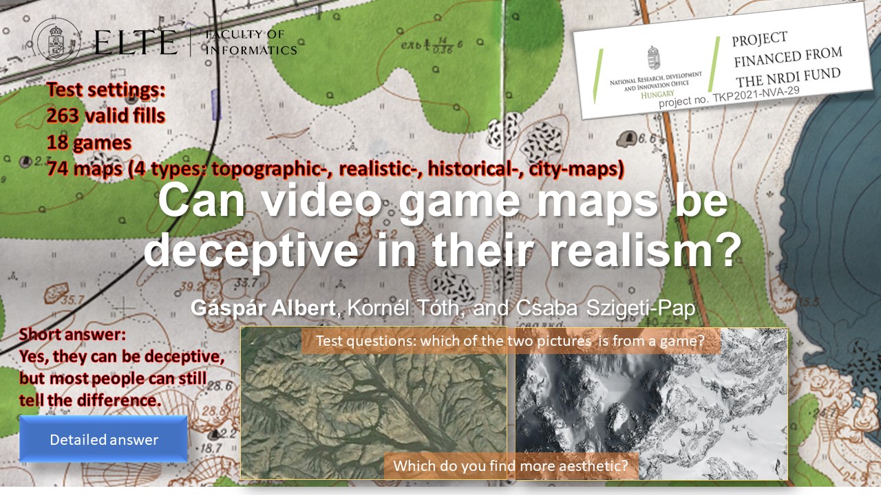
EGU23-1073 | Posters virtual | EOS1.4 | Highlight

AEOLIAN: A new Augmented Reality mobile application to enhance disaster training and response to evolving hazards 

Panagiotis Michalis, Katerina Georgiou, Orestis Sampson, Vasilis Nousis, Marios Palazis, Chrysoula Papathanasiou, Eleftherios Ouzounoglou, and Angelos Amditis

Disaster risk is expected to amplify in the forthcoming years considering the recent climatic projections that highlight that the frequency of shifting weather events is expected to increase posing a significant threat to the resilience of critical assets and societal functions [1]. The increasing trend of extreme weather events and natural hazards highlight the urgency of societies to adapt to current and future evolving hazards. Emerging technologies can play a significant role towards the preparedness and response of societies to disaster risks; however, the vast majority of existing solution are customised to the needs of citizen protection authorities and do not enable interaction with citizens to bridge the risk perception action gap.

This work presents AEOLIAN AR mobile application which focuses on actively engaging both citizens and citizen protection authorities (CPAs) to enhance their risk perception but also response actions during an emerging crisis. AEOLIAN is a new crowdsourcing solution which is following a co-creation design process, through various development iteration phases with main end users [2]. The solution places at the centre both relevant authorities and vulnerable citizens, in an effort to deliver functionalities focused on knowledge generation and exchange among target users. This involves the dissemination of early warnings and real-time bi-directional interaction and exchange of crowdsourcing information between experts and vulnerable communities in case of evolving hazards, allowing for precautionary actions to be employed in areas of concern. It is coupled by Augmented Reality (AR) technology, which seamlessly blends real environments and virtual objects [3], to enrich the knowledge of citizens by providing an immersive storytelling of ‘disaster tales’ to inform users about historical hazardous events that have occurred in their region. Gamified disaster risk training modules also aim to empower participation and learning for climatic and anthropogenic related risks. AEOLIAN has the potential to improve understanding and risk communication between CPAs and citizens towards building disaster resilient societies.

Acknowledgments:

This research has been financed by European Union’s Horizon 2020 research and innovation programme under Grant Agreement No 101019707, project RiskPACC (Integrating Risk Perception and Action to enhance Civil protection-Citizen interaction).

References:

[1] Michalis, P. and Vintzileou, E. (2022). The Growing Infrastructure Crisis: The Challenge of Scour Risk Assessment and the Development of a New Sensing System. Infrastructures. 2022; 7(5):68. https://doi.org/10.3390/infrastructures7050068.

[2] Michalis, P., Anniés, J., Papathanasiou, C., Ouzounoglou, E. and Admitis, A. (2022). Co-creation as an approach to bridge the Risk Perception Action Gap and customise crowdsourcing tools to respond effectively to climatic risks. Proceedings of the 3rd International Conference on Natural Hazards and Infrastructure, 5-7 July 2022, Athens, Greece, ISSN 2623-4513.

[3] Katika, K., Karaseitanidis, I., Tsiakou, D., Makropoulos, C., Amditis, A. (2021) Augmented Reality(AR) Supporting Citizen Engagement in Circular Economy, Circular Economy and Sustainability, https://doi.org/10.1007/s43615-021-00137-7.

How to cite: Michalis, P., Georgiou, K., Sampson, O., Nousis, V., Palazis, M., Papathanasiou, C., Ouzounoglou, E., and Amditis, A.: AEOLIAN: A new Augmented Reality mobile application to enhance disaster training and response to evolving hazards, EGU General Assembly 2023, Vienna, Austria, 23–28 Apr 2023, EGU23-1073, https://doi.org/10.5194/egusphere-egu23-1073, 2023.

EGU23-1381 | Posters virtual | EOS1.4 | Highlight

Enhancement of local community resilience to natural and man-made disasters through the application of co-created novel technological tools 

Chrysoula Papathanasiou, Panagiotis Michalis, Konstantinos Stavrou, Evangelos Tsougiannis, Jeannette Anniés, Sofia Papageorgiou, Eleftherios Ouzounoglou, and Angelos Amditis

Natural and man-made disasters are associated with significant impacts on society, economy and the environment and are considered an issue of national priority at a global level. Further to that, such disasters are exacerbated by climate change (EC DG-ECHO, 2021) and their frequency of occurrence and impact intensity is expected to increase significantly, further affecting the countries’ interlinked economies. The standard practice adopted to mitigate risks includes the undertaking of measures, customized to the needs, particularities and socioeconomic features of the area under threat (Papathanasiou et al., 2015). Informed policy- and decision-making processes need to be outlined from relevant stakeholders. However, this top-down approach, which currently involves policies and measures decided by relevant authorities is not only outdated, but has also been proven to be insufficient. Currently, there is a justified tendency to actively include citizens in disaster management, fostering thus a more citizen-oriented, bottom-up approach. State-of-the art technological tools with advanced functionalities offer extended capabilities towards this direction. RiskPACC project brings together researchers, practitioners and first responders from nine European countries in at least 21 co-creation workshops at 7 case studies, enhancing the communication between local Civil Protection Authorities (CPAs) and citizens and bridging the risk perception-action gap (RPAG) (Michalis et al., 2022).

This work outlines the co-creation approach adopted for the Municipality of Rafina-Pikermi (MRP) use case workshops that focus on wildfires and floods. The functionalities of the AR Aeolian mobile application were defined based on feedback by CPAs and citizens, as provided during workshops, successive iterations and response to appropriate questionnaires posed by the tool providers. User-friendliness was a core design element of the tool to ensure its easy applicability by citizens and control by CPAs, meeting at the same time the need to train the local community how to effectively manage disasters. The process of familiarizing CPAs and citizens with such solutions and encouraging their active participation in relevant training sessions supported them to better understand their particular role in disaster risk reduction, fostering improved situation awareness and risk perception, which is strongly encouraged by immersive technologies. Lessons learnt from citizen empowerment to adopt technical solutions for disaster risk management can be replicated to other use cases with similar population features.


Acknowledgments:

This research has been financed by European Unions Horizon 2020 research and innovation programme under Grant Agreement No 101019707, project RiskPACC (Integrating Risk Perception and Action to enhance Civil protection-Citizen interaction).


References:

EC, Directorate-General ECHO, (2021). Overview of natural and man-made disaster risks the European Union may face: 2020 edition, Publications Office.  

Michalis, P., Anniés, J., Papathanasiou, C., Ouzounoglou, E. and Admitis, A. (2022). Co-creation as an approach to bridge the Risk Perception Action Gap and customise crowdsourcing tools to respond effectively to climatic risks. Proceedings of 3rd International Conference on Natural Hazards and Infrastructure, 5-7 July 2022, Athens, Greece, ISSN 2623-4513.

Papathanasiou, C., Makropoulos, C. and Mimikou, M., (2015). Hydrological modelling for flood forecasting: calibrating the post-fire initial conditions, Journal of Hydrology, Vol. 529, Part 3, pp. 1838-1850, https://doi.org/10.1016/j.jhydrol.2015.07.038

How to cite: Papathanasiou, C., Michalis, P., Stavrou, K., Tsougiannis, E., Anniés, J., Papageorgiou, S., Ouzounoglou, E., and Amditis, A.: Enhancement of local community resilience to natural and man-made disasters through the application of co-created novel technological tools, EGU General Assembly 2023, Vienna, Austria, 23–28 Apr 2023, EGU23-1381, https://doi.org/10.5194/egusphere-egu23-1381, 2023.

EGU23-1615 | Posters on site | EOS1.4

The CEDAS (building CEnsus for seismic Damage Assessment) project: citizen science to increase risk awareness 

Chiara Scaini, Antonella Peresan, and Carla Barnaba

Citizen science has proven very useful to increase awareness and preparedness of societies prone to disaster risk. The active involvement of citizens is also strongly envisaged by strategic documents related to disaster risk reduction (e.g. SENDAI Framework, United Nations Global Assessment Report). Here, we describe the CEDAS (building CEnsus for seismic Damage ASsessment) project, which involved high-school students in citizen science activities related to seismic risk reduction. In particular, students collected data on building characteristics (e.g. height, material) near to their homes using their phone or personal computer. Prior to data collection students were trained on risk-related concepts (hazard, exposure and vulnerability) with specific focus on buildings exposure the area where the activity was carried out (northeastern Italy). CEDAS was implemented in 2021 and 2022 involving approximately 320 students who collected more than 6000 building forms. The CEDAS project is not only data collection: students also analyzed the data and compared the exposure parameters in different areas. Finally, the interpreted the results with the help of teachers and researchers. CEDAS has demonstrated its potential for collecting exposure data in seismic-prone areas and/or include characteristics useful for multi-hazard and multi-risk assessment. However, its generalization requires the adaptation of the training material to the specific context. This presentation will support the discussion on CEDAS based on active involvement of participants. Attendants will have the opportunity to test the CEDAS approach for selected buildings. Pictures of the building front and aerial view, together with a street view, will be displayed on the screen. The active involvement of participants will support the discussion both on technical (e.g. parameters to be prioritized during the collection) and communication (e.g. citizens engagement and training) aspects. The discussion will also cover future developments of CEDAS, in particular in relation to risk awareness and preparedness (e.g. definition of impact assessment metrics).

How to cite: Scaini, C., Peresan, A., and Barnaba, C.: The CEDAS (building CEnsus for seismic Damage Assessment) project: citizen science to increase risk awareness, EGU General Assembly 2023, Vienna, Austria, 23–28 Apr 2023, EGU23-1615, https://doi.org/10.5194/egusphere-egu23-1615, 2023.

In Korea, disaster broadcasting online system and disaster information delivery platform provide disaster information broadcasting and text messages as well as various multimedia services to inform the public. However, it is not possible for Disaster Prevention-Related Organizations and accurately acquire disaster situation information in real time and provide information for preemptive response.

Therefore, in order to quickly deliver weather emergency information to the Disaster Prevention-Related Organizations like fire fighter, we analyse necessary meteorological information for fire fighting and transfer the customized contents that can effectively respond to disaster situations are developed. We propose a system architecture to deliver meteorological information to the person in charge.


How to cite: Lee, B. and Jung, W.-S.: Design of Weather Emergency Information Delivery System to Disaster Prevention-Related Organizations, EGU General Assembly 2023, Vienna, Austria, 23–28 Apr 2023, EGU23-1956, https://doi.org/10.5194/egusphere-egu23-1956, 2023.

EGU23-2951 | Orals | EOS1.4

Communication for emergencies – the need for a new and inclusive ecosystem 

David Wales, Alexandra Olson, and Alexis Gizikis

“The future of emergency communication requires a new ecosystem that enhances capacity and capability by creating an environment that is accessible, equitable, and anticipates change as a constant state.”

This is the key finding of research designed to identify policy recommendations for the EU and which is intended to be of assistance to policymakers at national, regional, and local levels.

It recognises that current models of communication in relation to emergencies are typically oriented towards top-down or single-direction communication, flowing from professionals to lay persons. The impact of this legacy approach extends far beyond the obvious and visible delivery mechanisms. It also frames the underpinning research, discussions, and attitudes. As such, it perpetuates existing limitations and biases of the system, for example, an underappreciation of the needs, role, and contribution of citizens and communities.

It also means that global aspirations- such as enhancing resilience and integration- can at best only ever be partially achieved because they are only seen through a narrow and restrictive lens. This has profound implications and fundamental changes are required to better accommodate multi-directional communication in which the role of authorities and professionals adapts to one of enablement, rather than control.

The primary and overarching recommendation for a new communications ecosystem emerged through considering the wider meaning of specific findings from the research. These are shown below:

  • Bridge the communication gaps between professionals and citizens. For example in relation to language (terminology), content, risk tolerance, stereotypes, desired outcomes/priorities, and assumptions.
  • Recognise that communication is a continuous activity that is reliant on creating the right conditions for it to be effective.
  • Design consistent messaging and communication that is inclusive and adaptable to specific needs.
  • Recognise communication as a learning opportunity and actively design in opportunities to exploit this throughout the cycle.
  • Communication strategies should recognise and positively support the opportunities that emergencies provide for citizens, communities, and formal agencies to enhance integration and resilience.

In proposing this paper to the EGU General Assembly 2023, we hope it may represent a valuable opportunity to consider opportunities to align the work of the climate and crisis sectors in this area. Hopefully, in doing so, we will learn from each other and make the task of those using our work easier and more effective.

Note: The authors were funded by the ENGAGE project to produce the report referenced in this abstract. ENGAGE is an EU-funded project, which started in July 2020 and whose mission is to identify novel knowledge, impactful solutions, and emergency response guidelines for exploiting Europe ́s societal resilience.


How to cite: Wales, D., Olson, A., and Gizikis, A.: Communication for emergencies – the need for a new and inclusive ecosystem, EGU General Assembly 2023, Vienna, Austria, 23–28 Apr 2023, EGU23-2951, https://doi.org/10.5194/egusphere-egu23-2951, 2023.

EGU23-3241 | ECS | Posters on site | EOS1.4

The design of user-centred seismic risk maps – the Swiss case 

Irina Dallo, Laura Noemi Schnegg, and Michèle Marti

Maps are a widely used mean to communicate spatial hazard and risk information to the public, with the aim to increase individual risk awareness. The use of maps is triggered by scientific evidence that maps are the format most preferred by the public. However, past studies have shown that, if not well designed, maps are often misinterpreted and can trigger wrong attitudes. Thereby, the different elements such as the icons on the map, the chosen layers, the legend, or the used color scale influence the comprehension of the information on the map. In the context of natural hazards, and more precisely earthquakes, research has so far mainly focused on the design of hazard maps, and little is known about the effective design of risk maps. We thus assessed how to design understandable, useful, and actionable seismic risk maps for the public.

To this end, we conducted a transdisciplinary project in Switzerland by ensuring an interdisciplinary co-production of the map and testing it with the public. First, we – an interdisciplinary group at the Swiss Seismological Service at ETH Zurich – co-designed different versions of the seismic risk map varying the color scale and legend format. Second, we tested these versions with a public survey (between-subjects experiment); representative for the German- and French-speaking part of Switzerland. We assessed which map version was correctly interpreted, perceived as useful, increased people’s risk perception, and triggered people to take protective actions. Further, we analyzed whether certain social groups (e.g., house owners) had different preferences, risk perception, or intentions to take action.

At the conference, we will present the preliminary results of the survey and provide evidence-based recommendations on how to design user-centred seismic risk maps. This should support institutions responsible for public communication to add seismic risk maps to their products to effectively inform the public about seismic risks and, in turn, increase their risk awareness and intention to take protective actions. 

This project has received funding from the Federal Office for the Environment (FOEN), the Federal Office for Civil Protection (FOCP), and the Swiss Federal institute of Technology Zurich (ETH Zurich).

How to cite: Dallo, I., Schnegg, L. N., and Marti, M.: The design of user-centred seismic risk maps – the Swiss case, EGU General Assembly 2023, Vienna, Austria, 23–28 Apr 2023, EGU23-3241, https://doi.org/10.5194/egusphere-egu23-3241, 2023.

EGU23-4508 | ECS | Orals | EOS1.4

Building a prepared community to volcanic risk: assessment of awareness raising tools for secondary school in Goma, (Eastern DR Congo) 

Blaise Mafuko Nyandwi, Matthieu Kervyn, François Muhashy Habiyaremye, François Kervyn, and Caroline Michellier

Disasters induced by natural hazards are increasing globally and have severe impacts. Some of these hazards, as volcanic eruptions, are related to the earth's interior mechanisms and cannot be prevented. Thereby, risk mitigation is the best strategy for reducing their impacts in densely populated areas, such as the city of Goma in the eastern Democratic Republic of Congo, exposed to volcanic threats from Nyiragongo. This requires the population to be prepared to respond to volcanic risk, by having a high state of awareness, anticipation, and readiness. “Living with a volcano” should be one of the life skills all Goma children acquire during their schooling, regardless of where they attend school. Therefore, this study used a mixed-method approach (questionnaire survey, focus group and written composition) to assess the awareness raising impact of two educational tools recently implemented in Goma for secondary students: the Hazagora serious game and the volcano museum. Several students (402 in total) from 12 schools participated in one of these risk awareness activities, while other students were assessed as controls. Results indicate that the tools have a positive impact on students’ volcanic disaster understanding, their risk perception, and their implication in DRR initiatives. Specifically, the volcano museum increases knowledge of volcanic process more than the Hazagora serious game; the latter increases more the perceived self-capacities and willingness of implementing protective measures. Risk perception raises almost identically with both tools. In general, participants indicate that they receive sufficient scientific information throughout the Hazagora serious game and the volcano museum visit to better understand the physical mechanisms of volcanic hazards and their impacts on human properties and livelihood. In addition, they claim to have received relevant information on protective measures and abilities, and to be willing to search for additional risk information. This study highlights that the two tools are complementary; thus, awareness raising through a diversity of tools can be more effective than a single and isolated activity.

How to cite: Mafuko Nyandwi, B., Kervyn, M., Muhashy Habiyaremye, F., Kervyn, F., and Michellier, C.: Building a prepared community to volcanic risk: assessment of awareness raising tools for secondary school in Goma, (Eastern DR Congo), EGU General Assembly 2023, Vienna, Austria, 23–28 Apr 2023, EGU23-4508, https://doi.org/10.5194/egusphere-egu23-4508, 2023.

In recent years, natural disasters such as typhoons, torrential rains, and wildfires have increased due to climate change. Such a phenomenon is an unpredictable meteorological phenomenon. In this kinds of disasters, warning and alert information rapid transition should be made through disaster prevention-related agencies and regional warning systems. Recently, there has been an increasing demand for such rapid transition information. From the point of view of the current transition system for disaster warning and alert system, the severe weather information from the Meteorological Agency in South Korea is transmitted to broadcasting stations and related media using fax, e-mail, and the like. However, these manual transmission of information is not as much fast as it should be required. To make matters worse, there were cases where it did not delivered. In terms of management and operation of this warning system, related agencies have different independent operation systems depending on the type of disaster. For this reason, when multiple disasters occur at the same time or in stages, it is difficult to respond immediately because the systems are not well coordinated. In addition, for the same meteorological phenomenon, the damage that occurs in the area will differ depending on the disaster prevention capacity of the area, the degree of urbanization and industrialization, and the different shape of watershed of the area. In this study, we analyzed existing severe weather information transmission systems. The new novel system shows a prototype that reflects being rapid, being accurate and being integrated. Then, the study presents a methodology for considering the characteristics of the region. Prototypes planned in this way are evaluated whether functional performance is implemented.  The proposed system lets the urgency of weather events make a decision from a meteorological point of view. This will automatically and quickly categorize the level of need you have to be notified of. Depending on the grade, it will promptly and automatically generated and deliver customized information to the public and the government immediately right after any concerned situation occurs. The system has reflected the construction of a standardized information transmission system. Then, the proposed system will enable operation and management by integrating forecasting systems operated independently by each agency into one system. System integration increases the efficiency of generating and transmitting the necessary information, enabling effective response to the complex disasters. Even in the same weather, if the degree of disaster impact varies by region, the customized information level will be differentiated according to vulnerability, exposure, hazardous, and disaster prevention capacity.  

This study will enable the rapid transmission of necessary information to the public and related organizations for efficient response to unpredictable and complex natural disasters through the improved severe weather information transmission system. Finally, It is expected to contribute to minimizing human and material damage due to natural and social disasters by providing alert and warning with customized information for each region that reflects the degree of disaster impact.

How to cite: Jeun, S. and Kwon, K.: System Development of generation and transmission of customized severe weather information for Emergency responses in South Korea, EGU General Assembly 2023, Vienna, Austria, 23–28 Apr 2023, EGU23-4858, https://doi.org/10.5194/egusphere-egu23-4858, 2023.

In order to successfully set the EU on the path to reach climate neutrality by 2050, it is essential to have communities on board and willing to make changes to act for a sustainable future. However, without courses focused on climate change on the core curriculum of most schools in Europe, many adults are under informed about the effects of climate change, and what can be done on an individual level to reach these goals. The impact of warming oceans are multifold and affect not only communities that directly boarder the sea, but all neighboring nations as well. The Deep Network project addresses the need for adults to become more aware of the problems regarding climate change and the ocean by curating an online ocean-education information hub. To accomplish this, a network will be built working in close partnership with researchers, ocean activists, industries, and professional adult educators to develop high quality, accessible educational material that covers a range of topics related to how human activities impact the ocean. Some of the topics covered in the Deep Network project include ocean pollution, rising sea levels, ocean warming/acidification, habitat destruction, fisheries, and tourism. Additionally, to engage communities to action and to maintain a sustained interest in marine science and conservation, “inspiring practices” will be promoted for each topic. These are examples of realistic actions or lifestyle changes that one can directly implement into one’s own life. Anthropogenic influences on the oceans directly affect us all in varying ways. The goal of The Deep Network project is to create a strong line of accessible communication, trust, and transparency between ocean research and the communities, to ensure that the responsibility of a sustainable future falls not on the scientists, activists, and industry partners alone. A well-informed community has the potential to make a difference in legislation and gives people the opportunity to make educated decisions to act for a sustainable future.

How to cite: Johansen, C.: The Deep Network: curating and co-producing quality ocean-education information for adults., EGU General Assembly 2023, Vienna, Austria, 23–28 Apr 2023, EGU23-5104, https://doi.org/10.5194/egusphere-egu23-5104, 2023.

EGU23-5636 | Orals | EOS1.4

Investigating students' perception of climate change and geo-hydrological risk in Italian public high schools 

Roberto Coscarelli, Loredana Antronico, Stefano Luigi Gariano, and Paola Salvati

Young generation will have to manage, in the not-too-distant future, the increase of climate-change-related hazards. Infact, extreme rainfall events, increases in mean temperatures,  decreases in mean rainfall, tropical cyclones, thunderstorms, droughts are already having a significant impacts on people’s life and to the environment. In light of this, the more young people will be aware of the climate change (CC) and will know how to deal with the risks induced by it, the more they will be able to take measures and adopt behaviors to reduce negative impacts as well as to influence the choices of policy makers. For this reason, knowing the perception, the degree of knowledge and the preparedness of young people to these issues is becoming increasingly important.

By means of a quantitative research method (structured questionnaire), a survey on  a group of Italian high public school students, aged between 13 and 20 and located in central (Umbria region) and southern (Calabria region) Italy, was carried out. This survey focused on young people awareness, perception and preparation concerning natural risks, including landslide and flood risk, and climate change. The survey's results show the following informations: a) the questioned students are aware of the CC issue and they generally believe that human actions and lifestyle affect CC; moreover, young people are more worried than adults about how CC may affect nature and the environment; b) the findings confirm the close relationship between youth and the media in terms of perception, information, and understanding of CC and its impacts; c) besides believing that better risk communication between authorities and citizens is necessary, the students  have low level of trust in local administrations and on the policy regarding geo-hydrological risk; d) young interviewed who participated in a specific educational activity on landslide and flood hazard revealed that they had a good understanding of the triggering processes of these phenomena. Even though the samples is not highly representative of the whole Italian young population, the survey shows that Italian political institutions need to plan responsible, morally sound, and convincing activities in order to win over citizens' credibility and trust, especially younger ones. Additionally, it is crucial that scientists collaborate with politicians, policy makers, and schools to i) promote shared and sustainable actions involving public, particularly the younger generation, and thus increasing people resilience; and ii) develop an integrated and multidisciplinary approach to comprehend a complex phenomenon like climate change and its effects on people and environment.

How to cite: Coscarelli, R., Antronico, L., Gariano, S. L., and Salvati, P.: Investigating students' perception of climate change and geo-hydrological risk in Italian public high schools, EGU General Assembly 2023, Vienna, Austria, 23–28 Apr 2023, EGU23-5636, https://doi.org/10.5194/egusphere-egu23-5636, 2023.

EGU23-6079 | ECS | Posters on site | EOS1.4 | Highlight

Waves…a tool to explore our home! A successful experience in improving risk perception 

Maria Vittoria Gargiulo, Ferdinando Napolitano, and Paolo Capuano

In a geologically interesting land like Italy, and in particular Campania, educating and informing about the concept of risk in general, and specifically seismic risk, is of fundamental importance.

The possibilities of seismic risk mitigation, in fact, depend not only on the scientific community but also on how well prepared and informed society is about the risk itself. It is, therefore, crucial to train the local population to increase disaster risk preparedness and resilience within our region.

The Science Capital framework, developed by Prof. Louise Archer er al. (https://doi.org/10.1002/tea.21227), refers to a person’s science-related resources, such as their science-related understanding, knowledge, attitudes, activities, and social contacts. It also offers a key to defining how everyone's store of scientific knowledge is enriched and influenced by their habits, family, and network of contacts. Understanding this context and its dynamics helps us to enhance the resources available for scientific culture, with a view to building a competent and inclusive educational community. 

With this in minds, we built a didactic protocol dedicated to seismic risk perception taking into consideration the Science Capital framework.

“Waves…a tool to explore our home!” allows students to acquire both specific topics, such as the physical quantities involved in an earthquake, its generation and its dynamics, and general concepts, such as the perception of seismic risk and the impact of man in the prevention, in the possible induction and in the response to an earthquake.

An evaluation phase was carried out to assess the learning experience and the effectiveness of the science communication technique.

This work has been supported by CORE ("sCience and human factor for Resilient sociEty") project, funded from the European Union’s Horizon 2020 - research and innovation program under grant agreement No 101021746 .


How to cite: Gargiulo, M. V., Napolitano, F., and Capuano, P.: Waves…a tool to explore our home! A successful experience in improving risk perception, EGU General Assembly 2023, Vienna, Austria, 23–28 Apr 2023, EGU23-6079, https://doi.org/10.5194/egusphere-egu23-6079, 2023.

EGU23-6102 | ECS | Orals | EOS1.4

Voluntary spring monitoring to make invisible groundwater visible 

Inga Retike, Jaanus Terasmaa, Oliver Koit, Jānis Bikše, Jekaterina Demidko, Marlen Hunt, and Agnese Kukela

Groundwater accounts for nearly 99% of all liquid freshwater on Earth. Not only does groundwater provide almost half of the global drinking water supply and ensures the well-being of humans and sustain dependent ecosystems (rivers, lakes, and wetlands), it is an essential aspect in climate change mitigation too. Despite the exceptional importance of groundwater in social, economic, and environmental processes, it remains poorly understood, mismanaged, and often neglected. In order to increase global awareness of groundwater protection, the theme for World Water Day 2022 was “Groundwater: Making the invisible visible” with the culminating event - the first UN-Water Summit on Groundwater held in Paris on 7-8 December. Data collection and sharing on groundwater were among the key actions highlighted during the Summit because “we cannot manage what we do not measure”.

One of the ways to make groundwater visible is to demystify the underground resources beneath our feet through citizen science. Many volunteer water monitoring programs have generated valuable data sets around the world. Data collection by volunteers is cost- and time effective, supports local communities by raising awareness of groundwater protection, and boosts outdoor tourism. Moreover, such campaigns provide information on water bodies that would otherwise remain unmonitored and, if carefully designed, can be used by national water managers and even support decision-making.

Here we present a joint Estonian-Latvian web-based application for the volunteer monitoring of springs launched in February 2021 (accessible by allikad.info and avoti.info). The web-based map application aims to collect new information on already known springs and locate new ones by providing clear guidelines on how to carry out proper spring monitoring. More than 200 users have already joined the application and approximately 600 new springs have been added to the database. Together, 1132 new observations have been made and 2930 images of springs have been added. This valuable information source has been recently recognized by national water managing authorities and used to improve the transboundary groundwater monitoring network between Estonia and Latvia. We will present how citizen science can improve groundwater management, as well as our success stories and lessons learned. 

The study benefits from Iceland, Liechtenstein and Norway through the EEA and Norway Grants Fund for Regional Cooperation project No.2018-1-0137 “EU-WATERRES: EU-integrated management system of cross-border groundwater resources and anthropogenic hazards”  and Interreg Estonia-Latvia cooperation program project “WaterAct”.

How to cite: Retike, I., Terasmaa, J., Koit, O., Bikše, J., Demidko, J., Hunt, M., and Kukela, A.: Voluntary spring monitoring to make invisible groundwater visible, EGU General Assembly 2023, Vienna, Austria, 23–28 Apr 2023, EGU23-6102, https://doi.org/10.5194/egusphere-egu23-6102, 2023.

EGU23-7342 | Orals | EOS1.4

Risk communication during seismo-volcanic crises: the example of Mayotte, France 

Robin Lacassin, Maud Devès, Hugues Pécout, and Geoffrey Robert

Population information is a fundamental issue for effective disaster risk reduction. As demonstrated by numerous past and present crises, implementing an effective communication strategy is, however, not a trivial matter. Here, and in Devès et al. 2022, we draw lessons from the seismo-volcanic “crisis” that began in the French overseas department of Mayotte in May 2018, and which is related to a submarine eruption off the eastern coast of the island. The seismo-volcanic activity is still ongoing today and large uncertainties remain about its possible future evolution. Mayotte’s case study is interesting for several reasons: (1) although the seismo-volcanic phenomenon itself is associated with moderate impacts, it triggered a social crisis that risk managers themselves qualified as “a communication crisis”, (2) risks are perceived mostly indirectly by the population, which poses specific challenges, in particular to scientists who are placed at the heart of the risk communication process, and (3) no emergency planning or monitoring had ever been done in the department of Mayotte with respect to volcanic issues before May 2018, which means that the framing of monitoring and risk management, as well as the strategies adopted to share information with the public, has evolved significantly over time. Our first contribution is to document the gradual organization of the official response. Then we attempt to understand what may have led to the reported “communication crisis”. To that end, we collect and analyze the written information delivered by the main actors of monitoring and risk management to the public from May 2018 to April 2021. Finally, we compare its volume, timing, and content with what is known of at-risk populations’ information needs. Our results outline the importance of ensuring that communication is not overly technical, that it aims to inform rather than reassure, that it focuses on risk and not only on hazard, and that it provides clues to possible risk scenarios. We issue recommendations for improvement of public information about risks in Mayotte, but also elsewhere in contexts where comparable geo-crises may happen. 

Devès, M., Lacassin, R., Pécout, H., & Robert, G. (2022). Risk communication during seismo-volcanic crises: the example of Mayotte, France. Nat. Hazards Earth Syst. Sci., 22, 2001–2029, https://doi.org/10.5194/nhess-22-2001-202

How to cite: Lacassin, R., Devès, M., Pécout, H., and Robert, G.: Risk communication during seismo-volcanic crises: the example of Mayotte, France, EGU General Assembly 2023, Vienna, Austria, 23–28 Apr 2023, EGU23-7342, https://doi.org/10.5194/egusphere-egu23-7342, 2023.

EGU23-8055 | Posters on site | EOS1.4 | Highlight

Investigating the role of citizens' trust during and after emergencies 

Raffaella Russo, Maria Vittoria Gargiulo, Maria Prosperina Vitale, Serena Quarta, and Paolo Capuano

During and after catastrophes it is important to investigate the role played by key governmental institutions and scientific community in vehiculating correct information to the whole population on how to manage the consequences of disasters in order to minimize losses and avoid other possible cascading effects. Indeed, messages spread out by policy makers and scientific community get positive effects, only if they are trusted by citizens.

The European project entitled “sCience and human factOr for Resilient society” (H2020 CORE) considers trust as a key factor for the individuals’ risk perception, their behavioural response and disaster preparedness. Within this scenario, a survey is promoted by means of an online questionnaire including scales and indicators related to risk perception and trust by controlling for geographical context, socio-demographic and economic backgrounds together with direct and indirect individual experiences. The aim of the survey is twofold: on one hand, it permits to consider the effects on citizens’ behaviors by analysing  different hazards, such as earthquakes, tsunami, wildfire, industrial accident, terrorist attack, flash flood and COVID-19 pandemic; on the other one, it allows to underline best practices adopted by institutions during emergencies in different countries by also investigating the role of fake news.

The final aim is to release guidelines devoted to the policy makers and scientific community experts in order to understand what they can do to be trusted by communities. 

Acknowledgment: The present abstract has been produced for the CORE project that has received funding from the European Union’s Horizon 2020 research and innovation programme under grant agreement No 101021746.

How to cite: Russo, R., Gargiulo, M. V., Vitale, M. P., Quarta, S., and Capuano, P.: Investigating the role of citizens' trust during and after emergencies, EGU General Assembly 2023, Vienna, Austria, 23–28 Apr 2023, EGU23-8055, https://doi.org/10.5194/egusphere-egu23-8055, 2023.

EGU23-9175 | ECS | Orals | EOS1.4

AMALPI trek: a geocultural trail from Maloja to St. Gotthard to increase the awareness of natural hazard in mountain settings 

Francesco Arrigoni, Christian Ambrosi, Tiziana Apuani, Massimo Ceriani, and Cristian Scapozza

The historical evolution of a territory is usually related to its geological features and geomorphological dynamics. Floods and slope instabilities modify the landscape impacting on human life. The perception of the value of natural resources in mountain area and the culture of respect is an essential component in strategies aimed at ensuring the population a future of well-being, social and economic growing.

The AMALPI Trek takes its name from the A.M.AL.PI.18 Project [1], which is the Italian acronymous for “Moving Alps, and Movements in the Alps”, developed in the framework of the European funded Interreg Italy-Switzerland Cooperation Program V-A 2014-2020. The project aims to encourage an innovative strategy for the promotion of natural and cultural heritage in the Alpine area from Maloja to St. Gotthard (through Val Bregaglia, Valchiavenna, Regione Moesa and Alto Ticino), even by the creation of a cross-border geo-cultural trail connecting sites which have experienced important geomorphological and anthropic changes due to the occurrence of landslides of great social impact. The trail is addressed to a scientific-cultural and educational tourism, to raise the perception of landscape components in the framework of the “total history”, composed by the geo(morpho)logical, bioecological and historic-cultural heritages. Placed in a central position, the AMALPI Center (scheduled to open mid-2023 in Chiavenna), will be a study and research hub on large landslides, reference for school activities and promotion events. In addition, an open access hiking guidebook and map will lead the trekker to discover tools and methods that allow the comprehension of past and ongoing processes, with the help of illustrative panels describing the main patrimonial aspects of the territory, which is rich in historical palaces, archaeological sites, and natural monuments.

The AMALPI Trek runs through 10 Alpine valleys and crosses 7 mountain passes, for a total of about 150 km, plus several thematic itineraries that branch out of the main trail. Along the way, 19 large landslides of different age and type are touched. In many segments, the AMALPI trek follows historical trade routes, used in the past for the exchange of silk and soapstone products. There are some links between large landslides and stone resources typical of these mountains. A striking example are the “crotti”, natural caves used as cellars, perfect places for the storage of foods and other goods, and the “trone”, local soapstone caves, both generated by the gravitational accumulation of cyclopean boulders. The petrographic features of soapstone outcropping rock offer then a good workability, but locally they become weakness planes predisposing sliding.

Looking at the causes and effects of landslide events, the trekker accrues the perception of human vulnerability to natural hazard, but it is also invited to discover how to prevent, mitigate, and manage hillslope dynamic to develop a sustainable and fulfilling life in mountain areas.


[1] Interreg V-A Italy-Switzerland 2014-2020 Cooperation Program, Axis II “Cultural and natural enhancement”). Project ID 594274, “A.M.AL.PI. 2018 – Alpi in Movimento, Movimento nelle Alpi. Piuro1618–2018”.

https://progetti.interreg-italiasvizzera.eu/it/b/78/alpiinmovimentomovimentonellealpipiuro

How to cite: Arrigoni, F., Ambrosi, C., Apuani, T., Ceriani, M., and Scapozza, C.: AMALPI trek: a geocultural trail from Maloja to St. Gotthard to increase the awareness of natural hazard in mountain settings, EGU General Assembly 2023, Vienna, Austria, 23–28 Apr 2023, EGU23-9175, https://doi.org/10.5194/egusphere-egu23-9175, 2023.

EGU23-9182 | ECS | Posters on site | EOS1.4

Participatory approach to adapt scientific communication to the socio-cultural context: the case of the seismo-volcanic activity in Mayotte 

Louise Le Vagueresse, Maud Devès, Jocelyn Jacquot, Robin Lacassin, and Raphaël Grandin

Population information is key to disaster risk reduction and scientists have a key role to play in that respect. However, implementing effective scientific communication is not trivial. We draw lessons from our experience of the seismo-volcanic crisis of Mayotte, France. In May 2018, an unprecedented seismic activity started in Mayotte. It was found, a year later, to be linked to volcanic activity, and the birth of a huge submarine volcano ~50km off the east coast of the island. The activity is still ongoing and is being actively studied to understand the phenomena and estimate associated risks. But there are large uncertainties, due to a lack of preexisting knowledge as the area had been poorly studied before 2018, and is challenging to instrument. In this context, informing at-risk populations is difficult. During the first months of the earthquake swarm, the perceived lack of information led to strong anxiety and a feeling of distrust towards scientists and authorities (Fallou et al., 2020; Devès et al., 2022). Experts in charge of monitoring, who are mostly from mainland France, are attempting to develop new ways of disseminating knowledge (e.g., a simplified monthly newsletter, translated into local languages). Nevertheless, they struggle to overcome the socio-cultural gap between mainland France and Mayotte archipelago (multilingualism, levels of literacy, precarious living conditions, see Roinsard, 2014). There is thus a need to explore alternative ways of communicating scientific information so that it can reach the relevant audiences more effectively. We present an approach drawing on the expertise of earth sciences and human and social sciences that reverse the classic top-down approach (the latter does not generally work very well, even less so in Mayotte). We first develop visual and interactive information tools to better represent the uncertainties associated with the knowledge produced by the volcanological and seismological observation network of Mayotte (REVOSIMA). We focus on the link between seismicity and deformation, two phenomena whose consequences are the easiest to perceive for the populations. We then train secondary school students, in collaboration with their teacher, on the basis of these materials. Finally we accompany those students, with the help of their teachers, to develop their own scientific dissemination materials with the objective to transmit this information to their family and friends. This method has the advantage of delegating the tasks of translating and disseminating the acquired knowledge to individuals from different socio-cultural backgrounds on the island who are familiar with the codes and information habits of their respective communities. As this project is still ongoing, we discuss here its conditions of realisation and its contribution to ongoing research on the communication of scientific information in a context of risks and crises.

How to cite: Le Vagueresse, L., Devès, M., Jacquot, J., Lacassin, R., and Grandin, R.: Participatory approach to adapt scientific communication to the socio-cultural context: the case of the seismo-volcanic activity in Mayotte, EGU General Assembly 2023, Vienna, Austria, 23–28 Apr 2023, EGU23-9182, https://doi.org/10.5194/egusphere-egu23-9182, 2023.

EGU23-11949 | ECS | Orals | EOS1.4

Moving from disaster reports to disaster tales to increase flood risk awareness 

Paola Mazzoglio, Stefano Macchia, Enrico Gallo, Julia Winter, and Pierluigi Claps

The lack of basic information about the area where people live and about major hydrometeorological disasters that occurred in the past can lead the population to underestimate the flood risk. The flood risk perception is often related only to past direct experiences and to the memory of floods that took place in the same areas. However, this risk perception is high during the weeks that follow a flood event and then decreases rapidly.

In Italy, the regional agencies in charge of flood management widely use disaster reports (DRs) as the preferred way to collect and standardize information on past flooding events and on the meteorological conditions of that events. However, these DRs are often examined only by technicians, while the general audience is rarely aware about their availability or cannot fully understand what is reported in these documents.

In this work, we performed a systematic survey of the DRs drawn in the past years by the Italian regional agencies in charge of civil protection. We suggest that these DRs could be improved to provide more effective communication to citizens in view of increasing flood risk awareness, reinforcing the communication of civil protection planning and management, and improving the resilience of the population to extreme events. More specifically, we suggest that these disaster reports could be reframed into disaster tales (DTs) without losing the detail level required for the typical technical uses of the DRs. Moreover, these recompiled DTs can be used as tools that offer wider knowledge of the events to improve people’s preparedness and self-protection behavior when a future major flood event will occur.

From a practical point of view, we suggest improving the structure of these reports with the integration of short videos and pictures taken by citizens during the event, maps and interactive tools able to present handier multimedia views of the events. By watching and listening to what has happened, the population can better understand the feelings of the people experiencing an emergency, learning how to act during future floods. We also suggest using a storyline approach to present the whole sequence of events and decisions taken during the flood, putting in chronological order the most significant episodes occurred during the event and the recovery phase.

Application to some case studies of flooding occurred in Italy illustrates how to implement the DRs to create more readily accessible DTs.

How to cite: Mazzoglio, P., Macchia, S., Gallo, E., Winter, J., and Claps, P.: Moving from disaster reports to disaster tales to increase flood risk awareness, EGU General Assembly 2023, Vienna, Austria, 23–28 Apr 2023, EGU23-11949, https://doi.org/10.5194/egusphere-egu23-11949, 2023.

EGU23-12639 | ECS | Orals | EOS1.4 | Highlight

Fighting Climate Misinformation: Fact-Checking of Climate Misinformation in Spanish-speaking podcasts. 

Jon Xavier Olano Pozo, Caterina Cimolai, Andrea Arnal, Mercè Cisneros Bermejo, Anna Boqué Ciurana, Daniel Dermit, Marc Massip, Javier Sigró, and Enric Aguilar

Despite the evidences of the effects of climate change, and the need to adopt adaptation and mitigation measures against its effects,  it still exists a significant current of denialism . Radio podcasts, an evolution of classical radio shows, are an interesting communication and leisure tool for disseminating climate misinformation in today's saturated communication world.

In the framework of the CLIMACAST: UNDERSTANDING AND EXPOSING CLIMATE MISINFORMATION ON PODCASTS project, we monitor, identify, verify and disseminate short notes to fight this climate misinformation. Currently, the project is in the middle of its execution; and we have monitored monitoring more than a thousand hours of podcasts in Spanish-speaking countries from July to December of 2022. The project, funded by META and Poynter’s International Fact-Checking Network is a joint collaboration between C3/IU-RESCAT/URV, VERIFICAT and Kinzen and Chequeados.

The climate misinformation measure unit of this project is a climate claim. A claim is the smallest unit of analysis of verifiable information containing a disputed claim about climate, climate variability and climate change. In addition, to be considered a claim, the information or meaning included in the message should be verifiable content. To track problematic terms, the editors of Verificat monitor podcasts where people post climate disinformation to detect recurring words or phrases in this area to define keywords to find the podcasts. When the podcasts are selected, an artificial intelligence tool transcribes them to a specifically designed dashboard. If it detects problematic content - for example, the word 'calentólogo' (warmist) is typical of negationist slang - the system highlights the keyword for greater detection by analysts. The analyst checks if the keyword refers to some climate and/or meteorological aspect. Then, the analyst determines the content's verifiability based on the message's real climate disinformation. Each claim identified is classified in six main narratives: the main misinformation: climate change does not exist, climate change is not human-caused, climate change is not bad, solutions to face climate change do not work, climate science is not liable and greenwashing.

The results show how the claims are regularly identified in regular podcasts. However, it also shows slight growth in the two weeks of COP27.

How to cite: Olano Pozo, J. X., Cimolai, C., Arnal, A., Cisneros Bermejo, M., Boqué Ciurana, A., Dermit, D., Massip, M., Sigró, J., and Aguilar, E.: Fighting Climate Misinformation: Fact-Checking of Climate Misinformation in Spanish-speaking podcasts., EGU General Assembly 2023, Vienna, Austria, 23–28 Apr 2023, EGU23-12639, https://doi.org/10.5194/egusphere-egu23-12639, 2023.

EGU23-13054 | ECS | Orals | EOS1.4

Using climate stories to bridge the valley of death 

Sophie van der Horst, Felix van Veldhoven, Eva Boon, Jan-Willem Anker, Timo Kelder, Lisette Klok, and Hasse Goosen

Much of the scientific insights and information on climate change and adaptation do not reach decision-makers, companies, and citizens. In literature, this gap between science and society has been referred to as a ‘valley of death’. One of the reasons for the gap is that scientists and societal actors have different understandings and perceptions of what is usable. Climate services should shift from being science-driven, to services that are user-driven and science-informed. In line with this thought, practices such as co-creation and tailoring climate information to user contexts are suggested and described to increase the success of climate services. 

Within the EU funded REACHOUT project, we applied 'storytelling' techniques to create climate stories for six cities across Europe. This is a novel way to transform climate data (hazard maps and datasets) into information that is appealing to local users and citizens. The climate stories combine a narrative structure with visualizations to communicate scientific knowledge to an audience. 

Climate stories are currently being developed within REACHOUT to advance user-oriented climate services to support the implementation of the Green Deal. The initial results are promising as the climate stories are welcomed by the cities as an innovative means to communicate results from the project to the wider audience. For instance, the city of Athens, Milan and Logroño use climate stories about heat to increase awareness and initiate action. 

Climate stories have also been used within the Dutch Climate Impact Atlas to explain climate hazards and impacts to users. In our presentation, we will elaborate on our experiences with the development of climate stories, and discuss the best practices.

How to cite: van der Horst, S., van Veldhoven, F., Boon, E., Anker, J.-W., Kelder, T., Klok, L., and Goosen, H.: Using climate stories to bridge the valley of death, EGU General Assembly 2023, Vienna, Austria, 23–28 Apr 2023, EGU23-13054, https://doi.org/10.5194/egusphere-egu23-13054, 2023.

EGU23-13888 | Posters virtual | EOS1.4

Lend Me Your Ears: Space Weather Citizen Science Through Harnessing Sonification 

Martin Archer, Michael Hartinger, Marek Cottingham, Xueling Shi, Evaldas Vidugiris, Anne Holland, James Harold, Emmanuel Masongsong, Duke Hill, Michael Fox, Shane Coyle, Robert Alexander, Alessandra Pacini, and Robert Candey

The changing conditions in near-Earth space cause space weather. This poses a risk to our everyday lives through the technology we rely upon through impacts on crucial power, communications, navigation, and transport systems. Analogues of sound in the space plasmas around our planet, known as Ultra Low Frequency (ULF) waves, are one means by which energy is circulated from the solar wind to the radiation belt, auroral, and ionospheric regions. Time-series data of ULF waves is often analysed visually, however, such data lends itself more naturally to our sense of sound. Guided by experts in audio, citizen science, and public engagement, we have developed sonification tools that render ULF waves audible. Alongside this, a graphical user interface has been developed, enabling citizen scientists to highlight signals within this audible data that standard methods can struggle to identify. These efforts are part of a NASA-funded pilot project called HARP (Heliophysics Audified Resonances in Plasmas), where high-school students and members of the public contribute to space weather science through listening. We provide an overview of how we carefully developed and tested this citizen science project before launching it publicly.

How to cite: Archer, M., Hartinger, M., Cottingham, M., Shi, X., Vidugiris, E., Holland, A., Harold, J., Masongsong, E., Hill, D., Fox, M., Coyle, S., Alexander, R., Pacini, A., and Candey, R.: Lend Me Your Ears: Space Weather Citizen Science Through Harnessing Sonification, EGU General Assembly 2023, Vienna, Austria, 23–28 Apr 2023, EGU23-13888, https://doi.org/10.5194/egusphere-egu23-13888, 2023.

EGU23-14593 | ECS | Orals | EOS1.4

Using geomojis to communicate geosciences: from development to use 

Claire Shires and Benjamin van Wyk de Vries

Communication across linguistic and cultural borders is vital in our globalised but compartmentalised world, where different people from different origins mix and interact. In the context of geological hazards and the geological environment, we are working towards a clear system that enables specialists in different fields to communicate effectively with each other, and for a common system that allows all types of non-specialists (e.g. general public) to communicate as well. This works using symbols and pictograms to represent geological and environmental phenomena and features, for example geohazards, that can be used to communicate clearly and efficiently. Certain hazard symbols are already in use across the globe, such as those for chemical or environmental hazards, or such as 'rock fall' warning signs that are universal. In this project, we focus on the geological environment and geohazards, and much of the work is done within a UNESCO Geoscience Programme project 'Geoheritage for Resilience', using geoheritage sites as sites for communication and testing, and more recently with a Franco-Mexican ECOS exchange project 'Building Sense in Natural Heritage'. Our geological pictograms, or ‘geomojis’, bridge the gap between simple symbols and words, crossing language borders by representing concepts that we have identified as particularly important for understanding geohazards and risk. Our geomojis are linked to the Global Framework for Geology (see Global and Planetary Change, 2018 - https://digitalcommons.mtu.edu/michigantech-p/427), allowing the context of each geomoji in the Earth system to be understood. We are currently running international workshops to promote discussion and test the geomojis that we have created. These workshops have raised new pictographic needs and the problems associated with them. The goal of these workshops is to consolidate geoscience knowledge from different specialisations and create a basic standardised set of symbols for all geological hazards. This standardisation of geohazard symbols could improve communication not only between specialists and non-specialists, but between geologists themselves. The global framework and geomojis help us to think outside the box of our specialist environment. These geo-pictograms can be used for geoscience communication in all forms, from hazard and risk publications to signage at geological sites and in discussions with local populations. They can be adapted and modified for the local context and needs, while providing a central, and global, base for comparison. We plan to use the set of reference geomojis to accompany a multilingual glossary on geological hazard and risk terminology, a project that we hope will help international geoscience communication.

How to cite: Shires, C. and van Wyk de Vries, B.: Using geomojis to communicate geosciences: from development to use, EGU General Assembly 2023, Vienna, Austria, 23–28 Apr 2023, EGU23-14593, https://doi.org/10.5194/egusphere-egu23-14593, 2023.

EGU23-15345 | ECS | Orals | EOS1.4 | Highlight

Empowering youngsters: Climate high school assemblies to increase risk perception and awareness 

Anna Boqué Ciurana, Jon Xavier Olano Pozo, Gisela Cebrián-Bernat, and Juan Prieto

EMPOCLIM is a project that aims to raise awareness and involve young people in sustainable development through school climate assemblies at five educational centers in Camp de Tarragona, Spain. Thanks to innovative democratic processes designed to learn, deliberate, and decide in an assembly way, the students look for solutions to climate change, proposing actions to promote sustainability at the local and regional levels.

EMPOCLIM emphasizes strengthening environmental awareness and empowering young people through education, recognizing their potential to become ambassadors and agents of change for climate action and sustainable development in their environment, and sharing knowledge and experiences with their families, local communities, and policymakers.

As a result of the climate assemblies, a generation of an action plan and political recommendations by the participating educational communities to achieve the 2 SDGs Climate action and affordable and clean energy at the local and regional levels is obtained.

Parallelly EMPOCLIM project has developed two didactic guides for teachers to work with the knowledge involved with two specific SDGs (the two mentioned before).

Once the EMPOCLIM project was finished, the methodology established continued to be implemented in the high schools on demand, as University Rovira i Virgili offered this Workshop as one that transfers university information to high schools. In the future, EMPOCLIM will probably evolve up-scaled in different national and European proposals and to other educational levels.

We acknowledge  Diputació Provincial de Tarragona for funding the EMPOCLIM project.

How to cite: Boqué Ciurana, A., Olano Pozo, J. X., Cebrián-Bernat, G., and Prieto, J.: Empowering youngsters: Climate high school assemblies to increase risk perception and awareness, EGU General Assembly 2023, Vienna, Austria, 23–28 Apr 2023, EGU23-15345, https://doi.org/10.5194/egusphere-egu23-15345, 2023.

EGU23-15461 | ECS | Posters on site | EOS1.4

Attribution and communication of climate indices in Hungary and Greece 

Péter Szabó, Rita Pongrácz, Elisavet Galanaki, and Vassiliki Kotroni

Although anthropogenic global warming is well-known within the scientific community, the public is still not certain how to associate specific local climate events to this global issue. Therefore, it is essential to raise public awareness by providing sound, graphical, interesting and easily understandable scientific information. Our attribution projects aim for this task both in Hungary and Greece – the former started in September 2021, while the latter a year later. Within the projects, we have slightly different approaches for analysis and dissemination as well. In Hungary, seasonally relevant indices are calculated and published in each season near the time of an event occurrence, and the dissemination is done mainly via a national platform aiming for climate awareness (www.masfelfok.hu), but to reach the public even more, a broad media platform and a large social media network is used as well. In Greece, NOA has also developed a dissemination strategy that mainly focuses on weather and climate extremes and produces layman and explanatory articles that are published on www.meteo.gr, which is visited more than 350.000 times daily.

We found common and relevant indices both for Hungary and Greece that can be shown, thus we selected agriculturally-relevant, spring climate indices for both countries: vegetation start for cold-resistant plants, vegetation start for warm-demanding plants, late frost, and possible frost period. The analyses are performed within the two projects based on several data sources with daily temporal resolution: (1) an ensemble of CMIP6 global climate model simulations of both natural-only forcings and historical runs, (2) an ensemble of regional climate model simulations from Euro-CORDEX, including the RCP4.5 and RCP8.5 scenarios, (3) a fine-resolution, homogenized observation-based gridded data for Hungary.

How to cite: Szabó, P., Pongrácz, R., Galanaki, E., and Kotroni, V.: Attribution and communication of climate indices in Hungary and Greece, EGU General Assembly 2023, Vienna, Austria, 23–28 Apr 2023, EGU23-15461, https://doi.org/10.5194/egusphere-egu23-15461, 2023.

EGU23-15970 | ECS | Posters virtual | EOS1.4 | Highlight

An effectiveness scoring system for risk and uncertainty in serious games for natural hazards 

Shreyasi Choudhury, Bruce D. Malamud, and Amy Donovan

Serious games (SGs) for natural hazards (NHs) can provide an artificial space for players to understand the risk they face through defined rules and quantifiable results. Here, we deduce a scoring system for natural hazard SGs to understand whether these games introduce and communicate the interplay between social/physical vulnerability, exposure, hazard, and uncertainty (called ‘four elements’ here forth) to target players. We first identified 48 natural hazard SGs via a critical review of peer-reviewed and grey- literature. From these 48 SGs, we select 22 that were accessible and scored them on a 12-point scale through a two-stage process: (i) identify the indicators (or evaluation criteria) for three risk elements – vulnerability (6 indicators), hazard (7 indicators), and exposure (7 indicators) – along with uncertainty (8 indicators); and (ii) deduce the scores of the games by employing the evaluation criteria on 22 games. Based on the scores, we found that 70% of the 22 SGs could be applied to more than one hazard type (one of the hazard indicators), whilst 52% of the games included social vulnerability and/or critical loss facilities as exposure. About half of the SGs (48%) fostered player unpredictability which means that the focus of most natural hazard SGs is to indicate how decisions taken by one community member can impact the whole community or another individual in a community. Comparing the game scores, four games ranked highest with a score of 9 out of a possible 12; showing that such games can communicate hazard risks into an appropriate context. Games with high scores (above 10 out of 12) can help the people-at-risk (who are the target players in SGNHs) weigh up in their mind the costs and benefits of different actions, empowering communities to take disaster risk reduction, preparedness, and resilience actions.

How to cite: Choudhury, S., Malamud, B. D., and Donovan, A.: An effectiveness scoring system for risk and uncertainty in serious games for natural hazards, EGU General Assembly 2023, Vienna, Austria, 23–28 Apr 2023, EGU23-15970, https://doi.org/10.5194/egusphere-egu23-15970, 2023.

EGU23-16067 | Posters on site | EOS1.4 | Highlight

Implementing a Citizen Seismology Communication Strategy in a Complex Economic, Political and Security Context: Issues and Feedback from the OSMOSE Project in Haïti 

Laure Fallou, Alice Corbet, Eric Calais, Nixon Calixte, Rémy Bossu, and Patrick Attiè

The OSMOSE project aims to develop citizen seismology in Haiti where seismic risk is high and the scars left by the 2010 earthquake are still very prominent. The project proposes to use low-cost seismic sensors (Raspberry Shake) to (1) complement the national seismic network and (2) improve risk perception, preparedness and scientific knowledge of the population.

This second objective is not self-evident and requires the integration of these volunteers in a wider network, with a real communication strategy towards them but also towards the general population. Originally, the communication strategy was to be established on three levels: the first one for exchanges between the volunteers and the scientists of the project, the second one to support the volunteers in their interactions with their communities so that they become « seismology ambassadors », and the third one to inform the general public. The project planned to support this communication strategy with a series of classic tools (website, social media, partnerships with schools or media), innovative ones (Messaging Apps bots, Virtual Reality...) and already existing tools such as the LastQuake application developped by the EMSC, which allows to collect and give information about felt earthquakes.

During the conception phase some challenges linked to the cultural, economic and hazard context had been considered and taken into account. For instance materials must be translated in French and Creole. Access to technology, whether for practical or literacy reasons, is very unequal.  Moreover, the team had the ambition to study the place of voodoo, religious and scientific culture in the explanation of earth movements in order to adapt the approach and make communication more effective to increase risk awareness and preparedness.

However, we faced many unforeseen difficulties in implementing this communication strategy, mainly related to the security and political context in Haiti. The security context made it nearly impossible to access the field, which would have allowed for in-depth sociological surveys. These surveys had for objectives to better understand risk perception and risk culture, but also educational and cultural barriers (e.g., how can we talk about earthquakes when people do not know that geological faults exist?) or the great differences between the educated people, the urban and impoverished public of the slums and the rural inhabitants. Yet, this knowledge is decisive in the establishment of the communication strategy and difficult to replace by purely quantitative online research. The existing litterature is unsufficient. Beyond these methodological difficulties, the political problems and the disorganization of the State have had repercussions on the academic community, and therefore on the project partners.

Through this presentation of a concrete example of communication in citizen science and the difficulties encountered, the authors wish to share their experience and launch a discussion around the solutions envisaged (an even stronger engagement with volunteers through a WhatsApp group, alternative ways to understand risk culture…).

This, in the expectation and hope for the Haitian people that the political and security situation will improve.

How to cite: Fallou, L., Corbet, A., Calais, E., Calixte, N., Bossu, R., and Attiè, P.: Implementing a Citizen Seismology Communication Strategy in a Complex Economic, Political and Security Context: Issues and Feedback from the OSMOSE Project in Haïti, EGU General Assembly 2023, Vienna, Austria, 23–28 Apr 2023, EGU23-16067, https://doi.org/10.5194/egusphere-egu23-16067, 2023.

EGU23-17394 | ECS | Orals | EOS1.4

The wind is changing – Hurricanes and Climate Change Perceptions 

Yannik Stuka, Valentina Bosetti, and Matthew Ryan Sisco

In the scientific community, there is vast consensus that human activity caused the climate to change significantly with regards to pre-industrial times and actions need to be taken immediately to prevent the worst scenarios from materializing. In the general public, however, such widespread support cannot be observed and is even completely lacking in some parts of the population. To a large part, this great heterogeneity seems to be built on the volatile effects of personal weather experiences on climate change perceptions. Individuals reverting to this source of information to make inferences about the climate are prone to attribution biases and other psychological fallacies, failing to grasp the true magnitude and strength of ongoing climate change.


This paper investigates this mechanism by looking into the effects of the 2020 hurricane season on climate change perceptions. After identifying the strongest hurricanes in the USA, Google Trends data is used to extract the salience as perceived by the population of each of these events. This data is then combined with a rich survey module containing responses on attitudes and behaviors on climate change to uncover the distinct building blocks of how hurricanes can shape climate change beliefs.


It can be observed that during periods of hurricane exposure, people worry more about climate change and display higher motivation to act in favor of climate change mitigation. The effect intensifies with the magnitude of the tropical storm and the length of the entire hurricane season. In a second part of the analysis, the focus is laid on different effect magnitudes for distinct personal characteristics. Political ideology in particular has been identified to heavily distort how people learn from weather events, emphasizing that how climate extremes are evaluated is only a reflection of their previously held core beliefs. This makes it increasingly hard to convince skeptical (e.g. conservative) peer groups of the challenges lying ahead. In this paper however, an ideology gradient can be discovered, showing a stronger effect of hurricane exposure for Conservatives than for Liberals. This can mostly be explained through a higher baseline worry by Liberals about climate change, and thus a lower margin to react to the occurrence of hurricanes. Conservatives, traditionally being more climate change skeptical, have scope to update their climate change beliefs and do so in the face of extreme weather events in this study.


Overall, these findings confirm previous literature on the positive impact of hurricanes on belief in and worry about climate change but open up a whole new ally on the distinct effect on conservative parts of the population. The positive impact on generally climate change skeptical individuals can spark hope and lay the foundation for further research into how to convince those that were thought to be inconvincible, to ultimately win widespread support and consensus for climate change action. This is what is ultimately needed to be able to win support for powerful policies enacted by governments who can draw on majorities in parliaments, and finally achieve large-scale changes in behavior to fight against climate change.

How to cite: Stuka, Y., Bosetti, V., and Sisco, M. R.: The wind is changing – Hurricanes and Climate Change Perceptions, EGU General Assembly 2023, Vienna, Austria, 23–28 Apr 2023, EGU23-17394, https://doi.org/10.5194/egusphere-egu23-17394, 2023.

‘Geoheritage’ refers to important geological heritage having significant scientific, educational, aesthetical, cultural and economic values for human. It helps in understanding the past civilizations and progressive development from ancient times to present. Hence, such heritage sites are need to be preserved, conserved and renovated for present as well as future generations.

The International Commission on Geoheritage (ICG) is a part of International Union of Geological Sciences (IUGS) which aims at recognition of geological heritage sites, geo-collections and heritage stones for their database generation and maintenance, followed by promotional and educational purposes. ICG comprises of three subcommisions among which sub commission on heritage stones deals with identification and characterization of natural stones used in historically significant buildings and monuments, its historical quarries and recognition of stone-built monuments.

From India, several heritage stones such as Makrana Marble, Jaisalmer limestone, Jodhpur sandstone and many more have been reported. These stones have been used in establishment of historically significant monuments such as Mehrangarh fort, Taj Mahal, Umaid bhawan etc. However, no attention has been given to the historically important monuments in northern India. This study is aimed at highlighting monuments in Bangana area of district Una in Himachal Pradesh.

Several historical forts and temples, such as Solasinghi Fort, Solasinghi Temple, Chaumukha Temple, Shiv Temple Jarola, and Baba Balak Nath Temple are present in Bangana area. Among them, Solasinghi fort is an important monument built during the 19th century. It is made up of plastered sandstone bricks. Similar sandstone blocks are used for building other monuments in the area. The sandstone belongs to the middle Shiwalik. It is a grey coloured fine-grained sandstone and is hard and compact. Mica flakes are easily visible.

The sandstone mainly consists of mainly quartz, feldspar, muscovite and rock fragments. Quartz grains are angular to sub-rounded with either irregular or smooth grain boundaries. Silica and microscopic biotite flakes make up the matrix, which makes up around 5–10% of the volume of the rock. Silica cement is present. Even though the stone is not aesthetically appealing but due to its local availability and durability, it was used for the building these monuments.

Currently, these monuments are in a dilapidated state. They have been left abandoned and are adversely affected due to natural and anthropogenic activities. Conservation of these monuments and historical buildings is a matter of serious concern. No attention is given to these monuments and buildings by the authorities for the conservation of these heritage sites.

This work mainly focuses on the evaluation of the present condition and preservation of these heritage monuments. The study will provide some suggestive measures for the protection of these heritage structures using modern techniques and machinery, keeping in mind the building material to maintain the originality.

Keywords: Heritage Monuments, Conservation, Geoheritage

How to cite: Manocha, A. R.: Conservation of Heritage Monuments: A case study of Solasinghi Fort and surrounding monuments in Bangana area, Una, Himachal Pradesh, EGU General Assembly 2023, Vienna, Austria, 23–28 Apr 2023, EGU23-272, https://doi.org/10.5194/egusphere-egu23-272, 2023.

EGU23-3284 | Orals | EOS1.5

The limestone of Ançã Formation: a heritage stone from Portugal 

David Martin Freire-Lista, Lidia Catarino, Fernando Figueiredo, and Maria Helena Henriques

Ançã limestone is one of the most widely used geological formations as building stone throughout history in Portugal, and it can be recognized in many places throughout the country and abroad. The middle Jurassic Ançã Formation was deposited between the Bajocian and the Bathonian at the Lusitanian Basin (central west of Portugal), and it outcrops in Cantanhede municipality, about 25 km northwest of Coimbra. This formation is approximately 250 m thick and it is constituted at the base by layers that reach ≈2 to ≈3 m of greywish micritic limestone, slightly marly, changing to light gray and yellowish to white laterally. It is followed by creamy white to micritic limestones, in layers from ≈0.5 to ≈1 m thick.

Hard limestone types of low porosity and high strength are exploited on three quarry zones located in the Ançã-Portunhos-Outil region, which have many processing and carving workshops. The current annual production of Ançã limestone is ≈8000 m3, which is a distinguishing element of civil construction in the entire area. In addition, the Stone Museum of Cantanhede is a place of learning that promotes activities related to building stones.

The limestone of Ançã Formation is a strong candidate for “Global Heritage Stone”. This stone fits the proposed designation as it has been used since prehistoric times and its greatest use occurs since the 14th century. It has been widely used in important buildings, tombs and monuments of Coimbra. Some historically remarkable examples include the “Porta Especiosa” in the Old Cathedral, the entrance of Santa Cruz Church and the tomb of the first king of Portugal, D. Afonso Henriques.

The University of Coimbra – Alta and Sofia have been granted UNESCO World Heritage status in 2013, and all associated buildings, monuments and pedestrian streets are constructed from heritage stones. Coimbra University is located on a hill overlooking the city. It has colleges that grew and evolved over more than seven centuries within the old town, with the Ançã limestone as the main building stone. Notable buildings include a number of 16th-century colleges, the Royal Palace of Alcáçova, which has housed the University since 1537, the Joanine Library (early 17th century), and the 18th-century Botanical Garden, as well as the large “University City” created during the 1940s.

The importance of Coimbra’s emblematic heritage makes it necessary to protect Ançã limestone and its historical quarries. Given the ongoing transformation of the dimension stone industry, it is important that urban planners and policymakers responsible for cultural heritage work in tandem with needs of the traditional quarry extraction areas.

As may be deduced from the foregoing, Ançã limestone meets all the requisites for a GHS nomination. Its designation would contribute to raising awareness of its essential importance for regional economic growth, while furthering more efficient use of this dimension stone as a restoration material.

Fundação para a Ciência e a Tecnologia I.P. of Portugal supported this study with the CEECIND/03568/2017, UIDB/00073/2020 and UIDP/00073/2020 projects of I & D unit Geosciences Center (CGEO).

How to cite: Freire-Lista, D. M., Catarino, L., Figueiredo, F., and Henriques, M. H.: The limestone of Ançã Formation: a heritage stone from Portugal, EGU General Assembly 2023, Vienna, Austria, 23–28 Apr 2023, EGU23-3284, https://doi.org/10.5194/egusphere-egu23-3284, 2023.

The earth is a complex planet in permanent modification and the set of its changes includes the degradation of its stony constituents. These degradations result from the interactions of these constituents with an environment that presents conditions different from those where they were formed and in two-time scales: the geological and the time of man and his projects. About the degradations that occurred over geological time and inside the Earth's crust, we can learn about them from the exposure of stony materials close to the surface, due to uplifts and exhumations resulting from tectonic movements. From the interaction of these materials with these new conditions and, through human interference, the speed of transformation is further increased, whether using extraction, processing, and application techniques. As a result, there is inevitable degradation, which in turn will mean deterioration involving, from contemporary buildings to cultural heritage elements. Situations involving these interactions and their different forms of degradation, whether in extraction or application, can be observed around the world, both in constructions and sculptural sets, produced in stone, and in their respective quarries of origin. In this direction, and as an example, we are bringing information about geological interactions of ultramafic rocks, which underwent transformations inside the Earth's crust, generating steatite. Then, and already in the time of man and his projects, we bring information about the results of interactions of this steatite with the environment from which they were extracted and where they were applied, as in the case of the architectural complex of Congonhas, Brazil, which is a cultural heritage of humanity. As a mineralogical association, these steatites are essentially constituted by minerals such as: talc, serpentine, chlorite, and amphiboles. Subordinately, the presence of carbonates and opaque minerals is observed, all with variable contents. In the case of Congonhas, the carbonate is dolomite, pyrite was the sulphide and magnetite the oxide, often altered to hematite and goethite/limonite. These alterations present in the extraction fronts are very similar to those observed in the elements of the cultural heritage of Congonhas. Both in the quarries and in the applications, the forms of degradation result from rock interactions in geological time and application. Of this set of degradations, those involving chromatic variations, loss of parts by differential erosion with elimination of soft components, by mechanical actions and by dissolution, which in this case involve minerals such as carbonates and opaques, are most visible. Presents are other forms, such as patinas, fissures and biological colonizations. Due to lack of adequate information, mainly involving the dissemination of geological knowledge, as well as participatory approaches with local communities, Congonhas’ heritage is at risk of permanent damage. With the publicity about these degradations, which are progressive, it is expected a greater awareness and measures on the part of the agencies responsible for the conservation of this cultural heritage.

How to cite: Costa, A.: The soapstone present in elements of the cultural heritage of humanity in Congonhas - Brazil: interactions from the quarry to the monuments, EGU General Assembly 2023, Vienna, Austria, 23–28 Apr 2023, EGU23-3698, https://doi.org/10.5194/egusphere-egu23-3698, 2023.

The “Brecha da Arrábida” consists of an Upper Jurassic intraformational conglomerate breccia, of granular support, with carbonate clasts of different colours, in a carbonate-red clay cement, whose genesis is associated with an immersed karst during the early phases of the North Atlantic opening. It has been exploited both as structural stone since the roman period until the 15th century, the time where it started to be use as an ornamental stone linked to the “Manueline Artistic Style” (a kind of Portuguese specific late gothic style) in the outdoors of the monuments and for the 17th century on, only for interiors purposes.  

The first reference know to the “Brecha da Arrábida”, not with in scientific sense, was made by Duarte Nunes Leão (1530-1608): ”From this stone is built all that great village (the city of Setúbal), with houses, temples, walls and towers, because there is no other stone like this, so in the village and its terminus, as in the mountains, neighboring the Arrábida mountain range, [...]”. And the first reference to Brecha da Arrábida comes from the Baron of Eschwege (1831), when studying the region of Setúbal, designates a type of rock as “Ancient sandstone", also indicating the corresponding formations in Germany, France and England, respectively: “Rothe-todliegende”, “gréshouiller” and “Grésrouge”. He describes the location of the outcrops, stating that: “appears at the foot of Setubal, at the foot of the Serra de S. Luiz and Palmella, on the south coast of Serra da Arrábida” and even though “this ancient sandstone seems to form the base of all the most modern formations near the Serra da Arrabida, which is still need to check”. In 1841, Daniel Sharpe, an English geologist who came to Portugal in 1831, publishes in the Transactions of the Geological Society of London a memoir entitled: “On the geology in the neighbourhood of Lisbon", naming the rock as “Old Red Conglomerate”.

One of the most emblematic monuments is the Jesus Church and Convent (Setúbal), distinguished by the European Commission with the “European Heritage Label” (2011), in 2013 was recognized by the Pan-European Federation of Cultural Heritage Europa Nostra” as one of the seven most endangered monuments in Europe.

In Portugal, from the 88 occurrences listed (on work list), 65 are applications in classified Monuments, 24 of which are National Monuments, and some integrated in UNESCO classifications. Several historical applications can be listed in Monuments in six foreign countries: Austria, Brazil, France, Mozambique, Spain and United Kingdom.

Since this ornamental stone ended the exploitation on the half of the 70´s of the last century, before the first generalized publication of the geotechnical properties of ornamental stones, for constructive reasons, do not exist any publication about this thematic. For the full characterization of the “Brecha da Arrábida” (historical importance, geographic dispersion and physic-mechanic properties) to present as a candidate of “Heritage Stone” classification, all that data was deepened and presented to the Heritage Stone Subcommission, ending successfully its certification on October 2022.

How to cite: Kullberg, J., Prego, A., Lopes, L., and Alves, T.: The “Brecha da Arrábida”: new historical findings, geographic dissemination, and geotechnical contributions for the classification as Heritage Stone, EGU General Assembly 2023, Vienna, Austria, 23–28 Apr 2023, EGU23-8401, https://doi.org/10.5194/egusphere-egu23-8401, 2023.

EGU23-8696 | Orals | EOS1.5

Beige Bahia, the Brazilian travertine-like limestone 

Maria Heloisa Frasca and Nuria Castro

The “Beige Bahia” is a unique light beige limestone visually resembling a travertine. It is an uncommon type of natural stone and a vital mineral resource of Ourolândia (State of Bahia), a municipality in the Northeast region of Brazil, where around 25 quarries and 45 looms in several processing plants are reported (Iza et al. 2022).

Member of the Caatinga Formation, Miocene-Pleistocene age, it is, in fact, a secondary, calcrete type, limestone formed by chemical, physical and biogenic alteration of a marine Neoproterozoic limestone of the Salitre Formation. It resembles a brecciated limestone and is characterized by a heterogeneous arrangement of calcareous fragments in a micritic matrix.

The presence of irregular and centimetric cavities is typical, resulting from the dissolution and recrystallization processes. Most of them seem like geodes due to calcite crystals covering their walls. Another relevant characteristic is the sparse occurrence of whitish areas, composed of microcrystalline calcite and minor clay minerals (illite group).

Beige Bahia had its exploration and processing started in the 1960s, although it had already been “discovered in the backlands of Bahia in the 1950s” when the pioneering producers called it “Marta Rocha marble”, in allusion to the famous Miss Brazil 1956 from Bahia, and the stone had immediate acceptance in the yet incipient Brazilian market of marbles and granites (Ribeiro et al. 2002)

Primarily named “Beige Bahia”, it has been commercialized as a travertine to which it does indeed have some similar characteristics and is even called “National Travertine” or “Brazilian Travertine”. Resembling imported travertines, but at a much lower price, this stone is one of the most commercialized all over the country, and exported mainly to USA, for covering floors and walls, indoors (mainly) and outdoors. It is also commonly used on kitchen, bathroom sink tops and other furniture.

Beige Bahia can be found in countless residential and in façades and columns of modern buildings. It is also covering important Brazilian heritage buildings, such as the Planalto Palace and the Federal Supreme Court, in Brasília (the capital of Brazil) (Frascá et al. 2020). In Rio de Janeiro, the heritage building of the Bank of Brazil Cultural Centre has Beige Bahia flooring in the exposition room. Another example is the Beige Bahia veneers at the Legislative Assembly of Minas Gerais building.

All aspects mentioned here demonstrate the geological, historical, and social importance of this rock, whose occurrence must be known and publicized.

References

Frascá, M.H.B.O., Neves, R., Castro, N.F. 2020. The White Marbles of Brasília, a World Heritage site and capital of Brazil. London, Geological Society Special Publications, 486: 217-227. https://doi.org/10.1144/SP486-2018-31.

Ribeiro, A.F., Pereira, C.P., Braz, E., Magalhães, A.C.F., Chiodi Filho, C. 2002. Mármore Bege Bahia em Ourolândia-Mirangaba-Jacobina, Bahia: geologia, potencialidade e desenvolvimento integrado. Salvador, CBPM. (Série Arquivos Abertos; 17). 56p.

Iza, E.R.H.F (org.). 2022. Rochas ornamentais do estado da Bahia. 2nd ed. Salvador, CPRM. https://rigeo.cprm.gov.br/bitstream/doc/21244/1/irm_rochas_ornamentais_ba.pdf, accessed on 5 Jan. 2023.

How to cite: Frasca, M. H. and Castro, N.: Beige Bahia, the Brazilian travertine-like limestone, EGU General Assembly 2023, Vienna, Austria, 23–28 Apr 2023, EGU23-8696, https://doi.org/10.5194/egusphere-egu23-8696, 2023.

EGU23-10479 | Posters virtual | EOS1.5

Geoheritage of Torres, Southern Brazil: Disseminating its geodiversity and promoting geotourism 

Victória Sander, Marcos Antonio Batista dos Santos Filho, Jaqueline Lopes Diniz, Luiz Filipe Silva e Souza Leite, Mariane Candido, Mauro Daniel Rodrigues Bruno, Priscila dos Santos Ebling, Fernanda Luft-Souza, Bernardo Vázquez-García, Daiane Rodrigues, Gustavo Nunes Aumond, and Maria Elisabeth da Roch

Situated on the northern coast of the Rio Grande do Sul state, in the southern region of Brazil, the Torres municipality contains beautiful landscapes, with a variety of natural sights such as great dunes, lagoons, and its famous volcanic rock natural towers. The main geological processes that sculpted this region are associated with wind activity and the numerous rises and falls of the sea level that occurred between the Pleistocene to the present day. Torres is a highly popular tourist beach, and sees its population grow by nearly 500% during the summer months. Due to it being a tourism hotspot and its incredible geodiversity, Torres is one of the main areas of the “Caminhos dos Cânions do Sul” Geopark (CCSG), a 2,830 km2 area that encompasses seven municipalities situated at the boundary of the Rio Grande do Sul and Santa Catarina states. The geopark has three pillars, education, geoconservation, and tourism, and it aims to boost the economic, sociocultural, and environmental growth of the region in a sustainable manner. The geopark also seeks to help in the preservation of geological sites that most represent its regional diversity, such as the great Juro-Cretaceous volcano-sedimentary rock towers that give the city of Torres its name (which translates from the Portuguese to “Towers”). These structures, which can be seen throughout Torres’ coastline, are composed mostly of the basalts of the Serra Geral Group, which overlay the sandstones of the Botucatu paleodesert. In this municipality, the CCSG has, through lectures, itinerant exhibitions, training courses, and participation in cultural and scientific events, helped increase public consciousness regarding the importance of preserving and valorizing the area's geoheritage. In this work, we present a project developed through a partnership involving the Torres prefecture, the CCSG, and the GeoRoteiros group, which has as its objective the installation of information plaques about the geological evolution of the “Morros Testemunhos” and the state's Coastal Plain. We plan to install 10 plaques throughout the beach, each displaying didactic images and texts in an accessible language for the general public. The information available on these plaques will be summarized; in case the reader wishes to learn more, a QR Code will be available to take them to the websites of the organizing institutions, where they can not only read additional information, but also watch videos discussing the geosites of the geopark. This is a pilot project which will ascertain the viability of developing similar projects for the other municipalities that compose the CCSG.

How to cite: Sander, V., Batista dos Santos Filho, M. A., Lopes Diniz, J., Silva e Souza Leite, L. F., Candido, M., Rodrigues Bruno, M. D., Ebling, P. D. S., Luft-Souza, F., Vázquez-García, B., Rodrigues, D., Nunes Aumond, G., and Elisabeth da Roch, M.: Geoheritage of Torres, Southern Brazil: Disseminating its geodiversity and promoting geotourism, EGU General Assembly 2023, Vienna, Austria, 23–28 Apr 2023, EGU23-10479, https://doi.org/10.5194/egusphere-egu23-10479, 2023.

EGU23-12818 | ECS | Orals | EOS1.5

Enhancement of the Piemonte (NW Italy) stone heritage 

Elena Storta, Luca Barale, Alessandro Borghi, Anna d'Atri, Giovanna Antonella Dino, and Fabrizio Piana

Piemonte region (Northwestern Italy) shows an extraordinary richness of ornamental stones, whose exploitation strongly influenced during the centuries, and still influences the local culture. Indeed, more than 150 lithotypes, mainly exploited in valleys and mountain areas, are used in the rural, urban and architecture heritage of the region.

The great variety of Piemonte stone materials used since ancient times as ornamental stones  is due to the presence of rocks belonging to very different geological units, ranging from the deep lithospheric mantle to both the continental and oceanic crust, together with successions deposited in different sedimentary basins, as well as many types of metamorphic rocks originating in different geodynamic regimes.


This great variety of rocks represents a historical and cultural heritage worthy of study and scientific dissemination not only among experts of Earth Sciences, but also among a wider public.


Starting from the Interactive Geolithological Map of the ornamental stones of Piemonte, performed by CNR-IGG (Institute of Geosciences and Earth Resources-Turin), in collaboration with ARPA Piemonte and the Department of Earth Sciences of the University of Turin, recently published on the Geoportal of Arpa Piemonte, within the webGIS application GeoPiemonte Map 2021

(https://webgis.arpa.piemonte.it/agportal/apps/webappviewer/index.html?id=6ea1e38603d6469298333c2efbc76c72), some important materials from a geological, economic-commercial and cultural point of view were selected for the enhancement of Piemonte ornamental stones.


Hence the idea of trying to bring to light the relevance and value of some of these stones as proposal for the nomination as ‘’IUGS Global Heritage Stone Resource (GHSR)’’ and some quarry districts as ‘’Global Heritage Stone Province (GHSP)’’.

How to cite: Storta, E., Barale, L., Borghi, A., d'Atri, A., Dino, G. A., and Piana, F.: Enhancement of the Piemonte (NW Italy) stone heritage, EGU General Assembly 2023, Vienna, Austria, 23–28 Apr 2023, EGU23-12818, https://doi.org/10.5194/egusphere-egu23-12818, 2023.

EGU23-14744 | ECS | Orals | EOS1.5

Multi-analytical methodology to indagate the Pietraforte sandstone risk assessment 

Teresa Salvatici, Irene Centauro, Eugenio Segabinazzi, Sara Calandra, Emanuele Intrieri, and Carlo Alberto Garzonio

Pietraforte sandstone is one of the most important stone material used during Renaissance in Historic Center of Florence, a UNESCO World Heritage Site. One of its main uses as building material is rusticated block facades, a peculiar masonry technique typical of many historical Florentine palace (ie. Palazzo Pitti, Palazzo Medici Riccardi, Palazzo Strozzi, etc.). The characteristic color of Pietraforte, ranging from grey to yellow-ochreous, is a distinctive feature of the urban landscape of Florence.

Stone rusticated blocks constitute elements with different overhangs which make them subject to decay phenomena due to weathering that, together with their intrinsic characteristics, can lead to detachment and loss of blocks (even of considerable size).

The study of Pietraforte as a geoheritage with its morphological, mechanical, physical, mineralogical, and petrographic characterization is an important starting point to understand the possible evolution of decay processes.

A multi-analytical characterization of this stone in several study cases allow the comparison of Florentine rusticated blocks used in different architectural registers (rough-hewn, smooth-faced and pillow rusticated), highlighting different behaviors of Pietraforte in distint architectural contexts.

For example, convolute laminations and calcite veins (Pecchioni et al. 2007, Pecchioni et al. 2020), typical macroscopic characteristics of Pietraforte, show different behavior depending on the type of rusticated blocks.

A multi-analytical methodology has been developed including sampling for physical, petrographic and mineralogical characterization and Non Destructive Techniques (NTD), using ultrasonic pulse velocity and sclerometric tests for mechanical behaviors (Salvatici et al. 2020, Centauro et al. 2022, Calandra et al. 2023). The main morphological features of Pietraforte from a geological point of view are investigated pondering each rusticated blocks as a rock mass and applied some methods of rock slope stability analysis.

The study performed in this work aims to protect and preserve geoheritage stones finding a new and sustainable restoration and conservation approach for Pietraforte built Cultural Heritage weaknesses. Furthermore this multi analytical approach allow the diagnosis of the vulnerability of the stone material to detachments of scales, fragments and whole blocks that represent a damage to the monuments and a danger for people.

How to cite: Salvatici, T., Centauro, I., Segabinazzi, E., Calandra, S., Intrieri, E., and Garzonio, C. A.: Multi-analytical methodology to indagate the Pietraforte sandstone risk assessment, EGU General Assembly 2023, Vienna, Austria, 23–28 Apr 2023, EGU23-14744, https://doi.org/10.5194/egusphere-egu23-14744, 2023.

EGU23-14920 | ECS | Posters virtual | EOS1.5

Characterization protocol of Florentine historical mortars for absolute dating 

Sara Calandra, Emma Cantisani, Elena Pecchioni, Teresa Salvatici, Irene Centauro, and Carlo Alberto Garzonio

The raw materials used in the realization of a mortar provide information on the supply areas, original recipes and ancient technologies used to realize a building or an artefact. The raw materials utilized may vary over time, so they may be useful to give an indication of its relative dating.

In this field, from the pioneering studies of Labeyrie and Delibrias, (1964) and Stuiver and Smith, (1965), was evaluated the possibilities to radiocarbon dating of historical mortars; this research field still open, since may present many issues in its application. In principle, the carbon fraction datable is represented by calcite (CaCO3) resulting from the hardening of the quicklime (calcium hydroxide, Ca(OH)2) that reacts with CO2 from the atmosphere. The lime binder and lump (un-mixed portion of lime in an aerial mortar) represent the portions that must be isolated from other carbon sources to accurately date mortars. Previous research shows that suitable and proper sampling of mortar samples is of fundamental importance for a conclusive radiocarbon analysis.

In recent years, a complete characterization of the mortar before radiocarbon dating was strongly encouraged (Cantisani et al. 2021). The minero-petrographic characterization is the first step to identify the type of mortar and to develop an efficient analytical approach that allows to select the most suitable component of mortar for absolute dating.

This work is aimed at mortar characterizing of an important architectural Cultural Heritage in Florence (Italy), Palazzo Medici Riccardi, to understand the building technique, the choice of raw materials, the history of its construction and, possibly, the presence of mortar datable fraction. A correct sampling and characterization procedures allow to know the composition of the binder, the nature of the aggregate, the presence of lumps, the carbonate origins etc. Therefore, to reduce the cost and time of dating, it is necessary to utilize always a fully characterized sample, consisting of a calcite binder, to be subjected subsequently to analysis to accelerator mass spectrometry (AMS) for dating.

The research proposes on operative protocol applied on 12 mortar masonry samples of Palazzo Medici Riccardi, composed by: i) a preliminary in-depth characterization of mortar specimens, by means of multi-analytical techniques such as OM, XRPD, TGA, SEM-EDS, OM-CL for a chemical, minero-petrographic and physical characterization fields; ii) non-destructive analyses of datable samples selected, using XRPD, OM-CL and ATR-FTIR (Calandra et al. 2022). The combined use of characterization techniques is the key to obtaining more evidence regarding the composition of the samples to be dated. The selection protocol has made it possible to choose several samples for dating, thanks to which the history of the construction of Palazzo Medici Riccardi will be further explored.


How to cite: Calandra, S., Cantisani, E., Pecchioni, E., Salvatici, T., Centauro, I., and Garzonio, C. A.: Characterization protocol of Florentine historical mortars for absolute dating, EGU General Assembly 2023, Vienna, Austria, 23–28 Apr 2023, EGU23-14920, https://doi.org/10.5194/egusphere-egu23-14920, 2023.

EGU23-15874 | Posters virtual | EOS1.5 | Highlight

The geological story-telling of geopark building stones 

Laura Damas Mollá, Arantxa Bodego, Jesus A. Uriarte, Maialen Sagarna, Iñaki Antiguedad, and Arantza Aranburu

Stones used as building materials provide identity to the landscape of towns and cities, especially those of local origin. They are also a direct reference to the regional geology. In line with the main philosophy that defines the UNESCO Global Geoparks network, protection, education and sustainable development, including both their natural and cultural values (https://en.unesco.org/global-geoparks), ornamental and building stones acquire a significant importance, as they are part of the Geoheritage. The results obtained in the characterisation of these lithologies are used for educational and didactic purposes and serve to valorise Geology. This documentation is significantly important for local development activities, especially in the case of rural areas affected by depopulation.

Las Loras Geopark (North Spain) is a territory with a landscape marked by a strong relief (http://geoparquelasloras.es/index.php/las-loras/). There are numerous small rural towns and villages that contain an important built cultural heritage, especially of the Romanesque period, such as the town of Aguilar de Campoo (Palencia, Spain). In the centre of the Geopark is located the Valdelucio Valley (https://www.valledevaldelucio.es/inicio) with an extension of 96.04 km², and a significant depopulation (330 people census in 2020), it is in this region where the need to implement development activities has been established. The geological discourse centred on building stones requires the development of cultural heritage rooted in society, accessible and, especially, appreciated, such as the existing churches. For this reason, the stones of three of them have been studied, the Church of San Pedro in Paúl (pre-Romanesque, the oldest), the church of Santa Leocadia in Quintanas (municipality that houses the town council of the Valley) and the Sanctuary of the Virgen de la Vega in Pedrosa (with important roots in the Valley).

Stones of Jurassic to the Cretaceous ages, mainly sandstones and limestones, have been identified. As they are rocks from the immediate surroundings, the account of their origin is a synthesis of the geological history of the Valley, of its evolution from wetlands, to rivers, alluvial fans, to the establishment of deltas and carbonate marine platforms. In addition, the Quaternary tuffs used allow to explain the recent geomorphological processes. During the research phase, work was organized in cooperation with the local population in workshops, field trips and conferences. The results have been presented with i) geological mappings of the façades representing the different lithologies present in them, ii) a stratigraphic synthetic column of the geological formations, with indication of equivalent hand samples taken in the field, and iii) microscopy images of the hand samples.

In addition to geological story-telling, the collaboration with the population has allowed prioritisation of content and activity concepts. This methodology has introduced the geology of the Valley to them. What is not known is not valued, and these activities help to value the territory from a wider perspective.

How to cite: Damas Mollá, L., Bodego, A., Uriarte, J. A., Sagarna, M., Antiguedad, I., and Aranburu, A.: The geological story-telling of geopark building stones, EGU General Assembly 2023, Vienna, Austria, 23–28 Apr 2023, EGU23-15874, https://doi.org/10.5194/egusphere-egu23-15874, 2023.

As a climate physicist  - I’m conscious we can use the evidence in the environment around us to help attribute and understand how we adapt to environmental changes. The stones in our vicinities, their use and the geo weathering over long time periods gives us clues to older indigenous societies and the choices made in their cultural epochs.  In this discussion I’ll discuss how society changes over the past 2000 years can be a) assessed using formal methods of signal analysis using paleo and instrumental data record, b) interpreted through the clues provided by stone use/ re-use and weathering evidence and c) known alterations to the climate dynamics in given localities. Examples will be drawn from the localities influenced by long term Pacific and Atlantic climate processes, and the interpretation of how society choices have functioned through their use of stone will be debated.

How to cite: Bruun, J.: A narrative of climate states as represented through cultural use and re-use of stone in local societies, EGU General Assembly 2023, Vienna, Austria, 23–28 Apr 2023, EGU23-15987, https://doi.org/10.5194/egusphere-egu23-15987, 2023.

The city of Rabat, capital of the Moroccan Kingdom, listed as a UNESCO World Heritage Site in 2012 and home to several historical monuments testifying to a cultural wealth and architectural diversity of which the Chellah site is part.

 The monument of Chellah located according to the coordinates: X = -6.8330340 / 6°49'58.9224 "W, Y = 34.0070770 / 34°0'25.4772 "N is special by its history, its architecture, its location within the city of Rabat shared heritage.

This site is 7 ha in area with ramparts of 1030m in length and 4 m to 9.5 m in height, it houses 23 towers and 3 doors.

The historical origin of Sala's (Chellah today) dates back to the VII-VI B.C. During the Phoenician period, this site could play the role of a seaport on the Atlantic route between Lixus and Mogador.

The site of Chellah includes traces of many civilizations, such as the Phoenicians, the Mauritanians, the Almoahades and the Merinids.

The historical site Chellah is at the same time a historical site, a real estate heritage, a universal heritage, an archaeological heritage, a tangible and intangible urban heritage.

The historical site Chellah knows physical and chemical degradations seen its location and the particularity of the building materials as well as the techniques employed mainly for the rehabilitation.

And given the importance of investigation and scientific studies before any restoration operation, we propose in this work a characterization of the stone used in previous restoration made during the protectorate period.

The stone used is the calcarenites of which we propose a characterization under optical microscope and by using the technique of diffraction of the rays X DRX and the fluorescence of the rays X (FX). These analyses made it possible to affirm that this stone is a sandy limestone of a micro-sparitic cement which testifies to a bad conservation of the stone in front of the bad weather, this stone includes comparable fractions of calcium oxide and silica with a loss of fire of 25%, the analyses also made it possible to put in evidence the pathologies which touch them and the minerals of alterations.

Keywords : Alteration, Calarenites, Limestone, Chellah

How to cite: Belhaj, S. and Belhaj, O. E.: Chemical and physical characterization of calcarenites from the protectorate period used in the Chellah site., EGU General Assembly 2023, Vienna, Austria, 23–28 Apr 2023, EGU23-16847, https://doi.org/10.5194/egusphere-egu23-16847, 2023.

EGU23-16959 | Orals | EOS1.5 | Highlight

The historical geological collections of the "Ennio Quirino Visconti" Higher School at the Roman Collegium: a hidden geological jewel in Rome, from the XVII century to nowadays 

Sveva Corrado, Beatrice Adanti, Francesco Grossi, Vitamaria Bosco, Paola Vasconi, Andrea Bollati, and Marina Fabbri

The geological collections, hosted in the Liceo Classico Statale “E. Q. Visconti” in Rome, from the "wonders" of Jesuit Father Athanasius Kircher to the nineteenth-century collections and  the present-day “Wunder Musaeum”, will be presented in this presentation. These collections represent a rich and "hidden" geological jewel preserved in the heart of Rome, made up of thousands of minerals, rocks, fossils and teaching tools, aquired through a long and fascinating story. A historical-scientific heritage that the "Geomuseum" project, developed between the geologists of the University of Roma Tre and teachers of the higher School, has made possible in order to enhance it and make it accessible to the general public and the students, for outreach and teaching purposes.

How to cite: Corrado, S., Adanti, B., Grossi, F., Bosco, V., Vasconi, P., Bollati, A., and Fabbri, M.: The historical geological collections of the "Ennio Quirino Visconti" Higher School at the Roman Collegium: a hidden geological jewel in Rome, from the XVII century to nowadays, EGU General Assembly 2023, Vienna, Austria, 23–28 Apr 2023, EGU23-16959, https://doi.org/10.5194/egusphere-egu23-16959, 2023.

EGU23-2630 | Posters on site | EOS2.7

An interactive visualisation tool to manage metadata in engaged research projects, track progress, map stakeholders, and evaluate output, outcomes and impacts. 

Roberta Bellini, Paul Coughlan, Aisha Bello-Dambatta, Alex Rigby, Panagiotis Ritsos, and Aonghus Mc Nabola

Increasingly, funded research projects are expected to address critical societal challenges. These challenges require generating and integrating multi-disciplinary and practical knowledge through collaboration among different actors. Correspondingly, many funding agencies demand more insightful planning, reporting and proof of performance, showing how and what the research has achieved against key performance indicators, as well as societal impacts and contributions, such as to the UN Sustainable Development Goals.

Such complex reporting requires accessible data management where researchers and coordinators can manipulate large amounts of data, gathered over time from different sources, and in a broad range of formats. A practical expectation is to inform meaningful and repeated progress reports which list and link deliverables, publications, indicators of performance and social impacts.

This paper presents the research management experience of a multi-disciplinary team and their reflections on how they responded to these challenges and implemented working solutions. As a team from five disciplines, we reflect on this shared experience gained over a 6.5 year-long EU-funded project. Stimulated by the project complexity, we came to recognise that how we managed the data provided us with an opportunity to collaborate meaningfully and to link in novel ways the contributions of research activities to the outcomes and impacts of the project. In brief, we devised a new research data management approach through which we collated and visualised the data so as to facilitate deeper exploration of the interactions among the researchers, tasks and deliverables.

We began by designing an Excel-based matrix to facilitate managing project metadata. Our objective was to demonstrate progress and achievement against key performance indicators, the level of engagement among stakeholders, and the links of tasks to the SDGs. The ideation and design of the original matrix emerged from discussions among task-leaders. Implementation required contributions from all team members. Given the nature of the project, the matrix was extensive and, so, needed to be interrogated using filters.  

Recognising the limitations of data tabulation, we linked the matrix to a powerful visualisation web-based software to create user-friendly visuals, inviting interactive analyses of workflows and stakeholder engagement. The matrix and visualisation tool will be demonstrated during the presentation. This approach enabled visualisation of planned and emergent interactions within the project, underpinned by interconnections among key activities and researchers.

The approach is usable by different stakeholders and useful at different project/programme stages. Research project managers can use it to anticipate and track researcher deployment and work package management at funding application/proposal stage and at project reporting stages. Researchers can use it to manage their workload, share reporting responsibilities, promote discussion with other team members, and reflect on actual and potential collaborations. They can also capture their achievements to support applications for subsequent research or non-academic positions. Finally funding agencies and scientific coordinators can interrogate and visualise project metadata and evaluate them against project aims, objectives and milestones.

How to cite: Bellini, R., Coughlan, P., Bello-Dambatta, A., Rigby, A., Ritsos, P., and Mc Nabola, A.: An interactive visualisation tool to manage metadata in engaged research projects, track progress, map stakeholders, and evaluate output, outcomes and impacts., EGU General Assembly 2023, Vienna, Austria, 23–28 Apr 2023, EGU23-2630, https://doi.org/10.5194/egusphere-egu23-2630, 2023.

EGU23-3605 | Posters on site | EOS2.7

The FAIR “Research Object” paradigm for realizing Open Science with the RELIANCE EOSC project 

Anne Fouilloux, Federica Foglini, and Elisa Trasatti

The field of Open Science has made scientists agree on the idea that data, workflows and services should be findable, accessible, interoperable, and thus optimally reusable (FAIR). These principles apply to Earth Science communities also, dealing with rapidly evolving natural phenomena. However, there is still a weakness regarding research sharing and re-use through the scientific community, due to lack of technological solutions and their long-term implementation. The H2020 Reliance project (https://www.reliance-project.eu) delivers a suite of innovative and interconnected services that extend European Open Science Cloud (EOSC) capabilities to support the management of the research lifecycle within Earth Science communities, Copernicus users, and beyond. The project has delivered three complementary technologies: Research Object, Data Cubes and AI-based Text Mining. ROHub (https://reliance.rohub.org/) is the Research Object management platform that implements these three technologies and enables researchers to collaboratively manage, share and preserve their research work. ROHub implements the full Research Object model and paradigm: resources associated to a particular research work are aggregated into a single FAIR digital object, and metadata relevant for understanding and interpreting the content is represented as semantic metadata that are user and machine readable. 

Research Objects are the innovative and interoperable service, open-by-default, and cross-disciplinary research management environment. Research Objects are virtual aggregations of resources that bring together data, methods, results and people to document scientific investigations, according to Open Science principles. To guide researchers, different types of Research Objects can be created: Basic, that can contain anything; Bibliography-centric, including manuals, and/or other material that support research; Data-centric, focused on datasets which can be indexed, discovered, and manipulated; Executable, including code, data and computational environment. This type of Research Objects can be executed and is often used for scripts and/or Jupyter Notebooks. Research Objects can be public/open/private and can be snapshotted or archived with permanent identifier (DOI). Additional information is associated and displayed in ROHub such as number of downloads, additional discovered metadata (automatically generated from the Reliance Text Mining service), keywords and citation. The toolbox and share tools in ROHub allow end-users to download, snapshot and archive the Research Object and/or share it. Any Research Object in ROHub is a FAIR digital object that is for instance findable in OpenAire, including those without DOI associated.

The development of ROHub is co-designed and validated through multidisciplinary and thematic real life use cases led by three different Earth Science communities: Geohazards, Sea Monitoring and Climate Change communities. In our presentation, we will showcase different types of Research Objects for the three Earth Science communities represented in Reliance to highlight how the scientists in our respective disciplines fostered their work towards Open Science.

The RELIANCE (Research lifecycle management for Earth Science Communities and Copernicus users in EOSC) project has received funding from the European Union’s Horizon 2020 INFRAEOSC programme under grant agreement No 101017501.


How to cite: Fouilloux, A., Foglini, F., and Trasatti, E.: The FAIR “Research Object” paradigm for realizing Open Science with the RELIANCE EOSC project, EGU General Assembly 2023, Vienna, Austria, 23–28 Apr 2023, EGU23-3605, https://doi.org/10.5194/egusphere-egu23-3605, 2023.

EGU23-12995 | Posters on site | EOS2.7

EMSO ERIC support, coordination and management service for the benefit of a distributed consortium 

Gabriella Quaranta, Valentina Tegas, and Juanjo Dañobeitia

In order to achieve a successful research and innovation project, it is increasingly critical to clearly define efficient coordination and management processes. Keeping in mind the limited research funding at the National and European levels and the growing competition in academic areas and more, in general, in the research environment, the proper management of research projects has become essential. Designing and ensuring a realistic project plan in terms of scope, objectives, time and costs is a critical condition to obtain financing and a crucial element to guarantee a successful implementation of a project. This is even more decisive when the project provides for the participation of affiliated entities; this is a common practice in the case of the ERIC- European Research Infrastructure Consortium.  

In the case of EMSO ERIC- The European Multidisciplinary Seafloor and water column Observatory -the project management should normally consider an effective way of coordinating human resource efforts and activities between its central management office and the different affiliated Research Organisations, members of the ERIC  consortium, who could join the same project.

In general, and even more so within a distributed ERIC,  participation in a project means delivering precise impacts and results relevant to the mission of the Consortium and its members, in relation to their strategic roadmap and vision.

For this reason, within EMSO ERIC, an internal service has been created that aims to encourage and promote a permanent and structured collaboration between the EMSO ERIC Central Management office and the research organizations, in the context of activities and strategies planned and implemented since the beginning of the project.

While ensuring a constant and effective cooperative link in the framework of externally funded projects, the EMSO ERIC coordination and management service offers the opportunity to leverage the impact of project activities and results on the growth, strength, outreach and cohesion of EMSO ERIC.

This process covers the whole project life cycle, from its embryonic stage as a proposal, through its implementation and until its completion and conclusion, supporting the development of all the project management steps and monitoring the technical implementation of the activities to fulfil deadlines and targets, trying to be successful in project management as well as in research.

How to cite: Quaranta, G., Tegas, V., and Dañobeitia, J.: EMSO ERIC support, coordination and management service for the benefit of a distributed consortium, EGU General Assembly 2023, Vienna, Austria, 23–28 Apr 2023, EGU23-12995, https://doi.org/10.5194/egusphere-egu23-12995, 2023.

EGU23-16968 | ECS | Posters on site | EOS2.7

Best Practices in  Program Management: A Review of Experiences and Insights from the ITINERIS PROJECT proposal 

Luigi Abruzzese, Massimo Bilotta, and Laura Beranzoli

Best Practices in  Program Management: A Review of Experiences and Insights from the ITINERIS PROJECT proposal

Objective: The objective of this study is to identify and analyze the various experiences and best practices that have been documented in the ITINERIS proposal with a focus on the research and academic aspect

Methodology: To achieve this objective, we will conduct a literature review of multiple sources, including academic journals and industry publications. In addition, we will conduct interviews with research coordinators and project managers to gather insights into their own experiences and best practices during the time of the proposal. The data collected through these methods will be analyzed using a qualitative approach to identify common themes and patterns in the experiences, and best practices reported.

Expected Outcomes: The expected outcomes of this study are as follows:

A comprehensive overview of the experiences and best practices pertaining to the research and academic sector.

Identify key themes and patterns in the experiences, and best practices reported, including the importance of strong leadership, clear communication, and robust project management processes.

Recommendations for researchers and project managers on how to effectively apply these best practices in their own work.

Contribution to the academic literature on how to propose a successful research infrastructure proposal.


How to cite: Abruzzese, L., Bilotta, M., and Beranzoli, L.: Best Practices in  Program Management: A Review of Experiences and Insights from the ITINERIS PROJECT proposal, EGU General Assembly 2023, Vienna, Austria, 23–28 Apr 2023, EGU23-16968, https://doi.org/10.5194/egusphere-egu23-16968, 2023.

EGU23-16982 | ECS | Posters on site | EOS2.7

Keys to risk management in the energy efficiency conversion of government buildings: the INGV NZEB case study 

Luigi Abruzzese, Massimo Bilotta, Robert Migliazza, and Giovanni De Luca
Keys to risk management in the energy efficiency conversion of government buildings
 
1. The importance of risk management in the energy efficiency building conversion
 

The energy sector is an important part of any economy and the risks associated with it can be significant. Risk management is essential to ensure that the transition from conventional buildings to Near Zero Energy Buildings (NZEB) remains viable and sustainable.

There are five key steps to effective risk management in the energy sector. 1. Identifying Risks: The first step in effective risk management is to identify and assess the risks in a NZEB building. This includes identifying potential sources of risk, such as market fluctuations, regulatory changes, and technological advances. It also involves assessing the likelihood of these risks occurring and their potential impact on operations.  2. Developing a Risk Strategy: Once the risks have been identified, it’s essential to develop a strategy for managing them. This involves creating processes and procedures to mitigate the risks and ensuring they are implemented effectively. This strategy should also include contingency plans so that if a risk occurs, it can be managed effectively. 3. Monitoring and Reviewing: Risk management isn’t a one-time process – it needs to be continuously monitored and reviewed to ensure it remains effective in dealing with changing circumstances or emerging risks. Regular reviews should be conducted to evaluate whether existing strategies are still appropriate or whether new ones need to be developed or existing ones modified or replaced. 4. Training & Awareness: Training employees about risk management is essential for ensuring its effectiveness across all departments within an organisation. Employees must be aware of what constitutes a risk and how best to manage it when it arises so that they can take appropriate action when required. 5. Communication: Effective communication between all departments within an organisation is critical for successful risk management, as it ensures everyone is aware of any potential risks and understands how they need to be handled when they arise. This also helps foster collaboration between teams when dealing with any issues related to risk management. In conclusion, effective risk management in NZEB building conversions is essential for ensuring its sustainability over time and avoiding costly mistakes or disruptions caused by unexpected events or circumstances arising from existing or emerging risks. By following these five key steps, organizations can ensure they have an effective strategy in place for managing risk in their operations now, as well as in the future.

How to cite: Abruzzese, L., Bilotta, M., Migliazza, R., and De Luca, G.: Keys to risk management in the energy efficiency conversion of government buildings: the INGV NZEB case study, EGU General Assembly 2023, Vienna, Austria, 23–28 Apr 2023, EGU23-16982, https://doi.org/10.5194/egusphere-egu23-16982, 2023.

EGU23-167 | Posters on site | EOS3.1

The geological period no one talks about: menstruation in the field 

Robyn Pickering and Rivoningo Khosa

A simple Google search for the phrase “period in geosciences” will likely yield reference to geological time. However, ask any woman1 in geosciences, in either academia or industry, and they will have experienced at least one menstrual period in the field, predicted or not. Given the composition of most undergraduate classes, at least half the class are likely to be at risk of experiencing menstruation during field training, and yet, this issue remains unspoken of at best, taboo at worst. This is a global issue, with some Institutions leading the way with innovative policy and practical guidelines2.

To get a sense of the scale of this issue in the South African setting, we ran an informal survey, during the Human Evolution Research Institute’s (HERI) All Womxn Field Camp. This is a three day, two night, women’s only field training camp, which in 2022 had 19 participants from five African countries. Participants ranged from undergarduates, to PhD candidates, post docs and permenant academic staff from the University of Cape Town and Iziko South African Museum. Participants all reported experiencing menstruation at some point during their field training and all expressed issues of discomfort, pain and anxiety affecting their ability to work optimally. Many indicated the inability to openly communicate with lecturers and/or demonstrators about menstruation related issues due to the surrounding stigma.

Following this discussion and referring to best practice guidelines elsewhere2, we propose including sanitary wear in packing lists provided to students. We put together an emergency period kit to accompany every field excursion, containing a range of menstrual products, pain relief, sanitizer etc. We further recommend that bathroom breaks should be planned for and made frequent throughout all field excursion2,3. Finally, we advocate for open communication about this issue and hope that the emergency period kits can help facilitate this. The awkwardness and stigma that surrounds menstruation needs to be tackled head on, and we encourage all lecturers, demonstrators and PIs to actively participate in this endeavor to ensure that all geoscientists have a fair chance to engage optimally in field settings.

References:

1. we refer here to cisgendered women who menstruate; we could also have referred this group as people who menstruate

2. Giles, S., Greene, S., Ashey, K., Dunne, E., Edgar, K., and Hanson, E. Getting the basics right: a field-teaching primer on toilet stops in the field, EGU General Assembly 2020, EGU2020-11723, https://doi.org/10.5194/egusphere-egu2020-11723, 2020

3. Pickering, R., Hasbibi, S., and Tostevin, R. Redesigning field training to provide an informative, safe, and even fun experience for first year students at the University of Cape Town, South Africa., EGU General Assembly 2022, EGU22-522, https://doi.org/10.5194/egusphere-egu22-522, 2022

How to cite: Pickering, R. and Khosa, R.: The geological period no one talks about: menstruation in the field, EGU General Assembly 2023, Vienna, Austria, 23–28 Apr 2023, EGU23-167, https://doi.org/10.5194/egusphere-egu23-167, 2023.

EGU23-1972 | ECS | Orals | EOS3.1

The state of diversity, equity and inclusion in the cloud physics community 

Ulrike Proske, Karin Ardon-Dryer, Zamin A. Kanji, Diana L. Pereira, Zyanya Ramirez-Diaz, Antonia Velicu, and Luis A. Ladino

Diversity in teams improves the quality of scientific research and fosters innovation (Plaut, 2010). In particular, since climate change is a global equity issue, its research demands diverse perspectives. For progress in the understanding of the Earth System, diversity of both scientists and study locations is important. Repeatedly, the geosciences have been shown to be among the least diverse research fields, in which women and other underrepresented groups are exposed to systemic biases (Simarski, 1992; Stokes et al., 2015; Bernard and Cooperdock, 2018). However, assessment of subdisciplines is lacking.

In this project we conduct the first analysis of diversity, equity, and inclusion (DEI) in the cloud physics community. We combine a metadata analysis of 7064 cloud physics papers which were published between 1970 and 2020 with a survey of ~200 participants from the cloud physics community.
The published papers analysis shows that female first author contributions become evident only after 1995. Today, only ca. 17% of studies in the cloud physics field are led by women. However, the relative retention rate for women equals that of men for both entering the field at the same time period. When we asked the participants if they felt included in the cloud physics community, it was encouraging to see that roughly 70% indicated that they felt always or most of the time included, but 30% felt excluded or only included some of the time. This was especially true for young people (<40; 35%), women (37%) and LGBTIQ+ (44%). 33% of those who identified as Asian, Hispanic, Latinx or Black also felt excluded or only included some of the time. Further, of the 200 participants surveyed, 23% identified as part of a minority group. Almost half of those reported that their minority status had a negative impact on their scientific career, particularly in terms of collaborations, promotions, publishing, funding, salary, and citations.
Geographically, authors from the Global North dominate, with less than 5% of studies led by authors with a tropical affiliation. Even where the location of a field study is tropical, the participation of local tropical authors is low, indicating widespread practice of the so-called helicopter or parachute science. However, while there is a consensus among respondents that collaborations with colleagues from tropical latitudes will advance the community, a large fraction of survey respondents are not planning such collaborations .

The data, results, and perspectives from this work can aid the cloud physics community to become aware of its DEI state, as well as to develop new strategies to improve itself and ultimately achieve a better understanding of the climate system.


Bernard, R. E., and E. H. G. Cooperdock. “No Progress on Diversity in 40 Years.” Nature Geoscience (2018), https://doi.org/10.1038/s41561-018-0116-6.

Plaut, V. C. “Diversity Science: Who Needs It?” Psychological Inquiry (2010), https://doi.org/10.1080/1047840X.2010.492753.

Simarski, L. T. “Examining Sexism in the Geosciences.” Eos, Transactions American Geophysical Union (1992), https://doi.org/10.1029/91EO00210.

Stokes, P. J., R. Levine, and K. W. Flessa. “Choosing the Geoscience Major: Important Factors, Race/Ethnicity, and Gender.” Journal of Geoscience Education (2015), https://doi.org/10.5408/14-038.1.

How to cite: Proske, U., Ardon-Dryer, K., Kanji, Z. A., Pereira, D. L., Ramirez-Diaz, Z., Velicu, A., and Ladino, L. A.: The state of diversity, equity and inclusion in the cloud physics community, EGU General Assembly 2023, Vienna, Austria, 23–28 Apr 2023, EGU23-1972, https://doi.org/10.5194/egusphere-egu23-1972, 2023.

EGU23-2595 | Posters on site | EOS3.1 | Highlight

Equality of opportunities in geosciences: The EGU Awards Committee experience 

Thomas Blunier

EGU, the European Geosciences Union, is Europe’s premier geosciences union, dedicated to the pursuit of excellence in the Earth, planetary, and space sciences for the benefit of humanity, worldwide. Every year, the EGU awards and medals programme recognises eminent scientists for their outstanding research contribution in the Earth, planetary and space sciences. In addition, it identifies the awardees as role models for the next generation of early career scientists to foster geoscience research.

Nominations for all the medals and awards are submitted every year online by 15 June by the members of the EGU scientific community. Any person can be nominated except the EGU president, vice-president council members (not including ex- officio members) and chairs of the EGU committees. The EGU Council, the medal and award committees’ members and the Union and division officers are committed to soliciting nominations of deserving individuals by avoiding conflicts of interest. Each EGU medal or award is selected through a rigorous assessment of the candidates and their merits through the respective committee. The procedures for nomination, selection of candidates and the time schedule are described in detail on EGU websites.

It is a strict necessity when recognizing scientific excellence by any scientific association providing equal opportunities and ensuring balance. The processes and procedures that lead to the recognition of excellence has to be transparent and free of gender biases. However, establishment of clear and transparent evaluation criteria and performance metrics in order to provide equal opportunities to researchers across gender, continents and ethnic groups can be challenging since the definition of scientific excellence is often elusive.

This presentation aims to present the experience and the efforts of the European Geosciences Union to ensure equal opportunities. Data and statistics will be presented in the attempt to provide constructive indications to get to the target of giving equal opportunities to researchers across gender, continents and ethnic groups.

How to cite: Blunier, T.: Equality of opportunities in geosciences: The EGU Awards Committee experience, EGU General Assembly 2023, Vienna, Austria, 23–28 Apr 2023, EGU23-2595, https://doi.org/10.5194/egusphere-egu23-2595, 2023.

Scientific evaluation built upon numeric metrics is advantageous: It’s time effective (saving precious research time), fair (directly comparable and less biased by subjective reviewer opinions), and does not require, and cannot be altered by, individual linguistic or other skills (unlike written CVs, for example).

The ruling metric, the h-index, is currently misused widely to rank academics based upon numbers of papers (only papers) published and number of received citations: Who published the most adequately cited papers wins permanent jobs, project funding, and awards. Something that is most easily achieved by an academic, who blends in, and works in, an established research entity and along an established line of research, and does not share methodologies.

I believe that, in stark contrast, a multi-metric profile can end the academic detour past high-quantity low-quality science publication (e.g., “publish or perish”), all-dominant research camps, irreversible scientific views, and inaccessible science. If designed carefully, a numeric multi-metric profile provides a multitude of critical academic incentives. As such it offers a unique opportunity to foster academic diversity, boost disruptive science, and rebuild the bridges with the general public (i.e., academia’s stakeholder); likely the most sensible way forward for science.

Today, the quality of research can – numerically – be valued higher than its quantity; the openness of research, methodologies, and tools can be represented by a single, if also brutally honest number; pivotal academic contributions towards method and tool development, and even to some degree, teaching, and outreach can be recognised in quantified form.

Such a multi-metric professional profile characterises individual academics, instead of purely (and poorly) ranking them. Assembling complementary team or project members becomes easier; more successful research likelier. Individual strengths and weaknesses become clear and allow academics (and supervisors) to make use of them and take steps to improve.

Here, I will introduce, outline, and *make available* the first, ready-to-be-used version of the academic profile, ProAc. It is geared towards making academic evaluation fairer and more time-effective, and science the best it can be: diverse, collaborative, disruptive. ProAc is neither perfect nor complete – it never will be. This is why it is designed for continuous improvements and adjustments. ProAc is crafted with all my heart and your gain in mind, but also with the hope for your feedback and support down along its exciting roadmap.

With love, fury, and a bit of coding. 💫

How to cite: Crameri, F.: Profiling, instead of ranking, academics with the multi-metric academic profile ProAc, EGU General Assembly 2023, Vienna, Austria, 23–28 Apr 2023, EGU23-6465, https://doi.org/10.5194/egusphere-egu23-6465, 2023.

EGU23-7603 | Orals | EOS3.1 | Highlight

How inclusive is the EGU? Editorial boards of EGU journals show a disbalance in European countries of affiliation 

Alida Timar-Gabor, Liviu Matenco, Ivica Vilibić, Johanna Stadmark, Andrea Popp, Ira Didenkulova, Daniel J. Conley, Lisa Wingate, Barbara Ervens, and Claudia Jesus-Rydin

The European Geoscience Union is the largest geoscience society of Europe, representing ~18000 geoscience members from across the world. The EGU engages and serves its community by providing opportunities for members to network, present their research results and exchange ideas at EGU organised conferences, workshops and in their diverse scientific journals. The EGU has also established an EDI Committee to assess the current representation of European countries within the EGU structure and initiatives that reflect and impact the geoscience community. In this context we have conducted a detailed analysis on the geographical representation of European researchers (defined by their country of affiliation) being a member in editorial boards of EGU journals.

Our survey of all 19 EGU journals in 2022, revealed that out of 1176 editors currently 792 editors have an affiliation at a European country, accounting for 67%; scientists with a host institution based in North America were also highly represented (~20%). Most of the editors based in Europe are affiliated to institutions in Germany, UK, France, Switzerland, the Netherlands and Italy. Nordic countries (Denmark, Sweden, and Finland) as well as countries in Southern Europe (Spain, Portugal, and Greece) have a lower representation, with less than 5% of the total number of editors based in each of these European countries.

21 European countries did not have a representative on any of the 19 EGU journal editorial boards. Countries that were not represented include Albania, Andorra, Belarus, Bosnia and Herzegovina, Bulgaria, Estonia, Hungary, Iceland, Ireland, Latvia, Liechtenstein, Lithuania, Malta, Moldova, Monaco, Montenegro, North Macedonia, Romania, San Marino, Serbia, and Slovakia. Other countries with very limited representation included Poland, Czech Republic (3 editors), Slovenia (2 editors) and Croatia and Ukraine with one editor each. Apart from Iceland and Ireland all these severely underrepresented countries are geographically located in Eastern and Central Europe. In total their representation amounts to 1.3% of the total number of EGU journal editors based in Europe. This is extremely low, as the population of these countries represents about 29% of Europe`s population and their scientific productivity based on Scopus indexed articles published currently amounts to 11.6% of Europe`s research output in the field of Earth and Planetary sciences. Collectively, the EGU General Assembly presenters with a host institution based in the above-mentioned severely underrepresented countries represent about 8 % of the European presenters during the last 7 years. We further compared the current data with other performance indicators such as participation in EGU, EGU awards and award nominations. The share of 1.3% in editorial representation was significantly lower than that of award nominations (about 4%) and even lower than the share of EGU awards (1.7%). We will discuss possible reasons for this underrepresentation. We will also show what strategies the Publications Committee has applied so far to increase diversity in their boards and suggest other actions that could be taken to enhance the diversity in editorial boards in EGU and other journals.

How to cite: Timar-Gabor, A., Matenco, L., Vilibić, I., Stadmark, J., Popp, A., Didenkulova, I., Conley, D. J., Wingate, L., Ervens, B., and Jesus-Rydin, C.: How inclusive is the EGU? Editorial boards of EGU journals show a disbalance in European countries of affiliation, EGU General Assembly 2023, Vienna, Austria, 23–28 Apr 2023, EGU23-7603, https://doi.org/10.5194/egusphere-egu23-7603, 2023.

EGU23-7729 | Orals | EOS3.1

Schrodinger’s queers: Are they, or aren’t they? 

Michael Horswell

STEM disciplines have a bad reputation for gender and sexual minority (GSM) inclusion. Both large scale quantitative surveys and more personally focussed qualitative research have shown that most GSM people in STEM disciplines modify, restrict, or manage their self-expression in professional contexts. In educational institutions, relationships are potentially more fraught as the interpersonal complexities of pedagogic interactions make things yet more difficult.

This paper will reflect on a range of contextual literature as a way positioning the personal stories of seven GSM academics at a British university. Undertaken over a period of two years, the reported research involved a series of open discussions with teaching academics across a range of STEM disciplines. Surprisingly, even in the context of a liberal, higher education context, all collaborators adopted impression management strategies in their relationships with colleagues, and noticeably more constrained relationships with students.

The paper concludes with preliminary observations about the impact of institutional equality and diversity policies as a way of promoting an open, and inclusive professional context, and considers the implications of the research for student-facing STEM academics.

How to cite: Horswell, M.: Schrodinger’s queers: Are they, or aren’t they?, EGU General Assembly 2023, Vienna, Austria, 23–28 Apr 2023, EGU23-7729, https://doi.org/10.5194/egusphere-egu23-7729, 2023.

EGU23-8039 | Orals | EOS3.1

Motivations for Engaging in Diversity, Equity, Inclusion and Justice Efforts in the Earth System Science Community 

Rebecca Haacker, Melissa Burt, Patricia Montaño, Marissa Vara, and Valerie Sloan

In the Earth system sciences, the motivations of organizations for pursuing diversity, equity, inclusion and justice (DEIJ) often center on the benefits to the institution or the science enterprise. The argument is known as the “business case for diversity” in which diverse teams are more creative, set high bars for research, and produce ideas that are more innovative than those produced by homogeneous groups. 

While true, as the sole motivation for DEIJ efforts, the business case is insufficient and does not address the harmful workplaces many marginalized scholars encounter. Institutions will make more progress towards diversifying the STEM workforce by understanding and articulating their ethical responsibilities and transitioning to an equity-centered approach. Emphasizing personal motivations to actively engage in DEIJ work resonates with individuals more, rather than engaging with DEIJ to benefit an institution’s goals. 

Two recent studies in the United States support this argument. The first is an alumni study of postdoctoral fellows at the National Center for Atmospheric Research that explored alumni efforts and motivations for engaging in DEIJ work. The second study surveyed attitudes towards DEIJ efforts among STEM graduate students at Colorado State University who took a course on social responsibility in science. Both studies demonstrate the motivations for scientists to support and get involved in these efforts and indicate that the business case is misaligned with the motivations of students and professionals in STEM. Understanding the attitudes and motivations that individuals have for DEIJ in STEM presents an opportunity for how institutions can best learn from and support these motivations for systemic and sustainable change.

How to cite: Haacker, R., Burt, M., Montaño, P., Vara, M., and Sloan, V.: Motivations for Engaging in Diversity, Equity, Inclusion and Justice Efforts in the Earth System Science Community, EGU General Assembly 2023, Vienna, Austria, 23–28 Apr 2023, EGU23-8039, https://doi.org/10.5194/egusphere-egu23-8039, 2023.

EGU23-9648 | Orals | EOS3.1

The Equator Project- how to remove barriers, improve access and enhance experience for ethnic minority students in Geography, Earth and Environmental Science postgraduate research 

Natasha Dowey, Sam Giles, Chris Jackson, Rebecca Williams, Ben Fernando, Anya Lawrence, Munira Raji, Jenni Barclay, Louisa Brotherson, Ethny Childs, Jacqueline Houghton, George Jameson, Anjana Khatwa, Keely Mills, Francisca Rockey, Steven Rogers, and Catherine Souch

Geography, Earth and Environmental Science (GEES) research will play a vital role in addressing the grand challenges of the 21st century, contributing to many of the UN sustainable development goals and the global energy transition. However, geoscience knowledge can only be successfully applied to global problems that impact people from all walks of life if the discipline itself is equitable.

There is a well-documented racial and ethnic diversity crisis in GEES subjects in the Global North1 that leads to inequities in who does environmental research. The Equator project2 set out to increase participation and retention of UK-domiciled Black, Asian and minority ethnic postgraduate research (PGR) students in GEES topics. Our goal was to improve equity and diversity in a research area critical to a more sustainable future; not because of a business case, or for diversity as a resource- but for social justice.

Equator was a six-month project, funded by the Natural Environment Research Council (NERC), that developed three evidence-based interventions targeting different barriers to racial and ethnic diversity in GEES research. To remove barriers to access, a doctoral training working group was formed to share best practices and develop recommendations to make PhD recruitment more equitable. To improve access and participation, a ring-fenced research school for ethnic minority undergraduate, masters and doctoral students was delivered. To increase retention and improve student experience, a targeted mentoring network pairing students with mentors from both industry and academia was created.

Evaluation of interventions took the form of action research with a Theory of Change approach, with surveys used to capture feedback and reflections in each of the three work packages. This occurred alongside collaborative, self-reflective inquiry within the project team and steering committee. The steering committee included grassroots organisations, higher education institutions, professional bodies and an equity, diversity and inclusion (EDI) consultant.

The Equator doctoral training working group developed recommendations to remove barriers to ethnic minority students applying for and being accepted on to PhD programs. These transferable and practical suggestions are designed to be implemented by academics and professional service staff working in doctoral training recruitment, and are broken down into student-facing, procedural and interview/evaluation categories. Themes covered include pre-application support, data collection and reporting, website materials, and standardisation of recruitment materials.

Evaluation of the Equator Research School and Mentoring Network led to the development of recommendations for successful interventions to improve participation and retention in research. Participants in the Equator Research School and Mentoring Network provided very positive feedback both during and following the interventions. The majority of those involved felt a stronger sense of belonging and inclusion in GEES research and were more likely to consider a research career after participating. The evaluation process showed unequivocally that the ring-fenced, discipline-specific, fully-funded nature of the interventions was a critical factor in participants applying to be involved.


1Dowey et al. 2021 Nature Geoscience https://doi.org/10.1038/s41561-021-00737-w

2Dowey et al. 2022 The Equator Project https://doi.org/10.31223/X5793T


How to cite: Dowey, N., Giles, S., Jackson, C., Williams, R., Fernando, B., Lawrence, A., Raji, M., Barclay, J., Brotherson, L., Childs, E., Houghton, J., Jameson, G., Khatwa, A., Mills, K., Rockey, F., Rogers, S., and Souch, C.: The Equator Project- how to remove barriers, improve access and enhance experience for ethnic minority students in Geography, Earth and Environmental Science postgraduate research, EGU General Assembly 2023, Vienna, Austria, 23–28 Apr 2023, EGU23-9648, https://doi.org/10.5194/egusphere-egu23-9648, 2023.

EGU23-9896 | Posters on site | EOS3.1

Analysis of Women Conference Leadership Levels: Convener Impacts on the Science Program Committee 

Andreas Keiling and Beverly Smith-Keiling

Conferences have increasingly come under a spotlight for inclusion and representation of marginalized groups. Here, we retrospectively analyzed perceived binary gender within the internal structure and dynamics of scientific leadership at the Chapman conference series, spanning a period from 2007 to 2019. Chapman conferences are small, focused meetings, under the umbrella of the American Geophysical Union (AGU), in the Earth and space sciences. They follow a centralized, two-leveled scientific leadership model, starting at conference inception by the organizing conveners and their selection of an invited science program committee (SPC). Our main findings were: (1) On average, women in leadership were underrepresented in relation to the total AGU membership number of women. (2) On average, if women were among conveners, the number of women in the SPC increased, reaching equity comparable to AGU membership of women. (3) On average, the women convener ratio was less equitable than the women SPC ratio. In conclusion, targeted efforts for equity–especially at the convener level of the centralized conference model–are needed, as increased representation of women at the convener level improved representation of women at the SPC. Further equity for other marginalized groups such as non-binary gender and other identities can be improved with broader demographic data collection and analysis.

How to cite: Keiling, A. and Smith-Keiling, B.: Analysis of Women Conference Leadership Levels: Convener Impacts on the Science Program Committee, EGU General Assembly 2023, Vienna, Austria, 23–28 Apr 2023, EGU23-9896, https://doi.org/10.5194/egusphere-egu23-9896, 2023.

EGU23-10358 | ECS | Orals | EOS3.1

Using top-down and bottom-up approaches to advance diversity, equity and inclusion 

Lydia O'Halloran and Mažeika Patricio Sulliván

Only when we approach science from multiple perspectives will we accelerate our understanding and protection for the earth we all share. Institutional barriers – such as lack of time, resources, or recognition – can impede academic engagement in diversity, equity, and inclusion (DEI) related activities. To minimize these barriers and effectively promote DEI activities in our institutions, we propose a model across multiple scales of engagement: from the individual/personal scale to working/research groups to administrative units such as departments, schools, and field stations. We provide examples of a combination of both top-down and bottom-up approaches to remove barriers that limit DEI in the geosciences. We highlight ideas for theoretical contemplation as well as concrete action items from the Baruch Institute of Coastal Ecology and Forest Science in South Carolina, USA. Some of these actions include working with local community groups to bridge the gap between scientific needs of the local community and the scientific community at large; grant writing to meaningfully engage with marginalized communities that rely on natural resources; and opening discourse to uncover barriers to more equal representation. The goal is to provide a DEI structure that blends individual contributions and initiative with administrative support and leadership, therein supporting geoscientists across career stages that are diverse in their backgrounds, motivation and intended work arenas to advance science from multiple perspectives for an enriched scientific legacy. 

How to cite: O'Halloran, L. and Patricio Sulliván, M.: Using top-down and bottom-up approaches to advance diversity, equity and inclusion, EGU General Assembly 2023, Vienna, Austria, 23–28 Apr 2023, EGU23-10358, https://doi.org/10.5194/egusphere-egu23-10358, 2023.

EGU23-11524 | Posters on site | EOS3.1

Equitable Letters for Space Physics 

Alexa Halford, Angeline Burrell, McArthur Jones, John Coxon, and Kate Zawdie

 Equitable Letters in Space Physics (ELSP) is an organization that aims to encourage merit-based recommendations and nominations in the space physics community by providing resources and reviews. Recommendation and award nomination letters are a known source of bias that affect education and job opportunities, career progression, and recognition for scientists from underrepresented backgrounds. ELSP was founded to mitigate this bias within the current system by providing a proof-reading service that focuses on identifying phrasing and structure within letters that unintentionally undermines the purpose of the recommendation or nomination. If you are writing a recommendation letter for someone you know professionally, you can send it to us and we will send it out to our reviewers. They will provide recommendations on how you can make your letter more equitable and less biased, using a combination of the techniques and resources described on our site, with the aim to make unbiased recommendation letters more accessible to all. If you are interested in being a reviewer or having your writing reviewed, please reach out to us. We're a relatively young initiative and are keen to engage with and involve many diverse voices. Our website with more information, sample letters, and other resources can be found at https://equitableletterssp.github.io/ELSP/

How to cite: Halford, A., Burrell, A., Jones, M., Coxon, J., and Zawdie, K.: Equitable Letters for Space Physics, EGU General Assembly 2023, Vienna, Austria, 23–28 Apr 2023, EGU23-11524, https://doi.org/10.5194/egusphere-egu23-11524, 2023.

EGU23-11530 | ECS | Orals | EOS3.1

GeoLatinas beyond earth sciences: for an equitable, inclusive, and diverse planetary and space science 

Gabriela Gonzalez Arismendi, Clairet Guerra, Priscilla Nowajewski-Barra, and Humberto Carvajal-Chitty

GeoLatinas in Space is an initiative that fosters scientific literacy in an inclusive environment. For decades access to space-related formation has been precluded to social advantage groups. Minorities have faced low visibility of role models in leadership positions, language barriers, lack of access to resources and information, and ultimately non-inclusive working spaces, resulting in an even more challenging environment. In light of current and historical social challenges that minorities face, GeoLatinas’ visionary purpose offers a platform that aims to empower Latinas in Earth and Planetary sciences. Our community intends to create an inclusive, safe space for scientists from different backgrounds to converge. The new space race is growing exponentially, and occupations in space are becoming more and more relevant. The technology revolution is already here, but it is still centered and constrained by linguistic restrictions. As the new space race gets underway, a need for scientifically competent individuals from other fields will also arise. To promote literacy and communication in planetary sciences, GeoLatinas in Space has established a community that encourages information sharing, makes it approachable, and assures that it is evenly circulated in multiple languages. 

By providing and expanding accessibility to space literacy content and encouraging the creation of professional profiles dedicated to space projects and the cosmos, our goal and efforts are focused on closing knowledge gaps in developing nations, particularly Latin America. By showing that space jobs are feasible today and accessible to those who are interested in pursuing them, we engage a broader audience and work to inspire younger generations.

How to cite: Gonzalez Arismendi, G., Guerra, C., Nowajewski-Barra, P., and Carvajal-Chitty, H.: GeoLatinas beyond earth sciences: for an equitable, inclusive, and diverse planetary and space science, EGU General Assembly 2023, Vienna, Austria, 23–28 Apr 2023, EGU23-11530, https://doi.org/10.5194/egusphere-egu23-11530, 2023.

EGU23-11761 | Posters on site | EOS3.1 | Highlight

Geoscience Access, Inclusion and… Belonging? Making Geoscience Degrees a Place of Belonging for All 

Bethany Fox, Anna Davidson, Rukhsana Din, Manju Patel-Nair, and Vicki Trowler

In the UK, the geosciences are one of the least diverse areas of science at all levels, from school through to senior professionals. This lack of diversity operates on a number of axes, including race, ethnicity, disability, and socioeconomic background. Both universities and learned societies have a range of initiatives to encourage students from under-represented groups to take up geoscience undergraduate degrees. However, merely increasing statistical representation is not sufficient for a truly ethical approach to diversity and inclusion. If we are to progress as a field, we must find ways to make geoscience undergraduate degrees feel like a place of belonging for all.  

We ran a series of workshops for current and recent undergraduates from under-represented groups in geoscience disciplines at UK universities. Groups represented included Black, Asian and minoritised ethnicity students; LGBTQIA+ students; disabled students; students from low-income backgrounds; students who were the first in their family to attend university; students from non-traditional educational backgrounds; international students; and students from a minoritised religious background. Most attendees identified as belonging to more than one of these groups. Geoscience disciplines represented by our attendees included geology, human and physical geography, environmental science and geochemistry.  

During the workshops, we asked participants to tell us about their experiences of geoscience undergraduate degrees and provide practical recommendations for improvements which would increase a sense of belonging. These recommendations covered a range of areas and most can be straightforwardly implemented by individual geoscience lecturers, although some require more institutional buy-in. Here we introduce the findings and recommendations, while full details are available at geoaccess.org.uk. 

How to cite: Fox, B., Davidson, A., Din, R., Patel-Nair, M., and Trowler, V.: Geoscience Access, Inclusion and… Belonging? Making Geoscience Degrees a Place of Belonging for All, EGU General Assembly 2023, Vienna, Austria, 23–28 Apr 2023, EGU23-11761, https://doi.org/10.5194/egusphere-egu23-11761, 2023.

EGU23-12652 | ECS | Posters on site | EOS3.1 | Highlight

Female representation across Copernicus journals 

Andrea Popp, Johanna Stadmark, and Alida Timar-Gabor

In an effort to assess the representation of women across all Copernicus journals, we assigned the apparent gender to each person serving on Copernicus editorial boards (1089 editors in total). Some people are present in more than one journal and can have different roles within one journal, however, we counted them only once per journal in our analysis. We identified the sex of a person by the typical gender association of their first name and by looking at pictures. We are aware that this approach to identifying biological sex can be limited and that gender identity cannot be inferred from this kind of analysis. Our assessment shows that the proportion of apparent female editors across all journals is between 10% and 57% with lower proportions among larger editorial boards. On average, we identified 27% of all editors to be female. We compare these numbers to the average representation of female scientists during EGU General Assemblies (GAs), which serves as a reference for the general gender distribution within the European geosciences community. Based on the self-reported gender of EGU GA participants, senior women constitute about one-third of the EGU participants, while 40% of the ECS participants identify as female. However, commonly more senior scientists are invited to join editorial boards. Thus, our initial assessment indicates that the estimated number of female scientists on editorial boards of Copernic journals nearly reflects the representation of senior female scientists attending EGU GAs. 

How to cite: Popp, A., Stadmark, J., and Timar-Gabor, A.: Female representation across Copernicus journals, EGU General Assembly 2023, Vienna, Austria, 23–28 Apr 2023, EGU23-12652, https://doi.org/10.5194/egusphere-egu23-12652, 2023.

EGU23-13202 | ECS | Posters on site | EOS3.1

The EDIG project: a grassroots initiative working to address systemic inequities in geoscience on a global scale 

Robert A. Watson, Aileen L. Doran, Anna Bidgood, Morgane Desmau, Aaron Hantsche, Amy Benaim, Caroline Tiddy, Evie Burton, Lucy Roberts, Phil Rieger, and William "Iam" Gaieck

In early 2020, a group of geoscientists and other experts came together, within the framework of the Irish Centre for Research in Applied Geoscience (iCRAG), to learn about the challenges experienced by researchers in iCRAG, and to identify ways to work together to create a more inclusive environment. However, it was swiftly realised that these issues were manifest across the geosciences, and that any meaningful changes would need to be structural and widespread. This led to the formation of the Equity, Diversity and Inclusion in Geoscience (EDIG) project: a volunteer-led, virtual initiative, aiming to make geoscience more inclusive, accessible, and equitable. The EDIG project strives to improve awareness of the impact of prejudice, bias, exclusion, discrimination and other experiences within the larger geoscience community and to create strategies and networks to tackle inequities within geoscience.

To help us better understand the challenges faced across the geoscience community, we ran an anonymous survey asking people about their experiences (or lack of) with equality, diversity, and inclusion related topics. The results of the survey helped to structure an online, free conference run over three days in December 2020. This inaugural event aimed to amplify the voices and experiences of underrepresented groups in geoscience in regard to equity, diversity and inclusion, drawing on the knowledge of 17 speakers from geoscience communities around the world.

From the conversations at the 2020 event, we decided to expand outwards, opening our committee up to new volunteers and developing new projects to address barriers and challenges holistically. Many of these projects have involved collaborations with other initiatives and groups, including focused workshops (e.g., early career researcher barriers in Ireland) and are leading to new resources to help reach a wider network. In November 2022, we ran our second virtual conference, which sought to shift the conversation beyond increasing awareness toward strategies for action, and along with our original focus on improving awareness included sessions on data (collection, use, challenges) and how we might influence the future of equity, diversity and inclusion in geoscience.

Going forward, our focus is to grow our network by building greater international links with other like-minded organisations (we’ve discovered that many people want to be involved, which is great!). We want to create a platform for us all to come together to work towards a more equitable and just geoscientific community. We also aim to raise awareness of the vital contributions of minoritized groups to geoscientific knowledge and the damaging consequences of their marginalisation and oppression in the history of our science. Only by creating a global network of supporters and activists can we hope to improve the diversity and inclusivity of our science. Let’s all come together to listen, learn and move forward together.

How to cite: Watson, R. A., Doran, A. L., Bidgood, A., Desmau, M., Hantsche, A., Benaim, A., Tiddy, C., Burton, E., Roberts, L., Rieger, P., and Gaieck, W. ".: The EDIG project: a grassroots initiative working to address systemic inequities in geoscience on a global scale, EGU General Assembly 2023, Vienna, Austria, 23–28 Apr 2023, EGU23-13202, https://doi.org/10.5194/egusphere-egu23-13202, 2023.

EGU23-13710 | Posters on site | EOS3.1 | Highlight

Demographics of presenters and convenors at the EGU General Assemblies 2015-2022 – are there differences between physical, virtual and hybrid meetings? 

Johanna Stadmark, Daniel J. Conley, and Claudia Alves de Jesus-Rydin

The first step for institutions committed to equality, diversity and inclusion is to know their demographics. This presentation includes descriptive statistics for 8 consecutive years (2015–2022) based on presentations and convenorship at the EGU General Assemblies.

In the years 2015-2019, when the meeting was a physical meeting in Vienna, around 90% of the participants gave presentations. In 2020 the meeting was held online at short notice and the registration for participation was free of charge. In 2021 the entire meeting was planned online already at the time of submission of abstracts and the participant fee was lower than for the previous physical meetings. In 2022 the GA was held as a fully hybrid meeting with around 7000 participants in Vienna and 7000 online. This presentation will focus on the gender, career stage, and geographical distribution among presenters and convenors.

The total number of presenters has increased over the time period 2015-2022, and this increase was observed throughout all career stages. The proportion of women presenters has increased from 32% in 2015 to 39% in 2022. A similar trend was observed for the convenors, an increase in total numbers over the years and a higher proportion (40%) of women in 2022 than in 2015 (26%).

In the hybrid meeting in 2022 early career scientists to a higher extent participated physically in the meeting than online. Among more senior researchers a higher proportion attended the meeting virtually. While there were no differences in how women and men participated (online or physically), there are differences connected to the country affiliations. More than half of participants from countries in most of western Europe attended in Vienna, while participants from North America and Asia attended online.

Since EGU General Assembly is the largest geosciences conference in Europe understanding the demographic evolution and their participation to EGU activities, including the GA, of various groups is an important tool for EGU governing body to draw targeted actions to ensure that the current procedures are fair and that all in the community are being and feeling included. We therefore aim to analyse the changes in demographics with regards to gender, career stage as well as to geographical distribution of the presenters and convenors also in coming years to better understand the potential impacts of meetings organized online or physically, or as a combination of both these modes.

How to cite: Stadmark, J., Conley, D. J., and Alves de Jesus-Rydin, C.: Demographics of presenters and convenors at the EGU General Assemblies 2015-2022 – are there differences between physical, virtual and hybrid meetings?, EGU General Assembly 2023, Vienna, Austria, 23–28 Apr 2023, EGU23-13710, https://doi.org/10.5194/egusphere-egu23-13710, 2023.

EGU23-14670 | ECS | Orals | EOS3.1 | Highlight

Unconscious bias in academia: its effects in geoscience and space science research communities and call for actions 

Rungployphan Kieokaew and the IDEEA collaboration

Diversity in the workplace has several benefits including enhancing creativity and collective intelligence – both crucial for problem-solving and unfettered discoveries in scientific collaboration. Geoscience and space science are STEM research fields that attract people from diverse backgrounds across the globe; these research fields have implications far beyond the tackling of climate change issues. Whereas diversity has several benefits, the academic communities, particularly in geoscience and space science, have been demographically skewed. Moreover, discriminations, sexual harassments, and bullying are not unheard of. Unconscious bias deals with stereotyping based on several apparent attributes or more-implicit convictions, such as gender, sexual orientation, race, age, religion, political views, etc. Prejudice against minorities in academia is evidenced in demographic representation at all career stages and gender pay gaps, for instance. By compiling recent studies, I will present the effects of unconscious bias on common academic metrics and practices (e.g., h-index, citation, authorship, and peer-review) and career progression (e.g., progress evaluation and hiring process). As a part of the solution, some action plans by various institutions and local initiatives will be presented. This talk aims to raise awareness of the impacts of unconscious bias in academia, especially in the geoscience and space science communities, and call for collective efforts from local to institutional levels.

How to cite: Kieokaew, R. and the IDEEA collaboration: Unconscious bias in academia: its effects in geoscience and space science research communities and call for actions, EGU General Assembly 2023, Vienna, Austria, 23–28 Apr 2023, EGU23-14670, https://doi.org/10.5194/egusphere-egu23-14670, 2023.

EGU23-15865 | Posters on site | EOS3.1 | Highlight

Is This Really Still Happening?! 

Kirstie Wright, Claire Mallard, Lucia Perez-Diaz, Maëlis Arnould, and Nicolas Coltice

Despite quotas, increased advocacy and movements like Me Too and Time’s Up, sexism in science and the wider world is as prevalent as ever. So why could this be? Is it the expectation that as women and minorities are more common in the workplace, the fight for equality and inclusivity has been “won” or the greater recognition of sexist behaviors and microaggressions? Or is it the rise of “incels” and the encouragement of “masculinity influencers” who subscribe to a brand of extreme misogyny?

Now in its seventh year, the Did This Really Happen?! project provides a safe space for the submission of anonymised testimonies documenting real lived experiences of everyday sexism in scientific environments, including sexist biases and a range of micro and macro aggressions. These are, in turn, converted into comic strips by the DTRH team, as a way to visualize the stories and start a conversation.

Since the project’s inception in 2016, we have received over 150 testimonies which have been turned into about 50 comics, with many more in various stages of preparation. Testimonial topics have ranged from treating women as objects to questioning female competencies and confining males to stereotypical roles (Bocher et al., 2020). 

In this presentation, we will assess if and how the topics of the stories received within our project have evolved since 2016, and we will attempt to reply to the following question, through the lenses of our project: how has the state of sexism evolved in academia since the start of Did this really happen?!. Using a quantitative analysis of all the stories we have received so far, we will prove that (sadly) our project is as relevant today as when it was started. 

How to cite: Wright, K., Mallard, C., Perez-Diaz, L., Arnould, M., and Coltice, N.: Is This Really Still Happening?!, EGU General Assembly 2023, Vienna, Austria, 23–28 Apr 2023, EGU23-15865, https://doi.org/10.5194/egusphere-egu23-15865, 2023.

EGU23-16091 | ECS | Posters on site | EOS3.1

A new EDI Division of the Italian Geological Society 

Chiara Amadori and EDI Division of the Italian Geological Society

The study by Agnini et al. (2020) has described the scenario over the last two decades about the presence of women working in geosciences in the Italian University system. Data show a slightly positive trend in the female percentages of both full (from 9.0% to 18.5%) and associate professors (23.6% to 28.9%). Conversely, the same positive trend is not seen among research fellows/assistant professors, although the PhD population (i.e., the career starting point) shows near gender balance. The under representation of women among permanent researchers is around 35% and 32% for non-permanent researchers. In Italy, the Glass Ceiling Index is alarmingly high, 3.02, and never approached the value of 1 that indicates no difference between women and men in terms of their chances of being promoted. It is clear that more efforts are needed to promote work-life balance policies and a firm discouragement of the prevailing patriarchal mentality would eventually help in reconciling family and work to give equal opportunities to men and women.

On this topic, in 2021, the Italian Geological Society (SGI) created a new Division dedicated to Equity, Diversity and Inclusion, “PanGEA, Geoscienze Senza Frontiere”. This new SGI Division aims to coordinate and promote activities to overcome differences in gender, sexual orientation, ethnic origin, disability, language and age and support inclusiveness in Italian geology. The Division is also conceived as an open environment, intended to create opportunities for communication, mutual support and professional development. To do so, the Division organizes – at least once a year – a national workshop to connect academic geoscientists to professionals from the public and private sectors and teachers. We believe in the need to build supporting and mentoring actions at different levels because geology is a discipline that must evolve to embrace all kinds of diversity. 


Agnini, C., Pamato, M. G., Salviulo, G., Barchi, K. A., and Nestola, F.: Women in geosciences within the Italian University system in the last 20 years, Adv. Geosci., 53, 155–167, https://doi.org/10.5194/adgeo-53-155-2020, 2020.

How to cite: Amadori, C. and of the Italian Geological Society, E. D.: A new EDI Division of the Italian Geological Society, EGU General Assembly 2023, Vienna, Austria, 23–28 Apr 2023, EGU23-16091, https://doi.org/10.5194/egusphere-egu23-16091, 2023.

EGU23-16312 | Orals | EOS3.1

Summary of Actions for a More Diverse Space Physics Research Community 

Michael Liemohn, McArthur Jones Jr, Alexa Halford, John Coxon, Chigomezyo Ngwira, and Xochitl Blanco-Cano

We summarize key perspectives, initiatives, strategies and actions from the papers submitted to the Research Topic special collection, “Driving Towards a More Diverse Space Physics Research Community,” recently closed in Frontiers in Astronomy and Space Sciences. In order to achieve and, more importantly, sustain a diverse environment where all members of the research community can thrive, regardless of race, gender, ethnicity, religious beliefs, or any other discerning factor, we must nurture an inclusive, welcoming and respectful research culture. There are innumerous aspects to the research environment that result in high attrition rates of minority researchers. This is a worldwide problem that is the responsibility of every member of the space physics research community to address. Deep rooted, systemic biases, both implicit and explicit, are present throughout the field of space physics and can result in dramatically different experiences for minority researchers as compared to their majority counterparts. Longstanding systemic biases have led to differences in how groups are treated within a society, such as inequitable service expectations, and therefore tackling the issue of structural equity is necessary to sustain diversity and inclusion within an organization or community. The submissions to this Research Topic range from personal reflections to grassroots efforts to descriptions of formal committee work. It is clear that our community is striving towards a more equitable and inclusive mindset, and yet the community is not diverse nor fully inclusive or equitable. This presentation distills the major elements of insight from these papers as a call to action for the space physics research community.

How to cite: Liemohn, M., Jones Jr, M., Halford, A., Coxon, J., Ngwira, C., and Blanco-Cano, X.: Summary of Actions for a More Diverse Space Physics Research Community, EGU General Assembly 2023, Vienna, Austria, 23–28 Apr 2023, EGU23-16312, https://doi.org/10.5194/egusphere-egu23-16312, 2023.

EGU23-16491 | ECS | Posters on site | EOS3.1 | Highlight

The European Geosciences Community: insights from a survey on workplace diversity and climate 

Anouk Beniest, Andrea Popp, Anita Di Chiara, Derya Gürer, Elenora van Rijsingen, Mengze Li, and Simone Pieber

Although the Geosciences remain one of the least diverse scientific communities, we need more quantitative data to capture how homogeneous or diverse the community actually is. It is also unclear how this non-diverseness translates into workplace safety. Unsafe working conditions are frequently reported in mainstream media, but it remains difficult to develop targeted and effective solutions without knowing who is affected. To obtain data on how different members of the geoscience community experience workplace environments, we released an anonymous survey which can be accessed via:[https://qfreeaccountssjc1.az1.qualtrics.com/jfe/form/SV_6LLqSaXRyLZ3yZg]. The survey interrogates topics affecting workplace safety, such as sexual harassment, discrimination, (un)equal gender treatment. It also includes recommendations and strategies to improve overall workplace safety. Initial findings show that around 40-50% of respondents (n=78) have sometimes experienced a) disrespectful comments or actions, b) people questioning the respondents’ professional expertise, and c) sexist or racist language in their workplace. Such experiences predominantly caused about 40% of total respondents to consider leaving their institutions or changing careers. Our survey also showed that, only around 18% of respondents feel supported by their institutional administrations to report an incident, or trust the reporting system to be fair and unbiased. This preliminary outcome means that there is a major task at hand at the institutional level to transform current working environments into a safe space where geoscientists can thrive. The updated results and insights from this survey will be presented at the EGU General Assembly in 2023.


How to cite: Beniest, A., Popp, A., Di Chiara, A., Gürer, D., van Rijsingen, E., Li, M., and Pieber, S.: The European Geosciences Community: insights from a survey on workplace diversity and climate, EGU General Assembly 2023, Vienna, Austria, 23–28 Apr 2023, EGU23-16491, https://doi.org/10.5194/egusphere-egu23-16491, 2023.

EGU23-16983 | ECS | Posters on site | EOS3.1

Comparing measured and perceived productivity of Earth scientists during COVID-19 work-from-home initiatives 

Sarah Hatherly and Christopher Spencer

Bibliometric and survey-based data are used to evaluate and compare the productivity of Earth scientists. Work-from-home initiatives have led to disproportionate impact among different genders. An individual’s perception of their own productivity is significant in understanding how equity-deserving groups are affected by disruptions to normal routines. Additionally, peer-reviewed publications are a key metric of academic productivity, as they are a vital component of career advancement. Using sex- (female vs. male) and gender-based (women vs. men) methods, this study investigates how both the perceived and measured productivity of women and men was impacted by global COVID-19 work-from-home initiatives. Here we show that in a normal year females publish proportionally to males, and that the proportion of female first authors increased between the 2019-2020 (“pre-pandemic”) and 2020-2021 (“during pandemic”) years. This finding is contrary to the perceived productivity between women and men and indicates that our perceptions may not always match reality. Although women and men are publishing at nearly identical rates based on their proportions within our field, women are harder on themselves. Support structures should be focused on women and early-career researchers as their more negative perception of self-productivity can lead to mental health issues and a lack of confidence.  

How to cite: Hatherly, S. and Spencer, C.: Comparing measured and perceived productivity of Earth scientists during COVID-19 work-from-home initiatives, EGU General Assembly 2023, Vienna, Austria, 23–28 Apr 2023, EGU23-16983, https://doi.org/10.5194/egusphere-egu23-16983, 2023.

EGU23-17006 | Posters on site | EOS3.1

Open Science: Creating a Nurturing, Inclusive Scientific Future 

Cynthia Hall, Yvonne Ivey, and Chelle Gentemann

As life on Earth faces an increasing set of challenges - natural disasters, climate and environmental injustices, and food and water insecurities - it is imperative to have more minds, more hearts, more seats at the table to solve today’s and tomorrow’s challenges. Open science is required to respond to such challenges. For NASA, open science is a collaborative culture within the scientific community and the general public that empowers the open sharing of data, information, and knowledge to accelerate scientific and applications-based research and understanding. Open science creates a more nurturing, diverse, inclusive, and equitable science ecosystem. Open Science accelerates science by promoting a collaborative culture by the open sharing of data, information, and knowledge within the scientific community and the wider public. Open science increases participation of historically underrepresented groups by providing more equitable access to data and information. Open Science empowers communities by making data more accessible, usable, and meaningful for all as a public service

NASA’s Transform to Open Science (TOPS) mission advances the principles of open science, which aims to build trust, understanding, and lead the co-production of knowledge and new discoveries. As we start the Year of Open Science (2023), the TOPS team is developing resources and activities to support and enable user communities as they move towards open science. Join us for an innovative session in which you will: (1) learn more about NASA’s TOPS mission, and (2) mind-map a mosaic in support of a more diverse, inclusive, equitable, and accessible scientific ecosystem. During the session, we want to discuss with attendees their ideas around open science, what role science and accessibility of science data has had on their life and community, and how best to foster a respectful and collaborative environment for future scientists on a global scale.

How to cite: Hall, C., Ivey, Y., and Gentemann, C.: Open Science: Creating a Nurturing, Inclusive Scientific Future, EGU General Assembly 2023, Vienna, Austria, 23–28 Apr 2023, EGU23-17006, https://doi.org/10.5194/egusphere-egu23-17006, 2023.

EGU23-17313 | Posters on site | EOS3.1

Diversity Promotion Activities in the Earth and Planetary Sciences in Japan 

Chiaki Oguchi and Rie Hori

In various fields of science and technology research in Japan, a liaison group of gender-equal academic associations was established by several academic associations around 2000. Since then, the liaison group has become fully active, and the number of participating academic associations has increased, now exceeding 100. JpGU has participated in these activities since their inception. Since the earth sciences encompass many fields, the first step was to recruit people who could cooperate with JpGU through the academic associations that are members of JpGU.  JpGU became a governing committee in charge of the activities of the Liaison Committee at 6th term. The activities of the society include a survey of the current status of female researchers through a large-scale questionnaire once every five years and make proposals and requests based on the results of these survey, and the development of the next generation through the sub-activities (summer school for junior and senior high school girls) for the development of a new generation of female researchers in particulars, etc. JpGU also has done its own activities such as career support counseling during JpGU meeting and made logos representing diversity of session conveners. In this presentation, we will list and briefly introduce the footprints of those who have cooperated in the promotion of diversity, equality, and inclusion through JpGU and liaison groups as a record at this point.

How to cite: Oguchi, C. and Hori, R.: Diversity Promotion Activities in the Earth and Planetary Sciences in Japan, EGU General Assembly 2023, Vienna, Austria, 23–28 Apr 2023, EGU23-17313, https://doi.org/10.5194/egusphere-egu23-17313, 2023.

The PARADeS project uses participatory approaches to contribute towards enhancing Ghana’s national flood disaster risk reduction and management strategy. The project was initiated by practitioners from Ghana and the problem setting was developed during a definition phase of the project. When the project started, commitment and strong partnership and involvement of partners were already established - a prerequisite for collaborative and non-extractive research.

Multiple workshops and focus group discussions were ‘successfully’ conducted in collaboration with our local partners. Despite the sound basis of the project (e.g. shared goal(s), strong and committed partnership), we experienced challenges before, during and post fieldwork. In this contribution, we particularly reflect and focus on including and managing different types of participants. On the one hand, we engaged with representatives from different governmental institutions and non-governmental organizations with mostly academic background during the workshops. On the other hand, flood-affected urban and rural citizens with strongly differing educational backgrounds and socio-economic assets elaborated on their flood experiences during the focus group discussions. Here, three main themes and challenges arose:

  • Selection of participants: Identifying blind spots of researchers and local partners, e.g. the risk of missing out marginalized voices,
  • Expectations management: Coping with expectations of participants and communicating own room of action, and
  • Feedback processes: Preventing extractive research by feedbacking information relevant to the participants

During the session, these themes are discussed using the guiding principles for fieldwork with participants (see Rangecroft et al. 2020) by highlighting ethics, communication, power dynamics and positionality. For this, we share our experiences and lessons learned e.g. how we deal with the problem of getting a gender balanced participant list or how we manage unexpected structures of focus groups. Furthermore, we would like to share our uneasiness when, for example, a focus group discussion turned into a community talk or unrealistic though understandable expectations were raised. By sharing our successes and pitfalls, we would like to contribute to a broader discussion on how to improve fieldwork, prepare for surprise and, especially, to meet expectations of participants, partners and researchers without compromising each other’s needs and integrity. 


Rangecroft, S., M. Rohse, E. W. Banks, R. Day, G. Di Baldassarre, T. Frommen, Y. Hayashi, B. Höllermann, K. Lebek, E. Mondino, M. Rusca, M. Wens and A. F. Van Loon (2020). "Guiding principles for hydrologists conducting interdisciplinary research and fieldwork with participants." Hydrological Sciences Journal: 1-12.

How to cite: Höllermann, B. and Ntajal, J.: Managing participants, expectations and surprises during fieldwork – Experiences from collaborative flood risk management in Ghana, EGU General Assembly 2023, Vienna, Austria, 23–28 Apr 2023, EGU23-207, https://doi.org/10.5194/egusphere-egu23-207, 2023.

EGU23-851 | ECS | Orals | EOS4.1

Organisational preparedness for the physical risks of climate change in the UK 

Denyse S. Dookie, Declan Conway, and Suraje Dessai

Understanding local perceptions of preparedness, risk and response to climate change is important for effective adaptation-focused actions and policy design. While there have been national surveys of the public’s concern, organisational perspectives are less studied. This research presents findings of a national survey of UK-based organisations’ perceptions about adapting to a changing climate. The survey covers awareness among organisations of climate change, its physical risks and how organisations are taking action to prepare for perceived risks. Administered in spring 2021, our survey summarises the insights of 2,400 respondents in roles related to organisational planning. The majority of respondents (69%) were from the private sector, while others came from public health authorities, local authorities, public educational establishments, and third sector or charitable organisations. 58% of respondents identified the effects of climate change as a concern. While the survey results support a picture of UK organisations taking steps to prepare for similar extreme weather events in the future, action is strongly informed by dealing with the effects of extremes already experienced. There is a much lower proportion of organisations taking measures to deal with the physical risks of future climate change. In terms of future action, organisations perceived a strong role for leadership from government and collective responsibilities for adaptation, signalling a need to recognise this in efforts to promote adaptation. These findings, though UK-centric, provide insight to societal responses, options and pathways, especially at the organisational level for the less widely studied private sector, as noted in IPCC AR6 WGII Chapter 13: Europe. 

How to cite: Dookie, D. S., Conway, D., and Dessai, S.: Organisational preparedness for the physical risks of climate change in the UK, EGU General Assembly 2023, Vienna, Austria, 23–28 Apr 2023, EGU23-851, https://doi.org/10.5194/egusphere-egu23-851, 2023.

Professional experiences led geoscientists initially to put together epistemic-moral hybrids [1], e.g. The Cape Town Statement on Geoethics  [2]. Then, combining geosciences and political philosophies more comprehensively, geo-philosophical assessments of human practices as part of the Earth System emerged [3] [4]. These assessments describe the Human-Earth Nexus amalgamating insights into (i) the dynamics of the Earth System; (ii) socio-historical features of human societies; (iii) philosophical appraisals of socio-political choices.

Scholars of the history of science recently developed a theory of the evolution of knowledge [5] [6] [7]. Applied to societies experiencing anthropogenic global change, they discern the concept of an ergosphere to depict the essence of the Human-Earth Nexus. “With their rapidly evolving culture, humans have introduced an “ergosphere” (a sphere of work, as well as of technological and energetic transformations) as a new global component of the Earth system, in addition to the lithosphere, the hydrosphere, the atmosphere, and the biosphere, thus changing the overall dynamics of the system.“ [6, p. 7].

The historians’ theory of evolution of knowledge offers geoscientists notions (e.g. borderline problem, economy of knowledge, and external representation) for assessing human practices, e.g. (i) a ‘borderline problem’ defined as: “problems that belong to multiple distinct systems of knowledge. Borderline problems put these systems into contact… (and sometimes into direct conflict) with each other, potentially triggering their integration and reorganisation” [7, p427]; (ii) an ‘economy of knowledge’ defined as: “societal processes pertaining to the production, preservation, accumulation, circulation, and appropriation of knowledge mediated by its external representation” [7, p.429]; (iii) an ‘external representation’ defined as: “any aspect of the material culture or environment of a society that may serve as an encoding of knowledge” [7, p. 224].

Concluding: (i) taking a geo-philosophical perspective means, per se, specifying a borderline problem, an economy of knowledge, and an external representation; (ii) the theoretical findings of the history of science offer a standardised methodology for geo-philosophical studies, namely asking: What borderline problem? What economy of knowledge? What external representation? Responses will discern sharper the socio-historical features of geo-philosophical topics, be it geoheritage or the Human-Earth-Nexus.

[1] Potthast T (2015) Toward an Inclusive Geoethics—Commonalities of Ethics in Technology, Science, Business, and Environment. In: Peppoloni MW (ed) Geoethics. Elsevier, pp 49–56

[2] Di Capua G, Peppoloni S, Bobrowsky P (2017) The Cape Town Statement on Geoethics. Ann Geophys 60:1–6. https://doi.org/10.4401/ag-7553

[3] Di Capua G, Bobrowsky PT, Kieffer SW, Palinkas C (2021) Introduction: geoethics goes beyond the geoscience profession. Geol Soc London, Spec Publ SP508-2020–191. https://doi.org/10.1144/SP508-2020-191

[4] Bohle M, Marone E (2022) Phronesis at the Human-Earth Nexus: Managed Retreat. Front Polit Sci 4:1–13. https://doi.org/10.3389/fpos.2022.819930

[5] Rosol C, Nelson S, Renn J (2017) Introduction: In the machine room of the Anthropocene. Anthr Rev 4:2–8. https://doi.org/10.1177/2053019617701165

[6] Renn J (2018) The Evolution of Knowledge: Rethinking Science in the Anthropocene. HoST - J Hist Sci Technol 12:1–22. https://doi.org/10.2478/host-2018-0001

[7] Renn J (2020) The Evolution of Knowledge - Rethinking Science for the Anthropocene. Princeton University Press, Oxford, UK

How to cite: Bohle, M.: Takings from the History of Science for Geo-philosophical Studies, EGU General Assembly 2023, Vienna, Austria, 23–28 Apr 2023, EGU23-1204, https://doi.org/10.5194/egusphere-egu23-1204, 2023.

EGU23-1385 | Posters on site | EOS4.1 | Highlight

An expanded definition of geoethics 

Giuseppe Di Capua and Silvia Peppoloni

Geoethics incorporates instances, categories, concepts, principles, and values already present in the cultural debate, and develops an original theoretical and interdisciplinary framework that merges reflections and considerations that animate philosophical, political, sociological, economic, and (geo)scientific discussions. Geoethics analyses critically and rationally theoretical and practical issues of local and global importance (from climate change, to defense against geohazards and the use of geo-resources), in order to guide social stakeholders towards more inclusive, sustainable, and ecologically-oriented choices.

Geoethics can be qualified as:

  • universal and pluralist (it defines an ethical framework for humanity, in the awareness that the respect of the plurality of visions, approaches, tools is essential to assure dignity to all agents and to guarantee a wide range of opportunities for developing more effective actions to face common threats).
  • wide (its issues and reflections cover an extensive variety of themes);
  • multidisciplinary (its approach favors cooperation and overcoming the sectoral languages of the individual disciplines, to reach the intersection and integration of knowledge);
  • synthetic (it expresses a position of synthesis, definable as ecological humanism, between various existential concepts and different conceptions regarding the nexus between human being and Earth system);
  • local and global (its topics of interest concern both local and regional dimensions, as well as the global one related to the entire Earth system);
  • pedagogical (it proposes a reference model to cultivate one's ethical dimension, to reach a greater awareness of the value of human identity, not in terms of exercisable power over the other by oneself, but of respect of the dignity of what exists);
  • political (it criticizes the materialism, egoism, and consumerism of capitalism, prefiguring a profound cultural change of economic paradigms, and supports the right to knowledge as the foundation of society).

By contributing to change the perception of the nexus between the human being and the Earth system and consequently the social and legal structures of the organization of human communities, geoethics defines educational and political horizons for reaching a global reform of society (Peppoloni and Di Capua 2021: https://doi.org/10.3390/su131810024).

Based on these considerations, the definition of geoethics, as included in the Cape Town Statement on Geoethics (Di Capua et al. 2017: https://doi.org/10.4401/ag-7553) and internationally adopted, can find a new, broader formulation, which also describes better its theoretical structure and operational logic:

Geoethics is a field of theoretical and applied ethics focused on studies related to human-Earth system nexus. Geoethics is the research and reflection on principles and values which underpin appropriate behaviors and practices, wherever human activities interact with the Earth system. Geoethics deals with ways of creating a global ethics framework for guiding individual and social human behaviors, while considering human relational domains, plurality of human needs and visions, planetary boundaries, and geo-ecological tipping points. Geoethics deals with the ethical, social, and cultural implications of geoscience knowledge, education, research, practice, and communication and with the social role and responsibilities of geoscientists.

How to cite: Di Capua, G. and Peppoloni, S.: An expanded definition of geoethics, EGU General Assembly 2023, Vienna, Austria, 23–28 Apr 2023, EGU23-1385, https://doi.org/10.5194/egusphere-egu23-1385, 2023.

EGU23-1391 | Posters on site | EOS4.1

Proposal of ethical guidelines for the European Research Infrastructure EPOS 

Silvia Peppoloni and Giuseppe Di Capua

In the science and technology domain, common methods, procedures, and protocols (rules allowing to make science) guarantee the quality and reliability of scientists’ and technicians’ work. When those rules are adequately followed, there should not arise any problems in deciding what is the best action to take while carrying out research and technological activities. But this is not enough to ensure that activities are conducted ethically.

Ethics influences personal and collective conduct and thereby shapes relationships and resulting outcomes. Research institutions/networks/organizations and their operators have societal responsibilities since their activities may have an impact on stakeholders, partners, and general end users with consequential effects on the economy, society, culture, public policy or services, health, the environment, or quality of life that goes way beyond a purely academic impact. Science, technology, and ethics are closely interconnected and they mutually influence the subject of their analyses and reflections. Thus, research and technological activities have to consider ethics to develop their full potential.

The mission of EPOS is “To establish and underpin a sustainable and long-term access to solid Earth science data and services integrating diverse European Research Infrastructures under a common federated framework.” This mission encapsulates ethical aspects that must be considered by the EPOS community (scientists, technicians, and data providers, who have different roles and therewith responsibilities within the EPOS community) and that are reflected in EPOS’ goals (https://www.epos-eu.org/about-epos).

In the EU H2020 EPOS-SP project, we developed first draft of the ethical guidelines for the EPOS community, that considers the following EPOS key-concepts:

  • multidisciplinary research;
  • integrated use of data, models, and facilities;
  • appropriate legal solutions;
  • common and shared data policy;
  • open access policy;
  • transparent use of data;
  • mutual respect of intellectual property rights.

The ethical guidelines are essential for establishing an informal “contract” between all members of the EPOS community for managing the relationships within the research infrastructure and with partners by defining principles and values to be shared for building a community of purposes, that is a set of individual and institutional subjects who share an organization, a language, a mission, goals to be achieved, a working method and operational tools.

These guidelines shall ensure that the research conducted within EPOS and services operated in this context are done in an ethical way.

The ethical guidelines are an orienting document for the implementation of the EPOS ERIC’s (European Research Infrastructure Consortium) tasks towards its reference community and stakeholders and are preparatory to the drafting of the final version of the EPOS ERIC ethical guidelines on which to develop subsequent ethical codes for managing specific activities or issues concerning EPOS activities.

How to cite: Peppoloni, S. and Di Capua, G.: Proposal of ethical guidelines for the European Research Infrastructure EPOS, EGU General Assembly 2023, Vienna, Austria, 23–28 Apr 2023, EGU23-1391, https://doi.org/10.5194/egusphere-egu23-1391, 2023.

EGU23-2805 | Posters on site | EOS4.1

Study on the effective disaster risk management and communication for resilient community 

Mo-Hsiung Chuang, Kuo-Chen Ma, and Yih-Chi Tan

This 27th United Nations Climate Change Conference clearly pointed out that global warming is progressing. The threat of climate change and extreme disasters will increase rapidly, and the risk of community disasters will increase significantly. Therefore, effective disaster risk management and risk communication can enable community residents in disaster potential areas to understand disaster risks and build disaster prevention organizations, which has become a Practitioner in Disaster Risk Management. This study aims to explore training methods for resilient Communities. These include community environment diagnosis map making, including natural disaster risk and vulnerability discussion and disaster prevention map drawing, and secondly, how to train resilient community to conduct disaster risk control and disaster management measures before or during disaster events and recovery periods. Finally, combine the geographic information of the public sector and volunteers to conduct public-private cooperation to build disaster risk management and practice with resilient communities as the key players.

How to cite: Chuang, M.-H., Ma, K.-C., and Tan, Y.-C.: Study on the effective disaster risk management and communication for resilient community, EGU General Assembly 2023, Vienna, Austria, 23–28 Apr 2023, EGU23-2805, https://doi.org/10.5194/egusphere-egu23-2805, 2023.

EGU23-3462 | Posters on site | EOS4.1 | Highlight

How to collectively engage in reducing the carbon footprint of a research lab? 

Jean-Philippe Vidal, Céline Berni, Marina Coquery, Alexandre Devers, Leslie Gauthier, Claire Lauvernet, Matthieu Masson, Louise Mimeau, and Martin Turlan and the RiverLy Downstream team

This communication aims at testifying how individual commitments of researchers can be combined to engage a whole research lab – in this case INRAE RiverLy – in a carbon transition path. INRAE RiverLy is an interdsciplinary research unit for the management and restoration of river systems and their catchments. In 2020, a group of RiverLy people started questioning the downstream impacts of their research practices. An official internal action called RiverLy Downstream was thus launched to address these issues. A first lab-scale carbon accounting for the year 2019 was performed thanks to the GES 1point5 tool (https://apps.labos1point5.org/ges-1point5). It showed a large contribution of air travel to the total carbon footprint. Further carbon accounting for 2020 and 2021 however highlighted the even larger impact of purchases (equipment, consumables, etc.) thanks to newly implemented features in GES 1point5. An open “climate day” was organized in the lab in September 2022 for (1) raising awareness through a general-public-oriented tool, (2) provide live feedback from other research labs engaged in a carbon transition, and (3) collectively identify propositions of local actions on different themes: purchases, travels, premises, computing, food, and research activities. These propositions fed a lab-wide survey that will help defining a few carbon footprint reduction scenarios based on their social acceptability. These scenarios will then be submitted to the lab board for implementation. The whole process benefited from rich interactions with INRAE national to regional strategy for reducing its environmental footprint (https://www.inrae.fr/en/corporate-social-responsibility-inrae), and with the French national initiative Labos1point5 (https://labos1point5.org/).

How to cite: Vidal, J.-P., Berni, C., Coquery, M., Devers, A., Gauthier, L., Lauvernet, C., Masson, M., Mimeau, L., and Turlan, M. and the RiverLy Downstream team: How to collectively engage in reducing the carbon footprint of a research lab?, EGU General Assembly 2023, Vienna, Austria, 23–28 Apr 2023, EGU23-3462, https://doi.org/10.5194/egusphere-egu23-3462, 2023.

EGU23-4066 | Posters on site | EOS4.1

Supradisciplinary approach: a (geo)ethical way of producing knowledge and guiding human actions in the XXI Century. 

Eduardo Marone, Martin Bohle, and Rika Prieser

Once upon a time, super-specialization and intra-disciplinary approaches were highly rated, although implying divisions of knowledge1. How to challenge such epistemic boundaries? The disciplinary methodology for creating knowledge is important, particularly when subject to solid quality control. However, it is often faulty when handling broad complex systems, such as Natural or Social ones, despite scholars building elaborated methodologies, such as multi-, inter, trans-, and cross-disciplinary practices2. They provided insights and knowledge generation, although showing limitations3,4,5 (epistemic, field domination, egos, etc.).

Geoethics, looking into appropriate behaviours and practices wherever human activities interact with the Earth system6, is an example of the above, which requires overcoming limitations of disciplinary approaches by aiming at supradisciplinary7: engaging with a subject matter across a range of discourses/fields without giving rise to an interdisciplinary hybrid or sui generis discipline.

Exploring what a supradisciplinary practice means, a networkn of scholars proposes a tactic to assemble fellows from the People Sciences and the Natural Sciences: (i) A respectful epistemic trespassing8 allows crossing traditional disciplinary boundaries, and applying proper supradisciplinary collaboration seems more ethical than other methodologies. (ii) Organizing the team under a rhizomatic structure9 does not allow any scientific field hierarchy, avoiding the dilemma of preferring transdisciplinary approaches versus interdisciplinary or multidisciplinary ones and vice versa. Epistemic trespassing is a powerful tool for creating new supradisciplinary knowledge, avoiding the usual hyper-protection (and egos) related to any disciplinary epistemic backyards. It must be considered that supradisciplinary collaboration depends strongly on the quality of the given scientific problem and the proper promotion of the needed epistemic metamorphosis, which seems a more ethical and efficient way of producing knowledge.


1 Klein, J. T., & Miller, R. C. (1983). The Dialectic and Rhetoric of Disciplinary and Interdisciplinary. Issues in Interdisciplinary Studies.

2 Van den Besselaar, P., & Heimeriks, G. (2001). Disciplinary, multidisciplinary, interdisciplinary: Concepts and indicators. In ISSI (pp. 705-716).

3 Okamura, K. Interdisciplinarity revisited: evidence for research impact and dynamism. Palgrave Commun 5, 141 (2019). https://doi.org/10.1057/s41599-019-0352-4

4 Editorial. How to avoid glib interdisciplinarity. Nature 552, 148 (2017). DOI: https://doi.org/10.1038/d41586-017-08465-1

5 Kotter, R., Balsiger, P. W., Bailis, S., & Wentworth, J. (1999). Interdisciplinarity and transdisciplinarity: a constant challenge to the sciences. Issues in Interdisciplinary Studies.

6 Peppoloni, S., Bilham, N., & Di Capua, G. (2019) Contemporary Geoethics Within the Geosciences. In: Exploring Geoethics. Springer International Publishing, Cham, pp 25–70

7 Balsiger, P. W. (2004). Supradisciplinary research practices: history, objectives and rationale. Futures, 36(4), 407-421.

8 Ballantyne, N. (2019). Epistemic trespassing. Mind, 128(510).

9 Deleuze, G., & Guattari, F. (1987) [1980]. A Thousand Plateaus. Translated by Massumi, Brian. University of Minnesota Press. p. 21. ISBN 0-8166-1402-4.

n The Network: Alexandra Aragão, Alessia Rochira, Anamaria Richardson, Antony Milligan, Bruno Costelini, Carlos A.S. Batista, Carlos Murillo, Carsten Herrmann-Pillath, Claire A. Nelson, Cornelia E. Nauen, Eduardo Marone, Francesc Bellaubi, Jas Chambers, Javier Valladares, Luis Marone, Martin Bohle, Nic Bilham, Paul Hubley, Rika Preiser, Sharon Stein, Silvia Peppoloni, Vincent Blok, Will Steffen.

How to cite: Marone, E., Bohle, M., and Prieser, R.: Supradisciplinary approach: a (geo)ethical way of producing knowledge and guiding human actions in the XXI Century., EGU General Assembly 2023, Vienna, Austria, 23–28 Apr 2023, EGU23-4066, https://doi.org/10.5194/egusphere-egu23-4066, 2023.

EGU23-4384 | ECS | Posters on site | EOS4.1

Social safety in the field – preparing the students, our future colleagues 

Kalijn Peters, Steye Verhoeve, and Wiebe Nijland

Watching the documentary ‘The Leadership’ led to a consentient discussion amongst colleagues. In this documentary a group of female scientists set off on a cruise to learn about and experience leadership. Personal experiences, what happens on board and statistics about social safety, show that feeling socially safe and included is still an issue amongst (female) scientists, especially when working in the field. The significantly high numbers of female field scientists in STEM research having experienced discrimination, gender inequality and (sexual) harassment cannot be ignored, so we decided this subject has to be embedded in our bachelor curriculum.

In order to enhance social safety in our earth sciences program, we set up a workshop on this subject for our bachelor students as part of a 15ECTS fieldwork course. In the field, students are physically and mentally challenged, while operating in an often unfamiliar environment, working in bigger and smaller groups, for longer periods of time and integrating all they have learned over the past year(s). With the many challenges this encompasses, they will likely face the boundaries of their comfort zone. This makes them more vulnerable and increases the risk of creating an unsafe working, studying/living environment. However, when treated with care, these experiences can have a significant positive impact on the students personal growth and become beneficial to their professional skills and learning.

The workshop we designed starts with discussing daily practicalities and individual responsibilities, including sanitary hygiene and proper field-equipment, and continues with professional attitude, an exercise on group dynamics, how to function in a team that is not your own choice, and getting to know your teammates in a playful manner. We finish with the discussion of (sexual) harassment, providing tools to become an active bystander, and giving the students case studies of socially (un)safe settings in the field. They present these case studies to each other on how they would react, reflecting on their own capabilities and responsibilities.

After this first year, student evaluations and discussions with field staff point out that this is a valuable part of the fieldwork. For example the staff could more easily refer to some manners discussed in the workshop, and the students could recognize the case studies and use this to tackle unsafe situations at an earlier stage. We now continue with optimizing the existing workshop, and would like to exchange experiences about this subject with colleagues to enhance improvement of social safety and personal growth in the field for both students and teaching staff.

How to cite: Peters, K., Verhoeve, S., and Nijland, W.: Social safety in the field – preparing the students, our future colleagues, EGU General Assembly 2023, Vienna, Austria, 23–28 Apr 2023, EGU23-4384, https://doi.org/10.5194/egusphere-egu23-4384, 2023.

The unprecedented acceleration of human extractions of living and mineral resources particularly after WWII and their wasteful transformation in an expanding technosphere is now estimated to exceed living matter[1]. This fossil fuel driven acceleration has led to exceeding planetary boundaries in several dimensions [2], including the on-going mass extinction of species particularly in the warming and overfished ocean. Catch reconstructions since the beginnings of global statistics in 1950 are revealing the extent of unsustainable extractions from the ocean[3]. Two decisions at global negotiations in 2022, one on harmful fishing subsidies and the landmark target 3 on the protection of 30% of ocean and land by 2030, have potential to slow down the excesses and gradually rebuild fully functional ecosystems. How can scientists enhance their contribution towards shifting the emphasis to implementation? We know from cognitive science, e.g. that excessive car speed and other forms of sensory overload stress humans and reduce quality of life while also harming the environment[4]. Yet even in the face of evidence, it has often been impossible to act decisively on this evidence. Similarly, it has so far been been difficult to overcome widespread cognitive dissonance about climate change and species extinctions in the ocean. Contrary to widely held beliefs, here it is postulated that different attitudes are not impervious to scientific information and learning. Historically these judgemental processes are not fixed, even when reinforced by social norms[5]. However, the accumulation of facts and their presentation in the scientific literature is not enough to bring about what may be considered desirable behavioural change. This is reflected in considerable effort put into policy briefs and other dissemination formats in recent years, including video and social media e.g. by the IPCC. Art of hosting and collective leadership are other proven approaches for building understanding and trust necessary to develop robust solutions through enabling collective action. In their various context-adapted formats they have been successfully deployed for joint learning and action in settings as diverse as largely illiterate small-scale fishing communities and government organisations. They could benefit research and academic institutions in their search for promoting more stakeholder engagement and fostering greater inter- and transdisciplinarity.

[1] Elhacham, E., Ben-Uri, L., Grozovski, J. et al. Global human-made mass exceeds all living biomass. Nature 588, 442–444 (2020). https://doi.org/10.1038/s41586-020-3010-5

[2] Steffen, E., Richardson, K., Rockstroem, J. et al. Planetary boundaries: Guiding human development on a changing planet. Science 347(6223) (2015). DOI: 10.1126/science.1259855

[3] Pauly, D. & Zeller, D. Catch reconstructions reveal that global marine fisheries catches are higher than reported and declining. Nature Commun. 7, 10244 (2016). doi: 10.1038/ncomms10244

[4] Knoflacher, H. Zurück zur Mobilität! Anstöße zum Umdenken. Ueberreuter, Wien (2013)

[5] Sparkman, G., Howe, L., Walton, G. How social norms are often a barrier to addressing climate change but can be part of the solution. Behavioural Public Policy 5(4), 528-555 (2021). DOI: https://doi.org/10.1017/bpp.2020.42

How to cite: Nauen, C. E.: Art of hosting approaches with greater participation of scientists can support robust solutions for increased societal resilience, EGU General Assembly 2023, Vienna, Austria, 23–28 Apr 2023, EGU23-4421, https://doi.org/10.5194/egusphere-egu23-4421, 2023.

EGU23-4443 | Posters on site | EOS4.1

Minerals as lenses to illustrate the relationships between Geology and colonialism 

Selby Hearth and Carrie Robbins

When the core ideas of Geology were being developed in the 19th century, geologists used colonial expeditions for transport, access, data, and -- critically -- specimens. Mineral specimens were sent from colonized and mined localities around the world to centralized collections in Europe and European settler states, forming diverse repositories of minerals, rocks, and fossils that geologists could then draw on without having to leave their home country. The accumulation of these specimens contemporaneously spurred the growth of museums and formed the collections at the heart of object-based pedagogy. As curators of these collections today, how can we use these specimens and their histories to illustrate these connections? This presentation will examine how the Bryn Mawr Mineral Collection is using mineral specimens in cataloging, display, and teaching to provoke reflection on this critical social dimension of our science. One of these strategies has been to recruit student research into mine sites and the provenance and provenience of individual specimens. Activating historical collections in this way helps make them relevant to today’s students. It also helps students recognize that geo-colonialism is not restricted to the past. Lithium, cobalt, and other rare minerals will be central to the production of batteries and anti-carbon technologies for the new “green economy” in the coming decades. It is important that mineral collections begin to use specimens to teach broader social histories of mining, extraction, and Western colonial relationships so that differential distributions of power are taken into account.

How to cite: Hearth, S. and Robbins, C.: Minerals as lenses to illustrate the relationships between Geology and colonialism, EGU General Assembly 2023, Vienna, Austria, 23–28 Apr 2023, EGU23-4443, https://doi.org/10.5194/egusphere-egu23-4443, 2023.

Scientists remain citizens and human beings. As so, they keep their critical mind and have visions for society and opinions on related crucial issues. The climate and ecological crisis makes no exception and has become the subject of more and more discussions among scientific communities. The bond between scientific research and societal issues can be seen in the common practice of national funding agencies asking scientists to explicitly define the societal values of their research activities (the so-called “knowledge utilization”). On such occasions, scientists need to prove that their findings will bring parts of technical, scientific, social, or even political solutions to a range of stakeholders, including decision-makers. Such a peculiar position raises many issues. In democracies, scientists and other experts are usually asked to remain neutral and only provide scientific and technical knowledge to support decision-makers (i.e., governments) who will make the decision.

The question of neutrality has particularly animated scientific communities for decades. May we, as scientists, activate only the rational part of our brains when doing science and activate the emotional one when we return to our daily personal and civic life? Should we remain neutral at all costs? When "business as usual" means making the ecological and social crisis more profound, does the concept of neutrality even exist? Is that ethical if doing nothing means supporting "business as usual"? Or should we admit that this is neither doable nor desirable?

In this paper, we suggest that being neutral and inactive is neither doable nor desirable for the sake of science and society. First of all, scientists are people, and their actions cannot remain completely value-free or independent from societal influences. Instead, the notions of objectivity, scientific rigor, and transparency, which all make part of scientific integrity, may be much more relevant to define good research practices. As long as these practices are followed, many ways of communicating with peers, stakeholders, and the public sphere may be considered, from appeased recommendations to stakeholders all the way down to (illegal) civil disobedience, as those may only differ by their degree of engagement in reporting the same facts. To which the ethics of responsibility should be added: we must say what we know (Resnik and Elliot, 2016).

We collected several testimonies from scientists from the earth and climate sciences engaged in activism and civil disobedience. The description of the several types of intellectual trajectories will help us understand how scientists connect their values to science and how, at their scale, their vision helps them disseminate science to improve societies and reduce their impacts on global changes.

Resnik, D. B. and Elliott, K. C.: The Ethical Challenges of Socially Responsible Science, Accountability in Research, 23, 31–46, https://doi.org/10.1080/08989621.2014.1002608, 2016.

How to cite: Lassabatere, L., Kuppel, S., and Vitón, Í.: Engaged scientists and the question of neutrality and integrity: illustrative intellectual trajectories of geoscientists, EGU General Assembly 2023, Vienna, Austria, 23–28 Apr 2023, EGU23-5456, https://doi.org/10.5194/egusphere-egu23-5456, 2023.

EGU23-5570 | ECS | Orals | EOS4.1

Decarbonising conference travel: testing a multi-hub approach 

Sabrina Zechlau, Stefanie Kremser, Andrew Charlton-Perez, Jadwiga Richter, Jose Santos, Julia Danzer, and Stefanie Hölbling

As the global research enterprise grapples with the challenge of a low carbon future, a key challenge is the future of international conferences. An emerging initiative which combines elements of the traditional in-person and virtual conference is a multi-hub approach. Here we report on one of the first real-world trials of a multi-hub approach, the World Climate Research Programme/Stratosphere-troposphere Processes And their Role in Climate (WCRP/SPARC) General Assembly held in Qingdao-Reading-Boulder during the last week of October 2022. Based on travel surveys of participants, we estimate that the multi-hub approach reduced the carbon footprint from travel of between a factor of 2.3 and 4.1 times the footprint when hosting the conference in a single location. This resulted in a saving of at least 288 tCO2eq and perhaps as much as 683 tCO2eq, compared to having the conference in one location only. Feedback from participants, collected immediately after the conference, showed that the majority (85%) would again attend another conference in a similar format. There are many ways that the format of the SPARC General Assembly could have been improved, but this proof-of-concept provides an inspiration to other groups to give the multi-hub format a try.

How to cite: Zechlau, S., Kremser, S., Charlton-Perez, A., Richter, J., Santos, J., Danzer, J., and Hölbling, S.: Decarbonising conference travel: testing a multi-hub approach, EGU General Assembly 2023, Vienna, Austria, 23–28 Apr 2023, EGU23-5570, https://doi.org/10.5194/egusphere-egu23-5570, 2023.

Paul Crutzen’s concept of the Anthropocene in Nature in 2002 stressed that “a daunting task [lay] ahead for scientists and engineers to guide society towards environmentally sustainable management” and that “this will require appropriate human behaviour at all scales”. The proposal by the Anthropocene Working Group of the International Commission on Stratigraphy’s Subcommission on Quaternary Stratigraphy for an ‘Anthropocene Epoch’ with an isochronous mid-20th century start has been recently challenged by another group of researchers. Mindful of the diachronous impacts of human evolution, they favor a much longer and still ongoing ‘Anthropocene Event’.

In sync with IUGS goals to promote public understanding of the Earth and contribute to international policy decisions, the Anthropocene debate offers an unprecedented opportunity for the geoscience profession to become proactively relevant to the UN’s next-step vision for Planet Earth. Arguably, its 2015-2030 agenda of 17 Sustainable Development Goals each focused on a facet of society and the environment needs a more holistic successor with realistic thinking about sustainability, “one of the most overused and ill-defined words in conversations about the environment” in the view of Andrew Revkin at Columbia University’s Earth Institute. Ideally, the UN’s successor plan would be aligned with the interdependent subsystems of the Earth-Human System and propelled by transdisciplinary involvement of the sciences and humanities.

Echoing an observation by Stanley Finney and Lucy Edwards in GSA Today in 2016 that the terms Anthropocene and Renaissance have similar characteristics as “richly documented, revolutionary human activities”, an ‘Anthropocene Renaissance’ would highlight the need for greater harmony among and between environmental and societal movements. In this vision, the past-framed ‘Anthropocene Event’ underpins the future-framed ‘Anthropocene Renaissance’ as a boldly integrated effort to ‘protect our planet’, one of twelve commitments made by world leaders in 2020 at the UN’s 75th Anniversary Meeting. In a profile of the Anthropocene debate in The New York Times on 18 December 2022, the conclusion featured my interview: “I always saw it not as an internal geological undertaking but rather one that could be greatly beneficial to the world at large”. The UN’s ‘Summit of the Future: Multilateral Solutions for a Better Tomorrow’ will take place in New York City on 22-23 September 2024.


How to cite: Koster, E.: Defining the Anthropocene for the greatest good as an Event-based Renaissance, EGU General Assembly 2023, Vienna, Austria, 23–28 Apr 2023, EGU23-6182, https://doi.org/10.5194/egusphere-egu23-6182, 2023.

EGU23-6356 | Posters on site | EOS4.1

Ma Terre en 180 Minutes: a transition support system to build decarbonization scenarios in the academic community. 

Nicolas Champollion and the Ma Terre en 180 Minutes team

A growing portion of scientists realized the need to not only alert about climate change, but also change their professional practices. A range of tools have emerged to promote more sustainable activities, yet many scientists struggle to go beyond simple awareness-raising to create concrete transition actions. This study proposed the use of a new game-based transition support system called " Ma Terre en 180 Minutes ", which is, to our knowledge, the first tool developed by and for the academic community. It has been designed to build scenarios of greenhouse gases (GHG) emissions reduction in the academic community, and present its deployment during the year 2021, including six hundred participants from 9 countries and 50 cities.


After the phase 1, called awareness, that aims to build a common scientific background about the context (global warming, its causes and consequences, planetary boundaries) and challenge (50% reduction of our carbon budget by 2030), the participants, with the phase 2 called role-playing, immerse themselves into fictional characters, to simulate the behavior of real research groups. Phase 1 and 2 are separated by a few days interphase helping participants to embody their fictional characters and be comfortable with the virtual research group they will simulate, as well as having time to perform their personal carbon footprint. Finally, an important final phase after the game-playing phase 2 take place to discuss, analyze and assess the results of phase 2.


Results show clear pathways for GHG reductions between 25 and 60%, and a median reduction of 46%. The alternatives allowing the greatest reduction are video communication tools (36%), followed by mutualization of professional activities and voluntary cancellation or reduction, thatrepresents 22 and 14% of reduction, respectively. The remaining 28% of reduction is composed by the use of trains as a transport alternative, the relocation of professional activities, the duration extension of some missions, etc… In addition, the analyses pointed out the importance of guided negotiations to bring out some alternatives such as relocation, local partners and computing optimization. An added value of this transition support system is that the information it collects (anonymously) will be used to answer pressing research questions in climate change science and environmental psychology regarding the use of serious games for promoting changes in attitudes and behaviors towards sustainability, and including broader questions on how network structures influence “climate behavior”, knowledge, and the governance of the commons.

How to cite: Champollion, N. and the Ma Terre en 180 Minutes team: Ma Terre en 180 Minutes: a transition support system to build decarbonization scenarios in the academic community., EGU General Assembly 2023, Vienna, Austria, 23–28 Apr 2023, EGU23-6356, https://doi.org/10.5194/egusphere-egu23-6356, 2023.

EGU23-7063 | Posters virtual | EOS4.1

The evolving Code of Conduct at the National Institute of Geophysics and Volcanology of Italy: a participatory process to combine law compliance and geoethics principles 

Giuliana Rubbia, Daniele Bravi, Valeria De Paola, Sergio Gurrieri, Maria Valeria Intini, and Silvia Peppoloni

According to the current legislation of Italy (e.g., Law No. 165/2001) public organizations must have a code of conduct in place, which specifies and complements the General Code of Conduct for public employees, embedding issues that are typical for the specific context. 

The Authority aimed at disseminating a culture of integrity and legality, the Italian National Anti-Corruption Authority (ANAC), provided a set of directives over time that specifies key actors and procedures, drafting methods, and fundamental principles that the Code must contain.

In this framework, public research institutes are no exception. At the National Institute of Geophysics and Volcanology of Italy (INGV) an interdisciplinary working group with diverse experiences and profiles has been created and committed to reviewing the current code of conduct and proposing a new one.

The drafting process progressed through a thorough examination of fundamental principles and compliance with laws, on the one hand, and with an in-depth analysis of areas of application in the context of the institute and its activities. 

Once drafted, the first version has been proposed for provisional approval by the Board of Administrators (CdA), and submitted for stakeholder consultation.  INGV personnel commented on the first version, expressed their concerns, and proposed various amendments. These comments have all been addressed, partially or completely accepted, or refused; an updated version has been created and submitted for a further round of approval by the Independent Evaluation Body (OIV), a body assessing the performance, clearness, and integrity of the administrative action.

The values on which the Code is structured refer to four geoethical domains: 1) the individual dimension, which concerns the ethical action of each individual recipient of the Code in the context of his/her specific work activity; 2) the interpersonal/professional dimension, which refers to relationships with colleagues; 3) the societal dimension, which includes relations with all the various components of society; and d) the relationship with the natural environment, which includes actions aimed at minimizing negative impacts on ecosystems and promoting eco-sustainable behaviors. Moreover, the code benefits from the principles expressed in the European Code of Conduct for Research Integrity and the European Charter for Researchers.

At present, the Code contains both ethical and legal norms, i.e. both principles underpinning appropriate behaviors and rules, which if violated give rise to sanctions.  Code recipients are called to observe them in order to ensure workplace well-being, quality of research and services, prevention of corruption phenomena, compliance with the constitutional duties of diligence, loyalty, impartiality, care of the public interest, and achievement of INGV institutional goals. The Code will be updated according to the structure of a new General Code of Conduct to be issued by the Italian Government.

How to cite: Rubbia, G., Bravi, D., De Paola, V., Gurrieri, S., Intini, M. V., and Peppoloni, S.: The evolving Code of Conduct at the National Institute of Geophysics and Volcanology of Italy: a participatory process to combine law compliance and geoethics principles, EGU General Assembly 2023, Vienna, Austria, 23–28 Apr 2023, EGU23-7063, https://doi.org/10.5194/egusphere-egu23-7063, 2023.

EGU23-7377 | Posters on site | EOS4.1

For a sustainable future: a survey about geoethics and 2030 Agenda among the Italian geosciences community 

Elena Egidio, Andrea Gerbaudo, Manuela Lasagna, Francesca Lozar, and Marco Davide Tonon

The annual Congress of the Società Geologica Italiana (SGI) and Società Italiana di MIneralogia e Petrologia (SIMP), held in Turin in September 2022 and dedicated to Geosciences for a sustainable future, has been the occasion to critically think on the role of the Geosciences for our society and planet, on the position geoscientists deserve and the role they must take in the formation of citizens, protection from natural hazards and preservation of cultural and natural heritage. In continuation of our previously published work Are we ready for a sustainable development? A survey among young geoscientists in Italy , the present study broadens the sample analyzed to include the entire Italian community of geoscientists and aims to highlight: 1) The relevance of the ethical aspects connected to the work of professionals and scholars, in accordance with the values of geoethics; 2) the most widely held views about the connections between the Earth Sciences and the 17 Sustainable Development Goals of the UN 2030 Agenda; 3) which initiatives have been put in place by Italian Earth Sciences departments on education for sustainability and which can be the best strategies for developing sustainability education related to geoscience issues. Based on 230 answers to a questionnaire with open and closed questions sent to the participants at the Congress, the results show that the Italian geocommunity has great awareness of the ethical implications of its work and research, in particular of the responsibility towards the environment; despite this consciousness, the average level of knowledge about the 2030 Agenda and its goals is still scarce. To fill this gap, the need for sustainability education initiatives in departments is recognized as urgent, as well as the use of inter- and transdisciplinary educational approaches that can train scholars and professionals capable of addressing the complex challenges of our time.

How to cite: Egidio, E., Gerbaudo, A., Lasagna, M., Lozar, F., and Tonon, M. D.: For a sustainable future: a survey about geoethics and 2030 Agenda among the Italian geosciences community, EGU General Assembly 2023, Vienna, Austria, 23–28 Apr 2023, EGU23-7377, https://doi.org/10.5194/egusphere-egu23-7377, 2023.

This communication aims at presenting how transitions are being made at different organizational scales at INRAE (French National Research Institute for Agriculture, Food and Environment): (1) at the scale of a research lab through the perspective of a sustainable development contact person, (2) at the scale of a regional research centre through the perspective of the sustainable development regional manager, and (3) at the national and institutional level with the view of the sustainable development director of INRAE. The overall institutional context is first introduced to further develop viewpoints of the three persons involved on the on-going transitions, the strengths of the implemented approach, but also the points of attention. This communication aims at triggering exchanges on how to make sustainable development reach all organizational levels while ensuring a global coherence, and notably across all professions including administration staff, scientists, engineers, etc.

How to cite: Gauthier, L., Vidal, J.-P., and Carnet, A.: How to make a sustainable development approach successful across all scales of a research institute? Crossed views at INRAE, EGU General Assembly 2023, Vienna, Austria, 23–28 Apr 2023, EGU23-7600, https://doi.org/10.5194/egusphere-egu23-7600, 2023.

EGU23-7601 | Orals | EOS4.1

Reducing environmental impact at NERSC (Bergen, Norway). 

Julien Brajard and Christine Due Sivertsen

NERSC is a non-profit research foundation established in Bergen (Norway) in 1986. Besides cutting-edge research in climate science, the NERSC has for a long time been very attentive to the working conditions, diversity, inclusion, and environmental impact of its activities.

In this poster, we will present the different efforts taken at the NERSC initiative to take the path of reducing its environmental impact, especially the GHG footprint, of its activities. We have divided the analysis into big compartments including the travels, the numerical computations, the field campaigns, and the premises. For each compartment, we are in the process to assess the GHG emissions, and some actions have already been taken to already minimize the impacts, for example, a travel policy, and opportunity campaigns.

In addition to the details of the work done by NERSC for reducing GHG emissions, we will reflect on challenges and problems encountered while taking those actions, some being general to the scientific or geoscience field (e.g., travel injunction), others being specific to NERSC (fundings, geographic location, low-carbon electricity).

Finally, we will draw perspective to the experience, and try to bring recommendations into the debate, such as a better inclusion of climate impact in the European research calls.

How to cite: Brajard, J. and Sivertsen, C. D.: Reducing environmental impact at NERSC (Bergen, Norway)., EGU General Assembly 2023, Vienna, Austria, 23–28 Apr 2023, EGU23-7601, https://doi.org/10.5194/egusphere-egu23-7601, 2023.

EGU23-7612 | ECS | Orals | EOS4.1

My earth in 180 minutes: A transition support system for reducing the carbon footprint in Academia. Experimental design for evaluating its impact on academic practices 

Claudia Teran-Escobar, Nicolas Becu, Nicolas Champollion, Nicolas Gratiot, Benoit Hingray, Géremy Panthou, and Isabelle Ruin

Some practices embedded in academic culture (international conferences, scientific instruments...) are  important sources of greenhouse gases (e.g., van Ewijk & Hoekman, 2021). Although the scientific community have started to propose ways to reduce the impact of international conferences (e.g., Warner et al., 2022), collective efforts should be pursued to reduce the carbon footprint of the entire academic world. Serious games have been used in the encourage climate change attenuation practices (Fernández Galeote et al., 2021). Nevertheless, to our knowledge, the deployed evaluations have only measured the changes on knowledge and not on actual practices.

My Earth in 180 Minutes (ME180, https://materre.osug.fr/) is a collaborative role-playing game aiming at raising awareness, stimulating interactions in groups and constructing scenarios of professional carbon footprint reductions with multiple stakeholders. The game sessions place staff (researchers, technical and administrative staff, etc.) in a situation of social interaction in which each person plays two characters (inspired from real life observations) of a research team needing to reduce its carbon footprint by 50%. The game allows to build scenarios to reproduce as much as possible the complexity of interactions and the level of inequality existing within academic world. With 85 games played between November 2020 and June 2021, My Earth in 180 Minutes collaborative workshop has shown robust results, in particular Academia’s capacity to reduce its own carbon footprint and propose concrete alternatives: video communication, mutualization and reduction of professional activities (Gratiot et al., 2022).

This communication will describe the methods designed to a) evaluate the effectiveness of the serious game “My Earth in 180 Minutes” in academic practices and b) investigate the factors (e.g., career status, family engagements) that enable or constrain changes in academic practices.

The protocol for a future study is described. Participants working in French research centres (N = 970) will be recruited and randomly split in two groups: a) a group who will participate to the ME180 workshop, or b) control group using another approach for discussing about Academic carbon footprint. Participants will complete online surveys about their professional practices (air travelling, commuting ...) and about the psychological, institutional and, sociodemographic factors related to these practices (intention towards reducing professional air travelling, number of children). The surveys will be repeated six times over the 2 years of the study: before the experiment, one, 6, 12, 18 and 24 months after the beginning of the study. Data will be analysed by using mixed linear methods.

We expect that carbon footprint reduction and related practices would be more important in the ME180 group. Mediation and moderation analysis will be used to identify psychological, institutional and, sociodemographic factors (career status, intention to change practices) that may facilitate or block the transition of professional practices.

The previous deployments of “My earth in 180 minutes” help in identifying Academic transition paths (Gratiot et al., in revision). The present study will allow to assess the effects of ME180 in Academic carbon footprint reduction to provide insights about the obstacles and levers of carbon footprint reduction in academia.

How to cite: Teran-Escobar, C., Becu, N., Champollion, N., Gratiot, N., Hingray, B., Panthou, G., and Ruin, I.: My earth in 180 minutes: A transition support system for reducing the carbon footprint in Academia. Experimental design for evaluating its impact on academic practices, EGU General Assembly 2023, Vienna, Austria, 23–28 Apr 2023, EGU23-7612, https://doi.org/10.5194/egusphere-egu23-7612, 2023.

EGU23-8072 | Orals | EOS4.1 | Highlight

Hydrogeoethical questions related to urban groundwater management: the case of Kabul city, Afghanistan 

Mohammad Salem Hussaini, Asadullah Farahmand, and Manuel Abrunhosa

Groundwater resources are largely invisible and unknown to most people. Hence, unauthorized appropriation of groundwater is not obvious, and its impacts are less evident. It can be said that it is an invisible geo-resource but its impacts and problems are visible to mankind, even if often its source is not recognized. Kabul, the capital of Afghanistan, is the fifth fastest-growing city in the world and rapid population growth and urbanization have created huge pressure on groundwater resources. As a result of a lack of surface water storage and the seasonal variability of river flows, Kabul is among the world's most water-stressed cities as it depends almost entirely on groundwater. The findings of scientific studies reveal that extensive groundwater depletion and degradation of groundwater quality in Kabul city is largely due to anthropogenic factors and it is likely to rapidly continue in the future, particularly in densely populated areas of the city. Here, ethics can play an important role because human behavior is among the main factors creating the problems. So, hydrogeoethical concepts can be assessed and discussed, especially for urban groundwater where human needs (social ethics) and environmental dynamics (environmental ethics) both should be respected. In this study, the most vital questions related to ethical aspects of groundwater management in Kabul city are extracted. To achieve the questions, the water ethics principles and ethical criteria were evaluated concerning the condition of groundwater and the society of Kabul city, as an exercise of applied hydrogeoethics. Finally, six questions are obtained as the result of this study. The response to these critical questions could be a key to solving many dilemmas related to groundwater management in an urban concept. It is recommended to groundwater managers and policymakers explore the answer to these questions and consider the findings in the policies, strategies, and regulations, particularly in urban regions.

The questions are as follows:

1) What is the level of contribution, obligation, responsibility, honesty, trust, and respect among geoscientists, and engineers related to groundwater management?

2) What kind of regulation is adequate for the management of over-abstraction urban groundwater; top-down or self-regulation or a mix of both?

3) How education and communication can shape moral motivation for city residents to better groundwater management?

4) What is the level of participation of public media (TV, radio, newspapers, etc.) in awareness-raising campaigns related to groundwater conditions?

5) Can groundwater abstraction from the deep aquifer (groundwater mining) be an ethical and sustainable policy concerning future generations and environmental ethics?

6) How consideration of gender equity and women's participation can be effective in the management of groundwater?

How to cite: Hussaini, M. S., Farahmand, A., and Abrunhosa, M.: Hydrogeoethical questions related to urban groundwater management: the case of Kabul city, Afghanistan, EGU General Assembly 2023, Vienna, Austria, 23–28 Apr 2023, EGU23-8072, https://doi.org/10.5194/egusphere-egu23-8072, 2023.

EGU23-8173 | ECS | Posters on site | EOS4.1 | Highlight

The specific responsibility of geoscientists in the midst the climate and ecological crises: a need to address personal and institutional dissonances 

Odin Marc, Elodie Duyck, Laurent Lassabatère, Iñigo Viton, and Marthe Wens

The climate and ecological crises question the role and responsibility of scientists and scientific institutions as producers and conveyers of knowledge. Decades of thorough reporting, efforts at communication towards policy makers, and strong-worded scientific warnings, have not yet lead to policy changes significant enough to reduce greenhouse gas emissions and halt environmental degradation. This questions whether geoscientists and scientific institutions should remain distanced from the political and societal implications of their research work, or if on the contrary they have a responsibility to lead by example and to use their position to press for urgent action on the climate and ecological crisis. 

We argue that the failure of governments and international institutions to address these crises at the appropriate scale gives scientists and scientific institutions a responsibility to be more than mere producers of knowledge.  Indeed, doing “science as usual” while warning of the ever growing urgency to act on the climate and ecological crisis risks is widening the already-existing dissonance between, on the one hand, our stated raison d’être and discourses and on the other hand, our everyday practice and institutional mechanisms ; effectively undermining our impact on the broader society.

We first discuss the issue of scientific institutions and the scientific community at large not yet leveling with the urgency to address the climate and ecological crises. A prominent example is that despite repeated campaigns for universities to severe ties with the fossil industry, most  are still accepting sponsoring and research funding from fossil companies, which contributes to the legitimization of companies that have been and are still actively opposing effective climate action. While some universities are taking initiatives to limit carbon intensive behavior such as flying, serve plant-based food as a standard, stop accepting polluting companies on campuses, or include climate education in all curriculums, these are still individual initiatives, dependent on the voluntary mobilization from student and staff.

 We then argue that we, as geoscientists, can not only lead by example with individual changes to our lives, but can also have a strong impact when engaging in collective action, pressing our universities and governments to enact strong climate and environmental policies. Public engagement of universities, of other scientific institutions, and of scientists can amplify and legitimize the voice of the climate and environmental movements in a mutually beneficial science-society approach, notably because the former produce the very scientific knowledge empowering these movements.  We propose to discuss recent examples, including from our own experience, of the impact of scientists engaging in demonstrations and civil disobedience as part of environmental groups, at the ethical level, but also regarding consequences within and outside of academic circles.

How to cite: Marc, O., Duyck, E., Lassabatère, L., Viton, I., and Wens, M.: The specific responsibility of geoscientists in the midst the climate and ecological crises: a need to address personal and institutional dissonances, EGU General Assembly 2023, Vienna, Austria, 23–28 Apr 2023, EGU23-8173, https://doi.org/10.5194/egusphere-egu23-8173, 2023.

EGU23-8259 | Posters on site | EOS4.1

Geoethics values clarification: A playable poster 

David Crookall and Pimnutcha Promduangsri

Values underlie geoethics and geoscience, especially climatology.  Can we understand or build geoethics without reference to values?  Are values and geoethics driven by beliefs, or should values remain unchanged despite changing beliefs?  Those are some of the questions that we may ask when considering ethics in life, in the geosciences and in climate change and action.  Values include honesty, compassion, quality, patience, objectivity, truth, respect, individualism, justice, power, peace and beauty.  How are these related to geoethics?  Often an ethical dilemma stems from two or more underlying value conflicts, such as individual identity and social value.  It is not easy to understand the principles and dynamics of such relations.

One way into this quagmire is by using a values clarification exercise or game (VCE or VCG).  A VCE can be a useful geoethics literacy tool to help people explore the complexities of such relationships, to allow them to express their own ideas, to confront their ideas with those of others and to gain a rich understanding of their own values that underlie geoethics.  Undorf and colleagues (eg, https://doi.org/10.5194/egusphere-egu22-12732, https://doi.org/10.1007/s10584-022-03435-7) have adopted a philosophical approach.  We take an easier approach, that of interactive, participatory gaming.

We have designed and used VCEs and VCGs in a variety of cultural and social settings and with encouraging results.  Our poster will outline our prior experience and allow you to participate, albeit superficially, in a VCE.  Please come to see us during the poster session, and be sure to bring along one or two friends so that you can play; three players is better than two.  Also bring some paper and a pen.

How to cite: Crookall, D. and Promduangsri, P.: Geoethics values clarification: A playable poster, EGU General Assembly 2023, Vienna, Austria, 23–28 Apr 2023, EGU23-8259, https://doi.org/10.5194/egusphere-egu23-8259, 2023.

EGU23-8402 | ECS | Orals | EOS4.1

The share of research infrastructure in comprehensive greenhouse gas budget for five French Earth and Space Science laboratories 

Odin Marc, Sylvain Biancamaria, Solene Derrien, François Gheusi, Jürgen Knödleser, Sylvain Kuppel, Marion Maisonobe, Arnaud Mialon, Pierrick Martin, Florian Pantillon, Luigi Tibaldo, and Florence Toublanc

To maintain global warming below 1.5°C the last IPCC report indicates global greenhouse gas (GHG) emissions should be reduced by 45% and 80% before 2030 and 2050, respectively, reaching an average of 2 tCO2e.pers-1.yr-1 on Earth. Although responsibilities vary, substantial reductions must be implemented across all aspects of society including academia. It can even be argued that, given its role in informing and alerting the public about climate and ecological change, the scientific community should have a leading role and demonstrate exemplarity in terms of reducing its environmental impact.

Here, we present a broad-scope GHG budget of five laboratories of the Observatoire Midi-Pyrénées in France, in 2019. The studied laboratories comprise 90 to 260 staff members each, with study fields encompassing the solid Earth and the environment, the superficial biosphere, oceanography and glaciology, atmospheric physics and chemistry, as well as astronomy and astrophysics.

To assess GHG emissions, we follow standard procedure (see Mariette et al., Environ. Res.: Infrastruct. Sustain., 2022) in which anyactivity data’ quantifying the usage of a given resource (e.g., in kWh of electricity, or km travelled by aircraft) is multiplied with an appropriate emission factor’ quantifying the unitary carbon footprint of the resource (e.g., electricity production or air-travel). The quantified budget thus includes infrastructures usage, professional travel and expenses and an estimation of the GHG footprint of research infrastructures, in particular scientific satellites. For the latter, we adapted the methodology of Knödleser et al. (Nature Astronomy, 2022), in which the GHG footprint is estimated based on the launch mass or cost of the mission and the share attributable to a given lab depends on the fraction of world author affiliated with the lab who have published articles referring to the satellite, as extracted from the Web of Science database.

We find that emissions related to the lab facilities (electricity, heating, air conditioning and waste) and to individual habits (commuting and lunch meals) both reach about 1 tCO2e.pers-1.yr-1. Unsurprisingly, professional trips significantly contribute to the overall budget (2-6 tCO2e.pers-1.yr-1) and are largely dominated by long-haul air travel. However, services and equipment equally contribute with more than 3-5 tCO2e.pers-1.yr-1. These numbers vary between the studied labs but higher (lower) values for services and equipment tends to compensate for lower (higher) values for professional trips. Furthermore, for three out of five laboratories observational data from research infrastructures represents the largest share of the emissions, with about 5-10 tCO2e.pers-1.yr-1. Although this last estimate is subject to large uncertainty and shows discrepancies between research fields, it suggests that current GHG budget should include at least a first order estimate of the footprint of research infrastructures and adapt reduction strategies accordingly.

How to cite: Marc, O., Biancamaria, S., Derrien, S., Gheusi, F., Knödleser, J., Kuppel, S., Maisonobe, M., Mialon, A., Martin, P., Pantillon, F., Tibaldo, L., and Toublanc, F.: The share of research infrastructure in comprehensive greenhouse gas budget for five French Earth and Space Science laboratories, EGU General Assembly 2023, Vienna, Austria, 23–28 Apr 2023, EGU23-8402, https://doi.org/10.5194/egusphere-egu23-8402, 2023.

EGU23-8683 | Orals | EOS4.1 | Highlight

The Knowledge Hub on Sea Level Rise and the science-based European Seas assessment reporting 

Nadia Pinardi, Bart van den Hurk, Jose A. Jimenez, Gundula Winter, Giulia Galluccio, Sandy Bisaro, Angelique Melet, Roderick van de Wal, Kristin Richter, Jan-Bart Calewaert, Bernd Bruegge, Lavinia G. Pomarico, Michael Depuydt, Thorsten Kiefer, and Petra Manderscheid

Nine European countries under the umbrella of the Joint Programming Initiatives on Climate (JPI Climate) and on Oceans (JPI Oceans) have set up a joint Knowledge Hub on Sea Level Rise. The ambition is to provide easy access to usable knowledge on regional-local sea level change in Europe, regularly updated as a series of periodic assessments. It will complement existing global and national assessments by providing additional geographical and contextual detail, tailored to regional, national and European policy development and implementation.

As its key product, it will deliver by the end of 2023 its first European Assessment Report on Sea level rise hazards and impacts, co-designed with European Sea stakeholders. The co-design framework is based on consultation workshops, questionnaires and a final Conference in Venice that enabled to discuss at large the regional and local end-user needs.

Based on the latest available science provided by  the IPCC AR6 WGI and II reports and using the most advanced knowledge on sea level rise from European services and research done at the national level, the Assessment report will allow to downscale to the European Seas the SLR impacts and devise adaptation strategies. We will present the user needs that were revealed by the stakeholder consultations and plan to provide a peek into the content of the first draft of this first Assessment Report.

How to cite: Pinardi, N., van den Hurk, B., Jimenez, J. A., Winter, G., Galluccio, G., Bisaro, S., Melet, A., van de Wal, R., Richter, K., Calewaert, J.-B., Bruegge, B., Pomarico, L. G., Depuydt, M., Kiefer, T., and Manderscheid, P.: The Knowledge Hub on Sea Level Rise and the science-based European Seas assessment reporting, EGU General Assembly 2023, Vienna, Austria, 23–28 Apr 2023, EGU23-8683, https://doi.org/10.5194/egusphere-egu23-8683, 2023.

Local climate change risk assessments and climate resilient adaptation are best supported by a quantitative integration of physical hazards, exposures and vulnerabilities that includes the characterization of uncertainties. However, it is challenging to take into account the complex information of climate change projections and uncertainties in participatory risk assessments with decision-makers. We propose to use Bayesian Networks (BNs) for this task. Bayesian Networks are a cutting-edge integrated modelling approach for combining qualitative and quantitative knowledge in uncertain and complex domains, such as climate change impacts on water. To quantify potential future hazards of climate change on water, it is state-of-the-art to rely on multi-model ensembles to integrate the uncertainties of both climate and impact modelling. At the same time, local expert knowledge needs to be integrated in local climate change risk assessments. We show how to integrate freely-available output of multiple global hydrological models into BNs, in order to probabilistically assess risks for water supply. To this end, a roadmap to set up BNs and apply probability distributions of risk levels under historic and future climate and water use in a participatory manner was co-developed with water experts from Spain and the Maghreb. Multi-model information on hydrological variables was computed by three global hydrological models driven by the output of four global climate models for four greenhouse gas emissions scenarios. The output of projected relative changes of hydrological hazards was pre-processed using MATLAB, taking into account local information on water availability and use, to set up the BN. Results show that the method is useful for probabilistically computing climate change impacts on water stress and to assess potential adaptation measures in a participative process with stakeholders and decision-makers. Local water experts positively evaluated the BN application for local climate change risk assessments. While requiring certain training, the presented approach is suitable for application in the many local risk assessments necessary to deliver efficient and successful climate resilient adaptation.

How to cite: Kneier, F., Woltersdorf, L., and Döll, P.: Participatory Bayesian Network modelling to assess climate change risks and adaptation regarding water supply: integrating multi-model ensemble hazard information and local expert knowledge, EGU General Assembly 2023, Vienna, Austria, 23–28 Apr 2023, EGU23-8861, https://doi.org/10.5194/egusphere-egu23-8861, 2023.

EGU23-8882 | Posters on site | EOS4.1

How to reduce the carbon footprint of Earth and Space Science? Potential strategies based on a comprehensive greenhouse gas budget for five French labs 

Florian Pantillon, Sylvain Kuppel, Sylvain Biancamaria, Solene Derrien, François Gheusi, Jürgen Knödlseder, Marion Maisonobe, Odin Marc, Arnaud Mialon, Pierrick Martin, Luigi Tibaldo, and Florence Toublanc

To maintain global warming below 1.5°C the last IPCC report indicates global greenhouse gas (GHG) emissions should be reduced by 45% and 80% before 2030 and 2050, respectively, reaching an average of 2tCO2e.pers-1.yr-1 on Earth. Recent estimates of the carbon footprint of universities and research centers accounting for indirect emissions often exceed 10tCO2e.pers-1.yr-1.

Here we find similar or higher values (10-30tCO2e.pers-1.yr-1) for the year 2019 for five research labs encompassing the solid Earth and the environment, the superficial biosphere, oceanography and glaciology, atmospheric physics and chemistry, and astronomy and astrophysics. These values are derived through a common procedure (see Mariette et al., 2022) in which any activity data quantifying the usage of a given resource (e.g., in kWh or km) is multiplied by an appropriate emission factor quantifying the unitary carbon footprint of the resource (e.g., electricity production or air travel). Our budget quantifies the share of emissions from local facilities (about 1tCO2e.pers-1.yr-1), lunch meals and commuting (about 1tCO2e.pers-1.yr-1), professional trips (2-6tCO2e.pers-1.yr-1), services and equipment (3-5tCO2e.pers-1.yr-1), and the use of observational data from research infrastructures, in particular scientific satellites (up to 10tCO2e.pers-1.yr-1; derived similarly to Knödlseder et al., 2022).

These numbers imply radical changes to make scientific activity sustainable and have strong implications on potential strategies to reduce GHG emissions. For example, a predominant discussion in the literature in the past years focused on avoiding air travel. However, in our case, shifting all national travels to train or halving the number of plane trips would reduce the total emissions by a fraction only. Similarly, any strategy targeting local building efficiency or individual habits will little influence the budget. In contrast, reducing or changing practice for services and equipment may have stronger impact but requires collective thinking, especially for research infrastructures that are planned and managed at national and international levels.

The sheer magnitude of our GHG emissions questions the degree of reduction that can be achieved without redirection of scientific activity. We present and discuss examples of changes such as shifting to interdisciplinary research including social sciences, focusing on archived data, relocating field work, or engaging more with students and society.

How to cite: Pantillon, F., Kuppel, S., Biancamaria, S., Derrien, S., Gheusi, F., Knödlseder, J., Maisonobe, M., Marc, O., Mialon, A., Martin, P., Tibaldo, L., and Toublanc, F.: How to reduce the carbon footprint of Earth and Space Science? Potential strategies based on a comprehensive greenhouse gas budget for five French labs, EGU General Assembly 2023, Vienna, Austria, 23–28 Apr 2023, EGU23-8882, https://doi.org/10.5194/egusphere-egu23-8882, 2023.

EGU23-9299 | ECS | Orals | EOS4.1

From informal to institutional science-society-policy interactions: Introducing a climate advisory board in Frankfurt, Germany 

Georg Sebastian Voelker, Ralf Becherer, Carmen Junge, and Thomas Seifert

Climate change may be the most severe crisis humanity has faced to date. Both the social and natural sciences have well understood the causes and effects of climate change as well as the possible mitigation and adaptation measures. However, implementations of both mitigation and adaptation measures generally fall behind the goals defined by the Paris agreement.

With increasing political awareness and progressing federal climate protection legislation in Germany communal politics is facing the challenge of charting explicit paths to net carbon neutrality. Due to diverse social and geographic settings as well as different existing infrastructures solutions have to be tailored to the local conditions. Local climate advisory panels are a common and if well constructed an effective way to support the local administration in the necessary transformation.

Here we report on the successful efforts lead by the local group of the Scientists for Future in Frankfurt, Germany, to aid the city hall in establishing a communal climate advisory panel. Early stakeholder communication, broad alliances with local climate protection initiatives and the shared experience of the Scientists for Future network were key to successfully establish an institutionalized science-society-policy interface to permanently support local climate action activities.

How to cite: Voelker, G. S., Becherer, R., Junge, C., and Seifert, T.: From informal to institutional science-society-policy interactions: Introducing a climate advisory board in Frankfurt, Germany, EGU General Assembly 2023, Vienna, Austria, 23–28 Apr 2023, EGU23-9299, https://doi.org/10.5194/egusphere-egu23-9299, 2023.

EGU23-10073 | Posters virtual | EOS4.1

Teaching Geosciences through practical activities to enhance global citizenship education in schools with a high dropout rate 

Ester Piegari, Giovanni Camanni, Daniela Flocco, Maurizio Milano, Nicola Mondillo, and Umberto Riccardi

Most students living in disadvantaged areas do not trust that their school education will have much bearing on their future and become disaffected from school as early as in lower secondary school.

We here report the results of teaching Geosciences through several practical activities carried out in suburban schools characterized by a high dropout rate. The lectures were given in the framework of the STEM project Next Land, which has the overarching goal of instilling interest towards scientific topics into young students and promoting the role of scientific education for sustainable development.

We propose a sequence of four laboratory activities on the subject of natural calamities (e.g. earthquakes and tsunamis), which are based on the use of both manual and IT skills.

The didactical experimentation has been conducted on 21 seventh-grade classes (age ~12) involving about 350 students from the area of Naples (Southern Italy). The final aim of the teaching is to test the potential of the Geosciences in generating attitudes and behaviours of solidarity and responsible global citizenship.

All the proposed activities try to make students aware that they are part of a connected global system, therefore through these lectures we attempt to help these young students to put in perspective their local reality in a larger one.

How to cite: Piegari, E., Camanni, G., Flocco, D., Milano, M., Mondillo, N., and Riccardi, U.: Teaching Geosciences through practical activities to enhance global citizenship education in schools with a high dropout rate, EGU General Assembly 2023, Vienna, Austria, 23–28 Apr 2023, EGU23-10073, https://doi.org/10.5194/egusphere-egu23-10073, 2023.

Existential and Global Catastrophic Risk, defined by Beard et al 2020 as risk that may result in the very worst catastrophes “encompassing human extinction, civilizational collapse and any major catastrophe commonly associated with these things.” As such, it has been the topic of work by many philosophers as we move into a world where humans have more and more power over the world around us.

However, geoscientists have typically neglected the study of these risks, and have in turn been neglected in the field of existential risk studies. I will discuss the ethical importance of reducing existential risk from a variety of different ethical frameworks, and how this links to the concepts in geoethics. I will then discuss some of the opportunities for geoscientists to contribute to the reduction of these risks, including some of the work that has been done by geoscientists to identify and reduce existential risk and increase civilisational resilience, as well as how methodological expertise of different geoscience disciplines can contribute to the growing corpus of theoretical work around existential risk.

How to cite: Futerman, G.: The Ethics and Role of Geoscientists in Existential Risk Studies, EGU General Assembly 2023, Vienna, Austria, 23–28 Apr 2023, EGU23-10097, https://doi.org/10.5194/egusphere-egu23-10097, 2023.

Minerals occupy a unique position as specimens yielding scientific information, objects with aesthetic and monetary value, and substances necessary for modern society. Aside from minerals in industrial use, a broad range of people are interested in minerals such as geologists, gemologists and jewelers, and people involved in minerals as collectors’ items including miners, dealers, private and institutional collectors, curators -- even art collectors and anthropologists. Traditionally, we have taken the extractive nature of these minerals for granted with little discussion of where and how they are obtained.

Adherence to legalities, disclosure of information, and personal and institutions responsibility are among ethical considerations. Legal considerations include how a mineral specimen is obtained in its initial extraction, its movement through opaque supply chains, export and import requirements, and ownership transfer. Disclosure issues range from curators and institutions maintaining and relaying accurate information about a mineral’s authenticity, sourcing, and history. What ethical responsibilities do individuals and institutions possess to ensure acquisition policies that address these issues? And, finally, as mineral extraction becomes a more pressing issue in the world’s move from a fossil-fuel economy, where does ethics lie in educating the public in the role minerals play in the environment and society?

Some of these questions raise issues which, in their complexity, have no apparent or easy solution. This paper presents the results of a literature survey on ethics of mineral specimens and raises questions for geoscientists.

How to cite: Eriksson, S.: Things we just don't talk about:  ethics in mineral collection, EGU General Assembly 2023, Vienna, Austria, 23–28 Apr 2023, EGU23-10191, https://doi.org/10.5194/egusphere-egu23-10191, 2023.

EGU23-10946 | Posters on site | EOS4.1

Research in Volcanology: where, when, and by whom? A global bibliometric analysis 

Susanna F. Jenkins, Geoffrey A. Lerner, George T. Williams, Elinor S. Meredith, and Jenni Barclay

The global and transdisciplinary nature of volcanology means that research takes place across institutions in a wide variety of locations around the world. The concentration of volcanic activity within certain regions means that researchers frequently conduct research outside their own borders. Collaboration between international and local researchers has the potential to produce mutual benefit and improve research. For local scientists, international collaboration can provide niche expertise that may not be currently available in the region where the volcano is located, in addition to resources, analyses, or equipment. For international researchers, in addition to different scientific perspectives, collaboration with local scientists can provide vital knowledge of local and regional information, access to field sites, and greater research relevance to the communities and organizations the research is often intended to benefit.

Despite these noted benefits, there is often a lack of inclusivity of local scientists in international research. In this study we use a bibliometric approach to understand who is doing and leading volcanic research, and in which countries the research is taking place. We assessed the metadata of ~24,000 volcanological works from 1901-2021 with 768 volcanoes identified across 68 countries. Our evaluation of affiliations shows that 40% of articles that name a volcano do not include any authors affiliated with the volcano’s country. We also look at case studies of island territories to explore to what extent local scientists are involved in doing research compared to the mainland or foreign countries. We find that only 23% of studies on volcanoes located on island territories have an author affiliated with the territory. Our assessment of bibliometric data provides insights and support for ongoing conversations on the inclusiveness of international research, both spatially and temporally, and can be used to identify geographical areas for improvement, as well as trends in inclusion and leadership.

How to cite: Jenkins, S. F., Lerner, G. A., Williams, G. T., Meredith, E. S., and Barclay, J.: Research in Volcanology: where, when, and by whom? A global bibliometric analysis, EGU General Assembly 2023, Vienna, Austria, 23–28 Apr 2023, EGU23-10946, https://doi.org/10.5194/egusphere-egu23-10946, 2023.

EGU23-11580 | Orals | EOS4.1

Geoethics: hammering out an interdisciplinary conversation 

Bethany Fox, Kate Dawson, Vicki Trowler, Sophie Briggs, Ruth Massey, Alexandra Fitzsimmons, Tania Marshall, Christina Riesselman, and Anna Davidson

Geoethics is not just a matter of geoscience, but involves complex transdisciplinary concerns with social, economic and cultural implications. Because of this, both geoethicists within geosciences and those working in social sciences and humanities are increasingly calling for dialogue across disciplinary silos. Drawing from our work on the British Academy funded interdisciplinary project, ‘Mining for Meaning: the Geoethics of Extractive Industries,’ we trace out what an interdisciplinary engagement with Geoethics might look like. As an earthly ethics that necessarily stretches beyond geological considerations to consider the socio-natural, cultural-spiritual and political-economic, any engagement with Geoethics demands conversations that bring geoscientific understandings into more explicit dialogue with ideas from the social sciences and the geohumanities (though not exclusively). Acknowledging the very real challenges of doing interdisciplinary work - from distinct understandings about research, knowledge and results, to disciplinary-specific technical terminology - we set out the core ideas underpinning Geoethical approaches in these domains. This lays important groundwork for crafting meaningful and indeed ethical conversations that stretch across these disciplines, but crucially, avoids the mining of other disciplines for useful concepts and metaphors, without due regard for their context, history and technical meaning – a form of disciplinary extractivism in itself. Animated by this anti-extractivism, the paper presents a reading of how the earth, ethics, knowledge and practices are understood from within the geosciences, social sciences and geohumanities respectively, charting out what we hope to be a useful frame of reference for working across these disciplines. We then use this analysis as the bedrock for discussing the potential of cross-disciplinary conversation. By critically responding to the relative strengths, limitations and offerings of each discipline’s conceptualisation of geoethics, we bring to the fore important interdisciplinary frictions, overlaps and potential collaborative directions. Taken together, we suggest that this two-part analysis offers scope for crafting meaningful conversations necessary for an interdisciplinary Geoethics. 

How to cite: Fox, B., Dawson, K., Trowler, V., Briggs, S., Massey, R., Fitzsimmons, A., Marshall, T., Riesselman, C., and Davidson, A.: Geoethics: hammering out an interdisciplinary conversation, EGU General Assembly 2023, Vienna, Austria, 23–28 Apr 2023, EGU23-11580, https://doi.org/10.5194/egusphere-egu23-11580, 2023.

EGU23-11656 | Orals | EOS4.1

Traveling for academic research : patterns, determinants and mitigation options 

Olivier Aumont, Tamara Ben Ari, Jérôme Mariette, Laurent Jeanneau, Aymeric Spiga, Gaelle Lefort, Philippe-e Roche, Alexandre Santerne, and André Estevez-Torres

In the midst of climate change, academic travels - one salient aspect of the carbon footprint of research activities - are at the center of a growing concern. Mitigation options often focus on two dimensions : (i) decreasing the frequency of attendance to conferences and (ii) modal shift in transport. Here, we analyze professional travel in academia from a unique database compiling about 100 000 travels from about 150 research labs across a large array of disciplines and localities in France to detail the structure, patterns and heterogeneity of national and international research travels for research purposes. We estimate the mitigation potential of a series of options encompassing but not limited to institutional options. We show that, if short distance traveling (typically below 1000 km) are largely dominant in number, their relative mitigation potential via modal shift is small (i.e., below 15%). On the other hand, long distance traveling, which is often associated with international collaborations or field work hold a much larger mitigation potential but question the very nature of research activities. We propose ambitious sobriety options to robustly decrease travel-induced GHG emissions in academia and discuss their acceptability in the context of the French public research system.

How to cite: Aumont, O., Ben Ari, T., Mariette, J., Jeanneau, L., Spiga, A., Lefort, G., Roche, P.-E., Santerne, A., and Estevez-Torres, A.: Traveling for academic research : patterns, determinants and mitigation options, EGU General Assembly 2023, Vienna, Austria, 23–28 Apr 2023, EGU23-11656, https://doi.org/10.5194/egusphere-egu23-11656, 2023.

EGU23-12019 | ECS | Posters on site | EOS4.1

Development of a Web Based Decision Support System to Provide Relevant Climate Indicators for Climate Change Adaption 

Lorenz König, Mike Teucher, Katrin Ziegler, Daniel Abel, Torsten Weber, Heiko Paeth, and Christopher Conrad

The African continent faces various challenges and numerous risks due to current and future climate change. To strengthen the resilience of West African societies in the sectors of agriculture, food security, water and risk management, adaption measures need to be implemented in time. In the WASCAL-LANDSURF project, an earth system model for West Africa is developed to enable high-resolution regional climate change information. The obtained data must be accessible to the public so that interested stakeholders and smallholders can incorporate them into their decision-making processes.
To realize this, a web based spatial decision support system (SDSS) is developed with state-of-the-art open-source technologies to give information on climate change as well as relevant cross-sector indicators. For successful co-development, stakeholder workshops were held to identify important key functionalities and indicators that need to be implemented. The SDSS will be multilingual and easy to use to ensure an extensive range of applications. Users will have the possibility to familiarize themselves with the Web Portal by means of different guides in order to ease the entry into the SDSS. The current prototype supports map and diagram visualization and selection of various indicators and climate data, as well as query functionalities for different West African regions. Many other functionalities, such as the possibility to download data and statistical outputs of selected indicators, will be integrated soon. The final web portal will give users the opportunity to include climate indices in a simple and clear way into their decision-making process to strengthen their resilience towards climate change.

How to cite: König, L., Teucher, M., Ziegler, K., Abel, D., Weber, T., Paeth, H., and Conrad, C.: Development of a Web Based Decision Support System to Provide Relevant Climate Indicators for Climate Change Adaption, EGU General Assembly 2023, Vienna, Austria, 23–28 Apr 2023, EGU23-12019, https://doi.org/10.5194/egusphere-egu23-12019, 2023.

EGU23-12106 | Orals | EOS4.1

Taking Stock of Greenhouse Gas Emissions in the Geosciences: an Example from GFZ Potsdam 

Christoph Sens-Schönfelder, Friedhelm von Blanckenburg, and Knut Kaiser

The basis of all serious efforts to reduce greenhouse gas emissions is an inventory of the emissions caused by the various activities of an organisation. The Greenhouse Gas Protocol provides the guideline for establishing such an inventory. The German Research Centre of Geosciences GFZ Potsdam used these guidelines to estimate its greenhouse gas emissions for 2019. Besides the estimation of quantities (e.g. travel distances or hotel nights) which is an administrative challenge, the specific emissions per unit of quantity -- the Global Warming Potential -- play a crucial role. Unequivocal accounting of emissions from construction work is another task of great complexity.  A compilation and standardisation of these values within the research community would greatly simplify the compilation of GHG inventories and help to improve their comparability. Controversy inevitably will arise regarding the design of mitigating measures, like purchase of electricity and heat from renewable sources (which generates extra costs) the compensation of emissions (of which the effectiveness is contested), and even to shifting scientific activities away from those with high greenhouse gas footprints (which may conflict with scientific needs). Building awareness for emissions caused by academic activities and careful communication of mitigation options comprise the first necessary steps en route to low (or net-zero)-emission science.

How to cite: Sens-Schönfelder, C., von Blanckenburg, F., and Kaiser, K.: Taking Stock of Greenhouse Gas Emissions in the Geosciences: an Example from GFZ Potsdam, EGU General Assembly 2023, Vienna, Austria, 23–28 Apr 2023, EGU23-12106, https://doi.org/10.5194/egusphere-egu23-12106, 2023.

EGU23-12452 | ECS | Orals | EOS4.1 | Highlight

The ethics of volcano geoengineering 

Lara Mani, Mike Cassidy, and Anders Sandberg

Volcano engineering is the practice of altering the state of volcanic systems and/or volcanic eruptions to exploit them or mitigate their risk. Past and current examples of volcano engineering are limited but include drilling crater walls to drain volcanic lakes, channeling and bombing lava flows, siphoning off CO2 rich volcanic lakes, and cooling lava flows with seawater. There have also been several incidental examples of drilling into magma reservoirs in search for geothermal resources in Hawaii, Iceland, and Kenya. While not causing anything more damaging than the loss of drill bits or forcing the use of alternative holes, this demonstrates that humans are increasingly able to reach volcanic plumbing systems. As the pursuit of high temperature and enhanced geothermal energy increases as the world strives for renewable energy and critical metal resources, it is also likely that such contacts will become more common. We must accept, therefore, that despite the controversial nature of this topic, geoengineering of volcanic systems is an inevitable consequence of such exploration in the coming century. Since we possess the technological and engineering potential to perturb volcanic systems, the question we ask here is, should we? Do we have the scientific knowledge to do so? What are the potential benefits to future humanity? And, what are the ways it could do more harm than good? We highlight that while volcano geoengineering has significant potential benefits, the risks and uncertainties are too great to justify its use in the short term. Even if we do not decide to conduct volcano geoengineering, we believe there is a strong ethical case to support research into the efficacy and safety of volcano geoengineering going forwards. In this work, we lay out a series of protocols and practices based on the ethical arguments to be followed should humanity decide to conduct volcano geoengineering in the future.

How to cite: Mani, L., Cassidy, M., and Sandberg, A.: The ethics of volcano geoengineering, EGU General Assembly 2023, Vienna, Austria, 23–28 Apr 2023, EGU23-12452, https://doi.org/10.5194/egusphere-egu23-12452, 2023.

EGU23-13681 | ECS | Orals | EOS4.1

Engaging stakeholders for the co-creation of Climate Services. Beyond ERA4CS INDECIS project  

Jon Xavier Olano Pozo, Anna Boqué Ciurana, and Enric Aguilar

INDECIS (Integrated approach for the development across Europe of user-oriented climate indicators for GFCS high-priority sectors: agriculture, disaster risk reduction, energy, health, water, and tourism) was a project part ERA4CS, an ERA-NET initiated by JPI Climate, and funded by FORMAS (SE), DLR (DE), BMWFW (AT), IFD (DK), MINECO (ES), ANR (FR) with co-funding by the European Union Grant 690462). INDECIS main produced different outcomes, such as software packages, improved datasets and a large number of scientific papers (see www.indecis.eu). 


Even though INDECIS formally ended in July 2021, the knowledge gained continues to pay off. This communication will synthetically show how we took advantage of the methodology for the engagement of stakeholders developed in INDECIS (Font et al. 2021). The co-creation methodology developed in the frame of INDECIS has served as a starting point for the development of further research, transfer, and empowerment actions of stakeholders for decision-making related to climate change in four main axes: in research, in leading international research and transfer projects in collaboration with industry, in local projects developed in partnership with industry, users and administration and, knowledge transference to high schools, bachelor degree and technical training to professionals. 


The research has continued through a doctoral dissertation based on co-creating a climate service for surfing (see Boqué Ciurana, 2022). It is also continued by developing more indices for tourism and tourism sites to face climate change effects through mitigation measures in the TURLIT-ODS project (see: http://turlit.eu). This project is a local scale project where with users, private actors, and administration, we try to define the optimal conditions to develop sport water activities in Calafell, Costa Daurada, Spain. 


With the industry, in collaboration with a private organization, we engage stakeholders in the infrastructure sector to co-define climate risk indices to manage risk and investments. In this project, through co-creation workshops developed with local agents from both the company (technical) and the administration and other sectorial actors, indices are being computed to assess the climate risk of mobility infrastructures (railways and highways). 


The co-creation methodology has been adapted to develop high school co-creation processes to empower young people with tools to fight climate change and misinformation (see EMPOCLIM project: http://www.empoclim.cat ). In the same way, the Geography, Sustainability, and Territorial Analysis bachelor at the Rovira i Virgili University, offers a subject (6 ECTS) to develop essential skills and competences for developing climate services based on the engagement of local stakeholders and co-creation. 


Last but not least. Updating the quality control and data homogenization software has allowed the development of training for NMHs in Colombia, Peru, and Chile in the frame of the ENANDES project. In this training, we added lectures and practices to capacity-building staff in co-creating climate services with local users. 


How to cite: Olano Pozo, J. X., Boqué Ciurana, A., and Aguilar, E.: Engaging stakeholders for the co-creation of Climate Services. Beyond ERA4CS INDECIS project , EGU General Assembly 2023, Vienna, Austria, 23–28 Apr 2023, EGU23-13681, https://doi.org/10.5194/egusphere-egu23-13681, 2023.

EGU23-13694 | Orals | EOS4.1

Reducing the carbon footprint of a public research laboratory in Geosciences. Assessing a reduction strategy built with laboratory members after a 3-year experimentation 

Thierry Pellarin, Nicolas Champollion, Nicolas Gratiot, Claudia Teran-Escobar, Isabelle Ruin, Geremy Panthou, Benoit Hingray, Gilles Delaygue, Eliot Jager, Alexis Lamothe, Guillaume Piton, Guillaume Evin, Juliette Blanchet, Nathalie Philippon, Armelle Philip, Patricia Martinerie, and Ghislain Picard

The Institute of Environmental Geosciences (IGE) is a public research laboratory in Earth and Environmental Sciences with a staff of about 300 people, which conducts research on climate, the anthropisation of our planet and environmental risks, combining glaciology, hydrology, oceanography, mechanics, atmospheric sciences and human sciences. An important part of its activity consists of field experiments in remote sites (Antarctica, Asia, South America, Africa), numerical simulations using significant computer resources (several million CPU hours/year), using expensive and sometimes energy intensive scientific equipment (e.g. 170 m² of cold rooms).

In 2019, the laboratory collectively decided to adopt a strategy to reduce its Carbon Footprint (CFP) by 7% per year in order to achieve a 50% reduction by 2030 and thus to comply with the objectives of the Paris Agreement. The first CFP budget (2018 and 2019, using the GES1point5 tool) showed a predominance of emissions from professional travels (~640 tCO2e out of 1850 tCO2e, i.e. 2.6 tCO2e/person). In this context, the strategy consisted in defining CO2 budgets for each of the 8 research teams of the IGE on the basis of the 2018/2019 emissions, imposing a 10% reduction per year from 2020. Given the pandemic in 2020 and 2021, the reduction targets for professional travel were easily achieved (-81% and -64%) and the reduction in 2022 was -39% compared to 2018/2019 instead of the targeted -27%.

For all emission items (commuting, professional travel, heating, electricity, digital computing, purchasing, refrigerants), the reduction was -45% in 2020, -30% in 2021 and -15% in 2022. To consider the evolution of the number of people in the laboratory (and in the teams), the mean individual CFP has been defined as the ratio between the CO2 emissions and the number of people in the laboratory. The IGE's mean individual CFP was 7.22 tCO2e/person in 2018/2019 and 5.45 tCO2e/person in 2022 (for a target of 6.0 tCO2/person). It should be 3.61 tCO2e/person in 2030.

The strategy (the long-term reduction trajectory and the team-based reduction objectives) is well received by the IGE laboratory staff, even if some staff are still reluctant to any form of reduction. To ease its implementation and check whether it is being kept, a bimonthly monitoring of the teams’ emissions and the mean personal CFP was set up. The IGE also proposes participation in awareness-raising tools (La Fresque du Climat, Ma Terre en 180'). Significant changes in travel habits have followed. For instance, out of the 30 members of the IGE who come to the EGU in Vienna each year, 90% came by plane and 10% by train (a 20-hour long journey) in 2018/2019, and this ratio was 25% by plane and 75% by train in 2022.

To achieve our objective, further actions need to be identified to reduce the "purchase" and "digital computing" emission posts. What will help is that the insulation of the buildings was initiated in 2022, and the cold rooms which emitted a very strong greenhouse gas (refrigerant gas R508b) were changed in 2022 for a model operating with CO2.

How to cite: Pellarin, T., Champollion, N., Gratiot, N., Teran-Escobar, C., Ruin, I., Panthou, G., Hingray, B., Delaygue, G., Jager, E., Lamothe, A., Piton, G., Evin, G., Blanchet, J., Philippon, N., Philip, A., Martinerie, P., and Picard, G.: Reducing the carbon footprint of a public research laboratory in Geosciences. Assessing a reduction strategy built with laboratory members after a 3-year experimentation, EGU General Assembly 2023, Vienna, Austria, 23–28 Apr 2023, EGU23-13694, https://doi.org/10.5194/egusphere-egu23-13694, 2023.

EGU23-13910 | Orals | EOS4.1 | Highlight

Social production of ignorance – the role for geoscientists in addressing “undone science” 

Fiona Johnson, Philippa Higgins, Martin Andersen, Kirsty Howey, Matthew Kearnes, Stuart Khan, and Greg Leslie

In this presentation we discuss the role of geoscientists and engineers in advocating for improved civic science that can minimise the impacts of industrial and mining activities on the environment and downstream communities, with a particular focus on water-related impacts. We argue that, if not carefully designed, data collection, analyses and communication by geoscientists does not always contribute to the wider public good because the issues that communities care about are not addressed – so called “undone science”. A case study, focusing on the environmental impacts of the McArthur River mine (MRM) in a remote part of the Northern Territory, Australia, is used to highlight key issues that should inform civic science and lead to better outcomes for communities and the environment.

Despite thousands of pages of “data” about the MRM project and its impacts, we argue that this project is an example of the social production of ignorance – because the knowledge of the communities most impacted by the mine’s activities is not improved by the reporting and impact assessments associated with the project. Based on a temporal synthesis of independent monitoring reports of the McArthur River Mine which covered the period from 2007 to 2018, we identify three main lessons for improving civic science. Firstly, without adequate baseline monitoring prior to development, data collection during a project cannot satisfactorily assess impacts of a development. Baseline data is particularly important when seasonal and interannual variability is high. Baseline and ongoing monitoring programs should be co-designed with the community, so that what matters to the community is monitored (e.g. culturally important sites, contamination in animal species relevant to the community). Secondly, geoscientists and engineers need to partner with social scientists and local community organisations to ensure that communities are effectively informed about the impacts of development, focusing on the impacts that matter to communities, not just the impacts that are conveniently measured. Finally regulatory processes need to be improved to ensure that problems identified by geoscientists and engineers are addressed.

How to cite: Johnson, F., Higgins, P., Andersen, M., Howey, K., Kearnes, M., Khan, S., and Leslie, G.: Social production of ignorance – the role for geoscientists in addressing “undone science”, EGU General Assembly 2023, Vienna, Austria, 23–28 Apr 2023, EGU23-13910, https://doi.org/10.5194/egusphere-egu23-13910, 2023.

EGU23-14085 | Posters virtual | EOS4.1

Carbon footprint and reduction initiatives in a French geosciences laboratory 

Laurent Jeanneau, Emilie Jardé, Anne-Laure Argentin, Annick Battais, Thomas Bernard, Alexandre Coche, Marion Fournereau, Frédérique Moreau, and Laure Guerit

The impact of our productivist societies on our environment is now clearly demonstrated. It is illustrated in particular by the alteration of biogeochemical flows, the erosion of biodiversity, the chemical pollution of environments, the anthropisation of soils, the alteration of the water cycle, the acidification of the oceans and climate change.

As higher education and research staff working at the interface between science and society, we are aware of the need for an environmental transition that can only be achieved by reducing our greenhouse gas emissions and our environmental impact. We do not believe that the content of our research justifies any form of exemption and are aware of the benefits of being exemplary. As a research lab, we are committed to participating in limiting the increase in the Earth's average temperature, ideally targeted at less than 1.5°C compared to the pre-industrial period. This objective requires achieving carbon neutrality by 2050.

From 2021 the Sustainable Development & Social Responsibility working group of the research laboratory “Géosciences Rennes” has been created (i) to determine the C footprint by using GES1.5 (Research Consortium labo1.5), (ii) to communicate and raising staff awareness of the climate emergency, (iii) to propose indicators for reducing the carbon footprint, (iv) to convey a message to the supervisory authorities to work on the various reduction items.

The calculated C footprint includes heating of buildings, electricity, purchase of goods and services, scientific missions and commutes. Between 2019 and 2021, the C footprint was 879, 520 and 708 T CO2eq, which corresponds to 5.8, 3.6 and 5.1 T CO2eq/person. The purchase of goods and services was the main item, representing 48 ± 8 % (mean ± SD) of the C footprint. Scientific missions represented 14 ± 9 % of the C footprint. Sanitary restrictions due to the covid pandemy induced a drastic decrease of the C footprint of scientific missions from 220 T CO2eq in 2019 to 43 T CO2eq in 2020.

Thanks to the GES1.5 toolkit, it is possible to identify the main emission items for a given laboratory and to design and quantify specific actions to collectively reduce the C footprint. These data were the corner stone of collaborative workshops to invent our low-carbon laboratory. This presentation will feature the data and the process of collective decision in “Géosciences Rennes” laboratory. These results highlight that achieving the European Union targets will require a rethinking of the way we do science. 

How to cite: Jeanneau, L., Jardé, E., Argentin, A.-L., Battais, A., Bernard, T., Coche, A., Fournereau, M., Moreau, F., and Guerit, L.: Carbon footprint and reduction initiatives in a French geosciences laboratory, EGU General Assembly 2023, Vienna, Austria, 23–28 Apr 2023, EGU23-14085, https://doi.org/10.5194/egusphere-egu23-14085, 2023.

EGU23-14481 | Orals | EOS4.1

Project VECTOR – researching challenges to mining in Europe through a robust ethics structure. 

Chris Stockey, Sarah Gordon, Rose Clarke, and Emily Lewis and the VECTOR Partnership

VECTOR (Vectors to Accessible Critical Raw Material Resources in Sedimentary Basins) is an EU Horizon and UKRI co-funded research project assessing the social, technical, and environmental challenges to mining critical raw materials in Europe. Our commitment to geoethics is informed by the diverse partnership’s research expertise and our social science research. We will incorporate these learnings into all subsequent research and outreach programmes to promote good practice. Our dedicated ethics structure ensures that we put this commitment into practice. This approach to project ethics is a first for a Horizon Europe project.

Plans for decarbonisation presented in the EU Green Deal include achieving Net Zero by 2050 and reducing net greenhouse gas emissions by at least 55% by 2030 (compared to 1990 levels). Meeting the supply of renewable energy needed to achieve these goals requires a sharp increase in production, and a more responsible use, of critical raw materials. Recycling alone cannot meet the projected demand. Sourcing raw materials from inside the EU, where suitable environmental, social, and political regulations could be implemented, may be instrumental in securing an ethical provision of metals. However, mineral projects face complex social, environmental, and technical challenges in the EU. VECTOR will explore these challenges through social- and geoscience research, integrating the results of both research streams into easy-to-understand resources.

The VECTOR consortium is committed to ensuring the highest level of ethical standards during the project, with respect to both conduct and outputs. To put this commitment into practice, the VECTOR consortium has appointed an Ethics Advisor, responsible for advising the project on ethical matters and Chairing an Independent Ethics Committee, which will bring subject matter expertise to ethical deliberations. The Ethics Advisor and the Independent Ethics Committee sit within an ethics governance framework that interacts with, but is independent of, the Project governance framework. This ensures that ethical matters arising during the course of the Project are considered by expert, neutral third parties who are not otherwise directly invested in the Project, and that their advice is given due weight in Project decision making processes and practically implemented. This approach is a first for a Horizon Europe project, and one we hope will set the bar for strong ethical project management across the Horizon universe.

This will also be informed by our social science research to understand how stakeholders balance the ethical, social, economic, political, and environmental consequences of sourcing critical raw materials. The aim is to understand how levels of social acceptance influence attitudes, decisions and policy acceptance. Insights gained from this will inform good practice standards in our other research and be used to develop outreach tools targeting all stakeholder groups, informing their future decision making. These include policy makers and the much-overlooked public, as well as continued professional development pathways for geoscientists.

Taken together, our ethics structure and social science research provide a robust geoethics framework that will evolve with our new understandings and inform our work to investigate a socio-environmentally sustainable supply of raw materials.

How to cite: Stockey, C., Gordon, S., Clarke, R., and Lewis, E. and the VECTOR Partnership: Project VECTOR – researching challenges to mining in Europe through a robust ethics structure., EGU General Assembly 2023, Vienna, Austria, 23–28 Apr 2023, EGU23-14481, https://doi.org/10.5194/egusphere-egu23-14481, 2023.

EGU23-14915 | ECS | Posters on site | EOS4.1

Is maximizing spatial resolution worth the computational cost? 

Yomna Eid and Edzer Pebesma

Link: https://docs.google.com/document/d/15788dfGPL5ehDaDsO7BsOKoGk3Bk7g2epKQ58HiYZVM/edit

The core of the modern data revolution is data centers: “the central nervous system of the 21st century,” [1] housing networking and storage equipment, and servers that enable services such as cloud computing. They consume increasing quantities of energy not only to run their operations, but also to cool down their servers. With advances in cloud computing and the growth of Internet services use, data centres are estimated to have the fastest growing carbon footprint from across the whole ICT sector.

Although the opportunities and risks of Big Data are often discussed in the geosciences, most of the literature and initiatives surprisingly neglect a crucial risk for sustainable development: the fact that the data revolution hampers sustainable development because of its environmental footprint. Therefore, the ability to quantify and project data centre energy use is a key energy and climate policy priority.

Remote sensing products present one of the highest storage-capacity demands, with imagery archives spanning petabytes. High- and very high-resolution remote sensing imagery has emerged as an important source of data for various geoscientific analysis, most of which are highly computationally taxing. With this trend in increasing spatial and temporal resolution, a crucial question remains - is the accuracy and overall quality of analysis results significantly impacted by substituting the standard high-resolution product with a less computationally-intensive, coarser-resolution one?

Emerging products such as the World Settlement Footprint [2] and Dynamic World [3] land use land cover maps, which are produced at very high temporal resolution (5 day) and spatial resolution (10 m). A generally accepted attitude is that developing products at higher resolutions is a legitimate scientific goal. However, the interest is often not which 10 m pixel changes land use and when exactly this happens, but rather how many pixels change land use over a larger area (a country, or basin) and over a larger time period (e.g. by year over a decade). For a few high resolution products we evaluate and report how such aggregated target quantities computed from lower spatial and temporal resolution data change the quality (accuracy) of the final product, and which resolutions still seem acceptable.

[1] Lucivero, F. Big Data, Big Waste? A Reflection on the Environmental Sustainability of Big Data Initiatives. Sci Eng Ethics 26, 1009–1030 (2020). https://doi.org/10.1007/s11948-019-00171-7

[2] Marconcini, M., Metz-Marconcini, A., Üreyen, S. et al. Outlining where humans live, the World Settlement Footprint 2015. Sci Data 7, 242 (2020). https://doi.org/10.1038/s41597-020-00580-5

[3] Brown, C.F., Brumby, S.P., Guzder-Williams, B. et al. Dynamic World, Near real-time global 10 m land use land cover mapping. Sci Data 9, 251 (2022). https://doi.org/10.1038/s41597-022-01307-4

How to cite: Eid, Y. and Pebesma, E.: Is maximizing spatial resolution worth the computational cost?, EGU General Assembly 2023, Vienna, Austria, 23–28 Apr 2023, EGU23-14915, https://doi.org/10.5194/egusphere-egu23-14915, 2023.

EGU23-15941 | Orals | EOS4.1 | Highlight

The UK Climate Resilience Programme (2019-2023) 

Suraje Dessai, Kate Lonsdale, Jason Lowe, Rachel Harcourt, and Peter Walton

Even with the successful implementation of the Paris agreement, a certain amount of climate change is now unavoidable over the next few decades and high warming levels by the end of the century cannot be ruled out. Therefore, urgent action is needed to build resilience and accelerate adaptation to climate variability and change. Informing the extensive range of actions needed to manage climate risks, reduce damage without exacerbating existing inequalities, and realise emerging opportunities, is a critical scientific and societal challenge. The UK has been at the forefront of climate adaptation policy with the Climate Change Act 2008 requiring the UK Government to conduct a five-yearly Climate Change Risk Assessment (CCRA) and National Adaptation Programme. Another important recent driver amongst UK organisations has been compliance with the Task Force on Climate-Related Financial Disclosures. The UK Climate Resilience (UKCR) Programme emerged as a response to these policy and societal needs. It aims to enhance the UK’s resilience to climate variability and change through frontier interdisciplinary research and innovation on climate risk, adaptation and services, working with stakeholders and end-users to ensure the research is useful and usable.

The UK Climate Resilience Programme, led by UK Research and Innovation and the UK Met Office and running from 2019 to 2023, has funded over 50 projects worth £19 million. It is part of the Strategic Priorities Fund initiative which provides research funding to develop strategically important research for the national government. Topics central to the programme’s research agenda have included improved characterisation and quantification of climate risks, enhanced understanding of the management of climate risks, and the development and delivery of climate services. Amongst its achievements, the programme has: developed a set of future UK socio-economic scenarios to be used alongside climate scenarios, delivered a step change in climate change risk assessment capability, and produced a roadmap for the development and implementation of UK climate services. It has funded arts and community based projects and pioneered an embedded researchers scheme in which the researcher collaborates with a host organisation to address their real world needs. The programme has also developed a more coherent community of climate resilience researchers and practitioners in the UK.

In this talk we will provide an overview of the programme, focusing on the nexus between UKCR–funded research, and UK policy and practice. For example, we will consider how the national CCRA process shaped the programme’s research agenda while at the same time the availability of research sets the parameters of risk assessments. We will also provide examples of co-production undertaken by researchers and practitioners and comment on what can be achieved in terms of societal resilience when there is collaboration on shared objectives. This programme is unique in dedicating significant time, funding and other resources to researching national resilience while working in close partnership with the national government. We anticipate that our learnings from this process will be of interest to other researchers, as well as policy makers and practitioners who work with researchers on climate resilience issues.

How to cite: Dessai, S., Lonsdale, K., Lowe, J., Harcourt, R., and Walton, P.: The UK Climate Resilience Programme (2019-2023), EGU General Assembly 2023, Vienna, Austria, 23–28 Apr 2023, EGU23-15941, https://doi.org/10.5194/egusphere-egu23-15941, 2023.

EGU23-15959 | Posters on site | EOS4.1 | Highlight

Changing the narrative: the hidden histories of British colonial mineral exploitation in Africa 

Dr Munira Raji, Dr Rebecca Williams, Dr Anya Lawrence, Dr Nicholas Evans, Professor Trevor Burnard, Dr M. Satish Kumar, Keely Mills, Steven Rogers, Catharine Souch, George Jameson, Jacqui Houghton, and Natasha Dowey

At the height of colonial Europe, during the late 18th century, many of the principles, theories, laws and practices that shape the (Western) academic discipline of Earth Science were established. However, during this imperial production of knowledge, there was little reference to or acknowledgement of any pre-existing geological knowledge. The legacy of colonialism is perpetuated through many modern Earth Science practices and education activities, and the influence of this legacy adds to the perception of Earth Science as a white, western-dominated subject and the erasure and dismissal of other geological knowledge. This project explores the unacknowledged local geological knowledge and labour upon which the foundational institutions of Earth Science are built and how this legacy creates modern-day exploitation, unethical behaviour and inequity in our discipline. 


We uncover some of the hidden histories of colonial mineral exploitation, including the role of British geologists and geological institutions in expanding colonial rule in Africa and how local geological knowledge and local guides underpinned the activities of the colonial geological surveys. British mineral exploitation in Africa started in the seventeenth century with a series of expeditions by pioneer British geologists and prospectors into South Africa's interior to make preliminary observations and geological surveys for minerals. More expeditions to other parts of Africa followed in the eighteenth century. During the late eighteenth century, many of the principles, theories, laws and practices that shaped the academic discipline of Earth Science were established in parallel to colonial expansion. The British Empire sustained a programme of exploratory geological surveys and activities directly linked with mapping the geological features to locate and discover economic mineral resources to fuel the British economy and industrialise the British Empire. Exploitable deposits of coal, copper, iron and limestone's essential smelting flux were vital for the long-term development of steamship lines, railways, and industry. 


At the end of the First World War, the British government promoted and intensified geological surveys in several British Empire territories – Uganda, Sierra Leone and Nigeria in 1918, Tanzania in 1925 and Kenya in 1933. Some pioneer British geologists were heralded for their pioneering work and credited with the discovery of economically significant minerals in Africa. Our archival investigation reveals many of these mineral resources were already used and mined locally and that local knowledge underpinned these resource 'discoveries' and local people were used as field assistants, guides, carriers, labourers, and camp guides. These pioneer geologists relied on the colonial structure to obtain information from natives central to fieldwork, mineral investigation, and discoveries. Still, history has omitted the contributions of the natives involved in these mineral discoveries and the acknowledgement of any local geological knowledge. Perhaps it is time to change the narrative from one of discovery to one of exploitation. As a discipline, by reckoning with the colonial legacy of our past, we can seek to normalise working with local knowledge and knowledge outside the boundaries of (western) Earth Science, leading to ethical,  equitable, interdisciplinary work, better preparing the discipline for current global challenges.

How to cite: Raji, D. M., Williams, D. R., Lawrence, D. A., Evans, D. N., Burnard, P. T., Kumar, D. M. S., Mills, K., Rogers, S., Souch, C., Jameson, G., Houghton, J., and Dowey, N.: Changing the narrative: the hidden histories of British colonial mineral exploitation in Africa, EGU General Assembly 2023, Vienna, Austria, 23–28 Apr 2023, EGU23-15959, https://doi.org/10.5194/egusphere-egu23-15959, 2023.

EGU23-16302 | Orals | EOS4.1 | Highlight

An Ethical Framework for Climate Intervention Research and Potential Scaling 

Billy Williams, Brooks Hanson, Raj Pandya, Janice LaChance, and Mark Shimamoto

Climate change is a global threat. As such, scientific and technology organizations and funders are increasingly devoting attention and resources to climate intervention research and, in some cases, already pursuing large-scale testing. Climate intervention measures include carbon dioxide removal and solar radiation management. The U.S. National Academy of Sciences and many other authoritative bodies have called for "a code of conduct" and governance structure to guide the research, potential scaling and possible deployment of these intervention measures.  This presentation will discuss a global initiative facilitated by AGU to help establish and gain support for an ethical framework to help guide such efforts, and to include various practical, ethical and governance considerations of potential climate intervention technologies to be considered before deciding potential scaled deployment of such measures – including climate justice considerations and representation.  Preliminary ethical framework modules and global engagement processes currently underway will be discussed.

How to cite: Williams, B., Hanson, B., Pandya, R., LaChance, J., and Shimamoto, M.: An Ethical Framework for Climate Intervention Research and Potential Scaling, EGU General Assembly 2023, Vienna, Austria, 23–28 Apr 2023, EGU23-16302, https://doi.org/10.5194/egusphere-egu23-16302, 2023.

EGU23-16734 | Orals | EOS4.1

Impact of the COVID19 crisis on changes in business travel and the associated carbon footprint. Case study of a French scientific research institute. 

Christophe Peugeot, Grolleau Dany, Play Caroline, Sultan Benjamin, Hernandez Valeria, Janicot Serge, and Tramblay Yves

The French National Research Institute for Sustainable Development (IRD) is a multidisciplinary academic organisation working in partnership with countries in the Mediterranean and intertropical zone. Through sustainability science, IRD is committed to achieving the Sustainable Development Goals. Because of its missions, the IRD has a particular footprint linked to the activities of its agents (2100 employees in 2020) and partners, who travel between France and the rest of the world.

The COVID19 health crisis has forced changes in work habits. This study aims to analyze the impact of these changes on carbon emissions. All business trips of IRD employees and partners in the period 2017-2022 were collected in an anonymized database (aboout 67,000 entries), which describes trips, mode of transportation, reasons for travel, and traveler status.

The annual number of trips dropped sharply during the health crisis, from an average of 14,000/year in 2017-2019 to less than 6,000 in 2022 (-60%). Associated carbon emissions dropped by 70%. Starting in 2021, the number of trips increased to about 90% of pre-covid levels in 2022. However, while the share of air travel in total travel has decreased slightly in 2022 compared to 2017-2019, the share of car travel has increased sharply over the past three years, at the expense of train travel, which remains less used than before COVID. On a finer scale, the share of each mode of transport (and therefore the associated footprint) differs markedly according to the regions in which the research teams work, depending on the type of activity and the modes of transport available (e.g. rail travel mainly in Europe, field campaigns mainly by car).

The analysis highlights that the few trips authorized in 2020 and 2021 were primarily for overseas field activities or mobilities, to and from France. These activities, which cannot be replaced by videoconferencing and which constitute the core of IRD's activity, have been prioritized. The widespread use of videoconferencing has reduced the need for travel, especially for meetings and conferences. This is likely accompanied by an increase in virtual meetings, the associated footprint of which is not assessed here.

Traveling less, using videoconferencing when possible, or pooling several objectives for a single trip are trends that seem to emerge from our analysis. It is interesting to note that they are consistent with the actions proposed by research teams engaged in footprint reduction strategies, as highlighted for example by the serious game "Ma Terre en 180'" or the national survey of the Labo1point5 group.

Our analysis, with only one year without travel restrictions (2022), must be consolidated over a longer period (at least 3 years) to assess the sustainability of practice changes and their impact on IRD's carbon footprint. These results will serve as guidelines to define the necessary actions to reduce the environmental footprint of IRD research activities.

How to cite: Peugeot, C., Dany, G., Caroline, P., Benjamin, S., Valeria, H., Serge, J., and Yves, T.: Impact of the COVID19 crisis on changes in business travel and the associated carbon footprint. Case study of a French scientific research institute., EGU General Assembly 2023, Vienna, Austria, 23–28 Apr 2023, EGU23-16734, https://doi.org/10.5194/egusphere-egu23-16734, 2023.

We desire to know out of different motivations. According to Aristotle, scientists can feel happy or eudaimon when they fulfill the final cause of humans, reasoning, by providing knowledge. Freud argued that infants start to learn in order to distinguish between conditions that cause them pain or pleasure. We want to increase chances of achieving desired outcomes and avoiding undesired outcomes of our decisions by understanding causalities between events and predicting future events. In Geoscientific contexts, we may want to understand nature in order to satisfy different desires such as physical and psychological comforts, ethical dignity and continuation of existence, which are inseparable from but also conflict often against each other. We seek optimal decisions by means of the Geoscientific knowledge amidst the conflicting desires and natural conditions that hamper the desires.

All formations in the universe and all our perceptions are impermanent. Buddhism views that the course of life in which one is born, ages, gets ill and dies is suffering, if one clings to satisfactions, existence or non-existence as they are impermanent. A human being is seen in Buddhism as an ever-changing flux comprised of body (rupa in Pali language), senses (vedana), perceptions (sanna), volitions (sankhara) and consciousness (vinnana), or the five aggregates (khandha). Lasting peacefulness can be experienced when one understands the impermanence of its five aggregates, or selflessness (sunnata), which is a goal of Buddhist practices.

From this Buddhist perspective, satisfactions of material needs provided by Geoscience do not last permanently. Geoscience may help humans satisfy their basic needs, but the standards of basic needs seem to be ever-growing, influenced often by materialism which overlooks spiritual sources of happiness and technocentric hopes for sustainability in the future. According to Buddhism, our experiences and actions (kamma) condition our perceptions, volitions and habits, and reifying them as constant or substantial leads us to assume that certain desires ‘ought’ to be met as basic living standards. However, such standards are subjective judgements that cannot be justified by factual propositions in ‘is’ forms.

It can be satisfying for scientists to perform their professional tasks of providing knowledge required for fulfilling the human needs. However, epistemic and aleatory uncertainties in Geoscience can frustrate their desire to know. Geoscientists may suffer from the frustration, if they cling to their tasks and desires, failing to see satisfactions as impermanent and uncertainties as natural processes.

It is important to note that Buddhism does not compel dogmatically ascetic life styles or nihilistic worldviews but suggests ways to cease suffering. The Threefold Training (ethics, mindfulness and wisdom), the practice methods of Buddhism, can be applied in pursuing Geoscience as opportunities to experience lasting peacefulness. Scientists can create peaceful conditions by helping others with their knowledge, and let go of their reification and desires through mindfulness and the Buddhist ontology. Studying human desires and providing honest information about uncertainties and physical boundaries of satisfying the desires would be also parts of the practice.

How to cite: Jung, H.: Buddhist thoughts on frustration of the desire the know in Geoscience, EGU General Assembly 2023, Vienna, Austria, 23–28 Apr 2023, EGU23-17116, https://doi.org/10.5194/egusphere-egu23-17116, 2023.

EGU23-17583 | Orals | EOS4.1

Inform international institutions for interdisciplinary development strategies linking nutrition enhancement and climate change adaptation 

Giulia Galluccio, Chiara Trozzo, Monia Santini, Marta Antonelli, and Océane Espin

Climate change and malnutrition, that includes undernutrition as well as micronutrient deficiency and overweight, are among the greatest issues in the 21st century. Acting in synergy, each of these dynamics aggravates the effects of the other, creating complex and compounding impacts that increase particularly the vulnerability of the poorest people. This so-called climate and nutrition nexus can be broadly described as the fact that climate change poses a serious threat to global nutrition security, while current food systems are contributing significantly to this warming dynamic and malnutrition is reducing people’s ability to cope with the induced changes. Therefore, climate information and science are crucial to inform both international funding institutions (especially their investment portfolios) and local decision-makers in the design and selection of comprehensive, effective and innovative strategies and actions to adapt and cope with climate change and therefore advance sustainable development at all scales.

Regarding this topic, we carried out a consultancy project funded by the ASAP II programme of the International Fund for Agricultural Development (IFAD) to inform its investment portfolio on the design and implementation of interdisciplinary development strategies linking nutrition enhancement and climate change adaptation. We reviewed and analysed 7 selected IFAD ‘climate related and nutrition-sensitive projects’ in Latin America and the Caribbean. The identification of best practices and lessons learned to be cultivated, scaled-up and even mainstreamed in future projects will encourage the sustainable transformation of the food systems, increase the climate resilience of the population and fight inequalities in the region.

Our work was articulated in three stages. Firstly, a wide literature review of scientific articles and other relevant documents published to date on the climate and nutrition nexus has been carried out, as well as a review of all related project documentation. This primary data collection and analysis has been complemented by conducting semi-structured interviews with key stakeholders from the projects. As part of this study, a two-day peer-to-peer sharing event was organised to assess the know-how accumulated by the participants and aimed to create an environment conducive to the exchange of knowledge and experiences, as well as to present and validate preliminary research results.

Our results are compiled in a practical guidebook that focuses on 9 main themes. The analysis allowed us to identify adaptation knowledge and solutions coming directly from the field and tested during the projects. The added value of considering the climate and nutrition nexus is to point out the numerous co-benefits of actions and practices which can both contribute to climate change mitigation and adaptation, and to the promotion of sustainable agricultural systems and healthy diets. The majority of the solutions identified concern: the consideration of the most vulnerable communities and populations, and in particular the empowerment of women, youth and indigenous people; governance and organisation from the global scale with South-South cooperation to the household level; and finally, the use of information from both traditional knowledge and more technical studies, as well as the implementation of climate-smart and nutrition-sensitive agriculture practices.

How to cite: Galluccio, G., Trozzo, C., Santini, M., Antonelli, M., and Espin, O.: Inform international institutions for interdisciplinary development strategies linking nutrition enhancement and climate change adaptation, EGU General Assembly 2023, Vienna, Austria, 23–28 Apr 2023, EGU23-17583, https://doi.org/10.5194/egusphere-egu23-17583, 2023.

CC BY 4.0